Mul$Instrument Intercalibra$on (MIIC) Status Chris Currey, Costy Lukashin, Aron Bartle April 22, 2015

Welcome message from author
This document is posted to help you gain knowledge. Please leave a comment to let me know what you think about it! Share it to your friends and learn new things together.
Transcript

Mul$-‐Instrument Intercalibra$on (MIIC) Status
Chris Currey, Costy Lukashin, Aron Bartle April 22, 2015

MIIC Project
• A ROSES ACCESS 2013 project (2 years) to deploy web services at NOAA NCDC and NASA ASDC to improve access to select data products in support of intercalibra$on and intercomparison studies

MIIC Deployment Plan

MIIC Objectives
• Access matched observa$ons ($me, view angles) from mul$ple satellite instruments within large datasets distributed across mul$-‐agency data centers
• Filter large data products within server-‐side func$ons at remote centers prior to network transmission
• Support GSICS, Cal-‐Val and CLARREO teams • Demonstrate benefit of OPeNDAP server-‐side func$ons • Demonstrate successful deployment of a NOAA and NASA
collabora$ve distributed data system • Demonstrate feasibility of accessing remote hyperspectral
OSSE datasets for comparison with observa$ons

Future MIIC Opportuni$es
• Deploy MIIC-‐OPeNDAP module at GSFC LAADS, access L1 and L2 MODIS data and reprocessed VIIRS SDR and EDR (Atmospheres) (E. Masuoka)
• Deploy MIIC-‐OPeNDAP module at GSFC DAAC, access L1 and L2 AIRS data and reprocessed CRIS data (S. Kempler)
• Deploy MIIC OPeNDAP server(s) at EUMETSAT, access Metop-‐A,B (P. Miu, T. Hewison)
• Provide MIIC link on the Earth Data Web portal (hWp://earthdata.nasa.gov) • Serve as basis for Reference Intercalibra$on architecture for CLARREO
Pathfinder (2016 – 2021)
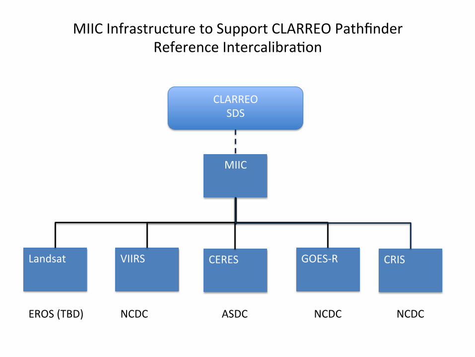
MIIC Infrastructure to Support CLARREO Pathfinder Reference Intercalibra$on
Landsat VIIRS CERES GOES-‐R CRIS
CLARREO SDS
EROS (TBD) NCDC NCDC NCDC ASDC
MIIC

Data Products for Ini$al MIIC Deployment
Product Center Type Temporal Coverage
Size
CERES L2 ASDC Footprints hour 50 MB
CALIPSO L1 ASDC Profile orbit 500 MB
CALIPSO L2 ASDC Layer, Profile, and VFM orbit 40-‐108 MB
CRIS SDR NCDC Spectra 6.8 min 257 MB
ATMS SDR NCDC Swath scans 7 min 2.6 MB
VIIRS SDR NCDC Swath scans 5 min 350 MB
VIIRS EDR NCDC Aerosol, Cloud, Ice, Land, Sea Surface,… 14 types
~ 5.8 min 1.1-‐ 9 MB
GOES13 NCDC Full disk scans 15 min. 2.7 GB
• Sizes are approximate; temporal and spa$al coverage vary with product type • Geoloca$on and science data may be in separate files at NCDC (use OPeNDAP NcML) • VIIRS channels stored in separate files
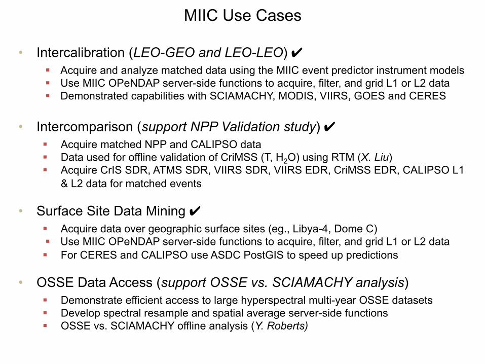
MIIC Use Cases
• Intercalibration (LEO-GEO and LEO-LEO) ✔ § Acquire and analyze matched data using the MIIC event predictor instrument models § Use MIIC OPeNDAP server-side functions to acquire, filter, and grid L1 or L2 data § Demonstrated capabilities with SCIAMACHY, MODIS, VIIRS, GOES and CERES
• Intercomparison (support NPP Validation study) ✔ § Acquire matched NPP and CALIPSO data § Data used for offline validation of CriMSS (T, H2O) using RTM (X. Liu) § Acquire CrIS SDR, ATMS SDR, VIIRS SDR, VIIRS EDR, CriMSS EDR, CALIPSO L1
& L2 data for matched events
• Surface Site Data Mining ✔ § Acquire data over geographic surface sites (eg., Libya-4, Dome C) § Use MIIC OPeNDAP server-side functions to acquire, filter, and grid L1 or L2 data § For CERES and CALIPSO use ASDC PostGIS to speed up predictions
• OSSE Data Access (support OSSE vs. SCIAMACHY analysis) § Demonstrate efficient access to large hyperspectral multi-year OSSE datasets § Develop spectral resample and spatial average server-side functions § OSSE vs. SCIAMACHY offline analysis (Y. Roberts)

What can you do with MIIC?
• Event Predic$on ✔ • Acquisi$on of matched events ✔ • Analysis and visualiza$on of events
Type Target Reference Date range Performance Volume Processed
Event predic$on GOES13 FD NPP VIIRS 2013 1492 events, 30 sec. N/A
Event predic$on Aqua MODIS NPP VIIRS 2013 948 events, 1 min. N/A
LEO-‐GEO 2DGridded GOES13 FD NPP VIIRS Jan. 1, 2013 4 events, 5 min. 14 GB
LEO-‐GEO Tuple GOES13 FD NPP VIIRS Jan. 1, 2013 4 events, 7 min. 14 GB
LEO-‐LEO 2DGridded Aqua CERES NPP VIIRS Jan., 2013 27 events, 4 min. 40 GB
LEO-‐LEO Tuple NPP VIIRS CALIPSO Aug. 12, 2013
1 event, 2 min. 4 GB
Surface Site Tuple NPP VIIRS N/A 2014 274 events, 18 min. 100 GB
Surface Site Tuple CALIPSO N/A 2013 182 events, 4 min. 91 GB
Surface Site 2DGridded
NPP VIIRS N/A 2014 274 events, 18 min. 100 GB
All products staged on ASDC servers, surface site (10 degree box at 75 W), data volumes are approximate

MIIC Architecture

NOAA -‐ NASA Collabora$ve Deployment
AWemp$ng to provide dedicated MIIC S-‐NPP 30 Day Cache w/ OPeNDAP access
• New SGI servers installed at ASDC
• 10 GE connec$vity to DPO • S$ll need to provide
Internet access

• SubmiWed request to NOAA for NPP file types • ATMS, VIIRS, and CRIS products (19 TB/mo.) • Current ip server not setup for OPeNDAP, files
need to be untarred and uncompressed, ip://ip-‐npp.class.ngdc.noaa.gov/
• NCDC to stand up dedicated 30 day MIIC cache with OPeNDAP access (J. Morris, L. Crandall)
S-‐NPP MIIC 30 Day Cache

1 2
3
4
MIIC Web Page Demo
User creates ICPlans to predict, acquire, and analyze data

• Event Predic$on results depicted on Google Maps
• Need to develop analysis and visualiza$on capabili$es for single events and collec$ons of events

TLEs Available for MIIC Event Predic$on (red implemented)
hWp://www-‐angler.larc.nasa.gov/cgi-‐bin/site/showdoc?mnemonic=TLE&c=satellite-‐list CAT# NAME TLE_LAST_UPDATED 13367 "Landsat 4" "2013-‐06-‐20 08:05:02" 14780 "Landsat 5" "2013-‐06-‐20 08:05:02" 15354 "ERBS" "2013-‐06-‐20 08:05:02" 15427 "NOAA-‐09" "2013-‐06-‐20 08:05:02" 16969 "NOAA-‐10" "2013-‐06-‐20 08:05:02" 19531 "NOAA-‐11" "2013-‐06-‐20 08:05:02" 21140 "Meteosat-‐5" "2013-‐06-‐20 08:05:02" 21263 "NOAA-‐12" "2013-‐06-‐20 08:05:02" 21574 "ERS-‐1" "2013-‐06-‐20 08:05:02" 23051 "GOES-‐8" "2013-‐06-‐20 08:05:02" 23455 "NOAA-‐14" "2013-‐06-‐20 08:05:02" 23522 "GMS-‐5" "2013-‐06-‐20 08:05:02" 23560 "ERS-‐2" "2013-‐06-‐20 08:05:02" 23581 "GOES-‐9" "2013-‐06-‐20 08:05:02" 23940 "TOMS-‐EP" "2013-‐06-‐20 08:05:02" 24786 "GOES-‐10" "2013-‐06-‐20 08:05:02" 24883 "OrbView-‐2" "2013-‐06-‐20 08:05:02" 24932 "Meteosat-‐7" "2013-‐06-‐20 08:05:02" 25063 "TRMM/VIRS" "2013-‐06-‐20 08:05:02" 25260 "SPOT-‐4" "2013-‐06-‐20 08:05:02" 25338 "NOAA-‐15" "2013-‐06-‐20 08:05:02" 25682 "Landsat 7" "2013-‐06-‐20 08:05:02" 25789 "QuikSCAT" "2013-‐06-‐20 08:05:02" 25991 "DMSP 5D-‐3 F15 (USA 147)" "" 25994 "Terra" "2013-‐06-‐20 08:05:02" 26352 "GOES-‐11" "2013-‐06-‐20 08:05:02" 26536 "NOAA-‐16" "2013-‐06-‐20 08:05:02" 26871 "GOES-‐12" "2013-‐06-‐20 08:05:02”
27386 "EnviSAT" "2013-‐06-‐20 08:05:02" 27421 "SPOT-‐5" "2013-‐06-‐20 08:05:02" 27424 "Aqua" "2013-‐06-‐20 08:05:02" 27453 "NOAA-‐17" "2013-‐06-‐20 08:05:02" 27509 "Meteosat-‐8 (MSG-‐1)" "2013-‐06-‐20 08:05:02" 27525 "Kalpana-‐1" "2013-‐06-‐20 08:05:02" 27642 "ICESat" "2013-‐06-‐20 08:05:02" 28054 "DMSP 5D-‐3 F16 (USA 172)" "" 28376 "Aura" "2013-‐06-‐20 08:05:02" 28451 "Feng Yun 2C" "2013-‐06-‐20 08:05:02" 28622 "MTSAT-‐1R" "2013-‐06-‐20 08:05:02" 28622 "MTSAT-‐1R/Aqua" "2013-‐06-‐20 08:05:02" 28654 "NOAA-‐18" "2013-‐06-‐20 08:05:02" 28912 "Meteosat-‐9 (MSG-‐2)" "2013-‐06-‐20 08:05:02" 28912 "Meteosat-‐9/Terra (MSG-‐2)" "2013-‐06-‐20 08:05:02" 28912 "Meteosat-‐9/Aqua (MSG-‐2)" "2013-‐06-‐20 08:05:02" 28937 "MTSAT-‐2" "2013-‐06-‐20 08:05:02" 29107 "CloudSAT" "2013-‐06-‐20 08:05:02" 29108 "Calipso" "2013-‐06-‐20 08:05:02" 29155 "GOES-‐13" "2013-‐06-‐20 08:05:02" 29499 "MetOp-‐A" "2013-‐06-‐20 08:05:02" 29522 "DMSP 5D-‐3 F17 (USA 173)" "2011-‐11-‐15 08:12:53" 29640 "Feng Yun 2D" "2013-‐06-‐20 08:05:02" 32382 "RadarSat-‐2" "2013-‐06-‐20 08:05:02" 33463 "FY2E" "2012-‐07-‐12 15:57:39" 33492 "GOSAT" "2013-‐06-‐20 08:05:02" 33591 "NOAA-‐19" "2013-‐06-‐20 08:05:02" 35951 "DMSP 5D-‐3 F18 (USA 210)" "" 36411 "GOES-‐15" "2013-‐06-‐20 08:05:02" 37838 "Megha-‐Tropiques" "2013-‐06-‐20 08:05:02" 37849 "Suomi Na$onal Polar Orbi$ng Partnership"
"2013-‐06-‐20 08:05:02" 38552 "Meteosat-‐10 (MSG-‐3)" "2013-‐06-‐20 08:05:02" 38771 "MetOp-‐B" "2013-‐06-‐20 08:05:02"
• Can run predic$ons for any spacecrai with TLEs from Space-‐Track.org
• Current plans to access
only instrument data hosted at ASDC or NCDC
• User can run predic$ons
w/o accessing data
• Extend list of satellites in current deployment? Run IC and access only data from 1 satellite
• Extended CLARREO algorithm (C. Roithmayr)

LEO-‐GEO Full Resolu$on (Tuple) Data for VIIRS vs. GOES13 Event Jan. 1, 2013
Jan. 1, 2013 NPP VIIRS-‐GOES13 MIIC IC Event, 46.4 N, -‐51.2 S, -‐114.7 W, -‐53.2 W, $me 2013-‐01-‐01T18:49:40Z through 2013-‐01-‐01T19:17:00Z; a. 1 km GOES13 band 0 data from CLASS, b. Matched 2 km VIIRS SDR Radiance_I3_Avg data, c. one VIIRS granule (of 7) that make up matched LEO-‐GEO event; fill values at scan angles greater than 31.7° and 56.3° due to “bow-‐$e” effect. Extremely large amount of data for a single event!
a. b.
c.

LEO-‐GEO Gridded Data for VIIRS vs. GOES13 Event Jan. 1, 2013
Gridded data, 0.5 degree, returned from MIIC server-‐side 2DHistogram func$on for single LEO-‐GEO matched event; factor of 3500 in data reduc$on compared to tuple data
GOES13 gridded VIIRS gridded
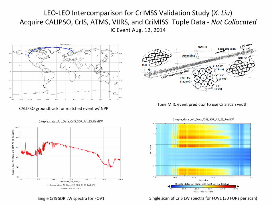
LEO-‐LEO Intercomparison for CrIMSS Valida$on Study (X. Liu) Acquire CALIPSO, CrIS, ATMS, VIIRS, and CriMISS Tuple Data -‐ Not Collocated
IC Event Aug. 12, 2014
CALIPSO groundtrack for matched event w/ NPP
Single CrIS SDR LW spectra for FOV1 Single scan of CrIS LW spectra for FOV1 (30 FORs per scan)
Tune MIIC event predictor to use CrIS scan width

Server-‐side Filtering for Surface Site Acquisi$on CERES SSF data, Jan. 2, 2011
a. No clear sky filter
b. 5 % clear sky filter
c. 95 % clear sky filter

Deployment Status
• Conducted review with ASDC; presented implementa$on requirements, design, and integra$on status
• Defined L2 WBS and drai L3 tasks; s$ll need integrated schedule with ASDC and NCDC concurrence
• MIIC soiware is ready for ini$al deployment (rpms built to simplify deployment at NCDC)
• ASDC hardware is in place; need to open up firewall to Internet
• NCDC hardware s$ll TBD; planned 30 day dedicated MIIC cache + OPeNDAP server
Issues
• Need integrated schedule • Need MOU and Interconnec$on Security Agreement with NCDC
• ROSES ACCESS proposal not mechanism for data system upgrades (hardware at NCDC TBD)
• EUMETSAT has requested soiware for evalua$on; will require NASA Soiware Release
Related Documents