This article appeared in a journal published by Elsevier. The attached copy is furnished to the author for internal non-commercial research and education use, including for instruction at the authors institution and sharing with colleagues. Other uses, including reproduction and distribution, or selling or licensing copies, or posting to personal, institutional or third party websites are prohibited. In most cases authors are permitted to post their version of the article (e.g. in Word or Tex form) to their personal website or institutional repository. Authors requiring further information regarding Elsevier’s archiving and manuscript policies are encouraged to visit: http://www.elsevier.com/copyright

Welcome message from author
This document is posted to help you gain knowledge. Please leave a comment to let me know what you think about it! Share it to your friends and learn new things together.
Transcript
This article appeared in a journal published by Elsevier. The attachedcopy is furnished to the author for internal non-commercial researchand education use, including for instruction at the authors institution
and sharing with colleagues.
Other uses, including reproduction and distribution, or selling orlicensing copies, or posting to personal, institutional or third party
websites are prohibited.
In most cases authors are permitted to post their version of thearticle (e.g. in Word or Tex form) to their personal website orinstitutional repository. Authors requiring further information
regarding Elsevier’s archiving and manuscript policies areencouraged to visit:
http://www.elsevier.com/copyright
Author's personal copy
Mud volcanoes in the geologic record of Mars: The case of Firsoff crater
M. Pondrelli a,⁎, A.P. Rossi b,c, G.G. Ori a,d, S. van Gasselt e, D. Praeg f, S. Ceramicola f
a IRSPS, Università d'Annunzio, Viale Pindaro, 65127 Pescara, Italyb International Space Science Institute, Hallerstrasse 6, CH-3012, Bern, Switzerlandc Department of Earth and Space Sciences, Jacobs University Bremen, Campus Ring 1, 28759 Bremen, Germanyd Ibn Battuta Centre, Faculté des Sciences, Université Cady Ayyad, Marrakech, Moroccoe Institut für Geologische Wissenschaften, Freie Universität Berlin, Germanyf Istituto Nazionale di Oceanografia e di Geofisica Sperimentale — OGS, Borgo Grotta Gigante 42/c, 34010 Sgonico (TS), Italy
a b s t r a c ta r t i c l e i n f o
Article history:Received 7 August 2010Received in revised form 9 February 2011Accepted 15 February 2011Available online 5 March 2011
Editor: T. Spohn
Keywords:mud volcanismfluid escapelayered depositsMarsArabia TerraFirsoff crater
We report the detection of mound-like landforms interpreted as mud volcanoes within Firsoff crater, in theArabia Terra region of Mars. The mounds stratigraphically overlie layered deposits within the crater, whichconsist of high albedo well-bedded deposits disrupted in meter-sized polygons. Hundreds of mounds areobserved on the crater floor, as isolated or composite subcircular cones 100–500 m in diameter and tens ofmeters high. More than one third of the mounds (35%) have subcircular depressions 5–39 m in diameter attheir apices that we interpret as vents. The mounds consist of meter-sized boulders of high albedo, embeddedin an apparently finer-grained unit; we interpret these deposits as mud volcanic breccia, containing bouldersof reworked light-toned layered deposits carried upward from deeper portions of the succession. The moundsare mainly located near the rim-bordering faults and in places aligned with fractures, suggesting subsurfacepathways for fluid migration. The mounds are interpreted as fossil mud volcanoes, recording the upwardmigration of overpressured fluids through the crater infill from deeper crustal sources, localized by impact-related faults.The geological conditions and processes that might have controlled sedimentary expulsion on Mars arediscussed. Mud volcanism has most of its controls in the subsurface. As a consequence, subsurface fluid flowprocesses could be expected in other craters within Arabia Terra and are less likely in higher, adjacenthighland terrains.
© 2011 Elsevier B.V. All rights reserved.
1. Introduction
Landforms described as pitted cones, mounds or knobs have beendescribed in several locations on Mars and a number of models havebeen proposed for their formation by depositional or erosionalprocesses (e.g., Burr et al., 2009). Proposed depositional modelsincludemud volcanism (Oehler and Allen, 2010; Ori et al., 2000, 2001;Skinner and Mazzini, 2009; Tanaka, 1997), different forms ofmagmatic volcanism (Fagents and Thordarson, 2007; Lanagan et al.,2001; McGill, 2005) and precipitation from springs linked to fluidexpulsion (Allen and Oehler, 2008). Erosional models involveupstanding remnants of differential erosion (Chan et al., 2008, 2010).
Mud volcanism is increasingly invoked to explain a variety ofMartian landforms located in lowland areas such as Elysium andAcidalia Planitia (e.g. Burr et al., 2009; Komatsu et al., 2011; Oehlerand Allen, 2010; Ori et al., 2000, 2001; Skinner and Mazzini, 2009;
Skinner and Tanaka, 2007; Tanaka, 1997). In general, these featuresare attributed to fluid overpressures developed within lowlandsedimentary successions, and it has been noted that the extrudedsediments could provide samples of deeper strata (Skinner andMazzini, 2009). To date, however, no candidate Martian mudvolcanoes have been shown to be associated with the depositscharacteristic of terrestrial mud volcanoes that can be linked tosubjacent sedimentary sequences.
Mud volcanoes on Earth display a variety of morphologies, rangingfrom relatively steep-sided cones to broad domes and caldera-likedepressions, with sizes ranging from 10 to 100 km2 (e.g. Dimitrov,2002; Kholodov, 2002; Kopf, 2002; Praeg et al., 2009). Faciesassociations are dominated by poorly sorted sediments, typically‘mud breccias’ comprising clasts up to boulder size in a finer matrix(e.g. Dimitrov, 2002; Kopf, 2002). On Earth, mud volcanoes aregenerally associated with areas of convergent tectonism and/or thicksedimentary sequences, which favor the development of high pore-fluid pressures (Dimitrov, 2002; Kholodov, 2002; Kopf, 2002). Mudvolcanoes observed at surface are inferred to be the tops of deeplyrooted vertical structures in which sediment extrusion is driven by amobile fluid fraction (water, hydrocarbons, and gas), which migrates
Earth and Planetary Science Letters 304 (2011) 511–519
⁎ Corresponding author at: International Research School of Planetary Sciences,Università d'Annunzio, viale Pindaro 42, 65127 Pescara, Italy. Tel.: +39 0854537886;fax: +39 0854549755.
E-mail address: [email protected] (M. Pondrelli).
0012-821X/$ – see front matter © 2011 Elsevier B.V. All rights reserved.doi:10.1016/j.epsl.2011.02.027
Contents lists available at ScienceDirect
Earth and Planetary Science Letters
j ourna l homepage: www.e lsev ie r.com/ locate /eps l
Author's personal copy
upward from zones of overpressures at depths up to severalkilometers (Deville et al., 2003).
A scenario involving rootless volcanic cones originating fromphreatomagmatic eruptions was proposed by Frey et al. (1979) for theCydonia region of southern Acidalia Planitia by analogy with similarlandforms in Iceland. Fagents and Thordarson (2007) proposed severaladditional locations as candidates to host rootless cones on Mars. Thisscenario is supported by the conical morphology, the presence of anorifice at the top of themounds, the randomspatial distribution, the lackof a structural control and the relatively large ratio of orifice to conediameter (0.25 to 0.65) (Fagents and Thordarson, 2007; Hamilton et al.,2010; Lanagan et al., 2001). Such an interpretation would imply ageological setting characterized by the presence of active volcanism andunderlying groundwater or ground-ice.
Pitted conical hills ~2 km in diameter in Cydonia Mensae–SouthernAcidalia Planitia were interpreted as volcanic constructs by McGill(2005). Such features are characterized by concentric light-toned bands(McGill, 2005).
Allen and Oehler (2008), based on a detailed morphologicalsurvey, proposed the presence of an extensive spring provinceincluding spring mounds in Vernal crater, not far from the studyarea. Thesemounds have an elliptical shape, are up to several hundredof meters in long dimension, with well defined boundaries, light-toned albedo, circumferential fractures, terrace-like morphology andcircular depressions at their apices. Moreover, sinuous furrowsassociated with mounds have been interpreted as potential surfacerunoff channels and groundwater sapping gullies (Allen and Oehler,2008). These deposits are associated with an extensive fracturesystem, which is interpreted to have favored upward flow of warmfluids.
Knobs located amidst light-toned layers in Candor Chasma havebeen interpreted as erosional remnants either of a single resistantlayer or an area with differential cementation (Chan et al., 2008,2010). Differential cementation might depend on the presence ofmore resistant layers or bodies or on subsurface flow circulation
(Chan et al., 2008, 2010). Such a scenario might suggest an associationof the mounds with specific stratigraphic levels, buried craters, orfaults/fractures.
In this paper, we present the results of a geomorphologicinvestigation of landforms that occur on the floor of Firsoff crater,which is located in the equatorial southern highlands of Arabia Terra,centered at 2.6°N–350.8°E (Fig. 1A). We consider the possible modelsfor their formation and argue them to be consistent with mudvolcanism. The results include the first evidence for the extrusion ofmaterials analogous to textures observed on Earth.
2. Methodology and data
Image data used in this study include products from the HighResolution Stereo Camera (HRSC) nadir on the European SpaceAgency's Mars Express Orbiter, NASA's Context Camera (CTX) andHigh Resolution Imaging Science Experiment (HiRISE) on MarsReconnaissance Orbiter. A listing of all the data used is provided inthe supplementary data (Table SD1).
As many of the textural and morphological characteristics of themounds are best described at high resolution, detailed mapping hasbeen performed on a subsection of a single HiRISE image(PSP_003788_1820, resolution ~0.3 m/pixel), representing about10% of the total image area. The HiRISE image is located in a part ofthe study area where mounds have their highest spatial density.Height estimates are based on both Mars Orbiter Laser Altimeter(MOLA) Precision Experiment Data Record (PEDR) profiles (Fig. SD1)and High Resolution Stereo Camera (HRSC) topography.
Data were processed using either DLR-VICAR (Video ImageCommunication and Retrieval, produced by the Jet PropulsionLaboratory and modified by the German Space Agency, DLR) or theUnited States Geological Survey (USGS) Integrated Software forImagers and Spectrometers ISIS3 system, then integrated andanalyzed with Geographic Information Systems (GIS) tools.
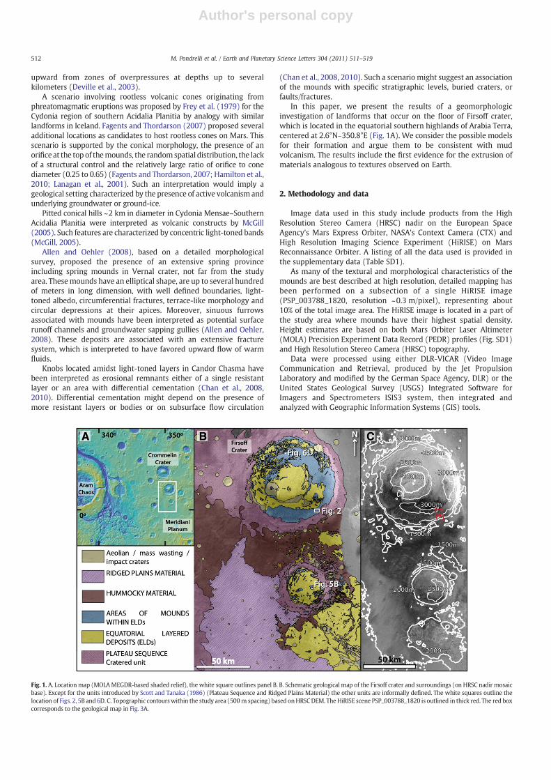
Fig. 1. A. Locationmap (MOLAMEGDR-based shaded relief), the white square outlines panel B. B. Schematic geological map of the Firsoff crater and surroundings (on HRSC nadir mosaicbase). Except for the units introduced by Scott and Tanaka (1986) (Plateau Sequence and Ridged Plains Material) the other units are informally defined. The white squares outline thelocation of Figs. 2, 5B and 6D. C. Topographic contourswithin the study area (500 m spacing) based onHRSCDEM. TheHiRISE scene PSP_003788_1820 is outlined in thick red. The red boxcorresponds to the geological map in Fig. 3A.
512 M. Pondrelli et al. / Earth and Planetary Science Letters 304 (2011) 511–519
Author's personal copy
3. Geological setting
The geological setting of the Firsoff impact crater and surroundingareas is shown in Fig. 1B. The map is partly derived from that of Scottand Tanaka (1986) based on Viking data, who recognized tworegional units in the area, on top of which we have mapped additionalmorpho-stratigraphic units.
The stratigraphic succession begins with the Plateau Sequence ofNoachian age, in this area represented by the Cratered unit (Fig. 1B),interpreted as a mixture of lava flows, pyroclastic materials andimpact breccias (Scott and Tanaka, 1986). These deposits arenonconformably overlain by the Equatorial Layered Deposits (ELDs)(e.g. Hynek et al., 2002; Malin and Edgett, 2000), which onlap thePlateau Sequence at crater rims and gently drape them on crater floorsand outside of the craters. Mounds always occur within areas of ELDsand overlie them (Fig. 1B). Both are unconformably overlain by theHummocky Material, a dark-toned and hummocky-looking unit(Fig. 1B), possibly of volcanoclastic origin. All these units areunconformably overlain by the Ridged Plains Material, interpretedas flood basalts of Hesperian age (Scott and Tanaka, 1986), whichprovide an upper constraint for the age of formation of the ELDs. Thestratigraphic succession is capped by aeolian dunes, sand sheets andmantling, which unconformably lie on both the ELDs and the mounds(Fig. 1B). Mass wasting features are predominantly located at thebases of mounds and scarps (Fig. 1B).
The ages of the ELDs and the mounds are constrained by thestratigraphic relations between the Cratered unit of the PlateauSequence and the Ridged Plains Material. According to the correlationchart proposed by Scott and Tanaka (1986), these relations constrainELDs and mound deposition to the upper part of the Noachian.
The Firsoff impact crater is approximately 90 km in diameter andhas an exposed depth of about 1500 m measured from crater floor tocrater rim (Fig. 1C). Using the morphometric relations of Garvin et al.(2003), it is possible to estimate the thickness of ELDs beneath theobserved mounds as between 200 and 500 m.
Depositional processes invoked to explain the origin of the ELDsinclude sub-glacial volcanism (Chapman and Tanaka, 2001), aeolian/airfall (Malin and Edgett, 2000), lacustrine deposition (Newsom et al.,2003), lacustrine/volcanic (Ori and Baliva, 1999) and spring deposi-tion (Rossi et al., 2008). Regardless of their origin, Arabia Terra is anarea of proposed past subsurface fluid flow (Allen and Oehler, 2008;Andrews-Hanna et al., 2007, 2010; Grotzinger et al., 2005; Rossi et al.,2008). Groundwater upwelling has been proposed to explain playa
formation and aeolian deposit preservation (Andrews-Hanna et al.,2007, 2010; Grotzinger et al., 2005) and spring activity (Allen andOehler, 2008; Rossi et al., 2008).
4. Description of mounds
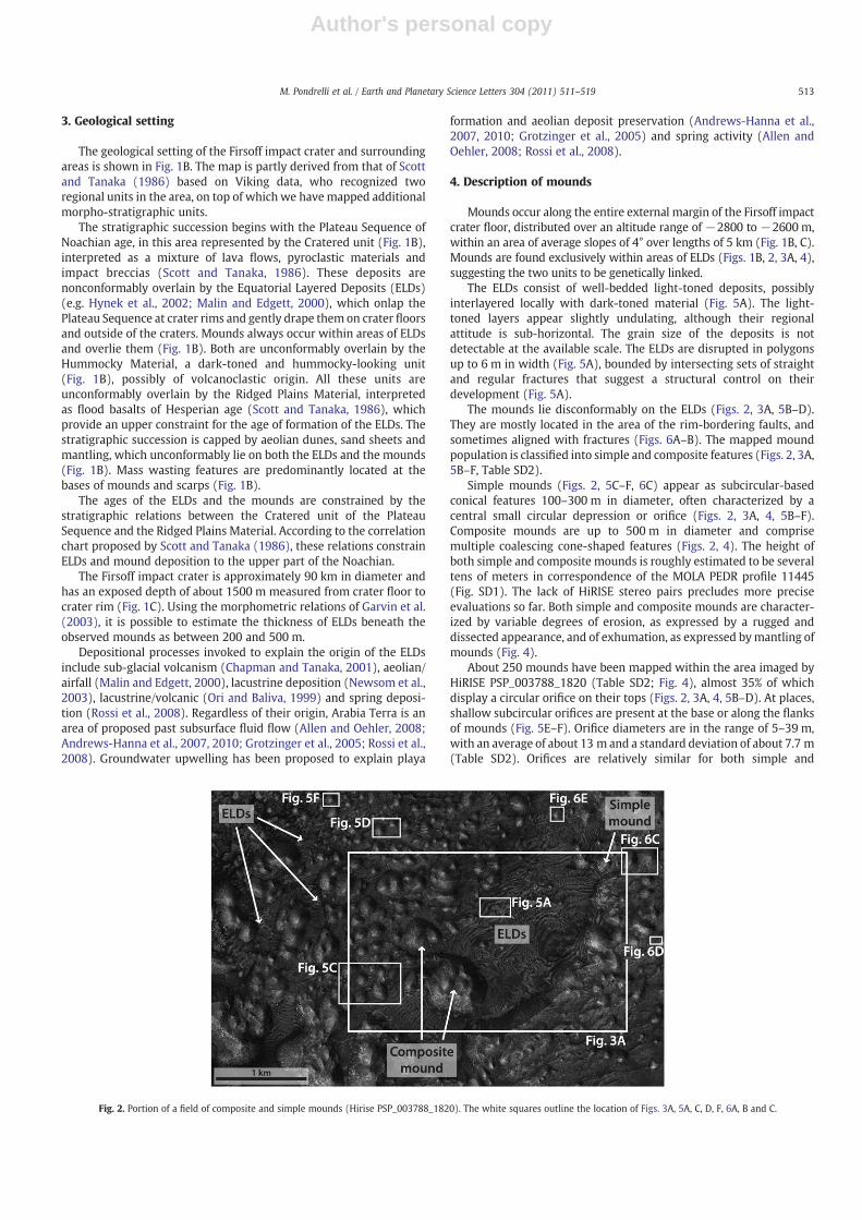
Mounds occur along the entire external margin of the Firsoff impactcrater floor, distributed over an altitude range of −2800 to −2600 m,within an area of average slopes of 4° over lengths of 5 km (Fig. 1B, C).Mounds are found exclusively within areas of ELDs (Figs. 1B, 2, 3A, 4),suggesting the two units to be genetically linked.
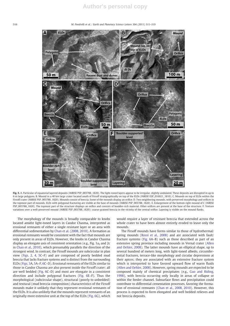
The ELDs consist of well-bedded light-toned deposits, possiblyinterlayered locally with dark-toned material (Fig. 5A). The light-toned layers appear slightly undulating, although their regionalattitude is sub-horizontal. The grain size of the deposits is notdetectable at the available scale. The ELDs are disrupted in polygonsup to 6 m in width (Fig. 5A), bounded by intersecting sets of straightand regular fractures that suggest a structural control on theirdevelopment (Fig. 5A).
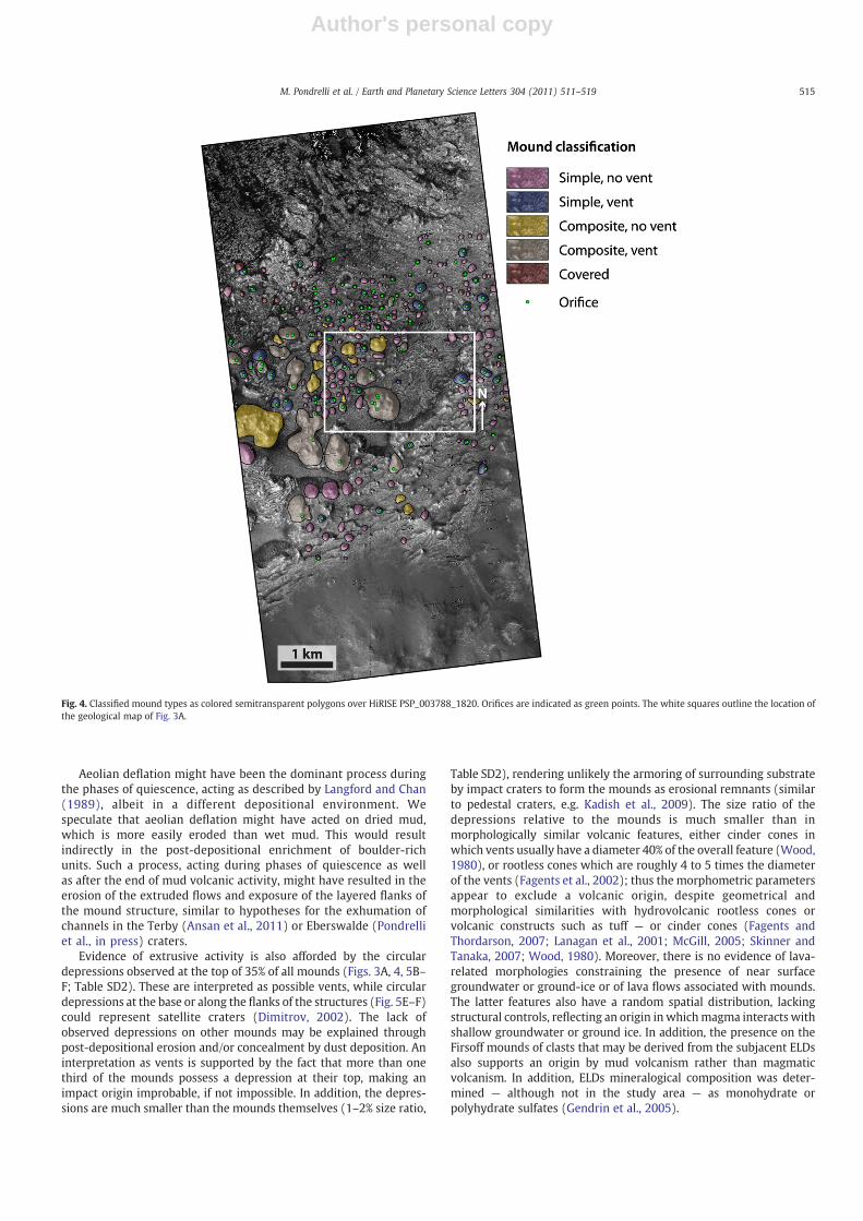
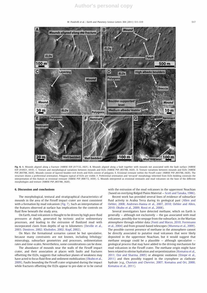
The mounds lie disconformably on the ELDs (Figs. 2, 3A, 5B–D).They are mostly located in the area of the rim-bordering faults, andsometimes aligned with fractures (Figs. 6A–B). The mapped moundpopulation is classified into simple and composite features (Figs. 2, 3A,5B–F, Table SD2).
Simple mounds (Figs. 2, 5C–F, 6C) appear as subcircular-basedconical features 100–300 m in diameter, often characterized by acentral small circular depression or orifice (Figs. 2, 3A, 4, 5B–F).Composite mounds are up to 500 m in diameter and comprisemultiple coalescing cone-shaped features (Figs. 2, 4). The height ofboth simple and composite mounds is roughly estimated to be severaltens of meters in correspondence of the MOLA PEDR profile 11445(Fig. SD1). The lack of HiRISE stereo pairs precludes more preciseevaluations so far. Both simple and composite mounds are character-ized by variable degrees of erosion, as expressed by a rugged anddissected appearance, and of exhumation, as expressed bymantling ofmounds (Fig. 4).
About 250 mounds have been mapped within the area imaged byHiRISE PSP_003788_1820 (Table SD2; Fig. 4), almost 35% of whichdisplay a circular orifice on their tops (Figs. 2, 3A, 4, 5B–D). At places,shallow subcircular orifices are present at the base or along the flanksof mounds (Fig. 5E–F). Orifice diameters are in the range of 5–39 m,with an average of about 13 m and a standard deviation of about 7.7 m(Table SD2). Orifices are relatively similar for both simple and
Fig. 2. Portion of a field of composite and simple mounds (Hirise PSP_003788_1820). The white squares outline the location of Figs. 3A, 5A, C, D, F, 6A, B and C.
513M. Pondrelli et al. / Earth and Planetary Science Letters 304 (2011) 511–519
Author's personal copy
composite mounds: they consist of shallow depressions, with anaverage area of approximately 180 m2 (standard deviation 241 m2).The ratio between the areas of orifices, where visible, and mounds areeverywhere less than 1% for composite mounds and less than 2% forsimple mounds.
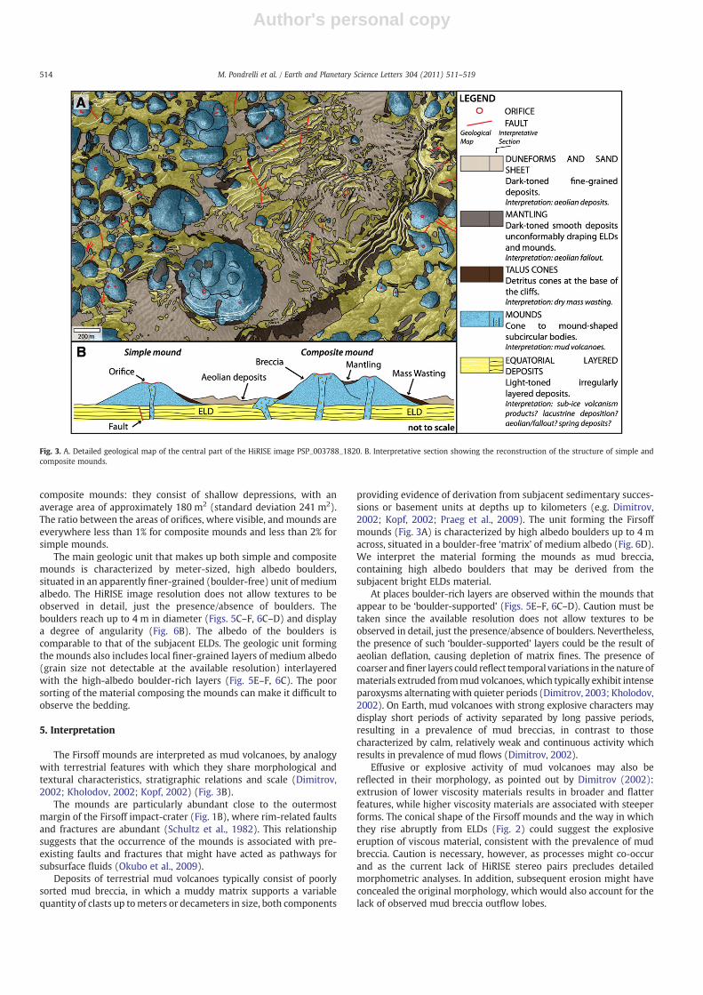
The main geologic unit that makes up both simple and compositemounds is characterized by meter-sized, high albedo boulders,situated in an apparently finer-grained (boulder-free) unit of mediumalbedo. The HiRISE image resolution does not allow textures to beobserved in detail, just the presence/absence of boulders. Theboulders reach up to 4 m in diameter (Figs. 5C–F, 6C–D) and displaya degree of angularity (Fig. 6B). The albedo of the boulders iscomparable to that of the subjacent ELDs. The geologic unit formingthe mounds also includes local finer-grained layers of medium albedo(grain size not detectable at the available resolution) interlayeredwith the high-albedo boulder-rich layers (Fig. 5E–F, 6C). The poorsorting of the material composing the mounds can make it difficult toobserve the bedding.
5. Interpretation
The Firsoff mounds are interpreted as mud volcanoes, by analogywith terrestrial features with which they share morphological andtextural characteristics, stratigraphic relations and scale (Dimitrov,2002; Kholodov, 2002; Kopf, 2002) (Fig. 3B).
The mounds are particularly abundant close to the outermostmargin of the Firsoff impact-crater (Fig. 1B), where rim-related faultsand fractures are abundant (Schultz et al., 1982). This relationshipsuggests that the occurrence of the mounds is associated with pre-existing faults and fractures that might have acted as pathways forsubsurface fluids (Okubo et al., 2009).
Deposits of terrestrial mud volcanoes typically consist of poorlysorted mud breccia, in which a muddy matrix supports a variablequantity of clasts up tometers or decameters in size, both components
providing evidence of derivation from subjacent sedimentary succes-sions or basement units at depths up to kilometers (e.g. Dimitrov,2002; Kopf, 2002; Praeg et al., 2009). The unit forming the Firsoffmounds (Fig. 3A) is characterized by high albedo boulders up to 4 macross, situated in a boulder-free ‘matrix’ of medium albedo (Fig. 6D).We interpret the material forming the mounds as mud breccia,containing high albedo boulders that may be derived from thesubjacent bright ELDs material.
At places boulder-rich layers are observed within the mounds thatappear to be ‘boulder-supported’ (Figs. 5E–F, 6C–D). Caution must betaken since the available resolution does not allow textures to beobserved in detail, just the presence/absence of boulders. Nevertheless,the presence of such ‘boulder-supported’ layers could be the result ofaeolian deflation, causing depletion of matrix fines. The presence ofcoarser andfiner layers could reflect temporal variations in the nature ofmaterials extruded frommud volcanoes, which typically exhibit intenseparoxysms alternatingwith quieter periods (Dimitrov, 2003; Kholodov,2002). On Earth, mud volcanoes with strong explosive characters maydisplay short periods of activity separated by long passive periods,resulting in a prevalence of mud breccias, in contrast to thosecharacterized by calm, relatively weak and continuous activity whichresults in prevalence of mud flows (Dimitrov, 2002).
Effusive or explosive activity of mud volcanoes may also bereflected in their morphology, as pointed out by Dimitrov (2002):extrusion of lower viscosity materials results in broader and flatterfeatures, while higher viscosity materials are associated with steeperforms. The conical shape of the Firsoff mounds and the way in whichthey rise abruptly from ELDs (Fig. 2) could suggest the explosiveeruption of viscous material, consistent with the prevalence of mudbreccia. Caution is necessary, however, as processes might co-occurand as the current lack of HiRISE stereo pairs precludes detailedmorphometric analyses. In addition, subsequent erosion might haveconcealed the original morphology, which would also account for thelack of observed mud breccia outflow lobes.
Fig. 3. A. Detailed geological map of the central part of the HiRISE image PSP_003788_1820. B. Interpretative section showing the reconstruction of the structure of simple andcomposite mounds.
514 M. Pondrelli et al. / Earth and Planetary Science Letters 304 (2011) 511–519
Author's personal copy
Aeolian deflation might have been the dominant process duringthe phases of quiescence, acting as described by Langford and Chan(1989), albeit in a different depositional environment. Wespeculate that aeolian deflation might have acted on dried mud,which is more easily eroded than wet mud. This would resultindirectly in the post-depositional enrichment of boulder-richunits. Such a process, acting during phases of quiescence as wellas after the end of mud volcanic activity, might have resulted in theerosion of the extruded flows and exposure of the layered flanks ofthe mound structure, similar to hypotheses for the exhumation ofchannels in the Terby (Ansan et al., 2011) or Eberswalde (Pondrelliet al., in press) craters.
Evidence of extrusive activity is also afforded by the circulardepressions observed at the top of 35% of all mounds (Figs. 3A, 4, 5B–F; Table SD2). These are interpreted as possible vents, while circulardepressions at the base or along the flanks of the structures (Fig. 5E–F)could represent satellite craters (Dimitrov, 2002). The lack ofobserved depressions on other mounds may be explained throughpost-depositional erosion and/or concealment by dust deposition. Aninterpretation as vents is supported by the fact that more than onethird of the mounds possess a depression at their top, making animpact origin improbable, if not impossible. In addition, the depres-sions are much smaller than the mounds themselves (1–2% size ratio,
Table SD2), rendering unlikely the armoring of surrounding substrateby impact craters to form the mounds as erosional remnants (similarto pedestal craters, e.g. Kadish et al., 2009). The size ratio of thedepressions relative to the mounds is much smaller than inmorphologically similar volcanic features, either cinder cones inwhich vents usually have a diameter 40% of the overall feature (Wood,1980), or rootless cones which are roughly 4 to 5 times the diameterof the vents (Fagents et al., 2002); thus the morphometric parametersappear to exclude a volcanic origin, despite geometrical andmorphological similarities with hydrovolcanic rootless cones orvolcanic constructs such as tuff — or cinder cones (Fagents andThordarson, 2007; Lanagan et al., 2001; McGill, 2005; Skinner andTanaka, 2007; Wood, 1980). Moreover, there is no evidence of lava-related morphologies constraining the presence of near surfacegroundwater or ground-ice or of lava flows associated with mounds.The latter features also have a random spatial distribution, lackingstructural controls, reflecting an origin in whichmagma interacts withshallow groundwater or ground ice. In addition, the presence on theFirsoff mounds of clasts that may be derived from the subjacent ELDsalso supports an origin by mud volcanism rather than magmaticvolcanism. In addition, ELDs mineralogical composition was deter-mined — although not in the study area — as monohydrate orpolyhydrate sulfates (Gendrin et al., 2005).
Fig. 4. Classified mound types as colored semitransparent polygons over HiRISE PSP_003788_1820. Orifices are indicated as green points. The white squares outline the location ofthe geological map of Fig. 3A.
515M. Pondrelli et al. / Earth and Planetary Science Letters 304 (2011) 511–519
Author's personal copy
The morphology of the mounds is broadly comparable to knobslocated amidst light-toned layers in Candor Chasma, interpreted aserosional remnants of either a single resistant layer or an area withdifferential sedimentation by Chan et al. (2008, 2010). A formation aserosional remnants would be consistent with the fact that mounds areonly present in areas of ELDs. However, the knobs in Candor Chasmadisplay an elongate axis of consistent orientation (e.g., Fig. 1a2 and 2cin Chan et al., 2010), which presumably parallels the direction of thestrongest wind. In contrast, the Firsoff mounds are subcircular in planview (Figs. 2, 4, 5C–F) and are composed of poorly bedded mudbreccia that lacks fracture systems and is distinct from the surroundingELDs (Figs. 3A, 5A–F, 6C–D). Erosional remnants of the ELDs similar tothose in Candor Chasma are also present inside the Firsoff crater: allare well bedded (Fig. 6C–D) and most are elongate in a consistentdirection and include polygonal fractures (Fig. 6E–F). Thus themorphological (subcircular shape), structural (poorly to unbedded)and textural (mud breccia composition) characteristics of the Firsoffmounds make it unlikely that they represent erosional remnants ofthe ELDs. It is also unlikely that themounds represent remnants of anoriginally more extensive unit at the top of the ELDs (Fig. 6G), which
would require a layer of resistant breccia that extended across thewhole crater to have been almost entirely eroded to leave only themounds.
The Firsoff mounds have forms similar to those of hydrothermal/spring mounds (Rossi et al., 2008) and are associated with fault/fracture systems (Fig. 6A–B) such as those described as part of anextensive spring province including mounds in Vernal crater (Allenand Oehler, 2008). The latter mounds have an elliptical shape, up toseveral hundred of meters long, with light-toned albedo, circumfer-ential fractures, terrace-like morphology and circular depressions attheir apices; they are associated with an extensive fracture systemwhich is interpreted to have favored upward flow of warm fluids(Allen and Oehler, 2008). However, spring mounds are expected to becomposed mainly of chemical precipitates (e.g., Guo and Riding,1998), with breccia occurring only locally in areas of collapse orwithin the feeder channel. Subsurface flows and precipitation couldcontribute to differential cementation processes, favoring the forma-tion of erosional remnants (Chan et al., 2008, 2010). However, thisprocess is expected to form elongated and well bedded relieves andnot breccia deposits.
Fig. 5. A. Particular of equatorial layered deposits (HiRISE PSP_003788_1820). The light-toned layers appear to be irregular, slightly undulated. These deposits are disrupted in up to6 m large polygons. B. Mound in a 40 km large crater located south of Firsoff stratigraphically on top of the ELDs (HiRISE ESP_016921_1810). C. Mounds on top of ELDs within theFirsoff crater (HiRISE PSP_003788_1820). Mounds consist of breccia. Some of the mounds display an orifice. D. Two neighboring mounds, with preserved morphology and orifices inthe topmost part of mounds. ELDs with polygonal fracturing are visible at the base of mounds (HiRISE PSP_003788_1820). E. Enlargement of the bottom right mound of C (HiRISEPSP_003788_1820). The topmost part of the structure displays an orifice and consists of boulder-rich material. Other orifices are present at the base of the structure. F. Texturevariations over a well-preserved mound (HiRISE PSP_003788_1820): coarse-grained breccia in the vicinity of the central orifice. Layering is visible on the mound flanks.
516 M. Pondrelli et al. / Earth and Planetary Science Letters 304 (2011) 511–519
Author's personal copy
6. Discussion and conclusions
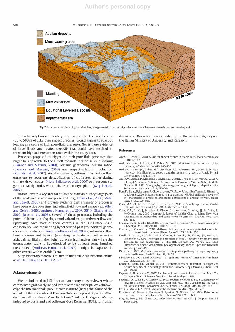
The morphological, textural and stratigraphical characteristics ofmounds in the area of the Firsoff impact crater are most consistentwith a formation by mud volcanism (Fig. 7). Such an interpretation ofthe features observed at surface has implications for the controls onfluid flow beneath the study area.
On Earth, mud volcanism is thought to be driven by high pore-fluidpressures at depth, generated by tectonic and/or sedimentaryprocesses, and leading to the extrusion of fluidized mud withincorporated clasts from depths of up to kilometers (Deville et al.,2003; Dimitrov, 2002; Kholodov, 2002; Kopf, 2002).
On Mars the formational scenarios cannot be but speculative,because many constraints are not known, including lithology/mineralogy, subsurface geometries and processes, sedimentationrates and time-scales. Nevertheless, some considerations can be done.
The abundance of mounds near the walls of the Firsoff impactcrater, and their association at places with faults and fracturesoffsetting the ELDs, suggests that subsurface planes of weakness mayhave acted to focus fluid flow and sedimentmobilization (Okubo et al.,2009). Faults bounding the Firsoff crater originated during the impactwhile fractures offsetting the ELDs appear to pre-date or to be coeval
with the extrusion of the mud volcanoes in the uppermost Noachian(based on overlying Ridged PlainsMaterial— Scott and Tanaka, 1986).
Recent work has provided several lines of evidence of subsurfacefluid activity in Arabia Terra during its geological past (Allen andOehler, 2008; Andrews-Hanna et al., 2007, 2010; Oehler and Allen,2010; Okubo et al., 2009; Rossi et al., 2008).
Several investigators have detected methane, which on Earth isgenerally — although not exclusively — the gas associated with mudvolcanoes, possibly due to seepage from the subsurface, in theMartianatmosphere through orbiter data (Fonti and Marzo, 2010; Formisanoet al., 2004) and from ground-based telescopes (Mumma et al., 2009).The possible current presence of methane in the atmosphere cannotbe directly associated to putative mud volcanoes that were likelydeposited in the uppermost Noachian, but it would suggest thatmethane seepage could be a plausible — although speculative —
geological process that may have added to the driving mechanism formud volcanism in the Firsoff crater. The methane origin might havebeen related to olivine hydration and serpentinization (Komatsu et al.,2011; Oze and Sharma, 2005) or abiogenic oxidation (Etiope et al.,2011) and then possibly trapped in the cryosphere as clathratehydrate (e.g., Chastain and Chevrier, 2007; Komatsu and Ori, 2000;Komatsu et al., 2011).
Fig. 6. A. Mounds aligned along a fracture (HiRISE ESP_017132_1825). B. Mounds aligned along a fault together with mounds not associated with the fault surface (HiRISEESP_016921_1810). C. Texture and morphological variations between mounds and ELDs (HiRISE PSP_003788_1820). D. Texture variations between mounds and ELDs (HiRISEPSP_003788_1820). Mounds consist of layered boulder-rich levels and ELDs consist of polygons. E. Erosional remnant within the Firsoff crater (HiRISE PSP_003788_1820). Thestructure shows a preferential orientation. Polygons typical of ELDs are visible. F. Preferential orientation and ‘terraced’ morphology inherited from ELDs bedding constrain theinterpretation of this feature as erosional remnant (HiRISE PSP_008772_1830). G. Mounds interpreted as erosional remnants and mud volcanoes on the base of the differentmorphologies and texture (HiRISE PSP_003788_1820).
517M. Pondrelli et al. / Earth and Planetary Science Letters 304 (2011) 511–519
Author's personal copy
The relatively thin sedimentary succession within the Firsoff crater(up to 500 m of ELDs over impact breccias) would appear to rule outloading as a cause of high pore-fluid pressures. Nor is there evidenceof large floods and related deposits that could have resulted intransient high sedimentation rates within the study area.
Processes proposed to trigger the high pore-fluid pressures thatmight be applicable to the Firsoff mounds include seismic shaking(Skinner and Mazzini, 2009), volcanic geothermal destabilization(Skinner and Mazzini, 2009) and impact-related liquefaction(Komatsu et al., 2007). An alternative hypothesis links surface fluidemissions to recurrent destabilization of clathrates, either duringclimate-driven cycles (Prieto-Ballesteros et al., 2006) or in response togeothermal dynamics within the Martian cryosphere (Kargel et al.,2007).
Arabia Terra is a key area for studies of Martian history: large partsof the geological record are preserved (e.g., Lewis et al., 2008; Malinand Edgett, 2000) and provide evidence that a variety of processeshave been active over time, including fluid flow and escape (e.g. Allenand Oehler, 2008; Andrews-Hanna et al., 2007, 2010; Okubo et al.,2009; Rossi et al., 2008). Several of these processes, including thepotential formation of springs, mud volcanism, groundwater flow andupwelling, have most of their controls in the subsurface. As aconsequence, and considering hypothesized past groundwater geom-etry and distribution (Andrews-Hanna et al., 2007), subsurface fluidflow processes and deposits (including candidate mud volcanoes) —
although not likely in the higher, adjacent highland terrainswhere thegroundwater table is hypothesized to be at least some hundredmeters deep (Andrews-Hanna et al., 2007) — might be expected inother craters within Arabia Terra.
Supplementarymaterials related to this article can be found onlineat doi:10.1016/j.epsl.2011.02.027.
Acknowledgments
We are indebted to J. Skinner and an anonymous reviewer whosecomments significantly helped improve the manuscript. We acknowl-edge the International Space Science Institute (Bern) that founded theactivity of the International Team on “Interior Layered Deposits: Whatdo they tell us about Mars Evolution?” led by T. Zegers. We areindebted to our friend and colleague Goro Komatsu, IRSPS, for fruitful
discussions. Our research was funded by the Italian Space Agency andthe Italian Ministry of University and Research.
References
Allen, C., Oehler, D., 2008. A case for ancient springs in Arabia Terra, Mars. Astrobiology8, 1093–1112.
Andrews-Hanna, J., Phillips, R., Zuber, M., 2007. Meridiani Planum and the globalhydrology of Mars. Nature 446, 163–166.
Andrews-Hanna, J.C., Zuber, M.T., Arvidson, R.E., Wiseman, S.M., 2010. Early Marshydrology: Meridiani playa deposits and the sedimentary record of Arabia Terra. J.Geophys. Res. 115, E06002.
Ansan, V., Loizeau, D., Mangold, N., LeMouélic, S., Carter, J., Poulet, F., Dromart, G., Lucas, A.,Bibring, J.P., Gendrin, A., Gondet, B., Langevin, Y., Masson, P., Murchie, S., Mustard, J.F.,Neukum, G., 2011. Stratigraphy, mineralogy, and origin of layered deposits insideTerby crater, Mars. Icarus 211, 273–304.
Burr, D., Bruno, B., Lanagan, P., Glaze, L., Jaeger,W., Soare, R.,WanBunTseung, J., Skinner Jr.,J., Baloga, S., 2009. Mesoscale raised rim depressions (MRRDs) on Earth: a review ofthe characteristics, processes, and spatial distributions of analogs for Mars. Planet.Space Sci. 57, 579–596.
Chan, M.A., Okubo, C.H., Ormö, J., Komatsu, G., 2008. A New Perspective on CandorChasma: Land of Knobs. LPSC XXXIX, Abstract, n. 1160.
Chan, M.A., Ormö, J., Murchie, S., Okubo, C.H., Komatsu, G., Wray, J.J., McGuire, P.,McGovern, J.A., 2010. Geomorphic knobs of Candor Chasma, Mars: New MarsReconnaissance Orbiter data and comparisons to terrestrial analogs. Icarus 205,138–153.
Chapman, M.G., Tanaka, K.L., 2001. Interior trough deposits on Mars: subice volcanoes?J. Geophys. Res. E Planets 106, 10087–10100.
Chastain, B., Chevrier, V., 2007. Methane clathrate hydrates as a potential source formartian atmospheric methane. Planet. Space Sci. 55, 1246–1256.
Deville, E., Battani, A., Griboulard, R., Guerlais, S., Herbin, J.P., Houzay, J.P., Muller, C.,Prinzhofer, A., 2003. The origin and processes of mud volcanism: new insights fromTrinidad. In: Van Rensbergen, P., Hillis, R.R., Maltman, A.J., Morley, C.K. (Eds.),Subsurface Sediment Mobilization: Geological Society, London, Special Publications,vol. 216, pp. 475–490.
Dimitrov, L., 2002. Mud volcanoes — the most important pathway for degassing deeplyburied sediments. Earth Sci. Rev. 59, 49–76.
Dimitrov, L.I., 2003. Mud volcanoes — a significant source of atmospheric methane.Geo-Mar. Lett. 23, 155–161.
Etiope, G., Baciu, C.L., Schoell, M., 2011. Extreme methane deuterium, nitrogen andhelium enrichment in natural gas from the Homorod seep (Romania). Chem. Geol.280, 89–96.
Fagents, S., Thordarson, T., 2007. Rootless volcanic cones in Iceland and on Mars. TheGeology of Mars: Evidence from Earth-based Analogs, p. 151.
Fagents, S.A., Lanagan, P., Greeley, R., 2002. Rootless cones on Mars: a consequence oflava-ground ice interaction. In: J.L.S., Chapman, M.G. (Eds.), Volcano–Ice Interactionon Earth and Mars: Geological Society Special Publication, 202, pp. 295–317.
Fonti, S., Marzo, G.A., 2010. Mapping the methane on Mars. A&A 512, A51.Formisano, V., Atreya, S., Encrenaz, T., Ignatiev, N., Giuranna, M., 2004. Detection of
methane in the atmosphere of Mars. Science 306, 1758–1761.Frey, H., Lowry, B.L., Chase, S.A., 1979. Pseudocraters on Mars. J. Geophys. Res. 84,
8075–8086.
Fig. 7. Interpretative block diagram sketching the geometrical and stratigraphical relations between mounds and surrounding units.
518 M. Pondrelli et al. / Earth and Planetary Science Letters 304 (2011) 511–519

Author's personal copy
Garvin, J., Sakimoto, S., Frawley, J., 2003. Craters on Mars: global geometric propertiesfrom gridded MOLA topography. Paper Presented at Sixth International Conferenceon Mars. Calif. Inst. of Technol., Pasadena, Calif.
Gendrin, A., Mangold, N., Bibring, J., Langevin, Y., Gondet, B., Poulet, F., Bonello, G.,Quantin, C., Mustard, J., Arvidson, R., 2005. Sulfates in martian layered terrains: theOMEGA/Mars Express view. Science 307, 1587.
Grotzinger, J., Arvidson, R., Bell III, J., Calvin,W., Clark, B., Fike, D., Golombek,M., Greeley,R., Haldemann, A., Herkenhoff, K., 2005. Stratigraphy and sedimentology of a dry towet eolian depositional system, Burns formation, Meridiani Planum, Mars. EarthPlanet. Sci. Lett. 240, 11–72.
Guo, L., Riding, R., 1998. Hot-spring travertine facies and sequences, Late Pleistocene,Rapolano Terme, Italy. Sedimentology 45, 163–180.
Hamilton, C.W., Fagents, S.A., Wilson, L., 2010. Explosive lava–water interactions inElysium Planitia, Mars: geologic and thermodynamic constraints on the formationof the Tartarus Colles cone groups. J. Geophys. Res. 115 E09006.
Hynek, B.M., Arvidson, R.E., Phillips, R.J., 2002. Geologic setting and origin of TerraMeridiani hematite deposit on Mars. J. Geophys. Res. 107, 11–18.
Kadish, S., Barlow, N., Head, J., 2009. Latitude dependence of Martian pedestal craters:evidence for a sublimation-driven formation mechanism. J. Geophys. Res. 114.
Kargel, J., Furfaro, R., Prieto-Ballesteros, O., Rodriguez, J., Montgomery, D., Gillespie, A.,Marion, G., Wood, S., 2007. Martian hydrogeology sustained by thermallyinsulating gas and salt hydrates. Geology 35, 975.
Kholodov, V., 2002. Mud volcanoes, their distribution regularities and genesis:communication 1. Mud volcanic provinces and morphology of mud volcanoes.Lithol. Miner. Resour. 37, 197–209.
Komatsu, G., Ori, G.G., 2000. Exobiological implications of potential sedimentarydeposits on Mars. Planet. Space Sci. 48, 1043–1052.
Komatsu, G., Ori, G.G., Di Lorenzo, S., Rossi, A.P., Neukum, G., 2007. Combinations ofprocesses responsible for Martian impact crater “layered ejecta structures”emplacement. J. Geophys. Res. 112, E06005.
Komatsu, G., Ori, G.G., Cardinale, M., Dohm, J.M., Baker, V.R., Vaz, D.A., Ishimaru, R.,Namiki, N., Matsui, T., 2011. Roles of methane and carbon dioxide in geologicalprocesses on Mars. Planet. Space Sci. 59, 169–181.
Kopf, A., 2002. Significance of mud volcanism. Rev. Geophys. 40, 1005.Lanagan, P.D., McEwen, A.S., Keszthelyi, L.P., Thordarson, T., 2001. Rootless cones on
Mars indicating the presence of shallow equatorial ground ice in recent times.Geophys. Res. Lett. 28, 2365–2367.
Langford, R.P., Chan, M.A., 1989. Fluvial–aeolian interactions: part II, ancient systems.Sedimentology 36, 1037–1051.
Lewis, K., Aharonson, O., Grotzinger, J., Kirk, R., McEwen, A., Suer, T., 2008. Quasi-periodicbedding in the sedimentary rock record of Mars. Science 322, 1532.
Malin, M., Edgett, K., 2000. Sedimentary rocks of early Mars. Science 290, 1927.McGill, G.E., 2005. Geologic Map of Cydonia Mensae–Southern Acidalia Planitia, Mars:
Quadrangles MTM 40007, 40012, 40017, 450007, 45012, 45017, USGS Geol. Inv.Ser. I-2811.
Mumma, M., Villanueva, G., Novak, R., Hewagama, T., Bonev, B., DiSanti, M., Mandell, A.,Smith, M., 2009. Strong release of methane on Mars in northern summer 2003.Science 323, 1041.
Newsom, H.E., Barber, C.A., Hare, T.M., Schelble, R.T., Sutherland, V.A., Feldman, W.C.,2003. Paleolakes and impact basins in southern Arabia Terra, including MeridianiPlanum: implications for the formation of hematite deposits on Mars. J. Geophys.Res. 108, 8075.
Oehler, D.Z., Allen, C.C., 2010. Evidence for pervasive mud volcanism in Acidalia Planitia,Mars. Icarus 208, 636–657.
Okubo, C., Schultz, R., Chan, M., Komatsu, G., 2009. Deformation band clusters on Marsand implications for subsurface fluid flow. Geol. Soc. Am. Bull. 121, 474.
Ori, G.G., Baliva, A., 1999. Large bulges at the center of impact craters on Mars. LPSCXXX, p. 1758.
Ori, G., Marinangeli, L., Komatsu, G., 2000. Gas (Methane?)-Related Features on theSurface of Mars and Subsurface Reservoirs. LPSC, p. 1550.
Ori, G., Komatsu, G., Ormo, J., Marinangeli, L., 2001. Subsurface models for the formationof mound-like morphologies on Mars. LPSC, p. 1539.
Oze, C., Sharma, M., 2005. Have olivine, will gas: serpentinization and the abiogenicproduction of methane on Mars. Geophys. Res. Lett. 32, L10203.
Pondrelli, M., Rossi, A.P., Platz, T., Ivanov, A., Marinangeli, L., Baliva, A., in press.Geological, geomorphological, facies and allostratigraphic maps of the Eberswaldefan delta. Planet. Space Sci.
Praeg, D., Ceramicola, S., Barbieri, R., Unnithan, V., Wardell, N., 2009. Tectonically-driven mud volcanism since the late Pliocene on the Calabrian accretionary prism,central Mediterranean Sea. Mar. Petrol. Geol. 26, 1849–1865.
Prieto-Ballesteros, O., Kargel, J., Fairèn, A., Fernández-Remolar, D., Dohm, J., Amils, R.,2006. Interglacial clathrate destabilization on Mars: possible contributing source ofits atmospheric methane. Geology 34, 149.
Rossi, A., Neukum, G., Pondrelli, M., Van Gasselt, S., Zegers, T., Hauber, E., Chicarro, A.,Foing, B., 2008. Large-scale spring deposits on Mars? J. Geophys. Res. 113, E08016.
Schultz, P.H., Schultz, R.A., Rogers, J., 1982. The structure and evolution of ancientimpact basins on Mars. J. Geophys. Res. 87, 9803–9820.
Scott, D., Tanaka, K., 1986. Geologic map of the western equatorial region of Mars. USGeol. Surv. Misc. Invest. Ser., Map I-1802-A.
Skinner Jr., J., Mazzini, A., 2009. Martian mud volcanism: terrestrial analogs andimplications for formational scenarios. Mar. Petrol. Geol. 26, 1866–1878.
Skinner Jr., J., Tanaka, K.L., 2007. Evidence for and implications of sedimentary diapirismand mud volcanism in the southern Utopia highland-lowland boundary plain,Mars. Icarus 186, 41–59.
Tanaka, K., 1997. Sedimentary history and mass flow structures of Chryse and AcidaliaPlanitiae, Mars. J. Geophys. Res. 102, 4131–4149.
Wood, C., 1980. Morphometric evolution of cinder cones. J. Volcanol. Geotherm. Res. 7,387–413.
519M. Pondrelli et al. / Earth and Planetary Science Letters 304 (2011) 511–519
Related Documents