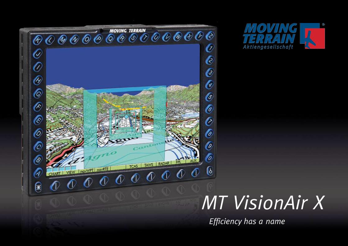
MT VisionAir X Efficiency has a name

Welcome message from author
This document is posted to help you gain knowledge. Please leave a comment to let me know what you think about it! Share it to your friends and learn new things together.
Transcript
�
MT VisionAir X Efficiency has a name

�
Moving TerrainQuality "Made in Germany" since 1993. Created for pilots by pilots.
The only Moving Map System on the
market, using original pilot charting
which can be expanded to the full IFR
range and as an EFB.
The MFD offers stand-alone and comple-
te redundancy in case of a total loss of
cockpit electronics.
Moving Terrain has the best resolution in
its class. The only ARINC slot unit (158mm
wide) with 1024 x 768 pixels.
Fully automatic routing system MT-Blitz-
Plan: IFR FPL directly from the aircraft.
The artificial horizon system (EFIS) that
does not require gyros or extra sensors.
MT Relief Dynamics: 3D terrain relief in
combination with original pilot charts. The
3D chart from the cockpit‘s perspective is
updated constantly via GPS.
High definition and satellite transmitted
radar pictures for Europe
MT Satellite Radar combined with original
pilot charts.
Pilot training for IFR and VFR purposes.
The system can display video and camera
images.
Content
The Moving Terrain AG . . . . . . . . . . . . . p. 2
MT VisionAir X . . . . . . . . . . . . . . . . . . . p. 4
Application . . . . . . . . . . . . . . . . . . . . . p. 6
Die X‘th series . . . . . . . . . . . . . . . . . . . . p. 8
The modular concept:
software and MFD modules . . . . . . . . p. 14
Passenger Entertainment &
Information System . . . . . . . . . . . . . . . p. 36
Accessories . . . . . . . . . . . . . . . . . . . . . p. 37
Original maps for our customers
all over the world . . . . . . . . . . . . . . . . p. 38
MT systems in use . . . . . . . . . . . . . . . . p. 39

�
Moving Terrain – the Aviation Center of Excellence
in the South of Germany
Charts and Nav DatabasesOwn chart format with flowing charts
worldwide in different scales.
Digital data is optimized by mathema-
tical processes, and intelligent storage
guarantees fast loading processes and
outstanding legibility.
Charts are digitized in-house and special
charts for particular customer demands
are available, too.
Quality assurance always by at least two
independent, qualified associates.
Manufacture and Quality Assurance
Quality assurance always by at least two
independent, qualified associates.
CertificationExtensive know-how of MT staff in avio-
nic certification.
New devices are designed from the outset
to conform to DO160 Environmental
Criteria.
Software DevelopmentAll software engineering is in-house and
guarantees independence and openness
for further development.
Some parts of programs are patent pro-
tected – also in USA – and the software
and device combinations such as
MT Satellite Radar and MT Relief Dyna-
mics have registered design protection.
Core competences in the sphere of faster
and 100% stable running self-engineered
multi-tasking processes.
Own chart standard for a globally compa-
tible format.
Equipment Development Since 1996 the design and development
of all MT devices have been performed
in-house.
Development in close cooperation with
specialists in the fields of software,
hardware and licensing who have been
associated with the company for many
years.
Thanks to the appropriate in-house ex-
pertise we are able to perform customi-
zed adaptations.
Due to our many years of experience with
procurement in the specialized supplier
market, we have comparatively fast and
reliable access to system components.
We check and optimize our resources
regularly.
In-Flight Testing„Pilots on staff“: design and ease of ope-
ration in the cockpit are critically tested
and perfected in practice.
All Master Systems and program modules
undergo extensive ground and in-flight
tests.
Support + DocumentationThe total know-how is available in-house
– all technical questions are answered
personally by qualified staff – in German,
English and French.
MarketingPresence at trade shows: original Master
Systems are exhibited in a realistic setting:
Moving Terrain which you can touch!
Many personal, longstanding contacts:
Satisfied customers of the first hour
remain loyal to our system, and their
good suggestions have contributed to the
quality of our products.
We maintain close and fruitful contact to
the leading LTBs.
�
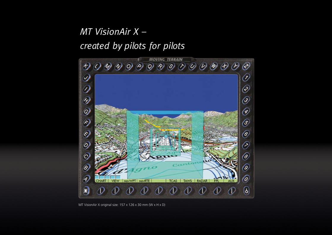
MT VisionAir X �
created by pilots for pilots
MT VisionAir X original size: 157 x 126 x 30 mm (W x H x D)
�
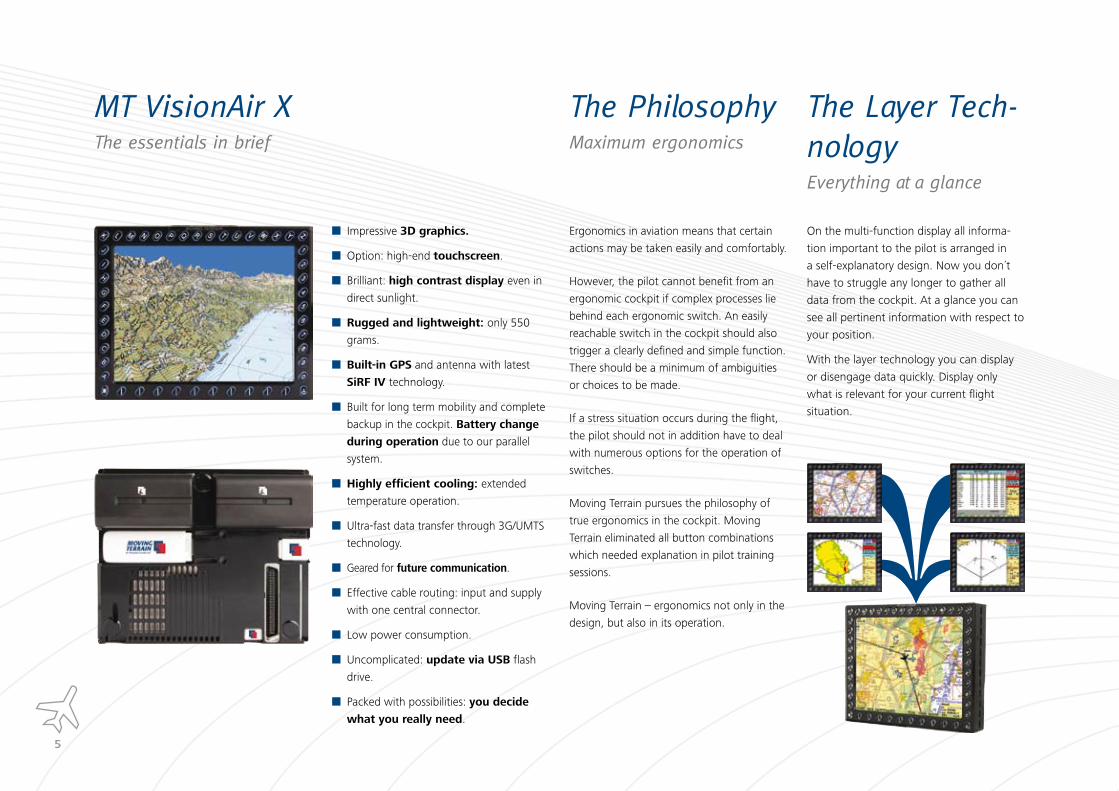
MT VisionAir XThe essentials in brief
Impressive �D graphics.
Option: high-end touchscreen.
Brilliant: high contrast display even in
direct sunlight.
Rugged and lightweight: only 550
grams.
Built-in GPS and antenna with latest
SiRF IV technology.
Built for long term mobility and complete
backup in the cockpit. Battery change
during operation due to our parallel
system.
Highly efficient cooling: extended
temperature operation.
Ultra-fast data transfer through 3G/UMTS
technology.
Geared for future communication.
Effective cable routing: input and supply
with one central connector.
Low power consumption.
Uncomplicated: update via USB flash
drive.
Packed with possibilities: you decide
what you really need.
The PhilosophyMaximum ergonomics
The Layer Tech-nologyEverything at a glance
Ergonomics in aviation means that certain
actions may be taken easily and comfortably.
However, the pilot cannot benefit from an
ergonomic cockpit if complex processes lie
behind each ergonomic switch. An easily
reachable switch in the cockpit should also
trigger a clearly defined and simple function.
There should be a minimum of ambiguities
or choices to be made.
If a stress situation occurs during the flight,
the pilot should not in addition have to deal
with numerous options for the operation of
switches.
Moving Terrain pursues the philosophy of
true ergonomics in the cockpit. Moving
Terrain eliminated all button combinations
which needed explanation in pilot training
sessions.
Moving Terrain – ergonomics not only in the
design, but also in its operation.
On the multi-function display all informa-
tion important to the pilot is arranged in
a self-explanatory design. Now you don´t
have to struggle any longer to gather all
data from the cockpit. At a glance you can
see all pertinent information with respect to
your position.
With the layer technology you can display
or disengage data quickly. Display only
what is relevant for your current flight
situation.
�
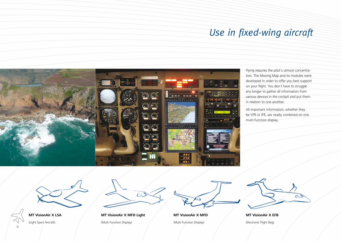
Use in fixed-wing aircraft
Flying requires the pilot‘s utmost concentra-
tion. The Moving Map and its modules were
developed in order to offer you best support
on your flight. You don´t have to struggle
any longer to gather all information from
various devices in the cockpit and put them
in relation to one another.
All important information, whether they
be VFR or IFR, are neatly combined on one
multi-function display.
MT VisionAir X EFB
(Electronic Flight Bag)
MT VisionAir X MFD
(Multi Function Display)
MT VisionAir X MFD Light
(Multi Function Display)
MT VisionAir X LSA
(Light Sport Aircraft)

�
Use in helicopters
Flying in unknown terrain, in busy airspace
or in bad visibility is supported to the opti-
mum level. Critical situations are immediately
visible on the multi-function display; the pilot
can react more quickly and avert hazards as
far as possible.
The visual connection “view from the cockpit
– perfectly positioned chart in the cockpit”
is immediate and facilitates orientation
significantly.
Maps for special requirements,
e.g. all helicopter landing
places in Germany. Contact us,
we will be pleased to advise
you.
Up-to-date and extensive
database of road names for
various areas. Particularly
suitable for rescue services.
Coloured icons on the maps
which highlight obstacles,
e.g. electricity poles. Special
displays, e.g. pipelines, are
possible.MT VisionAir X Heli Offshore
(Helicopter in offshore use)
MT VisionAir X Heli
(Helicopter)
�
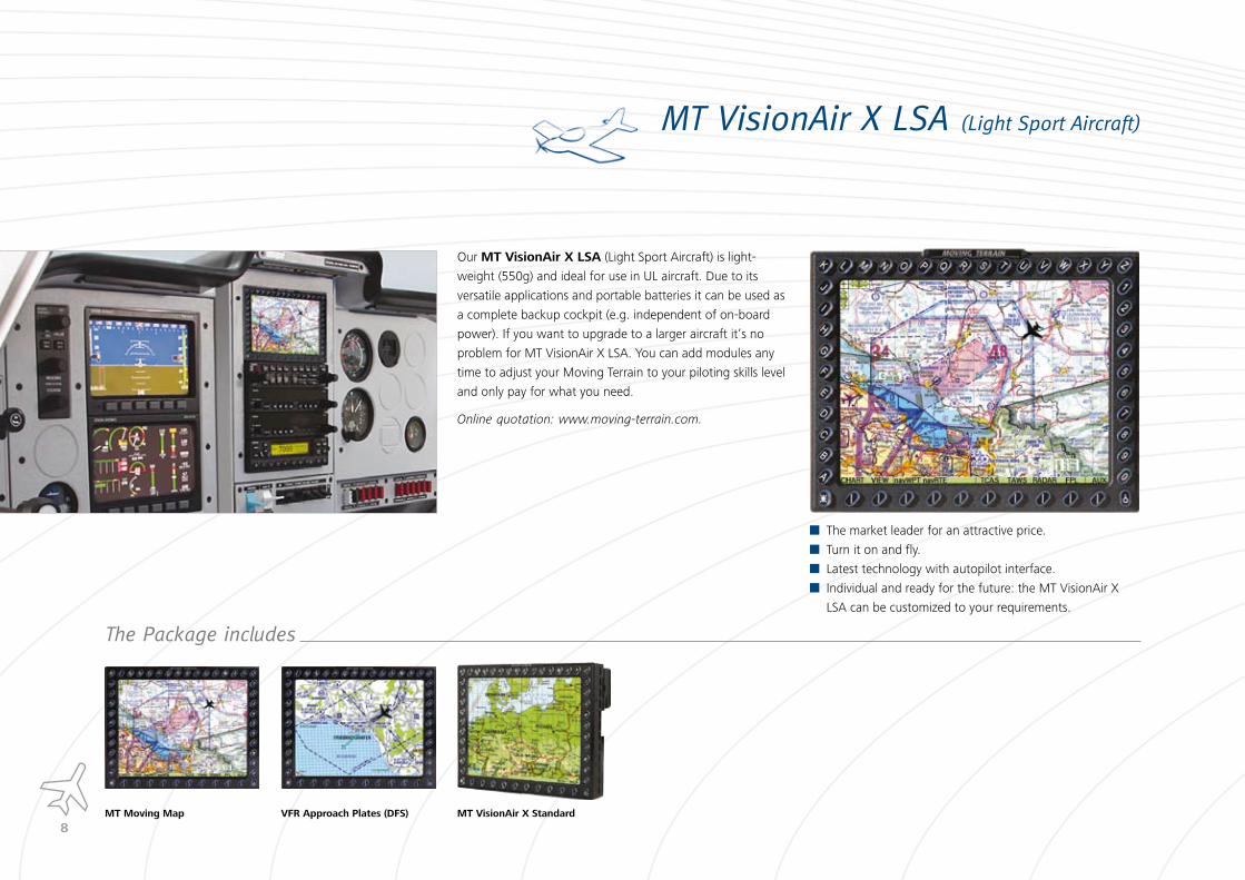
MT VisionAir X LSA (Light Sport Aircraft)
Our MT VisionAir X LSA (Light Sport Aircraft) is light-
weight (550g) and ideal for use in UL aircraft. Due to its
versatile applications and portable batteries it can be used as
a complete backup cockpit (e.g. independent of on-board
power). If you want to upgrade to a larger aircraft it‘s no
problem for MT VisionAir X LSA. You can add modules any
time to adjust your Moving Terrain to your piloting skills level
and only pay for what you need.
Online quotation: www.moving-terrain.com.
The market leader for an attractive price.
Turn it on and fly.
Latest technology with autopilot interface.
Individual and ready for the future: the MT VisionAir X
LSA can be customized to your requirements.
The Package includes
MT Moving Map VFR Approach Plates (DFS) MT VisionAir X Standard

�
MT VisionAir X MFD Light
MT VisionAir X MFD Light is the right choice for VFR
pilots who are also flying in difficult conditions.
With MT Relief Dynamics the familiar pilot charts are expan-
ded to the third dimension. This feature is not only impres-
sive with visual flight, it also makes orientation in unfamiliar
terrain or in bad visibility considerably easier.
The features integrated in the MFD Light Package are ideally
matched to the change from VFR to IFR, but they can also be
expanded and adapted any time. Modules can be retrofitted
simply whenever you want them.
Online quotation: www.moving-terrain.com.
Optimized VFR/IFR interface – proven technology priced
fairly.
Independence of onboard power – full backup system.
Individual configuration – you only pay for what you really
need.
The Package includes
MT Moving Map JeppView VFR Approach Charts MT Relief Dynamics MT VisionAir EP (Extended Performance) Easy Mount
�0
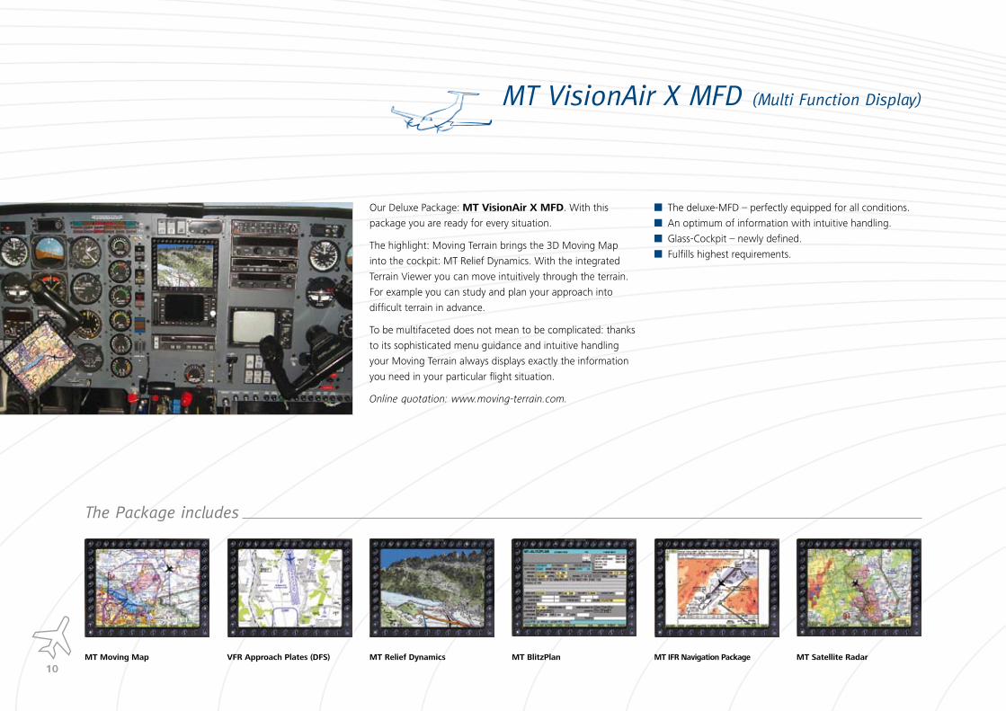
MT VisionAir X MFD (Multi Function Display)
Our Deluxe Package: MT VisionAir X MFD. With this
package you are ready for every situation.
The highlight: Moving Terrain brings the 3D Moving Map
into the cockpit: MT Relief Dynamics. With the integrated
Terrain Viewer you can move intuitively through the terrain.
For example you can study and plan your approach into
difficult terrain in advance.
To be multifaceted does not mean to be complicated: thanks
to its sophisticated menu guidance and intuitive handling
your Moving Terrain always displays exactly the information
you need in your particular flight situation.
Online quotation: www.moving-terrain.com.
The deluxe-MFD – perfectly equipped for all conditions.
An optimum of information with intuitive handling.
Glass-Cockpit – newly defined.
Fulfills highest requirements.
The Package includes
MT Moving Map VFR Approach Plates (DFS) MT Relief Dynamics MT BlitzPlan MT IFR Navigation Package MT Satellite Radar
��
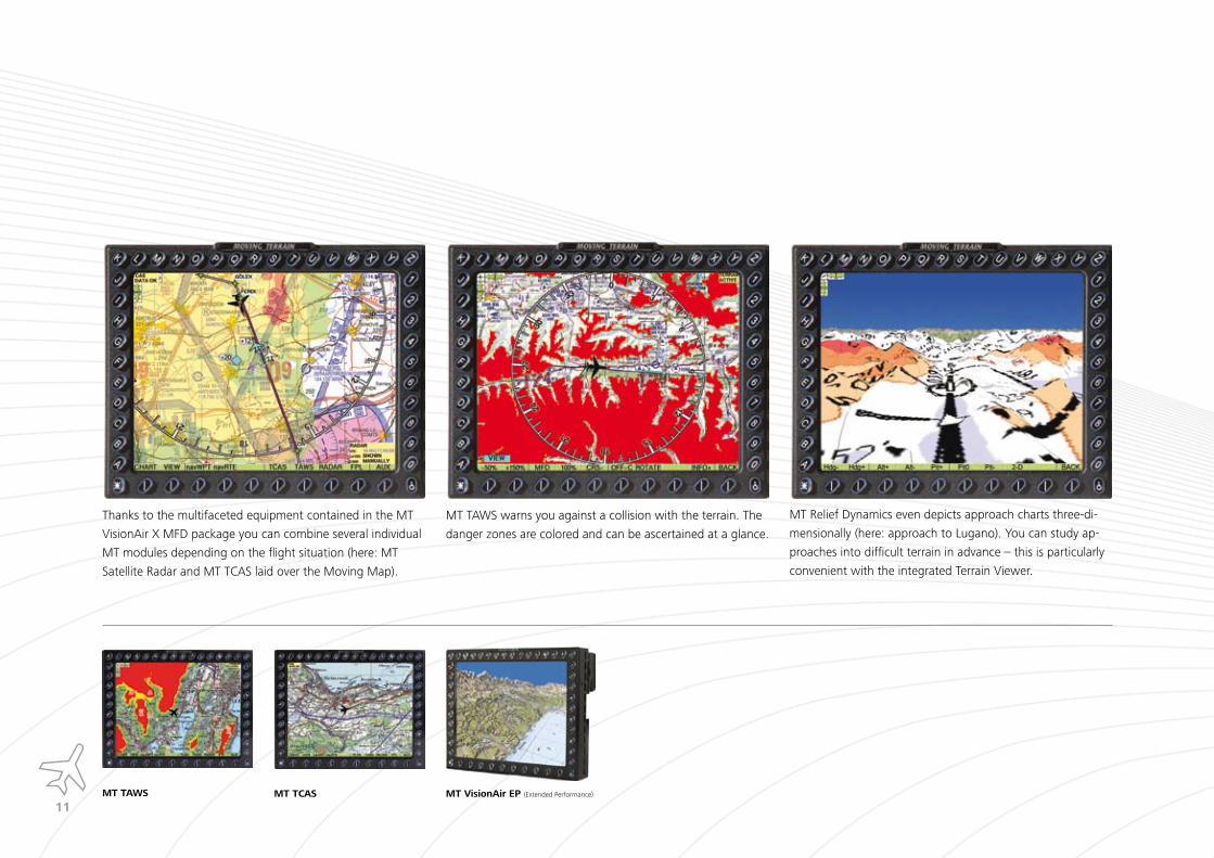
Thanks to the multifaceted equipment contained in the MT
VisionAir X MFD package you can combine several individual
MT modules depending on the flight situation (here: MT
Satellite Radar and MT TCAS laid over the Moving Map).
MT TAWS warns you against a collision with the terrain. The
danger zones are colored and can be ascertained at a glance.
MT Relief Dynamics even depicts approach charts three-di-
mensionally (here: approach to Lugano). You can study ap-
proaches into difficult terrain in advance – this is particularly
convenient with the integrated Terrain Viewer.
MT TAWS MT TCAS MT VisionAir EP (Extended Performance)
��
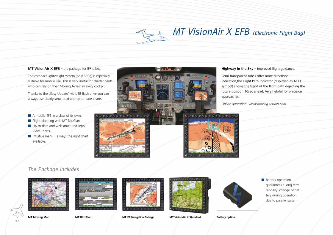
MT VisionAir X EFB (Electronic Flight Bag)
MT VisionAir X EFB – the package for IFR pilots.
The compact lightweight system (only 550g) is especially
suitable for mobile use. This is very useful for charter pilots
who can rely on their Moving Terrain in every cockpit.
Thanks to the „Easy Update“ via USB flash drive you can
always use clearly structured and up-to-date charts.
A mobile EFB in a class of its own.
Flight planning with MT-BlitzPlan
Up-to-date and well structured Jepp-
View Charts.
Intuitive menu – always the right chart
available.
The Package includes
MT Moving Map MT BlitzPlan MT IFR Navigation Package MT VisionAir X Standard Battery option
Highway in the Sky – improved flight guidance.
Semi-transparent tubes offer more directional
indication,the Flight Path Indicator (displayed as ACFT
symbol) shows the trend of the flight path depicting the
future position 10sec ahead. Very helpful for precision
approaches.
Online quotation: www.moving-terrain.com.
Battery operation
guarantees a long term
mobility: change of bat-
tery during operation
due to parallel system
��
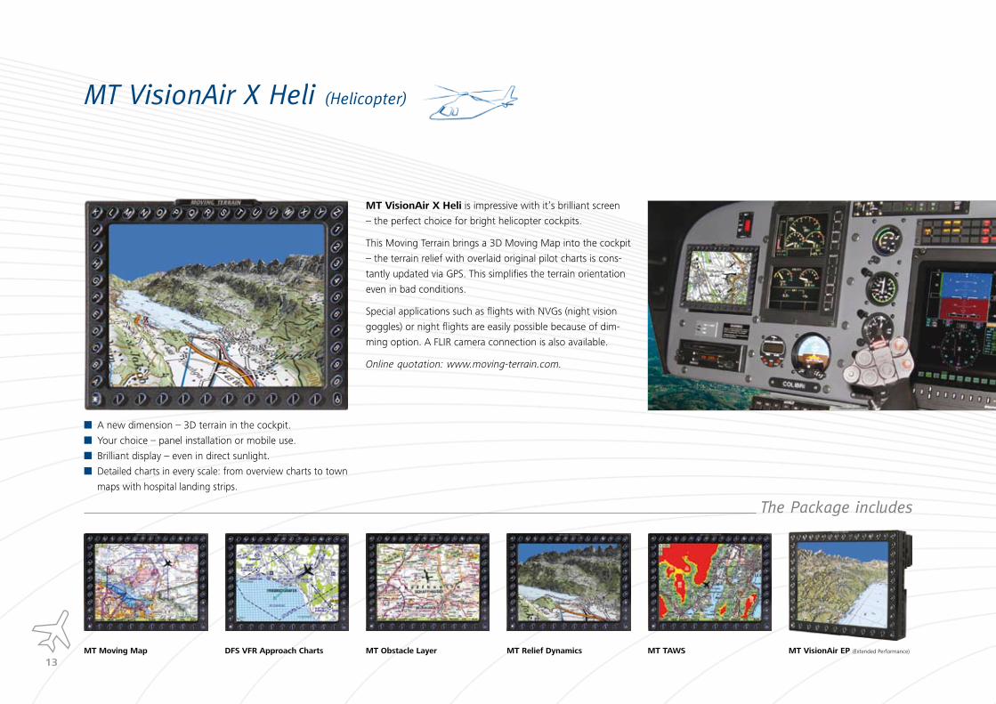
MT VisionAir X Heli (Helicopter)
MT VisionAir X Heli is impressive with it‘s brilliant screen
– the perfect choice for bright helicopter cockpits.
This Moving Terrain brings a 3D Moving Map into the cockpit
– the terrain relief with overlaid original pilot charts is cons-
tantly updated via GPS. This simplifies the terrain orientation
even in bad conditions.
Special applications such as flights with NVGs (night vision
goggles) or night flights are easily possible because of dim-
ming option. A FLIR camera connection is also available.
Online quotation: www.moving-terrain.com.
A new dimension – 3D terrain in the cockpit.
Your choice – panel installation or mobile use.
Brilliant display – even in direct sunlight.
Detailed charts in every scale: from overview charts to town
maps with hospital landing strips.
The Package includes
MT Moving Map MT Relief Dynamics MT VisionAir EP (Extended Performance)DFS VFR Approach Charts MT Obstacle Layer MT TAWS

��
The modular ConceptCombine individually, decide what you really need
Our ConceptCreates space in the panel.
Makes “scanning” in the cockpit easier
as everything that belongs together is
already superimposed on one MFD.
Individual combination, simple upgrades.
You only pay for components and func-
tions you really need.
MT Moving Mapincl. ICAO Chart Europe, VFR NavData (plus VFR
reporting points), MT Rotating Map function as
well as MT Track Recording & MT Logbook.
MT Relief Dynamics3D visualization from the cockpit‘s perspective:
terrain data textured with original pilot charts is
updated constantly via GPS.
MT Satellite RadarA realistic, high definition radar picture transmit-
ted via satellite directly into the cockpit without
onboard radar.
MT BlitzPlanReal time IFR flight planning in the cockpit with
preflight documentation: W&B, Fuel Calculation,
MET Briefing, NOTAMs and Flightlog.
MT IFR Complete Navigation Packagewith Electronic Flight Bag incl. Enroute Layer
Europe.
MT FMS (Flight Management System)Import of your route from MT-BlitzPlan at the push
of a button.
MT TAWSHigh definition warning system with vertical
profile and precise terrain data worldwide as
zoomable moving map.

��
MT TCASCollision warning: display of Avidyne signals with
indication of relative height and trend vector.
MT EFISElectronic Flight Information System: artificial
horizon without any gyros or sensors. The ultra
precise EGNOS-GPS data combined with MT DSS
technology is sufficient.
MT Stormscope (WX �00)Display of strikes in relation to the flight route in
the head- up mode with detection of lightning
and wind shears.
MT Track Recording and LogbookRecording the flight route allows a post-flight
review..
MT Autopilot InterfaceIn direct mode: flying a course line to destination.
In route mode: flying procedures and routes.
Smart interceptions without „overshoot“. * non-certified, for experimental use only
MT CameraDisplay of high quality camera pictures
(e.g. FLIR camera).
MT Obstacle LayerDisplay of obstacles with colored icons on the
map: power lines, cable cars and pipelines.

��
MT Relief DynamicsD Moving Map in the cockpitt
MT Relief Dynamics
High resolution terrain data, textured with
original flight charts.
See MT Relief Dynamics in comparison
with Walensee live shots from the cockpit:
www.moving-terrain.de.
Terrain Viewer: you can move very intuitively and individually in the terrain and change the perspectives as
required.Multifaceted depiction possibilities
Walensee (Switzer-land) chart: Swiss Topo, 1:50.000
Walensee (Switzer-land) chart: ICAO, 1:500.000
Kitzbühel (Austria)
chart: TFC, 1:250.000
Innsbruck (Austria) chart: JeppView Approach
3
Highway in the Sky
Improved flight guidance. Semi-transparent
tubes offer more directional indication,the
Flight Path Indicator (displayed as ACFT
symbol) shows the trend of the flight path
depicting the future position 10sec ahead.
��
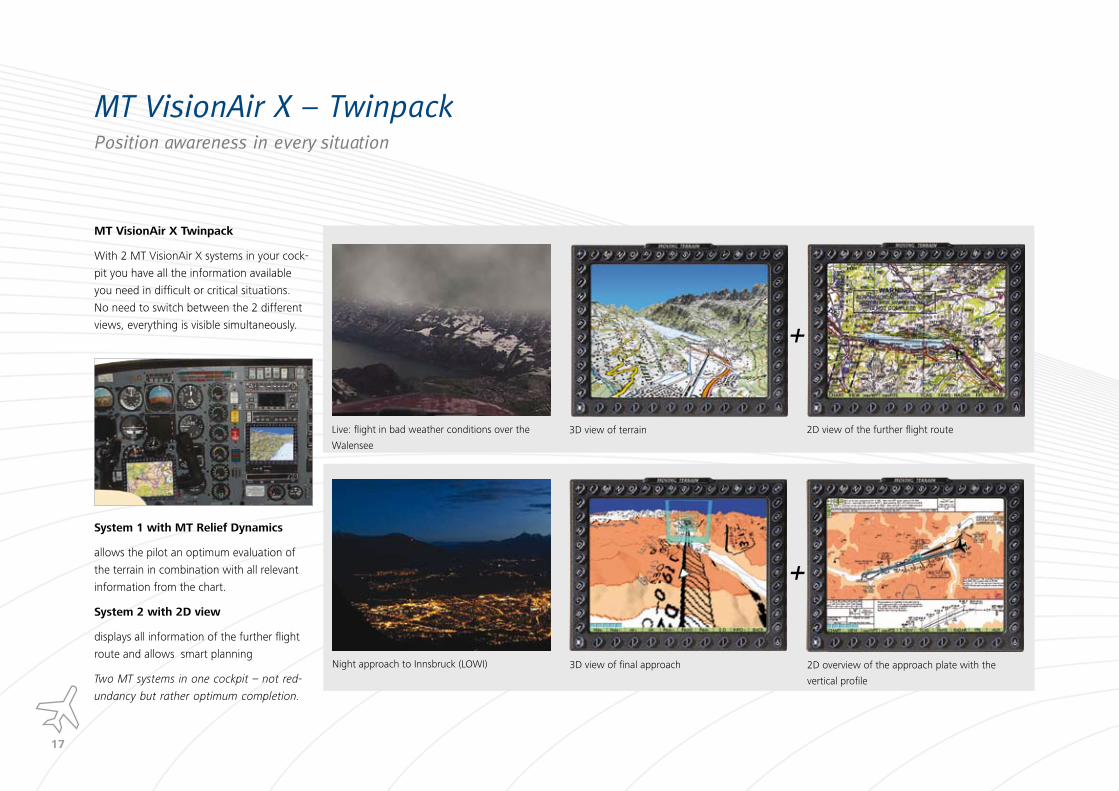
MT VisionAir X � TwinpackPosition awareness in every situation
MT VisionAir X Twinpack
With 2 MT VisionAir X systems in your cock-
pit you have all the information available
you need in difficult or critical situations.
No need to switch between the 2 different
views, everything is visible simultaneously.
System � with MT Relief Dynamics
allows the pilot an optimum evaluation of
the terrain in combination with all relevant
information from the chart.
System � with �D view
displays all information of the further flight
route and allows smart planning
Two MT systems in one cockpit – not red-
undancy but rather optimum completion.
+
Live: flight in bad weather conditions over the
Walensee
3D view of terrain 2D view of the further flight route
+
Night approach to Innsbruck (LOWI) 3D view of final approach 2D overview of the approach plate with the
vertical profile
��
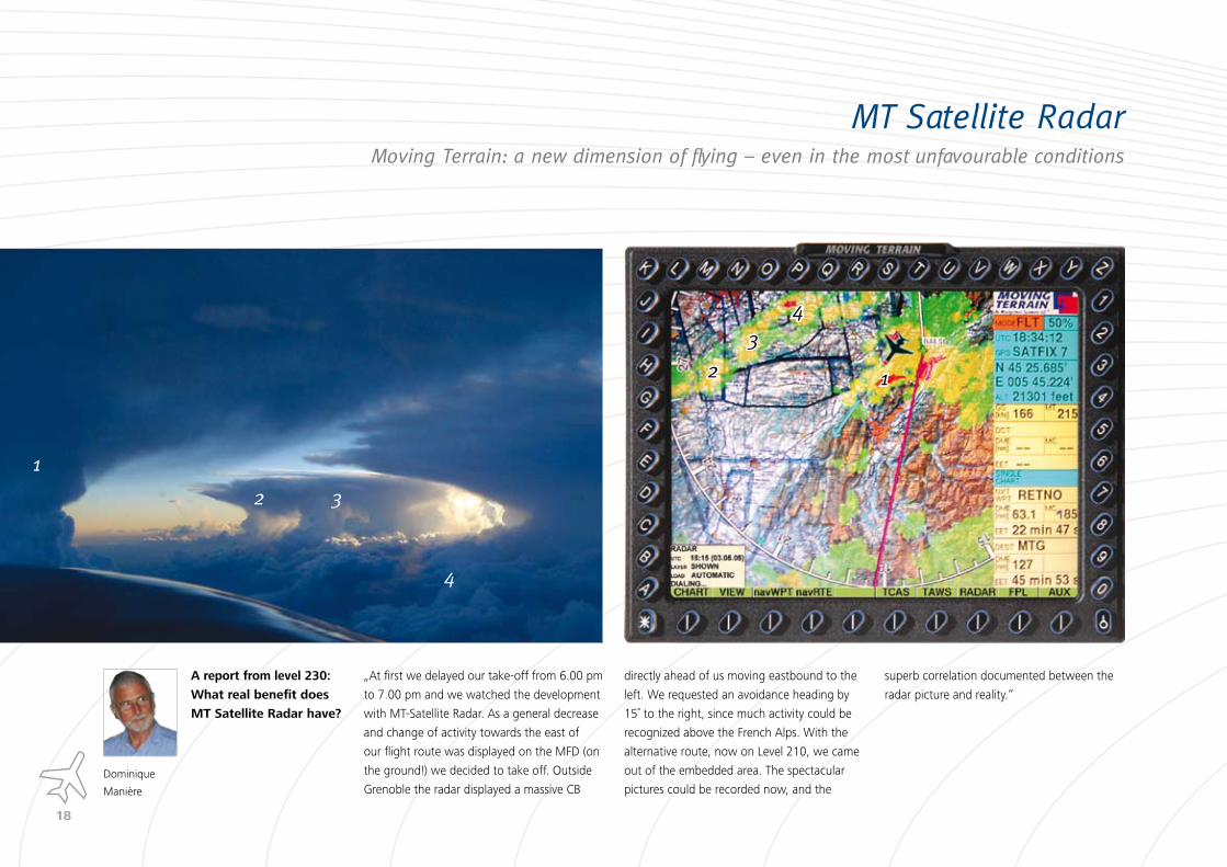
MT Satellite RadarMoving Terrain: a new dimension of flying – even in the most unfavourable conditions
12
3
4
1
2 3
4
A report from level ��0:
What real benefit does
MT Satellite Radar have?
Dominique
Manière
„At first we delayed our take-off from 6.00 pm
to 7.00 pm and we watched the development
with MT-Satellite Radar. As a general decrease
and change of activity towards the east of
our flight route was displayed on the MFD (on
the ground!) we decided to take off. Outside
Grenoble the radar displayed a massive CB
directly ahead of us moving eastbound to the
left. We requested an avoidance heading by
15˚ to the right, since much activity could be
recognized above the French Alps. With the
alternative route, now on Level 210, we came
out of the embedded area. The spectacular
pictures could be recorded now, and the
superb correlation documented between the
radar picture and reality.“
��
A realistic satellite transmitted radar picture directly into the cockpit‘s MFD
Flying with MT Satellite Radar
Seamless meteorological information in
excellent quality before and during flight
allows intelligent variations of possible flight
routes and takeoff times between or after
moving fronts or squall lines. An accurate
assessment before and any time in flight en-
sures safety. Many flights would be too risky
without this information. The new dimen-
sion replaces the uncertainty that appears
between pre-flight WX briefing and the
conventional use of onboard radar in-flight.
How does MT Satellite Radar work?
Imaging of raw data of the DWD (German
Met Office): the ground-based meteorologi-
cal radar (precipitation echo) of the Europe-
an network of radar systems for the central
European region. By linking many
radar stations on the ground you
will receive radar images not only as
viewed from a single onboard radar,
but a full representation along the entire
flight route without blanked-out areas. Con-
tinuously updated information is downloa-
ded via satellite modem to the MT-VisionAir,
ensuring uninterrupted monitoring of the
meteorological situation. The radar picture
along the proposed route can already be
checked on the ground, in detail or as a
summary for the entire route.
Preflight Radar Briefing via GSM
On the ground the use of ordinary GSM
phones (Global System for Mobile Com-
munication) or 3G modems is possible for
downloading meteorological data. Moving
Terrain recommends the in-flight use of
satellite modems instead of GSM to provide
area coverage independent of altitude.
Telephoning during flight
With the satellite telephone and the safety
cell amplifier using the telephone during the
flight is easily possible. The coverage is all-
encompassing and independent of height.
See page 37 for more information.
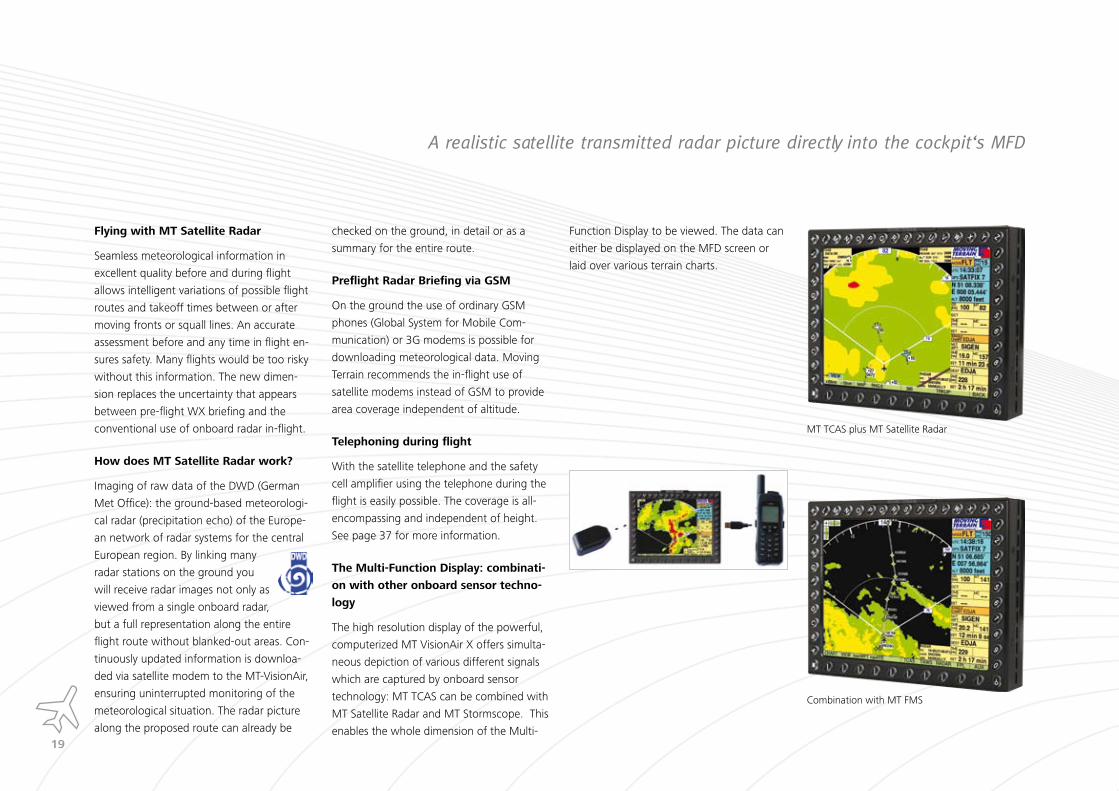
The Multi-Function Display: combinati-
on with other onboard sensor techno-
logy
The high resolution display of the powerful,
computerized MT VisionAir X offers simulta-
neous depiction of various different signals
which are captured by onboard sensor
technology: MT TCAS can be combined with
MT Satellite Radar and MT Stormscope. This
enables the whole dimension of the Multi-
Function Display to be viewed. The data can
either be displayed on the MFD screen or
laid over various terrain charts.
MT TCAS plus MT Satellite Radar
Combination with MT FMS
�0
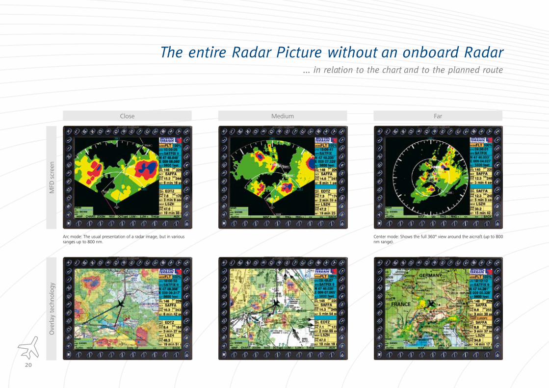
The entire Radar Picture without an onboard Radar... in relation to the chart and to the planned route
Close Medium Far
MFD
scr
een
Ove
rlay
tech
nolo
gy
Arc mode: The usual presentation of a radar image, but in various ranges up to 800 nm.
Center mode: Shows the full 360° view around the aicrraft (up to 800 nm range).
��
Automatic updates every �� minutes
Once initialized, the system runs automa-
tically: It connects every 15 minutes – the
dialing process requires no action on the
part of the pilot. After downloading the data
the connection is released automatically
- ensuring that costs are kept to an absolute
minimum.
History Function
The radar images are stored chronological-
ly and can be scrolled through. This gives
the option of monitoring clearly presented
meteorological data over long periods. This
increases the chances of accurate prediction
of cell motion effectively.
The Radar Picture on the MFD (e.g. for IFR flights)
The distinct advantage compared to ordinary
radar systems: CB lines represent an impe-
netrable “wall” for on-board radar. With
MT Satellite Radar an omni-directional radar
detection is possible. The real geometry of
rain, snow or thunder clouds is read and
presented.
Radar information on top of the Terrain
Map
The semi-transparent overlay of the radar
picture on charts of any type and scale
enables simultaneous use of the moving
map and radar images. At a glance the radar
situation can be seen in a correct relation
to the present position of the aircraft. This
representation is suitable for VFR flights and
helicopters, especially for a safe passage
through mountainous areas.
Assessment en route on the Europe Chart
Since the radar data has been fully availa-
ble wide-ranging, the radar picture can be
depicted large-scaled on a chart along the
planned flight route.
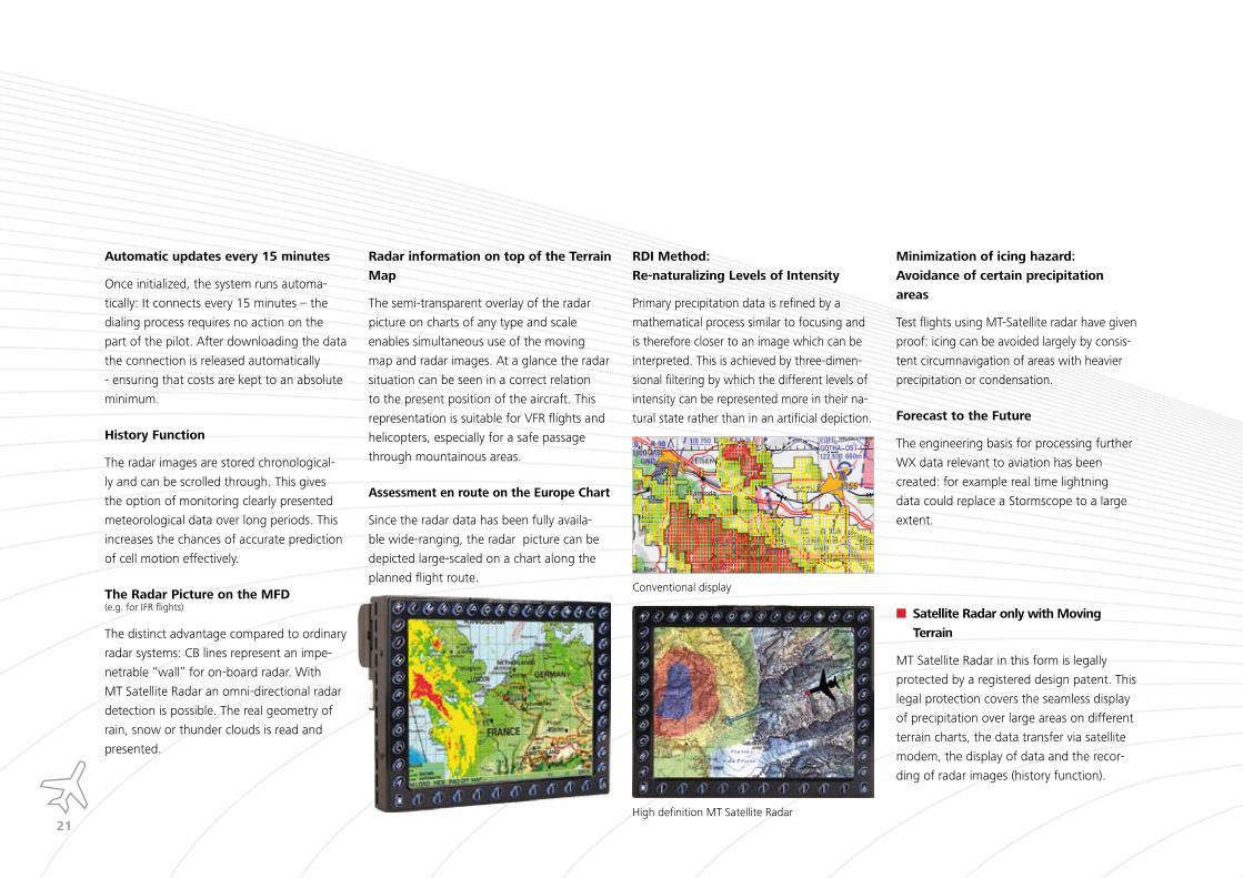
RDI Method:
Re-naturalizing Levels of Intensity
Primary precipitation data is refined by a
mathematical process similar to focusing and
is therefore closer to an image which can be
interpreted. This is achieved by three-dimen-
sional filtering by which the different levels of
intensity can be represented more in their na-
tural state rather than in an artificial depiction.
Minimization of icing hazard:
Avoidance of certain precipitation
areas
Test flights using MT-Satellite radar have given
proof: icing can be avoided largely by consis-
tent circumnavigation of areas with heavier
precipitation or condensation.
Forecast to the Future
The engineering basis for processing further
WX data relevant to aviation has been
created: for example real time lightning
data could replace a Stormscope to a large
extent.
Satellite Radar only with Moving
Terrain
MT Satellite Radar in this form is legally
protected by a registered design patent. This
legal protection covers the seamless display
of precipitation over large areas on different
terrain charts, the data transfer via satellite
modem, the display of data and the recor-
ding of radar images (history function).
Conventional display
High definition MT Satellite Radar

��
MT BlitzPlan... Board and fly with a valid flightplan
„Board and fly with a valid IFR flightplan. This is no longer a hope, this is now a product.“
(Pilot und Flugzeug, 05/2006)
With MT-BlitzPlan from Moving Terrain you
work out your flightplan in the aircraft and
activate it – while starting up or if necessary
even when being airborne. From the de-
cision to fly it takes two minutes to the
actual startup. „Start up and Fly“ – in the
world of flying this is unique.
�00% valid and CFMU compliant
routings which can not be rejected.
Enormous time saving – no waiting
times.
Flightplan is filed in a flash and is
immediately available to the tower
and control sectors concerned. No
investigation for AIS numbers or commu-
nication methods (telephone, fax, e-mail).
Marginal costs for guaranteed
correct routings. No AIS charges for
flightplans filed abroad.
Connection to the MT server and
Eurocontrol via GSM or satellite.
Flightplan and routings are sent to the
pilot by e-mail and SMS.
No external routing program re-
quired.
RAD and CDR do not have to be
considered anymore.

��
�. Planning:
Input of data highlighted in yellow
�. Flightplan submission:
No waiting time, instant activation of the 100% valid and CFMU compliant route
�. Input of the route into the FMS:
Transfer of the routing to the MT FMS at the touch of a button.
MT-BlitzPlan Features
Flightplan archive.
Multi- aircraft licence.
Visualization of the routing on the map
Complete IFR pre-flight documentation
with W&B, Fuel Calculation, METAR/TAF
and NOTAMs for DEP, DEST and ALT.
Professional dial up server for up to 10
simultaneous connections.
Visualized (colored) flightplan status.
Eurocontrol and SLOT messages.
Adaption of the route to your needs by
optional Pickup Point, Inflight Entry or
Forced Overfly Point.
Flightplan Submission two Minutes before takeoff � how does it work?
1. Input of flightplan data:
Load a preset and enter seven
relevant pieces of data.
2. MT BlitzPlan finds a valid route
allowing for CDR and RAD.
3. The route is instantly shown
on a map and programmed into the
FMS. The flightplan can be activa-
ted immediately.
4. The flightplan is immediately
available for the tower and all
sector controllers concerned.
5. Ready to take off in � minutes..

��
The entire IFR Preflight DocumentationPaperless or printed
Full automa-tic routing
Passenger manifest & familiarisation
Instant flight-plan activation
Full professional flightlog
Weight & Balance with graphics
Fuel calculation and ACFT performance
METAR / TAF
SLOT manage-ment: SLOTS via SMS
NOTAMS for DEP, DEST, ALT and enroute
INSTA
NTLY AIRBORNE
��
MT-BlitzPlan and the Ramp Check
All calculations and documentation for IFR
flight planning are visible in the aircraft and
can be verified clearly.
The whole system from one supplier:
MT-BlitzPlan is the only flight planning pro-
gram with fully automatic route generation
which also covers all aspects of the flight
plan documentation at the same time.
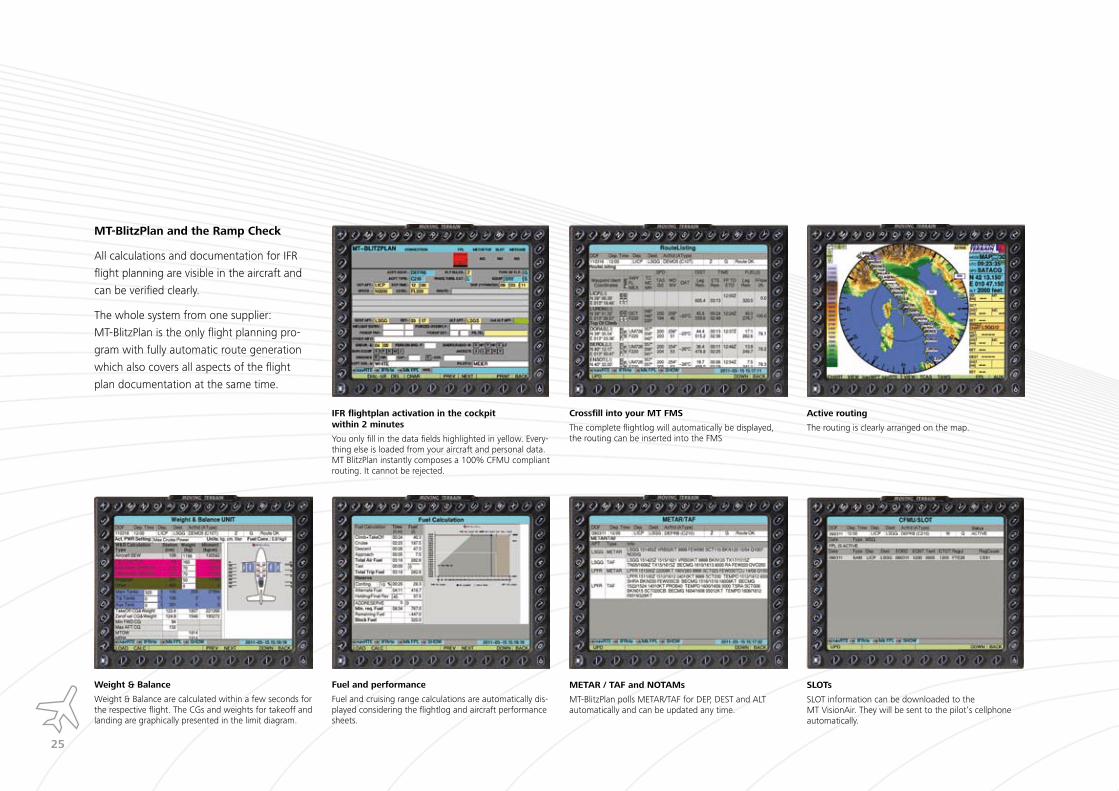
IFR flightplan activation in the cockpit within � minutes
You only fill in the data fields highlighted in yellow. Every-thing else is loaded from your aircraft and personal data. MT BlitzPlan instantly composes a 100% CFMU compliant routing. It cannot be rejected.
Crossfill into your MT FMS
The complete flightlog will automatically be displayed, the routing can be inserted into the FMS
Active routing
The routing is clearly arranged on the map.
Weight & Balance
Weight & Balance are calculated within a few seconds for the respective flight. The CGs and weights for takeoff and landing are graphically presented in the limit diagram.
Fuel and performance
Fuel and cruising range calculations are automatically dis-played considering the flightlog and aircraft performance sheets.
METAR / TAF and NOTAMs
MT-BlitzPlan polls METAR/TAF for DEP, DEST and ALT automatically and can be updated any time.
SLOTs
SLOT information can be downloaded to the MT VisionAir. They will be sent to the pilot‘s cellphone automatically.

��
MT IFR Navigation Package
FMS
All waypoints of a routing with detailed
information are listed. In combination with
MT-BlitzPlan automatically generated rou-
tings are filled into MT FMS at the touch of
a button.
Electronic Flight Bag
Always there: cleanly structured and always
up-to-date JeppView charts. With these you
are location-independent, able to plan your
route everywhere and print the charts if
required.
Enroute Layers and Charts
The enroute airways are available in a dedi-
cated mode without further information and
can be zoomed as desired. In addition – and
this is the most interesting combination
– they can be laid over any other chart. With
this option every chart can be enhanced to
an enroute or airway chart. Ideal for VFR fly-
ing, which requires more and more waypoint
navigation, especially in South Eastern and
Northern Europe.
��
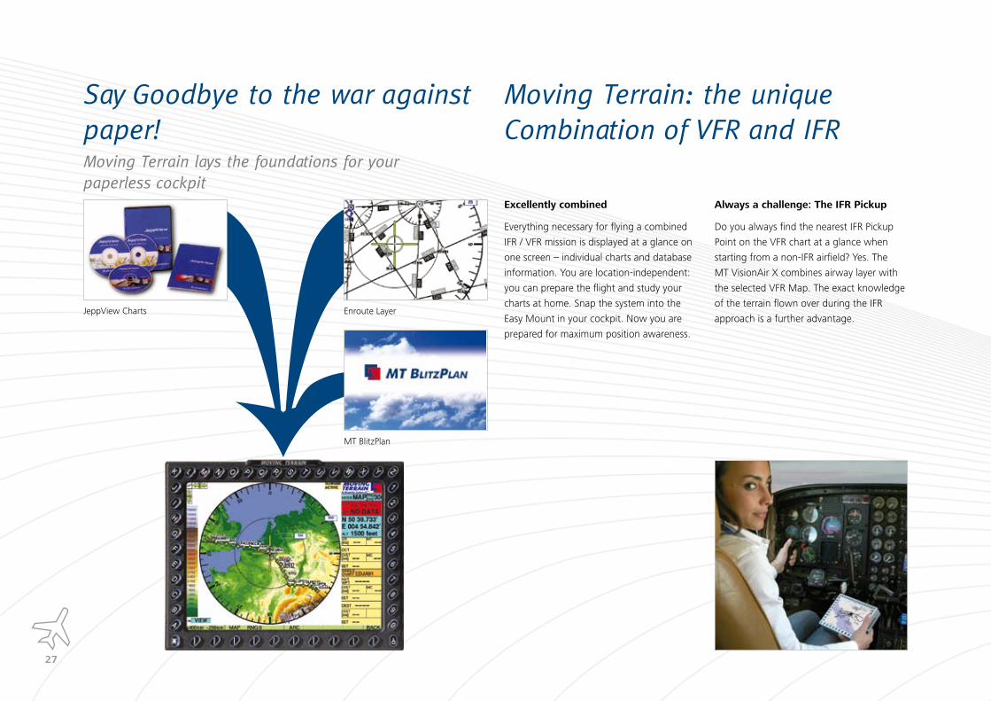
Say Goodbye to the war against paper!Moving Terrain lays the foundations for your paperless cockpit
Enroute Layer
MT BlitzPlan
JeppView Charts
Moving Terrain: the unique Combination of VFR and IFR
Excellently combined
Everything necessary for flying a combined
IFR / VFR mission is displayed at a glance on
one screen – individual charts and database
information. You are location-independent:
you can prepare the flight and study your
charts at home. Snap the system into the
Easy Mount in your cockpit. Now you are
prepared for maximum position awareness.
Always a challenge: The IFR Pickup
Do you always find the nearest IFR Pickup
Point on the VFR chart at a glance when
starting from a non-IFR airfield? Yes. The
MT VisionAir X combines airway layer with
the selected VFR Map. The exact knowledge
of the terrain flown over during the IFR
approach is a further advantage.

��
The mobile EFBQuickly stowed, quickly operational
Small, manageable and compact – yet all the important information
you need for an IFR-flight. The EFB can be used mobile for maximum
flexibility.
Your Advantages
The paperless cockpit is possible.
All JeppView charts are always with you, immediately available
and properly sorted
Your reliabe companion
Flight planning with MT-BlitzPlan at the push of a button.
Battery operation guarantees a long term mobility: change of
battery during operation due to parallel system.
Uncomplicated updates via USB flash drive.
Significant reduction of preflight effort and time.
��
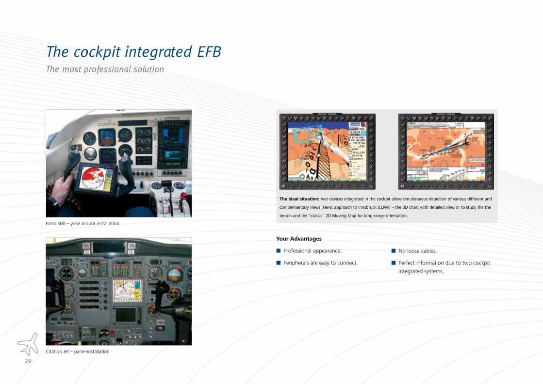
The cockpit integrated EFBThe most professional solution
Extra 500 – yoke mount installation
Citation Jet – panel-installation
The ideal situation: two devices integrated in the cockpit allow simultaneous depiction of various different and
complementary views. Here: approach to Innsbruck (LOWI) – the 3D chart with detailed view or to study the the
terrain and the “classic” 2D Moving Map for long-range orientation.
Your Advantages
Professional appearance.
Peripherals are easy to connect.
No loose cables.
Perfect information due to two cockpit
integrated systems.

�0
MT TAWS (Terrain Alert and Warning System)
Flying safely in mountainous terrain
High resolution terrain data warns against
the danger of a collision – clear and color
coded. The reconciliation of two indepen-
dent databases guarantees very precise
terrain information. Based on this data the
terrain which is assessed as a hazard is high-
lighted in color on the Moving Map, while at
the same time the data provides the basis for
the digital terrain model. The visualisation
of large lakes and rivers makes orientation
easier and ensures that your precise position
is ascertained.
MT TAWS – for a safe arrival at your desti-
nation
Dead End?
Climb Gradient?
Unknown Terrain?

��
MT TAWS: color coded warning against
terrain collision
The own flight altitude is continuously
compared with the digital terrain model: if
during descent or a low level flight the ter-
rain is approached, the color code indicates
higher elevated terrain. The 3 colors red
– amber – green explain the proximity levels
intuitively. Any possible “dead ends” are
visible at a glance before the return option
is gone.
Individual Configuration of Altitude
Levels
The altitude or proximity levels can be
configured individually. You decide which
proximity should be colored and displayed as
a hazard for your operation. Thus you see a
maximum amount of chart and you are still
informed about terrain hazards.
The Digital Terrain Model
The terrain model is based on very precise
data: the resolution is up to 1 m for height
and up to 50 m for the lateral dimension.
The conventional resolution is 900 m (0,5
nm).
Detailed Terrain even without a chart
MT TAWS database can be used to generate
an artificial terrain map. The analysis of the
terrain structure is possible with the display
of elevation using intuitively recognizable co-
lors. As terrain data from all over the world
is available this module offers the possibility
to have precise terrain maps even for very
remote areas – always an option if the parti-
cular chart is difficult to acquire.
With the optional high-end touchscreen you
can navigate quickly and simply to any point
on earth.
Illustration of the terrain considered as danger laid
over the basic map.
Display of the “dedicated mode”, in the „arc
mode“ or in the „360°“ mode. The vertical profile
analyses the future flight route regarding one‘s
own altitude.
The visualization of waterbodies provides a better
orientation and position awareness.
More Safety through an increased
sampling rate
Displayed height on
MT system
Highest point within
the domain Conventional
displayed
height
Height of the
center
point
within
the domain
��
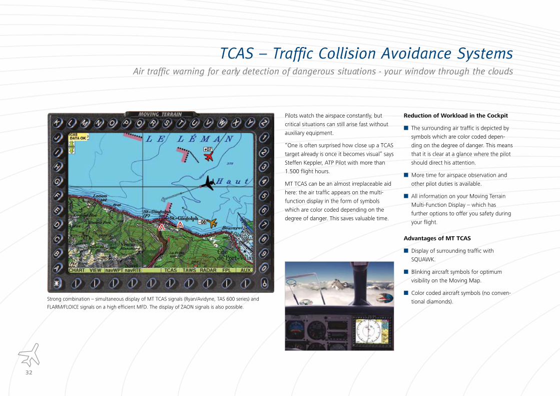
TCAS � Traffic Collision Avoidance SystemsAir traffic warning for early detection of dangerous situations - your window through the clouds
Strong combination – simultaneous display of MT TCAS signals (Ryan/Avidyne, TAS 600 series) and
FLARM/FLOICE signals on a high efficient MFD. The display of ZAON signals is also possible.
Pilots watch the airspace constantly, but
critical situations can still arise fast without
auxiliary equipment.
“One is often surprised how close up a TCAS
target already is once it becomes visual” says
Steffen Keppler, ATP Pilot with more than
1.500 flight hours.
MT TCAS can be an almost irreplaceable aid
here: the air traffic appears on the multi-
function display in the form of symbols
which are color coded depending on the
degree of danger. This saves valuable time.
Reduction of Workload in the Cockpit
The surrounding air traffic is depicted by
symbols which are color coded depen-
ding on the degree of danger. This means
that it is clear at a glance where the pilot
should direct his attention.
More time for airspace observation and
other pilot duties is available.
All information on your Moving Terrain
Multi-Function Display – which has
further options to offer you safety during
your flight.
Advantages of MT TCAS
Display of surrounding traffic with
SQUAWK.
Blinking aircraft symbols for optimum
visibility on the Moving Map.
Color coded aircraft symbols (no conven-
tional diamonds).

��
The „Critical Cylinder“ – your Wall of
Safety
Higher than your aircraft (and than
the “critical cylinder”).
Within the “critical cylinder”, dis-
tance and direction outside the
danger zone.
Within the “critical cylinder”, dan-
gerously close.
Lower than your aircraft ( and than
the “critical cylinder”).
The MT DSS Technology: Simulation of
Direction and Trend
Traffic Collision Avoidance Systems with
Dynamic Synchronous Simulation (DSS).
As a target is located in the area a simula-
tor is activated, the traffic‘s performance
is analyzed and the simulator is calibrated
accordingly. The motion of the aircraft
is extracted from that simulation and
immediately visualized. Thus the pilot is
able to recognize speed, direction and
the resulting threat at a glance on the MT
MFD.
Each aircraft is recognized individually by
the simulator and separately charted by
the MT software. This gives a transparent
picture of the surrounding air traffic.
Display of:
– Approach speed
– Flight direction
– Relative height in relation to the own
aircraft
– Trend (climb and descend rate)
Visualization of the traffic
Dedicated (without chart)
Blinking symbols: optimum visibility – es-
pecially on the Moving Map.
Indication of relative height with regard
to to your own aircraft (in 100 ft).
Red arrow: climbs / descends faster than
500 fpm.
The speed vector: plots 15 seconds ahead
and allows conclusions on the category of
the aircraft.
Laid over the Moving Map
The air traffic is seen in relation to the
terrain and thus a fast identification is
possible - much faster than “your traffic is
10 o‘clock, 3 miles”.
The pilot is alerted to oncoming traffic
while he is busy with flying duties.

��
MT EFISA Horizon without Gyros and Sensors - the ideal Backup
What is MT EFIS?
MT EFIS (Electronic Flight Information
System) displays an artificial horizon without
using any gyroscopes and additional sensors.
The exact WAAS/EGNOS GPS data in combi-
nation with the Dynamic Synchronous Simu-
lator (DSS) technology developed by Moving
Terrain are sufficient to reverse compute the
attitude from the flightpath. Impossible?
Check yourself!
Application
MT-EFIS may be used as a stand-by
horizon for the conventional on-board
system. Added safety in case of failure
of the onboard instruments or unsteady
horizon.
With MT EFIS even ultra-light aircraft have
the opportunity to upgrade cost-effec-
tively.
Limitations: – In the post-stall area. – In strong crosswinds and low true air speed (e.g. helicopter). – In yawing motion (e.g. engine failure on twin aircraft). – Non-certified, for information only.
All additional information at a glance
Horizon / Attitude.
Altitude (True).
Climb and descent rate.
QNH determination.
Angle of Attack (AOA).
Flight Path Angle.
Track (Magnetic).
Groundspeed.
Speed trend in 10 seconds.
Rate of turn.
Angle Of Attack (AOA)
Avoids stalls by visualizing the angle of
attack. Particularly when flying in unknown
terrain or in tight turns you are warned at a
glance before any loss of ascending force.
Flight Path Angle
This display illustrates the real flight path.
Climb and descent behaviour are displayed
clearly and obviously.
Digital Radar Altitude (DRA)
The Digital Radar Altitude (DRA) displays
the relative height of your aircraft based on
the digital terrain model. The visualization is
similar to a rising runway.
Inflight QNH
New: board-autonomous QNH determi-
nation for the overflown territory through
specifying the true altitude via the precision
WAAS/EGNOS GPS.
��
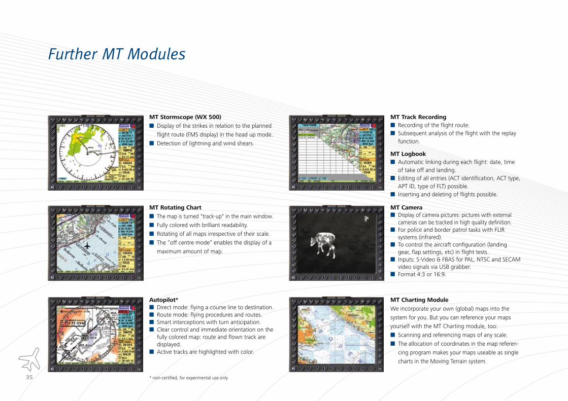
Further MT Modules
MT Stormscope (WX �00)
Display of the strikes in relation to the planned
flight route (FMS display) in the head up mode.
Detection of lightning and wind shears.
MT Rotating Chart
The map is turned "track-up" in the main window.
Fully colored with brilliant readability.
Rotating of all maps irrespective of their scale.
The “off centre mode” enables the display of a
maximum amount of map.
Autopilot*Direct mode: flying a course line to destination.Route mode: flying procedures and routes. Smart interceptions with turn anticipation.Clear control and immediate orientation on the fully colored map: route and flown track are displayed.Active tracks are highlighted with color.
* non-certified, for experimental use only
MT Track RecordingRecording of the flight route.Subsequent analysis of the flight with the replay function.
MT LogbookAutomatic linking during each flight: date, time of take off and landing. Editing of all entries (ACT identification, ACT type, APT ID, type of FLT) possible.Inserting and deleting of flights possible.
MT CameraDisplay of camera pictures: pictures with external cameras can be tracked in high quality definition.For police and border patrol tasks with FLIR systems (infrared).To control the aircraft configuration (landing gear, flap settings, etc) in flight tests.Inputs: S-Video & FBAS for PAL, NTSC and SECAM video signals via USB grabber. Format 4:3 or 16:9.
MT Charting Module
We incorporate your own (global) maps into the
system for you. But you can reference your maps
yourself with the MT Charting module, too:
Scanning and referencing maps of any scale.
The allocation of coordinates in the map referen-
cing program makes your maps useable as single
charts in the Moving Terrain system.

��
Passenger Entertainment & Information SystemThe Better Airshow
Features
Huge viewing angle of 85° each side.
Automatic detection of PAL / NTCS / SECAM signals.
Light weight: 870 grams.
Hidden connector outlets for simple mounting.
Easy to install with quick snap.
Technical Data
Inputs: Composite Video (e.g. Apple ipod, DVD), S-Video
(e.g. FLIR camera), DVI (e.g. notebook), VGA (e.g.
MT-VisionAir).
Native High Resolution: 1024 x 768 Pixel.
Size: 10.4“ Display.
Dimensions (W x H x D): 228mm x 181mm x 12mm, full
installation depth: 30mm.
Power: 24/28V, 18W.
g load: 10 g in x, y, z direction, rugged aircraft design.
Full package including quick release wall mount system.
DO ��0 certified.
The right system for every
size of business aircraft.
Cabin bulkhead or tray table
installations allow conveni-
ent and versatile viewing of
DVDs, Apple iPod, videos or
camera signals.
Worldwide passenger
information charts provide
instant orientation for VIP
passengers.
Observation System
Cockpit repeater function and camera input for observation
purposes.
��
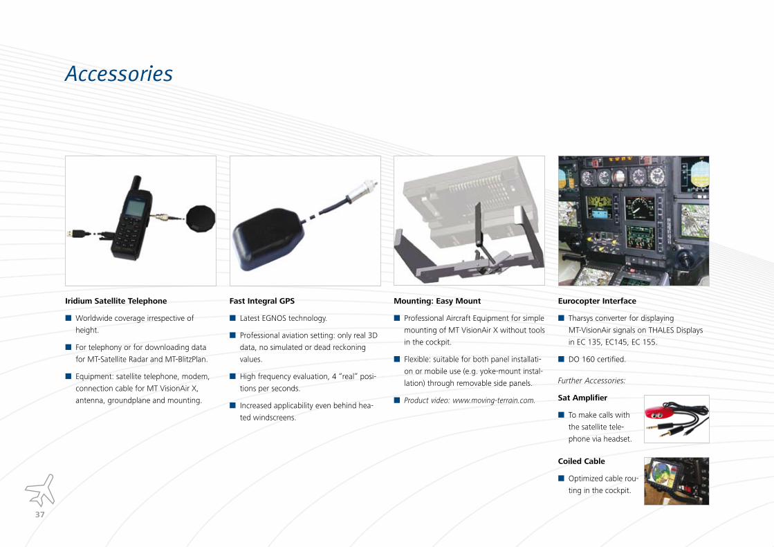
Further Accessories:
Sat Amplifier
To make calls with
the satellite tele-
phone via headset.
Coiled Cable
Optimized cable rou-
ting in the cockpit.
Accessories
Iridium Satellite Telephone
Worldwide coverage irrespective of
height.
For telephony or for downloading data
for MT-Satellite Radar and MT-BlitzPlan.
Equipment: satellite telephone, modem,
connection cable for MT VisionAir X,
antenna, groundplane and mounting.
Fast Integral GPS
Latest EGNOS technology.
Professional aviation setting: only real 3D
data, no simulated or dead reckoning
values.
High frequency evaluation, 4 “real” posi-
tions per seconds.
Increased applicability even behind hea-
ted windscreens.
Mounting: Easy Mount
Professional Aircraft Equipment for simple
mounting of MT VisionAir X without tools
in the cockpit.
Flexible: suitable for both panel installati-
on or mobile use (e.g. yoke-mount instal-
lation) through removable side panels.
Product video: www.moving-terrain.com.
Eurocopter Interface
Tharsys converter for displaying
MT-VisionAir signals on THALES Displays
in EC 135, EC145, EC 155.
DO 160 certified.

��
Familiar original Maps for our customers all over the World
ICAO chart Palma de Mal-lorca, Europe
TPC chart Africa Kilimanjaro,
TanzaniaTPC chart Africa Cape Town, South Africa
Sectional, TAC charts USA
Anchorage, Alaska
TPC and ONC charts Rio de Janeiro, South America
TPC and ONC charts Antarctica
TPC chart Honduras,
Central America
Emirates charts Dubai, UAE
TPC chart Balchasch Lake,
Kazakhstan
TPC chart Altai, Mongolia
TPC chart Islamabad,
Pakistan
ICAO chart Wellington,
New Zealand
A selection of our internationally available maps.
��
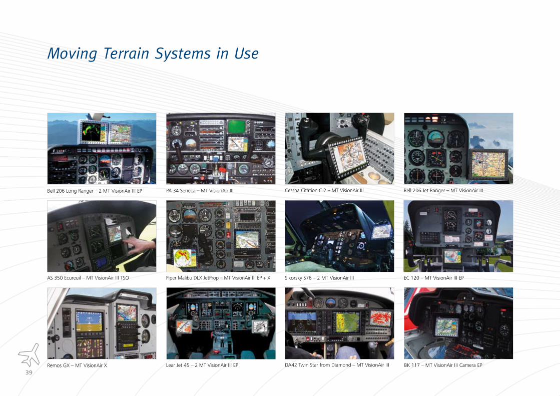
Moving Terrain Systems in Use
Bell 206 Long Ranger – 2 MT VisionAir III EP PA 34 Seneca – MT VisionAir III
Sikorsky S76 – 2 MT VisionAir III
Bell 206 Jet Ranger – MT VisionAir III
AS 350 Ecureuil – MT VisionAir III TSO Piper Malibu DLX JetProp – MT VisionAir III EP + X
Cessna Citation CJ2 – MT VisionAir III
EC 120 – MT VisionAir III EP
DA42 Twin Star from Diamond – MT VisionAir IIILear Jet 45 – 2 MT VisionAir III EPRemos GX – MT VisionAir X BK 117 – MT VisionAir III Camera EP

�0
Sparenberg 1
87477 Sulzberg, Germany
Telefon 0049 (0) 8376 9214-11
Fax 0049 (0) 8376 9214-14
www.moving-terrain.com
Related Documents
![EN mikomaxso CHILLOUT Technical insert 01 01 2019 · CHILLOUT . System products POUF ARMCHAIR SOFA [W x D x H] Ref. No. 786 x 820 x 400 CHI-MT-005 786 x 786 x 700 CHI-MT-004 1536](https://static.cupdf.com/doc/110x72/5f6cbee1dd182342b46e1412/en-mikomaxso-chillout-technical-insert-01-01-2019-chillout-system-products-pouf.jpg)