Msunduzi Municipality Final Draft Strategic Environmental Assessment Report Prepared for Department of Environmental Affairs, Department of Agriculture, Environmental Affairs and Rural Development, and Msunduzi Municipality Report No: 376998/FDSEA May 2010

Welcome message from author
This document is posted to help you gain knowledge. Please leave a comment to let me know what you think about it! Share it to your friends and learn new things together.
Transcript
Msunduzi Municipality
Final Draft Strategic Environmental Assessment
Report Prepared for
Department of Environmental Affairs,
Department of Agriculture, Environmental Affairs and Rural Development, and
Msunduzi Municipality
Report No: 376998/FDSEA
May 2010

SRK Consulting Msunduzi Final Draft SEA Page ii
eman 376998_ Final Draft SEA Report_May2010 May 2010
Executive Summary
Introduction
The Msunduzi Municipality (Msunduzi), in partnership with the national Department of
Environmental Affairs (DEA),(formerly the Department of Environmental Affairs and Tourism
(DEAT)) and the KwaZulu-Natal Department of Agriculture, Environmental Affairs and Rural
Development (DAEA&RD)(formerly the Department of Agriculture and Environmental Affairs
(DAEA)), have recognised the need for an appropriate policy to inform development planning and
approval that supports sustainable development in the Municipality. SRK Consulting (SRK) was
therefore appointed to execute the following tasks for Msunduzi:
• Status Quo Analysis (State of the Environment);
• Strategic Environmental Assessment (SEA);
• Municipal Open Space System (MOSS);
• Strategic Environmental Management Plan (SEMP) and
• Environmental Management Framework (EMF).
This report constitutes the product of the SEA process undertaken as part of the Msunduzi EMF.
The need for an SEA results from the limitations of project specific EIA’s and the need to ensure
that environmental issues are proactively addressed in policies, plans and programs. SEA is however
still evolving and there is no definitive approach that can be applied in all circumstances. Rather,
each SEA is specifically tailored to meet the needs and specific issues and inform decision making
when such development applications are received.
The Msunduzi SEA takes the form of a sustainability framework by providing a set of criteria
against which the Municipality can assess any policy, program or plan. The sustainability framework
developed within this SEA process was, for example, used to assess the sustainability of the recently
adopted Spatial Development Framework (SDF). The SEA was developed using information
gathered during the Status Quo phase; from literature reviews; and, specialist studies undertaken.
This research was supplemented by public and authority consultation.
Status Quo and Issues Identification
Msunduzi Municipality is located at the centre of the uMgungundlovu District Municipality. It
covers 640 square kilometres and is located 80 km from Durban along the N3. Pietermaritzburg (the
Districts main economic hub) is situated within the basin of the uMsunduzi River and its tributaries
and the hills around the city bowl tend to create a distinction between the urban and rural parts of the
municipality. The topography provides an urban/rural boundary and also contributes to the creation
of an atmospheric inversion layer on clear winter nights that traps pollutants within the city bowl.
This results in a high ambient concentration of air pollutants even though Msunduzi has relatively
few emitting industries.

SRK Consulting Msunduzi Final Draft SEA Page iii
eman 376998_ Final Draft SEA Report_May2010 May 2010
Soils within the Municipality vary greatly. The topography, rainfall patterns and geology has
resulted in the high agricultural potential of the area. However large portions of highly productive
agricultural land have been developed for other uses such as housing. The topography, geology and
other land characteristics in Msunduzi have also given rise to diverse habitats and species richness.
High levels of transformation have resulted in a significant loss of natural habitat and a relatively
low proportion of the municipality is regarded as “untransformed”. The majority of identified
biodiversity targets can, however, still be met.
Msunduzi Municipality constitutes almost entirely one catchment area which assists in catchment
management. This does imply that any adverse impact within the catchment may affect the entire
municipal area. Water quality varies from catchment to catchment basin but the main impact on the
city is evident in the decrease in water quality that occurs as it passes from the semi rural through the
urbanised portions of the municipality. The decrease in water quality compromises development
opportunities and the hosting of tourism events within the municipality such as the Duzi Canoe
Marathon. Wetlands provide a number of ecosystem goods and services critical for the realisation of
social and economic development goals, however, the extent of wetlands within Msunduzi has
declined significantly, particularly in the developed areas. The wetlands have generally been
transformed and most of the remaining wetlands are degraded.
Msunduzi is characterised by a complex racial mix and currently reflects a typical South Africa city
divided both by income and by race. Population growth in Msunduzi is higher than the national
average, as a result of urbanisation. High population growth is one of the major contributing factors
to biophysical and socio economic issues within the Municipality. The demand for services results in
risks to the aquatic and terrestrial environment while traffic congestion results in impacts on air
quality. Recorded cultural heritage sites consist mainly of European sites, while African, Coloured
and Indian cultural heritage sites have yet to be identified and recorded, and are therefore at risk of
being lost.
Msunduzi’s location on the N3 between Durban and Johannesburg together with its declaration as
the administrative capital means that the municipality is subject to development pressure while this
equally presents significant development opportunities. The ecosystems goods and services provided
by the environment are critical to realising these development opportunities. As the loss of goods
and services will compromise potential development opportunities, it is critical to ensure that
development keeps within the capacity of the environment to provide the necessary good and
services.
The total area for which Msunduzi has jurisdiction increased dramatically with the creation of wall
to wall municipalities. The capacity within the municipality has not however increased
proportionately to deal with this greater responsibility. The municipality has also lost key staff with
extensive experience; and, if and when replaced, new staff often lack the requisite experience. This
has resulted in an overall and significant decrease in the municipality’s capacity for environmental
governance.
There is a perception that the environment is not rated as a high priority by Council. This perception
is however difficult to confirm. There is also a general lack of understanding within sectors of the
municipality as to environmental issues and particularly the implications of the environmental
degradation aspects that have been detailed above.
SRK Consulting Msunduzi Final Draft SEA Page iv
eman 376998_ Final Draft SEA Report_May2010 May 2010
Weak environmental governance will inevitably lead to further environmental degradation and
exacerbate the risks that have been identified in the various themes of this strategic assessment.
Inappropriate land use; uncontrolled emissions; and pollution and environmental degradation,
compromise the ability of the environment to support socio-economic development. Ecosystem
goods and services that are vital for the health and well being of the municipal residents are
compromised. There is therefore a direct link between strong environmental governance and
management and the realisation of sustainable social and economic development goals. Further the
loss of ecosystem goods and services will result in significant cost implications for the municipality.
This is demonstrated by the unplanned and possibly wasteful expenditure incurred to rehabilitate
environmental damage that should have been prevented through strong environmental governance
and informed decision making at an early stage.
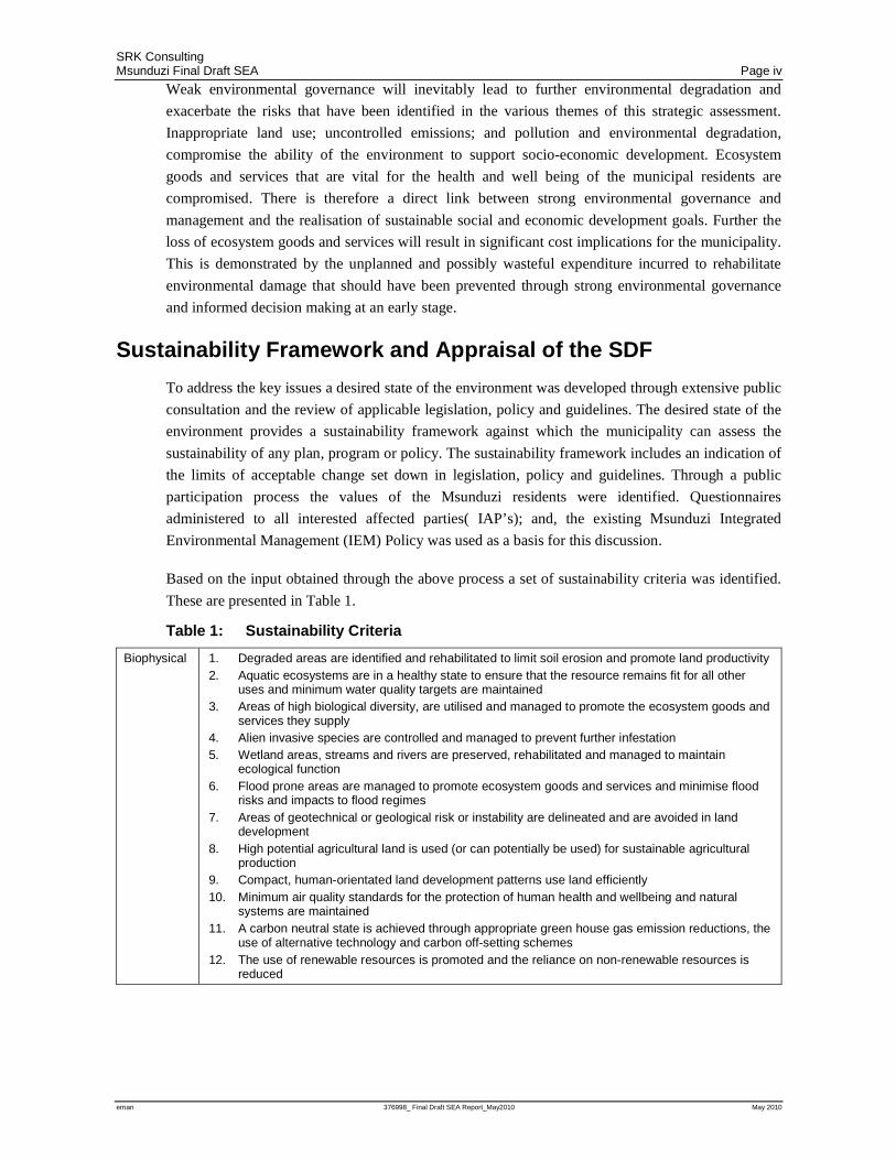
Sustainability Framework and Appraisal of the SDF
To address the key issues a desired state of the environment was developed through extensive public
consultation and the review of applicable legislation, policy and guidelines. The desired state of the
environment provides a sustainability framework against which the municipality can assess the
sustainability of any plan, program or policy. The sustainability framework includes an indication of
the limits of acceptable change set down in legislation, policy and guidelines. Through a public
participation process the values of the Msunduzi residents were identified. Questionnaires
administered to all interested affected parties( IAP’s); and, the existing Msunduzi Integrated
Environmental Management (IEM) Policy was used as a basis for this discussion.
Based on the input obtained through the above process a set of sustainability criteria was identified.
These are presented in Table 1.
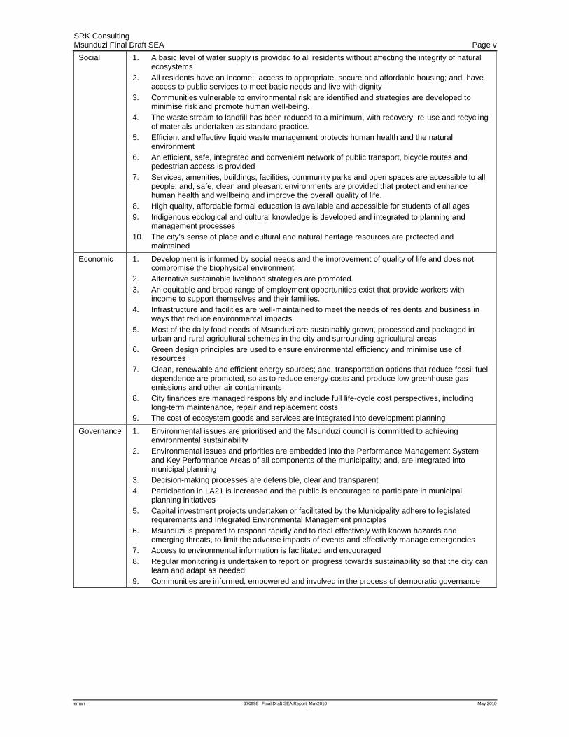
Table 1: Sustainability Criteria
Biophysical 1. Degraded areas are identified and rehabilitated to limit soil erosion and promote land productivity 2. Aquatic ecosystems are in a healthy state to ensure that the resource remains fit for all other
uses and minimum water quality targets are maintained 3. Areas of high biological diversity, are utilised and managed to promote the ecosystem goods and
services they supply 4. Alien invasive species are controlled and managed to prevent further infestation 5. Wetland areas, streams and rivers are preserved, rehabilitated and managed to maintain
ecological function 6. Flood prone areas are managed to promote ecosystem goods and services and minimise flood
risks and impacts to flood regimes 7. Areas of geotechnical or geological risk or instability are delineated and are avoided in land
development 8. High potential agricultural land is used (or can potentially be used) for sustainable agricultural
production 9. Compact, human-orientated land development patterns use land efficiently 10. Minimum air quality standards for the protection of human health and wellbeing and natural
systems are maintained 11. A carbon neutral state is achieved through appropriate green house gas emission reductions, the
use of alternative technology and carbon off-setting schemes 12. The use of renewable resources is promoted and the reliance on non-renewable resources is
reduced
SRK Consulting Msunduzi Final Draft SEA Page v
eman 376998_ Final Draft SEA Report_May2010 May 2010
Social 1. A basic level of water supply is provided to all residents without affecting the integrity of natural ecosystems
2. All residents have an income; access to appropriate, secure and affordable housing; and, have access to public services to meet basic needs and live with dignity
3. Communities vulnerable to environmental risk are identified and strategies are developed to minimise risk and promote human well-being.
4. The waste stream to landfill has been reduced to a minimum, with recovery, re-use and recycling of materials undertaken as standard practice.
5. Efficient and effective liquid waste management protects human health and the natural environment
6. An efficient, safe, integrated and convenient network of public transport, bicycle routes and pedestrian access is provided
7. Services, amenities, buildings, facilities, community parks and open spaces are accessible to all people; and, safe, clean and pleasant environments are provided that protect and enhance human health and wellbeing and improve the overall quality of life.
8. High quality, affordable formal education is available and accessible for students of all ages 9. Indigenous ecological and cultural knowledge is developed and integrated to planning and
management processes 10. The city’s sense of place and cultural and natural heritage resources are protected and
maintained
Economic 1. Development is informed by social needs and the improvement of quality of life and does not compromise the biophysical environment
2. Alternative sustainable livelihood strategies are promoted. 3. An equitable and broad range of employment opportunities exist that provide workers with
income to support themselves and their families. 4. Infrastructure and facilities are well-maintained to meet the needs of residents and business in
ways that reduce environmental impacts 5. Most of the daily food needs of Msunduzi are sustainably grown, processed and packaged in
urban and rural agricultural schemes in the city and surrounding agricultural areas 6. Green design principles are used to ensure environmental efficiency and minimise use of
resources 7. Clean, renewable and efficient energy sources; and, transportation options that reduce fossil fuel
dependence are promoted, so as to reduce energy costs and produce low greenhouse gas emissions and other air contaminants
8. City finances are managed responsibly and include full life-cycle cost perspectives, including long-term maintenance, repair and replacement costs.
9. The cost of ecosystem goods and services are integrated into development planning
Governance 1. Environmental issues are prioritised and the Msunduzi council is committed to achieving environmental sustainability
2. Environmental issues and priorities are embedded into the Performance Management System and Key Performance Areas of all components of the municipality; and, are integrated into municipal planning
3. Decision-making processes are defensible, clear and transparent 4. Participation in LA21 is increased and the public is encouraged to participate in municipal
planning initiatives 5. Capital investment projects undertaken or facilitated by the Municipality adhere to legislated
requirements and Integrated Environmental Management principles 6. Msunduzi is prepared to respond rapidly and to deal effectively with known hazards and
emerging threats, to limit the adverse impacts of events and effectively manage emergencies 7. Access to environmental information is facilitated and encouraged 8. Regular monitoring is undertaken to report on progress towards sustainability so that the city can
learn and adapt as needed. 9. Communities are informed, empowered and involved in the process of democratic governance
SRK Consulting Msunduzi Final Draft SEA Page vi
eman 376998_ Final Draft SEA Report_May2010 May 2010
As the Msunduzi Spatial development Framework (SDF) had recently been developed and adopted,
this provided an opportunity to use the sustainability criteria to assess the sustainability of the SDF.
This assessment was undertaken at the Area Based Management (ABM) scale using a Sustainability
Appraisal matrix.
For the northern ABM the SDF generally has a positive impact on sustainability, however there are
serious concerns around service capacity and land available for the expansion of services in this area.
For the CBD, Eastern Areas and Ashburton ABM the SDF worked towards social and economic
sustainability criteria but may negatively impact on the biophysical environment. Further
compaction and densification could however enable areas to be set aside for the provision of
ecosystem goods and services without reducing economic and social development objectives. The
Edendale and Imbali ABM’s have similar negative impacts. However in these areas it is the
provision of services that poses environmental threats. Current misuse of services specifically sewer
and stormwater reticulation systems results in onerous requirements for maintenance and impacts on
water quality that in turn impacts on economic opportunities like the Duzi Canoe Marathon. The
Vulindela ABM is almost entirely rural and lacks the basic services required for commercial and
industrial development. The SDF proposes the in-situ upgrade of the existing residential areas and
communal agriculture. These pose significant threats to water quality given the current trends in
service infrastructure maintenance and unsustainable land use practices.
Conclusion and Way Forward
The Msunduzi SEA identifies key environmental issues in that it establishes development trends and
threats; establishes a sustainability framework with a set of sustainability criteria; identifies Limits of
Acceptable Change and, a Desired State of the Environment against which the Municipality can
assess any policy, program or plan. In the development of the sustainability framework an overview
of the environment of Msunduzi is provided together with key environmental issues. Given the
potential pressures on the environment, as a result of both current and proposed development
pressure, a number of strategies are suggested within the sustainability framework to improve
environmental governance and management within Msunduzi. These strategies will form the basis
for the development of an SEMP that will guide the implementation of all the products of the
Msunduzi EMF process.
SRK Consulting Msunduzi Final Draft SEA Page vii
eman 376998_ Final Draft SEA Report_May2010 May 2010
Table of Contents Introduction ..................................................................................................................................... ii Status Quo and Issues Identification .............................................................................................. ii Sustainability Framework and Appraisal of the SDF ..................................................................... iv
Conclusion and Way Forward ....................................................................................................... vi
1 Introduction .................................................................................................................. 1
1.1 Background ............................................................................................................................ 1
1.2 What is an SEA ..................................................................................................................... 1
1.3 The Role of SEA in supporting sustainable development .................................................... 2
1.4 SEA in the context of an EMF process ................................................................................. 2
1.5 Legal and Policy Framework ................................................................................................. 3
1.6 Scope of Work and Study assumptions and limitations ....................................................... 4
1.7 Structure of the Report .......................................................................................................... 5
2 Methodology ................................................................................................................. 6
2.1 Collection and review of information ..................................................................................... 6
2.2 Scoping – identification of issues .......................................................................................... 7
2.3 Establishing criteria for sustainability assessment ............................................................... 8
2.4 Mapping and ranking of constraints and opportunities ......................................................... 9
2.5 Sustainability assessment ................................................................................................... 10
3 Status Quo for the Study Area .................................................................................. 11
3.1 Bio-physical ......................................................................................................................... 11
3.1.1 Locality and Extent ................................................................................................................ 11
3.1.2 Topography and Geology ...................................................................................................... 12
3.1.3 Climate and Air Quality ......................................................................................................... 12
3.1.4 Soils and Land Capability ...................................................................................................... 13
3.1.5 Rivers and Wetlands ............................................................................................................. 15
3.1.6 Biodiversity ............................................................................................................................ 16
3.2 Social 16
3.2.1 Demographic Profile .............................................................................................................. 16
3.2.2 Access to Basic Services ...................................................................................................... 17
3.2.3 Cultural Heritage ................................................................................................................... 17
3.3 Economic ............................................................................................................................. 18
3.3.1 Employment profile................................................................................................................ 18
3.3.2 Employment Sectors ............................................................................................................. 18
3.3.3 Income ................................................................................................................................... 19
3.3.4 Spatial Drivers ....................................................................................................................... 19
3.4 Governance ......................................................................................................................... 19
3.4.1 Leadership ............................................................................................................................. 20
3.4.2 Intergovernmental Cooperation ............................................................................................. 20
3.4.3 Efficiency and Effectiveness ................................................................................................. 20
3.4.4 Information Sharing ............................................................................................................... 21
3.4.5 Participation in Environmental Governance .......................................................................... 21
4 Strategic issues, constraints and opportunities ..................................................... 22
4.1 Overview of strategic issues................................................................................................ 22
4.1.1 Bio-physical ........................................................................................................................... 22
4.1.2 Social ..................................................................................................................................... 25
4.1.3 Economic ............................................................................................................................... 25
4.1.4 Governance ........................................................................................................................... 26
4.1.5 Identification of causes, linkages and cumulative issues ...................................................... 28
4.2 Key constraints and opportunities ....................................................................................... 31
4.2.1 Environmental Aspects of Conservation Importance ............................................................ 31
4.2.2 Environmental Aspects in need of Management .................................................................. 33
SRK Consulting Msunduzi Final Draft SEA Page viii
eman 376998_ Final Draft SEA Report_May2010 May 2010
5 Desired state of environment .................................................................................... 37
5.1 Limits of acceptable change ................................................................................................ 37
5.1.1 National ................................................................................................................................. 37
5.1.2 Provincial ............................................................................................................................... 38
5.1.3 Local ...................................................................................................................................... 39
5.2 Vision and objectives from Msunduzi Integrated Environmental Management Policy ...... 40
5.3 Identifying the current values of Msunduzi residents .......................................................... 41
5.3.1 Questionnaires ...................................................................................................................... 41
5.3.2 Public Meeting ....................................................................................................................... 42
5.3.3 Other meetings and workshops ............................................................................................ 43
5.4 Sustainability criteria for strategic assessment ................................................................... 43
6 Implications for planning and management ............................................................ 49
7 Strategic assessment of land use alternatives ........................................................ 51
7.1 SDF 51
7.2 Sustainability Appraisal ....................................................................................................... 52
7.2.1 Northern Areas ...................................................................................................................... 52
7.2.2 CBD, Ashburton and Eastern Areas ..................................................................................... 53
7.2.3 Greater Edendale and Greater Imbali ................................................................................... 54
7.2.4 Vulindlela ............................................................................................................................... 54
8 Public Involvement ..................................................................................................... 56
9 Conclusions and Way Forward ................................................................................. 58
10 References .................................................................................................................. 60
Appendices ...................................................................................................................... 62
Appendix 1 Figures ...................................................................................................................... 62
Appendix 2 Stakeholder Questionnaire and Analysis ................................................................. 63
Appendix 3 Msunduzi SDF .......................................................................................................... 64
Appendix 4 Sustainability Appraisal Matrix ................................................................................. 65
Appendix 5 EGI Framework......................................................................................................... 66
List of Tables
Table 1: Sustainability Criteria ......................................................................................................... iv
Table 1.1: Regulatory Framework ...................................................................................................... 4
Table 1.2: Report Structure ................................................................................................................. 5
Table 2.1: Public Involvement to obtain input into the SEA ............................................................... 7
Table 4.1: Causes of environmental impacts and cumulative issues within Msunduzi ................... 28
Table 5.1: Biophysical Sustainability Criteria .................................................................................... 44
Table 5.2: Social Sustainability Criteria ............................................................................................ 45
Table 5.3: Economic Sustainability Criteria ...................................................................................... 46
Table 5.4: Governance Sustainability Criteria .................................................................................. 48
Table 8.1: Comments received in the SEA and associated Responses .......................................... 56
Table 9.1: Environmental Strategies ................................................................................................. 59
List of Figures
Figure 1.1: EMF Phases ....................................................................................................................... 3
Figure 2.1: SEA sustainability framework ............................................................................................ 8
Figure 3.1: Msunduzi Locality ............................................................................................................ 11
Figure 3.2: Bioresource Groups within Msunduzi .............................................................................. 14
Figure 6.1: South African planning in which sustainability assessment can be integrated .............. 49
Figure 10.1: Development Constraints Map ................................................................................. 62
SRK Consulting Msunduzi Final Draft SEA Page ix
eman 376998_ Final Draft SEA Report_May2010 May 2010
Acronyms
ABM Area Based Management
Asigi-SA Accelerated and Shared Growth Initiative for South Africa
BRG Bioresource Groups
CBD Central Business District
DAEA&RD Department of Agriculture and Environmental Affairs and Rural Development
DEA Department of Environmental Affairs
DSoE Desired State of the Environment
DTLGA Department of Local Government and Traditional Affairs
DWAF Department of Water Affairs and Forestry
EIA Environmental Impact Assessment
EKZNW Ezemvelo KZN Wildlife
EMF Environmental Management Framework
IAP Interested and Affected Party
IDP Integrated Development Plan
IEM Integrated Environmental Management
IWMP Integrated Waste Management Plan
LAC Limits of Acceptable Change
MOSS Municipal Open Space System
NEMA National Environmental Management Act
NEMAQA National Environmental Management: Air Quality Act
NFSD National Framework for Sustainable Development
SABS South African Bureau of Standards
SANS South African National Standard
SDF Spatial Development Framework
SDST Spatial Decision Support Tool
SEA Strategic Environmental Assessment
SEMP Strategic Environmental Management Plan

1
Section A, 2nd Floor IBM House 54 Norfolk Terrace, off Blair Atholl Drive 3630 WESTVILLE PO Box 1969 3630, WESTVILLE e-Mail: [email protected] URL: http://www.srk.co.za Tel: +27 (0) 31 279 1200 Fax: +27 (0) 31 279 1204
G:\Proj\376998_MSunduzi EMF_EMAN_ISO\7) Reports\SEA\376998_ Final Draft SEA Report_May2010.doc
Partners JCJ Boshoff, MJ Braune, JM Brown, CD Dalgliesh, JR Dixon, DM Duthe, T Hart, PR Labrum, DJ Mahlangu, RRW McNeill, HAC Meintjes, BJ Middleton, MJ Morris, GP Murray, GP Nel, VS Reddy, PN Rosewarne, PE Schmidt, PJ Shepherd, VM Simposya, AA Smithen, PJ Terbrugge, KM Uderstadt, DJ Venter, HG Waldeck, A Wood
Cape Town +27 (0) 21 659 3060 Durban +27 (0) 31 279 1200 East London +27 (0) 43 748 6292 Johannesburg +27 (0) 11 441 1111 Kimberley +27 (0) 53 861 5798 Pietermaritzburg +27 (0) 33 345 6311 Port Elizabeth +27 (0) 41 509 4800 Pretoria +27 (0) 12 361 9821 Rustenburg +27 (0) 14 594 1280 Dar-es-Salaam +25 (5) 22 260 1881 Harare +263 (4) 49 6182
Directors AJ Barrett, JR Dixon, DJ Mahlangu, BJ Middleton, MJ Morris, PE Schmidt, PJ Terbrugge
Associates AN Birtles, BM Engelsman, R Gardiner, DJD Gibson, WC Joughin, SA McDonald, WA Naismith, M Ristic, JJ Slabbert, D Visser, ML Wertz, Consultants AC Burger, BSc (Hons); IS Cameron-Clarke, PrSci Nat, MSc; JAC Cowan, JH de Beer, PrSci Nat, MSc; GA Jones, PrEng, PhD; MEng, TR Stacey, PrEng, DSc; OKH Steffen, PrEng, PhD; RJ Stuart, PrTech Eng, GDE; DW Warwick, PrSci Nat, BSc (Hons)
SRK Consulting (South Africa) (Pty) Ltd
Reg No 1995.012890.07
6 May 2010
376998
Msunduzi Environmental Management Framework
Final Draft Strategic Environmental Assessment
1 Introduction 1.1 Background
The Msunduzi Municipality (Msunduzi), in partnership with the national Department of
Environmental Affairs (DEA), (formerly the Department of Environmental Affairs and Tourism
(DEAT)) and the KwaZulu-Natal Department of Agriculture and Environmental Affairs and Rural
Development (DAEA&RD(formerlythe Department of Agriculture and Environmental Affairs
(DAEA)), has recognised that to support sustainable social, economic and environmental
development within the Municipality, the adoption and implementation of an appropriate policy to
inform development planning and approval is required. To address these requirements, the
preparation of an Environmental Management Framework (EMF) is being undertaken by SRK
Consulting (SRK). The Msunduzi EMF includes a Status Quo Analysis, Strategic Environmental
Assessment (SEA), a Municipal Open Space System (MOSS), a Strategic Environmental
Management Plan (SEMP) and GIS based Spatial Decision Support Tool (SDST) for Msunduzi.
1.2 What is an SEA
The term 'Strategic Environmental Assessment', as defined in South Africa, refers to a process that
integrates sustainability considerations into the formulation, assessment and implementation of
policies, plans and programmes. SEA in South Africa and abroad is however still evolving and
therefore there is no definitive approach that can be applied in all circumstances. Rather the
SRK Consulting Msunduzi Final Draft SEA Page 2
eman 376998_ Final Draft SEA Report_May2010 May 2010
approach to each SEA is specifically tailored to meet the needs and specific issues the SEA aims to
address.
The introduction of SEA has resulted from the limitations of project specific Environmental Impact
Assessment (EIA’s) and the need to ensure that environmental issues are proactively addressed in
policies, plans and programs. EIA’s can only consider the effect any proposed development may
have on the biophysical and socioeconomic environment. SEA strategically determines the
opportunities and constraints that the environment poses to future development. This enables
planners to identify areas where development would be sustainable, and therefore the requirements
for impact mitigation lower, and areas where development should be limited. To this end an SEA
should:
• Identify issues, conflicts and proposed/ potential alternatives;
• Define the required level of environmental quality through stakeholder engagement;
• Explore environmental opportunities and constraints; and
• Provide a framework to assess the sustainability of existing and / or future plans and programs.
1.3 The Role of SEA in supporting sustainable development
The concept of sustainable development is the corner stone of the SEA process. Sustainable
development is defined as ‘development now, which meets the needs of the present without
compromising the ability of future generations to meet their needs1’. As such, sustainable
development requires a balance between economic and social development and environmental
protection. Sustainable development aims to improve human well-being by seeking a balance
between economic, social and environmental change.
To achieve sustainability within the Msunduzi municipality the SEA aims to integrate natural
environmental considerations into the planning process at the same level at which social, economic
and institutional considerations are addressed. The SEA provides a tool for the practical translation
of the idea of sustainability into programs and projects within the municipality particularly in the
integrated development planning process.
Core to the sustainability concept is the understanding that economic and social development is
inextricably linked to ecosystem function. That “free” ecosystem goods and services are the basis for
economic and social development and that the loss of these goods and services will impact on
economic and social development in the future.
1.4 SEA in the context of an EMF process
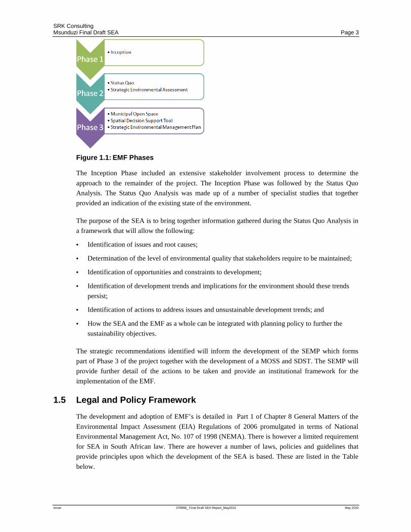
The purpose of the Msunduzi EMF is to provide informed decision making and provide a framework
against which plans, programs and policies can be assessed in the future. The Msunduzi EMF
consists of 3 Phases as indicated in Figure 1.1 below. The SEA Report, this report, forms part of
Phase 2 of the Msunduzi EMF project.
1 World Commission on Environment and Development (WCED). Our common future. Oxford: Oxford University Press, 1987.
SRK Consulting Msunduzi Final Draft SEA Page 3
eman 376998_ Final Draft SEA Report_May2010 May 2010
Figure 1.1: EMF Phases
The Inception Phase included an extensive stakeholder involvement process to determine the
approach to the remainder of the project. The Inception Phase was followed by the Status Quo
Analysis. The Status Quo Analysis was made up of a number of specialist studies that together
provided an indication of the existing state of the environment.
The purpose of the SEA is to bring together information gathered during the Status Quo Analysis in
a framework that will allow the following:
• Identification of issues and root causes;
• Determination of the level of environmental quality that stakeholders require to be maintained;
• Identification of opportunities and constraints to development;
• Identification of development trends and implications for the environment should these trends
persist;
• Identification of actions to address issues and unsustainable development trends; and
• How the SEA and the EMF as a whole can be integrated with planning policy to further the
sustainability objectives.
The strategic recommendations identified will inform the development of the SEMP which forms
part of Phase 3 of the project together with the development of a MOSS and SDST. The SEMP will
provide further detail of the actions to be taken and provide an institutional framework for the
implementation of the EMF.
1.5 Legal and Policy Framework
The development and adoption of EMF’s is detailed in Part 1 of Chapter 8 General Matters of the
Environmental Impact Assessment (EIA) Regulations of 2006 promulgated in terms of National
Environmental Management Act, No. 107 of 1998 (NEMA). There is however a limited requirement
for SEA in South African law. There are however a number of laws, policies and guidelines that
provide principles upon which the development of the SEA is based. These are listed in the Table
below.

SRK Consulting Msunduzi Final Draft SEA Page 4
eman 376998_ Final Draft SEA Report_May2010 May 2010
Table 1.1: Regulatory Framework
Legislation Context
Republic of South Africa Constitution Act 110 of 1983 (The Constitution);
Bill of Rights stipulates in Section 24 that: “Everyone has the right to an environment that is not harmful to their health or well-being; and to have the environment protected, for the benefit of present and future generations, through reasonable legislative and other measures that: Prevent pollution and ecological degradation; Promote conservation; and Secure ecologically sustainable development and use of natural resources while promoting justifiable economic and social development. “ The Bill of rights therefore underpins the objective of the SEA namely sustainable development that provides all Msunduzi residents with a healthy and protected environment.
National Environmental Management Act, No. 107 of 1998 (NEMA);
Chapter 5 makes provision for the development of procedures for the assessment of plans, policies and programs. The principles of NEMA as included in Chapter 1 also provide the cornerstone for SEA.
NEMA Environmental Impact Assessment (EIA) Regulations of 2006;
As above the development and adoption of EMF’s is detailed on Part 1 of Chapter 8 General Matters of the EIA Regulations. An SEA can be applied in the preparation of an EMF as is the case for the Msunduzi EMF.
Local Government Municipal Structures Act 117 of 1998 (Municipal Structures Act); Municipal Systems Act 32 of 1998 (Municipal Systems Act); and Municipal Planning and Performance Management Regulations (2001)
This legislation collectively provides a context for municipal planning. It requires that local authorities adopt a single inclusive policy framework that governs the allocation of capacity and resources, namely the IDP. Further, the regulations require that all Spatial Development Frameworks, that form part of the IDP, must be subject to a strategic assessment to determine the environmental implications of the development proposed within the framework
DEAT (2007), Strategic Environmental Assessment Guideline, Integrated Environmental Guideline Series 4, Department of Environmental Affairs and Tourism (DEAT), Pretoria, South Africa
The guidelines detail the key elements of the SEA process and highlight 3 main approaches to SEA.
1.6 Scope of Work and Study assumptions and limitations
The Msunduzi SEA forms part of the greater Msunduzi EMF. The purpose of the SEA component is
to bring together the findings of the various specialist studies undertaken in the Status Quo phase. As
discussed above the SEA conforms in the most part to the Sustainability Framework model for SEA
but also includes components of an EIA based model.
The SEA is based on data collected during the Status Quo phase of the EMF. It provides a
framework for identifying key issues and the opportunities and constraints posed by the
environment. The intention of the SEA is to support decision making for sustainable land use
planning by developing sustainability objectives and using these to assess the implications of
development scenarios proposed in the Integrated Development Plan (IDP). Equally however the
same sustainability objectives can then be used to assess any other plans programs and policies.
Through this process it is hoped that environmental capacity within the municipality will be built.
The SEA does not attempt to replace or contradict existing policy but rather to complement them by
providing a framework against which the sustainability of various policies can be assessed. The SEA
is a strategic document and as such cannot assess the impact of project level issues. Instead it
provides a strategic framework that will identify strategic issues and objectives against which

SRK Consulting Msunduzi Final Draft SEA Page 5
eman 376998_ Final Draft SEA Report_May2010 May 2010
projects can be assessed in the future. The SEA therefore does not replace assessment tools such as
an EIA. The SEA also does not exclude any development applications from being made. Rather the
SEA will inform decision making when such development applications are received.
The success of an SEA is dependent on the level of information available. This SEA has been based
on information collected during the Status Quo phase that was then supplemented by the specialist
studies. The Status Quo Phase of the project achieved as much as possible within the limits of the
resources available. There is however much still be done. To this end all specialist studies identified
how information gathered could be improved upon in the future. This has been included in the
actions identified in the SEA and will be included in the SEMP. During the implementation of the
EMF additional information will then be gathered and included in the refinement of the EMF during
the next review. The EMF product will therefore continually improve and evolve through the review
process.
1.7 Structure of the Report
Table 1.2 included below is an outline of the contents of this report.
Table 1.2: Report Structure
Section Title Content
Executive Summary
Executive Summary A brief overview of the report and key findings
Section 1 Introduction Background to the Msunduzi EMF specifically the SEA component
Section 2 Methodology An outline of how the SEA was developed together with key outcomes and objectives
Section 3 Status Quo of the Study Area A summary of the findings of the Status Quo Report and specialist study with a focus on identifying linkages between aspects of the environment and cross cutting issues
Section 4 Strategic Issues, Constraints and Opportunities
Identification of key issues arising from the Status Quo looking specifically at the identification of constraints and opportunities for development
Section 5 Desired State of Environment Development of a vision, objectives and sustainability criteria within a framework against which current land use trends and future plans, programs and policies can be assessed
Section 6 Implications for Planning and Management
An overview of how the SEA should be used in the future to inform decision making and planning
Section 7 Strategic Assessment of Land Use Alternatives
The assessment of land use trends against the sustainability criteria identified
Section 8 Conclusions and Way Forward Identification of key findings from the SEA specifically a summary of key strategies that will form the basis of the SEMP

SRK Consulting Msunduzi Final Draft SEA Page 6
eman 376998_ Final Draft SEA Report_May2010 May 2010
2 Methodology One of the main difficulties with SEA internationally is that there is no single approach that can be
applied in all circumstances. Various SEA processes have been developed internationally, each with
their own specific strengths in a particular context. As a result the SEA approach must be developed
to meet the specific needs and context of the SEA. DEAT SEA Guidelines (2007) do however
identify three models of SEA application. These models reflect the extent to which the SEA
influences decision making. They include:
• EIA-based model which mimics project EIA by assessing the impact of a policy, plan or
program after it has been developed;
• Integrated model integrates SEA principles into various stages of the policy formulation or
planning process and therefore influences the formulation of the policy, plan or program and the
decision making during the process; and
• Sustainability framework model where a sustainability vision and objectives are developed
that will inform future decision making.
• This SEA is essentially a sustainability framework as it aims to provide a vision and
sustainability objectives against which the municipality can assess any future plans, programs
and policies. It goes beyond this by also highlighting the proposed actions, to be expanded upon
in the SEMP, which the municipality must undertake to achieve the vision and sustainability
objectives. This SEA however also includes components of the EIA based model as it assesses
the implications of the development scenarios proposed in the Municipal Spatial Development
Framework (SDF). The individual steps taken towards the completion of the SEA are detailed
further below.
2.1 Collection and review of information
The SEA is based on information gathered during the Status Quo Phase (see Figure 1.1) of the
project and as contained in the Status Quo Report. This includes all the specialist studies that
informed the development of the Status Quo Report as follows:
• ThornEx & SRK (2009) Institutional Status Quo Report
• SRK (2009) Catchment Hydrology and Flood Zone Mapping
• INR & Groudtruth (2008) River health assessment
• INR (2008) Wetland Identification
• INR (2009) Agricultural Productivity mapping
• INR (2008) Biodiversity Conservation Plan for the Municipality
• WSP (formerly Simpson Ryder) (2009)Air quality Status Quo Reporting
• SRK (2009) Service capacity Status Quo Reporting
• Isibuko Se Afrika (2009) Socio Economic analysis and Planning Overview
• SRK (2008) Cultural Heritage Mapping

SRK Consulting Msunduzi Final Draft SEA Page 7
eman 376998_ Final Draft SEA Report_May2010 May 2010
This information has been supplemented through public participation. The public involvement
process is detailed further in Table 2.1 below.
Table 2.1: Public Involvement to obtain input into the SEA
Type Date Description
Steering Committee Meetings
23 August 2007 30 October 2007 14 February 2008 22 August 2008 30 October 2008 21 November 2008
The project steering committee is made up of representatives from the following organisations: DEA, DAEA&RD, Msunduzi Municipality, uMgungundlovu District Municipality, Department of Water Affairs and Forestry (DWAF), Ezemvelo KZN Wildlife (EKZNW) and the KwaZulu-Natal Department of Local Government and Traditional Affairs (DLGTA). The steering committee has guided the process of developing the Msunduzi EMF
Discussion Document 12 September 2009 To facilitate discussions during the Planning Workshop a discussion document was drafted and circulated to all stakeholders invited to participate in the workshop.
Planning Workshop 19 September 2009 Organisations representing public interested were asked to provide input into the development of the EMF. This included the identification of issues and existing information that would inform the EMF and specialist studies.
Advertising April 2008 23 June 2009 30 June 2009
A legal Notice was placed in The Witness on 15 April 2008 calling for the registration of Interested and Affected Party’ s (IAP’s). In addition to the legal notice, The Witness stories ran numerous editorials on the Msunduzi EMF detailing progress, meeting dates and calls for comment.
Notices April 2008 A list of IAP’s developed during the formulation of the Msunduzi Integrated Environmental Management (IEM) policy was used to identify potential IAP’s for the Msunduzi EMF. Notices in English and/ or Zulu were sent to all identified IAP’s as well as all municipal councillors and officials.
Stakeholder Questionnaire 27 Jan 2009 A questionnaire was circulated to all registered IAP’s. The questionnaire aimed to identify environmental issues and perceptions.
Public Meeting 05 August 2009 A public meeting was held to facilitate discussions on the Draft Status Quo Report and the existing IEM Policy with the intention of informing the identification of issues and the Desired State of the Environment.
2.2 Scoping – identification of issues
Scoping is the process of identifying significant issues, by means of literature review and
stakeholder consultation, associated with the Municipality that require further investigation by the
SEA team and specialists. In order to specify the requirements for the specialist studies, to be
undertaken in the Status Quo Phase, issues where initially identified in the Inception Phase and
detailed in the Inception Report.
In the SEA the list of issues is expanded and refined through the specialist investigation undertaken
in the Status Quo Phase and through public involvement as detailed in Table 2.1 above. Figure 2.1
illustrates the sustainability framework in which issues for the municipality have been reported in the
SEA.

SRK Consulting Msunduzi Final Draft SEA Page 8
eman 376998_ Final Draft SEA Report_May2010 May 2010
Figure 2.1: SEA sustainability framework
The framework is based on the concept that “free” ecosystem goods and services are the basis for
economic and social development. This framework is core to the sustainability concept. The
Framework recognises that the loss of these goods and services will severely impact on the
development potential of the municipality. Most critical to this concept is the fact that none of these
components of sustainability can be achieved without the support of good environmental governance
and decision making.
2.3 Establishing criteria for sustainability assessment
To obtain an indication of the values of the people that reside within Msunduzi a stakeholder
questionnaire was circulated to all registered IAP’s and Msunduzi Councillors. The questionnaire
asked IAP’s to provide an indication of their perceptions of the Msunduzi environment and key
issues of concern related to environmental management. A copy of the questionnaire is included as
Appendix 2. The quantitative data provided was analysed to obtain an indication of what issues the
Msunduzi stakeholders ranked most highly and therefore where the development of sustainability
criteria should focus.
In addition to the questionnaires the Msunduzi IEM Policy was used as a basis for the EMF
visioning exercise. The Msunduzi IEM Policy was developed between January 2006 and April 2007
when it was adopted by the Msunduzi Council. The development process included extensive public
consultation that spanned 12 months.
IAP’s were asked to use the IEM policy vision and objectives as a starting point and then asked to
provide input as to:
• How they would like to see Msunduzi in the future?
• Whether the existing vision still addressed priorities and public needs of the city and the national
policy limits / targets?
• What issues are not addressed in the IEM Policy Vision and Objectives?
• What can be done to address issues?
SRK Consulting Msunduzi Final Draft SEA Page 9
eman 376998_ Final Draft SEA Report_May2010 May 2010
Opportunities to provide input into the visioning exercise were provided as follows:
• At the public meeting held on the 5 August 2009;
• At the Msunduzi Catchment Management Forum Meeting on the 11 August 2009;
• At the Arosha Environmental Leadership Summit held on the 24 August 2009; or alternatively
• By contacting SRK individually in writing or telephonically.
In addition to the meetings and consultations mentioned above, input was also gained during the
Msunduzi Innovation and Development Institute Environmental Focus Group Meeting held on the
25 August 2009. The aim of the Focus Group meeting was to provide strategic direction to the
municipality.
Beyond the visioning undertaken, through the public involvement process, each of the specialist
reports also identified legal and policy targets or limits. These together with the public input were
used to develop sustainability criteria against which existing development trends are assessed and
against which future plans, policies and programs can be assessed.
2.4 Mapping and ranking of constraints and opportunities
During the specialist studies (Institutional, Catchment Hydrology, Surface Water Resources,
Wetlands, Agriculture, Biodiversity, Air quality, Current service capacity, Planning and Social,
Cultural Heritage, Geotechnical, Goods and Services) undertaken as part of the Status Quo phase,
opportunities and constraints to development were identified and mapped, where relevant. As part of
the SEA process a consolidated map of opportunities and constraints was developed. The various
constraints maps were combined using an approach as outlined below2.
Initially the nine specialist constraints maps were ranked based on the extent to which each
influenced the scale, type and location of development. The ranking was determined through
consideration of the following criteria:
• Whether the constraint was spatially specific at a small scale of mapping (i.e wetlands, areas of
biodiversity significance, flood zones, or areas of high agricultural productivity);
• The extent to which impacts resulting from the constraints could be mitigated (slope)
• The extent to which current legislation addressed constraints (i.e. air and water quality)
• The extent to which one constraint may result in indirect impacts on other aspects of the
environment (i.e. the impact of the transformation of wetlands on water quality)
Based on the criteria listed above above the following ranking was developed:
• Wetlands
• Biodiversity
• Flood
2 The approach used was adapted from the mapping of Geotechnical Constraints in the Pietermaritzburg area undertaken by the Council for Geoscience.
SRK Consulting Msunduzi Final Draft SEA Page 10
eman 376998_ Final Draft SEA Report_May2010 May 2010
• Agriculture
• Slope
• Air Quality
• Heritage
• Water
• Services
The ranking determines which environmental aspects (e.g. wetlands, biodiversity, flood zones etc.)
were more visible on the final consolidated map. The map indicates each aspect of the environment,
as a different colour. The most dominant aspect (highest ranked) determines the colour represented
on the map while the intensity of the colour represents the number of different constraints. For
example red denotes biodiversity, an area reflected in pink would mean that biodiversity was the
only constraint while an area reflected as dark red would indicate an area with a large number of
constraints, of which biodiversity was the most significant. The map is included as Appendix 1 and
is discussed further in Section 4.2.
2.5 Sustainability assessment
The Msunduzi SDF provides a spatial representation of the desired socio-economic development of
the Municipality. One of the objectives of the SEA was to assess the sustainability of development
trends and this was achieved through the process as outlined below.
A sustainability appraisal of the SDF was undertaken using the sustainability criteria identified in
Section 5.4 of this report. The sustainability appraisal considered two scenarios namely the status
quo and development proposed in terms of the SDF. The sustainability appraisal made use of a
Multi-Criteria Analysis technique to determine the extent to which the Status Quo and SDF worked
for or against the sustainability criteria. A Sustainability Appraisal matrix of the development
alternatives, was developed to assess the implications of the status quo and SDF for the four Area
Based Management (ABM) areas. Development trends where assessed in terms of their ability to
contribute to poverty alleviation and sustainable development. The sustainability objectives were
used to determine the relative effect of the Status Quo and SDF on the biophysical, social and
economic environment. Cross-cutting issues identified such as land degradation, inappropriate
development, urbanisation and governance were also used in the assessment. This technique allows
the identification of areas where development trends conflict with sustainable development
objectives for the study area.

SRK Consulting Msunduzi Final Draft SEA Page 11
eman 376998_ Final Draft SEA Report_May2010 May 2010
3 Status Quo for the Study Area Implicit in the sustainability concept is the understanding that economic and social development
cannot occur in the absence of the “free” ecosystem goods and services provided by a functioning
biophysical environment. As such, impacts to the biophysical environment will result in indirect
impacts on opportunities for economic and social development. Equally however, economic and
social development exerts pressure on the biophysical environment through the use of these goods
and services.
To this end a framework that includes the biophysical, social and economic components of the
environment, together with governance that underpins these, has been used to describe the current
state of the environment within Msunduzi. Further a section for cross cutting issues has been
included to describe the state of those aspects of environment that influence or affect more than one
theme or aspect of the environment.
3.1 Bio-physical
3.1.1 Locality and Extent
Msunduzi Municipality is located at the centre of the uMgungundlovu District Municipality, which
is within the Kwa-Zulu Natal province of South Africa. The municipality covers 640 square
kilometres and is located 80 km from Durban along the N3. The locality of Msunduzi is illustrated
further in Figure 3.1 below.
Figure 3.1: Msunduzi Locality

SRK Consulting Msunduzi Final Draft SEA Page 12
eman 376998_ Final Draft SEA Report_May2010 May 2010
3.1.2 Topography and Geology
Pietermaritzburg is situated in the basin of the uMsunduzi River and its tributaries. An escarpment
rises approximately 400m above the city to the West and North West. Altitude within the
municipality ranges from 495 to 1795 metres above sea level and the municipality generally slopes
from west to east.
The mountains around the city bowl create a distinction between the urban and rural parts of the
municipality. While this has provided opportunities to manage the urban/ rural interface, it has
limited the city’s expansion potential resulting in the formation of a number of small urban hubs
outside the city.
The predominant lithologies present in the Msunduzi municipal area are comprised of sedimentary
rocks of the Ecca Group and Dwyka Formation which form part of the lower Karoo Supergroup.
The aforementioned sediments are extensively intruded by Jurassic post-Karoo dolerite sheets, dykes
and sills that intermittently outcrop across the entire municipal area.
A small area on the eastern border of the municipal area comprises lithostratigraphic sequences of
the Natal Metamorphic Province (including the Mapumulo Group and Oribi Gorge Suite) overlain
unconformably by the Natal Group and the Karoo Supergroup.
Each major lithological sequence exhibits a distinct set of geotechnical conditions. When combined
with general slope characteristics of the area, these conditions can be expected to vary greatly within
a region of similar underlying geology. The diversity of the geotechnical conditions in the Msunduzi
Municipality brought about by the geology and geomorphology (combined with the hilly areas
surrounding the Pietermaritzburg Central Business District (CBD)) result in a very complex
interplay between slope gradient and potentially unstable transported sediments and soils.
3.1.3 Climate and Air Quality
The climate and local weather in Msunduzi are strongly influenced by topography, the higher lying
areas in the north and west of the municipality are cooler and receive more rainfall. Average annual
temperature varies between 16.3oC and 17.9oC. Msunduzi falls within a summer rainfall area
characterized by dry winters and wet summers with thunderstorms being very common in summer.
Average rainfall within the Municipality varies between 748mm and 1017mm per annum.
The Pietermaritzburg city is located in a hollow formed by the valleys of the uMsunduzi River and
its tributaries. On clear winter nights katabatic flow occurs resulting in the movement of air from
upslope areas down to the city bowl, much like water. This fills the valley floor with cold, dense air
creating an inversion that does not allow pollutants to escape. This air movement also brings
pollutants from the entire municipality into the valley where it remains trapped by the inversion
layer. The majority of industrial development within Msunduzi has been established within this
inversion layer, as this land is both flat and in close proximity to both road and rail transport routes.
As a result the city suffers short-term peaks in pollution despite relatively few heavy industries.
Reported trends in air quality are as follows:

SRK Consulting Msunduzi Final Draft SEA Page 13
eman 376998_ Final Draft SEA Report_May2010 May 2010
• There has been a decreasing trend in smoke generation over the last 30 years with the exception
being in the Northdale area, but there has been an increase in concentrations of particulate matter
(sized below PM10).
• Sporadic ambient monitoring of sulphur dioxide concentrations indicates decreases at two of the
six sites while all the other monitoring sites show an increase.
• An Increase of pollution within the Northdale-Willowton basin (Baynespruit Valley) has been
noted.
• High ambient benzene concentrations that exceed health standards were recorded in a snapshot
survey to indicate worst-case scenarios in Msunduzi. Benzene emissions are usually associated
with vehicular emissions particularly vehicular congestion.
• The presence of sulphurous compounds (sulphur dioxide and/or hydrogen sulphide) has been
suggested as the cause of most of the public’s odour complaints, but there are many other less
obvious contributors to the chemical cocktail that constitutes an odour nuisance. Uncertainty
therefore remains.
Within Msunduzi there are four main sources of air pollution:
• An increase in vehicle volumes and traffic congestions in peak hours, particularly in the CBD
and many of the arterial routes; and, vehicles on the N3 highway that pass through the centre of
the city basin and alongside Willowton contribute to particulate matter, and ambient benzene and
sulphur dioxide concentrations;
• A large majority of the industries within Msunduzi are old and operate old technology that have
higher emissions than modern alternatives. Industry that burn large quantities of coal and heavy
furnace/fuel oil, specifically in the Willowton industrial complex and the Mason’s Mill area
contribute to smoke, particulate matter and sulphur dioxide concentrations;
• Formal and informal settlements in and around the Edendale Valley that use coal and firewood
for heating and cooking contribute to air pollution, smoke and particulate matter; and
• Burning of sugar cane and brush wood from cleared plantations especially if the wind direction
is not considered prior to burning contribute to smoke and particulate matter
From this it can be seen that the management of Air Quality needs to address more than just
industrial emissions, and needs to be undertaken in a holistic and comprehensive manner.
3.1.4 Soils and Land Capability
Soils within the Municipality vary greatly. The topography, rainfall patterns and geology have
resulted in the high agricultural potential of the area, however, large portions of highly productive
agricultural land have been developed for other uses such as housing. The remaining areas of highly
productive agricultural land occur mainly on communally owned land in the Vulindlela area. Poor
agricultural practices in these areas are affecting the productivity of the land.
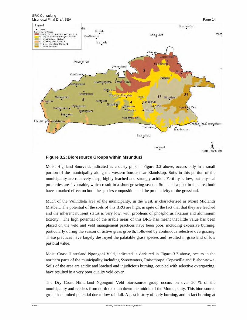
Figure 3.2 below shows the distribution of the bioresource groups (BRG’s) as identified by the
Department of Agriculture. The BRG’s provide further detail of the spatial distribution of both soil
types and land capability.
SRK Consulting Msunduzi Final Draft SEA Page 14
eman 376998_ Final Draft SEA Report_May2010 May 2010
Figure 3.2: Bioresource Groups within Msunduzi
Moist Highland Sourveld, indicated as a dusty pink in Figure 3.2 above, occurs only in a small
portion of the municipality along the western border near Elandskop. Soils in this portion of the
municipality are relatively deep, highly leached and strongly acidic . Fertility is low, but physical
properties are favourable, which result in a short growing season. Soils and aspect in this area both
have a marked effect on both the species composition and the productivity of the grassland.
Much of the Vulindlela area of the municipality, in the west, is characterised as Moist Midlands
Mistbelt. The potential of the soils of this BRG are high, in spite of the fact that that they are leached
and the inherent nutrient status is very low, with problems of phosphorus fixation and aluminium
toxicity. The high potential of the arable areas of this BRG has meant that little value has been
placed on the veld and veld management practices have been poor, including excessive burning,
particularly during the season of active grass growth, followed by continuous selective overgrazing.
These practices have largely destroyed the palatable grass species and resulted in grassland of low
pastoral value.
Moist Coast Hinterland Ngongoni Veld, indicated in dark red in Figure 3.2 above, occurs in the
northern parts of the municipality including Sweetwaters, Raisethorpe, Copesville and Bishopstowe.
Soils of the area are acidic and leached and injudicious burning, coupled with selective overgrazing,
have resulted in a very poor quality veld cover.
The Dry Coast Hinterland Ngongoni Veld bioresource group occurs on over 20 % of the
municipality and reaches from north to south down the middle of the Municipality. This bioresource
group has limited potential due to low rainfall. A past history of early burning, and in fact burning at
SRK Consulting Msunduzi Final Draft SEA Page 15
eman 376998_ Final Draft SEA Report_May2010 May 2010
any time of the year, coupled with selective overgrazing as the grass emerges, has resulted in a
particularly poor quality veld cover.
The Coast Hinterland Thornveld covers mainly the area in which the city occurs. The bioresource
group is known for its floristic richness but drastic deterioration in the quality of the veld has
resulted from the common practice of burning throughout the year to promote a flush of fresh growth
followed by selective overgrazing. Where both soil and water are suitable, the potential exists for the
production of sugar cane, maize and vegetables within this area.
The Valley Bushveld bioresource group occurs in a small area in the far eastern parts of the
municipality. The low and erratic rainfall of this BRG generally precludes any line of farming other
than livestock production that is based on the veld, except for select areas of arable land adjacent to a
reliable source of water from a river. As sweetveld, grazing can support beef animals throughout the
year. Goats can effectively utilise the available browse in summer, but need to graze during much of
the winter when trees lose their leaves. Wildlife should play an important role in the economy of the
Valley Bushveld.
3.1.5 Rivers and Wetlands
Msunduzi Municipality constitutes almost entirely one catchment. This has benefits in terms of
catchment management but also means that any impact within the catchment will affect the entire
municipality. The majority of the water produced in the Msunduzi catchment goes towards
servicing/supplementing Durban’s water requirements while Msunduzi sources the majority of its
water from the Umgeni catchment. The uMsunduzi River (and its various tributaries) is an important
feature of the municipal landscape. Significant proportions of the Msunduzi Municipality have
catchments that are currently in either a fair, poor or seriously modified ecological state. Catchments
within the municipality that are transformed have reached their full supply capacity. Water quality
varies between catchments but the impact of the city is evident from the decrease in water quality
that occurs as it passes through the urbanised portions of the municipality. Rivers within Msunduzi
are the source of a number of goods and services and these include:
• Water supply for industry, domestic use, agriculture and livestock watering;
• Dilution and removal of pollutants from agricultural, domestic and industrial sources;
• Reducing sediment inputs to coastal zone;
• Decomposing organic matter;
• Storing and regenerating essential elements;
• Provision of building materials in the form of clay bricks;
• Grazing fodder during dry seasons;
• Recreational and subsistence fishing;
• Providing aesthetic pleasures;
• Storm water management and control
• Sites for recreational swimming;
SRK Consulting Msunduzi Final Draft SEA Page 16
eman 376998_ Final Draft SEA Report_May2010 May 2010
• Recreational sport, such as canoeing and income generated in the area from events e.g. Dusi
Canoe Marathon;
• Open spaces within the City such as Alexandra Park;
• Environment for contemplation and spiritual renewal; and
• River-based educational activities.
The extent of wetlands has declined significantly, particularly in developed areas. Wetlands have
been transformed and most of the remaining wetland areas are in a degraded state due to
inappropriate land use and inadequate catchment management. There is a lack of ground level
information regarding the functionality of most of the wetland habitats within Msunduzi. As part of
the Status Quo Phase of the EMF a wetland specialist study was undertaken that mapped a total of
1049 wetlands. This covered an area of approximately 1001 Ha. Most wetlands within the
municipality were small, with an average wetland size of approximately 1 Ha. While the condition
of wetlands was not specifically evaluated as part of the wetland specialist study, observations made
during ground truthing suggest that most of the wetlands that remain are in a degraded state. The
network of wetland habitats do, however, form part of the system that generates the goods and
services as listed above. Wetlands also provide unique goods and services such as storm water
attenuation.
3.1.6 Biodiversity
The topography, geology and other land characteristics in the Msunduzi gave rise to diverse habitats
and species richness. High levels of transformation have resulted in a significant loss of natural
habitat and hence a range of species. A relatively low proportion of the municipality is regarded as
“untransformed”, yet it is at a level where most conservation targets can still be met.
The biodiversity specialist study that was conducted as part of the Status Quo Phase of the EMF
undertook a conservation planning exercise to identify areas of conservation significance within the
Municipality. In terms of this study 20186 ha or 31.7% of the municipal area is classified as having
conservation importance. However, only 853.5 ha or 1.35% of the Municipality is formally
protected. Large areas of degraded grasslands and grasslands in poor condition are present in the
municipality as a result of poor range management and alien invasive species are common.
A total of 56 animal species, 20 plant species and 8 vegetation types are regarded as being of
particular biodiversity significance. At least 50 endemic species occur in the area. A high number of
rare or threatened species occur within the Msunduzi Municipality and three species are thought to
have become extinct. A number of important aquatic biodiversity features have been identified that
require conservation. There are endemic fish species that raise the ecological value of sub-
catchments. At least 28 species of frogs have previously been recorded within the municipal region
although it is not certain that all of these still exist here. Most are red data species.
3.2 Social
3.2.1 Demographic Profile
Msunduzi is characterised by a complex racial mix with about 77% of the population being African.
It is a typical South African city divided between the rich and the poor; formal and informal; and,
SRK Consulting Msunduzi Final Draft SEA Page 17
eman 376998_ Final Draft SEA Report_May2010 May 2010
advantaged and disadvantaged. Areas such as the Greater Edendale and Vulindlela remain
predominantly black African, and are characterised by massive poverty. A growing black middle
class has moved to the former white areas, creating a more integrated society in these areas. There is
a close correlation between race, economic status and settlement patterns.
The number of people residing in the Msunduzi region increased from 518 961 in 1996 to 616 733 in
2007. This represents a cumulative increase of 18.84% for the period or a 1.71% per annum. This is
higher than the national average, which suggests that the Msunduzi region is also experiencing a net
inflow of people. Similarly the number of households in Msunduzi, has also increased.
The number of persons per square kilometre (km²) in 2007 was 953. The population density for the
province is around 102 persons/km². The high density is indicative of a relatively small area and an
exceptionally high urbanization level, with a big economically specialized city population drawing
on rural resources outside the area.
3.2.2 Access to Basic Services
The majority of the Msunduzi has adequate bulk water supply but areas such as Vulindlela will
require additional reticulation in the future. Rapid growth in areas such as Ashburton will require the
upgrade and extension of reticulation systems. The current demand for water exceeds the 99%
assurance yield of the Umgeni system and in order to secure reliable supply in the future
augmentation from other river systems will be required.
An estimated 72.4% of households have their refuse removed weekly; the remainder either do not
have access to these services (3%) or utilize their own dumps (36%) for waste disposal. The
Municipal landfill site has limited remaining capacity and there are high levels of illegal dumping of
domestic and industrial waste.
51.3% of households have access to full waterborne sanitation facilities and 4.3% to septic tanks.
Msunduzi has a high reliance on pit and bucket latrine systems and one in three households in
Msunduzi do not have adequate access to sanitation. The capacity of the Darvill Sewerage Treatment
Works is problematic due to the ingress of stormwater into the system that compromises the
functioning of the treatment works during and after storm events.
The transformation of natural areas to impermeable surfaces has resulted in greater peak stormwater
flow. This together with the illegal dumping of solid waste has impacted on the stormwater
management infrastructure. A large proportion of the municipality has access to adequate electricity
but aging infrastructure and a lack of maintenance is impacting on service delivery.
3.2.3 Cultural Heritage
Msunduzi has an extremely rich cultural, architectural, historical and archaeological resource base
that collectively makes up the heritage resources of the area. As part of the Status Quo Phase of the
EMF a Cultural Heritage Specialist Study was undertaken. The study identified and mapped a total
of 646 heritage resource points and 32 heritage resource zones within the Msunduzi Municipal area.
These consisted of architectural resources, archaeological resources, historical and cultural
resources.
SRK Consulting Msunduzi Final Draft SEA Page 18
eman 376998_ Final Draft SEA Report_May2010 May 2010
Results of the mapping revealed that the majority of heritage resources located within the Msunduzi
Municipal area consists of architectural resources, in the form of built structures (mostly buildings).
These are concentrated within the Pietermaritzburg CBD and its surrounding suburbs as well as in
the Georgetown area of Edendale. A significant number of historical and cultural resources are also
present within the Msunduzi Municipality. These consist of places of worship such as churches,
mosques and temples, cemeteries, open spaces, areas of political significance and areas of past
economic significance, to mention but a few. A general decline in the condition and quality of the
area’s identified heritage resources is noted.
A number of archaeological sites were also identified in the Msunduzi Municipality as part of the
Heritage Resource Study. However, as no systematic archaeological survey of the Municipal area
has been undertaken to date, the extent of the Municipalities archaeological resource base is largely
unknown.
A significant lack of formally recognised historical and cultural sites of traditional African, Coloured
and Indian cultures within the Msunduzi Municipal area is notable, and is a serious gap in the
available data.
3.3 Economic
3.3.1 Employment profile
The total labour force is generally made up of people between the ages of 15-65 years and
constitutes almost half the population of Msunduzi. It is defined as those members of the population
that are:
• employed in the formal sector;
• self-employed persons;
• employed in the informal sector; or
• unemployed persons.
Information on the spatial distribution of unemployment is not available, but the distribution of
poverty in the area suggests that it is concentrated mainly in the Greater Edendale and Vulindlela
ABM areas. Msunduzi’s economically active population, as a percentage of the total population of
working age, has increased from 60% in 1996 to 66% in 2007, indicating an expanding labour force.
3.3.2 Employment Sectors
Msunduzi’s employments sector is dominated by the Community/Social/Personal sector. This
indicates the dominance of the public sector and confirms the role of Msunduzi as the provincial
administrative centre and a service centre for the midlands region. It arises, in part, from the
relocation of government departments to the city. Trends within Msunduzi between 1996 and 2007,
however, indicate a decrease in the agricultural sector, while the construction, financial and
manufacturing sectors all showed an increase.

SRK Consulting Msunduzi Final Draft SEA Page 19
eman 376998_ Final Draft SEA Report_May2010 May 2010
3.3.3 Income
In 2007 it was recorded that almost 50% (308 119) of the population had no source of income. This
category has seen a decrease since 2001, when 68% of the population had no income.
Approximately 223 180 (36%) individuals earn an income of R6 400 or less per month, indicating
that a large portion of individuals/households fall within the low to middle income category. It is
also important to note that the individual income per month has increased from R4.6 bill 1996 to
R12 bill in 2007. This is an increase of about 15% per annum from 1996 to 2007.
3.3.4 Spatial Drivers
National and provincial development policies identify Pietermaritzburg as a focus area for
development and economic growth. The strategic location of Msunduzi along the N3 Corridor and
in relation to Gauteng and Durban is recognised at national and provincial levels. Pietermaritzburg
is categorized as a secondary node with potential for industrial, commercial and administrative
development.
The N3 and the provincial roads through the city have given rise to a central core in the CBD with
several major access routes radiating outwards. The majority of development occurs in close
proximity to these access routes particularly at intersections. Development along the access routes
particularly the N3 towards Durban is anticipated to continue.
3.4 Governance
The Msunduzi has many role-players that collectively influence and determine the state of the
environment in the area. They are comprised of:
• National, Provincial and Local government;
• Traditional authorities;
• Civil society groupings; and
• The scientific community.
The effective management of the biophysical, social and economic environment relies upon sound
environmental governance which makes environmental governance a ‘cross-cutting theme’
throughout each of the themes described above.
Msunduzi together with DAEA&RD and DEA are the three key role-players in the development and
implementation of the SEA as part of the greater EMF. Ultimately, however it, is the Municipality
that would be responsible for the implementation of the SEA. A description of the State of
Environmental Governance within Msunduzi is provided below in terms of the following headings:
• Leadership
• Intergovernmental Cooperation
• Efficiency and Effectiveness
• Information Sharing
• Participation in Environmental Governance
SRK Consulting Msunduzi Final Draft SEA Page 20
eman 376998_ Final Draft SEA Report_May2010 May 2010
3.4.1 Leadership
At a national level there is a progressive environmental legal framework, most of which has only
recently been enacted, that guides the interaction of the various role-players with the environment
(and to an extent with each other). The products of the greater Msunduzi EMF project such as the
SEA and SEMP assist in bringing together these legal provisions to enable cooperative and
improved decision-making in Msunduzi.
DEA is demonstrating leadership in governance through financial support for developing the SEA as
part of the Msunduzi EMF. Msunduzi also demonstrates leadership through its approval of the
Municipal IEM Policy and creation of the LA21 Environmental Forum. The Msunduzi’s IDP reflects
an environmental commitment and they have pledged commitment to the EMF and SEA as part of
this process. Despite these advancements the environment remains low on the list of priorities for
Msunduzi. The IEM policy objectives have not as yet been completely integrated into the
functioning of the Municipality, and sufficient resources have not being allocated to environmental
management. Environmental bylaws are either outdated or have not been developed. Problems with
enforcement exist due to the lack of resources.
3.4.2 Intergovernmental Cooperation
Msunduzi has created opportunities for all organs of state to participate in its affairs through the IDP
process and the LA21 Forum. However, there is weak or inconsistent participation by organs of state
in these structures. There are generally good working relations between the Municipality,
DAEA&RD and EKZNW on environmental, agricultural, and biodiversity matters. However, the
public is not always informed of these arrangements. The extent to which traditional leadership is
involved with environmental governance is unclear. However, indications are that tribal authorities
have limited inclusion in environmental governance. While the intention is to integrate
environmental governance into the Provincial Growth & Development Strategy as a cross cutting
theme, the Provincial Spatial and Economic Development Strategy (PSEDS) has not adequately
integrated environmental considerations and therefore may be encouraging growth in the area that
may potentially become unsustainable.
3.4.3 Efficiency and Effectiveness
The Municipality has limited ability to respond to opportunities provided by organs of state and
service providers for improving environmental integration and alignment. The municipality is also
limited in its ability to fulfil critical environmental protection functions such as stormwater
management, water and sanitation services, refuse removal and air quality management. There are
currently 112 staff vacancies in environment related functions.
A new macro organisational structure for the Municipality expresses the intention of expanding
capacity for strategic environmental management and planning. There is however weak integration
of environmental considerations in key municipal instruments such as the SDF and the Performance
Management System. The extent to which critical environmental issues are considered by all of the
Municipality’s functional units and executive committees is unknown.
SRK Consulting Msunduzi Final Draft SEA Page 21
eman 376998_ Final Draft SEA Report_May2010 May 2010
3.4.4 Information Sharing
The IDP reflects the Msunduzi Municipality’s commitment to information management and
communication for improved decision-making; they have improved their information management
structure at the strategic level and there is capacity for managing spatial information. However, there
is a lack of adequate information to inform environmental decisions in Msunduzi and the
municipality’s website does not share critical environmental information.
The media regularly discloses information on the inadequacy of the Municipality’s environmental
performance.
3.4.5 Participation in Environmental Governance
Council has created opportunities for civil society to participate in its affairs through the IDP process
and the LA21 Forum. However, the environmental participation mechanisms in the IDP process
seem to be weak i.e. there hasn’t been sufficient capacity building to allow for effective participation
in environmental decision-making and there is no environmental communication strategy.
There are a number of civil society groups and NGO’s that are actively involved with issues of
water, biodiversity conservation, air quality and climate change. The DWA Catchment Management
Forum also promotes society’s participation in environmental decision making.
Civil society plays an active role in biodiversity conservation through at least nine conservancies and
trusts. There is, however, no mechanism or structure to promote collective participation in
biodiversity governance in Msunduzi.
Business and industry through the Pietermaritzburg Chamber of Commerce has created the Air
Quality and Environment Forum to promote participation in air quality and environmental
governance.
There are various projects and activities that promote sustainable land management and agriculture
in Msunduzi. There is, however, no mechanism or structure in place to promote collective
participation and coordination in land governance in Msunduzi.
SRK Consulting Msunduzi Final Draft SEA Page 22
eman 376998_ Final Draft SEA Report_May2010 May 2010
4 Strategic issues, constraints and opportunities Issues were identified during the Inception Phase of the EMF to inform the requirements for the
specialist studies. These studies then informed Section 3 of this report. The specialist studies,
however, went beyond simply describing the current state of the environment within Msunduzi, they
also identified issues that have resulted in the current state of the environment and the potential
implications of environmental degradation. The specialist studies, where appropriate, also identified
spatial constraints and opportunities for development. This section aims to draw on the issues
identified in the specialist studies to identify the common threads. The intention is to identify the
core drivers of environmental degradation that will then inform the development of strategies that
will most efficiently address environmental issues.
4.1 Overview of strategic issues
4.1.1 Bio-physical
Inappropriate Land Use
The strategic location of Msunduzi as identified in national and provincial planning policy
encourages socio-economic growth. This rapid growth and the high rate of urbanisation results in
increasing pressure for land. As land suitable for development becomes scarce, areas that are less
suitable such as steep slopes, flood plains, wetlands, highly productive agricultural areas and areas of
biodiversity significance are targeted for development. Development in inappropriate areas results
in:
• Land degradation;
• Incompatible land uses;
• Loss of highly productive areas and soil erosion;
• Strain on existing bulk services
• Impacts to water quality and quantity; and
• Loss of natural habitat and associated goods and services.
The implications of these impacts are discussed further below. It is notable however that
inappropriate land use is the core issue that surrounds potential impacts to the biophysical
environment.
Land Degradation
Encroachment into highly productive agricultural areas is resulting in cultivation of marginal land
which further compromises agricultural productivity and results in soil erosion. Unresolved land
tenure and communal land ownership issues encourage unsustainable land use practices.
Land productivity and soil erosion are further impacted on by:
• Inappropriate fire management for example burning at inappropriate times of the year;
SRK Consulting Msunduzi Final Draft SEA Page 23
eman 376998_ Final Draft SEA Report_May2010 May 2010
• Incorrect grazing practices and increased stocking rates particularly in communally owned areas;
• Alien plant infestation; and
• Increased stormwater flow as a result of transformation from natural cover to impermeable
surfaces.
A decline in land productivity and soil erosion in turn impact on water quality and quantity.
Water
The rapid population growth in Msunduzi has resulted in urbanisation and unplanned densification
of areas that have impacted on the Municipality’s service capacity. Sewerage capacity in certain
areas is insufficient and residents lack understanding of these systems resulting in the need for
extensive maintenance. The lack of solid waste removal in certain areas together with aging
infrastructure impacts on stormwater infrastructure. This is the most significant contributor to the
decline of water quality and river health in Msunduzi. The transformation and degradation of
wetlands through infilling; inappropriate construction of infrastructure; and, inappropriate land use
management such as overgrazing and alien plant infestation, impact on the wetland system’s ability
to provide goods and services impacting on water quality and quantity.
Land transformation and degradation affects natural flood regimes, and an increase in the size of
flood areas which impacts on existing development; limits land available for development; and,
increases human vulnerability. Transformation of riparian areas has a significant impact on water
quality and flood regimes. A poor understanding of the area’s catchment hydrology makes integrated
catchment management progressively more difficult.
The abstraction of water for agricultural purposes, stream flow reduction from forest plantations and
reduced infiltration due to hardened surfaces diminishes the supply of water. Illegal discharges from
industrial sources, specifically hydrocarbons, chemical and heavy-metal pollutants, affect water
quality and threaten ecosystem integrity and human health.
Unless this is addressed the demand for water will shortly outweigh the supply, which will impact
adversely on development potential and quality of life in the municipality.
Ecosystem Goods and Services
Any impacts on biodiversity have the potential to affect ecosystem goods and services. The
transformation and degradation of natural habitats, including the infestation of alien invasive plants,
will result in the loss of ecosystem goods and services. The transformation, fragmentation and
degradation of natural habitats also limits species movement between areas of suitable habitat in the
landscape. This reduction in connectivity has a negative effect on the viability of species
populations, increasing the likelihood of local extinctions and increases the genetic isolation of
existing populations.
The inappropriate timing of veld burning has significant impacts on biodiversity. This is perhaps
most significant for plants, which are unable to respond to changing fire frequencies by moving to
different areas. Animal species are also affected by changes in available food and cover. Equally
however, infrequent burning results in a build-up of dead plant material, which changes fire intensity
and, can lead to plant species composition changes and increases in alien plant infestation.

SRK Consulting Msunduzi Final Draft SEA Page 24
eman 376998_ Final Draft SEA Report_May2010 May 2010
Industrial pollution, particularly within riparian zones and illegal dumping of waste affect the
suitability of habitat for a range of plant and animal species.
All the issues raised above have the potential to impact on biodiversity and the goods and services
provided by the associated ecosystems. In some cases however, it is the demand for specific goods
that results in these impacts. The demand for medicinal plants for traditional medicine remains high
amongst many urban and rural residents. A range of grassland plants and indigenous trees are
targeted by medicinal plant collectors and this is a threat to a number of plant species occurring
within the Msunduzi Municipality. Some indigenous plants (e.g. Hilton Daisy) are also targeted for
horticultural purposes.
Equally as populations increase and the service infrastructure, particularly electricity, is
compromised the demand for firewood has increased, which places pressure on the untransformed
woodlands, thickets and forested areas.
The impact of the loss of ecosystem goods and services is most significant on the poorer residents of
Msunduzi who are dependent on these natural resources for their livelihoods. The loss of goods and
services will reduce opportunities to alleviate poverty and human vulnerability.
Air Quality and Climate Change
The topography of Msunduzi that results in the inversion layer on calm winter nights limits the area
suitable for industrial developments that produce harmful air emissions. Sources of air pollution
within Msunduzi, particularly industrial sources, are not as significant as in other areas; it is rather
the topography of the area that results in the significant air quality issues within Msunduzi. The
topography of the municipality acts as a physical barrier to the dispersion of pollutants from within
the city bowl. Further the topography also creates a “catchment affect” that, on calm evenings,
results in pollutants from anywhere in the municipality flowing into the city bowl. Poor air quality
and seasonal pollution episodes will remain a regular feature in the area.
The air quality issues are exacerbated by insufficient air quality governance. There is a lack of
accurate information due to sporadic measurements for many criteria pollutants, insufficient
monitoring stations and very little in-stack monitoring. Collection of data has declined significantly
since 1997 which may be as a result of municipal restructuring. The provisions of the National
Environmental Management: Air Quality Act (NEMAQA) Act No. 39 of 2004 have yet to be
implemented jn regard to air quality. There is little evidence of intergovernmental cooperation to
support the development of an Air Quality Management Plan over the short term. There are
inappropriate strategies in place to manage the existing situation. The lack of understanding of the
air quality situation in the area is almost certainly the most significant sustainability risk as it may
lead to uninformed and inappropriate decisions. Global changes in the world’s atmosphere will
contribute to this change through local shifts in air temperature and other climatic variables. This
poses other potential risks to the municipality, specifically in terms of air quality.
The lack of information makes it difficult to determine the extent to which human and environmental
health is being affected as a result of air quality issues in Msunduzi. Ambient monitoring has
however noted health limit exceedances, which implies that air quality is currently impacting on
human and environmental health. Should air quality issues not be addressed the following indirect
impacts are anticipated:

SRK Consulting Msunduzi Final Draft SEA Page 25
eman 376998_ Final Draft SEA Report_May2010 May 2010
• A further decline in human health is anticipated which will impact on health services and the
ability of the population to generate income. Poor people and those living in informal
settlements will be particularly vulnerable.
• An increase in local pollutants, specifically nitrogen compounds, sulphur dioxides and nitrogen
oxides, will start affecting water quality. This will in turn impact on biodiversity, ecosystem
goods and services, human health and rural livelihoods.
• High pollution levels will gradually degrade architecturally and historically significant buildings
within the CBD affecting the area’s heritage and reducing the tourism opportunities they offer.
When considered together the implications of poor air quality have the potential to severely restrict
economic and social development potential.
4.1.2 Social
The rapid population growth within Msunduzi is resulting in inappropriate development and land
degradation as detailed in Section 4.1.1. While these manifest as biophysical issues they have serious
social implications as well. Land degradation will ultimately result in the loss of opportunities for
agricultural production and ecosystem goods and services (such as grazing, medicinal plants, wood
for fuel and building materials). This will significantly impact on rural livelihoods, which are most
sensitive, and reduce opportunities to alleviate poverty and human vulnerability.
The rapid population growth together with large housing backlogs results in high density informal
settlements. Due to their density, service requirements in informal settlements are far greater than
planned for and the Municipality has insufficient capacity to address these needs. High poverty
levels coupled with the high prevalence of HIV/AIDS and TB, places further pressures on municipal
services and infrastructure, job creation and natural resources. The challenges in service provision
result in impacts to river health that increases the risk of waterborne diseases, which increases the
demand for health services.
The increase in vehicular traffic and congestion due to urbanization affects the movement of people
and air quality. As discussed in Section 4.1.1 above, impacts on air quality will have implications for
human health particularly for poorer communities that are most vulnerable. A decrease in human
health within the Municipality impacts on the provision of health services, productivity levels and
the local economy.
The lack of knowledge and information on significant heritage resources in the area undermines
peoples’ cultural and social interests and the municipality’s ability to manage these valuable
resources. Developments may modify the character of heritage resources and unidentified resources
may be permanently lost.
4.1.3 Economic
Msunduzi’s unique location between Johannesburg, South Africa’s business hub, and Durban, South
Africa’s busiest port, provides major opportunities for economic development within the
municipality.
SRK Consulting Msunduzi Final Draft SEA Page 26
eman 376998_ Final Draft SEA Report_May2010 May 2010
The ecosystem goods and services provided by the environment also provide unique opportunities
for economic development, these include:
• Water from the Msunduzi catchment to supply industry, domestic use, agriculture and livestock
watering provides significant opportunities for development in these sectors. It is probable
however, that without proper management of water resources and habitats responsible for water
recycling, the demand for water will soon outweigh its supply. The Mgeni catchment has been
designated as a closed catchment and therefore the Msunduzi is also a closed catchment. As a
result, no further abstractions from the catchment will be allowed.Without clean water resources
the Municipality’s development opportunities will be significantly and adversely impacted upon.
• Goods and services provide tourism opportunities such as recreational sport. The most notable
example of this is the Dusi Canoe Marathon. In recent years however, the quality of water within
Msunduzi has compromised the event with some discussion around cancelling the race or
relocating it to rivers with better water quality. The loss of the Dusi Canoe Marathon will have
significant impacts on the local economy. Poor water quality will also impact on the potential for
future tourism development.
• Urban greening and the open space within the municipality provide a certain quality of life and
make Msunduzi the “City of Choice”. Should open spaces be lost, city marketing will be
impacted and residents may choose to relocate to areas such as Hillcrest that offer a similar
environment and which are close enough to allow residents to commute.
• The use of medicinal plants and animals for traditional medicine remains high amongst many
urban and rural residents. Untransformed areas of Msunduzi provide a range of grassland plants,
indigenous animals and indigenous trees that are targeted by Traditional Healers and medicinal
plant collectors. This provides opportunities for the informal trading and gardening of medicinal
plants. It also reduces the reliance of these residents on health services offered by the state.
However the loss of medicinal species, or the habitats that support them, will severely impact on
these opportunities.
• The natural environment currently provides natural stormwater attenuation. Development within
the catchment increases hard surfaces which affects the natural stormwater flow regime. This
results in the loss of floodplains and the need for the municipality to implement costly storm
water management, canalisation or the installation of attenuation infrastructure.
It is critical to build an understanding that all development is dependent on ecosystem goods and
services and therefore the loss of these goods and services would result in the loss of development
opportunities within the municipality. It is however the poor communities that are most reliant on the
ecosystem goods and services offered by an untransformed environment, and that while the loss of
these goods and services will impact the entire municipality, it is the poor that will be most affected
as they will have fewer livelihood options and will be less able to respond to environmental and
economic shocks.
4.1.4 Governance
The total area for which Msunduzi has jurisdiction increased dramatically with the creation of wall
to wall municipalities. This process increased the jurisdiction of the municipal area from the urban
component of Pietermaritzburg to include the surrounding rural areas such as Vulindlela. The
capacity within the municipality has however not increased to deal with this greater responsibility.

SRK Consulting Msunduzi Final Draft SEA Page 27
eman 376998_ Final Draft SEA Report_May2010 May 2010
The municipality has lost key staff with extensive experience, and if replaced, the new staff often
lack the requisite experience. This has resulted in an overall decrease in the municipality’s capacity
for environmental governance.
There is a perception that the environment is not rated as a high priority by Council. There is also a
general lack of understanding within components of the municipality as to environmental issues and
particularly the implications of environmental degradation. The allocation of land by traditional
authorities in areas not identified for development has resulted in land degradation and lack of
adequate service provision. Limited municipal capacity to police and manage these land use issues,
means that land mismanagement continues without adequate intervention. Opportunities for
environmental education have not been realised. Planning policy has not sufficiently recognised
environmental constraints and is not being sufficiently enforced. This results in insufficient attention
being given to environmental issues, with insufficient resources being allocated to environmental
management. By not addressing environmental issues the municipality continues to lose many
opportunities for social and economic development. Issues such as storm water management or
water provision are afforded high priority by the municipality but these measures are motivated by
growing environmental challenges.
The lack of human and financial resources results in the municipality’s limited ability to:
• Implement the Integrated Environmental Management Policy objectives;
• Improve their environmental by-laws;
• Implement adequate enforcement actions;
• Fulfil critical environmental protection functions; and
• Ensure environmental integration into key planning and management instruments and functional
business units.
By not addressing these issues the municipality compromises not only the biophysical environment
but the social and economic development opportunities provided by the biophysical environment.
Weak environmental governance will inevitably lead to a continuation in environmental degradation
and exacerbate the risks that have been identified in the various themes of this strategic assessment.
The lack of capacity in other local and provincial government structures is negatively affecting
intergovernmental cooperation. The low significance rating afforded to environmental matters within
the context of municipal development and service provision also contributes to this.
Should the environment not be prioritised, further environmental degradation will lead to the loss of
ecosystem goods and services. This will undermine the socio-economic rights of residents and
negatively affect the municipality’s economic opportunities. The cost of replacing environmental
goods and services such as stormwater attenuation and water recycling will be exorbitant and will
compromise the municipality’s long-term financial sustainability.
The Msunduzi EMF aims to raise the profile and address environmental issues within Msunduzi.
However it is critical that Council recognise the need for additional resources to implement the EMF
and address inappropriate development. It is critical that the municipality’s performance be
measured against sustainability criteria that will be identified in 5 below.

SRK Consulting Msunduzi Final Draft SEA Page 28
eman 376998_ Final Draft SEA Report_May2010 May 2010
4.1.5 Identification of causes, linkages and cumulative issues
While the causes, linkages and cumulative impacts between environmental issues in the Msunduzi
Municipality are not simple it is possible to present the key factors that have contributed to the
current state of the Msunduzi environment. This progression is provided in Table 4.1
Table 4.1: Causes of environmental impacts and cumulative issues within Msunduzi
ENVIRONMENTAL ISSUE: POOR ENVIRONMENTAL GOVERNANCE
CAUSE PRIMARY IMPACT CUMMULATIVE EFFECT
Lack of capacity
Insufficient funding
Complex legal frameworks
Multiple responsible authorities
Lack of co-operative governance
Institutional weaknesses
Political interference
Corruption
Ineffective compliance & enforcement
Delayed processes and approvals
Poor service delivery
Uninformed and poor decision making
Lack of fair & transparent distribution / management of resources
Environmental
Tendency towards illegal activities due to delays
Deterioration of environmental quality
Land degradation
Water pollution
Air pollution
Inappropriate land-use
Delayed service delivery increases dependence on natural resources
Social
Decreased participation and community involvement
Decline in human health & wellbeing
Perpetuation of poverty
Decrease in quality of life & sustainable livelihoods
Environmental injustice (the poor bear the environmental cost)
Economic
Duplicated and inefficient state resource use
Increased cost for the provision of services
ENVIRONMENTAL ISSUE: INAPPROPRIATE LAND USE
CAUSE PRIMARY IMPACT CUMMULATIVE EFFECT
Poor planning
Illegal land occupation
Incompatible land uses
Historic land allocation policy
Tragedy of the commons
Institutional weaknesses
Poor environmental governance
Loss of wetlands & floodplains
Loss of agricultural land
Erosion through stormwater run-off
Habitat fragmentation
Species loss
Traffic & air pollution impacts
Cultural heritage resource loss
Environmental
Loss of ecosystem goods & services
Wetland sedimentation / degradation
Increased water runoff
Landscape transformation
Loss of agriculturally productive land
Loss of non-renewable natural resources
Cultural heritage resource impacts
Visual and aesthetic impacts
Air pollution through dust and traffic
Increased demand for alternative land for agriculture (more transformation)
Social
Increased flood risks
Decline in human health & wellbeing
Perpetuation of poverty
Decrease in quality of life & sustainable livelihoods
Increased risk of disasters (landslides, fires, floods)
Increased nuisance and conflict
Economic
SRK Consulting Msunduzi Final Draft SEA Page 29
eman 376998_ Final Draft SEA Report_May2010 May 2010
Sedimentation of dams
Poor energy and resource use
Loss of productivity and food security
Increased requirement and costs to engineer goods & services
Loss of economic return from land
Tourism decline
Increased social dependency & poverty
Increased cost for the provision of services
ENVIRONMENTAL ISSUE: LAND DEGRADATION
CAUSE PRIMARY IMPACT CUMMULATIVE EFFECT
Overgrazing
Inappropriate burning
Poor land practices
Poor forestry management
Inappropriate land-uses
Alien plant invasion
Tragedy of the commons
Poor environmental governance
Soil loss & erosion
Loss of agricultural productivity
Alien plant invasion
Habitat fragmentation
Species loss
Environmental
Increased water turbidity and sedimentation
Wetland sedimentation / degradation
Increased water runoff
Increased water use through alien species
Loss of agriculturally productive land
Loss of non-renewable natural resources
Loss of ecosystem goods & services
Landscape transformation
Cultural heritage resource impacts
Visual and aesthetic impacts
Air pollution through dust
Increased demand for alternative land for agriculture (more transformation)
Social
Increased flood risks
Decline in human health & wellbeing
Perpetuation of poverty
Decrease in quality of life & sustainable livelihoods
Increased risk of disasters (landslides, fires, floods)
Economic
Sedimentation of dams
Increased cost of water purification
Loss of productivity and food security
Increased requirement and costs to engineer goods & services
Loss of economic return from land
Tourism decline
Increased social dependency & poverty
ENVIRONMENTAL ISSUE: WATER POLLUTION
CAUSE PRIMARY IMPACT CUMMULATIVE EFFECT
Land degradation
Industrial effluent
Sewerage management
Stormwater run-off
Wetland degradation
Human health risks
Eutrophication
Turbidity
Species loss and change in composition
Environmental
Increased water turbidity and sedimentation
Wetland sedimentation / degradation
Reduction in river health and species composition
Dissolved oxygen depletion
Loss of ecosystem goods & services
Visual and aesthetic impacts
Unpleasant odours
Algal blooms
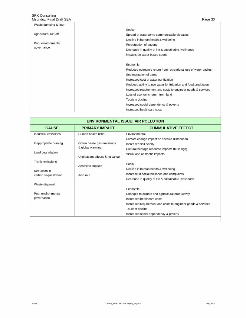
SRK Consulting Msunduzi Final Draft SEA Page 30
eman 376998_ Final Draft SEA Report_May2010 May 2010
Waste dumping & litter
Agricultural run-off
Poor environmental governance
Social
Spread of waterborne communicable diseases
Decline in human health & wellbeing
Perpetuation of poverty
Decrease in quality of life & sustainable livelihoods
Impacts on water based sports
Economic
Reduced economic return from recreational use of water bodies
Sedimentation of dams
Increased cost of water purification
Reduced ability to use water for irrigation and food production
Increased requirement and costs to engineer goods & services
Loss of economic return from land
Tourism decline
Increased social dependency & poverty
Increased healthcare costs
ENVIRONMENTAL ISSUE: AIR POLLUTION
CAUSE PRIMARY IMPACT CUMMULATIVE EFFECT
Industrial emissions
Inappropriate burning
Land degradation
Traffic emissions
Reduction in carbon sequestration
Waste disposal
Poor environmental governance
Human health risks
Green house gas emissions & global warming
Unpleasant odours & nuisance
Aesthetic impacts
Acid rain
Environmental
Climate change impact on species distribution
Increased soil acidity
Cultural heritage resource impacts (buildings)
Visual and aesthetic impacts
Social
Decline in human health & wellbeing
Increase in social nuisance and complaints
Decrease in quality of life & sustainable livelihoods
Economic
Changes to climate and agricultural productivity
Increased healthcare costs
Increased requirement and costs to engineer goods & services
Tourism decline
Increased social dependency & poverty
SRK Consulting Msunduzi Final Draft SEA Page 31
eman 376998_ Final Draft SEA Report_May2010 May 2010
4.2 Key constraints and opportunities
As part of the Status Quo Phase, and where relevant, an attempt was made to map opportunities and
constraints for development as part of each of the specialist studies. These maps were included in the
Status Quo Report. The challenge however was to represent all these maps as one consolidated map
of opportunities and constraints for development. Section 2.4 above describes the approach that was
used which included the ranking of the maps generated as part of the specialist studies. The ranking
distinguished between two main groups namely:
• Environmental Aspects of Conservation Importance; and
• Environmental Aspects in need of Management.
These are discussed further below.
4.2.1 Environmental Aspects of Conservation Importance
This section includes those aspects of the environment that occur only in specific areas of the
municipality and require conservation where they occur. While there may be opportunities for
offsets these aspects generally are spatially specific. These significantly constrain forms of
development that requires extensive land transformation such as residential, industrial and
commercial development. These areas do however offer opportunities for land uses that are
compatible with the conservation of biodiversity, ecosystem goods and services, open space,
aesthetics and tourism.
Wetlands
Wetland and buffer areas identified through specialist study were noted as the most sensitive habitats
requiring in-situ conservation. The importance of wetland habitats in terms of both water and
biodiversity conservation and the provision of ecosystem goods and services are widely recognised.
Due to the importance of wetlands and the functions that they fulfil authorities generally require that
wetland habitats and their buffer areas not be developed. As such wetland habitats where ranked
highest in the mapping exercise and are the most visible in the consolidated constraints map (see
Figure 10.1 in Appendix 1). The wetland and buffer areas identified are indicated in shades of grey
on the consolidated constraints map.
Transformation of wetland areas and their associated buffers should be avoided. These areas should
not however be considered areas of no development potential, but rather that they provide extensive
goods and services for the benefit of society.
Biodiversity
Areas of biodiversity importance were identified in the conservation plan developed as part of the
biodiversity specialist study. After wetlands, areas of high biodiversity importance were considered
the aspect most in need of in-situ conservation. Biodiversity conservation is legislated in South
Africa in terms of the National Environmental Management: Biodiversity Act No 10 of 2004. Areas
of biodiversity significance, identified through the conservation planning exercise, where ranked
second highest and are the second most visible on the consolidated constraints map (see Figure
10.1in Appendix 1). Areas of high biodiversity importance are indicated in shades of red on the
consolidated constraints map.

SRK Consulting Msunduzi Final Draft SEA Page 32
eman 376998_ Final Draft SEA Report_May2010 May 2010
As for wetlands, while areas of high biodiversity value do constrain forms of development that
would result in their transformation, they offer significant opportunities for compatible land uses. It
may also be possible to accommodate small scale development such as low density housing within
these areas should the density be appropriate and the development designed to address all potential
impacts to the open areas. The goods and services provided by the natural systems have large value
to the municipality as is demonstrated in the Goods and Services assessment undertaken during the
Status Quo Analysis (Appendix 12 of the Status Quo Report). The opportunities in these areas can
also be expanded to include low impact values such as eco-tourism, hiking, environmental
education, research opportunities, and spiritual use. Equally, should other forms of development be
proposed for these areas the current value of the area in terms of both its use and low impact values
should be carefully weighed against the value of any proposed development.
Flood zones and riparian corridors
Flood zones for rivers within Msunduzi were mapped as part of the Catchment hydrology specialist
study undertaken during the Status Quo Phase of the Project. The mapped areas constitute riparian
corridors that may be vulnerable to flooding. Transformation of these areas will impact on
biodiversity, catchment hydrology, flood vulnerability and water quality. Any development within
these areas is also likely to be damaged as a result of flooding. While the location of rivers is not
negotiable it is possible to manage the impacts of flooding through appropriate land management
and structural interventions such as the construction of weirs and dams. The National Water Act, No.
36 of 1998 and the NEMA EIA regulations also govern management of flood prone areas. As such,
flood zones identified through specialist investigations were ranked third highest and are the third
most visible on the consolidated constraints map (see Figure 10.1 in Appendix 1). Identified flood
zones are indicated in shades of blue on the consolidated constraints map.
Use of areas prone to flooding for development such as residential, commercial and industrial is not
recommended as this would impact on biodiversity, catchment hydrology, flood vulnerability and
water quality and may result in major impacts to infrastructure in the event of flooding. Flood zones
however may provide opportunities for development of sports fields, open space or recreational
areas (excluding ablution facilities) servitudes and specific agricultural activities. If correctly
managed it is not anticipated that appropriate development will impact on the flood zone and
compromise goods and services provided in the riparian habitat. Flood management however goes
beyond avoiding flood prone areas. Land use management, specifically the management of
stormwater from hard surfaces, is critical to limit flood risk. To ensure that flood risk does not
increase and begin impacting on existing infrastructure, any development or transformation of
natural areas to hardened surfaces should be required to design and implement a stormwater
management plan that will bring stormwater flow rates to below predevelopment rates.
Areas of high agricultural potential
KwaZulu-Natal is considered a key agricultural area in South Africa and is a large contributor to
national food security. However due to the increasing demand for land, highly productive
agricultural land is being lost to other land uses such as residential, commercial and industrial
development. The Conservation of Agricultural Resources Act No 43 of 1983 recognises these
potential conflicts and allows for the protection of agricultural resources. As part of the agricultural
specialist study areas of high agricultural potential within Msunduzi were mapped. High potential

SRK Consulting Msunduzi Final Draft SEA Page 33
eman 376998_ Final Draft SEA Report_May2010 May 2010
agricultural land is considered a non-renewable natural resource that requires a high level of
protection, wise use and management. Areas of high agricultural potential were considered fourth
most important in terms of in-situ conservation and are therefore fourth most visible on the
consolidated constraints map (see Figure 10.1in Appendix 1). Areas of high agricultural potential are
indicated in shades of brown on the consolidated constraints map.
While areas of high agricultural potential should be protected, risks to agricultural productivity go
beyond pressures exerted by the demand for land. The majority of areas with high agricultural
potential fall within the Vulindlela area of Msunduzi. Vulindlela is a rural tribal authority area. Land
tenure is therefore complicated. The population density and land tenure arrangements of the area
have resulted in unsustainable land use practices, such as overgrazing. These unsustainable land use
practices also threaten agricultural productivity within Msunduzi.
Areas of high agricultural potential offer opportunities for agricultural development and sustainable
livelihoods, specifically in rural areas, where other livelihood opportunities are scarce. Other types
of development such as residential, commercial and industrial development should be avoided in
highly productive agricultural areas. The viability of agricultural land must be carefully considered
in development applications. Opportunities exist for Msunduzi to be self sufficient in the provision
of agricultural products through the optimal use of high potential agricultural land within the
municipality and the surrounding agricultural areas.
4.2.2 Environmental Aspects in need of Management
Aspects included in this section of the report have been represented spatially but on a far courser
scale. This is due to two reasons, firstly these aspects are generally more variable in nature like air
quality for instance and secondly they are generally impacted on by the type of development
proposed rather than its location. Mitigation of impacts on these aspects of the environment is
therefore more about management measures than spatial location. For example development
proposed on a steep slope can be required to implement engineering measures and stormwater
management to limit impacts or risks. Equally, while the limitations of service provision can be
represented spatially, issues around service provision can be managed through the installation and
maintenance of appropriate services. These aspects of the environment were therefore rated lower
for the purpose of the mapping exercise. This does not imply that they are of any less importance but
rather that the focus for these aspects should be on management rather than on conservation in
spatially identified areas.
Slope
While slope poses potential constraints to development, engineering measures and stormwater
management can be implemented to minimise impacts posed by a steep slope. While these
mitigation measures are likely to increase the cost of development they do not pose a fatal flaw.
Steep slopes do however limit development potential, increase the cost of development, and can
easily be identified spatially. As such, areas with a slope greater than 1:3 were included as the fifth
most visible on the consolidated constraints map (Figure 10.1 in Appendix 1). Areas of steep slopes
(>1:3) are indicated in shades of purple on the consolidated constraints map.
SRK Consulting Msunduzi Final Draft SEA Page 34
eman 376998_ Final Draft SEA Report_May2010 May 2010
Water
Water Quality is critical for the realisation of social and economic development opportunities within
Msunduzi. If one was ranking environmental issues Water Quality would certainly rank highest. To
address surface water issues a state of the rivers analysis was undertaken for Msunduzi. At a rough
scale the assessment was able to identify sub-catchments where water quality could decrease without
severe impacts, sub-catchments where any decrease in water quality would have significant impacts
and sub-catchments that currently have water quality that is affecting human and aquatic health. The
National Water Act requires that no development create a discharge to river that will negatively
affect water quality. Similarly water quality limits have been established to control discharges to
rivers and streams. The cumulative impact of multiple discharges, coupled with illegal discharges
and poor governance and management of the sewer, stormwater and industrial effluent systems
creates significant water quality issues within Msunduzi. The management of discharges needs to be
addressed by the municipality and other key roleplayers. While it is critical that water quality be
managed it is not easily represented spatially.
The state of the rivers analysis undertaken during the Status Quo Phase of the project highlighted the
following causes of poor water quality:
• Illegal discharges of industrial effluent, lack of/inadequate sewerage infrastructure (and
maintenance thereof) and poor operation of waste water treatment works.
• Stormwater ingress into the sewerage system leading to surcharging sewer lines and
overloading of Darvill Waste Water Treatment Works.
• Urbanization and other developments resulting in increased impervious surfaces and therefore
increased stormwater runoff and flood response times within the catchments, which in turn
causes additional issues such as erosion and threats to infrastructure.
• Intensive agriculture and livestock pressures that cause deterioration of upslope and riparian
areas as well as the input of nutrients to surface water.
• Abstraction of water for agricultural purposes and streamflow reduction from forest plantations
diminish the supply of water resources.
• Alien plant invasion and an overall loss of riparian integrity mostly as a consequence of
impacting activities and developments within riparian zones.
• Quarrying and sand mining.
The management of water quality therefore goes far beyond the permitting of industry and the
identification of suitable areas for such industry. Water Quality management needs to focus on
cumulative impacts such as stormwater, catchment management and alien plant control, which have
been addressed in the issues of conservation importance such as wetlands, biodiversity and
floodlines. Equally, development on steep slopes has the potential, if unmanaged, to directly impact
on water quality. It was therefore decided that water should be ranked sixth. This does not imply
that water quality is not a key issue but indicates rather the scale of water quality mapping and the
extent to which root causes of water quality issues should be addressed. While the level of catchment
transformation should inform development planning at this scale it is not sufficiently specific to limit
development more than slope, flood lines or wetland mapping. Areas of sensitive water quality are
indicated in shades of green on the consolidated constraints map (see Figure 10.1 in Appendix 1).

SRK Consulting Msunduzi Final Draft SEA Page 35
eman 376998_ Final Draft SEA Report_May2010 May 2010
Air Quality
Air Quality is a key issue within Msunduzi. As discussed in section 4.1.1, however, the topography
of the area rather than the emissions within Msunduzi are the cause of high ambient concentrations
of pollutants. The mapping of Air Quality constraints therefore focused on topography to identify
both areas sensitive to emissions and areas where developments that are sensitive to poor air quality
should be avoided.
NEMAQA provides the legislative means to enforce minimum air quality standards. It is therefore
not the location of emitting industry that is critical but the management thereof. The air quality layer
provided was ranked seventh and is therefore the seventh most visible on the consolidated
constraints map (Figure 10.1at Appendix 1). Areas sensitive to air quality impacts are indicated in
shades of yellow on the consolidated constraints map.
It is noted that any emissions within Msunduzi have the potential to impact negatively on air quality,
specifically in the lower lying areas such as the City itself. It is also notable that areas such as
Willowton are more sensitive to emissions than Mkondeni and areas such as Georgetown and
Vulindlela are least susceptible to emissions. Prior to development that would result in significant
emissions, air quality modelling should be undertaken to determine potential impacts. The level of
air quality modelling should however be based on the location and the nature of the proposed
development. Msunduzi is currently attempting to develop an emissions inventory for existing
industry. Once a complete emissions inventory has been compiled a greater understanding of how
industry is influencing air quality within Msunduzi will be possible. Vehicle congestion is a major
contributor to air quality issues within Msunduzi and this poses management challenges that are not
easy to resolve. Msunduzi is in the process of compiling traffic volume information that can then be
used to model areas of impact. Until then, however, ongoing monitoring and management will be
critical.
Heritage
Msunduzi is known for its rich cultural heritage, relating mainly to historical buildings within the
Municipality. As part of the Cultural Heritage specialist study all known cultural heritage resources
were mapped and used to identify zones of cultural heritage importance. The National Heritage
Resources Act, No. 25 of 1999 allows for the protection of individual resources and cultural
landscapes. The Pietermaritzburg Town Planning Scheme also allows for the protection of the
general aesthetics that are supported by these resources. While heritage resources and the general
aesthetics within the municipality provide extensive opportunities for the city they do, to some
extent, constrain certain forms of development such as the demolition of buildings to make way for
new buildings of a completely different style. To address this, the heritage zones identified have
been ranked at eight and are therefore the eighth most visible on the consolidated constraints map
(Figure 10.1at Appendix 1). These areas are indicated in orange on the consolidated constraints map.
Services
Services provision, which includes the maintenance and capacity of bulk services, is one of the
contributors to poor water quality and environmental degradation and is therefore also a key issue.
As part of the specialist study that investigated services within Msunduzi the availability of services
was mapped. While this mapping provides insight into development opportunities and constraints
SRK Consulting Msunduzi Final Draft SEA Page 36
eman 376998_ Final Draft SEA Report_May2010 May 2010
the development constraints may be overcome by the provision or management of services. The
services mapping was therefore ranked ninth and is the least visible on the consolidated constraints
map (see Figure 10.1in Appendix 1). Areas of very low service provision are indicated in stippled
brown on the consolidated constraints map.
It must be kept in mind however, that in certain areas the upgrade or increase in capacity of services
may not be financially of physically viable, creating significant constraint to further development in
specific areas.
To further inform development opportunities and constraints posed by service provision, an “Urban
Fringe” cost analysis to determine areas feasible for service provision should be undertaken. This
will inform municipal decision making regarding areas where service provision is feasible from an
economic perspective and therefore help identify areas of development opportunity from a services
perspective.
Through investigations to inform the service capacity assessment it became clear that it is not
necessarily the lack of services that results in impacts to the environment but rather the misuse of
services and lack of maintenance. This situation can lead to incidents such as the discharge of
effluent to rivers. The need for the provision of basic services is a key social issue while the
maintenance and use of existing services results in biophysical impacts.
SRK Consulting Msunduzi Final Draft SEA Page 37
eman 376998_ Final Draft SEA Report_May2010 May 2010
5 Desired state of environment The DSoE for Msunduzi has been developed in the format of a Sustainability Framework which the
Municipality can then use to assess the sustainability of all plans, programs, and policies in the
future. The DSoE was informed by existing limits of acceptable change, the perceptions and needs
of the Msunduzi residents and the vision and objectives of the existing Msunduzi IEM Policy. The
DSoE developed will be used, particularly the sustainability criteria, to update the Msunduzi IEM
Policy.
5.1 Limits of acceptable change
For the purpose of the Msunduzi SEA the limits of acceptable change were identified through
existing legal and policy limits, identified through the legal review undertaken as part of the
institutional analysis, and the other specialist studies undertaken as part of the Status Quo Phase of
the EMF. The limits of acceptable change are broken up into National, Provincial, and Local laws
and policy and then further into laws and policy that pertain to the Biophysical, Social, Economic
and Governance aspects of the environment.
5.1.1 National This section provides a summary of all environmental quality limits and targets set by national
legislation and policy.
Biophysical
• The municipality should aim to ensure that activities listed in terms of the NEMA EIA
regulations and CARA do not take place without authorisation.
• The National Building Regulations and Standards Act, No. 103 of 1977 provides for control of
development in areas vulnerable to flooding and minimum requirements for stormwater control
and disposal.
• The South African Water Quality Guidelines developed by DWAF provides a Target Water
Quality Range that informed the development of target management classes for the 9 catchments
assessed as part of the river health specialist study.
• Sections 21 and 22 of the NEMAQA discuss the listing of activities which generate atmospheric
emissions and impact on human health and the environment.
• National Ambient Air Quality Standards have been Gazetted by the National Minister of the
Department of Water and Environmental Affairs in GN No. 1210 of 24 December 2009 in terms
of S9(1) of the NEMAQA.
• SANS 1929:2005 provides guidelines for ambient air quality limits for common pollutants.
Social
• The Municipality should take steps to support the national goal, which is to eradicate hunger,
malnutrition and food insecurity by 2015.
• The following national legislation and policy provides limits and targets for service provision.
− Municipal Systems Act (Act 32 of 2000);
SRK Consulting Msunduzi Final Draft SEA Page 38
eman 376998_ Final Draft SEA Report_May2010 May 2010
− The Water Services Act (Act 108 of 1997);
− DWAF: Strategic Framework for Water Services Act (2003);
− DWAF: Sanitation Policy;
− DWAF: Drinking Water Quality Management Framework (2005);
− DWAF: Minimum Requirements for Waste Disposal Sites;
− DWAF: Minimum Requirements for Cemeteries;
• The following national legislation places responsibility on Msunduzi to identify and manage
heritage resources within the municipality:
− The National Heritage Council Act, No. 11 of 1999;
− The National Heritage Resources Act, No. 25 of 1999;
− The National Monuments Act, No. 28 of 1969; and
− The National Environmental Management Act, No. 107 of 1998;
Economic
• The National Land reform target stipulates that 30% of agricultural land must be owned by black
farmers by 2014.
• The Accelerated and Shared Growth Initiative for South Africa (Asgi-SA) provides a framework
for growth and development, and commits government to growing the national economy by
4.5% by 2009 and more than 6% from 2010 to 2014. The overall aim is to halve poverty and
unemployment by 2014.
Governance
• The South African constitution sets out developmental duties of municipalities and requirements
for cooperative governance.
• The Municipal Structures Act No. 117 of 1998 allows for the establishment of local
municipalities and sets out minimum requirements for the following:
− Structure of the municipality;
− Structure and composition of the local council;
− Structure and composition of the Executive Committee;
− Establishment of Ward Committees;
− Community consultation; and
− Reporting.
• NEMA sets out procedures for cooperative governance including the preparation of
environmental implementation and management plans.
• Intergovernmental co-operation and interaction is governed by the Intergovernmental Relations
Act.
5.1.2 Provincial This section provides a summary of all environmental quality limits and targets set by legislation and
policy specific to KwaZulu Natal.
Biophysical
• EKZNW has set targets for biodiversity conservation in the Province as part of itsr conservation
plan.
SRK Consulting Msunduzi Final Draft SEA Page 39
eman 376998_ Final Draft SEA Report_May2010 May 2010
Social
• The Guidelines for Human Settlement Planning and Design (“Red Book”) provide provincial
limits and targets for service provision.
• The KwaZulu-Natal Heritage Act No. 10 of 1997 places responsibility on the Msunduzi to
identify and manage heritage resources within the municipality.
Economic
• The Provincial Growth and Development Strategy for KwaZulu-Natal is the provincial
translation of the National goals and targets. It therefore aligns itself to the national goal of
growing the national economy by 4.5% by 2009 and more than 6% from 2010 to 2014.
• The Provincial Spatial Economic Development Strategy (PSEDS) and related Provincial Policy,
requires that 50% of provincial capital budget expenditure to be aligned with the nodes and
corridors identified within the PSEDS.
5.1.3 Local This section provides a summary of all local environmental quality limits and targets and includes all
District and Municipal by-laws and policy such as the IDP and various sector plans.
Biophysical
• Msunduzi Municipality informally implements a guideline that limits the type of development
below the 1:50 flood line.
• There are no current targets set by legislation or policy, however, the general principle is to
preserve wetland habitat and promote the rehabilitation wherever possible.
• As part of the Biodiversity specialist study biodiversity targets for Msunduzi were set and
included as part of the conservation planning exercise.
• As part of the State of the Rivers assessment undertaken during the Status Quo Phase of this
project target management, classes were set for the 9 catchments assessed.
Social
The following local policy provides limits and targets for service provision:
• uMgungundlovu Integrated Waste Management Plan (IWMP) 2004 compiled by SRK; and
• Msunduzi’s Integrated Environmental Policy (2007)
• The Msunduzi 2008 -2012 IDP, which provides the following social development goal:
− “To eradicate poverty, through sustainable service delivery and by creating employment
opportunities to realize the millennium goals with particular focus on addressing gender
imbalances and youth disparities”
Economic
• The Msunduzi Local Economic Development (LED) plan sets out the following goals for the
municipality:
− To improve economic growth by above the national economic target (currently 6%)
− To improve employability and self employability by 10%, up from the current 7%, by the
year 2011.

SRK Consulting Msunduzi Final Draft SEA Page 40
eman 376998_ Final Draft SEA Report_May2010 May 2010
− To close the gap between the first and the second economies, the rich and the poor.
− To share information amongst groups
− To create awareness concerning Tourism
− To review the LED strategy for the Greater Edendale area,
− To use property development as a strategic tool to bring development to poorer areas
• The Msunduzi 2008 -2012 IDP lists the following economic development goals:
− “To promote integrated development in a consultative manner through provision of
sustainable services and infrastructure and optimal utilization of resources between sectors,
geographical areas and communities in line with the Provincial Growth and Development
Strategy and National Growth and Development Strategy.
− To promote sustainable economic growth and equitable development in order to perform
above the national and economic development indicators”
Governance
• The Msunduzi 2008 -2012 IDP included the following goal in terms of governance “To promote
sound governance in accordance with the King II Report”
5.2 Vision and objectives from Msunduzi Integrated Environmental Management Policy
The Msunduzi Municipality’s Integrated Environmental Management Policy forms a critical
component of the Desired State of the Environment (DSoE) because it represents the norms and
standards as interpreted by the needs of local interest groups. The Policy was approved by
Msunduzi’s Executive Committee (EXCO) on 7 May 2007, following a comprehensive stakeholder
engagement process. The environmental identity of the area is defined in the following
environmental vision:
“By 2020 the City will:
• be a safe, clean and hygienic environment with an integrated open space system adding balance
to the urban and rural environment.
• have environmentally responsible citizens that are well informed about the environmental issues
and who will be part of an innovative team that contributes to a sustainable living environment.
• have achieved legislated minimum ambient air quality standards and waste management
practices will ensure that the streets, open-spaces, rivers and streams of the City are clean and
well maintained.
• have minimum pollution by industries brought about by the implementation of policies and the
practicing of measures that ensure compliance with legislation.
• have a variety of approaches to ensure environmental sustainability for all citizens to benefit
from their natural environment.
• achieve balance between economic, social and environmental factors and a balance between
conservation and the use of natural resources which will protect the environment for future
generations.
SRK Consulting Msunduzi Final Draft SEA Page 41
eman 376998_ Final Draft SEA Report_May2010 May 2010
• fully develop the City’s tourism potential making Pietermaritzburg the trendsetting City of
Choice.”
The Environmental Policy identified a number of high priority environmental issues that need to be
addressed in order to achieve the vision. These priorities focus on the desired outcomes. The task of
the EMF Project is to refine these strategic outcomes based on the analysis of the existing situation
and to indicate what needs to be done, and by whom, to deliver the desired outcome.
The policy objectives that the Municipality have identified for the high priority environmental issues
are:
• “To preserve the City’s biodiversity and minimize the loss of species resulting from the
development of the City.
• To conserve and promote sustainable use of indigenous trees in the City.
• To maintain air quality at levels that is not a threat to the environment and human well-being.
• To ensure that the quality of water from rivers, streams and wetlands is suitable for the
maintenance of biodiversity and the protection of human well-being.
• To ensure the quality of potable water meets the minimum legislated standards.
• To plan for and facilitate a shift from the use of non-renewable to renewable resources.
• To accentuate the importance of energy and its role in development and the negative effects that
energy production may have on the environment.
• To protect the City’s landscapes and townscapes
• To ensure that the physiological and psychological effects of noise, shock and vibration levels
do not exceed legislated standards.
• To provide an effective and efficient waste management system.
• To promote sustainable environmental, social and economic development.
• To emphasize the interdependence between poverty, economic growth and the environment.
• To form and support environmental education initiatives that will enable Msunduzi communities
to use resources sustainably
• To preserve and improve the cultural heritage of the Msunduzi area.”
These policy objectives have informed the development of sustainability criteria included in Tables
5.1 – 5.4 below.
5.3 Identifying the current values of Msunduzi residents
5.3.1 Questionnaires
To obtain an indication of the values of the people that reside within Msunduzi, a stakeholder
questionnaire was circulated to all registered IAP’s and Msunduzi Councillors in February 2009. In
total 30 questionnaires where completed and returned. Of these the majority (50%) indicated that the
environment within Msunduzi was in need of improvement. In replying to development related
queries it was noted that the perceptions around the environment are greatly varied. This can be
SRK Consulting Msunduzi Final Draft SEA Page 42
eman 376998_ Final Draft SEA Report_May2010 May 2010
attributed both to individual perceptions and the location in which the respondents reside. In most
cases, however, there was a focus on service provision particularly in the qualitative data collected.
The responses focused mainly around waste collection and disposal by the municipality and
maintenance of public open spaces. Qualitative answers also touched on concerns around
inappropriate development or the location of “undesirable” development. Notably, the majority of
respondents indicated that they would like more public open space. Further the majority indicated
that they would prefer areas set aside to ensure ecological functioning and natural areas to be
conserved. 60% of respondents indicated that they would like more protected areas and most notably
only 47% indicated that they would like more active open space. This compared to the 77% support
of natural open space and 73% support for passive recreation and ecologically functioning open
space would indicate that residents are more concerned with maintaining natural processes and areas
than providing for social open space needs. It is however noted that this is only the perception of the
30 respondents who completed the questionnaire and who may share common values.
The issue that was noted of key concern was water quality (57%), followed by urban sprawl (53%)
then wetland conservation (50%), and followed by biodiversity conservation and informal
settlements (43%). Air quality and lack of basic services were rated equally with 36 % of
respondents noting them as key issues. Lack of employment opportunities was rated relatively low
(27%) with erosion (17%) and noise pollution (13%) being rated thelowest priorities. This differs
greatly from the qualitative data where the majority of respondents commented on service provision
or lack thereof.
The questionnaire should be considered in light of the groups that were sufficiently capacitated to
complete the questionnaire. It is important to note that 33% of respondents noted that they were
involved in one or more existing environmental institutions. However, this may be skewed as the
type of resident that was sufficiently capacitated to complete the questionnaire was also likely to be
involved in environmental management through other institutions.
5.3.2 Public Meeting
A public meeting was held on the 5th of August 2009. The purpose of the public meeting was to
present the outcomes of the Draft Status Quo Report and obtain input on the desired State of the
Environment through discussion of the existing Msunduzi IEM Policy vision and objectives.
The meeting was supportive of the existing vision and objectives but noted that the biggest challenge
would come in changing the general public’s attitude to the environment in order to obtain buy-in of
the vision. The need for open spaces within the municipality was again noted during the meeting,
tying in with responses obtained through the questionnaire. The needfor alien plant clearing and the
use of indigenous plants in the municipalities landscaping was noted. It was also recommended that
densification should be considered to ensure the retention and protection of sufficient open space. It
was suggested that rates rebates provide incentives for sustainable land use.
Waste management was raised as a key concern and it was noted that the objectives should include
the improvement of waste management, promotion of recycling and improving education. Land use
management was also discussed at length and it was noted that the public would prefer limited
industrial development that would not impact on areas with tourism development potential. Ribbon
SRK Consulting Msunduzi Final Draft SEA Page 43
eman 376998_ Final Draft SEA Report_May2010 May 2010
development was not supported and it was noted that residents would like to maintain the current
sense of place and quality of life offered in Msunduzi.
It was noted that global warming is an issue which mobilises people and which could be used to
increase participation in environmental matters including the use of renewable resources. It was also
noted that vehicle congestion was currently affecting air quality and quality of life in the
municipality and that a good public transport system would go a long way to addressing these issues.
The lack of sufficient resources to implement policy objectives provided was noted as a concern. It
was highlighted that in order to achieve environmental sustainability Msunduzi would need to
prioritise environmental issues and assign significant resources to achieving the environmental
objectives.
5.3.3 Other meetings and workshops SRK facilitated a breakaway session at the A’Rosha Environmental Leadership Summit on planning
for the City held on the 24 August 2009 . During the breakaway session the need for input from the
public was stressed. It was noted that Council’s activities, by law, were governed by input from the
public and as such the public needed to organise itself and provide input during the IDP and other
processes to ensure that environmental issues are prioritised and addressed.
Further to this, valuable input was gained from the City Summit process co-ordinated by MIDI
which identified visions and objectives that should guide the development and management of
Msunduzi into the future. Environmental opportunities to promote a more sustainable city
development scenario were identified.
It was also noted in both summits that environmental programmes need to provide a socio-economic
perspective and the following programs where raised as opportunities:
• Carbon sequestration and trading;
• Soil conservation and rehabilitation of degraded areas;
• Alien invasive clearing;
• Solid waste clearing and recycling; and
• Urban greening.
The above programmes were believed to provide opportunities to address environmental issues as
well as contribute to capacity building and social upliftment.
5.4 Sustainability criteria for strategic assessment
The final outcome of the DSoE process was the identification of sustainability criteria against which
the municipality should assess all plans, programs and policies and Limits of Acceptable Change
that include indicators and targets against which the municipality can measure achievement of the
sustainability objectives for the environment. This was undertaken in the format of a sustainability
framework that may then be included as part of the review of the existing Msunduzi IEM Policy.
The tables below provide an overview of strategic issues pertaining to sustainability as identified in
Section 4.1.1 of this report. They also include strategic objectives identified from the existing
Msunduzi IEM Policy, and the recommended sustainability framework. The tables are broken up
into the different aspects of the environment namely Biophysical, Social, Economic and
Governance.
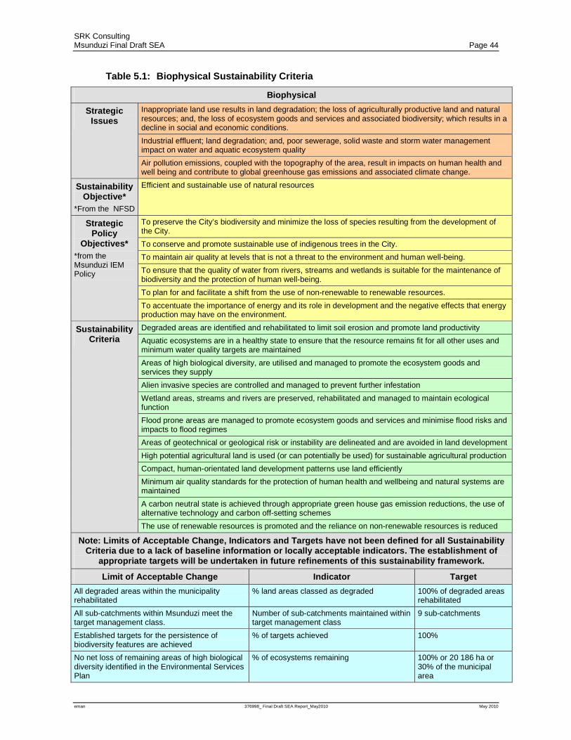
SRK Consulting Msunduzi Final Draft SEA Page 44
eman 376998_ Final Draft SEA Report_May2010 May 2010
Table 5.1: Biophysical Sustainability Criteria
Biophysical
Strategic Issues
Inappropriate land use results in land degradation; the loss of agriculturally productive land and natural resources; and, the loss of ecosystem goods and services and associated biodiversity; which results in a decline in social and economic conditions.
Industrial effluent; land degradation; and, poor sewerage, solid waste and storm water management impact on water and aquatic ecosystem quality
Air pollution emissions, coupled with the topography of the area, result in impacts on human health and well being and contribute to global greenhouse gas emissions and associated climate change.
Sustainability Objective*
*From the NFSD
Efficient and sustainable use of natural resources
Strategic Policy
Objectives* *from the Msunduzi IEM Policy
To preserve the City’s biodiversity and minimize the loss of species resulting from the development of the City.
To conserve and promote sustainable use of indigenous trees in the City.
To maintain air quality at levels that is not a threat to the environment and human well-being.
To ensure that the quality of water from rivers, streams and wetlands is suitable for the maintenance of biodiversity and the protection of human well-being.
To plan for and facilitate a shift from the use of non-renewable to renewable resources.
To accentuate the importance of energy and its role in development and the negative effects that energy production may have on the environment.
Sustainability Criteria
Degraded areas are identified and rehabilitated to limit soil erosion and promote land productivity
Aquatic ecosystems are in a healthy state to ensure that the resource remains fit for all other uses and minimum water quality targets are maintained
Areas of high biological diversity, are utilised and managed to promote the ecosystem goods and services they supply
Alien invasive species are controlled and managed to prevent further infestation
Wetland areas, streams and rivers are preserved, rehabilitated and managed to maintain ecological function
Flood prone areas are managed to promote ecosystem goods and services and minimise flood risks and impacts to flood regimes
Areas of geotechnical or geological risk or instability are delineated and are avoided in land development
High potential agricultural land is used (or can potentially be used) for sustainable agricultural production
Compact, human-orientated land development patterns use land efficiently
Minimum air quality standards for the protection of human health and wellbeing and natural systems are maintained
A carbon neutral state is achieved through appropriate green house gas emission reductions, the use of alternative technology and carbon off-setting schemes
The use of renewable resources is promoted and the reliance on non-renewable resources is reduced
Note: Limits of Acceptable Change, Indicators and Targets have not been defined for all Sustainability Criteria due to a lack of baseline information or locally acceptable indicators. The establishment of
appropriate targets will be undertaken in future refinements of this sustainability framework.
Limit of Acceptable Change Indicator Target
All degraded areas within the municipality rehabilitated
% land areas classed as degraded 100% of degraded areas rehabilitated
All sub-catchments within Msunduzi meet the target management class.
Number of sub-catchments maintained within target management class
9 sub-catchments
Established targets for the persistence of biodiversity features are achieved
% of targets achieved 100%
No net loss of remaining areas of high biological diversity identified in the Environmental Services Plan
% of ecosystems remaining 100% or 20 186 ha or 30% of the municipal area

SRK Consulting Msunduzi Final Draft SEA Page 45
eman 376998_ Final Draft SEA Report_May2010 May 2010
All listed alien invasive species controlled % infested areas maintained (defined as cleared with three follow-up operations)
100%
No net loss of remaining wetland functionality % of functional wetland habitat remaining 100% or 1000ha
No inappropriate development within floodplains % land within the floodplain with inappropriate development
0%
Remaining areas of high potential agricultural land are used or could potentially be used for agricultural production.
% of high potential agricultural land transformed to other uses
0%
SANS 1929:2005 guideline ambient air quality limits for identified pollutants are not exceeded
Ambient concentrations of the following: Sulphur Dioxide (SO2) Nitrogen Dioxide (NO2) Carbon Monoxide (CO) Particulate Matter (PM10) Ozone (O3) Lead (Pb) Benzene (C6H6)
No excedance of limits
Green house gas emission reductions, the use of alternative technology and carbon off-setting schemes to attain carbon neutral status
Nett Green house gas emissions Carbon footprint per capita
Municipality is carbon neutral
Recommendations & Strategies
Develop and implement a plan to identify and rehabilitate degraded land to a state that improves its contribution to ecosystem goods & services. Refine the State of the Rivers reporting undertaken as part of the Status Quo Phase to 35 sub-catchments. Develop and implement a Municipal Environmental Services Plan. Undertake a wetland functionality assessment for wetland areas within Msunduzi. Develop and implement a detailed flood risk assessment for the Municipality. Undertake an alien invasive clearing program. Identify areas of grazing importance throughout the municipality and implement sustainable land use practices for all areas of agricultural importance (grazing and cultivation). Develop a municipal wide air quality constraints model. Develop a carbon emissions inventory for the municipal area and identify strategies to reduce or offset the carbon emissions. Undertake a climate change risk assessment for the Municipality and develop an appropriate climate change adaption strategy
Table 5.2: Social Sustainability Criteria
Social
Strategic Issues
Rapid population growth as a result of urbanisation has resulted in poorly planned urban development and expansion which places immense pressure on the municipality to supply basic services and maintain exiting service infrastructure. This in turn impacts on service delivery and residents rights to basic services.
The lack of basic services such as effective waste removal and the provision of appropriate sanitation and water services impact on human health and well-being and result in a deterioration of the quality of life.
Lack of information regarding cultural heritage resources within the municipality has resulted in the loss and degradation of these resources.
Sustainability Objective* *From the
NFSD
Basic human needs must be met to ensure resources necessary for long-term survival are not destroyed for short term gain
Strategic Policy
Objectives* *from the
Msunduzi IEM Policy
To ensure the quality of potable water meets the minimum legislated standards.
To provide an effective and efficient waste management system.
To protect the City’s landscapes and townscapes
To ensure that the physiological and psychological effects of noise, shock and vibration levels do not exceed legislated standards.
To preserve and improve the cultural heritage of the Msunduzi area.

SRK Consulting Msunduzi Final Draft SEA Page 46
eman 376998_ Final Draft SEA Report_May2010 May 2010
Sustainability Criteria
A basic level of water supply is provided to all residents without affecting the integrity of natural ecosystems
All residents have an income; access to appropriate, secure and affordable housing; and, have access to public services to meet basic needs and live with dignity
Communities vulnerable to environmental risk are identified and strategies are developed to minimise risk and promote human well-being.
The waste stream to landfill has been reduced to a minimum, with recovery, re-use and recycling of materials undertaken as standard practice.
Efficient and effective liquid waste management protects human health and the natural environment
An efficient, safe, integrated and convenient network of public transport, bicycle routes and pedestrian access is provided
Services, amenities, buildings, facilities, community parks and open spaces are accessible to all people; and, safe, clean and pleasant environments are provided that protect and enhance human health and wellbeing and improve the overall quality of life.
High quality, affordable formal education is available and accessible for students of all ages
Indigenous ecological and cultural knowledge is developed and integrated with planning and management processes
The city’s sense of place and cultural and natural heritage resources are protected and maintained
Note: Limits of Acceptable Change, Indicators and Targets have not been defined for all Sustainability Criteria due to a lack of baseline information or locally acceptable indicators. The establishment of
appropriate targets will be undertaken in future refinements of this sustainability framework.
Limit of Acceptable Change Indicator Target
Absolute poverty is eradicated Human Development Index (Income + education levels + life expectancy)
To be defined
SABS 241 potable water quality limits are met
Indicators as per the SABS 241 standard
No excedance of Class I acceptable limit standards
Maintenance of the water quality of the Msunduzi River within Intermediate contact recreational use guidelines
Indicators as per the DWAF Water Quality Guidelines for Recreational use
Meet DWAF 80th Percentile for intermediate contact recreational guidelines for Faecal coliform pollution
Acceptable level of waste management Rural, Urban and Peri-urban waste management service levels
Rural – Level 1 Peri-Urban – Level 3 Urban – Level 5
Ambient noise is maintained within the limits set in SANS 10103
Ambient noise levels in: Industrial Areas CBD Residential areas Rural Areas
No excedance of SANS 10103 limits
All identified Cultural Heritage resources are maintained.
State of identified cultural heritage resources
All identified heritage resources conserved
Recommendations & Strategies
Undertake an urban greening program using indigenous trees; and, where appropriate, fruit trees to enhance food security. Develop an Integrated Waste Management Plan for Msunduzi to include the identification of opportunities for the recovery, reuse and recycling of waste. Undertake an environmental vulnerability assessment to identify communities at risk and develop appropriate strategies to minimise risks and promote human well-being Undertake regular noise monitoring at identified strategic locations Undertake an extensive cultural heritage resource identification and classification program.
Table 5.3: Economic Sustainability Criteria
Economic
Strategic Issues
The unequal distribution of wealth and resources, and resulting poverty, is resulting in environmentally harmful practices which are causing environmental and resource degradation.
The increased demand for development within the Msunduzi area, as a result of its strategic location within the primary Provincial development corridor and being established as the Provincial capital, is

SRK Consulting Msunduzi Final Draft SEA Page 47
eman 376998_ Final Draft SEA Report_May2010 May 2010
placing pressure on the optimal use of land and the provision of sustainable services and infrastructure.
Economic growth in Msunduzi has the potential to contribute to the regional, Provincial and National economy, increase average household incomes and meet basic needs.
Sufficient job creation to adequately address unemployment within a growing urbanised population is not occurring. .
Economic costs through the loss of ‘free’ ecosystem goods and services is not well understood or integrated into economic and development decision making.
Opportunities for training and job creation exist through environmental programs such as carbon sequestration; soil conservation and rehabilitation of degraded areas; alien invasive species management ; solid waste management and recycling; and, urban greening.
Sustainability Objective* *From the
NFSD
Socio-economic systems are embedded within, and dependent upon, eco-systems
Strategic Policy
Objectives* *from the
Msunduzi IEM Policy
To promote sustainable environmental, social and economic development.
To emphasize the interdependence between poverty, economic growth and the environment
Sustainability Criteria
Development is informed by social needs and the improvement of quality of life and does not compromise the biophysical environment
Alternative sustainable livelihood strategies are promoted.
An equitable and broad range of employment opportunities exist that provide workers with income to support themselves and their families.
Infrastructure and facilities are well-maintained to meet the needs of residents and business in ways that reduce environmental impacts
Most of the daily food needs of Msunduzi are sustainably grown, processed and packaged in urban and rural agricultural schemes in the city and surrounding agricultural areas
Green design principles are used to ensure environmental efficiency and minimise use of resources
Clean, renewable and efficient energy sources; and, transportation options that reduce fossil fuel dependence are promoted, so as to reduce energy costs and produce low greenhouse gas emissions and other air contaminants
City finances are managed responsibly and include full life-cycle cost perspectives, including long-term maintenance, repair and replacement costs.
The cost of ecosystem goods and services are integrated into development planning
Note: Limits of Acceptable Change, Indicators and Targets have not been defined for all Sustainability Criteria due to a lack of baseline information or locally acceptable indicators. The establishment of
appropriate targets will be undertaken in future refinements of this sustainability framework.
Limit of Acceptable Change Indicator Target
Unemployment rates below National average % of labour force without employment To be defined
Sustainable economic growth above National average
% Annual economic growth To be defined
More than 50% of daily food needs are grown, processed and packaged in Msunduzi and the surrounding agricultural areas
% of agricultural produce used in Msunduzi sourced locally
To be defined
Recommendations & Strategies
Include the EMF in the review of the IDP and SDF to identify areas suitable for sustainable development. Undertake detailed ecosystem goods and services evaluation for Msunduzi focussing on wetlands and grasslands. Use the sustainability framework and criteria to assess the sustainability of all municipal policies, plans and programmes Develop suitable financial or other instruments to provide incentives or disincentives that will promote environmental best practice and sustainable development Develop an integrated infrastructure cost model to inform the spatial determination of the urban fringe .
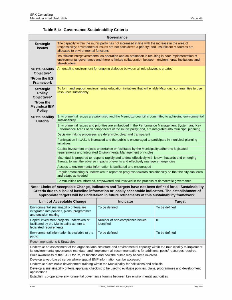
SRK Consulting Msunduzi Final Draft SEA Page 48
eman 376998_ Final Draft SEA Report_May2010 May 2010
Table 5.4: Governance Sustainability Criteria
Governance
Strategic Issues
The capacity within the municipality has not increased in line with the increase in the area of responsibility; environmental issues are not considered a priority; and, insufficient resources are allocated to environmental functions
Insufficient intergovernmental co-operation and co-ordination is resulting in poor implementation of environmental governance and there is limited collaboration between environmental institutions and stakeholders
Sustainability Objective*
*From the EGI Framework
An enabling environment for ongoing dialogue between all role players is created.
Strategic Policy
Objectives* *from the
Msunduzi IEM Policy
To form and support environmental education initiatives that will enable Msunduzi communities to use resources sustainably
Sustainability Criteria
Environmental issues are prioritised and the Msunduzi council is committed to achieving environmental sustainability
Environmental issues and priorities are embedded in the Performance Management System and Key Performance Areas of all components of the municipality; and, are integrated into municipal planning
Decision-making processes are defensible, clear and transparent
Participation in LA21 is increased and the public is encouraged to participate in municipal planning initiatives
Capital investment projects undertaken or facilitated by the Municipality adhere to legislated requirements and Integrated Environmental Management principles
Msunduzi is prepared to respond rapidly and to deal effectively with known hazards and emerging threats, to limit the adverse impacts of events and effectively manage emergencies
Access to environmental information is facilitated and encouraged
Regular monitoring is undertaken to report on progress towards sustainability so that the city can learn and adapt as needed.
Communities are informed, empowered and involved in the process of democratic governance
Note: Limits of Acceptable Change, Indicators and Targets have not been defined for all Sustainability Criteria due to a lack of baseline information or locally acceptable indicators. The establishment of
appropriate targets will be undertaken in future refinements of this sustainability framework.
Limit of Acceptable Change Indicator Target
Environmental sustainability criteria are integrated into policies, plans, programmes and decision making
To be defined To be defined
Capital investment projects undertaken or facilitated by the Municipality adhere to legislated requirements
Number of non-compliance issues identified
0
Environmental information is available to the public
To be defined To be defined
Recommendations & Strategies
Undertake an assessment of the organisational structure and environmental capacity within the municipality to implement its environmental governance mandate; and, implement all recommendations for additional posts/ resources required. Build awareness of the LA21 forum, its function and how the public may become involved. Develop a web-based server where spatial EMF information can be accessed Undertake sustainable development training within the Municipality for politicians and officials Develop a sustainability criteria appraisal checklist to be used to evaluate policies, plans, programmes and development applications Establish co-operative environmental governance forums between key environmental authorities
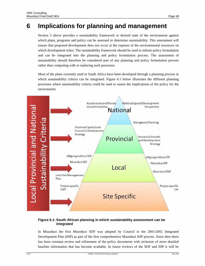
SRK Consulting Msunduzi Final Draft SEA Page 49
eman 376998_ Final Draft SEA Report_May2010 May 2010
6 Implications for planning and management Section 5 above provides a sustainability framework or desired state of the environment against
which plans, programs and policy can be assessed to determine sustainability. This assessment will
ensure that proposed development does not occur at the expense of the environmental resources on
which development relies. The sustainability framework should be used to inform policy formulation
and can be integrated into the planning and policy formulation process. The assessment of
sustainability should therefore be considered part of any planning and policy formulation process
rather than competing with or replacing such processes.
Most of the plans currently used in South Africa have been developed through a planning process in
which sustainability criteria can be integrated. Figure 6.1 below illustrates the different planning
processes where sustainability criteria could be used to assess the implications of the policy for the
environment.
Figure 6.1: South African planning in which sustainability assessment can be integrated
In Msunduzi the first Msunduzi SDF was adopted by Council in the 2001/2002 Integrated
Development Plan (IDP) as part of the first comprehensive Msunduzi IDP process. Since then there
has been constant review and refinement of the policy documents with inclusion of more detailed
baseline information that has become available. In future reviews of the SDF and IDP it will be
SRK Consulting Msunduzi Final Draft SEA Page 50
eman 376998_ Final Draft SEA Report_May2010 May 2010
crucial that the sustainability criteria detailed above be used to inform the sustainability of
development proposals. It therefore will not be necessary to undertake an entirely new process but
rather to include consideration of the sustainability criteria throughout the IDP and SDF
development process. It will be equally important for Council to use the sustainability criteria to
adjudicate policies, plans, programmes and development applications within the municipality.
In order to facilitate this process as part of the SEA, an assessment of the current draft SDF was
undertaken using the sustainability criteria presented in Section 5. This assessment is included in
Section 7.
SRK Consulting Msunduzi Final Draft SEA Page 51
eman 376998_ Final Draft SEA Report_May2010 May 2010
7 Strategic assessment of land use alternatives The sustainability appraisal of the SDF used the sustainability criteria presented in Section 5.4 of this
report to compare the extent to which the Status Quo and SDF scenarios contributed towards
sustainability in Msunduzi. This assessment was undertaken for each of the four ABM areas and
focused on planned development for the four ABM areas. To inform this assessment an overview of
the SDF and terms used is provided below.
7.1 SDF
The Msunduzi SDF was drafted by Udidi Development Consultants and was adopted by Council in
November 2009. A copy of the SDF is attached as Appendix 3. The Msunduzi SDF adopted an area
based management sector (ABMS) approach. The following planning principles were used in the
development of the SDF: integration; redressing imbalances; compaction; sustainability; urban
densification; and, quality urban environment
In order to redress historical imbalances, the SDF undertook a review of historical development
trends. This guided the location of future development and the identification of areas, such as
Edendale, in need of economic opportunities. In terms of the SDF the following types of
development are proposed:
• Future Agricultural Development – only communal agriculture is proposed in terms of the
SDF and only within the Vulindlela ABM;
• Future Residential Development – proposed throughout the municipality but is concentrated in
the Bishopstowe, Mkondeni and Ashburton areas;
• Future economic development – proposal consists of extensions to existing industrial areas but
may include some commercial or office development.
• In-situ upgrades - of formal, informal and rural residential areas and include the provision of
services or the upgrading of services in an area that is currently occupied.
• Nodes – the SDF identifies existing and future nodes as well as current nodes proposed for
consolidation and expansion. Nodes are classified as follows:
− CBD Node - consisting of various uses mainly, commercial, office and residential with the
density of development decreasing as they extend outwards.
− Regional Multi-Use Nodes - that serve a region and consist mainly of commercial
development. The Liberty Midlands Mall is an example of a regional multi use node.
− Community Multi-Use Nodes – that serve a community and consist of mainly commercial
and office development. These nodes may however accommodate a wide range of land
uses.
− Neighbourhood Multi-Use Nodes - serve a neighbourhood and can be either purely retail or
multi-use.
− Focussed Multi-Use Nodes – differ from other nodes as they serve a specific purpose rather
than an area. The node proposed in terms of the SDF consists of light industry,
warehousing and wholesale retail.
SRK Consulting Msunduzi Final Draft SEA Page 52
eman 376998_ Final Draft SEA Report_May2010 May 2010
− Administration Node – like the focussed Multi-Use Nodes the administrative node serves a
purpose rather than an area and will consist of office development to serve administrative
needs.
• Activity spines - the SDF attempts to locate major facilities within easy access of major
transport routes or corridors but does not promote ribbon development. Where mixed use
development is proposed along a corridor it is referred to as an activity spine. An activity spine
is only suggested where arterial roads extend from the CBD or between two or more closely
related nodes. Activity spines consist of a mix of potential developments including retail, office,
entertainment and residential developments. The activity spine normally extends about half a
street block from the road.
7.2 Sustainability Appraisal
A Sustainability Appraisal matrix was used to compare the extent to which the SDF scenario and the
current Status Quo scenario contribute towards, or detract from, sustainability in Msunduzi. The
sustainability criteria defined in Section 5.4 above were used to populate the Sustainability Appraisal
matrix. The comparison was undertaken for each of the ABM areas. The detailed Sustainability
Appraisal matrix is included in Appendix 4 while a summary of the implications for sustainability
for both the SDF and current Status Quo scenarios are provided below.
7.2.1 Northern Areas
The ABM is characterised by steep slopes and a highly transformed aquatic system. While the area
has a large amount of open space opportunities, the use of this open space is limited by a lack of
facilities and security concerns. Service infrastructure in this ABM are reaching capacity and space
to upgrade service capacity is extremely limited. Typically, the area is characterised by residential
development with economic activities being limited to the Cascades Shopping Centre and
surrounding areas.
The SDF proposes the following development for the Northern ABM:
• Residential development in the Woodlands and Eastwood areas;
• Activity spines from Liberty Midlands Mall to Cascades and along the Old Greytown Road;
• The following Nodes are identified:
− A community node that requires consolidation and upgrading in the vicinity of the
Cascades Shopping centre;
− A new administrative node within the Town Hill Hospital grounds;
− Two community nodes on the Old Greytown Road, that require consolidation and
upgrading; and
− Two economic activity nodes at The Liberty Midlands Mall and opposite the Northdale
Hospital
• An in-situ upgrade of the existing informal housing at Sobantu.
To a large extent it is possible to mitigate the potential impacts of proposed development on the
biophysical environment through site specific design. The provision of additional services required
to meet the needs of future development have not however been addressed in the SDF and this poses

SRK Consulting Msunduzi Final Draft SEA Page 53
eman 376998_ Final Draft SEA Report_May2010 May 2010
a significant threat to the social economic and biophysical environment. The SDF proposes large
areas for residential development, and the upgrading of existing informal residential areas. It has
however missed opportunities for mixed use development such as urban agriculture and low impact
manufacturing and retail attached to the business owner’s home. By setting aside areas of restricted
use areas, the SDF promotes the protection of sensitive habitats and the goods and services offered
by these ecosystems.
7.2.2 CBD, Ashburton and Eastern Areas
This ABM has historically provided the majority of the economic opportunities in the municipality.
The Ashburton area within the ABM has however remained at relatively low density. There is
increased development pressure in this area due to its location on the N3 in relation to Durban.
This ABM has been proposed for significant development in terms of the SDF including:
• Residential and economic development opportunity throughout the ABM focusing on the
Lynfield Park, Lincoln Meade and Ambleton areas;
• Economic opportunity areas around the existing Mkondeni industrial area and along the
Richmond Road;
• A small proportion of in-situ upgrade of existing residential areas in the Emantshaheni area;
• The following activity spines:
− Along Boshoff St, becoming Surrey and then New England Road, from Burger St to the
southern side of the New England Road off ramp, (linking the CBD and Hayfields Nodes);
− Along Berg Street becoming Mayors Walk from Albert Luthuli Street (Commercial Rd) to
the Botanical Gardens, (linking the CBD and Mayors Walk Neighbourhood Nodes); and
− Along Alan Paton Dr. from Burger Street to the University of KwaZulu Natal, (linking the
CBD and the 50 Durban Road Neighbourhood Nodes);
• The following Nodes are identified:
− A future community node near Cleland;
− Community nodes in need of consolidation and expansion in Bisley and along Mayors
Walk;
− A focused multi-use node in the Campsdrift area;
− An existing community node at 50 Durban Road;
− Two future neighbour hood nodes at Lincoln Meade and Bishopstowe
− Economic opportunity nodes at Lynfield park; the Richmond/Umlaas Road N3 interchange;
Ashburton; Ambleton City; and, Hayfields.
The SDF proposes development that will assist in realising further development opportunities and
compaction in areas subject to development pressure. The SDF does not however detail the density
of the proposed residential, economic opportunity and industrial areas, which limits this assessment.
Large parts of Ashburton, Mkondeni and Lincoln Meade are of high biodiversity importance, and at
a broad planning level the SDF may conflict with these areas. Site specific studies of areas proposed
for residential or economic development should be undertaken. Compaction and densification should
be considered to meet the same need for socio-economic development while still allowing for the
maintenance of important biodiversity elements. Initiatives such as the development of a biodiversity
SRK Consulting Msunduzi Final Draft SEA Page 54
eman 376998_ Final Draft SEA Report_May2010 May 2010
corridor within this ABM will also assist in identifying areas that should be retained for the
protection of ecosystem goods and services and focusing development in less sensitive areas. At the
moment only part of Ashburton is not connected to a municipal sewerage treatment works at
Lynfield Park. The sewerage works consists of drying beds that dry the effluent so that it can be
disposed of as landfill waste. The remainder of the area is serviced by septic or conservancy tanks.
The capacity of the Lynfield Park sewerage works is insufficient to deal with any further
densification. To address this Msunduzi is currently investigating options for the construction of a
regional sewerage works on the Duzi river.
7.2.3 Greater Edendale and Greater Imbali
The Edendale area was historically inhabited by the black middle class. The majority of the African
cultural heritage sites were identified within this ABM and specifically within Georgetown. After the
abolishment of apartheid, urbanisation increased, resulting in peri-urban development and
densification. The densification has strained service capacity and coupled with the misuse of services
in this area, has resulted in severe transformation of the catchment affecting downstream uses and
threatening tourist attractions such as the Duzi Canoe Marathon. The ABM has a large number of
wetland systems. However inappropriate land use in the ABM has resulted in the majority of open
spaces being transformed. The Edendale and Imbali areas have been previously disadvantaged and
therefore the SDF was tasked with identifying opportunities for these areas. Development proposed
for this ABM in terms of the SDF is as follows:
• Improvements to rural and informal residential areas throughout the ABM;
• The following nodes:
− The Qokololo economic opportunity node;
− Three future neighbourhood nodes near Unit EE, Unit 18 and Sinathingi;
− A Rural Service Centre at Georgetown;
By proposing in-situ upgrades for existing residential areas the SDF aims to address service related
issues. By identifying restricted use areas, the SDF further aims to provide open space and maintain
functioning ecosystems. The management and maintenance of both open space areas and services
are however critical. Traditionally open space areas have been invaded and have become informal
settlements. To avoid this, it is critical that the community take ownership of these areas and
understand their value. Equally the installation of services in this area has been problematic as the
misuse of services has resulted in increased maintenance requirements and, in the absence of
required maintenance, impacts on the environment, especially river health. Installation of further
services is likely to result in further impacts unless installation is coupled with major maintenance
capacity and community awareness programs.
Apartheid planning meant that economic opportunities in this ABM were extremely limited. One of
the objectives of the SDF is to identify economic opportunities within this ABM. The economic
opportunity and service nodes identified in the SDF will make economic opportunities and services
more accessible to communities in the ABM and reduce transport requirements.
7.2.4 Vulindlela
The Vulindlela ABM is almost entirely rural and therefore has limited infrastructure to support
development. Land tenure in the ABM is traditional which further complicates land use and the
SRK Consulting Msunduzi Final Draft SEA Page 55
eman 376998_ Final Draft SEA Report_May2010 May 2010
realisation of development opportunities. Much of Vulindlela is subject to land degradation resulting
from unsustainable land practices.
The following development is proposed by the SDF:
• Communal agriculture throughout the ABM;
• In situ upgrade of existing rural residential areas;
• The following nodes:
− Two Rural Service Centres at KwaMpande and Songonzima; and
− An economic opportunity node at Taylors Halt.
Agricultural development and in situ upgrades of this area are likely to result in further degradation
and impacts on biodiversity and water quality if not undertaken with due care. Communal
agriculture is not by definition unsustainable. However, given the current unsustainable land use
practices resulting from current land tenure, it is likely that further agricultural development may
exacerbate the situation. Interventions would be required to address the current situation and limit
the potential impact of further development on the environment. Equally, the provision of services
would be expected to improve water quality. Improved maintenance and a reduction in the misuse of
sewer reticulation systems will be key to ensuring sustainability.
The SDF identifies economic opportunities and alternative livelihood strategies through the
promotion of communal agriculture and the identification of an economic activity node at Taylors
Halt. These opportunities contribute to social and economic sustainability. They will need to be
managed to ensure biophysical sustainability.
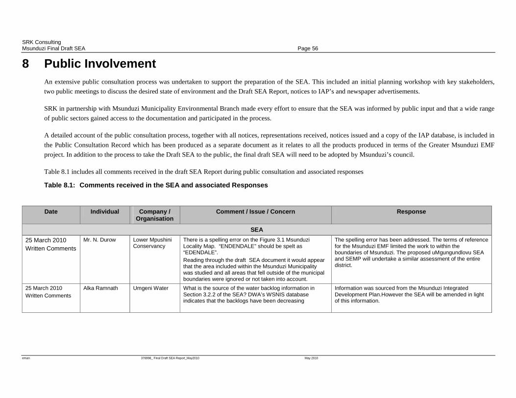
SRK Consulting Msunduzi Final Draft SEA Page 56
eman 376998_ Final Draft SEA Report_May2010 May 2010
8 Public Involvement An extensive public consultation process was undertaken to support the preparation of the SEA. This included an initial planning workshop with key stakeholders,
two public meetings to discuss the desired state of environment and the Draft SEA Report, notices to IAP’s and newspaper advertisements.
SRK in partnership with Msunduzi Municipality Environmental Branch made every effort to ensure that the SEA was informed by public input and that a wide range
of public sectors gained access to the documentation and participated in the process.
A detailed account of the public consultation process, together with all notices, representations received, notices issued and a copy of the IAP database, is included in
the Public Consultation Record which has been produced as a separate document as it relates to all the products produced in terms of the Greater Msunduzi EMF
project. In addition to the process to take the Draft SEA to the public, the final draft SEA will need to be adopted by Msunduzi’s council.
Table 8.1 includes all comments received in the draft SEA Report during public consultation and associated responses
Table 8.1: Comments received in the SEA and associated Responses
Date Individual Company / Organisation
Comment / Issue / Concern Response
SEA
25 March 2010 Written Comments
Mr. N. Durow Lower Mpushini Conservancy
There is a spelling error on the Figure 3.1 Msunduzi Locality Map. “ENDENDALE” should be spelt as “EDENDALE”. Reading through the draft SEA document it would appear that the area included within the Msunduzi Municipality was studied and all areas that fell outside of the municipal boundaries were ignored or not taken into account.
The spelling error has been addressed. The terms of reference for the Msunduzi EMF limited the work to within the boundaries of Msunduzi. The proposed uMgungundlovu SEA and SEMP will undertake a similar assessment of the entire district.
25 March 2010 Written Comments
Alka Ramnath Umgeni Water What is the source of the water backlog information in Section 3.2.2 of the SEA? DWA’s WSNIS database indicates that the backlogs have been decreasing
Information was sourced from the Msunduzi Integrated Development Plan.However the SEA will be amended in light of this information.
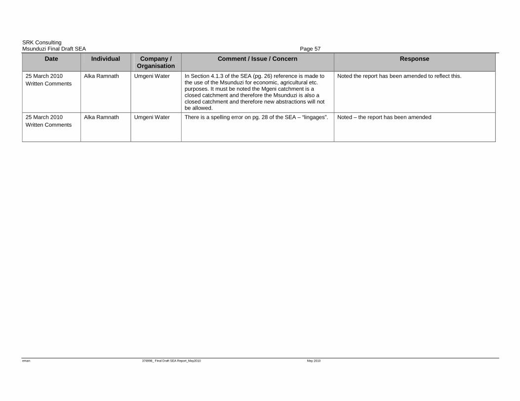
SRK Consulting Msunduzi Final Draft SEA Page 57
eman 376998_ Final Draft SEA Report_May2010 May 2010
Date Individual Company / Organisation
Comment / Issue / Concern Response
25 March 2010 Written Comments
Alka Ramnath Umgeni Water In Section 4.1.3 of the SEA (pg. 26) reference is made to the use of the Msunduzi for economic, agricultural etc. purposes. It must be noted the Mgeni catchment is a closed catchment and therefore the Msunduzi is also a closed catchment and therefore new abstractions will not be allowed.
Noted the report has been amended to reflect this.
25 March 2010 Written Comments
Alka Ramnath Umgeni Water There is a spelling error on pg. 28 of the SEA – “lingages”.
Noted – the report has been amended

SRK Consulting Msunduzi Final Draft SEA Page 58
eman 376998_ Final Draft SEA Report_May2010 May 2010
9 Conclusions and Way Forward The report provides context and background to the development of the SEA. The report then
describes how the SEA was conducted and provides a description of Msunduzi’s current biophysical,
social, economic and governance environment. Based on the current state of the environment key
environmental issues are identified. The critical issues identified include limitations in
environmental governance which results in environmental issues not being prioritised. This leads to
inappropriate land use and uncontrolled emissions to the environment which result in land
degradation, compromising ecosystems and the associated goods and services. These goods and
services are vital for the health and well being of the municipal residents and the realisation of
economic and social development.
To address the key issues a desired state of the environment was developed through extensive public
consultation and the review of applicable legislation, policy and guidelines. The desired state of the
environment provides a sustainability framework against which the municipality can assess the
sustainability of any policy, plan, program or development application. As the Msunduzi SDF had
just been developed and adopted, this provided an opportunity to use the sustainability criteria
developed to assess the sustainability of the SDF. This assessment was undertaken at the ABM scale
using a Sustainability Appraisal matrix.
The extent to which the SDF works towards, or detracts from, the sustainability criteria varies
greatly over the four ABM’s. Generally the SDF works more strongly towards the social and
economic sustainability criteria whilst sometimes potentially undermining the biophysical
environment. It may be possible to mitigate much of the negative environmental impact as a result of
development proposed in terms of the SDF at a site specific level. It is critical that environmental
governance be improved if sustainable development is to be achieved within the municipality.
Given the potential pressures on the environment, a number of strategies are identified in the Desired
State of the Environment that the municipality will need to implement to address development
pressures and encourage sustainable development. These strategies presented in Table 8.1 will form
the basis for the SEMP which will provide a detailed plan of work to be undertaken in terms of the
implementation of the EMF. The SEMP together with the ESP and EMF will form the final
products in terms of the overall Msunduzi EMF project.
SRK Consulting Msunduzi Final Draft SEA Page 59
eman 376998_ Final Draft SEA Report_May2010 May 2010
Table 9.1: Environmental Strategies
Biophysical 1. Develop and implement a plan to identify and rehabilitate degraded land to a state that improves its contribution to ecosystem goods & services.
2. Refine the State of the Rivers reporting undertaken as part of the Status Quo Phase to 35 sub-catchments.
3. Develop and implement a Municipal Environmental Services Plan. 4. Undertake a wetland functionality assessment for wetland areas within Msunduzi. 5. Develop and implement a detailed flood risk assessment for the Municipality. 6. Undertake an alien invasive clearing program. 7. Identify areas of grazing importance throughout the municipality and implement sustainable land
use practices for all areas of agricultural importance (grazing and cultivation). 8. Develop a municipal wide air quality constraints model. 9. Develop a carbon emissions inventory for the municipal area and identify strategies to reduce or
offset the carbon emissions. 10. Undertake a climate change risk assessment for the Municipality and develop an appropriate
climate change adaption strategy
Social 1. Undertake an urban greening program using indigenous trees; and, where appropriate, fruit trees to enhance food security.
2. Develop an Integrated Waste Management Plan for Msunduzi to include the identification of opportunities for the recovery, reuse and recycling of waste.
3. Undertake an environmental vulnerability assessment to identify communities at risk and develop appropriate strategies to minimise risks and promote human well-being
4. Undertake regular noise monitoring at identified strategic locations 5. Undertake an extensive cultural heritage resource identification and classification program.
Economic 1. Include the EMF in the review of the IDP and SDF to identify areas suitable for sustainable development.
2. Undertake detailed ecosystem goods and services evaluation for Msunduzi focussing on wetlands and grasslands.
3. Use the sustainability framework and criteria to assess the sustainability of all municipal policies, plans and programmes
4. Develop suitable financial or other instruments to provide incentives or disincentives that will promote environmental best practice and sustainable development
5. Develop an integrated infrastructure cost model to inform the spatial determination of the urban fringe .
Governance 1. Undertake an assessment of the organisational structure and environmental capacity within the municipality to implement its environmental governance mandate; and, implement all recommendations for additional posts/ resources required.
2. Build awareness of the LA21 forum, its function and how the public may become involved. 3. Develop a web-based server where spatial EMF information can be accessed 4. Undertake sustainable development training within the Municipality for politicians and officials 5. Develop a sustainability criteria appraisal checklist to be used to evaluate policies, plans,
programmes and development applications 6. Establish a co-operative environmental governance forums between key environmental authorities
SRK Consulting Msunduzi Final Draft SEA Page 60
eman 376998_ Final Draft SEA Report_May2010 May 2010
10 References DEAT (2007), Strategic Environmental Assessment Guideline, Integrated Environmental Guideline
Series 4, Department of Environmental Affairs and Tourism (DEAT), Pretoria, South Africa
Department of Agriculture and Environmental Affairs & Department of Environmental Affairs and
Tourism, Environmental sustainability toolkit for integrated development planning in KwaZulu-
Natal -Section 3 Tools – Information: Overview of Environmental Legislation and the MSA
(Unpublished guideline 2007);
Environment Conservation Act, No. 73 of 1989
Institute of Natural Resources, Agriculture specialist study conducted as part of the Msunduzi
Environmental Management Framework, (Unpublished report, 2009)
Institute of Natural Resources, Biodiversity specialist study conducted as part of the Msunduzi
Environmental Management Framework, (Unpublished report, 2008)
Institute of Natural Resources, Surface Water specialist study conducted as part of the Msunduzi
Environmental Management Framework, (Unpublished report, 2008)
Institute of Natural Resources, Wetlands specialist study conducted as part of the Msunduzi
Environmental Management Framework, (Unpublished report, 2008)
Isibuko Se Afrika, Socio-economic analysis and planning policy review specialist study conducted
as part of the Msunduzi Environmental Management Framework, (Unpublished report, 2009)
Local Government Municipal Structures Act 117 of 1998
Msunduzi Municipality, Msunduzi Integrated Development Plan for 2008 to 2012 (Msunduzi
Municipality 2008)
Msunduzi Municipality, Msunduzi Integrated Environmental Management Policy (Msunduzi
Municipality 2007)
Msunduzi Municipality, Msunduzi Spatial Development Framework (Msunduzi Municipality 2009)
Municipal Planning and Performance Management Regulations (2001)
Municipal Systems Act 32 of 1998
National Environmental Management Act, Environmental Impact Assessment Regulations (GNR
385, GNR 386 and GNR 387, 2006)
National Environmental Management Act, No. 107 of 1998
Republic of South Africa Constitution Act 110 of 1983
SRK Consulting Msunduzi Final Draft SEA Page 61
eman 376998_ Final Draft SEA Report_May2010 May 2010
SRK Consulting, Catchment Hydrology specialist study conducted as part of the Msunduzi
Environmental Management Framework, (Unpublished report, 2009)
SRK Consulting, Cultural heritage specialist study conducted as part of the Msunduzi Environmental
Management Framework, (Unpublished report, 2008)
SRK Consulting, Current service capacity specialist study conducted as part of the Msunduzi
Environmental Management Framework, (Unpublished report, 2009)
WSP Environmental, Air quality specialist study conducted as part of the Msunduzi Environmental
Management Framework, (Unpublished report, 2009)

SRK Consulting Msunduzi Final Draft SEA Page 62
eman 376998_ Final Draft SEA Report_May2010 May 2010
Appendices Appendix 1 Figures
Figure 10.1: Development Constraints Map

SRK Consulting Msunduzi Final Draft SEA Page 63
eman 376998_ Final Draft SEA Report_May2010 May 2010
Appendix 2 Stakeholder Questionnaire and Analysis
Suite 201, Sinodale Centre 345 Burger Street Pietermaritzburg 3201 P O Box 460 Pietermaritzburg 3200 South Africa e-Mail: [email protected] URL: http://www.srk.co.za Tel: +27 (0) 33 345 6311 Fax: +27 (0) 33 345 6403
G:\Proj\376998 MSunduzi EMF\4) Project_Work\Public_Participation\376998_Questionaire CL_27Jan09.docx
Partners JCJ Boshoff, MJ Braune, JM Brown, CD Dalgliesh, JR Dixon, DM Duthe, T Hart, PR Labrum, DJ Mahlangu, RRW McNeill, HAC Meintjes, BJ Middleton, MJ Morris, GP Murray, GP Nel, VS Reddy, PN Rosewarne, PE Schmidt, PJ Shepherd, VM Simposya, AA Smithen, PJ Terbrugge, KM Uderstadt, DJ Venter, HG Waldeck, A Wood
Cape Town +27 (0) 21 659 3060 Durban +27 (0) 31 279 1200 East London +27 (0) 43 748 6292 Johannesburg +27 (0) 11 441 1111 Kimberley +27 (0) 53 861 5798 Pietermaritzburg +27 (0) 33 345 6311 Port Elizabeth +27 (0) 41 509 4800 Pretoria +27 (0) 12 361 9821 Rustenburg +27 (0) 14 594 1280 Dar-es-Salaam +25 (5) 22 260 1881 Harare +263 (4) 49 6182
Directors AJ Barrett, JR Dixon, DJ Mahlangu, BJ Middleton, MJ Morris, PE Schmidt, PJ Terbrugge Associates AN Birtles, BM Engelsman, R Gardiner, DJD Gibson, WC Joughin, SA McDonald, WA Naismith, M Ristic, JJ Slabbert, D Visser, ML Wertz, Consultants AC Burger, BSc (Hons); IS Cameron-Clarke, PrSci Nat, MSc; JAC Cowan, JH de Beer, PrSci Nat, MSc; GA Jones, PrEng, PhD; MEng, TR Stacey, PrEng, DSc; OKH Steffen, PrEng, PhD; RJ Stuart, PrTech Eng, GDE; DW Warwick, PrSci Nat, BSc (Hons)
SRK Consulting (South Africa) (Pty) Ltd
Reg No 1995.012890.07
27 January 2009
376998
Dear Interested and Affected Party
Msunduzi Environmental Management Framework - Stakeholder Questionnaire In August 2007 SRK Consulting was appointed to prepare an Environmental Management Framework for the Msunduzi Municipal Area. The project commenced with an Inception Phase which was followed by numerous specialist studies all informing the Situational Analysis and Strategic Environmental Assessment (SEA) Phase which is in progress. To further inform the SEA, specifically the Desired State of the Environment, the questionnaire as attached has been developed. The purpose of the questionnaire is to obtain a better understanding of the public perceptions of the environment and involvement in environmental institutions. As an Interested and Affected party we would greatly appreciate it if you could take the time to complete the questionnaire and send it back to us via email or fax at the details provided in the letterhead. Alternatively should it be more convenient, questionnaires can be sent to Rodney Bartholomew at the Msunduzi Municipality - Conservation and Environment Unit via the municipal internal mail system. We would like to encourage as many people to participate as possible however to ensure that the input obtained from the questionnaires is included in the SEA Report we will require that the questionnaires be sent back by the 9 February 2009. Should you have any queries or require further copies of the questionnaire please do not hesitate to contact the undersigned.
Yours faithfully,
Pippa Emanuel
Environmental Scientist FOR: SRK CONSULTING
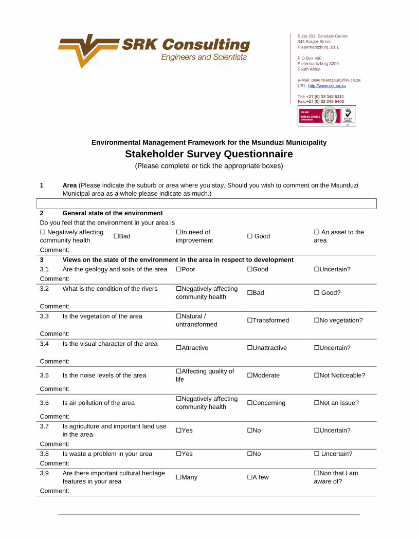
Suite 201, Sinodale Centre 345 Burger Street Pietermaritzburg 3201 P O Box 460 Pietermaritzburg 3200 South Africa e-Mail: [email protected] URL: http://www.srk.co.za Tel: +27 (0) 33 345 6311 Fax:+27 (0) 33 345 6403
Environmental Management Framework for the Msunduzi Municipality
Stakeholder Survey Questionnaire (Please complete or tick the appropriate boxes)
1 Area (Please indicate the suburb or area where you stay. Should you wish to comment on the Msunduzi
Municipal area as a whole please indicate as much.)
2 General state of the environment
Do you feel that the environment in your area is
� Negatively affecting community health
�Bad �In need of improvement
� Good � An asset to the area
Comment:
3 Views on the state of the environment in the area in respect to development 3.1 Are the geology and soils of the area �Poor �Good �Uncertain?
Comment:
3.2 What is the condition of the rivers
�Negatively affecting community health
�Bad � Good?
Comment:
3.3 Is the vegetation of the area
�Natural / untransformed
�Transformed �No vegetation?
Comment:
3.4 Is the visual character of the area
�Attractive �Unattractive �Uncertain?
Comment:
3.5 Is the noise levels of the area �Affecting quality of life
�Moderate �Not Noticeable?
Comment:
3.6 Is air pollution of the area �Negatively affecting community health
�Concerning �Not an issue?
Comment:
3.7 Is agriculture and important land use in the area
�Yes �No �Uncertain?
Comment:
3.8 Is waste a problem in your area �Yes �No � Uncertain?
Comment:
3.9 Are there important cultural heritage features in your area
�Many �A few �Non that I am aware of?
Comment:

4 Open Space Would you like to see more open space? a) Natural/open space �Yes �No
b) Recreational open space like picnicking, walking, relaxing etc. �Yes �No
c) Recreational open space for active sport �Yes �No
d) Formal protected areas �Yes �No
e) Ecologically functioning open spaces e.g. flood control areas �Yes �No
5 Key Issues
Please indicate which of the following you feel are key issues within your area by ticking the box
�Water quality �Biodiversity �Wetlands �Air Quality �Noise Pollution
�Urban Sprawl �Informal Settlements �Erosion �Lack of Basic Services
�Lack of job opportunities
Other (Please List):
6 Institutions
Are you a member of an environmental forum/ committee/ trust / conservancy?
�Yes �No
If so please provide the name of the institution/s and details of their role/ function.
7 General Comment (Please use the space provided below to make general comment around the state of environment in your area or Msunduzi Municipality as a whole and areas of concern)
8 Please complete the following:
Title: First Name: Surname: Initials:
Organization: Designation:
Tel: Fax:
Cell: e-mail:
Postal Address:
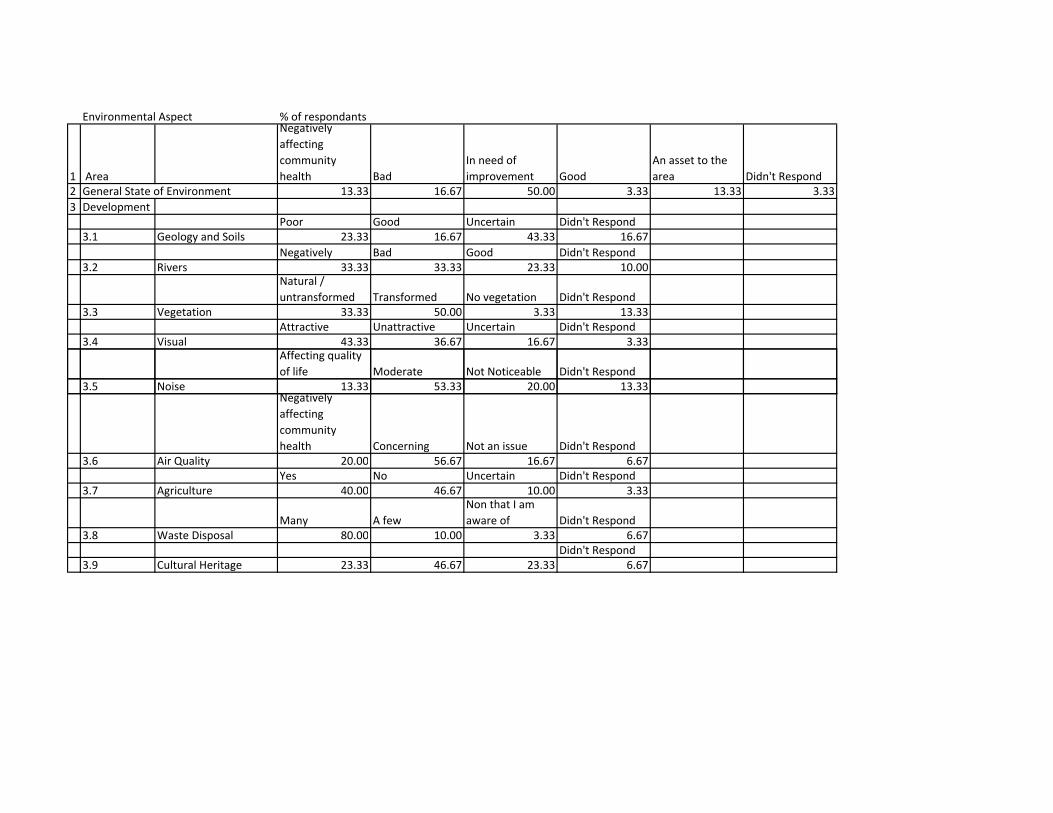
Environmental Aspect % of respondants
1 Area
Negatively
affecting
community
health Bad
In need of
improvement Good
An asset to the
area Didn't Respond
2 General State of Environment 13.33 16.67 50.00 3.33 13.33 3.33
3 Development
Poor Good Uncertain Didn't Respond
3.1 Geology and Soils 23.33 16.67 43.33 16.67
Negatively Bad Good Didn't Respond
3.2 Rivers 33.33 33.33 23.33 10.00Natural /
untransformed Transformed No vegetation Didn't Respond
3.3 Vegetation 33.33 50.00 3.33 13.33
Attractive Unattractive Uncertain Didn't Respond
3.4 Visual 43.33 36.67 16.67 3.33Affecting quality
of life Moderate Not Noticeable Didn't Respond
3.5 Noise 13.33 53.33 20.00 13.333.5 Noise 13.33 53.33 20.00 13.33Negatively
affecting
community
health Concerning Not an issue Didn't Respond
3.6 Air Quality 20.00 56.67 16.67 6.67
Yes No Uncertain Didn't Respond
3.7 Agriculture 40.00 46.67 10.00 3.33
Many A few
Non that I am
aware of Didn't Respond
3.8 Waste Disposal 80.00 10.00 3.33 6.67
Didn't Respond
3.9 Cultural Heritage 23.33 46.67 23.33 6.67
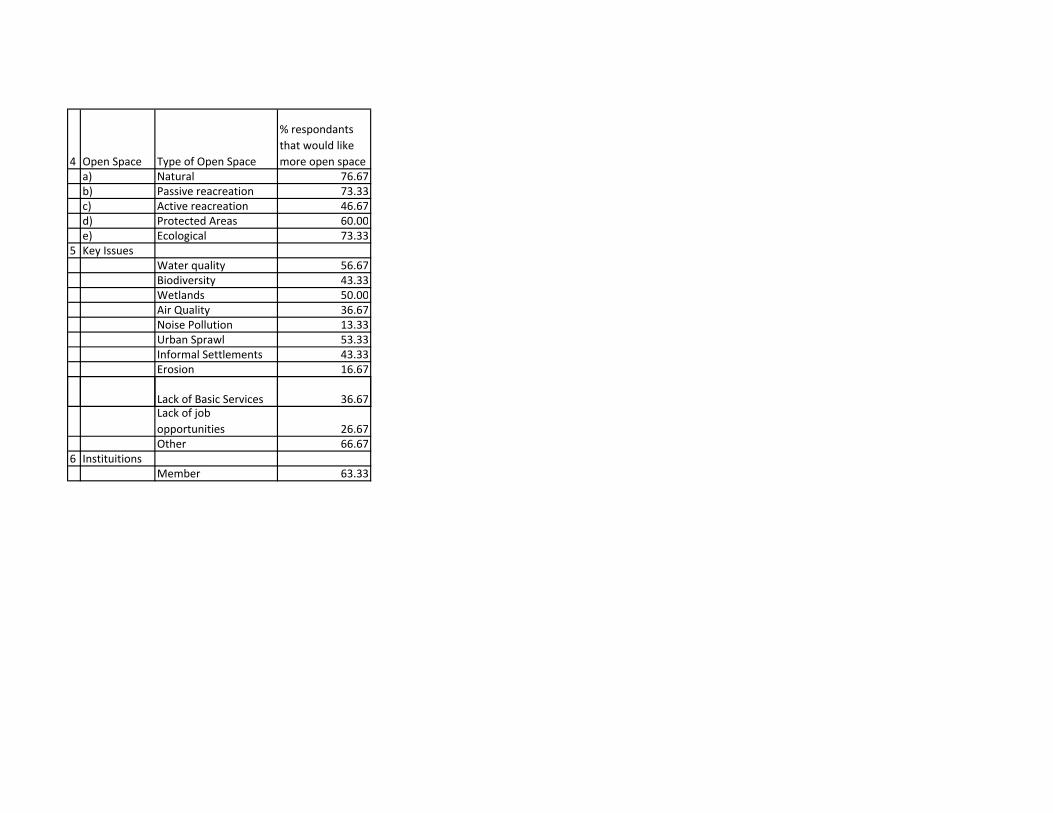
4 Open Space Type of Open Space
% respondants
that would like
more open space
a) Natural 76.67
b) Passive reacreation 73.33
c) Active reacreation 46.67
d) Protected Areas 60.00
e) Ecological 73.33
5 Key Issues
Water quality 56.67
Biodiversity 43.33
Wetlands 50.00
Air Quality 36.67
Noise Pollution 13.33
Urban Sprawl 53.33
Informal Settlements 43.33
Erosion 16.67
Lack of Basic Services 36.67Lack of job
opportunities 26.67
Other 66.67
6 Instituitions
Member 63.33
SRK Consulting Msunduzi Final Draft SEA Page 64
eman 376998_ Final Draft SEA Report_May2010 May 2010
Appendix 3 Msunduzi SDF
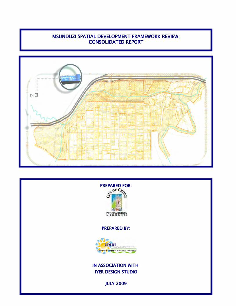
MSUNDUZI SPATIAL DEVELOMSUNDUZI SPATIAL DEVELOMSUNDUZI SPATIAL DEVELOMSUNDUZI SPATIAL DEVELOPMENT FRAMEWORK REVIEW:PMENT FRAMEWORK REVIEW:PMENT FRAMEWORK REVIEW:PMENT FRAMEWORK REVIEW:
CONSOLIDATED REPORTCONSOLIDATED REPORTCONSOLIDATED REPORTCONSOLIDATED REPORT
PREPARED FOR:PREPARED FOR:PREPARED FOR:PREPARED FOR:
PREPARED BY:PREPARED BY:PREPARED BY:PREPARED BY:
IN ASSOCIATION WITH:IN ASSOCIATION WITH:IN ASSOCIATION WITH:IN ASSOCIATION WITH:
IYER DESIGN STUDIOIYER DESIGN STUDIOIYER DESIGN STUDIOIYER DESIGN STUDIO
JULY 2009JULY 2009JULY 2009JULY 2009

MSUNDUZI SDF REVIEW
Msunduzi Consolidated SDF Review July 2009 Page i
TABLE OF CONTENTS TABLE OF CONTENTS ............................................................................................................... i 1.0 INTRODUCTION .........................................................................................................- 1 - 1.1 Background ................................................................................................................- 1 - 1.2 Historical Context ......................................................................................................- 2 - 2.0 LEGISLATIVE FRAMEWORK ....................................................................................- 4 - 3.0 SITUATIONAL ANALYSIS: Informants .....................................................................- 7 - 3.1 Physical Environment .............................................................................................. - 36 - 3.2 Agriculture and Agricultural Potential .................................................................... - 41 - 3.3 Environmental Conservation and Open Space System ........................................ - 45 - 3.4 Social Facilities ........................................................................................................ - 53 - 3.5 Housing .................................................................................................................... - 59 - 3.6 Infrastructure............................................................................................................ - 60 - 3.7 Social Environment.................................................................................................. - 62 - 3.8 Economic Environment ........................................................................................... - 65 - 4.0 APPROACHES TO FORMULATING THE SDF ........................................................ - 72 - 4.1 Format of the SDF .................................................................................................... - 72 - 4.2 Guiding Principles ................................................................................................... - 73 - 4.3 Concept for Integrating the City .............................................................................. - 73 - 4.4 Planning and Development Informants .................................................................. - 74 - 5.0 SUMMARY OF THE DRAFT SDF REVIEW .............................................................. - 75 - 5.1 The Intentions of the Guiding Principles of the SDF ............................................. - 75 - 5.2 District SDF Guidance Framework for Local SDFs ........................................................ 6. THE CONCEPTUAL FRAMEWORK OF THE SDF ................................................... - 76 - 6.1 Introduction .............................................................................................................. - 76 - 6.2 The Conceptual Principles ...................................................................................... - 76 - 6.3 Application of the Concept to Msunduzi ................................................................ - 77 - 7. THE SDF MAP AND ITS DESIGNATIONS ............................................................... - 80 - 7.1 Nodes .......................................... .............................................................................. - 80 - 7.2 Road System ............................................................................................................ - 81 - 7.3 Residential Areas ..................................................................................................... - 82 - 7.4 Economic Opportunity Areas and Economic Opportunity Nodes ........................ - 83 - 7.5 Open Space Areas ................................................................................................... - 84 - 7.6 Agriculture ................................................................................................................ - 88 - 7.7 Urban Growth Boundary.......................................................................................... - 88 - 7.8 The SDF Structure ................................................................................................... - 88 - 8. AREAS REQUIRING MORE DETAILED PLANNING 9. LAND USE YIELDS..................................... .................................................................. 92
MSUNDUZI SDF REVIEW
Msunduzi Consolidated SDF Review July 2009 Page ii
10. SUMMARY / CONCLUSION: What Does the Plan Do? 93 10.1 Restructuring the City ................................................................................................. 93 10.2 Creating a SustainableCity and improving it's viability ............................................ 93 11. MSUNDUZI SPATIAL DEVELOPMENT FRAMEWORK ALIGNMENT 95 12. DENSITY POLICY ......................................................................................................... 96 13. MSUNDUZI IDP REVIEW FOR 2009/10 - CAPITAL INVESTMENT PROGRAM 98 14. MSUNDUZI SDF - LAND USE MANAGEMENT GUIDELINES 101 15. MSUNDUZI SDF REVIEW - SUSTAINABLILITY APPRAISAL ................................... 104 15.1 What is a Sustainability Appraisal? .......................................................................... 104 15.2 Determination of Significance of Impact of Effect ................................................... 105 15.3 Evaluation of the SDF Process 105 15.4 Sustainability Appraisal for Msunduzi SDF Review 2009 ....................................... 106 (i) Process Appraisal ................................................................................................. - 106 - (ii) Policy Appraisal ..................................................................................................... - 107 - (iii) NEMA CONFORMANCE ......................................................................................... - 110 - (iv) DFA Conformance ................................................................................................. - 114 - LIST OF FIGURES: Figure 1: Study Area; Provincial and Local Context Figure 2: Historical Background to the growth of the City Figure 3: Msunduzi Municipality Spatial Development Framework (2002)
Figure 4: UMgungundlovu District Municipality Spatial Development Framework.
Figure 5: Slope Analysis
Figure 6: Agricultural Land Potential
Figure 7: The distribution of Primary Schools in Vulindlela ABM with a walking distance buffer of
1km radius.
Figure 8: The distribution of Secondary Schools in Vulindlela ABM with a walking distance buffer of 2km radius.
Figure 9: The distribution of clinics in the Vulindlela ABM with a walking distance buffer of 2km.
The area marked with a dotted is that which is not properly catered for.
MSUNDUZI SDF REVIEW
Msunduzi Consolidated SDF Review July 2009 Page iii
Figure 10: The distribution of Primary Schools in the Edendale ABM with a walking distance buffer of 1km radius
Figure 11: The distribution of Secondary Schools in the Edendale ABM with a walking distance
buffer of 2km radius (source: Iyer Design Studio, 2006).
Figure12: The distribution of clinics in the Edendale ABM with a walking distance buffer of 2km radius.
Figure 13: The distribution of community facilities in the Edendale ABM with a walking distance
buffer of 2km radius (source: Iyer Design Studio, 2006). Figure 14: The distribution of Primary Schools in the Northern Areas and ABM with a walking
distance buffer of 1km radius.
Figure 15 : The distribution of Secondary Schools in the Northern Areas and ABM with a walking distance buffer of 2km radius
Figure 16: The distribution of clinics in the Edendale ABM with a walking distance buffer of 2km
radius. Figure 17: Population Growth Structure for KwaZulu-Natal projected for 2026. Figure 18: Population Growth Strucure for Msunduzi Municipality projected for 2026. Figure 19: Growth patterns for KwaZulu-Natal and Msunduzi Local Municipality.
Figure 20: David Dewar’s generic concept of integrating the Apartheid city, illustrated in the
context of Msunduzi Municipality
Figure 21: Illustration of Planning Principles. Figure 22: Digram exhibiting Main Roads and Nodal System.
LIST OF TABLES :
Table 1 : List of Nodes and Nodes Hierarchy Table 2 : uMgungundlovu Settlement Hierachy Table 3 : uMgungundlovu Road Hierachy Table 4: Elements of UMgungundlovu District SDF
Table 5 : Land Grading Criteria Table 6 : Summarised Mean Annual Climatic data for the main climatic units Table 7 : Growth patterns for Msunduzi Local Municipality from 1994-2000.
MSUNDUZI SDF REVIEW
Msunduzi Consolidated SDF Review July 2009 Page iv
Table 8: KwaZulu-Natal projected population growth for 2026. Table 9: Msunduzi Municipality projected population growth for 2026. Table 10: Comparison of Economic Growth Patterns of major towns in KwaZulu-Natal. Table 11: Economic sectors of Msunduzi Local Municipality
Table 12: Number of Business and Turnover within Economic Sectors of Msunduzi Local
Municipality
Table 13: Employment in Economic Sectors within Msunduzi Local Municipality
Table 14: Economic Performance for Local Economy from 2003 to First Two Quarters of 2006
Table 15: SDF Review Guiding Principles
Table 16: Summary of SDF Principles and Applications
Table 17 : Potential Development Areas: Extent and Possible Yield
Table 18: Areas of Densification Table 19 : Msunduzi Capital Investment Program for 2009/10
LIST OF ANNEXURES:
ANNEXURE 1: DEVELOPMENT CORRIDOR CONCEPTS AND THE UMGUNGUNGLOVU SDF REVIEW
ANNEXURE 2A: COMMENTS ON THE DRAFT SDF REVIEW – MAY 2009 ANNEXURE 2B: NOTES OF PUBLIC MEETING – 14 MARCH 2009 ANNEXURE 3: MAPS

MSUNDUZI SDF REVIEW
Msunduzi Consolidated SDF Review July 2009 Page v
GLOSSARY ABM Area Based Management BID Business Improvement Districts CBD Central Business District CID City Improvement Districts DM District Municipality DLA Department of Land Affairs DLGTA Department of Local Government and Traditional Affairs EIA Environmental Impact Assessment EMF Environmental Management Framework GDP Gross Domestic Product GVA Gross Value Added ICM Integrated Catchment Management IDP Integrated Development Plan INR Institute of Natural Resources LM Local Municipality LUMS Land Use Management Systems MLL Minimum Living Levels MOSS Metropolitan Open Space System PGDS Provincial Spatial Development Strategy PMA Pietermaritzburg Metropolitan Area PSEDS Provincial Spatial Economic Development Strategy PTP Public Transport Plan SDF Spatial Development Framework STATSSA Statistics South Africa TLC Transitional Local Council UDM uMgungundlovu District Municipality

MSUNDUZI SDF REVIEW
Msunduzi Consolidated SDF Review July 2009 Page - 1 -
1.0 INTRODUCTION
The Spatial Development Framework (SDF) is an integral part of a Municipality’s IDP. It
represents the spatial expression of the Council’s development vision, and should therefore be reviewed regularly to take into account changing circumstances.
Council’s existing SDF was adopted during 2002, and is now being reviewed to
accommodate the 2025 Development Vision, which is “to be the dynamic, caring Capital City of Choice in Kwa-Zulu Natal.”
In fulfilling this Vision, the Municipality is guided by its mission for facilitating service
delivery which includes dealing with:
- Community participation - Social and Economic Development and Growth - Safety, Security and HIV/AIDS - Sustainable Service Delivery - Sound finance - Sound Governance - Sustainable Environmental Management
The purpose of this report is to assist the Municipality in its assessment of the Draft SDF, and must be read together with the Draft SDF map. This report is a consolidation of SDF’s for Four Area Based Management Areas (AMB’s). The Report summarises the detailed information that can be found in the reports of individual SDF’s for the ABM’s. A SDF, being part of the IDP, is a schematic plan and indicates the broad spatial intentions of the municipality. Being schematic, it does not indicate precise cadastral alignments of roads or areas. The precise details of the SDF are developed in subsequent more detailed Land Use Framework Plans (called Local area Plans) and ultimately in Planning Schemes.
1.1 Background
i) The approach adopted by the Municipality for the SDF review is the formulation of Spatial Development Frameworks for four spatial areas or Area Based Management Sectors (ABMS). From these plans, an overall SDF for the entire Municipality is distilled at an appropriate level of abstraction. The four ABMS are (see figure 1 ):
- Northern Areas; - CBD, Ashburton, Eastern Areas; - Vulindlela; and - Greater Edendale.
ii) In the process of integrating the four ABMS into a consolidated SDF, a certain level
of integration and rationalisation is necessary to ensure consistency and legibility.

MSUNDUZI SDF REVIEW
Msunduzi Consolidated SDF Review July 2009 Page - 2 -
Figure 1: Study Area; Provincial and Local Context (Also See Map 1)
1.2 Historical Context
i) In order to understand the challenges associated with the current form of the city and the planning and development interventions that will be required to address these challenges, we must remind ourselves how the current municipal boundaries came about. As illustrated in figure 2 , the Msunduzi Municipality Area consists of three district areas, each of which is home to approximately 200’000 people i.e.
• The former borough of Pietermaritzburg • Greater Edendale • The Vulindlela Tribal area
ii) During the 1850’s, development was concentrated mainly in the central grid which by
and large coincides with the existing CBD. Together with the surrounding townlands it made up the borough of Pietermaritzburg.
iii) In 1848, the Zwartkop location to the west of the borough was declared. The
boundaries of this area remained unchanged, and subsequently became the Vulindlela Tribal Area.
iv) During the 1970’s, the Edendale area was established as a separate administrative
entity as part of the Government’s apartheid policy. At the same time, in an effort to force people out of townships which formed enclaves in so-called white areas, investment was curtailed into infrastructure and maintenance in areas like Sobantu, leading to a deterioration of residential amenities.
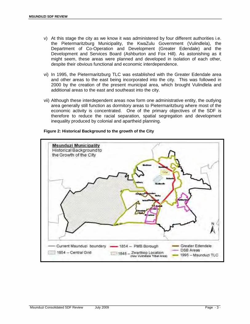
MSUNDUZI SDF REVIEW
Msunduzi Consolidated SDF Review July 2009 Page - 3 -
v) At this stage the city as we know it was administered by four different authorities i.e.
the Pietermaritzburg Municipality, the KwaZulu Government (Vulindlela), the Department of Co-Operation and Development (Greater Edendale) and the Development and Services Board (Ashburton and Fox Hill). As astonishing as it might seem, these areas were planned and developed in isolation of each other, despite their obvious functional and economic interdependence.
vi) In 1995, the Pietermaritzburg TLC was established with the Greater Edendale area
and other areas to the east being incorporated into the city. This was followed in 2000 by the creation of the present municipal area, which brought Vulindlela and additional areas to the east and southeast into the city.
vii) Although these interdependent areas now form one administrative entity, the outlying
area generally still function as dormitory areas to Pietermaritzburg where most of the economic activity is concentrated. One of the primary objectives of the SDF is therefore to reduce the racial separation, spatial segregation and development inequality produced by colonial and apartheid planning.
Figure 2: Historical Background to the growth of the City

MSUNDUZI SDF REVIEW
Msunduzi Consolidated SDF Review July 2009 Page- 4 -
2.0 LEGISLATION AND POLICY 2.1 National and Provincial Legislation and Policies
The SDF is guided by, amongst others, the following pieces of Legislation and Policies at a National and Provincial Level:
• South African Constitution and Principles of Sustainable Development • The Municipal System Act (MSA) • The Development Facilitation Act (DFA) • Environmental Conservation Act (ECA) • The National Environment Management Act (NEMA) • Social Housing Act (SHA) • Accelerated and Shared Growth Initiative for South Africa (ASGISA) • National Spatial Development Perspective (NSDP) • The Provincial Growth and Development Strategy (PGDS) • Provincial Spatial Economic Development Strategy (PSEDS) • White Paper on Spatial Planning and Land Use Management
2.1.1 South African Constitution and Principles of Sustainable Development
Chapter 7 of the Constitution deals with local government and section 152 deals with the objectives of local government. It indicates that these objectives are:
• To provide democratic and accountable government for local
communities; • To ensure the provision of services to communities in a sustainable
manner; • To promote social and economic development; • To promote a safe and healthy environment; and • To encourage the involvement of communities and community
organizations in the matters of local government.
SOUTH AFRICAN CONSTITUTION IMPLICATIONS FOR THE SDF • The IDP and SDF seek to actualise the objectives of the Constitution.
2.1.2 Municipal Systems Act
Section 23 (1) of the act indicates that a municipality must undertake developmentally- orientated planning and Section 24 (1) indicates that planning undertaken by the municipality must be aligned with and compliment plans of other municipalities and organs of state.
Section 26 of the Act indicates that a core component of an IDP is a SDF which must include the provision of basic guidelines for a land use management system for the municipality.
Section 35 of the Act also indicates that a SDF contained in an IDP prevails over a plan as identified in Section 1 of the Physical Planning Act (No. 125 of 1991).

MSUNDUZI SDF REVIEW
Msunduzi Consolidated SDF Review July 2009 Page- 5 -
Regulation promulgated in terms of the act outline the following requirements for a SDF:
“A spatial development framework reflected in a municipality’s integrated development plan must:
a) give effect to the principles contained in Chapter 1 of the Development
Facilitation Act, 1995 (Act 67 of 1995); b) set out objectives that reflect the desired spatial form of the municipality; c) contain strategies and policies regarding the manner in which to achieve the
objectives referred to in paragraph (b), which strategies and policies must-
i) indicate desired patterns of land use within the municipality; ii) address the spatial reconstruction of the municipality; and iii) provide strategic guidance in respect of the location and nature of
development within the municipality.
d) Set out basic guidelines for a land use management system in the municipality;
e) Set out a capital investment framework for the municipality’s development programmes;
f) Contain a strategic assessment of the environmental impact of the spatial development framework;
g) Identify programmes and projects for the development of land within the municipality;
h) Be aligned with the spatial development frameworks reflected in the integrated development plans of neighbouring municipalities; and
i) provide a visual representation of the desired spatial form of the municipality, which representation-
i) must indicate where public and private land development and
investment should take place; ii) must indicate desired or undesired utilisation of space in a particular
area; iii) may delineate the urban edge; iv) must identify areas where strategic intervention is required; and v) must indicate areas where priority spending is require.
These legislative requirements provide a clear framework for the development of the Msunduzi SDF and provide a legislative checklist for its contents.
IMPLICATIONS FOR THE SDF • The SDF in compliance with Chapter 5, and Section 25 (1) of the MSA (32 of
2000); and • The SDF in compliance with Sections 26, 34 and 35 of the MSA (32 of 2000).
2.1.3 The Principles contained in the Development Facilitation Act (DFA)
Chapter 1 of the DFA sets out a number of principles which apply to all land development. The following principles would apply to the formulation and content of a Spatial Development Framework.
a. Policies, administrative practice and laws should:
(b) provide for urban and rural land development;
MSUNDUZI SDF REVIEW
Msunduzi Consolidated SDF Review July 2009 Page- 6 -
(ii) facilitate the development of formal and informal, existing and new settlements;
(iii) discourage the illegal occupation of land, with due recognition of informal land development processes;
(iv) promote speedy land development; (v) promote efficient and integrated land development in that they:
• promote the integration of the social, economic, institutional and physical aspects of land development;
• promote integrated land development in rural and urban areas in support of each other;
• promote the availability of residential and employment opportunities in close proximity to or integrated with each other;
• optimize the use of existing resources including such resources relating to agriculture, land, minerals, bulk infrastructure, roads, transportation and social facilities;
• promote a diverse combination of land uses, also at the level of individual erven or subdivisions of land;
• discourage the phenomenon of “urban sprawl” in urban areas and contribute to the development of more compact towns and cities;
• contribute to the correction of the historically distorted spatial patterns of settlement in the Republic and to the optimum use of existing infrastructure in excess of current needs; and
• encourage environmentally sustainable land development practices and processes.
b. Members of communities affected by land development should actively participate in the process of land development.
c. The skills and capacities of disadvantaged persons involved in land development should be developed.
d. Policy, administrative practice and laws should promote sustainable land
development at the required scale in that they should –
(i) promote land development which is within the fiscal, institutional and administrative means of the Republic;
(ii) promote the establishment of viable communities; (iii) promote sustained protection of the environment’ (iv) meet the basic needs of all citizens in an affordable way; and (v) ensure the safe utilization of land by taking into consideration
factors such as geological formations and hazardous undermined areas
e. Each proposed land development area should be judged on its own merits and no particular use of land, such as residential, commercial, conservational, industrial, community facility, mining, agricultural or public use, should in advance or in general be regarded as being less important or desirable than any other use of land.
f. Land development should result in security of tenure, provide for the widest possible range of tenure alternatives, including individual and
MSUNDUZI SDF REVIEW
Msunduzi Consolidated SDF Review July 2009 Page- 7 -
communal tenure, and in cases where land development takes the form of upgrading an existing settlement, not deprive beneficial occupiers of homes or land or, where it is necessary for land or homes occupied by them to be utilized for other purposes, their interests in such land or homes should be reasonably accommodated in some other manner.
g. A competent authority at national, provincial and local government level should coordinate the interests of the various sectors involved in or affected by land development so as to minimize conflicting demands on scarce resources.
h. Policy, administrative practice and laws relating to land development should stimulate the effective functioning of a land development market based on open competition between suppliers of goods and services.
DFA IMPLICATIONS FOR THE SDF • The SDF is in line with the principles of the DFA which include the: • Promotion of the integration of the social, economic, institutional, and physical aspects of land
development; • Promotion of integrated land development in rural and urban areas in support of each other; • Promotion of residential and employment opportunities in close proximity to or integrated with
each other; • Optimisation of the use of existing resources including such resources relating to agriculture,
land, minerals, bulk infrastructure, roads, transportation and social facilities; • Promotion of a diverse combination of land uses, also at the level of individual erven or
subdivisions of land; • Discouraging of the phenomenon of “urban sprawl” in urban areas and contribute to the
development o more compact towns and cities; • Contribution to the correction of the historically distorted spatial patterns of settlement in the
Republic and to the optimum use of existing infrastructure in excess of current needs; and • Encouragement of environmentally sustainable land development practices and processes.
2.1.4 Environmental Conservation Act
The Environmental Conservation Act (No. 73 of 1989) is intended to provide for the effective protection and controlled utilisation of the environment. Part five of the Act refers to the control of activities that may have a detrimental effect on the environment. Section 21 of the Act refers to the Minister being permitted to identify those activities, which in his opinion have substantially detrimental effects on the environment, whether in general or in respect of certain areas. Any change in land use from agriculture, or undetermined use, to any other land use, and any use for nature conservation or zoned open space to any other land use, is subject to a mandatory EIA (Environmental Impact Assessment).
Act No 73, 1989, Part VIII, Section 31, makes provision that:
If in the opinion of the Minister (of Environmental Affairs and Tourism) the competent authority, local authority or the government institution concerned, any person performs an activity, or fails to perform any activity as a result of which the environment is, or may be, seriously damaged, endangered or detrimentally affected, the minister, competent authority, local authority or government institution, as the case may be, may be in writing direct such person to cease such activity; or to take steps that the Minister, competent authority, local authority or the government institution may deem fit within a period specified in the directive, with the view to eliminating, reducing or preventing damage, danger or detrimental effect.
MSUNDUZI SDF REVIEW
Msunduzi Consolidated SDF Review July 2009 Page- 8 -
IMPLICATIONS FOR THE SDF • NEMA supersedes the Environmental Conservation Act
2.1.5 National Environmental Management Act
The National Environmental Management Act (No. 27 of 1998) was drawn up to provide for co-operative, environmental governance by establishing principles for decision-making on matters affecting the environment, institutions that will promote co-operative governance and procedures for co-ordinating environmental functions exercised by organs of state; and to provide for matters connected therewith.
Section 28 of the Act that falls within Chapter 7 – Compliance, Enforcement and Protection can be related to future developments. Part 1 of the Chapter focuses on environmental hazards and Section 28 relates to the duty care and redemption of environmental damage. Section 28 provides that every person who causes, has caused, or may cause, significant pollution or degradation of the environment, must take reasonable measures to prevent such pollution or degradation from occurring, continuing or reoccurring or, insofar as such harm to the environment is authorised by law or cannot reasonably be avoided or stopped, to minimise and rectify such pollution or degradation of the environment.
IMPLICATIONS FOR THE SDF • Any EIA needs to look at existing planning tools (like the SDF) to motivate for the
impact. The SDF is focused on sustainability and the protection of the natural environment therefore development not in line with the SDF, and the protection of the natural environment, will not be allowed.
2.1.6 Social Housing Act
The Social Housing Act of 2008 was drawn up to establish and promote a sustainable social housing environment; to define the functions of national, provincial and local governments in respect of social housing; to provide for the establishment of the Social Housing Regulatory Authority in order to regulate all social housing institutions obtaining or having obtained public funds; to allow for undertaking of approved projects by other delivery agents with the benefit of public money; to give statutory recognition to social housing institutions; and to provide for matters connected therewith.
The General principles applicable to social housing include;
In giving priority to the needs of low and medium income households in respect of social housing development, the national, provincial and local spheres of government and social housing institutions must- a) Ensure their respective housing programmes are responsive to local housing
demands, and special priority must be given to the needs of woman, children, child-headed households, person with disabilities and the elderly;
b) Support the economic development of low to medium income communities by providing housing close to jobs, markets and transport and by stimulating job opportunities to emerging enterprenuers in the housing services and construction industries;
c) Afford residents the necessary dignity and privacy by providing the residents with a clean, safety and healthy environment;
d) Not discriminate against residents on any of the grounds set out in section 9 of the constitution, including individuals affected by HIV and AIDS;
MSUNDUZI SDF REVIEW
Msunduzi Consolidated SDF Review July 2009 Page- 9 -
e) Consult with interested individuals, communities and financial institutions in all phases of social housing development;
f) Ensure the sustainable and viable growth of affordable social housing as an objective of housing policy;
g) Facilitate the involvement of residents and key stakeholders through consultation, information sharing, education, training and skills transfer, thereby empowering residents;
h) Ensure secure tenure for residents in social housing institutions, on the basis of the general provisions governing the relationship between tenants and landlords as set out in the rental housing act, 1999 (Act No. 50 of 1999), and between primary housing co-operatives and its members as set out in the co-operatives Act. 2005 (Act No.14 of 2005);
i) Promote: i. an environment which is conducive to the realisation of the roles,
responsibilities and obligations by all role-players entering the social housing market;
ii. training opportunities for stakeholders and interested parties who wish to enter the social the social housing market;
iii. the establishment, development and maintenance of socially and economically viable communities to ensure the elimination and prevention of slums and slums conditions;
iv. social, physical and economic integration of housing development into existing urban and inner city areas through the creation of quality living environments
v. medium to higher density in respect of social housing development to ensure the economical utilisation of land and services;
vi. the provision of social, community and recreational facilities close to social housing development ;
vii. the expression of cultural identity and diversity in social housing development;
viii. the suitable location of social housing stock in respect of employment opportunities;
ix. the conversion of upgrading of suitable residential and non-residential buildings for social housing use;
x. incentives to social housing institutions and other delivery agents to enter the social housing market;
xi. an understanding and awareness of social housing processes; xii. transparency, accountability and efficiency in the administration and
management of social housing stock; xiii. best practices and minimum norms and standards in relation to the
delivery and management of social housing stock; xiv. the provision of institutional capacity to support social housing initiatives; xv. the creation of sustainable, viable and independent housing institutions
responsible for providing, developing, holding or managing social housing stock and;
xvi. the use of public funds in a manner that stimulates or facilitates private sector investment and participation in the social housing sector.
IMPLICATIONS FOR THE SDF • The SDF needs to identify appropriately located land for social housing
developments close to employment opportunities. • The SDF must be consultative to ensure that its proposals address the real needs of
communities. • Identify slum areas that need to be upgraded and eradicated. • The SDF needs to ensure that the spatial, economical, and social integration is
MSUNDUZI SDF REVIEW
Msunduzi Consolidated SDF Review July 2009 Page- 10 -
achieved. • The SDF needs to identify and promote areas of high density to reduce costs of
providing services. 2.1.7 The KwaZulu-Natal Heritage Act (1997)
Apart from provisions in the act that allow for the proclamation and listing of individual buildings, the act also allows for the protection of groups of buildings forming a conservation area and it provides for the general protection of buildings that are over sixty years in age.
Section 34 (1) of the act states that “No person may alter or demolish any structure or part of a structure which is older than 60 years without a permit issued by the relevant provincial heritage resources authority”.
Under Section 26 (1) the Act deals with demolitions, additions and alterations. Section 19 deals with Heritage Landmarks, Section 20 with Provincial Landmarks. Section 22 deals with the opening of a Heritage Register, and Section 23 deals with Heritage Conservancies.
Section 51 of the act allows for a fine and imprisonment for a period not exceeding two years or both such imprisonment and fine of anyone contravening Section 31 (1) of the Act.
IMPLICATIONS FOR THE SDF • The Act outlines the procedures property owners, the municipality and Amafa need
to follow to protect and conserve the vast built environment resources in Pietermaritzburg.
2.1.8 Accelerated and Shared Growth Initiative for South Africa (ASGI-SA)
ASGI-SA is a project driven by the Deputy Presidency which attempts to factor in the Second Economy in development initiatives, particularly the youth, women and people with disabilities. ASGI-SA’s focus on a set of concrete economic proposals that include a range of initiatives aimed at removing obstacles to economic growth has provided a platform for reviewing strategies for critical interventions towards sustainable development, and the empowerment of the poor and mainstreaming them into the mainstream economy.
The programme’s goal is the creation of small enterprise jobs in the Second Economy with a focus on the creation of 1 million jobs over a period of five years. ASGI-SA sets out the following principles and broad national goals:
• Accelerated growth in the economy to more than 4.5% in the period 2009,
and more than 6% from 2010 to 2014. • Reduce the gap between the first and second economies, and halve poverty
and unemployment by 2014. • Ensure that social security reaches all who are eligible.
The intended outcomes of the programme is the establishment of viable and sustainable economic enterprises/ businesses that have a scope for growing local economies, thereby creating quality jobs and higher income for individual entrepreneurs, workers and their families.

MSUNDUZI SDF REVIEW
Msunduzi Consolidated SDF Review July 2009 Page- 11 -
The KZN provincial government committed itself to the policy and objectives of ASGISA. In 2005, it launched the Economic Growth and Development Strategy which is aimed at transforming the structure of the provincial economy. The strategy is built on four fundamental principles. These are:
• Principle 1: Increasing investment in the province • Principle 2: Skills and capacity building • Principle 3: Broadening participation in the economy, and • Principle 4: Increasing competitiveness
The KZN government has further substantiated its support for ASGISA by initiating several programmes and strategic interventions in the provincial economy, these include;
a. Promotion and attraction of Foreign Direct Investment b. Investment in infrastructure:
- Dube Trade Port - Provincial Growth Fund - 2010 Soccer World Cup – supporting infrastructure
c. Sector Development d. Corridor Development
IMPLICATIONS FOR THE SDF • The strategies contained in the SDF and the IDP seek to address the following
principles of ASGI-SA: • Accelerated growth in the economy to more than 4.5% in the period 2009, and more
than 6% from 2010 to 2014. • Reduce the gap between the first and second economies, and halve poverty and
unemployment by 2014. • Ensure that social security reaches all who are eligible.
2.1.9 The Provincial Growth and Development Strategy (PGDS)
This document was adopted in 2004 and has been taken further through the Provincial Spatial Economic Development Strategy which will be highlighted below. This section gives a broad overview of the objectives of this plan.
Government is mandated to restructure the process of service delivery and development in the Province and this is achieved through the alignment of the actions of the three spheres of government, the different government sectors, and the various strategic frameworks. The PGDS is a tool whereby national spheres of government can direct and articulate their strategies, and where local government is able to reflect its human, fiscal and financial support needed to achieve the desired outcomes.
The PGDS facilitates proper coordination between the different spheres of government and it ensures that provincial departments align their activities with those of local government. In essence, it facilitates inter-governmental alignment and guides the activities of various agencies and role players.
Key elements of the strategy include:
• Partnerships: developing a wide range of effective partnerships, working
with national and local government, the business community and civil society, and building on their respective strengths;

MSUNDUZI SDF REVIEW
Msunduzi Consolidated SDF Review July 2009 Page- 12 -
• Coordination: creating an enabling environment for implementation of coordinated programmes with stakeholders in developing and implementing strategic interventions;
• Sustainable use of natural resources: application of sound environmental principles and responsible environmental management for long-term socio-economic development, as no real growth can occur without natural resource conservation;
• Communication: commitment from role players is only possible through effective communication; and
• Implementation, Monitoring and Evaluation: it is necessary to implement well designed and effective implementation plans which are linked to targets, milestones and timeframes.
Like the SDF, but at a more macro level, the PGDS provides a framework for public and private sector investment by highlighting areas of development opportunity. It also addresses key issues of implementation blockages whilst providing strategic direction.
IMPLICATIONS FOR THE SDF • The SDF aligns with the following provincial priorities: • Strengthening governance and service delivery; • Sustainable economic development and job creation; • Integrating investment in community infrastructure; and • Fighting poverty and protecting vulnerable groups in society.
2.1.10 National Spatial Development Perspective
The NSDP is a national level tool for policy co-ordination, particularly with regards to the spatial implications of infrastructure programmes within the national, provincial and local spheres of government. In essence, the NSDP provides:
• A set of principles and mechanisms to guide infrastructure investment and
development decisions; • A description of the spatial nature and form of the main social, economic and
environmental trends that should form the basis for a shared understanding of the national spatial economy; and
• An interpretation of the spatial realities and the implications for government intervention.
There are five normative principles identified in the NSDP which are summarised as follows:
• Rapid economic growth that is inclusive and sustained is a pre-requisite for
the achievement of other policy objectives, of which poverty alleviation is fundamental;
• There is a constitutional objective for government to provide basic services to all citizens wherever they currently are located;
• Beyond the constitutional requirements outlined above, government spending should be focussed on localities of economic growth or economic potential in order to leverage private sector investment. This will stimulate sustainable economic activities as well as creating long-term employment opportunities;
• Efforts to address past and current social inequalities should focus on people, and not on places; and
MSUNDUZI SDF REVIEW
Msunduzi Consolidated SDF Review July 2009 Page- 13 -
• To overcome the spatial imbalances of Apartheid, future settlement and economic development opportunities should be channelled into activity corridors and nodes that are adjacent to or that link to the main growth centres.
The NSDP is underpinned by the following assumptions:
• Location is critical for the poor to fully exploit growth opportunities; • The poor that are concentrated around economic centres have a far greater
opportunity to gain from economic growth; • Areas that demonstrate economic potential yield greater livelihoods as well
as income protection due to the diversity of income sources; • Poverty is best overcome in areas that demonstrate economic potential; • The poor are able to make rational choices regarding relocation to areas with
greater economic opportunities and potential; and • It is the role of government to ensure that policies and programmes are in
place so that the poor can benefit fully from development and growth opportunities in such areas.
The NSDP classifies the space economy into the following four typologies, namely:
• Highly diversified economic concentrations; • Diversified service economy concentrations; • Public and other service economy areas; and • Mass-produced and specialised economy concentrations.
The NSDP identifies the Msunduzi Municipality as part of the Durban- Pietermaritzburg area and as a “Highly diversified economic concentration”. It identifies the following characteristics for the municipality:
• A diverse economy accounting for a large percentage of the GVA in all categories excluding agriculture, and with an extremely high GVA in services and retail.
• A large population with a high percentage living below the MLL.
The NSDP identifies the following typical challenges that face highly diversified economic concentrations:
• Resource efficiency; • Severe environmental degradation and sprawl; • Collaboration with other spheres of government; • Ageing infrastructure; • Persisting and even growing high concentrations of severe poverty; • Inefficient public transport systems; • Rapid in-migration and household formation, over-burdening infrastructure
and swelling housing backlogs; • Growing the economy beyond 6% p. a. • Upgrading huge former townships into suburbs of the city which they are an
integral part; • Ensuring participatory governance; and • Compelling demands between the need to sustain the economy in the former
white areas and investment in former township areas.
IMPLICATIONS FOR THE SDF • The SDF is aligned with the following principles of the NSDP: • The provision of basic services to all citizens wherever they currently are located;

MSUNDUZI SDF REVIEW
Msunduzi Consolidated SDF Review July 2009 Page- 14 -
• Government spending should be focussed on localities of economic growth or economic potential in order to leverage private sector investment;
• Efforts to address past and current social inequalities are focussed on people, and not on places; and
• To overcome the spatial imbalances of Apartheid, future settlement and economic development opportunities are channelled into activity corridors and nodes that are adjacent to or that link to the main growth centres.
2.1.11 Provincial Spatial Economic Development Strategy
The KZN provincial government prepared a provincial as well as District profiles as a basis for understanding the province. Issues considered included:
• An analysis of the levels of social service provision in each district; • Population dynamics; • The Gross Value Added (GVA) per district and local municipality; and • Levels of water and sanitation provision.
The PSEDS is a response to these profiles and it sets out to:
• Focus where government directs its investment and development initiatives; • Capitalising on complementarities and facilitating consistent and focussed
decision making; and • Bringing about strategic coordination, interaction and spatial alignment.
The PSEDS identifies priority sectors in the KZN economy which include:
• The agricultural sector (including agri-processing) and land reform; • The industrial sector; • The tourism sector; and • The service sector (including government services)
The implications of this for the Msunduzi municipality are as follows:
• In terms of the agricultural sector, very little of the Msunduzi area is identified
spatially as falling within this category. • The Msunduzi area is, however, identified as a provincial tourism priority
areas as part of the greater Durban and Pietermaritzburg area. • In terms of industrial development, the corridor linking the two nodes of
Pietermaritzburg and Durban, and extending to Howick, form a primary zone of industrial potential.
• In terms of the tertiary/ service sector, the Msunduzi municipality is identified as a second order node. It is also noted that such nodes are vital to supporting development in poor rural areas.
In terms of corridors, the PSEDS identifies the Msunduzi municipality as falling on Provincial Priority Corridor 2 (PC2) which stretches from eThekwini to the Msunduzi Municipality and through to the uMgeni Municipality. There are two secondary corridors impacting on the municipality, namely the Kokstad- uMzimkulu- Msunduzi and Msunduzi- Nkandla- Ulundi corridors.
IMPLICATIONS FOR THE SDF • The Msunduzi area is identified as a provincial tourism priority areas as part of the
greater Durban and Pietermaritzburg area. The SDF seeks to develop this further. • In terms of industrial development, the corridor linking the two nodes of
Pietermaritzburg and Durban, and extending to Howick, form a primary zone of
MSUNDUZI SDF REVIEW
Msunduzi Consolidated SDF Review July 2009 Page- 15 -
industrial potential. The SDF seeks to develop this further. • In terms of the tertiary/ service sector, the Msunduzi municipality is identified as a
second order node. It is also noted that such nodes are vital to supporting development in poor rural areas. The SDF builds on this.
2.1.12 White Paper on Spatial Planning and Land Use Management
The Minister of Land Affairs, as the Minister responsible for land, proposes to introduce new legislation to parliament that provides a uniform, effective and efficient framework for spatial planning and land use management in both urban and rural contexts. This legislation will clear up the extraordinary legislative mess inherited from apartheid in this area of governance. The most dramatic effect of the White Paper is that it will rationalise the existing plethora of planning laws into one national system that will be applicable in each province, in order to achieve the national objective of wise land use.
The main elements of the new system proposed in the White Paper are as follows:
Principles. The basis of the system will be principles and norms aimed at achieving efficiency, equality, sustainability, fairness and good governance in spatial planning and land use management.
Land use regulators. The White Paper proposes a category of authorities able to take the different types of decision falling into the realm of spatial planning and land use management: land use regulators.
IDP-based local spatial planning. This element is of most use to this study. The White Paper spells out the minimum elements that must be included in a spatial development framework. It also proposes that the spatial development framework operate as an indicative plan, whereas the detailed administration of land development and land use changes is dealt with by a land use management scheme, which will actually record the land use and development permissions accruing to a piece of land. The inclusion of the spatial development framework, with a direct legal link to the land use management scheme, is an essential step towards integrated and coordinated planning for sustainable and equitable growth and development.
A uniform set of procedures for land development approvals. Where a proposed development is not permissible in terms of the prevailing land use management scheme, then permission is required from the appropriate land use regulator.
National spatial planning frameworks. In order to achieve more integrated and coordinated spending of public funds it is proposed that the Minister, in consultation, with cabinet, is able to prescribe national spatial planning frameworks around particular programmes or regions.
IMPLICATIONS FOR THE SDF • This document is still a white paper and has no legislative status. Once adopted, the
SDF has been aligned with its overall objectives and principles and will thus be in compliance.
2.1.13 Social Housing Policy
MSUNDUZI SDF REVIEW
Msunduzi Consolidated SDF Review July 2009 Page- 16 -
The primary objectives of the Social Housing Programme include;
• Contributing to the national priority of restructuring South African society in order to address structural, economical, social and spatial dysfunctionalities and imbalances to achieve Government’s vision of an economically empowered, non-racial, and integrated society living in sustainable human settlements.
• Improving and contributing to the overall functioning of the housing sector and in particular the rental sub-component, as far as social housing is able to contribute to widening the range of housing options available to the poor.
The most important elements of urban restructuring include; (i) Spatial Restructuring
Spatial restructuring is necessary to address the needs of the urban poor (most black), who are located far away or completely excluded from the economic opportunities. The majority of these people also have limited or inadequate access to housing. Therefore; it is necessary to restructure the city by means of identifying appropriately located land for the provision of social housing, where places work, live, and play can be created, whilst integrating parts of the city that were disintegrated due to past practises.
(ii) Economic Restructuring
Economic restructuring will occur when social housing is used as a tool for economic revitilization of poorly performing cities or towns. Introduction of social housing in economically underperforming cities has had a positive impact in a number of cities world-wide. The number of fully completed houses will determine the scale and number of sustainable jobs created during construction. The end result will be an empowered population, which is able to use the building skills to make a living whilst creating sustainable human settlements.
(iii) Social Restructuring
Social housing can be used as a tool to create stable social environments that integrated with rest of the city or urban area. This also means the creation of a “sense of place” where residents have a sense of belonging and feel secured. Social housing can also be used to achieve social integration amongst people of different racial groups and backgrounds.
The Guiding Principles for Social Housing include;
• Promoting urban restructuring through the social, physical, and economic integration of housing development into existing areas.
• Promoting establishment of well-managed, quality rental housing options for the poor.
• Responding to local housing demand. • Delivering housing for a range of income groups, in such a way as to
allow social integration and financial cross subsidisation. • Supporting the economic development of low income communities in a
number of ways. • Fostering the creation of quality living environments for low-income
persons.
MSUNDUZI SDF REVIEW
Msunduzi Consolidated SDF Review July 2009 Page- 17 -
• Promoting a safe, harmonious, and socially responsible environment both internal to the project and in the immediate urban environs.
• Promoting the creation of sustainable and viable projects. • Encouraging the involvement of private sector where possible. • Facilitating the involvement of residents in the project and/or key
stakeholders in the broader environment. • Ensuring secure tenure for the residents of projects, on the basis of the
general provisions for the relationship between residents and landlords as defined in the Housing Act, 1997 and the Rental Act, 50 of 1999.
• Supporting mutual acceptance of roles and responsibilities of tenants and social landlords, on the basis of the general provisions for the relationship between residents and landlords as defined in the Rental Act, 50 of 1999, the Co-operatives Act, 91 of 1981c, as well as the Social Housing Act, 16 of 2008.
• Facilitation, support and driven by all spheres of government. • Ensuring transparency, accountability and efficiency in the administration
and management of social housing stock. • Promoting the use of public funds in such a manner that stimulates
and/or facilitates private sector investment and participation in the social housing sector.
• Operating within the provisions of the Constitution,1996, the Public Finance Management Act, 1 of 1999, the Preferential Procurement Policy Framework Act, 5 of 2000, and other statutory procurement prescripts.
IMPLICATIONS FOR THE SDF • The SDF needs to identify appropriately located land for social housing
developments close to employment opportunities. • The SDF must be consultative to ensure that its proposals address the real needs of
communities. • Identify slum areas that need to be upgraded and eradicated. • The SDF needs to ensure that the spatial, economical, and social integration is
achieved. • The SDF needs to identify and promote areas of high density to reduce costs of
providing services. 2.2 Existing Local Policies and Plans 2.2.1 Msunduzi IDP (2006-2011); Revised IDP for 2009/10
The Msunduzi IDP identifies goals for the city, some of which have spatial implications. The goals for the city are summarised below:
• To promote integrated development in a consultative manner through
provision of sustainable services and infrastructure and optimal utilisation of resources between sectors, geographical areas and communities in line with the Provincial Growth and Development Strategy.
• To promote sustainable and equitable development in order to perform above the national and economic development indicators.
• To eradicate poverty, through sustainable service delivery and by creating employment opportunities to realise the millennium goals with particular focus on addressing gender imbalances and youth disparities.
• To provide sustainable and developmental finance through sound financial management.
MSUNDUZI SDF REVIEW
Msunduzi Consolidated SDF Review July 2009 Page- 18 -
• To promote health and safety and a caring environment guided by Local Agenda 21 Principles and Processes.
• Promote the City Heritage and enhance sustainable tourism. • To promote sound governance in accordance with the King II and III Report. • To promote and maintain infrastructure assets. • To promote and enhance E-Governance.
The guiding principles that underpin all the development activities identified in the IDP include:
• Sustainability; • Strategic focus; • Participation; • Transparency; • People centred; • Promotes transformation; • Customer focussed; • Integration and alignment; • Democratic; • Implementation orientated; • Accountability; and • Promotion of cooperative governance.
2.2.2 The Current Spatial Development Framework 2.2.2.1 The Municipality completed its comprehensive Integrated Development Plan in May
2002, which included the preparation of a Spatial Development Framework. Since then a number of developments have occurred in the municipality which has resulted in the current SDF being outdated and requires updating.
2.2.2.2 The primary purpose of this SDF was described as “the plan to advance the development of the city as a cohesive system made up of functionally interrelated elements and to consequently redress and focus on, amongst others, the following
(i) the integration of social, economic, institutional and physical aspects of land
development. (ii) the historically distorted and fragmented spatial patterns of the city and its
settlement. (iii) the development of a more compact city and the improvement of linkages to
support an efficient and effective city. (iv) accessibility to social and economic opportunities. (v) the management of development by identifying areas for investment or
upgrading to create unique places. (vi) a framework promoting diverse combination of land uses, supporting the
growth and investment potential within the urban system. (vii) improving the distribution of services and facilities, especially to areas which
are under provided, “
2.2.2.3 The Main Guiding Principles
The current SDF identifies its six (6) main principles, which include; (i) Compaction, (ii) Integration,
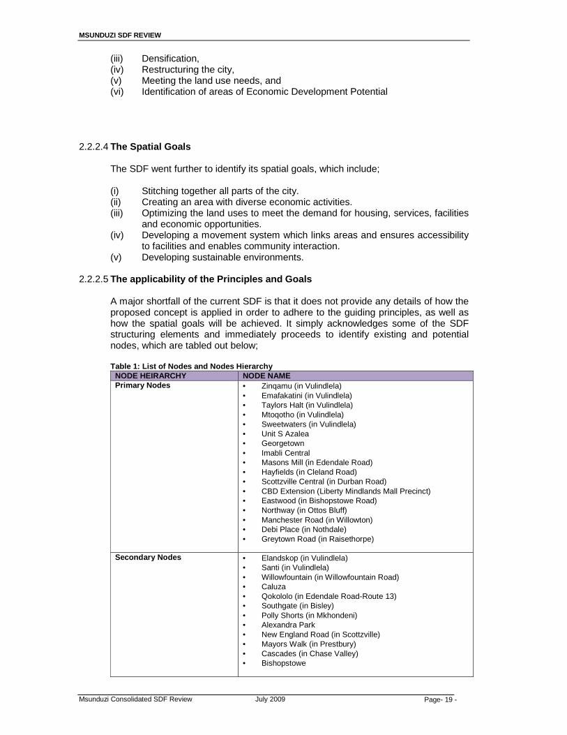
MSUNDUZI SDF REVIEW
Msunduzi Consolidated SDF Review July 2009 Page- 19 -
(iii) Densification, (iv) Restructuring the city, (v) Meeting the land use needs, and (vi) Identification of areas of Economic Development Potential
2.2.2.4 The Spatial Goals
The SDF went further to identify its spatial goals, which include; (i) Stitching together all parts of the city. (ii) Creating an area with diverse economic activities. (iii) Optimizing the land uses to meet the demand for housing, services, facilities
and economic opportunities. (iv) Developing a movement system which links areas and ensures accessibility
to facilities and enables community interaction. (v) Developing sustainable environments.
2.2.2.5 The applicability of the Principles and Goals
A major shortfall of the current SDF is that it does not provide any details of how the proposed concept is applied in order to adhere to the guiding principles, as well as how the spatial goals will be achieved. It simply acknowledges some of the SDF structuring elements and immediately proceeds to identify existing and potential nodes, which are tabled out below;
Table 1: List of Nodes and Nodes Hierarchy
NODE HEIRARCHY NODE NAME Primary Nodes • Zinqamu (in Vulindlela)
• Emafakatini (in Vulindlela) • Taylors Halt (in Vulindlela) • Mtoqotho (in Vulindlela) • Sweetwaters (in Vulindlela) • Unit S Azalea • Georgetown • Imabli Central • Masons Mill (in Edendale Road) • Hayfields (in Cleland Road) • Scottzville Central (in Durban Road) • CBD Extension (Liberty Mindlands Mall Precinct) • Eastwood (in Bishopstowe Road) • Northway (in Ottos Bluff) • Manchester Road (in Willowton) • Debi Place (in Nothdale) • Greytown Road (in Raisethorpe)
Secondary Nodes • Elandskop (in Vulindlela)
• Santi (in Vulindlela) • Willowfountain (in Willowfountain Road) • Caluza • Qokololo (in Edendale Road-Route 13) • Southgate (in Bisley) • Polly Shorts (in Mkhondeni) • Alexandra Park • New England Road (in Scottzville) • Mayors Walk (in Prestbury) • Cascades (in Chase Valley) • Bishopstowe

MSUNDUZI SDF REVIEW
Msunduzi Consolidated SDF Review July 2009 Page- 20 -
Tertiary Nodes • KwaMpande (in Vulindlela) • Gezubuso (in Vulindlela) • Ngubeni (in Vulindlela) • Sinathing Road • Caluza Harenwood • Machibisa-Mabulala (in Machibisa Road) • Dambuza-Eringini (in Dambuza/Machibisa Road) • Quarry (in Willowfountain-Route 9 Road) • Imabli Office (in FJ Sithole Road) • Slanspruit (in Newport Drive) • Foxhill (in Ambleton) • Ashburton • Jesmondene (in Marray Road – Hayfields) • Copesville
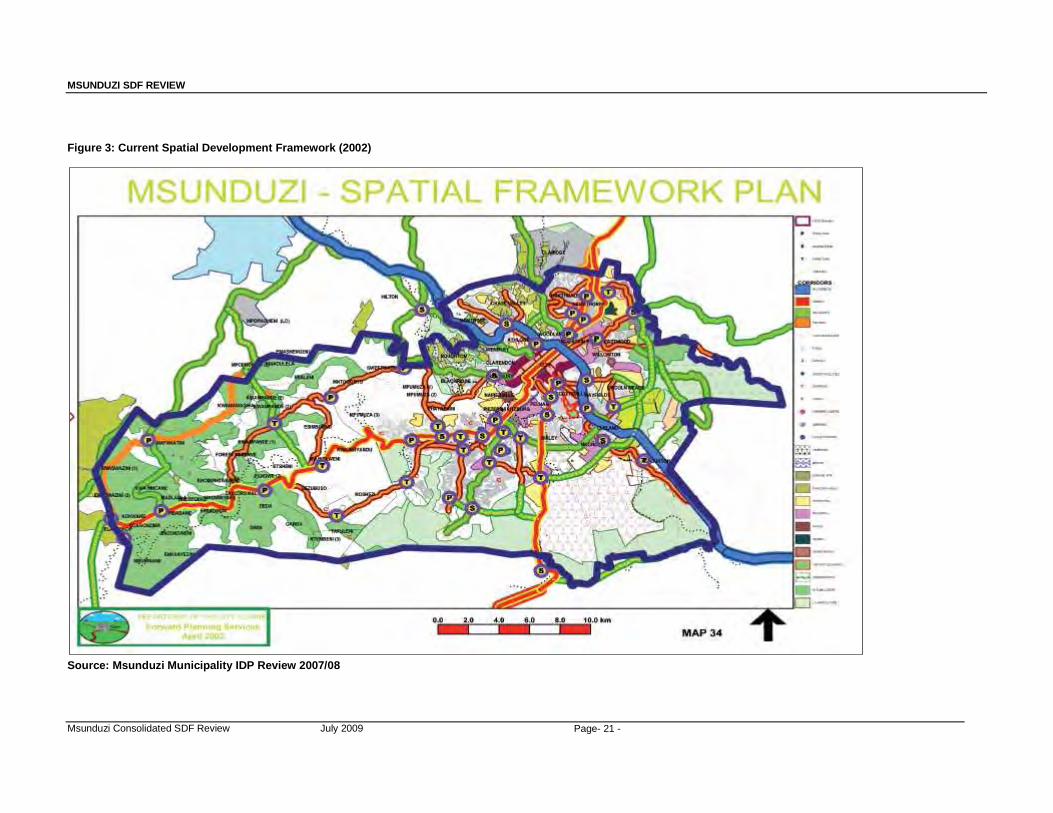
MSUNDUZI SDF REVIEW
Msunduzi Consolidated SDF Review July 2009 Page- 21 -
Figure 3: Current Spatial Development Framework (2002)
Source: Msunduzi Municipality IDP Review 2007/08

MSUNDUZI SDF REVIEW
Msunduzi Consolidated SDF Review July 2009 Page- 22 -
2.2.2.6 2006/07 IDP Review Recommendations for the SDF Review
The 2006/07 IDP Review provided recommendations to be considered during the SDF Review process. It identified several issues that have to be dealt with, these include; (a) The revision of the SDF needs to be a reflection of the revised 2006/07 IDP. (b) The revised needs to refine the extent of the “corridors” and the refinement
of the number of nodes suggested in the existing SDF in order that only the realistically achievable nodal developments are reflected.
(c) The need to have a sound public participation plan in order to ensure that the SDF process reaches out to all areas of the city.
(d) The need to seek assistance of the Department of Agriculture and Environmental Affairs to prepare the Strategic Environmental Assessment for the city to as an informants of the SDF review.
(e) The need for the SDF to coordinate and interact with planning and other spatially associated land uses and activities like transportation, open space system, stormwater management, ad local economic development.
(f) The SDF will need to provide guidelines for the preparation of a single Land Use Management System for the city.
2.2.3 District SDF Guidance Framework for Local SDFs
The following section is referenced from the revised UMgungundlovu Spatial Development Framework (SDF) of 2007 which sets out a Guidance Framework for the formulation of local municipality SDFs. The purpose of the framework is to ensure that there is vertical alignment between planning initiatives in the District.
2.2.3.1 Elements of the Framework
The framework consists of seven (7) elements, namely:
• Development Concept; • Development Nodes; • Development Corridors; • Agriculture and Land Reform • Environmental Considerations and Water Management; • Land Designations and Linkage to Local LUMS; and • Bulk Infrastructure
The District SDF provides an indication of how these elements should be interpreted by the local municipalities. An outline of the interpretation of these elements is provided below, as follows:
(i) Development Concept
The concept of a hierarchy of nodes connected by a system of corridors is suggested.
(ii) Development Nodes
It is suggested that development nodes are a reflection of areas with potential for economic development, where a range of services are provided. The identification of nodes at a local level should form a similar methodology as that of the district however; the hierarchy of the nodes should be

MSUNDUZI SDF REVIEW
Msunduzi Consolidated SDF Review July 2009 Page- 23 -
considered in the local context and influenced by local dynamics. Further, at a local level where nodes are identified, these should be clearly demarcated on a cadastral base in order to;
• Optimise the use of existing bulk infrastructure and social facilities; • Discourage urban sprawl; • Ensure compact and efficient urban areas; • Protect agricultural land with high production potential; • Provide guidance to both public and private sectors investors; • Promote economic, social and environmental sustainability; and • Accommodate reasonable future demand for development.
McCarthy (2007) in Udidi (2007, p74) identifies the fact that the DM sees the N3 intersection points as key economic drivers, specifically in terms of the PC2 Corridor from eThekwini- Msunduzi- uMgeni. He also notes that the issues of corridors cannot and should not be limited to the N3 alone. A full report by McCarthy is Annexed to this document as Annexure
The following points are also noted:
• A hierarchy of nodes and corridors is needed, with the N3 National
and Provincial priority corridor as the apex of that hierarchy in terms of its ability to generate growth and employment, which is at the same time accessible to people in some of the fastest growing and yet poorest population areas if the DM (ie. Mpofana).
• The Msunduzi municipality is, and will always remain, the primary node, and that almost all DM corridors will inevitably be arranged to either traverse it, or provide cross-linkages between each other on its periphery.
• Agriculture is an important employment bedrock for all the inter-nodal zones, especially to the south and west of the DM, and the viability of tertiary and rual nodes are closely linked to this sectors health and well-being.
• Probably the most important, most economic growth and new jobs (probably 90% of such), will derive in the DM from non-agricultural and non-primary sectors including services, manufacturing, construction and tourism. It is also most likely that these will be located along the provincial priority corridor, or along the DM’s primary corridor.
The following settlement hierarchy is identified:
Table 2 :uMgungundlovu Settlement Hierarchy
LEVEL OF NODE NAME Primary Pietermaritzburg Secondary Hilton/Howick Tertiary Richmond
Camperdown New Hanover/ Wartburg Mooi River
Rural Edendale Impendle Nottingham Road Rosetta Dalton/ Cool Air
(Source; uMgungundlovu SDF, 2007)

MSUNDUZI SDF REVIEW
Msunduzi Consolidated SDF Review July 2009 Page- 24 -
(i) Development Corridors
The main objectives of development corridors is to achieve integration, improve access and provide investment opportunities whilst correcting imbalances created by the apartheid planning system. It is suggested that through the use of development corridors, previously segregated areas can be connected and opportunities created for economic development in previously disadvantaged communities and the identification of alternative development axis.
(ii) Agriculture and Land Reform
The District SDF suggests that local level SDFs should clearly identify areas of agricultural importance and that these areas be properly managed. It also suggests that land reform programmes be accommodated at appropriate locations and that the outcomes of the Area Based Initiatives of Department of Land Affairs be incorporated.
(iii) Environmental Considerations and Water Management
At a district level, the C-Plan and Minset data has been used to identify areas of environmental significance however; at a local level these have to be refined through detailed analysis in the Strategic Environmental Assessment, Environmental Management Plan, and Environmental Management processes.
As far as water management is concerned, the district is identified as a significant water producing region therefore; the impact of development on water quality and quantity will be an important consideration. It is suggested that local municipalities prepare Water Resources Management Plans as part of the IDP sector plans.
(iv) Land Designations and Linkage to Local LUMS
It is suggested that the SDF be sufficient and specific enough to guide investment and inform future land use decisions by means of land use designations. It should be noted that land designations do not automatically give development rights to the land. The local SDF will the basis upon which the LUMS will be prepared.
(v) Bulk Infrastructure
The SDF should inform the local municipalities Capital Investment Programme as far a bulk infrastructure is concerned.
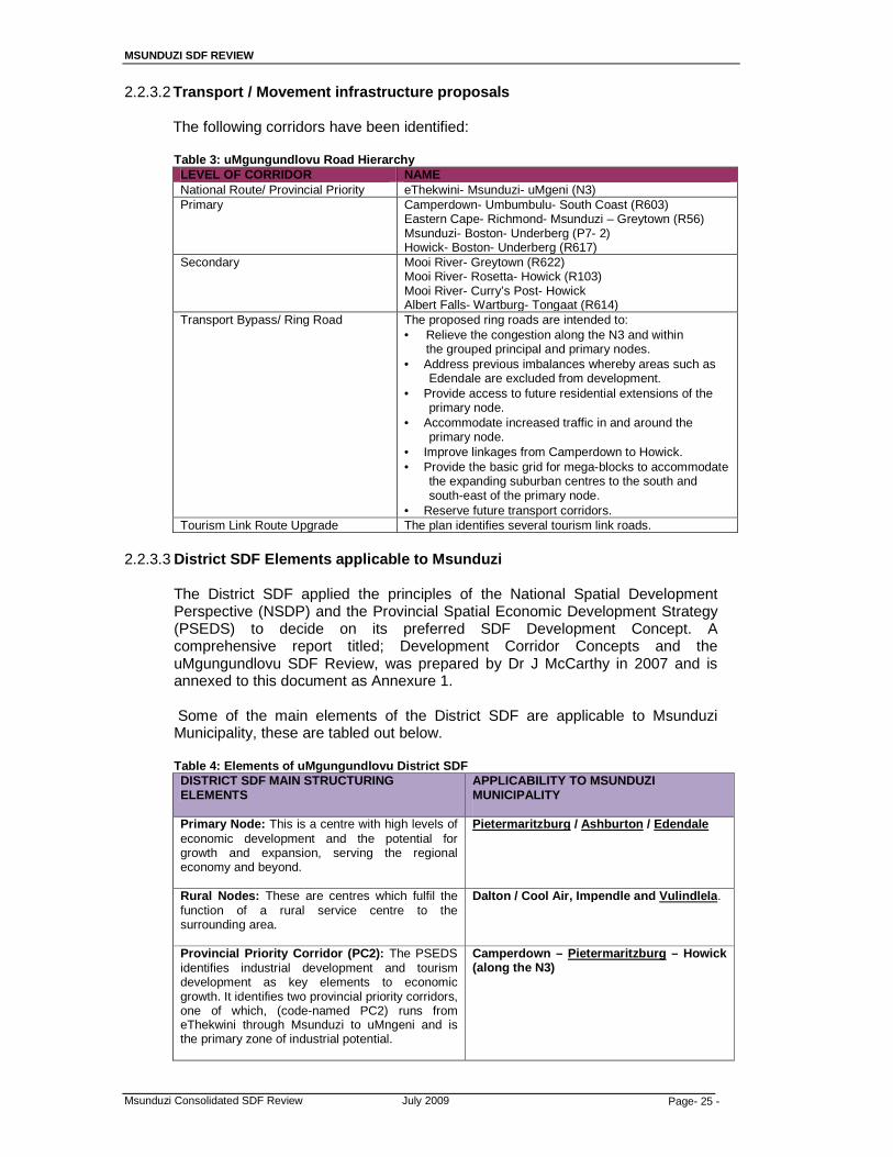
MSUNDUZI SDF REVIEW
Msunduzi Consolidated SDF Review July 2009 Page- 25 -
2.2.3.2 Transport / Movement infrastructure proposals
The following corridors have been identified:
Table 3: uMgungundlovu Road Hierarchy LEVEL OF CORRIDOR NAME National Route/ Provincial Priority eThekwini- Msunduzi- uMgeni (N3) Primary Camperdown- Umbumbulu- South Coast (R603)
Eastern Cape- Richmond- Msunduzi – Greytown (R56) Msunduzi- Boston- Underberg (P7- 2) Howick- Boston- Underberg (R617)
Secondary Mooi River- Greytown (R622) Mooi River- Rosetta- Howick (R103) Mooi River- Curry’s Post- Howick Albert Falls- Wartburg- Tongaat (R614)
Transport Bypass/ Ring Road The proposed ring roads are intended to: • Relieve the congestion along the N3 and within
the grouped principal and primary nodes. • Address previous imbalances whereby areas such as
Edendale are excluded from development. • Provide access to future residential extensions of the
primary node. • Accommodate increased traffic in and around the
primary node. • Improve linkages from Camperdown to Howick. • Provide the basic grid for mega-blocks to accommodate
the expanding suburban centres to the south and south-east of the primary node.
• Reserve future transport corridors. Tourism Link Route Upgrade The plan identifies several tourism link roads.
2.2.3.3 District SDF Elements applicable to Msunduzi
The District SDF applied the principles of the National Spatial Development Perspective (NSDP) and the Provincial Spatial Economic Development Strategy (PSEDS) to decide on its preferred SDF Development Concept. A comprehensive report titled; Development Corridor Concepts and the uMgungundlovu SDF Review, was prepared by Dr J McCarthy in 2007 and is annexed to this document as Annexure 1. Some of the main elements of the District SDF are applicable to Msunduzi Municipality, these are tabled out below.
Table 4: Elements of uMgungundlovu District SDF
DISTRICT SDF MAIN STRUCTURING ELEMENTS
APPLICABILITY TO MSUNDUZI MUNICIPALITY
Primary Node: This is a centre with high levels of economic development and the potential for growth and expansion, serving the regional economy and beyond.
Pietermaritzburg / Ashburton / Edendale
Rural Nodes: These are centres which fulfil the function of a rural service centre to the surrounding area.
Dalton / Cool Air, Impendle and Vulindlela .
Provincial Priority Corridor (PC2): The PSEDS identifies industrial development and tourism development as key elements to economic growth. It identifies two provincial priority corridors, one of which, (code-named PC2) runs from eThekwini through Msunduzi to uMngeni and is the primary zone of industrial potential.
Camperdown – Pietermaritzburg – Howick (along the N3)
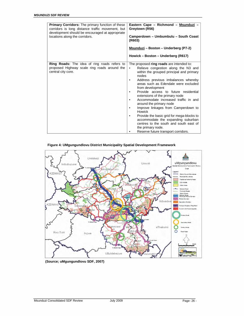
MSUNDUZI SDF REVIEW
Msunduzi Consolidated SDF Review July 2009 Page- 26 -
Primary Corridors: The primary function of these corridors is long distance traffic movement, but development should be encouraged at appropriate locations along the corridors.
Eastern Cape – Richmond – Msunduzi – Greytown (R56) Camperdown – Umbumbulu – South Coast (R603) Msunduzi – Boston – Underberg (P7-2) Howick – Boston – Underberg (R617)
Ring Roads: The idea of ring roads refers to proposed Highway scale ring roads around the central city core.
The proposed ring roads are intended to: • Relieve congestion along the N3 and
within the grouped principal and primary nodes
• Address previous imbalances whereby areas such as Edendale were excluded from development
• Provide access to future residential extensions of the primary node
• Accommodate increased traffic in and around the primary node
• Improve linkages from Camperdown to Howick
• Provide the basic grid for mega-blocks to accommodate the expanding suburban centres to the south and south east of the primary node.
• Reserve future transport corridors.
Figure 4: UMgungundlovu District Municipality Spatial Development Framework
(Source; uMgungundlovu SDF, 2007)
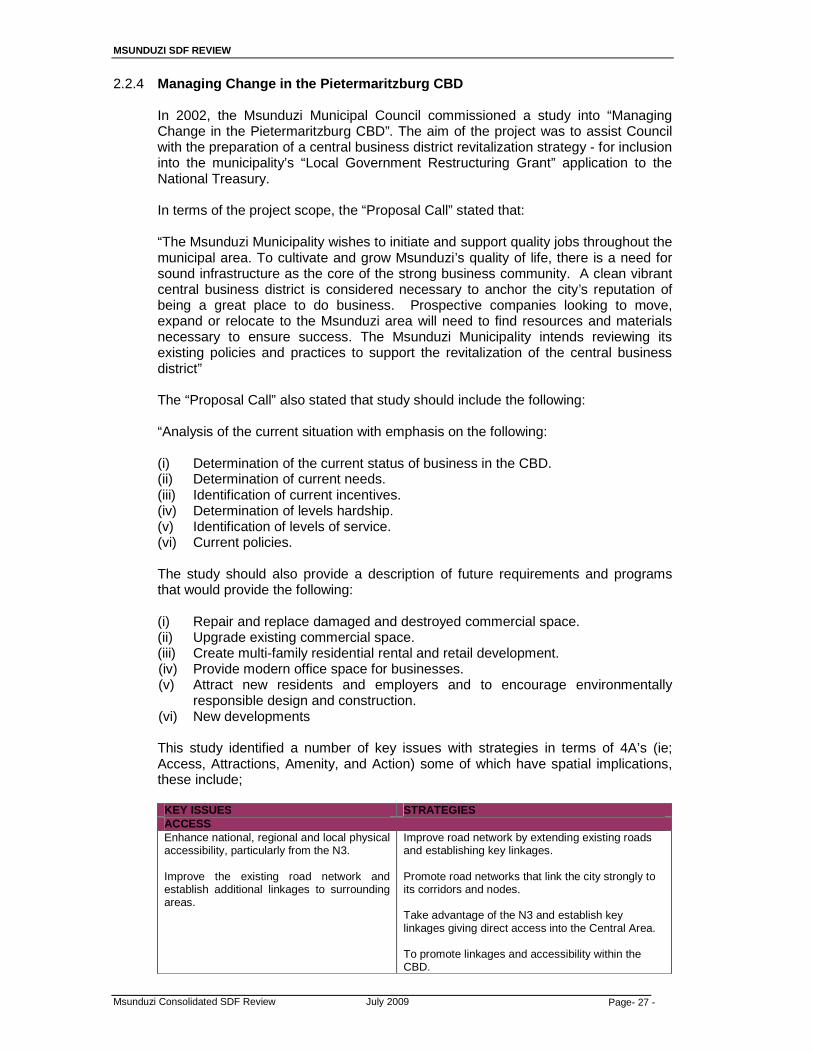
MSUNDUZI SDF REVIEW
Msunduzi Consolidated SDF Review July 2009 Page- 27 -
2.2.4 Managing Change in the Pietermaritzburg CBD
In 2002, the Msunduzi Municipal Council commissioned a study into “Managing Change in the Pietermaritzburg CBD”. The aim of the project was to assist Council with the preparation of a central business district revitalization strategy - for inclusion into the municipality’s “Local Government Restructuring Grant” application to the National Treasury.
In terms of the project scope, the “Proposal Call” stated that:
“The Msunduzi Municipality wishes to initiate and support quality jobs throughout the municipal area. To cultivate and grow Msunduzi’s quality of life, there is a need for sound infrastructure as the core of the strong business community. A clean vibrant central business district is considered necessary to anchor the city’s reputation of being a great place to do business. Prospective companies looking to move, expand or relocate to the Msunduzi area will need to find resources and materials necessary to ensure success. The Msunduzi Municipality intends reviewing its existing policies and practices to support the revitalization of the central business district” The “Proposal Call” also stated that study should include the following:
“Analysis of the current situation with emphasis on the following: (i) Determination of the current status of business in the CBD. (ii) Determination of current needs. (iii) Identification of current incentives. (iv) Determination of levels hardship. (v) Identification of levels of service. (vi) Current policies.
The study should also provide a description of future requirements and programs that would provide the following: (i) Repair and replace damaged and destroyed commercial space. (ii) Upgrade existing commercial space. (iii) Create multi-family residential rental and retail development. (iv) Provide modern office space for businesses. (v) Attract new residents and employers and to encourage environmentally
responsible design and construction. (vi) New developments This study identified a number of key issues with strategies in terms of 4A’s (ie; Access, Attractions, Amenity, and Action) some of which have spatial implications, these include;
KEY ISSUES STRATEGIES ACCESS Enhance national, regional and local physical accessibility, particularly from the N3. Improve the existing road network and establish additional linkages to surrounding areas.
Improve road network by extending existing roads and establishing key linkages. Promote road networks that link the city strongly to its corridors and nodes. Take advantage of the N3 and establish key linkages giving direct access into the Central Area. To promote linkages and accessibility within the CBD.

MSUNDUZI SDF REVIEW
Msunduzi Consolidated SDF Review July 2009 Page- 28 -
Improve CBD vehicle traffic flow/circulation and control/enforcement. Upgrade existing public transport services and facilities and provide additional services and facilities.
Promote an efficient traffic movement system. To create taxi holding areas for taxis outside of the main transport movement system to open up parking for business and enhance traffic flow. Establish, upgrade and improve transport transition nodes in the Central Area. Promote mixed land uses at public transport transition nodes to better serve passengers.
Develop/enhance corridors linking the CBD with major nodes in surrounding areas.
Corridors need to be developed to their full potential to ensure an organic integrated development of the city with economic opportunities for all.
Improve conditions for pedestrians.
To promote a pedestrian friendly CBD.
Address parking concerns (problems being experienced in regard to parking system and negative perceptions regarding availability and convenience of parking facilities).
To provide affordable, convenient, and secure parking facilities.
KEY ISSUES STRATEGIES ATTRACTIONS Facilitate the recycling/use of old/vacant buildings. Promote the maintenance of existing buildings. Promote the availability of a wider, improved range of government facilities and services.
Promote optimal use of vacant or unused buildings / structures. Facilitate necessary upgrading aesthetics and maintenance of buildings.
Formalise and support the informal trading sector.
Support, improve and upgrade SMME’s, emerging businesses, and informal traders.
Upgrade/beautify existing Public Open Spaces and promote environmental management.
Promote Environmental Conservation. Promote Environmental Management. Balance architectural enhancement with creation of more green lungs.
Develop new attractions - undertake lead projects (e.g. Freedom Square, Dorpspruit Waterfront Development).
Develop a catalytic urban spaces project that will trigger a range of secondary projects including Urban Renewal. Further development of Church Street Mall as an important urban space. Create sustainable human spaces / environments within the CBD.
Promote tourism further (in particular in relation to the rich cultural and heritage history and unique blend of pioneering, colonial and contemporary history).
Re-establish the Freedom Experience concept as a tourism product worthy of investment. Identify CBD based attractions/sites that should be linked to the Freedom Experience. To develop as a Gandhi presentation centre To develop as pick up/drop off site for heritage rail and railway enthusiasts. To promote city as an events destination. To develop a definitive plan which focuses on tourism management, destination marketing and the
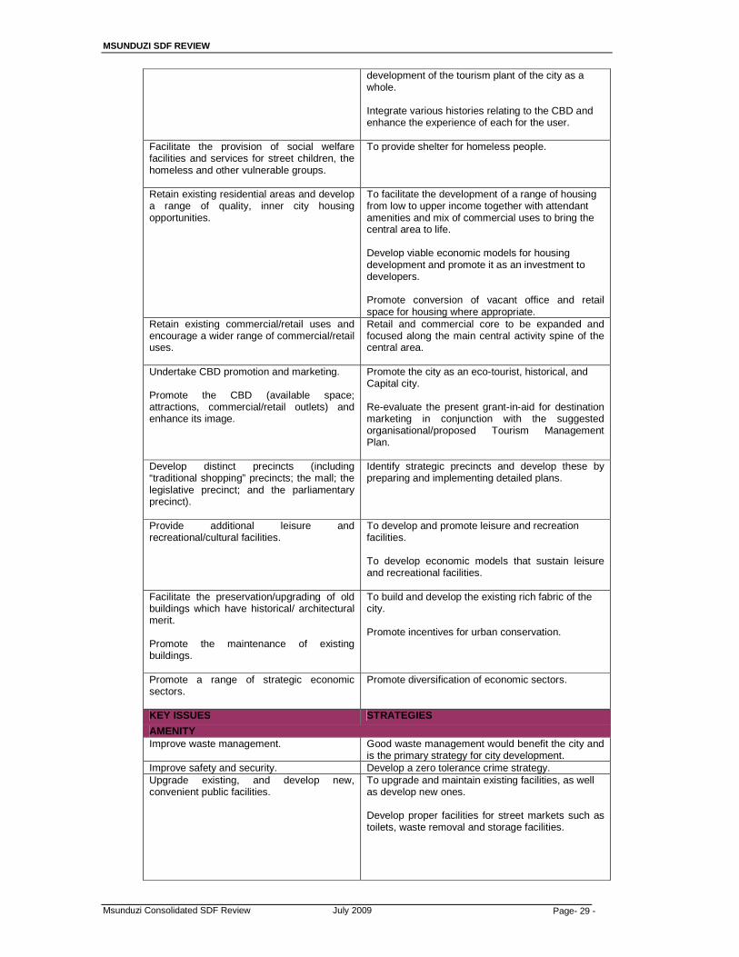
MSUNDUZI SDF REVIEW
Msunduzi Consolidated SDF Review July 2009 Page- 29 -
development of the tourism plant of the city as a whole. Integrate various histories relating to the CBD and enhance the experience of each for the user.
Facilitate the provision of social welfare facilities and services for street children, the homeless and other vulnerable groups.
To provide shelter for homeless people.
Retain existing residential areas and develop a range of quality, inner city housing opportunities.
To facilitate the development of a range of housing from low to upper income together with attendant amenities and mix of commercial uses to bring the central area to life. Develop viable economic models for housing development and promote it as an investment to developers. Promote conversion of vacant office and retail space for housing where appropriate.
Retain existing commercial/retail uses and encourage a wider range of commercial/retail uses.
Retail and commercial core to be expanded and focused along the main central activity spine of the central area.
Undertake CBD promotion and marketing. Promote the CBD (available space; attractions, commercial/retail outlets) and enhance its image.
Promote the city as an eco-tourist, historical, and Capital city. Re-evaluate the present grant-in-aid for destination marketing in conjunction with the suggested organisational/proposed Tourism Management Plan.
Develop distinct precincts (including “traditional shopping” precincts; the mall; the legislative precinct; and the parliamentary precinct).
Identify strategic precincts and develop these by preparing and implementing detailed plans.
Provide additional leisure and recreational/cultural facilities.
To develop and promote leisure and recreation facilities. To develop economic models that sustain leisure and recreational facilities.
Facilitate the preservation/upgrading of old buildings which have historical/ architectural merit. Promote the maintenance of existing buildings.
To build and develop the existing rich fabric of the city. Promote incentives for urban conservation.
Promote a range of strategic economic sectors.
Promote diversification of economic sectors.
KEY ISSUES STRATEGIES
AMENITY Improve waste management.
Good waste management would benefit the city and is the primary strategy for city development.
Improve safety and security. Develop a zero tolerance crime strategy. Upgrade existing, and develop new, convenient public facilities.
To upgrade and maintain existing facilities, as well as develop new ones. Develop proper facilities for street markets such as toilets, waste removal and storage facilities.
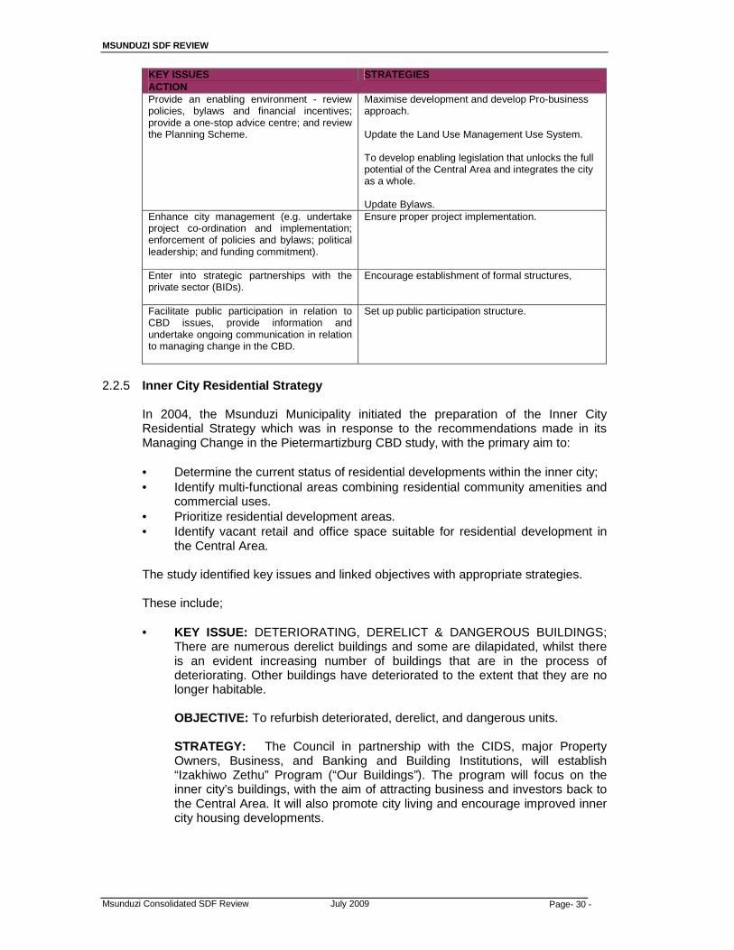
MSUNDUZI SDF REVIEW
Msunduzi Consolidated SDF Review July 2009 Page- 30 -
KEY ISSUES STRATEGIES ACTION Provide an enabling environment - review policies, bylaws and financial incentives; provide a one-stop advice centre; and review the Planning Scheme.
Maximise development and develop Pro-business approach. Update the Land Use Management Use System. To develop enabling legislation that unlocks the full potential of the Central Area and integrates the city as a whole. Update Bylaws.
Enhance city management (e.g. undertake project co-ordination and implementation; enforcement of policies and bylaws; political leadership; and funding commitment).
Ensure proper project implementation.
Enter into strategic partnerships with the private sector (BIDs).
Encourage establishment of formal structures,
Facilitate public participation in relation to CBD issues, provide information and undertake ongoing communication in relation to managing change in the CBD.
Set up public participation structure.
2.2.5 Inner City Residential Strategy
In 2004, the Msunduzi Municipality initiated the preparation of the Inner City
Residential Strategy which was in response to the recommendations made in its Managing Change in the Pietermartizburg CBD study, with the primary aim to:
• Determine the current status of residential developments within the inner city; • Identify multi-functional areas combining residential community amenities and
commercial uses. • Prioritize residential development areas. • Identify vacant retail and office space suitable for residential development in
the Central Area.
The study identified key issues and linked objectives with appropriate strategies.
These include;
• KEY ISSUE: DETERIORATING, DERELICT & DANGEROUS BUILDINGS; There are numerous derelict buildings and some are dilapidated, whilst there is an evident increasing number of buildings that are in the process of deteriorating. Other buildings have deteriorated to the extent that they are no longer habitable. OBJECTIVE: To refurbish deteriorated, derelict, and dangerous units. STRATEGY: The Council in partnership with the CIDS, major Property Owners, Business, and Banking and Building Institutions, will establish “Izakhiwo Zethu” Program (“Our Buildings”). The program will focus on the inner city’s buildings, with the aim of attracting business and investors back to the Central Area. It will also promote city living and encourage improved inner city housing developments.
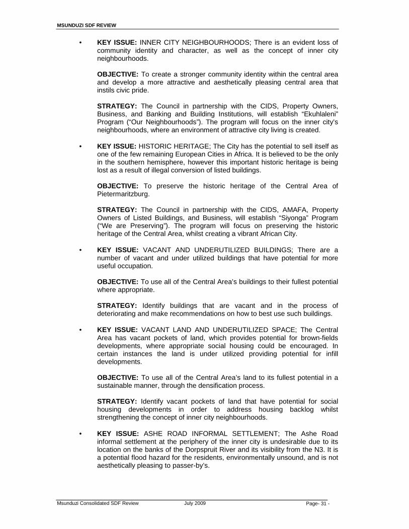
MSUNDUZI SDF REVIEW
Msunduzi Consolidated SDF Review July 2009 Page- 31 -
• KEY ISSUE: INNER CITY NEIGHBOURHOODS; There is an evident loss of community identity and character, as well as the concept of inner city neighbourhoods.
OBJECTIVE: To create a stronger community identity within the central area and develop a more attractive and aesthetically pleasing central area that instils civic pride.
STRATEGY: The Council in partnership with the CIDS, Property Owners, Business, and Banking and Building Institutions, will establish “Ekuhlaleni” Program (“Our Neighbourhoods”). The program will focus on the inner city’s neighbourhoods, where an environment of attractive city living is created.
• KEY ISSUE: HISTORIC HERITAGE; The City has the potential to sell itself as
one of the few remaining European Cities in Africa. It is believed to be the only in the southern hemisphere, however this important historic heritage is being lost as a result of illegal conversion of listed buildings.
OBJECTIVE: To preserve the historic heritage of the Central Area of Pietermaritzburg.
STRATEGY: The Council in partnership with the CIDS, AMAFA, Property Owners of Listed Buildings, and Business, will establish “Siyonga” Program (“We are Preserving”). The program will focus on preserving the historic heritage of the Central Area, whilst creating a vibrant African City.
• KEY ISSUE: VACANT AND UNDERUTILIZED BUILDINGS; There are a
number of vacant and under utilized buildings that have potential for more useful occupation.
OBJECTIVE: To use all of the Central Area’s buildings to their fullest potential where appropriate.
STRATEGY: Identify buildings that are vacant and in the process of deteriorating and make recommendations on how to best use such buildings.
• KEY ISSUE: VACANT LAND AND UNDERUTILIZED SPACE; The Central
Area has vacant pockets of land, which provides potential for brown-fields developments, where appropriate social housing could be encouraged. In certain instances the land is under utilized providing potential for infill developments.
OBJECTIVE: To use all of the Central Area’s land to its fullest potential in a sustainable manner, through the densification process.
STRATEGY: Identify vacant pockets of land that have potential for social housing developments in order to address housing backlog whilst strengthening the concept of inner city neighbourhoods.
• KEY ISSUE: ASHE ROAD INFORMAL SETTLEMENT; The Ashe Road
informal settlement at the periphery of the inner city is undesirable due to its location on the banks of the Dorpspruit River and its visibility from the N3. It is a potential flood hazard for the residents, environmentally unsound, and is not aesthetically pleasing to passer-by’s.
MSUNDUZI SDF REVIEW
Msunduzi Consolidated SDF Review July 2009 Page- 32 -
OBJECTIVE: To promote improved city living conditions in a sustainable manner.
STRATEGY: There is a need for Council to pursue the upgrading of the Ashe Road informal settlement and to consider negotiating with residents regarding relocation.
2.2.6 CBD and Central Area Local Development Plan
Numerous strategies were identified as part of the LDP (1998) process, some of
which have spatial implications and are relevant to the SDF. The list indicated below is not all encompassing but highlights some of the strategies identified that have spatial implications:
• The identification of city improvement districts (CID’s) and facilitation for
activating the CID’s; • Promote incentives for urban conservation; • To develop harmonious environments where modern and historic buildings are
integrated; • The need to carry out an audit of man made and natural elements worthy of
preservation; • Balance between conservation and development; • Promote the city’s corridors to the benefit of the central area; • To support and promote development that revitalises and grows the central
area; • The marking of pavement areas for informal stalls and the provision of
appropriate street furniture; • The promotion of housing in the central area; • Traditional mixed use housing areas in the city to be revitalised; • Promote densification of land for housing;The development of a riverside trail
around the city; • The identification of strategic environmental precincts and developing these by
preparing and implementing detailed plans; • The development of Business Improvement Districts (BID’s) and City
Improvement Districts (CID’s); • The development of a Metropolitan Open Space System (MOSS) linking hiking
trails, water courses, conservation areas, parks and cultural heritage resources as an integrated open space system;
• The development of catalytic urban spaces that will trigger a range of secondary projects including urban renewal;
• The definition of an interlinked hierarchy of public spaces, precincts, squares, markets, streets, parks and promenades;
• The development of the Msunduzi river as a multi-functional open space which is integrated with the city fabric;
• The development of a hierarchy of primary, secondary and tertiary road networks;
• Taking advantage of the close proximity of the N3 to the central area and the establishment of key linkages giving direct access into the central area;
• The promotion of road networks that link the city to its corridors; • The promotion of parking garages at strategic locations; • Undertaking commuter rail viability studies for the eastern and western areas; • Retail and commercial core to be expanded and focussed along the main
central activity spine of the central area; and • Consolidate existing retail and other major land uses.

MSUNDUZI SDF REVIEW
Msunduzi Consolidated SDF Review July 2009 Page- 33 -
As indicated, these are not all of the strategies identified in the LDP. The ones selected have a spatial implication and will be considered in the formulation of the Msunduzi SDF.
2.2.7 Metropolitan Pietermaritzburg Retail Study
This study was prepared in 1993 to:
• Create a framework for understanding the changing nature of retail systems; • Present proposals for a retail policy for the Pietermaritzburg Metropolitan Area
(PMA); and • To suggest appropriate parking standards for large multi-use complexes such
as neighbourhood, community or regional shopping centres.
The study area included municipal Pietermaritzburg, Edendale, Edendale East, Vulindlela, Foxhill and Shenstone/ Ambleton, Hilton, Mount Michael and Ashburton.
The study identifies the following:
• A desirable overall development pattern for the metropolitan area, including:
o Creating opportunities for the emergence of an outer axis structured along the current Eastern boundary of the then Pietermaritzburg Borough.
o Strengthening the major development axis (Northdale-CBD-Edendale Corridor).
o Supporting the evolution of a strong south-east axis. o Increasing residential densities.
• The establishment of an appropriate retail hierarchy, including:
o Identifying the role of the central area. o Identifying the role of the suburban community and neighbourhood
centres. o Identifying the role of convenience shopping clusters.
• What was termed “filling the retail gaps”.
Broad spatial policy guidelines identified include:
• Retaining the central area which fulfils the functions identified in the plan within
the context of a generally more competitive retail environment. • Encouraging decentralised retail developments in the form of community level
centres with the aim being to satisfy consumer needs in decentralised areas and to promote city building, in particular the consolidation of the major development axis.
• Encourage the widespread establishment of local convenience shopping clusters which supply the daily needs of nearby residents.
The report also makes the following:
• Broad spatial policy guidelines; • Spatial policy proposals of a general nature; and • Specific policy proposals for the central area and development corridors.

MSUNDUZI SDF REVIEW
Msunduzi Consolidated SDF Review July 2009 Page- 34 -
2.2.8 Northdale/ Edendale Public Transport Corridor Study
This study (2006) is a work in progress and identifies land uses in pre-defined areas that can act as catalysts to stimulate future development. The outcomes of this study will be aligned with the SDF.
The main objectives of establishing this corridor are the following:
• Greater Edendale-CBD-Northdale corridor will see public transport facilities
upgraded which would be in preparation for the implementation of the taxi recapitalization program in KwaZulu-Natal. This will result in a more efficient transportation system. A key feature will be the construction of a Central Public Transportation Interchange in "Freedom" Square.
• Fundamental restructuring of public transportation in the Msunduzi area, with a particular focus on creating attractive and user-friendly public facilities as well as the transformation of the minibus-taxi industry.
• Commuters and other users of public transportation will enjoy an improvement in the level of service with emphasis on fare stabilization, reduced journey times, and extended hours of operation.
• The promotion and support of non-motorized forms of transportation will be provided for that is walking and biking.
• Local economic development will be stimulated with the key focus being on inner-city renewal, job creation and poverty alleviation.
• Community interaction would be revived and bridged.
• The key elements of the public transportation corridor will be the following:
- Upgraded public transportation facilities and infrastructure, - Public transportation vehicles given priority over private vehicles, - Sidewalks and bikeways provided for pedestrians and cyclists, - Urban renewal, community revival and job creation through the
establishment of multi-purpose community centers, and adoption of a labour-intensive approach in undertaking some parts of the project.
2.2.9 Cemetery Development Plan
The cemeteries and crematoria plan was prepared by the uMgungundlovu District Municipality in 2002 with the main recommendations being contained in the proposed project lists. The plan proposed that these projects be implemented on a phased basis to address the problems in terms of urgency of community needs.
The Mkhambathini and Richmond municipalities were identified as Phase 1 interventions whereas two interventions in the Msunduzi municipality were identified as part of Phase 2, namely:
� A centralised LM cemetery that also provides the centralised DM cemetery
facility in Pietermaritzburg; and � A second cemetery to service the southern and south-western communities of
the Msunduzi municipality.
The main implications for the Msunduzi municipality associated with the provision of cemeteries is the need to identify and earmark suitable sites. Associated infrastructure will also need to be planned for including access so as to allow for the successful operation of such a facility.
MSUNDUZI SDF REVIEW
Msunduzi Consolidated SDF Review July 2009 Page- 35 -
2.2.10 Integrated Waste Management Plan
The Integrated Waste Management Plan (2002) outlines short, medium and long term interventions for the DM. The short-term implications for the Msunduzi LM are summarised below:
� Waste minimization: the implementation of a hazardous household waste
drop-off centre pilot project in the Msunduzi municipality; � Landfill Site Waste Acceptance: the establishment of a strategic builders’
rubble (construction/ demolition) waste centre in the Msunduzi municipality; and
� uMgungundlovu DM Regional Landfill Site Development- Phase 1.
The medium-term implications (5 to 10 years) 2008 – 2013 of the plan for the Msunduzi municipality are the Phase 2 developments of the uMgungundlovu DM regional landfill site, if this site is identified in the Msunduzi municipality. These include:
� Permit receipt followed by detailed design; � Contract documentation, tender and award; � The construction phase; and � The commissioning phase and 6 months external audits (permit conditioning)
Other medium term interventions include those on the “Dense Settlements” where waste collection, transportation and disposal will be extended to the Inadi (I, II, and III), Ximba, Mpumuza (I and II) and Nxamalala settlements.
The implications of the long term plans of action (10 – 15 years) 2013 to 2018 for the Msunduzi municipality include part of the Phase 3 development of the uMgungundlovu DM regional landfill site, if this site is located in the Msunduzi municipality. Actions include:
� Site extension contract documentation, tender and award; and � Development and commissioning. Other long term implications of the plan for the Msunduzi Municipality include the formalisation/ development of communal landfill sites in the Baynesdrift F/A. In addition to the issues outlined above, possible waste transfer stations, in support of the regional type facility, will need to be investigated further. This will likely take place during the review of the IWMP and once the outcomes of such an investigation are known, the spatial implications thereof will need to be incorporated into the SDF.
MSUNDUZI SDF REVIEW
Msunduzi Consolidated SDF Review July 2009 Page- 36 -
3.0 SITUATIONAL ANALYSIS: Informants A comprehensive analysis of the physical environment was undertaken and published in a document “Pietermaritzburg Metropolitan Plan Volume 1 Physical Conditions”. The objective of this analysis was to identify spatially the areas of the metropolitan region that are environmentally best suited for the location of selected land use activities. The section 3.1.1 LAND: Topography is sourced and based on the findings of this study.
3.1 Physical Environment
3.1.1 LAND: Topography (1) Relief
The Pietermaritzburg Metropolitan Region is characterized by a diversity of landscapes. The region transects four of Natal’s 49 classified physiographic regions. These are the “Natal Midlands” and the “Howick Benchland”, which forms part of the “Uplands” regional grouping, and have an altitude of between 1000 – 1400m above sea level, the “Greytown – Pietermaritzburg – Richmond Benchland” and the “Valley of a Thousand Hills” which form part of the “Intermediate” and “low lying” regional groupings respectively and have an altitude of between 400 – 1000m above sea level.
The most prominent topographical feature is an escarpment which forms an abrupt 400 – 600 metre vertical transition between the “Intermediate” and “Uplands” regions. The escarpment, which forms the watershed between the Msunduzi and Umgeni River catchments, extends in a crescent shape from Elandskop, situated in the south western portion of the region, to the upper reaches of the Rietspruit valley, situated in the north eastern portion of the region. The main effects of relief will tend to be on soil depth and drainage. On steep slopes the natural rate of erosion is rapid so that deep soils are usually confined to the gentler slopes, while depressions and concave slopes tend to become seepage zones where a water table may develop. In much of the study area with its many areas of rugged topography it must be expected that rock outcrops and shallow soil depths will occur in such areas. On the other hand, in very flat areas beside the larger streams where flooding occurs periodically, resulting in the deposition of alluvium, substantial areas of good alluvial soils may occur – as is indeed the case beside the Msunduzi river and several of its tributaries in the vicinity of Pietermaritzburg.
(2) Slope
Approximately 30% of the municipal area consists of topography having a gradient steeper than 1 metre in 3 metres (1:3). More than half of this steep topography is located in the western quadrant of the municipal area particularly within the boundaries of the Greater Edendale-Imbali ABM and the Vulindlela ABM. Flat topography having a gradient flatter than 1 metres in 3 metres (1:3) constitutes approximately 70% of the municipal area. At least 60% of this topography is concentrated in the former Pietermaritzburg Borough and its surrounds.

MSUNDUZI SDF REVIEW
Msunduzi Consolidated SDF Review July 2009 Page- 37 -
Figure 5: Slope Analysis showing areas steeper and flatter than 1:3
(3) Landform
Landform is also a major factor in determining land capability, mainly through the adverse effects of steep slopes and rock/stone outcrops which often cause land to have to be regarded as non-arable and hence land of low capability. Risk of flooding is another important consideration which is closely linked to landform.
The active nature of the clay soils found throughout the area can cause walls of buildings to crack unless appropriate foundations are constructed. One of the cheapest form of foundation which consists of brickwork laid on simple shallow non-reinforced cast strips. The engineering properties of some soils within the area require dwelling houses to be provided with deep strip, pile, beam or raft foundations. As these types of foundation can substantially increase building costs, consideration should be given to siting housing developments, particularly low cost housing schemes, in areas where simple relatively cheap foundations can be constructed.
The Metropolitan region has been graded into areas where the relative building foundation costs are likely to be “high”, “Medium”, and “low”. In the absence of comprehensive information concerning the plasticity index, shear strength properties and compressibility of the soils, the criteria used to determine these gradings was the percentage of clay found in the soils situated 0,6m to 1,2 metres below the surface. The depth of 0,6 metres was chosen as this is the normal founding level for simple strip foundations. “High” cost foundations were considered to be required in areas where the clay content of the soil is greater than 55%, “medium” cost foundations where the clay content is 35 to 55% and “low” cost foundation where the clay content is less than 35 % or where simple strip foundations could be cast on the underlying bedrock.
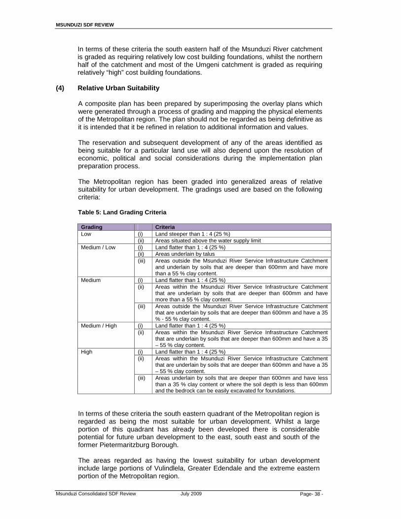
MSUNDUZI SDF REVIEW
Msunduzi Consolidated SDF Review July 2009 Page- 38 -
In terms of these criteria the south eastern half of the Msunduzi River catchment is graded as requiring relatively low cost building foundations, whilst the northern half of the catchment and most of the Umgeni catchment is graded as requiring relatively “high” cost building foundations.
(4) Relative Urban Suitability
A composite plan has been prepared by superimposing the overlay plans which were generated through a process of grading and mapping the physical elements of the Metropolitan region. The plan should not be regarded as being definitive as it is intended that it be refined in relation to additional information and values. The reservation and subsequent development of any of the areas identified as being suitable for a particular land use will also depend upon the resolution of economic, political and social considerations during the implementation plan preparation process. The Metropolitan region has been graded into generalized areas of relative suitability for urban development. The gradings used are based on the following criteria: Table 5: Land Grading Criteria Grading Criteria Low (i) Land steeper than 1 : 4 (25 %)
(ii) Areas situated above the water supply limit Medium / Low (i) Land flatter than 1 : 4 (25 %)
(ii) Areas underlain by talus (iii) Areas outside the Msunduzi River Service Infrastructure Catchment
and underlain by soils that are deeper than 600mm and have more than a 55 % clay content.
Medium (i) Land flatter than 1 : 4 (25 %) (ii) Areas within the Msunduzi River Service Infrastructure Catchment
that are underlain by soils that are deeper than 600mm and have more than a 55 % clay content.
(iii) Areas outside the Msunduzi River Service Infrastructure Catchment that are underlain by soils that are deeper than 600mm and have a 35 % - 55 % clay content.
Medium / High (i) Land flatter than 1 : 4 (25 %) (ii) Areas within the Msunduzi River Service Infrastructure Catchment
that are underlain by soils that are deeper than 600mm and have a 35 – 55 % clay content.
High (i) Land flatter than 1 : 4 (25 %) (ii) Areas within the Msunduzi River Service Infrastructure Catchment
that are underlain by soils that are deeper than 600mm and have a 35 – 55 % clay content.
(iii) Areas underlain by soils that are deeper than 600mm and have less than a 35 % clay content or where the soil depth is less than 600mm and the bedrock can be easily excavated for foundations.
In terms of these criteria the south eastern quadrant of the Metropolitan region is regarded as being the most suitable for urban development. Whilst a large portion of this quadrant has already been developed there is considerable potential for future urban development to the east, south east and south of the former Pietermaritzburg Borough.
The areas regarded as having the lowest suitability for urban development include large portions of Vulindlela, Greater Edendale and the extreme eastern portion of the Metropolitan region.

MSUNDUZI SDF REVIEW
Msunduzi Consolidated SDF Review July 2009 Page- 39 -
(5) Geology
The underlying geology of the region consists of a sequence of claustic or fragmented sedimentary rock strata, consisting of sandy and clayey sales, sandstones and tillites, overlaying a bedrock composed of granite and gneiss. Significant areas of intruded dolerite are found throughout the region. The sandy and clayey shales, which form part of the Pietermaritzburg Formation (Ecca Groups) and Volksrust formation, underlie about 80 % of the region. Whilst they are easily weathered when exposed, their low porosity and permeability often causes high surface water runoff, especially in areas having a shallow depth of soil cover. Soils derived from the process of weathering have accumulated at the base of escarpments within the region to form the talus geological formation. Extensive areas of talus are found in the Town Bush Stream Valley and the northern portion of Northdale within the Borough of Pietermaritzburg, the Sinathingi River Valley within Edendale, portions of Vulindlela, particularly the Mpumuza ward near Sweetwaters, and in the vicinity of Otto’s Bluff. These areas are generally unstable and subject to slumping.
(6) Soils
The soils found in most parts of the metropolitan region have a high clay content and are considered to be generally active in that they expand and contract in relation to changes in their moisture content. The degree to which these soils expand and contract is dependent upon the thickness and depth of the clay layer and the climatic conditions and drainage characteristics of the area. The depth of soil cover in the Msunduzi River catchment is generally shallower than in the Umgeni River catchment being 0,2 to 1,2 metres and 0,6 to 10 metres respectively. A notable exception is the area situated at the base of the escarpment where soil depths of up to 10 metres have been recorded. The other main factor in determining land capability is that of the soil where factors like soil depth, texture, drainage and moisture holding capacity are all important characteristics. These, together with the landform characteristics of slope and rockiness, have been combined by the KZN Department of Agriculture into a Land Capability Classification system for use in the province (Manson et al, 1995).
3.1.2 Climate ( See Map 5c & 5d )
Two main sources of information that have been used in compiling this review of climate include:
• the climatic data given for each of the Bioresource Units identified by the
Department of Agriculture (a total of 13 units). • the map showing mean annual precipitation as determined by Dent MC,
Lynch, SD and Schulze RE (1988)( WRC Report No 109/190 )
These sources of information, combined with the physiographic features indicate the following broadly similar agricultural climates:
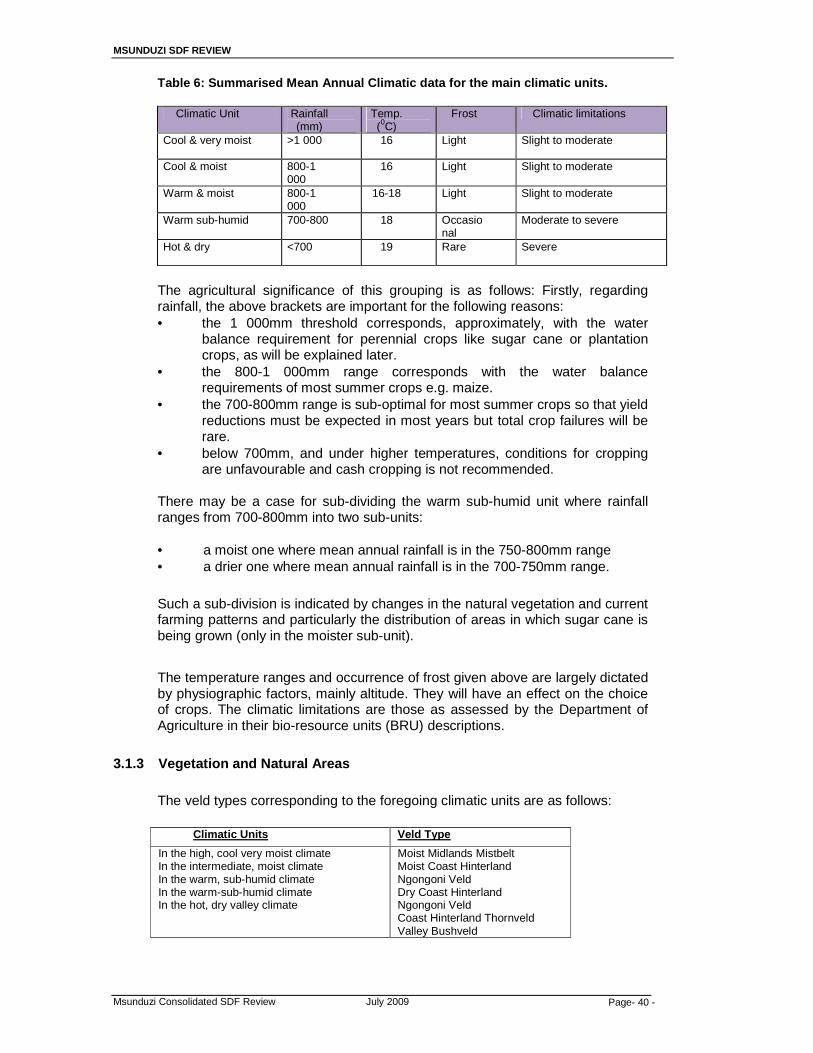
MSUNDUZI SDF REVIEW
Msunduzi Consolidated SDF Review July 2009 Page- 40 -
Table 6: Summarised Mean Annual Climatic data for the main climatic units.
Climatic Unit Rainfall (mm)
Temp. (0C)
Frost Climatic limitations
Cool & very moist >1 000 16 Light Slight to moderate
Cool & moist 800-1 000
16 Light Slight to moderate
Warm & moist 800-1 000
16-18 Light Slight to moderate
Warm sub-humid 700-800 18 Occasional
Moderate to severe
Hot & dry <700 19 Rare Severe
The agricultural significance of this grouping is as follows: Firstly, regarding rainfall, the above brackets are important for the following reasons: • the 1 000mm threshold corresponds, approximately, with the water
balance requirement for perennial crops like sugar cane or plantation crops, as will be explained later.
• the 800-1 000mm range corresponds with the water balance requirements of most summer crops e.g. maize.
• the 700-800mm range is sub-optimal for most summer crops so that yield reductions must be expected in most years but total crop failures will be rare.
• below 700mm, and under higher temperatures, conditions for cropping are unfavourable and cash cropping is not recommended.
There may be a case for sub-dividing the warm sub-humid unit where rainfall ranges from 700-800mm into two sub-units: • a moist one where mean annual rainfall is in the 750-800mm range • a drier one where mean annual rainfall is in the 700-750mm range.
Such a sub-division is indicated by changes in the natural vegetation and current farming patterns and particularly the distribution of areas in which sugar cane is being grown (only in the moister sub-unit).
The temperature ranges and occurrence of frost given above are largely dictated by physiographic factors, mainly altitude. They will have an effect on the choice of crops. The climatic limitations are those as assessed by the Department of Agriculture in their bio-resource units (BRU) descriptions.
3.1.3 Vegetation and Natural Areas
The veld types corresponding to the foregoing climatic units are as follows:
Climatic Units Veld Type
In the high, cool very moist climate In the intermediate, moist climate In the warm, sub-humid climate In the warm-sub-humid climate In the hot, dry valley climate
Moist Midlands Mistbelt Moist Coast Hinterland Ngongoni Veld Dry Coast Hinterland Ngongoni Veld Coast Hinterland Thornveld Valley Bushveld
MSUNDUZI SDF REVIEW
Msunduzi Consolidated SDF Review July 2009 Page- 41 -
Average grazing capacities for these veld types are as follows:
Moist Midlands Mistbelt 2,1ha per AU Moist Coast Hinterland Ngongoni Veld 2,4ha per AU Dry Boast Hinterland Ngongoni Veld 2,7-3,4ha per AU Coast Hinterland Thornveld 3,1ha per AU Valley Bushveld 5,1ha per AU
It should, however, be noted that much of the veld in the western areas is suffering from past overstocking so that the present grazing capacities will tend to be lower than the above.
It should also be noted that large parts of the study area are no longer under natural vegetation due to:
• urban development covering large parts of the central part of the municipal
area. • peri-urban residential areas which cover large parts of Greater Imbali,
Greater Edendale and Vulindlela. • forestry plantations which cover large parts of the northern areas and
Vulindlela. • cultivated land in Vulindlela and parts of Ashburton and the Eastern Area,
some of which is planted to sugar cane.
A further analysis of these latter land uses is offered in the discussion on present land uses.
The natural vegetation tends to reflect this pattern with thorn bush in the drier climates giving way to grassland veld types in the moister areas and even patches of indigenous forest in places along the very moist scarp face. The natural vegetation has, however, been heavily modified by population pressures, urban development and the establishment of timber plantations.
3.2 Agriculture and Agricultural Potential
3.2.1 Review of present agricultural land use
Present agricultural land use in the study area is reviewed below in relation to the main administrative areas within the municipality as follows:
(i) The Northern areas
These are the areas north of the city from the N3 highway around to Bishopstowe. They include the very moist and moist climatic units where rainfall favours intensive agriculture but much of the land is very steep, including the major escarpment between the Howick and Pietermaritzburg benchlands, and hence with little arable land. Large parts of the area have also been developed as residential areas including the suburbs of Montrose, Oak Park, Chase Valley, Northdale, Bombay Heights, Raisethorpe, Copesville, Panorama Gardens and Eastwood.
Most of the remaining land is used for forestry or for recreational purposes, e.g. Queen Elizabeth Park nature reserve, while parts of the escarpment, where it is very steep, have been left under indigenous forest.
MSUNDUZI SDF REVIEW
Msunduzi Consolidated SDF Review July 2009 Page- 42 -
The only farmland in the area is confined to an area astride the Greytown road, and to the Bishopstowe area. In both cases sugar cane production is the main farming enterprise. In terms of land tenure these are freehold properties owned by commercial farmers, though many are quite small properties.
(ii) The Eastern areas
This area extends along the eastern boundary of the municipality from Bishopstowe to near Umlaas Road in the south. It consists of two distinct sub-units:
• the Bishopstowe area on the northern side of the Msunduzi river, where both altitude and rainfall increase quickly (from about 500 to 700m in altitude and from below 600mm to 832mm mean annual rainfall for the Bishopstowe BRU)
• the southern part of the Msunduzi valley which is lower (mainly below 700m) and drier with a mean annual rainfall for the Ashburton BRU of only 691mm.
The difference in climate is reflected in the pattern of agricultural land use even though both are commercial farming areas. Thus, whereas cropping, mainly to sugar cane, is the main farming enterprise in the Bishopstow area, the southern area is mainly used for livestock production with cropping being confined to a few small patches of irrigable land beside the Msunduzi River, the Mpushini River or close to existing farm dams. Much of the grazing land in the southern area consists of either planted pastures, on what was previously cultivated land, or former cultivated land which is now reverting to bush (thornveld) indicating that the farmers in these areas have realised that dry land cash cropping is not economically viable.
There are several large poultry farms in this area but mainly just to the east of the N3 which forms the Municipality’s eastern boundary in this vicinity.
(iii) The Southern areas
This is the area to the south of the city from the Richmond road to Umlaas Road. It includes the residential suburbs of Bisley, Scottsville, Pelham, Epworth, Oribi, Cleland, Hayfields and Lincoln Meade as well as Mkondeni.
The farming area to the south of these suburbs is mainly rather higher than the above suburbs, much of it above 800m in altitude and receiving more rain (in the 750-800mm range) as compared to 738mm at Ukulinga (the University’s research farm near Mkondeni). As a result there is more cash cropping in this area with sugar cane again becoming an important crop. There are also several large poultry farms in the area.
This is again a commercial farming area on freehold land, but with a large number of smallholdings.

MSUNDUZI SDF REVIEW
Msunduzi Consolidated SDF Review July 2009 Page- 43 -
(iv) The Edendale and Imbali areas and the former farms of Ambleton and Shenstone
At the time of the latest available aerial photography (20/7/2004) the farm Shenstone was still mainly being used as grazing land but Ambleton was then already mainly residential land. Shenstone had some good arable land along its southern edge, with favourable topography, deep loamy Hutton soils and a rainfall of about 830mm. It was previously planted to sugar cane. The northern part of the farm was mainly grazing land.
Greater Imbali and Greater Edendale are now mainly residential land with only a little grazing land still remaining in Greater Imbali. In the Greater Edendale area, the south-western corner of the property is under forestry with some, mainly very steep, rugged grazing land. Otherwise both areas appear to be fully allocated as residential land. There is thus very little scope for agriculture except, possibly, for the development of small community garden type projects in the valley bottoms of the Slangspruit, Wilgefontein and KwaPata streams and, possibly, in some of the alluvium in the Msunduzi valley.
(v) The Vulindlela area
This is by far the largest area and the one with the most varied pattern of land use, the main ones being:
a. Residential land use, but in a more rural (now peri-urban) pattern of
scattered settlements based on traditional and communal land tenure and administration.
b. Grazing land, for use by the community as a whole. c. Arable land, mainly in comparatively large blocks but allocated to
individual community members. These areas have recently, in many cases, been allocated, at least partially, as residential land as a result of increasing population pressure.
d. Small irrigated gardens – usually run as community gardens. e. Timber plantations. f. Patches of indigenous forests, usually found on steep southerly slopes,
especially along the main escarpment. Shown on Map 2 . 3.2.2 Factors affecting agriculture
This section of the report provides an overview of the present situation regarding agriculture in the area covered by the Msunduzi Municipality as shown on. In order to do this it is necessary to review: firstly, the agricultural resources available in the area and secondly, the existing patterns of land tenure and land use in the various parts of the area. From an agricultural point of view the main features of the study area are as summarised below:
1. Physiography: the diversity of the area, in terms of both landform and climate, because of the huge range in altitude from 500-1 500m, and the fact that the main variations in altitude are at right angles to the flow of incoming moisture from the sea. This results in very moist sea-facing slopes on rising ground but with hot dry northerly and westerly slopes in rain shadow localities.

MSUNDUZI SDF REVIEW
Msunduzi Consolidated SDF Review July 2009 Page- 44 -
2. Climate: As a result of the above most of the higher ground has a cool moist climate. Even at the lower altitudes the area to the north of the Msunduzi river has a mean annual rainfall in excess of 800mm. The south and south east, on the other hand, tends to be dry with a mean annual rainfall below 700-750mm. Dryland cropping then tends to be risky and non-viable economically.
3. Soils: These vary largely in response to changes in climate, relief and
parent material; all three of which vary markedly within the study area. A more detailed analysis of soils and land capability is therefore being undertaken with those areas where agriculture is still possible in order to indicate areas for future development.
4. Water supplies: This is the other resource requiring more detailed
investigation with particular attention to areas in Vulindlela, Edendale and Imbali, and also in the Ashburton area, where additional irrigation may be possible. Figure 6: Agricultural Land Potential
3.2.3 Prime Agricultural Land Recommendations
In the more detailed investigations referred to above particular attention should be paid to urban agriculture and to the Vulindlela, Edendale and Imbali areas.
Due to factors affecting agriculture, it is therefore important in these areas to encourage farmers to conform to the following management recommendations:
MSUNDUZI SDF REVIEW
Msunduzi Consolidated SDF Review July 2009 Page- 45 -
� Any sub-division of land within this category should be subject to support by the Dept of Agriculture.
� Stop soil erosion by terracing, strip cropping and repairing donga’s; � Add organic matter to soil (with "green manure" cover crops, compost,
manures, crop residues, organic fertilizers); � Plant wind breaks in the form of indigenous trees to prevent wind erosion; � Rotate crops to ensure that nutrients in the soil are not depleted by
monoculture; � Grow crops appropriate to the soil type and climate; � Test soil and apply manures only when necessary; � Compost organic waste; � Introduce or enhance existing populations of natural predators, pathogens;
insects, and other biological control agents; � Maintain healthy soil (prevents soil-based diseases) and encourage the use
of ectomycorrhiza to improve nutrient and water uptake in crops; � Grow crops and crop varieties well-suited to climate and soil; and � Leave habitat (field margins, unmowed strips, pond and stream borders,
etc.,) for wildlife therefore providing wildlife corridors.
3.3 Environmental Conservation and Open Space System 3.3.1 Environmental Overview
Spatial planning within Msunduzi is influenced by the escarpment, and hills which surround the city in the north east and west. Development on the escarpment and hills is limited due to the slope, however these areas provide opportunities for recreation and job creation. Beyond these limitations however; it is critical to identify important areas of environmental significance, to protect and preserve valued ecosystems, natural habitats and special case areas in order to minimise negative environmental impacts. Specific ecosystems and vegetation communities that require environmental management are wetlands, grasslands, and indigenous forests that contain the habitats of important species. It should be noted that environmental management need not be limited to protection or preservation but also areas may be identified for opportunities that a particular environment may provide such as the rehabilitation of wetlands, eco-tourism opportunities etc. One of the development issues in the municipality is the promotion of LED therefore; it is essential that while accommodating these challenges, environmental assets associated with the municipality are not undermined. An integral part of ensuring this is the development of a Spatial Development Framework, based on a Local Environmental Analysis that will identify priority areas for management and types of use and suggest appropriate management techniques to ensure that environmental assets are not undermined during development. Prior to formulating the SDF, it was necessary to undertake Environmental Inventory. As a basis to the SDF it was necessary to identify the natural resources within the municipal area and to make optimal use of those resources. An environmental Inventory assigned categories of importance to various ecosystems, to include the assessment of agricultural potential in rural areas to inform the SDF.
MSUNDUZI SDF REVIEW
Msunduzi Consolidated SDF Review July 2009 Page- 46 -
3.3.2 Methodology
A comprehensive land use was undertaken for the municipality (see map 10 ): This land use was determined through the analysis of digitally corrected photography of the municipality. To better determine the Environmental Inventory this land use was then overlaid with Ezemvelo’s KZN wildlife’s MinSet data (shown on map 3b & 3c ). Minset is a function or tool within C-Plan (Conservation Planning Software) that is used to identify a ‘minimum set’ of sites (planning units) that would fulfill the aim firstly of achieving the conservation targets within a number of constraints that can be set by the user e.g. avoid highly productive agricultural land, or land adjacent to major highways. It presents the most efficient solution to achieving conservation targets and other land use constraints. The Minset output map shows areas that are already protected, ‘Mandatory Reserves’ and ‘Negotiable Reserves’. Mandatory reserves are those areas that appear as totally irreplaceable on the irreplaceability map, since there are no other alternatives for achieving the conservation targets. Areas identified as negotiable reserves are the areas that the Minset function returns as the most efficient for achieving targets and constraints. However there are alternatives to achieving the targets and constraints but with less efficiency, and hence the designation of this area is still negotiable. In using the results of the Minset analysis for impact assessment and incorporating recommended areas into regional and local plans, planners need to proceed with caution. While mandatory reserves (totally irreplaceable areas) must be incorporated to meet conservation targets, negotiable reserves need not. However with respect to the latter, if an area is rejected for incorporation into the conservation network, landscape planning cannot end there. For the planning cycle to be completed in this respect, the planner must identify and recommend the incorporation of alternative sites that will allow the targets for the affected biodiversity assets to be satisfied. This will involve the rerunning of the Minset analysis with the initially excluded site removed from the analysis, and is what makes C-Plan a truly interactive and iterative planning tool. By overlaying the two maps one is able to identify the untransformed land that falls within the categories of Mandatory and Negotiable reserves and in such a way identify the environmental priority areas. These were determined as follows:
Priority 1: Zones that are spatially defined as those areas that are
designated as non-negotiable reserves, in the EKZNW Min Set data set, and have a natural land cover. It therefore designates areas that are indigenous forests and grasslands or veld and have a high biodiversity value. These areas have the highest priority for environmental management and as such development within this designation should be low-key, highly environmentally sensitive and harmonious with the surrounding conditions.
Priority 2: Zones that are spatially designated as areas that have natural
land cover and not designated as negotiable reserves. They are therefore areas of moderate biodiversity importance and still maintain natural ecosystem. Development in this zone should still be environmentally sensitive as it could be identified as mandatory reserve in future based on land transformation in the future.
MSUNDUZI SDF REVIEW
Msunduzi Consolidated SDF Review July 2009 Page- 47 -
Priority 3: Zones that are spatially designated as areas that have natural land cover but have no reserve status as per the EKZNW MinSet data set. They are therefore areas of low biodiversity importance but still maintain natural ecosystems. They therefore have a high functional importance as they provide ecosystems goods and services such as habitat, clean water, carbon sequestering or nutrient recycling. This zone focuses on ecosystem goods and services and as such activities impacting on the functioning of the ecosystems should be limited such as large scale clearance, water extraction, emissions of waste into the air or streams and rivers.
The Environmental Inventory in the form of these priority zones will inform the
SDF. Beyond the Priority Areas the following factors need to be considered.
1. Indigenous forested areas
These areas are not mapped however, all areas of thornveld are. All areas under indigenous forest and properties with indigenous trees should be subject to the following guidelines:
� No indigenous trees should be removed without authorization from
DWAF who are responsible for protection of protected tree species. � No undergrowth should be removed or the natural forest structure
interfered with in any way as; when the forest undergrowth is removed, the large trees left standing often slowly die due to drought. Authorization must be obtained from DWAF prior to any clearing of both trees and under story of indigenous forested areas.
� All forest along streams and rivers must be conserved to prevent bank erosion.
� Wherever possible, patches of forest must be linked to form a continuous network and thus a path of migration for flora and fauna present (bushbuck, duiker, birds and so on) this would be easiest along existing corridors like streams and rivers.
� Forest trees should be left to screen development to improve stormwater drainage and aesthetics.
� Developers should be encouraged where possible to maintain any trees on site as part of the layout of the development.
2. Areas of High Biodiversity Value
These areas are identified as areas of high irreplacebility and areas in the minset data set designated as non-negotiable reserves should be categorized in this category, Further the environmental atlas areas within the municipality are almost entirely biodiversity related and therefore these areas are included in this category. These areas are somewhat limited by land transformation in the municipality and include only small portions of the northern areas and south western of the study area.
� This zone represents areas of natural vegetation and therefore any
transformation of this area greater than 3 Ha should be subject to impact assessment. Further any development greater than 1 Ha would be subject to Basic Assessment and any development greater than 20 Ha would be subject to Full Environmental Impact Assessment.

MSUNDUZI SDF REVIEW
Msunduzi Consolidated SDF Review July 2009 Page- 48 -
� The local authority should negotiate with the property developer to incorporate land not to be used for development into Conservation Reserves. This can be done when permission for development is being sought.
� The Environmental Impact Assessment required for priority 1 zones should include a biodiversity assessment of the site and it biological value.
� The layout of the development should take biodiversity impacts and mitigation into account and as such should avoid areas of high biodiversity value.
� The local authority should negotiate with the property developer to incorporate land not to be used for development into Conservation Reserves. This can be achieved as part of authorization for development on submission of the plans.
� When building plans are submitted to the local authority for approval, they shall indicate whether the development constitutes a listed activity and if so include a copy of the Record of Decision (ROD) issued by DAEA and an Environmental Management Plan (EMP) where required by the ROD.
� No construction of a listed activity under the NEMA EIA regulations may begin without authorization from DAEA, the Municipality in it’s development control capacity should not, under any circumstances, authorize any listed activity until such time as DAEA has given authorization for the activity to go ahead.
� Any unauthorized development should be reported immediately to the DAEA.
� The width of survey paths shall be kept to the absolute maximum of 1 metre.
� Where areas have been set aside for conservation in the layout , such areas will have to be demarcated. This should be done before building starts, sites must be staked and should be fenced or cordoned off with Chevron Tape. This is with a view to preventing damage to conservation areas during construction and operation. The fencing used should be appropriate and should allow for the movement of small animals, which may be found in this area.
� In the conserved areas, only nature-related recreation and education shall be permitted, such as bird watching, walking and canoeing. These areas should be left as undisturbed as possible.
� Exotics should be avoided in landscaping of developments. � Invasive aliens should be eradicated as part of landscaping and
management plan for the development. � As far as possible, medium density housing development in this zone
should be clustered in order to minimise visual impact and the amount of land needed. This reduces development costs and also makes land available for conservation or open space purposes. Further advantages are wind protection and better controlled access the development area
� Landowners shall be made aware of the priority status of their land before purchase. Estate agents in the area could assist in this regard. The clearance certificate issued to each purchaser shall make note of the priority status, for the purchaser’s information, should the estate agent not have raised the issue.
� Earthmoving equipment must be prohibited from the site until the environmental assessment has been approved and the vegetation to be conserved has been demarcated.
MSUNDUZI SDF REVIEW
Msunduzi Consolidated SDF Review July 2009 Page- 49 -
� The Local Council should not plant exotic trees or shrubs in areas of this category.
� Sub divisional applications should be assessed in the light of proposed usage and the effect it would have on areas of high biodiversity value.
� Landowners should be made aware of the high biodiversity value of their land before purchase. Landowners should be made aware of their responsibility to maintain and manage the vegetation on their land. The local council may need to provide assistance in the form of advice to landowners in high biodiversity value areas.
3. Nature Reserves
These areas are mapped on both the Cplan and Minset Maps.
� This is with a view to preventing damage to conservation areas. The
fencing used should be appropriate and should allow for the movement of small animals that may be found in this area, for eg Duiker, weasel.
� In the conserved areas, only nature-related recreation and education shall be permitted, such as bird-watching, walking and canoeing.
� The introduction of any exotic plants to conservation areas must be prevented and any existing alien invasive vegetation should be removed.
4. Wetlands, dams, and drainage corridors
The wetlands, dams, and drainage corridors are shown on Map 4 however; it must be stressed that wetlands identified over and above these maps should be subject to the same guidelines:
� Infilling, drainage and hardened surfaces (including buildings and
asphalt) should not be located in any of the wetland zones (i.e. permanent, seasonal and temporary) such activities generally result in significant impacts on a wetland’s hydrology, hydraulics and biota and on the goods and services wetlands provide.
� Hardened surfaces and erven should be located at least 15 m outside of the outer boundary of the seasonal/permanent zone (Note: if the width of the outer temporary zone is greater than 15 m and Item 1 above is met then this requirement would automatically be met). The seasonal and permanent zones generally have surface water for extended periods. In the case of seasonal zones, it may be for most of the wet season and in the case of permanent zones, it may be throughout the year. A buffer is required between areas potentially generating non-point source pollution and such areas characterized by surface water.
� Extension to the buffer in localized areas should also be included to minimize the impact of concentrated stormwater run-off into the wetland. Stormwater outflows should not enter directly into the wetland. A predominantly vegetated buffer area at least 20 m wide should be included between the stormwater outflow and the outer boundary of the wetland, with mechanisms for dissipating water energy and spreading and slowing water flow and preventing erosion. This buffer is particularly important when the catchment feeding the stormwater drain comprises predominantly hardened surfaces. Extensive hardened surfaces in the catchment and stormwater drains

MSUNDUZI SDF REVIEW
Msunduzi Consolidated SDF Review July 2009 Page- 50 -
significantly increase the intensity of stormwater runoff, which increases the risks of erosion in a wetland. In addition, urban stormwater runoff is often polluted. A buffer is therefore required to reduce the energy and erosive power of the stormwater and to decrease the level of pollutants in the runoff before it enters the wetland.
� Where the wetland has a particularly high biodiversity value, further buffering may be required, the width of which would depend on the specific requirements of the biota. This should be determined in consultation with Ezemvelo KZN Wildlife. The value of a wetland for biodiversity derives not only from features of the wetland but also from the quality of natural, non-wetland areas adjacent to the wetland, as many wetland dependent species such as the giant bullfrog (Pyxicephalus adspersus) require both wetland and non-wetland habitat.
� If a road crossing is planned in a wetland, first seek an alternative route. If this is not available then ensure that the road has minimal affect on the flow of water through the wetland (e.g. by using box culverts rather than pipes). Do not lower the base level of the wetland or any stream passing through the wetland. Ensure an adequate buffer is present to deal with run-off from the road (see Item 3 above). During construction, minimize disturbance of the wetland at and adjacent to the road crossing site. Road crossings may potentially greatly modify local water flow patterns in a wetland. In addition to having a damming or draining effect on the flow upstream of the road, roads which do not allow for the adequate passage of water may concentrate flow downstream, increasing the erosion hazard and drying out this portion of the wetland. A lowering of the base level increases the gradient in the wetland, thereby increasing the speed of water flow and its erosive potential and the extent to which it contributes to lowering the water table.
� Where a road runs alongside a wetland and it intercepts natural hillslope runoff into the wetland, the road should be set back from the boundary of the wetland by at least 20 m and feed-off points should be included at frequent intervals along the road (at least every 100 m) and the outflows of these should conform to the requirements of the stormwater outflows (given in Item 2 above). A road running alongside a wetland can strongly affect the natural hill slope runoff into the wetland by intercepting this runoff and concentrating it in localized entry points. The fewer the feed-off points into the wetland and the less protected they are, the more severe this effect will be.
� Where development (e.g. hardened surfaces, infilling and drainage) in a wetland is unavoidable then the resulting impacts must be mitigated. In many cases, off-site mitigation may be the only means of achieving satisfactory mitigation. The cumulative loss of wetlands in South Africa is already very high (see Section 1.1) and the continued net loss of wetlands needs to be prevented. Invasion of a wetland by alien plants may considerably reduce the integrity of a wetland.
� Where any disturbance of the soil takes place in a wetland, clear alien plants which establish and follow up for at least 2 years thereafter. Disturbance of a wetland favours the establishment of alien plants, which require long-term control.
� Where the infiltration rate of a wetland’s catchment is naturally high and the wetland is maintained predominantly by groundwater input, at least 60% of the wetland’s catchment should remain as permeable
MSUNDUZI SDF REVIEW
Msunduzi Consolidated SDF Review July 2009 Page- 51 -
surfaces in a residential area and preferably at least 30% in an industrial/commercial area. Where the level of development is very high, reduced surface runoff can be promoted through mechanisms such as porous pavements (The inclusion of these mechanisms in areas dominated by hardened surfaces is generally sound catchment management practice and should be encouraged widely). Failure to maintain groundwater input to a predominantly groundwater-fed wetland will considerably alter the hydrological regime of the wetland, thereby compromising its integrity.
� The onus is on the developer to identify and delineate all wetlands in the project area at a finer scale depending on the proposed development. Mapping at a minimum scale of 1: 10 000 is generally require .in order to account for the impact of a development adjacent to a wetland, it is essential that the boundary of the wetland be mapped. Any wetlands identified on the ground should be delineated and mapped by the municipality on an ongoing basis.
� Any development must comply with the requirements of the National Water Act. Through the concept of the “ecological reserve”, this act makes provision for ensuring water of acceptable quantity and quality for maintaining the ecological functioning of wetlands and river systems. While wetlands assist in enhancing water quality, they should not be relied upon as an easy substitute for addressing pollution at source, as this may lead to serious impacts to the wetland systems.
� Access to wetlands by off-road vehicles, man and livestock, should be as far as possible prevented.
� Development within the floodline or within 32 m of a river or stream should be avoided and vegetation in this zone should be conserved.
3.3.3 Basic Land Use
The percentages are an approximation to indicate land use trends to inform overall spatial planning at SDF level. A more detailed land use would be required at the Land Use Management System (LUMS) level which will follow the preparation of the SDF. The Grasslands takes about (31.7%) which is most of the land in the municipality, followed by land used for settlement purposes at 29.1% which includes; formal settlements (14.8%), traditional settlements (14.1%), and informal settlements (0.5%). It is important to distinguish between the different types of settlements as these would give an idea of the level of services available and those that are required. CBD, Ashburton and Eastern Areas ABM: Whilst the dominating land use is thornveld and grasslands, this area is predominantly used for residential purposes. The area is also home to some of the major employers in the city namely; government sector in the central area and industries in Mkhondeni, Willowton, and Pelham. This area is therefore, the largest rates contributor of the city. It is important to mention that this area plays a significant role in terms of transport infrastructure available in the city. This area accommodates the larger part of the N3 a primary movement corridor (also part of the Provincial Development Corridors) dissecting the city and the Edendale – Northdale development corridor; it is also home to the city’s only airport and railway station. A concentration of education facilities is found in this area and the largest of them being the University of KwaZulu-Natal. The north eastern part (Bellvue/New England) and south eastern part (Ukulinga/Ashburton) has pockets of cultivated land.

MSUNDUZI SDF REVIEW
Msunduzi Consolidated SDF Review July 2009 Page- 52 -
Northern Areas ABM: This area is mostly used for residential purposes and the natures of the settlements are both formal and informal, especially in the areas of Claridge and Copesville. Forestry/Plantations are also the dominant land uses especially to the west of the area with natural bush in between. The majority of commercial activities in the city are within this area with pockets of industrial uses in places. There are also pockets of Active/Passive Open Spaces (the largest being Queen Elizabeth Park), and Cultivated Land (Copesville/Claridge). It is important to note that the largest health institutions in the city namely; Grey’s Hospital and Townhill Mental Institution are within this area. The area is also part of the Edendale – Northdale development corridor and the N3. Greater Edendale Area ABM: A large part of this area is used for residential purposes even though it is largely under serviced. The natures of the settlements are formal, informal, and traditional even though there is no tribal authority in this area. Even though there are industrial activities in the area, the majority of people are unemployed and are relatively poor. This area has been identified as one city’s areas of priority spending with initiatives already underway to support this namely; the Greater Edendale Development Initiative (GEDI) and the Edendale – Northdale Development Corridor. Whilst the focus in the past has been on the Edendale Corridor (this has been where previous plans and investment has, in the past, been concentrated), this study has revealed that the majority of the people within the Edendale ABM live to the south of and away from the corridor. There exists an opportunity to downplay the number of hierarchical arrangement of nodes along the corridor and find alternate nodes within the formal sections of the Edendale ABM. Most of the formal shops exist off secondary /tertiary routes, such that newer larger formal nodes would not be to the detriment to these shops.
Topography and river corridors play a major part in structuring growth and development within the ABM. The area has major valleys and steep topography particularly those areas closer to the Vulindela ABM. These serve as structuring elements and constrain development into a series of development interfluves and an avoidance of steep land that would be difficult to service.
The ABM as a whole is characterized by a mix of both informal and formal residential development. The formal areas are concentrated in the middle of the ABM, while informal development occurs adjacent to Edendale Road and in the southern periphery of the ABM.An opportunity exists to upgrade /infill the residential component within the ABM.
The Edendale ABM is generally well served by services i.e. sewer, electricity, water, etc. However certain portions within the ABM such as Dambuza, Slangspruit, Sinathingi and Emantharen, appears to be poorly serviced.
Slangspruit, Shenstone, Unit EE, Willowfontein, Noshezi, and the Singathingi Rural areas are not serviced by facilities. In some instances no development occurs in the area due to the difficult topography. In the case of Slangspruit no formal facilities are indicated in the plans made available to the planning team – this needs to be investigated.
Apart from the spatial implications, the Edendale ABM is characterized, economically, by more than 70% of households which earn less than R1 600 per month. These high levels of poverty exist in all areas within PMB; however it is more concentrated in the Edendale area. There need to be a focus on developing the

MSUNDUZI SDF REVIEW
Msunduzi Consolidated SDF Review July 2009 Page- 53 -
economic sectors within the ABM and thus offering more opportunities for people. Skills training and capacity building must occur with institutions set in place to drive the implementation. Vulindlela ABM: This area is under traditional authorities and is predominantly rural with settlements largely traditional however; there are pockets of informal settlements. This area is the largest of the ABMs and houses the majority of the city’s population yet it is highly underdeveloped and serviced. The majority of people are unemployed, dependant on government grants, and some live off the land through subsistence farming. There are also pockets of Active/Passive Open Spaces, Forestry/Plantation, Grasslands, and Natural Bush. The education facilities are scattered all over the area and the lack of health facilities is obvious.
Vacant Land
In 2004, the Corporate Strategic Planning Business Unit assisted by the Estates Department completed the Land Audit of all Council owned land, at the request of the Economic Development and Planning Committee. This was done in order to formulate a land release programme. The Msunduzi Housing Delivery Unit was requested to within the list of audited land, identify land deemed suitable for future housing projects. A total of m2 of vacant Council land was identified. The full report submitted to the Economic Development and Planning Committee in annexed.
3.4 Social Facilities The demand for social development is expressed in the municipality’s IDP. The increase of the city’s population has demanded an increase of social facilities and services. Despite the limited resources, the municipality has responded to some of these issues including; the upgrading of the Central Library, the upgrading of Freedom Square, a number of community development projects in Vulindlela, Greater Edendale/Imbali, and Northern areas have been implemented, and the formulation of a Public Transport Plan and the Water Services Development Plan. The challenges of social security (housing, poverty, unemployment, HIV/AIDS etc.) are still prevalent in the city. Whilst the city has attempted to effectively deal with these issues, much more still needs to be done.
The level of social infrastructure varies throughout the municipality, and reflects the imbalaces created by the Apartheid system.
3.4.1 Vulindlela ABM: The area is relatively well catered for with schools, and clinics,
but desperately lacks community centres, sports and recreation facilities, and cemeteries. The issue of cemeteries is more serious in this area considering the large population, the impacts of HIV/AIDS, the distances traveled to the nearest cemetery, and the undesirable practice of home burials.

MSUNDUZI SDF REVIEW
Msunduzi Consolidated SDF Review July 2009 Page- 54 -
Figure 7: The distribution of Primary Schools in Vulindlela ABM with a walking distance buffer of 1km (radius)
Figure 8: The distribution of Secondary Schools in Vulindlela ABM with a walking distance buffer of 2km (radius)
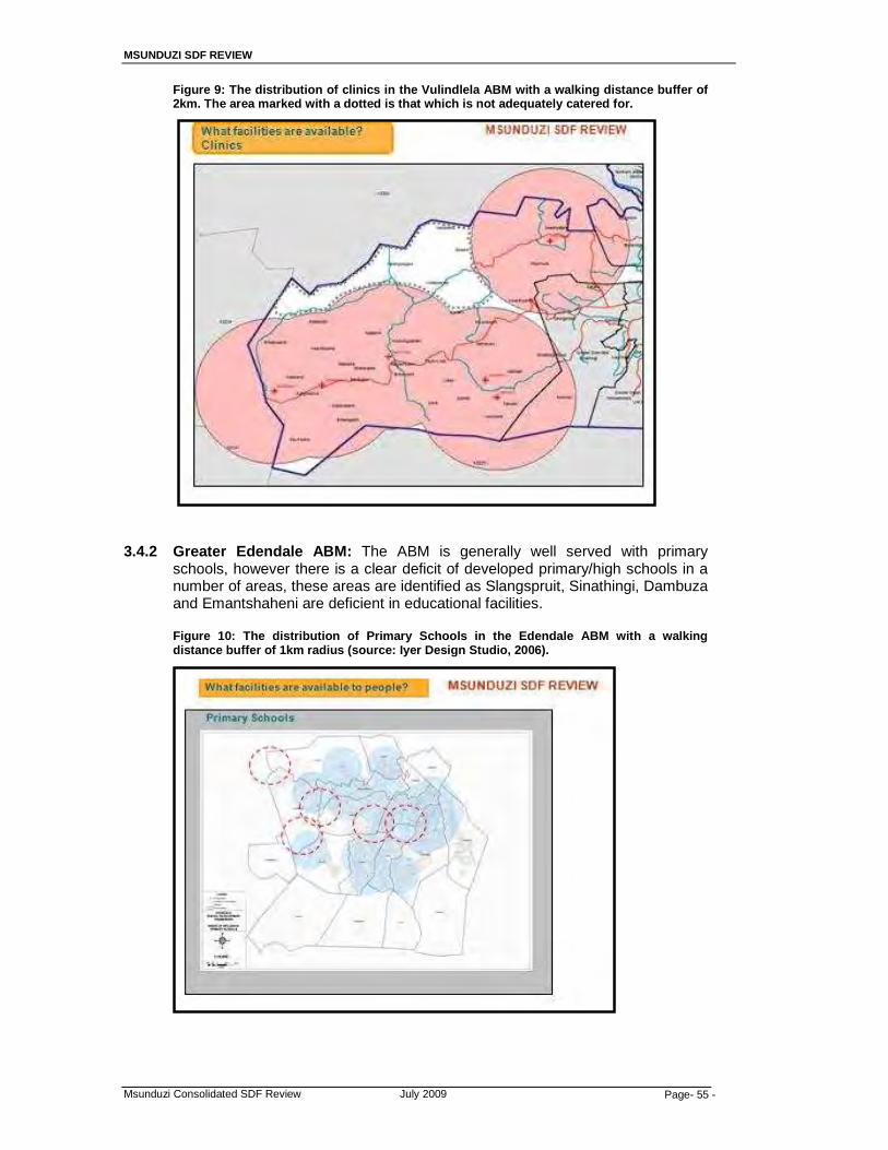
MSUNDUZI SDF REVIEW
Msunduzi Consolidated SDF Review July 2009 Page- 55 -
Figure 9: The distribution of clinics in the Vulindlela ABM with a walking distance buffer of 2km. The area marked with a dotted is that which is not adequately catered for.
3.4.2 Greater Edendale ABM: The ABM is generally well served with primary
schools, however there is a clear deficit of developed primary/high schools in a number of areas, these areas are identified as Slangspruit, Sinathingi, Dambuza and Emantshaheni are deficient in educational facilities. Figure 10: The distribution of Primary Schools in the Edendale ABM with a walking distance buffer of 1km radius (source: Iyer Design Studio, 2006).
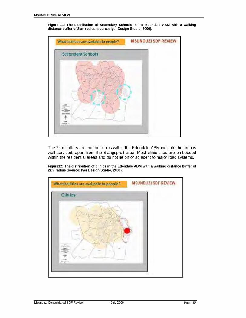
MSUNDUZI SDF REVIEW
Msunduzi Consolidated SDF Review July 2009 Page- 56 -
Figure 11: The distribution of Secondary Schools in the Edendale ABM with a walking distance buffer of 2km radius (source: Iyer Design Studio, 2006). The 2km buffers around the clinics within the Edendale ABM indicate the area is well serviced, apart from the Slangspruit area. Most clinic sites are embedded within the residential areas and do not lie on or adjacent to major road systems.
Figure12: The distribution of clinics in the Edendale ABM with a walking distance buffer of 2km radius (source: Iyer Design Studio, 2006).

MSUNDUZI SDF REVIEW
Msunduzi Consolidated SDF Review July 2009 Page- 57 -
Figure 13: The distribution of community facilities in the Edendale ABM with a walking distance buffer of 2km radius (source: Iyer Design Studio, 2006). A 2km buffer was also taken around the Community Facilities within Edendale and indicates the area is well serviced, apart from the Slangspruit area.
3.4.3 Northern Areas ABM and CBD, Ashburton, and Eastern Areas: There is a
satisfactory distribution of Primary schools in both ABM’s, with some gaps in places. The gap northeast of the area is not serious because a large part of this area is forestry. The gaps in Copesville, Cleland, Lincoln Meade, and Ashburton will need to be considered in light of the anticipated growth of the city in a southeasterly and southwesterly direction. Figure 14: The distribution of Primary Schools in the Northern Areas and ABM with a walking distance buffer of 1km radius.

MSUNDUZI SDF REVIEW
Msunduzi Consolidated SDF Review July 2009 Page- 58 -
There is a satisfactory distribution of Secondary schools in both ABM’s, with a gap evident in the Ashburton area. Future developments towards the Ashburton area will take this gap into consideration. Figure 15: The distribution of Secondary Schools in the Northern Areas and ABM with a walking distance buffer of 2km radius.
Figure 16: The distribution of clinics in the Edendale ABM with a walking distance buffer of 2km radius (source: Iyer Design Studio, 2006).
MSUNDUZI SDF REVIEW
Msunduzi Consolidated SDF Review July 2009 Page- 59 -
3.5 Housing
The declaration of the city as the provincial capital saw an exodus of government officials from Ulundi to Pietermaritzburg, and subsequently the demand for residential accommodation. Before the declaration, the city was sitting with a surplus of residential accommodation and at present the city is not coping with the current demand, even though more people are expected. It is in light of the above and the recent spending patterns that the sales of residential properties increased substantially in the past 3 years, and started slowing down in the first quarter of 2008. This trend also has a lot to do with the country’s growing black middle income group, which started its participation in the property market, and was later held back by the effects of the global economic meltdown. The market had risen to the occasion with most recent residential developments catering for middle to high income groups. The areas where these developments have been most noticeable include; Imbali, Bisley, Pelham, Boughton, Cascades, Cleland, and Chase Valley. The number of boarding houses particularly in the central area and Scottsville has also increased mainly because of the influx of students, the proximity to education facilities and the areas’ places of employment. An Inner City Residential Strategy was prepared by the city in 2004, from the research done; it became clear that there is a high demand for rental housing stock. This was also reiterated in the 2006/07 IDP that the increasing demand for rental housing would require Council to facilitate the construction of at least 500 middle income houses per annum. It needs to be pointed out though, that the demand for rental housing also includes the low income groups who can be accommodated through the social rental housing stock. The IDP Review of 2006/07 indicated that the Municipality is experiencing an average 2% household growth per annum therefore, an estimated 2500 houses need to be constructed annually to meet the demand.
3.5.1 The Msunduzi Housing Policy
Msunduzi Municipality has had to respond to the transformation agenda, which seeks to create integrated South African cities that are geared towards the creation of sustainable and integrated human settlements (Isibuko seAfrika, 2009). The transformation agenda requires that participants revisit their approaches to the delivery of housing and adopt new approaches such as; • Breaking New Ground (BNG) strategy; and • The National Housing Policy
(i) Breaking New Ground Strategy
The Breaking New Ground (BNG) strategy is founded on the principles of integrated and sustainable human settlements. It sees housing as a vehicle for addressing related socio-economic issues (Isibuko seAfrika, 2009).
MSUNDUZI SDF REVIEW
Msunduzi Consolidated SDF Review July 2009 Page- 60 -
(ii) The National Social Housing Policy
The National Housing Policy (is founded on the principles of using housing as a vehicle for achieving the national, provincial, and local development vision. It also looks at housing as vehicle for spatial restructuring, which is in line with the philosophy of creating post apartheid cities that are socially, economically, and spatially integrated.
The implications for the Spatial Development Framework are clearly about the identification of strategically located land for future housing developments to achieve the objectives of BNG and NSHP.
3.6 Infrastructure The city’s physical infrastructure includes; water and sanitation, roads and storm water, electricity, and waste removal. The provision and maintenance of these services amounts to more than 50% of the city’s capital budget.
“Since the amalgamation of different Transitional Local Councils (TLCs) the combined structure saw a rise in the needs of the people who needed services provision. There was a general inequality, inequity, lack and inadequate service delivery particularly in rural areas. Where services existed they were fragmented or at a single centralized place without reaching the periphery. To curb this, the municipality saw a need to develop a proper land use plan to provide a framework for service delivery,” (IDP, 2006).
3.6.1 Water and Sanitation: The city is supplied with bulk potable water by Umgeni
Water from Midmar Dam and the city is responsible for the reticulation to individual users. The municipality inherited different levels of services for water and sanitation when it incorporated Greater Edendale and Vulindlela in 1996 and 2000 respectively. The IDP, 2006 reports that Vulindlela area is the most desperate for the service. In the meantime, Umgeni Water is negotiating with the municipality to purchase the Vulindlela Water Scheme.
The recent developments particularly residential developments in the city have increased the demand for water and sanitation, and this has seen the municipality’s pipelines increase. However; there are still areas in the city in Greater Edendale and Bishopstowe that are provided with water by means of water tankers and boreholes, whilst informal settlements are provided with stand pipes. The Ashburton area is one of the few areas of the city that makes use of a septic tank system which is acceptable given the sizes of the stands. However, there are areas within this area where it is impossible to have this system due to low permeability and high water table. This situation has delayed approval of development applications, whereby the nature of the development requires a waterborne sewerage system. The level of sanitation facilities in Vulindlela and Greater Edendale include; no service, VIPs, conservancy tanks, septic tanks, and waterborne sewerage system. As indicated above, Vulindela is the hardest hit area in this regard. It is important to mention that the city’s infrastructure is aging and requires regular maintenance to ensure reliability particularly in Edendale where water losses are common. At a municipal wide level, the infrastructure will need to be upgraded in the near future.

MSUNDUZI SDF REVIEW
Msunduzi Consolidated SDF Review July 2009 Page- 61 -
3.6.2 Roads and stormwater: The levels of roads varies throughout the city, the so
called “Old City” is well provided with all weather access roads, whilst the newly incorporated areas have tarred roads, gravel roads, and lack of community access roads and adequate stormwater drainage. The Vulindlela area is still highly inaccessible.
The existing road system in the central area is under enormous strain from increased traffic volumes due to a number of reasons which include; the city’s status as the Capital and subsequent relocation of government offices to the city, the unprecedented economic growth of the city, the growing black middle class which means there are more people who can afford to buy cars, and the poor transport system and dependence on private vehicle usage. “This has caused severe congestion on the streets and there is a need to explore opportunities for expanding the roads or improving signaling to increase flow of traffic”, (IDP, 2006). The IDP, 2006 argues that statements made relating to single occupancy vehicle usage as the cause for traffic congestion are unfounded, as this congestion disappears during school holidays. This argument can be taken further to say that one has to acknowledge that the existing transport system requires people from all parts of the city to converge in the city centre before making their next links to their destinations. Private vehicles from outlying areas also converge in the central area to drop-off and pick up learners during peak hours. However, one must also consider that most families opt to take holidays during the same period, which reduces traffic on the city’s roads. A November 2006 presentation to EXCO by South Roads Agency Limited (SANRAL) reiterated that the 40 year old N3 Bypass is largely consumed by local urban commuters. At present freight transport amounts to 77’000 t/day and traffic is 15’000-40’000 v/day. There is an estimated 36’000 v/day that cross the N3 from Northdale (into Church Street), and 7’000 v/day make use of the northern ramps. The presentation revealed that in order to improve the capacity of the N3, insufficient capacity of Church Street and Bhambatha Road (was Greytown Road), it is necessary to improve the interchanges and provide additional lanes on the N3. It is the expectation of SANRAL that these multi-million rand projects will be done in partnership with Msunduzi Municipality, KZNDoT, and MTAB. It is important for the SDF to take cognizance of the local Edendale – Northdale Corridor Development (which runs through the central area) and the provincial Ethekwini – Umgeni Corridor Development. In both instances, significant development nodes are identified along these corridors and these will be affected or will affect the proposed road upgrading projects. The 2006/07 IDP reports that since the introduction of the IDP in local government, the Msunduzi Municipality has provided 21,541km in low cost housing developments. It is important to mention that at a municipal wide level, the aging road infrastructure requires regular maintenance and upgrading.
3.6.3 Electricity: Eskom is the sole bulk of supplier to the municipality which is
responsible for the individual connections therefore, it only provides grid electricity. The provision of electricity is demand driven and without an adequate SDF it is difficult to plan for future demands.
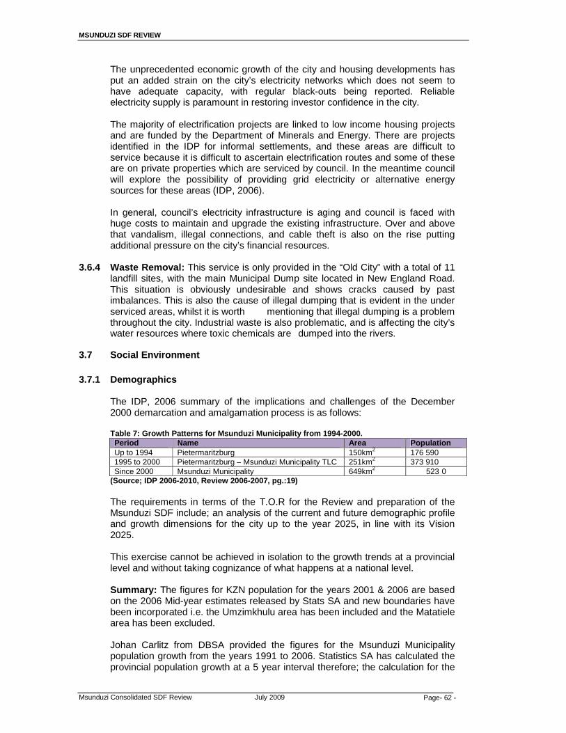
MSUNDUZI SDF REVIEW
Msunduzi Consolidated SDF Review July 2009 Page- 62 -
The unprecedented economic growth of the city and housing developments has put an added strain on the city’s electricity networks which does not seem to have adequate capacity, with regular black-outs being reported. Reliable electricity supply is paramount in restoring investor confidence in the city. The majority of electrification projects are linked to low income housing projects and are funded by the Department of Minerals and Energy. There are projects identified in the IDP for informal settlements, and these areas are difficult to service because it is difficult to ascertain electrification routes and some of these are on private properties which are serviced by council. In the meantime council will explore the possibility of providing grid electricity or alternative energy sources for these areas (IDP, 2006). In general, council’s electricity infrastructure is aging and council is faced with huge costs to maintain and upgrade the existing infrastructure. Over and above that vandalism, illegal connections, and cable theft is also on the rise putting additional pressure on the city’s financial resources.
3.6.4 Waste Removal: This service is only provided in the “Old City” with a total of 11
landfill sites, with the main Municipal Dump site located in New England Road. This situation is obviously undesirable and shows cracks caused by past imbalances. This is also the cause of illegal dumping that is evident in the under serviced areas, whilst it is worth mentioning that illegal dumping is a problem throughout the city. Industrial waste is also problematic, and is affecting the city’s water resources where toxic chemicals are dumped into the rivers.
3.7 Social Environment 3.7.1 Demographics
The IDP, 2006 summary of the implications and challenges of the December 2000 demarcation and amalgamation process is as follows:
Table 7: Growth Patterns for Msunduzi Municipality from 1994-2000. Period Name Area Population Up to 1994 Pietermaritzburg 150km2 176 590 1995 to 2000 Pietermaritzburg – Msunduzi Municipality TLC 251km2 373 910 Since 2000 Msunduzi Municipality 649km2 523 0
(Source; IDP 2006-2010, Review 2006-2007, pg.:19)
The requirements in terms of the T.O.R for the Review and preparation of the Msunduzi SDF include; an analysis of the current and future demographic profile and growth dimensions for the city up to the year 2025, in line with its Vision 2025.
This exercise cannot be achieved in isolation to the growth trends at a provincial level and without taking cognizance of what happens at a national level. Summary: The figures for KZN population for the years 2001 & 2006 are based on the 2006 Mid-year estimates released by Stats SA and new boundaries have been incorporated i.e. the Umzimkhulu area has been included and the Matatiele area has been excluded. Johan Carlitz from DBSA provided the figures for the Msunduzi Municipality population growth from the years 1991 to 2006. Statistics SA has calculated the provincial population growth at a 5 year interval therefore; the calculation for the
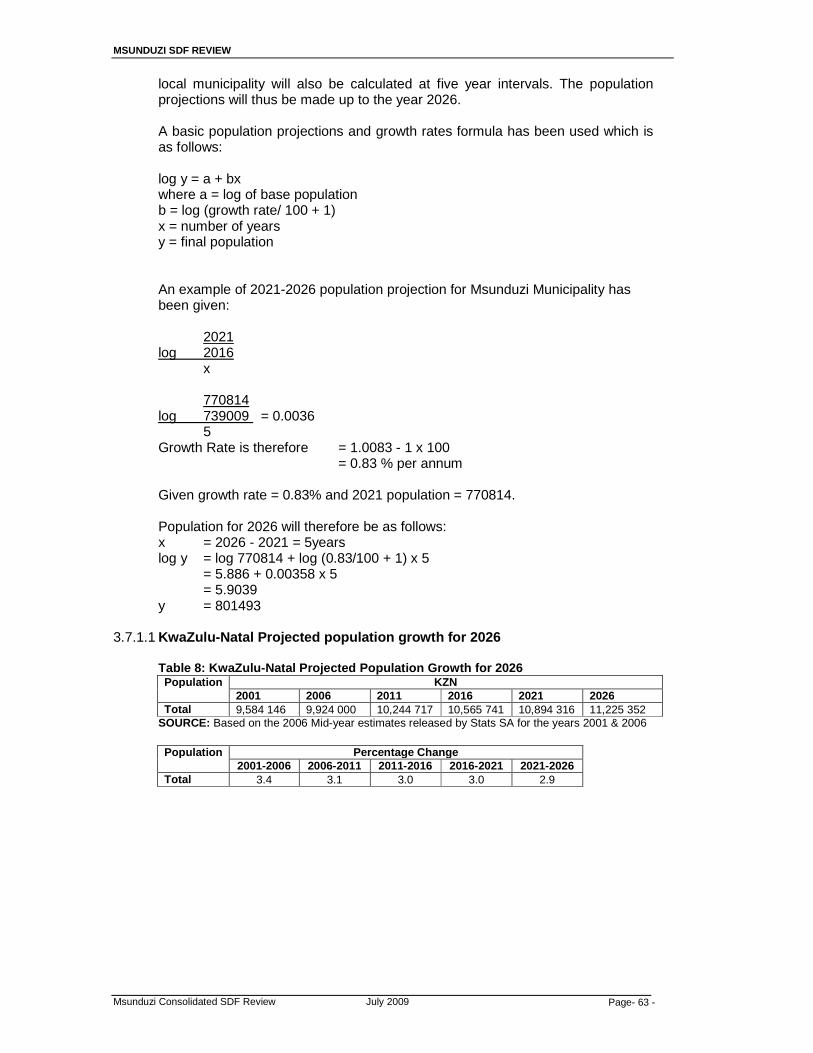
MSUNDUZI SDF REVIEW
Msunduzi Consolidated SDF Review July 2009 Page- 63 -
local municipality will also be calculated at five year intervals. The population projections will thus be made up to the year 2026. A basic population projections and growth rates formula has been used which is as follows: log y = a + bx where a = log of base population
b = log (growth rate/ 100 + 1) x = number of years y = final population
An example of 2021-2026 population projection for Msunduzi Municipality has been given:
2021
log 2016 x 770814
log 739009 = 0.0036 5 Growth Rate is therefore = 1.0083 - 1 x 100
= 0.83 % per annum
Given growth rate = 0.83% and 2021 population = 770814. Population for 2026 will therefore be as follows: x = 2026 - 2021 = 5years log y = log 770814 + log (0.83/100 + 1) x 5
= 5.886 + 0.00358 x 5 = 5.9039
y = 801493
3.7.1.1 KwaZulu-Natal Projected population growth for 2026 Table 8: KwaZulu-Natal Projected Population Growth for 2026
Population KZN 2001 2006 2011 2016 2021 2026
Total 9,584 146 9,924 000 10,244 717 10,565 741 10,894 316 11,225 352 SOURCE: Based on the 2006 Mid-year estimates released by Stats SA for the years 2001 & 2006
Population Percentage Change
2001-2006 2006-2011 2011-2016 2016-2021 2021-2026 Total 3.4 3.1 3.0 3.0 2.9

MSUNDUZI SDF REVIEW
Msunduzi Consolidated SDF Review July 2009 Page- 64 -
2.62.72.82.9
33.13.23.33.4
2001-2006
2011-2016
2021-2026
PopulationChange
Figure 17: Population Growth Structure for Kwa- Zulu Natal, projected for 2026
The figures above indicate that whilst the population of the province will continue to increase from 9,924 000 in 2006 up to 11, 225 352 in 2026, the growth rate will go down over the same period. This can be attributed to the impact HIV/AIDS will have over the same period, as well as behavior changes and more effective family planning methods.
3.7.1.2 The Msunduzi Municipality projected population growth for 2026 Table 9: Msunduzi Municipality projected population growth for 2026
Population
Msunduzi Municipality 1991 1996 2001 2006 2011 2016 2021 2026
Total 277521 571495 645042 676192 707758 739009 770814 801493 SOURCE: Johan Carlitz from DBSA (stats from 1991 to 2006)
Population
Percentage Change
1991-1996
1996-2001
2001-2006
2006-2011
2011-2016
2016- 2021
2021- 2026
Total 51.4 11.4 4.6 4.5 4.2 4.1 3.8
The figures above indicate that between 1991 to1996 there was a 51.4% increase in population, and in 1996 to 2001 there was an 11.4% increase in population. The increase of 1991-1996 can be attributed to the fact that in 1991 Pietermaritzburg Borough was a single entity however, after the elections of 1994 the Pietermaritzburg-Msunduzi TLC was established and it incorporated the Greater Edendale areas. The second increase in 1996-2001 was as a result of the introduction of “wall to wall” municipalities after the elections of December 2000. This resulted in the establishment of Msunduzi Municipality which amalgamated the TLC’s of Pietermaritzburg-Msunduzi and Ashburton, and included Claridge, Bishopstowe, and the Tribal Areas of Vulindlela.
As is the case at a provincial level, the population growth rate of Msunduzi Municipality is expected to go down from 4.6% in 2001-2006 to 3.8% in 2021 to 2026. Nevertheless, the population will increase at a lesser rate. This means whilst there is a backlog of services and facilities, future decisions will have to take cognizance of this trend in order to avoid an over supply of services and facilities which may become unsustainable.
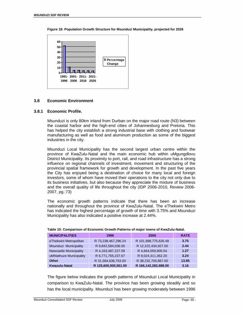
MSUNDUZI SDF REVIEW
Msunduzi Consolidated SDF Review July 2009 Page- 65 -
Figure 18: Population Growth Structure for Msunduzi Municipality, projected for 2026
3.8 Economic Environment 3.8.1 Economic Profile.
Msunduzi is only 80km inland from Durban on the major road route (N3) between the coastal harbor and the high-end cities of Johannesburg and Pretoria. This has helped the city establish a strong industrial base with clothing and footwear manufacturing as well as food and aluminum production as some of the biggest industries in the city.
Msunduzi Local Municipality has the second largest urban centre within the province of KwaZulu-Natal and the main economic hub within uMgungdlovu District Municipality. Its proximity to port, rail, and road infrastructure has a strong influence on regional channels of investment, movement and structuring of the provincial spatial framework for growth and development. In the past five years the City has enjoyed being a destination of choice for many local and foreign investors, some of whom have moved their operations to the city not only due to its business initiatives, but also because they appreciate the mixture of business and the overall quality of life throughout the city (IDP 2006-2010, Review 2006-2007, pg.:73)
The economic growth patterns indicate that there has been an increase nationally and throughout the province of KwaZulu-Natal. The eThekwini Metro has indicated the highest percentage of growth of time with 3.75% and Msunduzi Municipality has also indicated a positive increase at 2.44%.
Table 10: Comparison of Economic Growth Patterns of major towns of KwaZulu-Natal.
MUNICIPALITIES 1996 2005 RATE
eThekwini Metropolitan R 73,238,467,296.24 R 101,998,775,626.49 3.75
Msunduzi Municipality R 9,842,584,036.00 R 12,222,434,927.00 2.44
Newcastle Municipality R 4,163,487,227.59 R 4,664,059,905.54 1.27
uMhlathuze Municipality R 6,771,755,237.67 R 9,024,311,362.20 3.24
Other R 31,584,636,753.00 R 38,232,700,867.00 13.85 Kwazulu-Natal R 125,600,930,551.00 R 166,142,282,688.00 3.16
The figure below indicates the growth patterns of Msunduzi Local Municipality in
comparison to KwaZulu-Natal. The province has been growing steadily and so
has the local municipality. Msunduzi has been growing moderately between 1996
0
10
20
30
40
50
60
1991-1996
2001-2006
2011-2016
2021-2026
PercentageChange

MSUNDUZI SDF REVIEW
Msunduzi Consolidated SDF Review July 2009 Page- 66 -
and 2002 however between 2003 and 2005 there has been a substantial
increase. In 2001 the province and the local municipality has grown at the same
rate. The figure below indicates the growth pattern from 1996-2005. Figure 19: Growth Patterns for KwaZulu Natal and Msunduzi Local Municipality
Growth Patterns for KwaZulu Natal and Msunduzi Local Municipality
0.0 2.0 4.0 6.0 8.0 10.0 12.0 14.0
1996
1997
1998
1999
2000
2001
2002
2003
2004
2005
Yea
r
Percentage
Msunduzi
KZN
The structure of the Msunduzi Local Municipality comprises of various economic
activities however, the sector that is largest contributor to the economy in terms
of employment is general government services which contribute some 21%,
finance and business services contribute 20% and wholesale and retail and
manufacturing contribute 16% to the local economy. However when compared to
the provinces’ employment sectors it indicates a decline in general government
services as compared to Msunduzi. The higher figure can be attributed to the fact
that Msunduzi is the capital of KwaZulu Natal, hence the larger number of
government structures that exist. KwaZulu Natal does contribute a larger
percentage in terms of manufacturing (18%) as compared to Msunduzi.
Table 11: Economic sectors of Msunduzi Local Municipality
ECONOMIC SECTOR MSUNDUZI % KZN %
Agriculture, forestry and fishing 2 8
Mining 1 1
Manufacturing 16 18
Electricity & water 1 1
Construction 4 4
Wholesale & retail trade 16 16
Transport & communication 3 4
Finance and business services 20 16
Community, social and other personal services 17 15
General government services 21 17
TOTALS 100 100 Source: Census 2001
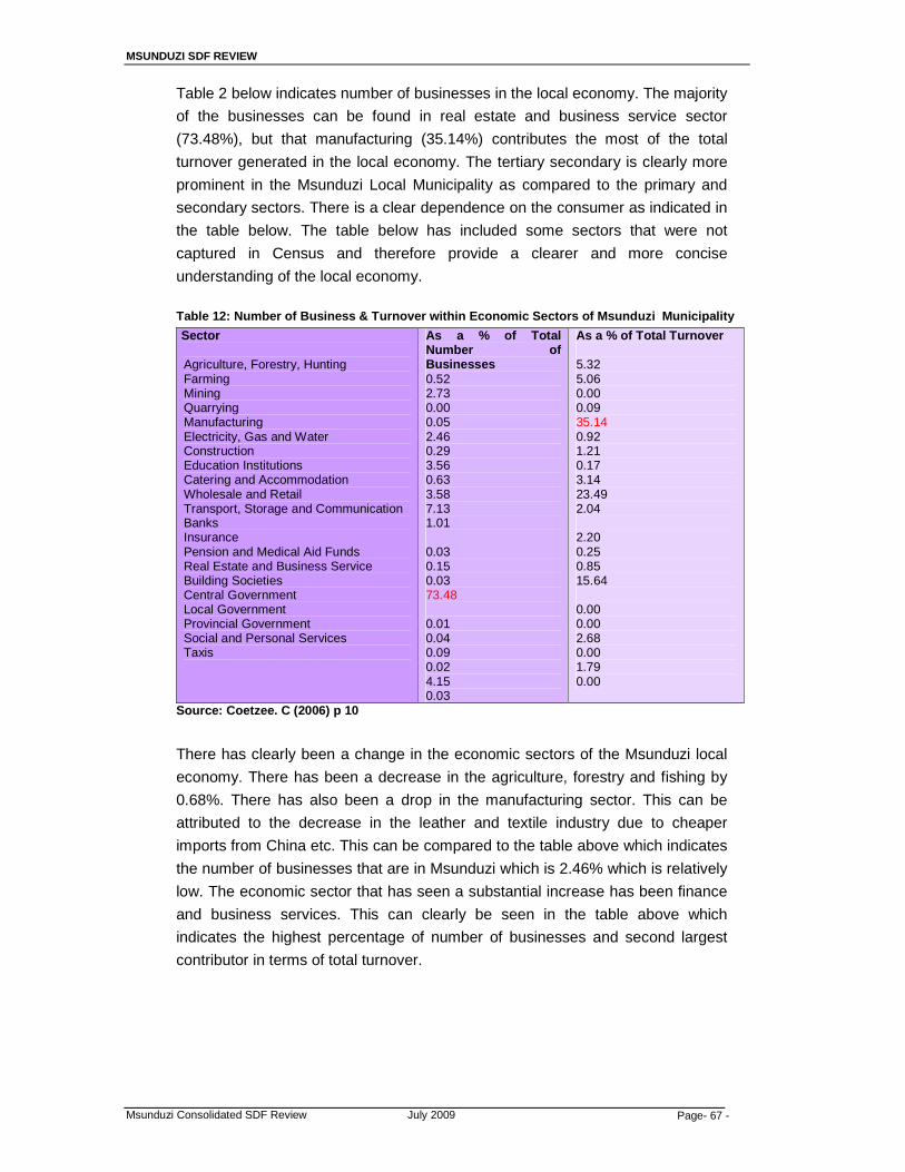
MSUNDUZI SDF REVIEW
Msunduzi Consolidated SDF Review July 2009 Page- 67 -
Table 2 below indicates number of businesses in the local economy. The majority
of the businesses can be found in real estate and business service sector
(73.48%), but that manufacturing (35.14%) contributes the most of the total
turnover generated in the local economy. The tertiary secondary is clearly more
prominent in the Msunduzi Local Municipality as compared to the primary and
secondary sectors. There is a clear dependence on the consumer as indicated in
the table below. The table below has included some sectors that were not
captured in Census and therefore provide a clearer and more concise
understanding of the local economy.
Table 12: Number of Business & Turnover within Economic Sectors of Msunduzi Municipality
Sector
Agriculture, Forestry, Hunting Farming Mining Quarrying Manufacturing Electricity, Gas and Water Construction Education Institutions Catering and Accommodation Wholesale and Retail Transport, Storage and Communication Banks Insurance Pension and Medical Aid Funds Real Estate and Business Service Building Societies Central Government Local Government Provincial Government Social and Personal Services Taxis
As a % of Total Number of Businesses 0.52 2.73 0.00 0.05 2.46 0.29 3.56 0.63 3.58 7.13 1.01 0.03 0.15 0.03 73.48 0.01 0.04 0.09 0.02 4.15 0.03
As a % of Total Turnover 5.32 5.06 0.00 0.09 35.14 0.92 1.21 0.17 3.14 23.49 2.04 2.20 0.25 0.85 15.64 0.00 0.00 2.68 0.00 1.79 0.00
Source: Coetzee. C (2006) p 10
There has clearly been a change in the economic sectors of the Msunduzi local
economy. There has been a decrease in the agriculture, forestry and fishing by
0.68%. There has also been a drop in the manufacturing sector. This can be
attributed to the decrease in the leather and textile industry due to cheaper
imports from China etc. This can be compared to the table above which indicates
the number of businesses that are in Msunduzi which is 2.46% which is relatively
low. The economic sector that has seen a substantial increase has been finance
and business services. This can clearly be seen in the table above which
indicates the highest percentage of number of businesses and second largest
contributor in terms of total turnover.
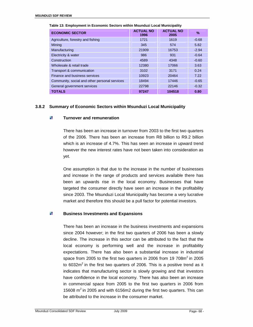
MSUNDUZI SDF REVIEW
Msunduzi Consolidated SDF Review July 2009 Page- 68 -
Table 13: Employment in Economic Sectors within Msunduzi Local Municipality
ECONOMIC SECTOR ACTUAL NO 1996
ACTUAL NO 2005 %
Agriculture, forestry and fishing 1721 1619 -0.68
Mining 345 574 5.82
Manufacturing 21909 16753 -2.94
Electricity & water 986 931 -0.64
Construction 4589 4348 -0.60
Wholesale & retail trade 12380 17066 3.63
Transport & communication 3102 3171 0.24
Finance and business services 10923 20464 7.22
Community, social and other personal services 18494 17446 -0.65
General government services 22798 22146 -0.32
TOTALS 97247 104518 0.80
3.8.2 Summary of Economic Sectors within Msunduzi Local Municipality
Turnover and remuneration
There has been an increase in turnover from 2003 to the first two quarters
of the 2006. There has been an increase from R8 billion to R9.2 billion
which is an increase of 4.7%. This has seen an increase in upward trend
however the new interest rates have not been taken into consideration as
yet.
One assumption is that due to the increase in the number of businesses
and increase in the range of products and services available there has
been an upwards rise in the local economy. Businesses that have
targeted the consumer directly have seen an increase in the profitability
since 2003. The Msunduzi Local Municipality has become a very lucrative
market and therefore this should be a pull factor for potential investors.
Business Investments and Expansions
There has been an increase in the business investments and expansions
since 2004 however; in the first two quarters of 2006 has been a slowly
decline. The increase in this sector can be attributed to the fact that the
local economy is performing well and the increase in profitability
expectations. There has also been a substantial increase in industrial
space from 2005 to the first two quarters in 2006 from 19 708m2 in 2005
to 6032m2 in the first two quarters of 2006. This is a positive trend as it
indicates that manufacturing sector is slowly growing and that investors
have confidence in the local economy. There has also been an increase
in commercial space from 2005 to the first two quarters in 2006 from
15608 m2 in 2005 and with 6156m2 during the first two quarters. This can
be attributed to the increase in the consumer market.
MSUNDUZI SDF REVIEW
Msunduzi Consolidated SDF Review July 2009 Page- 69 -
Labour Market
The labour market is vital to the economy as it determines the economic
activity that is prevalent in the local economy. There has been a decrease
in the number of claims for unemployment since the third quarter of 2005
and this trend has continued into the first two quarters of 2006. This is
significant as it indicates that there is a decrease in unemployment rate
and that there is an increase in employment opportunities due to the
positive growth of the local economy in the last three years.
Monetary Sector
The interest rate plays a significant role in the economy and impacts on
all aspects of the economy. The increase in the interest rates in the
second quarter of 2006 and the effects thereof are not clear at present.
The economy which is consumer dominated economically could be
potentially affected however it is presumptions at this stage.
Residential Property Market
The residential property market has increased all over South Africa and
Msunduzi is no different. The increase in this sector from January 2003 to
June 2006 is 176%. There is an increase in the higher priced property
market however the number of houses being sold has decreased by 63%.
The increase in the residential properties is one of the main reasons for
the increase in the wealth effect. The wealth effect occurs when
consumers borrow against the increase in collateral.
Retail Activity
The increase in retail activity is measured based on the head counts in
shopping complexes. This sector has seen an increase of 26% year on
year during June 2006. The average expenditure per person is R90 in
2004, R105 in 2005 and R111 in June 2006. Clearly this trend is set to
continue and that consumer market will clearly not be seeing a decrease
in market consumption.
Vehicle and Transport Sector
There has been an increase of new passenger vehicles sold per month
increased by 87% from January 2003 to June 2006. There has been an
increase of commercial vehicles by 55% during the same period.
However the interest rates have not deterred consumers from purchasing
MSUNDUZI SDF REVIEW
Msunduzi Consolidated SDF Review July 2009 Page- 70 -
vehicles however it should stabilize moderately. The rising fuel prices also
have not decreased the demand for new vehicles over this period
however the latter of 2006 should determine the state of the vehicle
market.
There has also been an increase in the number of heavy load vehicles in
the local economy. These vehicles are utilized for transporting
commercial and household goods.
Petrol and Diesel
The consumption of petrol and diesel are good indicators to determine the
economic activity within the local economy. There has been an increase
in the usage of petrol and diesel by 4% and 1.2% year on year. There
seems to be a greater demand for these commodities even though there
have been increases since January 2003 to June 2006. These increases
have only marginally affected the demand for these commodities.
Building and Development Sector
There has been an increase in this sector by 26% from the period of
January 2003 to June 2006. The Rand Value of the building plans
approved increase from R2.9m in January 2003 to R46m in June 2006
which has represented 1507% increase. This represents 100% increase
yearly for the approval of business plans. However there has been a
decrease in the first two quarters on 2006 due to the increase in interest
rates. This sector is influenced by the property market and the boom in
this sector has sparked off many residents to make changes to existing
properties. Building permits approved are a significant indicator of future
economic activity.
Hospitality and Entertainment Sector
There has been a phenomenal increase in this sector with an increase of
158% from January 2003 to June 2006 of local people utilizing this local
entertainment and hospitality venues. There has been an increase of non
local residents by 17% from January 2003 to June 2006 however there
has been a decrease in the first two quarters of 2006 by 13%.
The economic performance indicator is a weighted economic
performance indicator. The table below refers to the economic
performance of the local economy from January 2003 to June 2006.
There has been an increase of 195% however during the first two
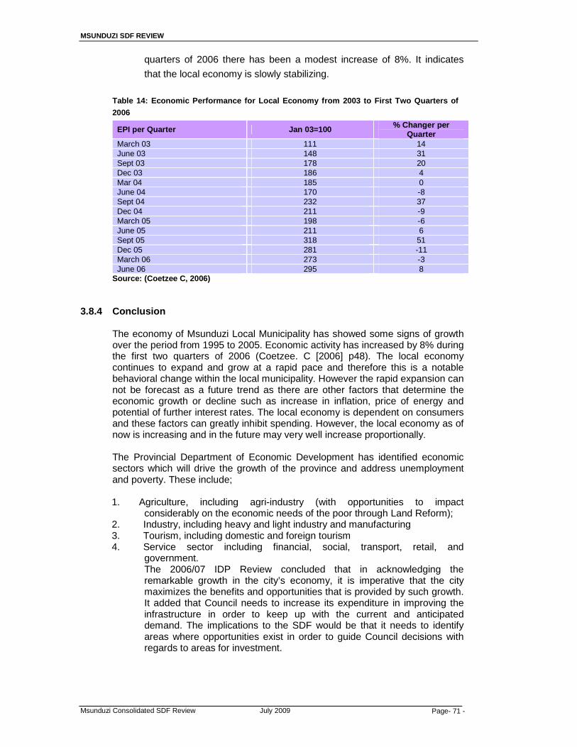
MSUNDUZI SDF REVIEW
Msunduzi Consolidated SDF Review July 2009 Page- 71 -
quarters of 2006 there has been a modest increase of 8%. It indicates
that the local economy is slowly stabilizing. Table 14: Economic Performance for Local Economy from 2003 to First Two Quarters of
2006
EPI per Quarter Jan 03=100 % Changer per Quarter
March 03 111 14 June 03 148 31 Sept 03 178 20 Dec 03 186 4 Mar 04 185 0 June 04 170 -8 Sept 04 232 37 Dec 04 211 -9 March 05 198 -6 June 05 211 6 Sept 05 318 51 Dec 05 281 -11 March 06 273 -3 June 06 295 8
Source: (Coetzee C, 2006) 3.8.4 Conclusion
The economy of Msunduzi Local Municipality has showed some signs of growth over the period from 1995 to 2005. Economic activity has increased by 8% during the first two quarters of 2006 (Coetzee. C [2006] p48). The local economy continues to expand and grow at a rapid pace and therefore this is a notable behavioral change within the local municipality. However the rapid expansion can not be forecast as a future trend as there are other factors that determine the economic growth or decline such as increase in inflation, price of energy and potential of further interest rates. The local economy is dependent on consumers and these factors can greatly inhibit spending. However, the local economy as of now is increasing and in the future may very well increase proportionally. The Provincial Department of Economic Development has identified economic sectors which will drive the growth of the province and address unemployment and poverty. These include; 1. Agriculture, including agri-industry (with opportunities to impact
considerably on the economic needs of the poor through Land Reform); 2. Industry, including heavy and light industry and manufacturing 3. Tourism, including domestic and foreign tourism 4. Service sector including financial, social, transport, retail, and
government. The 2006/07 IDP Review concluded that in acknowledging the remarkable growth in the city’s economy, it is imperative that the city maximizes the benefits and opportunities that is provided by such growth. It added that Council needs to increase its expenditure in improving the infrastructure in order to keep up with the current and anticipated demand. The implications to the SDF would be that it needs to identify areas where opportunities exist in order to guide Council decisions with regards to areas for investment.

MSUNDUZI SDF REVIEW
Msunduzi Consolidated SDF Review July 2009 Page- 72 -
4. APPROACHES TO FORMULATING THE SDF
4.1 Format of the SDF
A Spatial Development Framework is a plan that seeks to guide the overall spatial distribution of current and future desirable land uses in order to give effect to the Vision, Goals and Objectives of the Municipal IDP. It is a plan that outlines the Developmental Principles and policies that are applicable in the area in relation to physical space.
Conceptually, the treatment is that of identifying the different “planning interventions”.
A simple matrix, as indicated below, identifies each planning element by a three-way planning treatment. Type of activity EXISTING IMPROVE NEW Treatment Maintain
Ltd Improvement Consolidate Realign Formalise Upgrade
Infill “Greenfields
Examples: A. Residential Type of activity EXISTING
(Maintain)
IMPROVE
(Consolidate, Upgrade, etc)
NEW (Infill, “Greenfields)
Formal Residential Informal Residential Rural
B. Roads
Type of activity EXISTING (Maintain)
IMPROVE (Upgrade, Realign, )
NEW
Mobility / Ltd Access Rd
Major Arterial Minor Arterial
C. Nodes
Type of activity EXISTING (Maintain)
IMPROVE (Consolidate)
NEW
Primary Node Secondary Node Tertiary Node
In this sense, each basic element has a potential of 9 elements on the plan Key

MSUNDUZI SDF REVIEW
Msunduzi Consolidated SDF Review July 2009 Page- 73 -
4.2 Guiding Principles
i) In addition to the legislative provisions referred to in paragraph 2, the Principles for the Review have been modified and elaborated as seen in the Table below: Table 15: SDF Review Guiding Principles
CURRENT SDF: Guiding Principles
REVIEWED SDF: GUIDING PRINCIPLES
- Compaction - Integration - Densification - Restructuring of the City
- Meeting Land Use Needs - Identification of areas of
economic development potentials
• Compaction • Integration • Urban Densification • Restructuring of the City:
• Creating a Polycentric City • Redressing imbalances • Integrating the city
• Meeting Land Use Needs • Identification of areas of economic
development potentials • Sustainability • Creating a quality urban
environment
ii) The review was also informed by the SDF for the Umgungundlovu District Municipality, which identifies Msunduzi as the Primary Node in the District, and inter alia recommends the upgrading of certain tourist routes and the establishment of bypass routes to ease congestion in and around the primary node. Alignment with the SDF’s of adjoining Municipalities will be required before the reviewed SDF is finalised.
4.3 Concept for Integrating the City
Dewar’s generic concept as illustrated in the following diagram is utilised to achieve the planning principles.
Figure 20: David Dewar’s generic concept of integrating the Apartheid city, illustrated in the context of Msunduzi Municipality

MSUNDUZI SDF REVIEW
Msunduzi Consolidated SDF Review July 2009 Page- 74 -
4.4 Planning and Development Informants The application of general planning and development principles and concepts are
influenced by the local context. The following informants shape the SDF;
- The strategic location of the Municipality on the N3, providing high levels of accessibility between major urban centres and adjacent provinces.
- The City’s status as the Provincial Capital and the primary node in the District, and as an emerging metropolitan area.
- Present development patterns and the interaction between residential and employment areas, and the availability of services and facilities to communities.
- The present transport infrastructure which is focused on the central area, and low levels of connectivity between the peripheral areas.
- Relatively low levels of access to urban services and facilities for some communities.
- Physical and topographical constraints. - Environmental consideration. - Pockets of poverty and unemployment and low levels of participation in the
local economy by low income communities. These informants are analysed and discussed in detail in the contextual
framework, and the SDF’s for each of the ABMS’s.
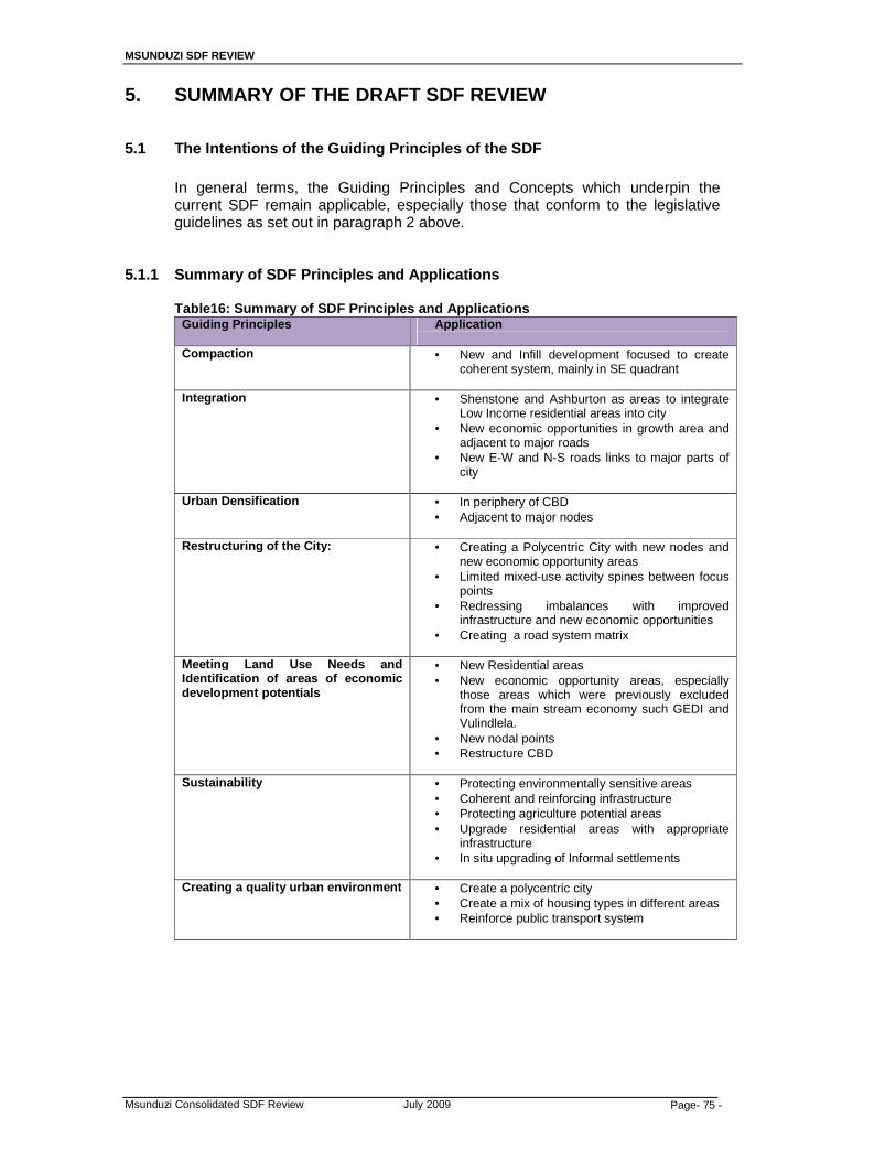
MSUNDUZI SDF REVIEW
Msunduzi Consolidated SDF Review July 2009 Page- 75 -
5. SUMMARY OF THE DRAFT SDF REVIEW
5.1 The Intentions of the Guiding Principles of the SDF
In general terms, the Guiding Principles and Concepts which underpin the current SDF remain applicable, especially those that conform to the legislative guidelines as set out in paragraph 2 above.
5.1.1 Summary of SDF Principles and Applications Table16: Summary of SDF Principles and Applications
Guiding Principles Application
Compaction
• New and Infill development focused to create coherent system, mainly in SE quadrant
Integration
• Shenstone and Ashburton as areas to integrate Low Income residential areas into city
• New economic opportunities in growth area and adjacent to major roads
• New E-W and N-S roads links to major parts of city
Urban Densification
• In periphery of CBD • Adjacent to major nodes
Restructuring of the City:
• Creating a Polycentric City with new nodes and new economic opportunity areas
• Limited mixed-use activity spines between focus points
• Redressing imbalances with improved infrastructure and new economic opportunities
• Creating a road system matrix
Meeting Land Use Needs and Identification of areas of economic development potentials
• New Residential areas • New economic opportunity areas, especially
those areas which were previously excluded from the main stream economy such GEDI and Vulindlela.
• New nodal points • Restructure CBD
Sustainability
• Protecting environmentally sensitive areas • Coherent and reinforcing infrastructure • Protecting agriculture potential areas • Upgrade residential areas with appropriate
infrastructure • In situ upgrading of Informal settlements
Creating a quality urban environment
• Create a polycentric city • Create a mix of housing types in different areas • Reinforce public transport system
MSUNDUZI SDF REVIEW
Msunduzi Consolidated SDF Review July 2009 Page- 76 -
6. THE CONCEPTUAL FRAMEWORK OF THE SDF
6.1 Introduction
The formulation of the Conceptual Framework was an attempt to conceptualize responses to the findings of the Contextual Framework and the key development issues identified therein. These key issues include; the Spatial Structuring Elements which will be used as a basis for managing and guiding future developments into a certain direction and pattern, ultimately in order to fulfil the Council’s IDP Vision.
The Spatial Structuring Elements of the City include:
• Nodes (Concentration of activity) • Corridors (Main roads / Arterials) • Settlement Patterns (Formal / Informal / Traditional); • Restrictive Conditions (Environmental / Topographical / Geotechnical); • Environment / Open Spaces (Active / Passive) • Urban Edge; • Mixed-Use Developments Aesthetic Environment (Visual Form / Heritage
Special Features)
6.2 The Conceptual Principles
The proposed development concept for the Msunduzi SDF review is informed by the principles o ;
• the Provincial Growth and Development Strategy (PGDS) [these
include; Good Governance, Competitive Investment, Local Economic Development, and Sustainable Communities],
• the NSDP [these include; Rapid economic growth, Government spending on fixed investment, Investment in poverty alleviation and basic services programmes, and Addressing past and present social imbalances],
• the PSEDS [these include; Sustainability, Correcting historical spatial imbalances, Curbing urban sprawl, Differentiated levels of infrastructure provision, Identification of priority development areas, Strengthening of major movement corridors, Identification of areas of high biodiversity and conservation significance, Alignment of national/ provincial/ municipal spatial visions, Aligning government budgets to priorities, and Private sector investment to support shared vision for the Province] and it is also informed by District SDF Guidance Framework for Local SDFs which is outlined above.
The concept implies the development of a road "lattice" that offers both alternative routes and the dissipation of traffic, with a clearly differentiated road system and clearly differentiated Nodes, i.e. a hierarchy of Nodes, varying from small local level nodes through to "regional" servicing nodes, with appropriate catchments or thresholds of support. The application of the twin concept of "Nodes and Corridors" has become common practice over the last few years. The use and application of these concepts has also become distorted and misused. Essentially, every major route or road (at the level of major Limited Access Mobility roads and Major Arterials) has tended to be called a "Corridor" or
MSUNDUZI SDF REVIEW
Msunduzi Consolidated SDF Review July 2009 Page- 77 -
a "Spine". Major activity foci located along such a road has been tended to be called a "Node".
In its "good practice" sense the concept implies the location of major facilities, of all types, being differentially located along these roads. At no stage in the evolution of this concept did it imply that it advocated the concept of "Ribbon Development”. The concept always meant that these nodes would be spatially distinct and separated, often separated at distances of the order of at least 2 kilometres from each other so that most people would be within walking distance of these foci. Only in very specific circumstances would the disposition of land uses along a major road become a "mixed-use" corridor. Unfortunately, the concepts of "Corridor" and "Mixed-use" have become intertwined and synonymous which is clearly an unfortunate interpretation. There has also been a tendency to locate a Node at every single intersection on these Major roads - sometimes without much differentiation between them. Clearly, there is a hierarchy of commercially orientated nodes, such that in a metropolitan area there would be at least the standard 5 tiers of a retail hierarchy and additional new forms of shopping centres. In addition, there could be decentralized office nodes, and hospital and administrative nodes. Consequently, the attempt to squeeze all of these types of foci into a simple trilogy of Primary, Secondary and Tertiary Nodes into plans, especially at the SDF level, is more than simplistic and inappropriate.
The draft SDF largely refines and builds on the current SDF, and is aimed at restructuring the existing radial form of the city through:
- The introduction of additional Mobility and Arterial roads to create a
more functional road lattice to facilitate movement with alternative options. It also attempts to improve access to areas previously marginalised from the local economy.
- The establishment of a series of nodes in both the urban and rural components of the city, distributed in such a way that communities are within reasonable travelling distance of the services offered at these nodes.
- Mixed use activity spines that extend a limited distance from the CBD,
and in focussed areas along some of the major routes, without undermining the primary mobility function.
- The location of new residential developments in relatively few areas
within an Urban Growth Boundary, to create a compact and efficient city, contain urban sprawl and conform to basic environmental objectives.
The Consolidated SDF‘s main departure from the current SDF is in the reduction and rationalisation of proposed nodes and development corridors.
6.3 Application of the Concept to Msunduzi i) Basic Terms
In order to avoid misunderstandings, the application of these concepts will use the terminology as set out below, and the arrangement of the various elements that comprise these concepts are illustrated in the following Concept diagram.

MSUNDUZI SDF REVIEW
Msunduzi Consolidated SDF Review July 2009 Page- 78 -
• Mobility Roads will be called just that, and not be termed "corridors".
As Limited Access Roads, these routes will only be able to have Nodes or any other form of development located at or near appropriate major intersections.
• Arterial Roads will also have Nodes appropriately located at or near
major intersections. It will however be possible to locate other major facilities located along these "spines" such as major playing fields, stadia, hospitals, high schools etc, without necessarily being part of the Nodes. Future arterial/link roads aimed at improved accessibility and the reduction of congestion are indicated on the SDF Map.
• Nodes will be distinguished in terms of the retail hierarchy when
commercially orienated; or when developed as specific administration or related types of uses. These nodes will be located in terms of their requisite thresholds of support, so that not every intersection is a Node. On the same basis, nodes are identified in Vulindlela, the tribal component of the Municipality.
• "Mixed-Use Corridors" will only occur in particular circumstances, ie
where arterial roads extend from the CBD or between two or more closely related nodes.
ii) Basic Elements
The SDF Plan will also distinguish between: (see diagram)
• ROADS o Existing roads - of all types o Roads for improvement or realignment o New Roads of all types
• NODES
o Existing nodes, which will be maintained at essentially their
current magnitude o Consolidated or extended nodes, in which existing nodes
will be upgraded to play an additional and higher order role.
o New nodes to be established and appropriately phased.
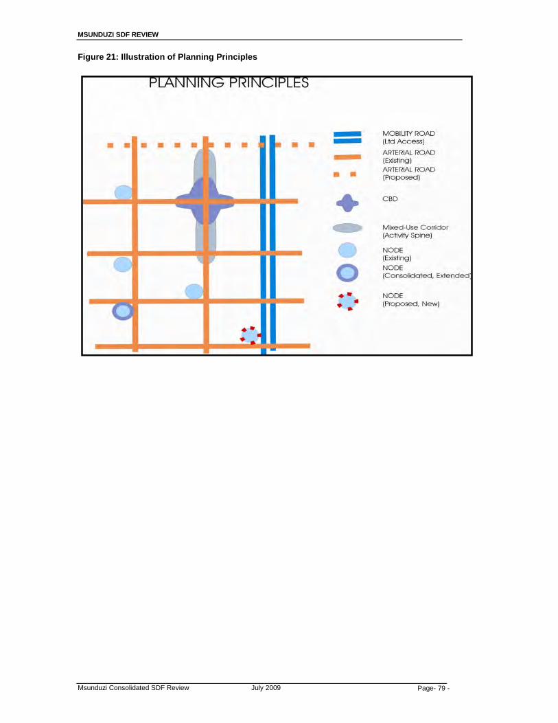
MSUNDUZI SDF REVIEW
Msunduzi Consolidated SDF Review July 2009 Page- 79 -
Figure 21: Illustration of Planning Principles

MSUNDUZI SDF REVIEW
Msunduzi Consolidated SDF Review July 2009 Page- 80 -
7. THE SDF MAP AND ITS DESIGNATIONS
In order to improve legibility while maintaining basic orientation, the cadastral layer has been removed from the base map. The main categories of existing land use are shown as a faint backdrop, with lower order uses such as corner shops, minor educational facilities and clinics being absorbed into the dominant surrounding land uses. Exceptions are made in cases where such existing facilities are at a higher order or serve as major landmarks, e.g. Edendale and Greys Hospital, UKZN and Maritzburg College. A range of standard designations are employed, and to improve legibility of the map, the main categories of existing land use are shown as a backdrop. The map distinguishes the various components as follows:
7.1 Nodes
A hierarchical system of nodes is proposed, based on existing levels and patterns of development, and the distribution of future development and transport linkages, to ensure optimum accessibility to goods and services through equitable distribution. The various nodes are distinguished in terms of whether they are:
- Existing and to be maintained at that level - Existing at a lower level and to be extended and consolidated into a
higher level node - New nodes to be introduced and phased in over time and as thresholds
occur, but shown at the level which is ultimately intended.
a) The CBD Node This is the heart of the City, and consists of the core and the frame surrounding it. The core contains the full range of uses associated with a CBD, while the frame accommodates transitionary uses at a lesser density. The so-called CBD extension node, which includes the recently developed Motor World, the Bird Sanctuary Site, the Midlands Mall and the RAS is incorporated into the CBD Node.
b) Regional Multi-Use Nodes
This level of node includes a retail component between 75 000 m2 and 120 000 m2, and serves a regional function. In addition to retail, it can include a wide range of compatible uses. There is one existing Regional Multi-Use Node (Liberty Mall and the surrounding area). There is a new proposed Multi-Use Node that will be introduced at Shenstone, in the Edendale area.
c) Community Multi-Use Nodes
These serve a community function, and would have a retail component ranging from 25 000 m2 - 40 000 m2. These nodes also accommodate a wide range of compatible uses, and the SDF distinguishes between existing community nodes to be maintained at existing levels, those with the potential for expansion and future nodes.

MSUNDUZI SDF REVIEW
Msunduzi Consolidated SDF Review July 2009 Page- 81 -
Essentially a new Multi-Use Community Node will be developed on the Edendale Road.
d) Neighbourhood Multi-Use Nodes
These operate at a neighbourhood level, and have retail components of between 5 000 m2 and 12 000 m2. These types of nodes occur in two forms, viz as mono use nodes that are pure retailing, and those that are multi-use. Again, the SDF identifies existing nodes to be maintained or expanded, and future nodes.
e) Focussed Multi-Use Nodes
This node includes light industrial, warehousing and “big-box” retailing and other uses not normally found in the other nodes, and is located at Camps Drift.
f) Administration Node
This node is on the edge of the CBD Node and includes Greys Hospital, Carter High School and the Town Hill Hospital Grounds, to which the Provincial Parliament is likely to relocate.
g) Rural Service Centers:
Rural Service Centers (RSC’s) are identified focal points from which a conglomeration of services would occur to serve the generally poor rural communities. These are main distribution centres or higher order points (nodes) where services are concentrated. The RSC’s are based on the Rural Service System model which seeks to spatially distribute economic activities (includes effective service delivery) at an identified concentration point (node) along movement networks. The concentration of economic activities is based on mutual benefit i.e. shared infrastructure, shared market, and one activity producing an input for another activity. The range of services at a concentration point is determined by the threshold which it serves and therefore, the larger the threshold, the greater the range of activities. Most of these nodal points are located in the Vulindela area.
h) Large scale Mixed-use Nodes (Corridor Opportunity Areas)
Large scale Mixed-use Nodes are identified along the N3. These offer opportunities for integrated and coordinated mixed use developments that include activities such as industry, offices and commercial land uses. In terms of Provincial policy, development is to be encouraged along the Provincial Priority Corridor (N3) at appropriate locations. In the case of Msunduzi, this would be around the intersections where development potential still exists i.e. the Lynfield Park/Lion Park and Richmond/Umlaas Road intersections. Local Area Development Plans would be required.
7.2 Road System
a) Provincial Priority Corridor/Limited Access Mobility Road This is the N3 which has been identified as a priority development corridor by the Provincial Cabinet.

MSUNDUZI SDF REVIEW
Msunduzi Consolidated SDF Review July 2009 Page- 82 -
Its prime function is to serve as a long-distance movement corridor, and although the agglomeration benefits of the corridor should be optimised, this should not interfere with its primary function. Consequently, development will be located at or near some intersections.
b) Activity Spines
Generally referred to as development corridors, these occur along major arterials leading into or from the CBD Node. A mix of complementary land uses including retail, office, entertainment and residential; about half a street block in width fronting onto the arterials are to be encouraged, but only in specific areas.
c) Arterial Roads and Bypasses
These existing; improved; and proposed roads are aimed at improving accessibility, alleviating congestion in and around the core, and opening up areas previously excluded from the local economy. In the case of future roads, the alignment shown is merely diagrammatic. The proposed road “matrix” comprises both major and minor arterial connections. A number of such roads is proposed in the Edendale, Imbali , Ashburton area in order to improve connectivity to all parts of the city, especially new employment areas.
7.3 Residential Areas
The various Residential areas are as follows:
o existing residential areas (formal, informal and rural) o where improvement and/or upgrading is required, and o future formal residential areas. o rural areas
The SDF does not specify the type or density of housing development in the future residential areas. These aspects are to be addressed in the Municipality’s Housing Plan and the Land Use Management System (LUMS). Density is however; addressed at a “Policy” level and will be found in Section10 of this report.
a) Existing Formal Residential areas
The majority of the existing urban residential areas of Msunduzi fall into category of Existing Formal Residential areas, with maintenance as the planning intervention.
b) Formal Residential Improvement Areas
Essentially many of the areas provided with poor levels of infrastructure in areas such as Edendale, are designated as Formal Residential Areas for Improvement, primarily with upgraded and appropriate levels of infrastructure.
c) Informal Residential Improvement Areas
All informal residential areas are identified as Informal Residential Improvement Areas; where such improvement includes all levels of en situ upgrading of infrastructure and the formalising of cadastral areas. The majority of these areas are found in the Edendale area.
MSUNDUZI SDF REVIEW
Msunduzi Consolidated SDF Review July 2009 Page- 83 -
d) Future Residential Areas Two different forms of new housing areas are identified; viz. large scale areas identified for future residential development of all economic levels, and “infill” development in small pockets available throughout the city area.
e) Rural Residential Areas
Rural Residential Areas are identified within the Urban Growth Boundary, especially in the Vulindela and Ashdown areas.
e) Restricted Use Areas These areas are those which, because of the topography, and other physical factors or environmental considerations, are generally unsuitable for development. They consist mainly of slopes steeper than 1:3, watercourses and other areas of environmental importance. The future management of these areas is to be addressed in more detail in the Municipality’s Environmental Management Framework, which is currently being formulated
f) Long Term Development Areas
Expansions of other areas are constrained by the topography and to the north-east and eastern side of the Municipality a Longer Term Development Area designation is proposed. These areas are presently either undeveloped or used for agricultural purposes and, on the basis of present projections and in pursuance of the general planning objectives of the SDF will not be required for urban expansion purposes in the short to medium term. The main intention is to maintain and enhance the existing rural character with agriculture remaining as the primary land use, supported by compatible land uses such as small scale tourism activities. Large scale land use changes should not be encouraged, and where proposed development is in conflict with these broad principles, detailed motivation will be required addressing issues such as need and desirability, conformity with the general objectives of the IDP and the SDF, the provision of services, access, and sustainability and so on.
7.4 Economic Opportunity Areas and Economic Opportunity Nodes
Areas for employment are indicated in several ways, viz.
o Existing economic opportunity areas o Future economic opportunity areas. o Future Economic Opportunity Nodes
a) Existing Economic Opportunity Areas
These are existing areas of major economic opportunities that provide employment to the City’s residents. These areas are mainly industrial in nature but in some areas they do include retail and office outlets.
b) Future Economic Opportunities Areas The areas will occur mainly as extensions to existing economic opportunity areas, in locations such as Mkhondeni south of Shorts Retreat Road, Masons Mill, and new areas along the Richmond Road from Shenstone Ambleton to Thornville.
MSUNDUZI SDF REVIEW
Msunduzi Consolidated SDF Review July 2009 Page- 84 -
c) Future Economic Opportunity Nodes
These areas, along the N3 identify higher level industrial, commercial and office developments and would be located in the existing and proposed nodes, and along activity spines.
7.5 Open Space Areas Several forms of Open Space and areas with restrictions on development are identified, viz
a) Conservation and Environmental Management Areas
These areas comprise an open space system related to the river systems and safeguard areas prone to flooding from development.
b) Forests
These are areas that are concentrated in the Northern Areas and Vulindlela ABM. The majority of the forested areas in the Northern ABM belong to the City Council and are currently leased out to private forestry companies.
c) Major Public Open Space
These are the large Active and Passive open space areas such as the Alexandra Park/Camps Drift Precinct, Queen Elizabeth Park, Bisley Nature Reserve, Botanical Gardens and the Scottzville Race Course precincts. The Alexandra Park and Camps Drift precinct forms a green lung in the city centre that offers residents very accessible open spaces and sporting facilities for recreational purposes. (i) Alexandra Park
The Alexander Park portion of this precinct should remain a green-lung for the city. Efforts should be made to improve the upkeep of the gardens in the rockeries and security in this area should be improved to encourage residents to fully utilise the facilities available. With the city poised to develop itself into a cycling destination, opportunities exist to develop on the existing cycling infrastructure which includes the “duck pond”, and for the development of other cycling facilities to include BMX’s, mountain bikes, and additional road riding facilities.
The following actions are required to improve the current state of the park:
• The clearing of weeds and grass in the rockeries to eliminate
hideouts for vagrants and robbers; • The installation of better lighting including high mast lighting; • The installation of CCTV cameras to monitor crime in the park;
and • The development of a facilities development plan for the park
with a particular focus on the development of cycling facilities.
MSUNDUZI SDF REVIEW
Msunduzi Consolidated SDF Review July 2009 Page- 85 -
(ii) Camp Drift Park
Camps Drift is an underutilised asset within the city. The canal portion of the drift has developed into a canoeing Mecca but there are still large portions of under utilised land stretching from French road through to the weir. Opportunities for the establishment of a Waterfront development in this area have been debated for several years and could form the catalyst for the future development of this area.
The following actions are required to improve the current state of the park:
• Land should be released to developers to build a mixed use
waterfront node which includes the waterfront and adjoining medium density residential units.
• Flood mitigation measures will also be required to prevent potential damage and loss of property.
d) River Systems Rivers and streams fulfil important functions within the city and should be rehabilitated and protected. Functions provided include:
• Reservoirs of natural fauna and flora; • Corridors for the movement of wildlife between ecosystems; • Storm water removal and attenuation; • Air, noise and heat absorption; and • Recreational areas for residents and their pets. The principal rivers draining the uMgungundlovu District are the Umgeni and its major tributary, the Msunduzi. The drainage pattern is fine textured dendritic, and made up of a large number of perennial and non-perennial rivers, streams and watercourses. The drainage pattern is indicative of the high surface run-off rates caused by the impervious nature of the underlying bedrock and the low permeable soils found in many parts of the Metropolitan region. The Msunduzi River drains approximately two thirds of the Metropolitan region. Its source is the elevated portions of Vulindlela situated along the south western boundary of the municipality.
Three major dams have been constructed within the boundaries of the DM although none of these fall within the municipal boundaries. The two dams on the Umgeni River, Midmar and Albert Falls are important essential amenities as well as being the main sources of potable water supply for the Durban – Pietermaritzburg region. The third dam, Henley Dam is situated on the Msunduzi River and is the source of water supply for a portion of the Pietermaritzburg Metropolitan region.
MSUNDUZI SDF REVIEW
Msunduzi Consolidated SDF Review July 2009 Page- 86 -
(i) The Msunduzi River
The Msunduzi River is the major river draining the municipality and it flows in a west-east direction through the municipality. Parts of its passage through the city have been canalised in order to improve drainage capacity as well as to reduce flooding. As a result, much of the natural amenity of the river has been lost.
(ii) The Dorpspruit
The Dorp Spruit meanders from its upper reaches in the Celtis road area and joins with the Msunduzi river near to Ohrtmann road and portions of the river flow through the Central Area. This river provided the water supply for the early settlement of Pietermaritzburg.
(iii) Mpushini River
The Mpushini spruit flows in a South-west- North-easterly direction parallel to the Mkhondeni river and joins with the Msunduzi river in Ward 37. Like the Mkhondeni river, the course of the river has not been majorly modified and the natural vegetation along the river is largely one of secondary grasslands and bushed grasslands, bushland, and bushland thicket.
(iv) Mkhondeni River
This river flows from the area to the south of the Bisley Valley Nature Reserve in a West- North-east direction where it joins with the Msunduzi river to the north of Ashburton. The course of the river has not been majorly modified and the natural vegetation along the river is largely one of secondary grasslands and bushed grasslands, bushland, and bushland thicket. There are a number of small dams in the catchment, the largest of which are on the main spruit in the southern sector of the catchment and also on the main tributary to the north of the N3.
(v) Flooding in the Msunduzi River Catchment
In 1995 severe flooding took place in the Msunduzi catchment which saw a loss of life of around 160 people, 586 families lost their homes, and infrastructural damage amounted to approximately R20 million. The disaster was caused by a combination of a number of factors, including: • Intense localised rainfall; • Housing development within the floodplains; • A lack of information on the risks associated with settlement
on the floodplain; • A degraded catchment resulting in high run-offs; • An inadequate disaster management system.
As a result of this, the Institute of Natural Resources (INR) was commissioned to prepare a Short Term Response to Flooding in the Msunduzi River Catchment. The result was the preparation of an Integrated Catchment Management (ICM) strategy with the following components:
MSUNDUZI SDF REVIEW
Msunduzi Consolidated SDF Review July 2009 Page- 87 -
• The establishment of a conceptual basis for the ICM within the
context of the Msunduzi catchment; • The establishment of a ICM ‘Leadership Group’ to direct
activities; • The compilation of an inventory of catchment stakeholders; • Vision formulation exercises amongst catchment institutions
and communities; • The development of information management and education
strategies in support of ICM.
Some of the specific recommendations of the study with spatial implications have been highlighted below: • Areas of flood risk to be physically defined and educational
programmes highlighting the risk of settlement in these areas should be developed;
• People living in the high risk areas be resettled and this resettlement be carried out on a ward and flood risk basis.
• After resettlement, house in the flood risk areas be demolished and be replaced with other more suitable land uses; and
• Further housing development in areas of high flood risk be actively prevented and other forms of development be subjected to full EIA’s.
(vi) Potential Waterfront Developments Potential waterfront developments have been identified along two of the rivers in the Central Area, namely: • The Camps Drift Waterfront; and • The Dorpspruit Waterway and Waterfront.
The Camps Drift Waterfront has been discussed in (c) above. The Dorpspruit Waterway and Waterfront forms part of a greater plan to uplift and develop a larger portion of land along the Dorpspruit river. These areas have for some time, been left without any maintenance and most buildings within the area are in a state of disrepair. As such, the returns on property investment in the area are low and the general public’s perception of the precinct is poor. A study (Brutal Design, 2003) prepared concept diagrams and analysed the feasibility of such a development.
In order to improve the current state of river systems and their tributaries, the following actions are recommended:
• The demarcation of the 1: 100 floodlines for all water courses within
the ABM and in areas of pressure from low income residential development, the placing of warning beacons;
• The establishment of stream reserves and the linking of these areas to the Msunduzi Land Use Management System (LUMS) to control future development within these zones;
• The prohibiting of all future development within these areas subject to Environmental Impact Assessments (EIA’s);
MSUNDUZI SDF REVIEW
Msunduzi Consolidated SDF Review July 2009 Page- 88 -
• The rehabilitation of these zone including the cleaning of accumulated rubbish, regular bush clearing as well as the planting of indigenous vegetation to ensure slope stability;
• Keeping of river courses in their natural form with the protection of all natural plant species.
• The natural land forms to be maintained wherever possible.
7.6 Agriculture
Agriculture refers to areas of land both within the urban component of the city and on its periphery which have high agricultural production potential and which should be set aside for intense food production purposes. In addition to local economic and food security objectives, such reservation is also in line with broad conservation objectives.
a) Communal Agriculture:
Communal agriculture refers to areas that are mostly and already used for communal agriculture, and which have potential for agriculture development at a subsistence level, thus promoting the concept of food security. These are areas which could be used for community gardens and/or communal grazing camps.
7.7 Urban Growth Boundary To discourage urban sprawl, an Urban Growth Boundary is suggested along the southern and south-western sides of the Municipality. No development will be entertained in areas outside of the UGB.
7.8 The SDF Structure
The application of the Guiding Principles and the Planning Principles to Msunduzi results in a new structure for the city.
This structure is that of creating a polycentric city - a city with several foci. These foci are connected with a road lattice that facilitates clear, convenient, easy to use, and alternate routes so that everyone can gain access to employment, shopping and recreation areas. These new foci include:
o A range of existing and new industrial areas; o A series of existing, upgraded and new multi-use based shopping, office,
and other use nodes are created so that all residents are within 2 kilometres of some major Node. In particular, two large multi-use Regional level Nodes are identified, viz. the Midlands Mall, and a new focus at Shenstone which will serve to integrate the city’s previous apartheid level separation.
o Two, large-scale, Mixed-Use Economic Opportunity Nodes are idenified for development at significant intersections on the N3 that serve to support and reinforce the Provincial Corridors initiatives.
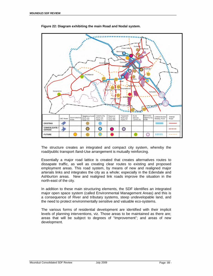
MSUNDUZI SDF REVIEW
Msunduzi Consolidated SDF Review July 2009 Page- 89 -
Figure 22: Diagram exhibiting the main Road and Nodal system. The structure creates an integrated and compact city system, whereby the road/public transport /land-Use arrangement is mutually reinforcing.
Essentially a major road lattice is created that creates alternatives routes to dissapate traffic, as well as creating clear routes to existing and proposed employment areas. This road system, by means of new and realigned major arterials links and integrates the city as a whole; especially in the Edendale and Ashburton areas. New and realigned link roads improve the situation in the north-east of the city.
In addition to these main structuring elements, the SDF identifies an integrated major open space system (called Environmental Management Areas) and this is a consequence of River and tributary systems, steep undevelopable land, and the need to protect environmentally sensitive and valuable eco-systems.
The various forms of residential development are identified with their implicit levels of planning interventions, viz. Those areas to be maintained as there are; areas that will be subject to degrees of “Improvement”; and areas of new development.
MSUNDUZI SDF REVIEW
Msunduzi Consolidated SDF Review July 2009 Page- 90 -
8. AREAS REQUIRING MORE DETAILED PLANNING
8.1 Context / Background
The SDF identifies o Existing areas, (of all types) that will be maintained as they are with no
further planning interventions, o Existing areas requiring differential levels of improvement, and o Areas for new development
The SDF is a broad scale indicative plan to guide broad planning decisions, and does not address the details of the intended planning interventions. In areas subject to both major pressures for change and areas for immediate planning interventions it becomes necessary to formulate more detailed and more appropriate plans. These large scale and more detailed plans are called Land Use Framework Plans or Local Area Plans.
Emerging from the analysis of the existing situation and from the intent of the SDF, certain areas have been identified for the formulation of such plans
8.2 Large scale Land Use framework Plans (Local Area Plans):
8.2.1 Ashburton
The Ashburton area has been identified as o an area for an open space system, o an area for Restricted Use o an area for long term development
Most of the area, in the short term, will continue to be used for low density development.
However given the need for increased certainty, it is necessary to ensure that more detailed guidance is created to guide development in both the short, medium, and long-term.
Consequently, it is recommended that such a Plan be commissioned.
8.2.2 Four GEDI Wards
Work has already proceeded to formulate Physical Development Framework Plans for four (4) central wards in the Edendale area, viz, Plessislaer, Caluza, Dambuza and Georgetown. A previous study has also addressed development for the central portion of the Edendale Corridor.
When completed, the PDFP will essentially be the equivalent of a Local Area Plan with sufficient detail to guide a series of further planning interventions.
8.2.3 Vulindela
It is recommended that the areas identified for rural upgrading be investigated further to determine the nature and extent of the required upgrading. This can be achieved by preparing and Local Area Plan for Vulindlela.
There is also a need to provide economic opportunities in these areas as a matter of priority as these are communities that are furthest from existing opportunities.
MSUNDUZI SDF REVIEW
Msunduzi Consolidated SDF Review July 2009 Page- 91 -
8.2.4 Northern Areas
It is recommended that the issues relating to traffic congestion in these areas be addressed as matter of priority. The informal settlements in these areas need to be investigated and their upgrading be prioritized in the Council’s Housing Sector Plan.
8.2.5 Small Scale Land Use Framework Plans:
There are substantial pressures for development at two intersections on the N3. The N3 has also been identified as a major corridor for development at the Provincial level.
In addition, the proposed Shenstone Multi-Use regional level Node has been identified as having the potential to be catalyst for development that will achieve the objective to integrate the city.
It becomes necessary to formulate appropriately detailed (ie; Small scale Local Area) Plans for the two major Mixed-use Opportunity Nodes on the N3 and the Shenstone Node
8.2.6 The Shenstone Multi-use Node
This major Node will comprise shops, offices, institutional and administrative and community uses; as well as higher density housing. The Node also abuts a proposed industrial area and adjacent residential area. It will connect to a major arterial and to a proposed rail station. In order to avoid ad hoc decisions being made an appropriate guiding framework must be produced.
8.2.7 Large Scale Mixed Use Nodes on the N3
There is a need to conduct Local Area Plans for the nodes along the N3 or Provincial Priority Corridor. The nature and extent of development will be determined by the findings of such plans.
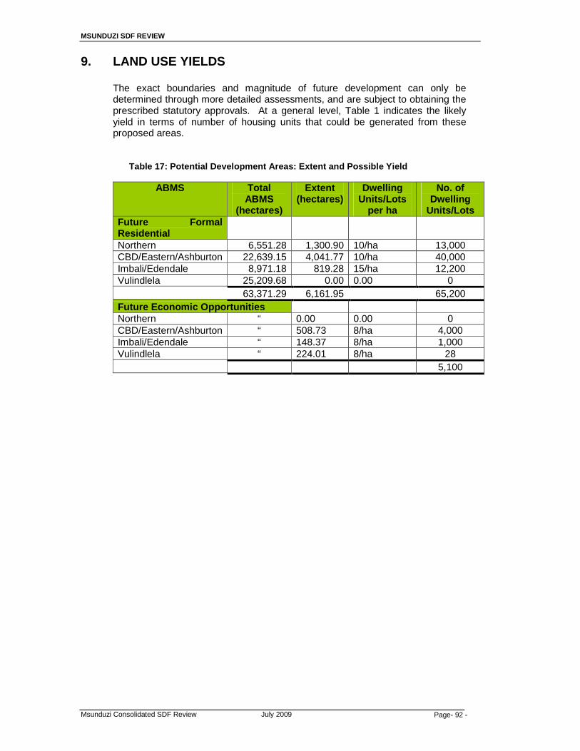
MSUNDUZI SDF REVIEW
Msunduzi Consolidated SDF Review July 2009 Page- 92 -
9. LAND USE YIELDS
The exact boundaries and magnitude of future development can only be determined through more detailed assessments, and are subject to obtaining the prescribed statutory approvals. At a general level, Table 1 indicates the likely yield in terms of number of housing units that could be generated from these proposed areas.
Table 17: Potential Development Areas: Extent and Possible Yield
ABMS Total ABMS
(hectares)
Extent (hectares)
Dwelling Units/Lots
per ha
No. of Dwelling
Units/Lots Futu re Formal Residential
Northern 6,551.28 1,300.90 10/ha 13,000 CBD/Eastern/Ashburton 22,639.15 4,041.77 10/ha 40,000 Imbali/Edendale 8,971.18 819.28 15/ha 12,200 Vulindlela 25,209.68 0.00 0.00 0 63,371.29 6,161.95 65,200 Future Economic Opportun ities Northern “ 0.00 0.00 0 CBD/Eastern/Ashburton “ 508.73 8/ha 4,000 Imbali/Edendale “ 148.37 8/ha 1,000 Vulindlela “ 224.01 8/ha 28 5,100

MSUNDUZI SDF REVIEW
Msunduzi Consolidated SDF Review July 2009 Page- 93 -
10. SUMMARY / CONCLUSION: What Does the Plan Do?
The planning responses and interventions to the various natural and economic informants not only address a number of specific concerns, but also serve to often meet end reinforce other aspects. The planning Concepts and Guiding Principles also serve to mutually reinforce each other. Consequently, the points made below will tend to be repeated as they simultaneously serve several different objectives.
10.1 Restructuring the City
The SDF redresses the imbalances inherited from the apartheid legacy with improved infrastructure and new economic opportunities. This is done by: 10.1.1 Integrating the components of the City
Shenstone and Ashburton areas are developed and will link the Low Income areas of Edendale and Imbali into the city, together with additional employment opportunity areas.
10.1.2 Creating a Polycentric City
A series of improved, upgraded and new nodes, together with new economic opportunity areas creates new opportunities and alternatives throughout the city. This also helps to spread the traffic flow
10.1.3 An Integrated Road matrix A series of major and minor arterial routes provides alternative routes to a series of additional employment areas and focus points.
10.1.4 Activity Spines A number of Limited Mixed-use Activity Spines are created along some roads extending development along corridors emerging from the CBD
10.1.5 Provincial Corridors Emphasis is given to reinforcing the Provincial Corridor system by consolidating and extending opportunities along the southern part of the N3 Corridor
10.2 Creating a Sustainable City and improving it’s viability.
10.2.1 Sustainability Protecting environmentally sensitive areas Creating a coherent system and reinforcing infrastructure Protecting agricultural potential areas Upgrade residential areas with appropriate infrastructure In situ upgrading of Informal settlements
10.2.2 Compaction
New and Infill development focused to create a coherent system, mainly in SE quadrant
MSUNDUZI SDF REVIEW
Msunduzi Consolidated SDF Review July 2009 Page- 94 -
10.2.3 Integration New economic opportunities in growth areas and adjacent to major roads that will facilitate public transportation.
10.2.4 Urban Densification
In the periphery of the CBD, and adjacent to major nodes.
10.2.5 Creating a Quality Environment Create a polycentric city – a city with several focal points Creating a mix of housing types in different areas Reinforcing the public transport system
10.2.6 Meeting Land Use needs and identifying areas of economic potential with: New Development • New Residential areas • New economic opportunity areas and commercial nodes • New nodal points • Extending open space system • New major roads that create a road matrix Upgrading, Consolidating and Improvement • Formal Residential Area with improved infrastructure and
densification • Upgrading of Rural areas • Insitu upgrading of Informal residential areas • Employment and Industrial areas • Open space system • Restructuring the CBD
Maintenance of existing areas • Formal residential areas • Existing nodes • Existing Industrial areas • Existing roads • Open space system
MSUNDUZI SDF REVIEW
Msunduzi Consolidated SDF Review July 2009 Page- 95 -
11. MSUNDUZI SDF ALIGNMENT
11.1 The alignment of the Msunduzi SDF with the SDF’s of neighbouring municipalities will be best achieved at a District level.
11.2 At present most municipalities are in the process of preparing or finalizing their
SDF’s as part of the IDP Review process. However; it is important to point out that there are elements of these SDF’s that will be common such as the identification of the N3 as a corridor of National and Provincial significance linking the towns of Mooi-River, Howick/Hilton, City of Pietermaritzburg, and Camperdown all within the boundaries of uMgungundlovu DM. Also of significance is that all the towns linked by the N3 are identified in the local SDF’s of all four municipalities as nodes of economical, administrative, and social significance or Primary Nodes. At a district level, the City of Pietermaritzburg is the most significant as it is the Provincial Capital, as well as the economic powerhouse of the midlands.
11.3 The NSDP and PSEDS has also identified the need to identify strategically located
pieces of land along the N3 for the development of economic nodes. In the Msuduzi SDF these strategic locations are identified on the Richmond/Umlaas Road Interchange and the Lynfield Park Road Interchange. Mkhambathini Municipality will also align itself to the NSDP and PSEDS, and where there are differences in interpretation, these will be addressed at a district level.
11.4 The Msnduzi SDF and uMngeni SDF are well aligned with no conflicting land use
designations. The proposed land use designations are either similar or complementary in nature and mainly consist of agriculture and residential.
11.5 The proposals to the on the southern periphery and just beyond the boundaries of
the municipality on the northern periphery of Richmond Municipality include; future residential, economic opportunities, development nodes, and long term development areas. These proposals are based on the understanding that the City of Pietermaritzburg is a growing metro therefore; planning processes should not live those areas that will be affected by such growth. Where differences of interpretation between municipalities occur, these will be addressed at a district level of alignment. The majority of areas on the south-western parts of Msunduzi are identified for agricultural purposes, which is in line with the current land uses in the Richmond municipality.
11.6 The Msunduzi SDF identifies a few areas of residential development north-east of
the municipality, which will have an impact on the proposals of uMshwathi municipality. The rest of the proposed land uses are either longer term development areas or restricted based on bio-physical sensitivities of these areas.
11.7 The areas far west of the municipality in Vulindlela and adjoing with Impendle
Municipality are not identified for any major new developments. The SDF acknowledges that there are existing rural settlement which lack services, and that these areas will require upgrading. Where areas of high agricultural potential were identified, these areas have been left for such purposes to ensure that there is continuation of farming practices at a subsistence level to ensure that food security is achieved whereby poor families are able to feed themselves by making use of the resource at their disposal.

MSUNDUZI SDF REVIEW
Msunduzi Consolidated SDF Review July 2009 Page- 96 -
12. DENSITY POLICY
There are several approaches to “densification”. These include: • Densifying existing detached housing area, particularly on large sites by
permitting ancillary or 2nd dwellings. • Permitting and encouraging medium density housing in appropriate
pockets and locations in areas with amenity attributes to make up for the relatively higher densities. These would be in appropriate areas adjacent to the open space system and area with good views.
• Encouraging higher density development in the form of both “Walk-up” medium-rise flats and areas suitable for high-rise flats.
In policy terms the areas to be encouraged are in the following situations: • In the periphery of the CBD • Along the Activity Spines extending from the CBD • Around all existing Neighbourhood and Community level shopping nodes • Around the proposed Regional level node at Shenstone The Map, below, identifies the main areas for densification, the areas are also indicated on the table below. Other areas will be identified at the level of Local area Plans and in the preparation of a Land Use Scheme. Table 18: Areas for Densification SUBURB NAME INTERVENTION DESCRIPTION Boughton Densification Densification along Sweetwaters road/ Mayors
Walk Blackridge Densification Densification along Sweetwaters road/ Mayors
Walk Densification adjacent to Heritage Primary School and the Botanical Gardens Hotel.
Prestbury Densification Densification along Sweetwaters road/ Mayors Walk Densification adjacent to the Bridge road centre.
Clarendon Densification Densification along Roberts road Wembley Densification Densification along Roberts road and Taunton
drive Napierville Densification Densification of properties adjacent to the
proposed new residential areas. Social Housing in old railway lands.
Bisley Densification Densification of properties adjacent to the Southgate Mall.
Cleland Densification Densification of properties along Murray road through to Hesketh drive.
Scottsville Densification Densification along Alan Paton/ Durban road and New England road
Hayfields Densification Densification along Hesketh road Lincoln Mead Densification Social housing and medium density housing
adjacent to the Maritzburg Golf Course and along Murray road.
Eastwood Densification Along the main road. Montrose Densification Densification along Town Bush road.
Densification along Peter Brown road Athlone Densification Densification adjacent to the commercial cluster
adjacent to Athlone School, as well as on and adjacent to the Lexton Boy Scout grounds.
Chase Valley Densification Densification along the lower portions of Chase Valley road.
Clarendon Densification Densification along Roberts’s road and the upper
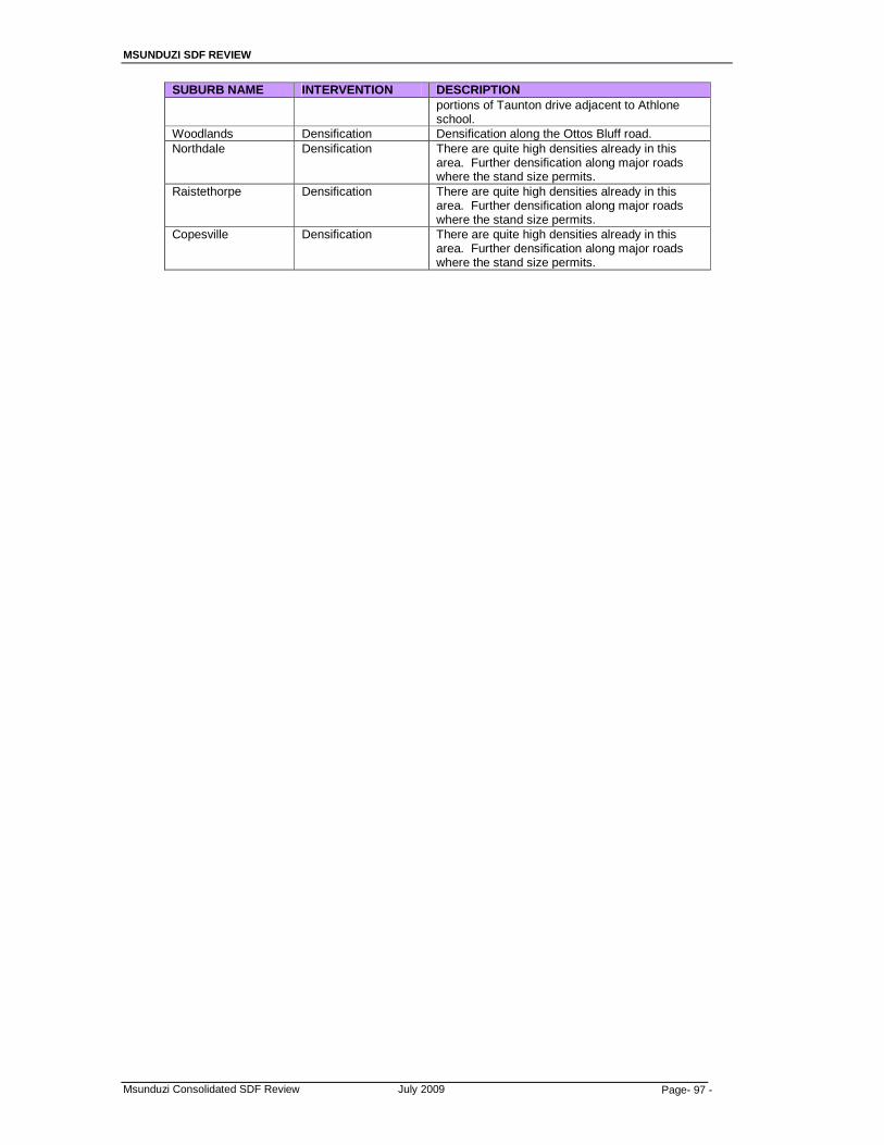
MSUNDUZI SDF REVIEW
Msunduzi Consolidated SDF Review July 2009 Page- 97 -
SUBURB NAME INTERVENTION DESCRIPTION portions of Taunton drive adjacent to Athlone school.
Woodlands Densification Densification along the Ottos Bluff road. Northdale Densification There are quite high densities already in this
area. Further densification along major roads where the stand size permits.
Raistethorpe Densification There are quite high densities already in this area. Further densification along major roads where the stand size permits.
Copesville Densification There are quite high densities already in this area. Further densification along major roads where the stand size permits.
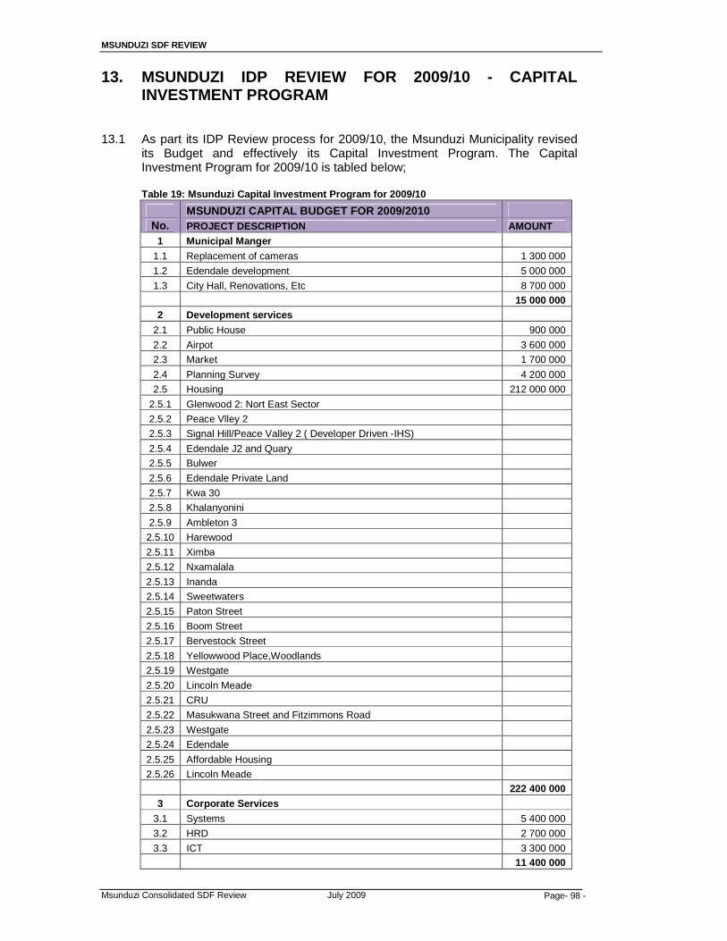
MSUNDUZI SDF REVIEW
Msunduzi Consolidated SDF Review July 2009 Page- 98 -
13. MSUNDUZI IDP REVIEW FOR 2009/10 - CAPITAL INVESTMENT PROGRAM
13.1 As part its IDP Review process for 2009/10, the Msunduzi Municipality revised
its Budget and effectively its Capital Investment Program. The Capital Investment Program for 2009/10 is tabled below;
Table 19: Msunduzi Capital Investment Program for 2009/10
MSUNDUZI CAPITAL BUDGET FOR 2009/2010 No. PROJECT DESCRIPTION AMOUNT
1 Municipal Manger
1.1 Replacement of cameras 1 300 000
1.2 Edendale development 5 000 000
1.3 City Hall, Renovations, Etc 8 700 000
15 000 000 2 Development services
2.1 Public House 900 000
2.2 Airpot 3 600 000
2.3 Market 1 700 000
2.4 Planning Survey 4 200 000
2.5 Housing 212 000 000
2.5.1 Glenwood 2: Nort East Sector
2.5.2 Peace Vlley 2
2.5.3 Signal Hill/Peace Valley 2 ( Developer Driven -IHS)
2.5.4 Edendale J2 and Quary
2.5.5 Bulwer
2.5.6 Edendale Private Land
2.5.7 Kwa 30
2.5.8 Khalanyonini
2.5.9 Ambleton 3
2.5.10 Harewood
2.5.11 Ximba
2.5.12 Nxamalala
2.5.13 Inanda
2.5.14 Sweetwaters
2.5.15 Paton Street
2.5.16 Boom Street
2.5.17 Bervestock Street
2.5.18 Yellowwood Place,Woodlands
2.5.19 Westgate
2.5.20 Lincoln Meade
2.5.21 CRU
2.5.22 Masukwana Street and Fitzimmons Road
2.5.23 Westgate
2.5.24 Edendale
2.5.25 Affordable Housing
2.5.26 Lincoln Meade
222 400 000
3 Corporate Services
3.1 Systems 5 400 000
3.2 HRD 2 700 000
3.3 ICT 3 300 000
11 400 000

MSUNDUZI SDF REVIEW
Msunduzi Consolidated SDF Review July 2009 Page- 99 -
4 Community
4.1 GEDI 4 800 000
4.2 Health And Welfare 100 000
4.3 Clinics 2 800 000
4.4 Landfills Site 5 000 000
4.5 Fire 5 700 000
4.6 Traffic Control 800 000
4.7 Security 100 000
4.8 Occupational Health 1 300 000
4.9 Garden Site 1 700 000
4.1 Development of Hollingwood Cemetry 3 000 000
4.11 Community Hall Mantainance 18 349
4.12 Crematoria Mantainance 130 640
4.13 Public Parks Mantainance 1 150 300
4.14 Sporte Ground -Mantainance Of Equipment 1 580 000
4.15 Swimming Pools Mantainance 945 950
4.16 Libraey Mantaince 394 000
29 519 239 5 Infrastructure 6 Roads
6.1 Roads Upgrading -Almond Banks 2 200 000
6.2 Roads Upgrading-Vulindlela D1140 11 000 000
6.3 Roads Upgrading-Rtcie Road 1 000 000
6.4 Roads Upgrading -Willowfontain 1 000 000
6.5 Surfacing 11 000 000
6.6 Foot Bridge 2 800 000
6.7 Church Streeet 20 000 000
6.8 Public Transport ( interchange ) 7 700 000
7 Sanitation
7.1 Sewarage Pipes-Azalea 4 000 000
7.2 Sewerage Pipes-Unit H 4 000 000
7.3 Sanitation Infrastructure Asset Renewal 6 000 000
7.4 Shenstone/Ambleton Toilets 2 000 000
7.5 Expansion of Sewarage Treatmetn Works 2 000 000
7.6 Grix Road Sewer and Pipe Bridge 1 000 000
7.7 VIP Installation-Vulindlela 39 000 000
7.8 Elimination of Conservancy Tanks 5 300 000
7.9 Sanitation Infrastructure CCTV Feasibility Study 5 000 000 8 Water
8.1 Edendale Proper New Mains and Reticulations 2 000 000
8.2 Service Midblock Eradication in Sobantu,Imbali and Ashdown 2 000 000
8.3 Elimination of stand pipes 1 000 000
8.4 Rehabilitation of Water infrastructure 1 000 000
8.5 Copesville Reservoir 1 000 000
8.6 Replace Consumer Meter 1 000 000
9 Electricity
9.1 Network Replacement/Reforcement 15 000 000
9.2 Network Refurbishment 5 700 000
9.3 Network Expansion 2 000 000
9.4 Electrification-Copesville Swapo 6 573 000
9.5 Street lighting Vulindlela & Edendale 3 652 227
9.6 Street lighting Network Replacement 2 000 000
9.7 Refurbishment of 33kv Transmission Lines 2 000 000
9.8 Sub-station Security(Cameras & fencing) 1 000 000

MSUNDUZI SDF REVIEW
Msunduzi Consolidated SDF Review July 2009 Page- 100 -
9.9 Pine Street Refurbishment 1 000 000
9.1 Replacement of Cage Transformers 1 000 000
9.11 Street lighting 7 000 000 199 925 227
13.2 The Capital Projects are mapped on Map 15.

MSUNDUZI SDF REVIEW
Msunduzi Consolidated SDF Review July 2009 Page- 101 -
14. MSUNDUZI SDF – LAND USE MANAGEMENT GUIDELINES 14.1 Both the Consolidated SDF and the individual ABM SDF’s are essentially
“schematic” plans and are non-cadastral. There is no direct interpretation of the SDF into a Land Use Scheme. In order to formulate a Land Use Scheme it is necessary to develop the SDF into either a composite Physical Development Framework (sometimes also called a Land Use Framework) or a series of Physical Development Framework Plans. It is such a plan, because it had a more detailed cadastral base, that provides the basis for the formulation of a Land Use Scheme.
14.1.1 There are several steps necessary to produce a Land Use Scheme, viz;
• The Translation of the existing TPS(s) zones into LUMS terminology • The introduction of appropriate new zones facilitated by the LUMS system
(eg; a series of mixed use and interface/buffer zones) • The translation of the land use areas implicit in the General Plans of areas
currently not in a TPS into LUMS terms. • The extension of the LUMS system into areas without any other form of
control using the existing zones available or introducing new/additional zones (eg; Traditional settlement areas, agriculture, etc)
The exercise of developing a Land Use Scheme also offers an opportunity to undertake a form of TPS Review and to modify the existing zones that are subject to change, ie;
• Expanding zones of the CBD, shopping areas, introducing relatively higher densities in specific areas and so on.
The intensions of the SDF therefore can be used to modify/amend the formulation of a Land Use Scheme. In this sense it provides some basic “guidelines” for the formulation of a Land Use Scheme
14.1.2 In this sense the intentions of the SDF can be used as follows:
• Existing formal zones that are not identified for change (Residential,
commercial, industrial, etc) can be simply translated into appropriate LUMS zones.
• Existing formal developments in areas with General Plans can have their areas matched with any appropriate zone in the existing TPS or with any new LUMS available zone to be introduced.
• Existing informal residential areas will however require the preparation of either Physical Development Framework Plans or upgrading layouts in order to identify which appropriate residential zones to apply.
• Areas in transition or subject to change (such as the formulation of corridors extending from the CBD, and the area of change around the CBD and major shopping facilities, hospitals, etc) can have new interface and/or mixed uses zones applied. The SDF identifies these areas in an indicative manner.
• The policy for densification enunciated in the SDF, ie around, major nodes, can inform the approach to evaluate and detail such areas
14.2 LUMS Background
The Department of Local Government and Traditional Affairs has set out a sectoral checklist for preparation of Land Use Management System (LUMS) Guidelines in a report entitled “Sectoral Guidelines for the Review of Integrated Development Plans in KwaZulu Natal”
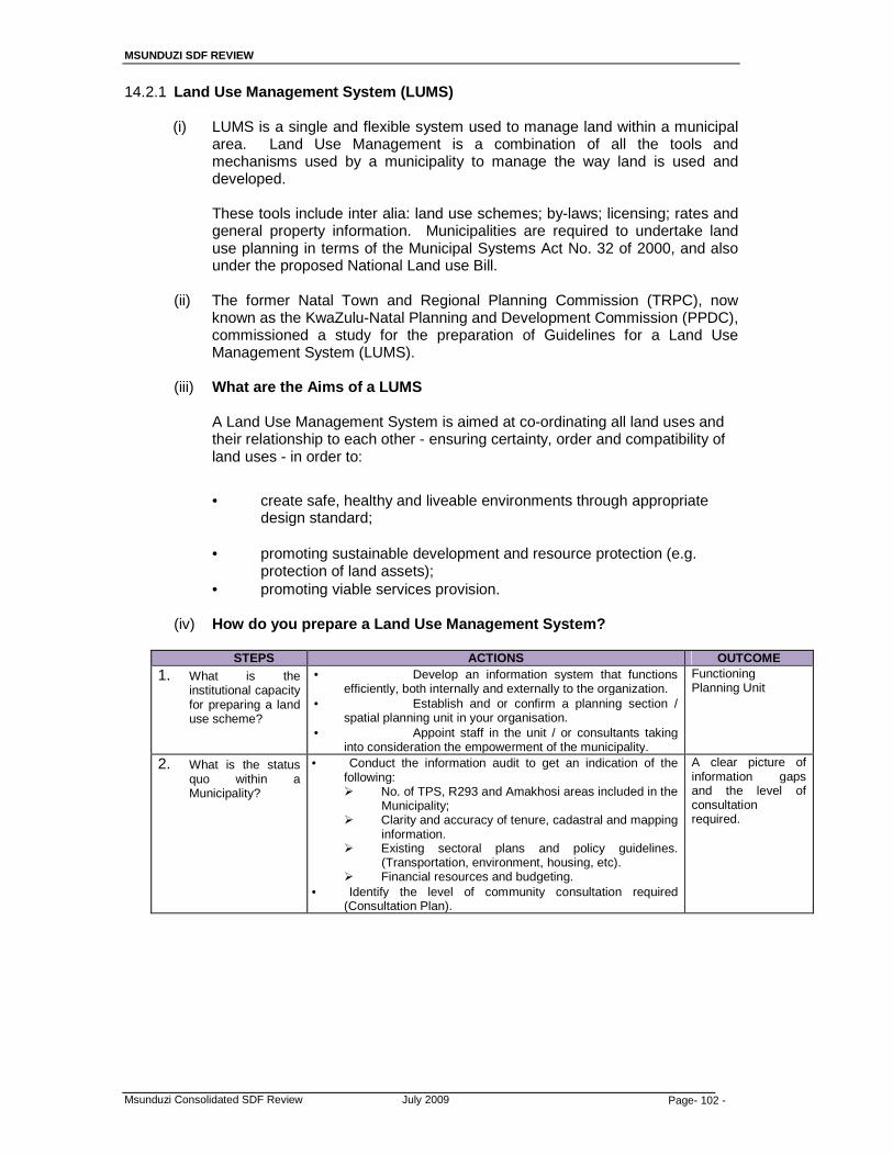
MSUNDUZI SDF REVIEW
Msunduzi Consolidated SDF Review July 2009 Page- 102 -
14.2.1 Land Use Management System (LUMS)
(i) LUMS is a single and flexible system used to manage land within a municipal area. Land Use Management is a combination of all the tools and mechanisms used by a municipality to manage the way land is used and developed.
These tools include inter alia: land use schemes; by-laws; licensing; rates and
general property information. Municipalities are required to undertake land use planning in terms of the Municipal Systems Act No. 32 of 2000, and also under the proposed National Land use Bill.
(ii) The former Natal Town and Regional Planning Commission (TRPC), now
known as the KwaZulu-Natal Planning and Development Commission (PPDC), commissioned a study for the preparation of Guidelines for a Land Use Management System (LUMS).
(iii) What are the Aims of a LUMS
A Land Use Management System is aimed at co-ordinating all land uses and their relationship to each other - ensuring certainty, order and compatibility of land uses - in order to:
• create safe, healthy and liveable environments through appropriate
design standard;
• promoting sustainable development and resource protection (e.g. protection of land assets);
• promoting viable services provision.
(iv) How do you prepare a Land Use Management System?
STEPS ACTIONS OUTCOME
1. What is the institutional capacity for preparing a land use scheme?
• Develop an information system that functions efficiently, both internally and externally to the organization.
• Establish and or confirm a planning section / spatial planning unit in your organisation.
• Appoint staff in the unit / or consultants taking into consideration the empowerment of the municipality.
Functioning Planning Unit
2. What is the status quo within a Municipality?
• Conduct the information audit to get an indication of the following: � No. of TPS, R293 and Amakhosi areas included in the
Municipality; � Clarity and accuracy of tenure, cadastral and mapping
information. � Existing sectoral plans and policy guidelines.
(Transportation, environment, housing, etc). � Financial resources and budgeting.
• Identify the level of community consultation required (Consultation Plan).
A clear picture of information gaps and the level of consultation required.

MSUNDUZI SDF REVIEW
Msunduzi Consolidated SDF Review July 2009 Page- 103 -
STEPS ACTIONS OUTCOME
3. What type of a Land Use Scheme (LUS) do you need?
• Prepare a Strategic Land use Framework which will include the following:
• Strategic issues identified in the IDP and its SDF. • Identify pressure points (areas needing urgent attention). • Identify the LUS level for various parts of the municipality
(Elementary, primary, comprehensive or rural level). • Decide on the type of Land Use Scheme you prefer by doing
either or a combination of the following: • Translate the existing zones into a LUS without a review or
consolidation. • Partially translate, consolidate or align different schemes and
extend such schemes to areas where there is no land use management.
• Undertake a detailed review of zones, land uses and controls in all current schemes with a view to creating a single scheme.
An agreement on the type of a Land Use Scheme that the Municipality wishes to prepare.
4. How to prepare a Land Use Scheme?
• Council resolves to prepare a LUS in accordance with a new LUMS using appropriate legislation (once available).
• Address information gaps (if necessary). • Formulation of the Statement of Intent (SOI) for large or
special areas of the LUS based on the objectives of the municipal IDP.
• Identify the zones, districts and appropriate development control.
A Municipal Land use Scheme comprising of a Plan, a Land Use Table (Matrix) and a table of development control (Land Use Template)
5. What is the Road to Approval of the LUMS?
• Circulate the LUS for public comments within a legislated time period.
• Amend the LUS by incorporating the received public comments.
• Table the LUS (reports and maps) to Council and Amakhosi or a structure comprising of the two for final approval.
• Submission to DTLGA for comments and or assessment.
An approved Land Use Scheme to guide land use management within a municipal area.
Reference: Sectoral guidelines for the Review of Integrated Development Plans in KwaZulu-Natal.

MSUNDUZI SDF REVIEW
Msunduzi Consolidated SDF Review July 2009 Page- 104 -
15. MSUNDUZI SDF REVIEW – SUSTAINABILITY APPRAISAL 15.1 What is a Sustainability Appraisal? The Department of Agriculture, Environmental Affairs, and Rural Development
(DAEARD) has provided a Sustainability Appraisal tool which it defines as follows (the entire Section is sourced and quoted from DAEARD, 2009):
15.1.1 Sustainability Appraisal [SA] provides a critical evaluation of the performance of a
Plan against predetermined social, economic and environmental criteria so that the potential impacts of the Plan and be evaluated and it’s performance can be improved. SA seeks to help inform decision-making by providing information on the potential environmental implications of policies, plans or projects.
15.1.2 SA’s help to ensure that plans, strategies and proposals take into account the
principles of sustainable development. The process permits a qualitative assessment of a plan, strategy, or proposal against independent sustainable development objectives.
15.1.3 Sustainability Appraisal can be an effective technique for integrating sustainability
considerations into plan making and evaluation, and has the advantage of being quicker than standard Strategic Environmental Assessments, producing a less rigorous, though still valuable, broad analysis, usually in the form of a checklist with accompanying explanation. This allows fairly rapid assumptions to be made about the sustainability impact of individual policies and plans and, indicates where policy adjustments need to be made.
15.1.3 The SA checklist comprises a list of statements related to economic, social and
environmental issues and concerns that are based on the Municipality’s Environmental Policy, the National Environmental Management Act Principles and the Development Facilitation Act Principles. Adjacent to the statements column is a column that relates to the qualitative assessment i.e. whether the proposed plan, policy or proposal has a Very positive, Positive, Neutral, Negative or Highly Negative impact or effect against each statement.
15.1.4 An example of a positive impact might be the provision of work opportunities in close
proximity to residential areas thereby reducing travel costs and impacts. A negative impact might be destruction of habitat through urban expansion. If due to the nature of the activity, a statement has no bearing on the activity concerned, then a Neutral or No Impact statement can be used.
15.1.5 A description of the potential impacts and effects on the sustainability criteria should
be provided in the commentary column to justify the scoring of the potential effect or impact.
15.1.6 Sustainability Appraisal is not a rigid system but a practical approach to ensure that
significant direct and indirect impacts of a programme are considered. It is important not to labour over it. The level of resources involved in each appraisal should be directly proportionate to the policy or programme.
15.1.7 Individual Appraisal’s should be done for the plan as a whole and for the 5 major
development changes or options proposed within the plan e.g. expansion of housing into the Mkhondeni catchment; Proposed node at Foxhill etc.
MSUNDUZI SDF REVIEW
Msunduzi Consolidated SDF Review July 2009 Page- 105 -
15.2 Determination of significance of impact or effect :
The results of the appraisal for each criteria should be recorded using the following measures:
(i) Scale of effect: Will any effect be marginal or significant? (ii) Timing of effect: Will the effect manifest itself in the short term or the long
term? (iii) Geographic scale: Will there be any trans-boundary effects (for example
impacts on adjoining Municipalities, Provincially or Nationally)? (iv) Rural / urban: Will there be differential impacts for rural and urban
environments? (v) Cumulative effects: Will there be any cumulative, secondary or indirect
effects arising from the interactions of policies and proposals. 15.3 Evaluation of the SDF process: 15.3.1 The development of the SDF should be considered against the generally accepted
principles and processes of strategic assessment. A justification and description of how the process considered these key principles should be provided. Limitations and gaps in information should be highlighted to inform future planning and revisions of the SDF.
15.3.2 The following (Sub-Section 12.4) is an outcome of the Sustainability Appraisal
undertaken for the Msunduzi SDF Review.
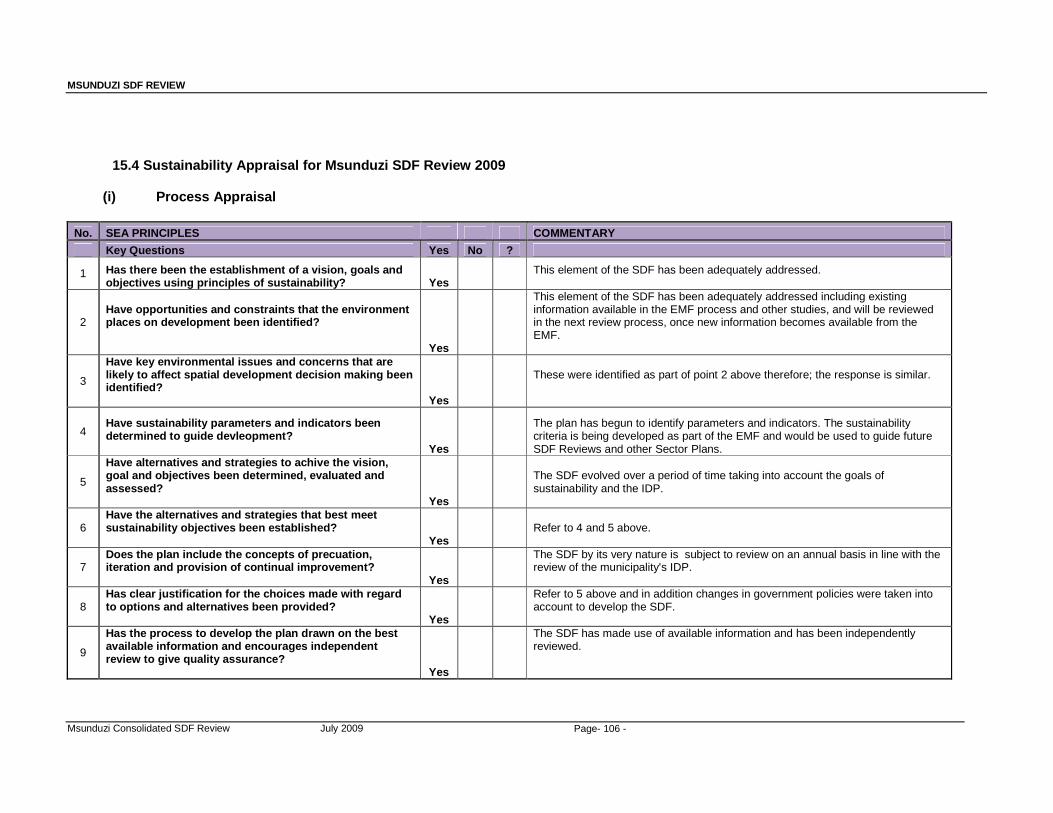
MSUNDUZI SDF REVIEW
Msunduzi Consolidated SDF Review July 2009 Page- 106 -
15.4 Sustainability Appraisal for Msunduzi SDF Review 2009
(i) Process Appraisal
No. SEA PRINCIPLES COMMENTARY
Key Questions Yes No ?
1 Has there been the establishment of a vision, goals and objectives using principles of sustainability? Yes
This element of the SDF has been adequately addressed.
2 Have opportunities and constraints that the environment places on development been identified? Yes
This element of the SDF has been adequately addressed including existing information available in the EMF process and other studies, and will be reviewed in the next review process, once new information becomes available from the EMF.
3
Have key environmental issues and concerns that are likely to affect spatial development decision making been identified? Yes
These were identified as part of point 2 above therefore; the response is similar.
4 Have sustainability parameters and indicators been determined to guide devleopment? Yes
The plan has begun to identify parameters and indicators. The sustainability criteria is being developed as part of the EMF and would be used to guide future SDF Reviews and other Sector Plans.
5
Have alternatives and strategies to achive the vision, goal and objectives been determined, evaluated and assessed? Yes
The SDF evolved over a period of time taking into account the goals of sustainability and the IDP.
6 Have the alternatives and strategies that best meet sustainability objectives been established? Yes
Refer to 4 and 5 above.
7 Does the plan include the concepts of precuation, iteration and provision of continual improvement? Yes
The SDF by its very nature is subject to review on an annual basis in line with the review of the municipality's IDP.
8 Has clear justification for the choices made with regard to options and alternatives been provided? Yes
Refer to 5 above and in addition changes in government policies were taken into account to develop the SDF.
9
Has the process to develop the plan drawn on the best available information and encourages independent review to give quality assurance? Yes
The SDF has made use of available information and has been independently reviewed.
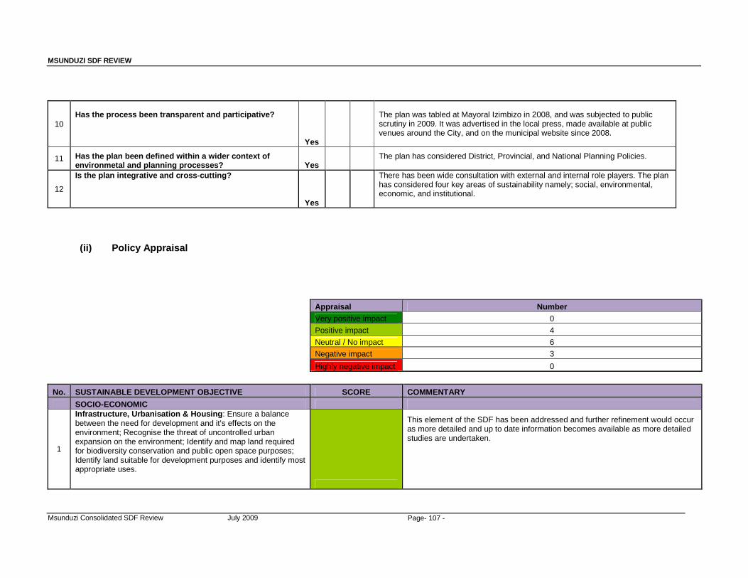
MSUNDUZI SDF REVIEW
Msunduzi Consolidated SDF Review July 2009 Page- 107 -
10 Has the process been transparent and participative? Yes
The plan was tabled at Mayoral Izimbizo in 2008, and was subjected to public scrutiny in 2009. It was advertised in the local press, made available at public venues around the City, and on the municipal website since 2008.
11 Has the plan been defined within a wider context of environmetal and planning processes? Yes
The plan has considered District, Provincial, and National Planning Policies.
12
Is the plan integrative and cross-cutting? Yes
There has been wide consultation with external and internal role players. The plan has considered four key areas of sustainability namely; social, environmental, economic, and institutional.
(ii) Policy Appraisal
Appraisal Number Very positive impact 0
Positive impact 4 Neutral / No impact 6 Negative impact 3
Highly negative impact 0
No. SUSTAINABLE DEVELOPMENT OBJECTIVE SCORE COMMENTARY
SOCIO-ECONOMIC
1
Infrastructure, Urbanisation & Housing : Ensure a balance between the need for development and it's effects on the environment; Recognise the threat of uncontrolled urban expansion on the environment; Identify and map land required for biodiversity conservation and public open space purposes; Identify land suitable for development purposes and identify most appropriate uses.
This element of the SDF has been addressed and further refinement would occur as more detailed and up to date information becomes available as more detailed studies are undertaken.
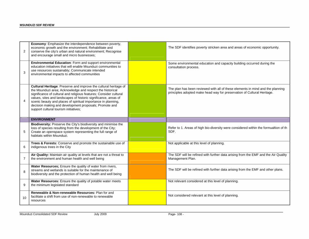
MSUNDUZI SDF REVIEW
Msunduzi Consolidated SDF Review July 2009 Page- 108 -
2
Economy : Emphasize the interdependence between poverty, economic growth and the environment; Rehabilitate and conserve the city's urban and natural environment; Recognise and encourage small and micro businesses;
The SDF identifies poverty stricken area and areas of economic opportunity.
3
Environmental Education : Form and support environmental education initiatives that will enable Msunduzi communities to use resources sustainably; Communicate intended environmental impacts to affected communities
Some environmental education and capacity building occurred during the consultation process.
4
Cultural Heritage : Preserve and improve the cultural heritage of the Msunduzi area; Acknowledge and respect the historical significance of cultural and religious features; Consider cultural values, sites and landscapes of historic significance, areas of scenic beauty and places of spiritual importance in planning, decision making and development proposals; Promote and support cultural tourism initiatives;
The plan has been reviewed with all of these elements in mind and the planning principles adopted make head way for preservation of Cultural Heritage.
ENVIRONMENT
5
Biodiversity: Preserve the City's biodiversity and minimise the loss of species resulting from the development of the City; Create an openspace system representing the full range of habitats within Msunduzi.
Refer to 1. Areas of high bio-diversity were considered within the formualtion of th SDF.
6 Trees & Forests: Conserve and promote the sustainable use of indigenous trees in the City
Not applicable at this level of planning.
7 Air Quality: Maintain air quality at levels that are not a threat to the environment and human health and well being
The SDF will be refined with further data arising from the EMF and the Air Quality Management Plan.
8
Water Resources; Ensure the quality of water from rivers, streams and wetlands is suitable for the maintenance of biodiversity and the protection of human health and well being
The SDF will be refined with further data arising from the EMF and other plans.
9 Water Resources: Ensure the quality of potable water meets the minimum legislated standard
Not relevant considered at this level of planning.
10
Renewable & Non-renewable Resources: Plan for and facilitate a shift from use of non-renewable to renewable resources
Not considered relevant at this level of planning.

MSUNDUZI SDF REVIEW
Msunduzi Consolidated SDF Review July 2009 Page- 109 -
11
Energy : Accentuate the importance of energy and it's role in development and the negative effects that energy production may have on the environment; Identify and encourage the use of alternative renewable and sustainable energy sources in new and existing developments.
This has not been addressed in the current plan and should be considered in the next review.
12
Landscapes & Townscapes : Protect the City's landscapes and townscapes; Identify activities suitable for each piece of available land based on its geology, soils, topography, aesthetics, biodiversity, ecological corridors, wildlife habitat.
Not considered relevant at this level of planning, rather at a Local Area Development Plan level.
13
Noise, Shock & Vibration : Ensure that the physiological and psychological effect of noise, shock and vibration levels do not exceed legislated standards
Not considered relevant at this level of planning.
14
Waste : Provide for an effective and efficient waste management system; Provide for an integrated approach to waste management.
The SDF will be refined with further data arising from the EMF and the Waste Management Plan.
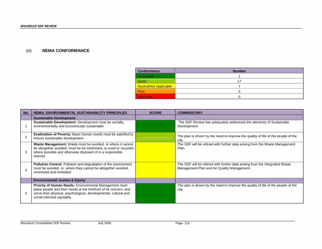
MSUNDUZI SDF REVIEW
Msunduzi Consolidated SDF Review July 2009 Page- 110 -
(iii) NEMA CONFORMANCE
Conformance Number Very good 1 Good 17 Neutral/Not Applicable 7 Poor 3 Very poor 0
No. NEMA: ENVIRONMENTAL SUSTAINABILITY PRINCIPLES SCORE COMMENTARY
Sustainable Development
1 Sustainable Development: Development must be socially, environmentally and economically sustainable
The SDF Review has adequately addressed the elements of Sustainable Development.
2 Eradication of Poverty: Basic human needs must be satisfied to ensure sustainable development.
The plan is driven by the need to improve the quality of life of the people of the city.
3
Waste Management: Waste must be avoided, or where it cannot be altogether avoided, must be be minimised, re-used or recycled where possible and otherwise disposed of in a responsible manner
The SDF will be refined with further data arising from the Waste Management Plan.
4
Pollution Control : Pollution and degradation of the environment must be avoided, or, where they cannot be altogether avoided, minimised and remedied
The SDF will be refined with further data arising from the Integrated Waste Management Plan and Air Quality Management.
Environmental Justice & Equity
5
Priority of Human Needs: Environmental Management must place people and their needs at the forefront of its concern, and serve their physical, psychological, developmental, cultural and social interests equitably.
The plan is driven by the need to improve the quality of life of the people of the city.
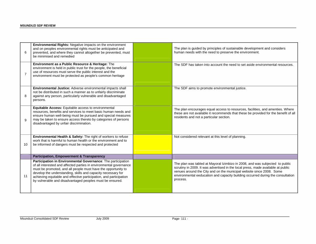
MSUNDUZI SDF REVIEW
Msunduzi Consolidated SDF Review July 2009 Page- 111 -
6
Environmental Rights: Negative impacts on the environment and on peoples environmental rights must be anticipated and prevented, and where they cannot altogether be prevented, must be minimised and remedied
The plan is guided by principles of sustainable development and considers human needs with the need to preserve the environment.
7
Environment as a Public Resource & Heritage: The environment is held in public trust for the people, the beneficial use of resources must serve the public interest and the environment must be protected as people's common heritage
The SDF has taken into account the need to set aside environmental resources.
8
Environmental Justice: Adverse environmental impacts shall not be distributed in such a manner as to unfairly discriminate against any person, particularly vulnerable and disadvantaged persons.
The SDF aims to promote environmental justice.
9
Equitable Access: Equitable access to environmental resources, benefits and services to meet basic human needs and ensure human well-being must be pursued and special measures may be taken to ensure access thereto by categories of persons disadvantaged by unfair discrimination.
The plan encourages equal access to resources, facilities, and amenties. Where these are not available it recommends that these be provided for the benefit of all residents and not a particular section.
10
Environmental Health & Safety: The right of workers to refuse work that is harmful to human health or the environment and to be informed of dangers must be respected and protected
Not considered relevant at this level of planning.
Participation, Empowerment & Transparency
11
Participation in Environmental Governance : The participation of all interested and affected parties in environmental governance must be promoted, and all people must have the opportunity to develop the understanding, skills and capacity necessary for achieving equitable and effective participation, and participation by vulnerable and disadvantaged peoples must be ensured.
The plan was tabled at Mayoral Izimbizo in 2008, and was subjected to public scrutiny in 2009. It was advertised in the local press, made available at public venues around the City and on the municipal website since 2008. Some environmental eeducation and capacity building occurred during the consultation process.
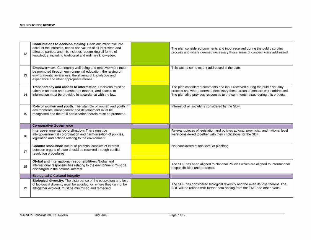
MSUNDUZI SDF REVIEW
Msunduzi Consolidated SDF Review July 2009 Page- 112 -
12
Contributions to decision making : Decisions must take into account the interests, needs and values of all interested and affected parties, and this includes recognizing all forms of knowledge, including traditional and ordinary knowledge.
The plan considered comments and input received during the public scrutiny process and where deemed necessary those areas of concern were addressed.
13
Empowerment : Community well being and empowerment must be promoted through environmental education, the raising of environmental awareness, the sharing of knowledge and experience and other appropriate means.
This was to some extent addressed in the plan.
14
Transparency and access to information : Decisions must be taken in an open and transparent manner, and access to information must be provided in accordance with the law.
The plan considered comments and input received during the public scrutiny process and where deemed necessary those areas of concern were addressed. The plan also provides responses to the comments raised during this process.
15
Role of women and youth: The vital role of women and youth in environmental management and development must be recognised and their full participation therein must be promoted.
Interest of all society is considered by the SDF.
Co-operative Governance
16
Intergovernmental co-ordination: There must be intergovernmental co-ordination and harmonisation of policies, legislation and actions relating to the environment.
Relevant pieces of legislation and policies at local, provincial, and national level were considered together with their implicatons for the SDF.
17
Conflict resolution: Actual or potential conflicts of interest between organs of state should be resolved through conflict resolution procedures.
Not considered at this level of planning.
18
Global and international responsibilities: Global and international responsibilities relating to the environment must be discharged in the national interest
The SDF has been aligned to National Policies which are aligned to International responsibilities and protocols.
Ecological & Cultural Integrity
19
Biological diversity: The disturbance of the ecosystem and loss of biological diversity must be avoided, or, where they cannot be altogether avoided, must be minimised and remedied
The SDF has considered biological diversity and the avert its loss thereof. The SDF will be refined with further data arising from the EMF and other plans.
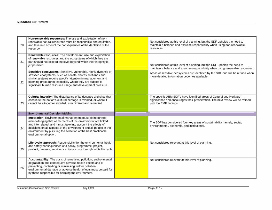
MSUNDUZI SDF REVIEW
Msunduzi Consolidated SDF Review July 2009 Page- 113 -
20
Non-renewable resources: The use and exploitation of non-renewable natural resources must be responsible and equitable, and take into account the consequences of the depletion of the resource
Not considered at this level of planning, but the SDF upholds the need to maintain a balance and exercise responsibility when using non-renewable resources.
21
Renewable resources: The development, use and exploitation of renewable resources and the ecosystems of which they are part should not exceed the level beyond which their integrity is jeopardised
Not considered at this level of planning, but the SDF upholds the need to maintain a balance and exercise responsibility when using renewable resources.
22
Sensitive ecosystems: Sensitive, vulnerable, highly dynamic or stressed ecosystems, such as coastal shores, wetlands and similar systems require specific attention in management and planning procedures, especially where they are subject to significant human resource usage and development pressure.
Areas of sensitive ecosystems are identified by the SDF and will be refined when more detailed information becomes available.
23
Cultural integrity: The disturbance of landscapes and sites that constitute the nation’s cultural heritage is avoided, or where it cannot be altogether avoided, is minimised and remedied
The specific ABM SDF's have identified areas of Cultural and Heritage significance and encourages their preservation. The next review will be refined with the EMF findings.
Environmental Decision Making
24
Integration: Environmental management must be integrated, acknowledging that all elements of the environment are linked and interrelated, and it must take into account the effects of decisions on all aspects of the environment and all people in the environment by pursuing the selection of the best practicable environmental option.
The SDF has considered four key areas of sustainability namely; social, environmental, economic, and institutional.
25
Life -cycle approach: Responsibility for the environmental health and safety consequences of a policy, programme, project, product, process, service or activity exists throughout its life cycle
Not considered relevant at this level of planning.
26
Accountability: The costs of remedying pollution, environmental degradation and consequent adverse health effects and of preventing, controlling or minimising further pollution; environmental damage or adverse health effects must be paid for by those responsible for harming the environment.
Not considered relevant at this level of planning.

MSUNDUZI SDF REVIEW
Msunduzi Consolidated SDF Review July 2009 Page- 114 -
27
Precautionary principle: A risk-averse and cautious approach is applied, which takes into account the limits of current knowledge about the consequences of decisions and actions
Once the EMF has been finalized, its findings and recommendations will be used to revise the SDF.
28
Consideration of impacts: The social, economic and environmental impacts of activities, including disadvantages and benefits, must be considered, assessed and evaluated, and decisions must be appropriate in the light of such consideration and assessment.
The SDF has considered four key areas of sustainability namely; social, environmental, economic, and institutional.
(iv) DFA Conformance
Conformance Number Very good 4 Good 11 Neutral/Not Applicable 4 Poor 0 Very poor 0
No. DFA: SUSTAINABILITY PRINCIPLES SCORE COMMENTARY
Policy
1 Provide for urban and rural development and should provide for formal and informal, existing and new settlements.
This is adeqautely addressed by the revised plan.
2 Discourage illegal occupation of land, with due recognition of informal land development processes
The plan identifies informally settled areas for improvement and the Housing Sector Plan will make recommendations on informal settlements.
3
Should encourage and optimise the contribution of all sectors of the economy to land development so as to maximise the Republic's capacity to undertake land development.
The plan promotes sustainable development of land by all sectors of society.
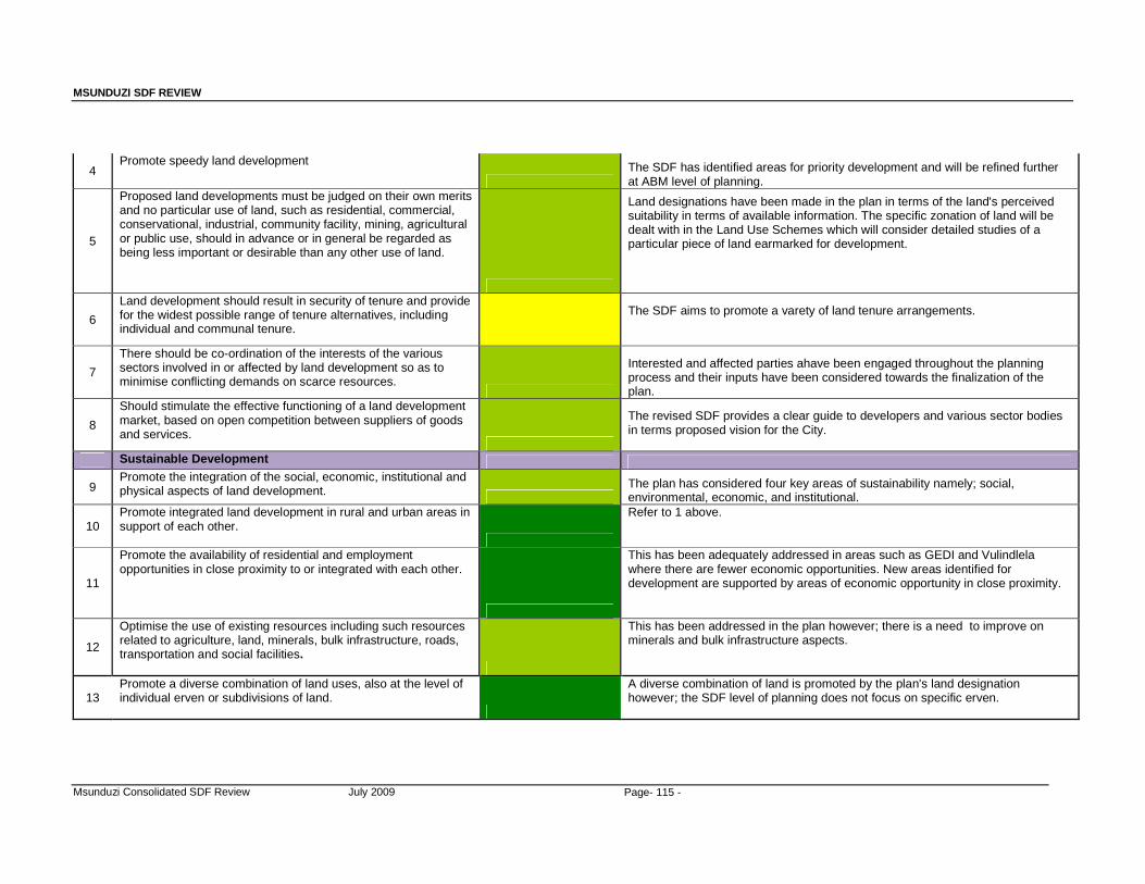
MSUNDUZI SDF REVIEW
Msunduzi Consolidated SDF Review July 2009 Page- 115 -
4 Promote speedy land development
The SDF has identified areas for priority development and will be refined further at ABM level of planning.
5
Proposed land developments must be judged on their own merits and no particular use of land, such as residential, commercial, conservational, industrial, community facility, mining, agricultural or public use, should in advance or in general be regarded as being less important or desirable than any other use of land.
Land designations have been made in the plan in terms of the land's perceived suitability in terms of available information. The specific zonation of land will be dealt with in the Land Use Schemes which will consider detailed studies of a particular piece of land earmarked for development.
6
Land development should result in security of tenure and provide for the widest possible range of tenure alternatives, including individual and communal tenure.
The SDF aims to promote a varety of land tenure arrangements.
7
There should be co-ordination of the interests of the various sectors involved in or affected by land development so as to minimise conflicting demands on scarce resources.
Interested and affected parties ahave been engaged throughout the planning process and their inputs have been considered towards the finalization of the plan.
8
Should stimulate the effective functioning of a land development market, based on open competition between suppliers of goods and services.
The revised SDF provides a clear guide to developers and various sector bodies in terms proposed vision for the City.
Sustainable Development
9 Promote the integration of the social, economic, institutional and physical aspects of land development.
The plan has considered four key areas of sustainability namely; social, environmental, economic, and institutional.
10 Promote integrated land development in rural and urban areas in support of each other.
Refer to 1 above.
11
Promote the availability of residential and employment opportunities in close proximity to or integrated with each other.
This has been adequately addressed in areas such as GEDI and Vulindlela where there are fewer economic opportunities. New areas identified for development are supported by areas of economic opportunity in close proximity.
12
Optimise the use of existing resources including such resources related to agriculture, land, minerals, bulk infrastructure, roads, transportation and social facilities.
This has been addressed in the plan however; there is a need to improve on minerals and bulk infrastructure aspects.
13 Promote a diverse combination of land uses, also at the level of individual erven or subdivisions of land.
A diverse combination of land is promoted by the plan's land designation however; the SDF level of planning does not focus on specific erven.
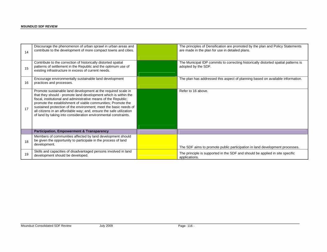
MSUNDUZI SDF REVIEW
Msunduzi Consolidated SDF Review July 2009 Page- 116 -
14
Discourage the phenomenon of urban sprawl in urban areas and contribute to the development of more compact towns and cities.
The principles of Densification are promoted by the plan and Policy Statements are made in the plan for use in detailed plans.
15
Contribute to the correction of historically distorted spatial patterns of settlement in the Republic and the optimum use of existing infrastructure in excess of current needs.
The Municipal IDP commits to correcting historically distorted spatial patterns is adopted by the SDF.
16 Encourage environmentally sustainable land development practices and processes.
The plan has addressed this aspect of planning based on available information.
17
Promote sustainable land development at the required scale in that they should - promote land development which is within the fiscal, institutional and administrative means of the Republic; promote the establishment of viable communities; Promote the sustained protection of the environment; meet the basic needs of all citizens in an affordable way; and, ensure the safe utilization of land by taking into consideration environmental constraints.
Refer to 16 above.
Participation, Empowerment & Transparency
18
Members of communities affected by land development should be given the opportunity to participate in the process of land development.
The SDF aims to promote public participation in land development processes.
19 Skills and capacities of disadvantaged persons involved in land development should be developed.
The principle is supported in the SDF and should be applied in site specific applications.
MSUNDUZI SDF REVIEW
Msunduzi Consolidated SDF Review July 2009 Page- 117 -
ANNEXURE 1
DEVELOPMENT CORRIDOR CONCEPTS AND THE
UMGUNGUNGLOVU SDF REVIEW
Dr Jeff McCarthy
06-05-2007
MSUNDUZI SDF REVIEW
Msunduzi Consolidated SDF Review July 2009 Page118
DEVELOPMENT CORRIDOR CONCEPTS AND THE UMGUNGUNGLOVU SDF REVIEW
Dr Jeff McCarthy
06-05-2007 Objective The purpose of this report is to provide an overview of the post-apartheid development
corridor perspective, up to and including the February 2007 Provincial Spatial Economic
Development Strategy (PSEDS), as a basis for assisting in the current (April 2007)
stages of the Umgungundlovu Spatial Development Framework review.
Since Umgungundlovu, as a region, embraces both a significant emergent metropolitan
area, and has rural and smaller town component within it and, at the same time the
region sits strategically astride a major intra-national linkage (Durban/Gauteng), we
examine the development corridor concept at a number of different geographical scales
in generic terms before returning to the specifics of Umgungundlovu.
Intra-metropolitan corridors
Much thinking on the post-apartheid planning of the Msunduzi and uMgungundlovu
areas in the 1990s was influenced by the UCT school of urban planning thought on intra-
metropolitan development corridors. Initially these were thought of as reconnecting the
former divided Group Areas components of especially Msunduzi, in physical terms. The
concepts of Professor Dave Dewar of UCT were particularly influential here, and they did
not only influence Msunduzi/uMgungundlovu in this province. The present author and
other urban researchers and planners in Durban/eThekweni were also influenced by
Dewar during the 1990s. Thus spatial development frameworks hatched in the 1990s for
both Msunduzi and eThekweni had partly drawn upon Dewar’s thinking, for example, in
conceptualizing intra-metropolitan “activity rich seams or corridors” shown in figure 1
overleaf. (This figure is reproduced from Professor Dewar’s more generic work in the
1980s where Dewar did not have a particular SA city in mind).
The employment and facility oriented “spines”, “seams” or “corridors” in these schemes
were seen as important both from the point of view of encouraging greater social
interaction in previous buffer strips within metro areas; and in the Msunduzi context from
the point of view of moving more work and investment generally to the north/south
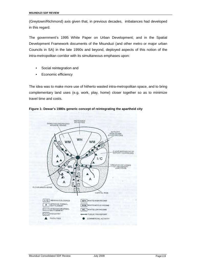
MSUNDUZI SDF REVIEW
Msunduzi Consolidated SDF Review July 2009 Page119
(Greytown/Richmond) axis given that, in previous decades, imbalances had developed
in this regard.
The government’s 1995 White Paper on Urban Development; and in the Spatial
Development Framework documents of the Msunduzi (and other metro or major urban
Councils in SA) in the late 1990s and beyond, deployed aspects of this notion of the
intra-metropolitan corridor with its simultaneous emphases upon:
• Social reintegration and
• Economic efficiency
The idea was to make more use of hitherto wasted intra-metropolitan space, and to bring
complementary land uses (e.g. work, play, home) closer together so as to minimize
travel time and costs.
Figure 1: Dewar’s 1980s generic concept of reintegrating the apartheid city

MSUNDUZI SDF REVIEW
Msunduzi Consolidated SDF Review July 2009 Page120
Inter-urban corridors An emphasis upon inter-urban development corridors also emerged in the late 1990s at
a national level, most particularly though so-called spatial development initiative (SDI)
concepts developed jointly within the Departments of Transport and Trade and
Industries.
As the DTI has recently noted, the SDI programme in South Africa was conceived in
1995. SDIs are based on the principle of growth corridors and to link key economic
nodes and regions in the country with occasional cross-border links with neighbouring
countries also being catered for (see figure 2). The corridors were designed as “arteries”,
which would encourage growth in the key sectors present in those areas. Support for
improved infrastructure goes hand in hand with support for catalytic economic projects
based on regional strengths in this framework.
According to DTI: “The SDIs were regarded as the vehicle for achieving higher rates of
both economic growth and job creation and to improve the functioning of government in
targeted regions of the country. The SDIs were characterised by intensive interventions
in identified areas to fast track private sector investments, to stimulate the growth of
Small Enterprise and micro enterprises (SMME) and to enhance the empowerment of
local communities.
FIGURE 2: SDIs in the Southern African Region
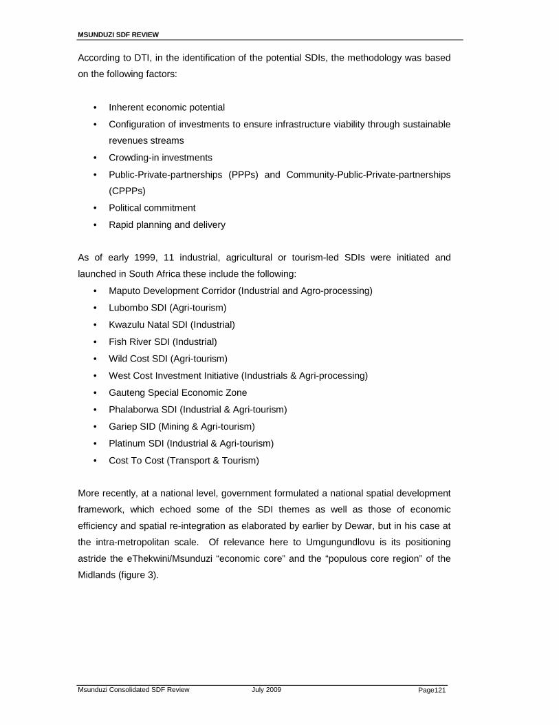
MSUNDUZI SDF REVIEW
Msunduzi Consolidated SDF Review July 2009 Page121
According to DTI, in the identification of the potential SDIs, the methodology was based
on the following factors:
• Inherent economic potential
• Configuration of investments to ensure infrastructure viability through sustainable
revenues streams
• Crowding-in investments
• Public-Private-partnerships (PPPs) and Community-Public-Private-partnerships
(CPPPs)
• Political commitment
• Rapid planning and delivery
As of early 1999, 11 industrial, agricultural or tourism-led SDIs were initiated and
launched in South Africa these include the following:
• Maputo Development Corridor (Industrial and Agro-processing)
• Lubombo SDI (Agri-tourism)
• Kwazulu Natal SDI (Industrial)
• Fish River SDI (Industrial)
• Wild Cost SDI (Agri-tourism)
• West Cost Investment Initiative (Industrials & Agri-processing)
• Gauteng Special Economic Zone
• Phalaborwa SDI (Industrial & Agri-tourism)
• Gariep SID (Mining & Agri-tourism)
• Platinum SDI (Industrial & Agri-tourism)
• Cost To Cost (Transport & Tourism)
More recently, at a national level, government formulated a national spatial development
framework, which echoed some of the SDI themes as well as those of economic
efficiency and spatial re-integration as elaborated by earlier by Dewar, but in his case at
the intra-metropolitan scale. Of relevance here to Umgungundlovu is its positioning
astride the eThekwini/Msunduzi “economic core” and the “populous core region” of the
Midlands (figure 3).

MSUNDUZI SDF REVIEW
Msunduzi Consolidated SDF Review July 2009 Page122
FIGURE 3: National Spatial development perspective Core Regions and Spatial Economic Linkages outside South Africa’s Three Main Metropolitan Areas
4
3
2
1
9
10
11
12
1
5
3
2
4
7
8
13 14
15
16
6
1
2
3
4
5
6
7
8
9
10
11
12
13
14
15
16
1
2
3
4
5
Gauteng
Ethekwini/ PMB
Cape
Town
Rustenburg
Potchefstroom-Klerksdorp
Witbank-Middelburg-Secunda
Nelspruit-Baberton
Empangeni-Richards Bay
East London
Nelson Mandela- Uitenhage
Vredenburg-Saldanha
Polokwane-Tzaneen
Newcastle-Dundee
Midlands (Estcourt-Mooi River)
Umtata- Port St Johns
Upington
Kimberley
Bloemfontein
Oudtshoorn-Garden Route
Diversified mining regions
Export-oriented regions
Populous core regions (high
population in relation to econ. base)
Established service regions (for
mining, tourism & agriculture)
Mining enclaves
Lephalale
Phalaborwa
FS Goldfields
Sishen-Kuruman
Aggenys-Springbok
Agriculture ManufacturingMining Infrastructure Services/ tourismAgriculture ManufacturingMining Infrastructure Services/ tourism
0200 000400 000600 000800 000
1 000 0001 200 0001 400 0001 600 0001 800 0002 000 000
Population
Economic “Base”
GVA (R Billions, Logarithmic Scale) 1 50105 3020 40
Surrounding population (within 15 km of boundary)
Population within designated area (2001 census)
0200 000400 000600 000800 000
1 000 0001 200 0001 400 0001 600 0001 800 0002 000 000
Population
Economic “Base”
GVA (R Billions, Logarithmic Scale) 1 50105 3020 40
Surrounding population (within 15 km of boundary)
Population within designated area (2001 census)
Service linkages & asso-
ciated functional regions
Opportunities for short-distance
migration and other forms of economic
access ( to nearby regions with a
relatively wide economic base)
Mining/ energy linkages
Manufacturing linkages
First set of Geo Spread priorities (proposed)
6
6 West Coast: alluvial
diamonds
5a
5b

MSUNDUZI SDF REVIEW
Msunduzi Consolidated SDF Review July 2009 Page123
DTI comment in a recent draft document that: “These 16 areas have clear economic
comparative and competitive advantages, which, to a large degree, are based on the
strength of the dominant economic activities and industrial concentration nodes within
them. Clustering of related economic activities is clearly a key regional competitive
advantage in these areas. Appropriate support to enhance the competitive edge of these
regions would clearly be of national and regional significance. In terms of the three
primary cores, their diversified economies and multiple-activity bases are critical to the
national economy and enhancement, if possible, would be ideal”.
A Provincial Development Corridor Perspective
The recent Provincial Spatial Economic Development Strategy (PSEDS) partly took its
brief from SDIs and the National Spatial Development Framework, and partly from the
specific comparative advantages of the various components of this province. The
collective perspective of Provincial Cabinet has been reflected in the recently approved
(February 2007) Provincial Spatial Economic Development Strategy (PSEDS).
Key elements of this Strategy are as that:
• Industrial development is seen as central to economic growth in the province and
“ Corridor linking two (Port) nodes & extending to Howick form the primary zone
of industrial potential” ;
• Tourism development is seen as second in importance and “Primary sectors of
tourism potential are beach, cultural and eco-tourism. Provincial tourism priorities
are:
• Greater Durban & Pietermaritzburg area • Drakensberg region….(and others)” ; and
• Agriculture and agribusiness are seen in the PSEDS, inter alia as having:
o “Massive potential for growth; and
o Largest existing or potential employer in rural areas; and
o can make greatest impact on reducing poverty levels in rural areas”
As the map below from the PSEDS shows, in the southern and western portions of the
District in particular, there are high quality agricultural lands (shaded green) which will be
important ingredients of growth strategy planning there.
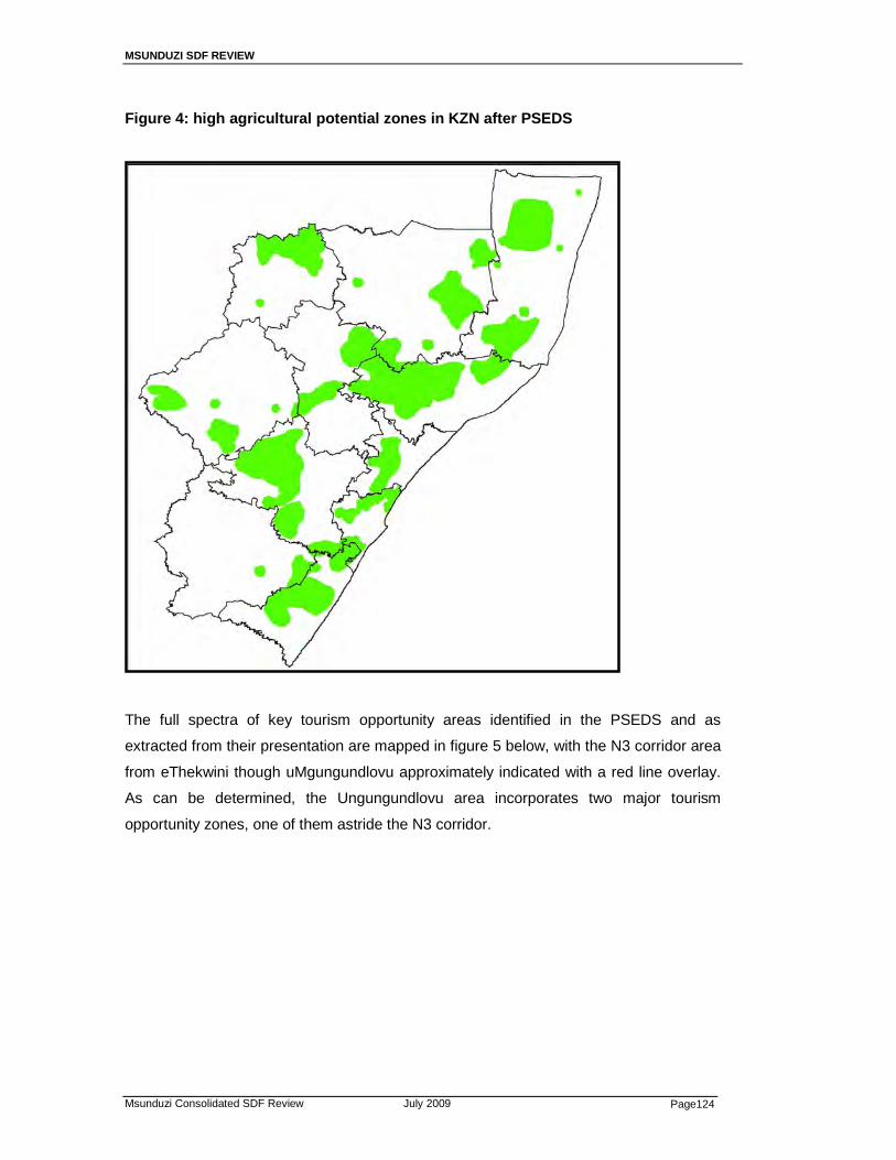
MSUNDUZI SDF REVIEW
Msunduzi Consolidated SDF Review July 2009 Page124
Figure 4: high agricultural potential zones in KZN after PSEDS
The full spectra of key tourism opportunity areas identified in the PSEDS and as
extracted from their presentation are mapped in figure 5 below, with the N3 corridor area
from eThekwini though uMgungundlovu approximately indicated with a red line overlay.
As can be determined, the Ungungundlovu area incorporates two major tourism
opportunity zones, one of them astride the N3 corridor.

MSUNDUZI SDF REVIEW
Msunduzi Consolidated SDF Review July 2009 Page125
Figure 5: Tourism Priority areas as identified in the February 2007 PSEDS, with N3 corridor area superimposed in red line
The PSEDS also recognises that: “The tertiary sector is the largest contributor to the
economies of all except for the Ilembe and Uthungulu district municipalities.
The tertiary sector comprises:
• Wholesale / retail trade • Transport / storage • Communication • Financial / insurance • Real estate • Business / Community / social / personal services • Government services…..”
It is noted that this important economic sector is arranged in a number of nodes of
varying levels in the province and in uMgungundlovu, as is reflected in figure 6 below.
The PSEDS also notes that in addressing poverty, jobs should be created through
developments in or near the established urban areas and the highest densities of
poverty are located in eThekweni, Msunduzi, Newcastle and Umhlatuze”.
As a result of all of the above, the PSEDS then goes on to identify two “provincial priority
corridors” for mixed economic investment, and these are mapped in relation to service
sector nodes in figure 7 overleaf. The provincial priority corridors are code-named PC1
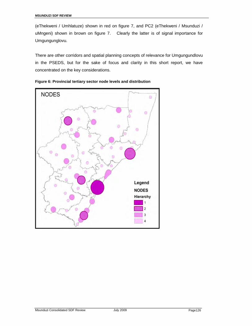
MSUNDUZI SDF REVIEW
Msunduzi Consolidated SDF Review July 2009 Page126
(eThekweni / Umhlatuze) shown in red on figure 7, and PC2 (eThekweni / Msunduzi /
uMngeni) shown in brown on figure 7. Clearly the latter is of signal importance for
Umgungunglovu.
There are other corridors and spatial planning concepts of relevance for Umgungundlovu
in the PSEDS, but for the sake of focus and clarity in this short report, we have
concentrated on the key considerations.
Figure 6: Provincial tertiary sector node levels and distribution
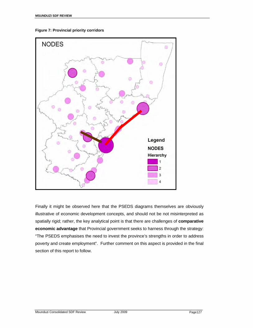
MSUNDUZI SDF REVIEW
Msunduzi Consolidated SDF Review July 2009 Page127
Figure 7: Provincial priority corridors
Finally it might be observed here that the PSEDS diagrams themselves are obviously
illustrative of economic development concepts, and should not be not misinterpreted as
spatially rigid; rather, the key analytical point is that there are challenges of comparative
economic advantage that Provincial government seeks to harness through the strategy:
“The PSEDS emphasises the need to invest the province’s strengths in order to address
poverty and create employment”. Further comment on this aspect is provided in the final
section of this report to follow.

MSUNDUZI SDF REVIEW
Msunduzi Consolidated SDF Review July 2009 Page128
Implications for the Umgungundlovu SDF Review
The spatial planning perspective of the District Municipality in relation to its area has
been evolving over time, as is evidenced by the current SDF review. In addition to this
review, most recently it has also become evident that the District Municipality sees N3
freeway intersection points as key economic drivers. Specifically, in a Terms of
Reference CORRIDOR DEVELOPMENT PROGRAMME PC2: ETHEKWINI-
MSUNDUZI-UMNGENI CORRIDOR recently issued to consultants it is noted that:
The DLGTA has been mandated to coordinate the implementation of a Corridor
Development Programme as a priority intervention aimed at promoting growth and
development in KwaZulu-Natal. The corridor that falls within uMgungundlovu District
Municipality is called eThekwini-Msunduzi-uMngeni corridor in terms of the KwaZulu-
Natal PSEDS.
uMgungundlovu District Municipality and its family of local municipalities has established
a Steering Committee that is vital to the implementation of the corridor development.
One of the responsibilities of the Steering Committee is to ensure that catalytic projects
for economic development are identified and implemented in the corridor. The Steering
Committee consists of representatives from the local municipalities falling within the
corridor, namely, Mkhambathini, Msunduzi and uMngeni Municipality….(where)…the
land around the N3 Intersections is identified as Opportunity points.”
In the author’s assessment, the Umgungundlovu District Municipality correctly infers that
these intersections will be the focus of development pressures for especially
manufacturing/industry and commercial/services use. Given both national and provincial
policy as outlined above, as well as international experience, it would be wise for the
District to accommodate as much of this pressure as is possible, given environmental
constraints and the need to protect the approaches to the two major provincial tourism
assets located within its boundaries (see figure 5).
However, as the current outputs of the Umgungundlovu SDF review process indicates,
and as some of the preceding material in this report also indicates, the issue of corridors
cannot and should not be restricted to the N3 corridor alone. A number of general points
are made in this regard in relation the main current output of the SDF review, as shown
in figure 8 below.
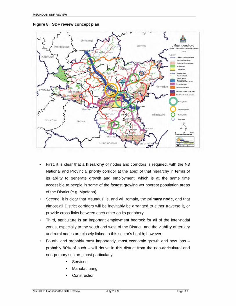
MSUNDUZI SDF REVIEW
Msunduzi Consolidated SDF Review July 2009 Page129
Figure 8: SDF review concept plan
• First, it is clear that a hierarchy of nodes and corridors is required, with the N3
National and Provincial priority corridor at the apex of that hierarchy in terms of
its ability to generate growth and employment, which is at the same time
accessible to people in some of the fastest growing yet poorest population areas
of the District (e.g. Mpofana).
• Second, it is clear that Msunduzi is, and will remain, the primary node , and that
almost all District corridors will be inevitably be arranged to either traverse it, or
provide cross-links between each other on its periphery
• Third, agriculture is an important employment bedrock for all of the inter-nodal
zones, especially to the south and west of the District, and the viability of tertiary
and rural nodes are closely linked to this sector’s health; however:
• Fourth, and probably most importantly, most economic growth and new jobs –
probably 90% of such – will derive in this district from the non-agricultural and
non-primary sectors, most particularly
� Services
� Manufacturing
� Construction
MSUNDUZI SDF REVIEW
Msunduzi Consolidated SDF Review July 2009 Page130
� Tourism
And, probably 90% of that will be aligned either along the provincial priority
corridor, or along the District Primary corridors, as shown in blue and purple
respectively on figure 8.
These are mostly both intra-metropolitan corridors within Msunduzi and inter-
urban corridors within the District, as such should be jointly planned and
facilitated, partly in terms of the intra-metropolitan corridor concepts referred to at
the outset, and partly in terms of the inter-urban concepts also referred to with
locally sensitive emphases upon the core principles of
- Comparative advantage
- Efficiency
- Integration
MSUNDUZI SDF REVIEW
Msunduzi Consolidated SDF Review July 2009 Page131
ANNEXURE 2:
A: PUBLIC COMMENTS ON THE DRAFT SDF
REVIEW – MAY 2009
MSUNDUZI SDF REVIEW
Msunduzi Consolidated SDF Review July 2009 Page132
PUBLIC COMMENTS ON THE DRAFT MSUNDUZI Person / Organization Comments Response 1. (a) The PMMB Trust requests sufficient time to in which to assess
the draft documentation, present the community proposals and help shape the future planning for the area towards a joint vision for one city. They therefore request an extension to Friday 15th May 2009.
Sufficient time for comments was provided therefore; this request was declined.
(b) The need to define “urban” and “rural” particularly “urban agriculture” and “rural residential”
The term “urban” refers to the urban component of the municipality or formally layed out areas where properties are properly defined in the Municipal Valuation Roll. The term “rural residential” refers to the rural component of the municipality outside the urban component. The term “urban agriculture” has been replaced with “communal agriculture”.
(c) The future Limited Mobility Access Roads occur to a large extent outside of the Msunduzi Municipality therefore; comments of neighboring municipalities are requested.
There is a limited number of future arterial roads within the
municipality. The Bellevue distributor has been removed from the SDF, Cleland Road and Hesketh Drive extensions have also been excluded. It is not clear whether this is an omission or a change in the SDF.
The SDF Review document will be tabled at District SDF level where alignment will occur between municipalities. The SDF map does not reflect all roads in the municipality but those which are considered as major roads. The roads in question are reflected on the amended map.
(d) The position of the Urban Growth Boundary is conflicting as there many formal residential areas outside of the boundary in the south and urban agriculture in the west. The purpose of the line in the plan needs to be clarified.
The “urban growth boundary” is only reflected along the Edendale valley where the terrain of the valley has been regarded as a natural boundary.
(e) There is a need to define the development corridors that have reduced and rationalized.
Which are the mixed use corridors?
The SDF Review document and map is very clear on the nature, objective, and hierarchy of corridors.
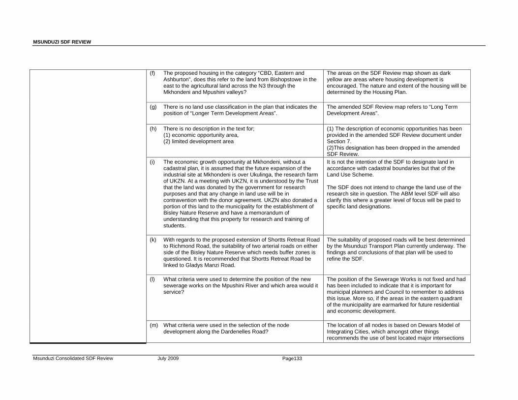
MSUNDUZI SDF REVIEW
Msunduzi Consolidated SDF Review July 2009 Page133
(f) The proposed housing in the category “CBD, Eastern and Ashburton”, does this refer to the land from Bishopstowe in the east to the agricultural land across the N3 through the Mkhondeni and Mpushini valleys?
The areas on the SDF Review map shown as dark yellow are areas where housing development is encouraged. The nature and extent of the housing will be determined by the Housing Plan.
(g) There is no land use classification in the plan that indicates the position of “Longer Term Development Areas”.
The amended SDF Review map refers to “Long Term Development Areas”.
(h) There is no description in the text for; (1) economic opportunity area, (2) limited development area
(1) The description of economic opportunities has been provided in the amended SDF Review document under Section 7. (2)This designation has been dropped in the amended SDF Review.
(i) The economic growth opportunity at Mkhondeni, without a cadastral plan, it is assumed that the future expansion of the industrial site at Mkhondeni is over Ukulinga, the research farm of UKZN. At a meeting with UKZN, it is understood by the Trust that the land was donated by the government for research purposes and that any change in land use will be in contravention with the donor agreement. UKZN also donated a portion of this land to the municipality for the establishment of Bisley Nature Reserve and have a memorandum of understanding that this property for research and training of students.
It is not the intention of the SDF to designate land in accordance with cadastral boundaries but that of the Land Use Scheme. The SDF does not intend to change the land use of the research site in question. The ABM level SDF will also clarify this where a greater level of focus will be paid to specific land designations.
(k) With regards to the proposed extension of Shortts Retreat Road to Richmond Road, the suitability of two arterial roads on either side of the Bisley Nature Reserve which needs buffer zones is questioned. It is recommended that Shortts Retreat Road be linked to Gladys Manzi Road.
The suitability of proposed roads will be best determined by the Msunduzi Transport Plan currently underway. The findings and conclusions of that plan will be used to refine the SDF.
(l) What criteria were used to determine the position of the new sewerage works on the Mpushini River and which area would it service?
The position of the Sewerage Works is not fixed and had has been included to indicate that it is important for municipal planners and Council to remember to address this issue. More so, if the areas in the eastern quadrant of the municipality are earmarked for future residential and economic development.
(m) What criteria were used in the selection of the node development along the Dardenelles Road?
The location of all nodes is based on Dewars Model of Integrating Cities, which amongst other things recommends the use of best located major intersections
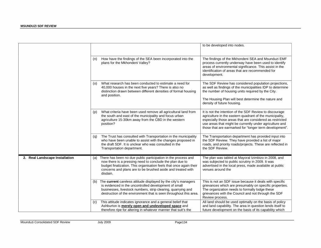
MSUNDUZI SDF REVIEW
Msunduzi Consolidated SDF Review July 2009 Page134
to be developed into nodes.
(n) How have the findings of the SEA been incorporated into the plans for the Mkhondeni Valley?
The findings of the Mkhondeni SEA and Msunduzi EMF process currently underway have been used to identify areas of environmental significance. This assist in the identification of areas that are recommended for development.
(o) What research has been conducted to estimate a need for 40,000 houses in the next five years? There is also no distinction drawn between different densities of formal housing and position.
The SDF Review has considered population projections, as well as findings of the municipalities IDP to determine the number of housing units required by the City. The Housing Plan will best determine the nature and density of future housing.
(p) What criteria have been used remove all agricultural land from the south and east of the municipality and focus urban agriculture 15-30km away from the CBD in the western position?
It is not the intention of the SDF Review to discourage agriculture in the eastern quadrant of the municipality, especially those areas that are considered as restricted use areas that might be currently under agriculture and those that are earmarked for “longer term development”.
(q) The Trust has consulted with Transportation in the municipality who have been unable to assist with the changes proposed in the draft SDF. It is unclear who was consulted in the Transportation department.
The Transportation department has provided input into the SDF Review. They have provided a list of major roads, and priority roads/projects. These are reflected in the SDF Review.
2. Real Landscape Installation (a) There has been no due public participation in the process and now there is a pressing need to conclude the plan due to budget finalization. This organisation feels that once again their concerns and plans are to be brushed aside and treated with disdain.
The plan was tabled at Mayoral Izimbizo in 2008, and was subjected to public scrutiny in 2009. It was advertised in the local press, made available at public venues around the
(b) The current careless attitude displayed by the city’s managers is evidenced in the uncontrolled development of small businesses, livestock numbers, strip clearing, quarrying and destruction of the environment that is seen throughout this area.
This is not an SDF issue because it deals with specific grievances which are presumably on specific properties. The organization needs to formally lodge these grievances with the Council and not through the SDF Review process.
(c) This attitude indicates ignorance and a general belief that Ashburton is merely open and undeveloped space and therefore ripe for altering in whatever manner that suit’s the
All land should be used optimally on the basis of policy and land capability. The area in question lends itself to future development on the basis of its capability which
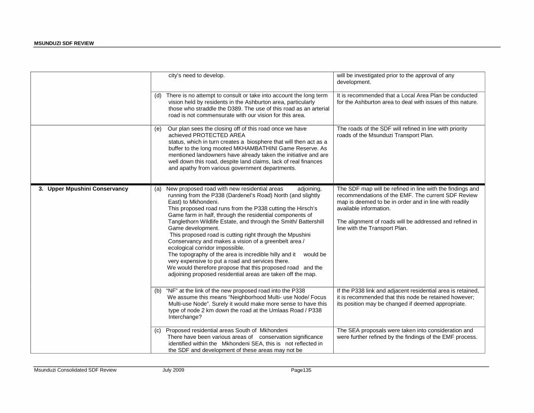
MSUNDUZI SDF REVIEW
Msunduzi Consolidated SDF Review July 2009 Page135
city’s need to develop.
will be investigated prior to the approval of any development.
(d) There is no attempt to consult or take into account the long term vision held by residents in the Ashburton area, particularly those who straddle the D389. The use of this road as an arterial road is not commensurate with our vision for this area.
It is recommended that a Local Area Plan be conducted for the Ashburton area to deal with issues of this nature.
(e) Our plan sees the closing off of this road once we have achieved PROTECTED AREA status, which in turn creates a biosphere that will then act as a buffer to the long mooted MKHAMBATHINI Game Reserve. As mentioned landowners have already taken the initiative and are well down this road, despite land claims, lack of real finances and apathy from various government departments.
The roads of the SDF will refined in line with priority roads of the Msunduzi Transport Plan.
3. Upper Mpushini Conservancy (a) New proposed road with new residential areas adjoining, running from the P338 (Dardenel’s Road) North (and slightly East) to Mkhondeni. This proposed road runs from the P338 cutting the Hirsch’s Game farm in half, through the residential components of Tanglethorn Wildlife Estate, and through the Smith/ Battershill Game development. This proposed road is cutting right through the Mpushini Conservancy and makes a vision of a greenbelt area / ecological corridor impossible. The topography of the area is incredible hilly and it would be very expensive to put a road and services there.
We would therefore propose that this proposed road and the adjoining proposed residential areas are taken off the map.
The SDF map will be refined in line with the findings and recommendations of the EMF. The current SDF Review map is deemed to be in order and in line with readily available information. The alignment of roads will be addressed and refined in line with the Transport Plan.
(b) “NF” at the link of the new proposed road into the P338 We assume this means “Neighborhood Multi- use Node/ Focus Multi-use Node”. Surely it would make more sense to have this type of node 2 km down the road at the Umlaas Road / P338 Interchange?
If the P338 link and adjacent residential area is retained, it is recommended that this node be retained however; its position may be changed if deemed appropriate.
(c) Proposed residential areas South of Mkhondeni There have been various areas of conservation significance identified within the Mkhondeni SEA, this is not reflected in the SDF and development of these areas may not be
The SEA proposals were taken into consideration and were further refined by the findings of the EMF process.
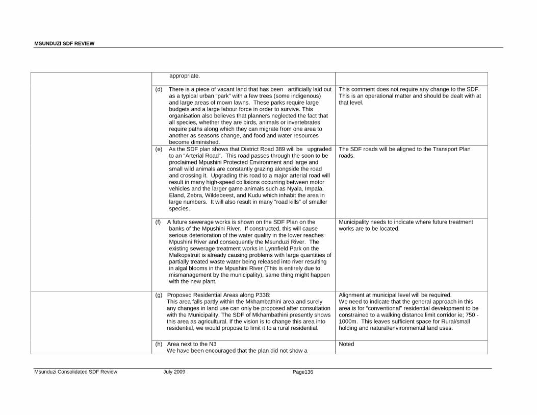
MSUNDUZI SDF REVIEW
Msunduzi Consolidated SDF Review July 2009 Page136
appropriate. (d) There is a piece of vacant land that has been artificially laid out
as a typical urban “park” with a few trees (some indigenous) and large areas of mown lawns. These parks require large budgets and a large labour force in order to survive. This organisation also believes that planners neglected the fact that all species, whether they are birds, animals or invertebrates require paths along which they can migrate from one area to another as seasons change, and food and water resources become diminished.
This comment does not require any change to the SDF. This is an operational matter and should be dealt with at that level.
(e) As the SDF plan shows that District Road 389 will be upgraded to an “Arterial Road”. This road passes through the soon to be proclaimed Mpushini Protected Environment and large and small wild animals are constantly grazing alongside the road and crossing it. Upgrading this road to a major arterial road will result in many high-speed collisions occurring between motor vehicles and the larger game animals such as Nyala, Impala, Eland, Zebra, Wildebeest, and Kudu which inhabit the area in large numbers. It will also result in many “road kills” of smaller species.
The SDF roads will be aligned to the Transport Plan roads.
(f) A future sewerage works is shown on the SDF Plan on the banks of the Mpushini River. If constructed, this will cause serious deterioration of the water quality in the lower reaches Mpushini River and consequently the Msunduzi River. The existing sewerage treatment works in Lynnfield Park on the Malkopstruit is already causing problems with large quantities of partially treated waste water being released into river resulting in algal blooms in the Mpushini River (This is entirely due to mismanagement by the municipality), same thing might happen with the new plant.
Municipality needs to indicate where future treatment works are to be located.
(g) Proposed Residential Areas along P338: This area falls partly within the Mkhambathini area and surely any changes in land use can only be proposed after consultation with the Municipality. The SDF of Mkhambathini presently shows this area as agricultural. If the vision is to change this area into residential, we would propose to limit it to a rural residential.
Alignment at municipal level will be required. We need to indicate that the general approach in this area is for “conventional” residential development to be constrained to a walking distance limit corridor ie; 750 -1000m. This leaves sufficient space for Rural/small holding and natural/environmental land uses.
(h) Area next to the N3 We have been encouraged that the plan did not show a
Noted
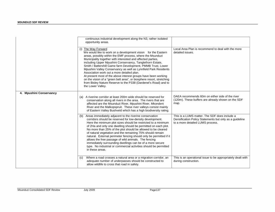
MSUNDUZI SDF REVIEW
Msunduzi Consolidated SDF Review July 2009 Page137
continuous industrial development along the N3, rather isolated opportunity areas.
(i) The Way Forward We would like to work on a development vision for the Eastern
areas, possibly within the EMF process, where the Msunduzi Municipality together with interested and affected parties, including Upper Mpushini Conservancy, Tanglethorn Estate, Smith / Battershill Game farm Development, PMMB Trust, Lower Mpushini Valley Conservancy as well as Lynnfield Park Residents Association work out a more detailed plan. At present most of the above interest groups have been working on the vision of a “green belt area”, or biosphere resort, stretching from Bisley Nature Reserve to the P338 (Dardenel’s Road) and to the Lower Valley.
Local Area Plan is recommend to deal with the more detailed issues.
4. Mpushini Conservancy
(a) A riverine corridor at least 200m wide should be reserved for
conservation along all rivers in the area. The rivers that are affected are the Msunduzi River, Mpushini River, Mkondeni River and the Malkopspruit. These river valleys consist mainly of Eastern Valley Bushveld which has a high biodiversity rating.
DAEA recommends 60m on either side of the river (120m). These buffers are already shown on the SDF map.
(b) Areas immediately adjacent to the riverine conservation corridors should be reserved for low-density development. Here the minimum plot sizes should be restricted to a minimum of 2Ha and only one dwelling should be permitted on each plot. No more than 25% of the plot should be allowed to be cleared of natural vegetation and the remaining 75% should remain natural. External perimeter fencing should only be permitted if it allows the free passage of wild animals. The fencing immediately surrounding dwellings can be of a more secure type. No industrial or commercial activities should be permitted in these areas.
This is a LUMS matter. The SDF does include a Densification Policy Statements but only as a guideline to a more detailed LUMS process.
(c) Where a road crosses a natural area or a migration corridor, an adequate number of underpasses should be constructed to allow wildlife to cross that road in safety.
This is an operational issue to be appropriately dealt with during construction.
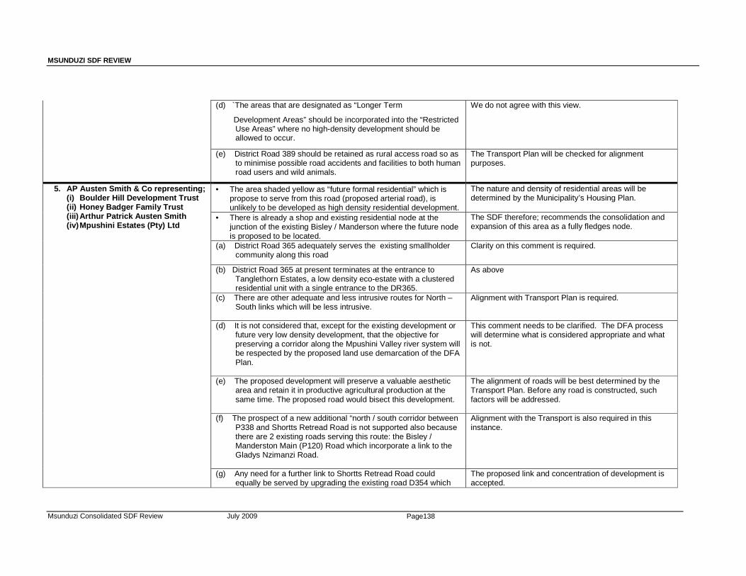
MSUNDUZI SDF REVIEW
Msunduzi Consolidated SDF Review July 2009 Page138
(d) `The areas that are designated as “Longer Term
Development Areas” should be incorporated into the “Restricted Use Areas” where no high-density development should be allowed to occur.
We do not agree with this view.
(e) District Road 389 should be retained as rural access road so as to minimise possible road accidents and facilities to both human road users and wild animals.
The Transport Plan will be checked for alignment purposes.
5. AP Austen Smith & Co representing; (i) Boulder Hill Development Trust (ii) Honey Badger Family Trust (iii) Arthur Patrick Austen Smith (iv) Mpushini Estates (Pty) Ltd
• The area shaded yellow as “future formal residential” which is propose to serve from this road (proposed arterial road), is unlikely to be developed as high density residential development.
The nature and density of residential areas will be determined by the Municipality’s Housing Plan.
• There is already a shop and existing residential node at the junction of the existing Bisley / Manderson where the future node is proposed to be located.
The SDF therefore; recommends the consolidation and expansion of this area as a fully fledges node.
(a) District Road 365 adequately serves the existing smallholder community along this road
Clarity on this comment is required.
(b) District Road 365 at present terminates at the entrance to Tanglethorn Estates, a low density eco-estate with a clustered residential unit with a single entrance to the DR365.
As above
(c) There are other adequate and less intrusive routes for North – South links which will be less intrusive.
Alignment with Transport Plan is required.
(d) It is not considered that, except for the existing development or future very low density development, that the objective for preserving a corridor along the Mpushini Valley river system will be respected by the proposed land use demarcation of the DFA Plan.
This comment needs to be clarified. The DFA process will determine what is considered appropriate and what is not.
(e) The proposed development will preserve a valuable aesthetic area and retain it in productive agricultural production at the same time. The proposed road would bisect this development.
The alignment of roads will be best determined by the Transport Plan. Before any road is constructed, such factors will be addressed.
(f) The prospect of a new additional “north / south corridor between P338 and Shortts Retread Road is not supported also because there are 2 existing roads serving this route: the Bisley / Manderston Main (P120) Road which incorporate a link to the Gladys Nzimanzi Road.
Alignment with the Transport is also required in this instance.
(g) Any need for a further link to Shortts Retread Road could equally be served by upgrading the existing road D354 which
The proposed link and concentration of development is accepted.

MSUNDUZI SDF REVIEW
Msunduzi Consolidated SDF Review July 2009 Page139
travels through a number of existing small holdings. This link could be extended to join in with the Old Main Road, or alternatively, could be located along the western boundary of existing and future development along Lynnfield Park.
(h) The SDF plan does not reflect the existing DR352 along the rail
bridge area.
This road is reflected.
(i) The clients states that the proposed arterial road extending from N3 Highway to Wally Hayward Drive traverses the low-lying land adjacent to the Mpushini River and one of its significant tributaries.
This point needs to be clarified as it does not mention any specifics to the SDF.
(j) With the railway crossing and 2 river crossings, it is difficult to accept that this proposal should be included.
The alignment of roads will be best dealt with in the Transport Plan.
(k) The land in question includes extensive areas of grasslands; it appears that this road may go through the Ishona Ilanga Nature Reserve. It also appears to go through sensitive and valuable Hirsch game farm, through Tonglethorn, through the Boulder Hill Ranch development, over the Mpushini river, over the existing D352 and through certain areas of strategic valuable pristine Thermeda grasslands to a point which presumed to be in the vicinity of the existing development along the western section of A P Smith Road and then through broken thornveld to a point where it links to Shortts Retreat Road. The route of this road goes through areas which must be classed as “highly sensitive and valuable”
The alignment of the road and construction thereof; would still need to go through a proper planning and application process. It is during this process where such issues would be addressed.
(l) The proposed arterial road existing from Richmond Road over existing Road P120 down along the Mpushini should not abut on the Mkhondeni river valley catchment area.
Exact alignment be determined by the Transport Plan.
(m) The justifiability of a “short cut” from the present Mkondeni Industrial area to the Shortts Rereat road should be located away from the Mkondeni riverine area.
This comment is accepted, if this road would have a negative impact on the water quality of the river.
(n) Clients are aware that this will exclude part of the present Bisley Nature Reserve – perhaps a few hectares. Any land excluded could be incorporated into whichever of several existing or proposed “high priority conservation areas along the Mpushini stream” are selected a suitable custodians if this valuable
This point needs to be clarified as it does not mention any specifics to the SDF.

MSUNDUZI SDF REVIEW
Msunduzi Consolidated SDF Review July 2009 Page140
riverine land. (o) The proposed arterial road linking the development node with
high density residential areas of Imbali, Slangspruit, etc. does need further considerations in relation to the creation of a corridor over the Thornville / Umlaas Road Crest along the “Dardenell’s Road in order to link the Mpushini / Mkondeni Corridors to the Umlaas river corridors.
The SDF Map is only formulated at policy level.
(p) Manderston is not a designated neighborhood multi-use node. At some future date the Main Road P120 from Bisley to Manderston will need to be upgraded to link up with other road networks outside the scope of the present SDF.
This point is accepted as far as it relates to the alignment of roads because these are best dealt with in the Transport Plan.
(q) In view of the scale of the map, which does not no reflect topographical or property boundaries, other than the major river systems, it is possible that the above comments will need modification.
Accepted
6. SSI Engineers and Environmental Consultants (PTY) LTD
(a) Despite the early sale of 34 sites, it was clear that there was a need to secure additional development rights on the application property so as to ensure that the development would be sustainable in the longer term. Consequently a client has initiated the process of installing the thus approved infrastructure in parallel with the process of addressing the need for the additional development rights. This process is now well underway.
(b) There is an objection which relates to the proposal to traverse a
portion of a client’s property by imposing a future road linking Ambleton, located within the Edendale area to the Lion Park Interchange. The client has an existing development approval which includes the development of 102 housing units, a club-house, meeting room and coffee shop, a tennis court and a swimming pool, a small office complex, security and administration office, a stable complex all set within a high quality secure farm wildlife estate, as reflected on the Site Development Plan.
The comment is accepted and the road will be realigned.
(c) Any routing of such high order road in the vicinity of the Client’s property will adversely impact on vision of the farm wildlife estate. Furthermore any major road-link such as envisaged, will
Same as b above.
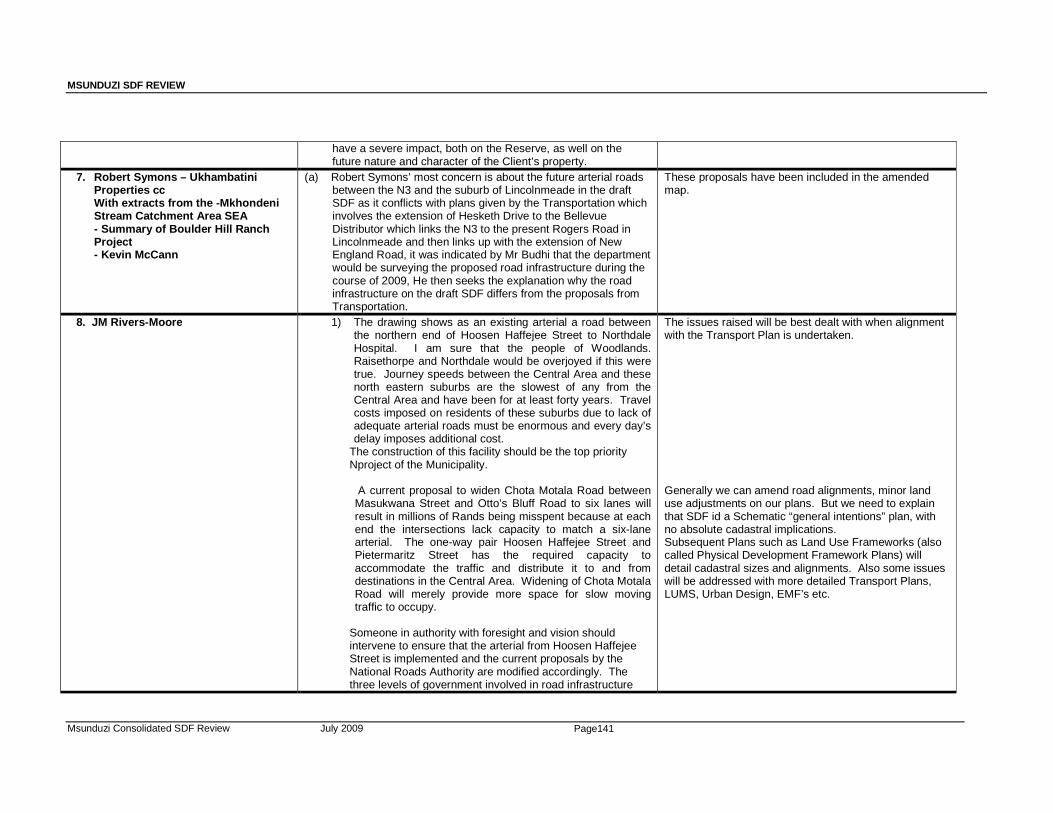
MSUNDUZI SDF REVIEW
Msunduzi Consolidated SDF Review July 2009 Page141
have a severe impact, both on the Reserve, as well on the future nature and character of the Client’s property.
7. Robert Symons – Ukhambatini Properties cc With extracts from the -Mkhondeni Stream Catchment Area SEA - Summary of Boulder Hill Ranch Project - Kevin McCann
(a) Robert Symons’ most concern is about the future arterial roads between the N3 and the suburb of Lincolnmeade in the draft SDF as it conflicts with plans given by the Transportation which involves the extension of Hesketh Drive to the Bellevue Distributor which links the N3 to the present Rogers Road in Lincolnmeade and then links up with the extension of New England Road, it was indicated by Mr Budhi that the department would be surveying the proposed road infrastructure during the course of 2009, He then seeks the explanation why the road infrastructure on the draft SDF differs from the proposals from Transportation.
These proposals have been included in the amended map.
8. JM Rivers -Moore 1) The drawing shows as an existing arterial a road between the northern end of Hoosen Haffejee Street to Northdale Hospital. I am sure that the people of Woodlands. Raisethorpe and Northdale would be overjoyed if this were true. Journey speeds between the Central Area and these north eastern suburbs are the slowest of any from the Central Area and have been for at least forty years. Travel costs imposed on residents of these suburbs due to lack of adequate arterial roads must be enormous and every day’s delay imposes additional cost.
The construction of this facility should be the top priority Nproject of the Municipality.
A current proposal to widen Chota Motala Road between Masukwana Street and Otto’s Bluff Road to six lanes will result in millions of Rands being misspent because at each end the intersections lack capacity to match a six-lane arterial. The one-way pair Hoosen Haffejee Street and Pietermaritz Street has the required capacity to accommodate the traffic and distribute it to and from destinations in the Central Area. Widening of Chota Motala Road will merely provide more space for slow moving traffic to occupy.
Someone in authority with foresight and vision should intervene to ensure that the arterial from Hoosen Haffejee Street is implemented and the current proposals by the National Roads Authority are modified accordingly. The three levels of government involved in road infrastructure
The issues raised will be best dealt with when alignment with the Transport Plan is undertaken. Generally we can amend road alignments, minor land use adjustments on our plans. But we need to explain that SDF id a Schematic “general intentions” plan, with no absolute cadastral implications. Subsequent Plans such as Land Use Frameworks (also called Physical Development Framework Plans) will detail cadastral sizes and alignments. Also some issues will be addressed with more detailed Transport Plans, LUMS, Urban Design, EMF’s etc.
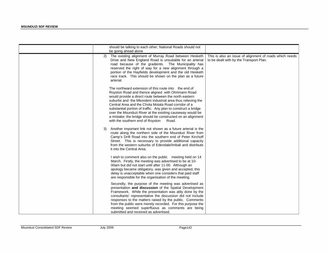
MSUNDUZI SDF REVIEW
Msunduzi Consolidated SDF Review July 2009 Page142
should be talking to each other; National Roads should not be going ahead alone
2) The existing alignment of Murray Road between Hesketh Drive and New England Road is unsuitable for an arterial road because of the gradients. The Municipality has reserved the right of way for a new alignment through a portion of the Hayfields development and the old Hesketh race track. This should be shown on the plan as a future arterial.
The northward extension of this route into the end of Royston Road and thence aligned with Ohrtmann Road would provide a direct route between the north eastern suburbs and the Mkondeni industrial area thus relieving the Central Area and the Chota Motala Road corridor of a substantial portion of traffic. Any plan to construct a bridge over the Msunduzi River at the existing causeway would be a mistake; the bridge should be constructed on an alignment with the southern end of Royston Road.
3) Another important link not shown as a future arterial is the route along the northern side of the Msunduzi River from Camp’s Drift Road into the southern end of Peter Kirchoff Street. This is necessary to provide additional capacity from the western suburbs of Edendale/Imbali and distribute it into the Central Area.
I wish to comment also on the public meeting held on 14
March. Firstly, the meeting was advertised to be at 10-00am but did not start until after 11-00. Although an apology became obligatory, was given and accepted, this delay is unacceptable when one considers that paid staff are responsible for the organisation of the meeting.
Secondly, the purpose of the meeting was advertised as presentation and discussion of the Spatial Development Framework. While the presentation was ably done by the consultants’ representative the discussion did not include responses to the matters raised by the public. Comments from the public were merely recorded. For this purpose the meeting seemed superfluous as comments are being submitted and received as advertised.
This is also an issue of alignment of roads which needs to be dealt with by the Transport Plan.

MSUNDUZI SDF REVIEW
Msunduzi Consolidated SDF Review July 2009 Page143
B: NOTES OF PUBLIC MEETING – 14 MARCH 2009
MSUNDUNZI MUNICIPALITY SPATIAL DEVELOPMENT FRAMEWORK REVIEW:
NOTES OF PUBLIC MEETING – 14 MARCH 2009 Date: 14 March 2009 Venue: Royal Show Grounds hall 6 Time: 13:00 pm. – 15:00pm
Participants Cllr Themba Zungu (TZ) Robbie Mkhize (RM) Vasu Naidoo (VN) Bryan Basett (BB) (Also see attached Attendance Register)
Apologies: Mayor Zanele Hlatshwayo Deputy Mayor Mervin Dirks Mr Rob Haswell
The meeting was structured along the following Agenda: Item No. 1. Welcome and apologies 2. Background to SDF 3. Presentation of SDF 4. Public Participation – Questions and Answers Session 5. Closure
MSUNDUZI SDF REVIEW
Msunduzi Consolidated SDF Review July 2009 Page144
No. Item & Action Responsibility 1. Welcome and Apologies
• The members were welcomed by chairperson, who expressed gratitude about the attendance of the meeting by members of Ward Committees and the public at large, this considering that the meeting was held on a Saturday morning. • Mr. Robbie Mkhize also extended his apologies about the late start of the meeting, explaining that the Deputy Mayor had been invited to open the meeting but was later held at another urgent Council commitment. He added that Councilor T Zungu would welcome all members on behalf of Council. • Cllr. Zungu welcomed all present on behalf of Council and explained that the meeting was a milestone in the journey of restructuring the typical Apartheid City.
RM TZ
2. Background
a. General • The decision to revise the municipal SDF was taken at a senior
management level and is in line with legislation requirements. • Due to the size and the diverse nature of the municipality, it was
decided that the ABM be divided into 4 focus areas in line with the ABM area boundaries.
• A tender process was followed, to which Udidi and IRC were the successful tenders. As a result, Udidi was subsequently appointed to undertake the overall Project Management of the review exercise.
• IRC was appointed to review the greater Edendale ABM, which includes the formulation of four Physical Development Framework Plans for Caluza, Dambuza, Georgetown, and Plessilaer.
• It is important that PT’s should not necessarily be restricted by ABM boundaries as there are certain areas of overlap e.g.; Vulindlela and Greater Edendale.
• Mr. Zungu emphasized the following for the background to SDF:
changes were made by the concill, clarifying that SDF is meant to reshape the city and also promote sustainable housing.
• People living in the city have be aware and participate in the reshaping of their city
• Most of the areas in UMgungundlovu do not have services which
imply that the SDF has to suggest ways of addressing these issues and to identify new areas for developments within the city for the future and improving service delivery (water, electricity, sanitation and storm water).
• The SDF has to encourage opening of industries, factories, and more shops in Vulindlela, Mbali all the outlying areas of the city.
• It is important for the City to become more industrialized so the city Council can collect more rates which in turn will used to fund the provision of services such as water, electricity and roads.
• The impact that the City has is not confined to municipal boundaries but also affects what happens at an UMgungundlovu District as a whole.
GH TZ
MSUNDUZI SDF REVIEW
Msunduzi Consolidated SDF Review July 2009 Page145
3. Presentation of SDF The Draft SDF was presented by Udidi.
• Presentation attached to minutes.
MF
4. Public -Questions And Answers • Members of the public raised the following questions pertaining the
Draft SDF presented and other related issues.
Mrs Pandora Long • How many SDF Review options were considered and what
was the criterion used to choose the preferred option being presented?
• Was there any public participation during the process of selecting options?
- The preparation of the SDF evolved over time and the Drafts
were presented to various internal and external stakeholders. The draft being presented is an outcome of that process.
Tulani Khofana (ward 23) • How are you going to counteract resistance from indigenous
peoples graves and ensure that there will be no encroachment.
- The SDF is sensitive to such issues and would not promote the development of such areas without exploring all possible options available. This matter would also be best dealt with when a specific property is identified.
Sipho Dube ( ward 4) • How will the SDF ensure that communities are protected from
potentially harmful development?
- The SDF is prepared with the strictest principles of sustainable development and ensuring the creation of quality urban environments. The SDF is prepared in a way that ensures that compatible land uses are encouraged whilst creating areas of work, live, and play.
Nhlanhla Shange (ward 16) • The limited resources available to Council are likely to hinder
the implementation of IDP proposals, what is the SDF suggesting in this regard?
- Council is committed to making the best use of limited
resources, so that a lot of communities can benefit. Communities in turn are expected to respect and protect the facilities and services they are being provided.
• The SDF should encourage the provision of recreation facilities in previously marginalized areas and underdeveloped communities?
- Council remains committed to providing recreation facilities in underdeveloped areas for example; Council approved that communities should be provided with facilities such as swimming pools one them being at Edendale behind the B.P garage. The provision of other facilities in other areas will be guided by available resources.
• What is the status of the proposals to extend Prince Alfred street to link up with College road/West street, in order to reduce congestion.
MF MF MF TZ TZ
MSUNDUZI SDF REVIEW
Msunduzi Consolidated SDF Review July 2009 Page146
- Council is the process of finalizing the Integrated Transport
Plan and this matter would be best addressed in that process. However; the SDF encourages any suggestions to deal with the current traffic congestions, as long as these are sustainable.
Hector Hlombeni (ward 20) • Does Council or government have any plans to purchase the
private properties in Edendale, so that these can be transferred to current occupiers?
• If the municipality has done anything, how many of these properties have been purchansed.
- Council gas spent approximately R20 million in order to address this matter. It has engaged in a number of discussions were held with stakeholders.
Sicelo Mlaba (ward 20) • Does Council have any plans to upgrade the old brewery site
in Imbali?
- The SDF has identified this site as an economic opportunity area.
• Does Council have any plans to develop the vacant properties
in Willowfountain?
- The majority of sites are on terrains that are difficult to develop or that would be too expensive to develop.
Roobus Moore (Scottsville) • The SDF needs to reflect links roads from town to Northdale
areas to deal with congestion.
- The SDF has identified and suggested this link.
• There is also a need to improve the Church Street / East street intersection.
- The SDF has also acknowledged this need. Stephanie Shooter (ward 27): • The SDF shows a proposed road in an area that is too steep to
develop.
- The Integrated Transport Plan should be used to align specific roads proposals.
Elane (ward 32): • Ward 23 also suffers from massive traffic congestion and
proposals need to be forward to deal with this.
- This matter was noted. Sipho Dube (ward 4): • The public participation process should have been undertaken
in 2008.
- This matter was noted and it was explained that the SDF Review is a process.
MF TZ MF MF MF MF MF MF

MSUNDUZI SDF REVIEW
Msunduzi Consolidated SDF Review July 2009 Page147
• It is also disturbing to note that Ward committee attendance for
Indian communities is poor.
- The matter was noted.
MF MF
. • Closure The Chairperson declared the meeting closed at 15:00pm and thanked members that attended.
RM
MSUNDUZI SDF REVIEW
Msunduzi Consolidated SDF Review July 2009 Page148
ANNEXURE 3:
MAPS
SRK Consulting Msunduzi Final Draft SEA Page 65
eman 376998_ Final Draft SEA Report_May2010 May 2010
Appendix 4 Sustainability Appraisal Matrix
SRK Consulting Msunduzi Final Draft SEA Page 66
eman 376998_ Final Draft SEA Report_May2010 May 2010
Appendix 5 EGI Framework
TTTTHORNHORNHORNHORN----EEEEX CCX CCX CCX CC
Environmental Governance and Environmental Governance and Environmental Governance and Environmental Governance and Institutional Institutional Institutional Institutional FrameworkFrameworkFrameworkFramework
for the
MSUNDUZI LOCAL MUNICIPALITY ENVIRONMENTAL MANAGEMENT FRAMEWORK
June 2008
Prepared for: Prepared by: SRK Consulting Engineers and Consultants
CK 2005/062067
Suite 201 Sinodale Centre 345 Burger Street Pietermaritzburg 3201 South Africa Tel: (033) 345-6311 Fax: (033) 345-6403 [email protected]
Tel: (033) 3431814 Fax: (033) 3431819
Contact person: Marita Thornhill (REF: C001-7)
PO Box 800 Hilton 3245
South Africa
Msunduzi EMF (Environmental Governance & Institutional Framework) Page 1 of 87 _____________________________________________________________________________________________________
_______________________________________________________________________________________________________________________________________REF: C001-7
Table of ContentTable of ContentTable of ContentTable of Contentssss
EXECUTIVE SUMMARY....................................................................................................... 4
SECTION 1: INTRODUCTION.............................................................................................. 8
1.1 Introduction ........................................................................................................................ 8
1.2 The Msunduzi Municipality ................................................................................................ 9
1.3 An Environmental Governance and Institutional Framework .......................................... 10
1.3.1 Project Scope ..................................................................................................... 10
1.3.2 Implications ......................................................................................................... 14
1.3.3 Approach and Methodology................................................................................ 18
1.4 Purpose and Structure of the Report ............................................................................... 21
SECTION 2: ENVIRONMENTAL GOVERNANCE...............................................................22
2.1 Introduction ...................................................................................................................... 22
2.1 A Model for Environmental Governance.......................................................................... 23
2.3 Application ....................................................................................................................... 26
SECTION 3: A FOCUS ON PEOPLE...................................................................................27
3.1 Introduction ...................................................................................................................... 27
3.2 A Collective Responsibility............................................................................................... 27
3.3 The Role of Government ................................................................................................. 29
3.4 The Role of Local Government........................................................................................ 32
3.5 A Commitment to Public Participation in Environmental Governance............................. 34
3.6 Society’s Role in Environmental Governance ................................................................. 35
3.7 A Commitment to Share Information ............................................................................... 36
3.7 How does this relate to the Msunduzi Municipality EMF? ............................................... 36
3.7 Concluding Remarks ....................................................................................................... 39
SECTION 4: A FOCUS ON SYSTEMS AND TOOLS ..........................................................41
4.1 Introduction ...................................................................................................................... 41
4.2 The EMF: An Integrated Instrument ................................................................................ 43
4.2.1 Purpose of the EMF............................................................................................ 43
4.2.2 Process of the EMF ............................................................................................ 45
4.2.3 The EMF’s Relationship with EIA ....................................................................... 47
4.2.4 The EMF’s Relationship with ‘Other Decisions’.................................................. 50
4.3 A Process for Ongoing Dialogue ..................................................................................... 52
4.3.1 Leadership for Good Governance ...................................................................... 52
4.3.2 Interaction with other organs of state ................................................................. 55
4.3.3 Interaction with society ....................................................................................... 57
4.3.4 Collective action.................................................................................................. 58
4.4 Efficiency and Effectiveness in Environmental Governance ........................................... 61
4.4.1 Environmental Functions vs Obligations ............................................................ 61

Msunduzi EMF (Environmental Governance & Institutional Framework) Page 2 of 87 _____________________________________________________________________________________________________
_______________________________________________________________________________________________________________________________________REF: C001-7
4.4.2 Performance Management ................................................................................. 61
4.4.3 Institutional Support ............................................................................................ 64
4.5 Concluding Remarks ....................................................................................................... 66
SECTION 5: A FOCUS ON THE FUTURE..........................................................................68
5.1 Introduction ...................................................................................................................... 68
5.2 A Vision for Environmental Governance.......................................................................... 69
5.3 Considering the Context .................................................................................................. 70
5.4 A Future by Consensus ................................................................................................... 71
5.5 Commitment for Collective Action.................................................................................... 72
5.6 Performance Monitoring .................................................................................................. 72
5.7 Concluding Remarks ....................................................................................................... 73
SECTION 6: ENVIRONMENTAL GOVERNANCE OUTLOOK ............................................74
6.1 Introduction ...................................................................................................................... 74
6.2 A Strategic Agenda.......................................................................................................... 74
6.3 Environmental Governance in the Local Municipality...................................................... 75
6.3.1 Leadership in Environmental Governance ......................................................... 75
6.3.2 Intergovernmental Cooperation .......................................................................... 76
6.3.3 Efficiency & Effectiveness in Governance .......................................................... 77
6.3.4 Information Sharing ............................................................................................ 79
6.3.5 Participation in Environmental Governance ....................................................... 80
6.4 Effectiveness of the EMF................................................................................................. 81
6.5 Conclusion and Recommendations ................................................................................. 82
REFERENCES.....................................................................................................................84
ANNEXURE 1: EXPERIENCE IN ENVIRONMENTAL GOVERNANCE...............................86

Msunduzi EMF (Environmental Governance & Institutional Framework) Page 3 of 87 _____________________________________________________________________________________________________
_______________________________________________________________________________________________________________________________________REF: C001-7
Abbreviations used in this reportAbbreviations used in this reportAbbreviations used in this reportAbbreviations used in this report
DAEA Department of Agriculture and Environmental Affairs
DEAT Department of Environmental Affairs and Tourism
EGI Framework Environmental Governance and Institutional Framework
EIA Environmental Impact Assessment
EMF Environmental Management Framework
IDP Integrated Development Plan
IEM Integrated Environmental Management
MEC Member of Executive Council
NEMA National Environmental Management Act
SEA Strategic Environmental Assessment
SEMP Strategic Environmental Management Plan
Msunduzi EMF (Environmental Governance & Institutional Framework) Page 4 of 87 _____________________________________________________________________________________________________
_______________________________________________________________________________________________________________________________________REF: C001-7
EXECUTIVE SUMMARYEXECUTIVE SUMMARYEXECUTIVE SUMMARYEXECUTIVE SUMMARY
“Sustainable development requires more than just a department, a minister and white papers. It requires a mosaic of
institutions, policies and values. Good governance is required to create a political eco-system that is adequate to save the real one”
- Chris Patten, Member of the European Commission, 2000 -
To achieve results we plan ‘with the end in mind’ as it injects a sense of purpose and keep us focused.
The Msunduzi Local Municipality’s development path is guided by a vision that displays development
choices in a healthy environment. The future of the Municipality also displays a ‘desired state of
governance’ where people work together (“Isixaxa – Pulling together”). This report illustrates the need
for thinking more seriously about the desired levels and systems of governance that will result in
good development outcomes. It places people at the forefront of development by emphasizing the
institutional dimension of sustainable development – the man-made management systems that are
designed to maintain or improve environmental resource quality. The report also serves to remind role-
players to think about the Strategic Environmental Management Plan that should guide the future
implementation of the EMF.
The Msunduzi Local Municipality has positioned itself strategically to achieve the ultimate policy goal –
meeting economic, social and environmental objectives – but the area’s challenges are surpassing its
ability to adequately respond to the environment’s needs and there is reason to believe that the
Msunduzi Municipality may not be on a sustainable development path. This has influenced the
decision to develop ‘a comprehensive policy framework’ to promote the capital as ‘a provincial flagship
for sound environmentally sustainable development’. An Environmental Management Framework
(EMF) was selected as an appropriate instrument to achieve this task.
The comprehensive approach adopted for this project meant that the key tasks of the Msunduzi
Municipality EMF had to be defined very clearly for the following reasons:
� To assist the project team in overall project design
� To define the focus for the governance and institutional study of the project.
� To empower role-players as to the purpose, process, products and implications of the project
outputs.
The Project Terms of Reference was therefore structured into an Analytical Framework to explain that
the Msunduzi Municipality EMF goes beyond an instrument in support of development decisions under
the EIA Regulations. The expectation is that the EMF must deliver a ‘Decision-Making Framework’ to
inform and guide different levels and types of short-term and long-term decisions and actions of all
role-players that operate in the Msunduzi Municipality. The Decision-Making Framework must consist
of three parts, each with their own tasks:
Msunduzi EMF (Environmental Governance & Institutional Framework) Page 5 of 87 _____________________________________________________________________________________________________
_______________________________________________________________________________________________________________________________________REF: C001-7
1) A Strategic Framework that is capable of delivering a strategic agenda for the area with long-
term goals and objectives, strategies and implementation plans and a system that can monitor and
evaluate progress for continued improvement
2) An Operational Framework that is capable of operationalizing the strategic agenda into detailed
strategies to influence actions and decisions of role-players on a daily basis.
3) A Spatial Part that is capable of illustrating the result of the strategic planning process (the
strategic agenda) and that offers role-players a user-friendly way of making informed spatial
development choices.
The comprehensive approach adopted for this project has significant implications for assessing the
governance and institutional dimension of the project. Essentially it requires a strong focus on the
prevailing ‘system of environmental governance’ in the area. This system consists of many role-
players and their sub-systems. These sub-systems interact with each other and with the environment
and influence the quality of the area’s resources and development outcomes. Planning the future of
the Msunduzi Municipality requires an understanding of how this system currently functions. In other
words we need to understand the existing state of environmental governance if the EMF must plan
for a future state of governance. The complexity of such a task is compounded by the fact that a
framework or system for monitoring environmental governance currently does not exist in South Africa.
For this reason the focus of the institutional dimension of the EMF Project was on developing a
‘catalyst’ that would be able to generate change in the institutional environment of the area. This
‘catalyst’ is offered here as a benchmark that focuses on the desired state of environmental
governance for the area. The report does not offer a situation assessment of the existing state of
governance in the area. It provides an institutional assessment as the basis against which future
contributions to environmental governance could be measured.
The Environmental Governance and Institutional Framework (The EGI Framework) offers a
benchmark for measuring environmental governance in the Msunduzi Municipality. It draws on
best practice to identify the basic building blocks for environmental governance. It then identifies legal
guidelines relevant to the study to clarify the roles and responsibilities of various role-players and the
manner in which they should interact. These guidelines were interpreted as the desired levels of
governance and they represent the legal thresholds for environmental governance. In other words
they offer the limits below which environmental governance would not be able to function as intended
and can be considered as targets for governance.
The EGI Framework underlines the need to ensure that role-players in the Msunduzi area understand:
� The approach and expectations of the EMF Project.
� The meaning and context of environmental governance.
� The EMF as an instrument.
� The role and responsibilities of the Municipality vs those of other role-players in the EMF.
Msunduzi EMF (Environmental Governance & Institutional Framework) Page 6 of 87 _____________________________________________________________________________________________________
_______________________________________________________________________________________________________________________________________REF: C001-7
� That the area’s environmental priorities will influence the future governance path of the area.
The effectiveness of environmental governance in the Msunduzi Municipality will be determined by the
extent to which an enabling environment promotes a collective responsibility for environmental
governance. The challenges of the Msunduzi Municipality and its role-players in striving towards a
desired state of governance include the following issues of governance:
� Each role-player must understand their specific roles and responsibilities.
� There must be a process for dialogue between role-players.
� People must be equipped with the necessary understanding and skills.
� Organisations must be able to work collectively and collaboratively.
� There must be institutional support for capacity development.
� Institutional arrangements must support collective action.
� There must be a vision to guide role-players
� Priorities for governance must be influenced by context-specific issues and the prevailing
levels of environmental quality.
� A desired state of governance must be defined through a process of consensus.
� Role-players must demonstrate a commitment to the future situation.
� Progress in environmental governance must be monitored and evaluated and role-players
must have the ability to adapt to the environment’s needs
The benchmark developed in this study also considered the desired levels of governance to measure
the effectiveness of the EMF as an institution for achieving environmental governance. The EMF as
an integrative instrument must be able to achieve its key tasks:
� To achieve the purpose of the National Environmental Management Act (NEMA)
� To achieve the objectives of Integrated Environmental Management (IEM)
� To support the EIA Regulations
� To inform different levels and types of decision-making
To achieve the above task the challenges in making the EMF work includes the following:
� There must be ongoing support for the EMF: The roles of the DEAT, DAEA and the
Municipality in the EMF are clearly defined.
� All role-players in the Msunduzi Municipality are given the opportunity to partake in the
development and management of the EMF.
� The EMF illustrates the existing environmental situation, identifies issues and priorities, and
identifies detailed strategies for implementation – meet all the requirements of the ToR.
� All role-players agree on the status and application of the EMF
� Institutional arrangements for managing the EMF are clearly defined.
� Development applications demonstrate conformance to EMF parameters.
� The EMF facilitates delisting of specifies activities from the EIA Regulations
� The EMF improves consistency in decision-making.

Msunduzi EMF (Environmental Governance & Institutional Framework) Page 7 of 87 _____________________________________________________________________________________________________
_______________________________________________________________________________________________________________________________________REF: C001-7
� Environmental information in the EMF is continuously improved.
� The EMF delivers a strategic agenda, broad strategies and an implementation plan with a
monitoring system to track progress.
� The EMF identifies the types & processes of decision-making that may have significant
impacts on the environment and facilitates the development of response strategies.
� The EMF identifies those organs of state that may have a significant contribution to make in
the Msunduzi Municipality
� The EMF parameters influence the IDP/SDF/LUMS.
While the EGI Framework clearly demonstrates that the responsibility for managing the environment
through the EMF is a collective effort, it does emphasise the critical role of government to create the
structures and enabling environment in which role-players can articulate their interests.
In the context of this study the Msunduzi Local Municipality represents the state and therefore has a
leadership role to play in the future of the EMF. Although it presents strategic opportunities for
enhancing the environmental governance situation in the area, there are concerns with respect to
bridging the gap between public expectation and the environmental reality. The Municipality faces
challenging intergovernmental relations, leadership issues, financial constraints, and capacity
shortages that affects its ability to demonstrate effectiveness and efficiency in environmental
governance. Preliminary observations of the environmental governance situation in the Msunduzi
Local Municipality demonstrate a Council that is committed to environmental values on a strategic
level but they seem to experience problems in discharging their obligations on the operational level.
The apparent lack of intergovernmental cooperation and support for local environmental governance is
cause of concern and should be addressed as a priority through the EMF. The lack of sustainable
financing presents serious implementation constraints and causes weak institutional capacity. The
situation has a negative impact on society’s fundamental right for reasonable measures to protect the
environment.
The Municipality displays a strong commitment to community participation through the IDP process.
There is evidence of ample opportunities for all sectors of society to participate in decision-making but
the extent of participation in environmental governance is not known. A number of interest groups
have organized themselves around environmental pressures and there is a sense of commitment, on
the strategic level at least, to promote society’s participation in governance.
The EGI Framework presents the structure within which the area’s environmental issues, opportunities
and constraints could be managed in the future. It offers guidance by proposing a strategic agenda
that could be applied to context-specific issues and priorities.
It is recommended that the benchmark provided by the EGI Framework be used during the SEA
process to identify key governance issues as it relates to ‘system development’ as introduced in this
study. These issues should inform the development of the Strategic Environmental Management Plan
as required for ensuring the future success of the EMF.

Msunduzi EMF (Environmental Governance & Institutional Framework) Page 8 of 87 _____________________________________________________________________________________________________
_______________________________________________________________________________________________________________________________________REF: C001-7
SECTION SECTION SECTION SECTION 1111: : : : INTRODUCTIONINTRODUCTIONINTRODUCTIONINTRODUCTION
1.1 1.1 1.1 1.1 IntroductionIntroductionIntroductionIntroduction
The report presents the Environmental Governance and Institutional Framework (the EGI Framework)
as a component part of the Msunduzi Municipality Environmental Management Framework (EMF).
The EMF will effectively propose a “new system” that will inform the Municipality and other role-players
how to respond to the existing environmental situation (reactively) and how to manage for a desired
environmental situation (proactively). While it is relatively easy to identify what needs to be done, it is
not easy to identify how to make this happen most effectively. In this context the underlying systems of
and mechanics of change, in particular the role of institutions and governance structures, becomes an
important consideration for successful implementation of the EMF.
The institutional considerations of a project of this nature are complex. It involves many role-players,
structural features and institutional aspects that interact with each other and with the physical
environment. This report aims to identify and create an understanding of the complex landscape in
which the EMF as an integrative instrument will play out. It aims to explain how the systems of
government, specifically local government, and society should ideally take part in the EMF and how
they should contribute to a “desired state of governance” to achieve a desired environmental
situation.
The report does not offer a situation assessment of the existing state of governance in the area. It
provides an institutional assessment as the basis against which future contributions to environmental
governance could be measured.
The EGI Framework underlines the need to ensure that role-players in the Msunduzi area understand:
� The approach and expectations of the EMF Project.
� The meaning and context of environmental governance.
� The EMF as an instrument.
� The role and responsibilities of the Municipality vs those of other role-players in the EMF.
� That the area’s environmental priorities will influence the future governance path of the area.
The EGI Framework therefore presents the structure within which the area’s environmental issues,
opportunities and constraints could be managed in the future.
Msunduzi EMF (Environmental Governance & Institutional Framework) Page 9 of 87 _____________________________________________________________________________________________________
_______________________________________________________________________________________________________________________________________REF: C001-7
The approach taken in this analysis and the development of an Environmental Governance and
Institutional Framework is based on the author’s research and practical experience in the subject
matter. Annexure 1 provides further details.
1.21.21.21.2 The Msunduzi MunicipalityThe Msunduzi MunicipalityThe Msunduzi MunicipalityThe Msunduzi Municipality
The Msunduzi Local Municipality, the fifth largest City in South Africa, is situated in the province of
KwaZulu-Natal where it also serves as its legislative and administrative capital. Despite having an
abundance of natural resources, an economy that is growing strong and other strategic advantages,
the Municipality’s Integrated Development Plan (IDP) (Msunduzi Municipality, 2007) illustrates an area
that is confronted with many social, economic, political and environmental challenges. The IDP reveals
a municipality that has positioned itself strategically to achieve the ultimate policy goal of win-win-win
solutions - meeting economic, social and environmental objectives. Despite the strategic interventions
the IDP also uncovers a municipality whose challenges are surpassing its ability to implement
adequate environmental strategies and programmes. This statement from the IDP document
explains the challenging situation:
“…the Municipality has developed the environmental policy and plan but there was no
comprehensive budget attached to that plan. They [the stakeholders] asked “what is the use of the
plan if you cannot fund it”? ...the challenge is to balance the budget with this kind of argument,
maintenance and new development within a limited budget”
The Msunduzi Municipality cannot advance socio-economic growth while it allows a decline in
environmental quality. The sustainable development paradigm of the country’s legal framework does
not allow for such an approach. The demands that the environmental challenges are placing on the
municipality and its citizens should be placed into a context of opportunities for the future. To this end
the Msunduzi Municipality, in partnership with the National Department of Environmental Affairs and
Tourism, and the KwaZulu-Natal Department of Agriculture and Environmental Affairs has seen the
opportunity to promote the capital of KwaZulu-Natal as “a provincial flagship for sound environmentally
sustainable development”1. Recognizing the need for a comprehensive policy framework to make
this a reality, they embarked on a joint project to develop an EMF for the municipal area.
The importance of the EMF for the Msunduzi Municipality is that it may re-orientate the area’s
development path in a more sustainable direction. The strategic challenge is to cerate the institutional
capacity to achieve this. The strategic task of the EMF is to inform the choices that are available for
the municipality and other role-players to achieve win-win-win solutions.
1 Terms of Reference for the Development of an Environmental Management Framework for Msunduzi Local Municipality,
KwaZulu-Natal (March,2007)

Msunduzi EMF (Environmental Governance & Institutional Framework) Page 10 of 87 _____________________________________________________________________________________________________
_______________________________________________________________________________________________________________________________________REF: C001-7
1.1.1.1.3333 An Environmental Governance and Institutional FrameworkAn Environmental Governance and Institutional FrameworkAn Environmental Governance and Institutional FrameworkAn Environmental Governance and Institutional Framework
Achieving ‘sound environmentally sustainable development’ is challenging from an institutional
perspective. It requires long-term planning, flexible and adaptive policy making, integrative thinking,
dealing with complex information and collective and collaborative working relationship between
various role-players. It is further influenced by institutional aspects such as the formal and informal
rules that guide behaviour, administrative processes, institutional capacity, management systems and
so forth. The EMF can not ignore these institutional elements and aspects if its purpose is to improve
environmental management and sustainable development in the Msunduzi area. In fact, a failure to
address the institutional dimension will inevitably lead to a failure to maintain or improve
environmental resource quality.
The all-inclusive challenge of a project of this nature is to ensure that it also delivers a ‘catalyst’ of
some sort that would be able to generate change in the institutional environment of the area. This is a
tough call considering the multidimensional nature of a change process. It requires that people and
organisations adapt to changing circumstances. It also requires people and organisations to change
their thought frameworks, their habits, organisational cultures, structures, methods and procedures.
The function of the EGI Framework in the EMF is to provide the supporting structure to facilitate
change in the way institutions behave so that good environmental outcomes can be the result of
development. Because it is a framework it has the key task to identify and interpret the most critical
institutional aspects and elements that need to be addressed through the EMF.
To define an appropriate focus for the governance and
institutional study of the project it was necessary to get a clear
understanding of the project’s approach and expectations.
The following sections unpack the project scope and
highlights critical institutional dimensions of the EMF. It then
explains the approach adopted for developing the EGI
Framework.
1.3.1 Project Scope
The EMF Project adopts a strategic management approach to environmental management and
requires the formulation of a decision-making framework that should inform stakeholder decisions and
actions with a focus on the future. To make the process a success it is required that all environmental
elements are integrated with the social and economic dimensions of the study area. To this end the
Governance Issues
� What is the aim of the EMF and why are
there so many products? � Little understanding of the EMF process
and implications.
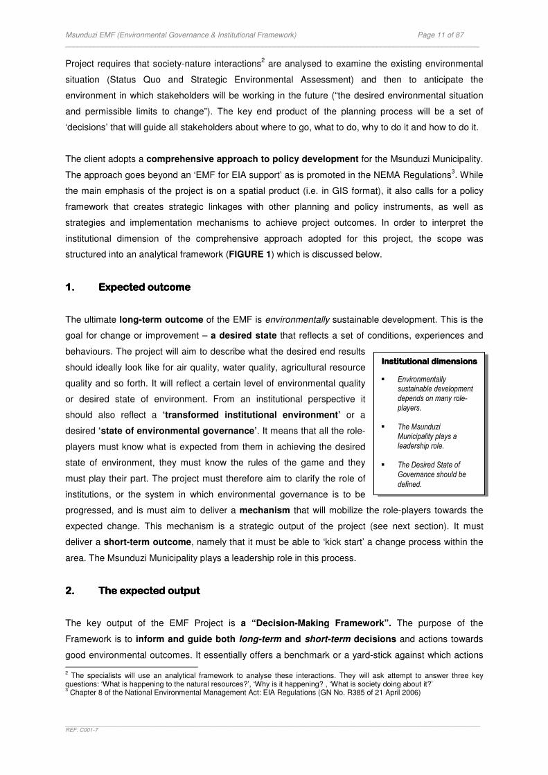
Msunduzi EMF (Environmental Governance & Institutional Framework) Page 11 of 87 _____________________________________________________________________________________________________
_______________________________________________________________________________________________________________________________________REF: C001-7
Project requires that society-nature interactions2 are analysed to examine the existing environmental
situation (Status Quo and Strategic Environmental Assessment) and then to anticipate the
environment in which stakeholders will be working in the future (“the desired environmental situation
and permissible limits to change”). The key end product of the planning process will be a set of
‘decisions’ that will guide all stakeholders about where to go, what to do, why to do it and how to do it.
The client adopts a comprehensive approach to policy development for the Msunduzi Municipality.
The approach goes beyond an ‘EMF for EIA support’ as is promoted in the NEMA Regulations3. While
the main emphasis of the project is on a spatial product (i.e. in GIS format), it also calls for a policy
framework that creates strategic linkages with other planning and policy instruments, as well as
strategies and implementation mechanisms to achieve project outcomes. In order to interpret the
institutional dimension of the comprehensive approach adopted for this project, the scope was
structured into an analytical framework (FIGURE 1) which is discussed below.
1.1.1.1. Expected outcomeExpected outcomeExpected outcomeExpected outcome
The ultimate long-term outcome of the EMF is environmentally sustainable development. This is the
goal for change or improvement – a desired state that reflects a set of conditions, experiences and
behaviours. The project will aim to describe what the desired end results
should ideally look like for air quality, water quality, agricultural resource
quality and so forth. It will reflect a certain level of environmental quality
or desired state of environment. From an institutional perspective it
should also reflect a ‘transformed institutional environment’ or a
desired ‘state of environmental governance’. It means that all the role-
players must know what is expected from them in achieving the desired
state of environment, they must know the rules of the game and they
must play their part. The project must therefore aim to clarify the role of
institutions, or the system in which environmental governance is to be
progressed, and is must aim to deliver a mechanism that will mobilize the role-players towards the
expected change. This mechanism is a strategic output of the project (see next section). It must
deliver a short-term outcome, namely that it must be able to ‘kick start’ a change process within the
area. The Msunduzi Municipality plays a leadership role in this process.
2.2.2.2. The expected outputThe expected outputThe expected outputThe expected output
The key output of the EMF Project is a “Decision-Making Framework”. The purpose of the
Framework is to inform and guide both long-term and short-term decisions and actions towards
good environmental outcomes. It essentially offers a benchmark or a yard-stick against which actions
2 The specialists will use an analytical framework to analyse these interactions. They will ask attempt to answer three key
questions: ‘What is happening to the natural resources?’, ‘Why is it happening? , ‘What is society doing about it?’ 3 Chapter 8 of the National Environmental Management Act: EIA Regulations (GN No. R385 of 21 April 2006)
Institutional dimensions Institutional dimensions Institutional dimensions Institutional dimensions
� Environmentally sustainable development depends on many role-players.
� The Msunduzi
Municipality plays a leadership role.
� The Desired State of
Governance should be
defined.
Msunduzi EMF (Environmental Governance & Institutional Framework) Page 12 of 87 _____________________________________________________________________________________________________
_______________________________________________________________________________________________________________________________________REF: C001-7
and decisions can be evaluated. Because the Framework is concerned about the existing and the
future environmental situation in the area it must be able to influence a wide variety of everyday
decisions whilst thinking about the future, for example:
� It must influence decisions about current-day projects on specific parcels of land (e.g. EIA
applications).
� It must be able to influence decisions about future plans for the area (e.g. sector plans for
housing).
� It must be able to facilitate corrective action where development is placing excessive pressure on
a natural resource (e.g. rehabilitating an area to improve water quality).
In its broadest sense the project should provide a ‘plan’ to help all
stakeholders to work towards the same goals. However, the plan’ should
not only guide stakeholders on a project level, it should also guide them
strategically, assisting role-players to make the environment part of their
mandates and operations before they engage in socio-economic activities. It
therefore creates a ‘bigger picture’ that reinforces every-day decision-making and offering role-players
a strategic opportunity to contribute to the environmental goals for the Msunduzi Municipality.
Developing a Decision-Making Framework that is able to influence the kind of decisions mentioned
above requires strategic and operational management and a wide variety of tools which can help and
improve the management process. It is supported by spatial and non-spatial components
2.12.12.12.1 Strategic Strategic Strategic Strategic FrameworkFrameworkFrameworkFramework
The Framework emphasizes the ‘top-down’ business of the Municipality – that it has the duty to
translate government’s broader policy framework for environmental management and sustainable
development for their area.
The development of the Strategic Framework follows an iterative cycle with four distinct phases,
namely policy and objective setting, planning, implementation and
review. The Framework provides context for the future management
of the area and underlines the notion that all role-players within the
Msunduzi area must act within the Framework.
The key task of the Framework is to deliver a strategic agenda for
the Msunduzi area and its ultimate aim is to influence and guide all
socio-economic activities and management of all institutions in the
area. The strategic nature of the agenda implies that it is involved
with the ‘big picture’ of the area. It brings all the aspects that relate to environmentally sustainable
Institutional dimensions Institutional dimensions Institutional dimensions Institutional dimensions
� Creating institutional capacity in the Msunduzi Municipality to manage the framework.
� All role-players in the Msunduzi
area must act within the framework.
� A Strategic Agenda for
environmental governance
Institutional dimensions Institutional dimensions Institutional dimensions Institutional dimensions
Guidelines to promote institutional development for
good environmental
governance
Msunduzi EMF (Environmental Governance & Institutional Framework) Page 13 of 87 _____________________________________________________________________________________________________
_______________________________________________________________________________________________________________________________________REF: C001-7
development together and it has the task to improve the environment and the quality of life. It is
concerned about developing long-term environmental goals and objectives, the implementation of
strategies, measuring performance as well as monitoring trends and identifying emerging issues
that might require strategic responses.
The Framework depends on good quality information that is available to all role-players whose
behavior is to be changed. The planning process therefore analyses the environmental complexities
of the area and uses it as a baseline for planning the desired direction that all role-players should
follow. It identifies sustainability goals and objectives, as well as broad strategies to achieve the
desired state of environment in the area.
To complete the management task, the Framework also attends to evaluation and control through
continuous improvement. A Monitoring & Evaluation System supports policy implementation. This
system monitors environmental quality and institutional performance and constantly seeks the
best tools and strategies to improve the management of the environment.
2.22.22.22.2 Operational Operational Operational Operational FrameworkFrameworkFrameworkFramework
In order to operationalise the goals and strategies from the Strategic Framework it is necessary to
develop detailed implementation strategies that will influence the actions and decisions of role-
players in the Msunduzi area. Detailed strategies include
management constraints, specific guidelines, methods, procedures
and practices to direct role-players towards the desired state of
environment. They guide day-to-day activities and procedures for
managing the environment while ensuring that development activities contribute to the strategic
environmental agenda. They also aim to promote coordination and consistency in managing the
environment in the area.
There is a constant exchange of information between the Strategic Framework and the Operational
Framework. The Monitoring & Evaluation System constantly identifies emerging issues and develops
new strategic responses and strategies. This in turn may influence the detail of implementation
strategies.
The Operational Framework of the EMF, which is linked with visual images in the Spatial Framework,
is essentially the management tool that will inform role-players where they should go, what they
should do, why they should do it and how they should do it.
Institutional dimensions Institutional dimensions Institutional dimensions Institutional dimensions
Detailed implementation strategies for improving governance
Msunduzi EMF (Environmental Governance & Institutional Framework) Page 14 of 87 _____________________________________________________________________________________________________
_______________________________________________________________________________________________________________________________________REF: C001-7
2.32.32.32.3 Spatial FrameworkSpatial FrameworkSpatial FrameworkSpatial Framework
The result of the strategic planning process is illustrated spatially. A user-friendly interactive
management tool is developed to illustrate the current environmental situation in the area. It may for
example illustrate ‘environmental hotspots’ - sensitive areas that
needs to be protected from development or areas of severe
degradation or with high pollution risk - or it may illustrate areas
where development is encouraged or discouraged.
The visual images of the area are linked to the strategic agenda (the goals and strategies that
originates from the Strategic Framework) and to the detailed strategies (the management
constraints, guidelines, methods, procedures and practices that originate from the Operational
Framework) and it informs role-players how best to carry out spatial development choices and actions.
There is a constant exchange of information between the Spatial Framework and the non-spatial
components (the Strategic and Operational Frameworks). The Monitoring & Evaluation System will
detect changes in the environmental quality of the area that may require adaptive management. The
spatial attributes will then be updated to reflect new priorities and strategies to inform the actions and
decisions of role-players.
1.3.2 Implications
The implications of the comprehensive approach that has been adopted in the EMF Project for the
governance and institutional study of the project are further investigated below:
‘‘‘‘A transformed institutional environmentA transformed institutional environmentA transformed institutional environmentA transformed institutional environment’’’’
The study must place a strong focus on role-players, their specific roles
and responsibilities, how they interact with each other and how they
interact with the environment. Each role-player within the area must know
what is expected from them in achieving the desired state of environment.
They must know the ‘rules of the game’ and they must play their part.
The study must clarify the institutional system in which environmental
governance is to be progressed as it provides the ‘rules of the game’ and
inform role-players how they should organise themselves for change.
Institutional dimensions Institutional dimensions Institutional dimensions Institutional dimensions
‘Environmental hotspots’ as priorities
for improving governance.
The EGI FrameworkThe EGI FrameworkThe EGI FrameworkThe EGI Framework
Identify the role-players in the Msunduzi Municipality, their
specific roles and
responsibilities
The EGI FrameworkThe EGI FrameworkThe EGI FrameworkThe EGI Framework
Interpret the institutional landscape that promote good
environmental governance
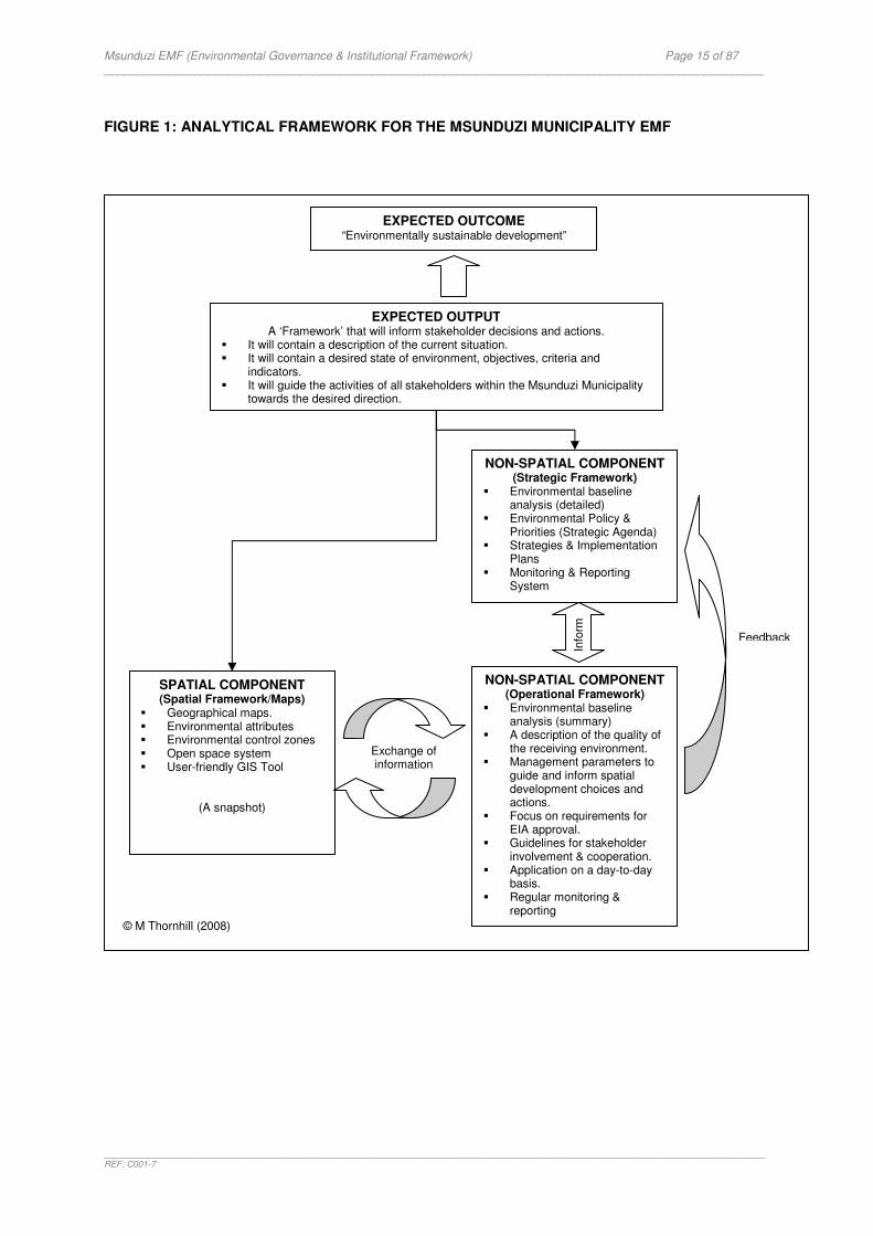
Msunduzi EMF (Environmental Governance & Institutional Framework) Page 15 of 87 _____________________________________________________________________________________________________
_______________________________________________________________________________________________________________________________________REF: C001-7
FIGURE 1: ANALYTICAL FRAMEWORK FOR THE MSUNDUZI MUNICIPALITY EMF
EXPECTED OUTPUT A ‘Framework’ that will inform stakeholder decisions and actions.
� It will contain a description of the current situation. � It will contain a desired state of environment, objectives, criteria and
indicators. � It will guide the activities of all stakeholders within the Msunduzi Municipality
towards the desired direction.
SPATIAL COMPONENT (Spatial Framework/Maps)
� Geographical maps. � Environmental attributes � Environmental control zones � Open space system � User-friendly GIS Tool
(A snapshot)
NON-SPATIAL COMPONENT (Operational Framework)
� Environmental baseline analysis (summary)
� A description of the quality of the receiving environment.
� Management parameters to guide and inform spatial development choices and actions.
� Focus on requirements for EIA approval.
� Guidelines for stakeholder involvement & cooperation.
� Application on a day-to-day basis.
� Regular monitoring & reporting
NON-SPATIAL COMPONENT (Strategic Framework)
� Environmental baseline analysis (detailed)
� Environmental Policy & Priorities (Strategic Agenda)
� Strategies & Implementation Plans
� Monitoring & Reporting System
Exchange of information
Info
rm
EXPECTED OUTCOME “Environmentally sustainable development”
Feedback
© M Thornhill (2008)
Msunduzi EMF (Environmental Governance & Institutional Framework) Page 16 of 87 _____________________________________________________________________________________________________
_______________________________________________________________________________________________________________________________________REF: C001-7
‘A Strategic AgendaA Strategic AgendaA Strategic AgendaA Strategic Agenda’’’’
The study must create a mechanism that will mobilize the role-players towards the expected change.
Such a mechanism needs to deliver a strategic agenda that will influence role-players and the
institutional landscape. The strategic agenda must interpret
government’s policy framework for environmental governance. It must
provide direction and focus role-players on how and why they are part
of the area’s sustainable future. It must set goals, objectives, strategies
and monitoring mechanisms for environmental governance.
To develop a strategic agenda the study must ideally analyse the existing environmental
governance and institutional capacity of the area. This analysis may be influenced by the following
key questions:
� How do role-players currently interact with each other in respect of environmental matters?
� How do they interact with the demands that the environment is
placing on them?
� What actions are taken by the stakeholders to ease or prevent
negative environmental impacts, correct environmental damage or
conserve natural resources?
� What are the key topics of concern (key issues) in environmental governance?
The existing situation should be used as a basis for developing a desired state of environmental
governance. By focusing on critical environmental problems in the area, the following key questions
may influence planning:
� How should role-players respond strategically to environmental
demands?
� How should they interact with each other?
� What are the environmental governance priorities?
‘‘‘‘ImplementationImplementationImplementationImplementation strategies strategies strategies strategies’’’’
The study should ideally develop strategies to achieve the desired state of environmental
governance. The complexity of the institutional environment makes this
a challenging task. In theory the expectation is that all role-players in the
Msunduzi area will be committed to implement governance strategies
and organise themselves to achieve environmental goals. This is
unfortunately an ideal that is difficult to achieve and control in reality.
The project should nevertheless attempt to develop a broad strategy to influence the direction of role-
The EGI FrameworkThe EGI FrameworkThe EGI FrameworkThe EGI Framework
Develop a strategic agenda for environmental governance in
the Msunduzi Municipality.
The EGI FrameworkThe EGI FrameworkThe EGI FrameworkThe EGI Framework
Analyse the existing governance and institutional
situation in the Msunduzi
Municipality
The EGI FrameworkThe EGI FrameworkThe EGI FrameworkThe EGI Framework
Develop a desired governance and institutional situation for the
Msunduzi Municipality
The EGI FrameworkThe EGI FrameworkThe EGI FrameworkThe EGI Framework
Develop a broad strategy to influence the behaviour of all role-players in the Msunduzi
Municipality

Msunduzi EMF (Environmental Governance & Institutional Framework) Page 17 of 87 _____________________________________________________________________________________________________
_______________________________________________________________________________________________________________________________________REF: C001-7
players on the basis of ethical behaviour and good environmental governance. Such a strategy should
emphasise information management and education and awareness as strategic priorities.
The EMF will develop detailed implementation strategies for specific areas or zones. Their aim is to
inform role-players of the parameters within which they should plan their
day-to-day activities. The parameters will be informed by institutional
guidelines (e.g. legal targets or standards for environmental quality) or
institutional procedures to be followed (e.g. EIA requirements). It may
also be influenced by the area’s institutional context (e.g. by identifying
key stakeholder groups that need to be consulted). The function of these parameters is to guide role-
players towards the desired state of environment. From an institutional perspective it means that role-
players should not only be guided on what to do but also how to make it happen most effectively.
The complexity of the institutional dimension of sustainable development reiterates the important role
of the EMF as an institutional instrument for the Msunduzi Municipality.
The Municipality must demonstrate their own commitment to the
strategic agenda and they have a facilitator’s role to play. The study
should therefore prioritise ways of creating institutional capacity
within the Municipality and develop a long-term plan in which
strategies, resources and target dates are laid out.
‘‘‘‘Monitoring and EvaluationMonitoring and EvaluationMonitoring and EvaluationMonitoring and Evaluation’’’’
The effect of implementing strategies can be monitored directly by measuring changes in the physical
or biological state of the environment. However this does not reveal any information on the critical
issues that have a significant impact on the environment namely the pressures from human activities
that causes environmental change. It also does not reveal how society
is responding to environmental problems. While state of environment
reporting uses a model that aims to draw these society-nature linkages
it remains difficult to establish a clear link between the state of
environment and the state of governance. For this reason the study
should aim to elaborate on ways to improve environmental accountability by identifying key
performance areas and/or measures of governance.
‘Defining the EMF’‘Defining the EMF’‘Defining the EMF’‘Defining the EMF’
The discussion above clearly indicates that the term ‘EMF’ in the context of this Project is a collective
term that includes the following meaning:
The EGI FrameworkThe EGI FrameworkThe EGI FrameworkThe EGI Framework
Develop a framework to promote monitoring of
environmental governance
The EGI FrameworkThe EGI FrameworkThe EGI FrameworkThe EGI Framework
Develop detailed implementation strategies to promote good environmental
governance.
The EGI FrameworkThe EGI FrameworkThe EGI FrameworkThe EGI Framework
Develop an implementation plan to create institutional capacity in the Msunduzi
Municipality

Msunduzi EMF (Environmental Governance & Institutional Framework) Page 18 of 87 _____________________________________________________________________________________________________
_______________________________________________________________________________________________________________________________________REF: C001-7
The Msunduzi Municipality EMF is a strategic environmental plan containing a long-term strategy as
well as detailed implementation strategies for managing the area’s environment. It contains a spatial
component and a monitoring and evaluation system to support policy implementation.
1.3.3 Approach and Methodology
The comprehensive approach adopted for this project has significant implications for addressing the
institutional dimension of the EMF. It is clearly evident that the responsibility for managing the
Msunduzi Municipality’s environment is a collective responsibility. It is also clear that the
achievement of a desired state of environment will require a change in the institutional
environment.
Assessing the governance and institutional dimension of the project would essentially require a strong
focus on the prevailing ‘system of environmental governance’ in the area. This system consists of
many role-players and their sub-systems. These sub-systems interact with each other and with the
environment and influence the quality of the area’s resources and development outcomes. Planning
the future of the Msunduzi Municipality requires an understanding of how this system currently
functions. In other words we need to understand the existing state of environmental governance if
the EMF must plan for a future state of governance. This represents an ideal scope of work. The
complexity of such a task is compounded by the fact that a framework or system for monitoring
environmental governance currently does not exist in South Africa.
The Project Terms of Reference requires a focus on the Msunduzi Local Municipality who
ultimately would be responsible for further development and management of the EMF. An
understanding of the Municipality’s existing capacity would therefore be fruitful in planning their future
capacity requirements. This would require a traditional ‘bottom-up’ approach to institutional
assessment that analyzes the Municipality’s organisational structure, capacities and obstacles
preventing the desired outcomes. This option was not supported by the budget realities of the Project.
The EGI Framework opted to make use of a ‘top-down’ approach to institutional assessment that
allows for performance assessment against allocated tasks (Spangenberg, 2002). This approach is an
appropriate first step for solving institutional problems strategically and it offers the following benefits:
� It accommodates the dynamics of the ‘new’ institutional system created by South Africa,
specifically as regards to the many role-players involved in environmental governance.
� It allows for the identification of key institutional aspects (key tasks) that would inform role-players
what their roles and responsibilities would be in the Msunduzi Municipality.
� It will allow for the development of a benchmark against which effectiveness could be assessed in
the future.
� The benchmark could be used to collect issues of governance during the SEA process.
Msunduzi EMF (Environmental Governance & Institutional Framework) Page 19 of 87 _____________________________________________________________________________________________________
_______________________________________________________________________________________________________________________________________REF: C001-7
� It will position the Municipality as one of many role-players in environmental governance and not
place unnecessary demands on their capacity.
The scope, approach and methodology for the governance and institutional study of the EMF were
therefore refined to include the following:
The aim of the study is to provide a ‘point of reference’ for the governance and institutional dimension of the EMF Project. The key output is an Environmental Governance and Institutional Framework (EGI Framework) that will focus on the desired state of environmental governance.
The Study Goals are:
1. To identify aspects of the landscape within which environmental governance
plays out while maintaining a close focus on the Msunduzi Municipality and the EMF as an institutional instrument to achieve good environmental governance.
2. To create a benchmark to guide further analysis of the institutional
environment in the Msunduzi area. It should be able to support the development of a strategic agenda for environmental governance in the Msunduzi Municipality and inform the development of objectives, criteria, indicators and guidelines for the Strategic Environmental Management Plan.
The point of departure of the EGI Framework was to make the governance concept more tangible by
identifying the basic building blocks for environmental governance. The Trialogue Model (Turton et
al 2005) was used to create three pillars to support the development of a benchmark for measuring
the “state of environmental governance”.
The benchmark was created as follows:
� Identification of key institutional aspects and institutional settings from the framework
legislation and selected sectoral legislation relevant to the study.
� The focus was on identifying role-players and the key tasks they will have to perform in
contributing to environmental governance through the EMF as the key instrument.
� The institutional elements (legal guidelines or requirements) were interpreted as the desired
levels of governance and they represent the legal thresholds for environmental governance. In
other words they offer the limits below which environmental governance would not be able to
function as intended.
� The desired levels of governance represent targets or desired states. This will allow role-players
to ‘plan with the end in mind’ (i.e. the outcome) and it will allow for monitoring progress towards
the desired future.
� The benchmark also considered the desired levels of governance to measure the effectiveness
of the EMF as an institution for achieving environmental governance by analysing its key tasks
and its relationship with decision-making processes.
Msunduzi EMF (Environmental Governance & Institutional Framework) Page 20 of 87 _____________________________________________________________________________________________________
_______________________________________________________________________________________________________________________________________REF: C001-7
The benchmark will allow for the following:
� It will enable further analysis of environmental governance in the Msunduzi Municipality.
� It will guide further interpretation of the specialist studies specifically with respect to the
identification of key role-players and responses required.
� It will enable the development of a desired state of governance to achieve the desired state of
environment
� It will enable the development of realistic measurements for implementing the EMF.
� It will allow role-players to focus their scarce resources on the making the EMF an effective
instrument for achieving environmental goals.
While the scope of the project did not provide for an institutional assessment of the Msunduzi Local
Municipality an effort was nevertheless made to provide some observations on the state of
environmental governance in the Municipality so as to demonstrate how the benchmark could be
applied in practice.
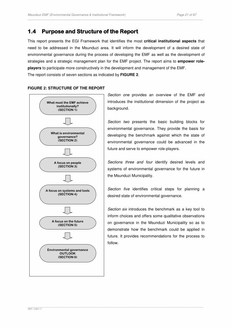
Msunduzi EMF (Environmental Governance & Institutional Framework) Page 21 of 87 _____________________________________________________________________________________________________
_______________________________________________________________________________________________________________________________________REF: C001-7
1.41.41.41.4 PuPuPuPurpose rpose rpose rpose and and and and SSSStructure tructure tructure tructure of thof thof thof theeee RRRReporteporteporteport
This report presents the EGI Framework that identifies the most critical institutional aspects that
need to be addressed in the Msunduzi area. It will inform the development of a desired state of
environmental governance during the process of developing the EMF as well as the development of
strategies and a strategic management plan for the EMF project. The report aims to empower role-
players to participate more constructively in the development and management of the EMF.
The report consists of seven sections as indicated by FIGURE 2.
FIGURE 2: STRUCTURE OF THE REPORT
Section one provides an overview of the EMF and
introduces the institutional dimension of the project as
background.
Section two presents the basic building blocks for
environmental governance. They provide the basis for
developing the benchmark against which the state of
environmental governance could be advanced in the
future and serve to empower role-players.
Sections three and four identify desired levels and
systems of environmental governance for the future in
the Msunduzi Municipality.
Section five identifies critical steps for planning a
desired state of environmental governance.
Section six introduces the benchmark as a key tool to
inform choices and offers some qualitative observations
on governance in the Msunduzi Municipality so as to
demonstrate how the benchmark could be applied in
future. It provides recommendations for the process to
follow.
Environmental governance OUTLOOK (SECTION 6)
A focus on systems and tools (SECTION 4)
A focus on people (SECTION 3)
What is environmental governance? (SECTION 2)
What must the EMF achieve institutionally? (SECTION 1)
A focus on the future (SECTION 5)

Msunduzi EMF (Environmental Governance & Institutional Framework) Page 22 of 87 _____________________________________________________________________________________________________
_______________________________________________________________________________________________________________________________________REF: C001-7
SECTION SECTION SECTION SECTION 2222: : : : ENVIRONMENTAL ENVIRONMENTAL ENVIRONMENTAL ENVIRONMENTAL GOVERNANCEGOVERNANCEGOVERNANCEGOVERNANCE
The previous section provided an overview of the EMF and introduced the institutional dimension of
the project. It explained why the EMF project demands a strong focus on role-players, their respective
roles and responsibilities, how they should interact with each other and with the environment. It also
pointed to the need for developing strategies for achieving good environmental governance. This
section clarifies the meaning of environmental governance and the institutional landscape in
order to create a common understanding of the basic building blocks that drives interaction and
environmental decision-making.
2.12.12.12.1 IntroductionIntroductionIntroductionIntroduction
Environmental governance is essentially about making decisions and about who makes decisions. It
is a process of accommodating conflicting interests and taking cooperative actions. The process
requires a structured approach to collective action and management for good environmental
outcomes. The process is guided by specific rules and it continuously searches for the best institutions
and institutional arrangements, instruments and tools to facilitate decision-making and the
implementation of decisions that protects people and the natural environment. Governance is often
used to refer to how those who have been entrusted with power use it
The institutional environment refers to the system in which sustainable development is to be
progressed. It includes inter alia the following:
� The formal and informal rules that permit, prescribe and prohibit certain actions and resolve
conflicts and disputes.
� The processes within which development is structured, for example procedures that set
parameters for defining problems as well as for developing and implementing decisions.
� Institutional capacity that operationalize development (for example organisations and their
systems).
� Institutional arrangements that structure the way people interact and take part in development.
Environmental governance is an ideal which is difficult to achieve in its totality. The actions that must
be taken to work towards this ideal should take cognisance of the nature and style of our man-made
management systems, specifically the principles associated with democracy such as participation,
rule of law, transparency, responsiveness, equity and inclusiveness, effectiveness and efficiency.
Accountability as an important consideration in ‘the way we govern’ is also an essential component of
‘good governance’ especially as decisions or actions may negatively affect the natural environment
and people’s health.
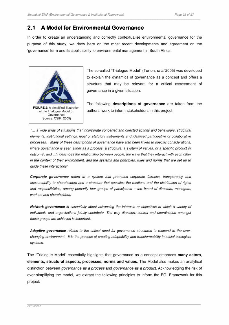
Msunduzi EMF (Environmental Governance & Institutional Framework) Page 23 of 87 _____________________________________________________________________________________________________
_______________________________________________________________________________________________________________________________________REF: C001-7
2.12.12.12.1 A Model for EnvironmeA Model for EnvironmeA Model for EnvironmeA Model for Environmental Governancental Governancental Governancental Governance
In order to create an understanding and correctly contextualise environmental governance for the
purpose of this study, we draw here on the most recent developments and agreement on the
‘governance’ term and its applicability to environmental management in South Africa.
The so-called “Trialogue Model” (Turton, et al 2005) was developed
to explain the dynamics of governance as a concept and offers a
structure that may be relevant for a critical assessment of
governance in a given situation.
The following descriptions of governance are taken from the
authors’ work to inform stakeholders in this project:
‘… a wide array of situations that incorporate concerted and directed actions and behaviours, structural
elements, institutional settings, legal or statutory instruments and idealized participative or collaborative
processes. Many of these descriptions of governance have also been linked to specific considerations,
where governance is seen either as a process, a structure, a system of values, or a specific product or
outcome’, and ...’it describes the relationship between people, the ways that they interact with each other
in the context of their environment, and the systems and principles, rules and norms that are set up to
guide these interactions’
Corporate governance refers to a system that promotes corporate fairness, transparency and
accountability to shareholders and a structure that specifies the relations and the distribution of rights
and responsibilities, among primarily four groups of participants – the board of directors, managers,
workers and shareholders.
Network governance is essentially about advancing the interests or objectives to which a variety of
individuals and organisations jointly contribute. The way direction, control and coordination amongst
these groups are achieved is important.
Adaptive governance relates to the critical need for governance structures to respond to the ever-
changing environment. It is the process of creating adaptability and transformability in social-ecological
systems.
The “Trialogue Model” essentially highlights that governance as a concept embraces many actors,
elements, structural aspects, processes, norms and values. The Model also makes an analytical
distinction between governance as a process and governance as a product. Acknowledging the risk of
over-simplifying the model, we extract the following principles to inform the EGI Framework for this
project:
FIGURE 2: A simplified illustration
of the Trialogue Model of Governance
(Source: CSIR, 2005)

Msunduzi EMF (Environmental Governance & Institutional Framework) Page 24 of 87 _____________________________________________________________________________________________________
_______________________________________________________________________________________________________________________________________REF: C001-7
‘‘‘‘Actors of governanceActors of governanceActors of governanceActors of governance’’’’
Three groups of actors – government, society and science – are involved in decision-making. They
are equally important within a given society. All three actors have to engage constructively to achieve
good governance.
Each one of the actors has a specific role and responsibility, as well as a specific relationship
with each other. Each actor is connected by means of a two-way interface. There are three
interfaces:
� Government/Society
� Government/Science
� Science/Society
Each one of the actors has the responsibility to ‘organise’ themselves in order to interact
constructively with the other actors in the governance ‘trialogue’. The
relationship between the actors is based on communication and feedback
loops.
In essence the Model explains that the process of governance functions
where the actors ‘meet’. It also explains that the quality of their
interactions plays a role in the product of governance, for instance how well their conflicting interests
are accommodated and how well they are cooperating.
‘‘‘‘Governance structure and Governance structure and Governance structure and Governance structure and processprocessprocessprocess’’’’
The process of governance is driven by structural and process aspects.
Structural aspects are mechanisms, processes and institutions that are
contained in the country’s institutional framework. They can be formal
(laws and regulations) or informal (diverse norms and values, some of
which exist merely as perceptions in society) and they influence
interaction between the various actors. They also influence interactions
between society as a whole and nature.
Process aspects are the management systems or the instruments that
create an enabling environment for interaction. Management systems
ideally support the process of governance by ensuring that all the actors
have an equal opportunity to articulate their needs and fulfil their roles
and responsibilities. This leads to constructive engagement and to good governance.
Desired situationDesired situationDesired situationDesired situation
Environmental decision-making in the Msunduzi area always involves role-players from government, society and
science sectors.
Desired situationDesired situationDesired situationDesired situation
The Msunduzi Municipality has created an enabling
environment for ongoing dialogue between all role-
players
Desired situationDesired situationDesired situationDesired situation
Each role-player has organised’ themselves for good
environmental governance
Msunduzi EMF (Environmental Governance & Institutional Framework) Page 25 of 87 _____________________________________________________________________________________________________
_______________________________________________________________________________________________________________________________________REF: C001-7
The structural aspects and process elements are key drivers of governance. The Model explains
how government, for example, has the responsibility for creating the structure and the enabling
environment for constructive interaction to take place. They have to direct and enable science to
develop solutions to increasingly complex problems, and should base policy formulation on the
articulated needs of society.
The structure and process of governance should allow for “good”
interaction between the actors. Interaction allows for ‘interests to be
articulated, legal rights to be exercises, legal obligations to be
discharged, and potential disputes to be mediated’.
‘‘‘‘Product of governanceProduct of governanceProduct of governanceProduct of governance’’’’
The product of governance or the conditions arising from the interactions is not so easy to define, yet it
is critical for this discussion. The end product may be described by qualitative statements such as
‘effective’ (or ineffective) or ‘good’ (poor).
Defining the product and quality of governance is complex and will depend to a great extent on the
context within which it is applied as it will define the priorities for action.
The product of governance could refer to the quality of the process, in other words a process that is
characterised by a) constructive interaction (all the actors are engaging), b) information exchange
for informed decision-making and c) reaching consensus whilst d) respecting the law and people’s
rights.
The multi-faceted nature of the governance concept also means that the quality of governance may be
influenced by how structural aspects, institutional arrangements, individual actor performance,
management systems and so forth interact with each other. The effectiveness of governance
arrangements might also depend on the effectives of the wide network of organisations in which a
particular organisation operates. The product of governance is therefore probably the sum of
performance of all the aspects of governance and it would be difficult to measure the effectiveness of
governance arrangements at one point or at one scale.
The product of governance is important because it shapes outcomes.
Weaknesses in governance may lead to poor environmental outcomes or
environmental degradation which is not acceptable or beneficial for
humans and the natural environment, now and in the future. The actors
should play ‘a collective game’ to shape environmental outcomes that
does not compromise the socio-economic rights of society.
Desired situationDesired situationDesired situationDesired situation
Each role-player understands and fulfills their responsibilities
in the governance process.
Desired situationDesired situationDesired situationDesired situation
There is agreement that each role-player is contributing to
good environmental outcomes

Msunduzi EMF (Environmental Governance & Institutional Framework) Page 26 of 87 _____________________________________________________________________________________________________
_______________________________________________________________________________________________________________________________________REF: C001-7
2.32.32.32.3 Application Application Application Application
The value of the Trialogue Model lies in its ability to make governance a more tangible part of the EMF
and it creates a basis upon which the institutional dimension of the project can be placed.
The Trialogue Model essentially offers three pillars (FIGURE 3) which constitutes the basic building
blocks for the EGI Framework. These pillars create the focus for developing a benchmark for
measuring the future ‘state of environmental governance’ in the Msunduzi Municipality. The
benchmark will consist of key institutional aspects (legal thresholds). Context-specific concerns (critical
issues and priorities) will refined the application of the benchmark.
FIGURE 3: THE BUILDING BLOCKS FOR THE MSUNDUZI MUNICIPALITY EMF
The next sections aim to develop the benchmark for environmental governance in the Msunduzi area.
It focuses on the key role of the EMF as the instrument to promote environmental governance.
PILLAR 1PILLAR 1PILLAR 1PILLAR 1
A focus on peopleA focus on peopleA focus on peopleA focus on people
DESIRED SITUATION
Environmental decision-making in the Msunduzi area always involves role-players from
government, society and science sectors.
� Each role-player
understands their role and responsibilities in the EMF.
� Role-players are
empowered and share information.
� Role-players have
opportunities to articulate their needs, exercise their rights, discharge their legal obligations and have
PILLAR 2PILLAR 2PILLAR 2PILLAR 2
A focus on systems & A focus on systems & A focus on systems & A focus on systems & toolstoolstoolstools
DESIRED SITUATION
Government has created an enabling environment for ongoing dialogue between all role-players
and each role-player has ‘organised’ themselves for good
environmental governance � Government uses the EMF
as an instrument for generating process for interaction.
� The decision-making
process is supported by developing institutional capacity.
� Each role-player
demonstrates commitment to the process.
PILLARPILLARPILLARPILLAR 3333
A focus on the futureA focus on the futureA focus on the futureA focus on the future
DESIRED SITUATION
There is agreement that each role-player is contributing to a
sustainable future � Role-players have agreed
on a desired state of governance for the area.
� There is a yard-stick in
place to monitor environmental governance.
� Role-players engage in
adaptive policy-making
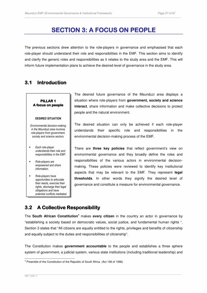
Msunduzi EMF (Environmental Governance & Institutional Framework) Page 27 of 87 _____________________________________________________________________________________________________
_______________________________________________________________________________________________________________________________________REF: C001-7
SECTION 3: A FOCUS ON PEOPLESECTION 3: A FOCUS ON PEOPLESECTION 3: A FOCUS ON PEOPLESECTION 3: A FOCUS ON PEOPLE
The previous sections drew attention to the role-players in governance and emphasised that each
role-player should understand their role and responsibilities in the EMF. This section aims to identify
and clarify the generic roles and responsibilities as it relates to the study area and the EMF. This will
inform future implementation plans to achieve the desired level of governance in the study area.
3.13.13.13.1 IntroductionIntroductionIntroductionIntroduction
The desired future governance of the Msunduzi area displays a
situation where role-players from government, society and science
interact, share information and make collective decisions to protect
people and the natural environment.
The desired situation can only be achieved if each role-player
understands their specific role and responsibilities in the
environmental decision-making process of the EMF.
There are three key policies that reflect government’s view on
environmental governance and they broadly define the roles and
responsibilities of the various actors in environmental decision-
making. These policies were reviewed to identify key institutional
aspects that may be relevant to the EMF. They represent legal
thresholds. In other words they signify the desired level of
governance and constitute a measure for environmental governance.
3.23.23.23.2 A A A A CCCCollective ollective ollective ollective RRRResponsibilityesponsibilityesponsibilityesponsibility
The South African Constitution4 makes every citizen in the country an actor in governance by
“establishing a society based on democratic values, social justice, and fundamental human rights “.
Section 3 states that “All citizens are equally entitled to the rights, privileges and benefits of citizenship
and equally subject to the duties and responsibilities of citizenship”.
The Constitution makes government accountable to the people and establishes a three sphere
system of government, a judicial system, various state institutions (including traditional leadership) and
4 Preamble of the Constitution of the Republic of South Africa (Act 108 of 1996)
PILLAR 1PILLAR 1PILLAR 1PILLAR 1
A focus on peopleA focus on peopleA focus on peopleA focus on people
DESIRED SITUATION
Environmental decision-making in the Msunduzi area involves role-players from government, society and science sectors.
� Each role-player
understands their role and responsibilities in the EMF.
� Role-players are
empowered and share information.
� Role-players have
opportunities to articulate their needs, exercise their rights, discharge their legal obligations and have potential conflicts mediated.
Msunduzi EMF (Environmental Governance & Institutional Framework) Page 28 of 87 _____________________________________________________________________________________________________
_______________________________________________________________________________________________________________________________________REF: C001-7
security services to support constitutional democracy. The functional roles and responsibilities of the
three spheres of government and its supporting institutions are spelled out in the Constitution.
The White Paper on Environmental Management Policy5 elaborates on the rights and
responsibilities of the various actors in environmental management and governance. The purpose of
the policy is to provide an overarching policy framework that sets the course for sustainable
development. The policy recognises the interdependent implementation of policy measures that
requires cooperation and commitment of all spheres of government and all sectors of society. The
policy highlights:
� The roles and responsibilities of national, provincial and local government in giving effect to the
constitutional environmental right.
� The role of society in sustainable development.
� The role science through research and development.
� The role of all actors in achieving an environmentally sustainable economy.
The National Environmental Management Act6 gives effect to policy by providing the structure in
which all the actors can organise themselves. As a framework for cooperative environmental
governance the Act confirms the role of government and the need for intergovernmental relations,
and the role of society in participating in environmental governance. The Act elaborates on the broad
roles and responsibilities and places emphasis on the need for information sharing in decision-making.
Specific subsidiary and sectoral policies and legislation fall within these overarching frameworks
and carry the detail roles of the various actors in everyday governance. They deal with individual
aspects of environmental management such as water resources, biodiversity, forestry, waste
management and air pollution. There are also environmental governance provisions in the majority of
the country’s socio-economic development policies and legislation as a result of the extensive law
reform process in South Africa since promulgation of its new Constitution in 1996. These policies and
laws will be identified throughout the EMF Project by the specialist studies and will inform the activities
of the role-players in the EMF.
The abovementioned policies form the basis for interpreting the generic roles and responsibilities and
they represent the desired level of environmental governance at the strategic level. The importance
of these legal guidelines is that they represent legal thresholds. In other words they offer the limit
below which environmental governance would not be able to function. These guidelines must inform
the detailed roles and responsibilities in the EMF.
5 The White Paper on Environmental Management Policy (1998)
6 The National Environmental Management Amendment Act (Act 8 of 2004)
Msunduzi EMF (Environmental Governance & Institutional Framework) Page 29 of 87 _____________________________________________________________________________________________________
_______________________________________________________________________________________________________________________________________REF: C001-7
3.3.3.3.3333 The The The The RRRRole of ole of ole of ole of GGGGovernmentovernmentovernmentovernment
In a democratic society it is the responsibility of the state to create the governance structures in which
role-players can find a space where they can articulate their interests.
‘A duty on all spheres of government’
The Constitution creates the essential structure for environment governance. It creates ‘one system
of government’ consisting of three spheres that are regarded as ‘distinctive, interrelated and
interdependent spheres of government’. The Bill of Rights, besides stipulating what South African
citizens are entitled to, is also an indication of the underscoring crucial values and goals which need to
be protected. It binds all, including the legislature, executive, judiciary and all organs of state.
Accordingly, a duty is placed on all three spheres of government to create “reasonable legislative and
other measures”7 in delivering the environmental right as contemplated by the Constitution. This duty
means that government as a whole is responsible for ensuring sustainable development and must
abide by the provisions contained in all relevant national, provincial and local environmental legislation
and policies. The Constitution also places a duty on government to cooperate on environmental
matters and introduces principles of cooperative government and intergovernmental relations.
They are expected to exercise their functions within the framework of intergovernmental relations (also
see section 4.3.2).
The National Environmental Management Act (1998) sets out the
relevant factors that must be considered in order to satisfy the
requirement of sustainable development. Because NEMA is framework
legislation it requires all organs of state to consider their activities
which may significantly affect the environment and to design measures
to minimise impacts. They will have to contribute to the Msunduzi
Municipality’s environmental situation through the EMF.
The Constitution and the NEMA provides the overall framework and
philosophy of sustainable development and it is up to all three spheres
of government to give effect to this by balancing environmental issues
against social and economic considerations.
The Msunduzi Municipality EMF offers a strategic opportunity for every
organ of state to give effect to their environmental duty. The EMF should
therefore aim to identify those organs of state that may have a significant contribution to the
environmental situation in the area.
7 Section 24 (b) of the Bill of Rights, Constitution (1996)
Desired level of Desired level of Desired level of Desired level of governancegovernancegovernancegovernance
Every organ of state understands their role in
environmental governance and they are discharging their legal
obligations in the Msunduzi
Municipality.
Desired level of Desired level of Desired level of Desired level of governancegovernancegovernancegovernance
The EMF identifies those organs of state that may have a significant contribution to make
in the Msunduzi Municipality.

Msunduzi EMF (Environmental Governance & Institutional Framework) Page 30 of 87 _____________________________________________________________________________________________________
_______________________________________________________________________________________________________________________________________REF: C001-7
‘Fragmentation’
The Constitution sets out the legislative and executive authorities and functional areas of competence
of the difference spheres of government. An analysis of these provisions (specifically Schedules 4 and
5) shows numerous environment related functions that are assigned to more than one sphere of
government (e.g. to both national and provincial). These functions are also exercised by different
government agencies. This fragmentation of environmental functions throughout government
institutions, departments and other organs of state have lead to some
confusion and duplication of functions resulting in the need for
government to coordinate their activities and to promote consistency
in the implementation of their functions. Accordingly government has
created specific legal provisions within which they can organise
themselves to achieve coordination and consistency thereby contributing
to good environmental governance. Chapter three of NEMA is an
example of procedures and instruments that are available for addressing the fragmentation of
environmental functions through a system of Environmental Implementation and Management Plans.
The Intergovernmental Relations Framework Act (2005) further provides measures to strengthen
coordination and consistency amongst organs of state (also see section 4.3.2).
‘A lead agent’
Government has appointed the National Department of Environmental Affairs & Tourism (DEAT)
as lead agent to address the challenges of fragmentation and for ensuring the integrated and
coordinated implementation of environmental management in South Africa. They are supported by
provincial environmental authorities who operate within the national framework.
Addressing specific environmental problems in the Msunduzi
Municipality may require coordination and cooperation between different
spheres and departments. The EMF should ideally identify these needs
and the actions required by the specific government departments. The
DEAT and their provincial counterpart, the KwaZulu-Natal Department
of Agriculture and Environmental Affairs (DAEA), would need to
work hand-in-hand to address issues of coordination and cooperation.
‘Supporting local government’
The constitutional arrangements demands that each sphere of government operate effectively and
efficiently without encroachment by another sphere of government. Their independence is respected
and they have equal status. The final responsibility for the well-being of all inhabitants of South Africa
nevertheless rest with national government and they are required to supervise the provincial
Desired level of Desired level of Desired level of Desired level of governancegovernancegovernancegovernance
Government uses the EMF to addresses the fragmented nature of environmental functions and there is
coordination and consistency.
Desired level of Desired level of Desired level of Desired level of governancegovernancegovernancegovernance
DEAT and the provincial environmental authority provide
leadership for environmental coordination and consistency in
the Msunduzi area.
Msunduzi EMF (Environmental Governance & Institutional Framework) Page 31 of 87 _____________________________________________________________________________________________________
_______________________________________________________________________________________________________________________________________REF: C001-7
administration and to intervene if necessary8. The same applies for provincial supervision of local
government9. Provinces must therefore monitor the actions of municipalities and act on behalf of the
inhabitants of the province to ensure that there is efficient and effective service delivery by
municipalities and that they fulfil their obligations. The Provincial Integrated Development Planning
Forum and the annual review process instituted by the KwaZulu-Natal Department of Local
Government and Traditional Affairs is an example of provincial oversight of municipalities.
Intervening in the affairs of another sphere of government could be seen to show inability to govern
effectively and is therefore not preferred. This in effect places demands on national and provincial
government to provide maximum support to local government to ensure that society will receive the
quality and quantity of service to which it is entitled.
There are three points of importance at this point:
1) There are national and provincial government departments that exercise functions involving
the management of the environment. The roles and responsibilities of these departments are
captured in a variety of sectoral policies and legislation (e.g. on water, forests and biodiversity). These
departments will play a critical role in the EMF. They have the task to support the Msunduzi
Municipality in achieving environmental quality by carrying out their detailed roles and responsibilities
in terms of environmental management. National departments include the Departments of Water
Affairs and Forestry, and Environmental Affairs and Tourism. On a
provincial level the Department of Agriculture and Environmental Affairs
(DAEA) and Ezemvelo KwaZulu-Natal Wildlife (EKZNW) have
environmental management functions.
2) There are national and provincial government departments that
exercise functions which may impact the environment. These
departments are obliged to consider their obligations in terms of NEMA.
In KwaZulu-Natal the Departments of Economic Development, Housing
and Transport are examples of departments whose activities may
impact the environment. They will have to take steps to ensure
compliance with environmental governance principles. In practice it
means that sector departments and service providers must ensure that
the projects they implement in the municipality conform to the regulatory requirements or other good
governance practices. On a policy level it means that the Provincial Department of Economic
Development for example must ensure the incorporation of sustainability principles in the strategies
they develop to guide local economic development. The EMF will be able to assist them in considering
the environmental implications of the strategies they promote in the Msunduzi Municipality.
8 Section 100 of the Constitution, 1996
9 Section 139 of the Constitution, 1996
Desired level of Desired level of Desired level of Desired level of governancegovernancegovernancegovernance
Every organ of state contributes to environmental governance in
the Msunduzi Municipality.
Desired level of Desired level of Desired level of Desired level of governancegovernancegovernancegovernance
The EMF identifies those organs of state that may affect priority environmental issues in
the Msunduzi Municipality. They develop response
strategies.
Msunduzi EMF (Environmental Governance & Institutional Framework) Page 32 of 87 _____________________________________________________________________________________________________
_______________________________________________________________________________________________________________________________________REF: C001-7
3) Local government exercises functions involving the management of the environment and
functions that impact the environment.
All departments in all spheres of government must therefore contribute to the process and product of
environmental governance on a local level. Those who are managing the environment have to
coordinate their activities for maximum local government support. The departments that exercise
functions that may affect the environment in the Msunduzi Municipality have to take steps to ensure
compliance with good environmental governance principles.
The role and responsibility of national and provincial government in delivering the environmental right
as explained above cannot be overemphasized. If national and provincial government fails to organise
themselves to achieve good environmental governance it inevitably means a failure on local
government level.
The DAEA plays a significant role in local environmental governance and
hence in the EMF. They act on behalf of the inhabitants of the province
and they must ensure that municipalities exercise good environmental
governance. They have to support, monitor and develop local government
capacity10
to enable them to perform their environmental functions and to
ensure that there is environmentally efficient and effective service delivery
by municipalities.
3.3.3.3.4444 The The The The RRRRole of ole of ole of ole of Local GovernmentLocal GovernmentLocal GovernmentLocal Government The role of local government is to govern, on its own initiative, the local government affairs of its
community, subject to national and provincial legislation11
. As government closest to the people
they are first and foremost responsible for the provision of services and social and economic
development. They engage with communities and give priority to their basic needs. At the same time
they are also responsible to care for the environment to ensure that the health and quality of living is
protected and that citizens continue to benefit form the environment in
the long term. Their daily challenge is to balance economic, social and
environmental factors with the aim of achieving sustainable development.
The roles and responsibilities of local government are outlined in Chapter
7 and Schedules 4and 5 of the Constitution and is further informed by a
number of laws (see Section 2). A distinction is made here between
functions and obligations. Local government exercises functions that impact the environment and
functions involving the management of the environment. Municipalities often misinterpret this
10
Section 155(6) of the Constitution, 1996 11
Chapter 7 of the Constitution, 1996
Desired level of Desired level of Desired level of Desired level of governancegovernancegovernancegovernance
DAEA support, monitor and develop the Msunduzi
Municipality’s capacity for
environmental governance.
Desired level of Desired level of Desired level of Desired level of governancegovernancegovernancegovernance
The Msunduzi Local Municipality understands its
environmental responsibilities and discharges their legal
obligations through the EMF.
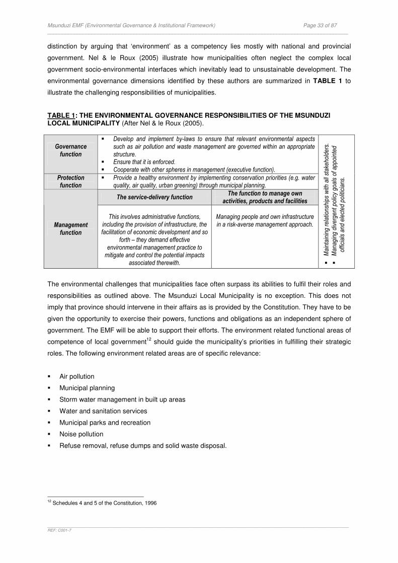
Msunduzi EMF (Environmental Governance & Institutional Framework) Page 33 of 87 _____________________________________________________________________________________________________
_______________________________________________________________________________________________________________________________________REF: C001-7
distinction by arguing that ‘environment’ as a competency lies mostly with national and provincial
government. Nel & le Roux (2005) illustrate how municipalities often neglect the complex local
government socio-environmental interfaces which inevitably lead to unsustainable development. The
environmental governance dimensions identified by these authors are summarized in TABLE 1 to
illustrate the challenging responsibilities of municipalities.
TABLE 1: THE ENVIRONMENTAL GOVERNANCE RESPONSIBILITIES OF THE MSUNDUZI LOCAL MUNICIPALITY (After Nel & le Roux (2005).
Governance function
� Develop and implement by-laws to ensure that relevant environmental aspects such as air pollution and waste management are governed within an appropriate structure.
� Ensure that it is enforced. � Cooperate with other spheres in management (executive function).
Protection function
� Provide a healthy environment by implementing conservation priorities (e.g. water quality, air quality, urban greening) through municipal planning.
The service-delivery function The function to manage own activities, products and facilities
Management function
This involves administrative functions,
including the provision of infrastructure, the facilitation of economic development and so
forth – they demand effective environmental management practice to
mitigate and control the potential impacts associated therewith.
Managing people and own infrastructure in a risk-averse management approach.
�
Mai
ntai
ning
rel
atio
nshi
ps w
ith a
ll st
akeh
olde
rs.
�
Man
agin
g di
verg
ent p
olic
y go
als
of a
ppoi
nted
offic
ials
and
ele
cted
polit
icia
ns.
The environmental challenges that municipalities face often surpass its abilities to fulfil their roles and
responsibilities as outlined above. The Msunduzi Local Municipality is no exception. This does not
imply that province should intervene in their affairs as is provided by the Constitution. They have to be
given the opportunity to exercise their powers, functions and obligations as an independent sphere of
government. The EMF will be able to support their efforts. The environment related functional areas of
competence of local government12
should guide the municipality’s priorities in fulfilling their strategic
roles. The following environment related areas are of specific relevance:
� Air pollution
� Municipal planning
� Storm water management in built up areas
� Water and sanitation services
� Municipal parks and recreation
� Noise pollution
� Refuse removal, refuse dumps and solid waste disposal.
12
Schedules 4 and 5 of the Constitution, 1996
Msunduzi EMF (Environmental Governance & Institutional Framework) Page 34 of 87 _____________________________________________________________________________________________________
_______________________________________________________________________________________________________________________________________REF: C001-7
The EMF will assist the Msunduzi Local Municipality in identifying key interventions for fulfilling their
strategic tasks. The EMF will also identify how all organs of state should support sustainable local
governance.
3.3.3.3.5555 A CA CA CA Commitment toommitment toommitment toommitment to Public Participation in Environmental Public Participation in Environmental Public Participation in Environmental Public Participation in Environmental
GovernanceGovernanceGovernanceGovernance
All three spheres of government have the duty to promote participatory democracy. It underlines
government’s relationship with society.
The provisions of the White Paper Policy on Environmental Management in terms of public
participation in environmental governance are significant for the purpose
of this report. The policy recognises that ‘sustainable and integrated
management of the environment depends on cooperation and
initiatives from all sectors of society’. The policy commits government
as a whole to establish multi-sectoral advisory structures and public
participation mechanisms and processes that are fair, transparent and
effective13
. There is also a commitment to promote participation of marginalised sectors of society, to
allocate resources for building capacity for managing participation in environmental governance and to
develop communication strategies that address public participation needs.
The principles of NEMA 14
that serve as a guideline by reference to which any organ of state must
exercise there functions, further expands on the roles and responsibilities of all organs of state in
public participation. The following principles are extracted from the act and serve as examples:
� Environmental management must place people and their needs at the forefront of its concern, and serve their physical, psychological, developmental, cultural and social interests equitably.
� The effects of decisions on the environment and all people in the environment must be taken into account. � Environmental justice must be pursued. Environmental impacts must not unfairly discriminate against any
person, particularly vulnerable and disadvantaged people. � The participation of all IAPs in environmental governance must be promoted. Every person must have the
opportunity to develop the understanding, skills and capacity necessary for achieving participation. � Decisions must take into account the interests, needs and values of all people. Traditional and ordinary
knowledge must be included in the decision-making process. � Community well-being and empowerment must be promoted through environmental education, the raising of
environmental awareness, the sharing of knowledge and experience and other appropriate means. � The rights of workers to refuse work that is harmful to human health or the environment and to be informed of
dangers must be respected and protected.
13
Strategic Goal No 4 of the White Paper on Environmental Management Policy, 1998 14
Chapter 1 of the National Environmental Management Act, 1998.
Desired level of Desired level of Desired level of Desired level of governancegovernancegovernancegovernance
Every organ of state demonstrates a commitment to
public participation in
environmental governance.
Msunduzi EMF (Environmental Governance & Institutional Framework) Page 35 of 87 _____________________________________________________________________________________________________
_______________________________________________________________________________________________________________________________________REF: C001-7
� Decisions must be taken in an open & transparent manner and access to information must be provided in accordance with the law.
� The environment is held in public trust for the people, the beneficial use of environmental resources must
serve the public interest and the environment must be protected as the people’s common heritage. � The vital role of women & youth in environmental management and development must be recognised and
their full participation therein must be promoted.
While every organ of state must be committed to public participation in the activities they promote in
the Msunduzi Municipality, this duty is of significance to the local Municipality. As the level of
government closest to the people their role is to engage with communities and give priority to their
needs, including their environmental needs. Information sharing and the communication methods they
employ will determine their success in public participation. The EMF will be able to support their
efforts.
3.3.3.3.6666 Society’s Society’s Society’s Society’s RRRRole in ole in ole in ole in EEEEnvironmental nvironmental nvironmental nvironmental GGGGovernanceovernanceovernanceovernance
Society’s role in environmental governance is built on the two pillars created by the Constitution:
� Citizenship based on rights, privileges and benefits.
� Citizenship subject to duties and responsibilities.
Society in this context includes many role-players and each has an
important role to play in environmental governance. These role-players
include amongst others individuals, project proponents, affected and
interested parties, environmental practitioners, non-governmental
organisations, community based organisations, business and industry
and special interest groups like women and youth. Society’s role in
environmental governance is to articulate their interests, exercise their rights and discharge their
legal obligations. While they have rights to sustainable development, to demand that the
environment is taken care of, to be consulted, to be informed and so
forth, they also have the duty to participate constructively, to contribute
in finding environmental solutions, to enforce environmental laws, to
respect the rights of others and to observe the principles and processes
provided by government to carry out their duties and responsibilities.
They have the responsibility to coordinate themselves and create their
own processes for interaction.
The scientific sector must ensure that decisions are based on sound scientific information. Their role is
to provide technical information to maximise the environmental benefits of development. They have to
conduct research to find answers, innovative solutions, appropriate technologies and methodologies to
ensure sustainable resource use. Research and development must make use of all sources of
Desired level of Desired level of Desired level of Desired level of governancegovernancegovernancegovernance
Society at large understands their role in environmental
governance. They coordinate themselves to carry out their
duties and responsibilities.
Desired leDesired leDesired leDesired level of vel of vel of vel of governancegovernancegovernancegovernance
The EMF identifies those role-players in society that may
have a significant contribution
to make in the area.
Msunduzi EMF (Environmental Governance & Institutional Framework) Page 36 of 87 _____________________________________________________________________________________________________
_______________________________________________________________________________________________________________________________________REF: C001-7
information, forms of knowledge and research methodologies, including participatory research.
Research must be ongoing and the results must be made available to all decision-making participants.
The EMF, as an integrative instrument, creates opportunities for society at large to focus on their roles
and responsibilities in managing the environment in the Msunduzi Municipality. The expectation is that
the various role-player groups and task-specific organisations (e.g. schools, tertiary education
institutions, and industry-based institutions) will demonstrate their commitment to local environmental
governance by sharing response strategies to address priority issues in their area.
3.73.73.73.7 A CA CA CA Commitment to ommitment to ommitment to ommitment to SSSSharharharhareeee IIIInfnfnfnformation ormation ormation ormation
A commitment to participation in governance demands a commitment to sharing information. Sharing
information enhances transparency and accountability and it leads to empowerment.
The Constitution gives the right to information. Several laws govern access to information in South
Africa for example the Promotion of Access to Information Act (No 2 of 2000), the Promotion of Access
to Administrative Justice Act (No 3 of 2000), the Protected Disclosures Act (No 26 of 2000), and
provisions in the NEMA for disclosure on different types of environmental
information. These laws underline the rights of citizens to access on
information on environmental quality and trends, pollution risks and the
performance of institutions, as well as their rights to be informed on
decisions that may affect them. It also underlines the responsibility of
role-players to make information freely available and directly accessible.
The success of the EMF will largely depend on the quality and detail of information which should be
supplemented on an ongoing basis. Managing information will require partnerships and special
arrangements between organs of state and the private sector for sharing information. Science as an
actor in governance plays a critical role in information. Although their role is not explore in more detail
in the remainder of the report their contribution in governance should not be overlooked as they
generate knowledge for solving practical problems.
3.73.73.73.7 How does How does How does How does thisthisthisthis relate to the Msunduzi Municipality EMF relate to the Msunduzi Municipality EMF relate to the Msunduzi Municipality EMF relate to the Msunduzi Municipality EMF????
This section broadly identified the generic roles and responsibilities of role-players. It serves three
purposes:
1) It demonstrates that implementation of the EMF is not solely the responsibility of the Msunduzi
Local Municipality but that good environmental outcomes are the results of collective action from
Desired level of Desired level of Desired level of Desired level of governancegovernancegovernancegovernance
All role-players are committed to disclose and
share environmental
information
Msunduzi EMF (Environmental Governance & Institutional Framework) Page 37 of 87 _____________________________________________________________________________________________________
_______________________________________________________________________________________________________________________________________REF: C001-7
within a bigger governance system. This system comprises of the sub-systems of government
and society. It is these subsystems and the way they interact with each other and with the
environment that will influence the quality of the area’s environment. Environmental quality in the
Msunduzi Municipality will therefore depend on the contribution of:
� National and provincial organs of state
� Local government
� Society (and its various groupings)
2) Although each role-player is equally important in decision-making, the role of government in this
system is significant. In a democratic society it is the responsibility of the state to create the
governance structures and the enabling environment in which role-players can find the space to
articulate their interests. In the context of this project the state is represented by the Msunduzi
Local Municipality. Being closest to the people it has the duty to accept a catalyst role in
environmental governance. The Municipality must therefore create an enabling environment for
constructive interaction between all role-players, bringing government closer to society.
3) The EMF is an integrative instrument that not only allows all role-players to better understand
their roles in managing the environment in the area; it offers them an opportunity to focus on
their contributions to the area’s priorities.
If the EGI Framework aims to establish a benchmark to guide an analysis of the institutional and
governance situation of the area it has to take the bigger system into account. It means that the
benchmark should address the performance of all role-players in environmental governance. In
other words it should develop objectives, criteria, targets and indicators as it relate to the ‘system’s’
contribution to environmental governance in the area. This is not impossible but the task is outside the
scope of this study project. For this reason the study will maintain a focus on the significant
contribution of government towards achieving the environmental goals of the EMF.
‘‘‘‘A strategic opportunityA strategic opportunityA strategic opportunityA strategic opportunity’’’’
The EMF offers a strategic opportunity to improve the environmental governance situation in the
Msunduzi Municipality. The process enhances the potential to bring all role-players together by
identifying key environmental problems that demands collective and cooperative action. Sharing
information empowers role-players and offers them an opportunity to better understand their roles
and responsibilities in finding solutions to environmental problems in the area. The area’s
environmental needs will enable each role-player to fulfil their roles and responsibilities by
adapting their actions and decisions.

Msunduzi EMF (Environmental Governance & Institutional Framework) Page 38 of 87 _____________________________________________________________________________________________________
_______________________________________________________________________________________________________________________________________REF: C001-7
For government as a whole the EMF is an opportunity to demonstrate leadership in environmental
management and to improve intergovernmental cooperation around environmental matters. For the
Msunduzi Local Municipality it is an opportunity to demonstrate environmental accountability by
discharging their environmental responsibilities and legal obligations, and accept a leadership role in
its area of jurisdiction. Science has an opportunity to generate innovative solutions that are aimed at
maximising the environmental benefits of development. Society will have the opportunity to bring their
local knowledge to the table and to contribute to environmental problems through their own actions
and activities.
From a governance point of view the EMF creates the democratic process whereby government can
fulfil their crucial role in sustainable local governance by providing direction and developing a
mechanism to monitor and evaluate performance and report back to the community. Society at large
will have the opportunity to pressure government to make serious efforts to promote environmental
accountability. For example, should the municipality fail to fulfil their environmental obligations they
have to call upon the province to intervene. An informed, empowered population will understand their
constitutional rights that enable them to demand such accountability.
The EMF will develop implementation plans based on the various issues identified during the Strategic
Environmental Assessment process. These plans will be linked to specific role-players, time-frames,
milestones and required resources. Their implementation will be monitored and evaluated to ensure
they are effective and obtain the desired results. Progress will be shared on a regular basis. This will
improve accountability in local environmental governance.
‘‘‘‘Strategic challengesStrategic challengesStrategic challengesStrategic challenges’’’’
The EMF also presents an enormous challenge in bridging the gap between public expectation
and the environmental reality. Achieving a desired level of environmental governance in the
Msunduzi Municipality faces challenging intergovernmental relations, leadership issues, financial
constraints, information shortages, shortages in human resource capacity and so forth. There is also
an inherent risk of not achieving the desire because of the context within which a ‘balance’ must be
struck between social, economic and environmental needs. These challenges should be placed into a
context of opportunities for the future through implementation of the EMF. It underlines the importance
of developing clear objectives, targets and indicators that could inform the choices that are available
but it also emphasize the importance of defining measurable outcomes of environmental governance
that are realistic and achievable.

Msunduzi EMF (Environmental Governance & Institutional Framework) Page 39 of 87 _____________________________________________________________________________________________________
_______________________________________________________________________________________________________________________________________REF: C001-7
3.73.73.73.7 Concluding RConcluding RConcluding RConcluding Remarksemarksemarksemarks
This section broadly identified the generic roles and responsibilities of role-players as it is explained in
the country’s legal framework. The legal guidelines (interpreted as the ‘desired levels of governance’
in the text boxes) in this section represent the legal thresholds for environmental governance. In
other words they offer the limits below which environmental governance in the Msunduzi Municipality
would not be able to function as intended. They inform the benchmark that will:
1) Guide further analyses of environmental governance in the Msunduzi Municipality.
� The specialist studies will add information.
� Analysis of the Local Municipality’s ‘environmental governance system’ will add information
2) Inform the desired state of environmental governance in the Msunduzi Municipality.
� The desired state will only be determined after completion of the status quo studies and the
identification of issues and priorities during the Strategic Environmental Assessment process.
� The desired state of environmental governance will have to take the area’s environmental
needs and institutional capacity into account and will be developed by consensus.
FIGURE 4 demonstrates how the information from this section informs the development of a
benchmark for analysing the future governance situation in the Msunduzi Municipality (these
measures should inform the development of objectives and targets in the EMF):
The basic building blocks of environmental governance demands a focus on role-players (Pillar 1).
The legal guidelines create the expectation that each role-player group contributes and support
environmental governance in the specific area based on the interaction that took place between them.
Their specific contribution is determined by the context within which they operate. The EMF is the
instrument that allows them to focus on the environmental situation, issues and priorities of the area
and identifies their specific contributions in addressing the environmental priorities. In practice it will
require each role-player to consider its activities and how they may influence the environmental
situation. The influence could be positive or negative.
The EMF develops a Strategic Agenda which enables ‘collective action’. The Agenda will identify who
should be involved and how they should contribute. It is therefore expected that each role-player, in
using the Strategic Agenda, will be ‘empowered’ to develop response strategies which reflects their
commitment’s to the environmental goals of the area. Their contributions will be monitored through
the EMF.
The study context demands that the Msunduzi Local Municipality, as a key role-player, develop their
own response strategies to contribute to the area’s environmental goals. They also have the duty to
demonstrate leadership. It implies that they will have the right systems and tools in place to facilitate
ongoing dialogue between the role-players so that they will be encouraged to contribute to the area’s
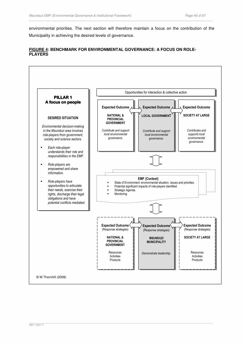
Msunduzi EMF (Environmental Governance & Institutional Framework) Page 40 of 87 _____________________________________________________________________________________________________
_______________________________________________________________________________________________________________________________________REF: C001-7
environmental priorities. The next section will therefore maintain a focus on the contribution of the
Municipality in achieving the desired levels of governance.
FIGURE 4: BENCHMARK FOR ENVIRONMENTAL GOVERNANCE: A FOCUS ON ROLE-PLAYERS
Expected Outcome
NATIONAL & PROVINCIAL GOVERNMENT
Contribute and support
local environmental governance.
Expected Outcome LOCAL GOVERNMENT
Contribute and support local environmental
governance.
Expected Outcome
SOCIETY AT LARGE
Contributes and supports local environmental governance.
Opportunities for interaction & collective action PILLAR 1PILLAR 1PILLAR 1PILLAR 1
A focus on peopleA focus on peopleA focus on peopleA focus on people
DESIRED SITUATION
Environmental decision-making in the Msunduzi area involves role-players from government, society and science sectors.
� Each role-player
understands their role and responsibilities in the EMF.
� Role-players are
empowered and share information.
� Role-players have
opportunities to articulate their needs, exercise their rights, discharge their legal obligations and have potential conflicts mediated.
Expected Outcome (Response strategies)
MSUNDUZI
MUNICIPALITY
Demonstrate leadership.
Expected Outcome (Response strategies)
SOCIETY AT LARGE
Resources Activities Products
© M Thornhill (2008)
EMF (Context) � State of Environment: environmental situation, issues and priorities. � Potential significant impacts of role-players identified. � Strategic Agenda. � Monitoring
Expected Outcome (Response strategies)
NATIONAL & PROVINCIAL GOVERNMENT
Resources Activities Products

Msunduzi EMF (Environmental Governance & Institutional Framework) Page 41 of 87 _____________________________________________________________________________________________________
_______________________________________________________________________________________________________________________________________REF: C001-7
SECTION SECTION SECTION SECTION 4444: : : : A FOCUS ON SYSTEMS AND TOOLSA FOCUS ON SYSTEMS AND TOOLSA FOCUS ON SYSTEMS AND TOOLSA FOCUS ON SYSTEMS AND TOOLS
The previous section described a ‘desired level of governance’ where all role-players will be
‘empowered’ to contribute to the EMF. This section underlines the need for role-players to understand
the purpose and implications of the EMF. It then focuses on the duty of the Msunduzi Local
Municipality to facilitate the development of a ‘governance system’ in which role-players can play their
collective game.
This section essential aims to answer the following two questions:
� What does the desired system of governance look like?
� How can the EMF contribute to this system?
4.14.14.14.1 IntroductionIntroductionIntroductionIntroduction
The desired future situation in the Msunduzi Municipality displays a
situation where an enabling environment creates capacity for
collective action.
This future situation can only be achieved if (after Heslop, 2006):
� There is a process that stimulates ongoing dialogue and
interaction between all role-players.
� People are equipped with the necessary understanding and
skills and have access to information and knowledge to
perform effectively.
� Organisations have the ability to work collectively and
collaboratively, share information, make decisions for the
long-term and have responsive management styles.
� There is institutional support (legal and regulatory provisions)
for capacity development in environmental governance.
� Institutional and governance arrangements support collective
action.
South Africa’s progressive Constitution introduced in the previous section demonstrates significant
institutional support for environmental governance in development. Sustainable development is
embedded in framework legislation as well as in sectoral and subsidiary policies and laws and it
supports the need for capacity development for collective action. The EMF as an instrument enables
PILLAR 2PILLAR 2PILLAR 2PILLAR 2
A focus on systems & A focus on systems & A focus on systems & A focus on systems & toolstoolstoolstools
DESIRED SITUATION
Government has created an enabling environment for ongoing dialogue between all role-players
and each role-player has organised’ themselves for good
environmental governance � Government uses the EMF
as an instrument for generating process for interaction.
� The decision-making
process is supported by developing institutional capacity for managing the instrument.
� Each role-player
demonstrates commitment
to the process.

Msunduzi EMF (Environmental Governance & Institutional Framework) Page 42 of 87 _____________________________________________________________________________________________________
_______________________________________________________________________________________________________________________________________REF: C001-7
role-players in the Msunduzi Municipality to achieve the purpose of the legal framework. The EMF
creates process. The process stimulates dialogue and interaction and empowers people to take
action.
Role-players need to understand the EMF and the implications for their respective organisations.
They will have to use the EMF to design ‘response strategies’. In other words they will be expected to
consider their organisation’s activities, how these may influence the natural environment within which
they operate and respond to it in some way. The EMF guides their responses.
This section draws on a number of laws to identify institutional aspects to inform the benchmark for
environmental governance in the Msunduzi Municipality EMF. The National Environmental
Management Amendment Act (2004) is of specific significance. The following laws were screened to
inform the development of the benchmark as it relates to the Municipality:
� The Local Government: Municipal Structures Act (2000)
� Local Government: Municipal Systems Act (2000)
� The Intergovernmental Relations Framework Act (2005)
There are also other laws, amendments and regulations that apply to municipalities which may add
detail to benchmark development. They were not used in this analysis. It is recommended that they be
screened in future to complete the benchmark:
� White Paper on Local Government (1998)
� Municipal Demarcation Act (1998)
� Municipal Finance Management Act (2003)
� Municipal Property Rates Act (2004)
� Organised Local Government Act (1997)
� Development Facilitation Act (0000)
� The Promotion of Administrative Justice Act (2000)
� The Promotion of Access to Information Act (2000)
� Other sectoral legislation such as the Disaster Management Act (2002), the Housing Act (1997),
National Land Transport Transition Act (2000) and more.
Sectoral environmental legislation that contains critical institutional aspects relevant to this project will
also be identified by the specialist studies. They will add detail to the benchmark.
The institutional aspects of these laws represent legal thresholds. In other words they signify desired
levels of governance and constitute measures for environmental governance. These thresholds
could potentially be used as targets.

Msunduzi EMF (Environmental Governance & Institutional Framework) Page 43 of 87 _____________________________________________________________________________________________________
_______________________________________________________________________________________________________________________________________REF: C001-7
The legal thresholds should influence the development of objectives, criteria, targets and indicators for
the desired state of governance that will be developed by consensus in the final stages of the EMF
Project.
4.24.24.24.2 The EMF: An IntegratThe EMF: An IntegratThe EMF: An IntegratThe EMF: An Integratedededed Instrument Instrument Instrument Instrument
An EMF can loosely be described as a structure or basic system that enables the management of the
environment in a specific area and in a specific manner, towards a common goal. The integrative
nature of this policy instrument points to its ability to combine institutional rules with the knowledge
and interests of all the role-players to produce a product that delivers an outcome that is acceptable to
all. The product further has the ability to integrate environment concerns and environmental
sustainability into other instruments such as the Integrated Development Plan (IDP). The dynamic
nature of the instrument suggests that the product is not static and that it develops continuously
through a consultative process that adapts and transforms society’s interaction with nature.
The National Environmental Management Act (NEMA) introduced the EMF as ‘an instrument in
support of the EIA Regulations’. However the value and purpose of an EMF goes beyond
reinforcing project-level EIA decisions.
4.2.1 Purpose of the EMF
As a policy instrument, the EMF is first and foremost an instrument to achieve the purpose of the
NEMA. In short this purpose is:
� To promote cooperative environmental governance. � To manage activities that may harm the environment.
The EMF is also an instrument to achieve the objectives of Integrated Environmental
Management15
(IEM). These objectives must guide the activities of all the role-players. These
objectives are:
� To promote the integration of NEMA principles into decisions that may have a significant effect on the environment.
� To identify, predict and evaluate the actual and potential impact on the environment, socio-economic
conditions and cultural heritage, the risks and consequences, and alternatives and options for mitigation of activities, with a view to minimizing negative impacts, maximising benefits, and promoting compliance with the principles of environmental management
� To ensure that the effects of activities on the environment receives adequate consideration before
actions are taken in connection with them.
15
Chapter 5: National Environmental Management Act, Amended Act (2004)

Msunduzi EMF (Environmental Governance & Institutional Framework) Page 44 of 87 _____________________________________________________________________________________________________
_______________________________________________________________________________________________________________________________________REF: C001-7
� To ensure opportunity for public participation in decisions that may effect the environment.
� To ensure the consideration of environmental attributes in management and decision-making which may
have a significant effect on the environment.
� To identify and employ the modes of environmental management best suited to ensuring that a particular activity is pursued in accordance with the principles of environmental management.
The EMF is an instrument to support the EIA Regulations16
which specifies its purpose as follows:
� To initiate the compilation of information and maps specifying the attributes of the environment in
particular geographical areas.
� To use such information and maps as environmental management frameworks in the consideration of development applications in or affecting the geographical areas to which the framework applies.
The comprehensive approach adopted for the Msunduzi Municipality EMF (see section 1.3.1) requires
the EMF to be an instrument to promote environmentally sustainable development. The purpose
of the EMF is therefore extended to inform different levels and types of decision-making. The
EMF must deliver a strategic agenda for the area, illustrated spatially, with strategies for
implementation and a Monitoring and Evaluation System that is able to detect changes in
environmental quality and institutional performance.
The effectiveness of the EMF as an instrument will be determined by the extent to which it achieves its
purpose. It underlines the need to define the ‘desired state of environmental governance’ as regards
to:
� What must be achieved?
� Who will be involved?
� How will they collaborate?
� What resources will be required?
� How will success be monitored?
� How will information be share with role-players?
� How will role-players adapt?
16
Chapter 8 of the NEMA: EIA Regulations (GN No. R385 of 21 April 2006)
Desired level of governanceDesired level of governanceDesired level of governanceDesired level of governance
The EMF achieved its purpose:
� Promotes cooperative environmental governance
� Achieves the objectives of IEM. � Specifies the environmental attributes of
the environment in the Msunduzi Municipality.
� Informs development applications. � Informs different levels and types of
decision-making.
Msunduzi EMF (Environmental Governance & Institutional Framework) Page 45 of 87 _____________________________________________________________________________________________________
_______________________________________________________________________________________________________________________________________REF: C001-7
4.2.2 Process of the EMF
The NEMA and its Regulations specify who and how an EMF may be initiated, the process to be
followed and its contents. The Draft EMF Guideline (2006) adds procedural and technical guidelines to
support the process of developing an EMF. The Final Inception Report of the EMF Project (SRK,
2008) provides further detail on the process to develop the Msunduzi Municipality EMF. This section
only draws on the legal guidelines to identify desired levels of governance for the process. The
comprehensive approach adopted for this Project requires careful consideration of process
requirements.
‘‘‘‘Who initiates the EMF?Who initiates the EMF?Who initiates the EMF?Who initiates the EMF?’’’’
The Regulations state that the Minister of Environmental Affairs and the MEC of Environment in
KwaZulu-Natal is allowed to initiate an EMF. The Draft EMF Guideline (2006) however maintains that
in practice EMF’s will probably be ‘joint initiatives between provincial
departments and local authorities that act within the mandates of the
MEC’s’. The Msunduzi Municipality EMF is a partnership between the
National Minister of Environmental Affairs (Department of
Environmental Affairs and Tourism, DEAT), the MEC of Environment in
KwaZulu-Natal (Department of Agricultural and Environmental Affairs,
DAEA) and the local authority (The Msunduzi Local Municipality).
‘‘‘‘How is an EMF initiated?How is an EMF initiated?How is an EMF initiated?How is an EMF initiated?’’’’
The Regulations makes reference to a draft EMF that should be compiled ‘before it is initiated’. In
other words, a draft EMF should be compiled before it is subjected to a public participation
process. This regulation acknowledges the differences in context that
may occur from one area to another and should therefore be regarded
as minimum requirements (DEAT EMF Guidelines). In this Project the
design of the EMF has been subjected to a Planning Workshop17
to
obtain input from key stakeholders into the process and methodology.
Public participation will continue throughout the preparation of the draft
EMF.
‘‘‘‘What about the contents?What about the contents?What about the contents?What about the contents?’’’’
The Regulations specify the contents of a draft EMF as follows:
17
Draft Minutes of the Planning Workshop Msunduzi EMF held at Sinodale Centre, Pietermaritzburg on 19 September 2007. Minutes prepared by SRK.
Desired level of Desired level of Desired level of Desired level of governgoverngoverngovernanceanceanceance
All role-players in the Msunduzi Municipality are given the
opportunity to partake in the development and management of
the EMF.
Desired level of Desired level of Desired level of Desired level of governancegovernancegovernancegovernance
Ongoing support for EMF:
The roles of the DEAT, DAEA and the Municipality in the EMF are
clearly defined.

Msunduzi EMF (Environmental Governance & Institutional Framework) Page 46 of 87 _____________________________________________________________________________________________________
_______________________________________________________________________________________________________________________________________REF: C001-7
� Identify the geographical area to which it applies. � Specify the environmental attributes of such an area (including the
environmental sensitivity, extent, interrelationship and significance of the attributes).
� Identify any parts in the area to which those attributes relate. � State the conservation status of the area and in those parts. � State the environmental management priorities of the area � Indicate the kind of activities that would have a significant impact on
those attributes and those that would not. � Indicate the kind of activities that would be undesirable in the area or
in specific parts of the areas � Include any other matters that may be specified.
‘‘‘‘PrPrPrProcedural and institutional arrangements?ocedural and institutional arrangements?ocedural and institutional arrangements?ocedural and institutional arrangements?’’’’
The draft EMF will be open for scrutiny and contribution by all role-players. The Regulations
stipulate that the EMF can be ‘adopted’ after which notice must be given in the relevant Government
Gazette. Should this option be used the EMF must be taken into account when decisions are made on
development activities. However, initial consultation with the relevant authorities indicates that this
option is still open for discussion as the implications are not clear.
The procedural and institutional arrangements for the process and
management of an EMF are not clear. The NEMA Amendment Act
(2004) and the subsequent proposal for additional amendments (May
2007) indicates that Regulations may be promulgated to clarify
procedural aspects and institutional arrangements.
Considering that the EMF is a relatively ‘new’ instrument and that implementation is still in its infant
stages the EMF Project offers an opportunity to contribute to questions around procedures and
institutional arrangements. The following questions have been raised by the role-players and should
be subjected to further dialogue:
� The EMF is a partnership between the National DEAT, the Provincial DAEA and the Msunduzi Local Municipality. Who will ultimately be responsible for managing the instrument? How will these parties collaborate?
� How will the EMF be made available to the public in order
to facilitate information sharing in future development processes?
� How will the EMF be made available to Environmental
Assessment Practitioners for consideration in the EIA process?
� Will the EMF apply to applications under the Development Facilitation Act?
� Will the public have the right to appeal provisions (and application) of the EMF? What
process will they follow?
Desired level of Desired level of Desired level of Desired level of governancegovernancegovernancegovernance
All role-players agree on the status
and application of the EMF.
Desired level of Desired level of Desired level of Desired level of governgoverngoverngovernanceanceanceance
Institutional arrangements for managing the EMF are clearly
defined.
Desired level of Desired level of Desired level of Desired level of governancegovernancegovernancegovernance
The EMF illustrates the existing environmental situation, identifies issues and priorities, and meets
the other requirements of the ToR.
Msunduzi EMF (Environmental Governance & Institutional Framework) Page 47 of 87 _____________________________________________________________________________________________________
_______________________________________________________________________________________________________________________________________REF: C001-7
4.2.3 The EMF’s Relationship with EIA
Understanding the EMF as an instrument in support of the EIA Regulations requires an understanding
of the shortcomings of EIA as an instrument for achieving the objectives of IEM.
EIA takes places relatively late at the downstream end of the decision-making process when options
for significant change in the project proposal are rather limited. Normally at this stage, the issues have
been narrowed to how a project should be implemented environmentally, rather than whether, where
and what form of development is environmentally appropriate. The EMF is designed to ‘upstream’
environmental concerns by addressing environmental issues in a more holistic manner. The
proactive nature of the EMF means that it aims to anticipate and prevent environmental damage
before development proposals are evaluated. It reinforces project-level EIA by streamlining the
process with ‘the bigger picture’. The EMF therefore takes a top-down and bottom-up approach to
promoting environmentally sound and sustainable development.
The EMF reinforces project-level EIA in the following manner (DEAT, 2006):
� It provides applicants with an early indication of the areas in which it would be potentially appropriate to undertake an activity.
� It anticipates potential impacts and provides early warning in respect of thresholds, limits and cumulative
impacts.
� It indicates the scope of potential impacts and information needs that may be necessary for environmental impacts assessments.
� It identifies the different regulatory responsibilities that apply to a development proposal.
� It recommends mechanisms for addressing the needs of the relevant authorities.
� It may identify areas where environmental authorisation must be required for certain additional listed
activities.
� It may identify areas where the undertaking of certain activities may be excluded.
� It guides decision-making by making detailed information available about an area before activity proposals are generated.
‘‘‘‘Improved and informedImproved and informedImproved and informedImproved and informed decisions decisions decisions decisions’’’’
From an environmental governance perspective, accountability in decision-making includes the
responsibility to consider projects holistically. The NEMA calls for decisions that are “integrated,
acknowledging that all elements of the environment are linked and interrelated, and it must take into
account the effects of decisions on all aspects of the environment and all people in the environment by
pursuing the selection of the best practicable environmental option”18
. The EMF introduces a holistic
decision-making model which allows the governance process to adopt an integrated decision-
18
NEMA, Chapter 1, Principle 2(4)(b)
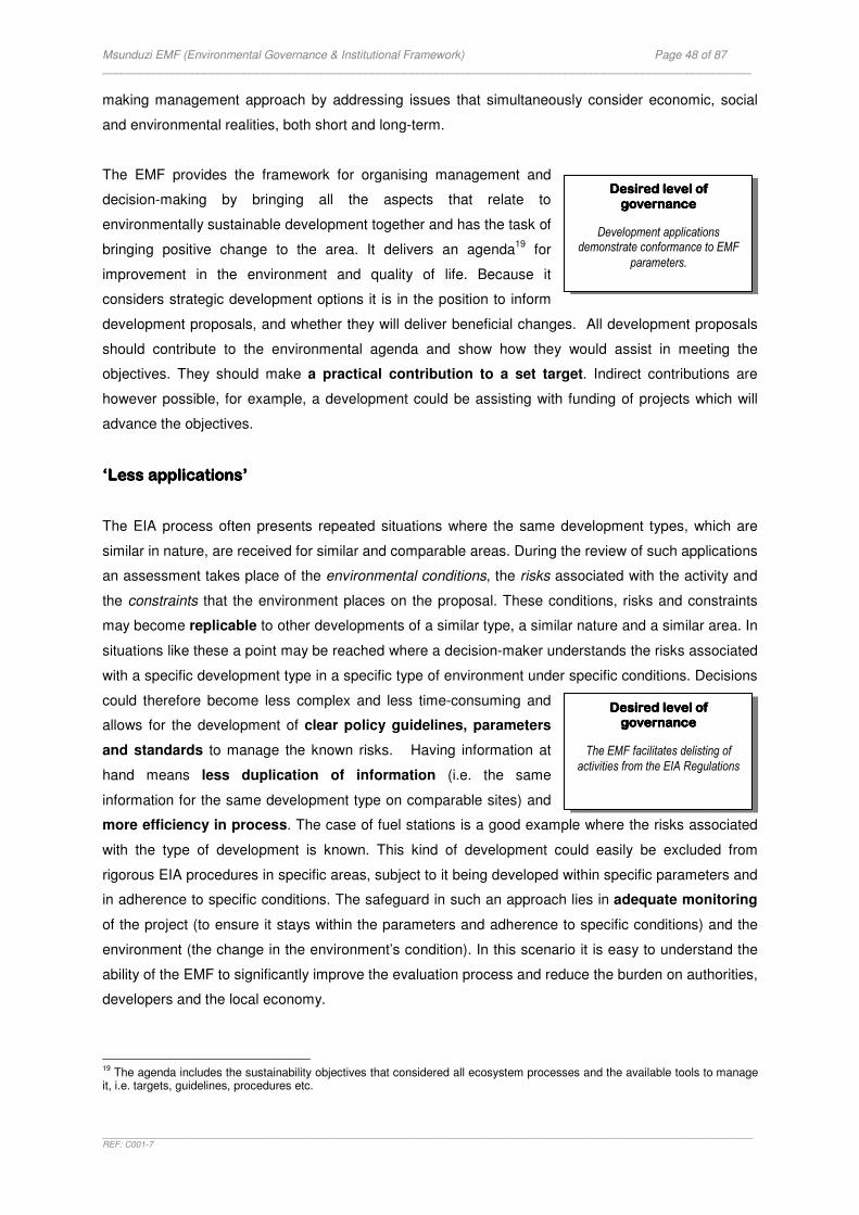
Msunduzi EMF (Environmental Governance & Institutional Framework) Page 48 of 87 _____________________________________________________________________________________________________
_______________________________________________________________________________________________________________________________________REF: C001-7
making management approach by addressing issues that simultaneously consider economic, social
and environmental realities, both short and long-term.
The EMF provides the framework for organising management and
decision-making by bringing all the aspects that relate to
environmentally sustainable development together and has the task of
bringing positive change to the area. It delivers an agenda19
for
improvement in the environment and quality of life. Because it
considers strategic development options it is in the position to inform
development proposals, and whether they will deliver beneficial changes. All development proposals
should contribute to the environmental agenda and show how they would assist in meeting the
objectives. They should make a practical contribution to a set target. Indirect contributions are
however possible, for example, a development could be assisting with funding of projects which will
advance the objectives.
‘Less applications’‘Less applications’‘Less applications’‘Less applications’
The EIA process often presents repeated situations where the same development types, which are
similar in nature, are received for similar and comparable areas. During the review of such applications
an assessment takes place of the environmental conditions, the risks associated with the activity and
the constraints that the environment places on the proposal. These conditions, risks and constraints
may become replicable to other developments of a similar type, a similar nature and a similar area. In
situations like these a point may be reached where a decision-maker understands the risks associated
with a specific development type in a specific type of environment under specific conditions. Decisions
could therefore become less complex and less time-consuming and
allows for the development of clear policy guidelines, parameters
and standards to manage the known risks. Having information at
hand means less duplication of information (i.e. the same
information for the same development type on comparable sites) and
more efficiency in process. The case of fuel stations is a good example where the risks associated
with the type of development is known. This kind of development could easily be excluded from
rigorous EIA procedures in specific areas, subject to it being developed within specific parameters and
in adherence to specific conditions. The safeguard in such an approach lies in adequate monitoring
of the project (to ensure it stays within the parameters and adherence to specific conditions) and the
environment (the change in the environment’s condition). In this scenario it is easy to understand the
ability of the EMF to significantly improve the evaluation process and reduce the burden on authorities,
developers and the local economy.
19
The agenda includes the sustainability objectives that considered all ecosystem processes and the available tools to manage it, i.e. targets, guidelines, procedures etc.
Desired level of Desired level of Desired level of Desired level of governancegovernancegovernancegovernance
The EMF facilitates delisting of
activities from the EIA Regulations
Desired level of Desired level of Desired level of Desired level of governancegovernancegovernancegovernance
Development applications demonstrate conformance to EMF
parameters.
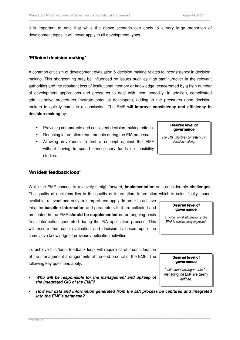
Msunduzi EMF (Environmental Governance & Institutional Framework) Page 49 of 87 _____________________________________________________________________________________________________
_______________________________________________________________________________________________________________________________________REF: C001-7
It is important to note that while the above scenario can apply to a very large proportion of
development types, it will never apply to all development types.
‘‘‘‘Efficient decisionEfficient decisionEfficient decisionEfficient decision----makingmakingmakingmaking’’’’
A common criticism of development evaluation & decision-making relates to inconsistency in decision-
making. This shortcoming may be influenced by issues such as high staff turnover in the relevant
authorities and the resultant loss of institutional memory or knowledge, exacerbated by a high number
of development applications and pressures to deal with them speedily. In addition, complicated
administrative procedures frustrate potential developers, adding to the pressures upon decision-
makers to quickly come to a conclusion. The EMF will improve consistency and efficiency in
decision-making by:
� Providing comparable and consistent decision-making criteria.
� Reducing information requirements during the EIA process.
� Allowing developers to test a concept against the EMF
without having to spend unnecessary funds on feasibility
studies.
‘‘‘‘An ideal feedback loopAn ideal feedback loopAn ideal feedback loopAn ideal feedback loop’’’’ While the EMF concept is relatively straightforward, implementation sets considerable challenges.
The quality of decisions lies in the quality of information, information which is scientifically sound,
available, relevant and easy to interpret and apply. In order to achieve
this, the baseline information and parameters that are collected and
presented in the EMF should be supplemented on an ongoing basis
from information generated during the EIA application process. This
will ensure that each evaluation and decision is based upon the
cumulative knowledge of previous application activities.
To achieve this ‘ideal feedback loop’ will require careful consideration
of the management arrangements of the end product of the EMF. The
following key questions apply:
� Who will be responsible for the management and upkeep of the integrated GIS of the EMF?
� How will data and information generated from the EIA process be captured and integrated
into the EMF’s database?
Desired level of Desired level of Desired level of Desired level of governancegovernancegovernancegovernance
Institutional arrangements for managing the EMF are clearly
defined.
Desired level of Desired level of Desired level of Desired level of governancegovernancegovernancegovernance
The EMF improves consistency in
decision-making.
Desired level of Desired level of Desired level of Desired level of governancegovernancegovernancegovernance
Environmental information in the
EMF is continuously improved.
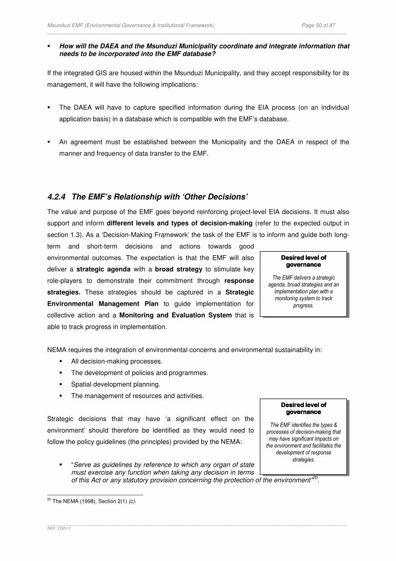
Msunduzi EMF (Environmental Governance & Institutional Framework) Page 50 of 87 _____________________________________________________________________________________________________
_______________________________________________________________________________________________________________________________________REF: C001-7
� How will the DAEA and the Msunduzi Municipality coordinate and integrate information that needs to be incorporated into the EMF database?
If the integrated GIS are housed within the Msunduzi Municipality, and they accept responsibility for its
management, it will have the following implications:
� The DAEA will have to capture specified information during the EIA process (on an individual
application basis) in a database which is compatible with the EMF’s database.
� An agreement must be established between the Municipality and the DAEA in respect of the
manner and frequency of data transfer to the EMF.
4.2.4 The EMF’s Relationship with ‘Other Decisions’
The value and purpose of the EMF goes beyond reinforcing project-level EIA decisions. It must also
support and inform different levels and types of decision-making (refer to the expected output in
section 1.3). As a ‘Decision-Making Framework’ the task of the EMF is to inform and guide both long-
term and short-term decisions and actions towards good
environmental outcomes. The expectation is that the EMF will also
deliver a strategic agenda with a broad strategy to stimulate key
role-players to demonstrate their commitment through response
strategies. These strategies should be captured in a Strategic
Environmental Management Plan to guide implementation for
collective action and a Monitoring and Evaluation System that is
able to track progress in implementation.
NEMA requires the integration of environmental concerns and environmental sustainability in:
� All decision-making processes.
� The development of policies and programmes.
� Spatial development planning.
� The management of resources and activities.
Strategic decisions that may have ‘a significant effect on the
environment’ should therefore be identified as they would need to
follow the policy guidelines (the principles) provided by the NEMA:
� “Serve as guidelines by reference to which any organ of state must exercise any function when taking any decision in terms of this Act or any statutory provision concerning the protection of the environment”
20.
20
The NEMA (1998), Section 2(1) (c).
Desired level of Desired level of Desired level of Desired level of governancegovernancegovernancegovernance
The EMF identifies the types & processes of decision-making that may have significant impacts on
the environment and facilitates the development of response
strategies.
Desired level of Desired level of Desired level of Desired level of governancegovernancegovernancegovernance
The EMF delivers a strategic agenda, broad strategies and an
implementation plan with a monitoring system to track
progress.
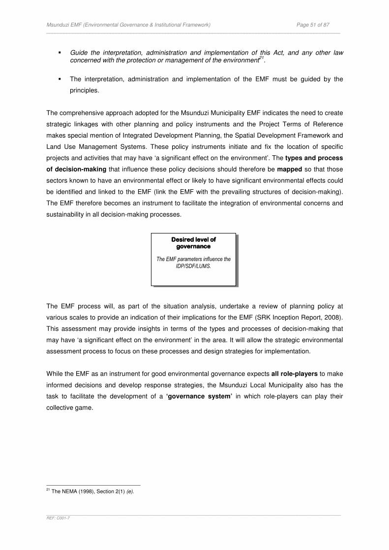
Msunduzi EMF (Environmental Governance & Institutional Framework) Page 51 of 87 _____________________________________________________________________________________________________
_______________________________________________________________________________________________________________________________________REF: C001-7
� Guide the interpretation, administration and implementation of this Act, and any other law
concerned with the protection or management of the environment21
.
� The interpretation, administration and implementation of the EMF must be guided by the
principles.
The comprehensive approach adopted for the Msunduzi Municipality EMF indicates the need to create
strategic linkages with other planning and policy instruments and the Project Terms of Reference
makes special mention of Integrated Development Planning, the Spatial Development Framework and
Land Use Management Systems. These policy instruments initiate and fix the location of specific
projects and activities that may have ‘a significant effect on the environment’. The types and process
of decision-making that influence these policy decisions should therefore be mapped so that those
sectors known to have an environmental effect or likely to have significant environmental effects could
be identified and linked to the EMF (link the EMF with the prevailing structures of decision-making).
The EMF therefore becomes an instrument to facilitate the integration of environmental concerns and
sustainability in all decision-making processes.
The EMF process will, as part of the situation analysis, undertake a review of planning policy at
various scales to provide an indication of their implications for the EMF (SRK Inception Report, 2008).
This assessment may provide insights in terms of the types and processes of decision-making that
may have ‘a significant effect on the environment’ in the area. It will allow the strategic environmental
assessment process to focus on these processes and design strategies for implementation.
While the EMF as an instrument for good environmental governance expects all role-players to make
informed decisions and develop response strategies, the Msunduzi Local Municipality also has the
task to facilitate the development of a ‘governance system’ in which role-players can play their
collective game.
21
The NEMA (1998), Section 2(1) (e).
Desired level of Desired level of Desired level of Desired level of governancegovernancegovernancegovernance
The EMF parameters influence the
IDP/SDF/LUMS.

Msunduzi EMF (Environmental Governance & Institutional Framework) Page 52 of 87 _____________________________________________________________________________________________________
_______________________________________________________________________________________________________________________________________REF: C001-7
4.34.34.34.3 A A A A Process for Ongoing DialogueProcess for Ongoing DialogueProcess for Ongoing DialogueProcess for Ongoing Dialogue
The EMF is a collaborative project between the DEAT, DAEA and the Msunduzi Local Municipality
and the process of developing the instrument is a first step towards promoting the Municipality as “a
provincial flagship for sound environmentally sustainable development”. However, the Municipality has
the key task to create a home for the EMF and use it to generate process for ongoing dialogue
between all role-players. This will require a fresh look at the implications and the institutional capacity
required to make this a reality.
The effectiveness of the Municipality will be determined by the extent to which it can create an
enabling environment for achieving its purpose. The purpose of local government is to22
:
� Provide democratic and accountable government for local communities
� Ensure the provision of services to communities in a sustainable manner.
� Promote social and economic development.
� Promote a safe and healthy environment.
� Encourage the involvement of communities and community organisations in the matters of local
government.
For this they have to create a process for constructive interaction between the role-players in
environmental governance. The process will create capacity, within the Municipality and amongst the
role-players and in so doing enhance the effectiveness of the area’s governance system. This in turn
will improve the system’s ability to cope with environmental changes. It becomes an ongoing
learning process that constantly exchanges knowledge and improvement for environmental
governance.
4.3.1 Leadership for Good Governance
The effectiveness of the Msunduzi Local Municipality in promoting a safe and healthy environment will
be determined by the extent to which it would be able to demonstrate leadership in local
environmental governance.
Council have to be conscious of how they exercise authority over
natural resources and the environment. Their daily decisions may
affect the environment and people’s environmental rights and they will
be held accountable to the communities they serve. It highlights their
responsibility to empower the public to participate and voice their
concerns in political and decision-making processes and how society
could hold the representatives of their government accountable.
22
Chapter 7 of the Constitution (1996)
Desired level of Desired level of Desired level of Desired level of governancegovernancegovernancegovernance
Council and its supporting structures demonstrate leadership
in environmental governance.
Msunduzi EMF (Environmental Governance & Institutional Framework) Page 53 of 87 _____________________________________________________________________________________________________
_______________________________________________________________________________________________________________________________________REF: C001-7
Accountability builds up trust and credibility. It cannot be enforced without transparency which means
that their decisions must be taken in a manner that follows rules and regulations and information on
decisions must be made available to those who may be affected by it. Transparency also means that
Council will develop standards against which it will govern its operations and that they will collect and
share information on the results of their management.
Leadership in good governance further means that the Municipality will communicate regularly with
its partners, be it other organs of state or society as a whole. They must provide opportunities for
participation either directly or through legitimate institutions or representatives so that all role-players
could have an opportunity to articulate their needs and exercise their rights.
A commitment to leadership and the ability to create process is of course dependent on the
Municipality’s own institutional capacity. Internal processes and business activities must be effective
and efficient and it must produce results that meet the needs of society while making the best use of
resources at their disposal.
In order for the Municipality to demonstrate leadership in local environmental governance they must
be able to create process that enables the implementation of their key tasks:
� Interaction with other organs of state.
� Interactions with society at large.
� Efficiency and effectiveness in environmental governance.
The South African Constitution23
introduces basic values and principles governing public
administration. It underscores the principles of good governance as mentioned above. These
principles are key drivers for an efficient public service, accountable administration of public funds,
respect for law and human rights, democratic community participation and a legal framework to
enforce the rule of law.
There are various other policy instruments and codes of conduct and ethics in South Africa that are
intended to improve the quality of governance, especially as it relates to the issue of good corporate
governance, for example:
� The King 2 Report (2002) requires characteristics like discipline,
transparency, independence, accountability, fairness and social
responsibility to be present in the structure and practices of
government departments and business enterprises.
23
Chapter 10 of the South African Constitution (1996)
Desired level of Desired level of Desired level of Desired level of governancegovernancegovernancegovernance
The Municipality demonstrates leadership through corporate
citizenship.
Msunduzi EMF (Environmental Governance & Institutional Framework) Page 54 of 87 _____________________________________________________________________________________________________
_______________________________________________________________________________________________________________________________________REF: C001-7
� The Public Finance Management Act24
and the Local Government Municipal Finance
Management Act25
regulates good corporate governance practices and aim to secure
transparency, accountability and sound management of the revenue, expenditure, assets and
liabilities of the institutions to which the Acts apply.
� The Batho Pele White Paper aims to improve citizen-orientated customer service by introducing
principles for transforming public service delivery.
The above policies and codes have not been analysed for the purpose of this report although they are
relevant for delivering environmental sustainability. They provide the catalyst for defining the local
environmental agenda and expect the Municipality to demonstrate good corporate citizenship with
regard to human rights, social responsibility and environmental sustainability.
The EMF offers the Municipality a strategic opportunity to demonstrate corporate citizenship by
using the EMF to create process or enhance existing processes for environmental governance. The
process of developing and managing the EMF brings all key-role-players together to identify
environmental issues and share related information. It will improve decision-making in an open and
transparent manner. It will develop standards and promote environmental accountability through
monitoring and reporting. It will promote a collective responsibility for environmental governance. Role-
players will be able to participate and fulfil their respective roles and responsibilities. The Municipality
will be able to demonstrate their own commitment to their environmental functions and obligations by
enhancing effectiveness and efficiency of internal processes and business activities. The value of the
EMF therefore lies not only in its ability to promote a healthy environment; it also offers the
Municipality an instrument to achieve its legitimate purpose as it will:
� Enhance democratic government through environmental accountability.
� Improve the delivery of services in an environmentally sustainable manner.
� Promote socio-economic development within environmental parameters.
� Promote a safe and healthy environment
� Encourage involvement of society and create capacity in environmental matters of local
government.
Legislation provides key structural elements (principles, institutions, mechanisms, instruments,
procedures) that permit the Municipality to create process for demonstrating leadership in local
environmental governance. The expectation is that they will use these structural elements to generate
process and an enabling environment for achieving its purpose and it underlines the importance of the
EMF as an instrument to create process.
24
The Public Finance Management Act (Act No.1 of 1999) 25
Local Government Municipal Finance Management Act (Act No. 56 of 2003)
Msunduzi EMF (Environmental Governance & Institutional Framework) Page 55 of 87 _____________________________________________________________________________________________________
_______________________________________________________________________________________________________________________________________REF: C001-7
The EMF also presents the challenges that the Municipality face in achieving the desired levels of
governance. It emphasizes financial constraints, leadership issues, shortages in human resource
capacity and bridging the gap between public expectation and institutional realities.
4.3.2 Interaction with other organs of state
Leadership in local environmental governance is not attainable without full support from the other
spheres of government. Section 3 explained the environmental duty of all spheres of government and
the need for cooperation in environmental matters. It also explained the nature and relationship
between the three spheres and that the Municipality should govern its affairs on its own initiative but
with support from the other spheres. It underlines the responsibility of the Municipality to discharge
their environmental functions and obligations within the framework for intergovernmental
relations. This framework makes provision for government as a whole to coordinate their activities for
service delivery and it offers principles, coordinating structures, mechanisms and instruments to
achieve coordination and consistency in observing the principles of the Constitution.
The National Environmental Management Act (1998) and the Intergovernmental Relations Framework
Act (IGRF Act) (2005) are both framework laws that promote intergovernmental cooperation and they
guide the Municipality as to how they should promote environmental accountability in their area of
jurisdiction. They need to promote coordination and consistency in securing the protection of the
environment by ensuring inter alia:
� Environmental principles are integrated into decision-making processes.
� Participation in intergovernmental structures
� National and provincial environmental objectives are incorporated in their processes.
� Environmental conflicts are resolved.
� Arrangements are made to promote IEM.
� International environmental issues are appropriately managed.
� Compliance, enforcement and protection measures.
‘‘‘‘The 5The 5The 5The 5----Year Local Government Year Local Government Year Local Government Year Local Government Strategic AgendaStrategic AgendaStrategic AgendaStrategic Agenda’’’’
South Africa’s government has adopted the ‘5-Year Local Government Strategic Agenda’ (2006)26
with
the following strategic priorities for strengthening governance:
� Mainstreaming hands-on support to Local Government to improve municipal governance, performance and accountability.
� Addressing the structure and governance arrangements of the State in order to better
strengthen, support and monitor Local Government.
26
Department of Provincial and Local Government website: http://www.thedplg.gov.za
Msunduzi EMF (Environmental Governance & Institutional Framework) Page 56 of 87 _____________________________________________________________________________________________________
_______________________________________________________________________________________________________________________________________REF: C001-7
� Refining and strengthening the policy, regulatory and fiscal environment for Local
Government and giving greater attention to the enforcement measures.
This Agenda aims to ensure that the end of the second term of local government (2006 to 2011) will
be characterised by sustainable local governance. It clearly specifies actions that must be taken by
the various spheres of government and other stakeholders during the next couple of years. These
actions relate to issues of intergovernmental support, capacity, meeting service delivery targets,
improved planning, access to information, enforcing aspects of legislation and so forth. The Agenda
has been structured into five key performance areas27
that now inform the strategic objectives of
Municipal Managers and a municipality’s Performance Management System:
� Municipal Transformation and Organisational Development
� Infrastructure Development and Service Delivery
� Local Economic Development
� Municipal Finance Viability and Management
� Good Governance and Public Participation
If good governance is indeed about the ‘processes and interactions between government and the
public’ one would expect elements of governance to be present in each of the key performance areas.
This cross-cutting nature of governance demands such an approach.
‘Good Governance and Public Participation’ as a key performance area
in municipal management is of specific interest for the purpose of this
study. The Strategic Agenda calls for strong leadership, transparency
and accountability and addresses, amongst others, matters such as:
� Mechanisms for community participation
� Institutional structures for local government administration
� Management systems that enhance institutional operations
� Information sharing and communication
� Intergovernmental cooperation
� Quality of services delivery
The 5-Year Local Government Strategic Agenda’ is clearly focussed on getting the machinery of local
government to work for the people by promoting good governance. This does not exclude
environmental governance and therefore. The Agenda therefore creates an ideal opportunity for the
Msunduzi Local Municipality to mobilize the involvement of other organs of state and their social
27
Local Government: Municipal Systems Act: Municipal Performance Regulations for Municipal Managers and Managers directly accountable to Municipal Managers (Regulation No. R 805 of 2006).
Desired level of Desired level of Desired level of Desired level of governancegovernancegovernancegovernance
The EMF is aligned with the 5-Year Local Government Strategic Agenda and the key performance
areas of the Municipality.
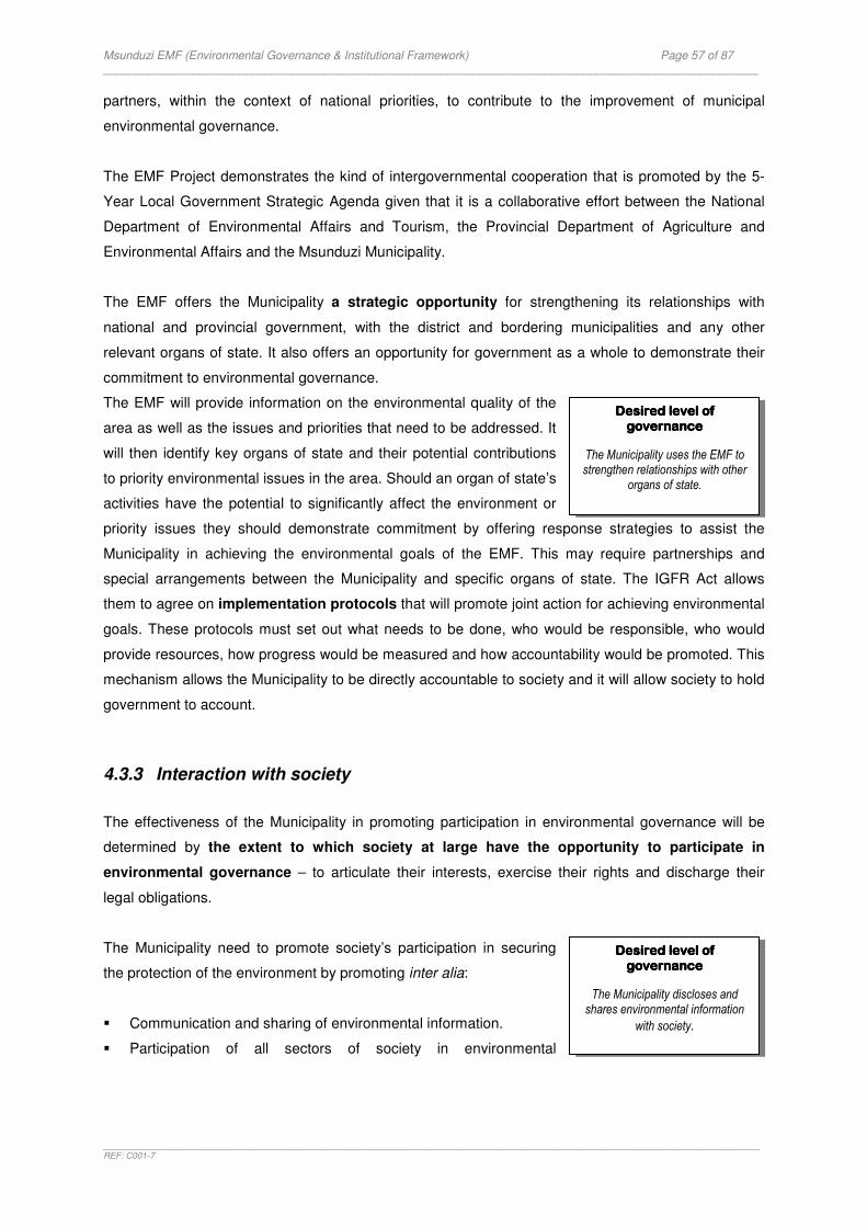
Msunduzi EMF (Environmental Governance & Institutional Framework) Page 57 of 87 _____________________________________________________________________________________________________
_______________________________________________________________________________________________________________________________________REF: C001-7
partners, within the context of national priorities, to contribute to the improvement of municipal
environmental governance.
The EMF Project demonstrates the kind of intergovernmental cooperation that is promoted by the 5-
Year Local Government Strategic Agenda given that it is a collaborative effort between the National
Department of Environmental Affairs and Tourism, the Provincial Department of Agriculture and
Environmental Affairs and the Msunduzi Municipality.
The EMF offers the Municipality a strategic opportunity for strengthening its relationships with
national and provincial government, with the district and bordering municipalities and any other
relevant organs of state. It also offers an opportunity for government as a whole to demonstrate their
commitment to environmental governance.
The EMF will provide information on the environmental quality of the
area as well as the issues and priorities that need to be addressed. It
will then identify key organs of state and their potential contributions
to priority environmental issues in the area. Should an organ of state’s
activities have the potential to significantly affect the environment or
priority issues they should demonstrate commitment by offering response strategies to assist the
Municipality in achieving the environmental goals of the EMF. This may require partnerships and
special arrangements between the Municipality and specific organs of state. The IGFR Act allows
them to agree on implementation protocols that will promote joint action for achieving environmental
goals. These protocols must set out what needs to be done, who would be responsible, who would
provide resources, how progress would be measured and how accountability would be promoted. This
mechanism allows the Municipality to be directly accountable to society and it will allow society to hold
government to account.
4.3.3 Interaction with society
The effectiveness of the Municipality in promoting participation in environmental governance will be
determined by the extent to which society at large have the opportunity to participate in
environmental governance – to articulate their interests, exercise their rights and discharge their
legal obligations.
The Municipality need to promote society’s participation in securing
the protection of the environment by promoting inter alia:
� Communication and sharing of environmental information.
� Participation of all sectors of society in environmental
Desired level of Desired level of Desired level of Desired level of governancegovernancegovernancegovernance
The Municipality uses the EMF to strengthen relationships with other
organs of state.
Desired level of Desired level of Desired level of Desired level of governancegovernancegovernancegovernance
The Municipality discloses and shares environmental information
with society.

Msunduzi EMF (Environmental Governance & Institutional Framework) Page 58 of 87 _____________________________________________________________________________________________________
_______________________________________________________________________________________________________________________________________REF: C001-7
management with special emphasis on marginalised sectors of society, as well as special interest
groups such as women and youth.
� Public participation processes that are fair, transparent and
effective.
� Commitment from business and industry.
� Technical information from the scientific sector for informed
decision-making.
� Community well-being through education, awareness and
empowerment.
Council need to be especially conscious about how their decisions may affect poor people who face
high risks because of environmental degradation and who often does not have the means to make
environmental decisions that will improve their livelihoods. It places a duty on Council to empower
poor people to become their own advocates.
The EMF creates a strategic opportunity for the Municipality to
create process or enhance existing processes for promoting the
participation of society as a whole in environmental governance. The
EMF will assist people to understand the environmental nature of their
own spatial zones and to make livelihood choices. The Municipality will be able to use the EMF as an
instrument to promote the participation of various society groupings in managing these zones. Where
information is needed for improved decision-making, science should
be encouraged to improve the scientific base for decisions. Where
environmental quality is declining society should be empowered to
halt degradation and contribute to a sustainable resource base
through their actions and activities.
4.3.4 Collective action
Leadership in local environmental governance is not attainable without full support from all spheres
of government as well as all sectors of society. The Msunduzi Local Municipality’s role as facilitator
is to promote collective action, decision-making and accountability. The NEMA provides a number of
institutions that could assist the Municipality in this key task. The Act emphasises that cooperative
environmental governance involves all role-players - government and society alike – and it explains
the ‘rules of the game’ and how each role-player must play their part.
TABLE 2 draws structural elements from NEMA to demonstrate how constructive engagement
between government and society at large should be promoted. The expectation is that the Municipality
will mobilise the Act to generate process for similar interactions. The table demonstrates government’s
Desired level of Desired level of Desired level of Desired level of governancegovernancegovernancegovernance
The Municipality promotes society’s participation in
environmental governance.
Desired level of Desired level of Desired level of Desired level of governancegovernancegovernancegovernance
Society sectors manage the spatial zones within which they live and
work.
Desired level of Desired level of Desired level of Desired level of governancegovernancegovernancegovernance
The Municipality builds environmental capacity of the local community, councillors and staff for achieving participation in the
environmental affairs of the
Municipality.
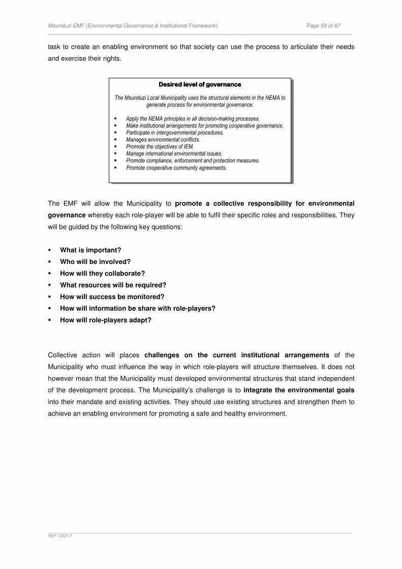
Msunduzi EMF (Environmental Governance & Institutional Framework) Page 59 of 87 _____________________________________________________________________________________________________
_______________________________________________________________________________________________________________________________________REF: C001-7
task to create an enabling environment so that society can use the process to articulate their needs
and exercise their rights.
The EMF will allow the Municipality to promote a collective responsibility for environmental
governance whereby each role-player will be able to fulfil their specific roles and responsibilities. They
will be guided by the following key questions:
� What is important?
� Who will be involved?
� How will they collaborate?
� What resources will be required?
� How will success be monitored?
� How will information be share with role-players?
� How will role-players adapt?
Collective action will places challenges on the current institutional arrangements of the
Municipality who must influence the way in which role-players will structure themselves. It does not
however mean that the Municipality must developed environmental structures that stand independent
of the development process. The Municipality’s challenge is to integrate the environmental goals
into their mandate and existing activities. They should use existing structures and strengthen them to
achieve an enabling environment for promoting a safe and healthy environment.
Desired level of governanceDesired level of governanceDesired level of governanceDesired level of governance
The Msunduzi Local Municipality uses the structural elements in the NEMA to generate process for environmental governance:
� Apply the NEMA principles in all decision-making processes. � Make institutional arrangements for promoting cooperative governance. � Participate in intergovernmental procedures. � Manages environmental conflicts. � Promote the objectives of IEM. � Manage international environmental issues. � Promote compliance, enforcement and protection measures.
� Promote cooperative community agreements.

Msunduzi EMF (Environmental Governance & Institutional Framework) Page 60 of 87 _____________________________________________________________________________________________________
_______________________________________________________________________________________________________________________________________REF: C001-7
TABLE 2: THE NATIONAL ENVIRONMENTAL MANAGEMENT ACT PROMOTES INTERACTION IN ENVIRONMENTAL GOVERNANCE
Constructive Engagement Structural element Government Society National
Environmental Management Principles
� Principles are used to develop and test policy and subsequent actions, including decision-making, legislation, regulation & enforcement.
� Principles guide society’s interaction and own responsibilities.
Institutions for promoting cooperative governance
� A Committee as the structure in which government organises themselves to promote IEM and environmental governance.
� Government is accountable through performance reporting.
� Municipalities voice their interests through Organised Local Government
� A Forum as the structure in which society organises themselves to participate in IEM and environmental governance.
� Society voices their interest & hold government accountable through measures of compliance monitoring.
� Society is accountable through performance reporting
Procedures for cooperative governance
Intergovernmental coordination and accountability
� Procedures & instruments facilitate intergovernmental coordination in achieving the objects of IEM.
� Government is accountable through performance reporting.
� Local government is accountable by complying with provincial plans and principles in the preparation of policies, programmes or plans emanating from the IDP process.
� Society participates in the procedures and voices their interests.
� Society holds government accountable against the various Plans and Annual Reports.
Fair decision-making and conflict management
� Government uses the procedures to mediate disputes.
� Government is accountable through performance reporting.
� Society exercises their right to participate in dispute resolution.
� Society holds government accountable against performance reporting.
Integrated Environmental Management
� Government uses the systematic approach and instruments of IEM to ensure informed decisions for sustainable development, e.g. EIA and EMF.
� Society exercises their right to be consulted and actively participates in the decision-making process. Science generates technical information.
International obligations and agreements
� Government uses mechanisms to deal effectively and in the national interest with international issues affecting the environment.
� Government is accountable through performance reporting reports
� Local government reports on their commitment to Local Agenda 21
� Society exercises their right to participate in international issues affecting the environment.
� Society holds government accountable against the performance report.
Compliance, enforcement and
protection
� Government takes measures to implement its duty of care.
� Government takes steps to protect people and communities from environmental risks.
� Government discloses information on environmental risks
� Society takes measures to implement its duty of care.
� Society holds government accountable if they fail to take measures to implement their duties.
� Society takes steps to protect people and communities from environmental risks.
� Society exercises their right to refuse hazardous work conditions
� Society exercises their right to legal standing to enforce environmental laws
Environmental Management Cooperation Agreements
� Government may enter into agreements with any person or community to promote compliance to environmental management principles.
� Society may enter into an agreement with any person or community to promote compliance to environmental management principles
Administration
� Government uses the mechanisms & measures available to purchase, expropriate or reserve land for environmental purposes, to intervene in litigation, inter into agreements, appoint contract employees, assign or delegate a power, function or duty, and make regulations.
� Local government encourages the use of model bylaws on matters affecting the environment in their area of jurisdiction.
� Society exercises their right to be consulted and actively participates in the decision-making process.

Msunduzi EMF (Environmental Governance & Institutional Framework) Page 61 of 87 _____________________________________________________________________________________________________
_______________________________________________________________________________________________________________________________________REF: C001-7
4.44.44.44.4 Efficiency and Effectiveness in Efficiency and Effectiveness in Efficiency and Effectiveness in Efficiency and Effectiveness in Environmental Environmental Environmental Environmental GoveGoveGoveGovernancernancernancernance
The EMF creates an opportunity for the Municipality to demonstrate commitment to their leadership
role in local environmental governance. Such a commitment will require them to lead by example and
this generates challenges with respect to its own institutional realities as the effectiveness of the
Municipality will be determined by the extent to which it would be able to demonstrate efficiency and
effectiveness in environmental governance.
4.4.1 Environmental Functions vs Obligations
The Msunduzi Local Municipality has environmental functions and
obligations. They exercise functions that impact the environment
and functions involving the management of the environment and
obligations (refer to section 3.4 of this report) and the expectation is
that they will exercise their key tasks in accordance with law. They
have to identify the impacts that their activities may have on the
environment and develop interventions to manage these impacts. They also have to give priority to
their purpose and functional areas of competence as expected by the Constitution.
The EMF will allow the Municipality to focus on the key environmental issues and priorities in the
area when they consider response strategies for fulfilling their strategic tasks. The environmental
situation should influence their management approach and how to best use the resources at their
disposal for producing results that meets customer needs.
4.4.2 Performance Management
The comprehensive approach adopted for the Msunduzi Municipality EMF demands that the outputs
of the EMF be incorporated in the Municipality’s Performance Management System. To this end they
will be expected to integrate environmental considerations in the process of service delivery. FIGURE
5 draws from best practices in performance management (DTLGA,
2003) to demonstrate how environmental governance should be
integrated into the management framework for the Municipality. Good
environmental governance calls for efficiency and effectiveness in
productivity and expects the following:
Desired level of Desired level of Desired level of Desired level of governance governance governance governance
The Municipality discharges their environmental functions and
obligations through the EMF.
Desired level of Desired level of Desired level of Desired level of governancegovernancegovernancegovernance
The EMF informs the Municipality’s Performance
Management System.

Msunduzi EMF (Environmental Governance & Institutional Framework) Page 62 of 87 _____________________________________________________________________________________________________
_______________________________________________________________________________________________________________________________________REF: C001-7
FIGURE 5: MANAGEMENT FRAMEWORK FOR ENVIRONMENTAL GOVERNANCE
INPUTS:
The Municipality will be making the best use of resources at their disposal. It includes environmental
resources and implies that it will be used sustainably and in a manner that protects the environment. It
also means that:
� They secure adequate budget for managing their environmental
functions and obligations.
� Their staff must be equipped with the necessary understanding
and skills and have access to information and knowledge to
perform effectively.
� Their facilities must be managed in a responsible manner.
PROCESS:
The Municipality’s business activities are carried out in an environmental responsible manner. The
following are examples of how the Municipality can contribute:
� They identify the impacts of their activities and services on the
environment and develop interventions to manage these
impacts.
� Planning processes takes cognizance of environmental
parameters.
� Environmental requirements are streamlined with business
functions, systems and activities.
� They work collectively and collaboratively with other
organisations and role-players, share information, make
decisions for the long-term and have responsive management styles.
� There is ongoing dialogue with society through fair, transparent and effective processes.
INPUTS TRANSFORMATION OUTCOME
Information Technology
Raw materials Labour Capital
Facilities
Products or Services
(Environmentally responsible)
Business Activities
(Corporate and Network
governance)
SHORT-TERM Desired State of
Governance LONG-TERM
Desired State of
Environment
PRODUCTIVITY (Efficiency and Effectiveness)
Maximize development results & minimise environmental impact
OUTPUTS
The process of developing the EMF will create human resource
capacity. The Municipality must
strengthen the resources
required to maintain it.
The Municipality uses the EMF to:
� Create process for
ongoing dialogue and collective action.
� Improve
environmental effectiveness & efficiency in service
delivery.

Msunduzi EMF (Environmental Governance & Institutional Framework) Page 63 of 87 _____________________________________________________________________________________________________
_______________________________________________________________________________________________________________________________________REF: C001-7
OUTPUTS:
The products and services that are delivered by the Municipality are environmentally sustainable.
Examples are:
� The facilities of the municipality will be energy efficient.
� Infrastructure will be environmentally sustainable.
� Policies and response strategies have been developed and are
implemented.
� Women and youth participate in environmental projects.
� Waste management bylaws are implemented.
� Planning documents such as the IDP and SDF will demonstrate conformance with the EMF.
OUTCOMES:
The Municipality’s products and services must satisfy the needs of customers. To this end the
Municipality will have to be reminded that their customers and their needs include inter alia:
� The environment and environmental limits that are not
exceeded.
� The “regulators” and the need to maintain the integrity of
government’s legal framework.
� Interest groups and the need for environmental justice.
� Customers who are not empowered to understand the need for
environmental integrity.
� Future generations and their unknown needs.
The Municipality will know whether it has achieved good results in the SHORT TERM if, amongst
others:
� They have achieved the desired levels of governance that was chosen as a contribution to the
state of the area’s environmental governance (developed through consensus).
� The development process has improved the institutional capacity within the Municipality.
� The Municipality’s leadership impacted the levels of participation amongst role-players.
� Organs of state have committed to support the environmental priorities of the area.
� The Municipality demonstrates a responsive management style (they adapt their strategies).
The Municipality will know whether it has achieved good results in the LONG-TERM if, amongst
others:
� Role-players are working together and they use natural resources sustainably.
� The quality of the environmental resources is improving or the desired environmental situation is
reached.
The Municipality’s products and services
demonstrate environmental
responsibility.
The result of the Municipality’s
governance contributes to:
� The desired state of
governance � The desired state of
the environment
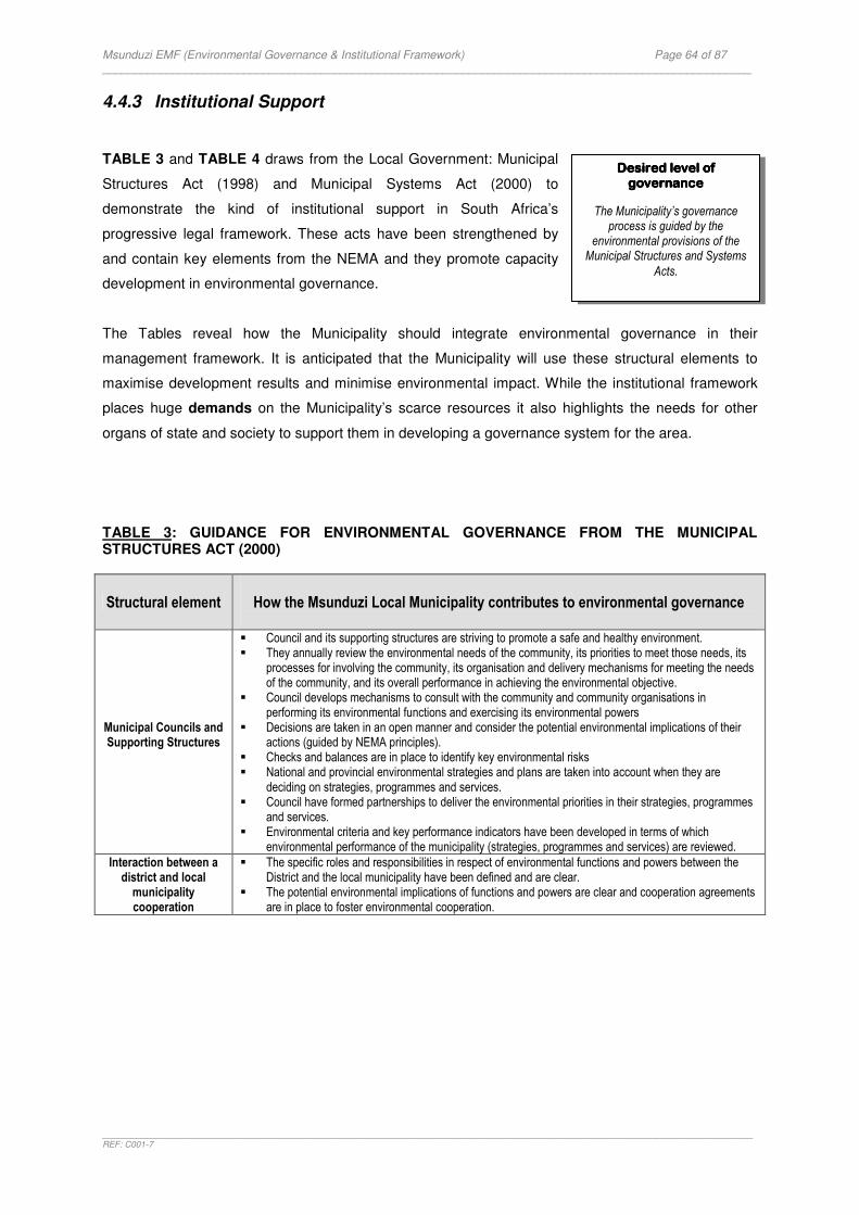
Msunduzi EMF (Environmental Governance & Institutional Framework) Page 64 of 87 _____________________________________________________________________________________________________
_______________________________________________________________________________________________________________________________________REF: C001-7
4.4.3 Institutional Support
TABLE 3 and TABLE 4 draws from the Local Government: Municipal
Structures Act (1998) and Municipal Systems Act (2000) to
demonstrate the kind of institutional support in South Africa’s
progressive legal framework. These acts have been strengthened by
and contain key elements from the NEMA and they promote capacity
development in environmental governance.
The Tables reveal how the Municipality should integrate environmental governance in their
management framework. It is anticipated that the Municipality will use these structural elements to
maximise development results and minimise environmental impact. While the institutional framework
places huge demands on the Municipality’s scarce resources it also highlights the needs for other
organs of state and society to support them in developing a governance system for the area.
TABLE 3: GUIDANCE FOR ENVIRONMENTAL GOVERNANCE FROM THE MUNICIPAL STRUCTURES ACT (2000)
Structural element
How the Msunduzi Local Municipality contributes to environmental governance
Municipal Councils and Supporting Structures
� Council and its supporting structures are striving to promote a safe and healthy environment. � They annually review the environmental needs of the community, its priorities to meet those needs, its
processes for involving the community, its organisation and delivery mechanisms for meeting the needs of the community, and its overall performance in achieving the environmental objective.
� Council develops mechanisms to consult with the community and community organisations in performing its environmental functions and exercising its environmental powers
� Decisions are taken in an open manner and consider the potential environmental implications of their actions (guided by NEMA principles).
� Checks and balances are in place to identify key environmental risks � National and provincial environmental strategies and plans are taken into account when they are
deciding on strategies, programmes and services. � Council have formed partnerships to deliver the environmental priorities in their strategies, programmes
and services. � Environmental criteria and key performance indicators have been developed in terms of which
environmental performance of the municipality (strategies, programmes and services) are reviewed.
Interaction between a district and local municipality cooperation
� The specific roles and responsibilities in respect of environmental functions and powers between the District and the local municipality have been defined and are clear.
� The potential environmental implications of functions and powers are clear and cooperation agreements are in place to foster environmental cooperation.
Desired level of Desired level of Desired level of Desired level of governancegovernancegovernancegovernance
The Municipality’s governance process is guided by the
environmental provisions of the Municipal Structures and Systems
Acts.
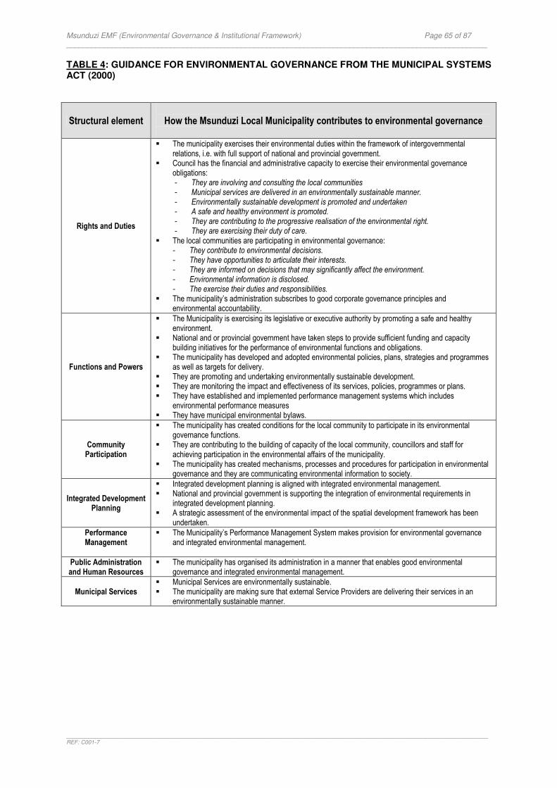
Msunduzi EMF (Environmental Governance & Institutional Framework) Page 65 of 87 _____________________________________________________________________________________________________
_______________________________________________________________________________________________________________________________________REF: C001-7
TABLE 4: GUIDANCE FOR ENVIRONMENTAL GOVERNANCE FROM THE MUNICIPAL SYSTEMS ACT (2000)
Structural element
How the Msunduzi Local Municipality contributes to environmental governance
Rights and Duties
� The municipality exercises their environmental duties within the framework of intergovernmental relations, i.e. with full support of national and provincial government.
� Council has the financial and administrative capacity to exercise their environmental governance obligations: - They are involving and consulting the local communities - Municipal services are delivered in an environmentally sustainable manner. - Environmentally sustainable development is promoted and undertaken - A safe and healthy environment is promoted. - They are contributing to the progressive realisation of the environmental right. - They are exercising their duty of care.
� The local communities are participating in environmental governance: - They contribute to environmental decisions. - They have opportunities to articulate their interests. - They are informed on decisions that may significantly affect the environment. - Environmental information is disclosed. - The exercise their duties and responsibilities.
� The municipality’s administration subscribes to good corporate governance principles and environmental accountability.
Functions and Powers
� The Municipality is exercising its legislative or executive authority by promoting a safe and healthy environment.
� National and or provincial government have taken steps to provide sufficient funding and capacity building initiatives for the performance of environmental functions and obligations.
� The municipality has developed and adopted environmental policies, plans, strategies and programmes as well as targets for delivery.
� They are promoting and undertaking environmentally sustainable development. � They are monitoring the impact and effectiveness of its services, policies, programmes or plans. � They have established and implemented performance management systems which includes
environmental performance measures � They have municipal environmental bylaws.
Community Participation
� The municipality has created conditions for the local community to participate in its environmental governance functions.
� They are contributing to the building of capacity of the local community, councillors and staff for achieving participation in the environmental affairs of the municipality.
� The municipality has created mechanisms, processes and procedures for participation in environmental governance and they are communicating environmental information to society.
Integrated Development
Planning
� Integrated development planning is aligned with integrated environmental management. � National and provincial government is supporting the integration of environmental requirements in
integrated development planning. � A strategic assessment of the environmental impact of the spatial development framework has been
undertaken.
Performance Management
� The Municipality’s Performance Management System makes provision for environmental governance and integrated environmental management.
Public Administration and Human Resources
� The municipality has organised its administration in a manner that enables good environmental governance and integrated environmental management.
Municipal Services � Municipal Services are environmentally sustainable. � The municipality are making sure that external Service Providers are delivering their services in an
environmentally sustainable manner.
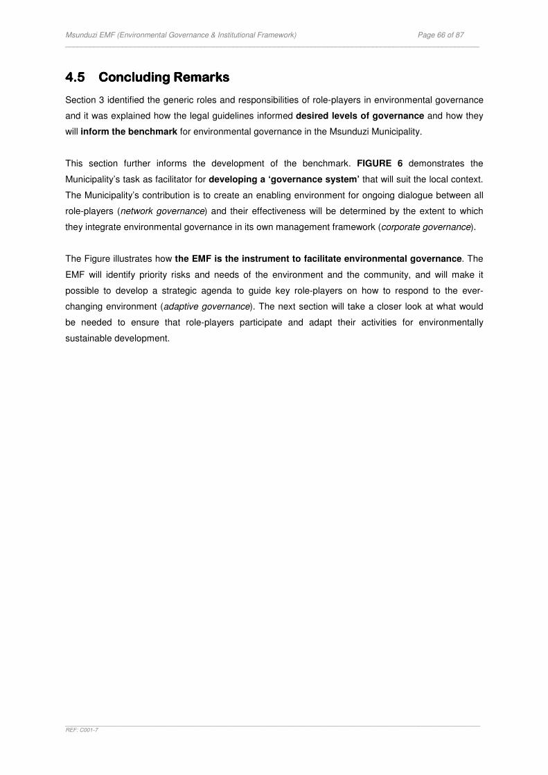
Msunduzi EMF (Environmental Governance & Institutional Framework) Page 66 of 87 _____________________________________________________________________________________________________
_______________________________________________________________________________________________________________________________________REF: C001-7
4.54.54.54.5 Concluding Concluding Concluding Concluding RRRRemarksemarksemarksemarks
Section 3 identified the generic roles and responsibilities of role-players in environmental governance
and it was explained how the legal guidelines informed desired levels of governance and how they
will inform the benchmark for environmental governance in the Msunduzi Municipality.
This section further informs the development of the benchmark. FIGURE 6 demonstrates the
Municipality’s task as facilitator for developing a ‘governance system’ that will suit the local context.
The Municipality’s contribution is to create an enabling environment for ongoing dialogue between all
role-players (network governance) and their effectiveness will be determined by the extent to which
they integrate environmental governance in its own management framework (corporate governance).
The Figure illustrates how the EMF is the instrument to facilitate environmental governance. The
EMF will identify priority risks and needs of the environment and the community, and will make it
possible to develop a strategic agenda to guide key role-players on how to respond to the ever-
changing environment (adaptive governance). The next section will take a closer look at what would
be needed to ensure that role-players participate and adapt their activities for environmentally
sustainable development.
Msunduzi EMF (Environmental Governance & Institutional Framework) Page 67 of 87 _____________________________________________________________________________________________________
_______________________________________________________________________________________________________________________________________REF: C001-7
FIGURE 6: BENCHMARK FOR ENVIRONMENTAL GOVERNANCE: SYSTEMS AND TOOLS - (MSUNDUZI LOCAL MUNICIPALITY)
Expected Outcome
NATIONAL & PROVINCIAL GOVERNMENT
Contribute & support local environmental
governance.
Expected Outcome LOCAL GOVERNMENT
Contribute & support local environmental
governance.
Expected Outcome
SOCIETY AT LARGE
Contribute & support local environmental
governance.
“NETWORK GOVERNANCE” Opportunities for interaction & collective action
“NETWORK GOVERNANCE” Expected Outcome
MSUNDUZI MUNICIPALITY
Demonstrate leadership
An’ Environmental Governance System’ for the context
© M Thornhill (2008)
EMF (Context) � State of Environment: environmental situation, issues and priorities. � Potential significant impacts of role-players identified. � Strategic Agenda. � Monitoring
Expected Outcome (Response strategies)
NATIONAL & PROVINCIAL GOVERNMENT
PILLAR 2PILLAR 2PILLAR 2PILLAR 2
A focus on systems & A focus on systems & A focus on systems & A focus on systems & toolstoolstoolstools
DESIRED SITUATION
Government has created an enabling environment for ongoing dialogue between all role-players and each
role-player has organised’ themselves for good environmental
governance � Government uses the EMF as
an instrument for generating process for interaction.
� The decision-making process
is supported by developing institutional capacity for managing the instrument.
� Each role-player demonstrates
commitment to the process.
Expected Outcome (Response strategies)
SOCIETY AT
LARGE
INPUTS TRANSFORMATION OUTCOME
Information Technology
Raw materials Labour Capital
Facilities
Products or Services
(Environmentally Responsible)
Business Activities
(Corporate & Network
Governance)
SHORT-TERM Desired State of
Governance LONG-TERM
Desired State of Environment
PRODUCTIVITY (Efficiency and Effectiveness) Maximize development results & minimise environmental impact
OUTPUTS
“CORPORATE GOVERNANCE”
PILLAR 1PILLAR 1PILLAR 1PILLAR 1
A focus on peopleA focus on peopleA focus on peopleA focus on people
DESIRED SITUATION
Environmental decision-making in the Msunduzi area involves role-players
from government, society and science sectors.
� Each role-player understands
their role and responsibilities in the EMF.
� Role-players are empowered
and share information. � Role-players have
opportunities to articulate their needs, exercise their rights, discharge their legal obligations and have potential conflicts mediated.
Msunduzi EMF (Environmental Governance & Institutional Framework) Page 68 of 87 _____________________________________________________________________________________________________
_______________________________________________________________________________________________________________________________________REF: C001-7
SECTION SECTION SECTION SECTION 5555: : : : A FOCUS ON THE FUTURE A FOCUS ON THE FUTURE A FOCUS ON THE FUTURE A FOCUS ON THE FUTURE
This section identifies critical steps for refining the benchmark and for planning a desired state of
environmental governance for the Msunduzi Municipality.
5.15.15.15.1 IntroductionIntroductionIntroductionIntroduction
The desired future of the Msunduzi Municipality displays a situation
where all role-players are contributing to a sustainable future.
This future situation can only be achieved if:
� Role-players are guided by a vision for the future.
� The context informs the priorities and tasks to be informed.
� A desired state of governance for the area is defined by
consensus.
� Role-players demonstrate commitment to the future situation.
� There is collective action.
� Progress is monitored and evaluated.
� Role-players and their systems adapt to the ever-changing
environment.
The previous sections created the desired levels and systems of
governance as it relates to role-players and their systems and tools. It represents targets or desired
states and allows role-players to ‘plan with the end in mind’ (i.e. the outcome) and to monitor progress
towards the desired future.
Planning for the future must however be informed by an understanding of the existing situation and
an agreement of a desired situation. The future must be decided based on realities if the goal is to
ensure ‘collective action’ and these realties must be improved and constantly monitored if the
environmental governance targets must be achieved.
FIGURE 7 demonstrates critical steps for refining the environmental governance benchmark.
PILLAR 3PILLAR 3PILLAR 3PILLAR 3
AAAA focus on the future focus on the future focus on the future focus on the future
DESIRED SITUATION
There is agreement that each role-player is contributing to a
sustainable future � Role-players have agreed
on a desired state of governance for the area.
� There is a yard-stick in
place to monitor environmental governance.
� Role-players engage in
adaptive policy-making

Msunduzi EMF (Environmental Governance & Institutional Framework) Page 69 of 87 _____________________________________________________________________________________________________
_______________________________________________________________________________________________________________________________________REF: C001-7
FIGURE 7: Refining the environmental governance benchmark for continuous improvement.
5.25.25.25.2 A Vision for Environmental GovernanceA Vision for Environmental GovernanceA Vision for Environmental GovernanceA Vision for Environmental Governance
The desired future situation in the Msunduzi Municipality must reflect the kind of environment and
quality of life that the community wants for their area. The EMF will provide information on the existing
environmental situation and it will allow role-players to think about what they want the future
environmental situation to be like.
The development of a vision should ideally reflect the statutory duty to contribute to the achievement
of sustainable development in the Msunduzi Municipality. The desired levels and systems of
Role-players
Systems & Tools
Future
Roles & Responsibilities: Government
Society
Desired levels of governance: Opportunities for ‘Collective action’
Responses
A desired system of governance: An enabling environment that
creates capacity
EMF as an instrument to promote system development.
Desired State of Governance: Vision
Consensus on priorities
� Develop Strategic Agenda
� Develop Strategies � Develop Implementation
plans � Who will be involved? � How will they
collaborate? � Allocation of resources? � How will we monitor
success?
Implement (Continuous system
development)
Monitor, Evaluate, Report
Environmental Performance
Adapt
Monitor, Evaluate, Report
Institutional Performance
Adapt
State of environment, issues and priorities.

Msunduzi EMF (Environmental Governance & Institutional Framework) Page 70 of 87 _____________________________________________________________________________________________________
_______________________________________________________________________________________________________________________________________REF: C001-7
governance identified in the previous sections must therefore be used when thinking about the future,
but so would community needs and the local environmental context.
A broad consensus in society on what is in the best interest of the whole community and how this can
be achieved requires a broad and long-term perspective on what is needed for sustainable human
development and how to achieve the goals of such development. To this
end the White Paper on Environmental Management Policy (1998)
offers guidelines to influence the development of an environmental
vision for the Msunduzi Municipality. These guidelines have been
considered here against the need to focus on a desired state of
governance that will result in good environmental outcomes. The
desired future of the Msunduzi Municipality displays the following:
� An ‘environmental governance system’.
� A society that works together.
� Government maintains the integrity of the legal framework for environmental governance.
� There are win-win-win solutions.
� Environmental governance is an integrated part of the development process of all role-players.
� Priorities are determined by the legal framework and the area’s context.
� The quality of the environment is enhanced and impacts are controlled by using the best
possible measures, mechanisms and instruments.
The desired state of governance in the Msunduzi Municipality will however be determined by the
area’s environmental needs and the institutional capacity that is available for meeting these needs.
5.35.35.35.3 Considering the Considering the Considering the Considering the ContextContextContextContext
The task of the EMF is to analyse the existing environmental situation, issues and priorities to
establish a baseline for future planning. The existing situation will allow role-players to obtain answers
on the following key questions:
� What is important?
� Who must be involved?
� What must they do?
� How will they collaborate?
� What resources will be required?
� How will success be monitored?
� How will information be shared?
� How will role-players adapt their activities?
Desired level of Desired level of Desired level of Desired level of governancegovernancegovernancegovernance
The Environmental Vision for the Msunduzi Municipality
considers the desired state of
environmental governance.
Desired level of Desired level of Desired level of Desired level of governancegovernancegovernancegovernance
Determining the desired future situation of the Msunduzi Municipality considers the
environmental priorities.
Msunduzi EMF (Environmental Governance & Institutional Framework) Page 71 of 87 _____________________________________________________________________________________________________
_______________________________________________________________________________________________________________________________________REF: C001-7
Planning for the future state of governance means that the baseline
situation must also consider the existing state of governance in the
area. To this end it is specifically important to analyse the Municipality’s
institutional capacity for advancing good environmental governance
for the desired levels of environmental quality. The resources of the
EMF Project do not provide for such an assessment and it therefore
creates a planning gap. The specialists’ assessment may however provide some insights into how the
Municipality is responding to key environmental issues.
The context and existing environmental situation will inform the specific contributions that key role-
players need to make in addressing the area’s environmental priorities. In practice it will require each
role-player to consider its own activities and how they may influence the environmental situation. They
would then be able to consider interventions and response strategies.
5.45.45.45.4 A Future by A Future by A Future by A Future by ConsensusConsensusConsensusConsensus
There are several actors and as many view points in a given society. The different interests in society
must be mediation to reach a broad consensus on what is in the best interest of the whole
community, how this can be achieved and who should play key roles.
The context will influence decisions about the future state of governance and will inform the
development of a strategic agenda with goals, objectives, strategies and monitoring mechanisms for
environmental governance. Key role-players should acknowledge their tasks in achieving the agenda.
Two important guidelines:
� The commonly sited ‘lack of capacity’ should not justify weak governance that only leads to
environmental degradation. Consensus is about playing ‘a collective game’ to shape
environmental outcomes that does not compromise the socio-
economic rights of society.
� The development of measurements for environmental
governance (indicators) should respond to the information
demands of the community. Consensus on the key questions
from the public should therefore influence commitment and performance monitoring.
Desired level of Desired level of Desired level of Desired level of governancegovernancegovernancegovernance
The future situation of the Msunduzi Municipality is
developed by consensus.
Desired level of Desired level of Desired level of Desired level of governancegovernancegovernancegovernance
Determining the desired future situation of the Msunduzi Municipality considers the
existing institutional capacity.
Msunduzi EMF (Environmental Governance & Institutional Framework) Page 72 of 87 _____________________________________________________________________________________________________
_______________________________________________________________________________________________________________________________________REF: C001-7
5.55.55.55.5 CommitmentCommitmentCommitmentCommitment for Collective Action for Collective Action for Collective Action for Collective Action
The legal guidelines create the expectation that each role-player group contributes and support
environmental governance. It underlines the need for role-players to
interact and find the best options to contribute collectively to the area’s
environmental priorities.
The expectation is that each role-player will consider its activities, how
they may influence the existing environmental situation in the area and
how they could commit a contribution. The ideal situation reflects the
development of formal response strategies.
5.65.65.65.6 Performance Performance Performance Performance MMMMonitoringonitoringonitoringonitoring
The EMF will have to develop a system to monitor and evaluate the efforts of role-players. The
qualitative nature of governance makes the identification of measuring points difficult. For example it is
much easier to identify quantifiable activities (e.g. emissions form a specific industry, a municipality’s
response in terms of wastewater management) than non-quantifiable activities (e.g. how role-players
work together).
Performance monitoring will have to include:
� A programme that monitors environmental quality in order to detect changes in the
environment.
� A programme that monitors institutional performance in order to measure progress towards
the desired levels of governance (i.e. ‘distance to target’).
The framework for structuring monitoring information in the Monitoring & Evaluation System should
consider the context within which monitoring take place. In other words, while monitoring
environmental quality may make use of a Pressure-State-Response type framework, institutional
monitoring need to structure information into a management framework that correspond better to the
planning frameworks used by organisations (i.e. a Logic Model as used
by local government).
The development of indicators should also be carefully considered as
they have to respond to the key issues and concerns from the public.
The SEA process will provide opportunities for society to identify their key
questions.
The EMF will have to consider monitoring arrangements where both the local authority and the
Department of Agriculture and Environmental Affairs monitor results.
Desired level of Desired level of Desired level of Desired level of governancegovernancegovernancegovernance
The future situation of the Msunduzi Municipality
demonstrates collective action.
Desired level of Desired level of Desired level of Desired level of governancegovernancegovernancegovernance
The future situation of the Msunduzi Municipality measures trends in
environmental quality and
institutional performance.
Msunduzi EMF (Environmental Governance & Institutional Framework) Page 73 of 87 _____________________________________________________________________________________________________
_______________________________________________________________________________________________________________________________________REF: C001-7
5.5.5.5.7777 ConcluConcluConcluConcluding Remarksding Remarksding Remarksding Remarks
The EGI Framework provides the benchmark for informing and measuring the future environmental
governance of the Msunduzi Municipality. It offers the ‘rules of the game’ and allows each role-player
to play their part for achieving a desired environmental situation in the area.
Achieving the desired state of environmental governance is a process that will have to develop a
phased approach and ongoing communication and consultation with role-players.
The quality if the Msunduzi Municipality’s environment will be determined by the extent to which the
governance system achieves the desired levels of governance.
Msunduzi EMF (Environmental Governance & Institutional Framework) Page 74 of 87 _____________________________________________________________________________________________________
_______________________________________________________________________________________________________________________________________REF: C001-7
SECTION SECTION SECTION SECTION 6666: : : : ENVIRONMENTAL ENVIRONMENTAL ENVIRONMENTAL ENVIRONMENTAL GOVERNANCE GOVERNANCE GOVERNANCE GOVERNANCE OUTLOOK OUTLOOK OUTLOOK OUTLOOK
This section introduces the benchmark that was developed in the study as a key tool to inform future
choices and offers some qualitative observations on the ‘state of environmental governance’ in the
Msunduzi Municipality. The aim is to demonstrate the application of the benchmark.
6666.1.1.1.1 IntroductionIntroductionIntroductionIntroduction
A framework or system for monitoring environmental governance does not exist in South Africa.The
EGI Framework for the Msunduzi Municipality EMF contributes to the advancement of a monitoring
system for environmental governance. It adopts a ‘top-down’ approach to institutional assessment that
allows for performance assessment against key institutional tasks and develops a benchmark against
which institutional effectiveness and the state of environmental governance could be measured in
future.
6.26.26.26.2 A Strategic AgendaA Strategic AgendaA Strategic AgendaA Strategic Agenda
The benchmark for measuring environmental governance has three pillars which could be interpreted
to become the strategic goal of governance. The strategic goal is a desired outcome, a desired state
or the goal for change or improvement. The goal could be phrased as follows:
To create an enabling environment for promoting a collective responsibility for environmental
governance in the Msunduzi Municipality
The desired state of governance in the Msunduzi Municipality will be achieved if:
� National and provincial government and organs of state demonstrates a commitment to support
local environmental governance.
� Local government demonstrates leadership for creating a ‘governance system’ for the area
contribute and support local environmental governance – they demonstrates.
� Society at large demonstrates a commitment to support local environmental governance.
The benchmark identifies ‘legal threshold objectives’ or outcome objectives that apply generically to
all role-players. The context within which they are applied will dictate their applicability. The outcome
objectives for the Msunduzi Municipality are as follows:
� Leadership in environmental governance
Msunduzi EMF (Environmental Governance & Institutional Framework) Page 75 of 87 _____________________________________________________________________________________________________
_______________________________________________________________________________________________________________________________________REF: C001-7
� Intergovernmental Cooperation
� Efficiency and Effectiveness in Environmental Governance
� Information sharing
� Participation in Environmental Governance
The desired levels of governance as identified by the benchmark gives an indication of what the
process of governance should look like to achieve the objectives. The governance process will be
influenced by the context-specific priorities which will also allow for the development of outcome
indicators to measure ‘distance to target’ (i.e. the progress towards the objectives).
The following section demonstrates application of the benchmark. It illustrates how the Municipality,
as a key role-player, contributes to the process of governance.
6.36.36.36.3 Environmental GovernanceEnvironmental GovernanceEnvironmental GovernanceEnvironmental Governance in the Local Municipality in the Local Municipality in the Local Municipality in the Local Municipality
A qualitative assessment was carried out by extracting context-specific issues from various municipal
documents through a desktop analysis, notably the Municipality IDP. The assessment is structured
into tables that offer preliminary observations.
6.3.1 Leadership in Environmental Governance
The effectiveness of the Msunduzi Local Municipality in promoting a safe and healthy environment will
be determined by the extent to which it would be able to demonstrate leadership in local
environmental governance.
The desired levels of governance that need to be attained to achieve environmental leadership
include:
� The Municipality understands its environmental functions and obligations.
� Council and its supporting structures demonstrate environmental oversight.
� They demonstrate leadership through corporate citizenship.
� They demonstrate environmental accountability, transparency, communication and
participation and efficiency and effectiveness.

Msunduzi EMF (Environmental Governance & Institutional Framework) Page 76 of 87 _____________________________________________________________________________________________________
_______________________________________________________________________________________________________________________________________REF: C001-7
EXPECTED OUTCOME: Leadership in Environmental Governance
Key questions: � Is there evidence that Council and its supporting structures are committed to environmental values? � To what extent do they exercise environmental oversight? � What bylaws have been developed, implemented and enforced with respect to protection functions (solid waste, waste water,
parks/open space etc)? � What conservation policies have been developed and implemented with respect to water, land, air, urban greening? � How is the Municipality enforcing environmental laws? How many environmental prosecutions? � To what extent does council involve traditional leadership in environmental governance? � Are politicians and senior officials aware of the environmental values of their area? Are they trained in environmental governance?
Signs of good environmental governance: � Council is demonstrating an awareness of environmental values. The IDP reflects a Municipality that has positioned itself strategically
for environmental governance. � Council has created the LA21 Environmental Forum. It is chaired by an EXCO councillor. It is the only committee in council with
membership from civil society. � Council has adopted an IEM Policy and is taking steps to institutionalize it. � There has been an improvement in the information management infrastructure which allows for future mainstreaming of
environmental information into decision-making. � The EMF is a collaborative effort between DEAT and DAEA & Municipality.Partnership for this project demonstrates leadership.
Signs of weak environmental governance: � Council are experiencing difficulties in operationalizing environmental objectives and there is no evidence of environmental standards
for governing its operations. The weak management systems are impacting the environmental oversight function. � The Sound Governance Business Unit seems to neglect the environmental dimension of governance. � The development, implementation and enforcement of environmental bylaws need to be improved. � There are conflicting pressures between the protection of the environment and the need for service delivery and development - it
demonstrates an underscoring of environment as a resource. � The political decision makers do not demonstrate an understanding of environmental issues. There is a need to better equip the local
officials through increased funding, increased staff and increased political support.
Existing indicators: � IDP Commitment to the environment. � No of environmental policies and bylaws. � Has the Municipality audited its plans, policies and programmes for adherence to NEMA principles?
Proposed indicators: � Capacity to develop, implement and enforce environmental by-laws.
6.3.2 Intergovernmental Cooperation
The effectiveness of the Msunduzi Local Municipality will be determined by the extent to which it is
able to take a leadership role in intergovernmental relations around environmental matters.
The desired levels of governance that need to be attained to achieve intergovernmental cooperation
in environmental matters include:
� The Municipality discharges their environmental functions and obligations within the
framework for intergovernmental relations.
� They promote environmental accountability in their area of jurisdiction and expect every organ
of state to contribute to environmental governance.
� They expect the DEAT and DAEA to demonstrate leadership for environmental coordination in
their area.
� They expect the DAEA to provide support, monitor and develop their capacity for
environmental governance.
� They promote environmental cooperation with the district & neighbouring municipalities
Msunduzi EMF (Environmental Governance & Institutional Framework) Page 77 of 87 _____________________________________________________________________________________________________
_______________________________________________________________________________________________________________________________________REF: C001-7
EXPECTED OUTCOME: Intergovernmental Cooperation
Key questions: � To what extent has the Municipality incorporated national and provincial environmental objectives in their processes? � To what extent are they participating in intergovernmental structures? � Has the Municipality created structures, mechanisms or instruments to promote participation in environmental governance? � To what extent are government departments and other organs of state considering the impacts of their activities on the Msunduzi
Municipality’s environmental resources? � To what extent are government departments and other organs of state engaging with the LA 21 Environmental Forum? � What contribution are government departments making to environmental programmes in the Msunduzi Municipality? � To what extent does the DAEA support the Municipality? Do they support, monitor and develop the Municipality’s capacity for
environmental governance? � What opportunities do the public have to demand accountability in Intergovernmental cooperation?
Signs of good environmental governance: � The IDP process creates opportunities for all organs of state to participate and contribute to environmental governance. � The Municipality’s IDP reflects the provincial sector department’s environmental objectives. � The LA21 Environmental Forum creates participation opportunities for organs of state. � The DAEA has produced various resources to support integrated environmental (e.g. guidelines for IDP, Waste Management Plans). � The DAEA has demonstrated commitment to support the Greater Edendale Development Initiative. � The DAEAA has allocated budget for air pollution monitoring. � The Provincial Department of Transport has launched the ‘Waste for Food’ Project. � The EMF is a collaborative effort between DEAT and DAEA & Municipality.
Signs of weak environmental governance: � The Municipality’s IDP reflects priority national/ provincial environmental objectives but no plans of implementation. � Organs of state generally demonstrate weak commitment to participation in the IDP process. There is a general lack of coordination,
cooperation & engagement between the municipality and service providers/sector departments and there is a need to improve mechanisms to facilitate coordination and integration.
� The IDP reflects no budget allocations by sector departments for environmental programmes in the area (exception for air pollution monitoring).
� The Municipality is not complying with the Department of Agriculture and Environmental Affairs’ guidelines to incorporate environmental considerations into the IDP process.
� The public have little opportunities to demand accountability in intergovernmental cooperation.
Existing indicators: � IDP Commitment to the environment.
Proposed indicators: � Capacity for cooperating with other spheres in environmental management � Budget allocations from organs of state to environmental programmes. � Implementation protocols for environmental management � Environmental commitments in the 5-Year Local Government Strategic Agenda
6.3.3 Efficiency & Effectiveness in Governance
The effectiveness of the Msunduzi Local Municipality will be determined by the extent to which it can
demonstrate efficiency and effectiveness in environmental governance.
The desired levels of governance that need to be attained to achieve institutional efficiency and
effectiveness include:
� The Municipality creates the capability to carry out their environmental governance, protection
and management functions.
� They secure adequate budgets for managing environmental priorities.
� They create capacity for environmental governance.
� They integrate environmental considerations in the process of delivering products and
services.
� Their products and services are environmentally sustainable.
Msunduzi EMF (Environmental Governance & Institutional Framework) Page 78 of 87 _____________________________________________________________________________________________________
_______________________________________________________________________________________________________________________________________REF: C001-7
EXPECTED OUTCOME: Efficiency and Effectiveness in Governance
Key questions: � Is there sustainable financing for environmental governance? � Is the organisational structure aligned with the key tasks of the Municipality? � Does the Municipality have a strategy or an overall approach for addressing environmental priorities? � Is the Municipality’s systems aligned with the key tasks of the Municipality? For example, do they have operational policies and
procedures to guide every-day tasks and do they have the ability to adapt and adjust to changing circumstances? � Does the Municipality have the necessary skills to perform their key environmental tasks? � Does the Municipality manage their facilities in a responsible manner? For example do they have measures in place to minimise
waste or to be energy efficient? � Does the Municipality demonstrate an ability to work collectively and collaboratively with its key partners and society at large? � How does the Municipality ensure that its Service Providers contribute to environmental governance?
Signs of good environmental governance: � The Municipality has developed an environmental vision and Council has adopted an IEM Policy. � The Municipality has positioned itself strategically to respond to environmental challenges - it shows awareness of environmental
responsibilities and indicates a problem of discharging obligations.
� Strategies and budgets are allocated to environmental protection functions, e.g. the development, upgrade and maintenance of water and sanitation infrastructure mitigates environmental impacts.
� Budget has been allocated to selected environmental projects. � Budget has been allocated for ensuring environmental compliance in selected functional areas, e.g. provision has been made for
EIAs for Electrification Services. � Council has adopted a LA21 Initiative which proves to be sustainable. � The Municipality has developed environmental values on the strategic level, for example The Infrastructure; Services & Facilities
Business Unit’s Service Charter includes environmental values. � The Greater Edendale Development Initiative has mainstreamed poverty and environment. � As a member of the South African Cities Network the Municipality demonstrates an ability to collaborate and exchange information for
sustainable strategy development.
Signs of weak environmental governance: � There is no comprehensive plan of implementation for environmental management. � There are inadequate financial and human resources to carry out the municipality’s environmental responsibilities. � The increase in environmental awareness within Council has a distinct impact on the environmental unit’s capacity. It leads to a state
of inability to respond to the many opportunities for alignment and integration. There is a definite need to increase the numbers of posts.
� There is no evidence to suggest sustainable financing for achieving key tasks, e.g. the IDP does not reflect budgets for ongoing environmental programmes for the 2007/08 to 2010/11 financial years. There is also no evidence that budget have been allocated for EIAs in infrastructure development projects. There is inadequate budget allocations to waste management
� There is ample evidence that the Municipality is unable to manage their legal environmental obligations. Examples of non-compliance include: - Weak integration of environmental considerations in the IDP process specifically demonstrated by the absence of
environmental sector plans (waste, air quality, Integrated Environmental Management Programme). - The SDF does not contain a strategic assessment of its environmental impact as is required by the MSA Regulations. - Key environmental sector plans are not in place. - Weak integration of EIA into municipal infrastructure projects - Non compliance regarding drafting/monitoring of EMP’s for housing projects.
� There is no evidence that the Municipality have considered the impacts of their activities on the environment. There are no environmental standards for service delivery.
� There is no evidence to suggest that the Municipality demands its Service providers to demonstrate commitment to environmental governance.
� There is no proclaimed, integrated open space system. � The apparent lack of documented policies & procedures impacts transparency, objectivity & accountability.
Existing indicators: � Capacity indicators:
- Budgetary allocation for environment - Staff numbers for managing the environment - Budget allocated for skills training
� The development and implementation of IMEP priority strategies: noise pollution, coastal management, litter and illegal dumping, air pollution and quality open space, especially in disadvantaged areas.
� Has the municipality audited its plans, policies and programmes for adherence to the NEMA principles? � IDP Commitment to the environment:
- The extent to which IEM has been included into the IDP/SDF - Has a strategic environmental assessment of the impact of the Spatial Development Framework for the municipality been
carried out? - For each of the following, is there a current, adopted plan that is integrated and aligned to the IDP? Air Quality Plan, Integrated
Waste Management Plan, Oil Spill Contingency Plan, Water Services Development Plan, Plan to provide access to basic water services; Invasive Species monitoring, control and eradication plan.
- Is the IDP aligned to the National Biodiversity Strategy & Bioregional Plan?

Msunduzi EMF (Environmental Governance & Institutional Framework) Page 79 of 87 _____________________________________________________________________________________________________
_______________________________________________________________________________________________________________________________________REF: C001-7
� Has the municipality officially adopted the Agenda 21 process? � Is there an approved implementation plan for Agenda 21? � The number of EIA applications received per year. � Number of EIAs evaluated. � Number of development applications commented on
Proposed indicators: � Financial contributions (expenditure by population/against key tasks/skills development) � Ratio of environmental staff to total staff by gender � IDP Commitment to the environment (integration of environmental performance indicators in the PMS) � Institutional arrangements or mechanisms (guidelines, standards, cooperation agreements with service providers) to ensure
environmental considerations are integrated in service delivery. � No of EIAs as a % of total infrastructure projects � The extent to which EIA’s for infrastructure projects conforms to the EMF parameters.
6.3.4 Information Sharing
The effectiveness of the Msunduzi Local Municipality will be determined by the extent to which it
discloses and share environmental information.
The desired levels of governance that need to be attained to achieve the expected outcome include:
� The Municipality creates capacity for information management.
� They regularly disclose and share environmental information with society (specifically as
regards environmental risks).
� They expect other organs of state and society groups to disclose and share information.
� They involve science for quality information and the creation of knowledge.
� They promote the sharing of local knowledge.
EXPECTED OUTCOME: Information Sharing
Key questions: � Does the municipality have capacity for managing information? � Does the Municipality disclose information on environmental quality, trends, pollution from industry, emergencies and risks? � Is there sustainable financing for managing information? � Is the organisational structure aligned with the need for environmental information management? � Does the Municipality have a strategy or an overall approach for sharing environmental information? � Does the Municipality have the necessary skills to manage environmental information?
Signs of good environmental governance: � The IDP reflects commitment to information management and communication for improved decision-making. � Improvements in the information management infrastructure and system at the strategic level provide promising opportunities for
inclusion of environmental information. � There seems to be capacity for managing spatial information but the extent is not known. � The Municipality’s website demonstrates improvement in information management.
Signs of weak environmental governance: � The Municipality does not disclose information on their environmental performance. � Capacity for managing environmental information seems to be limited. � There is no integrated communication strategy. � Role-players feel that the City needs to ‘take control of the environmental situation, move away from reliance on consultants for core
functions such as monitoring and managing information’. � Information disclosure in the media reflects negative reporting.
Existing indicators: � Budgetary allocation to environmental research.
Proposed indicators: � Capacity for managing environmental information � Accessibility of information

Msunduzi EMF (Environmental Governance & Institutional Framework) Page 80 of 87 _____________________________________________________________________________________________________
_______________________________________________________________________________________________________________________________________REF: C001-7
6.3.5 Participation in Environmental Governance
The effectiveness of the Msunduzi Local Municipality will be determined by the extent to which it
would be able to demonstrate commitment to participation in environmental governance.
The desired levels of governance that need to be attained to achieve the expected outcome include:
� The Municipality promotes society’s participation and cooperation in environmental
governance.
� They create opportunities for society to partake in environmental projects.
� They build environmental capacity of the local community, councillors and staff for achieving
participation in the environmental affairs of the Municipality.
� They manage environmental conflicts.
� They promote partnerships between organs of state and the private sector.
EXPECTED OUTCOME: Participation in Environmental Governance
Key questions: � Does the Municipality have capacity for promoting and managing participation of all sectors of society in environmental governance? � Is there sustainable financing for managing public participation in environmental governance? � What opportunities are there for the public (all groups) to participate in environmental governance? How can they influence
decisions? � How do they promote the participation of special interest groups in environment governance? � How do they promote commitment from business and industry? � What structures, mechanisms and processes are in place to promote dialogue with society? � To what extent does the Municipality promote community well-being through education, awareness and empowerment? � To what extent is traditional leadership in involve in environmental governance? � How are environmental conflicts resolved in the Msunduzi Municipality?
Signs of good environmental governance: � The Municipality displays a strong commitment to community participation through the IDP process. The IDP creates opportunities for
all sectors of society to participate through various structures and mechanisms such as the Mayoral Izimbizo meetings, traditional council offices, multi-purpose centres, community-based planning etc.
� The IDP identifies the development of policy for community participation – it creates opportunities for mainstreaming environment. � governance � The IDP identifies the role of special interest groups (women and youth) in environmental governance. � The LA 21 provides opportunities for society to contribute to environmental decision-making. � There are various sector-specific structures for promoting society’s participation in environmental governance, e.g. Catchment
Management and Air Quality Forum. � Future plans for ward-based plans will enhance society’s opportunities to participate in environmental governance. � There is strong evidence of various stakeholder groups that have organised themselves in environmental governance.
Signs of weak environmental governance: � There is no evidence to suggest sustainable financing for promoting empowerment in environmental governance, e.g. the IDP does
not reflect budgets for Environmental Awareness and Education Programmes for the 2007/08 to 2010/11 financial years. � There seems to be no environmental communication strategy. � Inadequate understanding of environmental issues and commitment of resources from the decision-makers, some businesses and
developers. � The attitude, behaviour and involvement of people in both affluent and less resourced areas constrain initiatives aimed at curbing
menaces such as illegal dumping of solid waste. � Constituents perceive environmental issues as the responsibility of the local government. � Environmental education, awareness and raining programmes are needed for all sectors of the population to make every individual
conscious of his/her responsibility to LA 21 principles.
Existing indicators: � Budgetary allocation to environmental education � Level of environmental awareness and education.
Proposed indicators: � Capacity for participation in environmental governance � Capacity of councillors to promote environmental governance � Budgetary allocation to environmental education � The extent to which communities participate in structures, mechanisms & procedures. � Environmental agreements with society groups � No of youth and women participants in environmental projects
Msunduzi EMF (Environmental Governance & Institutional Framework) Page 81 of 87 _____________________________________________________________________________________________________
_______________________________________________________________________________________________________________________________________REF: C001-7
6666....4444 Effectiveness of the EMF Effectiveness of the EMF Effectiveness of the EMF Effectiveness of the EMF
The benchmark also considered the EMF as a key institutional instrument for achieving environmental
governance. The effectiveness of the EMF will be determined by the extent to which it achieves its
key institutional tasks. The need to focus on the instrument was highlighted by the key issues
identified by stakeholders during the Planning Workshop:
Stakeholder IssuesStakeholder IssuesStakeholder IssuesStakeholder Issues � The need for interventions for inappropriate development � Little understanding of the EMF process and implications of inappropriate development. � The need to identify a home for the EMF and link responsibilities to the Municipality PMS. � The SDF and EMF processes should work closely together and inform each other. � All planning should be aligned. � Responsibilities for implementation of the EMF would need to be clearly defined. � The legal requirements and strategies for review of the EMF need to be clarified. � Implementation of the EMF would require an empowerment process for communities. � Business would have a large role to play in the EMF. � General lack of understanding by the general public around the EMF. � The number of planning processes underway results in confusion for communities. � Will the EMF have legal status and would it have to be considered in applications under the DFA? � What is the aim of the EMF and why are there so many products? � The EMF must be a practical product that could be easily implemented. � The composition of the Project Steering Committee: cultural heritage and civil society not represented.
The benchmark identifies ‘legal threshold objectives’ or outcome objectives that apply to the EMF as
an integrative instrument. The Msunduzi Municipality EMF must achieve the following objectives:
� Promote the purpose of NEMA (Cooperative environmental governance and the management
of activities that may harm the environment).
� The objectives of IEM
� Support the EIA Regulations
� Inform different levels and types of decision-making
The desired levels of governance that will ensure the effectiveness of the EMF include the following:
� There must be ongoing support for the EMF: The roles of the DEAT, DAEA and the
Municipality in the EMF are clearly defined.
� All role-players in the Msunduzi Municipality are given the opportunity to partake in the
development and management of the EMF.
� The EMF illustrates the existing environmental situation, identifies issues and priorities, and
identifies detailed strategies for implementation – meet all the requirements of the ToR.
� All role-players agree on the status and application of the EMF
Msunduzi EMF (Environmental Governance & Institutional Framework) Page 82 of 87 _____________________________________________________________________________________________________
_______________________________________________________________________________________________________________________________________REF: C001-7
� Institutional arrangements for managing the EMF are clearly defined.
� Development applications demonstrate conformance to EMF parameters.
� The EMF facilitates delisting of specifies activities from the EIA Regulations
� The EMF improves consistency in decision-making.
� Environmental information in the EMF is continuously improved.
� The EMF delivers a strategic agenda, broad strategies and an implementation plan with a
monitoring system to track progress.
� The EMF identifies the types & processes of decision-making that may have significant
impacts on the environment and facilitates the development of response strategies.
� The EMF identifies those organs of state that may have a significant contribution to make in
the Msunduzi Municipality
� The EMF parameters influence the IDP/SDF/LUMS.
6.56.56.56.5 ConclusionConclusionConclusionConclusion and Recommendations and Recommendations and Recommendations and Recommendations
This section introduced the benchmark that was developed in the study as a key tool to inform future
choices and offered some qualitative observations on the ‘state of environmental governance’ in the
Msunduzi Municipality. The aim was to demonstrate the application of the benchmark.
The EGI Framework of the Msunduzi Municipality EMF has achieved its key tasks:
� Identified key institutional aspects within which environmental governance plays out.
� A focus on the desired state of environmental governance.
� Maintained focus on the Municipality.
� Maintained focus on the EMF as an instrument and its relationship with institutional aspects.
� Created a benchmark to guide further analysis of the institutional environment in the Msunduzi
Municipality.
� Supported the development of s strategic agenda that could be applied to context-specific
issues and priorities.
Institutional sustainability is a key success factor for the EMF but monitoring the state of environmental
governance is a challenging task. There are also scientific difficulties in establishing a clear link
between ‘implementation’ (state of governance) and changes in the environment (state of
environment). The monitoring ideal is to identify and monitor critical or strategic control points
(critical issues or key activities) that have an impact on the environment. These points could be
specific stresses/pressures/responses from human activities that cause environmental change and
which may warrant some modification or remedial action. However, the quality of a resource is
influenced by many variables and role-players which make the identification of strategic control
points difficult and monitoring complex. The qualitative nature of governance also makes the
identification of strategic control points difficult. It is much easier to identify quantifiable activities (e.g.
Msunduzi EMF (Environmental Governance & Institutional Framework) Page 83 of 87 _____________________________________________________________________________________________________
_______________________________________________________________________________________________________________________________________REF: C001-7
emissions form a specific industry, a municipality’s response in terms of wastewater management)
than non-quantifiable activities (e.g. how role-players work together).
The cross-cutting nature of governance implies that each specialist study may identify issues of
governance as it relates to the specific resource under discussion. They will draw on the institutional
environment to identify decision measures (policies, laws, programmes etc) that are available for
influencing management of the resource. From a governance perspective, the focus of monitoring is
essentially on measuring the effectiveness of institutions as it relates to the resource. Indicators
should be able to identify weak or strong points in the institutional environment. The Water Quality and
Quantity Study will for example attempt to link water quality and quantity to people’s behaviour and the
existing measures to influence their behaviour (Water law, specific programmes etc).
It is recommended that the benchmark provided by the EGI Framework be used during the SEA
process to identify key governance issues as it relates to ‘system development’ as introduced in this
study. These issues should inform the development of the Strategic Environmental Management Plan
as required for ensuring the future success of the EMF.

Msunduzi EMF (Environmental Governance & Institutional Framework) Page 84 of 87 _____________________________________________________________________________________________________
_______________________________________________________________________________________________________________________________________REF: C001-7
REFEREREFEREREFEREREFERENCESNCESNCESNCES 1) Barnard C E (2005) Key drivers in environmental legislation towards good governance. Paper
published in Symposium Manuscripts for the International Symposium on Ecosystems Governance, held 10-13 October 2005 in Kwa-Maritane, South Africa.
2) DEAT (2006) Draft Guideline 6: Environmental Management Frameworks in support of the EIA
Regulations, 2005, Integrated Environmental Management Guideline Series, department of Environmental Affairs and Tourism (DEAT), Pretoria.
3) DTLGA (2003) Best Practice Guide for Municipal Organisational Performance Management in
KwaZulu-Natal. KwaZulu-Natal Department of Traditional and Local Government Affairs (DTLGA), South Africa, Pietermaritzburg.
4) DPLG (2001) Local Government: Municipal Planning and Performance Management Regulations.
Regulation No. R 796 of 2001 under section 120 read with sections 37, 43 and 49 of the Local Government: Municipal Systems Act, 2000 (Act No. 32 of 2000). Department of Provincial and Local Government (DPLG), Republic of South Africa.
5) DPLG (2006) Local Government: Municipal Performance Regulations for Municipal Managers and
Managers directly accountable to Municipal Managers. Regulation No. R 805 of 2006 under section 120 of the Local Government: Municipal Systems Act, 2000 (Act No. 32 of 2000). Department of Provincial and Local Government (DPLG), Republic of South Africa.
6) Hattingh J, Kgomongoe M, Leaner J, Maree G, Strydom W, Turton An and van Wyk E (2004)
Obstacles to Successful Implementation of Government Tools. Report No. ENV-P-I 2004-017. Division of Water, Environment and Forestry Technology, CSIR, Pretoria.
7) Hattingh J, Leaner J, Maree G, Strydom W, Turton A, van Wyk E, Claassen M, Moolman M and
Roux D (2005) Towards Innovative Ways to Ensure Successful Implementation of Government Tools. Report No. ENV-P-I 2004-083. Division of Water, Environment and Forestry Technology, CSIR, Pretoria.
8) Heslop V (2006) Institutional capacity to progress sustainable development in New Zealand: What
will it take? A background paper prepared for the Office of the Parliamentary Commissioner for the Environment, Wellington. Vivacity Consulting Ltd, Auckland.
9) Kuye JO, Thornhill C, Fourie D et al (2002) Critical Perspectives on Public Administration: Issues
for Consideration. Heinemann, Sandown, South Africa. 10) Msunduzi Municipality (2006) Integrated Environmental Management Policy for the Msunduzi
Municipality. Policy developed by R Bartholomew , B Dladla and Z Msomi. 11) Msunduzi Municipality (2007) Integrated Development Plan. 12) Nel J and le Roux E (2005) Municipalities as the Regulator and the Regulated: Some challenges
on the complexity of sustainability challenges. Paper presented at the International Association for Impact Assessment South Africa’s Annual National Conference.
13) Republic of South Africa (1998) White Paper on Environmental Management Policy for South
Africa. 14) Republic of South Africa (1998) The National Environmental Management Act.
Msunduzi EMF (Environmental Governance & Institutional Framework) Page 85 of 87 _____________________________________________________________________________________________________
_______________________________________________________________________________________________________________________________________REF: C001-7
15) Spangenberg J H (2002) Institutions for Sustainable Development: Indicators for Performance Assessment. A paper presented at the Barcelona Workshops on Governance for Sustainable Development in 2002. The paper is available from www.iigov.org/gds/workshop.
16) Thornhill M (2008 In Prep) Towards a Model for Measuring Environmental Governance in South
Africa. Working Paper. 17) Turton A, Hattingh H, Caassen M, Roux D & Ashton P (2005) Towards a Model for Ecosystem
Governance: An Integrated Water Resource Management Example. Paper published in Symposium Manuscripts for the International Symposium on Ecosystems Governance, held 10-13 October 2005 in Kwa-Maritane, South Africa.

Msunduzi EMF (Environmental Governance & Institutional Framework) Page 86 of 87 _____________________________________________________________________________________________________
_______________________________________________________________________________________________________________________________________REF: C001-7
ANNEXURE 1ANNEXURE 1ANNEXURE 1ANNEXURE 1: EXPERIENCE IN ENVIRONMENTAL : EXPERIENCE IN ENVIRONMENTAL : EXPERIENCE IN ENVIRONMENTAL : EXPERIENCE IN ENVIRONMENTAL GOVERNANCEGOVERNANCEGOVERNANCEGOVERNANCE
Marita Thornhill has been involved in sustainable development planning in all three spheres of government. This has equipped her with knowledge of the intergovernmental planning system, the environment-development interface, the socio-political dimensions of environmental management and skills to mainstream environment with socio-economic development. The approach taken in this analysis and the development of an Environmental Governance and Institutional Framework for this Project is based on the author’s research and practical experience in the subject matter. Lessons learnt and best practices are drawn from similar work previously done for the KwaZulu-Natal Department of Agriculture and Environmental Affairs. The following list of selected projects demonstrates experience: � Project Coordinator for the KwaZulu-Natal Cooperative Environmental Governance Programme
(2001 to 2006) in terms of the National Environmental Management Act (1998). � Main author and editor for the 1st Edition Provincial Environmental Implementation Plan (EIP) for
KwaZulu-Natal as required by the National Environmental Management Act, 1998 and gazetted in 2004.
� Project Coordinator for the KwaZulu-Natal Municipal Environmental Management Support
Programme which involved policy and strategy development, inter-and intradepartmental liaison, programme design, development of instruments and mechanisms to coordinate environmental functions and support local government planning, monitoring and reporting (2003 to 2006).
� Member of the Subcommittee for Environmental Law Reform to the National Statutory Committee
for Environmental Coordination (2004 to 2006). � Provincial Champion and Project Coordinator for KwaZulu-Natal State of Environment Reporting
Programme; Programme Manager for the Provincial State of Environment Report (2003 to 2006). � Participated in institutional development and restructuring of the KZN Environmental Management
function (2002-2006) managing the Environmental Planning Function (undertake functional and workload analysis and prepare job descriptions).
� Project Champion for a Pilot Project to Develop an Integrated Environmental Programme for the
Ilembe District Municipality in KwaZulu-Natal (2004 to 2005). Relevant reports and publications: � Thornhill M, Bulman R, Evans, J and Sampson I (2002) The Environment as catalyst:
Understanding environmental governance for sustainable development. Paper presented at Annual National Conference of International Association for Impact Assessment South Africa (IAIA-SA) in Dikhololo, South Africa: October 2002.
� Thornhill M and Pillay K (2004d) Stakeholder Participation in State of Environment Reporting:
Lessons Learnt for Environmental Governance in KwaZulu-Natal. Paper presented at Annual National Conference of International Association for Impact Assessment South Africa (IAIA-SA) in Champagne, Drakensberg, KwaZulu-Natal, October 2004.
� Thornhill M (2005a) The KwaZulu-Natal Municipal Environmental Management Support Strategy.
Unpublished Report, KwaZulu-Natal Department of Agriculture and Environmental Affairs, Pietermaritzburg.
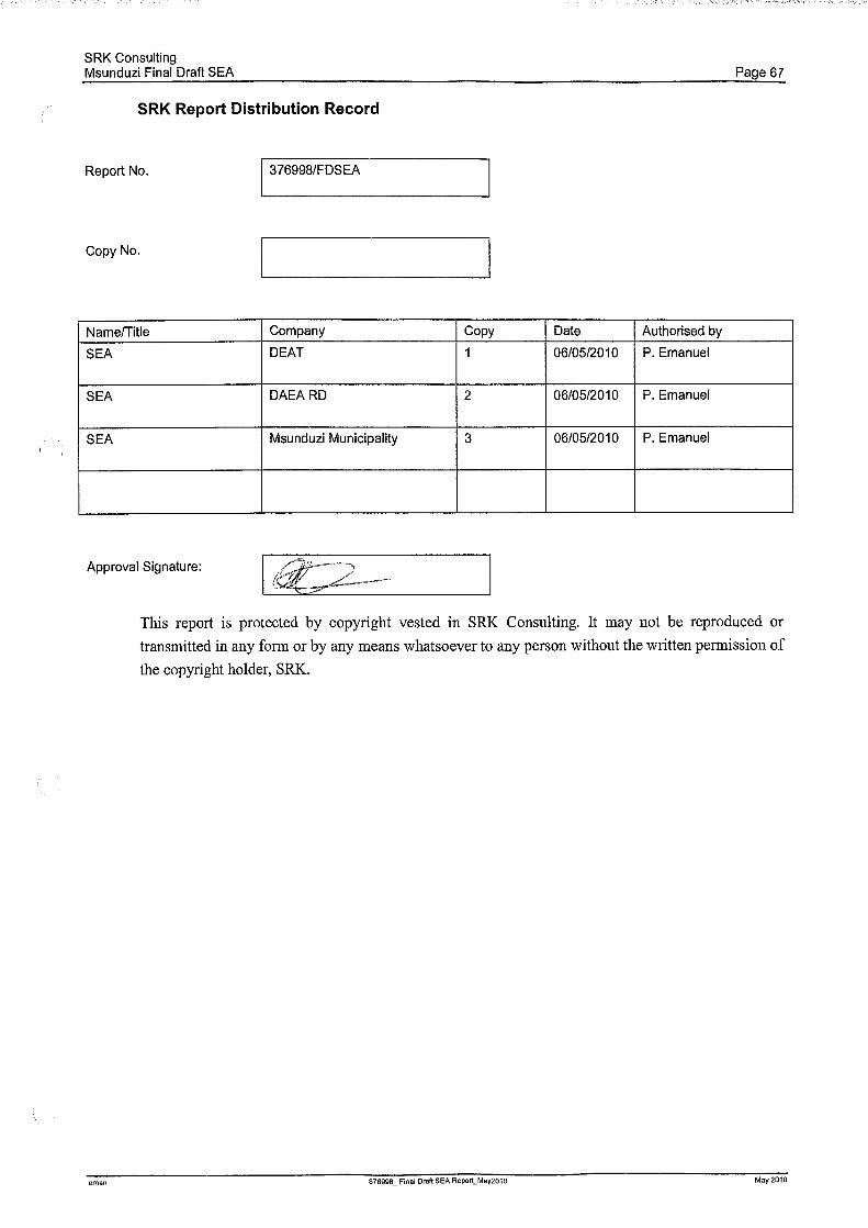
Related Documents