Master Plan National Capital Integrated Coastal Development FINAL

Welcome message from author
This document is posted to help you gain knowledge. Please leave a comment to let me know what you think about it! Share it to your friends and learn new things together.
Transcript

Master Plan National Capital Integrated Coastal Development
FINAL

Colophon
The Master Plan of the National Capital Integrated Coastal Development is a joint project by Government of Indonesia and the Government of The Netherlands.
The project is financed by the Government of The Netherlands
Executing agency is The Coordinating Ministry for Economic Affairs, Indonesia
Consultants Master Plan: Witteveen+Bos Grontmij Kuiper Compagnons Ecorys Triple-A Deltares Bita Bina Semesta Bita Enarcon Engineering Palu2Indonesia VandenBroek Consulting Lasmana Rochman L. Gandaatmadja Abendnego Mr. Martijn WieriksIn collaboration with Program Management Unit consultants: Royal HaskoningDHV Rebel Group UNESCO-IHEWith contributions from: Pentair flow technologies Bureau ANL Photography: Fendi Siregar Inong Hunain Kuiper Compagnons A. Bahrul B.D Witteveen+Bos Grontmij DeltaresIllustrations: KuiperCompagnons Clary Scheres
2 National Capital Integrated Coastal Development Project | Master Plan | Final 1 October 2014
Master Plan National Capital Integrated Coastal Development
Coordinating Ministry for Economic Affairs | Special Capital Region of Jakarta | National Development Planning Agency | Ministry of Public Works | Government of the Netherlands
INA556-3 INA556-3 Final
V.J. Coenen MSc A. Kops MSc 1 October 2014
1 October 2014
Final 1 October 2014 | Master Plan | National Capital Integrated Coastal Development Project 3

4 National Capital Integrated Coastal Development Project | Master Plan | Final 1 October 2014

0. PREFACE 9
1. INTRODUCTION 13 1.1. 2007: A different flood 14 1.2. Main goal 14 1.3. From JCDS to Master Plan 15
2. THE MASTER PLAN 17 2.1. Purpose of this Master Plan 18 2.2. Scope 18 2.3. Composition of this report 19
3. NATIONAL CAPITAL UNDER THREAT 21 3.1. Floods: the motive for this Master Plan 23 3.2. Urban challenges 25
4. INTEGRATED SOLUTIONS 29 4.1. Mission 31 4.2. Approach 31 4.3. Short term no regret measures 31 4.4. Principal long term solutions 35 4.5. Spatial Alternatives 38
5. SAFE AND PROSPEROUS UNDER THE WINGS OF THE GREAT GARUDA 43 5.1. Sea Dike alignment 45 5.2. Concept for spatial development: The Great Garuda 47 5.3. Urban design 49 5.4. Relations with the current coastal zone 53
indexpaginacijfers zijn nog niet definitief. Kan pas als alle tekst is geplaatst
Final 1 October 2014 | Master Plan | National Capital Integrated Coastal Development Project 5

6 National Capital Integrated Coastal Development Project | Master Plan | Final 1 October 2014

6. BUSINESS CASES 55 6.1. Introduction 57 6.2. A feasible plan 57 6.3. Key factors 58 6.4. Nominal costs and revenues of main components 59 6.5. Results 62 6.6. Economic effects 63 6.7. Risk profile 63
7. THE PLAN PER THEME 67 7.1. Flood safety 69 7.2. Social aspects 73 7.3. Land reclamation 75 7.4. Business and residential 77 7.5. Mainports 81 7.6. Mobility and infrastructure 82 7.7. Water Management 85 7.8. Recreation and green-space 87 7.9. Environmental impacts 91
8. THE PLAN PER AREA 95 8.1. Phase A: Dikes- an opportunity for coastal revitalisation 97 8.2. Phase B: The Great Garuda 99 8.3. Phase C 107 9. TRANSFORMING THE COASTAL ZONE . THE DELIVERY STRATEGY 109 9.1. Phasing 111 9.2. Implementation strategy 111
Final 1 October 2014 | Master Plan | National Capital Integrated Coastal Development Project 7
paginacijfers zijn nog niet definitief. Kan pas als alle tekst is geplaatst

8 National Capital Integrated Coastal Development Project | Master Plan | Final 1 October 2014

0PREFACE
mail Martijn Steenstra 15-9: De preface(0) met daarin de political statements worden nog geschreven. Hier graag ruimte laten voor 3 pagina’s text.
Final 1 October 20144 | Master Plan | National Capital Integrated Coastal Development Project 9

Master Plan:• ThisisthefinaleditionoftheNCICDMasterPlanandcontainstheresults
oftheplanningprocessuntil1September2014.• ThisPlanwasdevelopedunderdirectguidanceoftheIndonesianCoordi-
natingMinistryofEconomicAffairs,theNationalDevelopmentPlanningAgency,theMinistryofPublicWorksandtheSpecialCapitalRegionofJakartaandistheresultofthelongtermcooperationbetweenthegovern-mentsofIndonesiaandtheNetherlandsinthefieldofwatermanagement.TheprojectwasfinancedbytheGovernmentoftheNetherlands.
POLITICAL STATEMENTS:
Guidelines president-elect Joko Widodo::On 25 July 2014, president-elect Joko Widodo was briefed on the NCICD project. The project was fully endorsed by president-elect Joko Widodo and he provided the following guidelines to facilitate implementation:• simultaneousimplementationofPhasesA,BandC• facilitatetheimplementationbyplanningtheprojectwithinthe
boundaries of DKI Jakarta• keeptheprojectorganisationsimple• Centralgovernmentplans,DKIJakartaimplements• theprivatesectorismainactorinimplementation• specificregulationstoenabletheprojectwillhavetobeestablishedThis master plan is fully in line with the guidelines expressed by president Joko Widodo
10 National Capital Integrated Coastal Development Project | Master Plan | Final 1 October 2014

This is the Master Plan for the Integrated Coastal Development of the National Capital Jakarta. The plan aims to provide a solution for long term protection of Greater Jakarta against flooding from the sea. But this plan provides much more than that. It creates new space to the National Capital, by expanding seaward in a planned matter. It helps to solve the current connectivity problems of West-Java and Banten and addresses many of the current environmental problems.
The same sea that is now a threat will be used in many ways to benefit the Na-tional Capital, and the country as a whole. JJakarta Bay provides room for a new city district that accommodates over 1.5 million people from all income classes and a National Tangerang-Bekasi Highway that connects the provinces Jakarta, West-Java and Banten. The bay is also used to expand the port and strengthen the existing fisheries, thus stimulating economic growth. The bay will be converted into a large waduk (retention lake). It contributes to alleviate the urban floods and river floods which have affected the National Capital for so long, and will also serve as a sustainable source for drinking water for the citizens of Jakarta.
The shape of the Great Garuda was chosen as iconic design for the planned coastal defence and land reclamations. The Garuda will protect the city and will bring safety and prosperity to the National Capital. It will offer Greater Jakarta a new image clearly visible and recognizable from the sky. A capital ready for the 21st century. To be proud of and to be enjoyed by all.
The Master Plan was developed under direct guidance of the Coordinating Ministry of Economic Affairs, National Development Planning Agency, Ministry of Public Works and the Special Capital Region of Jakarta and is the result of the long term cooperation between the governments of Indonesia and the Netherlands in the field of water management.
This Master Plan is an important step towards implementation. It provides a worked-out, well founded development and implementation model for the new city. It is a strong framework and starting point for feasibility studies on various components and detailed designs. It provides also a good basis for funding and contracting stages.
PROVIDE A SAFE ENVIRONMENT FOR THE PEOPLE OF
JAKARTA TO SURVIVE, LIVE AND THRIVE. CREATE AN
ENDURING, SUSTAINABLE FOUNDATION TO BUILD THE
FUTURE OF THE CITY. RISE TO THE CHALLENGE OF THE
WATER FROM THE SEA AND THE RIVERS.
Draft 1 April 2014 | Master Plan | National Capital Integrated Coastal Development Project 11

12 National Capital Integrated Coastal Development Project | Master Plan | Final 1 October 2014
IINTRODUCTION
Final 1 October 20144 | Master Plan | National Capital Integrated Coastal Development Project 13

1.1. 2007: A different floodThe 10 million inhabitants of the Jakarta metropolitan area (Indonesia) are used to flooding in the rainy season. Sedimentation and waste accumulation, com-bined with peak river discharges, create occasional floods in the 13 rivers and canals flowing through the low lying urban delta. Street flooding caused by heavy rainfall is a more common event, as the city struggles to keep the urban drainage system in pace with urbanization. However, in November 2007 North Jakarta was hit by a different flood. A high tide over-topped the sea wall on several locations and sea water was rushing through the streets creating high waters up to 1,5 metres deep for several days.
This flooding from the sea confirmed what some researchers already had been warning for: North Jakarta is subsiding at a staggering speed of 7,5 centimetres per year on average. In some parts subsidence rates even go up to 17 centime-tres per year. Large parts of the city, including the coastal defences, are subsiding further and further below sea level.
In 2008 the existing sea wall was reinforced, but due to the subsidence this sea wall is already at a critically low level. Overtopping at high tide is expected within the coming years.
1.2. Main goalFor several years Indonesia and the Netherlands have been working together to reduce and prevent floods in the National Capital of Indonesia. This collaboration resulted in the Jakarta Coastal Defence Strategy (JCDS) in 2011. Bilateral coopera-tion is continued in the National Capital Integrated Coastal Development (NCICD) project.
The JCDS project and the first phases of the NCICD project concluded that:• strengtheningtheexistingseawallsandupgradingthedrainagepumping
capacity can no longer provide sufficient protection for the long term. Moreo-ver, space in Jakarta is too limited to create the required large storage basins. An offshore solution for flood protection has become inevitable to protect the city against floods from the sea and rivers in the coastal zone.
FACTS:• InNovember2007,NorthJakartawashitbythefirstmajorfloodfromthe
sea.LandsubsidenceinNorthJakartaistheunderlyingcauseofthisflood-ing.Theaveragerateofsubsidenceis7,5centimetresperyear,butinsomecoastalareasasubsidencerateof17centimetresperyearhasbeenmeas-ured.
• The2007floodscausedanestimateddamageof$544million.Moreover, 76peoplewerekilledandover590,000refugeeswereregistered.Inthesameyearafloodfromtheseatookplace.
• Largescaledeepgroundwaterextractionsaremostlikelythemajorcauseforthislandsubsidence.
• In2008aseawallwascreated,butduetothesubsidencethisseawallisalreadyatacriticallylowlevel.Overtoppingathightideisexpectedwithinthecomingyears.
14 National Capital Integrated Coastal Development Project | Master Plan | Final 1 October 2014

• anoffshoresolutionoffersmanyopportunitiesforthedevelopmentofthecoastal zone and to contribute to the socio-economic development of the National Capital of Indonesia as laid down in the MP3EI plan.
The main goal of the NCICD Master Plan is therefore to offer Jakarta long term protection against flooding from the sea and rivers in the coastal area, and at the same time facilitate socio-economic development.
Realising this goal requires an integrated planning approach. This Master Plan is therefore a Master Plan for both flood protection and for coastal development.
1.3. From JCDS to Master Plan
This Master Plan of the National Capital Integrated Coastal Development (NCICD) project contains the results of the planning process in the period January 2013 - March 2014.
The NCICD project follows the Jakarta Coastal Defence Strategy project that resulted in a strategy for flood protection. In the Strategy Consolidation phase of the NCICD project, assumptions underpinning the Strategic Direction and design aspects of the Strategic Direction were researched. Conclusions from this addi-tional research led to an optimised version of the JCDS: the Final Implementation Model (FIM).
This Master Plan was developed on the foundation of the FIM. Further research into spatial aspects, engineering of solutions, financial and economic aspects and environmental impacts was done to further substantiate the choices made in this Master Plan.
The Master Plan is not the final planning stage. After approval, detailed designs and feasibility studies for components will have to be prepared, either by the Indonesian government or by private investors. Also funding and contracting procedures will require additional planning or revision of existing plans.
FURTHER READING:• JCDSreports(2011):Atlas,Agenda,AturanMain
JCDS Inceptionphase
Strategy Consolidation phase
Optionsphase
Designphase
AtlasAgenda
Aturan-MainInception report
Final Implementation ModelDraft Master Plan
Master Plan
Final 1 October 2014 | Master Plan | National Capital Integrated Coastal Development Project 15
16 National Capital Integrated Coastal Development Project | Master Plan | Final 1 October 2014

IITHE MASTER PLAN
Final 1 October 20144 | Master Plan | National Capital Integrated Coastal Development Project 17
2.1. Purpose of this master planThe purpose of the Master Plan is threefold:• provideaworked-outlongtermfloodsafetymodelwhichalsoprovidesexcel-
lent socio-economic opportunities for the National Capital;• provideadesignforurbandevelopmentwithunderlyingbusinesscasesas
development framework;• providearoadmapforimplementation.
This Master Plan was developed as a basis for stakeholder and political consulta-tion. It is the second step in a series of decision making steps which started with the Jakarta Coastal Defence Strategy. By adopting the Master Plan, the Govern-ment of Indonesia, the Special Capital Region of Jakarta and the Provinces of West Java and Banten establish it as the framework for further spatial, institutional and financial planning and commit to further elaboration. Next steps include adjust-ment of existing plans and execution of impact- and feasible studies, which will provide further information for final investment decisions.
Considering the urgency, the Government of Indonesia and the Special Capital Region of Jakarta should jointly decide on the rapid execution of the Phase A measures.
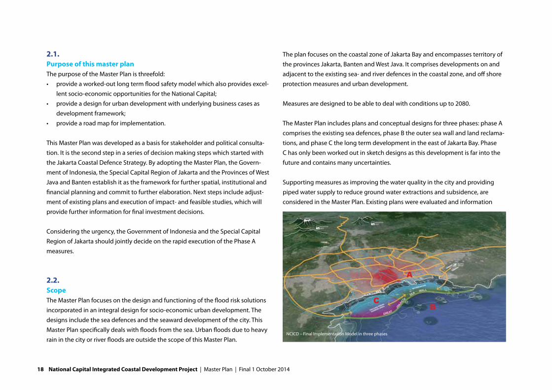
2.2. ScopeThe Master Plan focuses on the design and functioning of the flood risk solutions incorporated in an integral design for socio-economic urban development. The designs include the sea defences and the seaward development of the city. This Master Plan specifically deals with floods from the sea. Urban floods due to heavy rain in the city or river floods are outside the scope of this Master Plan.
The plan focuses on the coastal zone of Jakarta Bay and encompasses territory of the provinces Jakarta, Banten and West Java. It comprises developments on and adjacent to the existing sea- and river defences in the coastal zone, and off shore protection measures and urban development.
Measures are designed to be able to deal with conditions up to 2080.
The Master Plan includes plans and conceptual designs for three phases: phase A comprises the existing sea defences, phase B the outer sea wall and land reclama-tions, and phase C the long term development in the east of Jakarta Bay. Phase C has only been worked out in sketch designs as this development is far into the future and contains many uncertainties.
Supporting measures as improving the water quality in the city and providing piped water supply to reduce ground water extractions and subsidence, are considered in the Master Plan. Existing plans were evaluated and information
CB
A
NCICD – Final Implementation Model in three phases
18 National Capital Integrated Coastal Development Project | Master Plan | Final 1 October 2014

from stakeholders was obtained and incorporated. Additional design of systems, planning and cost calculations, however, are not part of this Master Plan.
2.3. The Master Plan: the level of accuracyThis Master Plan has been prepared using the best available data in Indonesia. The accuracy and abundance of data varied, sometimes data was scarce and sometimes the quality of data and reports could not be verified. The team also faced uncertainties relating to future developments (real estate values and eco-nomic development on the medium and long term?). We tried to make the most accurate and realistic predictions and scenario’s. This, however, is always challeng-ing in a complex project spanning several decades.For the Master Planning phase, this level of accuracy is sufficient as the Master Plan will be further elaborated in the design and planning phase. In each of the coming elaboration steps a review of the data (technical, financial) and an update of predictions is required to make sure that the construction and contracting is based on the latest and best available information.
2.4. Composition of the reportThis Master Plan is divided in two parts. Part 1 describes the flood risks, urban challenges and the solutions at headlines. Part two goes into more detail on the plans per theme and per subarea. The structure of the Master Plan is shown in the figure on the right.
The Master Plan is based on many underlying analyses, calculations and further elaborations. These are bundled in six separate reports:
1. Engineering report2. Upgrading existing sea defences3. Spatial planning & urban design4. Financial and economic study5. Strategic environmental assessment building blocks6. Implementation plan has been separately reported.
Chapter 9 is based on research by the PMU that has been reported separately in several PMU assistance reports.
1. Introduction
2. The Master Plan
3. National Capital Under Threat
4. Integrated solutions
5. Safe and prosperous under the wings of the Great Garuda
6. Business Cases
7. Plan per area
8. Plan per theme
9. Transforming the coastal zone, the delivery strategy
PART
1PA
RT 2
MISSION AND FOCUS
MOTIVE FOR ACTION
SOLUTIONS
PLAN IN MORE DETAIL
composition of the report
Final 1 October 2014 | Master Plan | National Capital Integrated Coastal Development Project 19

20 National Capital Integrated Coastal Development Project | Master Plan | Final 1 October 2014

IIINATIONAL CAPITAL UNDER THREAT
Final 1 October 20144 | Master Plan | National Capital Integrated Coastal Development Project 21

THERE ARE TWO MAIN ISSUES AT STAKE: PROTECTING JAKARTA
AGAINST THE SEA, AND MAKING SURE THAT THE RIVERS OF JAKARTA
CAN DISCHARGE TO THE SEA. BOTH HAVE TO BE TACKLED TO RELIEVE
JAKARTA OF DANGEROUS FLOODS.
Clogged urban waterways increase risk of floods
Inadequate constructions lead to risks
22 National Capital Integrated Coastal Development Project | Master Plan | Final 1 October 2014
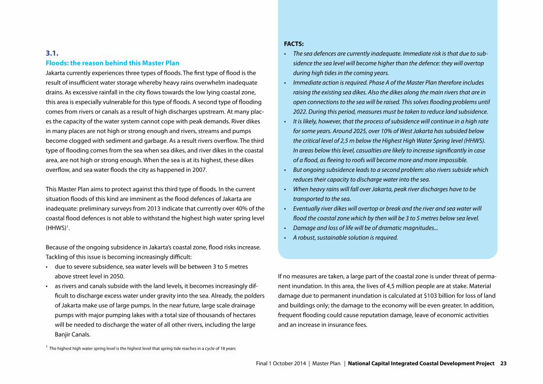
3.1. Floods: the reason behind this Master PlanJakarta currently experiences three types of floods. The first type of flood is the result of insufficient water storage whereby heavy rains overwhelm inadequate drains. As excessive rainfall in the city flows towards the low lying coastal zone, this area is especially vulnerable for this type of floods. A second type of flooding comes from rivers or canals as a result of high discharges upstream. At many plac-es the capacity of the water system cannot cope with peak demands. River dikes in many places are not high or strong enough and rivers, streams and pumps become clogged with sediment and garbage. As a result rivers overflow. The third type of flooding comes from the sea when sea dikes, and river dikes in the coastal area, are not high or strong enough. When the sea is at its highest, these dikes overflow, and sea water floods the city as happened in 2007.
This Master Plan aims to protect against this third type of floods. In the current situation floods of this kind are imminent as the flood defences of Jakarta are inadequate: preliminary surveys from 2013 indicate that currently over 40% of the coastal flood defences is not able to withstand the highest high water spring level (HHWS)1.
Because of the ongoing subsidence in Jakarta’s coastal zone, flood risks increase. Tackling of this issue is becoming increasingly difficult:• duetoseveresubsidence,seawaterlevelswillbebetween3to5metres
above street level in 2050.• asriversandcanalssubsidewiththelandlevels,itbecomesincreasinglydif-
ficult to discharge excess water under gravity into the sea. Already, the polders of Jakarta make use of large pumps. In the near future, large scale drainage pumps with major pumping lakes with a total size of thousands of hectares will be needed to discharge the water of all other rivers, including the large Banjir Canals.
If no measures are taken, a large part of the coastal zone is under threat of perma-nent inundation. In this area, the lives of 4,5 million people are at stake. Material damage due to permanent inundation is calculated at $103 billion for loss of land and buildings only; the damage to the economy will be even greater. In addition, frequent flooding could cause reputation damage, leave of economic activities and an increase in insurance fees.
1 The highest high water spring level is the highest level that spring tide reaches in a cycle of 18 years
FACTS:• Theseadefencesarecurrentlyinadequate.Immediateriskisthatduetosub-
sidencethesealevelwillbecomehigherthanthedefence:theywillovertopduringhightidesinthecomingyears.
• Immediateactionisrequired.PhaseAoftheMasterPlanthereforeincludesraisingtheexistingseadikes.Alsothedikesalongthemainriversthatareinopenconnectionstotheseawillberaised.Thissolvesfloodingproblemsuntil2022.Duringthisperiod,measuresmustbetakentoreducelandsubsidence.
• Itislikely,however,thattheprocessofsubsidencewillcontinueinahighrateforsomeyears.Around2025,over10%ofWestJakartahassubsidedbelowthecriticallevelof2,5mbelowtheHighestHighWaterSpringlevel(HHWS).Inareasbelowthislevel,casualtiesarelikelytoincreasesignificantlyincaseofaflood,asfleeingtoroofswillbecomemoreandmoreimpossible.
• Butongoingsubsidenceleadstoasecondproblem:alsoriverssubsidewhichreducestheircapacitytodischargewaterintothesea.
• WhenheavyrainswillfalloverJakarta,peakriverdischargeshavetobetransported to the sea.
• Eventuallyriverdikeswillovertoporbreakandtheriverandseawaterwillfloodthecoastalzonewhichbythenwillbe3to5metresbelowsealevel.
• Damageandlossoflifewillbeofdramaticmagnitudes...• Arobust,sustainablesolutionisrequired.
Final 1 October 2014 | Master Plan | National Capital Integrated Coastal Development Project 23
FACTS:• TheNationalCapitalisgrowingrapidlyandthedemandforspaceisrising.• Thetransportinfrastructureisoverloaded.• Mainports(port,airport)reachedtheirmaximumcapacitylongago.Connec-
tionsfromTanjungPriokandSukarnoHattaAirporttothehinterlandsufferfromcontinuoustrafficjams,makingthemmoreandmoreunattractiveastransporthub.
• Unplannedoccupationofopenspacesalongriversandcoastlineiscommon.• Onlypartsofthecityareprovidedwithpipedwatersupply;groundwateris
extractedasalternativesourceofdrinkingwater;infuture,sourcesforrawwaterwillbecomescarceduetothegrowingpopulation.
• Riverpollutionwithuntreatedwastewaterandsolidwasteissevere.• Jakartalacksrecreationalareasandgreenspaces.
THIS MASTER PLAN AIMS TO SOLVE THE FLOOD PROBLEMS RELATED TO
THE SEA. SUBSIDENCE IS A KEY DRIVER, AGGRAVATING FLOOD RISKS IN
THE COASTAL ZONE.
24 National Capital Integrated Coastal Development Project | Master Plan | Final 1 October 2014

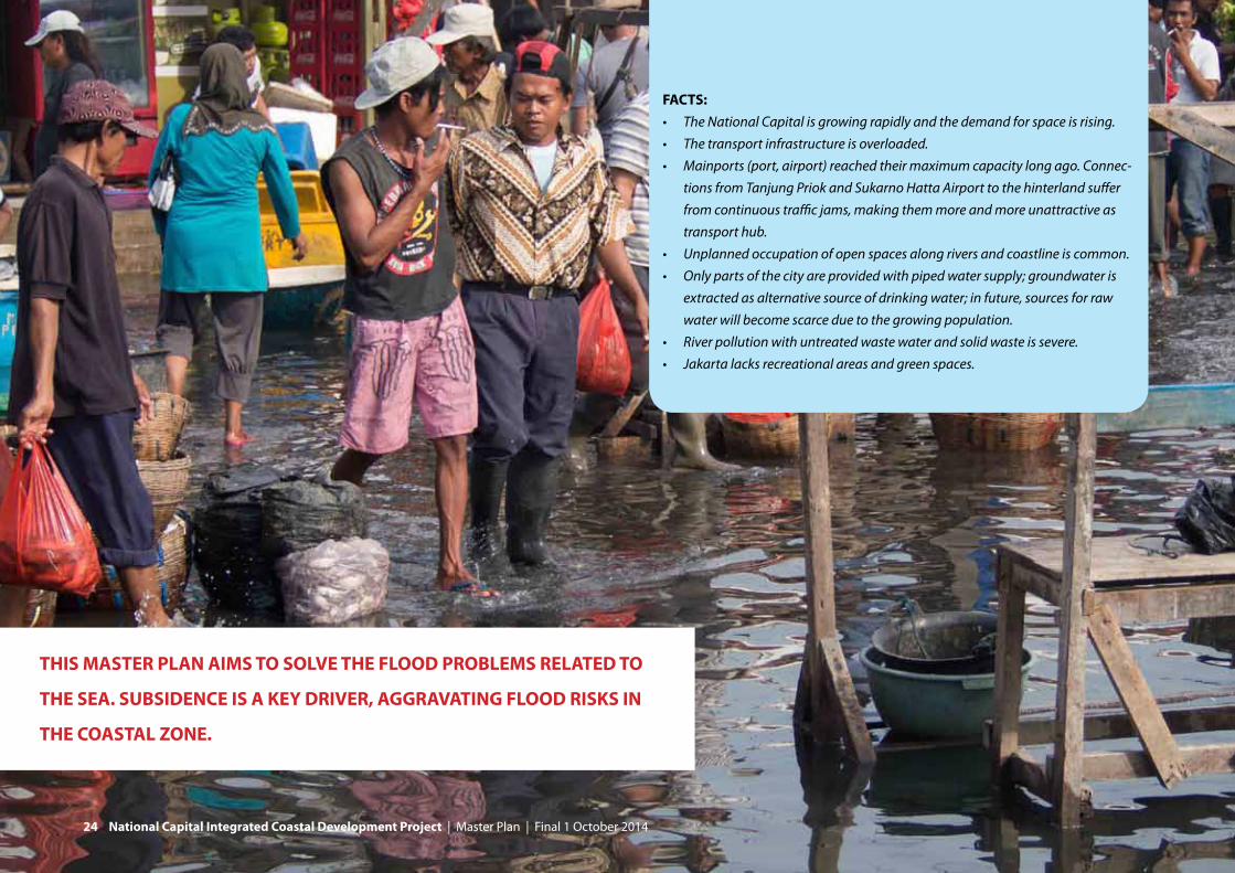
3.2. Urban challenges Jakarta has grown far beyond its administrative borders. But especially in the functioning of the city, boundaries are being surpassed. The coastal zone is facing serious challenges.
The road system of the city is at times paralysed by heavy traffic. Travelling times for commuters are stretching because of distance and especially because of heavy traffic. Not only growth in numbers, but also an increase in car-ownership leads to more cars on the road. In the period 2002-2010, car ownership has increased from 17 to 25%, and the ownership of mopeds increased from 34 to 72%. Road infrastructure and especially public transport infrastructure haven’t kept up with the cities growth and this is putting a serious strain on the economic growth of Jakarta. In example, several links in the ring road system are missing and the MRT-project has not yet been completed. Also growth in the east-west corridor of western Java as a whole is affected as access to the port of Tanjung Priok and the Sukarno-Hatta airport is seriously affected by traffic. Traffic under normal condi-tions is bad, when floods occur traffic comes to a grinding standstill.
Another pressing issue is the availability of space for development as a whole. The metropolitan area of the city is still growing rapidly and space for as well residen-tial as business related real estate development is limited and increasingly expen-sive. Growth takes mainly place in Bogor, Depok, Tangerang and Bekasi, making it a multi centred city often referred to as Jabodetabek.
The main ports of Jakarta are reaching their maximum capacity. Improvement of hinterland connections and extra space for future development of airports and harbours are required to streamline economic development according to the goals of the Master Plan for the Acceleration and Expansion of Indonesia Econom-ic Development (MP3EI).
As a consequence of a process of uncontrolled densification, many open spaces have turned into slums that lack proper roads, drainage and water supply facili-ties. Informal settlements have developed along the water’s edge around reten-tion basins (waduks), the rivers and the coastline and are in a dilapidated state. Floods currently hamper the development of these areas. With a growing econo-my and increased income per family, the availability of sufficient low-cost housing is key to further development of the growing population.
The city struggles to supply clean water to its citizens and companies. Providing clean water is one of the key factors for economic development. Only part of the city, about 25%, is served with piped water supply. In addition many legal and illegal ground water pumps are installed, being the main cause for land subsid-ence. DKI Jakarta therefore aims at full coverage of piped water supply in 2030 which will be an enormous challenge. Additional sources for raw water of about 7 m3/s in 2030 are essential, as the availability from current sources will not be able to meet future demands.
Also considering the living environment Jakarta has reached boundaries. Pol-lution of rivers by industry and households, garbage dumping and smog are pressing issues. Most of the existing retention ponds have been polluted by hu-man, industrial and commercial waste and garbage. They often clog the drainage system, they form a very untidy sight with a bad smell and pose a health hazard. Black waters are disposed directly into rivers and the bay. In the slums, where even basic facilities are lacking, this leads to very unhealthy situations.
FURTHER READING:TheB.1EngineeringReportandtheunderlyingtechnicalreportsdescribethesituationregardingfloodsafetyinmoredetail
Final 1 October 2014 | Master Plan | National Capital Integrated Coastal Development Project 25

JAKARTA IS A THRIVING METROPOLIS, BUT FACES
SERIOUS GROWTH CHALLENGES
26 National Capital Integrated Coastal Development Project | Master Plan | Final 1 October 2014

Jakarta has an enormous lack of outdoor recreation possibilities: pleasant outdoor environments are limited. The availability of green space in the city has decreased from over thirty percent in the 1960’s to around 10 percent now. The only notable preserved nature area is Muara Angke mangrove and the only notable recrea-tion area is Ancol. The waterfront of Jakarta is now dominated by slums, fishing communities and gated communities. Creating a public and attractive waterfront is important for the appearance of the city as well as for the quality of life that the city can offer its citizens and visitors for leisure and business. Thereby green and parks contribute to the economy of the city as well.
FURTHER READING:• TheJCDSAtlasreportprovidesadetailedurbananalysisoftheNational
Capital.• FormoredetailedinformationontrafficseereportB3bTransportSystem.In
thisreportthecurrentsituation,trendsandthedirectionstowardsrelievingthetrafficsituationareworkedout.
• FormoreinformationonexpecteddemandsforrealestateseeReportB4FinancialandEconomicStudy.
• ThesituationregardingslumsandsocialhousingisworkedoutintheC5.3reportonSocial,Environmentalandspatialimpacts.
• WaterqualityissuesareanalysedinreportC5.1.
Final 1 October 2014 | Master Plan | National Capital Integrated Coastal Development Project 27

28 National Capital Integrated Coastal Development Project | Master Plan | Final 1 October 2014

IVINTEGRATED SOLUTIONS
Final 1 October 20144 | Master Plan | National Capital Integrated Coastal Development Project 29

TEN AMBITIONS FOR URBAN DEVELOPMENT:1. protectJakarta’scoastalzoneagainstfloodingfromthesea;2. providenewspaceforseawardgrowthofJakartaandtherebygenerate
revenuesforthefloodmanagementmeasures;3. createanew,attractivewaterfrontcityoverlookingJakartaBay;4. providehousingandemploymentforalleconomicclassesinordertodecrease
disparitybetweenrichandpoor;5. improveconnectivity,byestablishingmissinglinksinthepublictransportand
roadinfrastructure(theTangerang-BekasiHighway);6. improvetheconditionsformarineeconomicsectors,likefisheriesandports;7. provideahealthyandpleasantlivingenvironmentforJakarta’scitizensand
visitorsasanimportantfactorforattractingforeigninvestmentbyimprovingwaterquality,wastemanagement,environmentalconditionsandbyprovidinggreenspaceforrecreation;
8. contributetosolvingthepressingrawwatersupplyissuesoftheNationalCapital;
9. beleadingregardingsustainabledesigninIndonesiabydevelopingsustainablesystemsrelatedtothewatercycle,transportationandpowersupply;
10.betrulyIndonesianinitsdesign,reflectingIndonesiancultureasasymbolfortheNationalCapital.
30 National Capital Integrated Coastal Development Project | Master Plan | Final 1 October 2014

The problems in the National Capital are deeply interrelated and need to be solved applying an integrated approach. This holds for both strategic urban development issues, as well as solving practical problems like providing alterna-tive housing for the low-income residents living on the sea walls when current sea walls are strengthened. At the same time, an integrated approach offers opportunities, finding synergy between solutions for social issues.
4.1. MissionThe mission of this Master Plan is to integrate flood safety solutions with urban development, thus solving urban problems and at the same time generating revenues to finance flood protection. This Master Plan therefore is more than a flood management plan. It aims to be a catalyst for development of the coastal zone. The urgent need for a sea wall for flood protection provides the anchoring point for such an integrated plan. But what kind of urban development is envisioned? Ten main ambitions for urban development are presented in the box on the opposite page.
4.2. ApproachSo in the approach of the Master Plan, developing a solution for the flood safety problem is the central goal of this Master Plan. Flooding needs to be solved urgently and therefore is the catalyst for other developments. As a foundation for the Master Plan, the best hydraulic solution for the flooding problem has been developed, including short term (no-regret) as well as long term solutions.
But at the same time, the hydraulic solutions are combined with land reclama-tions, toll roads and port expansion. These combinations contribute both to the
urban development ambitions of the coastal zone, as to generating revenues to finance flood protection measures. Investment opportunities have been opti-mised to create maximum revenues, balancing possible revenues and market absorption of real estate.
4.3. Short term no regret measuresShort term actions for flood defence are urgent. Sea defences will overtop in the coming years and there is no time to lose. The measures mentioned below are urgent no-regret measures.
ReinforcecurrentdefencesImplementing sustainable solutions will require considerable more time than available. Therefore the current sea and river defences have to be strengthened
Final 1 October 2014 | Master Plan | National Capital Integrated Coastal Development Project 31

Priority areas
Kemal
Ceng
aren
g dr
ain
Ciliw
ung
Caku
ng D
rain
Bajir
Kan
al T
imur
32 National Capital Integrated Coastal Development Project | Master Plan | Final 1 October 2014

and heightened by at least 1,5 meters to provide time. As subsidence slowly lowers the flood defences, this provides protection until 2022, allowing time to develop more robust solutions.
Action is most urgent near Pluit, Pantai Mutiara and along Ancol. At these loca-tions protection levels are so low that overflow may occur under normal yearly conditions already. Given the critical situation, preliminary designs have been made during the development of this Master Plan. For this purpose, Northern Jakarta and its surroundings has been divided in a system of 7 dike rings that protect the area within from inundation . 1
For 5 rivers and canals 2 , Dinas Pekerjaan Umum (public works of the City of Jakarta) is already preparing the construction of new pumping stations that will closed them off from Jakarta Bay: water will no longer flow under gravity but will be pumped out to the bay. Closing off these rivers significantly reduces the length of river embankments that needs to strengthened. While these embankments are situated in dense urban areas, this also reduces the number of people that needs to be resettled. For this reason, this measure is also recommended for the Kali Grogol, Kanal Ancol and Kali Sunter.
Implementation of dike reinforcement will start in 2014. At many locations, the available space for dike improvements is limited. Therefore designs were made that are integrated in the dense urban environment. Where possible, functions will be combined with or on these dikes.
SlowdownsubsidencethroughpipedwatersupplyAt the same time, in any scenario it is essential to stop the cause of increasing flood risks, and reduce subsidence. In all of the coastal zone subsidence is severe. In the central and western part of Jakarta bay subsidence currently amounts on average 7,5 cm per year. Towards the east of the coastal zone, subsidence is less: around 3 cm per year.
1 A ring dike is a closed system of measures (i.e. dikes, higher grounds, gates, etc.) to protect the area within from
inundation.
2 Kali Kamal, Kali Angke, Kali Muara Karang, Ciliwung and Kali Sentiong
Phase A (2015)
Final 1 October 2014 | Master Plan | National Capital Integrated Coastal Development Project 33

Three principal solutions: a. abandon The National Capital, b. onshore protection by high dikes and large city waduks and c. offshore sea wall with large offshore waduk
34 National Capital Integrated Coastal Development Project | Master Plan | Final 1 October 2014

Subsidence, to a large extent, is caused by ground water extractions, which must be stopped and replaced by piped water supply. Not stopping subsidence means that Jakarta’s coastal zone is subsiding deeper and deeper below sea level, mak-ing solutions for the flooding problems increasingly difficult and expensive. Stopping subsidence successfully or slowing it down significantly is enormously beneficial: significant reduction of subsidence before 2020 can postpone invest-ments for long term solutions, or make this unnecessary altogether. This will probably not be feasible anymore for the western part of Jakarta, but it is for the eastern part. However, the challenge is big as also this area is quickly urbanis-ing making an increase in groundwater use likely. To regularly assess the need for high investments in long term measures, subsidence should be thoroughly monitored.
ImprovewaterqualityCurrently the rivers and the Bay of Jakarta have serious water quality problems. Concentrations of oxygen are low due to heavy pollution with organic material and human waste, resulting in toxic situations for fish and other aquatic species. Concentrations of nutrients and heavy metals surpass standards by far. The smell of untreated waste water covers large parts of Jakarta. Unhygienic situations are common in the small streets of the kampongs. Improving the water quality is pressing and prerequisite to create an attractive, healthy and viable waterfront city. It is also conditional for using urban water as source for raw water. Therefore an integral water quality improvement program should be started, comprising law enforcement, waste water treatment, solid waste management, dredging and awareness programs. Acceleration of the existing sanitation Master Plan is required to meet the national ambition of full sanitation coverage in 2020.
AdditionalhydraulicmeasuresAdditional upstream measures help alleviate flood risks in the coastal area: diver-sion of water coming to Jakarta, improving the city drainage system (allowing
better through flow), adding more retention to the system and improving the drainage pumping capacity.
4.4. Principal long term solutionsIf subsidence is not stopped in time, additional solutions are required to offer flood safety to the citizens of North Jakarta. Three principal long term solutions have been considered: abandoning North Jakarta, onshore dike reinforcement and an offshore solution.
Abandoning North JakartaOne line of thought could be to abandon North Jakarta. This would only be a viable option if the benefits of coastal protection wouldn’t outweigh the costs or if no feasible technical solution would be available. Economic study shows that abandoning the zone at risk of flooding would mean that 4,5 million people would have to be reallocated and that USD 103 billion worth of land and real estate in an already densely populated metropolitan area would be lost.
Abandoning North Jakarta is therefore not considered a desirable nor a viable option, as the invested capital and the number of inhabitants simply is too large. The avoided material damage of USD 103 billion justifies a considerable invest-ment in flood safety.
Onshore solutionAn onshore solution signifies protecting the city with a huge sea wall on the
FURTHER READING:• TechnicalreportC1.5Groundwater&subsidenceevaluatesthesubsidence
problem.
Final 1 October 2014 | Master Plan | National Capital Integrated Coastal Development Project 35

current coast line and adjoining equally high river dikes. The polders in the coastal zone will become increasingly deep. High dikes along the rivers, far inland, and the sea (up to 7 meters in the long term) will be necessary to keep the water from flowing into the polders. All crossings of rivers will have to be elevated up to several meters high, requiring space for long and high access roads. In addition, around 10 thousand hectares of retention ponds and a large pumping capacity will be required to keep the polders free from flooding.
Implementing this option means drastic measures in the existing densely popu-lated city. Building these dikes and retention ponds requires displacing many people. Because of subsidence, the amount of land needed for retention would increase in time. In 50 years time, only a 50 metres wide sea wall will separate North Jakarta from the 5 metres higher sea. If this dike does break, consequences will be disastrous. It is unlikely that in that situation evacuation is possible and the casualty risk is high. In addition, thousands of hectares of retention ponds and a large pumping capacity will be required to keep the polders free from flooding.
Offshore solutionAn offshore solution consists of a outer sea wall in the Bay of Jakarta, creating the required huge pumping lake (giant waduk) offshore. By combining the sea wall with land reclamations, a robust and unbreakable sea defence can be made. The retention lake behind the dike will have a lowered water level which facili-tates free discharge of rivers. Pumping installations keep the water level in the lake sufficiently low. However, this alternative poses new challenges. To realise an acceptable water quality in the giant waduk, pollution in the rivers has to be reduced with approximately 75% (organic substances mainly from households) to 95% (nutrients). The implementation of a sewage collection and treatment system in Jakarta’s coastal zone needs to be accelerated considerably, requiring immedi-ate action.
The giant waduk decreases the necessity for more waduks in the city. This option provides solid protection up to 2080, which provides time to reduce subsidence. In addition, this solution offers socio-economic development opportunities in line with the goals of the MP3EI as the dike can be combined with urban develop-ment. The dike and land reclamations make closure of the second and third ring roads around Jakarta possible. The giant waduk offers an additional source for raw water and opportunities for further harbour development are created through combinations with dike and infrastructure development. This solution requires a large investment, but can be financed through combination with the develop-ment of a waterfront city. This waterfront city will become the appealing water front that Jakarta deserves.
The offshore option of near shore retention, by creating retention lakes in be-tween the 17 planned land reclamations, is not considered a structural solution. Assessment proved that near shore retention is not able to provide sufficient space to store excess water. The required storage area for the western lake is 7,200 hectares of water given the required pumping capacity. In between the planned land reclamations approximately 1,700 hectares of water is available. The increase in pumping capacity required to prevent flooding in a 1 in 100 years design flood event given the near shore storage area, is not considered feasible.
36 National Capital Integrated Coastal Development Project | Master Plan | Final 1 October 2014

Implementation modelThe offshore solution is the most robust solution. In addition this solution offers many possibilities to create added value for the city and funding through land reclamations.The implementation model is phased: the reinforcement of the current coastline will start already in 2014. The closure of the bay is divided in two phases (phases B and C).
BASED ON THESE CONSIDERATIONS, THE OFF-SHORE
ALTERNATIVE IS CHOSEN AS THE BASIS FOR FURTHER
DESIGN. THIS MEANS DESIGNING AN OUTER SEA WALL
AS A LONG TERM SOLUTION, INTEGRATED WITH A LARGE
RETENTION RESEVOIR IN A REVITALISATION OF THE
COASTAL ZONE
Final 1 October 2014 | Master Plan | National Capital Integrated Coastal Development Project 37

As subsidence is largest in the western part of the coastal zone, this area needs to be closed off first. Flood risks will become unacceptable in this area around 2025 as over 10% of the area west of Tanjung Priok harbour will be subside below the critical level of 2,5 meters below the highest high water spring level (HHWS). This level is chosen as a threshold value as with inundations of 2,5 meters even ‘verti-cal evacuation’ to roofs and first floors of houses becomes increasingly difficult, rapidly increasing the casualty risk. From this moment the western part of the outer sea wall need to be closed.
In the eastern part of the coastal zone subsidence is lower. The critical level will be reached beyond 2040, providing more time before closing off the bay becomes necessary and to reduce subsidence.
4.5. Spatial alternativesWith the offshore solution as a basis, several alternatives and options have been investigated regarding the combination of coastal protection measures and opportunities for spatial development (see figure on the next page). The basic and reference alternative aims just to protect the coastal zone against flooding, consisting off the outer sea dike including pumps and sluices and a toll road connecting east and west. Total costs for this alternative have been calculated at
FURTHER READING:• ReportB4.Financialandeconomicstudy• ReportC1.1(FinalImplementationModel)evaluatesprincipalsolutionsand
alternatives• ThehydraulicsolutionisworkedoutinB1.Engineeringreport
FACTS:• theoffshoresolutionmeansclosingoffpartofthebayofJakartawithan
offshoreouterseawallinJakartaBay;• thisseawallprotectsagainstfloodingfromtheseaandcreatesalarge
retentionbasin(minimum7.500ha);• thewaterlevelinthelakeisallowedtofluctuateby2,5metrestotemporarily
storeriverwaterandurbandrainagewater;• around2030thegiantwadukcaneveninthedryseasonofadryyear
providearawwatersupplyof12m3/s,assumingthatwastewaterinJakartaiseffectivelytreated;
• thewaterintheretentionbasinwillbekeptatalowlevelusinghugepumpingstationswithacapacityofaround730m3/second:thebiggestintheworld;
• byloweringthewaterlevelintheretentionlake,riversareenabledtodischargetothelakeundergravity,evenafter2025whenseawaterleveliswellabovelandlevels;
• theimplementationconsistsofthreemainphases.PhaseAisthestrengtheningofthecurrentseawallandriverdikes,necessarytokeepJakartasaveforthefollowingyears.PhaseBconsistsofclosingthewesternpartofthebaywithanouterseawall.InthewesternpartofJakartasubsidenceishighest,makingclosingoffthewesternpartofthebaymostnecessary.Closingofftheeasternpartofthebay(phaseC)willonlybenecessaryincaseeffortstoslowdownorstopsubsidenceintheeastareunsuccessful.Thiswillbealongtermdevelopmentthatshouldbestarteddepending on monitoring results.
38 National Capital Integrated Coastal Development Project | Master Plan | Final 1 October 2014

$ 12 billion. Other alternatives focus on generating revenues to close this financial gap. They differ especially in the size of land reclamations and therefore oppor-tunities for urban expansion. Alternatives of 1.250, 3.150 and 4.000 hectares have been studied and will be evaluated in the following chapter.
A strong wish of Indonesian government is to develop the flood defences in an integrated and cost neutral programme. The economic growth and the urban expansion of Jakarta provides opportunities to indeed do so and make combina-tions with the development of real estate, toll roads and harbour expansion. The ‘outer sea wall only’ alternative does not comply with this starting point as this project hardly generates any revenues.
Principal solutions, alternatives and options
Final 1 October 2014 | Master Plan | National Capital Integrated Coastal Development Project 39
40 National Capital Integrated Coastal Development Project | Master Plan | Final 1 October 2014

FACTS PREFERRED DEVELOPMENT • Theestimatedsandstockis300millionm3.Thisamountofsandfor
constructionpurposesisassumedasamaximuminthebusinesscase,thedesignoffersspaceforfurtherdevelopmentifmoresandisavailable.
• Thedesignintegratesthespatialandsocio-economicambitionsofthecity.• PhaseA:improvementoftheexistingdikeontheshore.Planningofwork
2014-2018• PhaseB:constructionoftheouterseawallincluding1.250haland
reclamation.Planningofthework2018-2022.• Completionofthemissingnorthernlinksinthesecondandthirdringroad
ofJakarta.RealisationofNationalTollRoadbetweenTangerangandBekasi(2x4lanes)
• RealisationsofMRTbetweenthecitycentreandnewlandreclamations,totallength11km.
Preferred development: create a Waterfront City with a flexible approachBuilding a city on the outer sea wall offers an enormous potential to solve mul-tiple urban problems, and at the same time generate financial means. However, developing the sea wall already is a mega-project in all respects, let alone combining it with large scale land reclamations. Managing risks is of key impor-tance. The two top risks influencing the business case are related to sand avail-ability and economic growth. The development of the sea dike and the land reclamations in deep water (up to 18 metres) require large amounts of sand. The estimated sand reserves within a reasonable distance of the city are around 300 million m3. This is based on interviews with market experts. Further surveys are necessary to proof whether more sand is available. Another risk is the general economy: economic growth might cool down for a period of time and demand for real estate (especially offices) in such a period might be lower than now as-sumed. A lower demand for offices will have a negative impact on the financial return.
A flexible model is the best model to mitigate the main risks in the project. From this perspective, a model of 1.250 hectares of land reclamation is preferred which has the potential to be extended up to 4.000 hectares or more when the economic situation so allows. Depending on sand availability and market uptake of real estate the size of the project can later be amended to this maximum. The 1.250 ha alternative will therefore be the basis for further elaboration in the next chapter.
Final 1 October 2014 | Master Plan | National Capital Integrated Coastal Development Project 41
42 National Capital Integrated Coastal Development Project | Master Plan | Final 1 October 2014
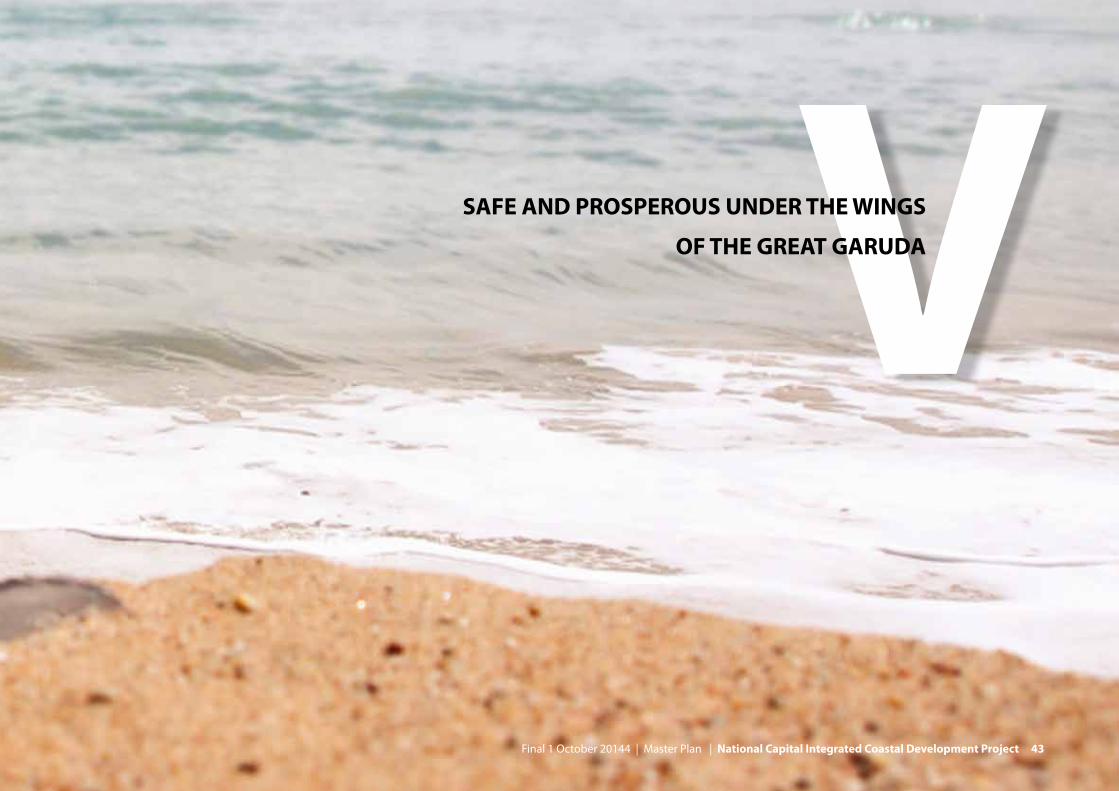
VSAFE AND PROSPEROUS UNDER THE WINGS
OF THE GREAT GARUDA
Final 1 October 20144 | Master Plan | National Capital Integrated Coastal Development Project 43

FURTHER READING:• ReportB1.(Engineeringreport),reportC1.2(WaterBalance)andreportC1.6
(RetentionLakeAnalysis)provideinformationonthesizeoftheretentionreservoir.
• ReportB3(SpatialplanningandUrbanDesign)provideinformationonthelandfalls,infrastructureandregionalsocio-economicopportunities.
44 National Capital Integrated Coastal Development Project | Master Plan | Final 1 October 2014

The final implementation model and the preferred development of a waterfront city of 1.250 ha are elaborated in a spatial design. The design strives to develop a waterfront city with a maximum added value considering the ten spatial ambi-tions described in chapter four.
This chapter focuses on the spatial design of the phase B development of the waterfront city. In addition it provides a vista on developments in phase C result-ing in a development framework for Northern Jakarta. The design for short term measures of phase A is worked out in more detail in report B2.“Upgradingexistingseadefences”.For the locations Pluit and Kali Baru pilot designs have been made that serve as examples of how reinforcement of the existing dike and spatial plan-ning can be combined.
5.1. Sea Dike alignmentStarting point for the spatial design are the hydraulic and infrastructural bound-ary conditions for the alignment of the outer sea wall The alignment depends on the following conditions:
Size of the basinThe main reason for developing the outer sea wall far offshore is the necessity of creating a giant waduk. The required size of the waduk is mainly determined by the required capacity to buffer peak discharges of rivers and canals. It should also be large enough to act as raw water source for water supply. In addition, the lake should be large enough to create a robust system, in which natural attenuation and re-aeration processes contribute to an acceptable water quality. Based on these three arguments, the minimal required size is calculated at 7.500 ha.
Bathymetry and bayAs can be seen on the maps, the alignment for the outer sea wall follows the convex contours of the sea bed: to minimise costs by avoiding the deepest waters as much as possible and to connect to the natural shape of the coastline of North Java.
Land fallsThe dike meets the land at Tanjung Priok Harbour. This important harbour should remain easily accessible from the sea. In the west the landfall is determined by the mouth of Kosambi river. This river remains in open connection to the sea, so that no additional water storage is required for this river.
Infrastructure developmentAlong the outer sea wall a long distance Tangerang-Bekasi Highway (toll) will be developed, as well as roads for local connections. These roads provide the missing links in as well the current east west connection (Trans Java Toll road) as in the current system of outer ring roads of Jakarta. The toll road essentially connects Tangerang and Bekasi, and the shorter the connection, the better.
Closure of the eastern part of Jakarta Bay can be postponed, or may still be avoided. The east west infrastructure connection however, is already required on a shorter term. For the eastern part of the bay, the design therefore includes a road connection. This connection does not necessarily follow the trajectory of a future sea dike: it is optimised from an infrastructure perspective.
Final 1 October 2014 | Master Plan | National Capital Integrated Coastal Development Project 45
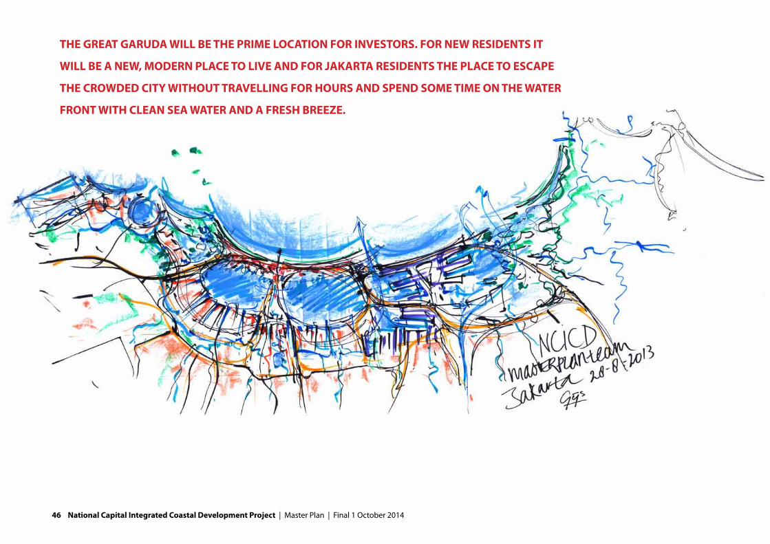
THE GREAT GARUDA WILL BE THE PRIME LOCATION FOR INVESTORS. FOR NEW RESIDENTS IT
WILL BE A NEW, MODERN PLACE TO LIVE AND FOR JAKARTA RESIDENTS THE PLACE TO ESCAPE
THE CROWDED CITY WITHOUT TRAVELLING FOR HOURS AND SPEND SOME TIME ON THE WATER
FRONT WITH CLEAN SEA WATER AND A FRESH BREEZE.
46 National Capital Integrated Coastal Development Project | Master Plan | Final 1 October 2014

5.2. Concept for spatial development: The Great GarudaIn addition to the alignment of the sea dike, two other factors are vital to the development of the spatial concept.
1. Connectivity: the dike will accommodate a new district of the city. Up to 1,5 million people will live and work here in future. High quality infrastructure should connect the new offshore district to the primary north-south develop-ment axis that defines Jakarta. By directly connecting the dike to the current city centre, Jakarta’s the central axis is extended: this spine will be the catalyst for urban regeneration.
2. Toprealestatelocationwithaniconicdesign:the dike accommodates highly desirable real estate development. It accommodates a new Central Business District for Jakarta and a new spectacular beach front. However, the reclama-tions are located in deep water and cost recovery is a major challenge. Only a new iconic waterfront city with high quality development, would attract major investors. At the same time plenty room for middle- and low-income housing will be created, thus making a city for all residents.
Combining the natural convex contour lines of Jakarta Bay with rational concave infrastructural connections create wing-like shapes. In the centre, these shapes are connected to the central city axis. Soon, these shapes were associated with the national symbol of Indonesia: the Garuda. The outer sea wall was transformed into the Great Garuda.
This is more than just an ornament or a landmark. The Great Garuda protects the National Capital of Indonesia against the sea. It is also the first image of Indonesia which foreigners and Indonesian expats will see when landing over the Bay of Jakarta. It is shaped to provide space for growth and connectivity.
THE BASIC DESIGN IS 1250 HECTARES, ALLOWING
PLENTY ROOM FOR FUTURE LAND RECLAMATIONS
FACTS:• ThebasicdesignoftheGreatGarudais1.250hainsize,offering650.000
peopleaplacetoliveand350.000peopleaplacetowork.• Additionallandreclamationscanbedevelopedinshallowwatersinthe
giantwadukwhendemandforrealestateallowsso.• 15%oftheGreatGarudaisreservedforthenewCentralBusinessDistrict
(CBD)and30%forsocialhousing.• Intotal23,7millionm2ofrealestatewillberealised,ofwhichover61%for
housing,35%forretailandofficesand4%forindustry.• Prioritywillbegiventocreatesustainablefacilitiesforfishingcommunities
whowillhavetoberelocatedfromthecurrentcoastline.NewfishingportswillbelocatedonthewingtipsoftheGreatGaruda,beingclosetothecurrentfishinggrounds.
• ThenewCBDwillhaveanMRTconnectiontotheexistingcitycentrewithalengthof11,2kilometres.
• ATangerang–BekasiHighwaywithatotallengthof43kilometresand2x4laneswillspanJakartaBayandpasstheGreatGaruda.UndertheCBD,anunderpasswithalengthof2kilometreswillbecreated.Itpassesthesea-lanetowardsTanjungPriokwithanenormousiconicbridgewithaclearanceof 70meters.
Final 1 October 2014 | Master Plan | National Capital Integrated Coastal Development Project 47

POISED IN THE MIDDLE OF THE GREAT WING-SHAPED SEA WALL WILL BE A NEW
CENTRAL CITY AREA, POSITIONED AS A NATURAL EXTENSION OF THE CENTRAL
SPINE AREA OF JAKARTA, IT WILL PROVIDE A SPECTACULAR AND WARM WELCOME
TO ALL WHO COME TO THE NATION’S CAPITAL.
48 National Capital Integrated Coastal Development Project | Master Plan | Final 1 October 2014

5.3. Urban designIn these initial 3D impressions, the potential of the Great Garuda to become a new face of Jakarta is clearly shown. The central area located on an extension of the city axis, has the highest density and building heights. It also enjoys a large civic space at the heart of this new city district. In our vision for the Great Garuda we place the green network as one of the core spatial arrangement criteria. The green-spaces of the Great Garuda include a large city level park, urban block parks, grand avenues, waterfront boulevards, mangroves and wetlands, nature reserves and the city street network.
In order to generate maximum revenues and boost the attraction of major inves-tors, it is highly recommended to embrace the Garuda as the new national gov-ernment seat and relocate the most important governmental and civic functions to this location. In order to grow, the CBD needs anchor tenants and in this the
government can play an important role to stimulate growth in the new CBD. In doing this, land in the city currently occupied by these functions would become available for redevelopment.
The CBD requires state of the art infrastructure. The design completes the north-ern part of the two outer ring roads of Jakarta and more local connections to the main land are established. A high speed rail connects the CBD with the airport and other parts of Java. An MRT line connects the CBD with the current city centre to assure interaction.
The wings of the Garuda host a new double city waterfront that on one side opens up to the sea and on the other side to the fresh water lagoon. At the sea there are long stretches of new beach created whilst on the lagoon side urban
Final 1 October 2014 | Master Plan | National Capital Integrated Coastal Development Project 49

FORMED BY THE LAWS OF NATURE, FLOW AND EFFICIENCY, THIS ELEGANT FOIL-
SHAPED WATERFRONT CITY RESEMBLES A GREAT BIRD, AN EAGLE SPREADING ITS
GREAT WINGS TO PROTECT THE PEOPLE OF JAKARTA, THE NATIONAL CAPITAL.
Urban design: 1.250 ha and areas for future extension
PORT ExPANSION AREA
Kemal
Ceng
aren
g dr
ain
Ciliw
ung
Caku
ng D
rain
Bajir
Kan
al T
imur
50 National Capital Integrated Coastal Development Project | Master Plan | Final 1 October 2014

wharfs, jetties, and waterside office, commercial, leisure and residential develop-ments are created. Creating sufficient residential neighbourhoods and a mix of working and living in the CBD is essential for its functioning.
On each wing there are many smaller urban blocks each separated by green buff-ers. The main roads pass through green corridors and at the outer extents of both wings, there are parks and locations for habitat development.
The east side of the Bay for now will be dominated by current activities. Tanjung Priok will have space for further development and remains connected to the sea. New is the Tangerang-Bekasi Highway connecting the Garuda with the West Java province, thereby establishing a missing link in the east-west connection in Java. In future the decision might have to be taken on closure of the eastern part of the bay. In addition preliminary plans for airport development and possibly further harbour developments exist. For now, these plans are indicatively drawn in: deci-sions will have to be taken later on.
The retention basis itself will have several functions as well. It provides leisure opportunities: for example for boating, swimming and fishing. In addition the lake provides opportunities for commercial fresh water fishing. Water management of the lake will be tuned to also provide raw water supply to the city, thereby alleviating the current pressure on water supply. In a dry year, the west lake can guarantee a reliable water supply of 12 m3/s in the dry season, assuming that waste water is effectively treated in future. A good water quality is a vital condi-tion for all these developments.
THE NATIONAL SYMBOL, BELOVED BY EVERYONE, COMES
TO THE RESCUE OF THE NATIONAL CAPITAL, GUARDING
ITS’ PEOPLE FROM DROWNING AND PROVIDING A GRAND
PERSPECTIVE OR THE FUTURE OF INDONESIA.
Final 1 October 2014 | Master Plan | National Capital Integrated Coastal Development Project 51

52 National Capital Integrated Coastal Development Project | Master Plan | Final 1 October 2014

5.4. Relations with the current coastal zoneThe effects of the development on the existing city will be considerable. The primary effect in the coastal zone will be that increased safety levels will offer incentives for investment. It offers the inhabitants of kampongs and residential neighbourhoods the assurance to invest in their properties and land prices will rise. In addition some specific coastal functions require attention in further design.
Land reclamationsThe development of the plan will mostly be complimentary to the current and planned land reclamations. These are developed as mid- to high-end mixed-use urban villages. Where they are currently situated at the sea, they will be situated at a lake site in the future. The plan offers the residents of these islands many facilities that are currently not catered for as the Great Garuda considers all aspects of city life: providing civic amenities such as hospitals, schools and governmental functions. In addition the Great Garuda is likely to attract some of the best major businesses from the country, region and across the world, providing work opportunities for inhabitants.
ResettlementsMost of the settlements along rivers and coasts are a result of employment opportunities and economic activities for settlements in the coastal zone. A lot of the slum areas are located near the economic activities like Tanjung Priok. For dike construction, resettlements will be necessary, impacting the current situa-tion and especially the social structure and cohesion in these neighbourhoods. Resettlement can provide an opportunity to revitalise settlements in the existing city, construct liveable dikes and counter illegal housing. On the Garuda space will be reserved for social housing. Careful study is necessary to implement social housing in a proper manner, tuning into the current life style in which social inter-
action revolves around streets and public spaces in the neighbourhood. Getting it wrong leads to social isolation and may trap neighbourhoods in a downward spiral.
Fishing activitiesAll along the coast of Jakarta Bay and within the bay itself are many small and me-dium sized fishing ports, harbours, markets, processing and storage facilities, fish farms, seaweed farms and associated communities. They are a source of employ-ment both directly and indirectly (repairs, parts, servicing of boats and equipment plus the community shops and services for workers and their families) and the centre of the communities that have grown up around them.
The nature of fishing behind the new dike will change from salt water to brackish or sweet water. This requires a challenging transition for some maritime industries that needs to be carefully considered. The plan offers opportunities to do so. In future, there is as well a possibility to utilise the lagoon for closed water fishing and farming as to develop new fishing port facilities and associated community neighbourhoods on the outer wing tips of the Great Garuda.
FURTHER READING:• ReportB3A.Urbandesignreport• ReportB3C.Regionalplanningcontextreport• ReportB5.SEAbuildingblocks
Final 1 October 2014 | Master Plan | National Capital Integrated Coastal Development Project 53

54 National Capital Integrated Coastal Development Project | Master Plan | Final 1 October 2014

VIBUSINESS CASES
Final 1 October 20144 | Master Plan | National Capital Integrated Coastal Development Project 55

FACTS:• Financingthefloodprotectionbylandreclamationsandothersourcesof
revenuesisoneoftheprinciplesinthisproject.• Toassessthepotentialoftheserevenues,businesscaseshavebeen
developed.• Businesscasesprovideinsightintheoverallfinancialaspectsofthisproject,
includingaspectslikecosts,revenues,interestrates,returnoninvestmentsandplanningofcomponents.
• ThebusinesscaseoftheNCICD-projectiscomplexandwiderangingasthebusinesscaseessentiallyconcernsbuildinganew,largesizecity.
• AlthoughthebusinesscasesinthisMasterPlanhavebeendevelopedusingcurrentIndonesiancostsandrevenues,theoutcomesshouldbeusedwithcareastheyalsocontainlongtermpredictionswithsomedegreeofuncertainties.
• ThebusinesscasesinthisMasterPlancouldchangesignificantlywhendesignsandtimingofcomponentsarechanged.
56 National Capital Integrated Coastal Development Project | Master Plan | Final 1 October 2014
6.1. IntroductionFinancing flood protection with urban development and other sources of reve-nues, preferably developed by private enterprises, is one of the project principles. This principle, however appealing from a public budget perspective, transforms a straightforward civil engineering project into a challenging integrated urban development with a complex financing structure. The size of the urban develop-ment (a large city) with all its different components contributes to this complexity. In order to assess the financial feasibility of such undertaking, business cases were made. Business cases provide insight in the overall result of financial aspects like costs, revenues, interest rates and return on investments. It also provides informa-tion on the commercial viability of a project (would private investors and develop-ers be able to make a profit) and the need for public financing for less profitable components.
Also other valuable financial information can be derived for business cases, like the impact of time on the finances (faster/slower development), the impact of fluctuating interest rates and changing real estate prices.
The business cases in the NCICD project were based on the best available infor-mation, like:- actual Indonesian costs of construction and materials, derived from current
land reclamations and recently completed civil engineering projects.- actual market information on real estate prices in Jakarta and market predic-
tions by major Jakarta based real estate companies- information from toll road companies and feasibility studies on public trans-
port systems
Despite this information, the business cases should always be used with some care, as the long term predictions on economy, costs and real estate values do have a degree of uncertainty. Also, the way the project is actually implemented will have a significant impact on the business case. Changes in design and timing of costly components will influence the business case. For instance changing the current mix of offices, retail, high-end and social housing will have a large impact.
6.2. A feasible planFor each of the alternatives a business case was developed, built up of the busi-ness cases for the major urban and civil engineering components. In this chapter, however, we focus on the business case for the preferred alternative: the 1.250 ha alternative.
The 1.250 hectares alternative is a financially sound development with a positive net present value of about 3 billion dollar. This means that if one would add up all future costs, revenues and other costs (like interest rates) and translate this into current value, the project would result into a positive outcome. This preferred alternative is the result of several iterations: also larger alternatives of 3.150 and 4.000 hectares (with different designs and construction schemes) have been calculated but proved to represent a negative net present value. Also the required upfront investments of the 1.250 alternative are considerably lower than in other alternatives. In addition, the preferred alternative can be realized with existing resources (eg. availability of sand), and has limited risks regarding economic developments.
THE GREAT GARUDA IS ADAPTIVE IN ITS DESIGN, THERE IS
SPACE FOR ADDITIONAL DEVELOPMENT UP TO 4.000 HA
Final 1 October 2014 | Master Plan | National Capital Integrated Coastal Development Project 57

The 1.250 hectares alternative could be the starting point of a larger develop-ment. The design is adaptive and could be developed into a waterfront city of 4.000 hectares when additional sand reserves are discovered and demand for real estate remains high.
The business case consists of four components: (1) flood protection, (2) land recla-mation and real estate development, (3) transportation and (4) harbour develop-ment. In addition a special component is defined regarding the functioning of the retention lake and necessary pre-conditions. The business case includes phase A (upgrading the current sea defences) and phase B (the Great Garuda consisting of the Outer Sea Wall, land reclamations and the offshore Tangerang – Bekasi high-way). Phase C (the long term development in the East Lagoon) for now includes too many uncertainties to include in the business case.
6.3. Key factors Choices in design and volume have a significant impact on the outcomes of the business case and have been optimised in the 1.250 ha alternative. The main fac-tors of influence are:
Spatial designA major factor in the business case is the location of the land reclamations. The outer sea wall needs to be developed far offshore, in deep water as there is a need for a large retention lake (waduk) and fresh water reservoir, therefore creating substantial costs for sand, rock and sheet piles. As large quantities are required (300 million m3 sand and 9,5 million m3 rock), small price changes have a large impact. Revenues are mainly derived from real estate developments on land reclamations. Where these are planned in deeper water, profits are lower. In the plan therefore a balance is sought between developing a seaside waterfront far offshore and developments in more shallow water (the tail of the Great Garuda). Where possible, land reclamations are located on shallows in Jakarta Bay.
ASSUMPTIONS BUSINESS CASE :• Thedefinedstartingyearis2014.Allpricesarecalculatedtopricesintheyear
2014.• Theperiodupto2050waschosenforthebusinesscaseasallmain
investmentsareexpectedtohavetakenplaceinthatperiod,andastheinvestmentsandrevenuesafter2050onlyhaveasmallinfluenceontotalrevenues.
• ForGDPgrowtharealgrowthfigurehasbeenassumedofabout6%onayearlybasisintheperioduntil2015.Intheperiod2009-2013realgrowthwas6,2peryear(period2004-20086,5%).
• Duetothepresenteconomicboomaninflationrateof10%isuseduntil2017.Afterwards,asomewhatmoremoderatelongterminflationpercentageisassumedof7,0%yearlyuntil2050.Thisisinlinewithmoremoderate economic growth expectations.
• Regardingthelongtermofthisproject(till2050)wehaveassumedayearlynominalincreaseof9%forallrevenueprices.Forthefirstyears(continuationofcurrentupswing)wehaveassumedanaverageincreaseperyearof20%(2015)andforlateryears12,5%fortheperiod2016-2017.
• 1%ofthetotalconstructioncostareusedforannualoperating&maintenancecosts,withtheexceptionoftheshiplocksintheouterseawall,thepipelinerelocationandthecablecrossingovertheouterseawall.Forthesecomponents4%isassumed.Forthelandreclamations0,5%isused.
58 National Capital Integrated Coastal Development Project | Master Plan | Final 1 October 2014
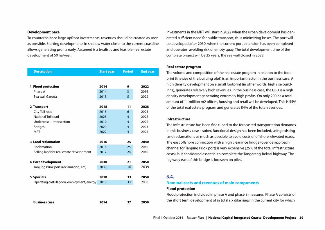
Development paceTo counterbalance large upfront investments, revenues should be created as soon as possible. Starting developments in shallow water closer to the current coastline allows generating profits early. Assumed is a (realistic and feasible) real estate development of 50 ha/year.
Investments in the MRT will start in 2022 when the urban development has gen-erated sufficient need for public transport, thus minimizing losses. The port will be developed after 2030, when the current port extension has been completed and operates, avoiding risk of empty quay. The total development time of the complete project will be 25 years, the sea wall closed in 2022.
Real estate programThe volume and composition of the real estate program in relation to the foot-print (the size of the building plot) is an important factor in the business case. A high density development on a small footprint (in other words: high rise build-ings), generates relatively high revenues. In the business case, the CBD is a high density development generating extremely high profits. On only 200 ha a total amount of 11 million m2 offices, housing and retail will be developed. This is 55% of the total real estate program and generates 84% of the total revenues.
InfrastructureThe infrastructure has been fine tuned to the forecasted transportation demands. In this business case a sober, functional design has been included, using existing land reclamations as much as possible to avoid costs of offshore, elevated roads. The east offshore connection with a high clearance bridge (over de approach channel for Tanjung Priok port) is very expensive (25% of the total infrastructure costs), but considered essential to complete the Tangerang-Bekasi highway. The highway east of this bridge is foreseen on piles.
6.4. Nominal costs and revenues of main componentsFlood protectionFlood protection is divided in phase A and phase B measures. Phase A consists of the short term development of in total six dike rings in the current city for which
Description Start year Period End year
1 Flood protection 2014 9 2022 Phase A 2014 3 2016 Sea wall Garuda 2018 5 2022 2 Transport 2018 11 2028 City Toll road 2018 6 2023 National Toll road 2025 4 2028 Underpass + intersection 2019 4 2022 Bridges 2020 4 2023 MRT 2022 4 2025 3 Land reclamation 2016 25 2040 Reclamation 2016 25 2040 Selling land for real estate development 2017 24 2040 4 Port development 2030 21 2050 Tanjung Priok port (reclamation, etc) 2030 10 2039 5 Specials 2018 33 2050 Operating costs lagoon, employment, energy 2018 33 2050 Business case 2014 37 2050
Final 1 October 2014 | Master Plan | National Capital Integrated Coastal Development Project 59

dike reinforcements and installation of pumping stations is required. The total costs of phase A are $ 1.9 billion.
Phase B flood protection includes the development of the outer sea wall, includ-ing pumping station, jetties at the wings, locks, pipeline relocation, cable cross-ings and mangrove restoration. The total costs are $ 4.8 billion.No direct income is expected from flood protection measures. However, flood
protection leads to significant income for the government as increased safety leads to higher property, profit and income taxes. These secondary revenues are not included directly in the business case, but an indicative calculation has been made of economic effects for employment, taxes and added economic value of the total development.
Real estate Buildable land Relative Land price / sqm Total revenues
Housing 69,3% $ 7.207 M
1 Housing (CBD) 425.250 8,8% 12.215 $ 5.194 M
2 Housing (high) 243.000 5,0% 2.791 $ 678 M
3 Housing (middle) 1.727.325 35,5% 720 $ 1.244 M
4 Housing (low) 972.000 20,0% 93 $ 90 M
Office 14,8% $ 11.394 M
5 Office (CBD) 425.250 8,8% 24.570 $ 10.448 M
6 Office (high) 291.600 6,0% 3.241 $ 945 M
Retail 4,0% $ 3.870 M
7 Retail (prime) 70.875 1,5% 47.210 $ 3.346 M
8 Retail (high) 121.500 2,5% 4.310 $ 523 M
Industry 12,0% $ 163 M
9 Industry 583.200 12,0% 280 $ 163 M
10 … 0 0,0% $ 0 M
Total 4.860.000 100% 4.657 $ 22.634 M
Land reclamation 1.080 ha
Buildable 45,0%
Total ground floor 4.860.000 sqm
60 National Capital Integrated Coastal Development Project | Master Plan | Final 1 October 2014

TransportThe transportation component consists of the Tangerang-Bekasi highway, city (toll) roads, bridges and a metro or light rail (MRT) from Jakarta mainland into the new land reclamation. Total costs of transport elements are $ 5.0 billion.
Infrastructure not specifically developed for the Great Garuda, like the freight rail-way or trans-Java high speed rail, are not part of the business case. The develop-ment of the high speed rail is however accommodated by reserving the necessary space.
Transportation generates income through toll-revenues and the sale of MRT tick-ets through estimates are included in the business case. Total nominal revenues amount to about $4,4 billion.
Land reclamationsThe total size of the land reclamations, flood protection and infrastructure in the design and business case is 1.250 ha, of which 1.080 ha concerns land reclama-tions. According to practice and regulations, 45% of this area is buildable. Costs of all the land reclamations are $ 7.0 billion. This is not including the construction of the outer sea wall. In addition to the land reclamation costs, extra costs for land development and nature compensation are calculated.
The main source of funding is the sale of land. 45% of the total area will be covered with buildings, 55% will be used for infrastructure and public green and recreation areas. The new Central Business District will cover 44% of the buildable area, 8% is reserved for high-end housing, 30% for middle-class housing and 17% for low-cost housing. The next table summarizes the total revenues per real estate type.
Port developmentTanjung Priok port will expand in the next decades. In the business case the port is considered to be an autonomous development until 2030 (thus not part of the NCICD business case). Forecasts of container volumes predict that there is room for a total area of 400 hectares in the period 2030-2050. Costs for developing this land for container terminals are $ 0.8 billion . Additional port Infrastructure is not included in these costs calculations.
In the business case, the port generates income by the sale of developed land and ship call duties. Income generated for the port authority by sales of land and ship call duties can amount to $2,4 billion nominal. Costs and revenues for commercial operators have not been calculated because of lack of information.
Other costsFor all components of the business case also 1% maintenance costs have been in-cluded in the business case, with some exceptions. For locks, pipelines and cable crossings 4% is used, and for the land reclamations 0,5 % is used. The operation costs of the large waduk (reservoir) are included in the business case.
An important condition for the development of the bay is the improvement (by 75 to 95%!) of the water quality. Costs for measures to improve the water quality
LIVING AND WORKING ON THE GREAT GARUDA• 45%ofthetotalareaoftheGreatGarudawillbebuilt,55%isforinfrastruc-
tureandpublicgreenandrecreationareas• ThenewCentralBusinessDistrictwillcover44%ofthebuildablearea,8%is
reservedforhigh-endhousing,30%formiddle-classhousingand17%forlow-cost housing.
• Intotal650.000inhabitantswillliveand350.000willworkontheGaruda
Final 1 October 2014 | Master Plan | National Capital Integrated Coastal Development Project 61

are part of existing dredging programs, solid waste management programs and the JICA sanitation master plan, and are therefore not included in the business case. These efforts need to be speeded up to facilitate the execution of the plan. In addition, priority should be given to sanitation improvements in the western side of the coastal zone.
6.5. ResultsThe financial result is a combination of all the costs needed to realize the flood protection and the revenues from toll, MRT, land sales and generated port in-come. The revenues are used to finance the (upfront) investment costs.
Overall there the components land reclamation and port expansion are profitable and the components flood protection and transportation are loss making. Over time, the sum of revenues are higher than the total costs, resulting in a positive business case.
It is important to consider that all business case calculations are so far without any financing costs (payments for debt and equity servicing). The figures below provide more insight in the cash-flow pattern in time.
Area Nominal development cost Nominal maintence costs Nominal revenue NPV-result
1 Flood protection (6.736.490.331) (2.345.026.691) - (10.303.118.244)
2 Transport (5.039.992.267) (1.159.198.221) 4.407.087.360 (968.518.230)
3 Land reclamation (8.929.487.585) (1.026.855.310) 22.633.635.995 13.495.418.969
4 Port (829.400.000) (99.528.000) 2.369.600.000 1.357.007.500
5 Specials (operation lagoon) (292.195.200) - (222.626.363)
Total (21.535.370.183) (4.922.803.422) 29.410.323.355 3.358.163.631
62 National Capital Integrated Coastal Development Project | Master Plan | Final 1 October 2014

Looking at the cash flows shows that until 2022 upfront investments are required with a maximum of 1.7 billion dollar on a yearly basis. After 2022 the revenues from the land sales ensure that there is financial sound cash flow, enabling the business case to end positive.
The initial investment costs are acceptable. Given the amount of medium term revenues, private investors will be interested to participate in this project.
6.6. Economic effectsIn addition to the cash flows of the Business Case the total development cre-ates additional economic effects that are highly beneficial to the city. Indicative calculations have been made for the economic effects of the components flood protection and land reclamations.
Water safety benefits (in terms of Present Value) for avoided damage in the risk area on land and buildings are $ 103 billion and additional amount of $ 110 bil-lion (in terms of PV) is estimated for avoided production losses from economic activities established on the land and/or in buildings in the period up to 2020. In addition, land values and real estate prices will increase. The benefits for the gov-ernment in terms of (prevention of foregone) tax on value added due to flood protection has been calculated on $ 5.1 billion for the period 2016-2020.Up to 2020, due to the flood protection, direct employment of finally 935.000 employed persons and an additional indirect employment of 600.000 employed persons is saved in the risk area. The secured income tax for this employment has been calculated on $ 2.45 billion for the period 2016 – 2020.
The land reclamation and urban development on the Great Garuda will create employment and enormous value added for the city. The land reclamation will provide structurally over 550.000 employed people in total. During construction of the Great Garuda, on average additional 4.250 persons are temporary em-ployed per year. The value added of this employment for the economy sums up to $ 64 billion (!) (in terms of PV) for the period up to 2040.
6.7. Risk profileKey risks regarding the NCICD-development and the measures that can be taken to manage these risks are mentioned below.
• Development duration: the plan has a long time horizon (longer than usual for private developers) and requires pre-financing large upfront investments.
Mitigation:developmentscanbesplitupinmanageableparts(e.g.OuterSeaWall
in5years,landreclamationsinsizesof50ha./year)
• Availability of sand: the plan needs a substantial amount of sand (in total 300 million m3), especially for land development in deep sea areas. Due to the sand need also for the existing reclamations the sand capacity on locations might not be sufficient or sand has to be transported from different places at much higher sand prices.
Mitigation:thedesignoftheGaruda(includingouterseawallandlandreclama-tionsisbasedupontheknownestimatedsandreservesof300millionm3.
Final 1 October 2014 | Master Plan | National Capital Integrated Coastal Development Project 63

64 National Capital Integrated Coastal Development Project | Master Plan | Final 1 October 2014
• Cost risks: development costs might be substantially larger in case of higher sand prices. Timing of purchase of sand and the capacity of the industry are crucial factors in this respect.
Mitigation:allkindofcontingenciesarebuiltinwithinthecurrentcalculations,specialfocusmustbeatbuyingandbuildingattherighttime.
• Market risks: economic growth and demand for real estate (especially offices) might be lower than now assumed. A lower demand for offices (or less reloca-tion of government offices to CBD) will have a negative effect on the revenues and financial return.
Mitigation:theGarudadevelopmenthasamarketuptakecomparabletotheaver-agecurrentuptake.GovernmentalguaranteesofmovinggovernmentalofficestothenewCBDisnecessary.ThedesignoftheGarudaisflexible,allowingforslowingdownandaccelerationbasedontheactualeconomicsituation.
• Revenue prices: real estate prices and land prices might be lower than ex-pected (especially in case of an economic downturn or more moderate than expected economic growth)
Mitigation:sellinglandmustbeplannedineconomicstabletimes.EspeciallytheCBDmustbesoldineconomicgoodtimes.
• Financing: debt and equity rates might be higher than expected
Mitigation:marketvalidationsonconditionsofbanks/privatepartiestofacilitateloans.
• Sanitation measures may not be finalized before 2022: a polluted lagoon might result having a negative impact on the real estate values. .
Measures:strongfocusontheplanningtoberealizedontime,firststepstosetupanintegratedwaterqualityimprovementprogramhavebeentaken.
FURTHER READING:Forfurtherreadingregardingthebusinesscasesseereport:• Spatial-economicreportBusinessCaseNCICDB4
Forfurtherreadingregardingthefinancingstrategyseechapter9,thedeliverystrategy.
Final 1 October 2014 | Master Plan | National Capital Integrated Coastal Development Project 65

66 National Capital Integrated Coastal Development Project | Master Plan | Final 1 October 2014

VIITHE PLAN PER THEME
Final 1 October 20144 | Master Plan | National Capital Integrated Coastal Development Project 67

Measures phase A
Kemal
Ceng
aren
g dr
ain
Ciliw
ung
Caku
ng D
rain
Bajir
Kan
al T
imur
68 National Capital Integrated Coastal Development Project | Master Plan | Final 1 October 2014

In this chapter the master plan is described in more detail, explaining the ration-ale by theme.
7.1. Flood safetyNCICD will provide flood safety for Northern Jakarta both on short and long term. Three phases are distinguished in the development of flood safety infrastructure.
Phase AUpgrading the current coastal defence is the high priority measure. This set of high priority measures includes 1) slowing down the land subsidence (by provid-ing alternatives for ground water extractions), 2) strengthening and heightening sea walls, 3) upgrading the urban drainage system and 4) preventing upstream river water entering the low-lying Jakarta area. Also accelerating the water sanita-tion is part of phase A.Sea wall sections in Pluit and Ancol are under immediate threat, implementation therefore starts already in 2014. The design levels for these sections take current subsidence rates into account, and will provide safety until 2022. If the implemen-tation of long term measures is delayed, the dike profile offers sufficient basis to further increase the dike height providing additional safety for another 5-10 years. Implementing the phase A dike in the densely populated coastal zone, with buildings against and on top of the sea wall, requires detailed urban planning and careful socio-economic solutions and community involvement. Several dike typologies have been developed to meet local requirement: basic dikes, reduced dikes, green dikes, inland dikes and beach dikes. In addition dikes with land recla-mations have been developed, thus providing a wide range of options..
In chapter 8 case studies for locations at Pluit and Kali Baru show how kampongs and slum areas could be upgraded in combination with flood protection. This upgrading could be an excellent opportunity for coastal revitalisation.
Phase BIt is unlikely that subsidence will be slowed down in the foreseeable future as it will take time to develop and implement alternatives for ground water extrac-tions. Sea water levels will rise, canals and rivers will gradually stop flowing under gravity into the sea. Large drainage pumps are needed, especially in central Jakarta where subsidence rates are high. Pumping stations require pumping lakes to temporarily store peak river discharges.
THE WIDE RANGE OF CONCEPTUAL DESIGNS FOR DIKES
PROVIDE AN EXCELLENT TAILOR MADE OPPORTUNITY TO
REVITALIZE THE COASTAL ZONE.
Drainage pump and pumping lake to absorb peaks in rivers
Final 1 October 2014 | Master Plan | National Capital Integrated Coastal Development Project 69

Measures phase B
Kemal
Ceng
aren
g dr
ain
Ciliw
ung Ca
kung
Dra
in
Bajir
Kan
al T
imur
70 National Capital Integrated Coastal Development Project | Master Plan | Final 1 October 2014

The need for large storage lakes (waduks) is one of the main reasons for creating the offshore waduk, rather than seeking room for such storage lakes in the city of Jakarta. The location of the outer sea (phase B) wall is mainly determined by the required storage capacity of the giant waduk between current coastline and sea wall. It provides sufficient room for future expansion of the land reclamation and storage capacity for bulk water supply.
Lack of data has made it difficult to statistically determine the moment when riv-ers will stop flowing and when flood risks become unacceptable. For most rivers and canals this will be sometime between 2015 and 2030, depending on the local subsidence rate, the river profile and river level in respect to the sea level. Given this uncertainty, a closing data of 2022 was chosen. Around 2022 sea water
levels will be around 3-4 meters above street level, which is a critical level as many houses in poor areas are below this height and ‘vertical’ evacuation will not pro-vide safety against floods anymore. The current sea wall and the many rivers open to the sea would provide a safety risk, requiring a more robust and shorter Outer Sea Wall. By 2022 also many rivers and canals will not be flowing freely to the sea, thus requiring pumps and pumping lakes either onshore or offshore.
From this perspective, there is a difference between the eastern and western part of Jakarta. As subsidence is higher in the western part, measures are more urgent there. The western part of the bay needs to be closed between 2022 and 2028. For the eastern part, closure can be postponed until 2040, or even further if subsid-ence can be slowed down in the coming years.
The cross section through the land reclamation
Final 1 October 2014 | Master Plan | National Capital Integrated Coastal Development Project 71
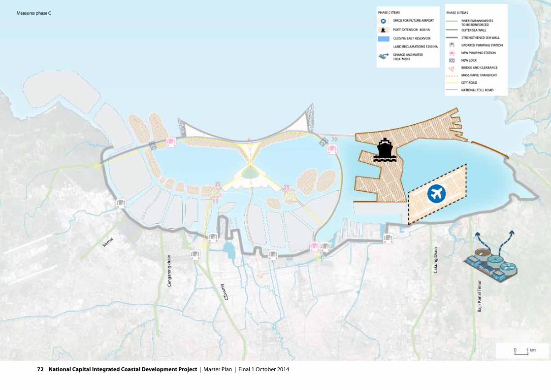
Kemal
Ceng
aren
g dr
ain
Ciliw
ung
Caku
ng D
rain
Bajir
Kan
al T
imur
Measures phase C
72 National Capital Integrated Coastal Development Project | Master Plan | Final 1 October 2014

The NCICD program significantly increases the flood safety of Northern Jakarta. As required in decree 121-2012 of the Governor of Jakarta, the design of the outer sea wall will be based on an extreme event that statistically occurs only once in 1,000 years. For design of the embankments along rivers and the giant waduk, a safety standard of once in 100 to 200 years is used. The urban drainage water and water from upstream rivers will flow into the giant waduk. To keep the water level in this reservoir low and meet the safety standards in the rivers, the largest pumping station in the world is required with a pumping capacity of 730 m3/s. This is taking into account a fluctuation of 2,5 meters above the minimum water level in the waduk and a waduk size of at least 75 square kilometres.
Phase CFor the eastern part of the Bay an adaptive approach is chosen. The subsidence is still relatively low and the main rivers can still flow freely. At this moment it is not possible to determine whether an outer sea wall will be necessary, or can still be avoided. In addition, the design requirements regarding the size and combina-tions with functions on the long term depend on economic development of this region. In a later point in time decisions for this area will have to be taken.
7.2. Social aspectsA project of the magnitude as proposed in this master plan has considerable positive and negative social impacts. Main effects are related to employment, the development of communities in the coastal zone and the impacts on fishery and related communities.
EmploymentThe increase in water safety generates several positive economic effects. As described in chapter 6, damage in the coastal zone is avoided ($ 103 billion) and economic activities are secured ($110 billion up to 2020). This is important to the economy, but especially important to the families of the directly and indirectly
FURTHER READING:• B1–engineeringreport• B2–upgradingexistingseadefences
FACTS OUTER SEA WALL• Theouterseawallisanimpressivestructurethatwillbe25kilometresin
lengthand,atthedeepestpoint,itwillbe24metreshighofwhich7,7metreswillbeabovesealevel(+7,7LWS-2012).
• Atitswidest,thebaseofthedikewillbe380metreswide.• Theouterslopesofthedikewillbedesignedataslopeofapproximately1:7
becauseofgeotechnicalstabilityandwaverunup.• Toprotecttheinnerandouterslopesoftheseawallanarmourlayerofrock
willbeapplied.Sheetpilingwillbeappliedatinnerslopesincombinationwithurbandevelopment.
• Theouterseawallwillbeclosedin2022.• Theconstructiontimeoftheseawall,thepumpingstationandthetollroad
isestimatedat4-6years• Theouterseawallwillprovideprotectionupto2080(atalandsubsidence
rateof2,5cm/yearundertheOuterSeaWallandsealevelriseof0,08cm/year).
Final 1 October 2014 | Master Plan | National Capital Integrated Coastal Development Project 73

employed. Up to 2020, direct employment of 935.000 persons and an additional indirect employment of 600.000 persons is saved as their working spaces are pro-tected from flood risks. These jobs will be lost if no coastal protection measures are taken.
In addition, extra jobs are created. The land reclamation will provide structurally over 550.000 new jobs. During construction of the Great Garuda, an additional 4.250 temporary jobs are generated on average.
Communities: development and re-locationThe coastal zone of Jakarta includes a broad social range in housing:- Low income areas: slum areas, squatters and low-income settlements on the
riverbanks and kampungs; - High-end and middle class housing: elite residential/real estate (Pantai Muti-
ara), middle class housing and future land reclamations.
Many riverbanks and waduks are typically occupied by (semi-) illegal low-income occupants as these were the only available areas for squatters.Many slum areas are located near the economic activities like Tanjung Priok. The total population living in the slums in the Jakarta coastal zone amounts to just under 1,5 million: about 6.5 % of the total population. Some high-end residential areas are built for the sea view and direct connection to the sea. This is also the case for the planned land reclamations.
The phase A sea wall strengthening will provide protection to all of the coastal communities, but will also have direct and major impacts on some of the coastal communities. The current sea defence is an integral part of neighbourhoods. Houses are built on top of the sea wall, in some parts the sea wall goes straight through residential areas and slums. Activities like shipyards and ship-breaking yards rely on a direct connection to the sea that might be disrupted by the de-
velopment of a dike. Reducing the impact on these communities and economic activities is of paramount socio-economic importance.Starting point for the conceptual design of phase A is to limit relocations due to dike reinforcement as much as possible. This is firstly achieved by disconnecting rivers and canals from the Jakarta Bay allowing lower, controlled water levels behind the drainage pumps significantly reducing the required dike improvement lengths and relocations. In addition, the impact of phase A is further reduced by constructing seawall improvements on the seaward side of the existing sea wall. Chapter 8 furthermore provides an example of how dike improvement can go hand in hand with urban re-vitalisation. In addition to renewal of existing neigh-bourhoods, the Great Garuda area offers space for social housing and re-location. 17% of the Great Garuda is reserved for social housing. The outer sea wall in phase B will guarantee the flood safety level in the current coastal zone. This creates a better investment climate in the National Capital for mid-end and high-end housing. The overall value of the area will increase and the
74 National Capital Integrated Coastal Development Project | Master Plan | Final 1 October 2014

area around the retention lakes and rivers will become more attractive (also due to the sanitation programme). A lock in the outer sea wall will be built to provide for a connection to the sea. Nevertheless the direct connection and sea view of the existing real estate and future land reclamations to the sea and sea view will be lost.
Fisheries and fishing communitiesAll along the coast of Jakarta Bay and within the bay itself lie many small and medium sized fishing ports, landing areas, harbours, markets, processing and storage facilities, fish farms, seaweed farms and communities depending on these facilities. There is great diversity in the quality and standard of the facilities but regardless of whether they are formally organised or apparently chaotic, whether they are hi-tech or traditional, the maritime industries are an important source of employment both directly and indirectly (repairs, parts, servicing of boats and equipment plus the community shops and services for workers and their families) and the centre of the communities that have grown up around them.The number of fishermen and vessels decreased in recent years. In 2012 12,000 active fisherman were reported. The fish production fluctuates per year, but an upward trend is registered. The statistics indicate a scale enlargement as produc-tion per vessel, per fisherman and per processing unit is increasing. The amount of cultivation farmers decreased (1,500 in 2012) since the cultivation of green mussels has been forbidden by DKI Jakarta due to the bad water quality in the Bay of Jakarta.
The autonomous development of the fishery sector is uncertain. Because of recent investments in new facilities and infrastructure, the productivity of fisher-ies in the Bay of Jakarta could increase. On the other hand fishing activities are negatively affected by the construction of the permitted land reclamations in Jakarta Bay.
The Garuda and sea wall will block direct access to the fishing ports. Also existing fishing grounds and salt water aquaculture will disappear in the fresh water reten-tion lake. Considering the importance of the fishery sector to the communities they support, great care has to be taken of taking measures to mitigate effects of the closure of the bay.
Mitigation measures and long term opportunities can compensate for the impact. A lock will be included in the outer sea wall to facilitate the passage from the docks to the fishing grounds. Due to increased shipping times this is not seen as an ideal solution for daily sea-going fishermen.
Located at the outer tips of both the west and east wings of the Great Garuda new fishing ports and fishing communities are planned to re-locate current communi-ties. These will be primarily designed with and for the people who will use them for work and living but will most likely also draw some interest for visitors. This can be interesting for fishing communities as they can sell their produce directly from markets or temporary and permanent shops, stalls, restaurants and food stands.
On the long term the fresh water retention lake could provide new alternatives for fishermen and cultivation farmers if water quality is sufficient.
7.3. Land reclamationClosing the outer sea wall before 2022 will be one of the most challenging hy-draulic civil works that has been carried out worldwide. No less than 90 million m3 sand will be needed for the outer sea wall alone. An additional 210 million m3 will be used for land reclamations, creating a total area of 1.250 ha for infrastructure and urban development.
Final 1 October 2014 | Master Plan | National Capital Integrated Coastal Development Project 75
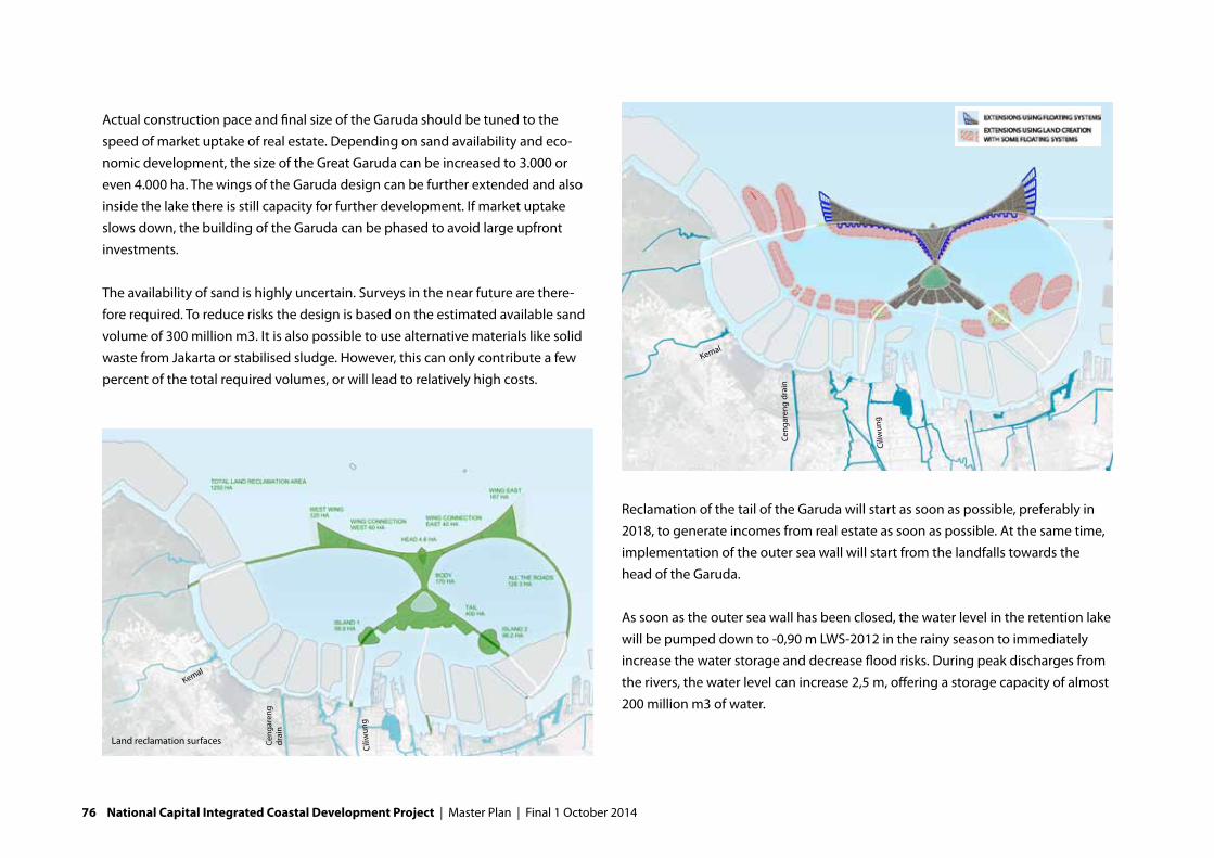
Actual construction pace and final size of the Garuda should be tuned to the speed of market uptake of real estate. Depending on sand availability and eco-nomic development, the size of the Great Garuda can be increased to 3.000 or even 4.000 ha. The wings of the Garuda design can be further extended and also inside the lake there is still capacity for further development. If market uptake slows down, the building of the Garuda can be phased to avoid large upfront investments.
The availability of sand is highly uncertain. Surveys in the near future are there-fore required. To reduce risks the design is based on the estimated available sand volume of 300 million m3. It is also possible to use alternative materials like solid waste from Jakarta or stabilised sludge. However, this can only contribute a few percent of the total required volumes, or will lead to relatively high costs.
Reclamation of the tail of the Garuda will start as soon as possible, preferably in 2018, to generate incomes from real estate as soon as possible. At the same time, implementation of the outer sea wall will start from the landfalls towards the head of the Garuda.
As soon as the outer sea wall has been closed, the water level in the retention lake will be pumped down to -0,90 m LWS-2012 in the rainy season to immediately increase the water storage and decrease flood risks. During peak discharges from the rivers, the water level can increase 2,5 m, offering a storage capacity of almost 200 million m3 of water.
Land reclamation surfaces
Kemal
Ceng
aren
g dr
ain
Ciliw
ung
Kemal
Ceng
aren
g dr
ain
Ciliw
ung
76 National Capital Integrated Coastal Development Project | Master Plan | Final 1 October 2014

Impacts on underwater infrastructure Power plants and infrastructure for communication and energy (e.g. LNG pipe-lines and internet cables) are situated along the current coastline. The develop-ment of the dike and retention lake will require the relocation of all this infrastruc-ture for two reasons. First, the temperature in the lake will become too high for the power plants to function efficiently. Second, the communication and energy infrastructure will otherwise be buried and damaged by the creation of the dike and reclamation.
7.4. Business and residentialThe real estate program consists of a complete city district including all relevant functions and social groups. It is build up around the idea of creating a new Central Business District (CBD) and the housing and retail facilities to support it.
The Great Garuda will therefore be a relatively high density urban area. This is necessary to make the development financially viable, at the same time it is desir-able in order to create critical mass required for a thriving, diverse and dynamic urban area.
In planning the densities the potential land-uses, functions, activities, neighbour-hood creation, and the character of streets and spaces is taken into account just as the visual and physical connections and associations. Attention is paid to the skyline and to the logic of the sequence of urban nodes.
About 45% of the total land of the Garuda can be build on. In the business case a conservative estimate of 486 ha of ground floor is calculated. More than half of the total real estate program consists of housing, one third of offices and the rest of industry and retail.
FACTS LAND RECLAMATION• Intotal1.250haoflandwillbecreated.Thedesignisflexibleandcanbe
enlargedupto3.000oreven4.000hectaresifsandisavailable.• Inm3ofsand,the1.250havariantiscomparabletoaPalmIslandinDubai
ortheMaasvlakte2intheNetherlands.• Thelandreclamationsattheinsideoftheseawallwillhaveasurfacelevelof
+3,77mLWS-2012.• Sandwillneedtobebroughtfromfaraway,fromborrowareaslocatedin
WestJavaandSouthSumatraatadistanceof48upto173km.• Tocompletethisenormousprojectintime,alargepartoftheworldwide
dredgingcapacityisneeded.
Total program mix
Final 1 October 2014 | Master Plan | National Capital Integrated Coastal Development Project 77

Floor Area Ratios urban design
Kemal
Ceng
aren
g dr
ain
Ciliw
ung
78 National Capital Integrated Coastal Development Project | Master Plan | Final 1 October 2014

Central Business DistrictThe CBD is financially the most important area of the program. Looking at the total amount of square metres real estate the CBD is 55% of the total program (in m2 Gross Floor Area, GFA). However looking at the revenues, the CBD contributes 84% of the total revenues.
The CBD consist of the following functions: high-end housing, office and prime retail. A total amount of 11 mln. M2 GFA The layout of the CBD is a dense area, with a Floor Space Index of approximately 12. In order to function optimal it needs a net buildable area of 92 ha. or a gross area of 205 ha. The spatial constel-lation of the CBD is worked out in chapter 8.
HousingThe housing element of the design is best reflected by the following diagram showing the spread of the program across housing categories in this master plan.
We made a mixed design of high-end and high-class housing, middle class and low-class. This functional mix makes it possible to grow further (in terms of hous-ing) within the new urban area, besides it makes a social mix of lower, middle and upper-class.
High end apartments are located within the CBD, whereas the high class residen-tial areas are located beneath the wings of the Garuda. Other neighbourhoods are more mixed with lower income housing mainly situated around the maritime communities and middle income housing in the rest of the wings.
CBD
CBD: % of m2 GFA CBD: % of revenues
Rest of programCBD
Rest of program
Total housing mix
FURTHER READING:• B4–financialandeconomicstudy
Final 1 October 2014 | Master Plan | National Capital Integrated Coastal Development Project 79

FURTHER READING:• B4–financialandeconomicstudy• C4.1Economiccostbenefitanalysis
Urban design: 1.250 ha and areas for future extension
PORT ExPANSION AREA
Kemal
Ceng
aren
g dr
ain
Ciliw
ung
Caku
ng D
rain
Bajir
Kan
al T
imur
80 National Capital Integrated Coastal Development Project | Master Plan | Final 1 October 2014

7.5. Main ports
Port developmentTanjung Priok is the most important (main-)port of Indonesia and an essential eco-nomic driver for Jakarta. In addition, this port has an important role for the whole west Java corridor development and specifically for the Bekasi industrial area.
Currently (2013) the container traffic in Tanjung Priok is around 7 million TEU. For 2030 the container traffic forecast for Tanjung Priok is 18 million TEU; at an annual growth rate for the period 2008-2030 of 7.4%. The container terminals are operating at maximum capacity and there is a strong need for capacity expansion. The Indonesian economy is growing fast with rates of 5-6% annually and is expect-ed to grow further with rates of 6 to-7% in the coming decades. Currently the port is a bottleneck for economic growth in the region as capacity is insufficient, hinterland connections are poor and congested and logistics service providers perform poorly. In addition, subsidence is lowering the quays, which will require investments. These
factors raise costs and therefore sincerely affect the position of the port in a region with stiff competition.
Port development is in principle an autonomous development. Port extension plans are already launched until 2030 and these are not part of the business case of the master plan. The master plan contributes significantly to the port development by easing traffic congestion and thereby boost port activities. Additional expansions of the ports are also foreseen after 2030. These can be combined with other develop-ments in the eastern part of the bay.
It can go without saying, that keeping an open connection to the sea is essential for its functioning. The bridge of the Tangerang-Bekasi highway in the master plan will have a 70 metres clearance to provide this open access.
The port of Sunda Kelapa will be closed off from the sea by the development of the outer sea wall. Locks in the outer sea will continue to provide access to the sea for Sunda Kelapa, fishing ports, as well for recreational boats and yachts.
Final 1 October 2014 | Master Plan | National Capital Integrated Coastal Development Project 81

Airport developmentAt the request of DKI Jakarta, an area is reserved in the Master Plan for the devel-opment of a new international airport. To avoid interference with the flight paths and approaches of the current (Soekarno-Hatta) airport, only locations far west (in the Tangerang district) or in the east part of Jakarta Bay will be potentially suit-able. The eastern part of the bay is sufficiently large to accommodate an airport, however, specific airport studies will have to be performed to assess feasibility related to flight paths and (environmental) impacts.
7.6. Mobility and infrastructureThe city of Jakarta has been facing major traffic problems for years. The urban transport systems haven’t kept up with the growing demand for mobility result-ing in congestion. The congestion is caused not only by growth of the numbers of travellers, but also by an increase in car-ownership.
Traffic jams are wide spread, and as mentioned in the MP3EI: they have a negative impact on economic development. In addition it creates side effects such as noise and air pollution, which are for an important part caused by the great numbers of motorcycles.
To reduce traffic congestion, two major developments have to take place. First a modal shift has to take place: from cars and motorcycles to use of public trans-portation. Second, the infrastructure in the city needs to be upgraded: as well for public transportation as for road transport. These are two major points of atten-tion in the spatial design of the master plan.
The design of the sea dike and Garuda include the completion of the ring roads in the north of Jakarta, it provide a route for the Tangerang-Bekasi Highway and High Speed Railway and includes facilities for public transport (MRT and busses).
FACTS ON THE ROAD NETWORK• Basedonroughcalculations(noforecastmodelisavailable),the650.000
inhabitantsoftheGarudaand350.000peoplewhoworkontheGarudaresultinanamountof1,2milliontripsperday.
• Basedontrafficforecaststhecapacityofroadswillbeasfollows: - Tengerang-Bekasihighwaywillbea2x4laneroadintheeastanda2x3
lane road in the west. - TheouterringRoad2willbea2x3laneroad. - ThetwoconnectionsfromtheGarudatothemainlandwillbe2x2+2x4
lane roads.• ThebridgeovertheharbourentranceofTanjungPriokwillhaveaclearance
of70metres.
Main road network
82 National Capital Integrated Coastal Development Project | Master Plan | Final 1 October 2014

Modality shiftPolicies for mobility strive for a shift towards an increased use of public transpor-tation. According to history however, the policy for 2030 (60% by public trans-port) is very ambitious. Therefore we used a modal split of maximum 45% travel by public transport (MRT and bus) to determine the need for capacity of the road network. Based on the available information and discussions with stakeholders, we come to the following assumptions about the modal split for the people work-ing and living on the Garuda.
Because of the difference in travel distances, we have used different values for the trips made on the Garuda (inside the Garuda), the trips between the city of Jakarta and the Garuda (inside Jakarta) and trips to and from destinations outside Jakarta (outside Jakarta). These modal splits are used in the design of the road and public transport networks.
Design main road networkThe current main road network in Jakarta consists of the Jakarta Inner Ring Road, the Outer Ring 1 and a number of radial connections across the city. The Jakarta Inner Ring Road is surrounding the central city and is a complete ring. The Outer Ring 1 is still incomplete, there are links missing at the west and the north-east. Both rings share the toll road along the coast of Jakarta. Plans exist to complete the missing road sections in Outer Ring 1. In addition plans exist to realize a sec-ond outer ring and a toll road along the coast westwards.
The design of the Garuda includes the following additions to the road network:• TheOuterRing2issituatedontheOuterSeaWall,therebycompletingthe
now missing northern connection. • TheTangerang-BekasiHighway(toll-road)issituatedontheOuterSeaWall.In
this eastern part of the bay this road is built on stilts.• ThecurrentOuterRing1willbecompletedwithanewroadontheGaruda
and the planned land reclamations. At the east side, near Tanjung Priok, the Outer Ring uses a part of the toll road which is already under construction.
• City(toll)roadsconnecttheGarudawiththeplannedlandreclamationsandthe city of Jakarta. These roads also are connections between the Jakarta Inner Road and the Outer Ring Roads.
These roads will serve to connect the Great Garuda to the city and to the east and the west. Just as important, these additions to the road network will drastically re-duce the high traffic load on the current coast road. The provinces of Banten and West Java will be much better connected to Jakarta and the harbour of Tanjung Priok an also Sukarno-Hatta airport.
Design public transport networkTo accommodate a shift towards greater use of public transport, a high quality public transportation network is designed for the Great Garuda. This network consists of:
Main public transportation network
Final 1 October 2014 | Master Plan | National Capital Integrated Coastal Development Project 83

• TheseawallprovidesarouteforaHighSpeedtrain,aspartoftheHighSpeedrailway along the north coast of Java (Cilegon - Banyuwangi).
• afreightrailwayintheeastofthecoastalzonetoconnectTanjungPriokwiththe hinterland;
• alightrail(MRT)toconnecttheCBDwiththecentralcity.Thisconnectionisanextension of the South-North corridor in the city of Jakarta.
• anoptionalMRT-connectionviatheplannedlandreclamationsalongthecoast to directly connect the CBD of the Garuda with the airport
The alignment of the freight railway can be partly combined with the high speed rail in the eastern coastal zone. The bridge at Tanjung Priok has a vertical clear-ance of approximately 70 m. When the High Speed train is using this bridge, gradients are required of approximately 7000 m. For that reason, a route south of Tanjung Priok was chosen.
Mobility on the GarudaBus routes along the main roads of the Garuda, in combination with the MRT form the main form of public transport inside the Garuda, accommodating 45% of traffic. The buses mainly drive on separate bus lanes, only in quiet streets they will make use of car lanes. In this way, a dense network is created for public transport by bus.
The green structures on the Garuda in combination with relatively short distances due to the high density development make that about 10% of traffic consists of pedestrians and bicycles.
The remaining traffic on the Garuda consists of cars and motorcycles. On the Garuda the Tangerang –Bekasi highway, ring road two and local roads together form the primary traffic and public transport arteries: Great Garuda Grand Av-enues. They connect this development with the rest of the city and form part of the primary east-west Jakarta connections. In these roles they become important Road profiles main road network
Main public transportation network
MRT
HSL-train
HSL-trainMRT (option)
Ceng
aren
g dr
ain
Ciliw
ung
Caku
ng D
rain
Bajir
Kan
al T
imur
Ceng
aren
g dr
ain
Ciliw
ung
Caku
ng D
rain
Bajir
Kan
al T
imur
Kemal
84 National Capital Integrated Coastal Development Project | Master Plan | Final 1 October 2014

and challenging to design. They must be capable of providing sufficient capac-ity for great numbers of passengers and vehicles, but must not become a barrier between the different development areas. The road corridors will be lined by large trees and will thus become strong landscape elements forming an impres-sive green corridor.
7.7. Water ManagementThe main components of the designed water system of the coastal zone consists of polder systems in north Jakarta, the rivers and canals that flow into the reten-tion basin, the retention basin itself and the water management system on the Garuda itself.
Polder managementIn total seven polders will be established in phase A. To create hydraulic managea-
ble units, several dike rings were developed. To keep the land within these polders dry, waduks and drainage pumps are required to pump out rain water and inflow-ing upstream water. Most polders will discharge their water into the retention lake behind the Outer Sea Wall. The Lower Sunter and Ancol Pumps will be adjusted so that they can discharge their water directly to the sea at Tanjung Priok.
Rivers 7 rivers and canals in western Jakarta will discharge into the giant waduk (the retention reservoir behind the Outer Sea Wall), including the Cengkareng Drain and Banjir Kanal Barat. After closing the bay, the water level will be lowered by 1,5 meter to -0,90 LWS-2012 in the dry season. This minimum level is determined based on the current depths of the rivers and the bay. Lowering the water level will immediately improve the river discharge during floods.
Retention basinThe retention basin of in total 75km2 serves as a giant waduk: it temporarily stores river water discharged into it before this water is pumped out. The water level in the retention basin can fluctuate 2,5 metres, creating storage space. The largest pumping station in the world is installed to maintain the water levels within the established boundaries.
Cross section retention lake including in and out flow
THE RETENTION BASIN DOES NOT ONLY ABSORB THE
FLOOD WATER, IT IS ALSO A SOURCE FOR DRINKING
WATER. CLEANING THE RIVERS AND CANALAS IN JAKARTA,
HOWEVER, IS A PRECONDITION
FURTHER READING:• B3a–spatialplanning&urbandesign• B3b–Transportsystemanalysis• B3c–Tangerang-Bekasianalysis
Final 1 October 2014 | Master Plan | National Capital Integrated Coastal Development Project 85

Water management measures
86 National Capital Integrated Coastal Development Project | Master Plan | Final 1 October 2014
The water level in the retention lake can, in time, be lowered to facilitate river discharge when the rivers subside further. This leads to a higher head difference between the water level in the retention lake and the sea. The total acceptable head difference over the outer sea wall however, is finite.
Supplying quality drinking water to Jakarta’s population is currently a challeng-ing task. Piped water supply and distribution reaches only a small amount of the population. The retention basin might, over time, become a source of raw water supply. For this purpose, the operational level needs to be increased during the dry season to +0,65 m LWS-2012 in order not to surpass the minimum water level. In a dry year, the giant waduk can guarantee a reliable water supply of 12 m3/s in the dry season, adding up to 30 m3/s in the wet season. By combining this source of bulk water with other sources (including sustainable use of ground water), the National Capital can be provided with sufficient piped water year round.
The current water quality of the urban water is very poor and needs to be im-proved for the retention basin to function properly. This is further described under the environmental aspects in section 7.9.
Water management on the Great GarudaDesigning a complete urban area provides the opportunity to establish a state-of-the-art and sustainable water system on the Garuda. Rather than considering only engineering solutions, a combined approach of natural and man-made elements is most suitable to develop a robust water management system combined with high-quality environments.
All waste water on the Garuda will be collected and treated. Runoff from roads will be filtrated before it reaches surface water, or will be collected and treated as well. A separate system is designed for rainwater. This relatively clean water is not mixed with sewer water: it is used as a supply for surface water streams on the Garuda
and feeds into the parks, green zones and mangrove areas. This water as much as possible flows under gravity to, eventually, the retention lake or the sea. Roadside catchments and drainage swales, water attenuation ponds and extensive perme-able surfaces can be integrated into the design and the benefits of green roofs and other techniques to slow down rain water run-off should be promoted.An issue regarding water management in the Garuda is the salt water seepage of up to 3 m3/s, which will occur through the outer sea wall. As this is relatively high, it may be considered to create a polder in the Garuda, and catch salt water seep-age in a drainage system.
7.8. Recreation and green-spaceThe incredible pace of urbanisation in Jakarta has resulted in enormous pressures on the city’s green infrastructure (both recreational and natural). Open spaces have been consumed by both legal and illegal development and the quality and safety of open spaces is not consistently good.
Many people do not have access to open spaces for recreation, leisure, health and well-being. Studies across the world have shown that quality and plentiful urban green results in urban populations that are physically and mentally healthier as well as more productive in work and education. The proximity of urban green contributes considerably to the attractiveness of the central business district.
THIS PARK WILL BE A LANDMARK LANDSCAPE AND
WILL FUNCTION NOT ONLY AS A PRIMARY OPEN SPACE
FOR THE GREAT GARUDA POPULATION, BUT ALSO AS A
DESTINATION FOR THE CITIZENS OF JAKARTA.
Final 1 October 2014 | Master Plan | National Capital Integrated Coastal Development Project 87

Recreation and green space
Kemal
Ceng
aren
g dr
ain
Ciliw
ung
Caku
ng D
rain
Bajir
Kan
al T
imur
88 National Capital Integrated Coastal Development Project | Master Plan | Final 1 October 2014

The design of the Great Garuda places the green network as a core criterion for spatial arrangement. The green-spaces of the Great Garuda have a hierarchy and include a large city level park, urban block parks, grand avenues, waterfront boulevards, mangroves and wetlands, nature reserves and the city street network.
Central ParkThe Central Park is the largest primary open space alongside the waterfronts and open waters. Located at the heart of the Great Garuda this parks is a large-scale multi-functional open space. It will become a focal point for the surrounding urban developments and will include a great diversity of functions, amenities and activities. This park, as an integrated urban element, not only has a major physical value but also provides opportunities for financial value and returns to be realised. In many cities property values directly overlooking and in close proximity to high-quality open spaces, command amongst the highest in the city. So whilst it may ap-pear to be a great extravagance creating such a large open space on costly land created in the sea, the civic benefits and direct and indirect increased land- and property-values are believed to compensate for this.
Standing in the area of highest density development and surrounded by the tall-est buildings on the Great Garuda, this park will become a vital part of the urban fabric and a vibrant open space suitable for big outdoor activities and celebra-tions.
Museums, concert hall and the like would be appropriate elements to be consid-ered for inclusion within an iconic building or building cluster within the park. Other smaller restaurant, gallery and café / bar pavilions could also be dotted throughout the park in order to further promote its popularity and extend hours of activity and use.
Garuda City SquareThe Garuda City Square is located immediately to the south of the central park. This is a formal open space in the centre of this city district. It is a location for formal civic events and can also accommodate sculptural and artistic installations and performances. The MRT line passes through the square and there is an inte-grated public transport stop with opportunities to park (underground car park-ing), store bicycles and gain information about public transport routes, events etc.
Urban Block ParksIn addition to the functions of the larger parks, the urban block parks provide easy access local open spaces that can be specifically tailored to the character and needs of their immediate populations and built functions.
Jakarta Bay Urban Beachfront and Waterfront BoulevardA prime waterfront real-estate location for large hotels and large-scale recreation / mass-tourism functions, the Jakarta Bay New Urban Beachfront and Waterfront Boulevard is the main publicly accessible new leisure destination. As the name suggests this is a place designed to attract visitors from a wider catchment area. The beach park will include pavilions, kiosks, beach festivals, outdoor perfor-mance spaces, piers, jetties and other sea-side activities.
The waterfront parkCloser to the outer east and west edges of the wings, the waterfront park is a green strip alongside the waterfront. This is a semi-natural waterside and includes mangroves, boardwalks and river-taxi pontoons and mooring locations. It is a re-laxed landscape with little formal program and it is intended to be a counterpoint to the intense waterside typologies found closer to the head of the Great Garuda.
Final 1 October 2014 | Master Plan | National Capital Integrated Coastal Development Project 89

90 National Capital Integrated Coastal Development Project | Master Plan | Final 1 October 2014

City Piers and Garuda Wharfs West and East Located on the watersides surrounding the main body of the Great Garuda and on the southern edges of both wings, are areas of lower height developments with waterside leisure, entertainment and marina activities. The landscape design will be heavily influenced by marina styles and should consider ways to incor-porate traditional fishing port and harbour architecture in a contemporary way. References such as Clarke Wharf in Singapore can be considered.
Mangroves, Wetlands and Nature IslandsAs well as recreation and leisure landscapes, we also propose that certain areas become places for nature with minimal human disruption and access. The crea-tion of the lagoon will result in many different habitat typologies developing from fresh and brackish water within the lagoon to tidally influenced salt water mari-time conditions outside of the sea dike. We therefore consider various locations for the enhancement of existing habitats and natural areas, as well as the devel-opments of new nature zones. Mangrove Park and Discovery Centre is located at the western tip of the Great Garuda western wing. The intention of this park is to re-establish large areas of mangrove forest and wetland and to create an educa-tive and recreational program to allow people to learn about the importance of mangroves and to enjoy the tranquillity of the wetland park. Boardwalks extend throughout the series of mangrove islands and at the discovery centre it is pos-sible to hire boats, take a water-taxi, and engage in a range of informative and fun activities.
7.9.Environmental impactsClosing the bay has significant environmental impacts. Initially, these effects will be negative as the current environmental system will change significantly. Several major environmental impacts of the master plan have been researched and com-bined in a building blocks document for a strategic environmental analysis. The study identifies impacts, suggests possibilities for mitigation and helps to identify new opportunities to add qualities. The Master Plan incorporates many of the suggested measures.
MangrovesThe last true mangrove areas of Jakarta Bay can be found around Pantai Indah Kapuk area. The Mangrove covers in total 320 ha of which 180 ha is protected. The mangroves currently suffer from several external forces including, low water quality, solid waste, illegal cutting and most notably subsidence. Given the current subsidence rates, it is very likely that parts of the mangroves become submerged, resulting in oxygen depletion and subsequently to the complete degradation of the forest. The closure of the bay results in an accelerated degra-dation of the mangrove forest. The bay will change into a fresh water basin with different hydraulic conditions, making it impossible for mangroves to exist in the area.
In order to mitigate the loss in mangrove area, several possibilities have been analysed. The goal is to create a true estuarine system with intertidal conditions, a size of at least 180 ha and the potential to provide the same ecosystem services the current mangrove area is able to provide. The locations with the most poten-tial for mangrove development are in the east side of the bay just north of the mouth of the Sungai Cikarang, in-between the feathers of the Garuda or along the western side of the seawall and western reclamations.
THE IMPACTS OF THE PROJECT ARE SIGNIFICANT, BOTH
POSITIVE AND NEGATIVE. MITIGATION OF ADVERSE
IMPACTS IS ESSENTIAL
Final 1 October 2014 | Master Plan | National Capital Integrated Coastal Development Project 91

The phase B design incorporates the development of mangroves in the western wing of the Garuda. The development of a mangrove park and discovery centre is proposed here. At this location nature education, mangrove restoration and city recreation can be combined in an interesting mix.
By mitigating the loss of mangroves in the right locations, the mangrove cover in the region can be strengthened. Opportunities to develop mangroves are the in-corporation of mangroves in the design of Phase C and using accretion structures in the east to create an estuarine system with intertidal conditions north of the Sungai Cikarang Mouth. Considering the uncertainties of spatial development and long term flood defence requirements these design will have to be develop at a later stage.
Water qualityJakarta lacks effective waste water treatment, leading to exceptionally high loads of human waste, organic materials and nutrients in Jakarta’s rivers. Over 95% of urban water is classified as highly polluted. This is not surprising, as in past decades, the development of sewerage systems has not proceeded as planned and the coverage remains as low as 2%. Furthermore, only 30% of that sewerage capacity is used and only 12% of the installed wastewater treatment capacity is utilized. In addition, law enforcement of existing regulations on sanitation has remained weak. Poor sanita-tion has major impact on the health of Jakarta’s residents and the availability and quality of water for households and commercial users. It has a negative impact on aquatic life, water related activities like fisheries, tourism and on social welfare, such as reduced school attendance, inconvenience or wasted time. The low chemical quality has already led to the prohibition of mussel farming near Tanjung Priok port.
If no measures are taken, the water quality of the retention basin will become extremely bad. Organic material will cause oxygen depletion leading to mass starva-tion of aquatic species. High nutrients will cause excessive bloom of algae or water
hyacinth. Heavy metals and pathogens will prohibit the use of the retention lake as source for drinking water. To achieve an acceptable water quality, pollution with organic substances has to be reduced with 75%, combined with a reduction of 95% of the current nutrient loads (especially phosphate). Additional attention has to be given to micro pollutants and pathogens, to make the retention lake suitable as source for drinking water.
An enormous challenge lies ahead. Therefore, priority needs to be given to a water quality improvement program that focuses on law enforcement of existing regu-lations, acceleration of sanitation in western Jakarta, solid waste management, dredging and awareness programs. In addition, it might be needed to dredge the current top layer of the bay, as organic material might be piled up here. However, these measures are complex and expensive, and will not be finalised before 2022. Unusual, innovative and maybe radical technical approaches have to be explored, like flushing, mechanical aeration of the retention lake, deviation of the polluted base flow of rivers, stimulating phosphate retention by adding chemicals or alterna-tives for waste water collection. The effectiveness of these measures need to be further explored in a Water Quality Acceleration Roadmap that needs to developed, in which all current programs and acceleration measures need to be aligned and coordinated.
The closure of the bay makes cleaning of rivers imperative. It creates the neces-sary momentum to implement sanitation measures that was lacking until now for Jakarta, and therefore has a positive impact on water quality. This in addition has positive effects on living conditions along the rivers and the coastline. In addition, the outer sea wall retains the pollutants in the bay, dramatically improving the water quality outside the basin. This has a positive effect on marine ecosystems and pos-sibly increases productivity for fisheries. For instance the pollution of the valuable Thousand Islands is reduced, thus contributing to protection of coral reefs and sea grass areas.
92 National Capital Integrated Coastal Development Project | Master Plan | Final 1 October 2014

Marine lifeThe ecology of the freshwater and estuarine system is heavily impacted by pollution and low oxygen concentrations. Several migratory fish species and three species of eel can be found in the Jakarta Bay. Populations of all three eel species however, are severely depressed.
The closure of the bay turns the bay of Jakarta into a fresh water retention lake, which has a large impact on the ecological situation of the Jakarta Bay. As a result, sedentary marine species of fish and benthos will die out. Larger reef fish and pe-lagic species however, will try to migrate towards better suited habitats at seaward locations. They can be aided by giving them time to find a way out along the shifting saline gradient. Disappearance of marine species will take place over several months giving euryhaline species time to dominate the food chain and consume cadavers of disappearing species. Sudden massive mortality is therefore not likely to occur.
In the newly created situation a diversity of tolerant fish species disperse over the retention lake quickly, especially when the waters entering the lake are of sufficient quality. Many of these freshwater species are interesting target species for fisheries and aquaculture. In order to mitigate the loss of migrating fish species and estuarine life, estuarine habitats can be created outside the dam, along the south west coast (this can be combined with mangrove developments). By adjusting the ship locks and pumping stations migratory fish will be able to migrate from sea to the estua-rine system into the retention lake.
Hydrodynamic impactsClosing the bay of Jakarta will create a significant change in flow patterns of the bay. Changes in flow may create new erosion and sedimentation risks. To understand these risks, a hydrodynamic study was carried out with a state-of-the art hydro-dynamic model (Delft 3D) and the latest data on flow patterns, tidal cycles and
bathymetry.The conclusion is that the existing flow velocities in the Bay of Jakarta are low (typical less than 0,1 meter per second). The Outer Sea Wall will create slightly higher velocities around the wingtips (0,3 meter per second during ebb), but these are still considered to be too low to create major erosion risks. There will be some areas with increased sedimentation risks as velocities in the reservoir and in sheltered areas (like the approach channel to Tanjung Priok) will decrease.
Difference in flow velocities (m/sec) between existing situation and after construction of the Outer Sea Wall.
Red: increase in velocity; risk of erosion. Blue: decrease in velocity; risk of sedimentation.
Final 1 October 2014 | Master Plan | National Capital Integrated Coastal Development Project 93

94 National Capital Integrated Coastal Development Project | Master Plan | Final 1 October 2014

VIIITHE PLAN PER AREA
Final 1 October 20144 | Master Plan | National Capital Integrated Coastal Development Project 95

96 National Capital Integrated Coastal Development Project | Master Plan | Final 1 October 2014

In this chapter the designs are worked out per phase and per location to show how different themes combined contribute to a safe and revitalised coastal zone. Where chapter 7 focussed on themes and technical design, this chapter focuses on the integration of themes and the urban design.
8.1. Phase A: dikes-an opportunity for coastal revitalisationPhase A consists of the reinforcement of the dikes along rivers and the coast as described in chapter 7. In total seven dike rings have been designed to create hydraulic units which will protect the coastal zone until the closure of the Outer Sea Wall. However, most of the surface area of Jakarta is developed and most waterfronts are flanked by important road and infrastructure corridors or dense developments, both legal and illegal.
Making room for strengthened flood defence structures requires large land ac-quisitions and relocations. Considering integrated solutions combining dikes and walls with infrastructure, buildings and facilities is therefore key to ensure optimal use of valuable and limited space.
In technical report B2 six concepts for the technical designs of dikes are present-ed. These concepts should be worked out per location. In some places as a rather technical solutions, in others in combination with infrastructure or as part of an urban development concept.
Using the right concepts, dikes could add value to coastal communities. Coastal protection becomes the catalyst for development and revitalisation. To show how this can work in practice, the locations Pluit and Kali Baru are chosen as pilot loca-tions. Here the location Pluit is shown as an example as its situation is typical for some densely populated locations along the coast line.
Current situation PluitThe coastal zone in Pluit faces many challenges. Subsidence levels are high as well as the risk of floods. There is a complex, dense mix of land-uses and extensive informal and illegal land occupation and development. Pluit fulfils an important function in the city water system. A large pumping station with a large waduk is situated here. The location chosen as a pilot is the area between the Waduk Pluit and the sea.
Around the north-east part of Waduk Pluit, illegal settlements have developed on the banks. This is not a desirable situation from environmental, hydraulic and living environment point of view.
In the current situation, the settlements and businesses here have a strong rela-tion with the sea. Fishermen rely on the proximity to their boats and activities like ship repair and ship demolition depend on direct access from the sea. Lack of space for the development of the dike is a very important issue here.
Development strategyThe focus in this pilot is creating space for redevelopment of the coastal zone using the reinforcement of the dike as a catalyst. Concepts to combine the dike with roads, buildings, marine facilities and environmental improvements were explored.
In Pluit the new sea wall is designed offshore of the current sea wall, thus creating additional land in the shallow waters between the old and the new sea defences. This newly created land provides the opportunity to build new affordable social housing for the coastal residents now living in poor conditions. The figure on the previous page shows the development steps.• Step1istoconstructtheoffshoreseadiketoachievethenecessaryfloodsafe-
ty standards. Temporary piers may also be made to allow those who currently
Final 1 October 2014 | Master Plan | National Capital Integrated Coastal Development Project 97

rely on direct water access to continue to have this. A wide dike is developed along the west side of the inlet. To the east the dike re-joins the current land and will be combined with road infrastructure.
• Step2referstothesubsequentroadandinfrastructureimprovements.• Instep3newlandiscreatedbehindthenewdike.Thisisanessentialstepin
the transformation process whereby a new urban village will be made. The lo-cal community, currently living in poor conditions, can relocate here. Redevel-opment, by relocating close by is considered the best way for redevelopment, preferred over relocation to locations far away.
• Oncenewbuildingareconstructed,residentscanbere-located,landclearedand the next row of development can take place (step 4).
• Steps5and6arethecreationofpermanentnewslipwaysandmooringpiers/docks.
• Step7showstheopportunitytocreateamarket,storageandprocessingareafor fishing related activities and functions.
• Oncetheillegal/informalareasalongthenortheastedgeofwadukPluithave been relocated it is possible to undertake environmental improvements whereby suitable waterside habitats and open spaces for recreation are cre-ated (8).
• Step9referstotheestablishmentofacompactbutvaluablepublicopengreen space for the new community around which civic functions such as schools, health care etc. may be focused.
• Thefinalstepisthenstep10,wherethelaststageofurbanrenewalisunder-taken.
In terms of overall urban design concept, the key relationships between open spaces and the people who use them are carefully taken into account. Open spaces are considered important for all kinds of domestic and employment re-lated activities. With this aspect as a fundamental design and planning considera-tion, the north-south alignment is the most appropriate for pedestrian and non-
car routes. Running perpendicular to the sea edge (east-west) are therefore the vehicular routes. This arrangement allows strong connectivity to be established between the primary employment location of the coast edge (fishing and fishing related industries) and the heart of the new urban village where the workers and their families will live and run businesses.
STRENGTHENING THE SEA WALL IS AN EXCELLENT
OPPORTUNITY TO REVITALISE THE COASTLINE. AN
INTEGRATED APPROACH IS REQUIRED IN WHICH FLOOD
PROTECTION AND URBAN DEVELOPMENT GO HAND-IN-
HAND
98 National Capital Integrated Coastal Development Project | Master Plan | Final 1 October 2014

In the Spatial planning & urban design book, this concept has been worked out as well on the building level.
ConclusionThe coastline of Jakarta is densely populated and used for a multitude of pur-poses. Developing the Phase A sea defence will have an impact on the land use and communities. Integrated urban designs aimed at both flood protection and revitalising local communities will reduce disruption, increase acceptance and add socio-economic value to the design. The Pluit pilot provides a concept which also could be used as a model for other populated areas. Also other conceptual designs for different situations on the coastline have been developed and are presented in technical reports B2 and B3.
8.2. Phase B: the Great GarudaThe main structures that define the shape of phase B are: the outer sea wall alignment, the central city axis, connections and the iconic design of the Garuda. Within the area of the Garuda itself, the density distribution, the green space strategy and the road structure are main elements in the design. In this section specific areas and neighbourhoods of the Garuda are presented in more detail, showing their characteristics and possibilities and focussing on the urban design.
FURTHER READING:• B3a–Spatialplanning&urbandesign• B2c–Evaluationreport• B2d–DikeringDconceptualdesign
Final 1 October 2014 | Master Plan | National Capital Integrated Coastal Development Project 99

Zones within the Great Garuda
MARITIME COMMUNITIES
MARITIME COMMUNITIES
WING PARK NEIGHBOURHOOD
WATERFRONTNEIGHBOURHOOD
WATERFRONTNEIGHBOURHOOD
WING PARK NEIGHBOURHOOD
HEAD OF THE GARUDA
CORE AREA
THETAIL
CREATIVE LIVING PARK
CREATIVE HQAND RESEARCH
100 National Capital Integrated Coastal Development Project | Master Plan | Final 1 October 2014

The Great Garuda Core AreaThe core area of the Garuda predominantly features commercial developments with retail, leisure and cultural and entertainment components. Also the admin-istrative centre of Jakarta will relocate to this core area of the Garuda. The general programming is intended to create active streets so that each commercial tower includes publicly accessible functions at the lower levels. This can include shop-ping malls, cafés, restaurants, bars, clubs, galleries etc.
A lively and genuinely mixed-use city has the capacity to support a rich array of cultural and entertainment facilities. Some of these will be specific locations and buildings, others may be seasonal events that are able to reach a wide and broad audience. In designing the city an important consideration is which locations are most suitable for cultural and entertainment clusters. For instance in London, the culture and entertainment centre West End is located between busy shopping streets, creative and culturally diverse Soho and the important commercial and administrative parts of the city. The non-building specific activities are also of great importance to the cultural development of a city. Open air events are able to provide big-scale, popular activities for the city and enhance a feeling of civic pride. It is important to plan spaces that can accommodate such events.
A public cultural complex in the core area can include many different functions. In some cities it is the museum, library of an integrated theatre, music, performance
and/or sport building. In other cities it is a part of town where many cultural and public facilities are located in close proximity. The most important factor is that it should be a mix of paid entry facilities and functions, and free, publicly accessible facilities and functions. This is necessary to ensure viability on all levels.
The Waterfront Downtown Areas These downtown areas are the main mixed-use urban areas with a strong mix of commercial, retail and residential functions. Located between the heart of the Great Garuda and the City Piers, they are the ultimate high-urban living areas with a mix of residential unit sizes but almost exclusively apartment typologies. In these developments the mix-of use is considered to be a vertical mix rather than horizontal. This means that each building should have the potential to include various different uses and functions.
Cities are melting-pots of ideas, cultural exchanges and commercial activity. Of-fices bring in many people each day on their commute to and from home. This footfall provides the basis from which commercial and retail developments can grow. The shops attract people both during and outside of office hours so that the city experiences prolonged periods of high levels of activity. However, when resi-
BODY AND HEAD OF THE GREAT GARUDA, THE CENTRAL
BUSINESS DISTRICT
Final 1 October 2014 | Master Plan | National Capital Integrated Coastal Development Project 101

dential developments are missing or too small in commercial areas or city cores, there is a tendency for the city core to die-out in the evenings and weekends. The addition and integration of large numbers of residential developments reinforces the viability and vitality of the city core and allows enhanced levels of commercial and retail activity plus extended hours of footfall and therefore encourages the development of civic facilities such as art galleries. Large office concentrations attract large numbers of transient populations; those visiting the city for work, business and conferences etc. Cultural and social activities and amenities draw in people from outside the city to visit and stay. People in the city core often live smaller than those in the suburbs, so visiting friends and family need places to stay. Each of these factors contribute to the attraction of the city core for hotel, restaurant, café and bar development.
Parking in this city district must be carefully planned. The program is dense and population numbers high therefore it is necessary to include basement or embed-ded multi-level parking facilities. These should be regularly located throughout the district but should be designed in such a way that they do not negatively im-pact upon the overall urban picture. It is not desirable to have extensive inactive facades that are associated with old-fashioned multi-level parking garages. In-stead, parking garages should be clad with other functions so that they integrate into the city fabric and provide easy access and adequate parking to support all of the planned city functions.
Head of the GarudaThe head of the Great Garuda is shown as a prominent open space and civic icon location. It is the primary visual element when viewing the new Jakarta Water-front from the sea. Surrounded on all sides by water, this location will be highly visible and should be designed so that it becomes the strongest image of the Great Garuda waterfront. As the ‘head’ is located in the deepest waters of the Great Garuda, its construction requires careful planning. Steep dike walls com-
bined with retaining walls can be applied and in parts floating techniques may also be applied in order to further enhance the maritime experience.
A key design objective is to maximise the feeling of being at sea and standing at the gateway to the city but also at the gateway to the thousand islands. It will showcase the culture and heritage of Indonesia and Jakarta whilst combining this with innovative and progressive design. As the primary location for arrivals from the sea it should adopt a breath-taking and memorable design. However, it is also the pinnacle of the new Capital City location which is a city for everyone and therefore the designs and access to this area should carefully blend exclusivity with inclusivity; a place for all where everyone feels special and proud.
102 National Capital Integrated Coastal Development Project | Master Plan | Final 1 October 2014

The TailThe base of the tail of the Great Garuda is a location where main road and public transport infrastructure routes come together. Here the creation of a large inner lake park is proposed that will be the focal point for the surrounding tail-feather islands and the main connection between existing Jakarta and the Great Garuda. At the northern end of the inner lake, where the tail joins the body, there is a de-velopment location that benefits from excellent connectivity and that is particu-larly suitable for city scale sport, leisure and entertainment facilities. It is a location that people can easily reach but there is also sufficient space between this area and nearby residential and office areas that potential noise and crowd disruption will not be a negative impact on these areas.
Waterfront Neighbourhoods
The Waterfront Neighbourhoods are medium-high rise, mostly residential neigh-bourhoods located on the connecting parts of each wing. These neighbourhoods mark a transition from ultra-urban to mid-urban city living. There is an intention to create mixed-use urban blocks with vertically mixed functions around the block perimeter and north-south aligned residential buildings set within the blocks in garden courtyards. These blocks are developed above the main road highway connection so that through traffic is not impeded by local traffic and residential areas do not suffer the effects of traffic pollution.
THE TAIL; RESIDENTIAL MIXED-USE AND SPORT, LEISURE &
ENTERTAINMENT
LIVING ON THE WINGS OF THE GARUDA; WATERFRONT
NEIGHBOURHOODS AND MARITIME COMMUNITIES
Final 1 October 2014 | Master Plan | National Capital Integrated Coastal Development Project 103
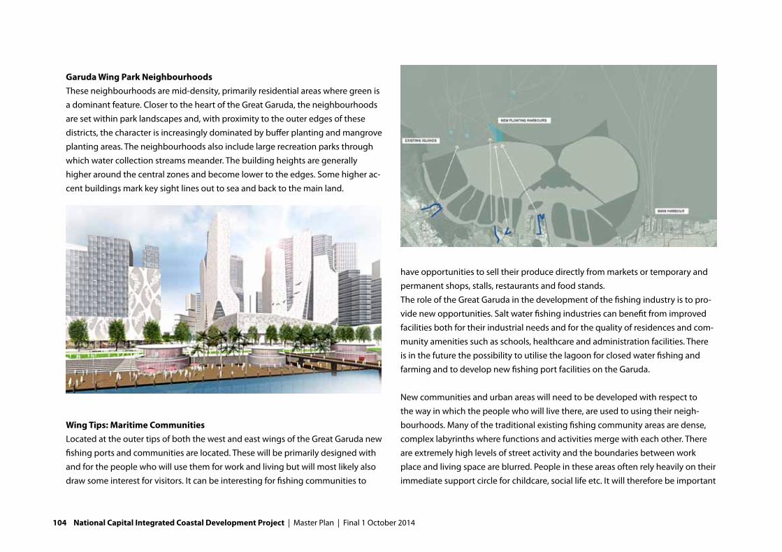
Garuda Wing Park Neighbourhoods These neighbourhoods are mid-density, primarily residential areas where green is a dominant feature. Closer to the heart of the Great Garuda, the neighbourhoods are set within park landscapes and, with proximity to the outer edges of these districts, the character is increasingly dominated by buffer planting and mangrove planting areas. The neighbourhoods also include large recreation parks through which water collection streams meander. The building heights are generally higher around the central zones and become lower to the edges. Some higher ac-cent buildings mark key sight lines out to sea and back to the main land.
Wing Tips: Maritime CommunitiesLocated at the outer tips of both the west and east wings of the Great Garuda new fishing ports and communities are located. These will be primarily designed with and for the people who will use them for work and living but will most likely also draw some interest for visitors. It can be interesting for fishing communities to
have opportunities to sell their produce directly from markets or temporary and permanent shops, stalls, restaurants and food stands.The role of the Great Garuda in the development of the fishing industry is to pro-vide new opportunities. Salt water fishing industries can benefit from improved facilities both for their industrial needs and for the quality of residences and com-munity amenities such as schools, healthcare and administration facilities. There is in the future the possibility to utilise the lagoon for closed water fishing and farming and to develop new fishing port facilities on the Garuda.
New communities and urban areas will need to be developed with respect to the way in which the people who will live there, are used to using their neigh-bourhoods. Many of the traditional existing fishing community areas are dense, complex labyrinths where functions and activities merge with each other. There are extremely high levels of street activity and the boundaries between work place and living space are blurred. People in these areas often rely heavily on their immediate support circle for childcare, social life etc. It will therefore be important
104 National Capital Integrated Coastal Development Project | Master Plan | Final 1 October 2014

to carefully consider how the new neighbourhoods can foster this spirit of com-munity and provide architectural solutions that are appropriate.
Whilst the ambition on the Great Garuda will be to provide higher density devel-opments priority in these areas is not to disconnect people from the streets and spaces of the neighbourhood. Across the world there are examples of schemes where low-quality dense low-rise housing has been replaced by multi-level apart-ment accommodation in the name of progress. In some cases this has resulted in communities who were once focussed around the street, feeling disconnected from each other and unfamiliar in their new situation. In the worst cases this change has produce negative social situations where nobody feels responsible for the area in which they live and anti-social behaviour has risen. The importance of neighbourhood pride, civic ownership and community is thus a vitally important
ingredient when considering the architectural typologies for the new fishing / maritime community areas.
Floating communities is a concept that aims to embrace the traditional fishing / maritime settlement character. The Indonesian people have shown throughout history and even today, that they can be extremely innovative and inventive in discovering ways to build homes and businesses in the water and at the water edge. We see opportunities to allow this independent, approach to continue by allocating locations where people can develop their new communities together. These areas will be provided with appropriate utilities and basic infrastructure, but the built structures and organization can, and should be strongly influenced by the people themselves. At the wingtips we promote maritime development areas that are primarily for the working communities who will inhabit them whilst
Final 1 October 2014 | Master Plan | National Capital Integrated Coastal Development Project 105

106 National Capital Integrated Coastal Development Project | Master Plan | Final 1 October 2014

THE EGGS: CREATIVE LIVING AND WORKING ON A NEAR
SHORE ARCHIPELAGO ISLAND
along the inner-sides of the wings and around the body of the Great Garuda, we suggest active fishing and maritime activity mixed with leisure, tourism and rec-reation to add a new layer to the employment and entertainment opportunities in maritime Jakarta. This approach will allow people to continue to work in famil-iar fields of maritime employment or to develop new, complementary skills that can allow them to benefit from other opportunities in related fields with perhaps greater financial rewards.
Creative Living ParkGreat Garuda Creative Living Park is an area created on a near-shore archipelago island between the new developments and the former coast line of Jakarta. This location explores the relationships between old and new and the challenges of creating new land in the sea. It is a pioneering landscape. The location makes it very appealing for a number of functions as it benefits from proximity to residen-tial and business functions of all types. Here a creative living park is proposed
where innovative architectural design and business creativity can have a promi-nent place in the total new development area.
The concept for creative working space applies a principle once common throughout traditional cities; live and work on the same premises. The principle is that the residential building has a work space integrated into it. In some cases this is a shop or workshop on the ground floor. In some cases it may be an office on one or more floors but in all cases living space is generally located above the working areas. To create this kind of environment specific planning and permit-ting requirements will have to be applied. In addition architectural competitions or small commissions can be used to allow many small architectural practices to
Final 1 October 2014 | Master Plan | National Capital Integrated Coastal Development Project 107

design individual houses within a row or complex and create the specific creative neighbourhood as envisaged. In order to promote the attractiveness and viability of such live-work units it is essential to plan their location in the overall master-plan, very carefully.
Typical uses of live-work units are in residential support services and small busi-ness support services. In terms of residential support services functions such as child day care, offices for household cleaning companies, hair-dressers, small scale beauty services, dentists and doctors’ practices etc can be considered. These do not require locations within large rows of retail activities as they are generally essential or day-to-day services that people will choose due to the proximity to their house. They are generally small units and are found scattered throughout residential areas. Short-term parking facilities are important for such businesses but they require few other specific elements. Small business support services include financial advisors, solicitors, legal advisors, print and courier services, print-shops and day-to-day stationary supplies, web-design and maintenance companies etc. These functions have some benefit from clustering and prominent locations so may be located on main thorough-fares and in residential areas close to larger business and commercial areas. Other groups attracted to live-work units are start-up entrepreneurs and research practices. These benefit from ease of interaction with larger commercial, office and institutional facilities and should be located in close proximity to these.
Creative Headquarters & Research CentresWhilst the creative office location is a thriving mix of many companies of all sizes, the creative headquarters or research centre tends to be a large single company development dedicated to the progressive design and development parts of a company. Located between the existing city and Great Garuda, this area is one of the islands in the new near-shore archipelago and is also adjacent to the indus-trial hub of Tanjung Priok. The large scale creative HQ / research centre should be
a showcase for innovative and environmentally responsible architecture.
Connecting to the context of current city and the seaThe relationship between the Great Garuda and other planned and on-going off shore land developments is complimentary. The Great Garuda is developed as an integral part of the Jakarta Metropolis and considers not only its role and relation-ship with regards to the existing city, but also to the many planned and on-going land reclamation projects in Jakarta Bay. Many of these plans promote themselves as mid- to high-end residential mixed-use urban villages and are seen as high quality, safe and flood free locations for those who can afford to live there. The future residents of these islands will have many of their daily needs catered for within each island but larger scale facilities and amenities are not always included in the programming of these developments.
At the Great Garuda all aspects of city life and the requirements of the urban population are considered thereby providing civic amenities such as hospitals, schools and governmental functions. The Great Garuda is also likely to attract some of the best major businesses from the country, region and across the world to locate there. Many of the people who come to work may choose or want to live on some of the planned island developments and likewise those who can afford to live at the planned islands may also want to work at these companies. Whilst the islands offer secluded oasis developments, they do not perhaps provide the city waterfront that the Great Garuda intends to deliver. So also in terms of water-front typologies there is increased diversity created for leisure, nature, industry, recreation and city branding.
A new city-a sustainable cityThis new, modern city provides excellent opportunities to create a really sustain-able city in terms of energy use and efficient (re-)use of water. By integrating energy-saving and energy-producing elements (solar panels) in the designs it
108 National Capital Integrated Coastal Development Project | Master Plan | Final 1 October 2014

FURTHER READING:• B3a–spatialplanning&urbandesign
Phase C
should be possible to create an energy-neutral city. Re-introducing traditional natural cooling techniques are driven by the cool sea breeze, is an important ele-ment of this ambition. The location next to the Java sea will also create outdoor living and working opportunities. Smart ‘cool’ designs are required.
8.3. Phase CPhase C consists of several long term developments on the east side of Jakarta Bay. Closure of this part of the Bay is anticipated in case subsidence in east Jakarta cannot be stopped. The east dike section with the Tangerang Bekasi Highway provides a good starting point for this closing.
Sufficient space is available in the bay to accommodate the extension of the mainport Tanjung Priok and an airport, but additional studies will have to show whether this airport is feasible. Port extensions up to 2050 are included in the phase C design.
Final 1 October 2014 | Master Plan | National Capital Integrated Coastal Development Project 109

110 National Capital Integrated Coastal Development Project | Master Plan | Final 1 October 2014

IXTRANSFORMING THE COASTAL ZONE
[THE DELIVERY STRATEGY]
Final 1 October 20144 | Master Plan | National Capital Integrated Coastal Development Project 111

112 National Capital Integrated Coastal Development Project | Master Plan | Draft 1 April 2014

In the following decades the Jakarta’s coastal zone will be transformed. The Master Plan shows what developments are envisioned. This chapter specifically focuses on how this project can be delivered.
9.1. Main drivers for program deliveryThe delivery of integrated and complex initiatives like NCICD is driven by seven main factors: (1) Urgency, (2) a robust plan and sound design, (3) Finance, (4) Organization, (5) stakeholder support, (6) knowledge and (7) an enabling envi-ronment. Each main driver has a number of secondary drivers, as shown in the fishbone diagram below.
This chapter focuses on the organization, legal basis and financing necessary for the delivery of the project.
9.2 The organization of NCICDThe NCICD institutional setup has been developed on the basis of a number of assessments, considerations and discussions. The most important are:
• Aninventoryandscoringoftheadvantagesanddisadvantagesofacoordi-nated sector approach (business as usual) versus an integrated approach
• Benchmarkingagainstsimilarprojectsworldwide• BenchmarkingofbestpracticeswithinIndonesia• Applicationofassetmanagementprinciples.
The results of these analyses are presented in several technical reports and back-ground documents (see box further reading).
Finance Stakeholder support
Enabling Environment
Private
Public
User fees
Plan & Design Organization Knowledge
Contributions
Communication
Cooperation
Legal Framework
Permits
Decisions
Feasibility
Objectives
Road Map
Management
Procedures
Leadership
Data
Capacities
Expertise
!URGENCY
FURTHER READING:Forfurtherreadingregardingthedeliverystrategyseethefollowingreports:• NCICDDeliveryStrategy(mainreport)• TheOrganizationofNCICD• NCICDLegalBasis• NCICDFundingStrategy• PPPRoadmapandprocurementstrategy• FinancingModelandBusinesscases• KnowledgeandCapacityDevelopmentstrategy• CommunicationStrategy• AssetManagementStrategy
Final 1 October 2014 | Master Plan | National Capital Integrated Coastal Development Project 113

Organization principles Five leading principles were formulated for the organization of NCICD:1) A dedicated and single public
authority with adequate mandate and legal basis to govern the NCICD development process: the NCICD authority.
2) An entrepreneurial and value for money approach through a public-private Strategic Development Company under public authority planning and control.
3) Asset management and the full life cycle approach are applied for design, funding and operations.
4) Learning organization to cope with uncertainties5) Simple organization to maintain transparency, efficiency and effectiveness.
On the basis of the above principles the institutional setup and organizations are described below.
Institutional setupThe institutional setup for NCICD will consist of a publicly owned Strategic Development Company for integrated program delivery, which is supervised and controlled by a Public Development Authority in which relevant Ministries, Provinces and other key stakeholders are represented. The Authority consists of a Steering Committee, an Implementing Body and a Strategic Development Company (see next figure).
NCICDAuthority
Full Life CycleManagement
Learning Organization
Entrepreneurial & value driven
NCICD AUTHORITYSteering
Committee
Implementing Body
NCICD Strategic Development Company
Program implementation
Ministers & Governors:Strategic Direction
Government representatives:Regulation
BUMN/BUMD: Realization
Prov.
STEERING COMMITTEE
NCICD Authority
Min Min MinProv DKIJak
Implementing Body(Chair DKI)
Strategic Development CompanyBUMN/D
Program implementation
Prov
114 National Capital Integrated Coastal Development Project | Master Plan | Final 1 October 2014

DKI is the main stakeholder and first responsible for program implementation. DKI Jakarta is represented in the Steering Committee by the Governor, the Imple-menting Body will be chaired by DKI, and DKI will also have a major share in the Strategic Development Company. The Strategic Development Company will be enabled to establish joint ventures with strategic investors.
NCICD Implementing BodyThe key role and responsibility of the Implementing Body is program governance. The Implementing Body will act as regulator for the entire program. The five key roles in program governance are shown below.
The Chairman of the implementing body is appointed by the president and/or the Governor of DKI Jakarta. His/her main initial task will be developing and staff-ing the organization and establishing the Strategic Development Company. The implementing body will be financed from the National Budget (APBN).
The Authority acts on behalf of the participating government institutions (min-istries and provinces) and also balances the interests of the private sector, the affected communities and social, environmental and cultural values.
Strategic Development CompanyThe Strategic Development Company will be a combination of State Owned and Regional Enterprise (BUMN/BUMD), with a significant share of a major (interna-tional) private investor.
The key role and responsibility of the Strategic Development Company is Program Delivery. The Strategic Development Company is a publicly owned Enterprise and is the executing entity for the development and financing of the NCICD facilities and infrastructure. It is especially meant for dealing with the private businesses and investors, but it will also be entrusted with public interest tasks (as a SOE normally operates under the current SOE Law), such as resettle-ment, utilities and environmental projects.
The Strategic Development Company:• WillbeestablishedasleadingentityfortheimplementationofNCICD.• Hasabusinessplan,investmentpackages,withunderlyingbusinesscasesand
revenue opportunities (see section 9.3).• Hasaccesstofinancebackedupbygovernmentguarantees.• Attractsinvestorsbyusingincentiveschemes,providingsupportandfacilities,
one stop shopping etc.
Planning &
Programming
- Scenario development
- Strategic agenda & decisionmaking & alignment
- Budgeting for pre-investments APBN/D (seed capital)
Preparation of
Implementation
- Establishing procedures, one window permitting, compliance
- International funding, Government guarantees, International cooperation
- Design approvals
Monitoring &
Control
- Strategic Company performance
- Approval of strategic company plans
- Monitoring KPI’s
Business Development
- Approve Business Plans of Strategic Company
- Backing up of market consultations
- Strategic Company performance
Stakeholder Management
- Representation of Govt. sectors , civil society, community empowerment
- Strategic Communication
- Interface management, Conflict resolution
Final 1 October 2014 | Master Plan | National Capital Integrated Coastal Development Project 115

• Optimizesbetweensub-programstowardstheobjectivesofthecompanyandthe public interest.
• Createsvaluethroughintegratedplanningofcomponentsanddriveforrev-enue creation and cost reduction.
• Initiatesflagshipprojects.• Mayimplementcertainactivitiesandprojectsonitsown.
The Strategic Development Company has three main roles: concessionaire, especially for land development activities, PPP contracting agency for road and rail projects, executing agency for the flood safety and environmental components of the program (see below).
Based on solid business planning and commercial considerations the Strategic Development Company will package program components to match funding sources, timeframe as well as public and private interests.
Private-led project consortiums/project companies (Special Purpose Vehicle - SPV) operate under the umbrella of the Strategic Development Company, and are responsible for further investments, implementation and O&M. The Strategic Development Company manages the inter project flow of funds and inter project coordination, and synchronizes the planning of all components.
Institutional development processThe establishment of the NCICD Authority is considered in the context of the broader NCICD institutional development process that started in 2012 during JCDS. Already during JCDS it was envisaged that the program would have a broader impact, which led to the establishment of the Coordination Team, under responsibility of the Coordinating Ministry for Economic Affairs. After the start of the master Planning process the programme management unit was established, and now at the end of the Master Plan phase, the NCICD Authority is going to be established. Somewhat later in the process tasks will be handed over to one or more asset management bodies, operators or service providers (see figure below).
Strategic Development Company: Three roles in Program Delivery
Concessionaire(B2B)
Bundling & cross funding
Execution(conventional)
Contracting(PPP)
Land Development Transport/Access Safety & Environmental
Tail, Body +
Land side islands
Deep seaport
Wings…x
Phase A Dikes
Phase B Seawall
Pumps &
Locks
Sewerage &
Sanitation
Lagoon Operation
(raw water)
TollRoad
UrbanRoad
MRT
Road Map of the Institutional Development Process
Min. PU
2012 2013 2014 2015 2016 2020-20XX
PMU NCICD Authority
Strategic Company
Asset Management Body
116 National Capital Integrated Coastal Development Project | Master Plan | Final 1 October 2014

Asset Management approach
In the next program phase, preparations have to be made for the establishment of a robust asset management system. Advanced asset management and full life cycle principles have to be applied from the design stage onwards. It is recom-mended to aim at international best asset management practice and apply ISO 55000 or similar guidelines. An Asset Management Body is envisaged with specific responsibilities and own funding sources for the flood infrastructure. The Technical Report on Asset Man-agement elaborates this further.
9.3 Legal basis for delivery of the programThe legal anchoring of NCICD is taking shape through the following steps:1) Master Plan endorsement by the NCICD Coordination Team (echelon 1).2) Acceptance of the Master Plan by the President through PERPRES.3) PERPU (emergency legislation) to justify urgent measures, signed by the
President.4) Permanent legislation (UU) following PERPU, endorsed by the Parliament.5) PERPRES for establishing the NCICD Authority (Badan Pengembangan).6) PP (Government Regulation) to establish the Strategic Development Company.
PERPU is issued on the basis of the emergency situation for the National Capital. It is temporary legislation which will be in place until final legislation (Undang-Undang) is established. PERPU justifies extraordinary and urgent measures (not business as usual). PERPU will be replaced by permanent legislation that will determine the legal framework for the entire duration of the program.
Further budgetary and spatial plan anchoring is arranged by:7) APBN/APBD budget for NCICD, for 2015 and subsequent years8) Master Plan transposition in PERPRES 54/2008 (Spatial Plan of Jabodetabek-
punjur).9) Master Plan transposition in Spatial Plan (RTRW) DKI Jakarta. The above 9 steps are placed in a short term planning framework below.
Master PlanNCICD
Design & Plan-ning
Investment & procurement
Detailed design Construction &
DevelopmentO & M
Reverse impact of O&M on design
Forward impact of design on O&M
STEPS
1 Master Plan endorsement (by Echelon 1)
2 Master Plan acceptance via PERPRES
3 PERPU for Development Authority
4 UU for formalizing PERPU of DA
5 PERPRES (for organization & procedures of
the Development Authorithy
6 PP for the establishment of the
Straregic Company/BUMN
7 Budget APBN/APBD 2015
8 Amend RTRWJ abodetabekpunjur
(Perpres 54/2008)
9 Amend RTRW DKI Jakarta
Q4-2014
Q1-2015
Q2-2015
Q3-2015
Q4-2015
Final 1 October 2014 | Master Plan | National Capital Integrated Coastal Development Project 117

9.4 The funding of NCICDThe funding requirements of the program are listed in chapter 6 for the main program components. Below a qualification of the commercial viability of NCICD components and potential funding and delivery approaches is shown.
Exploration of NCICDs PPP potential and roadmap towards private sector involve-ment as well as the business case analysis learns that the project is not applicable for a single master development concession awarded to a private investor. The Integrated NCICD development as a whole cannot be qualified as a commercially viable and bankable business case, due to:
• Largesizeofthedevelopmentanditshighupfront,non-scalable,non-phase-able and non-revenue generating multibillion dollar investments in flood safety measures.
• TherelativelyhighproductioncostofsquaremetersfortheGaruda(landreclamation in 16 m deep water).
• Highdependenceonlandsalesrevenuesthatareextremelysensitivetopriceand volume changes subject to economic, market and political developments.
• Majormarketuncertaintiesduetothedevelopmentofseventeenconcessionsfor land reclamations in Jakarta Bay.
• Planninguncertaintieswithregardtothespatial,environmentalandinfra-structural conditions.
In order to get the private sector to invest, the public sector itself must first make a substantial commitment. When initial public investments are made, substantial private investments can be expected.
Guiding principles for the NCICD funding strategyThe following three guiding principles are recommended in deciding and devel-oping the funding strategy for NCICD:1) The funding strategy secures the implementation of the critical safety meas-
ures on a timely basis.2) The funding strategy seeks to minimize the burden to APBN/D and GOI’s
indebtedness. 3) Private sector takes a leading role in the development of NCICD. PPPs / Private
investments and finance are to be used as the key means to reduce and spread the burden to the budget and leverage the economic impact of NCICD. Private funding potential will be backed by credible business cases and proven mar-ket appetite.
NCICD cannot be funded solely through one funding method. It requires a combi-nation of government funding and support, private investment, PPP and prob-ably SOEs involvement. This requires splitting assets or packaging projects, which may result in multiple institutional windows for implementation.
Financial Commercial Component Delivery
NPV=0
Commercially Viable
BodyPort
Land side islandsTail
Wings
Sale of Land
Concessions
BOT
Partially Commercially Viable
Not Commercially Viable
MRTCity Road Network
Water SupplyNational Toll Road
BOT + VGF
DBFM(O)
Sewerage & WWTLocks
PumpsSea wall / Dikes
DBFM(O)
Traditional Public Funding
118 National Capital Integrated Coastal Development Project | Master Plan | Final 1 October 2014

Funding of Phase AThe flood safety measures of Phase A are currently under preparation and will be implemented from October 2014 until 2017. There is no revenue potential identi-fied in Phase A; the potential for private funding is limited to the private landown-ers on the coast who are required to strengthen their own segment of coastline according to the specifications provided by the Government.
The table below summarizes the funding and delivery of Phase A. The proposed delivery model is Design and Build (DB). The use of bilateral funding can produce significantly lower cost of financing and higher speed of implementation as com-pared to multi-lateral funding.
In combination with the actual strengthening of sea dikes, locally integrated solutions are called for with existing land use, residential areas, infrastructure connections, economic activities, recreational areas and nature. The integration of those other values may raise additional financing requirements, which are
currently not identified. Additional planning and preparation work is expected in addition to engineering designs for sea dikes, to arrive at acceptable, properly integrated tailor made plans for local situations.
The required upgrade of river dikes may be integrated with the ongoing JEDI / JUFMP programs and hence be integrated with these ongoing projects. This may be a sensible approach to speed up the implementation and to take advantage of potential efficiencies and synergies between NCICD and these programs.
The upgrade of pumping capacity in Phase A is budgeted within the APBD of DKI and there are also some bi-lateral co-funded schemes.
Components Cost (US$ millions) Delivery Revenue model Investor Private Finance Public Finance
Sea wall $582 DB na GOI Private contribution Bilateral loans APBN
(financial or in kind) (80%) (20%)
Pumping stations $294 DB na GOI/DKI APBN/D
River dikes $476 DB na GOI Mulitlateral loan APBD
(JEDI/JUFMP)
Resettlement $725 DB na GOI Mulitlateral loan APBD
(JEDI/JUFMP)
Final 1 October 2014 | Master Plan | National Capital Integrated Coastal Development Project 119

Funding of Phase B (and C)Following the guiding principles and findings from the business case analysis and PPP road map, roughly two funding strategies can be applied to develop Phases B/C:1. The non-revenue flood safety measures are realized within the public finance
realm. The impact to the budget (APBN/D) can be reduced by making use of private finance schemes (off balance sheet finance to spread investment burden and reduce impact on indebtedness) and bi- or multilateral loans to spread the burden to the budget.
2. Funding of the non-revenue flood safety components as part of an integrated private development. The non-revenue components are cross subsidized through bundling of commercially viable and unviable components in one project.
The second approach is recommended. The principle of funding Phases B and C is the integrated development and funding of NCICD through a government owned Strategic Development Company (see section 9.2). Scope optimization and synergies between the commercially viable and non-viable flood safety and transport components can be addressed through integrated (business) planning and cross funding within the company. The company has flexibility in the packag-ing of components to match funding sources, timeframe and private interests and may engage the private sector either through PPP contracts, B2B or Joint Ventures agreements.
The Strategic Development Company allows for applying multiple strategic fund-ing schemes, where bilateral and multilateral funding can be channelled through the Strategic Development Company (and guaranteed by the Government of Indonesia).
The company’s ability to attract funding under government guarantee and to be capitalized with seed capital (equity injection by the GOI), allows it to realize the non-scalable and non-phase-able flood safety components with cheap low cost finance. This approach provides the company with longer term and cheaper financing facilities as compared to a pure private developer. In this way the com-pany can build a much more robust business case where the revenues of future land developments can be used to repay outstanding debt and interest obliga-tions related to the construction of the OSW and other initial investments.
The table on the next page shows a possible set up of the component financing for Phase B under the NCICD Strategic Development Company approach.
Further investments by the company can be funded out of a combination of pro-ject finance and retained cash from the sale of reclaimed land. The company’s free cash flow is used to subsequently cross fund:1) Outer Sea Wall (loan repayment) + land reclamation phase 2) Transportation: City Toll, MRT and National toll3) Land reclamation phase II and III4) Others: Pumping Stations, Locks and Port5) Dividend pay-outs to the Government of Indonesia
Next steps towards the funding of NCICD1) Setting up the structure and mechanisms of the NCICD Strategic Development
Company 2) To make the required budget reservations for the set up and capitalization of
the company and to kick start its business planning activities.3) To enter into consultation with bilateral partners to get involved in NCICD and
to provide loans to the company.
120 National Capital Integrated Coastal Development Project | Master Plan | Final 1 October 2014

4) To select the state owned enterprises and private companies that will consti-tute the company.
5) To develop the business plan and delivery strategy of the NCICD components in consultation with the potential bi-lateral funding partners and other private sector investors.
Components Capex (US$ billion) Delivery Revenue model Investor Private Finance Strategic Development
model Company Funding
Outer Sea Wall +
Reclamation Phase I
Pumping stations
& Locks
Nat Toll Road
MRT
City Road Network
Reclamation Phase II
(Wings)
Reclamation
Phase III (Wings)
Port
3.8
6.4
0.9
3.4
1.0
0.6
1.2
1.3
0.8
DB
DBFM
DBFM-O
DBFM - O
DBFM - O
DB-Sell
DB-Sell
DB-Sell
Land Sales
Availability Payments
Milestone +
Availability Payments
Milestone +
Availability Payments
Availability Pay-
ments/Road Charges
Land Sales
Land Sales
Land Sales / Leases
Stra. Dev. Co
Private
Private
Private
Private
Strat. Dev.Co
Strat. Dev.Co
Strat. Dev.Co
Private Debt / Equity
(70%/30%)
Private Debt / Equity
(70%/30%)
Private Debt (85%)
Private Debt (85%)
Guaranteed Bi-lateral loan (80%) and cash
flow from land sales. Equity GOI (20%)
Milestone payment from cash balances
Milestone payment from cash balance
(including toll fees)
Milestone payment from cash balance and
availability payments from Farebox
Milestone payment from cash balance
(including toll fees)
Project loans + Cash Balance
Project loan + Cash balance
Cash balance
Final 1 October 2014 | Master Plan | National Capital Integrated Coastal Development Project 121
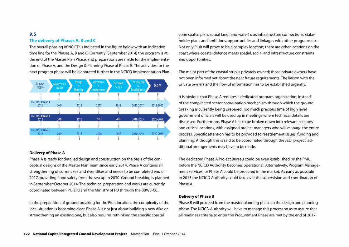
9.5 The delivery of Phases A, B and CThe overall phasing of NCICD is indicated in the figure below with an indicative time line for the Phases A, B and C. Currently (September 2014) the program is at the end of the Master Plan Phase, and preparations are made for the implementa-tion of Phase A, and the Design & Planning Phase of Phase B. The activities for the next program phase will be elaborated further in the NCICD Implementation Plan.
Delivery of Phase APhase A is ready for detailed design and construction on the basis of the con-ceptual designs of the Master Plan Team since early 2014. Phase A contains all strengthening of current sea and river dikes and needs to be completed end of 2017, providing flood safety from the sea up to 2030. Ground breaking is planned in September/October 2014. The technical preparation and works are currently coordinated between PU-DKI and the Ministry of PU through the BBWS-CC.
In the preparation of ground breaking for the Pluit location, the complexity of the local situation is becoming clear. Phase A is not just about building a new dike or strengthening an existing one, but also requires rethinking the specific coastal
zone spatial plan, actual land (and water) use, infrastructure connections, stake-holder plans and ambitions, opportunities and linkages with other programs etc. Not only Pluit will prove to be a complex location; there are other locations on the coast where coastal defence meets spatial, social and infrastructure constraints and opportunities.
The major part of the coastal strip is privately owned; those private owners have not been informed yet about the near future requirements. The liaison with the private owners and the flow of information has to be established urgently.
It is obvious that Phase A requires a dedicated program organization, instead of the complicated sector coordination mechanism through which the ground breaking is currently being prepared. Too much precious time of high level government officials will be used up in meetings where technical details are discussed. Furthermore, Phase A has to be broken down into relevant sections and critical locations, with assigned project managers who will manage the entire process. Specific attention has to be provided to resettlement issues, funding and planning. Although this is said to be coordinated through the JEDI project, ad-ditional arrangements may have to be made.
The dedicated Phase A Project Bureau could be even established by the PMU before the NCICD Authority becomes operational. Alternatively, Program Manage-ment services for Phase A could be procured in the market. As early as possible in 2015 the NCICD Authority could take over the supervision and coordination of Phase A.
Delivery of Phase BPhase B will proceed from the master planning phase to the design and planning phase. The NCICD Authority will have to manage this process so as to assure that all readiness criteria to enter the Procurement Phase are met by the end of 2017.
Master PlanNCICD
Design &
Planning
Investment &
procurement
Detailed design
Construction &
DevelopmentO & MStrategy
(JCDS)
2012 2014 2014 2015 2015 2012-2017 2018-2030
2012 2014 2016 2017 2018 2018-2025 2025-20XX
2012 2014 2018 2020 2022 2030-2040 2040-20XX
TIME LINE Phase a
TIME LINE Phase B
TIME LINE Phase C
122 National Capital Integrated Coastal Development Project | Master Plan | Final 1 October 2014

The activities include a substantial number of studies, surveys and business case development, leading to a robust and feasible project concept for Phase B. All this work has to be carried out by project teams for which Terms of References have to be prepared and funding made available.
The NCICD Authority must decide about setting up the Strategic Development Company for Phase B, approve its business plan, approve the funding strategy, carry out market sounding etc. A NCICD Fund may have to be prepared.
Several donors are prepared to support this next phase, notably the Netherlands and South Korea. Other donors may want to step in later. The NCICD Authority will have to coordinate donor activities and/or obtain their support.
Delivery of Phase CPhase C requires further Master Planning. Because the Phase C Outer Seawall is not required until 2040, the priority was laid on Phases A and B. The plans for the eastern part of Jakarta Bay are very dynamic and include deep sea port devel-opment, a new offshore airport, toll roads, industrial zone development, waste to energy production etc. The potential of the area is huge and requires robust planning and business development. Because of the linkages of Phase C with Phases A and B the management of the planning process will be under the NCICD Authority. The establishment of a Strategic Development Company for Phase C is not foreseen on the short term.
9.6. Uncertainties and risk management
Master planning phaseThe scope of the Master Plan project did not include generating primary data. Most of the data was extracted from existing studies and combined with data and experiences from previous projects (land reclamations). A technical survey was carried out to measure the heights of the current sea wall.
As (reliable) data in Indonesia is scarce and not easily accessible, many uncer-tainties emerged during the plan process. When possible, alternative models or compatible international data was used, but for some topics a large degree of uncertainty still exists. The strategy in dealing with these remaining uncertainties consists of two elements:
• robust designs. Example: when designing sea dikes, uncertainties on land subsidence, wave run-up and tidal anomalies emerged. By taking a conserva-tive approach, risks of underestimating possible impacts were limited.
• adaptive strategies. There is still plenty of room in the strategy for adapta-tion. The timing of the Outer Sea Wall, for instance, can be revised depend-ing on new developments (in land subsidence, economy). Another example: although the size of the reservoir is designed on the best available expertise on river discharges and predictions of (future) rain fall events, still a degree of uncertainty remains. In our analysis we concluded that system adaptation by adding additional drainage pumps is easy and cost-effective.
Uncertainties and risk managementRegarding the uncertainties the picture is very diverse, even within topics. Some examples:Cost calculations: civil engineering cost calculations are largely based on actual
THE PROBLEM OF SCARCITY OF RELIABLE DATA WAS
SOLVED BY DEVELOPING ROBUST DESIGNS AND ADAPTIVE
STRATEGIES
Final 1 October 2014 | Master Plan | National Capital Integrated Coastal Development Project 123

costs in current land reclamations works and are therefore quite accurate. The main uncertainty within these cost calculations is the future cost of sand and rock (due to the expected pressure on these markets). The situation regarding uncer-tainties in some other major topics is as follows:
• Business case: real estate prices are based on the current market prices and recent markets developments in Jakarta and therefore accurate. The predic-tion of the future market prices (necessary to complete the business case), however, is to some extend speculative as no reliable long term economic prediction can be made.
• Hydraulics: reliable discharge data are scarce and the discharge calculations were prepared based on rain fall data in the catchment area and discharge models. The size of the reservoir was based on these calculations. However, it is unknown how much of the upstream water in the future will be diverted around the city in the future, what upstream urban developments in the fu-ture will be and how climate change will influence the inflow.
• Sea bed conditions: the offshore geological composition under the Great Garuda is unknown and no detailed prediction can be made on compaction and settling of the Great Garuda. Assumptions had to be made.
Uncertainties lead to financial risks. Some uncertainties/risks can be minimized by generating new primary data (additional field research), but many uncertainties related to future developments will remain.
Mega projects as the NCICD are inherently full of risks. The size, the complexity and the duration of the project create various technical, financial and organisa-tional risks. The top three of risks are:• Uncertainmid-andlongtermeconomicdevelopment.Atemporarycool-
down of the growth of the economy could have an impact on real estate
prices and consequently the business case and, in the worst case, the speed of realisation of the Great Garuda.
• Availabilityofsand.Thereisahugedemandofsandforlandreclamations,butthere are only limited source areas. The price of sand and the costs of transpor-tation could easily rise as sand will have to be brought in from distant source areas.
• Waterquality.Theeffortstoclean-uptheurbandrainagewaterbyconstruc-tion of sewerage and waste water treatment systems must be accelerated sig-nificantly. However, this is not an easy task in the densely populated city. If the water quality does not improve, the water quality in the reservoir will be poor, affecting both the residents and the market potential of the Great Garuda and obstructing the use of the reservoir as raw water supply source.
Risk management is one of the most important aspects in managing such pro-jects. Each risk requires its own approach: many technical risks can be minimized by research, financial risks by sharing benefits and risks or by seeking the right contracting strategy.
124 National Capital Integrated Coastal Development Project | Master Plan | Final 1 October 2014
Related Documents