Procedia Environmental Sciences 14 (2012) 164 – 176 1878-0296 © 2011 Published by Elsevier B.V. Selection and/or peer-review under responsibility of University of Bucharest , Faculty of Geography, Department of Regional Geography and Environment, Centre for Environmental Research and Impact Studies. doi:10.1016/j.proenv.2012.03.016 Landscape, Environment, European Identity, 4-6 November, 2011, Bucharest Morphometrical and dynamical features of the South Dobrogea lakes, Romania Camelia-Eliza Telteu * , Liliana Zaharia a University of Bucharest, 1 Bd., sector 1, Bucharest 010041, Romania Abstract This paper presents some morphometrical and dynamical features of the South Dobrogea lakes based on the bathymetric data between 2010-2011. The analyze includes the lakes on the Black Sea shore (Siutghiol, Limanu and Tatlageac) and on the right side of the Danube River (Bugeac, Oltina, Mârleanu, Domneasca). The Siutghiol Lake is the deepest one with 7.82 m and has the highest volume (69.69 mil. m³). The Domneasca Lake has the lowest maximum depth (2 m) and the smallest area (0.49 km²). The wind is a main factor which causes the water dynamic, and determines the resuspension of the sediments by the wave action. In order to estimate the bottom dynamic conditions, the form factor (V d ), the erosion and transport areas (ET) of fine sediments and the fine sediments accumulation areas (A 0 ) were determined based on the morphometrical features: lakes area (A, in km²), the mean depth (D m , in m) and the maximum depth (D max , in m). The study shows that the areas of accumulation prevail in the Tatlageac, Siutghiol and Domneasca lakes (62.64-69.36 %) and the erosion and transport areas prevail in the Bugeac, Oltina, Mârleanu and Lakes (76.67-99 %). The dynamic ratio (the ratio between the area's square root and the mean depth) ranges between 4.18 (Oltina Lake) and 0.40 (Domneasca Lake). The relation between the lake form and the bottom dynamic conditions is highlighted by the form factor which ranges between 0.78 (Limanu Lake) and 1.83 (Domneasca Lake). Our estimation of the erosion, transport and accumulation areas of the fine sediments could be useful for improving the management of the lakes, especially for the lakes that are used for fish production, imposing some structural and nonstructural measures. Keywords: wind; waves; erosion; accumulation; sediments; morphometrical parameters; South-East of Romania * Corresponding author. Tel.: +40-21-314-3508/2155; fax: +40-21-315-3074. E-mail address: [email protected]. Available online at www.sciencedirect.com © 2011 Published by Elsevier B.V. Selection and/or peer-review under responsibility of University of Bucharest , Faculty of Geography, Department of Regional Geography and Environment, Centre for Environmental Research and Impact Studies.

Welcome message from author
This document is posted to help you gain knowledge. Please leave a comment to let me know what you think about it! Share it to your friends and learn new things together.
Transcript

Procedia Environmental Sciences 14 ( 2012 ) 164 – 176
1878-0296 © 2011 Published by Elsevier B.V. Selection and/or peer-review under responsibility of University of Bucharest , Faculty of Geography, Department of Regional Geography and Environment, Centre for Environmental Research and Impact Studies.doi: 10.1016/j.proenv.2012.03.016
Landscape, Environment, European Identity, 4-6 November, 2011, Bucharest
Morphometrical and dynamical features of the South Dobrogea lakes, Romania
Camelia-Eliza Telteu*, Liliana Zaharia aUniversity of Bucharest, 1 Bd., sector 1, Bucharest 010041, Romania
Abstract
This paper presents some morphometrical and dynamical features of the South Dobrogea lakes based on the bathymetric data between 2010-2011. The analyze includes the lakes on the Black Sea shore (Siutghiol, Limanu and Tatlageac) and on the right side of the Danube River (Bugeac, Oltina, Mârleanu, Domneasca). The Siutghiol Lake is the deepest one with 7.82 m and has the highest volume (69.69 mil. m³). The Domneasca Lake has the lowest maximum depth (2 m) and the smallest area (0.49 km²). The wind is a main factor which causes the water dynamic, and determines the resuspension of the sediments by the wave action. In order to estimate the bottom dynamic conditions, the form factor (Vd), the erosion and transport areas (ET) of fine sediments and the fine sediments accumulation areas (A0) were determined based on the morphometrical features: lakes area (A, in km²), the mean depth (Dm, in m) and the maximum depth (Dmax, in m). The study shows that the areas of accumulation prevail in the Tatlageac, Siutghiol and Domneasca lakes (62.64-69.36 %) and the erosion and transport areas prevail in the Bugeac, Oltina, Mârleanu and Lakes (76.67-99 %). The dynamic ratio (the ratio between the area's square root and the mean depth) ranges between 4.18 (Oltina Lake) and 0.40 (Domneasca Lake). The relation between the lake form and the bottom dynamic conditions is highlighted by the form factor which ranges between 0.78 (Limanu Lake) and 1.83 (Domneasca Lake). Our estimation of the erosion, transport and accumulation areas of the fine sediments could be useful for improving the management of the lakes, especially for the lakes that are used for fish production, imposing some structural and nonstructural measures. © 2012 Published by Elsevier Ltd. Selection and peer-review under responsibility of ICELEI 2011 Keywords: wind; waves; erosion; accumulation; sediments; morphometrical parameters; South-East of Romania
* Corresponding author. Tel.: +40-21-314-3508/2155; fax: +40-21-315-3074. E-mail address: [email protected].
Available online at www.sciencedirect.com
© 2011 Published by Elsevier B.V. Selection and/or peer-review under responsibility of University of Bucharest , Faculty of Geography, Department of Regional Geography and Environment, Centre for Environmental Research and Impact Studies.

165 Camelia-Eliza Telteu and Liliana Zaharia / Procedia Environmental Sciences 14 ( 2012 ) 164 – 176
1. Introduction
The lakes are open systems, whose physicochemical characteristics and dynamic are determined by the synergistic action of several factors, mainly: the morphometrical features (the depth, the area, the water volume), the slope and bottom morphology, the trophic state, the catchment's size, the groundwater interactions, the climatic conditions, the flow input. All these features also influence the nature and the rate of sedimentation into the lakes [1]. During the strong winds, waves with significant heights will form and they will break along the slope starting the erosion process. The intensity of the erosion depends on the depth of the water, on the slopes lithology, on the area of the wind action and on the waves height. So, the slopes are eroded and pieces of land are transported within the lake, facilitating the deposition and/or suspension in the water. Gravel, sand and clay are transported in this way [2]. The lake sediments reflect what is happening in the water and on the bottom of the lake [3]. The internal loading is important in large and shallow lakes, because the wind with low velocities can cause the resuspension of the sediments from the bottom of the lakes, and influence all the processes in the aquatic ecosystems [3]. In the shore region prevails the erosion processes and in the deeper regions prevail the accumulation processes [4, 5].
On a worldwide scale, important contributions regarding the way how the size, form and depth of the lake can influence the lake's structure [6] can be found in some paperworks written by: Forel [7], Welch [8], Hutchinson [2], Håkanson [9], Wetzel [10, 11], Kalff [12]. Starting from the sediment composition and the lake's bottom morphometry [13], the erosion, transportation and accumulation areas can be determined. Håkanson [14, 15] estimated these areas based on their potential for resuspension and using the effective fetch in small glacial lakes [16, 17]. Blais and Klaff [16] used Pb (lead) as a geochemical tracer of sediment deposition and Rowan et al. [18] created a model for estimating the erosion area using exposure as a surrogate for wave energy and underwater slope [16]. At regional scale (Black Sea Basin), there are several lakes which faced some changes (shoreline configurations, volumes, hydrological regime, ecological status) because of the increasing of the human activities and their potential impacts (as urbanization, industrialization, pollution, habitat fragmentation, the building of the channels, dredging activities), like: the Varna-Beloslav Lake Complex (Bulgaria) [19], Durankulak and Shabla Lakes (Bulgaria) [20], Abant Lake (Turkey) [21] (Turkey) [22], Sünnet Lake (Turkey) [23].
In Romania, important contributions regarding the genesis of the South Dobrogea lakes, based on the [24] [ 25], Banu [26]. The
morphometrical and hydrological features of the lakes have been determined and [25, 27], Breier [28] [29]. Some contributions regarding the ecological and hydrochemical features of the lakes have been brought by Romanescu [30, 31, 32], Galatchi et al. [33], Godeanu and Galatchi [34].
This paper complements and updates the scientific information on the lakes in South Dobrogea region, published in previous work. Its core aims are: 1) to identify and analyze the morphometrical features of the South Dobrogea lakes: Bugeac, Oltina, Domneasca, Mârleanu, Siutghiol, Limanu and Tatlageac lakes; 2) to analyze the lacustrine dynamic, by estimating the erosion, transport and accumulation areas of fine sediments in the studied lakes. The determined morphometrical features of the South Dobrogea lakes were used for computing the parameters of the waves generated by wind: the height, the length and the period. Based on these parameters, the erosion, transport and accumulation areas of fine sediments were then estimated. It is an approach based on applying methodologies from the specialized literature and on data obtained mostly by own measurements (bathymetric data). Finally we mentioned some considerations on the practical importance of knowledge of the lacustrine dynamics. If the information on morphometrical characteristics of the lakes are present also in previous studies [25, 27, 28, 29] (which we have used for comparisons), the approach and estimations on the dynamical features of these lakes are originals.

166 Camelia-Eliza Telteu and Liliana Zaharia / Procedia Environmental Sciences 14 ( 2012 ) 164 – 176
2. Study area
The South Dobrogea is a structural plateau in the South-East of Romania (Fig. 1 A), with almost horizontal layers, overlapping in many sedimentary cycles, over the Eastern side of the Moesian Platform [35]. It is bounded in the West side by the Danube River, in the East by the Black Sea, in the North side by the Central Dobrogea and in the South by the Bulgarian border (Fig. 1 B). It is a platform unit, with plane or wavy interfluves and with altitude ranging between 200 m (in the West) and 100 m (in the East) [36]. From a lithological point of view, in this area 90% of the outcrop is loessoid deposits followed by limestone, marl-limestone (7% outcrop, 75% based on loessoid deposits), sandstones, conglomerates, sands, gravels and clays [37].
Fig. 1. The South Dobrogea Region. A. The location in Romania. B. The hydrographical map revised)
South Dobrogea's geographical location and the features of the meteorological parameters determine a
relatively dry temperate climate with sea influences in the East [36]. The mean multiannual air temperature ranges between 10.8 °C/year (at Adamclisi weather station - WS) and 11.7 °C/year (at
mean multiannual amount of precipitation range between 412 mm/year (at Mangalia WS) [38]. An important meteorological parameter in
the water cycle is the evapotranspiration which recorded a mean of 725.6 mm/station (it exceeded 120 mm/month in the interval June-August, between 1961-2000 [39]). Because of the climatic features of South Dobrogea and the sea influences, the snow layer is only present for a short while (in average 15 days in a year, 44 days maximum [39]) and it has a monthly mean thickness which

167 Camelia-Eliza Telteu and Liliana Zaharia / Procedia Environmental Sciences 14 ( 2012 ) 164 – 176
Because of the specific physiographic features of this area, the density of the drainage network is very weak (under 0.1 km/km²) and the rivers have an intermittent flow, sometimes even accidental, becoming active only after heavy rainfalls [38, 40].
The genesis of the studied lakes is connected to some valleys that got deeper, according to some researchers [25] in the Neoeuxinian regression or in the Dacian regression, according to others [26]. The mouths of the valleys were created by silt deposits and abrasion, getting the looks of a bay, in the Neolithic transgression [25] or Wallachian transgression [26]. So, in the case of the South-Eastern lakes (Tatlageac and Limanu) some rivers got deeper and their mouths were closed with sediments by the Black Sea. In the case of the Bugeac, Oltina, Mârleanu and Domneasca lakes other rivers got deeper and their mouths were closed with sediments by the Danube River. The Siutghiol Lake was a bay which got deeper and was closed with sediments deposed by the Black Sea.
3. Methodology
The analysis of the morphometrical features of South Dobrogea lakes is based on the processing of data obtained from our bathymetrical measurements between 2010-2011. These were accomplished with the sounder Garmin GPS 298 with the sensor (sensor accuracy < 0.1 m checked with a gauging staff at 0.5 m, 1 m and 2 m depth) installed on a motorboat. The depths were recorded on cross and longitudinal sections with a boat speed of 6 km/h. The mean distance between the sections was established starting with the morphometrical features of the lakes, being some deviations due to the aquatic vegetation. The bathymetrical maps were accomplished by interpolating the bathymetrical data and the shorelines using
The relative depth (Drel) was estimated using the equation (1) [3]:
max
20relDD
A (1)
Drel = the relative depth (%); Dmax = the maximum depth (m); A = the area of the lake (km²). The shore line development (DL) was estimated using the equation (2) [2, 41]:
2LLD
A (2)
DL = the shore line development; A = the area of the lake (km²); L = the length of the lake (km). In the shallow lakes, the wind causes the waves which cause the bank/slope erosion and influence the
resuspension of the sediments within the lakes [3]. The waves' features were estimated using the equations (3)-(7). These features are:
a. The effective fetch (the distance of the free water surface over which winds influence the waves) [3,
42]: F A (3)
F = the effective fetch (km); A = the area of the lake (km²). b. The waves's height [43, 44, 45]:

168 Camelia-Eliza Telteu and Liliana Zaharia / Procedia Environmental Sciences 14 ( 2012 ) 164 – 176
0.47
2 20.0026sgH gFW W
0.472
20.0026s
gFWWH
g (4)
Hs = the significant wave height (m); g = the acceleration due to gravity (m/s²); W² = the wind speed (m/s); F = the effective fetch (m).
c. The waves's period [43, 45]:
0.28
20.46sgT gFW W
0.28
20.46s
gFWWT
g (5)
Ts = the significant wave period (seconds); g = the acceleration due to gravity (m/s²); W = the wind speed (m/s); F = the effective fetch (m).
d. The waves's length [45, 46, 47]:
21.56 sT (6) = the wavelength (m); T = the period (seconds).
e. The waves's velocity [2]:
wv gz (7) vw = the wave velocity (m/s); g = the acceleration due to gravity (m/s²); z = the mean depth of the lake (m).
The estimation of the fine sediments' erosion, transport and accumulation areas of the lake is achieved in two steps:
a. Firstly, we computed the intermediate parameters necessary for the estimation of the erosion, transport and accumulation areas of the fine sediments using the equations (8) - (10):
a.1. The form factor (Vd) [2, 3]:
max
3d
DVD
(8)
Vd = the form factor or the volume development; D = the mean depth of the lake (m); Dmax = the maximum depth of the lake (m).
a.2. The depth of the wave base (Dwb) [3]:
45.721.4wb
ADA
(9)
Dwb = the depth of the wave (m); A = the area of the lake (km²). a.3. The dynamic ratio (DR) [15]:
ADRD
(10)
169 Camelia-Eliza Telteu and Liliana Zaharia / Procedia Environmental Sciences 14 ( 2012 ) 164 – 176
DR = the dynamic ratio; A = the area of the lake (km²); D = the mean depth of the lake (m). b. Secondly, we estimated the weight of erosion, transport and accumulation areas of the fine
sediments using the equations (11) - (13): b.1. The erosion and transport areas for the lakes with an area > 1 km² [3]:
0.061
0.25 41 DRET DR (11) ET = the areas of the erosion and transport; DR = the dynamic ratio. b.2. The erosion and transport areas for the lakes with an area < 1 km² [3]:
0.5
1.5max
3max1
d
d
V
V
D WBAD WB e
ETA
(12)
ET = the areas of the erosion and transport; A = the area of the lake (km²); WB = the depth of the wave (m); Dmax = the maximum depth of the lake (m); Vd = the form factor.
b.3. The areas of accumulation of fine sediments [3]:
0 100%A ET (13) A0 = the accumulation area; ET= the erosion and transport areas.
4. Results and discussion
4.1. The mophometrical features of the lakes
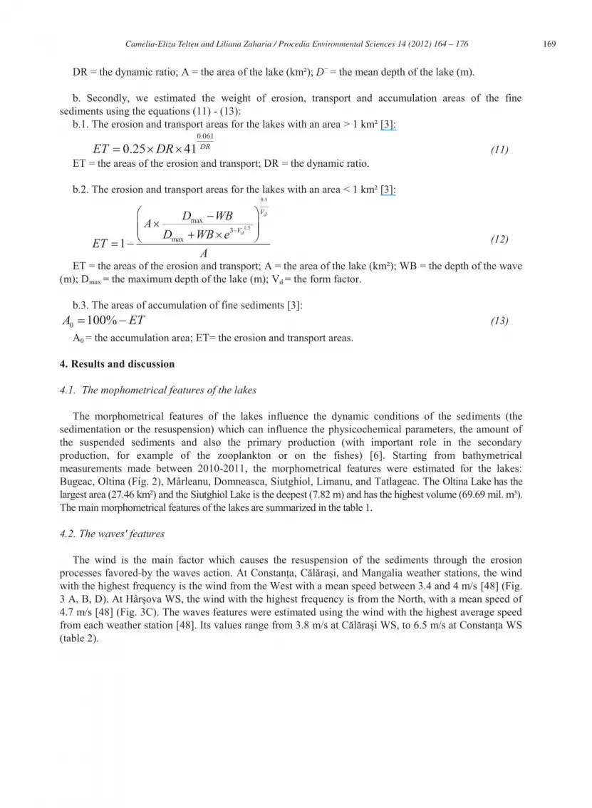
The morphometrical features of the lakes influence the dynamic conditions of the sediments (the sedimentation or the resuspension) which can influence the physicochemical parameters, the amount of the suspended sediments and also the primary production (with important role in the secondary production, for example of the zooplankton or on the fishes) [6]. Starting from bathymetrical measurements made between 2010-2011, the morphometrical features were estimated for the lakes: Bugeac, Oltina (Fig. 2), Mârleanu, Domneasca, Siutghiol, Limanu, and Tatlageac. The Oltina Lake has the largest area (27.46 km²) and the Siutghiol Lake is the deepest (7.82 m) and has the highest volume (69.69 mil. m³). The main morphometrical features of the lakes are summarized in the table 1.
4.2. The waves' features
The wind is the main factor which causes the resuspension of the sediments through the erosion processes favored with the highest frequency is the wind from the West with a mean speed between 3.4 and 4 m/s [48] (Fig. 3 A, B, D4.7 m/s [48] (Fig. 3C). The waves features were estimated using the wind with the highest average speed from each weather station [48]. Its values range from 3.8 (table 2).
170 Camelia-Eliza Telteu and Liliana Zaharia / Procedia Environmental Sciences 14 ( 2012 ) 164 – 176
Fig. 2. The bathymetrical maps of Oltina Lake (A) and Bugeac Lake (B)
Table 1. Data on the morphometrical features of the lakes from the South Dobrogea*
Parameter Bugeac Lake (29.07.201030.07.2010)
Oltina Lake (03.08.2010)
Mârleanu Lake (04.08.2011)
Domneasca Lake (05.08.2011)
Siutghiol Lake (08.07.2011)
Limanu Lake (18.07.2011)
Tatlageac Lake (15.08.2011)
Volume (V, mil. m³) 24.17 34.45 5.01 0.60 69.69 0.41 1.87 Area (A, km²) 19.34 27.46 5.86 0.49 17.34 0.58 1.76 Lenght (L, km) 6.07 6.41 3.57 1.41 7.57 1.79 2.44 Width (l, km) 2.88 4.27 2.23 0.49 4.12 0.16 0.61 The mean depth ( D , m)
1.24 1.25 0.85 1.22 4.02 0.71 1.06
Maximum depth (Dmax, m)
2.5 2.5 2.76 2 7.82 2.7 3.18
Perimeter (P, km)
15.69 18.05 10.54 3.19 27.53 3.74 5.59
Relative depth (Drel, %)
0.97 1.16 0.59 0.12 2.89 0.18 0.37
Shore line Development (DL)
0.09 0.06 0.17 1.03 0.12 0.87 0.39
* based on the bathymetrical measurements achieved between 2010-2011.
4.3. The estimation of the erosion, transport and accumulation areas of fine sediments
The results of the estimations on the fine sediments' erosion, transport and accumulation areas and on the factor form of the studied lakes are summarised in table 3. Its analyses show that the erosion and transport areas prevail in the Bugeac and Oltina lakes. This is due to the morphometrical features (large areas and small depths). The higher the percentage of the erosion area, the higher will be the resuspension, advection and turbidity processes [42]. The erosion and transport areas have values up to
A
B

171 Camelia-Eliza Telteu and Liliana Zaharia / Procedia Environmental Sciences 14 ( 2012 ) 164 – 176
90% because in the lakes there can be deep holes, some macrophytes or sheltered zone which have the role of sediments accumulation areas [6, 49].
Table 2. Data of winds at the weather stations the closest to the study lakes and on the waves' features from South Dobrogea lakes
Lake The weather station
considered
Period The wind direction with the highest average speed
The mean frequency
of the wind (%)
The mean
speed of the wind
(m/s)
The Effective
Fetch (EF, m)
The significant
wave height
(Hs, m)
The significant
wave period
(Ts, seconds)
The wavevelocity (vw, m/s)
The wavelength
Bugeac 1961-2000 NE 16.6 3.8 4398.12 0.16 1.68 3.50 4.38 Oltina 1961-2000 NE 16.6 3.8 5240.45 0.18 1.76 3.51 4.83
Mârleanu 1961-2000 NE 16.6 3.8 2420.76 0.12 1.42 2.89 3.14 Domneasca 1965-2000 N 23 4.7 701.154 0.09 1.10 3.46 1.89 Limanu Mangalia 1965-2000 N 11.3 5.6 761.11 0.11 1.22 2.63 2.31 Siutghiol 1965-2000 N 13.3 6.5 4165.04 0.28 2.09 6.27 6.82 Tatlageac 1965-2000 N 13.3 6.5 1324.99 0.17 1.52 3.22 3.59
Source data: data regarding the wind's direction, the mean frequency and the mean speed were taken from [48].
(1961 2000) (B); WS (C) (1965 2000) and Mangalia WS (1965 2000) (D)

172 Camelia-Eliza Telteu and Liliana Zaharia / Procedia Environmental Sciences 14 ( 2012 ) 164 – 176
Table 3. Data on the volume factor (Vd), dynamic ratio (DR), erosion and transport areas (ET), and accumulation areas (A0) of the South Dobrogea lakes (results obtained according to the methodology proposed by [3, 50])
Lake Vd Index Form
DR Dwb (m)
ET (%)
A0 (%)
Bugeac 1.50 Concave 3.52 2.5 93.84 6.16 Oltina 1.51 Concave 4.18 2.5 99 1.0 Mârleanu 0.93 Slightly convex 2.83 2.76 76.67 23.33 Domneasca 1.83 Concave 0.40 1.03 30.64 69.36 Limanu 0.78 Slightly convex 1.08 1.57 83.24 16.76 Tatlageac 1.00 Slightly convex 1.25 2.66 37.36 62.64 Siutghiol 1.54 Concave 1.04 7.45 32.25 67.75
The area of the lake above the wave base can be reflected by the form factor [51, 3]. This represents
the ratio between the water volume and the volume of a cone having the base equal to the area of the lakes and the height equal with the maximum depth [2, 52]. The Limanu, Mârleanu and Tatlageac lakes have lower values of the form factor thus highlighting large areas above the wave base (table 3). Based on the values of the form factor, the basin shape can be estimated indirectly using the classes below (table 4):
Table 4. The classes of the form factor [50]
ape The volume factor (Vd) Very convex 0.05-0.33 Convex 0.33-0.67 Slightly convex 0.67-1.00 Linear 1.00-1.33 Concave >1.33
The form factor values of the studied lakes show that the majority are concave or slightly convex
(table 3 and 4). The lowest values of the form factor highlight an intensive process of resuspension (if
rate of sedimentation and the values of the form factor [53]. Also, the values of the form factor will increase once with the increasing of the lakes volumes (for example: the Siutghiol Lake). This confirms the increasing of the sedimentation rate once with the form factor because a greater volume of the lakes will increase the capacity of sedimentation (if the other processes from the lakes will have a constant evolution). The highest values of the form factor are specific to the lakes with the greatest depth (for example: the Siutghiol Lake) which can influence the resuspension of the sediments by bottom slope processes [53].
The resuspension of the sediments is, by definition, the redistribution in the water column of the sediments which have been previously deposited on the bottom of the lake [54]. It prevails in lakes with values of the dynamic ratio over 0.26. The turbidity currents, linked to the slope processes, prevail in lakes with dynamic ratio over 0.26 [3]. The dynamic ratio is a form parameter which describes the bottom dynamic conditions [50]. Based on the values of the dynamic ratio, the lakes can be separated in four classes with different features of the erosion, transport and accumulation areas (Table 5) [50]. According to this classification Bugeac, Mârleanu, Domneasca, Limanu, Tatlageac and Siutghiol lakes belong to the intermediate class and only the Oltina Lake belongs to the shallow class.
The large and shallow aquatic units have high values of the dynamic ratio and large sedimentary areas exposed to the wind/waves action (for example: Bugeac and Oltina Lakes) [55]. The lakes with small depth and small values of the relative depth will have large areas affected by resuspension (for example:

173 Camelia-Eliza Telteu and Liliana Zaharia / Procedia Environmental Sciences 14 ( 2012 ) 164 – 176
Domneasca Lake). In the Bugeac, Oltina, Mârleanu and Domneasca lakes prevail the areas where the removal and periodical deposition of the fine sediments take place because of the advective processes (especially of the wind/waves action). These are composed of sand, gravel or consolidated clay [3, 56, 57]. In Limanu, Tatlageac and Siutghiol lakes prevail the areas where the fine sediments are deposited continuously (soft bottom areas) [3, 56].
Table 5. The classes for the dynamic ratio (DR) [50]
Class DR Description 1
Very deep <0.064 Areas dominated by slope processes and erosion and transport processes for fine particles
2 Deep
0.064 - 0.25 Areas influenced by slope processes where erosion, transport and accumulations for fine particles occur
3 Intermediate
0.25 - 4.1 Areas more influenced by wind and wave processes where erosion, transport and accumulations for fine particles occur
4 Shallow
> 4.1 Areas dominated by wind and wave processes and erosion and transport processes for fine particles
The hypsographic curve is the distribution curve of the relative area (the weight of the areas from the
total area) in ratio with the relative depth (which is the weight of the depth from the total depth). It shows how the area of the lake changes with the depth of the lake [58]. The aspect of the hypsographic curve is given by the ratio between the accumulation areas of the sediments and the erosion areas of the lake [59]. The hypsographic curves of the studied lakes highlight that these lakes, generally, have large relative areas above the depth of the wave base (Dwb), so the resuspension of the sediments will be influenced by the advective processes (the wind/waves action) (Fig. 4).
The shallower the lake, the more will the sediments be exposed and modeled by the waves. The resuspension of the sediments will grow with the reducing of the depth of wave base [6]. By definition, the wave base represents the limit between the erosion, transport and accumulation areas of fine sediments. It represents the depth on which the waves can resuspend the fine sediments [6]. This was estimated starting from the area of the lake and depends on the wind surface action, on the speed and period of the wind, and on the way the wind/waves action influence the bottom dynamic conditions [42].
5. Conclusions
This paper highlights the morphometrical features (the area, the volume, the mean depth, the maximum depth) and the bottom dynamic conditions of 7 lakes in the South Dobrogea region: Bugeac, Oltina, Domneasca, Mârleanu, Siutghiol, Limanu and Tatlageac lakes. The analysis of the morphometrical features is based on the processing of data obtained from our own bathymetrical measurements. The Oltina Lake has the largest area (27.46 km²). The Siutghiol Lake has the highest volume (69.69 mil. m³) and the greatest depth (7.82 m). Based on the morphometrical parameters and using relations taken from the literature, we estimated indirectly the lacustrine dynamic, more precisely, the erosion, transport and accumulation areas of fine sediments. In addition to the morphometric features of lakes, we have been included in calculations data on wind speed, a major factor influencing the lacustrine dynamic. The erosion and transport areas prevail (over 90%) in Limanu, Bugeac and Oltina Lakes, due to their large areas and small depths. The accumulation area prevail (62.64-67.75%) in the Tatlageac, Domneasca and Siutghiol lakes, which generally has small areas and are deeper. The higher the percentage of the erosion area, the higher will be the resuspension, and turbidity processes.

174 Camelia-Eliza Telteu and Liliana Zaharia / Procedia Environmental Sciences 14 ( 2012 ) 164 – 176
Fig. 4. The area-depth relative hypsographic curve of the South Dobrogea lakes: A. Siutghiol Lake; B. Tatlageac Lake; C. Limanu Lake; D. Domneaasca Lake. Dwb= the depth of the wave (m) indicated by the horizontal line; Dmax= the maximum depth (m); Vd = the form factor or the volume development; Area = the area of the lake (km²); V = the volume of the lake (mil. m³).
The estimation of the erosion, transport and accumulation areas of fine sediments could be useful for identifying some causes which determine changes of the lakes' morphometrical, morphological and physicochemical parameters, influencing the lake functionalities and uses. Knowing the particularities of lake dynamics could help for improving the lakes management (mainly for the lakes that are used for fish production). In this regard, adequate structural and nonstructural measures could be taken. As structural measures for mitigate the sediment input in lakes could be provided: actions for the prevention and the control of the slopes erosion, the construction of some dams, the rehabilitation of the existing dredges, the construction of channels to divert the rainwater. The nonstructural measures can include: a proper management for the fish production of the lakes, the periodical check of the different technical works around the lakes, the cleaning and the maintenance of the existing channels for diverting the rainwater.
Acknowledgements
Doctoral Studies in the field of life and earth sciences -financed through Sectorial Operational Program for the Development of Human Resources 2007-2013 from European Social Fund.
References
[1] Schnurrenberger D, Russell J, Kelts K. Classification of lacustrine sediments based on sedimentary components. Journal of Paleolimnology 2003; 29: 141-154.

175 Camelia-Eliza Telteu and Liliana Zaharia / Procedia Environmental Sciences 14 ( 2012 ) 164 – 176
[2] Hutchinson GE. A Treatise on limnology. vol. I. Geography, physics and chemistry. John Wiley&Sons, New York; 1957. [3] Håkanson L. Internal loading: a new solution to an old problem in aquatic sciences. Lakes&Reservoirs: Research and
Management 2004; 9: 3-23. Zaharia L. Hydrology. University of Bucharest Press; 2001 [in Romanian].
L, Diaconu D. Hydrology. University Press, Bucharest; 2005 [in Romanian]. [6] Håkanson L. The importance of Lake Morphometry for the Structure and Function of Lakes. Internal. Rev. Hydrobiol. 2005; 90:
433-461. [7] Forel FA. La limnologie, branche de la Geographie. Comptes Rendue Du Sixième Congres International de Geographie. 1895:
1-4. [8] Welch PS. Limnological Methods. Blakiston Philadelphia; 1948. [9] Håkanson L. A manual of lake morphometry. Berlin, Heidelberg, New York: Springer-Verlag; 1981. [10] Wetzel RG. Limnology. 2nd Edition. Saunders College Publishing: Philadelphia, PA. 1983. [11] Wetzel RG. Limnology: Lake and River Ecosystems. 3rd Edition. Academic Press. San Diego. CA. 2001. [12] Kalff J. Limnology-Inland Water Systems. Prentice Hall, Upper Saddle River, New Jersey. 2002. [13] Punning JM, Terasmaa J, Kadastik E. Grain size of the bottom sediments of Lake Väike Juusa (southern Estonia) as the
indicator of water-level fluctuations. Proc. Estonian Acad. Sci. Geol. 2005; 54 (1): 40-51. [14] Håkanson L. The influence of wind, fetch and water depth on the distribution of sediments in Lake Vanern, Sweden. Can. J.
Earth Sci. 1977; 14: 397-412. [15] Håkanson L. Lake bottom dynamics and morphometry: The dynamic ratio. Water Resour. Res. 1982; 18(5). 1444-1450. [16] Blais JM, Kalff J. The influence of lake morphometry on sediment focusing. Limnol. Oceanogr. 1995; 40 (3): 582-588. [17] Weyhenmeyer GA, Håkanson L, Meili M. A validated model for daily variations in the flux, origin, and distribution of settling
particles within lakes. Limnol. Oceanogr. 1997; 42 (7): 1517-1529. [18]Rowan DJ, Kalff J, Rasmussen JB. Estimating the mud deposition boundary depth in lakes from wave theory. Can. J. Fish.
Aquat. Sci 1992; 49: 2490-2497. [19] Stanchev H, Peychev V, Palazov A, Stancheva M. Long-Term Alterations to the Varna-Beloslav Lake Complex due to human
activities (Bulgarian Black Sea Coast). Conference on Water Observation and Information System for Decision Support. Balwois 2010; 4: 1-7. http://balwois.com/balwois/info_sys/publication2010.php.
[20] Hristova N. The regime of water level of lakes Durankulak and Shabla. Conference on Water Observation and Information System for Decision Support. Balwois 2008; 3: 1-7. http://balwois.com/balwois/info_sys/publication2008.php.
[21] Dügel M. Species assemblages and habitat preferences of Ostracoda (Crustacea) in Lake Abant (Bolu, Turkey). Belg. J. Zool. 2008; 138 (1): 50-59.
O. Tolerance, optimum ranges, and ecological requirements of freshwater Ostracoda (Crustacea) in Ecol. Res. 2006; 21: 165-173.
A, Avuka D, Kiliç M. Limnoecological relationship between water level fluctuations and Ostracoda (Crustacea) species composition in Lake Sünnet (Bolu, Turkey). Turk. J. Zool. 2010; 34: 429-442.
C. The level oscillations of the waters and of the Black Sea in the Quaternary. Bull. Of Rom. Geogr. Soc. 1942; LXI: 1-112 [in Romanian].
[25] G P. The lakes from the P. R. of Romania. Genesis and hydrological regime. R.P.R Academy Press, Bucharest; 1963 [in Romanian].
[26] Banu AC. Data about the historical transgression of the Black Sea Basin and of the Lower Danube. Hydrobiology. Socialist Republic of Romania Academy Press. 1964; 5: 237-252[in Romanian].
P. The lakes in Romania regional limnology. Academy R.S.R. Press. Bucharest; 1971 [in Romanian]. [28] Breier A. The lakes from the Romanian Black Sea Coast. Academy Press; Bucharest; 1976 [in Romanian].
P. The aspects regarding the present status of the Siutghiol and Techirghiol lakes. Annals of the University -Geography Series 2003; 3: 134-138 [in Romanian].
[30] Romanescu Gh, Romanescu G. The physico-chemical features of the lakes from the Romanian Black Sea Coast (The Cape Midia Vama veche). The geographical seminar "Dimitrie Cantemir" 2005; 25: 97-117 [in Romanian].
[31] Romanescu Gh. The ecological characteristics of the romanian littoral lakes-the sector Midia Cape-Vama Veche. Lakes, reservoirs and ponds 2008; 1-2: 49-60.
[32] Romanescu Gh, Dinu C, Radu A, Török L. Ecologic characterization of the fluviatile limans in the south-west Dobrudja and their economic implications (Romania). Carpathian Journal of Earth and Environmental Sciences 2010; 5 (2): 25-38.
[33] Galatchi LD, Dobrinas S, Chirila E. Threats on the seaside lakes water and their acute and long-term consequences. In Simeonov L, Chirila E. (Eds.). Chemical as Intentional and Accidental Global Environmental Threats. Springer; 2006, p. 201-218.
[34] Godeanu S, Galatchi LD. The Determination of the Degree of Eutrophication of the Lakes on the Romanian Seaside of the Black Sea. Ann. Limnol.-Int. J. Lim. 2007; 43 (4): 245-251.

176 Camelia-Eliza Telteu and Liliana Zaharia / Procedia Environmental Sciences 14 ( 2012 ) 164 – 176
[35] Popescu N, Ielenicz M. The Dobrogea's relief features and evolution. Annals of Bucharest University 2003; LII: 5-58. V. Dobrogea's climate. Annals of Bucharest University. 2003; LII: 83-105.
eds. The Geography of Romania-vol. V, The Romanian Plain, The Danube River, The Dobrogea Plateau, The Romanian Black Sea Coast and The Continental Shelf. The Romanian Academy Press; 2005, p. 759-760.
[38] rom the South Dobrogea. Air and Water: Components of the Environment 2011, 3: 73-85.
[39] Baciu M. The potentia . The Climate of Romania, The Romanian Academy Press; 2008, p. 293-299.
I. The waters of Dobrogea. Annals of the Bucharest University. 2003; LII: 107-143. [41] Wetzel RG, Likens GE. Limnological Analyses. 3rd edition. New York: Springer-Verlag; 2000. [42] Håkanson L, Bryhn AC. A dynamic mass-balance model for phosphorus in lakes with a focus on criteria for applicability and
boundary conditions. Water Air Soil Pollut. 2008; 187: 119-147. [43] CERC. Waves in inland reservoirs. Beach Erosion Board Corp of Engineers, Tech Mem 132; 1962.
M. The landscape dynamics of the Izvorul Muntelui Lake. The Suceava University Press, 2004 [in Romanian]. [45] Douglas RW, Rippey B. The random redistribution of sediment by wind in a lake. Limnol. Oceanogr. 2000; 45 (3): 686-694. [46] Douglas RW. Sedimentation Patterns and Mechanisms of Contaminant Transport in Lough Neagh, Northern Ireland. PhD
thesis in Philosophy. The University of Ulster. 1997. [47] Smith IR, Sinclair IJ. Deep water waves in lakes. Freshw. Biol. 1972; 2: 387-399. [48] Tor V. The climatic conditions and their influence over the landscape in South Dobrogea. PhD Thesis in Geography.
University of Bucharest. 2004. [49] Håkanson, L. A revised dynamic model for suspended particulate matter (SPM) in coastal areas. Aquat. Geochem 2006; 12:
327-364. [50] Lindgren D, Håkanson L. Morphometric classification and GIS-based data analysis in coastal modeling and management. Open
Environment Sciences. 2011; 5: 1-17. [51] Håkanson, L. Quantifying Burial, the Transport of Matter from the Lake Biosphere to the Geosphere. Internat. Rev. Hydrobiol.
2003; 88: 539-560. [52] Håkanson L, Bryhn AC. Goals and remedial strategies for water quality and wildlife management in a coastal lagoon - A case
study of Ringkøbing Fjord. Denmark. Journal of Environmental Management 2008; 86: 498-519. [53] Håkanson L. A model to predict gross sedimentation in small glacial lakes. Hydrobiologia 1994; 284: 19-42. [54] Bloesch J. A review of methods used to measure sediment resuspension. Hydrobiologia 1994; 284: 13-18. [55] Håkanson L, Bryhn AC, Blenckner T. Operational effect variables and functional ecosystem classifications-a review on
empirical models for aquatic systems along a salinity gradient. Internat. Rev, Hydrobiol. 2007; 92: 326-357. [56] Håkanson L, Gyllenhammar A, Brolin A. A dynamic compartment model to predict sedimentation and suspended particulate
matter in coastal areas. Ecological Modelling. 2004; 175: 353-384. [57] Håkanson L, Blenckner T, Malmaeus MJ. New, general methods to define the depth separating surface water from deep water,
outflow and internal loading for mass-balance models for lakes. Ecological Modelling 2004; 175: 339-352. [58] Johansson H, Brolin AA, Håkanson L. New Approaches to the Modelling of Lake Basin Morphometry. Environ. Model Assess.
2007; 12: 213-228. [59 P. The bathymetrical curve in the analysis of the lakes genetic types. Communications of Geography 1963; II: 29-31
[in Romanian].
Related Documents