Morphology of Piton de la Fournaise basaltic shield volcano (La Re ´union Island): Characterization and implication in the volcano evolution Laurent Michon 1 and Francky Saint-Ange 1 Received 24 October 2005; revised 24 May 2007; accepted 13 December 2007; published 5 March 2008. [1] The topography of Piton de la Fournaise volcano (PdF) differs from the classic view of basaltic shield volcanoes as it is characterized by (1) several steep slope zones on its flanks and (2) a large U-shaped caldera, the Enclos-Grand Bru ˆle ´ structure (EGBS). Most of these structures were previously interpreted as the scars of lateral landslides, the deposits of which cover the submarine flanks of PdF. We carried out a detailed analysis of the morphology of PdF, which reveals that the steep slope zones form two independent, circumferential structures that continue into the caldera. The development of circumferential steep slopes on volcano flanks may have several origins: constructive, destructive, and deformation processes. We interpret those processes acting on PdF as caused by the spreading of the volcanic edifice above a weak hydrothermal core, leading to outward displacements and a summit extensive stress field. The continuity of the steep slope on both sides of the EGBS escarpments suggests that this structure was not caused by a 4.5 ka old giant landslide as it is usually proposed but is due to a mainly vertical collapse. The recent debris avalanche deposits east of the island indicate that this event likely destabilized part of the submarine flank. We propose that the collapse of the Grand Bru ˆle ´, the lower half of the EGBS, was due to the downward drag related to the dense intrusive complex of the Alize ´s volcano, which is located 1 km below the Grand Bru ˆle ´. The collapse of the Enclos is interpreted as the consequence of the deformation of the hydrothermal system of the pre-Enclos volcano. Although the continuity of the geological and morphological structures between the Enclos and the Grand Bru ˆle ´ suggests a narrow link between these two collapse events, their chronology and relationship are still uncertain. Finally, we hypothesize that the persistence of the NE and SE rift zones during the last 150 ka, despite the large changes of the topography related to the recurrent flank destabilizations, is linked to a deep sources, which can be either underlying crustal faults or the continuous downward subsidence of the Alize ´s intrusive complex. Citation: Michon, L., and F. Saint-Ange (2008), Morphology of Piton de la Fournaise basaltic shield volcano (La Re ´union Island): Characterization and implication in the volcano evolution, J. Geophys. Res., 113, B03203, doi:10.1029/2005JB004118. 1. Introduction [2] The morphology of volcanoes results from construc- tion, destruction and deformation processes that interact during their evolution [e.g., Moore, 1964; Moore and Mark, 1992; Rowland and Garbeil, 2000; Merle and Borgia, 1996; Cecchi et al., 2005]. Hence the analysis of the morphology allows the identification of structures the development of which is related to internal processes and/or a specific eruption history [e.g., Tort and Finizola, 2005]. At Piton de la Fournaise, one of the world’s most active shield volcanoes [e.g., Le ´nat and Bache `lery , 1987], the succession of construction and dismantling phases (i.e., erosion and landslide) led to the development of a complex morphology [e.g., Bache `lery , 1981; Rowland and Garbeil, 2000]. One of the most striking features is the E-W elongated horseshoe- shaped collapse structure in which the currently active cone developed (Figure 1). The structure is composed, from west to east, by the Enclos depression, the Grandes Pentes, and the Grand Bru ˆle ´ and is bounded by 100- to 200-m-high escarpments, the Bois Blanc, Bellecombe and Tremblet escarpments in the north, west and south, respectively. The formation of the Enclos-Grand Bru ˆle ´ structure (EGBS) is one the greatest scientific controversies on PdF. One interpretation is that the Enclos depression results from a polyphase caldera collapse whereas the Grand Bru ˆle ´ exhib- its the scars of lateral landslides with the Grandes Pentes as their headwall [Bache `lery , 1981] (Figure 2a). Another interpretation is that the entire EGBS results from a giant landslide that was also partly responsible for the debris JOURNAL OF GEOPHYSICAL RESEARCH, VOL. 113, B03203, doi:10.1029/2005JB004118, 2008 Click Here for Full Articl e 1 Laboratoire Ge ´oSciences Re ´union, Institut de Physique du Globe de Paris, Universite ´ de la Re ´union, CNRS, UMR 7154, Ge ´ologie des Syste `mes Volcaniques, Saint Denis, France. Copyright 2008 by the American Geophysical Union. 0148-0227/08/2005JB004118$09.00 B03203 1 of 19

Welcome message from author
This document is posted to help you gain knowledge. Please leave a comment to let me know what you think about it! Share it to your friends and learn new things together.
Transcript
Morphology of Piton de la Fournaise basaltic shield volcano
(La Reunion Island): Characterization and implication in the
volcano evolution
Laurent Michon1 and Francky Saint-Ange1
Received 24 October 2005; revised 24 May 2007; accepted 13 December 2007; published 5 March 2008.
[1] The topography of Piton de la Fournaise volcano (PdF) differs from the classic viewof basaltic shield volcanoes as it is characterized by (1) several steep slope zones on itsflanks and (2) a large U-shaped caldera, the Enclos-Grand Brule structure (EGBS). Mostof these structures were previously interpreted as the scars of lateral landslides, thedeposits of which cover the submarine flanks of PdF. We carried out a detailed analysis ofthe morphology of PdF, which reveals that the steep slope zones form two independent,circumferential structures that continue into the caldera. The development ofcircumferential steep slopes on volcano flanks may have several origins: constructive,destructive, and deformation processes. We interpret those processes acting on PdF ascaused by the spreading of the volcanic edifice above a weak hydrothermal core, leadingto outward displacements and a summit extensive stress field. The continuity of the steepslope on both sides of the EGBS escarpments suggests that this structure was not causedby a 4.5 ka old giant landslide as it is usually proposed but is due to a mainly verticalcollapse. The recent debris avalanche deposits east of the island indicate that this eventlikely destabilized part of the submarine flank. We propose that the collapse of the GrandBrule, the lower half of the EGBS, was due to the downward drag related to the denseintrusive complex of the Alizes volcano, which is located 1 km below the Grand Brule.The collapse of the Enclos is interpreted as the consequence of the deformation of thehydrothermal system of the pre-Enclos volcano. Although the continuity of the geologicaland morphological structures between the Enclos and the Grand Brule suggests a narrowlink between these two collapse events, their chronology and relationship are stilluncertain. Finally, we hypothesize that the persistence of the NE and SE rift zones duringthe last 150 ka, despite the large changes of the topography related to the recurrent flankdestabilizations, is linked to a deep sources, which can be either underlying crustal faultsor the continuous downward subsidence of the Alizes intrusive complex.
Citation: Michon, L., and F. Saint-Ange (2008), Morphology of Piton de la Fournaise basaltic shield volcano (La Reunion Island):
Characterization and implication in the volcano evolution, J. Geophys. Res., 113, B03203, doi:10.1029/2005JB004118.
1. Introduction
[2] The morphology of volcanoes results from construc-tion, destruction and deformation processes that interactduring their evolution [e.g., Moore, 1964; Moore and Mark,1992; Rowland and Garbeil, 2000;Merle and Borgia, 1996;Cecchi et al., 2005]. Hence the analysis of the morphologyallows the identification of structures the development ofwhich is related to internal processes and/or a specificeruption history [e.g., Tort and Finizola, 2005]. At Pitonde la Fournaise, one of the world’s most active shieldvolcanoes [e.g., Lenat and Bachelery, 1987], the succession
of construction and dismantling phases (i.e., erosion andlandslide) led to the development of a complex morphology[e.g., Bachelery, 1981; Rowland and Garbeil, 2000]. One ofthe most striking features is the E-W elongated horseshoe-shaped collapse structure in which the currently active conedeveloped (Figure 1). The structure is composed, from westto east, by the Enclos depression, the Grandes Pentes, andthe Grand Brule and is bounded by 100- to 200-m-highescarpments, the Bois Blanc, Bellecombe and Trembletescarpments in the north, west and south, respectively.The formation of the Enclos-Grand Brule structure (EGBS)is one the greatest scientific controversies on PdF. Oneinterpretation is that the Enclos depression results from apolyphase caldera collapse whereas the Grand Brule exhib-its the scars of lateral landslides with the Grandes Pentes astheir headwall [Bachelery, 1981] (Figure 2a). Anotherinterpretation is that the entire EGBS results from a giantlandslide that was also partly responsible for the debris
JOURNAL OF GEOPHYSICAL RESEARCH, VOL. 113, B03203, doi:10.1029/2005JB004118, 2008ClickHere
for
FullArticle
1Laboratoire GeoSciences Reunion, Institut de Physique du Globe deParis, Universite de la Reunion, CNRS, UMR 7154, Geologie des SystemesVolcaniques, Saint Denis, France.
Copyright 2008 by the American Geophysical Union.0148-0227/08/2005JB004118$09.00
B03203 1 of 19
avalanche deposits on the submarine flanks [Duffield et al.,1982; Gillot et al., 1994; Labazuy, 1996] (Figure 2b). Athird interpretation was recently proposed by Merle andLenat [2003], who take into account the role of bothhydrothermal systems and deep decollement levels in thevolcano’s deformation. In their model, a lateral movement(the Grand Brule) triggered a vertical collapse in the summitarea (the Enclos depression; Figure 2c). Several additionallarge-scale structures may be related to the same mechanism,resulting in 100-m-high escarpments and steep slope zones
outside the structures mentioned above [e.g., Bachelery,1981; Oehler et al., 2004].[3] The present study aims at describing in detail the
morphology of PdF and at understanding the origin of themain structures, i.e., the steep slope zones on the volcanoflanks and the EGBS. We use different digital elevationmodels (with 25- and 50-m resolution) to determine thedetailed and first-order morphologies of the edifice. Inte-gration of the available geological and geophysical data,and of the different published conceptual models, allows us
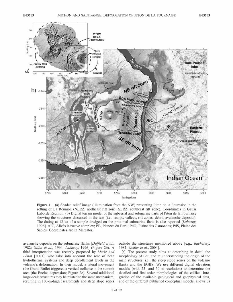
Figure 1. (a) Shaded relief image (illumination from the NW) presenting Piton de la Fournaise in thesetting of La Reunion (NERZ, northeast rift zone; SERZ, southeast rift zone). Coordinates in GaussLaborde Reunion. (b) Digital terrain model of the subaerial and submarine parts of Piton de la Fournaiseshowing the structures discussed in the text (i.e., scarps, valleys, rift zones, debris avalanche deposits).The dating at 12 ka of a sample dredged on the proximal submarine flank is also reported [Labazuy,1996]. AIC, Alizes intrusive complex; PB, Planeze du Baril; PdO, Plaine des Osmondes; PdS, Plaine desSables. Coordinates are in Mercator.
B03203 MICHON AND SAINT-ANGE: DEFORMATION OF PITON DE LA FOURNAISE
2 of 19
B03203

Figure 2. Schematic views and cross sections of the three different models previously proposed toexplain the formation of the large Enclos-Grand Brule structure (EGBS). (a) A polyphase caldera collapseand the Grand Brule is the scar of one or several lateral landslides, the Grandes Pentes being the headwallof these slides [after Bachelery, 1981]. (b) The entire structure is the scar of a single, landslide [afterLabazuy, 1996; Oehler et al., 2004]. (c) A slide of the Grand Brule due to a deep decollement induced acollapse of the Enclos caldera [after Merle and Lenat, 2003]. Coordinates are in Gauss Laborde Reunion(km).
B03203 MICHON AND SAINT-ANGE: DEFORMATION OF PITON DE LA FOURNAISE
3 of 19
B03203
to constrain their spatiotemporal relationship and theirpotential origin. Finally, we present a chronology for thelast 150 ka of PdF in which we consider the potential role ofthe rift zones and the intraedifice density contrasts in thevolcano evolution.
2. Evolution of Piton de la Fournaise in theGeological Setting of La Reunion Island
[4] Measured from the seafloor, La Reunion Island is a7-km-high oceanic shield volcano with a diameter of220–240 km. Considering the historical magma produc-tion rate and the oldest dated subaerial basalts (2.1 Ma[MacDougall, 1971]), an age of around 5 Ma was estimatedsince the beginning of the edifice growth [Gillot et al., 1994].The initial magmatic evolution was characterized by thedevelopment of two adjacent volcanoes (the Piton des Neigesand Alizes), which encountered recurrent flank destabiliza-tions [Lenat et al., 2001; Bachelery et al., 2003;Oehler et al.,2004]. The Alizes volcano is now completely dismantled andthe only evidence of its past existence is the large intrusioncomplex discovered by drilling below the Grand Brule(Figure 1) [Rancon et al., 1989], the old submarine remnants[Labazuy, 1996] and the pre-Brunhes reverse magneticanomalies, which were determined as magmatic formationsolder than those of Piton de la Fournaise [Lenat et al., 2001].The destabilization of the Alizes volcano led to the develop-ment of the Eastern Plateau, which corresponds to a subma-rine relief composed of several hundreds of km3 of debrisavalanche deposits [Labazuy, 1991; Oehler, 2005, availableat http://tel.archivesouvertes.fr/tel-00010498/en/]. Around530 ka ago, Piton de la Fournaise appeared west of the centerof Alizes, which had stopped its activity. Between 530 and12 ka (the date of Piton des Neiges’ last eruption [Deniel etal., 1992]), Piton des Neiges and Piton de la Fournaiseshowed contemporaneous activity. Finally, for the last12 ka, eruptions are restricted to Piton de la Fournaise.[5] Geochronological [Gillot and Nativel, 1989] and
geological data [Mairine and Bachelery, 1997] indicatethat PdF results from two main building phases, 0.53–0.29 Ma and 0.15 Ma to present-day, separated by a periodduring which erosion prevailed. The first constructionperiod led to the formation of the ‘‘ancient’’ PdF, whichwas likely centered on the present-day Plaine des Sables[Bachelery and Mairine, 1990]. The distribution of dikeswarms in the Riviere des Remparts indicates that at leastone rift zone developed during this first phase (i.e., the SWrift zone [Mairine and Bachelery, 1997]). Debris flow unitsin the eastern scarp of the Riviere des Remparts andwestern scarp of the Riviere Langevin intercalated with0.22 Ma old lava flows indicate that the ‘‘ancient’’ Four-naise suffered intense erosion, which induced the incisionof the paleo-Riviere des Remparts [Bachelery and Mairine,1990]. This valley was progressively filled in until thecollapse of the Morne Langevin caldera 0.15 Ma ago. Thisevent led to an eastward shift of the volcanic center. As aresult, the geometry of the feeding zone changed: two NEand SE rift zones developed from the volcanic center[Bachelery, 1981] (Figure 1). Part of the debris avalanchedeposits covering the Eastern Plateau and forming the RalePousse lobe are interpreted as related to this large collapse[Oehler, 2005]. During the last 0.15 Ma, the ‘‘recent’’ PdF
was affected by at least two caldera collapses whose originsare still controversial.[6] 1. The Plaine des Sables caldera resulted from several
collapse events starting 60 ka ago [Bachelery and Mairine,1990]. Several datings of the debris avalanche deposits(between 110 and 45 ka) dredged on the Eastern Plateaushow that these events were associated with large flanklandslides, the deposits of which spread over the proximalpart of the submarine plateau and the Rale Pousse (Figure 1b)[Labazuy, 1996].[7] 2. The Enclos caldera formed around 4.5 ka ago
[Bachelery and Mairine, 1990]. Pyroclastic deposits aroundthe Enclos indicate that the collapse was simultaneous to alarge explosive eruption [Abchir et al., 1998]. However, asfor other basaltic calderas [e.g., MacDonald, 1972; Munroand Rowland, 1996], the volume of the deposit (around0.5–1 km3 [Abchir et al., 1998]) is 1 order of magnitudelower than that of the Enclos caldera. The summit part ofthe Rale Pousse debris avalanche lobe, which age isuncertain is considered as to be related to the slide of theGrand Brule [Labazuy, 1996; Oehler, 2005].[8] During the ‘‘recent’’Fournaiseevolution (post-0.15Ma),
intense erosion led to the formation of deep valleys (Rivieredes Remparts, Riviere Langevin, Riviere Basse Vallee, andRiviere de l’Est; Figure 1). An additional erosional struc-ture was discovered on the eastern flank of PdF. Geophys-ical data and a drill hole in the northern part of the GrandBrule revealed the presence of the Osmondes paleoriver[Courteaud, 1996], where more than 170 m of alluvialformations were encountered below 60 m of recent lavaflows. The relationship and the chronology between thisvalley and the Grand Brule are poorly understood.
3. Analysis of the Piton de la FournaiseMorphology
[9] Piton de la Fournaise is characterized by three mainmorphological features: (1) The flanks, which are continu-ous from the summit to the sea in the north, east and south,whereas the western flank is buttressed by Piton des Neiges,(2) two visible calderas, the Plaine des Sables and theEGBS, bounded by 100-m-high escarpments, and (3) verydeeply incised valleys (the Riviere des Remparts, RiviereLangevin, Riviere de l’Est, and Riviere Basse Vallee),which dissect the western part of the edifice. We focusour analysis on the two first morphological structures.
3.1. Characterization of the Flanks of PdF
[10] Our analysis of the morphology of PdF is mainlybased on the study of a 25-m step digital elevation model(DEM) developed by Institut Geographique National (IGN).This DEM was calculated by stereophotogrammetry from aset of aerial photographs taken in 1997. Stereotriangulationand 967 ground control points were used to control theaccuracy of the model (vertical error of ±4.5 m at 2s[Villeneuve, 2000]). The DEM being calculated from aerialphotographs, its accuracy slightly decreases in denselyvegetated areas (i.e., the flanks of the edifice) and increasesaround the Enclos depression. As a consequence, minortopographic structures are disregarded.[11] The flanks of PdF are characterized by different
slope domains from the coast to the summit [Rowland
B03203 MICHON AND SAINT-ANGE: DEFORMATION OF PITON DE LA FOURNAISE
4 of 19
B03203

and Garbeil, 2000] (Figure 3a). At low elevations, the slopevalue range between 8� and 15�, corresponding to typicalvalues of basaltic oceanic volcanoes [Mark and Moore,1987; Hurlimann et al., 2004]. At higher elevations, thetopography of the southern, eastern and northern flanks ischaracterized by steep slope zones ranging between 20� and
35� (Figures 3 and 4), while the summit shows slopesbetween 2� and 8�, if the escarpments and the active coneare disregarded. Such a slope distribution is strikinglysimilar to what is observed on Volcan Fernandina, Wolf,and Cerro Azul in the western Galapagos archipelago[Rowland, 1996; Rowland and Garbeil, 2000]. In contrast,
Figure 3. (a) Slope map of PdF showing the variable slopes on the volcano flanks. PFP, Piton deFourche Plateau; REP, Riviere de l’Est Plateau; PCVZ, Plaine des Cafres Volcanic Zone. (b) Gray scaleslope image with location of the upper and lower steep slope zones highlighted in red (USS andLSS) characterized by slope values ranging between 20� and 30�. Coordinates are in Gauss LabordeReunion.
B03203 MICHON AND SAINT-ANGE: DEFORMATION OF PITON DE LA FOURNAISE
5 of 19
B03203
this slope distribution is not observed on the western flankof PdF where the edifice is buttressed by Piton des Neiges.[12] Radial topographic profiles allow a better character-
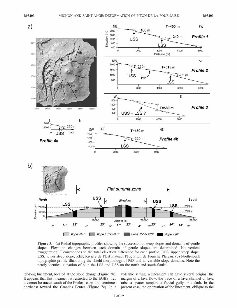
ization of the flank geometry (Figure 5). On the southernand eastern flanks, single linear profiles were producedfrom digital elevation models, but a composite profilewas required for the northern flank in order to avoidcomplications of Riviere de l’Est and Plaine des Osmondes(Figure 5a). Topographic profiles, except for profile 3 (theeast flank), reveal a seaward tilted stair-like topography withtwo steep slope zones separated by inclined plateaus such asthe Piton de Fourche and the Riviere de l’Est (Figure 5a).Each steep slope zone corresponds to one step betweenflank segments that are characterized by constant slopevalues. The elevation changes across the upper steep slope(USS) and lower steep slope (LSS) are similar with 160,230, and 210 m for the upper slope and 240, 285, and 220 mfor the lower slope, respectively. Moreover, for each profile,the elevation change across the USS is always smaller thanthat across the LSS. In the SW, SE and north flanks, theUSS and LSS are located at a nearly constant elevation ataround 2000 m for the USS and 1000–1200 m for the LSS(Figure 5b). The resulting morphology is characterized by ageometry resembling an ‘‘overturned soup plate.’’ Combin-ing the slope map and topographic profiles suggests that theUSS and LSS form two independent morphological struc-tures on the southern and northern flanks of PdF.Concerning profile 3 on the east flank, only one steep slopezone is observed. This exception raises the problem of therelationship between the steep slope zones outside theEGBS and in the Grandes Pentes. The Grandes Pentescould correspond either to an independent structure whosedevelopment is related to the formation of the EGBS [e.g.,Bachelery, 1981; Merle and Lenat, 2003], or to the conti-nuity of the upper and lower steep slope zone, which would
merge in the east flank. Whatever the relationship betweenthe Grandes Pentes and the USS and LSS, two morpholog-ical structures can be determined in the south, SE, NE, andnorth flanks (Figure 3b). The upper morphological structureis subcircular, whereas the lower structure presents twolobes at the location of the NE and SE rift zones. Alongthe NE rift zone, the lower structure presents relatively lowslope values, which could be due to burial by lava flowssuch as during the 1977 eruption.
3.2. Analysis of the Enclos-Grand Brule Structure
[13] The EGBS is the most recent large-scale structure ofPiton de la Fournaise. From east to west, it is composed ofthe Enclos depression, the Grandes Pentes and the GrandBrule (Figure 6). Secondary structures correspond to thePlaine des Osmondes and Piton de Crac. The Plaine desOsmondes is interpreted as the most recent collapse struc-ture of the Enclos [Bachelery, 1981]. The similar geometry(dip and thickness of the lava flows), the petrology of thelava flows of Piton de Crac and Bois Blanc scarp, and theorientation of the only dike observed on Piton de Cractoward the active summit cone suggests that Piton de Crac isa remnant part of PdF isolated by collapse events anderosion [Bachelery, 1981].[14] For our analysis of the EGBS, we consider three
different zones that help reinterpreting the evolution and theformation of the overall collapse structure.3.2.1. Enclos[15] The floor topography of the Enclos reveals a series of
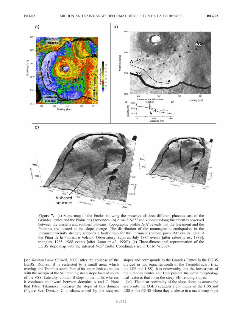
relatively flat plateaus at different elevations: 2050–2200,1750–1900, and 1900–2000 m for the western, southern,and northern plateau, respectively, which are separated bysteeper slope zones (Figure 7a). The transition between thewestern and southern plateaus consists of a N65� trendingsteep slope zone, which is associated with a subtle kilome-
Figure 4. Northwestward view of the PdF summit. The USS separates two areas of low slope values(i.e., the Piton de Fourche Plateau below and the Planeze du Baril above). GP, Grandes Pentes. The blackarrow in the insert indicates the location and the viewing direction.
B03203 MICHON AND SAINT-ANGE: DEFORMATION OF PITON DE LA FOURNAISE
6 of 19
B03203
ter-long lineament, located at the slope change (Figure 7b).It appears that this lineament is restricted to the EGBS, i.e.,it cannot be traced south of the Enclos scarp, and continuesnortheast toward the Grandes Pentes (Figure 7c). In a
volcanic setting, a lineament can have several origins: themargin of a lava flow, the trace of a lava channel or lavatube, a spatter rampart, a fluvial gully or a fault. In thepresent case, the orientation of the lineament, oblique to the
Figure 5. (a) Radial topographic profiles showing the succession of steep slopes and domains of gentleslopes. Elevation changes between each domain of gentle slopes are determined. No verticalexaggeration. T corresponds to the total elevation difference for each profile. USS, upper steep slope;LSS, lower steep slope; REP, Riviere de l’Est Plateau; PFP, Piton de Fourche Plateau. (b) North-southtopographic profile illustrating the shield morphology of PdF and its variable slope domains. Note thenearly identical elevation of both the LSS and USS on the north and south flanks.
B03203 MICHON AND SAINT-ANGE: DEFORMATION OF PITON DE LA FOURNAISE
7 of 19
B03203

general slope, and its length are difficult to explain as lavastructures or river patterns. Field observations reveal thatlong and linear extensive fractures cut several units of lavaflows of different ages at the upper break-in-slope, whichcorresponds to the location of the lineament (Figure 7b).The older the lava flows, the wider the fractures. Thedevelopment of such a fracture network is in agreementwith a continuous process of deformation. Moreover, thispart of the Enclos is characterized by recurrent tectonicearthquakes confined to the region south of the lineament[Lenat et al., 1989; Sapin et al., 1996] (Figure 7a). Wesuggest that the alignment of the extensive fractures, thelineament and the seismicity results from the activity of anormal fault (Figure 7b). We also propose that the 100-m-high offset of the Enclos floor results from tectonic activityalong this large fault during or after the EGBS formation.3.2.2. Tremblet Scarp[16] Analysis of the morphology of PdF reveals the
existence of steep slope zones both inside and outside theEGBS. The possible link between these morphologicalstructures across the Tremblet scarp in the south and acrossthe Bois Blanc scarp in the north is still unclear even thoughthe different steep slope zones are characterized by identicalslope values. The detailed analysis of the slope distributionon both sides of the Tremblet scarp provides new constrains
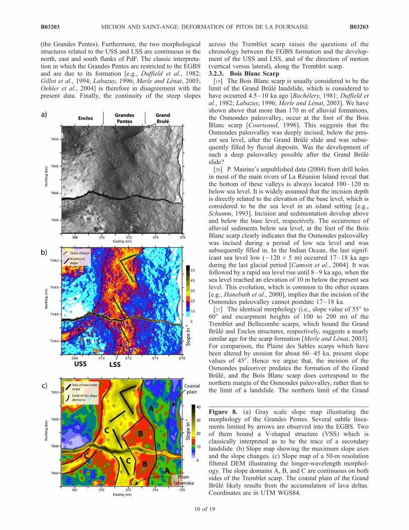
on the relationship between the morphological structuresoutside and inside the EGBS.[17] The lowest part of the Grandes Pentes is character-
ized by a V-shaped structure (VSS), which was commonlyinterpreted as the trace of a small-scale landslide that hasoccurred after the Grand Brule landslide [e.g., Bachelery,1981] (Figures 7c and 8). This structure is limited by twoNE and SE linear steep slope zones where slope valuesexceed 30� (Figure 8). The slope map suggests that anotherSE trending steep slope zone seems to be continuous southof the Tremblet scarp (Figure 8b). However, the irregularityof the topography does not allow establishing firmly thiscontinuity outside the EGBS. We calculated a 50-m low-pass-filtered DEM from the original 25-m step DEM(Figure 8c) in order to smooth the rough topography andto keep the first-order morphology. Three different slopedomains can be distinguished from this DEM: domain Awith an average slope of 10�, domain B with 14� anddomain C exceeding 18�. Geometrically, these areas arecontinuous on both sides of the Tremblet scarp. Domain Ais at low elevation. Inside the EGBS, it corresponds to theupper part of the Grand Brule. South of the Tremblet scarp,domain A is situated between the seacoast and domain B.The lowest part of the Grand Brule, which is characterizedby gentle slopes between 4� and 8� corresponds to thecoastal plain formed by the overlap of multiple lava deltas
Figure 6. Gray scale slope map representing the structures of the EGBS. Figures 7a, 7b, and 8 arelocated. Coordinates are in UTM WGS84.
B03203 MICHON AND SAINT-ANGE: DEFORMATION OF PITON DE LA FOURNAISE
8 of 19
B03203
[see Rowland and Garbeil, 2000] after the collapse of theEGBS. Domain B is restricted to a small area, whichoverlaps the Tremblet scarp. Part of its upper limit coincideswith the margin of the SE trending steep slope located southof the VSS. Laterally, domain B stops in the north, whereasit continues southward between domains A and C. Notethat Piton Takamaka increases the slope of this domain(Figure 8c). Domain C is characterized by the steepest
slopes and corresponds to the Grandes Pentes in the EGBSdivided in two branches south of the Tremblet scarp (i.e.,the LSS and USS). It is noteworthy that the lowest part ofthe Grandes Pentes and LSS present the same morpholog-ical features that form the steep SE trending slopes.[18] The clear continuity of the slope domains across the
scarp into the EGBS suggests a continuity of the USS andLSS in the EGBS where they coalesce in a main steep slope
Figure 7. (a) Slope map of the Enclos showing the presence of three different plateaus east of theGrandes Pentes and the Plaine des Osmondes. (b) A main N65� and kilometer-long lineament is observedbetween the western and southern plateaus. Topographic profile A-A0 reveals that the lineament and thefractures are located at the slope change. The distribution of the nonmagmatic earthquakes in thelineament vicinity strongly supports a fault origin for the lineament (circles, post-1997 events, data ofthe Piton de la Fournaise Volcano Observatory; squares, July 1985 events [after Lenat et al., 1989];triangles, 1985–1988 events [after Sapin et al., 1996]). (c) Three-dimensional representation of theEGBS slope map with the inferred N65� faults. Coordinates are in UTM WGS84.
B03203 MICHON AND SAINT-ANGE: DEFORMATION OF PITON DE LA FOURNAISE
9 of 19
B03203
(the Grandes Pentes). Furthermore, the two morphologicalstructures related to the USS and LSS are continuous in thenorth, east and south flanks of PdF. The classic interpreta-tion in which the Grandes Pentes are restricted to the EGBSand are due to its formation [e.g., Duffield et al., 1982;Gillot et al., 1994; Labazuy, 1996; Merle and Lenat, 2003;Oehler et al., 2004] is therefore in disagreement with thepresent data. Finally, the continuity of the steep slopes
across the Tremblet scarp raises the questions of thechronology between the EGBS formation and the develop-ment of the USS and LSS, and of the direction of motion(vertical versus lateral), along the Tremblet scarp.3.2.3. Bois Blanc Scarp[19] The Bois Blanc scarp is usually considered to be the
limit of the Grand Brule landslide, which is considered tohave occurred 4.5–10 ka ago [Bachelery, 1981; Duffield etal., 1982; Labazuy, 1996; Merle and Lenat, 2003]. We haveshown above that more than 170 m of alluvial formations,the Osmondes paleovalley, occur at the foot of the BoisBlanc scarp [Courteaud, 1996]. This suggests that theOsmondes paleovalley was deeply incised, below the pres-ent sea level, after the Grand Brule slide and was subse-quently filled by fluvial deposits. Was the development ofsuch a deep paleovalley possible after the Grand Bruleslide?[20] P. Mairine’s unpublished data (2004) from drill holes
in most of the main rivers of La Reunion Island reveal thatthe bottom of these valleys is always located 100–120 mbelow sea level. It is widely assumed that the incision depthis directly related to the elevation of the base level, which isconsidered to be the sea level in an island setting [e.g.,Schumm, 1993]. Incision and sedimentation develop aboveand below the base level, respectively. The occurrence ofalluvial sediments below sea level, at the foot of the BoisBlanc scarp clearly indicates that the Osmondes paleovalleywas incised during a period of low sea level and wassubsequently filled in. In the Indian Ocean, the last signif-icant sea level low (�120 ± 5 m) occurred 17–18 ka agoduring the last glacial period [Camoin et al., 2004]. It wasfollowed by a rapid sea level rise until 8–9 ka ago, when thesea level reached an elevation of 10 m below the present sealevel. This evolution, which is common to the other oceans[e.g., Hanebuth et al., 2000], implies that the incision of theOsmondes paleovalley cannot postdate 17–18 ka.[21] The identical morphology (i.e., slope value of 55� to
60� and escarpment heights of 100 to 200 m) of theTremblet and Bellecombe scarps, which bound the GrandBrule and Enclos structures, respectively, suggests a nearlysimilar age for the scarp formation [Merle and Lenat, 2003].For comparison, the Plaine des Sables scarps which havebeen altered by erosion for about 60–45 ka, present slopevalues of 45�. Hence we argue that, the incision of theOsmondes paleoriver predates the formation of the GrandBrule, and the Bois Blanc scarp does correspond to thenorthern margin of the Osmondes paleovalley, rather than tothe limit of a landslide. The northern limit of the Grand
Figure 8. (a) Gray scale slope map illustrating themorphology of the Grandes Pentes. Several subtle linea-ments limited by arrows are observed into the EGBS. Twoof them bound a V-shaped structure (VSS) which isclassically interpreted as to be the trace of a secondarylandslide. (b) Slope map showing the maximum slope axesand the slope changes. (c) Slope map of a 50-m resolutionfiltered DEM illustrating the longer-wavelength morphol-ogy. The slope domains A, B, and C are continuous on bothsides of the Tremblet scarp. The coastal plain of the GrandBrule likely results from the accumulation of lava deltas.Coordinates are in UTM WGS84.
B03203 MICHON AND SAINT-ANGE: DEFORMATION OF PITON DE LA FOURNAISE
10 of 19
B03203

Brule is subsequently located south of the Osmondespaleovalley axis and the Piton de Crac is a remnant partof the southern flank of the paleovalley.
4. Discussion
[22] Our study of the morphology of Piton de la Four-naise reveals the existence of two subcircumferential steepslope zones on the volcano’s north, NE, SE, and southflanks, which are locally incised by deep valleys and, whichare continuous on the east flank, into the Enclos-GrandBrule structure. In the following, we show the main impli-cations of this geometric relationship that led to the recentevolution of Piton de la Fournaise and the development ofthe EGBS.
4.1. Steep Slope-Forming Processes
[23] Basaltic shield volcanoes are commonly character-ized by a relatively flat summit zone and gentle oceanwardslopes. This classic shape results from the superposition ofthin low-viscosity lava flows the run out distances of whichvary from few hundreds of meters to several kilometers.However, steep slopes are also observed on basaltic volca-noes [e.g., Rowland and Garbeil, 2000] and several pro-cesses can explain their development.
[24] Steep slopes may result from the concentration oferuptive vents and pyroclastic cones in the summit area,leading to a differential vertical growth between the summitand the volcano flanks (Figure 9) [Rowland and Garbeil,2000]. The differential vertical growth may also originatefrom the development of small-size lava flows related toconcentric summit vents [Naumann and Geist, 2000]. Thesetwo constructional processes lead to the formation of steepconvex-outward slopes like at Cerro Azul, Wolf and Fer-nandina volcanoes, western Galapagos [Rowland andGarbeil, 2000; Naumann and Geist, 2000]. Endogenousgrowth through recurrent dike intrusion [e.g., Annen et al.,2001], the growth of cryptodomes [Donnadieu and Merle,2001] and an overpressurized magmatic chamber [Cullenet al., 1987] are possible processes, which induce theformation of steep slopes on the summit or the flanks ofthe volcano. For dike intrusions, the resulting slope geom-etry ranges from elongated slopes along-strike of a rift zoneto an isotropic slope distribution restricted to the summit[Rowland and Garbeil, 2000; Annen et al., 2001]. Thegrowth of a cryptodome leads to an asymmetric deformationand the development of concave- and convex-outward steepslopes [Donnadieu and Merle, 2001].[25] Destruction processes such as erosion and landslides
can also form steep slopes (Figure 10). Erosion is respon-sible for valleys the development of which can be controlled
Figure 9. Construction processes able to develop steep slopes in basalt shield volcanoes.
B03203 MICHON AND SAINT-ANGE: DEFORMATION OF PITON DE LA FOURNAISE
11 of 19
B03203

by preexisting faults or structural limits such as calderawalls [Stearns and MacDonald, 1946; Bachelery, 1981].Small-size and large-scale landslides also produce steepslopes on the volcano flanks presenting a concave-ocean-ward geometry [Moore, 1964; Bachelery, 1981; Oehler etal., 2004].[26] Deformation processes have a strong influence on the
volcano morphology (Figure 11). An edifice may deformabove a basal layer composed of low-strength sediments,ultramafic cumulates or intrusive complexes [e.g., Borgia etal., 1990; Borgia, 1994]. Circumferential thrust-fault-related
steep slopes develop at the base of the edifice and normalfaults accommodate the spreading motion [Merle and Borgia,1996]. The lack of any deformation within the pelagicsediments below the submarine flanks and of any distalanticline, even several tens of kilometers away from thevolcano suggests that this process did not occur at LaReunion [Michon et al., 2007]. A hydrothermally alteredinterior of a volcano may also act as a decollement level. Asshown by Cecchi et al. [2005], the sagging of the volcano’ssummit part results in the upward lateral extrusion of thealtered interior. The resulting morphology presents circum-
Figure 10. Destruction processes able to develop steep slopes in basalt shield volcanoes.
Figure 11. Deformation processes able to develop steep slopes in basalt shield volcanoes.
B03203 MICHON AND SAINT-ANGE: DEFORMATION OF PITON DE LA FOURNAISE
12 of 19
B03203

ferential steep slopes that are locally associated with thrustfaults (Figure 11). Finally, slumping units above a localdecollement level are bounded upward by normal faults,which also form steep slopes on the volcano flanks [Stearnsand Clark, 1930; Moore and Krivoy, 1964; Merle andLenat, 2003]. Steep slopes related to thrust faults presenta convex-outward shape whereas concave-outward steepslopes are attributed to normal faults.[27] In summary, circumferential steep slopes like those
observed at PdF can only result from either constructionprocesses or spreading processes, and not through erosion.
4.2. Caldera-Forming Processes
[28] Several mechanisms may lead to the development ofcircular to elliptical, and horseshoe-shaped calderas. Theirgeometry and size depend on the mechanisms encountered.On volcanoes other than basaltic shields, the developmentof large calderas is attributed to the collapse of the chamberroof during large explosive eruptions [e.g., Lipman, 1997;Roche et al., 2000]. In that context, the size of the caldera isdependent on the volume of the erupted magma. On basalticshield volcanoes, large calderas with diameters rangingfrom 5 to 20 km may also develop [MacDonald, 1965;Bachelery, 1981; Munro and Rowland, 1996]. However,they usually lack of significant related pyroclastic depositssuggesting nonexplosive or minor explosive mechanisms toexplain their development [e.g., MacDonald, 1972; Munroand Rowland, 1996]. In Hawaii, the caldera of Kilauea isinterpreted as resulting from either the coalescence ofseveral pit craters [MacDonald, 1965], a main collapserelated to the lateral magma withdrawal during the largelateral eruption of 1790 [MacPhie et al., 1990] or from theload of a cumulate complex at the base of the magmachamber [Walker, 1988]. In the western Galapagos, thecombined effect of magma withdrawal and the load ofcumulative bodies is considered to be responsible for thedevelopment of the large and deep calderas [Munro andRowland, 1996]. Recently, Cecchi et al. [2005] showed thatthe deformation of the hydrothermal system, which isobviously larger that the magmatic reservoir may lead tothe collapse of large calderas. It is important to note thatwhatever the model, the collapse of the volcano’s summit isrelated to the active magmatic system.[29] Horseshoe-shaped calderas are relatively common on
island volcanoes like Fogo, El Hierro, Tenerife, and LaReunion islands. Their geometry is characterized by a flatsummit zone and a large depression bounded by regularscarps that link the summit depression to the sea coast. Thefrequent occurrence of debris avalanche deposits on thesubmarine flanks suggests that their formation is due todestabilizations and subsequent landslides. Several modelshave been proposed to explain their origin. They can resultfrom a single large landslide that affects both the volcanoflank and the summit [Duffield et al., 1982; Labazuy, 1996;Cantagrel et al., 1999; Day et al., 1999]. Hurlimann et al.[1999] proposed that the collapse of the summit was able todestabilize the volcano flank, leading to flank landslide.Merle and Lenat [2003] recently showed with analogmodels that the slide of a volcano flank may trigger a lateralflow in the hydrothermal system, which leads to thedevelopment of a large caldera in the summit area. They
applied this model to PdF in order to explain the develop-ment of the EGBS.
4.3. Origin of the Steep Slopes and the EGBS
[30] One of the main observations made in the presentstudy is the apparent continuity of the different slopedomains across the Tremblet scarp into the EGBS withoutany visible lateral offset (Figure 7). Such a continuitysuggests that the steep slopes and the EGBS are indepen-dent structures. We have used the geometry of both struc-tures and their intersection to determine their temporalrelationship and origin.4.3.1. Age and Origin of the LSS and USS[31] We put forward two hypotheses to explain the
continuity of the slope domains on both sides of theTremblet scarp:[32] Hypothesis 1 is that the development of the LSS and
USS post-dates the formation of the EGBS the lower part ofwhich (i.e., the Grand Brule) has previously been consid-ered as the trace of a landslide. Assuming that the EGBSformed 4.5 to 10 ka ago, the steep slopes developed quiterapidly. We showed that circumferential steep slopes resultfrom two different processes: differential growth (construc-tion process) or spreading (deformation process).[33] Differential growth is highly unlikely for the follow-
ing reasons. (1) In contrast to the volcanoes of westernGalapagos, no concentric eruptive vents are found above theUSS and LSS. (2) There is no concentration of pyroclasticcones in the two areas delimited by the steep slopes. (3) Thelength of lava flows is not constant and varies fromhundreds of meters to several kilometers, making the lavaflow accumulation hypothesis unrealistic. (4) Finally, 97%of the post-EGBS volcanic activity has been restricted to theEnclos. The total elevation changes along each topographicprofile (T value in Figure 5a), which would reveal thedifferential growth should not be similar outside and insidethe EGBS.[34] Spreading is the second process capable of the
development of circumferential steep slopes. If the eleva-tion changes related to the LSS and USS are related todeformation, the total deformation is a combination ofoutward lateral and upward displacements. Consideringthe upward motion only, which corresponds to the elevationchange measured for each profile, minimum displacementrates of 2 to 4 cm/a and 2.5 to 5 cm/a are calculated for theUSS and LSS and are inferred for a deformation starting at10 and 5 ka, respectively. These values are similar to thetotal deformation rates measured for the very active spread-ing at Kilauea where large earthquakes occurred [Delaneyet al., 1998]. At PdF the lack of seismicity in the vicinity ofthe steep slopes is in disagreement with a very activedeformation. Moreover, geodetic data acquired outside theEGBS in the flat summit zone do not show any displace-ment [Briole et al., 1998]. Consequently, the developmentof the LSS and USS due to spreading does not agree withthe available data.[35] Hypothesis 2 is that the development of the LSS and
USS predates the formation of the EGBS and does not resultfrom a large deeply rooted landslide. It seems unrealisticthat a superficial landslide occurred on a decollement levelpresenting a topography characterized by similar slopedomains than outside the EGBS. The exact motion along
B03203 MICHON AND SAINT-ANGE: DEFORMATION OF PITON DE LA FOURNAISE
13 of 19
B03203

the lateral scarps and subsequently of the Grand Brulecannot be determined precisely. However, only a predom-inantly vertical collapse is possible. Hence the formation ofthe EGBS results from a vertical to subvertical collapserather than a giant landslide. Such a motion could explainthe lack of clear continuity between subaerial and subma-rine structures [Oehler, 2005] (Figure 1b) in contrast towhat is observed at large landslide deposits [e.g., Le Friantet al., 2004; Tibaldi, 2001]. The preservation of the slopedomains inside the EGBS would be explained by a lowamount of overlapping lava flows in the Grandes Pentes andthe Grand Brule since the collapse. Such a hypothesis issupported by the map of the historical lava flows, whichshows that most of the lava flows are restricted to the upperpart of the EGBS (i.e., the Enclos) and only few flows occurin the Grande Pentes [Stieltjes et al., 1986].[36] As for hypothesis 1, construction and deformation
processes might form circumferential steep slopes. Weshowed above that construction processes like those pro-posed by Naumann and Geist [2000] and Rowland andGarbeil [2000] cannot be applied to PdF. The eruptive ventsare not concentrically distributed above the LSS and USS,and the lava flow length strongly varies.[37] In contrast, spreading may have occurred. The pre-
EGBS edifice built up after the Plaine des Sables collapseabout 60–45 ka ago. According to this potential onset ofdeformation, and given the elevation changes, expecteddeformation rates are of few millimeters per year. Volcanoesmight spread under gravity if a low-strength body/layerexists at the base of the edifice, and if the load of the edificeacting on the low-strength material is high enough. Twodifferent modes of spreading lead to the development ofcircumferential steep slopes. On the one hand, the spreadingcan be related to the deformation of a basal low-strengthlayer [e.g., Merle and Borgia, 1996; Oehler et al., 2005]. Insuch a case, the steep slopes are located at the base of theedifice and radial normal faults develop. On the other hand,the spreading is induced by an internal low-strength layer orbody [e.g., Cecchi et al., 2005]. The resulting steep slopesare on the volcano flanks and normal faults are circumfer-ential. At PdF, the exact topography of the pre-EGBSvolcano cannot be firmly determined. Nevertheless, themorphology and the slope adjacent to the Enclos depres-sion, which are preserved from the pre-EGBS period, andthe shape of the active cone, allows estimating a pre-EGBScollapse topography of around 3000 m located at the placeof the present active cone. The location of the circumfer-ential LSS and USS on the volcano flanks supports thepresence of an internal low-strength body rather than a basaldecollement. In conclusion, we propose that the LSS andUSS do result from neither construction processes nor abasal spreading, but from the deformation of the weakinternal part of the volcano under gravity (Figure 12).[38] The nature and geometry of the weak core are
unknown. According to geoelectrical data acquired in theEnclos, the Plaines de Sables, and the Planeze du Baril[Benderitter, 1990; Courteaud, 1996; Lenat et al., 2000],PdF is characterized by a deep widespread low-resistivitybody which could correspond to the top of the hydrothermalsystem of the pre- EGBS volcano. The lack of hot springs[Coudray et al., 1990] in the adjacent deep valleys andfumaroles would suggest that this hydrothermal system is
no longer active. Nevertheless, these characteristics are notconclusive against the active hydrothermal system as de-spite a current intense volcanic activity and a large hydro-thermal system [Lenat et al., 2000], PdF presents only veryfew fumaroles restricted to the summit pit crater and no hotsprings at all. It is subsequently hard to determine whetherspreading is still active, but we suggest that the deformationstopped when the Enclos collapsed 4.5 ka ago. Indeed, thesummit of the volcano, which was acting on the hydrother-mal body was dismantled. The lack of steep slope on thewest part of PdF could suggest that the remnant part of the‘‘ancient’’ Fournaise blocked the deformation in the west.[39] Contrary to the experiments of Cecchi et al. [2005]
in which only one circumferential steep slope zone isdescribed, two steep slope zones developed at PdF. Sucha vertical complexity in the steep slope geometry alsooccurs on other volcanoes where several bulges are visible(e.g., Etna, Arenal [Cecchi et al., 2005]). This can beexplained by the complexity of the hydrothermal systemcompared to the simplified models. For instance, intra-edifice preexisting discontinuities might induce a deforma-tion partitioning and subsequently several steep slope levels.Laterally the steep slope geometry can also be influenced bythe rift zones along which recurrent magma intrusionsdecrease the strength of the rocks by hydrothermal alter-ation. Such a lateral variation could explain the NE and SElobes of the LSS along the NE and SE rift zones, respec-tively. This indicates that the current rift zones have beeninherited from the pre-Enclos volcano.4.3.2. Origin of the EGBS[40] Usually, vertical collapses are restricted to the area of
the magmatic system (i.e., summit and rift zones). At PdF,besides the summit zone, the eastern flank also suffered avertical collapse. Given the geomorphological and geolog-ical continuity between the Enclos and the Grand Brule(identical scarps slope and continuous faults in the EGBS),we propose that the collapse of the Enclos was associated tothat of the Grand Brule. Although large lateral eruptionsalready caused the development of summit calderas onbasaltic and andesitic volcanoes [e.g., MacPhie et al.,1990; Kaneko et al., 2005], the collapse of the Grand Brule,several kilometers away from any active magmatic system,is unlikely related to magmatic withdrawal. The verticalcollapse of the EGBS might also be triggered by a deeplyrooted slump in which the displacements in the upper part(close to the upper normal fault) can be predominantlyvertical whereas they evolve to lateral away from the fault(above the low dipping decollement). Assuming a maxi-mum depth of the decollement at the top of the oceanic crust(6 km below sea level (bsl) [de Voogd et al., 1999]) and theBellecombe scarp as the trace of the upper normal fault, thevertical motion would be restricted to the few first kilo-meters only, i.e., west of the Grandes Pentes, and notextended to the overall EGBS.[41] We showed that the Grand Brule was located above
the large intrusive complex of the Alizes volcano, the ageof which is considered as to be older than 0.78 Ma [Lenatet al., 2001]. This complex was drilled between 950 and2850 m bsl, end of the drilling. It is composed of gabbros inthe 1400 upper meters and dunites and wehrlite dunitesbelow [Rancon et al., 1989]. Gravimetric data suggestthat the complex continues down to at least 4 km bsl
B03203 MICHON AND SAINT-ANGE: DEFORMATION OF PITON DE LA FOURNAISE
14 of 19
B03203

[Malengreau et al., 1999]. Such a body may have twodifferent implications in the evolution of PdF:[42] 1. It has been shown that olivine cumulates at high
temperature (>1100�C) may deform as ice [Clague andDenlinger, 1994]. The Alizes cumulative complex couldhave deformed under gravitational forces and subsequentlyinduced the vertical collapse of the Grand Brule. However,as the drilling project aimed at determining the geothermalpotential of the intrusive complex, it has been shown thatthe present temperature of the complex was far from hot(142�C at 3003.5 m below the surface [Rancon et al.,1989]). Even if the 4.5 ka ago temperature cannot be firmlydetermined, analysis of secondary minerals within thegabbro and dunite reveals a progressive cooling of thecomplex from late magmatic biotite crystallization at600–900�C to serpentine crystallization at 350�C maximum[Lerebour et al., 1989]. Hence it is strongly unlikely that theolivine cumulates of the Alizes intrusive complex deformedin the recent times and triggered the collapse of the GrandBrule 4.5 ka ago.[43] 2. Walker [1988] proposed that dense bodies, such as
cumulates are able to trigger a downward drag and thecollapse of the summit. Such a mechanism has beenproposed as a source of subsidence to explain the develop-ment of the large calderas of the volcanoes of westernGalapagos [Munro and Rowland, 1996]. Considering thepresence of the large intrusive complex of the Alizesvolcano, we hypothesize that the vertical collapse of theGrand Brule would correspond to a discrete event (i.e.,collapse of 100–150 m of a 7-km-wide area) simultaneouslyto the long-term downward motion of this dense body. Thismodel differs from Walker [1988] as the dense body isrelated to an ancient volcano (i.e., the Alizes) rather than anactive volcano. The occurrence of the vertical collapse ofthe Grand Brule potentially destabilized the adjacent sub-marine flank and initiated debris avalanches which depositscould correspond to the youngest unit described by Oehler[2005].[44] The Enclos caldera was interpreted in different ways:
(1) an independent structure resulting from successivesyneruptive collapses [Bachelery, 1981]; (2) the upper part
of the scar of a large flank landslide [Duffield et al., 1982;Labazuy, 1991; Gillot et al., 1994]; and (3) a summitdeformation initiated by the slide of the Grand Brule [Merleand Lenat, 2003]. Although the occurrence of pyroclasticdeposits around the Enclos indicates that the collapse wassimultaneous to an explosive eruption [Abchir et al., 1998],the volume of the deposit (around 0.5–1 km3 [Abchir et al.,1998]) is 1 order of magnitude lower than that of the Encloscaldera. This volume difference and the lack of any evi-dence of large submarine eruption suggest that the collapseof the Enclos does not result from the emptying of themagmatic reservoir. It has been recently proposed that thecollapse of the Enclos has been caused by the lateral flow ofthe large summit hydrothermal system [Merle and Lenat,2003]. This model, which can explain the collapse of a largestructure without the same erupted volume faces one mainproblem. According to Merle and Lenat [2003], the defor-mation of the hydrothermal system was made possible bythe lateral slide of the Grand Brule only, which headwallcorresponds to the Grandes Pentes. Our data stronglysuggest that this slide did not occur 4.5 ka ago and thatthe Grandes Pentes (domain C in Figure 8) are not restrictedto the EGBS. Hence the deformation as the authors pro-posed cannot be applied to PdF. However, we follow Merleand Lenat [2003] on two points: (1) the deformation of theGrand Brule and the Enclos are linked and (2) the Enclosmay result from the deformation of the summit hydrother-mal system.[45] Taking into account our results, we propose two
distinct evolutions in which a first collapse initiated thesecond one. On the one hand, the collapse of the EGBS wasinitiated by the vertical collapse of the Grand Brule, due tothe continuous downward drag of the Alizes intrusivecomplex. This event allowed the deformation of the hydro-thermal system of the pre-Enclos volcano and subsequentlythe collapse of the summit zone. On the other hand, thecollapse of the Enclos results from the deformation of thesummit hydrothermal system under gravity, which also ledto the development of the LSS and USS. This hypothesis issupported by analog models, which show that the spreadingof a volcano related to a weak internal core entails the
Figure 12. N-S cross section of PdF illustrating the potential origin of the upper and lowercircumferential steep slopes by the spreading of the edifice above a weak hydrothermal core.
B03203 MICHON AND SAINT-ANGE: DEFORMATION OF PITON DE LA FOURNAISE
15 of 19
B03203
coeval development of circumferential steep slopes on thevolcano flanks and the vertical collapse of the summit zone[Cecchi et al., 2005]. We propose that this event may havedestabilized part of the eastern flank of PdF, which wascontinuously affected by a downward drag. The relationshipbetween summit collapse and flank deformation has alreadybeen suggested for Tenerife [Marti et al., 1997; Hurlimannet al., 1999]. However, contrary to what geological datashow for PdF, the summit collapse triggered a flank land-slide at Tenerife.
4.4. Evolution of PdF During the Last 150 ka
[46] Considering the geological data and the interpreta-tions presented above, we propose the following chronologyfor the last 150 ka of PdF. This date corresponds to thecollapse of the Morne Langevin caldera [Bachelery andMairine, 1990]. According to Oehler [2005], this eventcorresponds to the first and most voluminous eastwarddestabilization of PdF, which spread over the EasternPlateau. Afterward, the ‘‘recent’’ PdF (<150 ka) built upat a location west of the present active cone [Bachelery andMairine, 1990]. This edifice the shape and evolution ofwhich are unknown suffered recurrent collapses between60 and 45 ka, forming the Plaine des Sables calderas.Although the origin of the upper part of this caldera is stilluncertain (vertical [Bachelery and Mairine, 1990] versuslateral [Duffield et al., 1982; Gillot et al., 1994; Oehler etal., 2004]), the debris avalanche deposits on the submarineEastern Plateau indicate that the collapses were coeval to atleast one major landslide [Labazuy, 1996; Oehler, 2005]. Itis noteworthy that the northern limit of the landslide scar(the Ravine Ferdinand [Merle and Lenat, 2003]) is the onlywell-observed structure which is really continue in both thesubaerial and submarine domains (Figure 1b).[47] The pre-Enclos edifice built up at a location close to
the present active cone. This volcano progressively spreadabove its weak hydrothermal core. The geometry of thislow-strength body was likely controlled by preexistingstructures such as the decollement level of previous slides,the magma chambers and the intrusion complexes. Twocircumferential steep slopes (i.e., the LSS and USS) resultfrom this deformation (Figure 13a). At the same time, thevolcano was incised by deep valleys, among which is theOsmondes paleovalley in the east flank. The presence ofthe Osmondes paleovalley in the northern part of the EGBS,whose minimum age is of 18–19 ka clearly indicates thatPdF did not subsequently suffered the slide of the GrandBrule as it was usually proposed. Around 4.5 ka ago, boththe summit and east flank were cut by a vertical collapsethat led to the development of the west and south parts ofthe EGBS; the present northern limit of EGBS consisting ofthe Osmondes paleovalley’s northern flank (Figure 13b).This collapse event likely destabilized part of the coastalzone and the eastern submarine flank. The related debrisavalanche covered the proximal Eastern Plateau as revealedby the age of a dredged sample (12 ka [Labazuy, 1996])(Figure 1b) and flowed through the Chenal Vincent down tothe Rale Pousse [Labazuy, 1996; Oehler, 2005]. The coastaland submarine origin of the debris avalanche could explainthe absence of clear continuity between the subaerial andsubmarine domains. Similar or larger submarine destabili-zations occurred during the recent evolution of PdF. How-
ever, their importance was underestimated until recently.According to Oehler [2005], their deposits cover aroundhalf of the surface of the submarine flanks.[48] The lack of lava flows intercalated in the alluvial
sediments of the Osmondes paleoriver could suggest theexistence of a relief between the eruption zone and thevalley. This barrier disappeared when the Plaine desOsmondes collapsed (Figure 13c). Even though the age ofthis event is unknown, a vertical mode of deformation canbe reasonably inferred. Indeed, the width of the lowest partof the Plaine des Osmondes (i.e., between the Piton de Cracand the Bois Blanc scarp) is more than twice lower than atits maximum width. Such a geometry disagrees with theclassic landslide scar. After the collapse of the Plaine desOsmondes, the lava flowed through the Osmondes paleo-valley and completely counterbalanced the erosion processthat developed since tens of thousands of years ago.[49] One of the most striking features of this 150 ka
lasting evolution is the persistence of the NE and SE riftzones, despite the recurrent collapses and landslides, and theeastward migration of the eruptive center. This contrastswith the general observations made on other volcanoes,where flank destabilizations or large changes of the topog-raphy induce a reorganization of the rift zones [Tibaldi,2003; Walter and Troll, 2003; Acocella and Tibaldi, 2005].The persistence of both rift zones, which contributed toform the NE and SE submarine plateaus (Figure 1), suggeststhat their location and development are controlled by deepsources. Walter et al. [2006] proposed that the NE and SErift zones results from the intermittent eastward spreading ofPdF. However, the undeformed marine sedimentation eastof the island [de Voogd et al., 1999] and the lack of anticlinestructures in the bathymetry [Oehler et al., 2005] suggestthat PdF did not experience such a deformation.[50] In what follows we put forward two different fea-
tures, which could have played a key role in the develop-ment of the stable rift zones:[51] 1. It has been recently shown that the main structures
of La Reunion volcanoes are parallel to the oceanic litho-spheric structures, suggesting a control of the crustal dis-continuities in the tectonomagmatic evolution [Michon etal., 2007]. The persistence of both rift zones could thenresult from a control of the crustal structures.[52] 2. The lower part of the NE and SE rift zones, the
submarine parts included, are located north and south of theAlizes intrusive complex, respectively. Assuming that acontinuous downward drag related to a dense body entailsa diffuse extension in its vicinity, we hypothesize that thedike lateral migration in the NE and SE flanks of PdF wascontrolled by this stress field. In a certain way, this modelpresents similarities with that of Walter et al. [2005] inwhich the gravity-driven flank movement leads to a radialadjacent extension controlling the magma lateral migrationand the development of two concentric curved rift zones.Whatever the model, the rarity of the eruptions along the riftzone lower parts, i.e., outside the Enclos caldera (only 3%of the eruptions since the 18th century [Villeneuve, 2000])and their fan-shaped geometry suggest the existence of adiffuse stress field, which does not efficiently favor themagma lateral migration on the flanks. Despite the slightlateral propagation of the magma intrusions along the riftzones, the combined effect of the summit frequent intrusion
B03203 MICHON AND SAINT-ANGE: DEFORMATION OF PITON DE LA FOURNAISE
16 of 19
B03203
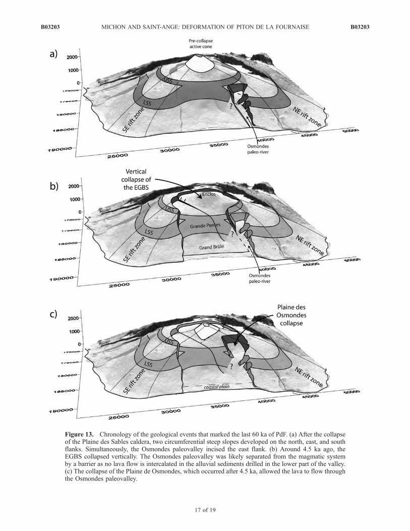
Figure 13. Chronology of the geological events that marked the last 60 ka of PdF. (a) After the collapseof the Plaine des Sables caldera, two circumferential steep slopes developed on the north, east, and southflanks. Simultaneously, the Osmondes paleovalley incised the east flank. (b) Around 4.5 ka ago, theEGBS collapsed vertically. The Osmondes paleovalley was likely separated from the magmatic systemby a barrier as no lava flow is intercalated in the alluvial sediments drilled in the lower part of the valley.(c) The collapse of the Plaine de Osmondes, which occurred after 4.5 ka, allowed the lava to flow throughthe Osmondes paleovalley.
B03203 MICHON AND SAINT-ANGE: DEFORMATION OF PITON DE LA FOURNAISE
17 of 19
B03203
and the very likely existence of a decollement level withinthe edifice (the top of the Alizes volcano) potentiallyfavored the large eastward destabilizations, which occurredbetween 45 and 60 ka.
5. Conclusions
[53] Our study of PdF aimed at the understanding of thepresent-day edifice morphology, which recorded the mostrecent geological events. The analysis was focused on thesteep slope zones located on the volcano flanks and theEnclos-Grand Brule structure, which cut the upper part andeastern flank of the edifice. We took into account thedifferent available geological data and tested them againstthe potential processes, which may form both structures. Wepresented new results allowing a reappraisal of the recentevolution of Piton de la Fournaise.[54] 1. The steep slope zones were previously interpreted
as slide headwalls and/or caldera margins [e.g., Bachelery,1981; Oehler et al., 2004]. However, their distribution andmorphological characteristics suggest that they form twoindependent circumferential structures (the USS and LSS),which coalesce in the east flank. Their development isinterpreted as resulting from the spreading of the pre-Enclosvolcano above a weak hydrothermal core.[55] 2. The Enclos-Grand Brule structure (a U-shaped
structure) is formed by the Enclos depression, the GrandesPentes, and the Grand Brule. Although the Enclos originwas a matter of great debate during the last decades (verticalversus lateral collapse), there had been a general agreementon a sliding origin of the Grand Brule [Bachelery, 1981;Duffield et al., 1982; Gillot et al., 1994; Labazuy, 1996;Merle and Lenat, 2003; Oehler et al., 2004]. However, ouranalysis of the continuity of different slope domains insideand outside the EGBS suggests that the Grand Brule resultsfrom a mainly vertical collapse instead of a giant landslide.The entire EGBS subsequently underwent a vertical col-lapse �4.5 ka ago. Among different potential sources forthe collapse of the Grand Brule, we prefer the continuousdownward drag induced by the dense intrusive complex ofthe Alizes volcano. Following Merle and Lenat [2003], wepropose that the collapse of the Enclos was caused by thedeformation of the hydrothermal system of the pre-Enclosvolcano. Despite the clear continuity between the Enclosand the Grand Brule, which suggests a close relationship inthe development of both structures, their chronology andexact links remain poorly understood.
[56] Acknowledgments. The authors want to thank Scott Rowland,Laszlo Keszthelyi, Jim Kauahikaua, Jurgen Neuberg, and the AssociateEditor Susan Sakimoto, whose comments considerably improved an earlierversion of the paper. Thanks are also given to Jean-Francois Lenat, OlivierMerle, and Philippe Labazuy for the stimulating discussion about Piton dela Fournaise. This work was partly funded by the BQR 2004 of theUniversity of La Reunion provided to L.M. This is IPGP contribution 2299.
ReferencesAbchir, M. A., S. M. Semet, G. Boudon, P. Ildefonse, P. Bachelery, andR. Clocchiati (1998), Huge hydrothermal explosive activity on Piton de laFournaise, Reunion Island: The Bellecombe ash member, 2700 BC, inVolcanic Risk—The European Laboratory Volcanoes, Publ. EUR 18161EN, edited by R. Casal et al., pp. 447–455, Eur. Comm., Brussels.
Acocella, V., and A. Tibaldi (2005), Dike propagation driven by volcanocollapse: A general model tested at Stromboli, Italy, Geophys. Res. Lett.,32, L08308, doi:10.1029/2004GL022248.
Annen, C., J.-F. Lenat, and A. Provost (2001), The long-term growth ofvolcanic edifices: Numerical modelling of the role of dyke intrusion andlava-flow emplacement, J. Volcanol. Geotherm. Res., 105, 263–289.
Bachelery, P. (1981), Le Piton de la Fournaise (Ile de la Reunion). Etudevolcanologique, structurale et petrologique, Ph.D. thesis, 215 pp., Univ.Clermont-Ferrand II, Clermont-Ferrand, France.
Bachelery, P. and P. Mairine (1990), Evolution volcano-structurale du Pitonde la Fournaise depuis 0.53 Ma, in Le Volcanisme de la Reunion, Mono-graphie, edited by J.-F. Lenat, pp. 213–242, Cent. de Rech. Volcanol.,Clermont-Ferrand, France.
Bachelery, P., B. Robineau, M. Courteaud, and C. Savin (2003), Avalanchesde debris sur le flanc occidental du volcan-bouclier Piton des Neiges(Reunion), Bull. Soc. Geol. Fr., 174, 125–140.
Benderitter, Y. (1990), Etudes geoelectriques et electromagnetiques a laReunion, in Le Volcanisme de la Reunion, Monographie, edited by J.-F.Lenat, pp. 29–42, Cent. de Rech. Volcanol., Clermont-Ferrand, France.
Borgia, A. (1994), Dynamic basis of volcanic spreading, J. Geophys. Res.,99, 17,791–17,804.
Borgia, A., J. Burr, W. Montero, L. D. Morales, and G. E. Alvarado (1990),Fault propagation folds induced by gravitational failure and slumping ofthe Central Costa Rica Volcanic Range: Implications for large terrestrialand Martian volcanic edifices, J. Geophys. Res., 95, 14,357–14,382.
Briole, P., P. Bachelery, B. McGuire, J. Moss., J. C. Ruegg, and P. Sabourault(1998), Deformation at Piton de la Fournaise: Evolution of the monitoringtechniques and knowledge acquired in the last five years, in VolcanicRisk—The European Laboratory Volcanoes, Publ. EUR 18161 EN, editedby R. Casal et al., pp. 467–474, Eur. Comm., Brussels.
Camoin, G. F., L. F. Montaggioni, and C. J. R. Braithwite (2004), Lateglacial to post glacial sea levels in the western Indian Ocean, Mar. Geol.,206, 119–146.
Cantagrel, J. M., N. O. Arnaud, E. Ancochea, J. M. Fuster, and M. J. Huertas(1999), Repeated debris avalanches on Tenerife and genesis of LasCanadas caldera wall (Canary Islands), Geology, 27, 739–742.
Cecchi, E., B. van Wyk de Vries, and J. M. Lavest (2005), Flank spreadingand collapse of weak-cored volcanoes, Bull. Volcanol., 67, 72 –91,doi:10.1007/s00445-004-0369-3.
Clague, D. A., and R. P. Denlinger (1994), Role of olivine cumulates indestabilizing the flanks of Hawaiian volcanoes, Bull. Volcanol., 56,425–434, doi:10.1007/s004450050052.
Coudray, J., P. Mairine, E. Nicolini, and J. M. Clerc (1990), Approcheshydrogeologique, in Volcanic Risk—The European Laboratory Volca-noes, Publ. EUR 18161 EN, edited by R. Casal et al., pp. 307–355,Eur. Comm., Brussels.
Courteaud, M. (1996), Etude des structures geologiques et hydrogeologi-ques du Massif de la Fournaise par la methode audiomagnetotellurique,Ph.D. thesis, 212 pp., Univ. Reunion, Saint Denis, France.
Cullen, A., A. R. MacBirney, and R. D. Rodgers (1987), Structural controlson the morphology of Galapagos shields, J. Volcanol. Geotherm. Res.,34, 143–151.
Day, S. J., S. I. N. Heleno da Silva, and J. F. B. D. Fonseca (1999), A pastgiant lateral collapse and present-day flank instability of Fogo, CapeVerde Islands, J. Volcanol. Geotherm. Res., 94, 191–218.
Delaney, P. T., R. P. Denlinger, M. Lisowski, A. Miklius, P. G. Okubo,A. T. Okamura, and M. K. Sako (1998), Volcanic spreading at Kilauea,1976–1996, J. Geophys. Res., 103, 18,003–18,023.
Deniel, C., G. Kieffer, and J. Lecointre (1992), New 230Th and 238U and14C age determinations from Piton des Neiges volcano, Reunion. Arevised chronology for the differentiated series, J. Volcanol. Geotherm.Res., 51, 253–267.
de Voogd, B., S. Pou Palome, A. Hirn, P. Charvis, J. Gallart, D. Rousset,J. Danobeitia, and H. Perroud (1999), Vertical movements and materialtransport during hotspot activity: seismic reflection profiling offshore LaReunion, J. Geophys. Res., 104, 2855–2874.
Donnadieu, F., and O. Merle (2001), Geometrical constraints of the 1980Mount St. Helens intrusion from analogue models, Geophys. Res. Lett.,28, 639–642.
Duffield, W. A., L. Stieltjes, and J. Varet (1982), Huge landslide blocks inthe growth of Piton de la Fournaise, La Reunion, and Kilauea Volcano,Hawaii, J. Volcanol. Geotherm. Res., 12, 147–160.
Gillot, P.-Y., and P. E. Nativel (1989), Eruptive history of the Piton de laFournaise Volcano, Reunion Island, Indian Ocean, J. Volcanol.Geotherm. Res., 36, 53–65.
Gillot, P.-Y., J.-C. Lefevre, and P. E. Nativel (1994), Model for the structuralevolution of the volcanoes of Reunion island, Earth Planet. Sci. Lett., 122,291–302.
Hanebuth, T., K. Statteger, and P. M. Grootes (2000), Rapid flooding of theSunda Shelf: A late glacial sea level record, Science, 288, 1033–1035.
Hurlimann, M., E. Turon, and J. Marti (1999), Large landslides triggered bycaldera collapse events in Tenerife, Canary Islands, Phys. Chem. Earth A,24, 921–924.
B03203 MICHON AND SAINT-ANGE: DEFORMATION OF PITON DE LA FOURNAISE
18 of 19
B03203

Hurlimann, M., J. Marti, and A. Ledesma (2004), Morphological and geo-logical aspects related to large slope failures on oceanic islands: The hugeLa Orotava landslides on Tenerife, Canary Islands, Geomorphology, 62,143–158.
Kaneko, T., A. Yasuda, T. Shimano, S. Nakada, T. Fujii, T. Kanazawa,A. Nishizawa, and Y. Matsumoto (2005), Submarine flank eruption preced-ing caldera subsidence during the 2000 eruption of Miyakejima Volcano,Japan, Bull. Volcanol., 67, 243–253, doi:10.1007/s00445-004-0407-1.
Labazuy, P. (1991), Instabilites au cours de l’evolution d’un edifice volca-nique en domaine oceanique: Le Piton de la Fournaise (ıcirc;le de laReunion), Ph.D. thesis, 252 pp., Univ. Clermont Ferrand II, ClermontFerrand, France.
Labazuy, P. (1996), Recurrent landslides events on the submarine flank ofPiton de la Fournaise volcano (Reunion Island), in Volcano Instabilityon the Earth and Other Planets, edited by W. J. McGuire, A. P. Jones,and J. Neuberg, Geol. Soc. Spec. Publ., 110, 293–305.
Le Friant, A., C. L. Harford, C. Deplus, G. Boudon, R. S. J. Sparks,R. A. Herd, and J. C. Komorowski (2004), Geomorphological evolutionof Montserrat (West Indies): Importance of flank collapse and erosionalprocesses, J. Geol. Soc., 161, 147–160.
Lenat, J.-F. and P. Bachelery (1987), Dynamics of magma transfer at Pitonde la Fournaise volcano (Reunion Island, Indian Ocean), in Modeling ofVolcanic Processes, edited by C.-Y. King and R. Scarpa, pp. 57–72,F. Vieweg, Brauschweig, Germany.
Lenat, J.-F., P. Bachelery, A. Bonneville, and A. Hirn (1989), The beginningof the 1985–1987 eruptive cycle at Piton de la Fournaise (la Reunion):New insights in the magmatic and volcano-tectonic systems, J. Volcanol.Geotherm. Res., 36, 209–232.
Lenat, J.-F., D. Fitterman, D. B. Jackson, and P. Labazuy (2000), Geoelec-trical structure of the central zone of Piton de la Fournaise volcano(Reunion), Bull. Volcanol., 62, 75–89.
Lenat, J.-F., B. Gibert-Malengreau, and A. Galdeano (2001), A newmodel for the evolution of the volcanic island of Reunion (IndianOcean), J. Geophys. Res., 106, 8646–8663.
Lerebour, P., J.-P. Rancon, and T. Auge (1989), The Grand Brule explora-tion drilling: New data on the deep framework of the Piton de la Four-naise volcano. part 2: Secondary minerals, J. Volcanol. Geotherm. Res.,36, 129–137.
Lipman, P. W. (1997), Subsidence of ash-flow calderas: Relation to calderasize and magma chamber geometry, Bull. Volcanol., 59, 198–218.
MacDonald, G. A. (1965), Hawaiian calderas, Pac. Sci., 19, 320–334.MacDonald, G. A. (1972), Volcanoes, 510 pp., Prentice-Hall, EnglewoodCliffs, N. J.
MacDougall, I. (1971), The geochronology and evolution of the youngisland of Reunion, Indian Ocean, Geochim. Cosmochim. Acta, 35,261–270.
MacPhie, J., G. P. L. Walker, and R. L. Christiansen (1990), Phreatomag-matic and phreatic fall and surge deposits from explosions at Kilaueavolcano, Hawaii, 1790 A.D.: Keanakakoi Ash Member, Bull. Volcanol.,52, 334–354.
Mairine, Ph., and P. Bachelery (1997), Un grand episode erosionnel dansl’histoire ancienne du Piton de la Fournaise (ıcirc;le de la Reunion), C. R.Acad. Sci., 325, 243–249.
Malengreau, B., J.-F. Lenat, and J.-L. Froger (1999), Structure of theReunion Island (Indian Ocean) inferred from the interpretation of gravityanomalies, J. Volcanol. Geotherm. Res., 88, 131–146.
Mark, R. K., and J. Moore (1987), Slopes of the Hawaiian ridge, U.S. Geol.Surv. Prof. Pap., 1350, 101–107.
Marti, J., M. Hurlimann, G. J. Ablay, and A. Gudmundsson (1997), Verticaland lateral collapses on Tenerife (Canary Islands) and other volcanicocean islands, Geology, 25, 879–882.
Merle, O., and A. Borgia (1996), Scaled experiments of volcanic spreading,J. Geophys. Res., 101, 13,805–13,817.
Merle, O., and J. Lenat (2003), Hybrid collapse mechanism at Piton de laFournaise volcano, Reunion Island, Indian Ocean, J. Geophys. Res.,108(B3), 2166, doi:10.1029/2002JB002014.
Michon, L., F. Saint-Ange, P. Bachelery, N. Villeneuve, and T. Staudacher(2007), Role of the structural inheritance of the oceanic lithosphere in themagmato-tectonic evolution of Piton de la Fournaise volcano (La ReunionIsland), J. Geophys. Res., 112, B04205, doi:10.1029/2006JB004598.
Moore, J. G. (1964), Giant submarine landslides on the Hawaiian ridge,U.S. Geol. Surv. Prof. Pap., 501-D, 95–98.
Moore, J. G., and H. L. Krivoy (1964), The 1962 flank eruption ofKilauea volcano and structure of the east rift zone, J. Geophys. Res.,69, 2033–2045.
Moore, J. G., and M. K. Mark (1992), Morphology of the Island of Hawaii,GSA Today, 2, 257–262.
Munro, D. C., and S. K. Rowland (1996), Caldera morphology in the wes-tern Galapagos and implications for volcano eruptive behavior and me-chanisms of caldera formation, J. Volcanol. Geotherm. Res., 72, 85–100.
Naumann, T., and D. Geist (2000), Physical volcanology and structuraldevelopment of Cerro Azul Volcano, Isabela Island, Galapagos: Implica-tions for the development of Galapagos-type shield volcanoes, Bull.Volcanol., 61, 497–514.
Oehler, J.-F. (2005), Les destabilisations de flanc des volcans de l’Ile de LaReunion (Ocean Indien): Mise en evidence, implications et origins, Ph.D.thesis, 422 pp., Univ. Clermont Ferrand II, Clermont Ferrand, France.
Oehler, J.-F., P. Labazuy, and J.-F. Lenat (2004), Recurrence of major flanklandslides during the last 2–Ma-history of Reunion Island, Bull. Volcanol.,66, 585–598, doi:10.1007/s00445-004-0341-2.
Oehler, J. F., B. Van Wyk de Vries, and P. Labazuy (2005), Landslides andspreading of oceanic hot-spot and arc shield volcanoes and low strengthlayers (LSLs): An analogue modelling approach, J. Volcanol. Geotherm.Res., 144, 169–189.
Rancon, J.-P., P. Lerebour, and T. Auge (1989), The Grand Brule explora-tion drilling: New data on the deep framework of the Piton de la Four-naise volcano. part 1: Lithostratigraphic units and volcanostructuralimplications, J. Volcanol. Geotherm. Res., 36, 113–127.
Roche, O., T. H. Druitt, and O. Merle (2000), Experimental study of calderaformation, J. Geophys. Res., 105, 395–416.
Rowland, S. K. (1996), Slopes, lava flow volumes, and vent distributionson Volcan Fernandina, Galapagos Islands, J. Geophys. Res., 101,27,657–27,672.
Rowland, S. K., and H. Garbeil (2000), Slopes of oceanic basalt volcanoes,in Remote Sensing of Active Volcanism, Geophys. Monogr. Ser., vol. 116,edited by P. J. Mouginis-Mark, J. A. Crisp, and J. H. Fink, pp. 223–247,AGU, Washington, D. C.
Sapin, M., A. Hirn, J.-C. Lepine, and A. Nercessian (1996), Stress, failureand fluid flow deduced from earthquakes accompanying eruptions atPiton de la Fournaise volcano, J. Volcanol. Geotherm. Res., 70, 145–167.
Schumm, S. A. (1993), River response to baselevel change: Implications forsequence stratigraphy, J. Geol., 101, 279–294.
Stearns, H. T., and W. O. Clark (1930), Geology and water resources of theKau District, Hawaii, U.S. Geol. Surv. Water Supply Pap., 616, 194 pp.
Stearns, H. T., and G. A. MacDonald (1946), Geology and ground-waterresources of the Island of Hawaii, Bull. 9, 363 pp., Hawaii Div. ofHydogr., Honolulu.
Stieltjes, L., P. Bachelery, A. Bacquet, A. de Villele, M. Kasser, J.-F. Lenat,and P. Moutou (1986), Carte des coulees historiques du volcan de laFournaise (Ile de la Reunion, Ocean Indien), 43 pp., BRGM, Orleans,France.
Tibaldi, A. (2001), Multiple sector collapses at Stromboli volcano, Italy:How they work, Bull. Volcanol., 63, 112–125.
Tibaldi, A. (2003), Influence of cone morphology ion dykes, Stromboli,Italy, J. Volcanol. Geotherm. Res., 126, 79–95.
Tort, A., and A. Finizola (2005), Structural survey of Misti volcanic cone(southern Peru) combining elliptical Fourier function analysis of the vol-cano morphology and self-potential measurements, J. Volcanol.Geotherm. Res., 141, 283–297.
Villeneuve, N. (2000), Apports multi-sources a une meilleure comprehen-sion de la mise en place des coulees de lave et des risques associes auPiton de la Fournaise: Geomorphologie quantitative en terrain volcani-que, Ph.D. thesis, 378 pp., Inst. de Phys. du Globe de Paris, Paris.
Walker, G. P. L. (1988), Three Hawaiian calderas: An origin through load-ing by shallow intrusions, J. Geophys. Res., 93, 14,773–14,784.
Walter, T. R., and V. R. Troll (2003), Experiments on rift zone evolution inunstable volcanic edifices, J. Volcanol. Geotherm. Res., 127, 107–120.
Walter, T. R., V. R. Troll, B. Cailleau, A. Belousov, H.-U. Schmincke,F. Amelung, and P. v. d. Bogaard (2005), Rift zone reorganizationthrough flank instability in ocean island volcanoes: An example fromTenerife, Canary Islands, Bull. Volcanol., 67, 281–291, doi:10.1007/s00445-004-0352-z.
Walter, T. R., A. Klugel, and S. Munn (2006), Gravitational spreading andformation of new rift zones on overlapping volcanoes, Terra Nova, 18,26–33.
�����������������������L. Michon and F. Saint-Ange, Laboratoire GeoSciences Reunion,
Universite de la Reunion, BP 7151, F-97715 Saint Denis cedex 9, France.([email protected])
B03203 MICHON AND SAINT-ANGE: DEFORMATION OF PITON DE LA FOURNAISE
19 of 19
B03203
Related Documents