Revealing the natural complexity of fluvial morphology through 2D hydrodynamic delineation of river landforms Wyrick J.R., Senter A.E., Pasternick G.B., (2013) Evan Norman - Geographic Information Analysis - 2.27.2 Shaded relief map of a streambed

Morphological Unit (1) (1)
Aug 17, 2015
Welcome message from author
This document is posted to help you gain knowledge. Please leave a comment to let me know what you think about it! Share it to your friends and learn new things together.
Transcript

Revealing the natural complexity of fluvial morphology through 2D hydrodynamic delineation of river landformsWyrick J.R., Senter A.E., Pasternick G.B., (2013)
Evan Norman - Geographic Information Analysis - 2.27.2015
Shaded relief map of a streambed

What is a morphological unit (MU)?
“Topographic forms within the river corridor that represent distinct form-process applications.”
-Controlled by ecohydraulic variables-Near-census-In this study, applicable at lengths ~1-10 times W

How are MUs delineated?
Hydraulics (water flow)
+
DEM and LiDAR data (Landforms)
=
MU

Why are MUs calculated?
-Describes underlying landforms in a river with 2D modeling
-Habitat assessments

-Subjectivity
-Changing flow conditions
-“Ideal” conditions
-Increasing MU types
-Overlap of zones
-Flow direction
Drawbacks

Example MU delineation procedure for a lowland gravel-cobble river
-Spatial Analyst- Raster calculator
-Irregular shapes
-Precise
-Thresholds are adjusted by discharge in model
More about MU mapping..
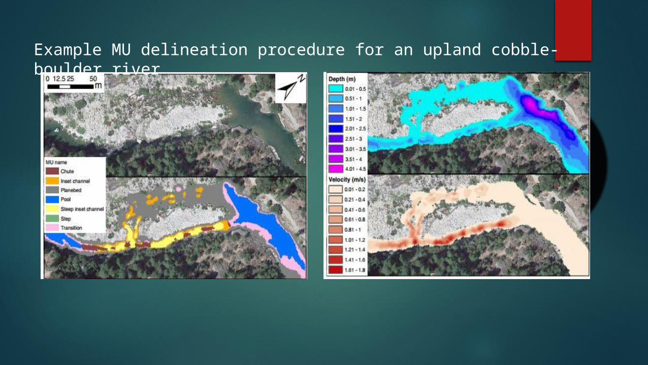
Example MU delineation procedure for an upland cobble-boulder river

Conclusions:
How do riffle-pool sequences correlate with discharge?
How are MUs distributed?
Lateral or longitudinal variability?
Spatial scales.
Riparian species.
Related Documents