Proceedings of the Ninth International Space Syntax Symposium Edited by Y O Kim, H T Park and K W Seo, Seoul: Sejong University, 2013 MORPHOLOGICAL ANALYSIS OF THE TRANSFORMATIONS OF KONAK SQUARE IN IZMIR 039 Işın Can Izmir Institute of Technology e-mail: [email protected] Ela Çil Izmir Institute of Technology e-mail: [email protected] Berna Yaylalı-Yıldız Izmir Institute of Technology e-mail: [email protected] Pınar Kılıç-Çalğıcı Izmir Institute of Technology e-mail: [email protected] Koray Velibeyoğlu Izmir Institute of Technology e-mail: [email protected] Abstract Historical public spaces are always seen as the shop windows of cities by local authorities. Therefore there have been continuous discussions on public spaces’ use, display, power, and control in every city. Konak Square, first public square of Izmir, was constructed consciously as an administrative centre by the government. The square has gone through different processes since 19th century. This paper tries to examine these cyclical transformations of Konak Square through morphological analysis. It focuses on Konak Square and its vicinity through the three available maps of 1941, 1989, and 2013. Subsequently it examines the two future proposals of the square both by looking at the syntactic analysis of pedestrian models and recent discussions on the square. It uses axial analysis, in situ observations, and archival research. Axial analysis coincides to reveal how the square’s accessibility has shifted within the city but also compares it with the other important squares of Izmir. In situ observations support the axial analysis but also signify the different daily practises and the appropriation of hard and soft spaces in the square. This study revealed that in order to judge the future proposals of a public space, we have to understand first how the space was being used and changed, most importantly the current uses and practices. Although the global integration values of the square decreased each period, locally the square became more integrated both physically and socially. Consequently, the two proposals pose a threat in the pedestrian use of the square. Keywords: Design Synthesis, generative urban design, Neural Networks, Complex systems, GeoComputation, Space Syntax Theme: Historical Evolution of Built Form

Welcome message from author
This document is posted to help you gain knowledge. Please leave a comment to let me know what you think about it! Share it to your friends and learn new things together.
Transcript
Proceedings of the Ninth International Space Syntax Symposium
Edited by Y O Kim, H T Park and K W Seo, Seoul: Sejong University, 2013
MORPHOLOGICAL ANALYSIS OF THE TRANSFORMATIONS OF
KONAK SQUARE IN IZMIR
039
Işın Can
Izmir Institute of Technology
e-mail: [email protected]
Ela Çil
Izmir Institute of Technology
e-mail: [email protected]
Berna Yaylalı-Yıldız
Izmir Institute of Technology
e-mail: [email protected]
Pınar Kılıç-Çalğıcı
Izmir Institute of Technology
e-mail: [email protected]
Koray Velibeyoğlu
Izmir Institute of Technology
e-mail: [email protected]
Abstract
Historical public spaces are always seen as the shop windows of cities by local authorities.
Therefore there have been continuous discussions on public spaces’ use, display, power, and
control in every city. Konak Square, first public square of Izmir, was constructed consciously as an
administrative centre by the government. The square has gone through different processes since
19th century. This paper tries to examine these cyclical transformations of Konak Square through
morphological analysis. It focuses on Konak Square and its vicinity through the three available
maps of 1941, 1989, and 2013. Subsequently it examines the two future proposals of the square
both by looking at the syntactic analysis of pedestrian models and recent discussions on the
square. It uses axial analysis, in situ observations, and archival research. Axial analysis coincides
to reveal how the square’s accessibility has shifted within the city but also compares it with the
other important squares of Izmir. In situ observations support the axial analysis but also signify
the different daily practises and the appropriation of hard and soft spaces in the square. This
study revealed that in order to judge the future proposals of a public space, we have to
understand first how the space was being used and changed, most importantly the current uses
and practices. Although the global integration values of the square decreased each period,
locally the square became more integrated both physically and socially. Consequently, the two
proposals pose a threat in the pedestrian use of the square.
Keywords: Design Synthesis, generative urban design, Neural Networks, Complex systems,
GeoComputation, Space Syntax
Theme: Historical Evolution of Built Form
Proceedings of the Ninth International Space Syntax Symposium, Seoul, 2013
I Can, E Çil, B Yaylalı-Yıldız, P Kılıç-Çalğıcıı and K Velibeyoğlu : Morphological analysis of the
transformations of Konak square in Izmir
039: 2
INTRODUCTION
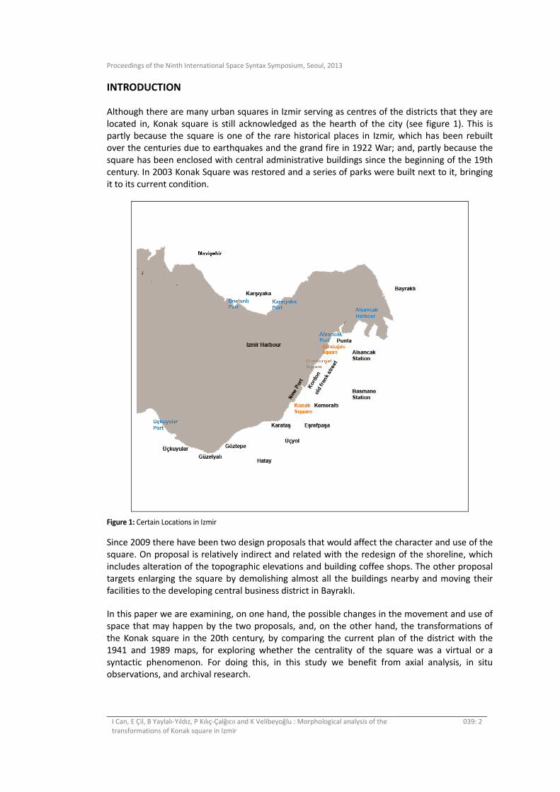
Although there are many urban squares in Izmir serving as centres of the districts that they are
located in, Konak square is still acknowledged as the hearth of the city (see figure 1). This is partly because the square is one of the rare historical places in Izmir, which has been rebuilt
over the centuries due to earthquakes and the grand fire in 1922 War; and, partly because the
square has been enclosed with central administrative buildings since the beginning of the 19th
century. In 2003 Konak Square was restored and a series of parks were built next to it, bringing
it to its current condition.
Figure 1: Certain Locations in Izmir
Since 2009 there have been two design proposals that would affect the character and use of the
square. On proposal is relatively indirect and related with the redesign of the shoreline, which
includes alteration of the topographic elevations and building coffee shops. The other proposal
targets enlarging the square by demolishing almost all the buildings nearby and moving their
facilities to the developing central business district in Bayraklı.
In this paper we are examining, on one hand, the possible changes in the movement and use of
space that may happen by the two proposals, and, on the other hand, the transformations of
the Konak square in the 20th century, by comparing the current plan of the district with the
1941 and 1989 maps, for exploring whether the centrality of the square was a virtual or a
syntactic phenomenon. For doing this, in this study we benefit from axial analysis, in situ observations, and archival research.
Proceedings of the Ninth International Space Syntax Symposium, Seoul, 2013
I Can, E Çil, B Yaylalı-Yıldız, P Kılıç-Çalğıcıı and K Velibeyoğlu : Morphological analysis of the
transformations of Konak square in Izmir
039: 3
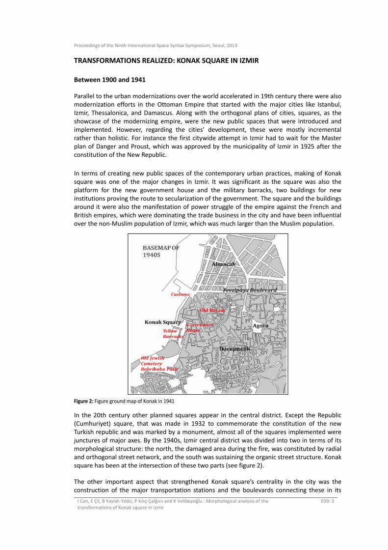
TRANSFORMATIONS REALIZED: KONAK SQUARE IN IZMIR
Between 1900 and 1941
Parallel to the urban modernizations over the world accelerated in 19th century there were also modernization efforts in the Ottoman Empire that started with the major cities like Istanbul,
Izmir, Thessalonica, and Damascus. Along with the orthogonal plans of cities, squares, as the
showcase of the modernizing empire, were the new public spaces that were introduced and
implemented. However, regarding the cities’ development, these were mostly incremental
rather than holistic. For instance the first citywide attempt in Izmir had to wait for the Master
plan of Danger and Proust, which was approved by the municipality of Izmir in 1925 after the constitution of the New Republic.
In terms of creating new public spaces of the contemporary urban practices, making of Konak
square was one of the major changes in Izmir. It was significant as the square was also the
platform for the new government house and the military barracks, two buildings for new
institutions proving the route to secularization of the government. The square and the buildings around it were also the manifestation of power struggle of the empire against the French and
British empires, which were dominating the trade business in the city and have been influential
over the non-Muslim population of Izmir, which was much larger than the Muslim population.
Figure 2: Figure ground map of Konak in 1941
In the 20th century other planned squares appear in the central district. Except the Republic
(Cumhuriyet) square, that was made in 1932 to commemorate the constitution of the new
Turkish republic and was marked by a monument, almost all of the squares implemented were
junctures of major axes. By the 1940s, Izmir central district was divided into two in terms of its
morphological structure: the north, the damaged area during the fire, was constituted by radial and orthogonal street network, and the south was sustaining the organic street structure. Konak
square has been at the intersection of these two parts (see figure 2).
The other important aspect that strengthened Konak square’s centrality in the city was the
construction of the major transportation stations and the boulevards connecting these in its
Proceedings of the Ninth International Space Syntax Symposium, Seoul, 2013
I Can, E Çil, B Yaylalı-Yıldız, P Kılıç-Çalğıcıı and K Velibeyoğlu : Morphological analysis of the
transformations of Konak square in Izmir
039: 4
vicinity. The pier was attached to the square as well as the last stop of the trams and buses were
by the square, and one of the two train stations, Basmane station, was connected by the new boulevard constructed in 1937. Konak square was becoming the node of the developing city as
well; the National Movie Theatre and the National Library were built close by.
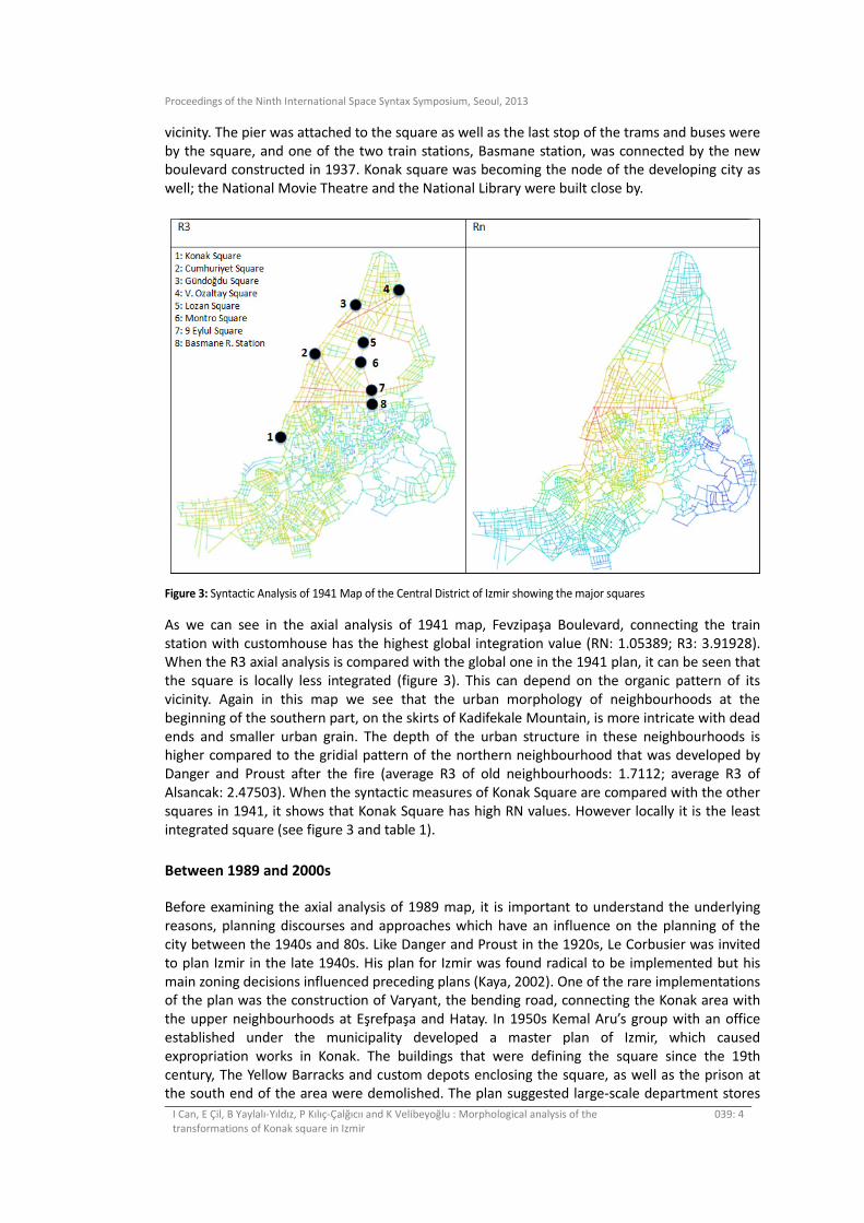
Figure 3: Syntactic Analysis of 1941 Map of the Central District of Izmir showing the major squares
As we can see in the axial analysis of 1941 map, Fevzipaşa Boulevard, connecting the train
station with customhouse has the highest global integration value (RN: 1.05389; R3: 3.91928). When the R3 axial analysis is compared with the global one in the 1941 plan, it can be seen that
the square is locally less integrated (figure 3). This can depend on the organic pattern of its
vicinity. Again in this map we see that the urban morphology of neighbourhoods at the
beginning of the southern part, on the skirts of Kadifekale Mountain, is more intricate with dead
ends and smaller urban grain. The depth of the urban structure in these neighbourhoods is higher compared to the gridial pattern of the northern neighbourhood that was developed by
Danger and Proust after the fire (average R3 of old neighbourhoods: 1.7112; average R3 of
Alsancak: 2.47503). When the syntactic measures of Konak Square are compared with the other
squares in 1941, it shows that Konak Square has high RN values. However locally it is the least
integrated square (see figure 3 and table 1).
Between 1989 and 2000s
Before examining the axial analysis of 1989 map, it is important to understand the underlying
reasons, planning discourses and approaches which have an influence on the planning of the
city between the 1940s and 80s. Like Danger and Proust in the 1920s, Le Corbusier was invited
to plan Izmir in the late 1940s. His plan for Izmir was found radical to be implemented but his
main zoning decisions influenced preceding plans (Kaya, 2002). One of the rare implementations of the plan was the construction of Varyant, the bending road, connecting the Konak area with
the upper neighbourhoods at Eşrefpaşa and Hatay. In 1950s Kemal Aru’s group with an office
established under the municipality developed a master plan of Izmir, which caused
expropriation works in Konak. The buildings that were defining the square since the 19th
century, The Yellow Barracks and custom depots enclosing the square, as well as the prison at the south end of the area were demolished. The plan suggested large-scale department stores

Proceedings of the Ninth International Space Syntax Symposium, Seoul, 2013
I Can, E Çil, B Yaylalı-Yıldız, P Kılıç-Çalğıcıı and K Velibeyoğlu : Morphological analysis of the
transformations of Konak square in Izmir
039: 5
and office buildings to be built on the area between the Konak square and the harbour. The old
Jewish cemetery was turned into a park. Again in this period due to financial problems, municipality sold the empty public lands in Konak to the Social Insurance Institution for raising
its funding and capital (Yılmaz, 2003; Kaya, 2002).
Konak square was being dismissed and the attention was being given to the allocation of
theatre and opera houses in the proposed new park. Its inconceivable emptiness formed by
demolishing the Yellow Barracks was creating cyclical discussions regarding the redesign of the square (Yılmaz, 2003). In the early 1960s the area became a vast void, only marked by the Clock
Tower and large boulevards cutting through. With several transportation stations, it was
becoming solely a traffic junction. But the seaside of the square sustained its liveliness for the
pedestrians: the ferry quay, the coffee houses, restaurants by the sea were making the area
attractive for spending leisure time.
In the early 1980s, Izmir Province Complex and the new municipality building were built next to
the old governor’s offices. All these buildings brought back the administrative character of the
square. But the major transformation was yet to come: a major landfilling operation started in
1984 created a seashore drive that started from Konak square toward the south. Additionally
the north side of the road was expanded from Customs House separating the Square from the
other buildings, the historical mosque and the government offices, on the eastern side. We can follow these changes in 1989 map (figure 4). Especially Integration RN analysis shows that the
highest integration values move towards the south and east (average RN of south and east part:
0.886685) The only street that passes through the square with high integration value is the
Cumhuriyet Boulevard going between the Social Insurance Institution buildings (YKM) and the
old barracks (see table 2 below).
Figure 4: Figure Syntactic Analysis of 1989 Map
The most dense traffic stream which was blocking the pedestrian accessibility between
Kemeraltı, the old trade centre, and the sea can be seen in this period, in order to overcome this
problem two pedestrian overpasses were built; one connecting the Clock Tower and Kemeraltı
and the other connecting the two sides of the square’s northern end. Additionally on the expropriated land parking areas -located along the sea after the landfill, and a multi-storey car
park were built in the place of Yellow Barracks and near to AKM (Atatürk Cultural Centre), major
bus terminal was located. Consequently, Konak Square not only became undefined with its
Proceedings of the Ninth International Space Syntax Symposium, Seoul, 2013
I Can, E Çil, B Yaylalı-Yıldız, P Kılıç-Çalğıcıı and K Velibeyoğlu : Morphological analysis of the
transformations of Konak square in Izmir
039: 6
emptiness but also a chaotic, messy place with all the juxtapositions of transportation, traffic
congestion, segregation and disconnection, different masses of urban blocks, and styles. Konak has become a cross-through place, and still on the most integrated street, together with
Fevzipaşa. As it can be seen from the Integration RN in 1989 Map (see figure 5 above), Varyant
Road moved the integration values up to Eşrefpaşa Housing Settlements, making Eşrefpaşa
more central and carrying the accessibility to Üçyol and towards Hatay region.
But the planning idea to solve the traffic congestion culminating at Konak was yet to come in the early 1990s. There was a major landfill on the northern sea shore of the Konak area as an
aftermath of a decision to bypass Konak square and connect the north and south of the city
with a highway. But the highway could not be built as the chamber of architects took the plan to
the court and won the case. The landfill area was turned into green areas for public use. This
resolution ended up enlarging and enhancing the use of squares, such as the Republic and Gündoğdu squares on the northern seashore. Hence Konak Square has become the starting
point of a promenade between the historical centre and Alsancak harbour; as this path
flourished with cafes, bars, and various leisure activities by the seaside on green spaces. Konak
Square is behaving as a smooth transition area between this cultural, historical, and
entertainment hub at the north and the residential areas at the south. The realization of the
transformations would be seen in the analysis of the current city plan.
Konak Square Since 2000s
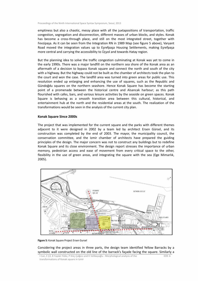
The project that was implemented for the current square and the parks with different themes
adjacent to it were designed in 2002 by a team led by architect Ersen Gürsel, and its
construction was completed by the end of 2003. The mayor, the municipality council, the
conservation committee, and the Izmir chamber of architects have prepared the guiding
principles of the design. The major concern was not to construct any buildings but to redefine Konak Square and its close environment. The design report stresses the importance of urban
memory, pedestrian access and ease of movement from every critical space to the other,
flexibility in the use of green areas, and integrating the square with the sea (Ege Mimarlık,
2005).
Figure 5: Konak Square Project Ersen Gursel
Considering the project areas in three parts, the design team identified Yellow Barracks by a
symbolic wall constructed on the old line of the barrack’s façade facing the square. Similarly a
Proceedings of the Ninth International Space Syntax Symposium, Seoul, 2013
I Can, E Çil, B Yaylalı-Yıldız, P Kılıç-Çalğıcıı and K Velibeyoğlu : Morphological analysis of the
transformations of Konak square in Izmir
039: 7
linear pool and fountains symbolized the old shoreline while delineating the square. The base of
the Clock Tower reclaimed its original ground level and the monument of Hasan Tahsin (the first bullet) was moved to a place, where it can also be seen from the highway. The administrative
buildings are given a separate zone while the old Mosque and the Clock Tower are put into a
visual dialogue.
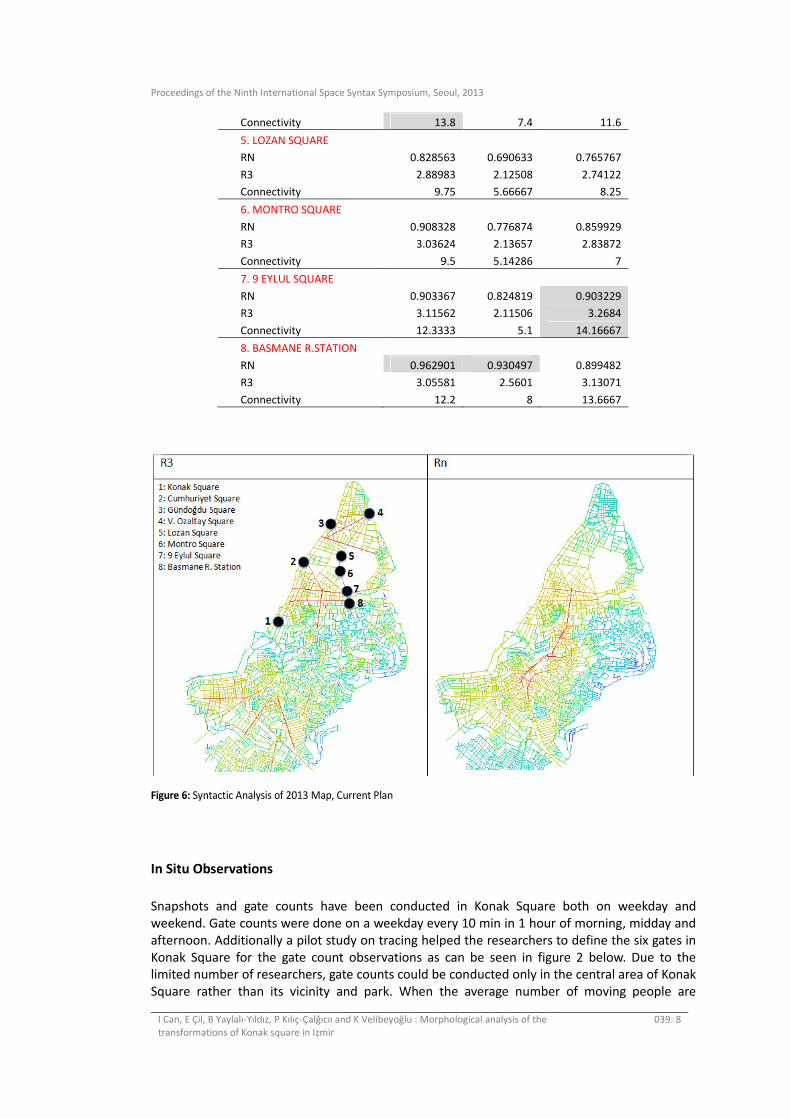
The new design connects Kemeraltı, the historical market area, directly with the seashore and
the ferry station with a 100m wide overpass on the upper level of the highway, as well as the northern seashore of Konak district that starts with the old customs buildings. Pedestrians are
using mostly these two important axis targeted by the designer in the area. As a result in the
local integration (R3) map, it can be discussed that the recent design achieved considerable
success regarding the connection of north and south parts (see figure 6). In the RN axial analysis,
although Fevzipaşa Boulevard preserves its high integration values, Ikiçeşmelik Street has become the most integrated street. And this road connects Hatay district with the northern part
of the city, through pulling the integration values. Consequently in the global analysis, Konak
Square loses its centrality in terms of integration and accessibility for vehicular movement. On
the other hand together with the intersection of sea, underground tube, and bus transportation,
Konak becomes very accessible for the active use of pedestrians. Syntactic measures supports
this finding, Konak Square’s RN values decreases between 1941 and 2013. In contrast, local measures (R3 and connectivity) increases (see table 1). In 1941 and 1989 Basmane Railway
Station has highest RN while V. Ozaltay Square has highest local measures. In 2013 9 Eylul
Square has both the highest global and local measures compared to the other squares and
nodes (see table 1).
The area where used to be Yellow Barracks and later bus stations is designed as a series of parks consisting hard and soft surfaces. The south end of parks is marked by semi-open structures
referring to the entrance of the subway and parks. There is a cactus garden; large areas of lawn
are separated from each other by pedestrian paths and trees that are also planted for orienting
movement. Hard surfaced areas are designed as history parks having seating zones and two
plates of maps illustrating the ancient Izmir plans that are made out of stone mosaic. Also the waterfront parallel to the square and the parks were developed in order to join Kordon with
Güzelyalı, north and south neighbourhoods of Konak district. A small hill and green
amphitheatre were built for watching the view and possible concert activities. An embedded
café in the hill was proposed for eating facilities, but was not constructed (see figure 5).
Table 1 Syntactic Measures of Main Squares in 1941, 1989, and 2013
SYNTACTIC MEASURES 1941 1989 2013
1. KONAK SQUARE
RN 0.932669 0.894885 0.848316
R3 2.27501 2.0859 2.38503
Connectivity 5.9 5 6.18182
2. CUMHURIYET SQUARE
RN 0.836433 0.756893 0.83227
R3 2.77235 2.11624 2.6422
Connectivity 8.625 4.72727 7.33333
3. GUNDOGDU SQUARE
RN 0.745262 0.742181 0.726262
R3 2.78025 2.54119 2.75301
Connectivity 7.25 6.75 6.75
4. V. OZALTAY SQUARE
RN 0.710141 0.67256 0.695252
R3 3.2036 2.58358 2.99818
Proceedings of the Ninth International Space Syntax Symposium, Seoul, 2013
I Can, E Çil, B Yaylalı-Yıldız, P Kılıç-Çalğıcıı and K Velibeyoğlu : Morphological analysis of the
transformations of Konak square in Izmir
039: 8
Connectivity 13.8 7.4 11.6
5. LOZAN SQUARE
RN 0.828563 0.690633 0.765767
R3 2.88983 2.12508 2.74122
Connectivity 9.75 5.66667 8.25
6. MONTRO SQUARE
RN 0.908328 0.776874 0.859929
R3 3.03624 2.13657 2.83872
Connectivity 9.5 5.14286 7
7. 9 EYLUL SQUARE
RN 0.903367 0.824819 0.903229
R3 3.11562 2.11506 3.2684
Connectivity 12.3333 5.1 14.16667
8. BASMANE R.STATION
RN 0.962901 0.930497 0.899482
R3 3.05581 2.5601 3.13071
Connectivity 12.2 8 13.6667
Figure 6: Syntactic Analysis of 2013 Map, Current Plan
In Situ Observations
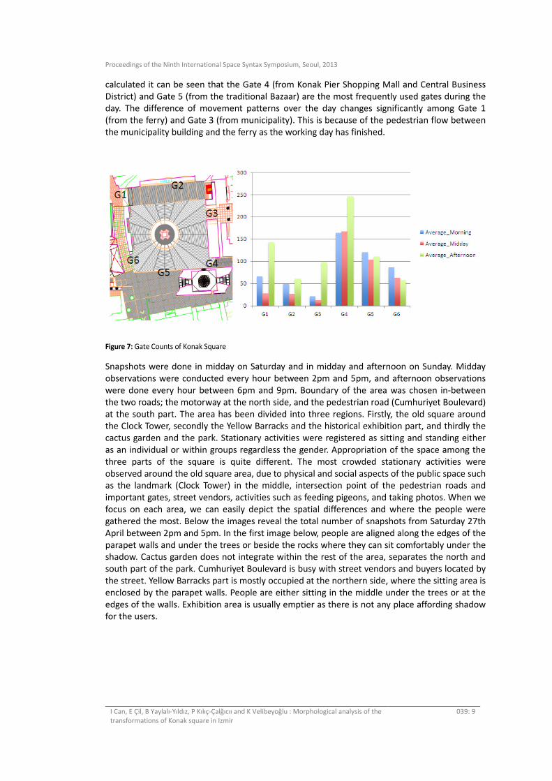
Snapshots and gate counts have been conducted in Konak Square both on weekday and
weekend. Gate counts were done on a weekday every 10 min in 1 hour of morning, midday and
afternoon. Additionally a pilot study on tracing helped the researchers to define the six gates in
Konak Square for the gate count observations as can be seen in figure 2 below. Due to the limited number of researchers, gate counts could be conducted only in the central area of Konak
Square rather than its vicinity and park. When the average number of moving people are
Proceedings of the Ninth International Space Syntax Symposium, Seoul, 2013
I Can, E Çil, B Yaylalı-Yıldız, P Kılıç-Çalğıcıı and K Velibeyoğlu : Morphological analysis of the
transformations of Konak square in Izmir
039: 9
calculated it can be seen that the Gate 4 (from Konak Pier Shopping Mall and Central Business
District) and Gate 5 (from the traditional Bazaar) are the most frequently used gates during the day. The difference of movement patterns over the day changes significantly among Gate 1
(from the ferry) and Gate 3 (from municipality). This is because of the pedestrian flow between
the municipality building and the ferry as the working day has finished.
Figure 7: Gate Counts of Konak Square
Snapshots were done in midday on Saturday and in midday and afternoon on Sunday. Midday
observations were conducted every hour between 2pm and 5pm, and afternoon observations
were done every hour between 6pm and 9pm. Boundary of the area was chosen in-between
the two roads; the motorway at the north side, and the pedestrian road (Cumhuriyet Boulevard)
at the south part. The area has been divided into three regions. Firstly, the old square around the Clock Tower, secondly the Yellow Barracks and the historical exhibition part, and thirdly the
cactus garden and the park. Stationary activities were registered as sitting and standing either
as an individual or within groups regardless the gender. Appropriation of the space among the
three parts of the square is quite different. The most crowded stationary activities were
observed around the old square area, due to physical and social aspects of the public space such as the landmark (Clock Tower) in the middle, intersection point of the pedestrian roads and
important gates, street vendors, activities such as feeding pigeons, and taking photos. When we
focus on each area, we can easily depict the spatial differences and where the people were
gathered the most. Below the images reveal the total number of snapshots from Saturday 27th
April between 2pm and 5pm. In the first image below, people are aligned along the edges of the
parapet walls and under the trees or beside the rocks where they can sit comfortably under the shadow. Cactus garden does not integrate within the rest of the area, separates the north and
south part of the park. Cumhuriyet Boulevard is busy with street vendors and buyers located by
the street. Yellow Barracks part is mostly occupied at the northern side, where the sitting area is
enclosed by the parapet walls. People are either sitting in the middle under the trees or at the
edges of the walls. Exhibition area is usually emptier as there is not any place affording shadow for the users.

Proceedings of the Ninth International Space Syntax Symposium, Seoul, 2013
I Can, E Çil, B Yaylalı-Yıldız, P Kılıç-Çalğıcıı and K Velibeyoğlu : Morphological analysis of the
transformations of Konak square in Izmir
039: 10
Figure 8: Snapshots of Konak Square Saturday 27th April
Although the designers and their consultants have stressed that the environment of the square
should be allocated to green areas, we can assert that neither the design report (Ege Mimarlık, 2005) nor the executed landscape reflect that the possibility of diverse and dense uses of the
space had been anticipated. Green landscape is designed for creating a background as if a zone
of visual calmness, or an aid in pedestrian movement. The palm and cypress trees as well
manifest that they are chosen more toward spatial orientation than creating space for users, for
possible inhabitations. But current practices appropriate the space, the square and the parks are full of people: old and young, men, women, children, families, and lovers come here for
their leisure time to hang out, to picnic, to socialize. Every bit of shade is claimed. Recent
discussions neglect the everyday life of Konak Square. Below these proposals are explained in
detail.
TRANSFORMATIONS PROPOSED
1. Design Proposal Concerning the Waterfront of the Konak Square
Discussions about the regeneration of the waterfront area in Izmir firstly initiated by the Izmir Metropolitan Municipality (IMM) via the support of the Mayor Aziz Kocaoglu. Initial decisions
were taken and debated in the Design Forum as well as in the Cultural Workshop. This attempt
was an archetype in Turkey, as the local authority was arranging the meetings and involving
more than 100 professions including; architects, landscape architects, planners, urban designers,
industrial designers who were volunteer. The project covers 40km long seashore area starting
from Inciralti to Sasali. Therefore the area was divided into four regions and assigned to different groups of designers. The project aimed to integrate Izmir citizens with the sea. Izmir is
a linear city aligned by the bay, but there are some geographical constraints as the hills are
parallel to the sea. Although it is an obstacle for settling and accessibility, topography gives
richness in providing different vistas towards the bay. Hence there were three steps in the
project. First one was to regenerate the seashore together with the organized cultural events. Moreover another important input was to regain the swimming activity along the waterfront
area as it was in the past. As a result floating platforms and decks are proposed. Secondly, there
is an attempt to sustain the pedestrian and cycling paths along the waterfront, for the continuity
of pedestrian routes. Thirdly, as mentioned above the seashore is seen as the stage of an
amphitheatre where the hills are the places for the audience. As a result designers proposed terraces for watching the city view especially on skirts of Kadifekale Mountain.
Proceedings of the Ninth International Space Syntax Symposium, Seoul, 2013
I Can, E Çil, B Yaylalı-Yıldız, P Kılıç-Çalğıcıı and K Velibeyoğlu : Morphological analysis of the
transformations of Konak square in Izmir
039: 11
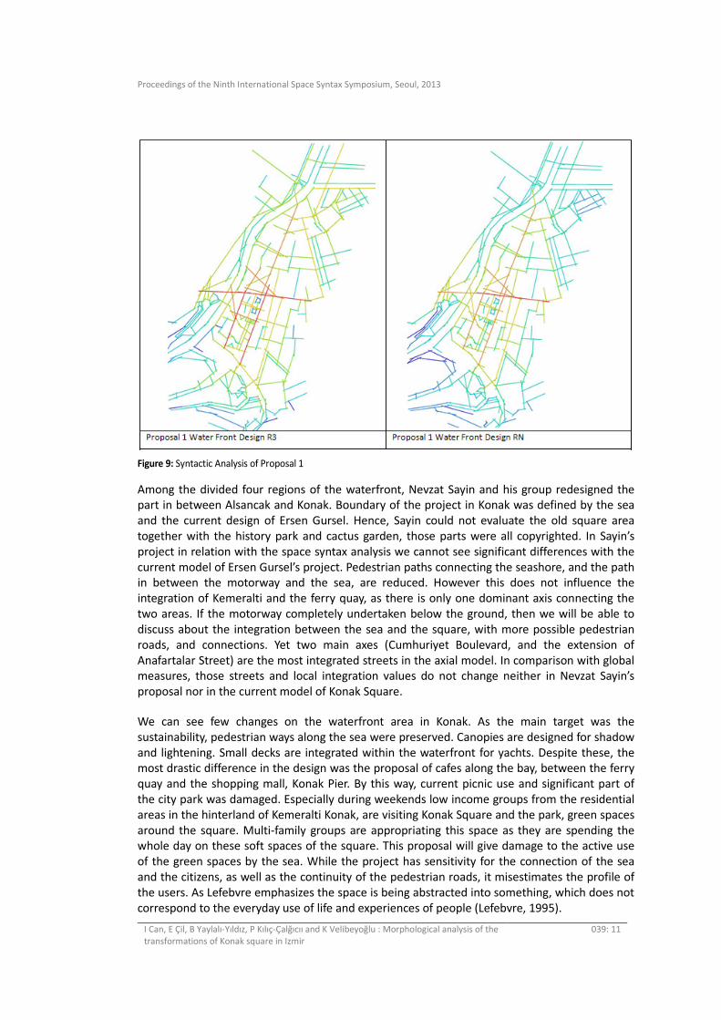
Figure 9: Syntactic Analysis of Proposal 1
Among the divided four regions of the waterfront, Nevzat Sayin and his group redesigned the part in between Alsancak and Konak. Boundary of the project in Konak was defined by the sea
and the current design of Ersen Gursel. Hence, Sayin could not evaluate the old square area
together with the history park and cactus garden, those parts were all copyrighted. In Sayin’s
project in relation with the space syntax analysis we cannot see significant differences with the
current model of Ersen Gursel’s project. Pedestrian paths connecting the seashore, and the path in between the motorway and the sea, are reduced. However this does not influence the
integration of Kemeralti and the ferry quay, as there is only one dominant axis connecting the
two areas. If the motorway completely undertaken below the ground, then we will be able to
discuss about the integration between the sea and the square, with more possible pedestrian
roads, and connections. Yet two main axes (Cumhuriyet Boulevard, and the extension of
Anafartalar Street) are the most integrated streets in the axial model. In comparison with global measures, those streets and local integration values do not change neither in Nevzat Sayin’s
proposal nor in the current model of Konak Square.
We can see few changes on the waterfront area in Konak. As the main target was the
sustainability, pedestrian ways along the sea were preserved. Canopies are designed for shadow
and lightening. Small decks are integrated within the waterfront for yachts. Despite these, the most drastic difference in the design was the proposal of cafes along the bay, between the ferry
quay and the shopping mall, Konak Pier. By this way, current picnic use and significant part of
the city park was damaged. Especially during weekends low income groups from the residential
areas in the hinterland of Kemeralti Konak, are visiting Konak Square and the park, green spaces
around the square. Multi-family groups are appropriating this space as they are spending the whole day on these soft spaces of the square. This proposal will give damage to the active use
of the green spaces by the sea. While the project has sensitivity for the connection of the sea
and the citizens, as well as the continuity of the pedestrian roads, it misestimates the profile of
the users. As Lefebvre emphasizes the space is being abstracted into something, which does not
correspond to the everyday use of life and experiences of people (Lefebvre, 1995).
Proceedings of the Ninth International Space Syntax Symposium, Seoul, 2013
I Can, E Çil, B Yaylalı-Yıldız, P Kılıç-Çalğıcıı and K Velibeyoğlu : Morphological analysis of the
transformations of Konak square in Izmir
039: 12
2. Proposals of the Politicians aimed at transforming the whole area
Starting at the same time with the discussions on re-constructing Izmir as a Mediterranean city, the debates that specifically concentrate on the square make it the centre of power struggles.
There have been two waves of arguments, one being in 2008 and the other being in 2013, These
debates repeat the modern ideology of clearing spaces and opening up vistas, so that the
square should be seen from distant locations, as well as providing a wide view to the pedestrian
on the square. But most stressed is the idea that the square should be ample area in proportion
to the importance of the city deserves.
Before the 2009 elections, one of the projects suggested by Kemal Karataş as a local political
figure, was to make Konak square a space similar to Red Square in Moscow. For him, almost all
the government buildings would be demolished and the city administration was to be moved to
Bayraklı, where the new central business district is currently developing. A small lake would be
built at the location of the demolished buildings. Additionally, the Clock Tower, Yalı Mosque, and the Governor’s Office Building, would be removed to be rebuilt on pedestals at one side of the
proposed square. In fact, he also suggested that there would be a triumphal arch like the one in
Paris and a boulevard like the Champs Elysées Boulevard reaching from the new Konak Square
to ancient Agora.
In 2013 there were new voices in favour of demolishing the Municipality Building on the grounds that its structural system was not sound. Serdar Değirmenci, the starter of the recent
speculations and the head of the City Council, proposed to demolish the building and to have
more area for a new square that should be named after Hasan Tahsin. Moreover, the monument
of journalist Hasan Tahsin is not glorious enough. It can be demolished too and a more glorious
monument, which can be selected in a design competition, can be built. After finding new
locations for the Buildings of the Social Security offices and the Central Bank, they can also be demolished and the Konak Square would be widened. (…)”
Ekrem Demirtaş, the current chair of the Izmir Trades Office, has argued on the same lines with
the head of the City Council and stated that the Municipality and the Central Bank Buildings
should be demolished. Although Karataş’s projects were found drastic and caused upheaval
citywide, Demirtaş’s statement was accepted positively by Chamber of Izmir Planners. Nehir Yüksel, the chair of the Izmir Branch stated that they would support the steps of actions in order
to have Konak, to gain a real status of an urban square. Additionally, Yüksel states that getting
rid of the aforementioned buildings from the site would help the square to be better united
with the seashore (Hürriyet, 2013).
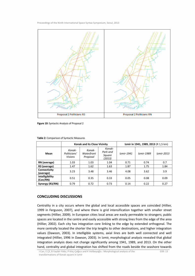
All politicians either from political parties, local government or chamber of commerce, they actively involved in the debates of reclamation of Konak Square, and the myths about
demolishing the governmental buildings around the square. This axial model representing this
discussion, are based on the idea suggesting demolish of all the municipality buildings at the
north, social insurance buildings at the east, and police offices by the east façade of the square.
We cannot predict how the pedestrian roads or motorway is going to be arranged. Therefore we developed our model from the preliminary ideas. In the integration analysis, it can be seen that
the street coming from the 1st Kordon goes till the south where bus stops are located, is the
most integrated street both in global and local analysis. Additionally southeast axis coming from
the hospital and Archaeological Museum is directly connected with the ferry quay, thus having
higher integration values than the current model.
Proceedings of the Ninth International Space Syntax Symposium, Seoul, 2013
I Can, E Çil, B Yaylalı-Yıldız, P Kılıç-Çalğıcıı and K Velibeyoğlu : Morphological analysis of the
transformations of Konak square in Izmir
039: 13
Figure 10: Syntactic Analysis of Proposal 2
Table 2: Comparison of Syntactic Measures
Konak and its Close Vicinity Izmir in 1941, 1989, 2013 (R 1,5 km)
Mean Konak-
Politicians’
Visions
Konak-
Waterfront
Proposal
Konak-
Park and
Square
(2013)
Izmir-1941 Izmir-1989 Izmir-2013
RN (average) 1.03 1.03 1.04 0.71 0.74 0.7
R3 (average) 1.47 1.62 1.63 1.87 1.75 1.84 Connectivity (average)
3.23 3.48 3.46 4.08 3.62 3.9
Intelligibility (Con/RN)
0.51 0.35 0.33 0.05 0.08 0.09
Synergy (R3/RN) 0.79 0.72 0.73 0.14 0.22 0.27
CONCLUDING DISCUSSIONS
Centrality in a city occurs where the global and local accessible spaces are coincided (Hillier,
1999 in Ferguson, 2007), and where there is grid intensification together with smaller street
segments (Hillier, 2009). In European cities local areas are easily permeable to strangers; public
spaces are located in the centre and easily accessible with strong lines from the edge of the area
(Hillier, 2002). Each city has integration core linking to the edge by extended orthogonal. The
more centrally located the shorter the trip lengths to other destinations, and higher integration
values (Dawson, 2003). In intelligible systems, axial lines are both well connected and well
integrated (Hillier, 1996 in Dawson, 2003). In Izmir, morphological analysis revealed that global
integration analysis does not change significantly among 1941, 1989, and 2013. On the other
hand, centrality and global integration has shifted from the roads beside the seashore towards
Proceedings of the Ninth International Space Syntax Symposium, Seoul, 2013
I Can, E Çil, B Yaylalı-Yıldız, P Kılıç-Çalğıcıı and K Velibeyoğlu : Morphological analysis of the
transformations of Konak square in Izmir
039: 14
the ring roads on the edge. Therefore, Konak Square is not well connected to its surrounding in
the integration analysis, but supported with various transportations such as ferry, subway,
buses, and mini-buses (dolmus). As can be seen from the table 2 Izmir has very low intelligibility
values all in 1941, 1989, and 2013. This can be due to the hybrid structure of the city both with
organic patterns of the traditional bazaar area and the grid structure area at the waterfront.
Additionally Izmir is a linear city; therefore it does not have the extended orthogonal lines
connecting the edge into the centre. Instead, different types of transportations and Konak
Square’s location as being beside the sea and as an administrative centre and historical place
play an important role in its accessibility, centrality and publicness. Intelligibility of Konak Square
is high in two proposals and current pedestrian models. Specifically the intelligibility of the
proposal of politicians is the highest as it is aimed. However this is only the intelligibility of the
emptiness of the space. Its publicness will be diminished, as it will be a huge undefined space.
This study has two main outcomes. Firstly, through reading the square from realized
transformations, in linear cities it is inevitable that the centrality will shift as the city expands.
Axial analysis revealed that Konak Square, the historical centre of Izmir has lost its centrality as
the global integration values decreases, and moves towards east Basmane, 9 Eylul Square.
However due to the local measures, as well as the characteristics of Konak Square such as low
cost of accessibility, availability of green spaces, being historical, cultural, and commercial,
junction of various functions, and transportations, possibility of appropriation of spaces, starting
point of a promenade makes the square more crowded and useable by Izmir citizens. There are
discussions on moving the administrative functions of the square to the new CBD, Bayrakli. This
will change the old administrative image of the square at certain point. However, as a square
formed intentionally by the government, none of the other squares achieved the publicness of
Konak Square. Hence, syntactic analysis is important but has to be supported by qualitative
measures. Without doing archival research and looking at in situ observations, it would be very
difficult to read historical centres only from the map.
Secondly, through reading Konak Square from transformations proposed, we can see that the
centrality of Konak in citizens’ imagery and being a symbolic space supported by activities
causes politicians to propose bold projects for the city through Konak square. Emptying the
space will definitely give more freedom in movement (and have more axial lines to intersect)
but increased monumentality will lessen the current uses that we observe in the space and thus
the place will be more present in the imagery than in everyday life.
REFERENCES
Ballice, G. 2011. “Konak Ataturk Meydani’nin Mekansal Donusumu.” In Ege Mimarlik, Ekim.
Dawson, P. C. 2003. “Analysing the Effects of Spatial Configuration on Human Movement and
Social Interaction in Canadian Arctic Communities.” In 4th International Space Syntax
Symposium. London, UK.
Dimenberg, E. 1998. “Henry Lefebvre on Abstract Space.” In Philosophy and Geography II: The
Production of Public Space, edited by A. Light and J Smith. Maryland: Rowman &
Littlefield Pub.
Ege Mimarlık. 2004/2. “Konak Square and Its Environs Urban Design Project, Konak Square
Meets the Sea Again.” in UIA 2005_stanbul Special Issue, Ege Mimarlık. 50: 44-53.
Proceedings of the Ninth International Space Syntax Symposium, Seoul, 2013
I Can, E Çil, B Yaylalı-Yıldız, P Kılıç-Çalğıcıı and K Velibeyoğlu : Morphological analysis of the
transformations of Konak square in Izmir
039: 15
EPA and IMM. 2002. Konak Meydanı ve Çevresi Düzenleme Projesi Teknik Raporu, October, pp.
1-14.
Eyüce, Ö. 2005. Konak Square: From Past to Present in Pictures. Ege Mimarlik, Special Issue, UIA
Istanbul.
Ferguson, P. 2007. “The Streets of Innovation.” In 6th International Space Syntax Symposium.
Istanbul, Turkey.
Hillier, B. 1996. Space is the Machine : a configurational theory of architecture. Cambridge; New
York. NY USA, Cambridge University Press.
Hillier, B. 1999. “The hidden geometry of deformed grids: or, why space syntax works, when it
looks as though it shouldn’t.” Environment and Planning B: Planning and Design 26:
169-191.
Hillier, B. 2002. “A theory of the city as object: or, how spatial laws mediate the social
construction of urban space.” URBAN DESIGN International 7(3/4): 153-179.
Hillier, B. 2009. “Spatial Sustainability in Cities.” In 7th International Space Syntax Symposium.
Stockholm.
Kaya, N. 2002. “Analysis of the Interaction between Theory and Practice in Urban Planning:
Understanding Izmir Experience.” unpublished PhD diss., Izmir, Izmir Institute of
Technology.
Lefebvre, H. 1995. The Production of Space. Cambridge: Blackwell.
Madanipour, A. 2004. “Marginal Public Spaces in European Cities.” Journal of Urban Design 9(3):
267-286.
Yılmaz, F. 2003. Tarihsel Süreç Içinde Konak Meydanı, Izmir Büyük Sehir Belediyesi Kent Kitaplıgı.
Izmir, (Stil Matbaacılık, Istanbul). pp. 1-40.
“Karataş’tan Konak Meydanı için ‘Kızık Meydan’ Projesi.” 2008. Milliyet. 22 June. [online]
http://www.milliyet.com.tr/chp-konak-meydani-ni%20yikacak/ege/haberdetay/23.06.
2008/879358/default.htm
“İzmir’e Yeni Bir Öneri” 2013. Hürriyet, 09 January. [online] Avaliable at:
http://hurarsiv.hurriyet.com.tr/goster/ShowNew.aspx?id=22319214
“İzmir’de Yükselen Ses: Büyükşehir Binaları Yıkılsın!” 2013. Ege’de Son Söz. 10 January. [online]
Avaliable at:
http://www.egedesonsoz.com/haber/Izmir-de-yukselen-ses-Buyuksehir-binasi-yikilsin/
832305
Related Documents