ROADWAYS MASS TRANSIT COMPLETE STREETS CYCLING FINAL 2018 MONTEREY COUNTY REGIONAL TRANSPORTATION PLAN

Welcome message from author
This document is posted to help you gain knowledge. Please leave a comment to let me know what you think about it! Share it to your friends and learn new things together.
Transcript

ROADWAYS
MASS TRANSIT
COMPLETE STREETSCYCLING
FINAL
2018 MONTEREY COUNTY REGIONAL TRANSPORTATION PLAN

Final
2018 Monterey County
Regional Transportation Plan
Prepared By:
Transportation Agency for Monterey County 55B Plaza Circle
Salinas, CA 93901
(831) 775-0903
www.tamcmonterey.org
In Coordination with:
Association of Monterey Bay Area Governments 24580 Silver Cloud Ct, Monterey, CA 93940

The preparation of this report was financed in part through grants from the United States Department of Transportation (DOT) and facilitated by the Metropolitan Planning Organization, the Association of Monterey Bay Area Governments. Additional financial assistance was provided by the California State Department of Transportation.

Transportation Agency for Monterey County
Board of Directors Luis Alejo, Supervisorial District 1 Staff
John Phillips, Supervisorial District 2 Debra L Hale, Executive Director
Simon Salinas, Supervisorial District 3 Todd Muck, Deputy Executive Director
Jane Parker Supervisorial District 4 Planning Staff
Mary Adams, Supervisorial District 5 Christina Watson, Principal Planner
Carolyn Hardy, City of Carmel-By-The-Sea Mike Zeller, Principle Transportation Planner
Jerry Edelen, City of Del Rey Oaks Ariana Green, Associate Transportation Planner
Maria Orozco, City of Gonzales Grant Leonard, Associate Transportation Planner
Leah Santibanez, City of Greenfield Virginia Murillo, Transportation Planner
Mike LeBarre, City of King City Hank Meyers, Senior Transportation Planning Engineer
Bruce Delgado, City of Marina Rich Deal, Principle Transportation Engineer
Ed Smith, City of Monterey Administration
Robert Huitt, City of Pacific Grove Rita Goel, Director of Finance & Administration
Kimbley Craig, City of Salinas David Delfino, Finance Officer/Analyst
Todd Bodem, City of Sand City Elouise Rodriguez, Senior Administrative Assistant
Ralph Rubio, City of Seaside Maria Montiel, Administrative Assistant
Alejandro Chavez, City of Soledad Lynn Terry, Accounting Clerk
Ex-Officio Members
Maura Twomey, AMBAG
Tim Gubbins, Caltrans District 5
Oscar Rios, City of Watsonville
Richard Steadman,
Monterey Bay Unified Air Pollution Control District
Bill Sabo, Monterey Regional Airport District
Carl Sedoryk, Monterey-Salinas Transit (MST)

Table of Contents
Executive Summary i
Chapter 1: Introduction 1.
Document Structure 1.
Regionally Significant Transportation Issues 2.
Transportation Agency for Monterey County and the Regional Planning Process
2.
Monterey County Geography and Regional Transportation System 4.
Monterey County Economic and Demographic Trends 7.
Development of the Regional Transportation Plan: Planning for Sustainable Communities
9.
Public Participation 9.
Chapter 2: Policy Element – A Framework for Meeting Long-Term Mobility Needs
11.
Performance Measurement 14.
Chapter 3: Financial Element – Financing our Transportation System 15.
Local Transportation Sales Taxes 16.
State Route 156 Toll Revenues 18.
Chapter 4: Transportation Investments 22.
Regional Transportation Investments 23.
Regional Development Impact Fee Program 23.
Goods Movement 23.
Corridor 1: North Monterey County Gateways 25.
Corridor 2: Inland Salinas Valley/US 101 27.
Corridor 3: Salinas-Monterey Corridor 30.
Corridor 4: Coastal Corridor/State Route 1 32.
The Multi-Modal Transportation System: Non-Regional Investments 35.

Non-Regional Transportation Costs 35.
Highway Operations, Maintenance and Rehabilitation 35.
Local Streets and Roads 36.
New Facilities 36.
Operations, Maintenance and Rehabilitation 36.
Complete Streets 37.
Roundabouts 37.
Public Transit 39.
Public Transit Operations 40.
Service Improvements & Unmet Public Transit Needs 43.
Transit Capital, Rehabilitation and Replacement 44.
Existing Transit Facilities 44.
Future Facility Needs 45.
Municipal Facilities – Designing for Transit 46.
Vehicle Replacements 46.
Americans with Disabilities Act and Mobility Management 46.
Consolidated Public Transit-Human Services Transportation Plan: Meeting Future Needs
48.
Active Transportation: Bicycle and Pedestrian Investments 49.
Bicycle Facilities 49.
Bikeways and Planning in Monterey County – Existing Conditions 49.
Recreational Bicycling 50.
Intermodal Transportation Links 50.
Policy Considerations for Bicycle Facilities Design 50.
Bicycle Programs 51.
Bicycle Sharing 51.
Pedestrian Facilities 52.
Americans with Disabilities Act 53.

Future Needs – The Monterey County Bicycle and Pedestrian Facilities Master Plan
53.
Monterey Bay Sanctuary Scenic Trail 54.
Transportation System Management 57.
511 Traveler Information System 57.
Rideshare Programs 57.
State Highway Safety Programs 58.
SAFE Callbox Program 58.
Freeway Service Patrol 59.
Intelligent Transportation Systems 59.
Central Coast Strategic Deployment Plan 60.
Intelligent Transportation Systems and Transit 61.
Airports 62.
Regional Airport System Plan 62.
Monterey County Airports 63.
Monterey Regional Airport 64.
Salinas Municipal Airport 65.
Mesa Del Rey (King City) Airport 65.
Marina Municipal Airport 65.
Maritime Transportation 67.
Chapter 5: Environmental Documentation 68.
Coordinated Environmental Review 68.
Notice of Preparation 68.
Program Environmental Impact Report 68.
Air Quality Conformity 69.

List of Appendices
Appendix A: Public Outreach
Appendix B: Fund Estimate
Appendix C: Regional Transportation Plan Project List
Appendix D: Regional Transportation Plan Checklist
List of Tables & Figures
Tables
Table 1-1: Monterey County Population Forecast 7.
Table 1-2: Housing Units 8.
Table 1-3: Employment by Industry 9.
Table 3-1: Transportation Revenue Sources 19.
Table 4-1: Aviation Forecasts - Based Aircraft and General Aviation Operations
62.
Table 4-2: Description of Public Airports in Monterey County 63.
Figures
Figure 1-1: Map of Monterey County 6.
Figure 2-1: Regional Transportation Plan Goals, Policies & Performance Measures
12.
Figure 3-1: Transportation Funding by Source 15.
Figure 3-2: Dedicated vs. Discretionary Funding 16.
Figure 4-1: Distribution of Expenditures by Project Type 22.
Figure 4-2: MST Regional Service (2013) 41.
Figure 4-3: Monterey Bay Sanctuary Scenic Trail Segment Map 56.


2018 Monterey County Regional Transportation Plan Summary i
Executive Summary
The Transportation Agency for Monterey County is designated by the State of California to serve as the Regional Transportation Planning Agency for the County. The mission of the Agency is to proactively plan and fund a transportation system that enhances mobility, safety, access, environmental quality and economic activities by investing in regional transportation projects serving the needs of Monterey County residents, businesses and visitors.
The Transportation Agency for Monterey County’s 2018 Regional Transportation Plan is a road map to meeting our transportation challenges and achieving these goals.
The Transportation Agency is governed by a 17-member Board of Directors representing the five county Supervisorial Districts, each of Monterey County’s 12 incorporated cities, and ex-officio members representing Caltrans, Monterey-Salinas Transit, the Association of Monterey Bay Area Governments (AMBAG), the Monterey Bay Unified Air Pollution Control District, the Monterey Regional Airport, and the City of Watsonville.
The Transportation Agency prepares the Regional Transportation Plan every four years, which provides a basis for actions to allocate state and federal funding to transportation projects. The Agency prepares its plan in coordination with AMBAG, which prepares a Metropolitan Transportation Plan for the three-county Monterey Bay Area in its role as the federal Metropolitan Planning Organization for this region. These plans outline the Agency’s priorities for meeting future transportation and mobility needs, consistent with the policy goals and objectives adopted by the Agency, as well as within the constraints of transportation revenues forecast over the 22-year planning horizon of the document.
Regionally Significant Transportation Issues
The 2018 Regional Transportation Plan aims to address the major challenges confronting Monterey County’s transportation system, while recognizing the new funding opportunities presented by the passage of Measure X in 2016 and Senate Bill 1 in 2017.
For years, the primary transportation funding challenge was decreasing revenues, contrasted with increasing needs. However, with the passage of Measure X, a 3/8% sales tax dedicated to improving Monterey County’s transportation network, and the passage of Senate Bill 1, Monterey County is forecasted to receive significantly more funding to meet its transportation needs. Measure X is expected to raise an estimated $20 million annually, or a total of $600 million over 30 years. 60% of the funds will be distributed to local cities and the county for road maintenance and safety projects. The remaining 40% will be used for regional mobility and safety improvements. Similarly, Senate Bill 1 will provide as much as double that amount for both local and regional projects in Monterey County, through a combination of increased formula-based funds and competitive grant opportunities.
SB 1 and Measure X funding will make a significant dent in the large backlog of local street and road maintenance needs, but the length of time these repairs have been underfunded means that it will take many years to fully meet these needs. The 2018 Regional Transportation Plan identifies approximately $3.71 billion in costs for local streets and roads operations, maintenance and rehabilitation needs across Monterey County, of which only 11.8% is assumed to be funded in this plan. Additionally, federal transportation revenues available to Monterey

2018 Monterey County Regional Transportation Plan Summary ii
County continue to decrease and be less consistent. The elimination of federal earmarks has significantly reduced the amount of federal funding received for local transit and regional road projects.
Optimistically, the Measure X funding provides an opportunity to build smarter (i.e. complete streets, roundabouts) when funding becomes available, and to leverage the new SB 1 state monies whenever possible. Moving forward, it will be key for TAMC and local agencies to maximize the potential of local funds to leverage matching state and federal funding to make progress on the maintenance backlog and deliver needed transportation improvements.
Planning for Sustainable Communities
In 2008, the State of California enacted Senate Bill 375, requiring Metropolitan Planning Organizations to prepare a Sustainable Communities Strategy. The Sustainable Communities Strategy integrates land use and transportation planning by coordinating transportation investments with land use patterns to reduce greenhouse gas emissions targets set by the state for each region. Besides meeting emissions goals, the Sustainable Communities Strategy also strives to accommodate regional housing needs, and represents an important statewide effort to build healthy communities and ensure convenient, safe access to high quality transportation options.
SB 375 requires that the Regional Transportation Plan be consistent with the Sustainable Communities Strategy. To develop this plan, the Transportation Agency coordinated with AMBAG, regional transportation planning partners and member jurisdictions to craft a Policy Element, a Financial Element and a regional list of transportation investments which achieve regional greenhouse gas emissions targets and support the Sustainable Communities Strategy. The list of projects identified for funding in the Regional Transportation Plan was identified through coordination with member jurisdictions and selected based on extensive public outreach and evaluation of project performance relative to adopted goals and policy objectives. AMBAG likewise developed a sustainable land use pattern in conjunction with local jurisdictions that is supportive of the countywide transportation project lists. For more information on the Sustainable Communities Strategy, refer to AMBAG’s 2040 Metropolitan Transportation Plan/Sustainable Communities Strategy.
Plan Components
The main components of the 2018 Regional Transportation Plan include:
• The Policy Element;
• The Financial Element and fund estimate;
• Transportation Investments included in the plan; and
• Environmental Documentation.

2018 Monterey County Regional Transportation Plan 1
1. Introduction
The mission of the Transportation Agency for Monterey County is to plan and proactively fund a transportation system that enhances mobility, safety, access, environmental quality and economic activities by investing in regional transportation projects serving the needs of Monterey County residents, businesses and visitors.
The Transportation Agency for Monterey County’s 2018 Regional Transportation Plan is a road map to meeting our transportation challenges and achieving these goals. The Agency prepares the Regional Transportation Plan every four years, which provides a basis for actions to allocate state and federal funding to transportation projects. The Agency prepares its plan in coordination with the Association of Monterey Bay Area Governments, which prepares a Metropolitan Transportation Plan for the three-county Monterey Bay Area in its role as the region’s federal Metropolitan Planning Organization. These plans outline the Agency’s priorities for meeting future transportation and mobility needs, consistent with the policy goals and objectives adopted by the Agency, as well as within the constraints of transportation revenues forecast over the 22-year planning horizon of the document.
Document Structure
The 2018 Monterey County Regional Transportation Plan includes the following components:
• Chapter 1: Introduction
Introduction describes the Transportation Agency for Monterey County, the regional planning process, a description of Monterey County, economic and demographic forecasts upon which long range planning is based, and a summary of significant issues discussed in the document.
• Chapter 2: The Policy Element
The Policy Element describes the long-range goals and policy objectives established for prioritizing transportation investments.
• Chapter 3: The Financial Element
The Financial Element describes the fund estimate prepared of all transportation revenues that the Transportation Agency reasonably expects to be available over the twenty-year life of the plan.
• Chapter 4: Transportation Investments
This chapter serves as the Action Element of the Regional Transportation Plan, describing the regionally significant transportation investments included in the plan, which were prioritized based on the Policy Element and constrained by the fund estimate.
• Chapter 5: Environmental Documentation
A coordinated Draft Environmental Impact Report was prepared by AMBAG for the 2040 Metropolitan Transportation Plan and Sustainable Communities Strategy (MTP/SCS), which also evaluates the program-level environmental impacts associated with implementation of the 2014 Monterey County Regional Transportation Plan.

2018 Monterey County Regional Transportation Plan 2
Regionally Significant Transportation Issues
The 2018 Regional Transportation Plan aims to address the major challenges confronting Monterey County’s transportation system, while recognizing the new funding opportunities presented by the passage of Measure X in 2016 and Senate Bill 1 in 2017.
For years, the primary transportation funding challenge was decreasing revenues, contrasted with increasing needs. However, with the passage of Measure X, a 3/8% sales tax dedicated to improving Monterey County’s transportation network, and the passage of Senate Bill 1, Monterey County is forecast to receive significantly more funding to meet its transportation needs. Measure X is expected to raise an estimated $20 million annually, or a total of $600 million over 30 years. 60% of the funds will be distributed to local cities and the county for road maintenance and safety projects. The remaining 40% will be used for regional mobility and safety improvements. Similarly, Senate Bill 1 will provide as much as double that amount for both local and regional projects in Monterey County, through a combination of increased formula-based funds and competitive grant opportunities.
SB 1 and Measure X funding will make a significant dent in the large backlog of local street and road maintenance needs, but the length of time these repairs have been underfunded means that it will take many years to fully meet these needs. The 2018 Regional Transportation Plan identifies approximately $3.71 billion in costs for local streets and roads operations, maintenance and rehabilitation needs across Monterey County, of which only 11.8% is assumed to be funded in this plan. Additionally, federal transportation revenues available to Monterey County continue to decrease and be less consistent. The elimination of federal earmarks has significantly reduced the amount of federal funding received for local transit and regional road projects.
Optimistically, the Measure X funding provides an opportunity to build smarter (i.e. complete streets, roundabouts) when funding becomes available, and to leverage the new SB 1 state monies whenever possible. Moving forward, it will be key for TAMC and local agencies to maximize the potential of local funds to leverage matching state and federal funding to make progress on the maintenance backlog and deliver needed transportation improvements.
The Transportation Agency for Monterey County and the Regional Planning Process
The Transportation Agency for Monterey County is designated by the State of California to serve as the Regional Transportation Planning Agency for the County. The Transportation Agency is governed by a 17-member Board of Directors representing the five county Supervisorial Districts, each of Monterey County’s 12 incorporated cities, and ex-officio members representing Caltrans, Monterey-Salinas Transit (MST), the Association of Monterey Bay Area Governments (AMBAG), the Monterey Bay Unified Air Pollution Control District, the Monterey Regional Airport, and the City of Watsonville.
The Agency maintains the following standing advisory committees that provide input to staff and the Board of Directors on plans, programs and regionally significant transportation issues:
Executive Committee
The Executive Committee is a subcommittee of the Board of Directors responsible for making recommendations on critical policy and administrative issues to be considered by the Board.

2018 Monterey County Regional Transportation Plan 3
Rail Policy Committee
The Rail Policy Committee is a subcommittee of the Board of Directors responsible for making recommendations to staff and the Board on major policy issues related to the implementation of rail projects being planned by the Agency.
Technical Advisory Committee
The Technical Advisory Committee advises staff and the Board of Directors on issues related to plans, programs, project delivery and funding. Membership of this committee includes public works and planning representatives from the Agency’s member jurisdictions.
Bicycle & Pedestrian Facilities Advisory Committee
The Bicycle & Pedestrian Facilities Advisory Committee advises staff and the Board on bicycle and pedestrian plans, programs and funding. This citizen advisory committee includes representatives appointed by the Board to represent the Agency’s member jurisdictions.
Measure X Citizen Oversight Committee
The Citizens Oversight Committee was appointed by the TAMC Board of Directors on March 22, 2017. The committee is responsible for ensuring that taxpayers’ safeguards identified in the Measure X Transportation Safety & Investment Plan are met. The Committee will review independent audits, review and make recommendations on any proposed changes to the plan, review and comment on project delivery schedules, and prepare and present annual reports on the administration of the program.
MST Mobility Advisory Committee
In addition to the standing committees described above, the Agency has designated the MST Mobility Advisory Committee to serve as the Social Services Transportation Advisory Council for Monterey County pursuant to the Transportation Development Act. This citizen advisory committee includes members appointed by the MST Board that are responsible for advising the Agency on unmet transit needs and specialized transportation needs of the elderly, people with disabilities and people of limited means.
Public participation in the regional planning process is necessary and essential for developing plans, programs and projects that meet the needs of the county’s citizens. The Agency employs the following strategies to engage the public in the regional transportation planning process to provide a range of opportunities for the public to provide input on the Agency’s activities:
• Public Meetings: The Agency schedules and holds noticed public meetings of the Board of Directors and advisory committees, which include structured opportunities for the public to provide testimony. All Board of Directors meetings are televised and available for viewing on the Transportation Agency’s website.
• Electronic Media: The Transportation Agency maintains a website where information about all plans, programs and activities are posted. This includes all public meeting agendas, minutes and outreach material. Questions and requests for information can

2018 Monterey County Regional Transportation Plan 4
be submitted through the website, which are directed to the appropriate staff for response within 24 hours if possible. The Agency also administers a Facebook page to announce public meetings, events, major accomplishments and the weekly Cone Zone report. Some of these announcements are also made on the agency’s Twitter account. For corridor studies and construction projects, the Agency issues a periodic newsletter to a list of interested parties who have signed up online or at meetings, to provide information, announce events, and direct the public to online ways to provide input.
• Weekly Cone Zone Report: The Agency assembles information on all the countywide transportation construction work and distributes it to an email mailing list comprised of local agencies, media outlets, stakeholders, and members of the public.
• Annual Report and Outreach Materials: The Agency has prepared and distributed an Annual Report throughout Monterey County since 2005, which includes information about actions taken by the Agency during the previous year, as well as transportation issues confronting the community. The Agency also maintains a set of brochures, flyers and other outreach materials for distribution at meetings and presentations. The Agency translates these materials into Spanish whenever possible.
• Media Outreach: The Agency regularly issues press releases and responds to media inquiries on news stories.
• Transportation Forums: The Agency periodically schedules and hosts forums on transportation topics of relevance to Monterey County, which has included meetings of the California Transportation Commission and other regional and statewide bodies.
• Ad-hoc Committees: The Agency creates ad-hoc advisory committees to gain stakeholder input on focused transportation issues, studies or projects.
• Targeted Presentations: Agency staff regularly delivers presentations to public groups and local jurisdictions. The Agency also participates in community group, and private industry group associations.
• Public Outreach Coordination: The Agency staff includes a public outreach coordinator to serve as the lead contact for responding to questions from the media and public about the Agency, and for engaging in public outreach activities.
These public participation strategies are undertaken on a continual basis. Projects included in the Regional Transportation Plan are shaped by ongoing public engagement. Specific public outreach activities undertaken by the Agency to develop the 2018 Monterey County Regional Transportation Plan are described in more detail later in this Chapter.

2018 Monterey County Regional Transportation Plan 5
Monterey County Geography and the Regional Transportation System
Monterey County covers 3,324 square miles of coastal mountains and valleys stretching along 100 miles of the California coastline. The County is bordered by Santa Cruz County to the north, San Benito and Fresno Counties to the east, Kings County in the southeast, and San Luis Obispo County to the south. The geography of Monterey County is defined by the Monterey Bay, the Santa Lucia Mountain Range that stretches southward from the Monterey Peninsula along the Coast, the Diablo Range along the eastern borders of the County, and the central Salinas Valley.
Monterey County can generally be divided into five sub-areas:
1) North Monterey County: including the unincorporated communities of Castroville, Prunedale, Moss Landing and Aromas;
2) Greater Salinas area: including Salinas and unincorporated communities to the west;
3) Monterey Peninsula: including the cities of Marina, Seaside, Sand City, Del Rey Oaks, Monterey, Pacific Grove, Carmel-by-the-Sea and the unincorporated communities of Pebble Beach and Carmel Valley;
4) South Monterey County: including the Salinas Valley cities of Gonzales, Soledad, Greenfield and King City, as well as the unincorporated communities of Chualar, San Lucas, San Ardo and Bradley; and
5) Big Sur Coast: between Carmel and San Luis Obispo County.
Major water features include the Monterey Bay, the Salinas River, the Pajaro River separating Monterey County from Santa Cruz County and the Elkhorn Slough at Moss Landing.
Figure 1-1 illustrates Monterey County’s regional location, the cities and communities within the county, as well as the Regional Transportation System. Existing regional transportation facilities connect the communities described above and are also defined by the County’s
physical geography. The main north-south interregional facilities include State Route 1 along the coast and US 101 through the inland Salinas Valley, as well as the Union Pacific Coast Mainline railroad. State Routes 156, 183 and 68, as well as various county roads, serve to connect the coast and inland communities.
Land uses in Monterey County are diverse. Agricultural production in North Monterey County and the

2018 Monterey County Regional Transportation Plan 6
Salinas Valley areas contribute significantly to the area’s economy. Approximately 1,210,000 acres are devoted to irrigated cropland, dry farming, grazing, animal husbandry, and related agricultural services, representing an over $4 billion industry to Monterey County. More than 80 percent of this land is rangeland, with much of the remainder in locally cultivated prime farmland (187,015 acres) and farmland of statewide importance (42,650 additional acres). These farmlands are most widespread in the North County, greater Salinas area, and central Salinas Valley areas. The importance of agriculture to the Monterey County economy cannot be underestimated: the county grows approximately 80% of the nation’s lettuce and roughly the same percentage of its artichokes. Monterey County has also become a significant wine-growing region with approximately 40,000 acres devoted to wine grape cultivation in the county. The transportation needs of the agricultural industry are an important consideration in planning for the movement of goods and commodities in Monterey County, as discussed later in this chapter.
The Monterey Peninsula primarily serves residential, tourism, educational and commercial uses. Several military facilities are located on the Monterey Peninsula. Monterey Bay National Marine Sanctuary and the marine related educational institutions, is a growing contributor to the area’s economic mix. Internationally popular visitor attractions are also located in Monterey County, particularly on the Monterey Peninsula and coast which support a roughly $2 billion annual hospitality industry supporting roughly 22,000 jobs. Major attractions include the Monterey Bay Aquarium, annual events such as the Pebble Beach Concours D’Elegance and AT&T Golf Pro-am, and major car races at the Laguna Seca International Raceway, as well as natural attractions such as the Pacific coastline and state and regional parks. The transportation needs of this industry creates significant demands on the County’s infrastructure, particularly on regional roads and highways connecting Monterey County with the San Francisco Bay area to the north. Many of the improvements identified in the Regional Transportation Plan accommodate the transportation demands of this segment of Monterey County’s economy.
Educational institutions, including California State University at Monterey Bay, the Naval Postgraduate School, the Defense Language Institute, the Monterey Institute for International Studies, and Monterey Peninsula and Hartnell Community Colleges, also form an important part of the region’s economy.

SALINAS
MONTEREY
CASTROVILLE
CARMEL
MARINA
BIG SUR
PRUNEDALE
SOLEDAD
GREENFIELD
SEASIDE
CARMEL VALLEY
GONZALES
Major Roadway
City/County Road
Railroad
Monterey Branch Line
River/Creek
MONTEREY COUNTYEY CO
SAN BENITO COUNTY
SANTA CRUZ COUNTYSANTA CLARA
COUNTY
DEL REY OAKS
MOSS LANDING
SAND CITYPACIFIC GROVE
KING CITY
TRANSPORTATION AGENCY FOR MONTEREY COUNTY55-B Plaza Circle, Salinas, CA 93901 • Phone (831) 775-0903 • www.tamcmonterey.org

2018 Monterey County Regional Transportation Plan 8
Monterey County Economic and Demographic Trends
The Monterey County Regional Transportation Plan is based on regional growth assumptions included in the 2018 AMBAG forecast. That forecast includes population, employment and housing unit projections over the 20-year planning horizon. Detailed information about the forecast can be found as an Appendix in Monterey Bay 2035: Moving Forward, which is the Metropolitan Transportation Plan prepared by AMBAG.
Monterey County Population
Table 1-1 below summarizes forecast population growth by jurisdiction. The forecast estimates that the population of Monterey County will grow by more than 19% during the 20-year planning period. Although the Salinas Valley cities are expected to have largest percent increases in population and housing units (Table 1-2), growth is distributed more or less equally between the coast and inland Salinas Valley areas when looking at the county as a whole.
Table 1-1: Monterey County Population Forecast
Geography 2015 2020 2025 2030 2035 2040
Compound
Annual
Growth Rate
Change
Over
Forecast
Period
Monterey County 432,637 448,211 462,678 476,588 489,451 501,751 0.59% 15.97%
Carmel-By-The-Sea 3,824 3,833 3,843 3,857 3,869 3,876 0.05% 1.36%
Del Rey Oaks 1,655 1,949 2,268 2,591 2,835 2,987 2.39% 80.48%
Gonzales 8,411 8,827 10,592 13,006 15,942 18,756 3.26% 122.99%
Greenfield 16,947 18,192 19,425 20,424 21,362 22,327 1.11% 31.75%
King City 14,008 14,957 15,574 15,806 15,959 16,063 0.55% 14.67%
Marina 20,496 23,470 26,188 28,515 29,554 30,510 1.60% 48.86%
Monterey 28,576 28,726 29,328 29,881 30,460 30,976 0.32% 8.40%
Pacific Grove 15,251 15,349 15,468 15,598 15,808 16,138 0.23% 5.82%
Salinas 159,486 166,303 170,824 175,442 180,072 184,599 0.59% 15.75%
Sand City 376 544 710 891 1,190 1,494 5.67% 297.34%
Seaside 34,185 34,301 35,242 36,285 37,056 37,802 0.40% 10.58%
Soledad 24,809 26,399 27,534 28,285 29,021 29,805 0.74% 20.14%
Balance of County 104,613 105,361 105,682 106,007 106,323 106,418 0.07% 1.73%

2018 Monterey County Regional Transportation Plan 9
Housing Units
Housing unit growth estimated over the planning period is summarized by jurisdiction in Table 1-2 below. Again, the distribution of total growth over the planning period is expected to be evenly split between coastal and inland communities in Monterey County.
Table 1-2: Housing Units
2015 2020 2025 2030 2035 2040
Compound
Annual
Growth Rate
Change
Over
Forecast
Period
Monterey County 139,177 144,491 149,032 153,708 158,151 163,186 0.64% 17.25%
Carmel-By-The-Sea 3,417 3,432 3,436 3,441 3,456 3,462 0.05% 1.32%
Del Rey Oaks 741 874 1,020 1,180 1,297 1,361 2.46% 83.67%
Gonzales 1,987 2,109 2,508 3,083 3,792 4,456 3.28% 124.26%
Greenfield 3,794 4,140 4,403 4,635 4,863 5,081 1.18% 33.92%
King City 3,283 3,672 3,863 4,058 4,210 4,276 1.06% 30.25%
Marina 7,334 8,172 8,776 9,324 9,692 10,014 1.25% 36.54%
Monterey 13,637 13,846 14,126 14,322 14,627 14,908 0.36% 9.32%
Pacific Grove 8,184 8,271 8,303 8,343 8,431 8,516 0.16% 4.06%
Salinas 43,001 44,797 46,683 48,805 50,505 53,043 0.84% 23.35%
Sand City 176 238 298 371 493 619 5.16% 251.70%
Seaside 10,913 11,126 11,264 11,517 11,878 12,342 0.49% 13.09%
Soledad 3,927 4,338 4,552 4,735 4,926 5,107 1.06% 30.05%
Balance of County 38,783 39,476 39,800 39,894 39,981 40,001 0.12% 3.14%
Employment
Employment by industry is summarized in Table 1-3 below. The forecast is divided between the coast (Carmel by-the-Sea, Del Rey Oaks, Marina, Monterey, Pacific Grove, Sand City, Seaside and unincorporated coastal areas) and inland areas (Gonzales, Greenfield, King City, Salinas, Soledad, and unincorporated inland areas). The AMBAG Population and Employment forecast projects that Agriculture and Tourism will continue to perform strongly, but the largest employment gains to be in education and healthcare. Education has been the third most important sector of the economy, with growing institutions such as California State University at Monterey Bay. Employment in healthcare is expected to grow as the population ages.
Continued development to accommodate the county’s growing population, the needs of the agricultural and shipping industries, coastal visitor attractions such as the Monterey Bay Aquarium, and expanding educational facilities, will drive long term regional transportation planning in Monterey County.

2018 Monterey County Regional Transportation Plan 10
Table 1-3: Employment
Monterey County - Costal 2015 2020 2025 2030 2035 2040
Monterey County Total 203,550 211,799 218,203 224,207 230,212 235,822
Carmel-By-The-SeaAgricultural 16 17 17 17 17 17
Construction 46 46 47 48 49 49
Industrial 106 111 115 117 120 122
Retail 450 458 467 476 483 492
Service 1,907 1,956 2,022 2,091 2,157 2,215
Public 223 219 233 245 257 269
Self-Employed 187 190 195 201 207 213
TOTAL 2,935 2,998 3,096 3,195 3,289 3,378
Del Rey OaksAgricultural 0 0 0 0 0 0
Construction 17 17 17 18 18 18
Industrial 5 5 6 6 6 6
Retail 118 120 123 125 127 129
Service 151 157 165 173 180 188
Public 24 24 25 26 27 29
Self-Employed 44 47 51 56 60 63
TOTAL 359 371 387 404 418 432
MarinaAgricultural 13 14 14 14 14 15
Construction 385 389 393 400 408 416
Industrial 210 222 229 235 240 245
Retail 1,359 1,386 1,413 1,450 1,481 1,528
Service 2,168 2,267 2,384 2,503 2,618 2,731
Public 1,571 1,708 1,751 1,795 1,840 1,888
Self-Employed 634 664 702 742 771 798
TOTAL 6,340 6,649 6,886 7,140 7,373 7,620
MontereyAgricultural 988 1,031 1,036 1,039 1,045 1,046
Construction 906 916 925 944 962 981
Industrial 1,367 1,417 1,467 1,509 1,542 1,575
Retail 3,355 3,419 3,485 3,551 3,603 3,668
Service 13,431 13,831 14,432 15,049 15,615 16,144
Public 12,090 11,896 12,605 13,241 13,896 14,558
Self-Employed 1,894 1,923 2,020 2,073 2,152 2,200
TOTAL 34,030 34,434 35,970 37,405 38,814 40,173
Pacific GroveAgricultural 0 0 0 0 0 0
Construction 190 192 194 198 201 205
Industrial 92 98 101 105 107 110
Retail 753 768 783 797 809 824
Service 1,977 2,021 2,093 2,182 2,251 2,317
Public 1,508 1,533 1,606 1,674 1,744 1,815
Self-Employed 481 483 495 510 525 538
TOTAL 5,000 5,093 5,272 5,466 5,637 5,808
Sand CityAgricultural 0 0 0 0 0 0
Construction 117 118 120 122 124 127
Industrial 110 117 121 125 128 131
Retail 691 711 725 739 749 763
Service 468 488 526 566 602 628
Public 63 62 64 66 68 70
Self-Employed 68 72 76 80 85 90
TOTAL 1,517 1,569 1,633 1,698 1,758 1,810
SeasideAgricultural 0 0 0 0 0 0
Construction 316 319 323 329 335 342
Industrial 150 160 167 172 176 195
Retail 1,677 1,710 1,743 1,776 1,801 1,834
Service 2,315 2,392 2,480 2,572 2,658 2,740
Public 4,193 4,565 4,678 4,795 4,913 5,039
Self-Employed 999 1,016 1,065 1,082 1,136 1,149
TOTAL 9,650 10,161 10,455 10,726 11,020 11,299

2018 Monterey County Regional Transportation Plan 11
Monterey County - Inland 2015 2020 2025 2030 2035 2040
Monterey County Total 203,550 211,799 218,203 224,207 230,212 235,822
GonzalesAgricultural 3,320 3,568 3,583 3,604 3,629 3,640
Construction 15 15 15 16 16 16
Industrial 22 143 159 164 168 172
Retail 100 102 104 106 107 109
Service 377 446 483 520 556 592
Public 311 341 349 357 365 374
Self-Employed 333 348 371 401 437 469
TOTAL 4,477 4,963 5,064 5,166 5,278 5,371
GreenfieldAgricultural 5,393 5,797 5,822 5,839 5,872 5,881
Construction 27 27 27 28 28 29
Industrial 40 57 84 87 89 91
Retail 189 243 298 313 318 324
Service 330 343 360 376 393 409
Public 455 471 491 509 528 548
Self-Employed 590 614 647 660 682 702
TOTAL 7,024 7,552 7,729 7,813 7,911 7,982
King CityAgricultural 1,102 1,235 1,260 1,264 1,271 1,273
Construction 29 29 29 30 31 31
Industrial 99 145 150 165 168 172
Retail 399 407 415 423 428 436
Service 743 770 803 836 868 899
Public 1,648 1,665 1,749 1,825 1,903 1,983
Self-Employed 422 442 457 471 484 493
TOTAL 4,441 4,692 4,862 5,013 5,154 5,287
SalinasAgricultural 11,503 12,673 12,737 12,783 12,859 12,882
Construction 1,574 1,591 1,607 1,649 1,691 1,733
Industrial 2,230 2,304 2,354 2,414 2,475 2,520
Retail 9,169 9,334 9,480 9,651 9,792 9,977
Service 13,428 14,112 14,882 15,763 16,495 17,256
Public 21,084 21,689 22,740 23,627 24,536 25,468
Self-Employed 5,408 5,569 5,861 6,072 6,312 6,457
TOTAL 64,396 67,270 69,660 71,958 74,160 76,294
SoledadAgricultural 889 956 960 963 968 969
Construction 9 9 9 9 9 10
Industrial 208 222 230 237 243 249
Retail 292 298 304 310 314 320
Service 523 540 560 580 600 618
Public 939 961 1,005 1,046 1,087 1,130
Self-Employed 582 599 627 641 663 681
TOTAL 3,442 3,584 3,694 3,786 3,885 3,978
Balance of CountyAgricultural 30,875 32,854 32,968 33,044 33,226 33,264
Construction 1,469 1,484 1,499 1,519 1,539 1,559
Industrial 1,781 1,826 1,878 1,921 1,951 1,981
Retail 3,248 3,276 3,326 3,382 3,412 3,452
Service 12,766 13,071 13,599 14,031 14,534 14,956
Public 5,491 5,587 5,755 6,002 6,255 6,514
Self-Employed 4,308 4,404 4,472 4,539 4,598 4,664
TOTAL 59,939 62,503 63,497 64,438 65,516 66,390

2018 Monterey County Regional Transportation Plan 12
Development of the Regional Transportation Plan: Planning for Sustainable Communities
In 2008, California Senate Bill 375 was passed requiring Metropolitan Planning Organizations to prepare a Sustainable Communities Strategy. AMBAG serves as the lead agency to prepare this strategy. The Sustainable Communities Strategy integrates land use and transportation planning by coordinating transportation investments with land use patterns to reduce greenhouse gas emissions targets set by the state for each region. Besides meeting emissions goals, the Sustainable Communities Strategy also accommodates regional housing needs, and represents an important statewide effort to build healthy communities and ensure convenient, safe access to high quality transportation options.
SB 375 requires that the Regional Transportation Plan be consistent with the Sustainable Communities Strategy. To develop this strategy, the Transportation Agency coordinated with AMBAG and regional transportation planning partners in the three county Monterey Bay area to craft a Policy Element, a Financial Element and a regional list of transportation investments which achieve regional greenhouse gas emissions targets and support the Sustainable Communities Strategy. The list of projects identified for funding in the Regional Transportation Plan was identified through coordination with member jurisdictions and selected based on extensive public outreach and evaluation of project performance relative to adopted goals and policy objectives. AMBAG likewise developed a sustainable land use pattern in conjunction with local jurisdictions that is supportive of the countywide transportation project lists. To view the Sustainable Communities Strategy, refer to AMBAG’s 2040 Moving Forward Monterey Bay Plan.
Public Participation
A detailed summary of public outreach activities undertaken by the Transportation Agency to develop the 2018 Monterey County Regional Transportation Plan is included as Appendix A. Given the coordinated nature of the planning process, outreach for this plan was also included in the public participation process for the Sustainable Communities Strategy. This public outreach plan has been designed to meet environmental justice requirements and ensure that reasonable opportunities to comment on the plan are available to the public and a diverse range of stakeholders.

2018 Monterey County Regional Transportation Plan Summary 11
2. Policy Element: A Framework for Meeting Long-term Mobility Needs
The Policy Element of the Regional Transportation Plan provides a framework for selecting and evaluating transportation projects to meet Monterey County’s mobility needs over the twenty-year lifetime of the plan. To develop a list of transportation improvements that support land use assumptions in the regional Sustainable Communities Strategy, the Policy Element of the 2018 Regional Transportation Plan incorporates goals, objectives and performance measures that are oriented toward achieving a balanced transportation system. This policy framework moves away from automobile-oriented goals and measures and instead evaluates how well the planned system transports people and goods.
To accomplish this, the Policy Element of the plan is derived from the Smart Mobility Framework developed by Caltrans, which has been used by other regions across California to address state sustainability planning requirements. This Policy Element is also designed to be consistent with the goals, policies and measures included in the 2040 Moving Forward Monterey Bay Plan prepared by AMBAG for the Monterey Bay region. The element includes the following broad set of goals, which are tied to objectives and performance measures:
o Access & Mobility: Improve ability of Monterey County residents to meet most daily needs without having to drive. Improve the convenience and quality of trips, especially for walk, bike, transit, car/vanpool and freight trips.
o Safety & Health: Design, operate, and manage the transportation system to reduce serious injuries and fatalities, promote active living, and lessen exposure to pollution.
o Environmental Stewardship: Protect and enhance the County's built and natural environment. Act to reduce the transportation system’s emission of greenhouse gases.
o Social Equity: Reduce disparities in healthy, safe access to key destinations for transportation-disadvantaged populations. Demonstrate that planned investments do not adversely impact transportation-disadvantaged populations.
o Economic Benefit: Invest in transportation improvements – including operational improvements – that re-invest in the Monterey County economy, improve economic access and improve travel time reliability and speed consistency for high-value trips. Optimize cost-effectiveness of transportation investments.
The Policy Element for the 2018 Monterey County Regional Transportation Plan is included as Figure 2-1 below.

2018 Monterey County Regional Transportation Plan Summary 12
Figure 2-1: Regional Transportation Plan Goals, Policies and Performance Measures
Goals Policy Objectives Performance Measures
Access & Mobility
Improve ability of Monterey County residents to meet most daily needs without having to drive. Improve the convenience and quality of trips, especially for walk, bike, transit, car/vanpool and freight trips.
• To improve safe, attractive and affordable access to work, school, goods and other key destinations by walking, bicycling and transit.
• Improve travel time and travel time reliability for pedestrian and bicycle trips between key origins and destinations.
• Improve travel time reliability and speed consistency for transit, car/vanpool and freight trips between key origins and destinations.
• Improve the quality of walk, bicycle, car/vanpool and transit trips.
• Percentage of work trips that are 30 minutes or less by mode.
• Average work trip travel time.
Safety & Health
Design, operate, and manage the transportation system to reduce serious injuries and fatalities, promote active living, and lessen exposure to pollution.
• To decrease fatalities and injuries for all travel modes. Pedestrian and bicyclist fatalities and injuries will not be higher than their proportion of total trips.
• Improve health by increasing percentage of trips made by healthy transportation options (bicycle, pedestrian and transit trips).
• Decrease the quantities of harmful airborne pollutants and congested vehicle miles traveled.
• Number of fatalities and injuries per capita.
• Bicycle, pedestrian and transit mode share.
• Congested vehicle miles of travel.
• Harmful airborne pollutants (tons/day).

2018 Monterey County Regional Transportation Plan Summary 13
Figure 2-1 (Cont.): Regional Transportation Plan Goals, Policies and Performance Measures
Goals Policy Objectives Performance Measures
Environmental Stewardship
Protect and enhance the County's built and natural environment. Act to reduce the transportation system’s emission of greenhouse gases.
• Reduce greenhouse gas emissions consistent with regional targets.
• Avoid or minimize impacts to local, state and federally defined sensitive areas.
• Conserve farmland resources.
• Projected greenhouse gas emissions in 2020 and 2035.
• Impacts to open space (acres).
• Impacts to farmland conservation (acres).
Social Equity
Reduce disparities in healthy, safe access to key destinations for transportation-disadvantaged populations. Demonstrate that planned investments do not adversely impact transportation-disadvantaged populations.
• Demonstrate that planned investments reduce or eliminate disparities in Access & Mobility, Economic Benefit, and Safety & Health objectives between transportation-disadvantaged and non-transportation disadvantaged populations.
• Demonstrate that transportation-disadvantaged communities do not experience disproportionate impacts from transportation construction or operations.
• Distribution of investments.
• Equitable transit access: Low income and minority populations within 1/2 mile of a high-quality transit stop.
Economic Benefit
Invest in transportation improvements – including operational improvements – that re-invest in the Monterey County economy, improve economic access and improve travel time reliability and speed consistency for high-value trips. Optimize cost-effectiveness of transportation investments.
• Improve regional accessibility for freight and reduce truck hours of delay.
• Prioritize enhancement and maintenance of the existing transportation system. Maintain streets and roads in a condition rated good or higher according to the Pavement Management Index.
• Jobs near transit (percent).
• Truck delay (hours).
• Maintain the transportation system (percent of funding).

2018 Monterey County Regional Transportation Plan Summary 14
The Policy Element is structured around both short-term and long-term strategies and actions for meeting mobility needs, while supporting development of healthy communities, preserving the environment, ensuring the equitable distribution of investments and enhancing the county’s economy. Performance measures evaluate the planned system relative to the 2020, 2035, and 2040 timeframes for achieving state greenhouse gas targets.
The following chapters describe the Transportation Agency’s plan for funding and delivering a transportation system in the future within this policy framework. The Policy Element is not just a yardstick to evaluate projects by, however. The Policy Element serves as a guide for an iterative scenario planning process followed to develop the project list described in Chapter 4.
Performance Measurement
Performance measures for the plan described above are aligned with the measures included in the AMBAG 2040 Moving Forward Monterey Bay Plan for the region given the coordinated relationship between the plans. The performance of regionally significant projects and investment categories described above has been assessed on a region-wide basis and can be referenced in the AMBAG document. Performance of the plan relative to these measures has also been analyzed and reported in the coordinated Draft Environmental Impact Report prepared by AMBAG for the transportation plans in the three-county region. Environmental documentation is discussed further in Chapter 5.

2018 Monterey County Regional Transportation Plan 15
3. Financial Element: Investing in our Transportation System
Projects in the Regional Transportation Plan are constrained by available revenues. The Financial Element identifies the revenues that the Transportation Agency reasonably expects to be available to fund projects over the life of the plan. Actual revenues secured for transportation over the next twenty-two years will be dependent on variables such as the local, state and national economy, and the public’s willingness to approve additional revenues to maintain and improve our transportation infrastructure.
The Agency coordinated with AMBAG and regional transportation planning partners in the Monterey Bay area to develop a 22-year fund estimate of local, state and federal transportation revenues assumed to be available for transportation projects. The financial estimate identifies a total of approximately $4.91 billion in projected funding for transportation projects in Monterey County through the 2040 horizon year of the plan, in current year dollars.
Figure 3-1 below summarizes the Financial Element by funding source. The fund estimate assumes that the primary burden for funding transportation improvements will fall to regions and localities. The most important source of existing funding is the gas tax that motorists pay when filling-up at the pump. Until Senate Bill 1 (Beall) was enacted in 2017, the gas tax in California had not been increased since 1994. Senate Bill 1, will double the amount of revenues local jurisdictions each receive from the state for their local street maintenance and rehabilitation needs. A large majority of the new revenues for cities will come out of the newly created Road Maintenance and Rehabilitation Account where cities will receive funding to fix their existing infrastructure. In addition to these funds, the passage of Measure X represents a critical new source of local funding that can be used to leverage State and federal grant opportunities. Measure X is anticipated to generate an estimated $20 million annually for a total of $600 million over thirty years through a retail transactions and use tax of a three-
eighths’ of one‑percent (3/8%). The revenue from the sales tax measure will be used to fund transportation safety and mobility projects in Monterey County.
Even with these fund sources, the Regional Transportation Plan assumes that new sources of funding are needed to fully fund transportation priorities identified in the plan.
Local
47% State
39%
Federal
14%
Figure 3-1: Transportation Funding by Source

2018 Monterey County Regional Transportation Plan 16
Figure 3-2 below summarizes the Financial Element by discretionary vs. dedicated revenues. The bulk of the funding available is considered dedicated to specific projects or types of projects, limiting the amount of flexibility available to the Agency to move funding to different types of projects. Dedicated funding includes sources such as the Monterey County Regional Development Impact Fee program and federal grants for public transit. Discretionary funds are eligible for allocation to a wider range of types of projects. State Transportation Improvement Program and Regional Surface Transportation Program funds are the largest source of discretionary funds allocated by the Agency.
New
15%
Dedicated
71%
Discretionary
14%
Figure 3-2 also identifies new revenues. This category represents new discretionary funding sources included in the financial estimate based on regional efforts to plan and secure these funds in the future. These new revenues are included to document the level of funding needed to deliver regional projects to achieve greenhouse gas targets and implement the Sustainable Communities Strategy. This approach is allowed by the Federal Highways Administration and has been used by other regional agencies in California to develop Regional Transportation Plans to comply with Senate Bill 375's requirement for meeting greenhouse gas emissions targets.
New revenues included in the 2018 Monterey County Regional Transportation Plan include a transportation sales tax measure, an update to the gas tax, and a toll to construct the State Route 156 West Corridor project (described in Chapter 4). Except for tolling for State Route 156, these new sources have been approved and implemented. More detail about the new funding sources included in the plan is provided below.
Figure 3-2: Funding by Discretionary and Dedicated Revenues

2018 Monterey County Regional Transportation Plan 17
Local Transportation Sales Tax
The Regional Transportation Plan includes a new voter-approved local transportation sales tax, equivalent to three-eighths of a percent sales tax for regional transportation in Monterey County. The Transportation Safety & Investment Plan (Measure X) was recently approved by the voters of Monterey County.
Starting in May of 2015, the Transportation Agency engaged in a public outreach effort to inform the public about our transportation needs, funding challenges and the self-help option. The Transportation Agency for Monterey County placed the Transportation Safety & Investment Plan (Measure X) on the November 8, 2016 ballot and the measure was approved with 67.7% approval from Monterey County voters. The measure is anticipated to generate an estimated $20 million annually for a total of $600 million over thirty years through a retail transactions and use tax of a three-eighths’ of one‑percent (3/8%). The revenue from Measure X funds critical safety, mobility, and maintenance projects and programs in three categories:
• $360 million (60%) to Local Road Maintenance, Pothole Repairs & Safety
• $160 million (27%) to Regional Road Safety & Congestion Improvements
• $80 million (13%) to Pedestrian & Bike Safety and Mobility Projects
State Route 156 Toll Revenues
Tolling revenues for State Route 156 West are included as a reasonably available revenue source for Monterey County. TAMC has been working closely with Caltrans to outline the tasks, activities and agreements necessary to consider tolling via a public-private partnership or public tolling authority as an option to fund construction of the State Route 156 West Corridor project. The agency completed a Level 2 Tolling Traffic and Revenue Study for State Route 156 in 2017 and a Supplemental Environmental Impact Report for the tolling aspect of the project is currently being conducted by Caltrans.
Activities required to implement tolling of the SR 156 West project include:
• Completion of a Supplemental Environmental Impact Report.
• Securing funding to cover the current funding shortfall (est. $75 million to $110 million).
• Securing required environmental and coastal permits.
• Completion of project design.
• Or, if a public-private option is selected:
o State legislation re-authorizing Public-Private Partnerships.
o Execution of a Pre-Development Agreement between Caltrans, TAMC and a private developer team in which the developer participates in project planning, value engineering, determining financial feasibility and other activities that take place before the construction procurement phase.
o Completion of an investment-grade Traffic and Revenue Study, as other products needed to inform TAMC’s decision to proceed with tolling for the project.

2018 Monterey County Regional Transportation Plan 18
The fund estimate includes all transportation funds that the Agency reasonably expects to be available over the life of the plan to fund the transportation investments described in Chapter 4.
Table 3-1 below is a summary of the fund sources in the Financial Element. To comply with state and federal regulations, the fund estimate has also been escalated to future dollars using a flat rate assumed throughout the three-county AMBAG region to forecast project costs in year-of-expenditure dollars. The detailed 22-year fund estimate and funding source descriptions are in Appendix B. The fund estimate is consistent with the State Transportation Improvement Program fund estimate, the first five years of the Federal Transportation Improvement Program, and the Interregional Transportation Improvement Program, in accordance with state and federal planning requirements.
Table 3-1: Transportation Revenue Sources
Revenue Sources (all figures in 1,000's)
22 Year $ current
22 Year $ future
LOCAL REVENUE SOURCES $2,647,796 $3,081,246
City Sales Taxes Used on Transportation $16,000 $16,422
City/County Developer Fees $75,020 $92,140
City/County General Funds for Transportation Projects $52,756 $64,796
FORA CIP Fees & Presidio (Monterey County) $107,800 $132,401
Gas Tax (Highway User Tax) $405,085 $405,085
SB1 RMRA Local Gas Tax $282,794 $282,794
CA General Fund Loan Repayment $2,640 $2,640
Airport Revenues $24,439 $30,016
Rail Line Lease Revenue $5,632 $6,917
Regional Developer Fees $126,584 $155,472
Transit Fares $191,966 $235,775
Transit non-fare revenue $191,966 $235,775
Measure Q Transit Sales Tax $221,925 $272,571
Transportation Development Act/LTF $317,900 $390,448
Vanpool Lease $0 $0
2016 Transportation Sales Tax $440,000 $540,413
Highway 156 Toll Revenues $185,288 $217,578
REGIONAL REVENUE SOURCES $24,156 $29,669
AB2766 $24,156 $29,669
STATE REVENUE SOURCES $1,555,458 $1,883,352
Airport Improvement Program match $990 $1,216
California Aid to Airports Program $660 $811
Freeway Service Patrol $5,060 $6,215
SAFE $8,316 $10,214
SHOPP $681,666 $837,230
RMRA SHOPP $406,560 $499,342
State Transit Assistance (STA) $64,503 $79,223

2018 Monterey County Regional Transportation Plan 19
SB1 STA $61,345 $75,344
STA SOGR $16,984 $20,860
STIP - Interregional Share $0 $0
STIP - Regional Share $137,895 $150,734
Active Transportation Program $120,461 $147,952
Low Carbon Transit Operations Program $8,690 $10,673
SB1 Other Programs $22,000 $22,000
Affordable Housing & Sustainable Communities $20,328 $21,539
FEDERAL TRANSIT REVENUE SOURCES $295,803 $374,885
Fixed Guideway Capital Investment Grants (5309) $15,000 $30,000
Enhanced Mobility of Seniors and Individuals with Disabilities (5310) $9,081 $11,153
State Planning (5304) $1,423 $1,748
Metropolitan Planning (5303) $150 $184
Rural Area Formula Program (5311) $32,626 $40,072
Urbanized Area Formula Program (5307) $127,875 $157,058
Small Transit Intensive Cities (5307c) $18,612 $22,859
State of Good Repair Grants (5337) $16,500 $20,265
Bus and Bus Facilities Formula Program (5339) $14,036 $17,239
Bus and Bus Facilities Discretionary Program (5339b) $60,500 $74,307
FEDERAL HIGHWAY REVENUE SOURCES $390,572 $479,705
High Risk Rural Road (HR3) $7,529 $9,247
Highway Bridge Program (HBP) $78,711 $96,674
Highway Safety Improvement Program (HSIP) $68,794 $84,494
Surface Transportation Block Grant $124,278 $152,640
FEMA/CALEMA/ER - Emergency Road Repair Funding $37,087 $45,550
FAA Airport Improvement Program (AIP) $74,173 $91,100
GRAND TOTALS $4,913,784 $5,848,856

2018 Monterey County Regional Transportation Plan 22
4. Transportation Investments
The 2018 Regional Transportation Plan identifies a range of transportation investments to be funded over the 22-year lifetime of the document that support the goals and policy objectives of the plan, as well as the region’s Sustainable Communities Strategy. The Agency coordinated with member jurisdictions to assemble a list of transportation projects for consideration in the plan. The list of projects was evaluated through a scenario planning process undertaken by AMBAG. After conducting quantitative and qualitative assessments of how different project scenarios performed relative to the adopted goals and policy objectives described in Chapter 2, the Agency selected a preferred project scenario.
Figure 4-1 summarizes the total distribution of funding to project categories in the 2018 Regional Transportation Plan. The plan assumes increased investment relative to the previous plan in active transportation projects (supporting bicycling and walking), public transit improvements, and local streets and roads projects. Local streets and roads improvements are important for implementing Complete Streets projects that ensure that pedestrian, bicycle and transit facilities appropriate to the type of street and location are included in each project.
Although the Regional Transportation Plan highlights large projects that improve the regional transportation system, maintaining local streets and roads, enhancing public transit, improving airports, and providing for active transportation are equally important to the quality of life in Monterey County. These improvements support the Sustainable Communities Strategy and are part of a planned system that achieves the region’s greenhouse gas reduction targets.
Transportation investments described in this chapter are divided between regionally significant transportation improvements funded in the plan and local, non-regional projects that are summarized in the plan according to the project categories identified above. The entire project list for the 2018 Regional Transportation Plan, including project cost estimates and project descriptions for regional projects, is included as Appendix C to this document.
Figure 4-1: Distribution of Transportation Expenditures by Project Type
Highways 36%
Local Streets and Roads
19%
Transit 29%
Airports 2%
Active Transportation
14%

2018 Monterey County Regional Transportation Plan 23
Regional Transportation Investments
As described above, the Regional Transportation Plan is focused on regionally significant projects on the regional road, highway, transit and rail network that are described individually in the plan and included in the AMBAG Regional Travel Demand Model for evaluation purposes. The plan incorporates long-term priorities adopted by the Transportation Agency Board of Directors in 2011, updated in January 2013, and updated again in December 2017. These regional priorities were identified using a qualitative assessment consistent with the regional goals and objectives approved for the policy element of the regional plan. Regional Development Impact Fee Program
The Transportation Agency administers the Monterey County Regional Development Impact Fee Program, which collects fees from development projects to mitigate the cumulative regional impacts of new trips on the regional road and highway network. The Regional Development Impact Fee Nexus Study establishes a relationship between the impact fees and new development, projects needed to serve new trips, and the proportion of project costs attributable to those trips. Projects included in the fee program must also be included in the Regional Transportation Plan. An update to the Nexus Study was completed in 2014, and this plan reflects the projects in that study. The Agency began a new update of the Nexus Study in August 2017, and it is anticipated to be completed by summer of 2018, after this Regional Transportation Plan is adopted. Readers are referred to the Regional Development Impact Fee Program Nexus Study for more information on how the fee program was developed. Goods Movement
As noted in Chapter 1, the regional highway and rail network in Monterey County also serves as the regional goods movement system supporting the county’s major industries. Improvements included in the 2018 Regional Transportation Plan have been identified to serve goods movement needs and are consistent with recent corridor-based studies and funding efforts. These include the 2012 Commercial Flows Study and Salinas Valley Truck-to-Rail Intermodal Facility Feasibility Study completed by AMBAG. The truck to rail study recommended sites for an intermodal facility for shipping Salinas Valley agricultural products to market by rail, which is assumed to be a privately funded project not included on the project list in this plan.
US 101 serves as the main north-south corridor for goods movement between Los Angeles and San Francisco, and is the primary corridor for goods movement into and out of the Central Coast counties. In 2014, AMBAG initiated a US 101 Corridor Freight Study through a Caltrans planning grant that recommended improvements for freight movements in the corridor.
The Agency is also working with the Central Coast Coalition, which is a partnership of Central Coast transportation agencies from Santa Cruz to Santa Barbara, to improve funding in the region and to seek funding for US 101 improvements that support goods movement and interregional access.

2018 Monterey County Regional Transportation Plan 24
Regionally significant transportation investments that are included in the 2018 Regional Transportation Plan are divided into the following four regional corridors described below:
• Corridor 1: North Monterey County Gateways
• Corridor 2: Inland Salinas Valley/US 101 Corridor
• Corridor 3: Salinas-Monterey Corridor
• Corridor 4: Coastal Corridor/State Route 1
Detailed information about these projects, including project descriptions and project costs are included in Appendix C.

2018 Monterey County Regional Transportation Plan 25
Corridor 1: North Monterey County Gateways
Regional routes connecting Monterey County to the San Francisco Bay Area and Northern California are critical to the Monterey County economy, serving commuters and students, visitors to Monterey County, transporting county goods to market and providing access to medical facilities. Planned improvements on these gateway routes will expand transportation options, improve safety and support the county’s leading industries: agricultural and tourism.
A. Rail Extension to Salinas: This project will provide a safe, air-quality beneficial alternative to driving on US 101 by establishing new daily passenger rail service between Salinas and Silicon Valley. Service will extend Caltrain and/or Capitol Corridor trains to Monterey County, with new stations in Pajaro/Watsonville, Castroville and Salinas. Major stops in Gilroy and San Jose will allow convenient transfers to regional rail service to San Francisco, Oakland and Sacramento, as well planned high-speed rail service to central and southern California. In 2013, the Agency created the Kick Start project, which funds the first segment of improvements, focused on extending two trains daily to Salinas and Gilroy from San Jose.
B & C. State Route 156 West Corridor: The Transportation Agency has conducted a Level 2 Traffic and Revenue Study that concludes that tolling can be utilized to finance a portion of the project, but there remains a need for significant state and/or federal funding. The Agency has agreed to proceed with the Castroville Boulevard Interchange portion of the project in the near term and have Caltrans finalize the supplemental environmental document related to tolling, while continuing to evaluate the potential to secure matching funds to cover the $70 million to $110 million shortfall.
B. Segment 1: This project will construct a new interchange at SR 156 and Castroville Boulevard just east of the current Castroville Boulevard signalized intersection and realign Castroville Boulevard. The project will meet critical safety needs and reduce traffic by removing the at-grade signalized intersection. In addition, the Blackie Road extension will provide a safer means for truck traffic from the Castroville distribution center to directly access State Route 156, by removing the need to travel on SR 183 through town.
C. Segments 2 & 3: These segments of this high priority project will meet critical safety needs and reduce traffic congestion by adding four lanes between Castroville and US 101 to the south of the existing Highway 156 and construct a new US 101/SR 156 interchange. The existing highway will be converted into to a frontage road for improved access to the Oak Hills community, and will become a designated route for bicyclists. The project will also reconstruct the US 101-SR 156 Interchange and reroute the San Miguel Road access to US 101, to remove conflicts between local, regional and interregional traffic, and improve operations on this heavily-traveled section of US 101.
D. State Route 156/Blackie Road: This project will construct a new road connecting Blackie Road with Castroville Boulevard at the new State Route 156 interchange (Project B above). This road will provide a new connection from the major distribution center in south Castroville to State Route 156, reducing truck traffic, improving traffic flow and pedestrian safety on Merritt Street through the town of Castroville.
2018 Monterey County Regional Transportation Plan 26
E. Monterey County G12 Operational and Capacity Improvements: This Pajaro to Prunedale corridor has become a major thoroughfare between State Route 1 and US 101 since the construction of the Salinas Road/SR 1 and San Miguel Canyon Road/US 101 interchanges. Improvements in this corridor, to be conceptually-defined in a new Caltrans-funded Pajaro to Prunedale corridor study, will improve traffic flow and safety along County Road G12: San Miguel Canyon, Hall, Werner and Salinas Roads. The project is anticipated to include improvements to storm water drainage and bicycle facilities along the corridor, as well as intersection improvements at key locations, such as: San Miguel Canyon Road at Castroville Boulevard, Moro Road and Langley Canyon Road, Hall Road at San Miguel Canyon Road, Sill Road and Willow Road, and the Werner/Salinas Road triangle.

2018 Monterey County Regional Transportation Plan 27
Map 1 – North Monterey County Gateways

2018 Monterey County Regional Transportation Plan 28
Corridor 2: Inland Salinas Valley/US 101 Corridor
The inland US 101 Corridor includes the City of Salinas and the South Monterey County cities of Gonzales, Soledad, Greenfield and King City. This corridor serves as both a significant county commute corridor and an important interregional corridor for goods movement and Monterey County’s agricultural industry. Planned improvements in the 2018 Regional Transportation Plan will enhance mobility and expand travel options in the City of Salinas. The projects in the plan will also improve access to transportation for the South Monterey County cities for work, recreation, education and travel outside of Monterey County. Improvements to US 101 will upgrade this facility to improve safety and operations and enhance capacity.
A. Russell Road Widening: This project will widen Russell Road to four lanes between US 101 and San Juan Grade Road.
B. US 101 Alvin Drive: This project will construct a new overpass/underpass on US 101 and a new road connecting to Alvin Drive in North Salinas.
C. US 101 Salinas Corridor: This project will widen US 101 to six lanes from Boronda Road to south of the Airport Boulevard interchange within the existing right-of-way where feasible to increase capacity and improve operations at existing interchanges.
D. US 101 Harris Road Interchange: The project will construct a new interchange on US 101 near Harris Road (south of Salinas) to provide access to US 101 for the industrial facilities on Harris Road and in Spreckels, and across the highway on Spence Road. The project will connect to improvements planned in Project E below.
E. US 101 South County Frontage Roads/Freeway Upgrade: This project will eliminate at-grade highway crossings to improve safety and enhance highway operations, and construct frontage roads between Salinas and Soledad for improved access to farms and cities. The project will be phased and will construct a two-lane frontage road on the west side of US 101 between the Abbott Street Interchange and Chualar, close Abbott Street between US 101 and Harris Road, construct a two-lane frontage road on the east side of US 101 from Harris Road to Chualar, extend frontage roads from Chualar to Soledad. These frontage roads will link to Project D above, the interchange near Harris Road/Spence Road. The Agency is working with a coalition of Central Coast counties in to secure state matching funding for these improvements, which are important for moving goods to market. F. US 101 5th Street Roundabouts The project will construct roundabouts on both sides of the US 101-5th Street Interchange to improve vehicular flow and improve safety for motorists and pedestrians.

2018 Monterey County Regional Transportation Plan 29
Map 2 – Inland Salinas Valley/US 101 Corridor

2018 Monterey County Regional Transportation Plan 30
G. US 101 Gloria Road Interchange (Gonzales): The project will re-align and reconstruct the Gloria Road / US 101 interchange in Gonzales.
H. US 101 North Interchange (Soledad): This project will modify the north Soledad interchange and construct related ramp improvements, which could accommodate future widening of US 101 mainline to six lanes.
I. US 101 South Interchange (Soledad): This project will modify south Soledad interchange and construct related ramp improvements to accommodate possible future widening of US 101 mainline to six lanes as well as the planned SR 146 Bypass from Front Street to Metz Road.
J. State Route 146 Bypass: This project will realign State Route 146 and construct a new two lane arterial around the south edge of Soledad, connecting the South Soledad interchange with Metz Road with a crossing of the Union Pacific Railroad tracks. This facility will serve interregional traffic traveling to the Pinnacles National Park.
K. US 101 Walnut Avenue Interchange (Greenfield): This project will reconstruct the existing tight-diamond interchange with a wider Walnut Avenue overcrossing and implement signal improvements at the ramp intersections.
L. US 101 1st Street Interchange (King City): This project will extend San Antonio Drive from Lonoak Road to First Street/US 101 interchange, including a grade separated crossing over the Union Pacific railroad tracks.
M. Amtrak Coast Daylight: The Transportation Agency is coordinating with the Central Coast Coordinating Council to increase daily Amtrak California Pacific Surfliner service from San Luis Obispo to Downtown San Francisco. The planned project will include station stops in Salinas, Soledad and King City to provide interregional access to and from South Monterey County. New stations are being planned by the City of Soledad and King City for this service, which are included in the 2014 Regional Transportation Plan as separate projects.
N. Salinas Bus Rapid Transit (North Main Street and East Alisal Routes): This project will expand transit access and improve travel options in the City of Salinas by constructing high quality Bus Rapid Transit improvements on the following routes: 1) North Main Street between the downtown Salinas Transit Center and Boronda Road, and 2) Monterey-Salinas Transit Line 41 service in the East Salinas/Alisal corridor.
O. South Monterey County Regional Transit Improvements (Salinas to King City): This project will expand regional transit in South Monterey County by increasing Monterey-Salinas Transit Line 23 service between King City and Salinas to provide 30 minute headways. The project will also include Bus Rapid Transit improvements on the existing route through Salinas to eliminate bottlenecks at major intersections that can impact on-time performance on this line.

2018 Monterey County Regional Transportation Plan 31
Corridor 3: Salinas-Monterey Corridor
The Salinas-Monterey Corridor includes two major regional commute routes between Salinas that connect residential and employment centers in Salinas and on the Monterey Peninsula:
• State Route 68 between Salinas and Monterey; and
• Marina – Salinas Multimodal Corridor (Blanco Road-Reservation Road-Imjin Parkway) to State Route 1
Both routes are conventional two-lane roadways that are heavily congested during peak travel times. The corridor has numerous constraints in serving the major commute flows between these communities. Projects to either widen State Route 68 between Salinas and Monterey or construct a bypass through the former Fort Ord have not been pursued due to significant cost and environmental factors. Blanco and Reservation Roads have served as an alternative to travel on State Route 68, but improvements to Blanco Road are constrained by impacts to prime farmlands. Beginning with the closure of Fort Ord in 1994, the regional plan began identifying the Blanco-Reservation-Imjin route for multi-modal regional improvements, which were subsequently included in the Fort Ord Base Reuse Plan and refined in the Regional Transportation Plans that followed.
The 2014 Regional Transportation Plan identifies improvements to both regional routes, which are necessary to accommodate commute needs in this corridor.
A. & B. Marina-Salinas Multimodal Corridor: The planned project will accommodate high quality transit service via a dedicated busway or priority at signals, as well as improvements to improve safety and access for bicyclists and pedestrians along an alignment through the former Fort Ord, and alongside California State University, Monterey Bay. The study alignment for this project connects downtown Salinas Intermodal Rail and Transit Center with the Monterey Branch Line at 8th Street. The project also includes widening of Imjin Road to four lanes between Reservation Road and Imjin Parkway, and separately, will widen Davis and Reservation Roads between Blanco Road and the existing four lane section of Reservation Road at Intergarrison Road.
C. State Route 68 Safety and Traffic Flow: This project will construct safety, congestion relief, and wildlife connectivity projects along State Route 68 between Blanco Road in Salinas and State Route 1 in Monterey.

2018 Monterey County Regional Transportation Plan 32
Map 3: Salinas – Monterey Corridor

2018 Monterey County Regional Transportation Plan 33
Corridor 4: Coastal Corridor/State Route 1
State Route 1 between Castroville and Carmel serves as a commute corridor for work trips between Salinas and Marina during weekdays, and is the primary route between Santa Cruz and Monterey and provides interregional access to the Monterey Peninsula and coast from the San Francisco Bay Area and Northern California on weekends, holidays and peak travel periods. The 2018 Regional Transportation Plan accommodates travel needs in this corridor through a combination of transit and roadway improvements.
A. MST Rapid Bus Corridor: To improve travel times and on-time performance for regional transit between Salinas and Monterey, this project will construct bus improvements along the State Route 1 corridor either through bus improvements on the State Route 1 shoulder, or by constructing a dedicated busway parallel to the existing freeway, or a combination of the two. Monterey-Salinas Transit is currently conducting a multimodal feasibility study of the corridor.
B. State Route 1 Monterey Road Interchange: This project will construct a new interchange on SR 1 north of the existing Fremont Boulevard interchange, connecting to Monterey Road, to serve future development on the former Fort Ord.
C. State Route 1 Sand City Widening: This project will widen State Route 1 to 6 lanes between Fremont Boulevard and State Route 218/Canyon Del Rey with intersection improvements at State Route 1 and Fremont Boulevard. This Regional Transportation Plan includes only the interchange components of the project – the roadway widening is assumed to be beyond the time horizon of this plan based on the Regional Development Impact Fee program.
D. Del Monte Avenue Widening (Camino El Estero to Sloat Avenue): This project, sponsored by the City of Monterey, will widen Del Monte Avenue by adding an additional eastbound lane between Camino El Estero and Sloat Avenue to support future Bus Rapid Transit Service.
E. State Route 68 Holman Safety and Traffic Flow - Pacific Grove: This project will make safety and operational improvements to Holman Highway in Pacific Grove, including bicycle, pedestrian, and ADA improvements.
F. State Route 68 Holman Safety and Traffic Flow - Monterey: This project will widen Holman Highway to four lanes near the entrance to the Community Hospital of the Monterey Peninsula and replace the existing signalized intersection with a roundabout; improvements to Highway 68 at Skyline Forest Drive are a phase of this project.
G. Carmel River FREE: This project is a flood control, habitat restoration and transportation improvement project that will replace a portion of the elevated State Route 1 roadway embankment with a causeway, realign and re-profile the existing highway to improve stormwater flows, and construct new southbound left turn lane to serve the Palo Corona Regional Park. New trails and habitat preservation are also a key feature of this project.

2018 Monterey County Regional Transportation Plan 34
Map 4: Coastal Corridor/State Route 1

2018 Monterey County Regional Transportation Plan 35
H. Fort Ord Recreational Trail and Greenway (FORTAG): The Fort Ord Regional Trail and Greenway Project is a 30-mile paved active transportation facility that will provide a safe, separated route connecting the Monterey Bay Sanctuary Scenic Trail with local parks, schools, shopping and the new Fort Ord National Monument. The project will also connect residents in the cities Marina, Monterey, Del Rey Oaks, and Seaside with jobs, events and classes at California State University Monterey Bay (CSUMB).
I. State Route 1 Carmel Operational Improvements: This project, sponsored by the County of Monterey, will construct a northbound climbing lane on State Route 1 between Rio Road and Carmel Valley Road to relieve congestion on this facility.

2018 Monterey County Regional Transportation Plan 36
The Multi-Modal Transportation System:
Non-Regional Investments
The Regional Transportation Plan serves as the first step toward securing state and federal funding for transportation projects. As such, the plan includes an estimate of all transportation revenues forecasted to be available over the life of the plan, and a listing of all non-regional transportation costs proposed by municipalities and public transit operators.
The 2018 Regional Transportation Plan is also an important component of the process to plan for healthy, sustainable communities through the Sustainable Communities Strategy. As such, the plan must identify all proposed transportation projects in the county because the local and regional road, highway, rail and transit networks function as a system. The plan is used to identify all projects that can be included in the AMBAG Regional Travel Demand Model for evaluation relative to the goals and objectives identified in Chapter 2. The Regional Transportation Plan serves as an important mechanism for ensuring that plans for transportation projects are integrated and different modes of transportation are effectively coordinated.
Non-Regional Transportation Costs
The local, or non-regional transportation costs included in the Regional Transportation Plan are summarized in Appendix C.
These costs represent hundreds of relatively minor transportation improvements that the Transportation Agency may be directly involved with and which are being planned, developed and prioritized by member jurisdictions. Projects may be modified or eliminated, and represent ongoing needs (street and road maintenance or operating costs are examples) that are difficult to predict over the twenty-year planning horizon. Costs for these minor projects, although important for planning and funding purposes, are therefore accounted-for in grouped categories. This method best reflects the priorities of member jurisdictions and eliminates the need to amend the long-range plan for modifications to minor projects between regional plan updates.
The current Federal Transportation Act also mandates that all project costs be escalated to show to "year of expenditure" dollars and matched to escalated projected revenues. Some projects could be constructed significantly sooner or later than the years shown. Escalated project costs in the Regional Transportation Plan do not reflect a commitment to construct projects in a certain timeframe, but rather demonstrate how much projects could cost if projects were constructed in these years.
Highway Operations, Maintenance and Rehabilitation
Costs to operate, maintain, repair or upgrade the State Highway system are included in the Regional Transportation Plan. These costs include projects planned and funded by Caltrans through the State Highway Operations and Protection Program (SHOPP). Since Caltrans is directly responsible for planning and initiating these minor projects in cycles, All SHOPP projects are included in the group listings in Appendix C. Costs in this category are based on the level of funding estimated over the twenty-year planning period and included as a funding category in this plan.

2018 Monterey County Regional Transportation Plan 37
Local Streets and Roads
Local streets and roads connect people to homes, employment, recreation and the regional transportation system. These facilities do not just provide access for automobiles; improvements to local streets and roads are important for accommodating walking, bicycling and access to public transit services. Investments in local streets and roads are an important part of the strategy for planning sustainable communities. The 2018 Regional Transportation Plan attempts to maximize funding for local streets and roads and incorporate other transportation needs that support the Sustainable Communities Strategy when local streets and roads are maintained or constructed.
Local street and road costs in the Regional Transportation Plan are divided between new facilities and costs to operate, maintain and rehabilitate existing infrastructure.
New Facilities
Costs for new street and road facilities include new streets and roads, as well as projects to widen existing facilities. Costs for new facilities in the 2018 Regional Transportation Plan are targeted at serving planned growth in priority areas, including the City of Salinas, and the South Monterey County cities. New local facilities identified in the Fort Ord Base Reuse Plan and the Capital Improvement Program prepared by the Fort Ord Reuse Authority are included in this funding category. New facilities can be constructed as Complete Streets that accommodate all forms of transportation, as discussed in the section that follows.
Operations, Maintenance and Rehabilitation
This funding category includes costs to construct operational and intersection improvements on roadways that improve safety, rehabilitate failing streets and roads, as well as maintain and resurface existing facilities on an ongoing basis. The 2018 Regional Transportation Plan supports increased investment in street and road operations, maintenance and rehabilitation over the existing plan, but assumes that funding will continue to fall far short of the level needed to meet these needs and maintain local streets and roads in a state of good repair. The California Local Streets and Roads Needs Assessment, sponsored in

2018 Monterey County Regional Transportation Plan 38
part by the League of California Cities and California Association of Counties, has surveyed municipalities and evaluated the condition of facilities across the state since 2008 using a scoring system based on a 100-point scale. A score of 71-80 is considered to be good, and a range where best management practices can be employed. Between 2008 and 2016, the condition of Monterey County roadways deteriorated from a score of 63, which is considered at risk in the assessment, to a score of 50, which is on the cusp of failing. As part of Measure X, all of the cities and the County are required to participate in a comprehensive pavement management program.
This plan identifies a total of $3.71 billion in costs needed to improve and maintain the system in a state of good repair, of which only 11.8% is assumed to be funded in the plan. As described in Chapter 3, even if all the transportation funding forecast for the plan were discretionary, these costs would consume most of the county’s transportation funding capacity, and other important goals of the plan would not be met.
Costs included in the regional plan, however, do present an important opportunity to implement complete streets projects whenever improvements are proposed and funded, which can improve access for pedestrians, bicyclists and transit at a relatively low cost.
Complete Streets
Complete Streets projects are an important component of the strategy to develop sustainable communities in Monterey County and to achieve greenhouse gas targets. California Assembly Bill 1358 requires that policies supporting the implementation of complete streets be incorporated into municipal general plans whenever those plans are updated. As part of the coordinated process to prepare the Sustainable Communities Strategy, the Transportation Agency completed a Complete Streets Needs Assessment of Monterey County to identify gaps in priority development areas where complete streets projects are needed to accommodate pedestrian, bicycle and transit access appropriate to the type of street and location. Projects identified for these locations are included in the Regional Transportation Plan as operations, maintenance and rehabilitation costs.
To facilitate the implementation of Complete Streets projects, the Agency also prepared a Complete Streets Guidebook, which contains resources that member jurisdictions can use to evaluate street projects to ensure that Complete Streets features are considered during planning and design. The Guidebook, and links to other online Complete Streets resources, is available on the Transportation Agency website.
Roundabouts
Complementary to the complete streets policy approach described above, consideration and implementation of roundabouts at intersections is an important strategy for achieving the goals of the 2018 Monterey County Regional Transportation Plan. Roundabouts at intersections allow for free movement of
Source: City of Marina, CA

2018 Monterey County Regional Transportation Plan 39
vehicles at intersections, which reduces vehicle emissions. Roundabout intersections are a proven to be safer than signalized intersections given low design speeds, simplified turn movements and the reduced number of conflicts through intersections. Roundabouts also incorporate pedestrian and bicycle friendly accommodations that make these types of intersections safer and easier to navigate for all users.
Roundabouts are increasingly supported by state and federal policy and technical guidance. Specifically, Intersection Control Evaluation is a framework adopted by the Caltrans that includes consideration of roundabouts for intersection improvements. The Transportation Agency recommends that member jurisdictions utilize the Intersection Control Evaluation guidance available through Caltrans whenever considering intersection improvements.
Several projects in the plan will use the intersection control evaluation to determine whether roundabouts are a cost-effective strategy, most notably the SR 68 Scenic Corridor project.

2018 Monterey County Regional Transportation Plan 40
Public Transit
Public transit provides an important alternative to travel by car and represents another set of investments needed to achieve regional sustainability goals. Regionally significant transit improvements, which accommodate interregional travel and travel options for commuters, were described for the regional transportation corridors above. This section describes the public transit system supported by funding in the Regional Transportation Plan.
The 2018 Monterey County Regional Transportation Plan supports expansion of public transit service and improvements to meet the county’s long-term transit needs. The ability of MST and the Transportation Agency to expand service or implement service improvements have either been hampered by the lack of a stable fund source for public transit and an overall lack of funding beginning in 2008 with the onset of the economic downtown. Rising costs, particularly for Americans with Disabilities Act service provided through a largely unfunded mandate, also have played a role. Although local and state revenues for transit are recovering, the total amount of traditional state support for transit has been capped by structural changes.
Federal operating support is another critical funding component to delivering quality transit service. MST has been successful at securing competitive grants through the Federal Transit Administration for new services, but these fund sources are relatively short-term or one-time revenues. Changes to these programs in the most recent MAP-21 and FASTACT transportation bills consolidate programs and will most likely limit the amount of funding that will be secured.
As described in Chapter 3, the 2014 Monterey County Regional Transportation Plan identifies new sources of discretionary funding to address these issues and implement service improvements that can help the County meet greenhouse gas targets and other sustainability goals.
The significant public, private and non-profit transportation services provided in Monterey County are listed below.
Monterey-Salinas Transit (MST): MST is the sole public transit service provider in Monterey County. MST is a public transit district established in 2010 that operates fixed route transit services across a 293.9 square mile service area stretching between Templeton in San Luis Obispo County, and San Jose in Santa Clara County. MST also operates an Americans with Disabilities Act (ADA)-compliant paratransit service fleet of 29 vehicles for service to the population within ¾ mile of MST scheduled routes in the unincorporated County, as well as special transit services and mobility management programs. Membership in the MST District includes each city in Monterey County, as well as representation from the County of Monterey.
Regional Vanpools: A regional vanpool program is administered in Monterey County through the California Vanpool Authority, which provides vans and organizes both traditional vanpools and vanpools serving agricultural workers in rural areas.
Greyhound Bus Lines: Greyhound operates inter-county service linking Monterey County with adjacent counties. Greyhound also provides limited service between Gilroy, Salinas and King City via the Highway 101 Corridor.
Amtrak California: Amtrak California operates daily intercity Thruway bus service between Santa Barbara and Oakland with scheduled stops in Salinas and King City. This service operates

2018 Monterey County Regional Transportation Plan 41
as a bus bridge connecting Pacific Surfliner service in Southern California with the Amtrak Capitol Corridor and Bay Area destinations.
Monterey Airbus: Main Event Transportation of Monterey operates daily scheduled airport shuttle service between downtown Monterey, San Jose Mineta International Airport, and San Francisco International Airport.
Taxi Operators: Private taxis are an important link in the transportation system, providing flexible transportation based on demand. Taxis are also important for serving the needs of residents without access to automobiles, including the elderly and people with disabilities. Taxi operations in Monterey County are regulated through the Monterey County Regional Taxi Authority. MST staff support the daily operation of the taxi authority.
Independent Transportation Network Monterey County: This Monterey County affiliate of the Independent Network America Program coordinates rides for enrolled seniors and adults with visual impairments in Salinas and on the Monterey Peninsula using volunteer drivers.
Given that MST is the sole public transit operator, investments in the MST system supported by this plan are described in more detail in the sections that follow.
Public Transit Operations
Operating funds included in the 2014 Regional Transportation Plan support the services operated my MST. The MST system, as of September 2017, operates 56 fixed route lines with a fleet of 123 vehicles. Figure 4-2 illustrates the existing MST system.
Significant new services established since adoption of the 2014 Regional Transportation Plan,
including services receiving state and federal grant support, are highlighted below.

2018 Monterey County Regional Transportation Plan 42
Figure 4-2: MST Regional Service (2017)

2018 Monterey County Regional Transportation Plan 43
Service to Military Installations: MST partners with the Department of Defense to fund and operate transit service for employees and personnel of military installations in Monterey County, including the Presidio of Monterey Defense Language Institute, the Naval Postgraduate School, Camp Roberts, and Fort Hunter Liggett in South Monterey County. This service, also open to the general public, provides interregional connections that fill service gaps.
• Presidio of Monterey services connect this facility with the following destinations:
–Salinas-VA-DOD Clinic Presidio - Marshall Park (Seaside)
Presidio - Del Monte Center (Monterey) Presidio - Stillwell Park (Seaside)
Presidio - La Mesa (Monterey) Presidio – N. Salinas
Presidio - Marina Presidio - Santa Cruz
Presidio - Toro Park
• Naval Postgraduate School service is provided between this major facility and employer with the La Mesa Housing complex in Monterey and the Ord Military Community in Seaside as well as the Dunes Shopping Center in Marina.
• Fort Hunter Liggett service provides interregional connections for base personnel and employees between Salinas and Paso Robles in San Luis Obispo County, with stops in Salinas, Soledad, Greenfield, King City, Fort Hunter Liggett, Camp Roberts, Paso Robles, and Templeton.
• Camp Roberts service is provided between this installation and Fort Hunter Liggett as well as Paso Robles and Templeton.
MST Trolley: MST operates free seasonal trolley service oriented towards visitors on the Monterey Peninsula between Memorial Day and Labor Day. The Trolley operates between Downtown Monterey and the Monterey Bay Aquarium/Cannery Row to reduce congestion on the impacted Lighthouse Avenue corridor. It also operates on weekends Labor Day through Memorial Day.
MST On Call: MST operates demand-responsive public transit service in the City of Marina, and the south Monterey County cities of Gonzales, Soledad, Greenfield and King City. On Call service replaced the municipal dial-a-ride services formerly operated by Soledad, Greenfield and King City in response to recommendations made in past service studies and triennial transit performance audits.
MST Line 55 San Jose Express: MST operates daily scheduled service between Downtown Monterey and San Jose Diridon Station in Downtown San Jose, which also serves as the Amtrak California Thruway bus connection to the Monterey Peninsula. This service provides bus access from the Monterey Peninsula to the Bay Area, with connections to Amtrak California Capitol Corridor Service and Caltrain in San Jose, Greyhound at Gilroy and San Jose, as well as stops serving San Jose State University.

2018 Monterey County Regional Transportation Plan 44
MST Line 86 King City – San Jose/San Jose Airport: MST operates daily scheduled service between King City and San Jose/San Jose Airport with stops in Greenfield, Soledad, Gonzales, Salinas, and Gilroy, which also serves as an Amtrak Thruway Bus. The service provides bus access from the Salinas Valley to San Jose, the Bay Area, and the Mineta San Jose International Airport with connections to Greyhound bus service, Amtrak California Capitol Corridor service, and Caltrain in San Jose.
Service Improvements and Unmet Public Transit Needs
The 2018 Monterey County Regional Transportation Plan supports expansion of public transit service and improvements to meet the county’s long-term transit needs.
As described in Chapter 3, the 2018 Monterey County Regional Transportation Plan identifies new sources of discretionary funding to address these issues and implement service improvements that can help the County meet greenhouse gas targets and other sustainability goals.
MST periodically analyzes its service improvement needs in a Short Range Transit Plan and area service studies. The most recent studies were completed for the Salinas Area in the 2012 Salinas Area Service Study and for South Monterey County in the 2010 South County Area Service Analysis. Key recommendations of these studies include:
• Simplification or realignment of routes in Salinas
• Extension/restoration of service hours
• Expansion of service to East Salinas
• Improved intercity transfers for South Monterey County passengers
• Establishment of an intercity circulator between South Monterey County cities
• Provision of shelters and amenities in South Monterey County
Major regional improvements included in the 2018 Monterey County Regional Transportation Plan, including Bus on Shoulder/Branch Line Rapid Transit and South County Regional Transit Improvements, partly address these issues. This plan would also support reestablishment of MST Line 42 service between Downtown Salinas and the Westridge Shopping Center via East Alisal Street and Laurel Avenue.
The Short Range Transit Plan and Service studies for the Peninsula Area were last completed in 2006; however, if there were the capacity to expand service, MST would propose re-establishment of the following:
• Line 20 – Salinas-Monterey: 15 minute headways during peak periods and 30 minute headways on Sunday.
• Line 23 Salinas-King City: hourly service throughout the weekday.
• Line 41 Northridge – Salinas: 15 minute headways during peak commute periods.
A Marina Area Service Study was also completed in 2009. Improvements identified in that study for service to California State University Monterey Bay and major origins and destinations in Marina have largely been implemented, albeit in modified form.

2018 Monterey County Regional Transportation Plan 45
Unmet Public Transit Needs
The Transportation Agency also conducts a public outreach process on an annual basis to determine whether or not there are unmet transit needs that are reasonable to meet in Monterey County.
An unmet transit need is a public transportation need that the public transportation system is not currently meeting and would be expected to generate sufficient ridership to meet the required 15% farebox recovery ratio, as set by the TAMC Resolution 2004-19 pursuant to TDA law.
Unmet transit needs are placed into the following categories:
1. Transit service improvement requests that would improve an existing service.
2. Transit service expansion requests that extend a transit route beyond its current limits and fill a gap in service.
3. Capital improvement projects that would enhance existing public transit facilities.
TAMC shares the list of unmet transit needs comments with Monterey-Salinas Transit, the only public transportation provider in the county. The unmet transit needs comments list serves as a public input tool for MST’s short and long term transit service planning and improvements. TAMC works with MST to evaluate comments based on the time frame in which unmet transit needs can be met:
• Short term transit improvements are those that can be implemented in the current service year within MST’s funding limits and without negatively impacting existing services.
• Long term transit improvements are those that would require additional funding beyond MST’s current funding limits. Long term improvement comments remain on the unmet transit needs comment list until additional funding becomes available.
MST’s Mobility Advisory Committee provides input on the categorized unmet transit needs comments list. This input serves to prioritize needs in the region, and is used to assist prioritizing transit projects as funds become available. The TAMC Board of Directors will receive the final list.
Transit Capital, Rehabilitation and Replacement
This funding category includes costs for capital facilities and vehicle replacement needs. This section includes a description of existing facilities, future facility needs and vehicle replacement needs.
Existing Transit Facilities
Monterey-Salinas Transit operates from five key transit centers. Each of these centers operates on a time-transfer pulse schedule, providing easy connections and quick transfers among multiple routes. MST is supported by two maintenance and operations facilities.
• Monterey Transit Plaza: This center occupies a triangular city park formed by the intersection of Munras, Pearl, and Tyler Streets in downtown Monterey. The plaza can

2018 Monterey County Regional Transportation Plan 46
accommodate eight coaches simultaneously, with a ninth bus stop located on Pearl Street and a tenth bus located on Tyler Street across from the Transit Plaza. It is a transfer center for all routes serving the Monterey Peninsula. Amtrak also uses this facility for its bus connection between Carmel/Monterey and Salinas, which is timed to meet the Amtrak Coast Starlight arrivals.
• Sand City Station (formerly known as Edgewater Transit Exchange): Located in Sand City between the Edgewater and Sand Dollar Shopping Centers adjacent to Highway 1, this exchange provides a key regional transit hub to Seaside and Sand City with linkages to employment, residential, and shopping in Monterey, Marina, and Salinas. It is also used to provide direct daily bus service to the regional employment center at Ryan Ranch in Monterey. This station has been improved to serve as a terminus for the MST JAZZ Bus Rapid Transit service and rechristened “Sand City Station.”
• Marina Transit Exchange: This center is a hub for both local and high frequency transit lines and links directly with California State University at Monterey Bay, University of California MBEST Center, residential and commercial redevelopment for Marina and Seaside at the former Fort Ord military base, Watsonville and the Monterey Peninsula. The exchange facility was completed in 2008. MST is working with the City of Marina to redevelop property adjacent to the new transit exchange as a transit-oriented development.
• Salinas Transit Center: The Salinas Transit Center, located between Salinas and Lincoln Streets in the 100-block of “Old Town” Salinas, was constructed in April 1989 and serves most of Salinas and the north and south county routes. The transit center operates from nine departure gates which may allow some transfers between Salinas and inter-city routes. MST is planning to retain this transit center following construction of the Salinas Intermodal Transit Center at the existing Amtrak station, which will be used as a stop for MST buses.
• Watsonville Transit Center: The Watsonville Transit Center, serving North Monterey and Santa Cruz County, is located at the corner of West Lake and Rodriguez Streets and is the transfer point between Monterey-Salinas Transit and the Santa Cruz Metropolitan Transit District (METRO). This center serves MST routes between Salinas and Watsonville.
• Maintenance and Operations Facilities: Monterey-Salinas Transit owns two operations facilities, the Thomas D. Albert (TDA) Operations Facility in Monterey, and the Clarence “Jack” Wright, Jr. (CJW) Operations Facility in Salinas. MST’s administrative offices moved to Ryan Ranch Business Park in 2016. Also during 2016-17, the Albert Division on Ryan Ranch Road in Monterey underwent a $20 million renovation and expansion project. The Wright Division houses maintenance and operations facilities for Salinas area services and provides a backup dispatcher location.
Future Facility Needs
The following capital improvements are envisioned within the 22-year time horizon of the 2018 Monterey County Regional Transportation Plan:

2018 Monterey County Regional Transportation Plan 47
• Maintenance and Operations Facility Expansion and Replacement: MST has outgrown its existing maintenance and operations facilities, which are a barrier to expanding and improving service. MST's plans to design and construct a new facility on the former Fort Ord were ultimately not approved by the County of Monterey. MST is in the process of considering alternatives for accommodating its future support needs, through multiple satellite facilities. The 2018 Monterey County Regional Transportation Plan includes long-term funding for these future facilities:
o Clarence J. Wright Maintenance and Operations Facility Renovation: The Clarence “Jack” Wright, Jr. (CJW) Operations Facility in Salinas is in need of renovating and expanding to meet the existing and future needs of Salinas service. Of note, MST will receive its first two battery electric vehicles in 2018 and will need to charge these vehicles for routes in Salinas.
o South County Operations and Maintenance Facility: MST is proposing to construct an operations and maintenance facility within King City to support public transit which primarily serves southern Monterey County. This project will support service improvements planned for line 23 to hourly service when the facility has been constructed. The proposed South County Operations and Maintenance Facility Project is located on a 4.8-acre, vacant parcel within the East Ranch Business Park Specific Plan.
Monterey Transit Exchange: The existing Monterey Transit Exchange location is not adequate to meet existing and projected operating needs. MST is coordinating with the City of Monterey to plan a replacement exchange, which may be located somewhere else in the downtown area. Reviews of several sites have been conducted; however, community consensus has not formed around a particular downtown location for a transit exchange.
Municipal Facilities - Designing for Transit
Support from city and county governments and private developers with the installation of bus stops, bus pull-outs, and transit amenities are important for improving public transit access. Appropriate accommodation for transit should be considered and designed into new streets and development projects from the outset. Designing for Transit is a manual created by Monterey-Salinas Transit for integrating public transportation and land use in Monterey County. The manual discusses ten ways to design more transit-friendly communities and encourages the inclusion of transit-related improvements early in the design of a development project. The manual includes a set of design standards (bus stops, pavement requirements, turning radii, etc.) that can be used in designing new roadways and developments, smart growth and livable community incentives, as well as specific policy and implementation language for use in local general plans, zoning ordinances, building and public works permit process. That document is available electronically on the Monterey-Salinas Transit website – www.mst.org.
Vehicle Replacements
Replacement of aging vehicles is a costly, ongoing and significant capital need for MST. The MST service area is vast due to its regional intercity travel routes, so MST vehicles accumulate

2018 Monterey County Regional Transportation Plan 48
mileage rapidly. MST vehicles should be replaced after they have reached their useful life according to the following FTA schedules:
• Transit coaches: Every 12 years or 500,000 miles
• MST RIDES and other minibuses: 5 years or 150,000 miles
• MST Trolley coaches: Every 10 years or 350,000 miles.
• Accessible taxis: Every 4 years or 100,000 miles.
This plan accommodates scheduled MST vehicle replacements over the planning horizon.
Americans with Disabilities Act – Mobility Management
Meeting the goal of improving access and mobility in the transportation plan requires that investments be made to serve the needs of the elderly, people with disabilities, and other transit-dependent individuals. The elderly population is expected to grow considerably over the planning horizon, which will place unique demands on Monterey County communities and the transportation system. The Regional Transportation Plan includes the costs of supporting programs and services that meet these needs.
In 2006, the Transportation Agency designated MST to serve as the Consolidated Transportation Services Agency for Monterey County, which is responsible for planning and coordinating transportation services for specialized needs groups. MST has since been successful at securing grant funding, primarily through the Federal Transit Administration, to initiate new mobility management programs and services. A dedicated source of funding was approved by the voters of Monterey County in November 2014 – Measure Q (a 1/8% sales tax). These ongoing transit operating costs are supported in the 2018 Monterey County Regional Transportation Plan, and are described in more detail below.
• MST RIDES Program: The RIDES program is an accessible, demand-responsive service operated by MST to comply with the Americans with Disabilities Act. Eligible riders within ¾ mile of MST routes can enroll in the program and schedule trips a day in advance. MST also maintains an agreement with the County of Monterey to operate Special Transit Service which is also provided to the population within a mile of MST routes in much of the populated unincorporated areas, as well as within the US 101 Corridor south of King City.
• MST Senior Shuttles: MST secured funding through the former New Freedom grant program administered by the Federal Transit Administration to establish transit routes planned by and tailored to the needs of elderly residents on the Monterey Peninsula and Salinas. Funding to continue these routes is provided by Measure Q.
• Accessible Taxi Program: Wheelchair-accessible taxis are critical for meeting the mobility needs of people with disabilities. MST secured grant funds to purchase nine accessible taxis and coordinated with taxi operators to put these vehicles into service. While they were initially leased to local taxi operators, they have now been sold outright to these entities and continue to provide wheelchair accessible taxi service in Monterey County.

2018 Monterey County Regional Transportation Plan 49
• Senior Taxi Voucher Program: MST secured funding through Measure Q to distribute discount taxi vouchers for seniors in participating communities. The program currently serves the Monterey Peninsula and Salinas. Rides using a voucher require a $3.00 co-pay and are good for trips up to $17.00 (which accounts for most trips in the areas served).
• Senior Travel Training Program: MST offers a travel training program to show seniors how to use public transportation, which enhances mobility for this vulnerable population, but also is used to reduce demands placed on the RIDES program and associated costs.
• MST Navigator Program: MST recruits and trains volunteers to assist customers at transit exchanges. This program is targeted at serving the elderly and persons with disabilities and complements the Senior Travel Training Program.
• Monterey Mobility Management Center: This center, located at the Bus Stop Shop in Downtown Monterey, is staffed to serve as a one-stop source of information about services to the elderly and people with disabilities. The Mobility Management Programs described above are administered from this facility. MST also operates a satellite Mobility Management Center in Salinas, which is planned to be relocated to a larger facility that is closer to both the Train Station and the Salinas Transit Center.

2018 Monterey County Regional Transportation Plan 50
Coordinated Public Transit - Human Services Transportation Plan: Meeting Future Needs
AMBAG adopted a Coordinated Public Transit – Human Services Transportation Plan (or Coordinated Plan) in 2013 to serve as a plan for coordinating and funding projects meeting the specialized needs of the elderly, people with disabilities and the transit-dependent. Any project applying for Section 5310 grants through the Federal Transit Administration must be derived from or consistent with this plan. The document also serves as a resource for identifying long-term strategies and actions for meeting specialized mobility needs, which are supported by the Regional Transportation Plan.
The Coordinated Plan identifies the following long-term projects which are included here to identify long term needs in the 2018 Monterey County Regional Transportation Plan.
• Ongoing replacement of aging RIDES vehicles
• Expansion of the RIDES program to provide door to door or door through door service
• Maintenance and expansion of MST Mobility Management Programs
• Maintenance of the MST Taxi Voucher program
• Expansion of the accessible taxi program
• Expansion of the Independent Transportation Network service in Monterey County
• Expansion of the regional vanpool program to serve the needs of agricultural workers and to serve rural areas.

2018 Monterey County Regional Transportation Plan 51
Active Transportation: Bicycle and Pedestrian Investments
Bike and pedestrian facilities are integral components of Monterey County's multi-modal transportation system. The region’s mild climate and relatively flat topology make biking and walking a viable mode of travel for many living in the county. The close proximity between housing and jobs in the older communities of Monterey County also support the use of bicycles and walking as a transportation alternative, although key gaps in the network currently exist.
The Regional Transportation Plan includes policies for maximizing the transportation system to promote walking and bicycle travel, including development of bicycle and pedestrian facilities, safety programs and promotional events, improved access and safety provisions, and improved linkages to bikeways and recreational trail system.
Bicycle Facilities
Monterey County’s regional bikeways system, and the Agency’s regional bicycle planning activities are described in more detail below.
Bikeways and Planning in Monterey County – Existing Conditions
Monterey County has approximately 246 miles of maintained bikeways on state, county and local roads. Bikeways in the county are classified as Class I, II, and III. These classifications generally follow design standards established by Caltrans. Classifications are described as follows:
• Class I: Bicycle Paths are bikeways separated from vehicle traffic.
• Class II: Bicycle Lanes provide cyclists a marked area of the roadway that is part of the roadway also used by motor vehicles. Bicycle lanes have identification signage, pavement stencils, striping, and minimum width requirements.
• Class III: Bicycle Routes are recommended roadways that bicycles share with motor vehicles without a marked bike lane. Bicycle Route signs are placed periodically along the route and at changes of direction.
• Class IV: Cycle Tracks are increasingly recommended to provide additional safety and comfort, particularly along busy arterials.
The majority of bikeways in Monterey County are Class II and III, however a large Class I facility exists along the Monterey Peninsula coastline. The Monterey Bay Coastal Trail extends from Lovers Point in Pacific Grove to Del Monte Boulevard, north of Marina, providing a scenic and highly traveled recreational opportunity as well as an important bicycle and pedestrian commuter link in the Monterey peninsula. It is anticipated that the Monterey Bay Coastal Trail

2018 Monterey County Regional Transportation Plan 52
will become an important link in the proposed Monterey Bay Sanctuary Scenic Trail (described later in this chapter) and larger California Coastal Trail.
Recreational Bicycling
Many of the bicycle and pedestrian facilities in Monterey County also serve recreational users. The need for recreational facilities in the area is also supported by the county’s tourism economy. Cycling events held at Laguna Seca each year draw visitors to Monterey County seeking recreational opportunities, which contributes to the need for quality facilities.
Intermodal Transportation Links
Bicycle riders may connect with other transportation modes if the proper facilities are available. These modes include transit, carpools, rail, and air transportation. Bike racks are now available on all MST buses. MST now carries more than 2,200 bikes on buses every month.
State and federal rail services are required to offer accommodations to store bicycles during short trips. Presently, interstate Amtrak service still requires bicycles to be boxed and stored in the baggage compartment; however, intercity and commuter trains within California do provide for unboxed bicycle storage. Amtrak stations are not equipped with secure bicycle locking facilities for either employees or passengers. Local jurisdictions may apply for funding for such facilities near or at the stations. Improvements to the area’s rail system will also benefit bicycle usage, as future rail facilities will include bicycle storage to promote multi-modal travel.
Policy Considerations for Bicycle Facility Design
The Transportation Agency has adopted two policies at the recommendation of its Bicycle and Pedestrian Facilities Advisory Committee to guide planning for bicycle facilities in Monterey County and direct input provided by the Agency on plans and designs developed by member jurisdictions. In order to facilitate regional travel by bicycle, TAMC encourages its member agencies to construct bicycle facilities on new roadways as follows:
• In coordination with state, regional, and local bikeways plans;
• According to the specifications in Chapter 1000 of the Caltrans Highway Design Manual;
• With consideration of bicycle lanes (Class 2 facilities) on all new major arterials and on new collectors with an Average Daily Traffic (ADT) greater than 3,000, or with a speed limit in excess of 30 miles per hour;
• With special attention to safe design where bicycle paths intersect with streets; and

2018 Monterey County Regional Transportation Plan 53
• With consideration of sharrows in plans and projects proposed by the Agency and member jurisdictions, consistent with the Monterey County Bicycle and Pedestrian Master Plan and the California Manual for Uniform Traffic Control Devices.
Bicycle Programs
The Transportation Agency administers several programs to promote and facilitate bicycle travel in Monterey County, which include:
• Monterey County Bikeways Map: In 1997, TAMC published the first Monterey County Bikeways Map. The Agency completed the most recent update in 20016, illustrating bikeways, recommended routes, and bicycle facilities throughout Monterey County.
• Bicycle Service Request Form Program: In 2001, the Agency initiated a Bicycle Service Request Form Program. Service request forms are available at bike shops and on-line to report roadway hazards to bicyclists. The Agency distributes these request forms to local public works departments for their response and action.
• Bicycle Protection Program: Between 2001 and 2012, the Agency received funding through the Monterey Bay Air Pollution Control District to help increase the number of bike racks and lockers in the county. In 2015, the Agency restarted the program using the Agency’s share of Regional Surface Transportation Program (RSTP) funds, with an annual budget of $30,000. Through the Bike Protection Program, the Agency provides bike racks, lockers, repair stations, and skateboard racks in the locations most heavily used by bicyclists and skateboarders. Public bicycle and skateboard storage and repair stations continue to be a pressing need in Monterey County.
• Bicycling Public Education: Public education is important for increasing knowledge about bicycling as a form of transportation. The Transportation Agency helps plan and coordinate a Monterey County Bike Week public awareness campaign each May in coordination with National Bike Month. The Agency also sponsors Cyclovia, an annual open streets event on East Alisal in Salinas. The Agency plans to continue supporting future campaigns and events as a sponsor and work with its Bicycle and Pedestrian Facilities Advisory Committee to organize activities.
Bicycle Sharing
In 2012, the Transportation Agency prepared a study that examined the feasibility of establishing a bicycle sharing program in Monterey County. The concept of bicycle sharing originated in Europe and has been gaining popularity in the United States. Bicycle sharing is a form of public transportation that allows riders to rent bicycles from automated docking stations and return the bicycles to any station in the network. Similar to car sharing, bicycle sharing systems are membership-based. Membership fees typically pay for the first half hour of use, at which point additional charges are assessed in half-hour intervals. The pricing structure of these systems therefore incentivizes short trips. Benefits of bike sharing systems identified in published research include traffic congestion and emissions reductions by providing an alternative to short automobile trips, increased public awareness and enthusiasm for bicycling, economic benefits around bike sharing stations, and possible public health benefits.

2018 Monterey County Regional Transportation Plan 54
The Bicycle Sharing Feasibility Study and Implementation Plan identified a system of stations on the Monterey Peninsula and in Salinas that would form the basis of a viable program. The study identified strategies for partnering with local bicycle rental business to establish a program, as well as a concept of operations document to serve as a roadmap for implementing a system.
Monterey County has a relatively small population with unique conditions that pose challenges for establishing a bicycle sharing program. The County has a robust tourist economy and established local business serving the local visitor rental market; although the program is targeted toward residents and commuters for short trips, a bicycle sharing program was seen during the outreach process as a competitor for visitor business.
As of December 2017, the cities of Salinas and Monterey are pursuing implementing Bikesharing programs in their communities.
Pedestrian Facilities
Walking is a viable, inexpensive, non-polluting, and healthy way to travel. Walking also serves as intermediary trips between other transportation modes, such as work-bus stop, shop-car, and school-bike trips. The Sustainable Communities Strategy calls for increased investment in improvements for pedestrian access as a means to encourage more walking trips.
As described above, pedestrian investments can be incorporated into local streets and roads projects as Complete Streets components. Pedestrian-specific enhancements can include sidewalks, intersection improvements incorporating bulb-outs and pavement treatments, as well as streetscape improvements that enhance the attractiveness and comfort of the pedestrian environment. The Complete Streets Needs Assessment identifies regionally significant gaps in the existing pedestrian circulation system. Improvements identified in Safe Routes to School Plans are included in lists of local projects upon which the Active Transportation group funding category is based.

2018 Monterey County Regional Transportation Plan 55
Americans with Disabilities Act
The Americans with Disabilities Act (ADA), passed in 1990, is a comprehensive law prohibiting discrimination against people with disabilities. ADA requires access to public transportation systems for people with disabilities equal to the service available to the able-bodied. Problems commonly associated with sidewalks and pathways for the disabled are driveway cuts, lack of curb cuts, sign posts, benches, and rough and severely cracked sidewalk surfaces. Future Needs: The Monterey County Bicycle & Pedestrian Facilities Master Plan
The Transportation Agency has worked closely with its Bicycle and Pedestrian Facilities Advisory Committee and 13 member jurisdictions to identify gaps in the countywide road and highway network where bicycle and pedestrian improvements are needed. In 2011, the Agency adopted the Monterey County Bicycle & Pedestrian Facilities Master Plan to provide a basis for the allocation of state and federal funds for bicycle and pedestrian projects.
The Plan serves to accomplish two main purposes. First, the plan lists all existing and proposed projects and facilities of jurisdictions within Monterey County and satisfies the General Bikeways Plan requirements set by the California Department of Transportation (California Streets and Highways Code Section 891.2). Local jurisdictions may choose to adopt the plan or submit an equally qualified plan to ensure eligibility for state and federal bicycle-funding sources.
Second, the plan establishes a countywide list of projects. This list assists the Agency in the allocation of various funds for regional bicycle and pedestrian projects. The plan identifies over 500 bicycle and pedestrian projects to accommodate non-motorized travel, which are reflected in the active transportation costs included in the Regional Transportation Plan.
In 2017, the Agency began the process of updating the plan, and adapting it to better align with goals and funding criteria of the new state’s new Active Transportation Program. That updated is anticipated to be completed in Summer of 2018.
Detailed information on planned bicycle and pedestrian facilities in Monterey County can be found in the Bicycle & Pedestrian Facilities Master Plan.
Monterey Bay Sanctuary Scenic Trail
One of the most important planned regional bicycle facilities in Monterey County is the Monterey Bay Sanctuary Scenic Trail. The Monterey Bay Sanctuary Scenic Trail is a collaborative effort among public agencies, non-profit organizations and the public to construct a trail that would span Monterey Bay from the city of Pacific Grove to Santa Cruz County line. The primary purpose of the Trail is to enhance appreciation and protection of the Monterey Bay National Marine Sanctuary as well as provide a safe, accessible scenic trail for pedestrians, bicyclists, and other users free of automobile traffic. The Sanctuary Scenic Trail originally was a project of the Santa Cruz County Inter-Agency Task Force, a Santa Cruz Committee that formed in 1993.
The Transportation Agency completed the Monterey County

2018 Monterey County Regional Transportation Plan 56
portion of the Sanctuary Scenic Trail Master Plan in 2008. That plan lists the various components needed to complete the trail. There are 17 planned trail segments with a total length of 33 miles in Monterey County. With parts of the trail already constructed, the plan is oriented around gaps, improvements to existing sections, and installation of wayfinding and interpretive elements.
Figure 4-3 depicts the phased segments of the Sanctuary Scenic Trail, as well as priorities in the corridor that will connect surrounding communities to the trail. Segments are assigned to one of the three phasing categories: short term (1-5 years), mid-term (5-10 years) and long term (10-20 years). The cost for the entire trail network is estimated to be $28.5 million.
The Monterey Bay Sanctuary Scenic Trail incorporates the California Coastal Trail and includes coordination with the State Coastal Conservancy and Coastal Commission to implement the California Coastal Trail in Monterey County. Future development of the trail will be significantly constrained by the coastal geography or topography south of the Monterey Peninsula. The Agency will continue to coordinate with coastal partner agencies to develop and accommodate the California Coastal Trail in the regional plan.
Work to Date
The Agency is currently coordinating with county jurisdictions and congressional representatives to fund and construct trail segments identified in the Master Plan, which will be incorporated in a larger California Coastal Trail project being developed statewide.
Planning for the Moss Landing segment from Moss Landing Road to the existing highway bridge on State Route 1, including a new bicycle and pedestrian bridge over the entrance to Elkhorn Slough, is ongoing. Construction is expected to take place in 2020.
Former congressman Sam Farr (D-Carmel) worked to provide federal funding for the trail construction effort, delivering $4.5 million to Monterey County. In 2017, Monterey County received an additional $7.5 million in state funding to completed the Moss Landing Segment over the Elkhorn Slough, demonstrating the continued importance of this trail project.

2018 Monterey County Regional Transportation Plan 57
Figure 4-3: Sanctuary Scenic Trail Segment Map

2018 Monterey County Regional Transportation Plan 58
Transportation System Management
The existing and projected need for capital improvements to Monterey County’s regional transportation infrastructure to serve planned growth across the county is substantial, relative to the resources that the Transportation Agency and its regional planning partners have available to fund and deliver projects. Given the number of capital improvement needs, the Agency has identified a corresponding need for strategies and measures that can be implemented, to maximize use of existing regional infrastructure and resources, including:
• 511 Traveler Information Program to provide current information to the traveling public;
• Rideshare Programs to promote carpooling and travel alternatives;
• Safety Programs that support the safe use of existing regional roadways to eliminate congestion due to traffic accidents; and
• Intelligent Transportation Systems involving the application of technology that maximizes the efficiency of the existing system.
The following discussion addresses the Transportation Agency’s efforts to manage the existing transportation system and reduce the county’s long-term transportation costs and need for expensive capital infrastructure projects.
511 Traveler Information System
A 511 Traveler Information System generally provides a wide range of travel information, from vehicle travel times, to transit schedules, rideshare and carpooling information and weather and tourism information. By making travel information easy to access, it is expected that people can make more informed choices about when to travel, what type of transportation to use, and what route to take.
A Monterey Bay Area 511 System will be an effective strategy for simultaneously addressing numerous transportation challenges in both the short and long-term, at a low cost, and with significant benefits for multiple modes. The system would be designed to maximize the opportunities to build upon existing local transportation resources.
Rideshare Programs
The Transportation Agency began administering the Commute Alternatives Program for Monterey County in 2014, which is intended to promote carpooling and alternatives to driving. This program provides resources and information about travel alternatives, and assistance with organizing commuter carpools. The program includes direct outreach to employers to develop and implement alternative commute programs and offer financial incentives to participants.
Specific programs that have been offered include:
• Guaranteed Ride Home Program: Registered participants can be reimbursed for taxi fares or rental car costs should an employee carpool or ride transit to work and be stranded without of means of returning home.
• Commuter Choice Programs: IRS offers tax benefits that commuters and employers can take advantage of for commute benefits.

2018 Monterey County Regional Transportation Plan 59
• Park & Ride Lots: Park-and-Ride Lots serve as convenient pick-up points for your carpool, vanpool, or bus.
• Rideshare Month: This statewide initiative in the month of October is designed to increase awareness about the benefits of using sustainable transportation such as carpooling, vanpooling, riding the bus, bicycling, walking, and telecommuting. Commuters are asked to make a commitment to use a sustainable form of transportation at least one day during Rideshare Week.
In 2018 the Transportation Agency is scheduled to launch a new program blending traveler information and trip reduction features. The new program will feature an interactive web-based platform that allows individuals and businesses to access traveler information and services, locate potential carpool partners, and enable participation in trip reduction challenges and other interactive features.
State Highway Safety Programs
The Transportation Agency is involved in, or administers, several programs to enhance safe use of regional infrastructure and reduce travel delays associated with accidents on regional roadways.
SAFE Call Box Program
The Transportation Agency is the designated Service Authority for Freeways and Expressways (SAFE) for Monterey County. The SAFE is a countywide motorist aid program that is funded with a one dollar-per-vehicle annual registration surcharge assessed by the state Department of Motor Vehicles to Monterey County residents. The program, cosponsored by the CHP and Caltrans, supports the installation and service of the emergency dispatch phones on the major roadways. The call boxes are designed to be used by motorists in emergency situations to summon assistance. Roadside call boxes can assist and expedite the clearing of accidents and other incidents that contribute to traffic congestion.
TAMC adopted the Monterey County Call Box Implementation Plan in February 1999. As of 2001, call box units had been installed along Route 101 between Salinas and San Luis Obispo County (at 2 mile increments) and Salinas and San Benito county lines (at 1 mile increments), along Route 156 (at 2 mile increments), along Route 1 between the Monterey Peninsula and the northern county line (at 2 mile increments), and along Route 68. Phase III of the call box program included the installation of eight call boxes along Highway 1 in the Big Sur area which was completed in 2007. The Agency, in coordination with Monterey County Public Works, the

2018 Monterey County Regional Transportation Plan 60
Fire Protection District and CalFire, selected twelve new call box locations along Jolon Road, Carmel Valley Road and Arroyo Seco Road for installation. These locations include areas that have historically seen accidents and fires, and that have limited cell phone coverage and are far from residences or businesses.
The Monterey County call box system has been installed as fully accessible to the mobility and hearing impaired in accordance with the Americans with Disabilities Act (ADA) by being equipped with TTY technology. The system has also been upgraded to use digital technology.
In 2017, the Agency completed a multi-year usage analysis to determine if reducing the size of the call box system was warranted. The analysis showed a considerable decline in usage along routes 101, 156, 68, and 1 north of Carmel. The decline corresponds to an increase in cell phone reception along these routes, as well as the continued proliferation of cell phone ownership. Based on this analysis, a large majority, approximately 80%, of the call box system in Monterey County could be considered for removal because of increased cell phone coverage and declining usage. Similar removal strategies are being considered or implemented by nearly all SAFE programs across California as increasing cell phone coverage is resulting in a statewide decline in call box use. Given these considerations, the Agency is beginning the process of establishing a call box Removal Plan with Caltrans and the California Highway Patrol. The plan is expected to be finalized in the spring of 2018 and implemented shortly after approval by Caltrans, the California Highway Patrol, and the Agency Board of Directors.
Freeway Service Patrol
The Freeway Service Patrol was initiated by the Transportation Agency in 2000 with state funds to provide motorists with emergency roadside assistance from roving tow truck services
through a contractual arrangement with tow truck operators. Since congestion often occurs as the result of stranded vehicles, the patrol qualifies as a Traffic Demand Management project for air quality evaluation purposes.
The Freeway Service Patrol operates on Route 101, from Sanborn Road in Salinas to the San Benito County line, Monday through Friday, during the
AM and PM commute periods and on Sunday afternoons during peak travel months and holiday/special event weekends. It also operates along Route 1, between Reservation Road in Marina and Carpenter Road in Carmel, on Monday through Friday during AM and PM commute periods and special event weekends. This service could be expanded if additional needs are identified and the state approves additional funding.
Intelligent Transportation Systems
Intelligent Transportation Systems (ITS) enable people and goods to move more safely and efficiently through a state-of-the-art, inter-modal transportation system utilizing advanced sensor, computer, and communication technologies and management strategies.
The Intelligent Transportation Society of America (ITS America) is an organization founded by a congressional mandate to coordinate the development and deployment of intelligent transportation systems in the United States. Their mission is to foster public/private partnerships to increase the safety and efficiency of surface transportation through the application of advanced technologies.
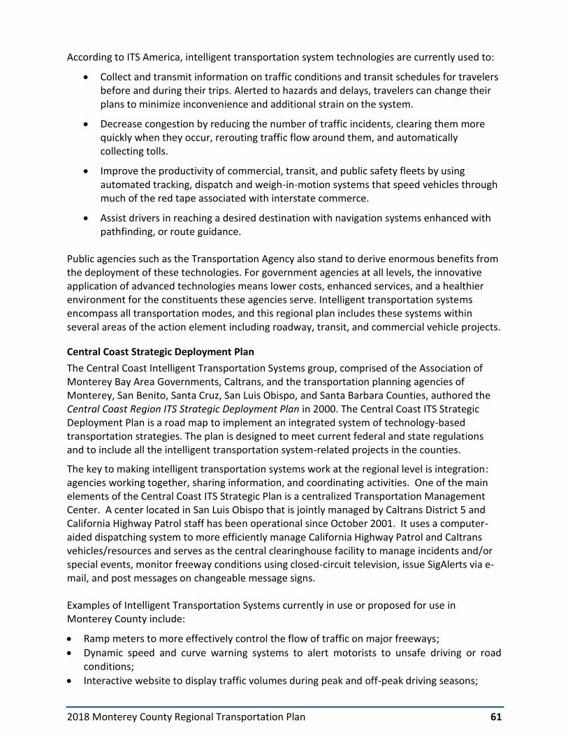
2018 Monterey County Regional Transportation Plan 61
According to ITS America, intelligent transportation system technologies are currently used to:
• Collect and transmit information on traffic conditions and transit schedules for travelers before and during their trips. Alerted to hazards and delays, travelers can change their plans to minimize inconvenience and additional strain on the system.
• Decrease congestion by reducing the number of traffic incidents, clearing them more quickly when they occur, rerouting traffic flow around them, and automatically collecting tolls.
• Improve the productivity of commercial, transit, and public safety fleets by using automated tracking, dispatch and weigh-in-motion systems that speed vehicles through much of the red tape associated with interstate commerce.
• Assist drivers in reaching a desired destination with navigation systems enhanced with pathfinding, or route guidance.
Public agencies such as the Transportation Agency also stand to derive enormous benefits from the deployment of these technologies. For government agencies at all levels, the innovative application of advanced technologies means lower costs, enhanced services, and a healthier environment for the constituents these agencies serve. Intelligent transportation systems encompass all transportation modes, and this regional plan includes these systems within several areas of the action element including roadway, transit, and commercial vehicle projects.
Central Coast Strategic Deployment Plan
The Central Coast Intelligent Transportation Systems group, comprised of the Association of Monterey Bay Area Governments, Caltrans, and the transportation planning agencies of Monterey, San Benito, Santa Cruz, San Luis Obispo, and Santa Barbara Counties, authored the Central Coast Region ITS Strategic Deployment Plan in 2000. The Central Coast ITS Strategic Deployment Plan is a road map to implement an integrated system of technology-based transportation strategies. The plan is designed to meet current federal and state regulations and to include all the intelligent transportation system-related projects in the counties.
The key to making intelligent transportation systems work at the regional level is integration: agencies working together, sharing information, and coordinating activities. One of the main elements of the Central Coast ITS Strategic Plan is a centralized Transportation Management Center. A center located in San Luis Obispo that is jointly managed by Caltrans District 5 and California Highway Patrol staff has been operational since October 2001. It uses a computer-aided dispatching system to more efficiently manage California Highway Patrol and Caltrans vehicles/resources and serves as the central clearinghouse facility to manage incidents and/or special events, monitor freeway conditions using closed-circuit television, issue SigAlerts via e-mail, and post messages on changeable message signs. Examples of Intelligent Transportation Systems currently in use or proposed for use in Monterey County include:
• Ramp meters to more effectively control the flow of traffic on major freeways;
• Dynamic speed and curve warning systems to alert motorists to unsafe driving or road conditions;
• Interactive website to display traffic volumes during peak and off-peak driving seasons;

2018 Monterey County Regional Transportation Plan 62
• Use of transit vehicle tracking systems to support transit operations;
• Advanced traffic signal control systems;
• Closed circuit television cameras on state routes to help monitor congestion and respond to incidents and blockages more quickly;
• Temporary changeable message signs on major roadways to advise motorists of local traffic conditions during special events; and,
• Emergency vehicle signal pre-emption. The Central Coast ITS Strategic Plan lists several priorities for Monterey County. These are:
• Traveler information systems (changeable message signs, highway advisory radio) along US 101, SR 1, SR 68 and SR 156;
• Upgrades to traffic signal systems to improve signal coordination;
• Safety applications on rural highways; and
• A 511 telephone call-in system The Central Coast ITS Strategic Plan provides an architecture, or map, of the implementation strategy. Also, the Plan notes the steps that need to occur to implement the Plan. One of those steps is integrating intelligent transportation systems in to mainstream transportation planning efforts, such as the Regional Transportation Plan. As such, intelligent transportation system projects have been included in the regional plan project list, and will be implemented either as separate safety projects, or as part of new capacity projects. Intelligent Transportation Systems and Transit
As part of the deployment plan, Monterey-Salinas Transit has installed several intelligent transportation system projects:
• Signal Priority In cooperation with the City of Monterey and with a grant from the Congestion Mitigation and Air Quality, MST and the City installed signal priority equipment on key commuter routes at selected intersections to speed bus and traffic flow in commute hours. This technology has been installed on the MST JAZZ Bus Rapid Transit Route described earlier in the Chapter. MST hopes to further expand signal priority to the Cities of Salinas, Seaside, Marina, and selected state highway intersections.
• Advance Communication System MST is installing the latest radio, dispatch, and vehicle locator systems. They are connected to Global Positioning Satellites (GPS) that allow for a wide variety of technological advances. These systems will assist to speed buses and transfer connections, aid in bus scheduling, provide passenger counting and loading data thus helping to reduce overcrowding. ITS will provide a higher level of customer service such as buses enunciators and real-time bus arrival times and system conditions.

2018 Monterey County Regional Transportation Plan 63
Airports
Airports in Monterey County provide interregional connections to and from the County. Airport projects from the adopted capital improvement programs are included in the plan’s project list. Publicly-owned civil aviation airports are discussed below.
Regional Airport System Plan
Aviation forecasts in this plan are based on the Regional Airport System Plan prepared by AMBAG most recently in 2006, which provides a basis for assisting airport sponsors and local communities with general aviation, commercial aviation, and military airports.
Table 4-1 below describes airport forecasts for Monterey County. The Regional Airport System Plan provides forecasts to the year 2025. Both the number of total based aircraft in the county and annual operations are projected to increase over this forecast period. No major deficiencies to aviation services are identified in the Regional Airport System Plan.
Table 4-1: Aviation Forecasts - Based Aircraft and General Aviation Operations
Based on the airport service areas, population growth, aviation trends, and the character and nature of aviation facilities within the Monterey County and Santa Cruz County region, the plan forecasts the following developments:
• Moderate increase in demand: The growth of population in the region will moderately increase commercial and general aviation demand;
• Capital Upgrades Needed: Facilities are needed to support increased business travel demand. Runway extensions, minor land acquisition, additions of navigational aids, and development of new aircraft hangars are necessary to meet forecast demand.
• No new commercial airport development required: The quality of commercial passenger service at the Monterey Regional airport, and the proximity of San Jose International Airport will allow for airline service without the need for new commercial airport development. With availability for increased operations, the existing general public airports in the region could absorb aircraft from other regions if facilities are closed in those regions.
Total Based Aircraft 2005 2020 2025
Marina Municipal 74 98 108
Salinas Municipal 224 258 273
Monterey Regional 143 172 184
Mesa Del Rey (King City) 33 50 55
Monterey County Total 474 578 620
Annual Aviation Operations 2005 2010 2015
Marina Municipal 31,800 47,530 55,080
Salinas Municipal 78,400 94,170 101,010
Monterey Regional 78,565 92,890 98,850
Mesa Del Rey (King City) 13,860 24,000 27,000
Monterey County Total 202,625 258,590 281,940

2018 Monterey County Regional Transportation Plan 64
The roles and configuration of the system in Monterey County is expected to remain the same. Monterey Peninsula Airport will remain the sole commercial facility. Salinas and King City Municipal Airports will continue to provide agricultural operations.
Future airport development depends on the ability of an airport to cover development costs. The primary responsibility for financing rests with each airport. There are many sources of airport development funds, including FAA’s Airport Improvement Program (AIP), the California Department of Transportation, passenger facility charges, private donations, leasebacks, direct revenue loans, certificates of participation, and revenue and general obligation bonds. Capital improvements can also be financed from annual operating and tax revenues.
The county’s publicly owned airports are described in the sections that follow. Monterey County Airports
There are four publicly-owned airports located in Monterey County:
• Monterey Regional Airport (MRY)
• Mesa Del Rey Airport in King City
• Marina Municipal Airport
• Salinas Municipal Airport
Passenger and general aviation air services are provided at Monterey Peninsula Airport. The airports at Salinas, King City (Mesa Del Rey), and Marina Municipal Airports are limited to general aviation. Public Airports in Monterey County are described in Table 4-2 below.
Table 4-2: Description of Public Airports in Monterey County
Airport
Data Monterey Regional Salinas Marina King City
Number of Runways 2 4 1 1
Longest Runway (in feet) 7,598 6,000 3,000 4,485
Instrument Landing yes yes no no
Control Tower yes yes no no
Scheduled passenger service yes no no no
Regional airport surveillance radar no no yes no
Owner/operator Airport District City City City
Functional Classification
Primary Commercial Service Non-Hub Regional/Business/Corporate
Regional-General Aviation Business/Corporate
Community– General Aviation
Community – General Aviation

2018 Monterey County Regional Transportation Plan 65
Monterey Regional Airport
The Monterey Regional Airport is located in the central coastal area of Monterey County, three miles east of Monterey. The airport is owned and operated by the Monterey Peninsula Airport District, and is the only airport served by certified air carriers in Monterey County. The California Aviation System Plan classifies the Monterey Peninsula Airport as a primary commercial service airport of regional significance. The airport operates 24 hours a day daily. The airport has its own independently elected board of directors.
Facilities and Services The airport site consists of approximately 498 acres. The airfield operating area occupies the center of the airport and contains two runways; one for commercial jet operations and the other is a general aviation runway. The airport’s south area contains the passenger terminal, with related access and parking facilities, and three fixed based operators, serving commercial private jets. The Monterey Regional Airport is currently served by four airlines providing scheduled passenger service to San Francisco, Los Angeles, Las Vegas, and Phoenix.
Ground Access Network The regional transportation network that provides access to the Monterey Regional Airport includes US 101, State Route 68 and State Route 1, as well as the Blanco, Davis, Reservation and Imjin Parkway corridor between Salinas and State Route 1 in Marina. Regional access is also provided by Monterey-Salinas Transit. An airport limousine service and taxicabs also serve the airport. Much of the local hospitality industry provides its own shuttle services for guests. Transportation services at the airport are currently sufficient to accommodate demand.
Ground Access Improvement Program
The 2018 Monterey County Regional Transportation Plan supports development of the Monterey Regional Airport by expanding regional access. Strategies for enhancing ground access to this airport as part of the Ground Access Improvement Program include implementation of projects on the regional ground access network, with a focus on State Route 68 between Salinas and Monterey, as well as development of transit service providing airport connections and continual evaluation of transit routes serving the airport.
Specific regional projects to be implemented as part of the Ground Access Improvement Program include the following:
State Route 68 Commuter Improvements
US 101 South County Freeway Upgrade
US 101 Harris Road Interchange
Marina-Salinas Corridor Widening
Marina-Salinas Multimodal Corridor
Planning Activities
The Monterey County Airport Land Use Commission adopted a comprehensive land use plan for the Monterey Peninsula Airport influence area in 1987. The Plan serves to alert land use agencies to potential future incompatible land uses in the areas adjacent to the airport.

2018 Monterey County Regional Transportation Plan 66
The most recent master plan for the Monterey Regional Airport was updated in 1993. A new Master Plan and Airport Layout Plan were initiated in 2014 and completed in 2016. The master plan is currently in environmental review, which is expected to be completed in 2018.
Noise Mitigation The Airport District has adopted the FAR Part 150 Airport Noise Compatibility Program that mitigates noise intrusion into surrounding communities. The noise program, like the land use plan, is designed to consider future incompatible land uses in the areas adjacent to the airport.
Salinas Municipal Airport
Facilities and Services
The Salinas Municipal Airport, owned by the City of Salinas, is located on the southeastern boundary of Salinas. This general aviation facility occupies 763 acres and has three runways serving single and twin-engine aircraft and helicopters, as well as an increasing number of turboprops and turbine-powered business jets. The airport has an air traffic control tower and a precision instrument approach system serving one of the runways. More than 40 individual buildings serve airport users, including a terminal building with a flight service station.
Planning Activities
An Airport Master Plan was prepared for the Salinas Municipal Airport in 1976, and has not been updated since that time.
Mesa Del Rey (King City) Airport
Facilities and Services
Mesa Del Rey Airport is owned and operated by the City of King City, and covers 214 acres on King City's north boundary within the city limits. There is no control tower, so incoming and outgoing flights operate under visual flight rules. Terminal facilities include a service and maintenance hangar for the FBO (Fixed Based Operator), two storage hangars with a capacity for 18 aircraft, and uncovered tie-downs for an additional 58 aircraft. A radio station is used for homing. The airport meets general aviation requirements for the areas extending generally from the town of Greenfield on the north to town of San Lucas on the south.
Planning Activities
An Airport Master Plan was prepared for Mesa Del Rey Airport in 1976, and has not been updated since that time.
Marina Municipal Airport
The former Fritzsche Army Airfield was part of the military operations at Fort Ord from the 1950s until the base’s closure in 1994. As an army airfield, it was primarily used by rotary-wing aircraft (helicopters). There were some fixed-wing operations by aircraft under 12,500 pounds gross landing weight and the airfield was used for approach training by U.S. Air Force tactical aircraft and U.S. Navy Aircraft.
Facilities and Services
Marina Municipal Airport occupies 845.5 acres of the former Fritzsche Army Airfield within the City limits of Marina. The facility includes approximately 100,000 square feet of hangar space,

2018 Monterey County Regional Transportation Plan 67
70,000 square feet of hangar-related office/shop space, 50,000 square feet of other shop/office and storage area, and other flight-related facilities. The regional Airport Surveillance Radar, which services the major airports in the Monterey Bay region, is located at the airport. Since the departure of the military, private uses such as training, light industrial and recreational activities take place at the airport.
Planning Activities
The City of Marina initiated an update to the airport Master Plan in 2014, and completed it in 2016. The master plan is currently in environmental review and is expected to be completed in 2018.

2018 Monterey County Regional Transportation Plan 68
Maritime Transportation
There are two coastal harbors in Monterey County:
• City of Monterey Harbor
• Moss Landing Harbor
The harbors primary function is to support activities related to commercial fishing and pleasure vessels. Shipping occurs mainly from seaports in San Francisco and Oakland. Combined, the harbors have 1,145 slips. Each slip may be used by one or more boats, and slips are filled to capacity a majority of the time. Access to the harbors is provided via Route 1.
In addition to these harbors, the Moss Landing Energy Plant maintains an offshore mooring facility for oil tankers located ¾ mile offshore. The tankers transport the fuel required to serve the electrical generating plant at Moss Landing. Highway access to the harbors is provided via Route 1.
The Monterey Bay currently does not have maritime passenger transportation services, and no plans are currently in place to study the feasibility of implementing passenger services. The long-term feasibility of ferry service between Santa Cruz, the Monterey Peninsula, and points in between would be limited by the sea conditions and current lack of competitiveness with auto travel times (about 45 to 60 minutes).

2018 Monterey County Regional Transportation Plan 68
5. Environmental Documentation
This chapter presents an overview of the environmental review process conducted to determine the probable environmental impacts associated with adoption of the 2018 Monterey County Regional Transportation Plan, including the projected greenhouse gas emissions associated with implementation of the plan.
Coordinated Environmental Review
As described elsewhere in this document, the 2040 Moving Forward Monterey Bay Plan prepared by AMBAG and the 2018 Monterey County Regional Transportation Plan are coordinated documents. The Regional Transportation Plan is used by AMBAG to prepare a combined plan and Sustainable Communities Strategy for the Monterey Bay Area. These plans can be classified as a project under the California Environmental Quality Act requiring environmental review appropriate to the scope and nature of the document.
Recognizing an opportunity to achieve cost savings and streamline the environmental review process, AMBAG, the Santa Cruz County Regional Transportation Commission, the San Benito Council of Governments and the Transportation Agency for Monterey County, elected to merge the environmental analysis for each of their respective long-range transportation plans into one analysis. A single Draft Environmental Impact Report (EIR) has therefore been prepared by AMBAG for the 2040 Moving Forward Monterey Bay Plan (the Metropolitan Transportation Plan and Sustainable Communities Strategy) that includes the Regional Transportation Plans prepared in each county.
Notice of Preparation
AMBAG prepared and released a Notice of Preparation for the EIR in December, 2015. AMBAG held three scoping meetings on the EIR in Monterey County in January, 2016, which served as public workshops for the regional transportation plans and Sustainable Communities Strategy. The purpose of scoping meetings for the EIR was to collect public input on issues that the EIR should analyze. Input received at the scoping meetings and responses to the Notice of Preparation was incorporated into development of the environmental document. Program Environmental Impact Report
The EIR has been prepared as a Program EIR (rather than a "project" EIR). Adoption of the Regional Transportation Plan represents a first step in qualifying projects identified in the document for state and federal funding. The plan does not provide project designs nor details relating to the site-specific alignment, location, and scheduling of the transportation projects. Adoption of this comprehensive planning document does not represent an approval action for any of the individual transportation programs and projects listed in the plan. Additional actions on the part of the agencies and jurisdictions responsible for implementation of individual programs and projects are necessary for projects to proceed.
The program EIR is, therefore, intended to focus on those probable regional environmental effects associated with the implementation of the Regional Transportation Plan that can be identified now, while deferring analysis of site-specific impacts. Further project-specific environmental review is necessary as projects are developed and proposed for funding. Project specific review will be tiered-off of the program-level analysis prepared for the long-range plan.

2018 Monterey County Regional Transportation Plan 69
More Information
The EIR is incorporated into the 2018 Regional Transportation Plan by reference. The reader is referred to the EIR for more information on potential regional, system-wide environmental effects associated with implementation of the plan. The report provides an evaluation of alternatives, identifies an environmentally superior alternative, and identifies potential impacts that could be significant and unavoidable. The Draft EIR is available for review on the AMBAG and Transportation Agency websites and copies can be obtained by contacting either AMBAG or the Transportation Agency.
Air Quality Conformity
AMBAG is responsible for determining that the combined transportation plan for the tri-county Monterey Bay Area conforms with the federally-mandated Air Quality Management Plan prepared by the Monterey Bay Unified Air Pollution Control District (Air District). Air quality planning and regional planning through growth projections are interdependent processes. AMBAG provides regional growth data to the Air District. The Air District regularly updates the Air Quality Management Plan based in part upon those regional projections. The Monterey Bay Area is classified as an attainment area for ozone precursors based on federal ozone standards. The region is in conformity with the State Implementation Plan for air quality and therefore AMBAG is exempt from preparing a conformity analysis.

APPENDIX A
Public Outreach

2018 Monterey County Regional Transportation Plan
Public Outreach
Chapter 1 of the 2018 Monterey County Regional Transportation Plan describes the regional
transportation planning process through which public outreach is sought on an ongoing basis to
develop plans, programs and inform decision-making for transportation. The Monterey Bay
Area Public Participation Plan adopted by AMBAG in 2015 serves as a guide for structuring
public outreach into the long-range planning process and identifies a menu of strategies to be
employed to solicit public feedback.
Public outreach efforts undertaken to develop the Regional Transportation Plan are
summarized below.
2016 Measure X: Education and Outreach Activities
Passed in November 2016 with the support of over two-thirds of Monterey County voters,
Measure X is Monterey County’s 3/8th of a cent sales tax to support transportation in Monterey
County. As part of the public education and outreach leading up to Measure X, the Board
approved the hiring of a transportation sales tax measure outreach plan consultant to develop
and implement a strategic outreach plan to increase public awareness and understanding of
transportation needs and funding challenges. The plan’s focus was to identify our needs,
explain those needs and the funding crisis and shortfalls in state & federal funding; which
presents challenges in our efforts to maintain local roads, make safety improvements and
ensure that we have a local transportation network that moves people, goods and enhances
the quality of our life.
The outreach plan over the nearly two-year period included the following outreach efforts:
• 80-100 presentations to a broad range of community groups, business organizations, chambers of commerce’s, city councils, school superintendents, service clubs, trade & professional organizations, educational & medical institutions, taxpayer associations, LULAC, Agricultural Industry, Hospitality Industry and the Board of Supervisors.
• Print & broadcast interviews with local newspaper, radio and television media outlets.
• Commentaries and op-ed pieces to the local newspapers.
• Interviews with Editorial Boards of the Monterey County Weekly and Monterey Herald.
• Organized a community leaders Keep Monterey County Moving committee composed of 40 members from throughout the county, representing diverse economic and social

interests. This Committee actively participated in the development of the Transportation Safety & Investment Plan.
• Sought public input via surveys, comments, focus groups, stakeholders’ interviews, TAMC website.
• Provided information and sought input on our website, Facebook and Twitter pages.
• Developed informational fact sheets, targeted special interest fact sheets and individualized city/county fact sheets, a Transportation Safety & Investment Plan document, a Policies & Project Descriptions document for the Transportation Safety & Investment Plan.
SR 68 Scenic Highway Plan
The SR 68 Scenic Highway Plan provides a conceptual plan for delivering operational and safety
improvements to the SR 68 Corridor between Blanco Road in Salinas and SR 1 in Monterey.
Work on the plan too place between December 2015 and August 2017. An extensive public
outreach effort was performed throughout the course of SR 68 Scenic Highway Plan
development process. The outreach effort included traditional public workshops,
community/stakeholder meetings, online engagement, and media. The input received through
these various channels helped inform the study and ultimately the study recommendations.
SR 68 Pacific Grove Corridor Study
Between September 2014 and October 2016, the Transportation Agency in partnership with the
City of Pacific Grove and Caltrans conducted a study of the State Route 68 Corridor in Pacific
Grove to identify improvements that will provide safer access for all modes of travel. The
outreach effort included traditional public workshops, community/stakeholder meetings, on-
line engagement, and media. The input received through these various channels helped inform
the study and ultimately the study recommendations.
Monterey County Active Transportation Plan
The 2018 Transportation Agency for Monterey County Active Transportation Plan is an update
of the 2011 Bicycle and Pedestrian Master Plan, which identified all existing and proposed
bicycle and pedestrian facilities in Monterey County and the communities therein.
To develop the Active Transportation Plan, Agency staff consulted with TAMC’s Bicycle and
Pedestrian Facilities Advisory Committee , which is composed of volunteer representatives from
each supervisorial district and city in Monterey County as well as representatives from public
agencies and a bicycle/pedestrian interest group, as appointed by the TAMC Board of Directors,
and TAMC’s Technical Advisory Committee, composed of public works representatives from
each of the twelve cities in Monterey County, Monterey County Public Works, Caltrans,

Monterey-Salinas Transit, the Fort Ord Reuse Authority, the Monterey Bay Unified Air Pollution
Control District, and the Association of Monterey Bay Area Governments.
TAMC staff developed a project specific Active Transportation Plan page on the TAMC website.
Draft documents were posted on this site. Approximately 447 people submitted comments via
the public participation Wiki-mapping tool. Staff collaborated with the Monterey County Health
Department to gather input from disadvantaged communities, via their Greenfield Leadership
and Civic Engagement group. Staff also collaborated with the City of Gonzales to host a South
County public workshop for the Plan.
Wayfinding Plan
The Regional Bicycle and Pedestrian Wayfinding Plan for Monterey County provides standard
guidelines for bicycle and pedestrian wayfinding signage throughout Monterey County. The
goal of the Wayfinding Plan is to promote bicycling and walking as viable transportation
alternatives for Monterey County residents and visitors. The plan was crafted with input from
the Wayfinding Plan Advisory Committee, an ad-hoc committee of the Transportation Agency
for Monterey County. It is comprised of project stakeholders, including representatives from
TAMC’s Bicycle and Pedestrian Facilities Advisory Committee, County of Monterey, local cities,
the Monterey County Health Department, Building Healthy Communities, Fort Ord Reuse
Authority, the Velo Club, Green Pedal Couriers, Fort Ord Recreation Trails Friends, Pebble
Beach, and Monterey Salinas-Transit. Members of the public may also participate.
Trail Planners Advisory Group (TrailPAC)
The Trail Planners Advisory Council (TrailPAC) brings together representatives from the
Monterey Peninsula Regional Parks District, the Big Sur Land Trust, the California Department
of State Parks and other stakeholders interested in expanding the trail networks in Monterey
County. The Group met regularly in 2015 and 2016.
Public Meetings
Outreach to stakeholders, the public and member jurisdictions was undertaken through noticed
public meetings of AMBAG and the Transportation Agency for Monterey County. Public
presentations about preparation of the 2018 Regional Transportation Plan were initiated in
2012 and meetings were scheduled to provide information and request actions at key
milestone points during development of the plan. Presentations and discussion about the plan
were held with the following bodies:
Transportation Agency for Monterey County Board of Directors
April 2017: Approval of a project list for inclusion in the Sustainable Communities
December 2017: Authorization to release Draft Regional Transportation Plan

January 2018: Noticed Public Hearing on the Draft 2014 Regional Transportation Plan
June 2018: Adoption of 2018 Monterey County Regional Transportation Plan and EIR
Technical Advisory Committee
September 2016: Discussion/feedback on financial assumptions and call for projects
January 2018: Review of Draft Regional Transportation Plan and MTP/SCS
June 2018: Review of Final Regional Transportation Plan
Bicycle & Pedestrian Facilities Advisory Committee
June 2018: Review of Final Regional Transportation Plan
Public Workshops
The following public workshops were held in Monterey County to solicit public input on the
Sustainable Communities Strategy, Metropolitan Transportation Plan and transportation
investments included in the Monterey County Regional Transportation Plan. These workshops
also served as public scoping meetings for the coordinated Draft Environmental Impact Report
prepared for these documents:
January, 2016: Public Workshop for the Notice of Preparation for the Environmental Impact
Report for all documents
• Salinas
April, 2017: Public workshops on initial scenarios, land use and transportation investments
for the Sustainable Communities Strategy
• Salinas
• Marina
January, 2018: Public hearings on the final Metropolitan Transportation Plan, Sustainable
Communities Strategy and Regional Transportation Plan
• Gonzales
• Seaside
A wide range of groups were invited to, and participated in these workshops, including
members of the general public, and representatives of disadvantaged communities and
environmental interests.
Telephone Surveys
To assure that all sectors of the county had a chance to provide input, the Transportation
Agency conducted three telephone preferences surveys on the Regional Transportation Plan
and Sustainable Communities Strategy: in May 2014, December 2015 and June 2016. The

surveys provided valuable public input on preferences for transportation, investments, support
for sustainable communities strategies, and funding for transportation.
Regional Transportation Plan Distribution
Notices or copies of the Regional Transportation Plan were distributed to the following
jurisdictions, agencies and groups:
• Transportation Agency member jurisdictions
• Bicycle and Pedestrian Facilities Advisory Committee
• MST Mobility Advisory Committee
• San Benito Council of Governments
• Santa Cruz County Regional Transportation Commission
• State and Federal Resource Agencies responsible for land use, natural resources,
environmental protection, conservation and historic preservation
• California Rural Legal Assistance Foundation
• Highway 68 Coalition
The Draft Environmental Impact Report was also circulated to these contacts for review.
Online and Media Outreach Materials and announcements related to public workshops, the Sustainable Communities
Strategy and the Draft 2018 Monterey County Regional Transportation Plan were made
available through posting to the Transportation Agency website (www.tamcmonterey.org).
Information about public workshops was also distributed through social media pages
maintained by the Agency.

APPENDIX B
Regional Transportation Plan Fund Estimate

REVENUESOURCES ASSUMPTIONS/SOURCENOTESLOCALREVENUESOURCESCitySalesTaxesUsedonTransportation IncludesfundingestimatesforMontereyMeasureP.
City/CountyDeveloperFeesImpactfeesonnewdevelopmentprojects.FeescurrentlycollectedinSalinas,Monterey,Gonzales,Marina,andCarmel.
City/CountyGeneralFundsforTransportationProjectsBasedoninformationinformationprovidedbyjurisdictionsonlocalrevenuesbudgetedtotransportation.
FORACIPFees&Presidio(MontereyCounty) Presidiofeescollectedarepartiallydiscretionarytomilitaryprojects.
GasTax(HighwayUserTax)Gastaxtoescalateat1.75%throughouttheentireperiodoftheRegionalTransportationPlan.
SB1RMRALocalGasTax Basedonestimatesfromthefundingpackage.CAGeneralFundLoanRepayment Basedonestimatesfromthefundingpackage.AirportRevenues ProvidedbytheCityofSalinas.
RailLineLeaseRevenueRevenuesgeneratedfromMontereyBranchLinepropertyleases.Leaserevenueswillnolongerbeavailableonceraillineservicebegins.
RegionalDeveloperFees Basedoninformationprovidedbymemberjurisdictions.
TransitFaresPublictransitfarerevenueassumptionsprovidedbyMST.RevenueassumptionsforSalinasRail($4mill./yearstartingin16/17,and$1millionforMontereyBranchLineservicein18/19.
Transitnon‐farerevenue ProvidedbyMST.MeasureQTransitSalesTax ProvidedbyMST.
TransportationDevelopmentAct/LTFEstimatedevelopedbyTAMC.Revenuesgeneratedfroma1/4percentofretailsalestax,returnedtocountyandallocatedbyTAMC.Fundsdesignatedforplanning,bike&pedprojectsandpublictransit.
2016TransportationSalesTaxNewcountywidetransportationsalestaxinitiatedinNovember2017assumedforfundestimate.Estimatebasedon2016MeasureXeffort:$20mill.(in2016$'s)inrevenuesexpectedfrom3/8centcountywidesalestax.
Highway156TollRevenuesTollrevenuesbeingstudiedtofinanceconstructionoftheStateRoute156WestCorridorproject.AssumptionsbasedonTollingTrafficandRevenueStudyAppendix,RevenueScheduleTollingPlanD
REGIONALREVENUESOURCES
AB2766MontereyBayUnifiedAirPollutionControlDistrictgrants.Basedonactualgrantamountfor12/13.RegionalfundsdividedbetweenMonterey,SanBenitoandSantaCruzCounties.
STATEREVENUESOURCES
AirportImprovementProgrammatch$1,650forFY2012/2013Statewide.BasedonmatchofFAAgrants.Assumedannualaverageoflast8yearsoffunding($45MontereyCounty).
CaliforniaAidtoAirportsProgram Dedicatedtoallpublicuseairports.$10,000annually.$30KMontereyCounty.
FreewayServicePatrolVehiclelicensefeerevenueforstatewidefreewaytowtruckprogams.Basedonaverageoflastfoureyears:MontereyCounty:$230,000.
SAFE Basedonthe$1feeleviedonregisteredvehiclesineachcounty.
SHOPPAveragebasedonamountprogrammedin2008through10‐yearSHOPP(2023);Fundingin2024‐2035isbasedonannualaverage.
RMRASHOPP Basedonestimatesfromthefundingpackage.StateTransitAssistance(STA) StateControllerestimates.SB1STA Basedonestimatesfromthefundingpackage.STASOGR StateControllerestimates.STIP‐InterregionalShare AssumingnoITIPfunding
STIP‐RegionalShareBaselineequals2016STIPFEtargetcapacityforFY20/21timesformulasharesofSTIPforeachcounty.FY15/16‐20/21forprojectsprogrammedin2016STIPandincludescarryoverbalancesfromprioryearSTIPshares.
ActiveTransportationProgram
BasedonfundinglevelsforbicycleandpedestrianprogramsconsolidatedintotheCaliforniaActiveTransportationprogram.Calculatedthe10%ruralcompetitiveportionusingRuralPlanningAssistancefundformula,andthe50%statewidecompetitiveusingpopulation.
LowCarbonTransitOperationsProgram BasedonestimatesfromtheinitialprogramSB1OtherPrograms Basedonestimatesfromthefundingpackage.
AffordableHousing&SustainableCommunitiesAssumingMontereyCountywillreceive0.92%ofthefundsavailableStatewide
FEDERALTRANSITREVENUESOURCESFixedGuidewayCapitalInvestmentGrants(5309) Assumingaone‐timereceiptofa$15milliongrant.
EnhancedMobilityofSeniorsandIndividualswithDisabilities(5310)
FederalTransitAdministrationGrantsfortransitandnon‐profitprojectssupportingneedsoftheelderlyandpeoplewithdisabilities.IncludesfundingformerlyincludedintheNewFreedomsgrantprogram.MontereyCountyestimatebasedonpopulation(http://www.dot.ca.gov/hq/MassTrans/5310.html).
StatePlanning(5304)Federalgrantfundingfortransitplanning.Basedonanannualaverageoftransitplanningfundsreceivedoverthelastfiveyears(http://www.dot.ca.gov/hq/tpp/grants_archive.html).

MetropolitanPlanning(5303) AssumingMontereyCounty’shistoricalshareofplanningfunds.
RuralAreaFormulaProgram(5311)
Federalgrantfundssupportingprojectsthatprovidetransportationbetweennonurbanizedareasandurbanizedareasthatresultinconnectionsofgreaterregional,statewide,andnationalsignificance.$3.4milwasavailableinfy2011.FundsourceforMSTprojects,providedbyMST.
UrbanizedAreaFormulaProgram(5307)
Availableforareawithpopulationover50,000.EstimatescamefromChrisGiglio,aconsultanttoMetro,fromachartmadebyFTAafterMAP21.Numbersareunderthetransittab.ExpandedtoincludesomeformerJobsAccessReverseCommutefunding(http://www.dot.ca.gov/hq/MassTrans/Docs‐Pdfs/5311/2012estimates.pdf).
SmallTransitIntensiveCities(5307c) Estimatebasedonfouryearannualaverage.StateofGoodRepairGrants(5337) Estimatebasedonfouryearannualaverage.BusandBusFacilitiesFormulaProgram(5339) EstimateprovidedbyMST.BusandBusFacilitiesDiscretionaryProgram(5339b) Estimatebasedonthreeyearannualaverage.FEDERALHIGHWAYREVENUESOURCES
HighRiskRuralRoad(HR3)Estimatebasedonannualaverageof5yearsofawardedprojectlist.(http://www.dot.ca.gov/hq/LocalPrograms/HR3/approved_project_lists.html).
HighwayBridgeProgram(HBP)Federalfundingtoreplaceorrehabilitatebridges.EstimateassumesannualaverageofawardedprojectlistfromFFY12to15(http://www.dot.ca.gov/hq/LocalPrograms/hbrr99/hbrr99a.html).
HighwaySafetyImprovementProgram(HSIP)
Federalfundsforprojectsthatimprovesafetyonroadsandhighways.Somefundingavailableforbikeandpedestrianimprovements.EstimateusesannualaverageoftheHSIPfundsoverthelast5yearperiodunderSAFETEA‐LU(http://www.dot.ca.gov/hq/LocalPrograms/HSIP/prev_cycle_results.html)
SurfaceTransportationBlockGrant
Flexiblesourceofdescretionaryfundsfortransportationprojects.FundsforMontereyCountyareexchangedforstatefunding,sothesefundsarereceivedasstatefunding.Includedunderfederalcategoryinthefundestimatetoreflectsource.Summarychartsincludethesefundsasstatefunds.Estimatebasedonapportionmentforecastsummary(http://www.dot.ca.gov/hq/transprog/federal/rstp/rstp_est_2012_16.pdf).
FEMA/CALEMA/ER‐EmergencyRoadRepairFunding Estimatebasedonfouryearannualaverage.FEDERALAVIATIONREVENUESOURCES
FAAAirportImprovementProgram(AIP)Federalfundingforairports.EstimateassumesannualaverageofFFAgrantsfromFederalFiscalYear2006to2011.
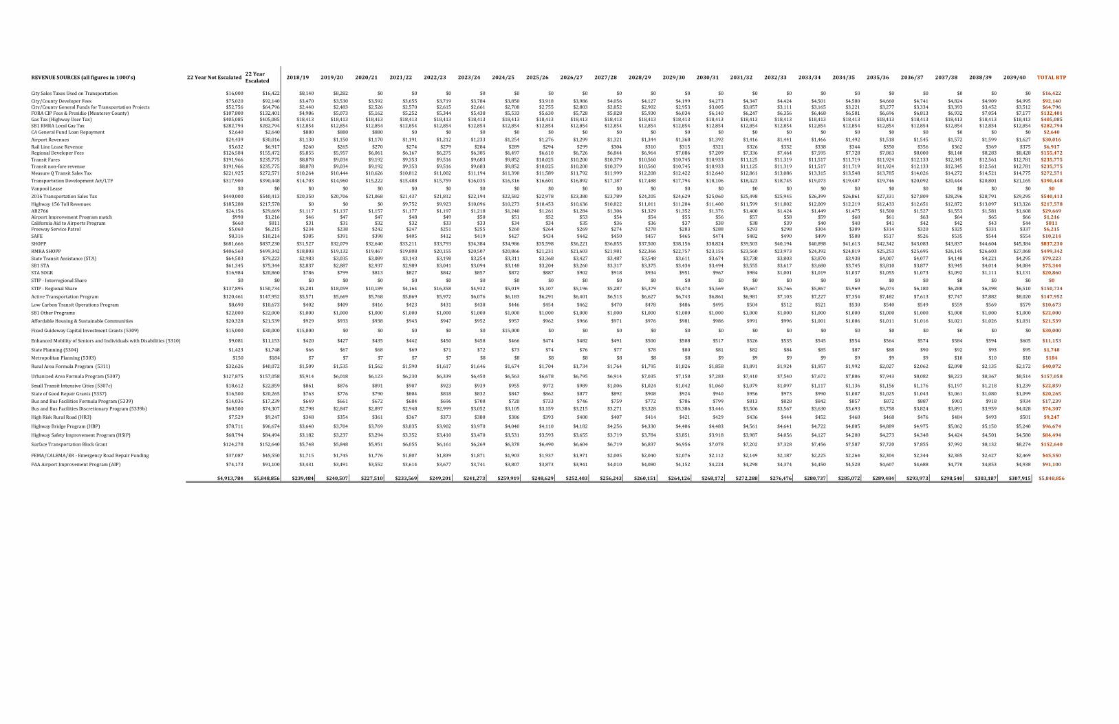
REVENUESOURCES(allfiguresin1000's) 22YearNotEscalated22YearEscalated
2018/19 2019/20 2020/21 2021/22 2022/23 2023/24 2024/25 2025/26 2026/27 2027/28 2028/29 2029/30 2030/31 2031/32 2032/33 2033/34 2034/35 2035/36 2036/37 2037/38 2038/39 2039/40 TOTALRTP
CitySalesTaxesUsedonTransportation $16,000 $16,422 $8,140 $8,282 $0 $0 $0 $0 $0 $0 $0 $0 $0 $0 $0 $0 $0 $0 $0 $0 $0 $0 $0 $0 $16,422
City/CountyDeveloperFees $75,020 $92,140 $3,470 $3,530 $3,592 $3,655 $3,719 $3,784 $3,850 $3,918 $3,986 $4,056 $4,127 $4,199 $4,273 $4,347 $4,424 $4,501 $4,580 $4,660 $4,741 $4,824 $4,909 $4,995 $92,140City/CountyGeneralFundsforTransportationProjects $52,756 $64,796 $2,440 $2,483 $2,526 $2,570 $2,615 $2,661 $2,708 $2,755 $2,803 $2,852 $2,902 $2,953 $3,005 $3,057 $3,111 $3,165 $3,221 $3,277 $3,334 $3,393 $3,452 $3,512 $64,796FORACIPFees&Presidio(MontereyCounty) $107,800 $132,401 $4,986 $5,073 $5,162 $5,252 $5,344 $5,438 $5,533 $5,630 $5,728 $5,828 $5,930 $6,034 $6,140 $6,247 $6,356 $6,468 $6,581 $6,696 $6,813 $6,932 $7,054 $7,177 $132,401GasTax(HighwayUserTax) $405,085 $405,085 $18,413 $18,413 $18,413 $18,413 $18,413 $18,413 $18,413 $18,413 $18,413 $18,413 $18,413 $18,413 $18,413 $18,413 $18,413 $18,413 $18,413 $18,413 $18,413 $18,413 $18,413 $18,413 $405,085SB1RMRALocalGasTax $282,794 $282,794 $12,854 $12,854 $12,854 $12,854 $12,854 $12,854 $12,854 $12,854 $12,854 $12,854 $12,854 $12,854 $12,854 $12,854 $12,854 $12,854 $12,854 $12,854 $12,854 $12,854 $12,854 $12,854 $282,794CAGeneralFundLoanRepayment $2,640 $2,640 $880 $880 $880 $0 $0 $0 $0 $0 $0 $0 $0 $0 $0 $0 $0 $0 $0 $0 $0 $0 $0 $0 $2,640
AirportRevenues $24,439 $30,016 $1,130 $1,150 $1,170 $1,191 $1,212 $1,233 $1,254 $1,276 $1,299 $1,321 $1,344 $1,368 $1,392 $1,416 $1,441 $1,466 $1,492 $1,518 $1,545 $1,572 $1,599 $1,627 $30,016RailLineLeaseRevenue $5,632 $6,917 $260 $265 $270 $274 $279 $284 $289 $294 $299 $304 $310 $315 $321 $326 $332 $338 $344 $350 $356 $362 $369 $375 $6,917RegionalDeveloperFees $126,584 $155,472 $5,855 $5,957 $6,061 $6,167 $6,275 $6,385 $6,497 $6,610 $6,726 $6,844 $6,964 $7,086 $7,209 $7,336 $7,464 $7,595 $7,728 $7,863 $8,000 $8,140 $8,283 $8,428 $155,472TransitFares $191,966 $235,775 $8,878 $9,034 $9,192 $9,353 $9,516 $9,683 $9,852 $10,025 $10,200 $10,379 $10,560 $10,745 $10,933 $11,125 $11,319 $11,517 $11,719 $11,924 $12,133 $12,345 $12,561 $12,781 $235,775Transitnon‐farerevenue $191,966 $235,775 $8,878 $9,034 $9,192 $9,353 $9,516 $9,683 $9,852 $10,025 $10,200 $10,379 $10,560 $10,745 $10,933 $11,125 $11,319 $11,517 $11,719 $11,924 $12,133 $12,345 $12,561 $12,781 $235,775MeasureQTransitSalesTax $221,925 $272,571 $10,264 $10,444 $10,626 $10,812 $11,002 $11,194 $11,390 $11,589 $11,792 $11,999 $12,208 $12,422 $12,640 $12,861 $13,086 $13,315 $13,548 $13,785 $14,026 $14,272 $14,521 $14,775 $272,571
TransportationDevelopmentAct/LTF $317,900 $390,448 $14,703 $14,960 $15,222 $15,488 $15,759 $16,035 $16,316 $16,601 $16,892 $17,187 $17,488 $17,794 $18,106 $18,423 $18,745 $19,073 $19,407 $19,746 $20,092 $20,444 $20,801 $21,165 $390,448
VanpoolLease $0 $0 $0 $0 $0 $0 $0 $0 $0 $0 $0 $0 $0 $0 $0 $0 $0 $0 $0 $0 $0 $0 $0 $0 $0
2016TransportationSalesTax $440,000 $540,413 $20,350 $20,706 $21,068 $21,437 $21,812 $22,194 $22,582 $22,978 $23,380 $23,789 $24,205 $24,629 $25,060 $25,498 $25,945 $26,399 $26,861 $27,331 $27,809 $28,296 $28,791 $29,295 $540,413
Highway156TollRevenues $185,288 $217,578 $0 $0 $0 $9,752 $9,923 $10,096 $10,273 $10,453 $10,636 $10,822 $11,011 $11,204 $11,400 $11,599 $11,802 $12,009 $12,219 $12,433 $12,651 $12,872 $13,097 $13,326 $217,578AB2766 $24,156 $29,669 $1,117 $1,137 $1,157 $1,177 $1,197 $1,218 $1,240 $1,261 $1,284 $1,306 $1,329 $1,352 $1,376 $1,400 $1,424 $1,449 $1,475 $1,500 $1,527 $1,553 $1,581 $1,608 $29,669AirportImprovementProgrammatch $990 $1,216 $46 $47 $47 $48 $49 $50 $51 $52 $53 $54 $54 $55 $56 $57 $58 $59 $60 $61 $63 $64 $65 $66 $1,216CaliforniaAidtoAirportsProgram $660 $811 $31 $31 $32 $32 $33 $33 $34 $34 $35 $36 $36 $37 $38 $38 $39 $40 $40 $41 $42 $42 $43 $44 $811FreewayServicePatrol $5,060 $6,215 $234 $238 $242 $247 $251 $255 $260 $264 $269 $274 $278 $283 $288 $293 $298 $304 $309 $314 $320 $325 $331 $337 $6,215SAFE $8,316 $10,214 $385 $391 $398 $405 $412 $419 $427 $434 $442 $450 $457 $465 $474 $482 $490 $499 $508 $517 $526 $535 $544 $554 $10,214
SHOPP $681,666 $837,230 $31,527 $32,079 $32,640 $33,211 $33,793 $34,384 $34,986 $35,598 $36,221 $36,855 $37,500 $38,156 $38,824 $39,503 $40,194 $40,898 $41,613 $42,342 $43,083 $43,837 $44,604 $45,384 $837,230
RMRASHOPP $406,560 $499,342 $18,803 $19,132 $19,467 $19,808 $20,155 $20,507 $20,866 $21,231 $21,603 $21,981 $22,366 $22,757 $23,155 $23,560 $23,973 $24,392 $24,819 $25,253 $25,695 $26,145 $26,603 $27,068 $499,342StateTransitAssistance(STA) $64,503 $79,223 $2,983 $3,035 $3,089 $3,143 $3,198 $3,254 $3,311 $3,368 $3,427 $3,487 $3,548 $3,611 $3,674 $3,738 $3,803 $3,870 $3,938 $4,007 $4,077 $4,148 $4,221 $4,295 $79,223SB1STA $61,345 $75,344 $2,837 $2,887 $2,937 $2,989 $3,041 $3,094 $3,148 $3,204 $3,260 $3,317 $3,375 $3,434 $3,494 $3,555 $3,617 $3,680 $3,745 $3,810 $3,877 $3,945 $4,014 $4,084 $75,344STASOGR $16,984 $20,860 $786 $799 $813 $827 $842 $857 $872 $887 $902 $918 $934 $951 $967 $984 $1,001 $1,019 $1,037 $1,055 $1,073 $1,092 $1,111 $1,131 $20,860
STIP‐InterregionalShare $0 $0 $0 $0 $0 $0 $0 $0 $0 $0 $0 $0 $0 $0 $0 $0 $0 $0 $0 $0 $0 $0 $0 $0 $0
STIP‐RegionalShare $137,895 $150,734 $5,281 $18,059 $10,189 $4,164 $16,358 $4,932 $5,019 $5,107 $5,196 $5,287 $5,379 $5,474 $5,569 $5,667 $5,766 $5,867 $5,969 $6,074 $6,180 $6,288 $6,398 $6,510 $150,734
ActiveTransportationProgram $120,461 $147,952 $5,571 $5,669 $5,768 $5,869 $5,972 $6,076 $6,183 $6,291 $6,401 $6,513 $6,627 $6,743 $6,861 $6,981 $7,103 $7,227 $7,354 $7,482 $7,613 $7,747 $7,882 $8,020 $147,952
LowCarbonTransitOperationsProgram $8,690 $10,673 $402 $409 $416 $423 $431 $438 $446 $454 $462 $470 $478 $486 $495 $504 $512 $521 $530 $540 $549 $559 $569 $579 $10,673
SB1OtherPrograms $22,000 $22,000 $1,000 $1,000 $1,000 $1,000 $1,000 $1,000 $1,000 $1,000 $1,000 $1,000 $1,000 $1,000 $1,000 $1,000 $1,000 $1,000 $1,000 $1,000 $1,000 $1,000 $1,000 $1,000 $22,000
AffordableHousing&SustainableCommunities $20,328 $21,539 $929 $933 $938 $943 $947 $952 $957 $962 $966 $971 $976 $981 $986 $991 $996 $1,001 $1,006 $1,011 $1,016 $1,021 $1,026 $1,031 $21,539
FixedGuidewayCapitalInvestmentGrants(5309) $15,000 $30,000 $15,000 $0 $0 $0 $0 $0 $15,000 $0 $0 $0 $0 $0 $0 $0 $0 $0 $0 $0 $0 $0 $0 $0 $30,000
EnhancedMobilityofSeniorsandIndividualswithDisabilities(5310) $9,081 $11,153 $420 $427 $435 $442 $450 $458 $466 $474 $482 $491 $500 $508 $517 $526 $535 $545 $554 $564 $574 $584 $594 $605 $11,153
StatePlanning(5304) $1,423 $1,748 $66 $67 $68 $69 $71 $72 $73 $74 $76 $77 $78 $80 $81 $82 $84 $85 $87 $88 $90 $92 $93 $95 $1,748
MetropolitanPlanning(5303) $150 $184 $7 $7 $7 $7 $7 $8 $8 $8 $8 $8 $8 $8 $9 $9 $9 $9 $9 $9 $9 $10 $10 $10 $184
RuralAreaFormulaProgram(5311) $32,626 $40,072 $1,509 $1,535 $1,562 $1,590 $1,617 $1,646 $1,674 $1,704 $1,734 $1,764 $1,795 $1,826 $1,858 $1,891 $1,924 $1,957 $1,992 $2,027 $2,062 $2,098 $2,135 $2,172 $40,072
UrbanizedAreaFormulaProgram(5307) $127,875 $157,058 $5,914 $6,018 $6,123 $6,230 $6,339 $6,450 $6,563 $6,678 $6,795 $6,914 $7,035 $7,158 $7,283 $7,410 $7,540 $7,672 $7,806 $7,943 $8,082 $8,223 $8,367 $8,514 $157,058
SmallTransitIntensiveCities(5307c) $18,612 $22,859 $861 $876 $891 $907 $923 $939 $955 $972 $989 $1,006 $1,024 $1,042 $1,060 $1,079 $1,097 $1,117 $1,136 $1,156 $1,176 $1,197 $1,218 $1,239 $22,859
StateofGoodRepairGrants(5337) $16,500 $20,265 $763 $776 $790 $804 $818 $832 $847 $862 $877 $892 $908 $924 $940 $956 $973 $990 $1,007 $1,025 $1,043 $1,061 $1,080 $1,099 $20,265
BusandBusFacilitiesFormulaProgram(5339) $14,036 $17,239 $649 $661 $672 $684 $696 $708 $720 $733 $746 $759 $772 $786 $799 $813 $828 $842 $857 $872 $887 $903 $918 $934 $17,239
BusandBusFacilitiesDiscretionaryProgram(5339b) $60,500 $74,307 $2,798 $2,847 $2,897 $2,948 $2,999 $3,052 $3,105 $3,159 $3,215 $3,271 $3,328 $3,386 $3,446 $3,506 $3,567 $3,630 $3,693 $3,758 $3,824 $3,891 $3,959 $4,028 $74,307
HighRiskRuralRoad(HR3) $7,529 $9,247 $348 $354 $361 $367 $373 $380 $386 $393 $400 $407 $414 $421 $429 $436 $444 $452 $460 $468 $476 $484 $493 $501 $9,247
HighwayBridgeProgram(HBP) $78,711 $96,674 $3,640 $3,704 $3,769 $3,835 $3,902 $3,970 $4,040 $4,110 $4,182 $4,256 $4,330 $4,406 $4,483 $4,561 $4,641 $4,722 $4,805 $4,889 $4,975 $5,062 $5,150 $5,240 $96,674
HighwaySafetyImprovementProgram(HSIP) $68,794 $84,494 $3,182 $3,237 $3,294 $3,352 $3,410 $3,470 $3,531 $3,593 $3,655 $3,719 $3,784 $3,851 $3,918 $3,987 $4,056 $4,127 $4,200 $4,273 $4,348 $4,424 $4,501 $4,580 $84,494
SurfaceTransportationBlockGrant $124,278 $152,640 $5,748 $5,848 $5,951 $6,055 $6,161 $6,269 $6,378 $6,490 $6,604 $6,719 $6,837 $6,956 $7,078 $7,202 $7,328 $7,456 $7,587 $7,720 $7,855 $7,992 $8,132 $8,274 $152,640
FEMA/CALEMA/ER‐EmergencyRoadRepairFunding $37,087 $45,550 $1,715 $1,745 $1,776 $1,807 $1,839 $1,871 $1,903 $1,937 $1,971 $2,005 $2,040 $2,076 $2,112 $2,149 $2,187 $2,225 $2,264 $2,304 $2,344 $2,385 $2,427 $2,469 $45,550
FAAAirportImprovementProgram(AIP) $74,173 $91,100 $3,431 $3,491 $3,552 $3,614 $3,677 $3,741 $3,807 $3,873 $3,941 $4,010 $4,080 $4,152 $4,224 $4,298 $4,374 $4,450 $4,528 $4,607 $4,688 $4,770 $4,853 $4,938 $91,100GRANDTOTALS $4,913,791 $5,848,856 $239,484 $240,507 $227,510 $233,569 $249,201 $241,273 $259,919 $248,629 $252,403 $256,243 $260,151 $264,126 $268,172 $272,288 $276,476 $280,737 $285,072 $5,848,856
$4,913,784 $5,848,856 $239,484 $240,507 $227,510 $233,569 $249,201 $241,273 $259,919 $248,629 $252,403 $256,243 $260,151 $264,126 $268,172 $272,288 $276,476 $280,737 $285,072 $289,484 $293,973 $298,540 $303,187 $307,915 $5,848,856

APPENDIX C
Regional Transportation Plan Project List

ID No. Sponsor Project Title Project Description Total Cost 2020 2035 2040
MON‐MYC288‐UM County SR 1 ‐ Carmel River FREE Replace a portion of the elevated SR 1
roadway embankment with a causeway.
Realignand re‐profile the existing highway
between the southern end of the existing
Carmel River bridge to the south of the
proposed overflow bridge. Construct new
bicycle and pedestrian access. Construct
new southbound left turn lane to serve the
Palo Corona regional Park entrance.
$14,900 $14,900
MON‐CT023‐CT Caltrans SR 1 ‐ Imjin Parkway Interchange Construct new interchange at Imjin
Parkway and SR 1.
$40,000 $40,000
MON‐CT045‐MA Caltrans SR 1 ‐ Monterey Rd Interchange Construct new interchange.
(PM EB R80.75/R83.27)
$4,600 $4,600
MON‐MST015‐MST MST SR 1 ‐ Rapid Bus Corridor Construct improvements to accommodate
regional MST bus service on the SR 1
shoulders and/or along the SR 1 corridor
for a rapid bus corridor during peak travel
periods.
$32,000 $4,000 $28,000
MON‐CT015‐CT Caltrans SR 1 ‐ Seaside ‐ Sand City Construct local road improvements in the
vicinity Fremont Boulevard ‐ Highway 1
intersection and other capacity
improvements.
$22,900 $9,000 $13,900
MON‐CT011‐CT Caltrans SR 68 ‐ Extend 4‐Lane Segment to Corral De Tierra Widen existing roadway to 4‐lanes
between existing 4 lane segment at Toro
Park and Corral de Tierra Road (MON‐68‐
4.0/15.0).
$25,555 $25,555
MON‐CTXXX‐CT Caltrans,
TAMC
SR 68 ‐ Safety and Traffic Flow ‐ Salinas to
Monterey
Construct safety, congestion relief, and
wildlife connectiviity projects along SR 68
from Blanco Road to SR 1.
$52,000 $2,000 $50,000
MON‐MRY006‐MY Monterey SR 68 ‐ Holman Highway Safety & Traffic Flow in
Monterey
Widen Holman State Route 68 Holman
Highway to 4 lanes from the vicinity of
Community Hospital of the Monterey
Peninsula to State Route 1 and construct
roundabout at hospital entrance.
$12,000 $12,000
MON‐TAMC008‐TAMC TAMC
Pacific Grove
SR 68 ‐ Holman Highway Safety & Traffic Flow in
Pacific Grove
Make safety and operational
improvements to Holman Highway in
Pacific Grove; includes bicycle, pedestrian
and traffic safety and ADA improvements.
$17,300 $1,000 $16,300
MON‐KCY006‐CK King City US 101 ‐ 1st Street Interchange (Lonoak Street I/C) Extend San Antonio over railroad tracks
from Lonoak to US 101/First Street
Interchange. (PM R39.77)
$32,580 $4,980 $27,600
MON‐SNS006‐SL Salinas US 101 ‐ Alvin Drive Construct overpass/underpass and 4 lane
street structure.
$13,325 $13,325
MON‐GON016‐GO Gonzales US 101 ‐ Fifth Street Interchange Roundabouts Construct roundabouts on both sides of
the US101/Fifth Street Interchange to
improve vehicular flow.
$7,500 $7,500
MON‐GON015‐GO Gonzales US 101 ‐ Gloria Road Interchange Construct interchange improvements at US
101 at Gloria Road south of Gonzales
$39,500 $3,600 $35,900
MON‐CT044‐SL Salinas US 101 ‐ Harris/Spence Road Interchange Construct new Interchange on US 101 in
the vicinity of Harris and Spence Roads.
$57,662 $57,662
MON‐SOL002‐SO Soledad US 101 ‐ North Interchange Install new interchange north of US 101
and Front Street in Soledad.
$17,500 $5,200 $12,300
MON‐CT030‐SL Salinas US 101 ‐ Salinas Corridor Widen US 101 to 6 lanes within the existing
right of way at locations where feasible.
$52,000 $52,000
2018 Monterey County Regional Transportation Plan Project List
Regionally Significant Projects (Current Year; $1,000's)

ID No. Sponsor Project Title Project Description Total Cost 2020 2035 2040
2018 Monterey County Regional Transportation Plan Project List
Regionally Significant Projects (Current Year; $1,000's)
MON‐CT031‐CT Caltrans US 101 ‐ South County Frontage Roads Construct Frontage Roads from Harris Road
to Chualar, then to Soledad and possibly
King City. (EA 05‐OH330)
$112,000 $5,000 $57,000 $50,000
MON‐SOL003‐SO Soledad US 101 ‐ South Interchange Install new interchange south of US 101
and Front Street.
$21,760 $2,950 $18,810
MON‐GRN008‐GR Greenfield US 101 ‐ Walnut Avenue Interchange Relocate and replace existing US
101/Walnut Avenue Interchange and
widen to six lanes. (EA 05‐OP160) PM
53.4/54.3
$28,800 $6,400 $22,400
MON‐SOL014‐SO Soledad SR 146 Bypass Construct to 4 lanes from SR 146 (Metz
Road) to Nestles Road. Install Class II bike
facility.
$21,000 $21,000
MON‐MYC147‐UM County SR 156 ‐ Blackie Road Construct new road from Castroville
Boulevard/SR 156 to Blackie Road
$9,000 $9,000
MON‐CT022‐CT Caltrans SR 156 ‐ Castroville Blvd Interchange Construct new interchange for SR 156 and
Castroville Blvd/Blackie Rd
$30,000 $30,000
MON‐CT036‐CT Caltrans SR 156 ‐ Corridor Widening Project Construct new 4 lane expressway south of
existing alignment, and convert existing
highway to frontage road, and construct
new interchange at US 156 and 101;
companion project is CT022
$304,000 $4,000 $300,000
MON‐SNS050‐SL Salinas Russell Road Widening Widen Street from US 101 to San Juan
Grade Road.
$3,078 $3,078
MON‐MST008‐MST MST Marina‐Salinas Corridor ‐ Bus Rapid Transit Construct Bus Rapid Transit Improvements
between Salinas and Marina, as part of a
multimodal transit corridor through the
former Fort Ord in Marina.
$60,000 $60,000
MON‐MYCXXX‐UM County Marina‐Salinas Corridor ‐ Davis Road Bridge,
Widening and Reservation Rd
Widen Davis Rd to 4 lanes from Blanco Rd
to Reservation Rd, Construct new 4 lane
bridge over the Salinas River, Widen
Reservation Rd to 4 lanes from Davis Rd to
existing 4 lane section adjacent to East
Garrison at Intergarrison Road.
$21,500 $50,000
MON‐MAR001‐MA Marina,
County
Marina‐Salinas Corridor ‐ Imjin Widening Measure X project to widen Imjin Pkwy to 4
lanes from Reservation Rd to Imjin Rd.
$20,000 $20,000
MON‐MRY005‐MY Monterey Del Monte Corridor Add eastbound lane from El Estero to Sloat
Ave. Intersection improvements to Sloat
Ave and Aguajito Ave including addition of
left turn lanes and signal operations
improvements.
$30,000 $5,000 $25,000
MON‐TAMC006‐TAMC TAMC Fort Ord Regional Trail and Greenway (FORTAG) Construct a regional network of paved
recreational trails and greenways
connecting communities to open space
throughout parts of Marina, California
State University Monterey Bay (CSUMB),
Del Rey Oaks, Monterey and Seaside.
$40,000 $6,000 $34,000
MON‐MYC181‐UM County County Road G12 Operational and Capacity
Improvements
Operational and capacity improvements
along San Miguel Canyon Road, Hall Road,
Elkhorn Road, Salinas Road, and Porter
Drive, including road widening, turning
lanes, signalization and intersection
improvements, and bicycle and pedestrian
facilities.
$55,000 $5,000 $40,000 $10,000

ID No. Sponsor Project Title Project Description Total Cost 2020 2035 2040
2018 Monterey County Regional Transportation Plan Project List
Regionally Significant Projects (Current Year; $1,000's)
MON‐MST011‐MST MST Salinas Bus Rapid Transit Construct Bus Rapid Transit improvements
along Alisal Street and North Main Street.
$20,000 $20,000
MON‐MST016‐MST MST South Monterey County Regional Transit
Improvements
Increase the frequency of MST service
between King City and Salinas .
$27,500 $5,000 $22,500
MON‐MST017‐MST MST Commuter Bus, Salinas Valley Transit Centers &
Vanpools
Build two transit centers in the Salinas
Valley (Salinas, King City) and expand
commuter bus and vanpool service.
$25,000 $5,000 $20,000
MON‐TAMC003‐TAMC TAMC Rail Extension to Monterey County Extends existing rail service from San Jose
to Salinas and constructs station
improvements in Gilroy, Pajaro, Castroville
and Salinas. Kickstart phase to be
completed by 2020 will establish stops in
Gilroy and Salinas with limited Salinas
station improvements.
$135,710 $68,025 $67,685
MON‐TAMC004‐TAMC TAMC Coast Rail Service Establishes once daily rail service between
downtown San Francisco and downtown
Los Angeles with stops in Salinas, Soledad
and King City.
$500 $500
MON‐TAMC009‐TAMC TAMC Habitat Preservation/Advance Mitigation Countywide Habitat Preservation/Advance
Mitigation for projects
$5,000 $1,000 $4,000
MON‐TAMC010‐TAMC TAMC Safe Routes to School Projects and programs that promote safe
walking, bicycling and rides to schools,
including transportation to Rancho Cielo.
$20,000 $2,000 $8,000 $10,000
MON‐TAMC011‐TAMC TAMC Senior & Disabled Transportation Projects and programs to increase
transportation for older adults and persons
with disabilities.
$15,000 $1,500 $6,000 $7,500
Subtotal $1,463,190 $167,945 $1,014,335 $280,910
Non‐Regional Grouped Project Costs (Current Year; $1,000's)
Transit
Rail and Bus Rapid Transit New Facilities $6,086 $6,086
Capital, Rehab & New Facilities $315,915 $50,915 $86,000 $179,000
Operations $556,099 $60,277 $305,000 $190,822
ADA & Mobility Management $266,000 $63,000 $170,000 $33,000
Subtotal $1,144,100 $180,278 $561,000 $402,822
Highways
Highway Projects $15,491 $3,116 $12,375 $0
Highway Operations, Maintenance and Rehab $633,576 $0 $478,139 $155,437
Subtotal $649,067 $3,116 $490,514 $155,437
Local Streets & Roads
Capital Expansion $221,987 $6,492 $93,615 $121,880
Operations, Maintenance & Rehab $440,421 $48,266 $345,580 $46,575
Subtotal $662,408 $54,758 $439,195 $168,455
Active Transportation, Transportation Demand & System Management
Active Transportation $156,522 $20,739 $96,897 $38,886
Transportation Demand Management $5,250 $1,500 $3,750
Transportation Systems Management $1,670 $435 $1,235
Subtotal $163,442 $22,674 $101,882 $38,886
Other
Airports $67,296 $5,929 $56,367 $5,000
Subtotal $67,296 $5,929 $56,367 $5,000
Total $4,149,503 $434,700 $2,663,293 $1,051,510

ID No. Project Title Project DescriptionTotal Unconstrained
Cost
MON‐CT015‐CT SR 1 ‐ Widening Seaside to Sand City Widen SR 1 to six lanes from Fremont
Boulevard to at least Canyon Del Rey
and make interchange and related local
road improvements in the vicinity of
Canyon Del Rey.
$47,434
MON‐MRY025‐MY SR 68 ‐ SR 1 Overcrossing Reconstruct Highway 1 overcrossing
near Holman Highway.
$20,000
MON‐KCY020‐CK US 101 ‐ Broadway Interchange Install dual on and off ramps. (PM BB
R41.17/EB R 41.20)
$30,000
MON‐SOL004‐SO US 101 ‐ Camphoria Interchange Install new interchange at Camphoria‐
Gloria Street.
$35,500
MON‐MAR115‐MA Imjin Parkway full widening Widen from 4 lanes to 6 lanes and
construct turning lanes.
$5,000
MON‐SNS001‐SL Westside Bypass Construct 4‐lane westside bypass
around Salinas from Boranda to Davis
Rd, including 4‐lane Rossi St connector.
Includes widening of Davis to 4 lanes
from bypass connection to W Blanco Rd.
$50,472
MON‐TAMC001‐TAMC Monterey Branch Line Light Rail Construct light rail transit service using
the existing 16 mile Monterey Branch
Line between Monterey and Castroville
adjacent to Highway 1. Phase 1 includes
reconstruction of tracks, construction of
stations, purchase of vehicles and
operating costs for service between
Monterey and Marina. Phase 2 includes
reconstruction of tracks to connect to
the planned commuter rail station in
Castroville and include operating costs
to Castroville and increased
frequencies.
$255,000
MON‐TAMC002‐TAMC Monterey Branch Line Light Rail ‐
Salinas River Bridge Replacement
Construct new rail bridge on the
Monterey Branch Line over the Salinas
River.
$15,000
2018 Monterey County Regional Transportation Plan: Unconstrained Project Costs
($1,000's)

2018 Monterey County Regional Transportation Plan: Unconstrained Project Costs
($1,000's)
Unconstrained Non-Regional Grouped Costs
Highways
New Projects $630,902
Operations, Maintenance & Rehabilitation$267,228
Local Streets & RoadsCapital Expansion $323,784Operations, Maintenance & Rehabilitation $3,279,254
TransitCapital, Rehab & New Facilities $175Operations, Maintenance & Rehabilitation $18,781
Active TransportationActive Transportation $398,383
AirportsAirports $100,000
Total $5,476,913

2018 Monterey County Regional Transportation Plan
Appendices

APPENDIX D
Regional Transportation Plan Checklist


Related Documents


