Montane lakes (lagoons) of the New England Tablelands Bioregion Dorothy M. Bell 1 , John T. Hunter 2 and Robert. J. Haworth 2 1 School of Environmental Studies and Rural Science, University of New England, Armidale, NSW 2351, 2 School of Behavioural, Cognative and Social Sciences, University of New England, Armidale, NSW 2351, AUSTRALIA Abstract: The vegetation of montane lagoons of the New England Tablelands Bioregion, New South Wales is examined using flexible UPGMA analysis of frequency scores on all vascular plant taxa, charophytes and one liverworts. Seven communities are described- 1. Hydrocotyle tripartita – Isotoma fluviatilis – Ranunculus inundatus – Lilaeopsis polyantha herbfield 2. Eleocharis sphacelata – Potamogeton tricarinatus sedgeland 3. Eleocharis sphacelata – Utricularia australis – Isolepis fluitans, herbfield 4. Utricularia australis – Nitella sonderi herbfield 5. Eleocharis sphacelata – Utricularia australis – Ricciocarpus natans sedgeland 6. Carex gaudichaudiana – Holcus lanatus – Stellaria angustifolia sedgeland 7. Cyperus sphaeroides – Eleocharis gracilis – Schoenus apogon – Carex gaudichaudiana sedgeland. 58 lagoons were located and identified, only 28% of which are considered to be intact and in good condition. Two threatened species (Aldovandra vesiculosa and Arthaxon hispidus) and three RoTAP-listed taxa were encountered during the survey. Cunninghamia (2008) 10(3): 475–492 Introduction Temporary wetlands are far more common and widely distributed in Australia than are permanent lakes and swamps (Paijmans 1985); in the New England Bioregion, on the New South Wales Northern Tablelands, shallow lentic wetlands are a feature of the flat terrain derived from Tertiary basalt flows. More than 70% of these montane wetlands have been drained or dammed (Brock et al. 1999; Keith 2004). Keith (2004) refers to the intermittent and semi-permanent wetlands found on deflation hollows of the NSW Northern Tablelands and the Southern Tablelands Monaro region as montane lakes; Jacobs & Brock (1993) describe these wetlands as ephemeral lakes and swamps. However Paijmans et al. (1985) restricts lakes to those water-bodies greater than 1 m deep when full, a definition that would exclude all but two of the wetlands on the New England Tablelands Bioregion. Timms (1992) discusses the pitfalls of attempting to define lakes in Australia where many lakes are ephemeral, and in his study excluded small water bodies (ponds; <1 ha) and those where vegetation dominates the water surface (swamps). We have reservations about using the term lake for these New England Tablelands wetlands, since all are dominated by emergent macrophytes, most are shallow, and a few are less than 1 ha. It is symptomatic of this confusion over terminology that sees Benson & Jacobs (1994) describe these systems on the Monaro as lakes, while describing all vegetation communities present as marshes. Globally these systems would probably best be described as semi-permanent or ephemeral marshes (Usback & James 1993). Like some of the geomorphological literature (Walker 1976; Haworth et al. 1999) and local custom, we will refer to these wetlands as lagoons (Usback & James 1993; Bell & Clarke 2004; Benson & Ashby 2000). The Northern Tablelands lagoons are shallow (mostly < 1.5 m deep) upland wetlands and ponds, typically located in saucer- shaped areas of negative relief with closed or semi-closed drainage, on flat or gently undulating landscapes associated with Tertiary basalt flows (Walker 1977). A distinguishing feature are their well-defined and apparently wave-cut banks that contrast with sandy lunettes on their downwind shores, both features indicating that they formed under climatic conditions different from the present. Lagoons differ from other regional wetlands in morphology and location. Most are oval-shaped, often with distinct rocky margins, though with considerable recent silt accumulation on their edges. They occur above 900 m, close to the top of the Great Divide or to adjacent leading ridges, and inland of the 1000 mm rainfall isohyet. They are not found in the wettest areas of the eastern ‘falls country’, but in more inland areas prone to cycles of wetting and drying, where weathering

Welcome message from author
This document is posted to help you gain knowledge. Please leave a comment to let me know what you think about it! Share it to your friends and learn new things together.
Transcript
Montane lakes (lagoons) of the New England Tablelands Bioregion
Dorothy M. Bell1, John T. Hunter2 and Robert. J. Haworth2
1School of Environmental Studies and Rural Science, University of New England, Armidale, NSW 2351, 2 School of Behavioural, Cognative and Social Sciences, University of New England, Armidale, NSW 2351, AUSTRALIA
Abstract: The vegetation of montane lagoons of the New England Tablelands Bioregion, New South Wales is examined using flexible UPGMA analysis of frequency scores on all vascular plant taxa, charophytes and one liverworts. Seven communities are described-
1. Hydrocotyle tripartita – Isotoma fluviatilis – Ranunculus inundatus – Lilaeopsis polyantha herbfield
2. Eleocharis sphacelata – Potamogeton tricarinatus sedgeland
3. Eleocharis sphacelata – Utricularia australis – Isolepis fluitans, herbfield
4. Utricularia australis – Nitella sonderi herbfield
5. Eleocharis sphacelata – Utricularia australis – Ricciocarpus natans sedgeland
6. Carex gaudichaudiana – Holcus lanatus – Stellaria angustifolia sedgeland
7. Cyperus sphaeroides – Eleocharis gracilis – Schoenus apogon – Carex gaudichaudiana sedgeland.
58 lagoons were located and identified, only 28% of which are considered to be intact and in good condition. Two threatened species (Aldovandra vesiculosa and Arthaxon hispidus) and three RoTAP-listed taxa were encountered during the survey.
Cunninghamia (2008) 10(3): 475–492
Introduction
Temporary wetlands are far more common and widely distributed in Australia than are permanent lakes and swamps (Paijmans 1985); in the New England Bioregion, on the New South Wales Northern Tablelands, shallow lentic wetlands are a feature of the flat terrain derived from Tertiary basalt flows. More than 70% of these montane wetlands have been drained or dammed (Brock et al. 1999; Keith 2004).
Keith (2004) refers to the intermittent and semi-permanent wetlands found on deflation hollows of the NSW Northern Tablelands and the Southern Tablelands Monaro region as montane lakes; Jacobs & Brock (1993) describe these wetlands as ephemeral lakes and swamps. However Paijmans et al. (1985) restricts lakes to those water-bodies greater than 1 m deep when full, a definition that would exclude all but two of the wetlands on the New England Tablelands Bioregion. Timms (1992) discusses the pitfalls of attempting to define lakes in Australia where many lakes are ephemeral, and in his study excluded small water bodies (ponds; <1 ha) and those where vegetation dominates the water surface (swamps). We have reservations about using the term lake for these New England Tablelands wetlands, since all are dominated by emergent macrophytes, most are shallow, and a few are less than 1 ha. It is symptomatic of this confusion over terminology that sees Benson & Jacobs
(1994) describe these systems on the Monaro as lakes, while describing all vegetation communities present as marshes. Globally these systems would probably best be described as semi-permanent or ephemeral marshes (Usback & James 1993). Like some of the geomorphological literature (Walker 1976; Haworth et al. 1999) and local custom, we will refer to these wetlands as lagoons (Usback & James 1993; Bell & Clarke 2004; Benson & Ashby 2000).
The Northern Tablelands lagoons are shallow (mostly < 1.5 m deep) upland wetlands and ponds, typically located in saucer-shaped areas of negative relief with closed or semi-closed drainage, on flat or gently undulating landscapes associated with Tertiary basalt flows (Walker 1977). A distinguishing feature are their well-defined and apparently wave-cut banks that contrast with sandy lunettes on their downwind shores, both features indicating that they formed under climatic conditions different from the present.
Lagoons differ from other regional wetlands in morphology and location. Most are oval-shaped, often with distinct rocky margins, though with considerable recent silt accumulation on their edges. They occur above 900 m, close to the top of the Great Divide or to adjacent leading ridges, and inland of the 1000 mm rainfall isohyet. They are not found in the wettest areas of the eastern ‘falls country’, but in more inland areas prone to cycles of wetting and drying, where weathering

476 Cunninghamia 10(3): 2008 Bell, Hunter & Haworth, Montane lakes (lagoons) of the New England Tablelands
by watertable fluctuation is more intense. Retention of water in the closed basins is facilitated by drainage impediment caused by the accumulation of the secondary products of weathering, such as stiff clays and the duricrusts ferricrete and silcrete. These secondary products are most commonly associated with basalt weathering but may occasionally form from different rock types under similar environmental conditions, probably that of marked seasonal variation in watertables and subsequent precipitation of duricrust minerals.
Lagoons receive water from their relatively small catchments by combinations of hydrological processes; some are mainly stream-fed, some spring-fed and some fed by overland flow. Most lagoons were probably initiated by return-flow sapping at the base of basalt rises, and some have marginal peatlands that may retain moisture when the central basin is dry. Though largely closed systems, water may spill into the adjoining major river catchments, the Clarence, Macleay or Gwydir, in extreme floods.
Similar lagoons are found in low relief tableland areas along the Great Divide e.g. the Monaro (Pillans 1987; Benson & Jacobs 1994). Although most often associated with basalt lithologies, they are not volcanic in origin. Apart from obvious differences in morphology to volcanic maars, the superficial nature of the drainage-divide lagoons was demonstrated by Coenraads (1989) who drilled through the basement of four Glen Innes lagoons to the underlying country rock.
Some lagoons have either sand dunes or clay-rich mounds on their eastern (lee) side called ‘lunettes’ (because of their typical wind-formed crescent shape), and probably products of deflation or wave action formed under different climatic conditions during the glacial cycle of the last 2 million years (Pillans 1987). Unlike most lakes, their basins tend to be renewed by deflation (wind erosion) over periods of tens of thousands of years, and as their catchments are small, they are rarely completely infilled. Lagoon sediments are rarely more than several metres deep, and radiocarbon dating of the peat fraction indicates that the present cycle of sedimentation commenced approximately 15 000 years ago, as climate became wetter and warmer after the last Glacial Maximum (Haworth 1994; Haworth et al. 1999).
Since European settlement the hydrology of the Northern Tableland lagoons has been extensively altered by agricultural practices such as draining, impoundment, excavation and grazing (Walker 1977; Brock et al. 1997; Benson & Ashby 2000). A preliminary inventory using map and air photo analysis (Walker 1977) identified 29 lagoons in New England but since Walker’s 1977 study it has become obvious that there are more lagoons in this region, and that the majority are highly modified, and the vegetation communities in them are under threat. Vegetation typical of these lagoons is included in the Endangered Ecological Communities Upland Wetlands of the Drainage Divide of the New England Tableland Bioregion (listed under the NSW Threatened Species Conservation Act 1995) and Upland wetlands of the
New England Tablelands and the Monaro Plateau (listed under the Commonwealth Environment Protection and Biodiversity Conservation Act 1999).
Management and conservation initiatives require an up-to-date understanding of the extent and condition of these lagoons. Past descriptions of vegetation have either been limited to a single site (Millington 1949), or have focussed on a sub-regional scale i.e. lagoons of the Guyra 1:100 000 Map Sheet (Benson & Ashby 2000). Other investigators have dealt with the ecology of individual taxa or groups of taxa, e.g. Myriophyllum variifolium (Brock 1991), the family Characeae (Casanova 1993; Casanova & Brock 1999), the relationships between Glyceria australis and Juncus articulatus (Smith & Brock 1996), or co-existence within the genus Eleocharis (Bell & Clarke 2004). Other work has focussed on seedbanks (Brock 1998); a long-term vegetation survey of six lagoons revealed habitat partitioning (zonation) in both standing vegetation and soil seedbank (Bell 2000).
Some temporary wetlands species display considerable morphological plasticity with different architectural forms, one for growing in the water column and another for surviving on damp mud (Brock 1991). These species are termed amphibious responders by Brock & Casanova (1997), who allocated Northern Tablelands wetlands species into three broad functional groups based on their establishment characteristics.
It is our intention to 1) investigate the location, extent and integrity of lagoons on the Northern Tablelands Bioregion and provide a current inventory; and 2) describe lagoon vegetation community patterns and their compositional and distributional gradients. This study forms part of a broader investigation on montane wetlands systems of the Northern Tablelands (Hunter & Bell 2007).
Methods
The vegetation of six of the least disturbed lagoons (Llangothlin, Little Llangothlin, Pinch, Billybung, Kolora and Wyanbah Lagoons) was sampled in January 1998. The lagoons had, at that time, been experiencing relatively high rainfall for the previous three years and all but Wyanbah held water. The southern and northern ends of the 250 hectare Llangothlin Lagoon and the grazed and un-grazed sides of Billybung Lagoon were considered as separate sites; 3 transects per site (24 transects total) were placed perpendicular to the shoreline from the approximate high water mark to a few metres into the central Eleocharis sphacelata stands. The lower edge of the Carex gaudichaudiana stands, where they occurred, were deemed to be the high water mark; if Carex was absent, the grass Hemarthria uncinata marked the upper end of the transect.
The presence/absence of all vascular plant species, charophytes and the large floating liverwort Ricciocarpus natans was recorded in contiguous 0.5 m x 0.5 m (¼ m2)
Cunninghamia 10(3): 2008 Bell, Hunter & Haworth, Montane lakes (lagoons) of the New England Tablelands 477
quadrats along the whole length of each transect. Both charophytes and Ricciocarpus natans are often common to dominant elements of these communities (Casanova 1993). After sampling, vegetation was stratified along transects into two to four visually distinct bands per site. Multivariate analysis data consisted of frequency scores for each species in plots consisting of six contiguous quadrats (total area 3.00 x 0.5 m) from a random position within each band (68 plots in total). Frequency scores ranged from one (present in one quadrat in the plot) to six (present in all quadrats). Nomenclature follows that of Harden (1990–1993) except where recent changes have occurred (PlantNET 2006). Species life history types (submerged, floating submerged, floating-leaved, emergent and terrestrial) were allocated to each species. Terrestrial species were those not normally found in intact wetlands in either their dry or flooded states.
The depth profile of each transect was measured at 1 m intervals using a datum point at the high water end of the first transect and measuring depths with a dumpy level. Transects varied in length from 62 m (Billybung un-grazed) to 362 m (Little Llangothlin). Water depth at the deepest point on transects varied from zero at Wyanbah to 1.39 m at Little Llangothlin Lagoon.
All lagoons were visited from 1989 to 1992 and in 2006 (first author, 20 sites only) and opportunistically on other occasions. Landholders were asked about the history of each lagoon, particularly on the history of hydrological changes such as drainage and impoundment. Each site was traversed and vegetation, water depth and hydrological changes noted. In 2006 a number of newly identified sites were visited.
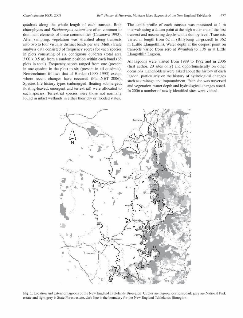
Fig. 1. Location and extent of lagoons of the New England Tablelands Bioregion. Circles are lagoon locations, dark grey are National Park estate and light grey is State Forest estate, dark line is the boundary for the New England Tablelands Bioregion.
478 Cunninghamia 10(3): 2008 Bell, Hunter & Haworth, Montane lakes (lagoons) of the New England TablelandsTa
ble
1. D
istri
butio
n, d
escr
iptio
n an
d co
nditi
on o
f mon
tane
lago
ons o
n th
e N
orth
ern
Tabl
elan
ds B
iore
gion
of N
SW.
Lago
on G
roup
Lago
onTe
nure
Lat/L
ong
Alti
tude
(m
)Ba
sin
area
(ha)
Pare
nt
mat
eria
lH
ydro
logi
cal
dist
urba
nce
Not
es
Kin
gs P
lain
sPr
ivat
e29°3
8′02″S
15
1°26′4
0″E
930
2B
asal
tA
ppar
ently
inta
ct, v
ery
shal
low.
Gle
n In
nes
Cla
reva
ulx
Priv
ate
29°3
7′06″S
15
1°40′3
0″E
1010
140
Bas
alt
Dra
ined
Mul
tiple
dra
ins.
Dun
vega
nPr
ivat
e29°3
7′55″S
15
1°41′0
9″E
1013
14B
asal
tD
rain
edPi
pe in
low
wal
l to
man
ipul
ate
drai
nage
. Wes
tern
side
pl
ough
ed a
nd so
wn
to fe
scue
.R
edde
ston
eTS
R/P
rivat
e29°4
0′03″S
15
1°38′4
9″E
1034
30B
asal
tD
rain
edM
uch
alte
red.
Dra
in th
roug
h ce
ntre
plu
s 2 d
ams
inte
rrup
t dra
in. V
-sha
ped
wal
l fur
ther
nor
th a
cros
s ba
sin.
Orig
inal
are
a di
fficu
lt to
det
erm
ine.
Trer
iffith
sPr
ivat
e29°4
1′33″S
15
1°45′0
0″E
1081
2B
asal
tSm
all d
am a
t m
argi
nEs
sent
ially
inta
ct.
John
Rya
llPr
ivat
e29°4
7′05″S
15
1°55′1
3″E
1186
7B
asal
tEs
sent
ially
inta
ct. L
ow w
all a
t nor
ther
n en
d ap
pear
s to
have
no
impa
ct o
n hy
drol
ogy.
Gle
n A
thol
Nor
thPr
ivat
e29°4
7′17″S
15
1°54′1
9″E
1185
4B
asal
tSl
ight
im
poun
dmen
tD
ivid
ed b
y a
rais
ed m
ound
(& d
itch)
supp
ortin
g ea
st/
wes
t fen
ce.
Gle
n A
thol
Wes
tPr
ivat
e29°4
7′41″S
15
1°54′0
0″E
1185
5B
asal
tD
rain
edTh
ree
wid
e sh
allo
w d
rain
s, ro
ad-w
orks
acr
oss n
orth
-ea
st c
orne
r.B
lair
Hill
Priv
ate
29°5
1′32″S
15
1°46′4
0″E
1269
4B
asal
tIn
tact
, sha
llow
but
bad
ly tr
ampl
ed b
y ca
ttle.
Bar
leyf
ield
-G
lenc
oeC
row
n La
nd29°5
4′32″S
15
1°43′5
0″E
1144
10B
asal
tIn
tact
.
Nov
arPr
ivat
e29°5
2′53″S
15
1°33′2
9″E
1345
<1B
asal
tSl
ight
Very
shal
low.
Sm
all d
itch
dug
in b
asin
with
low
ban
k.
Wes
t Nov
arPr
ivat
e29°5
2′47″S
15
1°33′0
8″E
1342
<0.5
Bas
alt
Impo
unde
dVe
ry sh
allo
w. E
dge
of w
etla
nd e
xcav
ated
to fo
rm h
igh
dam
wal
l.
Llan
goth
linN
orth
Lla
ngot
hlin
Priv
ate
30°0
2′29″S
15
1°46′0
8″E
1362
7B
asal
t/gr
anite
Impo
unde
dN
o w
etla
nd v
eget
atio
n.
Llan
goth
linPr
ivat
e30°0
3′30″S
15
1°45′5
4″E
1354
410
Bas
alt/
gran
iteO
utle
t low
ered
pre
viou
sly
then
rest
ored
.
Sout
h Ll
ango
thlin
Priv
ate
30°0
4′02″S
15
1°45′4
5″E
1368
3B
asal
tIn
tact
, ver
y sh
allo
w.
Littl
e Ll
ango
thlin
Nat
ure
Res
erve
30°0
5′11″S
15
1°47′0
0″E
1355
100
Bas
alt/
gran
iteO
utle
t low
ered
pre
viou
sly
then
rest
ored
in 1
99?
Bill
y B
ung
Priv
ate/
Nat
ure
Res
erve
30°0
5′26″S
15
1°46′2
4″E
1363
25B
asal
tEs
sent
ially
inta
ct. N
ever
dra
ined
.
Tubb
amur
raPr
ivat
e30°0
6′01″S
15
1°45′1
7″E
1355
4B
asal
tD
rain
ed, d
am
in la
goon
bed
Dra
ined
at o
utle
t, so
me
exca
vatio
n fo
r roa
d-fil
l.
Abb
ey G
reen
Priv
ate
30°0
6′17″S
15
1°47′2
9″E
1351
11B
asal
t/gr
anite
Dra
ined
Out
let l
ower
ed 6
0 cm
, old
er sh
allo
w d
rain
age
syst
em.
Kyo
ma
Priv
ate
30°0
7′45″S
15
1°43′0
5″E
1348
3G
rani
te-
silc
rete
Very
shal
low.
Slig
htly
impo
unde
d by
road
. Silc
rete
and
si
lcre
ted
cong
lom
erat
e bo
ulde
rs o
n la
goon
bed
.
Cunninghamia 10(3): 2008 Bell, Hunter & Haworth, Montane lakes (lagoons) of the New England Tablelands 479
Guy
raEv
eret
ts F
lat
Priv
ate
30°0
9′20″S
15
1°39′3
5″E
1312
27B
asal
t/gr
anite
Dra
ined
2m d
eep
drai
n to
sout
h, p
artly
cul
tivat
ed.
Littl
e W
ater
view
Priv
ate
30°1
1′00″S
15
1°40′0
1″E
1318
5B
asal
tD
rain
edC
entra
l dra
in.
Wat
ervi
ewPr
ivat
e30°1
1′13″S
151°
40′2
2″E
1317
11B
asal
tIm
poun
ded
Use
d fo
r aba
ttoir
was
te w
ater
for m
any
year
s.
Elm
woo
dPr
ivat
e30°1
2′10″S
15
1°39′5
5″E
1320
16B
asal
tC
ultiv
ated
.
Sabo
tPr
ivat
e30°1
3′17″E
15
1°37′4
0″S
1325
5B
asal
tIn
tact
.
Mot
her o
f Duc
ksPr
ivat
e/ D
EC30°1
4′00″S
15
1°39′3
0″E
1315
430
Bas
alt
Dra
ined
Out
let l
ower
ed 2
m, p
artly
enc
lose
d by
dyk
e &
moa
t.
Pinc
h (D
itton
s, B
lack
Mou
ntai
n,
Littl
e)
Priv
ate
30°1
7′05″S
15
1°40′5
6″E
1335
43B
asal
tD
rain
edSy
stem
of m
argi
nal d
rain
s fee
ding
into
low
ered
(now
ap
prox
80
cm) o
utle
t, bu
t im
pact
on
vege
tatio
n sl
ight
.
Bro
ckle
yB
ald
Bla
irPr
ivat
e30°1
2′45″S
15
1°47′3
0″E
1277
25B
asal
tIm
poun
ded
in
1960
sLo
ss o
f all
aqua
tic v
eget
atio
n.
Kol
ara
Priv
ate
30°1
4′13″S
15
1°49′4
6″E
1330
8B
asal
tEs
sent
ially
inta
ct, d
rain
ed p
revi
ousl
y bu
t res
tore
d, sm
all
dam
nea
r out
let.
Eden
glen
(upp
er)
Priv
ate
30°1
4′40″S
15
1°51′2
6″E
1312
8B
asal
tD
rain
edD
eep
cent
ral d
rain
, out
let l
ower
ed.
East
Ede
ngle
n (lo
wer
)Pr
ivat
e30°1
4′33″S
15
1°51′4
8″E
1306
6B
asal
tD
rain
edD
rain
age
syst
em w
ith c
entra
l dra
in, o
utle
t low
ered
at
leas
t 60
cm.
Bro
ckle
y Sw
amp
Priv
ate
30°1
6′20″S
15
1°52′4
0″E
1282
20B
asal
tD
rain
edC
entra
l dra
in e
xcav
ated
198
0s, o
utle
t now
on
oppo
site
si
de to
nat
ural
out
let.
Dra
in d
eepe
ned
in 1
994.
Li
ttle
Bro
ckle
yPr
ivat
e30°1
6′00″S
15
1°52′1
0″E
1300
2B
asal
tD
rain
edSi
te d
iffic
ult t
o id
entif
y be
caus
e of
dra
inag
e.
East
Bro
ckle
yPr
ivat
e30°1
5′45″S
151°
52′4
0″E
1290
2B
asal
tD
rain
edSi
te d
iffic
ult t
o id
entif
y, a
ppar
ently
cov
ered
by
an
airs
trip.
Loch
Abb
raPr
ivat
e30°1
9′27″S
15
1°49′5
1″E
1306
8B
asal
tD
am w
all
acro
ss n
orth
ern
end
Esse
ntia
lly in
tact
, dam
wal
l not
effe
ctiv
e.
Ant
hony
’sPr
ivat
e30°2
0′05″E
15
1°44′2
0″S
1335
1B
asal
tIm
poun
ded
Loss
of a
ll aq
uatic
veg
etat
ion.
Cop
nor
Priv
ate
30°1
9′45″S
15
1°41′5
0″E
1330
1B
asal
tA
ppar
ently
inta
ct.
Arm
idal
ePr
imro
se H
ill
(Hill
woo
d)Pr
ivat
e30°2
8′19″S
15
1°31′3
2″E
1075
6G
reyw
acke
Dra
ined
, tw
o da
ms i
n la
goon
be
d
Old
dra
in n
on-f
unct
iona
l, bo
re in
cat
chm
ent.
Pans
yfie
lds
Priv
ate
30°2
8′44″S
15
1°32′3
2″E
1079
2B
asal
tD
rain
edVe
ry sh
allo
w.
Saum
erez
Pon
dsPr
ivat
e30°2
9′23″S
15
1°33′4
9″E
1050
24B
asal
tIm
poun
ded
then
dra
ined
Vege
tatio
n m
ore
or le
ss in
tact
but
out
let s
light
ly
low
ered
. Pip
e in
dam
wal
l to
allo
w d
rain
age.
Tang
lew
ood
(Nan
dew
ar)
Priv
ate
30°2
9′52″S
15
1°36′0
2″E
1086
3B
asal
tD
am in
lago
on
bed
Dam
spoi
l use
d to
ext
end
land
ing
strip
alo
ng la
goon
ed
ge.
Gre
en W
attle
Priv
ate
30°3
0′52″S
15
1°36′2
7″E
1070
2B
asal
tD
am in
lago
on
bed
1992
Shal
low.

480 Cunninghamia 10(3): 2008 Bell, Hunter & Haworth, Montane lakes (lagoons) of the New England TablelandsLa
goon
Gro
upLa
goon
Tenu
reLa
t/Lon
gA
ltitu
de
(m)
Basin
ar
ea (h
a)Pa
rent
m
ater
ial
Hyd
rolo
gica
l di
stur
banc
eN
otes
Pine
grov
e (S
aum
erez
A
irpor
t)
Priv
ate
30°3
1′24″S
15
1°33′5
8″E
1044
3B
asal
tSm
all d
am a
t on
e en
dEs
sent
ially
inta
ct b
ut so
il di
stur
bed
by c
attle
tram
plin
g an
d w
orm
dig
ging
.
Wya
nbah
(A
irpor
t)C
row
n La
nd30°3
1′51″S
15
1°37′1
8″E
1086
4B
asal
tEs
sent
ially
inta
ct, m
inor
soil
exca
vatio
ns a
roun
d ed
ge
for r
oad
build
ing.
Dan
gars
leig
hPr
ivat
e30°3
8′00″S
15
1°41′1
6″E
1043
1B
asal
tD
rain
ed th
en
impo
unde
dVe
ry sh
allo
w, m
argi
n er
oded
. Dra
ined
long
ago
, dam
w
all e
rect
ed a
cros
s dra
in.
Thom
asPr
ivat
e30°3
2′44″S
15
1°33′1
3″E
1034
4B
asal
t/si
lcre
teEs
sent
ially
inta
ct. T
wo
outle
ts, a
ppar
ently
slig
htly
lo
wer
ed.
Stra
hle
Priv
ate
30°3
2′51″S
15
1°32′2
7″E
1043
6B
asal
tD
rain
edO
ld d
rain
, muc
h tra
mpl
ed b
y ca
ttle.
Saw
pit S
wam
pPr
ivat
e30°3
1′28″S
15
1°32′0
7″E
1062
<1B
asal
tVe
ry sh
allo
w.
Bar
leyf
ield
s -
Ura
llaTS
R30°3
7′24″S
15
1°31′4
2″E
1069
6B
asal
tM
inor
Smal
l dam
abo
ve m
argi
n, w
orm
dig
ging
. Old
hig
hway
pa
rtial
ly e
ncro
ache
s on
wes
tern
side
.U
ralla
Dan
gars
TSR
30°4
0′53″S
15
1°30′1
2″E
1022
55G
rani
te-
deriv
ed
sedi
men
t
Impo
unde
dEx
tens
ive
wal
l ere
cted
in 1
850s
to in
crea
se c
apac
ity fo
r us
e in
gol
dmin
ing.
May
hav
e on
ce b
een
mor
e ex
tens
ive.
Rac
ecou
rse
Ura
lla S
hire
30°4
0′23″S
15
1°29′3
0″E
1030
20G
rani
teIn
tact
. Rac
etra
ck a
roun
d ed
ge, a
lso
boat
ing.
Lag
oon
bed
plou
ghed
in 1
980s
to g
row
oat
s.K
entu
cky
Priv
ate
30°4
5′″S
15
1°26′″
E10
624
Porp
hyrit
eD
rain
edD
rain
ed lo
ng a
go.
Tayl
ors
Priv
ate
30°4
6′07″S
15
1°27′2
0″E
1050
7D
iorit
eSh
allo
w d
rain
Wal
cha
Rou
nd S
wam
pPr
ivat
e31°1
2′19″S
15
1°42′3
3″E
1276
45B
asal
tD
rain
ed th
en
impo
unde
dIm
poun
ded
in la
te 1
990s
acr
oss o
ld d
rain
. Tot
al lo
ss o
f w
etla
nd v
eget
atio
n by
200
4.Th
e La
kes
(Bra
cken
dale
)Pr
ivat
e31°1
3′23″S
15
1°41′2
8″E
1264
20B
asal
tIm
poun
ded
Tota
l los
s of w
etla
nd v
eget
atio
n.
Yarr
owitc
hSt
ate
Fore
st31°1
7′40″S
15
1°58′2
5″E
1128
8B
asal
tD
rain
edSy
stem
of d
rain
s in
lago
on b
ed, o
utle
t low
ered
.
New
Cou
ntry
Sw
amp
Nat
iona
l Par
k31°1
9′42″S
15
1°52′1
0″E
1166
15B
asal
t/sla
teEs
sent
ially
inta
ct. O
utle
t affe
cted
by
road
to p
icni
c ar
ea
but a
ppar
ently
not
rais
ed.
Sout
h H
ead
Stat
e Fo
rest
31°2
7′35″S
15
1°16′5
5″E
1210
<1B
asal
t/sla
teVe
ry sh
allo
w. M
argi
n no
long
er in
tact
due
to e
rosi
on.
Cunninghamia 10(3): 2008 Bell, Hunter & Haworth, Montane lakes (lagoons) of the New England Tablelands 481
Analyses and data exploration used options available in the PATN Analysis Package (Belbin 1995a). For the final presentation, all species and their relative cover scores were included, and the analysis performed used the Kulczynski association measure recommended for ecological applications (Belbin 2004), along with flexible Unweighted Pair Group arithmetic Averaging (UPGMA) and the default PATN settings. Community structural names are based on the most consistently dominant taxa or, in the case of Eleocharis sphacelata, on the tallest emergent taxa. Semi- Strong- Hybrid Multidimensional Scaling (SSH) was used as the ordination technique. Multidimensional scaling (MDS) moves objects around in a space defined by the number of dimensions chosen and the dissimilarities among sites in terms of their composition (Belbin 1991b). SSH calculates the level of stress, which is the miss-match between distances between points and the best estimate of the same values (Belbin 1995b). Simple regression was used to follow the changes in species richness against basin depth.
Results
Lagoon site details and condition
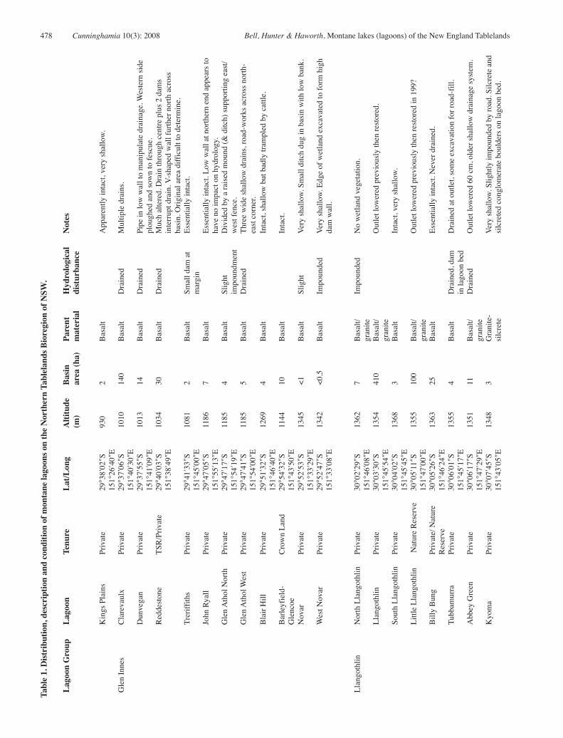
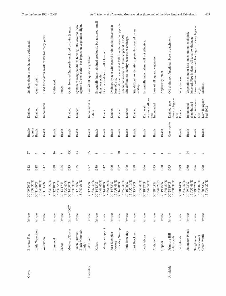
We identified 58 montane lagoons in the New England Tablelands Bioregion (Table 1). These wetlands are most common in the Guyra-Llangothlin area and west of Armidale, with scattered sites near Glen Innes, Uralla and south of Walcha (Fig. 1). While this list is comprehensive for known lagoons, it is likely that others on basalt-derived terrain may yet be undiscovered.
Lagoons range in altitude from 930 m (Kings Plains) to over 1360 m (Billybung, South Llangothlin), and from Kings Plains northwest of Glen Innes in the north to just north of Hanging Rock in the south (Fig. 1). Wetlands range in size from less than 1 ha to 430 hectares. Only two, Mother of Ducks (430 ha) and Llangothlin (410 ha) are substantial in size; two others, Clarevaulx (140 ha) and Little Llangothlin (100 ha) are moderately large; 16 are of medium size (10 –100 ha), the largest of these is Pinch Lagoon at 43 ha. The remainder (66 %) are small (<10 ha) with 6 of these less than 1 ha in area.
22 lagoons have more or less intact basins supporting wetland vegetation. Of these, five are small and very shallow and only hold water intermittently, and in a further two (Strahles, Blair Hill) the basin sediments are much disturbed by cattle trampling and the vegetation appears restricted to no more than a handful of species. Only 15 (28%) of lagoons could be considered intact and in good condition. Only one of each of the two substantial and two large lagoons (respectively, Llangothlin and Little Llangothlin) is intact. Of the 16 medium lagoons, only four (25%) are intact and of the 38 small lagoons, only nine (24%) are intact or deep enough to hold water frequently.
Disturbance to basin hydrology is common; lagoons have been drained, impounded or have had dams sunk into basin floors. Drainage has involved simply a lowering of the outlet (which usually requires cutting through a layer of ferricrete) or lowering of the outlet in conjunction with drainage via either a single central drain (Edenglen) or a network of drains (Clarevaulx, Glen Athol West). Mother of Ducks lagoon outlet has been lowered by a massive 2 m. A large central ditch excavated into the basin at Brockley Swamp cuts through the lagoon margin; water now drains in the opposite direction to the original overflow outlet. The outlets of three lagoons (Llangothlin, Little Llangothlin and Kolara) have been restored to their approximate original levels after past lowering. Other disturbances include the construction of a wall across part of the basin to prevent water reaching private grazing and cropping land (Reddestone). Roadworks or airstrips impinge on the edges of some lagoon basins (Glen Athol West, Barleyfields-Uralla, Tanglewood). Three lagoons (Dangars, Barleyfields-Uralla and Edenglen) provided water for nineteenth century goldmining (pers. com. Arnold Goode, Ron Sisson). Pinegrove and Barleyfields-Uralla are often subject to worm-digging to provide fishing bait. Previous recreational uses of the lagoons included boating (Racecourse, Mother of Ducks) and public swimming events (Dangars).
Almost all lagoons (85 %) occur on private property. Only six are on public land with a further three partly on public and partly on private land (Billybung, Mother of Ducks, Reddestone). All but five lagoons (Little Llangothlin, Racecourse, New Country Swamp, part of Mother of Ducks, Billybung) are currently grazed by cattle; a few lagoons are grazed only by sheep (Wyanbah, Kolora).
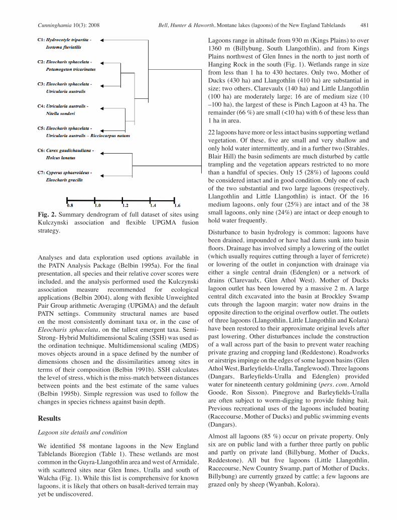
Fig. 2. Summary dendrogram of full dataset of sites using Kulczynski association and flexible UPGMA fusion strategy.
482 Cunninghamia 10(3): 2008 Bell, Hunter & Haworth, Montane lakes (lagoons) of the New England Tablelands
Vegetation patterns
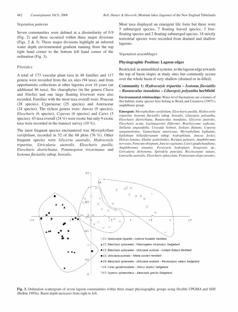
Seven communities were defined at a dissimilarity of 0.9 (Fig. 2) and these occurred within three major divisions (Figs. 2 & 3). These major divisions highlight an inferred water depth environmental gradient running from the top right hand corner to the bottom left hand corner of the ordination (Fig. 3).
Floristics
A total of 173 vascular plant taxa in 48 families and 117 genera were recorded from the six sites (94 taxa), and from opportunistic collections at other lagoons over 16 years (an additional 86 taxa). Six charophytes (in the genera Chara and Nitella) and one large floating liverwort were also recorded. Families with the most taxa overall were: Poaceae (28 species), Cyperaceae (25 species) and Asteraceae (24 species). The richest genera were: Juncus (9 species), Eleocharis (6 species), Cyperus (6 species) and Carex (5 species). 43 taxa overall (24 %) were exotic but only 9 exotic taxa were recorded in the transect survey (10 %).
The most frequent species encountered was Myriophyllum variifolium, recorded in 52 of the 68 plots (76 %). Other frequent species were Glyceria australis, Hydrocotyle tripartita, Utricularia australis, Eleocharis pusilla, Eleocharis dietrichiana, Potamogeton tricarinatus and Isotoma fluviatilis subsp. borealis.
Most taxa displayed an emergent life form but there were 5 submerged species, 7 floating leaved species, 3 free-floating species and 2 floating-submerged species. 18 strictly terrestrial species were recorded from drained and shallow lagoons.
Vegetation assemblages
Physiographic Position: Lagoon edges
Restricted, in unmodified systems, to the lagoon edge towards the top of basin slopes at study sites but commonly occurs over the whole basin if very shallow (drained or in-filled).
Community 1: Hydrocotyle tripartita – Isotoma fluviatilis – Ranunculus inundatus – Lilaeopsis polyantha herbfieldEnvironmental relationships: Water-level fluctuations are a feature of this habitat; many species here belong to Brock and Casanova (1997)’s amphibious group.
Emergent: Myriophyllum variifolium, Eleocharis pusilla, Hydrocotyle tripartita, Isotoma fluviatilis subsp. borealis, Lilaeopsis polyantha, Eleocharis dietrichiana, Ranunculus inundatus, Glyceria australis, Eleocharis acuta, Lachnagrostis filiformis, Brachyscome radicans, Stellaria angustifolia, Crassula helmsii, Isolepis fluitans, Cyperus sanguinolentus, Gamochaeta americana, Myriophyllum lophatum, Epilobium billardierianum subsp. hydrophilum, Juncus fockei, Holcus lanatus, Elatine gratioloides, Rorippa palustris, Amphibromus nervosus, Panicum obseptum, Juncus vaginatus, Carex gaudichaudiana, Amphibromus sinuatus, Persicaria hydropiper, Eragrostis sp., Utricularia dichotoma, Spirodela punctata, Ricciocarpus natans, Limosella australis, Eleocharis sphacelata, Pennisetum alopecuroides,
Fig. 3. Ordination scattergram of seven lagoon communities within three major physiographic groups using flexible UPGMA and SSH (Belbin 1995a). Basin depth increases from right to left.
Cunninghamia 10(3): 2008 Bell, Hunter & Haworth, Montane lakes (lagoons) of the New England Tablelands 483
Paspalum distichum, Juncus articulatus, Hemarthria uncinata, Schoenus apogon, Juncus bufonius, Euchiton involucratus, Centipeda minima, Rumex crispus, Hypericum japonicum, Asperula charophyton, Trifolium repens.
Floating-leaved: Nymphoides montana, Potamogeton tricarinatus, Nymphoides geminata, Brasenia schreberi.
Floating-submerged: Aldrovandra vesiculosa, Utricularia australis.
Variability: Recorded at all six sites. A generally species-rich community (mean richness 15, range 11–23) with fewer species at the very shallow temporary Wyanbah Lagoon.
Notes: In most drained lagoons and in shallow, presumably long in-filled lagoons, elements of this community occur across the whole basin. Often, where substantial hydrological disturbance has occurred, a few species of this community (e.g. Hydrocotyle tripartita and Lachnagrostis filiformis) are the only wetland species that remain, occurring alongside common terrestrial pasture species, both exotic and native.
Physiographic Position: Lagoon basinsRestricted to the lagoon basin in deeper water. Generally only occurs in intact lagoons with little or no hydrological disturbance. Elements of this community (Eleocharis sphacelata and Myriophyllum variifolium) may occur in some in-filled lagoons (Wyanbah, Barleyfields) and in some drained lagoons (Edenglen).
Community 2: Eleocharis sphacelata – Potamogeton tricarinatus sedgelandEnvironmental relationships: Occurring in deepest parts of some lagoons.
Emergent: Eleocharis sphacelata, Myriophyllum variifolium, Glyceria australis, Eleocharis dietrichiana, Panicum obseptum.
Floating-leaved: Potamogeton tricarinatus, Nymphoides montana, Nymphoides geminata.
Variability: In the transect survey only recorded in the shallow Wyanbah, in Little Llangothlin Lagoons and at the northern end of Llangothlin Lagoon.
Notes: Characterised by high cover and abundance of both Eleocharis sphacelata and Potamogeton tricarinatus (where it occurs). In Little Llangothlin Lagoon often an Eleocharis sphacelata monoculture. This community is characterised by low species richness (4.4, range 1–8) and the floating submerged plant Utricularia australis is absent (compare to Communities 3, 4 and 5).
Community 3: Eleocharis sphacelata – Utricularia australis – Isolepis fluitans herbfieldEnvironmental relationships: Occurring in deeper parts of smaller or shallower lagoons and at intermediate depths of large, deeper sites.
Emergent: Myriophyllum variifolium, Isolepis fluitans, Eleocharis sphacelata, Glyceria australis, Isotoma fluviatilis subsp. borealis, Hydrocotyle tripartita, Brachyscome radicans, Amphibromus sinuatus, Ranunculus inundatus.
Floating-leaved: Potamogeton tricarinatus, Nymphoides montana.
Floating submerged: Utricularia australis.
Variability: In the transect survey found at all sites except Wyanbah. Not present at Little Llangothlin Lagoon where intermediate depths were mostly open water.
Notes: Essentially represents communities at intermediate depths where relatively shallow water and vegetation cover prevent disturbance by wind. Extensive in the deeper centre of Little Llangothlin Lagoon and
covers almost the whole surface of Llangothlin Lagoon except for part of the southern end where open water and stands of Myriophyllum variifolium are common. Mean richness six (range 3–11).
Community 4: Utricularia australis – Nitella sonderi herbfieldEnvironmental relationships: Occurring at sheltered intermediate depths of large lagoons where cover of emergents and floating-leaved plants is low and patchy.
Emergent: Myriophyllum variifolium, Isolepis fluitans, Paspalum distichum, Eleocharis pusilla.
Floating: Ricciocarpus natans.
Floating-leaved: Potamogeton tricarinatus.
Floating-submerged: Lemna trisulca, Utricularia australis.
Submerged: Nitella sonderi, Nitella cristata, Chara muelleri, Potamogeton crispus, Najas tenuifolia.
Variability: Only found in the transect survey at the southern end of Llangothlin Lagoon but noted on other occasions at Racecourse (Casanova 1993) and Little Llangothlin Lagoons.
Notes: Characterised by submerged species, sparse cover of emergents and floating-leaved species and relatively high light penetration into the water column. Low richness (7.7, range 7–9) and extreme patchiness of all species is a feature of this community.
Community 5: Eleocharis sphacelata – Utricularia australis – Ricciocarpus natans sedgelandEnvironmental relationships: Occurring in sheltered deeper parts of large lagoons.
Emergent: Myriophyllum variifolium.
Floating: Ricciocarpus natans.
Floating-submerged: Lemna trisulca.
Submerged: Utricularia australis.
Variability: Southern end of Llangothlin Lagoon only.
Notes: Characterised by floating and floating-submerged species in sheltered relatively deep water between clumps of Eleocharis sphacelata and low cover of emergents such as Myriophyllum variifolium. Low richness (5, range 4–5).
Physiographic Position: Lagoon margins
Restricted to damp lagoon margins at or near the high water mark and fed by seepage.
Community 6: Carex gaudichaudiana – Holcus lanatus – Stellaria angustifolia sedgeland Environmental relationships: Occurring at damp margins of lagoons at approximately high water mark where seepage is present.
Emergent: Holcus lanatus, Glyceria australis, Carex gaudichaudiana, Stellaria angustifolia, Hydrocotyle tripartita, Eleocharis dietrichiana, Eleocharis pusilla, Eleocharis acuta, Epilobium billardierianum subsp. hydrophilum, Lachnagrostis filiformis, Asperula charophyton, Neopaxia australasica, Anthoxanthum odoratum, Isolepis fluitans, Gamochaeta americana, Myriophyllum variifolium, Isotoma fluviatilis subsp. borealis, Brachyscome radicans, Trifolium repens, Viola betonicifolia, Juncus fockei, Spiranthes sinensis, Myriophyllum lophatum, Amphibromus nervosus.
Variability: Within the transect survey only at Billybung and Little Llangothlin Lagoons but common at many other sites where seepage
484 Cunninghamia 10(3): 2008 Bell, Hunter & Haworth, Montane lakes (lagoons) of the New England Tablelands
occurs at margins at the base of basalt slopes (e.g. parts of Kolora and Pinch Lagoons, Thomas Lagoon and Abbey Green Lagoon). A relatively rich community (9.9, range 7–15).
Notes: Appears to be a transitional community not strictly part of the lentic wetland but fed by seepage from the surrounding slopes, similar to Carex sedgelands of swampy, drainage line and creek-line areas in other parts of the Northern Tablelands.
Community 7: Cyperus sphaeroideus – Eleocharis gracilis – Schoenus apogon – Carex gaudichaudiana sedgelandEnvironmental relationships: Restricted to damp margins of Llangothlin Lagoon at approximately high water mark and fed by seepage from the base of the slope and from the lunette.
Emergent: Cyperus sphaeroideus, Eleocharis gracilis, Hydrocotyle tripartita, Holcus lanatus, Hypericum japonicum, Eragrostis sp., Schoenus apogon, Stellaria angustifolia, Carex gaudichaudiana, Pennisetum alopecuroides, Myriophyllum lophatum, Epilobium billardierianum subsp. hydrophilum, Ranunculus lappaceus, Gamochaeta americana, Sacciolepis indica, Hemarthria uncinata, Hypochaeris radicata, Brachyscome radicans, Trifolium repens, Eriocaulon scariosum, Prunella vulgaris, Lachnagrostis filiformis, Crassula helmsii, Glyceria australis, Arthraxon hispidus, Gonocarpus micranthus, Leucanthemum vulgare, Leiocarpa sp. ‘Uralla’ (D.M. Bell), Eryngium sp. ‘Little Llangothlin NR’ (D.M. Bell 5 6) A, Eleocharis dietrichiana, Neopaxia australasica, Lilaeopsis polyantha, Euchiton involucratus, Spiranthes sinensis, Isotoma fluviatilis subsp. borealis, Eleocharis atricha, Festuca elatior, Austrostipa inaequiglumis, Amphibromus nervosus, Hydrocotyle peduncularis, Isolepis fluitans, Dichondra repens, Haloragis heterophylla, Hypoxis hygrometrica, Juncus vaginatus, Juncus articulatus, Juncus bufonius, Microtis unifolia, Phragmites australis, Solenogyne bellioides, Utricularia dichotoma.
Floating leaved: Potamogeton tricarinatus.
Variability: Only at Llangothlin Lagoon margins close to granite-derived soil and the sandy lunette.
Notes: Similar to Community 6 but more species-rich (mean 25, range 21–31), similar in part to Carex sedgelands.
Environmental gradients and community distribution
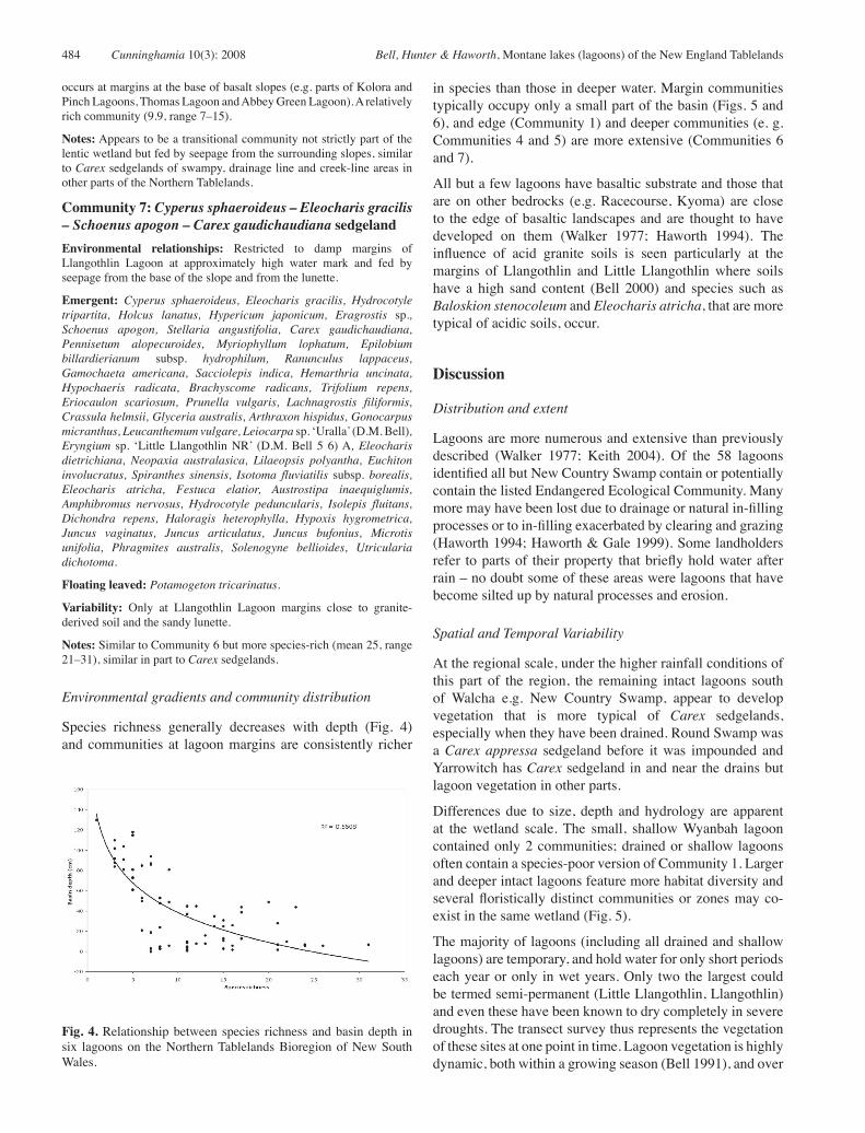
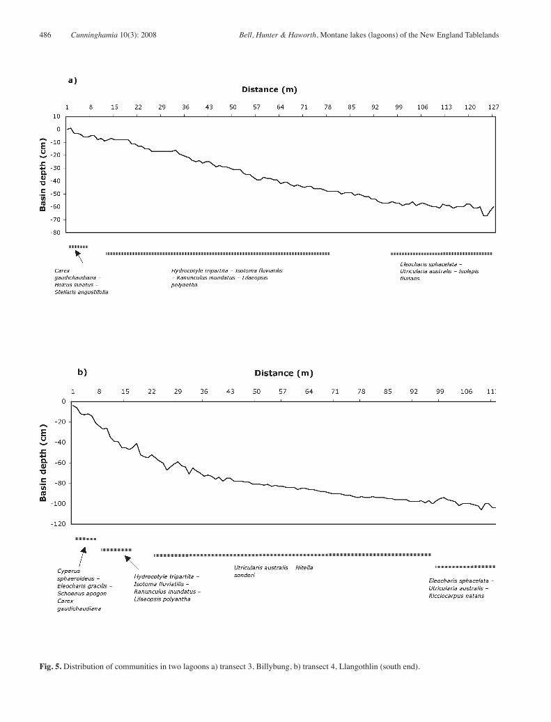
Species richness generally decreases with depth (Fig. 4) and communities at lagoon margins are consistently richer
in species than those in deeper water. Margin communities typically occupy only a small part of the basin (Figs. 5 and 6), and edge (Community 1) and deeper communities (e. g. Communities 4 and 5) are more extensive (Communities 6 and 7).
All but a few lagoons have basaltic substrate and those that are on other bedrocks (e.g. Racecourse, Kyoma) are close to the edge of basaltic landscapes and are thought to have developed on them (Walker 1977; Haworth 1994). The influence of acid granite soils is seen particularly at the margins of Llangothlin and Little Llangothlin where soils have a high sand content (Bell 2000) and species such as Baloskion stenocoleum and Eleocharis atricha, that are more typical of acidic soils, occur.
Discussion
Distribution and extent
Lagoons are more numerous and extensive than previously described (Walker 1977; Keith 2004). Of the 58 lagoons identified all but New Country Swamp contain or potentially contain the listed Endangered Ecological Community. Many more may have been lost due to drainage or natural in-filling processes or to in-filling exacerbated by clearing and grazing (Haworth 1994; Haworth & Gale 1999). Some landholders refer to parts of their property that briefly hold water after rain – no doubt some of these areas were lagoons that have become silted up by natural processes and erosion.
Spatial and Temporal Variability
At the regional scale, under the higher rainfall conditions of this part of the region, the remaining intact lagoons south of Walcha e.g. New Country Swamp, appear to develop vegetation that is more typical of Carex sedgelands, especially when they have been drained. Round Swamp was a Carex appressa sedgeland before it was impounded and Yarrowitch has Carex sedgeland in and near the drains but lagoon vegetation in other parts.
Differences due to size, depth and hydrology are apparent at the wetland scale. The small, shallow Wyanbah lagoon contained only 2 communities; drained or shallow lagoons often contain a species-poor version of Community 1. Larger and deeper intact lagoons feature more habitat diversity and several floristically distinct communities or zones may co-exist in the same wetland (Fig. 5).
The majority of lagoons (including all drained and shallow lagoons) are temporary, and hold water for only short periods each year or only in wet years. Only two the largest could be termed semi-permanent (Little Llangothlin, Llangothlin) and even these have been known to dry completely in severe droughts. The transect survey thus represents the vegetation of these sites at one point in time. Lagoon vegetation is highly dynamic, both within a growing season (Bell 1991), and over
Fig. 4. Relationship between species richness and basin depth in six lagoons on the Northern Tablelands Bioregion of New South Wales.

Cunninghamia 10(3): 2008 Bell, Hunter & Haworth, Montane lakes (lagoons) of the New England Tablelands 485
a number of years in response to changes in water depth and to water level history (Bell 2000). A drought may see that part of Llangothlin Lagoon, which in 1998 supported the Utricularia australis – Nitella sonderi community, covered with terrestrial plants such as Conyza bonariensis and Persicaria sp. Even where the species mix is the same, for example, in the edge Community 1, under some conditions, different species such as Myriophyllum variifolium (wetter) or Hydrocotyle tripartita (drier) may dominate. Many of the species respond to deeper water by altering growth-forms (Brock & Casanova 1997), but survive in dry sediments by means of seeds, tubers (Potamogeton tricarinatus) or dormant winter buds (Utricularia australis, Aldrovanda vesiculosa).
Because of temporal and within wetland variation, vegetation description in these, as in other dynamic systems, is problematic (Bell 2000). Although vegetation at the regional or whole wetland scale is appropriate for large-scale mapping (Benson & Jacobs 1994; Benson & Ashby 2000), broad descriptions ignore, of necessity, a wealth of detail that occurs at finer grains. Species richness, for example, varies strongly with depth (Figs 4 and 5). Thus though full wetland presence/abundance lists imply that all species co-exist, our study suggests that this is not always the case. At finer grains, differences among within-lagoon communities emerge that may be more important to the functioning of these systems than differences between lagoons.
Associations with other vegetation types
Seepage as a source of moisture is a feature of the lagoons whose catchments include basalt slopes or lunettes; the moisture in these areas is probably not static, but drains slowly through the soil, rather than ponding. Of the other two major wetland types in the Bioregion, the vegetation of these seepage areas (Communities 6 and 7) shares many species with the nutrient-rich Carex sedgelands, but few species (Gonocarpus micranthus, Baloskion stenocoleum) with the nutrient-poor and acidic bogs (Hunter & Bell 2007), and then only where granitic soils occur on margins. Under wet conditions, lagoons share few species with terrestrial communities, but opportunistic or weedy species, both native (Asperula conferta) and exotic (Cirsium vulgare) colonise damp mud during dry times.
Reservation and conservation issues
Lagoons on private property (85 %) are potentially vulnerable to damaging landuse activities; these usually involve some sort of hydrological disturbance. Since 1994 one site has been impounded, and dams excavated into the basins of two other sites. Impoundment has the potential to create a permanent reservoir and to literally ’drown’ all within-basin vegetation. An example of the vulnerability of these wetlands, and of landholder interactions is illustrated by recent events at Pinch Lagoon. Although the outlet of Pinch Lagoon has
been lowered, there are drainage ditches along the lagoons margins, and sufficient water remains in the basin to support extensive wetland vegetation. The principal landholders value the fodder provided (mostly Glyceria australis with some Eleocharis sphacelata), and cattle frequently graze in deep water. The wetland drains into another property; where the owner partially filled in the drain, raising water levels in the lagoon, risking a reduction in Glyceria cover and reducing the value of the vegetation as fodder (pers. com., Madge Sole, October 2006).
Although most lagoons are grazed, moderate grazing does not appear to have a deleterious affect on vegetation, except in those situations (Strahles, Blair Hill) where trampling in deep mud or peat in shallow basins destroys vegetation.
A low abundance of ‘true’ aquatic species such as submerged, floating and floating-leaved species is a feature of most lagoon communities. These species are most at risk from changing hydrology as few of them can survive prolonged absence of a water column, although the floating-leaved Nymphoides montana and Potamogeton tricarinatus can survive on damp mud for some time. Thus the communities most at risk of changes to hydrology are the deeper water Communities 2 to 5. Some species (Eleocharis sphacelata) persist in drained lagoons but seed production on dry soil is poor to absent. Other species may disappear altogether with a resulting reduction in the invertebrate and other faunal species that depend on that particular mixture of exposed water column and plant architecture.
Small lagoons and drained lagoons tell us what these wetlands could be like under severe hydrological changes. With a reduction in the duration of the inundation period, the small wetlands become an expanded edge community (Community 1). Where larger wetlands have been drained (Pinch, Saumerez Ponds), the distribution of edge species appears to have expanded to cover the whole wetland. However these shallow wetlands, as well as being the most abundant in the Bioregion, are valuable remnant systems as the species in them are usually strictly wetland species, and, as we have shown (Fig. 4), lagoon edges are more species-rich than other communities.
As with montane bogs (Hunter & Bell 2007), lagoons are at their northern limits in the New England Tablelands Bioregion and are thus susceptible to long-term changes in climate. Suggested impacts of climate change here are higher temperatures and increased rainfall seasonality (Hennessy et al. 2004). Dry periods are likely to be prolonged, and evapotranspiration will increase due to higher overall temperatures. Some lagoon species may disappear, to be replaced by more opportunistic species; the communities that require deeper sheltered water may be lost despite a store of viable diaspores in the sediments. The floating-leaved Nymphoides montana may be replaced by Nymphoides geminata, a plant of temporary wetlands (as has happened in part of Wyanbah Lagoon). The extensive (approx. 400 ha) Eleocharis sphacelata – Potamogeton tricarinatus
486 Cunninghamia 10(3): 2008 Bell, Hunter & Haworth, Montane lakes (lagoons) of the New England Tablelands
Fig. 5. Distribution of communities in two lagoons a) transect 3, Billybung, b) transect 4, Llangothlin (south end).
Cunninghamia 10(3): 2008 Bell, Hunter & Haworth, Montane lakes (lagoons) of the New England Tablelands 487
community of Llangothlin Lagoon could become more like the hybrid edge/deep community of Wyanbah and Saumerez Ponds with the loss of many plant and fauna species. Although seedbanks in these wetlands are long-lived (Brock 1997; Bell 2004), the potential impacts of prolonged dry periods on oospores, seeds and other propagules require investigation.
Management: retaining intermittence and semi-permanence
On geological time scales wetlands are temporary features of the landscape and have probably been slowly filling with sediment since the cessation of the active basin deflation period. Thus we need to be realistic about potential changes to these systems, particularly as we have no records of the sort of communities these basins supported before the beginning of sheep grazing in the Tablelands in the 1850s (Haworth 1994). We can, however, predict with some certainty what the present wetlands will become if drainage continues.
At shorter time scales, what is certain is that in these systems the diversity of habitat and species depends on the diversity of wetting and drying cycles (Brock et al. 1999). Restoring lagoon outlets to their original levels (Little Llangothlin Lagoon) should, in time, restore habitat diversity. The ditch and levee system, created in part of a large degraded lagoon basin to maintain bird habitat (Mother of Ducks Lagoon), is in fact, an artificial wetland, and may not be as successful. Although the original basin floor supported the weedy species Juncus articulatus, flooding that part of the basin within the levee did not appear to reduce the abundance of that species (Smith & Brock 1996). The reserve is now undergoing invasion by the native but weedy Carex fascicularis.
In 1998 a few plants of the exotic weedy species Ranunculus sceleratus appeared at the edge of Dangars Lagoon. By 2006, the population there was substantial, and scattered plants have appeared at Racecourse and Little Llangothlin Lagoons. This species, a coloniser of bare mud and dispersed by waterbirds, and is of particular concern to those wetlands where expanses of bar mud are common.
Rare or restricted plant species
There are 22 taxa of conservation significance in these wetlands. Aldovandra vesiculosa is currently listed as Endangered and Arthaxon hispidus as Vulnerable under the NSW Threatened Species Conservation Act 1995. Three taxa have been reported under the RoTAP criteria (Briggs & Leigh 1996): Asperula charophyton (3RCa), Brasenia schreberi (3RC-) and Goodenia macbarronii (3VC).
Three additional taxa are of significance:
Plantago sp. nov. The edge of Billybung Lagoon contains one of the only two known populations of Plantago sp. nov. (pers. com. Lachlan Copeland).
Eryngium sp. ‘Little Llangothlin NR’ (D.M. Bell 5 6), also known from the ACT, this species occurs within the
Bioregion almost exclusively as small scattered populations on the margins or edges of lagoons (Billybung, Llangothlin, Edenglen, Thomas and South Head) with the biggest population at Billybung Lagoon.
Both the Plantago sp. nov. and Eryngium ‘Uralla’ (D.M. Bell NR 54142) display heterophylly; terrestrial forms have divided leaves, underwater forms undivided.
Leiocarpa sp. ‘Northern Tablelands’, although fairly common and widespread, also occurs almost exclusively on the margins of lagoons.
A further 14 species are considered as significant due to their being considered regionally uncommon, from depleted habitat or at or near their northern distributional limit (Sheringham & Westaway 1998). These taxa are: Carex chlorantha, Carex tereticaulis, Crassula helmsii, Elatine gratioloides, Eleocharis atricha, Glossostigma diandrum, Isolepis fluitans, Isotoma fluviatilis subsp. borealis, Lemna trisulca, Lipocarpha microcephala, Myriophyllum simulans (not seen in this survey), Veronica serpyllifolia, Lilaeopsis polyantha and Juncus filicaulis. Many of these species, e.g. Lilaeopsis polyantha, Isotoma fluviatilis subsp. borealis and Isolepis fluitans, are abundant and widespread in lagoons; it is the particular system that is rare in the landscape, so these species are generally not encountered in general surveys.
Acknowledgements
Thanks go to Jonathan Burne and Raelee Kerrigan for assistance with sampling, Geoff Smith for assistance in visiting sites (1992 –1993) and Canran Liu for providing an opportunity to re-visit 20 lagoons in 2006. Thanks also must go the NSW National Parks and Wildlife Service and the following landholders for permission to visit lagoons on their properties: Phil and Lou Abrahams, Neil Cooke, Jim Elks, Arthur Frizell, Bob Gallagher, Peter Gerard, John and Karen Gilbert, Michael Hickey, John Jackson, Paul Kennedy, Daryl Meehan, David Ranger, Jim Reid, George Saunders, Arthur Scotton, Ron Sisson, Kevin and Maureen Smith, Madge Sole, Fred Starr, Stephen Walls, Lex and Margaret Waters, Alan Weiderman, Stephen and Bill Williams, Clyde and Barry Wright and Peter Wyatt. Botany UNE provided funding for the first author.
ReferencesBakker, J. P. (1985) The impact of grazing on plant communities,
plant populations and soil conditions on salt marshes. Vegetatio 62: 391–398.
Belbin, L. (2004) PATN Pattern analysis package. (CSIRO Division of Wildlife Ecology: Canberra).
Belbin, L. (1995a) Users guide: PATN pattern analysis package. (Division of Wildlife & Ecology CSIRO: Canberra.
Belbin, L. (1995b) Technical reference: PATN pattern analysis package. (Division of Wildlife & Ecology CSIRO: Canberra.
488 Cunninghamia 10(3): 2008 Bell, Hunter & Haworth, Montane lakes (lagoons) of the New England Tablelands
Bell, D. M. (1991) Plant phenology in temporary lagoons. Grad. Dip. Sci. Thesis (University of New England: Armidale).
Bell, D. M. (2000) The ecology of co-existing Eleocharis species. PhD Thesis (University of New England: Armidale).
Bell, D. M. & Clarke, P.J. (2004) Seed-bank dynamics of Eleocharis: can spatial and temporal variability explain habitat segregation? Australian Journal of Botany 52: 119–131.
Benson, J. S. & Ashby, E. M. (2000) Vegetation of the Guyra 1: 100 000 map sheet New England Bioregion, New South Wales. Cunninghamia 6: 747–872.
Benson, J. S. & Jacobs, S. W. L. (1994) Plant communities of the Monaro Lakes. Cunninghamia 3: 651–676.
Brock, M. A. (1991) Mechanisms for maintaining persistent populations of Myriophyllum variifolium J. Hooker in a fluctuating shallow Australian wetland. Aquatic Botany 39: 211–219.
Brock, M. A. (1998) Are temporary wetlands resilient? Evidence from seed banks of Australian and South African wetlands. Pp. 193–206 in McComb, A. J. & Davis, J. A. (eds.) Wetlands for the Future (Gleneagles Publishing: Adelaide).
Brock, M. A., & Casanova, M. T. (1997) Plant life at the edge of wetlands: ecological responses to wetting and drying patterns. Pp. 181–192 in Klomp, N. & Lunt, I. (eds.) Frontiers in ecology: building the links (Elsevier Science: Oxford).
Brock, M.A., Smith, R.G.B, & Jarman, P.J. (1999) Drain it, dam it: Alteration of water regime in shallow wetlands on the New England Tableland of New South Wales. Wetlands Ecology and Management 3: 37–46.
Brock, M. A., Smith, R. G. B. & Jarman, P. J. (1997) Drain it, dam it: alteration of water regime in shallow wetlands on the New England Tableland of New South Wales, Australia. Wetlands Ecology & Management 7: 37–36.
Casanova, M. T. (1993) The ecology of charophytes in temporary and permanent wetlands: an Australian perspective. PhD Thesis (University of New England: Armidale).
Casanova, M. T. (1999) Life histories of charophytes from permanent and temporary wetlands in Eastern Australia. Australian Journal of Botany 47: 383–397.
Coenraads, R. R. (1989) Evaluation of the natural lagoons of the Central Province, NSW–are they Sapphire-prducing maars? Exploration Geophysics 20: 347–363.
Harden, G.J. (1990–1993) (Ed.) Flora of New South Wales, Vols. 1 (2000), 2 (2002), 3 (1992) and 4 (1993). (New South Wales University Press: Kensington).
Haworth R. J. (1994) European impact on lake sedimentation in upland eastern Australia. PhD Thesis (University of New England: Armidale).
Haworth, R.J. & Gale, S.J., Short, S.A. & Heijnis, H. (1999) Land use and lake sedimentation on the New England Tablelands of New South Wales, Australia. Australian Geographer 30: 51–73.
Hennessy, K., Page, C., McInnes, K., Jones, R., Bathols, A. (2004) Climate change in New South Wales. Part 1: Past climate variability and projected changes in average climate. CSIRO, Australian Government Bureau of Meteorology, Canberra.
Hunter, J.T. & Bell, D.M. (2007) The vegetation of montane bogs in eastern flowing catchments of northern New England, New South Wales. Cunninghamia 10(1):77–92
Jacobs, S. W. L. & Brock, M. A. (1993) Southern (temperate) Australia Pp. 244–304 in Wetlands of the World I: inventory, ecology and management. Whigam D. F., Dykyjova, D. & Hejny, S. (Kluwer Academic Publishers, Dordrecht).
Keith, D.A. (2004) Ocean Shores to Desert Dunes: the Native Vegetation of New South Wales and the ACT. (Department of Environment & Conservation: Hurstville).
Millington, R. J. (1949) The ecology of Thomas’ Lagoon – a mountain meadow pond. Unpublished thesis (New England University College: Armidale).
NSW Threatened Species Conservation Act (1995) http://www.legislation.nsw.gov.au and http://www.nationalparks.nsw.gov.au/npws.nsf/Content /Final+determinations).
Paijmans, K., Galloway, R.W., Faith, D.P., Fleming, P.M., Haantjens,H.A., Heyligers, P.C., Kalma, J.D. & Loffler, E. (1985) Aspects of Australian wetlands. CSIRO Division, Water & Land Resources Technical Paper No. 44.
Pillans, B. J. (1987) Lake shadows – aeolian clay sheets associated with ephemeral lakes in basalt terrain, southern New South Wales. Search 18: 313–315,
PlantNET (2006) The Plant Information Network System of the Botanic Gardens Trust. Version 2 (http://plantnet.rbgsyd.nsw.gov.au).
Sheringham, P. & Westaway, J. (1998) Significant vascular plants of Upper North East New South Wales. Unpublished report update, NSW National Parks and Wildlife Service.
Smith R. G. B. & Brock M. A. (1996) Coexistence of Juncus articulatus L. and Glyceria australis C. E. Hubb. in a temporary shallow wetland in Australia. Hydrobiologia 340: 147–151.
Spence, D. H. N. (1964) Factors controlling the distribution of fresh-water macrophytes with particular reference to the lochs of Scotland. Journal of Ecology 55: 147–169.
Timms, B. V. (1992) Lake Geomorphology. (Gleneagles Publishing: Adelaide).
Usback, S. & James, R. (1993) A Directory of Important Wetlands in Australia. (Australian Nature Conservation Agency: Canberra).
Walker, G. T. (1977) Preliminary Report on the Geomorphology of Natural Lagoons in the New England District: Nature, Origin, Modification and Significance. Unpublished ms (University of New England: Armidale).
Manuscript accepted 3 March 2008

Cunninghamia 10(3): 2008 Bell, Hunter & Haworth, Montane lakes (lagoons) of the New England Tablelands 489
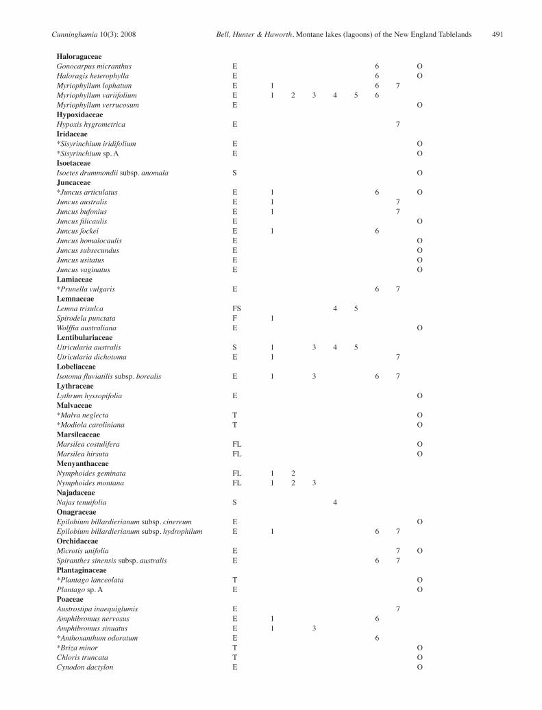
Appendix 1: Floristic composition of lagoons of the New England Tablelands Bioregion.
Taxa found within the survey sites are scored according to their presence in each of the seven communities defined. Other taxa were found in previous surveys (Bell 2000) or opportunistically (Op) and therefore are not assigned to a specific community.1 = Hydrocotyle tripartita – Isotoma fluviatilis – Ranunculus inundatus – Lilaeopsis polyantha herbfield 2 = Eleocharis sphacelata – Potamogeton tricarinatus sedgeland 3 = Eleocharis sphacelata – Utricularia australis – Isolepis fluitans herbfield 4 = Utricularia australis – Nitella sonderi herbfield 5 = Eleocharis sphacelata – Utricularia australis –Ricciocarpus natans sedgeland6 = Carex gaudichaudiana – Holcus lanatus – Stellaria angustifolia sedgeland 7 = Cyperus sphaeroideus – Eleocharis gracilis – Schoenus apogon – Carex gaudichaudiana sedgeland
* = introduced in origin. Casanova (1993) was used for non-vascular species and charophyte nomenclature was verified by Michelle Casanova (pers. com.) Species life history types include: E: emergent; F: free-floating; FS: free-floating submerged, FL: floating-leaved; S: submerged; T: terrestrial.
Species Type 1 2 3 4 5 6 7 OpAlismataceaeDamasonium minus FL OAmaranthaceaeAlternanthera denticulata E OApiaceaeCentella asiatica E O*Daucus carota T OEryngium sp. ‘Little Llangothlin NR’ E 7Hydrocotyle peduncularis E 6Hydrocotyle tripartita E 1 3 6 7Lilaeopsis polyantha E 1 7AsteraceaeAmmobium alatum T O*Aster subulatus E OBrachyscome graminea E OBrachyscome radicans E 1 3 6 7Calotis scapigera E OCentipeda minima E 1*Conyza parva E O*Conyza bonariensis E O*Cotula coronopifolia E O*Crepis capillaris E OEuchiton involucratus E 1 6*Gamochaeta americana E 1 6 7*Hypochaeris glabra E O*Hypochaeris radicata E 6 7*Lactuca serriola E OLeiocarpa sp. ‘Uralla’ E 6*Leucanthemum vulgare E 6 7Pseudognaphalium luteoalbum E OSolenogyne bellioides E 6*Sonchus asper subsp. glaucescens E O*Taraxacum officinale E O*Tolpis umbellata T O*Tragopogon dubius T O*Xanthium spinosum T OAzollaceaeAzolla filiculoides var rubra F OBrassicaceae*Rorippa palustris E 1Cabombaceae 1Brasenia schreberi FL 1CampanulaceaeWahlenbergia communis T O
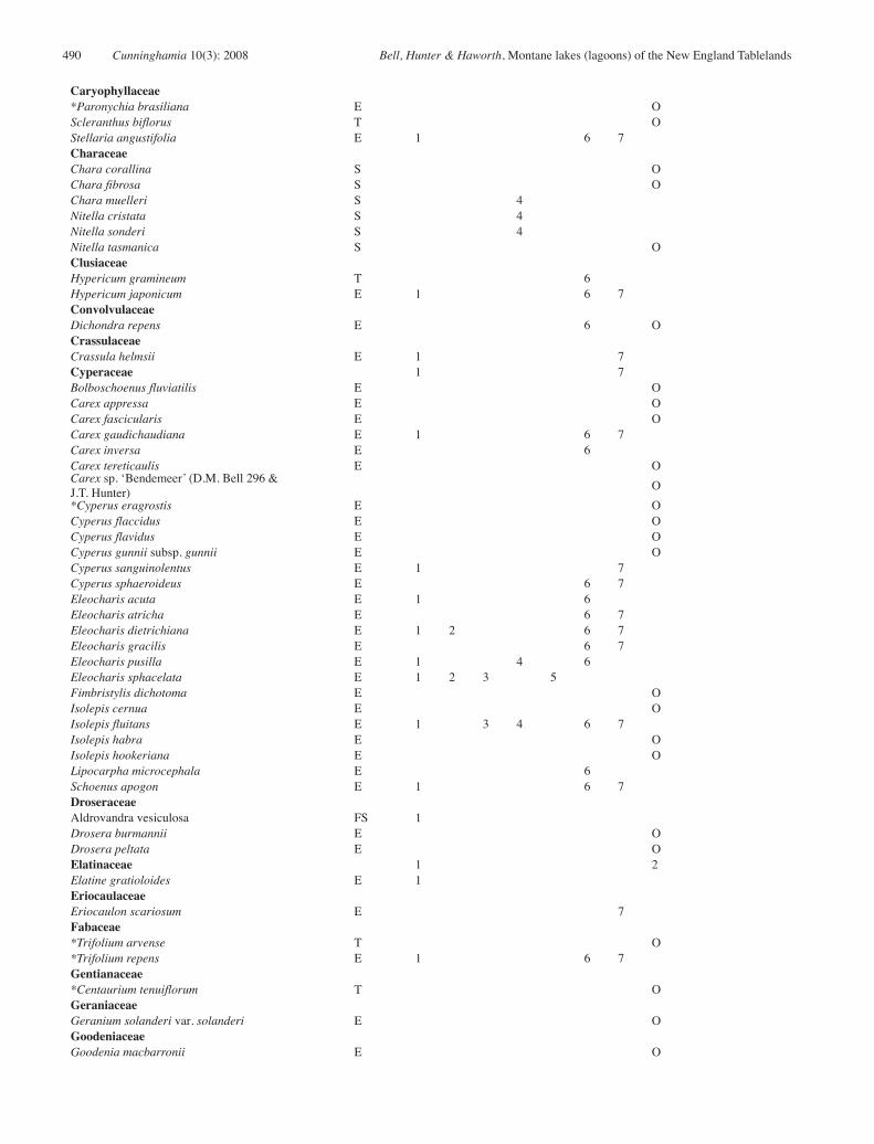
490 Cunninghamia 10(3): 2008 Bell, Hunter & Haworth, Montane lakes (lagoons) of the New England Tablelands
Caryophyllaceae*Paronychia brasiliana E OScleranthus biflorus T OStellaria angustifolia E 1 6 7CharaceaeChara corallina S OChara fibrosa S OChara muelleri S 4Nitella cristata S 4Nitella sonderi S 4Nitella tasmanica S OClusiaceaeHypericum gramineum T 6Hypericum japonicum E 1 6 7ConvolvulaceaeDichondra repens E 6 OCrassulaceaeCrassula helmsii E 1 7Cyperaceae 1 7Bolboschoenus fluviatilis E OCarex appressa E OCarex fascicularis E OCarex gaudichaudiana E 1 6 7Carex inversa E 6Carex tereticaulis E OCarex sp. ‘Bendemeer’ (D.M. Bell 296 & J.T. Hunter) O*Cyperus eragrostis E OCyperus flaccidus E OCyperus flavidus E OCyperus gunnii subsp. gunnii E OCyperus sanguinolentus E 1 7Cyperus sphaeroideus E 6 7Eleocharis acuta E 1 6Eleocharis atricha E 6 7Eleocharis dietrichiana E 1 2 6 7Eleocharis gracilis E 6 7Eleocharis pusilla E 1 4 6Eleocharis sphacelata E 1 2 3 5Fimbristylis dichotoma E OIsolepis cernua E OIsolepis fluitans E 1 3 4 6 7Isolepis habra E OIsolepis hookeriana E OLipocarpha microcephala E 6Schoenus apogon E 1 6 7DroseraceaeAldrovandra vesiculosa FS 1Drosera burmannii E ODrosera peltata E OElatinaceae 1 2Elatine gratioloides E 1EriocaulaceaeEriocaulon scariosum E 7Fabaceae*Trifolium arvense T O*Trifolium repens E 1 6 7Gentianaceae*Centaurium tenuiflorum T OGeraniaceaeGeranium solanderi var. solanderi E OGoodeniaceaeGoodenia macbarronii E O
Cunninghamia 10(3): 2008 Bell, Hunter & Haworth, Montane lakes (lagoons) of the New England Tablelands 491
HaloragaceaeGonocarpus micranthus E 6 OHaloragis heterophylla E 6 OMyriophyllum lophatum E 1 6 7Myriophyllum variifolium E 1 2 3 4 5 6Myriophyllum verrucosum E OHypoxidaceaeHypoxis hygrometrica E 7Iridaceae*Sisyrinchium iridifolium E O*Sisyrinchium sp. A E OIsoetaceaeIsoetes drummondii subsp. anomala S OJuncaceae*Juncus articulatus E 1 6 OJuncus australis E 1 7Juncus bufonius E 1 7Juncus filicaulis E OJuncus fockei E 1 6Juncus homalocaulis E OJuncus subsecundus E OJuncus usitatus E OJuncus vaginatus E OLamiaceae*Prunella vulgaris E 6 7LemnaceaeLemna trisulca FS 4 5Spirodela punctata F 1Wolffia australiana E OLentibulariaceaeUtricularia australis S 1 3 4 5Utricularia dichotoma E 1 7LobeliaceaeIsotoma fluviatilis subsp. borealis E 1 3 6 7LythraceaeLythrum hyssopifolia E OMalvaceae*Malva neglecta T O*Modiola caroliniana T OMarsileaceaeMarsilea costulifera FL OMarsilea hirsuta FL OMenyanthaceaeNymphoides geminata FL 1 2Nymphoides montana FL 1 2 3NajadaceaeNajas tenuifolia S 4OnagraceaeEpilobium billardierianum subsp. cinereum E OEpilobium billardierianum subsp. hydrophilum E 1 6 7OrchidaceaeMicrotis unifolia E 7 OSpiranthes sinensis subsp. australis E 6 7Plantaginaceae*Plantago lanceolata T OPlantago sp. A E OPoaceaeAustrostipa inaequiglumis E 7Amphibromus nervosus E 1 6Amphibromus sinuatus E 1 3*Anthoxanthum odoratum E 6*Briza minor T OChloris truncata T OCynodon dactylon E O
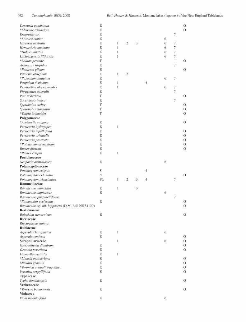
492 Cunninghamia 10(3): 2008 Bell, Hunter & Haworth, Montane lakes (lagoons) of the New England Tablelands
Deyeuxia quadriseta E O*Eleusine tristachya E OEragrostis sp. E 7*Festuca elatior E 6Glyceria australis E 1 2 3 6 7Hemarthria uncinata E 1 6 7*Holcus lanatus E 1 6 7Lachnagrostis filiformis E 1 6 7*Lolium perenne T OArthraxon hispidus E 7*Panicum gilvum E OPanicum obseptum E 1 2*Paspalum dilatatum E 6 7Paspalum distichum E 1 4Pennisetum alopecuroides E 1 6 7Phragmites australis E 7Poa sieberiana T OSacciolepis indica E 7Sporobolus creber T OSporobolus elongatus T O*Vulpia bromoides T OPolygonaceae*Acetosella vulgaris E OPersicaria hydropiper E 1Persicaria lapathifolia E OPersicaria orientalis E OPersicaria prostrata E O*Polygonum arenastrum E ORumex brownii E O*Rumex crispus E 1PortulacaceaeNeopaxia australasica E 6PotamogetonaceaePotamogeton crispus S 4Potamogeton ochreatus S OPotamogeton tricarinatus FL 1 2 3 4 7RanunculaceaeRanunculus inundatus E 1 3Ranunculus lappaceus E 6Ranunculus pimpinellifolius 7*Ranunculus sceleratus E ORanunculus sp. aff. lappaceus (D.M. Bell NE 54120) ORestionaceaeBaloskion stenocoleum E ORicciaceaeRicciocarpus natansRubiaceaeAsperula charophyton E 1 6
E OScrophulariaceae 1 6 OGlossostigma diandrum E OGratiola peruviana E OLimosella australis E 1*Linaria pelisseriana E OMimulus gracilis E O*Veronica anagallis-aquatica E OVeronica serpyllifolia E OTyphaceaeTypha dominengsis E OVerbenaceae*Verbena bonariensis E OViolaceaeViola betonicifolia E 6
Related Documents


