NGWMN- Montana Providing mutual benefit Thomas Patton Montana Bureau of Mines and Geology October 28, 2015 Well 158587: 03N 30E 21 CCAA- Yellowstone County

Welcome message from author
This document is posted to help you gain knowledge. Please leave a comment to let me know what you think about it! Share it to your friends and learn new things together.
Transcript

NGWMN-
Montana
Providing mutual
benefit
Thomas Patton
Montana Bureau of Mines
and Geology
October 28, 2015
Well 158587: 03N 30E 21 CCAA-
Yellowstone County
Great Falls
Billings
Miles City
Glendive
Havre
Glasgow
Bozeman
Helena
Missoula
Kalispell
Three Forks
Helena
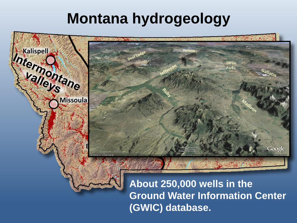
About 250,000 wells in the
Ground Water Information Center
(GWIC) database.
Montana hydrogeology

Great Falls
Billings
Miles City
Glendive
Havre
Glasgow
Bozeman
Helena
Missoula
Kalispell
About 250,000 wells in the
Ground-Water Information
Center (GWIC) database.
Madison limestone – north central
Montana
Fort Union Formation – eastern
Montana
Montana hydrogeology

1,010 monitoring wells. About 30 percent (300+/-)
dedicated or unused wells: 107 instrumented wells.
Monitoring network design
1
10
100
1000
Jan-84 Jan-92 Jan-00 Jan-08
Ca
Na
Mg
HCO3 SO4
Cl
Co
ncen
trati
on
mg
/L
Water quality
~10-year frequency
Quarterly – hourly
measurements
Water levels
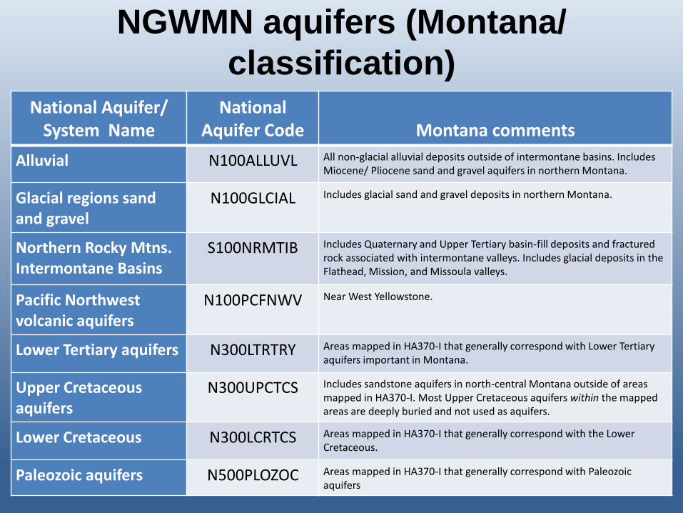
National Aquifer/ System Name
National Aquifer Code Montana comments
Alluvial N100ALLUVL All non-glacial alluvial deposits outside of intermontane basins. Includes Miocene/ Pliocene sand and gravel aquifers in northern Montana.
Glacial regions sand and gravel
N100GLCIAL Includes glacial sand and gravel deposits in northern Montana.
Northern Rocky Mtns. Intermontane Basins
S100NRMTIB Includes Quaternary and Upper Tertiary basin-fill deposits and fractured rock associated with intermontane valleys. Includes glacial deposits in the Flathead, Mission, and Missoula valleys.
Pacific Northwest volcanic aquifers
N100PCFNWV Near West Yellowstone.
Lower Tertiary aquifers N300LTRTRY Areas mapped in HA370-I that generally correspond with Lower Tertiary aquifers important in Montana.
Upper Cretaceous aquifers
N300UPCTCS Includes sandstone aquifers in north-central Montana outside of areas mapped in HA370-I. Most Upper Cretaceous aquifers within the mapped areas are deeply buried and not used as aquifers.
Lower Cretaceous N300LCRTCS Areas mapped in HA370-I that generally correspond with the Lower Cretaceous.
Paleozoic aquifers N500PLOZOC Areas mapped in HA370-I that generally correspond with Paleozoic aquifers
NGWMN aquifers (Montana/
classification)

• 70 wells (yellow dots)
selected from network of
97.
• Average depth is 177 ft.
• “Documented changes”
subnetworks near
Colstrip, Absaroka, and
Scobey.
• Data gaps where no
monitoring available.
NGWMN (N300LTRTRY)

Montana network wells designated as NGWMN sites (trend/background)
Montana Network Montana/NGWMN

Microsoft SQL Server database:
Data are accessible by web applications; Excel and Access; web mappers, and web services.
Water level frequency: Quarterly measurements. 100+/- instrumented sites provide hourly/daily values. Updates available quarterly.
Water quality frequency: Sites sampled every 5-10 years. Analytical data available when released from the MBMG Analytical Laboratory.
Linkage to the NGWMN portal:
Webservices in Geoserver (v2.0.2) provide casing, completion, lithology, water levels, daily average, and water quality data.
NGWMN update frequency:
Nightly harvest to NGWMN through CIDA
Data system and the portal
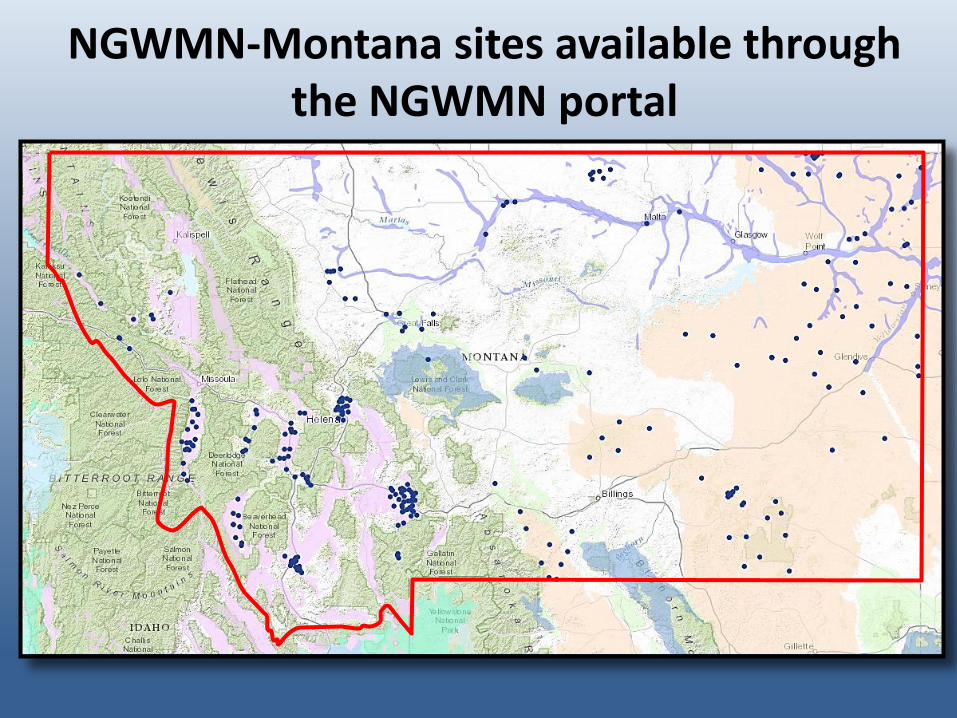
NGWMN-Montana sites available through the NGWMN portal

Linkage to NGWMN portal
• NGWMN-Montana sites in the Ground Water Information Center provide construction, lithology, water level, and water quality data.
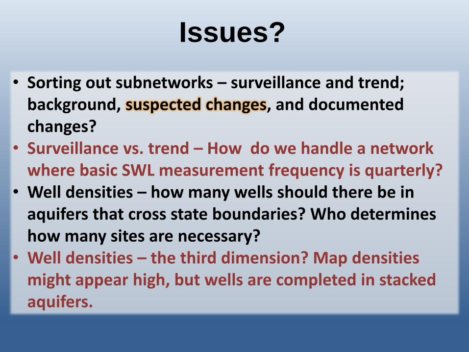
• Sorting out subnetworks – surveillance and trend; background, suspected changes, and documented changes?
• Surveillance vs. trend – How do we handle a network where basic SWL measurement frequency is quarterly?
• Well densities – how many wells should there be in aquifers that cross state boundaries? Who determines how many sites are necessary?
• Well densities – the third dimension? Map densities might appear high, but wells are completed in stacked aquifers.
Issues?
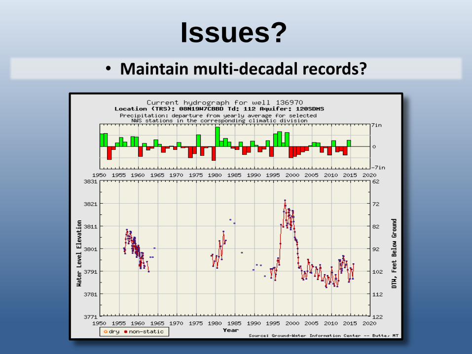
• Maintain multi-decadal records?
Issues?

Deer Lodge Valley telemetry site (wells
219909, 219913, and 257455)
NGWMN-
Montana
Providing mutual
benefit
Thomas Patton
Montana Bureau of Mines
and Geology
October 28, 2015
Related Documents


