Monitoring tiger and their prey species in Kerinci Seblat National Park, Indonesia Final Report, July 2006 A report to Rufford Small Grant (for Nature Conservation) Organization Name: Durrell Institute of Conservation and Ecology Project Period: 1 July 2005 to 30 June 2006 Principal Investigator: Prof. Nigel Leader-Williams DICE University of Kent Kent, CT2 7NR Tel: +44(0)1227 823754 Fax: +44(0)1227 827289 E-mail: [email protected] Project Manager – Indonesia: Mr Yoan Dinata Project Consultant: Dr Matthew Linkie

Welcome message from author
This document is posted to help you gain knowledge. Please leave a comment to let me know what you think about it! Share it to your friends and learn new things together.
Transcript
Monitoring tiger and their prey species in Kerinci Seblat National Park,
Indonesia
Final Report, July 2006
A report to Rufford Small Grant (for Nature Conservation)
Organization Name: Durrell Institute of Conservation and Ecology Project Period: 1 July 2005 to 30 June 2006 Principal Investigator: Prof. Nigel Leader-Williams DICE University of Kent Kent, CT2 7NR Tel: +44(0)1227 823754 Fax: +44(0)1227 827289 E-mail: [email protected] Project Manager – Indonesia: Mr Yoan Dinata Project Consultant: Dr Matthew Linkie
Monitoring team
Matthew Linkie (DICE, Project Consultant)
Yoan Dinata (Fauna & Flora International-Indonesia programme, Project Manager-Indonesia)
Agung Nugroho Zaini (Field Researcher)
Iding Ahmad Haidir (KSNP, Forest Technician)
Agung Nofrianto (Desk based officer)
Doddy Yu Saputra (Field Researcher)
Erman Saputra (Field Researcher)
Agung Nugroho (from KSNP, GIS officer – currently enrolled in an international M.Sc.
programme)
Sugarna (Community ranger)
Sutisna (Community ranger)
Asril (Community ranger)
Hambali (Community ranger)
Jaya (Community ranger)
M. Nur (Community ranger)
Undergraduates and postgraduates, who conducted their field research in KSNP, and
volunteers who joined the project during Year 2.
Nevridedi Endri (BSc, Institut Pertanian Bogor, IPB)
Muhamad Andri (BSc, University of Islam As-syafiah)
Ade Maulana Irvan (BSc, Universitas Negeri Jakarta, UNJ)
Neneng Susanti (MSc, Univesitas Indonesia, UI)
David Gusman (University of Andalas, Volunteer)
Sabirudin (Local NGO, Volunteer)
Eka Susanti (University of Lampung, Volunteer)
2
Summary
This report covers all activities completed during Project Year (PY) 2. The main aim of PY2
was to assess tiger populations in poorly known areas in the 13,300 km2 Kerinci Seblat
National Park (KSNP) and use this information to improve tiger conservation management.
The project has achieved this by increasing the capacity amongst Indonesian scientists
through training and research that has enabled all project staff to successfully conduct high
quality camera trap surveys to estimate tiger density and to conduct detection/non-detection
surveys, a new method developed by this project, to estimate tiger prey abundance. These
tiger and prey data were used as part of a global tiger assessment that subsequently identified
KSNP as one of the two highest priority areas for the long-term survival of tigers in Sumatra.
The tiger and prey data were also used by the Indonesian Department of Forestry to reclassify
project study sites as core protection zones inside KSNP and to present a strong case to
provincial government to veto the construction of a road that would have bisected KSNP. The
project has continued to expand and now works with six Indonesian universities. In fact, it
was some of these students that were part of the project team that recently photographed the
critically endangered and endemic Sumatran ground cuckoo, which has only been recorded
once since 1916. This record gained wide exposure to the project and its donors being covered
by over 26 media organizations, including The Sunday Times, The Independent, Channel 4
News, The Jakarta Post and Fox News. The project is now well established in KSNP and has
consequently been able to respond to other conservation needs, such as implementing the first
formal KSNP human-elephant conflict mitigation programme. As this diversification
continues the tiger programme is developing a community component that is anticipated to
begin in PY3.
Introduction
Current Project Status Kerinci Seblat National Park (KSNP), west-central Sumatra, is an important protected area for
tigers because it is still contains large blocks of forest that continue outside the national park
boundaries. Whilst these large forest blocks could support viable tiger populations, the
pervasive threats of illegal logging and poaching of both tigers and their prey render the future
of this species uncertain. In order to assess the impact of these different threats and the
conservation strategies aimed at reducing them, reliable, scientific information is needed on
the population trends of tigers and their prey. This report highlights project activities
3
completed over the past six months of Project Year (PY) 2, which aimed to collect baseline
data on tigers and their prey in KSNP. More specifically the project objectives were:
• Conduct surveys of tigers and prey for PY2 in the KSNP monitoring programme;
• Continue to investigate the factors that determine tiger and prey abundance in KSNP;
• Determine tiger and prey population status in KSNP;
• Train KSNP staff and Indonesian students in tiger and prey monitoring techniques;
• Disseminate project information to project partners and policy makers; and,
• Monitor and evaluate project results and effectiveness.
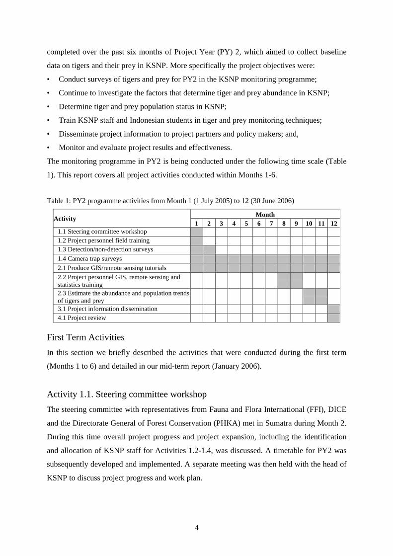
The monitoring programme in PY2 is being conducted under the following time scale (Table
1). This report covers all project activities conducted within Months 1-6.
Table 1: PY2 programme activities from Month 1 (1 July 2005) to 12 (30 June 2006)
Activity Month 1 2 3 4 5 6 7 8 9 10 11 12
1.1 Steering committee workshop 1.2 Project personnel field training 1.3 Detection/non-detection surveys 1.4 Camera trap surveys 2.1 Produce GIS/remote sensing tutorials 2.2 Project personnel GIS, remote sensing and statistics training 2.3 Estimate the abundance and population trends of tigers and prey 3.1 Project information dissemination 4.1 Project review
First Term Activities In this section we briefly described the activities that were conducted during the first term
(Months 1 to 6) and detailed in our mid-term report (January 2006).
Activity 1.1. Steering committee workshop The steering committee with representatives from Fauna and Flora International (FFI), DICE
and the Directorate General of Forest Conservation (PHKA) met in Sumatra during Month 2.
During this time overall project progress and project expansion, including the identification
and allocation of KSNP staff for Activities 1.2-1.4, was discussed. A timetable for PY2 was
subsequently developed and implemented. A separate meeting was then held with the head of
KSNP to discuss project progress and work plan.
4
Activity 1.2. Project personnel field survey training As scheduled, during Month 1, project personnel comprising two KSNP forest rangers, four
community scouts and two Indonesian national university graduates received four weeks
training in field equipment use, including GPS and camera traps, and field survey methods.
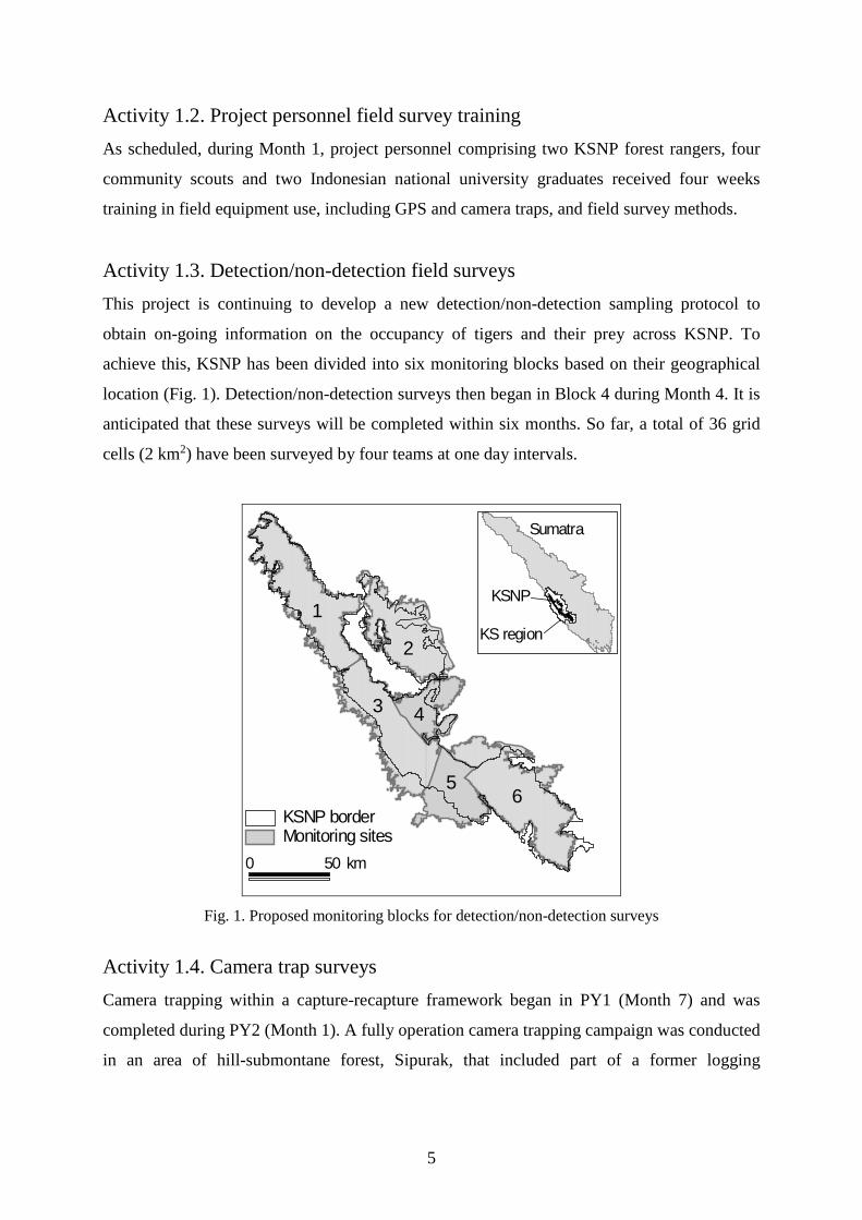
Activity 1.3. Detection/non-detection field surveys This project is continuing to develop a new detection/non-detection sampling protocol to
obtain on-going information on the occupancy of tigers and their prey across KSNP. To
achieve this, KSNP has been divided into six monitoring blocks based on their geographical
location (Fig. 1). Detection/non-detection surveys then began in Block 4 during Month 4. It is
anticipated that these surveys will be completed within six months. So far, a total of 36 grid
cells (2 km2) have been surveyed by four teams at one day intervals.
Monitoring sitesKSNP border
0 50 km
1
2
3 4
56
Sumatra
KS region
KSNP
Fig. 1. Proposed monitoring blocks for detection/non-detection surveys
Activity 1.4. Camera trap surveys
Camera trapping within a capture-recapture framework began in PY1 (Month 7) and was
completed during PY2 (Month 1). A fully operation camera trapping campaign was conducted
in an area of hill-submontane forest, Sipurak, that included part of a former logging
5
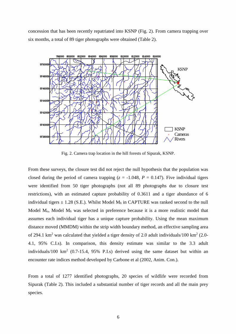
concession that has been recently repatriated into KSNP (Fig. 2). From camera trapping over
six months, a total of 89 tiger photographs were obtained (Table 2).
Rivers# Cameras
KSNP
798000 800000 802000 804000 806000 808000 810000 812000 814000 816000
9738000
9740000
9742000
9744000
9746000
9748000
9750000
#
#
# #
#
##
###
#
#
#
#
#
#
#
# #
#
#
#
######################
KSNP
Fig. 2. Camera trap location in the hill forests of Sipurak, KSNP.
From these surveys, the closure test did not reject the null hypothesis that the population was
closed during the period of camera trapping (z = -1.048, P = 0.147). Five individual tigers
were identified from 50 tiger photographs (not all 89 photographs due to closure test
restrictions), with an estimated capture probability of 0.3611 and a tiger abundance of 6
individual tigers ± 1.28 (S.E.). Whilst Model Mh in CAPTURE was ranked second to the null
Model Mo, Model Mh was selected in preference because it is a more realistic model that
assumes each individual tiger has a unique capture probability. Using the mean maximum
distance moved (MMDM) within the strip width boundary method, an effective sampling area
of 294.1 km2 was calculated that yielded a tiger density of 2.0 adult individuals/100 km2 (2.0-
4.1, 95% C.I.s). In comparison, this density estimate was similar to the 3.3 adult
individuals/100 km2 (0.7-15.4, 95% P.I.s) derived using the same dataset but within an
encounter rate indices method developed by Carbone et al (2002, Anim. Con.).
From a total of 1277 identified photographs, 20 species of wildlife were recorded from
Sipurak (Table 2). This included a substantial number of tiger records and all the main prey
species.
6
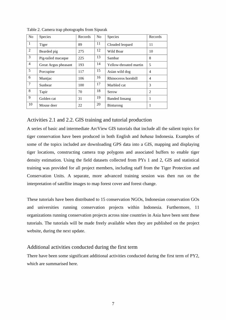
Table 2. Camera trap photographs from Sipurak
No Species Records No Species Records
1 Tiger 89 11 Clouded leopard 11 2 Bearded pig 275 12 Wild Boar 10 3 Pig-tailed macaque 225 13 Sambar 8 4 Great Argus pheasant 193 14 Yellow-throated martin 5 5 Porcupine 117 15 Asian wild dog 4 6 Muntjac 106 16 Rhinoceros hornbill 4 7 Sunbear 100 17 Marbled cat 3 8 Tapir 70 18 Serow 2 9 Golden cat 31 19 Banded linsang 1 10 Mouse deer 22 20 Binturong 1
Activities 2.1 and 2.2. GIS training and tutorial production A series of basic and intermediate ArcView GIS tutorials that include all the salient topics for
tiger conservation have been produced in both English and bahasa Indonesia. Examples of
some of the topics included are downloading GPS data into a GIS, mapping and displaying
tiger locations, constructing camera trap polygons and associated buffers to enable tiger
density estimation. Using the field datasets collected from PYs 1 and 2, GIS and statistical
training was provided for all project members, including staff from the Tiger Protection and
Conservation Units. A separate, more advanced training session was then run on the
interpretation of satellite images to map forest cover and forest change.
These tutorials have been distributed to 15 conservation NGOs, Indonesian conservation GOs
and universities running conservation projects within Indonesia. Furthermore, 11
organizations running conservation projects across nine countries in Asia have been sent these
tutorials. The tutorials will be made freely available when they are published on the project
website, during the next update.
Additional activities conducted during the first term There have been some significant additional activities conducted during the first term of PY2,
which are summarised here.
7
Field survey manual: matching theory and practice In response to a lack of field survey materials available in bahasa Indonesia, the Project
Manager wrote and produced a concise technical manual that outlines monitoring objectives,
field survey theory and how to apply this in the field. This manual was included with the GIS
training CDs sent out.
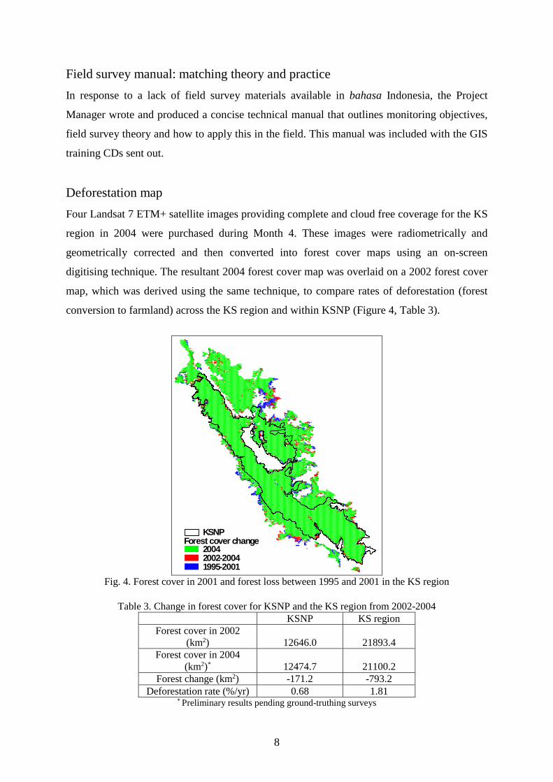
Deforestation map Four Landsat 7 ETM+ satellite images providing complete and cloud free coverage for the KS
region in 2004 were purchased during Month 4. These images were radiometrically and
geometrically corrected and then converted into forest cover maps using an on-screen
digitising technique. The resultant 2004 forest cover map was overlaid on a 2002 forest cover
map, which was derived using the same technique, to compare rates of deforestation (forest
conversion to farmland) across the KS region and within KSNP (Figure 4, Table 3).
1995-2001
Forest cover change
2002-20042004
KSNP
Fig. 4. Forest cover in 2001 and forest loss between 1995 and 2001 in the KS region
Table 3. Change in forest cover for KSNP and the KS region from 2002-2004
KSNP KS region Forest cover in 2002
(km2) 12646.0 21893.4 Forest cover in 2004
(km2)* 12474.7 21100.2 Forest change (km2) -171.2 -793.2
Deforestation rate (%/yr) 0.68 1.81 * Preliminary results pending ground-truthing surveys
8
Deforestation rates in the KS region have increased from 0.96%/yr (1995-2001) to 1.81%/yr
(2002-2004), or nearly a doubling in rates (Table 4). Whilst the 2002-2004 deforestation rates
were substantially higher outside of KSNP, the deforestation rates inside KSNP have
increased more rapidly from 0.27%/yr (1995-2001) to 0.68%/yr (2002-2004).
Table 4. Change in deforestation rates for KSNP and the KS region from 1995-2001 and 2002-2004
Deforestation rate (%/yr) KSNP KS region
Forest change 1995-2001 0.27 0.96 Forest change 2002-2004* 0.68 1.81
* Preliminary results pending ground-truthing surveys
Mid-term Project Year 2 presentation – Directorate General of Forest
Conservation A joint workshop between the ‘Tiger and Prey Monitoring Programme’ and the ‘Tiger
Protection and Conservation Programme’ involving all project collaborators convened in
Jakarta during Month 6 to present and discuss projects results. The meeting was chaired by
the Director General of PHKA, and attended by the Indonesian Institute of Sciences, FFI,
DICE and the head of KSNP. Project partners congratulated both projects on their hard work
and success. The main issues raised by our project partners were the status of roads that are
planned to bisect KSNP and the problem of illegal logging inside KSNP. Clear and concisely
written reports documenting all tiger and prey monitoring project results and conclusions have
been sent to PHKA, the Indonesian Institute of Sciences, donors and project partners.
World Bank and UNESCO meetings During Month 6, two separate meetings were held with the World Bank’s Forestry
Governance Office (Mario Boccucci) and World Resource Institute Director (Fred Stolle) and
then with the UNESCO deputy director (Han Qunli). During these meetings the latest 2002-
2004 forest change maps for the KS region were exposed and discussed in light of the recent
proposals for roads construction through KSNP and the need for on the ground action (i.e.
government support for law enforcement). Consequently, each organisation expressed an
interest and willingness to help in lobbying the Department of Forestry and provincial
governors to veto these planned roads.
9
Zonation meeting At the request of the Head of KSNP, the Project Manager attended a KSNP zonation meeting
in Bogor during Month 6. Whilst the different conservation zone categories were discussed
for KSNP, the 2002-2004 forest change maps and tiger monitoring data enabled more detailed
decisions to be made.
Study visit to Wildlife Conservation Society (WCS) project in Way Kambas
National Park During Month 2, after camera trap surveys had finished in Sipurak, the project staff had a
working break by visiting a related conservation project in Way Kambas National Park,
southern Sumatra. The purpose of the weeklong trip was to exchange ideas and experiences,
and maintain staff motivation and enthusiasm through forging stronger links with the WCS
staff working on similar tiger and elephant conservation issues in a protected area. The trip
served as a useful introduction to the WCS human-elephant conflict mitigation project, which
is a planned activity for KSNP as part of the project expansion in PY2.
Poster display at the annual Lake Kerinci Festival At the request of the Head of KSNP, project staff prepared and presented a poster display at
the Lake Kerinci Festival in Month 1. The festival, attended by local and provincial
government and local communities, provided a good opportunity to promote the project to a
much wider audience and give greater exposure for our donors.
Second Term Activities Here we detail project activities that were completed during the second term of Months 7-12
(February-July 2006). We then detail the numerous additional activities conducted during the
second project term that were not part of the original proposal. Overall, the project is running
on schedule and continuing to expand (such as working with seven Indonesian universities
now).
Activity 1.3. Detection/non-detection surveys During the first term, a total of 36 grid cells (2 km2) were each surveyed independently by at
four teams one day intervals. On schedule, during Months 7-12, these surveys continued until
the 80 cell target, as recommended by Darryl MacKenzie, had been achieved. The project is
10
continuing to refine the detection/non-detection sampling protocol to obtain on-going
information on the occupancy of tigers and their prey across KSNP. This emerging field
method has attracted the attention of other projects in Sumatra (WCS, ZSL, WWF-US) that
are now using these surveys on tiger and prey. This is encouraging because as all projects
should be producing comparable data from different study areas across the island.
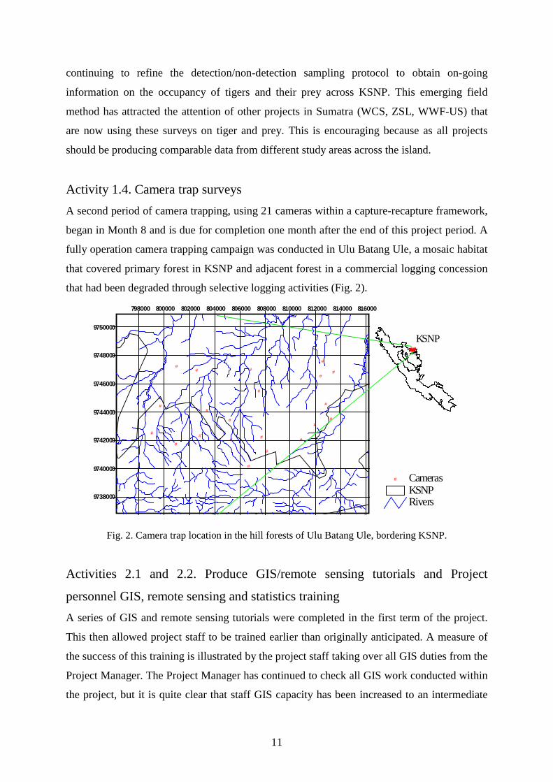
Activity 1.4. Camera trap surveys A second period of camera trapping, using 21 cameras within a capture-recapture framework,
began in Month 8 and is due for completion one month after the end of this project period. A
fully operation camera trapping campaign was conducted in Ulu Batang Ule, a mosaic habitat
that covered primary forest in KSNP and adjacent forest in a commercial logging concession
that had been degraded through selective logging activities (Fig. 2).
RiversKSNP
# Cameras
798000 800000 802000 804000 806000 808000 810000 812000 814000 816000
9738000
9740000
9742000
9744000
9746000
9748000
9750000
#
#
##
#
#
##
#
#
#
#
#
#
#
#
#
#
#
#
#
#####################
KSNP
Fig. 2. Camera trap location in the hill forests of Ulu Batang Ule, bordering KSNP.
Activities 2.1 and 2.2. Produce GIS/remote sensing tutorials and Project
personnel GIS, remote sensing and statistics training A series of GIS and remote sensing tutorials were completed in the first term of the project.
This then allowed project staff to be trained earlier than originally anticipated. A measure of
the success of this training is illustrated by the project staff taking over all GIS duties from the
Project Manager. The Project Manager has continued to check all GIS work conducted within
the project, but it is quite clear that staff GIS capacity has been increased to an intermediate
11
level. The next step will be to train these staff in more complex algorithms to enable them to
spatially analyse project field data.
Activity 2.3. Estimate the abundance and population trends of tigers and prey The detection/non-detection surveys were conducted in a patch of forest 1154.5 km2 in the
central-eastern side of KSNP. Applying a constant occupancy model, i.e. one that assumes
occupancy and detection probability to be constant across the four surveys and 80 sites, found
a high occupancy of tiger and their prey in the study site (Table 5). Tigers had an occupancy
estimate of 0.8052 or approximately 80% of the study area was occupied by tigers. These
results highlight the importance of this block of forest for tiger survival and verify reports by
the KSNP-FFI Tiger Protection and Conservation Units of the importance of this area. Further
analyses are being conducted to investigate the influence of environmental covariates, such as
distance to roads, on tiger and prey occupancy and detection probabilities.
Table 5. Preliminary occupancy estimates for tiger and key prey species in KSNP, using the constant
model.
Species common name Proportion of area occupied (±S.E.)
Tiger 0.8052 (0.0520)
Muntjac 0.9698 (0.0257)
Sambar 0.9212 (0.0320)
Wild pig Sus sp. 0.9635 (0.0213)
Tapir 0.9544 (0.0281)
Serow 0.7248 (0.2643)
From a total of 1277 identified photographs, 20 species of wildlife were recorded from Ulu
Batang Ule (Table 6). This included a substantial number of tiger records and all the main
prey species. Table 6. Camera trap photographs from Ulu Batang Ule
No Species Records No Species Records
1 Tiger 80 11 Clouded leopard 15 2 Bearded pig 22 12 Wild Boar 6 3 Pig-tailed macaque 134 13 Sambar 1 4 Great Argus pheasant 46 14 Asian wild dog 6
5 Porcupine 55 15 Sumatran ground pheasant 10
12
6 Muntjac 49 16 Marbled cat 4 7 Sunbear 52 17 Pangolin 4 8 Tapir 71 18 Masked palm-civet 3 9 Golden cat 10 19 Unknown/blank 10 10 Mouse deer 2 20
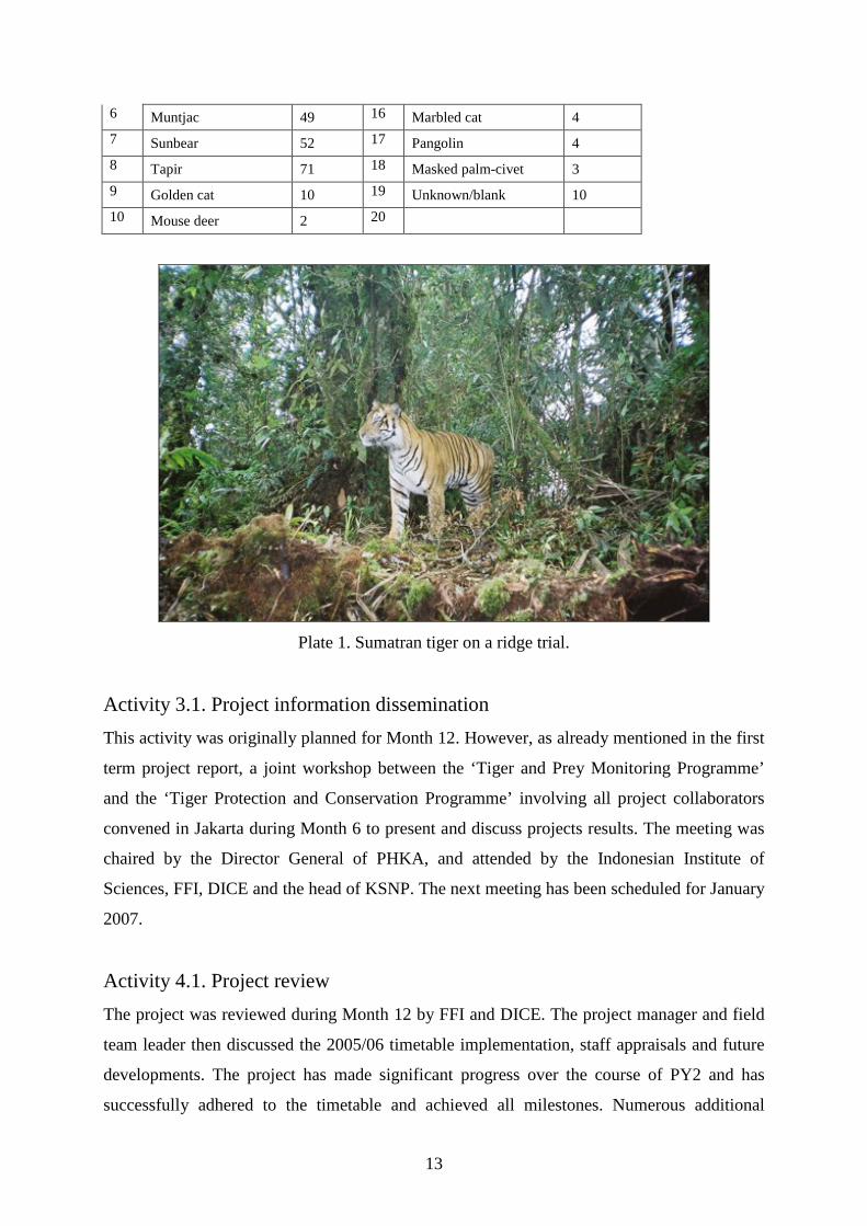
Plate 1. Sumatran tiger on a ridge trial.
Activity 3.1. Project information dissemination This activity was originally planned for Month 12. However, as already mentioned in the first
term project report, a joint workshop between the ‘Tiger and Prey Monitoring Programme’
and the ‘Tiger Protection and Conservation Programme’ involving all project collaborators
convened in Jakarta during Month 6 to present and discuss projects results. The meeting was
chaired by the Director General of PHKA, and attended by the Indonesian Institute of
Sciences, FFI, DICE and the head of KSNP. The next meeting has been scheduled for January
2007.
Activity 4.1. Project review The project was reviewed during Month 12 by FFI and DICE. The project manager and field
team leader then discussed the 2005/06 timetable implementation, staff appraisals and future
developments. The project has made significant progress over the course of PY2 and has
successfully adhered to the timetable and achieved all milestones. Numerous additional
13
activities have been completed, such as the deforestation mapping, and these have been
important for KSNP management.
Second Term Additional Activities
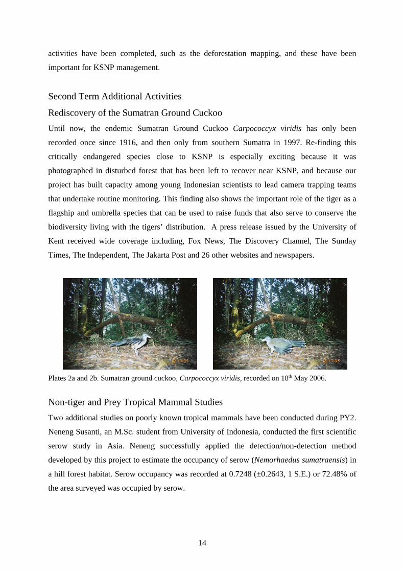
Rediscovery of the Sumatran Ground Cuckoo Until now, the endemic Sumatran Ground Cuckoo Carpococcyx viridis has only been
recorded once since 1916, and then only from southern Sumatra in 1997. Re-finding this
critically endangered species close to KSNP is especially exciting because it was
photographed in disturbed forest that has been left to recover near KSNP, and because our
project has built capacity among young Indonesian scientists to lead camera trapping teams
that undertake routine monitoring. This finding also shows the important role of the tiger as a
flagship and umbrella species that can be used to raise funds that also serve to conserve the
biodiversity living with the tigers’ distribution. A press release issued by the University of
Kent received wide coverage including, Fox News, The Discovery Channel, The Sunday
Times, The Independent, The Jakarta Post and 26 other websites and newspapers.
Plates 2a and 2b. Sumatran ground cuckoo, Carpococcyx viridis, recorded on 18th May 2006.
Non-tiger and Prey Tropical Mammal Studies Two additional studies on poorly known tropical mammals have been conducted during PY2.
Neneng Susanti, an M.Sc. student from University of Indonesia, conducted the first scientific
serow study in Asia. Neneng successfully applied the detection/non-detection method
developed by this project to estimate the occupancy of serow (Nemorhaedus sumatraensis) in
a hill forest habitat. Serow occupancy was recorded at 0.7248 (±0.2643, 1 S.E.) or 72.48% of
the area surveyed was occupied by serow.
14
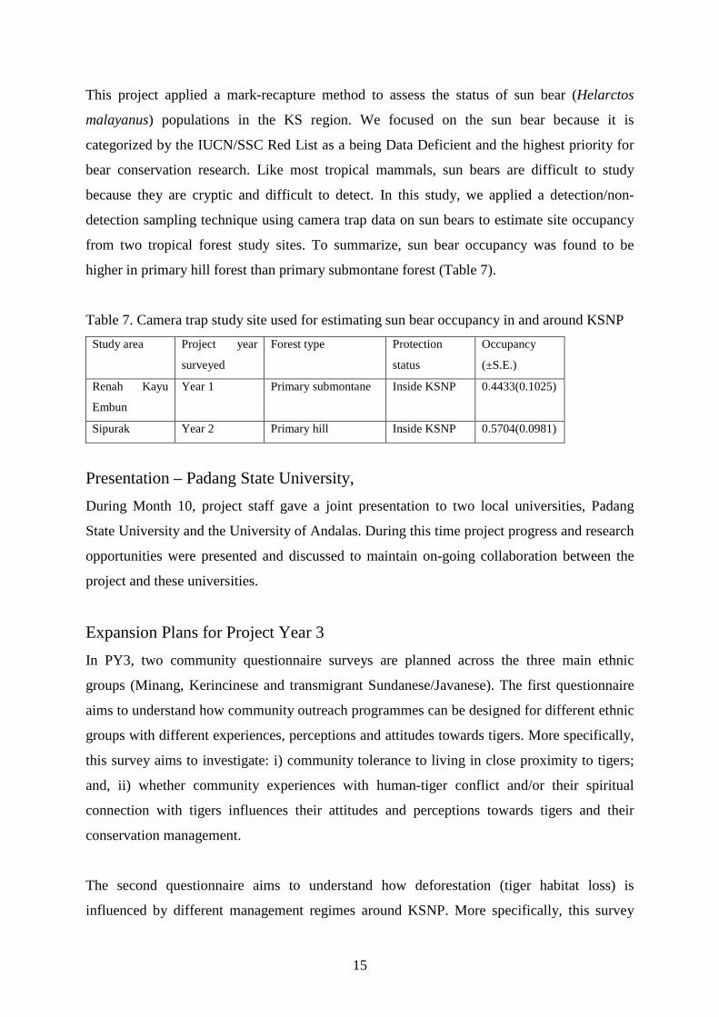
This project applied a mark-recapture method to assess the status of sun bear (Helarctos
malayanus) populations in the KS region. We focused on the sun bear because it is
categorized by the IUCN/SSC Red List as a being Data Deficient and the highest priority for
bear conservation research. Like most tropical mammals, sun bears are difficult to study
because they are cryptic and difficult to detect. In this study, we applied a detection/non-
detection sampling technique using camera trap data on sun bears to estimate site occupancy
from two tropical forest study sites. To summarize, sun bear occupancy was found to be
higher in primary hill forest than primary submontane forest (Table 7).
Table 7. Camera trap study site used for estimating sun bear occupancy in and around KSNP Study area Project year
surveyed
Forest type Protection
status
Occupancy
(±S.E.)
Renah Kayu
Embun
Year 1 Primary submontane Inside KSNP 0.4433(0.1025)
Sipurak Year 2 Primary hill Inside KSNP 0.5704(0.0981)
Presentation – Padang State University, During Month 10, project staff gave a joint presentation to two local universities, Padang
State University and the University of Andalas. During this time project progress and research
opportunities were presented and discussed to maintain on-going collaboration between the
project and these universities.
Expansion Plans for Project Year 3 In PY3, two community questionnaire surveys are planned across the three main ethnic
groups (Minang, Kerincinese and transmigrant Sundanese/Javanese). The first questionnaire
aims to understand how community outreach programmes can be designed for different ethnic
groups with different experiences, perceptions and attitudes towards tigers. More specifically,
this survey aims to investigate: i) community tolerance to living in close proximity to tigers;
and, ii) whether community experiences with human-tiger conflict and/or their spiritual
connection with tigers influences their attitudes and perceptions towards tigers and their
conservation management.
The second questionnaire aims to understand how deforestation (tiger habitat loss) is
influenced by different management regimes around KSNP. More specifically, this survey
15
aims to understand: i) how the different natural resource management systems operate in local
communities surrounding KSNP; ii) local community conservation knowledge and
conservation attitudes; and, iii) whether greater conservation knowledge is linked with a more
positive conservation attitude, and if positive attitudes result in more positive conservation
actions (as measured through observed village level deforestation rates).
A human-elephant conflict will be implemented during PY3. Sumatran elephants live in
fragmented populations across human-dominated landscapes where they compete with
humans for space and resources. As human populations continue to convert forest to
farmland, they reduce elephant habitat and increase the likelihood of crop-raiding. This
represents one of the most severe forms of conflict as it threatens local livelihoods and can
lead to loss of both human and elephant life, which impedes elephant conservation. Through
wide national and international collaboration, this project will implement the first human-
elephant conflict mitigation programme in farmland outside of Kerinci Seblat National Park
(KSNP) and the first monitoring programme for inside KSNP. Thus, this project proposes to
conserve the threatened elephant populations in and around the KSNP through six main
objectives, which are,
• Increase capacity within KSNP staff, local communities and project staff to monitor and
mitigate HEC outside of the KSNP
• Increase capacity within KSNP staff and project staff to monitor elephant populations
inside the KSNP
• Raise local awareness of HEC mitigation methods
• Disseminate project information to project partners and policy makers
• Monitor and evaluate project results and effectiveness
Finally, the project would very much like to acknowledge and offer a debt of gratitude for the
support offered by the collaborators and donors listed below,
Collaborating Institutions PHKA
FFI-Indonesia program
The Bureau of KSNP
UNAND, West Sumatra province
16
UNIB, Bengkulu province
UNAS, Jakarta
UI, Jakarta
IPB, Bogor
University of Islam As-syafiah, Jakarta
Universitas Negeri Jakarta, Jakarta
Donors US Fish and Wildlife Service
21st Century Tiger
Rufford Small Grants for Nature Award
Peoples Trust for Endangered Species
17
Related Documents