MODIS Science Team Meeting - 18 – 20 May 2011 1 Routine Mapping of Land-surface Carbon, Water and Energy Fluxes at Field to Regional Scales by Fusing Multi-scale and Multi-sensor Imagery Rasmus Houborg Earth System Science Interdisciplinary Center, University of Maryland, College Park European Commision, JRC, Institute for Environment and Sustainability, Ispra, Italy Martha C. Anderson & W.P. Kustas USDA-ARS Hydrology and Remote Sensing Laboratory, Beltsville, MD Feng Gao & Matthew Rodell NASA Goddard Space Flight Center, Greenbelt, MD

MODIS Science Team Meeting - 18 – 20 May 20111 Routine Mapping of Land-surface Carbon, Water and Energy Fluxes at Field to Regional Scales by Fusing Multi-scale.
Dec 18, 2015
Welcome message from author
This document is posted to help you gain knowledge. Please leave a comment to let me know what you think about it! Share it to your friends and learn new things together.
Transcript

MODIS Science Team Meeting - 18 – 20 May 2011 1
Routine Mapping of Land-surface Carbon, Water and Energy Fluxes at Field to Regional Scales by Fusing
Multi-scale and Multi-sensor Imagery
Rasmus HouborgEarth System Science Interdisciplinary Center, University of Maryland, College ParkEuropean Commision, JRC, Institute for Environment and Sustainability, Ispra, Italy
Martha C. Anderson & W.P. KustasUSDA-ARS Hydrology and Remote Sensing Laboratory, Beltsville, MD
Feng Gao & Matthew Rodell
NASA Goddard Space Flight Center, Greenbelt, MD

MODIS Science Team Meeting - 18 – 20 May 2011 2
Motivation
Routine carbon and water cycle predictions at fine spatial resolution (< 100 m) are of critical importance in applications such as drought monitoring, yield forecasting, agricultural management and crop growth monitoring
These applications require both high spatial resolution and frequent coverage in order to effectively resolve processes in heterogeneous landscapes at the scale of individual fields or patches
Multi-scale and multi-sensor fusing approaches have the ability to blend aspects of spatially coarse (e.g. MODIS) and spatially fine (e.g. Landsat) resolution sensors to extend the applicability of land surface modeling schemes to provide meaningful decision support at micrometeorological scales (< 100m)
One of the major challenges to applying a LSM over spatial and temporal domains lies in specifying reasonable inputs of key controls on vegetation dynamics and ecosystem functioning

MODIS Science Team Meeting - 18 – 20 May 2011 3
Goals and Objectives
Fuse Landsat and MODIS data streams to facilitate high spatial resolution monitoring of carbon, water and heat fluxes at a temporal frequency not otherwise possible
Refine and implement a novel technique for using satellite estimates of leaf chlorophyll to delineate variability in photosynthetic efficiency in space and time
Develop and apply a scalable thermal-based flux modeling system and multi-scale data fusion approach to targeted regions that encompass a range of land cover types and environmental conditions
Validate blended vegetation biophysical products and flux simulations using a combination of in-situ datasets, multi-year flux tower observations and independent satellite datasets and LSM output
Work toward an automated approach to enable routine thermal-based flux mapping at fine spatial scales (<100 m) critically important to local water resource and agricultural management

MODIS Science Team Meeting - 18 – 20 May 2011 4
Satellite products

MODIS Science Team Meeting - 18 – 20 May 2011 5
ModelsData fusion algorithm
STARFM = Spatial and Temporal Adaptive Reflectance Fusion Model

MODIS Science Team Meeting - 18 – 20 May 2011 6
ModelsVegetation parameter retrieval tool
REGFLEC = REGularized canopy reFLECtance tool Physically-based approach for estimating key
descriptors (LAI and leaf chl) of vegetation dynamics
Combines leaf optics (PROSPECT), canopy reflectance (ACRM), and atmospheric radiative transfer (6SV1) modules
Requires at-sensor radiance observations in green, red and nir wavebands, standard atmospheric state data, land cover and soil map
The retrieval system is entirely image-based and does not rely on local ground-based data for model calibration
REGFLEC accommodates variations in sensor and atmospheric absorption and scattering conditions, soil background conditions, surface BRDF and species composition
Houborg & Anderson (2009)

MODIS Science Team Meeting - 18 – 20 May 2011 7
ModelsVegetation parameter retrieval tool
REGFLEC LAI and leaf chl retrieval accuracies
Measured
LAI (SPOT 10m - MD, US) Leaf chl (SPOT 10m - MD, US)

MODIS Science Team Meeting - 18 – 20 May 2011 8
ModelsLand-surface model
TRAD (φ), fcTRAD (φ), fc
Rsoil
Tc
Tac
Hs
Ts
Ra H = Hc + Hs
Rx
Hc
Ta
ABL
Ta
ALEXI DisALEXI
5 km30 m
Tw
o-S
ou
rce M
od
el
TRAD,i(φi), fc,i
i
Ra,i
Blending height
Regional scale DTRAD - GOESTa - ABL model
Landscape scaleTRAD - Landsat, MODISTa - ALEXI
Surface temp:Air temp:
Atmosphere-Land Exchange Inverse (ALEXI)

MODIS Science Team Meeting - 18 – 20 May 2011 9
ModelsLand-surface model

MODIS Science Team Meeting - 18 – 20 May 2011 10
Processing steps

MODIS Science Team Meeting - 18 – 20 May 2011 11
Study regions
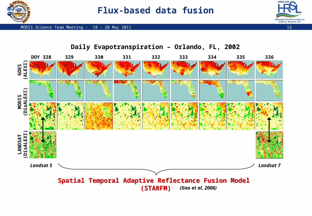
MODIS Science Team Meeting - 18 – 20 May 2011 12
Flux-based data fusionG
OES
(AL
EX
I)M
OD
IS(D
isA
LE
XI)
LA
ND
SA
T(D
isA
LE
XI)
DOY 328 329 330 331 332 333 334 335 336
Landsat 5 Landsat 7
(Gao et al, 2006)Spatial Temporal Adaptive Reflectance Fusion Model
(STARFM)Spatial Temporal Adaptive Reflectance Fusion Model
(STARFM)
Daily Evapotranspiration – Orlando, FL, 2002

MODIS Science Team Meeting - 18 – 20 May 2011 13
Flux-based data fusionG
OES
(AL
EX
I)M
OD
IS(D
isA
LE
XI)
LA
ND
SA
T(D
isA
LE
XI)
DOY 328 329 330 331 332 333 334 335 336
Landsat 5
(Gao et al, 2006)Spatial Temporal Adaptive Reflectance Fusion Model
(STARFM)Spatial Temporal Adaptive Reflectance Fusion Model
(STARFM)
Daily Evapotranspiration – Orlando, FL, 2002
Ob
servedP
redic
ted
R2: 0.83 (9% error)

MODIS Science Team Meeting - 18 – 20 May 2011 14
Validation efforts
Retrieved vegetation biophysical products will be validated using a combination of in-situ datasets and independent satellite datasets
The quality of observed and blended flux maps will be evaluated at localized points using available flux tower observations
Generated flux maps will be compared to independent flux output from the suite of LSMs embedded within the Land Information System (LIS) Land Data Assimilation System (LDAS)
Related Documents