ASHTON COAL PROJECT ENVIRONMENTAL ASSESSMENT – DA 309-11-2001 MOD 7 Appendix 1 Gas Drainage Noise Impact Assessment

Welcome message from author
This document is posted to help you gain knowledge. Please leave a comment to let me know what you think about it! Share it to your friends and learn new things together.
Transcript
ASHTON COAL PROJECT ENVIRONMENTAL ASSESSMENT – DA 309-11-2001 MOD 7
Appendix 1
Gas Drainage Noise Impact Assessment

ASHTON COAL PROJECT ENVIRONMENTAL ASSESSMENT – DA 309-11-2001 MOD 7


ASHTON COAL PROJECT ENVIRONMENTAL ASSESSMENT – DA 309-11-2001 MOD 7
Appendix 2
Gas Drainage Air Quality Impact Assessment

ASHTON COAL PROJECT ENVIRONMENTAL ASSESSMENT – DA 309-11-2001 MOD 7
A PEL Company
REPORT - FINAL
ASHTON COAL LTD GAS DRAINAGE PROJECT – AIR
QUALITY AND GREENHOUSE GAS ASSESSMENT
Wells Environmental Services
Job No: 5527
22 February 2011
5527 Ashton Gas Drainage Stage 1 AQA Final V1.docx ii
Ashton Coal Ltd Gas Drainage Project – Air Quality and Greenhouse Gas Assessment
Wells Environmental Services | PAEHolmes Job 5527
PROJECT TITLE: ASHTON COAL LTD GAS DRAINAGE
PROJECT – AIR QUALITY AND
GREENHOUSE GAS ASSESSMENT
JOB NUMBER: 5527
PREPARED FOR: Philip Burns
WELLS ENVIRONMENTAL SERVICES
PREPARED BY: R. Kellaghan
APPROVED FOR RELEASE BY: A.Todoroski
DISCLAIMER & COPYRIGHT: This report is subject to the copyright
statement located at www.paeholmes.com ©
Queensland Environment Pty Ltd trading as
PAEHolmes ABN 86 127 101 642
DOCUMENT CONTROL
VERSION DATE PREPARED BY REVIEWED BY
01 22.02.2011 R. Kellaghan J. Berry
Queensland Environment Pty Ltd trading as
PAEHolmes ABN 86 127 101 642
SYDNEY:
Suite 2B, 14 Glen Street
Eastwood NSW 2122
Ph: +61 2 9874 8644
Fax: +61 2 9874 8904
BRISBANE:
Level 1, La Melba, 59 Melbourne Street South Brisbane Qld 4101
PO Box 3306 South Brisbane Qld 4101
Ph: +61 7 3004 6400
Fax: +61 7 3844 5858
Email: [email protected]
Website: www.paeholmes.com

5527 Ashton Gas Drainage Stage 1 AQA Final V1.docx iii
Ashton Coal Ltd Gas Drainage Project – Air Quality and Greenhouse Gas Assessment
Wells Environmental Services | PAEHolmes Job 5527
ES1 EXECUTIVE SUMMARY
The proposed Ashton Gas Drainage Project involves the construction of 15 gas wells to allow
surface to seam goaf drainage to improve the efficiency of the underground ventilation system.
A qualitative air quality impact assessment demonstrates that air quality impacts during both
construction and operation would be minimal.
Air quality impacts during the construction phase will be short lived (1 week per pad) and are
expected to be easily controlled through commonly applied dust management measures.
Air quality impacts during operation can be broadly characterised based on local air quality
impacts, from the diesel compressor, and greenhouse gas emissions from the venting of
methane (CH4).
Emissions from the operation of the diesel powered gas extraction compressors are unlikely to
compromise air quality goals, with separation distances of at least 2 km providing a sufficient
buffer between extraction plant and the closest residences.
Greenhouse Gas (GHG) emissions of carbon dioxide (CO2) and methane (CH4) from goaf gas
venting were estimated and compared against Australian baseline levels. It is not expected that
the annual GHG emissions from ACOL operations will increase significantly from current
operations.
5527 Ashton Gas Drainage Stage 1 AQA Final V1.docx iv
Ashton Coal Ltd Gas Drainage Project – Air Quality and Greenhouse Gas Assessment
Wells Environmental Services | PAEHolmes Job 5527
TABLE OF CONTENTS
1 INTRODUCTION 5 1.1 Scope and Objectives 5
2 STATUTORY REQUIREMENTS 5 2.1 Air Quality Criteria and Standards 5
3 EXISTING ENVIRONMENT 7 3.1 Location of Privately-owned Residences 7 3.2 Dispersion Meteorology 8 3.3 Ambient Air Quality 9
3.3.1 PM10 concentrations 9
4 IMPACTS 10 4.1 Construction Phase Impacts 10 4.2 Operation Phase Impacts 11
4.2.1 Local Air Quality 11 4.2.2 Greenhouse Gas Emissions 11
5 MANAGEMENT AND MONITORING 12
6 CONCLUSIONS 13
7 REFERENCES 14
APPENDIX A A-1 A.1.1 Fugitive Greenhouse Gas Emissions from Venting A-2 A.1.2 Greenhouse Gas Emissions from Diesel A-2
LIST OF TABLES
Table 2.1: Air quality standards / goals for particulate matter concentrations .......................... 6
Table 3.1: Annual average PM10 concentrations at each Ashton TEOM monitoring site (µg/m3) .. 9
Table 4.1: Estimated GHG emissions from Stage 1 operation of the gas wells ........................ 12
LIST OF FIGURES
Figure 3.1: Locations of Closest Residences ......................................................................... 7
Figure 3.2: Wind Roses for ACOL repeater site– July 2007 to June 2008 ................................. 8

5527 Ashton Gas Drainage Stage 1 AQA Final V1.docx 5
Ashton Coal Ltd Gas Drainage Project – Air Quality and Greenhouse Gas Assessment
Wells Environmental Services | PAEHolmes Job 5527
1 INTRODUCTION
PAEHolmes have been commissioned by Wells Environmental Services, on behalf of Ashton Coal
Pty Ltd (ACOL), to assess the potential for air quality impacts associated with the construction
and operation of gas drainage wells at the Ashton Underground Mine.
Due to higher than expected gas concentrations occurring during underground mining, ACOL is
seeking approval for the construction and operation of up to 15 surface gas wells to drain gas
from underground workings for safety purposes.
1.1 Scope and Objectives
The primary objective of the study is to identify and assess all potential air quality and
greenhouse gas emissions from the construction and operation of the gas well. The scope of
the assessment is limited to a qualitative air quality impact assessment for the construction and
operation of the surface gas drainage wells for the Ashton Underground Mine.
2 STATUTORY REQUIREMENTS
The most important piece of legislation for preventing and controlling air emissions in NSW is
the Protection of the Environment Operations Act 1997 (POEO Act). The POEO Act requires that
no occupier of any premises causes air pollution through a failure to maintain or operate
equipment or deal with materials in a proper and efficient manner.
The POEO (Clean Air) Regulation 2010 is made under the act and provides standards of
concentrations for scheduled activities which are not to be exceeded.
Air quality assessment in NSW is guided by the NSW DECCW “Approved methods for the
modelling and assessment of air pollutants in NSW” (NSW DEC, 2005). The Approved Methods
specifies the impact assessment criteria for air pollutants which are outlined in Section 2.1.
2.1 Air Quality Criteria and Standards
The primary emissions during construction will be dust and particulate matter. Emissions of
particulate matter are generally considered in three separate size fractions. These are
described as total suspended particulate matter (TSP), particulate matter with equivalent
aerodynamic diameters 10 m or less (PM10) and particles with equivalent aerodynamic
diameters of 2.5 m and less (PM2.5). Goals for TSP were developed before more recent health
studies suggested stronger relationships between health impacts and exposure to smaller size
fractions of particulate matter, including PM10 and PM2.5.
Emissions during operation include those associated with diesel consumption in the gas
extraction compressors and the venting of the coal seam gas (predominantly methane (CH4)).
Pollutants from diesel exhaust include coarse and fine fractions of particulate matter (PM10 /
PM2.5), oxides of nitrogen (NOx), carbon monoxide (CO), sulfur dioxide (SO2) and volatile
organic compounds / air toxics.
The impact assessment criteria refer to the total pollutant load in the environment and impacts
from new sources of these pollutants must be added to existing background levels for
compliance assessment. Table 2.1 summarises the air quality goals that are relevant to this
study.

5527 Ashton Gas Drainage Stage 1 AQA Final V1.docx 6
Ashton Coal Ltd Gas Drainage Project – Air Quality and Greenhouse Gas Assessment
Wells Environmental Services | PAEHolmes Job 5527
Table 2.1: Air quality standards / goals for particulate matter concentrations
Pollutant Standard Averaging Period Source
PM10 50 g/m3 24-Hour NSW DEC (2005) (assessment criteria)
30 g/m3 Annual NSW DEC (2005) (assessment criteria)
PM2.5 25 µg/m3 24-Hour NEPM Advisory Reporting Standard 1
8 µg/m3 Annual NEPM Advisory Reporting Standard 1
Nitrogen Dioxide 246 µg/m3 (0.12 ppm)
1-Hour NSW DEC (2005) (assessment criteria)
62 µg/m3
(0.03 ppm)
Annual NSW DEC (2005) (assessment criteria)
Carbon Monoxide 10 mg/m3 (9 ppm)
8-Hour NSW DEC (2005) (assessment criteria)
Sulfur Dioxide 570 µg/m3
(0.2 ppm)
1-Hour NSW DEC (2005) (assessment criteria)
228 µg/m3 (0.08 ppm)
24-Hour NSW DEC (2005) (assessment criteria)
60 µg/m3
(0.02 ppm)
Annual NSW DEC (2005) (assessment criteria)
Volatile Organic Compounds / Air Toxics
Benzene 0.029 mg/m3 1-Hour NSW DEC (2005) (assessment criteria)
PAH as Benzo(a)pyrene
0.0004 mg/m3 1-Hour NSW DEC (2005) (assessment criteria)
1,3-butadiene 0.04 mg/m3 1-Hour NSW DEC (2005) (assessment criteria) Note: 1 The National Environment Protection Measure (NEPM) for Ambient Air Quality sets “Advisory Reporting Standards”
for PM2.5 for averaging periods of 1 day and 1 year. It is important to note that the advisory reporting standards were
established to assess monitoring data representative of average population and are not used for compliance or impact
assessment for specific projects.
5527 Ashton Gas Drainage Stage 1 AQA Final V1.docx 7
Ashton Coal Ltd Gas Drainage Project – Air Quality and Greenhouse Gas Assessment
Wells Environmental Services | PAEHolmes Job 5527
3 EXISTING ENVIRONMENT
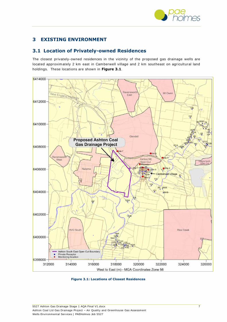
3.1 Location of Privately-owned Residences
The closest privately-owned residences in the vicinity of the proposed gas drainage wells are
located approximately 2 km east in Camberwell village and 2 km southeast on agricultural land
holdings. These locations are shown in Figure 3.1.
Figure 3.1: Locations of Closest Residences

5527 Ashton Gas Drainage Stage 1 AQA Final V1.docx 8
Ashton Coal Ltd Gas Drainage Project – Air Quality and Greenhouse Gas Assessment
Wells Environmental Services | PAEHolmes Job 5527
3.2 Dispersion Meteorology
Annual and seasonal windroses for the Ashton repeater site from July 2007 to June 2008 were
analysed and are shown in Figure 3.2. The dominant winds are from the west-northwest and the
east-southeast for all seasons, with less wind from the west-northwest during summer and from
the east-southeast during winter. The prevailing winds would mostly be expected to transport
emissions from the project towards residences located to east-southeast.
Figure 3.2: Wind Roses for ACOL repeater site– July 2007 to June 2008
NNNNENNE
NENE
ENEENE
EE
ESEESE
SESE
SSESSESS
SSWSSW
SWSW
WSWWSW
WW
WNWWNW
NWNW
NNWNNW
10% 20% 30%
NNNNENNE
NENE
ENEENE
EE
ESEESE
SESE
SSESSESS
SSWSSW
SWSW
WSWWSW
WW
WNWWNW
NWNW
NNWNNW
10% 20% 30% 40% 50%
NNNNENNE
NENE
ENEENE
EE
ESEESE
SESE
SSESSESS
SSWSSW
SWSW
WSWWSW
WW
WNWWNW
NWNW
NNWNNW
5% 10% 15% 20% 25%
NNNNENNE
NENE
ENEENE
EE
ESEESE
SESE
SSESSESS
SSWSSW
SWSW
WSWWSW
WW
WNWWNW
NWNW
NNWNNW
10% 20% 30% 40% 50%
NNNNENNE
NENE
ENEENE
EE
ESEESE
SESE
SSESSESS
SSWSSW
SWSW
WSWWSW
WW
WNWWNW
NWNW
NNWNNW
10% 20% 30%Wind speed (m/s)
>0.5 - 1.5
>1.5 - 3
>3 - 4.5
>4.5 - 6
>6 - 7.5
>7.5
Annual and seasonal windroses forAshton SEOC Mine Repeater Site
July 2007 - June 2008
SpringWinter
AutumnSummer
AnnualCalms = 6.2%
Calms = 6.0% Calms = 10.7%
Calms = 3.7% Calms = 4.5%
5527 Ashton Gas Drainage Stage 1 AQA Final V1.docx 9
Ashton Coal Ltd Gas Drainage Project – Air Quality and Greenhouse Gas Assessment
Wells Environmental Services | PAEHolmes Job 5527
3.3 Ambient Air Quality
Air quality standards and goals refer to pollutant levels that include the contribution from
specific projects and existing sources. To assess impacts against all the relevant air quality
standards and goals (see Section 2) it is necessary to have information or estimates on
existing background pollutant levels in the area. Dust concentration (PM10) and dust deposition
is monitored in the vicinity of ACOL.
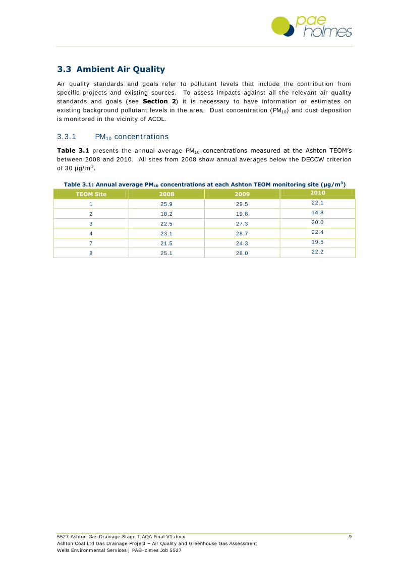
3.3.1 PM10 concentrations
Table 3.1 presents the annual average PM10 concentrations measured at the Ashton TEOM‟s
between 2008 and 2010. All sites from 2008 show annual averages below the DECCW criterion
of 30 µg/m3.
Table 3.1: Annual average PM10 concentrations at each Ashton TEOM monitoring site (µg/m3)
TEOM Site 2008 2009 2010
1 25.9 29.5 22.1
2 18.2 19.8 14.8
3 22.5 27.3 20.0
4 23.1 28.7 22.4
7 21.5 24.3 19.5
8 25.1 28.0 22.2

5527 Ashton Gas Drainage Stage 1 AQA Final V1.docx 10
Ashton Coal Ltd Gas Drainage Project – Air Quality and Greenhouse Gas Assessment
Wells Environmental Services | PAEHolmes Job 5527
4 IMPACTS
4.1 Construction Phase Impacts
The construction of 15 gas wells located parallel to the longwalls and spaced approximately 300-
400m apart would be progressively completed. The construction and drilling phases of the
drainage wells will require minimal disruption to the environment. A level pad will be cleared for
the drilling, which will require the use of trucks to hold and secure the drilling equipment plus
several light transport vehicles. The construction will be undertaken during daylight hours over
a 1 week period for each of the 15 proposed drainage wells.
The primary emissions during construction will be dust and particulate matter. The majority of
the particulate matter (PM) emissions generated from construction will be in the coarse size
fractions, generally referred to as PM10. Particulate matter (PM) emissions in the fine size
fractions, generally referred to <PM2.5 are typically associated with combustion sources.
Construction of level pads and drilling of the gas wells will result in dust emissions from:
Trucks and light vehicles travelling on existing unpaved roads or construction of additional
tracks where necessary;
Front end loaders for clearing / pad construction; and
Drilling of the gas wells;
Air quality impacts during the construction phase will be minor. They would be short lived (1
week per pad) and are expected to be easily controlled through commonly applied dust
management measures. Procedures for controlling dust impacts during construction are
outlined in Section 5.
There would be some minor emissions as a result of construction vehicles (exhaust emissions)
which would include oxides of nitrogen (NOx), carbon monoxide (CO), sulfur dioxide (SO2) and
organic compounds. However these emissions are typically minor for projects of this scale and
too widely dispersed to give rise to significant off-site concentrations.

5527 Ashton Gas Drainage Stage 1 AQA Final V1.docx 11
Ashton Coal Ltd Gas Drainage Project – Air Quality and Greenhouse Gas Assessment
Wells Environmental Services | PAEHolmes Job 5527
4.2 Operation Phase Impacts
Emissions from the operation of the project include those associated with the venting of the coal
seam gas (predominantly methane (CH4)) and diesel consumption in the compressors. Air
quality impacts can be broadly characterised based on local air quality impact and greenhouse
gas emissions. Odorous hydrocarbons or sulfur compounds are not expected in the coal seam
gas, and even if small quantities are present, odour impacts would not be expected due to
separation distances of greater than 2 km to residences.
4.2.1 Local Air Quality
A diesel compressor will be used to power a Venturi gas extraction device, capable of
exhausting up to 800 l/s of gas. The diesel compressor would be similar to that used for the
existing gas wells and would have a rated power of approximately 275 kW with a fuel
consumption of approximately 48 l/hr.
Pollutants from diesel exhaust include coarse and fine fractions of particulate matter (PM10 and
PM2.5), oxides of nitrogen (NOx), carbon monoxide (CO), sulfur dioxide (SO2) and organic
compounds such as Volatile Organic Compounds (VOCs).
The operation of the diesel compressor has not been quantifiably assessed (through dispersion
modelling) based on the minor consumption level and the fact that separation distances of at
least 2 km to the closest private residences is an adequate buffer to ensure that impact
assessment criteria for the key criteria pollutants would not be compromised. It is noted that
the emissions from the diesel compressor at each gas well site would be temporary as it would
be moved from gas well to gas well as mining progresses. ACOL are also investigating the
implementation of an electric or gas powered compressor to replace the diesel compressor
which would further minimise emissions during gas extraction.
4.2.2 Greenhouse Gas Emissions
Carbon Dioxide (CO2) and methane (CH4) would be the most significant greenhouse gases
(GHG) released from goaf gas venting. The gas vented from the proposed wells would be 90-
98% methane and exit at a flow rate of approximately 800 l/s. The vents would be located
parallel to the longwalls, spaced approximately 300-400 m apart. The GHG emissions from the
operation of the project would therefore be largely from CH4 from venting and CO2 from the
combustion of diesel fuel in the compressor.
The total duration for an active vent (from running to capping) is expected to be 2 months, after
which extraction moves onto the next well. There may be a free venting stack to allow natural
free venting of gas following movement of the extraction infrastructure, however the CH4 levels
and flow rates for free venting have not been provided and GHG emissions are therefore not
estimated for free venting.
Inventories of GHG emissions can be calculated using published emission factors. Different
gases have different greenhouse warming effects (referred to as global warming potentials) and
emission factors take into account the global warming potentials of the gases created during
combustion. The estimated GHG emissions are referred to in terms of CO2-equivalent (CO2-e)
emission by applying the relevant global warming potential. Three „scopes‟ of emissions (scope
1, scope 2 and scope 3) are defined for GHG accounting and reporting purposes. This
terminology has been adopted in Australian greenhouse reporting and measurement methods
and has been employed in this assessment.

5527 Ashton Gas Drainage Stage 1 AQA Final V1.docx 12
Ashton Coal Ltd Gas Drainage Project – Air Quality and Greenhouse Gas Assessment
Wells Environmental Services | PAEHolmes Job 5527
Scope 1 direct GHG emissions are defined as those emissions that occur from sources that are
owned or controlled by the reporting entity. Scope 2 emissions are a category of indirect
emissions that account for GHG emissions from the generation of purchased energy products
(principally electricity, steam/heat and reduction materials used for smelting) by the entity.
Scope 3 emissions are defined as those emissions that are a consequence of the activities of an
entity, but which arise from sources not owned or controlled by that entity. For the purposes of
this assessment, GHG emissions are reported for operation only (construction phase emissions
not considered) and limited to an assessment of direct (Scope 1) emissions from gas extraction
and venting and indirect (Scope 3) emissions from diesel production.
GHG emissions were estimated using the methodologies detailed in the National Greenhouse
and Energy Reporting System Measurement Technical Guidelines (NGER guidelines) June 2009
(DCC, 2009). The NGER guidelines were established as part of the National Greenhouse and
Energy Reporting (NGER) Determination 2008 commenced on 1 July 2008 and made under
subsection 10 (3) of the National Greenhouse and Energy Reporting (NGER) Act 2007.
A summary of the estimated GHG emissions are provided in Table 4.1. Further details on how
the emissions were calculated are provided in Appendix A.
Table 4.1: Estimated GHG emissions from Stage 1 operation of the gas wells
Emissions (t co2-e / annum)
Scope 1 Scope 3 Total
Gas venting 328,173 328,173
Diesel 1,128 86 1,214
A comparison is made with the baseline 1990 Australian emissions, which are reported under
the Kyoto Protocol as 547.7 Mt CO2-e (DCC, 2009a). The baseline is used to assign Australia‟s
target under the Kyoto Protocol, which is 108% of the 1990 level. The total annual Scope 1
emissions will account for an increase in GHG emissions of 0.06 % of total Australian emissions
(1990). It is noted that much of the annual GHG emissions reported in Table 4.1 would
currently occur from the operating mine released through other pathways such as ventilation
shafts and existing wells. The annual GHG emissions from ACOL operations would therefore not
significantly increase as a result of this project.
5 MANAGEMENT AND MONITORING
Mitigation measures employed to control dust generation during construction would include, but
not necessarily limited to the following:
Use of water carts to maintain moist soil during clearing and stripping of pads and on access
tracks during hot and windy conditions;
Minimising ground disturbance and the number and size of soil stockpiles to as low as
practical; and
All vehicles should be confined to a designated route with a speed limit enforced;
Due to the small scale and temporary nature of construction phase, monitoring (in addition to
that already conducted by ACOL) is not required for construction.
Monitoring during the operation of the gas wells includes a continuous ambient CH4 monitoring
and communications system and manual monitoring procedures in the event of a system failure.
5527 Ashton Gas Drainage Stage 1 AQA Final V1.docx 13
Ashton Coal Ltd Gas Drainage Project – Air Quality and Greenhouse Gas Assessment
Wells Environmental Services | PAEHolmes Job 5527
6 CONCLUSIONS
A qualitative air quality impact assessment demonstrates that air quality impacts during both
construction and operation of the surface gas drainage project would be minimal. Air quality
impacts during the construction phase will be short lived (1 week per pad) and are expected to
be easily controlled through commonly applied dust management measures.
Emissions from the operation of the diesel powered gas extraction compressor are unlikely to
compromise air quality goals, with separation distances of at least 2 km providing a sufficient
buffer between extraction plant and the closest residences.
GHG emissions of carbon dioxide (CO2) and methane (CH4) from goaf gas venting were
estimated and compared against Australian baseline levels. It is not expected that the annual
GHG emissions from ACOL operations will increase significantly from current operations.

5527 Ashton Gas Drainage Stage 1 AQA Final V1.docx 14
Ashton Coal Ltd Gas Drainage Project – Air Quality and Greenhouse Gas Assessment
Wells Environmental Services | PAEHolmes Job 5527
7 REFERENCES
DCC (2009) National Greenhouse and Energy Reporting Measurement Technical Guidelines for
the estimation of greenhouse gas emissions by facilities in Australia, Commonwealth of
Australia, June 2009.
DCC (2009a). Department of Climate Change. The Australian Government‟s Initial Report under
the Kyoto Protocol – Report to facilitate the calculation of the assigned amount of Australia
pursuant to Article 3, paragraphs 7 and 8 of the Kyoto Protocol – Revised submission to the
UNFCC Secretariat.
DCCEE (2010) National Greenhouse Accounts (NGA) Factors, Australian Government
Department of Climate Change and Energy Efficiency, July 2010.
NEPC (1998). National Environmental Protection (Ambient Air Quality) Measure Environment
Protection and Heritage Council, as amended 7 July 2003.
NSW DEC (2005) “Approved Methods for the Modelling and Assessment of Air Pollutants in
NSW”, August 2005.
5527 Ashton Gas Drainage Stage 1 AQA Final V1.docx A-1
Ashton Coal Ltd Gas Drainage Project – Air Quality and Greenhouse Gas Assessment
Wells Environmental Services | PAEHolmes Job 5527
APPENDIX A
GHG Emission Estimation
5527 Ashton Gas Drainage Stage 1 AQA Final V1.docx A-2
Ashton Coal Ltd Gas Drainage Project – Air Quality and Greenhouse Gas Assessment
Wells Environmental Services | PAEHolmes Job 5527
A.1.1 Fugitive Greenhouse Gas Emissions from Venting
Direct GHG emissions from venting have been estimated based on the method outlined in the
National Greenhouse and Energy Reporting System Measurement Technical Guidelines (NGER
guidelines) June 2009 (Chapter 3 Part 3.2 Division 3.2.2 Subdivision 3.2.2.2 Fugitive Emissions
from extraction of coal – Method 4), as follows:
The quantity of fugitive emissions from venting is based on the gas flow rate of 800 l/s
converted to m3 and calculated for the entire year based on the continuous operation:
800 l/s / 1000 X (3600 x 8760) = 22,228,800
For the purpose of GHG estimates it is assumed that vent gas comprises:
90% CH4 (methane);
10% CO2 (carbon dioxide).
The volume of gas in m3 (CH4 and CO2) is converted to tonnes CO2-e by using the conversion
factor provided in Method 4:
for CH4– 6.784 x 10-4 x 21
for CO2 – 1.861 x 10⁻³
The total tonnes CO2-e released in a year is calculated as follows:
For CH4 - 22,228,800 X 0.9 X (6.784 x 10-4 x 21) = 323,478
For CO2 - 22,228,800 X 0.1 X (1.861 x 10-3) = 4,695.
A.1.2 Greenhouse Gas Emissions from Diesel
Greenhouse gas emissions from diesel consumption were estimated using the following
equation:
where:
ECO2-e = Emissions of GHG from diesel combustion (t CO2-e)
Q = Estimated combustion of diesel (GJ)1
EF = Emission factor (Scope 1 or Scope 3)for diesel combustion (kg CO2-e/GJ)2
The quantity of diesel consumed (kL) in the compressor is estimated at 48 l/hr. The quantity of
diesel consumed (Q) in GJ is then calculated using an energy content factor for diesel of
38.6 gigajoules per kilolitre (GJ/kL).
Greenhouse gas emission factors and energy content for diesel were sourced from the National
Greenhouse Account (NGA) Factors 2010, published by the Department of Climate Change and
Energy Efficiency.

ASHTON COAL PROJECT ENVIRONMENTAL ASSESSMENT – DA 309-11-2001 MOD 7
Appendix 3
Gas Drainage Aboriginal Heritage Impact
Assessment

ASHTON COAL PROJECT ENVIRONMENTAL ASSESSMENT – DA 309-11-2001 MOD 7
INSITE HERITAGE PTY LTD PO BOX 98
WANGI WANGI NSW 2267 PH/FAX 02 49755 818
Ashton Coal Operations Ltd
Aboriginal Archaeological Assessment
Gas Wells Western Underground Panels
Camberwell, Hunter Valley, NSW
Report to Ashton Coal Operations Ltd
Feburary 2011
INSITE HERITAGE PTY LTD
2
INSITE HERITAGE PTY LTD PO BOX 98
WANGI WANGI NSW 2267 PH/FAX 02 49755 818
Project Coordinators ACOL P Fletcher
Wells Environmental A Wells
Insite Heritage A Besant
Our Reference ACOL_2011_WUG_22.02.11
Date
22nd Feb 2011
Authors A Besant Director

INSITE HERITAGE PTY LTD
3
Table of Contents
EXECUTIVE SUMMARY ..................................................................................................................... 4
1.0 INTRODUCTION ..................................................................................................................... 5
1.1 SCOPE OF WORK ............................................................................................................................. 5
1.2 METHODOLOGY .............................................................................................................................. 5
1.3 EXISTING ENVIRONMENT .................................................................................................................. 5
2.0 GAS WELL DESIGN ................................................................................................................ 6
3.0 IMPACT MANAGEMENT ........................................................................................................ 6
3.1 AVOIDANCE ................................................................................................................................... 6
3.2 MONITORING ................................................................................................................................. 9
3.3 SITE INDUCTIONS ............................................................................................................................. 9
3.4 IDENTIFICATION OF PREVIOUSLY UNKNOWN SITES .................................................................................. 9
4.0 DISCUSSION AND RECOMMENDATIONS ................................................................................ 9
5.0 BIBLIOGRAPHY .................................................................................................................... 11
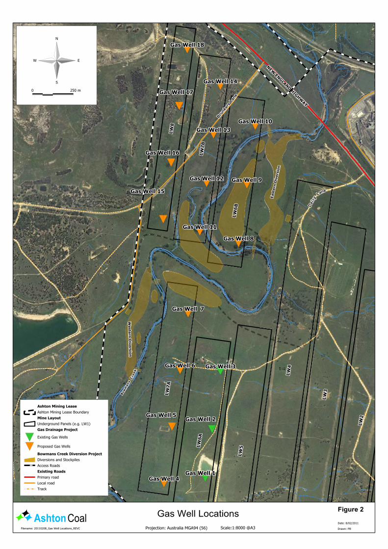
List of Figures FIGURE 1 LOCATION OF THE PROPOSED 15 ADDITIONAL GAS WELLS. ....................................................................... 7

INSITE HERITAGE PTY LTD
4
Executive Summary Insite Heritage were commissioned by Ashton Coal Operations Ltd (ACOL) to assess the archaeological impacts of a proposed gas well project and provide mitigation measures to minimise adverse impacts on cultural values known on the surface of the underground extraction area. The proposed gas wells are located in the areas of longwalls (LW) 6-8 known as the western underground panels. The gas wells are required to vent the underground workings in the Pike Gully Seam and provide for safety of personnel. The project is for up to 15 gas wells, to be strategically placed above the underground workings to draw off the gas. The footprint of each gas well compound is approximately 20m x 15 m. The location of the gas wells is not within any land subject to Native Title. The following report recommends the placement of the gas wells be adjusted to avoid any known Aboriginal cultural heritage sites of significance. In addition a monitoring program of groundworks, resulting in compound location adjustments or relocation of artefacts where they are considered by the archaeologist and stakeholders to be of low significance (eg. an isolated find or very small scatter with little artefact variability). The monitoring of ground works would be carried out in accordance with ACOL clearance policies and procedures. The monitoring will allow the involvement of the Aboriginal stakeholders to ensure minimal impact on unknown cultural sites.
INSITE HERITAGE PTY LTD
5 ACOL_GASWELLS_final_22 2 11.docx
1.0 Introduction This Aboriginal Archaeology Assessment Report has been prepared in support of an application by Ashton Coal Operations Pty. Limited (ACOL) to drill gas wells into the Pikes Gully seam in the western underground panels to enable the safe operation of the underground mine.
1.1 Scope of Work
The assessment of impact of the gas wells has been based on data recorded in previous archaeological assessments for the Ashton Coal Project (ACP), see Section 3.1. This assessment has been prepared as a desktop study to address the impacts that could occur during the construction and operation of the gas wells.
1.2 Methodology
The methodology used in this study is based on a desktop review of the known archaeological resource overlying LW 6-8. The details of the known sites and areas of potential archaeological deposit (PAD) were noted and overlain by the preferred strategic locations for the gas wells. The final proposed gas well locations were then adjusted to avoid known sites and PAD’s and are shown in Figure 1. The gas well impacts include the entire area of gas well compound, upgrading of existing access tracks and any new access routes required.
1.3 Existing Environment
Aboriginal heritage sites and isolated finds that potentially may be impacted by mine subsidence (and associated remediation works) within the project are summarised in Table 1. Management and ongoing monitoring measures have been outlined in Section 4.
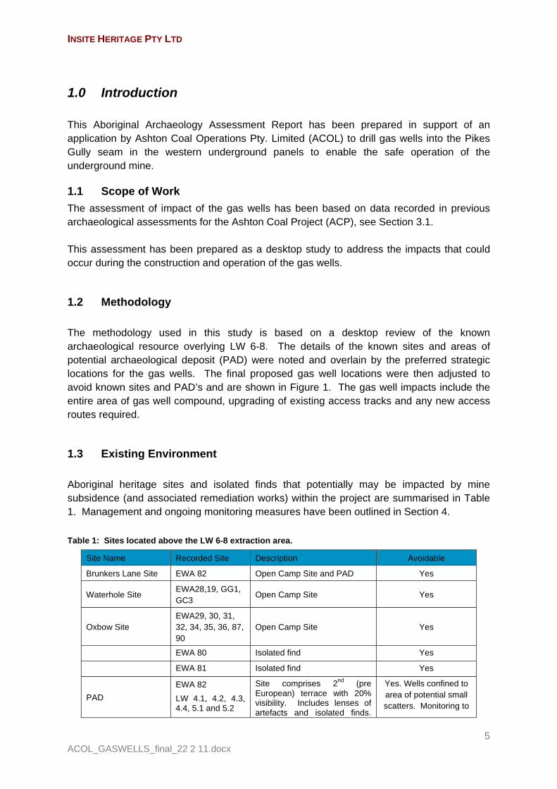
Table 1: Sites located above the LW 6-8 extraction area.
Site Name Recorded Site Description Avoidable
Brunkers Lane Site EWA 82 Open Camp Site and PAD Yes
Waterhole Site EWA28,19, GG1, GC3
Open Camp Site Yes
Oxbow Site EWA29, 30, 31, 32, 34, 35, 36, 87, 90
Open Camp Site Yes
EWA 80 Isolated find Yes
EWA 81 Isolated find Yes
PAD
EWA 82
LW 4.1, 4.2, 4.3, 4.4, 5.1 and 5.2
Site comprises 2nd (pre European) terrace with 20% visibility. Includes lenses of artefacts and isolated finds.
Yes. Wells confined to area of potential small scatters. Monitoring to
INSITE HERITAGE PTY LTD
6 ACOL_GASWELLS_final_22 2 11.docx
Site Name Recorded Site Description Avoidable
The recording includes an area of potential late Pleistocene, early Holocene landform.
avoid isolated finds and small scatters.
Potential area of Pleistocene terrace avoided completely.
EWA 89 Isolated find Yes
LW 2.1 Artefact Scatter Yes
EWA 97 3 artefacts Yes
AFA
21-26,44-50,51-61 Isolated finds & small scatters recorded by ACOL during ground disturbance works – have been avoided and remain in-situ.
Yes
The terrace area on which EWA 82 is located has been included in an area of PAD. The character of the PAD is generally small artefact scatters located in very shallow topsoil deposits over a Holocene terrace obscured by vegetation cover. A small area of potential Pleistocene deposit has been identified within the area of PAD and will be avoided completely.
2.0 Gas Well Design The key aspects of the development that could potentially impact on archaeological values are:
20m x 15m pads for each of the fifteen (15) gas wells. Upgrading and construction of new access tracks where required.
3.0 Impact Management The potential impacts of the gas wells will be managed as follows:
1. Avoidance – of known sites and areas of potential archaeological deposit (PAD). 2. Monitoring of ground disturbance – in accordance with ACOL internal management
requirements. 3. An Aboriginal Heritage Impact Permit (AHIP) be sought to cover impact by the gas
well activity particularly in the areas of known and potential PAD (see Figure 1).
3.1 Avoidance
The locations of most of the gas wells have been selected to avoid all known sites and areas of PAD. The location of sites is known from numerous archaeological assessments carried out since 2001. Previous studies pertinent to the ACOL holdings are listed in Table 2.

INSITE HERITAGE PTY LTD
7 ACOL_GASWELLS_final_22 2 11.docx
Figure 1 Location of the proposed 15 additional gas wells.

INSITE HERITAGE PTY LTD
8 ACOL_GASWELLS_final_22 2 11.docx
Table 2 Previous studies on ACOL holdings / underground areas.
Ashton Coal Operations Pty Ltd
2006 Archaeological and Cultural Heritage Management Plan. Prepared by Insite Heritage Pty Ltd.
Environmental Resource Management P/L
2006 Archaeological and Cultural Heritage Subsidence Management Plan. Ashton Coal Longwall Panels 1-4. Annexe L Ashton Coal Subsidence Management Plan.
Hardy, V. 2001 Archaeological Survey, Ashton Mine, Camberwell, Hunter Valley, NSW. Report to HLA Envirosciences for White Mining Ltd. In Witter 2002.
Insite Heritage Pty Ltd
2009 Archaeological and Cultural Heritage Assessment Longwall 9. Report to ACOL.
Insite Heritage Pty Ltd
2009 AboriginalArchaeological Assessment Ashton Coal Operations – Bowmans Creek Diversion Project. Report to ACOL / Dept of Planning NSW
Insite Heritage Pty Ltd
2010 ACOL Interim Cultural Hertage Report Western Underground Panels, Camberwell NSW
Witter, D.C. 2002 Ashton Coal Mining Project. Environmental Impact Statement: Aboriginal Archaeology. A report to HLA Envirosciences for White Mining Ltd.
These reports have identified sites over the eastern (LW1-5) and western (LW 6-8) longwall areas. In addition further minor sites (isolated finds and small scatters) have been located in the course of ACOL’s due diligence process which involves specific site inspection by stakeholder groups prior to any ground works during the day to day operation of the mine. The location of these sites and the proposed gas wells can be seen in Figure 1 and are discussed below.
Gas wells 10, 12, 13 & 15 are located in the PAD area associated with EWA 82. Gas wells 4, 5, 6 & 7, are located in the southern area of LW 6-7, an area that had no
surface visibility at the time of the Witter survey. ACOL clearance procedures have identified sites in this area (AFA’s) indicating the potential of further sites in this location.
Gas wells 8, 9 & 11 are located in areas of low archaeological potential based on geomorphology assessment.
Gas wells 14, 16, 17 & 18 are located in disturbed land with low archaeological potential.
The area of PAD associated with EWA 82 is the subject of a current AHIP to allow underground mining and associated activities. That application refers to the gas well activity as a management requirement and states:
“All sites will be impacted during the life of the underground mining. The site will require remediation of cracking to ensure the surface and workings do not connect. In addition the end subsidence levels will require the longwall areas to be filled to keep the creek terraces self draining. The construction of the creek diversions will impact on the diversion areas in addition to stockpile areas, compounds and access roads. Studies have shown that gas will also be an issue in these longwalls and an application is to be submitted for gas wells to be strategically placed above the longwall panels. Therefore, the application seeks to cover all activities that are
INSITE HERITAGE PTY LTD
9 ACOL_GASWELLS_final_22 2 11.docx
required to provide for the continual safe operations of the mine. “ (ACHAR 2011 p 15).
Therefore this AHIP covers the gas well construction within the WUG area.
3.2 Monitoring
As part of ACOL’s internal management strategies, all proposed gas well site locations will be checked to confirm the absence of artefacts or PAD prior to ground disturbance. Where a previously unrecorded artefact is located, the site location will be adjusted to avoid impact. Such artefacts would be recorded on ACOL’s standard recording forms and marked to avoid inadvertent impact during the construction process.
3.3 Site inductions
As an additional safeguard the induction of plant operators will include site identification information, and the Ashton Environment Team will regularly inspect works. Should any potential archaeological material be identified, the archaeologist and Aboriginal community will be contacted to provide a formal identification. The Aboriginal community, as represented by ACOL’s Aboriginal Representative Panel, will be consulted as part of the management decision process being made.
3.4 Identification of previously unknown sites
Protocols for the management of previously unknown sites found in the course of works are detailed in the Environmental Management Plan. The location of the gas wells will be checked for unknown sites by the archaeologist and stakeholder representative (determined by rooster). Should PAD or a high/complex artefact scatter be suspected the gas well footprint will be adjusted to avoid the site. Where no evidence of artefact scatters or PAD is indicated, the earthworks will proceed under monitoring by the stakeholders (drawn from a rooster), to confirm the assessment. Should isolated finds or small scatters be located during the monitoring, the artefacts will be relocated outside the footprint of the compound and their previous and current position recorded.
4.0 Discussion and Recommendations The footprint of the gas well compounds and the excavation of the gas wells is considered a low risk activity in terms of Aboriginal cultural heritage. This is because the locations of items of Aboriginal heritage are reasonably well known on the basis of previous work and importantly, because there is scope to adjust the footprints to avoid potential impacts. There is always the potential for isolated finds and small artefact scatters to remain undetected in the landscape because of vegetation and soil cover. These artefacts may become exposed during monitoring of earthworks in preparation of the drilling pad. Where

INSITE HERITAGE PTY LTD
10 ACOL_GASWELLS_final_22 2 11.docx
there is stakeholder and archaeologist agreement that the uncovered items are low in significance and not indicative of a larger site, they will be relocated outside the area of works rather than to relocate the compound, which may only uncover more of the same material. To manage this scenario an AHIP will be required to allow for the movement of artefacts. Alternatively, where the unearthing of artefacts indicates the potential for a larger more complex site, the site will be recorded without further disturbance and the gas well compound relocated. Should artefacts be located in the footprint of a compound that are indicative of a potentially complex artefact scatter or PAD, the location of the compound should be adjusted to avoid the boundaries of the site (as defined by the archaeologist) and the site fully recorded on the ACOL and AHIMS database.
INSITE HERITAGE PTY LTD
11 ACOL_GASWELLS_final_22 2 11.docx
5.0 Bibliography
AECOM (2010, in prep) Extraction Plan - Pikes Gully Longwalls 6-8. Report to Ashton Coal Operations.
Besant, A & Wyatt, L 2008 Aboriginal Archaeological Assessment – Macquarie Generation Proposed Gas Pipeline East – West Route. Report to Parsons Brinkerhoff.
Besant, A & Wyatt, L 2008B Subsidence Management Archaeological
Impact Assessment. Unpublished report to Ashton Coal Operations.
Besant, A & Wyatt, L 2009 Aboriginal Archaeological Assessment –
Proposed Longwall 9. Report to Ashton Coal Operations
Besant, A. Carter, C & Wyatt, L 2009 A Aboriginal Archaeological
Assessment – Proposed south east Open Cut. Report to Ashton Coal Operations.
Besant, A & Wyatt, L 2011 Aboriginal Cultural Heritage Assessment
Report. AHIP application support document. Report to DECCW.
Evans & Peck Pty Ltd (2009) Bowmans Creek Diversion Environmental
Assessment. Report to Ashton Coal Operations.
Maunsell Australia. (2008) Ashton Coal Underground Subsidence
Management Plan Longwall and Miniwall Panels 5 to 9. Prepared for Ashton Coal Operations Limited, Maunsell Australia Pty Ltd, Maitland, NSW Australia.
Mitchell, P Dr. 2002 Geomorphology of the Ashton Coal Project site
in relation to archaeology. Camberwell, Hunter Valley NSW Report by Groundtruth Consulting to Witter. D
Witter, D. 2002 Ashton Coal Mining Project
Environmental Impact Assessment: Aboriginal Archaeology. Report to White Mining Ltd.

ASHTON COAL PROJECT ENVIRONMENTAL ASSESSMENT – DA 309-11-2001 MOD 7

ASHTON COAL PROJECT ENVIRONMENTAL ASSESSMENT – DA 309-11-2001 MOD 7
Appendix 4
Gas Drainage Terrestrial Ecology Impact
Assessment

ASHTON COAL PROJECT ENVIRONMENTAL ASSESSMENT – DA 309-11-2001 MOD 7

Ashton Coal Gas Drainage Wells - Riparian and Terrestrial Ecological Impact Assessment
Draft Version: Final 2 (21/02/2011)
Prepared by John-Paul King
Ashton Coal Gas Drainage Project Stage 1- Riparian and terrestrial ecology Draft: V 3
2 Pacific Environmental Associates Pty Ltd Ecologists and Ecohydrologists
Document Control
Distribution
Version Date Distribution Distribution Form
13/01/2011 Phil Burns (Wells)
Phil Fletcher (Ashton)
PDF via email
Upload to www.box.net site
24/01/2011 Phil Burns (Wells)
Phil Fletcher (Ashton)
PDF via email
Upload to www.box.net site
26/01/2011 Phil Burns (Wells)
PDF via email
08/02/2011 Phil Burns and Jonathon Berry (Wells) Word document via email
Document Ownership & Property Rights
This document is a report prepared by Pacific Environmental Associates Pty Ltd (PEA) for the client named on the
title page, and was prepared in response to a brief (written and/or verbal) issued by the client and agreed to by PEA
for the agreed fee. This document remains the property of PEA until full payment has been received from the client or
their agent. On such completion of the contract, the client is the owner of the document, but PEA retains rights to
intellectual property (such as field data) in the document. The information in this document and any information or
data compiled by PEA for the preparation of this document will be treated as private and confidential by PEA until
such time as this document is placed in the public domain by means of a development application or similar, or if the
client dishonours the contract by not paying the agreed fee within a reasonable time of completion of the study.
All rights are reserved and no part of this document may be copied or reproduced in any form without written
permission from the owner of the document, other than for fair dealing as defined under the Copyright Act 1968.
Document Limitations
This report has been prepared with the upmost care using information supplied by the client and other entities, as
well as the results of original investigations. PEA does not warrant that the information in this report is free from
errors or omissions. While the document satisfies the requirements of the brief, a need for additional investigations
and reporting may be identified after consultations with relevant authorities.
The current knowledge of the ecology of most flora and fauna species is poor. As a consequence, there are often
insufficient data to objectively assess potential consequences of a proposal for most species. Therefore, ecological
assessments typically rely to some extent on professional opinion or judgements based on the personal knowledge
Version Date Tasks undertaken and updated material Completed by 13/01/2011 Draft 1.1 Internal review and updated literature review of relevant
documents
JPK
24/01/2011 Draft 2.1 Reviewed by Alan Wells JPK
26/01/2011 Draft 3.0 Reviewed by Jonathan Berry JPK
08/02/2011 Draft 4.0 Reviewed by Michael Moore JPK

Ashton Coal Gas Drainage Project Stage 1- Riparian and terrestrial ecology Draft: V 3
3 Pacific Environmental Associates Pty Ltd Ecologists and Ecohydrologists
of the ecological consultant, investigations undertaken specifically for the proposal, and/or data derived from previous
studies (i.e. literature sources). In scientific jargon, such subjective judgements are hypotheses or ‘likely’
explanations based on the experience of the consultant. These hypotheses are often quite accurate (because of the
extensive experience of the consultant) but they nevertheless remain subjective opinions unless tested scientifically.
Where possible, PEA seeks to test hypotheses using scientifically sound methods. That is, PEA undertakes studies
designed to replace subjective judgements with objective data. However, this is not feasible for many of the issues
covered by most ecological assessments due to various constraints, and it is therefore necessary to rely on opinion
in parts of the assessment. In keeping with our position that the authors of ecological assessments should be
accountable for their opinions, the authors responsible for PEA’s reports are clearly stated on the title page.
Independence
Due to the reliance of ecological assessments on professional opinion, they unavoidably reflect the experiences and
attitudes of the authors to some extent. Such personal ‘bias’ cannot be avoided where people are involved in any
process. However, the advice provided should be independent. That is, the conclusions of a study should be the
same regardless of who the client was. It is common practice for a client to modify their proposal in response to
information supplied by the ecological consultant in order to avoid excessive ecological impact. This typically results
in an ecological assessment report that supports the proposal, which is the considered opinion of the authors but it is
in no way adversarial on behalf of the client. While others may disagree with opinions expressed in PEA’s reports,
the opinions are independent and represent the best advice of the authors based on the available data.

Ashton Coal Gas Drainage Project Stage 1- Riparian and terrestrial ecology Draft: V 3
4 Pacific Environmental Associates Pty Ltd Ecologists and Ecohydrologists
Executive Summary
This riparian and terrestrial ecology report has been prepared in support of an application by Ashton Coal Operations Pty. Limited (ACOL) to construct fifteen (15) gas wells strategically spaced across the surface of the underground mine to facilitate the drainage of gas to the surface, and minor support infrastructure for each well site (i.e. pads).
Each well site will include a constructed pad of approximately 300m2 of road base, a perimeter fence and house a range of machinery necessary to operate the wells. To minimise impacts, access tracks will not be constructed between established tracks and well sites, alternatively pre-determined routes will be marked and used. The proposed locations for the fifteen (15) sites were selected based on the following criteria:
1. Mature trees and remnant vegetation have been avoided;
2. Ecologically sensitive areas have been avoided;
3. Where possible the length of access tracks has been minimised; and,
4. The wells have been located in the best location to achieve a safe work environment whilst adhering to criteria 1-3 above.
Habitats identified include; riparian corridors, floodplain pasture, flood terraces, upland forest, woodland remnants, farm dams and pasture with scattered trees. The majority of this habitat is characterised by natural regeneration sourced from a small number of remnant trees. Only a small number of isolated mature hollow-bearing paddock trees were recorded, providing only marginal habitat for bird, bat and arboreal mammal species.
In total, six (6) vegetation units have been previously reported for the Bowmans Creek Diversion Project. None of the communities identified are consistent with determinations for Endangered Ecological Communities. Targeted surveys recorded individuals from two endangered populations, being the Hunter Weeping Myall population and the River red gum population in the Hunter Catchment. Individuals from the Hunter Weeping Myall population were recorded outside of the proposed impact areas, and will not be impacted. Individual River red gums occur on the lower reaches of Bowmans creek and are also outside of the proposed impact areas.
No significant flora species or habitats were identified within the proposal area. In total, four (4) significant fauna species have been recoded using the habitats within the Local Area; however none of these habitats will be modified or removed as part of activity.
The construction of the proposed fifteen (15) gas wells and the minor support infrastructure for each well will not directly impact significant natural areas (i.e. modify or remove habitats) or introduce secondary impacts (i.e. downstream impacts or change competition) to any ecologically sensitive areas. In conclusion, the proposal will not impact on habitats for threatened species, populations, or communities to the extent that these are put at further risk.
The potential for impacts to the sites' ecology is limited to accidental intrusions into remnant vegetation areas by contractors and Ashton staff. However, access into remnant or sensitive vegetation is generally restricted by existing fencing. The following summarises the recommendations made in this report:
• Access to areas outside the defined roads and tracks shall be avoided; • Existing environmental management plans for the area shall be adhered to; and • Ecological inductions should be established that detail the areas permissible for access and
egress and the appropriate driving methods.
The ecological findings of this assessment are consistent with the results of assessments conducted for the Bowmans Creek Environmental Assessment (2009) and we see no ecological reasons for not supporting the proposal.
Ashton Coal Gas Drainage Project Stage 1- Riparian and terrestrial ecology Draft: V 3
5 Pacific Environmental Associates Pty Ltd Ecologists and Ecohydrologists
1.0 INTRODUCTION 7
1.1 SCOPE OF WORK 7 1.2 METHODOLOGY 7
2.0 EXISTING ENVIRONMENT 10
2.1 GENERAL TERRESTRIAL HABITATS OF THE WIDER LOCAL AREA 10 2.1.1 NARAMA EXTENDED PROJECT ENVIRONMENTAL ASSESSMENT 10 2.1.2 RAVENSWORTH OPERATIONS PROJECT ENVIRONMENTAL ASSESSMENT 11 2.1.3 GLENNIES CREEK OPEN CUT COAL MINE 11 2.1.4. HABITATS OF THE LOCAL AREA 12 2.2 GENERAL TERRESTRIAL HABITATS OF THE PROPOSAL AREA 12 2.3 VEGETATION COMMUNITIES 13 2.2.1 OCCURRENCE OF IDENTIFIED VEGETATION COMMUNITIES WITHIN THE PROPOSAL AREA 15 2.4 SIGNIFICANT FLORA AND FAUNA 15 2.5 AREAS OF ENVIRONMENTAL SENSITIVITY 25
3.0 STATUTORY REQUIREMENTS 26
3.1 EPBC ACT 1999 26 3.2 THREATENED SPECIES ACT 1995 26 3.3 ENVIRONMENTAL PLANNING AND ASSESSMENT ACT 1979 26 3.4 STATE ENVIRONMENTAL PLANNING POLICIES (SEPP) 26 3.5 RELATIVE KEY THREATENING PROCESSES 26
4.0 PREDICTED IMPACTS 27
4.1 POTENTIAL IMPACTS ON WOODLAND BIRDS 27 4.2 POTENTIAL IMPACTS ON MICRO-BATS 27
5.0 MANAGEMENT 28
5.1 CURRENT MANAGEMENT ACTIONS FOR TERRESTRIAL ECOLOGY 28 5.2 ADDITIONAL MANAGEMENT REQUIREMENTS 29
6.0 CONCLUSIONS 30
APPENDIX A- FLORA DATA 37 APPENDIX B- 7-PART TESTS 54 1.0 SECTION 5A EP&A ACT – SEVEN PART TEST 54 1.1 WOODLAND BIRDS 7 -PART TEST 54 1.2 MICRO-BATS 7 PART TESTS 59 APPENDIX C- SURVEY METHODS, TIMING AND CONDITIONS 64

Ashton Coal Gas Drainage Project Stage 1- Riparian and terrestrial ecology Draft: V 3
6 Pacific Environmental Associates Pty Ltd Ecologists and Ecohydrologists
Figures Figure 1 Proposal Area ........................................................................................................................... 32
Figure 2- Locations of Surveys and Gas Wells ....................................................................................... 33 Figure 3-Locations of significant flora relative to gas well locations ........................................................ 34
Figure 4- Locations of significant fauna relative to gas well locations ..................................................... 35
Figure 5- Vegetation communities relative to gas well locations ............................................................. 36
Tables
Table 1. Terrestrial ecological surveys conducted in the Local Area. ....................................................... 8
Table 2. Classification of habitats found in the Local Area. .................................................................... 12
Table 3 Importance of habitats in the Proposal Area for native flora and fauna species. ..................... 13
Table 4. Descriptions of vegetation map units within the Local Area. ................................................... 13
Table 5. Habitats and vegetation units within the Proposal Area. ......................................................... 15
Table 6. Analysis of the Proposal Areas habitat potential for significant species recorded in the Local Area and the identification of impacts. .................................................................................................. 16
Table 7. Current management actions for significant species recorded on ACOL Lands and Conservation zones. ............................................................................................................................... 28
Table 8- Flora transect data .................................................................................................................... 38
Table 9- Bowmans Creek Flora Quadrat Data ........................................................................................ 42
Table 10 (cont)- Bowmans Creek Flora Quadrat Data ............................................................................ 43
Table 11- Walking transect data collected from the South east open cut and southern woodland localities, see Figure 2 for details. .......................................................................................................... 44
Table 12- SOEC Flora quadrat data ......................................................................................................... 48
Table 13: Flora and fauna surveys used in preparation of Environmental Assessment report. ......... 64

Ashton Coal Gas Drainage Project Stage 1- Riparian and terrestrial ecology Draft: V 3
7 Pacific Environmental Associates Pty Ltd Ecologists and Ecohydrologists
1.0 Introduction This riparian and terrestrial ecology report has been prepared in support of an application by Ashton Coal Operations Pty. Limited (ACOL) to construct fifteen (15) gas wells strategically spaced across the surface of the underground mine to facilitate the drainage of gas to the surface, and minor support infrastructure for each well site (i.e. pads). All possible transportation and/or potential uses for the gas will be dealt with in future assessments. Refer to Figure 1.0 of the EA for site locality and contest for this project.
Each well site will include a constructed pad of approximately 300m2 of road base, a perimeter fence and house a range of machinery necessary to operate the wells. To minimise impacts, access tracks will not be constructed between established tracks and well sites, alternatively pre-determined routes will be marked and used. The proposed locations for the fifteen (15) sites were selected based on the following criteria:
1. Mature trees and remnant vegetation have been avoided;
2. Ecologically sensitive areas have been avoided;
3. Where possible the length of access tracks has been minimised; and,
4. The wells have been located in the best location to achieve a safe work environment whilst adhering to criteria 1-3 above.
A detailed description of the proposal, and the localities for the wells is provided in Section 1.1 of the Ashton Coal Gas Drainage Project Stage 1 Environmental Assessment. The specific areas of issue for this report are presented below and diagrammatically in Figure 1:
1. Local Area- This includes all terrestrial lands from the New England Highway in the north to the Hunter River in the south and ranges from Glennies Creek in the east across Bowmans Creek and terminates on the Ravensworth mine site.
2. Proposal A rea- This includes all terrestrial lands within the footprint of the proposed disturbance and a buffer of 20 meters from the edges of the footprint, as shown in Figure 1.
1.1 Scope of Work The general aim of this report is to undertake a terrestrial flora and fauna assessment of the impacts from the proposed wells and supporting infrastructure on potential significant ecological issues, and whilst the Local Area does provide important habitats, given the innocuous nature of the proposal, the main focus of the “impact assessment” will be on the footprint of the proposal inclusive of a 20 metre buffer (Proposal Area). Several ecological surveys and assessments of the Local Area have already been undertaken, and therefore the aim here is to update the ecological datasets to relate the most recent listings and to incorporate data from surrounding and nearby surveys and assessments conducted for other projects.
The specific aims are to:
1. Conduct a literature review and database search for the Local Area which includes all natural features within the Proposal Area;
2. Provide an assessment of the terrestrial ecological characteristics of the Proposal Area; 3. Determine the potential impacts of the proposal on terrestrial ecological matters; and, 4. Provide recommendations to minimise impacts on terrestrial ecology.
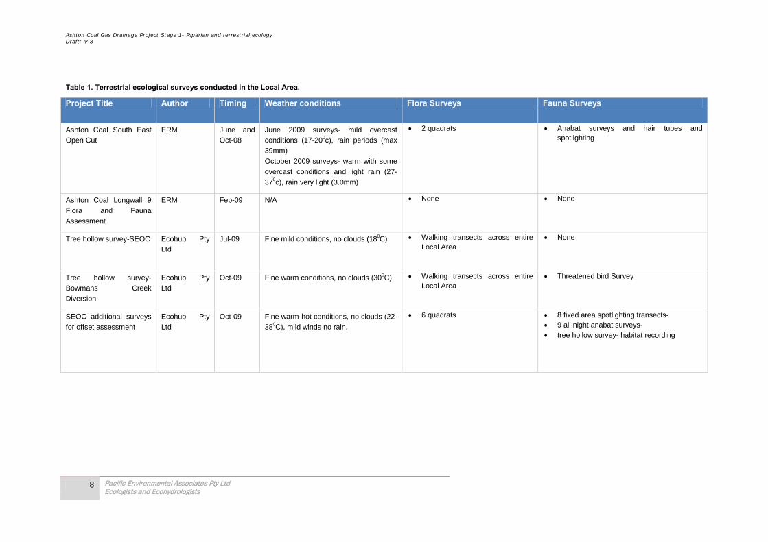
1.2 Methodology Various surveys of terrestrial ecology have been conducted across the Local Area (refer to Table 1 , Figure 3 and Figure 4). These surveys include intensive quantitative methods and together provide a detailed assessment of the ecological characteristics and significant ecological issues, details of the survey timing and conditions are reported in Appendix A and Appendix C. Given the depth of survey in the Local Area, no additional surveys were required for this report.
Ashton Coal Gas Drainage Project Stage 1- Riparian and terrestrial ecology Draft: V 3
8 Pacific Environmental Associates Pty Ltd Ecologists and Ecohydrologists
Table 1. Terrestrial ecological surveys conducted in the Local Area.
Project Title Author Timing Weather conditions Flora Surveys Fauna Surveys
Ashton Coal South East
Open Cut
ERM June and
Oct-08
June 2009 surveys- mild overcast
conditions (17-200c), rain periods (max
39mm)
October 2009 surveys- warm with some
overcast conditions and light rain (27-
370c), rain very light (3.0mm)
• 2 quadrats • Anabat surveys and hair tubes and spotlighting
Ashton Coal Longwall 9
Flora and Fauna
Assessment
ERM Feb-09 N/A • None • None
Tree hollow survey-SEOC Ecohub Pty
Ltd
Jul-09 Fine mild conditions, no clouds (180C) • Walking transects across entire Local Area
• None
Tree hollow survey-
Bowmans Creek
Diversion
Ecohub Pty
Ltd
Oct-09 Fine warm conditions, no clouds (300C) • Walking transects across entire Local Area
• Threatened bird Survey
SEOC additional surveys
for offset assessment
Ecohub Pty
Ltd
Oct-09 Fine warm-hot conditions, no clouds (22-
380C), mild winds no rain.
• 6 quadrats • 8 fixed area spotlighting transects- • 9 all night anabat surveys- • tree hollow survey- habitat recording

Ashton Coal Gas Drainage Project Stage 1- Riparian and terrestrial ecology Draft: V 3
9 Pacific Environmental Associates Pty Ltd Ecologists and Ecohydrologists
Project Title Author Timing Weather conditions Flora Surveys Fauna Surveys
Ashton coal Bi-annual
Fauna Monitoring ERM
Oct/-Nov-
09
October 2009 surveys- mild to warm
conditions (280C) no rain with a mild
ESE wind.
November 2009 surveys- warm to hot
conditions 29-370C) no rain calm
conditions.
• None
• 10 pitfall traps • 50 Elliot traps in two transects for four nights • 30 hair tubes in southern woodland- • 20 Elliot tree traps set for four nights • 10 hair funnels set in trees for 10 nights • 3 hrs of frog survey • one anabat for 10 nights • 10 x 10 min bird surveys • Targeted bird surveys
Additional Ecological
information for the South
East Open Cut
Environmental
Assessment- Response to
Adequacy Review
PEA
Consulting
Jan-10 January 2010 surveys- warm to hot
conditions 27-390C) mild rain periods
and high humidity on the 14th. Other
days mild winds, moderate cloud cover,
no rain.
• 12 Flora quadrats • three kilometres of searches for
threatened plant species along transects
• Three kilometres of avian transects • 3 hours of targeted avian surveys • 3 nights of continuous all night Anabat
surveys Anabat walking transects • Tree hollow surveys
Additional Ecological
information for Review of
Bowmans Creek
Diversion
PEA
Consulting
Feb-10 February 2010 surveys - warm humid
conditions (27-290C) moderate rain
periods and high humidity on the 4th.
Other day’s mild winds, moderate cloud
cover.
• 6 flora quadrats along impact area • Walking transects looking for
significant species • Targeted survey for Acacia
pendula, Thesium australe, Eucalyptus glaucina, Diuris tricolor, Digitaria porrecta, and Acacia pendula
• Five kilometre walking transect targeting Grey-crowned Babbler, Hooded Robin, and Speckled Warbler
• Tree hollow survey • Fauna habitat survey

Ashton Coal Gas Drainage Project Stage 1- Riparian and terrestrial ecology Draft: V 3
10 Pacific Environmental Associates Pty Ltd Ecologists and Ecohydrologists
2.0 Existing Environment The Local Area contains a range of natural terrestrial features that have the potential to be impacted by the proposal. This section details the natural terrestrial features of the Local Area and specifically details the features that could be potentially at risk of impact from the proposal.
The Local Area for the purposes of this assessment is restricted to the areas detailed in Figure 1.0 of the Ashton Coal Gas Drainage Project Stage 1 Environmental Assessment. It includes sections of Bowmans Creek, the approved Bowmans Creek diversion and a number of unnamed ephemeral creeks and drainage lines. The area is largely cleared for agricultural purposes with a retained riparian corridor along the natural sections of Bowmans Creek and small areas of terrestrial forest vegetation upslope in paddocks. The largest remnant is located to the south (referred hereafter as the “southern woodland”) and provides habitat for a range of threatened and regionally significant flora and fauna species which may also utilise the resources present within the Local Area by way of fragmented movement corridors. The topography of the Local Area is generally flat to undulating.
The soils reported include Loamy Rudosols, Brown Sodosols, Grey Sodosols, Red Chromosols, Mottled-Sodic Red Chromosols and Sodic Bleached-Mottled Brown Chromosols. These soils were identified on the creek flats, terrace, foot slopes, lower slopes, hill slopes and ridgelines. Soil properties identified include moderately acidic to moderately alkaline pH, slight to moderate salinity and high dispersion was a common characteristic.
2.1 General terrestrial habitats of the Wider Local Area A review of documents prepared in the wider Local Area over recent times is presented to provide background information on the local habitats and to put into perspective the relevance of significant findings made onsite.
2.1.1 Narama Extended Project Environmental Assessment Umwelt Environmental Consultants prepared an Environmental Assessment for the Narama Extended Project in 2009.
Three vegetation communities were identified, comprising:
• Derived grassland; • Central Hunter Box – Ironbark Woodland; and • Central Hunter Bulloak Forest Regeneration.
One Endangered Ecological Community (EEC), Central Hunter Grey Box – Ironbark Woodland was identified. A total of 117 flora species were recorded, of which 87 are native species and 30 are introduced. Species were recorded from a total of 40 families, the most common families being Poaceae (23 species), Asteraceae (20 species), Chenopodiaceae (8 species) and Fabaceae (7 species). One threatened flora species was identified in the assessment area, Bothriochloa biloba which was recorded outside the disturbance area for the project.
Four habitats were recorded in the assessment area, box-ironbark woodland; bulloak woodland; grassland; and aquatic. A total of 38 fauna species were recorded within the assessment area during surveys. This included 32 bird species, one amphibian species and five mammal species.
Two threatened bird Species were recorded within the Assessment Area: the speckled warbler (Chthonicola sagittatus), and the grey-crowned babbler (Pomatostomus temporalis temporalis). One threatened mammal species was recorded within the assessment area, the eastern bentwing-bat (Miniopterus schreibersii oneanensis).
Ashton Coal Gas Drainage Project Stage 1- Riparian and terrestrial ecology Draft: V 3
11 Pacific Environmental Associates Pty Ltd Ecologists and Ecohydrologists
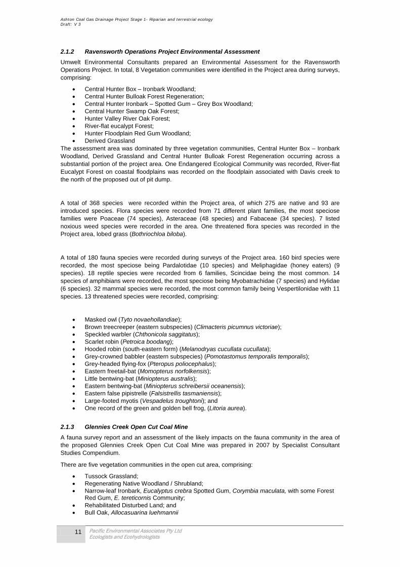
2.1.2 Ravensworth Operations Project Environmental Assessment Umwelt Environmental Consultants prepared an Environmental Assessment for the Ravensworth Operations Project. In total, 8 Vegetation communities were identified in the Project area during surveys, comprising:
• Central Hunter Box – Ironbark Woodland; • Central Hunter Bulloak Forest Regeneration; • Central Hunter Ironbark – Spotted Gum – Grey Box Woodland; • Central Hunter Swamp Oak Forest; • Hunter Valley River Oak Forest; • River-flat eucalypt Forest; • Hunter Floodplain Red Gum Woodland; • Derived Grassland
The assessment area was dominated by three vegetation communities, Central Hunter Box – Ironbark Woodland, Derived Grassland and Central Hunter Bulloak Forest Regeneration occurring across a substantial portion of the project area. One Endangered Ecological Community was recorded, River-flat Eucalypt Forest on coastal floodplains was recorded on the floodplain associated with Davis creek to the north of the proposed out of pit dump.
A total of 368 species were recorded within the Project area, of which 275 are native and 93 are introduced species. Flora species were recorded from 71 different plant families, the most speciose families were Poaceae (74 species), Asteraceae (48 species) and Fabaceae (34 species). 7 listed noxious weed species were recorded in the area. One threatened flora species was recorded in the Project area, lobed grass (Bothriochloa biloba).
A total of 180 fauna species were recorded during surveys of the Project area. 160 bird species were recorded, the most speciose being Pardalotidae (10 species) and Meliphagidae (honey eaters) (9 species). 18 reptile species were recorded from 6 families, Scincidae being the most common. 14 species of amphibians were recorded, the most speciose being Myobatrachidae (7 species) and Hylidae (6 species). 32 mammal species were recorded, the most common family being Vespertilonidae with 11 species. 13 threatened species were recorded, comprising:
• Masked owl (Tyto novaehollandiae); • Brown treecreeper (eastern subspecies) (Climacteris picumnus victoriae); • Speckled warbler (Chthonicola saggitatus); • Scarlet robin (Petroica boodang); • Hooded robin (south-eastern form) (Melanodryas cucullata cucullata); • Grey-crowned babbler (eastern subspecies) (Pomotastomus temporalis temporalis); • Grey-headed flying-fox (Pteropus poliocephalus); • Eastern freetail-bat (Momopterus norfolkensis); • Little bentwing-bat (Miniopterus australis); • Eastern bentwing-bat (Miniopterus schreibersii oceanensis); • Eastern false pipistrelle (Falsistrellis tasmaniensis); • Large-footed myotis (Vespadelus troughtoni); and • One record of the green and golden bell frog, (Litoria aurea).
2.1.3 Glennies Creek Open Cut Coal Mine A fauna survey report and an assessment of the likely impacts on the fauna community in the area of the proposed Glennies Creek Open Cut Coal Mine was prepared in 2007 by Specialist Consultant Studies Compendium.
There are five vegetation communities in the open cut area, comprising:
• Tussock Grassland; • Regenerating Native Woodland / Shrubland; • Narrow-leaf Ironbark, Eucalyptus crebra Spotted Gum, Corymbia maculata, with some Forest
Red Gum, E. tereticornis Community; • Rehabilitated Disturbed Land; and • Bull Oak, Allocasuarina luehmannii

Ashton Coal Gas Drainage Project Stage 1- Riparian and terrestrial ecology Draft: V 3
12 Pacific Environmental Associates Pty Ltd Ecologists and Ecohydrologists
Two additional communities are present in the northern boundary offset area, Swamp Oak (Casuarina glauca), and river oak (Casuarina cunninghamiana).
• Nine frog species were recorded in the area, comprising: • Green Tree Frog (Litoria caerulea); • Peron's Tree Frog (Litoria peronii); • Broad-palmed Frog (Litoria latopalmata); • Eastern Dwarf Tree Frog (Litoria fallax); • Smooth Toadlet (Uperoleia laevigata); • Common Eastern (Froglet Crinia signifera); • Spotted Marsh Frog (Limnodynastes tasmaniensis); • Eastern Banjo Frog (Limnodynastes dumerilii); and • Fletcher's Frog (Limnodynastes fletcheri).
61 bird species were recorded, one vulnerable species was recorded, the grey-crowned babbler (Pomatostomus temporalisi). 25 mammal species were recorded, four of which are classified as vulnerable, the eastern mastiff-bat (Mormopterus norfolkensis), eastern bentwing-bat (Miniopterus schreibersii oceanensis), grey-headed flying-fox (Pteropus poliocephalus), and the brush-tailed phascogale (Phascogale tapoatafa). 11 reptile species were also identified.
2.1.4. Habitats of the Local Area The majority of the natural habitat is characterised by unaided regeneration self-seeded from a small number of remnant trees. The cleared habitats are almost void of natural vegetation except for a small number of isolated mature hollow-bearing paddock trees. Creek Line habitats have been less disturbed and include mature hollow bearing trees and healthy understorey communities. Overall the habitats identified provide only marginal habitat for bird, bat and arboreal mammal species at the regional scale. These habitats fall under the hierarchical classification shown in Table 2 and Figure 5:
Table 2. Classification of habitats found in the Local Area.
Cleared Habitats Regenerating Habitats Creek Line Habitats Floodplain pasture Upland forest Riparian corridors
Farm dams Woodland remnants Flood terraces
Upland pasture Landscape plantings
Pasture with scattered trees
Fallen logs, leaf litter and structural diversity within the vegetation layers were present in creek line habitats. These elements are likely to provide shelter and breeding habitat for small ground-dwelling mammals, bids, amphibians, reptiles and bats. It is known from recent surveys that the riparian corridors of the Local Area are important for several bat species. The grassy understorey and fallen timber found in creek line and regenerating habitats may also provide suitable foraging substrate for significant bird species like the Grey-crowned Babbler, Speckled Warbler and Hooded Robin. Scattered trees and grass resources within the cleared habitats provide the only habitat in these areas for native fauna and it is well known that the network of paddock trees in a heterogeneous landscape can provide supplementary support for species occupying larger remnants; nonetheless the habitats of the cleared areas in this project are very limited.
The Local Area has a relatively flat topography and the diversity of aspects and slopes is limited. Rocky outcrops, caves or crevices are not present.
2.2 General terrestrial habitats of the Proposal Area
Habitats identified in the Proposal Area include; riparian corridors, floodplain pasture, flood terraces, upland pasture and pasture with scattered trees.
Ashton Coal Gas Drainage Project Stage 1- Riparian and terrestrial ecology Draft: V 3
13 Pacific Environmental Associates Pty Ltd Ecologists and Ecohydrologists
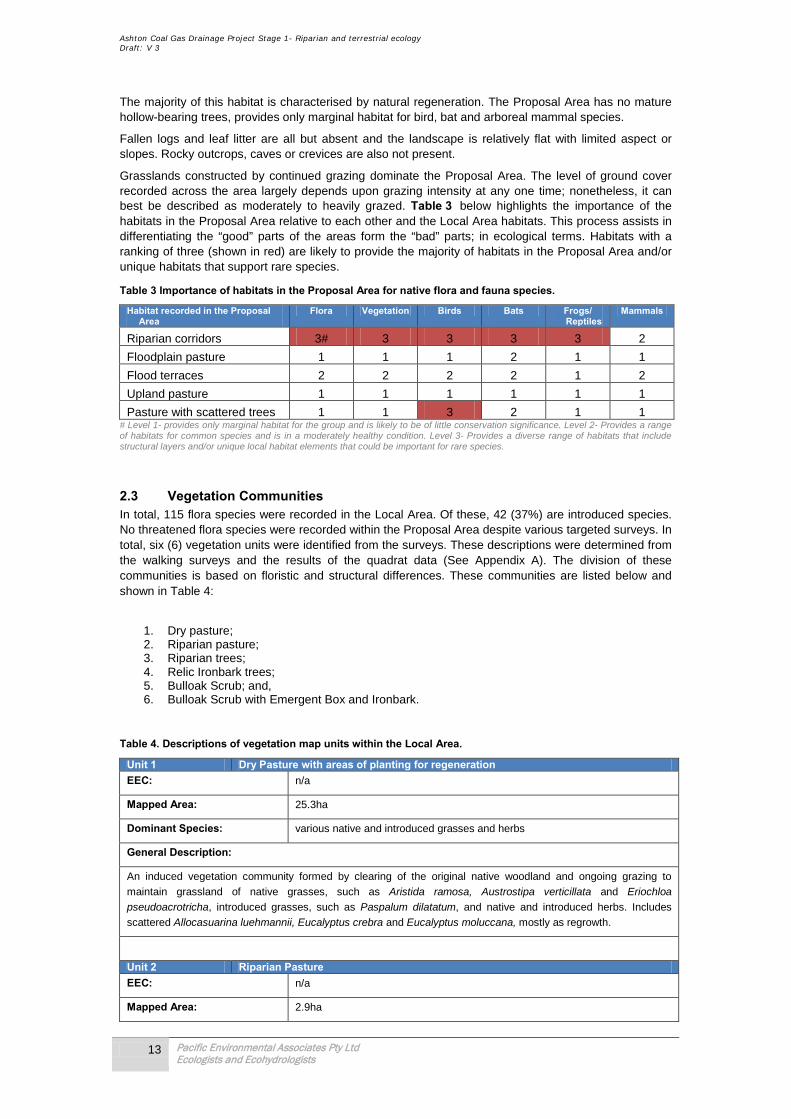
The majority of this habitat is characterised by natural regeneration. The Proposal Area has no mature hollow-bearing trees, provides only marginal habitat for bird, bat and arboreal mammal species.
Fallen logs and leaf litter are all but absent and the landscape is relatively flat with limited aspect or slopes. Rocky outcrops, caves or crevices are also not present.
Grasslands constructed by continued grazing dominate the Proposal Area. The level of ground cover recorded across the area largely depends upon grazing intensity at any one time; nonetheless, it can best be described as moderately to heavily grazed. Table 3 below highlights the importance of the habitats in the Proposal Area relative to each other and the Local Area habitats. This process assists in differentiating the “good” parts of the areas form the “bad” parts; in ecological terms. Habitats with a ranking of three (shown in red) are likely to provide the majority of habitats in the Proposal Area and/or unique habitats that support rare species.
Table 3 Importance of habitats in the Proposal Area for native flora and fauna species.
Habitat recorded in the Proposal Area
Flora Vegetation Birds Bats Frogs/ Reptiles
Mammals
Riparian corridors 3# 3 3 3 3 2
Floodplain pasture 1 1 1 2 1 1
Flood terraces 2 2 2 2 1 2
Upland pasture 1 1 1 1 1 1
Pasture with scattered trees 1 1 3 2 1 1 # Level 1- provides only marginal habitat for the group and is likely to be of little conservation significance. Level 2- Provides a range of habitats for common species and is in a moderately healthy condition. Level 3- Provides a diverse range of habitats that include structural layers and/or unique local habitat elements that could be important for rare species.
2.3 Vegetation Communities In total, 115 flora species were recorded in the Local Area. Of these, 42 (37%) are introduced species. No threatened flora species were recorded within the Proposal Area despite various targeted surveys. In total, six (6) vegetation units were identified from the surveys. These descriptions were determined from the walking surveys and the results of the quadrat data (See Appendix A). The division of these communities is based on floristic and structural differences. These communities are listed below and shown in Table 4:
1. Dry pasture; 2. Riparian pasture; 3. Riparian trees; 4. Relic Ironbark trees; 5. Bulloak Scrub; and, 6. Bulloak Scrub with Emergent Box and Ironbark.
Table 4. Descriptions of vegetation map units within the Local Area.
Unit 1 Dry Pasture with areas of planting for regeneration EEC: n/a
Mapped Area: 25.3ha
Dominant Species: various native and introduced grasses and herbs
General Description:
An induced vegetation community formed by clearing of the original native woodland and ongoing grazing to
maintain grassland of native grasses, such as Aristida ramosa, Austrostipa verticillata and Eriochloa pseudoacrotricha, introduced grasses, such as Paspalum dilatatum, and native and introduced herbs. Includes
scattered Allocasuarina luehmannii, Eucalyptus crebra and Eucalyptus moluccana, mostly as regrowth.
Unit 2 Riparian Pasture EEC: n/a
Mapped Area: 2.9ha

Ashton Coal Gas Drainage Project Stage 1- Riparian and terrestrial ecology Draft: V 3
14 Pacific Environmental Associates Pty Ltd Ecologists and Ecohydrologists
Dominant Species: various mostly introduced grasses and herbs
General Description:
Pasture on better quality fluvial soil dominated by introduced grasses, such as Panicum maximum var. trichoglume
and Paspalum dilatatum, and introduced herbs, such as Acetosa sagittata, Aster subulatus, Cirsium vulgare and
Conyza bonariensis.
Unit 3 Riparian Trees EEC: n/a
Mapped Area: 2.0ha
Dominant Species: Casuarina cunninghamii, Salix babylonica, Melia azedarach
General Description:
Marginal vegetation along the creek dominated by riparian trees, but with patches of herbaceous aquatics such as
Persicaria decipiens, Phragmites australis, Schoenoplectus validus, and Typha orientalis.
Unit 4 Relic Ironbark Trees EEC: n/a
Mapped Area: 0.3ha
Dominant Species: Eucalyptus crebra
General Description:
Not truly a separate vegetation community but worthy of separation as the only cluster of mature trees on the site.
These ironbark trees were evidently retained when the remainder of the site was cleared. The understorey
vegetation is dry pasture.
Unit 5 Bulloak Scrub EEC: n/a
Mapped Area: 9.5ha
Dominant Species: Allocasuarina luehmannii
General Description:
Dense regrowth of Allocasuarina luehmannii, presumably resulting from a reduction in grazing. The understorey is
very sparse and includes many weeds, such as Galenia pubescens and Opuntia spp.
Unit 6 Bulloak Scrub with Emergent Box and Ironbark And regenerating areas of Bulloak Scrub with Emergent Box and Ironbark
EEC: n/a
Mapped Area: 22.9ha
Dominant Species: Allocasuarina luehmannii, Eucalyptus moluccana, Eucalyptus crebra
General Description:
Similar to the previous unit but with greater regrowth of the trees which presumably dominated the original native
woodland vegetation.
The vegetation in the Local Area predominantly comprises Bulloak forest communities with isolated emergent eucalypt trees, relic Ironbark trees and patches of grassland created by historical clearing of the forest dominate the Local Area. The dominant forest type surveyed was Riparian Forest dominated by Casuarina cunninghamii (River Oak); isolated paddock trees include Eucalyptus crebra (Narrow-

Ashton Coal Gas Drainage Project Stage 1- Riparian and terrestrial ecology Draft: V 3
15 Pacific Environmental Associates Pty Ltd Ecologists and Ecohydrologists
leaved Ironbark) and Eucalyptus moluccana (Grey Box) with Corymbia maculata (Spotted Gum) as almost absent due largely we believe to past clearing. Low lying areas of Riparian corridors were dominated by aquatic species, Slender Knotweed (Persicaria decipiens), Common Reed (Phragmites australis), Schoenoplectus validus, and Broadleaf Cumbungi (Typha orientalis).
Ground cover in upland areas was moderately dense, and consists of forbs, grass species, and a limited number of ferns, sedges or other herbs. Common species in pasture areas include Three-awned Spear Grass (Aristida ramose), Slender Bamboo Grass (Austrostipa verticillata), Early Spring Grass (Eriochloa pseudoacrotricha) and Paspalum (Paspalum dilatatum). In areas with relic trees a range of other species were present including, Windmill Grass (Chloris truncata ), Short-hair Plume Grass (Dichelachne micrantha ), Poison Rock Fern (Cheilanthes sieberi subsp. Sieberi), Barbed Wire Grass (Cymbopogon refractus), Many-flowered Mat-rush (Lomandra multiflora subsp. Multiflora), Blue Flax Lily (Dianella revolute), Large Tick-trefoil (Desmodium brachypodum), Kidney Weed (Dichondra repens), Winter Apple (Eremophila debilis), White Burr-daisy (Calotis dentex), Small St. John’s Wort (Hypercium gramineum), Common Everlasting (Chrysocephalum apiculatum), and Tufted Bluebell (Wahlenbergia communis).
Appendix A shows the complete flora data recorded, the seasonality of surveys and where each quadrat, and transect, and the locality from which they were recorded.
2.2.1 Occurrence of Identified Vegetation Communities within the Proposal Area Not all vegetation communities recorded in the Local Area are present in the Proposal Area, and as such not all vegetation is relevant in terms of predicting the level of impact from the proposal. Table 4 below presents the communities that were recorded in the Proposal Area, the habitat present, and their spatial relativity to the proposal. These from here on become the vegetation communities of interest for the remainder of this assessment.
Table 5. Habitats and vegetation units within the Proposal Area.
Habitat type Vegetation unit
Description Number of wells in the vicinity of community
Number of tracks in the vicinity of community
Cleared Habitats
Unit 1 Dry Pasture 9 9
Unit 2 Riparian Pasture 2 1
Regenerating Habitats
Unit 5 Bull Oak Scrub 2 2
Creek Line Habitats
Unit 3 Riparian Trees 2 1
2.4 Significant Flora and Fauna Significant species, populations and communities identified in the Local Area during past studies form the “baseline” dataset for this assessment. This dataset is then combined with data from studies conducted in the Local Area since these earlier studies, in conjunction with updated species lists from National Parks & Wildlife Services Atlas and Environment Australia databases to form the initial “significant ecological issues of interest list” (SEIIL). The final step is the comparison of this SEIIL with the habitats present in the Proposal Area (i.e. area of impact) to identify potential impact species. These species become the species of issue for the remainder of the assessment and are formally assessed by 7-part test under the provisions of the Threatened Species Conservation Act 1995 (TSC Act 1995). Table 5 below summaries all the steps outlined above to identify the list of potential impact species.
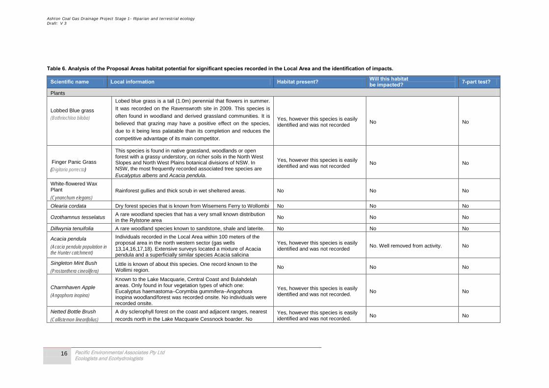
Ashton Coal Gas Drainage Project Stage 1- Riparian and terrestrial ecology Draft: V 3
16 Pacific Environmental Associates Pty Ltd Ecologists and Ecohydrologists
Table 6. Analysis of the Proposal Areas habitat potential for significant species recorded in the Local Area and the identification of impacts.
Scientific name Local information Habitat present? Will this habitat be impacted? 7-part test?
Plants
Lobbed Blue grass (Bothriochloa biloba)
Lobed blue grass is a tall (1.0m) perennial that flowers in summer.
It was recorded on the Ravenswroth site in 2009. This species is
often found in woodland and derived grassland communities. It is
believed that grazing may have a positive effect on the species,
due to it being less palatable than its completion and reduces the
competitive advantage of its main competitor.
Yes, however this species is easily identified and was not recorded
No No
Finger Panic Grass (Digitaria porrecta)
This species is found in native grassland, woodlands or open forest with a grassy understory, on richer soils in the North West Slopes and North West Plains botanical divisions of NSW. In NSW, the most frequently recorded associated tree species are Eucalyptus albens and Acacia pendula.
Yes, however this species is easily identified and was not recorded
No No
White-flowered Wax Plant (Cynanchum elegans)
Rainforest gullies and thick scrub in wet sheltered areas. No No No
Olearia cordata Dry forest species that is known from Wisemens Ferry to Wollombi No No No
Ozothamnus tesselatus A rare woodland species that has a very small known distribution in the Rylstone area
No No No
Dillwynia tenuifolia A rare woodland species known to sandstone, shale and laterite. No No No
Acacia pendula (Acacia pendula population in the Hunter catchment)
Individuals recorded in the Local Area within 100 meters of the proposal area in the north western sector (gas wells 13,14,16,17,18). Extensive surveys located a mixture of Acacia pendula and a superficially similar species Acacia salicina
Yes, however this species is easily identified and was not recorded
No. Well removed from activity. No
Singleton Mint Bush (Prostanthera cineolifera)
Little is known of about this species. One record known to the Wollimi region.
No No No
Charmhaven Apple (Angophora inopina)
Known to the Lake Macquarie, Central Coast and Bulahdelah areas. Only found in four vegetation types of which one: Eucalyptus haemastoma–Corymbia gummifera–Angophora inopina woodland/forest was recorded onsite. No individuals were recorded onsite.
Yes, however this species is easily identified and was not recorded.
No No
Netted Bottle Brush (Callistemon linearifolius)
A dry sclerophyll forest on the coast and adjacent ranges, nearest
records north in the Lake Macquarie Cessnock boarder. No Yes, however this species is easily identified and was not recorded.
No No

Ashton Coal Gas Drainage Project Stage 1- Riparian and terrestrial ecology Draft: V 3
17 Pacific Environmental Associates Pty Ltd Ecologists and Ecohydrologists
Scientific name Local information Habitat present? Will this habitat be impacted? 7-part test?
individuals were recorded onsite.
Darwinia biflora Often found on the edges of weathered shale-capped ridges, where these intergrade with Hawkesbury Sandstone.
No. No such habitat onsite. No No
Darwinia peduncularis Usually grows on or near rocky outcrops on sandy, well drained, low nutrient soil over sandstone. No such habitat onsite.
No. No such habitat onsite. No No
Eucalyptus camaldulensis (population in the Hunter catchment Eucalyptus camaldulensis)
Creek River and floodplain species of the interior river system of the East coast of Australia. Scattered remnants in the Local Area and recorded on the lower reaches of Bowmans Ck and Glennies Ck
Yes No. Well removed from activity and no downstream effects predicted.
No
Broken Back Ironbark (Eucalyptus fracta)
Found on Sandstone escarpments in the ranges. No No No
Slaty Red Gum (Eucalyptus glaucina)
Grows in grassy woodland and dry eucalypt forest, in moderately fertile and well-watered soils.
Yes, however this species is easily
identified and was not recorded, and
No trees will be cleared.
No No
Grove's Paperbark (Melaleuca groveana)
Grove's Paperbark grows in heath and shrubland, often in exposed sites, at high elevations, on rocky outcrops and cliffs.
No No No
Cymbidium canaliculatum (Cymbidium canaliculatum population in the Hunter Catchment)
Grows in the hollows of trees in dry sclerophyll forest or woodland. No No trees will be cleared. No
Illawarra Greenhood (Pterostylis gibbosa)
All known populations grow in open forest or woodland. No No No
Evans Grevillea (Grevillea evansiana)
Restricted to a small area east of Rylstone on the Central Tablelands. Grows in dry sclerophyll forest or woodland, occasionally in swampy heath, in sandy soils, usually over Hawkesbury sandstone.
No No No
Hairy Geebung (Persoonia hirsute)
The Hairy Geebung is found in sandy soils in dry sclerophyll open forest, woodland and heath on sandstone.
No No No
Leionema lamprophyllum subsp. obovatum (Leionema lamprophyllum
Leionema lamprophyllum subsp. obovatum occurs in dry eucalypt forest on exposed rocky terrain.
No No No
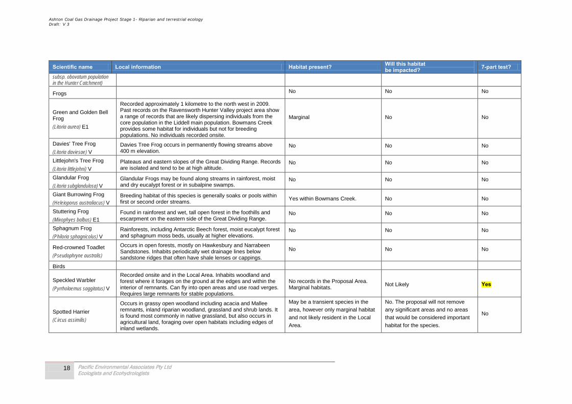
Ashton Coal Gas Drainage Project Stage 1- Riparian and terrestrial ecology Draft: V 3
18 Pacific Environmental Associates Pty Ltd Ecologists and Ecohydrologists
Scientific name Local information Habitat present? Will this habitat be impacted? 7-part test?
subsp. obovatum population in the Hunter Catchment)
Frogs No No No
Green and Golden Bell Frog
(Litoria aurea) E1
Recorded approximately 1 kilometre to the north west in 2009. Past records on the Ravensworth Hunter Valley project area show a range of records that are likely dispersing individuals from the core population in the Liddell main population. Bowmans Creek provides some habitat for individuals but not for breeding populations. No individuals recorded onsite.
Marginal No No
Davies' Tree Frog (Litoria daviesae) V
Davies Tree Frog occurs in permanently flowing streams above 400 m elevation.
No No No
Littlejohn's Tree Frog (Litoria littlejohni) V
Plateaus and eastern slopes of the Great Dividing Range. Records are isolated and tend to be at high altitude.
No No No
Glandular Frog (Litoria subglandulosa) V
Glandular Frogs may be found along streams in rainforest, moist and dry eucalypt forest or in subalpine swamps.
No No No
Giant Burrowing Frog (Heleioporus australiacus) V
Breeding habitat of this species is generally soaks or pools within first or second order streams.
Yes within Bowmans Creek. No No
Stuttering Frog (Mixophyes balbus) E1
Found in rainforest and wet, tall open forest in the foothills and escarpment on the eastern side of the Great Dividing Range.
No No No
Sphagnum Frog (Philoria sphagnicolus) V
Rainforests, including Antarctic Beech forest, moist eucalypt forest and sphagnum moss beds, usually at higher elevations.
No No No
Red-crowned Toadlet (Pseudophryne australis)
Occurs in open forests, mostly on Hawkesbury and Narrabeen Sandstones. Inhabits periodically wet drainage lines below sandstone ridges that often have shale lenses or cappings.
No No No
Birds
Speckled Warbler (Pyrrholaemus saggitatus) V
Recorded onsite and in the Local Area. Inhabits woodland and forest where it forages on the ground at the edges and within the interior of remnants. Can fly into open areas and use road verges. Requires large remnants for stable populations.
No records in the Proposal Area. Marginal habitats.
Not Likely Yes
Spotted Harrier (Circus assimilis)
Occurs in grassy open woodland including acacia and Mallee remnants, inland riparian woodland, grassland and shrub lands. It is found most commonly in native grassland, but also occurs in agricultural land, foraging over open habitats including edges of inland wetlands.
May be a transient species in the
area, however only marginal habitat
and not likely resident in the Local
Area.
No. The proposal will not remove
any significant areas and no areas
that would be considered important
habitat for the species.
No

Ashton Coal Gas Drainage Project Stage 1- Riparian and terrestrial ecology Draft: V 3
19 Pacific Environmental Associates Pty Ltd Ecologists and Ecohydrologists
Scientific name Local information Habitat present? Will this habitat be impacted? 7-part test?
Red Goshawk (Erythrotriorchis radiates) E4A
Red Goshawk appear to move from nesting sites in the ranges to coastal plains, where they are associated with permanent wetlands.
No No No
Black-breasted Buzzard (Hamirostra melanosternon)
Black-breasted Buzzard prefers timbered watercourses as breeding habitat. It also hunts over grasslands and sparsely timbered woodlands.
May be a transient species in the
area, however only marginal habitat
and not likely resident in the Local
Area.
No. The proposal will not remove
any significant areas and no areas
that would be considered important
habitat for the species.
No
Little Eagle (Hieraaetus morphnoides) V
Recorded in Glennies Creek 2010. Occupies open eucalypt forest, woodland or open woodland. She oak or acacia woodlands and riparian woodlands of interior NSW are also used
The Proposal will not remove any trees or habitat that could be used by the species.
No No
Blue-billed Duck (Oxyura australis) V
Wetlands, ponds and sewerage works. No No No
Black Bittern (Ixobrychus flavicollis) V
Inhabits both terrestrial and estuarine wetlands, generally in areas of permanent water and dense vegetation. Where permanent water is present, the species may occur in flooded grassland, forest, woodland, rainforest and mangroves.
No No No
Gang-gang Cockatoo (Callocephalon fimbriatum) V
In summer, generally found in tall mountain forests and woodlands, particularly in heavily timbered and mature wet sclerophyll forests. In winter, may occur at lower altitudes in drier more open eucalypt forests and woodlands, and often found in urban areas.
There is the potential for winter use of the site in the Local Area, however the proposal will not remove any habitat.
No No
Glossy Black-Cockatoo (Calyptorhynchus lathami) V
Inhabits open forest and woodlands of the coast and the Great Dividing Range up to 1000 m in which stands of she-oak species, particularly Black She-oak (Allocasuarina littoralis), Forest She-oak (A. torulosa) or Drooping She-oak (A. verticillata) occur.
Not known to have a preference for River Oak although it has been recorded to feed on the species. None will be removed as part of this proposal.
No hollow bearing trees will be removed as part of this proposal.
No No
Black-necked Stork (Ephippiorhynchus asiaticus) E1
Black-necked Storks are mainly found on shallow, permanent, freshwater terrestrial wetlands, and surrounding marginal vegetation, including swamps, floodplains, watercourses and billabongs, freshwater meadows, wet heathland, farm dams and shallow floodwaters, as well as extending into adjacent grasslands, paddocks and open savannah woodlands. They also forage within or around estuaries and along intertidal shorelines, such as saltmarshes, mudflats and sandflats, and mangrove vegetation.
No No No
Brown Treecreeper Found in eucalypt woodlands (including Box-Gum Woodland) and The Proposal will not remove any No No
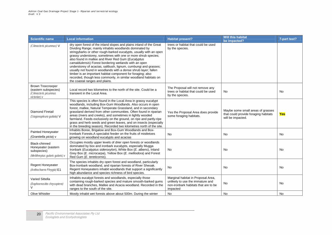
Ashton Coal Gas Drainage Project Stage 1- Riparian and terrestrial ecology Draft: V 3
20 Pacific Environmental Associates Pty Ltd Ecologists and Ecohydrologists
Scientific name Local information Habitat present? Will this habitat be impacted? 7-part test?
(Climacteris picumnus) V dry open forest of the inland slopes and plains inland of the Great Dividing Range; mainly inhabits woodlands dominated by stringybarks or other rough-barked eucalypts, usually with an open grassy understorey, sometimes with one or more shrub species; also found in mallee and River Red Gum (Eucalyptus camaldulensis) Forest bordering wetlands with an open understorey of acacias, saltbush, lignum, cumbungi and grasses; usually not found in woodlands with a dense shrub layer; fallen timber is an important habitat component for foraging; also recorded, though less commonly, in similar woodland habitats on the coastal ranges and plains.
trees or habitat that could be used by the species.
Brown Treecreeper (eastern subspecies) (Climacteris picumnus victoriae) v
Local record two kilometres to the north of the site. Could be a transient in the Local Area.
The Proposal will not remove any trees or habitat that could be used by the species.
No No
Diamond Firetail (Stagonopleura guttata) V
This species is often found in the Local Area in grassy eucalypt woodlands, including Box-Gum Woodlands. Also occurs in open forest, mallee, Natural Temperate Grassland, and in secondary grassland derived from other communities. Often found in riparian areas (rivers and creeks), and sometimes in lightly wooded farmland. Feeds exclusively on the ground, on ripe and partly-ripe grass and herb seeds and green leaves, and on insects (especially in the breeding season). Recorded two kilometres north of the site.
Yes the Proposal Area does provide some foraging habitats.
Maybe some small areas of grasses that could provide foraging habitats will be impacted.
Yes
Painted Honeyeater (Grantiella picta) v
Inhabits Boree, Brigalow and Box-Gum Woodlands and Box-Ironbark Forests.A specialist feeder on the fruits of mistletoes growing on woodland eucalypts and acacias
No No No
Black-chinned Honeyeater (eastern subspecies)
(Melithreptus gularis gularis) v
Occupies mostly upper levels of drier open forests or woodlands dominated by box and ironbark eucalypts, especially Mugga Ironbark (Eucalyptus sideroxylon), White Box (E. albens), Inland Grey Box (E. microcarpa), Yellow Box (E. melliodora) and Forest Red Gum (E. tereticornis).
No No No
Regent Honeyeater (Anthochaera Phrygia) E1
The species inhabits dry open forest and woodland, particularly Box-Ironbark woodland, and riparian forests of River Sheoak. Regent Honeyeaters inhabit woodlands that support a significantly high abundance and species richness of bird species.
No No No
Varied Sittella (Daphoenositta chrysoptera) V
Inhabits eucalypt forests and woodlands, especially those containing rough-barked species and mature smooth-barked gums with dead branches, Mallee and Acacia woodland. Recorded in the ranges to the south of the site.
Marginal habitat in Proposal Area, unlikely to use the immature and non-ironbark habitats that are to be impacted
No No
Olive Whistler Mostly inhabit wet forests above about 500m. During the winter No No No
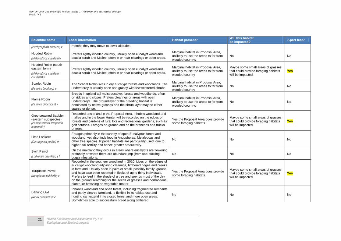
Ashton Coal Gas Drainage Project Stage 1- Riparian and terrestrial ecology Draft: V 3
21 Pacific Environmental Associates Pty Ltd Ecologists and Ecohydrologists
Scientific name Local information Habitat present? Will this habitat be impacted? 7-part test?
(Pachycephala olivacea) v months they may move to lower altitudes.
Hooded Robin (Melanodryas cucullata)v
Prefers lightly wooded country, usually open eucalypt woodland, acacia scrub and Mallee, often in or near clearings or open areas.
Marginal habitat in Proposal Area, unlikely to use the areas to far from wooded country.
No No
Hooded Robin (south-eastern form)
(Melanodryas cucullata cucullata) v
Prefers lightly wooded country, usually open eucalypt woodland, acacia scrub and Mallee, often in or near clearings or open areas.
Marginal habitat in Proposal Area, unlikely to use the areas to far from wooded country
Maybe some small areas of grasses that could provide foraging habitats will be impacted.
Yes
Scarlet Robin (Petroica boodang) v
The Scarlet Robin lives in dry eucalypt forests and woodlands. The understorey is usually open and grassy with few scattered shrubs.
Marginal habitat in Proposal Area, unlikely to use the areas to far from wooded country
No No
Flame Robin (Petroica phoenicea) v
Breeds in upland tall moist eucalypt forests and woodlands, often on ridges and slopes. Prefers clearings or areas with open understoreys. The groundlayer of the breeding habitat is dominated by native grasses and the shrub layer may be either sparse or dense.
Marginal habitat in Proposal Area, unlikely to use the areas to far from wooded country.
No No
Grey-crowned Babbler (eastern subspecies) (Pomatostomus temporalis temporalis)
Recorded onsite and in the Proposal Area. Inhabits woodland and mallee and in the lower Hunter will be recorded on the edges of forests and gardens of rural lots and recreational gardens, such as golf courses. Forages on-ground and on the branches and trucks of trees.
Yes the Proposal Area does provide some foraging habitats.
Maybe some small areas of grasses that could provide foraging habitats will be impacted.
Yes
Little Lorikeet
(Glossopsitta pusilla) V
Forages primarily in the canopy of open Eucalyptus forest and woodland, yet also finds food in Angophoras, Melaleucas and other tree species. Riparian habitats are particularly used, due to higher soil fertility and hence greater productivity.
No No No
Swift Parrot
(Lathamus discolour) e1
On the mainland they occur in areas where eucalypts are flowering profusely or where there are abundant lerp (from sap-sucking bugs) infestations.
No No No
Turquoise Parrot
(Neophema pulchella) v
Recorded in the southern woodland in 2010. Lives on the edges of eucalypt woodland adjoining clearings, timbered ridges and creeks in farmland. Usually seen in pairs or small, possibly family, groups and have also been reported in flocks of up to thirty individuals. Prefers to feed in the shade of a tree and spends most of the day on the ground searching for the seeds or grasses and herbaceous plants, or browsing on vegetable matter.
Yes the Proposal Area does provide some foraging habitats.
Maybe some small areas of grasses that could provide foraging habitats will be impacted.
Yes
Barking Owl
(Ninox connivens) V
Inhabits woodland and open forest, including fragmented remnants and partly cleared farmland. Is flexible in its habitat use and hunting can extend in to closed forest and more open areas. Sometimes able to successfully breed along timbered
No No No

Ashton Coal Gas Drainage Project Stage 1- Riparian and terrestrial ecology Draft: V 3
22 Pacific Environmental Associates Pty Ltd Ecologists and Ecohydrologists
Scientific name Local information Habitat present? Will this habitat be impacted? 7-part test?
watercourses in heavily cleared habitats (e.g. western NSW) due to the higher density of prey on these fertile soils.
Powerful Owl
(Ninox strenua) V
The Powerful Owl inhabits a range of vegetation types, from woodland and open sclerophyll forest to tall open wet forest and rainforest. The Powerful Owl requires large tracts of forest or woodland habitat but can occur in fragmented landscapes as well.
No No No
Red-backed Button-quail
(Turnix maculosa) V
In NSW, said to occur in grasslands, heath and crops. Said to prefer sites close to water, especially when breeding. The species has been observed associated with the following grasses (in various vegetation formations): speargrass Heteropogon, Blady Grass Imperata cylindrica, Triodia, Sorghum, and Buffel Grass Cenchrus ciliaris. One record 10 kilometres north at Greenland.
Yes the Proposal Area does provide some foraging habitats.
Maybe some small areas of grasses that could provide foraging habitats will be impacted.
Yes
Masked Owl
(Tyto novaehollandiae) v Lives in dry eucalypt forests and woodlands from sea level to 1100 metres.
No No No
Sooty Owl
(Tyto tenebricosa) v Occurs in rainforest, including dry rainforest, subtropical and warm temperate rainforest, as well as moist eucalypt forests
No No No
Mammals
Eastern Pygmy-possum
(Cercartetus nanus) v
Found in a broad range of habitats from rainforest through sclerophyll (including Box-Ironbark) forest and woodland to heath, but in most areas woodlands and heath appear to be preferred, except in north-eastern NSW where they are most frequently encountered in rainforest.
No No No
Spotted-tailed Quoll
(Dasyurus maculatus) v
Recorded across a range of habitat types, including rainforest, open forest, woodland, coastal heath and inland riparian forest, from the sub-alpine zone to the coastline.
No No No
Brush-tailed Phascogale
(Phascogale tapoatafa) v Prefer dry sclerophyll open forest with sparse groundcover of herbs, grasses, shrubs or leaf litter.
No No No
Yellow-bellied Sheathtail-bat
(Saccolaimus flaviventris) V
Roosts singly or in groups of up to six, in tree hollows and buildings; in treeless areas they are known to utilise mammal burrows. When foraging for insects, flies high and fast over the forest canopy, but lower in more open country.
No No No
Parma Wallaby
(Macropus parma) v Preferred habitat is moist eucalypt forest with thick, shrubby understorey, often with nearby grassy areas, rainforest margins and occasionally drier eucalypt forest.
No No No
Brush-tailed Rock-wallaby
(Petrogale penicillata) E1
Occupy rocky escarpments, outcrops and cliffs with a preference for complex structures with fissures, caves and ledges, often facing north.
No No No
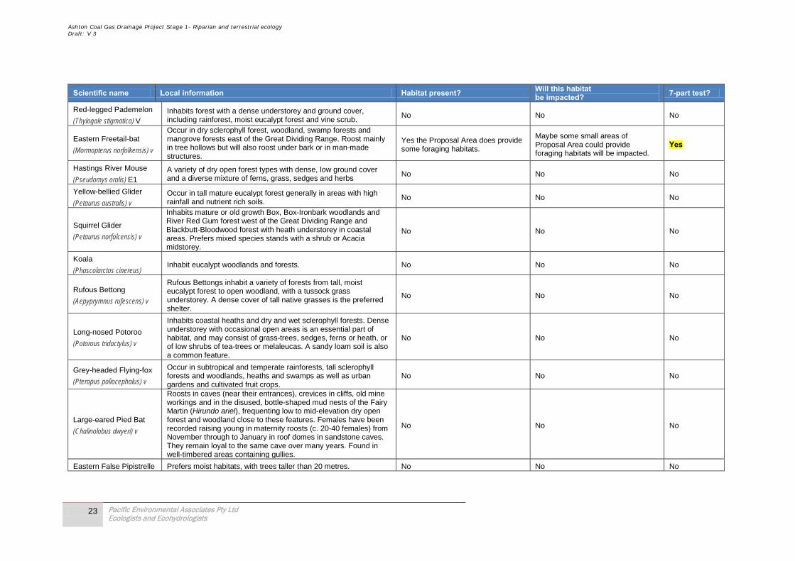
Ashton Coal Gas Drainage Project Stage 1- Riparian and terrestrial ecology Draft: V 3
23 Pacific Environmental Associates Pty Ltd Ecologists and Ecohydrologists
Scientific name Local information Habitat present? Will this habitat be impacted? 7-part test?
Red-legged Pademelon
(Thylogale stigmatica) V Inhabits forest with a dense understorey and ground cover, including rainforest, moist eucalypt forest and vine scrub.
No No No
Eastern Freetail-bat
(Mormopterus norfolkensis) v
Occur in dry sclerophyll forest, woodland, swamp forests and mangrove forests east of the Great Dividing Range. Roost mainly in tree hollows but will also roost under bark or in man-made structures.
Yes the Proposal Area does provide some foraging habitats.
Maybe some small areas of Proposal Area could provide foraging habitats will be impacted.
Yes
Hastings River Mouse
(Pseudomys oralis) E1 A variety of dry open forest types with dense, low ground cover and a diverse mixture of ferns, grass, sedges and herbs
No No No
Yellow-bellied Glider
(Petaurus australis) v Occur in tall mature eucalypt forest generally in areas with high rainfall and nutrient rich soils.
No No No
Squirrel Glider
(Petaurus norfolcensis) v
Inhabits mature or old growth Box, Box-Ironbark woodlands and River Red Gum forest west of the Great Dividing Range and Blackbutt-Bloodwood forest with heath understorey in coastal areas. Prefers mixed species stands with a shrub or Acacia midstorey.
No No No
Koala
(Phascolarctos cinereus) Inhabit eucalypt woodlands and forests. No No No
Rufous Bettong
(Aepyprymnus rufescens) v
Rufous Bettongs inhabit a variety of forests from tall, moist eucalypt forest to open woodland, with a tussock grass understorey. A dense cover of tall native grasses is the preferred shelter.
No No No
Long-nosed Potoroo
(Potorous tridactylus) v
Inhabits coastal heaths and dry and wet sclerophyll forests. Dense understorey with occasional open areas is an essential part of habitat, and may consist of grass-trees, sedges, ferns or heath, or of low shrubs of tea-trees or melaleucas. A sandy loam soil is also a common feature.
No No No
Grey-headed Flying-fox
(Pteropus poliocephalus) v
Occur in subtropical and temperate rainforests, tall sclerophyll forests and woodlands, heaths and swamps as well as urban gardens and cultivated fruit crops.
No No No
Large-eared Pied Bat
(Chalinolobus dwyeri) v
Roosts in caves (near their entrances), crevices in cliffs, old mine workings and in the disused, bottle-shaped mud nests of the Fairy Martin (Hirundo ariel), frequenting low to mid-elevation dry open forest and woodland close to these features. Females have been recorded raising young in maternity roosts (c. 20-40 females) from November through to January in roof domes in sandstone caves. They remain loyal to the same cave over many years. Found in well-timbered areas containing gullies.
No No No
Eastern False Pipistrelle Prefers moist habitats, with trees taller than 20 metres. No No No

Ashton Coal Gas Drainage Project Stage 1- Riparian and terrestrial ecology Draft: V 3
24 Pacific Environmental Associates Pty Ltd Ecologists and Ecohydrologists
Scientific name Local information Habitat present? Will this habitat be impacted? 7-part test?
(Falsistrellus tasmaniensis) v
Golden-tipped Bat
(Kerivoula papuensis) v
Found in rainforest and adjacent wet and dry sclerophyll forest up to 1000m. Also recorded in tall open forest, Casuarina-dominated riparian forest and coastal Melaleuca forests.
No No No
Little Bentwing-bat
(Miniopterus australis) v
Moist eucalypt forest, rainforest, vine thicket, wet and dry sclerophyll forest, Melaleuca swamps, dense coastal forests and banksia scrub. Generally found in well-timbered areas.
No No No
Eastern Bentwing-bat
(Miniopterus schreibersii oceanensis) v
Hunt in forested areas, catching moths and other flying insects above the tree tops.
Yes the Proposal Area does provide some foraging habitats.
Maybe some small areas of Proposal Area could provide foraging habitats will be impacted.
Yes
Southern Myotis
(Myotis macropus) v
Recorded onsite and in the vicinity of the Proposal Area. Generally roost in groups of 10 - 15 close to water in caves, mine shafts, hollow-bearing trees, storm water channels, buildings, under bridges and in dense foliage. Forage over streams and pools catching insects and small fish by raking their feet across the water surface.
Yes the Proposal Area does provide some foraging habitats.
Maybe some small areas of Proposal Area could provide foraging habitats will be impacted.
Yes
Greater Long-eared Bat
(Nyctophilus timoriensis) (South-eastern form)
Inhabits a variety of vegetation types, including mallee, bulloke Allocasuarina leuhmanni and box eucalypt dominated communities, but it is distinctly more common in box/ironbark/cypress-pine vegetation that occurs in a north-south belt along the western slopes and plains of NSW.
No No No
Greater Broad-nosed Bat
(Scoteanax rueppellii)
Utilises a variety of habitats from woodland through to moist and dry eucalypt forest and rainforest, though it is most commonly found in tall wet forest.
No No No
Eastern Cave Bat
(Vespadelus troughtoni)
A cave-roosting species that is usually found in dry open forest and woodland, near cliffs or rocky overhangs; has been recorded roosting in disused mine workings, occasionally in colonies of up to 500 individuals.
No No No
Reptiles
Broad-headed Snake
(Hoplocephalus bungaroides) Shelters in rock crevices and under flat sandstone rocks on exposed cliff edges during autumn, winter and spring.
No No No
Rosenberg's Goanna
(Varanus rosenbergi) Found in heath, open forest and woodland. No No No
Ashton Coal Gas Drainage Project Stage 1- Riparian and terrestrial ecology Draft: V 3
25 Pacific Environmental Associates Pty Ltd Ecologists and Ecohydrologists
Section 3 of this report outlines the predicted impacts on the species, populations or communities identified in the above tables as potentially being impacted by the Proposal (identified by “Yes” in last column). The complete 7-part tests as presented in in Appendix B of this report. Appendix C of this report presents further details on species, populations and communities that have been previously recorded in the Local Area and the relevance of these findings with the proposal.
2.5 Areas of Environmental Sensitivity There are no areas of environmental sensitivity within the local or proposal areas.
Two (2) World Heritage Properties and one (1) RASMSAR site are listed on the EPBC Act 1999 within the regional area (i.e. 24km from the proposal area):
• The Gondwana Rainforests of Australia (formerly known as the Central Eastern Rainforest Reserves);
• The Greater Blue Mountains; and,
• Hunter Estuary Wetlands.
The project will not impact these areas and are not considered relevant to the proposal.
Ashton Coal Gas Drainage Project Stage 1- Riparian and terrestrial ecology Draft: V 3
26 Pacific Environmental Associates Pty Ltd Ecologists and Ecohydrologists
3.0 Statutory Requirements
3.1 EPBC Act 1999 The Commonwealth Environment Protection & Biodiversity Conservation Act, 1999 (EPBC Act) provides for the need for the approval of the Commonwealth Environment Minister for all actions that will or are likely to have a significant impact on a matter of national environmental significance (MNES). The underground area was included within EPBC referral 2001/524 in 2001 and was assessed and deemed not to have an impact on any MNES.
The proposed modification to the original disturbance area detailed within EPBC referral 2001/524 will not result in any significant impacts on MNES.
3.2 Threatened Species Act 1995 The TSC Act provides a framework for the listing and declaration of threatened species, populations, endangered ecological communities, key threatening processes and critical habitat. It also provides a framework for the preparation and implementation of recovery plans and threat abatement plans and for licensing. No listed or declared threatened species, populations, endangered ecological communities, or critical habitat will be significantly impacted by this proposal.
3.3 Environmental Planning and Assessment Act 1979 The EP&A Act provides a framework for the assessment of development and activities which are likely to impact on threatened species, populations or ecological communities as listed pursuant to the TSC Act. It also requires that all relevant threat abatement plans and recovery plans are considered.
3.4 State Environmental Planning Policies (SEPP)
3.4.1 SEPP 44 – Koala Habitat Protection State Environmental Planning Policy No 44 – Koala Habitat Protection (SEPP 44) was introduced to protect potential and core koala habitat in NSW. Under SEPP 44, developers of land with koala habitat (as defined in the SEPP) have to consider the impact of their proposals on koalas, and in certain circumstances, prepare individual koala plans of management for their land. There is no core koala habitat in the Local Area and no koala recorded.
3.5 Relative key threatening processes The key threatening process of “clearing of native vegetation” is the only relevant process that requires addressing here and it is dealt within the 7-part tests conducted for each species of issues for the proposal; refer to Appendix B for more details.
Ashton Coal Gas Drainage Project Stage 1- Riparian and terrestrial ecology Draft: V 3
27 Pacific Environmental Associates Pty Ltd Ecologists and Ecohydrologists
4.0 Predicted Impacts In the absence of appropriate mitigation measures, impacts may include:
• Vegetation clearance – would only be required within the footprint of each well site; and these have been located in areas void of mature native vegetation, however some marginal habitat for ground foraging birds and bat species is present; and,
• Potential for accidental intrusions into remnant vegetation areas by contractors and Ashton staff, given the majority of the site are operational grazing lands, the potential for impacts as a result of this action are minimal.
4.1 Potential impacts on Woodland Birds (Grey-crowned babbler, speckled warbler, hooded robin, turquoise parrot) The proposal will involve minor disturbance to a small area of potential habitat, which will be mitigated with the regeneration of the grassland areas with woodland and forest. The removal of a small area of grassland for each well site, as a result of the proposal will not impact on the local populations. This impact will not reduce the viability of Grey-crowned babbler, Speckled warbler, Hooded robin or turquoise parrot in the Local Area, to a degree that could put any viable local populations at risk of extinction, and the proposal will not result in any additional impacts to those already assessed in previous assessments of ecology conducted onsite.
4.2 Potential impacts on Micro-bats (Large footed Myotis, Eastern Freetail-bat, Large pied bat, Yellow Sheathtail bat, Common bent-wing bat). The proposal will involve minor disturbance to a small area of habitat for individuals. It is predicted that the proposal will not remove or harm any hollow bearing trees that provide potential habitat. This proposal will not reduce the viability of micro-bats in the Local Area, to a degree that could put any viable local populations at risk of extinction and the proposal will not result in any additional impacts to those already assessed in previous assessments of ecology conducted onsite.
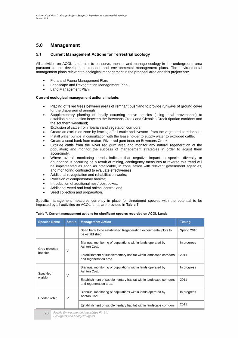
Ashton Coal Gas Drainage Project Stage 1- Riparian and terrestrial ecology Draft: V 3
28 Pacific Environmental Associates Pty Ltd Ecologists and Ecohydrologists
5.0 Management
5.1 Current Management Actions for Terrestrial Ecology All activities on ACOL lands aim to conserve, monitor and manage ecology in the underground area pursuant to the development consent and environmental management plans. The environmental management plans relevant to ecological management in the proposal area and this project are:
• Flora and Fauna Management Plan. • Landscape and Revegetation Management Plan. • Land Management Plan.
Current ecological management actions include:
• Placing of felled trees between areas of remnant bushland to provide runways of ground cover for the dispersion of animals;
• Supplementary planting of locally occurring native species (using local provenance) to establish a connection between the Bowmans Creek and Glennies Creek riparian corridors and the southern woodland;
• Exclusion of cattle from riparian and vegetation corridors; • Create an exclusion zone by fencing off all cattle and livestock from the vegetated corridor site; • Install water pumps in consultation with the lease holder to supply water to excluded cattle; • Create a seed bank from mature River red gum trees on Bowmans Creek; • Exclude cattle from the River red gum area and monitor any natural regeneration of the
population; and monitor the success of management strategies in order to adjust them accordingly.
• Where overall monitoring trends indicate that negative impact to species diversity or abundance is occurring as a result of mining, contingency measures to reverse this trend will be implemented as soon as practicable, in consultation with relevant government agencies, and monitoring continued to evaluate effectiveness.
• Additional revegetation and rehabilitation works; • Provision of compensatory habitat; • Introduction of additional nest/roost boxes; • Additional weed and feral animal control; and • Seed collection and propagation.
Specific management measures currently in place for threatened species with the potential to be impacted by all activities on ACOL lands are provided in Table 7. Table 7. Current management actions for significant species recorded on ACOL Lands.
Species Name Status Management Action Timing
Seed bank to be established Regeneration experimental plots to be established
Spring 2010
Grey-crowned babbler
V
Biannual monitoring of populations within lands operated by Ashton Coal.
In progress
Establishment of supplementary habitat within landscape corridors and regeneration area.
2011
Speckled warbler
V
Biannual monitoring of populations within lands operated by Ashton Coal.
In progress
Establishment of supplementary habitat within landscape corridors and regeneration area.
2011
Hooded robin V
Biannual monitoring of populations within lands operated by Ashton Coal.
In progress
Establishment of supplementary habitat within landscape corridors 2011
Ashton Coal Gas Drainage Project Stage 1- Riparian and terrestrial ecology Draft: V 3
29 Pacific Environmental Associates Pty Ltd Ecologists and Ecohydrologists
Species Name Status Management Action Timing
and regeneration area.
Southern or Large footed Myotis
V
Permanent marking of hollow bearing trees along Bowmans Creek corridor (these would be the preferred hollows in the Local Area).
Spring 2010
Biannual monitoring of health of tree hollows located along Bowmans Creek.
Spring 2010
Introduction of 20 micro-bat specific hollows/nest boxes into the creek corridor including the diversions (once established).
Spring 2010
Eastern Freetail-bat
V
Permanent marking of hollow bearing trees along Bowmans Creek corridor (these would be the preferred hollows in the Local Area).
Spring 2010
Biannual monitoring of health of tree hollows located along Bowmans Creek.
Spring 2010
Introduction of 20 micro-bat specific hollows/nest boxes into the creek corridor including the diversions (once established).
Spring 2010
Yellow Sheathtail bat
V
Permanent marking of hollow bearing trees along Bowmans Creek corridor (these would be the preferred hollows in the Local Area).
Spring 2010
Biannual monitoring of health of tree hollows located along Bowmans Creek.
Spring 2010
Introduction of 20 micro-bat specific hollows/nest boxes into the creek corridor including the diversions (once established).
Spring 2010
Large pied bat V
Permanent marking of hollow bearing trees along Bowmans Creek corridor (these would be the preferred hollows in the Local Area).
Spring 2010
Biannual monitoring of health of tree hollows located along Bowmans Creek.
Spring 2010
Introduction of 20 micro-bat specific hollows/nest boxes into the creek corridor including the diversions (once established).
Spring 2010
Common bent-wing bat
V
Permanent marking of hollow bearing trees along Bowmans Creek corridor (these would be the preferred hollows in the Local Area).
Spring 2010
Biannual monitoring of health of tree hollows located along Bowmans Creek.
Spring 2010
Introduction of 20 micro-bat specific hollows/nest boxes into the creek corridor including the diversions (once established).
Spring 2010
5.2 Additional Management Requirements Given the already established management and monitoring regime in place for the site there is no requirement to extend monitoring for any issue identified as part of this assessment. However a key impact identified in Section 4.0 is the accidental intrusion into naturally vegetated areas outside of the Proposal Areas by staff and contractors. To mitigate this potential impact the following recommendations are proposed:
• Access to areas outside the defined roads and tracks shall be avoided; • Existing environmental management plans for the area shall be adhered to; and • Ecological inductions should be established that detail the areas permissible for access and
egress and the appropriate driving methods.

Ashton Coal Gas Drainage Project Stage 1- Riparian and terrestrial ecology Draft: V 3
30 Pacific Environmental Associates Pty Ltd Ecologists and Ecohydrologists
6.0 Conclusions The proposed 15 gas wells and supporting infrastructure will have a minimal impact on local ecological issues, will not significantly impact on any of the identified threatened species, populations, communities or their habitats known to the Local Area. Minor impacts can be managed by the implementation of the management and monitoring actions outlined in Section 5.
The ecological findings of this assessment are consistent with the results of assessments conducted for the Bowmans Creek Environmental Assessment (2009) and we see no ecological reasons for not supporting the proposal.
Ashton Coal Gas Drainage Project Stage 1- Riparian and terrestrial ecology Draft: V 3
31 Pacific Environmental Associates Pty Ltd Ecologists and Ecohydrologists
References Allison F.R. (1989). Chapter 43. Molossidae. In D.W.Walton and B.J. Richardson (Eds). Fauna of Australia Volume
1B Mammalia. Australian Government Publishing Service, Canberra. Allison, F.R. and Hoye, G.A. (1995) “Eastern Freetail-bat Mormopterus norfolkensis.” in Strahan, R. (Ed.) The
Mammals of Australia. Reed Books, Chatswood, NSW. Augee, M.L. and Ford, D. 1999. Radio-tracking studies of Grey-headed Flying-foxes, Pteropus poliocephalus, from
the Gordon colony, Sydney. Proceedings of the Linnaean Society of New South Wales 121, 61-70. Barclay, R. M., Chruszcz B. J., Rhodes M. (2009). Foraging behaviour of the large-footed myotis, Myotis moluccarum
(Chiroptera : Vespertilionidae) in south-eastern Queensland Australian Journal of Zoology, 2000, 48, 385–392 Campbell, S. (2009). So long as it’s near water: variable roosting behaviour of the large-footed myotis (Myotis
macropus) Australian Journal of Zoology, 57, 89–98 Campbell, B. (2001) Aspects of roost selection by microchiropteran bats in Bundjalong National park, North-eastern
NSW. The Australian Bat Society Newsletter, N 17, 2001. DEH (2003) EPBC ACT Administrative Guidelines on Significance - Supplement for the Grey-headed Flying-Fox. Eamus D, Hatton T, Cook P, Colvin C. 2006. Ecohydrology: Vegetation
Function, Water and Resource management. CSIRO Publishing: Australia.
Eby, P. 2000b. A case for listing Grey-headed Flying-fox Pteropus poliocephalus as threatened in NSW under IUCN criterion A2. In Proceedings of a Workshop to Assess the Status of the Grey-headed Flying-fox in New South Wales.
Eby, P., Collins, L., Richards, G. and Parry-Jones, K. 1999. The distribution, abundance and vulnerability to
population reduction of a nomadic nectarivore, Pteropus poliocephalus during a period of resource concentration. Australian Zoologist 31, 240-253
Kunz, T.H. (1982) Roosting ecology of bats. Pp 1-56 in: Ecology of Bats (T.H. Kunz, ed.). Plenum Press, New York Mensforth L.J., Thorburn P.J., Tyerman, S.D.,Walker G.R., (1994). Sources of Water Used by Riparian Eucalyptus
camaldulensis Overlying Highly Saline Groundwater Oecologia, Vol. 100, No. 1/2, pp. 21-28 Roberts J, Marston F. 2000. Water Regime of Wetland and Floodplain
Plants in the Murray-Darling Basin. CSIRO, Land and Water: Canberra, ACT.
Rundel PW, Nobel PS (1991) Structure and function in desert root systems. In: Atkinson D (ed) Plant root growth, an ecological perspective. Blackwell Scientific, Oxford, pp 349-378
Sinclair, S.J. (2006). The influence of Dwarf Cherry (Exocarpus Stricta) on the health of River red gum (Eucalyptus
camaldulensis) Australian Forestry V 69 No2. pp 134-141. Thorburn, P.J., and Walker G.R., (1994). Variations in Stream Water Uptake by Eucalyptus camaldulensis with
Differing Access to Stream Water. Oecologia, Vol. 100, No. 3 pp. 293-301 Tidemann, C.R., Eby, P., Parry-Jones, K.A. and Vardon, M. 1999. Grey-headed Flying-fox. In The Action Plan for
Australian Bats. Duncan, A., Baker, G.B. and Montgomery, N. (eds). Environment Australia, Canberra. Wen, L., Ling, J., Saintilan, N., and Rogers, K. (2009). An investigation of the hydrological requirements of River red
gum (Eucalyptus camaldulensis) Forest, using Classification and Regression Tree modelling. Ecohydrol. 2, 143–155 (2009)

Ashton Coal Gas Drainage Project Stage 1- Riparian and terrestrial ecology Draft: V 3
32 Pacific Environmental Associates Pty Ltd Ecologists and Ecohydrologists
Figure 1 Proposal Area

Ashton Coal Gas Drainage Project Stage 1- Riparian and terrestrial ecology Draft: V 3
33 Pacific Environmental Associates Pty Ltd Ecologists and Ecohydrologists
Figure 2- locations of Surveys and Gas Wells
Proposed Gas Wells
Existing Gas Wells
Bird Census plots
Anabat stations
Fauna transects
Flora transects
Trapping transects
Ashton Coal Operations Lands
Figure 2. Locations of Surveys and Gas Wells

Ashton Coal Gas Drainage Project Stage 1- Riparian and terrestrial ecology Draft: V 3
34 Pacific Environmental Associates Pty Ltd Ecologists and Ecohydrologists
Figure 3-Locations of significant flora relative to gas well locations

Proposed Gas Wells
Existing Gas Wells
Ashton Coal Operations Lands
Acacia pendula
Eucalyptus camaldulensis (location of sub-population)
Figure 3. Locations of significant flora relative to gas well locations

Ashton Coal Gas Drainage Project Stage 1- Riparian and terrestrial ecology Draft: V 3
35 Pacific Environmental Associates Pty Ltd Ecologists and Ecohydrologists
Figure 4- Locations of significant fauna relative to gas well locations

Proposed Gas Wells
Existing Gas Wells
Ashton Coal Operations Lands
Hoded Robin
Brown Treecreeper
Speckled Warbler Grey-crowned Babbler
Spotted-tailed Quoll
Squirrel Glider
Common Bent-wing Bat
Yellow-bellied Sheathtal-bat
Large-footed Myotis
Figure 4. Location of Significant Fauna relative to Gas Wells

Ashton Coal Gas Drainage Project Stage 1- Riparian and terrestrial ecology Draft: V 3
36 Pacific Environmental Associates Pty Ltd Ecologists and Ecohydrologists
Figure 5- Vegetation communities relative to gas well locations

Proposed Gas Wells Existing Gas Wells Ashton Coal Operations Lands
Bulloak Scrub with Ironbark woodland- (Allocasuarina luehmannii, Eucalyptus moluccana, Eucalyptus crebra)
Riparian Trees/Pasture (Casuarina cunninghamii, Salix babylonica, Melia azedarach )
Regenerating Bulloak Scrub with Ironbark woodland- (Allocasuarina luehmannii, Eucalyptus moluccana, Eucalyptus crebra)
Bulloak Scrub (Allocasuarina luehmannii)
Dry Pasture with areas of planting for regeneration (A.pendula,A.salicina Allocasuarina luehmannii, Eucalyptus moluccana, Eucalyptus crebra)
Figure 5. Vegetation communities
Isolated trees and scrub (Allocasuarina luehmannii, Eucalyptus moluccana, Eucalyptus crebra)

Ashton Coal Gas Drainage Project Stage 1- Riparian and terrestrial ecology Draft: V 3
37 Pacific Environmental Associates Pty Ltd Ecologists and Ecohydrologists
Appendix A- Flora data

Ashton Coal Gas Drainage Project Stage 1- Riparian and terrestrial ecology Draft: V 3
38 Pacific Environmental Associates Pty Ltd Ecologists and Ecohydrologists
Table 8- Flora transect data
Classification/ Scientific name Recent Synonyms Common Name
Transect data information: Transect data recorded from walking transects in Bowmans creek locality see Figure 2 for details.
SUBKINGDOM TRACHEOBIONTA Vascular Plants
SUPERDIVISION PTERIDOPHYTANAE Seedless Vascular Plants
DIVISION POLYPODIOPHYTA Ferns
CLASS POLYPODIOPSIDA
Order Pteridales
ADIANTACEAE
Cheilanthes sieberi Slender Cloak-fern
SUPERDIVISION SPERMATOPHYTANAE Seed Plants
DIVISION MAGNOLIOPHYTA Flowering Plants
CLASS ROSOPSIDA Eudicotyledons
SUBCLASS CARYOPHYLLIIDAE
Order Caryophyllales
AIZOACEAE
Galenia pubescens Galenia i
AMARANTHACEAE
Alternanthera denticulata Lesser Joyweed
Amaranthus viridus Green Amaranth i
Gomphrena celosioides Gomphrena Weed i
BASELLACEAE
Anredera cordifolia Madeira Vine i
CACTACEAE
Opuntia aurantiaca Tiger Pear i
Opuntia stricta var. stricta Common Prickly Pear i
CARYOPHYLLACEAE
Spergularia marina Saltspurry
CHENOPODIACEAE
Chenopodium ambrosioides Mexican Tea i
Einadia hastata Shrubby Berry-saltbush
Enchylaena tomentosa Ruby Saltbush
POLYGONACEAE
Persicaria decipiens Polygonum decipiens Slender Knotweed
Persicaria lapathifolia Polygonum lapathifolia Pale Knotweed
Polygonum arenastrum Common Wireweed
Rumex brownii Swamp Dock
Rumex crispus Curled Dock i
PORTULACACEAE
Portulaca olearacea Pigweed
SUBCLASS ROSIDAE
Order Saxifragales CRASSULACEAE Bryophyllum X houghtonii Mother-of-millions i HALORAGACEAE Myriophyllum verrucosum Red Water-milfoil
Order Myrtales
MYRTACEAE
Eucalyptus crebra Narrow-leaf Ironbark
ONAGRACEAE
Epilobium billardierianum Smooth Willow-herb i
Ludwigia peploides subsp. montevidensis Water Primrose
Ashton Coal Gas Drainage Project Stage 1- Riparian and terrestrial ecology Draft: V 3
39 Pacific Environmental Associates Pty Ltd Ecologists and Ecohydrologists
Classification/ Scientific name Recent Synonyms Common Name
Oenothera stricta subsp. stricta Common Evening Primrose i
Order Malpighales
PHYTOLACCACEAE
Phytolacca octandra Inkweed i
SALICACEAE
Salix babylonica Weeping Willow i
Order Fabales
FABACEAE
FABOIDEAE
Glycine tabacina agg.
Order Fagales
CASUARINACEAE
Alloocasuarina luehmanii Casuarina luehmanii Bulloak
Casuarina cunninghamiana River Oak
Order Brassicales
BRASSICACEAE
Hirschfeldia incana Buchan Weed i
Rorippa laciniata Watercress i
Order Malvales
EUPHORBIACEAE
Chamaesyce dallachyana Caustic Weed i
Ricinus communis Castor Oil Plant i
MALVACEAE
Modiola caroliniana Red-flowered Mallow i
Sida corrugata Corrugated Sida i
Sida rhombifolia Paddys Lucerene i
Order Sapindales
ANACARDIACEAE
Schinus areira Schinus molle var. areira Pepper tree i
SUBCLASS ASTERIDAE
Order Gentianales
APOCYNACEAE
Araujia sericifera Araujia hortorum Moth Vine i
Order Lamiales
MYOPORACEAE
Eremophila debilis Myoporum debile Amulla
PLANTAGINACEAE
Plantago lanceolata Plantain i
Plantago major Large Plantain i
VERBENACEAE
Verbena bonariensis Purple Top i
BORAGINACEAE
Heliotropium amplexicaule Blue Heliotrope
Order Solanales
SOLANACEAE
Cestrum parqui Green Cestrum i
Datura stramonium Common Thornapple i
Lycium ferocissimum African Boxthorn i
Solanum nigrum Black Nightshade i
Order Apiales
APIACEAE
Centella asiatica Swamp Pennywort
Foeniculum vulgare Fennell i
Order Asterales
ASTERACEAE
Aster subulatus Symphyotrichum subulatum Wild Aster i
Bidens pilosa Cobblers Peg
Carthamus lanatus Saffron Thistle i
Centipida minima subsp. minima Centipida minima var. minima Spreading Sneeze Weed
Chrysocephalum apiculatum Helichrysum apiculatum Yellow Buttons

Ashton Coal Gas Drainage Project Stage 1- Riparian and terrestrial ecology Draft: V 3
40 Pacific Environmental Associates Pty Ltd Ecologists and Ecohydrologists
Classification/ Scientific name Recent Synonyms Common Name
Cirsium vulgare Scotch Thistle i
Conyza bonariensis Fleabane i
Dittrichia graveolens Stinkwort i
Schkuhria pinnata var. abrotanoides Dwarf Marigold
Senecio madagascariensis Fireweed i
Senecio quadridentatus Cotton Fireweed
Sonchus oleraceus Common Sow-thistle i
Tagetes minuta Stinking Roger i
Xanthium occidentale Xanthium strumarium pp Noogoora Burr i
CAMPANULACEAE
Wahlenbergia stricta Tall Bluebell
CLASS LILIOPSIDA Monocotyledons SUBCLASS COMMELINIDAE
Order Poales
CYPERACEAE
Cyperus eragrostis Umbrella Sedge i
Cyperus polystachyos Bunchy Flat-sedge
Fimbristylis dichotoma Common Fringe-rush
Isolepis cernua Scirpus cernuus Nodding Club-rush
Schoenoplectus validus Scirpus validus River Club-rush
JUNCACEAE
Juncus acutus Spiny Rush i
Juncus usitatus Common Rush
POACEAE
Aristida ramosa Three-awned Spear Grass
Austrostipa verticilliata Stipa verticilliata Slender Bamboo Spear
Grass
Avena barbata Beared Oat i
Chloris truncata Windmill Grass
Chloris virgata Feathertop Rhodes Grass
Cortadieria selloana Pampas Grass i
Cynodon dactylon Common Couch n
Digitaria brownii Cotton Panic Grass
Digitaria parviflora Small-flower Finger Grass
Digitaria sanguinalis Crab Grass i
Ehrharta erecta Panic Veldtgrass i
Eragrostis curvula African Lovegrass i
Lachnagrostis filiformis Agrostis avenacea Blown Grass
Panicum effusum Hairy Panic
Paspalum dilatatum Paspalum i
Phragmites australis Common Reed
Setaria parviflora Setaria gracilis Slender Pigeon Grass i
Sporobolus creber Sporobolus indicus var. creber Slender Rats Tail Grass
Vulpia bromoides Foxtail Grass i
TYPHACEAE
Typha orientalis Broad-leaf Cumbungi
Order Commelinales
COMMELINACEAE
Commelina cyanea Scurvy Weed
ABBREVIATIONS: i = introduced (i.e. not indigenous to Australia) n = native Australian species not considered to be indigenous to the site c = cultivated (i.e. planted on the site) t = threatened spp. = several species of the one genus (sometimes occurring as a hybrid swarm) sp. = unidentified species4 var. = variety subsp. = subspecies agg. = an aggregate of several yet to be defined species

Ashton Coal Gas Drainage Project Stage 1- Riparian and terrestrial ecology Draft: V 3
41 Pacific Environmental Associates Pty Ltd Ecologists and Ecohydrologists
Classification/ Scientific name Recent Synonyms Common Name
SCIENTIFIC NAMES & AUTHORITIES: Scientific names & families are those used in the Flora of New South Wales as maintained by the Royal Botanic Gardens (http://.plantnet.rbgsyd.gov.au). The classification scheme used for orders and higher taxa is detailed at http://www.hunterwetlands.com.au) For sake of simplicity, scientific names in this list do not include authorities. These can be found in the Flora of New South Wales.

Ashton Coal Gas Drainage Project Stage 1- Riparian and terrestrial ecology Draft: V 3
42 Pacific Environmental Associates Pty Ltd Ecologists and Ecohydrologists
Table 9- Bowmans Creek Flora Quadrat Data
QUADRAT 1 QUADRAT 2 QUADRAT 3 E 151.0636543 E 151.0636566 E 151.0618566 N -32.46331723 N 32.46465622 N 32.46767810 TREE LAYER 0 TREE LAYER (6m; dbh 0.3m) 2 TREE LAYER (8m; dbh 0.4m) 3 Casuarina cunninghamiana 2 Casuarina cunninghamiana 3 LOWER TREE LAYER 0 Schinus areira 1 LOWER TREE LAYER 0 SHRUB LAYER 0 LOWER TREE LAYER 0 SHRUB LAYER 1 GROUND LAYER 5 SHRUB LAYER 0 Lycium ferocissimum 1 Cynodon dactylon 1 Digitaria parviflora 1 GROUND LAYER 2 GROUND LAYER 3 Eragrostis curvula 3 Alternanthera denticulata 1 Alternanthera denticulata 1 Galenia pubescens 2 Aster subulatus 1 Aristida ramosa 1 Schkuhria pinnata var. abrotanoides 1 Cynodon dactylon 1 Austrostipa verticilliata 1 Tagetes minuta 1 Juncus acutus 1 Bidens pilosa 1 Juncus usitatus 1 Commelina cyanea 1 Persicaria lapathifolia 1 Cynodon dactylon 1 Sonchus oleraceus 1 Digitaria parviflora 1 Xanthium occidentale 1 Ehrharta erecta 1 Galenia pubescens 1 Heliotropium amplexicaule 1 Hirschfeldia incana 1 Plantago lanceolata 1 Sida rhombifolia 1 Tagetes minuta 1 Verbena bonariensis 1 Wahlenbergia stricta 1
Ashton Coal Gas Drainage Project Stage 1- Riparian and terrestrial ecology Draft: V 3
43 Pacific Environmental Associates Pty Ltd Ecologists and Ecohydrologists
Table 10 (cont)- Bowmans Creek Flora Quadrat Data
QUADRAT 4 QUADRAT 5 QUADRAT 6 E 151.0649936 E 151.0618615 E 151.0683670 N 32.46932961 N 32.47034282 N 32.47233671 TREE LAYER (4m; dbh 0.2m) 1 TREE LAYER (8m; dbh 0.3m) 2 TREE LAYER 0 Casuarina cunninghamiana 1 Casuarina cunninghamiana 2 LOWER TREE LAYER (6m; dbh 0.3m) 4 LOWER TREE LAYER 0 LOWER TREE LAYER 0 Alloocasuarina luehmanii 4 Eucalyptus crebra 1 SHRUB LAYER 0 SHRUB LAYER 0 SHRUB LAYER 1 GROUND LAYER 3 GROUND LAYER 4 Cestrum parqui 1 Aristida ramosa 1 Amaranthus viridus 1 Lycium ferocissimum 1 Aster subulatus 1 Cynodon dactylon 3 Chamaesyce dallachyana 1 Galenia pubescens 1 GROUND LAYER 4 Conyza bonariensis 1 Gomphrena celosioides 1 Aristida ramosa 1 Cynodon dactylon 1 Portulaca olearacea 1 Austrostipa verticilliata 1 Eragrostis curvula 2 Senecio madagascariensis 1 Bidens pilosa 1 Gomphrena celosioides 1 Setaria parviflora 1 Chloris truncata 1 Heliotropium amplexicaule 1 Tagetes minuta 1 Chrysocephalum apiculatum 1 Hirschfeldia incana 1 Vulpia bromoides 1 Cirsium vulgare 1 Opuntia stricta var. stricta 1 Wahlenbergia stricta 1 Commelina cyanea 1 Plantago lanceolata 1 Cynodon dactylon 1 Portulaca olearacea 1 Enchylaena tomentosa 1 Schkuhria pinnata var. abrotanoides 1 Eragrostis curvula 1 Sida rhombifolia 1 Galenia pubescens 1 Verbena bonariensis 1 Opuntia stricta var. stricta 1 Wahlenbergia stricta 1 Plantago lanceolata 1 Xanthium occidentale 1 Senecio madagascariensis 1
Sida rhombifolia 2
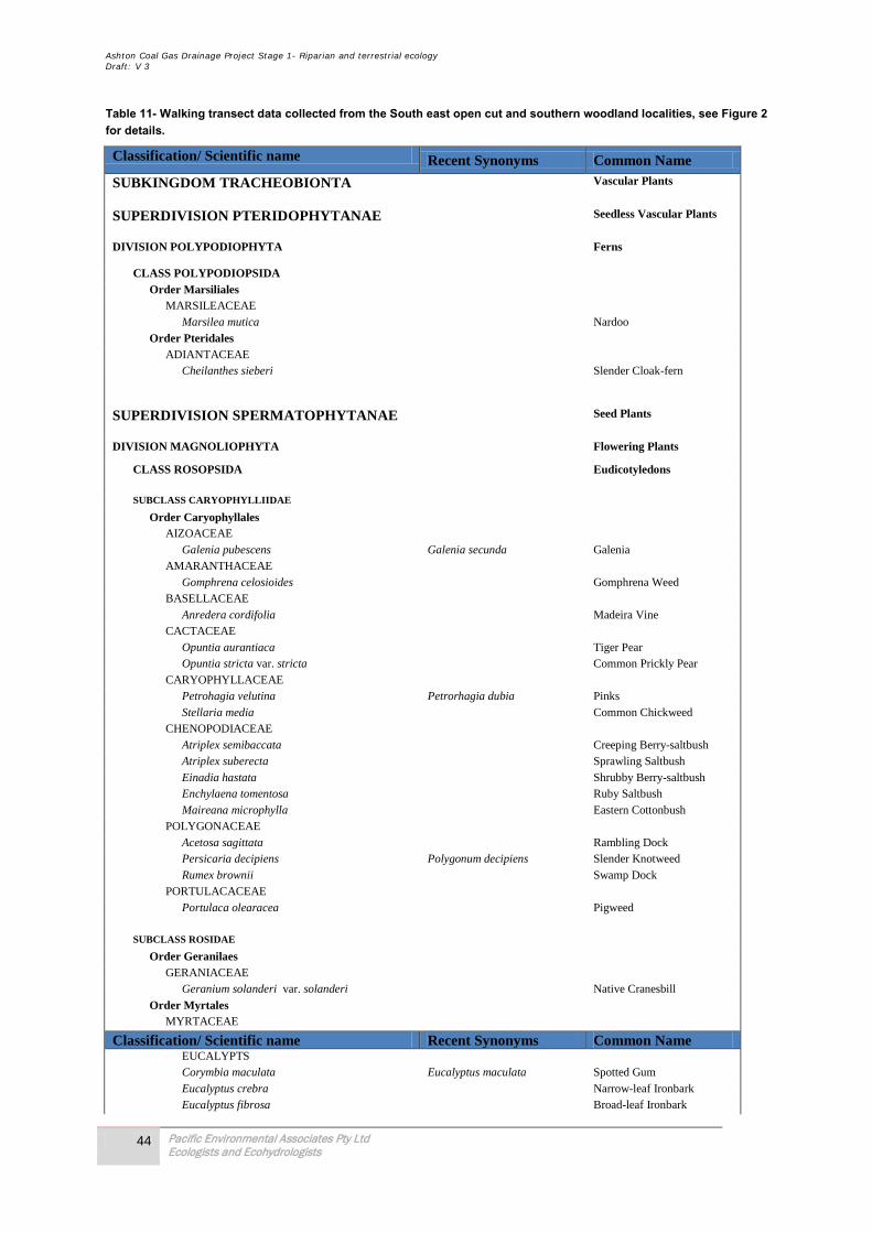
Ashton Coal Gas Drainage Project Stage 1- Riparian and terrestrial ecology Draft: V 3
44 Pacific Environmental Associates Pty Ltd Ecologists and Ecohydrologists
Table 11- Walking transect data collected from the South east open cut and southern woodland localities, see Figure 2 for details.
Classification/ Scientific name Recent Synonyms Common Name SUBKINGDOM TRACHEOBIONTA Vascular Plants
SUPERDIVISION PTERIDOPHYTANAE Seedless Vascular Plants
DIVISION POLYPODIOPHYTA Ferns
CLASS POLYPODIOPSIDA Order Marsiliales MARSILEACEAE Marsilea mutica Nardoo Order Pteridales ADIANTACEAE Cheilanthes sieberi Slender Cloak-fern
SUPERDIVISION SPERMATOPHYTANAE Seed Plants
DIVISION MAGNOLIOPHYTA Flowering Plants
CLASS ROSOPSIDA Eudicotyledons SUBCLASS CARYOPHYLLIIDAE Order Caryophyllales AIZOACEAE Galenia pubescens Galenia secunda Galenia AMARANTHACEAE Gomphrena celosioides Gomphrena Weed BASELLACEAE Anredera cordifolia Madeira Vine CACTACEAE Opuntia aurantiaca Tiger Pear Opuntia stricta var. stricta Common Prickly Pear CARYOPHYLLACEAE Petrohagia velutina Petrorhagia dubia Pinks Stellaria media Common Chickweed CHENOPODIACEAE Atriplex semibaccata Creeping Berry-saltbush Atriplex suberecta Sprawling Saltbush Einadia hastata Shrubby Berry-saltbush Enchylaena tomentosa Ruby Saltbush Maireana microphylla Eastern Cottonbush POLYGONACEAE Acetosa sagittata Rambling Dock Persicaria decipiens Polygonum decipiens Slender Knotweed Rumex brownii Swamp Dock PORTULACACEAE Portulaca olearacea Pigweed SUBCLASS ROSIDAE Order Geranilaes GERANIACEAE Geranium solanderi var. solanderi Native Cranesbill Order Myrtales MYRTACEAE
Classification/ Scientific name Recent Synonyms Common Name EUCALYPTS Corymbia maculata Eucalyptus maculata Spotted Gum Eucalyptus crebra Narrow-leaf Ironbark Eucalyptus fibrosa Broad-leaf Ironbark
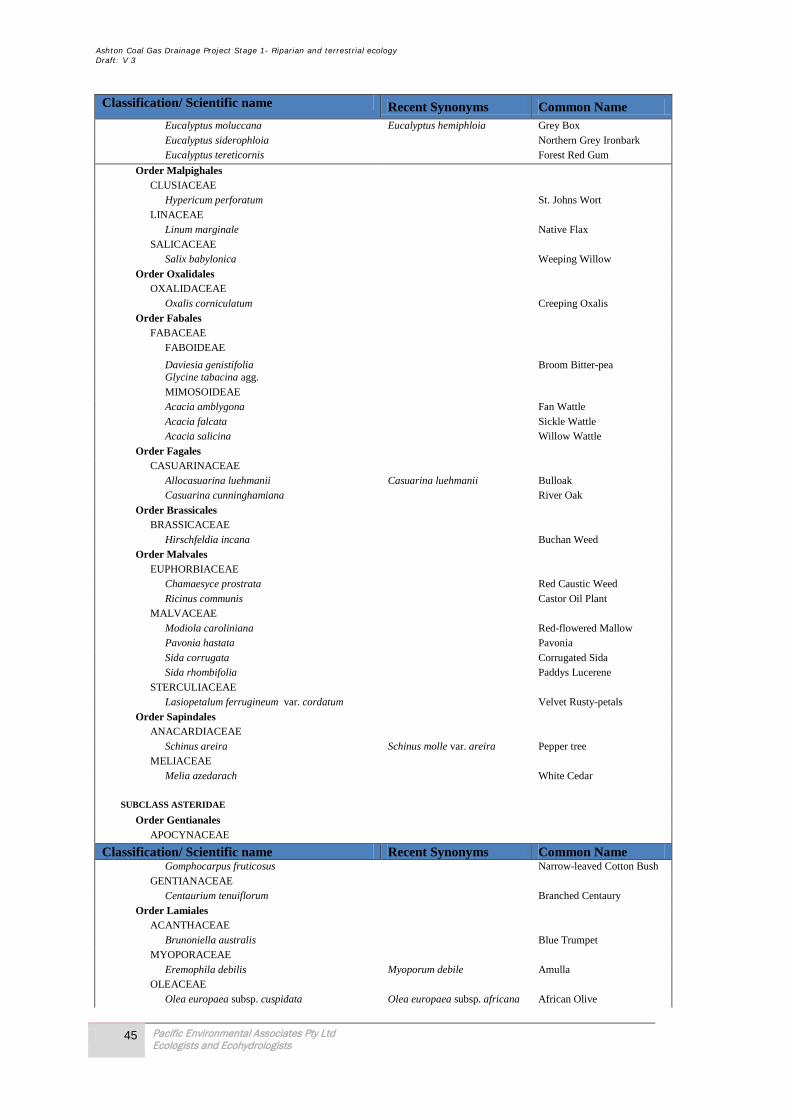
Ashton Coal Gas Drainage Project Stage 1- Riparian and terrestrial ecology Draft: V 3
45 Pacific Environmental Associates Pty Ltd Ecologists and Ecohydrologists
Classification/ Scientific name Recent Synonyms Common Name Eucalyptus moluccana Eucalyptus hemiphloia Grey Box Eucalyptus siderophloia Northern Grey Ironbark Eucalyptus tereticornis Forest Red Gum
Order Malpighales CLUSIACEAE Hypericum perforatum St. Johns Wort LINACEAE Linum marginale Native Flax SALICACEAE Salix babylonica Weeping Willow Order Oxalidales OXALIDACEAE Oxalis corniculatum Creeping Oxalis Order Fabales FABACEAE FABOIDEAE Daviesia genistifolia Broom Bitter-pea Glycine tabacina agg. MIMOSOIDEAE Acacia amblygona Fan Wattle Acacia falcata Sickle Wattle Acacia salicina Willow Wattle Order Fagales CASUARINACEAE Allocasuarina luehmanii Casuarina luehmanii Bulloak Casuarina cunninghamiana River Oak Order Brassicales BRASSICACEAE Hirschfeldia incana Buchan Weed Order Malvales EUPHORBIACEAE Chamaesyce prostrata Red Caustic Weed Ricinus communis Castor Oil Plant MALVACEAE Modiola caroliniana Red-flowered Mallow Pavonia hastata Pavonia Sida corrugata Corrugated Sida Sida rhombifolia Paddys Lucerene STERCULIACEAE Lasiopetalum ferrugineum var. cordatum Velvet Rusty-petals Order Sapindales ANACARDIACEAE Schinus areira Schinus molle var. areira Pepper tree MELIACEAE Melia azedarach White Cedar SUBCLASS ASTERIDAE Order Gentianales APOCYNACEAE
Classification/ Scientific name Recent Synonyms Common Name Gomphocarpus fruticosus Narrow-leaved Cotton Bush GENTIANACEAE Centaurium tenuiflorum Branched Centaury Order Lamiales ACANTHACEAE Brunoniella australis Blue Trumpet MYOPORACEAE Eremophila debilis Myoporum debile Amulla OLEACEAE Olea europaea subsp. cuspidata Olea europaea subsp. africana African Olive
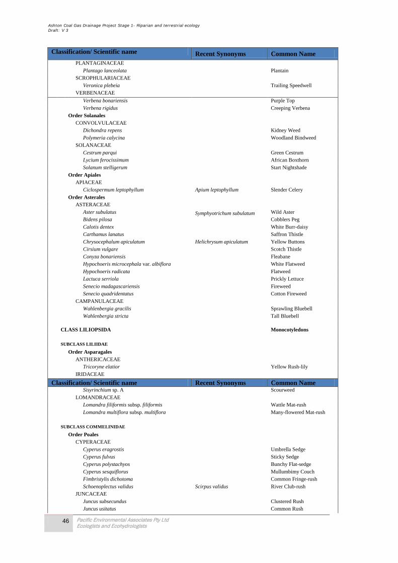
Ashton Coal Gas Drainage Project Stage 1- Riparian and terrestrial ecology Draft: V 3
46 Pacific Environmental Associates Pty Ltd Ecologists and Ecohydrologists
Classification/ Scientific name Recent Synonyms Common Name PLANTAGINACEAE Plantago lanceolata Plantain SCROPHULARIACEAE Veronica plebeia Trailing Speedwell VERBENACEAE
Verbena bonariensis Purple Top Verbena rigidus Creeping Verbena Order Solanales CONVOLVULACEAE Dichondra repens Kidney Weed Polymeria calycina Woodland Bindweed SOLANACEAE Cestrum parqui Green Cestrum Lycium ferocissimum African Boxthorn Solanum stelligerum Start Nightshade Order Apiales APIACEAE Ciclospermum leptophyllum Apium leptophyllum Slender Celery Order Asterales ASTERACEAE Aster subulatus Symphyotrichum subulatum Wild Aster Bidens pilosa Cobblers Peg Calotis dentex White Burr-daisy Carthamus lanatus Saffron Thistle Chrysocephalum apiculatum Helichrysum apiculatum Yellow Buttons Cirsium vulgare Scotch Thistle Conyza bonariensis Fleabane Hypochoeris microcephala var. albiflora White Flatweed Hypochoeris radicata Flatweed Lactuca serriola Prickly Lettuce Senecio madagascariensis Fireweed Senecio quadridentatus Cotton Fireweed CAMPANULACEAE Wahlenbergia gracilis Sprawling Bluebell Wahlenbergia stricta Tall Bluebell CLASS LILIOPSIDA Monocotyledons SUBCLASS LILIIDAE Order Asparagales ANTHERICACEAE Tricoryne elatior Yellow Rush-lily IRIDACEAE
Classification/ Scientific name Recent Synonyms Common Name Sisyrinchium sp. A Scourweed LOMANDRACEAE Lomandra filiformis subsp. filiformis Wattle Mat-rush Lomandra multiflora subsp. multiflora Many-flowered Mat-rush SUBCLASS COMMELINIDAE Order Poales CYPERACEAE Cyperus eragrostis Umbrella Sedge Cyperus fulvus Sticky Sedge Cyperus polystachyos Bunchy Flat-sedge Cyperus sesquiflorus Mullumbimy Couch Fimbristylis dichotoma Common Fringe-rush Schoenoplectus validus Scirpus validus River Club-rush JUNCACEAE Juncus subsecundus Clustered Rush Juncus usitatus Common Rush

Ashton Coal Gas Drainage Project Stage 1- Riparian and terrestrial ecology Draft: V 3
47 Pacific Environmental Associates Pty Ltd Ecologists and Ecohydrologists
Classification/ Scientific name Recent Synonyms Common Name POACEAE Aristida ramosa Three-awned Spear Grass Austrodanthonia setacea Danthonia setacea Small-flower Wallaby Grass Austrostipa scabra subsp. scabra Speargrass Austrostipa verticilliata Stipa verticilliata Slender Bamboo Spear Grass Bromus molliformis Soft Brome
Chloris gayana Rhodes Grass Chloris truncata Windmill Grass Chloris virgata Feathertop Rhodes Grass Cymbopogon refractus Barbed Wire Grass Cynodon dactylon Common Couch Dichelachne micrantha Short-hair Plume Grass Digitaria brownii Cotton Panic Grass Eleusine indica Crowsfoot Grass Eragrostis brownii Brown's Lovegrass Melinis repens Rhynchelytrum repens Red Natal Grass Panicum effusum Hairy Panic Panicum maximum var. trichoglume Green Panic Paspalum dilatatum Paspalum Paspalum distichum Paspalum paspalodes Water Couch Phragmites australis Common Reed Sorghum leiocladum Wild Sorgham Sporobolus creber Sporobolus indicus var. creber Slender Rats Tail Grass TYPHACEAE Typha orientalis Broad-leaf Cumbungi Order Commelinales COMMELINACEAE Commelina cyanea Scurvy Weed Tradescantia albiflora Tradescantia fluminensis Wandering Jew 115 ABBREVIATIONS: i = introduced (i.e. not indigenous to Australia) n = native Australian species not considered to be indigenous to the site c = cultivated (i.e. planted on the site) t = threatened spp. = several species of the one genus (sometimes occurring as a hybrid swarm) sp. = unidentified species4 sp. aff. = unidentified species with characteristics similar to the indicated species or genus3 ? = unconfirmed species4 var. = variety subsp. = subspecies cv. = cultivar (i.e. a anthropogenic form of the species) agg. = an aggregate of several yet to be defined species NOTES: 1. Recent 'synonyms' include misapplied names. 2. The inclusion of Boraginaceae in Lamiales in tenative. 3. A sample flora assemblage obtained from a short term survey, such as the present one, cannot be considered to be comprehensive, but rather indicative of the actual flora assemblage. It can take many years of flora surveys to record all of the plant species occurring within any area, especially species that are only apparent in some seasons. 4. Not all species can be accurately identified in a ‘snapshot’ survey due to absence of flowering or fruiting material, etc. SCIENTIFIC NAMES & AUTHORITIES: Scientific names & families are those used in the Flora of New South Wales as maintained by the Royal Botanic Gardens (http://.plantnet.rbgsyd.gov.au). The classification scheme used for orders and higher taxa is detailed at http://www.hunterwetlands.com.au) For sake of simplicity, scientific names in this list do not include authorities. These can be found in the Flora of New South Wales.

Ashton Coal Gas Drainage Project Stage 1- Riparian and terrestrial ecology Draft: V 3
48 Pacific Environmental Associates Pty Ltd Ecologists and Ecohydrologists
Table 12- SOEC Flora quadrat data
QUADRAT 1 QUADRAT 2 QUADRAT 3 E151.0752928 E151.0751097 E151.0755123 N32.48567962 N32.48677339 N32.48809370 TREE LAYER 0 TREE LAYER 0 TREE LAYER 0 LOWER TREE LAYER 0 LOWER TREE LAYER (6m; dbh 0.15m) 2 LOWER TREE LAYER (6m; dbh 0.2m) 1 Allocasuarina leuhmanii 2 Allocasuarina leuhmanii 1 SHRUB LAYER 1 Allocasuarina luehmanii 1 SHRUB LAYER 0 SHRUB LAYER 1 Cestrum parqui 1 GROUND LAYER 4 GROUND LAYER 1 Aristida ramosa 1 Aristida ramosa 1 GROUND LAYER 4 Austrostipa verticilliata 1 Atriplex semibaccata 1 Aristida ramosa 2 Bromus molliformis 1 Austrodanthonia setacea 1 Austrostipa scabra subsp. scabra 1 Centaurium tenuiflorum 1 Brunoniella australis 1 Austrostipa verticilliata 1 Cheilanthes sieberi 1 Chrysocephalum apiculatum 1 Carthamus lanatus 1 Conyza bonariensis 1 Einadia hastata 1 Cheilanthes sieberi 1 Eremophila debilis 1 Eremophila debilis 1 Chrysocephalum apiculatum 1 Fimbristylis dichotoma 1 Galenia pubescens 1 Dichelachne micrantha 1 Galenia pubescens 1 Glycine tabacina agg. 1 Fimbristylis dichotoma 1 Glycine tabacina agg. 1 Hypericum perforatum 1 Galenia pubescens 2 Opuntia stricta var. stricta 1 Lomandra filiformis subsp. filiformis 1 Glycine tabacina agg. 1 Oxalis corniculatum 1 Opuntia aurantiaca 1 Hypochoeris microcephala var. albiflora 1 Paspalum dilatatum 1 Opuntia stricta var. stricta 1 Hypochoeris radicata 1 Petrohagia velutina 1 Senecio madagascariensis 1 Paspalum dilatatum 1 Plantago lanceolata 1 Sida corrugata 1 Plantago lanceolata 1 Senecio madagascariensis 1 Senecio madagascariensis 1 Sida rhombifolia 1 Sida rhombifolia 1 Sporobolus creber 1 Solanum stelligerum 1 Tricoryne elatior 1 Verbena bonariensis 1 Verbena bonariensis 1 1 = 1-20% Wahlenbergia gracilis 1 Verbena rigidus 2 2 = 21-40% Wahlenbergia stricta 1 3 = 41-60%
4 = 61-80% 5 = 81-100%

Ashton Coal Gas Drainage Project Stage 1- Riparian and terrestrial ecology Draft: V 3
49 Pacific Environmental Associates Pty Ltd Ecologists and Ecohydrologists
QUADRAT 4 QUADRAT 5 E151.0762786 E151.0750620 N32.48759974 N TREE LAYER (8m; dbh 0.2m) 3 TREE LAYER 0 Eucalyptus crebra 3 LOWER TREE LAYER 0 LOWER TREE LAYER 0 SHRUB LAYER 0 SHRUB LAYER 0 GROUND LAYER 5 GROUND LAYER 3 Aristida ramosa 2 Atriplex semibaccata 1 Atriplex semibaccata 1 Austrodanthonia setacea 1 Austrostipa verticilliata 2 Austrostipa scabra subsp. scabra 1 Cheilanthes sieberi 1 Austrostipa verticilliata 1 Chrysocephalum apiculatum 1 Einadia hastata 1 Dichondra repens 1 Enchylaena tomentosa 1 Eremophila debilis 1 Galenia pubescens 2 Galenia pubescens 2 Glycine tabacina agg. 1 Hypericum perforatum 1 Opuntia aurantiaca 1 Opuntia aurantiaca 1 Senecio madagascariensis 1 Paspalum dilatatum 1 Plantago lanceolata 1 Senecio madagascariensis 1 Sida corrugata 1 Sida rhombifolia 1 Verbena bonariensis 1
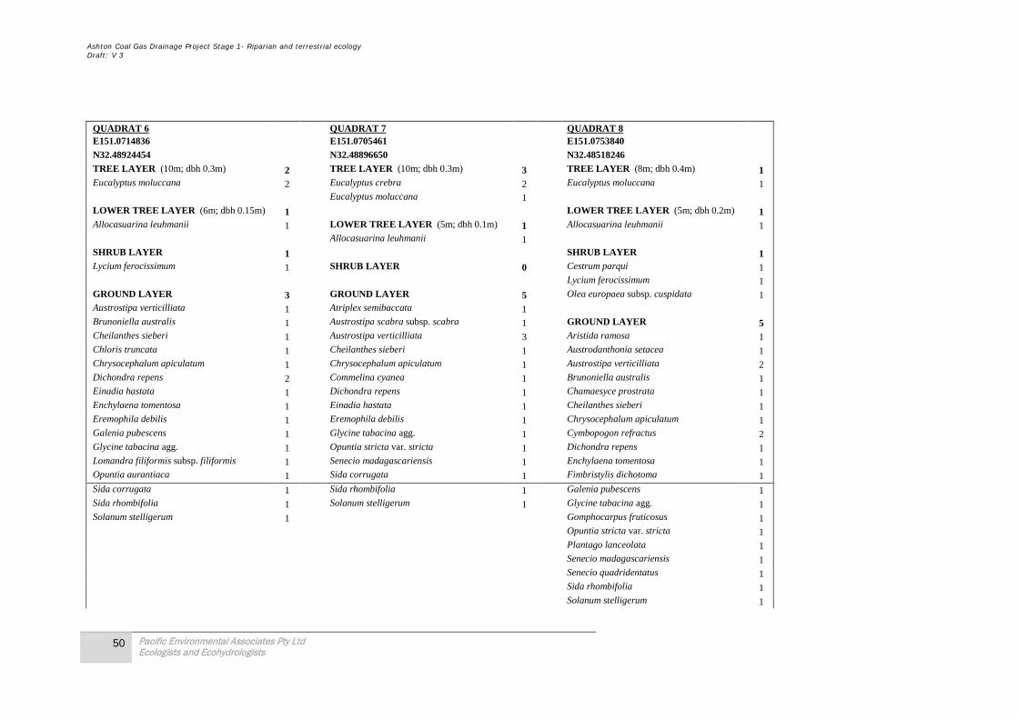
Ashton Coal Gas Drainage Project Stage 1- Riparian and terrestrial ecology Draft: V 3
50 Pacific Environmental Associates Pty Ltd Ecologists and Ecohydrologists
QUADRAT 6 QUADRAT 7 QUADRAT 8 E151.0714836 E151.0705461 E151.0753840 N32.48924454 N32.48896650 N32.48518246 TREE LAYER (10m; dbh 0.3m) 2 TREE LAYER (10m; dbh 0.3m) 3 TREE LAYER (8m; dbh 0.4m) 1 Eucalyptus moluccana 2 Eucalyptus crebra 2 Eucalyptus moluccana 1 Eucalyptus moluccana 1 LOWER TREE LAYER (6m; dbh 0.15m) 1 LOWER TREE LAYER (5m; dbh 0.2m) 1 Allocasuarina leuhmanii 1 LOWER TREE LAYER (5m; dbh 0.1m) 1 Allocasuarina leuhmanii 1 Allocasuarina leuhmanii 1 SHRUB LAYER 1 SHRUB LAYER 1 Lycium ferocissimum 1 SHRUB LAYER 0 Cestrum parqui 1 Lycium ferocissimum 1 GROUND LAYER 3 GROUND LAYER 5 Olea europaea subsp. cuspidata 1 Austrostipa verticilliata 1 Atriplex semibaccata 1 Brunoniella australis 1 Austrostipa scabra subsp. scabra 1 GROUND LAYER 5 Cheilanthes sieberi 1 Austrostipa verticilliata 3 Aristida ramosa 1 Chloris truncata 1 Cheilanthes sieberi 1 Austrodanthonia setacea 1 Chrysocephalum apiculatum 1 Chrysocephalum apiculatum 1 Austrostipa verticilliata 2 Dichondra repens 2 Commelina cyanea 1 Brunoniella australis 1 Einadia hastata 1 Dichondra repens 1 Chamaesyce prostrata 1 Enchylaena tomentosa 1 Einadia hastata 1 Cheilanthes sieberi 1 Eremophila debilis 1 Eremophila debilis 1 Chrysocephalum apiculatum 1 Galenia pubescens 1 Glycine tabacina agg. 1 Cymbopogon refractus 2 Glycine tabacina agg. 1 Opuntia stricta var. stricta 1 Dichondra repens 1 Lomandra filiformis subsp. filiformis 1 Senecio madagascariensis 1 Enchylaena tomentosa 1 Opuntia aurantiaca 1 Sida corrugata 1 Fimbristylis dichotoma 1 Sida corrugata 1 Sida rhombifolia 1 Galenia pubescens 1 Sida rhombifolia 1 Solanum stelligerum 1 Glycine tabacina agg. 1 Solanum stelligerum 1 Gomphocarpus fruticosus 1 Opuntia stricta var. stricta 1 Plantago lanceolata 1 Senecio madagascariensis 1 Senecio quadridentatus 1 Sida rhombifolia 1 Solanum stelligerum 1

Ashton Coal Gas Drainage Project Stage 1- Riparian and terrestrial ecology Draft: V 3
51 Pacific Environmental Associates Pty Ltd Ecologists and Ecohydrologists
Stellaria media 1 Veronica plebeia 1 Wahlenbergia stricta 1
QUADRAT 9 QUADRAT 10 E 151.0712050 E151.0751390 N 32.48690475 N 32.48278584 TREE LAYER (8m; dbh 0.3m) 2 TREE LAYER (8m; dbh 0.3m) 2 Eucalyptus crebra 1 Eucalyptus crebra 2 Eucalyptus moluccana 1 Eucalyptus moluccana 1 LOWER TREE LAYER (5m; dbh 0.1m) 2 LOWER TREE LAYER 0 Allocasuarina leuhmanii 2 SHRUB LAYER 1 SHRUB LAYER 0 Acacia salicina 1 Eremophila debilis 1 GROUND LAYER 1 Lycium ferocissimum 1 Maireana microphylla 1 Olea europaea subsp. cuspidata 1 Austrostipa scabra subsp. scabra 1 Pavonia hastata 1 Galenia pubescens 1 Lomandra filiformis subsp. filiformis 1 GROUND LAYER 2 Aristida ramosa 1 Atriplex semibaccata 1 Cheilanthes sieberi 1 Commelina cyanea 1 Cymbopogon refractus 1 Dichondra repens 1 Enchylaena tomentosa 1 Galenia pubescens 1 Geranium solanderi var. solanderi 1 Glycine tabacina agg. 1 Hirschfeldia incana 1 Hypericum perforatum 1 Lomandra filiformis subsp. filiformis 1 Lomandra multiflora subsp. multiflora 1 Microlaena stipoides var. stipoides 1 Plantago lanceolata 1
Ashton Coal Gas Drainage Project Stage 1- Riparian and terrestrial ecology Draft: V 3
52 Pacific Environmental Associates Pty Ltd Ecologists and Ecohydrologists
Polymeria calycina 1 Senecio madagascariensis 1 Sida corrugata 1 Sida rhombifolia 1 Verbena bonariensis 1 Wahlenbergia stricta 1
QUADRAT 11 QUADRAT 12 E 151.0862464 E 151.0935294 N 32.47839982 N 32.49222385 TREE LAYER 0 TREE LAYER (5m; dbh 0.3m) 1 Eucalyptus crebra 1 LOWER TREE LAYER (2-4m; dbh 0.15m) 2
Eucalyptus crebra (regrowth) 2 LOWER TREE LAYER 0 SHRUB LAYER 0 SHRUB LAYER 0 GROUND LAYER 5 GROUND LAYER 5 Aristida ramosa 3 Aristida ramosa 2 Calotis dentex 1 Atriplex semibaccata 1 Cheilanthes sieberi 1 Calotis dentex 1 Chloris gayana 1 Cheilanthes sieberi 1 Chrysocephalum apiculatum 1 Chrysocephalum apiculatum 1 Cirsium vulgare 1 Ciclospermum leptophyllum 1 Conyza bonariensis 1 Conyza bonariensis 1 Cymbopogon refractus 1 Cynodon dactylon 1 Cynodon dactylon 1 Dichelachne micrantha 1 Cyperus sesquiflorus 1 Enchylaena tomentosa 1 Eragrostis brownii 1 Fimbristylis dichotoma 1 Hypochoeris radicata 1 Galenia pubescens 1 Juncus usitatus 1 Gomphrena celosioides 1 Panicum effusum 1 Maireana microphylla 1

Ashton Coal Gas Drainage Project Stage 1- Riparian and terrestrial ecology Draft: V 3
53 Pacific Environmental Associates Pty Ltd Ecologists and Ecohydrologists
Paspalum dilatatum 1 Paspalum dilatatum 2 Plantago lanceolata 1 Plantago lanceolata 1 Senecio madagascariensis 1 Senecio madagascariensis 1 Sida rhombifolia 1 Sida corrugata 1 Verbena bonariensis 1 Sida rhombifolia 1 Wahlenbergia stricta 1 Solanum stelligerum 1 Verbena bonariensis 1 Verbena rigidus 1
Ashton Coal Gas Drainage Project Stage 1- Riparian and terrestrial ecology Draft: V 3
54 Pacific Environmental Associates Pty Ltd Ecologists and Ecohydrologists
Appendix B- 7-part tests
1.0 Section 5A EP&A Act – Seven Part Test Based on the assessment in Table 6 section 2.4, 9 significant species require further assessment under the provisions of the EP&A Act 1995 (7 -part tests). These potentially impacted species are assessed and recommendations are made to mitigate impacts and sustain populations in the Local Areas. Impacted species include:
• Stagonopleura guttata (Diamond Firetail); • Pomatostomus temporalis (Grey-crowned Babbler); • Neophema pulchella (Turquoise Parrot ) ; • Turnix maculosa (Red-backed Button-quail ); • Pyrrholaemus sagittatus (Speckled Warbler); • Miniopterus schreibersii oceansis (Eastern Bentwing-bat); • Mormopterus norfolkensis (Eastern Freetail-bat); and, • Myotis macropus (Southern or Large-footed Myotis).
1.1 Woodland Birds 7 -part test (a) in the case of a threatened species, whether the life cycle of the species is likely to be
disrupted such that a viable local population of the species is likely to be placed at risk of extinction
Diamond Firetail, Turquoise parrot (Neophema pulchella)
The Diamond Firetail is a locally rare species, with only one record in the Local Area. Although considered sedentary, regional seasonal movements in the Lower Hunter are likely, and given the infrequent records of the species a rare visitor to the area. The Diamond Firetail occupies eucalypt woodlands, forests and mallee where there is a grassy understorey. Firetails build bottle-shaped nests in trees and bushes, and forage on the ground, largely for grass seeds and other plant material, but also for insects (Blakers et al. 1984, Read 1994).
Turquoise parrot in the Local Area are usually recorded in open forests with a native grass understorey or mixed forests/ woodlands that include Callitris or Casuarinas and Eucalypts. Can be found foraging under a single tree within a cleared area; however this is always close to established forest areas that provide good habitat potential. One individual was recorded in the Southern Woodland in 2010 foraging within the Bulloak woodland on native grasses.
Grey-crowned Babbler, Speckled Warbler, Hooded Robin (Melanodryas cucullata cucullata)
There is a strong population of Grey-crowned Babbler in the Local Area that is connected and viable. In total surveys conducted on site and in the Local Area recorded over 50 individuals. Given the tendency of the species to relocate in close proximity to previous breeding sites and to expand their home ranges at different times of the year, individuals would be expected to use the proposal area.
Surveys in the Local Area identified two sub-populations of Speckled Warbler. Further surveys on adjoining sites located another additional sub-population. Local records for the species are extensive with over 60 sightings on the Atlas database for the LGA. Unlike the Babbler this ground foraging bird requires larger remnants for survival. The background local knowledge on this species suggests that in large (>50ha) forests/ woodlands either in gullies or ridgelines where there is a mixture of grasses and an open structure in the understorey Speckled warbler is likely to be present.
Many species which rely on the woodland such as the Hooded Robin still forage well out into paddocks, thus the effective area of a remnant from the perspective of a bird is often greater than the area that humans perceive and researchers typically measure. With this in mind the potential range of the Hooded Robin in the Local Area could include the Riparian corridor and enhancement of this habitat is recommended to provide additional resources to the local population.
Ashton Coal Gas Drainage Project Stage 1- Riparian and terrestrial ecology Draft: V 3
55 Pacific Environmental Associates Pty Ltd Ecologists and Ecohydrologists
Red-backed Button-quail (Turnix maculosa)
Surveys in the Local Area identified one record for this species 10 kilometres north of the Local Area. Further surveys on subject site and Local Area failed to any additional sub-populations. The background local knowledge on this species suggests that it occupies grasslands with scattered trees and cleared lands. We consider that this proposal will not reduce the viability of woodland birds in the Local Area, to a degree that could put the local population at risk of extinction.
(b) in t he ca se o f an endangered p opulation, whether t he l ife c ycle o f t he sp ecies t hat constitutes t he e ndangered p opulation is l ikely t o b e d isrupted s uch t hat t he v iability o f t he population is likely to be significantly compromised.
This factor applies a similar test as in factor (a) to endangered populations.
(c) in the case of an endangered ecological community or critically endangered ecological community, whether the action proposed:
i. is likely to have an adverse effect on the extent of the ecological community such that its local occurrence is likely to be removed or modified as a result of the action.
Not applicable to Diamond Firetail, Turquoise parrot, Grey-crowned Babbler, Speckled Warbler, Hooded Robin and Red-backed Button-quail.
ii. is likely to substantially and adversely modify the composition of the ecological community such that its local occurrence is likely to be placed at risk of extinction.
Not applicable to Diamond Firetail, Turquoise parrot, Grey-crowned Babbler, Speckled Warbler, Hooded Robin and Red-backed Button-quail.
(d) in relation to the habitat of a threatened species, population, or ecological community:
i. the extent to which habitat is likely to be removed or modified as a result of the action proposed, and
The proposed action would result in the loss of 3,375 m2 of potential marginal habitat from the activity area.
ii. whether an area of habitat is likely to become fragmented or isolated from other areas of habitat as a result of the proposed action, and
The proposal will not contribute to the cumulative loss of habitat and the increased fragmentation or isolation of habitat.
iii. the importance of the habitat to be removed, modified, fragmented or isolated to the long-term survival of the species, population or ecological community in the locality.
Diamond Firetail, Turquoise parrot
Ashton Coal Gas Drainage Project Stage 1- Riparian and terrestrial ecology Draft: V 3
56 Pacific Environmental Associates Pty Ltd Ecologists and Ecohydrologists
It is currently difficult to quantify the importance of the habitat, the Diamond Firetail is rarely recorded in the Local Area however Turquoise parrot is often recorded in the Local Area in similar habitats, but only in larger remnants. Given that the proposal will remove only a small area of the potential marginal habitat, it is predicted that this would not constitute a loss of significant habitat.
Grey-crowned Babbler, Speckled Warbler, Hooded Robin (Melanodryas cucullata cucullata)
It is currently difficult to quantify the importance of the habitat to Grey-crowned Babbler and Speckled Warbler, however the Grey-crowned Babbler is often recorded in the Local Area in similar habitats, as is the Speckled Warbler, but only in larger remnants. Given that the proposal will remove only a small area of the potential marginal habitat, it is predicted that this would not constitute a loss of significant habitat.
Several Hooded Robins including juveniles have been recorded in the Local Area within the ACP Southern Woodland Conservation Area. The habitats provided by Bowmans Creek are suitable to the requirements of Hooded Robin. Given the limited distribution of the species in the sub-regional area (based on NPWS records) and the breeding records made on this site, we consider the individuals to be part of isolated and disjunct population that is significant. Notwithstanding the importance of the habitat in the Local Area, the proposal will only result in the short term loss of a small area of habitat and result in the long term increase in potential habitat for the species.
Red-backed Button-quail (Turnix maculosa)
It is currently difficult to quantify the importance of the habitat, however the Red-backed Button-quail is often recorded in the Local Area in similar habitats, but only in larger remnants. Given that the proposal will remove only a small area of the potential marginal habitat, it is predicted that this would not constitute a loss of significant habitat.
(e) Whether the action proposed is likely to have an adverse effect on critical habitat (either directly or indirectly)
The proposal would not have any adverse effect on critical habitat. There is a capacity for critical habitats to be gazetted under the Threatened Species Conservation Act 1995. No such habitats have yet been gazetted for the Diamond Firetail, Turquoise parrot, Grey-crowned Babbler, Speckled Warbler, Hooded Robin and Red-backed Button-quail.
(f) Whether the action proposed is consistent with the objectives or actions of a recovery or threat abatement plan.
Diamond Firetail, Turquoise parrot (Neophema pulchella)
At this point in time no recovery plan has been prepared for Diamond Firetail by DECCW.
Key recovery priorities for Turquoise parrot are:
• Undertake fox and feral cat control programs in key habitat areas. • Retain areas of open woodland with grassy under-storey and adjoining grassland. • Protect hollow-bearing trees for nest sites. Younger mature trees should also be retained to
provide replacements for the older trees when they eventually die and fall over. • Protect sites where Turquoise Parrots forage and nest from heavy, prolonged grazing. • Report suspected illegal bird trapping, egg collection or sales to NPWS.

Ashton Coal Gas Drainage Project Stage 1- Riparian and terrestrial ecology Draft: V 3
57 Pacific Environmental Associates Pty Ltd Ecologists and Ecohydrologists
The proposal will assist in the recovery of this species by providing resources for the local population. A major priority of the mitigation for the Local Area is to restore and increase the Riparian corridor and Floodplain area of Bowmans Creek.
Grey-crowned Babbler, Speckled Warbler, Hooded Robin
At this point in time no recovery plan has been prepared for the Grey-crowned Babbler and Hooded Robin by DECCW.
Key recovery priorities for the Speckled Warbler are:
1. Keep domestic dogs and cats indoors at night. Desex domestic dogs and cats. Assess the appropriateness of dog and cat ownership in new subdivisions.
2. Undertake fox and feral cat control programs. 3. NPWS should be consulted when planning development to minimise impact on populations. 4. Retain dead timber on the ground in open woodland areas. 5. Limit firewood collection. 6. Retain existing vegetation along roadsides, in paddocks and remnant stands of native trees. 7. Encourage regeneration of habitat by fencing remnant stands to protect from long-term,
intense grazing. 8. Fence suitable woodland habitats, particularly those with unimproved pasture and an intact
native ground plant layer. 9. Increase the size of existing remnants, planting trees and establishing buffer zones of
unimproved uncultivated pasture around woodland remnants. 10. Assess the importance of the site to the species' survival. Include the linkages the site provides
for the species between ecological resources across the broader landscape. 11. Report any new sightings of the speckled warbler or Hooded Robin to the DECCW.
The proposal will assist in the recovery of this species by providing resources to 1,2,3,4,5,7,8, and 9. As stated a key requirement is remanent size. A major priority of the mitigation for the proposal is to restore and increase the Riparian corridor and Floodplain area of Bowmans Creek.
Red-backed Button-quail (Turnix maculosa)
Key recovery priorities for the Red-backed Button-quail are:
1. Protect and restore habitats, especially preventing drainage or destruction of key wetlands and habitats, as the species shows some preference for nesting near water. Also promote conservation incentives and agreements to improve management and protection of unreserved populations.
2. Raise awareness in the general community on the habitat requirements and threats, and foster community based programs to manage and restore wetlands and other habitats. Also raise awareness of the threats of habitat alteration and trampling of nestlings by livestock and feral Pigs, and ways to reduce threat.
3. Develop sustainable burning regimes, specifically reviewing the hazard reduction conditions on the NSW Threatened Species Hazard Reduction List; and providing maps of known occurrence to the NSW Rural Fire Service.
4. Reduce habitat destruction pressures from agriculture and urban development. 5. Develop appropriate agricultural management practices to protect habitat, by excluding stock
or reducing grazing pressure, and controlling weeds. Exclude livestock from areas used for nesting.
6. Control introduced predators, especially Red Foxes.
The Proposal will not have a major influence on management of this species in the Local Area. A major priority of the mitigation for the proposal is to restore and increase the Riparian corridor and Floodplain area of Bowmans Creek, which will assist in the restoration of habitats for this species.
Ashton Coal Gas Drainage Project Stage 1- Riparian and terrestrial ecology Draft: V 3
58 Pacific Environmental Associates Pty Ltd Ecologists and Ecohydrologists
(g) Whether the action proposed constitutes or is part of a key threatening process or is likely to result in the operation of, or increase the impact of, a key threatening process.
Diamond Firetail, Turquoise parrot (Neophema pulchella)
The NSW DECCW have identified that the following threatening processes are acting upon these species:
• Clearing and fragmentation of woodland, grassy woodland, open forest, grassland and mallee habitat for agriculture, residential development, and firewood collection.
• Loss of hollow-bearing trees.
• Poor regeneration of open forest and woodland habitats.
• Invasion of weeds, resulting in the loss of important food plants.
• Modification and destruction of ground- and shrub layers within habitat through: removal of native plants, litter and fallen timber; introduction of exotic pasture grasses; heavy grazing and compaction by stock; and frequent fire.
• Predation of eggs and nestlings by increased populations of native and introduced predators such as the Pied Currawong Strepera graculina, foxes and cats.
• Risk of local extinction due to small, isolated populations.
• Illegal trapping of birds and collection of eggs which also often results in the destruction of hollows.
Key recommendations proposed as part of the Local Area management plans to reduce the impact of these threats on the local populations include:
1. Increasing the size of the riparian corridor and creating floodplain woodland habitat; 2. Undertaking long term feral animal control; 3. Controlling grazing; 4. Controlling fire; and, 5. Connecting larger potential habitat sites by creating stepping stones between home ranges.
Grey-crowned Babbler, Speckled Warbler, Hooded Robin (Melanodryas cucullata cucullata)
The NSW DECCW have identified that the following threatening processes are acting upon these three species:
• Clearing of woodland remnants resulting in fragmentation of habitats. • Heavy grazing, removal of coarse, woody debris within woodland remnants and the
introduction of exotic pasture grasses. • Nest predation by species such as ravens and butcherbirds may be an issue in some regions
where populations are small and fragmented
The proposed action constitutes a key threatening process, and it is considered to contribute to the increased impact of a threatening process.
The NSW DECCW have identified that the following threatening processes are acting upon Speckled Warbler:
• Due to the fragmented nature of the populations and their small size the species is susceptible to catastrophic events and localised extinction.
Ashton Coal Gas Drainage Project Stage 1- Riparian and terrestrial ecology Draft: V 3
59 Pacific Environmental Associates Pty Ltd Ecologists and Ecohydrologists
• Poor regeneration of grassy woodland habitats. • Habitat is lost and further fragmented as land is being cleared for residential and agricultural
developments. In particular, nest predation increases significantly, to nest failure rates of over 80%, in isolated fragments.
• Nest failure due to predation by native and non-native birds, cats, dogs and foxes particularly in fragmented and degraded habitats.
Key recommendations proposed as part of the Local Area management plans to reduce the impact of these threats on the local population include:
1. Increasing the size of the riparian corridor and creating floodplain woodland habitat; 2. Undertaking long term feral animal control; 3. Controlling grazing; 4. Controlling fire; and, 5. Connecting larger potential habitat sites by creating stepping stones between home ranges.
Red-backed Button-quail (Turnix maculosa)
The NSW DECCW have identified that the following threatening processes are acting upon Red-backed Button-quail:
• The ground-dwelling nature of the Red-backed Button-quail and its defensive habit of freezing when disturbed render the species susceptible to predation by introduced, and native, predators, offset to an unknown extent by its cryptic plumage and habits. Further, clearing and alteration of habitat increases the number of feral and domestic predators such as the Red Fox (Vulpes vulpes) and feral Pigs and Cats (Felis catus). Possible reasons for the apparent decline of this species include:
o Red-backed Button-quail may be threatened by inappropriate burning and grazing regimes.
o Further, drainage of coastal wetlands and riparian grasslands for agriculture, particularly sugar cane farming, and urban development, reduces available breeding habitat.
o Trampling and disturbance by livestock and feral herbivores, such as Pigs (Sus scrofa), may alter the quality of habitat of this species and could directly affect nesting birds.
Key recommendations proposed as part of the Local Area management plans to reduce the impact of these threats on the local population include:
1. Increasing the size of the riparian corridor and creating floodplain woodland habitat; 2. Undertaking long term feral animal control; 3. Controlling grazing; 4. Controlling fire; and, 5. Connecting larger potential habitat sites by creating stepping stones between home ranges.
1.2 Micro-Bats 7 part tests (a) in the case of a threatened species, whether the life cycle of the species is likely to be
disrupted such that a viable local population of the species is likely to be placed at risk of extinction
Eastern Bentwing-bat (Miniopterus schreibersii oceansis) M. schreibersii oceanensis colonise in large numbers mainly in caves but also within man made structures such as bridge culverts, drains and buildings (DEH 2004; Hoye and Spence 2004). They are known to travel large distances between different roosts according to changing seasonal needs with winter roosting sites being located in cooler caves to aid in hibernation (Strahan 2000). As a result of migratory habits of this species, defining a local population is nearly impossible. Nursery caves are large but must contain specific conditions of high temperature and humidity to be suitable. They are often large, dome-shaped chambers which allow them to house large numbers of juvenile bats and to retain warmed air created from bat activities. M. schreibersii oceanensis is essentially a coastal species with foraging associated with major drainage systems (DEH 2004). They are insectivorous and show a preference for foraging in well timbered valleys above the tree canopy (Dwyer 1995).
Ashton Coal Gas Drainage Project Stage 1- Riparian and terrestrial ecology Draft: V 3
60 Pacific Environmental Associates Pty Ltd Ecologists and Ecohydrologists
Eastern F reetail-bat ( Mormopterus norfolkensis), S outhern o r Large-footed Myotis (Myotis macropus) Myotis macropus generally roost in groups of 10 - 15 close to water in caves, mine shafts, hollow-bearing trees, storm water channels, buildings, under bridges and in dense foliage. They forage over streams and pools catching insects and small fish by raking their feet across the water surface. Roosting sites is also an important factor for this species. Roost selection by M. macropus appears to be proximity of suitable waterways for foraging (Campbell 2009). Retention and maintenance of extensive riparian habitat, as well as the preservation of other structures used for roosting, are the most important conservation strategies for management of the day-roosting habitat of M. macropus. (Campbell 2009). Mormopterus norfolkensis is a tree-dwelling insectivorous bat which is often found in dry eucalypt forest and coastal woodlands. They have also been captured within riparian zones, wet sclerophyll forest and rainforest (Allison and Hoye 1995). They forage above the canopy or in unobstructed corridors in open areas (Allison and Hoye 1995) on either winged or wingless ants (Allison 1989). The habitat requirements of M. norfolkensis are not very well known or understood. They are tree dwelling bats (Allison and Hoye 1995) which roost together in small colonies in hollows or under loose bark (Australian Museum 2004b). The Eastern Freetail-bat was recorded foraging within the vegetation remnants contained on the subject site. Potential roosting habitat occurred in the Local Area, and the early detection of calls (just after dusk) suggests that this species may be resident onsite. Tree hollow surveys did not identify any habitat trees within the proposal area. We consider that this proposal will not reduce the viability of micro-bats in the Local Area, to a degree that could put the local population at risk of extinction.
(b) in t he ca se o f an endangered p opulation, whether t he l ife c ycle o f t he sp ecies t hat constitutes t he e ndangered p opulation is l ikely t o b e d isrupted s uch t hat t he v iability o f t he population is likely to be significantly compromised. This factor applies a similar test as in factor (a) to endangered populations. (c) in the case of an endangered ecological community or critically endangered ecological
community, whether the action proposed: i. is likely to have an adverse effect on the extent of the ecological community
such that its local occurrence is likely to be removed or modified as a result of the action.
Not applicable to Eastern Bentwing-bat, Southern Myotis or Eastern Freetail-bat.
ii. is likely to substantially and adversely modify the composition of the ecological community such that its local occurrence is likely to be placed at risk of extinction.
Not applicable to Eastern Bentwing-bat, Southern Myotis or Eastern Freetail-bat.
(d) in relation to the habitat of a threatened species, population, or ecological community:
i. the extent to which habitat is likely to be removed or modified as a result of the action proposed, and
The proposed action would result in the loss of 3,375 m2 of potential marginal habitat from the activity area.
ii. whether an area of habitat is likely to become fragmented or isolated from other areas of habitat as a result of the proposed action, and
The proposal will not contribute to the cumulative loss of habitat and the increased fragmentation or isolation of habitat.

Ashton Coal Gas Drainage Project Stage 1- Riparian and terrestrial ecology Draft: V 3
61 Pacific Environmental Associates Pty Ltd Ecologists and Ecohydrologists
iii. the importance of the habitat to be removed, modified, fragmented or isolated to the long-term survival of the species, population or ecological community in the locality.
It is currently difficult to quantify the importance of the habitat, the Eastern Bentwing-bat and Southern Myotis are rarely recorded in the local area however the Eastern Freetail-bat is often recorded in the Local Area in similar habitats. Recent research has highlighted the importance of continues riparian corridors and water permanency (Barcley et al 2009) to the Southern Myotis. Given that the proposal will remove only a small area of the potential marginal habitat, it is predicted that this would not constitute a loss of significant habitat.
(e) Whether the action proposed is likely to have an adverse effect on critical habitat (either
directly or indirectly) The proposal would not have any adverse effect on critical habitat. There is a capacity for critical habitats to be gazetted under the Threatened Species Conservation Act 1995. No such habitats have yet been gazetted for the Eastern Bentwing-bat, Southern Myotis or Eastern Freetail-bat.
(f) Whether the action proposed is consistent with the objectives or actions of a recovery or
threat abatement plan. Eastern F reetail-bat ( Mormopterus norfolkensis), S outhern o r Large-footed Myotis (Myotis macropus)
At this point in time no recovery plan has been prepared for this species by DECCW. DECCW (2006) have identified that the following actions need to be followed in order to recover this species:
• Retain hollow-bearing trees and provide for hollow tree recruitment. • Retain foraging habitat and protect roosting sites from damage or disturbance. • Minimise the use of pesticides in foraging areas. • Control foxes and feral cats around roosting sites, particularly maternity caves.
The proposal is consistent with all the recovery objectives for these species.
Eastern Bentwing-bat (Miniopterus schreibersii oceansis)
DECCW (2006) have identified that the following actions need to be followed in order to recover this species:
• Control foxes and feral cats around roosting sites, particularly maternity caves. • Retain native vegetation around roost sites, particularly within 300 m of maternity caves. • Minimise the use of pesticides in foraging areas. • Protect roosting sites from damage or disturbance.
(g) Whether the action proposed constitutes or is part of a key threatening process or is likely to
result in the operation of, or increase the impact of, a key threatening process.
Eastern F reetail-bat ( Mormopterus norfolkensis), S outhern o r Large-footed Myotis (Myotis macropus)
The NSW DECCW have identified that the following threatening processes are acting upon this species:
Ashton Coal Gas Drainage Project Stage 1- Riparian and terrestrial ecology Draft: V 3
62 Pacific Environmental Associates Pty Ltd Ecologists and Ecohydrologists
• Reduction in stream water quality affecting food resources; • Loss or disturbance of roosting sites; • Clearing adjacent to foraging areas; and • Application of pesticides in or adjacent to foraging areas.
The proposed action constitutes a key threatening process, and it is considered to contribute to the increased impact of a threatening process.
Eastern Bentwing-bat (Miniopterus schreibersii oceansis)
The NSW DECCW have identified that the following threatening processes are acting upon this species:
• Damage to or disturbance of roosting caves, particularly during winter or breeding. • Loss of foraging habitat. • Application of pesticides in or adjacent to foraging areas. • Predation by feral cats and foxes.
References Allison F.R. (1989). Chapter 43. Molossidae. In D.W.Walton and B.J. Richardson (Eds). Fauna of
Australia Volume 1B Mammalia. Australian Government Publishing Service, Canberra. Allison, F.R. and Hoye, G.A. (1995) “Eastern Freetail-bat Mormopterus norfolkensis.” in Strahan, R.
(Ed.) The Mammals of Australia. Reed Books, Chatswood, NSW. Augee, M.L. and Ford, D. 1999. Radio-tracking studies of Grey-headed Flying-foxes, Pteropus
poliocephalus, from the Gordon colony, Sydney. Proceedings of the Linnaean Society of New South Wales 121, 61-70.
Barclay, R. M., Chruszcz B. J., Rhodes M. (2009). Foraging behaviour of the large-footed myotis, Myotis
moluccarum (Chiroptera : Vespertilionidae) in south-eastern Queensland Australian Journal of Zoology, 2000, 48, 385–392
Campbell, S. (2009). So long as it’s near water: variable roosting behaviour of the large-footed myotis
(Myotis macropus) Australian Journal of Zoology, 57, 89–98 Campbell, B. (2001) Aspects of roost selection by microchiropteran bats in Bundjalong National park,
North-eastern NSW. The Australian Bat Society Newsletter, N 17, 2001. DEH (2003) EPBC ACT Administrative Guidelines on Significance - Supplement for the Grey-headed
Flying-Fox. Eamus D, Hatton T, Cook P, Colvin C. 2006. Ecohydrology: Vegetation
Function, Water and Resource management. CSIRO Publishing: Australia.
Eby, P. 2000b. A case for listing Grey-headed Flying-fox Pteropus poliocephalus as threatened in NSW under IUCN criterion A2. In Proceedings of a Workshop to Assess the Status of the Grey-headed Flying-fox in New South Wales.
Eby, P., Collins, L., Richards, G. and Parry-Jones, K. 1999. The distribution, abundance and
vulnerability to population reduction of a nomadic nectarivore, Pteropus poliocephalus during a period of resource concentration. Australian Zoologist 31, 240-253
Kunz, T.H. (1982) Roosting ecology of bats. Pp 1-56 in: Ecology of Bats (T.H. Kunz, ed.). Plenum Press, New York Mensforth L.J., Thorburn P.J., Tyerman, S.D.,Walker G.R., (1994). Sources of Water Used by Riparian
Eucalyptus camaldulensis Overlying Highly Saline Groundwater Oecologia, Vol. 100, No. 1/2, pp. 21-28

Ashton Coal Gas Drainage Project Stage 1- Riparian and terrestrial ecology Draft: V 3
63 Pacific Environmental Associates Pty Ltd Ecologists and Ecohydrologists
Roberts J, Marston F. 2000. Water Regime of Wetland and Floodplain Plants in the Murray-Darling Basin. CSIRO, Land and Water: Canberra, ACT.
Rundel PW, Nobel PS (1991) Structure and function in desert root systems. In: Atkinson D (ed) Plant root growth, an ecological perspective. Blackwell Scientific, Oxford, pp 349-378
Sinclair,S.J. (2006). The influence of Dwarf Cherry (Exocarpus Stricta) on the health of River Red Gum
(Eucalyptus camaldulensis) Australina Forestry V 69 No2. p 134-141. Thorburn, P.J., and Walker G.R., (1994). Variations in Stream Water Uptake by Eucalyptus
camaldulensis with Differing Access to Stream Water. Oecologia, Vol. 100, No. 3 pp. 293-301 Tidemann, C.R., Eby, P., Parry-Jones, K.A. and Vardon, M. 1999. Grey-headed Flying-fox. In The
Action Plan for Australian Bats. Duncan, A., Baker, G.B. and Montgomery, N. (eds). Environment Australia, Canberra.
Wen, L., Ling, J., Saintilan, N., and Rogers, K. (2009). An investigation of the hydrological requirements
of River Red Gum (Eucalyptus camaldulensis) Forest, using Classification and Regression Tree modelling. Ecohydrol. 2, 143–155 (2009)
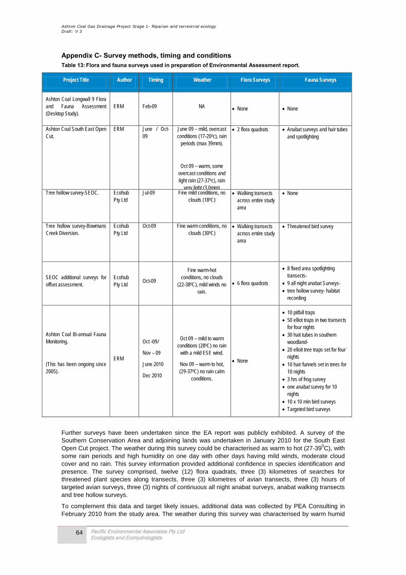
Ashton Coal Gas Drainage Project Stage 1- Riparian and terrestrial ecology Draft: V 3
64 Pacific Environmental Associates Pty Ltd Ecologists and Ecohydrologists
Appendix C- Survey methods, timing and conditions Table 13: Flora and fauna surveys used in preparation of Environmental Assessment report.
Project Title Author Timing Weather Flora Surveys Fauna Surveys
Ashton Coal Longwall 9 Flora and Fauna Assessment (Desktop Study).
ERM Feb-09 NA • None • None
Ashton Coal South East Open Cut.
ERM June / Oct-09
June 09 – mild, overcast conditions (17-200c), rain
periods (max 39mm).
Oct 09 – warm, some overcast conditions and light rain (27-370c), rain
very light (3.0mm)
• 2 flora quadrats • Anabat surveys and hair tubes and spotlighting
Tree hollow survey-SEOC. Ecohub Pty Ltd
Jul-09 Fine mild conditions, no clouds (180C)
• Walking transects across entire study area
• None
Tree hollow survey-Bowmans Creek Diversion.
Ecohub Pty Ltd
Oct-09 Fine warm conditions, no clouds (300C)
• Walking transects across entire study area
• Threatened bird survey
SEOC additional surveys for offset assessment.
Ecohub Pty Ltd
Oct-09
Fine warm-hot conditions, no clouds
(22-380C), mild winds no rain.
• 6 flora quadrats
• 8 fixed area spotlighting transects-
• 9 all night anabat Surveys- • tree hollow survey- habitat
recording
Ashton Coal Bi-annual Fauna Monitoring.
(This has been ongoing since 2005).
ERM
Oct -09/
Nov – 09
June 2010
Dec 2010
Oct 09 – mild to warm conditions (280C) no rain
with a mild ESE wind.
Nov 09 – warm to hot, (29-370C) no rain calm
conditions.
• None
• 10 pitfall traps • 50 elliot traps in two transects
for four nights • 30 hait tubes in southern
woodland- • 20 elloit tree traps set for four
nights • 10 hair funnels set in trees for
10 nights • 3 hrs of frog survey • one anabat survey for 10
nights • 10 x 10 min bird surveys • Targeted bird surveys
Further surveys have been undertaken since the EA report was publicly exhibited. A survey of the Southern Conservation Area and adjoining lands was undertaken in January 2010 for the South East Open Cut project. The weather during this survey could be characterised as warm to hot (27-390C), with some rain periods and high humidity on one day with other days having mild winds, moderate cloud cover and no rain. This survey information provided additional confidence in species identification and presence. The survey comprised, twelve (12) flora quadrats, three (3) kilometres of searches for threatened plant species along transects, three (3) kilometres of avian transects, three (3) hours of targeted avian surveys, three (3) nights of continuous all night anabat surveys, anabat walking transects and tree hollow surveys.
To complement this data and target likely issues, additional data was collected by PEA Consulting in February 2010 from the study area. The weather during this survey was characterised by warm humid

Ashton Coal Gas Drainage Project Stage 1- Riparian and terrestrial ecology Draft: V 3
65 Pacific Environmental Associates Pty Ltd Ecologists and Ecohydrologists
conditions (27-290C) moderate rain periods and high humidity on the 4th day. Other days had mild winds, moderate cloud cover. The additional survey included the following:
• Flora survey incorporating:
- 6 flora quadrats along impact area.
- Walking transects looking for significant species.
- Targeted survey for Acacia pendula, Thesium hannel, Eucalyptus glaucina, Diuris tricolor, Digitaria porrecta, and Acacia pendula.
• Fauna survey incorporating:
- Five kilometre walking transect targeting Grey-crowned Babbler, Hooded Robin, and Speckled warbler.
- Tree hollow survey.
- Fauna habitat survey.
Fieldwork for flora species undertaken in February 2010 comprised a combination of extensive field observations and plot or quadrat sampling. Field observations included rapid assessment of vegetation structure and floristics along tracks and during off-track walks. A total of 6 quadrats (20m x 20m) were located within the study area to sample floristics. Quadrats were located mainly in forest areas using a quasi-systematic approach whereby pre-determined paths were followed and quadrats placed at intervals equivalent to 10 minutes walking time. Abundance cover scores were applied to all vascular plant species recorded within each quadrat (1 = 1-20%; 2 = 21-40%; 3 = 41-60%; 4 = 61-80%; 5 = 81-100%). Plant nomenclature in accordance with the Flora of New South Wales as maintained by the Royal Botanic Gardens at http://plantnet.rbgsyd.gov.au has been adopted.
Acacia pendula A stand of Acacia have been planted as rehabilitation of mine spoil along Brunkers Lane. Survey of the area identified one Acacia pendula and numerous Acacia identified as Acacia salicina, which whilst superficially similar to A.pendula, there are some notable differences. A.pendula had flower buds present during surveys (A.salicina did not); A.pendula had noticeably more pendulus phyllodes than A.salicina and phyllode sizes were correlated to the two species descriptions.
A.salicina was the dominant wattle in these areas, and it is possible that these have been confused in the past with A.pendula, or that when seed was collected for the regeneration A.salicina seeds were collected by mistake. Regardless, A.pendula plants evidently have not naturalised in the study area to date with there being no obvious seedling establishment. Extensive searches on land adjacent to Bowmans Creek also failed to find A.pendula. Given the more than 300m separation it is evident that the proposed realignment of Bowmans Creek will not impact the Acacia pendula endangered population.
Digitaria porrecta This species is found in native grassland, woodlands or open forest with a grassy understory, on richer soils in the North West Slopes and North West Plains botanical divisions of NSW. In NSW, the most frequently recorded associated tree species are Eucalyptus albens and Acacia pendula. Common associated grasses and forbs in NSW sites include Austrostipa aristiglumis, Enteropogon acicularis, Cyperus bifax, Hibiscus trionum and Neptunia gracilis. (DECCW threatened species profile; PlanNet). The absence of previous records for this species within the region and the lack of suitable habitat within the study area (i.e. native grasslands and woodlands) suggest that this species is unlikely to occur in the study area. It was not found during ground searches.
Bothriochloa biloba
Lobed blue grass is a tall (1.0m) perennial that flowers in summer. It was recorded on the Ravenswroth site in 2009. This species is often found in woodland and derived grassland communities. It is believed that grazing may have a positive effect on the species, due to it being less palatable than its completion and reduces the competitive advantage of its main competitor. The species was not recorded in the survey area.
Related Documents


