Modelling Higher Dimensional Data for GIS Using Generalised Maps * Ken Arroyo Ohori Hugo Ledoux Jantien Stoter May 2, 2013 Abstract Real-world phenomena have traditionally been modelled in 2D/3D GIS. However, powerful insights can be gained by integrating additional non-spatial dimensions, such as time and scale. While this integration to form higher-dimensional objects is theoretically sound, its implementa- tion is problematic since the data models used in GIS are not appropriate. In this paper, we present our research on one possible data model/struc- ture to represent higher-dimensional GIS datasets: generalised maps. It is formally defined, but is not directly applicable for the specific needs of GIS data, e.g. support for geometry, overlapping and disconnected re- gions, holes, complex handling of attributes, etc. We review the properties of generalised maps, discuss needs to be modified for higher-dimensional GIS, and describe the modifications and extensions that we have made to generalised maps. We conclude with where this research fits within our long term goal of a higher dimensional GIS, and present an outlook on future research. 1 Introduction Spatial data modelling refers to the creation of abstract mathematical represen- tations of real world objects embedded in space. This includes not only purely spatial aspects, such as the objects’ geometry and topology, but also other char- acteristics required for their use, such as the ability to attach attributes (both for storage and for thematic aspects), mark visited objects, or to have efficient access to the objects within a region. Spatial models have been developed largely independently in the disciplines that required information on spatial objects, including computer graphics, computer- aided design and manufacturing (CAD/CAM), geology, and geographic infor- mation systems (GIS) [1]. Because of their independent creation, they are a reflection of the idiosyncrasies of their domains and differ significantly in key * Author’s draft of the paper to be presented at the 13th International Conference on Computational Science and Its Applications, within the session Spatial Data Structures and Algorithms for Geoinformatics, held in Ho Chi Minh City, Vietnam. 1

Welcome message from author
This document is posted to help you gain knowledge. Please leave a comment to let me know what you think about it! Share it to your friends and learn new things together.
Transcript

Modelling Higher Dimensional Data for GISUsing Generalised Maps∗
Ken Arroyo Ohori Hugo Ledoux Jantien Stoter
May 2, 2013
Abstract
Real-world phenomena have traditionally been modelled in 2D/3DGIS. However, powerful insights can be gained by integrating additionalnon-spatial dimensions, such as time and scale. While this integrationto form higher-dimensional objects is theoretically sound, its implementa-tion is problematic since the data models used in GIS are not appropriate.In this paper, we present our research on one possible data model/struc-ture to represent higher-dimensional GIS datasets: generalised maps. Itis formally defined, but is not directly applicable for the specific needsof GIS data, e.g. support for geometry, overlapping and disconnected re-gions, holes, complex handling of attributes, etc. We review the propertiesof generalised maps, discuss needs to be modified for higher-dimensionalGIS, and describe the modifications and extensions that we have made togeneralised maps. We conclude with where this research fits within ourlong term goal of a higher dimensional GIS, and present an outlook onfuture research.
1 IntroductionSpatial data modelling refers to the creation of abstract mathematical represen-tations of real world objects embedded in space. This includes not only purelyspatial aspects, such as the objects’ geometry and topology, but also other char-acteristics required for their use, such as the ability to attach attributes (bothfor storage and for thematic aspects), mark visited objects, or to have efficientaccess to the objects within a region.
Spatial models have been developed largely independently in the disciplinesthat required information on spatial objects, including computer graphics, computer-aided design and manufacturing (CAD/CAM), geology, and geographic infor-mation systems (GIS) [1]. Because of their independent creation, they are areflection of the idiosyncrasies of their domains and differ significantly in key
∗Author’s draft of the paper to be presented at the 13th International Conference onComputational Science and Its Applications, within the session Spatial Data Structures andAlgorithms for Geoinformatics, held in Ho Chi Minh City, Vietnam.
1
issues. One consequence of this is that in many fields support for 3D data hasbeen long widespread and the theoretical foundations for higher dimensions arewell established. However, GIS still has limited support for 3D data, and higher-dimensional GIS, despite decades of frequent mentions in literature [2, 3, 4, 5],remains in most cases a theoretical discussion1.
This slow progress in the GIS world is not due to a lack of applicationsin higher dimensions. While being limited to 3D space is acceptable to manyusers of geographic information, substantial work has been done regarding theintegration of non spatial-dimensions [6], such as time [7, 8] and scale [9, 10],to spatial data models. This is done either by creating specific models for thesenon-spatial dimensions, or by treating them as additional spatial ones [5], yield-ing a higher dimensional spatial model. The latter case is more extensible andgeneric, allowing us to manipulate objects in a dimension independent man-ner [11]. It is also the focus of this paper, and therefore the notion of a higherdimensional spatial model is first explained in detail in Section 2.
Since there is both a need for higher-dimensional GIS, and an availability ofsuch data models from other fields that are able to support higher-dimensionaldata, there is great potential in finding a suitable model and adapting it tothe specific needs of real-world (GIS) data, such as: support for overlappingregions, holes, and complex handling of attributes and metadata; and providingthe specific operations that are required for its use, such as good constructionand querying operations, buffering and overlays [12]. A short summary of themost remarkable representations for higher dimensional objects developed inother fields and that could thus be adopted is given in Section 3.
Among these, we propose the use of generalised maps, which are explainedin Section 4, a model capable of representing a wide class of objects in arbitrarydimensions. It has several advantageous properties, such as support for un-bounded objects (useful for time and other unbounded dimensions [13]), avoid-ing problems with incompatible orientations (a common problem when objectsare built independently), and providing a simple manner to attach attributes tothe objects of every dimension (e.g. vertex, edge, facet, etc.). Practically, it alsohas the advantage of having been implemented in 3D (it is used in GOCAD2
for geological modelling and in Moka3 for geometric modelling).However, generalised maps by themselves cannot support all the character-
istics of real-world spatial data. To bring our ideas into practice, in Section 5we therefore explain how we have modified and implemented generalised mapsfor this purpose, and how some specific challenging aspects of GIS data can behandled. We finalise with our conclusions, discussion and our plans for futurework in Section 6.
1Among the implementations that do exist, this term is most often used as a catchphrasefor any processing involving 3D space and time. However, time is usually treated as a mereattribute, and true 4D space is almost never used.
2http://www.gocad.org/3http://moka-modeller.sourceforge.net/
2 Higher-dimensional spatial informationThe simplest technique to handle additional dimensions in spatial information,both in GIS and other fields, is using multiple independent representations. Inpractice, this means that these dimensions are considered as simple attributeswhich are attached to 2D or 3D objects. Such is the case in so-called 2.5D modelsfor height, the ‘snapshot’ model for time [14] and most approaches to multi-scale data, including CityGML [15]. This approach is simple to understand andimplement, but it also has important disadvantages:
• There is only a fixed (discrete) number of representations, which meansthat the objects being represented only have a known value at certainpredefined points along the dimension. For example, a moving object’sposition is only known at certain moments.
• There is no link between the same object at different representations,which makes it difficult to maintain consistent representations after up-dates and precludes topological queries along this dimension. For instance,finding a moving object involves a brute force search, and checking if twoobjects at different scales are equivalent can only be inferred indirectly.
• The geometric and topological information is stored multiple times, whichis wasteful in memory and can easily lead to changes being propagatedincorrectly (or not at all), resulting in inconsistencies.
Many other approaches add some topology and additional information tothese independent 2D or 3D representations. For instance, event-based mod-els [16] connect successive moments in time with the changes that occurred inthem, object-relationship models [17] add information to model the changesthemselves, and the original tGAP structure [18] links appropriate 2D objectsat different levels of detail. These representations are lightweight and sufficientfor many applications, but they do not solve any of the above mentioned prob-lems in their entirety: there is still a fixed number of points along a dimension(e.g. levels of detail or moments in time), some topological relations are notpossible to keep in an efficient manner (especially along the additional dimen-sions), and inconsistencies are easy to generate when combining data sources ormanipulating objects without special care.
Because of this, others have proposed to treat all dimensions as spatial ones(see [19] for time and [20] for scale). This solution is more complex, but itmeans that objects have known geometry, topology and attributes at all possiblevalues within a range. Alternatively, this can be seen as having access to allthe topological relationships between the objects, down to the vertex-to-vertexlevel. This helps to avoid redundancies and inconsistencies in the data. Whatwe mean by treating all dimensions as spatial ones is explained as follows.
For simplicity, let us first consider a case with 2D space, time as the thirddimension, and only linear (flat) geometries. At any one point in time, an objectwould be represented as a polygon in 3D space, and it would be parallel to the

2D space plane and orthogonal to the time axis. Every object existing (and notmoving or changing shape) during a time period would then be a prism, withits base and top parallel to the 2D space plane and the other facets orthogonalto it. An example of this situation is shown in Figure 1.
x
ytime
t0
t1
t2
t3
Figure 1: A 2D space (x, y) + time (vertical axis) perspective view of thefootprint of two separate buildings at time t0, which were connected by a corridor(red) from time t1 to time t2 and then became disconnected again when thecorridor was removed until time t3. The moments in time are shown along thethick line representing the front right corner of the right building.
Extending this to a 4D representation of 3D space and time, every object atone point in time would be a polyhedron in 4D space, and an object that existsfor a period of time would be a polychoron, i.e. the four-dimensional analogue ofa polygon/polyhedron. If this object is not moving or changing shape, it wouldtake the form of a prismatic polychoron, i.e. the four-dimensional analogue of aprism. A simple example of such an object, generated by successive extrusionsof a 2D footprint from the GBKN4 data set, is shown in Figure 2.
3 Higher-dimensional data modelsThere are several data models that are able to support higher-dimensional ob-jects. However, most of these are limited to point or raster data, which havetrivial or no topology, and are thus much more straightforward to use and imple-ment. Higher-dimensional point clouds are common in data mining [21], whilehigher-dimensional rasters are common in medical imaging [22], among otherexamples.
4http://www.gbkn.nl, a Dutch large-scale topographic data set

(a) The GBKN footprint ofthe Aula Congress Centre inDelft
(b) After extruding it to cre-ate a block shaped polyhe-dron (perspective projectionof edges and facets only)
(c) After extruding it again (double perspectiveprojection of the edges only)
Figure 2: A 4D (3D+time) representation of the Aula Congress Centre in Delft.
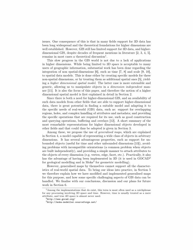
For vector data consisting of closed polytopes (i.e. the higher-dimensionalanalogue of a polygon/polyhedron), there are fewer options. A deceptivelysimple one involves the geometric subdivision of an n-dimensional polytope inton-dimensional simplices, i.e. an n-dimensional simplicial decomposition or n-dimensional triangulation, which can be easily represented and stored using anincidence model, as shown in Figure 3. In its simplest form, a data structure forthis could be a list of vertex coordinates, and a list of simplices, each containingthe n + 1 vertices that define it and the n + 1 simplices that are adjacent toit. This option has several advantages: the data structures are simple to useand implement, it can be compressed with relative ease [23, 24], and operationsbetween simplices are much more straightforward than those between arbitrarypolytopes (e.g. the intersection of two simplices of a certain dimension can yieldonly a limited number of different configurations).
(a) Triangle based representation (b) Tetrahedron-based representation
Figure 3: n-simplex based data structures in 2D and 3D. Black arrows representpointers from the element shown, while red arrows show the ones from otherelements that point to this one.
However, doing this subdivision is extremely difficult in practice, since itrequires the creation of an n-dimensional constrained triangulator, which hasbeen described in theory [25, 26] for some cases, but has never been implemented.Doing so for the general case, especially in a robust manner, would prove verydifficult.
Another option, and the one further discussed in this paper, is using orderedtopological models [27], a type of boundary representations that are based on asingle type of fundamental constructing element (e.g. a half-edge), on which ausually small number of pre-defined functions act. The more complex elementsand connected components of such a model are only defined implicitly, e.g. asa set of fundamental elements. This allows objects to be represented as is, atleast from a high level perspective, not needing to conform to a particular shape(unlike decomposition models like rasters).
Such data models also have the advantage of separating the topology ofthe objects (which is dealt with in the model directly), and their geometry(which is dealt with in an embedding model). This is a useful property, since itdistinguishes the problems in geometric modelling from those in computationalgeometry [28]. Algorithms and methods from both fields can then be appliedindistinctly to solve specific problems.

There are other possible models which are not discussed further in this pa-per but still represent interesting possibilities. Constructive models based onconstructive solid geometry, alternate decompositions [29] or intersections ofhalf-spaces have a strong theoretical background, but attaching attributes toindividual elements is difficult, and realising an object involves complex geo-metric computations. Nef polyhedra [30] are very powerful, but require theconstruction of an n-dimensional hyperspherical projective kernel, which is alsoa very complex task in practice [31].
4 Generalised mapsGeneralised maps (sometimes shortened as G-maps) are an ordered topologicalmodel developed by Liendhardt [32] based on the concept of a combinatorialmap, also known as a topological map, which was described by Edmonds [33].They are roughly equivalent to the cell-tuple structure of Brisson [34], but wereshown to be able to represent the topology of a wider class of objects, i.e. ori-entable or non-orientable cellular quasi-manifolds with or without boundary—manifolds partitioned into cells [35] that allow certain types of singularities, aslong as every i-dimensional cell (i-cell) is incident to no more than two (i+ 1)-cells in a (i+ 2)-cell.
A generalised map is composed of two elements: darts and involutions (α).The precise definition of a dart is complex [32], but since for our applicationwe are only interested in representing linear (flat) geometries, a dart can beintuitively seen as a unique combination of a specific i-cell (a vertex being a0-cell, an edge is a 1-cell, a facet is a 2-cell, and so on) in each dimension, all ofwhich are incident to each other. Meanwhile, involutions are bijective operatorsconnecting darts that are related along a certain dimension. In this manner, α0
joins darts into edges, α1 connects consecutive edges within a facet, α2 connectsadjacent facets within a volume, and so on. An example of a 3D generalised map(3-G-map) representation of two adjacent cubes is shown in Figure 4, where α0
thus joins vertices to form edges, α1 connects consecutive edges within a facet,α2 connects adjacent facets within a volume, and so on.
One can traverse the combinatorial structure by the use of the orbit operator,which returns a set of darts that are reachable by following certain involutionsonly. To obtain the darts that are part of a certain i-cell only, one can start fromany dart d belonging to the i-cell, following all involutions except for αi. This iscommonly denoted an <�αi > orbit of d [36]. Since αi connects adjacent i-cells,not following it means staying within the same i-cell. For simple construction,the sew operation is used, connecting two objects of the same dimension alongthe common face, i.e. (i − 1)-cell, in their boundaries. Analogously, the unsewoperation can be used to unset these involutions.
More formally, a n-dimensional generalised map is defined by a (n+2)-tupleG = (D,α0, α1, . . . , αn), where D is a non-empty set of darts, and αi is aninvolution (i.e. ∀d ∈ D,∀0 ≤ i ≤ n, αi(αi(d)) = d) that connects objects ofdimension i, and ∀0 ≤ i ≤ n− 2,∀i+2 ≤ j ≤ n, αi(αj(d)) is also an involution.

(a) A G-map representation of a cube.
/α =< α ,α >
/α =< α ,α >
/α =< α ,α >
(b) The �αi operator obtains all the darts be-longing to a specific i-cell. Thus, �α0 obtainsthe darts belonging to a vertex, �α1 those be-longing to an edge, and �α2 those belongingto a facet.
(c) A G-map representation of two cubes. Note how the individual cubes have identical involu-tions to those of (a), with the addition of an α3 involution that connects the two cubes at theircommon face. In the other darts, this involution is not used.
Figure 4: A 3D G-map representation of a pair of adjacent cubes, showing theα0 (dashed red), α1 (solid blue), α2 (double green), α3 (triple purple), and�αi
operators.
In order to traverse a G-map, the orbit operator< A > (d) =< αi1, αi2, . . . , αin >(d) obtains all the darts that can be reached from dart d by successive appli-cations of the operators αi1, αi2, . . . , αin ∈ A. For convenience, the operator<�αi > (d) is defined as well, which traverses all α involutions except for αi [36],obtaining all the darts that are part of the same i-cell as d.
The construction of objects in its simplest form is based on the sewingoperator, which joins two i-cells along the (i − 1)-cell that lies in their geo-metric common boundary. Thus, it takes two corresponding darts d1 and d2(∀0 ≤ j ≤ n, i 6= j ⇐⇒ d1 and d2 belong to the same j-cell) on oppositesides of the common (i − 1)-cell, computes their < α0, α1, . . . , αi−1 > (d1) and< α0, α1, . . . , αi−1 > (d2) orbits, performs a parallel traversal of both, andconnects them by adding αi involutions that connect the corresponding dartsfrom each orbit along the i-th dimension. Note that this implies the use ofconsistent ordering criteria in the orbit operator, such as always following thelowest possible α involution first. The unsew operator similarly uses a single< α0, α1, . . . , αi−1 > (d) orbit (since the (i− 1)-cells are now linked) to removeall the involutions between any darts in the orbit along the i-th dimension.
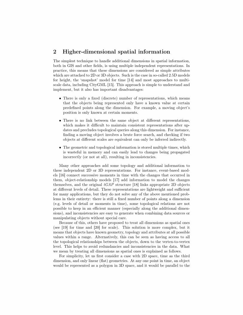
5 ImplementationThere are many possible realisations of generalised maps as a data structure.For instance, a minimal data structure that stores the combinatorial aspect ofan n-G-map could involve a single type of object, a Dart with n+1 pointers toother darts representing its involutions. However, another option could be tohave a set of Involutions that store the identifiers of the two darts that eachof them link. These two options are presented in Figure 5.
struct Dart {Dart *involutions[n+1];
};
(a) Based on darts
struct Involution {id dart1 , dart2;
};
(b) Based on involutions
Figure 5: A minimal G-maps implementation
Nevertheless, these data structures by themselves do not store any geometryor support many of the characteristics of GIS data. An implementation for usein GIS requires:
1. Geometry and topology Storing not only topological relationships, butalso the geometry of the objects. At least linear (flat) objects should besupported.
2. Attributes Storing complex attributes of different types (e.g. numeric,text, an element of a discrete set of classes, etc.), possibly at every di-mension (e.g. vertex, edge, face, etc.). Every i-cell can have a tuple of
attributes of different types, but all the cells of a certain dimension gen-erally have the same attribute types in their tuples.
3. Construction Constructing a model from both topological or non topo-logical data. Topological data might need to be checked (in case the topo-logical information does not match the actual geometry of the objects),while non topological construction should be performed in a consistentmanner, generating valid topological information and ensuring that ob-jects that are geometrically equivalent are only generated once.
4. Queries Answering geometric, topological and attribute based queriesefficiently. In order to do this, all necessary links between the objectsshould be kept, and an external data structure for spatial indexing mightbe required as well.
5. Holes Storing and efficiently accessing void regions in possibly every di-mension higher than 0. To ensure a consistent model, these holes shouldfit inside their containing object, which implies that they should be of thesame dimensionality or lower.
6. Disconnected and overlapping objects Keeping track and traversingobjects even when they form topologically disconnected groups. Theymight be disconnected by virtue of being geometrically disconnected, oralso by being in a configuration that is not directly representable usinggeneralised maps. This implies that a higher level structure that somehowmaintains this information is required. This data structure can howeverhave many possible forms.
The data structures presented previously are only sufficient to represent thecombinatorial structure (topology) of a generalised map, equivalent to thetopological relationships in a partition of space without holes. However, to rep-resent the geometry and other characteristics of the model, some modificationsand additional structures are needed. These are shown in Figure 6 and explainedas follows.
To store geometry, embedding structures are used; each one of these con-taining the geometry of a specific i-cell. Since only linear geometries are re-quired, only the 0-dimensional point embeddings are strictly necessary, whichstore the coordinates of each vertex. The geometry of the higher-dimensionalembeddings can then be inferred from the points in their boundary. Since eachdart represents a unique combination of an i-cell of each dimension, a dart canbe linked to its corresponding embedding structure for each dimension. On theother direction, it is sufficient to link an embedding to any one dart representingpart of its boundary.
Attributes and holes work in a similar manner. Since the tuples of at-tribute types of all i-cells (cells of equal dimension) are equal, one embeddingdata structure per dimension storing the attributes of that dimension, is suffi-cient. A list of holes present in that i-cell can be then kept as an additionalattribute, its only practical requirement being that the dimensionality of the
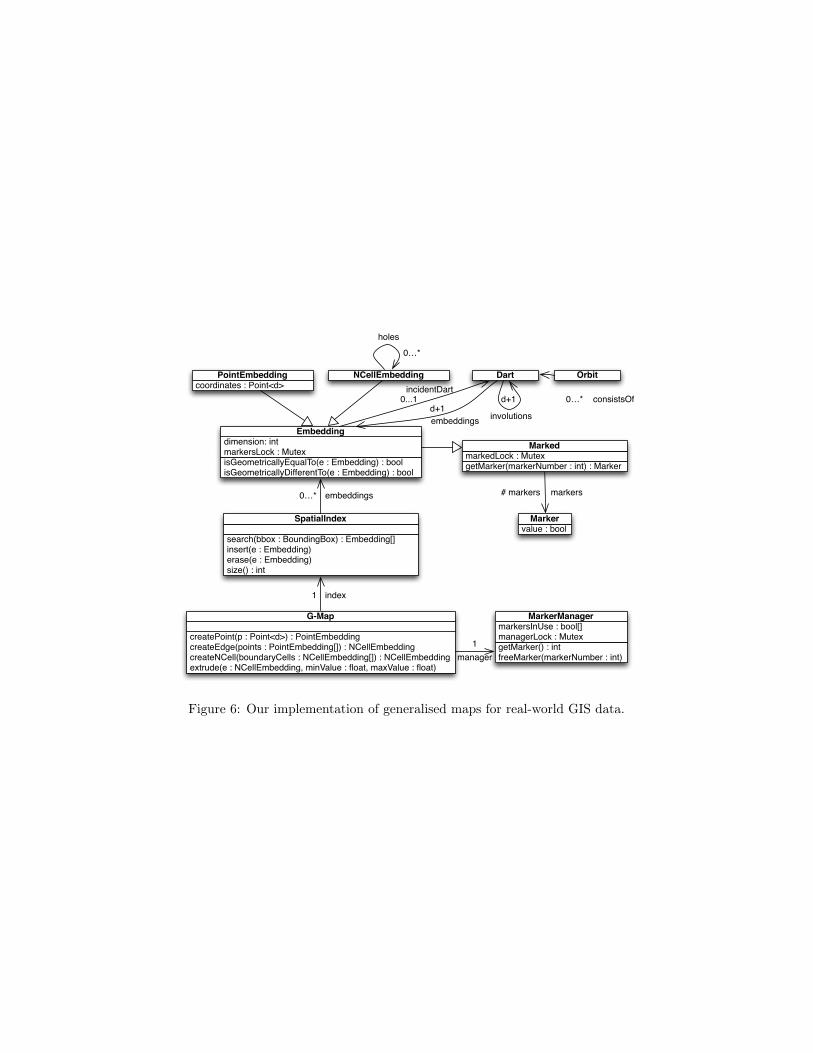
getMarker(markerNumber : int) : MarkermarkedLock : Mutex
Marked
value : boolMarker
getMarker() : intfreeMarker(markerNumber : int)
markersInUse : bool[]managerLock : Mutex
MarkerManager
Dart
isGeometricallyEqualTo(e : Embedding) : boolisGeometricallyDifferentTo(e : Embedding) : bool
dimension: intmarkersLock : Mutex
Embedding
coordinates : Point<d>PointEmbedding NCellEmbedding Orbit
search(bbox : BoundingBox) : Embedding[]insert(e : Embedding)erase(e : Embedding)size() : int
SpatialIndex
createPoint(p : Point<d>) : PointEmbeddingcreateEdge(points : PointEmbedding[]) : NCellEmbeddingcreateNCell(boundaryCells : NCellEmbedding[]) : NCellEmbeddingextrude(e : NCellEmbedding, minValue : float, maxValue : float)
G-Map
involutions
d+1 consistsOf0…*
holes0…*
markers# markers
embeddingsd+1
incidentDart0...1
embeddings0…*
index1
manager1
Figure 6: Our implementation of generalised maps for real-world GIS data.
hole (represented as an embedded cell as well) should be equal or lower thanthat of the containing cell, and that its geometry should be fully inside thecontaining cell.
Meanwhile, queries and disconnected objects are handled through theuse of a spatial index. For this purpose we have investigated several options,among which the most promising options are R-tree variants like the R*-tree,or a simple index using a single vertex per cell, such as the lexicographicallysmallest one. Usual R-tree implementations are not practical since they haveproblems when dealing with objects of heterogeneous dimension (e.g. an objectwith zero-length along a particular dimension has a volume5 of zero in higherdimensional space). The most important aspect of such a spatial index is thatit allows us to maintain a connected graph.
Finally, we have developed two construction operators: a higher dimen-sional analogue of extrusion, which uses a d-dimensional object and a rangealong the (d + 1)-th dimension to create a (d + 1)-dimensional object; and anincremental construction methods that creates a (d+1)-dimensional object de-scribed by the d-dimensional objects in its boundary. These are the focus oftwo upcoming articles and are not discussed here any further.
6 Conclusion and Future WorkThis paper presents part of our ongoing research to implement a higher-dimensionalGIS based on mathematical models that have been developed in other domains.This will enable the full integration of the separate dimensional aspects of GIS,such as 2D/3D space, time and scale [37]. We have modified and extended gen-eralised maps into a data structure that is not much more complex than a basicimplementation, but one that is able to support the real-world characteristicsthat are found in GIS data.
Our future work will cover: the visualisation of higher-dimensional data,efficient construction techniques, improved spatial indexing, keeping the consis-tency and validity of data, and improving the memory consumption of gener-alised maps.
AcknowledgementsThis research is supported by the Dutch Technology Foundation STW, which ispart of the Netherlands Organisation for Scientific Research (NWO), and whichis partly funded by the Ministry of Economic Affairs (Project code: 11300).
References[1] Frank, A.U.: Spatial concepts, geometric data models, and geometric data
structures. Computers & Geosciences 18(4) (1992) 409–4175more precisely, a Lebesgue measure

[2] Hazelton, N., Leahy, F., Williamson, I.: On the design of temporally-referenced, 3-D geographical information systems: development of four-dimensional GIS. In: Proceedings of GIS/LIS’90. (1990)
[3] Hansen, H.S.: A quasi-four dimensional database for the built environment.In: Proceedings of the 1st International Symposium on Digital Earth Mov-ing. Volume 2181 of Lecture Notes in Computer Science. (2001) 48–59
[4] O’Conaill, M.A., Bell, S.B.M., Mason, N.C.: Developing a prototype 4DGIS on a transputer array. ITC Journal (1) (1992) 47–54
[5] Raper, J.: Multidimensional geographic information science. Taylor &Francis (2000)
[6] Worboys, M.F.: A unified model for spatial and temporal information. TheComputer Journal 37(1) (1994) 26–34
[7] Goodchild, M.F.: Geographical data modeling. Computers & Geosciences18(4) (1992) 401–408
[8] Peuquet, D.J.: Representations of Space and Time. Guilford Press (2002)
[9] van Oosterom, P., Meijers, M.: Towards a true vario-scale structure sup-porting smooth-zoom. In: Proceedings of the 14th ICA/ISPRS Workshopon Generalisation and Multiple Representation, Paris. (2011)
[10] Li, Z.: Reality in time-scale systems and cartographic representation. TheCartographic Journal 31(1) (1994) 50–51
[11] Karimipour, F., Delavar, M.R., Frank, A.U.: A simplex-based approachto implement dimension independent spatial analyses. Computers & Geo-sciences 36(9) (September 2010) 1123–1134
[12] Albrecht, J.: Universal Analytical GIS Operations. A Task-Oriented Sys-tematization of Data Structure-Independent GIS Functionality Leading To-wards a Geographic Modeling Language. PhD thesis, University of Vechta(1995)
[13] Thompson, R.J., van Oosterom, P.: Integrated representation of (poten-tially unbounded) 2D and 3D spatial objects for rigorously correct queryand manipulation. In Kolbe, T.H., König, G., Nagel, C., eds.: Advances in3D Geo-Information Sciences. Lecture Notes in Geoinformation and Car-tography. Springer (2011) 179–196
[14] Basoglu, U., Morrison, J.: The efficient hierarchical data structure forthe US historical boundary file. In Dutton, G., ed.: Harvard Papers onGeographic Information Systems. Volume 4. Addison-Wesley (1978)
[15] OGC: OpenGIS City Geography Markup Language (CityGML) EncodingStandard. Open Geospatial Consortium. 1.0.0 edn. (August 2008)
[16] Peuquet, D.J., Duan, N.: An event-based spatiotemporal data model(ESTDM) for temporal analysis of geographical data. International Journalof Geographical Information Science 9(1) (1995) 7–24
[17] Claramunt, C., Parent, C., Spaccapietra, S., Thériault, M.: Databasemodelling for environmental and land use changes. In Stillwell, J.C.H.,Geertman, S., Openshaw, S., eds.: Geographical Information and Planning.Advances in Spatial Science. Springer Berlin / Heidelberg (1999) 181–202
[18] van Oosterom, P.: Variable-scale topological data structures suitable forprogressive data transfer: The GAP-face tree and GAP-edge forest. Car-tography and Geographic Information Science 32(4) (2005) 331–346
[19] Tøssebro, E., Nygård, M.: Representing topological relationships for spa-tiotemporal objects. Geoinformatica 15 (2011) 633–661
[20] van Oosterom, P., Meijers, M.: Vario-scale data structures supportingsmooth zoom and progressive transfer of 2D and 3D data. In: Jaarverslag2011. Nederlandse Commissie voor Geodesie (2012)
[21] Casali, A., Cicchetti, R., Lakhal, L.: Cube lattices: a framework for mul-tidimensional data mining. In: Proceedings of the 3rd SIAM InternationalConference on Data Mining. (2003) 304–308
[22] McInerney, T., Terzopoulos, D.: A dynamic finite element surface modelfor segmentation and tracking in multidimensional medical images withapplication to cardiac 4D image analysis. Computerized Medical Imagingand Graphics 19(1) (1995) 69–83
[23] Snoeyink, J., van Kreveld, M.: Good orders for incremental(re)construction. In: Proceedings of the 13th ACM Symposium on Com-putational Geometry. (1997) 400–402
[24] Blandford, D.K., Blelloch, G.E., Cardoze, D.E., Kadow, C.: Compact rep-resentations of simplicial meshes in two and three dimensions. InternationalJournal of Computational Geometry and Applications 15(1) (2005) 3–24
[25] Shewchuk, J.R.: Sweep algorithms for constructing higher-dimensionalconstrained Delaunay triangulations. In: Proceedings of the 16th AnnualSymposium on Computational Geometry. (2000) 350–359
[26] Shewchuk, J.R.: General-dimensional constrained Delaunay and con-strained regular triangulations, I: Combinatorial properties. Discrete &Computational Geometry 39(1003) (March 2008) 580–637
[27] Lienhardt, P.: Topological models for boundary representation: a compar-ison with n-dimensional generalized maps. Computer-Aided Design 23(1)(1991) 59–82
[28] Mäntylä, M.: An introduction to solid modeling. Computer Science Press,New York, USA (1988)
[29] Bulbul, R., Frank, A.U.: AHD: The alternate simplicial decompositionof nonconvex polytopes (generalization of a convex polytope based spatialdata model). In: Proceedings of the 17th International Conference onGeoinformatics. (2009) 1–6
[30] Bieri, H., Nef, W.: Elementary set operations with d-dimensional poly-hedra. In: Computational Geometry and its Applications. Volume 333 ofLecture Notes in Computer Science. Springer Berlin / Heidelberg (1988)97–112
[31] Granados, M., Hachenberger, P., Hert, S., Kettner, L., Mehlhorn, K., Seel,M.: Boolean operations on 3D selective nef complexes: Data structure,algorithms and implementation. In: Proceedings of the 11th Annual Euro-pean Symposium on Algorithms. (September 2003) 174–186
[32] Lienhardt, P.: N-dimensional generalized combinatorial maps and cellularquasi-manifolds. International Journal of Computational Geometry andApplications 4(3) (1994) 275–324
[33] Edmonds, J.: A combinatorial representation of polyhedral surfaces. No-tices of the American Mathematical Society 7 (1960)
[34] Brisson, E.: Representing geometric structures in d dimensions: topologyand order. In: Proceedings of the 5th annual symposium on Computationalgeometry, New York, NY, USA, ACM (1989) 218–227
[35] Hatcher, A.: Algebraic Topology. Cambridge University Press (2002)
[36] Lévy, B., Mallet, J.L.: Cellular modeling in arbitrary dimension usinggeneralized maps. Technical report, ISA-GOCAD (1999)
[37] van Oosterom, P., Stoter, J.: 5D data modelling: Full integration of 2D/3Dspace, time and scale dimensions. In: Proceedings of the 6th InternationalConference GIScience 2010, Springer Berlin / Heidelberg (2010) 311–324
Related Documents