1 MODEL OF COMMUNICATION PLANNING FOR CONTINGENCY PLAN OF DISASTER RISK MANAGEMENT SINABUNG VOLCANO ERUPTION PUJI LESTARI Universitas Pembangunan Nasional “Veteran” Yogyakarta, Indonesia [email protected] EKO TEGUH PARIPURNO Universitas Pembangunan Nasional “Veteran” Yogyakarta, Indonesia [email protected] SARI BAHAGIARTI KUSUMAYUDHA Universitas Pembangunan Nasional “Veteran” Yogyakarta, Indonesia [email protected] ARIF RIANTO BUDI NUGROHO Universitas Pembangunan Nasional “Veteran” Yogyakarta, Indonesia [email protected] ABSTRACT This study aims to find a communication model of contingency plan for disaster risk management of Sinabung Volcano eruption, in North Sumatera. The object of the research is communication and coordination across the government, non-government organization, and community. This study used planning theory, the concept of communication planning, and types of disaster management plan as tools for analysing. Descriptive qualitative is used as the method. Data collection was obtained from the focus group discussion (FGD), in-depth interviews, observation, and study documentation. There are three stages in descriptive qualitative research that is data reduction, data presentation, and conclusion. An analysis was conducted qualitatively on the program and competence actors. The results found the communication model of disaster risk management through documents of contingency planning to overcome the threat of Mount Sinabung eruption. During the emergency response period a core model was used to reduce the impact of the Mount Sinabung eruption. The contingency plan becomes the Karo District Government’s document. This document were authorized by an authorized Preprints (www.preprints.org) | NOT PEER-REVIEWED | Posted: 23 August 2018 doi:10.20944/preprints © 2018 by the author(s). Distributed under a Creative Commons CC BY license.

Welcome message from author
This document is posted to help you gain knowledge. Please leave a comment to let me know what you think about it! Share it to your friends and learn new things together.
Transcript
1
MODEL OF COMMUNICATION PLANNING FOR CONTINGENCY
PLAN OF DISASTER RISK MANAGEMENT SINABUNG VOLCANO
ERUPTION
PUJI LESTARI Universitas Pembangunan Nasional “Veteran” Yogyakarta, Indonesia
EKO TEGUH PARIPURNO
Universitas Pembangunan Nasional “Veteran” Yogyakarta, Indonesia [email protected]
SARI BAHAGIARTI KUSUMAYUDHA
Universitas Pembangunan Nasional “Veteran” Yogyakarta, Indonesia [email protected]
ARIF RIANTO BUDI NUGROHO
Universitas Pembangunan Nasional “Veteran” Yogyakarta, Indonesia [email protected]
ABSTRACT
This study aims to find a communication model of contingency plan for disaster risk management of Sinabung Volcano eruption, in North Sumatera. The object of the research is communication and coordination across the government, non-government organization, and community. This study used planning theory, the concept of communication planning, and types of disaster management plan as tools for analysing. Descriptive qualitative is used as the method. Data collection was obtained from the focus group discussion (FGD), in-depth interviews, observation, and study documentation. There are three stages in descriptive qualitative research that is data reduction, data presentation, and conclusion. An analysis was conducted qualitatively on the program and competence actors. The results found the communication model of disaster risk management through documents of contingency planning to overcome the threat of Mount Sinabung eruption. During the emergency response period a core model was used to reduce the impact of the Mount Sinabung eruption. The contingency plan becomes the Karo District Government’s document. This document were authorized by an authorized
Preprints (www.preprints.org) | NOT PEER-REVIEWED | Posted: 23 August 2018 doi:10.20944/preprints201808.0420.v1
© 2018 by the author(s). Distributed under a Creative Commons CC BY license.
2
official and is ready to be applied to the Emergency Response Operation Plan. Plans for emergency response operations are carried out based on information regarding damage and the need to obtain results of a quick review. Contingency plans are submitted to the legislature for political commitment and support and budget allocation.
Keywords: communication model, volcanic eruption, contingency planning, risk management, Sinabung
INTRODUCTION
Mount Sinabung is located in Karo, one of regency in North Sumatra. In
2010 Sinabung erupted after hundreds of years not happened. During
2011-2012 Mount Sinabung is relatively. However starting in 2013 until
July 2017, it has started to go off again. Based on the research of Lestari,
Bahagiarti, Paripurno, and Jayadianti (2016: 4265) Sinabung has high
disaster risk. The impact of eruption also has not been taken care, as
problem refugees and the impact of bodily harm other. Various
problems emerge caused by some factors particularly the lack of
communication planning and coordination between parties related to
disaster management of sinabung itself, such a government, the
community, and other private organization.
Communication is the basic element in disaster management as
the way of preparedness efforts. Communication needed in the
formation of the readiness people in for a disaster, both natural
disasters and disaster due to human (Asteria, 2016: 2). Communication
disaster mitigation was an act of just a top priority for thought and
undertaken to the people who live in proneness. How the government
and the parties involved prepare people living in proneness in
preparation for disaster by means of information early problems about
geology disaster (Roskusumah, 2013:60). Communication involving
communicator (sender message) providers, message, channel,
communicant (receiver messages), and also the effect of a message.
Effective communication based on Indonesia's constitution number 24
Preprints (www.preprints.org) | NOT PEER-REVIEWED | Posted: 23 August 2018 doi:10.20944/preprints201808.0420.v1
3
years of 2008 of disaster, preparedness is a series of activities
undertaken to anticipate the disaster through organizing as well as
through the right steps to take effect. According to the basic law of
disaster, the Regional Disaster Management Agency (BPBD) had
the responsibility to coordinate through contingency plans. Based on
government regulation number 21 years of 2008 on the implementation
of the disaster, stated that contingency plan is a process forward
planning to the state of being erratic to prevent or remedying a better in
an emergency situation or critical with agreed scenario and objectives,
set the act of technical and managerial, also a respond and the potential
which agreed before.
The research titled Model Communication Planning Based on
Contingency Plan For Disaster Risk Management of Sinabung Eruption
has been obtained by Lestari, et. all. This research generates a
recommendation to decision-makers, both central and local
government, disaster experts and the public who are expected to
further improve personal communication for the implementation of
disaster management as one priority in the national development and it
can be realized in a variety of regions in Indonesia. SMS Gateway
program and disaster communications SOP can be an alternative for
volcano communication model (Lestari et all., 2014: 182). That study has
not been effective to reduce disaster risk. This study aims to continue
with the focus about planning disaster communication uses planning
theory. The study of the planning theory has been carried out by Sawitri
(Sawitri, 2004: 15) stated that:
Theoretically and practically, the role of the planner in participatory planning is as a facilitator and communicator who help the communication between participants who produce planning effectively. In carrying out there, instead of relying on knowledge and analysis techniques, planner also needs to have the capacity building dialogue between various parties concerned. In accordance with their role, the planner must uphold ethics brought his behavior to promote public participation and responsibilities to public interests. As a communicator, planner also has to adhere to the pragmatic
Preprints (www.preprints.org) | NOT PEER-REVIEWED | Posted: 23 August 2018 doi:10.20944/preprints201808.0420.v1

4
natural norm in communications for obtaining public trust and able to establish communication effectively.
Researchers agreed with Sawitri about the importance of
communication for implementing the plan effectively, especially in
communication planning for disaster management of Sinabung
eruption. In a conceptual manner, communication planning is a
commentary on how to disseminate the message whom a right of a
communicator to public proper, through proper channels, and also the
right time (Wijaya, 2015: 53). The concept of communication planning
used as a reference in the process of disaster management plan.
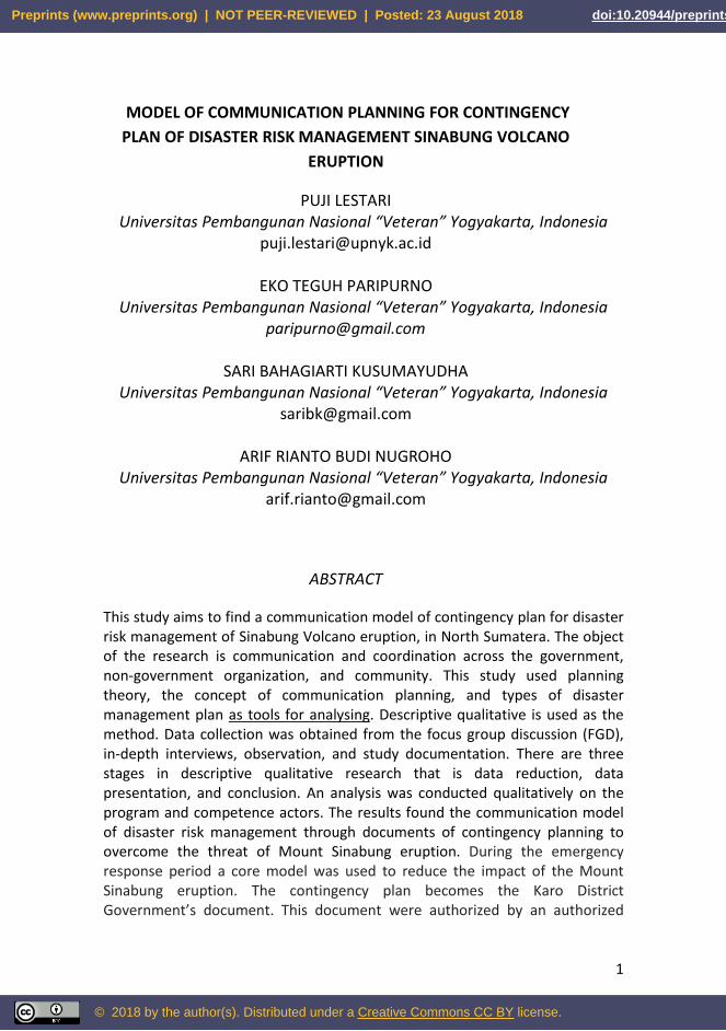
The disaster management consists of five plan as described in
Table 1 (Triutomo, 2011: 8-9).
Table 1 Type of Plans in Disaster Management
No Type of Plans Principles
1 Disaster Management Plan Arranged in normal conditions
General estimate
Coverage of activities broad /
common covering all stages / the
field of employment disaster be
used for all kinds of natural
disasters ( multi-hazard ) pre on
stage, when emergency, and
after a disaster.
All parties related are involved
Much time available Resources
necessary are still in the
“inventory” step
2 Mitigation Plan Arranged in normal condition
containing about various threats,
vulnerability, resources owned,
organizing and the role of /
function of every single
agencies/ investor
be used for all kinds of natural
disasters ( multi-hazard )
Preprints (www.preprints.org) | NOT PEER-REVIEWED | Posted: 23 August 2018 doi:10.20944/preprints201808.0420.v1
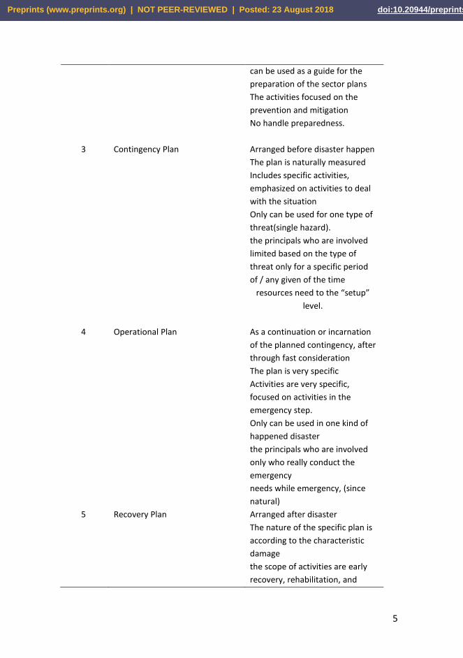
5
can be used as a guide for the
preparation of the sector plans
The activities focused on the
prevention and mitigation
No handle preparedness.
3 Contingency Plan Arranged before disaster happen
The plan is naturally measured
Includes specific activities,
emphasized on activities to deal
with the situation
Only can be used for one type of
threat(single hazard).
the principals who are involved
limited based on the type of
threat only for a specific period
of / any given of the time
resources need to the “setup”
level.
4 Operational Plan As a continuation or incarnation
of the planned contingency, after
through fast consideration
The plan is very specific
Activities are very specific,
focused on activities in the
emergency step.
Only can be used in one kind of
happened disaster
the principals who are involved
only who really conduct the
emergency
needs while emergency, (since
natural)
5 Recovery Plan Arranged after disaster
The nature of the specific plan is
according to the characteristic
damage
the scope of activities are early
recovery, rehabilitation, and
Preprints (www.preprints.org) | NOT PEER-REVIEWED | Posted: 23 August 2018 doi:10.20944/preprints201808.0420.v1
6
reconstruction
Focusing on any sectors such as
physic, social, and economic
the only parties involved in the
early recovery, rehabilitation,
and reconstruction
need for / long, medium term,
hanging from a large extent the
impact of disasters
resources needed is in stage
application/implementation of
development activities medium-
term/long.
(Source: Triutomo, et.all, 2011; 8-9)
According to a guidebook by Triutomo, et. all (2011: 11),
contingency planning is defined as the planning process forward, in a
state of erratic, where scenario approved and purposed, the act of
managerial and technical determined, and the system to respond to the
scene arranged in order to prevent, or overcome a better state or an
emergency situation faced by.
Based on the definition, a few grains that important on
contingency planning are; 1) should be done before in the form of the
state of emergency planning process forward, 2) more focusing on the
process rather than produce documents, 3) a consensus development
process to be agreed scenario and purpose to be taken, 4) a readiness to
emergency response by determining step, 5) handling system that will
be taken before an emergency occurs and includes efforts and both
prevent and also limiting the possibility of consequences that will
happen.
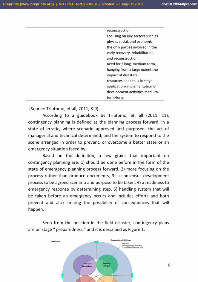
Seen from the position in the field disaster, contingency plans
are on stage " preparedness," and it is described as Figure 1.
Preprints (www.preprints.org) | NOT PEER-REVIEWED | Posted: 23 August 2018 doi:10.20944/preprints201808.0420.v1
7
Figure 1: Type of plan in disaster management
(Source: Triutomo, et.all, 2011; 8-9)
Figure 1 can be seen a program contingency plan kind of an early
warning in preparedness. The contingency plan is needed to prevent the
victim of disaster eruption. To contingency plans, indispensable theory
planning, and planning communication.
Based on some number of these studies, this study aims to find a
model planning communication to prepare the contingency plan
eruption phase of Mount Sinabung in Karo, North Sumatra. Previous
research about disaster management was about the understanding
Malaysian Malays Communication Characteristics in Reducing
Psychological Impact on Flood Victims. The study identifies a more
comprehensive list of values related to Malaysian communication
characteristics in the context of flood disaster management (Mustaffa,
Che Su, et al. (2018).
METHODOLOGY
This study uses a qualitative approach and wreaks previous research
namely disaster communication of Mount Sinabung in Karo district of
North Sumatra which erupted in 2010 and 2013 ago. The research was
done with descriptive of qualitative methods. This method is used to
make the image of the problems regarding the situation or occurrence.
According to the Moh Nazir (1985: 64), descriptive study is research that
examines the status of a group of humans, an object, a condition that
aims to give a picture in systematic, factual and actual concerning the
facts, properties as well as the relationship between the phenomenon to
be checked. The researcher develops a model of risk management
disaster community-based on contingency plan through Mountain
Sinabung Karo district of North Sumatra. There are three stages in
descriptive qualitative research that is data reduction, data presentation,
and conclusion (Hayati, 2015: 351). In the first stage of qualitative
Preprints (www.preprints.org) | NOT PEER-REVIEWED | Posted: 23 August 2018 doi:10.20944/preprints201808.0420.v1
8
research is describes the data, second data reduction, and the last
researcher performs the data presentation to get conclusions from data
that has been prepared and presented. Competence of qualitative
researchers, (Hayati, 2015: 356), has a broad and deep insight on the
topic to be studied, in addition, researchers are expected to have a
sensitivity to see every symptom that exists on the object of research.
Researchers have been conducting research on disasters since 2006
during the earthquake in Yogyakarta. Research on disaster
communications continues until 2018. In addition, produce scientific
publications from previous research results in national journals and
international journals.
Primary data collected from the interview with the head of the
national disaster agency (BNPB), regional disaster management agency
(BPBD). This study has partnered with the BPBD Karo and the
Kesbanglinmas of Karo, communities, and stakeholders that involved in
the disaster management. This is intended to obtain information on the
establishment of a relevant model for risk management. Considering the
data and resources disaster management operates in office. Data
collection of this research are; in-depth interviews, observation, and
study documentation, and Focus Group Discussions (FGD). A reason
why this research uses FGD method is because Focus Group Discussions
(FGD) is a common approach for data collection in qualitative research
projects. The primary characteristic of this method is to use interaction
data resulting from discussion among participants. The primary strength
of the FGD method is that it can provide rich data, more informative,
and valuable insight which can not be discovered through other
methods (Afiyanti, 2008: 58).
Focus group discussion (FGD) was conducted by inviting research
subject as follows; Element of the plan drafting contingency in Karo
(government agency, army/the national police, private institutions,
meteorology, climatology and geophysics (BMKG), Indonesian red cross
(PMI), Search and Rescue (SAR), Volunteers disaster management,
ORARI, NGO, Universities, Business institutions, Mass media, Scout, The
Preprints (www.preprints.org) | NOT PEER-REVIEWED | Posted: 23 August 2018 doi:10.20944/preprints201808.0420.v1
9
societies, Youth Organizations, any other parties related to the threat,
head of the regional disaster management board (BPBD), NGO
representatives, representatives of donors, representatives of
volunteers, representatives of disaster victims in Naman Teran, Simpang
Empat, Tiganderket, and Payung.
The data collected through FGD included; 1) experiences that
have been done by the participants in following various programs
disaster management of Sinabung 2013, 2) obstacles experienced during
involved in disaster management, 3) feedback about disaster
management of Sinabung 2013, 4) suggestions about model disaster
management to disaster mitigation mountain sinabung, 5) material plan
drafting contingency to disaster mitigation mountain sinabung: location
who is expected to victims, evacuation place, the number and
characteristic population, access to get help, long time assistance
required, profile refugees, and the total need.
Indonesia uses four volcano alert levels to activate community
mitigation plans. In order of increasing criticality, these are Normal,
Advisory (Waspada), Watch (Siaga) and Warning (Awas).
Implementation of policies, strategies, and actions are tied to each level.
In addition, mandatory actions by certain stakeholders are required at
certain alert levels. These mandatory actions increase the effectiveness
of disaster mitigation by both government and the community. The
contingency plan is better if developed in non Warning Stage.
(Andreastuti et.all. 2017)
The contingency plan has to be made together by all parties
(stakeholders) and multi-sector involved and role in tackling. Including in
connection with this were the associated government sector, those
state/regions, the private sector, the organization non-government/
NGOs, international organizations and community, and other related
parties which still relevant to the type of disaster.
A contingency plan is structured through "processes." This
process is essential because it is composed of the participant itself,
while the facilitator only directs the process of contingency plans.
Preprints (www.preprints.org) | NOT PEER-REVIEWED | Posted: 23 August 2018 doi:10.20944/preprints201808.0420.v1
10
Products from contingency plans are plans, inventories (stockpiles) and
budgets, and not emergency response success.
The data collected analyzed by the descriptive qualitative
method. First, a whole data presented in data display, then reduced
which relevant and which and the main issues examined to later made
categorization. The next stage is to make interpretation and the
conclusion the results of the study. From the withdrawal conclusion to
be obtained a picture of planning model of communications for disaster
mitigation mountain Sinabung through a contingency.
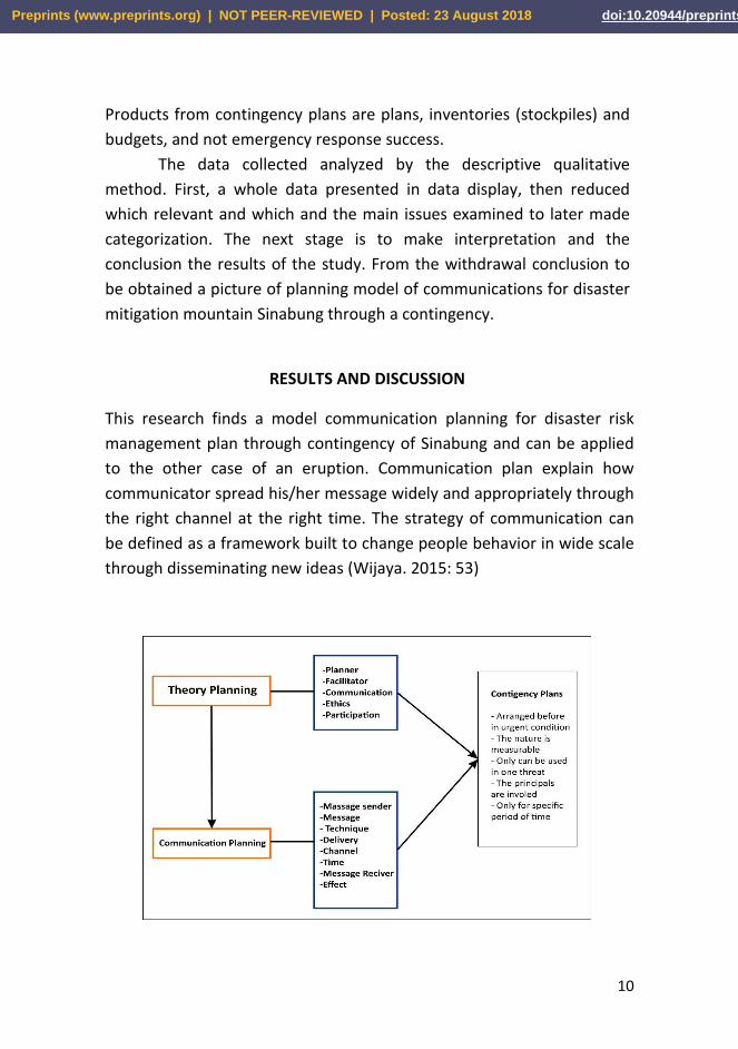
RESULTS AND DISCUSSION
This research finds a model communication planning for disaster risk
management plan through contingency of Sinabung and can be applied
to the other case of an eruption. Communication plan explain how
communicator spread his/her message widely and appropriately through
the right channel at the right time. The strategy of communication can
be defined as a framework built to change people behavior in wide scale
through disseminating new ideas (Wijaya. 2015: 53)
Preprints (www.preprints.org) | NOT PEER-REVIEWED | Posted: 23 August 2018 doi:10.20944/preprints201808.0420.v1
11
Figure 2: Model planning communication disaster risk management through
contigency plan
Figure 2 explain a relation the theory planning, communication
planning, and the contingency plan. The method scheme (consisting of
the planner, facilitators, communication, ethics, and participation)
underlying planning communication (involving messaging, a message,
technique delivery of the message, media or channel message, the
shipping period and delivery of the message, recipients a message and
the impact of messages). The theory planning and communication
planning give a guide in making plan disaster management in the form
of a contingency plan of Sinabung eruption.
According to the results of interviews with the executive
chairman of the BPBD Karo and head of preparedness, the district
government Karo especially the regional disaster management board
(BPBD) did not have documents contingency plan. In cope with the
Sinabung eruption, they use action plan documents or called operation
plans. There is no difference between the contingency plan with
operation plans, except time of its arrangement. Contingency plan
arranged before the disasters so that the plan is based on assumptions
and scenario. While operation plans compiled at disaster happen so that
the state of reality prepare this plan. Operation plans arranged by
adjusting the type of activity and resources are in the contingency plan,
based on the real needs of a disastrous kind that has happened.
Based on the information, writers strove to take that information
to national disaster agency (BNPB). The results are a contingency plan of
Sinabung eruption in 2014. Researchers confirmed to BPBD in Karo
District through the executive director, secretary, and head of
preparedness for finding the existence of a contingency plan document.
The result is they do not understand the document because as the new
officers as the result of mutation the officials at BPBD months earlier.
Considering that there is a document of contingency plan from BPBD,
this research program is updating contingency plan data that has been
made by BNPB in 2014. The updating of this data is possible so that the
planning can be close to the facts in the field. Data updating is based on
Preprints (www.preprints.org) | NOT PEER-REVIEWED | Posted: 23 August 2018 doi:10.20944/preprints201808.0420.v1
12
the contingency plan preparation manual (Triutomo et al., 2011)
covering; Activities in the framework of this follow-up plan are listed in
the table containing the stages and the actors/sectors as well as the
timing of the activities. The process of updating the contingency plan
document includes; 1) Inventory and maintenance of availability and
readiness of resources, facilities, and infrastructure in each area are
done periodically, 2) Periodic meetings for review to update data and
assumptions of disaster impact or projected resource needs, 3)
Developing fixed procedures that can support the
implementation/activation of contingency plans that have been
prepared, 4) Conduct periodic monitoring of threats and early warning
and dissemination. In updating the Contingency Plan document, the
researcher performs a data inventory.
Principles of Contingency Planning
The planning/preparation of a contingency plan has distinctive
features that become the principles of contingency planning. By such
understanding, contingency plans should be made on the basis of:
- Joint drafting process
- A disaster management plan for single hazard or collateral types.
- Contingency plans have scenarios.
- Shared scenarios and objectives
- Done openly (nothing is covered)
- Assign the roles and tasks of each sector
- Agree with the consensus that has been made together.
- Made for an emergency
In general, the preparation of a contingency plan is carried out in
the event of a disaster (the type of threat is known). In this situation,
contingency plans are immediately prepared without going through an
assessment/analysis of threats/hazards. However, the reality on the
Preprints (www.preprints.org) | NOT PEER-REVIEWED | Posted: 23 August 2018 doi:10.20944/preprints201808.0420.v1

13
ground is difficult because the situation is chaotic or panic. It would be
better if contingency plans are made when a potential disaster is known.
The period of the contingency plan
Based on the approximate situation (assumptions) by developing
an agreed scenario. Given the dynamics of vulnerability and capacity
that very fast, contingency plans need to be adjusted and updated the
scenario. In connection with the eruption Plan Plan of the eruption of
Mount Sinabung compiled by BNPB 2014, many data are changed.
Therefore, it is time to update data. This is done by the research team of
UPN Veteran Yogyakarta through the Budget Research Superior
University (PUPT) in 2017.
In principle, the preparation of contingency plans other than
jointly prepared by all stakeholders also developed scenarios and needs
analysis. Once the needs are calculated in detail, it is determined who
the executant are, and do not forget to make an assessment
(availability) of resources owned by the stakeholders. From the need
and availability of these resources, will be known the gap that will be
met from various sources prioritizing (potential) local and surrounding
resources.
Concerning the Hyogo Framework for Action (HFA Article 4),
there has been international recognition of systematic disaster risk
reduction efforts integrated into sustainable development and poverty
alleviation planning and program policies Disaster Risk Reduction Policy
has a goal to improve disaster preparedness and to keep development
activities from increasing the vulnerability of communities to disaster
threats. Therefore, contingency planning (as well as other types of plans
in disaster management) can be established at the
community/community level. This is done as an effort to accelerate
capacity building at the community level to manage and reduce disaster
risk. Due to the large area of Indonesia, it is impossible for the
Government to handle itself. Therefore, community empowerment is
needed by building the capacity of people in disaster-prone areas that
Preprints (www.preprints.org) | NOT PEER-REVIEWED | Posted: 23 August 2018 doi:10.20944/preprints201808.0420.v1
14
are at high risk, for them to be resilient to disaster. People are the first
to deal with disaster risks so they must be able to cope.
The involved component
The response of disaster mitigation agencies and communities to
anticipate disaster depends on a common understanding of the hazards
and an ability to take action during the event. Differences in hazard
perception among emergency managers and scientists can lead to
different and sometimes confusing and dangerous response actions.
(Andreastuti, et. all 2017).
Scientists can reduce the gap of colective perseption about
hazard and disaster. Baser on this condition, contingency plans are
prepared jointly by various parties/elements/components of society.
This acts intended as an effort of preparedness by all parties since
disaster management is a common affair between the government,
business institutions, and communities in which the government is
ultimately responsible. Each of the parties/actors can play an active role
in following the ability, expertise, competence, and authority and
contribute/use existing resources within the scope of authority. The
element of the plan drafting contingency in Karo are:
- government agency
- army / the national police
- private institutions
- Meteorology, Climatology, and Geophysics (BMKG)
- Search and Rescue (SAR)
- Volunteers disaster management
- ORARI
- NGO
- Universities
- Business institutions
- Mass media
- Scout
Preprints (www.preprints.org) | NOT PEER-REVIEWED | Posted: 23 August 2018 doi:10.20944/preprints201808.0420.v1
15
- The societies
- Youth Organizations
- Any other parties related to the threat
Implementation
Preparation of contingency plans may be undertaken through
prior training activities, or through other forums such as coordination
meetings, followed by meetings or workshops, or other forms of
activities. The formulation of a contingency plan is done through the
preparation and implementation.
At the preparation of their activities include the provision of a
map districts provincial, data “ districts in figures “, data about the
supply of resources of the respective sectors/the office's
organization/and information from various sources/element that can be
accounted for technically.
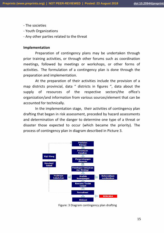
In the implementation stage, their activities of contingency plan
drafting that began in risk assessment, preceded by hazard assessments
and determination of the danger to determine one type of a threat or
disaster those expected to occur (which became the priority). The
process of contingency plan in diagram described in Picture 3.
Figure: 3 Diagram contingency plan drafting
Preprints (www.preprints.org) | NOT PEER-REVIEWED | Posted: 23 August 2018 doi:10.20944/preprints201808.0420.v1
16
(Source: Triutomo, et.all, 201)
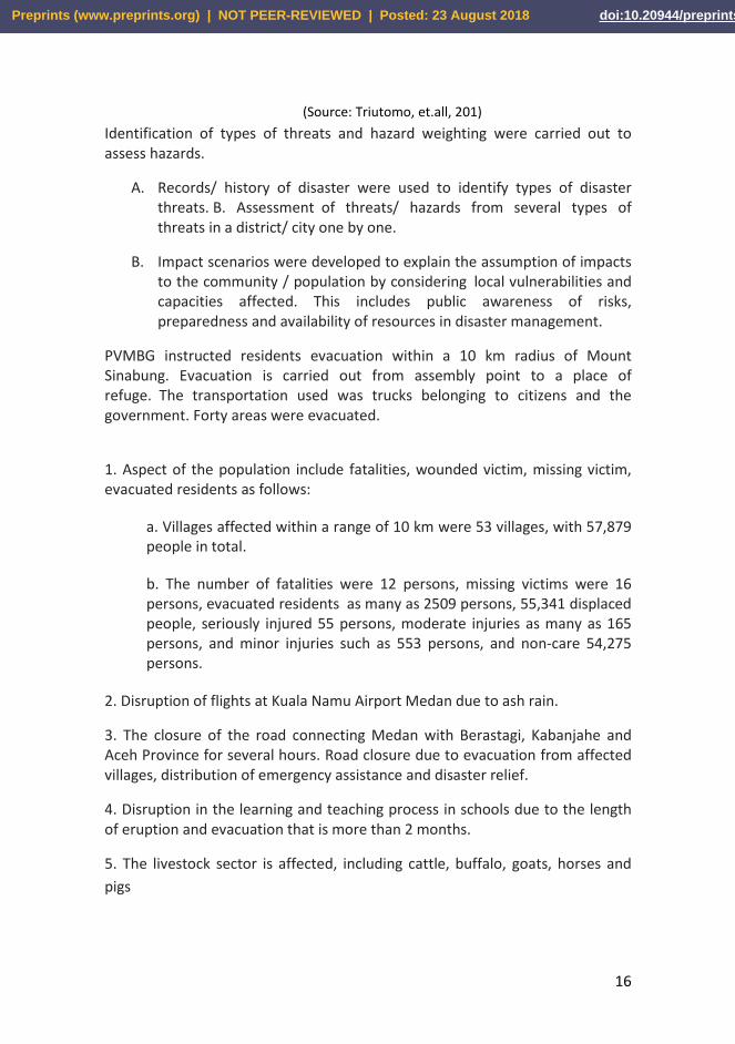
Identification of types of threats and hazard weighting were carried out to assess hazards.
A. Records/ history of disaster were used to identify types of disaster threats. B. Assessment of threats/ hazards from several types of threats in a district/ city one by one.
B. Impact scenarios were developed to explain the assumption of impacts to the community / population by considering local vulnerabilities and capacities affected. This includes public awareness of risks, preparedness and availability of resources in disaster management.
PVMBG instructed residents evacuation within a 10 km radius of Mount Sinabung. Evacuation is carried out from assembly point to a place of refuge. The transportation used was trucks belonging to citizens and the government. Forty areas were evacuated.
1. Aspect of the population include fatalities, wounded victim, missing victim, evacuated residents as follows:
a. Villages affected within a range of 10 km were 53 villages, with 57,879 people in total.
b. The number of fatalities were 12 persons, missing victims were 16 persons, evacuated residents as many as 2509 persons, 55,341 displaced people, seriously injured 55 persons, moderate injuries as many as 165 persons, and minor injuries such as 553 persons, and non-care 54,275 persons.
2. Disruption of flights at Kuala Namu Airport Medan due to ash rain.
3. The closure of the road connecting Medan with Berastagi, Kabanjahe and Aceh Province for several hours. Road closure due to evacuation from affected villages, distribution of emergency assistance and disaster relief.
4. Disruption in the learning and teaching process in schools due to the length of eruption and evacuation that is more than 2 months.
5. The livestock sector is affected, including cattle, buffalo, goats, horses and
pigs
Preprints (www.preprints.org) | NOT PEER-REVIEWED | Posted: 23 August 2018 doi:10.20944/preprints201808.0420.v1

17
Table 2 Impact on the livestock sector
Subdistrict Cow Buffalo Goat Horse Pig TOTAL
Namanteran 37 92 301 2 4
Simpang Empat 221 6 301 0 58
Tiganderket 116 21 56 0 87
Payung 74 2 33 0 0
Merdeka 40 25 70 32 75
448 146 761 34 224 1653
A. Several villages that were severely impacted and expected to be
harvest failures were:
1) Tiganderket sub-district, Tiganderket villages, Mardinding, and
Kutambaru, Perbaji, Tigenderket, Temburuh, Sukatendel.
2) Namanteran sub-district, Kutarayat villages, Simacem, and
Bakerah, for all commodities.
3) Merdeka sub-district, Ujungtera Village, Deram, Sadagperurih,
Cintarayut.
B. In the areas left by residents/farmers due to evacuate, it is estimated
that the plants will be damaged, in:
1) Payung sub-district, the villages of Guru Kinayan, Sukameriah,
Payun, Sukadi, Umbrella End, Cimbung, Bahekarang, Rinokaro.
2) Tiganderket Sub-district, Mardingding Village.
3) Teran Sub-district, Simacem villages, Bakerah, Kuta Gungung
4) Simpang Empat sub-district, village of Beras Sitepu
C. The entire plant area affected by the eruption of Mount
Sinabung about 25.735 Ha.
1) Vegetables include Leeks, potatoes, cabbage, tomatoes,
cauliflower, mustard greens, carrots, celery, lettuce, chili.
Preprints (www.preprints.org) | NOT PEER-REVIEWED | Posted: 23 August 2018 doi:10.20944/preprints201808.0420.v1
18
2) Fruits include pineapple, salak, mango, duku, jackfruit, papaya,
mangosteen, soursop, avocado.
3) Other commodities include Orange, Coffee, Avocado, Karo
Eggplant, Marks.
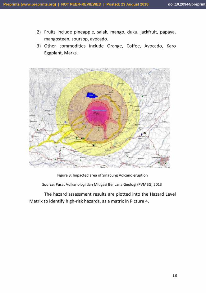
Figure 3: Impacted area of Sinabung Volcano eruption
Source: Pusat Vulkanologi dan Mitigasi Bencana Geologi (PVMBG) 2013
The hazard assessment results are plotted into the Hazard Level
Matrix to identify high-risk hazards, as a matrix in Picture 4.
Preprints (www.preprints.org) | NOT PEER-REVIEWED | Posted: 23 August 2018 doi:10.20944/preprints201808.0420.v1
19
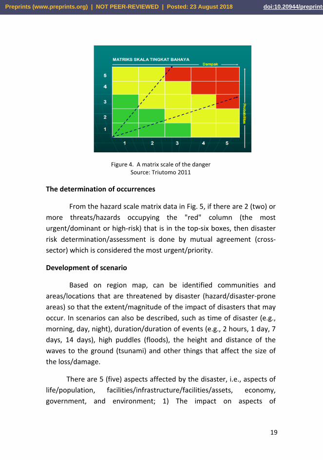
Figure 4. A matrix scale of the danger Source: Triutomo 2011
The determination of occurrences
From the hazard scale matrix data in Fig. 5, if there are 2 (two) or
more threats/hazards occupying the "red" column (the most
urgent/dominant or high-risk) that is in the top-six boxes, then disaster
risk determination/assessment is done by mutual agreement (cross-
sector) which is considered the most urgent/priority.
Development of scenario
Based on region map, can be identified communities and
areas/locations that are threatened by disaster (hazard/disaster-prone
areas) so that the extent/magnitude of the impact of disasters that may
occur. In scenarios can also be described, such as time of disaster (e.g.,
morning, day, night), duration/duration of events (e.g., 2 hours, 1 day, 7
days, 14 days), high puddles (floods), the height and distance of the
waves to the ground (tsunami) and other things that affect the size of
the loss/damage.
There are 5 (five) aspects affected by the disaster, i.e., aspects of
life/population, facilities/infrastructure/facilities/assets, economy,
government, and environment; 1) The impact on aspects of
Preprints (www.preprints.org) | NOT PEER-REVIEWED | Posted: 23 August 2018 doi:10.20944/preprints201808.0420.v1
20
life/population can be death, injuries, displacement, disappearance, and
others, 2) Impacts on aspects of facilities/infrastructure can be damage
to bridges, roads, PAM installations, PLN, damage to homes, and others,
3) The impact on the economic aspects can be damage to traditional
markets, crop failures, economic/trade disruptions, transport, and
others, 4) Impact on aspects of government can be the destruction of
documents/archives, office equipment, government buildings and
others, 5) Environmental impacts can include damage to the forest, lake,
tourism, pollution, destruction of plantation / agricultural lands, and so
on.
To measure the impact on the aspects of life/population, it is
necessary to establish pre-estimation of the number of people who are
threatened, the impacts of death, injury, displacement, disappearance,
and other effects will be determined to determine the
number/percentage of impacts. Impacts on aspects of
facilities/infrastructure, government, economy, and environment are
classified into light, moderate and severe damage.
The Determination of Policy and Strategy
Policies
The emergency handling policy is intended to guide the relevant
sectors to act/implement emergency response activities. The policy is
binding because, in emergency management, there are treaties that
must be obeyed by all parties. Examples of policies are (1) determining
the time of emergency response to be carried out (e.g., for 14 days), (2)
free care/treatment services for disaster victims.
Strategy
Emergency management strategies are implemented by each
sector according to the nature/characteristics of sector tasks. This
strategy is aimed at the effectiveness of policy implementation. For
example, from the policy of "free care/treatment service for the victim"
Preprints (www.preprints.org) | NOT PEER-REVIEWED | Posted: 23 August 2018 doi:10.20944/preprints201808.0420.v1
21
can be formulated strategy "appointing government hospital/private
that serves as the referral hospital."
Sectoral Planning
The first step in sectoral planning is identification activities. All
activities for handling urgent thing have to be identified that the
problem is tackled and completed, there are no activities that overlap
and no vital activities which were left behind. Those responsible for
implementation plan drafting contingency joined in the sector (for
example management and coordination, evacuation, food and non-
food, health, transportation, infrastructure). About the sector, the
number and the nomenclature determined by actors contingency plan
drafting. There was no stipulation definite/raw in determining the
number of and naming to sectors; 1) Sector situation. The situation was
an image of the worst condition during the incident, intended to
anticipate the level of difficulty in handling emergency and effort to do,
2) Sector target. Intended as goals to achieve in the handling of
emergency so that of the community or the victims could have been
treated to the full 3) Sector activity. That was conducted during an
emergency to ensure that the joined sector could be actively sector.
Sector activities triggered by the situation sector during the incident
disaster, 4) Sector’s actor identification. The emergency management
joined in sectors derived from a number of elements good government
and non-government, including members of the community broad. 5)
Implementation time activities. The implementation time activity by
sector is before/ahead of natural disaster, for a moment after of
disasters and any when needed.
CONCLUSION
This study found the communication model of disaster risk management
through documents of contingency planning to overcome the threat of
Mount Sinabung eruption. The core model is the communication
Preprints (www.preprints.org) | NOT PEER-REVIEWED | Posted: 23 August 2018 doi:10.20944/preprints201808.0420.v1
22
planning to reduce the impact of the eruption of Sinabung Volcano,
especially during the emergency response. The core of this model is the
communication planning in minimizing the impact of the eruption of
Mount Sinabung especially during the emergency response in the form
of the Contingency Plan document. The contingency plan becomes a
document of Karo District Government which is authorized by the
authorized official, the Regent of Karo and becomes the official
document (regional document) and ready to be implemented into
Emergency Response Operation Plan (through the information of
damage and the need of the result of the quick review) when disaster
strikes. The contingency plan is also submitted to the legislature for
political commitment and support and budget allocation. At this stage of
the research, the Contingency Plan product has not yet obtained formal
approval as the pilot stage, or new postal rehearsal will be conducted in
second-year research (2018).
ACKNOWLEDGMENTS
Our thanks to Research Fund Management And Devotion To The
Community (DRPM), The Ministry Of Research Technology And Higher
Education (Ristekdikti) 2017, Research Institutes And Devotion
Community (LPPM) Universitas Pembangunan Nasional “Veteran”
Yogyakarta, all parties involved in preparation of contingency plan
eruption Gunungapi Sinabung Especially Regent Karo, Regional
Secretary, Assistant Regent, Regional Disaster Management Agency
(BPBD) Karo and all head of who attended the Workshop Contingency
Plan Karo April 3-4 2017, postal officials observation Mountain
Sinabung. Thanks to Dr. Rizaldi Parani S.Sos. MIR for support proofreading
this article.
Preprints (www.preprints.org) | NOT PEER-REVIEWED | Posted: 23 August 2018 doi:10.20944/preprints201808.0420.v1
23
REFERENCE
Afiyanti, Yati. (2008). Focus Group Discussion Sebagai Metode Pengumpulan Data Penelitian Kualitatif. Jurnal Keperawatan Indonesia, 12(1), Pp. 58-62. Universitas Indonesia, Jakarta.
Andreastuti, M.Ch.S., Paripurno, E.T., Gunawan, H., Budianto, A, Syahbana, D. (2017). The character of community response to volcanic crises at Sinabung and Kelud volcanoes.
Andreastuti, M.Ch.S., Budianto, A., Paripurno, E.T. (2017). Integrating social and physical perspectives of mitigation policy and practice in Indonesia, in Fearnley, C. J., et al., eds., Observing the Volcano World, Advances in Volcanology, Springer Publications, New York.,
Asteria, Donna. (2016). Optimalisasi Komunikasi Bencana Di Media Massa Sebagai Pendukung Manajemen Bencana. Jurnal Ikatan Sarjana Komunikasi Indonesia. http://www.jurnal iski.or.id/index.php/jkiski/article/view/30/19)
Hayati, Naila. (2015). Pemilihan Metode Yang Tepat Dalam Penelitian.
Jurnal Tarbiyah al-Awlad, Volume IV, Edisi 1, hlm. 345-357.
Lestari, Puji, Sari Bahagiarti, Eko Teguh Paripurno, Herlina Jayadianti. (2016). Environmental Communication Model For Disaster Mitigation Of Mount Sinabung Eruption Karo Regency Of North Sumatra. Information Journal. International Information Institute. Tokyo. 19 (9B), Pp. 4265-4270. ISSN 1343-4500 eISSN 1344-8994.
Lestari, Puji, et al. (2014). Communication Model for Disaster Risk Reduction with SMS Gateway and a SOP for Early Warning Communications of Mount Sinabung in Indonesia. Conference Proceeding of Sustain The 5th International Conference on Sustainable Future for Human Security Sustain 2014, ISSN: 2188-0999. http://sustain-conference.com/files/procs/Proceeding%20SustaiN%202014.pdf)
Mustaffa, Che Su, et al. (2018). Understanding Malaysian Malays Communication Characteristics in Reducing Psychological Impact on Flood Victims. Malaysian Journal of Communication 31(1) http://ejournal.ukm.my/mjc/article/view/24424
Sawitri, Dewi. (2006). Profesi Perencana Dalam Perencanaan Partisipatif Suatu Kajian Teori Dan Praktek Perencanaan. Jurnal Mimbar Volume XXII No 1 January-Maret 2006. Universitas Islam Bandung.
Preprints (www.preprints.org) | NOT PEER-REVIEWED | Posted: 23 August 2018 doi:10.20944/preprints201808.0420.v1
24
Sugiyono. (2014). Memahami Penelitian Kualitatif. Bandung: Alfabeta. Triutomo, Sugeng, et.el. (2011). Panduan Perencanaan Kontinjensi
Menghadapi Bencana. Badan Nasional Penggulangan Bencana. Jakarta.
Republik Indonesia. (2008). Peraturan Pemerintah No. 21 Tahun 2008
tentang Penyelenggaraan Penanggulangan Bencana. Lembaran
Negara RI Tahun 2008, No. 4828. Sekretariat Negara. Jakarta. Republik Indonesia. (2007). Undang-Undang No. 24 Tahun 2007
tentang Penanggulangan Bencana. Lembaran Negara RI Tahun 2007, No. 4723. Sekretariat Negara. Jakarta.
Roskusumah, Titan. (2013). Komunikasi Mitigasi Bencana Oleh Badan Geologi K esdm Di Gunung Api Merapi Prov. D. I. Yogyakarta. Jurnal Kajian Komunikasi. http://jurnal.unpad.ac.id/jkk/article/view/6031 )
Wijaya, Ida Suryani. (2015). Perencanaan dan Strategi Komunikasi dalam kegiatan Pembangunan. Jurnal Lentera Vol XVII No 1 Juni 2015. IAIN Samarinda. hlm. 53.
BIODATA
Puji Lestari, Associate Professor, Active did research on communication disaster, cross cultural communication, marketing communications, and communication organization. The experience of being head of researchers research grants DP2M of higher education that is grant compete for 2008 until 2018 about disaster communication Mount Merapi and Mount Sinabung, also cross cultural communication ethnic Padang and Java.
Eko Teguh Paripurno, initially renowned as environmentalist through KAPPALA Indonesia organization, in which he established in 1994. He finished his Doctoral degree in Padjajaran University, Bandung. He was awarded an honor of Social Entrepreneur on 2000 from Ashoka Global, and Sasakawa Award from UN-ISDR on 2009,
as his efforts in community-based disaster risk management.
Sari Bahagiarti Kusumayudha, active was research about geological research like Geoheritage for Geotourism Development of Karyamukti Village and Surrounding Area, Cianjur Regency, West Java, Indonesia
Preprints (www.preprints.org) | NOT PEER-REVIEWED | Posted: 23 August 2018 doi:10.20944/preprints201808.0420.v1
25
(2017) and Fissure structure analysis to unravel groundwater inflow problem in gold mining site of Pongkor area, West Java, Indonesia (2018). Arif Rianto Budi Nugroho a bachelor’s graduate of the Department of Geological Engineering, University of Pembangunan Nasional “Veteran” Yogyakarta acquired his Master in Remote Sensing & GIS from the Gadjah Mada University and he is currently a doctoral candidate at the Padjadjaran Univesity. He is an active lecturer at Department of Geological Engineering, University of Pembangunan Nasional “Veteran” Yogyakarta. In addition to teaching, he is also an active at Study Center for Disaster Research Education and Management.
Preprints (www.preprints.org) | NOT PEER-REVIEWED | Posted: 23 August 2018 doi:10.20944/preprints201808.0420.v1
Related Documents