M K D ELTA L AND S 10770 – 72 ND AVENUE, HIGHWAY 91 WEST, AND ADJACENT LANDS BASELINE BIO-INVENTORY REPORT 2008, 2009, AND 2012 IN SUPPORT OF REZONING APPLICATION FINAL REPORT prepared for MK Delta Lands Group, North Delta Holdings, Burnaby, BC prepared by Susanne Sloboda, Ksenia Barton, Naomi Sands, Tom Plath, Brent Matsuda, Alana Hilton, Terry Taylor, Rex Kenner, Ian Robertson, Phil Henderson, Roberta Hammersley and Paul Skydt Robertson Environmental Services Ltd. Langley, BC in association with Katharine Scotton and John Millar Coast River Environmental Services Ltd., Vancouver, BC January, 2013 1525-200 th Street, Langley, British Columbia V2Z 1W5 T. 604.530.9800 • F. 604.628.9874 email: [email protected] Terrestrial & Aquatic Resources

Welcome message from author
This document is posted to help you gain knowledge. Please leave a comment to let me know what you think about it! Share it to your friends and learn new things together.
Transcript

MK DELTA LANDS 10770 – 72ND AVENUE, HIGHWAY 91 WEST,
AND ADJACENT LANDS
BASELINE BIO-INVENTORY REPORT 2008, 2009, AND 2012 IN SUPPORT OF REZONING APPLICATION
FINAL REPORT
prepared for
MK Delta Lands Group, North Delta Holdings,
Burnaby, BC
prepared by
Susanne Sloboda, Ksenia Barton, Naomi Sands, Tom Plath, Brent Matsuda, Alana Hilton, Terry Taylor, Rex Kenner, Ian Robertson, Phil Henderson, Roberta
Hammersley and Paul Skydt Robertson Environmental Services Ltd.
Langley, BC
in association with
Katharine Scotton and John Millar Coast River Environmental Services Ltd.,
Vancouver, BC
January, 2013
1525-200th Street, Langley, British Columbia V2Z 1W5 T. 604.530.9800 • F. 604.628.9874
email: [email protected]
Terrestrial & Aquatic Resources

MK DELTA LANDS
Baseline Bio-Inventory Report 2008, 2009, and 2012 Terrestrial and Aquatic Resources
10770 – 72nd Avenue, Highway 91 West,
and Adjacent Lands In Support of Rezoning Application
Final Report
prepared for:
MK Delta Lands Group, North Delta Holdings,
Burnaby, BC
prepared by:
Susanne Sloboda, Ksenia Barton, Naomi Sands, Tom Plath, Brent Matsuda, Alana Hilton, Terry Taylor,
Rex Kenner, Ian Robertson, Phil Henderson, Roberta Hammersley and Paul Skydt
Robertson Environmental Services Ltd. Langley, BC.
in association with
Katharine Scotton and John Millar Coast River Environmental Services Ltd.,
Vancouver, BC
January, 2013

MK Delta Lands: Aquatic and Terrestrial Resources Bio-Inventory
Page i
FINAL REPORT– January 2013
Table of Contents EXECUTIVE SUMMARY ............................................................................................................ viii 1. Introduction ....................................................................................................................... 1
1.1 Background ................................................................................................................... 1 1.2 Scope and Objectives ................................................................................................... 3
2. Study Area ........................................................................................................................ 4 3. Ecological Classification and Vegetation Characterization ............................................... 5
3.1 Ecosystems ................................................................................................................... 5 3.1.1 Approach ................................................................................................................. 5
3.1.1.1 Physiography ................................................................................................... 5 3.1.1.2 Ecosystem Classification and Mapping ............................................................ 5 3.1.1.3 Terrestrial Ecosystem Mapping (TEM) ............................................................. 6 3.1.1.4 Background ...................................................................................................... 6
3.1.2 Methods ................................................................................................................... 6 3.1.2.1 Field Work and Personnel ................................................................................ 7 3.1.2.2 Map Polygon Delineation ................................................................................. 7 3.1.2.3 Ecosystem Map Units ...................................................................................... 8 3.1.2.4 Overview ........................................................................................................ 10 3.1.2.5 Ecosystem Unit Descriptions ......................................................................... 13
3.2 At Risk Plants and Ecological Communities ................................................................ 25 3.2.1 Background ........................................................................................................... 25 3.2.2 Survey for At-Risk Plants ...................................................................................... 26 3.2.3 Methods ................................................................................................................. 27 3.2.4 At-risk Plants – Results ......................................................................................... 28 3.2.5 Ecological Communities at Risk ............................................................................ 29
4. Wildlife in the Study Area ................................................................................................ 31 4.1 Invertebrates ............................................................................................................... 31
4.1.1 Invertebrates – Methods ........................................................................................ 31 4.1.2 Invertebrates – Results ......................................................................................... 32
4.2 Amphibians and Reptiles ............................................................................................. 35 4.2.1 Amphibians and Reptiles – Methods ..................................................................... 37 4.2.2 Amphibians and Reptiles – Results ....................................................................... 37
4.3 Birds ............................................................................................................................ 41 4.3.1 Wintering Birds ...................................................................................................... 42
4.3.1.1 Wintering Birds – Methods ............................................................................. 42 4.3.1.2 Wintering Birds – Results ............................................................................... 42
4.3.2 Owls ...................................................................................................................... 47 4.3.2.1 Owls – Methods ............................................................................................. 47 4.3.2.2 Owls – Results ............................................................................................... 47
4.3.3 Breeding Birds ....................................................................................................... 47 4.3.3.1 Breeding Birds – Methods .............................................................................. 47 4.3.3.2 Breeding Birds - Results ................................................................................ 48
4.3.4 Fall Birds ............................................................................................................... 51 4.3.4.1 Fall Birds – Methods ...................................................................................... 51 4.3.4.2 Fall Birds – Results ........................................................................................ 51
4.3.5 Sandhill Crane ....................................................................................................... 53 4.3.5.1 Sandhill Crane – Methods .............................................................................. 54 4.3.5.2 Sandhill Crane – Results ................................................................................ 57

MK Delta Lands: Aquatic and Terrestrial Resources Bio-Inventory
Page ii
FINAL REPORT– January 2013
4.3.5.3 Summary of 2009 Sandhill Crane Monitoring Program .................................. 59 4.4 Mammals ..................................................................................................................... 60
4.4.1 Mammals – Methods ............................................................................................. 64 4.4.2 Mammals – Results ............................................................................................... 64
4.4.2.1 Medium and Large Mammals ......................................................................... 65 4.4.2.2 Small Mammals .............................................................................................. 66
4.5 Wildlife Habitat Suitability ............................................................................................ 66 4.5.1 Wildlife Habitat Suitability – Methods .................................................................... 66
4.5.1.1 Field Sampling ............................................................................................... 68 4.5.1.2 Habitat Suitability Ratings: Results ................................................................ 68
4.5.2 Wildlife Habitat - Results ....................................................................................... 69 5. Fish and Aquatic Habitats in the Study Area ................................................................... 85
5.1 Information Sources .................................................................................................... 85 5.2 Schedules and Watercourse Sensitivity Ratings ......................................................... 85 5.3 Fish and Aquatic Habitats – Methods .......................................................................... 86 5.4 Fish and Aquatic Habitats - Results ............................................................................ 87
5.4.1 Highway 91 West and 10770 Lands ...................................................................... 88 5.4.2 General Considerations ......................................................................................... 96 5.4.3 Species at Risk ...................................................................................................... 97
6. Literature Cited ................................................................................................................ 98

MK Delta Lands: Aquatic and Terrestrial Resources Bio-Inventory
Page iii
FINAL REPORT– January 2013
List of Tables Table 1. Ecosystem Units of the TEM study area ....................................................................... 14 Table 2. List of potentially occurring at-risk plant species in the 10770 Lands and Highway 91 West ............................................................................................................................................ 27 Table 3. Schedule of field visits for rare plant surveys in the 10770 Lands and Highway 91 West. .................................................................................................................................................... 27 Table 4. Potential Ecological Communities at Risk in the study area. ........................................ 29 Table 5. Aquatic and semiaquatic insects of conservation interest. ........................................... 31 Table 6. Insect survey dates and personnel. .............................................................................. 31 Table 7. Invertebrate species detected on the 10770 Lands during the 2008 surveys. .............. 32 Table 8. Invertebrate species detected in Highway 91 West during the 2008 surveys. .............. 33 Table 9. Provincially- and federally-listed amphibian and reptile species whose ranges overlap the study area. ............................................................................................................................ 36 Table 10. Survey dates and study area segments covered during the 2009 egg mass and visual encounter surveys conducted in the LSA. .................................................................................. 37 Table 11. Number of amphibian and reptile observations (species and life stages) plus nearby pH values from each sampled area. ........................................................................................... 38 Table 12. Provincially- and federally-listed bird species that may occur within the study area (in AOU order). ................................................................................................................................. 43 Table 13. Birds observed in Highway 91 West and 10770 Lands. ............................................. 45 Table 14. Breeding bird survey dates and locations. .................................................................. 47 Table 15. Species recorded during breeding bird surveys in Highway 91 West and the 10770 Lands. ......................................................................................................................................... 48 Table 16. Fall migration survey dates. ........................................................................................ 51 Table 17. Species recorded during fall migration bird surveys in Highway 91 West and the 10770 Lands. .............................................................................................................................. 52 Table 18. Provincially- and federally-listed mammal species that may occur in the study area or the BBECA. ................................................................................................................................. 62 Table 19. Small mammals confirmed present in the BBECA in 1999 ......................................... 65 Table 20. Wildlife species/groups selected for habitat suitability rating, including season and life requisite assessed. ..................................................................................................................... 67 Table 21. Habitat capability and suitability rating scheme .......................................................... 68 Table 22. Habitat capability and suitability mapping format ........................................................ 69 Table 23. Schedule of Delta watercourses, rationale and work window. .................................... 86 Table 24. Highway 91 West water quality sampling for spring 2008, and winter and spring 2009. .................................................................................................................................................... 92 Table 25. 10770 Lands water quality sampling results for spring 2008, and winter and spring 2009. ........................................................................................................................................... 93 Table 26. 10770 72nd Avenue fish sampling results from spring 2008 and winter 2009. ............ 94 Table 27. Highway 91 West fish sampling results for spring 2008 and winter 2009. .................. 95

MK Delta Lands: Aquatic and Terrestrial Resources Bio-Inventory
Page iv
FINAL REPORT– January 2013
List of Figures Figure 1. Local Study Area. .................................................................................................... 2 Figure 2. Terrestrial Ecosystem Mapping (TEM) of the study area. ....................................... 9 Figure 3. Terrestrial ecosystem summary map. .................................................................... 11 Figure 4. Amphibian survey results and watercourse pH sampling. ..................................... 39 Figure 5. Bird survey transects and owl survey results. ........................................................ 46 Figure 6. Sandhill Crane survey results. ............................................................................... 56 Figure 7. Cumulative counts of Sandhill Cranes (SACR) detected. ...................................... 57 Figure 8. American Bittern (feeding habitat - all seasons) .................................................... 74 Figure 9. Sandhill Crane (feeding habitat - growing season) ................................................ 75 Figure 10. Barn Owl (feeding habitat) ................................................................................... 76 Figure 11. Barn Owl (thermal habitat) ................................................................................... 77 Figure 12. Western Screech-owl (breeding habitat) ............................................................. 78 Figure 13. Songbirds (breeding habitat) ............................................................................... 79 Figure 14. Pacific Water Shrew (living habitat - all seasons) ................................................ 80 Figure 15. Trowbridge`s Shrew (living habitat - all seasons) ................................................ 81 Figure 16. Southern Red-backed Vole (living habitat - all seasons) ..................................... 82 Figure 17. Bats (feeding habitat) ........................................................................................... 83 Figure 18. Tree-roosting Bats (security and thermal habitat) ................................................ 84 Figure 19. Fisheries and water quality surveys ..................................................................... 91

MK Delta Lands: Aquatic and Terrestrial Resources Bio-Inventory
Page v
FINAL REPORT– January 2013
List of Photos Photo 1. Water quality sampling and trap location 1 in Highway 91 West and 10770 72nd Avenue study areas. ................................................................................................................................ 89 Photo 2. Water quality sampling and trap location 2 in Highway 91 West and 10770 72nd Avenue study areas. ................................................................................................................................ 89 Photo 3. Water quality sampling and trap location 3 in Highway 91 West and 10770 72nd Avenue study areas. ................................................................................................................................ 89 Photo 4. Water quality sampling and trap location 5 in Highway 91 West and 10770 72nd Avenue study areas. ................................................................................................................................ 89 Photo 5. Water quality sampling and trap location 6 in Highway 91 West and 10770 72nd Avenue study areas. ................................................................................................................................ 90 Photo 6. Water quality sampling and trap location 7 in Highway 91 West and 10770 72nd Avenue study areas. ................................................................................................................................ 90

MK Delta Lands: Aquatic and Terrestrial Resources Bio-Inventory
Page vi
FINAL REPORT– January 2013
List of Appendices Appendix 1. Definitions of Structural Stage Classification, Structural Stage and Stand Composition Modifiers .............................................................................................................. 108 Appendix 2. Plant Species documented by RESL in the 10770 Lands and Highway 91 West . ......................................................................................................................... 110 Appendix 3. Incidental Wildlife observations in Highway 91 West and the 10770 Lands .... 114 Appendix 4. Amphibian and reptile observations during egg mass and visual encounter surveys conducted in the study area. ....................................................................................... 116 Appendix 5 Incidental Bird Observations from 2009 Sandhill Crane Surveys. ................... 118 Appendix 6. Weather and effort data from 2009 Sandhill Crane surveys. ........................... 121 Appendix 7. 2009 Sandhill Crane observations. .................................................................. 123 Appendix 8. Life requsite definitions and codes used in Wildlife Habitat Suitability Ratings. .... ......................................................................................................................... 134 Appendix 9 Species ratings criteria for Wildlife Habitat Suitability Ratings ......................... 135

MK Delta Lands: Aquatic and Terrestrial Resources Bio-Inventory
Page vii
FINAL REPORT– January 2013
List of Acronyms AOU American Ornithologists Union BBECA Burns Bog Ecological Conservation Area BBER Burns Bog Ecosystem Review BMPs Best Management Practices CDC Conservation Data Centre COSEWIC Committee on the Status of Endangered Wildlife in Canada CRES Coast River Environmental Services CWS Canadian Wildife Services (Environment Canada) DAI Development Approval Information Areas Delta Corporation of Delta DNR Delta Nature Reserve DPA Development Permit Areas E Endangered (COSEWIC designation) EA Environmental Assessment ERC Environmental Review Committee ESAs Environmentally Sensitive Areas GVRD Greater Vancouver Regional District (now called "Metro Vancouver") LSA Local Study Area MKDL MK Delta Lands MOE Ministry of Environment NAR Not At Risk (COSEWIC designation) OCP Official Community Plan RESL Robertson Environmental Services Ltd. RSA Resource Study Area SARA Species At Risk Act SC Special Concern (COSEWIC designation) T Threatened (COSEWIC designation) WMA Wildlife Management Area

MK Delta Lands: Aquatic and Terrestrial Resources Bio-Inventory
Page viii
FINAL REPORT– January 2013
EXECUTIVE SUMMARY Robertson Environmental Services Ltd. (RESL) was contracted by MK Delta Lands Group to conduct aquatic and terrestrial resource inventory studies on MK Delta Lands Group’s holdings adjacent to the Burns Bog Ecological Conservancy Area (BBECA). The MK Delta Lands study area reported on in this baseline study comprises two lots: 10770 -72ND Avenue (the 10770 Lands) and Highway 91 West. In 2008 this study area was expanded to consider areas adjacent to these lots. At that time the property owner did not have sufficient environmental information to determine which if any of its holdings were suitable for any development. The expansion in the study area reflected the need to better understand the transition between the MK Delta Lands and the surrounding ecosystems and the potential for any land use change to disturb or otherwise affect adjacent land, in particular the Burns Bog Ecological Conservancy Area. For sampling purposes, the width of the local study area (LSA) for Highway 91 West was established as 300 m beyond the property boundaries, except where adjacent infrastructure or the absence of habitat (i.e. anthropogenic impacted areas) made this unrealistic for a bio-inventory. In practice, some sampling occurred beyond this boundary. In the case of the 10770 Lands (originally refered to as Highway 91 East), the study area was expanded to cover an intermediate level of sampling of the lands eastward as far as the base of the slope. This included the lower reaches and watersheds of two local creeks (Cougar and Blake creeks) and the area north of 72nd Avenue which includes the Delta Nature Reserve. The Burns Bog Ecosystem Review: Plants and Plant Communities (Madrone 1999) and the Burns Bog Ecosystem Review: Synthesis Report for Burns Bog (Hebda et al. 2000) provided important background information for this report. The present report has updated and supplemented the earlier studies via field work in 2008, 2009, and 2012 that focused on the MK Delta Lands’ properties (10770 – 72nd Avenue Lands and Highway 91 West). This report covers wildlife (plants and animals), plant communities and their ecological classification within the area outlined above. Field work included vegetation plot sampling for ecological classification, at risk plant surveys, invertebrate surveys, amphibian and reptile surveys, fish and water quality surveys, bird surveys (wintering birds, Western Screech-Owl, breeding birds, fall birds and Sandhill Cranes). No specific field surveys were conducted for mammals; RESL relied on information from work associated with the Burns Bog Ecosystem Review and incidental observations during field work. Ecological Classification and Vegetation Characterization The provincial Biogeoclimatic Ecosystem Classification System (BEC) was used to describe and map ecosystems. This approach facilitates interpretations for wildlife and for assessing species and ecological communities at risk. Field data and interpretive mapping form essential parts of the inventory for land use planning and development. Mapping included the following:
identifying existing ecosystem types; describing successional stages and structure of the ecosystems; identifying and describing disturbances; providing a base for wildlife and other interpretations; and

MK Delta Lands: Aquatic and Terrestrial Resources Bio-Inventory
Page ix
FINAL REPORT– January 2013
stratifying the landscape for planning purposes. A total of 22 ecosystem units were identified within the RSA. They are included within the following broad ecosystem types:
bog woodland; moss/grass/sedge dominated wetland; swamp forest; upland forest; transitional forest; shrub swamp; floodplain forest; and anthropogenic and non-vegetated ecosystems.
The most widespread of these communities was the Western Redcedar – Slough sedge Fluctuating Water Table Forest (57%), followed by the Western Redcedar – Skunk Cabbage Swamp Forest (11%), and the Pine – Salal Forest (11%). The plant communities of the 10770 Lands and the surrounding areas were ecologically distinct from Highway 91 West and the buffer areas surrounding it. Ecological Communities At Risk Ecological Communities at Risk are those identified by the BC CDC as Blue-listed/Special Concern, or Red-listed/Threatened or Endangered. Twelve Ecological Communities At Risk have been identified as potentially occurring within the RSA. In order to confirm these, element occurrence mapping would be required. Factors such as size, condition, and landscape context would be considered. While the at-risk status of the individual ecosystems of the study has not been mapped formally, the ecological importance of Burns Bog has been characterized and confirmed in numerous reports. At-Risk Plants A number of at-risk plants were identified as potentially occurring within the study properties but none were found. A few species were found that are considered regionally significant because they are uncommon in southern British Columbia except in Burns Bog: cloudberry, bog rosemary and velvet-leaved blueberry. Tetraplodon mnioides, an uncommon moss in the region, was also found.

MK Delta Lands: Aquatic and Terrestrial Resources Bio-Inventory
Page x
FINAL REPORT– January 2013
Invertebrates None of the invertebrates collected are considered rare, but some might be of interest because little is know of their habitats. A Blue-listed Dun Skipper was observed at the edge of Highway 91 West. Two species of dragonflies (Darners) are known from only one other location in the lower mainland, and are otherwise known only from central Vancouver Island and the Okanagan. Other “listed” species may occur because suitable habitat is present: Western Pine Elfin, a butterfly associated with Shore Pine. Amphibians and Reptiles Five amphibians and one reptile were observed in the four lots during field surveys. Northwestern Salamanders, Green Frogs and Pacific Chorus Frogs were the most common amphibians observed. The provincially Blue-listed and federally SARA 1 designated Northern Red-legged Frog was observed in Cougar Creek, outside of the main LSA. This species was not observed within the LSA despite the presence of apparently suitable habitat and the fact that they have been recorded (along with the Blue-listed SARA 1 designated Western Toad) in other areas of Burns Bog. Birds A number of bird species of conservation concern are known to potentially occur within the study area. Four sets of surveys were conducted for birds: winter bird surveys, owl surveys (targeting Western Screech-Owl), breeding bird surveys and fall migrant surveys. Sandhill Cranes were also surveyed and are discussed in a separate section. In addition to targeting bird species of conservation concern, the surveys were intended to describe the general assemblage of birds using the site. Winter No provincially or federally-listed species were observed during winter surveys. Red-tailed Hawk and Bald Eagle are the only raptor species regularly recorded during the winter surveys. Owl No Western Screech-Owls were observed during surveys. One Barred Owl was recorded. Breeding The Barn Swallow and Great Blue Heron, both Blue-listed species, are the only “listed” species observed during breeding bird surveys. Osprey, Bald Eagle and Red-tailed Hawk were observed flying over the study area but there was no evidence of nesting. Fall The following “listed” species were observed during the fall surveys: Barn Swallows, Double-crested Cormorants (fly-over), Great Blue Herons (fly-over) and Purple Martins (fly-over). Raptors recorded during the fall surveys included Bald Eagle, Sharp-shinned Hawk, Cooper’s Hawk, Red-tailed Hawk, American Kestrel, Merlin and Great-horned Owl. Sandhill Crane Sandhill Cranes were formerly a Blue-listed species (2008) and are currently considered a regionally significant species for which specific surveys were conducted. Thirty-three (33) Sandhill Crane surveys were conducted between June and October, 2009. No Sandhill Cranes were observed during the breeding period but during the fall staging

MK Delta Lands: Aquatic and Terrestrial Resources Bio-Inventory
Page xi
FINAL REPORT– January 2013
period they were observed foraging and preening west of Highway 91 West and at least one kilometer from it. A family group of two adults and one juvenile was observed within the expanded areas of Highway 91 West. Their segregation from other cranes suggests that they may have been local. Mammals Forty-one (41) mammal species have been recorded in the Burns Bog Ecological Conservancy Area (BBECA). Seven (7) Red- or Blue-listed mammals are identified in this report as potentially occurring within the MK Delta lands and the BBECA. These are shown in Table A: Table A. Red- or Blue-listed mammal pecies that may occur in the study area.
Occurrence Probablilty Mammal Species
High Olympic Shrew, Southern Red-backed Vole, Townsend’s Big-eared Bat, Trowbridge’s Shrew
Moderate Pacific Water Shrew
Low Keen’s Myotis (bat)
Very Low Snowshoe Hare, washingtonii subspecies
Wildlife Suitability Mapping Wildlife habitat suitability maps (HSM) were prepared for species and groups of species considered of regional management concern. These maps are useful for planning and land management decisions. Nine (9) species or species groups were chosen and these are presented in the following table, along with the life requisite1 considered and the corresponding ranking of habitat suitability (nil, low, moderate and high). Mapping covers all properties and the expanded study area, including the Delta Nature Reserve in the northwest. This area, and the peripheral forests in the 10770 72nd Avenue lands, along with the bottom of the escarpment provide valuable habitat for some of the species that use the bog but which may not breed or nest there. The large trees and cover associated with these forests provide roosting and cover habitat for tree-roosting bats (which may forage over the bog) and two species of owl. Table B shows the type of habitat present in the study area for the species considered. Table B. Species and groups targeted for habitat suitablility mapping. Ratings are as follows: N=Nil; L=low; M=moderate; H=high. These are presented in order of abundance (areal extent): M, L shows that the total area of medium habitat suitability is greater than that of low habitat suitability. Letters separated by a slash (/) indicate approximately equal areas represented by each. N (Nil) is indicated when it represents the greatest area.
habitat present and rank (low, moderate, high) Species or Group breeding living* feeding** thermal*** American Bittern ---- N, M, L ---- ---- Sandhill Crane ---- ---- N, L / M ---- Barn Owl ---- ---- N, L, M N, L, M Western Screech-Owl N, L, M, H ---- ---- ---- Breeding Songbirds L, M, H ---- ---- ---- Pacific Water Shrew ---- L, M/H ---- ---- Trowbridge’s Shrew ---- N, L/M ---- ----
1 life requisites - special requirements of an animal for sustaining and perpetuating the species. These requirements are supplied by the species’ habitat and include food, cover (security and/or thermal), reproduction, migration, hibernation, etc. (RIC 1999)

MK Delta Lands: Aquatic and Terrestrial Resources Bio-Inventory
Page xii
FINAL REPORT– January 2013
Southern Red-backed Vole ---- L, M/H ---- ---- Bats ---- ---- L, M, H N, M/H, L
*living – all seasons / ** feeding – all seasons for Barn owl; growing season for bats and Sandhill Crane *** thermal and security – all seasons for Barn owl; growing season for tree-roosting bats
Fish and Aquatic Habitats Fish sampling in 2008, 2009, and 2012 supplemented existing information available on the various watercourses of the area. Fish caught in traps include Coho Salmon, Coastal Cutthroat Trout (Blue-listed) and Threespine Stickleback. The Coho Salmon and Coastal Cutthroat Trout were caught in creeks outside of the bog area. Mapping by the Corporation of Delta indicates the presence of Coastal Cutthroat Trout in ditches near and connected to the south ditch bordering Highway 91 West and 10770 72nd Avenue. This species is likely restricted to these peripheral portions of the bog and study area. Northwestern Salamander was a relatively common incidental catch. Brassy Minnow (formerly Blue-listed) has been reported in water courses in the northern area of Highway 91 East during earlier studies (Whelen 1999). Brassy Minnow should be considered a species of likely occurrence for 10770 72nd Avenue but highly variable water levels (pronounced lows) may preclude it from this area in certain years. Cougar Creek, which flows through a small portion of the study area (northeast corner of 10770 72nd Avenue lands) provides good quality year-round salmonid habitat. It is a Schedule A or red-coded watercourse and must be protected from potential adverse impacts of development with appropriate setbacks. The main drainage canal that runs along the southern margins of Highway 91 West Lot and 10770 72nd Avenue Lands is listed as a Schedule B or yellow-coded watercourse. This designation requires that suitable setbacks be established along the portion of the properties nearest the drainage.

MK Delta Lands: Aquatic and Terrestrial Resources Bio-Inventory
Page xiii
FINAL REPORT– January 2013
This page left intentionally blank.

MK Delta Lands: Aquatic and Terrestrial Resources Bio-Inventory
Page 1
FINAL REPORT - January 2013
1. INTRODUCTION
1.1 BACKGROUND
The MK Delta Lands Group has been exploring land use options for its holdings which straddle Highway 91 in Delta. The holdings addressed in this report comprise two lots: the 10770 Lands (10770 - 72nd Ave) – 89 acres (36 ha), and Highway 91 West – 193 acres (78 ha) (Figure 1). While these lots are not part of the Burns Bog Ecological Conservancy Area (BBECA), the Burns Bog Ecosystem Review judged them to share some attributes characteristic of the Bog, but not essential to its viability (Hebda et al. 2000). To help obtain aquatic and terrestrial baseline resource information that might focus on suitable future uses of these lands and their surroundings, Robertson Environmental Services Ltd. (RESL) was contracted by MK Delta Lands, in association with Golder Associates Ltd. and Paul Skydt, to conduct aquatic and terrestrial resource inventory studies on these two lots and a buffer area surrounding them (Figure 1). In doing so, the intent was to provide inventory information in considerably greater detail for this area than was possible in the Burns Bog Ecosystem Review (BBER; Hebda et al. 2000). The resulting report summarizes vegetation, wildlife and fisheries resources of this study area based on existing knowledge and 2008, 2009, and 2012 field work. The focus of survey coverage during the 2008, 2009, and 2012 sampling years was based on several considerations. The Burns Bog Ecosystem Review (BBER) was an excellent source of biophysical information, but the data contributing to it was largely based on 1999 or previous sampling, and the interval amounting to over ten years has meant that some its background data require updating. Second, the Burns Bog Ecosystem Review covered the entire bog, some 3,000 ha, while the MK Delta Lands covered in this report represents less than one-tenth of that amount. Basically, any updated sampling in this smaller study area needed to be more detailed. Third, the studies comprising the Burns Bog Ecosystem Review largely covered the period from late spring to early fall; there was a need to expand seasonal sampling to cover winter, spring, and early summer. Fourth, a Corporation of Delta / Metro Vancouver program has been in place since 2006 to restore the original water levels of the Bog through ditch blocking. Such efforts could alter the flora and fauna since the release of the 2000 BBER, and justified investigation. Fifth, the regulatory environment has changed since 1999: in particular, the federal Species at Risk Act has been passed; specific species have been put on that statute’s Schedule 1, and owing to this increased attention, new information on the occurrence of such species in the study area was now needed. Lastly, sufficient information was required to advise the client on the constraints and opportunities that might apply to future land use planning for these holdings.

MK Delta Lands: Aquatic and Terrestrial Resources Bio-Inventory
Page 2
FINAL REPORT - January 2013
Figure 1. Local Study Area.

MK Delta Lands: Aquatic and Terrestrial Resources Bio-Inventory
Page 3
FINAL REPORT - January 2013
1.2 SCOPE AND OBJECTIVES
A broad range of flora and fauna has been reported in the BBECA (Hebda et al. 2000). The Burns Bog Ecosystem Review covered plant communities, invertebrates, amphibians, reptiles, fish, birds and mammals, including a number of sub-categories under each (Hebda et al. 2000). This bio-resource baseline inventory for the MK Delta Lands addresses all of these taxa and groups. While the study team tried to avoid emphasizing some topics more than others, three received justifiable emphasis: ecosystem mapping, habitat ratings for key species, and species at risk. The specific objectives to meet the general direction of the study were as follows:
1. This bio-inventory study presents baseline information conducted in 2008, 2009, and 2012. It is not an impact assessment but there is a companion environmental assessment report that addresses proposed development on the 10770 Lands (RESL and Enterprise Geoscience Services Ltd. 2013);
2. The baseline investigations have built on all biological topics of the earlier Burns Bog Ecosystem Review. We have attempted to provide much more detail for the portion of Burns Bog considered in this study;
3. Individual studies have been conducted in accordance with accepted and current protocols for specific topics (e.g. insects, at-risk plants);
4. The investigative approach has involved mapping and describing ecosystems in sufficient detail to allow habitat use rating by various taxa, followed by ground truthing (via field) surveys;
5. Ground truthing surveys have covered the main annual cycle of plants and animals; 6. The field investigations have been the basis for identifying sensitivities that might limit
habitat occurrence in the future and also opportunities to increase such occurrence; and 7. Document findings in report format supported by appropriate mapping that
communicates clearly the environmental attributes and sensitivities of the study area. The study of ecosystems and habitat suitability rating covered two lots owned by MK Delta Lands and also the adjacent or expanded study area surrounding. The animal and at-risk plants surveys focused more on the specific lots of the MK Delta Lands. In early 2012, MK Delta Lands determined that, based on information assembled up to that time, development was feasible on its 10770 72nd Avenue parcel. In support of that decision, environmental data for that lot was extracted from this report, then in draft stage, and submitted as part of an OCP Amendment report (Sloboda et al. 2012).

MK Delta Lands: Aquatic and Terrestrial Resources Bio-Inventory
Page 4
FINAL REPORT - January 2013
2. STUDY AREA The MK Delta Lands study area for this report originally comprised two discrete lots which straddle Highway 91 just south of 72nd Avenue in Delta (Figure 1). During the first field season (2008) this study area was expanded to consider areas immediately adjacent. This expansion reflected the need to better understand, via field sampling, the transition between the MK Delta Lands themselves and the surrounding ecosystems. Thus for purposes of sampling, the extent of the local study area (LSA) for Highway 91 West was established as 300 m beyond the property boundaries, except where adjacent infrastructure or the absence of habitat (i.e. anthropogenic areas) made this unrealistic for a bio-inventory. In practice, some sampling occurred beyond this boundary, particularly for ecosystem mapping. In this case, the report refers to the TEM study area which is the limit of ecosystem mapping shown in figures of vegetation communities. In the case of the 10770 Lands, the study area was expanded to cover an intermediate level of sampling of the lands eastward. This included the lower reaches and watersheds of two local creeks (Cougar Creek and Blake Creek), the area north of 72nd Avenue (including the Delta Nature Reserve), and adjacent lands eastward as far as the residential lands upslope. The extent of these buffers is shown in Figure 1. The regional study area (RSA) comprises the entire BBECA, because the ecological attributes of the MK Delta Lands should be viewed in the context of the entire BBECA. While the term local study area usually refers to the main areas covered by systematic sampling, in the case of mapping ecological communities our mapping extended somewhat beyong the LSA boundaries to the west, i.e. into the BBECA and what we have termed the RSA for this study.

MK Delta Lands: Aquatic and Terrestrial Resources Bio-Inventory
Page 5
FINAL REPORT - January 2013
3. ECOLOGICAL CLASSIFICATION AND VEGETATION CHARACTERIZATION
3.1 ECOSYSTEMS
3.1.1 Approach
3.1.1.1 Physiography
British Columbia's terrestrial and marine regions have been stratified into discrete geographical units in the five-level Ecoregion Classification system. The three lowest levels of the five level hierarchy, Ecoprovinces, Ecoregions, and Ecosections, are progressively more detailed. Ecosections differentiate areas of the province based on their climate, physiography, oceanography, hydrology, vegetation, and wildlife potential (Demarchi 1996). The study area is located within the Georgian Depression Ecoprovince. The Ecoprovince has a rainy coastal temperate climate; however it is drier than areas adjacent to the open Pacific Ocean due to a rainshadow effect related to the westward mountain ranges on Vancouver Island and the Olympic Peninsula in Washington. The Highway 91 West and the 10770 Lands lie within the Lower Mainland Ecoregion and the Fraser Lowland Ecosection. The latter consists of the delta, estuary, and lowlands of the Fraser River, and associated uplands (Demarchi et al. 1990). The Biogeoclimatic Ecosystem Classification (BEC) system groups together ecosystems with similar climate, soils, and vegetation (Pojar et al. 1987). At the regional level, vegetation, soils, and topography are used to infer the regional climate and to identify biogeoclimatic units that have relatively uniform climate. The study area occurs within the Moist Maritime subzone of the Coastal Douglas-fir biogeoclimatic zone (CDFmm) (Ministry of Forests 2012). The CDFmm lies in the rainshadow of the Vancouver Island and Olympic Mountains, resulting in warm, dry summers and mild, wet winters. Growing seasons are very long and feature pronounced water deficits on zonal and drier sites. Elevational limits range from sea level to approximately 150 m (Green and Klinka 1994).
3.1.1.2 Ecosystem Classification and Mapping
Use of the provincial BEC system allows for a standardized approach to ecosystem description and mapping, and facilitates interpretations for wildlife and for assessing at risk species and ecological communities. Such field data and interpretive mapping form an essential part of baseline inventory for land use planning and development. Biogeoclimatic units are further divided into “site series”, which are sites capable of producing the same mature or climax plant communities. Site series for Vancouver Forest Region biogeoclimatic units are described in Green and Klinka (1994) and form the basis for BEC interpretation and mapping in the Vancouver Forest Region. In addition, accepted nomenclature for site series and non-forested ecosystem units (and their typical environments) are provided in a standardized provincial database for each biogeoclimatic unit (Ministry of Environment 2006b). A separate, but related, classification system exists for wetlands. The National Wetlands Working Group developed the Canadian Wetland Classification System, a hierarchical system

MK Delta Lands: Aquatic and Terrestrial Resources Bio-Inventory
Page 6
FINAL REPORT - January 2013
that classifies forested and non-forested wetlands throughout Canada (National Wetlands Working Group 1988). A framework has been developed to integrate the BEC system and the Canadian Wetland Classification System in British Columbia (MacKenzie and Moran 2004). Wetlands are defined according to criteria developed by the Ministry of Forests, and are “areas where soils are water-saturated for a sufficient length of time such that excess water and resulting low soil oxygen levels are principal determinants of vegetation and soil development. Wetlands will have a relative abundance of hydrophytes in the vegetation community and/or soils featuring “hydric” characters.” (MacKenzie and Moran 2004) Scientific nomenclature and common names of plant species follow Meidinger et al. (2009).
3.1.1.3 Terrestrial Ecosystem Mapping (TEM)
As part of the Burns Bog Ecosystem Review, Madrone Consultants completed Terrestrial Ecosystem Mapping (TEM) of Burns Bog (Madrone 1999). The objective of the TEM component of this project is to update and revise portions of the 1999 TEM that fall within the current TEM study area and to add new and more detailed mapping where necessary. Terrestrial ecosystem mapping includes:
identifying and mapping the ecosystems present within the TEM study area; characterizing the successional stage and structure of the ecosystems; describing and mapping disturbances within the TEM study area; providing a base for wildlife and other interpretations; and stratifying the landscape in an ecologically meaningful way for planning purposes.
3.1.1.4 Background
The plant communities of Burns Bog were first recorded by land surveyors in the 1870s. These historical records were used to infer and map the vegetation that existed in the Bog at that time (Hebda and Biggs 1981, North and Teversham 1984). Modern plant communities of Burns Bog and the study area were subsequently classified, described, and mapped in varying detail in several publications (TERA and Norecol 1988, Pearson 1993, and Madrone 1999). The most comprehensive mapping was conducted by Madrone Consultants Ltd. as part of the Burns Bog Ecosystem Review (BBER) in 1999. The plant communities of the study area were mapped based on new (at the time) aerial photography and extensive field work that included surveying for plant species. A total of 24 different ecosystem units were mapped. As part of the South Fraser Perimeter Road (SFPR) project the 1999-2000 mapping was updated in that part of the Bog (Robertson 2006).
3.1.2 Methods
The work completed in this TEM update/revision follows and builds on the approach used in developing the 1999 TEM for the BBER (Madrone 1999). The TEM update/revision methodology emphasized:
delineating polygons at a larger (more detailed) scale to support the planning process; updating polygon labels to reflect vegetation changes that have occurred since 1999; completing additional field checks and surveys to increase the survey intensity within the
study area; and

MK Delta Lands: Aquatic and Terrestrial Resources Bio-Inventory
Page 7
FINAL REPORT - January 2013
completing ecosystem mapping for portions of the current TEM study area that fall outside of the 1999 TEM area.
Analysis of field data and interpretation of aerial photographs were used to describe and map ecosystems of the study area. The ecosystem mapping methodology is based on the BC provincial inventory standard (RIC 1998a). This methodology was adapted owing to the small size of the study area and specific project objectives. One major departure from the mapping standard is that surficial terrain units were not mapped, nor were they used as a base for the ecosystem mapping. Ecosystem mapping polygons are primarily based on delineation of changes in vegetation and soil moisture and nutrient regimes. An ecosystem map for the study area was produced with an accompanying legend and table listing polygon descriptive labels and attributes.
3.1.2.1 Field Work and Personnel
The original field work for the 1999 TEM was completed in August-October 1999 by personnel from Madrone Consultants Ltd. and from AGRA Earth and Environmental Ltd. Data collection followed methods in the Field Manual for Describing Terrestrial Ecosystems (BC MELP and BC MOF 1998). A total of 191 plots were completed. Of this total, 15 were full ecosystem plots (Ecosystem Field Form FS882), 37 were ground inspections (Ground Inspection Form - GIF), and 139 were visual checks. This sampling plan resulted in a Level Two Survey Intensity with more than 60% plot/polygon inspections. Field work for updating/revising the TEM for the TEM study area was carried out in 2008 by Ksenia Barton, a vegetation ecologist who participated in the 1999 study, accompanied by wildlife biologist Tom Plath and technician Jason Osterhold. Field surveys were completed in August and September, 2008. The 1999 TEM and associated plot data and the 2008 high resolution digital colour aerial photography were used for planning field surveys. Surveys consisted of field sampling at various plot locations designed to optimally sample the distribution of ecosystems and stands within the study area (Figure 2). Of the 130 ecosystem polygons delineated in the study area, 74 were ground-truthed. Field observations consisted of visual checks, which included notes on tree canopy composition, cover, and age, terrain and surficial material, vegetation composition and cover, ecosystem unit, and structural stage. Because field sampling was designed to build on and complement the sampling completed for the 1999 TEM (Madrone 1999), formal field plots (i.e. (i.e. FS882 or GIF forms) were generally not completed. Instead, field work focused on sampling as many polygons as possible within the study area of interest and on identifying where polygon boundaries needed refinement for the purpose of the current baseline reporting. Additional revisions of the TEM were completed in 2012 by Ksenia Barton. Field work was carried out on September 2 and 3, 2012, focusing on the 10770 72nd Avenue property and adjacent areas. A total of 71 visual checks were completed.
3.1.2.2 Map Polygon Delineation
Following field work completion, the 1999 TEM polygons were refined, supplemented with new information, and re-interpreted as necessary. The mapping was completed in a Geographic Information System environment, using ESRI ArcView 3.2 software. Information sources included 2008 high resolution digital colour aerial photography, the 1999 TEM of the study area, digital topographic mapping, surveyed water features, and mapped field observation locations

MK Delta Lands: Aquatic and Terrestrial Resources Bio-Inventory
Page 8
FINAL REPORT - January 2013
from 1999 and 2008. Ecosystem unit polygons were delineated along edaphic, vegetation, structural stage, and stand composition transitions at a scale of approximately 1:2000. Subsequently, TEM labels and linework were further refined in 2012 using current field data and Google Earth aerial imagery as a base (image date 8/4/2008).
3.1.2.3 Ecosystem Map Units
Site series for Vancouver Forest Region biogeoclimatic units are described in Green and Klinka (1994) and form the basis for Biogeoclimatic Ecosystem Classification interpretation and mapping in the Vancouver Forest Region. The BC Ministry of Environment (2006a) has assigned two-letter symbols to designate ecosystem units on maps. Site modifiers were not required for project objectives and they were not mapped. Structural stages describe seven stages of vegetation structure and successional status (Figure 2 table). Aerial photograph interpretation and field observations were used to map structural stages. Stand composition modifiers have been mapped to differentiate between coniferous, mixed, or broadleaved stands. Structural stage and stand composition classification are outlined in Appendix 1. Ecosystem unit interpretations are based on those in the 1999 TEM (Madrone 1999). In some cases, additional field sampling in the study area resulted in changes in the interpretation of the ecosystem units from the 1999 TEM.

MK Delta Lands: Aquatic and Terrestrial Resources Bio-Inventory
Page 9
FINAL REPORT - January 2013
Figure 2. Terrestrial Ecosystem Mapping (TEM) of the study area.

MK Delta Lands: Aquatic and Terrestrial Resources Bio-Inventory
Page 10
FINAL REPORT - January 2013
3.1.2.4 Overview
This section summarizes the ecological characteristics of the specific properties (Figure 3). Highway 91 West The Highway 91 West property is dominated by Lodgepole pine - Sphagnum Bog Forest/Woodland. A square in the northeast corner contains the least disturbed portion of that ecosystem in the property, with vigorous growth of Sphagnum capillifolium observed in 2012. The majority of the area has been regenerating from historical strip peat harvesting for decades, however it retains many characteristics of intact forms of this ecosystem. Patches of birch saplings occur in areas that are regenerating from past fires. Drier Pine – Salal young forest occurs in the extreme southeast corner. The 1999 studies concluded that most of the area has several attributes supporting, but not required for the viability of the Burns Bog portion of the BBECA (Land Use Coordination Office 1999). The Highway 91 West expanded LSA is also largely dominated by Lodgepole pine – Sphagnum Bog Forest/Woodland with patches of wet moss- and herb-dominated wetlands along its eastern boundary. The southeast corner of the expanded LSA consists of anthropogenic vegetation (rural fields).

MK Delta Lands: Aquatic and Terrestrial Resources Bio-Inventory
Page 11
FINAL REPORT - January 2013
Figure 3. Terrestrial ecosystem summary map.

MK Delta Lands: Aquatic and Terrestrial Resources Bio-Inventory
Page 12
FINAL REPORT - January 2013
10770 Lands The 10770 72nd Avenue property is a north-south-oriented approximately rectangular area located to the east of Highway 91. Seventy-two per cent (72%) of this area is covered by swamp forests, approximately half in the young broadleaved and mixed forest stages, and the other half in regenerating tall shrub and sapling stages following past disturbances. Disturbed areas in the northwest and the south support hardhack shrub swamp communities (an additional 8% of the property area). Swamps differ significantly from bogs. While both wetland types can grow on peat and be dominated by trees or shrubs, bogs have acidic and nutrient-poor soil conditions, while swamps have significant flow of nutrient-rich water at certain times of the year (MacKenzie and Moran 2004). The western edge of the property consists of a strip (14% of the property area) of young, mixed forest that is drier and has a less diverse understory than the adjacent forest types. This strip may have been part of the main bog (west of Highway 91) prior to the construction of Highway 91 in the 1980s. After construction, however, it lost the characteristics of a bog and it no longer has either a significant cover of peatmoss (Sphagnum) or other bog species, nor does it have the wet to very wet moisture regime that bogs (and all wetlands) have (MacKenzie and Moran 2004). Of note in the property is a small patch (0.5 ha) of mature coniferous Western Redcedar - Snowberry Floodplain Forest that occurs along the eastern edge of the property just south of the centre. The stand is dominated by large Western Redcedar (Thuja plicata) trees (up to 75 cm in diameter) and Sitka spruce (Picea sitchensis) trees (up to 100 cm in diameter). Based on a local growth model, the larger Western Redcedar trees are estimated to be 140-200 years old (Daniels 1994). The understory has a moderate cover of Lady and Spiny Wood Ferns (Athyrium filix-femina and Dryopteris expansa) with sparse shrub and moss layers. Another notable ecosystem that occurs within the property is a small (approx. 0.25 ha) stand of young Aspen (Populus tremuloides) trees, located just south of the centre of the property. The understory is dense with tall shrubs, ferns, and sedges. The regenerating stand is considered to be a seral association of Western Redcedar - Slough Sedge Fluctuating Water Table Forest, a type of swamp forest. The location, vegetation, water chemistry, and hydrology of the property are distinct from the areas of Burns Bog located west of Highway 91. As opposed to the bog ecosystems observed west of the Highway, the property is dominated by swamps, with minor components of drier and floodplain forests. No bog ecosystems were observed within the property. While 1999 mapping shows that the property occurs within the area that “has several attributes that support but which are not required for the viability of the [Burns Bog portion of the] BBECA” (Land Use Coordination Office 1999) the only significant supporting attribute is the seasonal westward flow of water from the property to Burns Bog via a series of drains under Highway 91. Like the MKDL property to the west, the expanded LSA between the property line and the rail line to the east is dominated by swamp ecosystems. It also includes the site of a former peat processing facility in the northeast corner, just south of 72nd Avenue. A rail corridor and a recreational trail run along the eastern edge of the area. The area includes two westward-flowing streams, Blake Creek and Cougar Creek, located north and south of 72nd Avenue

MK Delta Lands: Aquatic and Terrestrial Resources Bio-Inventory
Page 13
FINAL REPORT - January 2013
respectively. The stream valleys are dominated by young and mature upland forests with some mature floodplain forest. Delta Nature Reserve The Delta Nature Reserve is located north of 72nd Avenue and it is included in the expanded LSA of the 10770 Lands. The Reserve is dominated by young to mature swamp forests that are less disturbed than those located south of 72nd Avenue. Patches of Hardhack shrub swamp occur along the western edge of the Reserve. A narrow strip of young to mature upland forest runs along the eastern boundary of the Reserve.
3.1.2.5 Ecosystem Unit Descriptions
A total of 22 ecosystem units were mapped in the TEM study area (Table 1). Their distribution is illustrated in the TEM (Figure 2). The distribution of broad ecosystem types is illustrated in Figure 3.

MK Delta Lands: Aquatic and Terrestrial Resources Bio-Inventory
Page 14
FINAL REPORT - January 2013
Table 1. Ecosystem Units of the TEM study area
Ecosystem Type Ecosystem Unit Name Site
Series
Eco-system
Unit Code1
Area in TEM
Study Area (%)
Area in TEM
Study Area (ha)
Area in 10770 Lands
(%)
Area in 10770 Lands (m2)
bog woodland Lodgepole pine - Sphagnum Bog
Forest/Woodland 10 LS 40 202 _ _
moss/grass/ sedge dominated
wetland
Cattail Marsh 00 Wm05 <1 <1 _ _
Reed canarygrass - Hardhack Wetland
00 CH <1 2 2 6672
Tawny cottongrass - Sphagnum Wetland
00 TS 1 4 _ _
White beak-rush - Sphagnum Wetland
00 SR 2 10 _ _
White beak-rush – Three-way sedge Wetland
00 RD 10 48 _ _
swamp forest
Western Redcedar - Skunk cabbage Swamp Forest
11 RC 5 25 11 38 722
Western Redcedar - Indian-plum Fluctuating Water Table Forest
13 RP 6 30 4 13 669
Western redcedar - Slough sedge Fluctuating Water Table Forest
14 CS 13 64 57 207 196
upland forest
Douglas-fir - Grand fir - Oregon grape Forest
04 DG 4 21 _ _
Western Redcedar - Douglas-fir - Kindbergia Forest
05 RK 3 15 _ _
Western Redcedar - Grand fir - Foamflower Forest
06 RF <1 1 _ _
transitional forest Birch - Salal Woodland 00 BS 2 9 3 12 418
Pine - Salal Forest 00 LG 3 15 11 38 682
shrub swamp Hardhack - Sitka sedge Swamp 00 Ws50 4 18 6 23 259
floodplain forest
Western Redcedar - Snowberry Floodplain Forest
07 RS 1 6 4 15 567
Black Cottonwood - Red-osier dogwood Floodplain Forest
08 CD <1 1 _ _
anthropogenic and non-
vegetated ecosystems
River — RI <1 <1 _ _
Road Surface — RZ 1 5 _
Rural — RW 5 25 1 5337
Shallow Open Water — OW <1 1 _ _
Urban/Suburban — UR <1 1 _ _
Totals 100 502 100 361 524
1ecosystem unit code labels have been updated and may differ from the original 1999 and 2008 TEM labels

MK Delta Lands: Aquatic and Terrestrial Resources Bio-Inventory
Page 15
FINAL REPORT - January 2013
The individual ecosystem units and their distribution in the TEM study area are described below. Forested Site Series Forested ecosystem units that correspond to site series in the CDFmm that occur in the TEM study area are described below (arranged according to site series number). Douglas-fir - Grand fir - Oregon grape Forest (04-DG) The DG ecosystem is an upland forest type characterized by mixed stands with a canopy of western redcedar (Thuja plicata), Douglas-fir (Pseudotsuga menziesii), red alder (Alnus rubra), and bigleaf maple (Acer macrophyllum). Sword fern (Polystichum munitum) is prominent in the understory. This ecosystem unit occurs as young and mature forests (structural stages 5B, 5M, 6B, 6C, and 6M) and it is described as site series 04 of the CDFmm biogeoclimatic unit in Green and Klinka (1994). The DG ecosystem consists of 13 polygons distributed primarily along the westward-flowing streams to the north and south of 72nd Avenue and to the east of the railroad tracks in the 10770 72nd Avenue expanded study area (Figure 2). It occupies 4% of the TEM study area.. Depending on their size, condition and landscape context, occurrences of this forest type may represent element occurrences of the provincially red-listed Grand Fir/Dull Oregon-grape ecological community (BC MOE 2006b, BC CDC 2012). Western Redcedar - Douglas-fir - Kindbergia Forest (05-RK) The RK ecosystem is an upland forest type that occurs in pole and young forest stages (4C and 5C). The main tree canopy is comprised of shore pine, western redcedar and western hemlock (Tsuga heterophylla), which is also quite common in the shrub layer (Madrone 1999). The shrub and herb layer are characterized by an abundance of low salal (Gaultheria shallon) with occasional skunk cabbage (Lysichiton americanum), hardhack (Spirea douglasii), European mountain ash (Sorbus aucuparia) and bracken fern (Pteridium aquilinum) (Madrone 1999). The moss layer includes step moss (Hylocomium splendens), lanky moss (Rhytidiadelphus loreus), slender beaked moss (Eurhynchium praelongum), and flat moss (Plagiothecium undulatum) (Madrone 1999). All stands appear to be even-aged and the understory can be negligible in sites with high canopy closure (Madrone 1999). This ecosystem unit is described as site series 05 of the CDFmm biogeoclimatic unit in Green and Klinka (1994). The RK ecosystem comprises all or part of three polygons in the 10770 72nd Avenue expanded study area, in the northern portion of the Delta Nature Reserve (Figure 2). It occupies 3% of the TEM study area. Depending on their size, condition and landscape context, occurrences of this forest type may represent element occurrences of the provincially red-listed Western Redcedar – Douglas-fir/Oregon Beaked-moss ecological community (BC MOE 2006b, BC CDC 2012). Western Redcedar - Grand fir - Foamflower Forest (06-RF) The RF ecosystem is an upland forest type that occurs in sapling and mixed young forest stages. The canopy is dominated by bigleaf maple and red alder canopy with prominent salmonberry (Rubus spectabilis) in the shrub layer. This ecosystem unit is described as site series 06 of the CDFmm biogeoclimatic unit in Green and Klinda (1994).

MK Delta Lands: Aquatic and Terrestrial Resources Bio-Inventory
Page 16
FINAL REPORT - January 2013
The interpretation of this ecosystem unit has changed significantly compared to previous mapping by Madrone Consultants Ltd. in 1999. In the current mapping, the distribution of this ecosystem unit is restricted to lower slopes of the westward-flowing stream to the north of 72nd Avenue and to the east of the railroad tracks in the 10770 72nd Avenue Expanded LSA (Figure 2). Between the railroad tracks and Highway 91, areas that were formerly mapped as RF (Madrone 1999) are now interpreted as the fluctuating water table forest types (RP, CS) and forested swamp. RF is currently interpreted to occupy <1% of the TEM study area. Depending on their size condition and landscape context, occurrences of this forest type may represent element occurrences of the provincially red-listed Grand Fir/Three-leaved Foamflower ecological community (BC MOE 2006b, BC CDC 2012). Western Redcedar - Snowberry Floodplain Forest (07-RS) The RS ecosystem is a high bench floodplain forest that occurs in young and mature mixed structural stages. The canopy is dominated by mature red alder, bigleaf maple, and black cottonwood (Populus trichocarpa), with Sitka spruce (Picea sitchensis), western hemlock and western redcedar regeneration underneath. Very large western redcedar stumps occur. The shrub layer has vigorous growth of vine maple (Acer circinatum) and salmonberry. The herb layer is variable, including sword fern, spiny wood fern (Dryopteris expansa), large-leaved avens (Geum macrophyllum), false lily-of-the-valley (Maianthemum dilatatum), and piggy-back plant (Tolmiea menziesii). This ecosystem unit is described as site series 07 of the CDFmm biogeoclimatic unit in Green and Klinka (1994). Within the BC Wetland Classification System, this forest type is classified within the High bench Flood Class (Fh) (MacKenzie and Moran 2004):
High bench ecosystems occur where flooding rivers produce lengthy subsurface flow in the rooting zone but only periodic, brief inundation.
The RS ecosystem is limited in extent within the TEM study area, covering only 1% of the area, with polygons in the Delta Nature Reserve. It consists of three polygons in the 10770 Lands and the area immediately to the east: one along the westward-flowing creek south of 72nd Avenue, and part of two in the Delta Nature Reserve (Figure 2). A notable polygon of RS is a small patch (0.5 ha) that occurs along the eastern edge of the 10770 72nd Avenue property just south of the centre. The stand is dominated by large western redcedar trees (up to 75 cm in diameter) and Sitka spruce trees (up to 100 cm in diameter). Based on a local growth model, the larger western redcedar trees are estimated to be 140-200 years old (Daniels 1994). The understory has a moderate cover of lady and spiny wood ferns with sparse shrub and moss layers. Depending on their size, condition, and landscape context, occurrences of this forest type may represent element occurrences of the provincially red-listed western redcedar / common snowberry ecological community (BC MOE 2006b, BC CDC 2012). Black Cottonwood - Red-osier Dogwood Floodplain Forest (08-CD) The CD ecosystem is a middle bench floodplain forest. Typically, large red alders overtop the bigleaf maple canopy. The shrub layer has vigorous growth of vine maple and salmonberry. The

MK Delta Lands: Aquatic and Terrestrial Resources Bio-Inventory
Page 17
FINAL REPORT - January 2013
herb layer is variable, including sword fern and spiny wood fern. Within the TEM study area, this forest type occurs as broadleaved stands ranging from regenerating shrub stage to mature forest. This ecosystem unit is described as site series 08 of the CDFmm biogeoclimatic unit in Green and Klinka (1994). Within the BC Wetland Classification System, this forest type is classified within the Middle bench Flood Class (Fm) (MacKenzie and Moran 2004):
Middle bench ecosystems occur on sites briefly flooded (10–25 days) during freshet, allowing tree growth but limiting tree species to only flood-tolerant broadleaf species such as black cottonwood and red alder.
The CD ecosystem covers <1% of the TEM study area, and it is restricted to the area east of Highway 91 comprising all or part of two polygons in the 10770 Lands expanded study area, in the vicinity of the westward-flowing creek south of 72nd Avenue (Figure 2). Depending on their size, condition, and landscape context, occurrences of this forest type may represent element occurrences of the provincially blue-listed black cottonwood - red alder / salmonberry ecological community (BC MOE 2006b, BC CDC 2012). Lodgepole pine - Sphagnum Bog Forest/Woodland (10-LS) The LS ecosystem is a bog forest/woodland of varying structural stages (2b, 3a, 3b, 3bB, 3bC, 3bM, 4C, 5B, 5C, 5iB, 5iC, 5iM, 5M) and is characterized by shore pine, Labrador tea (Rhododendron groenlandicum), and Lodgepole Pine Sphagnum peatmoss. Some of the structural stages in this ecosystem unit appear to be static in that edaphic conditions limit further growth while other areas, which are responding to a fire or possibly a change in drainage, show very vigorous growth that will lead to a change in structural stage (Madrone 1999). This ecosystem unit is described as site series 10 of the DCFmm biogeoclimatic unit in Green and Klinka (1994). Within the BC Wetland Classification System, LS is classified within the Bog Wetland Class (Wb) (MacKenzie and Moran 2004):
Bogs are shrubby or treed, nutrient-poor peatlands with distinctive communities of ericaceous shrubs and hummock-forming Sphagnum species adapted to highly acid and oxygen-poor soil conditions. Bogs develop in basins where peat accumulation has raised the wetland surface above groundwater flow, or, less commonly, where groundwater is very low in dissolved nutrients
LS occurs in various structural stages within the TEM study area (2b, 3a, 3b, 3bB, 3bC, 3bM, 4C, 5B, 5C, 5iB, 5iC, 5iM, 5M). On some sites, edaphic conditions appear to limit tree growth, resulting in a widely spaced, stunted, shore pine woodland. On other sites, shore pine growth can be vigorous in response to regeneration from fire disturbance or drying conditions (Madrone 1999). In sites where trees grow less than 2 m tall, the shrub layer is made up of bog blueberry (Vaccinium uliginosum), Labrador tea, and small scattered pine shrubs. Ericaceous species of the open heath such as bog rosemary (Andromeda polifolia) and bog laurel (Kalmia microphylla) also occur (Madrone 1999). Sphagnum capillifolium, a peat moss, forms large hummocks, and

MK Delta Lands: Aquatic and Terrestrial Resources Bio-Inventory
Page 18
FINAL REPORT - January 2013
maritime reindeer lichen, Cladina portentosa, can be abundant (Madrone 1999). This is especially true in the southwest area of Burns Bog to the north of the landfill. This low shrub stage of this ecosystem is similar to the drier parts of the Wet (Sphagnum) heathland described in Hebda and Biggs (1981). In areas where no surface disturbance has taken place, as the tree species grow taller, shore pine remains the dominant tree species, while Western Hemlock and birch are scattered (Madrone 1999). Labrador Tea growth is very vigorous in these shrub sites and is often 90 - 110 cm tall. Bog Blueberry grows vigorously below the Labrador Tea, and Velvet-leaved Blueberry (Vaccinium myrtilloides) may also be locally abundant. These areas are typical of the Dry (Ledum) Heathland described by Hebda and Biggs (1981). In areas disturbed by fire or peat extraction, paper birch (Betula papyrifera) and European birch (Betula pendula) can be more abundant than shore pine and stand composition is mixed or broadleaved (Madrone 1999). Labrador tea is still the dominant shrub. Where fires have occurred, scattered fireweed (Epilobium angustifolium) is present, while in disturbed sites, tawny cotton-grass (Eriophorum virginicum), a species native to eastern North America, can be noticeable (Madrone 1999). Sphagnum mosses may be lacking in these areas. As the tree species reach 10 m in height, salal becomes a more noticeable component in the shrub layer, and this ecosystem will therefore probably succeed to the Pine- Salal (LG) ecosystem over time wherever tree growth appears to be still vigorous (Madrone 1999). Equal amounts of Labrador tea and salal form a dense low shrub layer. Bog blueberry occurs below the Labrador tea, while bog laurel is very scattered. Velvet-leaved blueberry may also be scattered as a low shrub. Mosses are abundant and quite varied but are dominated by step moss and red-stemmed feather moss (Pleurozium schreberi). Where the LS ecosystem is experiencing drying soil moisture conditions, it may transition to the Pine-Salal (LG) ecosystem over time. The LS ecosystem is the most abundant ecosystem unit in the TEM study area comprising 40% of the TEM study area. The distribution of LS comprises all or part of 50 polygons, and is primarily concentrated west of Highway 91. This ecosystem is distributed throughout the TEM study area west of Highway 91 West (Figure 2). Depending on their size, condition, and landscape context, occurrences of this forest type may represent element occurrences of the provincially red-listed Lodgepole Pine / Peat-Mosses CDFmm ecological community (BC MOE 2006b, BC CDC 2012). Western Redcedar - Skunk cabbage Swamp Forest (11-RC) The RC ecosystem is a forested swamp that occurs in tall shrub, young and mature forest stages within the TEM study area consisting of coniferous stands dominated by western redcedar. Broadleaved canopy components include black cottonwood, paper birch, and red alder. Structural stages for this ecosystem unit consist of: 3a, 3b, 5B, 5C, 5iM, 5M, and 6M. The shrub layer can be highly variable, but lush growth of salmonberry, skunk cabbage and lady fern are typical in the understory. The consistent occurrence of abundant skunk cabbage, salmonberry, and lady fern (Athyrium felix-femina) in the understory indicates similar nutrient and moisture conditions (Madrone 1999). The moss layer tends to be sparse. This ecosystem

MK Delta Lands: Aquatic and Terrestrial Resources Bio-Inventory
Page 19
FINAL REPORT - January 2013
unit is described as site series 11 of the CDFmm biogeoclimatic unit in Green and Klinka (1994). The bryophyte (mosses and liverwort) layer, while sometimes quite varied, is often sparse. Within the BC Wetland Classification System, RC is classified within the Swamp Wetland Class (Ws) (MacKenzie and Moran 2004):
A swamp is a forested, treed, or tall-shrub, mineral wetland dominated by trees and broadleaf shrubs on sites with a flowing or fluctuating, semipermanent, near-surface watertable. Tall-shrub swamps are dense thickets, while forested swamps have large trees occurring on elevated microsites and lower cover of tall deciduous shrubs. Both types of swamps have abundant available nutrients from groundwater and often have surface standing water. Swamps may be underlain with peat but this is well decomposed, woody, and dark.
In the current project, the interpretation of this ecosystem unit has changed from the 1999 TEM by Madrone Consultants Ltd. Some areas east of Highway 91 that were formerly interpreted as RC (Madrone Consultants Ltd. 1999) are now interpreted as CS, in the current TEM.the forested swamp influenced by a fluctuating water table. The two ecosystems are related, but differ somewhat in site conditions and vegetation indicators. More moisture movement through the site characterizes the RC ecosystem unit, whereas the CS ecosystem unit is characterized by moisture ponding and accumulatingon during winter months. The RC ecosystem covers 5% of the TEM study, and it occurs scattered throughout the areas east of Highway 91 as part or all of 12 polygons distributed in the 10770 Lands and its expanded study area including the Delta Nature Reserve (Figure 2). Depending on their size, condition, and landscape context, occurrences of this forest type may represent element occurrences of the provincially blue-listed Western Redcedar / Sword Fern - Skunk Cabbage ecological community (BC MOE 2006b, BC CDC 2012). Western Redcedar - Indian-plum Fluctuating Water Table Forest (13-RP) The RP ecosystem is a swamp forest ecosystem that is, of varying structural stages (2b, 3a, 3bB, 4B, 5B, 5C, 5M, 6M), influenced by a fluctuating water table where water ponds in the winter and the soil dries out in the summer. In broadleaved stands, red alder usually forms the canopy, and dense salmonberry dominates the shrub layer. This forest type occurs in a range of structural stages up to mixed, mature forest within the TEM study area. This ecosystem unit is described as site series 13 of the CDFmm biogeoclimatic unit in Green and Klinka (1994). Within the BC Wetland Classification System, RP is classified within the Swamp Wetland Class (Ws) (MacKenzie and Moran 2004). This ecosystem was previously interpreted primarily as RF and RC and was not mapped by Madrone Consultants Ltd. in their 1999 TEM. Unlike the RF ecosystem unit, the RP unit is influenced by a fluctuating water table that results from water accumulating and ponding in the area east of Highway 91 in the winter. The Highway blocks the westward flow of moisture, therefore the full characteristics of the swamp forest (RC) tend not to develop and the site is drier in the summer.

MK Delta Lands: Aquatic and Terrestrial Resources Bio-Inventory
Page 20
FINAL REPORT - January 2013
The RP ecosystem comprises 6% of the TEM study area and it occurs east of Highway 91 as part or all of 17 polygons distributed in the 10770 Lands and its expanded study area including the Delta Nature Reserve (Figure 2). Depending on their size, condition, and landscape context, occurrences of this forest type may represent element occurrences of the provincially red-listed western redcedar / Indian-plum ecological community (BC MOE 2006b, BC CDC 2012). Western redcedar - Slough sedge Fluctuating Water Table Forest (14-CS) The CS ecosystem is a forested swamp forest ecosystem of varying structural stages (3a, 3bB, 3bM, 4B, 5B, 5C, 5iB, 5iM, 5M, 6C, 6M) that is influenced by a fluctuating water table. This ecosystem unit is similar to the forested swamp (RC), but moisture flow through the site is reduced. The site is wetter in the winter but drier in the summer than is typical for the RC ecosystem. Skunk cabbage is less prominent than in the RC, and in this ecosystem unit the shrub layer has indicators of the fluctuating water table, such as black twinberry (Lonicera involucrate), red-osier dogwood (Cornus sericea), and pacific ninebark (Physocarpus capitatus). Black cottonwood and red alder dominate broadleaved stands. Regenerating stands have willow, paper birch, and Pacific crab apple (Malus fusca) overtopping a dense shrub layer. Salmonberry tends to be prominent in the shrub layer. Disturbed stands tend to have dense hardhack in the shrub layer. The herb layer often includes skunk ccabbage, lady fern and spiny wood fern, but disturbed sites have variable species, including grasses and sedges. This ecosystem unit is described as site series 14 of the CDFmm biogeoclimatic unit in Green and Klinka (1994). A small (approx. 0.25 ha) stand of young trembling aspen trees, located just south of the centre of the 10770 72nd Avenue property, is interpreted as a seral association of the CS ecosystem in the current TEM. The understory is dense with tall shrubs, ferns, and sedges. Within the BC Wetland Classification System, CS is classified within the Swamp Wetland Class (Ws) (MacKenzie and Moran 2004). The CS ecosystem covers 13% of the TEM study area and is concentrated east of Highway 91 as part or all of 26 polygons distributed in the 10770 Lands and its expanded study area including the Delta Nature Reserve (Figure 2). Depending on their size, condition, and landscape context, occurrences of this forest type may represent element occurrences of the provincially red-listed red alder / slough sedge [black cottonwood] ecological community. The trembling aspen stand may represent an element occurrence of the provincially red-listed trembling aspen / Pacific crab apple / slough sedge community (BC MOE 2006b, BC CDC 2012).

MK Delta Lands: Aquatic and Terrestrial Resources Bio-Inventory
Page 21
FINAL REPORT - January 2013
Other Vegetated Ecosystem Units Other vegetated ecosystem units are described in this section (arranged alphabetically). Birch - Salal Woodland (00-BS) The BS ecosystem occurs as young broadleaved forest stands. Sites are intermediate between wetland and upland habitat. It typically has a closed canopy of paper birch mixed with European birch (with 50 - 70% cover), and lodgepole pine occasionally scattered in this main canopy (Madrone 1999). The shrub layer is dominated by a very dense cover of low salal, with the invasive evergreen blackberry (Rubus laciniatus) and scattered Labrador tea occurring in some of the sites (Madrone 1999). Herbs are practically absent, except for bracken fern in some sites. Mosses are sparse to absent but may include: lanky moss, Oregon beaked moss (Kindbergia oregana), electrified cat’s tail (Rhytidiadelphus triquetrus), Sphagnum, and slender beaked moss (Madrone 1999). The BS ecosystem may arise where sites that formerly supported LS bog woodland dried out and sustained disturbances such as wildfires. The BS ecosystem covers 2% of the TEM study area and it is distributed on both sides of Highway 91consists of part of all of 13 polygons, mainly distributed throughout lots 4, A, and Highway 91 West and their expanded study areas, with one polygon occurring in the Highway 91 East lot (Figure 2). Cattail Marsh (00-Wm05) Wm05 is a marsh ecosystem that occurs in ditches within the TEM study area, where the surface substrate remains saturated for most of the growing season. The vegetation is dominated by Cattail (Typha latifolia). Wm05 is described in MacKenzie and Moran (2004). Within the BC Wetland Classification System, Wm05 is classified within the Marsh Wetland Class (Wm) (MacKenzie and Moran 2004):
A marsh is a permanently to seasonally flooded non-tidal mineral wetland dominated by emergent grass-like vegetation.
Wm05 occurs with less than 1% cover within the TEM study area, and it can be observed along roadways. Occurrences of this ecosystem may represent element occurrences of the provincially blue-listed common cattail marsh ecological community (BC MOE 2006b, BC CDC 2012), however this is unlikely given the anthropogenic habitats. Hardhack - Sitka sedge Swamp (Ws50) The Ws50 is a shrub swamp ecosystem. wetland occurs as structural stages 3a and 3b, and consists as dense shrub lands characterized by The vegetation consists of an extremely dense shrub layer dominated by thick hardhack that is often growing to two metres in height high (Madrone 1999). Species diversity is low in this ecosystem, though various other broadleaved shrubs, herbs and mosses may occur with low cover.The stands associated with this ecosystem unit vary considerably in bryophyte and shrub species composition, but none of the sites have trees (Madrone 1999). In some sites there is very little vegetation other than the dense

MK Delta Lands: Aquatic and Terrestrial Resources Bio-Inventory
Page 22
FINAL REPORT - January 2013
Hardhack. In others, shrubs are diverse and include sweet gale (Myrica gale), Labrador tea, salal, cascara (Rhamnus purshiana), and Pacific crab apple (Madrone 1999). Bryophytes may be diverse or lacking. The Ws50 is described in MacKenzie and Moran (2004). Ws50 covers 4% of the TEM study area, with polygons concentrated along Highway 91, on both sides The Ws50 ecosystem occurs as part or all of 18 polygons distributed throughout the entire study area including the Delta Nature Reserve, with an additional polygons occurring in habitat outside the LSA, but adjacent to the Highway 91 West expanded study area (Figure 2). Pine - Salal Forest (00-LG) The LG ecosystem occurs as young forest stands (mixed and coniferous) and in a tall shrub regenerating stage. Sites are intermediate between wetland and upland habitat. Stands typically have a closed canopy of shore pine, sometimes mixed with western hemlock and other conifer species. Where present, the broadleaved canopy component consists of birch. The shrub layer is dominated by a very dense cover of salal. Labrador tea is always present in minor amounts, and velvet-leaved blueberry may be scattered. Scattered bracken fern is the only herb that occurs. Mosses are sparse to lacking and include Oregon beaked moss and slender beaked moss (Madrone 1999). The LG ecosystem may arise where sites that formerly supported LS bog woodland dried out due to human alteration of soil moisture regime. The LG ecosystem covers 3% of the TEM study area and it is distributed on both sides of Highway 91 (Figure 2). The LG ecosystem is a forest, with variable structural stages (5C, 5iC, 5iM, 5M), transitioning between wetland and upland habitat. It consists of closed canopy stands of lodgepole pine that sometimes have western hemlock as a co-dominant, especially on the eastern side of the bog (Madrone 1999). As canopy closure increases, salal cover increases, and it is often 80% to 85% under dense tree cover (Madrone 1999). Labrador tea is always present in minor amounts, and velvet-leaved blueberry may be scattered (Madrone 1999). Scattered bracken fern is the only herb that occurs. Mosses are very sparse to lacking and include Oregon beaked moss and slender beaked moss (Madrone 1999). The LG ecosystem comprises part or all of 9 polygons primarily distributed throughout Highway 91 West and its expanded study area (Figure 2). Reed canarygrass - Hardhack Wetland (00-CH) CH is a wetland that is dominated by grass or shrubs. Vegetation is typically characterized by dense The CH ecosystem is an herbaceous wetland, occurring as structural stage 2b, characterized by dense sward of reed canarygrass (Phalaris arundinaceae) (Madrone 1999). European birch may be scattered in the tree and shrub layer. Hardhack is present but it may be very sparse. Other herbaceous species are very sparse and may include introduced and weedy species such as Himalayan blackberry (Rubus armeniacus), evergreen blackberry, thistles (Cirsium spp.), and common dandelion (Taraxacum officinale) (Madrone 1999). The bryophyte moss layer is lacking. MacKenzie and Moran (2004) describe these communities as follows:

MK Delta Lands: Aquatic and Terrestrial Resources Bio-Inventory
Page 23
FINAL REPORT - January 2013
Reed canarygrass communities are common throughout the southern two-thirds of the province in areas with warm and relatively dry summers. They represent a disclimax community that establishes or is seeded on cleared willow swamps and low-bench sites. Typical sites are the floodplains of low-gradient streams or lake flats that are flooded in the spring and have prolonged soil saturation. Soils are commonly Gleysolic and fine-textured. Phalaris arundinacea is strongly rhizotomous and produces a dense sod and full canopy that excludes most other species; most stands are monotypic.
The CH ecosystem covers less than 1% of the TEM study area. It occurs as part or all of 10 polygons, primarily distributed through the 10770 Lands and its expanded study area, including the Delta Nature Reserve (Figure 2). Tawny cottongrass - Sphagnum Wetland (00-TS) The TS ecosystem is an herbaceous wetland, occurring as structural stage 2b. It is a very simple ecosystem dominated by the non-native species tawny cotton-grass and bulbous rush (Juncus bulbosus) probably introduced (Madrone 1999). The meadows are sometimes dominated by bulbous rush, where the cotton-grass is absent. Sphagnum pacificum forms a continuous carpet throughout (Madrone 1999). Wool-grass (Scirpus cyperinus), also non-native, is scattered in the herb layer. This ecosystem is expected to succeed to the LS bog woodland eventually. Within the BC Wetland Classification System, TS is classified within the Bog Wetland Class (Wb) (MacKenzie and Moran 2004). The TS ecosystem covers 1% of the TEM study area and it occurs west of Highway 91 in areas where peat harvesting occurred historically (Figure 2). White beak-rush - Sphagnum Wetland (00-SR) The SR is a moss- or graminoid-dominated bog ecosystem. It occurs in both undisturbed sites and sites where historical peat harvesting occurred. is an herbaceous wetland, structural stages 1 and 2b, that occurs commonly in both the undisturbed and excavated sites (Madrone 1999). White beak-rush (Rhynchospera alba) is the dominant herb and usually occurs over a carpet of Sphagnum tenellum (Madrone 1999). Sphagnum papillosum also occurs in patches in the wettest pockets. Bog cranberry (Oxycoccus palustris) is quite common (Madrone 1999). Where the sites are undisturbed, the low shrub species are quite diverse and include Labrador Tea, Bog Blueberry, Bog Laurel, and Bog Rosemary. Lichens, such as Cladina portentosa and Cladonia squamosa, also occur and form hummocks in some places (Madrone 1999). In undisturbed sites, this ecosystem corresponds to the Rhynchospora lows described by Hebda and Biggs (1981). In disturbed sites, Tawny Cotton-grass often forms a very noticeable component. Round-leaved Sundew (Drosera rotundifolia) is also more common in the disturbed sites (Madrone 1999). Various Sphagnum species occur in these units including S. austinii, S. capillifolium, S. fuscum, S. pacificum, S. papillosum, S. rubellum, and S. tenellum. This ecosystem is expected to succeed to the LS bog woodland eventually.

MK Delta Lands: Aquatic and Terrestrial Resources Bio-Inventory
Page 24
FINAL REPORT - January 2013
Within the BC Wetland Classification System, SR is classified within the Bog Wetland Class (Wb). This ecosystem is encompassed within the Labrador tea – Bog-laurel – Peat-moss (Wb50) bog ecosystem described in MacKenzie and Moran (2004). The SR ecosystem is found as part orf all of six polygon in the LSA west of Highway 91, primarily in the Highway 91 West expanded study area, with one additional polygon occurring in the habitat immediately adjacent. It covers 21% of the TEM study area (Figure 2). Depending on their size, condition, and landscape context, occurrences of this wetland may be located within element occurrences of the provincially blue-listed Labrador tea / western bog-laurel / peat-mosses ecological community (BC MOE 2006b, BC CDC 2012). White beak-rush – Three-way sedge Wetland (00-RD) The RD ecosystem is an herbaceous wetland, occurring as structural stage 1 and 2b, where SR is a moss- or graminoid-dominated bog ecosystem. Vvegetation cover is variable in these disturbed sites, with white beak-rush occurring as the not continuous and can vary considerably (Madrone 1999). White Beak-rush is the most consistent species (20-75% cover)in these disturbed sites and can vary from 20% to 75% cover (Madrone 1999). This may be the only vegetation, but in some areas, the very scattered shrub cover includes sweet gale (Myrica gale), Llabrador tea, bog blueberry, salal, and the cultivated non-native highbush blueberry (Vaccinium corymbosum), and silver birch (Betula pubescens) (Madrone 1999). The herb layer can also include round-leaved sundew, tawny cotton-grass, and Chamisso’s cotton-grass (Eriophorum chamissonis), and the dwarf shrubs bog rosemary, bog cranberry, bog laurel, and the introduced non-native American cranberry (Oxycoccus macrocarpus) (Madrone 1999). Bryophytes do not usually occur (Madrone 1999). In the least vegetated and wettest areas, patches of Three-way Sedge or Bulbous Rush alternate with scattered White Beak-rush or bare organic surfaces. Sphagnum pacificum and Common Red Sphagnum were collected in these very wet sites but the cover was patchy. Sphagnum pacificum was also observed filling old ditches in these areas (Madrone 1999). Within the BC Wetland Classification System, RD is classified within the Bog Wetland Class (Wb) (MacKenzie and Moran 2004). The RD ecosystem covers 10% of the TEM study area and occurs in areas west of Highway 91 where historical peat harvesting occurred (Figure 2). Anthropogenic and Non-vegetated Ecosystem Units Anthropogenic and non-vegetated ecosystem units that occur in the TEM study area are described below (arranged alphabetically). River (RI) The RI ecosystem consists of a watercourse formed when water flows between continuous, definable banks (MOE 2006a). The flow may be intermittent or perennial. An area that has an ephemeral flow and no channel with definable banks is not considered a river (MOE 2006a).

MK Delta Lands: Aquatic and Terrestrial Resources Bio-Inventory
Page 25
FINAL REPORT - January 2013
The RI ecosystem unit is part of one polygon in the 10770 Lands expanded study area, consisting of the westward-flowing stream north of 72nd Avenue. It covers less than 1% of the TEM study area and it consists of a portion of Blake Creek (Figure 2). Road Surface (RZ) The Road Surface (RZ) ecosystem unit is defined as an area cleared and compacted for the purpose of transporting goods and services by vehicles (MOE 2006a). The RZ ecosystem unit is all or part of seven polygons in and around the 10770 Lands and its associated expanded study area, including the Delta Nature Reserve. It covers 1% of the TEM study area (Figure 2). Rural (RW) The RW Rural ecosystem unit is defined as any area in which residences and other human developments are scattered and intermingled with forest, range, farm land, and native vegetation or cultivated crops (MOE 2006a). (Forested areas and cultivated fields should be mapped as separate units). The RW ecosystem unit covers 5% of the TEM study area and it consists primarily of a rural property at the southern end of the study area west of Highway 91 plus the site of a former peat processing plant south of 72nd Avenue. It occurs as part or all of three polygon scattered around the study area (Figure 2). Shallow Open Water (OW) The OW ecosystem unit (Shallow Open Water) is described as a wetland composed of permanent shallow open water and lacking extensive emergent plant cover (MOE 2006a). The water is less than 2 m deep. (If vegetated, these units should develop into site series groups for interpretation). The OW ecosystem unit consists of part or all of four polygons scattered throughout the LSA west of Highway 91 (Figure 2). It covers less than 1% of the TEM study area. Urban/Suburban (UR) The Urban/suburban (UR) ecosystem unit is an area in which residences and other human developments form an almost continuous covering of the landscape (MOE 2006a). These areas include cities and towns, subdivisions, commercial and industrial parks, and similar developments both inside and outside city limits. The UR ecosystem unit occurs as part or all of five polygons distributed throughout that part of the TEM study area east of Highway 91 (Figure 2). It covers less than 1% of the study area.
3.2 AT RISK PLANTS AND ECOLOGICAL COMMUNITIES
3.2.1 Background
Definition of at risk elements, including species and plant communities, occurs within the context of national and provincial ranking systems. Over the past 25 years, the international organization NatureServe has developed methods to rank the conservation status of species

MK Delta Lands: Aquatic and Terrestrial Resources Bio-Inventory
Page 26
FINAL REPORT - January 2013
and plant communities. These methods have been adopted at the national level in Canada by the Committee on the Status of Endangered Wildlife in Canada (COSEWIC) and at the provincial level by the BC Conservation Data Centre (BC CDC) and the BC Ministry of the Environment (BC MOE). In British Columbia, the BC CDC systematically collects and disseminates information on the plants, animals, and ecological communities of conservation concern in British Columbia. This information is compiled and maintained in a spatial database, which provides a centralized and scientific source of information on the status, locations and level of protection of these organisms and plant communities. Ecological communities and species at risk are tracked on the BC CDC’s Red and Blue lists. For species:
The Red list includes species that have been legally designated as Endangered or Threatened under the Wildlife Act […], are extirpated, or are candidates for such designation. The Blue List includes species not immediately threatened, but of concern because of characteristics that make them particularly sensitive to human activities or natural events (BCMSRM 2002).
Provincially, some at risk entities are also listed under the Identified Wildlife Management Strategy (IWMS). The IWMS is an initiative of the Ministry of Environment in partnership with the Ministry of Forests, Lands and Natural Resource Operations and Range and carried out in consultation with other resource agenciesministries, stakeholders and the public. The IWMS provides foresters with best management practices for managing habitats for specific species and ecological communities. In addition, species at risk are identified as part of the Strategy: The Species at Risk category includes endangered, threatened, or vulnerable species of vertebrates and invertebrates, and endangered or threatened plants and plant communities that are negatively affected by forest or range management on Crown land and are not adequately protected by other mechanisms (BC MOE 2011). At the national level, the Species at Risk Act was enacted to “prevent Canadian indigenous species, subspecies and distinct populations of wildlife from becoming extirpated or extinct, to provide for the recovery of endangered or threatened species, to encourage the management of other species to prevent them from becoming at risk” (House of Commons Canada 2002). The act establishes COSEWIC as an independent body of experts responsible for assessing and identifying Species at Risk. COSEWIC designates species in the following categories: Special Concern, Threatened, Endangered, and Extirpated (COSEWIC 2010). Ecological communities at risk are currently not addressed at the federal level.
3.2.2 Survey for At-Risk Plants
3.2.2.1 Introduction A number of at-risk plant species may potentially occur in the local study area based on a search of the B.C. Species and Ecosystem Explorer (Table 2). Of these, three are provincially Red-listed (threatened) and sixteen are provincially Blue-listed (vulnerable).

MK Delta Lands: Aquatic and Terrestrial Resources Bio-Inventory
Page 27
FINAL REPORT - January 2013
Table 2. List of potentially occurring at-risk plant species in the 10770 Lands and Highway 91 West
Common Name Scientific Name CDC
RatingSARA
Vancouver Island beggarticks Bidens amplissima Blue 1 Two-edged water-starwort Callitriche heterophylla ssp. heterophylla Blue Yellow marsh-marigold Caltha palustris var. palustris Blue Bigleaf sedge Carex amplifolia Blue Pointed broom sedge Carex scoparia Blue Fox sedge Carex vulpinoidea Blue Three-flowered waterwort Elatine rubella Blue Nuttall's waterweed Elodea nuttallii Blue Purple-leaved willowherb Epilobium ciliatum ssp. watsonii Blue Slender-spiked mannagrass Glyceria leptostachya Blue Streambank lupine Lupinus rivularis Red 1 Western water-milfoil Myriophyllum hippuroides Blue Water-pepper Polygonum hydropiperoides Blue Dotted smartweed Polygonum punctatum Blue Long-leaved pondweed Potamogeton nodosus Red Oakes' pondweed Potamogeton oakesianus Blue Soft-leaved willow Salix sessilifolia Blue Henderson's checker-mallow Sidalcea hendersonii Blue Northern water-meal Wolffia borealis Red
Source: (BC MOE 2008)
3.2.3 Methods
Each lot was visited and surveyed for plants in late spring 2008, and again in mid-summer 2008 (Table 3; Figure 4) by botanist Terry Taylor and a field assistant. Dates were chosen to maximize the probability of locating rare elements: late spring to capture annual ephemerals, and early flowering species; and mid-summer to identify sedges and grasses, which usually are in fruit at that time. Annuals have normally completely disappeared by summer, except for the over-wintering seeds. Many grasses and sedges cannot be identified if fruits are not present. Table 3. Schedule of field visits for rare plant surveys in the 10770 Lands and Highway 91 West.
Survey Date Study Area
23-May-08 10770 72nd Avenue & Highway 91 West
31-Jul-08 10770 72nd Avenue
01-Aug-08 Highway 91 West A list of all plant species observed in the study area, both native and introduced, was made, and is provided in Appendix 2. Vascular and non-vascular species (mosses, liverworts, and macro-lichens) are included; surveys were not completed for fungi or mushrooms. A 16X hand lens was used during the visits to observe diagnostic features. Laboratory-level techniques (e.g., microscopic study of cell structure, chemical investigation) were not used for species identification, and therefore, the level of accuracy in identification of non-vascular species is not equal to that for the vascular plants, which can all be identified by using a hand-

MK Delta Lands: Aquatic and Terrestrial Resources Bio-Inventory
Page 28
FINAL REPORT - January 2013
lens. Most vascular plants could be named in the field, thus hard-to-identify samples of some species were collected for later study. The taxonomy for vascular plants used follows The Illustrated Flora of British Columbia (Douglas et al. 1998). All lots were traversed so that all or most plant communities could be sampled using the intuitive wandering method. This method allows the surveyor to sample areas most likely to produce “rare elements” based on knowledge and experience. Since only a small percentage of the actual area could be visited, emphasis was on sampling all or most of the habitats present. Plant ecologist Ksenia Barton also surveyed for at-risk plant species during field surveys completed in 2008 and 2012 (see Figure 2 for plot locations).
3.2.4 At-risk Plants – Results
No Blue- or Red-listed species were found during surveys of 10770 72nd Avenue and Highway 91 West areas. The purple-leaved willowherb (Epilobium ciliatum) was not in flower, but was tentatively identified as the common subspecies ciliatum. The blue-listed ssp. watsonii has been found in the Lower Mainland, but cannot be readily distinguished when not in flower. Allegheny blackberry (Rubus allegheniensis) found in the 10770 72nd Avenue area is an introduced non-native, uncommon weedy species which is probably increasing in the Lower Mainland. It has been seen along the north side of the BBECA, at Burnaby Lake, and in Maple Ridge. The mosses, Campylopus introflexus and Pseudoscleropodium purum are both non-native and although infrequent, appear to be increasing (T.Taylor, pers. comm.). Cloudberry (Rubus chamaemorus), bog rosemary (Andromeda polifolia), and velvet-leaved blueberry (Vaccinium myrtilloides) were found in the Highway 91 West area. These are regionally significant ice age relict species, not commonly found in southern British Columbia except in Burns Bog. Most of the area is covered by late bog stage native vegetation, dominated by shore pine (Pinus contorta var. contorta), and Labrador tea (Rhododendron groenlandicum). The human influence on the plant community is evident with the establishment of several European species. Dyking and draining of Burns Bog combined with the hybridization of paper birch (Betula papyrifera) and European birch (Betula pendula) has allowed the hybrid birch (Betula x pipera) to establish throughout the bog. With settlement and urbanization came the introduction of additional non-native and invasive plants which are significant species in some areas of the study area: Himalayan blackberry (Rubus discolor), evergreen blackberry (Rubus laciniatus), European birch, highbush blueberry (Vaccinium corymbosum), European mountain ash (Sorbus aucuparia), brown-fruited rush (Juncus pelocarpus), and the non-native tawny cotton-grass (Eriophorum virginicum). A small amount of the introduced Campylopus introflexus moss was found in the Highway 91 West area. A large part of the 10770 Lands was found to be hardhack (Spiraea douglasii) swamp. The habitat suitability for all species rated is low in this ecosystem type. The introduced moss Pseudoscleropodium purum was also seen here. This species also appears to be spreading in the Lower Mainland (T.Taylor, pers. comm.).

MK Delta Lands: Aquatic and Terrestrial Resources Bio-Inventory
Page 29
FINAL REPORT - January 2013
3.2.5 Ecological Communities at Risk
A Sensitive Ecosystem is “one that is at-risk or ecologically fragile in the provincial landscape” (MOE 2006b). Ecosystems at Risk are those identified by the BC CDC as Blue-listed/Special Concern, or Red-listed/Threatened or Endangered (MOE 2006b). In addition to Ecosystems at Risk, Sensitive Ecosystems include the following ecologically fragile ecosystems in southern coastal mainland areas: Old Forest, Woodland, Herbaceous, Riparian, Wetland, and Cliff (Environment Canada and BC Ministry of Sustainable Resource Management. 2005). The BC Ministry of Environment (2006b) considers the following criteria in assessing ecological sensitivity: “environmental specificity, susceptibility to hydrological changes, soil erosion, especially on shallow soils, spread of invasive alien plants, and sensitivity to human disturbance”. Ecological Communities at Risk are those identified by the BC CDC as Blue-listed/Special Concern, or Red-listed/Threatened or Endangered (MOE 2006b). Formal mapping of these elements has not been completed in the TEM study area, however 12 Ecological Communities At Risk may occur (Table 4). Table 4. Potential Ecological Communities at Risk in the study area.
Ecological Community At Risk* BC
List* Potential Correspondence to Ecosystem
Unit Within the study area black cottonwood - red alder / salmonberry Blue Black Cottonwood - Red-osier dogwood
Floodplain Forest common cattail Marsh Blue Cattail Marsh
grand fir / dull Oregon-grape Red Douglas-fir - Grand fir - Oregon grape Forest
grand fir / three-leaved foamflower Red Western Redcedar - Grand fir - Foamflower Forest
Labrador tea / western bog-laurel / peat-mosses Blue White beak-rush - Sphagnum Wetland
lodgepole pine / peat-mosses CDFmm Red Lodgepole pine - Sphagnum Bog Forest/Woodland
red alder / slough sedge [ black cottonwood ] Red Western redcedar - Slough sedge Fluctuating Water Table Forest
trembling aspen / Pacific crab apple / slough sedge
Red Western redcedar - Slough sedge Fluctuating Water Table Forest
western redcedar - Douglas-fir / Oregon beaked-moss
Red Western Redcedar - Douglas-fir - Kindbergia Forest
western redcedar / common snowberry Red Western Redcedar - Snowberry Floodplain Forest
western redcedar / Indian-plum Red Western Redcedar - Indian-plum Fluctuating Water Table Forest
western redcedar / sword fern - skunk cabbage Blue Western Redcedar - Skunk cabbage Swamp Forest
* Source: BC CDC (2012).
In order to determine whether Ecological Communities At Risk occur within the TEM study area, element occurrence mapping would be required, following the “Standard for Mapping Ecosystems at Risk in British Columbia” (MOE 2006b). Factors such as size, condition, and landscape context are considered in the identification of element occurrences of Ecological Communities At Risk.

MK Delta Lands: Aquatic and Terrestrial Resources Bio-Inventory
Page 30
FINAL REPORT - January 2013
While the at-risk status of the individual ecosystems of the study has not been mapped formally, the ecological importance of Burns Bog has been characterized in numerous reports (including Hebda et al. 2000 and Vitt et al. 1999). Habitat within and adjacent to Burns Bog is considered ecologically distinct:
Burns Bog is a large, domed, Sphagnum-dominated bog located within the Fraser River Delta of British Columbia. It is chemically distinct from more common bog types found within the interior of North America, but similar to other coastal bogs found locally, nationally, and internationally. At the landscape scale, Burns Bog is morphologically distinct from bogs found in the circumboreal interior and coastal Europe, though chemically similar to all other North American coastal bogs. Vegetatively, Burns Bog has common plant species that are similar to domed bogs found along the west coast of North America, but distinct from all other bogs both nationally and internationally. Studies that have examined bogs throughout the west coast of North America identify Burns Bog as the largest, domed bog in the region. It is the most southerly west-coast bog in Canada and one of the few most southerly in North America. Burns Bog features vegetation of considerable ecological significance. Whereas all bogs are Sphagnum-dominated, a unique combination of climatic, physiographic, and historical factors have made Burns Bog floristically distinct at regional, national, and international levels. Burns Bog has a diverse flora with 181 vascular plants, 76 moss species, 25 hepatic species, and 67 lichen species. It contains several species at the limits of their ranges, and also one vulnerable (blue list) vascular plant (Leersia oryzoides), and at least 2 vulnerable (blue list) bryophyte species: Orthotrichum affine and Polytrichum longisetum. Burns Bog is home to the only known occurrence of Cetraria sepincola in coastal British Columbia, and the only known occurrence of Cladonia metacorallifera in the province. Burns Bog represents the southernmost mainland location for plant species such as cloudberry (Rubus chamaemorus), crowberry (Empetrum nigritum), and velvetleaf blueberry (Vaccinium myrtilloides). In addition to its flora, Burns Bog also supports several endangered or threatened faunal species […] (Vitt et al. 1999).
The considerable documentation of the ecological uniqueness of Burns Bog and adjacent habitats establishes the ecological importance of the habitats within the study area.

MK Delta Lands: Aquatic and Terrestrial Resources Bio-Inventory
Page 31
FINAL REPORT - January 2013
4. WILDLIFE IN THE STUDY AREA In this report, wildlife is defined as invertebrates, amphibians, reptiles, birds, and mammals. Field work was completed in the study area to complement habitat suitability ratings and document occurrences of some species groups (e.g., insects, amphibians, birds), while for other species groups (e.g., mammals, reptiles), literature review (including review of previous studies) and habitat ratings were used to assessing occurrence in the study area. The following sections provide methods and results of all habitat ratings and field surveys completed and results of literature reviews.
4.1 INVERTEBRATES
In addition to the provincially Blue-listed dragonflies, there are several other species of conservation interest (Table 5). These include two dragonfly (darner) species of local significance, two corixids, a family of aquatic insects that inhabit ponds and slow moving streams, where they swim near the bottom, listed by Scudder (1996) as of concern for the Georgia Depression that may be expected in the BBECA, and one ground beetle of local significance. A Red-listed tiger beetle (Omus audouini) is known from the Boundary Bay area; it seems to be associated with open habitats close to the ocean (Garry Oak Ecosystems Recovery Team 2012). Table 5. Aquatic and semiaquatic insects of conservation interest.
Common Name Scientific Name CDC
Listing Reference
Beaverpond Baskettail Epitheca canis Blue Western Pondhawk Erythemis collocate Blue Blue Dasher Pachydiplax longipennis Blue Autumn Meadowhawk Sympetrum vicinum Blue Zigzag Darner Aeshna sitchensis Yellow of local significance Subarctic Darner Aeshna subarctica Yellow of local significance Anderson’s Waterboatman Cenocorixa andersoni Scudder 1994, 1996 North American Waterbug Trichocorixa verticalis Scudder 1994, 1996 Beller’s Ground Beetle Agonum belleri of local significance
4.1.1 Invertebrates – Methods
Surveys for aquatic insects, focusing on species at risk, were completed in the 10770 Lands and Highway 91 West in 2008 (Table 6). Surveys took place on two occasions (spring and summer) to improve the chances of recording early and late species. Surveys were completed by the late Dr. Rex Kenner. In addition, there were some incidental observations by other study team members. Table 6. Insect survey dates and personnel.
Survey Date
Duration Personnel Comments
23-May-08 1 hr R.D. Kenner 10770 72nd Avenue, Highway 91 W: benthics and dragonflies
11-Sep-08 10 hr R.D. Kenner 10770 72nd Avenue, Highway 91 W: dragonflies

MK Delta Lands: Aquatic and Terrestrial Resources Bio-Inventory
Page 32
FINAL REPORT - January 2013
Aquatic insects were sampled using an aquatic dipnet. The collected specimens were stored in 70% ethanol and taken back to the laboratory for mounting and identification. All specimens from a given study area/date were combined as a single sample. For a few species, (i.e. Water Scorpions), it was possible to identify the specimens in the field and these were released after capture. In some cases, a coarse sieve over a white pan was used as a passive filter. The contents of the net are placed on the sieve and as the substrate dries out, the insects burrow deeper and eventually fall out the bottom into the collecting pan. Adult dragonflies and butterflies were sampled by simple observation, with or without binoculars. Where a positive identification could not be made, it was necessary to catch the individual for examination in the hand. In some cases it was necessary to take the specimen back to the laboratory for more detailed examination. In the laboratory, the specimens were prepared for examination with a stereomicroscope (6-50 times magnification). Where necessary, males were dissected to expose the genitalia for examination to determine classification. In some cases where no males were collected it was not possible to obtain a definitive identification. In a few cases, specimens were passed on to other experts for identification. All specimens that were collected have been properly mounted and labeled and deposited in the Spencer Entomological Collection of the Beaty Biodiversity Museum at the University of British Columbia.
4.1.2 Invertebrates – Results
10770 Lands and Highway 91 West Invertebrate species recorded in the 10770 Lands (Table 7) and Highway 91 West (Table 8) during the 2008 surveys and the 1999 Delta Nature Reserve survey are presented below. Table 7. Invertebrate species detected on the 10770 Lands during the 2008 surveys.
Common Name Scientific Name 23-May 11-Sep Delta Nature Reserve 1999
Survey Comments
Water Beetle sp. Acilius abbreviatus - - x - Shadow Darner Aeshna umbrosa - - x - Predaceous Diving Beetle sp.
Agabus seriatus -
- x -
Water Scavenging Beetle sp.
Anacaena lutescens 12 - - -
Water Strider sp. Aquarius remigis - - x - Water Boatman sp. Callicorixa vulnerata 1 - x - Anderson’s Water Boatman
Cenocorixa andersoni
- - x -
Water Scavenging Beetle sp.
Cymbiodyta minima 1 - - -
Water Scavenging Beetle sp.
Cymbiodyta vindicata 2 - - -
Water Beetle sp. Hesperocorixa atopodonta
- - x -
Water Scavenging Beetle Hydrobius fuscipes 5 - - -

MK Delta Lands: Aquatic and Terrestrial Resources Bio-Inventory
Page 33
FINAL REPORT - January 2013
Common Name Scientific Name 23-May 11-Sep Delta Nature Reserve 1999
Survey Comments
sp. Predaceous Diving Beetle sp.
Ilybius quadrimaculatus
1 - - -
Kirby’s Backswimmer Notonecta kirbyi - - x - Common Backswimmer Notonecta undulata - - x - Predaceous Diving Beetle sp.
Sanfilippodytes terminalis
5 - - -
Autumn Meadowhawk Sympetrum vicinum
- x
(sight record) UTM
0505276 5442115
Bold text indicates Blue-listed species. Number of individuals of each species is presented for each survey date in the lot.
Table 8. Invertebrate species detected in Highway 91 West during the 2008 surveys.
Common Name Scientific Name 23-May
11-Sep
Delta Nature Reserve
1999 Survey Comments
Water Beetle sp. Acilius abbreviatus 2 X by-catch from fish traps, 23 May
Canadian Darner Aeshna canadensis Paddle-tailed Darner
Aeshna palmata 2 X
Zigzag Darner Aeshna sitchensis 1 UTM 0504221 5442224 Subarctic Darner Aeshna subarctica 1 X Predaceous Diving Beetle sp.
Agabus sp. X
Water Scavenging Beetle sp.
Anacaena lutescens 2
Common Green Darner
Anax junius X
Water Boatman sp. Callicorixa vulnerata 2 Anderson`s Water Boatman
Cenocorixa andersoni
X
Water Scavenging Beetle sp.
Cymbiodyta vindicata 1
Predaceous Diving Beetle sp.
Dytiscus cordieri 2 by-catch from fish traps,
Boreal Bluet Enallagma boreale X Water Scavenging Beetle sp.
Enochrus hamiltoni 1
Dun Skimmer Euphyes vestries Sight record - July 10 Water Strider sp. Gerris incognitus 1 Predaceous Diving Beatle sp.
Graphoderus perplexus
X
Crawling Water Beetle
Haliplus immaculicollis
X
Water Boatman sp. Hesperocorixa atopodonta
X

MK Delta Lands: Aquatic and Terrestrial Resources Bio-Inventory
Page 34
FINAL REPORT - January 2013
Common Name Scientific Name 23-May
11-Sep
Delta Nature Reserve
1999 Survey Comments
Water Boatman sp. Hesperocorixa laevigata
x
Predaceous Diving Beatle sp.
Hydroporus mannerheimi
4
Predaceous Diving Beatle sp.
Hydroporus tristis 12
Predaceous Diving Beatle sp.
Hygrotus sayi x
Pacific Forktail Ischnura cervula x Northern Spreadwing
Lestes disjunctus 1 x
Giant Water Bug Lethocerus americanus
x
Hudsonian Whiteface
Leucorrhinia hudsonica
1 x
Eight-spotted Skimmer
Libellula forensis x
Four-spotted Skimmer
Libellula quadrimaculata
x
Pond Skater Limnoporus notabilis x Predaceous Diving Beetle sp.
Liodessus obscurellus
1
Kirby`s Backswimmer
Notonecta kirbi x
Common Backswimmer
Notonecta undulata x
Crawling Water Beetle sp.
Peltodytes callosus x
California Darner Rhionaeschna californica
sight record
Blue-eyed Darner Rhionaeschna multicolor
x
Predaceous Diving Beetle sp.
Sanfilippodytes pacificus
2
Predaceous Diving Beetle sp.
Sanfilippodytes terminalis
10
Water Boatman sp. Sigara omani x Saffron-winged Meadowhawk
Sympetrum costiferum
1 x
White-facede Meadowhawk
Sympetrum obtrusum 1 x
Sriped Meadowhawk
Sympetrum pallipes 1 x
Yellow-legged Meadowhawk
Sympetrum vicinum 2 x UTM 0504303 5441628, many seen through out
area Water Scavenging Beetle
Tropisternus columbianus
x
Number of individuals of each species is presented for each survey date in the lot.

MK Delta Lands: Aquatic and Terrestrial Resources Bio-Inventory
Page 35
FINAL REPORT - January 2013
Locally significant Subarctic Darners (Aeshna subarctica) have previously been reported from Highway 91 West along with Autumn Meadowhawks and the potentially rare (Scudder 1994) Anderson’s Waterboatman (Cenocorixa andersoni) (Hebda et al 2000). On 23 May 2008, the northern part of Highway 91 West was surveyed; however, a very cool wet spring in 2008 resulted in a lower than expected number of species and lower species diversity. This date should have been late enough to have all the early species of odonates (dragonflies and their allies) flying. No species of concern were observed and suitable habitat was not seen for either the Beaverpond Baskettail or the Western Meadowhawk in the area surveyed. Blue Dashers may occur in the ditch by Highway 91 but this would probably be marginal habitat for this species (R. Kenner, pers. comm.). Blue Dashers would not be expected to be flying until later in the summer. Both Autumn Meadowhawks and Subarctic Darners are late flying species and would not be expected until mid-August/ September. None of the beetles or aquatic bugs collected in these surveys is known to be rare. The occurrence of the two Sanfilippodytes species in saturated Sphagnum may be of interest as the habitat for these species appears to be unknown (Larson et al. 2000). One species of butterfly, the Red Admiral (Vanessa atalanta), was recorded in the buffer area of Highway 91 West on September 11. This species is not listed or unique to the study area or Burns Bog. The Red Admiral was observed perched on the trunk of a small pine tree in the expanded area of Highway 91 West, approximately halfway through the study area going north to south. Of note on July 10, one Dun Skipper (Euphyes vestries) was observed near the entrance of Highway 91 West, just past the access gate along Highway 91 (D. Knopp, pers comm). This is a species at risk and is Blue-listed. Another Blue-listed species, Western Pine Elfin (Callophyrus eryphon sheltonensis), could also occur in the study area (Highway 91 West) as this species’ larval food plant, Shore Pine (Pinus contorta) is commonly found in the study area.
4.2 AMPHIBIANS AND REPTILES
Using the B.C. Species and Ecosystem Explorer, there are three provincially (Red- or Blue-) or federally (COSEWIC, SARA) listed amphibian species, and three reptile species, whose ranges overlap the study area (Table 9). Of these species, only Northern Red-legged Frog (Rana aurora) and Western Toad (Anaxyrus boreas) are likely to occur in the study area. Amphibian and reptile species recorded incidentally during other studies conducted in the study area, include: Green Frog (Lithobates clamitans), Pacific Chorus Frog (Pseudacris regilla), and Northwestern Garter Snake (Thamnophis ordinoides). Other amphibian and reptile species common to the Vancouver Lower Mainland are also likely to occur given the extent of wetland that occurs throughout the study area. These include Common Garter Snake (Thamnophis sirtalis), Western Terrestrial Garter Snake (Thamnophis elegans), Long-toed Salamander (Ambystoma macrodactylum), and Roughskin Newt (Taricha granulosa). The provincially Blue-listed Northern Red-legged Frog was reported in the middle of Burns Bog (Hebda et al. 2000) though the records were not substantiated by an expert and are doubtful (D. Knopp pers. comm.). The Western Toad has also been recorded in the BBECA and also could occur in the study area.

MK Delta Lands: Aquatic and Terrestrial Resources Bio-Inventory
Page 36
FINAL REPORT - January 2013
Table 9. Provincially- and federally-listed amphibian and reptile species whose ranges overlap the study area. Common
Name Scientific
Name BC
Status COSEWIC SARA
Habitat (from Matsuda et al. 2006)
Likelihood of Occurrence
Amphibians
Oregon Spotted Frog
Rana pretiosa
Red E
(May 2000)
1 Flooded marshes and wetlands next to forests with permanent water and ephemeral pools
Very low. Although the species may have once occurred in the vicinity, it is only known to occur in 4 locations in BC (Agassiz, Aldergrove, Seabird Island and Morris Valley). Extensive surveys in the BBECA have failed to record the species.
Northern Red-legged Frog
Rana aurora Blue SC
(Nov 2004)1
Cool temperate, moist forests and wetlands with trees; can occur in large bodies of water or shallow ponds and small streams; adults often found far from the water during wet conditions
Moderate during dispersal away from natal ponds. Despite the considerable amount of suitable habitat throughout the study area based on vegetation and moisture, low pH readings make more than occasional records unlikely. Two records from the Delta Nature Reserve were reported in Hebda et al. 2000.
Western Toad Anaxyrus boreas
Blue SC
(Nov 2002)1
Various habitats; permanent or temporary water bodies with shallow, sandy bottoms, or wetlands with emergent vegetation; metamorphs and adults will disperse into mature forests, clearcuts, and grasslands
Low. While suitable habitat appears to exist throughout the LSA, there are very few records for the species in Burns Bog, probably based on the low pH of the water. Prefers sandy, bottomed habitats for breeding - a feature not found in the study area.
Reptiles
Northern Rubber Boa
Charina bottae
Yellow SC
(May 2003)
1 Humid, mountainous regions, or drier lowlands; often associated with clearings in forests
Nil; species has not been recorded in the Fraser River Delta; most habitats around the BBECA are too wet for the species
Western Painted Turtle - Pacific Coast Population
Chrysemys picta pop. 1
Red E (Apr 2006)
1
Wetlands and streams with muddy bottoms, slow-moving water, and emergent aquatic vegetation
Low. While the species may once have occurred more widely in the Fraser Delta, the nearest records are from Burnaby Lake.
Western Pond Turtle
Actinemys marmorata
Red XT (May
2002) 1
Quiet ponds, marshes, or streams with muddy bottoms, and emergent aquatic vegetation
Nil; Considered to be extirpated in BC since 1966.

MK Delta Lands: Aquatic and Terrestrial Resources Bio-Inventory
Page 37
FINAL REPORT - January 2013
4.2.1 Amphibians and Reptiles – Methods
Surveys in 2008 were conducted primarily to assess general habitat suitability for Northern Red-legged Frog and identify other species present. They were conducted by Denis Knopp (DK) and Naomi Sands (NS) in the 10770 Lands on July 31, 2008 and Highway 91 West on August 1, 2008. This initial habitat assessment contributed to the habitat suitability ratings for the Northern Red-legged Frog, which are discussed in Section 4.5. Amphibian surveys consisted of visual encounter surveys along transects throughout suitable breeding habitat in the study area, searching for various life stages. The methodology used is a standardized amphibian survey procedure for lentic habitats (Matsuda 2002, RIC 1998b, Olson et al. 1997, Heyer et al. 1994). Surveys were conducted in 2009 targeting egg masses during the breeding season (March – May) as egg masses tend to be a more visible indicator of species’ presence. Visual encounter surveys were conducted in representative habitats in each of the lots and the associated expanded LSA in areas assessed to have high quality breeding habitat (Section 4.5). The 2009 surveys were conducted by Brent Matsuda (BM), Naomi Sands, Denis Knopp, and Jason Osterhold (JO). Survey dates and areas covered are provided in Table 10. Table 10. Survey dates and study area segments covered during the 2009 egg mass and visual encounter surveys conducted in the LSA.
Survey Date(s) Study Area
March 31 Highway 91 West; 10770 72nd Ave;
April 22 Highway 91 West
May 14 10770 72nd Ave
May 21 10770 72nd Ave.; Delta Nature Reserve
September 11 Highway 91 West; 10770 72nd Ave. Expanded LSA
Most surveys were conducted on foot, walking through wetlands visually searching for any life stages of amphibian species. The wetland within the expanded LSA at the south end of Highway 91 West was surveyed by kayak on April 22 due to water depths and limited foot access. The Cougar Creek and Blake Creek tributaries were surveyed on May 21, as part of surveys of the expanded LSA. These tributaries were surveyed again on September 11 as a post-breeding season search for terrestrial individuals and dispersing adults. A list of incidental wildlife observed during all amphibian surveys is provided in Appendix 3. Since acidity levels may have a substantial bearing on amphibian presence, pH readings taken during water quality sampling were also taken into consideration to determine the potential association between water acidity and amphibian occurrence in the study area.
4.2.2 Amphibians and Reptiles – Results
Five amphibian and one reptile species were observed during the surveys conducted in 2009 (Table 11). Overall there were at least 51 individual amphibian observations recorded (see Appendix 4). Locations for amphibian observations and the one reptile, a garter snake (Thamnophis sp.) are shown in Figure 4 with specific details regarding the observations explained in the subsections below. Survey routes traversed are shown for the May 14 and

MK Delta Lands: Aquatic and Terrestrial Resources Bio-Inventory
Page 38
FINAL REPORT - January 2013
September 11 surveys (Figure 5). Due to GPS difficulties only the actual locations of amphibian observations are shown for other surveys. Table 11. Number of amphibian and reptile observations (species and life stages) plus nearby pH values from each sampled area.
Highway 91 West No. of Obs.
Life Stage Comments pH Value Recorded
Northwestern Salamander (Ambystoma gracile)
5 Egg masses 5.8 – 6.3
Garter Snake (Thamnophis sp.)
1 Adult Brief glimpse; could not identify species N/A
Green Frog (Lithobates clamitans)
>2 1 tadpole and several adults
Tadpole scooped up in net; several adults were observed by two teams of surveyors in the east-west ditch; no specific count
5.8 – 6.3
Pacific Chorus Frog (Pseudacris regilla)
2 Adults Observed swimming 5.8 – 6.3
Total 10 10770 72nd Avenue
Northwestern Salamander
~100 Egg masses Dozens of egg masses observed 5.5 – 6.3
Pacific Chorus Frog >100 Tadpole Hundreds of tadpoles in several scattered ephemeral pools
5.5 – 6.6
Total - Cougar Creek
W. Red-backed Salamander (Plethodon vehiculum)
1 Adult Seen by Mike Toochin; Under plywood sign within 1 m of creek; No UTM taken but seen east of R. aurora along the creek
7.0 – 7.2
Northern Red-legged Frog (Rana aurora)
1 Adult Seen by DK; Unable to capture; no photo documentation
7.0 – 7.2
Total 2
Delta Nature Reserve
Green Frog 3 Tadpoles and adult
2 tadpoles and one large breeding male No sampling
Total 3 Blue-listed species are highlighted in bold.

MK Delta Lands: Aquatic and Terrestrial Resources Bio-Inventory
Page 39
FINAL REPORT - January 2013
Figure 4. Amphibian survey results and watercourse pH sampling.

MK Delta Lands: Aquatic and Terrestrial Resources Bio-Inventory
Page 40
FINAL REPORT - January 2013
Water pHs are presented along with amphibian observations to assess possible correlations between amphibian presence or absence in some of the areas rated as high quality amphibian (Northern Red-legged Frog) habitat based on vegetation and moisture but possibly constrained by water acidity (Table 11). The lethal threshold for the amphibians occurring on MKDL lands is not known but is suspected to occur between 4.5 and 5.5. This is speculative based information from amphibian surveys for the BBER and the MKDL, and the literature on acid rain effects on pond living amphibians (see discussion in sub-section 4.5.2). Recorded water temperatures ranged from 1.1°C to 18.6°C, but most of the temperature variability recorded after amphibian emergence was within the tolerance levels for amphibians (i.e., above 5ºC) particularly during the spring breeding season (typically March onwards). Highway 91 West and 10770 Lands Three amphibian species were recorded in Highway 91 West during surveys. All are common and widespread in suitable habitat throughout the Fraser lowlands. Two species were found in Cougar Creek and nowhere else – Northern Red-legged Frog and Western Red-backed Salamander (Plethodon vehiculum). The Pacific Chorus Frog was heard vocalizing during the October 22, 2008 habitat reconnaissance in Highway 91 West and seen or heard throughout the 2009 surveys in Highway 91 West and the expanded LSA. Several Pacific Chorus Frogs were heard in the east-west ditch along the southern boundary of Highway 91 West. Pacific Chorus Frogs were recorded at one location in 91W during the BBER (Hebda et al. 2000). On September 11, 2009 several adult/metamorphosed Green Frogs were observed by both teams of surveyors along the east-west ditch that represents the southern boundary of Highway 91 West. Northwestern Salamanders (6 larvae, 1 adult) were also caught in minnow traps at that same station during fisheries sampling on April 22 and May 23, 2008 (K. Scotton, Coast River Environmental, personal communication). There appears to be a barrier to amphibian distribution in the study area based on acidity. Most of the amphibian observations were made along the above-mentioned ditch and vicinity, with pH levels above 5.0. No amphibians were observed in the extensive wetland southwest of Highway 91 West or the expanded LSA on the west side, despite a high suitability habitat rating for Northern Red-legged Frog based on vegetation and moisture, but not pH. These wetlands were highly acidic (i.e., pH<5.0) based on readings taken at two stations in this complex. Acidity decreased on an eastward gradient towards the highway along the east-west ditch with readings from the station beside Highway 91 showing pH levels above 5.0 (Table 11). No amphibians were detected in the northern and northwestern portions of Highway 91 West. These areas were relatively acidic (pH< 5.0). One Common Garter Snake was recorded in the northern portion of 91W during the BBER (Hebda et al. 2000). Over 100 egg masses of Northwestern Salamanders were observed in the southern portion of the 10770 Lands along the ditch (which spreads into a broader wetland complex) under the powerlines bordering the expanded LSA on March 31, 2009 (Table 11; Figure 4). This estimate was likely an underestimation, as large sections of the wetland were not accessible to surveyors due to vegetation density and water depths. Northwestern Salamander egg masses were also

MK Delta Lands: Aquatic and Terrestrial Resources Bio-Inventory
Page 41
FINAL REPORT - January 2013
observed in the ditches paralleling Highway 91 (outside the fence) on both the east and west sides of Highway 91 and where the ditches form the border between the southern portion of the lots and the expanded LSA, including the culvert under Highway 91 (Figure 4). The pH readings at the station in the southwest corner of 10770 72nd Avenue lands were 5.5 or higher during all the sampling dates, similar to the pH readings at the station on the opposite side of the culvert in Highway 91 West (Figure 4). Northwestern Salamanders (4 neotenes/larvae and 2 egg masses) were also observed at the station in the southwest corner of 10770 72nd Avenue lands during the water quality sampling conducted on April 2, 2008 (K. Scotton, Coast River Environmental, personal communication). During the May 14, 2009 surveys, Northwestern Salamander egg masses were observed in the ditch running alongside Highway 91 in the northwest corner of Highway 91 East. Just outside the northeast corner of the Highway 91 East lot, but within the expanded LSA, hundreds of Pacific Chorus Frog tadpoles were observed in several small, flooded pools on the asphalt in the north portion of 10770 72nd Avenue lands during the May 21, 2009 surveys (Figure 4). Pacific Chous Frog and Long-toed Salamanders were recorded at one location each adjacent to and within the 10770 72nd Avenue lands during the BBER (Hebda et al. 2000). With less bog-influenced water in 10770 Lands measurements of pH varied from 5.5 to 6.6. These pH levels were consistently high during various times of the year at various water quality sampling stations scattered throughout this area. During the September 11 survey, a Northern Red-legged Frog was observed by Denis Knopp along Cougar Creek. This area had pH readings of 7.0 or slightly higher, indicative of neutral waters. The only Plethonid (terrestrial) salamander of the study, a Red-backed Salamander, was also observed here. No amphibians were observed in Blake Creek during any of the 2009 surveys or detected during the survey of the Cougar Creek tributary during the March surveys. Green Frogs were the only amphibians observed in the Delta Nature Reserve. Adults and larvae were found in the northern portion of the Nature Reserve in Cougar Creek on May 21 (Figure 4). These waters also had pH levels in the range of 7.0.
4.3 BIRDS
A search of the B.C. Species and Ecosystem Explorer and consultation with experienced birders in the Lower Mainland (Mike Toochin, Tom Plath), indicated there are 15 provincially (Red- or Blue-) or federally (COSEWIC, SARA) listed species that may occur regularly within the study area (Table 12). Several species have been documented using the study area; the remaining species might occur but only rarely as habitat is poor or non-existant (e.g. Green Heron) or the species occurs in low densities over a wide landscape (e.g. Peregrine Falcon). In 2008, bird surveys to determine species richness and relative abundance were conducted in the 10770 Lands and Highway 91 West. Bird populations were sampled in winter, the breeding season, and during fall migration. Additionally, species-specific surveys were completed for Sandhill Crane in 2009 and Western Screech-Owl, both birds classified as Special Concern by COSEWIC. The methods and results for each of these surveys are presented in the appropriate subsections below. A list of all incidental wildlife observed during bird surveys conducted in 2008 is provided in Appendix 3.

MK Delta Lands: Aquatic and Terrestrial Resources Bio-Inventory
Page 42
FINAL REPORT - January 2013
4.3.1 Wintering Birds
4.3.1.1 Wintering Birds – Methods
Winter bird surveys were conducted on February 28, 2008 within the 10770 Lands and Highway 91 West. Surveys were completed by Tom Plath (primary observer) and Linda Koch (secondary observer). Eighteen encounter transects within 10770 72nd Avenue and Highway 91 West lots (Figure 5) were conducted. UTMs were obtained along the length of each transect. All birds heard and seen were recorded as well as the individual numbers of each species. Care was taken not to double-count birds.
4.3.1.2 Wintering Birds – Results
Highway 91 West and 10770 Lands Twenty-two species were observed in the Highway 91 West and 10770 Lands (Table 13), eighteen species in the latter (excluding Red-breasted Sapsucker) and thirteen in the former. None of the bird species recorded was a species at risk. Notable observations include: three Bald Eagles, a regionally important species recorded from Highway 91 West; a Hutton’s Vireo in the 10770 Lands was formerly Blue-listed (vulnerable) and in the same lot sign of Red-breasted Sapsucker was observed. The latter species is not common in the Fraser River Delta (M.Toochin, pers.comm. 2008). The remaining species that were recorded are considered common species in the Lower Mainland during winter.

MK Delta Lands: Aquatic and Terrestrial Resources Bio-Inventory
Page 43
FINAL REPORT - January 2013
Table 12. Provincially- and federally-listed bird species that may occur within the study area (in AOU order).
Common Name Scientific Name BC List
COSEWIC SARA Status in Study Area. Habitat Preference
Double-crested Cormorant
Phalacrocorax auritus
Blue NAR
(May 1978)
occurs as fly-over only; no suitable habitat
Aquatic habitats, both estuarine and freshwater
American Bittern Botaurus lentiqunosus
Blue unknown, seasonal and low habitat suitability; likely an
occasional visitor
Aquatic habitats, both freshwater and estuarine with tall vegetation, such as
cattails and bulrushes
Great Blue Heron, fannini subspecies
Ardea herodias fannini
Blue SC
(Mar 2008) 1 individuals occasionally forage Ditches, open water bodies
Green Heron Butorides virescens Blue suitable habitat is lacking;
probable occasional visitor in post-breeding season
Heavily vegetated aquatic habitats
Peregrine Falcon, anatum subspecies
Falco peregrinus anatum
Red SC
(Apr 2007) 1
probably occurs as rare but regular in passage
Open areas, usually near where there is abundant prey
Peregrine Falcon, pealei subspecies
Falco peregrinus pealei
Blue SC (Apr 2007)
1 probably occurs as scarce but
regular year round visitor Open areas, usually near where there is
abundant prey
American Avocet Recurvirostra americana
Red
no habitat exists; rare visitor to
Fraser Delta Aquatic habitats, both estuarine and
freshwater – using shore edges
Caspian Tern Hydroprogne caspia Blue NAR
(May 1999) no habitat; occurs as fly-over
Aquatic habitats, both estuarine and freshwater (large rivers and lakes)
Band-tailed Pigeon Patagioenas fasciata
Blue SC (2008) 1 Low; not observed during surveys Coniferous forests and mixed forests.
Venture out on Fraser lowlands in fall in search of food
Barn Owl Tyto alba Blue T
(2010) 1 Moderate
Open areas, agriculture fields, fallow fields, disturbed areas

MK Delta Lands: Aquatic and Terrestrial Resources Bio-Inventory
Page 44
FINAL REPORT - January 2013
Common Name Scientific Name BC List
COSEWIC SARA Status in Study Area. Habitat Preference
Western Screech-Owl, kennicottii subspecies
Megascops kennicottii kennicottii
Blue SC
(May 2002) 1 habitat in study area rated poor Coniferous forests and mixed forests
Short-eared Owl Asio flammeus Blue SC
(Mar 2008) 3 Low
Fallow fields, open areas with low ground cover
Purple Martin Progne subis Blue occurrs as scarce post breeding
visitor Open areas, prefers to breed over water
Barn Swallow Hirundo rustica Blue T
(2011)
small numbers forage over some parts of study area
Open areas
Western Meadowlark (Georgia Depression population)
Sturnella neglecta pop. 1
Red observed in fall in former
cranberry fields; no breeding habitat
Fallow or weedy agricultural fields, locally occurs mostly in winter
Codes: COSEWIC – Committee on the Status of Endangered Wildlife in Canada (1977). Ratings, in order of severity, are: Extinct; Extirpated; Endangered (a wildlife species facing imminent extirpation or extinction); Threatened (T); Special Concern (SC); Not at Risk (NAR); Data Deficient (DD) [a category that applies when the available information is insufficient (a) to resolve a wildlife species eligibility for assessment; or (b) to permit an assessment of a wildlife species risk of extinction]. CDC List - Red-listed species: List of ecological communities, and indigenous species and subspecies that are extirpated, endangered or threatened in BC. Red-listed species and sub-species may be legally designated as, or may be considered candidates for legal designations as Extirpated, Endangered or Threatened under the BC Wildlife Act (1996); Blue-listed species: List of ecological communities, and indigenous species and subspecies of special concern (formerly vulnerable) in BC. SARA – Species At Risk Act (2002) – Schedule 1 includes those species that are federally protected by the Act. Schedule 3 includes species that are candidates for Schedule 1 status, but are in the process of assessment for that status.
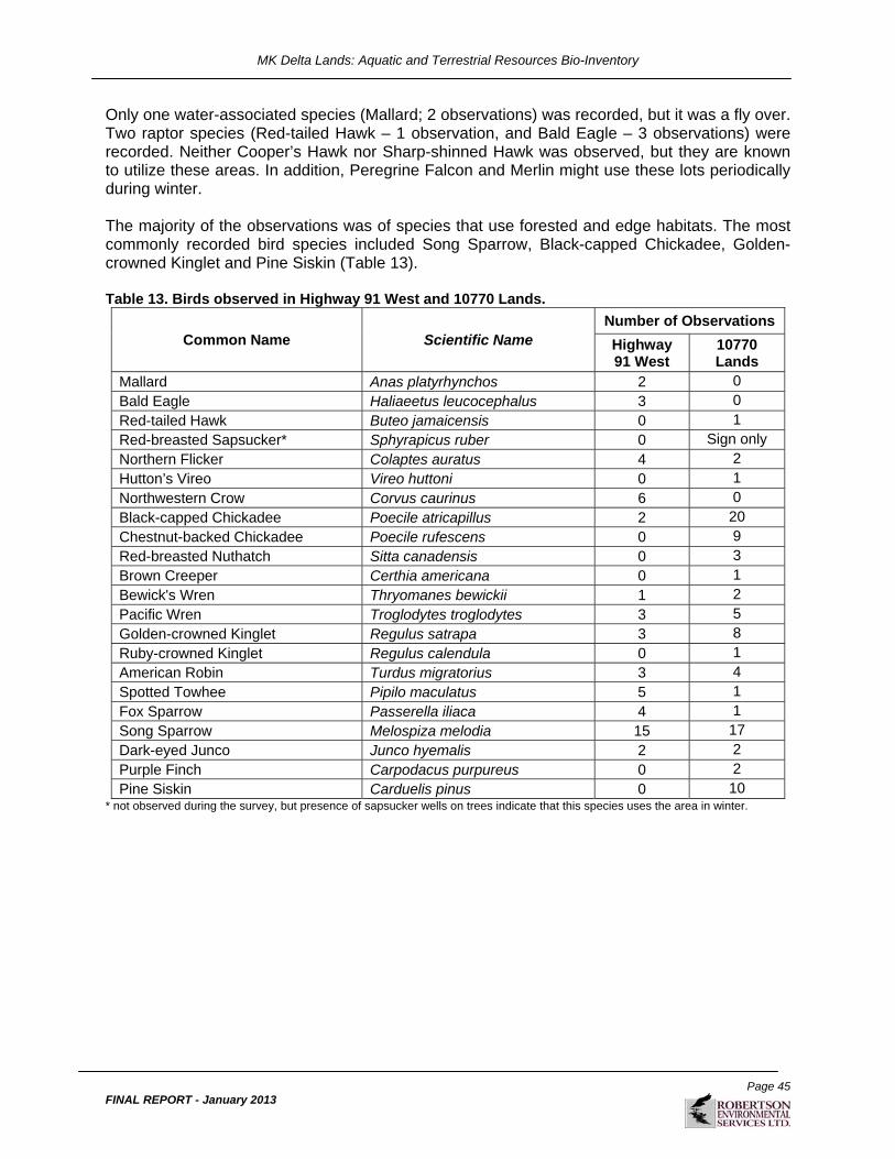
MK Delta Lands: Aquatic and Terrestrial Resources Bio-Inventory
Page 45
FINAL REPORT - January 2013
Only one water-associated species (Mallard; 2 observations) was recorded, but it was a fly over. Two raptor species (Red-tailed Hawk – 1 observation, and Bald Eagle – 3 observations) were recorded. Neither Cooper’s Hawk nor Sharp-shinned Hawk was observed, but they are known to utilize these areas. In addition, Peregrine Falcon and Merlin might use these lots periodically during winter. The majority of the observations was of species that use forested and edge habitats. The most commonly recorded bird species included Song Sparrow, Black-capped Chickadee, Golden-crowned Kinglet and Pine Siskin (Table 13). Table 13. Birds observed in Highway 91 West and 10770 Lands.
Common Name Scientific Name Number of Observations
Highway 91 West
10770 Lands
Mallard Anas platyrhynchos 2 0 Bald Eagle Haliaeetus leucocephalus 3 0 Red-tailed Hawk Buteo jamaicensis 0 1 Red-breasted Sapsucker* Sphyrapicus ruber 0 Sign only Northern Flicker Colaptes auratus 4 2 Hutton’s Vireo Vireo huttoni 0 1 Northwestern Crow Corvus caurinus 6 0 Black-capped Chickadee Poecile atricapillus 2 20 Chestnut-backed Chickadee Poecile rufescens 0 9 Red-breasted Nuthatch Sitta canadensis 0 3 Brown Creeper Certhia americana 0 1 Bewick's Wren Thryomanes bewickii 1 2 Pacific Wren Troglodytes troglodytes 3 5 Golden-crowned Kinglet Regulus satrapa 3 8 Ruby-crowned Kinglet Regulus calendula 0 1 American Robin Turdus migratorius 3 4 Spotted Towhee Pipilo maculatus 5 1 Fox Sparrow Passerella iliaca 4 1 Song Sparrow Melospiza melodia 15 17 Dark-eyed Junco Junco hyemalis 2 2 Purple Finch Carpodacus purpureus 0 2 Pine Siskin Carduelis pinus 0 10
* not observed during the survey, but presence of sapsucker wells on trees indicate that this species uses the area in winter.

MK Delta Lands: Aquatic and Terrestrial Resources Bio-Inventory
Page 46
FINAL REPORT - January 2013
Figure 5. Bird survey transects and owl survey results.

MK Delta Lands: Aquatic and Terrestrial Resources Bio-Inventory
Page 47
FINAL REPORT - January 2013
4.3.2 Owls
4.3.2.1 Owls – Methods
Western Screech Owl playback surveys were conducted by Tom Plath and Susanne Sloboda on March 31, April 3, and April 10, 2008. Western Screech Owl is a species at risk with habitat polygons rated low to moderate suitability in Highway 91 West and the 10770 Lands. Survey methodology followed provincial Inventory Methods for Owl Surveys (RISC 2006). Survey locations were selected based on habitat suitability within the study areas, with two stations at the 10770 Lands and one in Highway 91 West (Figure 5).
4.3.2.2 Owls – Results
Highway 91 West and 10770 Lands No Western Screech Owls responded during the call playback surveys. In 2006 a Western Screech-owl responded to a taped call approx. 500m east of the 72nd street right-of-way on the west side of the BBECA (Kyle Elliot, VNHS, pers. comm. to IR). A Barred Owl was observed perched in a Red Alder five metres from the team conducting the owl survey in the western part of the 10770 Lands on April 3. An owl pellet was found on the third owl survey (April 10, 2008) in the same area as the Barred Owl was previously observed.
4.3.3 Breeding Birds
4.3.3.1 Breeding Birds – Methods
Breeding bird surveys were conducted in representative habitats within the Highway 91 West lot and the 10770 Lands. Access to all areas within any given lot was limited by physical barriers such as deep wide ditches, dangerous boggy terrain and/or dense vegetation. Three breeding bird surveys were conducted in the 10770 Lands and Highway 91 West (Table 14). Surveys commenced on May 15th, 2008, and completed by June 19th, 2008. Surveys were conducted by Mike Toochin, Jason Osterhold and Holly Middleton. Table 14. Breeding bird survey dates and locations.
Study Area Lot Survey Dates
10770 72nd Ave. May 15, June 2, June 17
Highway 91 West May 22, June 4, June 18 Breeding bird surveys were conducted between 0500 and 1200 hours, following RIC (1999b) standards and were not conducted during wind conditions above Beaufort 2 or precipitation with the exception of light drizzle. Encounter transects were used for all breeding bird surveys. These involved walking a line from a start point to an end point marked by GPS coordinates and recording the species and number of birds seen or heard. Start and end UTMs of transects are plotted on Figure 6, and a straight line transect drawn between them. Note that the transects shown in Figure 6 under-represent the area covered during breeding bird surveys, since a precise straight line was never followed between the start and end UTMs. Birds were recorded as detected up to 100 metres on either

MK Delta Lands: Aquatic and Terrestrial Resources Bio-Inventory
Page 48
FINAL REPORT - January 2013
side of the transect line (or up to the Lot perimeter, whichever was less). Transects were often not in a straight line due to limited access (e.g., large ditches, flooded terrain). All data were recorded on standardized data sheets. For each transect, the data collected included the surveyors, location, transect #, start UTM, end UTM, data (bird species and number of individuals), start time, end time and weather conditions (cloud cover, ceiling, wind, precipitation class and temperature). Equipment used to visually identify birds included the following binoculars: 10x42 Swaroski EL; 8x43 Bushnell Elite, and 10x42 Pentax.
4.3.3.2 Breeding Birds - Results
Highway 91 West and 10770 72nd Avenue Lands Fifty-eight bird species were recorded in Highway 91 West and the 10770 Lands during breeding bird surveys in 2008 (Table 15). Fifty four species were recorded in the former and 45 in the latter. Barn Swallows foraging and as fly-overs was the only provincially/COSEWIC listed species recorded during breeding bird surveys. They were observed five times over the course of the breeding bird surveys, with four detections in Highway 91 West and one at the 10770 Lands, and all were recorded as fly-overs. The lack of suitable nest sites (i.e. buildings) prevents this species from nesting within the study area. Table 15. Species recorded during breeding bird surveys in Highway 91 West and the 10770 Lands.
Common Name Scientific Name Number of Observations
Highway 91 West
10770 Lands
Canada Goose Branta Canadensis 3 0
Mallard Anas platyrhynchos 9 1
Bald Eagle Haliaeetus leucocephalus 1 1
Red-tailed Hawk Buteo jamaicensis 8 0
Killdeer Charadrius vociferous 2 0
Glaucous-winged Gull Larus glaucescens 2 2
Mourning Dove Zenaida macroura 4 0
Black Swift Cypseloides niger 115 35
Rufous Hummingbird Selasphorus rufus 34 24
Downy Woodpecker Picoides pubescens 1 6
Hairy Woodpecker Picoides villosus 4 1
Northern Flicker Colaptes auratus 10 1
Pileated Woodpecker Dryocopus pileatus 1 1
Willow Flycatcher Empidonax traillii 39 9
Pacific-slope Flycatcher Empidonax difficilis 22 13
Cassin's Vireo Vireo cassinii 1 0
Warbling Vireo Vireo gilvus 1 11
Steller’s Jay Cyanocitta stelleri 1 0
Northwestern Crow Corvus caurinus 29 13
Common Raven Corvus corax 0 2

MK Delta Lands: Aquatic and Terrestrial Resources Bio-Inventory
Page 49
FINAL REPORT - January 2013
Common Name Scientific Name Number of Observations
Highway 91 West
10770 Lands
Tree Swallow Tachycineta bicolor 18 0
Violet-green Swallow Tachycineta thalassina 7 3
Northern Rough-winged Swallow Stelgidopteryx serripennis 1 0
Barn Swallow Hirundo rustica 4 1
Black-capped Chickadee Poecile atricapillus 10 18
Chestnut-backed Chickadee Poecile rufescens 5 6
Bushtit Psaltriparus minimus 15 7
Red-breasted Nuthatch Sitta Canadensis 2 2
Brown Creeper Certhia Americana 0 5
Bewick’s Wren Thryomanes bewickii 42 11
Pacific Wren Troglodytes troglodytes 2 0
Marsh Wren Cistothorus palustris 2 0
Golden-crowned Kinglet Regulus satrapa 3 9
Swainson’s Thrush Catharus ustulatus 19 23
Hermit Thrush Catharus guttatus 6 1
American Robin Turdus migratorius 125 61
European Starling Sturnus vulgaris 12 3
Cedar Waxwing Bombycilla cedrorum 60 25
Orange-crowned Warbler Vermivora celata 69 33
Yellow Warbler Dendroica petechial 1 8
Yellow-rumped Warbler Dendroica coronate 2 9
Townsend’s Warbler Dendroica townsendi 0 1
Common Yellowthroat Geothlypis trichas 60 5
Wilson’s Warbler Wilsonia pusilla 5 10
Western Tanager Piranga ludoviciana 3 13
Spotted Towhee Pipilo maculatus 82 19
Song Sparrow Melospiza melodia 91 97
White-crowned Sparrow Zonotrichia leucophrys 10 0
Golden-crowned Sparrow Zonotrichia atricapilla 0 1
Dark-eyed Junco Junco hyemalis 21 6
Black-headed Grosbeak Pheucticus melanocephalus 5 13
Red-winged Blackbird Agelaius phoeniceus 4 0
Brown-headed Cowbird Molothrus ater 29 5
Purple Finch Carpodacus purpureus 17 6
House Finch Carpodacus mexicanus 8 3
Red Crossbill Loxia curvirostra 2 0
Pine Siskin Carduelis pinus 23 20
American Goldfinch Carduelis tristis 64 43 Bold font indicates species that are provincially- or federally-listed.

MK Delta Lands: Aquatic and Terrestrial Resources Bio-Inventory
Page 50
FINAL REPORT - January 2013
The majority of the species recorded are common species in the Lower Mainland during the breeding season. The ten most frequently detected species within Highway 91 West and the 10770 Lands, in order of abundance (number of individuals in parenthesis) were: Song Sparrow (188), American Robin (186), Black Swift (150); American Goldfinch (107), Orange-crowned Warbler (102), Spotted Towhee (101), Cedar Waxwing (85), Common Yellowthroat (65), Rufous Hummingbird (58) and Bewick’s Wren (53). These species comprised 64% of the individuals detected (n=1703). With the exception of Black Swift the afore-mentioned species all are common breeders in the study area. The closest breeding habitat for Black Swift is located in the North Shore Mountains. Black Swifts are known to follow weather fronts where small flying insects are concentrated, and will fly great distances from their nest sites to forage. The May survey dates coincide with passerine migration which is reflected by the large number of Orange-crowed Warblers detected and the presence of birds that do not breed in the study area: Hermit Thrush and Golden-crowned Sparrow. These two species breed in montane habitats. Four species of water-associated birds were observed during the surveys: Canada Goose (3) Killdeer (2), Mallard (9) and Glaucous-winged Gull (2) in Highway 91 West and Mallard (1), and and Glaucus-winged Gull (2) in 10770 72nd Ave. While there was no direct evidence of breeding by these species, it is possible that a few mallards and killdeer breed in the Highway 91 West lot. Of the Mallards observed, nine were recorded flying over the study area. Overall, the habitat potential for water-associated species is very low in these lots. Two expected raptor species were observed during breeding bird surveys: Red-tailed Hawk (8) all in Highway 91 West and Bald Eagle (2) observations of individuals flying over. No raptor nests were detected in the Highway 91 West lot or the 10770 Lands, although a Red-tailed Hawk nest is suspected to occur near the southeast corner of Highway 91 West or the southwest corner of the 10770 Lands. Red-tailed Hawks were observed during each survey of Highway 91 West, and on two occasions (May 22nd and June 18th) the behaviour of the pair of birds observed indicated possible nesting nearby (e.g., constant calling, swooping towards survey crew, circling survey crew). Surveyors searched for a nest on May 22nd and June 18th but could not locate one. Effort was made to locate a nest during subsequent visits to the site for other tasks, although no nest was discovered. A Bald Eagle nest is situated in a large conifer outside the study area in the southwest corner of the Delta Nature Reserve. Fifty-three Bewick’s Wrens were recorded within the Highway 91 West lot and 10770 72nd Avenue land. This largely resident species has a fairly restricted range in the extreme southwest corner of B.C. (principally the lower Fraser Valley and southeast Vancouver Island). The number of Bewick’s Wrens recorded suggests a strong breeding population in the study area relative to other areas in the Greater Vancouver area. One observation each of Golden-crowned Sparrow and Cassin’s Vireo was recorded on the 10770 Lands and Highway 91 West respectively. These species likely do not breed in the study area, and were most likely observed as late migrants. Eighty-five observations of Cedar Waxwing were recorded in both study areas. This species is a very late breeder, and most of the observations were likely of individuals migrating into the region in flocks. Forty-eight observations of Willow Flycatcher were recorded in the two lots adjacent to Highway 91. Abundant breeding habitat for this species occurs along the riparian zones of larger ditches in Highway 91 West.

MK Delta Lands: Aquatic and Terrestrial Resources Bio-Inventory
Page 51
FINAL REPORT - January 2013
4.3.4 Fall Birds
4.3.4.1 Fall Birds – Methods
Fall bird surveys during the migration period were completed in Highway 91 West and the 10770 Lands (including the expanded study area). Two surveys were completed of accessible areas in the Highway 91 West lot, and three surveys were completed on the 10770 Lands, including the expanded study area (Table 16). More time was spent at the 10770 Lands due to the size of the expanded study area. Fall migration surveys commenced on September 8th, 2008 and were completed on October 7th, 2008. Surveys were completed by Mike Toochin, Jason Osterhold and Sharon Toochin. Table 16. Fall migration survey dates.
Study Area Lot Survey Dates
10770 72nd Ave Sept. 11, Sept. 18, Oct. 7
Highway 91 West Sept. 11, Oct. 6 Surveys started at 0800 and were completed approximately 1630 hours. This timetable is appropriate for birds in migration as territorial singing is over, and bird presence and movement is often related to weather movements. Surveys were not conducted during precipitation (except for light drizzle) or during winds above Beaufort 2 as birds are not effectively detected. Encounter transects were used for the fall migration surveys, which involved walking a line from a start point to an end point marked by GPS coordinates and recording the species and number of birds seen or heard. Birds were recorded as detected up to 100 metres on either side of the transect line (or up to the lot perimeter, whichever was less). Transects were often not in a straight line due to limited access (e.g., large ditches, flooded terrain). All data were recorded on standardized data sheets. For each transect, the data collected included the surveyors, location, transect number, start UTM, end UTM, data (bird species and number of individuals), start time, end time and weather conditions (cloud cover, ceiling, wind, precipitation class and temperature). Binoculars used to visually identify birds include: 10x42 Swarovski, 8x43 Bushnell Elite, and 10x42 Bausch and Lomb Elite.
4.3.4.2 Fall Birds – Results
Highway 91 East and West Fifty seven bird species were recorded in Highway 91 West and the 10770 Lands during fall migration surveys in 2008 (Table 17). Forty three species were observed in the latter, and forty nine in the former. Three species that are provincially- or federally-listed were recorded: Barn Swallow, Great Blue Heron, and Double-crested Cormorant. Barn Swallows were observed on only one occasion; the surveys started September 8 after most of this species would have departed southwards (M.Toochin, pers.comm.). Great Blue Herons were twice observed flying over the 10770 Landa, and one Double-crested Cormorant was observed also flying over this area (Table 17).

MK Delta Lands: Aquatic and Terrestrial Resources Bio-Inventory
Page 52
FINAL REPORT - January 2013
Table 17. Species recorded during fall migration bird surveys in Highway 91 West and the 10770 Lands.
Common Name Scientific Name Number of Observations
Highway 91 West
10770 Lands
Canada Goose Branta Canadensis 29 0
Green-winged Teal Anas crecca 3 0
Double-crested Cormorant Phalacrocorax auritus 0 1
Great Blue Heron Ardea Herodias 0 2 Sharp-shinned Hawk Accipiter striatus 1 0
Cooper's Hawk Accipter cooperii 0 1
Red-tailed Hawk Buteo jamaicensis 3 3
American Kestrel Falco sparverius 1 0
Glaucous-winged Gull Larus glaucescens 5 0
Barred Owl Strix varia 1 1
Great Horned Owl Bubo virginianus 1 0
Red-breasted Sapsucker Sphyrapicus ruber 0 1
Downy Woodpecker Picoides pubescens 8 6
Hairy Woodpecker Picoides villosus 3 3
Northern Flicker Colaptes auratus 15 14
Pileated Woodpecker Dryocopus pileatus 0 7
Hammond's Flycatcher Empidonax hammondii 1 0
Hutton's Vireo Vireo huttoni 2 9
Steller’s Jay Cyanocitta stelleri 20 23
Northwestern Crow Corvus caurinus 4 19
Common Raven Corvus corax 2 1
Barn Swallow Hirundo rustica 0 1 Black-capped Chickadee Poecile atricapillus 105 189
Chestnut-backed Chickadee Poecile rufescens 6 26
Bushtit Psaltriparus minimus 7 28
Red-breasted Nuthatch Sitta Canadensis 5 11
Brown Creeper Certhia Americana 9 18
Bewick’s Wren Thryomanes bewickii 22 38
Pacific Wren Troglodytes troglodytes 14 23
Marsh Wren Cistothorus palustris 2 0
Golden-crowned Kinglet Regulus satrapa 53 88
Ruby-crowned Kinglet Regulus calendula 6 5
American Robin Turdus migratorius 62 120
Varied Thrush Ixoreus naevius 7 7
American Pipit Anthus rubescens 1 0
Cedar Waxwing Bombycilla cedrorum 8 24
Orange-crowned Warbler Vermivora celata 33 1
Yellow Warbler Dendroica petechial 14 2
Fox Sparrow Passerella iliaca 3 5
Yellow-rumped Warbler Dendroica coronate 105 57

MK Delta Lands: Aquatic and Terrestrial Resources Bio-Inventory
Page 53
FINAL REPORT - January 2013
Common Name Scientific Name Number of Observations
Highway 91 West
10770 Lands
Townsend’s Warbler Dendroica townsendi 2 1
MacGillivray's Warbler Oporornis tolmiei 1 0
Common Yellowthroat Geothlypis trichas 22 0
Western Tanager Piranga ludoviciana 1 1
Spotted Towhee Pipilo maculatus 30 52
Savannah Sparrow Passerculus sandwichensis 3 0
Song Sparrow Melospiza melodia 140 205
Lincoln's Sparrow Melospiza lincolnii 5 0
White-crowned Sparrow Zonotrichia leucophrys 1 0
Golden-crowned Sparrow Zonotrichia atricapilla 0 2
Dark-eyed Junco Junco hyemalis 11 10
Red-winged Blackbird Agelaius phoeniceus 0 10
Purple Finch Carpodacus purpureus 11 1
House Finch Carpodacus mexicanus 10 12
Pine Siskin Carduelis pinus 10 36
American Goldfinch Carduelis tristis 13 25
Evening Grosbeak Coccothraustes vespertinus 3 16 Bold font indicates species that are provincially- or federally-listed.
The ten most common species in order of abundance during fall surveys (number of individuals in parenthesis) were as follows: Song Sparrow (345), Black-capped Chickadee (294), American Robin (182), Yellow-rumped Warbler (162), Bewick’s Wren (60), Pine Sisken (46), Golden-crowned Kinglet (141), Spotted Towhee (82), Steller’s Jay (43) and American Goldfinch (38). These ten species account for 72% of the birds observed (n=1929). The majority of the species that were observed are common species in the Lower Mainland during the fall. Excluding fly-overs, water-associated birds remained in low numbers: Canada Goose (29 mostly fly-overs), Green-winged Teal (2), and Glaucous-winged Gull (5). The extent of surface water declines in late summer and this constraint may influence low numbers in this part of Burns Bog. Four raptor species were observed during fall surveys: Red-tailed Hawk (6 observations divided equally between Highway 91 West and 10770 72nd Avenue), American Kestrel and Sharp-shinned Hawk (1 observation each in Highway 91 West), and Cooper’s Hawk (1 observation in the 10770 Lands). American Kestrels are common in southern Interior British Columbia, but relatively rare in the Lower Mainland. One Great Horned Owl was recorded in Highway 91 West.
4.3.5 Sandhill Crane
The Greater Sandhill Crane (Grus canadensis tabida) is a confirmed breeder in very few areas in the Lower Mainland: Richmond Bog, Richmond; Reifel Refuge and Burns Bog in Delta; Pitt Poulder in Pitt Meadows; and Langley Bog at Derby Reach Regional Park in Langley (CDC 2009; Katzie FN, personal communication 2007; Gebauer 1999; Blood and Backhouse 1999). The number of breeding pairs of cranes in Burns Bog has declined over the past 54 years from

MK Delta Lands: Aquatic and Terrestrial Resources Bio-Inventory
Page 54
FINAL REPORT - January 2013
eight in 1945 to three to four in the 1970’s and 80’s (Biggs 1976; Gebauer 1999). The Burns Bog breeding crane population is now estimated at two or three breeding pairs. As suggested by Safina (1993), crane breeding populations are limited mainly by the availability of large tracts of undisturbed habitat, water level fluctuations and predation. In addition to Littlefield’s (1995a, 1995b) suggestion that breeding pair decline is due to low nesting success, other contributing factors may include low crane colt (young) survival and resulting low recruitment, anthropogenic sources of disturbance, predation, and the loss and degradation of foraging and breeding habitat. In 1991 the Sandhill Crane was designated a blue-listed species by the British Columbia Conservation Data Centre (CDC) (CDC 2010). The Georgia Depression population of Sandhill Cranes was provincially red-listed from 2001 to 2005 (CDC 2010) but was downlisted to blue in 2005 because there was no evidence to support the notion that the Georgia Depression population was distinct from other coastal migrating cranes (CDC 2010). In 2009 all Sandhill Cranes were downlisted from blue to yellow. This species is considered of significant regional concern due to a decline of breeding cranes in the Lower Mainland and the threats to crane roosting, breeding and feeding habitat. A Sandhill Crane monitoring program was implemented for the construction phase of the South Fraser Perimeter Road (SFPR) Project as one of many of the proponent’s conditions (Environmental Assessment Office, 2008). The first year of the baseline study for the MK Delta Lands (2008) addressed habitat suitability ratings for Greater Sandhill Cranes and other wildlife species. A monitoring program was initiated the second year as past studies indicated that Sandhill Cranes had used the eastern portion of the BBECA (Hebda et al 2000, adapted from Gebauer 1999). The purpose of this monitoring program was to determine Sandhill Crane use of MK Delta Lands and adjacent expanded study areas within the BBECA and west of Highway 91 during late breeding and fall staging periods.
4.3.5.1 Sandhill Crane – Methods
The initial Sandhill Crane (Grus canadensis) surveys were conducted by two surveyors for a minimum of 3 hours each week on a randomly selected day. These started June 2 and alternated between morning (starting at sunrise) and evening (ending at sunset). If cranes were detected, surveyors extended their survey time to increase the chance of crane observations. The monitoring stations were selected according to the following:
1. the presence of moderate crane habitat suitability ratings within the MK Delta Lands property and expanded study areas (determined from studies conducted in 2008 by RESL);
2. site accessibility; and 3. surveyors professional judgment (based primarily on past and present crane detections).
Survey frequency changed throughout the monitoring program in response to the number of crane detections, and experience surveying the build-up of crane numbers in previous years on the west side of Burns Bog (Sloboda et al. 2009). Surveys were increased from weekly to daily after the second crane detection.

MK Delta Lands: Aquatic and Terrestrial Resources Bio-Inventory
Page 55
FINAL REPORT - January 2013
Stand-watch surveys were used (MOE 2001) during which observers sat in silence, listened for crane calls, and routinely scanned the area with binoculars and spotting scopes. Observers changed locations occasionally to better observe possible occurrence areas and to confirm the cranes’ positions. The first monitoring station was set up in the BBECA, approximately 875 metres west of Highway 91 West (Figure 6). On July 31, access to the BBECA was restricted due to a severe fire hazard, so an alternative monitoring station (Monitoring Station 2) was established on the western boundary of Highway 91 West and the eastern boundary of the BBECA, along the northern ditch and pathway. Subsequent monitoring stations were set up as required to increase the probability of crane detections. A list of incidental non-avian wildlife observed during the 2009 Sandhill Crane surveys is provided in Appendix 3. Bird species observed during the surveys, and the number of surveys during which they were observed, are presented in Appendix 5.

MK Delta Lands: Aquatic and Terrestrial Resources Bio-Inventory
Page 56
FINAL REPORT - January 2013
Figure 6. Sandhill Crane survey results.
MK Delta Lands: Aquatic and Terrestrial Resources Bio-Inventory
Page 57
FINAL REPORT - January 2013
4.3.5.2 Sandhill Crane – Results
Weather conditions varied throughout the duration of crane surveys and are documented in Appendix 6. On average, weather conditions were fairly dry and warm. Sandhill Crane Survey Effort and Count Information RESL spent 213.5 hours in survey effort (Appendix 7). Of the 33 surveys conducted between June 2 and October 21, 2009, one third (11) yielded crane detections all between August 18 and October 5. A total of 97 crane detections were recorded over the eleven days. The highest total number of cranes observed on one day was twenty (the maximum daily count during the 2009 monitoring program) on September 27, followed by seventeen cranes on September 30, and sixteen individuals on September 24. The average was eight cranes per detection day (Figure 7).
0
5
10
15
20
25
090818 090924 090925 090926 090927 090928 090929 090930 091002 091003 091005
Date (YYMMDD)
# S
AC
R D
ete
cte
d
# SACR detected
Figure 7. Cumulative counts of Sandhill Cranes (SACR) detected. Surveys were conducted weekly between June 2 and September 24, daily between September 24 and October 5, and thereafter for two half-days per week until October 21. The first detection was made on August 18 (1 heard), the second on September 24 (16 cranes) and subsequent detections were made almost daily (with the exception of October 1 and 4) until October 5. After four consecutive “nil” crane detections, monitoring ceased on October 21. Crane Use of MK Delta Lands and Expanded LSAs No cranes were detected within the Highway 91 West property. This was not unexpected given the low habitat suitability ratings (Section 4.5). Cranes were confirmed in the moss-, grass- and

MK Delta Lands: Aquatic and Terrestrial Resources Bio-Inventory
Page 58
FINAL REPORT - January 2013
sedge-dominated wetland of the Expanded LSA for Highway 91 West on several occasions (Figures 6). The 2009 monitoring program confirmed the use of the MKDL study area Highway 91 West Expanded LSA for foraging, but not for roosting or breeding. (Roosting occurs in the BBECA and breeding is possible in the open water habitat occurring in Area 2 (Figure 6)). Throughout the 2009 crane monitoring program four apparent patterns of observations became evident: a family group comprising two adults and one juvenile consistently used the eastern BBECA (Areas 1, 3-5) for foraging throughout the day (Figure 6); up to twenty and possibly more cranes regularly used the open water areas (Area 2) for roosting during the day and at night; pairs and groups of cranes were observed flying south and gaining height, indicating fall migration was in progress towards the end of September; and an occasional pair or group of cranes was observed flying over the eastern BBECA. Family Group of 3 Cranes – Highway 91 West Expanded LSAand BBECA The family group of two adults and one juvenile crane was frequently observed foraging and preening in the sedge-dominated wetlands of Areas 1 (Highway 91 West Expanded LSA), 3 (BBECA) and 5 (BBECA). This small group was observed twice on September 24, six times on September 25, five times on September 27, three times on September 28, four times on September 29 and once on September 30. The family group was not observed using the study area after September 30. The cranes were often observed flying back and forth between Areas 1 and what is assumed to be Area 6 (very low flight and close-proximity audio detections indicated use in this area)(Figure 6). The average foraging time for this family group over thirteen confirmed observations was 78 minutes per area, with a maximum of 124 minutes in the adjoining Expanded LSA on September 29. We assumed that the three cranes consistently observed were the same family group, but it is possible that there were two or more family groups of three cranes. The likelihood of observing a different family group is considered low since multiple groups of three were never observed at any one given time. Gebauer’s study from 1999 confirmed that two cranes were observed using the wetland during the day immediately west of Area 6. Cranes were also confirmed using the wetland immediately west of Area 1 in the spring (Gebauer 1999). It appears that small groups of cranes have continued to use the eastern BBECA for daytime foraging since 1999. Roosting Cranes - BBECA Several groups of cranes were observed daily, arriving at and departing from Area 2 on multiple occasions from September 24 to September 30. This large area of open water and small islands was confirmed as a night-time roosting area for cranes in 1999 (Gebauer 1999), and seemed to serve as daytime and night roosting grounds during the 2009 monitoring program. As many as nine cranes were observed flying from this area at any given time (September 24). The family group of three cranes was also observed landing in Area 2 towards late evening on September 26. Migrating cranes

MK Delta Lands: Aquatic and Terrestrial Resources Bio-Inventory
Page 59
FINAL REPORT - January 2013
It is likely that some of our crane observations were of departures of a non-local nature. For example, on September 24, four cranes were observed gaining height (over 1000 metres vertical distance) on thermals, then heading southeast. Observers eventually lost sight of the cranes. On September 27 observers witnessed a congregation of fourteen cranes flying high (over 1 kilometer vertical distance). The congregation disbanded into groups of two, three and nine cranes. The group of two broke off towards the western area of the BBECA and may have landed in the adjacent agricultural fields for foraging, while the group of three cranes headed back towards the eastern BBECA. The other group of nine cranes continued to gain elevation and headed southwest and southeast of the BBECA and MKDL Study Areas. On September 30 a total of seventeen cranes were observed gaining height on thermals (over 1 kilometer vertical distance). These cranes disbanded into groups of twelve, three and two. The group of twelve continued to gain height and head southwest until they were out of sight, while the group of three cranes headed southeast while gaining height at least I kilometer east of the study area, and the group of two cranes flew into Area 5 of the BBECA. It is possible that these cranes were merely heading off to other foraging grounds within the Lower Mainland (i.e. Riefel Sanctuary, Pitt Poulder) rather than migrating down south to their wintering grounds. Either way, they appeared to have left the vicinity of the BBECA and MKDL study area. Random Flyovers – MKDL Propertiesand BBECA Observers witnessed or heard several instances of crane flyovers within the approximate MKDL study area and the BBECA. At times, crane locations could not be confirmed, though they were heard or observed flying at lower elevations within close proximity to the monitoring stations. These observations could not be mapped due to the difficulty of determining their location.
4.3.5.3 Summary of 2009 Sandhill Crane Monitoring Program
Some key observations made during the 2009 Sandhill Crane Monitoring Program include the following:
No crane detections during the breeding season. This does not exclude the possibility that cranes used the area; they may simply have not been detected (they may be less vocal while nesting). The lack of detections in 2009 does not preclude the possibility of them breeding in this area in the future. If cranes were to breed near the study area, Area 2 appears to be the most probable area because of its large size, more stable water depth (suspected) and its closer proximity to the centre of the bog (and greater distance from the lagg zone). Areas 4 and 5 are also good candidate areas but may be more susceptible to fluctuations in the surface water depth due to their closer proximity to the lagg zone). Interestingly, Gebauer (1999) rated Area 2 as potential low habitat suitability, though he did not specify which life requisite, such as breeding or feeding, was being evaulated. Area 2 was a confirmed roosting area in 2009 and may be suitable for breeding since cranes typically nest in shallow wetlands of open water with islands of emergent vegetation (T.

MK Delta Lands: Aquatic and Terrestrial Resources Bio-Inventory
Page 60
FINAL REPORT - January 2013
Plath, pers. comm.). Gebauer rated Areas 4 and 5 as moderately high potential habitat for Sandhill Cranes, which is supported by the 2009 Monitoring Program for the feeding life requisite (see Section 5).
Cranes were detected foraging and preening, and potentially roosting in the study area during the fall staging period. A family group of two adults and one juvenile frequented the east side of the BBECA and the MK Delta Lands Expanded LSA’s, particularly Areas 1 and 3 within the Highway 91 West Expanded LSA. We speculate that this family group may represent local residents of the BBECA since they often isolated themselves from other crane groups (pairs to large groups) present at this time of the year. The wetland in Area 1 appeared to have the highest crane use based on detections during the monitoring program, and typically only the family group was observed using this area. Area 2, which is submerged with water year-round, served as a roosting site in which many cranes were observed close to dusk, with up to nine Sandhill Cranes observed at once.
The earliest detection time was 07:41 hours (October 2); the latest detection time was 18:59 hours (September 29). A total of 11 consecutive full-day surveys were conducted between September 25 and October 5, starting as early as 06:55 hours and as late as 07:32 hours, with end times ranging from 17:15 to 19:45 hours. In addition to these full day surveys, 13 dawn and 9 dusk surveys were conducted. The start and end times for both these survey types varied with seasonal changes of daylight hours. Dawn surveys started as early as 05:00 hours (July 31) and as late as 07:50 hours (October 21). Dusk surveys started as early as 16:35 hours on September 3 and as late as 18:45 hours on June 2 and 10. The bulk of initial detection times occurred during full-day monitoring surveys between 09:00 and 14:59 hours (77% of detections where n=33/43). The highest number of detections occurred between 10:00 and 10:59 hours (n=9), followed by 7 detections between 11:00 and 11:59 hours (n=7) and 09:00-09:59 hours and 12:00-12:59 hours at 6 detections each. The fourth highest number of detections occurred between 18:00 and 18:59 hours (n=4). No detections occurred prior to 07:00 hours and after 19:00 hours. These prominent daytime detections indicates cranes are using the area for foraging and daytime roosting, and also accounts for crane movement within Burns Bog and to/from adjacent areas.
4.4 MAMMALS
A total of forty one mammal species has been reported within the BBECA (Gebauer 1999). Several larger species are considered common and widespread in the BBECA and vicinity: Coyote (Canis latrans), Black-tailed Deer (Odocoileus hemionus), Beaver (Castor canadensis), Muskrat (Ondatra zibethicus), Raccoon (Procyon lotor), Douglas’ Squirrel (Tamiasciurus douglasii), Eastern Gray Squirrel (Sciurus carolinensis), Eastern Cottontail (Sylvilagus floridanus), and North American Deermouse (Peromyscus maniculatus) (Hebda et al. 2000; Gebauer 1999). Several mammal species with historical records for Burns Bog (Hebda et al 2000) are likely extirpated: Snowshoe Hare (Lepus americanus washingtonii), Townsend’s Chipmunk (Tamias townsendii), Yellow-Pine Chipmunk (Tamias amoenus), Porcupine (Erethizon dorsatum), Red Fox (Vulpes vulpes) and Spotted Skunk (Spilogale gracilis). None of these species have been detected in the bog for several decades despite extensive coverage from both the scientific and naturalist community.
MK Delta Lands: Aquatic and Terrestrial Resources Bio-Inventory
Page 61
FINAL REPORT - January 2013
Using the B.C. Species and Ecosystem Explorer, there are seven provincially (Red- or Blue-) and/or federally (COSEWIC, SARA) listed mammal species whose range overlaps that of the study area (Table 18) (2011). All of these species prefer forested habitats.

MK Delta Lands: Aquatic and Terrestrial Resources Bio-Inventory
Page 62
FINAL REPORT - January 2013
Table 18. Provincially- and federally-listed mammal species that may occur in the study area or the BBECA. Common
Name Scientific
Name BC List
COSEWIC SARA Habitat Preference Probability in Study Area
Keen’s Myotis Myotis keenii Red DD 3
Low elevation coastal hemlock type forests; possibly dependent on tree
cavities associated with old-growth or mature forests for roosts
Low. Occurrences are rare; presence of suitable rock crevices may be
a limiting factor.
Olympic Shrew Sorex rohweri Red Forest dependent in old growth or
second growth forest Moderate.
CDC record is from Burns Bog
Pacific Water Shrew
Sorex bendirii Red E 1
Moist, coastal forests that border streams and skunk-cabbage
marshes with an abundance of shrubs and coarse woody debris and
extensive canopy closure
Unknown. Closest occurrence records (3) are the northern edge of Burns
Bog.
Snowshoe Hare Lepus americanus washingtonii
Red Dense cover of coniferous and mixed
forests, with abundant understorey vegetation
Nil. Likely extirpated. No records for
decades. Southern Red-backed Vole, occidentalis ssp
Myodes gapperi occidentalis
Red Primarily a forest species, inhabiting
mature coniferous forests with abundant woody debris
High. Population discovered in the
BBECA in 1999.
Townsend’s Big-eared Bat
Corynorhinus townsendii
Blue Forested regions and building, and areas with a mosaic of woodland,
grassland and/or shrubland
Low. Occurrence records near Delta; no suitable breeding habitat in study area; may use Bog for
foraging.
Trowbridge’s Shrew
Sorex trowbridgii
Blue Mature forest (dry or moist) with
abundant ground litter
High. Closest occurrence is Latimer
Creek in Surrey; common shrew in lower Fraser Valley
Codes: COSEWIC – Committee on the Status of Endangered Wildlife in Canada (1977). Ratings, in order of severity, are: Extinct; Extirpated; Endangered (a wildlife species facing imminent extirpation or extinction); Threatened (T); Special Concern (SC); Data Deficient (DD) [a category that applies when the available information is insufficient (a) to resolve a wildlife species eligibility for assessment; or (b) to permit an assessment of a wildlife species risk of extinction]. BC List - Red-listed species:-List of ecological communities, and indigenous species and subspecies that are extirpated, endangered or threatened in BC. Red-listed species and sub-species may be legally designated as, or may be considered candidates for legal designations as Extirpated, Endangered or Threatened under the BC Wildlife Act (1996); Blue-listed species: List of ecological communities, and indigenous species and subspecies of special concern (formerly vulnerable) in BC. SARA – Species At Risk Act (2002) – Schedule 1 includes those species that are federally protected by the Act. Schedule 3 includes species that are candidates for Schedule 1 status.

MK Delta Lands: Aquatic and Terrestrial Resources Bio-Inventory
Page 63
FINAL REPORT - January 2013
Outlined below are comments regarding listed species in Table 18 and their potential status within the BBECA. Bats have been observed regularly over the BBECA (Hebda et al. 2000). While portions of the bog likely provide suitable habitat for foraging Keen’s Myotis (Myotis keenii) and Townsend’s Big-eared Bat (Corynorhinus townsendii) breeding habitat for either species is not present within the study area. Of the two species, Townsend’s Big-eared Bat has the highest likelihood of occurrence in the study area based on nearby records. Rausch et al. (2007) described a new species of shrew, the Rohwer’s or Olympic Shrew (Sorex rohweri), whose range overlaps the study area. This species is similar to the Cinereus Shrew (Sorex cinereus) and the Vagrant Shrew (Sorex vagrans). Positive identification can only be made from museum specimens. Museum specimens from 1895-2004 suggest that this species occurs on the south side of the Fraser River only from the BBECA to the Chilliwack Valley (Nagorsen and Panter 2009). Habitat data available for eight of the 13 capture sites in BC suggest that this shrew is associated with forest habitat of various seral stages (Nagorsen and Panter 2009). Of the 18 known occurrences in BC, nine are from Burns Bog which reflects, in part, the intensity of sampling in this area. The last capture in the BBECA was in 2004 near Crescent Slough as part of surveys conducted for the SFPR (Nagorsen and Panter 2009). On the basis of Burns Bog records, this species has a moderate likelihood of occurrence in the study area. The Pacific Water Shrew (Sorex bendirii) has a moderate likelihood of occurrence in the study area. This species is a riparian specialist, associated with wetlands, streams, and ditches. This species has been captured in habitats rated low to no suitability in the Lower Mainland, including ditches with sparse cover in open habitats. A Pacific Water Shrew was identified from the BBECA based on skull parts found in owl pellets (believed to be from Barn Owls) in a building on the northwestern margin of Burns Bog (Fraker et al. 1999). As the specimen was not trapped within the BBECA, it is unknown whether it originated in Burns Bog. Along with the pellet collected on the northern edge of Burns Bog there are three fairly recent records of their occurrence: one in a ditch east of 96th Street near River Road (MOE, unpublished data), the second in a Barn Owl pellet several hundred metres east of 80th Street (Fraker et al. 1999), and 2009 captures of two Pacific Water Shrews at 80th Street near the South Fraser Perimeter Road (Ministry of Transportation, unpublished data). According to Craig et al. (2009), the Pacific Water Shrew is sensitive to any activities that remove or modify riparian areas within 100 m of a water body. The discontinuous range of this species makes it vulnerable to habitat fragmentation. Craig et al. (2009) identified forestry activities in watersheds, urban development, and road or bridge building as activities that could destroy or degrade Pacific Water Shrew habitat. Road building and the construction of bridges not only impact riparian habitat but could create barriers that limit movement or dispersal of this shrew. The Snowshoe Hare, washingtonii subspecies, is unlikely to occur within or adjacent to the study area, and is considered extirpated from the study area (Robertson 2006). No evidence or observations of Snowshoe Hare were obtained onsite during the 2008 and 2009 field season. Prior to studies conducted for the SFPR, there were only four known occurrences of the coastal race of the Southern Red-backed Vole (Myodes gapperi occidentalis) in British Columbia. Three (Stanley Park 1910, Vancouver 1922, UBC Endowment Lands 1946) were identified from historical museum specimens (Nagorsen 2005). Although it was thought to be extirpated in the

MK Delta Lands: Aquatic and Terrestrial Resources Bio-Inventory
Page 64
FINAL REPORT - January 2013
Lower Mainland, a population was discovered in Lodgepole Pine – Salal woodland habitat in the BBECA in 1999, near 80th Street (Fraker et al. 1999). Subsequent trapping in 2004 in similar habitats along the western edge of the BBECA along the 72nd Street right-of-way confirmed the presence of Southern Red-backed Vole (Robertson 2006). As a forest species, this species is confined to Lodgepole Pine – Salal woodland habitat with a dense understory of Salal, comprising Pine-Salal and Pine Sphagnum ecosystems (map code LG, LS) in the LSA. Recent genetic work (i.e., DNA sequencing) on Red-backed Vole samples from across North America, including tissues from seven voles (ssp. occidentalis) taken in the BBECA during 1999 (Fraker et al. 1999) and one taken in 2004 (Robertson 2006), suggests that the BBECA vole is genetically identical to Red-backed Voles in the Cascades (C. gapperi ssp. saturatus). The BBECA voles (ssp. occidentalis) show lower genetic variation in their DNA than the Cascades population (ssp. saturatus) suggesting isolation and inbreeding in a small population (D. Nagorsen, pers. comm.). Until the results of this study are published, this subspecies will remain on the provincial Red-list and is afforded the protection this designation provides. This species has a high probability of occurrence in pine-salal woodlands of the study area. Trowbridge’s Shrew (Sorex trowbridgii) occurs in dry mixed coniferous and deciduous forests with rich soils and a deep litter layer in which it constructs its tunnels (Nagorsen 1996). It may also occur in wet forests, riparian habitats and ravines. This shrew has been confirmed within the BBECA: in 1999 D. Knopp caught several individuals in pitfall traps. Fraker et al. (1999) captured two during snap-trapping, one in pine woodland and the other in mixed deciduous forest (Gebauer 2000). Evidence suggests that Trowbridge’s shrew is the most common in the lower Fraser River valley (Nagorsen 1996), and this species has a high likelihood of occurrence in the study area.
4.4.1 Mammals – Methods
Mammal-specific field surveys were not carried out in the study area. A literature search provided information on mammals. All incidental observations during studies within the study area are recorded in Appendix 3. Species occurrence records were compiled from field work associated with the Burns Bog Ecosystem Review completed in 1999 (Hebda et al. 2000), and for the South Fraser Perimeter Road (SFPR) in 2006 (Robertson 2006). Potential for occurrence for mammals species without past location records was assessed based on habitat preferences identified by BC Species and Ecosystems Explorer, and habitat suitability for specific species rated by our study team. Habitat suitability is discussed below in Section 4.5. Live trapping was not attempted. Particularly with the discovery of the Olympic Shrew, many shrews cannot now be detected in the field and would have to be sacrificed for specific identification.
4.4.2 Mammals – Results
Large mammals (e.g. cougars and bears) have largely retreated to the less developed parts of the Lower Mainland or where local undeveloped woodlands provide refuge (e.g. for deer and Coyote) (Hemmera 2006), and given the focus on species at risk, which include many small mammals, the bio-inventory has focused on small mammals. A study of Black Bears (Ursus americanus) and Black-tailed Deer was undertaken by McIntosh and Robertson in 1999 documenting the presence of sign, occasional sightings of deer and Black Bears in Burns Bog, and analyzing habitat suitability for both the Black Bear and the Black-tailed Deer in Burns Bog.

MK Delta Lands: Aquatic and Terrestrial Resources Bio-Inventory
Page 65
FINAL REPORT - January 2013
While deer were confirmed in Burns Bog, any regular occurrence of bears was judged as very doubtful (McIntosh and Robertson 2000). An inventory of small mammals in the BBECA, consisting of pitfall, live and snap traps, was conducted between August and early October 1999 as part of the Burns Bog Ecosystem Review (Fraker et al. 1999). Fifteen small mammal species were confirmed present in the BBECA and are listed in Table 19 (Fraker et al. 1999). Coyote were also confirmed present in the BBECA during this inventory in 1999 (Gebauer 1999). Table 19. Small mammals confirmed present in the BBECA in 1999
Common Name Scientific Name Pacific Water Shrew Sorex bendirii Cinereus Shrew Sorex cinereus Dusky Shrew Sorex monticolus Trowbridge’s Shrew Sorex trowbridgii Vagrant Shrew Sorex vagrans American Shrew Mole Neurotrichus gibbsii Eastern Cottontail Sylvilagus floridanus alacer Southern Red-backed Vole, occidentalis ssp. Myodes gapperi occidentalis Creeping Vole Microtus oregoni North American Deermouse Peromyscus maniculatus Northern Flying Squirrel Glaucomys sabrinus Douglas’ Squirrel Tamiasciurus douglasii Pacific Jumping Mouse Zapus trinotatus Ermine Mustela erminea From Fraker et al. 1999 Bold text indicates species at risk.
The large majority of small mammals captured during the inventory were Deer Mice (Peromyscus maniculatus), comprising 85% of the total captures (Hebda et al. 2000). In addition to the 15 species confirmed in the BBECA, Long-tailed Weasel (Mustela frenata altifrontalis), Snowshoe Hare, Meadow Vole (Microtus pennsylvanicus), Northern Bog Lemming (Synaptomys borealis), Norway Rat (Rattus norvegicus), and Eastern Gray Squirrel have been reported in the BBECA (Hebda et al; Gebauer 1999; Perdichuk 1999), but were not confirmed during the 1999 inventory by Fraker et al. (1999). However, the Long-tailed Weasel specimen from Burns Bog, identified as this species by Perdichuk (1999), was actually an Ermine (Mustela erminea) (Hemmera 2006). Ditches in and along the outer edges of the BBECA are heavily colonized by both Muskrat and Beaver (Hemmera 2006). Bats are observed regularly over the area, but the bat fauna in the Bog has yet to be described (Hebda et al. 2000).
4.4.2.1 Medium and Large Mammals
Highway 91 West and 10770 Lands The area east of Highway 91 contains the habitat most suitable for medium and larger mammals in the study area. The mixed coniferous forests of the 10770 Lands and the woodland habitat of Highway 91 West provide potential cover and foraging habitat for Coyote and Black-tailed Deer.

MK Delta Lands: Aquatic and Terrestrial Resources Bio-Inventory
Page 66
FINAL REPORT - January 2013
The forested habitat east of Highway 91 provides the only suitable denning habitat for Black Bears within the Bog. Black Bears have not been recorded in the bog since 1999 and McIntosh and Robertson (1999) concluded that the continued presence of Black Bears in the BBECA could be significantly affected by the loss of mature and old forests, because of a lack of other denning opportunities. Raccoons are common in the BBECA and likely also occur in the 10770 Lands and Highway 91 West. Beaver and Muskrat likely use the ditches in these lots as well.
4.4.2.2 Small Mammals
Wildlife habitat ratings within the study area were completed for all of the at-risk small mammal species that may occur in the study area, and results are presented in Section 4.5. Highway 91 West and 10770 72nd Avenue According to Gebauer (1999), the perimeter forests, particularly those east of Highway 91, provide the most suitable habitat for small mammal diversity. Results from the inventory of small mammals in the BBECA and adjacent lands (Fraker et al. 1999) showed that the majority of captures (38%) occurred in mixed coniferous forest habitat, which is only present in the LSA within the 10770 Lands and associated expanded study area. Twenty-five percent of captures occurred in mixed deciduous forest, found in both lots east and west of Highway 91, and 16% occurred in pine woodland habitat which comprises a large portion of the Highway 91 West lot. The Cinereus Shrew and Dusky Shrew were trapped in mixed deciduous forest and pine woodland habitat (Fraker et al. 1999). Southern Red-backed Vole was captured in the pine woodland habitat only (Fraker et al. 1999). North American Deermouse and Vagrant Shrew were both captured in all habitat types, including all forested ecosystems in the BBECA (Fraker et al. 1999). While no American Shrew Moles were captured during the inventory, remains were found in a Barn Owl pellet; the American Shrew Mole is generally associated with moist coniferous and mixed forests (Fraker et al. 1999). The introduced Eastern Gray Squirrel is established within the mixed coniferous forest habitats of the 10770 Lands, and several individuals have been in observed in the birch habitats in Highway 91 West (Gebauer 1999). Douglas’ Squirrel and Eastern Cottontail are common in the BBECA and likely also occur in the two lots adjacent Highway 91.
4.5 WILDLIFE HABITAT SUITABILITY
4.5.1 Wildlife Habitat Suitability – Methods
Mapping the suitability of wildlife habitat for specific species can be a useful planning tool for land management decisions. In practice, the rating and mapping of wildlife habitat is an acceptable surrogate for wildlife survey programs whose results are frequently ambiguous. The objective of this component of the MK Delta Lands (MKDL) wildlife study was to rate habitat suitability for species and groups of regional management concern to assist the MK Delta Lands team in better understanding potential development constraints. The focus was on selected species and their life histories that might be sensitive to future changes in land use. Suitability can be defined as the ability of certain habitat features in its current condition to support a

MK Delta Lands: Aquatic and Terrestrial Resources Bio-Inventory
Page 67
FINAL REPORT - January 2013
species and/or life requisite (the special requirements of an animal for sustaining and perpetuating the species; i.e. feeding, shelter, thermal) in a particular season or all seasons (RIC 1999). Eight wildlife species and two species groups were selected for Wildlife Habitat Assessment (WHA) within the MKDL (Table 20). The species are all considered sensitive or at risk by the BC Provincial Government and are known to potentially occur in the MKDL study area. Seasons and life requisites assessed for each species were selected based on the provincial Wildlife Habitat Rating Standards (RIC 1999), and are defined in Appendix 8. Life requisites are generally selected based on the requirements of a species for which the habitat is used. For most species, one life requisite was mapped; for American Bittern and Common Barn Owl, two life requisites were mapped. Table 20. Wildlife species/groups selected for habitat suitability rating, including season and life requisite assessed.
Species Season Assessed1 Life Requisite2 Northern Red-legged Frog G LI (SH) American Bittern A FD, RE Sandhill Crane G FD Barn Owl A FD, TH Western Screech Owl A RE Breeding Songbird Diversity G RE diversity Pacific Water Shrew A LI (FD, SH) Trowbridge’s Shrew A LI (FD, SH) Southern Red-backed Vole, occidentalis ssp. A LI (FD, SH) Tree-roosting Bats G FD, TH, SH 1 A = All Seasons; G = growing; 2 LI = Living; FD = Feeding; RE = Reproducing; TH = Thermal; SH = Shelter.
A number of other species at risk were considered for wildlife habitat assessment, but were not selected because there was limited information on habitat preferences (thereby limiting our confidence in any result), the species used habitats that could not be effectively mapped using a Terrestrial Ecosystem Map base, or because the species was considered unlikely to occur in the study area. These species included: Horned Lark (Eremophila alpestris strigata): Blue-listed. Gebauer (2000) suggested
habitat for this species occurs in Burns Bog; however this species is found in extensive dry short grass fields, a habitat not found in the Bog. Last known from the YVR in the late 1980’s; likely extirpated due to airport expansion and development.
Townsend’s Mole (Scapanus townsendii): Red-listed, Endangered, SARA 1. This
species has not been recorded outside a 15 km radius around Huntingdon area in Abbotsford; suitable habitat does not occur in the study area
Townsend’s Big-eared Bat (Corynorhinus townsendii): Blue-listed. Only one known
nursery colony in the Lower Mainland (Minnekhada Regional Park). Status locally unclear; no suitable breeding habitat within the study area
Long-tailed Weasel (Mustella frenata altifrontalis): Red-listed. There are no recent
records for this species in the Lower Mainland; it may be extirpated from the Fraser Valley; and

MK Delta Lands: Aquatic and Terrestrial Resources Bio-Inventory
Page 68
FINAL REPORT - January 2013
Snowshoe Hare (Lepus americana washingonii): Red-listed. Much of its habitat in the
Fraser Valley has disappeared or been severely fragmented. Few records have been obtained in the Fraser Valley. The BBECA may be large enough to support an isolated population, though there are no recent records of this species in the vicinity of Burns Bog. The Eastern Cottontail with which this species might be easily confused, is a common animal throughout the Fraser Delta including Burns Bog.
4.5.1.1 Field Sampling
Wildlife habitat was rated in conjunction with ground truthing of ecosystems identified through aerial photography. Ground truthing in the form of visual inspections by the Ecosystem Specialist, Ksenia Barton, was conducted at 74 polygons within the MKDL study area and expanded LSA on August 26, 30th and 31st, and September 13 to16, 2008 (Figure 2). Field ratings for the species and life requisites listed in Table 21 were assessed in each polygon by the wildlife biologist, Tom Plath. In the field a 6-class rating system was used for assessing wildlife values. Species selected are generally sensitive or at risk species whose biology and habitat are often not well understood. As a result, ratings were lumped to create a 4-class system better suited for species with information gaps (RIC 1999). In addition, during a follow-up field assessment of the study area on October 22, 2008, Brent Matsuda and Tom Plath also verified habitat suitability of Highway 91 West and the 10770 Lands. Habitat suitability ratings were adjusted accordingly. Following provincial standards (RIC 1999) species accounts and ratings assumptions were assembled for each species (Appendix 9) and were used to guide habitat suitability ratings. Table 21. Habitat capability and suitability rating scheme
% of Provincial Best* Rating 6-class 4-class
76% - 100% High 1 H
51% - 75% Moderately High 2 M
26% - 50% Moderate 3
6% - 25% Low 4 L
1% - 5% Very Low 5
0% Nil 6 N
From RIC 1999 *”Provincial Best” is the provincial benchmark habitat (highest capability habitat in the province) for a species, against which all other habitats for that species are rated
4.5.1.2 Habitat Suitability Ratings: Results
Following field sampling, suitability ratings values were assigned to each of the ecosystem polygons currently found in the study area for each species and life requisite. Ratings were developed according to the methods provided by the Resource Inventory Committee British Columbia Wildlife Habitat Rating Standards (1999). Field ratings were used as a starting point for ratings for all polygons in the study area. This covered 74 out of 178 polygons, or 42% of all mapped polygons, a high proportion for a study such as this. For polygons not visited during the field surveys, habitat requirements and ratings assumptions for each species and life requisite, based on the habitat literature, were used to complete the remaining polygons. The habitat

MK Delta Lands: Aquatic and Terrestrial Resources Bio-Inventory
Page 69
FINAL REPORT - January 2013
literature is extensive: peer reviewed papers, technical reports on species and species groups, and personal expertise on selected species. The criteria for assigning ratings for each species are provided in Appendix 9. The suitability ratings for each of the selected species groups for all polygons in the study area are also provided in Appendix 9. A description of the polygons in the study area, including site series composition and structural stage, is provided in Section 3.1 of this report. Ratings in each ecosystem polygon for each species and life requisite are summarized in eleven wildlife habitat suitability maps: one for each species and life requisite, with the exception of Red-legged Frog. A standard colour-coding scheme was used for all maps to show the rating in each polygon (Table 22). Table 22. Habitat capability and suitability mapping format
Habitat Class Habitat Suitability Rating Colour
H High Orange
M Moderate Green
L Low Yellow
N Nil Grey From RIC 1999
Habitat suitability maps and polygon ratings delineation were refined subsequent to follow-up field surveys and expert knowledge of the area.
4.5.2 Wildlife Habitat - Results
A discussion of the results of the wildlife habitat suitability maps for each species is presented below. Caution should be used when interpreting the maps since they predict the current level of suitability of habitats for species life requisites, and do not necessarily preclude the possibility of species occurrence at the level implied by the rating. The habitat ratings and maps are limited in accuracy by the extent of knowledge of each species’ ecology and habitat. Species selected are often of management concern due to their rarity, and consequently habitat use may be less well understood than for more common species. In addition, the maps show entire polygons as having particular habitat suitability, when portions of a particular polygon may be more suitable than other areas in the same polygon. The mapping provides a course filter for habitat suitability. The maps provide a broad overview of which habitats within the study area are likely to provide suitable habitat for selected species and groups and also identify areas of low value for the wildlife species considered. Northern Red-legged Frog (Rana aurora) Habitat ratings are generally based on the structural and compositional features of the habitat and in the case of amphibians, proximity to water, and macro features of water bodies. Water and soil chemistry are not usually parameters in such ratings but Burns Bog includes areas of low pH potential below the lethal threshold for specific amphibian species. Because of the unknowns regarding the distribution of this species in low pH environments we decided that the habitat ratings in the field could not be adjusted defensibly for pH and thus are not presented. This is discussed further below.

MK Delta Lands: Aquatic and Terrestrial Resources Bio-Inventory
Page 70
FINAL REPORT - January 2013
The abundance and wide distribution of three amphibian species (Northwestern Salamander, Pacific Chorus Frog, Green Frog) in the study area and expanded LSA indicates that suitable breeding habitat for some amphibians exists in the MK Delta lots. While the 2008 reconnaissance and 2009 amphibian surveys conducted throughout the study area did not detect Northern Red-legged Frog or Western Toad, the occurrence of either species cannot be entirely ruled out, especially since the Northern Red-legged Frog was observed in the expanded study area in Cougar Creek. This species is capable of long-distance movement, and therefore could readily move to suitable habitat within the 10770 Lands.. Regarding acidity, pH levels of less than 5.0 approach the lethal threshold of many amphibian species (Bradford et al. 1992, Corn et al. 1989, Freda 1986). Many of the pH readings taken in Highway 91 West were below 5.0 (Figure 5) which may explain a lack of diversity and abundance of amphibians in these areas. Amphibian breeding (larvae and eggs) was detected in Highway 91 West in areas where pHs were above 5.0. Similarly, the area where >100 egg masses of Northwestern Salamanders were found within the 10770 Lands was also above a pH of 5.0. While adults and even fertilization may still occur in water below a pH of 5.0, embryonic mortality may occur as development progresses (Freda 1986). Thus, the possibility exists that adults may move into and use acidic waters, including ovipositing, but larvae may not survive to adulthood, and these areas would then act as population sinks. Theeffects of water acidity on Northern Red-legged Frog populations are not known. For two non-native ranids tolerance was highly varied: laboratory and field exposures of embryos and larvae of Green Frogs to bog water with a pH of 4.2 resulted in complete survival, whereas 100% percent mortality occurred with Bullfrogs (Saber and Dunson 1978). It appears that acidity levels in the wetlands are relatively high for the amphibian species of concern (Northern Red-legged Frog, Western Toad). Bog waters are typically acidic, especially bogs dominated by Sphagnum moss species, which acidifies water by exchange of endogenous H+ for environmental calcium (Clymo 1967, Kilham 1982). The Burns Bog ecosystem is a raised bog ecosystem with acidic, nutrient-poor water derived directly from precipitation with widespread peatland communities dominated by Sphagnum species of moss (Hebda et al. 2000). This is likely a major contributing factor to high acidity levels and the lack of amphibian breeding observed in Burns Bog, despite the abundance of seemingly good wetland habitat. Even the wetland/beaver pond and adjoining ditch at the southwest corner of Highway 91 West in the expanded LSA appeared devoid of amphibians despite extensive large, open wetland habitat with emergent vegetation and surrounding upland forest habitat. This area was originally rated as highly suitable living habitat during initial habitat assessments for Northern Red-legged Frog (Hilton et al. 2008), but the lack of detection of any amphibian species in this wetland complex seems indicative of processes influencing habitat use that are not readily visible. The water at this location is extremely black in colour, and darkly stained bog water is known to be lower in pH than clear water (Dunson and Connell 1982). The nearest amphibians detected to this wetland were Green Frogs and a Northwestern Salamander egg mass found in the ditch between the wetland and Highway 91 within 200 m of Highway 91. This may indicate a decreasing gradient of acidity as distance from the wetland increases. Both these species are known to be hardy, relative to other amphibian species, when it comes to breeding habitat conditions. This may explain their presence over other more sensitive species such as Northern Red-legged Frogs and Western Toads.

MK Delta Lands: Aquatic and Terrestrial Resources Bio-Inventory
Page 71
FINAL REPORT - January 2013
American Bittern (Botaurus lentiginosus) Within the study area American Bitterns are probably a scarce but regular non-breeding visitor, especially during the seasonally flooded winter and fall seasons. Surveys by Enviro-Pacific Consulting within the BBECA recorded several booming American Bitterns during spring, indicating potential breeding within the BBECA (Gebauer 2000). The suitability of foraging habitat within the study area was mapped (Figure 8). Small portions of the Highway 91 West lot and its expanded study area were rated as having moderately suitable foraging habitat: this habitat was limited to the former peat ponds at the northwest section of the Highway 91 West Expanded LSA, and in the vicinity of the beaver ponds in the south of the Highway 91 West lot and Expanded LSA. The moderately suitable former peat ponds extend into Lot A and its expanded study area. The reed canary grass ditch running along the north side of Lot 4 also provides moderately-rated foraging habitat. The remainder of the study area was rated as having low to no foraging habitat suitability for this species. American Bitterns breeding in the Fraser River Delta are largely restricted to the foreshore marshes of Sturgeon Banks, Westham Island, in the Pitt-Addington Wildlife Mangement Areas (WMA’s), and the marshy floodplains of certain rivers. Suitable breeding habitat for this species within the bog is found west of the study area in sections of permanent water and emergent marsh vegetation. Very little breeding habitat occurs in the study area as most of it is only seasonally flooded with permanent water restricted to ditches. Sandhill Crane (Grus canadensis) In autumn 1999, sightings of four cranes and another of two cranes occurred outside the MKDL study area in the Dominant Ecosystem Unit Area 4 (Figure 6). Sightings of a pair of cranes in the fall, and two sightings in the spring were made at the former peat ponds located at the western edge of the Highway 91 West Expanded LSA (Hebda et al 2000). Two Sandhill Cranes were observed in flight and then landing in the wet meadows south of Area 4 (Figure 6) on September 13, 2008 (Tom Plath, pers. observation). Wildlife habitat suitability mapping identified moderately suitable foraging habitat in the Expanded LSA of Highway 91 West (Figure 9). In 2009, Sandhill Crane monitoring surveys were conducted to determine Sandhill Crane use during late breeding and fall staging within the MK Delta Lands and adjacent expanded study areas within the BBECA and west of Highway 91. The location of monitoring stations was based on the 2008 wildlife habitat suitability mapping. The results of the 2009 studies confirm the habitat ratings for foraging habitat. Sandhill Crane use was confirmed in the moss/grass/sedge dominated wetland of the Highway 91 West expanded LSA on several occasions. The 2009 monitoring program was only able to confirm cranes using the expanded study areas for foraging, not for night roosting or breeding. Roosting does occur in the BBECA within the area investigated, and breeding could be a possibility in the open water habitat in Area 2. Barn Owl (Tyto alba) Overall the study area provides poor habitat for this species – roost sites are very limited; much of the study area is covered in thick shrub cover limiting access to prey, and it is far from
MK Delta Lands: Aquatic and Terrestrial Resources Bio-Inventory
Page 72
FINAL REPORT - January 2013
potential nest sites. Overall, the study area was rated as having low to no foraging habitat suitability (Figure 10). Moderately suitable thermal habitat was identified in forested portions of the 10770 Lands and the Highway 91 West buffer area. Highly suitable thermal habitat would occur in barns where nesting occurs. The remainder of the study area was rated as having low to no suitability for thermal habitat (Figure 11). Western Screech-owl (Otus kennicottii kennicottii) In 2006 a Western Screech-owl responded to a taped call approximately 500m east of the 72nd street right-of-way on the west side of the BBECA (Kyle Elliot, VNHS, pers. comm. to IR). Moderate and high suitability nesting habitat exists east of Highway 91 in the old and mature mixed floodplain forests of the 10770 Lands and the expanded LSA (Figure 12). Habitat in Highway 91 West was rated low suitability for reproducing habitat as the trees were generally too small to produce suitable cavities. Breeding Songbirds (Passerines) Polygons were assessed for potential diversity of breeding birds relative to other habitats within the Fraser Valley. Locally, avian breeding diversity is highest in structural stage 6-7 forests (mature to old-growth forests), marshes, riparian areas and floodplain cottonwood forests (T.Plath, pers.comm.). Breeding bird diversity within bog ecosystems is low due to small tree size and limited tree cover and diversity; this results in low structural diversity which limits available habitats within the local study area. Breeding bird diversity is highest in the mature forests east of Highway 91, especially in the Expanded LSA and in small areas on the eastern edge of the 10770 Lands. High suitability breeding habitat for songbirds is restricted to the 10770 Lands expanded study area, including the Delta Nature Reserve and the westward-flowing creek south of 72nd Avenue (Figure 13). The majority of habitat in Highway 91 East and its associated expanded study area is moderately suitable breeding habitat. Highway 91 West, and its expanded LSA generally have low suitability for breeding songbirds, although there are small areas in each of these lots with moderate suitability. Pacific Water Shrew (Sorex bendirii) A skull of this species was identified in 1999 in an owl pellet collected from a pine forest at the north end of the BBECA (Gebauer 2000), and in 2009 two Pacific Water Shrews were captured near the 1999 site where 80th Street intersects the South Fraser Perimeter Road, now under construction (Ministry of Transportation, Gateway Project, unpublished data). Ditches with permanent water in Highway 91 West and the 10770 Lands and associated expanded LSAs were rated high for this species (Figure 14). Much of the study area is covered in bog or floodplain ecosystems. Both wet habitat types however are only seasonally flooded. Moderately suitable living habitat for this species is found in portions of the Highway 91 West expanded study area. Habitat use by this shrew within much of the study area is probably seasonal with local distribution affected by water levels and the availability of non-wetted areas. Trowbridge’s Shrew (Sorex trowbridgii)

MK Delta Lands: Aquatic and Terrestrial Resources Bio-Inventory
Page 73
FINAL REPORT - January 2013
This shrew has been confirmed within the BBECA, including two captures during the inventory conducted by Fraker et al. (1999). This shrew occupies a wide variety of forest types but favours moist woodlands with abundant leaf litter. It avoids wet areas. Consequently, much of the bog habitats are rated as having low suitability, with the exception of small polygons of young Pine forest within Highway 91 West and its expanded LSA (Figure 15). The moist floodplain forests of the 10770 Lands and expanded LSA, specifically the Delta Nature Reserve, offer the best habitat for this species in the study area. Southern Red-backed Vole (Myodes gapperi occidentalis) Small mammal trapping in 1999 resulted in the discovery of a population of this species in the Pine-Salal and Pine-Sphagnum forests within the bog (Fraker et al. 1999). Additional trapping in 2004 found this species in another BBECA site in similar habitat (Robertson 2006). The mature (structural stage 5) forests of the bog are assumed to be ideal habitat for this species and were rated as moderate and high, as were the older coniferous floodplain and mesic forests east of Highway 91 (Figure 16). The largest area of moderate to high rated habitat for this species occurs in Highway 91 West. A small area of moderate-high suitability habitat also occurs within the 10770 Lands (western edge). Tree Roosting Bats For bats in general, there is only a small patch of high suitability foraging habitat located in the deciduous forest habitat of the westward-flowing creek south of 72nd Avenue (Figure 17). Moderately suitable foraging habitat exists within the 10770 Lands and its associated expanded LSA, including the Delta Nature Reserve and the northwest corner of the Highway 91 West expanded LSA. Mature forest east of Highway 91 may provide roosting sites, consisting of suitable security and thermal habitat, for several species of bat that are found locally. No suitable roosting habitat was identified in Highway 91 West due to the younger age of the forest in that lot. The best habitat in the study area occurs in the 10770 Lands Expanded LSA, specifically the Delta Nature Reserve and the westward-flowing creek south of 72nd Avenue (Figure 18).

MK Delta Lands: Aquatic and Terrestrial Resources Bio-Inventory
Page 74
FINAL REPORT - January 2013
Figure 8. American Bittern (feeding habitat - all seasons)

MK Delta Lands: Aquatic and Terrestrial Resources Bio-Inventory
Page 75
FINAL REPORT - January 2013
Figure 9. Sandhill Crane (feeding habitat - growing season)

MK Delta Lands: Aquatic and Terrestrial Resources Bio-Inventory
Page 76
FINAL REPORT - January 2013
Figure 10. Barn Owl (feeding habitat)

MK Delta Lands: Aquatic and Terrestrial Resources Bio-Inventory
Page 77
FINAL REPORT - January 2013
Figure 11. Barn Owl (thermal habitat)

MK Delta Lands: Aquatic and Terrestrial Resources Bio-Inventory
Page 78
FINAL REPORT - January 2013
Figure 12. Western Screech-owl (breeding habitat)

MK Delta Lands: Aquatic and Terrestrial Resources Bio-Inventory
Page 79
FINAL REPORT - January 2013
Figure 13. Songbirds (breeding habitat)

MK Delta Lands: Aquatic and Terrestrial Resources Bio-Inventory
Page 80
FINAL REPORT - January 2013
Figure 14. Pacific Water Shrew (living habitat - all seasons)

MK Delta Lands: Aquatic and Terrestrial Resources Bio-Inventory
Page 81
FINAL REPORT - January 2013
Figure 15. Trowbridge`s Shrew (living habitat - all seasons)

MK Delta Lands: Aquatic and Terrestrial Resources Bio-Inventory
Page 82
FINAL REPORT - January 2013
Figure 16. Southern Red-backed Vole (living habitat - all seasons)

MK Delta Lands: Aquatic and Terrestrial Resources Bio-Inventory
Page 83
FINAL REPORT - January 2013
Figure 17. Bats (feeding habitat)

MK Delta Lands: Aquatic and Terrestrial Resources Bio-Inventory
Page 84
FINAL REPORT - January 2013
Figure 18. Tree-roosting Bats (security and thermal habitat)

MK Delta Lands: Aquatic and Terrestrial Resources Bio-Inventory
Page 85
FINAL REPORT - January 2013
5. FISH AND AQUATIC HABITATS IN THE STUDY AREA
5.1 INFORMATION SOURCES
Existing information describing fish and fish habitat values within the study area was gathered from a variety of recent and historical sources. These include South Fraser Perimeter Road (SFPR) data (Coast River 2006), Burns Bog Baseline Fisheries Overview (M.A. Whelen and Associates 1999), (Hebda 2000), and the Corporation of Delta Watersheds Fish and Amphibian Distributions map (2003) (http://www.delta.ca/assets/Environment/PDF/fish_amphib_ watersheds_distributions.pdf) and Timing Schedules for Instream Works (2003) (http://www.delta.ca/assets/Environment/PDF/Delta_IWS_Timing_Schedules.pdf). Aerial photographs showing the aquatic features of Burns Bog and its surrounding lands dating back to the 1930’s were also inspected. The 2006 SFPR Habitat Impact Assessment Report (Coast River 2006) describes fish species’ presence, relative abundance and distribution in watercourses adjacent to the northern margin of the bog as well as the present fish habitat values within Cougar Creek. The Burns Bog Baseline Fisheries Overview by M. A. Whelen and Associates (1999) presents a relatively detailed fisheries account of the Bog lands, including surface drainages within the 10770 Lands and Highway 91 West. The report identifies central bog and perimeter bog watercourses and summarizes their fish habitat values. The report also presents late summer fish trapping and water quality data collected during their study at several sampling stations within the bog. In addition, the watercourses and aquatic features within the MKDL property east of Highway 91 and south of 72nd Avenue (the 10770 Lands) were visually inspected during wet and dry conditions during the fall of 2011 and the summer of 2012. The Burns Bog Ecosystem Review (Hebda 2000) report was a useful resource for information describing watercourses, water tables, and water movement throughout the bog and at its perimeter. The hydrology section and mapping (Helbert and Balfour 2000), and the water chemistry section and mapping (Balfour and Banack 2000) are both included in the final Burns Bog Ecosystem Review report (Hebda 2000). The Corporation of Delta Watersheds Fish and Amphibian Distributions (2003) maps were used to identify and code major municipal watercourses that drain the bog area. Among the main watercourses identified in Delta’s mapping are the drainage ditch that borders the southern property of Highway 91 West and the 10770 Lands, (connected underneath Highway 91 by a series of culverts), the 96th Street Ditch and the northern Bog Ditch. This mapping indicates that the drainage that crosses Highway 91 connecting Highway 91 West and the 10770 Lands feeds into a large drainage system that flows south through numerous interconnected roadside drainages ending at Mud Bay.
5.2 SCHEDULES AND WATERCOURSE SENSITIVITY RATINGS
Watercourses in Delta are designated as Schedule A, B or C which carry specific timing constraints that affect the dates when instream work may occur (Corp. Delta et al. 2003) (Table 23). Delta Timing Schedules for Instream Works (Corporation of Delta 2003) and CRES (2006) define the following schedules and watercourse sensitivity ratings within the Corporation of Delta:

MK Delta Lands: Aquatic and Terrestrial Resources Bio-Inventory
Page 86
FINAL REPORT - January 2013
Table 23. Schedule of Delta watercourses, rationale and work window.
Schedule Colour Code Rationale Work Window
A Red Salmon present Aug.1 – Sep.30
B Yellow Non-salmonid fish or amphibians present
Aug.16 – Feb.28
C - Agricultural protocol for fisheries for resident fish or amphibians
Aug.16 – Apr.30
It is important to note that this classification system is endorsed by DFO but differs from municipal stream classification systems in several respects. The FREMP shoreline classification system and the accompanying constraints to development are summarized as follows (FREMP 2001):
Red Coded Shoreline (High Productivity)
Red coded habitats include productive and diverse habitat features that support critical fish and wildlife functions on-site or as part of a more regional context and/or areas where habitat compensation has been previously constructed to offset habitat losses. Development in red coded areas is restrictive but may occur provided that mitigation is applied through site location and/or design to avoid impacts on habitat features and functions of the area. Habitat compensation is not an option as a rule. The only circumstances whereby exception to the above guideline can be considered are where the project is specifically undertaken in the interest of public health and safety. Even in these cases alternative siting and design mitigation must be pursued to the maximum extent possible.
Yellow Coded Shoreline (Moderate Productivity)
Yellow coded habitats include habitat features that are of moderate value in structure or diversity due to existing conditions (e.g. surrounding land uses or productivity) and support moderate fish and wildlife functions. Development may occur in yellow coded areas provided that mitigation and/or compensation measures are incorporated into the project design to ensure that there is No Net Loss, and where possible a Net Gain, of productive capacity as a result of the project. Mitigation options must be pursued to the maximum extent possible prior to consideration of compensation for unavoidable impacts to habitat features and functions.
Green Coded Shoreline (Low Productivity)
Habitat Green coded habitats include areas where habitat features and functions are limited due to existing conditions (e.g., developed for port or other urbanized uses). Development may occur in green coded areas provided that environmental impacts are mitigated through appropriate location, scheduling, design and operation and No Net Loss, and where possible a Net Gain, in the productive capacity of the site is achieved.
5.3 FISH AND AQUATIC HABITATS – METHODS
Coast River Environmental Services Ltd. (CRES) conducted site visits of the Highway 91 West and the 10770 Lands on 28 February 2008 to ground truth or confirm existing information. Further surveys were conducted on 1 and 2 April, 22 and 23 May, 19 June, 01 August 2008, 22 January 2009, and 26 and 29 May 2009 to collect water quality information and/or to trap fish to assess fish presence. Additional visual surveys of fish habitat suitability were conducted by foot

MK Delta Lands: Aquatic and Terrestrial Resources Bio-Inventory
Page 87
FINAL REPORT - January 2013
along watercourses and at aquatic features of the 10770 Lands during the summer of 2011 and the fall of 2012. The Highway 91 West parcel was accessed through the gate on Highway 91, which required a key to enter. The main access road from this gate was followed to the western boundary of the property, and wildlife trails and other clearings were used to access the interior of the property. The Highway 91 West Expanded LSA was accessed from the southwest by way of following the north-south drainage ditch (104th Street Ditch) from the corner of 64th Avenue and 104th Street north towards the confluence with the east-west drainage ditch. The 10770 Lands were accessed through the northeastern corner of the lot by walking in west from the railway and Cougar Creek. Near this access point, there was a trail that ran east-west adjacent to the old peat railway bed which we followed to reach the western boundary of this lot (Highway 91). Wildlife trails and other clearings were also used to access the interior of the lot. Mapping provided by Underhill Geomatics Ltd. indicated watercourses, and therefore our surveys focused on these known watercourse locations, with light investigation into other areas of the MK Delta Lands properties and Expanded LSAs. No new watercourses were identified during CRES field investigations in 2008, 2009, 2011 or 2012. All watercourses encountered were identified and visually assessed for fish habitat values and characteristics. Watercourses with fish habitat potential were set with fish traps and/or sampled to measure dissolved oxygen, pH, conductivity and temperature values. Major watercourses and points of interest were photographed and selected images are included in Section 5.5. Fish sampling was undertaken using standard gee-type minnow traps, baited with salmon roe. Traps were left to soak for approximately 24 hours to standardize trapping efficiency. Captured fish were removed, identified, measured (if salmonids), and released back into the area they were captured from. Water quality measurements were recorded in situ using a WTW MultiLine P4 hand-held unit. The parameters sampled for included pH, dissolved oxygen, conductivity and water temperature.
5.4 FISH AND AQUATIC HABITATS - RESULTS
The sites of interest to us as fisheries biologists in this study area lie on or near the perimeter of Burns Bog or along the outer margins of the bog lands, including portions of its lagg zone. Bogs typically offer relatively poor habitat for fish because of low dissolved oxygen levels, high summer water temperatures, and low pH levels. These water quality constraints can be due to a lack of freshwater exchange, high levels of solar capture, high oxygen consumption due to decomposing vegetation and very acidic groundwater. Dissolved oxygen (DO) levels in a watercourse indicate the amount of oxygen that is bio-available to aquatic organisms. Salmonids typically have a lower tolerance for low dissolved oxygen levels than do coarse fish species. Oxygen levels above 6.0 mg/L are generally adequate to meet juvenile salmonid requirements, while lower DO levels commonly cause stress to juvenile salmonids (CCME 1996). Prolonged exposure to water with less than 4.3 mg/L of dissolved oxygen is often lethal for juvenile salmonids (Sigma Consultants Ltd. 1983). Water acidity is also an important determinant of fish habitat suitability. A pH level range between 6.5 and 9.0 is considered suitable for salmonids and a diverse array of other aquatic life (CCME 1996). It is important to note, however, that these pH levels are recommended as guidelines only, and actual fish presence in the field is a more meaningful determinant of habitat and water quality suitability. Salmonids will experience stress and may be harmed at pH levels

MK Delta Lands: Aquatic and Terrestrial Resources Bio-Inventory
Page 88
FINAL REPORT - January 2013
between 4.5 and 5.0, while prolonged exposure to such an environment can be lethal. Levels between pH 4.0 and pH 4.5 are certainly lethal to salmonids but may also be harmful to many individuals or species of coarse fish which are not acclimated to such acidity (M. A. Whelen and Associates 1999). Threespine stickleback (Gasterosteus aculeatus) are adaptable to low pH levels and may be found widely distributed in watercourses with pH levels as low as 3.9 pH (Reimchen 1992). Water temperature may also cause mortalities to salmonids. Temperatures in above 25 ºC are often fatal for juvenile salmonids. Optimum water temperature for juvenile Coho Salmon (Oncorhynchus kisutch) are between 11.8 ºC and 14.6 ºC (Reiser and Bjornn 1979; and Beschta et al. 1987), with an upper lethal limit of 25.8 ºC (Beschta et al. 1987). The optimal rearing temperature range for juvenile Cutthroat Trout (Oncorhynchus clarkii) is between 9.5 ºC and 12.9 ºC, with an upper lethal limit of 23 ºC (Beschta et al. 1987). Threespine Stickleback may tolerate higher temperatures than juvenile salmonids, with optimal water temperatures close to 18 ºC, and an upper lethal limit of approximately 30 ºC (Guderley 1994).
5.4.1 Highway 91 West and 10770 Lands
The watercourses within Highway 91 West and the 10770 Lands comprise an integrated system of man-made drainages that are connected via a series of culverts that extend under Highway 91 (Figure 20; Photos 1 to 6). These drainages typically flow to the west during the winter months and are neutral or may flow toward the east during the drier summer months (Lee 2009). These flows eventually drain south to the Oliver Pump Station and into Mud Bay. Highway 91 bisects the two large MKDL properties; however, their drainages are connected via culverts under Highway 91. Combined rail, gas, sanitary sewer and drainage corridors border the north-eastern margin of the Bog within the Delta Nature Land Reserve and the Delta Conservation Land along the base of the escarpment separating residential land development on adjacent upland areas from the lowland bog area which includes Highway 91 West and the 10770 Lands. The latter lot has been cut-off or isolated from the main body or central core of the Bog by Highway 91 which trends along a general north/south axis through the north-eastern margin of the Bog. The 10770 Lands is also separated from the influence of its adjacent upland’s nutrient rich surface and groundwater input by the northeast interceptor ditch (Cougar Creek) which intercepts and carries permanent flows of cool, nutrient-rich, well oxygenated and mid-range pH water directly to the Fraser River. In contrast to the relatively rich fisheries bearing values of upper Cougar Creek, the 10770 72nd Avenue watercourses which were originally created as access road and railside drainages are too low in dissolved oxygen, pH and aquatic habitat values to provide suitable habitat to support resident fish populations. Coarse fish have been captured within the 10770 Lands drainages in the past, however recent fish sampling has not documented any fish within the lot. Some seasonal fish use may occur in the fall and winter when flooding can occur in Cougar Creek and local habitat values are more suitable for sustaining fish. Given the physical water quality constraints of the 10770 Lands and Highway 91 West drainages in addition to the mechanical constraints to fish passage at the Oliver pump station and the salt water environment of Mud Bay potential fisheries values at the site are very low. Even with upgrades to the pump station to further improve fish passage poor water quality and habitat quality at Highway 91 West and the 10770 Lands likely preclude the establishment of a resident fish population on the site.

MK Delta Lands: Aquatic and Terrestrial Resources Bio-Inventory
Page 89
FINAL REPORT - January 2013
Photo 1. Water quality sampling and trap location 1 in Highway 91 West and 10770 72nd Avenue study areas.
Photo 2. Water quality sampling and trap location 2 in Highway 91 West and 10770 72nd Avenue study areas.
Photo 3. Water quality sampling and trap location 3 in Highway 91 West and 10770 72nd Avenue study areas.
Photo 4. Water quality sampling and trap location 5 in Highway 91 West and 10770 72nd Avenue study areas.

MK Delta Lands: Aquatic and Terrestrial Resources Bio-Inventory
Page 90
FINAL REPORT - January 2013
Photo 5. Water quality sampling and trap location 6 in Highway 91 West and 10770 72nd Avenue study areas.
Photo 6. Water quality sampling and trap location 7 in Highway 91 West and 10770 72nd Avenue study areas.

MK Delta Lands: Aquatic and Terrestrial Resources Bio-Inventory
Page 91
FINAL REPORT - January 2013
Figure 19. Fisheries and water quality surveys

MK Delta Lands: Aquatic and Terrestrial Resources Bio-Inventory
Page 92
FINAL REPORT - January 2013
The 10770 Lands were found to include some remnants of old infrastructure and drainages that were likely associated with a historical commercial peat extraction operation and drying facility that was situated east of 10770 Lands within the Expanded LSA. All ditches and drainage areas within 10770 Lands and Highway 91 West exhibit limited channel complexity with low habitat diversity and absent to low fish values. These drainages were likely created to protect the old rail and road connections with the interior of the bog where peat mining operations were being carried out. The drainages are deteriorating over time as they have been unmaintained and are filling in with organic sediments. As expected, pH values measured in Highway 91 West (which is closer to the main body of the bog) watercourses were somewhat lower than 10770 72nd Avenue drainages (Table 24 and Table 25). Stream gradients are flat and substrates in all 10770 Lands and Highway 91 West watercourses are 100% fines and organics. Basic water quality fish suitability measurements collected in both Highway 91 West and 10770 72nd Avenue confirm that winter and mid-spring aquatic conditions are marginal to low for coarse species and are considered unsuitable for salmonids (Table 27 and Table 28). Table 24. Highway 91 West water quality sampling for spring 2008, and winter and spring 2009.
Date Location Map
Label pH
Dissolved Oxygen (mg/L)
Conductivity(µS/cm)
Temp(ºC)
28-Feb-08 W. end S. of Main Road 2 3.78 n/a 60 5.4
28-Feb-08 W. end N. of Main Road 2 4.7 n/a 75 4.8
28-Feb-08 S. end at Highway 3 5.8 n/a 150 6.4
22-May-08 S. end at Highway 3 6 n/a 130 14.5
22-May-08 W. end N. of Main Road 2 4.9 n/a 180 10.5
23-May-08 At Gate 1 5.6 n/a 180 12.1
22-Jan-09 At Gate 1 5.6 1.7 148 1.7
22-Jan-09 W. end N. of Main Road 2 4 4.6 95 1.7
22-Jan-09 S. end of LSA 3 5.8 1.3 195 2.9
26-May-09 At Gate 1 6.2 6 571 12.4
26-May-09 W. end N. of Main Road 2 5.3 0.2 147 12.6
26-May-09 W. end Expanded LSA 18 4.1 0.9 77 12.6
26-May-09 S end of LSA 3 6 1.5 188 13.3
26-May-09 SE Expanded LSA 19 6 1.8 169 15.1
26-May-09 SW Expanded LSA @ Beaver
Pond 20 4.8 1.3 75 15.1
26-May-09 SW Expanded LSA @
Confluence 21 4.9 3.1 74 17

MK Delta Lands: Aquatic and Terrestrial Resources Bio-Inventory
Page 93
FINAL REPORT - January 2013
Table 25. 10770 Lands water quality sampling results for spring 2008, and winter and spring 2009.
Date Location Map
Label pH
Dissolved Oxygen (mg/L)
Conductivity (µS/cm)
Temp (ºC)
28-Feb-08 Pond 6 6 n/a 270 8.4
28-Feb-08 Cougar Creek 5 7.2 n/a 250 8.6
28-Feb-08 S end at Highway 4 5.8 n/a 150 5.8
22-May-08 S end at Highway 4 5.9 n/a 130 13.6
19-Jun-08 Pond 3 6.3 n/a 250 13.1
22-Jan-09 S end at Highway 4 5.5 3 245 3
22-Jan-09 Cougar Creek 5 7 13.7 477 3.7
22-Jan-09 Pond 6 6.2 2 439 3.6
22-Jan-09 W end of property 7 5.8 4.9 91 1.1
22-Jan-09 Blake Creek 8 6.4 11.6 304 5.9
26-May-09 Cougar Creek N. 15 6.8 10.2 113 14.2
26-May-09 Cougar Creek Mid 16 7 10.6 107 15
26-May-09 Blake Creek Upper 17 6.9 11.2 88 14
26-May-09 Blake Creek 8 7 11.4 93 13.9
26-May-09 Cougar Creek 5 7.3 10.3 146 15.4
26-May-09 Pond 6 6.6 0.7 303 13
26-May-09 W end of property 7 6.3 9.3 108 13
26-May-09 S end at Highway 4 6.1 10.2 144 14.2 It is important to note, however, that under flooding conditions Cougar Creek can overflow its banks potentially flooding over the rail corridor and thus introducing fish from its watershed into areas of the old Peat Drying facility and possibly to parts of the 10770 Lands. Withdrawing flood waters could leave such introduced fish isolated and stranded in areas that would not sustain them. Cougar Creek and its tributary, Blake Creek, are Schedule A watercourses, as coded by the Corporation of Delta (2003). Coast River fish sampling conducted in January 2009 confirmed the presence of Cutthroat Trout in both Cougar Creek and Blake Creek, and juvenile Coho Salmon in Cougar Creek (Table 26). The presence of a Belted Kingfisher at Blake Creek during the survey suggests that the site is used as a food source by these birds.
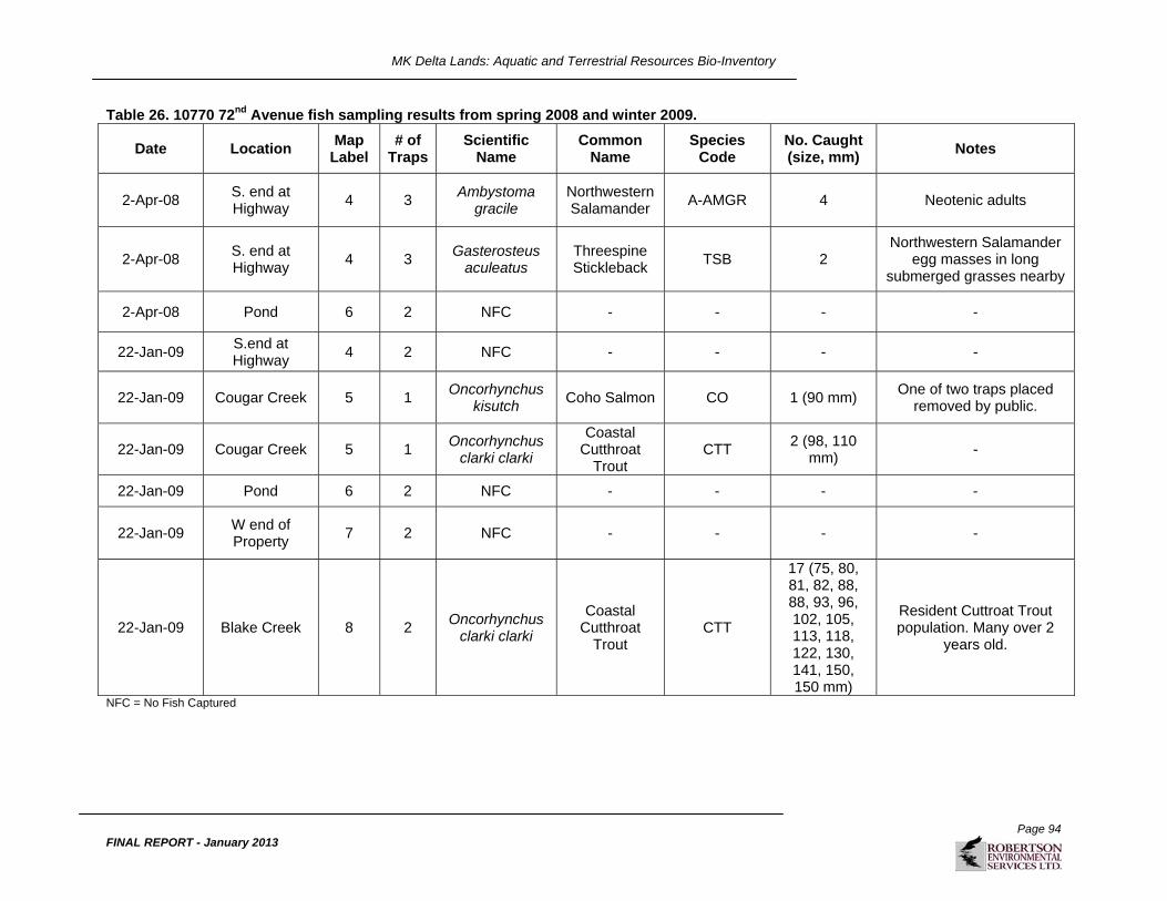
MK Delta Lands: Aquatic and Terrestrial Resources Bio-Inventory
Page 94
FINAL REPORT - January 2013
Table 26. 10770 72nd Avenue fish sampling results from spring 2008 and winter 2009.
Date Location Map
Label # of
TrapsScientific
Name Common
Name Species
Code No. Caught (size, mm)
Notes
2-Apr-08 S. end at Highway
4 3 Ambystoma
gracile Northwestern Salamander
A-AMGR 4 Neotenic adults
2-Apr-08 S. end at Highway
4 3 Gasterosteus
aculeatus Threespine Stickleback
TSB 2 Northwestern Salamander
egg masses in long submerged grasses nearby
2-Apr-08 Pond 6 2 NFC - - - -
22-Jan-09 S.end at Highway
4 2 NFC - - - -
22-Jan-09 Cougar Creek 5 1 Oncorhynchus
kisutch Coho Salmon CO 1 (90 mm)
One of two traps placed removed by public.
22-Jan-09 Cougar Creek 5 1 Oncorhynchus
clarki clarki
Coastal Cutthroat
Trout CTT
2 (98, 110 mm)
-
22-Jan-09 Pond 6 2 NFC - - - -
22-Jan-09 W end of Property
7 2 NFC - - - -
22-Jan-09 Blake Creek 8 2 Oncorhynchus
clarki clarki
Coastal Cutthroat
Trout CTT
17 (75, 80, 81, 82, 88, 88, 93, 96, 102, 105, 113, 118, 122, 130, 141, 150, 150 mm)
Resident Cuttroat Trout population. Many over 2
years old.
NFC = No Fish Captured

MK Delta Lands: Aquatic and Terrestrial Resources Bio-Inventory
Page 95
FINAL REPORT - January 2013
Sampling conducted by M.A. Whelen and Associates (1999) confirmed the presence of Coastal Cutthroat Trout, Rainbow Trout (Oncorhynchus mykiss), Coho Salmon, and Threespine Stickleback within Cougar Creek near the 10770 72nd Avenue Expanded LSA. Coastal Cutthroat Trout, Coho Salmon and Western Brook Lamprey (Lampetra richardsoni) were captured by these workers within Blake Creek, a tributary to Cougar Creek. This reach of Cougar Creek and its tributaries provides valuable habitat for fish species of concern, such as the Coastal Cutthroat Trout (provincially Blue-listed) and Coho Salmon. The mouth of Cougar Creek however, is affected by operations on the foreshore of the Fraser River near its mouth and returning adult spawners must also make it by the flap gate and debris rack obstruction at the stream mouth. Much of the lower reach of Cougar Creek is entrained between the sewer line and the rail line and exhibits poor channel complexity, inadequate instream cover and limited riparian vegetation. This reach does serve as a migration corridor for salmonids but provides limited habitat values for rearing and overwintering juveniles. A single Threespine Stickleback (TSB) was captured using minnow traps near the southwest corner of the 10770 Lands (Site 4) during spring (April 2008) sampling program (Table 27). No fish were captured in Highway 91 West watercourses during the same sampling period and water quality measurements suggested that Highway 91 West drainages were unsuitable to sustain fish populations (Table 27). The ditch that connects the two lots at their southern property boundaries (Sites 3 and 4), where the TSB was captured, is listed as a Schedule B watercourse, and has been found to contain significant numbers of Northwestern Salamanders and their egg masses (Coast River field observation and trapping results 2008 and 2009). It is, however important to note that TSB and Brassy Minnow (BMC; Hybognathus hankinsoni) have both been reported in northern 10770 72nd Avenue watercourses during earlier studies (Whelen 1999). Water levels in 10770 72nd Avenue drainages were, however, noted to be very low during the winter of 2007/2008, but suitable in the winter of 2008/2009, probably due to unusual levels of snowfall that had recently melted. Ditches and a pond in the northern end of the 10770 Lands suffer very low flows, and at times dry out completely during the summer (Sites 6 and 7). This suggests that coarse fish distribution within the bog margins may be affected by seasonal differences in runoff and rainfall. Table 27. Highway 91 West fish sampling results for spring 2008 and winter 2009.
Date Location Map
Label # of
TrapsScientific
Name Commmon
Name Species
Code No.
Caught Notes
2-Apr-08 S. end at Highway
3 3 Ambystoma
gracile Northwestern Salamander
A-AMGR
6
5 larvae, 4 with legs; 1 adult
23-May-08 S. end at Highway
3 3 Ambystoma
gracile Northwestern Salamander
A-AMGR
1 1 larvae
22-Jan-09 At Gate 1 2 NFC - - 2 Water beetle
22-Jan-09 W end of Property
2 2 NFC - - - -
22-Jan-09 S end at Highway
3 2 NFC - - - -
NFC = No Fish Captured

MK Delta Lands: Aquatic and Terrestrial Resources Bio-Inventory
Page 96
FINAL REPORT - January 2013
5.4.2 General Considerations
In addition to water quality sampling conducted by Coast River, water quality measurements conducted in late summer 2006 and winter of 2007 by WorleyParsons Komex Ltd. (WorleyParsons), and Enterprise Geoscience Services Ltd. (Enterprise) have also been reviewed and considered (EGSL 2007). The majority of water quality results by WorleyParsons and Enterprise were obtained from piezometer, or ground water sites. Therefore the measured parameters are not specifically applicable to fish habitat, however, our surface water investigations remain relatively consistent with groundwater findings. The most relevant groundwater parameters measured related to fish habitat are pH, temperature and ground water levels. High ground water levels in the piezometers related to adjacent open water drainage courses suggest that the net flow on a year-round four-season basis is generally from the bog into the open water drainages and then away from the bog. As such, low pH levels will generally prevent fish from moving into the central bog areas where pH levels and summer high water temperatures certainly preclude fish use. Growing conditions for the crop lands that surround the Bog are such that large volumes of water are required for irrigation during the summer season. It is evident that during the irrigation season, fish can be temporarily drawn into the bog’s perimeter drainages (due to irrigation demand) from larger watercourses including the Fraser River. This heavy water demand can cause water temperature and pH levels to be deflected toward healthier levels just through the large irrigation water demand. These changes are generally confined to the larger perimeter drainages of the bog and do not typically affect the interior bog drainages which remain charged primarily from groundwater movement out of the bog. The low pH level within the bog drainage area precludes fish use. Interior bog drainage pH levels generally fall below 5.0 which are too low to support healthy fish populations. In addition, summer water temperatures are commonly higher than salmonid tolerance levels and bacterial oxygen demand commonly drives down oxygen levels during summer conditions. The water quality data that were measured at flow stations and within piezometers suggests that there is some spottiness with regard to measured parameters but coupled with our fish sampling results and the results of earlier investigations by others it is evident that inadequate water quality and habitat exist within the internal bog drainages to support a fish population. Recent planning exercises surrounding the protection of the bog lands has resulted in experimental ditch blocking programs (GVRD 2007) to maintain higher water levels within the central bog area and to retain important water related functions within the sensitive lagg zones of the bog. These ditch blocking programs serve to maintain low pH levels within the bog drainages and also will serve as physical barriers to the potential movement of aquatic organisms up-gradient from the barriers. It is important to note that no fish are likely to occur in these areas due to the very low pH levels in affected open drainages. In summary, the bog tends to drain outward as expected for a domed bog. This tends to retain low pH values within the interior bog drainages. Slow moving water that remains exposed due to limited cover and shade is expected to heat up during the warm summer months which will present near lethal temperatures to most cold water species of fish and very low oxygen levels. Only during extended periods of heavy rainfall or heavy irrigation demand is one likely to encounter fish in the larger perimeter drainages that surround the bog.

MK Delta Lands: Aquatic and Terrestrial Resources Bio-Inventory
Page 97
FINAL REPORT - January 2013
5.4.3 Species at Risk
Brassy Minnow was provincially Blue-listed up until a few years ago when it was removed from the list. It has since been relisted as ‘Yellow’, meaning that the species is “apparently secure and not at risk of extinction” (Ministry of Environment, No Date). However, due to its previous designation under the provincial Blue list, presence of Brassy Minnow should be given extra consideration. There is no federal listing for the Brassy Minnow. The M.A. Whelen and Associates Ltd. Burns Bog Baseline Fisheries Overview (1999) confirmed that Brassy Minnow occurred in the 10770 72nd Avenue ditch that connects to sample site 3 (Figure 20) of the current study. Brassy Minnow were not included in the Delta Watersheds Fish and Amphibian Distributions Map (2003) for that zone. The Whelen report is detailed and includes specific sample locations along with capture results, and therefore, the Brassy Minnow should be considered as a species of likely occurrence within the 10770 Lands. Coast River fish trapping did not result in the capture of Brassy Minnow, or any other fish species at risk in the 10770 Lands. However, only two trapping sessions were conducted (spring 2008 and winter 2009) and we can not rule out the potential occurrence of fish in 10770 Lands. The Coastal Cutthroat Trout is provincially Blue-listed (species of Special Concern), but is not federally listed. Mapping completed by the Corporation of Delta in 2001 (revised 2003) indicates the presence of Coastal Cutthroat Trout and Coho Salmon in the region south of 10770 72nd Avenue lands and Highway 91 West bordered by the ditch along the southern property boundaries (Delta et al. 2003). As the ditch that borders the southern Highway 91 West and 10770 72nd Avenue property boundaries is connected to the larger drainage system identified as supporting Cutthroat Trout and Coho Salmon, access to these ditches is possible. Water quality measurements suggest that the water at Highway 91 West and 10770 72nd Avenue is not suitable for supporting salmonids. It is therefore unlikely that salmonids would venture into the ditch bordering the southern property boundary of Highway 91 West and the 10770 Lands under current conditions. In addition, our fish trapping did not result in any salmonids at Highway 91 West and 10770 72nd Avenue; however, trapping was only conducted in the spring and winter conditions could prove more favorable for brief salmonid intrusions under some circumstances. The Delta mapping also confirms that a Coastal Cutthroat Trout population resides in nearby Cougar Creek.
MK Delta Lands: Aquatic and Terrestrial Resources Bio-Inventory
Page 98
FINAL REPORT - January 2013
6. LITERATURE CITED Azous, A.L. and R.R. Horner (Eds). 1997. Wetlands and Urbanization: Implications for the Future. Final Report of the Puget Sound Wetlands and Stormwater Management Research Program. Washington Department of Ecology, King County Water and Land Resources Division and the University of Washington. Olympia and Seattle, WA. Balfour, J. and Banack, 2000. Burns Bog Ecosystem Review. Water Chemistry. Report prepared for Delta Fraser Properties Partnership and the Environmental Assessment Office in support of the Burns Bog Ecosystem Review, with additional data collected on publicly owned lands conducted for the Environmental Assessment Office in association with the Corporation of Delta. EBA Engineering Consultants Ltd., Vancouver, BC. BC Ministry of Environment (BC MOE). 2008. BC Species and Ecosystems Explorer. http://www.env.gov.bc.ca/atrisk/toolintro.html [accessed in 2008].
BC Ministry of Environment (BC MOE). 2011. BC Species and Ecosystems Explorer. http://www.env.gov.bc.ca/atrisk/toolintro.html [accessed in 2011]. BC Ministry of Environment, Lands and Parks and BC Ministry of Forests (BC MELP and BC MOF). 1998. Field Manual for Describing Terrestrial Ecosystems. Co-published by the Resources Inventory Branch, BC MELP, and Research Branch, BC MOF. Crown Publications Inc. Victoria, BC. BC Ministry of Sustainable Resource Management (BCMSRM). 2002. Species Ranking in British Columbia. March 2002. http://www.for.gov.bc.ca/hfd/library/documents/bib89068.pdf [accessed Nov. 24, 2011].
Beschta, R.L., R.E. Bilby, G.W. Brown, L.B. Holtby, T.D. Hofstra. 1987. Stream Temperature and aquatic habitat: fisheries and forestry interactions. In: E.O. Salo and T.W. Cundy (Eds.) Streamside Management: Forestry and Fishery Interactions, Institute of Forest Resources (pp. 191-232). University of Washington. Contribution No. 57 Bjornn, T.C. and D.W. Reiser. 1991. Habitat requirements of salmonids in streams. In: Influences of Forest and Rangeland Management on Salmonid Fishes and Their Habitats. American Fisheries Society Spec. Pub. 19:83-138. Blaustein, A.R. and L.K. Belden. 2003. Amphibian defenses against ultraviolet-B radiation. Evolution and Development 5: 89-97. Blood, Donald A. and Francis Backhouse. 1999. Wildlife in British Columbia At Risk: Sandhill Crane. Published by the Ministry of Environment, Lands and Parks, Victoria, BC. 6 pp. Bradford, D.F., C. Swanson, and M.S. Gordon. 1992. Effects of low pH and aluminum on two declining species of amphibians in the Sierra Nevada, California. Journal of Herpetology 26: 369-377. British Columbia Environmental Assessment Office. 2000. Burns Bog ecosystem review. Synthesis report. Environmental Assessment Office, Victoria, BC.

MK Delta Lands: Aquatic and Terrestrial Resources Bio-Inventory
Page 99
FINAL REPORT - January 2013
British Columbia Environmental Assessment Office, 2008. Environment Assessment Certificate for the South Fraser Perimeter Road, Schedule B Owner`s Table of Commitments and Assurances. Government of British Columbia. Victoria, BC. Canadian Council of Ministers of the Environment (CCME). 1996. Canadian Water Quality Guidelines, April 1996. Chapter 3.0 – Freshwater Aquatic Life. Clymo, R.S. 1967. Control of cation concentrations, and in particular of pH, in Sphagnum dominated communities. Pages 273-284 in Chemical Environment in the Aquatic Environment. H.L. Golterman and R.S. Clymo, eds. N.V. Noord-Hoilandsche Uitgevers Maatschappij - Amsterdam. Coast River Environmental Services (CRES). 2006. Fish Habitat Impact Assessment Technical Volume 9 of the South Fraser Perimeter Road Environmental Assessment Application. Cooper, John M. 2006. Sandhill Cranes Breeding on Northern Vancouver Island, British Columbia. Northwestern Naturalist 87:146-149. Corn, P.S., H.W. Stolzenburg, and R.B. Bury. 1989. Acid precipitation studies of Colorado and Wyoming: Interim report of surveys of mountain amphibians and water chemistry. U.S. Fish and Wildlife Service Biological Report 80 (40.26). 56 pp. Corporation of Delta, Environmental Services Division. Delta Timing Schedules for Instream Works [Map]. 2003. Corporation of Delta, Fisheries and Oceans Canada, B.C. Ministry of Water, Land and Air Protection. Corporation of Delta, Environmental Services Division. Delta Watersheds Fish and Amphibian Distributions [Map]. 2003. The Corporation of Delta. Corporation of Delta, Fisheries and Oceans Canada, B.C. Ministry of Water, Land and Air Protection. [Map] June 2003. Delta Agricultural Watercourses Maintenance Protocol Timing Schedules for Instream Works. Corporation of Delta. 2008. Official Community Plan Bylaw No. 3950, 1985. June 2008. Schedule A. Corporation of Delta , Delta, BC. COSEWIC. 2010. COSEWIC's Assessment Process and Criteria. http://www.cosewic.gc.ca/pdf/assessment_process_e.pdf [accessed Nov. 24, 2011].
Craig, V.J, R. G. Vennesland, and K. E. Welstead. 2009. Best management practices guidelines for Pacific Water Shrew in urban and rural areas. Working Draft September 2009. BC Ministry of Environment, 39 pp. Delta Watersheds Fish and Amphibian Distributions [Map]. 2003. The Corporation of Delta. Delta Timing Schedules for Instream Works [Map]. 2003. Corporation of Delta, Fisheries and Oceans Canada, B.C. Ministry of Water, Land and Air Protection.

MK Delta Lands: Aquatic and Terrestrial Resources Bio-Inventory
Page 100
FINAL REPORT - January 2013
Demarchi, D.A. 1996. An Introduction to the Ecoregions of British Columbia. January, 1996. Wildlife Branch, Ministry of Environment, Lands and Parks, Victoria, BC. Demarchi, M.W. and M.D. Bentley. 2005. Best Management Practices for Raptor Conservation during Urban and Rural Land Development in British Columbia. BC Ministry of Water, Land and Air Protection. Demarchi, D.A., R.D. Marsh, A.P. Harcombe and E.C. Lea. 1990. The Environment (of British Columbia). pp 55-142. in R.W. Campbell, N.K. Dawe, I. McTaggart-Cowan, J.M. Cooper, G.W. Kaiser and M.C.E. McNall. The Birds of British Columbia, Volume 1. Royal British Columbia Museum. Victoria, BC and Environment Canada, Canadian Wildlife Service, Delta BC. 514 pp. Department of Fisheries and Oceans (DFO) and Ministry of Environment, Lands and Parks (MELP). 1992. Land Development Guidelines for the Protection of Aquatic Habitat. First Printing May 1992; Second Printing September 1993. Douglas, G.W., et al., eds. 1998-2002. Illustrated Flora of British Columbia. Vol. 1-8. British Columbia Ministry of Sustainable Resource Management, and British Columbia Ministry of Forests, Victoria, BC. Dunson, W.A. and J. Connell. 1982. Specific inhibition of hatching in amphibian embryos by low pH. Journal of Herpetology 16: 314-316. Enterprise Geoscience Services Ltd. (EGSL). 2007. Second Update Report on Hydrological Monitoring Program: December 2006 to February 2007, MK Delta Lands, Delta, BC. Environment Canada and BC Ministry of Sustainable Resource Management. 2005. Sensitive Ecosystems Inventory of the Sunshine Coast and Adjacent Islands. Map Legend. http://a100.gov.bc.ca/appsdata/acat/documents/r3758/SEI_301_ml_1129668527899_de87a3f0bcb140dd9730f8a927346762.pdf [accessed Dec. 1, 2008]. Fraker, M., C. Bianchini, and I. Robertson. 1999. Small mammals. Burns Bog Ecosystem Review,. British Columbia Environmental Assessment Office, Victoria. 58 pp. Freda, J. and W.A. Dunson. 1985. The Effect of Acidic Precipitation on Amphibians breeding in Temporary Ponds in Pennsylvania. U.S. Fish and Wildlife Service, Eastern Energy and Land Use Team. Biological Report 80(40.21). Kearneyville, WV. Freda, J. 1986. The influence of acidic pond water on amphibians: a review. Water Air Soil Pollution 30: 439-450. FREMP. 2001. Retrieved January 24, 2008, from http://www.bieapfremp.org/main_fremp.html and http://www.bieapfremp.org/fremp/ managementplan/ colourcoding.html Garry Oak Ecosystems Recovery Team. 2012. Omus audouini. Available at www.goert.ca/documents/SAR_manual/Omus_audouini.pdf. Gascon, C. and J.R. Bider. 1985. Canadian Field-Naturalist 99: 259.

MK Delta Lands: Aquatic and Terrestrial Resources Bio-Inventory
Page 101
FINAL REPORT - January 2013
Gebauer, M.B. 2000. Burns Bog Terrestrial Ecosystem Mapping. Wildlife Interpretations. Report prepared for Delta Fraser Properties Partnership and the Environmental Assessment Office in support of the Burns Bog Ecosystem Review. Enviro-Pacific Consulting, Surrey, BC. Gebauer, M.B. 1999. Status of Wildlife in Burns Bog, Delta 1999. Late Summer/Early Fall 1999 Survey Results and Review of Existing Information. Report prepared for Delta Fraser Properties Partnership and the Environmental Assessment Office in support of the Burns Bog Ecosystem Review, with additional work on publicly owned lands conducted for the Environmental Assessment Office in association with the Corporation of Delta. Enviro-Pacific Consulting, Surrey, BC. Greater Vancouver Regional District (GVRD). 2007. Burns Bog Ecological Conservancy Area: Draft Management Plan April 2007. GVRD. Lower Mainland, BC. Green, R.N. and K. Klinka. 1994. A Field Guide to Site Identification and Interpretation for the Vancouver Forest Region. Land Management Handbook No. 28. BC Ministry of Forests Research Program, Victoria, BC. Guderley, H.E. 1994. Physiological Ecology and Evolution of the threespine stickleback. In: Bell, M.A., and S.A. Foster (Eds.) The Evolutionary Biology of the Threespine Stickleback (pp. 96). Oxford University Press. Hebda, R.J. and W.G. Biggs. 1981. The vegetation of Burns Bog, Fraser Delta, southwestern British Columbia. Syesis 14: 1-20. Hebda, R.J., K. Gustafson, G.K. Golinski and A.M. Calder. 2000. Burns Bog Ecosystem Review Synthesis Report for Burns Bog, Fraser River Delta, South-western British Columbia, Canada. Environmental Assessment Office, Province of British Columbia, Victoria, BC. Hemmera Envirochem. 2006. South Fraser Perimeter Road: Environmental Assessment Application. Prepared for the Ministry of Transportation. House of Commons Canada. 2002. Reprint of Bill C-5. First Session of the Thirty-seventh Parliament. June 11, 2002.
Ivey, Gary L. 2007. Factors influencing nest success of Great Sandhill Cranes at Malheur National Wildlife Refuge, Oregon. Masters Theses for the Oregon University State University Libraries. Kenner, R. 2008. Personal Communication. Entemologist. Provided expert advice on entomology-related issues. Kenner, R., S. Olson, T. Goshulak and D. Knopp, 2007. The Western Pondhawk (Erythemis collocata) in the Lower Mainland. Discovery (Vancouver Natural History Society) 36 (2): 16–20. Kenner, R.D. and Needham, K.M. 1999. Burns Bog Ecosystem Review: Invertebrate Component. Environmental Assessment Office. BC Ministry of Environment, Lands, and Parks, Victoria, BC. Kilham, P. 1982. Michigan Botanist 21: 159.

MK Delta Lands: Aquatic and Terrestrial Resources Bio-Inventory
Page 102
FINAL REPORT - January 2013
Land Use Coordination Office. 1999. Figure 6.10. Summary map of ecological viability in Burns Bog. Burns Bog Ecosystem Review. http://a100.gov.bc.ca/appsdata/epic/documents/p60/d11998/1052860304532_cd879b9c91c9431eac58f4f3da5e1ef9.pdf [accessed Dec. 1, 2008]. Larson, D.J., Y. Alarie and R.E. Roughley 2000. Predaceous Diving Beetles (Coleoptera: Dytiscidae) of the Nearctic Region. NRC Research Press, Ottawa. Lee, P. 2009. Personal Communication. Corporation of Delta, Engineering Graphics Technician. 14 January 2009. Littlefield CD. 1995a. Sandhill crane nesting habitat, egg predators and predator history on Malheur National Wildlife Refuge, Oregon. Northwestern Naturalist 76:137-143. Littlefield CD. 1995b. Demographics of a declining flock of great sandhill cranes in Oregon. Wilson Bulletin 107: 667-674. M. A. Whelen and Associates Ltd. 1999. Burns Bog Baseline Fisheries Overview, September 1999. Prepared for Delta Fraser Properties Partnership and the Environmental Assessment Office in support of the Burns Bog Ecosystem Review. MacKenzie, W.H. and J.R. Moran. 2004. Wetlands of British Columbia: a guide to identification. Res. Br., B.C. Min. For., Victoria, B.C. Land Manage. Handbook No. 52. Madrone Consultants Ltd. (Madrone). 1999. Burns Bog Ecosystem Review. Plants and Plant Communities. Report prepared for Delta Fraser Properties Partnership and the Environmental Assessment Office in support of the Burns Bog Ecosystem Review, with additional work on publicly owned lands conducted for the Environmental Assessment Office in association with the Corporation of Delta. Madrone Consultants Ltd., Duncan, BC. Madrone Consultants Ltd. 2000. Past and Current Ecosystem Dynamics. Burns Bog Ecosystem Review. British Columbia Environmental Assessment Office, Victoria. McCune, B. and L. Geiser. 1997. Macrolichens of the Pacific Northwest. Oregon State University Press, Corvallis, OR. McIntosh, K.A. and I. Robertson. 1999. Burns Bog Ecosystem Review. Status of Black Bears. Report prepared for Delta Fraser Properties Partnership and the Environmental Assessment Office in support of the Burns Bog Ecosystem Review. Robertson Environmental Services Ltd., Langley, BC. Meidinger, D., T. Lee, G.W. Douglas, G. Britton, W. MacKenzie, and H. Qian. 2009. British Columbia plant species codes and selected attributes. Version 5 Database. Research Branch, BC Ministry of Forests, Victoria, BC. http://www.for.gov.bc.ca/hre/becweb/resources/codes-standards/standards-species.html [accessed Dec. 1, 2008]. Ministry of Environment. No Date. Retrieved 20 June 2008 from http://www.env.gov.bc.ca/atrisk/help/list.htm

MK Delta Lands: Aquatic and Terrestrial Resources Bio-Inventory
Page 103
FINAL REPORT - January 2013
Ministry of Environment (MOE). 2001. Terms of Reference for an Urban Bio-Inventory. Version 3.0. March 2001. Available at: http://wlapwww.gov.bc.ca/vir/pa/bmp-appendTOR.pdf [Accessed November 13, 2008]. Ministry of Environment. 2005. Best Management Practices for Raptor Conservation during Urban and Rural Land Development in British Columbia. 31 March 2005. Prepared by M.W. Demarchi, and M.D. Bentley. Revised by L. Sopuck. Ministry of Environment. 2006. Develop with Care: Environmental Guidelines for Urban and Rural Land Development in British Columbia. March 2006. Victoria, BC. Ministry of Environment. 2006a. Provincial Site Series and Map Code List. March 2006. ftp://ftp.env.gov.bc.ca/dist/wis/tem/mapcode_Mar18_06.zip [accessed Dec. 1, 2008]. Ministry of Environment. 2006b. Standard for Mapping Ecosystems at Risk in British Columbia: An Approach to Mapping Ecosystems at Risk and Other Sensitive Ecosystems. December 5, 2006. Version 1.0. Prepared by Ministry of Environment Ecosystems Branch for the Resources Information Standards Committee. Ministry of Environment, Lands and Parks. 2004. Best Management Practices for Amphibians and Reptiles in Urban and Rural Environments in British Columbia. Ministry of Forests. 2008. Provincial Digital Biogeoclimatic Subzone/Variant Mapping. Vector Digital Data. Ministry of Forests Research Branch. ftp://ftp.for.gov.bc.ca/HRE/external/!publish/becmaps/GISdata/CurrentVersion/ABGC_BC_ver7.e00.zip [accessed Dec. 1, 2008]. Ministry of Sustainable Resource Management (MoSRM). 2001. Inventory Methods for Raptors - Standards for Components of British Columbia’s Biodiversity No. 11, Version 2.0. Prepared by Environment Inventory Branch for the Terrestrial Ecosystems Task Force – Resource Inventory Committee. Victoria, BC. Ministry of Water, Land and Air Protection (MWLAP). 2004a. Standards and Best Practices for Instream Works. Ecosystem Standards and Planning Biodiversity Branch, Victoria, BC. Ministry of Water, Land and Air Protection (MWLAP). 2004b. Environmental Best Management Practices for Amphibians and Reptiles in Urban and Rural Environments in British Columbia. Ministry of Water, Land and Air Protection. 2005. Environmental Best Management Practices for Urban and Rural Land Development in British Columbia. April 2005. Victoria, BC. Nagorsen, D.W. and N. Panter. 2009. Identification and status of the Olympic shrew (Sorex rohweri) in British Columbia. Northwestern Naturalist 90:117-129. Nagorsen, D. W. 2005. The rodents and lagomorphs of British Columbia. Royal British Columbia Museum Handbook, Victoria, 410 pp. Nagorsen, David W. 1996. Royal British Columbia Museum Handbook: Opossums, Shrews, and Moles of British Columbia. Volume 2. UBC Press, Vancouver, BC.

MK Delta Lands: Aquatic and Terrestrial Resources Bio-Inventory
Page 104
FINAL REPORT - January 2013
National Wetlands Working Group. 1988. Wetlands of Canada. Ecological Land Classification Series, No. 24. Sustainable Development Branch, Environment Canada, Ottawa, ON. North, M.E.A. and J.M. Teversham, 1984. The vegetation of the floodplains of the Lower Fraser, Serpentine and Nicomekl Rivers, 1859 to 1890. Syesis 17: 47-66. Pearson, B. 1993. Burns Bog Analysis. Ministry of Environment, Lands, and Parks. Vancouver, BC. Perdichuk, P.W. 1999. A Wildlife Survey of Burns Bog and adjacent areas including Delta Nature Reserve, Watershed Park and Cougar Creek, prepared for the Burns Bog Conservation Society, Delta, B.C. Plath, Thomas. 2010. Personal Communications. Wildlife Biologist. Provided expert advice on wildlife-related issues. Pojar, J., K. Klinka, and D.V. Meidinger. 1987. Biogeoclimatic ecosystem classification in British Columbia. For. Ecol. Manage. 22:119-154. Province of British Columbia. 2004. Riparian Areas Regulation. Order of the Lieutenant Governor in Council. July 27, 2004. Rausch, R.L., J.E. Feagin and V.R. Rausch. 2007. Sorex rowheri sp. nov. (Mammalia, Soricidae) from northwestern North America. Mammalian Biology 72(2): 93-105. Reimchen, T. 1992. Naikoon Provincial Park. Queen Charlotte Islands. Natural History and biophysical data for freshwater habitat. (As referenced by M. A. Whalen and Associates, 1999) Reiser D.W., and Bjorn, T.C. 1979. Habitat Requirements of Anadromous Salmonids. USDA Forest Service General Technical Report PNW-96, Pacific Northwest Forest and Range Experiment Station, Portland, Oregon. Resources Inventory Committee (RIC). 1998a. Standard for Terrestrial Ecosystem Mapping in British Columbia. Ecosystems Working Group, Terrestrial Ecosystems Task Force, Resources Inventory Committee, Victoria, BC. Resource Inventory Committee (RIC). 1998b. Inventory Methods for Pond-breeding Amphibians and Painted Turtle. Standards for Components of British Columbia’s Biodiversity No. 37. Ministry of Environment, Lands, and Parks Resources Inventory Branch, Victoria, B.C. Resources Inventory Committee (RIC). 1999a. British Columbia Wildlife Habitat Rating Standards. Version 2.0. Ministry of Environment, Lands and Parks, Resources Inventory Branch, Terrestrial Ecosystems Task Force, Resources Inventory Committee, Victoria, BC. Resource Inventory Committee (RIC). 1999b. Inventory Methods for Forest and Grassland Songbirds. Standards for components of British Columbia’s biodiversity No. 15, Version 2.0. Prepared by Ministry of Environment, Lands and Parks, Resources Inventory Branch, Victoria, B.C. Resource Inventory Standards Committee (RISC). 2006. Inventory Methods for Owl Surveys. Standards for Components of British Columbia’s Biodiversity No. 42, Version 1.0. Prepared by

MK Delta Lands: Aquatic and Terrestrial Resources Bio-Inventory
Page 105
FINAL REPORT - January 2013
Doris Hauleitner, Seepanee Ecological Consulting, for Ministry of Environment, Ecosystems Branch, Victoria, BC. Robertson Environmental Services Ltd. (RESL) 2006. Wildlife and Vegetation Impact Assessment Technical Volume 12 of the South Fraser Perimeter Road Environmental Assessment Application. Robertson Environmental Services Ltd. (RESL). 2008. Zone C Project Area, North Delta. Aquatic and Terrestrial Resources Bio-Inventory Interim Report. Draft Report submitted to MK Delta Lands Group by Robertson Environmental Services Ltd. in association with Coast River Environmental Services, Langley, BC. Saber, P.A., and W.A. Dunson. 1978. Toxicity of bog water to embryonic and larval anuran amphibians. Journal of Experimental Zoology 204: 33-42. Safina, C. 1993. Population trends, habitat utilization, and outlook for the future of the sandhill crane in North America: a review and synthesis. Bird Populations 1:1-27. Scudder, G.G.E. 1996. Terrestrial and freshwater invertebrates of British Columbia: priorities for inventory and descriptive research. Resource Branch, B.C. Ministry of Forests and Wildlife Branch, B.C. Ministry of Environment, Lands and Parks, Victoria, B.C. Working Paper. 09/1996. Scudder, G.G.E. 1994. An annotated systematic list of the potentially rare and endangered freshwater and terrestrial invertebrates in British Columbia. Entomological Society of British Columbia, Occasional Paper 2, April 1994. Sigma Environmental Consultants Ltd. 1983. Summary of Water Quality Criteria for Salmonid Hatcheries. Prepared for Fisheries and Oceans Canada. 161 pp. Sloboda, Susanne M., Naomi Sands, and Ian Robertson. 2009. Increases in Greater Sandhill Crane use of agricultural fields adjacent to Burns Bog, British Columbia. British Columbia Birds 19: 24-28. Sloboda, Susanne M., Ksenia Barton, Naomi Sands, Tom Plath, Brent Matsuda, Alana Hilton, Terry Taylor, Rex Kenner, Ian Robertson and Phil Henderson. 2012. Highway 91 East OCP Application Biophysical Baseline Inventory Report: Summary. British Columbia. SLR Consulting Ltd. and Golder Associates Ltd. 2008. 2007 Environmental Studies: Vegetation and Wildlife Component. Neighbourhood One Environmental Study Area. Silverdale Urban Reserve. Mission, BC. June 2008. Taylor, T. 2008. Personal Communications. Botanist. Provided expert advice on flora-related issues. TERA Environmental Consultants Ltd. and Norecol Environmental Consultants Ltd. (TERA and Norecol) 1988. Western Delta Lands Inc., Delta Centre New Community and Deep Sea Port Environmental Overview, Volume 7, Vegetation and Wildlife. Vitt, D.H., L.A. Halsey, and J. Doubt. 1999. Global and Regional Distinctness of Burns Bog. Prepared for Delta Fraser Properties Partnership and the Environmental Assessment Office. Department of Biological Sciences, University of Alberta, Edmonton, AB.

MK Delta Lands: Aquatic and Terrestrial Resources Bio-Inventory
Page 106
FINAL REPORT - January 2013

MK Delta Lands: Aquatic and Terrestrial Resources Bio-Inventory
Page 107
FINAL REPORT - January 2013
This page left intentionally blank.

MK Delta Lands: Aquatic and Terrestrial Resources Bio-Inventory
Page 108
FINAL REPORT - January 2013
Appendix 1. Definitions of Structural Stage Classification, Structural Stage and Stand Composition Modifiers
Structural stage classification system. Adapted from RIC (1998).
Structural Stages/
Substages Definition
Post-disturbance stages or environmentally induced structural development
1 (SB)
Sparse/bryoid: Initial stages of primary and secondary succession; bryophytes and lichens often dominant; time since disturbance <20 years for normal forest succession, may be prolonged (50-100+ years) where there is little or no soil development (bedrock, boulder fields); total shrub and herb cover <20%; total tree cover <10%.
1a (SP) Sparse - less than 10% vegetation cover; or 1b (BR) Bryoid - bryophite and lichen-dominated community (>50% of total vegetative cover).
Stand initiation stages or environmentally induced structural development
2 (H)
Herb: Early successional stage or herb communities maintained by environmental conditions or disturbance (e.g., snow fields, avalanche tracks, wetlands, flooding, grasslands, intensive grazing, intense fire damage); dominated by herbs (forbs, graminoids, ferns); some invading or residual shrubs and trees may be present; tree cover < 10%, shrubs < 20% or < 33% of total cover, herb-layer cover > 20%, or > 33% of total cover; time since disturbance < 20 years for normal forest succession; many non-forested communities are perpetually maintained in this stage.
2a (FO) Forb-dominated - includes non-graminoid herbs and ferns; 2b (GR) Graminoid-dominated - includes grasses, sedges, reeds, and rushes;
2c (AQ) Aquatic - floating or submerged; does not include sedges growing in marshes with standing water (classed as 2b); or
2d (DS) Dwarf shrub-dominated - dominated by dwarf woody species such as Arctostaphylos alpina, Salix reticulata, Rhododendron lapponicum, Cassiope tetragona (see Table 3.1 in Vegetation section).
3 (SH)
Shrub/Herb: Early successional stage or shrub communities maintained by environmental conditions or disturbance; dominated by shrubby vegetation; seedlings and advance regeneration may be abundant; tree cover < 10%, shrub cover > 20% or > 33% of total cover.
3a (LS)
Low shrub - dominated by shrubby vegetation < 2 m tall; seedlings and advance regeneration may be abundant; time since disturbance < 20 years for normal forest succession; may be perpetuated indefinitely by environmental conditions or disturbance; or
3b (TS) Tall shrub - dominated by shrubby vegetation that is 2-10 m tall; seedlings and advance regeneration may be abundant; time since disturbance < 40 years for normal forest succession; may be perpetuated indefinitely.
Stem exclusion stages
4 (PS)
Pole/Sapling: Trees > 10 m tall, typically densely stocked, have overtopped shrub and herb layers; younger stands are vigorous (usually > 10-15 years old); older stagnated stands (up to 100 years old) are also included; self-thinning and vertical structure not yet evident in the canopy - this often occurs by age 30 in vigorous broadleaf stands, which are generally younger than coniferous stands at the same structural stage; time since disturbance < 40 years for normal forest succession; up to 100+ years for dense (5000 - 15000+ stems per ha) stagnant stands.
5 (YF)
Young Forest: Self-thinning has become evident and the forest canopy has begun to differentiate into distinct layers (dominant, main canopy, and overtopped); vigorous growth and a more open stand than in the PS stage; begins as early as age 30 and extends to 50-80 years; time since disturbance generally 40-80 years, depending on tree species and ecological conditions.

MK Delta Lands: Aquatic and Terrestrial Resources Bio-Inventory
Page 109
FINAL REPORT - January 2013
Structural Stages/
Substages Definition
Understory reinitiation stage
6 (MF)
Mature Forest: Trees established after the last disturbance have matured; a second cycle of shade-tolerant trees may have become established; understories become well developed as the canopy opens up; time since disturbance generally 80-250 years on the southwest coast of B.C..
Old-growth stage
7 (OF)
Old Forest: Old, structurally complex stands comprised mainly of shade-tolerant and regenerating tree species, although older seral and long-lived trees from a disturbance such as fire may still dominate the upper canopy; snags and coarse woody debris in all stages of decomposition and patchy understories typical; understories may include tree species uncommon in the canopy, because of inherent limitations of these species under the given conditions; time since disturbance generally > 250 years on the southwest coast of B.C.
Structural stage modifiers for structural stage 3 – 7. Adapted from RIC (1998).
Modifier Description
s single storied
Closed forest stand dominated by the overstory crown class (dominant and co-dominant trees); intermediate and suppressed trees account for less than 20% of all crown classes combined; advance regeneration in the understory is generally sparse.
t two storied Closed forest stand co-dominated by distinct overstory and intermediate crown classes; the suppressed crown class is lacking or accounts for less than 20% of all crown classes combined; advance regeneration is variable.
m multi storied Closed forest stand with all crown classes well represented; each of the intermediate and suppressed classes account for greater than 20% of all crown classes combined; advance regeneration is variable.
i irregular Forest stand with very open overstory and intermediate crown classes (totaling less than 30% cover), and well-developed suppressed crown class; advance regeneration is variable.
h shelterwood Forest stand with very open overstory (less than 20% cover) and well-developed suppressed crown class and/or advance regeneration in the understory; intermediate crown class is generally absent.
Stand composition modifiers for structural stage 3 – 7. Adapted from RIC (1998).
Modifier Description C coniferous Greater than 3/4 of total tree layer cover is coniferous
B broadleaf Greater than 3/4 of total tree layer cover is broadleaf
M mixed Neither coniferous or broadleaf account for greater than 3/4 of total tree layer cover
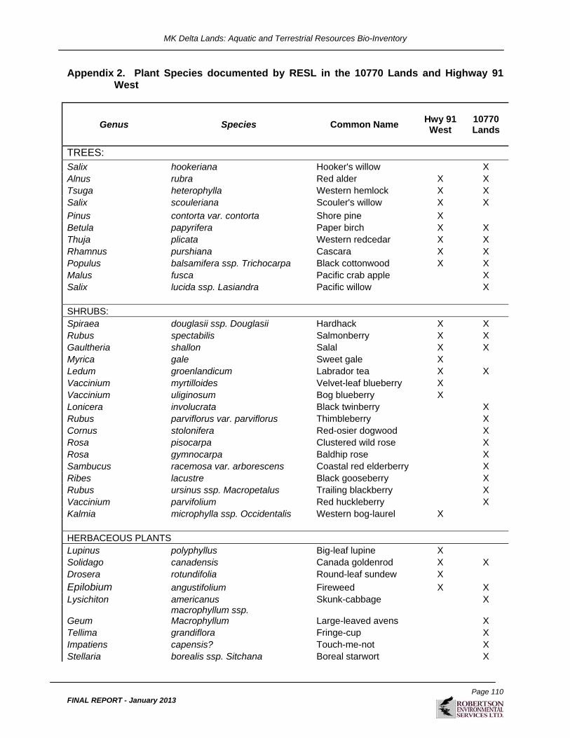
MK Delta Lands: Aquatic and Terrestrial Resources Bio-Inventory
Page 110
FINAL REPORT - January 2013
Appendix 2. Plant Species documented by RESL in the 10770 Lands and Highway 91 West
Genus Species Common Name Hwy 91 West
10770 Lands
TREES: Salix hookeriana Hooker's willow X Alnus rubra Red alder X X Tsuga heterophylla Western hemlock X X Salix scouleriana Scouler's willow X X
Pinus contorta var. contorta Shore pine X Betula papyrifera Paper birch X X Thuja plicata Western redcedar X X Rhamnus purshiana Cascara X X Populus balsamifera ssp. Trichocarpa Black cottonwood X X Malus fusca Pacific crab apple X Salix lucida ssp. Lasiandra Pacific willow X SHRUBS: Spiraea douglasii ssp. Douglasii Hardhack X X Rubus spectabilis Salmonberry X X Gaultheria shallon Salal X X Myrica gale Sweet gale X Ledum groenlandicum Labrador tea X X Vaccinium myrtilloides Velvet-leaf blueberry X Vaccinium uliginosum Bog blueberry X Lonicera involucrata Black twinberry X Rubus parviflorus var. parviflorus Thimbleberry X Cornus stolonifera Red-osier dogwood X Rosa pisocarpa Clustered wild rose X Rosa gymnocarpa Baldhip rose X Sambucus racemosa var. arborescens Coastal red elderberry X Ribes lacustre Black gooseberry X Rubus ursinus ssp. Macropetalus Trailing blackberry X Vaccinium parvifolium Red huckleberry X Kalmia microphylla ssp. Occidentalis Western bog-laurel X HERBACEOUS PLANTS Lupinus polyphyllus Big-leaf lupine X Solidago canadensis Canada goldenrod X X Drosera rotundifolia Round-leaf sundew X
Epilobium angustifolium Fireweed X X Lysichiton americanus Skunk-cabbage X
Geum macrophyllum ssp. Macrophyllum Large-leaved avens X
Tellima grandiflora Fringe-cup X Impatiens capensis? Touch-me-not X Stellaria borealis ssp. Sitchana Boreal starwort X

MK Delta Lands: Aquatic and Terrestrial Resources Bio-Inventory
Page 111
FINAL REPORT - January 2013
Genus Species Common Name Hwy 91 West
10770 Lands
Barbarea orthoceras American winter cress X Galium aparine Cleavers X
Epilobium ciliatum Purple-leaved willowherb X
Oenanthe sarmentosa Pacific water-parsley X Lactuca biennis Tall blue lettuce X GRASSES AND ALLIES
Luzula subsessilis Short-stalked wood-rush X
Scirpus microcarpus Small-flowered bulrush X X Juncus effusus Common rush X Scirpus atrocinctus Wool-grass X Carex sp. Sedge X Carex deweyana Dewey's sedge X Glyceria elata Tall mannagrass X Typha latifolia Common cat-tail X Juncus tenuis Slender rush X Agrostis scabra Hair bentgrass X Bromus vulgaris Columbia brome X FERNS AND ALLIES Equisetum arvense Common horsetail X X Pteridium aquilinum ssp. Lanuginosum Bracken fern X Polystichum munitum Swordfern X Dryopteris expansa Spiny wood fern X Equisetum telmateia ssp. Braunii Giant horsetail X Athyrium filix-femina ssp. Cyclosorum Lady fern X Polypodium glycyrrhiza Licorice fern X MOSSES AND LIVERWORTS Dicranum scoparium Broom moss X Campylopus introflexus X Pohlia nutans X
Sphagnum capillifolium White-toothed peat moss X
Sphagnum mendocinum Mendocino peat moss X Kindbergia praelonga Slender beaked moss X X Polytrichum strictum X Orthotrichum lyellii Lyell's bristle moss X X Hylocomium splendens Step moss X
Rhytidiadelphus triquetrus Electrified cat-tail moss X X
Aulacomnium androgynum Lover's moss X Rhizomnium glabrescens Fan moss X Bryum sp. X Atrichum undulatum Crane's-bill moss X

MK Delta Lands: Aquatic and Terrestrial Resources Bio-Inventory
Page 112
FINAL REPORT - January 2013
Genus Species Common Name Hwy 91 West
10770 Lands
Pseudoscleropodium purum X Homalothecium fulgescens Yellow moss X Claopodium crispifolium Rough moss X Porella navicularis X Porella cordaeana X Orthotrichum pulchellum X
Neckera douglasii Douglas' neckera moss X
Plagiothecium undulatum Wavy-leaved cotton moss X
Rhytidiadelphus loreus Lanky moss X Radula complanata X Ulota obtusiuscula X Polytrichum juniperinum Juniper haircap moss X Chiloscyphus pallescens X LICHENS Cladonia sp. X
Cladonia portentosa Maritime reindeer lichen X
Lecanora sp. Rim-lichen X Physcia tenella Fringed rosette lichen X Parmelia hygrophila Western shield lichen X Usnea subfloridana Beard lichen X Ramalina farinacea Dotted ramalina X Evernia prunastri Oakmoss lichen X Peltigera canina Dog lichen X Parmeliopsis hyperopta Gray starburst lichen X INTRODUCED SPECIES Tanacetum vulgare Tansy X X Plantago lanceolata Ribwort plantain X Taraxacum officinale Dandelion X X Leucanthemum vulgare Ox-eye daisy X Rubus discolor Himalayan blackberry X X Anthoxanthum odoratum Sweet vernalgrass X Vicia sativa Common vetch X X Cirsium arvense var. horridum Canada thistle X X
Hypericum perforatum Common St. John's wort X
Ranunculus repens Creeping buttercup X X Betula pendula European birch X Plantago major Common plantain X Cirsium vulgare Bull thistle X Phalaris arundinacea Reed canarygrass X X
Rubus laciniatus Cutleaf evergreen blackberry X X

MK Delta Lands: Aquatic and Terrestrial Resources Bio-Inventory
Page 113
FINAL REPORT - January 2013
Genus Species Common Name Hwy 91 West
10770 Lands
Hypochaeris radicata Hairy cat's ear X Lotus corniculatus Bird's-foot trefoil X Poa annua Annual bluegrass X Poa pratensis Kentucky bluegrass X
Sorbus aucuparia European mountain-ash X
Holcus lanatus Velvetgrass X Trifolium pratense Red clover X Trifolium repens White clover X Lamiastrum galeobdolon Lamium X Impatiens parviflora Small touch-me-not X Cardamine hirsuta Hairy bitter-cress X Geranium robertianum Robert's geranium X Ilex aquifolium English holly X Cerastium glomeratum Sticky chickweed X
Rubus allegheniensis ssp. Allegheniensis Allegheny blackberry X
Cytisus scoparius Broom X X Arctium minus Common burdock X Solanum dulcamara European bittersweet X Prunella vulgaris var. vulgaris Self heal X Sonchus arvensis var. arvensis Perennial sow-thistle X Lapsana communis Nipplewort X Lactuca muralis Wall lettuce X Senecio jacobaea Tansy ragwort X
Alopecurus pratensis Meadow meadow-foxtail X
Lactuca serriola Prickly lettuce X
Veronica serpyllifolia var. serpyllifolia Thyme-leaved speedwell X X

MK Delta Lands: Aquatic and Terrestrial Resources Bio-Inventory
Page 114
FINAL REPORT - January 2013
Appendix 3. Incidental Wildlife observations in Highway 91 West and the 10770 Lands
Date Location* Other Wildlife Observation
Amphibian Surveys
11-Sep-09 Highway 91 W Amphibians: Pacific Chorus Frog, Northwestern Salamander Tadpole
11-Sep-09 Highway 91 W Dragonflies: Shadow Darner, Paddletail Darner, White-faced Meadowhawk, Autumn Meadowhawk, Pacific Forktail, Western Forktail, Common Spreadwing, Bluet sp.
11-Sep-09 Highway 91 W
Birds: Yellow-rumped Warbler, Orange-crowned Warbler, Common Yellowthroat, Spotted Towhee, Song Sparrow, American Goldfinch, Evening Grosbeak, Northwestern Crow, Bewick's Wren, House Finch, Black-capped Chickadee, Red-breasted Nuthatch, Downy Woodpecker, Hairy Woodpecker, Northern Flicker, Canada Goose, Brown Creeper, Savannah Sparrow
11-Sep-09 10770 72nd Avenue Dragonflies: Shadow Darner
11-Sep-09 10770 72nd Avenue
Birds: Common Nighthawk, Black-capped Chidkadee, Evening Grosbeak, Yellow-rumped Warbler, Downy Woodpecker, Northern Flicker, Red-breaseted Nuthatch, Steller's Jay, Brown Creeper, Hutton's Vireo, Bushtit, Rufous Hummingbird, House Finch, Pacific Wren, Chestnut-backed Chickadee, Song Sparrow, Spotted Towhee, American Robin
11-Sep-09 Delta Nature Reserve Birds: Red-breasted Nuthatch, Black-capped Chickadee, Steller's Jay, Pacific Wren, Northern Flicker
Bird Surveys
22-May-08 Highway 91 W White-tailed deer (between 505062/5442114)
22-May-08 Highway 91 W Lots of Beaver activity along transect #6
04-Jun-08 Highway 91 W Douglas Squirrel
15-Jun-08 10770 72nd Avenue Deer Scat
01-Jun-08 10770 72nd Avenue Douglas squirrel
18-Jun-08 Highway 91 W Douglas Squirrel X3
18-Jun-08 Highway 91 W Red-tailed Hawk very agitated swooping down, circling, flying above (0505158/5441194) searched for nest not located
18-Jun-08 Highway 91 W Green Frog

MK Delta Lands: Aquatic and Terrestrial Resources Bio-Inventory
Page 115
FINAL REPORT - January 2013
Date Location* Other Wildlife Observation
06-Oct-08 Highway 91 W Mule Deer scat, Douglas Squirrel, Pacific Chorus Frog
26-Sep-08 Delta Nature Reserve Pacific Chorus Frog X2, 1 Douglas Squirrel
Sandhill Crane Surveys
Incidental Wildlife Other Than Birds (see Appendix 5 for Incidental Bird Observations)
02-Jun-09 Highway 91 W Spring Azur, Coyotes, Pacific Tree Frog
10-Jun-09 Highway 91 W Pacific Chorus Frog
19-Jun-09 Highway 91 W Douglas Squirrel
22-Jun-09 Highway 91 W Lorquin's Admiral
30-Jun-09 Highway 91 W Small Twistedstalk
10-Jul-09 Highway 91 W European Skipper, Green Darner, Lorquin's Admiral, Common Spreadwing
07-Aug-09 Highway 91 W Douglas Squirrel
11-Aug-09 Highway 91 W Spotted St. John's-wort
18-Aug-09 Highway 91 W Shadow Darner, Paddletailed Darner, White-faced Meadowhawk, Boreal Bluet, Douglas Squirrel, Big Brown Bat, Myotis species, Pacific Tree Frog
27-Aug-09 Highway 91 W Douglas Squirrel
03-Sep-09 Highway 91 W Pacific Chorus Frog, Dragonfly, Paddletail Darner, Shadow Darner, Big Brown Bat, Myotis sp.
16-Sep-09 Highway 91 W Douglas Squirrel, Pacific Chorus Frog
24-Sep-09 Highway 91 W Douglas Squirrel, Pacific Chorus Frog
25-Sep-09 Highway 91 W Pacific Chorus Frog, Douglas Squirrel
27-Sep-09 Highway 91 / BBECA Douglas Squirrel, Spotted St. John's-wort, Hoary Bat foraging over pond (large bat singly foraging at tree level; chunky red color)
16-Oct-09 BBECA Spotted St. John's-wort
* Locations include expanded LSA where applicable

MK Delta Lands: Aquatic and Terrestrial Resources Bio-Inventory
Page 116
FINAL REPORT - January 2013
Appendix 4. Amphibian and reptile observations during egg mass and visual encounter surveys conducted in the study area.
Life Stage Date UTMs (all 10U) Comments Hwy 91 West
1
Northwestern Salamander (Ambystoma gracile)
Eggs 31-Mar-09 505245 5441120
2 Garter Snake (Thamnophis sp.) Adult 22-Apr-09 505227 5441131 brief glimpse; could not identify species
3 Green Frog (Rana clamitans) Larva 22-Apr-09 505021 5441129 Tadpole scooped up in net
4 Northwestern Salamander Eggs 22-Apr-09 504970 5441133
5 Northwestern Salamander Eggs 22-Apr-09 504970 5441133 6 Northwestern Salamander Eggs 22-Apr-09 505079 5441131 7 Northwestern Salamander Eggs 22-Apr-09 505122 5441130 8 Pacific Treefrog (Hyla regilla) Adult 22-Apr-09 505017 5441129 Observed swimming
9 Pacific Treefrog Adult 22-Apr-09 505017 5441129 Adult Pacific Chorus Frog observed 10 Green Frog Adults 11-Sep-09 No UTMs taken Several seen along the east-west ditch 10770 Lands 1 Northwestern Salamander Eggs 31-Mar-09 505487 5441123
2 Northwestern Salamander Eggs 31-Mar-09 505479 5441125 3 Northwestern Salamander Eggs 31-Mar-09 505482 5441118 4 Northwestern Salamander Eggs 31-Mar-09 505472 5441122 5 Northwestern Salamander Eggs 31-Mar-09 505461 5441113 6 Northwestern Salamander Eggs 31-Mar-09 505466 5441120
7 Northwestern Salamander Eggs 31-Mar-09 505461 5441120
8 Northwestern Salamander Eggs 31-Mar-09 505458 5441121 9 Northwestern Salamander Eggs 31-Mar-09 505444 5441122 10 Northwestern Salamander Eggs 31-Mar-09 505431 5441121 11 Northwestern Salamander Eggs 31-Mar-09 505423 5441122 12 Northwestern Salamander Eggs 31-Mar-09 505409 5441122 13 Northwestern Salamander Eggs 31-Mar-09 505403 5441122 14 Northwestern Salamander Eggs 31-Mar-09 505383 5441117 15 Northwestern Salamander Eggs 31-Mar-09 505301 5441113
16 Northwestern Salamander Eggs 31-Mar-09 505410 5441115
17 Northwestern Salamander Eggs 14-May-09 505242 5442185 6 egg masses 18 Northwestern Salamander Eggs 14-May-09 505459 5442346

MK Delta Lands: Aquatic and Terrestrial Resources Bio-Inventory
Page 117
FINAL REPORT - January 2013
Life Stage Date UTMs (all 10U) Comments 19 Northwestern Salamander Eggs 14-May-09 505784 5442341
20 Pacific Treefrog Larvae 21-May-09
505660 5442136Hundreds of tadpoles in several scattered ephemeral pools
Cougar Creek
1 Red-backed Salamander (Plethodon vehiculum) Adult 11-Sep-09 No UTM taken
Seen by MT; Under plywood sign within 1 m of creek; No UTM taken but seen east of R. aurora along the creek
2 Red-legged Frog (Rana aurora) Adult 11-Sep-09 506027 5442127 Seen by DK; Unable to capture; no photo
documentation Delta Nature Reserve
1 Green Frog Adult 21-May-09 504990 5443791 Large breeding male
2 Green Frog Larva 21-May-09 504982 5443832 Tadpole scooped up in net
3 Green Frog Larva 21-May-09 504925 5443889 Tadpole scooped up in net

MK Delta Lands: Aquatic and Terrestrial Resources Bio-Inventory
Page 118
FINAL REPORT - January 2013
Appendix 5 Incidental Bird Observations from 2009 Sandhill Crane Surveys.
Species Code
Common Name Scientific Name Obs. Breeding
Bird 2009 (Jun 2-Jul 31)
No. of Surveys
Obs.
Obs. Fall Migr. 2009
(Aug 7-Oct 21)
No. of Surveys
Obs. AMGO American Goldfinch Carduelis tristis 10 18 AMKE American Kestrel Falco sparverius 0 4 AMPI American Pipit Antys rubescens 0 15 AMRO American Robin Turdus migratorius 9 22 AMWI American Wigeon Anas americana 0 6 BAEA Bald Eagle Haliaeetus leucocephalus 8 8 BCCH Black-capped Chickadee Poecile atricapillus 6 16 BEWR Bewick's Wren Thryomanes bewickii 4 15 BHCO Brown-headed Cowbird Molothrus ater 8 1 BHGR Black-headed Grosbeak Pheucticus melanocephalus 2 0 BLSW Black Swift Cypseloides niger 3 0 BNSW Barn Swallow Hirundo rustica 8 3 BRBL Brewer's Blackbird Euphagus cyanocephalus 1 0 BTPI Band-tailed Pigeon Patagioenas fasciata 1 0 BUSH Bushtit Psaltriparus minimus 1 9 CAGO Canada Goose Branta canadensis 5 17 CATE Caspian Tern Hydroprogne caspia 1 0 CAVI Cassin's Vireo Vireo cassinii 0 1 CBCH Chestnut-backed Chickadee Poecile rufescens 2 3 CEWA Cedar Waxwing Bombycilla cedrorum 10 16 CKGO Cackling Goose Branta hutchinsii 0 3 CLSW Cliff Swallow Petrochelidon pyrrhonota 2 0 COHA Cooper's Hawk Accipiter cooperii 1 11 CONI Common Nighthawk Chordeiles minor 6 5 CORA Common Raven Corus corax 1 12 COYE Common Yellowthroat Geothlypis trichas 10 10 DEJU Dark-eyed Junco Junco hyemalis 3 11 DOWO Downy Woodpecker Picoides pubescens 3 8 EUST European Starling Sturnus vulgaris 8 2 EVGR Evening Grosbeak Coccothraustes vespertinus 0 7 FOSP Fox Sparrow Passerella iliaca 0 1 GBHE Great Blue Heron Ardea herodias 2 1 GCKI Golden-crowned Kinglet Regulus satrapa 0 12

MK Delta Lands: Aquatic and Terrestrial Resources Bio-Inventory
Page 119
FINAL REPORT - January 2013
Species Code
Common Name Scientific Name Obs. Breeding
Bird 2009 (Jun 2-Jul 31)
No. of Surveys
Obs.
Obs. Fall Migr. 2009
(Aug 7-Oct 21)
No. of Surveys
Obs. GCSP Golden-crowned Sparrow Zonotrichia atricapilla 0 7 GRYE Greater Yellowlegs Tringa melanoleuca 1 0 GWFG Greater White-fronted Goose Anser albifrons 0 4 GWGU Glaucus-winged Gull Larus glaucescens 5 14 GWTE Green-winged Teal Anas crecca 3 2 HAWO Hairy Woodpecker Picoides villosus 1 1 HOFI House Finch Carpodacus mexicanus 4 5 HOLA Horned Lark Eremophila alpestris 0 1 HUVI Hutton's Vireo Vireo huttoni 1 1 KILL Killdeer Charadrius vociferus 4 3 LALO Lapland Longspur Calcarius lapponicus 0 5 LBDO Long-billed Dowitcher Limnodromus scolopaceus 0 1 MALL Mallard Anas platyrhynchos 4 12 MAWR Marsh Wren Cistothorus palustris 6 6 MERL Merlin Falco columbarius 0 3 MODO Mourning Dove Zenaida macroura 6 3 NOFL Northern Flicker Colaptes auratus 7 21 NOHA Northern Harrier Circus cyaneus 3 16 NOPI Northern Pintail Anas acuta 0 5
NRWS Northern Rough-winged Swallow
Stelgidopteryx serripennis 0 1
NOSH Northern Shrike Lanius excubitor 0 3 NOSL Northern Shoveler Anas clypeata 0 1 NWCR Northwestern Crow Corvus caurinus 8 12 OCWA Orange-crowned Warbler Vermivora celata 4 10 OSPR Osprey Pandion haliaetus 0 4 PEFA Peregrine Falcon Falco peregrinus 0 6 PESA Pectoral Sandpiper Calidris melanotos 0 2 PISI Pine Siskin Carduelis pinus 2 4 PIWO Pileated Woodpecker Dryocopus pileatus 0 4 PSFL Pacific Slope Flycatcher Empidonax difficilis 2 0 PUFI Purple Finch Carpodacus purpureus 3 5 RBNU Red-breasted Nuthatch Sitta canadensis 4 8 RCKI Ruby Crowned Kinglet Regulus calendula 0 3 RLHA Rough-legged Hawk Buteo lagopus 0 1 RNDU Ring-necked Duck Aythya collaris 0 1

MK Delta Lands: Aquatic and Terrestrial Resources Bio-Inventory
Page 120
FINAL REPORT - January 2013
Species Code
Common Name Scientific Name Obs. Breeding
Bird 2009 (Jun 2-Jul 31)
No. of Surveys
Obs.
Obs. Fall Migr. 2009
(Aug 7-Oct 21)
No. of Surveys
Obs. RTHA Red-tailed Hawk Buteo jamaicensis 0 6 RUHU Rufous Hummingbird Selasphorus rufus 4 0 RWBL Red-winged Blackbird agelaius phoeniceus 8 2 SAVS Savannah Sparrow Passerculus sandwichensis 8 14 SNGO Snow Goose Chen caerulescens 0 2 SOSA Solitary Sandpiper Tringa solitaria 0 1 SOSP Song Sparrow Melospiza melodia 10 19 SPTO Spotted Towhee Pipilo maculatus 9 14 SSHA Sharp-shinned Hawk Accipiter striatus 0 3 STJA Steller's Jay Cyanocitta stelleri 0 4 SWTH Swainson's Thrush Catharus ustulatus 5 3 TRSW Tree Swallow Tachycineta bicolor 6 0 VASW Vaux's Swift Chaetura vauxi 0 2 VATH Varied Thrush Ixoreus naevius 0 8 VGSW Violet-green Swallow Tachycineta thalassina 4 0 WAVI Warbling Vireo Vireo gilvus 0 1 WCSP White-crowned Sparrow Zonotrichia leucophrys 3 7 WEME Western Meadowlark Sturnella neglecta 0 4 WIFL Willow Flycatcher Empidonax traillii 10 2 WISN Wilson's Snipe Gallinago delicata 3 5 WIWA Wilson's Warbler Wilsonia pusilla 1 1 WIWR Pacific Wren Troglodytes troglodytes 0 4 WWPE Western Wood-Pewee Contopus sordidulus 2 0 YEWA Yellow Warbler Dendroica petechia 2 2 YRWA Yellow-rumped Warbler Dendroiica coronata 0 17

MK Delta Lands: Aquatic and Terrestrial Resources Bio-Inventory
Page 121
FINAL REPORT - January 2013
Appendix 6. Weather and effort data from 2009 Sandhill Crane surveys.
Date (YYMMDD)
Station #
Surveyor Initials
Survey Time (00:00 - 23:59)
Total Survey Time (00:00 hrs)
Weather Conditions (*see codes below Table)
Start End
Start End Temp.
(°C) Ceiling
Cloud Cover
Ppt Wind Temp.
(°C) Ceiling
Cloud Cover
Ppt Wind
091021 5 MT JO 07:50 11:50 4:00 8 M 100% N 0 13 M 100% N 1
091016 4 TP MT 07:10 12:15 5:05 12 L 100% R 2 16 L 100% N 2
091009 4 JO TP 07:15 12:00 4:45 7 M 95% N 1 12 M 80% N 2
091006 4 JO TP 07:10 12:30 5:20 4 U 0% N 1 10 M 95% N 2
091005 4 TP JO 07:10 19:45 12:35 4 H 10% N 1 12 H 15% N 1
091004 4 TP JO 07:10 19:45 12:35 4 U 0% N 1 10 U 0% N 2
091003 4 TP JO 07:15 18:45 11:30 3 H 2% N 1 7 M 20% N 3
091002 3 and 4 TP JO 07:10 19:40 12:30 9 M 5% N 1 5 H 35% N 2
091001 3 TP JO 07:10 17:15 10:05 6 L 100% R 2 12 L 100% N 1
090930 3 TP JO 07:10 19:00 11:50 4 M 10% N 1 8 M 60% N 2
090929 3 TP JO 07:20 19:00 11:40 7 L 100% R 2 10 M 50% N 1
090928 1 and 3 TP JO 07:32 19:00 11:28 7 M 15% N 1 11 L 95% N 3
090927 1 and 6 TP JO 06:55 19:35 12:40 4 U 0% N 1 11 M 2% N 1
090926 1 TP JO 06:55 19:05 12:10 4 U 0% N 1 12 M 5% N 2
090925 1 TP JO 07:00 19:10 12:10 4 U 0% N 0 10 U 0% N 1
090924 1 SS MT 06:38 12:00 5:22 13 U 0% N 1 16 U 0% N 1
090916 1 SS TP 17:05 20:05 3:00 17 M 100% D 0-1 13 M 100% N 0-1
090911 2 NS MT 06:20 09:30 3:10 12 U 0% F 1 15 U 0% N 1
090903 2 NS MT 16:35 20:30 3:55 19 H 50% N 2 15 M 100% N 0
090827 2 SS JO 05:50 09:30 3:40 11 U 2% N 0 19 U 5% N 0
090818 2 MT JO 17:01 20:57 3:56 25 H 10% N 2 15 H 5% N 0
090811 2 TP MT 05:48 09:28 3:40 14 M 30% N 0 18 M 50% N 1
090807 2 TP MT 17:16 20:55 3:39 17 M 95% N 2 14 M 100% N 2
090731 2 NS JO 05:00 08:00 3:00 18 U 0% N 1 21 U 0% N 1
090720 1 NS TP 17:35 20:35 3:00 25 H 70% N 3 21 U 5% N 2
090714 1 JO BM 05:10 09:30 4:20 13.5 M 99% N 0 15 M 95% N 2
090710 1 BM MT 18:10 21:35 3:25 28.5 H 5% N 2 11 H 5% N 0
090630 1 NS TP 05:30 08:45 3:15 10 U 5% N 1 17 U 2% N 1

MK Delta Lands: Aquatic and Terrestrial Resources Bio-Inventory
Page 122
FINAL REPORT - January 2013
Date (YYMMDD)
Station #
Surveyor Initials
Survey Time (00:00 - 23:59)
Total Survey Time (00:00 hrs)
Weather Conditions (*see codes below Table)
Start End
Start End Temp.
(°C) Ceiling
Cloud Cover
Ppt Wind Temp.
(°C) Ceiling
Cloud Cover
Ppt Wind
090622 1 SS TP 18:35 21:45 3:10 19 U 15 N 2 17 U 10 N 1
090619 1 SS MT 05:35 09:05 3:30 15 M 97% N-LR
0-1 18 L 100% N 1-2
090610 1 SS TP 18:45 21:45 3:00 22 M 85% N 0-1 21 U 20% N 0
090604 1 SS JO 05:10 08:10 3:00 18 U 0% N 0 24 U 0% N 0
090602 1 SS JO 18:45 21:30 2:45 30 U 70% N 1 26 U 5% N 1 Station #'s: 1=Highway 91 West Expanded LSA; 2=Highway 91 West; 3,4,5=Burns Bog Ecological Conservancy Area*Coding for weather conditions: Ceiling - L=Low; M=Medium; H=High; U=UnlimitedPpt=Precipitation - N=none; F=fog; M=misty; D=drizzly; LR=light rain; R=rain; HR=heavy rain; S=snow Wind - (As per Beaufort Scale) 0=calm; 1=light air; 2=light breeze, leaves rustle; 3=gentle breeze, leaves and twigs constantly move; 4=moderate breeze, small branches move, dust rises; 5=fresh breeze, small trees sway; 6=strong breeze, large branches moving.

MK Delta Lands: Aquatic and Terrestrial Resources Bio-Inventory
Page 123
FINAL REPORT - January 2013
Appendix 7. 2009 Sandhill Crane observations.
Date (d/m/y) T
ime
Da
wn
Du
sk
Fu
ll D
ay
# of SACR Station Info Observation Information
Comments
Juv.
Ad
ult
To
tal
UTM/location Stn #
Initial Detection/
Arrival Departure V/A S/F/U
Horiz. Dist. (m)
Bearing Vert.
Dist. (m)
Oct 22, 2009 x 503146 5442128 5 Oct 16, 2009 x 503128 5442455 4 Oct 9, 2009 x 503128 5442455 4 Oct 6, 2009 x 503128 5442455 4
Oct 5, 2009 12:35 x 1+ 503128 5442455 4 x V U >2000 250 unknown
Heard crane(s) very far to the west. Could not determine if moving or how many.
Oct 4, 2009 x 503128 5442455 4
Oct 3, 2009 12:12 x 3 503128 5442455 4 x
V, A F >1200 290 15
3 SACR flying from SW heading NW seeming to land (legs down). 5 sec observation in between gap in treeline. Hard to judge distance.
Oct 3, 2009 x
hard to judge location 4 x >1200 290
Hard to judge distance.
Oct 3, 2009 ? x 2+ 503128 5442455 4 x A >1000 290
SACR heard calling. Hard to judge distance.
Oct 2, 2009 07:41 x 2+ 503616 5442523 3 x A >1000 270
Heard distant cranes ~ 500 m W of Stn #3. Hard to determine distance. At 0845 surveyors moved to station # 4.
Oct 2, 2009 09:07 x 6 503128 5442455 4 x A F >2000 270 12
6 SACR flying in from the SW towards NE towards radio towers (field where SACR have been

MK Delta Lands: Aquatic and Terrestrial Resources Bio-Inventory
Page 124
FINAL REPORT - January 2013
Date (d/m/y) T
ime
Da
wn
Du
sk
Fu
ll D
ay
# of SACR Station Info Observation Information
Comments
Juv.
Ad
ult
To
tal
UTM/location Stn #
Initial Detection/
Arrival Departure V/A S/F/U
Horiz. Dist. (m)
Bearing Vert.
Dist. (m)
observed before)
Oct 2, 2009 09:16 x 17 503616 5442523 3 x V F 2000 230
2 cranes joined 15 cranes 2 km SW of stn #3, gained height (1000m), drifted E, then W, dropped roughly 2 km W of Stn #3. 10 cranes 2 km W of Stn #3. 3 cranes continued W out of sight. Lost sight of 4 cranes.
Oct 2, 2009 10:49 x 8 503128 5442455 4 x
V, A F
1000-1500 270
8 cranes took off from W of Stn #4 (1000-1500 m). Slowly gained height while moving E. Lost sight of them in clouds >2 km high a 3 km E of Stn #4. Calling while circling high but initially ascended silently. Appeared to be migrating.
Oct 1, 2009 x 503616 5442523 3
Sept 30, 2009 10:49 x 1 2 3 503616 5442523 3 x
V, A 3 F 800 45
Flying from W, SW towards NE (Stn #2). Flew 75m S of Stn #2 at vertical height of 20 m. Banked SE and appeared to go down in Highway 91 W. Stn #1 Peat Pond. Cranes potentially spooked by presence of observers.

MK Delta Lands: Aquatic and Terrestrial Resources Bio-Inventory
Page 125
FINAL REPORT - January 2013
Date (d/m/y) T
ime
Da
wn
Du
sk
Fu
ll D
ay
# of SACR Station Info Observation Information
Comments
Juv.
Ad
ult
To
tal
UTM/location Stn #
Initial Detection/
Arrival Departure V/A S/F/U
Horiz. Dist. (m)
Bearing Vert.
Dist. (m)
Sept 30, 2009 x Stn # 1 Peat Pond 1 x 800
Sept 30, 2009 11:47 x 2 503616 5442523 3 x A 1500
Could not see cranes calling from the W. (faint call given the distance)
Sept 30, 2009 11:56 x 12 503616 5442523 3 x
V, A 1500 240 100 Flying in from W.
Sept 30, 2009 x 3 x 2000 230
Lost sight as they disbanded at 12:11, some birds going W, some going SW.
Sept 30, 2009 11:57 x 1 3 5 503616 5442523 3 x
V, A 700 10
3 Cranes from Stn #1 join flock of 12 at bearing 150. 2 SACR called and flew up from field directly S of Stn #3 at bearing 180. At 11:59 all 7 were circling and gaining elevation up to 750m. At 12:11, flock of cranes started to break off. A group of 12 flew SW and disbanded. At 12:17 3 cranes flew SE at 1 km elevation until out of sight. at 12:22 2 cranes circled back in and dropped in elevation and landed 400 m directly W of Stn #3.
Sept 30, 2009 x 3 x 400 270
At 12:17 3 SACR flew out of sight (SE) at bearing 170. At 12:22 2 SACR landed 400

MK Delta Lands: Aquatic and Terrestrial Resources Bio-Inventory
Page 126
FINAL REPORT - January 2013
Date (d/m/y) T
ime
Da
wn
Du
sk
Fu
ll D
ay
# of SACR Station Info Observation Information
Comments
Juv.
Ad
ult
To
tal
UTM/location Stn #
Initial Detection/
Arrival Departure V/A S/F/U
Horiz. Dist. (m)
Bearing Vert.
Dist. (m)
m W (check this - see form as diagram indicates N into Lots A + 4)
Sept 29, 2009 10:50 x 1 2 3 503616 5442523 3 x
V, A 250 330 12
Flying into Stn #3 field. Landed 340m of Stn #3.
Sept 29, 2009 x x 340 360
Landed and started to feed alertly. Distance landed measured by GPS.
Sept 29, 2009 12:45 x 1 2 3 503616 5442523 3 x
V, A 340 270 15
Headed from feeding area SE then swung to the W and continued ou of sight.
Sept 29, 2009 15:06 x 1 2 3 503616 5442523 3 x
V, A 450 90 15
Coming from W headed E. Went down in fileds W of Stn #1
Sept 29, 2009 16:31 x
Stn#1 field W side, at bank x
At 16:31 saw 3 cranes feeding back of Stn #1 field.
Sept 29, 2009 16:41 x 1 2 3 503616 5442523 3 x
V, A 3F 450 100 15
Flying from E heading W. Flying the same general path as when they flew into field W of Stn #1
Sept 29, 2009 x 450 m S of Stn #2 x 600 220
Possibly heading to roost site (open water)
Sept 29, 2009 17:47 x 1 2 3 503616 5442523 3 x
V, A 3600 40 15
Flying from W in NE direction towards Stn #3
Sept 29, 2009 17:49 x
300 m NW of Stn. #2 x 300 350
Landed at 17:49 feeding in open Sphagnum, sedge, cottongrass meadows. No standing water similar to Stn #1. Within Lot 4 A LSA. Foraging/preening.

MK Delta Lands: Aquatic and Terrestrial Resources Bio-Inventory
Page 127
FINAL REPORT - January 2013
Date (d/m/y) T
ime
Da
wn
Du
sk
Fu
ll D
ay
# of SACR Station Info Observation Information
Comments
Juv.
Ad
ult
To
tal
UTM/location Stn #
Initial Detection/
Arrival Departure V/A S/F/U
Horiz. Dist. (m)
Bearing Vert.
Dist. (m)
Sept 29, 2009 18:59 x 1 2 3 503616 5442523 3 x V 400 15
3 Cranes left feeding area silently and headed W. After leaving area started calling. Nearing assumed roost location. Left as they came in. UTM for foraging/feeding area is 503611 5442862.
Sept 28, 2009 1250 x 1 2 3 503616 5442523 3 x V 450 190 15
3 Cranes flying low E presumably to feeding area of obs Stn #1.
Sept 28, 2009 headed E x
Probably landed in field at Stn #1
Sept 28, 2009 13:42 x 1 2 3 503616 5442523 3 x
V, A 400 340 12
Headed right for Stn #3. Landed 120m N of me!
Sept 28, 2009 13:43 x 120m N of Stn #3 x 120 360 feeding Sept 28, 2009 14:25 x 1 2 3 503616 5442523 3 x
V, A 3F 200 205 15
Left feeding area near Stn. #2 heading SW.
Sept 28, 2009 x see comment x
headed SW. Lost them in flight 1.5 km SW
Sept 28, 2009 13:41 x 1 2 3 504310 5442092 1 x
V, A 3F 250 315 5
Flying towards Stn.#2 NW peat ponds (flying from S end of Stn #1 field. Must have missed them coming in… TP had them @ 12:50 heading towards Stn #1)
Sept 28, 2009 x x 120 340?
Flying NW towards TP at Stn #2.

MK Delta Lands: Aquatic and Terrestrial Resources Bio-Inventory
Page 128
FINAL REPORT - January 2013
Date (d/m/y) T
ime
Da
wn
Du
sk
Fu
ll D
ay
# of SACR Station Info Observation Information
Comments
Juv.
Ad
ult
To
tal
UTM/location Stn #
Initial Detection/
Arrival Departure V/A S/F/U
Horiz. Dist. (m)
Bearing Vert.
Dist. (m)
Sept 28, 2009 14:56 x 1 2 3 504310 5442092 1 x V 3F 1400 180 20
3 SACR flying S/SW gaining elevation to 20 m then circling back to possible roost site. Vocalized twice.
Sept 28, 2009 x x 1250 225
Possible foraging and roosting site. Tom leaves Stn #3 for Stn #1 at 15:50.
Sept 28, 2009 18:43 x 1+ x A
Heard SACR 1 - 1.5 km W of Stn #1
Sept 27, 2009 08:51 x 1 2 3 504310 5442092 1 x
V, A 3 1250 10 10
Appeared to be going to same area as last 2 days. At 9:00 walked to NW peat pond to see where SACR were foraging.
Sept 27, 2009 09:38 x 1 2 3 504310 5442092 1 x V 3F 750 130 10
Seen from NW peat pond flying into pond where we are stationed.
Sept 27, 2009 09:48 x
Sedge/cottongrass meadows x 400 200
At 09:48 watched birds feeding S edge of peat pond. Definitely skittish/wary, alert/disturbed by our presence at 75m.
Sept 27, 2009 11:13 x 1 2 3 504310 5442092 1 x V 3F 300 320 10
headed for same location as detection #2: the peat ponds 1 km W at 250m N of Stn.
Sept 27, 2009 11:38 x 1 2 3 504310 5442092 1 x
A, V 3F
At 11:34 3 birds calling in flight N of us. Watched them flying W then N gaining height. At 11:48 joined 11 other birds. Gained

MK Delta Lands: Aquatic and Terrestrial Resources Bio-Inventory
Page 129
FINAL REPORT - January 2013
Date (d/m/y) T
ime
Da
wn
Du
sk
Fu
ll D
ay
# of SACR Station Info Observation Information
Comments
Juv.
Ad
ult
To
tal
UTM/location Stn #
Initial Detection/
Arrival Departure V/A S/F/U
Horiz. Dist. (m)
Bearing Vert.
Dist. (m)
height and headed S. At 12:00 2 broke away. Other 2 went back to foraging grounds heading east. At 12:03 3 broke away. At 12:10 3 sailed towards us to land. 2 sailed towards E and their foraging grounds and dropped down out of sight. The other 9 headed S.
Sept 27, 2009 12:47 x 1+ 504310 5442092 1 x V F 200 360 unknown
Heard calling crane N of us. Sounded like calling while flying W. Unknown numbers (probably same 3 cranes). At 13:42 heard calling in same area (hard to pinpoint). At 14:20 searched in Lot 4 and A LSA until 15:30 (see #A on map). No SACR. Did find possible downy SACR feather. Habitat looks suitable. Possible to probable SACR using Lot 4 and A LSA to the NW of us.
Sept 27, 2009 x 1 2 3 504310 5442092 1 x
V, A 3F 1500 340 15
3 SACR flew S/SE to probable roost site in distant peat pond.
Sept 27, 2009 x
Peat ponds W station. 1250 160

MK Delta Lands: Aquatic and Terrestrial Resources Bio-Inventory
Page 130
FINAL REPORT - January 2013
Date (d/m/y) T
ime
Da
wn
Du
sk
Fu
ll D
ay
# of SACR Station Info Observation Information
Comments
Juv.
Ad
ult
To
tal
UTM/location Stn #
Initial Detection/
Arrival Departure V/A S/F/U
Horiz. Dist. (m)
Bearing Vert.
Dist. (m)
Sept 27, 2009 16:07 x 1 2 3 504310 5442092 1 x V,A 3 1250 160 15
Flying N towards NW peat ponds. Calling in flight. Going back the way they arrived in last detection.
Sept 27, 2009 x x 1250 340
Distant NW peat ponds (probably).
Sept 26, 2009 09:25 x 1 2 3 504310 5442092 1 x V 3 1000 70 12
Looked like 3 cranes landed (flew to) open area NW of Stn.
Sept 26, 2009 10:00 x 1 2 3 504310 5442092 1 x V 3 300 180 15
Flew in from NW low. Landed at S end of peat pond where Stn. Is located.
Sept 26, 2009 x
cottongrass/sedge meadow 250 S of Stn.#1 x 250 180
Same feeding area as yesterday (watched feeding 10:13)
Sept 26, 2009 11:54 x 1 2 3 504310 5442092 1 x V 3 100 270 5
Called a couple of times. Flew SE then circled back. Appeared to land in distant peat ponds.
Sept 26, 2009 x
peat ponds SW of station x 1750 230
11:59 is the time the birds dropped down at S peat ponds.
Sept 26, 2009 18:52 x 1 2 3 504310 5442092 1 x V,A 3 1500 110 15
Sept 26, 2009 x
peat ponds W of station x 1250 270
SACR remained at destination upon surveyor's departure.
Sept 25, 2009 09:24 x 1 2 3 504310 5442092 1 x V 3 150 150 12
At 09:24 3 cranes flew low (12m) over trees, flying silently in, heading SE. Landed 150m S of us. Not visible

MK Delta Lands: Aquatic and Terrestrial Resources Bio-Inventory
Page 131
FINAL REPORT - January 2013
Date (d/m/y) T
ime
Da
wn
Du
sk
Fu
ll D
ay
# of SACR Station Info Observation Information
Comments
Juv.
Ad
ult
To
tal
UTM/location Stn #
Initial Detection/
Arrival Departure V/A S/F/U
Horiz. Dist. (m)
Bearing Vert.
Dist. (m)
Sept 25, 2009 x x 150 210
SACRs left destination.
Sept 25, 2009 10:32 x 1 2 3 504310 5442092 1 x V 3 150 335 12
3 cranes left silently in the direction they arrived.
Sept 25, 2009 11:10 x 1 2 3 504310 5442092 1 x
V, A 3 150 150 15
At 11:10 the same 3 cranes (2 A, 1J) flew back to original (assumed) feeding area. This time called a few times in flight.
Sept 25, 2009 x 3
S portion of former peat pond. See attached map. x 150 210
At 11:30 JO watched 3 cranes feeding at S edge of peat pond. Called 3 times.
Sept 25, 2009 12:58 x 1 2 3 504310 5442092 1 x V 3 150 335 12 Left silently.
Sept 25, 2009 14:26 x 1 2 3 504310 5442092 1 x V 3 150 150 15
Same 3 cranes flew in silently along the same flight path observations #1, 3. TP went with GPS south determining that the birds are 100 m W of station when they fly in and 250m S of Stn when they are foraging. Also, they were feeding in cottongrass and sedge.
Sept 25, 2009 15:40 x 1 2 3 504310 5442092 1 x V 3 100 335 10
3 SACR left direction they arrived. Same as observation 2, 4. 1 SACR vocalized once.
Sept 25, 18:51 x 2 504310 5442092 1 x V 2 500 25
2 flew in from 0.5km S of us.

MK Delta Lands: Aquatic and Terrestrial Resources Bio-Inventory
Page 132
FINAL REPORT - January 2013
Date (d/m/y) T
ime
Da
wn
Du
sk
Fu
ll D
ay
# of SACR Station Info Observation Information
Comments
Juv.
Ad
ult
To
tal
UTM/location Stn #
Initial Detection/
Arrival Departure V/A S/F/U
Horiz. Dist. (m)
Bearing Vert.
Dist. (m)
2009 Appeared to land at flooded peat ponds 1.25 km W of us.
Sept 25, 2009
peat ponds 1.25 km W of viewing area x
1.25 km 270
2 landed 18:53. Called (few birds?) 18:54.
Sept 25, 2009 x 1+ 504310 5442092 1 x A 1000 280
Possibly heard birds from Group of 3 (obs #2)
Sept 24, 2009 09:08 x 1 2 3 504310 5442092 1 x V,A 3 120 256 20
Many loud frequent flight calls. 3 SACR flew in low from field to N of our stn to S edge of our observation field.
Sept 24, 2009 x
Bog-scrub habitat within 50-100m of treeline to S. x 300 190
All 3 landed in field. See detection #2 for departure info. Observed all 3 foraging in bog.
Sept 24, 2009 10:08 x 1 2 3 504310 5442092 1 x V,A 3 300 190 0
Flew N (to adj field?)
Sept 24, 2009 x
Adj field to N (?). See detection info #1 x 150 256
Flew low (~20m) into adj field (?). Last observatin at 10:29.
Sept 24, 2009 10:12 x 2+ 504310 5442092 1 x A x
300-500 300 >200
Heard for 2 minutes. Sounded as if flying W and low.
Sept 24, 2009 x unknown x 500+ 300 Sept 24, 2009 10:19 x 2+2 504310 5442092 1 x V,A 800 140 700+ Sept 24, 2009 x unknown x 1000+ 243
Heading SE gaining height on thermal (lost sight of SACR)
Sept 24, 10:39 x 4+5 504310 5442092 1 x A,V x 1800 252 300

MK Delta Lands: Aquatic and Terrestrial Resources Bio-Inventory
Page 133
FINAL REPORT - January 2013
Date (d/m/y) T
ime
Da
wn
Du
sk
Fu
ll D
ay
# of SACR Station Info Observation Information
Comments
Juv.
Ad
ult
To
tal
UTM/location Stn #
Initial Detection/
Arrival Departure V/A S/F/U
Horiz. Dist. (m)
Bearing Vert.
Dist. (m)
2009
Sept 24, 2009 x Bog-central x 1500 252
2 groups of SACR (4+5) circled low and landed ~ 1500m from Stn. #1

MK Delta Lands: Aquatic and Terrestrial Resources Bio-Inventory
Page 134
FINAL REPORT - January 2013
Appendix 8. Life requsite definitions and codes used in Wildlife Habitat Suitability Ratings.
Life requisites used in capability and suitability ratings: definitions and codes (adapted from RIC 1999).
Life Requisite Code Definition
Food/Cover
Food FD habitat used for consuming food items, including searching for and consuming food simultaneously (such as done by grazers, browsers, flying insectivores, ducks, etc.)
Security SH habitat used for protection or hiding from predators
Thermal TH habitat used for protection from heat, cold, precipitation or wind
Specific
Living LI habitat used for general living activities and includes other life requisites such as FD, SH, or RE
Reproducing (eggs) RE habitat used for building a nest, laying eggs, incubation, hatching and feeding non-mobile young (amphibians, birds and reptiles); may or may not include courtship/mating, depending on the animal species

MK Delta Lands: Aquatic and Terrestrial Resources Bio-Inventory
Page 135
FINAL REPORT - January 2013
Appendix 9 Species ratings criteria for Wildlife Habitat Suitability Ratings Ratings criteria for each of the species assessed. Red-legged Frog Key Breeding requirements:
riparian areas, wetland areas and water bodies at low elevation bogs, fens with little to no water flow and diverse microhabitat presence of emergent and herbaceous vegetation, CWD and submerged wood eggs attached to emergent vegetation in water depths ranging from 30 to 500 cm deep water temperature >5 C for egg-laying
Ratings criteria used in assessing shelter (growing season) habitat for Red-legged Frog Rating Criteria H Riparian habitats adjacent to high rated reproductive units; moist terrestrial habitats
with abundant vegetation cover, CWD and leaf litter M Mesic shaded terrestrial habitats with moderate vegetation cover L Terrestrial habitats with limited shading, leaf litter and CWD N Dry, terrestrial habitats with no shade, leaf litter or CWD Assumptions: 1. Introduced frogs have not eliminated this species from the bog. 2. It is not known how acidic bog waters and low nutrients affect the status of this frog in the bog. 3. Permanent aquatic habitat with riparian vegetation in the study area is assumed to be moderate value. American Bittern Although no provincial bench marks have been set these birds are strongly associated with cattail/bulrush marshes locally. Key Foraging Attributes:
non-breeding season include tall-grass wet fields, slough/ditch margins especially with tall emergent vegetation
Ratings criteria used in assessing foraging habitat for American Bittern Rating Criteria H Structural stage 2 wetland habitats, especially with significant tall emergent
grasses/rushes >1ha M Structural stage 2 wetland habitats, especially with significant tall emergent
grasses/rushes <1ha L Ditches edged with tall emergent vegetation; wet low tall shrub habitats; structural
stage 3a N Forested habitats; Structural stage 3b or greater Assumptions: 1. Forested polygons are not used for foraging therefore rate nil (6).

MK Delta Lands: Aquatic and Terrestrial Resources Bio-Inventory
Page 136
FINAL REPORT - January 2013
2. Forested polygons with >30 % wet open (<3a) subunits rate low-very low (4-5); wet shrub ecosystems Structural Stage 3b rate low. 3. Wet shrub ecosystems Structural Stage 2b and less are rate moderate (3); cattail/bulrush polygons rate high. Adjustments: 1. Ditches line with emergent vegetation/cattails within 30 metres of road , railway or industrial, commercial areas are adjusted 1 rating classes lower. Sandhill Crane Habitat use was rated for the growing season for feeding and shelter (Li), foraging during the breeding season is generally around the nest site, during this season there are little differences between reproductive and foraging habitat. Key Breeding Attributes:
Large tracts of open area with good visibility, often nesting on vegetated islands in extensive shallow water ponds/marshes
Key Foraging Attributes:
Forages in fields, meadows, shallow open ponds usually with good visibility Ratings criteria used in assessing foraging habitat for Sandhill Crane Rating Criteria H Extensive shallow marshes, wetlands with low vegetation < 1m M Extensive open terrestrial habitats, Structural stage 2, 3a; shallow marshes, wetlands
with low vegetation < 1m and with nesting islands L Smaller wetted gaps ponds with decreased visibility; extensive open terrestrial
habitats, Structural stage 2, 3a N Forested areas; Structural stages >3a Assumptions: 1. Forested polygons without wet subunits rate nil (does not offer foraging habitat). 2. Forested polygons with >30 % wet open (<3a) subunits rate low-very low (4-5); shrub ecosystems Structural Stage 3b rate very low. 3. Seasonally flooded ecosystem Structural stages 2, 3a (<3b) rate moderate. 4. Permanent wet shrub ecosystems Structural stages 2, 3a greater than 5 ha rate high. Adjustments: 1. Wetland areas within 50 metres of road, railway or industrial, commercial areas are adjusted 2 rating classes lower. 2. Moderate or high rated ecosystems should receive a”buffer” extending 100 metres from edge of polygon for security. Barn Owl

MK Delta Lands: Aquatic and Terrestrial Resources Bio-Inventory
Page 137
FINAL REPORT - January 2013
The habitat of this species was rated for both foraging and thermal values. Bog habitat is relatively poor for this species consequently the highest rating given within the bog proper was three. Key Shelter (Thermal) Attributes:
1. prefers to roost/breed in abandoned buildings, barns, silos adjacent open habitats at low elevation
2. conifer groves with thick cover especially large cedar adjacent farmland Ratings criteria used in assessing shelter/thermal habitat for Barn Owl Rating Criteria H Farm buildings, old buildings within an agricultural setting M Large dense conifers (especially cedar) near foraging habitat; structural stage 6-7
forest adjacent foraging areas L Structural stage 4 conifer forest adjacent open areas N Structural stages <3b; deciduous forests lacking large cavities Assumptions: 1. Farm and abandoned buildings adjacent old field/open habitats provide high rated habitat. 2. Structural stage 5-7 conifer forests adjacent farmland provide moderate rated thermal shelter for non-breeding owls; forested ecosystems 5 and greater with potential for large cavities rate moderate. 3. Structural stage < 5 conifers provide low rated thermal shelter for owls. Coniferous forested ecosystems Structural Stage 3b-4 rate low-very low (4-5) 4. Ecosystem polygons Structural Stage 3a or less does not offer thermal habitat. Adjustments: 1. Coniferous forested polygons Structural Stage 5 and greater within 100 metres of farmland, highway right-of-way, or the Fraser River should rate 1 class higher. Key Foraging Attributes:
3. forages in open habitats and woodland edge preferring old fields habitat but including marshes, dykes, and grassy road edge
4. old field pasture with high Townsend’s Vole population in agricultural settings rate high Ratings criteria used in assessing foraging habitat for Barn Owl Rating Criteria H Old field habitat M Structural stage 2 habitats L Structural stage habitats >3a N Contiguous forest Assumptions:
1. Forested polygons Structural Stage 4-5 rate very low - low (4-5) for foraging, especially > 100 m from open habitats 2. Non-forested ecosystems Structural Stage 3b rate low (4) due to low prey accessibility (thick shrub) 3. Structural stage 2-3a habitats offer moderate foraging: prey accessibility is a factor in foraging - open sites with limited shrub cover has higher values than sites with dense shrub cover.

MK Delta Lands: Aquatic and Terrestrial Resources Bio-Inventory
Page 138
FINAL REPORT - January 2013
4. Old field habitats adjacent potential roost sites rate high. Western Screech-owl Breeding habitat was rated as these owls are on the south coast largely resident and forage within their breeding territory. Key Breeding Attributes:
nest in cavities produced by NOFL, PIWO sites usually having high basal area, many snags and CWD, often with a well developed
understory prefers coniferous and mixed stands dominated by Fd, Hw, Act structural stage 6-7,
proximity to water source important riparian forest with significant component of large DBH Cottonwood rate high
Ratings criteria used in assessing breeding habitat for Western Screech-owl Rating Criteria H Structural stage 6-7 riparian forest, with abundant cavities and snags M Structural stage 5 riparian forest with abundant cavities and snags L Structural stage 4 forest, with cavities and snags N Non-forested habitats Assumptions: 1. Non-forested polygons rate nil (6). 2. Structural Stage 3b and 4 pine dominated stands rate low-very low (4-5) due to minimal suitable cavity production and small DBH. 3. Structural stage 5 and greater cedar, Douglas-fir or hemlock stands rate moderate (3). 4. Structural Stage 6-7 mixed and coniferous polygons adjacent wetlands rate high (1-2). Breeding Songbirds (Passerines) Polygons were assessed for breeding bird diversity with relative to other habitats within the Fraser Valley. Avian breeding diversity in the Fraser Valley is highest in Structural 6-7 forests, marshes, riparian areas and floodplain cottonwood forests. Ratings criteria used in assessing breeding habitat for breeding songbirds Rating Criteria H Structural 6-7 forests, structural 5 forest adjacent wetlands M Structural 5 forests, or 4 with abundant shrub layer; forested aquatic habitats L Dry terrestrial habitats with little structure N Non-vegetated sites; monocultures Pacific Water Shrew Key Living Attributes:
Moist coastal forests bordering streams, and skunk-cabbage marshes Abundant shrub layer, CWD and moderate to high canopy closure
Ratings criteria used in assessing living habitat for Pacific Water Shrew Rating Criteria
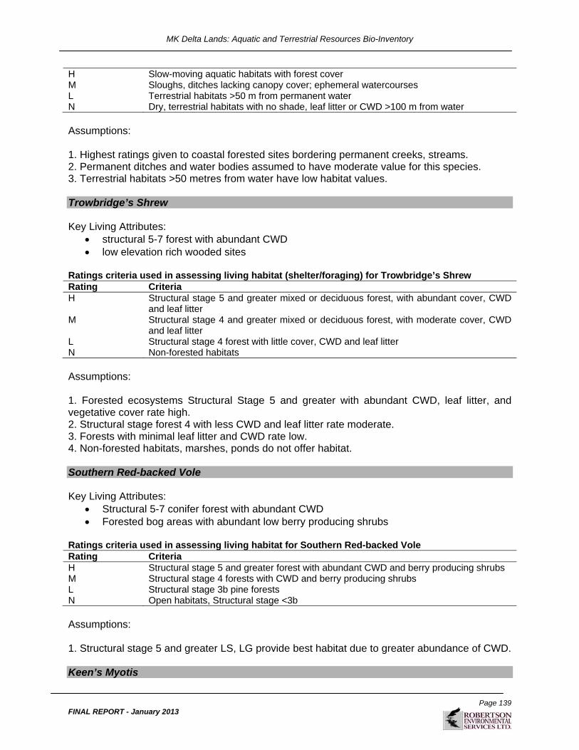
MK Delta Lands: Aquatic and Terrestrial Resources Bio-Inventory
Page 139
FINAL REPORT - January 2013
H Slow-moving aquatic habitats with forest cover M Sloughs, ditches lacking canopy cover; ephemeral watercourses L Terrestrial habitats >50 m from permanent water N Dry, terrestrial habitats with no shade, leaf litter or CWD >100 m from water Assumptions: 1. Highest ratings given to coastal forested sites bordering permanent creeks, streams. 2. Permanent ditches and water bodies assumed to have moderate value for this species. 3. Terrestrial habitats >50 metres from water have low habitat values. Trowbridge’s Shrew Key Living Attributes:
structural 5-7 forest with abundant CWD low elevation rich wooded sites
Ratings criteria used in assessing living habitat (shelter/foraging) for Trowbridge’s Shrew Rating Criteria H Structural stage 5 and greater mixed or deciduous forest, with abundant cover, CWD
and leaf litter M Structural stage 4 and greater mixed or deciduous forest, with moderate cover, CWD
and leaf litter L Structural stage 4 forest with little cover, CWD and leaf litter N Non-forested habitats Assumptions: 1. Forested ecosystems Structural Stage 5 and greater with abundant CWD, leaf litter, and vegetative cover rate high. 2. Structural stage forest 4 with less CWD and leaf litter rate moderate. 3. Forests with minimal leaf litter and CWD rate low. 4. Non-forested habitats, marshes, ponds do not offer habitat. Southern Red-backed Vole Key Living Attributes:
Structural 5-7 conifer forest with abundant CWD Forested bog areas with abundant low berry producing shrubs
Ratings criteria used in assessing living habitat for Southern Red-backed Vole Rating Criteria H Structural stage 5 and greater forest with abundant CWD and berry producing shrubs M Structural stage 4 forests with CWD and berry producing shrubs L Structural stage 3b pine forests N Open habitats, Structural stage <3b Assumptions: 1. Structural stage 5 and greater LS, LG provide best habitat due to greater abundance of CWD. Keen’s Myotis

MK Delta Lands: Aquatic and Terrestrial Resources Bio-Inventory
Page 140
FINAL REPORT - January 2013
Key Security/Thermal Attributes:
cool, wet coastal forests and karst features prefers old forest with deciduous trees (cottonwood), structural stage 6-7 roost in warm rock faces with crevices, small caves or loose bark
Ratings criteria used in assessing security/thermal habitat for Keen’s Myotis Rating Criteria H Structural stage 6-7 forests, with abundant cavities M Structural stage 5 forest with abundant cavities L Structural stage 5 forest with limited cavities N All forested ecosystems lacking cavities Assumptions: 1. Structural stage 6-7 forests with cavities and snags offer high rated foraging habitat Key Foraging Attributes:
forages in forest gaps Ratings criteria used in assessing foraging habitat for Keen’s Myotis Rating Criteria H Wetlands, aquatic and edge habitats in structural stage 6 and greater forest M Wetlands, aquatic and edge habitats > 2 km from potential roost sites L Open habitats >2 km from potential roost areas N Urban, industrial areas Assumptions: 1. Ponds, wetlands near roosting habitat offers high rated habitat
Related Documents