FCCC/SBSTA/2009/MISC.8 GE.09-61190 15 May 2009 ENGLISH ONLY UNITED NATIONS FRAMEWORK CONVENTION ON CLIMATE CHANGE SUBSIDIARY BODY FOR SCIENTIFIC AND TECHNOLOGICAL ADVICE Thirtieth session Bonn 1–10 June 2009 Item 6 of the provisional agenda Research and systematic observation Assessment of the status of the development of standards for essential climate variables in the terrestrial domain and development of a framework for climate-related terrestrial observations: Update on progress Revised submission from the secretariat of the Global Terrestrial Observing System 1. The Subsidiary Body for Scientific and Technological Advice (SBSTA), at its twenty-seventh session (FCCC/SBSTA/2007/16, para. 39), encouraged the secretariat of the Global Terrestrial Observing System (GTOS) and the sponsoring agencies of GTOS to finalize the assessment of the status of the development of standards for each of the essential climate variables in the terrestrial domain, and invited the GTOS secretariat to report to the SBSTA on progress at its twenty-ninth session. At the same session, the SBSTA encouraged the GTOS secretariat and the sponsoring agencies of GTOS to continue developing the framework for the preparation of guidance materials, standards and reporting guidelines for terrestrial observing systems for climate, in response to decision 11/CP.9, in the way they consider most appropriate, making use of existing institutional bodies and processes, where appropriate, and taking into account that such a framework should meet certain criteria (FCCC/SBSTA/2007/16, para. 40). 2. In response to the above invitation, the GTOS secretariat submitted, by the twenty-ninth session of the SBSTA, a progress report on the development of standards for each of the essential climate variables in the terrestrial domain, which included information on the development of the above- mentioned framework. That progress report is contained in FCCC/SBSTA/2008/MISC.12. 3. At its twenty-ninth session, the SBSTA agreed to defer consideration of the above-mentioned progress report to its thirtieth session. The GTOS secretariat and the sponsoring agencies of the GTOS have continued their work on the development of the standards for the essential climate variables and on the framework for the preparation of guidance materials, standards and reporting guidelines for terrestrial

Welcome message from author
This document is posted to help you gain knowledge. Please leave a comment to let me know what you think about it! Share it to your friends and learn new things together.
Transcript
FCCC/SBSTA/2009/MISC.8 GE.09-61190
15 May 2009 ENGLISH ONLY
UNITED NATIONS FRAMEWORK CONVENTION ON CLIMATE CHANGE SUBSIDIARY BODY FOR SCIENTIFIC AND TECHNOLOGICAL ADVICE Thirtieth session Bonn 1–10 June 2009 Item 6 of the provisional agenda Research and systematic observation
Assessment of the status of the development of standards for essential climate variables in the terrestrial domain and development of a framework for
climate-related terrestrial observations: Update on progress
Revised submission from the secretariat of the Global Terrestrial Observing System
1. The Subsidiary Body for Scientific and Technological Advice (SBSTA), at its twenty-seventh session (FCCC/SBSTA/2007/16, para. 39), encouraged the secretariat of the Global Terrestrial Observing System (GTOS) and the sponsoring agencies of GTOS to finalize the assessment of the status of the development of standards for each of the essential climate variables in the terrestrial domain, and invited the GTOS secretariat to report to the SBSTA on progress at its twenty-ninth session. At the same session, the SBSTA encouraged the GTOS secretariat and the sponsoring agencies of GTOS to continue developing the framework for the preparation of guidance materials, standards and reporting guidelines for terrestrial observing systems for climate, in response to decision 11/CP.9, in the way they consider most appropriate, making use of existing institutional bodies and processes, where appropriate, and taking into account that such a framework should meet certain criteria (FCCC/SBSTA/2007/16, para. 40).
2. In response to the above invitation, the GTOS secretariat submitted, by the twenty-ninth session of the SBSTA, a progress report on the development of standards for each of the essential climate variables in the terrestrial domain, which included information on the development of the above-mentioned framework. That progress report is contained in FCCC/SBSTA/2008/MISC.12.
3. At its twenty-ninth session, the SBSTA agreed to defer consideration of the above-mentioned progress report to its thirtieth session. The GTOS secretariat and the sponsoring agencies of the GTOS have continued their work on the development of the standards for the essential climate variables and on the framework for the preparation of guidance materials, standards and reporting guidelines for terrestrial
- 2 -
* This submission has been electronically imported in order to make it available on electronic systems, including the World Wide Web. The secretariat has made every effort to ensure the correct reproduction of the text as submitted.
observations, and prepared an updated and more comprehensive report on this matter. This updated report is included in the present document and provides information which supersedes that contained in document FCCC/SBSTA/2008/MISC.12.
4. In accordance with the procedure for miscellaneous documents, this submission is attached and reproduced* in the language in which it was received and without formal editing. .
- 3 -
REVISED SUBMISSION FROM THE SECRETARIAT OF THE GLOBAL TERRESTRIAL OBSERVING SYSTEM
Report to the 30th session of the Subsidiary Body for
Scientific and Technological Advice
A Framework for Terrestrial Climate-Related Observations and the Development of Standards for the Terrestrial Essential Climate Variables
1. A Framework for Terrestrial Climate-Related Observations: Proposed Implementation:
Part A – Synopsis
Part C – Full Report
2. Status of the Development of Standards for the Essential Climate Variables in the Terrestrial Domain
Part B – Synopsis
Part D – Full Report
April 2009
Submitted by the Secretariat of the Global Terrestrial Observing System
GTOS 71
version 1.0
- 4 -
Table of content
Executive Summary...........................................................................................................................6
Part A. Synopsis - A Framework for Terrestrial Climate-Related Observations: Proposed Implementation................................................................................................................7
A-1. Introduction and purpose ............................................................................................................7 A-2. Progress to date...........................................................................................................................7 A-3. The proposed structure ...............................................................................................................8
A-3.1 Overview.........................................................................................................................8 A-3.2 Relationship to other bodies interested in standardization...........................................10 A-3.3 Compliance with requirements .....................................................................................10
A-4. Summary and next steps ...........................................................................................................12 A-5. Recommendations.....................................................................................................................13 A-6. References ................................................................................................................................13
Part B. Synopsis - Status of the Development of Standards for the Essential Climate Variables in the Terrestrial Domain..............................................................14
B-1. Introduction and Objective .......................................................................................................14 B-2. Approach...................................................................................................................................14 B-3. Results and discussion ..............................................................................................................15 B-4. Recommendations.....................................................................................................................18 B-5. References.................................................................................................................................18
Part C. Report - A Framework for Terrestrial Climate-Related Observations: Proposed Implementation..............................................................................................................19
C-Abstract .........................................................................................................................................19 C-1. Introduction and background ....................................................................................................19 C-2. Progress to date .........................................................................................................................20 C-3. The proposed structure .............................................................................................................21
C-3.1 Overview.......................................................................................................................21 C-3.2 Organizational entities ..................................................................................................23
C-4. Roles and relationships .............................................................................................................24 C-4.1 Overview.......................................................................................................................24 C-4.2 New organizational entities ..........................................................................................25 C-4.3 Relationship to other bodies interested in standardization ...........................................28
C-5. Compliance with requirements .................................................................................................29 C-5.1 Responsiveness to SBSTA criteria ...............................................................................29 C-5.2 Other requirements........................................................................................................30
C-6. Summary and way forward .......................................................................................................31 C-7. Recommendations.....................................................................................................................32 C-8. References.................................................................................................................................33 C-9. Appendices................................................................................................................................34
C-9.1 Draft UN-ISO Memorandum of Understanding ...........................................................34 C-9.2 Draft JSG Terms of Reference......................................................................................36 C-9.3 Draft Initial work programme .......................................................................................37 C-9.4 Background information about key agencies involved in the Framework ...................40 C-9.5 Stages and substages of the ISO standards development process.................................46
- 5 -
Part D. Report - Status of the Development of Standards for the Essential Climate Variables in the Terrestrial Domain.............................................................. 47
D- Abstract ....................................................................................................................................... 47 D- Acknowledgements ..................................................................................................................... 47 D-1. Introduction and Objective....................................................................................................... 48 D-2. Methodology ............................................................................................................................ 48
D-2.1 Approach ...................................................................................................................... 48 D-2.2 Common standards ....................................................................................................... 49
D-3. ECV status................................................................................................................................ 51 D-3.1 Albedo .......................................................................................................................... 51 D-3.2 Biomass ........................................................................................................................ 53 D-3.3 Fire Disturbance ........................................................................................................... 55 D-3.4 Fraction of Absorbed Photosynthetically Active Radiation......................................... 57 D-3.5 Glaciers and Ice Caps ................................................................................................... 60 D-3.6 Ground Water ............................................................................................................... 62 D-3.7 Lake Levels and Reservoir Storage.............................................................................. 65 D-3.8 Land Cover ................................................................................................................... 67 D-3.9 Leaf Area Index............................................................................................................ 69 D-3.10 Permafrost .................................................................................................................. 71 D-3.11 River Discharge.......................................................................................................... 73 D-3.12 Snow Cover ................................................................................................................ 76 D-3.13 Soil Moisture .............................................................................................................. 78 D-3.14 Water Use................................................................................................................... 80
D-4. Summary................................................................................................................................... 81 D-5. Recommendations .................................................................................................................... 82 D-6. References ................................................................................................................................ 83 D-7. Appendix: Scope of four ISO Technical Committees.............................................................. 84
ABCD-7.2 Appendix 2: Acronyms .................................................................................................. 85
- 6 -
Executive Summary Reliable assessments of global and regional environmental changes - both natural and human-induced - require systematic, consistent and well-documented observations. Since data for the terrestrial environment are obtained by national agencies and given that the existing national data gathering systems developed in the absence of a consistent international framework, the fulfilment of this requirement presents a special challenge. Recognizing the inadequacy of the existing strategies for the United Nations Framework Convention on Climate Change (UNFCCC), its Conference of the Parties (COP) requested at its 9th session that the Global Terrestrial Observing System (GTOS) “develop a framework for the preparation of guidance materials, standards and reporting guidelines for terrestrial observing systems for climate, and associated data and products”. The COP Subsidiary Body for Scientific and Technological Advice (SBSTA) also requested at its 23rd session that the GTOS secretariat “assess the status of the development of standards for each of the essential climate variables in the terrestrial domain”. The present report reviews the progress to date and then responds to both the above requests. It updates and supersedes information that was provided on both matters in earlier reports by the GTOS and included in FCCC/SBSTA/2008/MISC.12. It proposes a Framework for the development of standards and guidance materials that builds on existing institutions and the mechanisms they established, specifically five UN specialized agencies sponsoring the GTOS (FAO, ICSU, UNEP, UNESCO, WMO) and the International Organization for Standardization (ISO). The proposed Framework is consistent with guidelines issued by the SBSTA at its 27th session. One new organizational entity is proposed, with responsibility for coordinating the standards development activities. Component parts of the Framework, their responsibilities and interactions have been identified, and draft foundation documents prepared (refer to Part C of this report). Following detailed review of the existing standards, guides and measurement protocols for individual ECVs, an initial work plan for the development of new standards was prepared (refer to Part D of this report) to take place within the proposed Framework. Based on the above work, the following recommendations are made: Recommendations Regarding the Framework development, it is recommended that:
1. COP/SBSTA endorse the Framework proposal developed in this report, in the present or modified form as appropriate.
2. COP/SBSTA request that the GTOS and its partners implement the UN-ISO Framework, by obtaining the approvals needed and setting up the appropriate mechanisms.
3. The development of an initial set of ECV standards and guidance materials begin as soon as possible.
4. The COP request countries to identify human and financial resources for supporting the Framework.
5. The GTOS be requested to report on progress to the SBSTA at its 32nd session. Regarding the status of ECV standardization, it is recommended that:
1. This report (specifically Part D) be employed in preparing a workplan for the development of standards and guidance materials for terrestrial ECVs.
2. COP/SBSTA encourage the CEOS and countries with satellite- based earth observation programmes to continue, and if possible accelerate methodology development, validation and intercomparisons of satellite-based ECV products for the terrestrial domain.
- 7 -
PART A. SYNOPSIS - A FRAMEWORK FOR TERRESTRIAL CLIMATE-RELATED OBSERVATIONS: PROPOSED IMPLEMENTATION
A-1. Introduction and purpose 1.1 Reliable assessment of global and regional environmental changes - both natural and human-induced - requires systematic, consistent and well-documented observations. The need for consistent and comprehensive global observations is particularly critical in case of climate change, due to the climate system which affects the environment and the society at all scales, from local to global. While such needs exists in all three parts of the global system (atmosphere, oceans, land), it is least fulfilled for the land component. The major reason is that sharing atmospheric and oceanic measurements results benefits all participating countries because of the dynamic nature and global scope of these systems. In contrast, observations on land have typically been made for local to national purposes, thus using independently developed methods that frequently produce incompatible measurements. 1.2 The consultation and planning process resulting in the GCOS Implementation Plan determined that “the climate observing system in the Terrestrial Domain remains the least well-developed component of the global system, whilst at the same time there is increasing significance being placed on terrestrial data for climate forcing and understanding, as well as for impact and mitigation assessment” (GCOS, 2004, p.9). 1.3 In developing the systematic observations for the UNFCCC, the Conference of the Parties (COP) in its ninth 9th session held in Milan, 1-12 December 2003, decided to invite (Decision 11/CP.9; UNFCCC, 2003):
“the sponsoring agencies of the Global Climate Observing System, and in particular those of the Global Terrestrial Observing System, in consultation with other international or intergovernmental agencies, as appropriate, to develop a framework for the preparation of guidance materials, standards and reporting guidelines for terrestrial observing systems for climate, and associated data and products, taking into consideration possible models, such as those of the World Meteorological Organization/Intergovernmental Oceanographic Commission Joint Commission for Oceanographic and Marine Meteorology, and to submit a progress report on this issue to the Conference of the Parties at its eleventh session”.
The GCOS Implementation Plan was endorsed by the Conference of the Parties (COP) at its 10th session (Decision 5/CP.10, Buenos Aires, 6-18 December 2004). 1.4 The present document summarizes the progress made to date, and then presents an approach for meeting the UNFCCC requirements. The term ‘Framework’ refers specifically to the mechanism envisioned by the COP.
A-2. Progress to date 2.1 Over the past several years, GTOS in collaboration with partners investigated various options which could meet the requirements for standardization. It studied two existing international mechanisms for standardization (an intergovernmental model, for example the Joint Commission on Oceanography and Marine Meteorology - JCOMM; and an international model, such as the International Organization for Standardization - ISO). GTOS then developed three options for implementing the Framework which were submitted to SBSTA through a series of progress reports:
The first progress report on developing a Framework for the preparation of guidance materials, standards and reporting guidelines for terrestrial observing systems for climate was presented to the 23rd session of SBSTA (Montreal, 28 November to 6 December 2005; SBSTA, 2005);
The second progress on the same subject was presented to the SBSTA at its 26th session in Bonn, Germany (SBSTA, 2007a). The GTOS provided an update to this report prior to the 27th session of the SBSTA in Bali (SBSTA, 2007b).
- 8 -
2.2 The three options presented to the SBSTA’s 27th session were (SBSTA, 2007b): Option A – “Terrestrial Joint Commission”: established as a subsidiary body of three
intergovernmental organizations that deal specifically with primary terrestrial observations (FAO, UNEP, WMO), similar to the JCOMM, led and implemented within the UN system;
Option B - Terrestrial Committee: A new group (or subgroup) created within the ISO. The structure, the rules of operation, work plan, and reporting would be embedded in a Memorandum of Understanding between the ISO and the GTOS/FAO. Standards development would generally follow ISO practices and precedents.
Option C - Terrestrial Observations Mechanism: a third model, where the coordinating entity would be another organization, such as the Intergovernmental Panel for Climate Change (IPCC).
The above options were compared using several types of criteria, and implementation steps were identified for options A and B.
2.3 The SBSTA provided helpful feedback to the individual progress reports. At its 27th session (held in Bali from 3 to 11 December 2007), the SBSTA responded as follows (SBSTA, 2008):
The SBSTA welcomed the efforts by the GTOS secretariat to develop a framework for the preparation of guidance materials, standards and reporting guidelines for terrestrial observing systems for climate, in response to decision 11/CP.9. The SBSTA welcomed the progress report by the GTOS secretariat on this matter and took note of the different options for such a framework presented therein. The SBSTA encouraged the GTOS secretariat and the sponsoring agencies of GTOS to continue developing the framework in the way they consider most appropriate, making use of existing institutional bodies and processes, where appropriate, and taking into account that such a framework should meet the following criteria:
(a) Standards should be developed on a scientifically sound basis; (b) The framework should provide for the involvement of governments in the development of standards and guidance materials and in their implementation; (c) Access to those standards and guidance materials should be free and unrestricted; (d) The process for developing the standards and guidance materials and the operation of the framework should be cost-effective and sustainable and take into account existing standards and guidance materials; (e) The framework should be flexible in view of future needs and developments in this area.
2.4 Subsequent discussions involving agencies potentially involved in implementing Options A or B resulted in an agreement that the preferred Framework should encompass the UN agencies as well as ISO, thus effectively merging the two options. A-3. The proposed structure A-3.1 Overview 3.1.1 Figure A-1 shows the proposed entities to constitute the Framework, and their relationships: intergovernmental and international organizations, including their components and programmes; and an “added set” established specifically for the development of standards for terrestrial observations. Briefly, these are:
The UNFCCC, with Conference of the Parties as the UNFCCC Decision Body and the Subsidiary Body for Scientific and Technical Advice (SBSTA) as the technical arm;
The FAO, with the GTOS as the main programme responsible for the terrestrial ECV issues; The WMO, with the GCOS as the main programme responsible for climate observation issues; Other UN organizations interested in standards for terrestrial observations, directly or through
sponsorship of programmes such as the GTOS; e.g. the United Nations Environment Programme (UNEP).
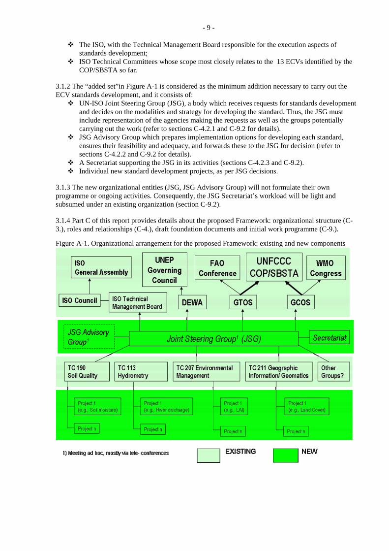
- 9 -
The ISO, with the Technical Management Board responsible for the execution aspects of standards development;
ISO Technical Committees whose scope most closely relates to the 13 ECVs identified by the COP/SBSTA so far.
3.1.2 The “added set”in Figure A-1 is considered as the minimum addition necessary to carry out the ECV standards development, and it consists of:
UN-ISO Joint Steering Group (JSG), a body which receives requests for standards development and decides on the modalities and strategy for developing the standard. Thus, the JSG must include representation of the agencies making the requests as well as the groups potentially carrying out the work (refer to sections C-4.2.1 and C-9.2 for details).
JSG Advisory Group which prepares implementation options for developing each standard, ensures their feasibility and adequacy, and forwards these to the JSG for decision (refer to sections C-4.2.2 and C-9.2 for details).
A Secretariat supporting the JSG in its activities (sections C-4.2.3 and C-9.2). Individual new standard development projects, as per JSG decisions.
3.1.3 The new organizational entities (JSG, JSG Advisory Group) will not formulate their own programme or ongoing activities. Consequently, the JSG Secretariat’s workload will be light and subsumed under an existing organization (section C-9.2). 3.1.4 Part C of this report provides details about the proposed Framework: organizational structure (C-3.), roles and relationships (C-4.), draft foundation documents and initial work programme (C-9.).
Figure A-1. Organizational arrangement for the proposed Framework: existing and new components
- 10 -
A-3.2 Relationship to other bodies interested in standardization 3.2.1 The ISO process is well suited to assimilating the contributions of other organizations, programmes, and individual experts. For this purpose, the ISO process recognizes three categories of liaison organizations (A, B, D). These liaison mechanisms facilitate the involvement of countries, international organizations and programmes, scientific bodies, and similar entities in the development of international standards. 3.2.2 ISO standards “are based on international consensus among the experts in the field”. The proposed standardization approach should therefore meet the requirements of other potential users of in situ environmental observations. It should also accommodate the development of ‘integrated standards’ that encompass in situ and space- based observations, once the methodologies for making and processing space-based measurements are sufficiently developed through R&D and thus stabilized. In turn, standardization of in situ measurements supports the development of satellite-based methods because of their vital role in the calibration, validation and intercomparisons of satellite-derived Essential Climate Variable (ECV) products. With its international reputation regarding standardization in both earth sciences and information technology, the ISO is well positioned to generate standards that underpin the needs of the UNFCCC and other users. A-3.3 Compliance with requirements 3.3.1 This section discusses the responsiveness of the proposed Framework to earlier guidelines. 3.3.2 Compliance with SBSTA 27 guidelines:
(a) Standards should be developed on a scientifically sound basis. This requirement is met: “Standards should be based on the consolidated results of science, technology and experience, and aimed at the promotion of optimum community benefits” (ISO, 2004). The involvement of technical experts is thus provided for in the process, e.g. through working groups in which experts act in their personal capacity (ISO, 2008). Category A and Category D liaison organizations also have the option of nominating experts to participate in a working group or a project team (ISO, 2008). (b) The Framework should provide for the involvement of governments in the development of standards and guidance materials and in their implementation. National governments are involved in various ways: (i) by providing inputs and representatives to standards development, through ISO technical committees and national delegations to ISO meetings, as well as through mirror national committees; (ii) by voting on the developed standards as part of the ISO process; (iii) by voting on the endorsement of a standard through the UN governing bodies; and (iv) by making programmatic decisions about adopting the developed standards for their national monitoring and reporting programmes and activities. It is important to note that the involvement of governments is subject to the ‘right people’ and financial resources being available; while the first condition does not generally pose problems, the second one may, and often does in case of developing countries. Although the ISO has a mechanism for making available financial support to developing countries for attending meetings etc., these resources are limited and the problem is thus not completely resolved. (c) Access to those standards and guidance materials should be free and unrestricted. Normally, documents containing ISO international standards are sold to increase revenue for ISO operations. Since the standards developed through the Framework will be dual UN-ISO standards, they will be available both through the UN organizations (free of charge, e.g. on the Internet), and through the usual ISO channels (for a fee, in digital or printed form). The resulting documents will thus be joint UN-ISO standards, jointly owned by the UN organizations
- 11 -
(‘background’ intellectual property) and the ISO (‘foreground’ intellectual property). There are existing precedents for this arrangement. (d) The process for developing the standards and guidance materials and the operation of the Framework should be cost-effective and sustainable and take into account existing standards and guidance materials.
Cost- effectiveness and sustainability: The incremental costs of the proposed Framework are the minimum possible while still achieving the purpose for which the Framework is established. This ‘minimum’ is feasible because within the ISO process, most of the additional costs rest with countries participating in the technical committees that develop the ECV standards. The incremental costs of the Framework, due to the ‘added set’ (section C-4.2), are minimized because:
o The added work represents the minimum necessary to ensure, through coordination, efficient and effective expenditure of the overall effort and resources.
o The added groups have no programme of their own but respond to requests from the UN agencies, therefore their workload will be relatively light.
o The financial viability of the proposed Framework depends on the willingness of countries supporting the existing TC Secretariats to also support the additional workload resulting from the development of the ECV standards.
Taking into account existing standards and guidance materials: Existing standards or guidance materials would be considered at two stages: when deciding on a requirement for a new standard, and when developing the standard (refer also to Part D). In the process of standard development, the existing standards, protocols, guides, and guidance materials are considered by ISO technical committees.
(e) The Framework should be flexible in view of future needs and developments in this area. In principle, the proposed Framework is suitable to the development of UN-ISO international standards for all terrestrial observations of interest to the UN agencies. Subject to changes in the participating agencies and related changes of the JSG, this Framework is also suitable for other observations regarding the Earth’s environment. Similarly, this Framework can be employed to develop standards for synergistic use of in situ and satellite measurement and reporting strategies, again following appropriate adjustments in the terms of reference and the sponsoring agencies.
3.3.3 An earlier report to SBSTA (SBSTA, 2007b) examining organizational options for the Framework also identified several criteria that an optimal Framework arrangement should meet. Further criteria were suggested in Part C of this report. These criteria and the suitability of the UN-ISO mechanism are briefly reviewed below.
A mechanism for scientific or technical input from “interested” countries, but not insisting on input from all countries on every issue: This is an intrinsic characteristic of the ISO process.
A means for coordination at international level with groups or organizations having similar interests, including scientific programmes, international agencies, and synthesis-producing groups: Such groups can contribute to the ISO standard development through liaison organizations or national member bodies.
A mechanism for arriving at a scientific or technical consensus: This is an intrinsic characteristic of the ISO process.
A mechanism for producing final international consensus: This is an intrinsic characteristic of the ISO process, implemented through voting.
A means for conveying the consensus to the national level for action: In the proposed Framework, this will occur through UNFCCC/UN endorsement of the developed standard.
- 12 -
A strategy that will ensure financial and in-kind support for the activity and by national governments: Such support is built- in as part of the ISO. It should be noted, however, that national support for ISO standards development varies depending on the national relevance of that standard, and on the financial resources available.
A communications strategy to raise the profile of the work and raise extra-budgetary resources: The ISO has an active communications/ public outreach programme (refer e.g. to the ISO Focus magazine issue on Climate change (Vol. 5, No. 2, February 2008, www.iso.org).
A means for ensuring continuity and for being responsive to changing requirements: This is an intrinsic characteristic of the ISO process. It includes procedures for review/ updates of existing standards and for undertaking new standard development projects.
The Framework should maximize the likelihood of success in achieving objectives of COP/SBSTA and of UN agencies: “Success” in this context is defined as the development and application of standards for the collection and reporting of terrestrial observations. In the proposed Framework, such success should be achievable a) through the combined leadership of UN-ISO in standard development (supported by national bodies and experts), and b) through the use of standards that are endorsed by the Decision Bodies of the UN organizations and the national governments represented therein. Thus, it is considered that the proposed merged model is as streamlined an approach for achieving success on a sustained basis as is feasible given the objective at hand.
Be as responsive, flexible and nimble as realistically possible: Within the broad domain of developing standards for climate- related terrestrial observations, the proposed model offers a high flexibility in terms of type of documents to be developed, contributors/ participants in such development, and type of output products. Furthermore, thematic areas other than in situ terrestrial observations could be addressed, and the nominal standards development process could be readily modified with the consent of the sponsoring agencies.
A-4. Summary and next steps 4.1 The proposed Framework put forward in this report meets the guidelines of the SBSTA, and requires modest additional organizational effort. It is based on a collaborative arrangement between UN agencies and the ISO, formalized through a Memorandum of Understanding; Joint Steering Group, a new coordination entity within the ISO process with representation from the sponsoring agencies; and the conduct of the standards development work through ISO technical committees and the process they employ. As well as complying with the criteria identified by the SBSTA, the Framework also meets other criteria regarding efficiency, effectiveness and flexibility. For details regarding the proposed Framework and supporting documentation, refer to Part C of this report. 4.2 The implementation of the Framework should proceed through several stages:
1. Endorsement of the proposed UN-ISO Framework as a solution that would meet the needs of the UNFCCC.
2. Approval of the UN-ISO Memorandum of Understanding. This approval should be given by the ISO Council and the corresponding Decision Bodies of the sponsoring UN organizations.
3. Completion of the terms of reference and procedures for the Joint Steering Group (refer to section C-9.2 for a draft version).
4. Development of an initial work plan, and of detailed plans for the initial set of projects. 5. Approval of the plan of work, beginning project execution.
- 13 -
A-5. Recommendations It is recommended that:
1. COP/SBSTA endorse the Framework proposal developed in this report, in the present or modified form as appropriate.
2. COP/SBSTA request that the GTOS and its partners implement the UN-ISO Framework, by obtaining the approvals needed and setting up the appropriate mechanisms.
3. The development of an initial set of ECV standards and guidance materials begin as soon as possible.
4. The COP request countries to identify human and financial resources for supporting the Framework.
5. The GTOS be requested to report on progress to the SBSTA at its 32nd session.
A-6. References GCOS. 2004. Implementation Plan for the Global Observing System for Climate in support of the
UNFCCC. Report GCOS – 92 (WMO/TD No. 1219). 136p. ISO. 2004. ISO/IEC Directives, Part 2. Rules for the structure and drafting of International Standards. 5th
edition, International Organization for Standardization. 68p. ISO. 2008. ISO/IEC Directives, Part 1. Procedures for the technical work. 6th edition, International
Organization for Standardization. 76p. SBSTA. 2006. Report of the Subsidiary Body for Scientific and Technological Advice on its twenty-third
session, held at Montreal from 28 November to 6 December 2005. Report FCCC/SBSTA/2005/10. 33p.
SBSTA. 2007a. Progress in the development of guidance materials, standards and reporting guidelines for terrestrial observing systems for climate Submission from the secretariat of the Global Terrestrial Observing System. Paper No. 2: A Framework for Terrestrial Climate-Related Observations: Implementation Options. Progress Report to the Subsidiary Body for Scientific and Technological Advice Twenty-sixth session, Bonn, 7–18 May 2007, Report FCCC/SBSTA/2007/MISC.6: 25-44.
SBSTA. 2007b. Further progress in the development of guidance materials, standards and reporting guidelines for terrestrial observing systems for climate. Submission from the secretariat of the Global Terrestrial Observing System secretariat to the Subsidiary Body for Scientific and Technological Advice, Twenty-seventh session, Bali, December 2007, Report FCCC/SBSTA/2007/MISC.27: 28-48.
UNFCCC. 2003. Report of the Conference of the Parties on its Ninth Session, held at Milan from 1 to 12 December 2003. Part Two: Action Taken by the Conference of the Parties at its Ninth Session. 65p.
- 14 -
PART B. SYNOPSIS - STATUS OF THE DEVELOPMENT OF STANDARDS FOR THE ESSENTIAL CLIMATE VARIABLES IN THE TERRESTRIAL DOMAIN
B-1. Introduction and Objective 1.1 At its 23rd session, the Subsidiary Body for Scientific and Technological Advice (SBSTA) to the UNFCCC Conference of the Parties (SBSTA, 2006, p. 16):
“.. also called on the GTOS secretariat to assess the status of the development of standards for each of the essential climate variables in the terrestrial domain.”
1.2 The Global Terrestrial Observing System (GTOS) and its sponsors have acted on this request. The development of the methodology and initial results were reported to the 26th (SBSTA, 2007a) and 27th (SBSTA, 2007b) session of the SBSTA. Detailed investigations were then carried out by teams of specialists dealing with individual Essential Climate Variables (ECVs), peer reviewed, and placed on the GTOS website. Through its Secretariat, the GTOS subsequently undertook a detailed inventory of the standards, guides and other guidance materials that are currently available for individual terrestrial ECVs, either directly addressing the standardization issues or otherwise relevant. One objective of this work was to contribute to the development of an initial workplan for the standardization effort to be undertaken within the proposed UN-ISO Framework for terrestrial ECVs. The full document is provided as an annex to this report (Part D); the following sections contain synopsis of the approach and results. 1.3 While both satellite and in situ measurement play key roles (depending on the ECV), the standards being considered in this report refer exclusively to in situ measurements. Satellite-based measurement and reporting standards need to be considered separately at this stage because, among other reasons, the methodologies are still under development. Nevertheless, standardization of in situ measurements for ECVs that rely fully on satellite data (e.g., Leaf Area Index) has been included in the report.
B-2. Approach 2.1 When deciding which ECVs should be subject to the standardization process in the initial phase, the following questions need to be answered (for brevity, the term ‘standard’ is used hereafter to denote the other reference materials).
1. What specific measurements need to be standardized (usually more than one per ECV)? 2. Although there may not be a consensus on the measurement approach, do candidate methods
exist (with supporting documentation) that could form the initial nucleus of an international standard?
3. In light of the above, is the preparation of an international standard feasible? 4. Would such a standard be of interest beyond GCOS/GTOS, thus potentially gathering more
support for, and involvement in, its formulation? 5. Which would be the candidate lead group(s) – within the ISO and within the UN or the
international scientific community? 6. Given the above, what is the most appropriate way forward for standardizing this ECV in terms
of need, priority, and the preferred format? 2.2 The above questions were addressed separately for each ECV. Much of the information was taken from the existing documentation, available at the GTOS Web site (www.fao.org/gtos/topcECV.html). A draft of the report was reviewed by experts and revised accordingly; the revised document constitutes Part D of this report.
- 15 -
B-3. Results and discussion 3.1 Since all ECV observations must be recorded and reported in relation to specific geographic locations, geographic representation standards underpin all ECV observing and reporting strategies. A total of 21 such ISO standards, common to the terrestrial ECVs, have been identified. 3.2 Answers to the above six questions for individual ECVs were captured under the following headings (refer to Part D):
Specific measurements Candidate measurement methods, standards and guides Feasibility Wider relevance Candidate lead groups
o Standard preparation lead o Technical input
Conclusion. In the paragraphs that follow, only the conclusions are summarized. 3.3 Albedo. Albedo measurements have long been of interest to studies, monitoring and modeling of climate and weather processes. Measurement guides have been developed by the WMO and by scientific groups, and they are periodically updated. Lack of standards does not appear to be an obstacle to obtaining reliable surface albedo data needed for ECV purposes. However, there is also a need for developing a consensus (and ultimately standards) for the measurement of the upwelling radiation reflected by the surface, as well as for the characterization of surface anisotropy. 3.4 Biomass. Preparation of an international standard for in situ biomass measurements is highly desirable and technically feasible. Such an activity would also require support by countries, especially those with large forest resources, in order to be successful. Given that the measurement issues are well understood, an international standard would be an appropriate format to aim at. 3.5 Fire Disturbance. Standardization of in situ measurements in support of satellite-based fire disturbance monitoring is at an early stage of development. Present efforts by the GOFC-GOLD Fire Implementation Team in conjunction with the CEOS LPV Subgroup are focused on a Burned Area Validation Protocol for Coarse Resolution Satellite data, and similar efforts could be undertaken for the other fire disturbance products. Since the methodologies will change with evolving technology (instrumentation and platforms), the exploration of new and robust in situ fire measurement approaches should be supported by the space agencies and should involve cooperation with the fire management agencies. 3.6 Fraction of Absorbed Photosynthetically Active Radiation (FAPAR). Further development of standardized methods for FAPAR in situ measurements would benefit from a comprehensive guide to field measurements. Such a document should be prepared from a broader perspective of canopy characterization, including other ECVs (especially Leaf Area Index); and consider the use of radiative transfer models to assess the merits of alternative sampling methodologies. A guide would be a suitable format if a standardization initiative is undertaken. 3.7 Glaciers and Ice Caps. The existing documentation has served countries and research teams in making and reporting observations on glaciers. As the next step, it appears that systematic glacier observations would benefit from an up-to-date document which, while building on the various sources, provides a common basis for making and reporting such observations in a consistent manner. An international standard would provide a suitable format.
- 16 -
3.8 Ground Water. Given the limited level of activity globally; the relatively simple measurement requirements; and the existing (including recently prepared) guidelines, the need for a comprehensive standard is presently low. The most serious challenge in groundwater monitoring is the comprehensiveness of the monitoring network, and standardization issues have not been identified as a significant impediment to expanding groundwater level monitoring at the country level. Should a standardization effort be undertaken, a guide is likely the most appropriate format to provide effective assistance in the establishment and operation of country - and acquifer - level monitoring programmes. 3.9 Lake Levels and Reservoir Storage. It is not clear to which extent the existing ISO standards have been considered in the current versions of the WMO guides. There may thus be a need to more systematically integrate recent ISO standards (mostly from TC113) with the WMO Guides, specifically for the chapters related to lake level and reservoir storage measurements. If appropriate, the relevant chapters of the integrated document could then be submitted as a working draft for a Lake Levels and Reservoir Storage International Standard. 3.10 Land Cover. Activities supporting ISO standardization of the Land Cover ECV are presently underway. 3.11 Leaf Area Index (LAI). There is sufficient expertise and experience with LAI in situ measurements to make the preparation of an international standard feasible. Such a standard should be prepared with FAPAR ECV measurements in mind, and possibly Biomass ECV as well. Given the state of knowledge and experience gained to date, an international standard would be an appropriate format. 3.12 Permafrost. There are existing documents that describe permafrost measurement methodologies. They were written by experienced practitioners, have been endorsed for use by scientific groups or international projects. They do not have a formal approved international status, and are maintained through voluntary efforts of interested individuals or institutions. Permafrost monitoring would thus benefit from an International Standard formalizing existing approaches and practices. 3.13 River Discharge. River Discharge observations would benefit from a consolidated standard for in situ observations where the various partial existing standards and guidelines are brought together and reconciled. A guide document may be a format suitable for putting the existing standards into context and to fill in gaps as they may be identified. 3.14 Soil Moisture. Soil moisture is a recently proposed additional ECV. While point soil moisture measurements are well established, the main challenge for this ECV is determination of the distribution of near-surface soil moisture in support of satellite-based sensing strategies. Although methodology development in this respect has not progressed far enough to attempt standardization, the preparation of a guide documenting possible approaches and their relative merits would be valuable for upcoming satellite missions - as well as for other human activities where soil moisture information is needed. 3.15 Snow Cover. Guidelines for snow measurements have in the past been prepared by the WMO and by commissions and associations of International Union of Geodesy and Geophysics; the responsible groups continue to monitor new developments and undertake revisions. There may be a need to integrate the WMO Guide with ISO TC 211 standards and, if appropriate, to formulate a new international standard for snow measurements (that could optionally encompass both in situ and satellite-based measurement methodologies). 3.16 Water Use. Although the FAO has developed methodologies and guides for country reporting water use and irrigation to its AQUASTAT database, there are insufficient international guidelines or standards
- 17 -
for making the specific measurements. The development of protocols and methodologies is needed but this ECV is not ready for standardization. 3.17 Table B-1 provides a summary of several aspects of the ECVs: relative importance of satellite and in situ observations; potential lead group for the development of an international standard within ISO, or elsewhere if such activity has already taken place; principal groups with technical expertise; and a tentative assessment of the overall priority for developing an international standard through a new initiative. Table B-1 indicates that:
o Depending on the ECV, satellite or in situ observations serve as the primary source of information: five for satellites (satellite is the primary measurement tool, in situ provides calibration/ validation data) four for in situ (in situ measurements are the main source, satellite may facilitate spatial extrapolation), and in five cases both seem equally important.
o There are two main candidate groups for developing international standards for terrestrial ECVs: the WMO (ECVs that have traditionally been of interest to the WMO and where WMO commissions have developed guide documents in the past); and ISO technical committees, both for ECVs where ISO has been active in the past and for those where no standardization efforts have yet taken place.
o Within the ISO, the scope of four Technical Committees appears most closely related to the terrestrial ECVs (refer also to Appendix D-7.1): TC 113 (Hydrometry); TC 190 (Soil Quality); TC 207 (Environmental Management); and TC 211 (Geographic Information/ Geomatics). Regarding the division of responsibilities among these, it is worth noting that:
o TC 113 has traditionally been concerned with water-related measurements, thus those ECVs naturally fit its scope;
o TC 190 has deals with soil characteristics, thus Soil Moisture fits here; o The scope of TC211 encompasses geographic aspects of all ECVs and some thematic
aspects (e.g., Land Cover); and o TC207 has so far been concerned with measurement aspects for e.g. greenhouse gas
emissions. o The differences between in foci might help to decide how some ECVs should be handled within
the ISO. If the primary standardization issue is the measurement itself (like LAI or biomass), the ECV might best be handled by e.g. TC207. Conversely, if the measurement protocol is generally agreed upon and the main issue is handling and presentation of the observations (e.g., Glaciers), TC211 could take the lead.
o In general, considerable technical expertise in ECV measurement issues exists, concentrated at the international level in scientific programmes, projects, collaborating groups, data centres, etc. Such groups would play a key role in the development of international standards, by providing both technical and user expertise.
3.18 The last column of Table B-1 shows a subjective indicator of the priority of developing a standard based on need and readiness as documented in Part D. It shows five ECVs as High (i.e. no existing standard document, but sufficient understanding/ information available to develop a standard), five as +/-Medium, and four as Low. If confirmed through wider consultation this should provide the basis for a realistic, phased progress in the development of ECV international standards.

- 18 -
Table B-1. An overview of the characteristics of, and readiness for, standardizing ECVs. ECV Name Primarily
INSitu,SATellite, EQUal_importance
Potential Lead within Framework
Lead on behalf of community
Priority/ Urgency (Subjective)
Albedo SAT WMO WMO, WGCV L Biomass EQU TC 207 FAO Forestry H Fire Disturbance SAT TC 207/TC 211 WGCV L
(When ready) FAPAR SAT TC 207 WGCV M
Glaciers and Ice Caps
EQU TC 207/TC 211 GTN-G (with WGMS)
H
Ground Water INS TC 113 IGRAC+ associates
L
Lake Levels and Reservoir Storage
EQU TC 113/WMO GTN-H +associates
L-M
Land Cover SAT TC 211 FAO, GOFC-GOLD
H
Leaf Area Index SAT TC 207 WGCV M-H
Permafrost INS TC207/TC 211 GTN-P +associates
H
River Discharge INS TC 113 GTN-H M-H Soil Moisture* EQU TC190 TBD H Snow Cover EQU WMO/TC 207 GTN-H M Water Use INS ISO TC 113 FAO Aquastat L
(When ready) * Proposed additional ECV (GCOS, 2009) B-4. Recommendations It is recommended that:
1. This report (specifically Part D) be employed in preparing a workplan for the development of standards and guidance materials for terrestrial ECVs.
2. The COP/SBSTA encourage the Committee on Earth Observation Satellites and countries with satellite-based earth observation programmes to continue, and if possible accelerate methodology development, validation and intercomparisons of satellite-based ECV products for the terrestrial domain.
B-5. References SBSTA. 2006. Report of the Subsidiary Body for Scientific and Technological Advice on its twenty-third session, held at Montreal from 28 November to 6 December 2005. Report FCCC/SBSTA/2005/10. 33p.
SBSTA. 2007a. Progress in the development of guidance materials, standards and reporting guidelines for terrestrial observing systems for climate Submission from the secretariat of the Global Terrestrial Observing System. Paper No. 2: A Framework for Terrestrial Climate-Related Observations: Implementation Options. Progress Report to the Subsidiary Body for Scientific and Technological Advice Twenty-sixth session, Bonn, 7–18 May 2007, Report FCCC/SBSTA/2007/MISC.6: 25-44.
SBSTA. 2007b. Further progress in the development of guidance materials, standards and reporting guidelines for terrestrial observing systems for climate. Submission from the secretariat of the Global Terrestrial Observing System secretariat to the Subsidiary Body for Scientific and Technological Advice, Twenty-seventh session, Bali, December 2007, Report FCCC/SBSTA/2007/MISC.27: 28-48.
- 19 -
PART C. REPORT - A FRAMEWORK FOR TERRESTRIAL CLIMATE-RELATED OBSERVATIONS: - PROPOSED IMPLEMENTATION
C-Abstract Reliable assessments of the changing global environment and of the impacts of human activities require accurate and representative data on the key variables describing the status and trends of the global atmosphere, oceans and land. The acquisition of such information is especially challenging for the terrestrial environment because existing data collection methodologies have been developed independently and are not easily reconciled at continental or global levels. Recognizing this as a crucial issue for the UN Framework Conference on Climate Change (UNFCCC), its Conference of the Parties (COP) requested that the Global Terrestrial Observing System (GTOS) “develop a framework for the preparation of guidance materials, standards and reporting guidelines for terrestrial observing systems for climate, and associated data and products”. GTOS undertook this work through several stages, the last one presented in this report. It describes a framework based on a joint effort of the specialized agencies of the United Nations and the International Organization for Standardization. The proposal builds strongly on existing mechanisms and institutions, thus minimizing the incremental costs of establishing and operating the proposed framework. Initial versions of the framework foundation documents are appended to the report.
C-1. Introduction and background Reliable assessments of global and regional environmental changes - both natural and human-induced - require systematic, consistent and well-documented observations. Since data for the terrestrial environment are obtained by national agencies and given that the existing national data gathering systems evolved without a consistent international framework, the fulfillment of this requirement presents a special challenge. The need for consistent and comprehensive global observations is particularly critical in case of climate change, due to the climate system which influences the environment and society at all scales, from local to global. While such need exists in all three parts of the global system (atmosphere, oceans, land), it is least satisfied for the land component. The major reason is that sharing atmospheric and oceanic measurements benefits all participating countries because of the dynamic nature and global scope of these systems. In contrast, land measurements have typically been made for local to national purposes, thus using independently developed methods that consequently produce incompatible measurements. The consultation and planning process resulting in the GCOS Implementation Plan determined that “the climate observing system in the Terrestrial Domain remains the least well-developed component of the global system, whilst at the same time there is increasing significance being placed on terrestrial data for climate forcing and understanding, as well as for impact and mitigation assessment” (GCOS, 2004). It defined a key action to be taken (GCOS, 2004, p. 6):
Key Action 9: The relevant intergovernmental organizations including WMO, FAO, UNEP, and ICSU need to create a mechanism for establishing standards, regulatory material and guidelines for terrestrial observing systems.
In developing systematic observations for the UN Framework Convention on Climate Change (UNFCCC), the Conference of the Parties (COP) in its 9th session held in Milan, 1-12 December 2003 (Decision 11/CP.9; UNFCCC, 2003) decided to invite:
- 20 -
“the sponsoring agencies of the Global Climate Observing System, and in particular those of the Global Terrestrial Observing System, in consultation with other international or intergovernmental agencies, as appropriate, to develop a framework for the preparation of guidance materials, standards and reporting guidelines for terrestrial observing systems for climate, and associated data and products, taking into consideration possible models, such as those of the World Meteorological Organization/Intergovernmental Oceanographic Commission Joint Commission for Oceanographic and Marine Meteorology, and to submit a progress report on this issue to the Conference of the Parties at its eleventh session”.
The GCOS Implementation Plan was endorsed by the Conference of the Parties (COP) at its tenth session (Decision 5/CP.10, Buenos Aires, 6-18 December 2004). Part C of this report provides a brief overview of the progress made to date in addressing the above task. It then presents an approach for meeting the requirements of the SBSTA as well as of the main sponsoring agencies that may be implemented and operated in practice. It is important to note that hereafter, the use of the term ‘standard’ represents standard, guidance materials, reporting guidelines, and other similar documents. Also, the term ‘Framework’ is used to refer specifically to the mechanism envisioned by the COP.
C-2. Progress to date Over the past several years, the GTOS (sponsored by FAO, ICSU, UNEP, UNESCO, WMO) in collaboration with partners investigated various alternatives to respond to the requirements for standardization. It studied two existing international mechanisms for standardization (an intergovernmental model, for example the Joint Commission on Oceanography and Marine Meteorology - JCOMM, and an international model, such as the International Organization for Standardization - ISO). It then developed three options for implementing the Framework. The GTOS submitted and presented to the SBSTA progress reports in phases:
The first progress report on developing a Framework for the preparation of guidance materials, standards and reporting guidelines for terrestrial observing systems for climate was presented at the 23rd session of the SBSTA (Montreal, 28 November to 6 December 2005; SBSTA, 2005);
The second progress on the same subject was presented the SBSTA at its 26th session in Bonn, Germany (SBSTA, 2007a). GTOS provided an update to this report prior to the 27th session of the SBSTA in Bali (SBSTA, 2007b).
The three options presented to the SBSTA’s twenty-seventh session were (SBSTA, 2007b):
Option A – “Terrestrial Joint Commission”: established as a subsidiary body of three intergovernmental organizations that deal specifically with primary terrestrial observations (FAO, UNEP, WMO), similar to the JCOMM, led and implemented within the UN system;
Option B - Terrestrial Committee: A new group (or subgroup) created within the ISO. The structure, rules of operation, work plan, and reporting would be embedded in a Memorandum of Understanding between the ISO and the GTOS/FAO. Standards development would generally follow ISO practices and precedents.
Option C - Terrestrial Observations Mechanism: a third model, where the coordinating entity would be another organization, such as the Intergovernmental Panel for Climate Change (IPCC).
The above options were compared using several types of criteria, and implementation steps were identified for options A and B.
The SBSTA provided feedback to the individual progress reports. At its 27th session (held in Bali from 3 to 11 December 2007), the SBSTA responded as follows (SBSTA, 2008):
- 21 -
“The SBSTA welcomed the efforts by the GTOS secretariat to develop a framework for the preparation of guidance materials, standards and reporting guidelines for terrestrial observing systems for climate, in response to decision 11/CP.9. The SBSTA welcomed the progress report by the GTOS secretariat on this matter and took note of the different options for such a framework presented therein. The SBSTA encouraged the GTOS secretariat and the sponsoring agencies of GTOS to continue developing the framework in the way they consider most appropriate, making use of existing institutional bodies and processes, where appropriate, and taking into account that such a framework should meet the following criteria:
(a) Standards should be developed on a scientifically sound basis; (b) The framework should provide for the involvement of governments in the development of standards and guidance materials and in their implementation; (c) Access to those standards and guidance materials should be free and unrestricted; (d) The process for developing the standards and guidance materials and the operation of the framework should be cost-effective and sustainable and take into account existing standards and guidance materials; (e) The framework should be flexible in view of future needs and developments in this area.”
Subsequent discussions involving agencies potentially involved in implementing Options A or B resulted in an agreement that the preferred Framework should encompass the UN agencies as well as the ISO, thus effectively merging options A and B above. In the following sections, this model is used as the basis for a proposed international Framework responding to the need for standardization in the terrestrial domain.
C-3. The proposed structure
C-3.1 Overview In terms of the SBSTA - expressed requirements, the major strengths of the UN agencies are: a)understanding and having the specific needs for the observations and therefore need for the standards; b) direct and formal access to most national governments that collect and report on such observations for their territories (via Decision Bodies of specialized UN agencies of which nearly all countries are members); and c) access to scientific and technical expertise regarding measurement methodologies (through international scientific programmes and projects). The major strengths of the ISO are: a) the methodology and infrastructure for developing internationally acceptable technical standards; and b) the track record of acceptance of such standards worldwide, resulting in a reputation and international recognition of the value of ISO standards. The standards sought by the SBSTA are intended to serve in the process of monitoring and reporting on the state of the terrestrial environment in support of international conventions such as the UNFCCC. Such monitoring and reporting is carried out primarily by national agencies under the direction of, and with funding provided by, the respective national governments. Thus, ultimately, the acceptance by national governments is a key element of the successful use of such standards; and endorsement by national governments should maximize the likelihood that the standards will be accepted at the national level. This is also reflected in the guidelines for Framework development provided by SBSTA 27. Given that the each of the previous options A and B was designed as stand-alone, the basis for merging requires a rationale and criteria for success. It is proposed that the merged model should:
Meet the criteria specific by SBSTA-27 (refer to section C-2. above).
- 22 -
Maximize the likelihood of success in achieving objectives of COP/SBSTA and of UN agencies regarding the Framework.
Be capable of responding to other (non-UNFCCC) requirements for standardization of terrestrial observations, or of observations that cross terrestrial and other (atmospheric, oceanographic) domains.
Exploit the strengths/advantages of each above option while avoiding (or mitigating) the disadvantages.
Be as responsive, flexible and nimble as realistically possible. Have a high likelihood of success in its operation (generating required outputs over time);
ongoing interest by the sponsoring agencies in this activity and low costs will be the major determinants in this respect.
From the above, the major components of the ‘merged model’ for developing terrestrial observation standards may be identified: 1. Requirement definition: Requirements for standards are defined by (or through) intergovernmental organizations represented by the UN agencies, such as the UNFCCC, FAO, and WMO.
For the ECVs, the requirements are determined by the COP, based on recommendations by the GCOS and the GTOS to the SBSTA. In the initial period, these recommendations would form the work content of the Framework. However, other UN organizations could also request that standardization activities be undertaken through the same Framework, subject to the ECV priorities being met and resources being available. The potential demand for standardization outside the ECV requirement suggests that the requests for standardization need to be vetted and prioritized before being passed on for execution, and an organizational entity needs to be responsible for this step.
2. Standard development: The standards will be developed using existing ISO procedures, with modifications appropriate for this task.
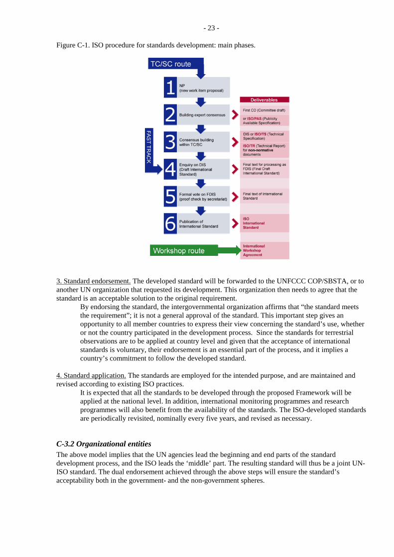
Figure C-1 shows an overview of the ISO standard development process; the detailed steps are shown in Appendix C-9.5. From these, it is evident that the overall process consists of numerous steps and can therefore take considerable time to complete – especially in case of complex or contentious standards. The length of time depends on the two basic phases: a) development of a technically sound document, and b) development of an international consensus (through voting) on the acceptability of the proposed standard. Both phases are necessary to ensure that the resulting standards are effective and receive broad acceptance; the time expended is part of the cost. Figure C-1 also indicates that various standardization options exist that may be applied to a particular requirement: a regular process, a fast track, or a workshop route. To accelerate the standard development for ECVs, the fast track and workshop approaches should be considered as preferred candidates, especially where the measurement issues are well understood and satisfactory methods have been developed. Once developed, an ISO standard has the approval of the countries represented in the standard development (i.e., voting ISO members) and is published as International Standard (refer to Appendix C-9.5 for more details about the ISO process).
- 23 -
Figure C-1. ISO procedure for standards development: main phases.
3. Standard endorsement. The developed standard will be forwarded to the UNFCCC COP/SBSTA, or to another UN organization that requested its development. This organization then needs to agree that the standard is an acceptable solution to the original requirement.
By endorsing the standard, the intergovernmental organization affirms that “the standard meets the requirement”; it is not a general approval of the standard. This important step gives an opportunity to all member countries to express their view concerning the standard’s use, whether or not the country participated in the development process. Since the standards for terrestrial observations are to be applied at country level and given that the acceptance of international standards is voluntary, their endorsement is an essential part of the process, and it implies a country’s commitment to follow the developed standard.
4. Standard application. The standards are employed for the intended purpose, and are maintained and revised according to existing ISO practices.
It is expected that all the standards to be developed through the proposed Framework will be applied at the national level. In addition, international monitoring programmes and research programmes will also benefit from the availability of the standards. The ISO-developed standards are periodically revisited, nominally every five years, and revised as necessary.
C-3.2 Organizational entities The above model implies that the UN agencies lead the beginning and end parts of the standard development process, and the ISO leads the ‘middle’ part. The resulting standard will thus be a joint UN-ISO standard. The dual endorsement achieved through the above steps will ensure the standard’s acceptability both in the government- and the non-government spheres.
- 24 -
National governments’ inputs and perspectives are inserted throughout the process:
At requirements definition stage, through their participation in intergovernmental organizations specifying the requirements, such as the UNFCCC.
During standard development, through their various contributions: representation in ISO Technical Committees (TC); participation of their experts in TC deliberations; operation of mirror national committees that review and otherwise contribute national perspective on a proposed standard; and voting on the acceptability of a proposed standard.
By making decisions regarding the use of the developed standards in the country’s monitoring programmes.
By supporting methodology development and/or research that underpin the techniques on which the standard is based, including research leading to further improvements of the standard.
The contributions of the research community are essential at the standard development stage, particularly at stages preceding (and including) the Draft International Standard (Figure C-1). Their continuing input is required as further modifications are made during the approval and voting stages (Appendix C-9.5). The scientific community also has lead responsibility in developing new or improved measurement methods through national or international research programmes.
C-4. Roles and relationships
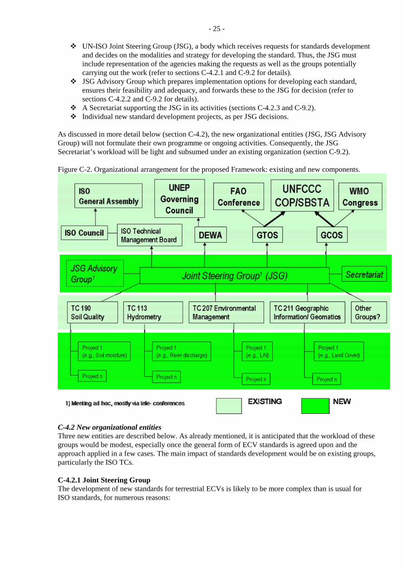
C-4.1 Overview Figure C-2 shows the proposed entities to constitute the Framework, and their relationships: intergovernmental and international organizations, including their components and programmes; and an “added set” established specifically for the development of standards for terrestrial observations. Briefly, these are:
The UN Framework Conference on Climate Change (UNFCCC), with Conference of the Parties as the UNFCCC Decision Body and the Subsidiary Body for Scientific and Technological Advice (SBSTA) as the technical arm.
The UN Food and Agriculture Organization (FAO), with FAO Conference as the FAO Decision Body and the Global Terrestrial Observing System (GTOS) as the main programme responsible for the terrestrial ECV issues. GTOS is also co-sponsored by several other UN agencies, including the WMO, UNEP and UNESCO.
The UN World Meteorological Organization (WMO), with WMO Congress as the WMO Decision Body and the Global Climate Observing System (GCOS) as the main programme responsible for climate observation issues. The GCOS is also co-sponsored by several other UN agencies.
The International Organization for Standardization (ISO), with General Assembly as the ISO Decision Body and the Technical Management Board (TMB) that is responsible for the execution aspects (including work programme) of standards development.
Other UN organizations interested in standards for terrestrial observations, directly or through sponsorship of programmes such as the GTOS; e.g., the UN Environment Programme (UNEP).
ISO Technical Committees (TCs) whose scope most closely relates to the thirteen ECVs identified by the COP/SBSTA so far. Each TC has a work programme consisting of projects ratified by the TMB, as specified by ISO procedures (ISO, 2008).
General information about the above agencies is provided in Appendix C-9.4. The ‘added set’ in Figure C-2 is considered as the minimum addition necessary to carry out the ECV standards development, and it consists of:
- 25 -
UN-ISO Joint Steering Group (JSG), a body which receives requests for standards development and decides on the modalities and strategy for developing the standard. Thus, the JSG must include representation of the agencies making the requests as well as the groups potentially carrying out the work (refer to sections C-4.2.1 and C-9.2 for details).
JSG Advisory Group which prepares implementation options for developing each standard, ensures their feasibility and adequacy, and forwards these to the JSG for decision (refer to sections C-4.2.2 and C-9.2 for details).
A Secretariat supporting the JSG in its activities (sections C-4.2.3 and C-9.2). Individual new standard development projects, as per JSG decisions.
As discussed in more detail below (section C-4.2), the new organizational entities (JSG, JSG Advisory Group) will not formulate their own programme or ongoing activities. Consequently, the JSG Secretariat’s workload will be light and subsumed under an existing organization (section C-9.2). Figure C-2. Organizational arrangement for the proposed Framework: existing and new components.
C-4.2 New organizational entities Three new entities are described below. As already mentioned, it is anticipated that the workload of these groups would be modest, especially once the general form of ECV standards is agreed upon and the approach applied in a few cases. The main impact of standards development would be on existing groups, particularly the ISO TCs. C-4.2.1 Joint Steering Group The development of new standards for terrestrial ECVs is likely to be more complex than is usual for ISO standards, for numerous reasons:
- 26 -
The requirements for standardization are put forward by intergovernmental organizations, as opposed to individual countries or industrial groups (typical approach).
Most terrestrial measurements have a thematic aspect (how measurements are made) as well as a reporting aspect (how the data are presented and reported), with geographic representation being a critical element of the latter.
The level for which a particular standard should be developed may not be obvious: the measurement itself (instrumentation and technique standardization), reporting (of measurements - units, format), or in a form that makes results of different measurement approaches compatible (e.g. using metadata)?
Given that all ECV standards are to meet the same overall purpose, the general structure and ‘look-and-feel’ of the standards should be the same, or similar. To which degree is the common structure necessary and feasible? Developing such overall structure/ structures will require discussion involving standard development experts as well as ECV measurement and user experts.
Depending on the ECV, the standardization may involve one or more TCs, and may or may not involve external groups with standardization activities (e.g. the WMO for hydrological variables). If several groups are to participate, their roles and interactions need to be defined so that the work may progress smoothly and efficiently. An overall Framework and its organizational consequences (e.g. joint working groups between two or more ISO TCs) can only be determined through discussions of representatives of the participating groups.
In many cases, there are existing ISO standards that are relevant to ECV measurements. Should these be kept separate and only referred to, or should a comprehensive standard be developed that extracts relevant parts of existing standards and builds on these; that is, at which level of detail should the standards (or standard) be developed?
The form of a standard. Depending on circumstances Standard, Publicly Available Specification, Technical Specification, Technical Report, International Workshop Agreement, and Guide are possible forms of ISO standardization (www.iso.org). This range of deliverables enhances the ISO’s flexibility and responsiveness to international requirements.
The level of task definition: as Scope of Work, Table of Content, or a Working Draft? This choice will also depend on the complexity of measuring individual ECVs, the level of coordination within the user community, the current degree of understanding of the measurement and reporting issues, and the existence of a document(s) upon which standard development may be founded.
Should a particular standard be developed through the regular process, fast-tracked, or using the workshop route (Figure C-1)?
Most of the initial standardization activities will deal with in situ measurements. However, the ultimate objective is to standardize both in situ- and satellite-based measurement approaches, and in some cases both are sufficiently advanced to make such standardization feasible. The decision about the scope of such an integrated standard will thus also require consideration of various viewpoints and finding the most effective approach.
In the proposed Framework, the above and similar questions will be dealt with by the Joint Steering Committee (JSG). The JSG role will thus be to decide on a way a particular standard will be developed; and, if required, to initiate and oversee the overall process through which the standard execution is carried out. In the proposed Framework, the JSG will have decision-making authority and its decisions, made through consensus, would be binding on the TCs involved. To comply with the practice that the TC work programme is normally approved by the TMB (ISO, 2008), the JSG should be established as a subcommittee of the TMB. - It should be noted that standards that are assigned to a particular TC will subsequently be tracked by that TC, as is usual in the ISO process. To carry out its tasks, the JSG must have representation of:
The UN communities that present the requirement. In practice, the requirements are defined through a consensus process involving scientific consultation and peer review, then presented by
- 27 -
programmes such as the GTOS to the UN body (COP/SBSTA in case of the ECVs) for approval, following which they are submitted to the UN-ISO Framework for execution. Therefore, the GCOS/ GTOS - level representation of the UN request is appropriate for the JSG because detailed understanding of the requirement exists within these programmes, specifically through the joint GCOS/GTOS Terrestrial Observation Panel for Climate (TOPC) and other scientific panels as well as specialists of the UN agencies themselves.
ISO groups potentially involved in the development of the standard, particularly the technical committees within whose scope the particular ECV falls. The representation must be at a level sufficient to make decisions about commitments to new programme activities (typically at TC Chair level).
Experts in technical aspects of the measurement and reporting methods. Typically, they will represent larger groups, projects, panels or other bodies where the measurement aspects have been dealt with in a focused manner and which may also have developed relevant technical documentation.
Establishment of groups like the JSG is provided for in the ISO process. Specifically, the ISO Technical Management Board (TMB) responsibilities include (ISO, 2008):
section 1.1g: “coordination of the technical work, including assignment of responsibility for the development of standards regarding subjects of interest to several technical committees, or needing coordinated development; to assist it in this task, the technical management board may establish advisory groups of experts in the relevant fields to advise it on matters of basic, sectoral and cross-sectoral coordination, coherent planning and the need for new work;”
section 1.2.3: “The tasks allocated to such a group may include the making of proposals relating to the drafting or harmonization of publications (in particular International Standards, Technical Specifications, Publicly Available Specifications and Technical Reports), but shall not include the preparation of such documents unless specifically authorized by the TMB(s).”
Based on the above, the proposed terms of reference for the JSG are summarized in Appendix C-9.2. C-4.2.2 JSG Advisory Group Decisions on standards development issues listed in section C-4.2.1 presume detailed expertise in several areas: (i) ISO standards development procedures, (ii) technical readiness of the methods for the standardization process, and (iii) the practical/execution aspects (thematic expertise available within the TCs, current workload, potential models for collaboration (subcommittee/ working group/ …), availability of resources, etc.). Ideally, all such expertise would reside in the JSG. However, for practical purposes it may be more effective to establish an advisory subgroup within the JSG that would consider the relevant issues and prepare an implementation plan for the JSG to adopt, in a modified form if appropriate. The proposed Framework allows for both options, and it would be up to the JSG to decide which avenue it chooses to pursue. The choice would also depend on the individual JSG members, their background and knowledge, workload, etc. in relation to a particular request for standardization. It is possible that JSG members themselves would take part in such work because of their specialized knowledge. In any case, it is anticipated that:
The subgroup members will generally be from the same ISO TCs or agencies as the JSG members.
The subgroup will act only upon the JSG requests and carry out tasks as specified by the JSG. For the most part, the subgroup will work through teleconferencing and Web conferencing.
- 28 -
Results of the Advisory Group’s work will be implementation plans for responding to standard development requests that are presented to the JSG. These plans (including options where appropriate) will be submitted to the JSG for decision and action. The establishment of advisory groups is also provided for in ISO procedures (ISO, 2008): section 1.13:
1.13.1 A group having advisory functions may be established by a technical committee or subcommittee to assist the chairman and secretariat in tasks concerning coordination, planning and steering of the committee’s work or other specific tasks of an advisory nature. 1.13.3 The tasks allocated to such a group may include the making of proposals relating to the drafting or harmonization of publications (in particular International Standards, Technical Specifications, Publicly Available Specifications and Technical Reports), but shall not include the preparation of such documents. 1.13.4 The results of such a group shall be presented in the form of recommendations to the body that established the group. The recommendations may include proposals for the establishment of a working group (see 1.11) or a joint working group (see 1.11.5) for the preparation of publications.
section 1.14: Technical committees or subcommittees may establish ad hoc groups, the purpose of which is to study a precisely defined problem on which the group reports to its parent committee at the same meeting, or at the latest at the next meeting. The membership of an ad hoc group shall be chosen from the delegates present at the meeting of the parent committee, supplemented, if necessary, by experts appointed by the committee.
Based on the above, the proposed terms of reference for the JSG Advisory Group are summarized in Appendix C-9.2. C-4.2.3 JSG Secretariat Based on ISO experience, groups like the JSG require a Secretariat that supports the group’s smooth functioning. Individual technical committees, which typically have several subcommittees and various projects underway, are supported by secretariats funded by willing countries. In case of the JSG, the Secretariat workload is expected to be relatively light, especially when dealing with the focused initial task of standards for the terrestrial ECVs. It is thus anticipated that the workload could be taken on by an existing agency. For practical reasons, the Secretariat should be provided by the agency where the JSG Chair works. Further information regarding the JSG Secretariat is provided in Appendix C-9.2.
C-4.3 Relationship to other bodies interested in standardization The ISO process is well suited to encompassing the contributions of other organizations, programmes, and individual experts. For this purpose, the ISO process recognizes four types of liaison organizations at the TC level (ISO, 2008):
Category A liaison: “Organizations that make an effective contribution to the work of the technical committee or subcommittee for questions deal with by this committee or subcommittee. Such organizations are sent copies of all relevant documentation and are invited to meetings. They may nominate experts to participate in a WG/PT (see 1.11.1.and 1.12).”
Category B liaison: “Organizations that have indicated a wish to be kept informed of the work of the technical committee or subcommittee. Such organizations are sent reports on the work of a technical committee or subcommittee.”
Category A and B liaisons are established by the ISO Chief Executive Officer and are reported to the TMB.
- 29 -
Category D liaison at the working group/ project team level (section 1.17.3): “Organizations that make a technical contribution to and participate actively in the work of a working group, maintenance team or project team. Liaison organizations can include manufacturer associations, commercial associations, industrial consortia, user groups and professional and scientific societies. Liaison organizations shall be multinational (in their objectives and standards development activities) with individual, company or country membership and may be permanent or transient in nature. A liaison organization shall have a sufficient degree of representativity within its defined area of competence within a sector or subsector of the relevant technical ot industrial field. Category D liaisons shall be submitted for approval to the technical management board be the committee secretary, with a clear indication of the WG/PT/MT concerned….. Category D liaison organizations have the right to participate as full members in a working group or project team. Category D liaisons experts act as the official representatives of the organization by which they are appointed.”
The above liaison mechanisms will be particularly important for those ECV standards where much of the expertise rests within scientific organizations, international programmes or similar bodies – e.g. Glaciers, Permafrost, and Leaf Area Index. Experts from such bodies could thus be invited to participate by an ISO liaison organization, e.g. the UN specialized agencies. Another option is for national member bodies involved in the development of a standard to include experts in their national delegation to the relevant ISO technical committee. Since ISO standards “are based on international consensus among the experts in the field”, the proposed standardization approach should therefore meet the requirements of other potential users of in situ environmental observations. It should also accommodate the development of ‘integrated standards’ that encompass in situ- and space-based observations, once the methodologies for making and processing space-based measurements are sufficiently developed through R&D and thus stabilized. In turn, standardization of in situ measurements supports the development of satellite-based methods because of their vital role in the calibration, validation and intercomparisons of satellite-derived ECV products.
C-5. Compliance with requirements
C-5.1 Responsiveness to SBSTA criteria As noted above (section C-2.), the SBSTA 27 provided five specific guidelines for the Framework development. This section discusses the responsiveness of the proposed Framework to these guidelines.
(a) Standards should be developed on a scientifically sound basis. This requirement is met: “Standards should be based on the consolidated results of science, technology and experience, and aimed at the promotion of optimum community benefits”; ISO, 2004a, section 3.1). The involvement of technical experts is thus provided for in the process, e.g. through working groups in which experts act in their personal capacity (ISO, 2008, section 1.11). Category A and Category D liaison organizations also have the option of nominating experts to participate in a working group or a project team (ISO, 2008, section 1.17). (b) The Framework should provide for the involvement of governments in the development of standards and guidance materials and in their implementation. National governments are involved in various ways: (i) by providing inputs and representatives to the standard development, directly through their representatives in the ISO technical committees and national delegations to ISO meetings, as well as through mirror national committees; (ii) by voting on the developed standards as part of the ISO process; (iii) by voting on the endorsement of a standard through the UN Decision Bodies; and (iv) by making programmatic decisions about adopting the developed standards for their national monitoring and reporting programmes. It is important to note that the involvement of governments is subject to the ‘right people’ and financial resources
- 30 -
being available. While the first condition does not generally pose problems, the second one may, and often does in case of developing countries. Although the ISO has a mechanism for making available financial support to attend meetings etc., these resources are limited and the problem is thus not completely resolved. (c) Access to those standards and guidance materials should be free and unrestricted. Normally, documents containing ISO international standards are sold to increase revenue for ISO operations. Since the standards developed through the Framework will be dual UN-ISO standards, they will be available both through the UN organizations (free of charge, e.g. on the Internet), and through the usual ISO channels (for a fee, in digital or printed form). The resulting documents will be joint UN-ISO standards, jointly owned by the UN organizations (‘background’ intellectual property) and the ISO (‘foreground’ intellectual property). There are precedents for this type of arrangement. (d) The process for developing the standards and guidance materials and the operation of the Framework should be cost-effective and sustainable and take into account existing standards and guidance materials.
Cost-effectiveness and sustainability: The incremental costs of the proposed Framework are the minimum possible while still achieving the purpose for which the Framework is established. This ‘minimum’ is feasible because within the ISO process, most of the additional costs rest with countries participating in the technical committees that develop the standards. The incremental costs of the Framework, due to the ‘added set’ (section C-4.2), are minimized due to:
o The added work represents the minimum necessary to ensure, through coordination, efficient and effective expenditure of overall effort and resources;
o The added groups have no programme of their own but respond to requests from the UN agencies, therefore their workload will be relatively light;
o The financial viability of the proposed Framework depends on the willingness of countries supporting the TC Secretariats to also support the additional workload resulting from the development of ECV standards.
Taking into account existing standards and guidance materials: Existing standards or guidance materials would be considered at two stages: when deciding on a requirement for a new standard, and when developing the standard. In the process of standard development, the existing standards, protocols, guides, and guidance materials are considered by ISO technical committees.
(e) The Framework should be flexible in view of future needs and developments in this area. In principle, the proposed Framework is suited to the development of UN-ISO international standards for all terrestrial observations of interest to the UN agencies. Subject to changes in the participating agencies and related changes of the JSG, this Framework is also suitable for other observations regarding the Earth’s environment. Similarly, this Framework can be employed to develop standards for synergistic use of in situ and satellite measurement and reporting strategies, again following appropriate adjustments in the terms of reference and the sponsoring agencies.
C-5.2 Other requirements An earlier report to SBSTA (SBSTA, 2007b) examining organizational options for the Framework also identified several criteria that an optimal Framework arrangement should meet. Further criteria were suggested in Part C of this report. These criteria and the suitability of the UN-ISO mechanism are briefly reviewed below.
- 31 -
A mechanism for scientific or technical input from “interested” countries, but not insisting on input from all countries on every issue: This is an intrinsic characteristic of the ISO process.
A means for coordination at international level with groups or organizations having similar interests, including scientific programmes, international agencies, and synthesis-producing groups: Such groups can contribute to the ISO standard development through liaison organizations or national member bodies (section C-4.).
A mechanism for arriving at a scientific or technical consensus: This is an intrinsic characteristic of the ISO process.
A mechanism for producing final international consensus: This is an intrinsic characteristic of the ISO process, implemented through voting.
A means for conveying the consensus to the national level for action: In the proposed Framework, this will occur through UNFCCC/UN endorsement of the developed standard (section C-4.).
A strategy that will ensure financial and in-kind support for the activity and support by national governments: Such support is built- in as part of the ISO. It should be noted, however, that national support for ISO standards development varies depending on the national relevance of that standard, and on the financial resources available (the latter is an issue particularly for developing countries; also refer to section C-5.1).
A communications strategy to raise the profile of the work and raise extra-budgetary resources: The ISO has an active communications/ public outreach programme (refer e.g., to the ISO Focus magazine issue on Climate Change (Vol. 5, No. 2, February 2008), and the ISO website (www.iso.org).
A means for ensuring continuity and for being responsive to changing requirements: This is an intrinsic characteristic of the ISO process. It includes procedures for review/ updates of existing standards and for undertaking new standard development projects.
The Framework should maximize the likelihood of success in achieving objectives of COP/SBSTA and of UN agencies: “Success” in this context is defined as the development and application of standards for the collection and reporting of terrestrial observations. In the proposed Framework, such success should be achievable a) through the combined leadership of UN-ISO in standard development (supported by national bodies and experts); and b) through the use of standards that are endorsed by the Decision Bodies of the UN organizations and the national governments represented therein. Thus, it is considered that the proposed model is as streamlined an approach for achieving success on a sustained basis as is feasible given the objective at hand.
Be as responsive, flexible and nimble as realistically possible: Within the broad domain of developing standards for climate- related terrestrial observations, the proposed model offers a high flexibility in terms of type of documents to be developed, contributors/ participants in such development, and type of output products. Furthermore, thematic areas other than in situ terrestrial observations could be addressed, and the nominal standards development process could be readily modified with the consent of the sponsoring agencies.
C-6. Summary and way forward The need for an international Framework for the development of standards, guidance materials and reporting guidelines was recognized in planning the Global Climate Observing System and confirmed by the international community. Following a request by the Conference of the Parties to the UN Framework Convention on Climate Change, the Global Terrestrial Observing System undertook, in collaboration with its partners, to investigate the issue and develop a proposal for implementation. With additional guidance provided by SBSTA 27, the proposal is presented in this report. The Framework is formulated as a joint initiative of the UN agencies (representing the requirements for standardization) and of the International Organization for Standardization (ISO), world's largest developer and publisher of International Standards. As the widespread use of ISO-published standards demonstrates, the principles
- 32 -
and procedures employed in the development of these standards should also effectively support standards and guidance materials required for the Essential Climate Variables. The proposed Framework employs collaborative arrangement between UN agencies and the ISO, formalized through a Memorandum of Understanding; Joint Steering Group, a new coordination entity within the ISO process with representation from the sponsoring agencies; and the conduct of the standards development work through ISO technical committees and the procedures they use. As well as complying with the criteria identified by the SBSTA, the Framework also meets other criteria regarding efficiency, effectiveness and flexibility. It requires modest organizational changes. The implementation of the proposed Framework should proceed through several stages:
1. Endorsement of the UN- ISO Framework as a solution that would meet UNFCCC needs. This endorsement should be given by the COP/SBSTA.
2. Approval of the UN- ISO Memorandum of Understanding (refer to a draft version in section C-9.1). This approval should be given by the ISO Council and the corresponding Decision Bodies in the participating UN organizations.
3. Completion of the terms of reference and procedures for the Joint Steering Group (refer to section C-9.2 for a draft version).
4. Development of an initial work plan (refer to section C-9.3 for a draft version), and of detailed plans for the initial set of projects.
5. Approval of the plan of work, beginning project execution.
C-7. Recommendations It is recommended that:
1. COP/SBSTA endorse the Framework proposal developed in this report, in the present or modified form as appropriate.
2. COP/SBSTA request that the GTOS and its partners implement the UN-ISO Framework, by obtaining the approvals needed and setting up the appropriate mechanisms.
3. The development of an initial set of ECV standards and guidance materials begin as soon as possible.
4. The COP request countries to identify human and financial resources for supporting the Framework.
5. The GTOS be requested to report on progress to the SBSTA at its 32nd session.
- 33 -
C-8. References FAO. 2008. Basic texts of the Food and Agriculture Organization of the United Nations. Volumes I and
II - 2008 edition. Available at www.fao.org/docrep/010/k1713e/k1713e00.htm (accessed 2009-03-16).
GCOS. 2004. Implementation Plan for the Global Observing System for Climate in support of the UNFCCC. Report GCOS – 92 (WMO/TD No. 1219). 136p.
GCOS. 2009. Implementation Plan for the Global Observing System for Climate in Support of the UNFCCC (2009 Update). Draft v0.2, 19 February 2009.[to be submitted to SBSTA]
ISO. 2004a. ISO/IEC Directives, Part 2. Rules for the structure and drafting of International Standards. 5th edition, International Organization for Standardization. 68p.
ISO. 2004b. ISO Strategic Plan 2005-2010. International Organization for Standardization, ISBN 92-67-10297-0). Available at www.iso.org/iso/isostrategies_2004-en.pdf (accessed 2009-03-14).
ISO. 2008. ISO/IEC Directives, Part 1. Procedures for the technical work. 6th edition, International Organization for Standardization. 76p.
SBSTA. 2005. Progress report on developing a framework for the preparation of guidance materials, standards and reporting guidelines for terrestrial observing systems for climate. Submission from the Global Terrestrial Observing System secretariat to the Subsidiary Body for Scientific and Technological Advice Twenty-third session, Report FCCC/SBSTA/2005/MISC.16. 3p.
SBSTA. 2007a. Progress in the development of guidance materials, standards and reporting guidelines for terrestrial observing systems for climate Submission from the secretariat of the Global Terrestrial Observing System. Paper No. 2: A Framework for Terrestrial Climate-Related Observations: Implementation Options. Progress Report to the Subsidiary Body for Scientific and Technological Advice Twenty-sixth session, Bonn, 7–18 May 2007, Report FCCC/SBSTA/2007/MISC.6: 25-44.
SBSTA. 2007b. Further progress in the development of guidance materials, standards and reporting guidelines for terrestrial observing systems for climate. Submission from the secretariat of the Global Terrestrial Observing System secretariat to the Subsidiary Body for Scientific and Technological Advice, Twenty-seventh session, Bali, December 2007, Report FCCC/SBSTA/2007/MISC.27. 28-48.
SBSTA. 2008. Report of the Subsidiary Body for Scientific and Technological Advice on its twenty-seventh session held in Bali from 3 to 11 December 2007, Report FCCC/SBSTA/2007/16. 30p.
UNFCCC. 2003. Report of the Conference of the Parties on its Ninth Session, held at Milan from 1 to 12 December 2003. Part Two: Action Taken by the Conference of the Parties at its Ninth Session. 65p.
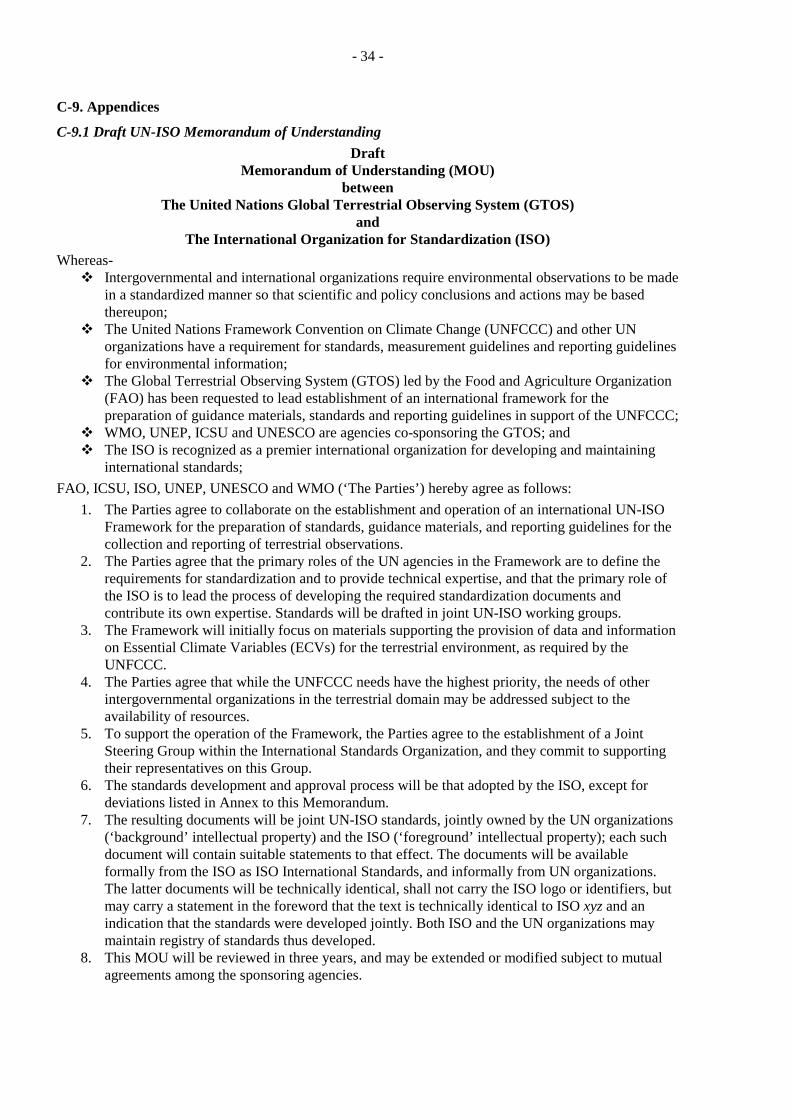
- 34 -
C-9. Appendices C-9.1 Draft UN-ISO Memorandum of Understanding
Draft Memorandum of Understanding (MOU)
between The United Nations Global Terrestrial Observing System (GTOS)
and The International Organization for Standardization (ISO)
Whereas- Intergovernmental and international organizations require environmental observations to be made
in a standardized manner so that scientific and policy conclusions and actions may be based thereupon;
The United Nations Framework Convention on Climate Change (UNFCCC) and other UN organizations have a requirement for standards, measurement guidelines and reporting guidelines for environmental information;
The Global Terrestrial Observing System (GTOS) led by the Food and Agriculture Organization (FAO) has been requested to lead establishment of an international framework for the preparation of guidance materials, standards and reporting guidelines in support of the UNFCCC;
WMO, UNEP, ICSU and UNESCO are agencies co-sponsoring the GTOS; and The ISO is recognized as a premier international organization for developing and maintaining
international standards; FAO, ICSU, ISO, UNEP, UNESCO and WMO (‘The Parties’) hereby agree as follows:
1. The Parties agree to collaborate on the establishment and operation of an international UN-ISO Framework for the preparation of standards, guidance materials, and reporting guidelines for the collection and reporting of terrestrial observations.
2. The Parties agree that the primary roles of the UN agencies in the Framework are to define the requirements for standardization and to provide technical expertise, and that the primary role of the ISO is to lead the process of developing the required standardization documents and contribute its own expertise. Standards will be drafted in joint UN-ISO working groups.
3. The Framework will initially focus on materials supporting the provision of data and information on Essential Climate Variables (ECVs) for the terrestrial environment, as required by the UNFCCC.
4. The Parties agree that while the UNFCCC needs have the highest priority, the needs of other intergovernmental organizations in the terrestrial domain may be addressed subject to the availability of resources.
5. To support the operation of the Framework, the Parties agree to the establishment of a Joint Steering Group within the International Standards Organization, and they commit to supporting their representatives on this Group.
6. The standards development and approval process will be that adopted by the ISO, except for deviations listed in Annex to this Memorandum.
7. The resulting documents will be joint UN-ISO standards, jointly owned by the UN organizations (‘background’ intellectual property) and the ISO (‘foreground’ intellectual property); each such document will contain suitable statements to that effect. The documents will be available formally from the ISO as ISO International Standards, and informally from UN organizations. The latter documents will be technically identical, shall not carry the ISO logo or identifiers, but may carry a statement in the foreword that the text is technically identical to ISO xyz and an indication that the standards were developed jointly. Both ISO and the UN organizations may maintain registry of standards thus developed.
8. This MOU will be reviewed in three years, and may be extended or modified subject to mutual agreements among the sponsoring agencies.
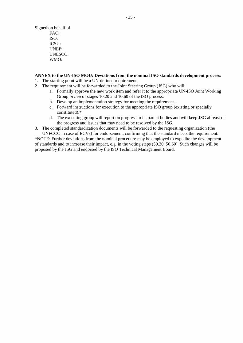
- 35 -
Signed on behalf of: FAO: ISO: ICSU: UNEP: UNESCO: WMO:
ANNEX to the UN-ISO MOU: Deviations from the nominal ISO standards development process: 1. The starting point will be a UN-defined requirement. 2. The requirement will be forwarded to the Joint Steering Group (JSG) who will:
a. Formally approve the new work item and refer it to the appropriate UN-ISO Joint Working Group in lieu of stages 10.20 and 10.60 of the ISO process.
b. Develop an implementation strategy for meeting the requirement. c. Forward instructions for execution to the appropriate ISO group (existing or specially
constituted).* d. The executing group will report on progress to its parent bodies and will keep JSG abreast of
the progress and issues that may need to be resolved by the JSG. 3. The completed standardization documents will be forwarded to the requesting organization (the
UNFCCC in case of ECVs) for endorsement, confirming that the standard meets the requirement. *NOTE: Further deviations from the nominal procedure may be employed to expedite the development of standards and to increase their impact, e.g. in the voting steps (50.20, 50.60). Such changes will be proposed by the JSG and endorsed by the ISO Technical Management Board.
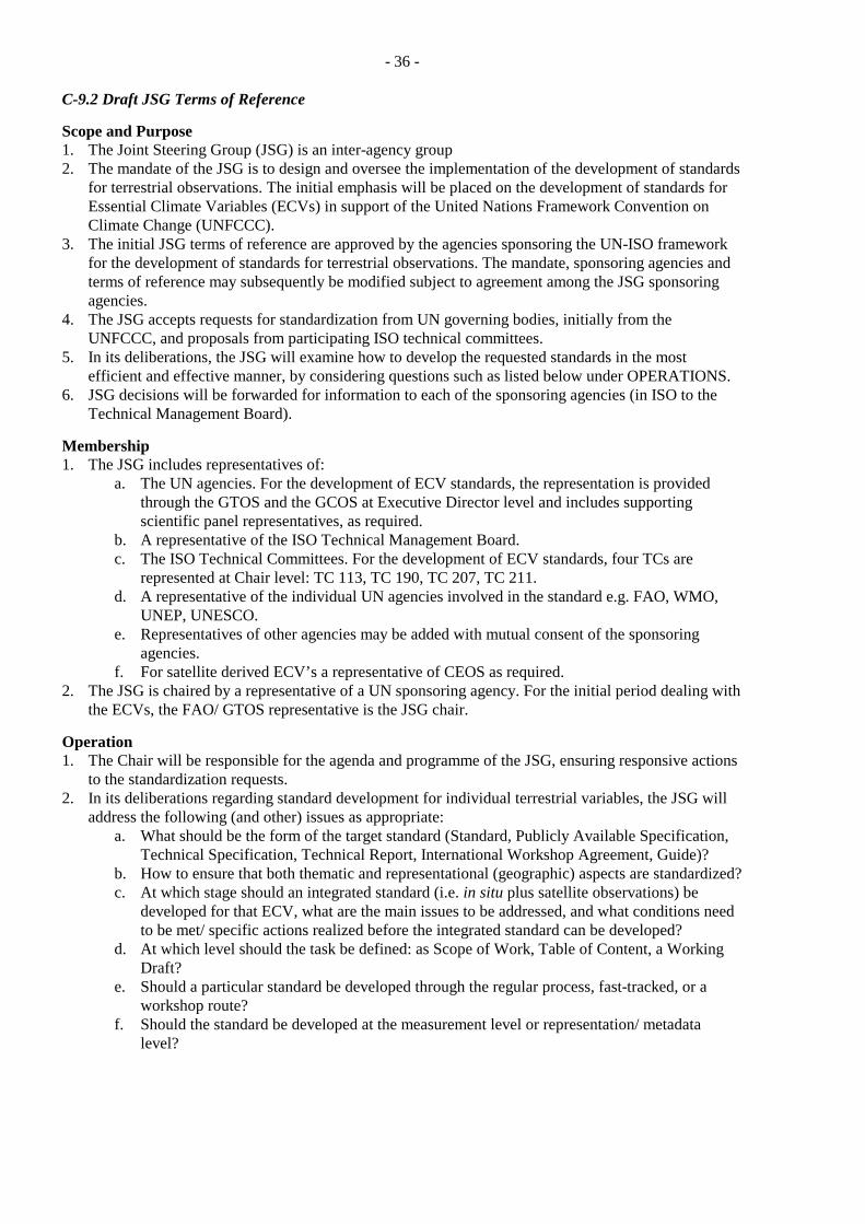
- 36 -
C-9.2 Draft JSG Terms of Reference
Scope and Purpose 1. The Joint Steering Group (JSG) is an inter-agency group 2. The mandate of the JSG is to design and oversee the implementation of the development of standards
for terrestrial observations. The initial emphasis will be placed on the development of standards for Essential Climate Variables (ECVs) in support of the United Nations Framework Convention on Climate Change (UNFCCC).
3. The initial JSG terms of reference are approved by the agencies sponsoring the UN-ISO framework for the development of standards for terrestrial observations. The mandate, sponsoring agencies and terms of reference may subsequently be modified subject to agreement among the JSG sponsoring agencies.
4. The JSG accepts requests for standardization from UN governing bodies, initially from the UNFCCC, and proposals from participating ISO technical committees.
5. In its deliberations, the JSG will examine how to develop the requested standards in the most efficient and effective manner, by considering questions such as listed below under OPERATIONS.
6. JSG decisions will be forwarded for information to each of the sponsoring agencies (in ISO to the Technical Management Board).
Membership 1. The JSG includes representatives of:
a. The UN agencies. For the development of ECV standards, the representation is provided through the GTOS and the GCOS at Executive Director level and includes supporting scientific panel representatives, as required.
b. A representative of the ISO Technical Management Board. c. The ISO Technical Committees. For the development of ECV standards, four TCs are
represented at Chair level: TC 113, TC 190, TC 207, TC 211. d. A representative of the individual UN agencies involved in the standard e.g. FAO, WMO,
UNEP, UNESCO. e. Representatives of other agencies may be added with mutual consent of the sponsoring
agencies. f. For satellite derived ECV’s a representative of CEOS as required.
2. The JSG is chaired by a representative of a UN sponsoring agency. For the initial period dealing with the ECVs, the FAO/ GTOS representative is the JSG chair.
Operation 1. The Chair will be responsible for the agenda and programme of the JSG, ensuring responsive actions
to the standardization requests. 2. In its deliberations regarding standard development for individual terrestrial variables, the JSG will
address the following (and other) issues as appropriate: a. What should be the form of the target standard (Standard, Publicly Available Specification,
Technical Specification, Technical Report, International Workshop Agreement, Guide)? b. How to ensure that both thematic and representational (geographic) aspects are standardized? c. At which stage should an integrated standard (i.e. in situ plus satellite observations) be
developed for that ECV, what are the main issues to be addressed, and what conditions need to be met/ specific actions realized before the integrated standard can be developed?
d. At which level should the task be defined: as Scope of Work, Table of Content, a Working Draft?
e. Should a particular standard be developed through the regular process, fast-tracked, or a workshop route?
f. Should the standard be developed at the measurement level or representation/ metadata level?
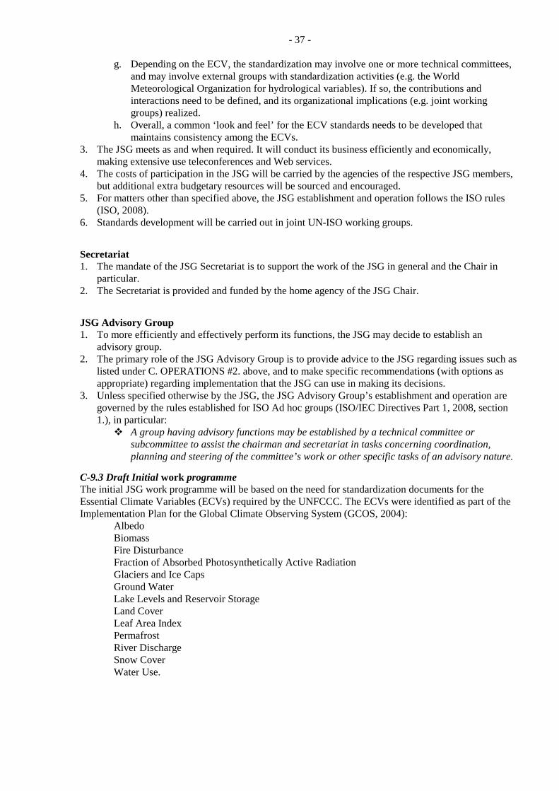
- 37 -
g. Depending on the ECV, the standardization may involve one or more technical committees, and may involve external groups with standardization activities (e.g. the World Meteorological Organization for hydrological variables). If so, the contributions and interactions need to be defined, and its organizational implications (e.g. joint working groups) realized.
h. Overall, a common ‘look and feel’ for the ECV standards needs to be developed that maintains consistency among the ECVs.
3. The JSG meets as and when required. It will conduct its business efficiently and economically, making extensive use teleconferences and Web services.
4. The costs of participation in the JSG will be carried by the agencies of the respective JSG members, but additional extra budgetary resources will be sourced and encouraged.
5. For matters other than specified above, the JSG establishment and operation follows the ISO rules (ISO, 2008).
6. Standards development will be carried out in joint UN-ISO working groups.
Secretariat 1. The mandate of the JSG Secretariat is to support the work of the JSG in general and the Chair in
particular. 2. The Secretariat is provided and funded by the home agency of the JSG Chair.
JSG Advisory Group 1. To more efficiently and effectively perform its functions, the JSG may decide to establish an
advisory group. 2. The primary role of the JSG Advisory Group is to provide advice to the JSG regarding issues such as
listed under C. OPERATIONS #2. above, and to make specific recommendations (with options as appropriate) regarding implementation that the JSG can use in making its decisions.
3. Unless specified otherwise by the JSG, the JSG Advisory Group’s establishment and operation are governed by the rules established for ISO Ad hoc groups (ISO/IEC Directives Part 1, 2008, section 1.), in particular:
A group having advisory functions may be established by a technical committee or subcommittee to assist the chairman and secretariat in tasks concerning coordination, planning and steering of the committee’s work or other specific tasks of an advisory nature.
C-9.3 Draft Initial work programme The initial JSG work programme will be based on the need for standardization documents for the Essential Climate Variables (ECVs) required by the UNFCCC. The ECVs were identified as part of the Implementation Plan for the Global Climate Observing System (GCOS, 2004):
Albedo Biomass Fire Disturbance Fraction of Absorbed Photosynthetically Active Radiation Glaciers and Ice Caps Ground Water Lake Levels and Reservoir Storage Land Cover Leaf Area Index Permafrost River Discharge Snow Cover Water Use.
- 38 -
Recently, Soil Moisture and Soil Carbon have been proposed as an addition to this list due to its importance and upcoming improved measurement capabilities, mainly from satellite platforms. Table C-1 provides a tentative summary of several aspects of the ECVs: relative importance of satellite and in situ observations; potential lead group for the development of an international standard within ISO, or elsewhere if such activity has already taken place; the principal other groups with technical expertise; and a subjective assessment of the overall priority for developing an international standard through a new initiative. Table C-1 indicates that:
Depending on the ECV, satellite or in situ observations serve as the primary source of information: five for satellites (satellite is the primary measurement tool, in situ provides calibration/ validation data) four for in situ (in situ measurements are the main source, satellite may facilitate spatial extrapolation), and in four cases both seem equally important.
There are two main candidate groups for developing international standards for terrestrial ECVs: WMO (ECVs that have traditionally been of interest to WMO and where WMO Commissions have developed guide documents in the past); and ISO Technical Committees, both for ECVs where ISO has been active in the past and for those where no standardization efforts have yet taken place.
Within ISO, the scope of four Technical Committees appears most closely related to the terrestrial ECVs (refer also to Appendix D-7.1): TC 113 (Hydrometry); TC 190 (Soil Quality); TC 207 (Environmental Management); and TC 211 (Geographic Information/ Geomatics). Regarding the division of responsibilities among these, it is worth noting that:
o TC 113 has traditionally been concerned with water- related measurements, thus those ECVs naturally fit its scope;
o TC 190 is concerned with soil measurements, thus Soil Moisture fits here; o The scope of TC211 encompasses geographic aspects of all ECVs and some thematic
aspects (e.g., Land Cover); and o TC207 has so far been concerned with measurement aspects for e.g. greenhouse gas
emissions. The differences in foci might help to decide how a given ECV should be handled within the ISO.
If the primary standardization issue is the measurement itself (like Biomass), the ECV might best be handled by TC113, TC 190, or TC 207. Conversely, if the measurement protocol is generally agreed upon and the main issue is handling and presentation of the observations (e.g. Glaciers), TC211 could take the lead.
In general, there is considerable technical expertise in ECV in situ measurement issues, concentrated internationally in scientific programmes, projects, collaborating groups of scientists, data centres, etc. Such entities would play a key role in the development of international standards, by providing technical and user expertise to the standards’ definition.
The last column of Table C-1 shows a subjective assessment of the priority of developing a standard based on need and readiness as documented in Part D. It shows five ECVs as High (i.e. no existing standard document, but sufficient understanding/ information available to develop a standard), five as +/-Medium, and four as Low. If confirmed through further consultation, this provides a basis for a realistic, phased progress in the development of ECV international standards. Finally, it should be noted that while the initial emphasis in the proposed work programme is given to in situ observation issues, the ultimate goal (and the need of the UNFCCC) are standards encompassing both measurement strategies in an integrated manner. The initial limited focus is warranted for several reasons:
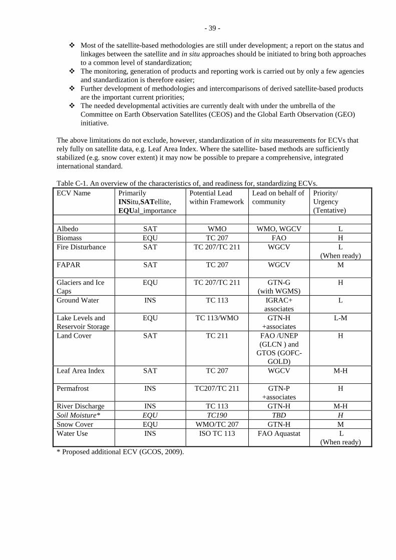
- 39 -
Most of the satellite-based methodologies are still under development; a report on the status and linkages between the satellite and in situ approaches should be initiated to bring both approaches to a common level of standardization;
The monitoring, generation of products and reporting work is carried out by only a few agencies and standardization is therefore easier;
Further development of methodologies and intercomparisons of derived satellite-based products are the important current priorities;
The needed developmental activities are currently dealt with under the umbrella of the Committee on Earth Observation Satellites (CEOS) and the Global Earth Observation (GEO) initiative.
The above limitations do not exclude, however, standardization of in situ measurements for ECVs that rely fully on satellite data, e.g. Leaf Area Index. Where the satellite- based methods are sufficiently stabilized (e.g. snow cover extent) it may now be possible to prepare a comprehensive, integrated international standard. Table C-1. An overview of the characteristics of, and readiness for, standardizing ECVs. ECV Name Primarily
INSitu,SATellite, EQUal_importance
Potential Lead within Framework
Lead on behalf of community
Priority/ Urgency (Tentative)
Albedo SAT WMO WMO, WGCV L Biomass EQU TC 207 FAO H Fire Disturbance SAT TC 207/TC 211 WGCV L
(When ready) FAPAR SAT TC 207 WGCV M
Glaciers and Ice Caps
EQU TC 207/TC 211 GTN-G (with WGMS)
H
Ground Water INS TC 113 IGRAC+ associates
L
Lake Levels and Reservoir Storage
EQU TC 113/WMO GTN-H +associates
L-M
Land Cover SAT TC 211 FAO /UNEP (GLCN ) and
GTOS (GOFC-GOLD)
H
Leaf Area Index SAT TC 207 WGCV M-H
Permafrost INS TC207/TC 211 GTN-P +associates
H
River Discharge INS TC 113 GTN-H M-H Soil Moisture* EQU TC190 TBD H Snow Cover EQU WMO/TC 207 GTN-H M Water Use INS ISO TC 113 FAO Aquastat L
(When ready) * Proposed additional ECV (GCOS, 2009).
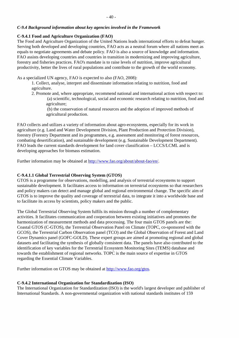
- 40 -
C-9.4 Background information about key agencies involved in the Framework
C-9.4.1 Food and Agriculture Organization (FAO) The Food and Agriculture Organization of the United Nations leads international efforts to defeat hunger. Serving both developed and developing countries, FAO acts as a neutral forum where all nations meet as equals to negotiate agreements and debate policy. FAO is also a source of knowledge and information. FAO assists developing countries and countries in transition in modernizing and improving agriculture, forestry and fisheries practices. FAO's mandate is to raise levels of nutrition, improve agricultural productivity, better the lives of rural populations and contribute to the growth of the world economy. As a specialized UN agency, FAO is expected to also (FAO, 2008):
1. Collect, analyse, interpret and disseminate information relating to nutrition, food and agriculture. 2. Promote and, where appropriate, recommend national and international action with respect to:
(a) scientific, technological, social and economic research relating to nutrition, food and agriculture; (b) the conservation of natural resources and the adoption of improved methods of agricultural production.
FAO collects and utilizes a variety of information about agro-ecosystems, especially for its work in agriculture (e.g. Land and Water Development Division, Plant Production and Protection Division), forestry (Forestry Department and its programmes, e.g. assessment and monitoring of forest resources, combating desertification), and sustainable development (e.g. Sustainable Development Department). FAO leads the current standards development for land cover classification – LCCS/LCML and is developing approaches for biomass estimation. Further information may be obtained at http://www.fao.org/about/about-fao/en/.
C-9.4.1.1 Global Terrestrial Observing System (GTOS) GTOS is a programme for observations, modelling, and analysis of terrestrial ecosystems to support sustainable development. It facilitates access to information on terrestrial ecosystems so that researchers and policy makers can detect and manage global and regional environmental change. The specific aim of GTOS is to improve the quality and coverage of terrestrial data, to integrate it into a worldwide base and to facilitate its access by scientists, policy makers and the public. The Global Terrestrial Observing System fulfils its mission through a number of complementary activities. It facilitates communication and cooperation between existing initiatives and promotes the harmonization of measurement methods and data processing. The four main GTOS panels are the: Coastal GTOS (C-GTOS), the Terrestrial Observation Panel on Climate (TOPC, co-sponsored with the GCOS), the Terrestrial Carbon Observation panel (TCO) and the Global Observation of Forest and Land Cover Dynamics panel (GOFC-GOLD). These expert groups are aimed at promoting regional and global datasets and facilitating the synthesis of globally consistent data. The panels have also contributed to the identification of key variables for the Terrestrial Ecosystem Monitoring Sites (TEMS) database and towards the establishment of regional networks. TOPC is the main source of expertise in GTOS regarding the Essential Climate Variables. Further information on GTOS may be obtained at http://www.fao.org/gtos.
C-9.4.2 International Organization for Standardization (ISO) The International Organization for Standardization (ISO) is the world's largest developer and publisher of International Standards. A non-governmental organization with national standards institutes of 159
- 41 -
countries as members, ISO forms a bridge between the public and private sectors. Therefore, ISO enables a consensus to be reached on solutions that meet both the requirements of business and the broader needs of society. For 2010, ISO defined the following objectives (ISO, 2004b):
Developing a consistent and multi-sector collection of globally relevant International Standards; Ensuring the involvement of stakeholders; Raising awareness and capacity of developing countries; Being open to partnerships for the efficient development of International Standards; Promoting the use of voluntary standards as an alternative or as a support to technical
regulations; Being the recognized provider of International Standards and guides to conformity assessment; Providing efficient procedures and tools for the development of a coherent and complete range of
deliverables.
C-9.4.2.1 Technical Management Board The standards development work is carried out under the overall management of the Technical Management Board (TMB). The TMB reports to the ISO Council and its role is defined in the statutes of the organization. It is responsible for the overall management of the technical work, including for a number of strategic and technical advisory groups. Member bodies are eligible for appointment/election to the TMB in accordance with a set of criteria established by the Council. The TMB responsibilities include (ISO, 2008):
a) Establishment of technical committees; b) Appointment of chairmen of technical committees; c) Allocation or re-allocation of secretariats of technical committees and, in some cases, subcommittees; d) Approval of titles, scopes and programmes of work of technical committees; f) Allocation of priorities, if necessary, to particular items of technical work; g) Coordination of the technical work, including assignment of responsibility for the development of standards regarding subjects of interest to several technical committees, or needing coordinated development.
C-9.4.2.2 Technical Committees The primary duty of a technical committee (TC) is the development and maintenance of International Standards. However, committees are also strongly encouraged to consider publication of intermediate deliverables. A proposal for work in a new field of technical activity which appears to require the establishment of a new technical committee may be made by a national ISO member body, a technical committee or subcommittee, and the TMB, among others. Such a proposal is circulated to ISO member bodies to determine support for (through voting), and level of participation in, the proposed committee. The deliverables from standards development by the TCs may take various forms:
International Standard is a document, established by consensus and approved by the ISO that provides, for common and repeated use, rules, guidelines or characteristics for activities or their results, aimed at the achievement of the optimum degree of order in a given context. Standards should be based on the consolidated results of science, technology and experience, and aimed at the promotion of optimum community benefits.
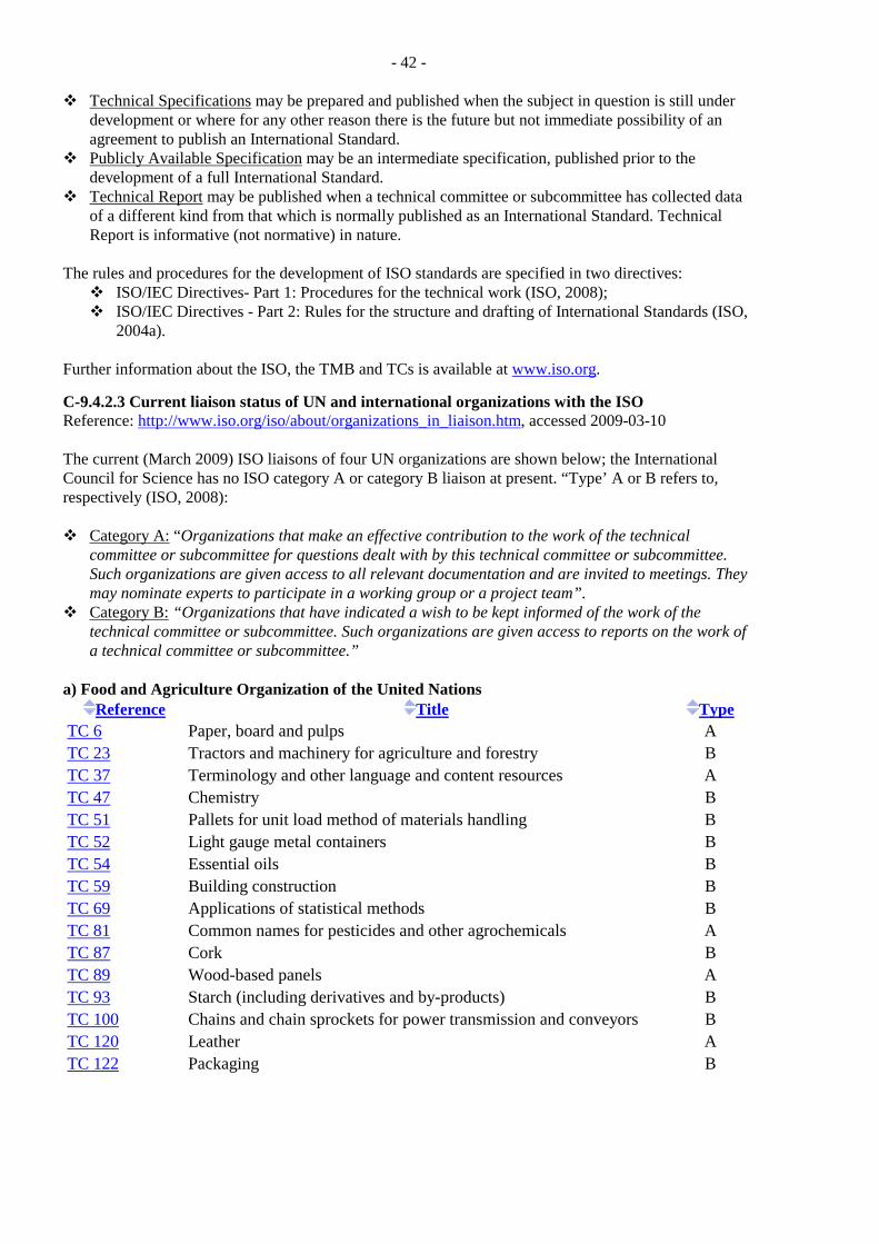
- 42 -
Technical Specifications may be prepared and published when the subject in question is still under development or where for any other reason there is the future but not immediate possibility of an agreement to publish an International Standard.
Publicly Available Specification may be an intermediate specification, published prior to the development of a full International Standard.
Technical Report may be published when a technical committee or subcommittee has collected data of a different kind from that which is normally published as an International Standard. Technical Report is informative (not normative) in nature.
The rules and procedures for the development of ISO standards are specified in two directives:
ISO/IEC Directives- Part 1: Procedures for the technical work (ISO, 2008); ISO/IEC Directives - Part 2: Rules for the structure and drafting of International Standards (ISO,
2004a). Further information about the ISO, the TMB and TCs is available at www.iso.org.
C-9.4.2.3 Current liaison status of UN and international organizations with the ISO Reference: http://www.iso.org/iso/about/organizations_in_liaison.htm, accessed 2009-03-10 The current (March 2009) ISO liaisons of four UN organizations are shown below; the International Council for Science has no ISO category A or category B liaison at present. “Type’ A or B refers to, respectively (ISO, 2008):
Category A: “Organizations that make an effective contribution to the work of the technical committee or subcommittee for questions dealt with by this technical committee or subcommittee. Such organizations are given access to all relevant documentation and are invited to meetings. They may nominate experts to participate in a working group or a project team”.
Category B: “Organizations that have indicated a wish to be kept informed of the work of the technical committee or subcommittee. Such organizations are given access to reports on the work of a technical committee or subcommittee.”
a) Food and Agriculture Organization of the United Nations Reference Title Type
TC 6 Paper, board and pulps A TC 23 Tractors and machinery for agriculture and forestry B TC 37 Terminology and other language and content resources A TC 47 Chemistry B TC 51 Pallets for unit load method of materials handling B TC 52 Light gauge metal containers B TC 54 Essential oils B TC 59 Building construction B TC 69 Applications of statistical methods B TC 81 Common names for pesticides and other agrochemicals A TC 87 Cork B TC 89 Wood-based panels A TC 93 Starch (including derivatives and by-products) B TC 100 Chains and chain sprockets for power transmission and conveyors B TC 120 Leather A TC 122 Packaging B
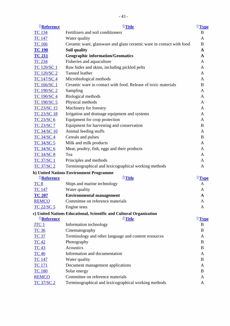
- 43 -
Reference Title Type TC 134 Fertilizers and soil conditioners B TC 147 Water quality A TC 166 Ceramic ware, glassware and glass ceramic ware in contact with food B TC 190 Soil quality A TC 211 Geographic information/Geomatics A TC 234 Fisheries and aquaculture A TC 120/SC 1 Raw hides and skins, including pickled pelts A TC 120/SC 2 Tanned leather A TC 147/SC 4 Microbiological methods A TC 166/SC 1 Ceramic ware in contact with food. Release of toxic materials B TC 190/SC 2 Sampling A TC 190/SC 4 Biological methods A TC 190/SC 5 Physical methods A TC 23/SC 15 Machinery for forestry A TC 23/SC 18 Irrigation and drainage equipment and systems A TC 23/SC 6 Equipment for crop protection A TC 23/SC 7 Equipment for harvesting and conservation B TC 34/SC 10 Animal feeding stuffs A TC 34/SC 4 Cereals and pulses B TC 34/SC 5 Milk and milk products A TC 34/SC 6 Meat, poultry, fish, eggs and their products A TC 34/SC 8 Tea A TC 37/SC 1 Principles and methods A TC 37/SC 2 Terminographical and lexicographical working methods A b) United Nations Environment Programme
Reference Title Type TC 8 Ships and marine technology A TC 147 Water quality A TC 207 Environmental management A REMCO Committee on reference materials A TC 22/SC 5 Engine tests A c) United Nations Educational, Scientific and Cultural Organization
Reference Title Type JTC 1 Information technology B TC 36 Cinematography B TC 37 Terminology and other language and content resources A TC 42 Photography B TC 43 Acoustics B TC 46 Information and documentation A TC 147 Water quality B TC 171 Document management applications A TC 180 Solar energy B REMCO Committee on reference materials A TC 37/SC 2 Terminographical and lexicographical working methods A
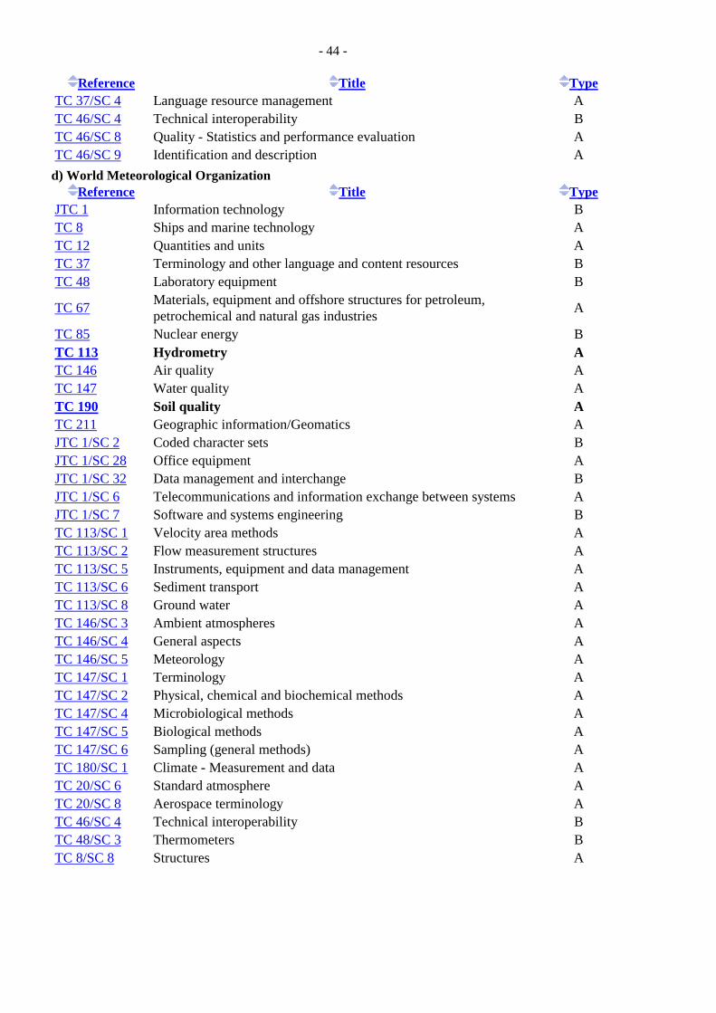
- 44 -
Reference Title Type TC 37/SC 4 Language resource management A TC 46/SC 4 Technical interoperability B TC 46/SC 8 Quality - Statistics and performance evaluation A TC 46/SC 9 Identification and description A d) World Meteorological Organization
Reference Title Type JTC 1 Information technology B TC 8 Ships and marine technology A TC 12 Quantities and units A TC 37 Terminology and other language and content resources B TC 48 Laboratory equipment B
TC 67 Materials, equipment and offshore structures for petroleum, petrochemical and natural gas industries A
TC 85 Nuclear energy B TC 113 Hydrometry A TC 146 Air quality A TC 147 Water quality A TC 190 Soil quality A TC 211 Geographic information/Geomatics A JTC 1/SC 2 Coded character sets B JTC 1/SC 28 Office equipment A JTC 1/SC 32 Data management and interchange B JTC 1/SC 6 Telecommunications and information exchange between systems A JTC 1/SC 7 Software and systems engineering B TC 113/SC 1 Velocity area methods A TC 113/SC 2 Flow measurement structures A TC 113/SC 5 Instruments, equipment and data management A TC 113/SC 6 Sediment transport A TC 113/SC 8 Ground water A TC 146/SC 3 Ambient atmospheres A TC 146/SC 4 General aspects A TC 146/SC 5 Meteorology A TC 147/SC 1 Terminology A TC 147/SC 2 Physical, chemical and biochemical methods A TC 147/SC 4 Microbiological methods A TC 147/SC 5 Biological methods A TC 147/SC 6 Sampling (general methods) A TC 180/SC 1 Climate - Measurement and data A TC 20/SC 6 Standard atmosphere A TC 20/SC 8 Aerospace terminology A TC 46/SC 4 Technical interoperability B TC 48/SC 3 Thermometers B TC 8/SC 8 Structures A
- 45 -
C-9.4.3 World Meteorological Organization (WMO)
The World Meteorological Organization (WMO) is a specialized agency of the United Nations with 188 member states and territories. The mission of WMO includes:
Facilitating worldwide cooperation in the establishment of networks of stations for the making of meteorological observations as well as hydrological and other geophysical observations related to meteorology, and to promote the establishment and maintenance of centres charged with the provision of meteorological and related services;
Promoting standardization of meteorological and related observations and to ensure the uniform publication of observations and statistics;
Promoting activities in operational hydrology and to further close cooperation between Meteorological and Hydrological Services;
WMO operates or co-sponsors several programmes, of most interest in the present context being the Global Climate Observing System (GCOS) and the Hydrology and Water Resources Programme (HWRP). The HWRP is concerned with the assessment of the quantity and quality of water resources. It includes standardization of various aspects of hydrological observations and the organized transfer of technologies. Further information about the WMO is available at http://www.wmo.int/pages/index_en.html. C-9.4.3.1 Global Climate Observing System (GCOS)
The Global Climate Observing System (GCOS) is intended to be a long-term, user-driven operational system capable of providing the comprehensive observations required for:
Monitoring the climate system, Detecting and attributing climate change, Assessing impacts of, and supporting adaptation to, climate variability and change, Application to national economic development, Research to improve understanding, modelling and prediction of the climate system.
GCOS addresses the total climate system including physical, chemical and biological properties, and atmospheric, oceanic, terrestrial, hydrologic, and cryospheric components. The GCOS is sponsored by WMO, UNESCO, UNEP and ICSU. It is supported by three science panels, reporting to the Steering Committee, that have been established to define the observations needed in each of the main global domains (atmosphere, oceans, and land); to prepare specific programme elements; and to make recommendations for implementation. The Terrestrial Observation Panel for Climate (TOPC) was set up to develop a balanced and integrated system of in situ and satellite observations of the terrestrial ecosystem. The Panel is jointly sponsored by GCOS and the GTOS. The TOPC focuses on the identification of terrestrial observation requirements, assisting the establishment of observing networks for climate, providing guidance on observation standards and norms, facilitating access to climate data and information and its assimilation, and promoting climate studies and assessments. Further information on the GCOS is available at http://www.wmo.int/pages/prog/gcos/index.php?name=about.
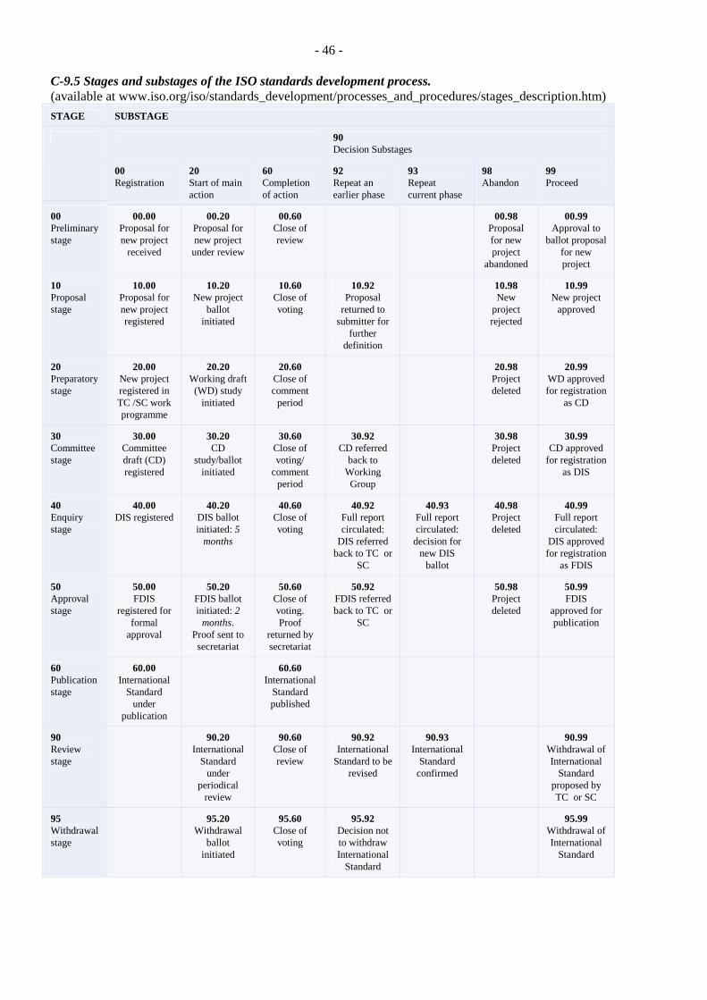
- 46 -
C-9.5 Stages and substages of the ISO standards development process. (available at www.iso.org/iso/standards_development/processes_and_procedures/stages_description.htm) STAGE SUBSTAGE
90 Decision Substages
00 Registration
20 Start of main action
60 Completion of action
92 Repeat an earlier phase
93 Repeat current phase
98 Abandon
99 Proceed
00 Preliminary stage
00.00 Proposal for new project
received
00.20 Proposal for new project
under review
00.60 Close of review
00.98 Proposal for new project
abandoned
00.99 Approval to
ballot proposal for new project
10 Proposal stage
10.00 Proposal for new project registered
10.20 New project
ballot initiated
10.60 Close of voting
10.92 Proposal
returned to submitter for
further definition
10.98 New
project rejected
10.99 New project
approved
20 Preparatory stage
20.00 New project registered in TC /SC work programme
20.20 Working draft (WD) study
initiated
20.60 Close of comment
period
20.98 Project deleted
20.99 WD approved for registration
as CD
30 Committee stage
30.00 Committee draft (CD) registered
30.20 CD
study/ballot initiated
30.60 Close of voting/
comment period
30.92 CD referred
back to Working Group
30.98 Project deleted
30.99 CD approved
for registration as DIS
40 Enquiry stage
40.00 DIS registered
40.20 DIS ballot initiated: 5
months
40.60 Close of voting
40.92 Full report circulated:
DIS referred back to TC or
SC
40.93 Full report circulated:
decision for new DIS
ballot
40.98 Project deleted
40.99 Full report circulated:
DIS approved for registration
as FDIS
50 Approval stage
50.00 FDIS
registered for formal
approval
50.20 FDIS ballot initiated: 2
months. Proof sent to secretariat
50.60 Close of voting. Proof
returned by secretariat
50.92 FDIS referred back to TC or
SC
50.98 Project deleted
50.99 FDIS
approved for publication
60 Publication stage
60.00 International
Standard under
publication
60.60 International
Standard published
90 Review stage
90.20 International
Standard under
periodical review
90.60 Close of review
90.92 International
Standard to be revised
90.93 International
Standard confirmed
90.99 Withdrawal of International
Standard proposed by TC or SC
95 Withdrawal stage
95.20 Withdrawal
ballot initiated
95.60 Close of voting
95.92 Decision not to withdraw International
Standard
95.99 Withdrawal of International
Standard
- 47 -
PART D. REPORT - STATUS OF THE DEVELOPMENT OF STANDARDS FOR THE
ESSENTIAL CLIMATE VARIABLES IN THE TERRESTRIAL DOMAIN D- Abstract This report provides an overview of standardization issues for the Essential Climate Variables (ECVs) identified by the Global Climate Observing System (GCOS) as critical observations for the terrestrial domain. The focus of the report is the degree of standardization of the procedures for the collection and reporting of the ECVs at the international level. Where possible, the relevant documents (international standards, guides, protocols) were identified and referenced. Although GCOS ECV observation requirements have both in situ and satellite components, this report deals with the former only because the consensus on satellite-based methodologies is still evolving. An approach to developing the missing international standards within the framework of the International Organization for Standardization is also proposed. D- Acknowledgements A draft of this report was reviewed by scientists involved in international or national activities dealing with the development of methodologies, products, or applications for individual terrestrial ECVs. They include: Richard Armstrong, National Snow and Ice Data Center, USA Frederic Baret, L’institut national de la recherche agronomique, France Crystal Barker Schaaf, Boston University, USA Antonio Bombelli, UN Food and Agriculture Organization, Italy Jerry Brown, International Permafrost Association Ivan Csiszar, National Oceanic and Atmospheric Administration, USA Antonio Di Gregorio, UN Food and Agriculture Organization, Italy Nadine Gobron, Joint Research Centre, Italy Martin Herold, Friedrich-Schiller-Universität, Germany Beverly Law, Oregon State University, USA John S.Latham, UN Food and Agriculture Organization, Italy Ulrich Looser, Global Runoff Data Centre, Germany Jaime Nickeson, National Aeronautics and Space Administration, USA Bernard Pinty, Joint Research Centre, Italy Reuben Sessa, UN Food and Agriculture Organization, Italy Michel Verstraete, Joint Research Centre, Italy Valery Vuglinskiy, State Hydrological Institute of Roshydromet, Russia Jean-Luc Widlowski, Joint Research Centre, Italy Mike Wulder, Canadian Forest Service, Canada Michael Zemp, University of Zurich, Switzerland The comments and suggestions of the reviewers have improved the report and are greatly appreciated.
- 48 -
D-1. Introduction and Objective The Global Terrestrial Observing System (GTOS) and its partners have been acting on a request by the UNFCCC Conference of the Parties (COP) to develop “a framework for the preparation of guidance materials, standards and reporting guidelines for terrestrial observing systems for climate, and associated data and products. The Framework mechanism to be put in place will have as its first priority ensuring that the appropriate guidance materials and standards are developed and made available for the Essential Climate Variables (ECV) identified by the Global Climate Observing System (GCOS). At its 23rd session, the SBSTA “..also called on the GTOS secretariat to assess the status of the development of standards for each of the essential climate variables in the terrestrial domain” (SBSTA, 2006, p. 16). Following the request by SBSTA 23, the GTOS developed and submitted documents describing the current status of each ECV. The information focused on measurement methods; existing product generation initiatives at the global level; and archiving, reporting and use of the reported measurements (refer to http://www.fao.org/gtos/topcECV.html for the most recent version). Building on the previous work and the resulting GTOS documents, the present report summarizes information on the measurement methods and the degree of standardization achieved so far, with the objective of identifying the ECVs that should be given priority attention once the above Framework mechanism is put in place. The standards being considered in this document refer exclusively to in situ measurements. Satellite- based measurement and reporting standards need to be considered separately at this point for several reasons:
Most of the methodologies are still under development; The monitoring, generation of products and reporting work is carried out by only a few agencies
and standardization is therefore much easier; Further development of methodologies and intercomparisons of derived products are the greatest
current priorities; The ECV developmental activities are handled under the umbrella of the Committee on Earth
Observation Satellites and the Global Earth Observation initiative. This limitation does not exclude, however, standardization of in situ measurements for ECVs that rely fully on satellite data, e.g. Leaf Area Index; nor does it exclude the possibility of developing more comprehensive standards encompassing in situ and satellite measurement strategies once the satellite methodologies are sufficiently stabilized. D-2. Methodology
D-2.1 Approach When deciding which ECVs should be subject to the standardization process in the initial phase, the following (and likely other) questions will need to be answered (for brevity, the term standard is used hereafter to denote the other reference materials specified above): 1. What specific measurements need to be standardized (usually more than one per ECV)? [Rationale:
The standardization process needs to encompass each measurement]. 2. Although there may not be consensus on the measurement approach, do candidate methods exist
(with supporting documentation) that could form the initial nucleus of an international standard? [Rationale: The process should focus on cases where enough is known about the various methodologies to attempt drafting a consensus document, but no single consensus approach has emerged and/or no corresponding document exists].
3. In light of the above, is the preparation of one standard feasible? [Rationale: Yes/No judgment call based on the above].
- 49 -
4. Would such a standard be of interest beyond GCOS/GTOS, thus potentially gathering more support for, and involvement in, its formulation? [Rationale: A standard of wider applicability would enjoy more support at the national level, thus making it more likely that the development process could be completed successfully].
5. Which would be the candidate lead group(s) – within the ISO and within the UN or international scientific community? [Rationale: In the Framework, the International Organization for Standardization (ISO) would play lead role in the preparation of the standards, and the candidates for leadership within the ISO are specifically considered. In several ECVs, UN organizations - particularly the World Meteorological Organization - have provided guidance aiming to standardize in situ measurements, and have published relevant documents. For the standardization process to be successful, a representative body with expertise in the ECV measurement aspects also needs to be involved, especially in the preparation of the ‘working draft’ of an international standard].
6. Given the above, what is the most appropriate way forward for standardizing this ECV in terms of need, priority, and the preferred format? [Rationale: If sufficient consensus and documentation exist, that ECV should not be an initial priority; depending on the nature of measurement to be made and the degree of maturity, a standard may or may not be the most appropriate format; a guide or another form may be preferable].
The above questions are discussed below, separately for each ECV. Much of the information was taken from existing documentation for individual ECVs, available at the GTOS Web site and referred to below as (GTOS, 2009). For ISO standards, the ‘development stage’ and the Technological Committee (TC) responsible are also included; the ISO international standard development stages are shown in Appendix C-9.5. It is also important to note that ISO standardization process can yield several different deliverables (refer to www.iso.org for further details):
o ISO Standard; o ISO/PAS Publicly Available Specification; o ISO/TS Technical Specification; o ISO/TR Technical Report; o IWA International Workshop Agreement; and o ISO Guide.
D-2.2 Common standards Since all ECV terrestrial observations must be recorded and reported in relation to specific geographic locations, geographic representation standards underpin all ECV observing and reporting strategies. Within the ISO, these are developed by TC 211 (Geographic Information/Geomatics). For brevity, some of the more directly relevant standards (to ECVs) are listed below and only once in this report.
o ISO/TS 19104:2008. Geographic information – Terminology. Stage 60.60. TC 211. o ISO 19105:2000. Geographic information -- Conformance and testing. Stage 90.93. TC 211. o ISO 19106:2004. Geographic information – Profiles. Stage 90.93. TC 211. o ISO 19107:2003. Geographic information -- Spatial schema. Stage 90.60. TC 211. o ISO 19108:2002. Geographic information -- Temporal schema. Stage 90.92. TC 211. o ISO 19109:2005. Geographic information -- Rules for application schema. Stage 90.60. TC 211. o ISO 19110:2005. Geographic information -- Methodology for feature cataloguing. Stage 90.60.
TC 211. o ISO 19111:2007. Geographic information -- Spatial referencing by coordinates. Stage 60.60. TC
211. o ISO/DIS 19111-2. Geographic information -- Spatial referencing by coordinates -- Part 2:
Extension for parametric values. Stage 40.99. TC 211. o ISO 19112:2003. Geographic information -- Spatial referencing by geographic identifiers. Stage
90.20. TC 211. o ISO 19113:2002. Geographic information -- Quality principles. Stage 90.92. TC 211.

- 50 -
o ISO 19114:2003. Geographic information -- Quality evaluation procedures. Stage 90.60. TC 211. o ISO 19115:2003. Geographic information -- Metadata Stage 90.60. TC 211. o ISO 19115-2:2009. Geographic information -- Metadata -- Part 2: Extensions for imagery and
gridded data. Stage 60.60. TC 211. o ISO/CD 19118. Geographic information – Encoding. Stage 30.99. TC 211. o ISO 19118:2005. Geographic information – Encoding. Stage 90.92. TC 211. o ISO/TR 19120:2001. Geographic information -- Functional standards. Stage 60.60. TC 211. o ISO/TR 19121:2000. Geographic information -- Imagery and gridded data. Stage 60.60. TC 211. o ISO/TR 19122:2004. Geographic information / Geomatics -- Qualification and certification of
personnel. Stage 60.60. TC 211. o ISO 19123:2005. Geographic information -- Schema for coverage geometry and functions. Stage
90.60. TC 211. o ISO/DIS 19126. Geographic information -- Feature concept dictionaries and registers. Stage
40.99. TC 211. o ISO/TS 19127:2005. Geographic information -- Geodetic codes and parameters. Stage 90.60. TC
211.ISO 19128:2005. Geographic information -- Web map server interface/. Stage 90.20. TC 211.
o ISO/PRF TS 19129. Geographic information -- Imagery, gridded and coverage data framework. Stage 50.20. TC 211.
o ISO/CD TS 19130. Geographic information - Imagery sensor models for geopositioning. Stage 30.60. TC 211.
o ISO 19131:2007. Geographic information -- Data product specifications. Stage 60.60. TC 211. o ISO 19135:2005. Geographic information -- Procedures for item registration. Stage 90.20. TC
211. o ISO 19136:2007. Geographic information -- Geography Markup Language (GML). Stage 60.60.
TC 211. o ISO 19137:2007. Geographic information -- Core profile of the spatial schema. Stage 60.60. TC
211. o ISO/TS 19138:2006. Geographic information -- Data quality measures. Stage 60.60. o ISO/TS 19139:2007. Geographic information -- Metadata -- XML schema implementation. Stage
60.60. TC 211. o ISO/DIS 19144-1. Geographic information -- Classification systems -- Part 1: Classification
system structure. Stage 40.60. TC 211. o ISO/CD 19144-2. Geographic information - Classification Systems -- Part 2: Land Cover
Classification System LCCS. Stage 30.60. TC 211. o ISO/DIS 19146. Geographic information -- Cross-domain vocabularies. Stage 40.20. TC 211. o ISO/CD 19156. Geographic information - Observations and measurements Stage 30.20. TC 211.
- 51 -
D-3. ECV status D-3.1 Albedo
1. Specific measurements The albedo of a surface is a joint property of the surface and of the illumination conditions. It varies in space and time and with measurement wavelength, depending on the surface as well as on the solar zenith angle and the amount and properties of atmospheric constituents (clouds, aerosols, gas molecules). Albedo is fully described by the bidirectional reflectance of the surface itself, and it is generally integrated over broader spectral bands such as short wave (0.3-0.7 micrometres) and near infrared (0.7-3.0 micrometres). Weather and climate models must evaluate the albedo of surfaces at the bottom of the atmosphere on a relatively dense geographical grid (of the order of tens of km) and at frequent intervals (every 15 minutes or so), in order to calculate the energy balance of the system. To achieve this, the models use parameterizations based on (or driven by) intermediary products derived from observations, such as the directional hemispherical reflectance factor (also known as 'black sky' albedo) and the bihemispherical reflectance factor for isotropic illumination ('white sky' albedo) - together with an estimate of their relative contributions, weighted by the fraction of diffuse radiation at the surface. Other models (hydrological, biogeochemical, agricultural, etc.) also require similar albedo estimates but at higher spatial resolutions (e.g. hundreds of metres). In situ observations are required for the evaluation of the accuracy and reliability of the albedo products derived from space measurements (GTOS, 2009). They must include:
o Observations of the direct, diffuse and total incoming solar radiation, within specific spectral bands as well as over the broad band (e.g., 0.3-3.0 micrometres);
o Observations of the solar radiation reflected by the surface, typically in one or in many specific directions; the latter is required for the characterization of the surface anisotropy.
2. Candidate measurement methods, standards and guides Specific standards have been developed only for the measurement of the incoming (downward) solar radiation. For instance, direct solar radiation (broadband or spectral) at the surface is measured using pyrheliometers, the receiving surfaces of which are arranged to be normal to the solar direction. Pyranometers are used to measure global radiation (direct plus diffuse) or diffuse - only radiation in the spectral range from 0.3 to 3.0 micrometres. The applicable measurement guidelines were developed by the WMO Commission for Instruments and Methods of Observation (CIMO):
o WMO. 2008. Guide to Meteorological Instruments and Methods of Observation. WMO-No. 8, Seventh edition, World Meteorological Organization, Geneva, Switzerland. [Contains Chapter 7: Measurement of radiation.]
The in situ radiation measurements most directly relevant to the GCOS are provided by the Baseline Surface Radiation Network (BSRN). The measurement protocol is described in:
o McArthur, L.J.B. 2005. Baseline Surface Radiation Network: Operations Manual. Version 2.1, World Climate Research Programme. Report WCRP 121, WMO/TD-No. 1274. 176p. [Contains chapters on site requirements, instrument installation, calibration, data acquisition, and other relevant topics].
o Ohmura A., Dutton, E., Forgan, B., Frohlich, C., Gilgen, H., Hegne, H., Heimo, A., Konig-Langlo, G., McArthur, B., Muller, G., Philipona, R., Whitlock, C., Dehne, K., and Wild, M. 1998. Baseline Surface Radiation Network (BSRN/ WCRP): New precision radiometry for climate change research. Bulletin of the American Meteorological Society 79: 2115-2136.
- 52 -
The following ISO standards are related to solar radiation measurements: o ISO 9022-9:1994. Optics and optical instruments -- Environmental test methods -- Part 9: Solar
radiation. Stage: 90.20 TC 172. o ISO 9022-17:1994. Optics and optical instruments -- Environmental test methods -- Part 17:
Combined contamination, solar radiation. Stage: 90.20. TC 172. o ISO 9060:1990. Solar energy -- Specification and classification of instruments for measuring
hemispherical solar and direct solar radiation. Stage: 90.92. TC 180. In situ radiation measurements useful for albedo calculations are made at hundreds of tower flux sites globally. Since about 2002, four-component net radiometers have been installed. The instruments measure incoming and outgoing shortwave radiation (0.305 to 2.8 micrometres; pyranometer), and incoming and outgoing longwave radiation (5 to 50 micrometres; pyrgeometer). Instrument recommendations for these measurements are provided in:
o Law, B.E., Loescher, H.W., Boden, T.A.. Hargrove, W., and Hoffman, F. 2005. AmeriFlux site evaluation and recommendations for network enhancement. Available at http://public.ornl.gov/ameriflux/AmeriFluxSiteEvaluationWEB.pdf.
3. Feasibility Observation standards for albedo measurements have already been established and are periodically updated by the WMO. 4. Wider relevance Albedo measurements are required primarily for surface radiation computations in climate, weather, and biogeochemical modeling (and related scientific) purposes. 5. Candidate lead groups Standard preparation lead: The WMO Commission for Instruments and Methods of Observation (CIMO) is the main technical body concerned with methods for standardization. Technical input: The CIMO includes sufficient expertise for establishing albedo measurement standards. However, it is not clear that the specific requirements of satellite programmes generating albedo products have been sufficiently taken into account. These requirements are well understood by groups involved in satellite products development and validation, notably the CEOS WGCV (Land Products Validation Subgroup). 6. Conclusion Albedo measurements have long been of interest to studies, monitoring and modeling of climate and weather processes. Measurement guides have been developed by the WMO and by scientific groups, and they are periodically updated. Lack of standards does not appear to be an obstacle to obtaining reliable surface albedo data needed for ECV purposes. However, there is also a need for developing a consensus (and ultimately standards) for the measurement of the upwelling radiation reflected by the surface, as well as for the characterization of surface anisotropy.
- 53 -
D-3.2 Biomass 1. Specific measurements According to the IPCC Good Practice Guidance for LULUCF (2003), the carbon pools of terrestrial ecosystems involving biomass are conceptually divided into:
o Above-ground biomass (all living biomass above the soil including stem, stump, branches, bark, seeds, and foliage);
o Below-ground biomass (all living biomass of live roots); o Dead mass (all non-living woody biomass not contained in the litter - standing, lying on the
ground, or in the soil); and o Litter (all non-living biomass in various states of decomposition above the mineral or organic
soil). 2. Candidate in situ measurement methods, standards and guides Many countries have national inventories that include biomass information, but almost exclusively for forests only and based on allometric relationships. Allometric equations are typically based upon regionally-specific relationships between merchantable volume (which is operationally measured) and biomass components (not operationally measured). The soil biomass component is usually estimated as a fraction of the aboveground total biomass, based upon plot-based stratified sampling. Management- oriented forest inventories in many countries contain volume information that would allow for wide-area biomass conversion. However, these datasets suffer from various limitations, including: they are not always publicly available, represent differing time periods, are not spatially exhaustive (covering only commercially relevant forest lands), and others. Data bases suffering from such shortcomings are not suited for use as ECVs because of the numerous differences among inventory methods and the consequent incompleteness and/or incompatibility of information from individual countries (GTOS, 2009). On the other hand, regional information from forest management plots and inventories may strongly support calibration and validation of remote sensing - or modeling - based strategies for biomass estimation. Because of the logistical and conceptual difficulties in obtaining global biomass inventories over time, satellite data are playing increasingly important roles; however, their proper use requires in situ biomass data for calibration, validation and intercomparisons among estimates obtained through various approaches. Biomass measurement methods are typically standardized through an inventory design at the national level. The basic measurements are well understood, even though their application varies among countries depending on many conceptual and practical factors. One international field protocol for measuring the various forest biomass compartments, and for biomass data requirements for other biomes, was published recently:
o Law, B.E., Arkebauer, T., Campbell, J.L., Chen, J., Sun, O., Schwartz, M., van Ingen, C., and Verma, S. 2008. Terrestrial Carbon Observations: Protocols for Vegetation Sampling and Data Submission. Report 55, Global Terrestrial Observing System. 87p. [Chapter 3: Stem Surveys. Chapter 4: Tree Increment Coring. Chapter 5: Foliage Sampling. Chapter 6: Understory and Ground Cover Survey. Chapter 7: Litter Sampling. Chapter 8: Soil and Root Sampling. Chapter 9: Laboratory Procedures for Root Sampling and Soil Preparation. Chapter 10: Woody Detritus Survey.]
The Intergovernmental Panel on Climate Change (IPCC) developed Good Practice Guidelines for reporting. However, these assume that the basic information on changes in the various biomass categories is already known. Also, since individual countries report ‘change over time’, the consequences of incompatible inventory designs are less significant:
o IPCC. 2003. Good Practice Guidance for Land Use, Land-Use Change and Forestry. Intergovernmental Panel for Climate Change, report published by the Institute for Global Environmental Strategies (IGES) for the IPCC, ISBN 4-88788-003-0.

- 54 -
There are no ISO standards related to biomass measurements. ISO TC 218 produced standards dealing with sawlogs, sawn timber and various derived products. 3. Feasibility Reconciling the various inventory designs or the resulting information is generally difficult and inevitably produces inaccurate results. In addition, some inventory designs are inherently less suited for ECV purposes than others, depending for example on how biomass change is defined and measured (GTOS, 2009). However, in principle the standardization of biomass measurements is feasible as demonstrated by Law et al (2008; see above). 4. Wider relevance Biomass measurements have the highest importance in forest ecosystems and at the national level where they also carry economic and policy implications. Other than the UNFCCC and its Good Practice Guidelines and international reporting (e.g. by FAO), there has not been significant need to reconcile such national inventories. 5. Candidate lead groups Standard preparation lead: Within ISO, TC207 is the most closely related group. The Forestry Department and the Environmental Assessment Unit, Natural Resources Department of FAO has probably the most experience with standardizing forestry reports based on national inventories and vegetation physiognomy. Technical input: The FLUXNET team (see Law et al. above) and the IPCC team that compiled the Good Practice Guidelines arguably have the most experience in biomass measurement methodologies at the global level. However, neither team is involved in using in situ biomass measurements together with satellite data, an area with considerable activity but still in research phase. Coordination activities among the remote sensing community and in situ groups have been initiated by the GOFC-GOLD project and by the Terrestrial Carbon Observing systems of GTOS. 6. Conclusion Preparation of an international standard for in situ biomass measurements is highly desirable and technically feasible. Such an activity would also require support by countries, especially those with large forest resources, in order to be successful. Given that the measurement issues are well understood, an international standard would be an appropriate format to aim at.
- 55 -
D-3.3 Fire Disturbance 1. Specific measurements The following measurements are required for this ECV:
o Burned area; o Active fire detection; o Fire radiated power.
2. Candidate in situ measurement methods, standards and guides Because of the spatial and temporal dynamics of vegetation fires, satellites provide the best resource for fire detection and measurement. If made, in situ measurements are limited to small areas and serve to calibrate, validate and inter-compare satellite-derived products and thereby ensure their accuracy over time. However, some fire disturbance measurements are currently made in situ, e.g. completeness of combustion and fire intensity. In situ measurements are also needed to establish emission factors used in estimating emissions from fire disturbance. Collection of in situ measurements related to fire is commonly the responsibility of land management agencies (e.g. forest and park services) or of other agencies (fire services, emergency services) that may collect data on their own or compile data from sub-national levels. National fire monitoring policies vary depending on existing regulations for fire management, on land ownership, land accessibility, the extent of cultural use of fire, and on financial means of the country (GTOS, 2009). There are no common standards for the acquisition, processing, or generation of satellite products, nor for the acquisition of supporting in situ data. For global-scale applications such as the ECVs, ‘pseudo in situ’ information derived from higher resolution satellite imagery is the most practical approach to the validation of medium and coarse resolution global fire products (GTOS, 2009): a) For burned area validation, pairs of Landsat-class imagery (30m resolution or higher) can be employed to validate burned areas mapped between their acquisition dates at coarser resolutions:
o Roy, D.P., Frost, P., Justice, C.O., Landmann, T., Le Roux, J., Gumbo, K., Makungwa, Dunham, K., Du Toit, R., Mhwandagara, K., Zacarias, A., Tacheba, B., Dube, O., Pereira, J., Mushove, P., Morisette, J., Vannan, S., and Davies, D. 2005. The Southern Africa Fire Network (SAFNet) regional burned area product validation protocol. International Journal of Remote Sensing 26: 4265-4292.
o CEOS Working Group on Calibration and Validation (WGCV) Land Products Validation LPV) Subgroup. LPV Burned Area Validation Protocol. Available at: http://lpvs.gsfc.nasa.gov/PDF/BurnedAreaValidationProtocol.pdf.
b) For ‘active fire’ products simultaneous independent observations are required:
o Morisette, J.T., Giglio, L., Csiszar, I., and Justice, C.O. 2005. Validation of the MODIS active fire product over Southern Africa with ASTER data. International Journal of Remote Sensing 26: 4239–4264.
c) Full validation of the Fire Radiated Power measurements approach requires unsaturated radiance measurements from high resolution space or airborne sensors which are currently not routinely available, but the use of airborne thermal imaging systems for FRP validation is possible (GTOS, 2009). In situ measurements, when employed, are limited to relatively small areas but similar techniques are used in different countries:
o Burned area: Location and geographic registration of edges of burn scars, usually geolocated data from airborne platforms or from ground measurements using precise geolocation tools such as the Global Positioning System;
- 56 -
o Active fire: Fire detection and monitoring is commonly performed from observation towers or aircraft platforms. In some cases burn scars are used as an indication of active fire occurrence after the event.
o Fire radiated power: Rarely collected using in situ measurements, but is feasible by means of radiometers mounted on various aircraft platforms.
No international standards have been established for any of the above measurement strategies, in situ or airborne. Among the many ISO standards dealing with fires (mostly in relation to infrastructure of various types), only few appear relevant to this ECV:
o ISO/TS 14934-1:2002. Fire tests -- Calibration and use of radiometers and heat flux meters -- Part 1: General principles. Stage: 90.92. TC 92.
o ISO 14934-3:2006. Fire tests -- Calibration and use of heat flux meters -- Part 3: Secondary calibration method. Stage: 90.92. TC 92.
3. Feasibility At this stage it is premature to attempt development of international standards for acquiring in situ fire disturbance data in support of global monitoring from satellites. However, the requisite methods continue to be developed as part of research efforts as well as in support of the generation of global satellite products by several space agencies. Standards and protocols are beginning to be developed for high resolution validation of coarse resolution fire disturbance products. 4. Wider relevance In situ fire disturbance measurements (especially those based on higher resolution satellite data) are relevant primarily for the validation of medium and coarse resolution products used for global to regional scale monitoring of fire disturbance and for related scientific issues, including fire emissions and net carbon uptake in the years following fire. 5. Candidate lead groups Standard preparation lead: The CEOS WGCV Land Products Validation (LPV) Subgroup, in collaboration with the GOFC-GOLD fire team is leading the efforts to promote standardized satellite fire disturbance product validation methods. The most closely related ISO group is TC92 (Fire Safety). Technical input: GOFC-GOLD Fire Implementation Team, the CEOS LPV Subgroup and their partners represent bulk of the expertise at the international level. 6. Conclusion Standardization of in situ measurements in support of satellite-based fire disturbance monitoring is at an early stage of development. Present efforts by the GOFC-GOLD Fire Implementation Team in conjunction with the CEOS LPV Subgroup are focused on a Burned Area Validation Protocol for Coarse Resolution Satellite data, and similar efforts could be undertaken for the other fire disturbance products. Since the methodologies will change with evolving technology (instrumentation and platforms), the exploration of new and robust in situ fire measurement approaches should be supported by the space agencies and should involve cooperation with the fire management agencies.
- 57 -
D-3.4 Fraction of Absorbed Photosynthetically Active Radiation The Fraction of Absorbed Photosynthetically Active Radiation (FAPAR) is a non-dimensional quantity describing the proportion of the incoming solar radiation (between 0.4 and 0.7 micrometres) that is absorbed by a vegetation canopy. Derived concepts include the 'Green leaves-only' FAPAR, which concerns the fraction of incoming solar radiation absorbed by live green plant materials (thus contributing to photosynthesis, as opposed to being absorbed by branches, for example), and 'Chlorophyll' FAPAR, which is an even more restrictive concept linked to the absorption exclusively by pigments in the leaves. Similarly to albedo, FAPAR depends on the illumination conditions and varies strongly in space and time. It is employed in light use efficiency-type models of vegetation growth. Depending on the model formulation, either diurnal variation or daily integrated values are used. FAPAR can also be also used as a proxy to characterize vegetation seasonality. 1. Specific measurements: The primary motivation for in situ FAPAR measurements is the validation and intercomparisons of satellite-derived FAPAR) products. The required in situ measurements are described in GTOS (2009):
a) ‘Total’ FAPAR (absorbed component) is computed as the balance between sources and sinks, with * positive elements corresponding to:
o Incoming photosynthetically active radiation (PAR) at the top of the canopy (direct and/or diffuse);
o Incoming PAR from horizontal light propagation (important only at very high spatial resolution);
o Light reflected by the underlying ground (soil and/or understory); * and losses corresponding to:
o Outgoing PAR reflected by the canopy (top and bottom); o Outgoing PAR propagating horizontally (important only at very high spatial
resolution).
b) “Green leaves-only” FAPAR refers to the fraction of PAR radiation absorbed by (entire) live leaves and thereby contributing to the photosynthetic activity within leaf cells. This FAPAR value can be derived from hemispherical photos taken from above the canopy when green leaves are clearly separable from the non-green elements (soil, trunks, litter). c) ‘Chlorophyll’ FAPAR refers to the fraction of PAR radiation absorbed by only the photosynthetic pigments in leaves. It is not directly accessible by measurements.
FAPAR in situ determination requires simultaneous measurements of PAR above and within the canopy. The latter may be taken at various heights, thus establishing a vertical FAPAR profile. FAPAR measurements are typically taken under overcast conditions using pyranometers or other commercial instruments (e.g. www.licor.com/env/Products/Sensors/rad.jsp). 2. Candidate in situ measurement methods, standards and guides In situ FAPAR measurement intended to serve for evaluating satellite-based products are conceptually difficult because of the diversity of definitions and retrieval algorithms, as well as the horizontal and vertical heterogeneity of vegetation canopies. Consequently, there is probably no comprehensive in situ data set that can serve as accurate and independent reference for medium to coarse resolution satellite products.
- 58 -
Standard optical methods were developed for forest and shrub canopy FAPAR and LAI, were adopted by the AmeriFlux network and the Canadian Carbon Programme, and published recently:
o Law, B.E., Arkebauer, T., Campbell, J.L., Chen, J., Sun, O., Schwartz, M., van Ingen, C., and Verma, S. 2008. Terrestrial Carbon Observations: Protocols for Vegetation Sampling and Data Submission. Report 55, Global Terrestrial Observing System. 87p. [Chapter 12: LAI measurements with LAI-2000].
The use of pyranometers is specified by:
o WMO. 2008. Guide to Meteorological Instruments and Methods of Observation. WMO-No. 8, Seventh edition, World Meteorological Organization, Geneva, Switzerland. [Contains Chapter 7: Measurement of radiation.]
No standard has been yet been defined for in situ measurements in other vegetation canopies; however, common procedures for grassland and cropland are based on destructive sampling (clipped plots). While local measurement of total FAPAR is relatively straightforward with the use of PAR radiation sensors or hemispherical photos, spatial representativeness presents considerable challenge. For small vegetation patches (~100-10000 m²), care must be taken to avoid borders effects that may bias the radiation balance. For larger areas, specific sampling strategies need to be employed:
o Morisette, J., Baret, F., Privette, J.L., Myneni, R.B., Nickeson, J., Garrigues, S., Shabanov, N., Weiss, M., Fernandes, R., Leblanc, S. et al.. 2006. Validation of global moderate resolution LAI products: a framework proposed within the CEOS Land Product Validation subgroup. IEEE Transactions on Geoscience and Remote Sensing 44: 1804-1817.
It has been suggested that radiative transfer model-based evaluation could be sufficient (without in situ measurements) if the accuracy requirement is not too stringent. Thus, efforts are underway to use validated radiative transfer models, capable of representing the foliage and branching architecture of individual trees, to evaluate the impact of different FAPAR estimation strategies, of spatial sampling schemes and of up-scaling procedures. Such an approach also offers the means for assessing the merits of commonly used FAPAR measurement protocols. The following ISO standards are related to solar radiation measurements:
o ISO 9022-9:1994. Optics and optical instruments -- Environmental test methods -- Part 9: Solar radiation. Stage: 90.20. TC 172.
o ISO 9022-17:1994. Optics and optical instruments -- Environmental test methods -- Part 17: Combined contamination, solar radiation. Stage: 90.20. TC 172.
o ISO 9060:1990. Solar energy -- Specification and classification of instruments for measuring hemispherical solar and direct solar radiation. Stage: 90.92. TC 180.
3. Feasibility The main issues related to in situ total FAPAR measurements are not concerned with the measurement itself (which is guided by WMO (2008)) but with practical problems related to measurement and sampling design, logistics, and costs. Large research networks have accumulated significant experience in this field, such as AmeriFlux (http://public.ornl.gov/ameriflux/sop.shtml), SPECNET (http://spectralnetwork.net/), and VALERI (www.avignon.inra.fr/valeri). AmeriFlux procedures are described in Law et al. (2008, see above) and in:
o Chen, J.M., and Law, B. 2007. Guidelines for LAI data submission to the Ameriflux Data Information System. Available at http://public.ornl.gov/ameriflux/AmeriFlux_LAI_Data_Submission_Guidelines.doc.
- 59 -
4. Wider relevance FAPAR in situ measurements have applicability to in situ estimates of biomass and productivity, model parameterization and evaluation (e.g. light-use efficiency models, biogeochemistry models), model-data assimilation, and FAPAR satellite products validation and intercomparisons in support of global vegetation and carbon cycle modeling. 5. Candidate lead groups Standard preparation lead: The WMO Commission for Instruments and Methods of Observation (CIMO) is the main technical body concerned with methods of standardizing radiation measurements themselves. Within the ISO, TC172 (Standardization of terminology, requirements, interfaces and test methods in the field of optics and photonics) is the most closely related group. However, as noted above the radiation measurement itself is not the main challenge in standardizing the in situ FAPAR data acquisition. Thus the most closely related ISO group is probably TC207 (Environmental Management; refer to Appendix D-7.1). Technical input: CIMO includes sufficient expertise for establishing radiation measurement standards. Most of the expertise regarding field measurement protocols resides in the CEOS WGCV (Land Products Validation Subgroup and the Infrared and Visible Optical Sensors Subgroup), as well as in the associated projects and groups. Large science-based networks such as FLUXNET, SPECNET and VALERI should also participate in setting the required standards. 6. Conclusion Further development of standardized methods for FAPAR in situ measurements would benefit from a comprehensive guide to field measurements. Such a document should be prepared from a broader perspective of canopy characterization, including other ECVs (especially Leaf Area Index); and consider the use of radiative transfer models to assess the merits of alternative sampling methodologies. A guide would be a suitable format if a standardization initiative is undertaken.
- 60 -
D-3.5 Glaciers and Ice Caps 1. Specific measurements To determine glacier changes, the following three primary variables need to be measured (GTOS, 2009):
o Glacierized area; o Specific mass balance, in water equivalent units (m); o Glacier front variation.
A periodic inventory of the total glacierized area is required to spatially extrapolate site measurements. 2. Candidate in situ measurement methods, standards and guides Within the Global Terrestrial Network for Glaciers (GTN-G), the combination of the direct glaciological method and the geodetic method has been proven to be a feasible approach that provides relevant results (GTOS, 2009). Where these are not available, other methods (flux method, hydrological method, indirect methods, modelling from climate records) are used to estimate glacier mass balance. A description of the different methods, their parameters, as well as their specific strengths and weaknesses can be found in:
o Østrem, G. and Brugman, M. 1991. Glacier mass-balance measurements: a manual for field and office work, NHRI Science Report, National Hydrology Research Institute, Canada.
o Dyurgerov, M. 2002. Glacier Mass Balance and Regime: Data of Measurements and Analysis In: Meier, M. (INSTAAR) and Armstrong, R. (NSIDC) (Eds.), Occasional Paper 55 INSTAAR/OP-55, ISSN 0069-6145, Institute of Arctic and Alpine Research University of Colorado, Boulder, Colorado 80309. 85p. + Appendices.
o Kaser, G., Fountain, A., and Jansson, P. 2002. A manual for monitoring the mass balance of mountain glaciers with particular attention to low latitude characteristics. A contribution from the International Commission on Snow and Ice (ICSI) to the UNESCO HKH-Friend programme. IHP-VI, Technical Documents in Hydrology, No. 59, UNESCO, Paris. 107p. + Appendices.
o Kaser, G., Cogley, J.G., Dyurgerov, M.B., Meier, M.F. and Ohmura, A. 2006. Mass balance of glaciers and ice caps: Consensus estimates for 1961–2004. Geophysical Research Letters, 33(L19501), doi.10.1029/2006GL027511. [provides an overview of the uncertainties of the combined approach]
o Zemp, M., Hoelzle, M. and Haeberli, W. 2009. Six decades of glacier mass balance observations - a review of the worldwide monitoring network. Annals of Glaciology, 50: p. 101–111. [provides an overview of available mass balance data and related issues]
Standards and guidelines for the compilation of an inventory of the global distribution of perennial ice can be found in:
o UNESCO. 1970. Perennial ice and snow masses – a guide for compilation and assemblage of data for a world inventory. Technical Papers in Hydrology No. 1, International Association of Scientific Hydrology, International Commission on Snow and Ice, Paris, France. 59p.
o UNESCO. 1973. Combined heat, ice and water balances at selected glacier basins, pt. 2: Specifications, standards and data exchange. UNESCO/IAHS Technical papers in hydrology 5. 32p.
o UNESCO. 1970. Combined heat, ice and water balances at selected glacier basins. Part I: A guide for compilation and assemblage of data for glacier mass balance measurements. UNESCO/ IAHS Technical Papers in Hydrology 5. 20p.
o Müller, F., Caflisch, T. and Müller, G. (Eds.). 1977. Instructions for the compilation and assemblage of data for a world glacier inventory. IAHS(ICSI)/UNESCO report, Temporal Technical Secretariat for the World Glacier Inventory (TTS/WGI), ETH Zurich, Switzerland. [to be available in electronic form]
o Müller, F. (Ed.). 1978. Instructions for the compilation and assemblage of data for a world glacier inventory; Supplement: Identification/glacier number IAHS(ICSI)/UNEP/UNESCO
- 61 -
report, Temporal Technical Secretariat for the World Glacier Inventory (TTS/WGI), ETH Zurich, Switzerland. [to be available in electronic form]
o Scherler, K. (Ed.). 1983. Guidelines for preliminary glacier inventories. IAHS(ICSI)/ UNEP/UNESCO report, Temporal Technical Secretariat for the World Glacier Inventory (TTS/WGMS), ETH Zurich, Switzerland. [to be available in electronic form]
o Rau, F., Mauz, F., Vogt, S., Khalsa, J.S. and Raup, B. (2005): Illustrated GLIMS glacier classification manual. Glacier classification guidance for the GLIMS Inventory. NSIDC: 36 pp. Available at http://www.glims.org/MapsAndDocs/assets/GLIMS_Glacier-Classification-Manual_V1_2005-02-10.pdf. [designed for satellite inventories]
o GLIMS Algorithm Working Group. 2006. GLIMS algorithm document. Available at www.glims.org/ (accessed 2006-10-19). [designed for satellite inventories]
o WGMS. 2007. Submission of Glacier Fluctuation Data to the World Glacier Monitoring Service: General Guidelines and Attribute Descriptions. World Glacier Monitoring Service, December 2007. 18p. Available at http://www.wgms.ch/downloads/WGMS_GuidelinesforDataSubmission.pdf (accessed 2009-02-02).
Recently, the International Association of Cryospheric Sciences established a working group to prepare an updated reference document on mass balance terminology and methods (www.cryosphericsciences.org/wg_mb.html); the least developed guidelines are those for carrying out glacier front variation measurements. No glacier observations - related standards have been published or are presently under development by the ISO. 3. Feasibility Given existing information; the importance of glaciers to monitoring environmental change; and the level of interest in the global community, the preparation of a comprehensive document is feasible. 4. Wider relevance Glacier observations and their reporting are critically important to countries and regions that rely on glaciers for supplying fresh water; and to scientific community and international organizations concerned with changing environmental conditions. 5. Candidate lead groups Standard preparation lead: Within ISO, TC207 (Environmental Management) is most closely related to measurement aspects in this thematic area. TC211 (Geographic Information/ Geomatics) has developed standards handling geospatial data that apply to glaciers as well as other environmental information. Technical input: The GTN-G, the World Glacier Monitoring Service (WGMS) and their partners represent various research and monitoring groups, including the WMO Hydrology and Water Resources Programme. 6. Conclusion The existing documentation has served countries and research teams in making and reporting observations on glaciers. As the next step, it appears that systematic glacier observations would benefit from an up-to-date document which, while building on the various sources, provides a common basis for making and reporting such observations in a consistent manner. An international standard would provide a suitable format.
- 62 -
D-3.6 Ground Water 1. Specific measurements Several critical variables must be considered under the heading “groundwater” (GTOS, 2009):
o groundwater level; o groundwater recharge and discharge; o well groundwater level; o water quality.
Priority is usually given to monitoring groundwater level (level of the water table, i.e. the upper surface or top of the saturated portion of the soil or bedrock layer) as a direct indicator of groundwater supply and withdrawal rates (GCOS, 2003), although discharge and recharge are the critical aspects for climate change purposes (GTOS, 2009). Based on a world-wide inventory of groundwater monitoring compiled by the International Groundwater Resources Assessment Centre (IGRAC), in many countries systematic monitoring of groundwater quantity or quality is minimal or non-existent, even at a regional scale (Jousma and Roelofsen, 2004; GTOS, 2009). 2. Candidate in situ measurement methods, standards and guides
o WMO. 2008. Guide to Hydrological Practices – 6th Edition. Volume I: Hydrology - From Measurement to Hydrological Information. Report No. 168, World Meteorological Organization, Geneva, Switzerland. Replaced: WMO. 1994. Guide to hydrological practices. Data acquisition and processing analysis, forecasting and other applications. World Meteorological Organization Report No.168, Geneva, Switzerland.735p.). [5th Edition contained: Chapter 16 — Groundwater. Chapter 21 — Collection of data]
o Jousma, G. (Ed.) 2006. Guideline on: Groundwater monitoring for general reference purposes. Report GP 2006-1, International Groundwater Resources Centre Assessment Centre, Utrecht, The Netherlands. [Annex C contains a description of different measurement tools and methods. Also makes a reference to ISO and ASTM International (American Society for Testing and Materials) “collections of guidelines on sampling methods, sample conservation and physical, chemical and biological testing methods”]
o Mosley, P. 2001. Exchange of hydrological data and products. Report No. 74 (WMO/TD – No. 1097), Technical Reports in Hydrology and Water Resources, World Meteorological Organization, Geneva, Switzerland. 7p.
The following ISO standards are relevant to ground water measurements:
o ISO 14686:2003. Hydrometric determinations -- Pumping tests for water wells -- Considerations and guidelines for design, performance and use. Stage: 90.93. TC 113.
o ISO/TS 22475-3:2007. Geotechnical investigation and testing -- Sampling methods and groundwater measurements -- Part 3: Conformity assessment of enterprises and personnel by third party. Stage: 60.60. TC 182.
o ISO 5667-18:2001. Water quality -- Sampling -- Part 18: Guidance on sampling of groundwater at contaminated sites. Stage: 90.92. TC 147.
o ISO 21413:2005. Manual methods for the measurement of a groundwater level in a well. Stage: 90.20. TC 113.
Other relevant references include:
o Aller, L., Bennett, T.W., Hackett, G., Petty, R. J., Lehr, J. H., Sedoris, H., Nielsen, D.M., and Denne, J. E. 1991. Handbook of suggested practices for the design and installation of ground-water monitoring wells. Report EPA160014-891034, US Environmental Protection Agency, Las Vegas, Nevada. 221p.
- 63 -
o Brown, R.H. 1972. Groundwater Studies: An International Guide for Research and Practice. Studies and Reports in Hydrology, 92-3-100960-5 (suppl. 1); 92-3-101247-9 (suppl. 2); 92-3-102087-0 (suppl. 4), UNESCO, Paris, France. 539p.
o European Committee for Standardization (CEN) and ISO TC 182 (Geotechnics) prepare common standards that deal with the direct investigation of soil, rock and groundwater.
o Kovalevsky, V., Kruseman, G., and Rushton, K. (Eds.). 2004. Groundwater studies. An international guide for hydrogeological investigations. IHP Groundwater Series, Serial Number N°3, Project IHP-VI Theme 2, ISBN 92-9220-005-4.
o Margane A. 2004. Guideline for groundwater monitoring. BGR and ACSAD Technical Cooperation Project “Management, protection and sustainable use of groundwater and soil resources in the Arab Region”, 7, Damascus.
o Nielsen, D.M. 1991. Practical handbook of ground-water monitoring. Lewis Publishers, Chelsea, ISBN 0-87371-124-6. 715p.
o OHIEPA. 1995. Technical guidance manual for hydrogeologic investigations and ground water monitoring. Ohio Environmental Protection Agency, Columbus, Ohio, USA.
o UN/ECE. 1999. State of the art on monitoring and assessment of groundwater. Task Force on Monitoring and Assessment, Lelystad, Netherlands.
o UN/ECE. 2000. Guidelines on Monitoring and Assessment of Transboundary Groundwaters. Task Force on Monitoring & Assessment, ISBN 9036953154, Lelystad, Netherlands. 64p.
o USEPA. 1986. RCRA ground-water monitoring technical enforcement guidance document (TEGD). U.S. Environmental Protection Agency, Office of Waste Programs Enforcement. See also http://openlibrary.org/b/OL17089115M.
o USEPA. 1992. RCRA ground-water monitoring: Draft Technical Guidance. U.S. Environmental Protection Agency, Washington, D.C. [Update to USEPA (1986)].
o Van Lanen, H.A.J. 1998. Monitoring for groundwater management in (semi-)arid regions. Series Studies and Reports in Hydrology, Project IHP-IV Project M-1-1(b), Report N° 57, ISBN 92-3-103579-7. 224p.
o WMO. 1972. Casebook on hydrological network design. Report 324, World Meteorological Organization, Geneva, Switzerland. WMO. 2008.
o WMO. 2008. Guide to Hydrological Practices – 6th Edition. Volume I: Hydrology - From Measurement to Hydrological Information. Report No. 168, World Meteorological Organization, Geneva, Switzerland.
3. Feasibility Reconciling all the existing standards into a coherent approach would be a difficult task. Since the measurement of water level changes is of primary importance to this ECV, this more limited reconciliation should not be as difficult. 4. Wider relevance In a recent world-wide survey, Jousma and Roelofsen (2004) found about 30 countries that expressed the need for guides or protocols on the design of monitoring networks, and on data collection, processing and analysis. It appears that information on ground water level alone is not sufficient for various purposes, e.g. water quality is generally important from the user perspective. Consequently, focus on groundwater level alone may not garner wide interest or support. 5. Candidate lead groups Standard preparation lead: The most suitable group appears to be ISO TC 113 due to its mandate within ISO, and the number of specific standards it already developed. The WMO Commission on Hydrology has much of the technical as well as user expertise.
- 64 -
Technical input: The International Groundwater Resources Assessment Centre (IGRAC) is probably in the best position to ensure technical inputs because of its mandate, the collaborating groups (particularly the GTN-H) and sponsors, and the projects it has undertaken to date. 6. Conclusion Given the limited level of activity globally (Jousma and Roelofsen, 2004); the relatively simple measurement requirements; and the existing (including recently prepared) guidelines, the need for a comprehensive standard is presently low. The most serious challenge in groundwater monitoring is the comprehensiveness of the monitoring network, and standardization issues have not been identified as a significant impediment to expanding groundwater level monitoring at the country level (Jousma and Roelofsen, 2004). Should a standardization effort be undertaken, a guide is likely the most appropriate format to provide effective assistance in the establishment and operation of country - and acquifer - level monitoring programmes.
- 65 -
D-3.7 Lake Levels and Reservoir Storage 1. Specific measurements The following measurements are required for this ECV:
o Surface area of a lake or a reservoir at various water levels (area curve); o Water Storage at various water levels (storage curve); o Water level.
(Note: the first two measurements provide calibration curves, i.e. a basis for converting water levels into volume of water; they need be done only once if there is no change over time).
2. Candidate in situ measurement methods The measurement methods are similar to those for river discharge and are thus described in:
o WMO. 2006. Technical Regulations. Vol. III Hydrology. Report No.49, World Meteorological Organization, Geneva, Switzerland. [Chapter D.1.2: Hydrological observations. A fairly extensive Annex on Hydrological Instruments and Methods of Observation, including some ISO standards but those quoted have been superseded by ISO, e.g. ISO3455 (1979) was revised in 2007]
o WMO. 2008. Guide to Hydrological Practices – 6th Edition. Volume I: Hydrology - From Measurement to Hydrological Information. Report No. 168, World Meteorological Organization, Geneva, Switzerland. Replaced: WMO. 1994. Guide to hydrological practices. Fifth edition. Data acquisition and processing analysis, forecasting and other applications. World Meteorological Organization Report No.168, Geneva, Switzerland.735p. [5th Edition contained: Chapter 10: Water levels of rivers, lakes and reservoirs. Chapter 21 — Collection of data. Chapter 52: Estimating reservoir capacity]
Numerous ISO standards have been published, including:
o ISO/TS 25377:2007. Hydrometric uncertainty guidance (HUG). Stage 60.60. TC113. o ISO 3454:2008. Hydrometry -- Direct depth sounding and suspension equipment. Stage 60.60.
TC113. o ISO 4366:2007. Hydrometry -- Echo sounders for water depth measurements. Stage 60.60.
TC113. o ISO 4373:2008. Hydrometry -- Water level measuring devices. Stage 60.60. TC113. o ISO 4366:2007. Hydrometry -- Echo sounders for water depth measurements. Stage: 60.60. TC
113. o ISO 4373:2008. Hydrometry -- Water level measuring devices. Stage: 60.60. TC 113. o ISO 772:1996. Hydrometric determinations -- Vocabulary and symbols. Stage: 90.92. TC 113. o ISO 1100-1:1996. Measurement of liquid flow in open channels -- Part 1: Establishment and
operation of a gauging station. Stage: 90.93. TC 113. o ISO 1100-2:1998. Measurement of liquid flow in open channels -- Part 2: Determination of the
stage-discharge relation. Stage: 90.92. TC 113. 3. Feasibility Since the basic documents already exist, the update and integration appear readily feasible. 4. Wider relevance Standards for lake and reservoir measurements have wide relevance from various perspectives – hydrological monitoring, reservoir management, water cycle studies, and climate modeling.
- 66 -
5. Candidate lead groups Standard preparation lead: Update of the WMO Guide to hydrological practices was led by the WMO Commission on Hydrology (CHy, 2008). The relevant ISO standards have been developed mostly by TC 113. Together, these groups have expertise in both the definition and the use of standards. Technical input: In addition to the above groups, the GTN-H and its associates encompass substantial expertise regarding this ECV. 6. Conclusion It is not clear to which extent the existing ISO standards have been considered in the current versions of the WMO guides. There may thus be a need to more systematically integrate recent ISO standards (mostly from TC113) with the WMO Guides (Report No. 168, No. 49), specifically for the chapters related to lake level and reservoir storage measurements. If appropriate, the relevant chapters of the integrated document could then be submitted as a working draft for a Lake Levels and Reservoir Storage International Standard.
- 67 -
D-3.8 Land Cover 1. Specific measurements The following information is required (GTOS, 2009):
o Land cover type/ category (e.g., forest); and/or o Land cover attribute (e.g., fraction of tree canopy cover); o Change in land cover type/category or attribute(s).
Both descriptors are obtained over the geographic domain (domains) of interest, typically from satellite data, and are presented in geographic format (map, spatial database). Near-operational global, regional and national land cover monitoring efforts integrate information from three common observation scales (Herold et al., 2008): moderate resolution satellite data (e.g. MODIS- or MERIS–type satellite sensors); fine resolution satellite data (from Landsat- and SPOT-type satellite sensors), and in situ observations (or from very high resolution satellite data). 2. Candidate in situ measurement methods, standards and guides The primary purpose of in situ land cover observations is to support accuracy assessment, validation, and intercomparisons of products derived from various satellite data sources (and/ or with various methodologies). In support of these needs, in situ observations are made to suit the purposes of a particular project. For global applications, ‘pseudo in situ’ data are often obtained from satellite data with higher spatial resolution. The following consensus approaches have been developed. a) For land cover type/ category:
o Di Gregorio, A. 2005. UN Land Cover Classification System (LCCS) – classification concepts and user manual for Software version 2. United Nations Food and Agricultural Organization Environment and Natural Resources Series, No. 8, Rome, Italy. 208 pp. LCCS is being developed into an ISO international standard (see below).
o DeFries, R., Achard, F., Brown, S., Herold, M., Murdiyarso, D., Schlamadinger, B. and De Souza, C. 2006. Reducing Greenhouse Gas Emissions from Deforestation in Developing Countries: Considerations for Monitoring and Measuring. Report GTOS- 46 (GOFC-GOLD report 26). 23p. Available at www.fao.org/gtos/pubs.html
o Achard, F., Grassi, G., Harold, M., Teobaldelli, M., and Mollicone, D. 2008. Use of satellite remote sensing in LULUCF sector. GOFC-GOLD Report No. 33, Land Cover Project Office, Jena, Germany. 25p. Available at . (URL: www.fao.org/gtos/gofc-gold/series.html).
o Strahler, A.H., Boschetti, L. , Foody, G.M., Friedl, M.A., Hansen, M.C., Herold, M., Mayaux, P., Morisette, J.T., Stehman, S.V., and Woodcock, C.E. 2006. Global land cover validation: Recommendations for evaluation and accuracy assessment of land cover maps. Report EUR 22156 EN, Office for Official Publications of the European Communities. 51p.
b) For land cover characteristics: Since this area is still in research phase, there are no standards or guidelines to be used; the topic is discussed by Strahler et al. (2006; see above). The following ISO standards are applicable to this ECV:
o ISO/TS 19101-2:2008. Geographic information -- Reference model -- Part 2: Imagery. Stage 60.60. TC 211.
o ISO/TR 19121:2000. Geographic information -- Imagery and gridded data. Stage 60.60. TC 211. o ISO 19115-2:2009. Geographic information -- Metadata -- Part 2: Extensions for imagery and
gridded data. Stage 60.60. TC 211. o ISO/DIS 19144-1. Geographic information -- Classification systems -- Part 1: Classification
system structure. Stage 40.60. TC 211. o ISO/CD 19144-2. Geographic information - Classification Systems -- Part 2: Land Cover
Classification System LCCS. Stage 30.60. TC 211.
- 68 -
o ISO/DIS 19146. Geographic information -- Cross-domain vocabularies. Stage 40.20. TC 211. o ISO/TS 19104:2008. Geographic information – Terminology. Stage: 60.60. TC 211. o ISO 17572-1:2008. Intelligent transport systems (ITS) -- Location referencing for geographic
databases -- Part 1: General requirements and conceptual model. Stage: 60.60. TC 204. 3. Feasibility The preparation of an ISO standard for land cover types/ categories is presently underway (see above). At this stage it would be difficult, and premature, to strive for standardizing methods for fractional products. Since land cover attributes (e.g. fractional cover products) are conceptually simpler than land cover categories, they may eventually be easier to standardize than a land cover classification scheme. The report by Strahler et al. (2006) could serve as a working draft for an accuracy assessment standard for satellite-based products. 4. Wider relevance Standardization of land cover at the global level is relevant primarily for international monitoring, assessment and reporting and for scientific purposes. Land cover, composition and characteristics are also important for numerous science applications, including climate, biogeochemical and hydrological modeling; determining or influencing land use; and they often indicate the degree to which human activities have modified landscapes. 5. Candidate lead groups Standard preparation lead: Within ISO, TC211 is the lead group. Technical input: UN FAO is the primary group for land cover type/category mapping standardization and is promoting standarization of its application at global, regional and national levels. For fractional land cover and for satellite aspects of the monitoring procedures, the GOFC-GOLD Panel and associated groups are the main international expert bodies. 6. Conclusion Activities supporting ISO standardization of the Land Cover ECV are presently underway.
- 69 -
D-3.9 Leaf Area Index The Leaf Area Index (LAI) ECV is defined as one-half of the developed leaf area per unit ground surface. ‘Effective’ LAI refers to values that would be derived from the indirect measurements by considering the leaves as randomly distributed in the canopy volume. Effective LAI is related to the LAI through the clumping index which describes the way leaves and needles are actually distributed in the canopy at the shoot, branch, tree, stand or landscape scales. 1. Specific measurements Two primary measurements are required:
o Total leaf area per unit ground area; o Canopy clumping index, a measure of the heterogeneity of 3D leaf distribution.
2. Candidate in situ measurement methods, standards and guides No universal standard has yet been adopted regarding the procedure to measure LAI (GTOS, 2009). Direct and indirect in situ LAI measurements methods (Jonckheere et al., 2004 and Breda, 2003) have both been employed:
o Direct methods are intensive, can only be used in a limited way, and consist of leaf collection (e.g. harvesting method or leaf litter collection during leaf- off season) followed by leaf area measurement (using planimetric or gravimetric methods).
o Indirect methods exploit remote observations of a proxy variable. They are generally faster, amendable to automation, allow for a larger spatial sample to be measured, and are therefore becoming the primary approach - especially to survey large areas. They are based on light interception, light transmission, light reflection, or lidar measurements. These indirect measurements generally yield effective LAI but some techniques (such as TRAC, hemispherical photos, lidar) also provide estimates of the clumping index to determine LAI. Most of these techniques do not allow separating from green and non-green vegetation elements, except for hemispherical cameras used under specific circumstances.
The various in situ LAI methods have individual strengths and weaknesses, and therefore are more applicable under some conditions than others. Although general consensus seems to exist on the usefulness and applicability of the various approaches, no standards have been defined or accepted; however, common guidelines have often been developed and used by research teams collaborating in larger research programmes in various countries. A community consensus guide for forest canopies has recently been published for indirect measurements based on remote observations:
o Law, B.E., Arkebauer, T., Campbell, J.L., Chen, J., Sun, O., Schwartz, M., van Ingen, C., and Verma, S. 2008. Terrestrial Carbon Observations: Protocols for Vegetation Sampling and Data Submission. Report 55, Global Terrestrial Observing System. 87p. [Chapter 5: Foliage sampling. Understory and Ground Cover Survey. Chapter 7. Litter Sampling. Chapter 12: LAI measurements. Chapter 13: TRAC measurements]
Similarly to FAPAR and albedo measurements, one of the main issues is the spatial representativeness of these measurements. For smaller areas (~100-10000 m²), care must be taken to avoid boundary effects. For larger areas, specific sampling strategies need to be followed:
o Morisette, J., Baret, F., Privette, J.L., Myneni, R.B., Nickeson, J., Garrigues, S., Shabanov, N., Weiss, M., Fernandes, R., Leblanc, S. et al., 2006. Validation of global moderate resolution LAI Products: a framework proposed within the CEOS Land Product Validation subgroup. IEEE Transactions on Geoscience and Remote Sensing, 44: 1804-1817.
There are no ISO standards directly applicable to LAI measurements.
- 70 -
3. Feasibility Given that general consensus exists and guidelines have been developed for the relatively complex forest canopies, the preparation of a standard should be feasible. 4. Wider relevance In the context of ECVs, LAI in situ measurements have limited applicability beyond satellite products validation and intercomparisons, and for regional to global studies of vegetation canopies and their functioning within the global climate system. Nevertheless, they play a direct and critical role in establishing the accuracy and reliability of space-derived LAI products, which are widely used in global vegetation and carbon cycle models. Local LAI measurements at flux tower sites can also help constrain process studies. 5. Candidate lead groups Standard preparation lead: Within the ISO, TC207 is the most closely related group. The CEOS WGCV (Land Products Validation Subgroup) presently has most expertise and interest regarding LAI measurements for ECV- related purposes. Technical input: The FLUXNET, SPECNET and VALERI networks and the Land Products Validation Subgroup together, with associated groups, comprise the bulk of the international expertise in LAI measurement protocols. 6. Conclusion There is sufficient expertise and experience with LAI in situ measurements to make the preparation of an international standard feasible. Such a standard should be prepared with FAPAR ECV measurements in mind, and possibly Biomass ECV as well. Given the state of knowledge and experience gained to date, an international standard would be an appropriate format.
- 71 -
D-3.10 Permafrost 1. Specific measurements ‘Permafrost’ occurs in sub-surface earth materials that remain continuously at or below 0°C for two or more consecutive years. The following specific measurements are required for ECV permafrost monitoring (GTOS, 2009):
o Thermal state of permafrost (ground temperature profile measured at specified depths; thickness measured or estimated);
o Permafrost extent (a measure of a region containing areas of permafrost); o Active-layer thickness (surface layer of ground, subject to annual thawing and freezing in areas
underlain by permafrost); o Seasonally frozen ground (for regions containing permafrost but soils therein without underlying
permafrost (e.g. Discontinuous zone) and for soils outside the permafrost regions that are subjected to annual freezing and thawing);
o Seasonally frozen ground (active layer overlying permafrost and for soils outside the permafrost regions that are subjected to annual freezing and thawing).
2. Candidate in situ measurement methods, standards and guides The measurement methods are described in diverse sources to varying degrees. A draft handbook resulted from an initiative by the Working Group on Periglacial Processes and Environments of the International Permafrost Association (IPA):
o Humlum, O. and Matsuoka, N. (Eds.) 2003. A Handbook on Periglacial Field Methods. Longyearbyen, Norway: University of the North in Svalbard: 10-20. available at http://www.geo.uio.no/IPA/A%20Handbook%20on%20Periglacial%20Field%20Methods%2020040406.pdf (accessed on 2009-02-03). [Contains chapters on: A device for monitoring of shallow ground temperatures. Methods for measuring active-layer thickness. Active layer temperature monitoring in blocky material; and others, less relevant to this topic]
Protocols are also available for:
o Permafrost temperature measurements: http://www.permafrostwatch.org/. o Active layer: http://www.udel.edu/Geography/calm/.
Other relevant documents include:
o Molau, U., and Molgaard, P. (Eds.). 1996. ITEX Manual. The International Tundra Experiment, Second Edition, ISBN: 87-90369-04-1, Danish Polar Center, Copenhagen. 53p.
o Nelson, F., Brown, J., Lewkowicz, T., and Taylor, A. CALM Active Layer Protocol. Available at http://www.udel.edu/Geography/calm/research/active_layer.html (accessed 2009-02-03).
o Parsons, M.A., Smith, S.L., Romanovsky, V.E., Shiklomanov, N.I., Christiansen, H.H., Overduin, P.P., Zhang, T., Balks, M.R., and Brown, J. 2008. Managing Permafrost Data: past approaches and future directions. In Ninth International Conference on Permafrost. Edited by D.L. Kane and K.M. Hinkel. Fairbanks, Alaska.
Only one (marginally- related) permafrost ISO standard could be located:
o ISO 10381-6:1993. Soil quality -- Sampling -- Part 6: Guidance on the collection, handling and storage of soil for the assessment of aerobic microbial processes in the laboratory. Stage: 90.92. TC 190
3. Feasibility With the existing documentation, experience and given a concentrated level of activity, the preparation of a standard should be readily feasible.
- 72 -
4. Wider relevance Like permafrost monitoring, a permafrost standard would be of interest primarily to environmental or scientific programmes concerned with cold environments. 5. Candidate lead groups Standard preparation lead: Permafrost monitoring methods are not presently dealt with in the ISO. TC 190 (Soil Quality) has a subcommittee on Physical Methods (STANDBY status). TC 182 (Geotechnics) deals with “field and laboratory testing on soil and rock” but specifically for construction/design purposes. Thus the most closely related to the measurement aspects is TC 207 (Environmental Management). TC 211 would be a suitable lead group if geographic aspects of the problem are dominant. Technical input: The International Permafrost Association (IPA) and the Global Terrestrial Network for Permafrost (GTN-P; www.gtnp.org) are the principal entities that should be involved, together with associated groups, in the development of an in situ permafrost standard. 6. Conclusion There are existing documents that describe permafrost measurement methodologies. They were written by experienced practitioners, have been endorsed for use by scientific groups or international projects. They do not have a formal approved international status, and are maintained through voluntary efforts of interested individuals or institutions. Permafrost monitoring would thus benefit from an International Standard formalizing existing approaches and practices.
- 73 -
D-3.11 River Discharge 1. Specific measurements River discharge is the rate at which water flows through a cross-section. Discharge at a given time and location requires measurements of:
o Velocity of water moving through the profile; and o (Periodic) measurements of the channel profile from which a discharge rating (the relation
between water level and discharge) is derived. 2. Candidate in situ measurement methods, standards and guides Four velocity measurement methods are most common (GTOS, 2009): conventional current-meter method, moving-boat method, tracer dilution method, and other miscellaneous methods. River discharge measurements are described in detail in:
o WMO. 2006. Technical Regulations. Vol. III Hydrology. World Meteorological Organization Report No.49 Geneva, Switzerland. [Chapter D.1.2: Hydrological observations; a fairly detailed Annex Hydrological instruments and methods of observation. The report contains some ISO standards but some of those quoted have been superseded by more recent ISO revisions]
o WMO. 2008. Guide to Hydrological Practices – 6th Edition. Volume I: Hydrology - From Measurement to Hydrological Information. Report No. 168, World Meteorological Organization, Geneva, Switzerland. Replaced: WMO. 1994. Guide to hydrological practices. Data acquisition and processing analysis, forecasting and other applications. World Meteorological Organization Report No.168, Geneva, Switzerland. [5th Edition contained: Chapter 10: Water levels of rivers, lakes, and reservoirs. Chapter 11: Discharge measurements. Chapter 12: Stream gauging stations. Chapter 21: Collection of data]
o WMO. 1980. Manual on Stream Gauging. Volumes I and II, Operational Hydrology Report No. 13. World Meteorological Organization Report No. 519, Geneva. [Now being updated (CHy, 2008)]
Other relevant standards and guide documents include:
o CBS. 2008. Draft version 1.1 of the WMO core profile of the ISO metadata standard as developed by the CBS InterProgramme Expert Team on Metadata Implementation (IPETMI), 16 September 2008. Commission for Basic Systems, World Meteorological Organization. Available at www.wmo.int/pages/prog/www/WDM/Metadata/documents.html.
o Mosley, P. 2001. Exchange of hydrological data and products. Report No. 74 (WMO/TD – No. 1097), Technical Reports in Hydrology and Water Resources, World Meteorological Organization, Geneva, Switzerland. 7p.
o Maurer, T. 2003. Development of an Operational Internet-based Near Real Time Monitoring Tool for Global River Discharge Data. Report 30, Global Runoff Data Center, Koblenz, Germany. 25p.
Many ISO standards have been published, including:
o ISO 4369:1979. Measurement of liquid flow in open channels -- Moving-boat method. Stage 90.93. TC113.
o ISO 9196:1992. Liquid flow measurement in open channels -- Flow measurements under ice conditions. Stage 90.93. TC113.
o ISO/TR 9210:1992. Measurement of liquid flow in open channels -- Measurement in meandering rivers and in streams with unstable boundaries. Stage 90.93. TC113.
o ISO 9555-1:1994. Measurement of liquid flow in open channels -- Tracer dilution methods for the measurement of steady flow -- Part 1: General. Stage 90.93. TC113.
o ISO 9555-2:1992. Measurement of liquid flow in open channels -- Tracer dilution methods for the measurement of steady flow -- Part 2: Radioactive tracers. Stage 90.93. TC113.
- 74 -
o ISO 9555-3:1992. Measurement of liquid flow in open channels -- Tracer dilution methods for the measurement of steady flow -- Part 3: Chemical tracers. Stage 90.93. TC113.
o ISO 9555-4:1992. Measurement of liquid flow in open channels -- Tracer dilution methods for the measurement of steady flow -- Part 4: Fluorescent tracers. Stage 90.93. TC113.
o ISO 9825:2005. Hydrometry -- Field measurement of discharge in large rivers and rivers in flood. Stage 90.60. TC113
o ISO/TR 11656:1993. Measurement of liquid flow in open channels -- Mixing length of a tracer. Stage 90.93. TC113.
o ISO 1100-2:1998. Measurement of liquid flow in open channels -- Part 2: Determination of the stage-discharge relation. Stage: 90.92. TC 113.
o ISO/TS 25377:2007. Hydrometric uncertainty guidance (HUG). Stage 60.60. TC113. o ISO 1088:2007. Hydrometry -- Velocity-area methods using current-meters -- Collection and
processing of data for determination of uncertainties in flow measurement. Stage 60.60. TC113.
o ISO 2537:2007. Hydrometry -- Rotating-element current-meters. Stage 60.60. TC113. o ISO 3454:2008. Hydrometry -- Direct depth sounding and suspension equipment. Stage
60.60. TC113. o ISO 3455:2007. Hydrometry -- Calibration of current-meters in straight open tanks. Stage
60.60. TC113. o ISO 4366:2007. Hydrometry -- Echo sounders for water depth measurements. Stage 60.60.
TC113. o ISO 4373:2008. Hydrometry -- Water level measuring devices. Stage 60.60. TC113. o ISO 4375:2000. Hydrometric determinations -- Cableway systems for stream gauging. Stage
90.93. TC113. o ISO 6420:1984. Liquid flow measurement in open channels -- Position fixing equipment for
hydrometric boats. Stage 90.93. TC113. o ISO/TR 11328:1994. Measurement of liquid flow in open channels -- Equipment for the
measurement of discharge under ice conditions. Stage 60.60. TC113. o ISO 11655:1995. Measurement of liquid flow in open channels -- Method of specifying
performance of hydrometric equipment. Stage 90.93. TC113 o ISO/TS 24154:2005. Hydrometry -- Measuring river velocity and discharge with acoustic
Doppler profilers. Stage 90.20. TC113. o ISO/TS 24155:2007. Hydrometry -- Hydrometric data transmission systems -- Specification
of system requirements. Stage 60.60. TC113. 3. Feasibility Given the many standards and guidance documents available, the development of a single document that would also put the others into overall context appears feasible. 4. Wider relevance A single standard would be of wide interest due to the importance of water supply by rivers for various uses, as well as for various research and monitoring purposes. 5. Candidate lead groups Standard preparation lead: the most suitable group appears to be ISO TC 113 due to its mandate within the ISO (Appendix D-6.1) and the number of specific standards it already developed. The WMO Commission for Hydrology has been the most active group to date in preparing practical river discharge measurement guidelines for global use.
- 75 -
Technical input: The Global Terrestrial Network for Hydrology (GTN-H) includes representatives of various research and monitoring groups, including the WMO Hydrology and Water Resources Programme (HWRP). 6. Conclusion River Discharge observations would benefit from a consolidated standard for in situ observations where the various partial existing standards and guidelines are brought together and reconciled. A guide document may be a format suitable for putting the existing standards into context and to fill in gaps as they may be identified.
- 76 -
D-3.12 Snow Cover 1. Specific measurements The following specific snow cover measurements need to be made for this ECV (GTOS, 2009):
o Snow cover extent; o Snow cover depth; o Snow water equivalent; o Snow cover duration.
2. Candidate in situ measurement methods Snow cover measurements are described in:
o Armstrong, R.L. and Brun, E. (Eds.) 2008. Snow and Climate: Physical Processes, Surface Energy Exchange and Modelling, Cambridge University Press, 219 p.
o Fierz, C., Armstrong, R., Durand, Y., Etchevers, P., Greene, E., McCling, D.M., Nishimura, K., Satyawali, P.K., and Sokratov, S. 2008. IACS International Classification for Seasonal Snow on the Ground. Report IHP-VI, Technical Documents in Hydrology, UNESCO, Paris.
o WMO. 2008. Guide to Hydrological Practices – 6th Edition. Volume I: Hydrology - From Measurement to Hydrological Information. Report No. 168, World Meteorological Organization, Geneva, Switzerland. Replaced: WMO. 1994. Guide to hydrological practices. Fifth edition. Data acquisition and processing analysis, forecasting and other applications. World Meteorological Organization Report No.168, Geneva, Switzerland.735p. [5th Edition contained: Chapter 10 — Water levels of rivers. Chapter 8: snow cover. Chapter 21: Collection of data. Chapter 31 – Snowmelt-runoff analysis]
o Sevruk, B. (Ed.). 1992. Snow cover measurements and areal assessment of precipitation and soil moisture. Report No. 749, OHR No. 35, World Meteorological Organization, ISBN 92-63-10749-1. 283 p.
Other relevant documents include:
o Armstrong, T., Roberts, B., and Swithinbank, C. 1973. Illustrated glossary of snow and ice. The Scott Polar Research Institute, Cambridge, U.K. 60p.
o Doesken, N.J., and Judson, A. 1996. The Snow Booklet: A Guide to the Science, Climatology, and Measurement of Snow in the United States. Department of Atmospheric Science, Colorado State University, Fort Collins, Colorado, USA.
o Lundberg, A., and Halldin, S. 2001. Snow measurement techniques for land-surface-atmosphere exchange studies in boreal landscapes. Theoretical and Applied Climatology 70: 215-230.
o NOAA. 2003. Snow Measurement Guidelines for National Weather Service Snow Spotters. 6p. Available at www.crh.noaa.gov/iwx/program_areas/snow_spotters/SnowMeasurement.pdf [accessed 2009-01-31].
o U.S. Department of Commerce. 1997. Snow Measurement Guidelines for National Weather Service Cooperative Observers. Silver Spring, Maryland, USA.
No ISO standards appear to have been developed for snow measurements.
3. Feasibility The existing WMO guide by Fierz et al. (2008) appear to serve well both the international hydrological community and national programmes. There is no present activity within the ISO related to this ECV. With the existing consensus and the available documentation of methods, the preparation of a standard should be readily feasible.
- 77 -
4. Wider relevance Snow measurements are strongly relevant to many environmental topics, and to daily life in countries at both high latitudes and high altitudes. Substantial national snow observation programmes have been developed to serve these interests. 5. Candidate lead groups Standard preparation lead: WMO Commission on Hydrology has been the leading group in preparing documents on standardized in situ snow measurements. The thematically closest ISO group is probably TC207 or TC211, depending on whether the measurement itself or data handling and presentation aspects of the standard are the primary concern. Technical input: GTN-H and its associates should be represented in the development of an in situ snow standard. The newly formed International Association for Cryospheric Sciences (IACS) will play an important role in the further development and implementation of snow measurement standards. 6. Conclusion Guidelines for snow measurements have in the past been prepared by the WMO and by commissions and associations of International Union of Geodesy and Geophysics; the responsible groups continue to monitor new developments and undertake revisions. There may be a need to integrate the WMO Guide with ISO TC 211 standards and, if appropriate, to formulate a new international standard for snow measurements (that could optionally encompass both in situ and satellite-based measurement methodologies).
- 78 -
D-3.13 Soil Moisture Soil moisture is a proposed addition to the terrestrial ECVs (GCOS, 2009), and is included here under the assumption that this addition will be approved by the SBSTA. Soil moisture is a very important environmental variable for land-atmosphere interactions as well as for agricultural and other human activities. It varies greatly in space (3-D) and time, thus its measurement presents a difficult challenge. In practice, only space-based measurements are potentially capable of providing the spatial and temporal resolution required for soil moisture information to be useful for the above purposes. However, available sensing technologies can only respond to surface moisture (not soil profile), and they need to be calibrated with surface measurements. Thus in situ soil moisture determination is an essential element of the overall measurement strategy. The following discussion is focused on surface soil moisture (depth 0 to 5-10 cm). 7. Specific measurements The amount of water in the soil, expressed in gravimetric (g/g) or volumetric (g/cm3) terms.
8. Candidate in situ measurement methods Various measurement methods have been developed over time. The basic (‘direct’) technique involves taking soil samples from the layer of interest, drying these at 105 degrees C, and calculating the fraction (%) of water originally present. If the sampled volume was also determined, the soil water content may be expressed in volumetric units (g/cm3). Since the sampling approach is laborious, destructive and expensive for large area applications, various other ‘indirect’ methods have been developed. For near-surface measurements, arguably the most frequently used technique is the Time Domain Reflectometry (TDR), based on the difference between dielectric properties of dry soil and of water. Other methods have been developed for profile measurements that are based on neutron scattering, gamma ray absorption, electrical resistance, and other principles (e.g., Ley et al., 1994). Each indirect method has its advantages and limitations that must be considered in its use. Studies have been conducted regarding proper methodologies to be employed and the interpretation of the measurements. Many of these studies have been published in peer- reviewed literature (e.g. Kelleners et al., 2005), and are generally followed by practitioners who employ the various methods. Commercial instruments are also available, with accompanying user guides. For users interested in data from various campaigns or studies, the relative performance of individual methods is critically important. Intercomparison tests have recently been published for profile measurement methods (e.g. IAEA, 2008). No standards or protocols have been found that deal specifically with soil moisture measurements. This is probably because making an individual soil moisture content measurement is straightforward, and is described in textbooks (e.g. Hillel, 1998) and other literature. However, in the context of soil moisture as ECV the main issue is estimation of areal distribution of surface soil moisture; this is because satellite- based estimates refer to relatively large individual cells. Since direct measurements over such large land parcels are prohibitive, indirect or other methods must become part of the solution. While indirect measurements- only is a feasible approach for limited- area experiments, for larger tests other ‘upscaling’ options must be considered, e.g. models calibrated using limited in situ measurements. This challenge of in situ measurements has been identified (Robinson et al., 2008) but not developed so far.
- 79 -
9. Feasibility The main issue, i.e. systematic approach to generating surface soil moisture distributions over sizeable areas (thus supporting the development and testing of satellite-based estimates) has not been well developed. While action in this domain is urgent given the upcoming satellite soil moisture missions, methodologies have not progressed far enough to permit standardization to take place. However, it should be possible to prepare a guide with an overview of available options and their relative merits. 10. Wider relevance Soil moisture is directly relevant to most aspects of agricultural crop production and management, and to a lesser extent to other human activities. In most cases, such information is required over spatial domains, rather than point estimates such as are obtained with current techniques. Methodological approaches leading to two- or- three- (area, time) dimensional estimates would be of broad interest. 11. Candidate lead groups Standard preparation lead: This topic is not ready for definitive standardization. However, a guide document for ‘upscaling’ options that would also address the issues with supporting measurements (e.g. sampling design) is highly desirable. Leadership for such an activity could come from international programmes (e.g. the Global Soil Wetness Project, http://www.iges.org/gswp/) or from projects associated with upcoming satellite soil moisture missions. Technical input: International or national research programmes contain the expertise needed for the preparation of such a guide. 12. Conclusion While point soil moisture measurements are well established, the main challenge for this ECV is determination of the distribution of near- surface soil moisture in support of satellite- based sensing strategies. Although methodology development in this respect has not progressed far enough to attempt standardization, the preparation of a guide documenting possible approaches and their relative merits would be valuable for upcoming satellite missions - as well as for other human activities where soil moisture information is needed.
- 80 -
D-3.14 Water Use Although the FAO has developed methodologies and guides for country reporting water use and irrigation to its AQUASTAT database, there are insufficient international guidelines or standards for making the specific measurements. The development of protocols and methodologies is needed but this ECV is not ready for standardization.
- 81 -
D-4. Summary
Table D-1 provides a tentative summary of several aspects of the ECVs: relative importance of satellite and in situ observations; potential lead group for the development of an international standard within ISO, or elsewhere if such activity has already taken place; principal groups with technical expertise; and a subjective assessment of the overall priority for developing an international standard through a new initiative. Table D-1 indicates that:
o Depending on the ECV, satellite or in situ observations serve as the primary source of information: five for satellites (satellite is the primary measurement tool, in situ provides calibration/ validation data) four for in situ (in situ measurements are the main source, satellite may facilitate spatial extrapolation), and in five cases both seem equally important.
o There are two main candidate groups for developing international standards for terrestrial ECVs: the WMO (ECVs that have traditionally been of interest to the WMO and where WMO commissions have developed guide documents in the past); and ISO technical committees, both for ECVs where ISO has been active in the past and for those where no standardization efforts have yet taken place.
o Within the ISO, the scope of four Technical Committees appears most closely related to the terrestrial ECVs (refer also to Appendix D-6.1): TC 113 (Hydrometry); TC 190 (Soil Quality); TC 207 (Environmental Management); and TC 211 (Geographic Information/ Geomatics). Regarding the division of responsibilities among these, it is worth noting that:
o TC 113 has traditionally been concerned with water- related measurements, thus those ECVs naturally fit its scope;
o TC 190 has deals with soil characteristics, thus Soil Moisture fits here; o The scope of TC211 encompasses geographic aspects of all ECVs and some thematic
aspects (e.g., Land Cover); and o TC207 has so far been concerned with measurement aspects for e.g. greenhouse gas
emissions. o The differences between in foci might help to decide how some ECVs should be handled within
the ISO. If the primary standardization issue is the measurement itself (like LAI or biomass), the ECV might best be handled by e.g. TC207. Conversely, if the measurement protocol is generally agreed upon and the main issue is handling and presentation of the observations (e.g. Glaciers), TC211 could take the lead.
o In general, considerable technical expertise in ECV measurement issues exists, concentrated at the international level in scientific programmes, projects, collaborating groups, data centres, etc. Such groups would play a key role in the development of international standards, by providing both technical and user expertise.
The last column of Table D-1 shows a subjective indicator of the priority of developing a standard based on need and readiness as documented above. It shows five ECVs as High (i.e. no existing standard document, but sufficient understanding/ information available to develop a standard), five as +/-Medium, and four as Low. If confirmed, this provides a basis for a realistic, phased progress in the development of ECV international standards. Finally, it should be noted that while this report deals primarily with in situ observation issues, the possibility of developing comprehensive standards encompassing both measurement strategies should be kept in mind. Where satellite methods are sufficiently mature (e.g. Snow Cover extent), it may be possible to prepare an integrated standard, or an annex to an in situ international standard.
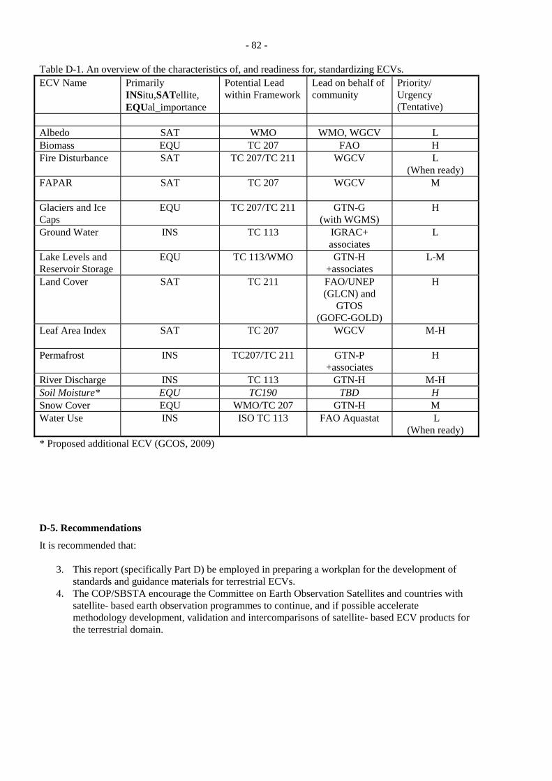
- 82 -
Table D-1. An overview of the characteristics of, and readiness for, standardizing ECVs. ECV Name Primarily
INSitu,SATellite, EQUal_importance
Potential Lead within Framework
Lead on behalf of community
Priority/ Urgency (Tentative)
Albedo SAT WMO WMO, WGCV L Biomass EQU TC 207 FAO H Fire Disturbance SAT TC 207/TC 211 WGCV L
(When ready) FAPAR SAT TC 207 WGCV M
Glaciers and Ice Caps
EQU TC 207/TC 211 GTN-G (with WGMS)
H
Ground Water INS TC 113 IGRAC+ associates
L
Lake Levels and Reservoir Storage
EQU TC 113/WMO GTN-H +associates
L-M
Land Cover SAT TC 211 FAO/UNEP (GLCN) and
GTOS (GOFC-GOLD)
H
Leaf Area Index SAT TC 207 WGCV M-H
Permafrost INS TC207/TC 211 GTN-P +associates
H
River Discharge INS TC 113 GTN-H M-H Soil Moisture* EQU TC190 TBD H Snow Cover EQU WMO/TC 207 GTN-H M Water Use INS ISO TC 113 FAO Aquastat L
(When ready) * Proposed additional ECV (GCOS, 2009) D-5. Recommendations
It is recommended that:
3. This report (specifically Part D) be employed in preparing a workplan for the development of standards and guidance materials for terrestrial ECVs.
4. The COP/SBSTA encourage the Committee on Earth Observation Satellites and countries with satellite- based earth observation programmes to continue, and if possible accelerate methodology development, validation and intercomparisons of satellite- based ECV products for the terrestrial domain.
- 83 -
D-6. References Breda, N.J. 2003. Ground-based measurements of leaf area index: a review of methods, instruments and
current controversies. Journal of Experimental Botany 54: 2403-2417. CHy. 2008. Report by Members of the AWG including plans for the period up to CHy-XIII. Report
AWG-3/Doc. 3.2, Third Session, Advisory Working Group, Commission for Hydrology, World Meteorological Organization. 18p.
GCOS. 2003. The Second Report on the Adequacy of the Global Observing Systems for Climate in support of the UNFCCC. Report GCOS – 82 (WMO/TD No. 1143), Global Climate Observing System, Geneva, Switzerland. 74p.
GCOS. 2009. Implementation Plan for the Global Observing System for Climate in Support of the UNFCCC (2009 Update). Draft v0.2, 19 February 2009.[to be submitted to SBSTA]
GTOS. 2009. Individual reports on standards for Essential Climate Variables. Available at http://www.fao.org/gtos/topcECV.html (accessed 2009-01-13 to 2009-01-30).
Herold, M., Woodcock, C.E., Loveland, T. R. Townshend, J., Brady, M., Steenmans, C. and Schmullius, C. 2008. Land Cover Observations as part of a Global Earth Observation System of Systems (GEOSS): progress, activities, and prospects, IEEE Systems 2, 3: 414-423.
Hillel, D. 1998. Environmental soil physics. Academic Press, ISBN 0123485258, 9780123485250. 771p. IAEA. 2008. Field Estimation of Soil Water Content: A Practical Guide to Methods, Instrumentation and
Sensor Technology. Training Course Series No. 30, International Atomic Energy Agency, ISSN 1018–5518, Vienna, Austria. 131p.
Jonckheere, I., Fleck, S., Nackaerts, K., Muysa, B., Coppin, P., Weiss, M., and Baret, F. 2004, ‘Review of methods for in situ leaf area index determination Part I. Theories, sensors and hemispherical photography’, Agricultural and Forest Meteorology 121: 19–35.
Jousma, G., and Roelofsen, F.J. 2004. World-wide inventory on groundwater monitoring. International Groundwater Resources Assessment Centre, Utrecht, The Netherlands. 33p. + Appendices.
Kelleners, T.J., Seyfried, M.S., Blonquist, J.M., Bilskie, J., and Chandler, D.G. 2005. Improved interpretation of water content reflectometer measurements in soils. Soil Science Society of America Journal 69: 1684-1690.
Ley, T.W., Stevens, R.G., Topielec, R.R., and Neibling, W.H. 1994. Soil water monitoring & measurement. Report PNW0475, Pacific Northwest Publication. Available at http://cru.cahe.wsu.edu/CEPublications/pnw0475/pnw0475.html#anchor1598593 (accessed 2009-04-08).
Robinson, D.A., Campbell, C.S., Hopmans, J.W., Hornbuckle, B.K., Jones, S.B., Knight, R., Ogden, F., Selker, J., and Wendroth, O.. 2008. Soil moisture measurement for ecological and hydrological watershed-scale observatories: A review. Vadose Zone Journal 7:358-389.
SBSTA. 2006. Report of the Subsidiary Body for Scientific and Technological Advice on its twenty-third session, held at Montreal from 28 November to 6 December 2005. Report FCCC/SBSTA/2005/10. 33p.
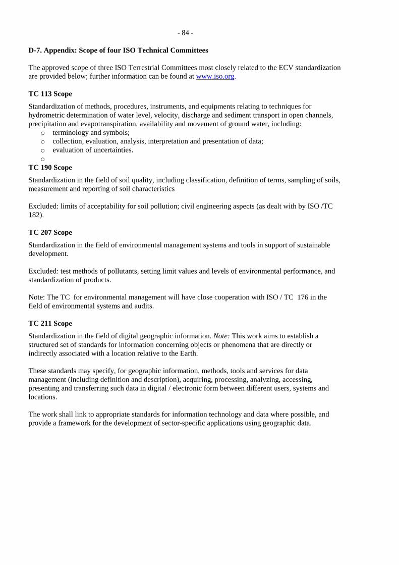
- 84 -
D-7. Appendix: Scope of four ISO Technical Committees The approved scope of three ISO Terrestrial Committees most closely related to the ECV standardization are provided below; further information can be found at www.iso.org. TC 113 Scope
Standardization of methods, procedures, instruments, and equipments relating to techniques for hydrometric determination of water level, velocity, discharge and sediment transport in open channels, precipitation and evapotranspiration, availability and movement of ground water, including:
o terminology and symbols; o collection, evaluation, analysis, interpretation and presentation of data; o evaluation of uncertainties. o
TC 190 Scope
Standardization in the field of soil quality, including classification, definition of terms, sampling of soils, measurement and reporting of soil characteristics Excluded: limits of acceptability for soil pollution; civil engineering aspects (as dealt with by ISO /TC 182). TC 207 Scope
Standardization in the field of environmental management systems and tools in support of sustainable development. Excluded: test methods of pollutants, setting limit values and levels of environmental performance, and standardization of products. Note: The TC for environmental management will have close cooperation with ISO / TC 176 in the field of environmental systems and audits. TC 211 Scope
Standardization in the field of digital geographic information. Note: This work aims to establish a structured set of standards for information concerning objects or phenomena that are directly or indirectly associated with a location relative to the Earth. These standards may specify, for geographic information, methods, tools and services for data management (including definition and description), acquiring, processing, analyzing, accessing, presenting and transferring such data in digital / electronic form between different users, systems and locations. The work shall link to appropriate standards for information technology and data where possible, and provide a framework for the development of sector-specific applications using geographic data.
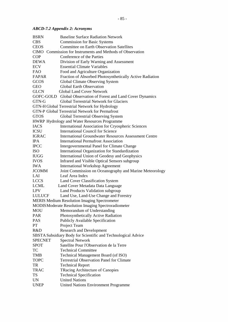
- 85 -
ABCD-7.2 Appendix 2: Acronyms
BSRN Baseline Surface Radiation Network CBS Commission for Basic Systems CEOS Committee on Earth Observation Satellites CIMO Commission for Instruments and Methods of Observation COP Conference of the Parties DEWA Division of Early Warning and Assessment ECV Essential Climate Variables FAO Food and Agriculture Organization FAPAR Fraction of Absorbed Photosynthetically Active Radiation GCOS Global Climate Observing System GEO Global Earth Observation GLCN Global Land Cover Network GOFC-GOLD Global Observation of Forest and Land Cover Dynamics GTN-G Global Terrestrial Network for Glaciers GTN-H Global Terrestrial Network for Hydrology GTN-P Global Terrestrial Network for Permafrost GTOS Global Terrestrial Observing System HWRP Hydrology and Water Resources Programme IACS International Association for Cryospheric Sciences ICSU International Council for Science IGRAC International Groundwater Resources Assessment Centre IPA International Permafrost Association IPCC Intergovernmental Panel for Climate Change ISO International Organization for Standardization IUGG International Union of Geodesy and Geophysics IVOS Infrared and Visible Optical Sensors subgroup IWA International Workshop Agreement JCOMM Joint Commission on Oceanography and Marine Meteorology LAI Leaf Area Index LCCS Land Cover Classification System LCML Land Cover Metadata Data Language LPV Land Products Validation subgroup LULUCF Land Use, Land-Use Change and Forestry MERIS Medium Resolution Imaging Spectrometer MODIS Moderate Resolution Imaging Spectroradiometer MOU Memorandum of Understanding PAR Photosynthetically Active Radiation PAS Publicly Available Specification PT Project Team R&D Research and Development SBSTA Subsidiary Body for Scientific and Technological Advice SPECNET Spectral Network SPOT Satellite Pour l'Observation de la Terre TC Technical Committee TMB Technical Management Board (of ISO) TOPC Terrestrial Observation Panel for Climate TR Technical Report TRAC TRacing Architecture of Canopies TS Technical Specification UN United Nations UNEP United Nations Environment Programme
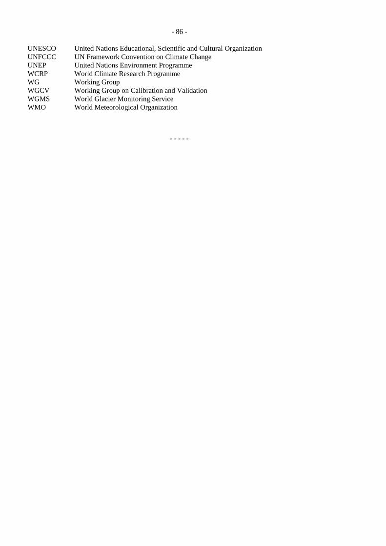
- 86 -
UNESCO United Nations Educational, Scientific and Cultural Organization UNFCCC UN Framework Convention on Climate Change UNEP United Nations Environment Programme WCRP World Climate Research Programme WG Working Group WGCV Working Group on Calibration and Validation WGMS World Glacier Monitoring Service WMO World Meteorological Organization
- - - - -
Related Documents