TASAC Minutes 19 June 2013 Final 17 July 2013 1 of 16 Minutes of the Tourist Attraction Signposting Assessment Committee and the Hunter Region Subcommittee Wednesday 19 June 2013 in the Hunter Conference Room, Motto Farm Motel 2285 Pacific Highway, Heatherbrae Members David Douglas Regional Coordinator TASAC and Drive, Destination NSW Ken Saxby Road Safety & Traffic Services Manager Hunter, RMS Maria Zannetides TASAC Secretariat Hunter Region Subcommittee Robyne Abernethy CEO, Central Coast Tourism Scott Stapleton Traffic & Safety Manager, RMS (Central Coast) Also present Tars Bylhouwer Marketing Manager, Destination Port Stephens Michael Aylmer Chairman, Destination Port Stephens Andrew Powrie Business Development and Investment Manager, Port Stephens Council Thea Anzures Marketing Coordinator, City of Newcastle Jacqui Greaves Business Development Manager, Central Coast Tourism Kathleen Straw Ranger Newcastle, NPWS Susan Davis Senior Ranger, NPWS Apologies Rhiannon Stevens Cessnock Council Sheridan Ferrier Tourism Hunter John Maretich Port Stephens Council Michelle Viola Port Stephens Council AGENDA ITEMS 1. DELEGATIONS / PRESENTATIONS & REGIONAL SIGNPOSTING ISSUES 1.1 Recognising Port Stephens Tars addressed the meeting about the importance of labelling “Port Stephens” as a destination on signposting even though it is not recognised as a locality by the Geographic Names Board and he made the following points: Research has been undertaken on consumers’ perceptions regarding “Port Stephens”. It is the third most popular short stay location in NSW and there is considerable evidence to suggest that it is regarded as a “destination” by consumers. However, “Port Stephens” does not appear on RMS white on green destination signs, NRMA mapping or promotional material prepared by Destination NSW. Destination NSW has recently supported the development of a digital application for Port Stephens.

Welcome message from author
This document is posted to help you gain knowledge. Please leave a comment to let me know what you think about it! Share it to your friends and learn new things together.
Transcript

TASAC Minutes 19 June 2013
Final 17 July 2013 1 of 16
Minutes of the Tourist Attraction Signposting Assessment Committee and the Hunter Region Subcommittee
Wednesday 19 June 2013 in the Hunter Conference Room, Motto Farm Motel 2285 Pacific Highway, Heatherbrae
Members
David Douglas Regional Coordinator TASAC and Drive, Destination NSW Ken Saxby Road Safety & Traffic Services Manager Hunter, RMS Maria Zannetides TASAC Secretariat Hunter Region Subcommittee
Robyne Abernethy CEO, Central Coast Tourism Scott Stapleton Traffic & Safety Manager, RMS (Central Coast) Also present
Tars Bylhouwer Marketing Manager, Destination Port Stephens Michael Aylmer Chairman, Destination Port Stephens Andrew Powrie Business Development and Investment Manager, Port Stephens Council Thea Anzures Marketing Coordinator, City of Newcastle Jacqui Greaves Business Development Manager, Central Coast Tourism Kathleen Straw Ranger Newcastle, NPWS Susan Davis Senior Ranger, NPWS Apologies
Rhiannon Stevens Cessnock Council Sheridan Ferrier Tourism Hunter John Maretich Port Stephens Council Michelle Viola Port Stephens Council AGENDA ITEMS 1. DELEGATIONS / PRESENTATIONS & REGIONAL SIGNPOSTING ISSUES 1.1 Recognising Port Stephens Tars addressed the meeting about the importance of labelling “Port Stephens” as a destination on signposting even though it is not recognised as a locality by the Geographic Names Board and he made the following points:
Research has been undertaken on consumers’ perceptions regarding “Port Stephens”. It is the third most popular short stay location in NSW and there is considerable evidence to suggest that it is regarded as a “destination” by consumers. However, “Port Stephens” does not appear on RMS white on green destination signs, NRMA mapping or promotional material prepared by Destination NSW.
Destination NSW has recently supported the development of a digital application for Port Stephens.

TASAC Minutes 19 June 2013
Final 17 July 2013 2 of 16
Many motorists wanting to visit “Port Stephens” do not understand that it is a very large area nor do they appreciate that there are a number of locations within it, including the towns of Nelson Bay, Shoal Bay and Raymond Terrace.
While there is a white on brown tourist sign on the Pacific Motorway directing motorists to Port Stephens, a white on green destination sign would be more effective for visitors.
Destination Port Stephens is working with Port Stephens Council on branding, advertising and internal gateways for the local government area (LGA).
Following on from the above comments Michael, Robyne and Andrew asked about how to change signage policy to better direct visitors to popular visitor destinations that are broad areas such as Port Stephens, Central Coast or the Blue Mountains, rather than the traditional system of directing motorists to towns or localities. In response the Committee offered the following advice:
i. The success of any signposting system depends on motorists doing some research prior to a trip. For signposting to work motorists need to follow consistent signage that leads them to an arrival point, which is itself appropriately signposted so that they know that they have reached their destination. Signposting systems do not work if the destination is a large area or region.
ii. Even if it were possible to install white on green destination signage on the Pacific Motorway for “Port Stephens” it would still be necessary to direct motorists to specific localities within the LGA from the northern side of the Hexham Bridge. If motorists are to be able to respond successfully to new signs north of the bridge, they must have some prior knowledge of the localities within Port Stephens.
iii. Destination Port Stephens and Port Stephens Council were invited to work with RMS to
review the placement and effectiveness of existing “Welcome” signs for the local government area as a whole and for the key towns within it. A useful starting point for the agencies would be to review the existing signposting north of the Hexham Bridge.
iv. The Tourist Signposting Manual provides for “Welcome” signs that promote LGAs and towns at their respective points of entry and the installation of such signs is undertaken following a process of consultation between RMS and the relevant local council. There is considerable flexibility in the design for these signs so long as they do not attempt to guide traffic, imitate any other sign type, they are safely positioned in the road reserve and they include the name of the local council in LGA “Welcome” signs and the town name in town “Welcome” signs. More details about the parameters for “Welcome” signs may be found on pages 33 and 94 of the Tourist Signposting Manual.
v. The Manual includes a category for Major Regional Tourist Centres. These are defined as cities or towns located off the major traffic corridors that provide an extensive range of services and have a large number of major tourist attractions (e.g. national parks, galleries, museums or water based activities such as fishing, boating or swimming in addition to food, accommodation, fuel and other services). Port Stephens Council could consider whether it wishes to apply for such signposting for Nelson Bay.

TASAC Minutes 19 June 2013
Final 17 July 2013 3 of 16
1.2 Newcastle signposting issues Thea informed the meeting about Newcastle Council’s report on Visitor Information Provision, which is considering pedestrian way-finding signage among other things. In addition, a report on Visitor Profiling and Satisfaction is nearing completion and will soon be released. It was noted that Newcastle City is currently undergoing an organisational review which may affect how it approaches tourism and economic development. The following Newcastle attractions were discussed:
Fort Scratchley Historic Site
Knobby’s Headland
Maritime Museum
Newcastle Museum and
Newcastle Art Gallery. Council and / or the operators of the above attractions might care to review the relevant TASAC eligibility criteria and if appropriate, submit applications to TASAC for consideration. Key requirements are that signposted attractions are open at least five days per week including both Saturday and Sunday, for a minimum of six hours per day and that that they provide a quality tourism experience that is supported by written interpretive information. If eligible, RMS would consider signposting for Fort Scratchley and Knobby’s Headland from Hannell Street Wickham, which is the nearest RMS road. Bathers Way walking track was also mentioned and Ken advised that any signposting for it would be on local (not RMS) roads and it was therefore a matter for Council. It was also noted that Newcastle no longer has a visitor information centre accredited at either level 1 or 2 but road signage for a former VIC is still in place. Action: RMS Hunter Region to remove signage for the former VIC from its roads and Council to
remove any signage for it on local roads.
1.3 TreeTop Adventure Park, Minmi Following a decision taken at the May TASAC meeting Maria wrote to TreeTop Adventure Park requesting additional information to address the following matters that were identified in a site inspection report for the application prepared by Valerie Antaki of Tourism Hunter:
i. The aerial courses are open from 9 am to 2 pm in winter, which is less than required by the Tourist Signposting manual. It may be that people who enter before 2 pm in winter are able to remain on site till 4.30 pm (the winter closing time advised by the applicant) but this is not clear.
ii. The opening hours sign at the entry does not inform visitors that they cannot commence the aerial courses after 2 pm in winter.
iii. The courses are difficult to navigate for visitors who are walking on the ground rather than moving through the tree canopy on the aerial courses.
The applicant has now responded to the above matters, including the submission of photographs to demonstrate that a new sign at its entry gate informs visitors that the last climbing session commences two hours prior to closing. Similar information has been included in the business’s website and will also be added to its brochure when it is next reprinted. The operator also advised that she intends to refresh mulch on the pathways under the aerial courses to improve pathway definition.
TASAC Minutes 19 June 2013
Final 17 July 2013 4 of 16
The adventure park is located within Blue Gum Hills Regional Park, which is managed by NPWS. Susan and Kathleen expressed their support for the application and added that their agency will soon apply to TASAC for signposting for the regional park. Both attractions would require signage at similar locations on RMS and Council roads and a better design outcome would result if a signage scheme that integrates the two could be prepared. Decision: TreeTop Adventure Park is eligible for tourist signposting in the Theme Parks category. Action: (a) Secretariat to advise the applicant as above and inform RMS Hunter Region.
(b) NPWS to submit an application for Blue Gum Hills Regional Park as soon as possible; liaise with the adventure park operator to ascertain if she is willing to delay installation of signs for her park until signage for the regional park can be progressed; and keep Maria informed.
1.4 Central Coast signage issues Jacqui inquired about existing tourist signposting for a scenic drive installed on the Pacific Motorway south of the Mooney Bridge. The sign is obscured by vegetation. Scott advised that RMS is in the process of looking to remove the signage following a decision at the December 2012 TASAC meeting. The sign is faded and unserviceable and the drive cannot be followed because there are no subsequent signs to guide motorists. The corresponding southbound sign on the Pacific Motorway will also require removal. The removal of the signs will be expensive, and funds will need to be sought in this regard. Action: Scott to inform Maria once the sign has been removed.
1.5 Members’ report on site inspections David and Ken made the following observations arising from their site inspections in the Port Stephens area and environs the day before the meeting:
i. Monarch Museum has tourist signposting but does not appear to be operating. Tars confirmed that the museum has been closed for some time but there are plans to reopen it towards the end of the year. It was noted that a new application would be required if and when the museum re-opened so that its eligibility for tourist signposting could be re-evaluated. Decision: Monarch Museum signposting to be covered over to avoid inconvenience to motorists. Action: (a) Tars to provide Maria with contact details for the museum owner.
(b) Secretariat to inform the museum owner of the above decision. (c) RMS Hunter Region to cover the sign.
ii. Existing tourist signposting for Oakvale Farm and Fauna World on Nelson Bay Road appears to be of
a non-standard design. The attraction has not been assessed by TASAC for more than five years so any eligibility it may have previously had is no longer current. Action: Secretariat to invite the operator to reapply for tourist signposting.
iii. Tourist signposting for Port Stephens Winery and Wonganella Wines was observed on Nelson Bay Road. Neither business has been assessed in the last five years so their eligibility for tourist signposting is no longer current. During the discussion it was noted that Murray’s Craft Brewing Company, which is located nearby, applied to TASAC for tourist signposting in 2011. In June 2011 TASAC asked the operator for additional information about the nature of the tourism experience outside the daily (2pm) tour time and more details of the written interpretive information for visitors.

TASAC Minutes 19 June 2013
Final 17 July 2013 5 of 16
No reply was received from the operator and the application lapsed. If eligible, the two wineries and the brewery would require signage from the same locations. Therefore, new applications for all three would be required if the brewery wished to pursue signposting.
iv. Sahara Trails Horse Riding has tourist signposting on Nelson Bay Road but no tourist signs at the relevant roundabout or at its entry. Action: Secretariat to invite the operator to reapply for tourist signposting.
v. The design of tourist signposting on Nelson Bay Road for Toboggan Run appears to be non-standard. Tars suggested that the signs may have become faded and were subsequently refreshed by the operator. Action: Secretariat to invite the operator to reapply for tourist signposting.
v. A sign on a State road is missing for Nelson Bay VIC, which is accredited at level 1, and signage on local roads is not adequate. Action: (a) RMS Hunter Region to make arrangements to install the required sign on its
road. (b) Tars to liaise with Council about improving signage on local roads.
vi. Tourist signposting for Hunter Botanic Gardens is becoming faded and does not reflect the attraction’s
full name (the sign refers to “Botanic Gardens”). Action: Secretariat to invite the operator to reapply for tourist signposting.
vii. Tourist signposting for Kooragang Wetlands in Newcastle does not give visitors the best idea of the nature of the attraction. Susan explained that the area is now managed by NPWS and that a better name on signposting would be Hunter Wetlands Ash Island. Action: Secretariat to invite NPWS to reapply for tourist signposting.
2. NEW TOURIST SIGNPOSTING APPLICATIONS 2.1 L P Dutton Trout Hatchery, Armidale TASAC members observed unserviceable signs for the trout hatchery the day before its April 2013 meeting held in Armidale and an application has been submitted following a request by TASAC so that the attraction can be re-evaluated. The aquaculture facility, which is run by the NSW Department of Trade and Investment, is open daily from 8 am to 3.30 pm during all months. Visitors can view aquarium displays where each tank is labelled with the common and scientific name for each fish variety (trout, cod and eel etc.) and information about the distribution, size and characteristics of each species. Static displays include posters about the history of the facility; breeding techniques; and fish development. Unbooked visitors generally undertake a self-guided tour of the facility after watching an 11 minute video in a 35 seat theatrette about the hatchery’s operations and the fish breeding cycle where some two million fish are bred for release into public waterways. Smoked trout is available for purchase but the product is bought in and not made from the fish grown on site. Tony Broomfield of Armidale Dumaresq Council will be asked to prepare a site inspection report. Decision: L P Dutton Trout Hatchery is potentially eligible for tourist signposting in the Primary and
Secondary Industry category, subject to the receipt of a satisfactory site inspection report.

TASAC Minutes 19 June 2013
Final 17 July 2013 6 of 16
Action: Secretariat to inform the applicant as above and complete the assessment of the
application if appropriate after receipt of a site inspection report.
2.2 Mt Canobolas State Conservation Area, Orange NPWS has submitted an application following a request from TASAC regarding faded and non-standard signs for ”Mt Canobolas”, which were observed prior to the January TASAC meeting. The attraction has 13 existing signs at seven locations. The locations of some of these appear to exceed the distance requirements under current RMS practices. Also, some signs are white on green not white on brown and a number of the white on brown signs are very faded. Mt Canobolas State Conservation Area (SCA) receives over 70,000 visitors per annum based on traffic counters and vehicle surveys and is the single most inquired about attraction at Orange VIC accounting for 30% of enquiries. The SCA is 13 km from Orange via Lake Canobolas along Canobolas and Cargo Roads and 14 km to Orange via Pinnacle Road. The attraction is open daily during all hours and consequently it has no opening hours sign at its entry. It offers six picnic areas, three lookouts and a camping area. A significant feature is the summit of Mt Canobolas at an elevation of 1,395 m, which is one of the highest points in NSW. Other features of interest are Hopetoun Falls and Boree and Tourac Creeks. Interpretive information is available in the form of visitor information panels at two locations, including at the summit and interpretive panels associated with one of the nature tracks. The SCA is promoted in an informative full colour brochure, which describes the site and its features and has access details, photos, opening times and contact details for further information. It also outlines the walking tracks, with distances and approximate times for each walk, along with a description of Mt Canobolas’ volcanic past and the area’s flora and fauna. The SCA is also promoted in an online brochure. Decision: Mt Canobolas SCA is eligible for tourist signposting in the National Parks, SCA, Forests and
Water Storage Areas category. Action: Secretariat to advise the applicant as above and inform RMS Western Region.
2.3 Yuranigh’s Aboriginal Grave Historic Site, Orange The background to the application is similar to that outlined for Mt Canobolas SCA above. The attraction, which is managed by NPWS, has two existing sign locations, one on the Mitchell Highway and one on Yuranighs Road. Yuranigh, a Wiradjuri man, accompanied explorer Sir Thomas Mitchell on an expedition into the interior of tropical Australia in 1848. When Yuranigh died four years later he was buried according to Aboriginal rites within a circle of carved trees. Out of respect Mitchell arranged for a European style gravestone to be erected nearby. In this way the historic site combines both Aboriginal and European burial customs in a manner that is not known of anywhere else in Australia. The attraction is open daily during all hours and therefore an opening hours sign is not necessary. There are no public toilets at the site but TASAC has the discretion to provide signposting notwithstanding the lack of public toilets as the site is a non-commercial attraction (i.e. free to enter)

TASAC Minutes 19 June 2013
Final 17 July 2013 7 of 16
and can be regarded as a short stay attraction because its nature, size and scale would not warrant a long stay by visitors. Interpretive information is available at the gravesite in the form of an interpretive panel with details about Yuranigh, his life and significance and also about the meaning of the carved trees that form the Aboriginal grave. A second panel depicts the designs of the carvings on the trees, some of which have been covered by regrowth. An online promotional brochure is available. The brochure includes descriptive information about the site and its significance; a map and access details; photos; opening times; and gives contact details for further information. There is a closed but unlocked gate along the access road to the grave. When David visited the site in January he felt that a closed gate could be off-putting to visitors who might be unsure about whether they should open it to proceed to the grave. The access from Yuranighs Road (off the Mitchell Highway) to the historic site appears to be via a private road. The arrangements for public use of this road need to be clarified and confirmed. RMS Western region will negotiate with the applicant if the requested name is too long for signposting. Decision: Yuranigh’s Aboriginal Grave Historic Site is potentially eligible for tourist signposting in the
National Parks, SCA, Forests and Water Storage Areas category, subject to the provision of additional information about the arrangements for public access to the grave.
Action: Secretariat to advise the applicant as above.
2.4 Borenore Karst Conservation Reserve, Orange The background to the application is similar to that outlined for Mt Canobolas SCA above. There are three existing signage locations for “Borenore Caves”, two in advance of and one at its entry off Escort Way. The attraction, which is managed by NPWS, is 5 km from Borenore and 17 km from Orange. It is open daily from 9am to 7 pm. A green timber routed sign near the entry gives the site’s full name and includes the NPWS logo. Another similar sign nearby welcomes visitors to “Borenore Caves” and advises that the gate is locked at 7 pm but it does not give an opening time. The reserve receives 10,000 visitors per annum and offers picnic and barbecue facilities. It contains several limestone caves a number of which are open to visitors, with Arch Cave being the most popular. The permanent water flow of Boree Creek and the reliable shelter of the caves meant that area was used by the Wiradjuri people for many thousands of years. Borenore marble, known as “Borenore Red”, was used in many Sydney public buildings such as Central Railway station, the Strand Arcade and for a fireplace made for Buckingham Palace. The site helps to preserve a variety of native flora and fauna, e.g. thornbills, honeyeaters and the eastern bent-wing bat. Interpretive information is available near the parking area in the form of visitor information panels under a small kiosk style shelter. The panels welcome visitors to the area, use symbols to inform visitors about the area’s features and use photos and text to describe the reserve and its significance. While the headings on the panels are legible, the other text cannot be read. Consistent with its policy, NPWS is moving away from hard copy brochures and only an online brochure is available for the reserve. It includes descriptive information about the site and its features, access details, photos, opening times and contact details for further information. The map shows the location of the picnic area and a track to one of the caves but it is very basic and does not indicate a variety of features of interest to visitors, including the location of toilets and the

TASAC Minutes 19 June 2013
Final 17 July 2013 8 of 16
parking area. The symbol for toilets is visible in a photo of the reserve’s visitor information panel confirming that toilets are available at the site, presumably near the picnic area. NPWS regularly liaises with Orange VIC to provide visitor information including regular updates about extreme fire days and park management events that might require closure of the reserve. By way of comment the applicant should be advised to update one or both of the opening hour’s signs at the entry so that visitors are advised of the opening time as well as the closing time. Decision: Borenore Karst Conservation Reserve is eligible for tourist signposting in the National Parks,
SCA, Forests and Water Storage Areas category. Action: Secretariat to advise the applicant as above and inform RMS Western Region.
2.5 Forest of Tranquility, Ourimbah The Forest of Tranquility has tourist signposting on and from the Pacific Motorway, which is not its nearest classified road. Two applications, one in the Walking Trails and Boardwalks section of the Outdoor Based category and one in the State Significant category, have been received following a request from TASAC that the operator reapply for tourist signposting. TASAC made its request because, the day prior to the December 2012 meeting, members noted that the attraction’s opening hours were less than required to justify motorway signposting and its access road (a local Council road) and driveway to its entry was rutted and difficult to negotiate, particularly for coaches. Outdoor Based application The attraction is a flora and bird sanctuary located 5 km from the Pacific Motorway. Its opening hours were extended recently so that it is now open daily from 10 am to 4 pm. Extended hours are also available on Friday and Saturday from mid-November to mid-December during firefly season when the attraction is open from 6 pm to 9 pm in addition to its daily hours. The new hours are shown on a laminated sheet of paper fixed to the window of a kiosk near the entry and another laminated sheet is attached to a blade style Royal Mail Box sign at its driveway on Ourimbah Creek Road. The application states that the attraction has “all weather access”. However, it is understood that its local access road and driveway can be badly rutted and difficult to negotiate following periods of heavy rain, which are quite common in the district. The condition of the attraction’s walking trails is monitored and assessed each week and paths are
cleared weekly with a blower “vac”. Additional trail monitoring occurs following flooding and high
wind weather. Bushwalking rules are displayed at the attraction’s entrance and staff are trained to monitor visitors’ footwear and direct them to the bushwalking park rules if necessary. Entrants are advised of any daily hazards as part of staff “meet and greet” duties. An 18 page document with photos of interpretive information at the site, website excerpts and photos of the existing tourist signposting was submitted to describe the visitor experience and status of the forest as a tourist attraction. It has five walking trails varying in duration from 15 to 80 minutes round trip. There are nine study stations in total along the walks e.g. the platypus pond, Bangalow palms and the open forest with the ninth station located at a kiosk near the entrance. Photos illustrate the interpretive information available at study stations 1 (forest understorey), 2 (estimate tree height), 9 and 7 (humidity station). The interpretation is in the form of visitor information panels with photos and text about the features at each location. It is assumed that all the study stops have similar interpretive information.

TASAC Minutes 19 June 2013
Final 17 July 2013 9 of 16
Photos that accompanied the application show that some visitor information panels appear a little tired, e.g. some of the letters on the sign that gives information about the various walks and their length are noticeably peeling. It may be that the panels have been in place since the attraction opened more than 10 years ago and it would be appropriate to refresh or replace them to better engage visitors and hold their attention. The attraction also offers a 13 page worksheet booklet on the walks with details of the seven study stations. This includes field study notes and questions and answers. It is not known whether the booklet is available to all visitors or only to ones with a particular interest, such as students. In addition, signage is currently in development with the Catchment Management Authority to highlight the endangered Tranquility Mint Bush that grows on site. The plant was the subject of an $80K government recovery program and only grows within a narrow radius of the site. The following information is required so that TASAC can finalise its position on the application:
i. Laminated A4 sheets of paper are not an appropriate format for opening hours signs at the entry of attractions. A more substantial and larger opening hours sign is required at the driveway entry.
ii. The new 7-day opening hours are referred to on the first page of the attraction’s website (http://www.forestoftranquility.com) but the park facilities page (http://www.forestoftranquility.com/facilities.php) indicates that the facility is open to the public weather permitting on Saturday and Sunday and all public holidays from 11am to 4pm. The website needs to be updated.
iii. The brochure and website advise that last entry is 1 – 2 hours before closing time. This is a wide range and is not helpful to visitors. A definite statement should be made and as there are shorter as well as longer walks through the forest, visitors should be allowed to enter up to one hour before closing. In addition, protocols including appropriate references in the brochure and website, should be established to so that visitors arriving close to 3 pm are advised that they can only take the shorter walks.
iv. Photos of the entry and parking area are required.
v. It would appear timely to upgrade the visitor information panels within the forest. While the condition of the panels does not warrant making this a requirement for tourist signposting, the operator should be asked to work towards refreshing of replacing all the visitor information signs at the site within the next 2 – 3 years to improve the experience for visitors.
vi. The attraction’s existing signposting is for “Forest of Tranquility” and this is the name requested on the application form. However, the attraction is also promoted as the Australian Rainforest Sanctuary and the use of the two names may be confusing for visitors.
When the above issues have been resolved, a site inspection report will be arranged and TASAC will subsequently finalise its position on the application. State Significant application An application in the State Significant category was lodged to demonstrate eligibility for the existing signposting on the Pacific Motorway, which is more remote than allowable unless attractions meet the requirements of this category. These are that attractions must open daily for at least six hours per day and receive a minimum of 150,000 per annum. The Forest of Tranquility is now open daily for six hours per day so it satisfies one of the mandatory requirements of the State Significant category. However, the application gives no information about

TASAC Minutes 19 June 2013
Final 17 July 2013 10 of 16
annual visitor numbers and it is therefore assumed that it does not meet the second mandatory requirement. Instead of providing information about visitation levels the applicant has asked TASAC for “a reasonable period of time” to demonstrate its visitor numbers to the Committee. The intention of the Tourist Signposting Manual in this category is that attractions already operate daily for six hours per day and that they have already achieved the required visitation level before they apply for more remote signage as a State Significant attraction, not that they apply in advance of satisfying both requirements and then given a period to achieve them. As the attraction has been operating for more than 10 years and does not currently receive the required visitation levels, it may be unrealistic to expect that it could reach 150,000 visitors per annum, even if it were granted a further “reasonable period of time” to build visitor numbers. In the first instance the operator should inform TASAC of its visitor numbers during the last three to five years so that the Committee can make an informed judgement on this matter. Decision: Additional information as outlined above is required to determine the Forest of Tranquility’s
eligibility for tourist signposting in the Outdoor Based category. The applicant has not demonstrated eligibility for tourist signposting in the State Significant category. However, to enable TASAC to finalise its decision on the State Significant application, the operator should provide advice regarding visitor numbers, currently and in the previous three to five years, that have been independently and professionally audited by a certified practising accountant, along with an explanation of how the numbers have been calculated.
If evidence does not support eligibility as a State Significant attraction, the existing signs on
the Pacific Motorway will be removed. Action: Secretariat to advise the applicant as above.
2.6 North Sapphire Beach, Coffs Harbour Walker Corporation Ltd has applied for Seaside Town signage for North Sapphire Beach at the intersection of the Pacific Highway and Split Solitary Road, about 6 km north of Coffs Harbour. A letter of support from Glenn Caldwell, Council’s Tourism Manager, accompanied the application. North Sapphire Beach is on the coast about 800 m east of the Pacific Highway. The application lists visitor services as a restaurant, a caravan park and a children’s playground. Ian Shanahan, RMS Northern Region has advised that North Sapphire Beach is not a locality recognised by the Geographic Names Board. For it to be recognised as such an application would need to be made to the Board under its standard process to have the area declared a locality. The process involves the advertisement of the application and community consultation. If such an application was successful, then North Sapphire Beach would be eligible for white on green directional signage from the relevant highway intersection. RMS also commented that even if it were recognised as a locality, it is unlikely that North Sapphire Beach would be eligible for tourist signposting as a Seaside Town or Village because it is in an urban area and more properly regarded as a suburb of Coffs Harbour than a seaside town or village. The Tourist Signposting Manual states that the Seaside Towns or Villages category applies to towns that do not have a scale of activities and services associated with a regional tourist centre but are nonetheless of interest to visitors. The Manual requires seaside towns or villages to “provide a range of services for visitors” including accommodation, food and fuel. As noted above, North
TASAC Minutes 19 June 2013
Final 17 July 2013 11 of 16
Sapphire Beach does not offer fuel and it only has one food outlet, one accommodation facility and a children’s playground. The visitor facilities located there are therefore not numerous or varied enough to warrant signposting in the Seaside Towns and Villages category. Decision: North Sapphire Beach is not eligible for tourist signposting in the Seaside Towns and Villages
category because it is not recognised as a locality by the Geographic Names Board, it is a suburb of Coffs Harbour rather than a separate town or village and its services for visitors are not numerous or varied enough to warrant such signposting.
Action: Secretariat to advise the applicant and Coffs Harbour Council as above.
3. CONFIRMATION OF MINUTES OF 15 MAY 2013 The minutes of TASAC’s meeting of Wednesday 15 May 2013 were confirmed. David and Maria advised that they had completed all the actions attributed to them from the meeting.
4. MATTERS ARISING FROM PREVIOUS MEETINGS 4.1 Yarrawarra Aboriginal Gallery The operator of Yarrawarra Aboriginal Cultural Centre and Wadjar Gallery has responded to TASAC’s request for additional information in support of an application to renew existing tourist signposting for “Yarrawarra Aboriginal Art Gallery”. The operator also agreed that an appropriate name for signage would be “Yarrawarra Aboriginal Gallery”. However, the following matters remain unresolved:
i. While the gallery’s opening hours have been recently increased, the new entry sign showing the longer hours is a laminated piece of paper and a more permanent, larger sign is necessary.
ii. The revised brochure shows the new hours in four locations, once on the front and in three
places on the back. However, one of the references to opening hours on the back page is wrong as it refers to the gallery’s previous hours (Wednesday to Sunday 10 am to 3 pm) instead of the new hours of 10 am to 4 pm on those days.
iii. The website is being amended by volunteers as part of a “major overhaul” and will reflect the
current opening hours. According to the applicant’s letter of 17 May 2013 this was to have been completed by the end of May. However, as at 8 July, the website still gives the opening hours as “10 am to 3 pm Wed to Sun”, which is less than required by the Tourist Signposting Manual.
iv. Some interpretive labels associated with displays of art can be seen in some of the most
recently provided photos of the gallery. However, none of the text on the labels can be read.
v. The original application and the more recent additional information does not adequately demonstrate that the gallery’s displays are supported by interpretive information, e.g. there were no copies of exhibition catalogues, legible photos of explanatory labels on art works or firm details about proposed exhibitions.
vi. The position of gallery co-ordinator has been vacant since at least earlier this year.
Recruitment for the position was underway at the time the additional information was

TASAC Minutes 19 June 2013
Final 17 July 2013 12 of 16
provided but the outcome is not known. The applicant (the CEO of Yarrawarra) a new co-ordinator to develop a future exhibition program but he acknowledges that if a suitable applicant for the position is not found soon then “we will need to develop this ourselves”. In the absence of a gallery co-ordinator and a forward exhibition program, the nature and quality of the experience that the gallery offers to visitors is not certain.
In view of the foregoing, visitors’ interests may best be served if the current dilapidated signs were removed and new signage installed if and when the applicant can demonstrate that the facility meets the requirements for tourist signposting. Alternatively, the dilapidated signs could be allowed to remain for say another three months to give the applicant more time to resolve the outstanding issues.
Action: Secretariat to request the operator to address the remaining outstanding issues by 30
September. TASAC will make a decision about the existing dilapidated signs at its next Northern Region meeting to be held on 11 October if this matter has not been satisfactorily resolved prior to that time.
4.2 Proposed Orange Wine Tourism Region update Glenn Mickle, Tourism Manager at Orange City Council, has consulted TASAC about new text to be used on panels within information bays for the proposed Orange Wine Tourism Region scheme. The text will be included within the main body of the panels below a heading “Welcome to the Orange Wine Region”. Decision: The text was noted and the project as a whole will be further considered at the July meeting.
4.3 Urunga Boardwalk The applicant has advised that she is implementing TASAC’s request to prepare a new brochure that more effectively promotes Urunga Boardwalk. TASAC will finalise its consideration of the application after a new brochure is submitted. 4.4 Inneslake Vineyards, Port Macquarie A site report recently prepared by Jane Ellis, Tourism Marketing and Promotions Coordinator at Port Macquarie Council, has provided additional information about the application including helpful images of the interior of the cellar door, a current product list and tasting notes. The report also notes that some interpretive information that Jane had seen on earlier visits has been removed. She was informed that it was “coming back” but it is unclear when this would happen. Action: Secretariat to contact the cellar door about the missing interpretive information and
report back to the July meeting.
4.5 Correction to March minutes re Sapphire Coast Tourism’s Destination Management
Plan Anthony Osborne of Sapphire Coast Tourism requested that an incorrect reference in the March 2013 minutes to a destination management plan in connection with the proposed Sapphire Coast Touring Route be replaced as follows:

TASAC Minutes 19 June 2013
Final 17 July 2013 13 of 16
“The drive is a key project within Sapphire Coast Tourism’s Destination Management Plan and Tom confirmed that it would also be part of the South Coast Destination Management Plan.”
Decision: That the above correction be accepted.
4.6 Six String Brewery, Erina The applicant has responded to TASAC’s request for additional information as follows:
i. A new larger opening hours sign has been installed at the brewery entry. The sign also informs visitors that self-guided brewery tours are available throughout the opening hours and guided tours are available at 11 am on Saturday.
ii. Similar information has been added to the brewery’s website (its Facebook page) in the
“About” link.
iii. Similar information will be added to the brewery’s brochure in the next print run, which is expected to occur in about four months.
iv. Images were provided in which the text in all the captions on the brewery’s interpretive
feature wall can be read. The feature wall depicts and explains the brewing process and facilitates self-guided tours by visitors.
Decision: Six String Brewery is eligible for tourist signposting in the Primary and Secondary Industry
category. Action: (a) Secretariat to advise the applicant as above and inform RMS Hunter Region.
(b) Secretariat to ask the owner to provide a copy of the revised brochure as soon as it is available.
5. INQUIRIES RECEIVED SINCE LAST MEETING The following inquiries received in the period since the last meeting were noted: 5.1 Australian Brewery, Rouse Hill 5.2 Wyndham Resort, Coffs Harbour 5.3 Billabong Retreat, Maraylya 5.4 Mollymook motel signage 5.5 Max’s Motor Museum, Corowa 5.6 Sgt Parry Memorial, Jugiong 5.7 Elouera Homestead, Mudgee 5.8 C1 Speed Indoor Karting, Shellharbour 6. POLICY ISSUES 6.1 Upper Hunter Tourist Drive 33 (Peats Ridge-Wollombi-Cessnock-Branxton) Rhiannon Stevens of Cessnock Council recently advised that signs have been ordered for Stage 1 of the upgrade to signage along Tourist Drive 33 and were due for delivery in May. All signs were

TASAC Minutes 19 June 2013
Final 17 July 2013 14 of 16
designed under the specifications of Australian Standard AS1743. Council’s maintenance crew will install the signs progressively in the weeks after delivery. Stage 1 encompasses new signage within Cessnock LGA, and is being funded within Council’s current financial year allocations. Stage 2 encompasses upgrades to existing signage along the drive in the adjacent Gosford LGA, which has been budgeted for 2013/14. Council is compiling promotional material, media and copy for the tourist drive with the assistance of key stakeholders. Some draft maps have been put together but nothing has been finalised. A draft of the promotional material will be submitted to TASAC prior to progression. Rhiannon anticipates that the material will be finalised in June-July 2013.
Decision: TASAC noted the progress report:
Action: Cessnock Council to provide a further update to Maria by 22 November 2013 for
consideration at the December Hunter Region meeting.
6.2 Former Upper Hunter Tourist Drives 27 & 29 TASAC determined to remove Upper Hunter Tourist Drives 27 and 29 about 12 months ago following consultations with the Councils that shared them (Upper Hunter Shire, Muswellbrook and Singleton for TD 27; and Gloucester and Upper Hunter for TD 29). Ken informed TASAC in June 2012 that RMS was working to remove the signs for the drives on its roads but the current position needs clarification. Action: Ken to check on progress of sign removal and advise Maria. 6.3 Former Tourist Drive 4 (Cooma-Braidwood-Captains Flat-Queanbeyan) In October 2011, following advice from some of the Councils that shared it, TASAC determined to no longer support Southern Tablelands Tourist Drive 4 and it subsequently requested RMS and Cooma Monaro, Palerang and Queanbeyan Councils to remove signage for it from State and local roads respectively. John Harper, RMS Southern Region, recently advised Maria that a review of RMS photographic records indicated that there was no signage for the drive on the relevant RMS roads (Monaro Highway in Cooma and on the Kings Highway at Queanbeyan and Braidwood). Decision: TASAC noted RMS’s advice that there is no signage for former TD 4 on its roads.
7. OTHER BUSINESS 7.1 Inquiry regarding proposed “Bombala a Capital Site” signage Steve at Platypus VIC has inquired about what would be involved in installing tourist signposting at an appropriate location to recognise Bombala’s role as one of the sites considered for selection as Australia’s capital. The catalyst for the inquiry would appear to be Canberra’s 100 year celebrations. Steve is interested in a sign with a legend such as “BOMBALA a Capital site C 1900”. There was some discussion about the desirability of promoting a town in terms of events that occurred a century ago and which had an outcome that did not favour the town. Karl Brough, RMS Southern Region, has advised that the requested signage can be achieved with town “Welcome” signage. Karl also provided a photo of the existing town “Welcome” signage on the

TASAC Minutes 19 June 2013
Final 17 July 2013 15 of 16
Monaro Highway north and south of Bombala and on the Bombala Cathcart Road approach to the town and gave the following advice regarding the design and placement of any replacement signage:
“Any new signs should be located outside the defined clear zones to minimise the hazard to vehicle occupants in the event of a crash. Our preference would also be for the signs to be located within the 60 km/h zones rather than the higher speed 100 km/h zones. The design of the sign structure itself should not introduce an unacceptable hazard. The sign panels should be kept simple so drivers can read the information easily - too much information could be detrimental to safety. The signs should not have features that may distract drivers or colours and patterns that imitate traffic signs. Signs should not adversely impact on driver sight lines, particularly from intersections.”
Changes to town “Welcome” signs need to be initiated by the local Council. RMS will assess any proposal once Council provides details of new signs, structures, and locations and would need to approve any detailed design before it could be implemented on state roads. Action: Secretariat to advise the inquirer as above.
7.2 Next Hunter Region TASAC meeting The next Hunter Region meeting will be held in Singleton on 11 December 2013. 8. NEXT MEETING The meeting that was to have been held on Wednesday 17 July 2013 in Grenfell (Weddin Shire) with the Western Region Subcommittee has been cancelled. The next meeting in the Sydney Region will be held on 21 August at a location to be advised in Sutherland Shire. The meeting concluded at 12.40 pm
TASAC Minutes 19 June 2013
Final 17 July 2013 16 of 16
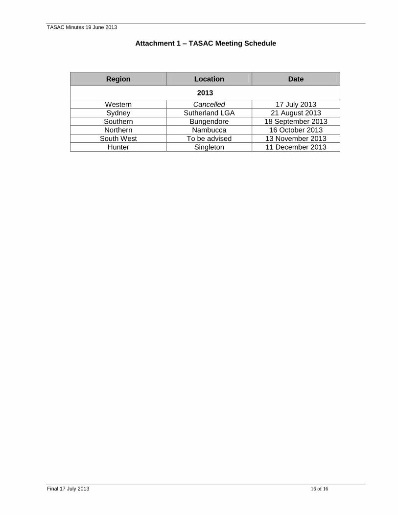
Attachment 1 – TASAC Meeting Schedule
Region Location Date
2013
Western Cancelled 17 July 2013
Sydney Sutherland LGA 21 August 2013
Southern Bungendore 18 September 2013
Northern Nambucca 16 October 2013
South West To be advised 13 November 2013
Hunter Singleton 11 December 2013
Related Documents