MINNESOTA NWI UPDATE Steve Kloiber Wetland Monitoring Coordinator Minnesota Department of Natural Resources

Welcome message from author
This document is posted to help you gain knowledge. Please leave a comment to let me know what you think about it! Share it to your friends and learn new things together.
Transcript

MINNESOTA NWI UPDATE Steve Kloiber
Wetland Monitoring Coordinator
Minnesota Department of Natural Resources
Outline
• Project Background / Status
• Quality Assurance Procedures / Plan
• Quality Control – Data Validation
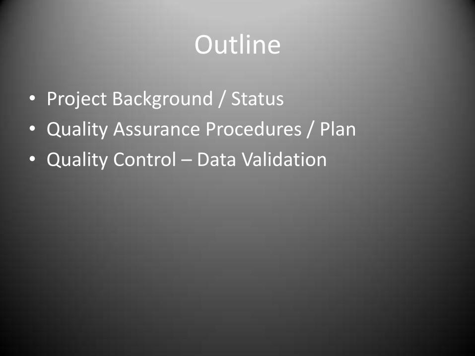
State Strategy
• Update the National Wetland Inventory in MN
• Status and Trends program for quantity & quality
• On-line permitting and restoration database

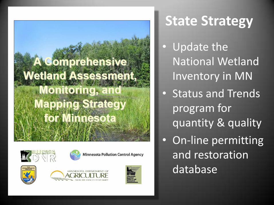
Why do we need an NWI update?
Some things have changed.

Why do we need an NWI update?
Some things have changed.
Why do we need an NWI update?
Some things have changed.

Spring Imagery Acquisition
• 0.5-meter or 1-foot resolution
• Percent complete = 82%
• Percent pending = 18%
Conducted in Geographically Defined Phases
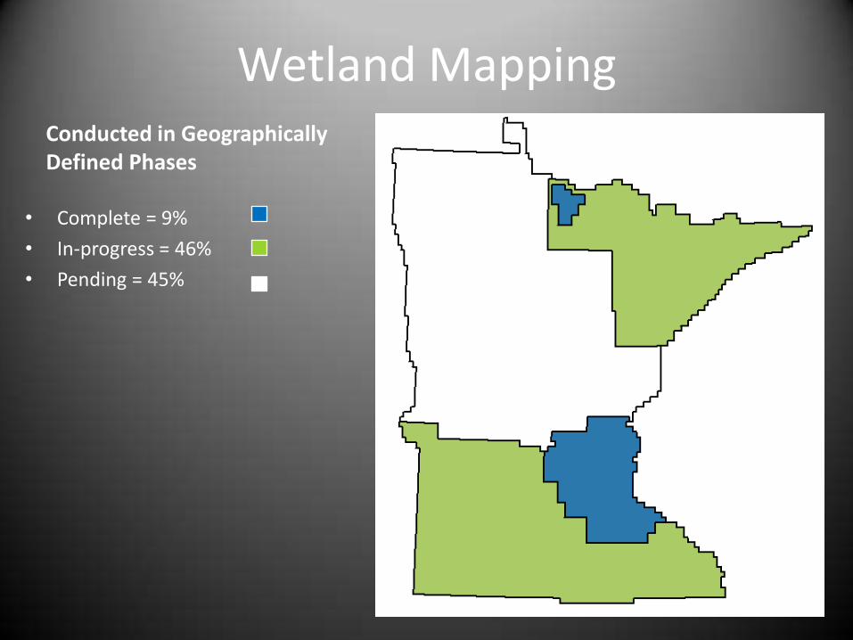
Wetland Mapping
• Complete = 9%
• In-progress = 46%
• Pending = 45%
Conducted in Geographically Defined Phases

Project Schedule & Data Access • Completion: 2019 (depending)
• Download from DNR Data Deli
• Also download through USFWS
• Online viewing at:
http://www.dnr.state.mn.us/eco/wetlands/map.html

for the NWI Update of Minnesota
QUALITY C O N T
R
O L

Definitions
• QA focuses on process improvement to prevent errors
• QC focuses on identifying errors in the finished product

QA/QC Plan
• Blueprint to ensure data are fit for purpose
• Document data quality objectives
• Describes systematic monitoring process

Define Data Quality Objectives
• Review problems with related datasets
• Review available standards and literature
• Specific objectives vary depending end user needs

Data Quality Objective Categories
• Precision/reproducibility (positional & attribute)
• Accuracy (positional & attribute)
• Resolution (scale, level of detail, MMU, etc.)
• Consistency (logical & topology)
• Completeness
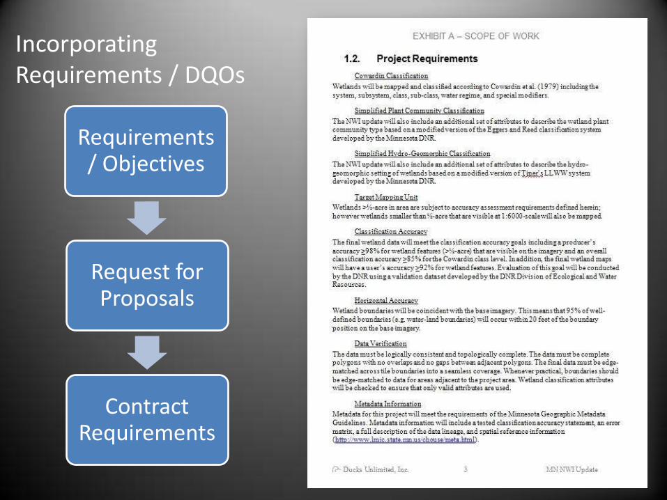
Requirements / Objectives
Request for Proposals
Contract Requirements
Incorporating Requirements / DQOs

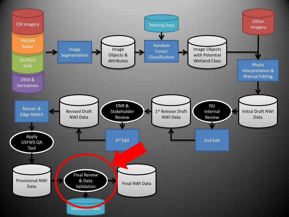
DEM & Derivatives
SSURGO Soils
PALSAR Radar
CIR Imagery
Image Segmentation
Image Objects & Attributes
Random Forest
Classification
Image Objects with Potential Wetland Class
Other Imagery
Photo Interpretation & Manual Editing
Initial Draft NWI Data
1st Release Draft NWI Data
2nd Edit 3rd Edit
Revised Draft NWI Data
Mosaic & Edge-Match
DNR & Stakeholder
Review
DU Internal Review
Apply USFWS QA
Tool
Provisional NWI Data
Final Review & Data
Validation Final NWI Data
Training Data
Validation Data
• Integrate QA/QC measures into your process.
• Multiple feedback loops

Desktop Feedback Loop
• Stereo Imagery Review • Wetlands from DOQQ process are compared to stereo imagery
• Stereo visualization can improve interpretation
– Sharper images
– More precise locations

Field Feedback Loop
• Field checking on selected wetland polygons

Crowdsource Feedback Loop
ArcSDE Database

DEM & Derivatives
SSURGO Soils
PALSAR Radar
CIR Imagery
Image Segmentation
Image Objects & Attributes
Random Forest
Classification
Image Objects with Potential Wetland Class
Other Imagery
Photo Interpretation & Manual Editing
Initial Draft NWI Data
1st Release Draft NWI Data
2nd Edit 3rd Edit
Revised Draft NWI Data
Mosaic & Edge-Match
DNR & Stakeholder
Review
DU Internal Review
Apply USFWS QA
Tool
Provisional NWI Data
Final Review & Data
Validation Final NWI Data
Training Data
Validation Data

USFWS QA/QC Tool
USFWS QAQC Tool performs a variety of automated checks in ArcGIS
DEM & Derivatives
SSURGO Soils
PALSAR Radar
CIR Imagery
Image Segmentation
Image Objects & Attributes
Random Forest
Classification
Image Objects with Potential Wetland Class
Other Imagery
Photo Interpretation & Manual Editing
Initial Draft NWI Data
1st Release Draft NWI Data
2nd Edit 3rd Edit
Revised Draft NWI Data
Mosaic & Edge-Match
DNR & Stakeholder
Review
DU Internal Review
Apply USFWS QA
Tool
Provisional NWI Data
Final Review & Data
Validation Final NWI Data
Training Data
Validation Data

FGCD Wetland Mapping Accuracy Goal
• “Ninety-eight percent of all wetlands visible on an image, at the size of the TMU or larger shall be mapped regardless of the origin (natural, farmed, or artificial).”

Questions About the FGDC Goal
• Assessment methods
– Field-check or photo-interpretation
– Points or polygons
– Handling confusion between classification error and positional error
• Is a 98% producer’s accuracy feasible
• Why is there no goal for user’s accuracy

Field vs Photo-Interpretation
• PI method
– “Visible” standard implies PI
– Visible to whom?
– PI experience = accurate?
• Field method
– Field accuracy > PI accuracy
– Time consuming, expensive
– Access restrictions

Points vs. Polygons

Classification Error or Positional Error
.

Validation Data
Field points • Stratified-random
• 75% wetland /25% upland
• Field-checked by UMN
• ±5.64 meters (image+GPS)
• Audited
PI points • Interpreted from high-resolution
digital stereo imagery
• 75% wetland /25% upland
• ±1.53 meters (image)
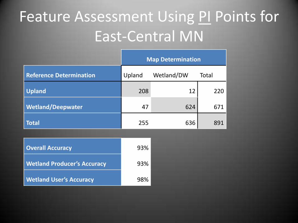
Feature Assessment Using PI Points for East-Central MN
Map Determination
Reference Determination Upland Wetland/DW Total
Upland 208 12 220
Wetland/Deepwater 47 624 671
Total 255 636 891
Overall Accuracy 93%
Wetland Producer’s Accuracy 93%
Wetland User’s Accuracy 98%
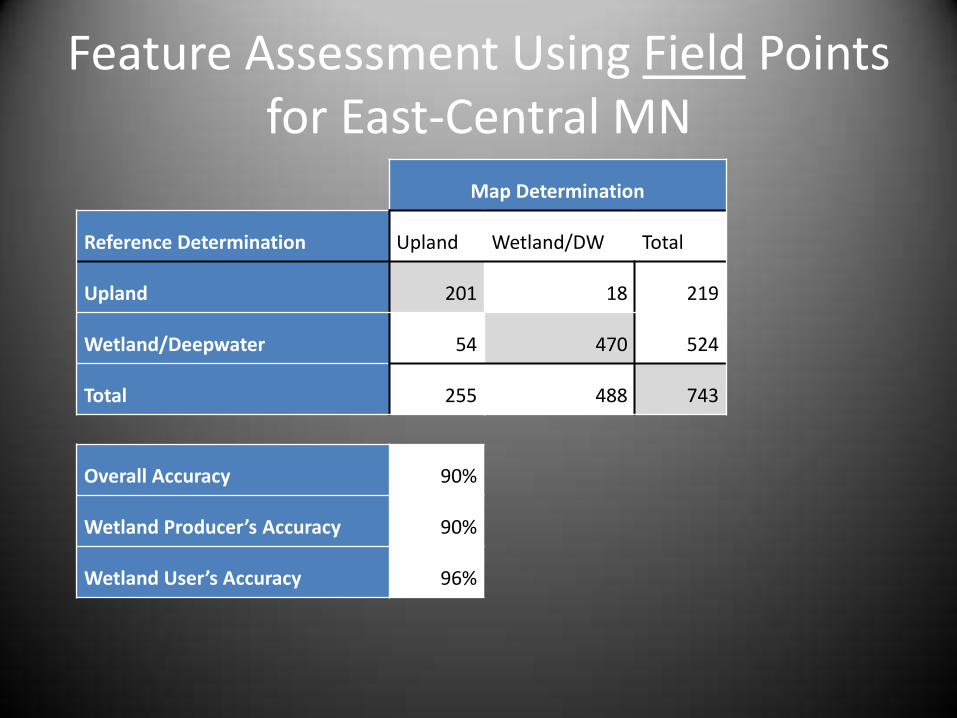
Feature Assessment Using Field Points for East-Central MN
Map Determination
Reference Determination Upland Wetland/DW Total
Upland 201 18 219
Wetland/Deepwater 54 470 524
Total 255 488 743
Overall Accuracy 90%
Wetland Producer’s Accuracy 90%
Wetland User’s Accuracy 96%

Class Assessment Using PI Points for East-Central MN
Map Class
Reference Class L1UB L2AB L2EM L2UB L2US PAB PEM PFO PSS PUB R2AB R2UB R2US UPL Total
L1UB 39 5 8 52
L2AB 2 26 9 3 1 4 45
L2EM 0
L2UB 5 3 3 31 3 45
L2US 1 1
PAB 21 5 11 1 1 39
PEM 2 99 2 1 1 18 123
PFO 1 30 3 19 53
PSS 13 2 20 1 7 43
PUB 1 1 22 7 1 1 142 5 180
R2AB 0
R2UB 2 2 58 62
R2US 1 1 6 6 14
UPL 5 5 1 208 219
Total 46 30 12 40 1 48 137 41 25 154 1 78 6 257 876

Reflections on Class Error Matrix
• An “accuracy” assessment
– Implies the reference data are 100% accurate
• Some common classes aren’t reliably separated with field observation or remote sensing
– Temporal variability (AB – UB)
– Spectrally indistinguishable (L1 – L2)

Temporal Variability

Temporal Variability

Temporal Variability

Temporal Variability
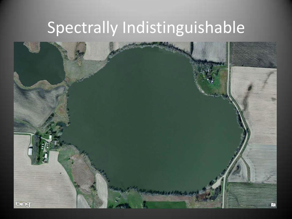
Spectrally Indistinguishable

Spectrally Indistinguishable

Wetland Class Accuracy
• Photo-interpreted validation data
• Wetland & deepwater classes only
• Overall class accuracy
– All points = 78%
– AB/UB confusion excluded = 84%
– L1/L2 and AB/UB excluded = 86%
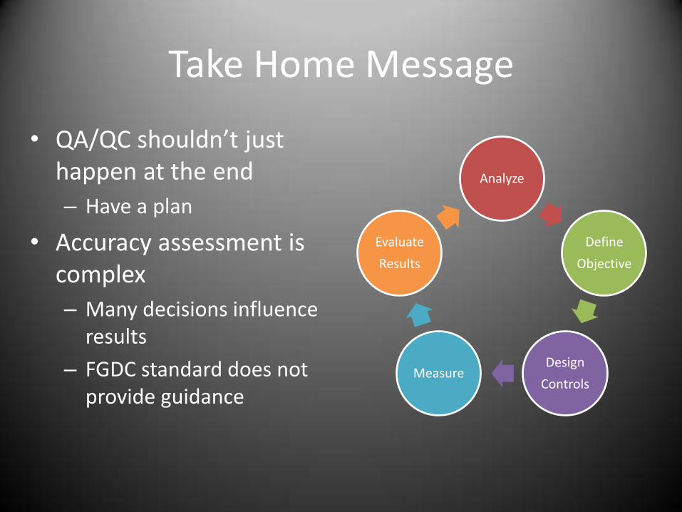
Analyze
Define
Objective
Design
Controls Measure
Evaluate
Results
Take Home Message
• QA/QC shouldn’t just happen at the end
– Have a plan
• Accuracy assessment is complex
– Many decisions influence results
– FGDC standard does not provide guidance

A Modest Proposal
Producer & User Accuracy Wetland/Upland
Quality Grade
Both > 95% A
95% > Both > 90% B
90% > Both > 80% C
80% > Both > 70% D
Both < 70% F
East-Central MN Producer Accuracy = 93% User Accuracy = 98% Overall Quality Grade = A-
Acknowledgments • Funding – ENRTF • DNR
– Doug Norris – Molly Martin
• University of MN – Joe Knight – Jennifer Corcoran – Lian Rampi
• DU/Equinox – Robb Macleod – Aaron Smith – Robb Paige
• St. Mary’s University – Andy Robertson – Dave Rokus
• Tech Advisory Committee – Brian Huberty – Nancy Read – Mark Gernes – Susanne Maeder – Rob Sip – Steve Eggers – Jeremy Maul – Les Lemm – Dale Krystosek

Questions?
Related Documents