Directorate of Water Resources and Improvement of River Systems Ministry of Transport and Communications 22 nd ,March,2018 1 Sule Shangarilia,Yangon Myanmar’s Inland Maritime Ports and Inland Water Transport: Capacity Assessment, Status and Development Plan

Welcome message from author
This document is posted to help you gain knowledge. Please leave a comment to let me know what you think about it! Share it to your friends and learn new things together.
Transcript

Directorate of Water Resources and Improvement of River Systems
Ministry of Transport and Communications
22nd,March,2018 1Sule Shangarilia,Yangon
Myanmar’s Inland Maritime Ports and Inland Water Transport: Capacity
Assessment, Status and Development Plan

CONTENT
▪ Country Context
▪ Current status of River channels
▪ DWIR Introduction (maintaining the Channels)
▪ Existing Port condition and Capacity
▪ Challenges
▪ Inland Port Development plans
▪ Advantages
▪ Conclusions
2
Topography
• The country is mountainous in north and
northwest.
• The eastern region has a plateau of about
3,000 ft above mean sea level. It has hilly and
flat terrain in central and southern areas.
• It altitudes, therefore, range from sea level to
snow capped mountains of about 19,000 ft.
• Approximately about 75 % of the country lies
in the tropics.
3

Annual Normal Rainfall
Range from minimum 600 mm to
maximum 5500 mm.
The lowest annual normal rainfall
occur in central part of Myanmar
The highest annual normal
rainfall occur in Coastal, Northern
and Southern part of Myanmar.
4

Current status
of
River channels
5
6
Th
an
lwin
Riv
er
Ka
lata
nR
iver
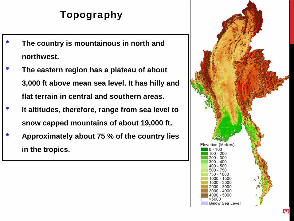
Name of
River
(Length)
(km)
(Catchment)
(sq-km)
(Discharge)
(mil cu-m)
Ayeyarwady 2100 288900 313720
Chindwin 1100 115300 141290
Sittaung 420 34395 41900
Thanlwin 2410 158000 257920
Kaladan 650 22611 53800
Name of River Navigable Length (km)
Ayeyarwady 1534
Chindwin 730
Thanlwin and other rivers in Mon
State
380
Dalta Region 2404
Rivers in Rakhaing State 1602
Total Length (km) 6650
Navigable Length of Major Rivers
6
Myanmar main rivers and navigability

DRAUGHT RESTRICTIONS
FROM 15TH NOVEMBER TO 15TH MAY ( DRY SEASON)
Sr.
NoRiver Stretch
Restricted Draught
Ft / inch meter
a Ayeyarwaddy River
1. Myitkyina-Sinbo 2‘ 6" 0.8
2. Bhamo- Katha 3‘ 6" 1.1
3. Katha-Mandalay 4‘ 0" 1.2
4. Mandalay-Pyay 5‘ 0" 1.5
5. Pyay-Henzada 5‘ 6" 1.7
b Chindwin River
1. Hkamti- Homalin 2‘ 6" 0.8
2. Homalin- Kalewa 3‘ 0" 0.9
3. Kalewa- Monywa 3‘ 3" 1.0
4. Monywa-Confluence 3‘ 0" 0.9
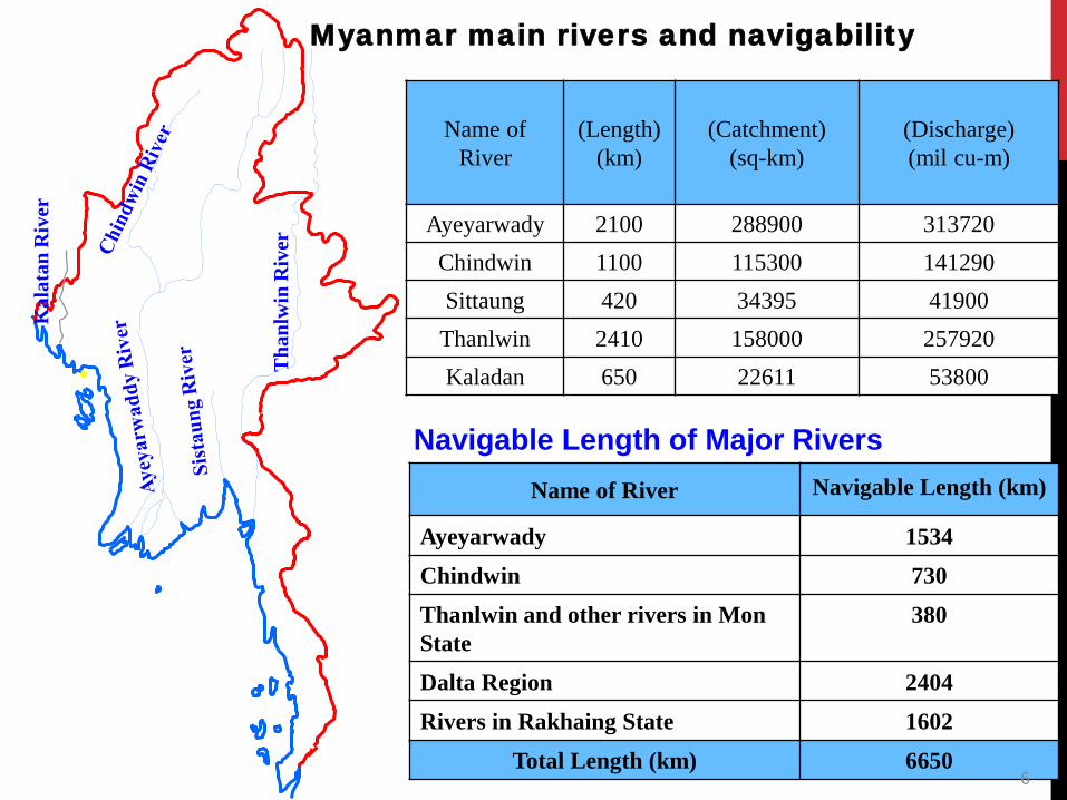
Constraints along the Ayeyarwady and Chindwin
Sr no. Waterway Constraints
Ayeyarwady 34
1 Bamaw – Hteegyaint 5
2 Hteegyaint – Mandalay 4
3 Mandalay – Chauk 10
4 Chauk – Magway 5
5 Magway – Pyay 3
6 Pyay - Yangon 7
Chindwin 20
1 Khamtee - Homalin 5
2 Homalin – Mawlaik 4
3 Mawlaik - Monywa 7
4 Monywa - Confluence 4
8

Directorate of Water
Resources and Improvement
of River Systems
(DWIR)
Introduction
9

Organizational Structure of DWIR
10

to contribute to the development of State economy through improving
water resources and river system.
Aims
to smooth and safety waterways navigation along rivers and creeks.
to protect and maintain the waterways of border rivers so as not to lose
State-owned land, and making arrangements thereof.
11

to Improve the navigation channel and to stabilize the inland river ports.
to protect the river banks erosion.
to cooperate with other organizations in demarcation of danger water level
of the towns.
to utilize the river water for domestic and agriculture all the year round.
to protect bank erosion of border rivers.
to observe the long term existence of the cross river bridges by river
engineering point of views.
to manage the prevention of the river water pollution.
to achieve adequate depth for maximum loading capacity of the vessels.
OBJECTIVES OF DWIR
12

(1) River Bed Regulation / Canalization
(2)Water Level Regulation
(3)Discharge Regulation
ALTERNATIVE RIVER IMPROVEMENT METHODS
13

Some projects implemented
by DWIR
14

15permeable groyne non permeable groyne
non permeable groyne
Construction of River Training Strucutres

16
Some activities of DWIR
Removing snags, debris
Dredging
Removing rocks
Inspection of bridges

Dredging work
17

To overcome the draught restrictions,
necessary to improve,
18
▪ (34) constraints on Ayeyarwady river from Bhamo to Yangon.
▪ (20) constraints on Chindwin river from Khamtee to confluence.

Priority Objectives of AIRBMP
(Implemented by DWIR)
➢AIRBM: Ayeyarwady integrated river basin management
project
➢AIRBM: strengthen integrated, climate resilient management
and development of the Ayeyarwady River Basin and
national water resources.
Component 3 will help reduce poverty by safe,
economical inland water transport that will provide
increased opportunities for trade, market access and
mobility.
➢Goal is to achieve a sustainable and environmentally sound
Transport Corridor.
19
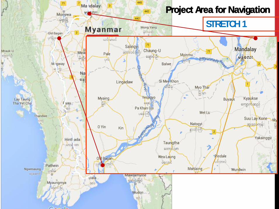
STRETCH 1
Project Area for Navigation

Existing Port condition and capacity
21
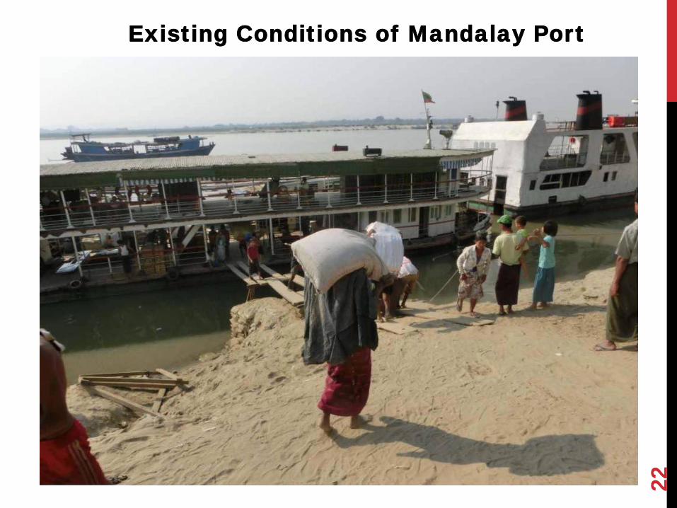
22
Existing Conditions of Mandalay Port

23
Existing Condition of Monywa Port

24
Existing Condition of Kalaywa Port
25
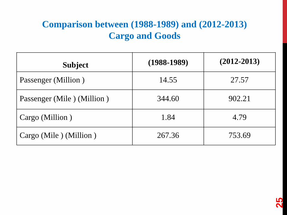
Subject (1988-1989) (2012-2013)
Passenger (Million ) 14.55 27.57
Passenger (Mile ) (Million ) 344.60 902.21
Cargo (Million ) 1.84 4.79
Cargo (Mile ) (Million ) 267.36 753.69
Comparison between (1988-1989) and (2012-2013)
Cargo and Goods

Current cargo structure of Inland water
transport
26

27

Firstly, Myanmar’s GDP is predicted by using growth rate method.
Secondly, freight volume production per GDP is predicted and total
freight volume of Myanmar is predicted.
Thirdly, the share of inland water transport is analyzed. At last,
inland water freight volume can be calculated.
Future Prediction
28

Throughput of main ports unit:
thousand tons, thousand person-times
29

Freight and passenger volume of Myanmar inland
water transport by types unit:
thousand tons, thousand person-times
30

▪ Cargo handling is carried out by Manpower
▪ No port facilities
▪ No ware houses
▪ No surface pavement
▪ Suitable port authority for inland ports
31
Challenges

Inland Port Development plans
32

Inland Port Development Priority
Division Port Priority Remark
Ayeyarwady Mandalay Port Highimportant for large handling
volume
Chindwin Monywa Port Highimportant for passenger
transport for local villages
Ayeyarwady Bamaw Port Highimportant for border trade bet.
China
Ayeyarwady Pakokku Port Highdevelopment for corridor bet.
Bengal Bay
Ayeyarwady Magway Port Middledevelopment for corridor bet.
Bengal Bay
Delta Pathein Port Middleimportant for passenger
transport for local villages
Chindwin Kalaywa Port Middleimportant for passenger
transport for local villages
33
34
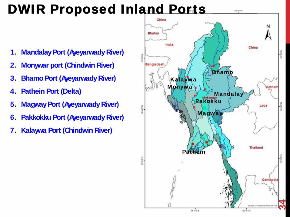
DWIR Proposed Inland Ports
1. Mandalay Port (Ayeyarwady River)
2. Monywar port (Chindwin River)
3. Bhamo Port (Ayeyarwady River)
4. Pathein Port (Delta)
5. Magway Port (Ayeyarwady River)
6. Pakkokku Port (Ayeyarwady River)
7. Kalaywa Port (Chindwin River)
Mandalay
Pathein
Bhamo
Monywa
Magway
Pakokku
Kalaywa

Inland Port Development Plan
➢ Project Duration 2018 to 2021 ( 4 year)
➢ Project Financing Amount-84 Million USD
➢ Scopes of Works
• Development of Bamaw, Monywar, Pakkoku and Magway ports
➢ Project plan
• This development project will be implemented by Build,
Operate and Transfer Method to share prosperity between
private and public sector
➢ Current Implementation status
• Received No Objection from Kachin, Sagaing and Magway
Regional Government and under preparation to submit to
Ministry of Finance and Planning
Location of Bamaw Port
Location of Monywar Port Location of Pakkoku Port Location of Magway Port

Mandalay Inland Port Improvement
1. Japan International Cooperation Agency (JICA) studied Myanmar National
Transport Development Plan (Dec, 2012 to February, 2014).
2. Includes road sector, railway sector & waterway sector.
3. In Waterway transport sector, “Mandalay Port Development Project” is highest
prioritized.
4. Mandalay Port Development Project was studied from August (2013) to February
(2014).
5. Annual cargos volume is (600,000) tons/ year at Mandalay port.
6. About (6) km long port area, no facilities of port & manually handled,
Background
36

Past and Present Condition at Mandalay Port
2004
1885
37

Location of Mandalay Port
38
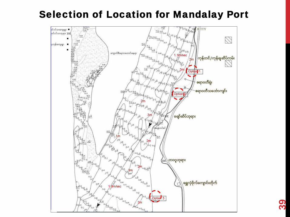
Selection of Location for Mandalay Port
39

PORT LOCATION
40 40
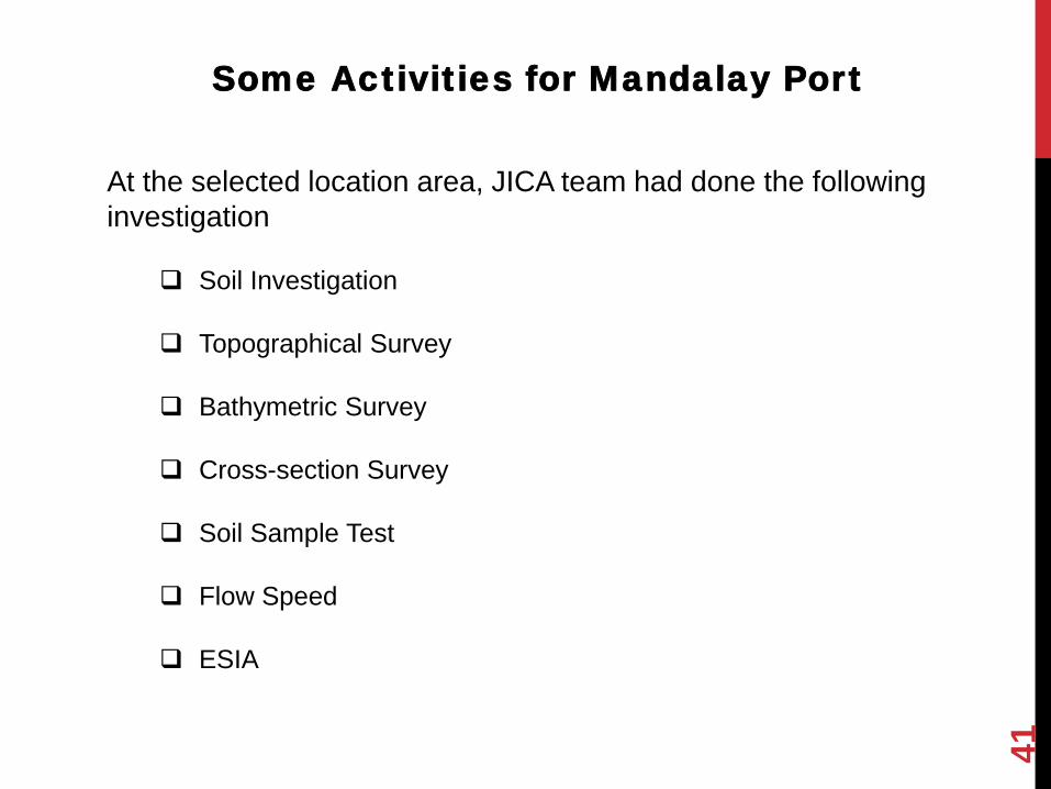
Soil Investigation
Topographical Survey
Bathymetric Survey
Cross-section Survey
Soil Sample Test
Flow Speed
ESIA
Some Activities for Mandalay Port
At the selected location area, JICA team had done the following
investigation
41

Proposed Design of Mandalay Port by JICA
team
Float type
Fixed type
42

Floating Types
WL Difference = 8 m ~ 10 m (Mandalay)
JICA recommended the floating type Jetty 43

Mandalay port Plan
44

Mandalay Port Development Project
1) Project Duration - 2018 to 2020 (23 month)
2) Project Financing Amount – 55.42 Mil USD
(JICA Grant)
1) Scopes of works
➢ Jetty 180 Metre
➢ Container Yard 29540 square metre
➢ Approach road 304 metre
➢ Approach bridge-238 metre and 183 metre
➢ Port Area-15 Acres
4) Current Implementation status
➢ Under negotiation for resettlement (300 Lakhs for 1 acre)
➢ Japan Embassy and Ministry of Planning and Finance is going
to sign an Exchange Note
➢ Preparing Detail Design and tender will be public in August
2018
45
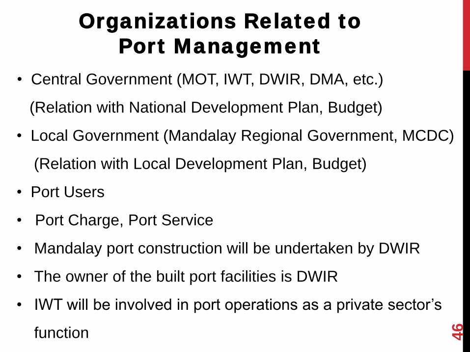
Organizations Related to
Port Management
• Central Government (MOT, IWT, DWIR, DMA, etc.)
(Relation with National Development Plan, Budget)
• Local Government (Mandalay Regional Government, MCDC)
(Relation with Local Development Plan, Budget)
• Port Users
• Port Charge, Port Service
• Mandalay port construction will be undertaken by DWIR
• The owner of the built port facilities is DWIR
• IWT will be involved in port operations as a private sector’s
function 46
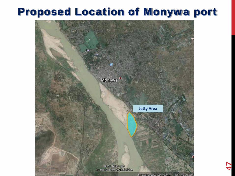
Proposed Location of Monywa port
47

Length = 180 meter
Port Ares = 130 acres
Design = Concrete Jetty + Pontoon type
Type = Fixed Type
Location = Down stream of Monywa,
Chindwin River
Monywa Port Development Plan
48

49
Proposed Location of Bhamo Port

Bhamo Port Development Plan
Location: - (19 miles)Down stream of Bhamo,
Mouth of Second Defile.
Area: - (5100 ft)x(2000 ft)
Phase (1)Implementation Plan - Port Area { 2200’ x 1000’)
- Number of Pontoon (2)
- Size of Pontoons
(180’ L)x(36’ B)x (4’ H)
Cargo Capacity - Phase (1) { 520000 tons)
- Phase (2) { 3920000 tons)
50

51
Proposed Location of Pakokku Port
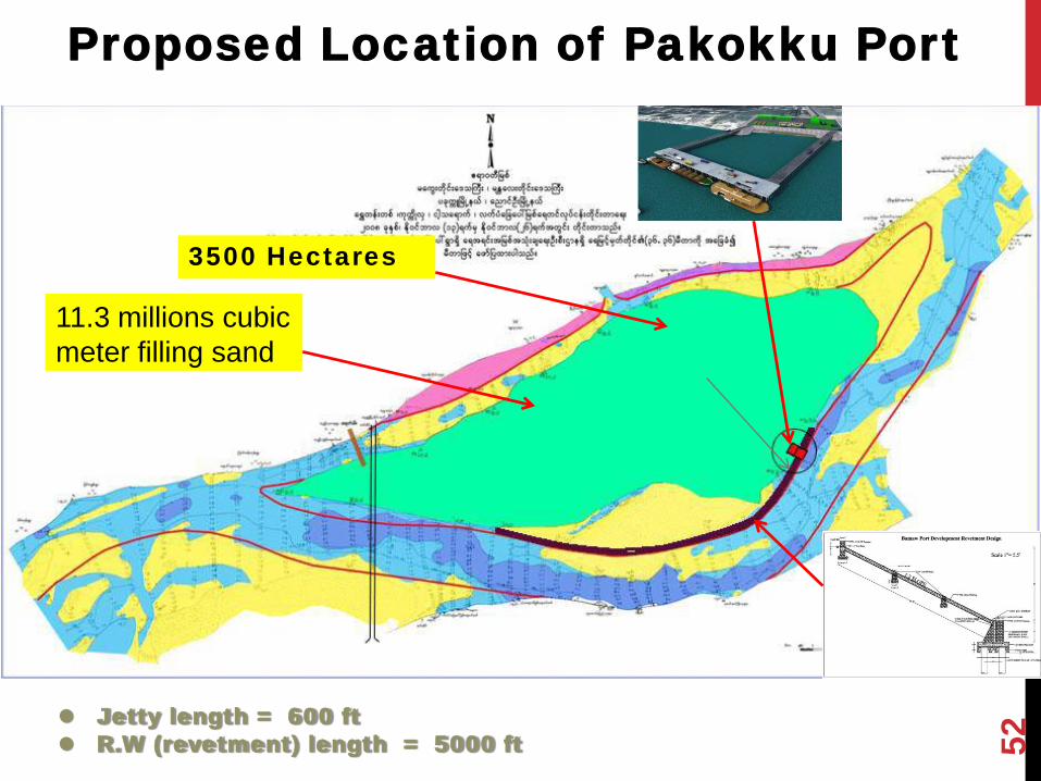
Proposed Location of Pakokku Port
3500 Hectares
11.3 millions cubic
meter filling sand
Jetty length = 600 ft
R.W (revetment) length = 5000 ft 52

Length = 180 meter
Design = Concrete Jetty + Pontoon type
Type = Fixed Type
Location = Aye Kyun, East of Pakokku City.
Pakokku Port Development Plan
53
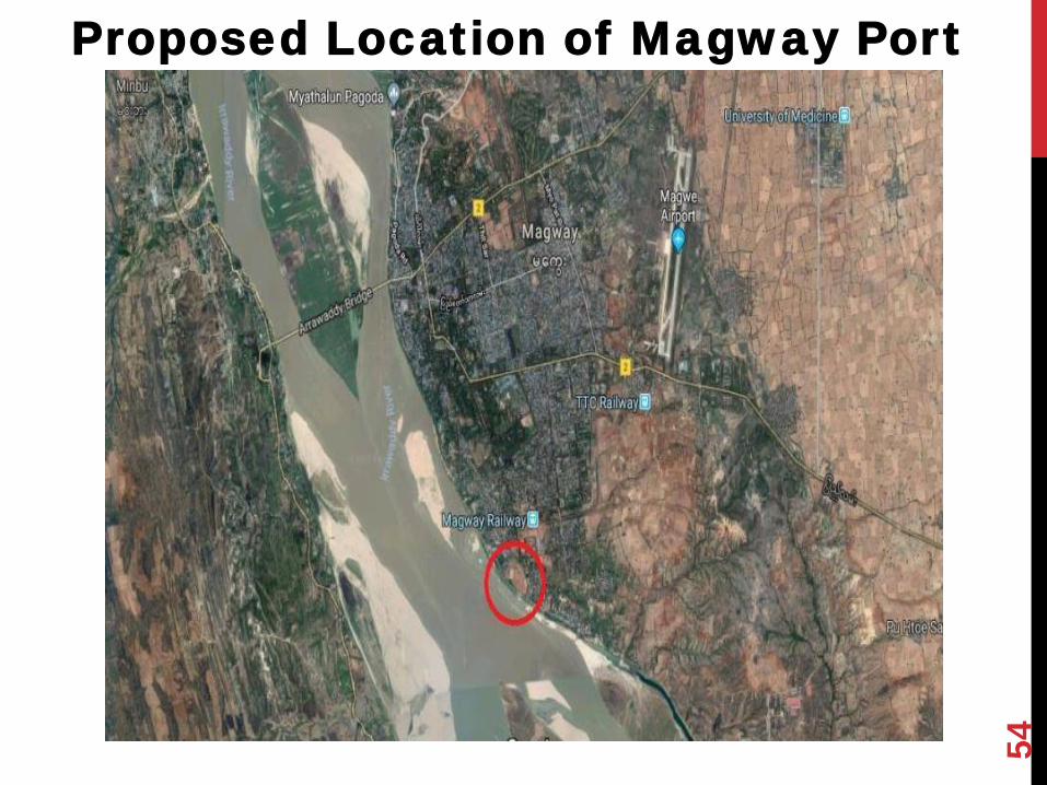
54
Proposed Location of Magway Port

Investment Plan overview
➢Bamaw, Magway, Pakkoku and Monywar ports
upgrading should be in first priorities.
➢Public consultation should be held prior to
implementation process
➢ It is better to implement in BOT system.
➢Draft design idea, location plan and estimated budget
is prepared by DWIR
➢Waterway transportation and port development should
be develop in parallel.
55
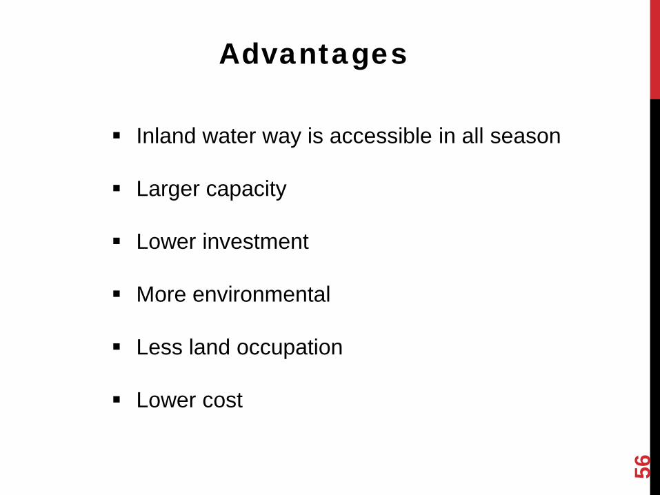
▪ Inland water way is accessible in all season
▪ Larger capacity
▪ Lower investment
▪ More environmental
▪ Less land occupation
▪ Lower cost
56
Advantages
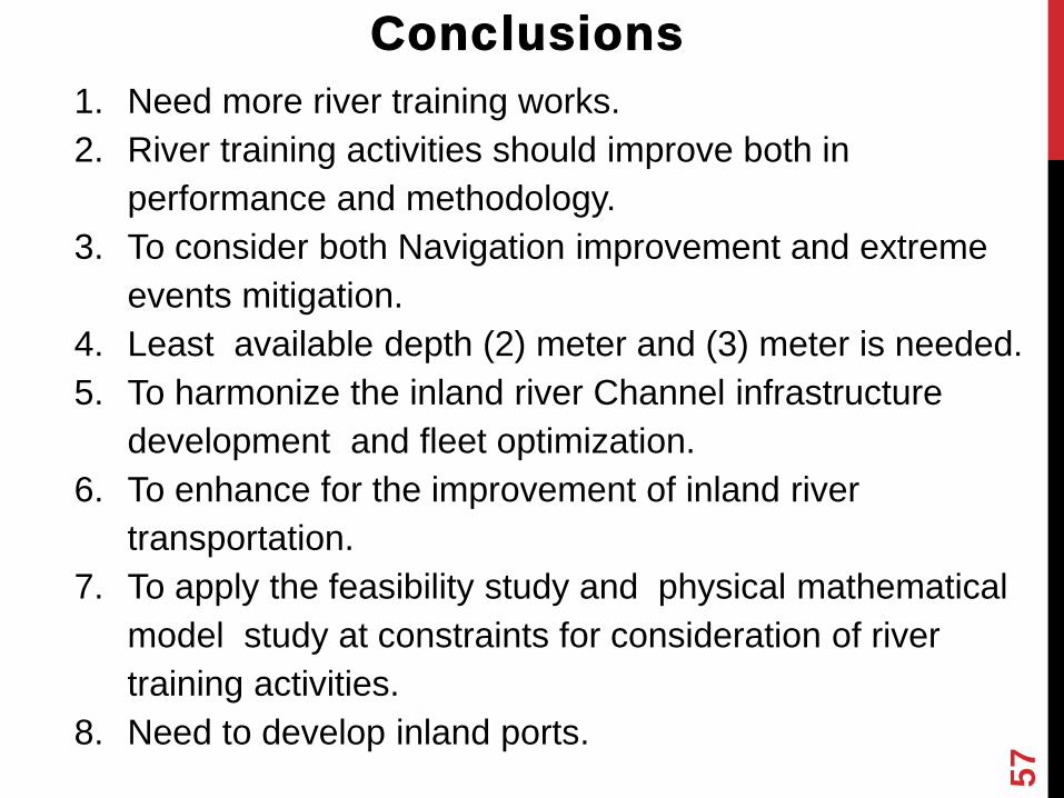
1. Need more river training works.
2. River training activities should improve both in
performance and methodology.
3. To consider both Navigation improvement and extreme
events mitigation.
4. Least available depth (2) meter and (3) meter is needed.
5. To harmonize the inland river Channel infrastructure
development and fleet optimization.
6. To enhance for the improvement of inland river
transportation.
7. To apply the feasibility study and physical mathematical
model study at constraints for consideration of river
training activities.
8. Need to develop inland ports.
Conclusions
57

THANK YOU FOR YOUR KIND ATTENTION
58
Related Documents