
Welcome message from author
This document is posted to help you gain knowledge. Please leave a comment to let me know what you think about it! Share it to your friends and learn new things together.
Transcript

cmeermann
Typewritten Text
Ministry of Tourism, Culture and Sport
cmeermann
Typewritten Text
cmeermann
Typewritten Text
cmeermann
Typewritten Text
cmeermann
Typewritten Text
cmeermann
Typewritten Text
cmeermann
Typewritten Text
Confirmation Letter
cmeermann
Typewritten Text
cmeermann
Typewritten Text
cmeermann
Typewritten Text
cmeermann
Typewritten Text
December 6, 2012
cmeermann
Typewritten Text
cmeermann
Typewritten Text

Ministry of Tourism, Culture and Sport
Culture Programs Unit Programs and Services Branch Culture Division 435 S. James St., Suite 334 Thunder Bay, ON P7E 6S7 Tel.: 807-475-1628
Ministère du Tourisme, de la Culture et du Sport
Unité des programmes culturels Direction des programmes et des services Division de culture 435, rue James sud, bureau 334 Thunder Bay, ON P7E 6S7 Tél. : 807-475-1628
Email: [email protected] Email: [email protected]
¹In no way will the ministry be liable for any harm, damages, costs, expenses, losses, claims or actions that may result: (a) if the Report(s) or its recommendations are discovered to be inaccurate, incomplete, misleading or fraudulent; or (b) from the issuance of this letter. Further measures may need to be taken in the event that additional artifacts or archaeological sites are identified or the Report(s) is otherwise found to be inaccurate, incomplete, misleading or fraudulent.
December 6, 2012
P.J. Racher Archaeological Research Associates Ltd. 154 Otonabee Drive Kitchener, ON N2C 1L7
Dear Mr. Racher,
RE: Review and Entry into the Ontario Public Register of Archaeological Reports: Archaeological Assessment Report Entitled, Stage 1 Archaeological Assessment, Port Ryerse Wind Power Project (FIT F-001579-WIN-130-601) Part of Lots 3–5, Broken Front, Geographic Township of Woodhouse, Norfolk County, Ontario, Dated October 30, 2012, Filed by MTCS Toronto Office November 7, 2012, MTCS Project Information Form Number P007-386-2011, MTCS File Number HD00097
This office has reviewed the above-mentioned report, which has been submitted to this ministry as a condition of licensing in accordance with Part VI of the Ontario Heritage Act, R.S.O. 1990, c 0.18.1 This review has been carried out in order to determine whether the licensed professional consultant archaeologist has met the terms and conditions of their licence, that the licensee assessed the property and documented archaeological resources using a process that accords with the 2011 Standards and Guidelines for Consultant Archaeologists set by the ministry, and that the archaeological fieldwork and report recommendations are consistent with the conservation, protection and preservation of the cultural heritage of Ontario.
The report documents the assessment of the study area as depicted in Figure 21 of the above titled report and recommends the following:
The results of the Stage 1 archaeological assessment indicate that the majority of the study area has clear potential for Pre-Contact and Euro-Canadian archaeological materials. Deep land alterations have negatively impacted Avalon Lane in the central part of the study area, a quarry and artificial pond in the south-central part of the study area, an industrial area in the south western part of the study area, a residential
2
area on the outskirts of Port Ryerse, and a section of Port Ryerse Road and adjacent lands. Archaeological potential has been removed from these locations.
Based on these findings, ARA recommends that all areas of archaeological potential within the proposed project location for the Port Ryerse Wind Power Project be subject to a Stage 2 archaeological assessment in advance of construction. In accordance with the requirements set out in Section 2.1 of the Standards and Guidelines for Consultant Archaeologists (MTC2011:28–39), the following assessment strategies should be utilized:
• For recently cultivated or actively cultivated lands, a pedestrian survey must be conducted at a maximum interval of 5 m. All ground surfaces must be recently ploughed, weathered by one heavy rainfall, and provide at least 80% visibility(MTC 2011:30–31); • For lands where ploughing is not viable, the assessment must be conducted using the test pit survey method at a maximum interval of either 5 m or 10 m. A maximum test pit survey interval of 5 m is required in all areas less than 300 m from any feature of archaeological potential, and a maximum test pit survey interval of10 m is required in all areas more than 300 m from any feature of archaeological potential (MTC 2011:31–32).
The identified areas of no archaeological potential are not recommended for further assessment. Additional areas of no archaeological potential may be identified in the course of Stage 2 on-site documentation. A Letter of Review and Acceptance into the Provincial Register of Reports is requested, as provided for in Section 65.1 of the Ontario Heritage Act.
Based on the information contained in the report, the ministry is satisfied that the fieldwork and reporting for the archaeological assessment are consistent with the ministry's 2011 Standards and Guidelines for Consultant Archaeologists and the terms and conditions for archaeological licences. This report has been entered into the Ontario Public Register of Archaeological Reports. Please note that the ministry makes no representation or warranty as to the completeness, accuracy or quality of reports in the register.
Should you require any further information regarding this matter, please feel free to contact me.
Sincerely,
Paige Campbell Archaeology Review Officer cc. Adam Rosso, Boralex Inc.

cmeermann
Typewritten Text
Stage 1 Archaeological Assessment
cmeermann
Typewritten Text
cmeermann
Typewritten Text

Prepared for
Boralex Inc.
772 Sherbrooke St. West, Suite 200
Montreal, QC H3A 1G1
Tel: (514) 284-9890 Fax: (514) 284-9895
&
UDI Renewables Corporation
&
The Ministry of Tourism, Culture and Sport
By
Archaeological Research Associates Ltd.
154 Otonabee Drive
Kitchener, ON N2C 1L7
Tel: (519) 804-2291 Fax: (519) 286-0493
Licenced under
P.J. Racher, M.A., CAHP
MTCS Licence #P007
Project #P007-386
PIF #P007-386-2011
30/10/2012
Original Report
Stage 1 Archaeological Assessment
Port Ryerse Wind Power Project
(FIT F-001579-WIN-130-601)
Part of Lots 3–5, Broken Front
Geographic Township of Woodhouse
Norfolk County, Ontario
cmeermann
Typewritten Text
cmeermann
Typewritten Text

Stage 1 Archaeological Assessment, Port Ryerse Wind Power Project (F-001579-WIN-130-601) _____________________________________________________________________________________________________________________
_____________________________________________________________________________________________________________________
October 2012 Archaeological Research Associates Ltd.
PIF #P007-386-2011
i
EXECUTIVE SUMMARY
Under a contract awarded in September 2011, Archaeological Research Associates Ltd. carried
out a Stage 1 archaeological assessment of lands with the potential to be impacted by the
proposed Port Ryerse Wind Power Project in Norfolk County, Ontario. This report documents the
background research and archaeological potential modeling involved in this assessment, and
presents conclusions and recommendations pertaining to archaeological concerns within the
study area.
Boralex Inc. (Boralex), in association with UDI Renewables Corporation (UDI), are proposing to
develop the Port Ryerse Wind Power Project east of the hamlet of Port Ryerse. The project was
awarded a Feed-In-Tariff contract (F-001579-WIN-130-601) with the Ontario Power Authority
on February 25, 2011, and the proponent is preparing their Renewable Energy Approval
application in accordance with the requirements set out in Ontario Regulation 359/09 made
under Part V.0.1 of the Environmental Protection Act. The project location is sited on privately-
owned agricultural lands, where landowners have entered into a lease agreement with
Boralex/UDI. The proposed Class 4 Wind Facility would include four wind turbine generators
and associated support structures, access roads and electrical lines (MKI 2011:1–6). The Stage 1
assessment documented in this report was completed as a component of the Renewable Energy
Approval application, in compliance with the requirements set out in Section 22 of
Ontario Regulation 359/09.
The Stage 1 assessment of the study area was conducted between December 2011 and
October 2012. The work was carried out under Ministry of Tourism, Culture and Sport licence
#P007, PIF #P007-386-2011, and was governed by the Standards and Guidelines for Consultant
Archaeologists (MTC 2011). Although optional, the study area was also subjected to property
inspections on March 28, 2012, July 6, 2012 and October 11, 2012 in order to gain first-hand
knowledge of its geography, topography and current condition, and to conclusively map its
archaeological potential.
The results of the Stage 1 assessment indicated that the study area, in its pristine state, would
have clear potential for Pre-Contact and Euro-Canadian archaeological sites. This potential is
based on proximity to six primary water sources (Hay Creek and five other unnamed creeks),
two historically-surveyed roadways (Port Ryerse Road and Gilbert Road) and the hamlet of
Port Ryerse (an area of early settlement). Several areas of disturbance were identified during the
property inspections, however, indicating that the study area currently comprises a mixture of
areas of archaeological potential and areas of no archaeological potential. Specifically, deep land
alterations have resulted in the removal of archaeological potential from 1) Avalon Lane in the
central part of the study area, 2) a quarry and artificial pond in the south-central part of the study
area, 3) an industrial area in the southwestern part of the study area, 4) a residential area on the
outskirts of Port Ryerse, and 5) a section of Port Ryerse Road and adjacent lands.
Based on these findings, Archaeological Research Associates Ltd. recommends that all areas of
archaeological potential within the proposed project location for the Port Ryerse Wind Power
Project be subject to a Stage 2 archaeological assessment as required by Ontario Regulation
359/09. In accordance with the requirements set out in Section 2.1 of the Standards and
Stage 1 Archaeological Assessment, Port Ryerse Wind Power Project (F-001579-WIN-130-601) _____________________________________________________________________________________________________________________
_____________________________________________________________________________________________________________________
October 2012 Archaeological Research Associates Ltd.
PIF #P007-386-2011
ii
Guidelines for Consultant Archaeologists (MTC 2011:28–39), the following assessment
strategies should be utilized:
For recently cultivated or actively cultivated lands, a pedestrian survey must be
conducted at a maximum interval of 5 m. All ground surfaces must be recently ploughed,
weathered by one heavy rainfall, and provide at least 80% visibility (MTC 2011:30–31);
For lands where ploughing is not viable, the assessment must be conducted using the test
pit survey method at a maximum interval of either 5 m or 10 m. A maximum test pit
survey interval of 5 m is required in all areas less than 300 m from any feature of
archaeological potential, and a maximum test pit survey interval of 10 m is required in all
areas more than 300 m from any feature of archaeological potential (MTC 2011:31–32).
The identified areas of no archaeological potential are not recommended for further assessment.
Additional areas of no archaeological potential may be identified in the course of Stage 2 on-site
documentation. A Letter of Review and Acceptance into the Provincial Register of Reports is
requested, as provided for in Section 65.1 of the Ontario Heritage Act.
Stage 1 Archaeological Assessment, Port Ryerse Wind Power Project (F-001579-WIN-130-601) _____________________________________________________________________________________________________________________
_____________________________________________________________________________________________________________________
October 2012 Archaeological Research Associates Ltd.
PIF #P007-386-2011
iii
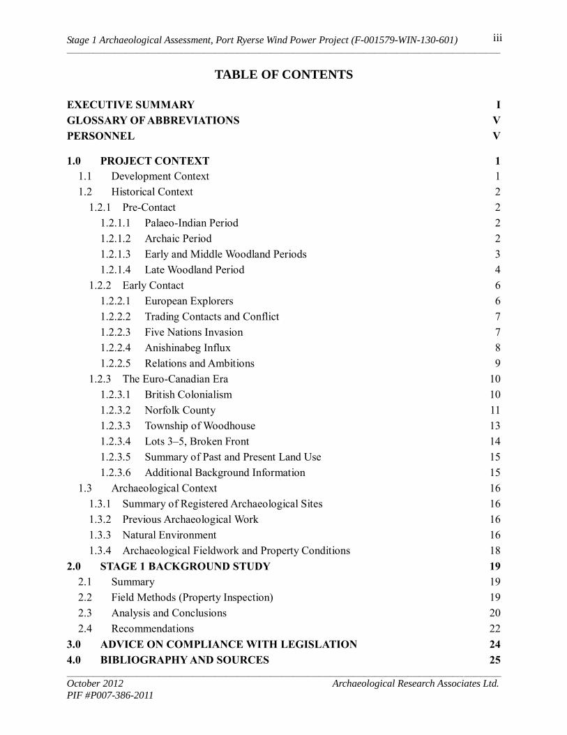
TABLE OF CONTENTS
EXECUTIVE SUMMARY I
GLOSSARY OF ABBREVIATIONS V
PERSONNEL V
1.0 PROJECT CONTEXT 1
1.1 Development Context 1
1.2 Historical Context 2
1.2.1 Pre-Contact 2
1.2.1.1 Palaeo-Indian Period 2
1.2.1.2 Archaic Period 2
1.2.1.3 Early and Middle Woodland Periods 3
1.2.1.4 Late Woodland Period 4
1.2.2 Early Contact 6
1.2.2.1 European Explorers 6
1.2.2.2 Trading Contacts and Conflict 7
1.2.2.3 Five Nations Invasion 7
1.2.2.4 Anishinabeg Influx 8
1.2.2.5 Relations and Ambitions 9
1.2.3 The Euro-Canadian Era 10
1.2.3.1 British Colonialism 10
1.2.3.2 Norfolk County 11
1.2.3.3 Township of Woodhouse 13
1.2.3.4 Lots 3–5, Broken Front 14
1.2.3.5 Summary of Past and Present Land Use 15
1.2.3.6 Additional Background Information 15
1.3 Archaeological Context 16
1.3.1 Summary of Registered Archaeological Sites 16
1.3.2 Previous Archaeological Work 16
1.3.3 Natural Environment 16
1.3.4 Archaeological Fieldwork and Property Conditions 18
2.0 STAGE 1 BACKGROUND STUDY 19
2.1 Summary 19
2.2 Field Methods (Property Inspection) 19
2.3 Analysis and Conclusions 20
2.4 Recommendations 22
3.0 ADVICE ON COMPLIANCE WITH LEGISLATION 24
4.0 BIBLIOGRAPHY AND SOURCES 25
Stage 1 Archaeological Assessment, Port Ryerse Wind Power Project (F-001579-WIN-130-601) _____________________________________________________________________________________________________________________
_____________________________________________________________________________________________________________________
October 2012 Archaeological Research Associates Ltd.
PIF #P007-386-2011
iv
5.0 IMAGES 31
6.0 MAPS 35
LIST OF IMAGES
Image 1: Area of No Archaeological Potential – Disturbed Lands at Avalon Lane 31
Image 2: Area of No Archaeological Potential – Disturbed Lands at Artificial Pond 31
Image 3: Area of No Archaeological Potential – Disturbed Lands Leading to Quarry 32
Image 4: Area of No Archaeological Potential – Disturbed Lands in Industrial Area 32
Image 5: Area of No Archaeological Potential – Disturbed Lands East of Hilltop Drive 33
Image 6: Area of No Archaeological Potential – Disturbed Lands along Port Ryerse Road 33
Image 7: Area of No Archaeological Potential – Disturbed Lands along Port Ryerse Road 34
Image 8: Area of No Archaeological Potential – Disturbed Lands east of Port Ryerse Road 34
LIST OF MAPS
Map 1: Location of the Study Area in the Province of Ontario 35
Map 2: Location of the Study Area in Norfolk County 36
Map 3: Middle Woodland Period Complexes 37
Map 4: Princess Point Site Clusters in Southern Ontario 37
Map 5: Pre-Contact Iroquoian Site Clusters 38
Map 6: Detail from S. de Champlain’s Carte de la Nouvelle France (1632) 38
Map 7: Detail from N. Sanson's Le Canada, ou Nouvelle France (1656) 39
Map 8: Detail from the Map of Galinée’s Voyage (1670) 39
Map 9: Detail from H. Popple’s A Map of the British Empire in America (1733) 40
Map 10: Detail from R. Sayer and J. Bennett’s General Map of the Middle British
Colonies in America (1776) 40
Map 11: Detail from D.W. Smyth’s A Map of the Province of Upper Canada (1800) 41
Map 12: Detail from J. Purdy’s A Map of Cabotia (1814) 41
Map 13: Detail from D.W. Smyth’s A Map of the Province of Upper Canada, 2nd
Edition
(1818) 42
Map 14: Detail from J. Arrowsmith’s Upper Canada (1837) 42
Map 15: Detail from J. Bouchette’s Map of the Provinces of Canada (1846) 43
Map 16: Detail from G.W. Colton’s Canada West (1856) 43
Map 17: Norfolk County from W.J. Gage and Co.’s Gage’s County Atlas (1886) 44
Map 18: The Township of Woodhouse from H.R. Page & Co.’s Illustrated Historical Atlas
of the County of Norfolk (1877) 45
Map 19: The Hamlet of Port Ryerse from H.R. Page & Co.’s Illustrated Historical Atlas of
the County of Norfolk (1877) 46

Stage 1 Archaeological Assessment, Port Ryerse Wind Power Project (F-001579-WIN-130-601) _____________________________________________________________________________________________________________________
_____________________________________________________________________________________________________________________
October 2012 Archaeological Research Associates Ltd.
PIF #P007-386-2011
v
Map 20: The Township of Woodhouse from H.R. Page & Co.’s Illustrated Historical Atlas
of the County of Norfolk (1877), Showing the Study Area 47
Map 21: Results of the Stage 1 Assessment – Archaeological Potential Modelling 48
LIST OF TABLES
Table 1: Euro-Canadian Residents of the Township of Woodhouse, according to H.R. Page
& Co.’s Illustrated Historical Atlas of the County of Norfolk (1877) 14
Table 2: Registered Archaeological Sites within 1 km of the Study Area 16
Table 3: Summary of Weather of Lighting Conditions during the Stage 1 Assessment 20
LIST OF APPENDICES
Appendix A: Project Mapping for the Port Ryerse Wind Power Project 50
GLOSSARY OF ABBREVIATIONS
ARA – Archaeological Research Associates Ltd.
CHVI – Cultural Heritage Value or Interest
FIT – Feed-in Tariff
MTC – (Former) Ministry of Tourism and Culture
MTCS – Ministry of Tourism, Culture and Sport
O. Reg. – Ontario Regulation
PIF – Project Information Form
REA – Renewable Energy Approval
ROW – Right-of-Way
PERSONNEL
Project Director: P.J. Racher, M.A., CAHP (MTCS licence #P007)
Project Manager: C.E. Gohm (MTCS Licence #R187)
Assistant Project Manager: P. Hoskins, M.A. (MTCS Licence #R415)
Field Director: H. Brown (MTCS Licence #R217)
Photographer: H. Brown
Background Research: C.J. Gohm, M.A.
Graphics: K. Brightwell, P.G. (GIS)
Report Preparation: C.J. Gohm
Licensee Revision: P.J. Racher

Stage 1 Archaeological Assessment, Port Ryerse Wind Power Project (F-001579-WIN-130-601) _____________________________________________________________________________________________________________________
_____________________________________________________________________________________________________________________
October 2012 Archaeological Research Associates Ltd.
PIF #P007-386-2011
1
1.0 PROJECT CONTEXT
1.1 Development Context
Under a contract awarded in September 2011, ARA carried out a Stage 1 archaeological
assessment of lands with the potential to be impacted by the proposed Port Ryerse Wind Power
Project in Norfolk County, Ontario. This report documents the background research and
archaeological potential modeling involved in this assessment, and presents conclusions and
recommendations pertaining to archaeological concerns within the study area.
Boralex Inc. (Boralex), in association with UDI Renewables Corporation (UDI), are proposing to
develop the Port Ryerse Wind Power Project east of the hamlet of Port Ryerse. The project was
awarded a FIT contract (F-001579-WIN-130-601) with the Ontario Power Authority on
February 25, 2011, and the proponent is preparing their REA application in accordance with the
requirements set out in O. Reg. 359/09 made under Part V.0.1 of the Environmental Protection
Act. The project location is sited on privately-owned agricultural lands, where landowners have
entered into a lease agreement with Boralex/UDI. The proposed Class 4 Wind Facility would
include four wind turbine generators and associated support structures, access roads and
electrical lines (MKI 2011:1–6). The Stage 1 assessment documented in this report was
completed as a component of the REA application, in compliance with the requirements set out
in Section 22 of O. Reg. 359/09.
The study area consists of an irregularly-shaped 183.97 ha parcel of lands bounded by
Woolley Road and Gilbert Road in the north, Lake Erie and Avalon Lane in the south,
Port Ryerse in the west, and Lake Erie in the east (see Map 1–Map 2). This study area comprises
all of the participating properties associated with the project, encompassing the project location
and additional lands that will not be subjected to impacts (see Appendix A), as well as parts of
the Port Ryerse Road and Gilbert Road ROWs. In legal terms, the study area falls on parts of
Lots 3–5, Broken Front in the Geographic Township of Woodhouse.
The Stage 1 assessment of the study area was conducted between December 2011 and
October 2012 under MTCS licence #P007, PIF #P007-386-2011. In compliance with the
objectives set out in Section 1.0 of the Standards and Guidelines for Consultant Archaeologists
(MTC 2011:13–23), this assessment was carried out in order to:
Provide information concerning the study area’s geography, history and current land
condition;
Determine the presence of known archaeological sites in the study area;
Present strategies to mitigate project impacts to such sites, if they are located;
Evaluate in detail the study area’s archaeological potential; and
Recommend appropriate strategies for Stage 2 archaeological assessment, if some or all
of the study area has archaeological potential.
The assessment was conducted in accordance with the provisions of the Ontario Heritage Act,
R.S.O. 1990, c. O.18. All notes, photographs and records pertaining to the background study are
currently housed in ARA’s processing facility located at 154 Otonabee Drive, Kitchener.
Stage 1 Archaeological Assessment, Port Ryerse Wind Power Project (F-001579-WIN-130-601) _____________________________________________________________________________________________________________________
_____________________________________________________________________________________________________________________
October 2012 Archaeological Research Associates Ltd.
PIF #P007-386-2011
2
Subsequent long-term storage will occur at ARA’s head office located at 97 Gatewood Road,
Kitchener.
The MTCS is asked to review the results and recommendations presented in this report and
provide their endorsement through a Letter of Review and Acceptance into the Provincial
Register of Reports.
1.2 Historical Context
After a century of archaeological work in southern Ontario, scholarly understanding of the
historic usage of lands in Norfolk County has become very well-developed. What follows is a
detailed summary of the archaeological cultures that have settled in the vicinity of the study area
over the past 11,000 years; from the earliest Palaeo-Indian hunters to the most recent
Euro-Canadian farmers.
1.2.1 Pre-Contact
1.2.1.1 Palaeo-Indian Period
The first documented evidence of occupation in southern Ontario dates to around 9000 BC, after
the retreat of the Wisconsinan glaciers and the formation of Lake Algonquin, Early Lake Erie
and Early Lake Ontario (Jarrow and Warner 1990; Jackson et al. 2000:416–419). At that time
small Palaeo-Indian bands moved into the region, leading mobile lives based on the communal
hunting of large game and the collection of plant-based food resources (Ellis and Deller 1990:38;
MCL 1997:34). Current understanding suggests that Palaeo-Indian peoples ranged over very
wide territories in order to live sustainably in a post-glacial environment with low biotic
productivity. This environment changed considerably during this period, developing from a sub-
arctic spruce forest to a boreal forest dominated by pine (Ellis and Deller 1990:52–54, 60).
An Early Palaeo-Indian period (ca. 9000–8400 BC) and a Late Palaeo-Indian period (ca. 8400–
7800 BC) are discernable amongst the lithic spear and dart points. Early points are characterized
by grooves or ‘flutes’ near the base while the later examples lack such fluting. All types would
have been used to hunt caribou and other ‘big game’. Archaeological sites from both time-
periods typically served as small campsites or ‘way-stations’ (occasionally with hearths or fire-
pits), where tool manufacture/maintenance and hide processing would have taken place. For the
most part, these sites tend to be small (less than 200 sq. m) and ephemeral (Ellis and Deller
1990:51–52, 60–62). Many parts of the Palaeo-Indian lifeway remain unknown.
1.2.1.2 Archaic Period
Beginning in the early 8th
millennium BC, the biotic productivity of the environment began to
increase as the climate warmed and southern Ontario was colonized by deciduous forests. This
caused the fauna of the area to change as well, and ancient peoples developed new forms of tools
and alternate hunting practices to better exploit both animal and plant-based food sources. These
new archaeological cultures are referred to as ‘Archaic’. Thousands of years of gradual change in
stone tool styles allows for the recognition of Early (7800–6000 BC), Middle (6000–3000 BC)
and Late Archaic periods (3000–900 BC) (MCL 1997:34).

Stage 1 Archaeological Assessment, Port Ryerse Wind Power Project (F-001579-WIN-130-601) _____________________________________________________________________________________________________________________
_____________________________________________________________________________________________________________________
October 2012 Archaeological Research Associates Ltd.
PIF #P007-386-2011
3
The Early and Middle Archaic periods are characterized by substantial increases in the number of
archaeological sites and a growing diversity amongst stone tool types and exploited raw
materials. Notable changes in Archaic assemblages include a shift to notched or stemmed
projectile points, a growing prominence of net-sinkers (notched pebbles) and an increased
reliance on artifacts like bone fish hooks and harpoons. In addition to these smaller items,
archaeologists also begin to find evidence of more massive wood working tools such as ground
stone axes and chisels (Ellis et al. 1990:65–67).
Towards the end of the Middle Archaic (ca. 3500 BC), the archaeological evidence suggests that
populations were 1) increasing in size, 2) paying more attention to ritual activities, 3) engaging
in long distance exchange (e.g. in items such as copper) and 4) becoming less mobile (Ellis et al.
1990:93; MCL 1997:34). Late Archaic peoples typically made use of shoreline/riverine sites
located in rich environmental zones during the spring, summer and early fall, and moved further
inland to deer hunting and fruit-gathering sites during late fall and winter (Ellis et al. 1990:114).
During the Late Archaic these developments continued, and new types of projectile points appear
along with the first true cemeteries. Excavations of burials from this time-frame indicate that
human remains were often cremated and interred with numerous grave goods, including items
such as projectile points, stone tools, red ochre, materials for fire-making kits, copper beads,
bracelets, beaver incisors, and bear maxilla masks (Ellis et al. 1990:115–117). Interestingly, these
true cemeteries may have been established in an attempt to solidify territorial claims, linking a
given band or collection of bands to a specific geographic location.
From the tools unearthed at Archaic period sites it is clear that these people had an encyclopaedic
understanding of the environment that they inhabited. The number and density of the sites that
have been found suggest that the environment was exploited in a successful and sustainable way
over a considerable period of time. The success of Archaic lifeways is attested to by clear
evidence of steady population increases over time. Eventually, these increases set the stage for
the final period of Pre-Contact occupation—the Woodland Period (Ellis et al. 1990:120).
1.2.1.3 Early and Middle Woodland Periods
The beginning of the Woodland period is primarily distinguished from the earlier Archaic by the
widespread appearance of pottery. Although this difference stands out prominently amongst the
archaeological remains, it is widely believed that hunting and gathering remained the primary
subsistence strategy throughout the Early Woodland period (900–400 BC) and well into the
Middle Woodland period (400 BC–AD 600). In addition to adopting ceramics, communities also
grew in size during this period and participated in developed and widespread trade relations
(Spence et al. 1990; MCL 1997:34).
The first peoples to adopt ceramics in the vicinity of the study area are associated with the
Meadowood archaeological culture. This culture is characterized by distinctive Meadowood
preforms, side-notched Meadowood points and Vinette 1 ceramics (thick and crude handmade
pottery with cord-marked decoration). Meadowood peoples are believed to have been organized
in bands of roughly 35 people, and some of the best documented sites are fall camps geared
towards the hunting of deer and the gathering of nuts (Spence et al. 1990:128–137).
Stage 1 Archaeological Assessment, Port Ryerse Wind Power Project (F-001579-WIN-130-601) _____________________________________________________________________________________________________________________
_____________________________________________________________________________________________________________________
October 2012 Archaeological Research Associates Ltd.
PIF #P007-386-2011
4
Ceramic traditions continued to develop during the subsequent Middle Woodland period, and
three distinct archaeological cultures emerged in southern Ontario: ‘Point Peninsula’ north and
northeast of Lake Ontario, ‘Couture’ near Lake St. Clair and ‘Saugeen’ in the rest of
southwestern Ontario (see Map 3). These cultures all shared a similar method of decorating
pottery, using either dentate or pseudo-scallop shell stamp impressions, but they differed in terms
of preferred vessel shape, zones of decoration and surface finish (Spence et al. 1990:142–43).
The local Saugeen complex, which appears to have extended from Lake Huron to as far east as
the Humber River, is characterized by stamped pottery, distinctive projectile points, cobble spall
scrapers and a lifeway geared towards the exploitation of seasonally-available resources such as
game, nuts and fish (Spence et al. 1990:147–156). Although relatively distant from the study
area, the Donaldson site along the Saugeen River may be representative of a typical Saugeen
settlement; it was occupied in the spring by multiple bands that came to exploit spawning fish
and bury members who had died elsewhere during the year (Finlayson 1977:563–578). The
archaeological remains from this site include post-holes, hearth pits, garbage-dumps (middens),
cemeteries and even a few identifiable rectangular structures (Finlayson 1977:234–514).
During the Middle to Late Woodland transition (AD 600–900), major developments took place at
the western end of Lake Ontario as maize (corn) horticulture was introduced and settled
agriculturalists emerged (Fox 1990:171, Figure 6.1). This shift is linked to the development of
the Princess Point complex, which is characterized by distinctively decorated ceramic vessels
(combining cord roughening, impressed lines and punctuate designs), triangular projectile points,
T-based drills, steatite and ceramic pipes and ground stone chisels and adzes (Fox 1990:174–
188).
The Grand Banks site near Cayuga is one of the best known Princess Point sites, and a calibrated
radiocarbon date of AD 406–586 indicates that it was home to the first maize horticulturalists in
northeastern North America (Warrick 2000:427). Generally, Princess Point sites consist of what
are called ‘incipient’ longhouses, circular or square houses and even rudimentary palisades.
Excavated evidence suggests that a typical village would have contained upwards of five
contemporary houses at any one time, serving a population of roughly 75 people for perhaps
40–50 years. The evidence also indicates that many of these villages were reoccupied repeatedly
over the centuries (Warrick 2000:429–434).
Intriguingly, approximately half of the documented Princess Point sites in Ontario have been
discovered along the Grand River, but examples have also been found in the vicinity of the
Credit and Humber Rivers (see Map 4). The distinctive artifacts and horticultural practices of
Princess Point peoples have led to the suggestion that they were the ancestors of the later
Iroquoian-speaking populations of southern Ontario (Warrick 2000:427).
1.2.1.4 Late Woodland Period
In the Late Woodland period (ca. AD 900–1600), the practice of maize horticulture spread
beyond the western end of Lake Ontario, allowing for population increases which in turn led to
larger settlement sizes, higher settlement density and increased social complexity among the
peoples involved. These developments are believed to be linked to the spread of Iroquoian-
speaking populations in the area; ancestors of the historically-documented Huron, Neutral and
Stage 1 Archaeological Assessment, Port Ryerse Wind Power Project (F-001579-WIN-130-601) _____________________________________________________________________________________________________________________
_____________________________________________________________________________________________________________________
October 2012 Archaeological Research Associates Ltd.
PIF #P007-386-2011
5
Haudenosaunee Nations. Other parts of southern Ontario, including the Georgian Bay littoral, the
Bruce Peninsula and the vicinity of Lake St. Clair, were inhabited by Algonkian-speaking
peoples, who were much less agriculturally-oriented. Late Woodland archaeological remains
from the greater vicinity of the study area show three major stages of cultural development prior
to European contact: ‘Early Iroquoian’, ‘Middle Iroquoian’ and ‘Late Iroquoian’ (Dodd et al.
1990; Lennox and Fitzgerald 1990; Williamson 1990).
Early Iroquoians (AD 900–1300) lived in small villages (ca. 0.4 ha) of between 75 and 200
people, and each settlement consisted of four or five longhouses up to 15 m in length. The
houses contained central hearths and pits for storing maize (which made up 20–30% of their
diet), and the people produced distinctive pottery with decorative incised rims
(Warrick 2000:434–438). The best documented Early Iroquoian culture in the local area is the
Glen Meyer complex, which is characterized by well-made and thin-walled pottery, ceramic
pipes, gaming discs, and a variety of stone, bone, shell and copper artifacts (Williamson
1990:295–304).
Over the next century (AD 1300–1400), Middle Iroquoian culture became dominant in
southwestern Ontario, and distinct ‘Uren’ and ‘Middleport’ stages of development have been
identified. Both houses and villages dramatically increased in size during this time: longhouses
grew to as much as 33 m in length, settlements expanded to 1.2 ha in size and village populations
swelled to as many as 600 people. Middle Iroquoian villages were also better planned,
suggesting emerging clan organization, and most seem to have been occupied for perhaps 30
years prior to abandonment (Dodd et al. 1990:356–359; Warrick 2000:439–446).
During the Late Iroquoian period (AD 1400–1600), the phase just prior to widespread European
contact, it becomes possible to differentiate between the archaeologically-represented groups that
would become the Huron and the Neutral Nations. The study area itself lies within the territorial
boundaries of the Pre-Contact Neutral Nation, documented in lands as far west as Chatham and
as far east as New York State.
The Neutral Nation is well represented archaeologically: typical artifacts include ceramic vessels
and pipes, lithic chipped stone tools, ground stone tools, worked bone, antler and teeth, and
exotic goods obtained through trade with other Aboriginal (and later European) groups (Lennox
and Fitzgerald 1990:411–437). The population growth so characteristic of earlier Middleport
times appears to have slowed considerably during the Late Iroquoian period, and the Pre-Contact
Neutral population likely stabilized at around 20,000 by the early 16th
century (Warrick
2000:446).
Pre-Contact Neutral villages were much larger than Middleport villages, with average sizes in
the neighbourhood of 1.7 ha. Exceptional examples of these could reach 5 ha in size, containing
longhouses over 100 m in length and housing 2,500 individuals. This seemingly rapid settlement
growth is thought to have been linked to Middleport ‘baby boomers’ starting their own families
and needing additional living space (Warrick 2000:446–449).
It has been suggested that the size of these villages, along with the necessary croplands to sustain
them, may have had some enduring impacts on the landscapes that surrounded them. In
Stage 1 Archaeological Assessment, Port Ryerse Wind Power Project (F-001579-WIN-130-601) _____________________________________________________________________________________________________________________
_____________________________________________________________________________________________________________________
October 2012 Archaeological Research Associates Ltd.
PIF #P007-386-2011
6
particular, there has been a correlation postulated between Pre-Contact era corn fields and
modern stands of white pine (Janusas 1987:69–70, Figure 7). Aside from these villages, the
Pre-Contact Neutral also made use of hamlets, agricultural field cabins, specialized camps
(e.g. fishing camps) and cemeteries (MCL 1997:35; Warrick 2000:449).
For the most part, Pre-Contact Neutral archaeological sites occur in isolated clusters defined by
some sort of geographic region, usually within a watershed or another well-defined topographic
feature (see Map 5). It has been suggested that these clusters represent distinct tribal units, which
may have been organized as a larger confederacy akin to the historic Five Nations Iroquois
(Lennox and Fitzgerald 1990:410). Nineteen main clusters of villages have been identified, the
closest manifestation of which is known as the ‘Lower Grand River Cluster’. This cluster,
located roughly 36.6 km northeast of the study area, appears to have flourished primarily in the
16th and the early 17
th centuries (Lennox and Fitzgerald 1990:Table 13.1).
The end of the Late Woodland period can be conveniently linked to the arrival and spread of
European fur traders in southern Ontario, and a terminus of AD 1600 effectively serves to
demarcate some substantial changes in Aboriginal material culture. Prior to the establishment of
the fur trade, items of European manufacture are extremely rare on Pre-Contact Neutral sites,
save for small quantities of reused metal scrap. With the onset of the fur trade ca. AD 1580,
European trade goods appear in ever-increasing numbers, and glass beads, copper kettles, iron
axes and iron knives have all been found during excavations (Lennox and Fitzgerald 1990:425–
432).
1.2.2 Early Contact
1.2.2.1 European Explorers
The first European to venture into what would become southern Ontario was Étienne Brûlé, who
was sent by Samuel de Champlain in the summer of 1610 to accomplish three goals: 1) to
consolidate an emerging friendship between the French and the First Nations, 2) to learn their
languages, and 3) to better understand their unfamiliar customs. Other Europeans would
subsequently be sent by the French to train as interpreters. These men became coureurs de bois,
“living Indian-style ... on the margins of French society” (Gervais 2004:182). Such ‘woodsmen’
played an essential role in all later communications with the First Nations.
Champlain himself made two trips to Ontario: in 1613, he journeyed up the Ottawa River
searching for the North Sea, and in 1615/1616, he travelled up the Mattawa River and descended
to Lake Nipissing and Lake Huron to explore Huronia (Gervais 2004:182–185). He learned
about many First Nations groups during his travels, including prominent Iroquoian-speaking
peoples such as the Wendat (Huron), Petun (Tobacco) and ‘la nation neutre’ (the Neutrals), and a
variety of Algonkian-speaking Anishinabeg bands. Champlain’s map of Nouvelle France from
1632 encapsulates his accumulated knowledge of the area (see Map 6). Although the distribution
of the Great Lakes is clearly an abstraction, prolific Neutral village sites can be seen ‘west’ of
Lac St. Louis (Lake Ontario).
Stage 1 Archaeological Assessment, Port Ryerse Wind Power Project (F-001579-WIN-130-601) _____________________________________________________________________________________________________________________
_____________________________________________________________________________________________________________________
October 2012 Archaeological Research Associates Ltd.
PIF #P007-386-2011
7
1.2.2.2 Trading Contacts and Conflict
The first half of the 17th century saw a marked increase in trading contacts between the First
Nations and European colonists, especially in southern Ontario. Archaeologically, these
burgeoning relations are clearly manifested in the widespread appearance of items of European
manufacture by AD 1630, including artifacts such as red and turquoise glass beads, scissors,
drinking glasses, keys, coins, firearms, ladles and medallions. During this time, many artifacts
such as projectile points and scrapers began to be manufactured from brass, copper and iron
scrap, and some European-made implements completely replaced more traditional tools (Lennox
and Fitzgerald 1990:432–437).
Nicholas Sanson’s Le Canada, ou Nouvelle France (1656) provides an excellent representation
of southern Ontario at this time of heightened contact. Here the lands of the Neutral Nation are
clearly labelled with the French rendering of their Huron name, ‘Attawandaron’ (see Map 7).
Unfortunately, this increased contact had the disastrous consequence of introducing European
diseases into First Nations communities. These progressed from localized outbreaks to much
more widespread epidemics (MCL 1997:35; Warrick 2000:457). Archaeological evidence of
disease-related population reduction appears in the form of reduced longhouse sizes, the growth
of multi-ossuary cemeteries and the loss of traditional craft knowledge and production skills
(Lennox and Fitzgerald 1990:432–433).
1.2.2.3 Five Nations Invasion
The importance of European trading contacts eventually led to increasing factionalism and
tension between the First Nations, and different groups began to vie for control of the lucrative
fur trade (itself a subject of competition between the French and British). In what would become
Ontario, the Huron, the Petun, and their Anishinabeg trading partners allied themselves with the
French. In what would become New York, the League of the Haudenosaunee (the Five Nations
Iroquois at that time) allied themselves with the British. The latter alliance may have stemmed
from Champlain’s involvement in Anishinabeg and Huron attacks against Iroquoian strongholds
in 1609 and 1615, which engendered enmity against the French (Lajeunesse 1960:xxix).
Interposed between the belligerents, the members of the Neutral Nation refused to become
involved in the conflict.
Numerous military engagements occurred between the two opposing groups during the first half
of the 17th century, as competition over territories rich in fur-bearing animals increased. These
tensions boiled over in the middle of the 17th
century, leading to full-scale regional warfare
(MNCFN 2010:5). In a situation likely exacerbated by epidemics brought by the Europeans and
the decimation of their population, a party of roughly 1,000 Mohawk and Seneca warriors set
upon Huronia in March 1649. The Iroquois desired to remove the Huron Nation altogether, as
they were a significant obstacle to controlling the northern fur trade (Hunt 1940:91–92).
The Huron met their defeat in towns such as Saint Ignace and Saint Louis, and Sainte-Marie was
abandoned and burned in the spring of 1649. Those that were not killed were either adopted in
the Five Nations as captives or dispersed to neighbouring regions and groups (Ramsden
1990:384). The Petun shared a similar fate, and the remnants of the affected groups formed new
Stage 1 Archaeological Assessment, Port Ryerse Wind Power Project (F-001579-WIN-130-601) _____________________________________________________________________________________________________________________
_____________________________________________________________________________________________________________________
October 2012 Archaeological Research Associates Ltd.
PIF #P007-386-2011
8
communities outside of the disputed area, settling in Quebec (modern-day Wendake), in the area
of Michilimackinac and near Lake St. Clair (where they were known as the Wyandot).
Anishinabeg populations from southern Ontario, including the Ojibway, Odawa, and
Pottawatomi, fled westward to escape the Iroquois (Schmalz 1977:2). The Neutral were targeted
in 1650 and 1651, and the Iroquois took multiple frontier villages (one with over 1,600 men) and
numerous captives (Coyne 1895:18). The advance of the Iroquois led to demise of the Neutral
Nation as a distinct cultural entity (Lennox and Fitzgerald 1990:456).
For the next four decades, southern Ontario remained an underpopulated wilderness
(Coyne 1895:20). This rich hunting ground was exploited by the Haudenosaunee to secure furs
for trade with the Dutch and the English, and settlements were established along the north shore
of Lake Ontario at places like Teiaiagon on the Humber River and Ganatswekwyagon on the
Rouge River (Williamson 2008:51). The Haudenosaunee are also known to have traded with the
northern Anishinabeg during the second half of the 17th
century (Smith 1987:19).
Due to their mutually violent history, the Haudenosaunee did not permit French explorers and
missionaries to travel directly into southern Ontario for much of the 17th century. Instead, they
had to journey up the Ottawa River to Lake Nipissing and then paddle down the French River
into Georgian Bay (Lajeunesse 1960:xxix). New France was consequently slow to develop in
southern Ontario, at least until the fall of several Iroquoian strongholds in 1666 and the opening
of the St. Lawrence and Lake Ontario route to the interior (Lajeunesse 1960:xxxii).
In 1669, the Haudenosaunee allowed an expedition of 21 men to pass through their territory. This
expedition, which included François Dollier de Casson (a Sulpician priest) and René Bréhant de
Galinée, managed to reach and explore the Grand River, which they named le Rapide after the
swiftness of its current. These men descended the Grand to reach Lake Erie, and they wintered at
the future site of Port Dover (Coyne 1895:21). Galinée’s map is one of the earliest documented
representations of the interior of southwestern Ontario (see Map 8). In it, he notes the locations
of several former Neutral villages at the western end of Lake Ontario, likely consisting of
abandoned ruins.
1.2.2.4 Anishinabeg Influx
The fortunes of the Five Nations began to change in the 1690s, as disease and casualties from
battles with the French took a toll on the formerly-robust group (Smith 1987:19). On July 19,
1701, the Haudenosaunee ceded lands in southern Ontario to King William III with the provision
that they could still hunt freely in their former territory (Coyne 1895:28). However, this
agreement appears to have lacked any sort of binding formality.
According to the traditions of the Algonkian-speaking Anishinabeg, Ojibway, Odawa and
Potawatomi bands began to mount an organized counter-offensive against the Iroquois in the late
17th century (MNCFN 2010:5). Around the turn of the 18
th century, the Anishinabeg of the Great
Lakes expanded into Haudenosaunee lands, and attempted to trade directly with the French and
the English (Smith 1987:19). This led to a series of battles between the opposing groups, in
which the Anishinabeg were more successful (Coyne 1895:28).

Stage 1 Archaeological Assessment, Port Ryerse Wind Power Project (F-001579-WIN-130-601) _____________________________________________________________________________________________________________________
_____________________________________________________________________________________________________________________
October 2012 Archaeological Research Associates Ltd.
PIF #P007-386-2011
9
Haudenosaunee populations subsequently withdrew into New York State, and Anishinabeg bands
established themselves in southern Ontario. Many of these bands were mistakenly grouped
together by the immigrating Europeans under the generalized designations of ‘Chippewa/
Ojibway’ and ‘Mississauga’. ‘Mississauga’, for example, quickly became a term applied to many
Algonkian-speaking groups around Lake Erie and Lake Ontario (Smith 1987:19), despite the fact
that the Mississaugas were but one part of the larger Ojibway Nation (MNCFN 2010:3).
The Anishinabeg are known to have taken advantage of the competition between the English and
French over the fur trade, and they were consequently well-supplied with European goods. The
Mississaugas, for example, traded primarily with the French and received “everything from
buttons, shirts, ribbons to combs, knives, looking glasses, and axes” (Smith 1987:22). The
British, on the other hand, were well-rooted in New York State and enjoyed mutually beneficial
relations with the Haudenosaunee.
As part of this influx, many members of the Algonkian-speaking Ojibway, Potawatomi and
Odawa First Nations came back to Lake Huron littoral. Collectively, these people came to be
known as the Chippewas of Saugeen Ojibway Territory (also Saugeen Ojibway Nation). These
Algonkian-speakers established themselves in the Bruce Peninsula, all of Bruce and Grey
Counties, and parts of Huron, Dufferin, Wellington, and Simcoe Counties (Schmalz 1977:233).
Throughout the 1700s and into the 1800s, Anishinabeg populations hunted, fished, gardened and
camped along the rivers, floodplains and forests of southern Ontario (Warrick 2005:2). However,
their ‘footprint’ was exceedingly light, and associated archaeological sites are both rare and
difficult to detect. Historical records often play a pivotal role in reconstructing Anishinabeg
lifeways during the timeframe, as the first European colonists often wrote about the locations of
Aboriginal camps and hunting grounds.
Historical maps from the 18th
century likewise shed valuable light on the contemporary cultural
landscape. H. Popple’s A Map of the British Empire in America (1733), for example, does not
show any prominent settlements in the vicinity of the study area, which is a result of the
ephemeral environmental impact of the mobile Ojibway (see Map 9).
1.2.2.5 Relations and Ambitions
The late 17th and early 18
th centuries bore witness to the continued growth and spread of the fur
trade across all of what would become the Province of Ontario. The French, for example,
established and maintained trading posts along the Upper Great Lakes, offering enticements to
attract fur traders from the First Nations. Even further north, Britain’s Hudson Bay Company
dominated the fur trade. Violence was common between the two parties, and peace was only
achieved with the Treaty of Utrecht in 1713 (Ray 2012). Developments such as these resulted in
an ever-increasing level of contact between European traders and local Aboriginal communities.
As the number of European men living in Ontario increased, so too did the frequency of their
relations with Aboriginal women. Male employees and former employees of French and British
companies began to establish families with these women, a process which resulted in the
ethnogenesis of a distinct Aboriginal people: the Métis. Comprised of the descendants of those
Stage 1 Archaeological Assessment, Port Ryerse Wind Power Project (F-001579-WIN-130-601) _____________________________________________________________________________________________________________________
_____________________________________________________________________________________________________________________
October 2012 Archaeological Research Associates Ltd.
PIF #P007-386-2011
10
born from such relations (and subsequent intermarriage), the Métis emerged as a distinct
Aboriginal people during the 1700s (MNO 2011).
Métis settlements developed along freighting waterways and watersheds, and were tightly linked
to the spread and growth of the fur trade. These settlements were part of larger regional
communities, connected by “the highly mobile lifestyle of the Métis, the fur trade network,
seasonal rounds, extensive kinship connections and a shared collective history and identity”
(MNO 2011).
In 1754, hostilities over trade and the territorial ambitions of the French and the British led to the
Seven Years’ War (often called the French and Indian War in North America), in which many
Anishinabeg bands fought on behalf of the French. After the French surrender in 1760, these
bands adapted their trading relationships accordingly, and formed a new alliance with the British
(Smith 1987:22). In addition to cementing British control over the Province of Quebec, the
Crown’s victory over the French also proved pivotal in catalyzing the Euro-Canadian settlement
process. The resulting population influx caused the demographics of many areas to change
considerably.
R. Sayer and J. Bennett’s General Map of the Middle British Colonies in America (1776)
provides an excellent view of the ethnic landscape of southern Ontario prior to the widespread
arrival of European settlers. This map clearly depicts Long Point, the Grand River, the territory
of the Ojibway, and the virtually untouched lands of southern Ontario (see Map 10).
1.2.3 The Euro-Canadian Era
1.2.3.1 British Colonialism
With the establishment of absolute British control came a new era of land acquisition and
organized settlement. In the Royal Proclamation of 1763, which followed the Treaty of Paris, the
British government recognized the title of the First Nations to the land they occupied. In essence,
the ‘right of soil’ had to be purchased by the Crown prior to European settlement
(Lajeunesse 1960:cix). Numerous treaties and land surrenders were accordingly arranged by the
Crown, and great swaths of territory were acquired from the Ojibway and other First Nations.
These first purchases established a pattern “for the subsequent extinction of Indian title”
(Gentilcore and Head 1984:78).
The first land purchases in Ontario took place along the shores of Lake Ontario and Lake Erie, as
well as in the immediate ‘back country’. Such acquisitions began in August 1764, when a strip of
land along the Niagara River was surrendered by Six Nations, Chippewa and Mississauga chiefs
(NRC 2010a). Although many similar territories were purchased by the Crown in subsequent
years, it was only with the conclusion of the American Revolutionary War (1775–1783) that the
British began to feel a pressing need for additional land. In the aftermath of the conflict, waves
of United Empire Loyalists came to settle in the Province of Quebec, driving the Crown to seek
out property for those who had been displaced. This influx had the devastating side effect of
sparking the slow death of the fur trade, which was a primary source of income for many First
Nations groups.
Stage 1 Archaeological Assessment, Port Ryerse Wind Power Project (F-001579-WIN-130-601) _____________________________________________________________________________________________________________________
_____________________________________________________________________________________________________________________
October 2012 Archaeological Research Associates Ltd.
PIF #P007-386-2011
11
By the mid-1780s, the British recognized the need to 1) secure a military communication route
from Lake Ontario to Lake Huron other than the vulnerable passage through Niagara, Lake Erie
and Lake St. Clair; 2) acquire additional land for the United Empire Loyalists; and 3) modify the
administrative structure of the Province of Quebec to accommodate future growth. The first two
concerns were addressed through the negotiation of numerous ‘land surrenders’ with
Anishinabeg groups north and west of Lake Ontario, and the third concern was mitigated by the
establishment of the first administrative districts in the Province of Quebec.
On July 24, 1788, Sir Guy Carleton, Baron of Dorchester and Governor-General of British North
America, divided the Province of Quebec into the administrative districts of Hesse, Nassau,
Mecklenburg and Lunenburg (Archives of Ontario 2009). The vicinity of the study area fell
within the district of Hesse at this time, which consisted of a massive tract of land encompassing
all of the western and inland parts of the province extending due north from the tip of Long Point
on Lake Erie in the east. According to early historians, “this division was purely conventional
and nominal, as the country was sparsely inhabited … the necessity for minute and accurate
boundary lines had not become pressing” (Mulvany et al. 1885:13).
Further change came in December 1791, when the Parliament of Great Britain’s Constitutional
Act created the Provinces of Upper Canada and Lower Canada from the former Province of
Quebec. Colonel John Graves Simcoe was appointed as Lieutenant-Governor of Upper Canada,
and he became responsible for governing the new province, directing its settlement and
establishing a constitutional government modelled after that of Britain (Coyne 1895:33).
Simcoe initiated several schemes to populate and protect the newly-created province, employing
a settlement strategy that relied on the creation of shoreline communities with effective
transportation links between them. These communities, inevitably, would be composed of lands
obtained from the First Nations, and many more purchases were subsequently arranged. In July
1792, Simcoe divided the province into 19 counties consisting of previously-settled lands, new
lands open for settlement and lands not yet acquired by the Crown. These new counties stretched
from Essex in the west to Glengarry in the east. Three months later, in October 1792, an Act of
Parliament was passed whereby the four districts established by Lord Dorchester were renamed
as the Western, Home, Midland and Eastern Districts (Archives of Ontario 2009).
The vicinity of the study area fell within the boundaries of the expansive Norfolk County at this
time, which also encompassed lands that would become part of the future Elgin, Middlesex,
Oxford, Brant and Haldimand Counties. David William Smyth’s A Map of the Province of Upper
Canada from 1800 clearly shows the extent of this new territory, which spanned parts of both the
Western and Home Districts (see Map 11).
1.2.3.2 Norfolk County
Shortly after the creation of Upper Canada, the original arrangement of the province’s districts
and counties was deemed inadequate. As population levels increased, smaller administrative
bodies became desirable, resulting in the division of the largest units into more ‘manageable’
component parts. The first major changes in the southwest took place in 1798, when an Act of
Parliament called for the realignment of the Home and Western Districts and the formation of the
Stage 1 Archaeological Assessment, Port Ryerse Wind Power Project (F-001579-WIN-130-601) _____________________________________________________________________________________________________________________
_____________________________________________________________________________________________________________________
October 2012 Archaeological Research Associates Ltd.
PIF #P007-386-2011
12
London and Niagara Districts. Many new counties and townships were subsequently created
(Archives of Ontario 2009).
The vicinity of the study area became part of the London District at this time, and the territorial
boundaries of Norfolk County were redefined (see Map 12). The eastern part of the county was
transferred to Haldimand County, the northern part was transferred to Oxford County, and the
western part was transferred to Middlesex County (Archives of Ontario 2009). The formation of
the Gore District in 1816 did not affect this area in any significant way (see Map 13).
Norfolk was first settled in the 1790s by United Empire Loyalists and newly-arrived British
immigrants fleeing America in the aftermath of the American Revolutionary War (Phelps
1972:54). Simcoe himself encouraged his most-favoured officers to settle along the mainland
shore, as he recognized the strategic military importance of Long Point Bay and the adjacent
bluffs (Mutrie 2004). At that time, the counties to the east and west of Norfolk remained largely
unsettled, and the future cities of Hamilton and Brantford were still unfounded (Phelps 1972:54).
The soils of Norfolk County were exceedingly rich, and prospective settlers travelled great
distances to acquire property. These settlers, which were primarily of British, Dutch and German
descent, came from Nova Scotia, New Brunswick, the eastern seaboard of the United States, and
the British Isles (Mutrie 2004). Simcoe’s motives for settling many of these people on the bluffs
overlooking Long Point proved well-founded, as this area guarded the hinterland of
Norfolk County during the War of 1812 (Mutrie 2004). After the war, another surge of
population growth occurred, and the front parts of the townships were settled by farmers while
the back parts were settled by lumbermen (Phelps 1972:54).
The layout of Norfolk County remained consistent until 1826, at which time the Townships of
Walpole and Rainham were removed from Norfolk County and added to Haldimand County in
the Niagara District (see Map 14). In 1837 and 1838, the layout of what would become
southwestern Ontario was significantly altered through the creation of the Huron, Brock,
Wellington, Talbot and Simcoe Districts (Archives of Ontario 2009). As part of this change,
Norfolk County became part of the newly-formed Talbot District, created in honour of noted
road-builder Colonel Talbot (see Map 15). In February 1841, the Talbot District became part of
Canada West in the new United Province of Canada.
The population of Norfolk County was 9,626 in 1841. By 1844, a total of 56,899 acres were
under cultivation, and there were 10 grist mills and 50 saw mills in operation (Smith 1846:186).
In 1845, the Townships of Walpole and Rainham were temporarily returned to Norfolk County
(Archives of Ontario 2009).
Following the abolition of the district system in 1849, the counties of Canada West were
reconfigured once again. Norfolk County emerged to stand on its own as an independent
municipality at this time, although the Townships of Walpole and Rainham were once again
transferred to Haldimand County (see Map 16). From this point onwards, the historic
Norfolk County consisted of the Townships of Houghton, Middleton, Walsingham, Windham,
Charlotteville, Townsend and Woodhouse (see Map 17).

Stage 1 Archaeological Assessment, Port Ryerse Wind Power Project (F-001579-WIN-130-601) _____________________________________________________________________________________________________________________
_____________________________________________________________________________________________________________________
October 2012 Archaeological Research Associates Ltd.
PIF #P007-386-2011
13
1.2.3.3 Township of Woodhouse
The historic Township of Woodhouse was situated in the southeastern corner of Norfolk County
and was bounded by the Township of Townsend on the north, the Township of Charlotteville on
the west, and the Township of Walpole on the east. It was known as one of the wealthiest
townships in Norfolk County, and contained two excellent natural harbours—Port Ryerse and
Port Dover. The land was well-watered by the Lynn River, Black Creek, Hay Creek and
Young’s Creek, and numerous limestone quarries were opened over the course of the
Euro-Canadian period (Phelps 1972:60).
The Township of Woodhouse was laid out with six concessions and a broken front bordering on
Long Point Bay (Phelps 1972:60). The front parts of the township were the first to be settled,
and, in general, the settlement of the remaining lands progressed slowly until good roads were
established. One such road, the Hamilton and Port Dover Plank Road, was completed in 1843
and was said to have cost $150,000 (Phelps 1972:60; Pearce 1973:120). This road, now known
as Highway 6, served as a major artery for travel throughout the eastern half of the township and
greatly facilitated new settlement in the area.
The Port Dover and Lake Huron Railway provided connections to many other regions to the
north and west (Phelps 1972:60). The arrival of the Hamilton & Lake Erie Railway in 1878
further added to transportation options within the township. This line ran approximately parallel
to the Hamilton and Port Dover Plank Road southwesterly to Port Dover (Pearce 1973:51).
By the mid-19th
century, a total of 28,226 acres had been taken up in the Township of
Woodhouse, 10,232 acres of which were under cultivation. At that time there were three grist
mills and eleven saw mills in the township, and the population was 1,694 (Smith 1846:223).
By 1879, the population of Port Dover alone reached 1,100 (Phelps 1972:60).
Numerous communities developed in the Township of Woodhouse over the course of the Euro-
Canadian period, including Port Dover and Port Ryerse (see Map 18). Port Dover was the largest
village in the township, and it also served as the principal port for Norfolk County (Phelps
1972:60). This area was first settled by Peter Walker, and the settlement of Port Dover was later
founded by Governor Simcoe to serve as a strategic military port. The first mills were established
by Daniel McQueen in 1801, but these were destroyed along with the rest of the village in the
War of 1812. These mills were rebuilt by Colonel Robert Nichol in 1824 (Phelps 1972:60).
Port Dover was subsequently rebuilt closer to the lake at the confluence of the Lynn River and
Black Creek. The site was laid out in 1834 on the property of Israel Powell and Moses
Nickerson. A market was established in 1840, a tannery was built in 1842, and a Presbyterian
church was constructed in 1846. By 1877, Port Dover contained many shops and stores, one
foundry, one newspaper (the Port Dover Independent), carriage and wagon shops, and a sizable
schoolhouse (Phelps 1972:60). The village was also home to the Norfolk Woollen Mills, which
was a five-storey timber-frame structure that produced all kinds of Canadian tweeds, flannels,
blankets and shawls. This factory was located near the Port Dover & Lake Huron Railway station
(Phelps 1972:60).

Stage 1 Archaeological Assessment, Port Ryerse Wind Power Project (F-001579-WIN-130-601) _____________________________________________________________________________________________________________________
_____________________________________________________________________________________________________________________
October 2012 Archaeological Research Associates Ltd.
PIF #P007-386-2011
14
Port Ryerse, situated at the mouth of Young’s Creek, was first settled by Samuel Ryerse in 1794.
This settlement prospered on account of its excellent harbour, and was noted for its numerous
successful businesses (see Map 19). The Simcoe and Port Ryerse Harbour Company, formed in
1862, made many improvements to the harbour, and great quantities of grain, lumber, staves,
flour and other goods were loaded and unloaded over the ensuing years (Phelps 1972:60).
1.2.3.4 Lots 3–5, Broken Front
As discussed in Section 1.1, the study area for this Stage 1 assessment falls on parts of Lots 3–5,
Broken Front in the historic Township of Woodhouse. The lots in this area were laid out during
the initial survey of the township in the late 18th century, and the vicinity of the study area was
well-settled for the remainder of the Euro-Canadian period.
In an attempt to reconstruct the historic land use of the study area, ARA examined a historical
map that documented past residents, structures (e.g. homes, businesses and public buildings) and
features during the late 19th
century. This map, published in H.R. Page & Co.’s Illustrated
Historical Atlas of the County of Norfolk (1877), was of the most detailed scale available
(60 chains to 1 inch). A georeferenced version of this historical map, showing the study area,
appears in Map 20 (McGill University 2001).
The map from the Illustrated Historical Atlas indicates that every lot and concession in the
vicinity of the study area was settled by the late 1870s. The names of the historically-attested
residents of the subject lots are summarized in Table 1, as are any additional relevant details
associated with their specific biographical entries.
Table 1: Euro-Canadian Residents of the Township of Woodhouse, according to H.R.
Page & Co.’s Illustrated Historical Atlas of the County of Norfolk (1877) (McGill University 2001)
Lot Concession Property Owner Lot
Size Post Office
Biographic
Details
Visible Features or
Structures
3 Broken
Front
E.P. Ryerse 200 Port Ryerse
Canadian-born
retired excise
officer; settled ca. 1800
Structure east of Port
Ryerse Road
Hiel Wood 75 N/A None Structure and orchard
east of Port Ryerse Road
4 Broken
Front
Ebenezer W. Gilbert 130 N/A None Structure and orchard
east of Gilbert Road
William L. Gilbert 75 Port Ryerse None Structures north and
south of Gilbert Road
Five part lots
(4 unidentified
owners and ‘A. S.’)
N/A N/A None
Structures north and
south of Gilbert Road;
structures south of
Radical Road
Edmund Gilbert 120 Port Ryerse
Canadian-born
farmer; settled
ca. 1820
No structures indicated

Stage 1 Archaeological Assessment, Port Ryerse Wind Power Project (F-001579-WIN-130-601) _____________________________________________________________________________________________________________________
_____________________________________________________________________________________________________________________
October 2012 Archaeological Research Associates Ltd.
PIF #P007-386-2011
15
Lot Concession Property Owner Lot
Size Post Office
Biographic
Details
Visible Features or
Structures
Edwin Gilbert 50 Port Ryerse
Canadian-born
farmer; settled
ca. 1820
No structures indicated
5 Broken
Front
F.A. Collver 50 Port Ryerse None No structures indicated
Dennis Hall 50 Port Ryerse None Structure south of
Radical Road
Daniel Woolley 75 N/A None Structures and orchard
south of Gilbert Road
A. Sheal 20 N/A None No structures indicated
James Stamp 100 Port Dover None No structures indicated
W. Nevit 25 N/A None No structures indicated
1.2.3.5 Summary of Past and Present Land Use
During Pre-Contact and Early Contact times, the vicinity of the study area would have comprised
a mixture of deciduous trees and open areas. It seems clear that the First Nations managed the
landscape to some degree, but the extent of such management is unknown. During the late 18th
century, Euro-Canadian settlers arrived in the area and began to clear the forests for agricultural
purposes. Over the course of the Euro-Canadian era, this locality would have comprised
primarily agricultural lands, with the historic community of Port Ryerse bounding the area to the
southwest. Presently, the study area consists of agricultural lands, municipal roadways, a quarry
and an artificial pond, several woodlots, and residential/industrial areas.
1.2.3.6 Additional Background Information
In the course of the archaeological assessments conducted for the project, additional research
concerning the settlement history and land use of the study area was carried out. In accordance
with the requirements set out in Section 7.5.7 of the Standards and Guidelines for Consultant
Archaeologists (MTC 2011:125), the title, author and PIF number of the related work appears
below:
Title: Stage 2 and 3 Archaeological Assessments, Port Ryerse Wind Power Project
(FIT F-001579-WIN-130-601), Part of Lots 3–5, Broken Front, Geographic Township of
Woodhouse, Norfolk County, Ontario. Author: Archaeological Research Associates Ltd.
PIF #P089-014-2012 and #P089-018-2012 (ARA 2012).
The additional information included in this report was considered during the formulation of
fieldwork strategies and recommendations pertaining to archaeological concerns within the study
area (see Section 2.0).
Stage 1 Archaeological Assessment, Port Ryerse Wind Power Project (F-001579-WIN-130-601) _____________________________________________________________________________________________________________________
_____________________________________________________________________________________________________________________
October 2012 Archaeological Research Associates Ltd.
PIF #P007-386-2011
16
1.3 Archaeological Context
1.3.1 Summary of Registered Archaeological Sites
An archival search was conducted using the MTCS’s Ontario Archaeological Sites Database in
order to determine the presence of any registered archaeological resources which might be
located within a 1 km radius of the study area (MTCS 2011b). Only one registered site was
found within these limits. The excavation results from this site are summarized in Table 2.
Table 2: Registered Archaeological Sites within 1 km of the Study Area
Borden
No. Site Name
Year
Assessed
Cultural
Affiliation
Site
Type Comments
AeHb-18 Dover View 1984 Archaic;
Euro-Canadian
Artifact
Scatter
A thin scatter of lithics, fire-cracked rock
and some 19th century European debris
Dover View is located along the Lake Erie shoreline on Lot 6, Broken Front, and is therefore
outside of the Stage 1 study area. This presence of this site does demonstrate the desirability of
the area for Pre-Contact and Euro-Canadian settlement.
1.3.2 Previous Archaeological Work
In accordance with the requirements set out in Section 7.5.8 of the Standards and Guidelines for
Consultant Archaeologists (MTC 2011:125), ARA submitted an inquiry to the MTCS in order to
determine whether any archaeological assessments had been previously conducted within the
limits of, or immediately adjacent to the study area. In a response provided by the Archaeology
Data Coordinator, ARA learned that there are no reports on record documenting past work within
50 m of the subject lands (MTCS 2011a).
1.3.3 Natural Environment
Environmental factors played a substantial role in shaping early land-use and site selection
processes, particularly in small Pre-Contact societies with non-complex, subsistence-oriented
economies. Euro-Canadian settlers also gravitated towards favourable environments, particularly
those with agriculturally-suitable soils and a moderate climate. In order to fully comprehend the
archaeological context of the study area, the following five features of the local natural
environment must be considered: 1) forests; 2) drainage systems; 3) climatic conditions;
4) physiography; and 5) soil types.
The study area lies within the deciduous forest, an ecological zone described as having the most
diverse forest life in Ontario. The region is characterized by a wide range of tree and shrub
species, including eastern white pine, red pine, eastern hemlock, white cedar, yellow birch, sugar
and red maple, basswood, red oak, black walnut, butternut, tulip, magnolia, black gum, and many
types of oaks and hickories. A number of rare species of mammals, birds, plants and insects
reside in the deciduous forest, including sassafras and tulip trees, southern flying squirrels, and

Stage 1 Archaeological Assessment, Port Ryerse Wind Power Project (F-001579-WIN-130-601) _____________________________________________________________________________________________________________________
_____________________________________________________________________________________________________________________
October 2012 Archaeological Research Associates Ltd.
PIF #P007-386-2011
17
red-bellied woodpeckers. Today, over 90% of Ontario’s population lives in this small region
(MNR 2012).
Relatively little of the original forest cover remains standing today, however, as early Euro-
Canadian agriculturalists conducted large-scale clearing operations to prepare the land for
cultivation—only scattered woodlots remain in areas that are otherwise too poor for agriculture
(MNR 2012). In Pre-Contact times, however, these dense forests would have been particularly
bountiful. It is believed that the First Nations of the Great Lakes region exploited close to 500
plant species for food, beverages, food flavourings, medicines, smoking, building materials,
fibres, dyes and basketry (Mason 1981:59–60). Furthermore, this diverse vegetation would have
served as both home and food for a wide range of game animals, including white tailed deer,
turkey, passenger pigeon, cottontail rabbit, elk, muskrat and beaver (Mason 1981:60).
In terms of local drainage systems, the subject lands lie entirely within the Long Point Region
watershed, which covers an area of approximately 2,900 sq. km and comprises a significant part
of the Northern Lake Erie drainage basin. Specifically, the study area falls within the Dedrick-
Young Creeks subwatershed group, which drains a combined area of 263 sq. km
(LESPR 2012:Section 2.11.6). Young’s Creek is located 350 m southwest of the study area,
Hay Creek is immediately adjacent to the study area in the northeast, and Lake Erie is
immediately adjacent to the study area in the south. Five unnamed creeks traverse the study area
from northwest to southeast, all of which drain into Lake Erie.
The local climatic region is that of the Lake Erie Counties, which lies south of the South Slopes.
The immediate vicinity of the study area experiences a mean annual temperature of 7.8 ºC, with
mean daily maximum temperatures of 27.2 ºC in July and mean daily maximum temperatures of
-9.0 ºC in January. The average frost-free period for the vicinity of the study area lasts 149 days,
and the growing season is typically 210 days long. The average annual precipitation level is
748 mm, and the mean annual snowfall level is 141.5 cm (Presant and Acton 1984:18–21). On
the whole, this agriculturally-favourable climate would have been well-suited for the common
grain and forage crops grown during the Euro-Canadian period, and would even allow for the
growth of less common species such as peanuts and ginseng (Present and Acton 1984:21).
Physiographically, the study area lies within the region known as the Norfolk Sand Plain, which
is a wedge-shaped plain stretching from the Niagara Escarpment southwesterly to the north shore
of Lake Erie. The sands and silts of this region were deposited as a delta in glacial
Lakes Whittlesey and Warren, which was built from west to east as the glacier withdrew
(Chapman and Putnam 1984:153–154). These physiographic elements have accumulated over
grey shale and limestone bedrock belonging to the Middle Devonian Dundee formation
(Davidson 1989:42).
The soils within the study area consist of a wide variety of types, which is unsurprising given the
extent of the subject lands (Presant and Acton 1984:Maps 9–10). The study area is variably
comprised of Berrien soils (sandy textures over lacustrine silty clay, imperfect drainage),
Beverly soils (sandy textures over lacustrine silty clay, imperfect drainage), Beach-Scarp
Complex soils (variable drainage), Brant soils (mainly lacustrine silt loam, well-drained),
Brantford soils (mainly lacustrine silty clay, moderately well-drained), Bookton soils (sandy
Stage 1 Archaeological Assessment, Port Ryerse Wind Power Project (F-001579-WIN-130-601) _____________________________________________________________________________________________________________________
_____________________________________________________________________________________________________________________
October 2012 Archaeological Research Associates Ltd.
PIF #P007-386-2011
18
textures over lacustrine silty clay, well-drained), Fox soils (mainly lacustrine sand and loamy
sand, rapid to well-drained), Silver Hill soils (sandy textures over lacustrine silt loam, poor
drainage) and St. Williams soils (mainly loamy fine sand and fine sandy loam, poor drainage).
In summary, the study area possesses a number of environmental characteristics which would
have made it attractive to both Pre-Contact and Euro-Canadian populations. The rich deciduous
forest and the nearby waterways would have attracted a wide variety of game animals, and
consequently, early hunters. The relatively well-drained soils would have been ideal for the
maize horticulture of Middle to Late Woodland peoples and the mixed agriculture practiced by
later Euro-Canadian populations. Finally, the proximity of the study area to Lake Erie would also
have influenced its settlement and land-use history. Such major waterways functioned as
principal transportation routes in both Pre- and Post-Contact times.
1.3.4 Archaeological Fieldwork and Property Conditions
The Stage 1 assessment was carried out between December 2011 and October 2012 under
MTCS licence #P007, PIF #P007-386-2011. Property inspections were conducted on
March 28, 2012, July 6, 2012 and October 11, 2012 to accurately map the archaeological
potential of the study area. All field observations were made using from accessible non-private
lands or areas were legal permission to enter had been obtained from the property owners
(see Section 2.2).
Key personnel involved during the assessment were P. Racher, Project Director; C.E. Gohm,
Project Manager; P. Hoskins, Assistant Project Manager; and H. Brown, Field Director. As
discussed in Section 1.2.3.5, the study area currently consists of agricultural lands, municipal
roadways, a quarry and an artificial pond, several woodlots, and residential/industrial areas.
No unusual physical features were encountered during the property inspections that affected the
results of the Stage 1 assessment.

Stage 1 Archaeological Assessment, Port Ryerse Wind Power Project (F-001579-WIN-130-601) _____________________________________________________________________________________________________________________
_____________________________________________________________________________________________________________________
October 2012 Archaeological Research Associates Ltd.
PIF #P007-386-2011
19
2.0 STAGE 1 BACKGROUND STUDY
2.1 Summary
The Stage 1 assessment of the study area, conducted under MTCS licence #P007, PIF #P007-
386-2011, was accomplished through an examination of the archaeology, history, geography and
current land condition of the vicinity of the study area. This background study was carried out
using archival sources (e.g. historical publications and records) and current academic and
archaeological publications (e.g. archaeological studies and reports). It also included the analysis
of modern topographic maps (at a 1:50,000 scale), recent satellite imagery, and historical
maps/atlases of the most detailed scale available (60 chains to 1 inch).
With occupation beginning in the Palaeo-Indian period approximately 11,000 years ago, the
greater vicinity of the study area comprises a complex chronology of Pre-Contact and
Euro-Canadian histories (see Section 1.2). Evidence of Archaic period, Woodland period and
Early Contact period remains are well-attested in Norfolk County, and Euro-Canadian
archaeological sites dating to pre-1900 and post-1900 contexts are likewise common. The
presence of a registered multi-component Pre-Contact and Euro-Canadian site in the immediate
vicinity of the study area demonstrates the attractiveness of the area for early settlement
(see Section 1.3.1).
As mentioned in Section 1.3.3, the natural environment of the study area would have been
attractive to both Pre-Contact and Euro-Canadian populations as a result of proximity to several
primary water sources. The relatively well-drained soils and diverse vegetation of the vicinity of
the study area would also have encouraged settlement throughout Ontario’s lengthy history.
Euro-Canadian populations would have been particularly drawn to Port Ryerse Road and
Gilbert Road, both of which were historically-surveyed roadways (see Section 2.3).
In summary, the Stage 1 background study included an up-to-date listing of sites from the
MTCS’s Ontario Archaeological Sites Database (in a 1 km radius around the study area), the
consideration of previous archaeological field work in the area (in a 50 m radius around the study
area), the analysis of topographic maps and historic settlement maps (at the most detailed scale
available), and the study of aerial photographs/satellite imagery. In this manner, the standards for
background research set out in Section 1.1 of the Standards and Guidelines for Consultant
Archaeologists (MTC 2011:14–15) were met.
2.2 Field Methods (Property Inspection)
In order to gain first-hand knowledge of the geography, topography and current condition of the
study area, and to conclusively map its archaeological potential, property inspections were
conducted on March 28, 2012, July 6, 2012 and October 11, 2012. Although optional,
Section 1.2 of the Standards and Guidelines for Consultant Archaeologists outlines the
appropriateness of such an option when a greater level of detail is needed to recommend further
assessment strategies (MTC 2011:15–17).
Stage 1 Archaeological Assessment, Port Ryerse Wind Power Project (F-001579-WIN-130-601) _____________________________________________________________________________________________________________________
_____________________________________________________________________________________________________________________
October 2012 Archaeological Research Associates Ltd.
PIF #P007-386-2011
20
Weather and lighting conditions were ideal during the property inspections, and a day-by-day
breakdown of these conditions appears in Table 3. ARA therefore confirms that fieldwork was
carried out under weather and lighting conditions that met the requirements set out in Section 1.2
Standard 2 of the Standards and Guidelines for Consultant Archeologists (MTC 2011:16).
Table 3: Summary of Weather of Lighting Conditions during the Stage 1 Assessment
Date Weather Conditions Temperature (Max °C) Lighting Conditions
March 28, 2012 Sunny 13 Excellent
July 6, 2012 Sunny 28 Excellent
October 11, 2012 Partly cloudy 12 Very good
As discussed in Section 1.3.4, all observations were made using from accessible non-private
lands or areas were permission to enter had been obtained from the property owners. Random
spot-checking was conducted from these areas; accordingly, additional areas of no archaeological
potential may be identified in the course of Stage 2 on-site documentation (where permission to
enter has been granted for additional lands).
In keeping with the requirements set out in Section 1.2 of the Standards and Guidelines for
Consultant Archaeologists, the property inspections 1) confirmed that all features of potential
(e.g. watercourses, natural land formations, etc.) were present where they were previously
identified; 2) identified no additional features of archaeological potential not visible on mapping
(e.g. relic water channels, patches of well-drained soils, etc.); 3) found no new features that could
affect assessment strategies (e.g. woodlots, permanently wet areas, steep grades, overgrown
vegetation, recent grading or filling, etc.); and 4) identified no built features (e.g. heritage
structures, plaques, monuments, cemeteries, etc.) that could affect assessment strategies
(MTC 2011:16–17). The property inspections did result in the identification of numerous areas of
disturbance, however. The integrity of the archaeological record has been severely impacted in
these areas as a result of past construction activities (see Section 2.3).
2.3 Analysis and Conclusions
In addition to the relevant historical sources and the results of past excavations and surveys
(see Section 1.2–Section 1.3), the archaeological potential of a property can be assessed using its
soils, hydrology and landforms as considerations. What follows is an in-depth analysis of the
archaeological potential of the study area, which incorporates the results of the property
inspections conducted on March 28, 2012, July 6, 2012 and October 11, 2012.
Throughout southern Ontario, scholars have noted a strong association between site locations
and waterways. Young, Horne, Varley, Racher and Clish, for example, state that "either the
number of streams and/or stream order is always a significant factor in the positive prediction of
site presence" (1995:23). They further note that certain types of landforms, such as moraines,
Stage 1 Archaeological Assessment, Port Ryerse Wind Power Project (F-001579-WIN-130-601) _____________________________________________________________________________________________________________________
_____________________________________________________________________________________________________________________
October 2012 Archaeological Research Associates Ltd.
PIF #P007-386-2011
21
seem to have been favoured by different groups throughout prehistory (Young et al. 1995:33).
According to Janusas (1988:1), "the location of early settlements tended to be dominated by the
proximity to reliable and potable water resources." Site potential modeling studies (Peters 1986;
Pihl 1986) have found that most prehistoric archaeological sites are located within 300 m of
either extant water sources or former bodies of water, such as post-glacial lakes.
While many of these studies do not go into detail as to the basis for this pattern, Young, Horne,
Varley, Racher and Clish (1995) suggest that the presence of streams would have been a
significant attractor for a host of plant, game and fish species, encouraging localized human
exploitation and settlement. Additionally, lands in close proximity to streams and other water
courses were highly valued for the access they provided to transportation and communication
routes. Primary water sources (e.g. lakes, rivers, streams and creeks) and secondary water
sources (e.g. intermittent streams and creeks, springs, marshes and swamps) are therefore of
pivotal importance for identifying archaeological potential (MTC 2011:17).
Section 1.3.1 of the Standards and Guidelines for Consultant Archaeologists emphasizes the
following six features/characteristics as being additional indicators of positive potential for Pre-
Contact archaeological materials: 1) features associated with extinct water sources (glacial lake
shorelines, relic river channels, shorelines of drained lakes, etc.); 2) the presence of pockets of
well-drained soils (for habitation and agriculture); 3) elevated topography (e.g. drumlins, eskers,
moraines, knolls, etc.); 4) distinctive landforms that may have been utilized as spiritual sites
(waterfalls, rocky outcrops, caverns, promontories, etc.); 5) proximity to valued raw materials
(quartz, ochre, copper, chert outcrops, medicinal flora, etc.); and 6) accessibility of plant and
animal food sources (spawning areas, migratory routes, prairie lands, etc.) (MTC 2011:17–18).
Conversely, it must be understood that non-habitational sites (e.g. burials, lithic quarries, kill
sites, etc.) may be located anywhere. Potential modeling appears to break down when it comes to
these idiosyncratic sites, many of which have more significance than their habitational
counterparts due to their relative rarity.
With the development of integrated 'complex' economies in the Euro-Canadian era, settlement
tended to become less dependent upon local resource procurement/production and more tied to
wider economic networks. As such, proximity to transportation routes (roads, canals, etc.)
became the most significant predictor of site location, especially for Euro-Canadian populations.
In the early Euro-Canadian era (pre-1850), when transport by water was the norm, sites tended to
be situated along major rivers and creeks—the 'highways' of their day. With the opening of the
interior of the Province of Ontario to settlement after about 1850, sites tended to be more
commonly located along historically-surveyed roads. Section 1.3.1 of the Standards and
Guidelines for Consultant Archaeologists recognizes trails, passes, roads, railways and portage
routes as examples of such early historical transportation routes (MTC 2011:18).
In addition to transportation routes, Section 1.3.1 of the Standards and Guidelines for Consultant
Archaeologists emphasizes three other indicators of positive potential for Euro-Canadian
archaeological materials: 1) areas of early settlement (military outposts, pioneer homesteads or
cabins, early wharfs or dock complexes, pioneer churches, early cemeteries, etc.); 2) properties
listed on a municipal register, designated under the Ontario Heritage Act or otherwise
Stage 1 Archaeological Assessment, Port Ryerse Wind Power Project (F-001579-WIN-130-601) _____________________________________________________________________________________________________________________
_____________________________________________________________________________________________________________________
October 2012 Archaeological Research Associates Ltd.
PIF #P007-386-2011
22
categorized as a federal, provincial or municipal historic landmark/site; and 3) properties
identified with possible archaeological sites, historical events, activities or occupations, as
identified by local histories or informants (MTC 2011:18).
Based on the location, drainage and topography of the subject lands and the application of land-
use modelling, it seems clear that the study area, in its pristine state, would have clear potential
for Pre-Contact and Euro-Canadian archaeological sites. Indicators of archaeological potential
include Hay Creek and five other unnamed creeks (all primary water sources), the hamlet of
Port Ryerse (an area of early settlement), as well as Port Ryerse Road and Gilbert Road (both
historically-surveyed roadways).
In its current state, however, the study area retains only part of this archaeological potential.
Section 2.1 of the Standards and Guidelines for Consultant Archaeologists states that only those
areas that are permanently wet, consist of exposed bedrock, have steep slopes greater than 20°, or
have been subjected to deep land alterations that have severely damaged the integrity of
archaeological resources can be considered exempt from requiring archaeological assessment
(MTC 2011:28). These guidelines serve as effective criteria for identifying areas of
no archaeological potential.
The results of the property inspections, coupled with modern satellite imagery and topographic
mapping, demonstrate that the archaeological potential of the study area has been negatively
affected by past construction activities in certain locations. A total of five areas of
no archaeological potential were identified during the property inspections, all of which have
been disturbed by past infrastructural, residential and/or industrial developments. Specifically,
deep land alterations have resulted in the removal of archaeological potential from 1) Avalon
Lane in the central part of the study area, 2) a quarry and artificial pond in the south-central part
of the study area, 3) an industrial area in the southwestern part of the study area, 4) a residential
area on the outskirts of Port Ryerse, and 5) section of Port Ryerse Road and adjacent lands
(see Image 1–Image 8). The remainder of the study area retains its archaeological potential.
Based on the results of this evaluation, the subject lands currently comprise a mixture of areas of
archaeological potential and areas of no archaeological potential. In total, 97.32% (179.04 ha) of
the study area was found to have archaeological potential, and 2.68% (4.93 ha) of the study area
was found to have no archaeological potential. ARA’s comprehensive evaluation of the
archaeological potential of the subject lands appears in Map 21.
2.4 Recommendations
The results of the Stage 1 archaeological assessment indicate that the majority of the study area
has clear potential for Pre-Contact and Euro-Canadian archaeological materials. Deep land
alterations have negatively impacted Avalon Lane in the central part of the study area, a quarry
and artificial pond in the south-central part of the study area, an industrial area in the
southwestern part of the study area, a residential area on the outskirts of Port Ryerse, and a
section of Port Ryerse Road and adjacent lands. Archaeological potential has been removed from
these locations.
Stage 1 Archaeological Assessment, Port Ryerse Wind Power Project (F-001579-WIN-130-601) _____________________________________________________________________________________________________________________
_____________________________________________________________________________________________________________________
October 2012 Archaeological Research Associates Ltd.
PIF #P007-386-2011
23
Based on these findings, ARA recommends that all areas of archaeological potential within the
proposed project location for the Port Ryerse Wind Power Project be subject to a Stage 2
archaeological assessment in advance of construction. In accordance with the requirements set
out in Section 2.1 of the Standards and Guidelines for Consultant Archaeologists
(MTC 2011:28–39), the following assessment strategies should be utilized:
For recently cultivated or actively cultivated lands, a pedestrian survey must be
conducted at a maximum interval of 5 m. All ground surfaces must be recently ploughed,
weathered by one heavy rainfall, and provide at least 80% visibility (MTC 2011:30–31);
For lands where ploughing is not viable, the assessment must be conducted using the test
pit survey method at a maximum interval of either 5 m or 10 m. A maximum test pit
survey interval of 5 m is required in all areas less than 300 m from any feature of
archaeological potential, and a maximum test pit survey interval of 10 m is required in all
areas more than 300 m from any feature of archaeological potential (MTC 2011:31–32).
The identified areas of no archaeological potential are not recommended for further assessment.
Additional areas of no archaeological potential may be identified in the course of Stage 2 on-site
documentation. A Letter of Review and Acceptance into the Provincial Register of Reports is
requested, as provided for in Section 65.1 of the Ontario Heritage Act.
Stage 1 Archaeological Assessment, Port Ryerse Wind Power Project (F-001579-WIN-130-601) _____________________________________________________________________________________________________________________
_____________________________________________________________________________________________________________________
October 2012 Archaeological Research Associates Ltd.
PIF #P007-386-2011
24
3.0 ADVICE ON COMPLIANCE WITH LEGISLATION
Section 7.5.9 of the Standards and Guidelines for Consultant Archaeologists requires that the
following information be provided for the benefit of the proponent and approval authority in the
land use planning and development process (MTC 2011:126–127):
This report is submitted to the Minister of Tourism, Culture and Sport as a condition of
licensing in accordance with Part VI of the Ontario Heritage Act, R.S.O. 1990, c 0.18.
The report is reviewed to ensure that it complies with the standards and guidelines that
are issued by the Minister, and that the archaeological fieldwork and report
recommendations ensure the conservation, protection and preservation of the cultural
heritage of Ontario. When all matters relating to archaeological sites within the project
area of a development proposal have been addressed to the satisfaction of the Ministry of
Tourism, Culture and Sport, a letter will be issued by the ministry stating that there are no
further concerns with regard to alterations to archaeological sites by the proposed
development.
It is an offence under Sections 48 and 69 of the Ontario Heritage Act for any party other
than a licensed archaeologist to make any alteration to a known archaeological site or to
remove any artifact or other physical evidence of past human use or activity from the site,
until such time as a licensed archaeologist has completed archaeological fieldwork on the
site, submitted a report to the Minister stating that the site has no further cultural heritage
value or interest, and the report has been filed in the Ontario Public Register of
Archaeology Reports referred to in Section 65.1 of the Ontario Heritage Act.
Should previously undocumented archaeological resources be discovered, they may be a
new archaeological site and therefore subject to Section 48 (1) of the Ontario Heritage
Act. The proponent or person discovering the archaeological resources must cease
alteration of the site immediately and engage a licensed consultant archaeologist to carry
out archaeological fieldwork, in compliance with Section 48 (1) of the Ontario Heritage
Act.
The Cemeteries Act, R.S.O. 1990 c. C.4 and the Funeral, Burial and Cremation Services
Act, 2002, S.O. 2002, c.33 (when proclaimed in force) require that any person
discovering human remains must notify the police or coroner and the Registrar of
Cemeteries at the Ministry of Consumer Services.
Stage 1 Archaeological Assessment, Port Ryerse Wind Power Project (F-001579-WIN-130-601) _____________________________________________________________________________________________________________________
_____________________________________________________________________________________________________________________
October 2012 Archaeological Research Associates Ltd.
PIF #P007-386-2011
25
4.0 BIBLIOGRAPHY AND SOURCES
Archaeological Research Associates Ltd. (ARA)
2012 Stage 2 and 3 Archaeological Assessments, Port Ryerse Wind Power Project (FIT F-
001579-WIN-130-601), Part of Lots 3–5, Broken Front, Geographic Township of
Woodhouse, Norfolk County, Ontario. PIF #P089-014-2012 and #P089-018-2012.
Archaeological Research Associates Ltd.
Archives of Ontario
2009 The Evolution of the District and County System, 1788-1899. Accessed online at:
http://www.archives.gov.on.ca/english/on-line-exhibits/maps/ontario-district-maps.aspx.
Cartography Associates
2009 David Rumsey Map Collection. Accessed online at: http://www.davidrumsey.com/.
Chapman, L.J. and D.F. Putnam
1984 The Physiography of Southern Ontario, 3rd Edition. Toronto: Ontario Geological
Survey, Special Volume 2.
Coyne, J. H.
1895 The Country of the Neutrals (As Far as Comprised in the County of Elgin): From
Champlain to Talbot. St. Thomas: Times Print.
Davidson, R.J.
1989 Foundations of the Land Bedrock Geology. In The Natural History of Ontario, edited
by J.B. Theberge, pp. 36-47. Toronto: McClelland and Stewart Inc.
Dodd, Christine F., D.R. Poulton, P.A. Lennox, D.G. Smith and G.A. Warrick
1990 The Middle Ontario Iroquoian Stage. In The Archaeology of Southern Ontario to A.D.
1650, edited by Chris J. Ellis and Neal Ferris, pp. 321-359. Occasional Publications of the
London Chapter, OAS Number 5. London: Ontario Archaeological Society Inc.
Ellis, C.J. and Deller, D.B.
1990 Paleo-Indians. In The Archaeology of Southern Ontario to AD 1650, edited by Chris J.
Ellis and Neal Ferris, pp. 37-74. Occasional Publications of the London Chapter, OAS
Number 5. London: Ontario Archaeological Society Inc.
Ellis, C.J., I.T. Kenyon, and M.W. Spence
1990 The Archaic. In The Archaeology of Southern Ontario to AD 1650, edited by Chris J.
Ellis and Neal Ferris, pp. 65-124. Occasional Publication of the London Chapter, OAS
Number 5. London: Ontario Archaeological Society Inc.
Finlayson, W.D.
1977 The Saugeen Culture: A Middle Woodland Manifestation in Southwestern Ontario.
National Museum of Man Mercury Series, Archaeological Survey of Canada Paper No.
61. Ottawa: National Museums of Canada
Stage 1 Archaeological Assessment, Port Ryerse Wind Power Project (F-001579-WIN-130-601) _____________________________________________________________________________________________________________________
_____________________________________________________________________________________________________________________
October 2012 Archaeological Research Associates Ltd.
PIF #P007-386-2011
26
Fox, W.
1990 The Middle Woodland to Late Woodland Transition. In The Archaeology of Southern
Ontario to AD 1650, edited by Chris J. Ellis and Neal Ferris, pp. 171-188. Occasional
Publication of the London Chapter, OAS Number 5. London: Ontario Archaeological
Society Inc.
Gentilcore, R.L. and C.G. Head
1984 Ontario’s History in Maps. Toronto: University of Toronto Press.
Gervais, G.
2004 Champlain and Ontario (1603-35). In Champlain: The Birth of French America,
edited by R. Litalien and D. Vaugeois, pp. 180-190. Montreal: McGill-Queen’s Press.
Google Earth
2012 Google Earth Version 6.1.0.5001. Accessed online at: http://www.google.com/
earth/index.html.
H.R. Page & Co.
1877 Illustrated Historical Atlas of the County of Norfolk. Toronto: H.R. Page & Co.
Hunt, G.T.
1940 The Wars of the Iroquois: A Study in Intertribal Trade Relations. Madison,
Wisconsin: University of Wisconsin Press.
Jackson, L. J., C. Ellis, A. V. Morgan and J. H. McAndrews
2000 Glacial Lake Levels and Eastern Great Lakes Palaeo-Indians. In Geoarchaeology: An
International Journal, Volume 15, Number 5, pp. 415-440.
Janusas, S.
1987 An Analysis of the Historic Vegetation of the Regional Municipality of Waterloo.
Kitchener: Regional Municipality of Waterloo.
1988 An Archaeological Perspective of an Historical Overview of the Regional
Municipality of Waterloo. Kitchener: Regional Municipality of Waterloo.
Karrow, P.F. and B.G. Warner
1990 The Geological and Biological Environment for Human Occupation in Southern Ontario.
In The Archaeology of Southern Ontario to AD 1650, edited by Chris J. Ellis and Neal
Ferris, pp. 5-35. Occasional Publication of the London Chapter, OAS Number 5. London:
Ontario Archaeological Society Inc.
Lajeunesse, E.J.
1960 The Windsor Border Region: Canada’s Southernmost Frontier. Toronto: The
Champlain Society.

Stage 1 Archaeological Assessment, Port Ryerse Wind Power Project (F-001579-WIN-130-601) _____________________________________________________________________________________________________________________
_____________________________________________________________________________________________________________________
October 2012 Archaeological Research Associates Ltd.
PIF #P007-386-2011
27
Lake Erie Source Protection Region (LESPR)
2012 Long Point Region Source Protection Area: Approved Updated Assessment Report.
Lake Erie Region Source Protection Committee. Accessed online at:
http://www.sourcewater.ca/swp_watersheds_longpoint/2012_LPR_Approved.pdf.
Lennox, P.A. and W.R. Fitzgerald.
1990 The Culture History and Archaeology of the Neutral Iroquoians. In The Archaeology of
Southern Ontario to AD 1650, edited by Chris J. Ellis and Neal Ferris, pp. 405-456.
Occasional Publication of the London Chapter, OAS Number 5. London: Ontario
Archaeological Society Inc.
Mason, R.J.
1981 Great Lakes Archaeology. New York: Academic Press.
McGill University
2001 The Canadian County Atlas Digital Project. Accessed online at:
http://digital.library.mcgill.ca/countyatlas/default.htm.
Métis Nation of Ontario (MNO)
2011 Culture & Heritage: Who are the Métis. Accessed online at:
http://www.metisnation.org/culture--heritage/who-are-the-metis.aspx.
Ministry of Culture (MCL)
1997 Conserving a Future for Our Past: Archaeology, Land Use Planning & Development
in Ontario. An Educational Primer and Comprehensive Guide for Non-Specialists. Toronto: Ministry of Culture.
Ministry of Natural Resources (MNR)
2012 About Ontario’s Forests. Accessed online at: http://www.mnr.gov.on.ca/en/Business/
Forests/%202ColumnSubPage/STEL02_163390.html.
Ministry of Tourism and Culture (MTC)
2011 Standards and Guidelines for Consultant Archaeologists. Toronto: Ministry of
Tourism and Culture.
Ministry of Tourism, Culture and Sport (MTCS)
2011a Past Archaeological Work within 50 m of the Project Area from the Archaeology
Data Coordinator. Provided December 6, 2011.
2011b Sites within a One Kilometre Radius of the Project Area from the Ontario
Archaeological Sites Database. Provided December 6, 2011.
Mississaugas of the New Credit First Nation (MNCFN)
2010 The History of the Mississaugas of the New Credit First Nation. Hagersville:
Mississaugas of the New Credit First Nation.
Stage 1 Archaeological Assessment, Port Ryerse Wind Power Project (F-001579-WIN-130-601) _____________________________________________________________________________________________________________________
_____________________________________________________________________________________________________________________
October 2012 Archaeological Research Associates Ltd.
PIF #P007-386-2011
28
M.K. Ince and Associates Ltd. (MKI)
2011 UDI Port Ryerse Wind Farm: Project Description Report (Draft). Prepared by
M.K. Ince and Associates Ltd.
Mulvany, C.P., G.M. Adam and C.B. Robinson
1885 History of Toronto and the County of York, Ontario, Volume 1. Toronto: C. Blackett
Robinson.
Mutrie, R.R.
2004 Norfolk History. Accessed online at: http://www.rootsweb.ancestry.com/~onnorfol/
history.htm.
Natural Resources Canada (NRC)
2004 The Atlas of Canada: Ontario Relief. Accessed online at: http://atlas.nrcan.gc.ca/auth/
english/maps/reference/provincesterritoriesrelief/ontario_relief.
2010a The Atlas of Canada: Historical Indian Treaties Time Line. Accessed online at:
http://atlas.nrcan.gc.ca/auth/english/maps/historical/indiantreaties/historicaltreaties/8.
2010b The Atlas of Canada: Toporama – Topographic Maps. Accessed online at:
http://atlas.nrcan.gc.ca/site/english/maps/topo/map.
Pearce, B.M. (ed.)
1973 Historical Highlights of Norfolk County. Hamilton: Griffin & Richmond Co.
Peters, J.
1986 Transmission Line Planning and Archaeological Research: A Model of
Archaeological Potential for Southwestern Ontario. In Archaeological Consulting in
Ontario: Papers of the London Conference 1985, ed. W.A. Fox, pp. 19-40. Occasional
Papers of the London Chapter, OAS, Inc., No. 2.
Phelps, E.
1972 Illustrated Historical Atlas of the Counties of Haldimand and Norfolk, 1877 and
1879. Reprint Edition. Toronto: H.R. Page & Co.
Pihl, R.
1986 Site Potential Modeling in Archaeological Consulting. In Archaeological Consulting in
Ontario: Papers of the London Conference 1985, ed. W.A. Fox, pp. 33-37. Occasional
Papers of the London Chapter, OAS, Inc., No. 2.
Presant, E.W. and C.J. Acton
1984 The Soils of the Regional Municipality of Haldimand-Norfolk. Report No. 57 of the
Ontario Soil Survey. Guelph: Research Branch, Canada Dept. of Agriculture.
Stage 1 Archaeological Assessment, Port Ryerse Wind Power Project (F-001579-WIN-130-601) _____________________________________________________________________________________________________________________
_____________________________________________________________________________________________________________________
October 2012 Archaeological Research Associates Ltd.
PIF #P007-386-2011
29
Ramsden, P.G.
1990 The Hurons: Archaeology and Culture History. In The Archaeology of Southern
Ontario to AD 1650, edited by Chris J. Ellis and Neal Ferris, pp. 361-384. Occasional
Publication of the London Chapter, OAS Number 5. London: Ontario Archaeological
Society Inc.
Ray, A.J.
2012 Hudson’s Bay Company. Accessed online at: http://www.thecanadianencyclopedia.com/
articles/hudsons-bay-company.
Schmalz, P.S.
1977 The History of the Saugeen Indians. Ottawa: Ontario Historical Society.
Smith, D.B.
1987 Sacred Feathers: The Reverend Peter Jones (Kahkewaquonaby) and the
Mississauga Indians. Toronto: University of Toronto Press.
Smith, W.H.
1846 Smith’s Canadian Gazetteer: Comprising Statistical and General Information
Respecting all Parts of the Upper Province, or Canada West. Toronto: H. & W.
Rowsell.
Spence, M.W., R.H. Pihl and C. Murphy
1990 Cultural Complexes of the Early and Middle Woodland Periods. In The Archaeology of
Southern Ontario to A.D. 1650, edited by Chris J. Ellis and Neal Ferris, pp. 125-170.
Occasional Publication of the London Chapter, OAS Number 5. London: Ontario
Archaeological Society Inc.
W.J. Gage and Co.
1886 Gage’s County Atlas. Toronto: W.J. Gage and Co.
Warrick, G.
2000 The Precontact Iroquoian Occupation of Southern Ontario. Journal of World
Prehistory 14(4):415–456.
2005 Lessons from the Past. In Grand Actions, Volume 10, No. 3, pp. 2–4. Cambridge: The
Grand River Conservation Authority.
Williamson, R.F.
1990 The Early Iroquoian Period of Southern Ontario. In The Archaeology of Southern
Ontario to A.D. 1650, edited by Chris J. Ellis and Neal Ferris, pp. 291-320. Occasional
Publications of the London Chapter, OAS Number 5. London: Ontario Archaeological
Society Inc.
Williamson, R.F. (ed.)
2008 Toronto: A Short Illustrated History of its First 12,000 Years. Toronto: James Lorimer
& Company Ltd.
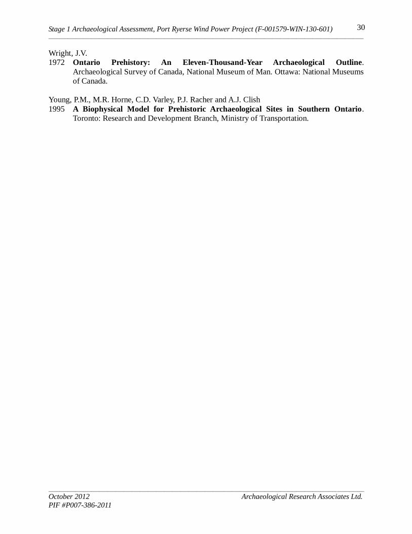
Stage 1 Archaeological Assessment, Port Ryerse Wind Power Project (F-001579-WIN-130-601) _____________________________________________________________________________________________________________________
_____________________________________________________________________________________________________________________
October 2012 Archaeological Research Associates Ltd.
PIF #P007-386-2011
30
Wright, J.V.
1972 Ontario Prehistory: An Eleven-Thousand-Year Archaeological Outline.
Archaeological Survey of Canada, National Museum of Man. Ottawa: National Museums
of Canada.
Young, P.M., M.R. Horne, C.D. Varley, P.J. Racher and A.J. Clish
1995 A Biophysical Model for Prehistoric Archaeological Sites in Southern Ontario.
Toronto: Research and Development Branch, Ministry of Transportation.
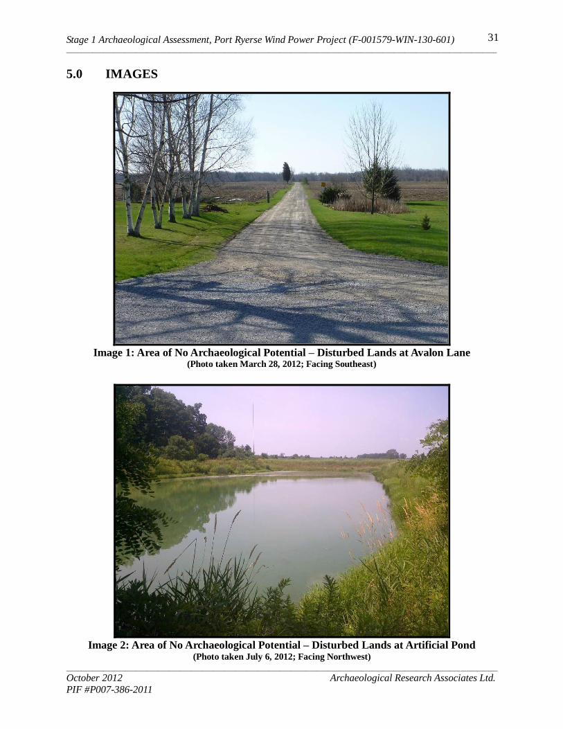
Stage 1 Archaeological Assessment, Port Ryerse Wind Power Project (F-001579-WIN-130-601) _____________________________________________________________________________________________________________________
_____________________________________________________________________________________________________________________
October 2012 Archaeological Research Associates Ltd.
PIF #P007-386-2011
31
5.0 IMAGES
Image 1: Area of No Archaeological Potential – Disturbed Lands at Avalon Lane
(Photo taken March 28, 2012; Facing Southeast)
Image 2: Area of No Archaeological Potential – Disturbed Lands at Artificial Pond
(Photo taken July 6, 2012; Facing Northwest)
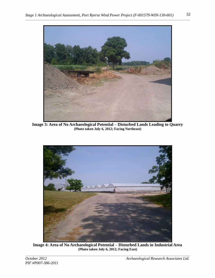
Stage 1 Archaeological Assessment, Port Ryerse Wind Power Project (F-001579-WIN-130-601) _____________________________________________________________________________________________________________________
_____________________________________________________________________________________________________________________
October 2012 Archaeological Research Associates Ltd.
PIF #P007-386-2011
32
Image 3: Area of No Archaeological Potential – Disturbed Lands Leading to Quarry
(Photo taken July 6, 2012; Facing Northeast)
Image 4: Area of No Archaeological Potential – Disturbed Lands in Industrial Area
(Photo taken July 6, 2012; Facing East)
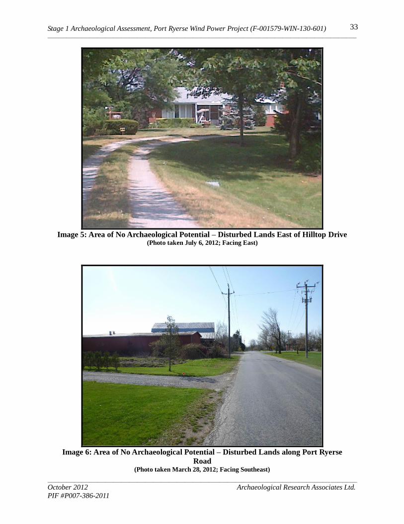
Stage 1 Archaeological Assessment, Port Ryerse Wind Power Project (F-001579-WIN-130-601) _____________________________________________________________________________________________________________________
_____________________________________________________________________________________________________________________
October 2012 Archaeological Research Associates Ltd.
PIF #P007-386-2011
33
Image 5: Area of No Archaeological Potential – Disturbed Lands East of Hilltop Drive
(Photo taken July 6, 2012; Facing East)
Image 6: Area of No Archaeological Potential – Disturbed Lands along Port Ryerse
Road
(Photo taken March 28, 2012; Facing Southeast)
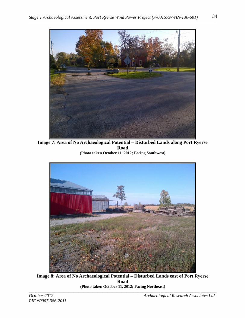
Stage 1 Archaeological Assessment, Port Ryerse Wind Power Project (F-001579-WIN-130-601) _____________________________________________________________________________________________________________________
_____________________________________________________________________________________________________________________
October 2012 Archaeological Research Associates Ltd.
PIF #P007-386-2011
34
Image 7: Area of No Archaeological Potential – Disturbed Lands along Port Ryerse
Road
(Photo taken October 11, 2012; Facing Southwest)
Image 8: Area of No Archaeological Potential – Disturbed Lands east of Port Ryerse
Road
(Photo taken October 11, 2012; Facing Northeast)
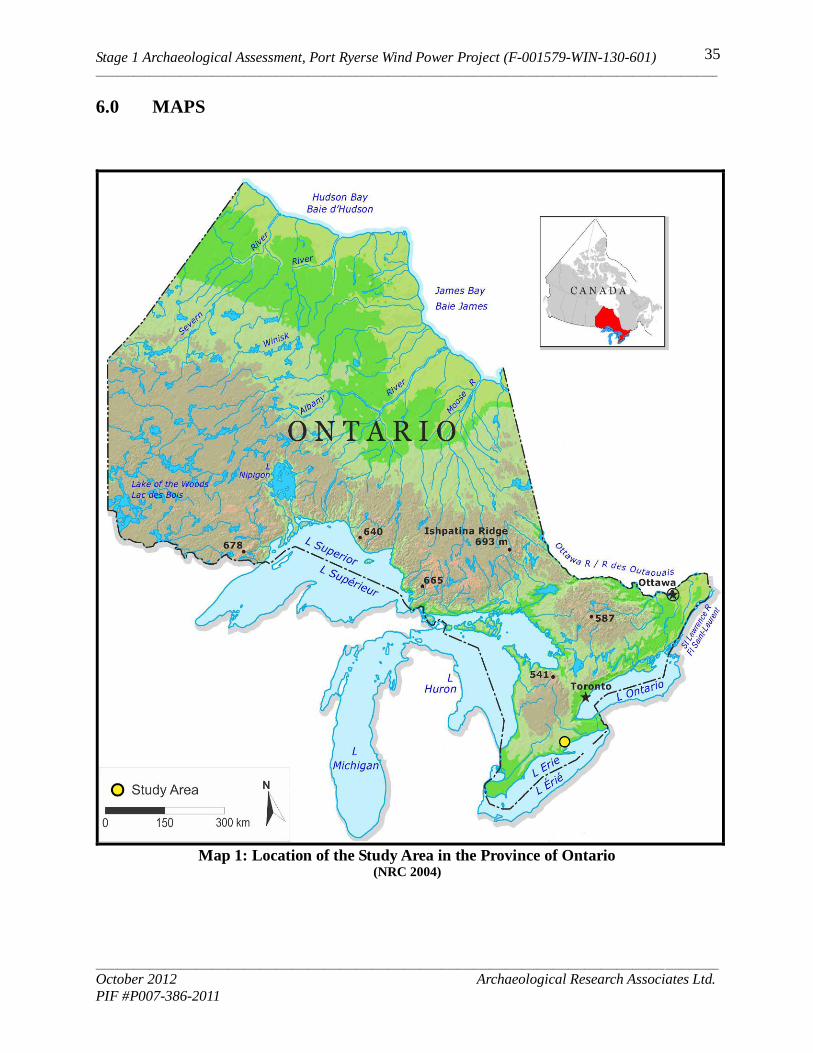
Stage 1 Archaeological Assessment, Port Ryerse Wind Power Project (F-001579-WIN-130-601) _____________________________________________________________________________________________________________________
_____________________________________________________________________________________________________________________
October 2012 Archaeological Research Associates Ltd.
PIF #P007-386-2011
35
6.0 MAPS
Map 1: Location of the Study Area in the Province of Ontario
(NRC 2004)
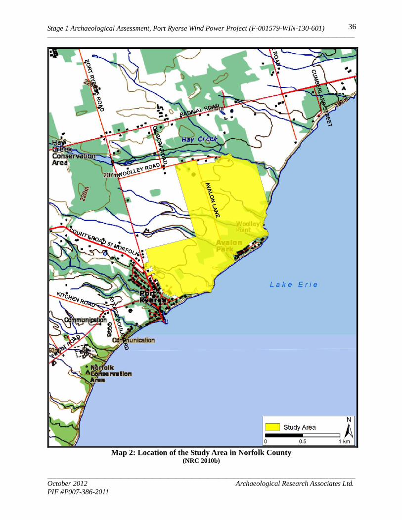
Stage 1 Archaeological Assessment, Port Ryerse Wind Power Project (F-001579-WIN-130-601) _____________________________________________________________________________________________________________________
_____________________________________________________________________________________________________________________
October 2012 Archaeological Research Associates Ltd.
PIF #P007-386-2011
36
Map 2: Location of the Study Area in Norfolk County
(NRC 2010b)
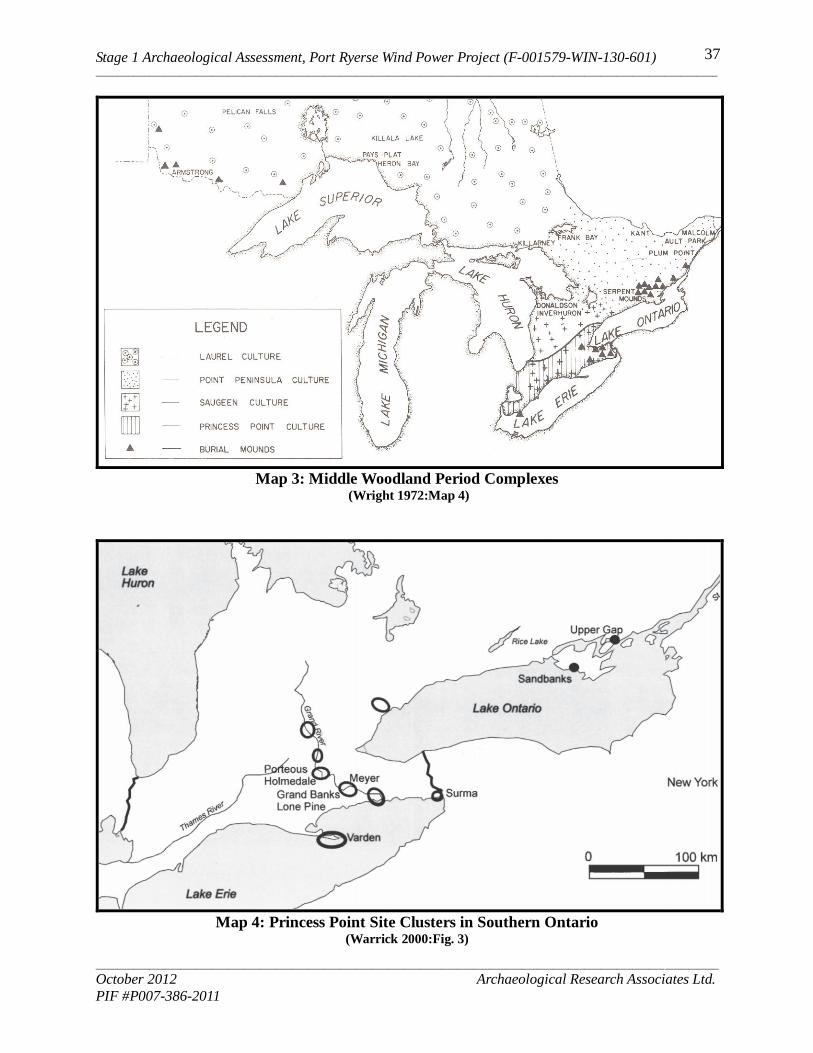
Stage 1 Archaeological Assessment, Port Ryerse Wind Power Project (F-001579-WIN-130-601) _____________________________________________________________________________________________________________________
_____________________________________________________________________________________________________________________
October 2012 Archaeological Research Associates Ltd.
PIF #P007-386-2011
37
Map 3: Middle Woodland Period Complexes
(Wright 1972:Map 4)
Map 4: Princess Point Site Clusters in Southern Ontario
(Warrick 2000:Fig. 3)

Stage 1 Archaeological Assessment, Port Ryerse Wind Power Project (F-001579-WIN-130-601) _____________________________________________________________________________________________________________________
_____________________________________________________________________________________________________________________
October 2012 Archaeological Research Associates Ltd.
PIF #P007-386-2011
38
Map 5: Pre-Contact Iroquoian Site Clusters
(Warrick 2000:Figure 10)
Map 6: Detail from S. de Champlain’s Carte de la Nouvelle France (1632)
(Gentilcore and Head 1984:Map 1.2)

Stage 1 Archaeological Assessment, Port Ryerse Wind Power Project (F-001579-WIN-130-601) _____________________________________________________________________________________________________________________
_____________________________________________________________________________________________________________________
October 2012 Archaeological Research Associates Ltd.
PIF #P007-386-2011
39
Map 7: Detail from N. Sanson's Le Canada, ou Nouvelle France (1656)
(Gentilcore and Head 1984:Map 1.10)
Map 8: Detail from the Map of Galinée’s Voyage (1670)
(Lajeunesse 1960:Map 2)
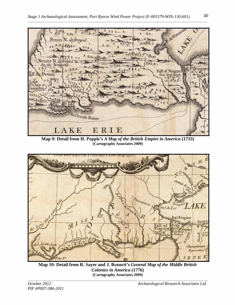
Stage 1 Archaeological Assessment, Port Ryerse Wind Power Project (F-001579-WIN-130-601) _____________________________________________________________________________________________________________________
_____________________________________________________________________________________________________________________
October 2012 Archaeological Research Associates Ltd.
PIF #P007-386-2011
40
Map 9: Detail from H. Popple’s A Map of the British Empire in America (1733)
(Cartography Associates 2009)
Map 10: Detail from R. Sayer and J. Bennett’s General Map of the Middle British
Colonies in America (1776) (Cartography Associates 2009)
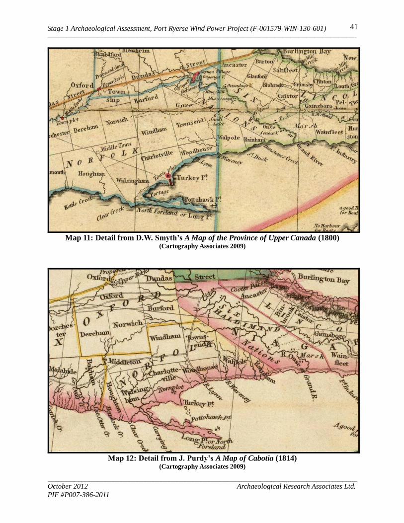
Stage 1 Archaeological Assessment, Port Ryerse Wind Power Project (F-001579-WIN-130-601) _____________________________________________________________________________________________________________________
_____________________________________________________________________________________________________________________
October 2012 Archaeological Research Associates Ltd.
PIF #P007-386-2011
41
Map 11: Detail from D.W. Smyth’s A Map of the Province of Upper Canada (1800)
(Cartography Associates 2009)
Map 12: Detail from J. Purdy’s A Map of Cabotia (1814)
(Cartography Associates 2009)
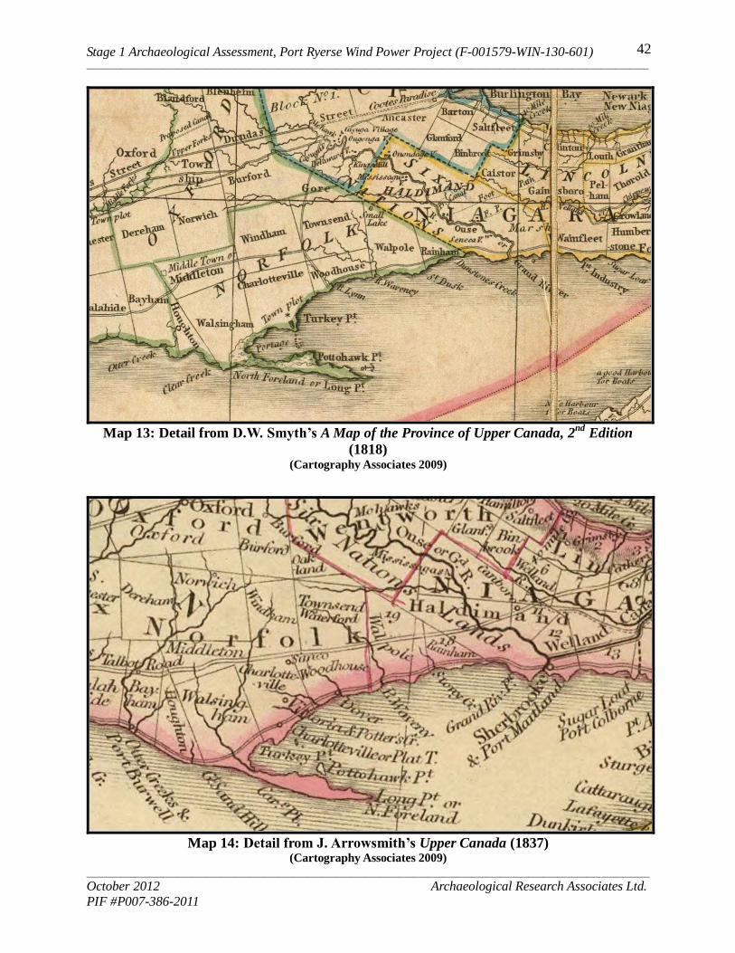
Stage 1 Archaeological Assessment, Port Ryerse Wind Power Project (F-001579-WIN-130-601) _____________________________________________________________________________________________________________________
_____________________________________________________________________________________________________________________
October 2012 Archaeological Research Associates Ltd.
PIF #P007-386-2011
42
Map 13: Detail from D.W. Smyth’s A Map of the Province of Upper Canada, 2
nd Edition
(1818) (Cartography Associates 2009)
Map 14: Detail from J. Arrowsmith’s Upper Canada (1837)
(Cartography Associates 2009)
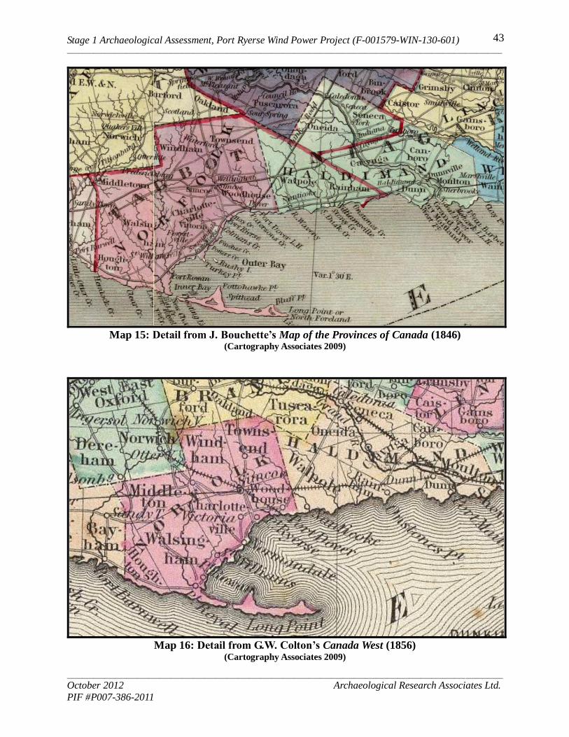
Stage 1 Archaeological Assessment, Port Ryerse Wind Power Project (F-001579-WIN-130-601) _____________________________________________________________________________________________________________________
_____________________________________________________________________________________________________________________
October 2012 Archaeological Research Associates Ltd.
PIF #P007-386-2011
43
Map 15: Detail from J. Bouchette’s Map of the Provinces of Canada (1846)
(Cartography Associates 2009)
Map 16: Detail from G.W. Colton’s Canada West (1856)
(Cartography Associates 2009)
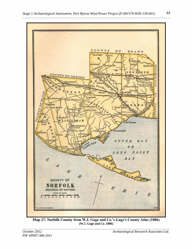
Stage 1 Archaeological Assessment, Port Ryerse Wind Power Project (F-001579-WIN-130-601) _____________________________________________________________________________________________________________________
_____________________________________________________________________________________________________________________
October 2012 Archaeological Research Associates Ltd.
PIF #P007-386-2011
44
Map 17: Norfolk County from W.J. Gage and Co.’s Gage’s County Atlas (1886) (W.J. Gage and Co. 1886)
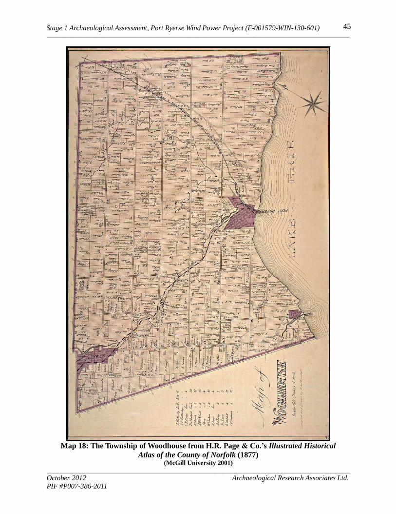
Stage 1 Archaeological Assessment, Port Ryerse Wind Power Project (F-001579-WIN-130-601) _____________________________________________________________________________________________________________________
_____________________________________________________________________________________________________________________
October 2012 Archaeological Research Associates Ltd.
PIF #P007-386-2011
45
Map 18: The Township of Woodhouse from H.R. Page & Co.’s Illustrated Historical
Atlas of the County of Norfolk (1877) (McGill University 2001)

Stage 1 Archaeological Assessment, Port Ryerse Wind Power Project (F-001579-WIN-130-601) _____________________________________________________________________________________________________________________
_____________________________________________________________________________________________________________________
October 2012 Archaeological Research Associates Ltd.
PIF #P007-386-2011
46
Map 19: The Hamlet of Port Ryerse from H.R. Page & Co.’s Illustrated Historical Atlas
of the County of Norfolk (1877) (Phelps 1972:85)
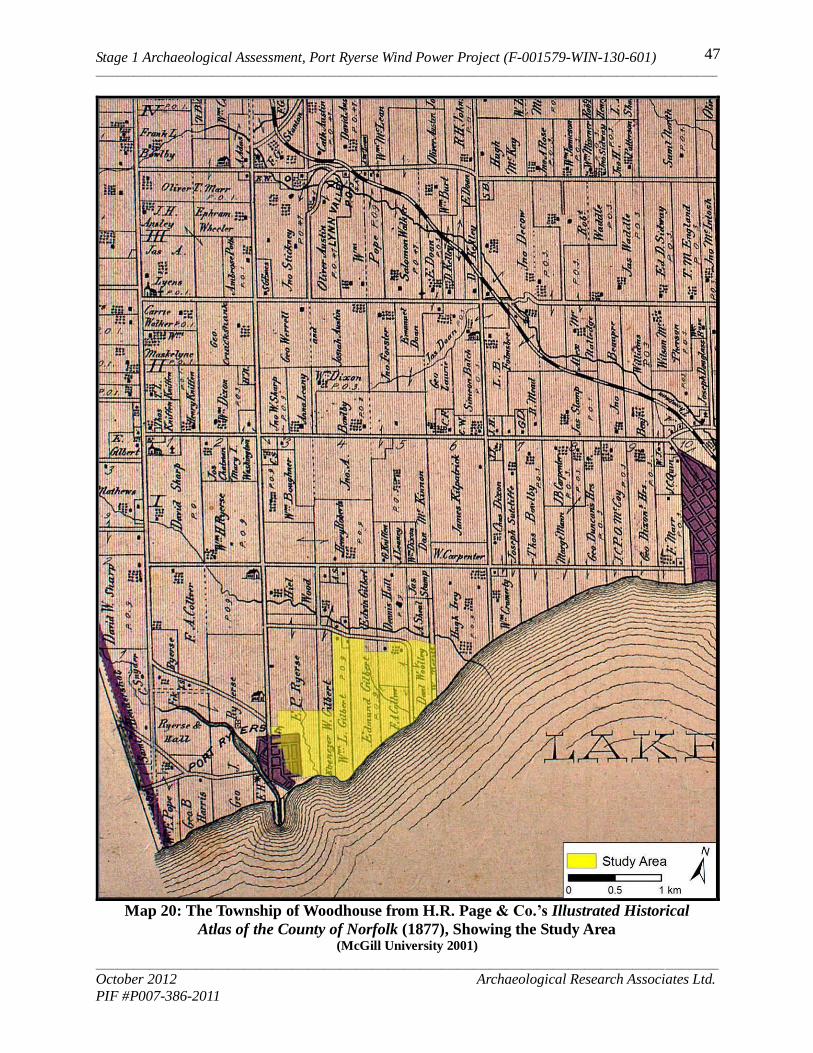
Stage 1 Archaeological Assessment, Port Ryerse Wind Power Project (F-001579-WIN-130-601) _____________________________________________________________________________________________________________________
_____________________________________________________________________________________________________________________
October 2012 Archaeological Research Associates Ltd.
PIF #P007-386-2011
47
Map 20: The Township of Woodhouse from H.R. Page & Co.’s Illustrated Historical
Atlas of the County of Norfolk (1877), Showing the Study Area (McGill University 2001)
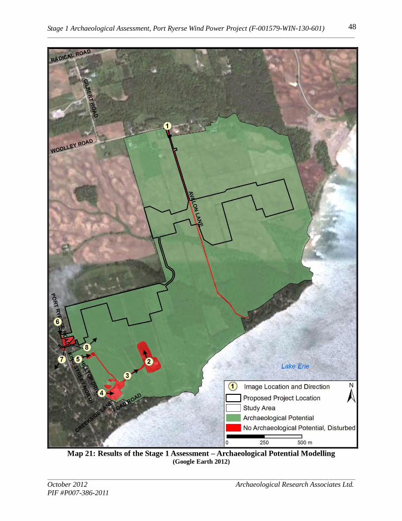
Stage 1 Archaeological Assessment, Port Ryerse Wind Power Project (F-001579-WIN-130-601) _____________________________________________________________________________________________________________________
_____________________________________________________________________________________________________________________
October 2012 Archaeological Research Associates Ltd.
PIF #P007-386-2011
48
Map 21: Results of the Stage 1 Assessment – Archaeological Potential Modelling
(Google Earth 2012)
Stage 1 Archaeological Assessment, Port Ryerse Wind Power Project (F-001579-WIN-130-601) _____________________________________________________________________________________________________________________
_____________________________________________________________________________________________________________________
October 2012 Archaeological Research Associates Ltd.
PIF #P007-386-2011
49
APPENDICES

Stage 1 Archaeological Assessment, Port Ryerse Wind Power Project (F-001579-WIN-130-601) ______________________________________________________________________________________________________________________________________________________________________________________________________________________________________________________________________________
______________________________________________________________________________________________________________________________________________________________________________________________________________________________________________________________________________
October 2012 Archaeological Research Associates Ltd.
PIF #P007-386-2011
50
Appendix A: Project Mapping for the Port Ryerse Wind Power Project (Provided by Stantec Consulting Ltd.)
Related Documents


![ACKNOWLEDGEMENT...Source of data: Tourism Development Department i adress] ACKNOWLEDGEMENT ! The Tourism Development Department (TDD), Ministry of Information, Culture and Tourism](https://static.cupdf.com/doc/110x72/5f3716de4fd1af528b3f06cf/acknowledgement-source-of-data-tourism-development-department-i-adress-acknowledgement.jpg)