AUTHOR(S): SIGNATURE(S): STATEMENT OF WORK - CASH PAYMENTS EVENT NUMBER(S)/DATE(S): NOTICE OF WORK PERMIT NUMBER(S)/DATE(S): YEAR OF WORK: PROPERTY NAME: CLAIM NAME(S) (on which the work was done): COMMODITIES SOUGHT: MINERAL INVENTORY MINFILE NUMBER(S), IF KNOWN: NTS/BCGS: MINING DIVISION: LATITUDE: o ' " LONGITUDE: o ' " OWNER(S): 1) 2) OPERATOR(S) [who paid for the work]: 1) 2) MAILING ADDRESS: TYPE OF REPORT [type of survey(s)]: TOTAL COST: PROPERTY GEOLOGY KEYWORDS (lithology, age, stratigraphy, structure, alteration, mineralization, size and attitude): REFERENCES TO PREVIOUS ASSESSMENT WORK AND ASSESSMENT REPORT NUMBERS: Ministry of Energy, Mines & Petroleum Resources Mining & Minerals Division BC Geological Survey Assessment Report Title Page and Summary (at centre of work) MAILING ADDRESS: Next Page J.Gillham 5629222 Dec 13, 2016 N/A 2016 Baker Gold, Copper, Silver 094E 026; 094E 302 094E 2, 7, 3, 6 E Omineca 57 15 0 127 01 00 Multinational Mining Inc (Sable Resources Ltd) Sable Resources Ltd Suite 900 - 999 West Hastings St Vancouver BC V6C 2W2 Geological $37,387.00 Toodoggone Volcanics, Takla Basalts, Black Lake Intrusive Suite, Stuhini Group, Hazelton Group, Jurassic, Propylitic Sericitic Alteration, Copper Gold Porphyry, Gold Silver Veins, Baker Mine, Suite 900 - 999 West Hastings St Vancouver BC V6C 2W2

Welcome message from author
This document is posted to help you gain knowledge. Please leave a comment to let me know what you think about it! Share it to your friends and learn new things together.
Transcript
AUTHOR(S): SIGNATURE(S):
STATEMENT OF WORK - CASH PAYMENTS EVENT NUMBER(S)/DATE(S):
NOTICE OF WORK PERMIT NUMBER(S)/DATE(S): YEAR OF WORK:
PROPERTY NAME:
CLAIM NAME(S) (on which the work was done):
COMMODITIES SOUGHT:
MINERAL INVENTORY MINFILE NUMBER(S), IF KNOWN:
NTS/BCGS:MINING DIVISION:
LATITUDE: o ' " LONGITUDE: o ' "
OWNER(S):1) 2)
OPERATOR(S) [who paid for the work]:1) 2)
MAILING ADDRESS:
TYPE OF REPORT [type of survey(s)]: TOTAL COST:
PROPERTY GEOLOGY KEYWORDS (lithology, age, stratigraphy, structure, alteration, mineralization, size and attitude):
REFERENCES TO PREVIOUS ASSESSMENT WORK AND ASSESSMENT REPORT NUMBERS:
Ministry of Energy, Mines & Petroleum ResourcesMining & Minerals DivisionBC Geological Survey
Assessment ReportTitle Page and Summary
(at centre of work)
MAILING ADDRESS:
Next Page
J.Gillham
5629222 Dec 13, 2016
N/A 2016
Baker
Gold, Copper, Silver
094E 026; 094E 302
094E 2, 7, 3, 6 EOmineca
57 15 0 127 01 00
Multinational Mining Inc (Sable Resources Ltd)
Sable Resources Ltd
Suite 900 - 999 West Hastings St
Vancouver BC V6C 2W2
Geological $37,387.00
Toodoggone Volcanics, Takla Basalts, Black Lake Intrusive Suite, Stuhini Group, Hazelton Group, Jurassic, Propylitic Sericitic
Alteration, Copper Gold Porphyry, Gold Silver Veins, Baker Mine,
Suite 900 - 999 West Hastings St
Vancouver BC V6C 2W2
GEOLOGICAL (scale, area)
Ground, mapping
Photo interpretation
GEOPHYSICAL (line-kilometres)Ground
Magnetic
Electromagnetic
Induced Polarization
Radiometric
Seismic
Other
Airborne
GEOCHEMICAL(number of samples analysed for...)
Soil
Silt
Rock
Other
DRILLING(total metres; number of holes, size)
Core
Non-core
RELATED TECHNICAL
Sampling/assaying
Petrographic
Mineralographic
Metallurgic
PROSPECTING (scale, area)
PREPARATORY / PHYSICAL
Line/grid (kilometres)
(scale, area)
Legal surveys (scale, area)
Road, local access (kilometres)/trail
Topographic/Photogrammetric
Trench (metres)
Underground dev. (metres)
Other
TYPE OF WORK INTHIS REPORT
EXTENT OF WORK(IN METRIC UNITS)
ON WHICH CLAIMS PROJECT COSTSAPPORTIONED
(incl. support)
TOTAL COST:
(scale, area)
Line/grid (kilometres)
PROSPECTING (scale, area)
Metallurgic
Mineralographic
Petrographic
Sampling/assaying
Non-core
Core
Other
Rock
Silt
Soil
Airborne
Other
Seismic
Radiometric
Induced Polarization
Electromagnetic
Magnetic
Photo interpretation
Ground, mapping
$37,387.00
$4,195505424, 505651, 505428, 505653, 505415 samples
$33,191.25505485, 505633, 505482, 505487, 505612.5 square km
2016 GEOLOGICAL MAPPING SURVEY
ON THE BAKER CLAIM GROUP
OMINECA MINING DIVISION
NTS: 94E/2, 7; 3, 6E LAT: 57° 15'N
LONG: 127° 00'W
OWNER: SABLE RESOURCES LTD. 900-999 West Hastings St Vancouver, B.C. V6C 2W2
BY:
J. GILLHAM
August 2, 2017
tfuller
Text Box
BC Geological Survey Assessment Report 36568
TABLE OF CONTENTS
TABLE OF CONTENTS ................................................................................................................................................................... 2 LIST OF TABLES .............................................................................................................................................................................. 2 LIST OF FIGURES ........................................................................................................................................................................... 2 1 SUMMARY ........................................................................................................................................................................................ 3 2 INTRODUCTION ........................................................................................................................................................................... 3 3 LOCATION AND ACCESS ........................................................................................................................................................... 4 4 CLIMATE & PHYSIOGRAPHY ................................................................................................................................................... 6 5 HISTORY ........................................................................................................................................................................................... 6 6 CLAIM STATUS ............................................................................................................................................................................... 7 7 GEOLOGY ................................................................................................................................................................................... 10 7.1 REGIONAL GEOLOGY .................................................................................................................................................... 10 7.2 LOCAL GEOLOGY ............................................................................................................................................................ 13 7.2.1 LITHOLOGY ................................................................................................................................................................ 13 7.2.2 STRUCUTRE................................................................................................................................................................. 15 7.2.3 ALTERATION AND MINERALIZATION .......................................................................................................... 15 7.2.4 DEPOSITS AND ZONES ......................................................................................................................................... 15 7.2.4.1 CHAPPELLE GROUP SUMMARY ................................................................................................................... 16 8 2016 MAPPING SURVEY ......................................................................................................................................................... 19 9 CONCLUSION & RECOMMENDATIONS .......................................................................................................................... 20 10 REFERENCES ............................................................................................................................................................................ 21 11 STATEMENT OF COSTS ......................................................................................................................................................... 24 10 STATEMENT OF QUALIFICATIONS ................................................................................................................................. 25
Appendix I – Petrographic Report Appendix II – Geologic Maps LIST OF TABLES 3.1 PROPERTY LOCATION ....................................................................................................................................................... 4 6.1 MINERAL TENURE .............................................................................................................................................................. 9 7.1 REGIONAL STRATIGRAPHY OF THE TOODOGGONE REGION ................................................................. 11 7.2 LITHOSTRATIGRAPHIC COLUMN, TOODOGGONE FORMATION ............................................................... 13 7.3 LIST OF MINFILE AND OTHER NOTABLE MINERAL OCCURRENCES, BAKER PROJECT .................. 16 8.1 PETROGRAPHIC SAMPLE LOCATIONS ..................................................................................................................... 19 LIST OF FIGURES 3.1 PROPERTY LOCATION ....................................................................................................................................................... 5 6.1 MINERAL TENURES ............................................................................................................................................................ 8 7.1 REGIONAL GEOLOGY ..................................................................................................................................................... 12 7.2 PROPERTY GEOLOGY...................................................................................................................................................... 14 7.3 GEOLOGY AND SELECT MINERALIZED ZONES ................................................................................................ 17
1. SUMMARY The Baker Gold Project (the “Baker Project” or “Property”) is located in the Toodoggone region of the Omineca Mining Division, 430 km northwest of Prince George, British Columbia. The Property is situated 35 km northwest of the former Kemess South open pit gold-copper mine. The Baker Project consists of 54 mineral claims, and 2 mining leases, all 100%-owned by Multinational Mining Inc., a 100% owned subsidiary of Sable Resources Ltd. The claims cover 6,601 hectares of land that encompass the Baker Gold Project which includes the past-producing Dupont-Baker ‘A’ and Multinational ‘B’ underground gold-silver mine, and the past-producing Shasta open pit/underground gold-silver mine, as well as multiple gold, silver, and copper showings. Access to the project is provided by a series of branching gravel roads, including the Finlay Forest Service Road that begins south of the town of Mackenzie, then connects to the Omineca Resource Access Road (ORAR). The ORAR continues beyond the end of the Kemess South mine access road, past the Sturdee River gravel airstrip located 10 km south, to the Project. Road access is currently seasonal and the driving time to the property from Prince George is 9 hours.
The Property lies within the Toodoggone region within a portion of the Stikine Terrane. The Stikine Terrane is comprised of Paleozoic to Mesozoic island arc assemblages and overlying Mesozoic sedimentary sequences within the lntermontane Belt. The oldest rocks exposed in the Toodoggone region consist of crystalline limestone of the Devonian Asitka Group. They are unconformably overlain by mafic volcanic rocks of the Upper Triassic Takla Group. Takla Group volcanic rocks are in turn overlain by bimodal volcanic and sedimentary strata of the Lower Jurassic Toodoggone Formation of the Hazelton Group.
The Baker Project is underlain primarily by andesitic to basaltic rocks of the Upper Triassic Takla Group, and feldspar porphryritic rocks (volcanic and intrusive) of the Toodoggone Formation. Past operators have recognized low to intermediate-sulphidation epithermal gold-silver mineralization occurring in association with northeast, northwest, north-northwest trending, sub-vertical to steeply dipping faults, and Cu-Au porphyry style alteration. Past production has occurred on the northwest portion of the Property from the Dupont/Baker ‘A’ vein and Multinational ‘B’ vein.
2. INTRODUCTION Work Described in this report is focused on the Baker claims (The historic Baker mine, surrounding tenure, and black gossan exploration target - all formerly Chappelle claims) owned by Sable Resources Ltd and held under a wholly owned subsidiary Multinational Mining Inc. These claims cover a large gossanous alteration zone consistent with a Cu-Au porphyry system (Duuring 2009), (the “Baker system”) and are contiguous with Sable’s other claims, principally covering the Shasta mine and Dave Price minfile showing. This report details a lithologic and alteration Mapping program supported by petrographic analysis covering approximately 7 square km of ground centered over the Baker system.
3. LOCATION AND ACCESS The Baker Project is located approximately 450 km north-northwest of Prince George in the Omineca Mining Division of north-central British Columbia (Figure 4.1). The Project is situated 45 km northwest of the past-producing Kemess South open pit copper-gold mine ("Kemess South"). It is centered at Latitude 57.285° N and Longitude 127.111° W or, in NAD 83 (Zone 9) UTM co-ordinates, 6350723 N and 613892 E, and covers parts of two BCGS mapsheets: 094E.025 and 094E.026.
Access to the Project is provided by a series of branching gravel roads, including the Finlay Forest Service Road ("Finlay FSR"), that begin south of Mackenzie, a small forestry town located about 180 km north of, and about a two-hour drive from, Prince George. The Finlay FSR forms the southern part of the Omineca Resource Access Road ("ORAR"), an industrial road that provides access to the past producing Kemess South mine/Kemess Underground development project, and beyond to the Baker Project. Driving time from the Kemess South turn-off on the ORAR to the project is about 60 minutes. Current seasonal road access to the Project is only during the late spring, summer and early fall seasons when the road conditions are snow-free.
Total driving distance from Prince George to the Project is 520 km, and total driving time is about 9 hours. There are no fueling stations once one leaves paved Highway 97; therefore fuel for the return trip to the Project area must be carried. At the Project, numerous mine and exploration roads remain in good condition and provide access to many of the previously drilled areas.
Year round helicopter access is via Smithers, a distance of 300 km south of the Project. Alternative helicopter access during summer months may be from the Kemess South mine site if it is under active exploration. Fixed-wing air service departing from Smithers or Prince George to it can be contracted to Black Lake located approximately 2 km southeast of the Project (floatplane in ice-free conditions or skis in winter-ice conditions), or the Sturdee valley airstrip located approximately 15 km south of the project.
Table 3.1 UTM coordinates of the Baker Mines and associated infrastructure.
Facility UTM
Location (Zone 9V)
Easting Northing
Baker Property 613909 6350701
Baker Mill 613746 6350046
Sable Camp 613551 6350195
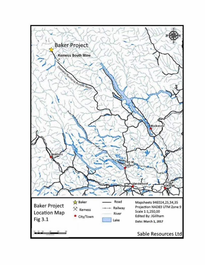
Baker Proje·c ·. Location Map F,i 3.1
Ke ess
• •/Town
rra·1 ay
River
Lake
Mapsheets 94E02, ,25,34,35 .. 1
Pr-0·ectio AD83 Zo · e 9 Scale 1:1,250~00 Edited B : JGil ha
Date: March 1, 2017
Sabl~_Re-sources ttd 1
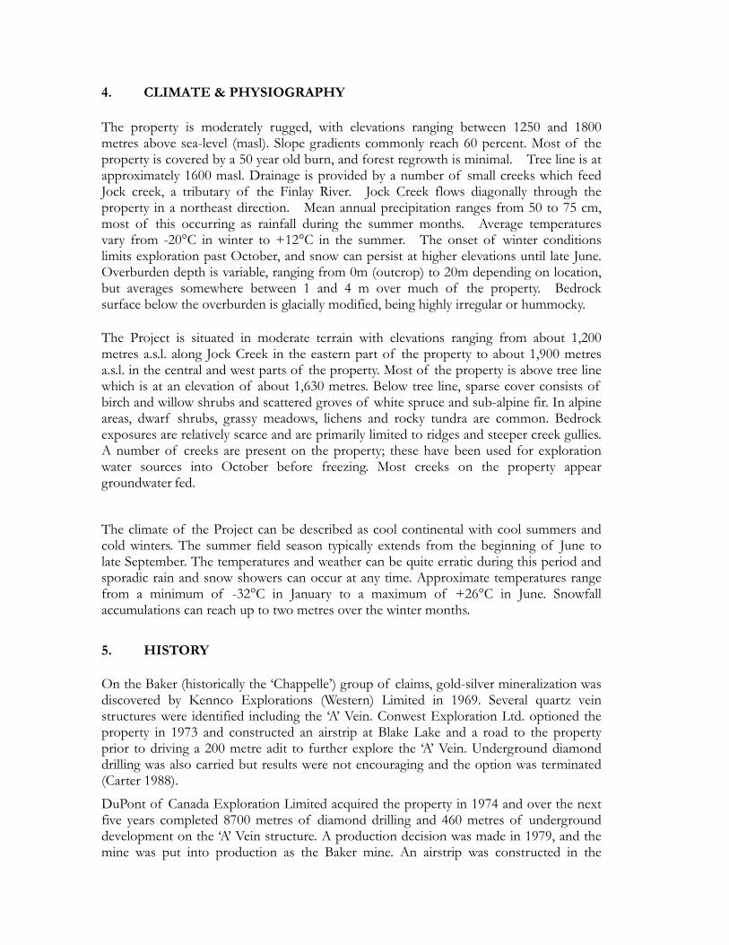
4. CLIMATE & PHYSIOGRAPHY The property is moderately rugged, with elevations ranging between 1250 and 1800 metres above sea-level (masl). Slope gradients commonly reach 60 percent. Most of the property is covered by a 50 year old burn, and forest regrowth is minimal. Tree line is at approximately 1600 masl. Drainage is provided by a number of small creeks which feed Jock creek, a tributary of the Finlay River. Jock Creek flows diagonally through the property in a northeast direction. Mean annual precipitation ranges from 50 to 75 cm, most of this occurring as rainfall during the summer months. Average temperatures vary from -20°C in winter to +12°C in the summer. The onset of winter conditions limits exploration past October, and snow can persist at higher elevations until late June. Overburden depth is variable, ranging from 0m (outcrop) to 20m depending on location, but averages somewhere between 1 and 4 m over much of the property. Bedrock surface below the overburden is glacially modified, being highly irregular or hummocky. The Project is situated in moderate terrain with elevations ranging from about 1,200 metres a.s.l. along Jock Creek in the eastern part of the property to about 1,900 metres a.s.l. in the central and west parts of the property. Most of the property is above tree line which is at an elevation of about 1,630 metres. Below tree line, sparse cover consists of birch and willow shrubs and scattered groves of white spruce and sub-alpine fir. In alpine areas, dwarf shrubs, grassy meadows, lichens and rocky tundra are common. Bedrock exposures are relatively scarce and are primarily limited to ridges and steeper creek gullies. A number of creeks are present on the property; these have been used for exploration water sources into October before freezing. Most creeks on the property appear groundwater fed.
The climate of the Project can be described as cool continental with cool summers and cold winters. The summer field season typically extends from the beginning of June to late September. The temperatures and weather can be quite erratic during this period and sporadic rain and snow showers can occur at any time. Approximate temperatures range from a minimum of -32°C in January to a maximum of +26°C in June. Snowfall accumulations can reach up to two metres over the winter months.
5. HISTORY On the Baker (historically the ‘Chappelle’) group of claims, gold-silver mineralization was discovered by Kennco Explorations (Western) Limited in 1969. Several quartz vein structures were identified including the ‘A’ Vein. Conwest Exploration Ltd. optioned the property in 1973 and constructed an airstrip at Blake Lake and a road to the property prior to driving a 200 metre adit to further explore the ‘A’ Vein. Underground diamond drilling was also carried but results were not encouraging and the option was terminated (Carter 1988).
DuPont of Canada Exploration Limited acquired the property in 1974 and over the next five years completed 8700 metres of diamond drilling and 460 metres of underground development on the ‘A’ Vein structure. A production decision was made in 1979, and the mine was put into production as the Baker mine. An airstrip was constructed in the
Sturdee River Valley to facilitate air freighting of all equipment including a 90 tonnes per day mill (Carter 1988).
The Baker Mine (referred to as the Dupont/Baker ‘A’ deposit) was operated by Dupont Canada during the period 1981 – 83 as an underground and open pit gold - silver mine. The Dupont operation included a 90 tons per day whole ore cyanidation plant using the Merrill-Crowe process (Carter 1988). Sable Resources Ltd. acquired the Baker site including the processing facility in 1989 and subsequently modified it to a flotation circuit with optional concentrate cyanidation.
The Multinational ‘B’ deposit, located adjacent to Adit Creek and upstream of the ‘A’ deposit, was a high grade gold-silver-copper deposit from which flotation concentrates were shipped off-site. This mine was intermittently operated by Sable during 1991-1997 (Craft 2003).
No reliable historical resource or reserve estimate could be located for either the Multinational ‘B’ or Dupont ‘A’ deposits; however, Craft (2001) reports that DuPont of Canada Exploration Ltd produced 95,000 tons from the Dupont ‘A’ between 1981 and 1983 at an average production grade of 0.9 oz/ton gold equivalent and that Sable produced 17,500 tons from the Multinational ‘B’ deposit at a grade of 0.5 oz/ton gold, 5 oz/ton silver, and 1% copper.
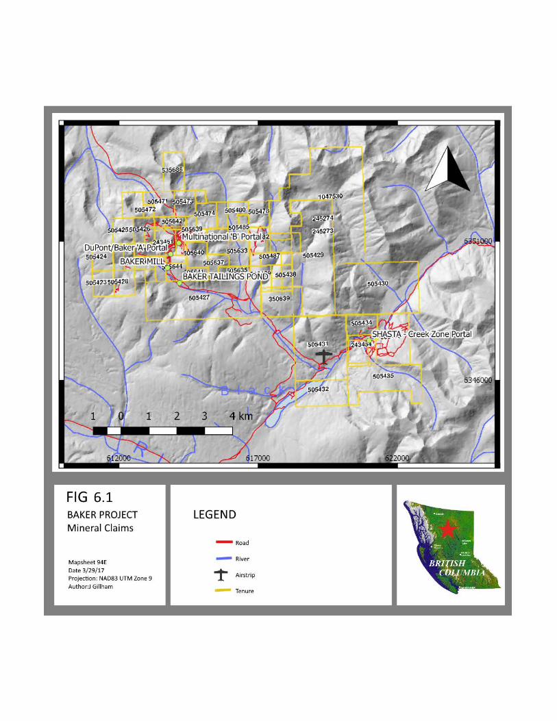
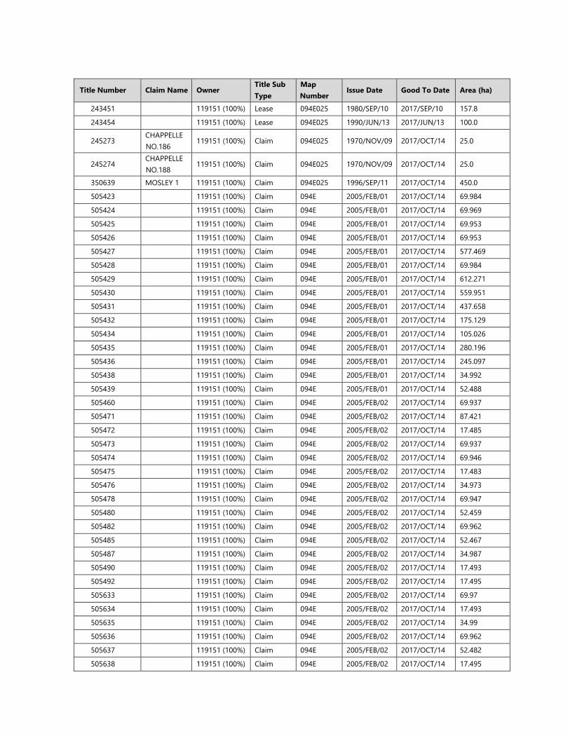
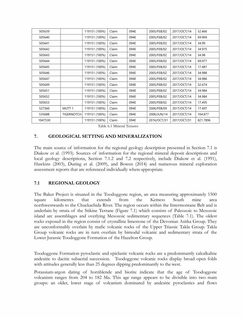
6. CLAIM STATUS The Baker Project consists of 54 contiguous British Columbia Mineral Titles Online (MTO) claims, and 2 British Columbia Mineral Titles Online (MTO) mining leases 100%-owned by Multinational Mining Inc., a 100% owned subsidiary of Sable Resources Ltd. and shown in Fig 4-2. The mineral claims are in good standing until October 14, 2017, and are as described in Table 4-1. The mining leases are 40-year term leases, due for renewal on June 13, 2020 and September 10, 2021 for the past producing Shasta and Baker mines respectively, and with lease payments due annually. The ‘Good to date’ presented in Table 4-1 for Mining leases 243451 and 243454 are the dates to which the annual lease payments have been made to, and not the date for renewal of the 40-year term lease term.
The claims cover 6,601 hectares of land that encompass the Baker project which includes former Dupont-Baker ‘A’ and Multinational ‘B’ underground gold-silver mine, and the former Shasta open pit/underground gold-silver mine, as well as multiple gold, silver, and copper MINFILE occurences as listed in Table 7-3 and shown in Figure 7.2
The work in this report occurs on mineral tenures held by Multinational Mining Inc (owner ID #119151), a wholly owned subsidiary of Sable Resources Ltd. These claims are part of a contiguous package (Table 6.1) that extends from the historic Chappelle claims (focus of this report) to the southeast past the Shasta mine (Figure 6.1).
Title Number Claim Name Owner
Title Sub Type
Map Number
Issue Date Good To Date Area (ha)
243451 119151 (100%) Lease 094E025 1980/SEP/10 2017/SEP/10 157.8
243454 119151 (100%) Lease 094E025 1990/JUN/13 2017/JUN/13 100.0
245273 CHAPPELLE NO.186
119151 (100%) Claim 094E025 1970/NOV/09 2017/OCT/14 25.0
245274 CHAPPELLE NO.188
119151 (100%) Claim 094E025 1970/NOV/09 2017/OCT/14 25.0
350639 MOSLEY 1 119151 (100%) Claim 094E025 1996/SEP/11 2017/OCT/14 450.0
505423 119151 (100%) Claim 094E 2005/FEB/01 2017/OCT/14 69.984
505424 119151 (100%) Claim 094E 2005/FEB/01 2017/OCT/14 69.969
505425 119151 (100%) Claim 094E 2005/FEB/01 2017/OCT/14 69.953
505426 119151 (100%) Claim 094E 2005/FEB/01 2017/OCT/14 69.953
505427 119151 (100%) Claim 094E 2005/FEB/01 2017/OCT/14 577.469
505428 119151 (100%) Claim 094E 2005/FEB/01 2017/OCT/14 69.984
505429 119151 (100%) Claim 094E 2005/FEB/01 2017/OCT/14 612.271
505430 119151 (100%) Claim 094E 2005/FEB/01 2017/OCT/14 559.951
505431 119151 (100%) Claim 094E 2005/FEB/01 2017/OCT/14 437.658
505432 119151 (100%) Claim 094E 2005/FEB/01 2017/OCT/14 175.129
505434 119151 (100%) Claim 094E 2005/FEB/01 2017/OCT/14 105.026
505435 119151 (100%) Claim 094E 2005/FEB/01 2017/OCT/14 280.196
505436 119151 (100%) Claim 094E 2005/FEB/01 2017/OCT/14 245.097
505438 119151 (100%) Claim 094E 2005/FEB/01 2017/OCT/14 34.992
505439 119151 (100%) Claim 094E 2005/FEB/01 2017/OCT/14 52.488
505460 119151 (100%) Claim 094E 2005/FEB/02 2017/OCT/14 69.937
505471 119151 (100%) Claim 094E 2005/FEB/02 2017/OCT/14 87.421
505472 119151 (100%) Claim 094E 2005/FEB/02 2017/OCT/14 17.485
505473 119151 (100%) Claim 094E 2005/FEB/02 2017/OCT/14 69.937
505474 119151 (100%) Claim 094E 2005/FEB/02 2017/OCT/14 69.946
505475 119151 (100%) Claim 094E 2005/FEB/02 2017/OCT/14 17.483
505476 119151 (100%) Claim 094E 2005/FEB/02 2017/OCT/14 34.973
505478 119151 (100%) Claim 094E 2005/FEB/02 2017/OCT/14 69.947
505480 119151 (100%) Claim 094E 2005/FEB/02 2017/OCT/14 52.459
505482 119151 (100%) Claim 094E 2005/FEB/02 2017/OCT/14 69.962
505485 119151 (100%) Claim 094E 2005/FEB/02 2017/OCT/14 52.467
505487 119151 (100%) Claim 094E 2005/FEB/02 2017/OCT/14 34.987
505490 119151 (100%) Claim 094E 2005/FEB/02 2017/OCT/14 17.493
505492 119151 (100%) Claim 094E 2005/FEB/02 2017/OCT/14 17.495
505633 119151 (100%) Claim 094E 2005/FEB/02 2017/OCT/14 69.97
505634 119151 (100%) Claim 094E 2005/FEB/02 2017/OCT/14 17.493
505635 119151 (100%) Claim 094E 2005/FEB/02 2017/OCT/14 34.99
505636 119151 (100%) Claim 094E 2005/FEB/02 2017/OCT/14 69.962
505637 119151 (100%) Claim 094E 2005/FEB/02 2017/OCT/14 52.482
505638 119151 (100%) Claim 094E 2005/FEB/02 2017/OCT/14 17.495
505639 119151 (100%) Claim 094E 2005/FEB/02 2017/OCT/14 52.466
505640 119151 (100%) Claim 094E 2005/FEB/02 2017/OCT/14 69.969
505641 119151 (100%) Claim 094E 2005/FEB/02 2017/OCT/14 34.99
505642 119151 (100%) Claim 094E 2005/FEB/02 2017/OCT/14 34.975
505643 119151 (100%) Claim 094E 2005/FEB/02 2017/OCT/14 34.98
505644 119151 (100%) Claim 094E 2005/FEB/02 2017/OCT/14 69.977
505645 119151 (100%) Claim 094E 2005/FEB/02 2017/OCT/14 17.487
505646 119151 (100%) Claim 094E 2005/FEB/02 2017/OCT/14 34.988
505647 119151 (100%) Claim 094E 2005/FEB/02 2017/OCT/14 34.986
505649 119151 (100%) Claim 094E 2005/FEB/02 2017/OCT/14 52.474
505651 119151 (100%) Claim 094E 2005/FEB/02 2017/OCT/14 34.984
505652 119151 (100%) Claim 094E 2005/FEB/02 2017/OCT/14 34.984
505653 119151 (100%) Claim 094E 2005/FEB/02 2017/OCT/14 17.495
527360 MUTT 1 119151 (100%) Claim 094E 2006/FEB/09 2017/OCT/14 17.497
535688 TIGERNOTCH 119151 (100%) Claim 094E 2006/JUN/14 2017/OCT/14 104.877
1047530 119151 (100%) Claim 094E 2016/OCT/31 2017/OCT/31 821.7896
Table 6.1 Mineral Tenures
7. GEOLOGICAL SETTING AND MINERALIZATION The main source of information for the regional geology description presented in Section 7.1 is Diakow et al. (1993). Sources of information for the regional mineral deposit descriptions and local geology descriptions, Section 7.1.2 and 7.2 respectively, include Diakow et al. (1991), Hawkins (2003), During et al. (2009), and Bowen (2014) and numerous mineral exploration assessment reports that are referenced individually where appropriate.
7.1 REGIONAL GEOLOGY The Baker Project is situated in the Toodoggone region, an area measuring approximately 1500 square kilometres that extends from the Kemess South mine area northwestwards to the Chuckachida River. The region occurs within the Intermontane Belt and is underlain by strata of the Stikine Terrane (Figure 7.1) which consists of Paleozoic to Mesozoic island arc assemblages and overlying Mesozoic sedimentary sequences (Table 7.1). The oldest rocks exposed in the region consist of crystalline limestone of the Devonian Asitka Group. They are unconformably overlain by mafic volcanic rocks of the Upper Triassic Takla Group. Takla Group volcanic rocks are in turn overlain by bimodal volcanic and sedimentary strata of the Lower Jurassic Toodoggone Formation of the Hazelton Group.
Toodoggone Formation pyroclastic and epiclastic volcanic rocks are a predominantly calcalkaline andesitic to dacitic subaerial succession. Toodoggone volcanic rocks display broad open folds with attitudes generally less than 25 degrees dipping predominantly to the west.
Potassium-argon dating of hornblende and biotite indicate that the age of Toodoggone volcanism ranges from 204 to 182 Ma. This age range appears to be divisible into two main groups: an older, lower stage of volcanism dominated by andesitic pyroclastics and flows
characterized by widespread propylitic and zeolitic alteration; and a younger, upper stage of volcanism dominated by andesitic ash-flow tuffs which generally lack significant epithermal alteration (Diakow et al., 1993). All the known epithermal gold-silver deposits and occurrences are restricted to the lower Toodoggone Formation volcanics and underlying units.
Table 7-1: Regional Stratigraphy of the Toodoggone Region (after Diakow et al., 1993)
Period Group Formation Lithology Upper and Lower Cretaceous
Sustut Brothers Peak Tango Creek
Nonmarine conglomerate, siltstone, shale, sandstone; minor ash-tuff
Cassiar Intrusions: Quartz, monzonite and granodiorite
Major Unconformity
Lower Cretaceous to
Middle Jurassic
Bowser Lake
Marine and nonmarine shale, siltstone and conglomerate Comfortable Contact
Middle and Lower Jurassic
Spatsizi Hazelton
Toodoggone
Marine equivalent of the Hazelton Group; shale siltstone and conglomerate, subordinate fine tuffs
Subaerial andesite to dacite flow and tuffs, rare basalt and rhyolite flows; subordinate volcanic siltstone to conglomerate; rare limestone lenses
Black Lake Intrusive Suite: Granodiorite and quartz monzonite
Unconformity
Upper Triassic Takla Submarine basalt to andesite flows and tuffs, minor limestone and argillite
Unconformity
Lower Permian Asikta Limestone, chert, argillite
Major Terrane Boundary Fault
Cambrian & P t
Siltstone, shale, sandstone, limestone; regionally metamorphosed to greenschist and amphibolite grade
Unconformably overlying volcanic strata of the Toodoggone Formation are sedimentary strata of Cretaceous age, including fine-grained clastics of the Skeena Group and chert pebble conglomerates and finer grained clastics of the Sustut Group. These sediments are structurally unaffected and are horizontal, forming cap rocks to high-standing plateaus primarily on the western edge of the Toodoggone region.
Late Triassic to Middle Cretaceous intrusions are exposed throughout the Toodoggone region. The most significant of these in terms of precious metal and porphyry mineralization are Early Jurassic granodioritic to quartz monzonitic bodies known as the Black Lake Suite of Intrusions. These intrusions host porphyry copper-gold mineralization in several localities, including the former Kemess South mine and several other deposits on the Kemess property in the southeastern part of the Toodoggone region.
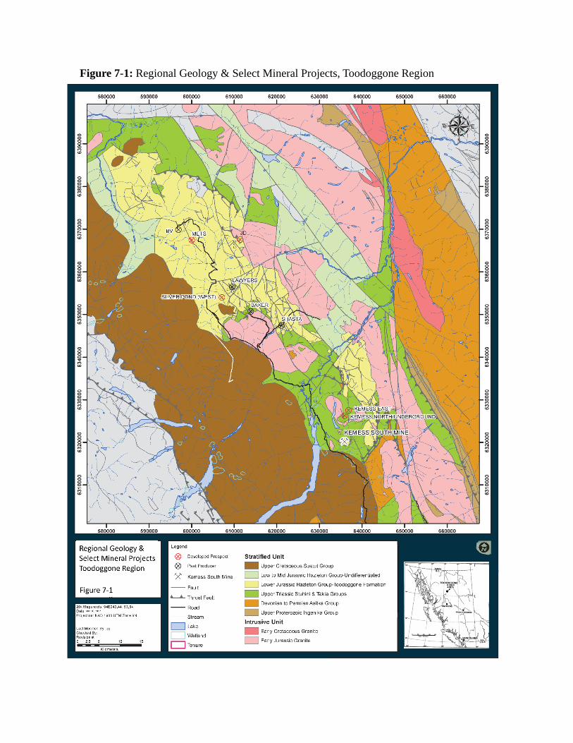
Figure 7-1: Regional Geology & Select Mineral Projects, Toodoggone Region
A northwest-trending set of younger, steeply dipping faults and half-grabens are the principle structures found in the region. Major structural breaks are postulated to have been caused by, or be the result of, a northwest-trending line of volcanic centres (Diakow et al., 1993). Small stocks are also aligned northwesterly, suggesting they were also influenced by the same structural trend. Subsequent to volcanism and intrusion, younger faults are recognizable as northwest-trending lineaments.
7.1 LOCAL GEOLOGY The descriptions that follow in Sections 7.2.1 to 7.2.4 are compiled from numerous reports that have evaluated the Project area, including: assessment reports downloaded from the B.C. Ministry of Energy and Mines’ ARIS (Assessment Report Indexing System) website; publications of the B.C. Geological Survey (B.C. Ministry of Energy and Mines); and hard copy reports obtained by SRL.
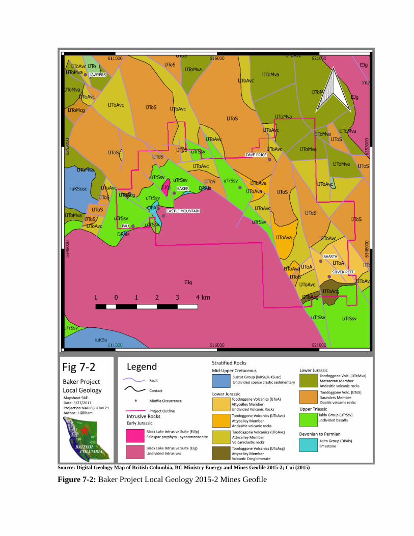
A map depicting the local geology is sourced from the Digital Geology Map of British Columbia, BC Ministry Energy and Mines Geofile 2005-2, and along with the minfile locations of the Project area is shown in Figure 7.2. The geology of the Baker Mine area (Diakow et al., 1993) is shown in Figures 7-3
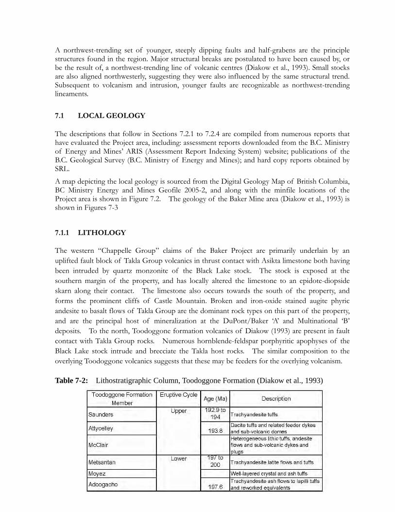
7.1.1 LITHOLOGY
The western “Chappelle Group” claims of the Baker Project are primarily underlain by an uplifted fault block of Takla Group volcanics in thrust contact with Asikta limestone both having been intruded by quartz monzonite of the Black Lake stock. The stock is exposed at the southern margin of the property, and has locally altered the limestone to an epidote-diopside skarn along their contact. The limestone also occurs towards the south of the property, and forms the prominent cliffs of Castle Mountain. Broken and iron-oxide stained augite phyric andesite to basalt flows of Takla Group are the dominant rock types on this part of the property, and are the principal host of mineralization at the DuPont/Baker ‘A’ and Multinational ‘B’ deposits. To the north, Toodoggone formation volcanics of Diakow (1993) are present in fault contact with Takla Group rocks. Numerous hornblende-feldspar porphyritic apophyses of the Black Lake stock intrude and brecciate the Takla host rocks. The similar composition to the overlying Toodoggone volcanics suggests that these may be feeders for the overlying volcanism.
Table 7-2: Lithostratigraphic Column, Toodoggone Formation (Diakow et al., 1993)
Source: Digital Geology Map of British Columbia, BC Ministry Energy and Mines Geofile 2015-2; Cui (2015)
Figure 7-2: Baker Project Local Geology 2015-2 Mines Geofile
611000 616000 Elg
IJToMva ToAvc
IJToAvc UToS IJ oAvc
1 0
luKSu 611000
Fig 7-2 Baker Project
Local Geology Mapsheet 94E Date: 3/ 27/2017 Projection:NAD 83 UTM zg
Author : J Gillham
IJToAvc
uTrSsv
IJ1bMva UToS
IJToAv~
lrn)os. ]J 05
. )1ro~ 8
/ _ i SHASTA "' <O
~1/ ilJToAvc
• IJToA IJli
EJg
1 2 3 4km
Legend ~
"'-Fault
Contact
• Mintile Occurrence
Project Outline
Intrusive Rocks Ea r ly Jurassic
61601111
Stratifi ed Rocks
Mid-Upper Cretaceous D Sustut Group (luKSu,luKSusc)
Undivided coarse elastic sedimentary
Lower Jurassic D Toodoggone Volcanics (UToA)
Attycelley Member Undivided Volcanic Rocks
D Toodoggone Volcanics (UToAva)
Attycelley Member Andesitic volcanic rocks
• Black Lake Intrusive Suite (EJfp) D Toodoggone volcanics (UToAvc) Feldspar porphyry - syenomonzonite Attyce lley Member
Volcaniclastic rocks
Black Lake Intrusive Suite (EJg)
Undivided Intrusives • Toodoggone Volcanics (UToAcg)
Attycelley Member Volcanic Conglomerate
uTrSsv uTrSsv
6211111D
Lower Jurassic Toodoggone Vole. (IJToMva)
Metsantan Member Andesitic volcanic rocks
D Toodoggone Vole. (IJToS)
Saunders Member Dacitic volcanic rocks
Upper Triassic D Takla Group (uTrSsv)
undivided basalts
Devonian to Permian
D Asita Group (DPAls)
limestone
Detailed descriptions of the Toodoggone Formation Members are not presented here, and the reader is encouraged to refer to Diakow et al (1993), for those descriptions.
7.2.2 STRUCTURE
Dominant structures on the Baker Project consist of steeply dipping normal faults, and north to northwest-trending strike-slip faults. One of the latter (the Saunders fault) borders the Shasta deposit to the east (Fig. 7-2), and has an estimated ~5 km right-lateral displacement (Diakow et al. 1993). Several of the Toodoggone area deposits, including Lawyers, Baker, and Shasta, lie near northwest-trending faults. Diakow (1990) proposed that these deposits lie along the margin of a fault-bounded trough which may have ponded later volcanics and localized hydrothermal fluids during extension. At Shasta, structurally controlled mineralized zones also have northwest trends, and may similarly reflect syn- to immediately post-volcanic normal fault activity. Small stocks in the area are also aligned northwesterly, suggesting they were also influenced by the same structural trend. Subsequent to volcanism and intrusions, younger faults are recognizable as northwest-trending lineaments.
A more detailed description of the structures found on the Baker (‘Chappelle’) claims is presented below in sections 7.2.4.1.
7.2.3 ALTERATION AND MINERALIZATION Alteration and associated mineralization on the Baker Project includes both the Dupont/Baker ‘A’ and Multinational ‘B’ vein systems on the Chappelle group of claims, and the Shasta deposit and on the Shasta claims. Alteration for the property consists of regional scale propylitic alteration of chlorite-epidote +/- calcite and pyrite. At the deposit scale, the Chappelle group of claims has undergone intense propylitic chlorite-epidote-pyrite alteration, and locally strong sericitic alteration. The lower grade regional alteration has been overprinted at Shasta by extensive potassic (quartz-adularia) alteration assemblage associated with a low-sulphidation epithermal system.
Further detail of the alteration and mineralization for the individual zones and deposits is discussed in more detail below in section 7.2.4
7.2.4 DEPOSITS AND ZONES The Baker Project covers an area that includes seven (7) B.C. MINFILE mineral occurrences, including the past producing underground and open cut/pit Dupont/Baker ‘A’, Multinational ‘B’, and Shasta mines. The Dupont/Baker ‘A’ and Multinational ‘B’ deposits are not distinguished in the MINFILE reports and both occur under the ‘BAKER’ MINFILE. The other six (6) MINFILE occurrences along with the ‘BAKER’ showing are listed in Table 7.2 and are shown on Figure 7.2. Historical mineral resource estimate for the Dupont/Baker ‘A’ and Multinational ‘B’ deposits are discussed in more detail in section Section 6: History.
Table 7-3: List of MINFILE and Other Notable Mineral Occurrences, Baker Project
MINFILE NO NAME STATUS ZONE NORTHING EASTING
094E 026 BAKER Past Producer 9 6350723 613891
094E 027 CASTLE MOUNTAIN Showing 9 6349625 613369
094E 072 PAU Prospect 9 6349120 611874
094E 302 BLACK GOSSAN Showing 9 6351000 617125
094E 151 DAVE PRICE Prospect 9 6352371 618569
094E 050 SHASTA Past Producer 9 6347401 621077
094E 145 SILVER REEF Showing 9 6346640 621502
7.2.4.1 CHAPPELLE GROUP SUMMARY The Baker property is underlain by an uplifted fault block of Takla Group volcanics in thrust contact with Asikta limestone both having been intruded by quartz monzonite of the Black Lake stock. The stock is exposed at the southern margin of the property, and has locally altered the limestone to an epidote-diopside skarn along their contact. The limestone also occurs towards the south of the property, and forms the prominent cliffs of Castle Mountain. Broken and iron-oxide stained augite phyric andesite to basalt flows of Takla Group are the dominant rock types on the property, and are the principal host of mineralization at Baker. To the north, upper cycle Toodoggone formation volcanics of Diakow (1990) are present in fault contact with Takla Group rocks.
Numerous hornblende-feldspar porphyritic apophyses of the Black Lake stock intrude and brecciate the Takla host rocks. The similar composition to the overlying Toodoggone volcanics suggests that these may be feeders for the overlying volcanism.The largest of these, intrusions, the Black Lake stock, extends 9 kilometres southeast from the Baker property. Its composition varies from granodiorite to quartz monzonite. Radiometric potassium-argon dates obtained by the Geological Survey of Canada on hornblende from this pluton indicate an emplacement age of 186 Ma. Another pair yielded ages of 189 Ma and 200 Ma on biotite and hornblende respectively (Diakow 1993). Two small syenomonzonite intrusions occur immediately to the north of the Black Lake stock near the A vein. Highly altered quartz feldspar porphyry which appears to be a late phase of the syenomonzonite intrusions, occurs immediately to the north of the A vein. The main portion of this porphyry unit lies at the fault contact between Asitka Group and Takla Group rocks near the western end of the A vein. Dike-like apophyses of this body, varying from 1 to 30 metres in thickness, subparallel and intersect the northeast extension of the A vein.
Prominent Propylitic and Sericitic alteration on the property has weathered a gossanous rust color. An assemblage of quartz-sericite-chlorite-pyrite gives way to an argillic clay assemblage proximal to veins. Milky quartz veins are the principal host to economic mineralization, and commonly exhibit polyphase breccia, and vuggy textures. Gold-silver mineralization is associated with pyrite, sphalerite, galena and chalcopyrite, with precious metal mineralization in the form of electrum and acanthite.
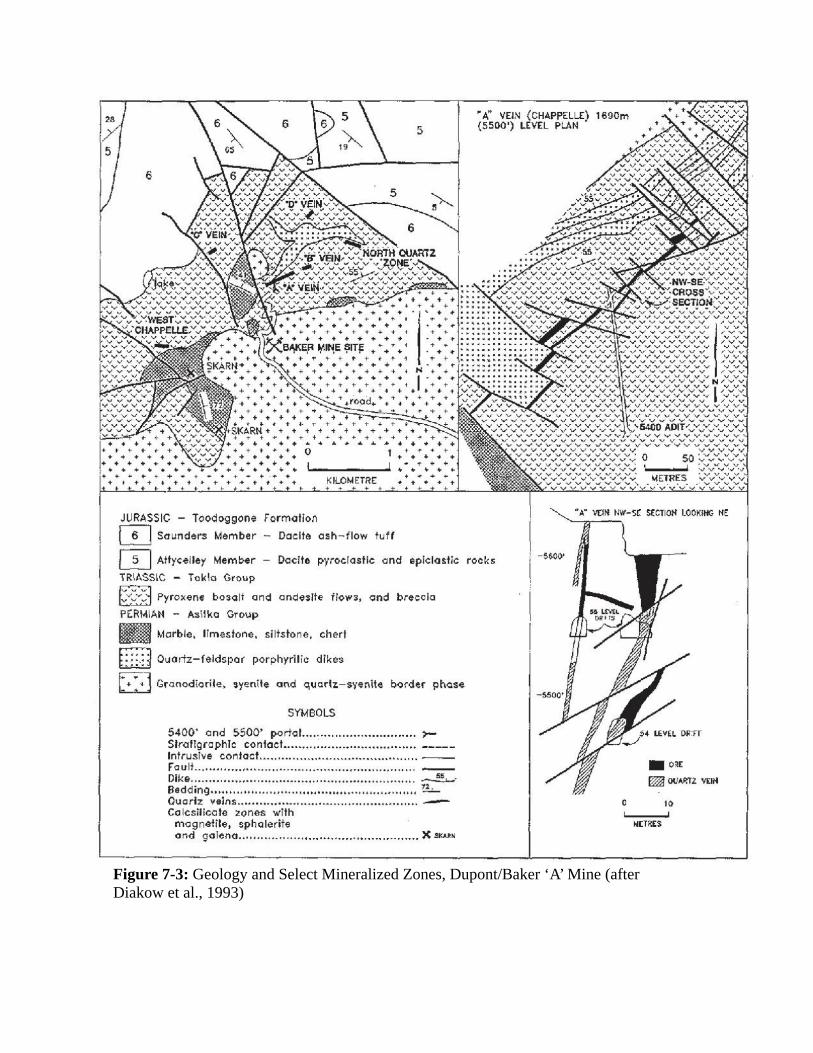
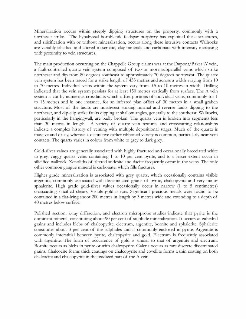
Figure 7-3: Geology and Select Mineralized Zones, Dupont/Baker ‘A’ Mine (after Diakow et al., 1993)
5
++++++++++++~++~ .. ~~.::;;::;;:::::;:::::::!..~J .f- + f- .f- -t 4-T ++ ++ + + i"
s.KARN + + + + • + + + + + + + + + + ~ + .,.
• 4 ~ ~ ~ ~ ~ + + • + + 0
.. .,. ... + + ..... + ..
+ + +- • + .. + + + + + ... t + • .. + • + + + ... + + + .., + + + KILOMETRE: + + + ~ •""' + .. +
"A" VEIN ( CHAPPELL£) 1690m (5500') LEVEL PLAN
f- i · .. ;1_±__±-·--·-·-·--·-"--'.'---"----"'---'·-~ ........ c......c+_c+c-.....__.,_., ... _.,__,+c-.,_ __ ..c
JURASSIC - Toodoggone Formation
0 Saunders Member Daclte ash-flow tuff
0 Attycelley Member Daclle pyroclastlc ond epiclostic rocks
TR\ASSlC - Tokio Group
f;SE~j Pyroxene bos<1lt ond andesrte flows, ond breccia
PERMIAH - Asi1ka Group
• Marble, limestone, siltstone, chert
EJ Ouorlz-feldspar porphyrilic dikes
B Granodtorile, syenile ond q1Jarh;-syentle bQrder !)h-::ise
SYMBOLS
5400' and 5500' porlol ............................... r-Slrallgraphlc contact ................................... . Intrusive contact ..................... ...................... ---roult ........................................................... . Dike ............................................................. ~-Bedding ........................................................ !!...... Oucriz veins ................................................. -Colcsilicole :zones with
mognoetile, spholerite ond galena ................................................. X sKn•
"A." vtltl Nll'-S~ S£CTIO!f LOOK!HG t/E
-5600'
LEV£~ DRH
-O~E
~ OOJ\RT2 VEIH
0 10
MURES
Mineralization occurs within steeply dipping structures on the property, commonly with a northeast strike. The hypabyssal hornblende-feldspar porphyry has exploited these structures, and silicification with or without mineralization, occurs along these intrusive contacts Wallrocks are variably silicified and altered to sericite, clay minerals and carbonate with intensity increasing with proximity to vein structures. The main production occurring on the Chappelle Group claims was at the Dupont/Baker ‘A’ vein, a fault-controlled quartz vein system composed of two or more subparallel veins which strike northeast and dip from 80 degrees southeast to approximately 70 degrees northwest. The quartz vein system has been traced for a strike length of 435 metres and across a width varying from 10 to 70 metres. Individual veins within the system vary from 0.5 to 10 metres in width. Drilling indicated that the vein system persists for at least 150 metres vertically from surface. The A vein system is cut by numerous crossfaults which offset portions of individual veins, commonly for 1 to 15 metres and in one instance, for an inferred plan offset of 30 metres in a small graben structure. Most of the faults are northwest striking normal and reverse faults dipping to the northeast, and dip-slip strike faults dipping at shallow angles, generally to the southeast. Wallrocks, particularly in the hangingwall, are badly broken. The quartz vein is broken into segments less than 30 metres in length. A variety of quartz vein textures and crosscutting relationships indicate a complex history of veining with multiple depositional stages. Much of the quartz is massive and drusy, whereas a distinctive earlier ribboned variety is common, particularly near vein contacts. The quartz varies in colour from white to grey to dark grey. Gold-silver values are generally associated with highly fractured and occasionally brecciated white to grey, vuggy quartz veins containing 1 to 10 per cent pyrite, and to a lesser extent occur in silicified wallrock. Xenoliths of altered andesite and dacite frequently occur in the veins. The only other common gangue mineral is carbonate, which fills fractures.
Higher grade mineralization is associated with grey quartz, which occasionally contains visible argentite, commonly associated with disseminated grains of pyrite, chalcopyrite and very minor sphalerite. High grade gold-silver values occasionally occur in narrow (1 to 5 centimetres) crosscutting silicified shears. Visible gold is rare. Significant precious metals were found to be contained in a flat-lying shoot 200 metres in length by 3 metres wide and extending to a depth of 40 metres below surface. Polished section, x-ray diffraction, and electron microprobe studies indicate that pyrite is the dominant mineral, constituting about 90 per cent of sulphide mineralization. It occurs as euhedral grains and includes blebs of chalcopyrite, electrum, argentite, bornite and sphalerite. Sphalerite constitutes about 3 per cent of the sulphides and is commonly enclosed in pyrite. Argentite is commonly interstitial between pyrite, chalcopyrite and gold. Electrum is frequently associated with argentite. The form of occurrence of gold is similar to that of argentite and electrum. Bornite occurs as blebs in pyrite or with chalcopyrite. Galena occurs as rare discrete disseminated grains. Chalcocite forms thick coatings on chalcopyrite and covellite forms a thin coating on both chalcocite and chalcopyrite in the oxidized part of the A vein.
8. 2017 MAPPING SURVEY Between June 9 and 21st, the area around the historic Baker mine, and the Black Gossan minfile showings was mapped for lithology and alteration at a scale of 1:10,000. Mapping was completed with the aid of a handheld GPS unit to record locations. 298 stations were mapped, and 242 rock samples were collected from those stations and shipped to Vancouver for storage. 15 of the collected samples were sent to Vancouver Petrographics Ltd. at 8080 Glover Rd. in Langley BC for petrographic analysis. The Petrographic report is attached in Appendix I. The locations of the petrographic samples are plotted on the Geologic Maps attached in Appendix II and listed in table 8-1 below. During the 2016 program, no attempt was made to assign mapped outcrop of the Toodoggone Formation to Member units. Historically the Toodoggone volcanic rocks in the 2016 survey area have been assigned to the Saunders member of the Lower Toodoggone Formation (Diakow 2006). Efforts were made to describe the lithology encountered, along with alteration, spacial distribution and structural relationships. Observed Toodoggone Formation rocks generally fit the description of units previously mapped in Diakow (1993) and Diakow (2006). Several intrusive rocks resembling Toodoggone Formation volcanics were encountered and are hereby assigned to the Black Lake Early Jurassic Intrusive Suite. Of the Toodoggone Formation, 4 informal volcanic/volcaniclastic units were identified, 3 by discernable mineralogy in hand specimen, and 1 latite unit based on field observations and petrographic analysis. The 3 units identified by observable field mineralogy consist of a plagioclase phyric unit, a plagioclase-quartz-kfeldspar phyric unit, and a plagioclase-quartz-kfeldspar-amphibole phyric unit, all appearing dacitic in composition and likely pyroclastic texture. 2 intrusive units of the Black Lake suite were mapped, consisting of the Black Lake granite, and a feldspar porphyry syenomonzonite unit. The intrusive nature of syenomonzonite was determined by the field relation to other units, lack of pyroclastic evidence, and confirmed by petrographic analysis. Stuhini/Takla group basalts/andesites (Diakow 1993) can be divided into an augite phenocryst and fine grained units. Limestone/marble has been assigned to the Permian Asitka Formation based on previous work (Diakow 1993). The 2016 map presented in Appendix II is consistent with lithologic descriptions by previous works by Drown (1981), Diakow (1991), Diakow (2006), Duuring (2009) and Ciu (2015). The position of known quartz veins presented in the 2016 map are reproduced from Drown (1981) and other Company reports and were not verified during this survey. Table 8-1: Petrographic Sample Locations
Petrographic Sample ID
NAD83 UTMZ9 East North
16BKTS1 611857 6350575 16BKTS2 612809 6351654 16BKTS3 616884 6350895 16BKTS4 616869 6351048
16BKTS5 617092 6350859 16BKTS6 616913 6350838 16BKTS7 613760 6351806 16BKTS8 613834 6351755 16BKTS9 611605 6350335
16BKTS10 611637 6350206 16BKTS11 612201 6349883 16BKTS12 612772 6349987 16BKTS13 613770 6350761 16BKTS14 615230 6351352 16BKTS15 613986 6351342
9. Conclusion & Recommendation The 2016 Mapping Survey was successful at further defining the lithology and alteration present over the Baker system. The survey delineated several hypabyssal intrusions, assigned here to early Jurassic age of the Black Lake Suite, within the area that were previously unmapped at regional scales and adds to those recognized by Drown (1981). Further, intrusion related hydrothermal alteration (Thompson 1996), consisting primarily widespread propylitic with large areas of sericitic overprints, was defined in the survey area. Three zones associated with coincident hypabyssal feldspar porphyry and sericitic and advanced argillic alteration centered around the West Chappelle, Baker, and Black Gossan zones can be broadly defined from this survey. These zones also correspond to areas of shallow historical exploration drilling(Craft 2005, Craft 2007), and are coincident with trace element geochemically anomalous zones defined in Gillham (2016). At present, the Baker system is a large hydrothermal system exhibiting alteration consistent with a Cu-Au porphyry system (Duuring 2009). The potential to discover a porphyry system, or alternatively, additional Dupont/Baker vein style mineralization associated with this alteration system exists and warrants future work. A work program is recommended to include: additional mapping to the east and southwest of the 2016 study area; a clay alteration study, consisting of spectral analysis of the collected samples and future samples to better refine the alteration zones; a helicopter flown magnetometer and deep penetrating EM survey over the Baker property. A deep penetrating IP survey over the most prospective areas for porphyry style mineralization identified in the airborne geophysics followed by drill testing of those targets would likely constitute the next step in exploring the property.
10 REFERENCES B.C. Geological Survey (1984): British Columbia Mineral Exploration Review 1983, Staff,
British Columbia Ministry of Energy and Mines, Information Circular 1984-1.
B.C. Geological Survey (1985): British Columbia Mineral Exploration Review 1984, Staff, British Columbia Ministry of Energy and Mines, Information Circular 1985-1.
B.C. Geological Survey (1986): British Columbia Mineral Exploration Review 1985, Staff, British Columbia Ministry of Energy and Mines, Information Circular 1986-1.
Carter, N.C. (1988): Report on the 1987 Exploration Program Chappelle Gold Project; for Multinational Mining Inc.
Clark, J.R. and Williams-Jones, A.E. (1991): 40Ar/39Ar ages of epithermal alteration and volcanic rocks in the Toodoggone Au-Ag district, north-central British Columbia (94E); B.C. Ministry of Energy and Mines, Geological Fieldwork 1990, Paper 1991-1, pages 207-216.
Craft, E.M., (1998): Report on the 1997 Exploration Program, The Chappelle Mineral Claims; a report for Sable Resources Ltd.
Craft, E.M., (2001): Report on the 2000 Exploration Program, The Chappelle Mineral Claims; a report for Sable Resources Ltd.
Craft, E.M., (2003): Report on the 2002 Exploration Program, The Chappelle Mineral Claims; a report for Sable Resources Ltd.
Craft, E.M., (2005): Report on the 2004 Exploration Program, The Chappelle and Shasta Mineral Claims; a report for Sable Resources Ltd.
Craft, E.M., (2007): Report on the 2006 Exploration Program, The Shasta and Baker Mineral Claims; a report for Sable Resources Ltd.
Cui, Y., Miller, D., Nixon, G., and Nelson, J., 2015. British Columbia digital geology. British Columbia Geological Survey, Open File 2015-2 Delancey, Peter R., (1989): 1989 Exploration Report on the Chappelle Property; a report for
Multinational Resources Inc. Dilles, John H., (2012): Footprints of porphyry Cu deposits: Vectors to the hydrothermal
center using mineral mapping and lithogeochemistry. USGS MRE G10AP00052 Diakow, L.J., Panteleyev, A, and Schroeter, T.G. (1991): Jurassic Epithermal Prospects in
the Toodoggone River area, northern British Columbia: Examples of Well Preserved, Volcanic Hosted, Precious Metal Mineralization; Economic Geology 86, pages 529-554
Diakow, L.J., Panteleyev, A, and Schroeter, T.G. (1993): Geology of the Early Jurassic Toodoggone Formation and Gold-Silver Deposits in the Toodoggone River Map Area, Northern British Columbia; BC Ministry of Energy and Mines, Bulletin 86, 66 pages.
Diakow, L.J., (2006): Geology of the Central Toodoggone River Map Area, North Central British Columbia, (Parts of NTS 94/E2, 6, 7, 10, and 11).
Duuring, P., Rowins, S.M., McKinley, B.S.M, Dikinson, J.M., Diakow, L.J.Kim, Y. and Creaser, R.A. (2009): Examining potential genetic links between Jurassic porphyry Cu±Au±Mo and epithermal Au±Ag mineralization in the Toodoggone district of North-Central British Columbia, Canada; Miner Deposita (2009) 44, pages 463-496.
Espinosa, S., (2004): Geophysical Report. Induced Polarization Survey on the Upper Ridge Zone Project For Sable Resources Ltd.
Evans, B.T. (1988): FAME Report on the Mets 1-2, Toodoggone Camp, B.C.; BC Ministry of Energy and Mines, Assessment Report 16692, 23 pages.
George Cross News Letter (1988): International Shasta Resources Ltd., Toodoggone Exploration Underway, No. 129, July 6, 1988.
George Cross News Letter (1988): Multinational Resources Inc., Baker Mine, November 4, 1988.
George Cross News Letter (1989): Cheni Gold Mines Inc., Summary and Update, No. 63, April 3, 1989.
George Cross News Letter (1989): Sable Resources Ltd., No. 125, June 29, 1989.
George Cross News Letter (1989): Cheni Gold Mines Inc., Gold Production Reported, No. 172, September 7, 1989.
George Cross News Letter (1990): Cheni Gold Mines Inc., Lawyers Mine Results, No. 11, January 16, 1990.
George Cross News Letter (1992): Cheni Gold Mines Inc., Drilling Confirms Zone Extension; No. 240, December 14, 1992.
George Cross News Letter (1993): Cheni Gold Mines Inc., Lawyers Mine Interim Report; No. 142 July 26, 1993.
Gillham, J., (2016): 2015 Lithogeochemical Survey on the Baker Claim Group; an in house report for Sable Resources Ltd.
Gillham, J. (2017): 2016 Mapping of the Chappelle claim group; a report for Sable Resources Ltd.
Hawkins, P.A. (1997): A Summary Report Covering the 1996 Drill Program on AGC Americas Gold Corp's JD Property, Toodoggone River Area, B.C., Report No. 97-065-1
Hawkins, P.A. (2003): A Technical Report Covering the Lawyers and Al (Ranch) Properties for Bishop Resources Inc., 136 pages.
Hedenquist, J.W. and Lowenstern, J.B. (1994): The Role of Magmas in the Formation of Hydrothermal Ore Deposits; Nature; Volume 370 (August 18, 1994), pages 519-527.
Holbek, P. (1989): 1988 Exploration Report on the Shasta Property; private report for Esso Minerals Canada Limited.
Holbek, P.M., (1990): 1989 Exploration Report on the Shasta Claim Group; an in house report for Esso Minerals Canada Ltd.
Holbek, P.M., (1991): 1990 Exploration Report on the Shasta Claim Group; an in house report for Esso Minerals Canada Ltd.
Ker, Priestman & Associates Ltd (1980) Environmental and Reclamation Report for DuPont of Canada Exploration Ltd. Baker Mine. File No 1522/1
Krause, R.G. (1994): 1994 Geological & Geochemical Report on the JD Gold-Silver Property, Toodoggone Area, Omineca Mining Division, B.C.; BC Ministry of Energy, Mines and Petroleum Resources, Assessment Report 23663, 39 pages.
Krause, R.G. (1996): 1995 Geological Report on the JD Gold Property, Toodoggone Area, Omineca Mining Division, B.C.; BC Ministry of Energy, Mines and Petroleum Resources, Assessment Report 24284, 57 pages.
Lane, R.A. (2011): Geochemical and Geological Report on the Lawyers Property; BC Ministry of Energy, Mines and Petroleum Resources, Assessment Report 32055, 69 pages.
Lane, R.A., Bowen, B.K., and Giroux, G. (2016): Technical Report and Resource Estimate on the Lawyers Gold-Silver Project, 178 pages.
Lexa, J., 1999, Outline of the Alpine geology and metallogeny of the Carpatho-Pannonian region: Society of Economic Geologists Guidebook Series, v. 31, p. 65–108.
Marsden, H.M., Moore, J.M.,(1988):Geological Fieldwork, Paper 1989-1 Marsden, H.M., and Moore, J.M., (1990): Stratigraphic and Structural Setting of the Shasta
Silver-Gold Deposit, North-Central, B.C.; B.C.E.M.P.R. Geological Fieldwork 1989, Paper 1990-1, pp. 305-3 14.
McPherson, M.D., Oiye, M., Holbek, P.M., (1991): 1990 Exloration report on the Shasta Claim Group; A report for International Shasta Resources Ltd. and Homestake Canada Ltd.
Ministry of Energy and Mines' website 'The Map Place' (2017): claims data, regional geology, aeromagnetic data and MINFILE descriptions for portions of map sheet 94E. The website address is: http://www.em.gov.bc.ca/mining/geolsurv/MapPlace/default.htm
Panteleyev, A. (1986): A Canadian Model for Epithermal Gold-Silver Deposits; Geoscience Canada, Volume 13, No. 2, pages 101-111.
Royal Oak Mines Ltd. (1997): Annual Report for 1996. Sable Resources Ltd. (1998): News Release dated July 17, 1998. Sable Resources Ltd. (2002): Annual Information Form for the year ended December 31,
2001. Schroeter, T.G. (1983): Toodoggone River Area (94E); in Geological Fieldwork 1982, B.C
Ministry of Energy and Mines and Petroleum Resources, Paper 1983-1, pages 125-126.
TetraTech EBA Inc., (2015): Dam Safety Inspection - Baker Mine, Tailings Storage Facilities 1 and 2, Toodoggone Area, British Columbia (October 2015); private report for Sable Resources Ltd.
Thiersch, P.C.,Williams-Jones, A.E., and Clark, J.R. (1997) Epithermal mineralization and ore controls of the Shasta Au-Ag deposit, Toodoggone District, British Columbia, Canada. Mineralium Deposita (1997) 32: 44-57
Thompson, A.J.B., & Thompson, J.F.H. (1996): ATLAS ALTERATION A FIELD AND
PETROGRAPHIC GUIDE TO HYDROTHERMAL ALTERATION MINERALS.
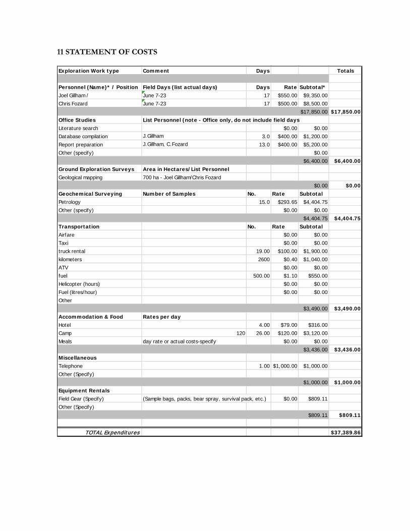
11 STATEMENT OF COSTS Exploration Work type Comment Days Totals
Personnel (Name)* / Position Field Days (list actual days) Days Rate Subtotal*Joel Gillham / June 7-23 17 $550.00 $9,350.00Chris Fozard June 7-23 17 $500.00 $8,500.00
$17,850.00 $17,850.00Office Studies List Personnel (note - Office only, do not include field daysLiterature search $0.00 $0.00Database compilation J.Gillham 3.0 $400.00 $1,200.00Report preparation J.Gillham, C.Fozard 13.0 $400.00 $5,200.00Other (specify) $0.00
$6,400.00 $6,400.00Ground Exploration Surveys Area in Hectares/List PersonnelGeological mapping 700 ha - Joel Gillham/Chris Fozard
$0.00 $0.00Geochemical Surveying Number of Samples No. Rate SubtotalPetrology 15.0 $293.65 $4,404.75Other (specify) $0.00 $0.00
$4,404.75 $4,404.75Transportation No. Rate SubtotalAirfare $0.00 $0.00Taxi $0.00 $0.00truck rental 19.00 $100.00 $1,900.00kilometers 2600 $0.40 $1,040.00ATV $0.00 $0.00fuel 500.00 $1.10 $550.00Helicopter (hours) $0.00 $0.00Fuel (litres/hour) $0.00 $0.00Other
$3,490.00 $3,490.00Accommodation & Food Rates per dayHotel 4.00 $79.00 $316.00Camp 120 26.00 $120.00 $3,120.00Meals day rate or actual costs-specify $0.00 $0.00
$3,436.00 $3,436.00MiscellaneousTelephone 1.00 $1,000.00 $1,000.00Other (Specify)
$1,000.00 $1,000.00Equipment RentalsField Gear (Specify) (Sample bags, packs, bear spray, survival pack, etc.) $0.00 $809.11Other (Specify)
$809.11 $809.11
TOTAL Expenditures $37,389.86
12. STATEMENT OF QUALIFICATIONS I, Joel Gillham, of 7676 Ontario St, Vancouver, British Columbia, Canada, hereby certify that: I graduated from Simon Fraser University with a Bachelor of Science degree in Earth Sciences (2007);
I have been continuously employed as a geoscientist in the mineral exploration industry since 2005;
I have been involved in the exploration, development and mining of the property that is the subject of this report since 2006, and am currently a director of Sable Resources Ltd.
Dated at Vancouver, BC this 2nd day of August 2017
Joel Gillham, B.Sc

APPENDIX I
Petrographic Report
Report for: Mr. Joel Gillham
Report 170204
June 15, 2017
Petrographic Report on 15 Rock Samplesfor Mr. Joel Gillham
Fabrizio Colombo, Ph.D., [email protected]
Petrographic Report #170204
Table of Contents1. Introduction..................................................................................................................................................32. Results.........................................................................................................................................................43. Bibliography.................................................................................................................................................74. Petrographic Descriptions............................................................................................................................8
Sample 1: 16 BKTS 1..................................................................................................................................8Sample 2: 16 BKTS 2................................................................................................................................11Sample 3: 16 BKTS 3................................................................................................................................14Sample 4: 16 BKTS 4................................................................................................................................16Sample 5: 16 BKTS 5................................................................................................................................18Sample 6: 16 BKTS 6................................................................................................................................21Sample 7: 16 BKTS 7................................................................................................................................23Sample 8: 16 BKTS 8................................................................................................................................26Sample 9: 16 BKTS 9................................................................................................................................28Sample 10: 16 BKTS 10............................................................................................................................31Sample 11: 16 BKTS 11............................................................................................................................34Sample 12: 16 BKTS 12............................................................................................................................36Sample 13: 16 BKTS 13............................................................................................................................38Sample 14: 16 BKTS 14............................................................................................................................41Sample 15: 16 BKTS 15............................................................................................................................44
5. Glossary of Microstructural and Petrologic Terms Used in the Text..........................................................46
2
Petrographic Report #170204
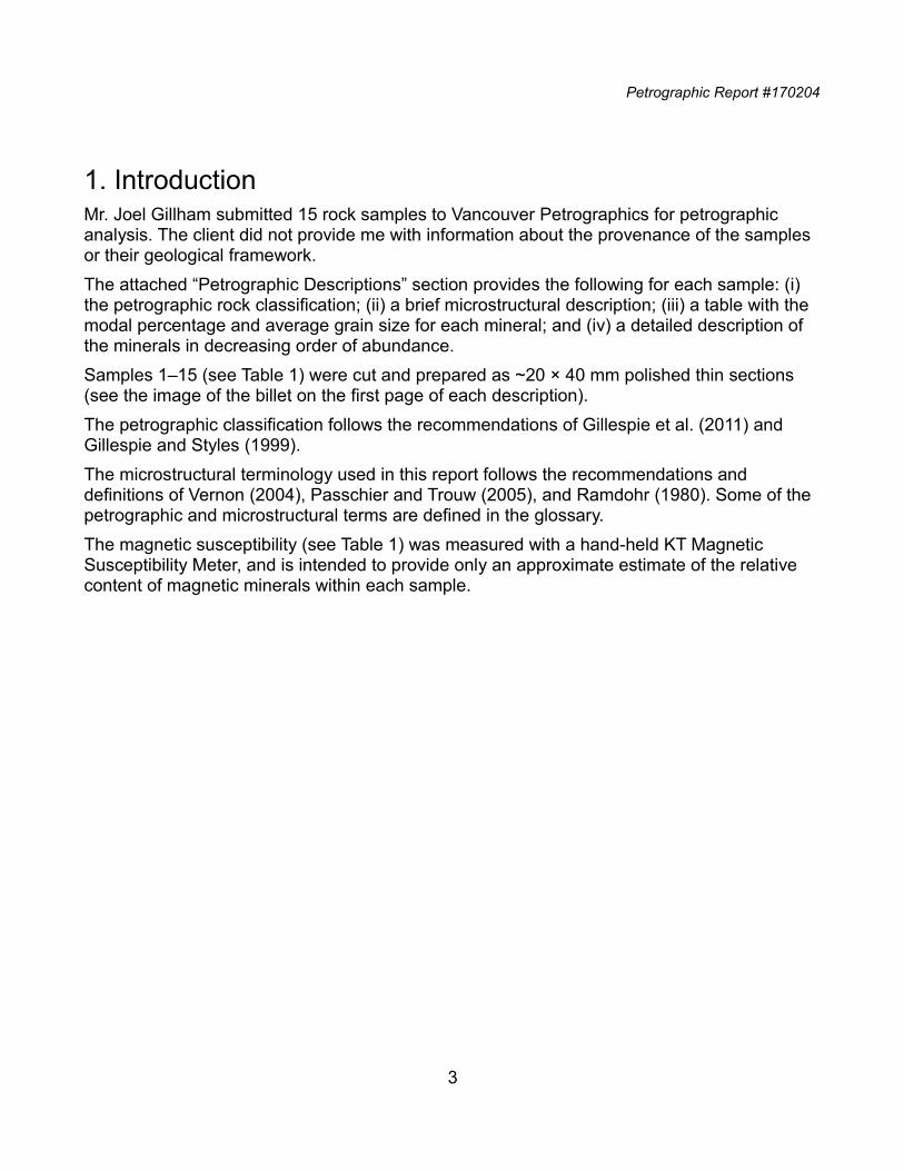
1. IntroductionMr. Joel Gillham submitted 15 rock samples to Vancouver Petrographics for petrographic analysis. The client did not provide me with information about the provenance of the samples or their geological framework.
The attached “Petrographic Descriptions” section provides the following for each sample: (i) the petrographic rock classification; (ii) a brief microstructural description; (iii) a table with the modal percentage and average grain size for each mineral; and (iv) a detailed description of the minerals in decreasing order of abundance.
Samples 1–15 (see Table 1) were cut and prepared as ~20 × 40 mm polished thin sections (see the image of the billet on the first page of each description).
The petrographic classification follows the recommendations of Gillespie et al. (2011) and Gillespie and Styles (1999).
The microstructural terminology used in this report follows the recommendations and definitions of Vernon (2004), Passchier and Trouw (2005), and Ramdohr (1980). Some of the petrographic and microstructural terms are defined in the glossary.
The magnetic susceptibility (see Table 1) was measured with a hand-held KT Magnetic Susceptibility Meter, and is intended to provide only an approximate estimate of the relative content of magnetic minerals within each sample.
3
Petrographic Report #170204
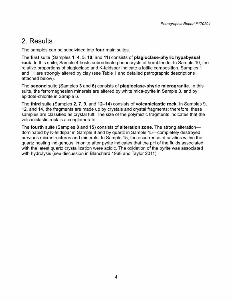
2. ResultsThe samples can be subdivided into four main suites.
The first suite (Samples 1, 4, 5, 10, and 11) consists of plagioclase-phyric hypabyssal rock. In this suite, Sample 4 hosts subordinate phenocrysts of hornblende. In Sample 10, the relative proportions of plagioclase and K-feldspar indicate a latitic composition. Samples 1 and 11 are strongly altered by clay (see Table 1 and detailed petrographic descriptions attached below).
The second suite (Samples 3 and 6) consists of plagioclase-phyric microgranite. In this suite, the ferromagnesian minerals are altered by white mica-pyrite in Sample 3, and by epidote-chlorite in Sample 6.
The third suite (Samples 2, 7, 9, and 12‒14) consists of volcaniclastic rock. In Samples 9, 12, and 14, the fragments are made up by crystals and crystal fragments; therefore, these samples are classified as crystal tuff. The size of the polymictic fragments indicates that the volcaniclastic rock is a conglomerate.
The fourth suite (Samples 8 and 15) consists of alteration zone. The strong alteration—dominated by K-feldspar in Sample 8 and by quartz in Sample 15—completely destroyed previous microstructures and minerals. In Sample 15, the occurrence of cavities within the quartz hosting indigenous limonite after pyrite indicates that the pH of the fluids associated with the latest quartz crystallization were acidic. The oxidation of the pyrite was associated with hydrolysis (see discussion in Blanchard 1968 and Taylor 2011).
4
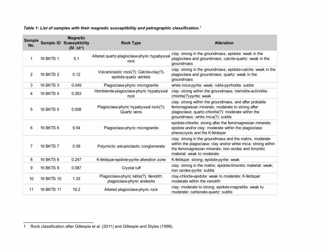
Table 1: List of samples with their magnetic susceptibility and petrographic classification.1
1 Rock classification after Gillespie et al. (2011) and Gillespie and Styles (1999).
Sample ID Rock Type Alteration
1 16 BKTS 1 5.1
2 16 BKTS 2 0.12
3 16 BKTS 3 0.049 Plagioclase-phyric microgranite white mica-pyrite: weak; rutile-pyrrhotite: subtle
4 16 BKTS 4 0.263
5 16 BKTS 5 0.008
6 16 BKTS 6 9.54 Plagioclase-phyric microgranite
7 16 BKTS 7 0.09 Polymictic volcaniclastic conglomerate
8 16 BKTS 8 0.247 K-feldspar-epidote-pyrite alteration zone K-feldspar: strong; epidote-pyrite: weak
9 16 BKTS 9 0.087 Crystal tuff
10 16 BKTS 10 1.33
11 16 BKTS 11 19.2 Altered plagioclase-phyric rock
Sample No.
Magnetic Susceptibility
(SI ·10-3)
Altered quartz-plagioclase-phyric hypabyssal rock
clay: strong in the groundmass; epidote: weak in the plagioclase and groundmass; calcite-quartz: weak in the groundmass
Volcaniclastic rock(?); Calcite-clay(?)-epidote-quartz veinlets
clay: strong in the groundmass; epidote-calcite: weak in the plagioclase and groundmass; quartz: weak in the groundmass
Hornblende-plagioclase-phyric hypabyssal rock
clay: strong within the groundmass; tremolite-actinolite-chlorite(?)-pyrite: weak
Plagioclase-phyric hypabyssal rock(?); Quartz veins
clay: strong within the groundmass, and after probable ferromagnesian minerals; moderate to strong after plagioclase; quartz-chlorite(?): moderate within the groundmass; white mica(?): subtle
epidote-chlorite: strong after the ferromagnesian minerals; epidote and/or clay: moderate within the plagioclase phenocrysts and the K-feldspar
clay: strong in the groundmass and the matrix, moderate within the plagioclase; clay and/or white mica: strong within the ferromagnesian minerals; iron oxides and limonitic material: weak to moderate
clay: strong in the matrix; epidote-limonitic material: weak; iron oxides-pyrite: subtle
Plagioclase-phyric latite(?); Xenolith: plagioclase-phyric andesite
clay-chlorite-epidote: weak to moderate; K-feldspar: moderate within the xenolith
clay: moderate to strong; epidote-magnetite: weak to moderate; carbonate-quartz: subtle
.
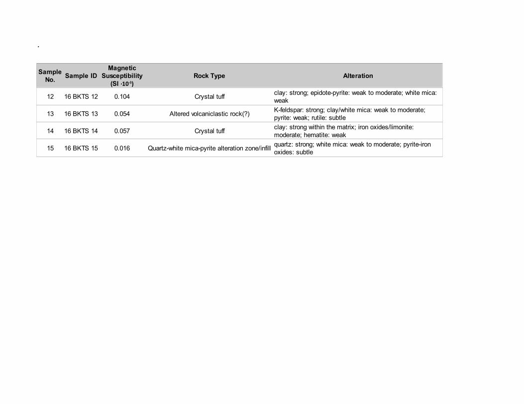
Sample ID Rock Type Alteration
12 16 BKTS 12 0.104 Crystal tuff
13 16 BKTS 13 0.054 Altered volcaniclastic rock(?)
14 16 BKTS 14 0.057 Crystal tuff
15 16 BKTS 15 0.016 Quartz-white mica-pyrite alteration zone/infill
Sample No.
Magnetic Susceptibility
(SI ·10-3)clay: strong; epidote-pyrite: weak to moderate; white mica: weak
K-feldspar: strong; clay/white mica: weak to moderate; pyrite: weak; rutile: subtle
clay: strong within the matrix; iron oxides/limonite: moderate; hematite: weak
quartz: strong; white mica: weak to moderate; pyrite-iron oxides: subtle
Petrographic Report #170204
3. Bibliography
Blanchard R (1968) Interpretation of leached outcrops, Mackay School of Mines, University ofNevada, Nevada Bureau of Mines. Bull 66.
Deer WA, Howie RA, Zussmann J (1992) An introduction to the rock-forming minerals. Longman, London
Delvigne JE (1998) Atlas of micromorphology of mineral alteration and weathering. The Canadian Mineralogist, special publication 3. Mineralogical Association of Canada, Ottawa
Gillespie MR, Barnes RP, Milodowski A (2011) British Geological Survey scheme for classifying discontinuities and fillings. In: British Geological Survey research report RR/10/05. http://www.bgs.ac.uk/downloads/start.cfm?id=1982. Accessed June 2017
Gillespie MR, Styles MT (1999) Classification of igneous rocks. British Geological Survey research report RR 99/06 (2nd edn), vol 1. http://www.bgs.ac.uk/downloads/start.cfm?id=7. Accessed June 2017
Passchier CW, Trouw RAJ (2005) Microtectonics (2nd edn). Springer, HeidelbergRamdohr P (1980) The ore minerals and their intergrowths (2nd edn), vol 1/2. Pergamon
Press, OxfordTaylor R (2011) Gossans and leached cappings: field assessment. Springer Science &
Business Media. Springer, HeidelbergTröger WE (1979) Optical determination of rock-forming minerals, part 1: determinative
tables. Schweizerbart Science Publishers, StuttgartVernon RH (2004) A practical guide to rock microstructure. Cambridge University Press,
Cambridge
This report consists of 46 pages and is signed byF. Colombo, Ph.D., P.Geo.E-mail: [email protected]
Tel: +1-778-855-3196
Web: www.petrographically.com
7
Petrographic Report #170204
4. Petrographic Descriptions
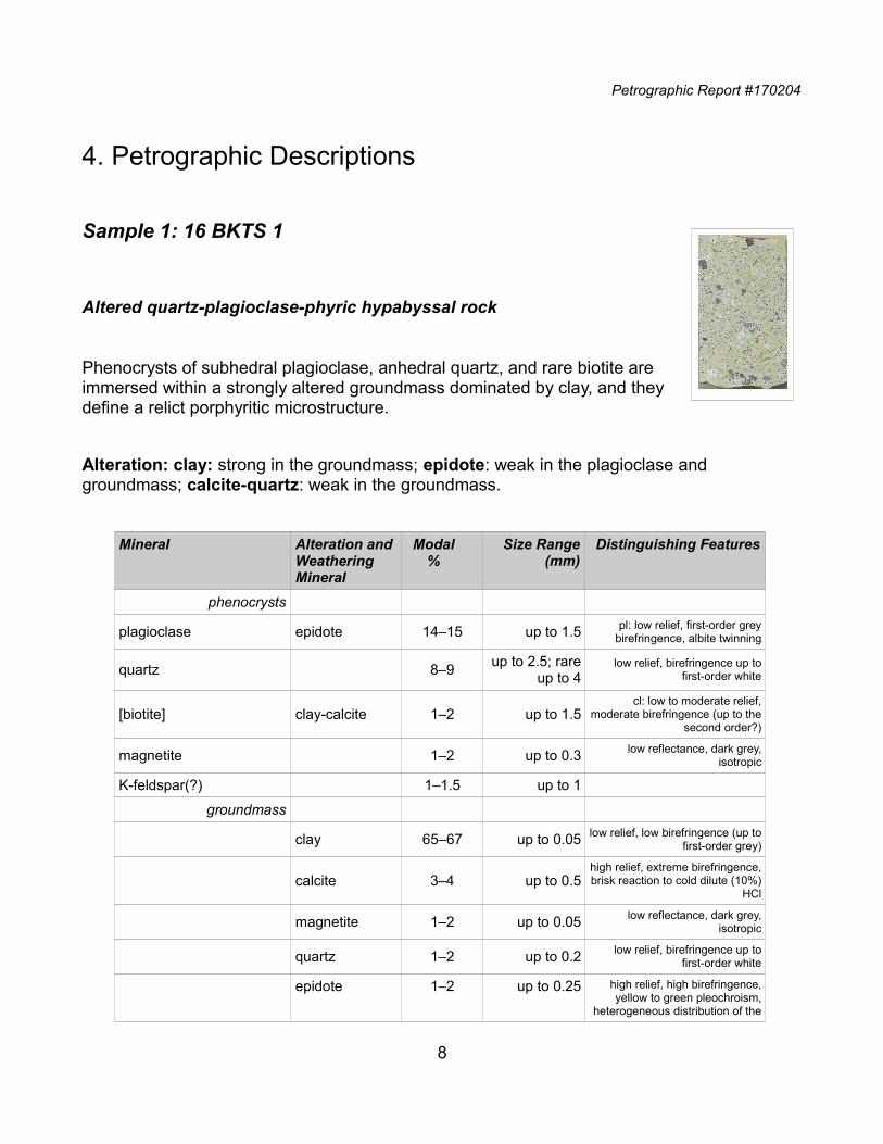
Sample 1: 16 BKTS 1
Altered quartz-plagioclase-phyric hypabyssal rock
Phenocrysts of subhedral plagioclase, anhedral quartz, and rare biotite areimmersed within a strongly altered groundmass dominated by clay, and theydefine a relict porphyritic microstructure.
Alteration: clay: strong in the groundmass; epidote: weak in the plagioclase and groundmass; calcite-quartz: weak in the groundmass.
Mineral Alteration andWeathering Mineral
Modal%
Size Range(mm)
Distinguishing Features
phenocrysts
plagioclase epidote 14‒15 up to 1.5 pl: low relief, first-order greybirefringence, albite twinning
quartz 8‒9up to 2.5; rare
up to 4low relief, birefringence up to
first-order white
[biotite] clay-calcite 1‒2 up to 1.5cl: low to moderate relief,
moderate birefringence (up to thesecond order?)
magnetite 1‒2 up to 0.3 low reflectance, dark grey,isotropic
K-feldspar(?) 1‒1.5 up to 1
groundmass
clay 65‒67 up to 0.05 low relief, low birefringence (up tofirst-order grey)
calcite 3‒4 up to 0.5high relief, extreme birefringence,brisk reaction to cold dilute (10%)
HCl
magnetite 1‒2 up to 0.05 low reflectance, dark grey,isotropic
quartz 1‒2 up to 0.2 low relief, birefringence up tofirst-order white
epidote 1‒2 up to 0.25 high relief, high birefringence,yellow to green pleochroism,
heterogeneous distribution of the
8
Petrographic Report #170204
Mineral Alteration andWeathering Mineral
Modal%
Size Range(mm)
Distinguishing Features
birefringence colours
apatite tr up to 0.3moderate relief, birefringence up
to first-order grey, straightextinction, negative elongation
Plagioclase forms subhedral phenocrysts (up to 1.5 mm), which are moderately altered by a very fine-grained unresolved material (epidote? clay? calcite?) and are overprinted by fine-grained crystals of epidote. Most of the phenocrysts are white on the billet (see image of the billet above). Some other phenocrysts are stained yellow, suggesting the occurrence of some K-feldspar crystals.Quartz forms anhedral phenocrysts (up to up to 2.5 mm; rare up to 4 mm) with sub-rounded (Photomicrograph 1) to embayed shapes. Fine-grained crystals of quartz are intergrown with the calcite in some of the replacement patches overprinting the groundmass.Clay dominates the composition of the replacement aggregate replacing the groundmass. The yellow stain indicates that the clay contains potassium and possibly replaced a K-feldspar-bearing groundmass.Magnetite forms subhedral crystals (up to 0.3 mm) dispersed within the groundmass. Because of its subhedral shape and its homogeneous distribution within the groundmass, I tentatively interpret the magnetite as a magmatic mineral.Subhedral books (up to 1.5 mm) of biotite are dispersed within the groundmass and are replaced by epitaxial clay and subordinate patches of calcite.Thin veinlets of calcite crosscut the porphyritic microstructure.
9

Petrographic Report #170204
10
Photomicrograph 1: Phenocrysts of plagioclase (pl) and quartz (qz) are immersed within a clay-altered groundmass. Plane-polarized transmitted light.
Petrographic Report #170204
Sample 2: 16 BKTS 2
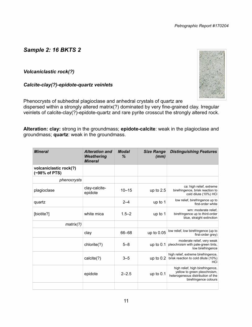
Volcaniclastic rock(?)
Calcite-clay(?)-epidote-quartz veinlets
Phenocrysts of subhedral plagioclase and anhedral crystals of quartz aredispersed within a strongly altered matrix(?) dominated by very fine-grained clay. Irregular veinlets of calcite-clay(?)-epidote-quartz and rare pyrite crosscut the strongly altered rock.
Alteration: clay: strong in the groundmass; epidote-calcite: weak in the plagioclase and groundmass; quartz: weak in the groundmass.
Mineral Alteration andWeathering Mineral
Modal%
Size Range(mm)
Distinguishing Features
volcaniclastic rock(?) (~98% of PTS)
phenocrysts
plagioclaseclay-calcite-epidote
10‒15 up to 2.5ca: high relief, extreme
birefringence, brisk reaction tocold dilute (10%) HCl
quartz 2‒4 up to 1 low relief, birefringence up tofirst-order white
[biotite?] white mica 1.5‒2 up to 1wm: moderate relief,
birefringence up to third-orderblue, straight extinction
matrix(?)
clay 66‒68 up to 0.05 low relief, low birefringence (up tofirst-order grey)
chlorite(?) 5‒8 up to 0.1moderate relief, very weak
pleochroism with pale-green tints,low birefringence
calcite(?) 3‒5 up to 0.2high relief, extreme birefringence,brisk reaction to cold dilute (10%)
HCl
epidote 2‒2.5 up to 0.1
high relief, high birefringence,yellow to green pleochroism,
heterogeneous distribution of thebirefringence colours
11
Petrographic Report #170204
Mineral Alteration andWeathering Mineral
Modal%
Size Range(mm)
Distinguishing Features
calcite-clay(?)-epidote-quartz veinlets (2% of PTS)
calcite 1 up to 0.25high relief, extreme birefringence,brisk reaction to cold dilute (10%)
HCl
clay(?) 1 up to 0.1 low relief, low birefringence (up tofirst-order grey)
epidote tr up to 0.1
high relief, high birefringence,yellow to green pleochroism,
heterogeneous distribution of thebirefringence colours
quartz tr up to 0.1 low relief, birefringence up tofirst-order white
pyrite [iron oxides] tr up to 0.7 long up to 0.7 long
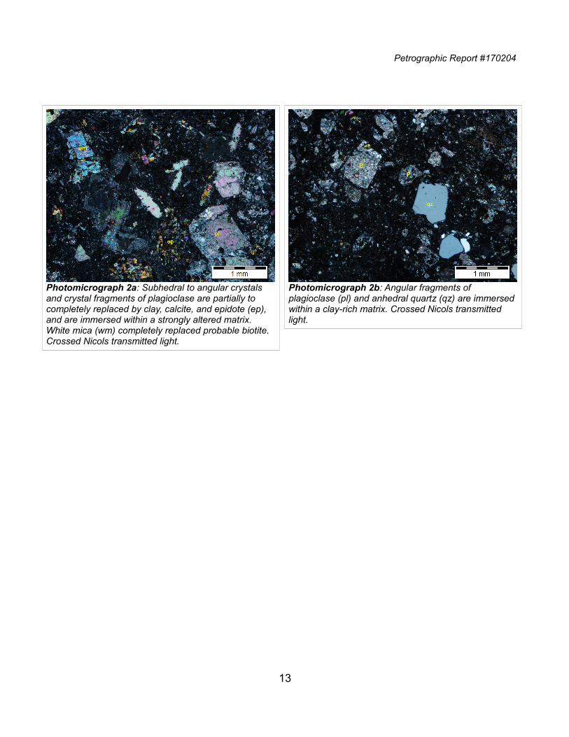
Plagioclase occurs as subhedral to angular phenocrysts randomly oriented within the strongly altered matrix(?). The plagioclase is moderately to strongly altered by very fine-grained clay and fine-grained replacement patches of calcite and fine-grained epidote (Photomicrographs 2a and 2b). The occurrence of inequigranular angular fragments of alteredplagioclase and probable ferromagnesian minerals suggests that this rock is a volcaniclastic rock.Quartz is subordinate to the plagioclase and forms anhedral crystals of up to 1 mm. The shapes of the quartz crystals range from anhedral to angular.White mica and calcite completely replaced crystals of biotite of up to 1 mm.Very fine-grained flakes of clay completely replaced the matrix of this rock. The clay hosts irregular patches of probable chlorite, vein-like domains of calcite and chlorite, and fine-grained crystals of epidote.
12
Petrographic Report #170204
13
Photomicrograph 2a: Subhedral to angular crystals and crystal fragments of plagioclase are partially to completely replaced by clay, calcite, and epidote (ep), and are immersed within a strongly altered matrix. White mica (wm) completely replaced probable biotite. Crossed Nicols transmitted light.
Photomicrograph 2b: Angular fragments of plagioclase (pl) and anhedral quartz (qz) are immersedwithin a clay-rich matrix. Crossed Nicols transmitted light.
Petrographic Report #170204
Sample 3: 16 BKTS 3
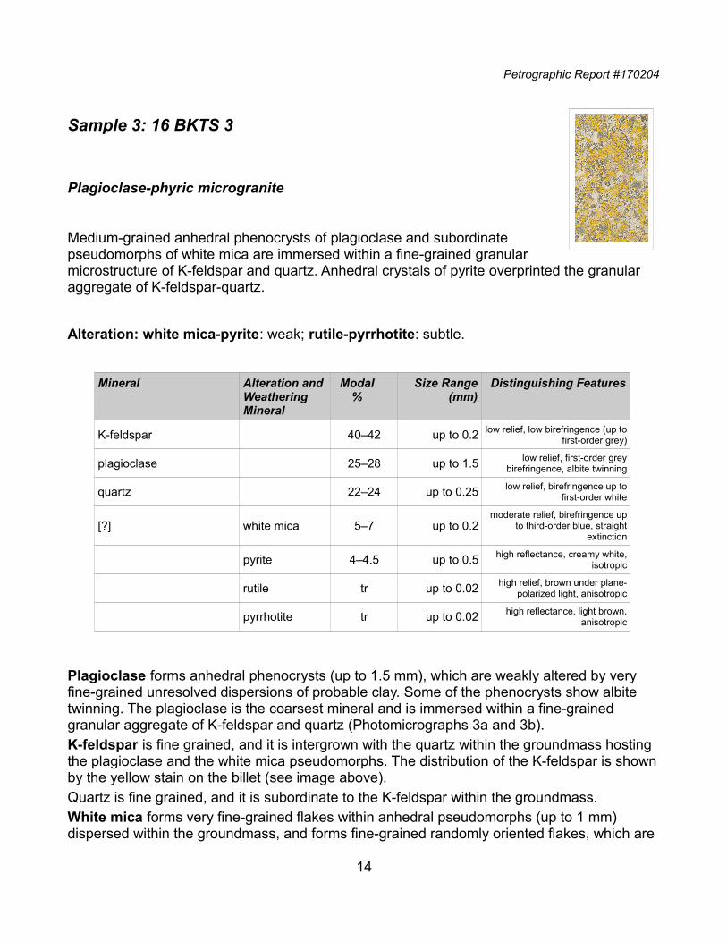
Plagioclase-phyric microgranite
Medium-grained anhedral phenocrysts of plagioclase and subordinatepseudomorphs of white mica are immersed within a fine-grained granularmicrostructure of K-feldspar and quartz. Anhedral crystals of pyrite overprinted the granular aggregate of K-feldspar-quartz.
Alteration: white mica-pyrite: weak; rutile-pyrrhotite: subtle.
Mineral Alteration andWeathering Mineral
Modal%
Size Range(mm)
Distinguishing Features
K-feldspar 40‒42 up to 0.2 low relief, low birefringence (up tofirst-order grey)
plagioclase 25‒28 up to 1.5 low relief, first-order greybirefringence, albite twinning
quartz 22‒24 up to 0.25 low relief, birefringence up tofirst-order white
[?] white mica 5‒7 up to 0.2moderate relief, birefringence up
to third-order blue, straightextinction
pyrite 4‒4.5 up to 0.5 high reflectance, creamy white,isotropic
rutile tr up to 0.02 high relief, brown under plane-polarized light, anisotropic
pyrrhotite tr up to 0.02 high reflectance, light brown,anisotropic
Plagioclase forms anhedral phenocrysts (up to 1.5 mm), which are weakly altered by very fine-grained unresolved dispersions of probable clay. Some of the phenocrysts show albite twinning. The plagioclase is the coarsest mineral and is immersed within a fine-grained granular aggregate of K-feldspar and quartz (Photomicrographs 3a and 3b).K-feldspar is fine grained, and it is intergrown with the quartz within the groundmass hosting the plagioclase and the white mica pseudomorphs. The distribution of the K-feldspar is shownby the yellow stain on the billet (see image above).Quartz is fine grained, and it is subordinate to the K-feldspar within the groundmass. White mica forms very fine-grained flakes within anhedral pseudomorphs (up to 1 mm) dispersed within the groundmass, and forms fine-grained randomly oriented flakes, which are
14
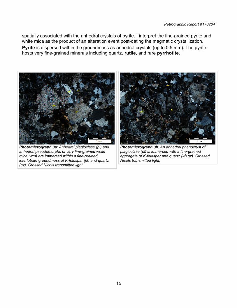
Petrographic Report #170204
spatially associated with the anhedral crystals of pyrite. I interpret the fine-grained pyrite and white mica as the product of an alteration event post-dating the magmatic crystallization.Pyrite is dispersed within the groundmass as anhedral crystals (up to 0.5 mm). The pyrite hosts very fine-grained minerals including quartz, rutile, and rare pyrrhotite.
15
Photomicrograph 3a: Anhedral plagioclase (pl) and anhedral pseudomorphs of very fine-grained white mica (wm) are immersed within a fine-grained interlobate groundmass of K-feldspar (kf) and quartz (qz). Crossed Nicols transmitted light.
Photomicrograph 3b: An anhedral phenocryst of plagioclase (pl) is immersed with a fine-grained aggregate of K-feldspar and quartz (kf+qz). Crossed Nicols transmitted light.
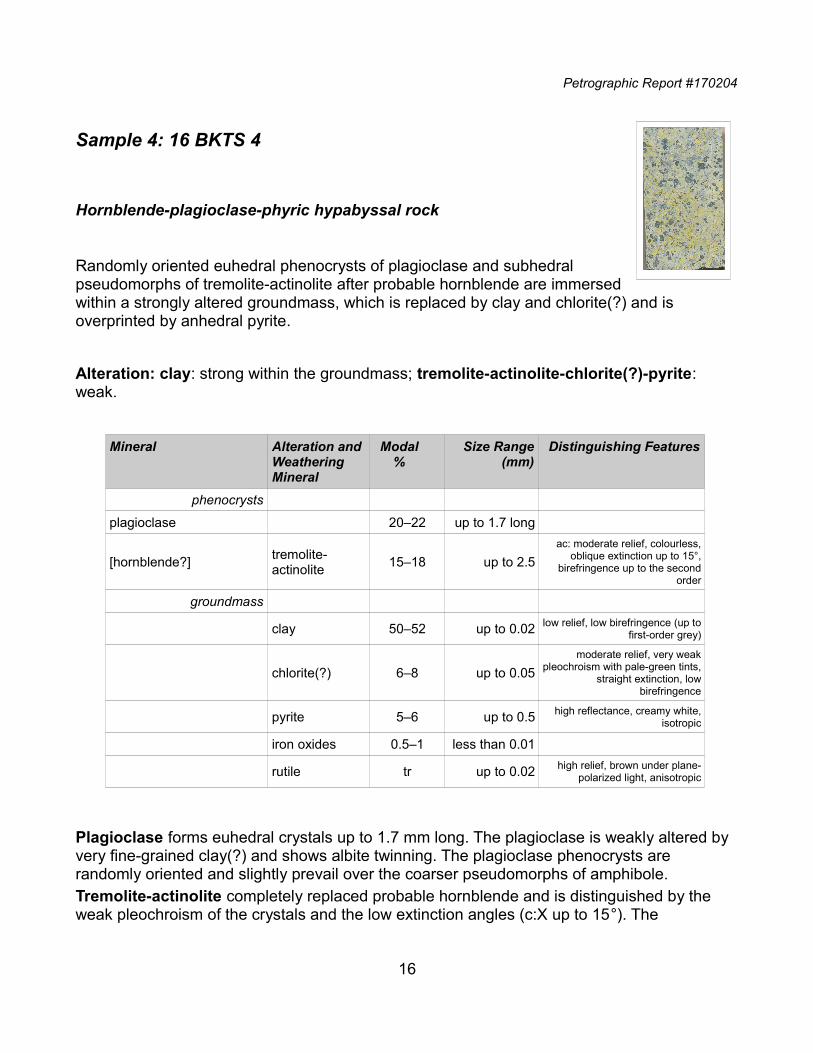
Petrographic Report #170204
Sample 4: 16 BKTS 4
Hornblende-plagioclase-phyric hypabyssal rock
Randomly oriented euhedral phenocrysts of plagioclase and subhedralpseudomorphs of tremolite-actinolite after probable hornblende are immersedwithin a strongly altered groundmass, which is replaced by clay and chlorite(?) and is overprinted by anhedral pyrite.
Alteration: clay: strong within the groundmass; tremolite-actinolite-chlorite(?)-pyrite: weak.
Mineral Alteration andWeathering Mineral
Modal%
Size Range(mm)
Distinguishing Features
phenocrysts
plagioclase 20‒22 up to 1.7 long
[hornblende?]tremolite-actinolite
15‒18 up to 2.5
ac: moderate relief, colourless,oblique extinction up to 15°,
birefringence up to the secondorder
groundmass
clay 50‒52 up to 0.02 low relief, low birefringence (up tofirst-order grey)
chlorite(?) 6‒8 up to 0.05
moderate relief, very weakpleochroism with pale-green tints,
straight extinction, lowbirefringence
pyrite 5‒6 up to 0.5 high reflectance, creamy white,isotropic
iron oxides 0.5‒1 less than 0.01
rutile tr up to 0.02 high relief, brown under plane-polarized light, anisotropic
Plagioclase forms euhedral crystals up to 1.7 mm long. The plagioclase is weakly altered by very fine-grained clay(?) and shows albite twinning. The plagioclase phenocrysts are randomly oriented and slightly prevail over the coarser pseudomorphs of amphibole.Tremolite-actinolite completely replaced probable hornblende and is distinguished by the weak pleochroism of the crystals and the low extinction angles (c:X up to 15°). The
16
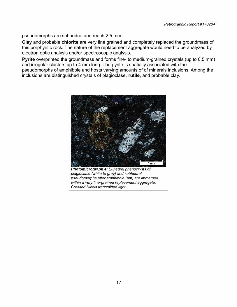
Petrographic Report #170204
pseudomorphs are subhedral and reach 2.5 mm.Clay and probable chlorite are very fine grained and completely replaced the groundmass of this porphyritic rock. The nature of the replacement aggregate would need to be analyzed by electron optic analysis and/or spectroscopic analysis.Pyrite overprinted the groundmass and forms fine- to medium-grained crystals (up to 0.5 mm)and irregular clusters up to 4 mm long. The pyrite is spatially associated with the pseudomorphs of amphibole and hosts varying amounts of of minerals inclusions. Among the inclusions are distinguished crystals of plagioclase, rutile, and probable clay.
17
Photomicrograph 4: Euhedral phenocrysts of plagioclase (white to grey) and subhedral pseudomorphs after amphibole (am) are immersed within a very fine-grained replacement aggregate. Crossed Nicols transmitted light.
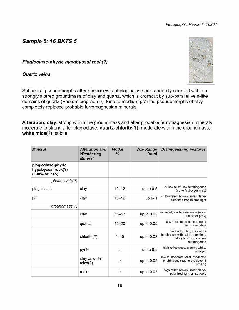
Petrographic Report #170204
Sample 5: 16 BKTS 5
Plagioclase-phyric hypabyssal rock(?)
Quartz veins
Subhedral pseudomorphs after phenocrysts of plagioclase are randomly oriented within a strongly altered groundmass of clay and quartz, which is crosscut by sub-parallel vein-like domains of quartz (Photomicrograph 5). Fine to medium-grained pseudomorphs of clay completely replaced probable ferromagnesian minerals.
Alteration: clay: strong within the groundmass and after probable ferromagnesian minerals; moderate to strong after plagioclase; quartz-chlorite(?): moderate within the groundmass; white mica(?): subtle.
Mineral Alteration andWeathering Mineral
Modal%
Size Range(mm)
Distinguishing Features
plagioclase-phyric hypabyssal rock(?) (~90% of PTS)
phenocrysts(?)
plagioclase clay 10‒12 up to 0.5 cl: low relief, low birefringence(up to first-order grey)
[?] clay 10‒12 up to 1 cl: low relief, brown under plane-polarized transmitted light
groundmass(?)
clay 55‒57 up to 0.02 low relief, low birefringence (up tofirst-order grey)
quartz 15‒20 up to 0.05 low relief, birefringence up tofirst-order white
chlorite(?) 5‒10 up to 0.02
moderate relief, very weakpleochroism with pale-green tints,
straight extinction, lowbirefringence
pyrite tr up to 0.5 high reflectance, creamy white,isotropic
clay or white mica(?)
tr up to 0.02low to moderate relief, moderatebirefringence (up to the second
order?)
rutile tr up to 0.02 high relief, brown under plane-polarized light, anisotropic
18
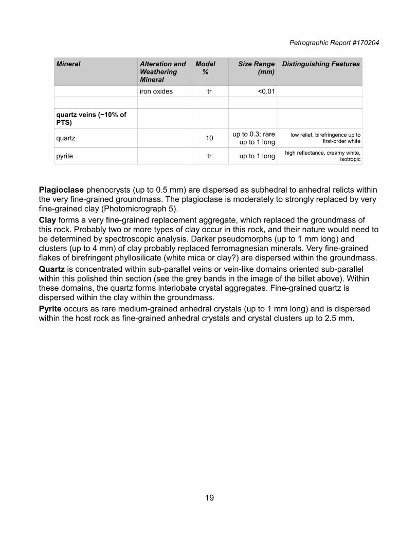
Petrographic Report #170204
Mineral Alteration andWeathering Mineral
Modal%
Size Range(mm)
Distinguishing Features
iron oxides tr <0.01
quartz veins (~10% of PTS)
quartz 10up to 0.3; rare
up to 1 longlow relief, birefringence up to
first-order white
pyrite tr up to 1 long high reflectance, creamy white,isotropic
Plagioclase phenocrysts (up to 0.5 mm) are dispersed as subhedral to anhedral relicts withinthe very fine-grained groundmass. The plagioclase is moderately to strongly replaced by very fine-grained clay (Photomicrograph 5).Clay forms a very fine-grained replacement aggregate, which replaced the groundmass of this rock. Probably two or more types of clay occur in this rock, and their nature would need tobe determined by spectroscopic analysis. Darker pseudomorphs (up to 1 mm long) and clusters (up to 4 mm) of clay probably replaced ferromagnesian minerals. Very fine-grained flakes of birefringent phyllosilicate (white mica or clay?) are dispersed within the groundmass.Quartz is concentrated within sub-parallel veins or vein-like domains oriented sub-parallel within this polished thin section (see the grey bands in the image of the billet above). Within these domains, the quartz forms interlobate crystal aggregates. Fine-grained quartz is dispersed within the clay within the groundmass.Pyrite occurs as rare medium-grained anhedral crystals (up to 1 mm long) and is dispersed within the host rock as fine-grained anhedral crystals and crystal clusters up to 2.5 mm.
19
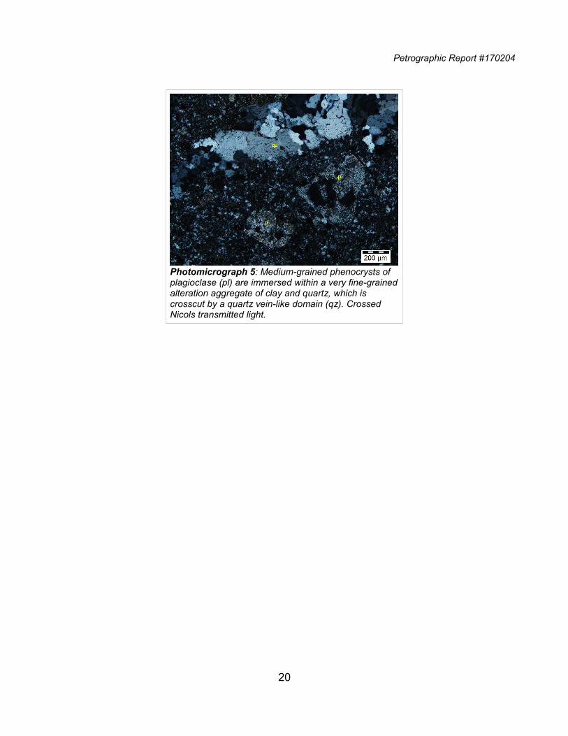
Petrographic Report #170204
20
Photomicrograph 5: Medium-grained phenocrysts of plagioclase (pl) are immersed within a very fine-grainedalteration aggregate of clay and quartz, which is crosscut by a quartz vein-like domain (qz). Crossed Nicols transmitted light.
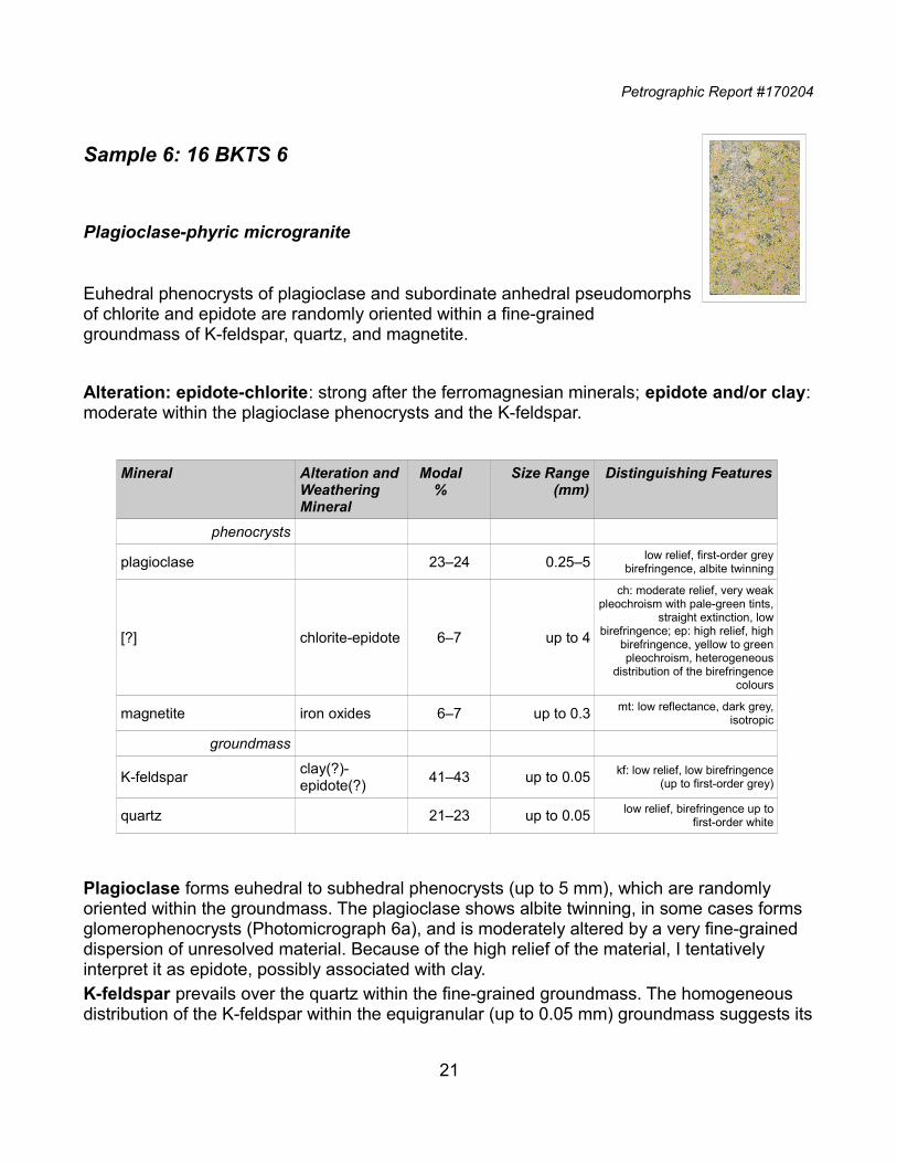
Petrographic Report #170204
Sample 6: 16 BKTS 6
Plagioclase-phyric microgranite
Euhedral phenocrysts of plagioclase and subordinate anhedral pseudomorphsof chlorite and epidote are randomly oriented within a fine-grainedgroundmass of K-feldspar, quartz, and magnetite.
Alteration: epidote-chlorite: strong after the ferromagnesian minerals; epidote and/or clay:moderate within the plagioclase phenocrysts and the K-feldspar.
Mineral Alteration andWeathering Mineral
Modal%
Size Range(mm)
Distinguishing Features
phenocrysts
plagioclase 23‒24 0.25‒5 low relief, first-order greybirefringence, albite twinning
[?] chlorite-epidote 6‒7 up to 4
ch: moderate relief, very weakpleochroism with pale-green tints,
straight extinction, lowbirefringence; ep: high relief, high
birefringence, yellow to greenpleochroism, heterogeneous
distribution of the birefringencecolours
magnetite iron oxides 6‒7 up to 0.3 mt: low reflectance, dark grey,isotropic
groundmass
K-feldsparclay(?)-epidote(?)
41‒43 up to 0.05 kf: low relief, low birefringence(up to first-order grey)
quartz 21‒23 up to 0.05 low relief, birefringence up tofirst-order white
Plagioclase forms euhedral to subhedral phenocrysts (up to 5 mm), which are randomly oriented within the groundmass. The plagioclase shows albite twinning, in some cases forms glomerophenocrysts (Photomicrograph 6a), and is moderately altered by a very fine-grained dispersion of unresolved material. Because of the high relief of the material, I tentatively interpret it as epidote, possibly associated with clay.K-feldspar prevails over the quartz within the fine-grained groundmass. The homogeneous distribution of the K-feldspar within the equigranular (up to 0.05 mm) groundmass suggests its
21
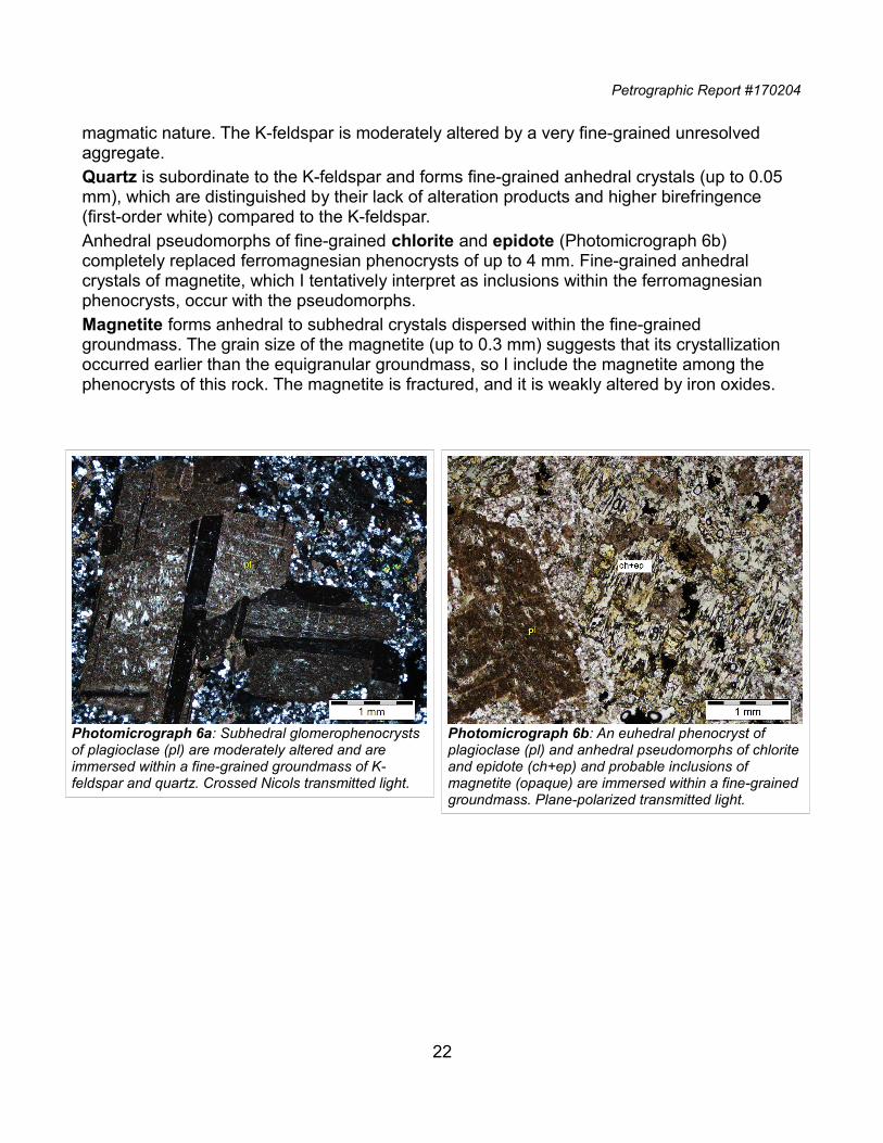
Petrographic Report #170204
magmatic nature. The K-feldspar is moderately altered by a very fine-grained unresolved aggregate.Quartz is subordinate to the K-feldspar and forms fine-grained anhedral crystals (up to 0.05 mm), which are distinguished by their lack of alteration products and higher birefringence (first-order white) compared to the K-feldspar.Anhedral pseudomorphs of fine-grained chlorite and epidote (Photomicrograph 6b) completely replaced ferromagnesian phenocrysts of up to 4 mm. Fine-grained anhedral crystals of magnetite, which I tentatively interpret as inclusions within the ferromagnesian phenocrysts, occur with the pseudomorphs.Magnetite forms anhedral to subhedral crystals dispersed within the fine-grained groundmass. The grain size of the magnetite (up to 0.3 mm) suggests that its crystallization occurred earlier than the equigranular groundmass, so I include the magnetite among the phenocrysts of this rock. The magnetite is fractured, and it is weakly altered by iron oxides.
22
Photomicrograph 6a: Subhedral glomerophenocrysts of plagioclase (pl) are moderately altered and are immersed within a fine-grained groundmass of K-feldspar and quartz. Crossed Nicols transmitted light.
Photomicrograph 6b: An euhedral phenocryst of plagioclase (pl) and anhedral pseudomorphs of chloriteand epidote (ch+ep) and probable inclusions of magnetite (opaque) are immersed within a fine-grainedgroundmass. Plane-polarized transmitted light.
Petrographic Report #170204
Sample 7: 16 BKTS 7
Polymictic volcaniclastic conglomerate
Polymictic sub-rounded fragments (from 1 mm up to 20 mm long in thepolished thin section) define a clast-supported microstructure and are madeup of euhedral phenocrysts of plagioclase, subhedral pseudomorphs of white mica and/or clay, and fine-grained pseudomorphs of hematite after magnetite. All of these are immersed within a very fine-grained groundmass, which in most cases is dominated by clay, and in othercases shows a higher relief and is probably dominated by a mixture of clay and epidote. The fragments are immersed within a heterogeneous matrix of clay, fragments of clay-altered groundmass, plagioclase fragments, and heterogeneous aggregates of iron oxides and limonitic material.
Alteration: clay: strong in the groundmass and the matrix, moderate within the plagioclase; clay and/or white mica: strong within the ferromagnesian minerals; iron oxides and limonitic material: weak to moderate.
Mineral Alteration andWeathering Mineral
Modal%
Size Range(mm)
Distinguishing Features
fragments (75% of PTS)~1 up to 20
mm long
phenocrysts
plagioclase 25‒28 up to 1.2 low relief, first-order greybirefringence, albite twinning
[amphibole]white mica and/or clay
6‒7 up to 0.7wm?: moderate relief,
birefringence up to third-orderblue, straight extinction
[magnetite] hematite 1.5‒2 up to 0.1 he: moderate reflectance, lightblue, anisotropic
groundmass
clay(?) 37‒39 up to 0.05 low relief, low birefringence (up tofirst-order grey)
hematite-iron oxides
2‒3 up to 0.25 he: moderate reflectance, lightblue, anisotropic
epidote 1 up to 0.1
high relief, high birefringence,yellow to green pleochroism,
heterogeneous distribution of thebirefringence colours
matrix (~25% of PTS)
23
Petrographic Report #170204
Mineral Alteration andWeathering Mineral
Modal%
Size Range(mm)
Distinguishing Features
clay 18‒20 up to 0.02 low relief, low birefringence (up tofirst-order grey)
iron oxides 3‒4 <0.01
plagioclase clay/epidote 0.5‒1 up to 0.3 pl: low relief, first-order greybirefringence, albite twinning
Clay dominates the composition of the groundmass, in which it forms very fine-grained flakes with low birefringence. Very fine-grained clay partially replaced the plagioclase phenocrysts. Euhedral phenocrysts of plagioclase (up to 1.2 mm) are randomly oriented within the strongly altered groundmass and define a porphyritic microstructure. The plagioclase crystals are moderately to strongly altered by a very fine-grained aggregate of probable clay. The fragments (from 1 mm up to 20 mm long) are sub-rounded and define a clast-supported microstructure with interstitial material consisting of clay, fragments of groundmass, and plagioclase. The fragments are variably overprinted by iron oxides and limonitic material.Subhedral pseudomorphs after amphibole are up to 0.7 mm across and are distinguished by their lozenge shape. The pseudomorphs are made up of fine-grained white mica and/or clay. These pseudomorphs are completely replaced by clay within the matrix.Hematite completely replaced fine-grained subhedral to anhedral crystals of magnetite (up to 0.25 mm) dispersed within the groundmass of the porphyritic fragments. Very fine-grained dispersions of magnetite and/or hematite are dispersed within the clay replacing the groundmass.The different alteration of the groundmass in the different fragments (e.g., Photomicrograph 7b) suggest a polymictic nature of this conglomerate, although all the fragments share a porphyritic nature imparted by the plagioclase, and in some fragments by the altered amphibole and altered magnetite.
24
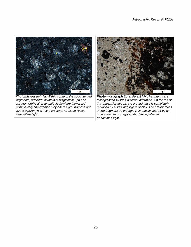
Petrographic Report #170204
25
Photomicrograph 7a: Within some of the sub-roundedfragments, euhedral crystals of plagioclase (pl) and pseudomorphs after amphibole [am] are immersed within a very fine-grained clay-altered groundmass anddefine a porphyritic microstructure. Crossed Nicols transmitted light.
Photomicrograph 7b: Different lithic fragments are distinguished by their different alteration. On the left of this photomicrograph, the groundmass is completely replaced by a light aggregate of clay. The groundmass of the fragment on the right is intensely altered by an unresolved earthy aggregate. Plane-polarized transmitted light.
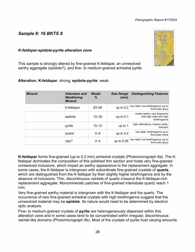
Petrographic Report #170204
Sample 8: 16 BKTS 8
K-feldspar-epidote-pyrite alteration zone
This sample is strongly altered by fine-grained K-feldspar, an unresolvedearthy aggregate (epidote?), and fine- to medium-grained anhedral pyrite.
Alteration: K-feldspar: strong; epidote-pyrite: weak.
Mineral Alteration andWeathering Mineral
Modal%
Size Range(mm)
Distinguishing Features
K-feldspar 63‒65 up to 0.2 low relief, low birefringence (up tofirst-order grey)
epidote 15‒20 up to 0.1mostly earthy, rare fragments
with high relief and highbirefringence
pyrite 10‒12 up to 1 high reflectance, creamy white,isotropic
quartz 5‒6 up to 0.2 low relief, birefringence up tofirst-order white
clay? 2‒4 up to 0.05 low relief, low birefringence (up tofirst-order grey)
K-feldspar forms fine-grained (up to 0.2 mm) anhedral crystals (Photomicrograph 8a). The K-feldspar dominates the composition of this polished thin section and hosts very fine-grained unresolved inclusions, which impart an earthy appearance to the replacement aggregate. In some cases, the K-feldspar is intergrown with subordinate fine-grained crystals of quartz, which are distinguished from the K-feldspar by their slightly higher birefringence and by the absence of inclusions. Thin, discontinuous veinlets of quartz crosscut the K-feldspar-rich replacement aggregate. Monomineralic patches of fine-grained interlobate quartz reach 1 mm.Very fine-grained earthy material is intergrown with the K-feldspar and the quartz. The occurrence of rare fine-grained anhedral crystals with high birefringence suggest that the unresolved material may be epidote. Its nature would need to be determined by electron optic analysis.Fine- to medium-grained crystals of pyrite are heterogeneously dispersed within this alteration zone and in some cases tend to be concentrated within irregular, discontinuous veinlet-like domains (Photomicrograph 8b). Most of the crystals of pyrite host varying amounts
26
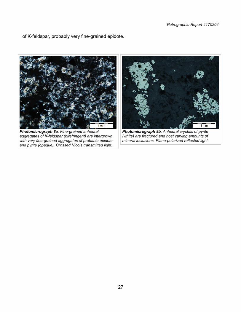
Petrographic Report #170204
of K-feldspar, probably very fine-grained epidote.
27
Photomicrograph 8a: Fine-grained anhedral aggregates of K-feldspar (birefringent) are intergrown with very fine-grained aggregates of probable epidote and pyrite (opaque). Crossed Nicols transmitted light.
Photomicrograph 8b: Anhedral crystals of pyrite (white) are fractured and host varying amounts of mineral inclusions. Plane-polarized reflected light.
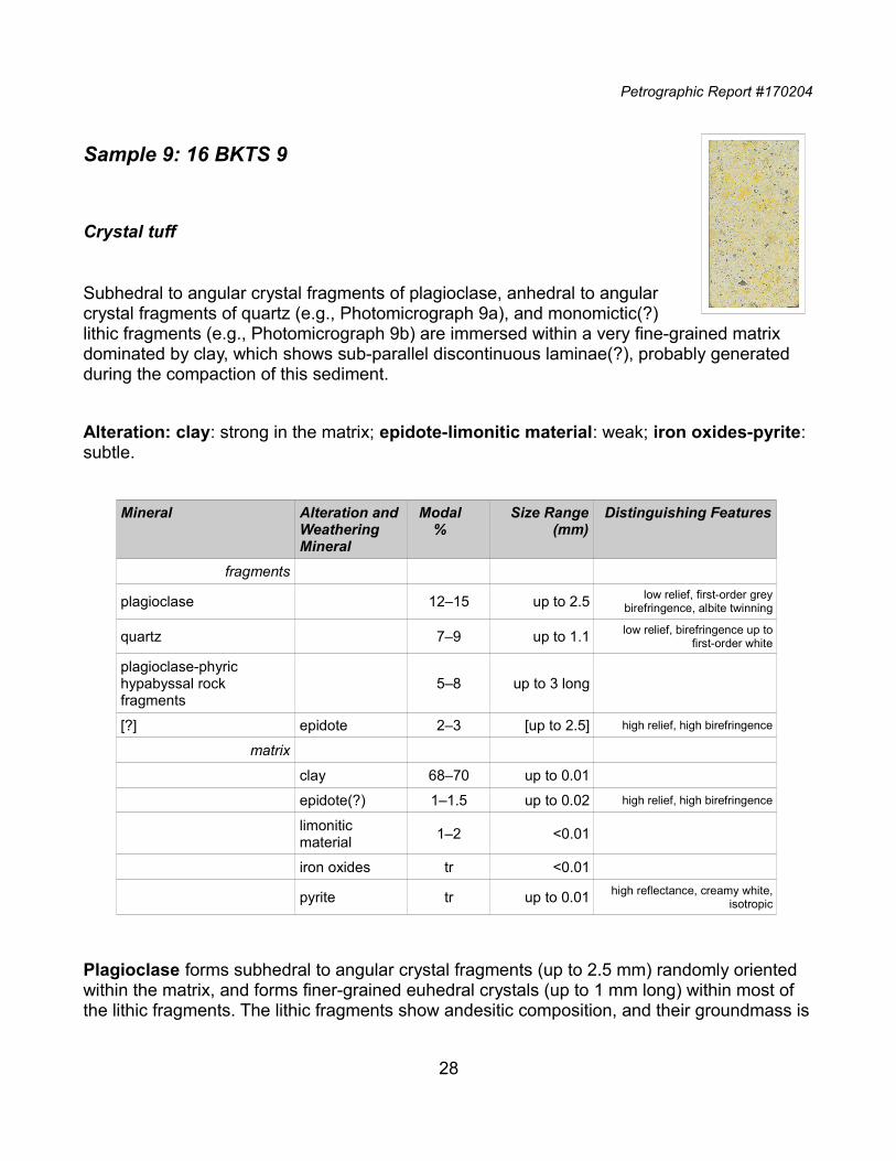
Petrographic Report #170204
Sample 9: 16 BKTS 9
Crystal tuff
Subhedral to angular crystal fragments of plagioclase, anhedral to angularcrystal fragments of quartz (e.g., Photomicrograph 9a), and monomictic(?)lithic fragments (e.g., Photomicrograph 9b) are immersed within a very fine-grained matrix dominated by clay, which shows sub-parallel discontinuous laminae(?), probably generated during the compaction of this sediment.
Alteration: clay: strong in the matrix; epidote-limonitic material: weak; iron oxides-pyrite: subtle.
Mineral Alteration andWeathering Mineral
Modal%
Size Range(mm)
Distinguishing Features
fragments
plagioclase 12‒15 up to 2.5 low relief, first-order greybirefringence, albite twinning
quartz 7‒9 up to 1.1 low relief, birefringence up tofirst-order white
plagioclase-phyric hypabyssal rock fragments
5‒8 up to 3 long
[?] epidote 2‒3 [up to 2.5] high relief, high birefringence
matrix
clay 68‒70 up to 0.01
epidote(?) 1‒1.5 up to 0.02 high relief, high birefringence
limonitic material
1‒2 <0.01
iron oxides tr <0.01
pyrite tr up to 0.01 high reflectance, creamy white,isotropic
Plagioclase forms subhedral to angular crystal fragments (up to 2.5 mm) randomly oriented within the matrix, and forms finer-grained euhedral crystals (up to 1 mm long) within most of the lithic fragments. The lithic fragments show andesitic composition, and their groundmass is
28
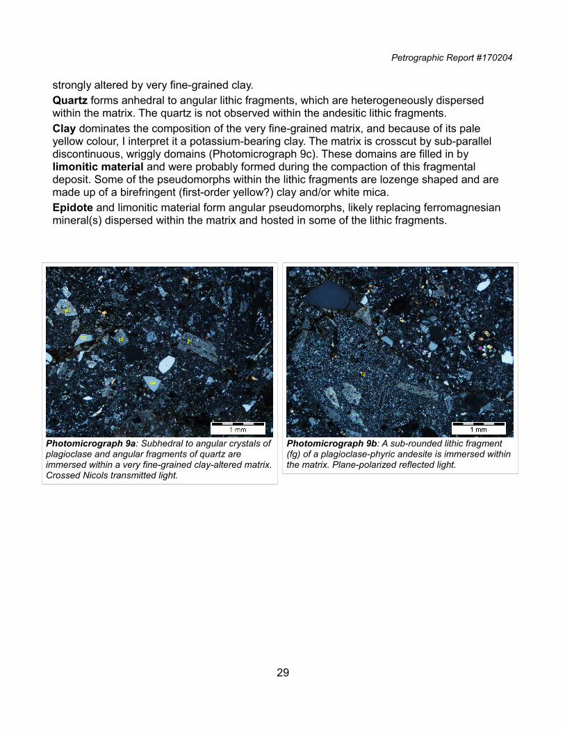
Petrographic Report #170204
strongly altered by very fine-grained clay.Quartz forms anhedral to angular lithic fragments, which are heterogeneously dispersed within the matrix. The quartz is not observed within the andesitic lithic fragments.Clay dominates the composition of the very fine-grained matrix, and because of its pale yellow colour, I interpret it a potassium-bearing clay. The matrix is crosscut by sub-parallel discontinuous, wriggly domains (Photomicrograph 9c). These domains are filled in by limonitic material and were probably formed during the compaction of this fragmental deposit. Some of the pseudomorphs within the lithic fragments are lozenge shaped and are made up of a birefringent (first-order yellow?) clay and/or white mica.Epidote and limonitic material form angular pseudomorphs, likely replacing ferromagnesian mineral(s) dispersed within the matrix and hosted in some of the lithic fragments.
29
Photomicrograph 9b: A sub-rounded lithic fragment (fg) of a plagioclase-phyric andesite is immersed withinthe matrix. Plane-polarized reflected light.
Photomicrograph 9a: Subhedral to angular crystals ofplagioclase and angular fragments of quartz are immersed within a very fine-grained clay-altered matrix.Crossed Nicols transmitted light.
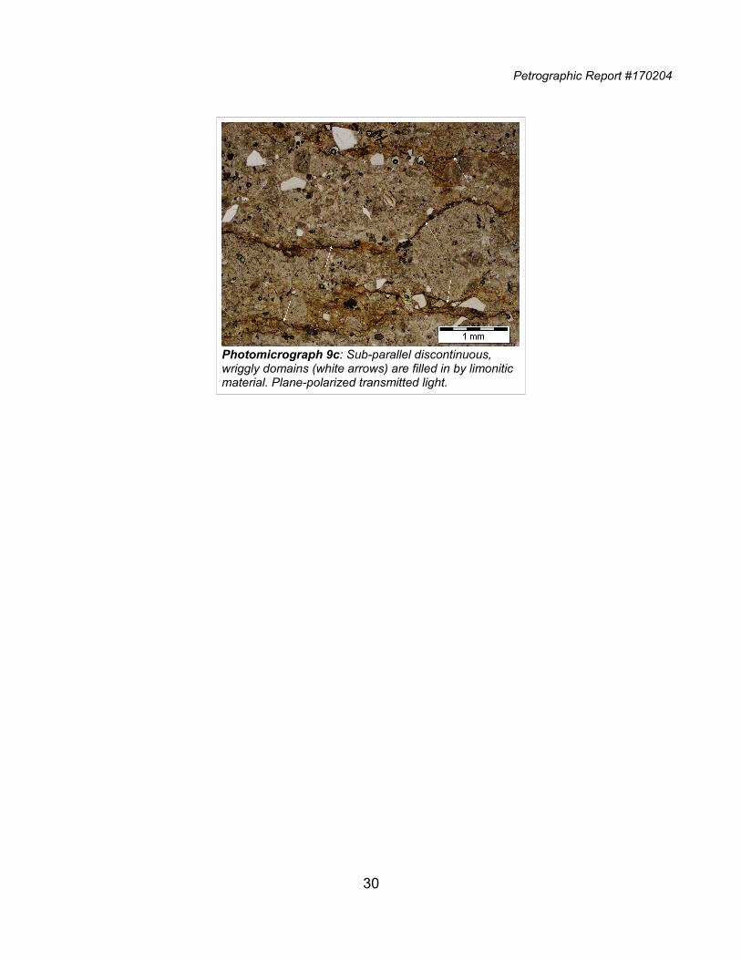
Petrographic Report #170204
30
Photomicrograph 9c: Sub-parallel discontinuous, wriggly domains (white arrows) are filled in by limonitic material. Plane-polarized transmitted light.
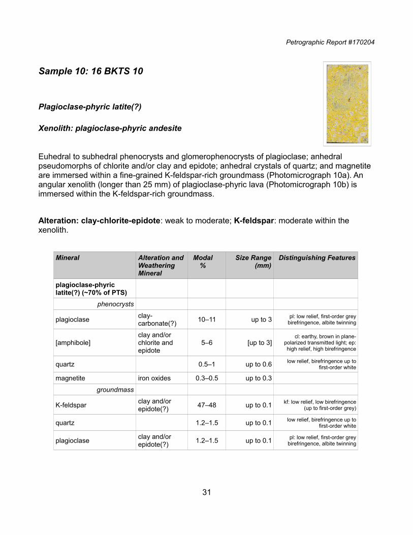
Petrographic Report #170204
Sample 10: 16 BKTS 10
Plagioclase-phyric latite(?)
Xenolith: plagioclase-phyric andesite
Euhedral to subhedral phenocrysts and glomerophenocrysts of plagioclase; anhedral pseudomorphs of chlorite and/or clay and epidote; anhedral crystals of quartz; and magnetite are immersed within a fine-grained K-feldspar-rich groundmass (Photomicrograph 10a). An angular xenolith (longer than 25 mm) of plagioclase-phyric lava (Photomicrograph 10b) is immersed within the K-feldspar-rich groundmass.
Alteration: clay-chlorite-epidote: weak to moderate; K-feldspar: moderate within the xenolith.
Mineral Alteration andWeathering Mineral
Modal%
Size Range(mm)
Distinguishing Features
plagioclase-phyric latite(?) (~70% of PTS)
phenocrysts
plagioclaseclay-carbonate(?)
10‒11 up to 3 pl: low relief, first-order greybirefringence, albite twinning
[amphibole]clay and/or chlorite and epidote
5‒6 [up to 3]cl: earthy, brown in plane-
polarized transmitted light; ep:high relief, high birefringence
quartz 0.5‒1 up to 0.6 low relief, birefringence up tofirst-order white
magnetite iron oxides 0.3‒0.5 up to 0.3
groundmass
K-feldsparclay and/or epidote(?)
47‒48 up to 0.1 kf: low relief, low birefringence(up to first-order grey)
quartz 1.2‒1.5 up to 0.1 low relief, birefringence up tofirst-order white
plagioclaseclay and/or epidote(?)
1.2‒1.5 up to 0.1 pl: low relief, first-order greybirefringence, albite twinning
31
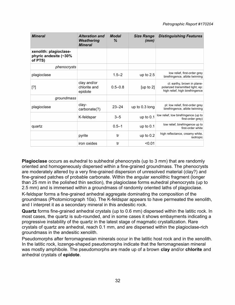
Petrographic Report #170204
Mineral Alteration andWeathering Mineral
Modal%
Size Range(mm)
Distinguishing Features
xenolith: plagioclase-phyric andesite (~30% of PTS)
phenocrysts
plagioclase 1.5‒2 up to 2.5 low relief, first-order greybirefringence, albite twinning
[?]clay and/or chlorite and epidote
0.5‒0.8 [up to 2]cl: earthy, brown in plane-
polarized transmitted light; ep:high relief, high birefringence
groundmass
plagioclaseclay-carbonate(?)
23‒24 up to 0.3 long pl: low relief, first-order greybirefringence, albite twinning
K-feldspar 3‒5 up to 0.1 low relief, low birefringence (up tofirst-order grey)
quartz 0.5‒1 up to 0.1 low relief, birefringence up tofirst-order white
pyrite tr up to 0.2 high reflectance, creamy white,isotropic
iron oxides tr <0.01
Plagioclase occurs as euhedral to subhedral phenocrysts (up to 3 mm) that are randomly oriented and homogeneously dispersed within a fine-grained groundmass. The phenocrysts are moderately altered by a very fine-grained dispersion of unresolved material (clay?) and fine-grained patches of probable carbonate. Within the angular xenolithic fragment (longer than 25 mm in the polished thin section), the plagioclase forms euhedral phenocrysts (up to 2.5 mm) and is immersed within a groundmass of randomly oriented laths of plagioclase. K-feldspar forms a fine-grained anhedral aggregate dominating the composition of the groundmass (Photomicrograph 10a). The K-feldspar appears to have permeated the xenolith,and I interpret it as a secondary mineral in this andesitic rock.Quartz forms fine-grained anhedral crystals (up to 0.6 mm) dispersed within the latitic rock. Inmost cases, the quartz is sub-rounded, and in some cases it shows embayments indicating a progressive instability of the quartz in the latest stage of magmatic crystallization. Rare crystals of quartz are anhedral, reach 0.1 mm, and are dispersed within the plagioclase-rich groundmass in the andesitic xenolith.Pseudomorphs after ferromagnesian minerals occur in the latitic host rock and in the xenolith.In the latitic rock, lozenge-shaped pseudomorphs indicate that the ferromagnesian mineral was mostly amphibole. The pseudomorphs are made up of a brown clay and/or chlorite and anhedral crystals of epidote.
32
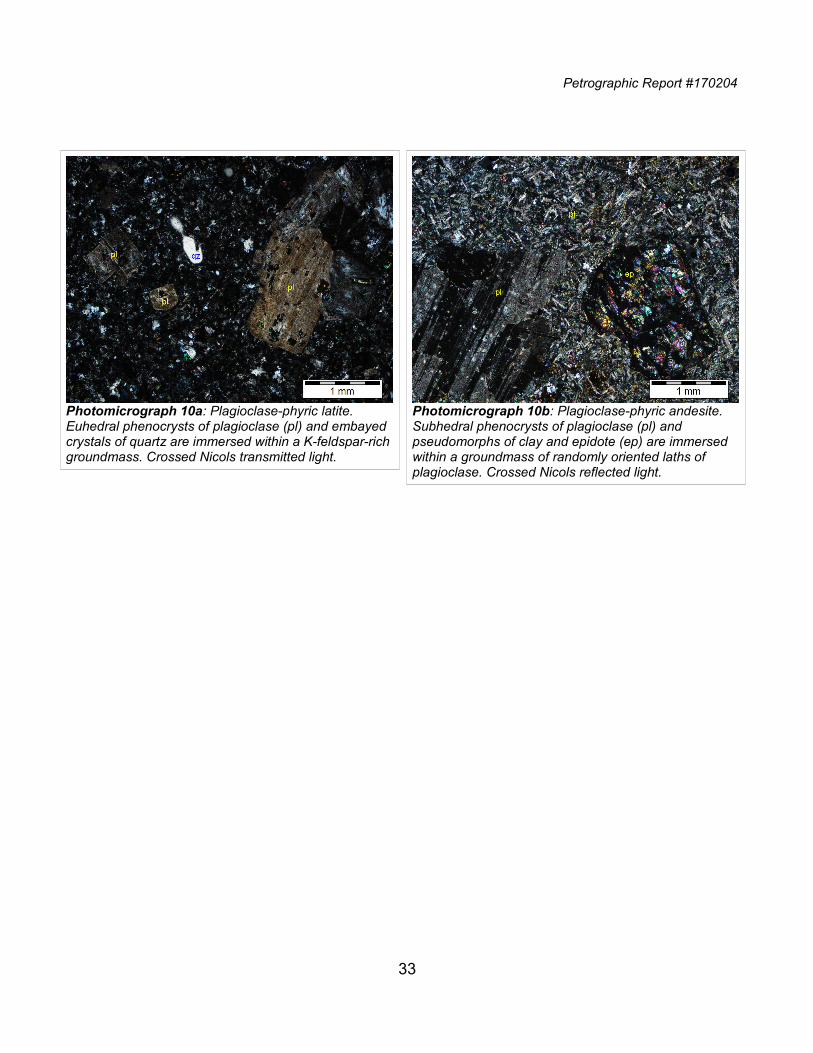
Petrographic Report #170204
33
Photomicrograph 10a: Plagioclase-phyric latite. Euhedral phenocrysts of plagioclase (pl) and embayed crystals of quartz are immersed within a K-feldspar-richgroundmass. Crossed Nicols transmitted light.
Photomicrograph 10b: Plagioclase-phyric andesite. Subhedral phenocrysts of plagioclase (pl) and pseudomorphs of clay and epidote (ep) are immersed within a groundmass of randomly oriented laths of plagioclase. Crossed Nicols reflected light.
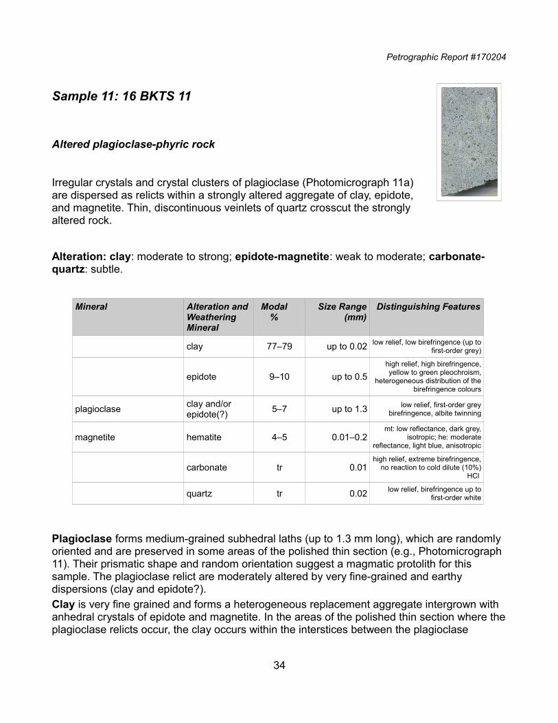
Petrographic Report #170204
Sample 11: 16 BKTS 11
Altered plagioclase-phyric rock
Irregular crystals and crystal clusters of plagioclase (Photomicrograph 11a)are dispersed as relicts within a strongly altered aggregate of clay, epidote,and magnetite. Thin, discontinuous veinlets of quartz crosscut the stronglyaltered rock.
Alteration: clay: moderate to strong; epidote-magnetite: weak to moderate; carbonate-quartz: subtle.
Mineral Alteration andWeathering Mineral
Modal%
Size Range(mm)
Distinguishing Features
clay 77‒79 up to 0.02 low relief, low birefringence (up tofirst-order grey)
epidote 9‒10 up to 0.5
high relief, high birefringence,yellow to green pleochroism,
heterogeneous distribution of thebirefringence colours
plagioclaseclay and/or epidote(?)
5‒7 up to 1.3 low relief, first-order greybirefringence, albite twinning
magnetite hematite 4‒5 0.01‒0.2mt: low reflectance, dark grey,
isotropic; he: moderatereflectance, light blue, anisotropic
carbonate tr 0.01high relief, extreme birefringence,
no reaction to cold dilute (10%)HCl
quartz tr 0.02 low relief, birefringence up tofirst-order white
Plagioclase forms medium-grained subhedral laths (up to 1.3 mm long), which are randomly oriented and are preserved in some areas of the polished thin section (e.g., Photomicrograph 11). Their prismatic shape and random orientation suggest a magmatic protolith for this sample. The plagioclase relict are moderately altered by very fine-grained and earthy dispersions (clay and epidote?).Clay is very fine grained and forms a heterogeneous replacement aggregate intergrown with anhedral crystals of epidote and magnetite. In the areas of the polished thin section where theplagioclase relicts occur, the clay occurs within the interstices between the plagioclase
34
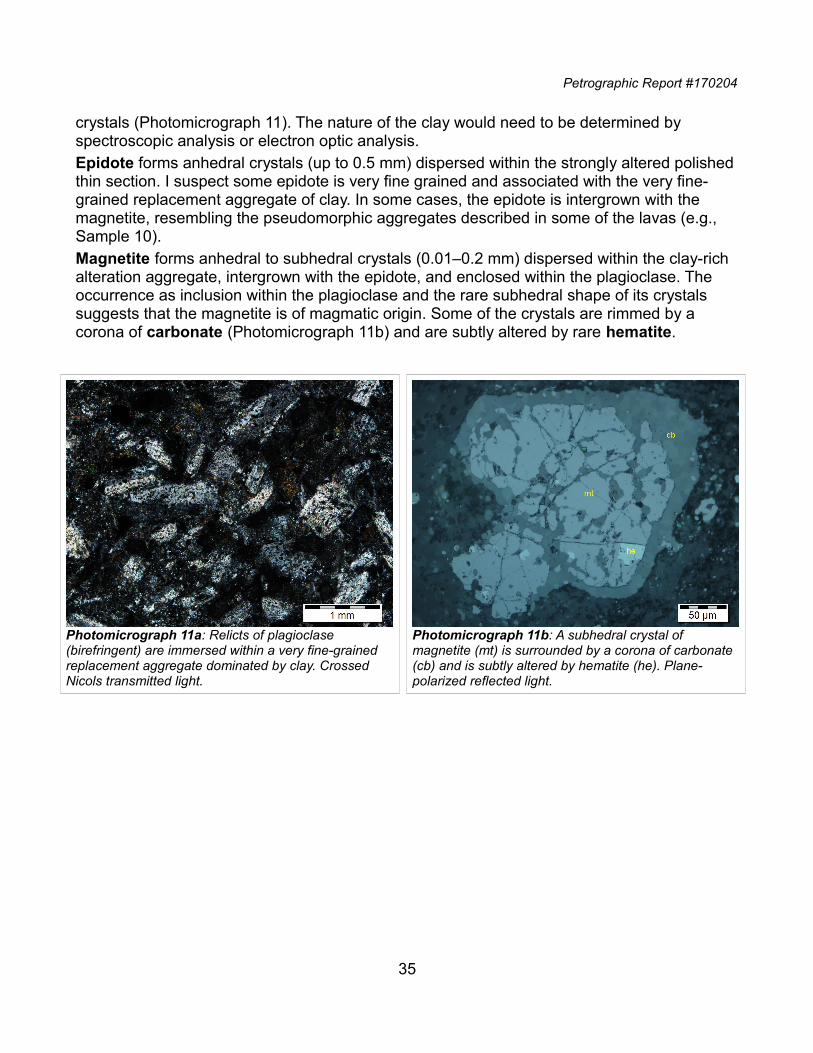
Petrographic Report #170204
crystals (Photomicrograph 11). The nature of the clay would need to be determined by spectroscopic analysis or electron optic analysis.Epidote forms anhedral crystals (up to 0.5 mm) dispersed within the strongly altered polishedthin section. I suspect some epidote is very fine grained and associated with the very fine-grained replacement aggregate of clay. In some cases, the epidote is intergrown with the magnetite, resembling the pseudomorphic aggregates described in some of the lavas (e.g., Sample 10).Magnetite forms anhedral to subhedral crystals (0.01‒0.2 mm) dispersed within the clay-rich alteration aggregate, intergrown with the epidote, and enclosed within the plagioclase. The occurrence as inclusion within the plagioclase and the rare subhedral shape of its crystals suggests that the magnetite is of magmatic origin. Some of the crystals are rimmed by a corona of carbonate (Photomicrograph 11b) and are subtly altered by rare hematite.
35
Photomicrograph 11a: Relicts of plagioclase (birefringent) are immersed within a very fine-grained replacement aggregate dominated by clay. Crossed Nicols transmitted light.
Photomicrograph 11b: A subhedral crystal of magnetite (mt) is surrounded by a corona of carbonate (cb) and is subtly altered by hematite (he). Plane-polarized reflected light.
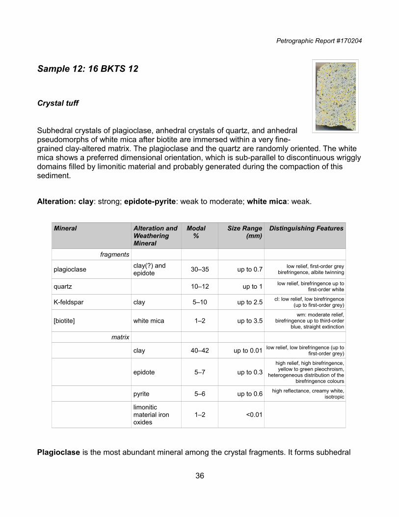
Petrographic Report #170204
Sample 12: 16 BKTS 12
Crystal tuff
Subhedral crystals of plagioclase, anhedral crystals of quartz, and anhedralpseudomorphs of white mica after biotite are immersed within a very fine-grained clay-altered matrix. The plagioclase and the quartz are randomly oriented. The white mica shows a preferred dimensional orientation, which is sub-parallel to discontinuous wrigglydomains filled by limonitic material and probably generated during the compaction of this sediment.
Alteration: clay: strong; epidote-pyrite: weak to moderate; white mica: weak.
Mineral Alteration andWeathering Mineral
Modal%
Size Range(mm)
Distinguishing Features
fragments
plagioclaseclay(?) and epidote
30‒35 up to 0.7 low relief, first-order greybirefringence, albite twinning
quartz 10‒12 up to 1 low relief, birefringence up tofirst-order white
K-feldspar clay 5‒10 up to 2.5 cl: low relief, low birefringence(up to first-order grey)
[biotite] white mica 1‒2 up to 3.5wm: moderate relief,
birefringence up to third-orderblue, straight extinction
matrix
clay 40‒42 up to 0.01 low relief, low birefringence (up tofirst-order grey)
epidote 5‒7 up to 0.3
high relief, high birefringence,yellow to green pleochroism,
heterogeneous distribution of thebirefringence colours
pyrite 5‒6 up to 0.6 high reflectance, creamy white,isotropic
limonitic material iron oxides
1‒2 <0.01
Plagioclase is the most abundant mineral among the crystal fragments. It forms subhedral
36
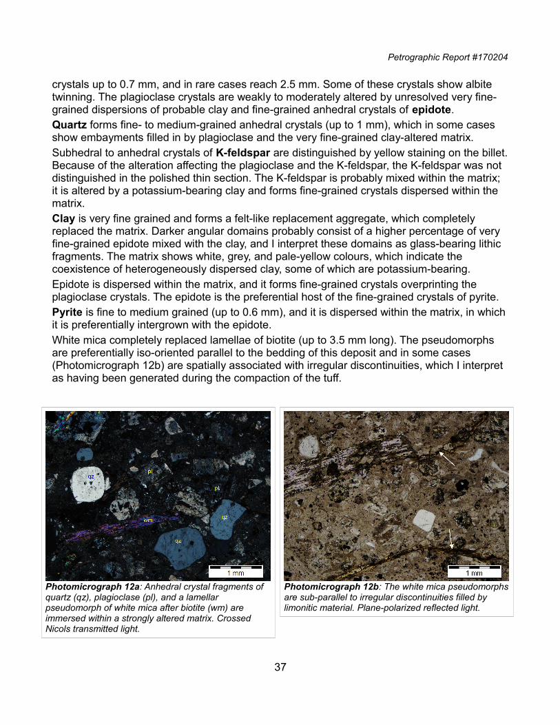
Petrographic Report #170204
crystals up to 0.7 mm, and in rare cases reach 2.5 mm. Some of these crystals show albite twinning. The plagioclase crystals are weakly to moderately altered by unresolved very fine-grained dispersions of probable clay and fine-grained anhedral crystals of epidote.Quartz forms fine- to medium-grained anhedral crystals (up to 1 mm), which in some cases show embayments filled in by plagioclase and the very fine-grained clay-altered matrix.Subhedral to anhedral crystals of K-feldspar are distinguished by yellow staining on the billet.Because of the alteration affecting the plagioclase and the K-feldspar, the K-feldspar was not distinguished in the polished thin section. The K-feldspar is probably mixed within the matrix; it is altered by a potassium-bearing clay and forms fine-grained crystals dispersed within the matrix.Clay is very fine grained and forms a felt-like replacement aggregate, which completely replaced the matrix. Darker angular domains probably consist of a higher percentage of very fine-grained epidote mixed with the clay, and I interpret these domains as glass-bearing lithic fragments. The matrix shows white, grey, and pale-yellow colours, which indicate the coexistence of heterogeneously dispersed clay, some of which are potassium-bearing.Epidote is dispersed within the matrix, and it forms fine-grained crystals overprinting the plagioclase crystals. The epidote is the preferential host of the fine-grained crystals of pyrite.Pyrite is fine to medium grained (up to 0.6 mm), and it is dispersed within the matrix, in whichit is preferentially intergrown with the epidote.White mica completely replaced lamellae of biotite (up to 3.5 mm long). The pseudomorphs are preferentially iso-oriented parallel to the bedding of this deposit and in some cases (Photomicrograph 12b) are spatially associated with irregular discontinuities, which I interpret as having been generated during the compaction of the tuff.
37
Photomicrograph 12a: Anhedral crystal fragments of quartz (qz), plagioclase (pl), and a lamellar pseudomorph of white mica after biotite (wm) are immersed within a strongly altered matrix. Crossed Nicols transmitted light.
Photomicrograph 12b: The white mica pseudomorphsare sub-parallel to irregular discontinuities filled by limonitic material. Plane-polarized reflected light.
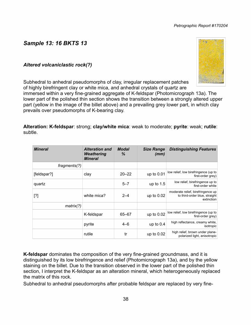
Petrographic Report #170204
Sample 13: 16 BKTS 13
Altered volcaniclastic rock(?)
Subhedral to anhedral pseudomorphs of clay, irregular replacement patchesof highly birefringent clay or white mica, and anhedral crystals of quartz areimmersed within a very fine-grained aggregate of K-feldspar (Photomicrograph 13a). The lower part of the polished thin section shows the transition between a strongly altered upper part (yellow in the image of the billet above) and a prevailing grey lower part, in which clay prevails over pseudomorphs of K-bearing clay.
Alteration: K-feldspar: strong; clay/white mica: weak to moderate; pyrite: weak; rutile: subtle.
Mineral Alteration andWeathering Mineral
Modal%
Size Range(mm)
Distinguishing Features
fragments(?)
[feldspar?] clay 20‒22 up to 0.01 low relief, low birefringence (up tofirst-order grey)
quartz 5‒7 up to 1.5 low relief, birefringence up tofirst-order white
[?] white mica? 2‒4 up to 0.02moderate relief, birefringence up
to third-order blue, straightextinction
matrix(?)
K-feldspar 65‒67 up to 0.02 low relief, low birefringence (up tofirst-order grey)
pyrite 4‒6 up to 0.4 high reflectance, creamy white,isotropic
rutile tr up to 0.02 high relief, brown under plane-polarized light, anisotropic
K-feldspar dominates the composition of the very fine-grained groundmass, and it is distinguished by its low birefringence and relief (Photomicrograph 13a), and by the yellow staining on the billet. Due to the transition observed in the lower part of the polished thin section, I interpret the K-feldspar as an alteration mineral, which heterogeneously replaced the matrix of this rock. Subhedral to anhedral pseudomorphs after probable feldspar are replaced by very fine-
38
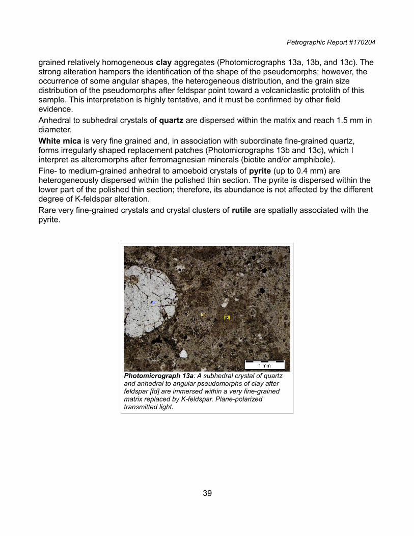
Petrographic Report #170204
grained relatively homogeneous clay aggregates (Photomicrographs 13a, 13b, and 13c). Thestrong alteration hampers the identification of the shape of the pseudomorphs; however, the occurrence of some angular shapes, the heterogeneous distribution, and the grain size distribution of the pseudomorphs after feldspar point toward a volcaniclastic protolith of this sample. This interpretation is highly tentative, and it must be confirmed by other field evidence.Anhedral to subhedral crystals of quartz are dispersed within the matrix and reach 1.5 mm in diameter.White mica is very fine grained and, in association with subordinate fine-grained quartz, forms irregularly shaped replacement patches (Photomicrographs 13b and 13c), which I interpret as alteromorphs after ferromagnesian minerals (biotite and/or amphibole).Fine- to medium-grained anhedral to amoeboid crystals of pyrite (up to 0.4 mm) are heterogeneously dispersed within the polished thin section. The pyrite is dispersed within the lower part of the polished thin section; therefore, its abundance is not affected by the different degree of K-feldspar alteration. Rare very fine-grained crystals and crystal clusters of rutile are spatially associated with the pyrite.
39
Photomicrograph 13a: A subhedral crystal of quartz and anhedral to angular pseudomorphs of clay after feldspar [fd] are immersed within a very fine-grained matrix replaced by K-feldspar. Plane-polarized transmitted light.
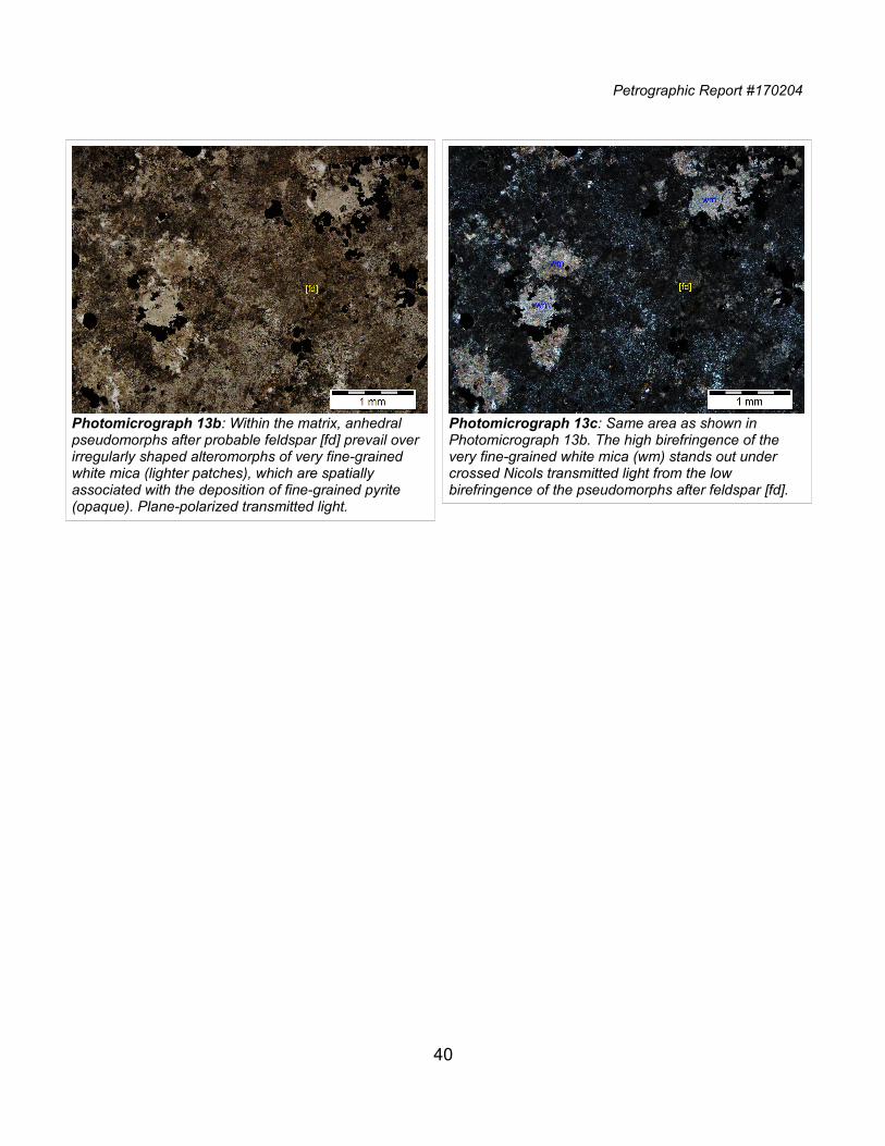
Petrographic Report #170204
40
Photomicrograph 13b: Within the matrix, anhedral pseudomorphs after probable feldspar [fd] prevail over irregularly shaped alteromorphs of very fine-grained white mica (lighter patches), which are spatially associated with the deposition of fine-grained pyrite (opaque). Plane-polarized transmitted light.
Photomicrograph 13c: Same area as shown in Photomicrograph 13b. The high birefringence of the very fine-grained white mica (wm) stands out under crossed Nicols transmitted light from the low birefringence of the pseudomorphs after feldspar [fd].
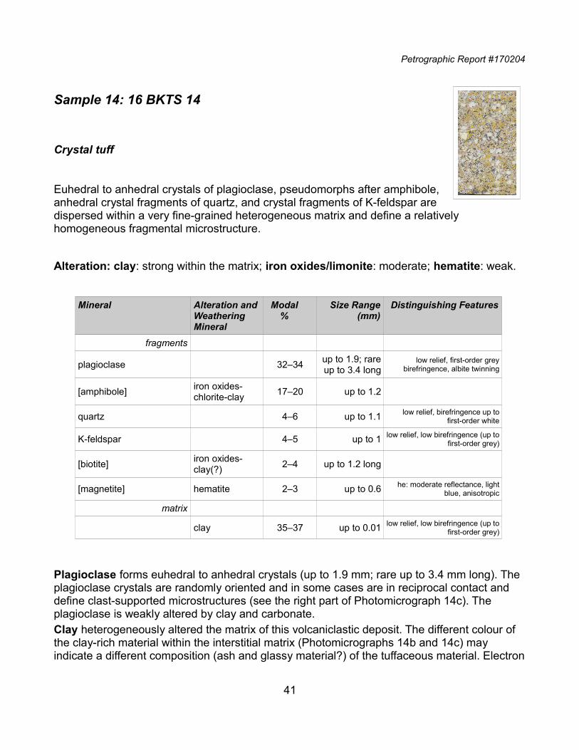
Petrographic Report #170204
Sample 14: 16 BKTS 14
Crystal tuff
Euhedral to anhedral crystals of plagioclase, pseudomorphs after amphibole,anhedral crystal fragments of quartz, and crystal fragments of K-feldspar aredispersed within a very fine-grained heterogeneous matrix and define a relatively homogeneous fragmental microstructure.
Alteration: clay: strong within the matrix; iron oxides/limonite: moderate; hematite: weak.
Mineral Alteration andWeathering Mineral
Modal%
Size Range(mm)
Distinguishing Features
fragments
plagioclase 32‒34up to 1.9; rareup to 3.4 long
low relief, first-order greybirefringence, albite twinning
[amphibole]iron oxides-chlorite-clay
17‒20 up to 1.2
quartz 4‒6 up to 1.1 low relief, birefringence up tofirst-order white
K-feldspar 4‒5 up to 1 low relief, low birefringence (up tofirst-order grey)
[biotite]iron oxides-clay(?)
2‒4 up to 1.2 long
[magnetite] hematite 2‒3 up to 0.6 he: moderate reflectance, lightblue, anisotropic
matrix
clay 35‒37 up to 0.01 low relief, low birefringence (up tofirst-order grey)
Plagioclase forms euhedral to anhedral crystals (up to 1.9 mm; rare up to 3.4 mm long). The plagioclase crystals are randomly oriented and in some cases are in reciprocal contact and define clast-supported microstructures (see the right part of Photomicrograph 14c). The plagioclase is weakly altered by clay and carbonate.Clay heterogeneously altered the matrix of this volcaniclastic deposit. The different colour of the clay-rich material within the interstitial matrix (Photomicrographs 14b and 14c) may indicate a different composition (ash and glassy material?) of the tuffaceous material. Electron
41
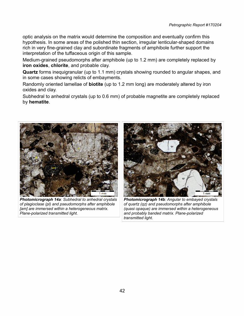
Petrographic Report #170204
optic analysis on the matrix would determine the composition and eventually confirm this hypothesis. In some areas of the polished thin section, irregular lenticular-shaped domains rich in very fine-grained clay and subordinate fragments of amphibole further support the interpretation of the tuffaceous origin of this sample.Medium-grained pseudomorphs after amphibole (up to 1.2 mm) are completely replaced by iron oxides, chlorite, and probable clay.Quartz forms inequigranular (up to 1.1 mm) crystals showing rounded to angular shapes, andin some cases showing relicts of embayments.Randomly oriented lamellae of biotite (up to 1.2 mm long) are moderately altered by iron oxides and clay.Subhedral to anhedral crystals (up to 0.6 mm) of probable magnetite are completely replaced by hematite.
42
Photomicrograph 14a: Subhedral to anhedral crystalsof plagioclase (pl) and pseudomorphs after amphibole [am] are immersed within a heterogeneous matrix. Plane-polarized transmitted light.
Photomicrograph 14b: Angular to embayed crystals of quartz (qz) and pseudomorphs after amphibole (quasi opaque) are immersed within a heterogeneous and probably banded matrix. Plane-polarized transmitted light.
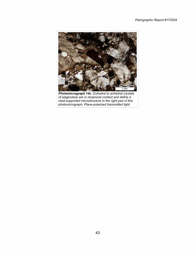
Petrographic Report #170204
43
Photomicrograph 14c: Euhedral to anhedral crystals of plagioclase are in reciprocal contact and define a clast-supported microstructure in the right part of this photomicrograph. Plane-polarized transmitted light.
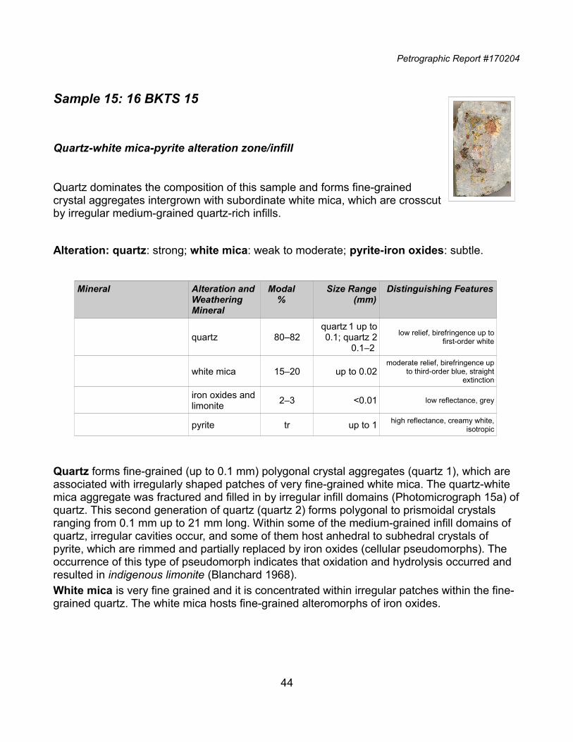
Petrographic Report #170204
Sample 15: 16 BKTS 15
Quartz-white mica-pyrite alteration zone/infill
Quartz dominates the composition of this sample and forms fine-grainedcrystal aggregates intergrown with subordinate white mica, which are crosscutby irregular medium-grained quartz-rich infills.
Alteration: quartz: strong; white mica: weak to moderate; pyrite-iron oxides: subtle.
Mineral Alteration andWeathering Mineral
Modal%
Size Range(mm)
Distinguishing Features
quartz 80‒82quartz 1 up to0.1; quartz 2
0.1‒2
low relief, birefringence up tofirst-order white
white mica 15‒20 up to 0.02moderate relief, birefringence up
to third-order blue, straightextinction
iron oxides and limonite
2‒3 <0.01 low reflectance, grey
pyrite tr up to 1 high reflectance, creamy white,isotropic
Quartz forms fine-grained (up to 0.1 mm) polygonal crystal aggregates (quartz 1), which are associated with irregularly shaped patches of very fine-grained white mica. The quartz-white mica aggregate was fractured and filled in by irregular infill domains (Photomicrograph 15a) ofquartz. This second generation of quartz (quartz 2) forms polygonal to prismoidal crystals ranging from 0.1 mm up to 21 mm long. Within some of the medium-grained infill domains of quartz, irregular cavities occur, and some of them host anhedral to subhedral crystals of pyrite, which are rimmed and partially replaced by iron oxides (cellular pseudomorphs). The occurrence of this type of pseudomorph indicates that oxidation and hydrolysis occurred and resulted in indigenous limonite (Blanchard 1968).White mica is very fine grained and it is concentrated within irregular patches within the fine-grained quartz. The white mica hosts fine-grained alteromorphs of iron oxides.
44
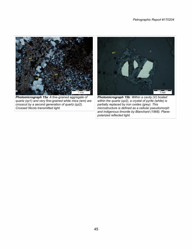
Petrographic Report #170204
45
Photomicrograph 15a: A fine-grained aggregate of quartz (qz1) and very fine-grained white mica (wm) are crosscut by a second generation of quartz (qz2). Crossed Nicols transmitted light.
Photomicrograph 15b: Within a cavity (V) hosted within the quartz (qz2), a crystal of pyrite (white) is partially replaced by iron oxides (grey). This microstructure is defined as a cellular pseudomorph and indigenous limonite by Blanchard (1968). Plane-polarized reflected light.
Petrographic Report #170204
5. Glossary of Microstructural and Petrologic Terms Used in the Text
a, b, c: Symbols used to describe the crystallographic axes of the crystals.
alteromorph: Mineral or group of minerals developed by partial to complete alteration or weathering of a primary mineral. An alteromorph does not always preserve the shape, size, and volume of the mineral that it has replaced.
amoeboid: With strongly curved and lobate interlocking grain boundaries; like an amoeba.
anhedral: Describes irregular grains showing no crystal-face boundaries.
euhedral: Describes a mineral with crystal faces.
foliation: Planar microstructural element that occurs penetratively on a mesoscopic scale in arock. Primary foliation includes bedding and igneous layering; secondary foliations are formed by deformation-induced processes.
groundmass: Aggregate that is distinctly finer grained than the phenocrysts in an igneous rock.
interlobate: With irregular lobate grain boundaries.
interstitial: Describes a mineral occupying angular cavities or interspace fillings between other minerals.
matrix: Aggregate that is distinctly finer grained than the crystals, clasts, and lithic fragments in a metamorphic and volcaniclastic rock. The usage is similar to that of “groundmass” inan igneous rock.
phenocryst: Crystal (commonly euhedral) that is distinctly larger than the other minerals around it.
pleochroism: A property of certain crystals of absorbing light to an extent that depends on the orientation of the vector of the light with respect to the optic axes of the crystal.
pseudomorph: Mineral or group of minerals developed by partial to complete alteration or weathering of a primary mineral. The pseudomorph preserves the shape, size, and volume of the mineral that it has replaced.
relict (residual structure): Structure remaining after a deformation or metamorphic event, such as a porphyroclast in a mylonite, a phenocryst in a metamorphosed volcanic rock, or a partially replaced porphyroblast in a retrograde metamorphic rock. “Relict” is sometimes used as a synonym for “residual.”
X, Y, Z: Symbols used to describe the optical indicatrix of the crystals.
46
APPENDIX II
Geologic Maps
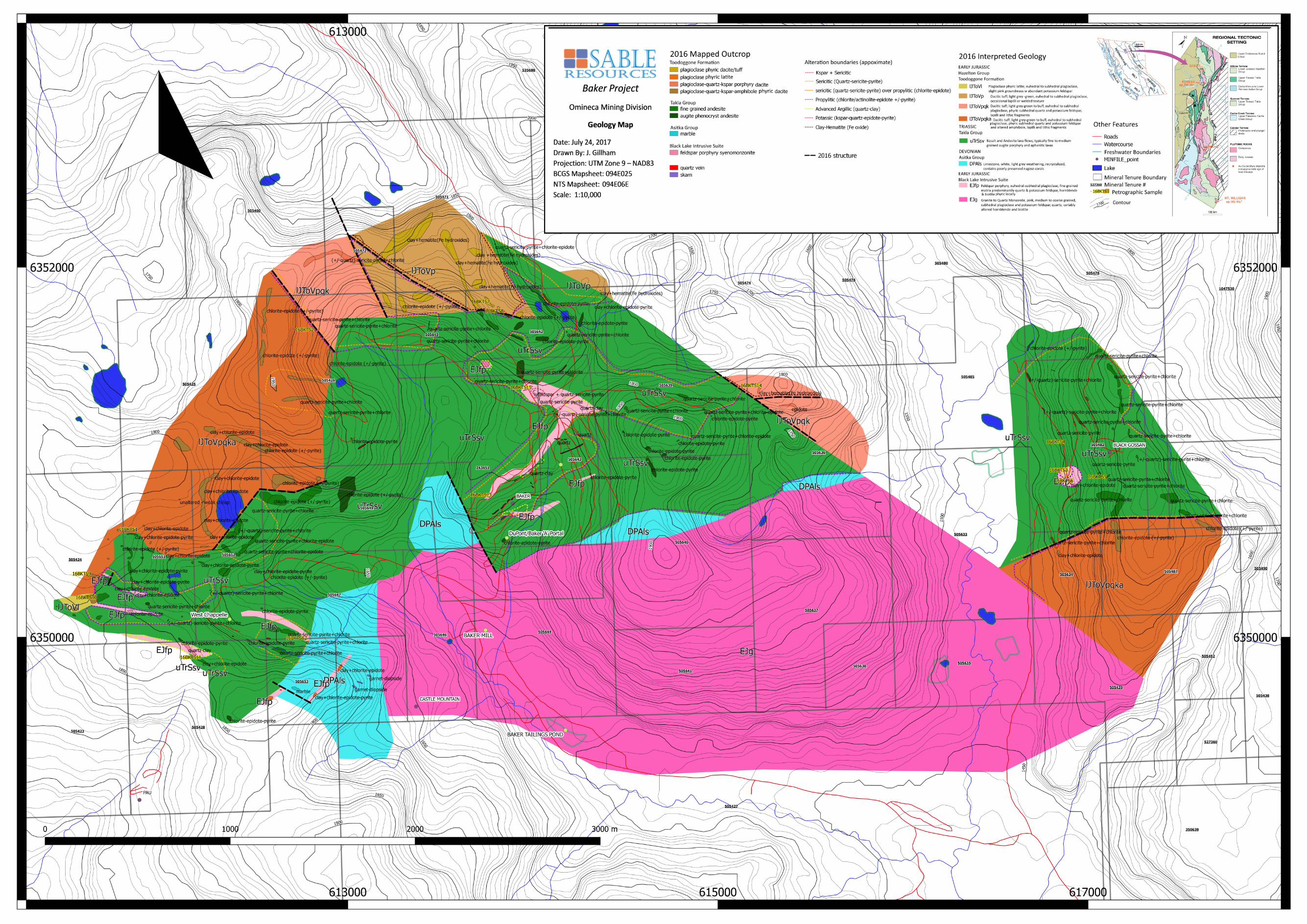
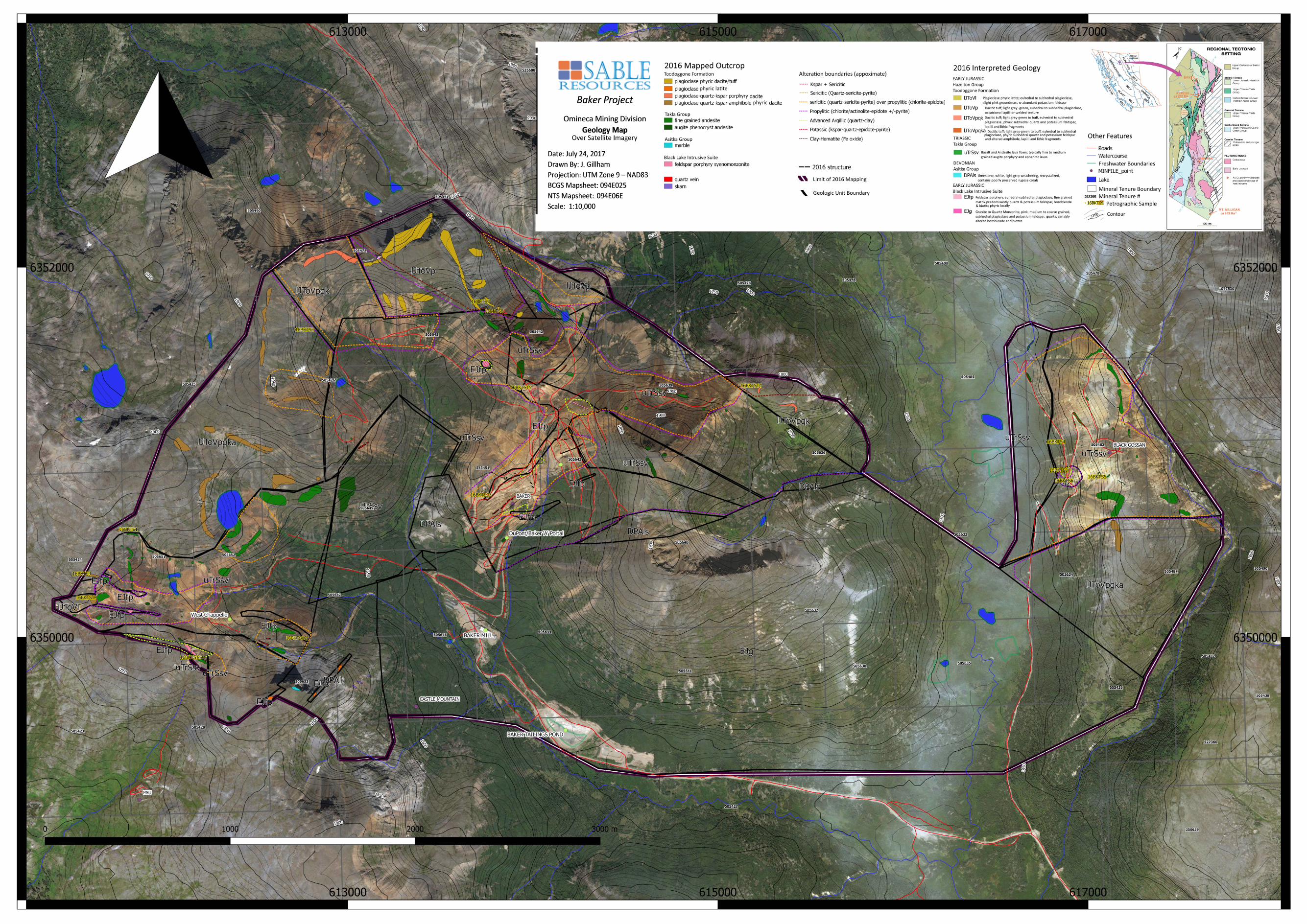
Related Documents


![State Environmental Planning Policy (Mining, … - Mining Petroleum Production...State Environmental Planning Policy (Mining, Petroleum Production and Extractive Industries) 2007 [2007-65]](https://static.cupdf.com/doc/110x72/5aea10be7f8b9a66258b8d32/state-environmental-planning-policy-mining-mining-petroleum-productionstate.jpg)