Mining in the Context of African World Heritage Cultural Landscapes: An Assessment of Management Planning Effectiveness A thesis submitted to the Faculty of Architecture, Civil Engineering and Urban Planning at the Brandenburg University of Technology Cottbus-Senftenberg in partial fulfilment of the requirement for the award of the academic degree of Doctor of Philosophy (Ph.D.) in Heritage Studies by Oris Chapinga Malijani from Lilongwe – Malawi First Supervisor: Prof. Dr. Dr. h.c. (NMU, UA) Michael Schmidt Second Supervisor: Prof. Dr. Rainer Herd Day of the oral examination: 22 nd September 2020

Welcome message from author
This document is posted to help you gain knowledge. Please leave a comment to let me know what you think about it! Share it to your friends and learn new things together.
Transcript
Mining in the Context of African World Heritage Cultural
Landscapes: An Assessment of Management Planning Effectiveness
A thesis submitted to the Faculty of Architecture, Civil Engineering and Urban Planning at the
Brandenburg University of Technology Cottbus-Senftenberg in partial fulfilment of the
requirement for the award of the academic degree of Doctor of Philosophy (Ph.D.) in Heritage
Studies
by
Oris Chapinga Malijani
from Lilongwe – Malawi
First Supervisor: Prof. Dr. Dr. h.c. (NMU, UA) Michael Schmidt
Second Supervisor: Prof. Dr. Rainer Herd
Day of the oral examination: 22nd September 2020
ii
Declaration
I hereby declare that this thesis has not been previously published or written by another person;
neither has it been submitted nor accepted for any other academic award. It is the result of my
original work carried out at Brandenburg University of Technology Cottbus, Germany, within the
framework of the Ph.D. Programme “Heritage Studies”. All materials from other sources have
been duly and adequately acknowledged.
Oris Chapinga Malijani
Original signature
Cottbus, 2020

iii
Dedication
This dissertation is dedicated to my family, friends and numerous people that have supported and
encouraged me as I was at various stages of the PhD project.
iv
Acknowledgement
First, I would like to express my special appreciation and gratitude to my supervisor, Professor
Michael Schmidt, for the guidance and support in my entire research project. I am deeply indebted
to him, without which the completion of this thesis would not be possible. Special thanks goes to
Prof. Marie Theres Albert for her guidance during the initial proposal development and
coordinating the research colloquium. I further acknowledge Professor. Anna Amelina, Dr. Anca
Prodan and Dr Katerina Schmidt for their support on the methodological and theoretical aspects
of the research.
I would also like to thank my colleagues at my Department and fellow Heritage Studies PhD
candidates for their inputs and encouragement during my research project: These include Valentina
Torelli, Maximilian Chami, Sijin Chen, Zain Ahmad Hajahjah, Marlen Meissner, Farnaz Mohseni,
Hina, Olukoya Obafemi, and Reza Sharifi.
My appreciation also goes to all those, who have helped me in collecting data for this thesis. During
my visits in Mulanje and Phalombe districts of Malawi, I had the chance of meeting and
communicating with several people, whose expertise and opinions on the subject were
instrumental to the success of my research.
I am thankful for the support of my current employer the Malawi Museums and Monuments under
the Malawi Department of Culture, Ministry of Civic Education, Community Development and
Culture, for the giving a study leave and access to archival resources for the success of this project.
Special thanks to the Director of Culture - Dr. Elizabeth Gomani Chindebvu, Deputy Director of
Museums and Monuments responsible for research - Dr. Potipher Kaliba and Deputy Director of
Museums and Monuments responsible for conservation - Ms Chrissy Chiumia for their tireless
effort in supporting and encouraging me during the entire PhD journey.
Lastly I thank my family members, my wife Chimwemwe, sons Keith and Smith and daughter
Kerith for their moral and social support during my entire period of PhD research.
Special gratitude to the Germany Education Exchange Programme (DAAD) for funding this PhD
project through the Graduate School Scholarship Program (GSSP). I am thankful for the financial
support rendered during my stay in Germany and field work in Malawi and South Africa.
v
Abstract
Sub-Saharan African cultural landscapes are adversely impacted by various development
pressures, which calls for a holistic and integrated approach in their management. Mining
development has been ranked highly by UNESCO World Heritage Centre, as one of the most
common factors threatening the conservation and management of World Heritage properties
around the world. For instance, out of 141 World Heritage properties which submitted their state
of conservation reports in 2015, 18% were affected by mining activities. Out of these, 84% of the
properties that were threatened by mining development were either cultural landscapes, natural
properties and or mixed properties. African World Heritage cultural landscapes are the ones highly
affected and threatened by planned and on-going mining and exploration activities.
Therefore, research was carried out using the Mulanje Mountain Cultural Landscape of Malawi
and Mapungubwe Cultural landscape of South Africa. Specifically, the study aimed at examining
the existing cultural landscape management theories and concepts in order to understand the key
elements to be integrated into the suggested strategic management planning methodological
framework. It also aimed at evaluating the impact of mining development on the conservation and
management of African cultural landscapes. The study also investigated the stakeholder’s views
and perception about the impact of mining activities on cultural and natural heritage values of the
landscapes. Further to this, it assessed the effectiveness of the existing strategic management
planning framework for the protection and management of cultural landscapes.
To achieve the research objectives, the literature was reviewed, firstly to determine the dimensions
of cultural landscapes, and secondly, to determine the dimensions of mining development in World
Heritage cultural landscapes. The study used two case studies as an effective comparative research
strategy in the investigation of the conflicting issues of mining development against the
conservation of the attributes of the two cultural landscapes. A case study research strategy was
combined with other research methodologies. These included interviews, focus-group-discussions,
observations, field site surveys, qualitative content analysis, and thematic analysis.
The study has revealed that stakeholder participation and inclusion is a key element in the
integration of mining development in cultural landscape planning. This research has contributed
to the methodological gap in cultural landscape management planning by developing and applying
an integrated strategic management planning methodological framework. This framework has
vi
proposed strategic solutions to challenges faced when managing Sub-Saharan African cultural
landscapes that are threatened by various development activities such as mining. The application
of the management planning methodological framework has shown that the governance in place
for Mulanje Mountain cultural landscape conformed to the requirements of a long-term and holistic
planning process and the participation and empowerment of multiple stakeholders in that process.
The developed framework has provided a comprehensive level of technical support for decision-
making in Mulanje Mountain cultural landscape. Given the fact that every cultural landscape is
unique in terms of its environmental, cultural, socio-economic and political context, and every
mining operation is also different in nature, it was recommended to have different approaches on
how mining and cultural landscape conservation can potentially co-exist. In order to facilitate the
potential integration of cultural landscape conservation and mining development, all key
stakeholders need to be committed to a collaborative approach to land use planning, decision-
making, natural and cultural resource management, socio-economic development and stakeholder
engagement.
Keywords: Cultural Landscapes, Mining Development, World Heritage, Management Planning,
Conservation
vii
Abstrakt
Unterschiedliche Entwicklungsaktivitäten beeinträchtigen die afrikanischen Kulturlandschaften
südlich der Sahara bereits heute einschneidend, weswegen ein ganzheitlicher und integrierter
Managementansatz für einen langfristigen Erhalt erforderlich ist. Bergbau wurde vom UNESCO-
Welterbezentrum als einer der häufigsten Faktoren eingestuft, der die Erhaltung und
Bewirtschaftung von Welterbestätten auf der ganzen Welt bedroht. So waren beispielsweise von
den 141 Welterbestätten, die 2015 ihre Erhaltungsberichte vorgelegten, 18 % negativ von
Bergbauaktivitäten betroffen. Davon waren 84 % der von der Entwicklung bedrohten Stätte
entweder Kulturlandschaften, Naturschutzgüter und/oder beides. Die Kulturlandschaften des
afrikanischen Welterbes sind hierbei unter denjenigen zu finden, die von geplanten und laufenden
Bergbau- und Explorationsaktivitäten besonders stark betroffen und bedroht sind.
Deswegen, wurde mithilfe der Fallstudien Mulanje Mountain Cultural Landscape of Malawi und
Mapungubwe Cultural Landscape in Südafrika über möglichen Managementansätzen geforscht.
Konkret ging es hierbei um die Untersuchung von bestehenden Theorien und Konzepten des
Kulturlandschaftsmanagements, um Schlüsselelemente zu verstehen, die in den vorgeschlagenen
methodischen Rahmen der strategischen Managementplanung integriert werden sollten. Zudem
zielte die Forschung auch darauf ab, die Auswirkungen der Bergbauentwicklung auf die Erhaltung
und Bewirtschaftung afrikanischer Kulturlandschaften zu bewerten. Des Weiteren wurden auch
die persönlichen Ansichten und Wahrnehmungen der Stakeholder über die Auswirkungen von
Bergbauaktivitäten auf die Werte des kulturellen und naturräumlichen Erbes der Landschaften
näher beleuchtet. Darüber hinaus bewertete die Arbeit die Wirksamkeit des bestehenden
strategischen Managementplanungsrahmens für den Schutz und die Bewirtschaftung von
Kulturlandschaften.
Zur Erreichung der Forschungsziele erfolgte zuallererst eine Literaturüberprüfung, um die
Dimensionen der Kulturlandschaften zu bestimmen, und das Ausmaß der Bergbauentwicklung in
Dener Welterbe-Kulturlandschaften festzustellen. Die vorgelegte Arbeit untersuchte des Weiteren
die zwei genannten Fallstudien in Form einer Vergleichsanalyse um die Möglichkeit von
Bergbauaktivitäten und dem gleichzeitigen Erhalt der Attribute der beiden Kulturlandschaften zu
erörtern. Eine Fallstudien-Vergleichsanalyse wurde mit zudem mit anderen Forschungsmethoden
viii
kombiniert. Hierzu gehörten Interviews, Fokusgruppendiskussionen, Beobachtungen,
Feldfeldbefragungen, qualitative Inhaltsanalysen und thematische Analysen.
Die durchgeführte Studie hat aufgezeigt, dass die Beteiligung und Inklusion aller Stakeholder ein
Schlüsselelement bei der Integration der derzeitigen und zukünftigen Bergbauentwicklungen in
die Kulturlandschaftsplanung darstellt. Durch die Entwicklung und Anwendung eines integrierten
strategischen Managementplanungs-Methodik Rahmens hat die Forschung damit zur Schließung
der methodischen Lücke in der Kulturlandschaftsplanung beigetragen. Dieses Rahmenwerk hat
strategische Lösungen für politische Herausforderungen vorgeschlagen, denen sich die
Verwaltung afrikanischer Kulturlandschaften südlich der Sahara gegenübersieht, die von
verschiedenen Entwicklungsaktivitäten wie dem Bergbau bedroht sind. Die Anwendung des
methodischen Rahmens der Managementplanung hat zudem gezeigt, dass die institutionelle
Steuerung für die Kulturlandschaft des Mulanje-Berges den Anforderungen eines langfristigen und
ganzheitlichen Planungsprozesses sowie der Beteiligung und Ermächtigung verschiedener
Stakeholder entspricht. Das entwickelte Rahmenwerk hat somit ein umfassendes Maß an
technischer Unterstützung für die Entscheidungsfindung in der Kulturlandschaft des Berges
Mulanje bereitgestellt. Angesichts der Tatsache, dass jede Kulturlandschaft in ihrem ökologischen,
kulturellen, sozioökonomischen und politischen Kontext einzigartig ist und jeder Bergbaubetrieb
auch unterschiedlicher Natur ist, wurde empfohlen, unterschiedliche Ansätze zu integrieren,
inwieweit Bergbau und kulturelle Landschaftspflege potenziell nebeneinander bestehen kann. Um
die mögliche Integration des Landschaftsschutzes und der Entwicklung des Bergbaus zu
erleichtern, müssen sich alle wichtigen Stakeholder für einen kollaborativen Ansatz in den
Bereichen Raumplanung, Entscheidungsfindung, Bewirtschaftung natürlicher und kultureller
Ressourcen, und sozioökonomischer Entwicklung zusammenfinden.
Schlagworte: Kulturlandschaften, Bergbauentwicklung, Welterbe, Managementplanung,
Naturschutz
ix
Table of Contents
Declaration ...................................................................................................................................... ii
Dedication ...................................................................................................................................... iii
Acknowledgement ......................................................................................................................... iv
Abstract ........................................................................................................................................... v
List of Figures ................................................................................................................................ xi
List of Tables ............................................................................................................................... xiii
List of Acronyms and Abbreviations ........................................................................................... xiv
1 GENERAL INTRODUCTION ............................................................................................ 1
1.1 Introduction ............................................................................................................................. 1
1.2 Problem Statement ................................................................................................................... 6
1.3 Project Aim and Objectives ..................................................................................................... 9
1.4 Key Research Questions .......................................................................................................... 9
1.5 The significance of the Study ................................................................................................ 10
1.6 Definition of Key Terms ........................................................................................................ 10
1.7 Thesis Organisation ............................................................................................................... 12
2 CONCEPTUAL AND THEORETICAL PERSPECTIVES IN UNDERSTANDING
CULTURAL LANDSCAPES ............................................................................................. 15
2.1 Introduction ........................................................................................................................... 15
2.2 Landscape as a Concept ......................................................................................................... 16
2.3 Conceptualizing Cultural Landscape ..................................................................................... 17
2.4 Theoretical Perspectives for Understanding Cultural Landscapes ........................................ 21
2.5 Cultural Landscapes in Sub-Saharan Africa .......................................................................... 29
2.6 Traditional Management Systems of Cultural Landscapes in pre-colonial Africa ............... 31
2.7 International Instruments on Management of Cultural Landscapes ...................................... 33
2.8 Chapter Summary .................................................................................................................. 39
3 MINING AND AFRICAN WORLD HERITAGE CULTURAL LANDSCAPES ........ 40
3.1 Introduction ........................................................................................................................... 40
3.2 Mining and Minerals in Africa .............................................................................................. 41
3.3 Impact of Mining Development on Cultural Landscapes ...................................................... 45
3.4 African World Heritage Sites threatened by Mining ............................................................. 53
3.5 Legal and Policy Frameworks ............................................................................................... 59
3.6 Malawi and South African National Regulatory Measures on Cultural Landscapes ............ 62
3.7 International Policies on Mining and Heritage Conservation ............................................... 64
3.8 Best Practices of Integrating Mining into Cultural Landscape Management ........................ 69
3.9 Chapter Summary .................................................................................................................. 72
4 RESEARCH METHODOLOGY ....................................................................................... 74
4.1 Introduction ........................................................................................................................... 74
4.2 Methods ................................................................................................................................. 77
4.2.1 Selection of Case Studies .......................................................................................... 77
4.2.2 Comparative Case Study Approach .......................................................................... 79
x
4.2.3 Document Analysis ................................................................................................... 80
4.2.4 Interviews .................................................................................................................. 81
4.2.5 Focus Group Discussions .......................................................................................... 83
4.2.6 Observations .............................................................................................................. 84
4.2.7 Field Site Surveys ...................................................................................................... 84
4.2.8 Qualitative Content Analysis ..................................................................................... 85
4.2.9 Thematic Analysis ..................................................................................................... 90
4.3 Triangulation ......................................................................................................................... 92
4.4 Ethical Considerations ........................................................................................................... 94
4.5 Chapter Summary .................................................................................................................. 94
5 CASE STUDIES: MULANJE MOUNTAIN AND MAPUNGUBWE CULTURAL
LANDSCAPES ..................................................................................................................... 96
5.1 Introduction ........................................................................................................................... 96
5.2 Case Study I: Mulanje Mountain Cultural Landscape, Malawi ........................................... 96
5.3 Case Study II: Mapungubwe Cultural Landscape, South Africa........................................ 114
5.4 Chapter Summary ................................................................................................................ 129
6 PERCEPTIONS OF LOCAL PEOPLE AND OTHER STAKEHOLDERS ON
PROTECTION OF CULTURAL LANDSCAPES ......................................................... 131
6.1 Introduction ......................................................................................................................... 131
6.2 Valuing Cultural Landscapes from Local People’s Perspective ......................................... 131
6.3 Stakeholders Identification and Consultations. ................................................................... 132
6.4 Stakeholder Views. .............................................................................................................. 135
6.5 Stakeholder’s Levels of Awareness in Mulanje .................................................................. 138
6.6 Discussion of Local People and other Stakeholders Perceptions ........................................ 144
6.7 Chapter Summary ................................................................................................................ 155
7 RESULTS ON ASSESSMENT OF EFFECTIVENESS OF MANAGEMENT
PLANNING FRAMEWORK ........................................................................................... 156
7.1 Introduction ......................................................................................................................... 156
7.2 Review of Management Plan for Mapungubwe Cultural Landscape (2013-2018) ............. 157
7.3 Management Plan Content Analysis.................................................................................... 158
7.4 Evaluation of Effectiveness and Impact on WHC Strategic Objectives (5Cs) ................... 162
7.5 Semi-Structured Interview Analysis and Theme Rationalization ....................................... 176
7.6 Discussion: Data Synthesis .................................................................................................. 183
7.7 Chapter Summary ................................................................................................................ 187
8 DISCUSSION AND APPLICATION: STRATEGIC MANAGEMENT PLANNING
METHODOLOGICAL FRAMEWORK ........................................................................ 189
8.1 Introduction ......................................................................................................................... 189
8.2 Comparative Framework ..................................................................................................... 190
8.3 Development of the Integrated Management Planning Methodological Framework ......... 193
8.4 Implementation Strategy: Cyclical Implementation Approach ........................................... 197
8.5 Application of the Management Planning Methodological Framework ............................. 198
8.6 Chapter Summary ................................................................................................................ 209
xi
9 CONCLUSIONS AND RECOMMENDATIONS .......................................................... 211
9.1 Thesis Summary .................................................................................................................. 211
9.2 Research Contribution ......................................................................................................... 215
9.3 Recommendations ............................................................................................................... 216
9.4 Limitations ........................................................................................................................... 219
9.5 Future Research ................................................................................................................... 219
10 Appendices
10.1. Questionnaire/Interview Guide………………………………………………………….. 212
10.2. Mining Heritage as World Heritage……………………………………………………... 217
11 References .………………………………………………………………………………..231
xii
List of Figures
Figure 1. 1. WHS under threat by extractive activities. .................................................................. 2
Figure 3. 1. African World Heritage Sites under threats from mining activities. ......................... 54
Figure 3. 2. A world map with mining concession data coverage. ............................................... 58
Figure 3. 3. A world map showing mining, and oil and gas concession data coverage. .............. 58
Figure 5. 1. Map of Malawi and bordering countries. .................................................................. 97
Figure 5. 2. Location of Mulanje Cultural Landscape on the map of Malawi. ............................. 99
Figure 5. 3. Map of proposed core and buffer zone of Mulanje World Heritage area. .............. 100
Figure 5. 4. Map of core and buffer zone of proposed Mulanje World Heritage area. .............. 102
Figure 5. 5. Map of Afro-montane regions of Africa and where Mulanje belong. ..................... 103
Figure 5. 6. World Heritage Sites in South Africa and Mapungubwe Cultural Landscape. ....... 116
Figure 5. 7. Map of Mapungubwe Cultural Landscape WHS. ................................................... 117
Figure 5. 8. Mapungubwe overlapping settlement periods. ........... Error! Bookmark not defined.
Figure 6. 1. Levels of awareness on the cultural importance of the landscape. .......................... 139
Figure 6. 2. Level of awareness on the World Heritage status of MMCL .................................. 140
Figure 6. 3. Levels of awareness on mineral exploration activities in MMCL .......................... 141
Figure 6. 4. Two scenarios on landscape preservation or exploitation of mineral resources ..... 142
Figure 6. 5. Prioritization of cultural heritage resources to be protected in case of mining ....... 143
Figure 7. 1. Structure of the Strategic Action Plan. .................................................................... 159
Figure 7. 2. Capacity building dimension in relation to other four strategic objectives. ............ 171
Figure 8. 1. Current best practice model of World Heritage cultural landscape management. .. 194
Figure 8. 2. Current best practice operational model. ................................................................. 195
Figure 8. 3. Best practice integrated cultural landscape management planning framework. ..... 196
Figure 8. 4. Theoretical best practice operational framework. ................................................... 197
Figure 8. 5. Integrated World Heritage cultural landscape management planning process. ...... 203
Figure 9. 1. Summary of the thesis progression from start to the end of the research. ............... 215
xiii
List of Tables
Table 1. 1 WHS under threat by extractive activities grouped by UNESCO World regions ......... 1
Table 1. 2. Factors affecting the management of most WH properties .......................................... 3
Table 3. 1. Summary data for the twelve sub-Saharan African countries. ................................... 42
Table 3. 2. Stages of mining development in relation with mining activities .............................. 46
Table 3. 3. Summary of potential long-term impacts of mining ................................................... 50
Table 3. 4. African World heritage sites under threat of mining activities ................................... 56
Table 3. 5. Legislations relating to mining activities and cultural landscapes ............................. 61
Table 3. 6. IFC standards relevant to heritage resources and their management. ......................... 67
Table 4. 1. Advantages and disadvantages of qualitative methods ............................................... 75
Table 4. 2. Summary of research objectives, methods and data sources ...................................... 76
Table 4. 3. Similarities and differences between the cultural landscapes ..................................... 80
Table 4. 4. Number of stakeholders interviewed .......................................................................... 82
Table 4. 5. Different approaches to content analysis .................................................................... 86
Table 4. 6. The final coding instrument used in the analysis ........................................................ 88
Table 4. 7. Semi-structured interview questions ........................................................................... 90
Table 4. 8. Comparative stages of content analysis and thematic analysis ................................... 91
Table 5. 1. Attributes that convey the values in Mulanje ........................................................... 106
Table 5. 2. List of attributes in Mapungubwe cultural landscape. .............................................. 125
Table 6. 1. Stakeholders identified, consulted and their responsibilities. ................................... 134
Table 7. 1. The coding instrument used in the analysis .............................................................. 160
Table 7. 2. Situational analysis evaluation. ................................................................................. 163
Table 7. 3. Strategic orientation evaluation. .................................. Error! Bookmark not defined.
Table 7. 4. Credibility dimension evaluation. ............................................................................. 165
Table 7. 5. Conservation dimension evaluation. ............................ Error! Bookmark not defined.
Table 7. 6. Communication dimension evaluation. ....................... Error! Bookmark not defined.
Table 7. 7. Capacity building dimension evaluation...................... Error! Bookmark not defined.
Table 7. 8. Community involvement dimension evaluation .......... Error! Bookmark not defined.
Table 8. 1. A comparative framework of cultural landscape management. ............................... 190
Table 8. 2. The implementation cycle ......................................................................................... 197
Table 8. 3. Comparative analysis of Mulanje Mountain cultural landscape management ......... 199
xiv
List of Acronyms and Abbreviations
ASAPA Association of Southern African Professional Archaeologists
AWHF Africa World Heritage Fund
CoAL Coal of Africa Limited
EIA Environmental Impact Assessment
EMP Environmental Management Plan
EMP Environmental Management Programme
EP Equator Principles
EPFI Equator Principles Financial Institutions
ESIA Environmental and Social Impact Assessments
IFC International Finance Corporation
GDP Gross Domestic Product
GoM Government of Malawi
HIA Heritage Impact Assessment
ICMM International Council on Mines and Minerals
ICOMOS International Council of Monuments and Sites
IUCN International Union for Conservation of Nature
MCL Mapungubwe Cultural Landscape
MGDS Malawi Growth and Development Strategy
MMCL Mulanje Mountain Cultural Landscape
MMCT Mulanje Mountain Conservation Trust
MMSD Minerals, Mining and Sustainable Development
NCC Canada National Capital Commission
NORAD Norwegian Agency for Development Cooperation
OUV Outstanding Universal Values
PDCA Plan-Do-Check-Act Model
PGEs Platinum Group Elements
PS Performance Standards
REE Rare Earth Elements
SAHRA South Africa Heritage Resource Agency
SANParks South Africa National Parks
xv
SMPMF Strategic Management Planning Methodological Framework
SWOT Strengths, Weaknesses, Opportunities, Threats
TBCA Trans-boundary Consulting Africa
TFCA Trans-frontier Conservation Area
UNDATA United Nations Statistics Division
UNECA United Nations Economic Commission for Africa.
UNECE United Nations Economic Commission for Europe
UNEP United Nations Environmental Programme
UNESCO United Nations Educational, Scientific and Cultural Organisation
USNPS United States National Park Service
WCPA World Commission on Protected Areas
WH World Heritage
WHC World Heritage Centre
WHCB World Heritage Capacity Building
WHM World Heritage and Mining
WHS World Heritage Site
WWF-UK World wild Fund - United Kingdom
5Cs Credibility, Conservation, Capacity building, Communication and
Community involvement
1
CHAPTER ONE
1 GENERAL INTRODUCTION
1.1 Introduction
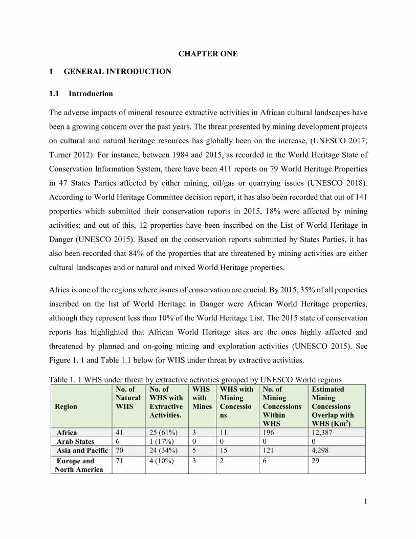
The adverse impacts of mineral resource extractive activities in African cultural landscapes have
been a growing concern over the past years. The threat presented by mining development projects
on cultural and natural heritage resources has globally been on the increase, (UNESCO 2017;
Turner 2012). For instance, between 1984 and 2015, as recorded in the World Heritage State of
Conservation Information System, there have been 411 reports on 79 World Heritage Properties
in 47 States Parties affected by either mining, oil/gas or quarrying issues (UNESCO 2018).
According to World Heritage Committee decision report, it has also been recorded that out of 141
properties which submitted their conservation reports in 2015, 18% were affected by mining
activities; and out of this, 12 properties have been inscribed on the List of World Heritage in
Danger (UNESCO 2015). Based on the conservation reports submitted by States Parties, it has
also been recorded that 84% of the properties that are threatened by mining activities are either
cultural landscapes and or natural and mixed World Heritage properties.
Africa is one of the regions where issues of conservation are crucial. By 2015, 35% of all properties
inscribed on the list of World Heritage in Danger were African World Heritage properties,
although they represent less than 10% of the World Heritage List. The 2015 state of conservation
reports has highlighted that African World Heritage sites are the ones highly affected and
threatened by planned and on-going mining and exploration activities (UNESCO 2015). See
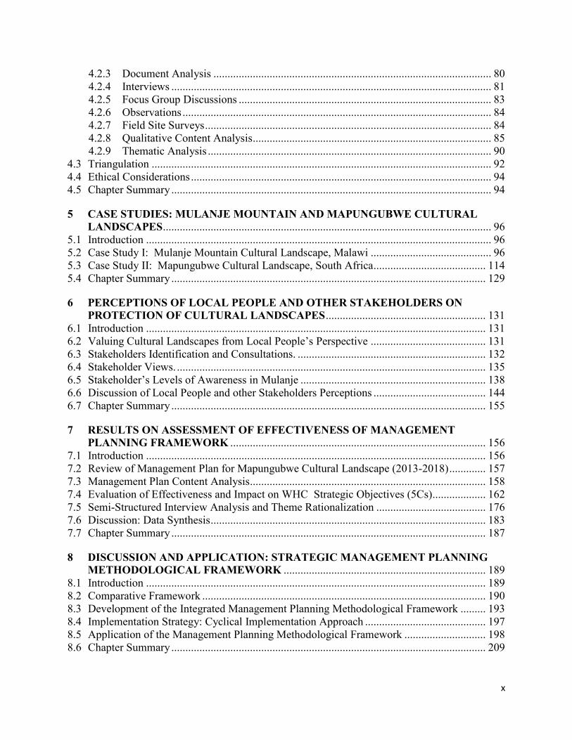
Figure 1. 1 and Table 1.1 below for WHS under threat by extractive activities.
Table 1. 1 WHS under threat by extractive activities grouped by UNESCO World regions
Region
No. of
Natural
WHS
No. of
WHS with
Extractive
Activities.
WHS
with
Mines
WHS with
Mining
Concessio
ns
No. of
Mining
Concessions
Within
WHS
Estimated
Mining
Concessions
Overlap with
WHS (Km2)
Africa 41 25 (61%) 3 11 196 12,387
Arab States 6 1 (17%) 0 0 0 0
Asia and Pacific 70 24 (34%) 5 15 121 4,298
Europe and
North America
71 4 (10%) 3 2 6 29
2
Latin America
and Caribbean
41 13 (31%) 1 10 121 1,207
Source: adopted from WWF-UK, (2015).
In sub-Saharan African countries, the impacts of mineral exploration and exploitation on cultural
landscapes are well documented (Matea et al. 2011; Rossler 2011; Turner 2012). The nature and
extent of the impacts usually differ according to the stages of the mining development and their
proximity to the mining and or exploration sites. Some of the direct impacts during the exploration
and actual mining stages include the destruction of the natural habitat and the ecosystems and the
cultural heritage which has high spiritual significance to the local communities who use these areas
as sacred spaces for their traditional rituals. Indirect negative impacts of mining activities on
cultural and natural heritage resources around and within cultural landscapes emanate from road
networks created for mineral transportation and other mining-related installations which also has
substantial negative impacts on the natural and cultural environment. According to the 2011 report
by United Nations Economic Commission for Africa (UNECA) on Minerals and Africa’s
Figure 1.1 WHS under threat by extractive activities grouped by UNESCO World regions Figure 1. 1. WHS under threat by extractive activities.
3
Development, it has highlighted that mining activities accelerate the rate and degree of change in
African’s cultural landscape (UNECA 2011). It is, therefore, a common fact that mining activities
modify cultural landscapes and their impact has long-term effects on local communities and
cultural and natural heritage resources.
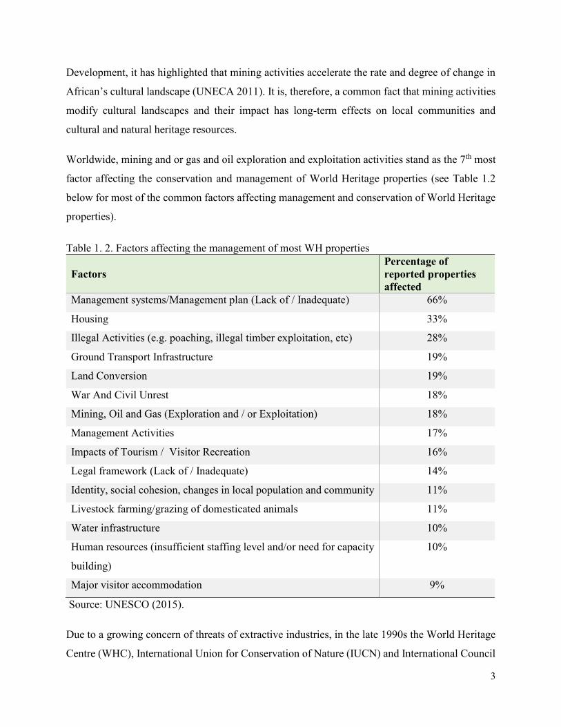
Worldwide, mining and or gas and oil exploration and exploitation activities stand as the 7th most
factor affecting the conservation and management of World Heritage properties (see Table 1.2
below for most of the common factors affecting management and conservation of World Heritage
properties).
Table 1. 2. Factors affecting the management of most WH properties
Factors
Percentage of
reported properties
affected
Management systems/Management plan (Lack of / Inadequate) 66%
Housing 33%
Illegal Activities (e.g. poaching, illegal timber exploitation, etc) 28%
Ground Transport Infrastructure 19%
Land Conversion 19%
War And Civil Unrest 18%
Mining, Oil and Gas (Exploration and / or Exploitation) 18%
Management Activities 17%
Impacts of Tourism / Visitor Recreation 16%
Legal framework (Lack of / Inadequate) 14%
Identity, social cohesion, changes in local population and community 11%
Livestock farming/grazing of domesticated animals 11%
Water infrastructure 10%
Human resources (insufficient staffing level and/or need for capacity
building)
10%
Major visitor accommodation 9%
Source: UNESCO (2015).
Due to a growing concern of threats of extractive industries, in the late 1990s the World Heritage
Centre (WHC), International Union for Conservation of Nature (IUCN) and International Council
4
of Monuments and Sites (ICOMOS) began discussing the issue and concern of mineral resource
extractions in protected areas, in particular, the negative impacts they have on the conservation
and management of natural and cultural heritage resources (UNESCO 1999). In 2008 the IUCN
issued a statement calling for World Heritage Sites to be off-limits to extractive industries (IUCN
2008). In the same period, the International Council of Minerals and Metals (ICMM) and other
international mineral advisory councils, made commitments to refrain from undertaking
explorations or mining activities in World Heritage Sites and other protected areas (ICMM 2008;
IUCN 2008). Similarly, the Operational Guidelines for implementation of the World Heritage
Convention state that protection and management of World Heritage Sites by countries should
include legislative and regulatory measures that ensure the protection of heritage sites against
development and change that might negatively impact their integrity and outstanding universal
value (UNESCO 2016). This is applicable to both sites which have a World Heritage status and
those on the UNESCO tentative list waiting to be inscribed.
In this situation, sub-Saharan African World Heritage cultural landscapes are the heritage spaces
in which States Parties to the World Heritage Convention needs to provide effective legislative
and regulatory measures to ensure that mining development are in tandem with the conservation
and management of the cultural and natural heritage resources which are found within these
cultural landscapes. If these legislative and regulatory measures are in place, according to the
World Heritage Convention, States Parties are requested to ensure that they are effectively
implemented, failure to do so the sites could not be listed as a World Heritage site; and if it is
already listed, the sites could easily be delisted from the World Heritage list.
However, not much academic research has been carried out in this field to critically explore the
negative impact mining development projects are causing on natural and cultural heritage values
of most cultural landscapes. Therefore, this research was undertaken to further examine the threats
of mining projects on effective conservation and management of cultural landscapes which
eventually has contributed to fill-in the knowledge gap in the heritage management academic field.
An integrated strategic management planning methodological framework has been proposed in
this thesis to be used by heritage and mining industry decision makers in order to balance the need
of economic development through mineral extractive industries and the socio-cultural
5
development through the conservation and proper management of the natural and cultural heritage
resources of the cultural landscapes.
Mulanje Mountain cultural landscape in Malawi, a site which is on the UNESCO World Heritage
Tentative list, has been used as the main case study. This cultural landscape is being threatened by
proposed mining development activities among other factors affecting its conservation and
management. A comparative case study of Mapungubwe Cultural Landscape World Heritage Site
in South Africa has been also been used. This second case study has similar issues and management
challenges of mining activities, but it has successfully been integrated into its management system.
Fieldwork was conducted in both case studies where the focus was on collection of data of mining
exploitation and exploration activities as factors affecting the two sites and map out the best
practices from these case studies. The gathered data has been used to develop the proposed
integrated strategic management planning methodological framework which can be used as a
planning tool when integrating development in cultural landscape management processes.
Hence, the proposed integrated strategic management planning methodological framework has
integrated the mining development aspects in the cultural landscape management system. It is
intended that this management planning methodological framework be used by site managers,
heritage institutions, mining developers and other mining investors as a planning tool for decision-
making aimed at preventing and resolving conflicting interests and minimizing potential damages
associated with mining developments in cultural landscapes of sub-Saharan African countries.
This proposed methodological framework is based on recognizing the rights of the local
communities of their cultural heritage resources and assessing risks of all stakeholders, including
the risk to cultural heritage. The concept of risk is an important dimension to understanding how,
and to what extent, a mining project may have an impact on people’s rights and on the
archaeological and cultural heritage resources of local communities and of a nation as a whole.
The proposed methodological framework has developed around the integration and effectiveness
of UNESCO’s strategic action plan for the implementation of World Heritage Convention (2012-
2022) which builds on the orientations set by the five strategic objectives by identifying the World
Heritage goals, priorities, and actions which could help to achieve long-term strategic objectives.
These strategic objectives include, strengthening the credibility of the World Heritage List; ensure
6
the effective conservation of the World Heritage properties; promote the development of effective
capacity building in states parties; increase public awareness, involvement and support for World
Heritage through communication; and enhance the role of communities in the implementation of
the World Heritage Convention (UNESCO 2011). In short, these strategic objectives are referred
to as ‘5Cs’, shortened as Credibility, Conservation, Capacity Building, Communication, and
Communities. To achieve this, the management planning framework for Mapungubwe cultural
landscape has been reviewed in order to provide an opportunity to evaluate the success in achieving
these strategic objectives of the UNESCO’s Strategic Action Plan.
The proposed integrated strategic management planning methodological framework and
corresponding guiding principles for cultural landscape management and mining development will
be discussed further and in more detail in chapter 7 and 8 of this thesis where a structured
framework has been developed and applied in one of the case studies. A set of management
planning strategies has been proposed in Chapter 8 for the implementation of the suggested
methodological framework.
1.2 Problem Statement
Potential losses of cultural and natural heritage resources within and around cultural landscapes
due mining development activities are not adequately considered in heritage management planning
processes. Existing mining projects neither includes cultural heritage impact assessment studies
before starting mining operations nor implementing systematic rescue work in the processing of
mining operations. Almost all active mining development projects so far suffer from a lack of
cultural heritage impact assessment studies. Mostly this is exacerbated by combined problems of
time constraints, under-budgeting and a shortage of qualified personnel in most African countries.
These are seriously hampering the management and conservation of cultural heritage resources in
affected cultural landscapes.
Other studies has revealed that mining exploration and exploitation activities within and in
proximity to cultural landscapes have significant adverse impacts on the cultural heritage
resources. The direct and indirect negative impacts include loss of cultural and natural heritage
resources found within and around the landscape. These include sacred sites and the sacred
elements; the degradations of the archaeological sites and artifacts found within the area like plant
7
and animal remains, burial sites and architectural features found within it. Mining exploration and
exploitation activities cause damage to the cultural heritage elements within the cultural landscapes
through land transformation, construction of road networks and installation of mining machinery.
Most cultural heritage sites in the African continent appear to suffer from inadequate management
(Ndoro 2016). This is the same with all sub-Saharan cultural landscapes which mostly are impacted
by infrastructural development. However, in order for Africa to develop socioeconomically and
reduce poverty, there is a need to exploit the natural resources which are found in these cultural
landscapes. Exploitation of mineral resources is one way of using cultural landscapes for economic
gains. But these mining activities are at odds with heritage conservation and protection in some
cultural landscapes. According to Ndoro (2016), he highlighted that one of the most contentious
issues with the management of sub-Saharan African cultural landscapes is the need to reconcile
heritage conservation with socioeconomic development around natural resource exploitation
within these cultural landscapes.
The demands of mineral exploitation for economic development in most African governments
have been articulated in their national strategic development agendas. In Malawi for example, this
has been prioritized in the Malawi Growth and Development Strategy (MGDS III, 2016) and in
the African region, this has been emphasized in the African Union Agenda 2063. Malawi Growth
and Development Strategy paper has identified mining as one of the sectors that could potentially
generate economic growth for the country. Similarly, the Malawi Mines and Mineral Policy
(2013), has indicated that the country has abundant mineral resources that can sustainably be
exploited to contribute to the government’s vision of transforming the country from predominantly
importing and consuming nation into one that is predominantly producing and exporting. The
contribution of mineral industry to Malawi’s economy is well emphasized in the national policy
document. It has recognized that the minerals sector has a significant potential to contribute
towards the rapid economic growth and development of the country, (Malawi Mines and Mineral
Policy (2013). The sector has somehow made some socioeconomic impact on the lives of
individuals and communities where these mining activities are in operation. The sector provides
both part-time and full-time jobs to the local people around mining sites. According to Amankwah
and Anim-Sackey (2003), in Ghana, for example, mining activities have reduced rural-urban
migration, promoted local economic development and contributed towards poverty reduction. In
8
the Malawi situation, mining operations have been seen as useful, since it has developed basic
skills among local community members by transforming the unskilled labor to semi-skilled and
skilled workers (Malunga 2017).
In some African rural communities where mining activities have flourished, the contribution to the
local economies in terms of investment in people and infrastructure has been acknowledged by the
local people and national government ministries and departments responsible for mining
developments, (Nyamekye 2012; Malung, 2017). These ranged from housing and resettlement
programmes, alternative livelihoods and direct training to employment opportunities for local
people (Nyamekye 2012; Malunga 2017). Most mining companies in Africa are expediting the
management of comprehensive social responsibility programmes which fund these development
projects. In Malawi, as part of the social responsibility programmes, mining projects have
supported education to local communities, provided safe water supplies and healthcare
programmes that meet the demands of the local people even beyond the closure of the mining
operations (Malunga, 2017).
However, in the Malawi context, the government’s development-oriented mining projects in
Mulanje Mountain Cultural Landscape, which the government is promoting is in conflict with the
proper management and conservation of the natural and cultural heritage resources found within
this cultural landscape. This is where the problem lies, bearing in mind that mining activities both
at planning and exploration stages pose a threat to the management of the natural and cultural
heritage resources. On the other hand, mining development is being prioritized by the Malawi
government as one of the vibrant economic activities to be supported since it is envisaged that it
will contribute to poverty reduction and economic sustainability for local people. Therefore,
arguing from a cultural heritage conservation point of view, it has been eluded that mineral
resources exploration and exploitation in African cultural landscapes threatens the proper
management and conservation of natural and cultural heritage resources within and around it. To
balance the two opposing initiatives, a synergy has been proposed in this thesis which has been
discussed in more detail in Chapter 7 through the integrated strategic management planning
methodological framework that has been developed.
9
1.3 Project Aim, Objectives and Key Research Questions
1.3.1 Main Aim
The main aim of this PhD research project was to contribute to the research gap in cultural
landscape studies by developing and applying an integrated strategic management planning
methodological framework that has proposed technical solutions to challenges faced when
managing Sub-Saharan African cultural landscapes that are threatened by on-going and planned
mining developments.
1.3.2 Specific Objectives
The following are the specific objectives in order to achieve the main aim:
a. To examine the existing cultural landscape management theories and concepts in order
to understand the key elements to be integrated into the strategic management
planning framework.
b. To understand the impact of mining on the conservation and management of African
cultural landscapes.
c. To find out the local people’s perception about the impact of mining activities on the
cultural and natural heritage resources within their localities.
d. To assess the effectiveness of strategic management planning frameworks for
protection and management of cultural landscapes threatened by mining development
projects.
1.3.3. Key Research Questions
To address the above specific objectives, the following four key questions guided this study:
1. To what extent do cultural heritage resources be considered in mining development
planning projects in African cultural landscapes?
2. What are the management strategies that can be put in place in order to harmonize mining
development activities and heritage conservation measures in African cultural landscapes?
3. What are the local people’s perceptions and levels of awareness about mining activities
and their impact on the cultural and natural heritage of African cultural landscapes?
4. Which key elements should be incorporated in the integrated strategic management
methodological framework as a planning instrument in order to assess and integrate
development in cultural landscape management planning processes?
10
1.3.4. The Significance of the Study
This research project has contributed to the theoretical and practical body of knowledge in one or
more key emerging issues of sustainable use, management and protection of cultural landscapes
threatened by development projects. A management planning methodological framework with key
strategic actions has been developed on how best the two aspects of heritage conservation and
mining development can be harmonized in African cultural landscapes so that national economic
developments should be in tandem with cultural heritage conservation programmes. Through this
project, the thesis has proposed innovative and promising contributions to the better management
and conservation of African cultural landscapes. In addition, through the application of the
proposed management planning methodological tool, a few African cultural landscapes which are
listed on the World Heritage list will not be placed on the List of World Heritage in Danger soon
after their inscriptions. The recommendations of this thesis can also be used by African States
Parties as a baseline to develop site management plans and incorporation of the thesis ideas in their
national cultural heritage strategic plans and policies.
This study has also contributed to the current debate on the sustainable use of cultural landscapes
which usually has conflicting interests amongst different stakeholders, whereby all of them would
like to exploit the cultural and natural resources from the cultural landscapes for national and local
socio-economic purposes. The study has also contributed to the development of a comprehensive
database of the perceptions of local people, heritage and mining experts on the proper management
of cultural landscapes that are threatened by mining developments. Finally, this study has
contributed to the body of literature on mining developments and sustainable use of cultural
heritage with particular emphasis to cultural landscapes of sub-Saharan Africa.
1.4 Definition of Key Terms
Cultural Landscape: is defined as a geographical area, including both cultural and natural
resources therein, either associated with a historic event, activity or person exhibiting other cultural
or aesthetic values (Birnbaum 1994). According to Birnbaum (1994), he has categorized cultural
landscapes into four types. This includes Historic Cultural Landscapes; Historic Designed
Landscapes; Historic Vernacular Landscapes and Ethnographic Landscapes.
11
A Historic Cultural Landscape is a type of cultural landscape that is significant for its association
with historic events and activities. Example include battlefields. While a Historic Designed
Landscape is a type of cultural landscape that was consciously designed or laid out by landscape
architects. Aesthetic values play a significant role in designed landscapes. Historic Vernacular
Landscapes is a landscape that evolved through use by the people whose activities shaped that
landscape. The ethnographic landscape is a landscape containing a variety of natural and cultural
resources that associated people define as heritage resources. Examples are contemporary
settlements, religious sacred sites and massive structures (Birnbaum 1994). These last two types
are the ones which are directly related to the case studies used in the research project.
Other than the above definition of cultural landscape proposed by Birnbaum (1994), another
definition of cultural landscape worth to be discussed here is the one which has been explained in
the Operational Guidelines for the Implementation of World Heritage Convention (UNESCO
2016) (For detailed discussion, see Chapter 2). Cultural Landscapes has been defined as cultural
properties which represent the combined works of man and nature. They have been divided into
three main categories. The first one is the landscape designed and created intentionally by man.
This includes gardens and parklands constructed for aesthetic reasons. The second type is the
organically evolved landscape. This second category has been further divided into two sub-
categories. This includes a relict or fossil landscape. This is a type of landscape in which an
evolutionary process came to an end at some time in the past. A second sub-category is a
continuing landscape. This is the one which retains an active social role in contemporary society
closely associated with a traditional way of life, and in which the evolutionary process is still in
progress. A final category is the associative cultural landscape. This type of landscape embraces
the powerful religious, artistic or cultural associations of the natural element rather than the
material cultural evidence, which may be insignificant or even absent (UNESCO 2016). The
combination of the last two categories fits well with the case studies used in this research.
Therefore, this UNESCO definition has been adopted throughout the thesis because the case
studies under discussions have World Heritage statuses.
Mining: has been defined in its broadest context as encompassing the extraction of valuable
minerals or other geological materials from the earth usually from an ore body for utilitarian
purposes (Hartman and Mutmansky 2002). While a Mine on its own is an excavation made in the
12
earth to extract minerals. A mineral is a naturally occurring inorganic element or compounds
having an orderly internal structure and a characteristics chemical composition, crystal form and
physical properties. An Ore is a mineral deposit that has sufficient utility and value to be mined at
a profit (ibid). Therefore, this project has linked mining development with heritage management
and conservation, bearing in mind that mining operations usually create a negative impact on
natural and cultural heritage resources, hence a synergy has been suggested in this thesis.
Cultural Landscape Management: It is defined as an interdisciplinary approach that draws on a
body of knowledge and skills developed in the field of history, art, geography, landscape
architecture, archaeology, anthropology, ecological sciences, social sciences, including town
planning, communication and marketing, sociology, financial management, interpretation, training
and education, as well as the various uses of landscape, such as agriculture, forestry, industry or
tourism (Mitchell and Rossle, 2009). The purpose of the management of cultural landscapes is to
protect the natural and cultural values for present and future generations. It is, therefore, the role
of management to guide change in the cultural landscape while retaining important values.
Planning is an important management tool. It is part of the management process that is used to
organize, document and coordinate management strategies among a variety of stakeholders with
varying interests on the resources of the cultural landscape, (ibid).
World Heritage Site: This is defined as a natural or man-made site, area or structure recognized
as being of outstanding international importance and therefore they are accorded special protection
by the World Heritage Convention. All World Heritage sites are nominated by the UNESCO
World Heritage Committee under the World Heritage Convention (UNESCO 2017).
Integrated Cultural Landscape Management Planning: In this thesis, it is defined as a dynamic
and multidisciplinary process for the management of cultural landscapes using an integrated
approach, regarding all aspects of the cultural landscapes, including all the natural and cultural
values, in an attempt to achieve sustainability.
1.5 Thesis Organisation
This thesis has been divided into nine chapters as follows:
13
Chapter one has provided a general overview of the study with an introductory part linking cultural
landscape management and conservation and the impact of mining development projects on the
cultural and natural values of the cultural landscape. This has been followed by a statement of
problem, aim and objectives, key research questions and the significance of the study. Thereafter,
key terms that have been used throughout the thesis has been defined.
Chapter two presents the theoretical perspectives for understanding and managing cultural
landscapes. The historical background of the concept of cultural landscapes, focusing on the
historical trends of their management and conservation both at the international, sub-Saharan
African regional level and national levels. Discussions have also been presented on how
international organizations got involved in the protection and management of the cultural
landscape. In the later part, the chapter presents the management and conservation aspects of
African cultural landscapes during the pre-colonial, colonial and post-colonial periods.
Chapter three has reviewed the literature on the impact of mining development on cultural
landscapes. An overview of African World Heritage cultural landscapes and other protected areas
which are under threat from mining activities has been presented. Legal and policy frameworks
for the management of impacts attributable to mining operations in African cultural landscapes
has been discused in this chapter.
Chapter four has focused on research methodological strategies adopted to achieve the objectives.
There are three sections in this chapter, in the first part, the justification for the selection of the
case studies and the research participants has been presented. Thereafter, there is an explanation
on the data collection methods, how data were analyzed and presented. On the last part is the
section on how the research ethical issues have been considered.
Chapter five provides a detailed review of two case studies that have been used in the study in
order to generate data for the thesis. This includes Mulanje Mountain Cultural Landscape in
Malawi, a site on the UNESCO World Heritage Tentative List and Mapungubwe Cultural
Landscape in South Africa, a site listed as a UNESCO World Heritage cultural landscape.
Chapter six provides the results of the perceptions of local people and other stakeholders on issues
concerning mining and management of cultural landscapes. The focus has been on understanding
how local people and other stakeholders perceive issues of mining and heritage conservation in
14
African cultural landscapes. A final part of this chapter has discussed the reconciliation of
conflicting interests over the use of natural and cultural resources found in African cultural
landscapes.
Chapter seven provides results of the assessment of the management planning framework for
Mapungubwe cultural landscape. The chapter has provided detailed results of how the
management plan has achieved and incorporated the strategic objectives of the UNESCO’s
strategic action plan for the implementation of the World Heritage Convention 2012-2022, (the
5Cs).
Chapter eight discusses the application of the suggested integrated strategic management planning
methodological framework for World Heritage cultural landscapes. The focus has been on the
discussion of the need to adopt the proposed integrated strategic management framework in order
to effectively and efficiently manage the cultural landscapes of sub-Saharan Africa.
Chapter nine concludes the chapter with general recommendations that have been put forward for
decision and policy makers in heritage and mining industry to follow. The last part of the chapter
is the concluding remarks of the thesis. Here, an outline of areas which needs further research in
the future has also been highlighted.
15
CHAPTER TWO
2 CONCEPTUAL AND THEORETICAL PERSPECTIVES IN UNDERSTANDING
CULTURAL LANDSCAPES
2.1 Introduction
In this chapter, conceptual and theoretical perspectives have been provided in order to understand
cultural landscapes in sub-Saharan Africa countries, especially on the relationship between the
local communities, nature and the surrounding environment. This conceptual and theoretical
perspective has drawn from the social constructionist perspective that includes aspects of
phenomenology and symbolic interactionism to define African cultural landscape as the symbolic
environment created by a human act of conferring meaning on nature and the environment (Greider
and Garkovich 1994). The local communities within and around sub-Saharan African cultural
landscapes define how part of the landscapes should be perceived, hence all cultural landscapes
reflects how the people have defined them (Taylor 2011). Mostly, African local communities
define themselves by the physical environment in which they have been surrounded with and
conversely, these natural environments are reconstructed in response to the local communities’
changing characterization of themselves (Greider and Garkovich 1994). This chapter will,
therefore, discuss this conceptual and theoretical overview of the idea of African cultural
landscape, its significance at the local, national and international level and will explore how the
concept in Africa has the special meaning manifested by its history, ways of life of the African
rural people and its intrinsic role of the intangible values associated with it.
The chapter has been organized into three parts. The first part has introduced and discussed the
two concepts of ‘Landscape’ and ‘Cultural Landscape’ as understood and defined in the African
context. The next part has reviewed theoretical perspectives to help in understanding sub-Saharan
cultural landscapes. Here three perspectives have been discussed: cultural landscapes as symbolic
environments, as cultural products and as cultural processes. In the last part, an analysis of the
management and conservation aspects of cultural landscapes in Africa has been provided. This has
been complemented with an overview of international legal and administrative instruments
applicable in the management of cultural landscapes.
16
2.2 Landscape as a Concept
Landscape as a concept is a broad term that is understood differently across a wide range of
disciplines. These multi-disciplinary fields of study range from, ecology, history, architecture,
among others. In ecological studies, landscape ecology deals with the ecological effects of spatial
patterning of ecosystems and develops approaches to landscape planning (Wu 2013). While in
landscape history, it explores the ways in which humanity has changed overtime, and how it is
continuing to change the physical appearance of the environment (Marcucci 2000). Whereas
landscape architecture is more of a multi-disciplinary field that incorporates a wide range of
disciplines, such as geography, geology, botany, horticulture, and industrial design with the aim
of applying artistic and scientific principles to the research, planning, design and management of
both natural and built environment (Francis 2011; Afanasyeva 2015).
The word landscape arrived in the English language in the 15th Century, following the arrival of
the Anglo-Saxons (Mitchel 2007). This term by then referred to as a system of human-made spaces
on the land (Twidale 2002). The concept of landscape in modern days was introduced in the 16th
century by the Dutch painters and portrayed ‘rural scenery’, depicting a tract of land perceived
from an artistic point of view (Olwig 1996; Afanasyeva 2015). Since then, a number of different
meanings of the landscape have been developed, adding to the multiple layers of definitions
underlying the concept.
There are several definitions of what constitutes a landscape, depending on context. In everyday
usage, however, a landscape constitutes either all the visible features of an area of land, usually
rural, often considered in terms of aesthetic appeal. The New Oxford Dictionary (2016), has
defined landscape as visible features of an area of land, its landforms and how they integrate with
natural and man-made features. The key aspect in this definition is the idea of the relationship
between the natural features and the man-made features. However, from the scholarly point of
view, a number of academicians have attempted to come up with a clear definition of what a
landscape encompass. According to Emmelin (1996), in her paper on landscape impact analysis,
she has defined landscape as a visual expression of the sum of objects and processes in a given
locality at a given time where there is an interaction between human and natural systems. An
important idea in her definition is that landscape is understood not as steady-state of locality, but
as a process continuing through time (Palang 2003). Therefore based on this definition of Emmelin
17
(1996), it can be elaborated further that land-use planning affecting these processes are influencing
the emergence of new landscapes depending on the specific policies and planning models that are
applied in different localities. While according to European Landscape Convention, the landscape
has been defined as “an area, perceived by the people, whose character is the result of action and
interaction of natural and/or human” (ELC 2000). This convention has also defined landscape
protection as “action to conserve and maintain the significant or character features of a landscape,
justified by its heritage value derived from its natural configuration and/or human activity” (Olwig
(2007; Bloemers 2011).
2.3 Conceptualizing Cultural Landscapes
Landscapes link people to nature and establish interaction with the environment (Kaya 2016).
Because the existence of tangible and intangible values in landscapes belongs to humans, the
landscape notion is highly cultural. Human beings are one element of nature, among others, and
the presence of a wide variety of relations between humans and the landscape are expressed by the
notion of cultural landscapes, (ibid). On the other hand, at this point in time, there is a need to
discuss what ‘cultural landscapes’ are. The term ‘cultural’, refers to the extended meaning of the
forms of these relations (Antrop 2005; Mitchell et al, 2009; Tudor 2014).
Landscapes as a field of scientific research can be traced to the early writings of geographers
mainly in the English, French and German schools of geography and related disciplines in the
second half of the 19th Century (Olwig 1996; 2007). Geographers evaluated the landscape in terms
of time and space as they are related to each other in a continuous process of development,
dissolution or replacement, (Mitchel 2007). Because of this, the landscape was considered as
having an organic quality. Moreover, their approach to landscape was distinctively
anthropocentric, as human beings were part of it, lived with it, and modified it (Leighly 1969;
Kaya 2016). In particular, the American Geographer, Carl Sauer developed the concept of Cultural
Landscape in 1925, (Leighly 1969). According to his approach, the cultural landscape is a
geographical area which is formed by all of the works of man that characterize the landscape (Solot
1986). However, this definition neglected the energy, customs, or beliefs of man.
The United States National Park Service (USNPS) has defined cultural landscapes as ‘a
geographical area, including both cultural and natural resources, and the wildlife or domestic
18
animals therein, associated with a historic event, activity, or person or exhibiting other cultural and
aesthetic values’. This USNPS definition classifies cultural landscapes into four major types:
historic sites; historic designed landscapes; historic vernacular landscapes; and ethnographic
landscapes, (Birnbaum 1994).
Furthermore, Robert Melnick (1984) prepared a report of Cultural Landscapes which included the
following perspective: ‘In a cultural landscape, the factor is culture, as it interacts, overtime with
the medium of the natural landscape we see and experience. This definition is quite similar to
Sauer’s except that it includes consideration of visual perceptions and experience of the landscape.
One of the most important advantages of Melnick’s views is the description of the characteristics
of the rural landscape and how these can be used for research and inventory of sites. Basically,
Melnick’s characteristics are the starting point for the assessment and mapping of cultural
landscapes, (Buckle 2004).
Additionally, the Canada National Capital Commission, (NCC 2009), developed a study about
cultural landscapes intended to bring in a set of guidelines for the identification and assessment of
cultural landscapes. This report outlines a methodology for search, analysis, identification of
cultural landscapes and suggests related management strategies. The key essence in a cultural
landscapes approach is to find out the relationship between people and landscapes in order to
develop appropriate management tools. This relationship creates the identity, the sense of place
and place attachment that form the concept of meaning and social values. Canada NCC (2009)
defines cultural landscapes as ‘any geographical area that has been modified, influenced, or given
special cultural meaning by people as a set of ideas and practices, embedded in a place’, and then
goes on to classify three basic categories: designed, evolved and associative. This classification is
similar to that of the UNESCO World Heritage Convention (WHC 1972). The NCCs definition is
used to comprehend the relationship between the tangible and intangible qualities of cultural
landscapes and it brings in the notion of meaning in addition to the natural and cultural
characteristics. A landscape may be important as a cultural landscape by virtue of its having
sentimental or spiritual meaning to a group of people, whether or not there are any physical relics
in the landscapes (NCC 2009).
19
Amos Rapoport (1992) discussed the cultural landscape in general as the subject matter of
environment-behavior relations, and of traditional dwellings and settlements in particular. He
argues that the cultural landscape is explained by discussing its two components – ‘Cultural’ and
‘Landscape’. All landscapes are lived in and are modified through human actions which give them
the meaning, and this makes them ‘cultural’, since culture defines all human beings, while at the
same time dividing them into groups. Cultural landscapes are the result of a complex history
because the different populations and groups produce derivative interaction, over time, with a
variety of physiographic and ecological specifics of the land, (i.e. geographic, biotic, resource,
social and other opportunities and constraints). This interaction produces different and specific
culture complexes called “Cultural Landscapes”, (Rapoport 1992). According to Rapoport,
cultural landscapes can be suggested as organizations of space, time, meaning and communication.
Cultural landscapes must be understood as a result of a historic layering of cultural and natural
values and attributes. It must be studied in its entirety and include the broader vernacular context
and setting.
Cultural landscapes have been used with many different meanings because of the notion that
cultural landscapes indicate a wide variety of relationships between populations with the
environment and its natural elements. As a result, the term embraces four distinctive characteristics
as indicated here. A cultural landscape has: (i) Natural elements such as climate, soil, vegetation,
geomorphology, and drainage, which are important components to understanding the backdrop of
the cultural landscape. The natural environment provides the biological and ecological framework
for the cultural landscape, i.e. natural factors. (ii) a distinctive character that has proceeded from
human cultural activity over time. Cultural influences are the tangible results of changes such as
settlements, transportation, land use, roads, and boundaries, as a combination of social, political
and economic facilities, i.e. cultural/social factors. (iii) a meaning formed over time from layers of
additional experience and feelings. The character is connected with meaning, i.e. cultural
association. (iv) a unique visual, aesthetic quality and authenticity due to natural and cultural relics,
i.e. perceptional aesthetic factors, (Melnick 1984; Tudor, 2014; Mitchell et al. 2009; Bloemers
2010; Rapoport 1992).
The concept is particularly relevant in Europe, where large-scale human impacts on land starting
in Neolithic times (c. 3000–1100 BC). Hunting, cultivation (of cereals, fruits and other crops) and
20
settlements altered natural ecosystems and shaped Europe’s landscape. Until the 18th century,
European landscapes preserved many remnants and structures of the remote past. Since then,
however, enormous technological and social changes have fundamentally altered land use,
(Tieskensa, et al 2017, Strecker, 2019). Transport infrastructure and urbanization have fragmented
habitats, while intensified agriculture has created a much more homogenized landscape,
threatening the diversity of habitats, species and genes. An important element of the 'cultural
landscape' concept is recognition that human activities are key drivers of changes in ecosystems
— with potentially severe impacts on human wellbeing, (Vos 1999). But the concept also reflects
the idea that human cultures are themselves shaped by their natural surroundings and ascribe huge
value to local ecosystems for their spiritual, aesthetic and recreational properties.
Almost all rural areas in Europe have been shaped or altered by humans and can be considered
cultural landscapes, many of which now are considered to entail valuable cultural heritage.
Current dynamics in land management have put cultural landscapes under a huge pressure of
agricultural intensification and land abandonment.
Traditional agricultural landscape (from Renaissance till 19th century, sometimes till today): The
landscapes became multi-functionally managed by farmers, mainly in mixed agriculture systems,
integrating forests and tree pastures, rough grazing lands, water systems, (Vos and Stortelder,
1992; Austad et al., 1993; Vos, 1993; Vos et al., 1993, etc.). Well-established regionally
differentiated land use systems developed that became the engines behind most of Europe's
characteristic cultural landscapes. These integrated farming forestry systems were regionally
differentiated by their adaptation to climate, physiography and local cultures. Almost all rural areas
in Europe have been shaped or altered by humans and are considered cultural landscapes. Current
dynamics in land management have put cultural landscapes under a huge pressure of agricultural
intensification and land abandonment, (Fairclough, 2002).
In 2000, the Council of Europe recognized the importance of managing cultural landscapes more
effectively. This led to the European Landscape Convention which has influenced government
policy and underpins a European emphasis on developing ways to manage landscapes in a
sustainable framework.
The Convention establishes the principle that all of Europe's landscape is a common cultural
resource, and that an important aim of European policy is to maintain the landscape's diversity for
21
reasons of local and regional identity, and for economic and social health. Underlying the
philosophy and agenda of the Convention are two very powerful inter-related ideas:
Landscape belongs to everyday life, as part of every citizen's culture, heritage and
environment, and must be democratized both in terms of identifying why it is valuable and
deciding how it is used and.
Landscape is a cultural construct composed of many different ways of understanding and
appreciation. Not all of these ways are 'scientific', objective or material. Many are personal,
individual and subjective, or reflect intangible aspects of the environment.
Landscape issues have been a concern of European and international policy for some time, but
with a relatively low level of recognition of its historical depth. Landscape's main champions to
date have been nature conservationists, geographers and landscape architects (eg IUCN 1994;
ICOMOS-Deutschland 1993; Ryszkowki et al. 1996; Bennett 1996; Hajós 1999). The idea of
landscape as being primarily natural has therefore dominated important documents such as the
Council of Europe's Pan-European Biological and Landscape Diversity Strategy (Sofia October
1995). For example, the IUCN defines many categories of Protected Areas ranging from areas
maintained as strict wilderness to managed resource areas (IUCN 1994). Almost all of the
categories focus more or less exclusively on natural ecosystems. The IUCN's overall definition is
of areas 'especially dedicated to the protection of biological diversity, and of natural and associated
cultural resources'.
2.4 Theoretical Perspectives for Understanding Cultural Landscapes
In this section, theoretical perspectives have been provided in order to understand cultural
landscapes. In the African context, the theoretical viewpoint draws on a social constructionist
perspective that includes aspects of phenomenology and symbolic interactionism on the way
cultural landscapes are viewed as symbolic environments created by a human act of giving
meaning on nature and the environment, (Greider and Garkovich 1994). The local people who
reside within and around these cultural landscapes define what part of the landscapes should be
valued highly.
2.4.1 Cultural Landscapes as Symbolic Environments
22
Sub-Saharan African Cultural landscapes are symbolic environments created by human acts of
conferring meaning to nature and the environment. The people define the environment from a
particular angle of vision and through a special filter of values and beliefs, (Greider and Garkovich
1994). These cultural landscapes reflect the local peoples’ self-definitions that are grounded in
culture. Sub-Saharan African cultural groups of people have transformed the natural environment
into landscapes through the use of different symbols that bestow different meanings on the same
physical objects or conditions of the landscape. According to Berger and Luckmann (1967), these
symbols and meanings are sociocultural phenomena which result from ongoing negotiations in a
cultural context. Through sociocultural phenomena, the physical environments have been
transformed into landscapes that are the reflections of how the local people have defined
themselves, (Greider and Garkovich 1994).
In African cultural contexts, the definitions of nature and the environment are grounded in various
symbols through which cultural groups transform nature and the world that is there into meaningful
subjective phenomena. These subjective phenomena are reflections of how local people define
themselves as individuals within a given cultural group. Faced with change, the process of
negotiating new self-definitions begins, but the negotiations occur within the context of existing
cultural landscapes that frame the directions that the new self-definitions may take, (Greider and
Garkovich 1994).
Cultural landscape phenomena are sociocultural phenomena in the sense that they are constructed
through social interactions among members of a cultural group as they negotiate the meanings of
nature and the environment. Sociocultural groups construct a landscape from nature and the
environment through culturally meaningful symbols, (Greider and Garkovich 1994). However,
one of the questions this thesis has tried to answer is on how landscapes persist and sustain core
understandings of human-natural environment relations among cultural groups of people in the
face of economic and other changes. Tax (1990) offers an explanation for the persistence of
significant symbols and values. Lying beneath what he calls the relatively observable worldview
of a culture is a structure of beliefs that are shared in a community.
Sub-Saharan African cultural groups use symbols to define the natural environment and fit it into
their ongoing, everyday life within which they organize both their relationships to each other and
their relationships with the environment. The natural environment is transformed through symbols
23
and concepts that organize local people’s relationships in the social world, (Greider and Garkovich
1994). Cultural groups in sub-Saharan African societies socially construct landscapes as
reflections of themselves. In the process, the social, cultural and natural environments are meshed
and become part of the shared symbols and beliefs of these members of the cultural groups. Thus,
the natural environment and the changes in it take on different meanings depending on the social
and cultural symbols affiliated with it, (Greider and Garkovich 1994).
A broader interpretive framework for understanding local people’s relationships with each other
and the environment is needed, one that links people’s changing conceptions of themselves. A
sociology of knowledge perspective, combined with phenomenological and symbolic interaction
perspectives, provides a framework for understanding the symbolic transformation of the
environment into cultural reflections of the local people. (Greider and Garkovich 1994). According
to Stryker (1987), a symbolic interaction framework emphasizes, among other things, the
importance of shared symbols and meanings in a group’s definitions of the situation, and the
negotiation of meaning as a change in context occurs. Nature and the environment are socially and
culturally constructed through these social processes and become cultural landscapes through
social interaction and negotiation, (Greider and Garkovich 1994).
In my case studies, for example, where some developers are exploring and exploiting the mineral
resources within the cultural landscapes, it is observed that these developers and local people use
very different epistemologies to make sense out of their worlds and with different cultural resource
management strategies result from these epistemologies, (Stoffle, et al. 1990). The landscape of
the two groups reflect these differing epistemologies. For instance, to the local people, the artifacts,
plants, mountains and hills, water pools and rivers and other elements of the non-human
environment connect them to their creation, to their ancestors, to each other, and to their future.
They do not have to understand the specific interconnections between these parts of the cosmos in
order to have a complete and comprehensive cosmology. Thus disturbance of any part disturbs the
whole, which includes disturbing the local people within and around the landscapes. Scientists or
developers, however, use the verification and hypothesis-testing of positivist science to understand
the cosmos and cannot understand the whole without testing the interconnections between the
parts. These are completely opposing epistemologies.
24
Knowledge of the whole, for example, leads local people within and around Mulanje Mountain
cultural landscape in Malawi, to recommend for holistic conservation, whereby the importance of
one part of the mountain which plays an important role in the spiritual life of the local communities,
is equivalent to the whole mountain covering the area. Disturbance of one part of the mountain
disturbs the local people because it disturbs the holistic cultural landscape that reflects their
definitions of themselves, (Stoffle and Evans 1990). Developers, however, discount the importance
of traditional religious practices within the mountain. They question that how can the destruction
of one small part of the mountain make any difference in an environment where the mountain is
so massive covering a wide area of land. This shows the differences and competition in
epistemologies which eventually lead to different assessments of the sociocultural and
environmental consequences of most development projects, for example, mining development
projects.
To apply this theoretical perspective of the cultural landscape as a symbolic environment in real
life, there is a need to develop more effective management planning frameworks of project
developments and community responses to environmental change. In the case of this thesis, the
proposed management planning methodological framework which has been developed, (see
chapter 7) has emphasized that the natural environment has multiple meanings and that these
meanings are symbolic reflections of how the local people define themselves. The changes in the
environment can challenge these cultural expressions and require a renegotiation of the meaning
of both the local communities and their relationships to the environment. In the arena of social and
cultural heritage impact assessment, this framework suggests that there are sociocultural-heritage
impacts of an environmental change precisely to the extent that new cultural definitions and
expressions that existed prior to the change will be lost. The suggested management planning
methodological framework also suggests that the potentially affected population should include
all local people whose cultural definitions and landscapes include the physical environment in
which the change is occurring or is proposed to occur, (Greider and Garkovich 1994).
Other researchers have noted that sociocultural-heritage impacts also occur prior to the actual
implementation of the development project or environmental change, (Freudenburg and Gramling
1992; Gibbs 1990; Stoffle et al 1991). For instance, sociocultural-heritage impacts occur from the
point of conception and especially, from the time planned development projects have been
25
announced. The proposed management planning methodological framework of cultural
landscapes, developed through this research, has accounted for the occurrence of sociocultural-
heritage impacts prior to actual change on cultural landscapes. Within this framework, the
sociocultural-heritage impacts have been created as cultural groups interpret the proposed changes
within the context of their definitions of themselves and begin the process of renegotiating these
definitions in light of the proposed changes. These definitions incorporate the group’s social and
economic resources and how these resources are used in ongoing social-cultural relations and
negotiations with other groups (Gibbs 1990). If the proposed changes can be incorporated into
local people’s ongoing self-definitions, symbols, and meanings with minimal conflict, then
renegotiation of their definitions of themselves will not be needed and sociocultural-heritage
impacts will not occur from the change (Stoffle et al 1991). If, however, the development project
or environmental change cannot be incorporated into this everyday life-world or threatens access
to valued resources, then negotiations among members of the group will occur. These new
definitions are the sociocultural-heritage impacts.
As the status of land and prospects for the physical environment become a focus of national and
international debate, the question of whose landscape is being protected, altered, or exploited
becomes more important. As Bord (1991) suggests, the issue of symbolic politics in the realm of
the global environment is becoming significant given the inherent uncertainty of environmental
problems, which leads to competing scenarios. The proposed management planning
methodological framework of landscapes provides a vehicle for understanding the use of power
and political conflicts that emerge around the issue of environmental change.
The management planning framework proposed in this thesis have emphasized a well-established
integration of stakeholders’ views and environmental issues. It has paid attention to the social
construction of reality by highlighting the need to explore the symbolic creation of cultural
landscapes, the cultural meanings of aspects of the physical environment and biophysical changes
in this environment, and the values and beliefs that sustain these symbols and their meanings.
2.4.2 Cultural Landscapes as Cultural Products
There is an important contrast between ‘cultural landscapes as a ‘symbolic environments’ and
cultural landscapes as ‘cultural products’. The later, focuses almost exclusively on the study of
landscape as a physical entity, in the longer-established approach. Whereas the symbolic landscape
26
approach differs mostly from cultural landscapes as a cultural product approach mainly over the
questions of subject/object (Cosgrove 1989). Cultural landscapes as a cultural product approach
purport to take an objective perspective, whilst the symbolic approach view suggests that the world
cannot be perceived in this way, we can only experience and understand it subjectively, (Robertson
and Richards 2003).
The first important point to make about the symbolic approach is, therefore, that it understands
cultural landscapes subjectively. In addition, because this approach sees all landscapes, whether
on the ground or imagined, as representations, then it includes landscape representations. Thus a
single landscape may well be either (or both) be subject to a range of interpretations dependent on
the cultural position of the interpreter or be viewed ‘simultaneously in a variety of ways’ (Seymour
2000).
2.4.3 Cultural Landscapes as Cultural Processes
More persuasive, however, are the views that rework landscape not as a cultural product but as a
cultural process. In cultural geography, this view is most closely associated with the work of W.J.T
Mitchell (2000), who attempted to move our understanding away from seeing the landscape as a
static text to seeing it as a part of a process by which identities are formed. In this view, the
landscape is active and dynamic, it does work, in both the mental and material senses.
It is within the fields of archaeology and anthropology that the notion of landscape as cultural
process finds its most consistent expression (Stephenson 2008). Nevertheless, where the landscape
is considered, the way in which it is understood is often based upon a phenomenological stance,
the key issue is the manner in which people experience and understand the world. In this view,
then, the physicality of the cultural landscape is seen as critical and as the setting in which humanly
created locales occur. This leads authors like Ingold (1993) to reject the notion of landscape as a
cultural or symbolic construct as it falsely separates mental and material worlds. Instead, he
proposes a temporality to landscape in order to incorporate the process of social-cultural life
(Ingold 1993).
This is a term that allows Ingold (1993) to see the landscape as part of and a product of the dynamic
process of dwelling in which the landscape is never built but it is perpetually under construct and
is always in the nature of ‘work in progress’. The landscape is never complete. It is always already
27
fashioned by human agency and is constantly being added to. Life activities are the medium
through which landscape is experienced and that occur in relationship with the visual and physical
forms of landscape. Hirsch (1995:3), argues that landscape is a cultural process that brings together
the cultural meaning of landscape with ‘the concrete actuality of everyday life’.
Cultural landscapes also provide useful ways of knowing the world. It gives us a framework of
understanding within which to describe and analyze what we see of, and feel about, the
environment in which we live (Swaffield 2006). The landscape also provides a systematic basis
for understanding the spatial patterns and processes we see around us and the way that people
adapt the environment to their needs and desires. Understanding cultural landscapes complements
and provides an important counterpoint to their ways of knowing.
Evolution process and mechanism of organically evolved cultural landscapes
The evolution of cultural landscapes is an important angle for the decoding of demographic, social,
economic and cultural changes in a certain place. Because of the existence of regional difference,
the evolution process and mechanism of cultural landscapes should be studied on different scales
and regions. In the past 100 years, rural cultural landscapes of Africa have changed enormously
due to the faster industrialization and urbanization.
The concern about the vanishing historic cultural landscapes and new emerging cultural landscapes
has become a recurring topic in most of landscape researcher around the world, (Antrop, 2005).
Landscapes change because they are the expression of the dynamic interaction between natural
and cultural forces in the environment. Cultural landscapes are the result of consecutive
reorganization of the land in order to adapt its use and spatial structure better to the changing
societal demands. In Africa, history has recorded many successive and even devastating landscape
changes, which have left barely any relics today. Today, the changes are seen as a menace, as a
negative evolution because they cause a loss of diversity, coherence and identity, which were
characteristic for the traditional cultural landscapes that are rapidly vanishing, (Antrop, 2005).
This growing concern is also expressed in number of World Heritage Cultural landscapes which
are being subjected to various development pressures. Values change accordingly and so does the
way of using and shaping the landscape. It is argued that this changing perception also influences
what kind and aspects of landscapes are studied, protected and managed. Diversity and identity of
28
cultural landscapes are central in the discussion. It is shown that coherence between small
composing elements in a broader spatial context is important for the legibility of the landscape and
that the ability to tell the (his)story of a place strongly enhances the identity and the overall value,
(Antrop, 2001).
This offers criteria for inventorying and assessing landscapes, which is needed to define future
management and development. Although the general trends of future development of the African
landscapes are rather well known, planning and managing future landscape remains difficult and
extremely uncertain. The processes and management in past traditional landscapes and the
manifold relations people have towards the perceivable environment and the symbolic meaning it
generates, offer valuable knowledge for more sustainable planning and management of future
landscapes.
Landscapes are dynamic and change is one of their properties. Humans have always adapted their
environment to better fit the changing societal needs and thus reshaped the landscape. All the
important driving forces are related to the population growth and the life-style becoming
increasingly more urban and more mobile. Since the 18th century, however, the pace and
magnitude of the changes increased greatly, causing definite breaks with the past. Only in the
beginning of the 20th century was there a first concern regarding the loss of natural and cultural
values.
A second period of concern emerged gradually at the end of the 20th century, stimulated by the
growing awareness of environmental deterioration and loss of ancestral roots. Modern
developments are found to be not very sustainable when compared to traditional land management
practices that lasted for centuries. More attention is given to the scattered remnants of the past
traditional landscapes. Their importance is manifold. They are the tangible witnesses of ancestral
values everyone can perceive and experience directly in the landscape. Symbolic and cognitive
values pass through esthetically felt scenery. They contain a lot of information concerning the still
poorly known history of ordinary people and land management traditions. Much wisdom and
inspiration for sustainable management can be found here, which is useful when decisions have to
be taken for the future management of landscapes, their restoration and even for creating new ones.
Landscapes of the past cannot be brought back, but ways how valuable elements and areas can be
29
preserved and become embedded functionally in the modern urbanized and globalized society
must be studied.
2.5 Cultural Landscapes in Sub-Saharan Africa
Africa is the continent where the human species differentiated itself. It is thus where the most
ancient cultural landscapes are found (Le Berre 2000). Some of the examples of these cultural
landscapes include sites like the Omo in Ethiopia, Turkana in Kenya, Olduvai in Tanzania,
Sterkfontein in South Africa, Koro-Koro in Chad, among others. Amongst some of the typologies
of cultural landscapes found in Africa includes; fossil cultural landscapes as evidenced by
numerous prehistoric sites in the region. Associative cultural landscapes are also numerous, they
are amongst the living landscapes, and they constitute an essential element of the nature-culture
link so important in African cultural heritage. African associative landscapes are diverse and it
includes woodlands, rocks, ponds, mountains, among others. It has also pastoral landscapes, a
distinctive category in the arid and semi-arid zone, with unique elements such as the pastoral wells
and cattle enclosures. Itineraries and exchange routes also constitute a category of linear
landscapes of diverse usage like commerce, religion, and culture, which was particularly important
in Africa. The examples of the Salt and Slave Routes are illustrative of the importance and diversity
of this category. In addition, the Intensive agricultural landscapes, terraced and with original
irrigation systems, translate the efforts of survival under difficult environmental conditions (Le
Berre 2000).
In this period of the 21st century, these different categories of landscapes are evolving rapidly under
the increased economic development projects within these cultural landscapes. It is important,
therefore that, means of conservation and management strategies of the most representative
elements of the African cultural landscapes be envisaged without hindering their development
potential.
African cultural landscapes are places or areas that demonstrate the combined works of man and
nature. In these areas, it is where people get their livelihood, portray their identities and belief
systems. These African cultural landscapes are shaped by the people within and surrounding them,
and nature’s resources are managed and harvested in a sustainable manner to satisfy the local
people’s material and spiritual needs. African’s cultural landscapes are vibrant scenic places that
30
are prime examples of traditional cultures that are still very much alive today. They demonstrate
life-styles, building techniques, and customs that have remained largely unchanged for centuries.
African cultural landscapes demonstrate a clear symbiotic relationship between the ecosystem and
the ethno-systems (Munjeri 2000). This is so because more than anywhere else, the cultures of
Africa have evolved out of nature and still draw their authority from it (Berre and Messan 1996).
In the context of Africa, everything relating to the interaction of natural resources and people is
indeed summarized in that statement. African civilizations have always been closely attached to
their natural surroundings from which they draw materials and inspirations. African cosmology
ties together the supreme deities, ancestors, and the natural resources: forests, mountains, springs
and other sacred places which form a network that enables people to understand the landscape
around them and give it a special meaning and purpose and to become part of it.
The spiritual interpretation of relationships of African cultural landscapes concerning the natural
heritage has enabled conservation of natural areas because of their holy nature (Le Berre and
Messan 1996). This arrangement works because in most African cultural landscapes, the living are
part of the spirits of the ancestors and the dead continue to exist as spirits co-existing with humanity
(Beach 1994). For example, in the case of sacred groves found in Ghana, 80% of the sacred groves
serves as a watershed or catchment areas that protect sources of water and provide essential herbs
of medicinal importance. In this particular area, through a system of taboos and customs,
encroachment or unwanted exploitation is limited. The unlimited powers vested in the custodians
equally protect other numerous groves in the country.
To emphasize the effectiveness of this ‘spiritual legislation’ another case of Baakye Amoako-Atta
presents the case for Tali sacred grove which covers 25 square kilometers of dense forest in the
middle of the savanna. Through the use of traditional regulatory mechanisms which involves five
village communities that offer custodial leadership over the grove of Jaagbo god, the landscape
has been preserved. The grove which is so dense attests to the ecological complexity of the Tali
grove which is the last drop of the thick forest in a vast plain of the degraded savanna, (Amoaka
1995). These groves are evidence that traditional values, human settlement, and initiative in the
conservation of natural landscape through religious beliefs can resist what is almost irreversible
destruction and degradation of the whole bio-geographical unit in West Africa. Mostly, in African
31
cases, elaborate rituals, traditional structures and the ‘great in-born pride’ in being part of the
mountain culture and the unbroken tradition of several years of agricultural achievement have
sustained these cultural landscapes and their inhabitants.
However, most of the African cultural landscapes are poorly managed. The core reason is the
absence of management guidelines and plans for these cultural landscapes. In most of these sites,
maintaining the correct balance between the requirements of the sites and the local people who
have placed their stamp on nature to produce the biologically productive and aesthetically pleasing
landscapes is a delicate ‘balancing act’ calling for skills and expertise and experience that is rarely
found.
In terms of authenticity and integrity of the cultural landscapes, as the position stands, in the
‘Operational Guidelines for the implementation of the World Heritage Convention’, the
authenticity of cultural landscapes relates to cultural sites and integrity relates to natural sites
(UNESCO 2016). With respect to integrity, the African perspective lies in the inseparability of the
cultural and natural environment. That being so, the nature-culture demarcation is hard to apply
because, in Africa, the natural heritage is the very basis of the cultural heritage. Thus, the division
between a natural and cultural heritage is almost impossible.
2.6 Traditional Management Systems of Cultural Landscapes in pre-colonial Africa
Africans protected and promoted their heritage resources well during the pre-colonial period.
Cultural heritage included but not limited to grooves, caves, pools, trees, graves, shrines, spiritual
landscapes and animals (Maradze 2003; Onyima 2016). Preservation of these resources was
managed through traditional management systems (Jopela 2011). These included taboos,
restrictions, myths and ceremonies, and these measures were effective in ensuring the survival of
heritage places (Maradze 2003). Jopela (2011) also reports of studies done in southern Africa
which revealed that rituals have been done in rock art sites such as Domboshava and Silozwane in
Zimbabwe; Tsodilo Hills in Botswana; Kandoa-Irangi in Tanzania; and Chongoni in Malawi.
Some customs and beliefs that were done in such places have endured to date. Smith (2005) states
that particular sections of rock art have a link to certain local customs and beliefs of the people
around the sites.
32
Chiefs were at the center of preserving their local heritage sites. Onyima 2016 states that in Nigeria
during this period, heritage was preserved in royal palaces of tribal kingdoms and empires by
kings, heads of families and kindred, deity priests in charge of shrines and sacred groves. The
chiefs made use of skilled personnel in arts and crafts to lead in the production of dance and crafts
necessary for ritual practices. Chiefs ensured that trees were not cut down in sacred grooves
(Maradze 2003). Oral tradition and training ensured the preservation of skilled personnel in various
arts and crafts (Onyima 2016). The chiefs, therefore, ensured that they had costume designers for
royal regalia and other props, mask carvers for masquerades, drum makers, praise singers,
choreographers, and weavers. In some cases, the chiefs doubled their roles as kings and religious
leaders, for example, Mulopwe of the Luba State, in the present day Congo, whose house at his
death became an important religious center or shrine under a priestess. Another one was Kyungu
in Northern Malawi who lived a life of seclusion on a summit of a hill, (Kalinga 1983).
Though the pre-colonial period has been portrayed as a chaotic world with barbaric ethnic wars,
cultural landscapes have relatively been untouched. This should be because most Africans had the
belief in the existence of a Creator (Tindall 1968) and spirit mediums hence places associated with
spirits were revered as sacred. In places where two or more ethnic groups interacted cultural
heritage sites were all preserved. Evidence in Chongoni Rock Art sites in Malawi shows that the
Batwa (short-statured people) and the Chewa used the same caves but the latter did not obliterate
the paintings of the former. Similarly before the arrival of the Maravi (Phiri) in the central region
of Malawi, there lived the Proto-Chewa, Zubieta (2009). Zubieta (2009) reports of several studies
that have suggested that the Phiri newcomers adopted “Gods” of the Banda. In Northern Malawi,
Tumbuka clans lived loosely headed by clan leaders/heads without a centralized system. They all,
however, paid allegiance to the “Chinkhang’ombe” cult (Kalinga 1983). When the Balowoka came
into the area under Msawira and established a kingdom over the Tumbuka, they also maintained
the Chinkhang’ombe cult. After the fall of Great Zimbabwe, the Changamire Empire was founded
by Changa, a Rozvi. Great Zimbabwe was a great empire with stone buildings built without mortar
and an important religious center. Though the new Empire did not occupy the Great Zimbabwe
buildings, Great Zimbabwe still functioned as a religious center, (Kalinga 1983).
Since most African chiefs wielded their power through divine decent (Shillington, 1995), their
subjects followed their dictates. Among the Yoruba the founding ancestor, Oduduwa, is said to
33
have been lowered from heaven by “Olurun” (the God of the Sky), the Bemba kings in Zambia
claimed their descent from crocodiles “Bena Ng’andu” and the Pharaohs in Egypt were regarded
as sons of Ra, the Sun God (ibid). This kind of claim enabled kings to manage cultural sites since
their word was that of “God” himself. There were customs and rituals that were done at various
points in time at cultural sites that ensured that the sites are preserved for posterity. The sites were
regarded as the abode for ancestors (Maradze 2003) or places for communication with the
ancestors (Jopela 2010). As such certain behavioral patterns were supposed to be observed at the
sites in respect for the ancestors. Maradze (2003) wrote about a sacred groove at Domboshava in
Zimbabwe which presents a classic example of how taboos and other restrictions conserved its
landscape:
“Oral tradition has it that cutting down of trees and cultivating in the vicinity of the groove was
prohibited”. It was believed that if a person cut down a tree it would be in its original place the
following day, and the culprit had to pay heavily.
Khuluvi sacred thicket in Malawi has survived to date because of restrictions that are enforced by
Malemia the custodian of the thicket who resides at Nankhodzo. Malemia overseas the sacred site
delegated by the Chiefs Tengani and Lundu. He sees to it that no one violates the site and anyone
wishing to offer a sacrifice is led by him, (Rengeley 1952). Every person by virtue of belonging to
a community was supposed to take part in the ceremonies to placate or gain the favors of the
ancestral spirits, (Tindall 1968). This ensured that all people in the community took part in the
preservation of their cultural landscapes.
2.7 International Instruments on Management of Cultural Landscapes
In the 19th and 20th century the pioneer environmentalist movements began and in addition to
landscapes becoming an important field of study, protection strategies were simultaneously
developed within the protection movements (Kaya 2016). After the Second World War, the first
international conservation achievement was realized. In 1962, a UNESCO “Recommendation
Concerning the Safeguarding of the Beauty and Character of Landscapes and Sites”, was accepted
by the members. For the purpose of this recommendation, the beauty and character of landscapes
and sites was taken to mean the preservation and, where possible, the restoration of the aspects of
34
rural and urban landscapes and sites, whether natural or man-made, which had a cultural or
aesthetic interest or form typical of natural surroundings (UNESCO 1962).
The recommendation mentioned the growing concern of the human negative impact on the beauty
and character of landscapes and sites forming part of the natural environment, including damage
through: improvement of the cultural, aesthetic and even vital heritage; cultivation of virgin land;
ill-regulated development of urban centres; vast schemes for industrial and commercial
development and equipment; and destruction of wildlife (UNESCO 1962).
This document pointed out that the beauty and character of landscapes and sites play a crucial role
in the life of humans, for whom they embody a physical, spiritual and moral regenerating influence.
They are important universally known examples that bear witness to their age. Landscapes and
sites are an important factor in the economic development and social life of many countries, and
are largely valuable in ensuring the health of their inhabitants.
The General Conference of UNESCO which met in Paris in 1962, in its twelfth session, requested
that member states bring this recommendation to the attention of the authorities and bodies
concerned with the protection of landscapes and sites and with regional development, (UNESCO
1962). The safeguarding of landscapes and sites should be ensured by use of the following
methods: general supervision by the responsible authorities; insertion of obligations into
development plans and planning at all levels, regional, rural and urban; organizing of extensive
landscapes by ‘zones’; organizing of isolated sites; and creation and maintenance of natural
reserves and national parks; acquisition of sites by communities, (UNESCO 1962).
Secondly, in 1964, the International Charter for the Conservation and Restoration of the
Monuments and Sites was adopted by ICOMOS as a basic document which frames the issue of
conservation within a system of international principles (UNESCO 1964). This document focused
on historical monuments and their settings and emphasized that ‘The concept of a historic
monument embraces not only the single architectural work but also the urban or rural setting in
which is found the evidence of a particular civilization, a significant development or a historic
event. This applies not only to great works of art but also to more modest works of the past which
have acquired cultural significance with the passing of time’. The Charter emphasized that it was
essential to preserve ancient buildings from changes and that restoration must be done to reveal
the aesthetic value of the monument. According to the Charter, conservation and restoration of
35
monuments must have appeal to all the sciences and techniques which can support the
safeguarding of the architectural heritage, (UNESCO 1964).
The third one relevant to cultural landscapes is the 2003 Convention for the Safeguarding of the
Intangible Cultural Heritage. UNESCO adopted this convention referring to the Declaration of
Human Rights of 1948, the International Covenant on Economic, Social and Cultural Rights of
1966, and the International Covenant on Civil and Political Rights of 1966. The purpose of this
Convention is: to safeguard the intangible cultural heritage; to ensure respect for the intangible
cultural heritage of the communities, groups and individuals concerned; to raise awareness at the
local, national and international levels of the importance of the intangible cultural heritage, and to
ensure mutual appreciation thereof; to provide for international cooperation and assistance
(UNESCO 2003). The convention defines intangible cultural heritage as the “practices,
expressions, knowledge, skills – as well as instruments, artifacts and cultural spaces associated
therewith – that communities, groups and, and in some events, individuals recognize as part of
their cultural heritage” The definition also points out that: it is transmitted from generation to
generation; is constantly recreated by communities and groups in response to their environment.
Their interaction with nature and their history provides them with a sense of identity and
continuity; promotes respect for cultural diversity and human creativity; and complies with
international rights regulations, (UNESCO 2003).
The World Heritage Convention and Cultural Landscapes
After World War II, the idea of creating an international movement for protecting heritage
emerged, protection ideas were converted to international legislation. UNESCO assisted the
convention managed by the World Heritage Committee (WHC) in 1972. The committee consisted
of 21 countries and it concerned with the protection of world cultural and natural heritage. The
Committee’s purpose is to encourage countries to sign the World Heritage Convention and to
ensure the listing and protection of their natural and cultural heritage. UNESCO defines heritage
listing as ‘the designation for places on earth that are of outstanding universal value to humanity
and such, have been inscribed on the World Heritage List to be protected for future generations
to appreciate and enjoy. Heritage is our legacy from the past, what we live with today, and what
we pass on to future generations. Our cultural and natural heritage are both irreplaceable sources
of life and inspiration”, (WHC 1972).
36
The concept of cultural landscapes is not new, although it has only relatively recently become a
prominent part of the international cultural heritage movement. After nearly a decade of debate,
in 1992 the World Heritage Committee (an international committee with responsibilities for
implementing the World Heritage Convention, adopted in 1972) agreed that cultural landscapes
could meet the criteria of “outstanding universal value” and revised the convention’s guidelines
accordingly. In doing so, the committee recognized that cultural landscapes have values in their
own right that are different from the scientific and the perceptually based scenic qualities of
properties valued for their natural characteristics.
The guidelines also specifically address the relationship between cultural heritage and natural
resource values by acknowledging that cultural landscapes represent the combined works of nature
and of man” as designated in Article 1 of the convention: “They are illustrative of the evolution of
human society and settlement over time, under the influence of the physical constraints and/or
opportunities presented by their natural environment and of successive social, economic and
cultural forces, both external and internal” (section 36 of the guidelines). In section 37, the term
“cultural landscape” was defined as “a diversity of manifestations of the interaction between
humankind and its natural environment.” By this definition, a cultural landscape is created through
the interrelationship of culture and nature, which shapes environments over time and results in
landscapes of today.
The World Heritage guidelines also specifically integrate nature conservation into the definition
of cultural landscapes, referring to the role of cultural landscapes in sustainable land use and to
their importance, in certain situations, for maintaining biological diversity. As these sections state:
Cultural landscapes often reflect specific techniques of sustainable landuse, considering the
characteristics and limits of the natural environment they are established in, and a specific spiritual
relation to nature. Protection of cultural landscapes can contribute to modern techniques of
sustainable landuse and can maintain or enhance natural values in the landscape. The continued
existence of traditional forms of land-use supports biological diversity in many regions of the
world. The protection of traditional cultural landscapes is therefore helpful in maintaining
biological diversity (section 38).
37
The committee also recognized the great diversity of cultural landscapes around the world. To
distinguish their different values, they defined three categories of cultural landscapes.
Category 1, the “clearly defined landscape designed and created intentionally by man,” largely
concentrates on parks and gardens (section 39-i). Certain World Heritage landscapes, like the
Cultural Landscape of Sintra in Portugal and the Lednice - Valtice Cultural Landscape in the Czech
Republic whose principal values are clearly rooted in their design, are equally clearly “working
landscapes” that reflect particular cultural responses to the natural environment. A recent
presentation on the 200-sq-km Lednice-Valtice Cultural Landscape pointed out that “human
creativity has completely changed the natural environment and created a complex cultural
landscape producing new natural environments.”
Category 2, “the “organically evolved landscape,” reflects that process of evolution of cultural
factors in association with the natural environment over time in their form and component features.
Such landscapes derive “from an initial social, economic, administrative, and/or religious
imperative” and have developed their present forms by association with and in response to their
natural environment. “Such landscapes reflect that process of evolution in their form and
component features.” They fall into two subcategories:
“A relict (or fossil) landscape (such as an archaeological landscape) is one in which an
evolutionary process came to an end at some time in the past, either abruptly or over a
period. Its significant distinguishing features are, however, still visible in material form.”
“A continuing landscape is one which retains an active social role in contemporary society
closely associated with the traditional way of life, and in which the evolutionary process is
still in progress. At the same time it exhibits significant material evidence of its evolution
over time”.
By virtue of their organic nature and continued management and use over time, all landscapes
may be said to have evolved. The essence of the organically evolved cultural landscapes, whether
relict or continuing, is that its most significant values lie in the material evidence of its evolution
in the context of a natural environment that influenced and shaped it.
Evolved continuing cultural landscapes, such as the Rice Terraces of the Philippine Cordilleras
and the Hallstatt-Dachstein Salzkammergut Cultural Landscape in Austria, are traditional
38
settlements that embody cultural adaptations to specific natural environments through which they
have shaped both a livelihood sustained over time and a distinctive sense of place.
Category 3, the “associative cultural landscape,” derives its significance from “the powerful
religious, artistic or cultural associations of the natural element rather than material cultural
evidence, which may be insignificant or even absent” “Associative cultural landscapes may be
defined as large or small contiguous or non-contiguous areas and itineraries, routes, or other linear
landscapes—these may be physical entities or mental images embedded in people’s spirituality,
cultural tradition and practice. The attributes of associative cultural landscapes include the
intangible, such as the acoustic, the kinetic and the olfactory, as well as the visual” (Australia
ICOMOS 1995). Tongariro National Park in New Zealand and Ulur u-Kata Tjuta National Park in
Australia are World Heritage Sites designated for both their natural and cultural qualities. They
are also traditional homelands of indigenous peoples who have lived on these lands for centuries
and have powerful spiritual associations with these places, often most vividly expressed in their
oral traditions passed from generation to generation.
IUCN distinguishes protected areas in six categories. Category V, Protected Landscape/Seascape,
is defined as “a protected area managed mainly for landscape/seascape conservation and
recreation. It is an area of land, with coast and sea as appropriate, where the interaction of people
and nature over time has produced an area of distinct character with significant aesthetic,
ecological and/or cultural value, and often with high biological diversity. Safeguarding the
integrity of this traditional interaction is vital to the protection, maintenance, and evolution of such
an area” (IUCN 1994). The key areas of significance of protected landscapes, as described in
IUCN’s “green book,” are high scenic quality, diverse associated habitats, flora and fauna along
with manifestations of unique or traditional land use patterns, and social organizations as
evidenced in human settlements and local customs, livelihoods, and beliefs (IUCN 1994).
In the early 1990s, the World Heritage Committee noted that cultural landscapes were increasingly
threatened with destruction, not only by traditional causes of decay but also by changing social
and economic conditions. At the beginning, there was no guidance on how they were to be
identified and managed. Then cultural landscapes were put in the broader World Heritage context,
and cultural criteria were broadened to cover a variety of interactions between humankind and the
39
natural environment. The Mulanje Mountain and Mapungubwe cultural landscapes, examples of
continuing organically evolved cultural landscapes, forms the basis of the case studies used in this
thesis which has been discussed in detail in Chapter 3 and 5.
2.8 Chapter Summary
This chapter has provided a theoretical and conceptual understanding of the concept of cultural
landscape in Sub-Saharan African context. Specifically, the two concepts of ‘Landscape’ and
‘Cultural Landscape’, has been defined and discussed based on different academic viewpoints.
Three theoretical perspectives have been reviewed and discussed in the context of African cultural
landscapes. These perspectives include either viewing cultural landscapes as symbolic
environments, or as cultural products, or as cultural processes. A brief overview of the cultural
landscapes of Africa has been discussed with reference to the theoretical perspectives discussed.
This has been followed by a discussion on the general traditional management systems applicable
to some African cultural landscapes. On the last part of this chapter is the discussion on the
international legal and administrative instruments for the management and conservation of cultural
landscapes.
In the next chapter, a detailed discussion of the factors affecting the management and conservation
of cultural landscapes in Africa has been presented. Specifically, the impact of mining on cultural
landscapes has been the main focus of this thesis. Hence chapter 3 below will provide an analysis
of the impact of extractives industries on African cultural landscapes.
40
CHAPTER THREE
3 MINING AND AFRICAN WORLD HERITAGE CULTURAL LANDSCAPES
3.1 Introduction
Exploration and exploitation of mineral deposits in most African cultural landscapes are
threatening the proper conservation and management of the cultural and natural attributes and
values of these landscapes. According to Raju and Sai (2016), mining has been defined as a process
of exploring, extracting and processing of minerals from the earth. Most of the cultural landscapes
in the sub-Saharan African region are known for their large quantities of rich mineral deposits,
(TBCA 2012). The most important minerals and metals that are produced in most parts of the sub-
Saharan African region include gold, Platinum Group Elements (PGEs), diamond, uranium,
manganese, chromium, nickel, bauxite and cobalt, coal and others. Africa has about 30% of the
world’s mineral reserves, including 40% of gold, 60% cobalt and 90% of the world’s Platinum
Group Mineral (PGM) reserves – making it a truly strategic producer of these precious metals,
(TBCA 2012). Over the past decades, most of the foreign direct investment has gone to the mining
sector. Many African countries have undertaken mineral extraction because of its contribution to
economic development through job creation, tax revenues, technology transfer and foreign
exchange acquisition among others. These have helped in the growth and development of mineral-
rich countries, (TBCA 2012).
This chapter has, therefore, provided a critical analysis of the impact of mining development on
the cultural attributes and values of cultural landscapes. Detailed examples of African World
Heritage sites which are at risk of mining exploration and exploitation activities has been provided.
This has been followed by an evaluation of the legal and policy frameworks for the management
of impacts attributable to mining operations in African cultural landscapes. Specific examples of
Malawi and South Africa regulatory measures on cultural landscapes have been given. In the last
section of the chapter, a general discussion has been provided as regards to the international
policies on mining and heritage conservation. Particular emphasis has been put on the evaluation
of the World Heritage Convention and other international policies on mining in and around World
Heritage properties. The chapter has concluded with a discussion on the practical aspects of mining
and heritage conservation applicable in cultural landscapes. These included some best practices
41
and initiatives that have been implemented as regards to issues of mining and World Heritage
management and conservation.
3.2 Mining and Minerals in Africa
Extensive archaeological evidence indicates that mining activities, particularly those aimed at the
extraction of iron, gold, and copper, have occurred in many of the sub-Saharan African countries
for at least a thousand years (Mendelsohn 1961). These activities expanded spectacularly during
the past century with the discovery of new mineral resources and the development of new mining
and metallurgical technologies. Mineral exploration surveys also revealed that, collectively, sub-
Saharan African countries contain some of the most abundant mineral reserves of strategic and
economic importance like gemstones, oil and gas than anywhere in the world (Anhaeusser &
Maske 1986; Wilson & Anhaeusser 2000; Ashton et al 2001). These mineral resources hold the
promise of exceptional long-term social and economic benefits for the region and their exploitation
has accelerated dramatically during the past century (Hounsome & Ashton 2001). Today, despite
recent adverse economic features and depressed commodity prices for many minerals and mineral
products, mining and its associated industries continue to form the cornerstone for the economies
of most sub-Saharan southern African countries. Table 3. 1 provides a summary data for the twelve
sub-Saharan African countries showing the relative importance of social and economic
contributions made by the mining sector in each country.
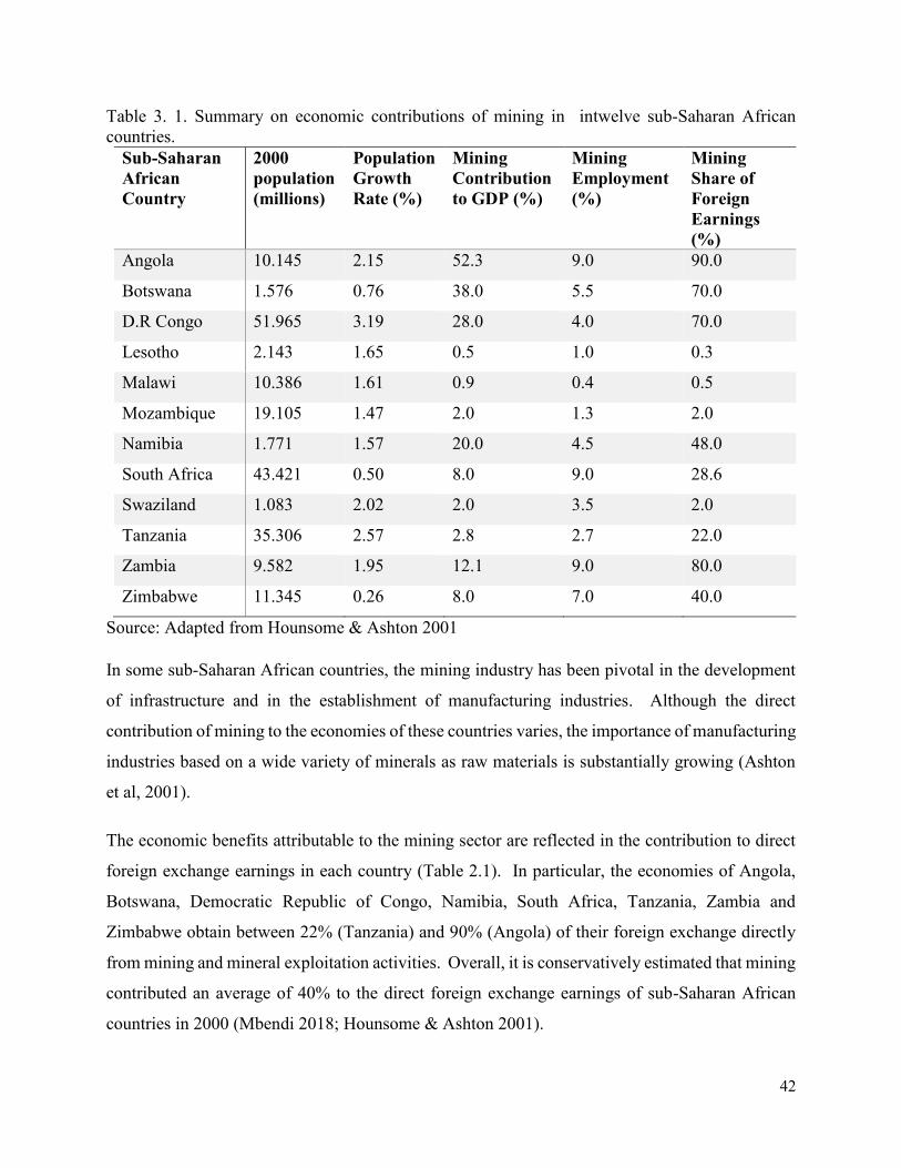
42
Table 3. 1. Summary on economic contributions of mining in intwelve sub-Saharan African
countries.
Sub-Saharan
African
Country
2000
population
(millions)
Population
Growth
Rate (%)
Mining
Contribution
to GDP (%)
Mining
Employment
(%)
Mining
Share of
Foreign
Earnings
(%)
Angola 10.145 2.15 52.3 9.0 90.0
Botswana 1.576 0.76 38.0 5.5 70.0
D.R Congo 51.965 3.19 28.0 4.0 70.0
Lesotho 2.143 1.65 0.5 1.0 0.3
Malawi 10.386 1.61 0.9 0.4 0.5
Mozambique 19.105 1.47 2.0 1.3 2.0
Namibia 1.771 1.57 20.0 4.5 48.0
South Africa 43.421 0.50 8.0 9.0 28.6
Swaziland 1.083 2.02 2.0 3.5 2.0
Tanzania 35.306 2.57 2.8 2.7 22.0
Zambia 9.582 1.95 12.1 9.0 80.0
Zimbabwe 11.345 0.26 8.0 7.0 40.0
Source: Adapted from Hounsome & Ashton 2001
In some sub-Saharan African countries, the mining industry has been pivotal in the development
of infrastructure and in the establishment of manufacturing industries. Although the direct
contribution of mining to the economies of these countries varies, the importance of manufacturing
industries based on a wide variety of minerals as raw materials is substantially growing (Ashton
et al, 2001).
The economic benefits attributable to the mining sector are reflected in the contribution to direct
foreign exchange earnings in each country (Table 2.1). In particular, the economies of Angola,
Botswana, Democratic Republic of Congo, Namibia, South Africa, Tanzania, Zambia and
Zimbabwe obtain between 22% (Tanzania) and 90% (Angola) of their foreign exchange directly
from mining and mineral exploitation activities. Overall, it is conservatively estimated that mining
contributed an average of 40% to the direct foreign exchange earnings of sub-Saharan African
countries in 2000 (Mbendi 2018; Hounsome & Ashton 2001).
43
Many sub-Saharan African countries depend highly on mineral exports in order to sustain national
economies. In 2012, mineral fuels (such as coal and petroleum) accounted for more than 90% of
the export earnings for Algeria, Equatorial Guinea, Libya, and Nigeria, whilst countries such as
Angola, Sierra Leone, Namibia, Zambia and Botswana they also rely heavily on the mining
industry as a major sources of foreign currency. They export large quantities of diamond, nickel,
soda ash, gold, copper, bauxite, alumina, and petroleum (TBCA 2012). In addition, minerals and
mineral fuels accounted for more than 50% of the export earnings of Mali from gold mines,
Mauritania from iron ore mines, Mozambique from aluminium mines, Zambia from copper and
cobalt mines and Namibia from diamond, uranium, gold, and zinc mines (TBCA 2012). Some
major new mines opening in Africa or under development are distributed between South Africa,
Namibia, Botswana, Tanzania, and Gabon producing gold, diamonds, niobium products, PGE’s,
chrome and base metals. Major discoveries over the past five years include the discovery of several
potentially diamondiferous kimberlites in Mauritania and Namibia. Following the above, it shows
that huge mining investments are taking place in South Africa with PGM 69% and gold 31%, while
investments are also taking place in Guinea for bauxite and aluminium minerals, Madagascar for
nickel minerals, Mozambique for coal minerals, Zambia for cobalt & copper minerals, and Nigeria
and Sudan for crude petroleum and Senegal for iron ores, among others.
The scale and importance of the diverse activities comprising the mining sector in the economies
of all sub-Saharan African countries have significant impacts on the social, economic and
biophysical environment (Hounsome & Ashton 2001). Depending on the size, type and location,
the impacts of mining activities and mineral exploration programmes are often large enough to be
regarded as drivers of environmental change, particularly on the World Heritage cultural
landscapes. Conversely, most of the World Heritage African cultural landscapes in the sub-
Saharan African region are known for their rich mineral resources.
In order to appreciate the ways in which mining activities affect most African cultural landscapes,
it is important to appreciate both the variety of mining activities and the different phases involved
in a typical mining operation.
3.2.1. Mining Operations in the Context of Cultural Landscapes
44
In most sub-Saharan African countries, there are basically two types of mining; the artisanal/small-
scale mining and industrial mining. Over 6 million people in Africa engage in ‘small-scale mining’
often as a side job with farming (TBCA 2012). A number of minerals are suitable for this purpose,
from building materials to precious stones (diamonds) and gold. Industrial mining, on the other
hand, is often associated with the industrial investment that comes largely from foreign companies.
In this sub-Saharan African region, the different impacts of mining on the social and physical
environment are associated with the minerals being mined, the mining method in relation to the
size of the area disturbed and workforce employed; and its physical and chemical characteristics.
The mining of most materials involved in construction, such as sand, gravel, and building stones
are generally limited in their environmental impacts to the land area disturbed as they are relatively
chemically stable. In contrast, the mining of most metallic ores involves the storage and processing
of these ores on the surface and the possibility of a variety of chemical processes can have severe
effects on the environment if not properly controlled and managed (ICMM 2010).
Mining methods vary widely and depend on the location, type, and size of mineral resources.
Surface mining methods are most economical in situations where mineral deposits occur close to
the surface (e.g. coal, salts, and other evaporite deposits or road quarry material) or form part of
surface deposits (e.g. alluvial gold and diamonds, and heavy mineral sands) (Ashton et al 2001).
Typical surface mining methods include strip mining and open pit mining, as well as dredge, placer
and hydraulic mining in riverbeds, terraces, and beaches. These activities always disrupt the
surface and this, in turn, affects the archaeological and other cultural heritage sites, soils, surface
water and near-surface groundwater, fauna, flora and all alternative types of land-use (Fuggle &
Rabie 1996; Ashton 1999).
Shallow underground mining, up to about 50 meters below the surface, includes bord (room) and
pillar mining (often used in coal mines), where pillars of the mineral seam are left to support
overlying material (Ashton et al 2001). For example, many of the gold and copper mines in
Zimbabwe, Zambia and the Democratic Republic of Congo are sited on historical workings that
employed a variety of shallow underground mining techniques (Mendelsohn 1961).
A variety of deep underground mining techniques are required to extract ores located deep beneath
the earth’s crust. Deep mining techniques include specialized ore extraction techniques, such as
block caving and long-wall mining, and require sophisticated infrastructure to ensure mine safety
45
and maintain safe working environments (Ashton et al 2001). The principal environmental
impacts associated with deep underground mining (for example, in gold, platinum, chrome and
copper mines) are linked to the mine wastes and blasting residues brought to the surface by mine
dewatering activities. These cause water pollution from leachates, as well as visual pollution,
changes in land use, excessive dust, and surface subsidence as a result of mine dewatering activities
(Ashton et al 2001).
Offshore (sub-marine) mineral deposits such as diamonds, oil, and gas, heavy mineral sands,
phosphorite, glauconite, and manganese occur off the shores of most African countries and some
of these are already exploited in various ways (Ashton et al 2001). These offshore mining activities
differ according to the specific locality and the effects of the mining operation on intertidal,
subtidal or deep-sea marine environments (Gurney et al 1996). Many offshore mining operations
are vulnerable to extreme weather conditions that pose added risks of fuel and material spills and
loss of human life (Ashton 1999).
Besides the rate and method of mining, the location, variety, and scale of mine infrastructure also
influence the nature and extent of impacts. Typical mine infrastructure includes: haul roads and
ore dumps; ventilation shafts; surface facilities (e.g. offices, workshops, car parks and
warehouses); tailings and waste rock disposal areas; transport and service corridors (e.g. railway
lines, roads, pipelines, conveyors, airstrips, port facilities, power, water and gas corridors); product
stockpiles; ore processing facilities; chemicals and fuel storage and the locations of towns and
housing facilities (Fuggle & Rabie, 1996; Ashton 1999; Weaver & Caldwell 1999; Ashton et al,
2001).
3.3 Impact of Mining Development on Cultural Landscapes
3.3.1. Mining Development Phases
Mining development involves different phases. These range from pre-exploration, exploration,
development and construction, operation and closure phases. In each stage of this mining
development, it is characterized by a diverse range of activities that vary in their potential to impact
on the physical cultural heritage resources and their associated values within cultural landscapes,
(See Table 3. 2 below shows the stages of mining development in relation with mining activities).
At the pre-exploration and exploration phases, the area of land considered for mining is oftentimes
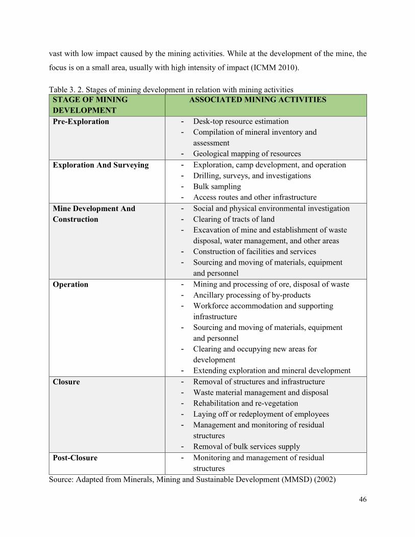
46
vast with low impact caused by the mining activities. While at the development of the mine, the
focus is on a small area, usually with high intensity of impact (ICMM 2010).
Table 3. 2. Stages of mining development in relation with mining activities
STAGE OF MINING
DEVELOPMENT
ASSOCIATED MINING ACTIVITIES
Pre-Exploration - Desk-top resource estimation
- Compilation of mineral inventory and
assessment
- Geological mapping of resources
Exploration And Surveying - Exploration, camp development, and operation
- Drilling, surveys, and investigations
- Bulk sampling
- Access routes and other infrastructure
Mine Development And
Construction
- Social and physical environmental investigation
- Clearing of tracts of land
- Excavation of mine and establishment of waste
disposal, water management, and other areas
- Construction of facilities and services
- Sourcing and moving of materials, equipment
and personnel
Operation - Mining and processing of ore, disposal of waste
- Ancillary processing of by-products
- Workforce accommodation and supporting
infrastructure
- Sourcing and moving of materials, equipment
and personnel
- Clearing and occupying new areas for
development
- Extending exploration and mineral development
Closure - Removal of structures and infrastructure
- Waste material management and disposal
- Rehabilitation and re-vegetation
- Laying off or redeployment of employees
- Management and monitoring of residual
structures
- Removal of bulk services supply
Post-Closure - Monitoring and management of residual
structures
Source: Adapted from Minerals, Mining and Sustainable Development (MMSD) (2002)
47
3.3.2. Exploration and surveying activities
Most of the potential environmental impacts associated with mining exploration and surveying
activities occur at a smaller scale than those that can be recorded during mine operational activities
and are mainly restricted to specific exploration areas and sites or slightly larger localities (Ashton
2001 et al). However, the cumulative effects of exploration activities at multiple sites within an
area have the potential to drive environmental change, particularly from a larger regional
perspective. The general cultural landscape impacts of mining exploration include the removal of
vegetation for survey lines, soil erosion from vehicle tracks, abandoned equipment and supplies,
pollution and contamination, and disturbance of archaeological and other cultural heritage sites.
3.3.3. Mine development and construction
The development and construction of a mine, cover the period of time when considerable changes
take place, for instance, as the mine infrastructure, plant and facilities are constructed, and when
the ore body is first exposed (see Table 3.2). In practical terms, the scale and sequence of events
vary from mine to mine, but always entails dramatic changes to most features of the cultural
landscape. Large areas of land are cleared of vegetation and leveled prior to construction of the
mine facilities. The spatial scale of the mine site where impacts may be displayed can vary from
a few tens of hectares to several square kilometers. However, the most immediate impacts on
cultural landscapes are the disruptions of the attributes conveying the significant socio-cultural
values of the sites.
3.3.4. Operation: Removal and storage of ores and waste material
The removal and storage (stockpiling) of ores prior to milling and extraction is usually the most
intensive activity on any mine operation. The process involves large-scale exposure of ore bodies,
followed by blasting, loading, and transportation of various ore grades to the stockpile sites where
the ores are separated on the basis of their ore grade (see Tables 3.2 and 3.3). Waste material,
including waste rock and soil overburden, are separated and stockpiled for possible later use during
mine rehabilitation after closure. These activities are characterized by large-scale disturbance due
to noise, vibration, and wind-blown dust. Rainfall is contaminated by eroded and oxidized
materials, leading to varying degrees of sedimentation and pollution in local watercourses,
including sacred pools in most cultural landscapes. Remediation techniques are very difficult to
48
apply to ore stockpiles since these are “live” and undergo changes on a daily basis. Waste rock
dumps can be rehabilitated as soon as they reach their planned extent (Ashton et al 2001).
3.3.5. Operation: Blasting, milling, and grinding activities
The routine operational phases account for most of the environmental impacts associated with
mining (see Tables 3.2 and 3.3) and are considered to have the greatest potential to drive cultural
landscape change. The extent to which mining operational activities act as drivers of landscape
change depends in part on the type, scale, duration and magnitude of the mining activities, and the
sensitivity of the receiving cultural landscape (Ashton et al 2001).
3.3.6. Mine closure and post-operational waste management
Many mine-related environmental impacts often continue long after the mine has stopped
production and has been closed (see Table 3.2). Amongst the more pronounced post-closure
impacts on record are landscape scarring in the form of un-rehabilitated waste rock dumps, mine
tailing dams, discard dumps, old shafts, and underground fires. In addition, continuing
environmental damage from polluted waters (including acid rock drainage), wind-blown dust and
the dispersal of contaminated solid waste is a feature of mines throughout the world (Johnson et al
1994). Environmental changes that result from these impacts include the following (Carl Duisberg
Gesellschaft 1999):
Loss of productive land for alternative uses;
Loss or degradation of groundwater quality;
Pollution of surface water by sediments and/or salts, as well as lower pH values and
increased metal concentrations;
Alterations to river channels by erosion and slumping;
Changes in river flow regimes with sharper flow peaks and reduced dry season flows;
Air pollution from dust, radionuclides and toxic gases; and
Risks of falls into abandoned shafts and pits that are not adequately protected.
General overviews of the main types of impacts associated with the various operational phases of
mining are described briefly below.
49
3.3.7. Environmental changes associated with surface and underground mining methods
Surface mining methods, including strip mining, open-pit mining, dredge, placer and hydraulic
mining, may drive environmental change of the affected land surface in the following ways (Brink
et al 1990):
Changes in topography and surface drainage with the potential for increased soil erosion,
long-term compaction, subsidence and reduced agricultural capacity;
Disturbance and disruption of the natural groundwater regime with the potential for both
ground and surface water pollution; and
Changes in topsoil characteristics with a potential for increased acidity and salt content,
development of nutrient deficiencies or imbalances, surface crustiness or desiccation,
changes in vegetation cover and land use with the potential for production of atmospheric
dust and other pollution.
3.3.8. Changes at Cultural Landscape Scale
The process of constructing, erecting and commissioning new mining infrastructure often results
in large-scale alteration of the environment, particularly at landscape and ecosystem levels.
Infrastructure associated with mine construction includes transport and service corridors (railway
lines, roads, pipelines, conveyors, airstrips, port facilities, power, water and gas corridors) and
surface facilities (e.g. offices, laboratories, workshops, vehicle parks and service bays, fuel storage
and dispensing depots and warehouses), sinking of mine shafts and the removal of soil, vegetation
and rock to access ore deposits and create sites for tailings and waste disposal areas. The landscape
level environmental impacts are generally in the form of landscape alteration and fragmentation
or dispersal of biological habitats, populations, communities, and ecosystems. They also include
altered patterns of stream flows, especially where mines have to be de-watered, (Ashton et al
2001).
The stages at which most significant impacts occur are during mine development and construction,
operation, and mine at closure, especially in the event of inadequate rehabilitation and planning
for the social and economic impacts of closure. The management of the impacts of mining has
greatly improved over the past decades, however, current best practices is not equally applied by
all mining operations and impacts can still be unacceptable from an environmental and social point
of view. The legacy of past mining methods is apparent all over the African continent and some
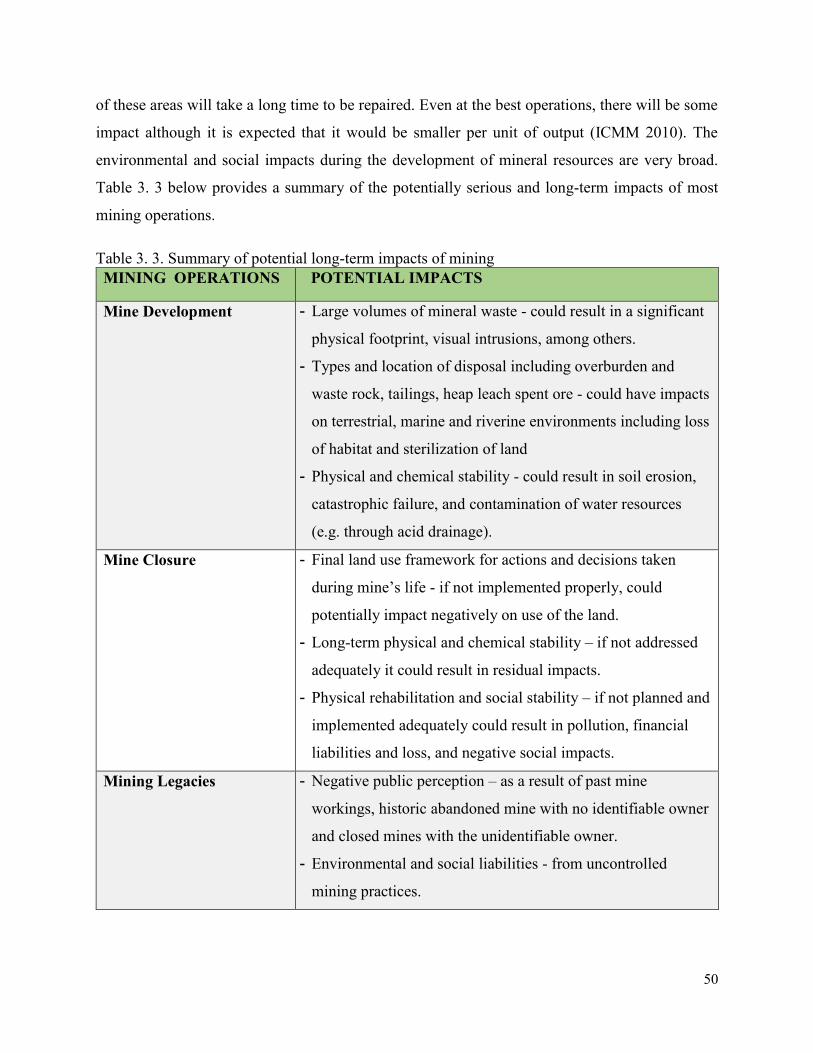
50
of these areas will take a long time to be repaired. Even at the best operations, there will be some
impact although it is expected that it would be smaller per unit of output (ICMM 2010). The
environmental and social impacts during the development of mineral resources are very broad.
Table 3. 3 below provides a summary of the potentially serious and long-term impacts of most
mining operations.
Table 3. 3. Summary of potential long-term impacts of mining
MINING OPERATIONS POTENTIAL IMPACTS
Mine Development - Large volumes of mineral waste - could result in a significant
physical footprint, visual intrusions, among others.
- Types and location of disposal including overburden and
waste rock, tailings, heap leach spent ore - could have impacts
on terrestrial, marine and riverine environments including loss
of habitat and sterilization of land
- Physical and chemical stability - could result in soil erosion,
catastrophic failure, and contamination of water resources
(e.g. through acid drainage).
Mine Closure - Final land use framework for actions and decisions taken
during mine’s life - if not implemented properly, could
potentially impact negatively on use of the land.
- Long-term physical and chemical stability – if not addressed
adequately it could result in residual impacts.
- Physical rehabilitation and social stability – if not planned and
implemented adequately could result in pollution, financial
liabilities and loss, and negative social impacts.
Mining Legacies - Negative public perception – as a result of past mine
workings, historic abandoned mine with no identifiable owner
and closed mines with the unidentifiable owner.
- Environmental and social liabilities - from uncontrolled
mining practices.
51
- Cost and accountability of rehabilitation – no responsibility or
ownership taken for rehabilitation.
Energy Use in the minerals
Sector
- Climate change – impacts of energy use on climate change
- Energy efficiency - sources of fuel and use of energy
- Emissions.
Metals in the Environment - Health impacts – occupational as well as public exposure
- The fate of contamination and pollution.
Threats to Biological
Diversity
- Areas of valuable biodiversity – potential impacts on areas of
high diversity
- Trade-offs between human activities and biodiversity
- Measuring effects of mining on biodiversity
- Managing and improving biodiversity – the effectiveness of
biodiversity offsets.
Source: Adapted from MMSD (2002).
3.3.9. Specific Impacts of Mining on Cultural Heritage Resources
The mining development phases have destructive and irreversible effects on the archaeological
and other cultural heritage sites found in most cultural landscapes. The land transformation
activities during the mining operations, development of access roads, clearing of the cultural
landscape to set up mining camps and site offices among other mining facilities, would directly
and indirectly destroy the historical, archaeological and palaeontological sites, cemeteries and
shrines and other sacred places like pools, groves, hills and other intangible cultural values found
within and around cultural landscapes. However, the severity of the impacts depends on the
closeness of the heritage sites to the mining project area.
A lot of archaeological and palaeontological sites and human remains are uncovered during land
transformation activities involved in mining development. This is due to the long history of human
habitation and settlement patterns in most of the African cultural landscapes. Damage to
cemeteries, sacred shrines, and other significant heritage features during mining development
phases usually have detrimental effects on the local communities which sometimes derail mining
development projects. Hence detailed cultural heritage impact assessment should be integrated
into the broader environmental impact assessments for all phases of mining development.
52
Obviously, any large mining operation is likely to have a proportionately greater impact on the
heritage resources than a smaller mining operation located in the same cultural landscape.
However, it is important to note that most large mining operations also tend to employ more
effective and efficient cultural heritage management programmes than smaller ones. Indeed, many
small mining operations very often cannot afford to implement effective cultural heritage
management programmes and their impacts on cultural heritage resources are sometimes
disproportionately large. This is clearly evident in the case of small-scale and artisan mining
operations, where little or no attention is directed towards minimizing impacts on the surrounding
environment. As a consequence, it is often extremely difficult to assign specific proportions of
heritage impact to different scales of mining operations where these occur in close proximity to
one another. The only way to separate the individual impacts in such a situation is through the
application of a carefully structured monitoring programme that examines and minimizes negative
impacts of mining operations on cultural heritage resources (Ashton et al 2001).
3.3.10. Distinguishing between direct, indirect and cumulative impacts
Environmental impacts associated with or caused by mining, as distinct from those associated with
the subsequent use of the extracted minerals, are largely confined to relatively restricted areas in
the vicinity of the appropriate geological formation and downstream in the catchment where the
deposit is located. These impacts would normally be considered to be “direct” impacts that can be
linked directly to the mining and ore processing operations (Ashton et al 2001).
In contrast, there are many other types of impacts that are associated with mining activities but do
not occur as a direct consequence of the mining activity itself. These would be considered to be
“indirect” impacts. A typical example would be the variety of impacts caused by the activities of
individuals and organizations that take place in areas peripheral to a mining operation. An example
of this is the discharge of effluent and wastes from households, businesses, and factories in the
towns that develop around or close to a particular mining operation. In several instances, these
indirect impacts can exceed the total environmental impact of the original mining operation and
thereby require a far greater degree of management attention.
The term “cumulative impacts” is generally applied to those situations where several impacts from
different processes and activities combine to exert a greater set of effects than those that would be
53
predicted from the original activities. An example of this type of situation would be the
combination of adverse effects that a local community within or surrounding a cultural landscape
would experience if it were exposed simultaneously to atmospheric emissions of gases, wind-
blown dust, and effluent discharged from a mining operation (Ashton et al 2001). A second
example would be the situation where effluents and discharges from several mining operations or
industries in a single catchment exerted a set of combined effects or impacts on the river system
draining the sacred lake which is part of the wider cultural landscape.
3.4 African World Heritage Sites threatened by Mining
There is a growing concern with mineral resource exploration and extraction activities, which are
threatening many cultural and natural World Heritage Sites across the African continent (Meskell
2011). In this section, an overview of African World Heritage cultural landscapes and other
protected areas which are under threat by mining activities has been presented. Historically, many
cultural and natural World Heritage Sites in Africa have been mined by European collectors,
antiquarians and wealthy western museums (Schmidt and McIntosh 1996). However, mining
activities have continued to threaten the management and conservation of most of these World
Heritage sites.
A recent study by the Trans-boundary Consulting Africa (TBCA 2012) found that there are 21
World Heritage Sites in Africa that are being affected by mining activities. The most affected of
these heritage sites are either natural or mixed World Heritage properties also categorized as
cultural landscapes even though some cultural World Heritage sites are also affected (See Figure
3. 1 ). There are indications that this number is on the increase.
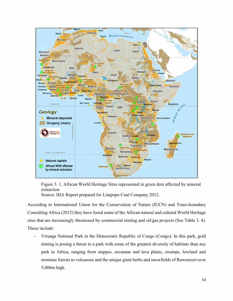
54
Figure 3. 1. African World Heritage Sites represented in green dots affected by mineral
extraction
Source: HIA Report prepared for Limpopo Coal Company 2012.
According to International Union for the Conservation of Nature (IUCN) and Trans-boundary
Consulting Africa (2012) they have listed some of the African natural and cultural World Heritage
sites that are increasingly threatened by commercial mining and oil/gas projects (See Table 3. 4).
These include:
- Virunga National Park in the Democratic Republic of Congo (Congo): In this park, gold
mining is posing a threat to a park with some of the greatest diversity of habitats than any
park in Africa, ranging from steppes, savannas and lava plains, swamps, lowland and
montane forests to volcanoes and the unique giant herbs and snowfields of Ruwenzori over
5,000m high.
55
- Comoe National Park in Cote d’Ivoire: the government of Cote D’Ivoire has currently
issued licenses to explore minerals in one of West Africa’s largest biosphere;
- Mount Nimba Strict Nature Reserve on the boundary of Cote d’Ivoire and Guinea: The
nature reserve’s unique biodiversity is under threat from miners extracting high-grade Iron
ore;
- Dja Biosphere Reserve in Cameroon: This is home to some of the largest and best-protected
rainforest tracts in Africa, but now the reserve is under threat from cobalt mining operations
on its precincts;
- Kahuzi-Biega National Park in the DRC: there is a direct threat to gorillas – a protected
species – due to unauthorized and unregulated Coltan and Gold mining;
- Selous Game Reserve in Tanzania: In this reserve, Uranium exploration within the property
of 50,000km2 sanctuary is posing a direct threat to large number of flora and fauna
undisturbed by human impact;
- Air and Tenere Nature Reserve in Niger: This is the largest protected area in Africa,
covering some 7.7 million hectares, due to its unique desert landscape, flora and fauna but
which is now under threat from petroleum prospecting activities;
- Manovo-Gounda Nature Reserves in the Central African Republic: The largest savannah
park in the west and central Africa, located at a major biogeographic crossroads of central
Africa, is being threatened by gas and petroleum exploration;
- Mana Pools National Park, Sapi and Chewore Safari Areas in Zimbabwe: Unregulated and
unlicensed gold, copper and uranium exploration are threatening directly the natural
wildlife species in these areas.
All these natural and or cultural World Heritage landscapes has been categorized as ‘heritage at
risk’. Some of these mining and exploration activities are at their nascent stages, which means that
governments, mining and oil/gas companies, financial backers and other stakeholders have the
opportunity to make well-informed decisions by committing themselves to preserve the heritage
and thereby also safeguarding the livelihoods of local people within and around these cultural
landscapes.
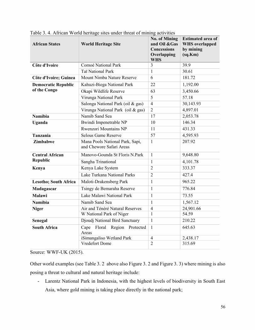
56
Table 3. 4. African World heritage sites under threat of mining activities
African States
World Heritage Site
No. of Mining
and Oil &Gas
Concessions
Overlapping
WHS
Estimated area of
WHS overlapped
by mining
(sq.Km)
Côte d'Ivoire Comoé National Park 3 39.9
Taï National Park 1 30.61
Côte d'Ivoire; Guinea Mount Nimba Nature Reserve 6 181.72
Democratic Republic
of the Congo
Kahuzi-Biega National Park 22 1,192.00
Okapi Wildlife Reserve 63 3,450.66
Virunga National Park 5 57.18
Salonga National Park (oil & gas) 4 30,143.93
Virunga National Park (oil & gas) 2 4,897.01
Namibia Namib Sand Sea 17 2,053.78
Uganda Bwindi Impenetrable NP 10 146.34
Rwenzori Mountains NP 11 431.33
Tanzania Selous Game Reserve 57 4,595.93
Zimbabwe Mana Pools National Park, Sapi,
and Chewore Safari Areas
1 207.92
Central African
Republic
Manovo-Gounda St Floris N.Park 1 9,648.80
Sangha Trinational 1 4,101.78
Kenya Kenya Lake System 2 333.37
Lake Turkana National Parks 2 427.4
Lesotho; South Africa Maloti-Drakensberg Park 1 965.22
Madagascar Tsingy de Bemaraha Reserve 1 776.84
Malawi Lake Malawi National Park 1 73.55
Namibia Namib Sand Sea 1 1,567.12
Niger Air and Ténéré Natural Reserves 4 24,901.66
W National Park of Niger 1 54.59
Senegal Djoudj National Bird Sanctuary 1 210.22
South Africa Cape Floral Region Protected
Areas
1 645.63
iSimangaliso Wetland Park 4 2,438.17
Vredefort Dome 2 315.69
Source: WWF-UK (2015).
Other world examples (see Table 3. 2 above also Figure 3. 2 and Figure 3. 3) where mining is also
posing a threat to cultural and natural heritage include:
- Larentz National Park in Indonesia, with the highest levels of biodiversity in South East
Asia, where gold mining is taking place directly in the national park;
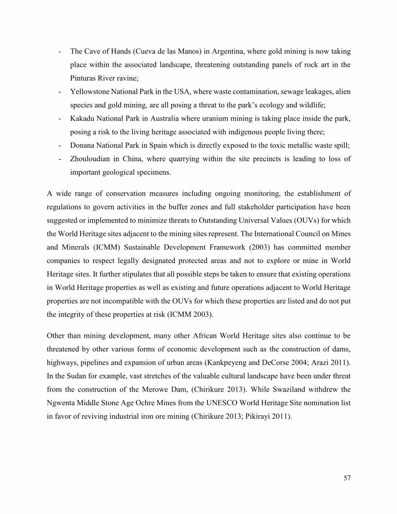
57
- The Cave of Hands (Cueva de las Manos) in Argentina, where gold mining is now taking
place within the associated landscape, threatening outstanding panels of rock art in the
Pinturas River ravine;
- Yellowstone National Park in the USA, where waste contamination, sewage leakages, alien
species and gold mining, are all posing a threat to the park’s ecology and wildlife;
- Kakadu National Park in Australia where uranium mining is taking place inside the park,
posing a risk to the living heritage associated with indigenous people living there;
- Donana National Park in Spain which is directly exposed to the toxic metallic waste spill;
- Zhouloudian in China, where quarrying within the site precincts is leading to loss of
important geological specimens.
A wide range of conservation measures including ongoing monitoring, the establishment of
regulations to govern activities in the buffer zones and full stakeholder participation have been
suggested or implemented to minimize threats to Outstanding Universal Values (OUVs) for which
the World Heritage sites adjacent to the mining sites represent. The International Council on Mines
and Minerals (ICMM) Sustainable Development Framework (2003) has committed member
companies to respect legally designated protected areas and not to explore or mine in World
Heritage sites. It further stipulates that all possible steps be taken to ensure that existing operations
in World Heritage properties as well as existing and future operations adjacent to World Heritage
properties are not incompatible with the OUVs for which these properties are listed and do not put
the integrity of these properties at risk (ICMM 2003).
Other than mining development, many other African World Heritage sites also continue to be
threatened by other various forms of economic development such as the construction of dams,
highways, pipelines and expansion of urban areas (Kankpeyeng and DeCorse 2004; Arazi 2011).
In the Sudan for example, vast stretches of the valuable cultural landscape have been under threat
from the construction of the Merowe Dam, (Chirikure 2013). While Swaziland withdrew the
Ngwenta Middle Stone Age Ochre Mines from the UNESCO World Heritage Site nomination list
in favor of reviving industrial iron ore mining (Chirikure 2013; Pikirayi 2011).
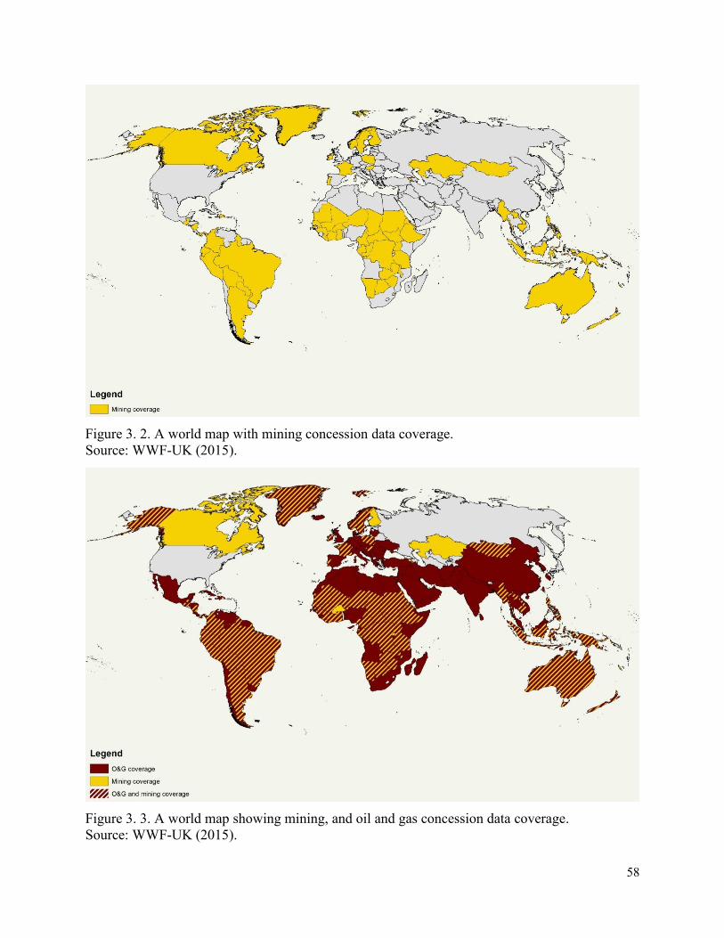
58
Figure 3. 2. A world map with mining concession data coverage.
Source: WWF-UK (2015).
Figure 3. 3. A world map showing mining, and oil and gas concession data coverage.
Source: WWF-UK (2015).
59
3.5 Legal and Policy Frameworks
Most sub-Saharan African countries have several old and new sets of interlocking legislations that
exert control over mining and related activities and their impacts on cultural landscapes. (See Table
3. 5). Many of these acts are now in the process of revision to reflect more clearly the principles
embodied in their respective constitutions and the tenets of international treaties designed to
minimize cultural landscape degradations. Inevitably, the changes in existing legislative
frameworks in most of the sub-Saharan African countries are complicated by the fact that some
pieces of legislation can be interpreted in ways which appear to conflict with the terms and
conditions set out in other legislations (Ashton et al 2001). Similarly, there are situations where
legislative requirements in neighboring countries differ from each other, thereby complicating the
process of managing impacts on shared or trans-boundary cultural landscapes. Nevertheless,
despite these differences, the legislative framework in each country seeks to promote the economic
benefits to be gained from mining whilst reducing to a minimum the risks to human safety and the
adverse consequences of environmental degradation. From an environmental perspective, most
attention is focused on minimization of waste products and associated sources of pollution or
contamination, and the rehabilitation of land surfaces that have previously been mined or used for
the disposal of waste products (Wells et al 1996; Gurney et al 1996; Chenje 2000).
This attention to minimizing the adverse consequences of mining activities is a welcome
development. In this context, it is also clear that many older mining operations started at a time
when there was little or no explicit concern for the surrounding environment. Disposal of wastes
was carried out in a manner designed solely to minimize costs, rather than to prevent pollution or
facilitate rehabilitation. In many instances, old mines were simply abandoned and no attempt was
made to rehabilitate the surface workings when the economic life of the ore body was exhausted.
This situation now places enormous responsibility for rehabilitation on the respective
governments, and is accompanied by a considerable economic burden (Fuggle & Rabie 1996;
Chenje 2000).
In South Africa, for example, recent enabling legislation, particularly the Environmental
Management Act (1998) provide specific guidelines that exert control on the ways in which mining
and quarrying activities may be conducted (Ashton 1999). In many instances, the provisions of
this Act (1998) complement and enhance components of the existing Mines and Minerals Act that
60
is designed to control mining activities. In most of the legislations in sub-Saharan African
countries, it clearly stipulates that an environmental impact assessment (EIA) must be carried out
before a mining license is granted for all new terrestrial and offshore mining activities. As part of
this process, mining companies are legally required to consult widely with the affected public
during the EIA and also to ensure that all the necessary licenses and permissions are acquired from
relevant local, provincial or national authorities (Weaver & Caldwell 1999; see also Ashton et al
2001).
The South African situation is similar to most countries with established EIA legislation where
virtually all mining activities are classified as "likely to significantly affect the environment" and
require that a full-scale EIA is conducted before taking the decision to proceed (Ashton et al 2001).
In some countries, this requirement relates to the size of a proposed mining or quarrying operation.
Whilst the ‘size limit’ requirement for an EIA may be a useful and pragmatic approach,
considerable caution is required in those cases where several "small" operations may be located in
close proximity to one another and whose combined impacts may be very large. In such situations,
it is useful to adopt a more "strategic" approach to the problem and thereby ensure that appropriate
attention is paid to the likely cumulative impacts of several small operations (Ashton et al 2001).
This process helps to eliminate instances of poor or inadequate planning and reduce the potential
risks associated with future rehabilitation costs.
According to Ashton et al (2001), they suggested that sub-Saharan African countries should
harmonize and rationalize their respective pieces of legislation relating to mining activities and
control of environmental impacts, particularly those that relate to protected cultural landscapes.
This would help to eliminate inconsistencies between countries and also to enhance a sense of
shared or common purpose between the states.
A partial outlook of the relevant legislation for different sub-Saharan African countries states is
given in Table 3. 5. In recent years, most of the sub-Saharan African countries member states have
succeeded in drawing up and ratifying several treaties and protocols designed to improve inter-
country relations and complement the approaches adopted in each country. A notable example in
this regard is the 1972 Convention for the protection of natural and cultural World Heritage sites
which encourage member states to have legislative and regulatory measures that ensures protection
of sites against development and any change that might negatively impact their integrity,

61
authenticity and outstanding universal values of African World Heritage cultural landscapes
(UNESCO 2016).
Table 3. 5. Legislations relating to mining activities and cultural landscapes
Country Sector / Area Laws or regulations
Angola Mines and Minerals
Heritage Resources
- Legislative Edict No. 3574 of 1965
- The Mining Code of 2011
- Presidential Decree 231/16
- Cultural Heritage Law No. 14/05 of 2005
Botswana Environment
Mines, Quarries
and Works
Heritage Resources
- National Conservation Strategy, 1990
- Mines, Quarries, Works and Machinery Act, No. 20
of 1973
- Monuments and Relics Act, No. 12 of 2001
Malawi Environment
Mines and Minerals
Heritage Resources
- Environmental Management Act, No. 19 of 2017
- Mines and Minerals Act 1981
- Petroleum (Exploration and Production) Act 1983
- Explosives Act 1968
- Monuments and Relics Act of 1991
Mozambique Environmental
Land Use
Mines and Minerals
Heritage Resources
- General Environment Act, No 20 of 1997
- Land Act of 1979
- Mining Act, No 20 of 2008
- Law on Protection of Cultural Heritage, 1988
Namibia Mines and Minerals
Heritage Resources
- Minerals (Prospecting and Mining) Act, 1992
- Mines Regulations of 1993
- National Heritage Act, No 27 of 2004
South Africa Environment
Mines and Minerals
Heritage Resources
- Environment Conservation Act of 73 of 1989
- National Environmental Management Act, 1998
- Environmental Laws Rationalization Act, 1997
- Minerals Act, No. 50 of 1991
- Mine Health and Safety Act, No 29 of 1996
- Mines and Works Act No. 27 of 1956
- Minerals and Energy laws Amendment Act, 1994
- National Heritage Resources Act, No. 25 of 1999
- National Heritage Council Act, No. of 1999
- World Heritage Convention Act, 1999
Swaziland Environment
Heritage Resources
- Environmental Management Act, No 15 of 2002
- Natural Resources Act, 1951
- National Trust Commission Act, No. 22 of 1973
Tanzania Mines and Minerals
- Mining Act, 1979
- Petroleum Act, 1980
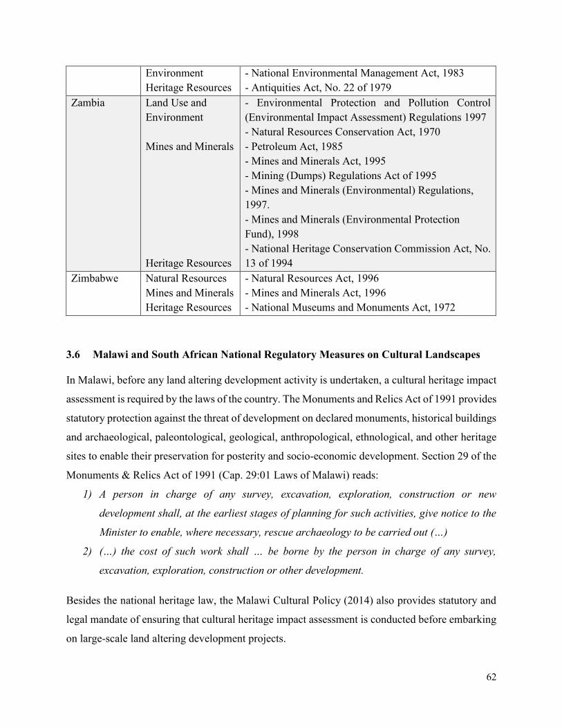
62
Environment
Heritage Resources
- National Environmental Management Act, 1983
- Antiquities Act, No. 22 of 1979
Zambia Land Use and
Environment
Mines and Minerals
Heritage Resources
- Environmental Protection and Pollution Control
(Environmental Impact Assessment) Regulations 1997
- Natural Resources Conservation Act, 1970
- Petroleum Act, 1985
- Mines and Minerals Act, 1995
- Mining (Dumps) Regulations Act of 1995
- Mines and Minerals (Environmental) Regulations,
1997.
- Mines and Minerals (Environmental Protection
Fund), 1998
- National Heritage Conservation Commission Act, No.
13 of 1994
Zimbabwe Natural Resources
Mines and Minerals
Heritage Resources
- Natural Resources Act, 1996
- Mines and Minerals Act, 1996
- National Museums and Monuments Act, 1972
3.6 Malawi and South African National Regulatory Measures on Cultural Landscapes
In Malawi, before any land altering development activity is undertaken, a cultural heritage impact
assessment is required by the laws of the country. The Monuments and Relics Act of 1991 provides
statutory protection against the threat of development on declared monuments, historical buildings
and archaeological, paleontological, geological, anthropological, ethnological, and other heritage
sites to enable their preservation for posterity and socio-economic development. Section 29 of the
Monuments & Relics Act of 1991 (Cap. 29:01 Laws of Malawi) reads:
1) A person in charge of any survey, excavation, exploration, construction or new
development shall, at the earliest stages of planning for such activities, give notice to the
Minister to enable, where necessary, rescue archaeology to be carried out (…)
2) (…) the cost of such work shall … be borne by the person in charge of any survey,
excavation, exploration, construction or other development.
Besides the national heritage law, the Malawi Cultural Policy (2014) also provides statutory and
legal mandate of ensuring that cultural heritage impact assessment is conducted before embarking
on large-scale land altering development projects.
63
In South Africa, the National Environmental Act of 1998 and the National Heritage Resources Act
of 1999 provides the same statutory regulatory measures that emphasize that development projects
should be ‘socially, culturally, environmentally and economically sustainable, and where
disturbance is unavoidable, it should be mitigated to enhance the cultural and natural heritage’.
Although many sub-Saharan African countries have legislation requiring mitigation of
environmental and social-cultural impacts of mining developments, the ability to enforce laws and
monitor performance is largely lacking. The implementation of these legislations and policies is
deficient mainly due to lack of political will. In Malawi and South Africa, for example, difficulty
in implementing these laws stem from conflicting mandates amongst government agencies
responsible for the decision making on the utilization of the resources of these cultural landscapes.
Similarly, in other sub-Saharan African countries, for example in Guinea, a major dilemma facing
policy-makers is balancing the role as advocates and beneficiary of mining projects with their
mandate to protect the country’s natural and cultural heritage resources for future generations
(Hughes and Sullivan 1989:45).
In these countries, a lack of resources and staff means that many mines are not frequently
inspected. Lack of funding, staffing, and training are also common constraints in many African
countries (Maponga and Mutemererwa 1995). Most government institutions responsible for
regulating mining development rely on mining companies to provide access and additional
resources, eliminating the element of spontaneity required for auditing (Maponga and
Mutemererwa 1995). Due to lack of available resources for monitoring the performance of mines,
for example in most African countries, the regulatory authorities rely on mining company reports
rather than conducting periodic site visits to determine compliance with standards set in the mining
contract.
The degree to which mining contributes to economic development and wise use of natural
resources depends in large part on the quality of these national regulations. Most African countries
lack strong regulations and the ability to enforce the law as an important safeguard for ensuring
that mining development projects do not result in the destruction of important natural and cultural
heritage resources critical to ensuring the livelihoods of most cultural landscape communities.
64
3.7 International Policies on Mining and Heritage Conservation
In this last section, a general discussion has been provided as regards to the international policies
on mining and heritage conservation. Particular emphasis has been put on the evaluation of the
World Heritage Convention, International Council on Mining and Metals, (ICMM) and the World
Conservation Union (IUCN) position statement as regards to their policies on mining in and around
World Heritage properties.
3.7.1 The World Heritage Convention
The Operational Guidelines for the Implementation of the World Heritage Convention states that
protection and management of World Heritage sites by countries should include legislative and
regulatory measures that ensure their protection against development and change that might
negatively impact their integrity, authenticity and outstanding universal value (UNESCO 2016).
Member States to the World Heritage Convention are therefore requested to ensure effective
implementation of these measures (Osti et al 2011). The World Heritage Committee, a decision
making body of the World Heritage Convention, has been emphasizing that mining exploration
and exploitation are incompatible with World Heritage status (UNESCO 2016). If the outstanding
universal value of a heritage site has been affected by mining activities, a site can be placed on the
World Heritage List in danger or if serious threats have been identified, they can be removed from
the World Heritage List. Prior to removal, however, a site at risk or threatened by mining
undergoes a review process by the World Heritage Committee, which makes recommendations on
particular courses of action or intervention needing to be made in order to minimize or reverse the
threat.
3.7.2 The IUCN and ICMM World Heritage Position Statement
Over the past decade, the International Council on Mining and Metals, (ICMM) and the World
Conservation Union (IUCN) have engaged in successful dialogue around mining, biodiversity and
other related issues. The key area of debate between conservation and mining has been on the
IUCN‘s protected areas category of the management system. The consensus view of the
conservation sector has been that mining should not take place in certain protected area
management categories (I-IV) and in UNESCO World Heritage Sites, (IUCN 2015; UNESCO
2016). Protected areas are so valuable that conservationists hold that they deserve to be singled
out for extra protection from destructive economic activities. ICMM also believes that there is a
65
need for a more objective landscape-based categorization system that is based on integrated
landuse planning aimed at achieving sustainable development (ICMM 2012).
ICMM as well as other mining companies and international financial institutions that fund mining
development activities have recognized the importance of conserving cultural and natural World
Heritage sites and have committed not to undertake activities that would damage them, (Marton-
Lefe`vre 2008). Similarly, IUCN has committed itself by coming up with a ‘World Heritage
Advice Note’ that deter the exploration and exploitation of minerals in natural World Heritage
sites, where most cultural landscapes are also categorized, (ICMM 2003; IUCN 2008). The IUCN
has emphasized that mining projects that are located outside World Heritage properties should not,
under any circumstances, have negative impacts on the outstanding universal values of these
exceptional places. In addition to this, they have affirmed that boundary changes to these sites
should not be used as an easy way of facilitating mining activities, (Marton-Lefe`vre 2008; IUCN
2008).
IUCN and ICMM also have a clear position on mineral resources and protected areas. This
position statement states that all exploration and extraction of mineral resources in protected areas
should be prohibited by law. If the projects are important to the economy of the country to the
extent that it cannot be stopped such projects should undergo thorough and rigorous environmental
and social impact assessment (ESIA) processes. The World Commission on Protected Areas
(WCPA) has prepared this ‘position statement on mining and associated activities in relation to
protected areas’, (IUCN 2008) which reflects IUCN’s position.
In applying its position, IUCN and WHC consider the following points:
1. Mineral exploration and exploitation within or affecting a World Heritage Site are
incompatible with World Heritage status, and has considered that these activities can
constitute a basis for inscription on the List of World Heritage in Danger, in accordance with
Paragraph 180 of the Operational Guidelines to the Convention.
2. The World Heritage Committee’s position is in line with the International Council on Mining
and Metals’ (ICMM) International Position Statement on Mining and Protected Areas, and
the positions of industry leaders, and that of international investment companies.
66
3. In accordance with Paragraph 172 of the Operational Guidelines to the World Heritage
Convention, all development projects which may affect the outstanding universal value of a
World Heritage Site (including mineral and oil/gas exploration and exploitation projects and
associated infrastructure) should be submitted by State Parties to the World Heritage
Committee before a decision on their implementation is taken.
4. All proposals for mineral exploration and exploitation (including associated infrastructure)
which may affect a World Heritage Site, but are located outside its boundaries, should be
subjected to an appropriate and rigorous appraisal process, such as an environmental and
social impact assessment (ESIA), prior to considering whether to grant consents and licenses.
These appraisal processes should respect the highest international best-practice standards,
including, but not limited to:
- Specifically assessing the likely effects of the proposal(s) on the site’s outstanding
universal value, including direct, indirect and cumulative effects;
- Identifying and evaluating alternatives, to determine the least damaging options;
- Being publicly disclosed and subject to thorough public consultation; and
- Proposing an environmental management plan detailing operating, monitoring and
restoration conditions.
5. Boundary modifications to World Heritage Sites, as defined in the Operational Guidelines to
the World Heritage Convention, should not be proposed for the purpose of facilitating
mineral exploration and exploitation projects, and/or associated infrastructure. Any proposed
changes to the boundaries of a World Heritage Site should be subjected to procedures at least
as rigorous as those involved in the nomination of the site, as required under the Operational
Guidelines to the WH Convention.
In spite of these international efforts to protect heritage sites including cultural landscapes that are
at risk because of mining activities, global trends in mineral explorations and exploitations and
demand suggest that future conflicts of interest between protected areas and areas to be used for
mining activities will increase (Finer and Orta-Martı´nez, 2010). To mitigate the current and future
environmental impacts of mineral extractions on cultural landscapes, there is need to thoroughly
apply the integrated strategic management planning methodological framework that has been
developed in this thesis, (details for the application of the proposed management planning
methodological framework has been discussed in chapter 8 of this thesis).
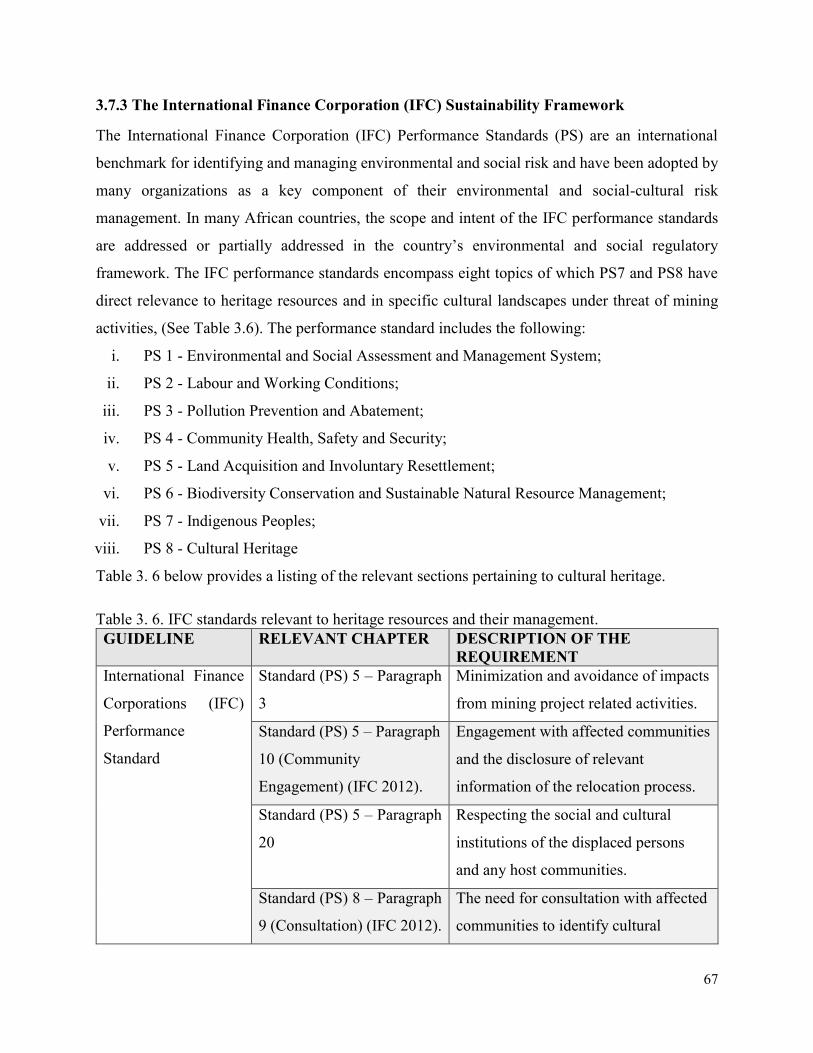
67
3.7.3 The International Finance Corporation (IFC) Sustainability Framework
The International Finance Corporation (IFC) Performance Standards (PS) are an international
benchmark for identifying and managing environmental and social risk and have been adopted by
many organizations as a key component of their environmental and social-cultural risk
management. In many African countries, the scope and intent of the IFC performance standards
are addressed or partially addressed in the country’s environmental and social regulatory
framework. The IFC performance standards encompass eight topics of which PS7 and PS8 have
direct relevance to heritage resources and in specific cultural landscapes under threat of mining
activities, (See Table 3.6). The performance standard includes the following:
i. PS 1 - Environmental and Social Assessment and Management System;
ii. PS 2 - Labour and Working Conditions;
iii. PS 3 - Pollution Prevention and Abatement;
iv. PS 4 - Community Health, Safety and Security;
v. PS 5 - Land Acquisition and Involuntary Resettlement;
vi. PS 6 - Biodiversity Conservation and Sustainable Natural Resource Management;
vii. PS 7 - Indigenous Peoples;
viii. PS 8 - Cultural Heritage
Table 3. 6 below provides a listing of the relevant sections pertaining to cultural heritage.
Table 3. 6. IFC standards relevant to heritage resources and their management.
GUIDELINE RELEVANT CHAPTER DESCRIPTION OF THE
REQUIREMENT
International Finance
Corporations (IFC)
Performance
Standard
Standard (PS) 5 – Paragraph
3
Minimization and avoidance of impacts
from mining project related activities.
Standard (PS) 5 – Paragraph
10 (Community
Engagement) (IFC 2012).
Engagement with affected communities
and the disclosure of relevant
information of the relocation process.
Standard (PS) 5 – Paragraph
20
Respecting the social and cultural
institutions of the displaced persons
and any host communities.
Standard (PS) 8 – Paragraph
9 (Consultation) (IFC 2012).
The need for consultation with affected
communities to identify cultural
68
heritage of importance and involve
affected communities and involve the
relevant national or local regulatory
authorities in the decision-making
processes.
Standard (PS) 8 – Paragraph
12 (Removal of Non-
Replicable Cultural
Heritage) (IFC 2012).
The removal of cultural heritage must
only be considered when no other
alternative is available.
Source: adapted from the IFC (2012) Guidance Note 8.
The IFC’s Performance Standards offer a framework for understanding and managing
environmental and social risks for high profile, complex, international or potentially high impact
mining projects and other development projects. The financial institution is required to verify, as
part of its environmental and social due diligence process, that the commercial developer complies
with the IFC Performance Standards, (IFC 2012). To do so, the mining institution needs to be
knowledgeable about the environmental and social laws of the country in which it operates and
compare these regulatory requirements against those of the IFC Performance Standards to identify
gaps. A good understanding of both sets of requirements, as well as potential gaps, ensure that the
financial institution will effectively identify and assess the key environmental and social risks and
impacts that might be associated with a financial transaction.
If non-compliances with the IFC Performance Standards are identified, and depending on the
severity of the issue, the financial institution can require the developer to develop a corrective
action plan for addressing the issue within a reasonable timeframe and stipulate this as a condition
of the financial transaction with the developer (IFC 2012).
3.7.4 Equator Principles Management Framework
The Equator Principles (EP) is a risk management framework, adopted by financial institutions,
for determining, assessing and managing environmental and social risk in projects and is primarily
intended to provide a minimum standard for due diligence to support responsible risk decision-
making, (EP 2013). This is also applicable in mining development projects in African cultural
69
landscapes. According to EP (2013) publication, it said that Equator Principles Financial
Institutions (EPFI) commit to implementing the EP in their internal environmental and social
policies, procedures and standards for financing projects and will not provide project finance or
project-related corporate loans to projects where the client will not, or is unable to, comply with
the EP. The EP has greatly increased the attention and focus on social/community standards and
responsibility, including robust standards for indigenous peoples, labor standards, and consultation
with locally affected communities within the project finance market. They have also promoted
convergence around common environmental and social standards.
According to EP (2013) publication, the EP consists of 10 Principles, as follows:
i. Principle 1: Review and categorisation
ii. Principle 2: Environmental and social assessment
iii. Principle 3: Applicable environmental and social standards
iv. Principle 4: Environmental and social management system and equator principles
action plan
v. Principle 5: Stakeholder engagement
vi. Principle 6: Grievance mechanism
vii. Principle 7: Independent review: project finance
viii. Principle 8: Covenants
ix. Principle 9: Independent monitoring and reporting project finance
x. Principle 10: Reporting and transparency client reporting requirements
3.8 Best Practices of Integrating Mining into Cultural Landscape Management
In this section, the practical aspects of mining and heritage conservation have been presented.
These include some best practices and initiatives that have been implemented as regards to issues
of mining and World Heritage management and conservation.
3.8.1. World Heritage and Mining (2000): Technical Workshop
In light of the ever-increasing demand for mineral resources, and resultant fact that mining
activities often occur in and around protected areas and World Heritage Sites, a need was
identified to have an open discussion on World Heritage and mining. In so doing, in September
2000, a technical workshop was organized by the IUCN and ICMM in cooperation with the World
70
Heritage Centre. This workshop was aimed at developing guidelines on the integration and
harmonization of mining and World Heritage conservation. In this workshop, diverse case studies
as best practices from Latin America, Africa, Asia, the Pacific and Europe were reviewed in order
to inform the development of guiding principles and recommendations as regards to co-existence
of mining development and in World Heritage sites. This workshop included representatives from
the mining and conservation sectors as well as World Heritage site managers and protected area
agencies from different States Parties. The World Heritage Committee, IUCN, and ICMM has a
long history of dealing with issues related to mining and World Heritage sites, both existing and
proposed (WHM 2000).
3.8.2. The ICMM Sustainable Development Framework (2003)
In the ICMM Sustainable Development Framework, the ICMM commits its member companies
to submit and respect legally designated protected areas and not to explore or mine in World
Heritage properties. It further stipulates that all possible steps be taken to ensure that existing
operations in World Heritage properties as well as existing and future operations adjacent to
World Heritage properties are not incompatible with the outstanding universal values for which
these properties were listed and do not put the integrity of these properties at risk (ICMM 2003).
3.8.3. Conserving Cultural and Biological Diversity: the Role of Sacred Natural Sites and
Cultural Landscapes (2006).
This guideline is based on the outcome of an international symposium on "Conserving Cultural
and Biological Diversity: The Role of Sacred Natural Sites" which took place in Tokyo in 2005.
The discussions focused on exploring the interrelationship between the natural and cultural
diversity, and this event constituted one of the highlights of the UNESCO Programme on
"Reinforcing Linkages between Cultural Diversity and Biodiversity for Sustainable Development"
launched in 2004 as a concrete follow-up to the World Summit on Sustainable Development
(Johannesburg 2002). Stakeholders from all over the world exchanged views on how to prevent
adverse impacts on the traditional knowledge and lifestyles of indigenous and local communities.
They expressed the view that sacred natural sites and cultural landscapes are expressions of
traditional beliefs and land management systems of local and indigenous communities. They
further claimed that understanding the links between nature and culture is important for
safeguarding both biological and cultural diversity, (UNESCO 2006)
71
3.8.4. Sacred Natural Sites: Guidelines for Protected Area Managers (2008).
In order to ensure the adequate management and protection of natural sacred sites, and to address
a wide range of pressures and threats, the IUCN Task Force on the Cultural and Spiritual Values
of Protected Areas and UNESCO’s Man and the Biosphere Programme developed guidelines to
support the efforts of a wide spectrum of faith groups and indigenous and traditional peoples of
the world for the long-term conservation of their sacred natural sites. These guidelines are the
result of an international workshop held in Kunming, China in 2003, where they were extensively
discussed. The guidelines were then revised at the World Parks Congress in South Africa in 2003,
and at the International Symposium on “Conserving Cultural and Biological Diversity: The Role
of Sacred Natural Sites and Cultural Landscapes”, in Japan in 2005, (Wild and McLeod 2008).
3.8.5. Mining and Biodiversity: A Collection of Case Studies (2010)
Following its 2004 publication on mining and biodiversity, and leading up to the Convention on
Biological Diversity’s 10th conference of the parties, the ICMM compiled a short collection of
recent case studies to demonstrate good practices in biodiversity. The purpose of the various case
studies was to show how good practice, collaboration, and innovative thinking can advance
biodiversity conservation in the context of mineral exploitation. In addition, the ICMM uses the
2010 publication to showcase how far the mining sector has come in conserving biodiversity, and
also to impress upon its members how much more remains to be done to develop and implement
sound biodiversity management methods so that it is ready to take on the increasing challenges
that lie ahead. One particular issue that was highlighted was the fact that mining and conservation
may not always be compatible with World Heritage conservation, as evidenced by ICMM
members’ commitment not to mine or explore in World Heritage Sites, (ICMM 2010).
3.8.6. Mainstreaming Biodiversity into Mining: A Guideline for Practitioners and Decision-
Makers in the Mining Sector (2012)
Given the importance of healthy ecosystems in supporting human well‐being on the one hand, and
the economic benefits derived from the mining industry on the other, there is a need to guide where
and how mining takes place in order to facilitate the sustainable development of Africa’s mineral
resources in a way that minimizes the impact of mining on the continent’s biodiversity and
ecosystem services. In light of the aforementioned, a guideline was developed to facilitate the
integration of relevant biodiversity information into decision making in order to decide where
72
mining may take place and how best to avoid, minimize or remedy biodiversity impacts to support
sustainable development. The main aim of the guideline is to assists the competent authorities in
implementing and enforcing the law, and assists companies to comply with the law, implement
good practice and reduce business risks, (DoA et al 2013).
Mining heritage as World Heritage
Mining is a global phenomenon. Its beginnings date back to early times, and it remains important
to humanity in the present day. Across the world, there are a large number of historical and present-
day mining areas, some of which are important and others of less relevance. The influences of
mining on the economy, culture, society and landscape depend on numerous different factors. Each
mining region therefore has its own special regional features.
The World Heritage List currently includes 27 sites connected to mining from different historical
periods and of different raw materials, (refer to Appendix 3: for World Heritage List connected to
mining around the world). These sites demonstrate the importance of mining for the development
of humanity. Alongside individual industrial monuments and ensembles, these sites include
mining towns, mining landscapes and industrial landscapes shaped by mining. The sites differ
significantly from each other both thematically and in terms of their complexity. When compared
with other World Heritage Sites typologies, mining cultural landscapes’ outstanding value
emanates from the broad spectrum of mining, industrial and cultural monuments and the associated
cultural values, as well as the diversity of the raw materials extracted and processed.
3.9 Chapter Summary
This chapter, therefore, has provided a critical analysis of the impact of different phases of mining
development on the attributes and values of cultural landscapes of sub-Saharan African countries.
An overview of African World Heritage cultural landscapes and other protected areas which are
under threat from mining activities has been presented. Legal and policy frameworks for the
management of impacts attributable to mining operations in African cultural landscapes have been
evaluated. This has been followed with specific examples of Malawi and South Africa regulatory
measures on cultural landscapes, where the two case studies have been drawn from. A detailed
description of the case studies has been discussed in chapter 5 of this thesis. In the last section of
this chapter, a general discussion has been provided as regards to the international policies on
73
mining and heritage conservation. Particular emphasis has been put on the evaluation of the World
Heritage Convention, IUCN and ICMM position statement as regards to their policies on mining
in and around World Heritage properties. The chapter has concluded with a discussion on some of
the practical aspects of mining and heritage conservation applicable in cultural landscapes. These
included some best practices and initiatives that have been implemented as regards to issues of
mining and World Heritage management and conservation.
In general, it has been observed that mining development projects have both positive and negative
impact on most cultural landscapes and the communities around them. Mining contributes to
economic growth, empowers communities through the creation of employment opportunities, and
provision of social amenities. On the other hand, mining of mineral resources is unsustainable
since it is based on the production of non-renewable resources from finite deposits. Unsustainable
extraction of mineral resources is always associated with irreparable environmental and social
impacts in most of the sub-Saharan African cultural landscapes.
In the next chapter 4, is the discussion of the methodological approaches that have been used to
achieve the objectives of the research.
74
CHAPTER FOUR
4 RESEARCH METHODOLOGY
4.1 Introduction
This chapter presents a detailed methodology for the research. The chapter begins with a
description and justification for the selection of the case studies. This is followed by an explanation
of the comparative approach that has been applied in the research. Thereafter, detailed methods
have been presented and broadly discussed on how they have been applied to achieve specific
objectives of the research. These include interviews, focus-group-discussions, observations, field
site surveys and content analysis. The last part of the chapter is the presentation on the ethical
issues considered in the research.
In this thesis, the triangulation methodological approach has been adopted, whereby qualitative
research methods have been used and compared in order to see whether they corroborate with each
other (Silverman 2005). The adoption of this method reduces the risk of invalidity and scientific
inaccuracy which may result from the fact that each individual method has several drawbacks
(Kirk and Miller 1986). (See also Table 4. 1 for advantages and disadvantages of different methods
used).
As Ulrike Flick has pointed out, qualitative research methodology is inherently multi-method in
focus (Flick 2002). Although objective reality can never be captured, the adoption of a multi-
method approach secures an in-depth understanding of the phenomenon under investigation,
(Denzin and Lincoln 2005). Therefore the triangulation approach allows the simultaneous
exploration of different data sources which secures the validity of the data, (see also Atikinson and
Delamont 2005). One of the reasons which necessitated the adoption of the triangulation approach
in the selected case studies of two African cultural landscapes was the social-cultural sensitivity
of the cultural practices within these landscapes, which often prevented local interview participants
to reveal some secretive information regarding the traditional ritual practices happening within the
landscapes. In this thesis, each research objective was addressed by a different research method
with different sources of information, (see Table 4. 2
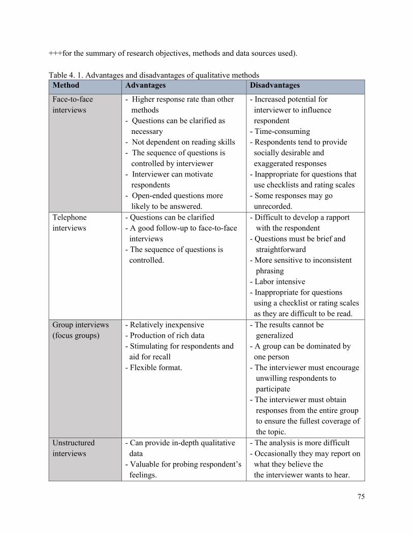
75
+++for the summary of research objectives, methods and data sources used).
Table 4. 1. Advantages and disadvantages of qualitative methods
Method Advantages Disadvantages
Face-to-face
interviews
- Higher response rate than other
methods
- Questions can be clarified as
necessary
- Not dependent on reading skills
- The sequence of questions is
controlled by interviewer
- Interviewer can motivate
respondents
- Open-ended questions more
likely to be answered.
- Increased potential for
interviewer to influence
respondent
- Time-consuming
- Respondents tend to provide
socially desirable and
exaggerated responses
- Inappropriate for questions that
use checklists and rating scales
- Some responses may go
unrecorded.
Telephone
interviews
- Questions can be clarified
- A good follow-up to face-to-face
interviews
- The sequence of questions is
controlled.
- Difficult to develop a rapport
with the respondent
- Questions must be brief and
straightforward
- More sensitive to inconsistent
phrasing
- Labor intensive
- Inappropriate for questions
using a checklist or rating scales
as they are difficult to be read.
Group interviews
(focus groups)
- Relatively inexpensive
- Production of rich data
- Stimulating for respondents and
aid for recall
- Flexible format.
- The results cannot be
generalized
- A group can be dominated by
one person
- The interviewer must encourage
unwilling respondents to
participate
- The interviewer must obtain
responses from the entire group
to ensure the fullest coverage of
the topic.
Unstructured
interviews
- Can provide in-depth qualitative
data
- Valuable for probing respondent’s
feelings.
- The analysis is more difficult
- Occasionally they may report on
what they believe the
the interviewer wants to hear.
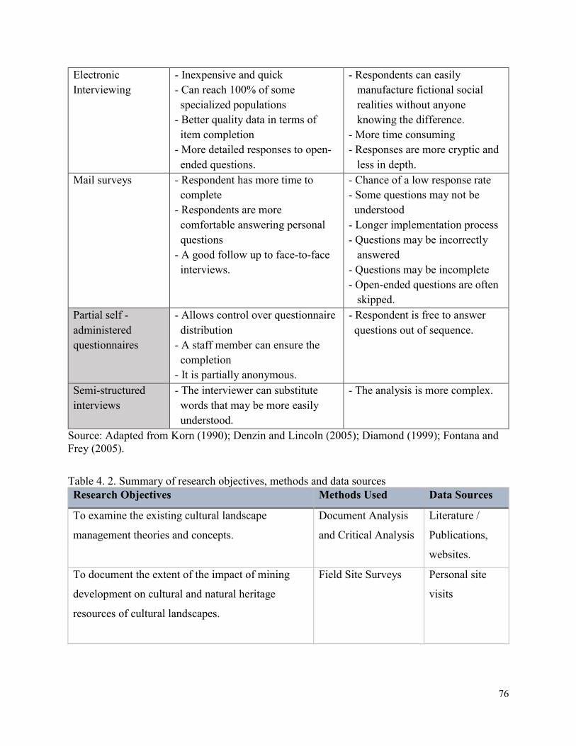
76
Electronic
Interviewing
- Inexpensive and quick
- Can reach 100% of some
specialized populations
- Better quality data in terms of
item completion
- More detailed responses to open-
ended questions.
- Respondents can easily
manufacture fictional social
realities without anyone
knowing the difference.
- More time consuming
- Responses are more cryptic and
less in depth.
Mail surveys
- Respondent has more time to
complete
- Respondents are more
comfortable answering personal
questions
- A good follow up to face-to-face
interviews.
- Chance of a low response rate
- Some questions may not be
understood
- Longer implementation process
- Questions may be incorrectly
answered
- Questions may be incomplete
- Open-ended questions are often
skipped.
Partial self -
administered
questionnaires
- Allows control over questionnaire
distribution
- A staff member can ensure the
completion
- It is partially anonymous.
- Respondent is free to answer
questions out of sequence.
Semi-structured
interviews
- The interviewer can substitute
words that may be more easily
understood.
- The analysis is more complex.
Source: Adapted from Korn (1990); Denzin and Lincoln (2005); Diamond (1999); Fontana and
Frey (2005).
Table 4. 2. Summary of research objectives, methods and data sources
Research Objectives Methods Used Data Sources
To examine the existing cultural landscape
management theories and concepts.
Document Analysis
and Critical Analysis
Literature /
Publications,
websites.
To document the extent of the impact of mining
development on cultural and natural heritage
resources of cultural landscapes.
Field Site Surveys
Personal site
visits
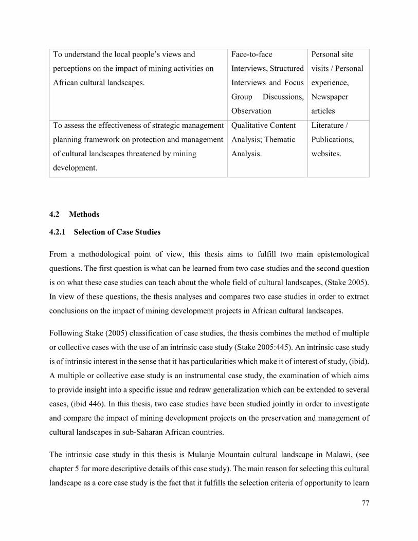
77
To understand the local people’s views and
perceptions on the impact of mining activities on
African cultural landscapes.
Face-to-face
Interviews, Structured
Interviews and Focus
Group Discussions,
Observation
Personal site
visits / Personal
experience,
Newspaper
articles
To assess the effectiveness of strategic management
planning framework on protection and management
of cultural landscapes threatened by mining
development.
Qualitative Content
Analysis; Thematic
Analysis.
Literature /
Publications,
websites.
4.2 Methods
4.2.1 Selection of Case Studies
From a methodological point of view, this thesis aims to fulfill two main epistemological
questions. The first question is what can be learned from two case studies and the second question
is on what these case studies can teach about the whole field of cultural landscapes, (Stake 2005).
In view of these questions, the thesis analyses and compares two case studies in order to extract
conclusions on the impact of mining development projects in African cultural landscapes.
Following Stake (2005) classification of case studies, the thesis combines the method of multiple
or collective cases with the use of an intrinsic case study (Stake 2005:445). An intrinsic case study
is of intrinsic interest in the sense that it has particularities which make it of interest of study, (ibid).
A multiple or collective case study is an instrumental case study, the examination of which aims
to provide insight into a specific issue and redraw generalization which can be extended to several
cases, (ibid 446). In this thesis, two case studies have been studied jointly in order to investigate
and compare the impact of mining development projects on the preservation and management of
cultural landscapes in sub-Saharan African countries.
The intrinsic case study in this thesis is Mulanje Mountain cultural landscape in Malawi, (see
chapter 5 for more descriptive details of this case study). The main reason for selecting this cultural
landscape as a core case study is the fact that it fulfills the selection criteria of opportunity to learn
78
and the accessibility to data. It also fulfills the basic requirements for optimizing understanding of
the case study which is the experiential knowledge and the study of the context and activities
associated with this case study (Stake 2005). Experiential knowledge has been provided by
personal participation and experience working with the Malawi Department of Culture to develop
the management plan and conservation projects for the landscape in the last decade.
The other case study of Mapungubwe cultural landscape in South Africa has been used to provide
and compare further issues related to the implementation of the existing management planning
framework for the protection and safeguarding of outstanding universal values of the World
Heritage cultural landscape which is being threatened by on-going mining activities. Evaluation
of the integration of the UNESCO strategic 5Cs (credibility, conservation, capacity building,
communication and community involvement), within the existing management planning
framework, in light of the on-going mining activities within the World Heritage cultural landscape
has been carried out. The main criteria for selecting this second comparative case study was also
the accessibility and the opportunity to learn, (Stake 2005). The notion of accessibility is closely
related to the opportunity to learn. That may mean taking the one most accessible or the one we
can spend the most time with. This criterion is one important for a qualitative researcher than the
criterion of representativity. As Stake (2005) mentions, sometimes it is better to learn a great deal
from an atypical case than a little from a seemingly typical case (ibid).
Therefore, the selection of case studies for evaluating the impact of mining development was based
on the availability of information regarding cultural landscapes’ conservation and management
challenges emanating from mining exploitation and exploration activities. The selection of the
second case study was considered important since the critical issues under investigations have been
compared. The current operational management planning framework for Mapungubwe World
Heritage cultural landscape has been critically reviewed. The issues drawn from this critical review
has been used to develop a strategic management planning methodological framework which has
been applied to Mulanje Mountain cultural landscape. As Stake (2005) implies ‘populations of
cases can be represented poorly by single cases or samples of very few cases, and such samples of
cases can provide questionable grounds for advancing grand generalization’.
79
A further selection criterion was the extent to which the case studies illuminated a wide range of
issues under investigation, in order to allow a broad examination of negative impacts of mining
development projects on the attributes and values of cultural landscapes in sub-Saharan Africa.
Views and perceptions of local people especially on their understanding of mining issues and
World Heritage status of their areas have been analyzed and compared.
4.2.2 Comparative Case Study Approach
Comparative case studies cover two or more cases in a way that produces more generalized
knowledge about key questions under investigation. This assesses and evaluates how and why
particular programmes and policies work or fail to work in these comparable case studies.
Comparative case studies are undertaken over time and emphasize comparison within and across
contexts, (Goodrick 2014). In this research, comparative case study as an approach was selected
in order to understand and explain the success or failure for the implementation of the management
planning framework in Mapungubwe cultural landscape, which led to the development of an
integrated management planning methodological framework which has been applied to a
comparable case study of Mulanje Mountain cultural landscape.
Comparative case studies approach involved the analysis and synthesis of the similarities,
differences and patterns across Mapungubwe cultural landscape and Mulanje Mountain cultural
landscape. As Goodrick (2014) also elaborated, comparative case studies often incorporate both
qualitative and quantitative data. He emphasized that, given the focus on generating a good
understanding of the cases and case context, data collection methods such field visits, observations,
interviews and document analysis is often used.
While the strategies used in data collection for single and comparative case studies are similar,
comparative case studies require more extensive conceptual, analytic and synthesizing work. The
synthesis across cases extends beyond the comparison of similarities and differences to using these
similarities and differences to support or refute propositions as to why an intervention succeeds or
fails, (Goodrick 2014). While some degree of comparison is at the heart of any design in which
multiple cases are used, the distinguishing feature of comparative case studies is the emphasis on
examining causality – the extent to which the intervention caused the results, particularly outcomes
and impacts. For the case studies selected in this research, investigations dwelled on the analysis
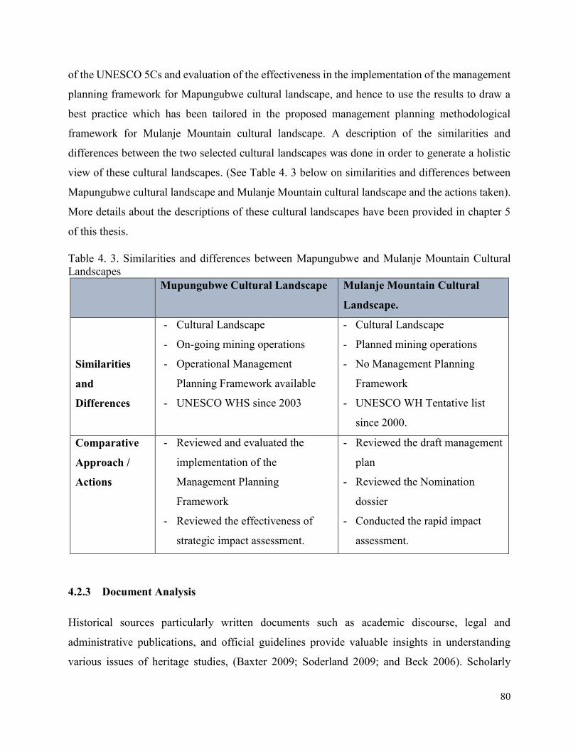
80
of the UNESCO 5Cs and evaluation of the effectiveness in the implementation of the management
planning framework for Mapungubwe cultural landscape, and hence to use the results to draw a
best practice which has been tailored in the proposed management planning methodological
framework for Mulanje Mountain cultural landscape. A description of the similarities and
differences between the two selected cultural landscapes was done in order to generate a holistic
view of these cultural landscapes. (See Table 4. 3 below on similarities and differences between
Mapungubwe cultural landscape and Mulanje Mountain cultural landscape and the actions taken).
More details about the descriptions of these cultural landscapes have been provided in chapter 5
of this thesis.
Table 4. 3. Similarities and differences between Mapungubwe and Mulanje Mountain Cultural
Landscapes
Mupungubwe Cultural Landscape Mulanje Mountain Cultural
Landscape.
Similarities
and
Differences
- Cultural Landscape
- On-going mining operations
- Operational Management
Planning Framework available
- UNESCO WHS since 2003
- Cultural Landscape
- Planned mining operations
- No Management Planning
Framework
- UNESCO WH Tentative list
since 2000.
Comparative
Approach /
Actions
- Reviewed and evaluated the
implementation of the
Management Planning
Framework
- Reviewed the effectiveness of
strategic impact assessment.
- Reviewed the draft management
plan
- Reviewed the Nomination
dossier
- Conducted the rapid impact
assessment.
4.2.3 Document Analysis
Historical sources particularly written documents such as academic discourse, legal and
administrative publications, and official guidelines provide valuable insights in understanding
various issues of heritage studies, (Baxter 2009; Soderland 2009; and Beck 2006). Scholarly
81
constructions, narratives, as well as images and connotations on cultural landscapes impacted by
development projects, are some of the issues that have been revealed by analyzing the literature.
As several authors have noted (Baxter, 2009; Soderland, 2009; Waterton et. al 2006), document
analysis – analyzing written documents for heritage research, constitutes an important
methodology for problematizing, identifying and unpacking issues of the heritage studies as a
discipline of study. On the account of this, both published and unpublished documents were
consulted and reviewed for the purpose of gaining insights into the subject under investigation.
Some of the documents related to heritage management planning in cases of development projects
which has been critically reviewed included site management plans, periodic reports, reactive
monitoring reports, and other numerous scientific publications.
4.2.4 Interviews
The scientific accuracy and validity of interview data have often been questioned and the
subjectivity of data has often been emphasized, since interviewing is inextricably and unavoidably
historically, politically, and contextually bound (Fontana and Frey 2005). An interviewer is a
person, historically and contextually located, carrying unavoidable conscious motives, desires
feelings, and biases, (Sheurich 1995). Interviewing is also a social interaction context and therefore
is influenced by this context, (Fontana and Frey 2005). Furthermore, the setting in which the
interview takes place, the language and culture of the participants, the ways in which an
interviewer presents him/herself and the necessity to gain trust affect to a great extent the outcome
of the interview.
However, subjectivity which is unavoidable does not render data collected to be scientifically
invalid. Qualitative data collected through interviews can provide researchers with valuable data
in so far as their accuracy is corroborated by data collected from other sources. In Addition,
subjectivity in the social science and humanistic field where the focal point is the ‘man’ and his/her
perceptions, behaviors and attitudes is unavoidable. A degree of subjectivity inheres even in
quantitative methods since the design of the questionnaire and the coding of the answers depends
to a great extent on the analyst’s point of view.
In the case of Mulanje Mountain cultural landscape, the majority of the interviews conducted
included semi-structured with open-ended questions, which occasionally were transformed into
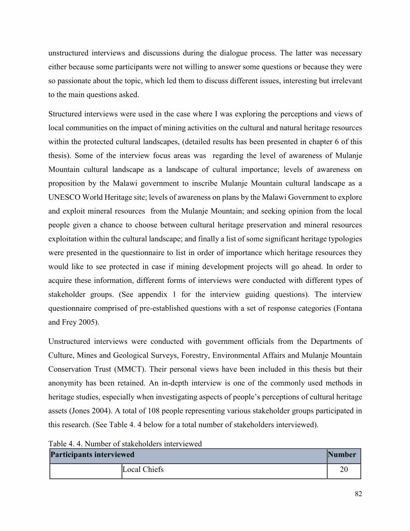
82
unstructured interviews and discussions during the dialogue process. The latter was necessary
either because some participants were not willing to answer some questions or because they were
so passionate about the topic, which led them to discuss different issues, interesting but irrelevant
to the main questions asked.
Structured interviews were used in the case where I was exploring the perceptions and views of
local communities on the impact of mining activities on the cultural and natural heritage resources
within the protected cultural landscapes, (detailed results has been presented in chapter 6 of this
thesis). Some of the interview focus areas was regarding the level of awareness of Mulanje
Mountain cultural landscape as a landscape of cultural importance; levels of awareness on
proposition by the Malawi government to inscribe Mulanje Mountain cultural landscape as a
UNESCO World Heritage site; levels of awareness on plans by the Malawi Government to explore
and exploit mineral resources from the Mulanje Mountain; and seeking opinion from the local
people given a chance to choose between cultural heritage preservation and mineral resources
exploitation within the cultural landscape; and finally a list of some significant heritage typologies
were presented in the questionnaire to list in order of importance which heritage resources they
would like to see protected in case if mining development projects will go ahead. In order to
acquire these information, different forms of interviews were conducted with different types of
stakeholder groups. (See appendix 1 for the interview guiding questions). The interview
questionnaire comprised of pre-established questions with a set of response categories (Fontana
and Frey 2005).
Unstructured interviews were conducted with government officials from the Departments of
Culture, Mines and Geological Surveys, Forestry, Environmental Affairs and Mulanje Mountain
Conservation Trust (MMCT). Their personal views have been included in this thesis but their
anonymity has been retained. An in-depth interview is one of the commonly used methods in
heritage studies, especially when investigating aspects of people’s perceptions of cultural heritage
assets (Jones 2004). A total of 108 people representing various stakeholder groups participated in
this research. (See Table 4. 4 below for a total number of stakeholders interviewed).
Table 4. 4. Number of stakeholders interviewed
Participants interviewed Number
Local Chiefs 20
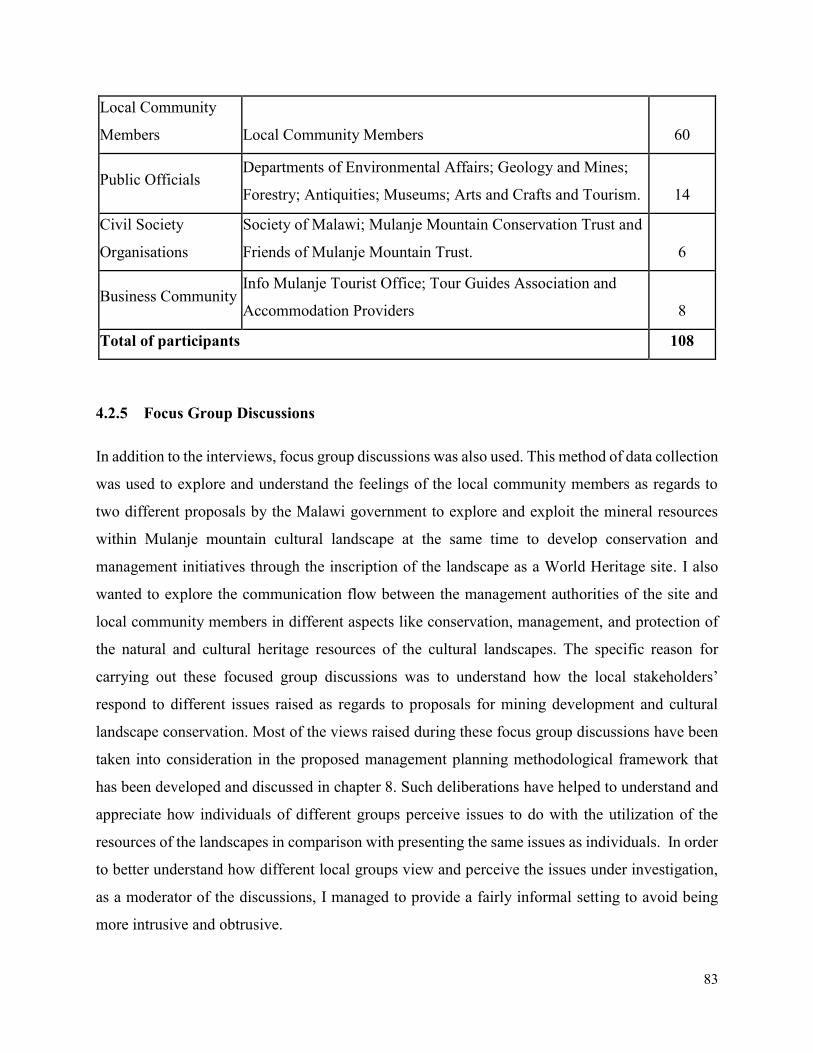
83
Local Community
Members Local Community Members 60
Public Officials Departments of Environmental Affairs; Geology and Mines;
Forestry; Antiquities; Museums; Arts and Crafts and Tourism. 14
Civil Society
Organisations
Society of Malawi; Mulanje Mountain Conservation Trust and
Friends of Mulanje Mountain Trust. 6
Business Community Info Mulanje Tourist Office; Tour Guides Association and
Accommodation Providers 8
Total of participants 108
4.2.5 Focus Group Discussions
In addition to the interviews, focus group discussions was also used. This method of data collection
was used to explore and understand the feelings of the local community members as regards to
two different proposals by the Malawi government to explore and exploit the mineral resources
within Mulanje mountain cultural landscape at the same time to develop conservation and
management initiatives through the inscription of the landscape as a World Heritage site. I also
wanted to explore the communication flow between the management authorities of the site and
local community members in different aspects like conservation, management, and protection of
the natural and cultural heritage resources of the cultural landscapes. The specific reason for
carrying out these focused group discussions was to understand how the local stakeholders’
respond to different issues raised as regards to proposals for mining development and cultural
landscape conservation. Most of the views raised during these focus group discussions have been
taken into consideration in the proposed management planning methodological framework that
has been developed and discussed in chapter 8. Such deliberations have helped to understand and
appreciate how individuals of different groups perceive issues to do with the utilization of the
resources of the landscapes in comparison with presenting the same issues as individuals. In order
to better understand how different local groups view and perceive the issues under investigation,
as a moderator of the discussions, I managed to provide a fairly informal setting to avoid being
more intrusive and obtrusive.
84
A total of five focus-group-discussions were conducted in the two periods of field visits in five
specific areas of Mulanje Mountain cultural landscape. The involved groups were selected based
on the local knowledge of the area and the subject matter which was being discussed. The group
discussion members actively participated in the deliberations regarding the protection and use of
the natural and cultural heritage resources of the landscape. This formed an important basis in
understanding the levels of awareness of the local people and how they perceive different cultural
values of the landscape.
4.2.6 Observations
Observation has been characterized as the ‘fundamental base of all research methods’ in the social
and behavioral sciences, (Adler and Adler 1994) and as a ‘mainstay of ethnographic enterprise’
(Werner and Schoepfle 1987). In the case of one of my main case studies, Mulanje Mountain
cultural landscape, participant and unobtrusive observation constituted a useful methodological
technique for assessing the attitudes of the local inhabitants while deliberating about the proposed
mining development project. During the period of field visits, critical deliberations amongst the
local elders, business community and the civil society member groups on the pros and cons of
allowing mining development in some parts of Mulanje Mountain were observed. This was very
significant to cross-tabulate and checking the validity of the data already collected through the
structured interviews and other sources.
4.2.7 Field Site Surveys
A field site survey was carried with the assistance of four local surveyors which were first trained
on how to locate areas of archaeological and cultural heritage importance within the landscape.
The survey area covered the culturally sensitive areas which could be negatively impacted by the
planned mining development projects. The random method of conducting site surveys was
employed for areas unknown to have cultural heritage properties. Areas with poor accessibility
were surveyed in a random manner giving attention to places with better visibility. The survey
involved screening of the surface area, natural gullies cut by rivers, eroded pedestrian pathways,
caves and rock shelters, groves and sacred areas. In most of these areas, cultural artifacts such as
pottery, lithic and iron slugs were observed.
85
4.2.8 Qualitative Content Analysis
Content analysis is defined as a ‘research technique for making replicable and valid inferences
from texts to the contexts of their use’ (Krippendorff 2004). Content analysis is one of the
numerous methods used to analyze text data but of the few that claims to be either quantitative or
qualitative methods. Described by Hsieh and Shannon (2005), as ‘a family of analytical
approaches’, content analysis varies from a systematic counting of word frequencies, as used in
quantitative content analysis, to a method for the interpretation of text data on the identification of
patterns or themes across data, as used in qualitative content analysis.
Both approaches use a process of coding and pattern identification. However, quantitative content
analysis reduces texts to a unit-by-variable matrix and analyses that matrix quantitatively to test
hypotheses (Ryan and Bernard 2003). While content analysis is concerned with the interpretation
of meaning from text data based either on codes derived from the data, (Hsieh and Shannon 2005).
Therefore, a qualitative content analysis approach was adopted for the analysis of the management
planning framework for Mapungubwe cultural landscape. The site management plan was adopted
as a primary source of evidence because it represents a principal instrument guiding the
conservation and management of the landscape (Rodwell 2002; Wilson and Boyle 2006).
The management plan establishes aims, objectives, management structures and actions for a
specific period of time. Progress against goals established in the management plan forms the basis
of ongoing national and World Heritage reporting requirements. The plan is also integral to the
World Heritage nomination and evaluation process. As such, the management plan has a long-
term impact on how the site is conceived and managed. Evidence from the management plan
analysis was corroborated with evidence from the physical surveys and interviews to assess
variations between planning and implementation strategies.
As the primary data was the text-based management planning framework, a qualitative and
directed content analysis approach was considered appropriate. The qualitative content analysis
uses a systematic classification process of codding and identifying themes to interpret the content
of the text data. A directed approach is used to validate or extend an existing theoretical framework
(Hsieh and Shannon 2005). A directed approach uses existing prior research to identify key
concepts as initial coding categories. This is followed by the development of operational
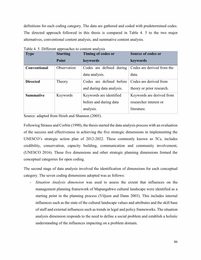
86
definitions for each coding category. The data are gathered and coded with predetermined codes.
The directed approach followed in this thesis is compared in Table 4. 5 to the two major
alternatives, conventional content analysis, and summative content analysis.
Table 4. 5. Different approaches to content analysis
Type Starting
Point
Timing of codes or
keywords
Source of codes or
keywords
Conventional Observation Codes are defined during
data analysis.
Codes are derived from the
data.
Directed Theory Codes are defined before
and during data analysis.
Codes are derived from
theory or prior research.
Summative Keywords Keywords are identified
before and during data
analysis.
Keywords are derived from
researcher interest or
literature.
Source: adapted from Hsieh and Shannon (2005).
Following Strauss and Corbin (1990), the thesis started the data analysis process with an evaluation
of the success and effectiveness in achieving the five strategic dimensions in implementing the
UNESCO’s strategic action plan of 2012-2022. These commonly known as 5Cs, includes
credibility, conservation, capacity building, communication and community involvement,
(UNESCO 2016). These five dimensions and other strategic planning dimensions formed the
conceptual categories for open coding.
The second stage of data analysis involved the identification of dimensions for each conceptual
category. The seven coding dimensions adopted was as follows:
- Situation Analysis dimension was used to assess the extent that influences on the
management planning framework of Mapungubwe cultural landscape were identified as a
starting point in the planning process (Viljoen and Dann 2003). This includes internal
influences such as the state of the cultural landscape values and attributes and the skill base
of staff and external influences such as trends in legal and policy frameworks. The situation
analysis dimension responds to the need to define a social problem and establish a holistic
understanding of the influences impacting on a problem domain.
87
- The strategic orientation was used to evaluate the extent that the planning process was
either long-term or holistic (Viljoen and Dann 2003). Using the understanding generated
in the situation analysis dimensions, strategic dimension should establish a goal-oriented
approach toward achieving a collective vision. In terms of a problem of mining
development, a strategic orientation provided a framework to assess the dynamic nature of
a problem domain and bring together the resources to impact on a problem in the most
effective way.
- The credibility dimension was used to evaluate the extent at which the dissemination and
promotion of the core principles of the World Heritage Convention such as outstanding
universal value, integrity, and authenticity were integrated into the management planning
framework of Mapungubwe cultural landscape.
- The conservation dimension was used to evaluate the conservation measures that has been
integrated in the management planning framework of Mapungubwe World Heritage
cultural landscape, including considerations on whether the outstanding universal value of
the cultural landscape, including conditions of integrity and authenticity, were being
sustained or enhanced since the landscape’s inscription on the World Heritage List.
- The communication dimension was used to establish the extent at which the management
planning framework of Mapungubwe World Heritage cultural landscape integrated
communication strategies into a strategic vision of the cultural landscape.
- The capacity building dimension was used to determine the extent to which the
management planning framework of Mapungubwe World Heritage cultural landscape has
integrated the issues of capacity building in the course of the planning period and beyond.
- The community involvement dimension was used to evaluate the extent to which
management planning system at the Mapungubwe World Heritage cultural landscape was
designed to support community involvement aspects.
In the third stage of the data analysis process, the seven open coding dimensions were used as the
framework for the development of an axial coding instrument. Strauss and Corbin (1990) described
axial coding as putting ‘data back together in new ways after open coding, by making connections
between categories’. The axial coding instrument was based on an instrument constructed by
Simpson (2001) and later adapted by Ruhanen (2004) and Landorf (2009). Simpson’s instrument
was developed to assess the extent that the principles of sustainable development had been
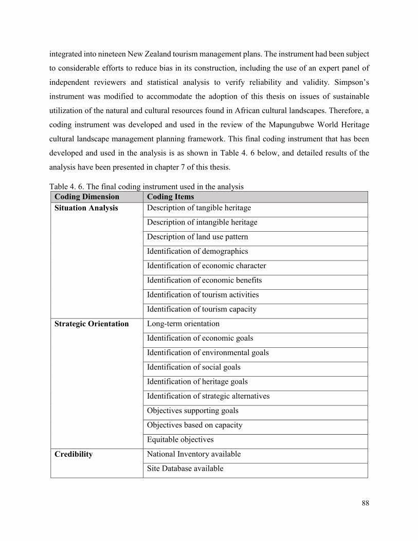
88
integrated into nineteen New Zealand tourism management plans. The instrument had been subject
to considerable efforts to reduce bias in its construction, including the use of an expert panel of
independent reviewers and statistical analysis to verify reliability and validity. Simpson’s
instrument was modified to accommodate the adoption of this thesis on issues of sustainable
utilization of the natural and cultural resources found in African cultural landscapes. Therefore, a
coding instrument was developed and used in the review of the Mapungubwe World Heritage
cultural landscape management planning framework. This final coding instrument that has been
developed and used in the analysis is as shown in Table 4. 6 below, and detailed results of the
analysis have been presented in chapter 7 of this thesis.
Table 4. 6. The final coding instrument used in the analysis
Coding Dimension Coding Items
Situation Analysis Description of tangible heritage
Description of intangible heritage
Description of land use pattern
Identification of demographics
Identification of economic character
Identification of economic benefits
Identification of tourism activities
Identification of tourism capacity
Strategic Orientation Long-term orientation
Identification of economic goals
Identification of environmental goals
Identification of social goals
Identification of heritage goals
Identification of strategic alternatives
Objectives supporting goals
Objectives based on capacity
Equitable objectives
Credibility National Inventory available
Site Database available
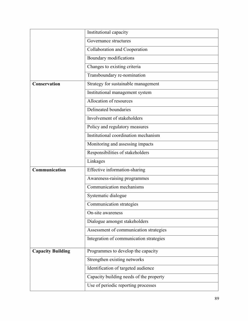
89
Institutional capacity
Governance structures
Collaboration and Cooperation
Boundary modifications
Changes to existing criteria
Transboundary re-nomination
Conservation Strategy for sustainable management
Institutional management system
Allocation of resources
Delineated boundaries
Involvement of stakeholders
Policy and regulatory measures
Institutional coordination mechanism
Monitoring and assessing impacts
Responsibilities of stakeholders
Linkages
Communication Effective information-sharing
Awareness-raising programmes
Communication mechanisms
Systematic dialogue
Communication strategies
On-site awareness
Dialogue amongst stakeholders
Assessment of communication strategies
Integration of communication strategies
Capacity Building Programmes to develop the capacity
Strengthen existing networks
Identification of targeted audience
Capacity building needs of the property
Use of periodic reporting processes
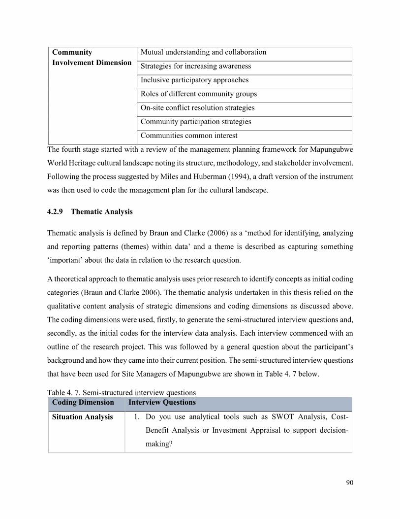
90
Community
Involvement Dimension
Mutual understanding and collaboration
Strategies for increasing awareness
Inclusive participatory approaches
Roles of different community groups
On-site conflict resolution strategies
Community participation strategies
Communities common interest
The fourth stage started with a review of the management planning framework for Mapungubwe
World Heritage cultural landscape noting its structure, methodology, and stakeholder involvement.
Following the process suggested by Miles and Huberman (1994), a draft version of the instrument
was then used to code the management plan for the cultural landscape.
4.2.9 Thematic Analysis
Thematic analysis is defined by Braun and Clarke (2006) as a ‘method for identifying, analyzing
and reporting patterns (themes) within data’ and a theme is described as capturing something
‘important’ about the data in relation to the research question.
A theoretical approach to thematic analysis uses prior research to identify concepts as initial coding
categories (Braun and Clarke 2006). The thematic analysis undertaken in this thesis relied on the
qualitative content analysis of strategic dimensions and coding dimensions as discussed above.
The coding dimensions were used, firstly, to generate the semi-structured interview questions and,
secondly, as the initial codes for the interview data analysis. Each interview commenced with an
outline of the research project. This was followed by a general question about the participant’s
background and how they came into their current position. The semi-structured interview questions
that have been used for Site Managers of Mapungubwe are shown in Table 4. 7 below.
Table 4. 7. Semi-structured interview questions
Coding Dimension Interview Questions
Situation Analysis 1. Do you use analytical tools such as SWOT Analysis, Cost-
Benefit Analysis or Investment Appraisal to support decision-
making?
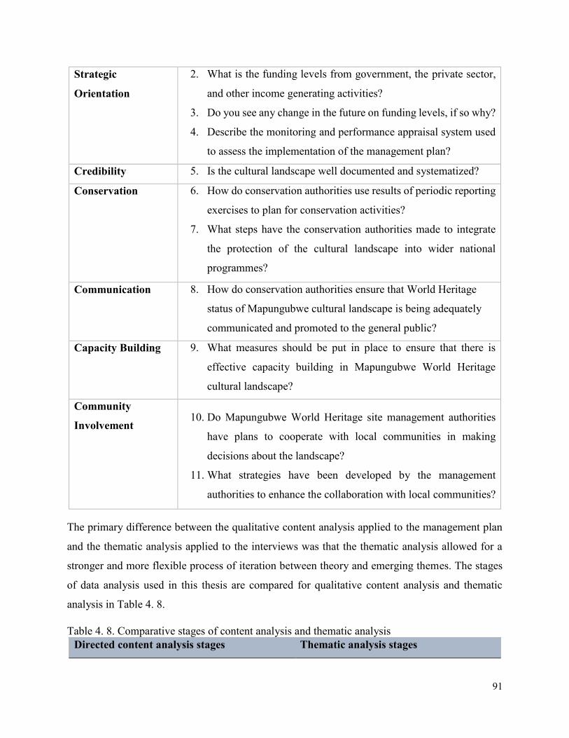
91
Strategic
Orientation
2. What is the funding levels from government, the private sector,
and other income generating activities?
3. Do you see any change in the future on funding levels, if so why?
4. Describe the monitoring and performance appraisal system used
to assess the implementation of the management plan?
Credibility 5. Is the cultural landscape well documented and systematized?
Conservation 6. How do conservation authorities use results of periodic reporting
exercises to plan for conservation activities?
7. What steps have the conservation authorities made to integrate
the protection of the cultural landscape into wider national
programmes?
Communication 8. How do conservation authorities ensure that World Heritage
status of Mapungubwe cultural landscape is being adequately
communicated and promoted to the general public?
Capacity Building 9. What measures should be put in place to ensure that there is
effective capacity building in Mapungubwe World Heritage
cultural landscape?
Community
Involvement 10. Do Mapungubwe World Heritage site management authorities
have plans to cooperate with local communities in making
decisions about the landscape?
11. What strategies have been developed by the management
authorities to enhance the collaboration with local communities?
The primary difference between the qualitative content analysis applied to the management plan
and the thematic analysis applied to the interviews was that the thematic analysis allowed for a
stronger and more flexible process of iteration between theory and emerging themes. The stages
of data analysis used in this thesis are compared for qualitative content analysis and thematic
analysis in Table 4. 8.
Table 4. 8. Comparative stages of content analysis and thematic analysis
Directed content analysis stages Thematic analysis stages
92
1. Familiarization with the literature.
Defining conceptual dimensions and
operational definitions from existing
theory and prior research.
1. Familiarization with the data.
Transcribing the data, checking the
data for accuracy and noting down
initial themes.
2. Construct coding dimensions.
Extracting component elements of each
conceptual dimension and constructing
coding dimensions.
2. Generate initial codes
Coding of interesting features
systematically across the data set
and collating the data.
3. Generate initial codes
Collating the criteria relevant to each
coding dimension from literature and
developing a coding instrument.
3. Search for themes
Collating codes into potential
themes and gathering all data
relevant to each potential theme.
4. Refine coding instrument
Checking if the coding instrument works
in relation to a representative sample of
the data set and refining the specifics of
coding items.
4. Review themes
Checking if the themes work in
relation to the coded extracts and the
entire data set, generating a thematic
map of the analysis.
5. Apply coding instrument
Apply the coding instrument across the
data set, reporting.
5. Define themes
Ongoing analysis to refine the
specifics of each theme.
(Source: Adapted from Braun and Clarke 2006; Hsieh and Shannon 2005).
4.3 Triangulation
Triangulation is a method used to increase the credibility and validity of research findings, (Cohen
2000). Triangulation strengthens a study through the convergence of multiple sources of evidence
to support any given finding. Yin (1994) notes that case study conclusions are more convincing
and accurate if they are corroborated by several sources of data. Denzin and Lincoln (2003)
contend that the logic of triangulation is based on the premise that no single method adequately
solves the problem of rival causal theories.
.
93
Three types of triangulation have been used in order to increase the credibility and validity of the
research findings. These include data triangulation whereby data was collected in different times
of the year, covering both Mulanje District in Malawi and Mapungubwe Distract of South Africa,
purposefully focusing on local communities, heritage practitioners and decision-makers in the
mining industry. Investigator triangulation was also applied which involved the use of several
research assistants from heritage institutions and graduate students who supported in collecting
multiple datasets addressing specific objectives of the study. Lastly methodological triangulation
was also used which promoted the use of several data collection methods.
Several data sets and methodological approached were used and included exploratory interviews
with key participants comprising of local community members, public officials, civil society
organization and business community, (n=108); document analysis, focus-group discussions,
observations, field site surveys, content analysis, to explore a range of experiences and perceptions
on mining and cultural landscape issues. This triangulation approach encouraged the use of several
methods to collect data using multiple research assistants with varied expertise and local
knowledge.
Phase one of the study focused on understanding the context of the study and included defining
the cases studies, desk research, preliminary interviews with key informants and the collection of
literature and specific policies. The second phase involved defining of the methodological
approaches, designing the research strategy and fine-tuning the research questions, case-study
analysis and attributes mapping. The final phase included community meetings to provide feed-
back on findings and development of parameters for impact evaluation. Data were coded and
thematically analyzed. The observations of local communities during discussions on options either
for mining or conservation of the landscape identified the complexities of the decision-making
process related to the topic under study. The observations were supplemented by the interviews
and focus groups. Each research method exposed one aspect of the issue under investigation. This
multimethod and multidisciplinary collaborative research was insightful. It permitted cross-
validation, and facilitated exploration of issues related to the integration of mining development
issues in the management and planning framework of the African World Heritage Cultural
Landscapes.
94
4.4 Ethical Considerations
It has been claimed that ‘any method decision is an ethics decision’ (Denzin and Lincoln 2003).
In this particular thesis, each selected method raised several ethical considerations regarding its
use. One of the main ethical considerations that was encountered was the dilemma on whether to
reveal my professional identity as an employee of Malawi Department of Museums and
Monuments, an institution which is responsible for the advancement of inscribing Mulanje
Mountain cultural landscape as a World Heritage Site, when discussing with the local community
members and other stakeholders, or as a university researcher studying the case of Mulanje cultural
landscape. This raises the following ethical dilemma: what is ethically and scientifically right for
a researcher? Is it ethical for a researcher to conceal his/her identity in order to gain invaluable and
more accurate data or should he/she sacrifice the accuracy of the data by revealing his/her identity?
A further ethical issue emerged from the ethical obligation to retain the anonymity of the
interviewees. Therefore, the opinions of the interviewees were referred to as anonymous personal
communications.
4.5 Chapter Summary
This chapter has illustrated the methodologies used in the research. The selection of the case
studies has been justified. The chapter demonstrated the use of case studies as an effective research
strategy in the investigation of contemporary and inter-related phenomena in changing cultural
landscapes which are threatened by modern development especially mining. A case study research
strategy is concerned with providing a detailed description of a bounded system. Case studies allow
the specifics of a case to be examined, revealing the complexity and detail within a case and
allowing comparisons across multiple case studies, (Landorf 2009). For the investigation of the
impact of mining development on the cultural attributes and significant values of African World
Heritage cultural landscapes, a case study research strategy was combined with other research
methodologies. These research methods have been presented and broadly discussed how they have
been applied to achieve specific objectives of the research. These include interviews, focus-group-
discussions, observations, field site surveys content analysis and thematic analysis.

95
In the next chapter 5, detailed analysis of the two case studies of Mulanje Mountain cultural
landscape of Malawi and Mapungubwe cultural landscape of South Africa will be presented in
detail.
96
CHAPTER FIVE
5 CASE STUDIES: MULANJE MOUNTAIN AND MAPUNGUBWE CULTURAL
LANDSCAPES
5.1 Introduction
This chapter provides an overview of the two case studies that have been used to collect data for
the research. This includes Mulanje Mountain Cultural Landscape in Malawi, a site on the
UNESCO World Heritage Tentative List, and Mapungubwe Cultural Landscape in South Africa,
a site listed as a UNESCO World Heritage cultural landscape. The information that has been
provided below is based on a desk research and field work that was carried out between 2016 –
2018 field seasons. Firstly, a general background of Mulanje Mountain and Mapungubwe cultural
landscapes has been provided. This background information has been contextualized in terms of
their location, geology, climatic conditions, local flora and fauna, and the general socio-cultural
characteristics of the landscapes. Thereafter, an overview of the attributes and significance of the
landscapes has been provided. This is in terms of the tangible and intangible heritage of the
landscapes and the associated intangible socio-cultural values. The last part of this chapter contains
an outlook of some of the factors affecting the conservation and management of these cultural
landscapes with a detailed discussion of the mining threat in each of the case studies.
5.2 Case Study I: Mulanje Mountain Cultural Landscape, Malawi
5.2.1 Location of Mulanje Mountain Cultural Landscape
Mulanje Mountain Cultural Landscape is situated in the southern part of Malawi. Malawi is a
landlocked country located in Southern Africa, between the latitude 9022' and 1707' south and
longitudes 32040' and 35055' east. Malawi is bordered to the north and northeast by the United
Republic of Tanzania, to the west by the Republic of Zambia and to the southwest and east by
Mozambique. The total area of the country is approximately 118,483km2 of which 94,275km2 is
the land and 24,208km2 is water, (Kaunda 2013). The topography comprises of plateaus between
750m and 1,350m above sea level, highland elevations rising to over 2,440m in the Nyika Plateau
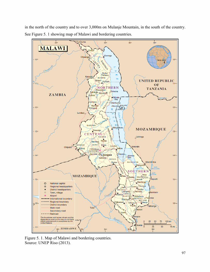
97
in the north of the country and to over 3,000m on Mulanje Mountain, in the south of the country.
See Figure 5. 1 showing map of Malawi and bordering countries.
Figure 5. 1. Map of Malawi and bordering countries.
Source: UNEP Riso (2013).
98
Malawi has an estimated population of 17 million people (GoM 2015). Approximately 85% of the
population lives in the rural area but it is anticipated that this figure will decrease due rapid
urbanization as the country had an annual urban population growth rate of 5.5% in 2010 making
it one of Africa’s fastest urbanizing nations, (Brown 2011).
Malawi’s major exports include food, live animals, beverages, and tobacco whilst imports include
petroleum products, fertilizers, machinery and transport equipment, and manufactured goods,
(UNDATA 2013). Agriculture is the backbone of Malawi’s economy, accounting to 34% of Gross
Domestic Product (GDP) and employing about 80% of the country population. However,
agriculture productivity is noted to be developing slowly and operating below its capacity due to
the dependence on small-scale farming systems that are characterized by low input use, over-
reliance on rain-fed agriculture, inadequate access to agriculture credit, inadequate access to output
and input markets, and failures in technology development and transfer. This is further exacerbated
by climate change effects such as erratic rains and droughts, (GoM 2007).
Malawi has traditionally been considered as an agro-based rather than mineral-based economy
because of the policies that the government pursued since attaining independence in 1964. As a
result, there was a lack of mining culture, little technical capacity and inadequate foreign and local
investment which contributed to the slow development of the mining industry, (Mines and
Minerals Policy 2013). Mining is expected to surpass the contribution of agriculture to GDP which
is currently at 35%. This will be a gradual process considering that the mineral sector contribution
to GDP is currently at 10%, (ibid.). Malawi has a variety of known mineral resources that include
uranium, heavy mineral sands, strontinite, rare earth minerals, phosphate, bauxite, gypsum,
vermiculite, precious and semiprecious stones, limestone, dimension stone, silica sands, sulphides,
and coal. There is also a potential for the discovery of other metallic minerals and high-value
metals including gold, platinum group minerals, and diamonds, (ibid). Most of these mineral
resources are located in the cultural landscapes of historic and cultural importance to the local
communities. This has necessitated the development of an integrated management planning
methodological framework proposed in this thesis for the proper exploration and extraction of
these mineral resources so that they should not destroy the cultural and natural heritage resources
of local, national and international importance.
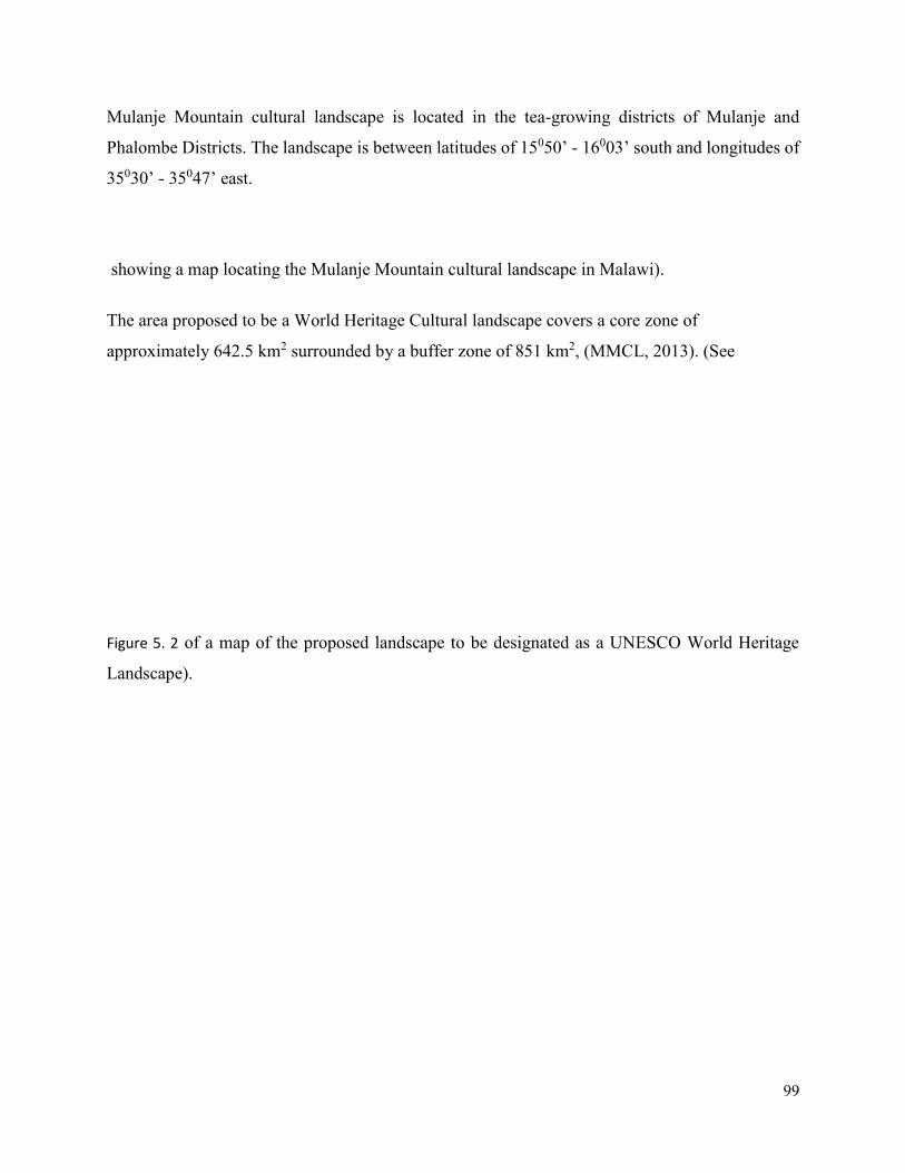
99
Mulanje Mountain cultural landscape is located in the tea-growing districts of Mulanje and
Phalombe Districts. The landscape is between latitudes of 15050’ - 16003’ south and longitudes of
35030’ - 35047’ east.
showing a map locating the Mulanje Mountain cultural landscape in Malawi).
The area proposed to be a World Heritage Cultural landscape covers a core zone of
approximately 642.5 km2 surrounded by a buffer zone of 851 km2, (MMCL, 2013). (See
Figure 5. 2 of a map of the proposed landscape to be designated as a UNESCO World Heritage
Landscape).
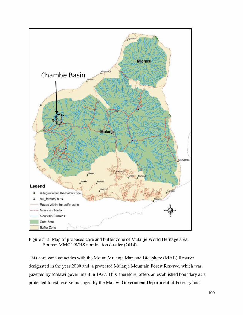
100
Figure 5. 2. Map of proposed core and buffer zone of Mulanje World Heritage area.
Source: MMCL WHS nomination dossier (2014).
This core zone coincides with the Mount Mulanje Man and Biosphere (MAB) Reserve
designated in the year 2000 and a protected Mulanje Mountain Forest Reserve, which was
gazetted by Malawi government in 1927. This, therefore, offers an established boundary as a
protected forest reserve managed by the Malawi Government Department of Forestry and
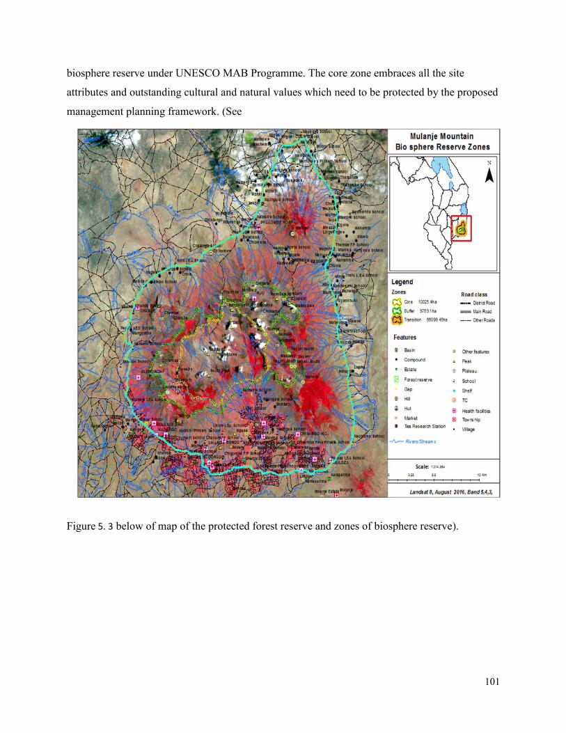
101
biosphere reserve under UNESCO MAB Programme. The core zone embraces all the site
attributes and outstanding cultural and natural values which need to be protected by the proposed
management planning framework. (See
Figure 5. 3 below of map of the protected forest reserve and zones of biosphere reserve).
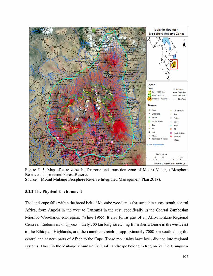
102
Figure 5. 3. Map of core zone, buffer zone and transition zone of Mount Mulanje Biosphere
Reserve and protected Forest Reserve
Source: Mount Mulanje Biosphere Reserve Integrated Management Plan 2018).
5.2.2 The Physical Environment
The landscape falls within the broad belt of Miombo woodlands that stretches across south-central
Africa, from Angola in the west to Tanzania in the east, specifically in the Central Zambesian
Miombo Woodlands eco-region, (White 1965). It also forms part of an Afro-montane Regional
Centre of Endemism, of approximately 700 km long, stretching from Sierra Leone in the west, east
to the Ethiopian Highlands, and then another stretch of approximately 7000 km south along the
central and eastern parts of Africa to the Cape. These mountains have been divided into regional
systems. Those in the Mulanje Mountain Cultural Landscape belong to Region VI, the Ulunguru-
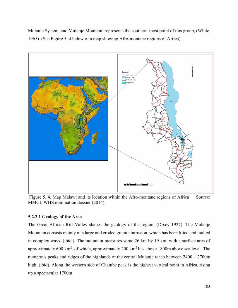
103
Mulanje System, and Mulanje Mountain represents the southern-most point of this group, (White,
1965). (See Figure 5. 4 below of a map showing Afro-montane regions of Africa).
Figure 5. 4. Map Malawi and its location within the Afro-montane regions of Africa Source:
MMCL WHS nomination dossier (2014).
5.2.2.1 Geology of the Area
The Great African Rift Valley shapes the geology of the region, (Dixey 1927). The Mulanje
Mountain consists mainly of a large and eroded granite intrusion, which has been lifted and faulted
in complex ways, (ibid.). The mountain measures some 26 km by 19 km, with a surface area of
approximately 600 km2, of which, approximately 200 km2 lies above 1800m above sea level. The
numerous peaks and ridges of the highlands of the central Mulanje reach between 2400 – 2700m
high, (ibid). Along the western side of Chambe peak is the highest vertical point in Africa, rising
up a spectacular 1700m.
104
Underneath these steep outer cliffs is a series of discontinuous plateaus, some 1100m above the
plains, with rolling grasslands of up to 2 km wide that have developed on the shallow soils
consisting of partially fragmented rock, usually on steep slopes. This weathered landscape is
intersected by deep, forested ravines and gullies with a myriad of streams, waterfalls, and pools.
One of the large upland valleys of the massive acts as the source of Malawi’s second largest river,
the Ruo. It has spectacular waterfalls, the highest of which fall over 150m, making it one of the
highest uninterrupted drops in Africa.
To the north of Mulanje is Michese Mountain which is also part of the proposed core zone of the
World Heritage cultural landscape, and it is separated from the Mulanje massif by a broad saddle
of some 2km. It is also known as the Fort Lister Gap, based on the historic Fort which is located
at this gap. Michese Mountain has a remarkable dome-shaped peak, which rises some 2300m with
numerous narrow gorges that had been incised around its bulge.
5.2.2.2. Climate and Rainfall
Like most of southern Africa, Malawi has a single rainy season. The summer begins in September,
which is followed by a cool season that lasts from May to August. Moisture-laden air from the
Mozambique Channel spills up against Mulanje, generating spells of mist, drizzle, and rain known
locally as Chiperone, mainly occurring along the mountain peaks and steep southeast-facing
slopes. The effect of the Chiperone rains extends well beyond the southern foot of the Mulanje
Mountain cultural landscape.
The mean annual temperature of the plateau falls below 150C. Night frosts occur between June
and September, and it occasionally snows on Sapitwa, the highest point of the mountain. The
rainfall of the region is unpredictable, and fires often burn deep into the forest during prolonged
dry seasons. Annually, the mean rainfall measures between 1600mm – 2000mm.
5.2.2.3 Flora and Fauna
Mulanje has acted as a habitat for various tropical biota during the periods of world glaciation,
when lowland climates were much drier and cooler than at present, (Davis et al 1994). The
combination of geology, climatic conditions and vegetation further created a unique environment
with a complex mosaic of habitats. Vegetation patterns change up slopes of Mulanje, reflecting
the influences of different temperature and rainfall patterns at each level. Plant scientists have
105
carried out extensive and a very varied range of research of the flora on the Mulanje forest reserve,
(White, et. al 2001; Chapman 1994). Currently, the list of Mulanje’s higher plants contains over
1100 species. There is a large, well-documented orchid flora on Mulanje which includes six
endemics. There are also six endemic grass species and three endemic sedge species as well. The
dominant endemic tree species on Mulanje is the Cedar, (Widdringtonia whytei) (White, et. al
2001; Chapman 1994).
The fauna of the Mulanje Mountain cultural landscape includes the mammals, birds, reptiles,
amphibians, fish, and invertebrates. The number of larger mammals on Mulanje has always been
low. (ibid.) There is a high level of endemism on the bird of the Afro-montane archipelago as a
whole (140 species) and to the Usambara – Mulanje system (56 species). Thirty – eight of these
140s species are found in Malawi and 22 on Mulanje. Several reptile species like lizards,
chameleons, and snakes are either endemic species or subspecies to Mulanje Mountain, (ibid.).
There are at least 74 species and subspecies of amphibians like frogs and toads on Mulanje
mountain cultural landscape, (ibid.) Mulanje fish fauna consists of seven species recorded above
Zoa falls on the Upper Ruo River, five of which occur nowhere else in Malawi. The invertebrates
species number is estimated to range from 25,000 – 30,000 (White et. al 2001).
Socio-economic characteristics
The district of Mulanje has a population of approximately 430,000 people and covers an area of
about 2,056km2. Its key industries are agriculture, including tea-growing, and forestry. Currently,
an estimated 63% of the total land area around the Mulanje Mountain cultural landscape is used
for agriculture. Of this, 70% is used for subsistence and 30% for commercial farming, (NORAD
2009).
A NORAD (2009) socio-economic baseline study in the central and southern districts of Malawi,
gives the average household size in the district as five, with up to 33% being female-headed. Most
of the houses are vernacular traditional houses with mud walls and grass-thatched roofs.
Households in Mulanje commonly depends on agriculture, with agricultural production limited to
small plot sizes of average 0.2 ha. Agriculture provides about 70% of household incomes. Poverty
and low levels of socio-economic development are key factors driving unsustainable resource use
in the region.
106
5.2.3 Cultural Heritage of Mulanje Mountain Cultural Landscape
5.2.3.1 Intangible Heritage
Mulanje Mountain cultural landscape is a living and vibrant landscape with deep roots in the
traditions of local people who live within and around it. These are the Mang’anja (Nyanja), Yao
and Lhomwe cultural tribal groups of people. The cultural landscape serves as a potent symbol of
Malawi’s cultural values and belief systems. The mountain and its socio-cultural attributes live in
the minds of the local communities within and around it. This has inspired the religious thought,
legend, art, and literature in the region.
The richness of the intangible heritage within the landscape has been attributed to the following
two factors; the physical nature of the place and its association with danger and; the botanical
diversity that includes many plant species that are used as medicinal herbal plants for traditional
healing. These factors have determined the way the mountain is regarded and have given rise to
traditions which have a strong belief system. The following practices and traditions are of
particular importance to Mulanje:
- Traditional ceremonies which are undertaken before the journey onto the mountain, like
the singing of traditional songs, traditional praying, and libations; and,
- Telling of the stories of the disappearance of people who treat the mountain or the
ancestors who reside there without the requisite respect.
Oral narratives have shown that the Mountain is associated with the ‘Abatwa1’ who are amongst
the earliest occupants of the Mountain and the landscape. Among other uses, the mountain is also
used for traditional girls’ initiation rituals called Chinamwali by the Lhomwe, Mang’anja and
Chewa tribes.
Table 5. 1 below summarizes the attributes that convey the site values, and some of the traditional
practices and belief systems, according to the oral interviews conducted in the area.
Table 5. 1. Cultural Significance of Mount Mulanje Cultural Landscape
Intangible cultural
heritage domains Cultural Significance
1 Abatwa, also known as Akafula are commonly described as short-statured hunter-gatherers, whom the Bantu speaking communities encountered when they settled in what is now Malawi during the third century A.A (Rangeley, 1963).
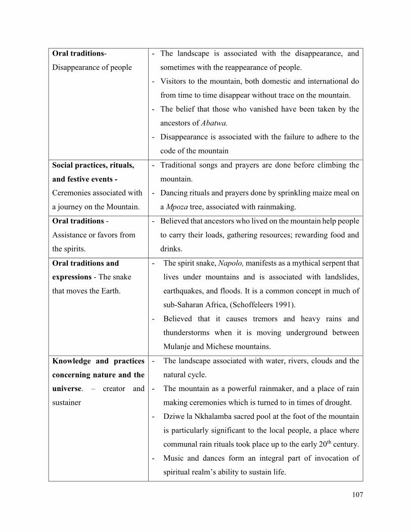
107
Oral traditions-
Disappearance of people
- The landscape is associated with the disappearance, and
sometimes with the reappearance of people.
- Visitors to the mountain, both domestic and international do
from time to time disappear without trace on the mountain.
- The belief that those who vanished have been taken by the
ancestors of Abatwa.
- Disappearance is associated with the failure to adhere to the
code of the mountain
Social practices, rituals,
and festive events -
Ceremonies associated with
a journey on the Mountain.
- Traditional songs and prayers are done before climbing the
mountain.
- Dancing rituals and prayers done by sprinkling maize meal on
a Mpoza tree, associated with rainmaking.
Oral traditions -
Assistance or favors from
the spirits.
- Believed that ancestors who lived on the mountain help people
to carry their loads, gathering resources; rewarding food and
drinks.
Oral traditions and
expressions - The snake
that moves the Earth.
- The spirit snake, Napolo, manifests as a mythical serpent that
lives under mountains and is associated with landslides,
earthquakes, and floods. It is a common concept in much of
sub-Saharan Africa, (Schoffeleers 1991).
- Believed that it causes tremors and heavy rains and
thunderstorms when it is moving underground between
Mulanje and Michese mountains.
Knowledge and practices
concerning nature and the
universe. – creator and
sustainer
- The landscape associated with water, rivers, clouds and the
natural cycle.
- The mountain as a powerful rainmaker, and a place of rain
making ceremonies which is turned to in times of drought.
- Dziwe la Nkhalamba sacred pool at the foot of the mountain
is particularly significant to the local people, a place where
communal rain rituals took place up to the early 20th century.
- Music and dances form an integral part of invocation of
spiritual realm’s ability to sustain life.
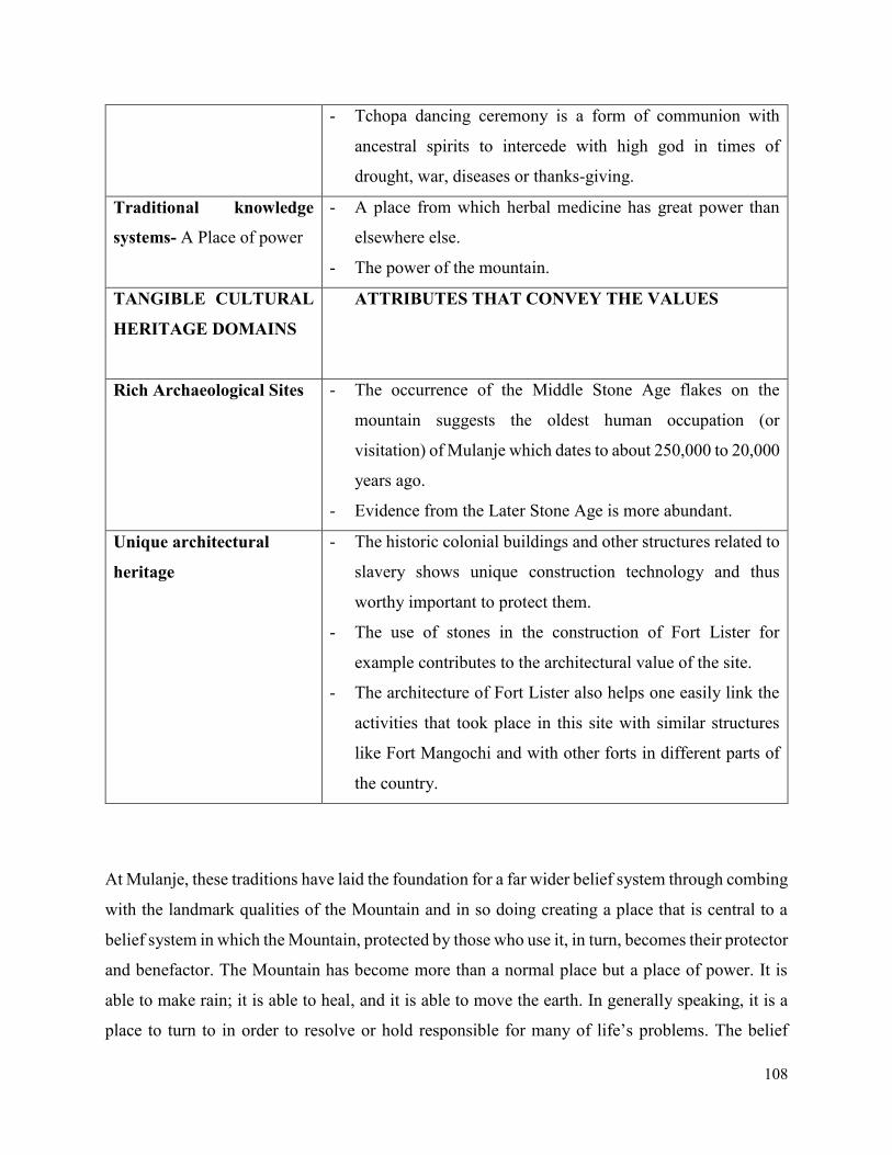
108
- Tchopa dancing ceremony is a form of communion with
ancestral spirits to intercede with high god in times of
drought, war, diseases or thanks-giving.
Traditional knowledge
systems- A Place of power
- A place from which herbal medicine has great power than
elsewhere else.
- The power of the mountain.
TANGIBLE CULTURAL
HERITAGE DOMAINS
ATTRIBUTES THAT CONVEY THE VALUES
Rich Archaeological Sites - The occurrence of the Middle Stone Age flakes on the
mountain suggests the oldest human occupation (or
visitation) of Mulanje which dates to about 250,000 to 20,000
years ago.
- Evidence from the Later Stone Age is more abundant.
Unique architectural
heritage
- The historic colonial buildings and other structures related to
slavery shows unique construction technology and thus
worthy important to protect them.
- The use of stones in the construction of Fort Lister for
example contributes to the architectural value of the site.
- The architecture of Fort Lister also helps one easily link the
activities that took place in this site with similar structures
like Fort Mangochi and with other forts in different parts of
the country.
At Mulanje, these traditions have laid the foundation for a far wider belief system through combing
with the landmark qualities of the Mountain and in so doing creating a place that is central to a
belief system in which the Mountain, protected by those who use it, in turn, becomes their protector
and benefactor. The Mountain has become more than a normal place but a place of power. It is
able to make rain; it is able to heal, and it is able to move the earth. In generally speaking, it is a
place to turn to in order to resolve or hold responsible for many of life’s problems. The belief
109
systems attached to the Mulanje mountain is one that is shared by all the cultural communities that
live around the mountain and its power is well-known all-over southern Africa and even beyond,
where its mystic qualities and in particular the power of its medicines and reputation of its healers
extends.
5.2.3.2 Tangible Heritage
The Mulanje mountain cultural landscape is also endowed with very rich tangible heritage. In this
thesis, the results of the tangible heritage of Mulanje has been presented based on the literature
review, archival research, local interviews and the field reconnaissance which was conducted.
Archaeological Sites
The landscape contains a number of archaeological sites of Stone Age and Iron Age period, which
have a direct link with the earliest inhabitants of the landscape and the intangible values of the
mountain today. An Early Iron Age Site at Skyline Archaeological site with concentrations of the
Nkope-type pottery was dated to the quarter of the first millennium A.D (Robinson 1977). There
is also a number of undocumented and documented rock art sites and rock-shelters of historic and
cultural importance to the local people. The well-known one is called Machemba rock art site, a
rock-shelter with ancient rock paintings of red geometric styles, situated close to a small stream
on the south of the Machemba hill. Another notable cultural heritage feature of tangible value is
the sacred pool and waterfall called Dziwe la Nkhalamba – situated on the foot of the Mulanje
Mountain. This sacred pool is highly revered by the local people because it is believed to be
inhabited by the Abatwa and their ancestors. Most rain-making traditional rituals took place at this
sacred pool and waterfall. It features frequently in the local mythical stories, as a place where
people have disappeared. Around the pool, there is still evidence of the shrines. The landscape is
also endowed with iron smelting furnaces. For instance, at a place known as Likhubula, there is an
iron smelting furnace that is linked to traditional religious-spiritual activities. There are also
numerous caves within and around the landscape, commonly known as ‘holy caves’. For example,
a notable one is the one situated at Nambirira, which is used for religious purposes up to this day.
Historical and Architectural Sites
The area within and around Mulanje Mountain cultural landscape contains a large number of
historical, colonial and postcolonial cultural heritage sites of local and national importance. These
include old colonial mansions, estates and tea factories; the timber plantation and an old boma;
110
Fort Lister and the remnants of Fort Anderson; the Old Church of Scotland mission site and
cemetery, the Mulanje CCAP Mission, Providence Industrial Mission, the Chisitu Catholic
Mission, the Hole Family mission; the gravesite of the national hero John Chilembwe; old
traditional villages that played an important part in the pre-colonial and colonial history, and which
also contain graves of old chiefs and their wives; grave sites on the plateau and the Phalombe
Disaster Memorial.
Collectively, these cultural heritage resources provide an overview of the history of Mulanje
Mountain cultural landscape. Within the landscape, there is a strong association between the slave
trade and its suppression. This mostly is reflected by historic features and architectural monuments
like Fort Lister, Old Fort Anderson, the Old Church of Scotland Mission and Chief Nkanda,
Matipwili, Chikumbu, Nyerezera and Mthiramanja memorial graves. Arab slave traders and their
local associates used a route from Liwonde to Zomba past Mulanje to Quelimane before sailing to
the Kilwa slave market in Tanzania, (Curry 1920). The forts in Mulanje were built to control and
block such routes and the missions also were important in the suppression of the slave trade.
5.2.3.3 Natural Heritage
The natural heritage in Mulanje Mountain cultural landscape, in particular, botanical diversity, is
important with regard to the manner in which it supports the belief systems associated with the
Mountain. Most notable is the existence of an important traditional healing system which depends
upon plants harvested from the mountain and the cultural values as a whole. The mountain on its
own as a natural feature, other than merely being a vehicle that carries the traditional and cultural
values, it has monumental qualities that have contributed greatly to the rise and maintenance of
the intangible values through the traditional belief systems accrued to it.
5.2.4 Significance and Values of the Landscape
The most significant aspect of Mulanje mountain cultural landscape is the intangible values which
are closely associated with the tangible nature of the mountain. The mountain’s monumental
qualities have contributed highly to the preservation of the intangible values of the mountain. Its
associated belief systems have created a sacred landscape that demands its users follow a strict
code of behavior that is both designed to protect them when visiting the mountain and to protect
the resources of the mountain which sustain the communities that live in and around the landscape.
111
The mountain, therefore, is an exceptional example of a system where the needs of man and nature
are combined into a system of mutual benefit with the resulting system providing the rules that
have protected the mountain and eco-system in the past and today.
The Mulanje cultural landscape, by the writing of this thesis, was being nominated as a UNESCO
World Heritage Site based on three selection criteria listed in the Operational Guidelines for the
implementation of the natural and cultural World Heritage sites, namely criterion IV, V and VI,
(UNESCO 2016).
Criterion IV stipulates that the heritage property should be ‘…an outstanding example of a type of
building, architectural or technological ensemble or landscape which illustrates a significant
stage in human history’. This criterion fits well with the Mulanje Mountain cultural landscape
because it reflects a significant stage in human history and the transitions that show adaptation
overtime. It reflects a traditional belief system that is inextricably linked to the mountain which
together forms a landscape. The traditions and belief system that define this landscape have
undergone changes over the past centuries through exposure to the slave trade, the colonial period
that followed and the introduction of Christianity.
In criterion V, which requires that a heritage property should be ‘…an outstanding example of the
traditional human settlement, land-use, or sea-use which is a representative of a culture (or
cultures) or human interaction with the environment especially when it has become vulnerable
under the impact of irreversible change’. Mulanje Mountain cultural landscape fits well with this
criterion because it is surrounded by human settlements where people practice both modern and
traditional agriculture. The modern tea plantations are restricted to the southern section of the
buffer zone around the mountain. Local people still practice the traditional form of African
pastoralism and agriculture, especially in the buffer zone. They also extract a range of traditional
resources from the mountain, notably medical plants, which feeds a wide range of trade networks.
For criterion VI, it requires that the heritage property should be “…directly or tangibly associated
with event or living traditions, with ideas, or with beliefs, with artistic and literary works of
outstanding universal significance’. The Mulanje cultural landscape is closely associated with the
Abatwa, the short people. These are the earliest hunter-gatherers who lived in the landscape before
the Bantu agriculturalist. Similarly, the traditional healers, herbalists and spirit mediums, guided
112
by spirit dreams, are able to access and use the potency of the mountain to the benefit of the people.
The place is also associated with a great snake (Napolo) which became destructive if not properly
treated. The snake is said to cause earthquakes, landslides, and floods that erase villages from the
mountain slopes.
Integrity and Authenticity
The Mulanje mountain cultural landscape encompasses the whole mountain, the areas in which
cultural practices take place and all the major associative sites. The proposed buffer zone includes
some of the villages where the local people live. The rock structures that make up the landscape
are intact, and various conservation efforts have been put in place to maintain the integrity of the
physical and cultural landscape. The preservation of the authenticity and integrity of the landscape
is the responsibility of the various institutions of the Malawi Government like Department of
Forestry, Department of Environmental Affairs, Department of Museums and Monuments, among
others.
However, development pressure is the main factor threatening the integrity of the cultural
landscape. This need to be carefully planned and managed. Traditional roles are changing under
the impact of international culture, thereby also changing the mechanisms that have so long
supported appreciation of the Mountain. Intangible heritage of this kind is inherently vulnerable,
and future action will be needed to record and document what is there, and to make local people
aware of the international value of the cultural landscape as part of global culture. Similarly,
conservation efforts will have to maintain the standards needed to ensure that the resources of the
Mulanje Mountain are protected from exploitation by outsiders who do not understand the
traditions that govern the place.
5.2.5 Factors affecting the Mulanje Cultural Landscape
There are a number of factors affecting the conservation and management of the Mulanje Mountain
cultural landscape. These include the following: mining, resource extraction, human encroachment
and agriculture, fires and natural disasters. However, this thesis has only focused and researched
in detail the effect of mining development on the protection and management of sub-Saharan
cultural landscapes.
i. Resource Extraction
113
Some 12% of the total land area around Mulanje is residential, with an average density of 208
people per square kilometer. These are generally subsistence livelihood villages dependent on
smallholder farming. The population growth rate is high. There is also overexploitation of
indigenous trees in the forest leading to deforestation in other areas. Hunting and illegal poaching
in and around the mountain is also a challenge.
ii. Human encroachment and agriculture
There is some concern about incidents where local inhabitants cross the forest boundaries,
cultivating several hectares of land inside the forest and thereby impacting on the biodiversity.
Land cleared for subsistence agriculture generally does not sustain farming for more than two
consecutive years, and erosion takes place once the encroacher has been removed or the land is
abandoned. Agricultural interventions also introduce invasive alien plants and animal species to
the mountain. A significant amount of land around Mulanje Mountain cultural landscape is also
used for commercial tea plantations, which has permanently transformed the ecosystem, but which
provide work opportunities in a commercial sector and reduces pressure on protected areas.
iii. Fires and Natural Disasters
Uncontrolled burning is also one of the challenges threatening the conservation and management
of the Mulanje Mountain cultural landscape. Over the past 10 years, the incidence of fire has
increased, due partly to inadequate capacity by the forestry department. In 1991, the famous
Phalombe disaster took place. A landslide came down from the source of Phalombe and other
rivers from the Mulanje and Michese mountains and swept away a number of villages and
properties.
iv. Mining Development
The area in which Mulanje Mountain is situated is geologically rich in mineral resources such as
bauxite and Rare Earth metals. In developing countries such as Malawi, exploitation of these
mineral resources contributes to economic growth, uplifts and empowers communities through the
creation of employment opportunities, and provides social amenities such as schools, hospitals and
safe drinking water as part of the corporate social responsibilities. In as much as mining
development projects have these positive potential benefits, unsustainable extraction of the mineral
resources has the potential to harm cultural attributes and outstanding values in most cultural
landscapes.
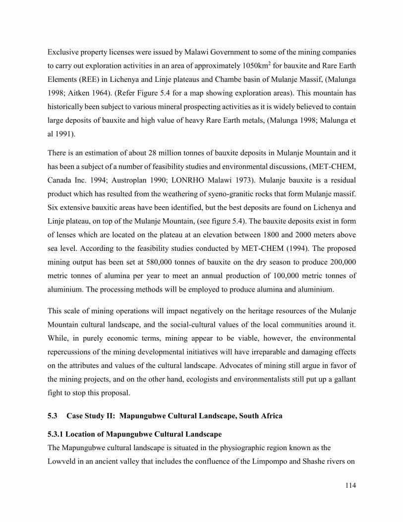
114
Exclusive property licenses were issued by Malawi Government to some of the mining companies
to carry out exploration activities in an area of approximately 1050km2 for bauxite and Rare Earth
Elements (REE) in Lichenya and Linje plateaus and Chambe basin of Mulanje Massif, (Malunga
1998; Aitken 1964). (Refer Figure 5.4 for a map showing exploration areas). This mountain has
historically been subject to various mineral prospecting activities as it is widely believed to contain
large deposits of bauxite and high value of heavy Rare Earth metals, (Malunga 1998; Malunga et
al 1991).
There is an estimation of about 28 million tonnes of bauxite deposits in Mulanje Mountain and it
has been a subject of a number of feasibility studies and environmental discussions, (MET-CHEM,
Canada Inc. 1994; Austroplan 1990; LONRHO Malawi 1973). Mulanje bauxite is a residual
product which has resulted from the weathering of syeno-granitic rocks that form Mulanje massif.
Six extensive bauxitic areas have been identified, but the best deposits are found on Lichenya and
Linje plateau, on top of the Mulanje Mountain, (see figure 5.4). The bauxite deposits exist in form
of lenses which are located on the plateau at an elevation between 1800 and 2000 meters above
sea level. According to the feasibility studies conducted by MET-CHEM (1994). The proposed
mining output has been set at 580,000 tonnes of bauxite on the dry season to produce 200,000
metric tonnes of alumina per year to meet an annual production of 100,000 metric tonnes of
aluminium. The processing methods will be employed to produce alumina and aluminium.
This scale of mining operations will impact negatively on the heritage resources of the Mulanje
Mountain cultural landscape, and the social-cultural values of the local communities around it.
While, in purely economic terms, mining appear to be viable, however, the environmental
repercussions of the mining developmental initiatives will have irreparable and damaging effects
on the attributes and values of the cultural landscape. Advocates of mining still argue in favor of
the mining projects, and on the other hand, ecologists and environmentalists still put up a gallant
fight to stop this proposal.
5.3 Case Study II: Mapungubwe Cultural Landscape, South Africa
5.3.1 Location of Mapungubwe Cultural Landscape
The Mapungubwe cultural landscape is situated in the physiographic region known as the
Lowveld in an ancient valley that includes the confluence of the Limpompo and Shashe rivers on
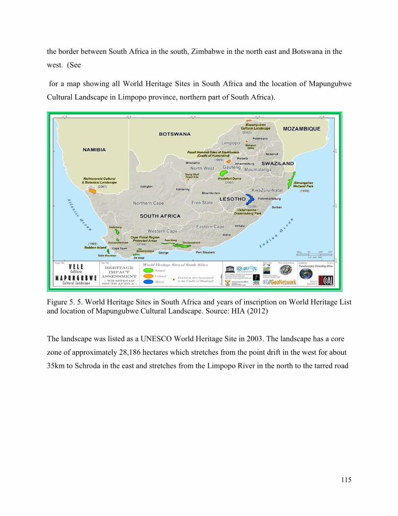
115
the border between South Africa in the south, Zimbabwe in the north east and Botswana in the
west. (See
for a map showing all World Heritage Sites in South Africa and the location of Mapungubwe
Cultural Landscape in Limpopo province, northern part of South Africa).
Figure 5. 5. World Heritage Sites in South Africa and years of inscription on World Heritage List
and location of Mapungubwe Cultural Landscape. Source: HIA (2012)
The landscape was listed as a UNESCO World Heritage Site in 2003. The landscape has a core
zone of approximately 28,186 hectares which stretches from the point drift in the west for about
35km to Schroda in the east and stretches from the Limpopo River in the north to the tarred road
116
linking Point Drift and Musina in the south. (See also
Figure 5. 6 and Figure 5.8. showing location of Mapungubwe cultural landscape and its core and
buffer zone respectively).

117
Figure 5. 6. Map of Mapungubwe Cultural Landscape WHS.
Source: HIA (2012)
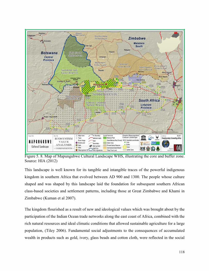
118
Figure 5. 8. Map of Mapungubwe Cultural Landscape WHS, illustrating the core and buffer zone.
Source: HIA (2012)
This landscape is well known for its tangible and intangible traces of the powerful indigenous
kingdom in southern Africa that evolved between AD 900 and 1300. The people whose culture
shaped and was shaped by this landscape laid the foundation for subsequent southern African
class-based societies and settlement patterns, including those at Great Zimbabwe and Khami in
Zimbabwe (Kuman et al 2007).
The kingdom flourished as a result of new and ideological values which was brought about by the
participation of the Indian Ocean trade networks along the east coast of Africa, combined with the
rich natural resources and ideal climatic conditions that allowed sustainable agriculture for a large
population, (Tiley 2006). Fundamental social adjustments to the consequences of accumulated
wealth in products such as gold, ivory, glass beads and cotton cloth, were reflected in the social
119
and physical separation of the elite class and sacred leader on the top of Mapungubwe Hill, with
commoners on the plains below. The power of the ruling class is still evident from their distinctive
hilltop graves and grave goods such as golden rhinoceros.
Over 400 archaeological sites in the core of the area contain tangible evidence of the evolution of
this indigenous kingdom, (Huffman 1984). It had its roots in changes that began when early Iron
farming people migrated southwards from West Africa between 350 and 600 AD and came into
contact with San hunter-gatherers. Three main phases of subsequent development are recognized
in the Mapungubwe cultural landscape.
The first phase, known as Zhizo, lasted from about AD 900 -1020 and is best preserved at the site
of Schroda. The second phase, known as Leopard’s Kopje dated about AD 1020 – 1220. The most
elaborate settlement during the third phase was on the Mapungubwe Hill and the adjacent southern
terrace and dated from AD 1220 – 1300, (Kuman et al 2007; Huffman 1984). The power of the
kingdom ended abruptly with the onset of the Little Ice at the end of the 13th century. Resultant
drought made it no longer possible to sustain the growing population and the power base for trade
shifted to Great Zimbabwe, (Calabrese 1998). Some of the cultural practices of the present day
Shona and Venda peoples originated during this historical process.
At the height of its importance, between AD 1220 and 1300, the Mapungubwe cultural landscape
sustained a population of at least 9000 people, (Van Doornum 2005). Regular flooding of the
Limpopo River provided silt and water for crops. Grazing lands enabled stock to be kept. Elephants
were hunted for their ivory and other animals for their hides, while several steep-sided hills were
used as ritual sites for rain-making. At least one of them, Mapungubwe Hill, was gradually
modified over the years by the addition of tonnes of soil carried to the hilltop to provide the
foundations for the elite homesteads and burial grounds. The sites retained much of their original
integrity as well as the intangible values with which they were imbued more than 700 years ago,
(Calabrese 2000).
5.3.2 The Physical Environment
Topology and Geology of the Area
120
Geologically, the core area of the Mapungubwe cultural landscape is centered on a relatively
isolated outcrop of sandstone hills, underlain by red mudstones and intruded by dolerite dykes.
The formation is part of the Karoo System. The sandstones are up to 300m thick in some places.
They are strategically correlated with the Clarens Sandstone Formation, formally known as Cave
Sandstone, that formed during the Triassic period between 225 and 190 million years ago and they
contain fossils of that time period, (Kent 1980). The sandstones have been used in Mapungubwe
cultural landscape as ideal surfaces for rock paintings. The dolerites are intrusive and date to
between the late Triassic and Cretaceous period. Most of the land in the core area is between 500
and 630m above sea level.
Mapungubwe cultural landscape comprises an attractive semi-arid landscape with variation in
geology, including extremely old Archaean rocks, metamorphic of intermediate age, karoo
sandstone/conglomerate uplands that are about 200million years old, and recent alluvium and
sands, (Kent 1980). The elevation is generally low with the highest point at 626m. Kimberlites of
about 100 million years old are found in the region, and a large diamond exists at Venetia, about
50km south of the park boundary. Coal reserves have been identified in the park and on
neighboring properties. A limited range of fossils is associated with the karoo and kimberlite
formations. A variety of soils are present, with large areas characterized by sandy, lime-rich soils
generally deeper than 750 mm. This region is linked to one of the oldest known geological features
in the world. The landscape is surrounded by the terrain of the Archaean granulite-grade rocks of
the central zone of the Limpopo belt, believed to have developed during the collision of the
Kaapvaal craton and the Zimbabwe craton 2700 million years ago, (McCarthy and Rubidge 2005).
Vegetation
Vegetation on the soils derived from the mudstones and sandstones is classified as Mopane Veld,
a Savanna Bushveld dominated by the shrub Colophospermum mopane. The mopane trees grow
to a full height of 6 meters when it is established on deep sandy soils, but in most of the
Mapungubwe cultural landscapes, its growth is stunted by swallow soils and limited water. Along
the Kalompe River, there are numerous tall Mopane trees in the deep alluvial soils, together with
a variety of acacias and other trees such as Marula and baobab (Adansonia digitata), riverine
species and grasses.
121
Climate and Rainfall
The climate of the Mapungubwe landscape is sub-tropical with rare frost and mean daily
temperatures of about 17oC in winter and 25oC in summer. Rain falls mainly in summer but is
erratic both seasonally and from year to year and ranges from 350 to 500mm per annum. Part of
the reason for the low rainfall is that the landscape lies at a low altitude of less than 500m above
sea level and is in the rain shadow of the higher and more extensive Southpansberg range to the
south and east.
5.3.3 Cultural Heritage of Mapungubwe Cultural Landscape
Human settlement in the Mapungubwe cultural landscape has a long history and extends beyond
the boundaries of the park into Botswana and Zimbabwe. The earliest archaeological sites date
back more than a million years with evidence of earlier Stone Age tools made by the ancestors of
the modern humans found within the landscape. Several sites have been excavated (Pollarolo and
Kuman 2009). In addition, there are sites dating to the Middle Stone Age and Later Stone Age as
well (Hall and Smith 2000). These Stone Age people were all hunter-gatherers who lived both
within rock shelters and out in the open. Within the last few thousand years, the San people made
numerous rock paintings that illustrate animals such as giraffe, elephant and rhinos, (Eastwood
and Cnoops 1999; Eastwood 1999). Archaeological excavations in several rock shelters indicate
that ancestors of the San people occupied the landscape for nearly 13,000 years (Van Doornum
2005) moving away only after interaction with the incoming of Iron Age farmers for several
hundred years between 900 and 1300 AD (Hall and Smith 2000).
Archaeological research between the 1930s and the present has provided much evidence for the
most significant period of human settlement in the Mapungubwe cultural landscape, when it was
the centre of the first known powerful indigenous kingdom in southern Africa, established by
cultural ancestors of many of the peoples living in present-day Limpopo province, (Huffman et al
2000; Calabrese 2000). Evidence of this occupation and history is preserved in hundreds of
archaeological sites in South Africa, Botswana and Zimbabwe (Huffman 2000). Wealth accrued
by its leaders, through trade from the Indian Ocean network (Wood 2000), resulted in social
organisations changing in a situation in which the ruling elite lived separately from commoners.
Due to a combination of political and climate change, the people of the kingdom dispersed after
AD 1300, with the center of regional power shifting to Great Zimbabwe, north of the Limpopo
122
River (Smith 2005). The wealth of Mapungubwe was realized in the 1930s when extensive
archaeological research uncovered valuable artifacts on the sacred hill, (Tiley 2006). More recent
research at several related sites has uncovered the extensive historical importance of the wider
region (Carruthers 2006).
Pre-colonial land-use included usage of different landscape positions in the Earlier Stone Age
(river terraces) (Pollarolo and Kuman 2009), Middle Stone Age (talus slopes, that is slopes covered
with loose rock) and Later Stone Age (caves) by hunter-gatherers, and within the last 2000 years
by Khoi herders (Hall and Smith 2000). Early Bantu-speaking farmers kept livestock and grew
crops on the lower-lying ground with better soils, while hilltops were favored by the elite and were
considered important for rain-making (Huffman et al 2000).
According to the Nomination Dossier which was submitted to UNESCO in 2002, (UNESCO
document 1099 of 2002) the Mapungubwe comprises of the following:
- Remains of palaces dating to the Mapungubwe period, AD 1200 to 1300;
- Archaeological remains testifying the beginnings of Mapungubwe dating from 300 to 1200
AD, represented by Zhizo and Leopard’s Kopje cultures or communities.
- Remains of early settlement attributed to the Stone Age, the Early Iron Age and Rock Art
traditions in the area;
- Natural landscape surrounding the built remains;
- An intangible heritage which comprises of Mapungubwe Hill itself which is associated
with sacredness, beliefs, customs and traditions of local communities;
- A living heritage that is associated with continuing traditions of rainmaking, participation
by local communities in reburial ceremonies; and
- Landscape sharing and interaction between farmers and hunter-gatherers.
5.3.4 The significance of the Landscape
The Mapungubwe Cultural Landscape has been inscribed on the UNESCO World Heritage Site as
a cultural landscape based on the following UNESCO World Heritage inscription criteria II, III,
IV and V. The criterion II states that a heritage property should ‘…exhibits an important
interchange of human values, over a span of time or within a cultural area of the world, on
developments in architecture, or technology, monumental arts, town-planning or landscape
123
design’. The Mapungubwe cultural landscape contains authentic evidence for an important
interchange of human values that led to cultural and social changes in Southern Africa between
AD 900 and 1300. These values are reflected in evidence for international trade in the Indian Ocean
network that created wealth in the community, causing ideological adjustments and changes in
architecture and town-planning. The archaeological evidence shows a shift from a ‘central cattle
pattern’ town layout to a pattern influenced by an elite class with sacred leadership in which the
king was secluded on the top of the Mapungubwe Hill.
The second criterion III which states that a heritage property should, ‘…bear a unique or at least
exceptional testimony to a cultural tradition or to a civilization which has expired’. For
Mapungubwe cultural landscape, until its demise at the end of the thirteenth century, it was the
most important inland settlement in the sub-continent. The cultural landscape contains a wealth of
information in archaeological sites that record the development of the kingdom from relatively
small settlements based on a central cattle kraal to a capital with separate areas for the elite and
commoners. High-status burials containing several unique gold leaf items that once covered
wooded sculptures, as well as thousands of gold beads, provide the earliest physical evidence of
substantial gold working in the sub-continent. Another important significance of the Mapungubwe
cultural landscape is the sacred rain making rituals, which remained an important intangible
heritage of the local people.
A third criterion IV used states that a cultural heritage property should be ‘…an outstanding
example of a type of architecture and technological ensemble and landscape which illustrates a
significant stage in human history’. The landscape is significant in relation to its context in
international trade, combined with ideal climatic conditions for agriculture, which have effectively
changed the human settlement and cultural traditions which led to the establishment of a sacred
leadership. It is the only geologically defined cultural landscape in the region that includes such a
full set of successive stages in the early history of this process. Hunter-gatherer and herder rock
paintings record some of the ideological and economic changes and new metaphors of power that
arose when Iron Age farmers settled in their territory in the first millennium AD.
A final criterion V which was used for the inscription of the Mapungubwe cultural landscape as a
World Heritage Site states that, a cultural heritage property should, ‘…be an outstanding example
124
of a traditional human settlement and land-use pattern which is representative of a culture or
human interaction with the environment that became vulnerable under the impact of irreversible
change’. The Mapungubwe cultural landscape records the sequence of spatial changes that reflect
the evolution of class distinction and sacred leadership. These are the only places where exotic
trade and non-utilitarian items have been found in large quantities. The combination of
accumulated wealth from trade, annual renewal of agricultural soil on the floodplain, population
growth during a period of favorable climate, and a landscape that lent itself to the spatial expression
of class distinction allowed a complex society to evolve.
According to World Heritage cultural landscapes’ categories as presented in the UNESCO
operational guidelines for the implementation of World Heritage properties, (UNESCO 2016), the
Mapungubwe cultural landscape falls under the ‘organically evolved landscape’ that has resulted
from an initial social, economic, administrative and religious imperative and developed by
association with and in response to its natural environment. Such landscapes reflect the process of
evolution in their form and component features. The Mapungubwe cultural landscape also falls
into the sub-category of a relict (fossil) landscape in which an evolutionary process came to an end
at some-time in the past, either abruptly or over a period of time. Its significant distinguishing
features are, however, still visible in material form. The landscape also fits well as an associative
cultural landscape, by virtual of the powerful religious, artistic and cultural associations of the
cultural elements of the landscape rather than material cultural evidence, which may be
insignificant or even absent.
The Mapungubwe cultural landscape evolved in response to the social imperatives that required a
regional population of sufficient size to enable a hierarchy of settlements to develop that would
maintain political control and a critical mass for the exchange of goods; subsistence imperatives
that utilized ideal climatic, hydrological and geomorphological conditions to develop agricultural
production and sustain the largest population living in the area. It also evolved in response to the
economic, administrative and religious imperatives that drove the internal trade in hides, ivory,
gold, and cotton; and maintaining the hierarchy of elite sacred leaders and commoners.
Attributes Mapping
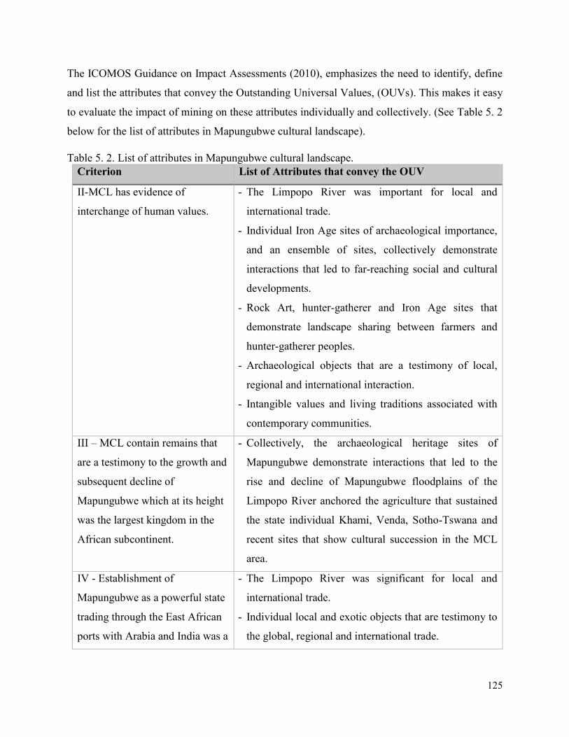
125
The ICOMOS Guidance on Impact Assessments (2010), emphasizes the need to identify, define
and list the attributes that convey the Outstanding Universal Values, (OUVs). This makes it easy
to evaluate the impact of mining on these attributes individually and collectively. (See Table 5. 2
below for the list of attributes in Mapungubwe cultural landscape).
Table 5. 2. List of attributes in Mapungubwe cultural landscape.
Criterion List of Attributes that convey the OUV
II-MCL has evidence of
interchange of human values.
- The Limpopo River was important for local and
international trade.
- Individual Iron Age sites of archaeological importance,
and an ensemble of sites, collectively demonstrate
interactions that led to far-reaching social and cultural
developments.
- Rock Art, hunter-gatherer and Iron Age sites that
demonstrate landscape sharing between farmers and
hunter-gatherer peoples.
- Archaeological objects that are a testimony of local,
regional and international interaction.
- Intangible values and living traditions associated with
contemporary communities.
III – MCL contain remains that
are a testimony to the growth and
subsequent decline of
Mapungubwe which at its height
was the largest kingdom in the
African subcontinent.
- Collectively, the archaeological heritage sites of
Mapungubwe demonstrate interactions that led to the
rise and decline of Mapungubwe floodplains of the
Limpopo River anchored the agriculture that sustained
the state individual Khami, Venda, Sotho-Tswana and
recent sites that show cultural succession in the MCL
area.
IV - Establishment of
Mapungubwe as a powerful state
trading through the East African
ports with Arabia and India was a
- The Limpopo River was significant for local and
international trade.
- Individual local and exotic objects that are testimony to
the global, regional and international trade.
126
significant stage in the history of
the sub-continent.
- The Limpopo flood plans host elephants which were
hunted for ivory.
- Natural landscape, rivers, valleys, and mountains.
V – The remains in the
Mapungubwe cultural landscape
graphically illustrate the impact
of climate change and record the
growth and then decline of the
kingdom of Mapungubwe as a
clear record of a culture that
became vulnerable to irreversible
change.
- The ensemble of archaeological heritage sites,
collectively, demonstrates the interactions that led to the
rise and decline of Mapungubwe.
- Floodplains of the Limpopo River anchored the
agriculture that sustained the state.
5.3.5 Factors affecting the Mapungubwe Cultural Landscape
There are a number of factors affecting the conservation and management of the Mapungubwe
cultural landscape. These include the following: infrastructure development, intensive agriculture,
natural disasters, and mining. However, the effect of mining development had been emphasized in
this thesis.
i. Infrastructure Development
Infrastructure development is one of the major factors that cause the destruction of the
archaeological sites. The removal of topsoil during access road construction, mining and other
earth removing events destroys the heritage sites. In the MCL, there has been an increase in game
farming in the recent years. Game view trails expose top soil thus placing sites at risk. The
construction of infrastructure for tourism also exposes the soil. Open cast mining and other
developments produce dust which affects the rock art sites around the landscape.
ii. Intensive Agriculture
The Shansi-Limpopo area is well-known for large-scale, intensive commercial agriculture which
has an effect of destroying the heritage sites. There is still some mechanized agriculture within the
Mapungubwe cultural landscape. There is also citrus plantations inside Vele Colliery. Activities
involving mechanized agriculture generate considerable dust whose effect on the rock art has so
far not been quantified.
127
iii. Natural Disasters
Rainfall is one of the major threat to the integrity of the Mapungubwe cultural landscape. Although
the middle Limpopo region receives little rainfall, occasionally it gets large amounts of rainfall
which cause considerable gully erosion and which create badlands. Rainfall washes away the top
soil, disturbing archaeological remains, and their associated contexts. The soil erosion caused by
rainfall exposes artifacts making it easier for them to be looted. Periodic flooding has also been
happening in the middle-Limpopo during the last and current century, and it is thought that some
sites within the Limpopo floodplain have been buried under sediment. Uncontrolled vegetation
growth causes the destruction of sites. Tree roots grow through archaeological contexts thereby
disturbing them by moving artifacts, features, and structures. Natural and human-induced fires
have also destroyed ground cover thereby exposing sites to conditions that promote erosion. All
sites located in areas with grass and woodland are under threat of fire.
iv. Mining Development
Mining potential in Mapungubwe cultural landscape is due to rich mineral deposits primarily coal
and diamonds. The South African Department of Mineral Resources has provided some mining
companies’ exploration rights as the quality of the coal found in the region is high. Mining projects
supported by the regional and national government on the South African potion of the cultural
World Heritage landscape of Mapungubwe has recently caused a huge controversy as they
negatively affect the landscape (Carruthers 2006). There are two mines in the greater Mapungubwe
landscape, namely the Vele Colliery and Venetia Mine. Vele Mine is currently not operational
whilst the plant is modified in order to produce different coking and thermal coal products. Venetia
diamond mine is in operational. These mining operations have different negative effects on the
protection and management of the cultural landscape.
Venetia Diamond Mine
The Venetia diamond mine is situated on a 3000 hectares stretch of land in the Vhembe District of
Limpopo province. It is located approximately 25km south of the core of the Mapungubwe World
Heritage Cultural Landscape. The mine was commissioned in 1992, and the World Heritage listing
was done in 2003, hence it took into consideration the existence of Venetia Mine and its associated
operational auxiliary infrastructure and asset that were there (MMCL 2003).
128
Venetia Mine is currently operating as an open pit diamond mine and has been since 1992. To
ensure the sustainability of the mine and to optimize the extraction of the diamondiferous
kimberlite ore, the mine has been converted to an underground operation. This ‘expansion’ is more
accurately defined as a change in mining method from the conventional open-pit mining method
to an underground mining method. Due to the depth of the current open pit, and the fact that it will
be un-economical to mine at a depth exceeding 400m, a decision was made to change the mining
method to an underground operation. It was reported that this change in mining method will not
increase the size of the current disturbed mining footprint and will have a significant impact on the
reduction in the amount of waste rock that is generated from mining. The stripping ratio of the
underground mine is estimated to be 50 tonnes of ore to 1 tonne of waste, which is significantly
less waste than the open pit mining methods.
The underground mining method requires certain infrastructure to be constructed to access the
diamond bearing ore underground. The development site for the underground infrastructure was
chosen due to its proximity to the open pit and the main kimberlite resources. The current disturbed
mining area equates to 2200 hectares and the underground development site is approximately 27
hectares. The underground site has been constructed in a previously disturbed area and consisted
of vertical shafts and a decline shaft. Once the ore is mined underground, it is brought to the surface
where it is treated through the current treatment plant, and both mineral residue facilities handle
the course and fine residues without exceeding the current mine boundaries.
A number of feasibility studies have been carried out as part of the requirement by the South
African government before embarking on any new development outside the already issued
operational licenses. These studies comprised of; Concept studies in 2008, a Pre-feasibility study
in 2009 and Feasibility studies in 2010. As part of the feasibility studies, Environmental Impact
Assessment (EIA) studies and Environmental Management Programme (EMP) studies were also
conducted and these included the required specialist studies on the biophysical and socioeconomic
conditions of the study area and stakeholder engagement and public participation. As part of the
EIA and EMP authorization for the underground mining project, a Heritage Impact Assessment
study was also undertaken. Subsequent to the submission of the different reports, relevant
environmental authorizations were issued.
129
It has also been noted that the Venetia Mine owns and operates various infrastructures related to
the pumping and conveyance of water to the mine within the Mapungubwe World Heritage
Cultural Landscape. With the change in mining method, there have been no further requirements
for the increase in water consumption at the mine, therefore, the current infrastructure within the
Mapungubwe cultural landscape is servicing the underground mine as well. The main consumer
of water on the mine is the treatment plant, where the kimberlite ore is crushed and washed to
liberate the diamonds, the underground mine is using the same treatment plant thus no increase of
water was required.
Vele Colliery Coal Mine
An Australian company, Coal of Africa Limited (CoAL) has recently been given a go-ahead to
begin construction of an opencast and underground coal mine called the Vele coal mine. The mine
is located 5.6 km to the east of the Mapungubwe Cultural Landscape (MCL) World Heritage Site
and bordering directly with the World Heritage Site buffer zone. As indicated in the Vele Mine’s
Environmental Management Programme (EMP), 50% of the mine’s west pit will overlap the view-
shed protection area around the Mapungubwe Cultural Landscape.
5.4 Chapter Summary
This chapter has provided an overview of the two World Heritage cultural landscapes case studies
that have been used in the research in order to generate data for the thesis. This includes Mulanje
Mountain Cultural Landscape in Malawi, a site on the UNESCO World Heritage Tentative List,
and Mapungubwe Cultural Landscape in South Africa, a site listed as a UNESCO World Heritage
cultural landscape. A general background of Mulanje Mountain and Mapungubwe cultural
landscapes has been provided. This is in terms of their historical, geographical, and social-cultural
background of the two landscapes. Thereafter, an overview of the attributes and significance of
the landscapes has been discussed and compared between the two cultural landscapes. This is in
terms of the cultural heritage attributes of the landscapes and the associated intangible values
attached. The last part of the chapter has presented some of the factors affecting the conservation
and management of each cultural landscapes with a detailed discussion of the mining development
as a specific threat being investigated and affecting the conservation and management of cultural
landscapes in most parts of sub-Saharan African countries.
130
The information generated from the analysis of the case studies has been a basis for the
development of the integrated management planning methodological framework that has been
suggested in this thesis, (see chapter 8 for a detailed discussion). This has helped to contextualize
the landscape and assess the interaction which is there between the local communities and the
natural environment.
The next chapter to follow will present the detailed results of the field research carried out in
Mulanje Mountain and Mapungubwe cultural landscapes, investigating the perceptions of local
people and other stakeholders on issues concerning mining, conservation, and management of
cultural landscapes. The focus was on understanding how local people and other stakeholders
perceive issues of mining and heritage conservation in cultural landscapes.
131
CHAPTER SIX
6 PERCEPTIONS OF LOCAL PEOPLE AND OTHER STAKEHOLDERS ON
PROTECTION OF CULTURAL LANDSCAPES
6.1 Introduction
In this chapter, perceptions of local people and other stakeholders on issues concerning mining
and management of cultural landscapes have been presented. The focus has been on an
understanding of how local people and other stakeholders perceive issues of mining and heritage
conservation in cultural landscapes. Specific areas of investigation included examination of levels
of awareness from different types of stakeholders on issues concerning protection of cultural
landscapes which are at risk of mining development; local people’s involvement on decision-
making on issues to do with management of cultural landscapes; identification of different types
of stakeholders and their role in the conservation and management of different aspects of cultural
landscapes; and an assessment of conflicting interests among different stakeholders on the
utilization of resources of cultural landscapes. Therefore, this chapter has broadly been organized
in three parts. The first part has discussed the general perception of local people, followed by an
identification of key stakeholders and their views on mining and cultural landscape. The final part
has discussed community involvement as a key aspect in cultural landscape management and
possible conflicting interests among stakeholders.
6.2 Valuing Cultural Landscapes from Local People’s Perspective
In Chapter 5 of this thesis, a detailed review of the attributes and values of Mulanje and
Mapungubwe cultural landscapes has been discussed. Further to understanding key aspects of the
landscapes, a participatory ethnographic research was carried out among local people and other
stakeholders. The aim was to solicit their views and perceptions in order to understand and properly
plan the effective use and management of cultural landscapes. According to the general views of
local people, it has been observed that not all aspects and features of cultural landscapes are
significant to them. Various community groups and other stakeholders value the landscape
differently.
132
However, almost all local people interviewed in Mulanje and Mapungubwe cultural landscapes,
respect their cultural landscapes and the ancestral spirits which they believe are residing there.
They consider the surrounding spaces and the landscapes in general as their homes. To them home
refers to the broader landscapes which they have a traditional territorial claim and it gives them an
identity as a community with strong socio-cultural values closely linked to the surrounding
environment. Therefore the proposed management planning framework in this thesis has
integrated this traditional viewpoint as a crucial aspect in order to safeguard the local cultural
identity in times of mining development. Any mining development project that will not integrate
these community perceptions will be in conflict and interference with some of the socio-cultural
values associated with these cultural landscapes.
The research has therefore revealed that most of the local people who participated in the interviews
and focus group discussions had negative views about mining in and or around cultural landscapes,
arguing that their ancestors will not be happy and it will desecrate the sacredness of these
landscapes. However, there were other individuals from the local groups who argue that mining is
important because it provides job opportunities within their rural communities.
6.3 Stakeholders Identification and Consultations.
Stakeholder identification is key before implementing the proposed management planning
framework in cultural landscapes. Determining who will be stakeholder representatives is very
important when planning for mining development initiatives in cultural landscapes. Ideally, each
stakeholder groups should be allowed to determine their own representatives, and efforts must be
made to ensure that representatives of all groups are included, (Phoya 2018). During the research,
some of the relevant stakeholders concerned with mining development and conservation of cultural
landscapes were engaged and consulted. This was considered an important process to ensure that
a wide range of stakeholders had inputs in the integrated strategic planning methodological
framework that has been developed through this research.
Most African cultural landscapes are living heritage sites with multiple stakeholders. Identifying
these different stakeholders with a stake in the management and utilization of the resources of
cultural landscapes was one of the tasks of this research project. In this thesis, the concept of
stakeholder has been broadly defined as anyone associated with cultural landscapes or issues
133
related to it, (Smith 2009). Under this broad definition, the concept of stakeholder encompass any
person, group or organisations with one of the following characteristics: has an interest or concern
or stake in the situation, issue, or will be fundamentally affected by outcomes of the mining on
cultural landscapes; has power or authority, or may otherwise be needed to implement any outcome
or solution as regards to mining and heritage conservation; may try to undermine the mining
development projects or landscape conservation issues if not meaningfully involved; or has
resources to contribute to the mining development process and cultural landscape conservation
programmes, (Smith 2009).
In this research, some of these stakeholders have been identified and representatives interviewed
in order to understand their perceptions and views on the proper management of the landscapes in
times of mining development projects. Different stakeholders attribute different interests, values,
and identities which are considered important to them. In order to clearly articulate and incorporate
the views and ideas of all stakeholders who participated in the research, a combined focus-group-
discussions and interviews were used to collect relevant data from the targeted case studies. Four
levels of stakeholder groups were identified and consulted (see Table 6. 1). These include
government agencies, mining companies, and local communities, especially those with land claims
in the area, non-governmental organizations and civil society groups. It has been observed that all
these stakeholders have different perceptions, interests, values, and belief systems as regards to
utilization of the natural and cultural resources of the targeted landscapes. According to Jawahar
and Mclaughlin (2001), they have defined stakeholder engagement as a process in which
individuals, groups, organizations, and associations are actively involved in setting goals,
formulating and evaluating policies and planning and implementing the programs concerning
cultural landscapes.
One of the challenges encountered in the identification of stakeholders was mainly on choosing
legitimate stakeholders with a direct stake on issues of cultural landscapes. Therefore a stakeholder
situational analysis was conducted in order to identify and select the right stakeholders to be
interviewed. Careful consideration of the identification was done to avoid leaving out core
stakeholders or including stakeholders perceived as illegitimate on issues to do with mining and
cultural heritage protection. The stakeholder engagement process has been integrated into the
management framework which has been discussed in detail in chapter 7. The framework has
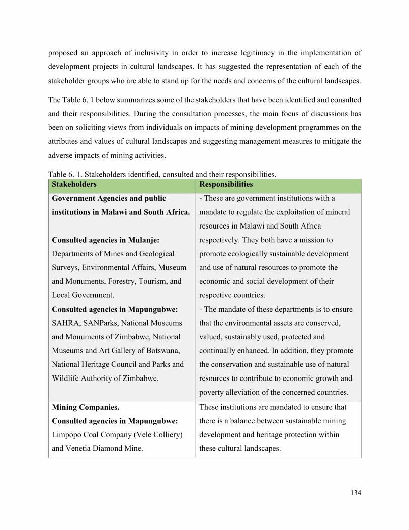
134
proposed an approach of inclusivity in order to increase legitimacy in the implementation of
development projects in cultural landscapes. It has suggested the representation of each of the
stakeholder groups who are able to stand up for the needs and concerns of the cultural landscapes.
The Table 6. 1 below summarizes some of the stakeholders that have been identified and consulted
and their responsibilities. During the consultation processes, the main focus of discussions has
been on soliciting views from individuals on impacts of mining development programmes on the
attributes and values of cultural landscapes and suggesting management measures to mitigate the
adverse impacts of mining activities.
Table 6. 1. Stakeholders identified, consulted and their responsibilities.
Stakeholders Responsibilities
Government Agencies and public
institutions in Malawi and South Africa.
Consulted agencies in Mulanje:
Departments of Mines and Geological
Surveys, Environmental Affairs, Museum
and Monuments, Forestry, Tourism, and
Local Government.
Consulted agencies in Mapungubwe:
SAHRA, SANParks, National Museums
and Monuments of Zimbabwe, National
Museums and Art Gallery of Botswana,
National Heritage Council and Parks and
Wildlife Authority of Zimbabwe.
- These are government institutions with a
mandate to regulate the exploitation of mineral
resources in Malawi and South Africa
respectively. They both have a mission to
promote ecologically sustainable development
and use of natural resources to promote the
economic and social development of their
respective countries.
- The mandate of these departments is to ensure
that the environmental assets are conserved,
valued, sustainably used, protected and
continually enhanced. In addition, they promote
the conservation and sustainable use of natural
resources to contribute to economic growth and
poverty alleviation of the concerned countries.
Mining Companies.
Consulted agencies in Mapungubwe:
Limpopo Coal Company (Vele Colliery)
and Venetia Diamond Mine.
These institutions are mandated to ensure that
there is a balance between sustainable mining
development and heritage protection within
these cultural landscapes.
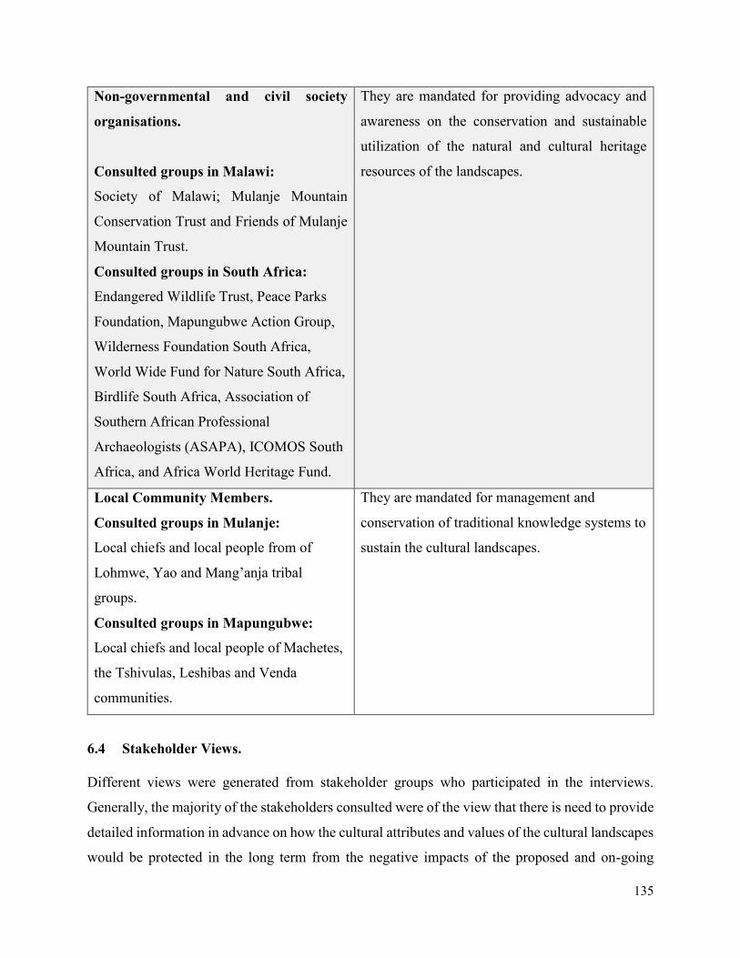
135
Non-governmental and civil society
organisations.
Consulted groups in Malawi:
Society of Malawi; Mulanje Mountain
Conservation Trust and Friends of Mulanje
Mountain Trust.
Consulted groups in South Africa:
Endangered Wildlife Trust, Peace Parks
Foundation, Mapungubwe Action Group,
Wilderness Foundation South Africa,
World Wide Fund for Nature South Africa,
Birdlife South Africa, Association of
Southern African Professional
Archaeologists (ASAPA), ICOMOS South
Africa, and Africa World Heritage Fund.
They are mandated for providing advocacy and
awareness on the conservation and sustainable
utilization of the natural and cultural heritage
resources of the landscapes.
Local Community Members.
Consulted groups in Mulanje:
Local chiefs and local people from of
Lohmwe, Yao and Mang’anja tribal
groups.
Consulted groups in Mapungubwe:
Local chiefs and local people of Machetes,
the Tshivulas, Leshibas and Venda
communities.
They are mandated for management and
conservation of traditional knowledge systems to
sustain the cultural landscapes.
6.4 Stakeholder Views.
Different views were generated from stakeholder groups who participated in the interviews.
Generally, the majority of the stakeholders consulted were of the view that there is need to provide
detailed information in advance on how the cultural attributes and values of the cultural landscapes
would be protected in the long term from the negative impacts of the proposed and on-going
136
mining operations in the two cultural landscapes. The feedback generated from these consultation
processes has helped to develop a strategic management planning methodological framework
which has been suggested in this thesis. The subsequent paragraphs below summarize the various
viewpoints from the key stakeholders identified above.
6.4.1 Government Institutions
The views from government officials who participated in the research stressed on the need to
ensure that local communities are fully and meaningfully involved in the protection of the cultural
landscapes and other activities associated with the mining development. Majority of these public
officials also felt that the most effective way to manage elements of cultural landscapes was to
relate them to a broader landscape and not treat them as individual elements. They also emphasized
the need to have a clear buffer zone determined by a full participation of all concerned
stakeholders. Some officials from SAHRA also highlighted the need for clear policies to regulate
development given that some mining licenses were granted for areas lying next to heritage places
such as Leokwe Hill. While one government official interviewed, said that there is a management
committee responsible for overseeing the operations of the mining development around
Mapungubwe. Membership of this committee includes community leaders as representatives.
6.4.2 Mining Agencies
Responding to the interview questionnaire, most of the officials working with mining companies
emphasized on the need to balance heritage conservation and economic development. In the case
of Mapungubwe cultural landscape, they indicated that a memorandum of understanding has been
signed between the South African government and mining companies committing to sound
heritage conservation and environmental stewardship. An environmental management committee
comprising of various stakeholders from the local communities, action groups and government
institutions have also been established.
6.4.3 Civil Society and Non-Governmental Organisations
The members of the civil society and non-governmental organizations who participated in the
research emphasized on the importance of a sound and sustainable heritage stewardship. They also
pointed out that large-scale infrastructural development like mining usually has negative impacts
on the spirits of the cultural landscapes. Most of them agreed that working together for a common
cause is more constructive than fighting. They also reiterated on the issues of restrictive and
137
ineffective regulations, whereby most of the laws used are outdated and they do not take into
consideration the traditional management systems. In general, almost all of them acknowledged
that these cultural landscapes are important places to the local community and humanity in general.
In Mulanje Mountain cultural landscape, for example, the interview responses from some members
of the civil society organizations revealed that at some point in time they took a court injunction
restraining further mineral exploratory activities within the mountain due to the concern of the
mining exploration activities on the environment. The main concerns raised were on issues of
water pollution, destruction of trees, issues of dust and destruction of the cultural values and
heritage resources.
6.4.4 Local Community Members
Most of the local people who were interviewed expressed their concern about the development of
large-scale mining activities in Mapungubwe and Mulanje cultural landscapes. The landowners in
different villages felt that they have not been fully involved in the developments and mining
activities around these cultural landscapes, hence they requested to be actively involved as well.
Other groups lauded the employment opportunities associated with mining but emphasized that
their culture and traditional values need to be preserved as well. They also lamented that allowing
mining to proceed in most part of the landscapes will limit them access to their ancestral heritage.
Some of the local communities also commented that active heritage protection will assist in
reviving their indigenous knowledge systems which also helps to protect the environment through
traditional laws. There were, however, some community members who were not sure of how they
could contribute to a process led by government institutions. They feel that as owners and
custodians of cultural landscapes, they should lead and decide what development programmes are
sustainable for their areas. In Mapungubwe cultural landscape, for example, the local community
members who were against mining development activities expressed concern on how they were
forcibly removed from the land and denied access to different parts of the landscape which is
associated with their ancestors. They also expressed concern of monopoly and imbalances in the
appropriation of benefits from the proceeds of the mining. While others claimed that some
government officials have been supporting the expansion of mining activities in the area because
of personal benefits compromising with the conservation of the traditional values and sacredness
of the area.
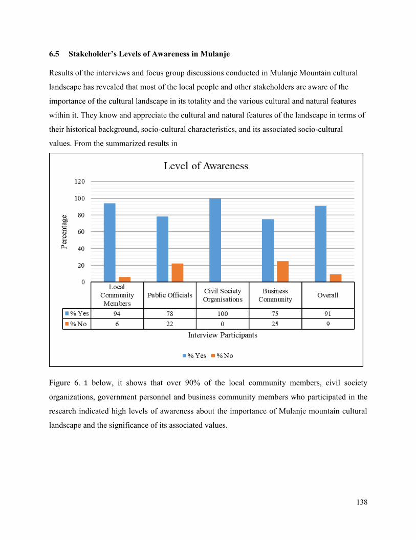
138
6.5 Stakeholder’s Levels of Awareness in Mulanje
Results of the interviews and focus group discussions conducted in Mulanje Mountain cultural
landscape has revealed that most of the local people and other stakeholders are aware of the
importance of the cultural landscape in its totality and the various cultural and natural features
within it. They know and appreciate the cultural and natural features of the landscape in terms of
their historical background, socio-cultural characteristics, and its associated socio-cultural
values. From the summarized results in
Figure 6. 1 below, it shows that over 90% of the local community members, civil society
organizations, government personnel and business community members who participated in the
research indicated high levels of awareness about the importance of Mulanje mountain cultural
landscape and the significance of its associated values.
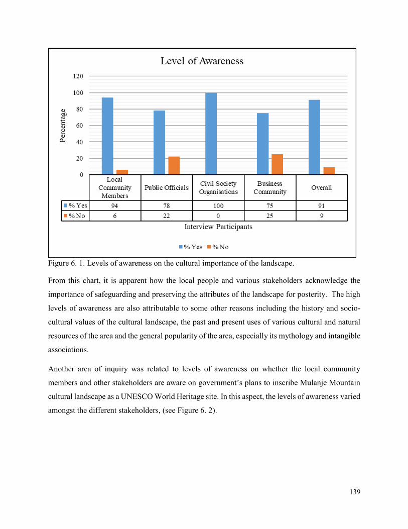
139
Figure 6. 1. Levels of awareness on the cultural importance of the landscape.
From this chart, it is apparent how the local people and various stakeholders acknowledge the
importance of safeguarding and preserving the attributes of the landscape for posterity. The high
levels of awareness are also attributable to some other reasons including the history and socio-
cultural values of the cultural landscape, the past and present uses of various cultural and natural
resources of the area and the general popularity of the area, especially its mythology and intangible
associations.
Another area of inquiry was related to levels of awareness on whether the local community
members and other stakeholders are aware on government’s plans to inscribe Mulanje Mountain
cultural landscape as a UNESCO World Heritage site. In this aspect, the levels of awareness varied
amongst the different stakeholders, (see Figure 6. 2).
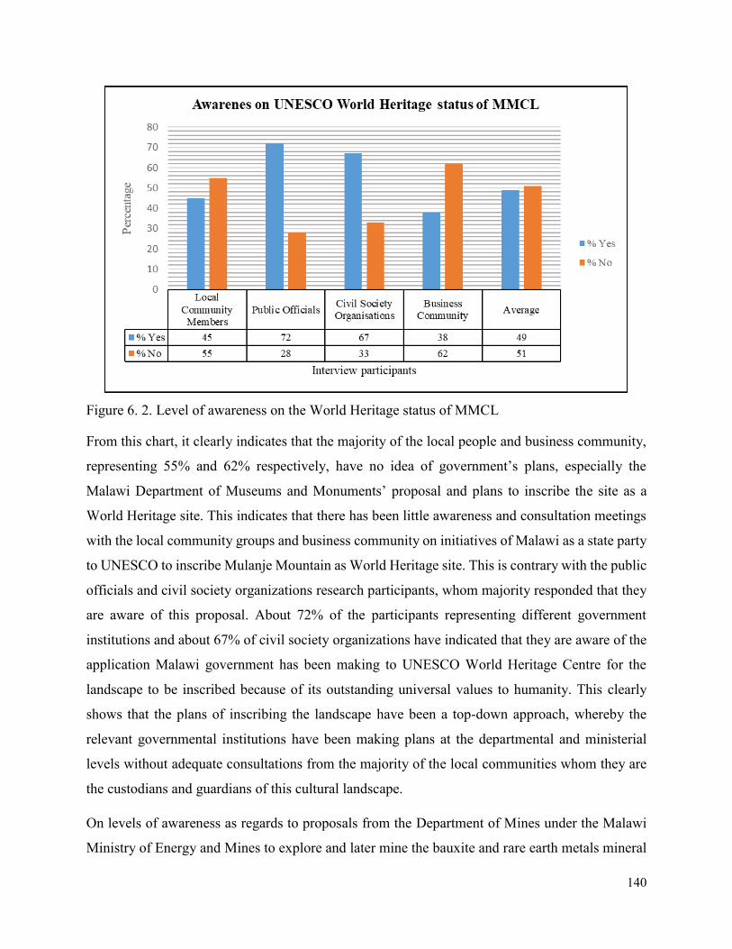
140
Figure 6. 2. Level of awareness on the World Heritage status of MMCL
From this chart, it clearly indicates that the majority of the local people and business community,
representing 55% and 62% respectively, have no idea of government’s plans, especially the
Malawi Department of Museums and Monuments’ proposal and plans to inscribe the site as a
World Heritage site. This indicates that there has been little awareness and consultation meetings
with the local community groups and business community on initiatives of Malawi as a state party
to UNESCO to inscribe Mulanje Mountain as World Heritage site. This is contrary with the public
officials and civil society organizations research participants, whom majority responded that they
are aware of this proposal. About 72% of the participants representing different government
institutions and about 67% of civil society organizations have indicated that they are aware of the
application Malawi government has been making to UNESCO World Heritage Centre for the
landscape to be inscribed because of its outstanding universal values to humanity. This clearly
shows that the plans of inscribing the landscape have been a top-down approach, whereby the
relevant governmental institutions have been making plans at the departmental and ministerial
levels without adequate consultations from the majority of the local communities whom they are
the custodians and guardians of this cultural landscape.
On levels of awareness as regards to proposals from the Department of Mines under the Malawi
Ministry of Energy and Mines to explore and later mine the bauxite and rare earth metals mineral
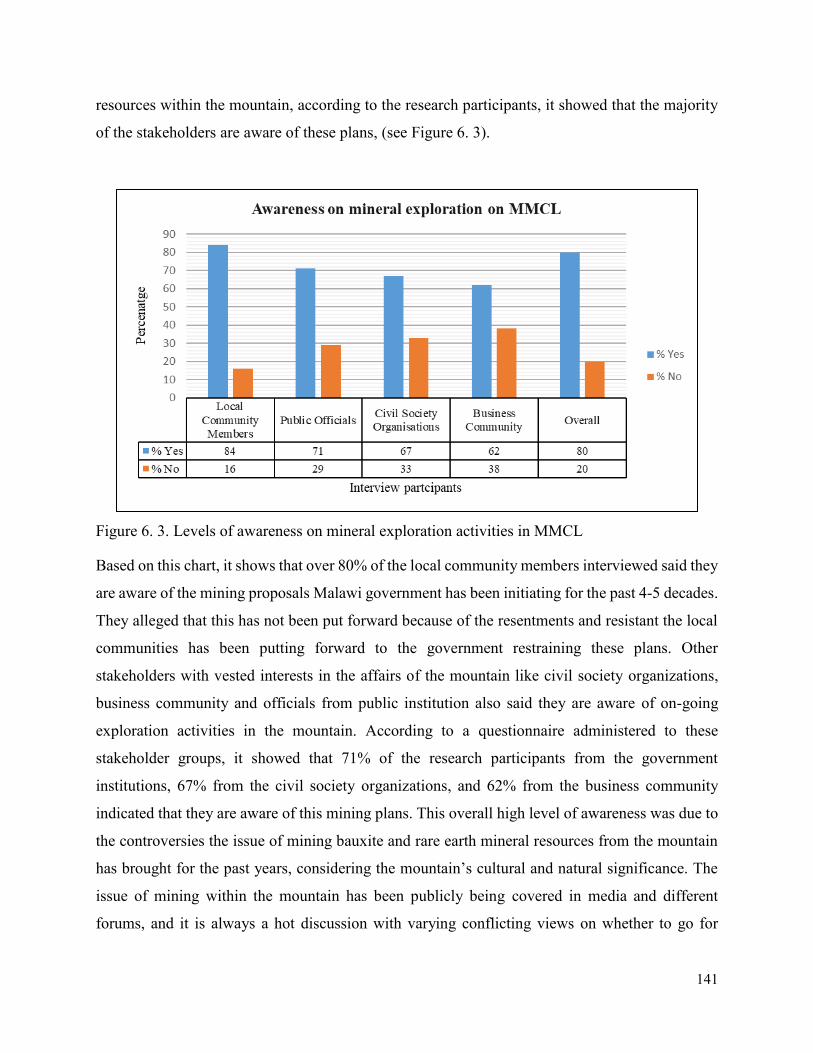
141
resources within the mountain, according to the research participants, it showed that the majority
of the stakeholders are aware of these plans, (see Figure 6. 3).
Figure 6. 3. Levels of awareness on mineral exploration activities in MMCL
Based on this chart, it shows that over 80% of the local community members interviewed said they
are aware of the mining proposals Malawi government has been initiating for the past 4-5 decades.
They alleged that this has not been put forward because of the resentments and resistant the local
communities has been putting forward to the government restraining these plans. Other
stakeholders with vested interests in the affairs of the mountain like civil society organizations,
business community and officials from public institution also said they are aware of on-going
exploration activities in the mountain. According to a questionnaire administered to these
stakeholder groups, it showed that 71% of the research participants from the government
institutions, 67% from the civil society organizations, and 62% from the business community
indicated that they are aware of this mining plans. This overall high level of awareness was due to
the controversies the issue of mining bauxite and rare earth mineral resources from the mountain
has brought for the past years, considering the mountain’s cultural and natural significance. The
issue of mining within the mountain has been publicly being covered in media and different
forums, and it is always a hot discussion with varying conflicting views on whether to go for
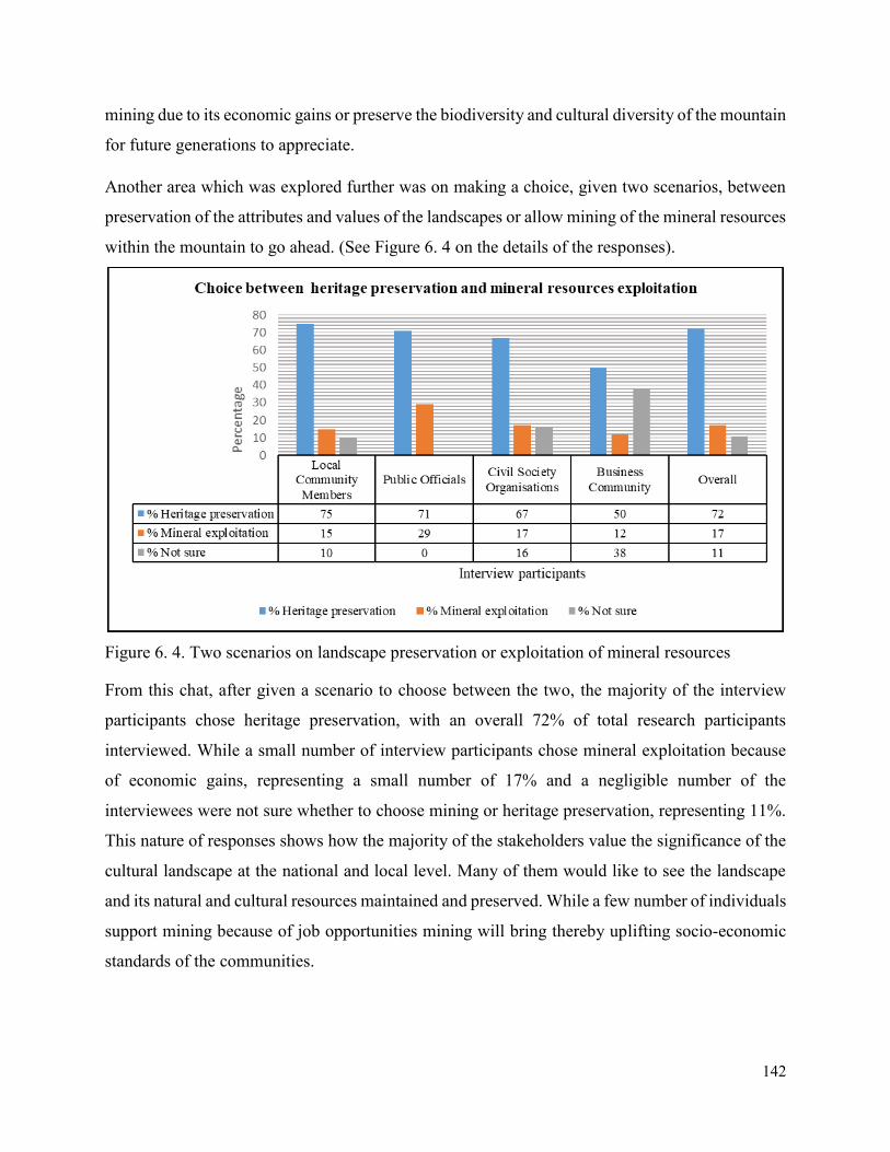
142
mining due to its economic gains or preserve the biodiversity and cultural diversity of the mountain
for future generations to appreciate.
Another area which was explored further was on making a choice, given two scenarios, between
preservation of the attributes and values of the landscapes or allow mining of the mineral resources
within the mountain to go ahead. (See Figure 6. 4 on the details of the responses).
Figure 6. 4. Two scenarios on landscape preservation or exploitation of mineral resources
From this chat, after given a scenario to choose between the two, the majority of the interview
participants chose heritage preservation, with an overall 72% of total research participants
interviewed. While a small number of interview participants chose mineral exploitation because
of economic gains, representing a small number of 17% and a negligible number of the
interviewees were not sure whether to choose mining or heritage preservation, representing 11%.
This nature of responses shows how the majority of the stakeholders value the significance of the
cultural landscape at the national and local level. Many of them would like to see the landscape
and its natural and cultural resources maintained and preserved. While a few number of individuals
support mining because of job opportunities mining will bring thereby uplifting socio-economic
standards of the communities.
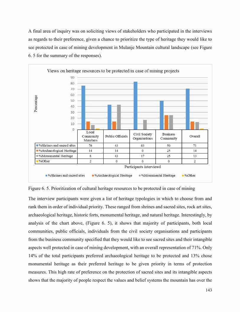
143
A final area of inquiry was on soliciting views of stakeholders who participated in the interviews
as regards to their preference, given a chance to prioritize the type of heritage they would like to
see protected in case of mining development in Mulanje Mountain cultural landscape (see Figure
6. 5 for the summary of the responses).
Figure 6. 5. Prioritization of cultural heritage resources to be protected in case of mining
The interview participants were given a list of heritage typologies in which to choose from and
rank them in order of individual priority. These ranged from shrines and sacred sites, rock art sites,
archaeological heritage, historic forts, monumental heritage, and natural heritage. Interestingly, by
analysis of the chart above, (Figure 6. 5), it shows that majority of participants, both local
communities, public officials, individuals from the civil society organisations and participants
from the business community specified that they would like to see sacred sites and their intangible
aspects well protected in case of mining development, with an overall representation of 71%. Only
14% of the total participants preferred archaeological heritage to be protected and 13% chose
monumental heritage as their preferred heritage to be given priority in terms of protection
measures. This high rate of preference on the protection of sacred sites and its intangible aspects
shows that the majority of people respect the values and belief systems the mountain has over the
144
years. Most of the people are symbolically connected to the landscape through these traditional
sacred sites, therefore, if they can be lost through mining, they feel that part of their heritage has
been lost as well.
6.6 Discussion of Local People and other Stakeholders Perceptions
A synthesis of all the information gathered was done to generalize and identify the impact of
mining development projects on the integrity of cultural landscapes. A number of interview
recordings, questionnaires, and field notes were analyzed and interpreted to highlight the impact
of proposed and on-going mining activities in the case studies. Particular importance was attached
to the analysis of all conservation reports and management plans of the two case studies in order
to understand the trends and extent of impacts on the values and attributes that convey the
significance of these landscapes.
According to the local people interviewed, the majority of them associated mining activities with
negativities. These included its contributions to land degradation, deforestation, and destruction of
cultures and community values. While some community members interviewed have associated
mining with strange illnesses and some with even deaths in the communities with environmental
pollution from mining activities, particularly the seepage of poisonous chemicals into water
bodies, (Hayford 2008). Other people interviewed also feel that the corresponding damage of
mining operations to the cultural landscape and the environment in general and its effects on the
local communities far outweigh the benefits derived from it.
There has also been a general concern as regards the widespread tension between mining
companies which has been given mining licenses in the cultural landscape and the local people
over the destruction of the trees in Mulanje Mountain itself and the general disregard of the rights
of the local people by most mining companies. This is similar in other African cultural landscapes
that have been destroyed, for example in Ghana, the mining communities complained that most of
the mining companies do not employ local people, and they prefer labor from the other areas
(Nyamekye 2012). However, it has been reported that it is the local people that bear the brunt of
their activities, for example, mining activities, particularly surface mining, has resulted in the
alienation of large tracts of land from communities, depriving poor and marginalized communities
of their land surface rights, and as a result depriving many communities of their sources of
145
livelihood (Akabzaa 2009). Other local people’s views were based on their experiences from what
happened in other mining sites. They raised concern that mining companies do not pay adequate
compensation to affected local communities for them to relocate to other areas and uplift their
standard of living. There was also a mention of noise pollution which will affect the ancestral
spirits in the Mulanje Mountain. This will be caused by blasting of the rocks in the mountain.
Many people also mentioned the cracks in the local buildings and houses because of the rock
blasting.
The views gathered in Mapungubwe were also similar to those of Mulanje. Here, it was revealed
that an opposition group consisting of local community members, local landowners, non-
governmental and civil society organizations had objected all industrial mining activities in that
part of the very sensitive Limpopo Valley without an approved Integrated Regional Development
Plan. The group lodged an appeal to address the serious shortcomings of the Environmental
Management Programme (EMP) which was prepared by Vele Coal mine. The appeal attempted to
prevent further damage to this environmentally sensitive and culturally important environment for
all South Africans. According to the opposing group, they noted serious flaws in the application,
which included inadequate consultations with the local communities around the area about the
mining and its impact on the environment as stipulated by law.
It was observed that the Environmental Management Plan (EMP) which was developed failed to
take into account the mine’s location within a sensitive cultural landscape. It failed to recognize
the cumulative impacts that future developments will have on the area. Among others:
- The EMP lacked information regarding the heritage resources and paleontological remains
at risk of destruction in the area; it failed to consider the rock art in the area and other
heritage sites.
- There were no definite commitments towards rehabilitation for biodiversity and the EMP
made wrong assumptions about the possibility of rehabilitation of ecosystems and species.
It made no reference to invertebrate species and hardly any to reptiles and amphibians.
- The true impact of dust was absent from the EMP and it did not factor in the impact of
night-time mining. At the same time, the EMP did not consider the full extent of the
negative visual impacts of mining.
146
- Mapungubwe cultural landscape as a World Heritage site offers a significant source of
income through ecotourism and farming which cannot be replaced by the alleged benefits
of mining.
The opposing group also noted that occasionally mining companies indicate misleading
employment figures, for example, figures such as 30,000 job opportunities to be rolled out by
mining operation often do not come to fruition. The facts are, as quoted from the Vele Mine’s
Environment Management Plan, the mine will employ 826 permanent employees resulting in an
impact on the direct livelihood of approximately 1495 people. After 29 years (being the
approximate lifespan of a coal mine), the employment opportunities will end.
Whilst, in the tourism sector at least 700 permanent jobs currently existed in the core of the
Mapungubwe Transfrontier Conservation Area (TFCA) and the conservative estimated direct jobs
to be created within the TFCA over the next 15 years amounts to 3,904 direct jobs. These
employment opportunities are sustainable and the environment will continue to contribute towards
the GDP of the country for the benefit of future generations.
Some interview respondents mentioned that the destruction of the cultural landscape through the
coal mining operation will be permanent. Even if it will be rehabilitated, it will not be transformed
back to its original form. It is also impossible to fully rehabilitate any disturbed area 100% and
certainly, with the resources set aside by most mining companies to do this, there was clearly no
intention to even try in some cases. In addition, they emphasized that, once water has been used
up, it cannot be re-created. Once the dust has affected the ancient rock paintings, they cannot be
revived. Once heritage sites have been destroyed, they cannot be re-created. Therefore, the term
‘rehabilitation’ is usually thrown around without full appreciation for what this means or what it
entails.
The interviews respondents also cited other examples on the negative impact of mining operations
in South Africa related to waste management issues, for instance, the acid mine drainage crisis
which is currently facing Gauteng, as an evidence of how decisions taken for the sake of
‘development’ are ill-informed in terms of the long-term consequences. They said they cannot
afford to keep making these same errors when faced with new development plans that clearly
benefit a few over the short term as opposed to many over the long term. They have indicated that
147
they are not against mining but certain areas should not be sacrificed for short-term gains at the
cost of a sustainable future.
In addition to waste management issues, they also said that mines also pose environmental and
social challenges due to potential disruptions to ecosystems and local communities. Mining
requires access to land and natural resources, such as water, which may compete with other land
uses (Ashton et al 2001). Although the size of most mining operations is small compared to other
land uses, for example, industrial agriculture and forestry, mining companies are limited by the
location of economically viable reserves, some of which may overlap with sensitive ecosystems
or traditional indigenous community lands.
Although mineral exports may make up a significant share of a country’s exports, mineral
development does not always boost a country’s economic growth and may, in some cases,
contribute to increased poverty (Sideri and Johns 1980; Auty 1990; Ross 2001; Gelb et al 1988).
The reasons for the lack of economic growth in mineral dependent states are not entirely conclusive
(Ross 1999). However, low levels of employment in the sector, use of mostly imported technology,
high market volatility of minerals, competition with agricultural sectors, and institutional
corruption and mismanagement may be contributing factors (Sideri and Johns 1990; Gelb et al
1988; Auty 1990). In addition, lack of full cost accounting result in overestimating the benefits of
subsidies offered to the mining sector is not taken into account.
6.6.1. Conflicting Interests on Use and Management of Cultural Landscapes
One of the notable challenges mentioned during the field research was the lack of community
involvement and conflicting interests on issues to do with management, use and protection of the
natural and cultural heritage resources of the landscape. Generally, almost all of the stakeholders
interviewed agreed on the conflicting regulations and other aspects, for example, the traditional
management systems against laws and contemporary management systems. The decisions made
in cultural landscapes often favor the economic interests of most governments instead of affected
local communities, which in most cases result in conflicts. These conflicting interests and
contentions have been noted in all the cultural landscapes which were investigated.
Although there have been promises of job opportunities and national economic growth through
these mining plans, however, based on other experiences from some mining projects, most
148
interview participants pointed out that the benefits of mining are not always equitably shared, and
local communities near mining sites are the ones who suffer most. In some cases, mining has
provided jobs in an otherwise economically marginal area (Redwood 1998). However, typically
these jobs are limited in number and duration. In addition, communities that came to depend on
mining to sustain their economies are especially vulnerable to negative social impacts especially
when the mines close. According to a study by Kuyek and Coumans (2003) on mining
communities, they reported that mining tends to raise wage levels, leading to the displacement of
some community residents and existing businesses and elevated expectations. Mining may also
trigger indirect negative social impacts, such as alcoholism, prostitution, and sexually transmitted
diseases, (Miranda et al 1998)
As discussed above, the management and protection of cultural landscapes involve multiple
stakeholders, such as government institutions, local communities, civil society organizations,
developers and associated business enterprises. According to Friedman and Miles (2002) on their
publication on developing stakeholder theory, they assert that these parties usually have conflicting
interests which hinder sustainable development in case of most cultural landscapes. The conflicts
between various stakeholders about the utilization of the various resources of the landscapes and
about the issue of resource equity often have a direct effect on the sustainable management of
cultural landscapes.
As observed from the interaction amongst the various stakeholders who participated in the
research, it was noted that almost all of them had different perspectives and perceptions about the
significance of cultural landscapes and the attributes and values they convey. These differences
usually lead to tension. Some disagreements among stakeholders involve utilization of resources
of the landscape and disagreements on which values of cultural landscapes to be preserved and
recognized (Myers et al. 2009).
Mayers et al (2009) suggested some of the issues that lead to tensions in cultural landscape
conservation. These include tensions between conservation of attributes and values of landscapes
against other national interests and agendas, including governance, economic development, and
environmental protection. Secondly, issues related to the recognition of traditional communities
and their heritage, including an understanding of heritage values, cultural worldviews, access,
ownership and use issues, and interpretation. Thirdly, in contested cultural landscapes, especially
149
where there is conflict over heritage values or different cultural or religious groups also cause
conflicts. And finally, Mayer et al (2009) also mentioned issues about how heritage conservation
and management is undertaken, especially disputes over methods, principles, and interventions,
and practices that fail to engage key stakeholders. All these are some of the key reasons why there
are always some conflicting interests in the management and proper utilization of the resources of
the landscapes. Understanding these factors that lead to tensions have led to the better development
of the strategic planning methodological framework that has been proposed in this thesis.
Management and negotiation strategies have been integrated into the framework as well.
As it has been observed, all cultural landscapes have multiple players with distinct roles in the
management of different aspects of the sites. This often results in conflicting approaches and
opinion as regards to the protection and management of these landscapes. Cultural landscapes
reflect multiple cultural connections and meanings. Coexistence of these connections is usually
problematic, which usually lead to actions that have negative impacts on the values of the
landscapes. For example, in the case of the interviews conducted in these two cultural landscapes,
it has been observed that public officials were prioritizing the conservation of the tangible heritage
with high economic significance in terms of tourism while most of the local communities valued
the sacred heritage and their intangible aspects as more important.
It has also been observed that most cultural landscapes in African are used for traditional spiritual
purposes, usually by small and minority groups. These traditional minority groups see these
landscapes and specific natural features within it as symbols of their cultural identity. This
therefore always triggers disputes over ownership of the entire landscape and meanings it conveys.
In some instances, these have led to conflicts leading to significant damage to the entire landscapes
and values associated with it. The best remedy is to respect the values and belief systems of these
local communities. As ICOMOS (2002) has highlighted in its Ethical Commitment Statement, that
a fundamental part of value-based heritage management is to understand the heritage values held
by different groups within a society and by the society as a whole. Ignoring or denying the heritage
values of a group with close and enduring associations with a place is both unacceptable.
Therefore, it can be argued that specific heritage values attributed to different cultural landscapes
most often are the basis for disputes, with different cultural groups and stakeholders presenting
claims for or against certain values. Sometimes this simply reflects different perspectives on
150
connections to cultural landscapes, for example, some local people may regard sacred traditional
pools as places of spiritual significance, whereas mining developers may appreciate its feasible
location for mining development due to closeness to a source of water. If all the values in cultural
landscapes are recognized well in advance, the dispute can easily be mitigated. But if one heritage
is acknowledged and others rejected, conflicts can easily erupt. According to the Burra Charter,
(Australia ICOMOS 2016, Articles 15 and 16), it recognizes that there are connections or
associations between people and a place that may include social or spiritual values and cultural
responsibilities. In this aspect, mining developers should be aware that most cultural landscapes
signify and express important meanings through local people’s experience in relation to their
environment. To ignore such connections may adversely impact the cultural identity, human
dignity, and well-being of individuals, families and cultural groups of most of these cultural
landscapes. The result maybe conflicts which may reduce the likelihood of an effective heritage
planning process.
It has also been observed that disagreements in management and use of natural and cultural
resources of cultural landscapes arise when right local people with a close attachment to the
spiritual and traditional values of the landscape have not been consulted. Most often, these people
are the ones which mobilize others not to accept proposed development projects, leading to tension
between developers and these local community groups. Subsequently, when two different groups
of people, local people, and developers, are in conflict, it is the landscape attributes and values that
most of the times are at risk. Therefore, adequate local people’s engagement and consultation
processes are very essential in landscape planning and management.
Another typical dispute is among stakeholders who are pro-development and those who are pro-
conservation of cultural landscapes. These two types of stakeholders are likely to argue their
respective cases from different perspectives, making common ground hard to find. When mining
development projects have been proposed in cultural landscapes, it usually favors the merits of
economic benefits against the benefits of landscape conservation. In such cases, conflict arises
when values of cultural landscapes and economic values come head to head. Tensions between
cultural landscape conservation advocates and stakeholders with economic interests related to
extraction of mineral resources are common in most heritage places. Therefore, the proposed
integrated strategic management planning methodological framework that has been proposed
151
through this research has tried to solve this challenge. The fact that most developers are likely to
argue their case from an economic discourse focusing on the commercial value of heritage and on
the other hand local people argues in relation to local identity, the framework has tried to bridge
the gap to amicably negotiate these conflicting perspectives. The possibility of achieving solutions
that will sustain both economic and heritage conservation outcomes is the most desirable one. This
will only be achieved through the application of the proposed integrated management planning
methodological framework discussed in Chapter 8.
6.6.2. Community Participation in Cultural Landscape Management
The protection of cultural landscapes through traditional management systems necessitates that the
local community participates in decision making as regard to the issues of cultural landscapes and
in the implementation of those decisions (Mumma 2000). Community participation has two
components; a right of access to information and a right to be consulted in decision-making.
According to Albert Mumma, (2000), he noted that most conventional legal regimes usually
restrict the availability of information to the local communities. Surprisingly, this has turned most
local communities to be passive observers to issues of mining development projects happening in
their cultural landscapes. Therefore, in the integrated strategic management planning framework
which has been developed through this research, it has suggested the inclusion of adequate
communication platform to ensure that the local communities have right of access to information
related to mining development issues.
It has also been observed that most local people within and surrounding cultural landscapes are
rarely involved in the critical stages of planning, implementation, and closure of mining
developments. Their interests, values and belief systems are rarely taken into account in the
implementation of mining decisions in most heritage places (Abungu and Githitho 2000).
Therefore, it has been suggested in the integrated planning framework to give priority to local
communities to participate in decision-making processes, in terms of, active consultation,
information sharing, and capacity building. It has already been discussed that mining development
projects in most cultural landscapes usually lead to changes in traditional values due to socio-
economic changes in society, which affects cohesion and values of local communities (Abungu
and Githitho 2000).
152
The exploitation of mineral resources from the cultural landscapes must not be carried out at the
expense of socio-cultural values of local communities. Mining development and conservation of
cultural landscapes has been integrated into the proposed integrated management planning
framework as a measure to achieve sustainable development. The key objective of this proposed
framework has been to strengthen cultural landscape conservation and its management, at the same
time to develop the local economies through mining development in such a way that the local
communities, national government, and developers benefit through the income from mining
proceeds. There is a close interaction between conservation activities of the landscape and
development activities, one supporting the other. It has been suggested that implementation of new
mining exploratory activities should not affect certain attributes and values of cultural landscapes
that were initially integral to the nomination of the landscape (Abungu and Githitho 2000).
Management planning should incorporate elements which conserve the spirit of the relationship
between man and the general landscape.
Marie Stenseke (2008) reviewed a research on community participation and she summarized the
following aspects in effective local people’s participation; power relations, active participants,
effective intuitional frameworks, positive communication, knowledge and capacity building,
monitoring and contextual factors. According to the review, she found that trust, communication,
and local influence are the vital ingredients in a participatory approach (Stenseke 2008). These
factors have therefore been integrated into the proposed management planning methodological
framework discussed in Chapter 8. Communication and co-management with local people are
some of the areas of competences for managers of cultural landscapes to achieve sustainable
management and use of cultural landscape resources. The concern to involve local people in
cultural landscape management and planning is also explicitly expressed in the convention on
biodiversity (1991), and the European landscape convention (Council of Europe 2000), and the
Aarhus convention (UNECE, 1998).
According to the findings of this research, it has also been observed that there is a gap between the
decisions made by cultural landscape decision makers at a government level and the decisions
made by the local people at a community level on some aspects of landscape management and
protection. This has prompted this research to single out some of the elements that have been
integrated into the proposed management planning methodological framework. Most decisions
153
made on conservation and management of the resources of the landscape are top-down. Therefore,
in the proposed framework, this has been reconsidered and changed, to make the approach of
decision-making more interactive and bottom-up. This is similar to ideas of Thackway and Olsson
(1999) who claimed that integration of community aspirations for the conservation of biodiversity
and cultural diversity in cultural landscapes, should ensure that there is a sustainable use of natural
and cultural resources, thereby ensuring long-term maintenance of their ecological functions. In
her research overview, Zachrisson (2004) identified a number of advantages for increased public
involvement. These included a reduction of conflicts, a more flexible and efficient management,
increased legitimacy, and an implied better use of place-specific knowledge.
As noted above, local participation appears to be a promising strategy for cultural landscape
management and planning. The understanding and conceptualizations of ‘local participation’, has
been used to describe anything from information sharing through communication between
government agencies and local people about policies and regulations about the aspects of cultural
landscapes. According to Pimbert and Pretty (1997), they have described four possible forms of
local participation in cultural landscape management. These included minimal participation,
which consists of minimal information sharing or consultation, the managers or developers define
the problems and solution for cultural landscape without obligations to integrate local people’s
views. The second one is participation for material incentives in which people participate by
providing resources such as labor or access, in return for material incentives. The third one is
interactive participation where local people participate in the joint analysis of issues and action
plans to do with the conservation and management of cultural landscapes. The last one is self-
mobilization in which local people take initiatives independent of external institutions as regards
to use and protection of cultural landscapes.
Ineffective and irresponsible implementation of local people’s participation in decision-making
might lead to conflict in most societies within and around cultural landscapes, with long-term
effects on collaboration amongst community members and developers. The application of the
integrated management planning framework has emphasized the integration of community
participation as a prerequisite for conservation and management of cultural landscapes in times of
development. Through this research, successful factors and challenges in the involvement of local
154
communities have been assessed in the two case studies in order to help develop and understand
the application of the framework.
Selman (2004) suggested stakeholder commitment as one important aspect of heritage
management planning. He made a distinction between capacity-driven participants, who have
economic interests, for example on some aspects of the landscape, and commitment-driven
participants, who mainly achieve something from the cultural landscape. Furthermore, distinctions
have been proposed between communities-of-interest, and communities-of-place, (Selman 2004).
The former relates to interest groups, while the latter relates to local communities. He also
differentiates special communities, like farming communities in the area, from general
communities, which include all inhabitants. Community involvement in cultural landscape
management is also better favored in complex social systems, linking together stakeholders at
various levels in society, than by only independent local groups in action (Olsson 2003). However,
it has to be clear that when seeking to implement an effective management system in cultural
landscapes, there is a need to have a broad participation of all relevant stakeholders (Zachrisson
2004). It has therefore been observed that partnership and active stakeholder involvement
including local communities, the private sector, and civil society organizations, are key to the
success of the implementation of the proposed management planning framework. At the same
time, it has to be understood that not everyone is interested or has the time to get involved in issues
concerning conservation and management of natural and cultural resources of the landscape.
Some of the problems of participatory approaches in cultural landscape conservation and
management are communication issues. Luz (2000) in his study on landscape planning in Bavaria,
Germany has also identified similar communication challenges. Among others, these included
weaknesses in communication and withholding of environmental and cultural information by
responsible public institutions. According to information gathered from the field, it has been
reported that when environmental and cultural heritage information is collected through scientific
efforts, it is rarely passed on to local people in a comprehensive way. Another challenge between
different stakeholders is regarding differences in perception and evaluation of impacts of
development initiatives in cultural landscapes. For example, most developers are seldom aware
that their perception of the resources of the cultural landscapes always differs from those of the
local people because of poor channels of communication between the two stakeholders. In
155
addition, previous negative experiences of various other development projects affect decision
making and attitudes towards new development initiatives. According to Brown et al (2004) they
assert that knowledge and learning is the most important aspect of understanding cultural
landscapes. They noted that the acceptance of various sources of knowledge and various forms of
knowledge is a key to understanding cultural landscapes. They emphasized that knowledge
generated by experience and in local context should be seen at par with scientific knowledge
(Brown et al 2004; Pinto-Correia et al 2006).
6.7 Chapter Summary
The chapter provided the results of the perceptions of local people and other stakeholders on issues
concerning mining and conservation of cultural landscapes. The focus was on understanding how
local people and other stakeholders perceive issues of mining and heritage conservation in African
cultural landscapes. A participatory ethnographic research was carried out among local people and
other stakeholders in the targeted case studies. The aim was to solicit their views and perceptions
in order to understand and properly plan the effective use and management of cultural landscapes.
Specific issues which were investigated included an examination on levels of awareness from
different types of stakeholders on issues concerning the protection of cultural landscapes which
are at risk of mining development and also on how local people got involved in decision-making.
Further to this, relevant stakeholders were identified and their roles in the conservation and
management of different aspects of cultural landscapes were discussed. It was revealed that
stakeholder identification is a key before implementing any development projects in cultural
landscapes. Determining who will be a stakeholder representative is very important when planning
for mining development initiatives in cultural landscapes.
Therefore, based on the results of this chapter, it was concluded that most of the local people and
other stakeholders who participated in the research were aware of the importance of the cultural
landscapes in their totality and the various cultural and natural features within it. In the next chapter
seven, the second results from the last objective of the study will be presented. This comprises of
the results from the assessment of the effectiveness of the management planning framework of
Mapungubwe cultural landscape in achieving the UNESCO strategic objectives and also protecting
the attributes and values of the landscape.
156
CHAPTER SEVEN
7 RESULTS ON ASSESSMENT OF EFFECTIVENESS OF MANAGEMENT
PLANNING FRAMEWORK
7.1 Introduction
This chapter has provided results of the assessment of the 2013-18 management planning
framework for Mapungubwe cultural landscape. The chapter has been broadly subdivided into
three parts. The first part is the detailed results of the review of the management plan for
Mapungubwe cultural landscape. The management planning framework was evaluated in order to
assess how effective it was in achieving the strategic objectives of the UNESCO’s strategic action
plan for the implementation of the World Heritage Convention 2012-2022. These include
credibility, conservation, capacity-building, communication, and community involvement, in short
commonly known as the 5Cs. These strategic objectives were adopted in 2002 at the World
Heritage Committee’s 26th meeting held in Budapest, Hungary, and were enlarged to encompass
‘communities’ in 2007 at the World Heritage Committee’s 31st meeting held in New Zealand,
(UNESCO 2015).
Further to this, the chapter has also provided results of the content analysis of the management
planning framework. The focus is on the presentation of the extent of the integration of various
dimensions of the management planning instrument into the management planning system of the
cultural landscape. These include; situational analysis, strategic orientation, organizational
structure, stakeholders identity, participation scope and participation continuity. These dimensions
have been adopted from Landorf (2009) in her recent publication on ‘developing a framework for
sustainable heritage management’.
The second part is a presentation of the results of the semi-structured interviews and theme
rationalization in relation to the various dimensions that have been used to evaluate the content of
the management planning framework. The semi-structured interview analysis has contributed to a
holistic understanding of the landscape and also supported data from the management plan.
157
7.2 Review of Management Plan for Mapungubwe Cultural Landscape (2013-2018)
The Mapungubwe World Heritage cultural landscape has a management plan as part of the
requirement of the World Heritage Convention which requires States Parties to integrate the
protection of heritage into some form of planning framework, (UNESCO 2016). The Operational
Guidelines also require States Parties to provide a management plan as part of the World Heritage
nomination and periodic reporting processes. Unlike the World Heritage Convention, the
Operational Guidelines are non-statutory which limits the enforceability of such requirement. The
Operational Guidelines go on to acknowledge that management systems vary across World
Heritage sites, but the common elements are participatory management and a cycle of ‘planning,
implementation, monitoring, evaluation, and feedback, (UNESCO 2016: Article 111). In addition
to identifying how the protection, conservation, and presentation of a World Heritage Site should
be managed, management plans provide key indicators for measuring the ongoing state of
conservation. These indicators form a basis for the six-yearly system of periodic reporting to the
World Heritage Committee.
The initial analysis of the Mapungubwe cultural landscape has revealed that the landscape is
managed by a multiple of organizations. These organizations included land property owners,
government agencies and non-governmental organizations, each with an interest in different
aspects of the cultural landscape. However, the roles and responsibilities of these various
organizations are not well articulated in the management plan document. The plan also has no
details on whether there are any formalized agreements in place between the organizations and
other stakeholders in the management of the landscape. It also lacks a clear and detailed
mechanism in relation to community involvement and participation.
In terms of the structure, the Mapungubwe World Heritage cultural landscape has generally
followed the three-part configuration and four linear planning process as proposed by Feilden and
Jokilehto (1998) in the Management Guidelines for World Cultural Heritage Sites. This
management guideline document provides useful definitions of conservation concepts including
authenticity, historical stratification, cultural and socio-economic values, and the different
management strategies available to landscape managers. The three-part management plan structure
described in the management guidelines document represents the sequence of activities that is
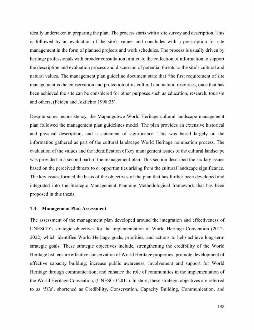
158
ideally undertaken in preparing the plan. The process starts with a site survey and description. This
is followed by an evaluation of the site’s values and concludes with a prescription for site
management in the form of planned projects and work schedules. The process is usually driven by
heritage professionals with broader consultation limited to the collection of information to support
the description and evaluation process and discussion of potential threats to the site’s cultural and
natural values. The management plan guideline document state that ‘the first requirement of site
management is the conservation and protection of its cultural and natural resources, once that has
been achieved the site can be considered for other purposes such as education, research, tourism
and others, (Feiden and Jokilehto 1998:35).
Despite some inconsistency, the Mapungubwe World Heritage cultural landscape management
plan followed the management plan guidelines model. The plan provides an extensive historical
and physical description, and a statement of significance. This was based largely on the
information gathered as part of the cultural landscape World Heritage nomination process. The
evaluation of the values and the identification of key management issues of the cultural landscape
was provided in a second part of the management plan. This section described the six key issues
based on the perceived threats to or opportunities arising from the cultural landscape significance.
The key issues formed the basis of the objectives of the plan that has further been developed and
integrated into the Strategic Management Planning Methodological framework that has been
proposed in this thesis.
7.3 Management Plan Assessment
The assessment of the management plan developed around the integration and effectiveness of
UNESCO’s strategic objectives for the implementation of World Heritage Convention (2012-
2022) which identifies World Heritage goals, priorities, and actions to help achieve long-term
strategic goals. These strategic objectives include, strengthening the credibility of the World
Heritage list; ensure effective conservation of World Heritage properties; promote development of
effective capacity building; increase public awareness, involvement and support for World
Heritage through communication; and enhance the role of communities in the implementation of
the World Heritage Convention, (UNESCO 2011). In short, these strategic objectives are referred
to as ‘5Cs’, shortened as Credibility, Conservation, Capacity Building, Communication, and
159
Communities. See Figure 7. 1 for the structure of strategic action plan and a general fundamental
framework for the implementation of World Heritage Convention.
Figure 7. 1. Structure of the Strategic Action Plan.
Source: UNESCO World Heritage Capacity building programme (2011).
The seven dimensions were assessed. These include the following:
- Situation Analysis dimension - this was used to assess the extent on how the external and
internal influences were identified as a starting point in the planning process. The internal
situation included the state of the cultural landscape values, attributes and the skill base of
staff, while the external situation included trends in legal and policy frameworks.
- The strategic orientation - this was used to evaluate the extent on how the planning process
was either long-term or holistic.
- The credibility dimension was used to evaluate the extent at which the dissemination and
promotion of the core principles of the World Heritage Convention such as outstanding
universal value, integrity, and authenticity were integrated into the management planning
framework of Mapungubwe cultural landscape.
- The conservation dimension was used to evaluate the conservation measures that has been
integrated in the management planning framework of Mapungubwe World Heritage
cultural landscape, including considerations on whether the outstanding universal value of
Credibility
Conservation
Capacity
Communication
Community
World
Heritage
Goals
Priorities
Short-Term
Actions
Medium-Term
Actions
Long-Term
Actions
What?
Who?
When?
Cost?
Successful
Result?
Strategic Orientation
Situation Analysis
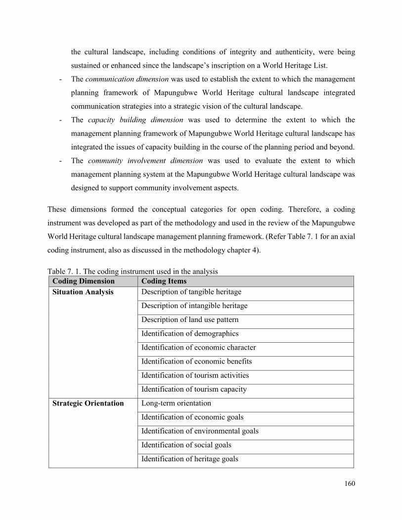
160
the cultural landscape, including conditions of integrity and authenticity, were being
sustained or enhanced since the landscape’s inscription on a World Heritage List.
- The communication dimension was used to establish the extent to which the management
planning framework of Mapungubwe World Heritage cultural landscape integrated
communication strategies into a strategic vision of the cultural landscape.
- The capacity building dimension was used to determine the extent to which the
management planning framework of Mapungubwe World Heritage cultural landscape has
integrated the issues of capacity building in the course of the planning period and beyond.
- The community involvement dimension was used to evaluate the extent to which
management planning system at the Mapungubwe World Heritage cultural landscape was
designed to support community involvement aspects.
These dimensions formed the conceptual categories for open coding. Therefore, a coding
instrument was developed as part of the methodology and used in the review of the Mapungubwe
World Heritage cultural landscape management planning framework. (Refer Table 7. 1 for an axial
coding instrument, also as discussed in the methodology chapter 4).
Table 7. 1. The coding instrument used in the analysis
Coding Dimension Coding Items
Situation Analysis Description of tangible heritage
Description of intangible heritage
Description of land use pattern
Identification of demographics
Identification of economic character
Identification of economic benefits
Identification of tourism activities
Identification of tourism capacity
Strategic Orientation Long-term orientation
Identification of economic goals
Identification of environmental goals
Identification of social goals
Identification of heritage goals
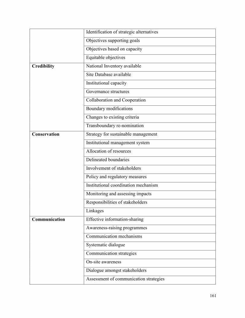
161
Identification of strategic alternatives
Objectives supporting goals
Objectives based on capacity
Equitable objectives
Credibility National Inventory available
Site Database available
Institutional capacity
Governance structures
Collaboration and Cooperation
Boundary modifications
Changes to existing criteria
Transboundary re-nomination
Conservation Strategy for sustainable management
Institutional management system
Allocation of resources
Delineated boundaries
Involvement of stakeholders
Policy and regulatory measures
Institutional coordination mechanism
Monitoring and assessing impacts
Responsibilities of stakeholders
Linkages
Communication Effective information-sharing
Awareness-raising programmes
Communication mechanisms
Systematic dialogue
Communication strategies
On-site awareness
Dialogue amongst stakeholders
Assessment of communication strategies
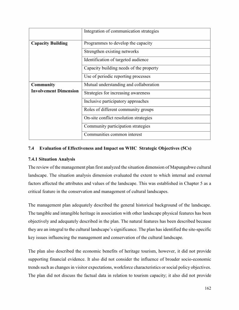
162
Integration of communication strategies
Capacity Building Programmes to develop the capacity
Strengthen existing networks
Identification of targeted audience
Capacity building needs of the property
Use of periodic reporting processes
Community
Involvement Dimension
Mutual understanding and collaboration
Strategies for increasing awareness
Inclusive participatory approaches
Roles of different community groups
On-site conflict resolution strategies
Community participation strategies
Communities common interest
7.4 Evaluation of Effectiveness and Impact on WHC Strategic Objectives (5Cs)
7.4.1 Situation Analysis
The review of the management plan first analyzed the situation dimension of Mapungubwe cultural
landscape. The situation analysis dimension evaluated the extent to which internal and external
factors affected the attributes and values of the landscape. This was established in Chapter 5 as a
critical feature in the conservation and management of cultural landscapes.
The management plan adequately described the general historical background of the landscape.
The tangible and intangible heritage in association with other landscape physical features has been
objectively and adequately described in the plan. The natural features has been described because
they are an integral to the cultural landscape’s significance. The plan has identified the site-specific
key issues influencing the management and conservation of the cultural landscape.
The plan also described the economic benefits of heritage tourism, however, it did not provide
supporting financial evidence. It also did not consider the influence of broader socio-economic
trends such as changes in visitor expectations, workforce characteristics or social policy objectives.
The plan did not discuss the factual data in relation to tourism capacity; it also did not provide
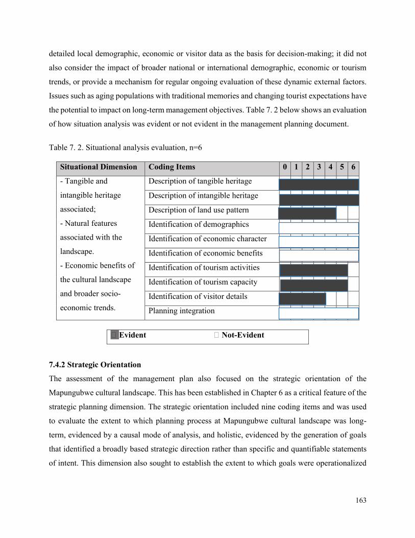
163
detailed local demographic, economic or visitor data as the basis for decision-making; it did not
also consider the impact of broader national or international demographic, economic or tourism
trends, or provide a mechanism for regular ongoing evaluation of these dynamic external factors.
Issues such as aging populations with traditional memories and changing tourist expectations have
the potential to impact on long-term management objectives. Table 7. 2 below shows an evaluation
of how situation analysis was evident or not evident in the management planning document.
Table 7. 2. Situational analysis evaluation, n=6
Situational Dimension Coding Items 0 1 2 3 4 5 6
- Tangible and
intangible heritage
associated;
- Natural features
associated with the
landscape.
- Economic benefits of
the cultural landscape
and broader socio-
economic trends.
Description of tangible heritage
Description of intangible heritage
Description of land use pattern
Identification of demographics
Identification of economic character
Identification of economic benefits
Identification of tourism activities
Identification of tourism capacity
Identification of visitor details
Planning integration
󠆯 Evident 󠆯 Not-Evident
7.4.2 Strategic Orientation
The assessment of the management plan also focused on the strategic orientation of the
Mapungubwe cultural landscape. This has been established in Chapter 6 as a critical feature of the
strategic planning dimension. The strategic orientation included nine coding items and was used
to evaluate the extent to which planning process at Mapungubwe cultural landscape was long-
term, evidenced by a causal mode of analysis, and holistic, evidenced by the generation of goals
that identified a broadly based strategic direction rather than specific and quantifiable statements
of intent. This dimension also sought to establish the extent to which goals were operationalized
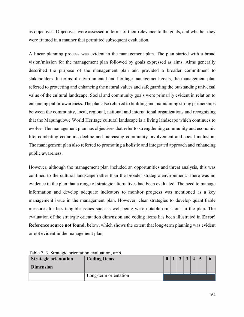
164
as objectives. Objectives were assessed in terms of their relevance to the goals, and whether they
were framed in a manner that permitted subsequent evaluation.
A linear planning process was evident in the management plan. The plan started with a broad
vision/mission for the management plan followed by goals expressed as aims. Aims generally
described the purpose of the management plan and provided a broader commitment to
stakeholders. In terms of environmental and heritage management goals, the management plan
referred to protecting and enhancing the natural values and safeguarding the outstanding universal
value of the cultural landscape. Social and community goals were primarily evident in relation to
enhancing public awareness. The plan also referred to building and maintaining strong partnerships
between the community, local, regional, national and international organizations and recognizing
that the Mapungubwe World Heritage cultural landscape is a living landscape which continues to
evolve. The management plan has objectives that refer to strengthening community and economic
life, combating economic decline and increasing community involvement and social inclusion.
The management plan also referred to promoting a holistic and integrated approach and enhancing
public awareness.
However, although the management plan included an opportunities and threat analysis, this was
confined to the cultural landscape rather than the broader strategic environment. There was no
evidence in the plan that a range of strategic alternatives had been evaluated. The need to manage
information and develop adequate indicators to monitor progress was mentioned as a key
management issue in the management plan. However, clear strategies to develop quantifiable
measures for less tangible issues such as well-being were notable omissions in the plan. The
evaluation of the strategic orientation dimension and coding items has been illustrated in Error!
Reference source not found. below, which shows the extent that long-term planning was evident
or not evident in the management plan.
Table 7. 3. Strategic orientation evaluation, n=6.
Strategic orientation
Dimension
Coding Items 0 1 2 3 4 5 6
Long-term orientation
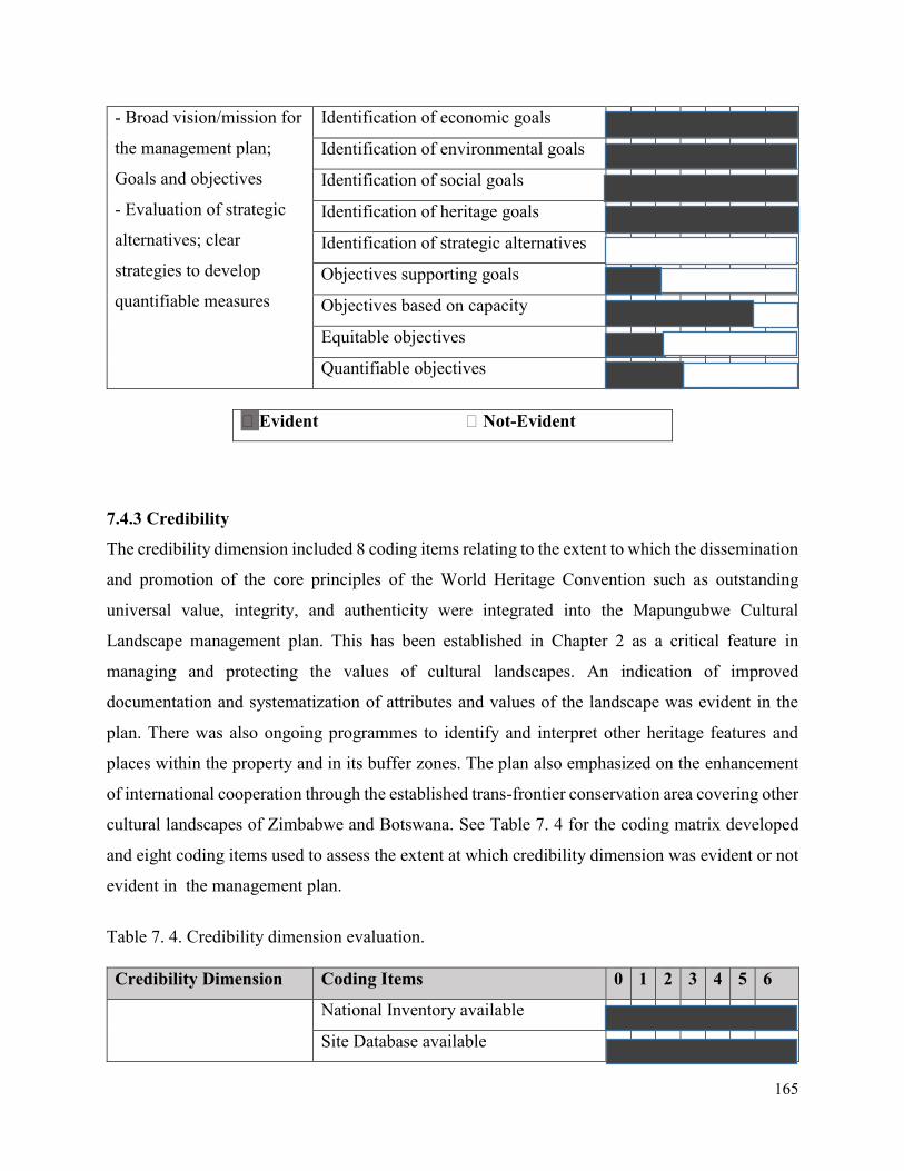
165
- Broad vision/mission for
the management plan;
Goals and objectives
- Evaluation of strategic
alternatives; clear
strategies to develop
quantifiable measures
Identification of economic goals
Identification of environmental goals
Identification of social goals
Identification of heritage goals
Identification of strategic alternatives
Objectives supporting goals
Objectives based on capacity
Equitable objectives
Quantifiable objectives
󠆯 Evident 󠆯 Not-Evident
7.4.3 Credibility
The credibility dimension included 8 coding items relating to the extent to which the dissemination
and promotion of the core principles of the World Heritage Convention such as outstanding
universal value, integrity, and authenticity were integrated into the Mapungubwe Cultural
Landscape management plan. This has been established in Chapter 2 as a critical feature in
managing and protecting the values of cultural landscapes. An indication of improved
documentation and systematization of attributes and values of the landscape was evident in the
plan. There was also ongoing programmes to identify and interpret other heritage features and
places within the property and in its buffer zones. The plan also emphasized on the enhancement
of international cooperation through the established trans-frontier conservation area covering other
cultural landscapes of Zimbabwe and Botswana. See Table 7. 4 for the coding matrix developed
and eight coding items used to assess the extent at which credibility dimension was evident or not
evident in the management plan.
Table 7. 4. Credibility dimension evaluation.
Credibility Dimension Coding Items 0 1 2 3 4 5 6
National Inventory available
Site Database available
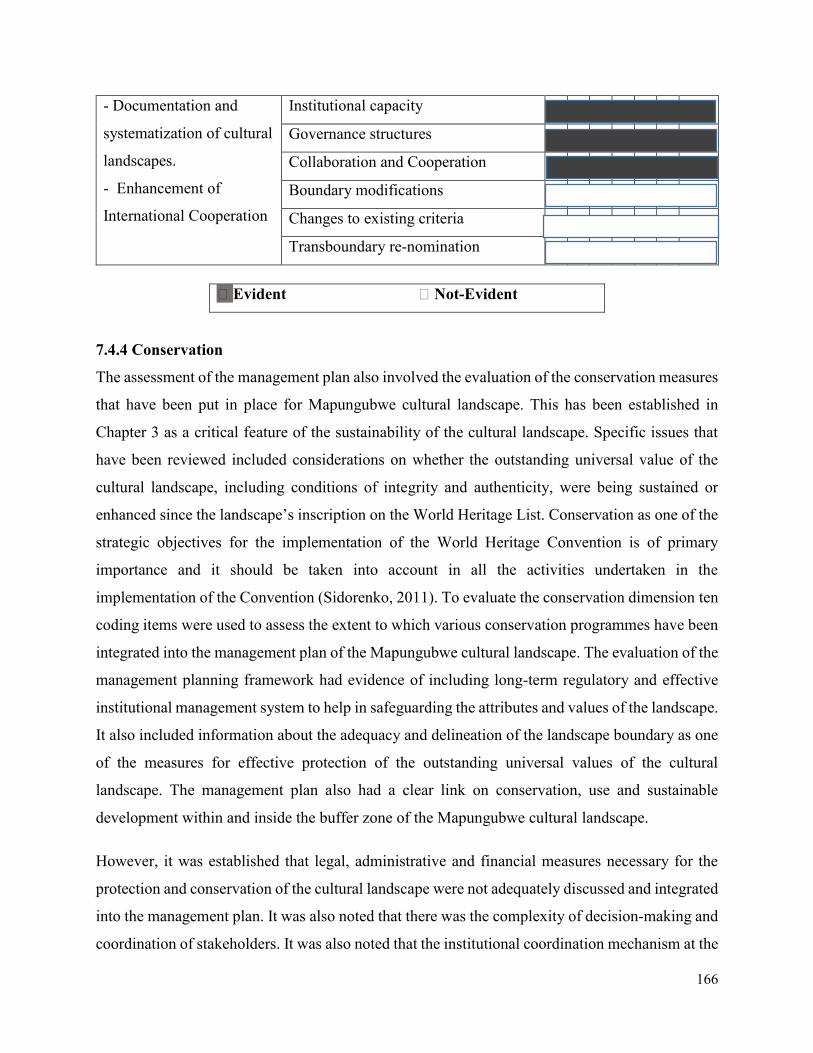
166
- Documentation and
systematization of cultural
landscapes.
- Enhancement of
International Cooperation
Institutional capacity
Governance structures
Collaboration and Cooperation
Boundary modifications
Changes to existing criteria
Transboundary re-nomination
󠆯 Evident 󠆯 Not-Evident
7.4.4 Conservation
The assessment of the management plan also involved the evaluation of the conservation measures
that have been put in place for Mapungubwe cultural landscape. This has been established in
Chapter 3 as a critical feature of the sustainability of the cultural landscape. Specific issues that
have been reviewed included considerations on whether the outstanding universal value of the
cultural landscape, including conditions of integrity and authenticity, were being sustained or
enhanced since the landscape’s inscription on the World Heritage List. Conservation as one of the
strategic objectives for the implementation of the World Heritage Convention is of primary
importance and it should be taken into account in all the activities undertaken in the
implementation of the Convention (Sidorenko, 2011). To evaluate the conservation dimension ten
coding items were used to assess the extent to which various conservation programmes have been
integrated into the management plan of the Mapungubwe cultural landscape. The evaluation of the
management planning framework had evidence of including long-term regulatory and effective
institutional management system to help in safeguarding the attributes and values of the landscape.
It also included information about the adequacy and delineation of the landscape boundary as one
of the measures for effective protection of the outstanding universal values of the cultural
landscape. The management plan also had a clear link on conservation, use and sustainable
development within and inside the buffer zone of the Mapungubwe cultural landscape.
However, it was established that legal, administrative and financial measures necessary for the
protection and conservation of the cultural landscape were not adequately discussed and integrated
into the management plan. It was also noted that there was the complexity of decision-making and
coordination of stakeholders. It was also noted that the institutional coordination mechanism at the
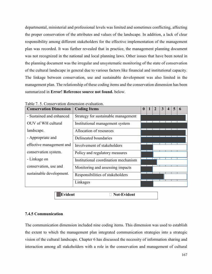
167
departmental, ministerial and professional levels was limited and sometimes conflicting, affecting
the proper conservation of the attributes and values of the landscape. In addition, a lack of clear
responsibility among different stakeholders for the effective implementation of the management
plan was recorded. It was further revealed that in practice, the management planning document
was not recognized in the national and local planning laws. Other issues that have been noted in
the planning document was the irregular and unsystematic monitoring of the state of conservation
of the cultural landscape in general due to various factors like financial and institutional capacity.
The linkage between conservation, use and sustainable development was also limited in the
management plan. The relationship of these coding items and the conservation dimension has been
summarized in Error! Reference source not found. below.
Table 7. 5. Conservation dimension evaluation.
Conservation Dimension Coding Items 0 1 2 3 4 5 6
- Sustained and enhanced
OUV of WH cultural
landscape.
- Appropriate and
effective management and
conservation system.
- Linkage on
conservation, use and
sustainable development.
Strategy for sustainable management
Institutional management system
Allocation of resources
Delineated boundaries
Involvement of stakeholders
Policy and regulatory measures
Institutional coordination mechanism \\\
Monitoring and assessing impacts
Responsibilities of stakeholders
Linkages
󠆯 Evident 󠆯 Not-Evident
7.4.5 Communication
The communication dimension included nine coding items. This dimension was used to establish
the extent to which the management plan integrated communication strategies into a strategic
vision of the cultural landscape. Chapter 6 has discussed the necessity of information sharing and
interaction among all stakeholders with a role in the conservation and management of cultural
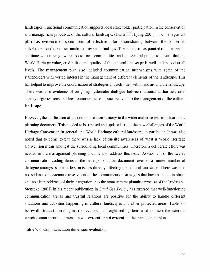
168
landscapes. Functional communication supports local stakeholder participation in the conservation
and management processes of the cultural landscape, (Luz 2000; Ljung 2001). The management
plan has evidence of some form of effective information-sharing between the concerned
stakeholders and the dissemination of research findings. The plan also has pointed out the need to
continue with raising awareness to local communities and the general public to ensure that the
World Heritage value, credibility, and quality of the cultural landscape is well understood at all
levels. The management plan also included communication mechanisms with some of the
stakeholders with vested interest in the management of different elements of the landscape. This
has helped to improve the coordination of strategies and activities within and around the landscape.
There was also evidence of on-going systematic dialogue between national authorities, civil
society organizations and local communities on issues relevant to the management of the cultural
landscape.
However, the application of the communication strategy to the wider audience was not clear in the
planning document. This needed to be revised and updated to suit the new challenges of the World
Heritage Convention in general and World Heritage cultural landscape in particular. It was also
noted that to some extent there was a lack of on-site awareness of what a World Heritage
Convention mean amongst the surrounding local communities. Therefore a deliberate effort was
needed in the management planning document to address this issue. Assessment of the twelve
communication coding items in the management plan document revealed a limited number of
dialogue amongst stakeholders on issues directly affecting the cultural landscape. There was also
no evidence of systematic assessment of the communication strategies that have been put in place,
and no clear evidence of their integration into the management planning process of the landscape.
Stenseke (2008) in his recent publication in Land Use Policy, has stressed that well-functioning
communication arenas and trustful relations are positive for the ability to handle different
situations and activities happening in cultural landscapes and other protected areas. Table 7.6
below illustrates the coding matrix developed and eight coding items used to assess the extent at
which communication dimension was evident or not evident in the management plan.
Table 7. 6. Communication dimension evaluation.
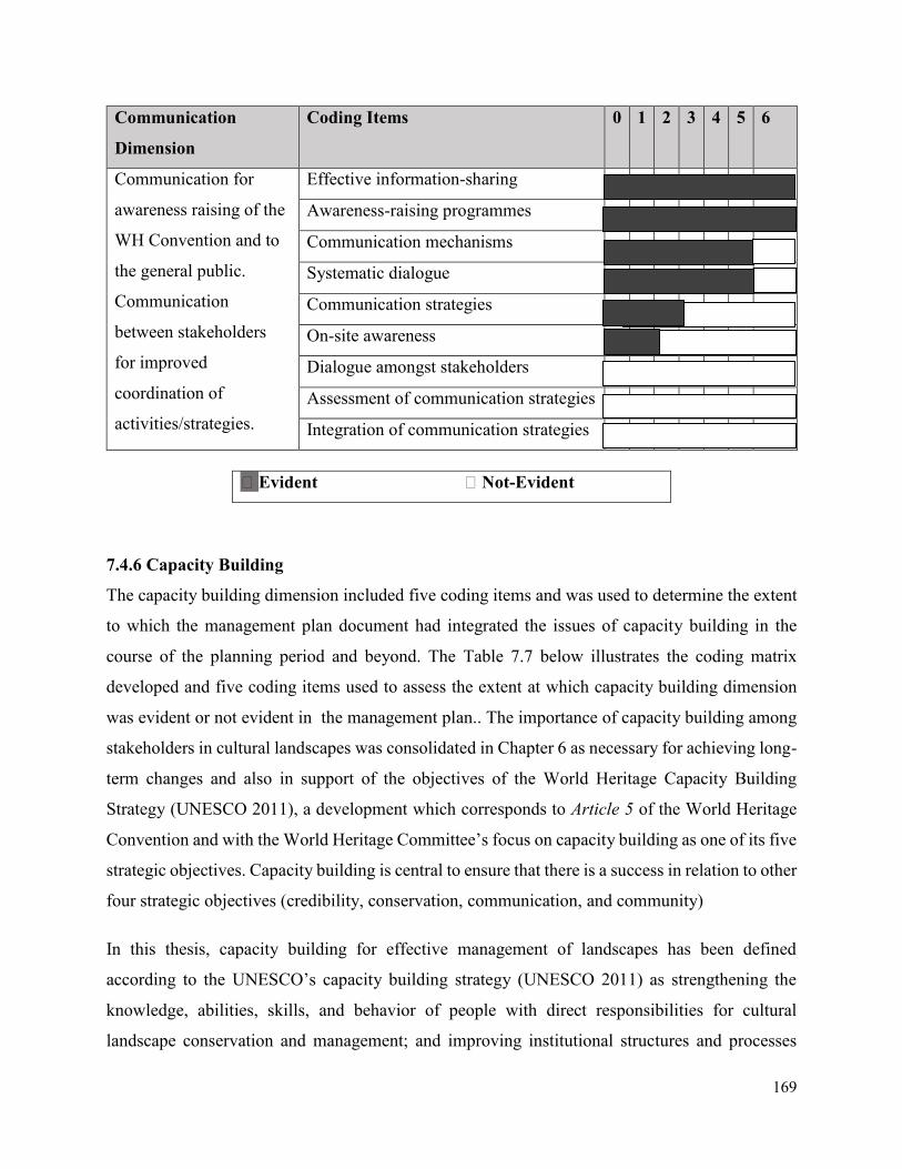
169
Communication
Dimension
Coding Items 0 1 2 3 4 5 6
Communication for
awareness raising of the
WH Convention and to
the general public.
Communication
between stakeholders
for improved
coordination of
activities/strategies.
Effective information-sharing
Awareness-raising programmes
Communication mechanisms
Systematic dialogue
Communication strategies
On-site awareness
Dialogue amongst stakeholders
Assessment of communication strategies
Integration of communication strategies
󠆯 Evident 󠆯 Not-Evident
7.4.6 Capacity Building
The capacity building dimension included five coding items and was used to determine the extent
to which the management plan document had integrated the issues of capacity building in the
course of the planning period and beyond. The Table 7.7 below illustrates the coding matrix
developed and five coding items used to assess the extent at which capacity building dimension
was evident or not evident in the management plan.. The importance of capacity building among
stakeholders in cultural landscapes was consolidated in Chapter 6 as necessary for achieving long-
term changes and also in support of the objectives of the World Heritage Capacity Building
Strategy (UNESCO 2011), a development which corresponds to Article 5 of the World Heritage
Convention and with the World Heritage Committee’s focus on capacity building as one of its five
strategic objectives. Capacity building is central to ensure that there is a success in relation to other
four strategic objectives (credibility, conservation, communication, and community)
In this thesis, capacity building for effective management of landscapes has been defined
according to the UNESCO’s capacity building strategy (UNESCO 2011) as strengthening the
knowledge, abilities, skills, and behavior of people with direct responsibilities for cultural
landscape conservation and management; and improving institutional structures and processes
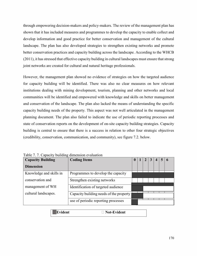
170
through empowering decision-makers and policy-makers. The review of the management plan has
shown that it has included measures and programmes to develop the capacity to enable collect and
develop information and good practice for better conservation and management of the cultural
landscape. The plan has also developed strategies to strengthen existing networks and promote
better conservation practices and capacity building across the landscape. According to the WHCB
(2011), it has stressed that effective capacity building in cultural landscapes must ensure that strong
joint networks are created for cultural and natural heritage professionals.
However, the management plan showed no evidence of strategies on how the targeted audience
for capacity building will be identified. There was also no clear measures on how relevant
institutions dealing with mining development, tourism, planning and other networks and local
communities will be identified and empowered with knowledge and skills on better management
and conservation of the landscape. The plan also lacked the means of understanding the specific
capacity building needs of the property. This aspect was not well articulated in the management
planning document. The plan also failed to indicate the use of periodic reporting processes and
state of conservation reports on the development of on-site capacity building strategies. Capacity
building is central to ensure that there is a success in relation to other four strategic objectives
(credibility, conservation, communication, and community), see figure 7.2. below.
Table 7. 7. Capacity building dimension evaluation
Capacity Building
Dimension
Coding Items 0 1 2 3 4 5 6
Knowledge and skills in
conservation and
management of WH
cultural landscapes.
Programmes to develop the capacity
Strengthen existing networks
Identification of targeted audience
Capacity building needs of the property
use of periodic reporting processes
󠆯 Evident 󠆯 Not-Evident
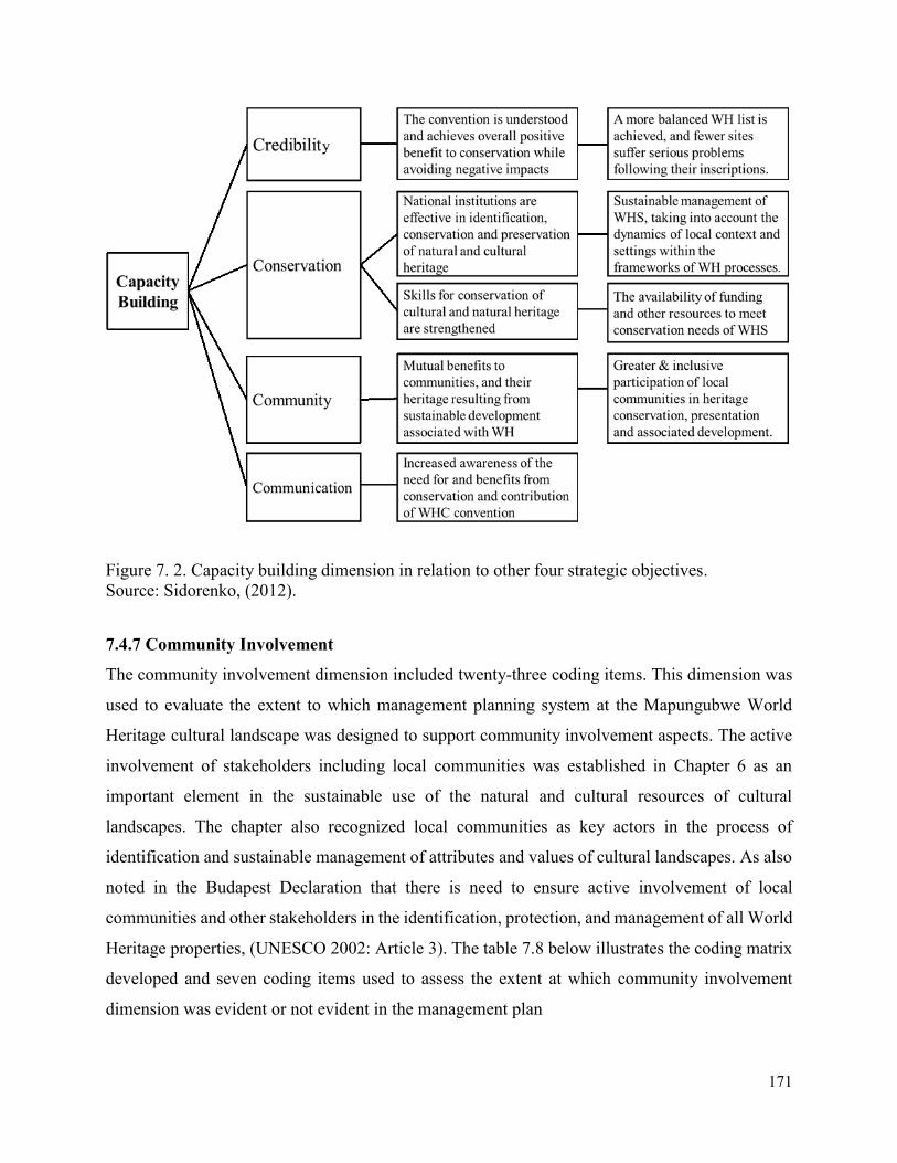
171
Figure 7. 2. Capacity building dimension in relation to other four strategic objectives.
Source: Sidorenko, (2012).
7.4.7 Community Involvement
The community involvement dimension included twenty-three coding items. This dimension was
used to evaluate the extent to which management planning system at the Mapungubwe World
Heritage cultural landscape was designed to support community involvement aspects. The active
involvement of stakeholders including local communities was established in Chapter 6 as an
important element in the sustainable use of the natural and cultural resources of cultural
landscapes. The chapter also recognized local communities as key actors in the process of
identification and sustainable management of attributes and values of cultural landscapes. As also
noted in the Budapest Declaration that there is need to ensure active involvement of local
communities and other stakeholders in the identification, protection, and management of all World
Heritage properties, (UNESCO 2002: Article 3). The table 7.8 below illustrates the coding matrix
developed and seven coding items used to assess the extent at which community involvement
dimension was evident or not evident in the management plan
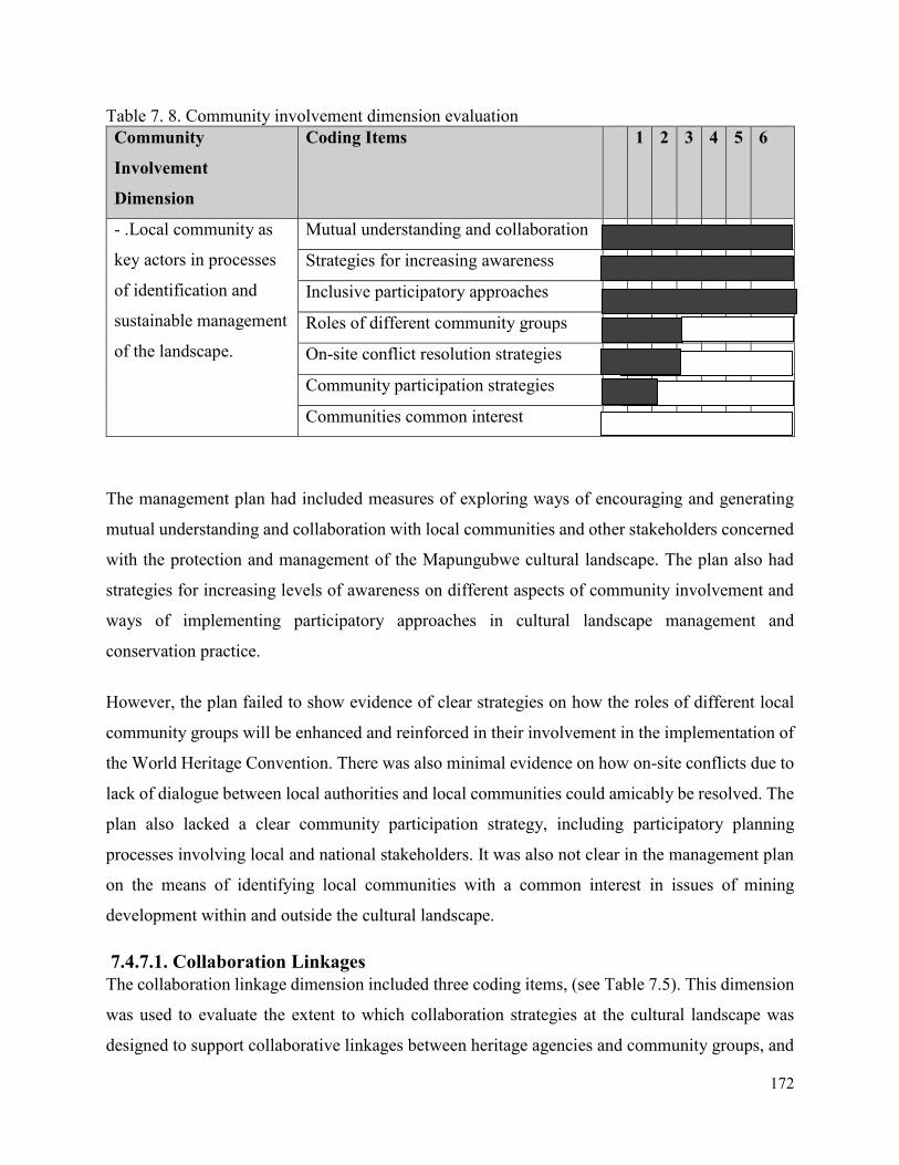
172
Table 7. 8. Community involvement dimension evaluation
Community
Involvement
Dimension
Coding Items 1 2 3 4 5 6
- .Local community as
key actors in processes
of identification and
sustainable management
of the landscape.
Mutual understanding and collaboration
Strategies for increasing awareness
Inclusive participatory approaches
Roles of different community groups
On-site conflict resolution strategies
Community participation strategies
Communities common interest
The management plan had included measures of exploring ways of encouraging and generating
mutual understanding and collaboration with local communities and other stakeholders concerned
with the protection and management of the Mapungubwe cultural landscape. The plan also had
strategies for increasing levels of awareness on different aspects of community involvement and
ways of implementing participatory approaches in cultural landscape management and
conservation practice.
However, the plan failed to show evidence of clear strategies on how the roles of different local
community groups will be enhanced and reinforced in their involvement in the implementation of
the World Heritage Convention. There was also minimal evidence on how on-site conflicts due to
lack of dialogue between local authorities and local communities could amicably be resolved. The
plan also lacked a clear community participation strategy, including participatory planning
processes involving local and national stakeholders. It was also not clear in the management plan
on the means of identifying local communities with a common interest in issues of mining
development within and outside the cultural landscape.
7.4.7.1. Collaboration Linkages
The collaboration linkage dimension included three coding items, (see Table 7.5). This dimension
was used to evaluate the extent to which collaboration strategies at the cultural landscape was
designed to support collaborative linkages between heritage agencies and community groups, and
173
encourage flexibility, innovation, and organizational learning. It was evident that the management
plan seeks to establish a framework for long-term inter-organizational collaboration. Inter-
organizational collaboration here has been defined as a process of joint decision-making among
autonomous key stakeholders in a social problem domain, aimed at agreeing on a direction for
action and implementing and managing strategies designed to achieve desired goals in relation to
the problem domain, (McCann 1983; Wilson and Boyle 2006).
The collaboration was facilitated through a partnership of stakeholders comprising of local
community members, representatives from government institutions, non-governmental agencies,
landowners and mining companies. The cultural landscape has a site manager whose role was to
provide administrative support to the partnership and ensure coordination between the partnership
members. However, the role of the site manager in holding the partners accountable for the
activities of the landscape is not clear. A collaboration facilitation mechanisms as identified by
Wilson and Boyle (2006), of assisting in the effective delivery of management plan objectives,
were not so evident in the planning document.
The management plan has indicated a commitment to the extensive implementation of objectives
to be executed by different stakeholders. The second expedition mechanism was a clear action plan
linked to a collaborative funding framework and performance measures. The management plan
showed a commitment to collaborative objectives which also linked action plans to collaborative
funding. On the basis of this evaluation, collaboration appears as much a matter of necessity as it
is a commitment to the ideals of participatory management.
7.4.7.2. Stakeholder Identity
The stakeholder identity dimension included six coding items, see Table 7.5. This dimension was
used to establish the extent to which the management plan integrated the values, needs, and
expectations of stakeholders into a strategic vision of the cultural landscape. Chapter 6 has
discussed the necessity of stakeholder involvement in the conservation and management of the
attributes and values of cultural landscapes as an expectation of management process. Defining a
shared understanding of the cultural meaning of a site is necessary for there to be a collective sense
of ownership and responsibility, or what Smith (2006) refers to as an ‘emotional engagement’ with
a site.
174
The management plan has referred to some form of stakeholder consultation. Although, how the
process was conducted, what understanding came from it, and how it was integrated into the
strategic planning process was unclear in the planning document. Statements such as ‘consultation
with the local community and relevant organizations and agencies’, indicated an assumed authority
in relation to the process and suggested it did not require a more explicit description.
Assessment of the stakeholder identity coding items in the management plan document revealed
that only issues of community values and attitudes directly affecting the cultural landscape has
been addressed. There was no evidence of the systematic assessment of contemporary community
values and attitudes to issues such as equity and social justice, lifestyle features such as leisure and
self-enhancement activities, or quality of life characteristics such as community health and social
engagement patterns, and no evidence of their integration into the management planning process.
The management plan referred to the need to develop performance measures and indicators for
measuring change. However, there was no indication that broader community values or quality of
life measure were to be developed. There was also minimal evidence that the vision for the
landscape was aligned with community values. There was an assumption of having a common
understanding regarding the cultural landscape value of the area. Despite it being fundamental to
any sustainable development agenda, this indicates the complexity of balancing community values.
7.4.7.3. Participation Scope
The participation scope dimension included eight coding items. This dimension was used to
determine the breadth of stakeholder engagement and the degree of influence each stakeholder
group had over the decision-making process. Stakeholder participation was established in Chapter
6 as necessary for strategic goals to be seen as legitimate. Broad stakeholder participation was also
seen as necessary if the diverse expertise and resources needed to tackle a social problem such as
sustainable development were to be harnessed. As Williams (2006) observes, ‘because no single
actor has the knowledge and resource capability to tackle problems unilaterally’ proper
management and conservation of cultural landscapes needs to be grounded in multi-organizational
and multi-stakeholder environments. This again highlights the tension between local stakeholders
and those managing protected cultural landscapes.
175
The management plan detailed a partnership structure among varying numbers of key stakeholders.
The plan provided partnership member names and detailed objective implementation
responsibilities. Local government agencies dominated the membership and the implementation
of objectives in the plan. An organization or individual was deemed to have participated in the
planning process if they had an active role in the implementation of objectives. The generic ‘public
consultation’ process noted in the plan was not deemed participation because of the lack of
influence over the planning outcomes. Objective implementation responsibilities were spread
across governmental and non-governmental agencies, businesses, residents and visitor groups in
the management plans.
An organization or individual was deemed to have influence over the development of strategic
directions if they were part and parcel of the management committee of the Mapungubwe World
Heritage cultural landscape. The management plan referred to consultation has taken place if it
was evident that the consultation process had been directed by the cultural landscape concerns of
the relevant government and non-governmental agencies and major landowner group who made
up the management committee, rather than an open process negotiation. The plan was developed
as a result of extensive research and consultation with public bodies, private landowners, and local
communities.
7.4.7.4. Participation Continuity
The participation continuity aspect included four coding items and was used to determine the
extent at which stakeholders were engaged at the start of the strategic planning process, would
continue to be engaged over the course of the planning period and beyond. The continuity of
stakeholders was consolidated in Chapter 6 as necessary for achieving long-term change.
Continuous stakeholder participation was also established in the same chapter where both the
Budapest Declaration and the Operational Guidelines call for the active involvement of a wide
variety of stakeholders in the management processes of World Heritage sites, (UNESCO 2002).
Stakeholder participation in the prioritization of objectives was investigated as a first step toward
the development of joint responsibility for the outcomes of the strategic planning process.
However, the management plan showed no evidence of broad stakeholder participation in the
prioritization of objectives. This was due to the fact that it was difficult to gauge whether broad
176
stakeholder participation did contribute to the final chosen strategic direction. The management
plan also failed to indicate that prioritization of objectives had been a negotiated process amongst
the cultural landscape management committee members.
The management plan document has listed a series of action plans derived from the analysis of the
key management issues. As with objective implementation responsibilities, the plan used a project
register to list project timelines and their implementation status. However, with many of the
projects being assigned to one implementer and the management plan lacking a comprehensive set
of collaborative performance indicators, it was difficult to gauge what the evaluation and review
process involved.
The plan did not clearly address the issue of ongoing partnership and legitimacy. As noted by
Williams (2006), sustainable development will involve a variety of public, private and voluntary
organizations in a ‘complex set of shifting and dynamic relationships and connections, with
interfaces characterized by ambiguity and tension’. Therefore, any system of governance will need
to remain flexible and ready to act within loose collaborative networks. Such a system also needs
the capacity to recognize self-interest and promote innovative thinking amongst cultural landscape
management committee members.
7.5 Semi-Structured Interview Analysis and Theme Rationalization
As outlined in Chapter 4, Methodology, the semi-structured interviews contributed to a holistic
understanding of the cultural landscapes used as case studies and were used to corroborate data
from the documentary evidence and physical surveys. Interviews were used to develop a deeper
understanding of the stakeholder relationships and management processes used at the two cultural
landscapes. The following section uses thematic analyses to examine the semi-structured
interviews in greater detail. A total of twelve interviews were included in the study. The selection
criteria for the choice of the interview participants were the following:
- Be either a manager responsible for the management of the cultural landscape or public
officer within the government conservation agencies responsible for the management and
conservation of cultural or natural heritage and or;
177
- Be in a position of influence in the management planning processes of the cultural
landscapes and accountable for the outcomes of the processes.
The thematic analysis of the interviews relied on the coding dimensions derived from the
qualitative content analysis of the site management planning framework, with an emphasis on 5Cs.
The interview procedure and the process of thematic analysis adopted in the following section
have been further detailed in Chapter 4, methodology.
7.5.1 Semi-Structured Interview Thematic Analysis: The Strategic 5 Cs
7.5.1.1 Situation Analysis
The situation analysis dimension related to the extent to which internal and external factors
impacting on some aspects of cultural landscapes were assessed as part of the planning process.
This discussion commenced with a question about the use of analytical techniques such as
benchmarking, strengths, weaknesses, opportunities, weaknesses, and threats (SWOT) analysis, or
investment appraisal methods such as cost-benefit analysis to support decision-making. The
management plan analysis indicated that the conservation planning process defined by Feilden and
Jokilehto (1998) was used thoroughly, but there was limited use of other formal strategic
management techniques to guide planning and decision-making.
7.5.1.2 Strategic Orientation
The strategic orientation dimension assessed the extent to which the planning process at the
cultural landscape was either long-term, holistic and objective oriented. The management plan
analysis indicated that a linear planning process was evident at Mapungubwe World Heritage
cultural landscape. However, the extent of long-term and holistic strategic thinking was not well
clarified. The description of the planning process was also limited and there was an emphasis on
economic and conservation objectives. Sustainable development and social community benefits
were mentioned but lacked detail and measurable outcomes.
7.5.1.3 Credibility
The credibility dimension investigated if the core principles of the World Heritage Convention
such as outstanding universal value, integrity, and authenticity were being adequately promoted
among all stakeholders. Most of the interview contributors indicated that there were an improved
documentation and systematization of the attributes and values of the Mapungubwe cultural
178
landscape. They also pointed out some examples of on-going projects aiming at identifying and
interpreting cultural and natural features of the landscape. They also agreed that international
cooperation has been enhanced through the establishment of the trans-frontier conservation area
covering two neighboring countries.
7.5.1.4 Conservation
The conservation dimension investigated the conservation measures that were employed in the
cultural landscape. Discussions focused on the extent of how the outstanding universal value of
the cultural landscape, including conditions of integrity and authenticity, were being sustained or
enhanced. Key information was solicited from key informants responsible for the conservation
issues of the landscape. The following two key questions relevant to conservation were included
in the questionnaire:
- How did conservation authorities use results of periodic reporting exercises to plan for
conservation activities at Mapungubwe cultural landscape?
- And secondly, what steps have the conservation authorities made to integrate the protection
of the Mapungubwe cultural landscape into wider national programmes?
From responses gathered through the questionnaire administered, on the first inquiry, the interview
participants indicated that the conservation authorities mainly use the results of the periodic
reporting exercises to improve the general management of the cultural landscape; identify the
needs of the landscape; improve the policies and legislation; and plan for other management and
conservation activities based on the issues that has been reported. On the second inquiry, the
respondents who answered the questionnaire on some of the steps conservation authorities have
made to integrate protection of the landscape in national programmes, indicated that there was the
annual provision of development and operational funds for the implementation of the landscape.
There was also some initiatives to reinforce heritage and other related laws, and an increase in
cooperation with other neighboring countries in which the property shares boundaries. In general,
it was reported that conservation of the heritage resources as one of the important dimension should
be taken into account when planning for mining development programmes.
7.5.1.5 Communication
179
The communication dimension investigated the extent to which the management plan integrated
communication strategies into a strategic vision of the cultural landscape. The analysis of the plan
has indicated that it has communication strategies for effective information sharing among all
stakeholders. To better understand the communication dimension of the cultural landscape,
information from key informants were solicited from the questionnaire administered. One critical
question that was asked in relation to communication was on:
- How did conservation authorities ensure that World Heritage status of Mapungubwe
cultural landscape was being adequately communicated and promoted to the general
public?
Analysis of the responses from the respondents revealed that there were adequate communication
and promotion of the World Heritage status of Mapungubwe. They mentioned the following means
of promoting the landscape to a wider community; campaigns, workshops, lectures, and talks about
the landscape; promotional activities and cultural festivals at the site; through educational
programmes in schools around the World Heritage property; informational signs across the
landscape; and availability of information kits. Generally, the inquiry was based on two levels of
awareness-raising. Awareness-raising concerning the cultural landscape itself and awareness to
the general public with regards to the World Heritage Convention, its objectives, principles,
mechanisms, roles, and obligations of responsible institutions to implement the Convention.
7.5.1.6 Capacity Building
The capacity building dimension investigated the extent to which the management plan document
integrated the issues of capacity building in the course of the planning period and beyond. The
analysis revealed that the plan had some capacity building strategies and measures to strengthen
networks for better management and conservation measures of the landscape. To better understand
the capacity building dimension of the cultural landscape, information from key informants was
also generated from the questionnaire administered. One critical question that was asked in relation
to capacity building dimension was:
- What measures should be done to ensure that there was effective capacity building in
Mapungubwe World Heritage cultural landscape?
180
Majority of the responses said that there was a need to create an effective information management
structure that should effectively disseminate information on training programmes and activities on
World Heritage issues and capacity building opportunities at all levels. The interview analysis
also showed the need for ensuring effective communication between providers of capacity building
with the audiences/beneficiaries. The analysis also indicated the need to strengthen the national
legislation and co-operation between different levels of authorities responsible for the management
and conservation of the cultural landscape. Organisations of on-site training workshops and
seminars with specific themes of the cultural landscape were also emphasized. Three target
audiences for capacity building was broadly identified as practitioners, institutions, and
communities (UNESCO 2011).
7.5.1.7 Community Involvement
The community involvement dimension investigated the extent to which management planning
system of the cultural landscape integrate and support community involvement aspects in the
management processes. The analysis of the plan has shown that there were strategies in place to
increase awareness and involve local communities in different aspects of the management and
conservation of the landscape. However, in order to fully understand community involvement at
the site level, two exploratory relevant questions were included in the questionnaire that was
administered to key informants. The following two questions were asked:
- Does the cultural landscape have plans to cooperate with local communities in the decision-
making of conservation and development projects, preparation of periodic state of
conservation reports and its follow-up activities?
- Which approach has been developed or could be developed by the management authorities
of Mapungubwe cultural landscape to enhance the collaboration and cooperation with local
communities?
Various responses were generated from this questionnaire survey. On the first question, almost all
respondents mentioned that the landscape has plans to cooperate with local communities in all
aspects of decision-making for issues to do with the landscape. On the second question, a variety
of responses were provided. These included; organizations of awareness campaigns at local,
national and regional levels; development of integrated conservation plans; dialogue and exchange
181
of information; active participation of stakeholders; organizations of workshops and seminars,
among others.
On the aspect of collaboration linkages, the examination focused on the extent to which
organizational systems and structures at the cultural landscape were designed to support
collaborative linkages between organizations and community groups, and encourage flexibility,
innovation, and organizational learning. This section of the interview, therefore, focused on
inquiring about the organizational structure and management skills. The interview analysis showed
evidence that the management system at the cultural landscape has a framework for long-term
collaboration through a multi-organizational partnership structure. On the aspect of stakeholder
identity which was exploring the extent to which the values, needs, and expectations of
stakeholders were integrated into a vision of the landscapes Analysis of the management plan for
Mapungubwe World Heritage cultural landscape has indicated limited engagement with local
values and issues beyond assessing attitudes to cultural landscapes.
The participation scope aspect was investigating the breadth of stakeholder engagement and degree
of influence of stakeholders in decision-making processes. The discussion focused on how site
managers understood key stakeholders in the management and conservation of cultural landscapes
and how those stakeholders have been involved in the management planning process. Analysis of
the management plan indicated that there had been strong government and non-government
institutional participation in the planning stages and influence on objectives of the Mapungubwe
World Heritage cultural landscape. The participation continuity aspect examined the extent to
which stakeholders were engaged in the strategic planning process continues. Analysis of the
management plan indicated that responsibility for the implementation of planning objectives was
assigned, to varying degrees, across all members of the cultural landscape management
committees.
7.4.2 Theme Rationalization
The previous section described participant responses to each coding dimension. The primary
responses and emergent themes have been illustrated with appropriate descriptions from the
interview transcripts. The initial analysis of the interviews identified a relatively consistent primary
182
response against each coding dimension across interview participants. A number of emergent
issues were identified within each dimension and summarized as keywords.
The primary responses generally supported the findings of the management plan content analysis.
However, as themes emerged, a more complex set of forces became apparent. Firstly, it was
evident that the types of analytical techniques normally utilized in a strategic planning process
were not applied consistently. The skills and resources of individual cultural landscape
management committee members and specialists in heritage conservation and management were
critical to the provision of technical support for decision-making. Secondly, it was evident that the
partnership structures in place at the Mapungubwe cultural landscape were complex and multi-
faceted. As a result, strategic planning processes did not provide a truly collaborative long-term
and holistic approach. On the organizational structure of Mapungubwe, like the strategic
orientation aspect, it was evident that the complex and multi-faceted partnerships structures at the
landscape had an impact on decision-making. However, the partnership structure did provide
flexibility and allow for innovation. While not mentioned directly, it was apparent that the heritage
conservation agency which hosts the Mapungubwe World Heritage cultural landscape
management office took the leadership role in the implementation of set objectives. Also not
mentioned directly was the need for a site manager to exercise skills as negotiators and champions
for critical issues affecting the landscape.
Thirdly, on the implementation of the WHC strategic objectives, the 5Cs, on the first objective –
credibility, it was evident that the documentation and systematization of information for the
attributes and values of the landscape were well organized and coordinated using available
systems. On the conservation aspect, it was evident that there was complexity in decision-making
affecting the enforcement of legal, administrative and technical measures for the conservation of
the landscape as a whole. On the communication aspect, it was evident that there was a lack of
clear and effective communication strategy which could be applied to the general public. This calls
for a revised strategy that can be integrated into the management planning processes of the
landscape. On the capacity-building aspect, it was evident that there were no clear mechanisms on
how the specific needs of the targeted audience and institutions could be identified and trained. On
the community aspect, it was evident that there were strategies in place on how the roles of
different community groups will be enhanced.
183
It was apparent that the integration of stakeholder values, needs and expectations was limited
primarily to partnership organizations. There was limited evidence of broader community
participation in the development of a mission for the cultural landscape. Interview participants
indicated an awareness of having a broader role within the community. However, because of the
constraints of the partnership structure and the principle commitment to conserving the historic
significance of the landscape, they had a limited capacity to develop extensive socio-economic
strategies and to evaluate their outcomes.
The integration of stakeholders into the formal planning process was also limited to those
organizations who were members of the partnership structure, and that these roles were not
reviewed regularly. There were apparent difficulties obtaining broad participation in the cultural
landscape and problems associated with the collaborative evaluation of objectives and outcomes
as part of a holistic planning process.
7.6 Discussion: Data Synthesis
The following discussion aims to synthesize the results presented above in terms of the seven
coding dimensions – situation analysis, strategic orientation, credibility, conservation,
communication capacity building and community involvement. The results are connected back to
the literature which provides the theoretical grounding of the research. The synthesized results are
drawn together into a comparative framework of cultural landscape management that indicates the
gaps between current best practice for Mapungubwe cultural landscape in South Africa and the
proposed integrated management planning methodological framework to be applied for Mulanje
Mountain cultural landscape.
7.6.1 Situation Analysis
An extensive situation analysis is an accepted foundation for holistic and long-term decision-
making (Viljoen and Dann 2003). This includes not only an analysis of the cultural and natural
significance of a cultural landscape but also other internal influences, such as the staff skill base,
and external influences, such as trends in heritage policy or tourism demand. Despite a strong
awareness of cultural landscape situational factors and an expectation that the Mapungubwe
cultural landscape would contribute to a local economic and social regeneration, there was limited
evidence in the reviewed management plan of an analysis of internal issues or an engagement with
184
broader economic and social issues or trends. This lack of analysis would otherwise reduce the
capacity for the cultural landscape management to respond quickly and effectively to changing
trends. A narrow focus of cultural landscape management related issues would equally limit
benefits that might otherwise flow to the broader community.
The interviews supported this finding but also revealed that partner organizations provided many
of the technical skill that would normally be utilized in strategic decision-making. These include
analytical techniques such as benchmarking, cost-benefit, SWOT and value chain analysis. As
noted earlier, McCann (1983) suggests that where no one entity has the responsibility for a social
problem, new institutional and legal frameworks are needed to coordinate any intervention.
Furthermore, Willaims (2006) and Wilson and Boyle (2006) support inter-organizational
collaboration as an appropriate framework in situations where no one organization has the
knowledge or resources to tackle the problem unilaterally. The continuous threat of mining
development projects in World Heritage cultural landscapes is viewed in this thesis as a problem.
Despite this support, many of the criticisms of partnership arrangements described earlier in this
thesis were also evident in the interviews. Various stakeholders were disposed to focus on their
own project-specific objectives. This manifests itself in an evident tension between the
effectiveness, legitimacy and participation principles of governance described in Davison and
Lockwood (2008) and the principles of inter-organizational collaboration described by Wilson and
Boyle (2006). Most discussions acknowledge the logistical need for some form of partnership
structure. However, this was tempered with the recognition that there were inherent coordination
issues. It was clear that centralized data collection and the development of meaningful performance
indicators would support greater coordination. It was also clear that the site manager skills and the
capacity of the site office to undertake the full strategic planning and review process were also
critical in the coordination process.
7.6.2 Strategic Orientation
Assessing a range of strategic alternatives and developing a balance of economic, environmental
and social objectives has been established as critical to longer-term sustainability (Simpson 2001;
Viljoen and Dann 2003). Such strategic orientation is capable of assessing dynamic problem
domains and bringing together the resources necessary to impact on the problem in the most
185
effective way (McCann 1983). Achieving an equitable balance of objectives has, however, been
established as problematic (Bull and Jones 2006; Davies, 2002; Litting and Griessler 2005). This
was evident in the management plan analysis. The plan followed an established linear process of
setting objectives and developing action plans to meet these objectives. However, while the focus
was on the conservation of the OUV of the World Heritage cultural landscape, broader socio-
economic objectives and quantifiable measures for the less tangible values associated with the
cultural landscape was not evident.
By contrast, the interviews did reveal an awareness of the broader role the cultural landscape
played within the local community. However, discussions focused on income generation, tourism
and employment growth as major issues. It was evident that there was limited operational capacity
and vision within the partnership structure to integrate long-term socio-economic objectives into
the planning process of the cultural landscape. This supports the findings of Pendlebury et al.
(2004) who highlighted a need for a ‘greater clarity of thinking’ if historic environments are to
contribute to broader socio-economic issues. It also supports the findings of Stubbs (2004) who
notes the lack of a robust framework for measuring sustainable development objectives at heritage
sites.
Multi-faceted and complex funding arrangements were also shown to be a contributor to the
capacity to develop strategic objectives. Discussions supported the view that objectives were short-
term and project specific, with cultural landscape management committee members taking
independent responsibility for implementation. The lack of a rigorous evaluation and review
process was symptomatic of this fragmentation, although the importance of structure and basic
systems as a driver of collaboration has been emphasized (Wilson and Boyle 2006).
7.6.3 Community Involvement
A community-led vision that incorporates local values and attitudes contributes to a collective
sense of responsibility and enhances connections between a heritage site and the local community
(Simpson 2001). Jointly establishing values, needs and expectations is also a key step in
establishing who the legitimate problem domain stakeholders are (McCann 1983). Despite this
critical role, there was minimal evidence that a community vision was addressed in the
management plan. Furthermore, the internalized strategic focus indicated that, however vague the
186
consultation process, it was assumed to equate to a common understanding regarding the cultural
values of the cultural landscape. This is in line with the findings of Simpson (2001) and Aas et al.
(2005) who note that the difficulties associated with isolating legitimate stakeholders and ensuring
equal participation usually result in tokenistic informing rather than the true delegation power.
The interviews also indicated that community participation in the development of vision was
problematic. Again, there was awareness amongst participants of the broader role each site played
within the local community and the need to promote greater inclusion in the management process.
However, the primary role of participants is to conserve the outstanding universal values of the
World Heritage cultural landscape which can be inconsistent with community visions of a
sustainable future. It was also evident that there was a limited sense of how the broader
participation might be generated and managed within the current system. Waterton et al (2006) see
this as a ‘failure to identify to what extent, or how, the expert should give ground or engage with
the community’.
Like the development of a vision that incorporates local values and attitudes, the capacity for all
stakeholders to contribute to the management of cultural landscapes is accepted as fundamental to
empowering local communities and enhancing the equitable distribution of the benefits of that
resource (Aas et al 2005; Simpson 2001). As Gallent (2008) suggests, there is also a struggle in
such a process between the need to balance the devolution of power to communities with the need
to retain strategic oversight, in this case in relation to the conservation of the attributes and values
of cultural landscapes. It was clear that there was a commitment to stakeholder collaboration in
the management plan. The difficulty of isolating legitimate stakeholders and then ensuring equal
participation was also evident. The plan focused on the development of formal partnership
relationships between government and non-government organizations rather than broad-based
collaboration with informal community groups and individual citizens.
The interviews supported this finding. Participants emphasized the partnership as the primary
mechanism for participation and highlighted the difficulties of broad-based participation in the
planning process. The significant role played by local authorities as conduits for community
communication rather than democratic participation, was apparent. Also apparent was the need for
187
stronger strategic planning process and performance measures that would enable a more integrated
and longer-term approach to be taken.
Continuous stakeholder engagement that facilitates ongoing independence and commitment has
been identified as necessary if systematic changes are to occur (Williams 2006). It is also a
necessary component for the ongoing viability of a social problem-solving intervention (McCann
1983). The ‘active involvement’ of local communities in the management process is called for in
the Budapest Declaration (UNESCO 2002), while the ‘participation of local and national
populations in the protection and presentation of heritage’ is a stated objective in the Operational
Guidelines (UNESCO 2008: Article 211). However, Pendlebury et al (2004) point out that
‘partnership building’ has been a significant feature of urban regeneration policy in historic areas,
yet partnerships have ‘frequently been criticized for being opportunistic and short-lived to capture
resources and for having no real transforming impact on power relations’. This point is supported
by other such as Bull and Jones (2006), Davies (2002), Davidson and Lockwood (2008) and
Chhotray and Stoker (2009). This raises questions about whether it is possible to balance the
conservation and management of the attributes and values of the cultural landscape with the active
involvement of local communities looking for development. The management plan, however, did
not show evidence of broad stakeholder participation in the setting of objectives and also did not
indicate a clear process for a review of stakeholder participation.
This was supported by the comments related to the review of the management plan rather than a
broader review of the partnership structure and participation processes. Responses also focused on
the achievement of project-based operational issues and the need to respond to external reporting
requirements such as UNESCO’s periodic reporting. There appeared not to be an active annual
systematic review process in place as would be the case in a normal cyclic strategic planning
process. The lack of consistent performance measures and data collection capacity was indicated
by several respondents to be an issue, as was the independence of individual organizations.
7.7 Chapter Summary
This chapter has provided results of the assessment of the management planning framework for
Mapungubwe cultural landscape. The chapter has provided detailed results of how the
management plan has achieved and incorporated the strategic objectives of the UNESCO’s
188
strategic action plan for the implementation of the World Heritage Convention 2012-2022. These
include credibility, conservation, capacity-building, communication, and community involvement.
Further to this, the chapter has also provided results of the content analysis of the management
planning framework. The focus has been on presenting the extent of the integration of various
dimensions of the management planning instrument into the management planning system of the
cultural landscape. These include; situational analysis, strategic orientation, organizational
structure, stakeholders identity, participation scope and participation continuity. The last part of
the chapter has presented the results of the semi-structured interviews and theme rationalization in
relation to the various dimensions that have been used to evaluate the content of the management
planning framework.
The results generally indicate that the management of African cultural landscapes necessitates a
broader approach than that proposed by Feilden and Jokilehto (1998) Management Guidelines for
World Heritage Sites. There was evidence of conflicting interests in the management and
conservation approaches in the cultural landscapes. This calls for a need to revise management
guidelines that should encompass a stronger strategic planning process at World Heritage cultural
landscapes, and a need for greater operational capacity linked to national funding frameworks.
The following chapter 8, Discussion and Application, has proposed and applied an integrated
strategic management planning methodological framework, as a theoretical tool for integrating
development in protected cultural landscapes. The instrument incorporates the conventional
approach to strategic planning found organizational literature (Johnson et al. 2008) and the
collaborative decision framework suggested by McCann (1983). The methodological framework
has then been applied to Mulanje Mountain cultural landscape in Malawi.
189
CHAPTER EIGHT
8 DISCUSSION AND APPLICATION: STRATEGIC MANAGEMENT PLANNING
METHODOLOGICAL FRAMEWORK
8.1 Introduction
This chapter discusses a management planning methodological framework that has been developed
in order to integrate mining development in cultural landscape management planning programmes.
This methodological framework for cultural landscapes has been developed as a practical
methodological tool to be applied in all protected cultural landscapes that need to integrate
development activities in protected cultural landscapes. It is intended to offer performance
standards for achieving and maintaining appropriate use and management of resources of cultural
landscapes.
This proposed management planning methodological tool includes a framework of spatially
represented information connected to significant aspects of cultural landscapes such as the
relationship between the local people and their associated environment. A key function of this
proposed framework is to methodologically identify and integrate areas of potential conflict
between mining development projects and protection of significant attributes and values of cultural
landscapes. It will achieve this by integrating the sustainable utilization of natural and cultural
heritage resources of the cultural landscapes through the application of proposed landscape
management planning strategies.
The chapter has been divided into three parts. The first part presents a framework that compares
current best practice derived from the case study results of Mapungubwe with an integrated best
practice for cultural landscape management proposed in this chapter. The second part is the
discussion on the developed management planning methodological framework which has aimed
at promoting integration and sustainability on the use of the resources of the cultural landscapes.
On the last part, is the application of the suggested management planning methodological
framework to Mulanje Mountain Cultural landscape.
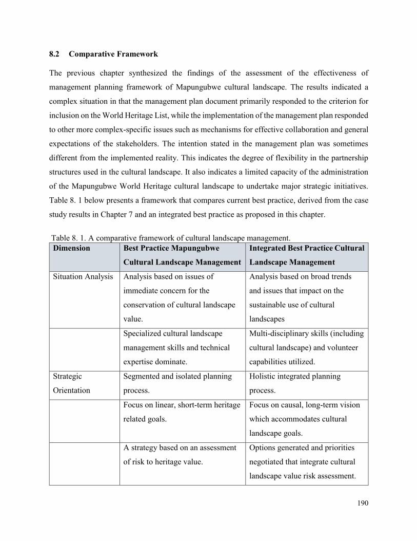
190
8.2 Comparative Framework
The previous chapter synthesized the findings of the assessment of the effectiveness of
management planning framework of Mapungubwe cultural landscape. The results indicated a
complex situation in that the management plan document primarily responded to the criterion for
inclusion on the World Heritage List, while the implementation of the management plan responded
to other more complex-specific issues such as mechanisms for effective collaboration and general
expectations of the stakeholders. The intention stated in the management plan was sometimes
different from the implemented reality. This indicates the degree of flexibility in the partnership
structures used in the cultural landscape. It also indicates a limited capacity of the administration
of the Mapungubwe World Heritage cultural landscape to undertake major strategic initiatives.
Table 8. 1 below presents a framework that compares current best practice, derived from the case
study results in Chapter 7 and an integrated best practice as proposed in this chapter.
Table 8. 1. A comparative framework of cultural landscape management.
Dimension Best Practice Mapungubwe
Cultural Landscape Management
Integrated Best Practice Cultural
Landscape Management
Situation Analysis Analysis based on issues of
immediate concern for the
conservation of cultural landscape
value.
Analysis based on broad trends
and issues that impact on the
sustainable use of cultural
landscapes
Specialized cultural landscape
management skills and technical
expertise dominate.
Multi-disciplinary skills (including
cultural landscape) and volunteer
capabilities utilized.
Strategic
Orientation
Segmented and isolated planning
process.
Holistic integrated planning
process.
Focus on linear, short-term heritage
related goals.
Focus on causal, long-term vision
which accommodates cultural
landscape goals.
A strategy based on an assessment
of risk to heritage value.
Options generated and priorities
negotiated that integrate cultural
landscape value risk assessment.
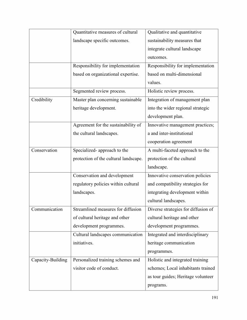
191
Quantitative measures of cultural
landscape specific outcomes.
Qualitative and quantitative
sustainability measures that
integrate cultural landscape
outcomes.
Responsibility for implementation
based on organizational expertise.
Responsibility for implementation
based on multi-dimensional
values.
Segmented review process. Holistic review process.
Credibility Master plan concerning sustainable
heritage development.
Integration of management plan
into the wider regional strategic
development plan.
Agreement for the sustainability of
the cultural landscapes.
Innovative management practices;
a and inter-institutional
cooperation agreement
Conservation Specialized- approach to the
protection of the cultural landscape.
A multi-faceted approach to the
protection of the cultural
landscape.
Conservation and development
regulatory policies within cultural
landscapes.
Innovative conservation policies
and compatibility strategies for
integrating development within
cultural landscapes.
Communication Streamlined measures for diffusion
of cultural heritage and other
development programmes.
Diverse strategies for diffusion of
cultural heritage and other
development programmes.
Cultural landscapes communication
initiatives.
Integrated and interdisciplinary
heritage communication
programmes.
Capacity-Building Personalized training schemes and
visitor code of conduct.
Holistic and integrated training
schemes; Local inhabitants trained
as tour guides; Heritage volunteer
programs.
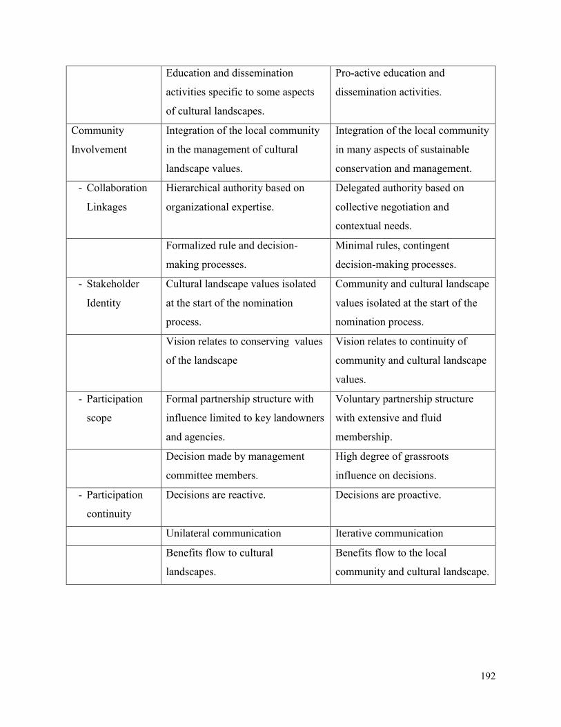
192
Education and dissemination
activities specific to some aspects
of cultural landscapes.
Pro-active education and
dissemination activities.
Community
Involvement
Integration of the local community
in the management of cultural
landscape values.
Integration of the local community
in many aspects of sustainable
conservation and management.
- Collaboration
Linkages
Hierarchical authority based on
organizational expertise.
Delegated authority based on
collective negotiation and
contextual needs.
Formalized rule and decision-
making processes.
Minimal rules, contingent
decision-making processes.
- Stakeholder
Identity
Cultural landscape values isolated
at the start of the nomination
process.
Community and cultural landscape
values isolated at the start of the
nomination process.
Vision relates to conserving values
of the landscape
Vision relates to continuity of
community and cultural landscape
values.
- Participation
scope
Formal partnership structure with
influence limited to key landowners
and agencies.
Voluntary partnership structure
with extensive and fluid
membership.
Decision made by management
committee members.
High degree of grassroots
influence on decisions.
- Participation
continuity
Decisions are reactive. Decisions are proactive.
Unilateral communication Iterative communication
Benefits flow to cultural
landscapes.
Benefits flow to the local
community and cultural landscape.
193
8.3 Development of the Integrated Management Planning Methodological Framework
This methodological framework aims at promoting integration and sustainability on the use of the
resources of the cultural landscapes; securing cultural landscape protection; and promoting
cooperative cultural landscape governance. Specifically, the methodological framework has the
following objectives:
1. To facilitate decision-making in order to ensure sustainable management of significant
features, attributes, and values of cultural landscapes and their buffer zones;
2. To provide strategic guidance on usage of cultural and natural heritage within cultural
landscapes and their buffer zones;
3. To identify sensitive areas of high cultural significance that convey the outstanding values;
4. To identify the cultural landscapes’ mining development opportunities and constraints;
5. To assess the economic and conservation potential of cultural landscapes;
6. To provide a decision support system in respect of incorporating development issues into
the management and planning processes of cultural landscapes;
7. To include existing policies as bases for establishing values, guidelines, and standards for
future developments.
This proposed strategic management planning methodological tool has bridged a gap between the
current state of cultural landscape management and the anticipated state that integrates
development in protected cultural landscapes. It has achieved this by applying the various cultural
landscape management strategies and controlling measures in cases of mining development
activities that may impact the attributes and values of cultural landscapes.
The framework is based on a model of the current best practice of cultural landscape management
that remains inwardly focused on situational issues of immediate concern for cultural landscapes.
The model, shown graphically in Figure 8. 1, indicates an inwardly focused cultural landscape
with a dynamic central core of independent key stakeholders. The strategic orientation is
segmented and projects specific, with key objectives determined by individual stakeholders’
agendas rather than collective negotiation. The cultural landscape management is fragmented,
decision-making is hierarchical, and power rests with several major stakeholders, thus making the
integration of development within the landscape difficult. Beyond the key local community
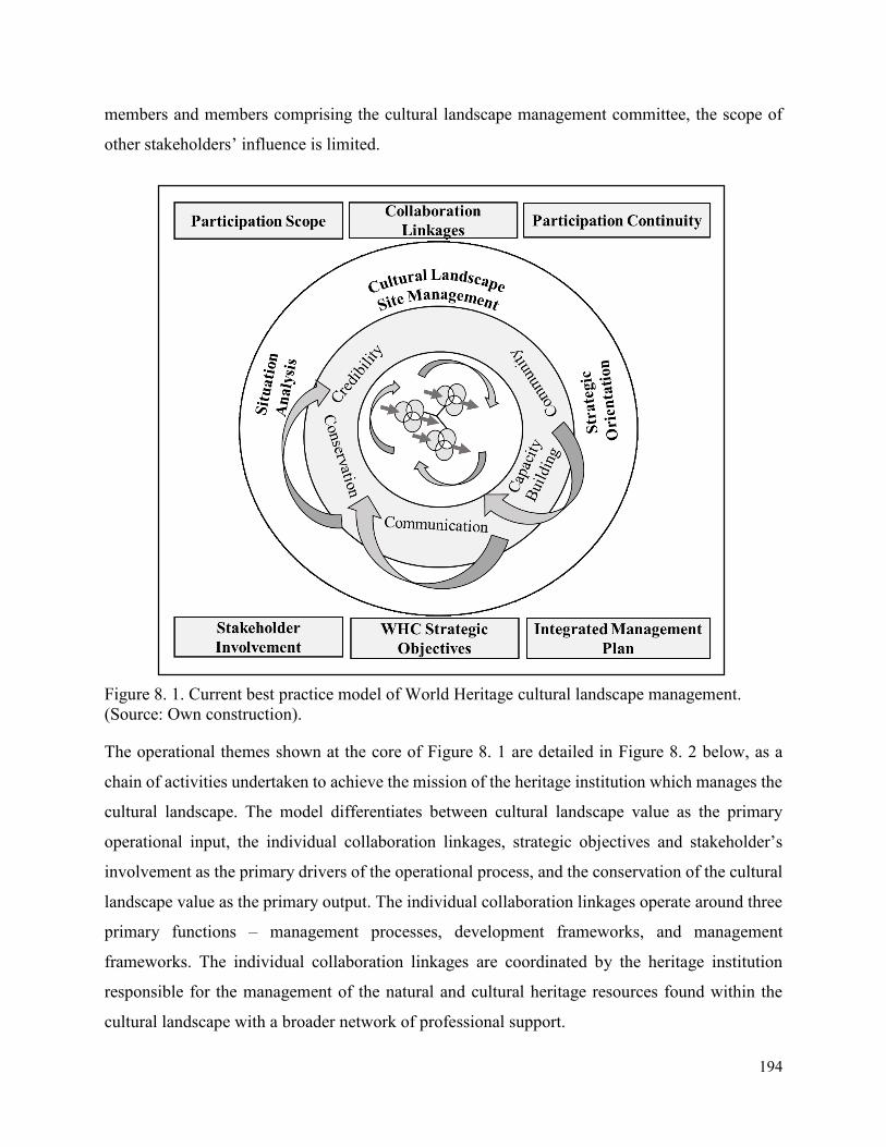
194
members and members comprising the cultural landscape management committee, the scope of
other stakeholders’ influence is limited.
Figure 8. 1. Current best practice model of World Heritage cultural landscape management.
(Source: Own construction).
The operational themes shown at the core of Figure 8. 1 are detailed in Figure 8. 2 below, as a
chain of activities undertaken to achieve the mission of the heritage institution which manages the
cultural landscape. The model differentiates between cultural landscape value as the primary
operational input, the individual collaboration linkages, strategic objectives and stakeholder’s
involvement as the primary drivers of the operational process, and the conservation of the cultural
landscape value as the primary output. The individual collaboration linkages operate around three
primary functions – management processes, development frameworks, and management
frameworks. The individual collaboration linkages are coordinated by the heritage institution
responsible for the management of the natural and cultural heritage resources found within the
cultural landscape with a broader network of professional support.
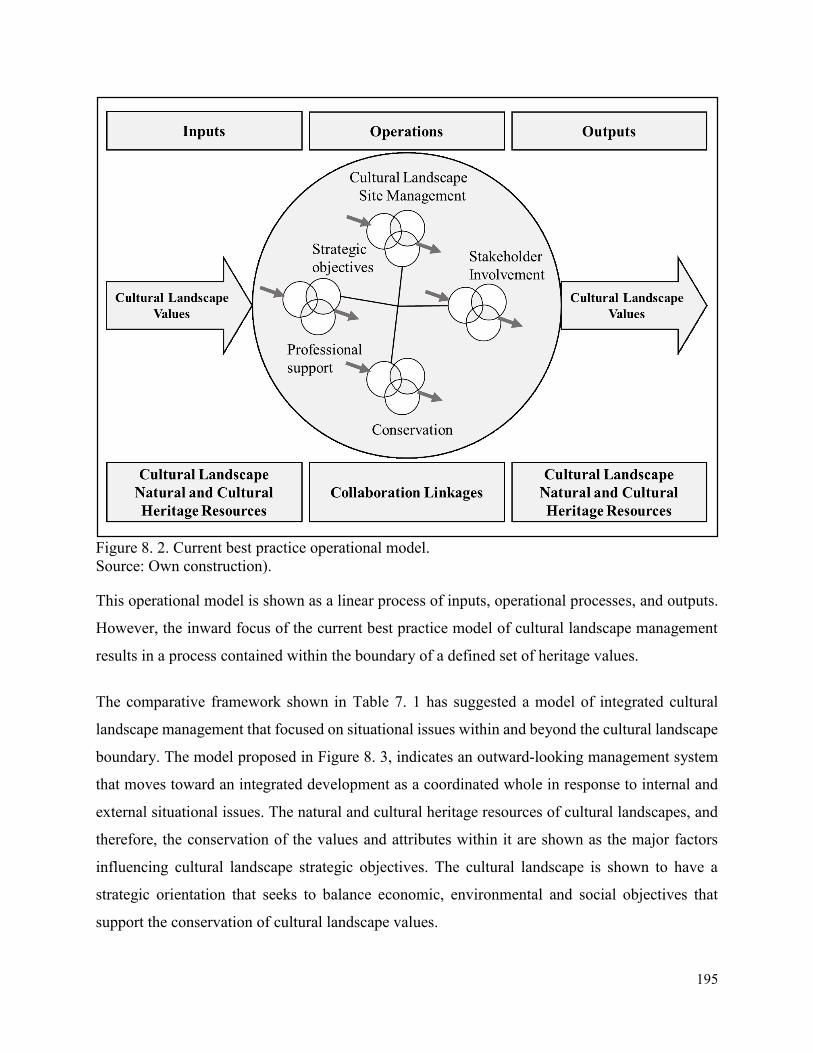
195
Figure 8. 2. Current best practice operational model.
Source: Own construction).
This operational model is shown as a linear process of inputs, operational processes, and outputs.
However, the inward focus of the current best practice model of cultural landscape management
results in a process contained within the boundary of a defined set of heritage values.
The comparative framework shown in Table 7. 1 has suggested a model of integrated cultural
landscape management that focused on situational issues within and beyond the cultural landscape
boundary. The model proposed in Figure 8. 3, indicates an outward-looking management system
that moves toward an integrated development as a coordinated whole in response to internal and
external situational issues. The natural and cultural heritage resources of cultural landscapes, and
therefore, the conservation of the values and attributes within it are shown as the major factors
influencing cultural landscape strategic objectives. The cultural landscape is shown to have a
strategic orientation that seeks to balance economic, environmental and social objectives that
support the conservation of cultural landscape values.
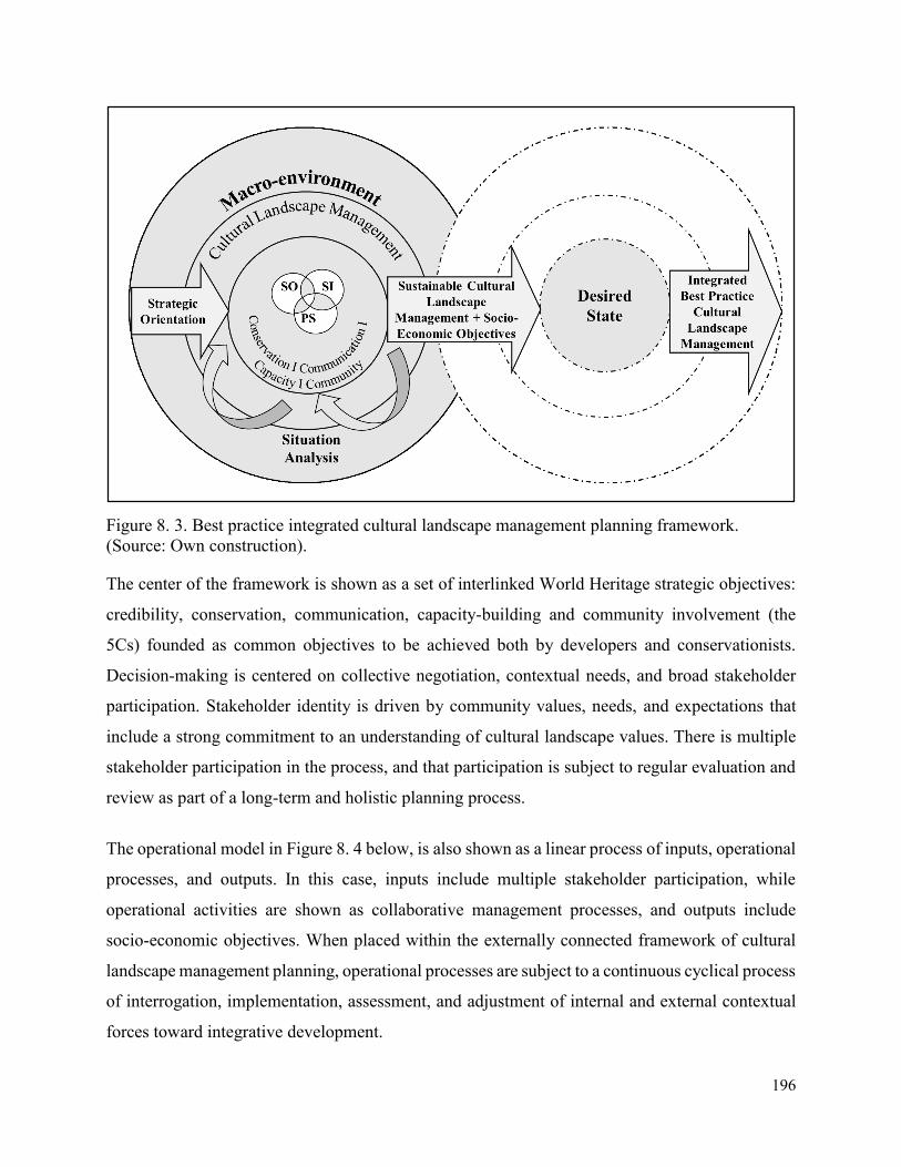
196
Figure 8. 3. Best practice integrated cultural landscape management planning framework.
(Source: Own construction).
The center of the framework is shown as a set of interlinked World Heritage strategic objectives:
credibility, conservation, communication, capacity-building and community involvement (the
5Cs) founded as common objectives to be achieved both by developers and conservationists.
Decision-making is centered on collective negotiation, contextual needs, and broad stakeholder
participation. Stakeholder identity is driven by community values, needs, and expectations that
include a strong commitment to an understanding of cultural landscape values. There is multiple
stakeholder participation in the process, and that participation is subject to regular evaluation and
review as part of a long-term and holistic planning process.
The operational model in Figure 8. 4 below, is also shown as a linear process of inputs, operational
processes, and outputs. In this case, inputs include multiple stakeholder participation, while
operational activities are shown as collaborative management processes, and outputs include
socio-economic objectives. When placed within the externally connected framework of cultural
landscape management planning, operational processes are subject to a continuous cyclical process
of interrogation, implementation, assessment, and adjustment of internal and external contextual
forces toward integrative development.
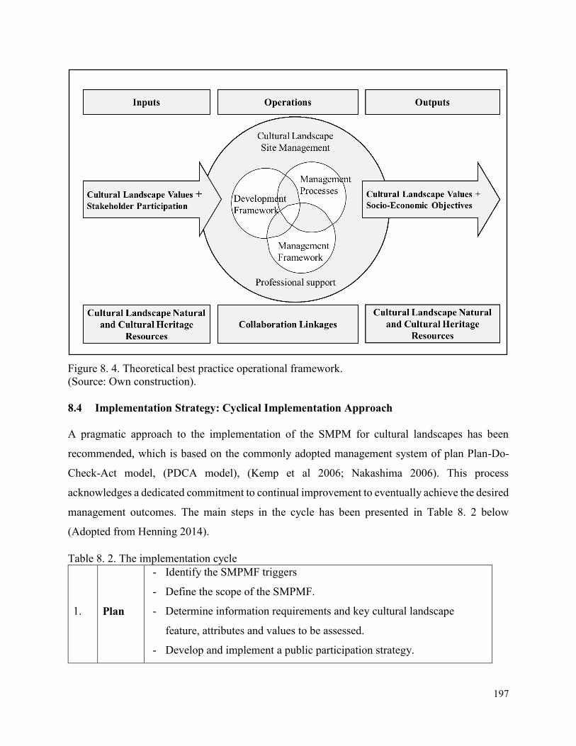
197
Figure 8. 4. Theoretical best practice operational framework.
(Source: Own construction).
8.4 Implementation Strategy: Cyclical Implementation Approach
A pragmatic approach to the implementation of the SMPM for cultural landscapes has been
recommended, which is based on the commonly adopted management system of plan Plan-Do-
Check-Act model, (PDCA model), (Kemp et al 2006; Nakashima 2006). This process
acknowledges a dedicated commitment to continual improvement to eventually achieve the desired
management outcomes. The main steps in the cycle has been presented in Table 8. 2 below
(Adopted from Henning 2014).
Table 8. 2. The implementation cycle
1. Plan
- Identify the SMPMF triggers
- Define the scope of the SMPMF.
- Determine information requirements and key cultural landscape
feature, attributes and values to be assessed.
- Develop and implement a public participation strategy.

198
- Determine context for cultural landscape management, based on
opportunities, constraints, issues, and desired state.
- Delineate management zones and assign management objectives and
requirements.
- Develop implementation strategy.
- Seek formal adoption.
- Establish institutional arrangements.
2. Do
- Cultural landscape management and conservation training of
stakeholders. Depending on the audience, training mechanisms
can include manuals, tutored sessions, brochures, etc.
- Recruitment of SMPMF in appraisal of proposals / applications for
activities or developments.
- Implementation of SMPMF management measures, including
provisions and arrangements for accomplishing management
objectives and desired state.
3. Check
- Monitoring of SMPMF performance and overall implementation.
- Monitoring to be based on Cultural Landscape Management
Framework for Strategic Issues & Priorities, and to focus on
associated indicators.
4. Act
- Taking stock of the lessons learnt during the implementation of the
SMPMF and the outcome of the review stage, management actions
need to be taken to ensure that the SMPMF is revised as needed.
8.5 Application of the Management Planning Methodological Framework
This section applies the suggested management planning methodological framework by
integrating mining development programme into the Mulanje Mountain cultural landscape
management process.
8.5.1 Apply Integrated Best Practice
The first stage in this process is to compare the management planning framework proposed for
Mulanje Mountain cultural landscape with the integrated best practice management framework
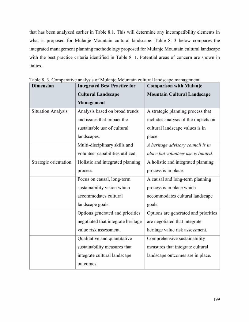
199
that has been analyzed earlier in Table 8.1. This will determine any incompatibility elements in
what is proposed for Mulanje Mountain cultural landscape. Table 8. 3 below compares the
integrated management planning methodology proposed for Mulanje Mountain cultural landscape
with the best practice criteria identified in Table 8. 1. Potential areas of concern are shown in
italics.
Table 8. 3. Comparative analysis of Mulanje Mountain cultural landscape management
Dimension Integrated Best Practice for
Cultural Landscape
Management
Comparison with Mulanje
Mountain Cultural Landscape
Situation Analysis Analysis based on broad trends
and issues that impact the
sustainable use of cultural
landscapes.
A strategic planning process that
includes analysis of the impacts on
cultural landscape values is in
place.
Multi-disciplinary skills and
volunteer capabilities utilized.
A heritage advisory council is in
place but volunteer use is limited.
Strategic orientation Holistic and integrated planning
process.
A holistic and integrated planning
process is in place.
Focus on causal, long-term
sustainability vision which
accommodates cultural
landscape goals.
A causal and long-term planning
process is in place which
accommodates cultural landscape
goals.
Options generated and priorities
negotiated that integrate heritage
value risk assessment.
Options are generated and priorities
are negotiated that integrate
heritage value risk assessment.
Qualitative and quantitative
sustainability measures that
integrate cultural landscape
outcomes.
Comprehensive sustainability
measures that integrate cultural
landscape outcomes are in place.
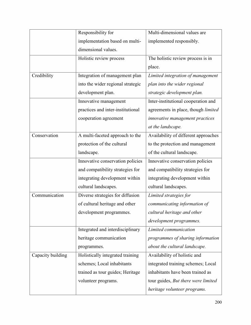
200
Responsibility for
implementation based on multi-
dimensional values.
Multi-dimensional values are
implemented responsibly.
Holistic review process The holistic review process is in
place.
Credibility Integration of management plan
into the wider regional strategic
development plan.
Limited integration of management
plan into the wider regional
strategic development plan.
Innovative management
practices and inter-institutional
cooperation agreement
Inter-institutional cooperation and
agreements in place, though limited
innovative management practices
at the landscape.
Conservation A multi-faceted approach to the
protection of the cultural
landscape.
Availability of different approaches
to the protection and management
of the cultural landscape.
Innovative conservation policies
and compatibility strategies for
integrating development within
cultural landscapes.
Innovative conservation policies
and compatibility strategies for
integrating development within
cultural landscapes.
Communication Diverse strategies for diffusion
of cultural heritage and other
development programmes.
Limited strategies for
communicating information of
cultural heritage and other
development programmes.
Integrated and interdisciplinary
heritage communication
programmes.
Limited communication
programmes of sharing information
about the cultural landscape.
Capacity building Holistically integrated training
schemes; Local inhabitants
trained as tour guides; Heritage
volunteer programs.
Availability of holistic and
integrated training schemes; Local
inhabitants have been trained as
tour guides, But there were limited
heritage volunteer programs.
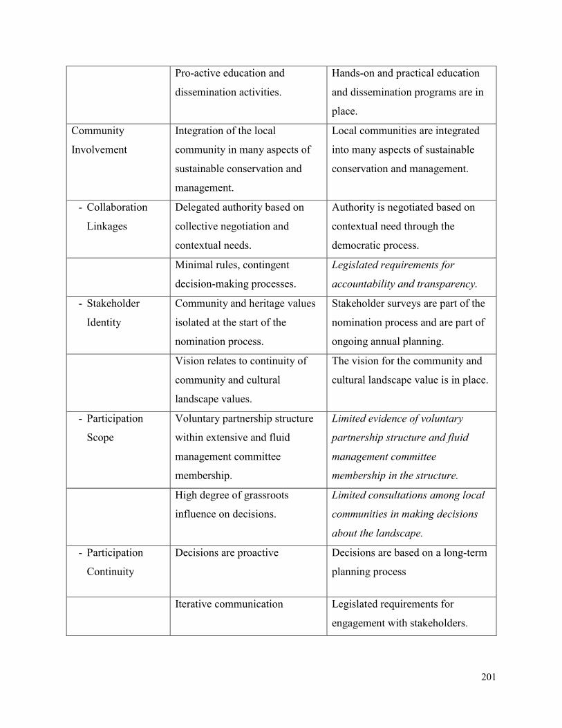
201
Pro-active education and
dissemination activities.
Hands-on and practical education
and dissemination programs are in
place.
Community
Involvement
Integration of the local
community in many aspects of
sustainable conservation and
management.
Local communities are integrated
into many aspects of sustainable
conservation and management.
- Collaboration
Linkages
Delegated authority based on
collective negotiation and
contextual needs.
Authority is negotiated based on
contextual need through the
democratic process.
Minimal rules, contingent
decision-making processes.
Legislated requirements for
accountability and transparency.
- Stakeholder
Identity
Community and heritage values
isolated at the start of the
nomination process.
Stakeholder surveys are part of the
nomination process and are part of
ongoing annual planning.
Vision relates to continuity of
community and cultural
landscape values.
The vision for the community and
cultural landscape value is in place.
- Participation
Scope
Voluntary partnership structure
within extensive and fluid
management committee
membership.
Limited evidence of voluntary
partnership structure and fluid
management committee
membership in the structure.
High degree of grassroots
influence on decisions.
Limited consultations among local
communities in making decisions
about the landscape.
- Participation
Continuity
Decisions are proactive Decisions are based on a long-term
planning process
Iterative communication Legislated requirements for
engagement with stakeholders.
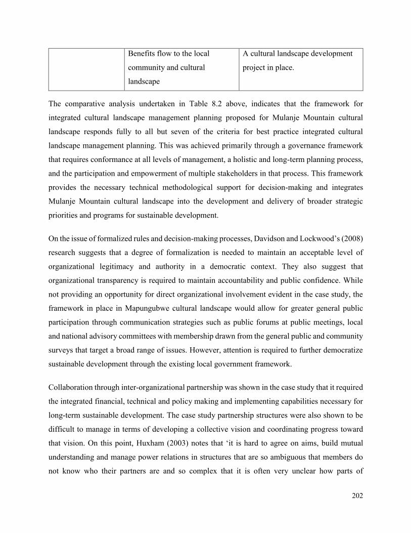
202
Benefits flow to the local
community and cultural
landscape
A cultural landscape development
project in place.
The comparative analysis undertaken in Table 8.2 above, indicates that the framework for
integrated cultural landscape management planning proposed for Mulanje Mountain cultural
landscape responds fully to all but seven of the criteria for best practice integrated cultural
landscape management planning. This was achieved primarily through a governance framework
that requires conformance at all levels of management, a holistic and long-term planning process,
and the participation and empowerment of multiple stakeholders in that process. This framework
provides the necessary technical methodological support for decision-making and integrates
Mulanje Mountain cultural landscape into the development and delivery of broader strategic
priorities and programs for sustainable development.
On the issue of formalized rules and decision-making processes, Davidson and Lockwood’s (2008)
research suggests that a degree of formalization is needed to maintain an acceptable level of
organizational legitimacy and authority in a democratic context. They also suggest that
organizational transparency is required to maintain accountability and public confidence. While
not providing an opportunity for direct organizational involvement evident in the case study, the
framework in place in Mapungubwe cultural landscape would allow for greater general public
participation through communication strategies such as public forums at public meetings, local
and national advisory committees with membership drawn from the general public and community
surveys that target a broad range of issues. However, attention is required to further democratize
sustainable development through the existing local government framework.
Collaboration through inter-organizational partnership was shown in the case study that it required
the integrated financial, technical and policy making and implementing capabilities necessary for
long-term sustainable development. The case study partnership structures were also shown to be
difficult to manage in terms of developing a collective vision and coordinating progress toward
that vision. On this point, Huxham (2003) notes that ‘it is hard to agree on aims, build mutual
understanding and manage power relations in structures that are so ambiguous that members do
not know who their partners are and so complex that it is often very unclear how parts of
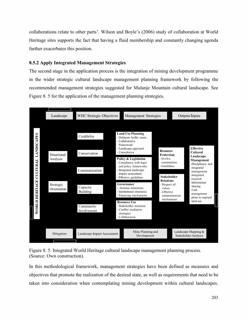
203
collaborations relate to other parts’. Wilson and Boyle’s (2006) study of collaboration at World
Heritage sites supports the fact that having a fluid membership and constantly changing agenda
further exacerbates this position.
8.5.2 Apply Integrated Management Strategies
The second stage in the application process is the integration of mining development programme
in the wider strategic cultural landscape management planning framework by following the
recommended management strategies suggested for Mulanje Mountain cultural landscape. See
Figure 8. 5 for the application of the management planning strategies.
Figure 8. 5. Integrated World Heritage cultural landscape management planning process.
(Source: Own construction).
In this methodological framework, management strategies have been defined as measures and
objectives that promote the realization of the desired state, as well as requirements that need to be
taken into consideration when contemplating mining development within cultural landscapes.
204
Therefore, management strategies for two key stakeholder groups associated with mining
development and conservation and management of cultural landscapes has been proposed. These
include government conservation and mining industry, as discussed below.
8.5.2.1. Management Strategies for Government Conservation Agencies
Conservation agencies are responsible for the effective management of cultural landscapes which
has been designated as World Heritage sites. These agencies need to be institutionally capacitated
with human resources, equipment, and funding, and they should be able to play a role in land use
decisions and socio-economic development. The role of conservation agencies is to ensure that
cultural landscapes are managed in terms of laws and regulations of the country, the resources of
the cultural landscapes are adequately protected, and ensuring that benefits are flowing from the
conservation of the cultural landscape to local communities. Issues relating to the wise use of
resources of cultural landscapes, regional land use, and environmental and social impacts
associated with development activities are the responsibility of conservation agencies. Seven
management interrelated strategic areas have been suggested. These include governance and
institutional capacity, policy and legislation, land use planning, resource use, resource protection,
socio-economic development, and effective cultural landscape management.
Strategic Area 1: Governance and Institutional Capacity
There is a need to ensure that effective organizational structures are in place to facilitate the
efficient management of cultural landscapes. This also includes the development of financing
mechanisms to facilitate the effective management and conservation activities within the cultural
landscapes, and develop mechanisms for generating and sharing revenue that takes into account
considerations of transparency, ethics, equity, and sustainability. There is also a need to increase
awareness locally and nationally of the values of cultural landscapes through improved
information, knowledge sharing, and communication. There is also a need to improve the
institutional capacity of relevant to work at the national and community levels.
Strategic Area 2: Policy and Legislation
There is a need to strengthen the legal and policy frameworks in most of the heritage institutions
with a mandate to conserve and protect cultural landscapes. There is also a need to provide for a
single integrated environmental permitting process for all mineral extractive developments that
205
should incorporate issues of heritage conservation and other aspects of the environment. There is
also a need to apply integrated environmental and social impact assessment procedures for
development affecting cultural landscapes. In specific this includes all mining development
projects in cultural landscapes. Regular condition assessments should be conducted to monitor the
possible impact of mining-induced factors on the attributes and values of cultural landscapes.
Comprehensive and effective assessment tools should be adopted for this activity. Clear guidelines
and regulations should be developed to govern activities planned in buffer zones of cultural
landscapes that have been designated world heritage status. For this to be effective, there is need
to ensure that buffer zones are under the control of the management authority.
Strategic Area 3: Land Use Planning.
There is a need to establish buffer and transitional zones around cultural landscapes or significant
attributes and spaces within cultural landscapes that have high significance to the local
communities. This is important since avoidance and other mitigation strategies can be used to
protect critical and sensitive attributes that convey the values of the landscapes. There is also a
need to provide a collaborative framework within different government departments and agencies,
local communities, and other decision-makers and managers of mining development projects who
participate in land use decisions. This is important to minimize conflicts and tensions once
decisions to mine the landscape has been made. A landscape approach to all sacred natural sites
should be taken. This landscape approach should recognize the role of sacred sites in wider cultural
landscapes, protected area systems, ecological corridors, and other land uses. In addition to this,
there is also need to recognize that some sacred natural sites, and the cultures that hold them sacred,
cross international boundaries and that some may be within or surrounding existing protected
areas. This recognition is important for proper integration of these sacred sites into the wider
cultural landscape planning system. There is also need to ensure that all relevant stakeholders at
the local, national and international levels have been adequately consulted at the earliest possible
stages in planning for mining development in cultural landscapes and in any plans to nominate
landscapes as World Heritage Sites. An open and transparent multi-disciplinary approach should
be ensured in determining boundaries for cultural landscapes that have been designated world
heritage status. This approach should make sure that the values and attributes are protected and
206
should also take into account the ecological, cultural and mineral and other economic values, as
well as other socio-economic factors.
Strategic Area 4: Resource Use
On this aspect on resource use, there is need to ensure a full inclusion of all relevant custodians of
cultural landscape values and key stakeholders in decision-making processes as regards to mineral
extractions and conservation of cultural landscapes. This should be done to avoid future conflicts
and uncooperative partnerships. Where appropriate, there is also a need to use conflict
management, mediation and resolution methods to promote mutual understanding between
traditional custodians and more recent occupants, resource users/mining developers, and heritage
managers. There is also a need to encourage mining and conservation specialists to work together
taking into consideration the unique aspects of mining and the multiple value and conditions of
cultural landscapes.
Strategic Area 5: Resource Protection
There is a need to develop guidelines for governing mining development activities in the buffer
zone. This should be supported by developing regulations that relate to all mining activities and
any other development with the full participation of all relevant stakeholders. Regular condition
assessments should be conducted to monitor the possible impact of mining-induced factors on the
attributes and values of the cultural landscapes. There is also need to ensure that local communities
through their leadership contribute meaningfully to the management and protection of cultural
landscapes.
Strategic Area 6: Socio-Economic Development
There is need to ensure that there is effective regional land-use planning relating to the use and
management of the resources of the cultural landscape. There is also a need to adopt an integrated
landscape approach to socio-economic development within and around cultural landscapes with
full participation and involvement of all key stakeholders. There is need to ensure that activities
associated with the conservation and management of cultural landscapes maximizes the social and
ecological benefits and minimizes the adverse ecological and socio-cultural impacts. Further to
this, there is also a need to work with mining companies in order to ensure an integrated approach
to cultural landscape management and community development.
207
Strategic Area 7: Effective Cultural Landscape Management
There is a need to seek the support of development planning authorities in addressing current and
future land uses that may affect cultural landscapes. Hence, it requires promotion of a disciplinary
and integrated approach to the management of these cultural landscapes. What is also more
important is the development of an integrated natural and cultural heritage research that studies
the biodiversity and cultural diversity values, and assesses the contribution of proper management
of cultural landscapes to biodiversity conservation. Conservation agencies should also facilitate
the meeting and sharing of information between local communities within and around cultural
landscapes, the developers and all key stakeholders. The management planning of these landscapes
should also be linked with the broader regional land use planning so that they can be seen as an
integral component of the broader region.
8.5.2.1. Management Strategies for Mining Industry
Most mining companies have realized the negative effects mining operations have on the
management and conservation of cultural landscapes and other protected areas. As such, mining
companies are under increased international pressure to mine responsibly and respect national and
international regulations and policies applicable in protected areas of the countries they operate.
The mining industry has also started to play a more prominent role in local and regional socio-
economic development through sustainable development. In order for this to happen, the mining
industry needs to be committed to international best practice standards pertaining to mine design
and mine closure, environmental management, and socio-economic development.
Strategic Area 1: Governance and Institutional Support
Mining companies need to contribute to government capacity in cultural landscape management
and support site management and conservation programmes. Hence there is a need to encourage
all those involved in the mining industry to better understand ecosystem management and adopt
these principles. Government institutions should be encouraged to develop communication
mechanisms that will promote dialogue among local communities and other affected
organizations. Mining companies should also contribute to the development of local government
capacity in cooperation with international and national agencies and interest groups. They also
need to respect the authority of national and regional governments, taking into account their
development objectives and support the sharing of economic benefits generated by the mining
208
operations. Further to this, they need to adopt structured biodiversity and cultural diversity
approaches that begin with avoiding unacceptable impacts, minimizing the impacts that occur,
restoring areas that are impacted, and then offsetting the residual net loss of cultural landscapes.
Strategic Area 2: Mine Planning and Closure
Mining companies should design mining activities that maximize economic, social and
environmental benefits and minimize consequences and side effects within or beyond natural
boundaries. They should also ensure that mining activities operating in close proximity to cultural
landscapes are designed, operated and closed in consideration of the socio-cultural values and
contribute to the conservation of those values. They should ensure that adequate financial
resources are in place to meet the requirements of the mine closure. Further to this, they need to
develop closure plans from the initial phases of mining that addresses environmental and
community-related issues as well as cultural landscape values in consultation with stakeholders.
Strategic Area 3: Socio-Economic Development
Mining companies should ensure that they employ risk management strategies and best practices
that take into account the local cultures and economic and environmental circumstances in the
design, construction, operation and decommissioning of the mine. In addition, they also need to
assess the local, cultural, environmental and economic impacts of proposed activities and engage
local communities and other affected organizations in the design of community development
strategies, including mine closure. Mining companies should also mitigate to the greatest extent
adverse effects on communities by activities associated with exploration, extraction and mine
closure. They should also ensure that the development of social and labor plans are integrated with
local and regional socio-economic development policies and strategies.
Strategic Area 4: Stakeholder Relations
Mining companies should ensure that commercial interests respect the value systems of
conservation and management of cultural landscapes and that both stakeholders respect cross-
cultural values. They also need to increase awareness about mining and recognize that mining
companies may be key stakeholders. Further, they need to establish communication mechanisms
with all affected stakeholders.
209
Strategic Area 5: Effective Cultural Landscape Management
Mining companies need to conduct environmental assessments of exploration, infrastructure
development, mining or processing activities, including secondary effects and plan and design
accordingly. There is also need to ensure that assessments of the cultural diversity and biodiversity
have been undertaken in order to increase the scientific understanding of the ecosystems and
contribute to the conservation of the landscapes by exploration, extraction and processing
activities. There is also a need to support research in order to expand scientific knowledge and
develop improved technologies to protect the landscapes. Mining companies also need to work
with government and other relevant agencies in developing sound economic and equitable
environmental standards. They also need to comply with all applicable laws and regulations and
ensure that environmental management and social development strategies comply with
international best practices and guidelines. Further to this, they need to adopt an approach where
risk and impact identification consider direct and indirect project-related impacts on all attributes
and values of the landscape.
8.6 Chapter Summary
This chapter set out to develop and apply an integrated strategic management planning
methodological framework to Mulanje Mountain cultural landscape of Malawi. Integral to that
development was a management plan content analysis of Mapungubwe cultural landscape of South
Africa. It was clear from the case study that there are some inherent problems with the framework
of heritage management currently in place for cultural landscapes. Firstly, there was limited
capacity to undertake a coordinated and truly collaborative strategic planning and review process.
Secondly, partnership structures and decision-making framework was complex, difficult to
coordinate and lacked a commitment to true collaboration. Finally, the continuous participation of
multiple stakeholders throughout the management process was shown to be problematic and
initiated only when necessary.
The application of the management planning methodological framework has shown that the
governance in place for Mulanje Mountain cultural landscape conformed to the requirements for
a long-term and holistic planning process and the participation and empowerment of multiple
stakeholders in that process. The developed framework has provided a comprehensive level of
210
technical support for decision-making in Mulanje Mountain cultural landscape. Given the fact that
every cultural landscape is unique in terms of its environmental, cultural, socio-economic and
political context, and every mining operation is also different in nature, more detailed
considerations are needed in each case where mining and cultural landscape conservation can
potentially co-exist. In order to facilitate the potential integration of cultural landscape
conservation and mining development, all key stakeholders need to be committed to a
collaborative approach to land use planning, decision-making, natural and cultural resource
management, socio-economic development and stakeholder engagement.
The following and final chapter will conclude the thesis by summarizing what has been discussed
in the last chapters and then provide key recommendations that need to be followed by all relevant
stakeholders of cultural landscapes.
211
CHAPTER NINE
9 CONCLUSIONS AND RECOMMENDATIONS
9.1 Thesis Summary
Like all cultural landscapes around the world, sub-Saharan African cultural landscapes are
adversely impacted by various development pressures, which calls for a holistic and integrated
approach in their management. This research was carried out using two case studies. The main aim
of the research was to contribute to the methodological gap in cultural landscape planning by
developing and applying an integrated strategic management planning methodological framework.
This framework has proposed strategic solutions to challenges faced when managing Sub-Saharan
African cultural landscapes that are threatened by various development activities such as mining.
Specifically, the study examined the existing cultural landscape management theories and concepts
in order to understand the key elements to be integrated into the strategic management planning
methodological framework. It also evaluated the impact of mining development on the
conservation and management of African cultural landscapes. The study has also understood the
stakeholder’s views and perception about the impact of mining activities on cultural and natural
heritage attributes of the landscapes. Further, it has assessed the effectiveness of strategic
management planning framework for protection and management of cultural landscapes.
To achieve these objectives, the literature was reviewed, firstly to determine the dimensions of
cultural landscapes, and secondly, to determine the dimensions of mining development in World
Heritage cultural landscapes. The literature reviewed in chapter 2 has provided a theoretical and
conceptual understanding of the concept of cultural landscape in Sub-Saharan African context.
Specifically, the two concepts of ‘Landscape’ and ‘Cultural Landscape’, has been defined and
discussed based on different academic viewpoints. Three theoretical perspectives have been
reviewed and discussed in the context of African cultural landscapes. These perspectives included
either viewing cultural landscapes as symbolic environments, or as cultural products, or as cultural
processes. A brief overview of the cultural landscapes of Africa has been discussed with reference
to the theoretical perspectives discussed. This has been followed by a discussion on the general
traditional management systems applicable to some African cultural landscapes. On the last part
212
of this chapter is the discussion on the international legal and administrative instruments for the
management and conservation of cultural landscapes.
The literature reviewed in chapter 3 has provided a critical analysis of the impact of different
phases of mining development on the attributes and values of cultural landscapes. An overview of
African World Heritage cultural landscapes and other protected areas which are under threat from
mining activities has been presented. Legal and policy frameworks for the management of impacts
attributable to mining operations in African cultural landscapes have been evaluated. This has been
followed by specific examples of Malawi and South Africa regulatory measures on cultural
landscapes, where the two case studies have been drawn from. In the last section of this chapter is
a general discussion of international policies on mining and heritage conservation. Particular
emphasis has been put on the evaluation of the World Heritage Convention, IUCN and ICMM
position statement as regards to their policies on mining in and around World Heritage properties.
The chapter has concluded with a discussion on some of the practical aspects of mining and
heritage conservation applicable in cultural landscapes. These included some best practices and
initiatives that have been implemented as regards to issues of mining and World Heritage
management and conservation.
Chapter 4 has discussed the methodologies used in the research. The chapter has demonstrated the
use of case studies as an effective research strategy in the investigation of contemporary and inter-
related phenomena in changing cultural landscapes which are threatened by modern development
such as mining. A case study research strategy is concerned with providing a detailed description
of a bounded system. Case studies allow the specifics of a case to be examined, revealing the
complexity and details within a case and allowing comparisons across multiple cases. A case study
research strategy was combined with other research methodologies. These research methods have
been presented and broadly discussed on how they have been applied to achieve specific objectives
of the research. These include interviews, focus-group-discussions, observations, field site surveys
content analysis, and thematic analysis.
Chapter 5 has provided an overview of two case studies that have been used in the study in order
to generate data for the thesis. This includes Mulanje Mountain Cultural Landscape in Malawi, a
site on the UNESCO World Heritage Tentative List (until the publication of this thesis), and
213
Mapungubwe Cultural Landscape in South Africa, a site listed as a UNESCO World Heritage
cultural landscape. A general historical, geographical, and social-cultural background of Mulanje
Mountain and Mapungubwe cultural landscapes has been provided. Thereafter, an overview of the
attributes and significance of the landscapes has been discussed and compared between the two
cultural landscapes. The last part of the chapter has presented some of the factors affecting the
conservation and management of each cultural landscape with a detailed discussion on the mining
development as a specific threat which has been investigated. The information generated from the
analysis of the two case studies has been a basis for the development of the integrated management
planning methodological framework that has been suggested in this thesis.
Chapter 6 has provided the results of the perceptions of local people and other stakeholders on
issues concerning mining and management of cultural landscapes. The focus has been on
understanding how local people and other stakeholders perceive issues of mining and heritage
conservation in African cultural landscapes. A participatory ethnographic research was carried out
with an aim of soliciting stakeholders’ views and perceptions on the effective use and management
of cultural landscapes. Specific issues which were examined included levels of awareness from
different stakeholders on issues concerning the protection of cultural landscapes which are at risk
of mining development and also on how local people get involved in decision-making. Further to
this, relevant stakeholders were identified and their roles in the conservation and management of
different aspects of cultural landscapes were discussed. It was revealed that stakeholder
identification is a key before implementing any development projects in cultural landscapes.
Determining who will be a stakeholder representative is very important when planning for mining
development initiatives in cultural landscapes. Therefore, based on the results of this chapter, it
was concluded that most of the local people and other stakeholders who participated in the research
were aware of the importance of the cultural landscapes in its totality and the various cultural and
natural features within it.
Chapter 7 has provided results of the assessment of the management planning framework for
Mapungubwe cultural landscape. The chapter has provided detailed results of how the
management plan has achieved and incorporated the strategic objectives of the UNESCO’s
strategic action plan for the implementation of the World Heritage Convention 2012-2022. These
included credibility, conservation, capacity-building, communication, and community
214
involvement. Further to this, the chapter has also provided results of the content analysis of the
management planning framework. The focus has been on presenting the extent of the integration
of various dimensions of the management planning instrument into the management planning
system of the landscape. These include; situational analysis, strategic orientation, organizational
structure, stakeholders identity, participation scope, and participation continuity. The last part of
the chapter has presented the results of the semi-structured interviews and theme rationalization in
relation to the various dimensions that have been used to evaluate the content of the management
planning framework.
Chapter 8 has developed and applied an integrated strategic management planning methodological
framework to Mulanje Mountain cultural landscape. Integral to that development was a
management plan content analysis of Mapungubwe cultural landscape. It was clear from the case
study that there were some inherent problems with the framework of heritage management
currently in place for cultural landscapes. Firstly, there was limited capacity to undertake a
coordinated and truly collaborative strategic planning and review process. Secondly, partnership
structures and decision-making framework was complex, difficult to coordinate and lacked a
commitment to true collaboration. Finally, the continuous participation of multiple stakeholders
throughout the management process was shown to be problematic and initiated only when
necessary.
The application of the management planning methodological framework has shown that the
governance in place for Mulanje Mountain cultural landscape conformed to the requirements for
a long-term and holistic planning process and the participation and empowerment of multiple
stakeholders in that process. The developed framework has provided a comprehensive level of
technical support for decision-making in Mulanje Mountain cultural landscape. Given the fact that
every cultural landscape is unique in terms of its environmental, cultural, socio-economic and
political context, and every mining operation is also different in nature, it was recommended to
have different approaches on how mining and cultural landscape conservation can potentially co-
exist. In order to facilitate the potential integration of cultural landscape conservation and mining
development, all key stakeholders need to be committed to a collaborative approach to land use
planning, decision-making, natural and cultural resource management, socio-economic
development and stakeholder engagement. Figure 9. 1 summarizes how the thesis has progressed
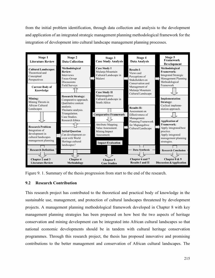
215
from the initial problem identification, through data collection and analysis to the development
and application of an integrated strategic management planning methodological framework for the
integration of development into cultural landscape management planning processes.
Figure 9. 1. Summary of the thesis progression from start to the end of the research.
9.2 Research Contribution
This research project has contributed to the theoretical and practical body of knowledge in the
sustainable use, management, and protection of cultural landscapes threatened by development
projects. A management planning methodological framework developed in Chapter 8 with key
management planning strategies has been proposed on how best the two aspects of heritage
conservation and mining development can be integrated into African cultural landscapes so that
national economic developments should be in tandem with cultural heritage conservation
programmes. Through this research project, the thesis has proposed innovative and promising
contributions to the better management and conservation of African cultural landscapes. The
216
recommendations of this thesis can also be used by African States Parties as a baseline to develop
site management plans and incorporation of the thesis ideas in their national cultural heritage
strategic plans and policies.
This study has also contributed to the current debate on the sustainable use of cultural landscapes
which usually has conflicting interests amongst different stakeholders, whereby all of them would
like to exploit the cultural and natural resources from the cultural landscapes for national and local
socio-economic purposes. Finally, this study has contributed to the body of literature on mining
developments and sustainable use of cultural heritage with particular emphasis to cultural
landscapes of sub-Saharan Africa.
9.3 Recommendations
With reference to the above discussions and aims of the study, general recommendations in terms
of governance, land use planning, conservation and management, and mine planning and
development have been drawn, as presented below:
9.3.1 Governance
1. Encourage the harmonization of policies and legislations, and where conflicting policies
and legislations exists, a mechanism should be put in place to allow for inter-sectorial
dialogue.
2. Provide integrated environmental licensing and permitting system for mineral extractive
developments in order to deal with negative impacts on the OUV of World Heritage
cultural landscapes.
3. Promote the use of best practice based Strategic Environmental Assessments (SEAs),
Heritage Impact Assessments (HIAs), as well as specific Environmental and Social Impact
Assessments (ESIAs) to inform good land use planning in order to ensure the maintenance
of the OUVs for World Heritage cultural landscapes.
4. Develop formal agreements, frameworks, and procedures to facilitate trans-frontier
cooperation between countries where World Heritage cultural landscapes are trans-
boundary in nature.
217
9.3.2 Land Use Planning
- Define the legal status of buffer zones to World Heritage cultural landscapes as well as the
regulatory measures to manage landuse within these areas.
- Ensure that land use planning processes are effective in their ability to reconcile
competitive land uses from an environmental, social and economic point of view, and this
should include a good decision-making framework to allow for the evaluation of these
competing natural resource use practices, including their opportunities and constraints.
- Implement land use planning and permitting processes that are transparent and inclusive,
and allow for the participation of all key stakeholders in the development of land use plans
and frameworks.
- Base land-use planning decisions and processes on good and relevant information to inform
the planning process, including relevant and up to date information on mineral deposits in
the area.
- Ensure that land use planning processes develop or improve existing mechanisms to
facilitate the successful integration of biodiversity conservation, protected areas, and
mining into the land use planning process.
- Adopt a regional approach to land use planning by using a landscape-level approach to
identify the most suitable use, and balance social, economic and environmental actions and
priorities in a holistic manner.
- Ensure land use planning has a long-term vision for land use, which allows for multiple
and/or sequential land uses within the broader landscape. This would also allow for
planning for mine closure to form an integral part of the land use planning process.
- Provide for an effective negotiation and/or arbitration system which can be used in the
event of competing land use claims.
9.3.3 Conservation and Management of Cultural Landscapes
- Ensure a workable and practical buffer zone around World Heritage cultural landscapes
and develop regulations that relate to all mining activities and any other development with
the full participation of all stakeholders.
- Link cultural landscape area planning with broader regional land use planning so that the
cultural landscapes are seen as an integral component of the broader region.
218
- Identify opportunities for mutually beneficial collaboration with other stakeholders such as
the mining industry in the management of protected World Heritage cultural landscapes.
- Ensure the active participation of conservation managers in regional land use planning
processes.
- Adopt an ecosystem service approach as a key strategy for the integrated management of
land, water and living resources that promotes conservation and sustainable use in an
equitable way and also includes cultural and spiritual values.
9.3.4 Mine Planning and Development
- Promote the International Council on Mining and Metals (ICMM) sustainable development
framework and principles as a basis for good practice for the mining and extractive
industry.
- As with the ICMM position on protected areas, the mining and extractive industry should
in principle adopt an approach that World Heritage cultural landscapes are ‘no-go’ areas.
- Consider development and conservation as complimentary processes for the management
of World Heritage cultural landscapes. This could be achieved through effective
stakeholder participation right from the outset of the project.
- Partner with relevant stakeholders to ensure the effective conservation and protection of
World Heritage cultural landscapes.
- Employ risk management strategies and best practices that take into account local cultures
and economic and environmental circumstances in the design, construction, operation and
decommissioning of mines.
- Provide for a collaborative approach to landscape management and socio-economic
development in the planning and operational phases of the mine.
With reference to this and the overall goal of the research, the following conclusions can be drawn:
i. Sustainable use, conservation, and management of cultural landscapes are underpinned
by a balance across economic, environmental and social-cultural dimensions that can
be best achieved through a long-term and holistic planning process, and participation
and empowerment of multiple stakeholders.
219
ii. Adequate legal protection, operational capacity, and integration into broader national
policy frameworks are required if sub-Saharan African World Heritage cultural
landscapes are to successfully implement the WHC strategic objectives.
iii. The conservation and management of cultural landscape values need to be integrated
into the long-term and holistic planning process that addresses heritage values as an
integral part of the management planning processes.
iv. Cultural landscapes need to take into account the potential for developmental change
in response to the stakeholder participation process and the need for integrated
development. This will require more robust descriptions of heritage attributes that
convey the significant values of the landscapes.
9.4 Limitations
As mentioned in Chapter 4, methodology, there are potentially two limitations in this research.
The first limitation results from the complexity of the concepts being studied. These include
cultural landscapes and mining. These concepts are very broad which cannot be understood by a
single methodological approach. This limitation has been addressed through the use of a case study
strategy and a combination of other methods to generate a theoretical management planning
framework which is testable, logically coherent and based on sound evidence. The second
limitation lies in the time and sample frame adopted in the research. The research was conducted
solely by the author as a PhD candidate who had limited capacity in terms of resources and
logistical challenges to meet all targeted research participants. This challenge was addressed by
seeking additional support from working colleagues and sponsors of the study programme.
9.5 Future Research
The thesis has highlighted several areas for future research. The first area relates to the
development of practical compatibility models for the integration of development projects into the
management operational frameworks of cultural landscapes. The lack of evidence in relation to
workable strategies, including coexistence of development projects and cultural landscape
conservation, was a key feature of the literature review and the management planning assessment
results. There is a need for a more research on the practical outcomes of the management planning
220
strategies suggested in the application of the strategic management planning framework developed
through this research.
There is also a need for future research aiming at developing evaluation methods and development
indicators for cultural landscapes. Research is needed in this area to develop functional approaches
and common indicators that will enable cultural landscape managers and developers to respond to
the aims of integrative development in a holistic way, and to benchmark progress toward those
aims.
Another area that needs further research relates to integration of development within the overall
World Heritage system. Although development programmes are needed in almost all developing
countries, the World Heritage system discourage any development as it affects the integrity and
authenticity of World Heritage sites. However, a stronger approach needs to be taken to consider
future development in the nomination, management and reporting processes of World Heritage
sites. This will need to be supported by the development of practical strategies and capacity
building programs across all relevant stakeholders.
Finally, while this thesis has presented a strategic integrated management planning methodological
framework for integration of development projects into cultural landscape management processes,
further research is required to investigate both the validity of that framework and the existence of
alternative frameworks. Such research could also build on this framework and the above
suggestions to provide comprehensive guidelines for the better integration of development into
cultural landscape management planning.
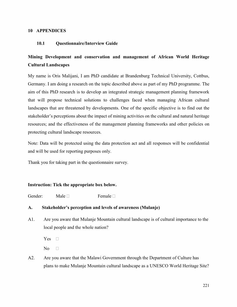
221
10 APPENDICES
10.1 Questionnaire/Interview Guide
Mining Development and conservation and management of African World Heritage
Cultural Landscapes
My name is Oris Malijani, I am PhD candidate at Brandenburg Technical University, Cottbus,
Germany. I am doing a research on the topic described above as part of my PhD programme. The
aim of this PhD research is to develop an integrated strategic management planning framework
that will propose technical solutions to challenges faced when managing African cultural
landscapes that are threatened by developments. One of the specific objective is to find out the
stakeholder’s perceptions about the impact of mining activities on the cultural and natural heritage
resources; and the effectiveness of the management planning frameworks and other policies on
protecting cultural landscape resources.
Note: Data will be protected using the data protection act and all responses will be confidential
and will be used for reporting purposes only.
Thank you for taking part in the questionnaire survey.
Instruction: Tick the appropriate box below.
Gender: Male Female
A. Stakeholder’s perception and levels of awareness (Mulanje)
A1. Are you aware that Mulanje Mountain cultural landscape is of cultural importance to the
local people and the whole nation?
Yes
No
A2. Are you aware that the Malawi Government through the Department of Culture has
plans to make Mulanje Mountain cultural landscape as a UNESCO World Heritage Site?
222
Yes
No
A3. Are you aware that the Malawi Government through the Department on Mines has plans
to explore and exploit the mineral resources found in Mulanje Mountain cultural
landscape?
Yes
No
A4. Given two options, to choose between cultural heritage preservation and mineral
resources exploitation within the cultural landscape, what would you choose?
Cultural and natural heritage preservation
Mineral resources exploitation
Not sure
A5. What cultural heritage resources do you need to be protected in case of mining
development projects?
Shrines and sacred sites (graves, sacred pools, rock art/shelters
Archaeological Heritage
Monumental Heritage
Other, please specify:________________________________
B. Effectiveness of legislations and policies
B1. Malawi’s National Cultural Policy (2014) is contributing towards the development,
management and protection of Mulanje Mountain Cultural Landscape.
[ ] [ ] [ ] [ ] [ ]
Strongly Agree Agree Note Sure Disagree Strongly Disagree
B2. Environment Conservation Act of 73 of 1989 contributing towards the development,
management and protection of Mapungubwe Cultural Landscape.
[ ] [ ] [ ] [ ] [ ]
Strongly Agree Agree Note Sure Disagree Strongly Disagree
223
B3. National Environmental Management Act, 1998 contributing towards the development,
management and protection of Mapungubwe Cultural Landscape.
[ ] [ ] [ ] [ ] [ ]
Strongly Agree Agree Note Sure Disagree Strongly Disagree
B4. Environmental Laws Rationalization Act, 1997 contributing towards the development,
management and protection of Mapungubwe Cultural Landscape.
[ ] [ ] [ ] [ ] [ ]
Strongly Agree Agree Note Sure Disagree Strongly Disagree
B5. Minerals Act, No. 50 of 1991 contributing towards the development, management and
protection of Mapungubwe Cultural Landscape.
[ ] [ ] [ ] [ ] [ ]
Strongly Agree Agree Note Sure Disagree Strongly Disagree
B6. Mine Health and Safety Act, No 29 of 1996 contributing towards the development,
management and protection of Mapungubwe Cultural Landscape.
[ ] [ ] [ ] [ ] [ ]
Strongly Agree Agree Note Sure Disagree Strongly Disagree
B.7. Mines and Works Act No. 27 of 1956 contributing towards the development, management
and protection of Mapungubwe Cultural Landscape.
[ ] [ ] [ ] [ ] [ ]
Strongly Agree Agree Note Sure Disagree Strongly Disagree
B8. Minerals and Energy laws Amendment Act, 1994 contributing towards the development,
management and protection of Mapungubwe Cultural Landscape.
[ ] [ ] [ ] [ ] [ ]
Strongly Agree Agree Note Sure Disagree Strongly Disagree
B9. National Heritage Resources Act, No. 25 of 1999 contributing towards the development,
management and protection of Mapungubwe Cultural Landscape.
[ ] [ ] [ ] [ ] [ ]
Strongly Agree Agree Note Sure Disagree Strongly Disagree
224
B10. National Heritage Council Act, No. of 1999 contributing towards the development,
management and protection of Mapungubwe Cultural Landscape.
[ ] [ ] [ ] [ ] [ ]
Strongly Agree Agree Note Sure Disagree Strongly Disagree
B11. World Heritage Convention Act, 1999 contributing towards the development, management
and protection of Mapungubwe Cultural Landscape.
[ ] [ ] [ ] [ ] [ ]
Strongly Agree Agree Note Sure Disagree Strongly Disagree
B12. Management Plan 2012…. contributing towards the development, management and
protection of Mapungubwe Cultural Landscape.
[ ] [ ] [ ] [ ] [ ]
Strongly Agree Agree Note Sure Disagree Strongly Disagree
C. Management Planning Framework
C1. What aspects need to be addressed in order to improve the conservation and management
of cultural landscapes?
C2. What aspects need to be addressed in order promote the integration of development in
cultural landscape planning?
C3. What aspects need to be addressed in order promote the sustainable utilization of the
resources of cultural landscapes?
C4. How do management plans and related heritage policies influence the development of a
sustainable utilization, management and conservation of cultural landscapes?
225
C5. Please list four important stakeholders dealing with issues of mining and conservation of
cultural landscapes?
C6. What support needs to be provided to the stakeholders in question above order to assist
them to scale up issues of development integration into cultural landscapes?
C7. Please list (if any) important issues and aspects that can improve the management and
conservation of cultural landscapes in Africa?
C8. Please list (if any) important issues and aspects that can encourage the active
participation of stakeholders to promote the utilization and protection of cultural and
natural heritage resources found in cultural landscapes?
C9. Please list (if any) cultural heritage typology and their related intangible aspects that
require more management consideration in Mulanje Mountain/Mapungubwe cultural
landscape?
C10. Please list (if any) current or past aspects/initiatives that have assisted with improving the
conservation and management of status Mulanje Mountain/Mapungubwe cultural
landscape?
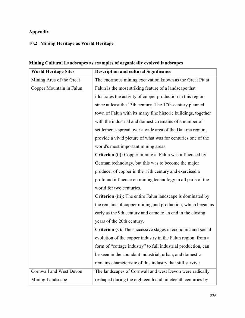
226
Appendix
10.2 Mining Heritage as World Heritage
Mining Cultural Landscapes as examples of organically evolved landscapes
World Heritage Sites Description and cultural Significance
Mining Area of the Great
Copper Mountain in Falun
The enormous mining excavation known as the Great Pit at
Falun is the most striking feature of a landscape that
illustrates the activity of copper production in this region
since at least the 13th century. The 17th-century planned
town of Falun with its many fine historic buildings, together
with the industrial and domestic remains of a number of
settlements spread over a wide area of the Dalarna region,
provide a vivid picture of what was for centuries one of the
world's most important mining areas.
Criterion (ii): Copper mining at Falun was influenced by
German technology, but this was to become the major
producer of copper in the 17th century and exercised a
profound influence on mining technology in all parts of the
world for two centuries.
Criterion (iii): The entire Falun landscape is dominated by
the remains of copper mining and production, which began as
early as the 9th century and came to an end in the closing
years of the 20th century.
Criterion (v): The successive stages in economic and social
evolution of the copper industry in the Falun region, from a
form of “cottage industry” to full industrial production, can
be seen in the abundant industrial, urban, and domestic
remains characteristic of this industry that still survive.
Cornwall and West Devon
Mining Landscape
The landscapes of Cornwall and west Devon were radically
reshaped during the eighteenth and nineteenth centuries by
227
deep mining for predominantly copper and tin. The remains
of mines, engines houses, smallholdings, ports, harbours,
canals, railways, tramroads, and industries allied to mining,
along with new towns and villages reflect an extended period
of industrial expansion and prolific innovation.
Criterion (ii): The development of industrialized mining in
Cornwall and west Devon between 1700 and 1914, and
particularly the innovative use of the high-pressure steam
beam engine, led to the evolution of an industrialized society
manifest in the transformation of the landscape through the
creation of smallholdings, railways, canals, docks and ports,
and the creation or remodeling of towns and villages.
Together these had a profound impact on the growth of
industrialization in the United Kingdom, and consequently on
industrialized mining around the world.
Criterion (iii): The extent and scope of the remains of
copper and tin mining, and the associated transformation of
the urban and rural landscapes presents a vivid and legible
testimony to the success of Cornish and west Devon
industrialised mining when the area dominated the world's
output of copper, tin and arsenic.
Criterion (iv): The mining landscape of Cornwall and west
Devon, and particularly its characteristic engine houses and
beam engines as a technological ensemble in a landscape,
reflect the substantial contribution the area made to the
Industrial Revolution and formative changes in mining
practices around the world.
Zollverein Coal Mine
Industrial Complex in Essen
The Zollverein industrial complex in Land Nordrhein-
Westfalen consists of the complete infrastructure of a
historical coal-mining site, with some 20th-century buildings
of outstanding architectural merit. It constitutes remarkable
228
material evidence of the evolution and decline of an essential
industry over the past 150 years.
Criterion (ii): The Zollverein XII Coal Mine Industrial
Complex is an exceptional industrial monument by virtue of
the fact that its buildings are outstanding examples of the
application of the design concepts of the Modern Movement
in architecture in a wholly industrial context.
Criterion (iii): The technological and other structures of
Zollverein XII are representative of a crucial period in the
development of traditional heavy industries in Europe, which
were reinforced through the parallel development and
application of Modern Movement architectural designs of
outstanding quality.
Mines of Rammelsberg,
Historic Town of Goslar and
Upper Harz Water
Management System
The copper, lead and tin mines of Rammelsberg mountain, in
the Harz region, were worked continuously from the 11th
century until the 1980s. They bear outstanding testimony to
mining installations and practices in Europe, both in terms of
surface and underground remains, particularly from the
Middle Ages and the Renaissance period.
Criterion (i): The historic mining network of the Mines of
Rammelsberg, the Historic Town of Goslar and the Upper
Harz Water-Management System constitutes one of the
largest mining and metallurgical complexes for non-ferrous
metals in Europe. Known to have existed since ancient times,
it has been in continuous use since the Middle Ages, initially
under the impetus of Cistercian monks, and in later periods
under the control of regional princes and of the Holy Roman
Empire, of which Goslar was one of the capitals. The
ensemble is an outstanding example of human creative genius
in the fields of mining techniques and industrial water-
management.
229
Criterion (ii): The historic mining network of the Mines
Rammelsberg, the Historic Town of Goslar and the Upper
Harz Water-Management System exhibits an important
interchange of human values, in the field of mining and water
management techniques, from the Middle Ages until the
modern and contemporary periods in Europe. It was the
inspiration for Agricola’s De re metallica, the authoritative
work on metallurgy and mining in the Renaissance.
Criterion (iv): The historic mining network of the Mines of
Rammelsberg, the Historic Town of Goslar and the Upper
Harz Water-Management System constitutes an outstanding
and very comprehensive technological ensemble in the fields
of mining techniques, non-ferrous metallurgy and the
management of water for drainage and power. Its extent and
its period of continuous operation are exceptional. It also
provides a characteristic example of administrative and
commercial organization in the Middle Ages and the
Renaissance period, through the remains of the monastery of
Walkenried and the town planning of the Historic Town of
Goslar.
Neolithic Flint Mines at
Spiennes (Mons)
The Neolithic Flint Mines of Spiennes occupy two chalk
plateaux located to the south-east of the city of Mons. They
cover an area essentially devoted to agriculture. The site
appears on the surface as a large area of meadows and fields
strewn with millions of scraps of worked flint. Underground,
the site is an immense network of galleries linked to the
surface by vertical shafts dug by Neolithic populations.
Criterion (i): The Neolithic Flint Mines at Spiennes provide
exceptional testimony to early human inventiveness and
application.
230
Criterion (iii): The arrival of the Neolithic cultures marked a
major milestone in human cultural and technological
development, which is vividly illustrated by the vast complex
of ancient flint mines at Spiennes.
Criterion (iv): The flint mines at Spiennes are outstanding
examples of the Neolithic mining of flint, which marked a
seminal stage of human technological and cultural progress.
Major Mining Sites of
Wallonia
The four sites of the property form a strip 170 km long by 3–
15 km wide, crossing Belgium from east to west, consisting
of the best-preserved 19th- and 20th-century coal-mining
sites of the country.
Criterion (ii): Among the earliest and largest in Europe, the
four Walloon coalmines are testimony to the early
dissemination of the technical, social and urban innovations
of the industrial revolution. They then played a major
exemplary role on the technical and social levels through to
recent times. Finally, they are one of the most important sites
of interculturalism arising out of mass industry through the
participation of workers from other regions of Belgium,
Europe and later Africa.
Criterion (iv): The ensemble of the four Walloon mining
sites provides an eminent and complete example of the world
of industrial mining in continental Europe, at various stages
of the industrial revolution. It bears significant testimony to
its industrial and technological components, its urban and
architectural choices, and its social values, especially
following the Bois-du-Cazier disaster (1956).
City of Potosí In the 16th century, this area was regarded as the world’s
largest industrial complex. The extraction of silver ore relied
on a series of hydraulic mills.
231
Criterion (ii): The “Imperial City” of Potosí, such as it
became following the visit of Francisco de Toledo in 1572,
exerted lasting influence on the development of architecture
and monumental arts in the central region of the Andes by
spreading the forms of a baroque style incorporating Indian
influences.
Criterion (iv): Potosí is the one example par excellence of a
major silver mine in modern times. The industrial
infrastructure comprised 22 lagunas or reservoirs, from
which a forced flow of water produced the hydraulic power
to activate the 140 ingenios or mills to grind silver ore. The
ground ore was then amalgamated with mercury in refractory
earthen kilns called huayras or guayras. It was then molded
into bars and stamped with the mark of the Royal Mint.
Criterion (vi): Potosí is directly and tangibly associated with
an event of outstanding universal significance: the economic
change brought about in the 16th century by the flood of
Spanish currency resulting from the massive import of
precious metals in Seville.
Historic Town of Ouro Preto Founded at the end of the 17th century, Ouro Preto (Black
Gold) was the focal point of the gold rush and Brazil’s
golden age in the 18th century. With the exhaustion of the
gold mines in the 19th century, the city’s influence declined
but many churches, bridges and fountains remain as a
testimony to its past prosperity and the exceptional talent of
the Baroque sculptor Aleijadinho.
Criterion (i): Set in a remote and rugged landscape, the
aesthetic quality of the vernacular and erudite architecture
and irregular urban pattern of Ouro Preto makes the town a
treasure of human genius. The most notable of the city’s
architectural works are represented by the religious
232
monuments and administrative buildings, including the
Palácio dos Governadores (Governors’ Palace), today the
School of Mines, and the former Casa de Câmara e Cadeia
(Administrative and Prison House), home to the
Inconfidência Museum. The Baroque churches carry
sculptures by Antônio Francisco Lisboa, Aleijadinho,
colonial Brazil’s greatest artist, and the ceiling paintings of
Manuel da Costa Athaide among others. These were the
representatives of the initial expressions of an artistic form
deemed genuinely national and developed in a region marked
by difficult access and a scarcity of materials and labor in the
18th century.
Criterion (iii): The built heritage of the Historic City of
Ouro Preto bears exceptional testimony to the creative talents
of a society built on pioneering mining wealth under
Portuguese colonial rule. Although the architecture,
paintings, and sculptures are based on underlying models
introduced by Portuguese immigrants, the works vary
significantly from the contemporary European art, not only
with respect to their spatial conception, but in their decorative
treatment, in particular the stone sculptures carved on the
facades, distinctive for their originality and design and in the
combined use of two materials, gneiss and soapstone. The
absence of formal convents or monasteries, due to the edict
of the Portuguese Crown which prohibited the establishment
of religious orders in Minas Gerais, led to the construction of
churches and chapels displaying the full splendor, quality,
and originality of the syncretized artistic traditions of two
cultures.
Sewell Mining Town
Situated at 2,000 m in the Andes, 60 km to the east of
Rancagua, in an environment marked by extremes of climate,
233
Sewell Mining Town was built by the Braden Copper
company in 1905 to house workers at what was to become
the world’s largest underground copper mine, El Teniente. It
is an outstanding example of the company towns that were
born in many remote parts of the world from the fusion of
local labour and resources from an industrialized nation, to
mine and process high-value natural resources.
Criterion (ii): Sewell town in its hostile environment is an
outstanding example of the global phenomenon of company
towns, established in remote parts of the world through a
fusion of local labour with resources from already
industrialised nations, to mine and process high value copper.
The town contributed to the global spread of large-scale
mining technology.
Humberstone and Santa Laura
Saltpeter Works
Humberstone and Santa Laura works contain over 200 former
saltpeter works where workers from Chile, Peru and Bolivia
lived in company towns and forged a distinctive communal
pampinos culture. That culture is manifest in their rich
language, creativity, and solidarity, and, above all, in their
pioneering struggle for social justice, which had a profound
impact on social history.
Criterion (ii): The development of the saltpeter industry
reflects the combined knowledge, skills, technology, and
financial investment of a diverse community of people who
were brought together from around South America, and from
Europe. The saltpeter industry became a huge cultural
exchange complex where ideas were quickly absorbed and
exploited. The two works represent this process.
Criterion (iii): The saltpeter mines and their associated
company towns developed into an extensive and very distinct
urban community with its own language, organisation,
234
customs, and creative expressions, as well as displaying
technical entrepreneurship. The two nominated works
represent this distinctive culture.
Criterion (iv): The saltpeter mines in the north of Chile
together became the largest producers of natural saltpeter in
the world, transforming the Pampa and indirectly the
agricultural lands that benefited from the fertilizers the works
produced. The two works represent this transformation
process.
Nord-Pas de Calais Mining
Basin
Remarkable as a landscape shaped over three centuries of
coal extraction from the 1700s to the 1900s, the site consists
of 109 separate components over 120,000 ha. It features
mining pits (the oldest of which dates from 1850) and lift
infrastructure, slag heaps (some of which cover 90 ha and
exceed 140 m in height), coal transport infrastructure, railway
stations, workers’ estates and mining villages including social
habitat, schools, religious buildings, health and community
facilities, company premises, owners and managers’ houses,
town halls and more.
Criterion (ii): The Nord-Pas de Calais Mining Basin
provides exceptional testimony to the exchange of ideas and
influences regarding the extraction methods used for
underground coal seams, the design of worker housing and
urban planning, as well as the international human migration
that accompanied the industrialization of Europe.
Criterion (iv): The living and evolving mining landscapes of
the Nord-Pas de Calais Basin provide an eminent example of
the large-scale development of coal mining in the 19th and
20th centuries, by large industrial companies and their
considerable workforce. This is a space structured by urban
235
planning, specific industrial structures and the physical
vestiges of coal extraction (slag heaps and subsidence).
Criterion (vi): The social, technical and cultural events
associated with the history of the Mining Basin had
international repercussions. They are a unique and
exceptional illustration of the danger of mine-working and of
the history of its major disasters (Courrières). They are
testimony to the evolution of the social and technical
conditions of coal extraction. They represent a major
symbolic place of the workers’ condition and their solidarity,
from the 1850s to 1990. They are testimony to the
dissemination of the ideals of worker unionism and
socialism.
Iwami Ginzan Silver Mine
and its Cultural Landscape
Iwami Ginzan Silver Mine pioneered the development of
silver mines in pre-Modern Asia. It had contributed to
exchange of values between East and West by achieving the
large-scale production of high quality silver through the
development of the Asian cupellation techniques transferred
from China through Korea and the Japanese unique
assemblage of numerous labor-intensive small businesses
based upon manual techniques in the 16th century.
Criterion (ii): During the Age of Discovery, in the 16th and
early 17th centuries, the large production of silver by the
Iwami Ginzan Silver Mine resulted in significant commercial
and cultural exchanges between Japan and the trading
countries of East Asia and Europe.
Criterion (iii): Technological developments in metal mining
and production in Japan resulted in the evolution of a
successful system based on small-scale, labor-intensive units
236
covering the entire range of skills from digging to refining.
The political and economic isolation of Japan during the Edo
Period (1603 to 1868) impeded the introduction of
technologies developed in Europe during the Industrial
Revolution and this, coupled with the exhaustion of
commercially viable silver-ore deposits, resulted in the
cessation of mining activities by traditional technologies in
the area in the second half of the 19th century, leaving the
site with well-preserved archaeological traces of those
activities.
Criterion (v): The abundant traces of silver production, such
as mines, smelting and refining sites, transportation routes,
and port facilities, that have survived virtually intact in the
Iwami Ginzan Silver Mine Site, are now concealed to a large
extent by the mountain forests that have reclaimed the
landscape. The resulting relict landscape, which includes the
surviving settlements of the people related to the silver
production, bears dramatic witness to historic land-uses of
outstanding universal value.
Røros Mining Town and the
Circumference.
(Norway)
Røros Mining Town and the Circumference consist of three
sites within the Circumference, i.e. the area of privileges
awarded by the Danish-Norwegian King to Røros Copper
Works in 1646. The town and the cultural landscapes cover a
large continuous area which includes the landscape
surrounding the mining town, the urban agricultural areas,
and the most important mining landscapes where agricultural
practices and copper work operations were carried out.
Criterion (iii): From the time copper ore was found in the
mountains at Røros in 1644 until the copper works went
237
bankrupt in 1977, with German mining technology as a
starting point, employing German, Danish, Swedish
immigrants, and Norwegian nationals,, a unique culture
developed to extract the valuable copper in a remote and
sparsely inhabited area. Today there is no mining in the area,
but Røros Mining Town and the traces of mining, smelters,
transport, and water management systems bear unique
witness to the adaptation of technology to the requirements of
the natural environment and the remoteness of the situation.
Criterion (iv): Røros townscape and its related industrial and
rural landscapes, with their interlinked industrial activity and
domestic and agricultural accommodation within an urban
environment, illustrate in an outstanding manner how people
adapted to the extreme circumstances in which they had to
live and how they used the available indigenous resources to
provide shelter, produce food for their sustenance, and
contribute to the national wealth of the country.
Technologically, their buildings and installations evolved
through the use of available indigenous materials to
functionally satisfy the combined approach of mining and
agrarian practices whilst at the same time accommodating the
consequences of dealing with extreme climatic conditions.
Criterion (v): Røros Mining Town and the Circumference
constitute a totality that is an outstanding example of
traditional settlement and land-use. The various activities that
have been carried out in the area constitute a coherent and
interdependent unit. These activities have shaped a cultural
landscape that provides a unique picture of how the mines
and the mining town functioned as a complex and at times
238
vulnerable system that verged on the limits of what was
possible in an inhospitable environment with a harsh climate.
Wieliczka and Bochnia Royal
Salt Mines
The deposit of rock salt in Wieliczka and Bochnia has been
mined since the 13th century. This major industrial
undertaking has royal status and is the oldest of its type in
Europe. The site is a serial property consisting of Wieliczka
and Bochnia salt mines and Wieliczka Saltworks Castle.
Criterion (iv): The Wieliczka and Bochnia Royal Salt Mines
illustrate the historic stages of the development of mining
techniques in Europe, from the 13th to the 20th centuries.
The galleries, the subterranean chambers arranged and
decorated in ways that reflect the miners’ social and religious
traditions, the tools and machinery, and the Saltworks Castle
which administered the establishment for centuries, provide
outstanding testimony about the socio-technical system
involved in the underground mining of rock salt.
Engelsberg Ironworks.
(Sweden)
Sweden's production of superior grades of iron made it a
leader in this field in the 17th and 18th centuries. This site is
the best-preserved and most complete example of this type of
Swedish ironworks.
Criterion (iv): Engelsberg is an outstanding example of an
influential European industrial complex of the 17th-19th
centuries, with important technological remains and the
associated administrative and residential buildings intact.
Blaenavon Industrial
Landscape.
(South Wales)
The area around Blaenavon is evidence of the pre-eminence
of South Wales as the world's major producer of iron and
coal in the 19th century. All the necessary elements can still
be seen - coal and ore mines, quarries, a primitive railway
239
system, furnaces, workers' homes, and the social
infrastructure of their community.
Criterion (iii): The Blaenavon Landscape constitutes an
exceptional illustration in material form of the social and
economic structure of 19th century industry.
Criterion (iv): The components of the Blaenavon Industrial
Landscape together make up an outstanding and remarkably
complete example of a 19th century industrial landscape.
240
11 REFERENCES
Adler, P., & Adler , P. (1994). Observational techniques. In N. Denzin, & S. Lincoln, Handbook
of qualitative research (pp. 377-392). Thousand Oaks, CA: Sage.
Afanasyeva, D. (2015). Shared heritage: sacred landscapes of Crimea, their development and
protection in the multicultural context, unpublished PhD thesis. Cottbus, Germany:
Brandenburg Technical University.
Aitken, W. G. 1964. Notes on the Mulanje bauxite deposits. Unpublished Report. Geological
Survey. Malawi, T238.
Akabzaa, T. (2009). Mining in Ghana: Implications for National Economic Development and
Poverty Reduction. In B. Campbell, Mining and Development in Africa (pp. 25-65).
Montreal, Canada: Pluto Publishers.
Alushai, N. (2001). Preliminary report on the oral history of the Mapungubwe area. Pretoria:
Unpublished report for Dept of Environmental Affairs and Tourism.
Amankwah, R. S. (2003). Strategies for Sustainable Development of the Small-Scale Gold and
Diamond mining industry of Ghana. Resources Policy, 131-138.
Amoaka-Atta, B. (1995). Sacred groves in Ghana. In B. vonDroste, H. Plachter, & M. Rossler,
Cultural landscapes of universal value. (pp. 81-95). New York: Gustav Fischer Verlag.
Anhaeusser, C.R. & S. Maske (Eds) (1986). The Mineral Deposits of Southern Africa, Volumes
I and II. The Geological Society of South Africa, Johannesburg. Pp. 2376.
Antrop, M. (2005). Why landscapes of the past are important for the future. . Landscape and Urban
Planning, Web Science.
Arazi, N. (2011). Safeguarding archaeological cultural resources in Africa—policies, methods and
issues on (non-) compliance. African Archaeological Review 28, 27-38.
Ashton, P.J. (1999). Using environmental impact assessments to determine the consequences of
mining activities and to highlight the costs of sustainable development. In: Proceedings of
the Conference on Environmental Management Systems in Mining, 11-13 October 1999,
Kempton Park, South Africa. Pp.12.
241
Ashton, P.J., et al (2001). An Overview of the Impact of Mining and Mineral Processing
Operations on Water Resources and Water Quality in the Zambezi, Limpopo and Oilfants
Catchments in Southern Africa. University of Zimbabwe, Harare, Zimbabwe. Report No.
ENV-P-C 2001-042. xvi + 336 pp.
Atkinson, P., & Delamont, S. (2005). Qualitative Research Traditions. In C. Calhoun, C. Rojek, &
B. Turner, The SAGE Handbook of Sociology. Sage.
Austroplan, (1990). Integrated Exploitation and Processing of Mulanje/Manica Bauxite and
Establishment of Alumina/Aluminium industry in the SADC Region.
Auty, R. (1990). Resource-Based Industrialization: Sowing the Oil in Eight Developing Countries.
Oxford: Clarendon Press.
Baxter, I. (2009). Means Make the End: The Context for the Development of Methodologies to
Assess the State of the Historic Environment in the UK. In L. Sorensen, & J Carmen(Eds),
Heritage Studies: Methods and Approaches (pp. 85-102). London: Routledge.
Beach, D. (1994). The Shona and their neighbors. Oxford: Blackwell Publishers.
Beard, J. (1997). Geography, environment and flora of Mt Mulanje, Central Africa. Journal of the
Royal Society of Western Australia, 189-191.
Beck, W. (2006). Narratives of World Heritage in Travel Guidebooks. nternational Journal of
Heritage Studies,, 521-535.
Bell, S. (2002). Management of Cultural Landscapes: What Does this Mean in the Former Soviet
Union? A Case Study from Latvia. Landscape Research Vol. 34, No. 4, 425–455.
Berelson, B. (1952). Content analysis in communications research. Illinois: Free Press.
Berger, & Luckmann. (1967). The Social Construction of Reality: A Treatise in the Sociology of
Knowledge. Garden City, NY: Anchor Books.
Bertrand, & Huges. (2005). Media Research: Audiences, Institutions, Texts 2005th Edition.
Published by Palgrave.
Birnbaum, C. (1994). Protecting Cultural Landscapes: Planning, Treatment and Management of
Historic Landscapes. Preservation Briefs Issue No. 36.
242
Bloemers, T. (2010). Protection and Development of the Dutch Archeological-Historical
Landscape and Its European Dimension. In T. Bloemers, H. Kars, & a. M. Arnold Van der
Valk, The Cultural Landscape and Heritage Paradox. (pp. 3- 16). Amsterdam.: The
University of Amsterdam Press.
Bord, R. (1991). Comment on 'transverse interaction'. Symbolic Interaction Vol. 14, 365-66.
Braun, V, and Clarke, V (2006). Using thematic analysis in psychology. Qualitative Research in
Psychology, 3, 77-101.
Breugel, J. v. (2001). Chewa Traditional Religion. Publisher Christian Literature Association in
Malawi.
Brink, et al (1990). The changing impact of urbanization and mining on the geological
environment. South African Journal of Science, 86(7-10): 434-440.
Brown, D. (2011). Making the linkages between climate change adaptation and spatial planning
in Malawi. Environmental Science & Policy, 940-949.
Brown, G., Smith, C., Alessa, L., & Kliskey, A. (2004). A comparison of perceptions ofbiological
value with scientific assessment of biological importance. Applied Geography 24, 161–
180.
Buckle, R. (2002). Managing cultural Landscapes: A case study of Stirling, Alberta. Canada):
University of Calgary (Canada), Master Thesis.
Bull, AC and Jones, B (2006). Governance and Social capita in urban regeneration: A comparison
between Bristol and Naples. Urban strategies, 43 (4), 767-786.
Calabrese, J. (1988). Report on the 1997 field season Shashe-Limpopo Archaeological project
Venetia Limpopo Nature Reserve. Johannesburg: Archaeology Department: Prepared for
DeBeers Consolidated Mines.
Calabrese, J. (2000). Interregional interaction in southern Africa: Zhizo and Leopard’s Kopje
relations in northern South Africa, southwestern Zimbabwe and eastern Botswana, AD
1000 to 1200. African Archaeological Review, 183-210.
243
Calabrese, J. (2000b). Metals, ideology and power: the manufacture and control of materialised
ideology in the area of the Limpopo-Shashe confluence, c.AD 900 to 1300. South African
Archaeological Society, Goodwin Series 8, 100-111.
Carruthers, J. (2006). Mapungubwe: An Historical and Contemporary Analysis of a World
Heritage Cultural Landscape. Koedoe: 1–14 Google Scholar.
CBD. (1992). Text of the Convention - Convention on Biological Diversity. Retrieved from
www.cbd.int/convention/text.
Chapman, J. (1990). Mount Mulanje, Malawi: a plea for its future. World Wildlife Fund.
Chapman, J. (1994). Mount Mulanje. Centres of Plant Diversity; Europe, Africa, south-west Asia.
Chenje, M. (Ed.) (2000). State of the Environment in the Zambezi Basin 2000. Report by Southern
African Development Community (SADC-ELMS and WSCU), Maseru, Lusaka, Harare.
Chhotray, V and Stoker, G (2009). Governance Theory and Practice: A Cross-Disciplinary
Approach. Basingstoke: Palgrave Macmillan.
Chirikure, S. (2013). Heritage conservation in Africa: The good, the bad, and the challenges.
Southern African Journal of Science, 1-3.
Clark, J. (1973). Archaeological investigation of a painted rockshelter at Mwana wa Chencherere,
north of Dedza, central Malawi. Society of Malawi Journal, 28-46.
Cole-King, P. (1973). Kukumba Mbiri mu Malawi. A Summary of Archaeological Research to
March 1973. Lilongwe: Malawi Department of Antiquities.
Cosgrove D. (1989). Geography is everywhere: Culture and Symbolism in Human Landscapes.
In: Gregory D., Walford R. (Eds.) Horizons in Human Geography. Horizons in Geography.
Palgrave, London.
Council of Europe, (2000). European Landscape Convention, Cultural Heritage, Landscape and
Spatial Planning Division, France www.coe.int/EuropeanLandscapeConvention.
Curry, J. (1920). The Hill of Good Bye. The story of a solitary white woman’s life in Central Africa.
Davidson, J and Lockwood, M (2008). Partnerships as instruments of good regional governance:
Innovation for sustainability in Tasmania. Regional Studies, (42 (5) 641-656.
244
Davies, JS (2002). The governance of urban regeneration: A critique of the 'governing without
government' thesis. Public administration, 80 (2) 301-322.
Davis, G., & Tilton, J. E. (2003). Should Developing Countries Renounce Mining?: A Perspective
on the Debate. Paper contributed to Extractive Industries Review (EIR).
Davis, S., Heywood, H. Y., & Hamilton, A. C. (1994). Mount Mulanje, Malawi. Afro-montane
Regional Center of Endemism. CPD Site AF 64.
Denzin, NK and Lincoln YS (Eds.) (2003). Strategies of Qualitative Inquiry, 2nd ed. Thousand
Oaks: Sage Publications.
Derricourt, R. (1980). People of the Lakes: Archaeological Studies in Northern Zambia. Zambian
Papers No 13.
Dixey, F. (1927). The Mulanje Mountain of Nyasaland. Geographical Review, 611-626.
Dixey, F. (1926). The Bauxite Deposits of the Mulanje Mountains. Annual Rep. Geol Surv.
Nyasaland.
DoA. (2013). Department of Environmental Affairs. Mining and Biodiversity Guideline:
Mainstreaming biodiversity into the the mining sector. Pretoria: SANBI Grasslands
Programme.
Eastwood, E. (1999). Red lines and arrows: attributes of supernatural potency in the San rock art
of the Northern Province of South Africa and south-western Zimbabwe. South African
Archaeological Bulletin, 16-27.
Eastwood, E., & Cnoops, C. (1999). Capturing the spoor: towards explaining kudu in the San rock
art of the Limpopo-Shashi confluence area. South African Archaeological Bulletin, 107-
119.
ELC. (2000). European Landscape Convention. European Treaty Series- No. 176.
Emmelin, L. (1996). Landscape impact analysis: a systematic approach to landscape impacts of
policy. Landscape Research journal, 13-35.
EP. (2013). The Equator Principles . Retrieved from www.equator-
principles.com/resources/equator_principles _III.pdf. Accessed 12 Nov, 2017
245
Feilden, B., & Jokilehto, J. (1998). Managment Gudelines for World Cultural Heritage Sites.
Rome: ICCROM.
Finer, M., & Orta-Martınez, M. (2010). A second hydrocarbon boom threatens the Peruvian
Amazon: trends, projections, and policy implications. Environmental Research Letter, 1-
10.
Flick, U. (2002). An Introduction to Qualitative Research. SAGE Publications.
Fontana, A., & Frey, J. (2005). The interview: From neutral stance to political involvement. In N.
Denzin, & Y. S. Lincoln, The SAGE handbook of qualitative research (pp. 695-728).
Thousand Oaks, CA: Sage.
Fowler, P. (2003). Linking Nature and Culture: World Heritage Cultural Landscapes . In M.
Rössler(Ed), Cultural Landscapes: the Challenges of Conservation. UNESCO World
Heritage Centre.
Francis, M (2011). A Case Study Method for Landscape Architecture. Landscape Journal 20:15-
29.
Freudenburg, & Gramling. (1992). Community impacts of technological change: toward a
longitudinal perspective. Social Forces Vol. 50., 37-55.
Friedman, A., & Miles, S. (2002). Developing stakeholder theory. Journal of Management Studies
39.
Fuggle, R.F. & Rabie, M.N (1996). Environmental Management in South Africa. Juta & Co,
Johannesburg. 823 pp.
Gallent, N (2008). Strategic-local tensions and the spatial planning approach in England.
Planning Theoery and Practice, 9 (3) 307-323
Gelb, A. (1988). Oil Windfalls: Blessing or Curse? New York: Oxford University Press.
Gesellschaft, C.D (1999). Report on the International Round Table on Mining and the
Environment: Berlin.
Gibbs. (1990). Psychological impacts of toxic exposure in Third World countries. Impact
Assessment Bulletin, 7-18.
246
GoM. (2007). Government of Malawi. Malawi Growth and Development Strategy: 2006-2011.
GoM. (2013). Mines and Mineral Policy. Ministry of Mining.
GoM. (2013). National Climate Change Investment Plan (2013–2018). Ministry of Environment
and Climate Change Management, Environmental Affairs Department.
GoM. (2015). Republic of Malawi Intended Nationally Determined Contribution. Environmental
Affairs Department, Government of Malawi.
Goodrick, D. (2014). Comparative Case Studies, Methodological Briefs. Impact Evaluation 9
UNICEF Office of Research, Florence.
GoPNG. (2002). Government of Papua New Guinea. Fourth Quarter Bulletin: Annual Bulletin,
2001 . PNG Department of Mining. Port Moresby, PNG: GoPNG.
Gowtham, M., Raju, A., & Sai , N. (2016). Mining Industry And its Impact on Environment And
Human Health. International Journal of Advance Research in Science and Engineering
Vol. No.5, Issue 04.
Greider, T., & Garkovich L. (1994). Landscapes: The Social Construction of Nature and the
Environment. Rural Sociology 59, 1-24.
Gurney, J. & Kirkley, M.B. (1996). Kimberlite dyke mining in South Africa. Africa Geoscience
Review. 3. 191-201.
Hartmann, H., & Mutmansky, J. (2002). Introductory Mining Engineering. Edition. John Wiley
and Sons. Inc.
Hayford, E. (2008). Impact of Gold Mining on Soil and some Staple Foods Collected from Selected
Mining Communities in and around Tarkwa-Prestea Area. West African Journal of Applied
Ecology, 1-12.
Henning, D and Beate, J (2014). Mapungubwe Cultural Landscape World Heritage Site
Environmental Management Framework: Strategic Environmental Management Plan.
HIA. (2012). Heritage Impact Assessment Report And Management Plan Relating To The
Establishment Of The Vele Colliery Near Mapungubwe World Heritage Site, Musina,
247
Limpopo Province: South Africa. Report prepared for Limpopo Coal Company (Pty) Ltd
for submission to the Department of Environmental Affairs.
Hirsch, E. (1995). Landscape: between place and space. In E. Hirsch, & M. O'Hanlon, The
Anthropology of Landscape. Oxford: Clarendon Press.
Hounsome, R. & P.J. Ashton (2001). Sustainable Development for the Mining and Minerals
Sector in Southern Africa. Draft Position Paper for the Mining, Minerals and Sustainable
Development Project, Stellenbosch. 16 pp.
Hsieh, HF and Shannon, SE (2005). Three Approaches to qualitative content analysis. Qualitative
Health Research, 15 (9) 1277-1288.
Huffman, T. (1984). Leopard’s Kopje and the nature of the Iron Age in Bantu Africa. Zimbabwea,
28-35.
Huffman, T. (2000). Mapungubwe and the origins of the Zimbabwe culture. South African
Archaeological Society Goodwin Series 8, 14-29.
Hughes, A., & Sullivan , M. (1989). Environmental Impact Assessment in Papua New Guinea:
Lessons for the Wider Pacific Region. Pacific Viewpoint Vol 30.
Huxham, C (2003). Theorizing collaboration practice. Public Management Review, 5 (3) 401-
423.
ICMM. (2003). ICMM SD Framework – Final Principles . Retrieved from International Council
on Mining and Metals: www.iucn.org/sites/dev/files/import/downloads/minicmmstat.pdf.
Accessed in 20 October 2017.
ICMM. (2010). Mining and Biodiversity: A collection of case studies. Retrieved from
www.icmm.com/website/publications/pdfs. Accessed on 20 Oct 2017.
ICOMOS. (2002). Ethical Commitment Statement for ICOMOS Members. Madrid: Adopted by
the 13th General Assembly.
ICOMOS. (2010). Guidance on Heritage Impact Assessments for Cultural World Heritage
Properties. Retrieved from http://openarchive.icomos.org. Accessed on 20.12.2017.
248
ICOMOS. (2013). The Burra Charter: the Australia ICOMOS Charter for Places of Cultural
Significance. ICOMOS Australia.
IFC. (2012). International Finance Corporation. Performance Standard 8 Cultural Heritage.
Retrieved from www.ifc.org/wps/wcm/connect/ Accessed 12 Nov, 2017.
Ingold, T. (1993). The temporality of landscape. World Archaeology 25, 152-74. IOOOlln. (n.d.).
IUCN. (2017). Put natural world heritage sites off limits for mining and oil exploration, IUCN
says. Available on www.iucn.org/content. Assessed 17th October 2017 .
Janet Stephenson, (2008). The Cultural Values Model: An integrated approach to values in
landscapes.
Jawahar I. M. and Mclaughlin G.L. (2001). Toward a Descriptive Stakeholder Theory: an
Organizational Life Cycle Approach Academy of Management Review 26:3, 397-414
Johnson, G., Scholes, K., & Whittington, R. (2008). Exploring Corporate Strategy. Harlow:
Prentice Hall.
Johnston, C., & Myers, D. (2009). Resolving Conflict and Building Consensus in Heritage Place
Management: Issues and Challenges. In D. Myers, S. N. Smith, & E. Ostergren(Eds),
Consensus Building, Negotiation, and Conflict Resolution for Heritage Place
Management. Los Angeles, California: Getty Conservation Institute.
Jones, M. (2004). Application of systematic review methods to qualitative research: practical
issues. Journal of Advanced Nursing, 271-278.
Jopela, A. (2011). Traditional Custodianship: A Useful Framework for Heritage Management in
Africa? Conservation and Management of Archaeological Sites. Conservation and
Management of Archaeological Sites , 103-122.
Kalinga, & Owen JM. (1983). Cultural and Political Change in Northern Malawi c.1350-1800.
African Study Monographs, 49-58.
Kankpeyeng, B., & DeCorse, C. R. (2004). Ghana’s vanishing past: Development, antiquities and
the destruction of the archaeological record. African Archaeological Review, 89–128.
249
Kaunda, C. (2013). Energy situation, potential and application status of small-scale hydropower
systems in Malawi. Renewable and Sustainable Energy Reviews 26, 1-19.
Kaya, A. (2016). Environmental Sustainability and Landscape Management. In Recep EFE, & I
Cürebal, A Gad, B Toth. St. Kliment Ohridski University Press, Sofia.
Kayambazinthu, D. (2000). Empowering communities to manage natural resources: Where does
power lie? The case of Malawi. In Empowering communities to manage natural resources.
In S. Shackleton, & B. Campbell, Empowering communities to manage natural resources:
case studies from southern Africa. Lilongwe/Pretoria/Harare: SADC/CSIR/WWF.
Kemp, D (2006). Community relations management systems in the minerals industry: combining
conventional and stakeholder-driven approaches, International Journal of Sustainable
Development (IJSD), Vol. 9, No. 4.
Kent, L. (1980). tratigraphy of South Africa. Part 1: Litho-stratigraphy of the Republic of South
Africa, South West Africa/Namibia and the Republics of Bophuthatswana, Transkei and
Venda. Pretoria: Department of Mineral and Energy Affairs, Handbook 8.
Kirk, J., & Miller, J. (1986). Reliability and Validity in Qualitative Research. SAGE Publications.
Korn, E., & Simon , R. (1990). Measures of explained variation for survival data. Statist. Med., 9.
487–503.
Krippendorff, K (2004). Content Analysis: An Introduction to it Methodology. Thousand Oaks:
Sage Publications.
Krippendorff, K. (1980). Validity in content analysis. In E. Mocheman(Ed), Computerstrategien
für die kommunikationsanalyse (pp. 69-112). Frankfurt, Germany: Campus.
Kuman, K. (2007). The earlier stone age in Southern Africa: Site context and the influence of cave
studies. In T. Pickering , T. Schick, & K. Toth, Breathing Life into Fossils. Taphonomic
Studies in Honour of C.K. (Bob) Brain (pp. 181-198). Bloomington, Indianna: Stone Age
Institute Press.
Kuyek, J., & Coumans , C. (2003). No Rock Unturned: Revitilizing the Economies of Mining
Dependent Communities. MiningWatch Canada, Ottawa, Canada.
250
Ladkin, AC and Fletcher J (2005). Stakeholder collaboration and heritage. Annals of Tourism
Research, 32 (1) 28-48.
Landorf (2009). Developing a framework for sustainable heritage management: A study of UK
Industrial heritage sites. International Journal of Heritage Studies, 15(6), 494-510.
LeBerre, M. (2000). Cultural landscapes in Africa – Genesis. In R. M, & G. Saouma-Forero, The
World Heritage Convention and Cultural Landscapes in Africa Expert Meeting (pp. 44-
58). Tiwi, Kenya: UNESCO WHC.
LeBerre, M., & L Messan. (1996). From nature to the spirits in African heritage. In D. Munjeri, &
Ndoro D, African Cultural Heritage and the World Heritage Convention. First Global
Strategy meeting. Harare: UNESCO, WHC.
Leighly, J. (1969). Land and Life, A Selection from the Writings of Carl Ortwin Sauer. Cultural
Landscapes as Heritage: A Landscape-Based Approach to Conservation, 315-350.
Litting, B and Griessler, E (2005). Social sustainability: A catchword between political
pragmatism and social theory. International journal of sustainable development, 8, 65-79.
Ljung, M. (2001). Collaborative learning for sustainable development of agri-food systems.
Agraria 303. Uppsala, SLU.
LONRHO (1973). Mount Mulanje Bauxite Project: Feasibility Study, Phase II. Unpublished
Report. Geological Survey. Malawi, No.659.
Luz, F. (2000). Participatory landscape ecology—a basis for acceptance and implementation.
Landscape and Urban Planning 50, 157-166.
MacmillanDenzin, N., & Lincoln, Y. (2005). The SAGE Handbook of Qualitative Research, Third
Edition. SAGE Publications.
Malunga G (1998). Rare earths exploration and reserve estimation strategies, the Malawi case,
Mining in Africa, Johannesburg, South Africa, South Africa Institute of Mining and
Metallurgy, pp. 51-54.
Malunga G, Samama, J and Houot, R (1991). Rare Earths Potential in Malawi, Materials Science
Forum, Vols. 70, pp 193 -204.
251
Malunga G. (nd) Mulanje Mountain Bauxite Project, Project Profile Mulanje Mountain Bauxite.
http://sdnp.org.mw/geosoc-mw/mulanje-bauxite.htm
Malunga, G. (2017). Mining Community Engagement as a tool for social economic transformation
in mining areas. Mining and Trade Review. Issue No. 49, 10.
Manyanga, M. (2007). Resilient Landscapes: socio-environmental dynamics in the Shashi-
Limpopo Basin, southern Zimbabwe c.AD 800 to the present. Studies in Global
Archaeology 11. Uppsala.
Mapong, O., & Mutemererwa, A. (1995). Management of Natural Resources and the Environment
in Zimbabwe: The Case of Gold. Paper prepared for UNCTAD, United Nations Conference
on Trade and Development.
Maradze, J. (2003). Back to the Old School? Revival of Traditional Management Systems in
Zimbabwe. Papers from the 14th General Assembly and Scientific Symposium of ICOMOS.
Marcucci, D.J (2000). Landscape history as a planning tool. Landscape and Urban Planning, Vol:
49, Issue: 1, pp: 67-81.
Martin, O., & Piatti, G. (2009). World Heritage and Buffer Zones/Patrimone Mondial et Zones
Tampons. Paris: UNESCO World Heritage Centre: International Expert Meeting on World
Heritage and Buffer Zones, Davos, Switzerland.
Marton-Lefe, . J. (2008). Intervention at World Heritage Committee. Quebec International Union
for Conservation of Nature.
Mbendi, (2000). Mbendi Information for Africa. Expectation from Mining in Africa 2018.
[Online]. Accessed on 27 April 2018. Available at website: (www.mbendi.co.za).
McCann, JE (1983). Design guidelines for social problem-solving. Journal of Applied Behavioral
Science, 19 (2) 177-192.
McCarthy, T., & Rubidge, B. (2005). The Story of Earth & Life. A Southern African Perspective
on a 4.6-Billion-Year Journey. Cape Town: Struik Publishers/Johnnic Publishing Group.
McFareen, W. (1986). History in the Land of Flames: The Maravi States of Pre-colonial Malawi.
Berkeley: University of California.
252
Melnick, R. (1984). Cultural Landscapes: Rural Historic Districts in the National Park System.
Washington, D.C: Park Historic Architecture Division, Cultural Resources Management,
U.S. Department of the Interior.
Mendelsohn, F. (Ed.) (1961).The Geology of the Northern Rhodesian Copperbelt. Macdonald,
London. 523 pp.
Meskell, L. (2012). The nature of heritage: The new South Africa. Oxford: Blackwell Publishing
Ltd.
MET-CHEM, Canada Inc. (1994). Feasibility study for Mulanje Mountain Bauxite in Malawi.
MIDCOR, Malawi.
Miles, M, and Huberman, AM (1994), Qualitative Data Analysis: An Expanded Sourcebook, 2nd
ed. Beverly Hills: Sage Publications.
Miranda, M., & et, a. l. (1998). All That Glitters is Not Gold: Balancing Conservation and
Development in Venezuela’s Frontier Forests. Washington, DC: World Resources
Institute.
Mitchel, W.J.T (2007). Imperial Landscape. The Cultural Geography Reader. Ed. Oakes T, Price,
P. (2007). pp. 496. Routledge. pp 127-139.
Mitchell, N., & Rossler, M. (2009). World Heritage Cultural Landscapes: A Handbook for
Conservation and Management. UNESCO World Heritage series No. 26.
Mitchell. (2000). Cultural Geography - A Critical Introduction. Oxford: Blackwell.
MMCL, (2013). Application for inscription of the Mount Mulanje Cultural Landscape on the
World Heritage List. Ministry of Tourism and the Department of Antiquities.
MMSD (2002), Breaking New Ground, The Report of the Mining, Minerals and Sustainable
Development Project. Earthscan Publications Ltd London.
Mumma, A. (2000). Legal Aspects of Cultural Landscape Protection in Africa World Heritage
Cultural Landscapes, 1992–2002. Review and Prospect.
Munjeri, D. (2000). Cultural landscapes in Africa - an overview. In M. Rosler, & G. Saouma-
Forero, The World Heritage Convention and Cultural Landscapes in Africa Expert Meeting
(pp. 35-43). Tiwi, Kenya: UNESCO WHC.
253
Myers, D., Smith, N. S., & Ostergren, E. (2009). Consensus Building, Negotiation, and Conflict
Resolution for Heritage Place Management. Los Angeles, California: Proceedings of a
Workshop Organized by the Getty Conservation Institute.
Nakashima, K (2006). A new approach to environmental-performance evaluation. International
Journal of Production Research Vol. 44, Issue. 18-19.
Ndoro, W. (2016). World Heritage and Development in Sub-Saharan Africa. World
Anthropologies, 129 -131.
NORAD. (2009). Environmental and Socio-Economic Baseline Study – Malawi. Study 4/2009.
Oslo: Norwegian Agency for Development Cooperation.
Nthara, S. (1973). The history of the Chewa : with 5 maps. Stuttgart: Steiner.
Nyamekye, S., & Mensah, P. (2012). Mining or Our Heritage? Indegenous Local Peoples Views
on Industrial Waste of Mines in Ghana. In K.-Y. S. (ed), Industrial Waste (pp. 151-172).
10.5772/35740.
Olsson. (2003). Buliding capacity for resilience in social-ecological systems. Doctoral
Dissertation. Department of Systems Ecology, Stockholm University.
Olwig, K. (1996). Recovering the Substantive Nature of Landscape. Annals of the Association of
American Geographers, Vol. 86, Issue 4, 630-653.
Olwig, K.R (2007). The practice of landscape ‘Conventions’ and the just landscape: The case of
the European landscape convention, Landscape Research Landscape and Urban Planning,
Volume 84, Issue 2.
Onyima, B. (2016). Nigerian Cultural Heritage: Preservation, Challenges and Prospects. OGIRISI:
a New Journal of African Studies 12, 273-292.
Osti, M., Lauren, C., Joshua, B., Bomhard, B., & Hutton, J. (2011). Oil and Gas Development in
the World Heritage and wider protected area network in sub-Saharan Africa. Biodiversity
and Conservation.
Palang, H., & , H., Kaur, E., Aluma H. & Jurimae,. (1999). Conflicts between landscape values as
a driving force for landscape management. Norsk Geografisk Tidsskrift–Norwegian
Journal of Geography, Vol. 53,, 153–160.
254
Palang, H., & et al. (2005). Rural Landscapes: past processes and future strategies. Landscape and
Urban Planning 70, 3–8.
Pendlebury, J (2009). Conservation in the Age of Consensus. Abingdon: Routledge.
Pendlebury, J, et al (2004). The conservation of English cultural built heritage. International
Journal of Heritage Studies, 10 (1) 11-31.
Phoya, E. (2018). How can Malawi ensure community development agreements are implemented
effectively? Mining and Trade Review.
Pikirayi. (2011). Tradition, archaeological heritage protection and communities in the Limpopo
province of South Africa. . Adis Ababa, Ethiopia: OSSREA.
Pimbert, M., & Pretty, J. (2007). Diversity and sustainability in Community based conservation.
Paper presented to the UNESCO-IIPA regional workshop on Community-based
Conservation. UNESCOCommunityDiversity.
Pinto-Correia, T., Gustavsson, R., & Pirnat, J. (2006). Bridging the gap between centrally defined
policies and local decisions – Towards more sensitive and creative rural landscape
management. Landscape Ecology, 333–346.
Pollarolo, L., & Kuman, K. (2009). Excavation at Kudu Koppie site, Limpopo Province, South
Africa. The South African Archaeological Bulletin, 69-74.
Rangeley, W. (1952). Makewana – the Mother of All People. Nyasaland Journal No. 2, 31-50.
Rapoport, A. (1992). On Cultural Landscapes. Traditional Dwellings and Settlements Review, 33-
47.
Redwood, J. (1998). Social Benefits and Costs of Mining: The Carajás Iron Ore Project. In G.
McMahon(Ed), Mining and the Community: Results of the Quito Conference. Washington,
DC: The World Bank.
Robertson, I., & Richards P. (2003). ‘Introduction’. In Richards, & Robertson, Studying Cultural
Landscapes. London: Arnold.
Robinson, K. (1970). The Iron Age of the Southern Lake Area of Malawi. Lilongwe: Malawi
Department of Antiquities.
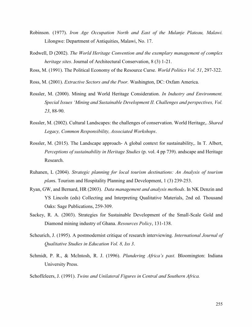
255
Robinson. (1977). Iron Age Occupation North and East of the Mulanje Plateau, Malawi.
Lilongwe: Department of Antiquities, Malawi, No. 17.
Rodwell, D (2002). The World Heritage Convention and the exemplary management of complex
heritage sites. Journal of Architectural Conservation, 8 (3) 1-21.
Ross, M. (1991). The Political Economy of the Resource Curse. World Politics Vol. 51, 297-322.
Ross, M. (2001). Extractive Sectors and the Poor. Washington, DC: Oxfam America.
Rossler, M. (2000). Mining and World Heritage Consideration. In Industry and Environment.
Special Issues ‘Mining and Sustainable Development II. Challenges and perspectives, Vol.
23, 88-90.
Rossler, M. (2002). Cultural Landscapes: the challenges of conservation. World Heritage,. Shared
Legacy, Common Responsibility, Associated Workshops.
Rossler, M. (2015). The Landscape approach- A global context for sustainability,. In T. Albert,
Perceptions of sustainability in Heritage Studies (p. vol. 4 pp 739). andscape and Heritage
Research.
Ruhanen, L (2004). Strategic planning for local tourism destinations: An Analysis of tourism
plans. Tourism and Hospitality Planning and Development, 1 (3) 239-253.
Ryan, GW, and Bernard, HR (2003). Data management and analysis methods. In NK Denzin and
YS Lincoln (eds) Collecting and Interpreting Qualitative Materials, 2nd ed. Thousand
Oaks: Sage Publications, 259-309.
Sackey, R. A. (2003). Strategies for Sustainable Development of the Small-Scale Gold and
Diamond mining industry of Ghana. Resources Policy, 131-138.
Scheurich, J. (1995). A postmodernist critique of research interviewing. International Journal of
Qualitative Studies in Education Vol. 8, Iss 3.
Schmidt, P. R., & McIntosh, R. J. (1996). Plundering Africa’s past. Bloomington: Indiana
University Press.
Schoffeleers, J. (1991). Twins and Unilateral Figures in Central and Southern Africa.
256
Schoffeleers, J. (1999). The Chisumphi and Mbona Cults in Malawi, A Comparative History. In
J. Schoffeleers(ed), Guardians of the Land (pp. 147-186). Kachere Texts, Mambo Press.
Selman, P. (2004). Community participation in the planning and management of cultural
landscapes. Journal of Environmental Planning and Management 47, 365-392.
Seymour, S. (2000). Historical Geographies of Lndscapes. In B. Graham, & Nash, Modern
Hostorical Geographies. London: Longman.
Shillington, K. (1995). History of Africa. Record Label: Palgrave Macmillan. Publication.
Sideri, S., & Johns, S. (1990). Mining for Development in the Third World: Multinational
Corporations, State Enterprises and the International Economy. New York: Pergamon
Press.
Sidorenko, A. (2011). The Periodic Reporting Exercise in support of the implementation of the
5Cs Strategic Objectives: From National Programmes to a World Heritage Programming
approach. Workshop of National Focal Points of Central, South-East and Eastern
European Countries. Paris: UNESCO World Heritage Centre.
Silverman, D. (2005). Doing Qualitative Research: A Practical Handbook, Social Science. SAGE
Publications.
Simpson, K (2001). Strategic Planning and community involvement as contributors to sustainable
tourism development. Current Issues in Tourism, 4 (1)3-41
Simpson, K (2001). Strategic planning and community involvement as contributors to sustainable
tourism development. Current Issues in Tourism, 4 (1) 3-41.
Smith, B. (2005). Kasama Spirit Sites (Northern Zambia). In B. Taylor, Encyclopaedia of Religion
and Nature (p. 954).
Smith, B., & Hall, S. (2000). Empowering places: rock shelters and ritual control in farmer -
forager interactions in the Northern Province, South Africa. South African Archaeological
Society , 30-46.
Smith, L. (2006). Uses of Heritage. London: Routledge.
257
Smith, S. (2009). Consensus Building for Cultural Heritage Place Management. In D. Myers, S.
N. Smith, & E. Ostergren(Eds), Consensus Building, Negotiation, and Conflict Resolution
for Heritage Place Management. Los Angeles, California : Getty Conservation Institute .
Soderland, H. (2009). he History of Heritage: A Method in Analyzing Legislative Historiography.
In M. Sorensen, & J. Carman, Heritage Studies: Methods and Approaches (pp. 55-84).
London: Routledge.
Solot, M (1986) Carl Sauer and Cultural Evolution, Annals of the Association of American
Geographers, 76:4, 508-520.
Sovereign Metals Limited. (2017, December 5). Malingunde project overview. Retrieved from
Sovereign Metals Limited: http://sovereignmetals.com.au/projects/
Stake, R. (2005). Qualitative case studies. In N. Denzin, & YS Lincoln(Eds), The Sage handbook
of qualitative research (3rd ed) (pp. 443-466). Thousand Oaks, CA: Sage.
Stenseke, M. (2008). Local participation in cultural landscape maintenance: Lessons from Sweden
. Land Use Policy journal.
Stoffle, A. (1990). Native American Cultural Resource Studies at Yucca Mountain. Nevada,:
University of Michigan, Institute for Social Research.
Strauss, AL, and Corbin, J (1990). Basics of Qualitative Research: Grounded Theory Procedures
and Techniques. Thousand Oaks: Sage.
Stryker, S. (1987). The vitalization of symbolic interactionism. Social Psychology Quarterly, 83-
94.
Stubbs, M (2004). Heritage-sustainability: Developing a methodology for the sustainable
appraisal of the historic environment. Planning, Practice and Research, 19 (3) 283-305
Swaffield, S., & J Primdal. (2006). Spatial Concepts in landscape analysis and policy. Some
implications of globalisation, Landscape Ecology, 315-331.
Tax, S. (1990). Can world views mix? Human Organisation. Vol. 46. pp 280-86.
Taylor, K (2011). Cultural landscapes: A bridge between culture and nature? International Journal
of Heritage Studies.
258
TBCA. (2012). Trans-boundary Consulting Africa. Situational Analysis: World Heritage and
Impacts of Development in Africa. African World Heritage Fund: Final Draft Report.
Thackway, R., & Olsson, K. (1999). Public/private partnerships and protected areas: selected
Australian case studies. Landscape and Urban Planning 44, 87–97.
The Nation . (2017, December 5). Msinja, Malawi's Ancient City (I). Retrieved from The Nation
more than just news: http://mwnation.com/msinja-malawi%E2%80%99s-ancient-city-i/
Tiley, S. (2006). Mapungubwe Cultural Landscape'. In, World Heritage Sites of South Africa. In
T. Hauf, & DuPreez, Green Vision Foundation. Cape Town.
Tiley-Nel, S., & et al. ( 2009). The Dating of the gold graves from Mapungubwe Hill. Journal of
African Archaeology 7, 95-101.
Tindall, P. (1965). A History of Central Africa. Longmans of Rhodesia: Published by Praeger.
Tudor, C. (2014). An Approach to Landscape Character Assessment. Natural England,
www.gov.uk/natural-england, 57.
Turner, S. (. (2012). World Heritage and the Extractive Industries. Independent Study
Commissioned by IUCN in conjunction with the UNESCO World Heritage Centre, ICMM
and Shell.
Twidale, C.R (2002). The two-stage concept of landform and landscape development involving
etching: origin, development, and implications of an idea. Earth-Science Reviews.
Elsevier. Earth-Science Reviews. Volume 57, Issues 1–2, pp 37-74
UNDATA. (2014). World statistics pocketbook. United Nations Statistics Division.
UNECE. (1998). Aarhus convention. Retrieved from United Nations Economic Commission for
Europe: www.unece.org/env/pp/treatytext.htm.
UNESCO (1965). Recommendation concerning the Safeguarding of Beauty and Character of
Landscapes and Sites. Paris.
UNESCO WHC. (2017, June 6). Decision number WHC-15/39.COM. Retrieved from UNESCO
WHC: http://whc.unesco.org.
259
UNESCO. (1972). Convention concerning the protection of the world cultural and natural
heritage. Paris: United Nations Educational Scientific and Cultural Organization.
UNESCO. (2002). Mapungubwe Nomination Dossier. Retrieved from www.whc.unesco.org.
UNESCO. (2002). The Budapest Declaration on World Heritage. Retrieved from
whc.unesco.org/en/budapestdeclaration. Accessed on 6 May 2017.
UNESCO. (2006). Conserving cultural and biological diversity: the role of sacred natural sites
and cultural landscapes. International Symposium. UNESCO Division of Ecological and
Earth Sciences.
UNESCO. (2009). Analytical summary of the state of conservation of World Heritage Properties.
Paris: United Nations Educational Scientific and Cultural Organization.
UNESCO. (2011). Strategic Action Plan for the Implementation of the World Heritage Convention
2012 -2022. Retrieved from whc.unesco.org/archive/2011/whc11. Accessed on 11 Nov
2017.
UNESCO. (2011). World Heritage Capacity Building Strategy. Retrieved from whc.unesco.org.
Accessed on 12 July 2017.
UNESCO. (2016). Operational Guidelines for the Implementation of the World Heritage
Convention. Retrieved from WHC.16/01: whc.unesco.org/document/156250. Accessed on
7 Feb 2017.
UNESCO. (2016). Operational guidelines for the implementation of the World Heritage
Convention. Paris: United Nations Educational Scientific and Cultural Organization.
UNESCO. (2017, December 11). Chongoni Rock-Art Area. Retrieved from UNESCO World
Heritge Sites: http://whc.unesco.org/en/list/476.
UNESCO. (2017, June 4). Decision number WHC-11/35.COM/7B. Retrieved from UNESCO
WHC: http://whc.unesco.org.
United Nations Economic Commission for Africa (UNECA). (2017, June 9). Minerals and
Africa’s Development, The International Study Group Report on Africa Mineral Regime.
260
Retrieved from United Nations Economic Commission for Africa:
http://www.africaminingvision.org.
VanDoornum, B. (2007). Tshisiku Shelter and the Shashe-Limpopo confluence area hunter-
gatherer sequence. Southern African Humanities Vol. 19, 17-67.
Viljoen, J., & Dann, S. (2003). Strategic Management: Planning and Implementing Corporate
Strategies. Frenchs Forest: Pearson.
Warren, A. (2001). Causes and consequences of Anthropogenic Fire in Mulanje Mountain Forest
Reserve, Southern Malawi. M. Sc. Thesis. Environmental Anthropology, University of
Kent, Canterbury, U.K.
Waterton, E, et al (2006). The utility of discourse analysis to heritage studies: The Burra Charter
and social inclusion. International Journal of Heritage Studies, 12 (4) 339-355.
Weaver, A.B. and. Caldwell, P (1999). Environmental impact assessment for mining projects. In:
(Petts, J. Ed.), Handbook of Environmental Impact Assessment: Volume 2: Environmental
Impact Assessment in Practice: Impact and Limitations. Blackwell Science, Oxford, United
Kingdom. Pp. 377-403.
Wells, J.D., et al (1992). Terrestrial Minerals. In: (Fuggle, R.F. & M.A. Rabie, Eds.),
Environmental Management in South Africa. Juta and Co., Johannesburg.
Werner, & Schoepfle. (1987). Systematic Fieldwork: Foundations of ethnography and
interviewing. Sage Publications.
White, F. (1965). The savanna woodlands of the Zambezian and Sudanian Domains: an ecological
and phytogeographical comparison. Webbia, 651-681.
White, F., Dowsett-Lemaire, F., & Chapman, J. (2001). The Evergreen Forest Flora of Malawi.
Royal Botanic Gardens, Kew, U.K.
WHM. (2000). Technical Workshop Report on World Heritage and Mining 21 – 23 September
2000 Gland, Switzerland. Retrieved from whc.unesco.org/document/140623. Accessed
October 2017.
261
Wild, R., & McLeod, C. (2008). Best Practice Guidelines Nº 16 Task Force on the Cultural and
Spiritual Values of Protected Areas in collaboration with UNESCO's Mand and the
Biosphere Programme.
Wild, R., & McLeod, C. (2008). Sacred Natural Sites: Guidelines for Protected Area Managers.
Gland, Switzerland: IUCN.
Williams, P (2006). The governance of sustainable development in Wales, Local Environments,
11 (3), 253-267.
Wilson, L and Boyle, E (2006). Inter-organizational collaboration at UK World Heritage Sites.
Leadership and Organizational Journal, 27 (6) 501-523.
Wilson, M.G.C. and Anhaeusser CR (Eds.) (1998). The Mineral Resources of South Africa, Sixth
Edition. Handbook No. 16, Council for Geoscience, Pretoria. pp.740.
Wood, M. (2000). Making connections: relationships between international trade and glass beads
from the Shashe-Limpopo area. South African Archaeological Society Goodwin Series 8,
78-90
WWF-UK (2015). A Global Assessment of Extractive Activity within Natural World Heritage
Sites. (online) Available at https://assets.wwf.org.uk. Accessed 20 September 2017)
Wu J. (2013). Landscape Ecology. In: Leemans R. (ed) Ecological Systems. Springer, New York,
NY.
Wu, Jianguo. (2008). Making the Case for Landscape Ecology: An Effective Approach to Urban
Sustainability. Landscape Journal. 27. 41-50.
Yin, RK (2004). Case Study Research: Design and Methods, 3rd ed. Thousand Oaks: Sage
Publications.
Yousf, H. (2007). Culture and development: A review of literature, the continuing tension between
modern standards and local contexts. Paris: Working Paper No. 50. Agence Française de
Dévelopement.
Zachrisson. (2004). Co-management of Natural Resources. Paradigm Shifts, Key Concepts and
Cases. Report no: 1. Umea: Mountain Mistra Programme report.
262
Zhang, X. (2015). Resolving the conflicts of sustainable world heritage landscapes in cities: Fully
open or limited access for visitors? Habitat International, 91-100.
Zubieta, L. (2006). The Rock Art of Mwana wa Chentcherere II Rock Shelter, Malawi: a Site-
Specific Study of Girls’ Initiation Rock Art. Leiden: African Studies Centre.
Zubieta, L. (2009). A Girls’ initiation rock art in south-central Africa: women’s voices. In e. D
Seglie, & O. L. Otte M, Prehistoric Art: Signs, Symbols, Myth, Ideology Proceedings of
the XV UISPP World Congress (pp. 151-6). Lisbon: Oxford: Archaeopress.
Related Documents