Exploring Geosciences – 12 Thematic Lessons- Block 2 Mining Exploration Lesson 3 Geochemical Surveys September 30 th ,, 2020

Welcome message from author
This document is posted to help you gain knowledge. Please leave a comment to let me know what you think about it! Share it to your friends and learn new things together.
Transcript

ExploringGeosciences –
12 Thematic Lessons-
Block 2Mining Exploration
Lesson 3
Geochemical Surveys
September 30th,, 2020

Your Host:Francine Fallara, P. Geo., M.Sc.A (OGQ #433)
Exploration geologist with over 25 years of field experience in various difficult geological environments
Consultant in analytical data analysis specialized in complex geological exploration studies
Expert in 3D geological modeling and digital targeting of mineralswww.ffexplore3d.com
2

Thematic Bloc 2 - Overview
3
Thematic Block 2 Lesson Subtitle Date - 2020 English
Mining Exploration
1 Cartography Surveys September 2nd 1:30 – 3:30 PM
2 Geophysical Surveys September 16th 1:30 – 3:30 PM
3 Geochemical Surveys September 30th 1:30 – 3:30 PM
Exploring Geosciences: B2-Mining Exploration: L3- Geochemical Surveys

Lesson 3 – Geochemical Surveys
4
Lesson 3 Sub-lessons September 30th
GeochemicalSurveys
a. Intro to geochemistry
1:30 – 3:30 PM
b. Overview of field techniques
c. Using geochemistry data
d. Validating and interpreting geological surveys with geochemistry
Exploring Geosciences: B2-Mining Exploration: L3- Geochemical Surveys

5
Geochemistry studies the origin, evolution and distribution of chemical elements on Earth which are contained in the rock-forming minerals and the products derived from it, as well as in living beings, water and atmosphere.
One of the goals of geochemistry is to determine the abundance of elements in nature, as this information is essential to hypotheses development about the origin and structure of our planet and the universe.
Exploring Geosciences: B2-Mining Exploration: L3- Geochemical Surveys
What is Geochemistry?
https://www.gob.mx/sgm

6
Geochemistry uses chemistry to understand various processes on Earth
Geochemistry = Chemistry of the Earth’s materials — Minerals and rocks:
Study of the chemical composition of the Earth and other planets:
The chemical processes and reactions that govern the composition of rocks, water, and soils.
The cycles of matter and energy that transport the Earth's chemical components in time and space, and their interaction with the hydrosphere and the atmosphere.
Exploring Geosciences: B2-Mining Exploration: L3- Geochemical Surveys
What is Geochemistry?
The Geochemistry of Rocks and Natural Waters, A. Koschinsky

7Exploring Geosciences: B2-Mining Exploration: L3- Geochemical Surveys
What is Geochemistry?
The Geochemistry of Rocks and Natural Waters, A. Koschinsky
Victor Moritz Goldschmidt 1888 - 1947
Swiss chemist Victor Moritz Goldschmidt is the founder, characterizing, in 1933, the major role of geochemistry as:
The task to investigate the composition of the Earth as a whole and of its various components and to uncover the laws that control the distribution of the various elements.
Based on a comprehensive collection of analytical data of terrestrial material:
• Rocks, waters and atmosphere• Meteorites• Astrophysical data about the composition of other cosmic
bodies and geophysical data about the nature of the Earth’s inside.
• Information from the synthesis of minerals in the lab and from the observation of their mode of formation and stability conditions
Goldschmidt System - eduqas

8Exploring Geosciences: B2-Mining Exploration: L3- Geochemical Surveys
Main Layers that form the Earth
The Geochemistry of Rocks and Natural Waters, A. Koschinsky
Earth’s Interior
Goldschmidt System - eduqas
The Earth's crust is a thin hard outer shell of rock. Under the crust, there is a deep layer of hot soft rock called the mantle.

9Exploring Geosciences: B2-Mining Exploration: L3- Geochemical Surveys
The crust and upper mantle can be divided into three layers according to their rigidity:
The lithosphere is the upper, rigid layer of the Earth:
Consists of the crust and the top of the mantle
About 100 km thickThe Geochemistry of Rocks and Natural Waters, A. Koschinsky
Earth’s Interior
Main Layers that form the Earth

10Exploring Geosciences: B2-Mining Exploration: L3- Geochemical Surveys
The crust and upper mantle can be divided into three layers according to their rigidity:
The asthenosphere, below the lithosphere, in the Earth's mantle, is the hot, soft rock of the asthenosphere:
This boundary between the lithosphere and the asthenosphere occurs at the point where temperatures climb above 1300°C
The Geochemistry of Rocks and Natural Waters, A. Koschinsky
Earth’s Interior
Main Layers that form the Earth

11Exploring Geosciences: B2-Mining Exploration: L3- Geochemical Surveys
The crust and upper mantle can be divided into three layers according to their rigidity:
The mesosphere is the solid part of the earth's mantle lying between the asthenosphere and the core.
The Geochemistry of Rocks and Natural Waters, A. Koschinsky
Earth’s Interior
Main Layers that form the Earth

12Exploring Geosciences: B2-Mining Exploration: L3- Geochemical Surveys
Geochemistry of the Earth’s Minerals and Rocks
The Geochemistry of Rocks and Natural Waters, A. Koschinsky
Earth’s Interior Earth’s Geo-Chemistry
The bulk of the Earth is made from iron, oxygen, magnesium and silicon.
More than 80 chemical elements occur naturally in the Earth and its atmosphere.
Mostly Earth is composed of three parts:• Crust• Mantle (Upper & Lower)• Core

13Exploring Geosciences: B2-Mining Exploration: L3- Geochemical Surveys
Geochemistry of the Earth’s Minerals and Rocks
The Geochemistry of Rocks and Natural Waters, A. Koschinsky
Earth’s Geo-Chemistry
The Earth's crust is a thin layer of rock that floats on the mantle.
The Earth’s crust is made mostly from oxygen and silicon:
• Silicate minerals such as quartz, with aluminum, iron, calcium, magnesium, sodium, potassium, titanium and traces of 64 other elements.
Earth’s Interior

14Exploring Geosciences: B2-Mining Exploration: L3- Geochemical Surveys
Geochemistry of the Earth’s Minerals and Rocks
The Geochemistry of Rocks and Natural Waters, A. Koschinsky
Earth’s Geo-Chemistry
The upper mantle is made up of iron and magnesium silicates.
The lower mantle is mostly silicon and magnesium sulfides and oxides.
The core is mostly iron, with little nickel and traces of sulfur, carbon, oxygen and potassium.
Earth’s Interior

15Exploring Geosciences: B2-Mining Exploration: L3- Geochemical Surveys
Geochemistry of the Earth’s Minerals and Rocks
The Geochemistry of Rocks and Natural Waters, A. Koschinsky
Earth’s Geo-Chemistry
The outer core is so hot (4500°C -6000°C) that it is always molten.
The inner core is even hotter (up to 7000°C) but it stays solid because the pressure is 6000 times greater than on the surface.
Earth’s Interior

16Exploring Geosciences: B2-Mining Exploration: L3- Geochemical Surveys
Geochemistry of the Earth’s Minerals and Rocks
The Geochemistry of Rocks and Natural Waters, A. Koschinsky
Earth’s Interior Earth’s Mass Distribution
• Inner core = 1.7% of the Earth's mass• Outer core = 30.8%• Core - mantle boundary = 3%• Lower mantle = 49%• Upper mantle = 15%• Ocean crust = 0.099%• Continental crust = 0.374%

17Exploring Geosciences: B2-Mining Exploration: L3- Geochemical Surveys
Elemental Composition of the Earth’s Crust
Goldschmidt System - eduqas
99% of the earth’s crust by weight is made up of just eight elements: Oxygen Silicon Aluminum Iron Calcium Sodium Potassium Magnesium

18Exploring Geosciences: B2-Mining Exploration: L3- Geochemical Surveys
Geochemistry of the Earth’s Processes
The Geochemistry of Rocks and Natural Waters, A. Koschinsky
Geochemistry is the study of the composition of geological materials and the behavior of
individual elements during geological processes.

19Exploring Geosciences: B2-Mining Exploration: L3- Geochemical Surveys
Geochemistry of the Earth’s Processes
The Geochemistry of Rocks and Natural Waters, A. Koschinsky
Geochemical analysis is now a vital tool in most fields of geological and environmental research for studies of:
Water, soil, and air quality, Formation of rocks and minerals Fossilization mechanisms Metal accumulation in
organisms from contaminated water and soil

20
Isotope geochemistry: Determination of the relative and absolute concentrations of the elements and their isotopes in the earth and on earth's surface.
Trace element, petro, soil, sediment and marine geochemistry: Examination of the distribution and movements of elements in different parts of the earth (crust, mantle, hydrosphere etc.) and in minerals with the goal to determine the underlying system of distribution and movement.
Planetary geochemistry and Cosmo geochemistry: Analysis of the distribution of elements and their isotopes in the cosmos.
Exploring Geosciences: B2-Mining Exploration: L3- Geochemical Surveys
Geochemistry Subdivisions

21
Biogeochemistry: Field of study focusing on the effect of life on the chemistry of the earth.
Organic geochemistry: A study of the role of processes and compounds that are derived from living or once-living organisms.
Inorganic geochemistry
Aquatic geochemistry: Understanding the role of various elements in watersheds.
Regional, environmental and exploration geochemistry: Applications to environmental, hydrological and mineral exploration studies.
Exploring Geosciences: B2-Mining Exploration: L3- Geochemical Surveys
Geochemistry Subdivisions

22Exploring Geosciences: B2-Mining Exploration: L3- Geochemical Surveys
The Goldschmidt Classification of Elements
Goldschmidt System - eduqas
Victor Moritz Goldschmidt 1888 - 1947
Swedish born mineralogist considered to be one of the founders of modern geochemistry and crystal chemistry
Chemical elements on the periodic table are classified into 4 groups according to their preferred host phases:
Lithophile Siderophile Chalcophile Atmophile

23Exploring Geosciences: B2-Mining Exploration: L3- Geochemical Surveys
The Goldschmidt Classification of Elements
Goldschmidt System - eduqas

24Exploring Geosciences: B2-Mining Exploration: L3- Geochemical Surveys
The Goldschmidt Classification of Elements
Goldschmidt System - eduqas
In Goldschmidt’s classification, elements are divided on how they partition between coexisting silicate liquid, sulfide liquid, metallic liquid, and gas phase:
Silicate Liquid
Sulfide Liquid
Metallic Liquid
Gas Phase
Siderophile
Chalcophile
Lithophile
Atmophile H, He, N, Noble gases
Alkalis, Alkaline Earths,Halogens, B, O, Al, Si, Sc, Ti, V, Cr, Mn, Y, Zr, Nb,Lanthanides, Hf, Ta, Th, U
Cu, Zn, Ga, Ag, Cd, In, Hg,Tl, As, S, Sb, Se, Pb, Bi, Te
Fe, Co, Ni, Ru, Rh, Pd, Os,Ir, Pt, Mo, Re, Au, C, P, Ge, Sn

25Exploring Geosciences: B2-Mining Exploration: L3- Geochemical Surveys
Goldschmidt System - eduqas
Lithophile (rock loving) elements are found:
Close to the Earth’s surface
They combine readily with oxygen
Form compounds that do not sink into the core
Lithophile Elements: Concentrated in the Crust

26Exploring Geosciences: B2-Mining Exploration: L3- Geochemical Surveys
Goldschmidt System - eduqas
Lithophile elements include:
Aluminium Calcium Potassium Magnesium Sodium Oxygen Silicon Titanium
Lithophile Elements: Concentrated in the Crust

27Exploring Geosciences: B2-Mining Exploration: L3- Geochemical Surveys
Lithophile Elements: Concentrated in the Crust
Goldschmidt System - eduqas
Lithophile are found in the silicate minerals which make up 93% of the crust by mass and constitute the common rock-forming minerals:
Quartz Orthoclase Feldspar Plagioclase Feldspar Biotite Mica Muscovite Mica Hornblende (Amphibole) Augite (Pyroxene) Olivine Garnet Clay Minerals (Kaolinite)

28Exploring Geosciences: B2-Mining Exploration: L3- Geochemical Surveys
Goldschmidt System - eduqas
Siderophile Elements: Concentrated in the Core
Siderophile (iron-loving) elements:
High density metals
Sink into the Earth’s core
Do not combine with oxygen
Dissolve in iron as solid solutions or in the molten state

29Exploring Geosciences: B2-Mining Exploration: L3- Geochemical Surveys
Goldschmidt System - eduqas
Siderophile elements include:
Gold Iridium Iron Molybdenum Nickel Platinum
Siderophile Elements: Concentrated in the Core

30Exploring Geosciences: B2-Mining Exploration: L3- Geochemical Surveys
Goldschmidt System - eduqas
Chalcophile Elements: Trace amounts in the Crust
Chalcophile (ore-loving) elements:
Combine readily with sulfur
Form compounds that do not sink to the core
Make up just 0.046% of crust by mass:
• Concentrated in mineral veins

31Exploring Geosciences: B2-Mining Exploration: L3- Geochemical Surveys
Goldschmidt System - eduqas
Chalcophile elements include:
Arsenic Cadmium Copper Lead Silver Sulphur Tin Zinc
Chalcophile Elements: Trace amounts in the Crust

32Exploring Geosciences: B2-Mining Exploration: L3- Geochemical Surveys
Goldschmidt System - eduqas
Atmophile (atmosphere-loving) elements:
Known as volatile elements
Occur in gases and liquids close to the Earth’s surface
Atmophile Elements: Concentrated in the Atmosphere & Hydrosphere

33Exploring Geosciences: B2-Mining Exploration: L3- Geochemical Surveys
Goldschmidt System - eduqas
Atmophile elements include:
Carbon Hydrogen Nitrogen Argon Helium Neon Krypton Xenon
Atmophile Elements: Concentrated in the Atmosphere & Hydrosphere

34Exploring Geosciences: B2-Mining Exploration: L3- Geochemical Surveys
The Exploration Challenge
A New Search Space
Deep Exploration Targeting
CSIRO, 2013, James S. Cleverley
Geochemical Geological Exploration
Until two decades ago, geological exploration was restricted to easily detectable outcropping mineralized bodies.

35Exploring Geosciences: B2-Mining Exploration: L3- Geochemical Surveys
The Exploration Challenge
A New Search Space
Deep Exploration Targeting
CSIRO, 2013, James S. Cleverley
Geochemical Geological Exploration
Nowadays, exploration leads to deposits that are not exposed to the surface and therefore are difficult to locate: For indirect exploration,
different methods were developed for the detection of hidden mineralized bodies:
Geochemical prospection based on established principles of geochemistry cycle and distribution of elements.
36Exploring Geosciences: B2-Mining Exploration: L3- Geochemical Surveys
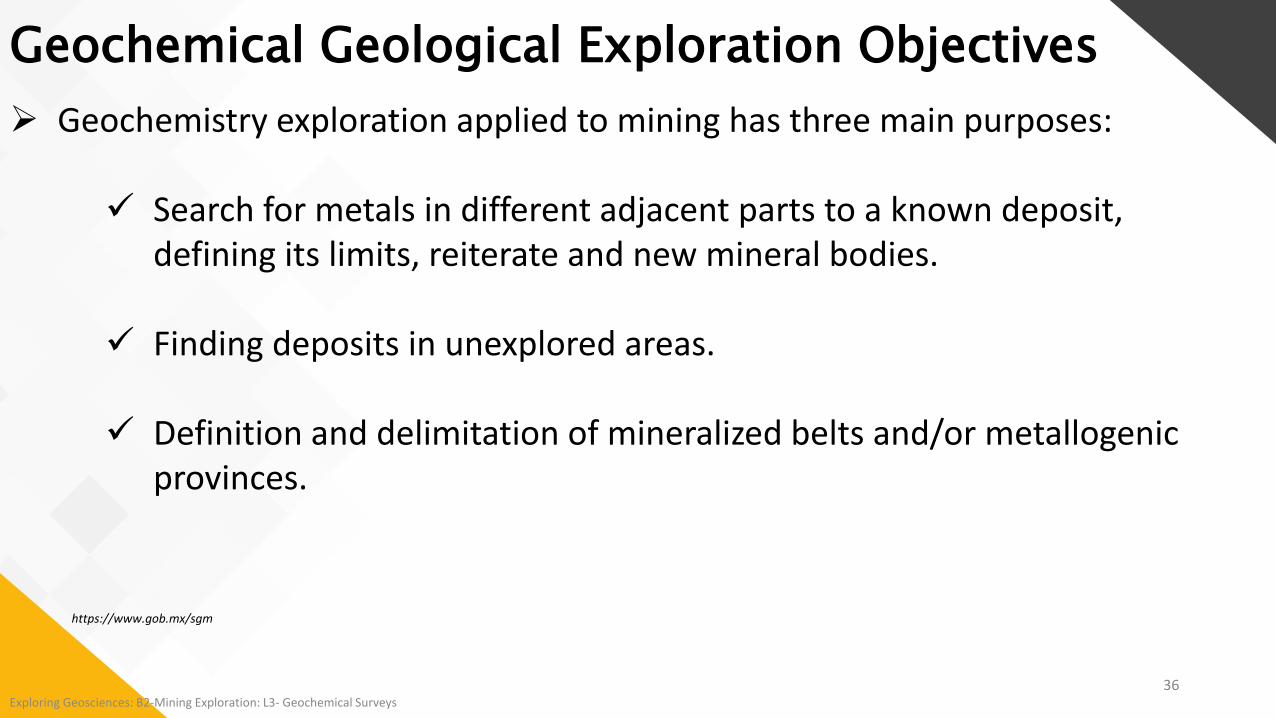
Geochemistry exploration applied to mining has three main purposes:
Search for metals in different adjacent parts to a known deposit, defining its limits, reiterate and new mineral bodies.
Finding deposits in unexplored areas.
Definition and delimitation of mineralized belts and/or metallogenic provinces.
Geochemical Geological Exploration Objectives
https://www.gob.mx/sgm

37Exploring Geosciences: B2-Mining Exploration: L3- Geochemical Surveys
Geochemical Geological Exploration Objectives
How do I explore for a mineral system?
CSIRO, 2013, James S. Cleverley
Geochemistry has a direct connection to the commodity that is sought: Geophysics, though
indisputably useful, cannot make the same claim.
Geochemical responses are often larger than the target itself: Which makes it easier
(and cheaper) to detect

38Exploring Geosciences: B2-Mining Exploration: L3- Geochemical Surveys
Geochemical Geological Exploration Objectives
How do I explore for a mineral system?
CSIRO, 2013, James S. Cleverley
Where is the next ore body?
Inputs from:
Data Integration
New technology
3D Analytics
The Why Question
Why is the ore body there?
The Where Question

39Exploring Geosciences: B2-Mining Exploration: L3- Geochemical Surveys
Among the fundamental principles of geochemistry is the recognition of geochemical environments that are developed in the earth's crust and are grouped into:
Surface geochemical environment: Supergene, secondary and exogenous Geochemical reactions: Weathering, erosion, sedimentation
and soil occurs: Clear superficial conditions and features, such as:
• Low temperature and pressure• Free fluids movement• Plenty oxygen, water and carbon dioxidehttps://www.gob.mx/sgm
Geochemical Geological Exploration Principles

40Exploring Geosciences: B2-Mining Exploration: L3- Geochemical Surveys
Dispersion: Formation of a mineral deposit with a certain distribution of the ore
minerals or elements associated with them: A halo around the deposit is formed from a few centimeters to
kilometers of extension
Types of dispersion: Primary dispersion:
• Involves all emplacement processes during the formation of how the mineralized body was formed.
Secondary dispersion: • Involves the redistribution of primary models, by any
subsequent process• Often under low temperature and pressure conditions
https://www.gob.mx/sgm
Geochemical Geological Exploration Principles

41Exploring Geosciences: B2-Mining Exploration: L3- Geochemical Surveys
Dispersion: Primary and Secondary
Both types depend on:
The geochemical mobility of elements which depends on the:
Mechanical properties (mobile stage of mineral):
• Viscosity, solution, size, shape and density of the grains and the physic- chemical features of each element.
https://www.gob.mx/sgm
Geochemical Geological Exploration Principles

42Exploring Geosciences: B2-Mining Exploration: L3- Geochemical Surveys
We may sample material derived from the rocks on the assumption that if the rocks are enriched in metals of interest, the derived material will be too.
CIM Short Course, 2013, Steve Amor
Schematic diagram of primary and secondary dispersions
Geochemical Geological Exploration Principles

43Exploring Geosciences: B2-Mining Exploration: L3- Geochemical Surveys
We may sample material derived from the rocks on the assumption that if the rocks are enriched in metals of interest, the derived material will be too.
Eric Grunsky, 2015
Schematic diagram of primary and secondary dispersions
Geochemical Geological Exploration Principles
Mineral deposits represent anomalous concentrations of specific elements, usually within a relatively confined volume of the Earth's crust.
Most mineral deposits include a central zone, or core, in which the valuable elements or minerals are concentrated.
This zone surrounding the core deposit is known as a primary halo or anomaly
H. E. Hawkes and J. S. Webb (1979) Geochemistry in mineral exploration, 2nd edition, p.535-548.

44Exploring Geosciences: B2-Mining Exploration: L3- Geochemical Surveys
We may sample solid material derived directly from the rock as soil, or sediment created by the mass-wasting of soil into streams, or sediment on which metals transported in solution (ground-, creek- or lake-water) are precipitated, or the waters themselves CIM Short Course, 2013, Steve Amor
Dispersion of metals from sulfide deposits by groundwater and streams into lakes and lake sediments.(Allan et al. (1973), reproduced in Levinson (1980))
Geochemical Geological Exploration Principles

45Exploring Geosciences: B2-Mining Exploration: L3- Geochemical Surveys
We also may be sampling material that has been transported by glaciers, or stream or lakesediment derived from it.
CIM Short Course, 2013, Steve Amor
Glacial dispersion from metals from sulfide deposit into till (Miller, 1984).
Geochemical Geological Exploration Principles

46Exploring Geosciences: B2-Mining Exploration: L3- Geochemical Surveys
Overview of Geochemical Exploration Methods
Regional Prospecting ...1850
Goldoz.com.au
CSIRO, 2013, James S. Cleverley

47Exploring Geosciences: B2-Mining Exploration: L3- Geochemical Surveys
Until 20 years ago, geological exploration was restricted to easily detectable outcropping mineralized bodies, however, today exploration has led to deposits that are not exposed to the surface and therefore are difficult to locate: The purpose is the possible discovery of a geochemical "anomaly" or area where the
chemical pattern indicates the presence of ore in the vicinity.
As a result, geochemical exploration focuses on the determination of the elements of the ore or elements associated with the ore that are dispersed, called respectively indicator elements and guide elements:
For example, in a deposit of lead-zinc (Pb-Zn) sulfide: The indicator elements are lead and zinc A possible guide element will be mercury (Hg)
https://www.gob.mx/sgm
Why Use Geochemical Exploration Methods?

48Exploring Geosciences: B2-Mining Exploration: L3- Geochemical Surveys
The different types of studies performed by sampling elements are:
Lake and stream-sediment and water geochemistry Soil geochemistry Till geochemistry Rock geochemistry Gas geochemistry Vegetation geochemistry
Types of Geochemical Exploration Methods
CIM Short Course, 2013, Steve Amor

49Exploring Geosciences: B2-Mining Exploration: L3- Geochemical Surveys
Lake and stream-sediment and water geochemistry: The method of sampling lake sediments and waters is ideally suited to
large-scale regional projects that only a government or large company could undertake, although some prospectors carry out lake surveys of more limited scope, particularly in winter when access is easier.
Types of Geochemical Exploration Methods
CIM Short Course, 2013, Steve Amor
There are also large online databases of lake data collected
by both the Provincial and Federal governments
Coverage of lake-sediment and water sample collection by Geological Survey of Canada (GSC).

50Exploring Geosciences: B2-Mining Exploration: L3- Geochemical Surveys
Lake and stream-sediment and water geochemistry: Lake water samples are collected in Nalgene bottles; normally before
collecting sediment samples, so that disturbed sediment does not get into the sampled water.
Types of Geochemical Exploration Methods
CIM Short Course, 2013, Steve AmorRetrieving a lake-sediment sample from a “Hornbrook bomb”
Collecting lake-water samples in Nalgene bottles.
Lake and stream sampling should be considered as a first-pass method that can be used to identify targets prior to more detailed geochemical work (soil or till sampling) or prospecting.

51Exploring Geosciences: B2-Mining Exploration: L3- Geochemical Surveys
Soil geochemistry: The soils are mainly humoferric and ferrohumic podzols, both consist of
an: Organic-rich Ah horizon and an ash-grey leached Ae horizon:
• Neither of which should be sampled Underlain by a rusty brown B horizon:
• The preferred sample medium for many prospectors as it is enriched in metals leached from the A horizons
The base of the soil profile is the C horizon:• Consisting of the relatively unweathered source material of
the soil
Types of Geochemical Exploration Methods
CIM Short Course, 2013, Steve Amor

Unweathered mineral matter.
Effects of groundwater, vegetation, oxidation.(not sampled)
Oxidized, bioturbated and organic debris, extensive weathering of mineral matter.
Top Layer = 0 to 5cm. Organic debris with little mineral matter.
Progressive weathering of mineral matter up the profile.
we
ath
erin
g
52
Types of Geochemical Exploration Methods
Sampling the Soil Profile

53Exploring Geosciences: B2-Mining Exploration: L3- Geochemical Surveys
Types of Geochemical Exploration Methods
Soil geochemistry: Soil sampling may be a second-stage prospecting procedure used to follow up a
drainage anomaly OR may also constitute the first geochemical work to be carried out, if mineralization is already known to occur nearby.
Soil samples are laid out on a grid, normally in the form of regularly spaced cut lines
CIM Short Course, 2013, Steve Amor
Sampling lines are spaced so that any important feature should be cut by at least two of them
Samples are spaced so the key feature is sampled in at least two adjacent samples
Normally, this means that the spacing between the samples is much less than the spacing between the lines: Samples are spaced at intervals of 10 to 25 metres Lines are 100 to 200 metres apart.Selection of line and sample spacing should reflect
the size of the expected target.

54Exploring Geosciences: B2-Mining Exploration: L3- Geochemical Surveys
Types of Geochemical Exploration Methods
Till geochemistry: Till (sometimes called drift) is the sediment from the movement of glacier ice over
the land surface and the plucking and grinding of bedrock. Typically unsorted, meaning that fragments of all sizes are intimately mixed together
CIM Short Course, 2013, Steve Amor
Typical rocky till, exposed in a road cut

55Exploring Geosciences: B2-Mining Exploration: L3- Geochemical Surveys
Types of Geochemical Exploration Methods
Till geochemistry:
CIM Short Course, 2013, Steve Amor
The interpretation of till geochemistry requires knowledge of the glacial history of the area; in particular, the direction(s) of ice movement.
Usually, ice-movement direction is generally towards the coast, but large- and small-scale deviations from this rule are not uncommon.
Several field methods are used to determine the direction of ice movement:
Most common is to measure the direction of striations on glaciated rock surfaces.
Downloadable database of striation measurements exist
Striations on a flat rocksurface
Striations directions map

56Exploring Geosciences: B2-Mining Exploration: L3- Geochemical Surveys
Types of Geochemical Exploration Methods
Till geochemistry:
CIM Short Course, 2013, Steve Amor
Glacial dispersion of beryllium (Be) from the Strange Lake rare earth-rare metal deposit, Labrador (Batterson 1989).

57Exploring Geosciences: B2-Mining Exploration: L3- Geochemical Surveys
Types of Geochemical Exploration Methods
Schematic sections and plan of glacial dispersion from an ore zone
Assuming a single till-depositing event: Distance “up-ice” to
the bedrock source of a geochemical anomaly, or mineralized boulder, detected at surface is dependent on the till thickness.CIM Short Course, 2013, Steve Amor
(from Miller, 1984)
Till geochemistry:

58Exploring Geosciences: B2-Mining Exploration: L3- Geochemical Surveys
Select the geochemical survey study area:
The main purpose of this stage is to select areas or regions that have good mineral potential and that can be prospected effectively.
Initial selection of areas should be based on a most thorough review of the known geology and records of past mining and prospecting activity:
“To get some idea of background for an area of interest, prospectors should examine regional and local historical survey data with respect to their area of interest”
Based on recorded mineralization and on the geological environment.
Geochemical Mineral Exploration: How to?
H. E. Hawkes and J. S. Webb (1979) Geochemistry in mineral exploration, 2nd edition, p.535-548.
CIM Short Course, 2013, Steve Amor

59Exploring Geosciences: B2-Mining Exploration: L3- Geochemical Surveys
Define the geochemical survey scale:
Geochemical Mineral Exploration: How to?
Continental Scale – > 1:500,000 & < 1:1,000,000Mapping large crustal blocks/tectonic assemblages
Regional Scale - > 1:50,000 & < 1:500,000Regional geological mapping
Local/Camp Scale < 1:50,000Exploration scale studies and detailed geologic mapping
Eric Grunsky, 2015

60Exploring Geosciences: B2-Mining Exploration: L3- Geochemical Surveys
Characterize the target size and geometry:
Some features of ore environment, such as favorable host rocks, geological structures, or geochemical provinces, are related to the genesis and localization.
Each geological, geophysical, and geochemical features of the ore environment defines a target area of characteristic size, shape, and relationship to the ore.
Geochemical Mineral Exploration: How to?
H. E. Hawkes and J. S. Webb (1979) Geochemistry in mineral exploration, 2nd edition, p.535-548.

61Exploring Geosciences: B2-Mining Exploration: L3- Geochemical Surveys
Choose the exploration technique: For greatest overall effectiveness, an optimum balance must be struck
between the various geological, geophysical, and geochemical methods that are known to be applicable.
The choice must be based on relevant previous experience and case-history data.
Fit with the chosen scale of the study area.
Selection of methods is also strongly influenced by the size of the target and by property control.
Geochemical Mineral Exploration: How to?
H. E. Hawkes and J. S. Webb (1979) Geochemistry in mineral exploration, 2nd edition, p.535-548.

62Exploring Geosciences: B2-Mining Exploration: L3- Geochemical Surveys
Rely on the chosen geochemical survey method:
Reliability depends not only on how effective the exploration method is in locating the target, but also extent to which an anomaly is specifically related to ore and the abundance of non-significance anomalies that may confuse interpretation and require fallow-up survey.
Geochemical Mineral Exploration: How to?
H. E. Hawkes and J. S. Webb (1979) Geochemistry in mineral exploration, 2nd edition, p.535-548.
63Exploring Geosciences: B2-Mining Exploration: L3- Geochemical Surveys
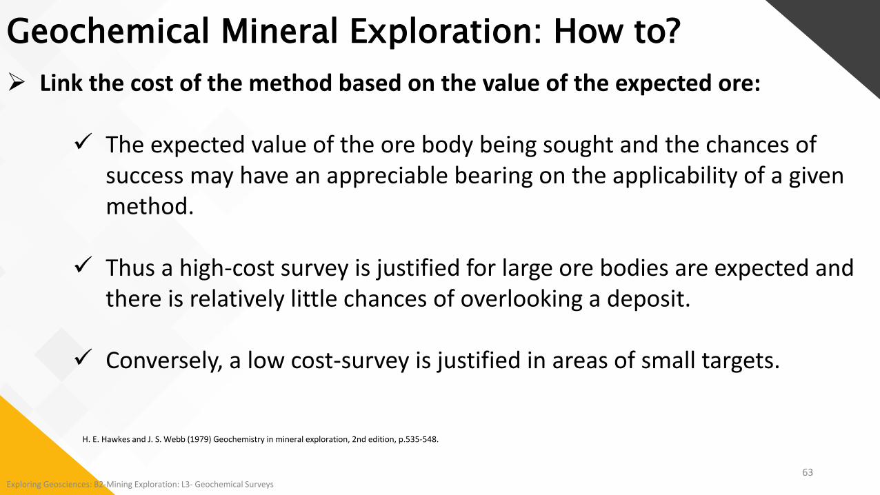
Link the cost of the method based on the value of the expected ore:
The expected value of the ore body being sought and the chances of success may have an appreciable bearing on the applicability of a given method.
Thus a high-cost survey is justified for large ore bodies are expected and there is relatively little chances of overlooking a deposit.
Conversely, a low cost-survey is justified in areas of small targets.
H. E. Hawkes and J. S. Webb (1979) Geochemistry in mineral exploration, 2nd edition, p.535-548.
Geochemical Mineral Exploration: How to?

64Exploring Geosciences: B2-Mining Exploration: L3- Geochemical Surveys
Assure high quality control for geochemical surveys:
Geochemical methods of exploration constitutes an important tool in the investigation of the economic mineral deposits.
Any geochemical investigation to be effective, must take into consideration several aspects of the ore body, including genesis and cost at various stages of exploration.
Geochemical Mineral Exploration: How to?
H. E. Hawkes and J. S. Webb (1979) Geochemistry in mineral exploration, 2nd edition, p.535-548.

65Exploring Geosciences: B2-Mining Exploration: L3- Geochemical Surveys
Justify the role of geochemistry in an exploration program:
Geochemistry is an essential component in most modern integrated mineral exploration programs, for the following reasons:
1. Economic mineral deposits are commonly characterized by their low grade and large tonnage. Discovery, assessment and development are highly dependent upon geochemical methods and analyses.
2. Exploration activity is mostly carried out in tropical and subtropical environments where chemical weathering has predominated and where geochemical prospecting techniques have proven most effective.
Recent estimates suggest that between 10 and 25% of exploration budgets are allocated to geochemistry.
Geochemical Mineral Exploration: How to?
H. E. Hawkes and J. S. Webb (1979) Geochemistry in mineral exploration, 2nd edition, p.535-548.

66Exploring Geosciences: B2-Mining Exploration: L3- Geochemical Surveys
Choose the elements to analyze:
“Primary Targets”: Metal elements that are most commonly sought by prospectors
“Secondary Targets”: Metals (except fluorine) which may be sought under special geological and
economic circumstances
“Pathfinders”: Uneconomic elements useful in discovering a deposit of an element other than
themselves:• Usually, the target have sampling or analytical challenges that the pathfinders do not.
Geochemical Mineral Exploration: How to?
CIM Short Course, 2013, Steve Amor

67Exploring Geosciences: B2-Mining Exploration: L3- Geochemical Surveys
Geochemical Mineral Exploration: How to?
CIM Short Course, 2013, Steve Amor

68Exploring Geosciences: B2-Mining Exploration: L3- Geochemical Surveys
Reduce ‘nugget’ effects:
Gold analyses in geochemical samples are subject to the “nugget effect” which can cause an anomaly to be missed, or alternately for an unrealistically high value to be returned; the outcome depends very much on chance
Geochemical Mineral Exploration: How to?
CIM Short Course, 2013, Steve Amor
“Nugget” or “particle sparsity” effect illustration:
Gold’s sample material represented by the smaller square will return a very low assay
If the scoop picks up the single gold particle (represented by the larger dot), the assay will be very high.
As indicators of the bulk gold composition of the sample, neither will be correct (Harris, 1981).
A pathfinder element like arsenic is more evenly distributed and not subject to this problem.

69Exploring Geosciences: B2-Mining Exploration: L3- Geochemical Surveys
Understand analytical certificates:
Analyses preceded by the “less than” (<) sign: Means there is so little of the element in question in the sample that
the analytical method is not sensitive enough to measure it. The < sign is sometimes replaced by a minus sign (-) Rarely (though it may turn up in old assessment documents) the
words “ND” meaning “Not detected”.
“Greater than” (>) sign: Indicates an analysis that exceeds the method’s upper range
Geochemical Mineral Exploration: How to?
CIM Short Course, 2013, Steve Amor

Field Cartography
A long tradition
Exploring Geosciences: B2-Mining Exploration: L3- Geochemical Surveys70

Helicopter Outcrop Stripping
In compliance with all the regulations 71
Exploring Geosciences: B2-Mining Exploration: L3- Geochemical Surveys

Outcrop Stripping
In compliance with all the regulations
72Exploring Geosciences: B2-Mining Exploration: L3- Geochemical Surveys

Trenching and Sampling
Experienced and efficient
73Exploring Geosciences: B2-Mining Exploration: L3- Geochemical Surveys

More than 50,000 lakes to our credit
Sampling of Lake Sediments
74Exploring Geosciences: B2-Mining Exploration: L3- Geochemical Surveys

Sampling and Characterization
Lake Sediments
Surface Water
75Exploring Geosciences: B2-Mining Exploration: L3- Geochemical Surveys
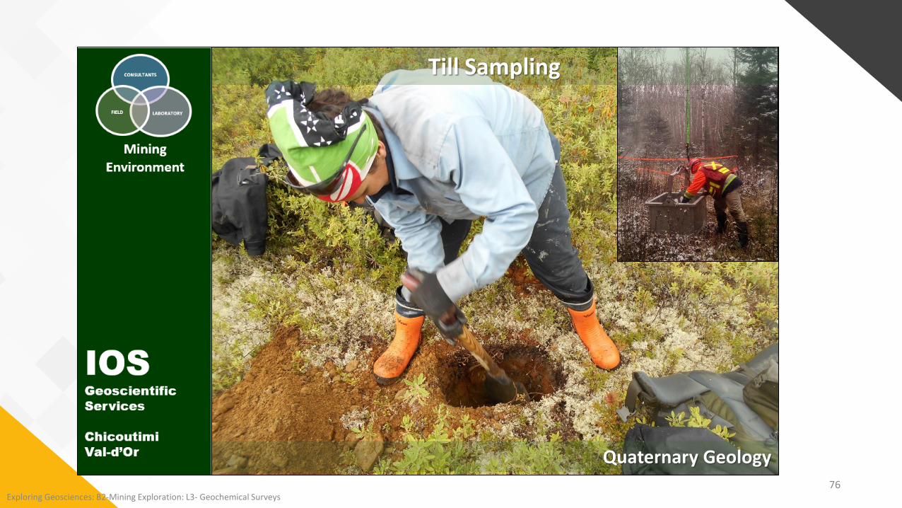
Till Sampling
Quaternary Geology76
Exploring Geosciences: B2-Mining Exploration: L3- Geochemical Surveys

Soil Sampling
Highly skilled experience
77Exploring Geosciences: B2-Mining Exploration: L3- Geochemical Surveys

Trenching Sampling Drill Hole Sampling
Drilling tailings within abandoned sitesCollecting soil samples
Soil Sampling and Characterization
78Exploring Geosciences: B2-Mining Exploration: L3- Geochemical Surveys

Pedogeochemistry:LiftIndex, Double-normalization and Probabilism
Beyond statistics
79Exploring Geosciences: B2-Mining Exploration: L3- Geochemical Surveys

Preparation of Soil Samples
Super-clean work by reducing all risk of contamination
80Exploring Geosciences: B2-Mining Exploration: L3- Geochemical Surveys

81Exploring Geosciences: B2-Mining Exploration: L3- Geochemical Surveys
PLANNING AND SAMPLING General influences
EXPLORATION GEOCHEMISTRY: From planning to interpretation, with all its complexity
http://www.iosgeo.com/en/
MEDIUM ADAPTED TO THE CONTEXT REGIONAL OR LOCAL ENVIRONMENT TYPE AVAILABILITY AND HOMOGENEITY BEHAVIOR OF TARGETED METAL
USE THE MOST SUITABLE MEDIUM, THE RIGHT ANALYTICAL METHOD FOR THE MEDIUM, AND THE ONE YOU MASTER THE MOST
EFFICIENCY vs COSTS

82Exploring Geosciences: B2-Mining Exploration: L3- Geochemical Surveys
PLANNING AND SAMPLING Problems
EXPLORATION GEOCHEMISTRY: From planning to interpretation, with all its complexity
http://www.iosgeo.com/en/
80% OF QUALITY PROBLEMS ARE FROM SAMPLING * Numbering errors Localization errors Bad material No description of the material No description of the environment Contamination problem Poorly trained staff Not very robust working method *Project Manager

83Exploring Geosciences: B2-Mining Exploration: L3- Geochemical Surveys
PLANNING AND SAMPLING Numbering
EXPLORATION GEOCHEMISTRY: From planning to interpretation, with all its complexity
http://www.iosgeo.com/en/
MOST SERIOUS ERRORS If there is an anomaly, the tracking takes place in
the wrong place SIMPLE, DIGITAL SYSTEM
Avoid letters Avoid complexities (i.e. no line)
• Example: 92951125, project 929, 5 for soils, sample 1125
CUSTOM COUPON BOOKS With barcode
REDUNDANCY Bag, coupon, aluminum ticket, ribbon

84Exploring Geosciences: B2-Mining Exploration: L3- Geochemical Surveys
PLANNING AND SAMPLING Location
EXPLORATION GEOCHEMISTRY: From planning to interpretation, with all its complexity
http://www.iosgeo.com/en/
GPS with external antenna (± 1 m) Pay attention to the coordinate system (NAD27
and NAD83) Planning traverses Digital transfer AND handwritten notes
Watch out for numbering shifts GPS corroborated with line / station numbers
GPS inaccuracy causes zigzags in the lines

85Exploring Geosciences: B2-Mining Exploration: L3- Geochemical Surveys
PLANNING AND SAMPLING Material selection
EXPLORATION GEOCHEMISTRY: From planning to interpretation, with all its complexity
http://www.iosgeo.com/en/
The quality of the survey depends on the homogeneity of the medium collected.
Samples representing material other than the targeted material generate noise
Must be performed by trained employees (not just supervised)
Dramatic effects on results and interpretation: Not filterable Difficult to detect after GARBAGE IN, GARBAGE OUT!

86Exploring Geosciences: B2-Mining Exploration: L3- Geochemical Surveys
PLANNING AND SAMPLING Material selection
EXPLORATION GEOCHEMISTRY: From planning to interpretation, with all its complexity
http://www.iosgeo.com/en/
The meaning of the geochemical signature depends on the study area and therefore on its environment
The sample environment must be adequately described (expensive to do after).
Topography, slope, drainage, hydrography, forest cover, geomorphology, outcrops, etc.
Soil profile Anthropogenic influence Eliminate false anomalies

87Exploring Geosciences: B2-Mining Exploration: L3- Geochemical Surveys
PLANNING AND SAMPLING Describe the sample
EXPLORATION GEOCHEMISTRY: From planning to interpretation, with all its complexity
http://www.iosgeo.com/en/
Necessary for interpretation Required for QCQA (Redundancy) Granulometry, color, humidity, cohesion, etc. Constituents:
Silt, sand, gravel Type of pebbles Presence of a glaze Organic matter:
Humus, twigs, fibers, sphagnum, etc. Crusts:
• Ferrochelate, calcrete, gypsum, etc.

88Exploring Geosciences: B2-Mining Exploration: L3- Geochemical Surveys
PLANNING AND SAMPLING Describe the color
EXPLORATION GEOCHEMISTRY: From planning to interpretation, with all its complexity
http://www.iosgeo.com/en/
MUNSELL'S CHART Required for QCQA (Redundancy) Too subjective to be just descriptive
Ex.: Red brown, Goose poo brown, chocolate brown Cannot be used in a database
TVC (perception) versus RGB (measurement) Tint (Base color)
• R: red; Y: yellow, V: green, B: cyan, P: purple• YR, GY, BG, PB, RP• 5: pure, 10: hybridized
Value (tint brightness) 1: white, 10: black
Chromaticity (Purity of perceived color) 1: gray, 12: saturated color

89Exploring Geosciences: B2-Mining Exploration: L3- Geochemical Surveys
PLANNING AND SAMPLING Sample size
EXPLORATION GEOCHEMISTRY: From planning to interpretation, with all its complexity
http://www.iosgeo.com/en/
CATIONIC METHODS 300-1000 grams wet
CHEMISTRY OF DETRITICAL FRACTIONS 300 gr for the fines 1-5 kg for BLEG 10 kg for heavy minerals
MINERALOGICAL METHODS 10 kg for nugget gold 20-30 kg for the tills 20-50 kg for eskers

90Exploring Geosciences: B2-Mining Exploration: L3- Geochemical Surveys
SAMPLING PATTERNS OPTIMAL SCALES OF SURVEYS
EXPLORATION GEOCHEMISTRY: From planning to interpretation, with all its complexity
http://www.iosgeo.com/en/
Regional
Local
MEDIUM TRANSPORT RESOLUTION
RIVERS AND ESKERS 1 - 300 km > 10 km Detrital
LAKES 1-5 km > 1 km Cat> Det
TILLS 300 m-30 km > 500 m Detrital
STREAMS 0-5 km > 500 m Det or Cat
SOILS 0-1 km <100 m Cationic
Unusual methods (plants, water, termite mounds, etc.) are far less well precise

91Exploring Geosciences: B2-Mining Exploration: L3- Geochemical Surveys
PLANNING AND SAMPLING LAKES
EXPLORATION GEOCHEMISTRY: From planning to interpretation, with all its complexity
http://www.iosgeo.com/en/
Mileage spacing Heavy logistics Gyttja in the darkest part of the lake
Under the hypolimnion Avoid sampling near riverbanks, mouths, or in bog
lakes Helicopter torpedo sampling
BLIND Tight sampling of the same lake: NOT USEFUL

92Exploring Geosciences: B2-Mining Exploration: L3- Geochemical Surveys
PLANNING AND SAMPLING RIVERS AND ESKERS
EXPLORATION GEOCHEMISTRY: From planning to interpretation, with all its complexity
http://www.iosgeo.com/en/
Pluri-kilometric spacing Sifted and clean gravel
• Heart of the esker or swimming pool in the rapids Avoid shoulders or sandy dunes Rapid dilution of chemical signal Oxidizing system, no sulfide Heavy mineral studies only

93Exploring Geosciences: B2-Mining Exploration: L3- Geochemical Surveys
PLANNING AND SAMPLING STREAMS: DETRITAL
EXPLORATION GEOCHEMISTRY: From planning to interpretation, with all its complexity
http://www.iosgeo.com/en/
Detrital material Sub-kilometer spacing Alluvial plain, meanders High energy zone
• Confluences, rapids, traps Concentration of heavy minerals Mineralogy or chemistry Oxidizing medium: destroyed sulfides

94Exploring Geosciences: B2-Mining Exploration: L3- Geochemical Surveys
PLANNING AND SAMPLING STREAMS: ORGANIC
EXPLORATION GEOCHEMISTRY: From planning to interpretation, with all its complexity
http://www.iosgeo.com/en/
Organic banks Flood zones Organic material Adsorption of water cations Restricted watershed influx

95Exploring Geosciences: B2-Mining Exploration: L3- Geochemical Surveys
PLANNING AND SAMPLING GLACIAL SEDIMENTS: DETRITAL
EXPLORATION GEOCHEMISTRY: From planning to interpretation, with all its complexity
http://www.iosgeo.com/en/
Bottom till and melting till Geomorphological study (specialist)
Material availability Flow direction Complex stratigraphy, palimpsest Doesn't work everywhere Presence of wind glacis or runoff
Mineralogical study (10-30 kg) Chemical analysis (0.5-2 kg) Fence 2-20 km, perpendicular to the dominant flow Spacing on fences: According to target

96Exploring Geosciences: B2-Mining Exploration: L3- Geochemical Surveys
PLANNING AND SAMPLING SOILS
EXPLORATION GEOCHEMISTRY: From planning to interpretation, with all its complexity
http://www.iosgeo.com/en/
Only local grid method Line 100 - 400 meters Station 25 - 100 meters Different horizons do not have the same signature
Humus "A": cationic Ferrochelate "B": cat + detrital Horizon "C": detrital

97Exploring Geosciences: B2-Mining Exploration: L3- Geochemical Surveys
PLANNING AND SAMPLING SOILS SAMPLING
EXPLORATION GEOCHEMISTRY: From planning to interpretation, with all its complexity
http://www.iosgeo.com/en/
Inverted plastic bag used as a glove to
avoid contamination
Hole crossing the target horizon
Kraft paper bag Barcode label

98Exploring Geosciences: B2-Mining Exploration: L3- Geochemical Surveys
PLANNING AND SAMPLING SOILS SAMPLING
Fibrisol: Organic peaty soils
EXPLORATION GEOCHEMISTRY: From planning to interpretation, with all its complexity
http://www.iosgeo.com/en/
PEAT
Pierre-Luc> 6 feet

99Exploring Geosciences: B2-Mining Exploration: L3- Geochemical Surveys
PLANNING AND SAMPLING SOILS PROFILES
EXPLORATION GEOCHEMISTRY: From planning to interpretation, with all its complexity
http://www.iosgeo.com/en/
L-F : Fibrous materialAh : Humic matterAe : Leached area
B : Ferruginous zone
C : Non altered overburden

100Exploring Geosciences: B2-Mining Exploration: L3- Geochemical Surveys
PLANNING AND SAMPLING SOILS PROFILES: PODZOL
EXPLORATION GEOCHEMISTRY: From planning to interpretation, with all its complexity
http://www.iosgeo.com/en/
Leached soil, poorly developed Typically thin Dominant on the tills
Very acidic Cold climate Typical forest floor of the taiga
Conifers Ericaceae
Dominated by chelation Organic-iron-aluminum complex Horizon B poorly developed
Easy to sample

101Exploring Geosciences: B2-Mining Exploration: L3- Geochemical Surveys
PLANNING AND SAMPLING SOILS PROFILES: BRUNISOL
EXPLORATION GEOCHEMISTRY: From planning to interpretation, with all its complexity
http://www.iosgeo.com/en/
Very well drained soil Hardwoods, pine forests, etc.
Permeable terrain (sand and gravel) Positive water balance, dominated by downward flow Oxidizing environment
Intense ferrochelate Highly developed Horizon B
Complex structure, can be thick No leached zone Ae
Easy-to-sample humus Horizon B: can be difficult Presence of ferricrust Destroyed by forest fires

102Exploring Geosciences: B2-Mining Exploration: L3- Geochemical Surveys
PLANNING AND SAMPLING SOILS PROFILES: BRUNISOL
EXPLORATION GEOCHEMISTRY: From planning to interpretation, with all its complexity
http://www.iosgeo.com/en/
FERRICRUST HARDSTEIN

103Exploring Geosciences: B2-Mining Exploration: L3- Geochemical Surveys
PLANNING AND SAMPLING SOILS PROFILES: GLEYSOL
EXPLORATION GEOCHEMISTRY: From planning to interpretation, with all its complexity
http://www.iosgeo.com/en/
Continuously waterlogged soil Swamp, bog, sphagnum moss
Poorly drained, waterproof land Anoxic, reducing
No ferrochelate Horizon B absent Enrichment of clays
Humus sits directly on the clay
Can be deep Holes 1-2 meters Dutch Auger

104Exploring Geosciences: B2-Mining Exploration: L3- Geochemical Surveys
PLANNING AND SAMPLING SOILS PROFILES: LUVISOL
EXPLORATION GEOCHEMISTRY: From planning to interpretation, with all its complexity
http://www.iosgeo.com/en/
Leaching soil Agricultural plains, herbaceous plants Good drainage
Weathering and production of clays Positive water balance, dominated by downward
eluviation / illuviation Complex structure Easy to sample
Can be thick and disturbed

105Exploring Geosciences: B2-Mining Exploration: L3- Geochemical Surveys
PLANNING AND SAMPLING SOILS PROFILES: OTHERS
EXPLORATION GEOCHEMISTRY: From planning to interpretation, with all its complexity
http://www.iosgeo.com/en/
MOLLISOL: Accumulation of organic matter in herbaceous plains REGOSOL: Poorly developed profiles CRYOSOL: Developed on permafrost VERTISOL: Clay soils with poorly developed profiles and argilopedoturbation FIBRISOL: Organic peaty soils
https://soilweb.ca/

106Exploring Geosciences: B2-Mining Exploration: L3- Geochemical Surveys
Data for major elements are generally reported in the form of oxides as weight per cent (e.g. silica, SiO2 wt. percent) and trace elements in parts per million (ppm) or micrograms per gram (μg g−1).
An important consideration in the interpretation of data is analytical uncertainty, particularly when evaluating the existence or significance of small variations in composition.
Some of the most common sources of uncertainty are sample contamination, incomplete sample digestion (some minerals are extremely resistant to acids), interferences between elements, and poor instrument calibration.
Geochemical Data Interpretation
H. E. Hawkes and J. S. Webb (1979) Geochemistry in mineral exploration, 2nd edition, p.535-548.

107Exploring Geosciences: B2-Mining Exploration: L3- Geochemical Surveys
The extent of these problems is best limited at the time of analysis by taking necessary precautions and through discussion with experienced laboratory staff.
They are, however, impossible to eliminate completely and an indication of analytical uncertainty should therefore be reported with the data, ideally as ‘error bars’ on geochemical diagrams.
Uncertainties can be estimated from the regular analysis of reference materials of known composition and from the analysis of two or more samples.
Geochemical Data Interpretation
H. E. Hawkes and J. S. Webb (1979) Geochemistry in mineral exploration, 2nd edition, p.535-548.

108Exploring Geosciences: B2-Mining Exploration: L3- Geochemical Surveys
To help in interpretation, data are often imported into graphing and statistical computer programs.
A wide variety of diagrams can be produced to compare the data with those from previous studies and to demonstrate trends or new interpretations.
Geochemical Data Interpretation
H. E. Hawkes and J. S. Webb (1979) Geochemistry in mineral exploration, 2nd edition, p.535-548.

109Exploring Geosciences: B2-Mining Exploration: L3- Geochemical Surveys
Geochemical Data Interpretation
1) 2D and 3D quantitative punctual data:
a) Added analyzes of cartographic surveys, compilation and drilling (DDH)
2) 2D and 3D qualitative punctual data:
b) Alteration and mineralization observed (in %)
2D and 3D Geochemistry
Fallara, Rabeau, Cheng and de Kemp (2008)

110Exploring Geosciences: B2-Mining Exploration: L3- Geochemical Surveys
Targeting Proximal and Distal Footprints
Geochemical Data Interpretation
Fisher et al; 2013

111Exploring Geosciences: B2-Mining Exploration: L3- Geochemical Surveys
Targeting Proximal and Distal Footprints
Geochemical Data Interpretation
Golden Mile
Kanowna Belle
Paddington
Mt Pleasant
Kundana
Binduli10 km
Scott HalleyMinmap
Fisher et al; 2013

112Exploring Geosciences: B2-Mining Exploration: L3- Geochemical Surveys
Targeting Proximal and Distal Footprints
Geochemical Data Interpretation
Fisher et al; 2013
Whole rock geochemistry / mineralogy, mineral chemistry
Immobile geochemistry / mineralogy, mineral chemistry
<50 meters - Gas, hydrogeochemistry biogeochemistry (trees/shrubs)
> 50-100 meters - Hydrogeochemistry

113Exploring Geosciences: B2-Mining Exploration: L3- Geochemical Surveys
Real time integrated data while drilling
Geochemical Data Interpretation
Fisher et al; 2013

114Exploring Geosciences: B2-Mining Exploration: L3- Geochemical Surveys
Real time integrated data while drilling
Geochemical Data Interpretation
Fisher et al; 2013
Geochemistry

115Exploring Geosciences: B2-Mining Exploration: L3- Geochemical Surveys
Linking geophysics and geochemistry
Geochemical Data Interpretation
Fisher et al; 2013

116Exploring Geosciences: B2-Mining Exploration: L3- Geochemical Surveys
Geochemical surveys are conducted to provide baseline information for: Mineral exploration Geologic mapping Baseline values for environment/land use purposes
Geochemical survey data: Contains various information for geological, geochemical, environmental and
climatic processes. Uses more than 50 elements can be analyzed at sufficiently low detection
limits. Reflects processes that form or affect mineralogy. Represents a multivariate data space over a two or three dimensional
geographic space and time.
Geochemical Data Interpretation
E. C. Grunsky and P. de Caritat Geochemistry: Exploration, Environment, Analysis 2019; Geochem2019-031

E. C. Grunsky and P. de Caritat Geochemistry: Exploration, Environment, Analysis 2019; Geochem2019-031
Geochemical Data Interpretation
Melville Peninsula Case Study
117

E. C. Grunsky and P. de Caritat Geochemistry: Exploration, Environment, Analysis 2019; Geochem2019-031
Regional basement rock type map of Nunavut, Canada, showing the location of the Melville Peninsula study area.
Geochemical Data Interpretation
118

E. C. Grunsky and P. de Caritat Geochemistry: Exploration, Environment, Analysis 2019; Geochem2019-031
Regional scale of geochemical surveys 1:250,000
Geochemical Data Interpretation
1 site/13km2
119

E. C. Grunsky and P. de Caritat Geochemistry: Exploration, Environment, Analysis 2019; Geochem2019-031
Geological map of the southern part of the Melville Peninsula, Nunavut, Canada, with lake sediment sample sites (shown as black dots)
Geochemical Data Interpretation
120

E. C. Grunsky and P. de Caritat Geochemistry: Exploration, Environment, Analysis 2019; Geochem2019-031
Mineral occurrences obtained from NUMIN (2017)
Geochemical Data Interpretation
121

E. C. Grunsky and P. de Caritat Geochemistry: Exploration, Environment, Analysis 2019; Geochem2019-031
Map of the residual values of Au (ppb) estimated from a robust interpretation of lake sediment geochemical data, Melville Peninsula.
Geochemical Data Interpretation
122

E. C. Grunsky and P. de Caritat Geochemistry: Exploration, Environment, Analysis 2019; Geochem2019-031
Map of the residual values of Ni (ppm) estimated from a robust interpretation of lake sediment geochemical data, Melville Peninsula.
Geochemical Data Interpretation
123

E. C. Grunsky and P. de Caritat Geochemistry: Exploration, Environment, Analysis 2019; Geochem2019-031
Map of the residual values of Zn (ppm) estimated from a robust interpretation of lake sediment geochemical data, Melville Peninsula.
Geochemical Data Interpretation
124

E. C. Grunsky and P. de Caritat Geochemistry: Exploration, Environment, Analysis 2019; Geochem2019-031
Map of the residual values of Cu (ppm) estimated from a robust interpretation of lake sediment geochemical data, Melville Peninsula.
Geochemical Data Interpretation
125

3D Spatial Interpretations and Geochemical Quantification: Used to identify and illustrate possible anomalies found within the
vicinity of known mineral deposits.
Geochemical Data Interpretation
Fisher et al; 2013126

3D Spatial Interpretations and Geochemical Quantification: Used to identify and illustrate possible anomalies found within the
vicinity of known mineral deposits.
Geochemical Data Interpretation
Fisher et al; 2013
Gold isosurfaces: 0.05,0.1, 0.5, 1.0 ppm
127

3D Spatial Interpretations and Geochemical Quantification: Used to identify and illustrate possible anomalies found within the
vicinity of known mineral deposits.
Geochemical Data Interpretation
Fisher et al; 2013
Favorable Alteration
Isosurfaces (0.5, 0.6, 0.7)
128

110Exploring Geosciences: B2-Mining Exploration: L3- Geochemical Surveys
B2: Lesson 3: Geochemical Surveys: Videos
THE GEOLOGICAL MAP "Drawing the Earth's skin"(9.47min)
https://youtu.be/qdz9DN74ukY
Mineral Exploration Geologist (5.02min)
https://youtu.be/3uXyZ3FGTCo
Tellus geochemical sampling: collecting soil samples (6.2min)
https://youtu.be/sDAtLfSP9SU
Geochemical Prospecting (28.06min)
https://youtu.be/-Ys0LH7sYWg
Geochemical Techniques for Undercover Exploration: The 'New Geophysics'?- James Cleverley, 2013 (56.45)
https://youtu.be/ag2JLP5vIkQ

FNQLSDI.CA
Questions?
Thanks!
130Exploring Geosciences: B2-Mining Exploration: L3- Geochemical Surveys
Related Documents