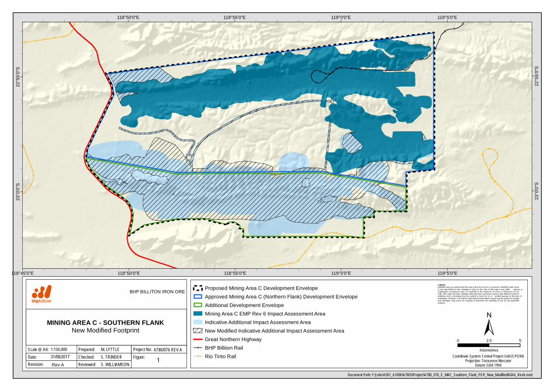
119°5'0"E 119°5'0"E 119°0'0"E 119°0'0"E 118°55'0"E 118°55'0"E 118°50'0"E 118°50'0"E 118°45'0"E 22°55'0"S 22°55'0"S 23°0'0"S 23°0'0"S Liability BHPBIO does not warrant that this map is free from errors or omissions. BHPBIO shall not be in any way liable for loss, damage or injury to the user of this map or any other person or organisation consequent upon or incidental to the existence of errors or omissions on this map. This map has been compiled with data from numerous sources with different levels of reliability and is considered by the authors to be fit for its in tended purpose at the time of publication. However, it should be noted that the information shown may be subject to change and ultimately, map users are required to determine the suitability of use for any particular purpose. Document Path: Y:\Jobs\A501_A1000\A780\3Project\A780_076_E_MAC_Southern_Flank_PER_New_ModifiedIAIAA_RevA.mxd Date: Scale @ A4: MINING AREA C - SOUTHERN FLANK New Modified Footprint 0 5 2.5 Kilometres 1 31/08/2017 BHP BILLITON IRON ORE Figure: Project No: 1:150,000 Checked: Prepared: M. LYTTLE S. TRINDER A780/076 REV A Revision: Rev A Reviewed: S. WILLIAMSON Coordinate System: Central Project Grid (CPG94) Projection: Transverse Mercator Datum: GDA 1994 Proposed Mining Area C Development Envelope Approved Mining Area C (Northern Flank) Development Envelope Additional Development Envelope Mining Area C EMP Rev 6 Impact Assessment Area Indicative Additional Impact Assessment Area New Modified Indicative Additional Impact Assessment Area Great Northern Highway BHP Billiton Rail Rio Tinto Rail

Welcome message from author
This document is posted to help you gain knowledge. Please leave a comment to let me know what you think about it! Share it to your friends and learn new things together.
Transcript
119°5'0"E
119°5'0"E
119°0'0"E
119°0'0"E
118°55'0"E
118°55'0"E
118°50'0"E
118°50'0"E
118°45'0"E
22°5
5'0"S
22°5
5'0"S
23°0
'0"S
23°0
'0"S
Liability BHPBIO does not warrant that this map is free from errors or omissions. BHPBIO shall not be in any way liable for loss, damage or injury to the user of this map or any other person or organisation consequent upon or incidental to the existence of errors or omissions on this map. This map has been compiled with data from numerous sources with different levels of reliability and is considered by the authors to be fit for its in tended purpose at the time of publication. However, it should be noted that the information shown may be subject to change and ultimately, map users are required to determine the suitability of use for any particular purpose.
Document Path: Y:\Jobs\A501_A1000\A780\3Project\A780_076_E_MAC_Southern_Flank_PER_New_ModifiedIAIAA_RevA.mxd
Date:Scale @ A4:
MINING AREA C - SOUTHERN FLANKNew Modified Footprint
0 52.5
Kilometres
131/08/2017
BHP BILLITON IRON ORE
Figure:Project No:1:150,000
Checked:Prepared: M. LYTTLE
S. TRINDERA780/076 REV A
Revision: Rev A Reviewed: S. WILLIAMSONCoordinate System: Central Project Grid (CPG94)
Projection: Transverse MercatorDatum: GDA 1994
Proposed Mining Area C Development EnvelopeApproved Mining Area C (Northern Flank) Development EnvelopeAdditional Development EnvelopeMining Area C EMP Rev 6 Impact Assessment AreaIndicative Additional Impact Assessment AreaNew Modified Indicative Additional Impact Assessment AreaGreat Northern HighwayBHP Billiton RailRio Tinto Rail

119°5'0"E
119°5'0"E
119°0'0"E
119°0'0"E
118°55'0"E
118°55'0"E
118°50'0"E
118°50'0"E
118°45'0"E
118°45'0"E22
°55'0
"S
22°5
5'0"S
23°0
'0"S
23°0
'0"S
Liability BHPBIO does not warrant that this map is free from errors or omissions. BHPBIO shall not be in any way liable for loss, damage or injury to the user of this map or any other person or organisation consequent upon or incidental to the existence of errors or omissions on this map. This map has been compiled with data from numerous sources with different levels of reliability and is considered by the authors to be fit for its in tended purpose at the time of publication. However, it should be noted that the information shown may be subject to change and ultimately, map users are required to determine the suitability of use for any particular purpose.
Document Path: Y:\Jobs\A501_A1000\A780\3Project\A780_027_E_MAC_Southern_Flank_PER_Map15_RevC.mxd
Date:Scale @ A4:
MINING AREA C - SOUTHERN FLANKVegetation Condition within the Proposed
Mining Area C Development Envelope 0 105
Kilometres
158/11/2017
BHP BILLITON IRON ORE
Figure:Project No:1:150,000
Checked:Prepared: M. LYTTLE
B. BARNETTA780/027 REV C
Revision: Rev B Reviewed: S. WILLIAMSONCoordinate System: Central Project Grid (CPG94)
Projection: Transverse MercatorDatum: GDA 1994
Proposed Mining Area C DevelopmentEnvelopeApproved Mining Area C (NorthernFlank) Development EnvelopeAdditional Development EnvelopeMining Area C EMP Rev 6 ImpactAssessment AreaNew Modified Indicative AdditionalImpact Assessment Area
Vegetation ConditionExcellentVery GoodGoodPoorNot mappedClearedGreat Northern HighwayBHP Billiton Rail
119°5'0"E
119°5'0"E
119°0'0"E
119°0'0"E
118°55'0"E
118°55'0"E
118°50'0"E
118°50'0"E
118°45'0"E
22°5
5'0"S
22°5
5'0"S
23°0
'0"S
23°0
'0"S
Liability BHPBIO does not warrant that this map is free from errors or omissions. BHPBIO shall not be in any way liable for loss, damage or injury to the user of this map or any other person or organisation consequent upon or incidental to the existence of errors or omissions on this map. This map has been compiled with data from numerous sources with different levels of reliability and is considered by the authors to be fit for its in tended purpose at the time of publication. However, it should be noted that the information shown may be subject to change and ultimately, map users are required to determine the suitability of use for any particular purpose.
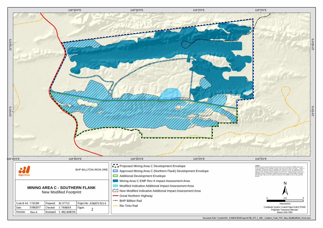
Document Path: Y:\Jobs\A501_A1000\A780\3Project\A780_075_E_MAC_Southern_Flank_PER_New_ModifiedIAIAA_RevA.mxd
Date:Scale @ A4:
MINING AREA C - SOUTHERN FLANKNew Modified Footprint
0 52.5
Kilometres
231/08/2017
BHP BILLITON IRON ORE
Figure:Project No:1:150,000
Checked:Prepared: M. LYTTLE
S. TRINDERA780/075 REV A
Revision: Rev A Reviewed: S. WILLIAMSONCoordinate System: Central Project Grid (CPG94)
Projection: Transverse MercatorDatum: GDA 1994
Proposed Mining Area C Development EnvelopeApproved Mining Area C (Northern Flank) Development EnvelopeAdditional Development EnvelopeMining Area C EMP Rev 6 Impact Assessment AreaModified Indicative Additional Impact Assessment AreaNew Modified Indicative Additional Impact Assessment AreaGreat Northern HighwayBHP Billiton RailRio Tinto Rail
119°5'0"E
119°5'0"E
119°0'0"E
119°0'0"E
118°55'0"E
118°55'0"E
118°50'0"E
118°50'0"E
118°45'0"E
118°45'0"E22°55'0"S
22°55'0"S
23°0'0"S
23°0'0"S
Liability BHP BIO d oes not warrant that this m ap is free from errors or om issions. BHP BIO shall not b e in any way liab le for loss, dam ag e or injury to the user of this m ap or any other person or org anisation consequent upon or inc id ental to the existence of errors or om issions on this m ap. This m ap has b een com piled with data from num erous sources with d ifferent levels of reliab ility and is considered b y the authors to b e fit for its in tended purpose at the tim e of pub lication. However, it should b e noted that the inform ation shown m ay b e sub ject to chang e and ultim ately, m ap users are required to determ ine the suitab ility of use for any particular purpose.
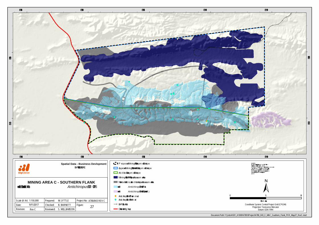
Document Path: Y:\Jobs\A501_A1000\A780\3Project\A780_043_E_MAC_Southern_Flank_PER_Map27_RevC.mxd
Spatial Data - Business Devlopment
Date:Scale @ A4:
MINING AREA C - SOUTHERN FLANKInferred Extent of Hab itat for Antichiropus ‘DIP 007’
0 105
Kilom etres
279/11/2017
BHP BILLITON IRON ORE
Figure:Project No:1:150,000
Checked:Prepared: M. LYTTLE
B. BARNETTA780/043 REV C
Revision: Rev C Reviewed: S. WILLIAMSONCoordinate System: Central Project Grid (CPG94)
Projection: Transverse MercatorDatum: GDA 1994
P roposed Mining Area C Developm ent EnvelopeApproved Mining Area C (Northern Flank) Developm ent EnvelopeAd d itional Developm ent EnvelopeMining Area C EMP Rev 6 Im pac t Assessm ent AreaNew Mod ified Ind icative Ad d itional Im pac t Assessm ent AreaInferred Antichiropus 'DIP 007' Hab itatInferred Antichiropus 'DIP 007' Hab itat (Unverified )Antichiropus ̀DIP 007' ind eterm inedAntichiropus ̀DIP 007' c onfirm edBHP Billiton RailGreat Northern Hig hway

#
#
##
#
#
#
#
##
##
##
#
#
#
#
##
#
#
#
#
##
#
##
#
#
#
!
!
!!
!
!
!
!!
!
!
!
!
!
!
!
!
119°0'0"E
119°0'0"E
118°55'0"E
118°55'0"E
118°50'0"E
118°50'0"E22
°55'0
"S
22°5
5'0"S
23°0
'0"S
23°0
'0"S
Liability BHPBIO does not warrant that this map is free from errors or omissions. BHPBIO shall not be in any way liable for loss, damage or injury to the user of this map or any other person or organisation consequent upon or incidental to the existence of errors or omissions on this map. This map has been compiled with data from numerous sources with different levels of reliability and is considered by the authors to be fit for its in tended purpose at the time of publication. However, it should be noted that the information shown may be subject to change and ultimately, map users are required to determine the suitability of use for any particular purpose.
Document Path: Y:\Jobs\A501_A1000\A780\3Project\A780_088_E_MAC_Southern_Flank_PER_Map29_RevD.mxd
Date:Scale @ A4:
MINING AREA C - SOUTHERN FLANKImpacts to Ghost Bat Caves and
Antichiropus 'DIP007' Habitat Following Mitigation
29
±26/10/2017
BHP BILLITON IRON ORE
Figure:Project No:1:110,000
Checked:Prepared: J. ROBERTS
B. BARNETTA780/088 REV D
Revision: Rev C Reviewed: S. WILLIAMSONCoordinate System: Central Project Grid (CPG94)
Projection: Transverse MercatorDatum: GDA 1994
Proposed Mining Area C Development EnvelopeApproved Mining Area C (Northern Flank)Development EnvelopeAdditional Development EnvelopeMining Area C EMP Rev 6 Impact AssessmentAreaInferred Antichiropus 'DIP007' HabitatPriority Ecological Community
Bat caves in proposed impact areas! High! LowBat caves outside proposed impact areas# High# Low
BHP Billiton RailGreat Northern HighwayNew Modified Indicative Additional ImpactAssessment Area
0 63Kilometers
##
#
##
Inset A
0 300Metres
119°15'0"E
119°15'0"E
119°10'0"E
119°10'0"E
119°5'0"E
119°5'0"E
119°0'0"E
119°0'0"E
118°55'0"E
118°55'0"E
118°50'0"E
118°50'0"E
118°45'0"E
118°45'0"E22
°50'0
"S
22°5
0'0"S
22°5
5'0"S
22°5
5'0"S
23°0
'0"S
23°0
'0"S
23°5
'0"S
23°5
'0"S
Liability BHPBIO does not warrant that this map is free from errors or omissions. BHPBIO shall not be in any way liable for loss, damage or injury to the user of this map or any other person or organisation consequent upon or incidental to the existence of errors or omissions on this map. This map has been compiled with data from numerous sources with different levels of reliability and is considered by the authors to be fit for its in tended purpose at the time of publication. However, it should be noted that the information shown may be subject to change and ultimately, map users are required to determine the suitability of use for any particular purpose.
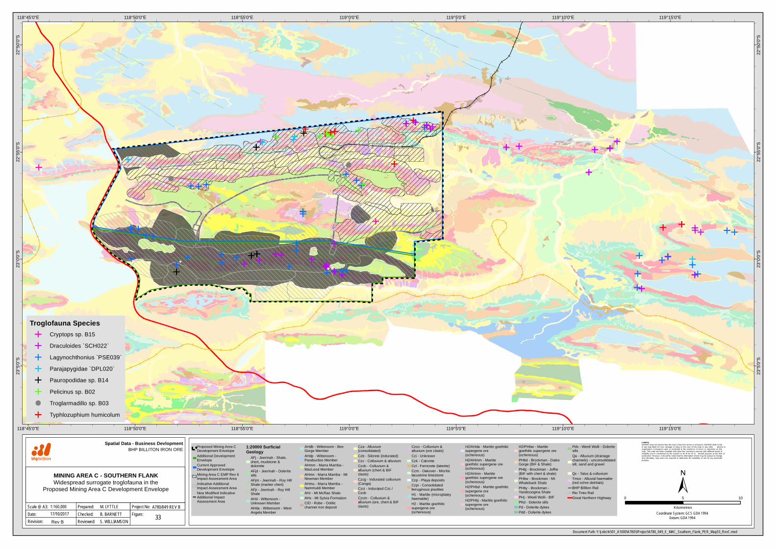
Document Path: Y:\Jobs\A501_A1000\A780\3Project\A780_049_E_MAC_Southern_Flank_PER_Map33_RevC.mxd
Spatial Data - Business Devlopment
Date:Scale @ A3:
MINING AREA C - SOUTHERN FLANKWidespread surrogate troglofauna in the
Proposed Mining Area C Development Envelope0 105
Kilometres
3317/10/2017
BHP BILLITON IRON ORE
Figure:Project No:1:160,000
Checked:Prepared: M. LYTTLE
B. BARNETTA780/049 REV B
Revision: Rev B Reviewed: S. WILLIAMSONCoordinate System: GCS GDA 1994
Datum: GDA 1994
Proposed Mining Area CDevelopment EnvelopeAdditional DevelopmentEnvelopeCurrent ApprovedDevelopment EnvelopeMining Area C EMP Rev 6Impact Assessment AreaIndicative AdditionalImpact Assessment AreaNew Modified IndicativeAdditional ImpactAssessment Area
1:20000 SurficialGeology
AFj - Jeerinah - Shale,chert, mudstone &dolomiteAFjd - Jeerinah - DoleritesillsAFjm - Jeerinah - Roy HillShale (marker chert)AFjr - Jeerinah - Roy HillShaleAHd - Wittenoom -Unknown MemberAHda - Wittenoom - WestAngela Member
AHdb - Wittenoom - BeeGorge MemberAHdp - Wittenoom -Paraburdoo MemberAHmm - Marra Mamba -MacLeod MemberAHmn - Marra Mamba - MtNewman MemberAHmu - Marra Mamba -Nammuldi MemberAHr - Mt McRae ShaleAHs - Mt Sylvia FormationCID - Robe - Ooliticchannel iron deposit
Cza - Alluvium(consolidated)Czb - Silcrete (indurated)Czc - Colluvium & alluviumCzcb - Colluvium &alluvium (chert & BIFclasts)Czcg - Indurated colluvium(Canga)Czci - Indurated Czc /CzcbCzcm - Colluvium &alluvium (ore, chert & BIFclasts)
Czco - Colluvium &alluvium (ore clasts)Czi - UnknownCzk - CalcreteCzl - Ferricrete (laterite)Czm - Oakover - Micriticlacustrine limestoneCzp - Playa depositsCzpi - Consolidatedferruginous pisolitesH1 - Martite (microplateyhaematite)H2 - Martite goethiticsupergene ore(ochereous)
H2/AHda - Martite goethiticsupergene ore(ochereous)H2/AHmm - Martitegoethitic supergene ore(ochereous)H2/AHmn - Martitegoethitic supergene ore(ochereous)H2/PHbd - Martite goethiticsupergene ore(ochereous)H2/PHbj - Martite goethiticsupergene ore(ochereous)
H2/PHbw - Martitegoethitic supergene ore(ochereous)PHbd - Brockman - DalesGorge (BIF & Shale)PHbj - Brockman - Joffre(BIF with chert & shale)PHbw - Brockman - MtWhaleback ShalePHby - Brockman -Yandicoogina ShalePHj - Weeli Wolli - BIFPKd - Dolerite sillsPd - Dolerite dykesPdd - Dolerite dykes
Pds - Weeli Wolli - DoleritesillsQa - Alluvium (drainagechannels) - unconsolidatedsilt, sand and gravel
Qc - Talus & colluviumTmco - Alluvial haematite(red ochre detritals)BHP Billiton RailRio Tinto RailGreat Northern Highway
Troglofauna SpeciesCryptops sp. B15Draculoides `SCH022`Lagynochthonius `PSE039`Parajapygidae `DPL020`Pauropodidae sp. B14Pelicinus sp. B02Troglarmadillo sp. B03Typhlozuphium humicolum
CoondewannaSub Catchment
Weeli WolliCreek SubCatchment
FortescueSub
Catchment
119°25'0"E
119°25'0"E
119°20'0"E
119°20'0"E
119°15'0"E
119°15'0"E
119°10'0"E
119°10'0"E
119°5'0"E
119°5'0"E
119°0'0"E
119°0'0"E
118°55'0"E
118°55'0"E
118°50'0"E
118°50'0"E
118°45'0"E
118°45'0"E
118°40'0"E
118°40'0"E
118°35'0"E
118°35'0"E22
°45'0
"S
22°4
5'0"S
22°5
0'0"S
22°5
0'0"S
22°5
5'0"S
22°5
5'0"S
23°0
'0"S
23°0
'0"S
23°5
'0"S
23°5
'0"S
23°1
0'0"S
23°1
0'0"S
Liability BHPBIO does not warrant that this map is free from errors or omissions. BHPBIO shall not be in any way liable for loss, damage or injury to the user of this map or any other person or organisation consequent upon or incidental to the existence of errors or omissions on this map. This map has been compiled with data from numerous sources with different levels of reliability and is considered by the authors to be fit for its in tended purpose at the time of publication. However, it should be noted that the information shown may be subject to change and ultimately, map users are required to determine the suitability of use for any particular purpose.
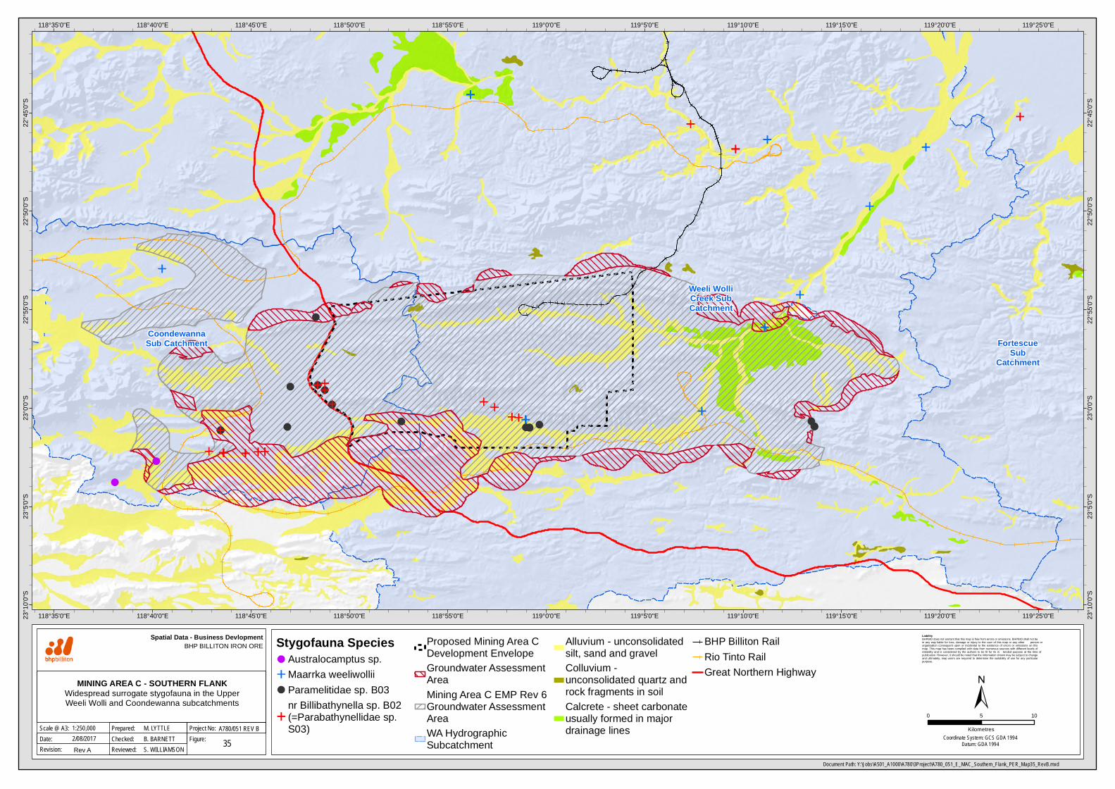
Document Path: Y:\Jobs\A501_A1000\A780\3Project\A780_051_E_MAC_Southern_Flank_PER_Map35_RevB.mxd
Spatial Data - Business Devlopment
Date:Scale @ A3:
MINING AREA C - SOUTHERN FLANKWidespread surrogate stygofauna in the UpperWeeli Wolli and Coondewanna subcatchments
0 105
Kilometres
352/08/2017
BHP BILLITON IRON ORE
Figure:Project No:1:250,000
Checked:Prepared: M. LYTTLE
B. BARNETTA780/051 REV B
Revision: Rev A Reviewed: S. WILLIAMSONCoordinate System: GCS GDA 1994
Datum: GDA 1994
Stygofauna SpeciesAustralocamptus sp.Maarrka weeliwolliiParamelitidae sp. B03nr Billibathynella sp. B02(=Parabathynellidae sp.S03)
Proposed Mining Area CDevelopment EnvelopeGroundwater AssessmentAreaMining Area C EMP Rev 6Groundwater AssessmentAreaWA HydrographicSubcatchment
Alluvium - unconsolidatedsilt, sand and gravelColluvium -unconsolidated quartz androck fragments in soilCalcrete - sheet carbonateusually formed in majordrainage lines
BHP Billiton RailRio Tinto RailGreat Northern Highway

Coondewanna Recharge
MACDewatering
Hope DownsDewatering
Weeli WolliEvapo-transpiration
Weeli WolliCreek Dischargeand Throughflow
South FlankDewatering
Weeli WolliCreek
Recharge
119°15'0"E
119°15'0"E
119°10'0"E
119°10'0"E
119°5'0"E
119°5'0"E
119°0'0"E
119°0'0"E
118°55'0"E
118°55'0"E
118°50'0"E
118°50'0"E
118°45'0"E
118°45'0"E
118°40'0"E
118°40'0"E22
°50'0
"S
22°5
0'0"S
22°5
5'0"S
22°5
5'0"S
23°0
'0"S
23°0
'0"S
23°5
'0"S
23°5
'0"S
Liability BHPBIO does not warrant that this map is free from errors or omissions. BHPBIO shall not be in any way liable for loss, damage or injury to the user of this map or any other person or organisation consequent upon or incidental to the existence of errors or omissions on this map. This map has been compiled with data from numerous sources with different levels of reliability and is considered by the authors to be fit for its in tended purpose at the time of publication. However, it should be noted that the information shown may be subject to change and ultimately, map users are required to determine the suitability of use for any particular purpose.
Document Path: Y:\Jobs\A501_A1000\A780\3Project\A780_077_E_MAC_Southern_Flank_PER_Map36_RevB.mxd
Date:Scale @ A4:
MINING AREA C - SOUTHERN FLANKConceptual groundwater flow within project area
0 105
Kilometres
3624/08/2017
BHP BILLITON IRON ORE
Figure:Project No:1:250,000
Checked:Prepared: M. LYTTLE
T. LAWTONA780/077 REV B
Revision: Rev B Reviewed: S. WILLIAMSONCoordinate System: Central Project Grid (CPG94)
Projection: Transverse MercatorDatum: GDA 1994
Flow directionDischargeRechargeInferred dykeMapped dykePriority Ecological CommunityWA Hydrographic Catchments -Sub CatchmentsProposed Mining Area CDevelopment Envelope
Approved Mining Area C (NorthernFlank) Development EnvelopeAdditional Development EnvelopeIndicative Additional ImpactAssessment Area (Pit)Indicative pit outlineBHP Billiton RailRio Tinto RailHighways
!(!(
!($+
$+
$+")
" $+!
""
" $+$+""$+
$+
##̂_̂_#
$+
$+$+
$+ _̂̂_̂_ ")
119°15'0"E
119°15'0"E
119°10'0"E
119°10'0"E
119°5'0"E
119°5'0"E
119°0'0"E
119°0'0"E
118°55'0"E
118°55'0"E
118°50'0"E
118°50'0"E
118°45'0"E
118°45'0"E22
°55'0
"S
22°5
5'0"S
23°0
'0"S
23°0
'0"S
23°5
'0"S
23°5
'0"S
Liability BHPBIO does not warrant that this map is free from errors or omissions. BHPBIO shall not be in any way liable for loss, damage or injury to the user of this map or any other person or organisation consequent upon or incidental to the existence of errors or omissions on this map. This map has been compiled with data from numerous sources with different levels of reliability and is considered by the authors to be fit for its in tended purpose at the time of publication. However, it should be noted that the information shown may be subject to change and ultimately, map users are required to determine the suitability of use for any particular purpose.
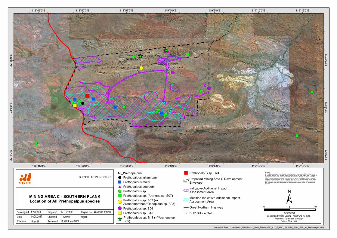
Document Path: U:\Jobs\E001_E500\E084\2_MXD_Project\A780_027_E_MAC_Southern_Flank_PER_All_Prethopalpus.mxd
Date:Scale @ A4:
MINING AREA C - SOUTHERN FLANKLocation of All Prethopalpus species
0 105
Kilometres
.
±14/08/2017
BHP BILLITON IRON ORE
Figure:Project No:1:220,669
Checked:Prepared: M. LYTTLE
T CarrollA780/027 REV B
Revision: Rev B Reviewed: S. WILLIAMSONCoordinate System: Central Project Grid (CPG94)
Projection: Transverse MercatorDatum: GDA 1994
All_Prethopalpus! Prethopalpus julianneae" Prethopalpus maini# Prethopalpus pearsoni$+ Prethopalpus sp.") Prethopalpus sp. (Araneae sp. S07)!(
Prethopalpus sp. B03 (exAraneomorphae/ Oonopidae sp. B03)
!( Prethopalpus sp. B06") Prethopalpus sp. B15_̂ Prethopalpus sp. B18 (=?Araneae sp.
S05)
" Prethopalpus sp. B24Proposed Mining Area C DevelopmentEnvelopeIndicative Additional ImpactAssessment AreaModified Indicative Additional ImpactAssessment AreaGreat Northern HighwayBHP Billiton Rail

© BHP Billiton Iron Ore
1,270.0 Kilometres1,270.0
Notes
Legend
635.000
South Flank Highway Pits Adjacent to Regional Dyke
1: 25,000
Recommended Pit Design
Pit Crest
Pit Toe
Ramp
Outline
Hillshade
BHPBIO 1:20000 Structure
Fault
Fold
Dyke
Joint
Vein

")
")
")")
")
")
")
")
")
")
")
")
")")
")")
")
")
")")
")
")
")
")
!
")
")
")
")
")
!
")
")
")
")")")
")")
")
")
")
!
")
")
")
")
")
")")
")
")
")
")
")
")
")
")
")
")
")")
")
")")")
")
")
")
")
")
")
")")
")")
")
")
")
")
")")")
")
")")
")
")
")") ")
")
") ")
!
")
")
")
")
!!
")
")")")
")")
")
")
")
")
")
")
!
!
!!
! ")
")
!
!
!!
!
!
!
")
")
")
")")
")")
")")")
")
")
")
")
")
")
")
")
")
")
")")")")")
")
")
")
")
")
")
")
")
")
")
")
")
")
")
") ")")
118°50'0"E
118°50'0"E
118°45'0"E
118°45'0"E22
°55'0
"S
22°5
5'0"S
Liability BHPBIO does not warrant that this map is free from errors or omissions. BHPBIO shall not be in any way liable for loss, damage or injury to the user of this map or any other person or organisation consequent upon or incidental to the existence of errors or omissions on this map. This map has been compiled with data from numerous sources with different levels of reliability and is considered by the authors to be fit for its in tended purpose at the time of publication. However, it should be noted that the information shown may be subject to change and ultimately, map users are required to determine the suitability of use for any particular purpose.
Document Path: Y:\Jobs\A501_A1000\A780\3Project\A780_086_E_JunaDowns_Fauna_RevA.mxd
Date:Scale @ A4:
JUNA DOWNS PROJECT AREAFauna habitats and conservation significantfauna within the Juna Downs Project Area
0 1 2
Kilometres
±26/10/2017
BHP BILLITON IRON ORE
Figure:Project No:1:70,000
Checked:Prepared: S. TRINDER
R. GREGORYA780/086 REV A
Revision: Rev A Reviewed: S. WILLIAMSONCoordinate System: Central Project Grid (CPG94)
Projection: Transverse MercatorDatum: GDA 1994
Conservation Significant Vertebrate Fauna") Underwoodisaurus seorsus ( Priority 2 ) ") Trichosurus vulpecula subsp. arnhemensis ( n/a ) ") Rhinonicteris aurantia ( n/a ) ") Pseudomys chapmani ( Priority 4 ) ") Merops ornatus ( n/a ) ") Macroderma gigas ( n/a ) ! Liasis olivaceus subsp. barroni ( n/a )! Grallina cyanoleuca ( n/a ) ! Falco cenchroides ( n/a )! Coracina novaehollandiae subsp. subpallida ( n/a )! Chrysococcyx basalis ( n/a ) ! Cacomantis pallidus ( n/a )
Fauna HabitatCleared/ DisturbedDrainage Area/ FloodplainGilgai PlainHardpan PlainHillcrest/ HillslopeMajor Drainage LineMinor Drainage LineMulga WoodlandSand PlainStony Plain
Juna Downs Project Area
Great Northern Highway
RailRio Tinto Rail
""
!
""
""
""""
"""""
"
""""
""
""""
""
"""""
"
"
!!
""
"
""
""
""
""
"""
!!!!!!!!!!!
""
""
""
!!!!!!
!!!!"
""""
""""""
"""""""!"!""!!!
""
"
!
""
""""
!
""
""
""
""""""
""""
""
""
""""
""
""""
""""""""
""
""
!
""
""
"
""
""
!"""!!"!!"""
""""""
!!!
""
!
""""
!!
""
!
!"
!
!
!
!!
!
""
!!
""""
!
""""""
!
!
"""""""
!
"
!"!"!"
!
"""""
!
""""
!!!!!!!!!!!!!!!
!!
!
!
"
"
!
!
!!!
!
!!
!
"
"!
""
!
""!"!!!"
"
"
!
"
""
"""
"
"
""
"
"
"
"
!
"
"
"
!
!
"
""
"
""
"
""
"
"
!!
"
"
"
"""
"
""
""
"
""
!
"""""""
"
""
"
"
"
!
"
"
!"""!!"!!"
!
"
""
!
"
"
!
"
"
"
""""""
!"
!
""!
"
"
"
!!!!!!!!!!!!!!!!!
!
!!
!
!
!!
"
!!!
!
!
!
"
!
!
!
!
!
!
"
"!
!
"
!
!
!
"!
!
!!
""
!
!
"
!
!
"
"
"
"
!
"
!!
"
!
"
"
"
!
!
"
!"
"
"
!
!!
!
""
"
"
"
!!
!
!""
!
"
!
"
"
"
!
!
!
"
!
"
!
!!!
!
"
""
!!!
"
!!!
"""""
!
"
!
"""
"!"
"
"!"
"
!"""""""
!!!
!!!
""
!!!
!
!!!
""
"
"""""
"""
"
!!!
"
!!!
!!!!
""!"!!!!"!"!!!""!!!!!!!!
"!!!!"!!!!!!!
"
"!!
"
!
"
!!"!!!!
"
!
!
!
!
!
"
"
!
"""!"!"!""
!
!
!!!
!!!
!
!!!!!!!!
!
!!!"
!!"!!"!
!"
!
"
!
!!
!
!
!!
!
!!!!!!!"
!!
!
"
!
"!""
""
!!
!""
!
!!!!!
!
!!
118°50'0"E
118°50'0"E
118°45'0"E
118°45'0"E22
°55'0
"S
22°5
5'0"S
Liability BHPBIO does not warrant that this map is free from errors or omissions. BHPBIO shall not be in any way liable for loss, damage or injury to the user of this map or any other person or organisation consequent upon or incidental to the existence of errors or omissions on this map. This map has been compiled with data from numerous sources with different levels of reliability and is considered by the authors to be fit for its in tended purpose at the time of publication. However, it should be noted that the information shown may be subject to change and ultimately, map users are required to determine the suitability of use for any particular purpose.
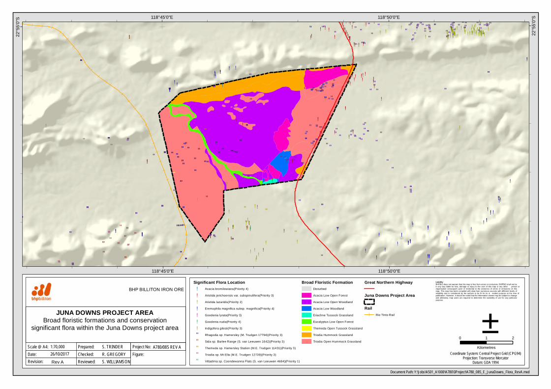
Document Path: Y:\Jobs\A501_A1000\A780\3Project\A780_085_E_JunaDowns_Flora_RevA.mxd
Date:Scale @ A4:
JUNA DOWNS PROJECT AREABroad floristic formations and conservation
significant flora within the Juna Downs project area0 1 2
Kilometres
±26/10/2017
BHP BILLITON IRON ORE
Figure:Project No:1:70,000
Checked:Prepared: S. TRINDER
R. GREGORYA780/085 REV A
Revision: Rev A Reviewed: S. WILLIAMSONCoordinate System: Central Project Grid (CPG94)
Projection: Transverse MercatorDatum: GDA 1994
Significant Flora Location! Acacia bromilowiana(Priority 4)
! Aristida jerichoensis var. subspinulifera(Priority 3)
! Aristida lazaridis(Priority 2)
! Eremophila magnifica subsp. magnifica(Priority 4)
! Goodenia lyrata(Priority 3)
! Goodenia nuda(Priority 4)
! Indigofera gilesii(Priority 3)
" Rhagodia sp. Hamersley (M. Trudgen 17794)(Priority 3)
" Sida sp. Barlee Range (S. van Leeuwen 1642)(Priority 3)
" Themeda sp. Hamersley Station (M.E. Trudgen 11431)(Priority 3)
" Triodia sp. Mt Ella (M.E. Trudgen 12739)(Priority 3)
" Vittadinia sp. Coondewanna Flats (S. van Leeuwen 4684)(Priority 1)
Broad Floristic FormationDisturbedAcacia Low Open ForestAcacia Low Open WoodlandAcacia Low WoodlandEriachne Tussock GrasslandEucalyptus Low Open ForestThemeda Open Tussock GrasslandTriodia Hummock GrasslandTriodia Open Hummock Grassland
Great Northern Highway
Juna Downs Project Area
RailRio Tinto Rail

Table 1: Summary of troglofauna species only recorded within Indicative Additional Impact Assessment Areas
Species uncertain are shown in bold.
Higher Group
Species
Assessed
IAIAA
Modified
IAIAA
New
Modified
IAIAA
No. of
Animals
No. of
Holes
Likely
Range (km)
Restriction
Category
Arachnida
Pseudoscorpiones
Indohya `PSE005` x x x 9 9 21 Unlikely
Tyrannochthonius sp. B14 x x 1 1 - Unlikely
Schizomida
Draculoides sp. B20 x x x 4 4 10.0 Unlikely
Draculoides sp. B59-DNA x 2 1 - Unlikely
Draculoides sp. B32 x x 4 1 - Unlikely
Araneae
?Gnaphosidae sp. B01 x x 1 1 - Unlikely
Prethopalpus julianneae x x x 1 1 - Uncertain
Prethopalpus maini x x 5 5 17.8 Unlikely
Prethopalpus sp. B15 x x x 1 1 - Uncertain
Prethopalpus sp. B24 x x x 1 1 - Unlikely
Malacostraca
Isopoda
nr Andricophiloscia sp.
B16
x x x 1 1 - Unlikely
Philosciidae sp. B03 x x x 17 1 - Unlikley
Philosciidae sp. B15 x x x 1 1 - Unlikely
Troglarmadillo sp. B14 x x x 12 2 11.2 Unlikely
Symphyla
Cephalostigmata
Australoschendyla sp. B06 x x 2 2 6.6 Unlikely
Chilenophilidae sp. B07 x x 1 1 - Unlikely
Hanseniella sp. B07 x x x 7 5 24.1 Unlikely
Hanseniella sp. B34 x x x 1 1 - Unlikely
Entognatha
Diplura
Japygidae ‘DPL005‘ x x 2 2 14.5 Unlikely
Japygidae ‘DPL007‘ x 3 2 5.7 Unlikely
Parajapygidae `DPL023` x x x 2 2 3.1 Unlikely
Parajapygidae `DPL024` x x x 1 1 - Uncertain
Parajapygidae sp. B25 x x 1 1 - Unlikely
Insecta
Coleoptera
nr Claviger sp. B01 x x 1 1 - Unlikely
TOTAL 21 17 21
Related Documents