2020 LA River Master Plan Program EIR 3.11-1 February 2021 ICF 54.20 Section 3.11 Mineral Resources 3.11.1 Introduction Mineral resources are naturally occurring chemical and compounds that are formed from inorganic and organic substances. Mineral Resources include oil and natural gas, and commercially viable minerals and aggregate resources, including areas suitable for the drilling for and production of oil and natural gas, and surface mining activities. This section describes existing conditions and applicable laws or regulations pertaining to mineral resources, with an analysis of the potential mineral resource impacts that could result from the 2020 LA River Master Plan. Where needed, this section identifies mitigation measures that would reduce or avoid any significant impacts, when feasible. The analysis in this section includes impact determinations under CEQA for the 2020 LA River Master Plan that are applicable to all 18 jurisdictions in the study area, including the County and non-County jurisdictions (17 cities). Except for significant and unavoidable impacts, all identified significant environmental effects of the proposed 2020 LA River Master Plan can be avoided or reduced to a less-than-significant level if the mitigation measures identified in this PEIR are implemented. These mitigation measures will be implemented for subsequent projects that are carried out by the County. Because some later activities under the 2020 LA River Master Plan would not be carried out by the County, the County cannot enforce or guarantee that the mitigation measures would be incorporated. Therefore, where this PEIR concludes a less-than-significant impact for later activities carried out by the County, the impact would be significant and unavoidable when these activities are not carried out by the County. 3.11.2 Setting 3.11.2.1 Geographic This section discusses the existing conditions related to mineral resources in the project study area. Regionally Important Mineral Resources Based on preliminary data for 2017 from the U.S. Geological Survey (USGS) National Minerals Information Center, California ranked fifth – after Nevada, Arizona, Texas, and Alaska – in the value of non-fuel mineral production (USGS 2018). Nonfuel mineral resources include metals such as gold, silver, iron, and copper; industrial metals such as boron compounds, rare-earth elements, clays, limestone, gypsum, salt, and dimension stone; and construction aggregate including sand, gravel, and crushed stone. The market value of non-fuel mineral production for California was $3.6 billion – approximately 4.7 percent of the nation’s total (USGS 2018). In Los Angeles County, mineral resources serve various public, commercial, scientific, and recreational purposes. Local extraction sites are valuable assets used to help facilitate the continual growth of the region and economic market. Important local mineral resources include construction

Welcome message from author
This document is posted to help you gain knowledge. Please leave a comment to let me know what you think about it! Share it to your friends and learn new things together.
Transcript
2020 LA River Master Plan Program EIR 3.11-1
February 2021 ICF 54.20
Section 3.11 Mineral Resources
3.11.1 Introduction Mineral resources are naturally occurring chemical and compounds that are formed from inorganic
and organic substances. Mineral Resources include oil and natural gas, and commercially viable
minerals and aggregate resources, including areas suitable for the drilling for and production of oil
and natural gas, and surface mining activities. This section describes existing conditions and
applicable laws or regulations pertaining to mineral resources, with an analysis of the potential
mineral resource impacts that could result from the 2020 LA River Master Plan. Where needed, this
section identifies mitigation measures that would reduce or avoid any significant impacts, when
feasible.
The analysis in this section includes impact determinations under CEQA for the 2020 LA River
Master Plan that are applicable to all 18 jurisdictions in the study area, including the County and
non-County jurisdictions (17 cities). Except for significant and unavoidable impacts, all identified
significant environmental effects of the proposed 2020 LA River Master Plan can be avoided or
reduced to a less-than-significant level if the mitigation measures identified in this PEIR are
implemented. These mitigation measures will be implemented for subsequent projects that are
carried out by the County. Because some later activities under the 2020 LA River Master Plan would
not be carried out by the County, the County cannot enforce or guarantee that the mitigation
measures would be incorporated. Therefore, where this PEIR concludes a less-than-significant
impact for later activities carried out by the County, the impact would be significant and
unavoidable when these activities are not carried out by the County.
3.11.2 Setting
3.11.2.1 Geographic
This section discusses the existing conditions related to mineral resources in the project study area.
Regionally Important Mineral Resources
Based on preliminary data for 2017 from the U.S. Geological Survey (USGS) National Minerals
Information Center, California ranked fifth – after Nevada, Arizona, Texas, and Alaska – in the value
of non-fuel mineral production (USGS 2018). Nonfuel mineral resources include metals such as gold,
silver, iron, and copper; industrial metals such as boron compounds, rare-earth elements, clays,
limestone, gypsum, salt, and dimension stone; and construction aggregate including sand, gravel,
and crushed stone. The market value of non-fuel mineral production for California was $3.6 billion –
approximately 4.7 percent of the nation’s total (USGS 2018).
In Los Angeles County, mineral resources serve various public, commercial, scientific, and
recreational purposes. Local extraction sites are valuable assets used to help facilitate the continual
growth of the region and economic market. Important local mineral resources include construction
Los Angeles County Public Works
3.11 Mineral Resources
2020 LA River Master Plan Program EIR 3.11-2
February 2021 ICF 54.20
materials and minerals of historical significance including precious gemstones and metals.
Aggregate resources include rock, sand, and gravel; which are important for the construction and
manufacturing of concrete. According to the Los Angeles County General Plan, major local mineral
resources consist of oil, rock deposits, and sand and gravel (County of Los Angeles 2015).
Non-Fuel Mineral Resources
Sand and Gravel
The mining of sand and gravel began in the region in the early 1900s when the demand increased by
the popular use of concrete in construction and building material and was spurred by construction
associated with growth in California and the southwestern United States. Construction aggregate
refers to sand and gravel (natural aggregates) and crushed stone (rock) that are used as Portland
cement concrete aggregate, asphaltic-concrete aggregate, road base, railroad ballast, riprap, and fill
for the production of other construction materials. According to the California Geological Survey
(CGS), the State currently has approximately 4.3 billion tons of permitted resources, and the CGS
estimates the State would need approximately 13.5 billion tons of aggregate in the next 50 years.
California is the largest producer of sand and gravel in the nation and the greater Los Angeles area is
the nation’s leading producer for its geographical size. The County has high quantities of sand and
gravel, which are located close to the market. Sand and gravel deposits follow the LA River flood
plain, coastal plain, and other water bodies and courses. Significant potential deposit sites have been
identified by the State Geologist. They lie along the flood plain from the San Fernando Valley through
downtown Los Angeles. Much of the area identified has been developed with structures and is
inaccessible for mining extraction. Major sand and gravel extraction sites are located in the alluvial
fans of the Big Tujunga Wash in the San Fernando Valley and in the San Gabriel River near Irwindale.
Other extraction areas are located in northern Los Angeles County in other washes (County of Los
Angeles 2015).
Non-Fuel Mineral Resource Zones
The California Geological Survey Mineral Resources Project (Mineral Resources Project) provides
information about California’s nonfuel mineral resources. The Mineral Resources Project classifies
lands throughout the State that contain regionally significant mineral resources as mandated by the
Surface Mining and Reclamation Act (SMARA) of 1975. Development generally results in a demand
for minerals, especially construction aggregate. SMARA requires all cities and counties to
incorporate in their general plans the mineral designations approved by the State Mining and
Geology Board.
The classification process involves the determination of Production-Consumption Region
boundaries, based on identification of active aggregate operations (Production) and the market area
served (Consumption). The Production-Consumption Regional boundaries are modified to include
only the portions of the region that are urbanized or urbanizing and are classified for their aggregate
content. An aggregate appraisal further evaluates the presence or absence of significant sand, gravel,
or stone deposits that are suitable sources of aggregate. The classification of these mineral resources
is a joint effort of the State and the local governments. It is based on geologic factors and requires
that the State Geologist classify the mineral resources area as one of the four Mineral Resource
Zones (MRZs), Scientific Resource Zones (SZ), or Identified Resource Areas (IRAs), described below:
• MRZ-1: No significant mineral deposits are present.
Los Angeles County Public Works
3.11 Mineral Resources
2020 LA River Master Plan Program EIR 3.11-3
February 2021 ICF 54.20
• MRZ-2a: Areas underlain by mineral deposits where geologic data indicate that significant
measured or indicated resources are present. As shown on the California Mineral Land
Classification Diagram, MRZ-2 is divided on the basis of both degree of knowledge and economic
factors. Areas classified MRZ-2a contain discovered mineral deposits that are either measured
or indicated reserves as determined by such evidence as drilling records, sample analysis,
surface exposure, and mine information.
• MRZ-2b: Areas underlain by mineral deposits where geologic information indicates that
significant inferred resources are present. Areas classified MRZ-2b contain discovered mineral
deposits that are either inferred reserves as determined by limited sample analysis, exposure,
and past mining history or are deposits that presently are sub-economic.
• MRZ-3a: Areas containing known mineral occurrences of undetermined mineral resource
significance.
• MRZ-3b: Areas containing inferred mineral occurrences of undetermined mineral resource
significance. Land classified MRZ-3b represent areas in geologic settings that appear to be
favorable environments for the occurrence of specific mineral deposits.
• MRZ-4: Insufficient data available to assign any other MRZ designation.
• SZ Areas: Scientific Resource Zones containing unique or rare occurrences of rocks, minerals, or
fossils that are of outstanding scientific significance shall be classified in this zone.
• IRA Areas: County or State Division of Mines and Geology Identified Resource Areas where
adequate production and information indicates that significant minerals are present.
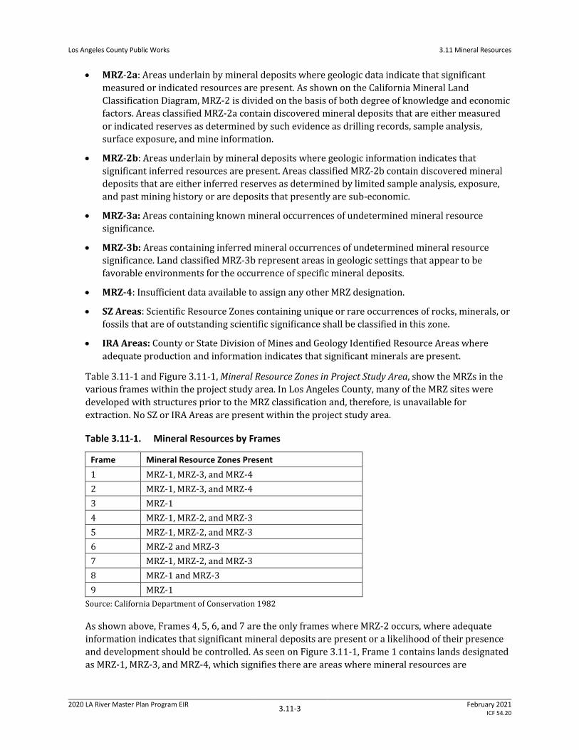
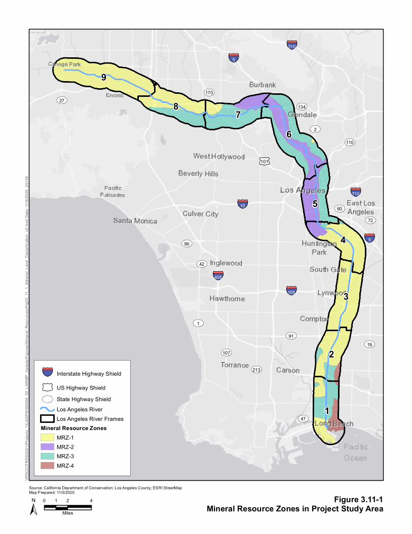
Table 3.11-1 and Figure 3.11-1, Mineral Resource Zones in Project Study Area, show the MRZs in the
various frames within the project study area. In Los Angeles County, many of the MRZ sites were
developed with structures prior to the MRZ classification and, therefore, is unavailable for
extraction. No SZ or IRA Areas are present within the project study area.
Table 3.11-1. Mineral Resources by Frames
Frame Mineral Resource Zones Present
1 MRZ-1, MRZ-3, and MRZ-4
2 MRZ-1, MRZ-3, and MRZ-4
3 MRZ-1
4 MRZ-1, MRZ-2, and MRZ-3
5 MRZ-1, MRZ-2, and MRZ-3
6 MRZ-2 and MRZ-3
7 MRZ-1, MRZ-2, and MRZ-3
8 MRZ-1 and MRZ-3
9 MRZ-1
Source: California Department of Conservation 1982
As shown above, Frames 4, 5, 6, and 7 are the only frames where MRZ-2 occurs, where adequate
information indicates that significant mineral deposits are present or a likelihood of their presence
and development should be controlled. As seen on Figure 3.11-1, Frame 1 contains lands designated
as MRZ-1, MRZ-3, and MRZ-4, which signifies there are areas where mineral resources are
Los Angeles County Public Works
3.11 Mineral Resources
2020 LA River Master Plan Program EIR 3.11-4
February 2021 ICF 54.20
potentially located but their value is unknown as well as areas where no mineral resource are
located. Frame 2 is show to be predominantly MRZ-1 which signifies no mineral deposits are found
in the frame except for small portions of land designated as MRZ-3 and MRZ-4, which signifies there
is either not enough data to make a determination or that there are mineral resources but their
value is unknown. Frame 3 is entirely MRZ-1, which signifies there are no mineral resources in the
frame. Frame 4 is predominately MRZ-1, with a small portion of land designated as MRZ-2 located
west of the LA River predominately in the City of Vernon, which identifies land as containing known
mineral resources as well as a small portion of land designated as MRZ-3 which signifies there could
be mineral resources but their value is unknown. In Frame 5, which is entirely located in the City of
Los Angeles, MRZ-2 is located west of the LA River, and runs the entirety of the frame, while land
designated as MRZ-3 is located on the east side of the LA River and runs the entirety of the frame. In
Frame 6, MRZ-2 is found within the entire frame mostly in the center of the frame while lands
designated MRZ-3 are found encompassing almost the rest of the frame with a small portion of land
designated as MRZ-1 is located in the east of the frame. Frame 6 contains the Cities of Glendale and
Los Angeles. In Frame 7, MRZ-2 is found in the northeastern portion of the frame, which contains the
Cities of Los Angeles and Burbank. Much of the area identified has been developed with structures
and is currently inaccessible for mining extraction (County of Los Angeles 2015). Frame 7 also
contains land designated as MRZ-1 and MRZ-3 which signifies there are portions of the frame that
contain no mineral resources and there are portions with mineral resources of unknown value.
Frame 8 is predominately MRZ-1 and MRZ-3. Frame 9 is entirely MRZ-1 which signifies there are no
mineral resources located in the frame.
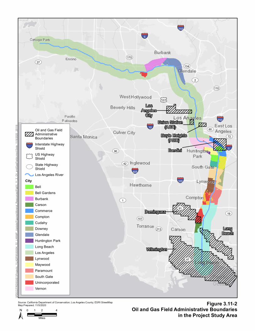
Oil and Gas Extraction
According to California Department of Conservation, Geologic Energy Management Division
(CalGem), there are 72 oil fields located in Los Angeles County (17 abandoned, 55 active). Within
these oil fields, there are a total of 2,750 active oil wells, not including those offshore. (CalGem
2018).
As depicted on Figure 3.11-2, the project study area runs through 7 oil fields, including Wilmington
Oil Field, Long Beach Oil Field, Dominguez Oil Field, Bandini Oil Field, Boyle Height Oil Field, Union
Station Oil Field, and Los Angeles City Oil Field.
Table 3.11-2. Oil Fields and Oil and Gas Wells by Frame
Frame Oil Fields Present Active Oil and Gas Wells Plugged and Abandoned Oil
and Gas Wells
1 Wilmington Oil Field
Long Beach Field
824 1,270
2 Dominguez Oil Field 5 339
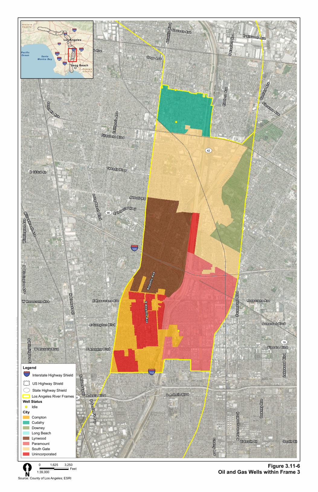
3 None 0 0
4 Bandini Oil Field 1 34
5 Boyle Heights Oil Field
Union Station Oil Field
Los Angeles City Oil Field
0 104
6 None 0 45
§̈¦405
§̈¦210
§̈¦105
§̈¦710
§̈¦10
§̈¦5
£¤101
ST91
ST27
ST72
ST2
ST107
ST42
ST19
ST110
ST1
ST213
ST60
ST90
ST47
ST170
ST134
§̈¦5
9
1
2
3
4
5
678
Figure 3.11-1Mineral Resource Zones in Project Study Area±
Source: California Department of Conservation; Los Angeles County; ESRI StreetMap Map Prepared: 11/5/2020
0 2 41
Miles
\\PDC
CITR
DSGI
S1\Pr
ojects
_1\LA
DPW\
0005
4_02
_LAR
MP_U
pdate
\Figu
res\M
ineral
_Res
ource
s\Fig0
3_11
_1_M
ineral
_Lan
d_Cla
ssific
ation
_v2.m
xd D
ate: 1
1/5/20
20 2
5119
§̈¦ Interstate Highway Shield
£¤ US Highway ShieldST State Highway Shield
Los Angeles RiverLos Angeles River Frames
Mineral Resource ZonesMRZ-1MRZ-2MRZ-3MRZ-4
§̈¦405
§̈¦210
§̈¦105
§̈¦710
§̈¦10
§̈¦5
£¤101
ST91
ST27
ST72
ST2
ST107
ST42
ST19
ST110
ST1
ST213
ST60
ST90
ST47
ST170
ST134
§̈¦5Bandini
LosAngeles
City
Boyle Heights(ABD)
Dominguez
LongBeach
Wilmington
Union Station(ABD)
Figure 3.11-2Oil and Gas Field Administrative Boundaries
in the Project Study Area±Source: California Department of Conservation; Los Angeles County; ESRI StreetMap Map Prepared: 11/5/2020
0 2 41
Miles
\\PDC
CITR
DSGI
S1\Pr
ojects
_1\LA
DPW\
0005
4_02
_LAR
MP_U
pdate
\Figu
res\M
ineral
_Res
ource
s\Fig0
3_11
_2_O
il_an
dGas
Fields
.mxd
Date
: 11/5
/2020
251
19
Oil and Gas FieldAdministrativeBoundaries
§̈¦ Interstate HighwayShield
£¤US HighwayShield
STState HighwayShieldLos Angeles River
CityBellBell GardensBurbankCarsonCommerceComptonCudahyDowneyGlendaleHuntington ParkLong BeachLos AngelesLynwoodMaywoodParamountSouth GateUnincorporatedVernon
Los Angeles County Public Works
3.11 Mineral Resources
2020 LA River Master Plan Program EIR 3.11-5
February 2021 ICF 54.20
Frame Oil Fields Present Active Oil and Gas Wells Plugged and Abandoned Oil
and Gas Wells
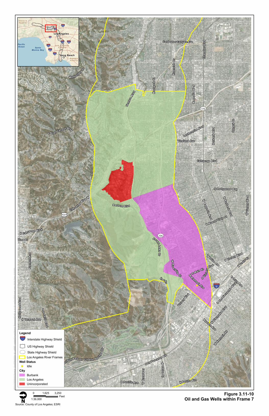
7 None 0 0
8 None 0 0
9 None 0 0
Total 830 1,792
Source: California Department of Conservation 1982
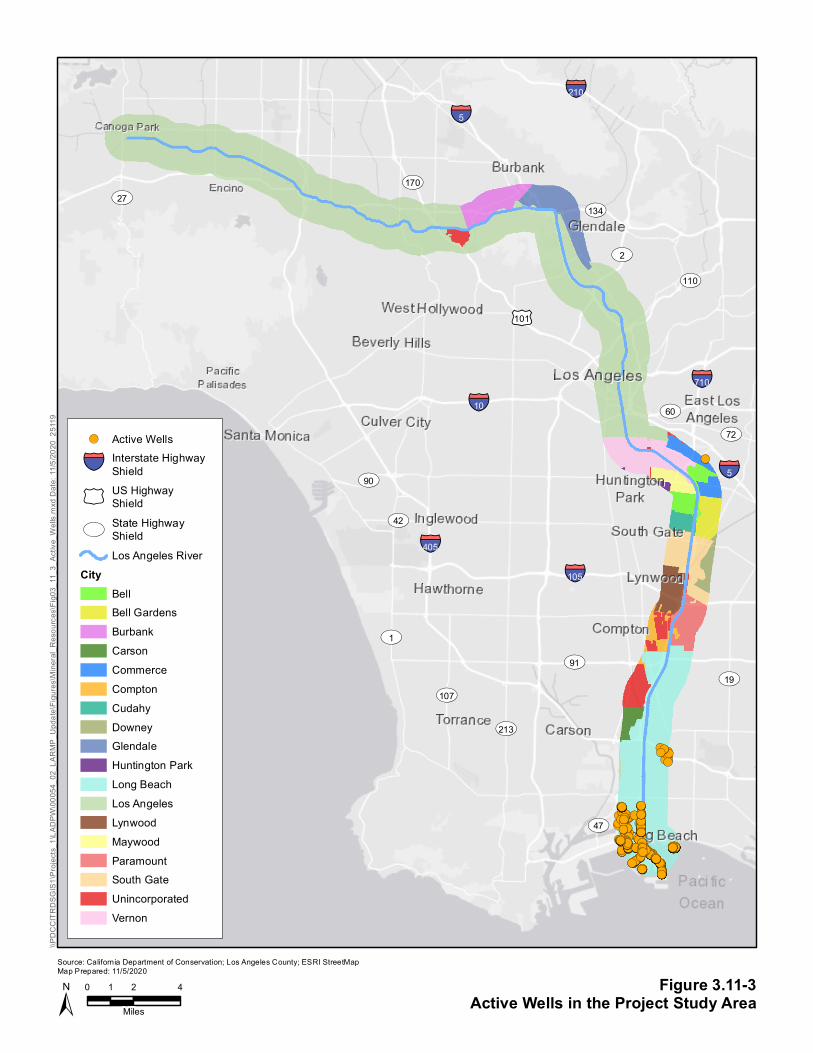
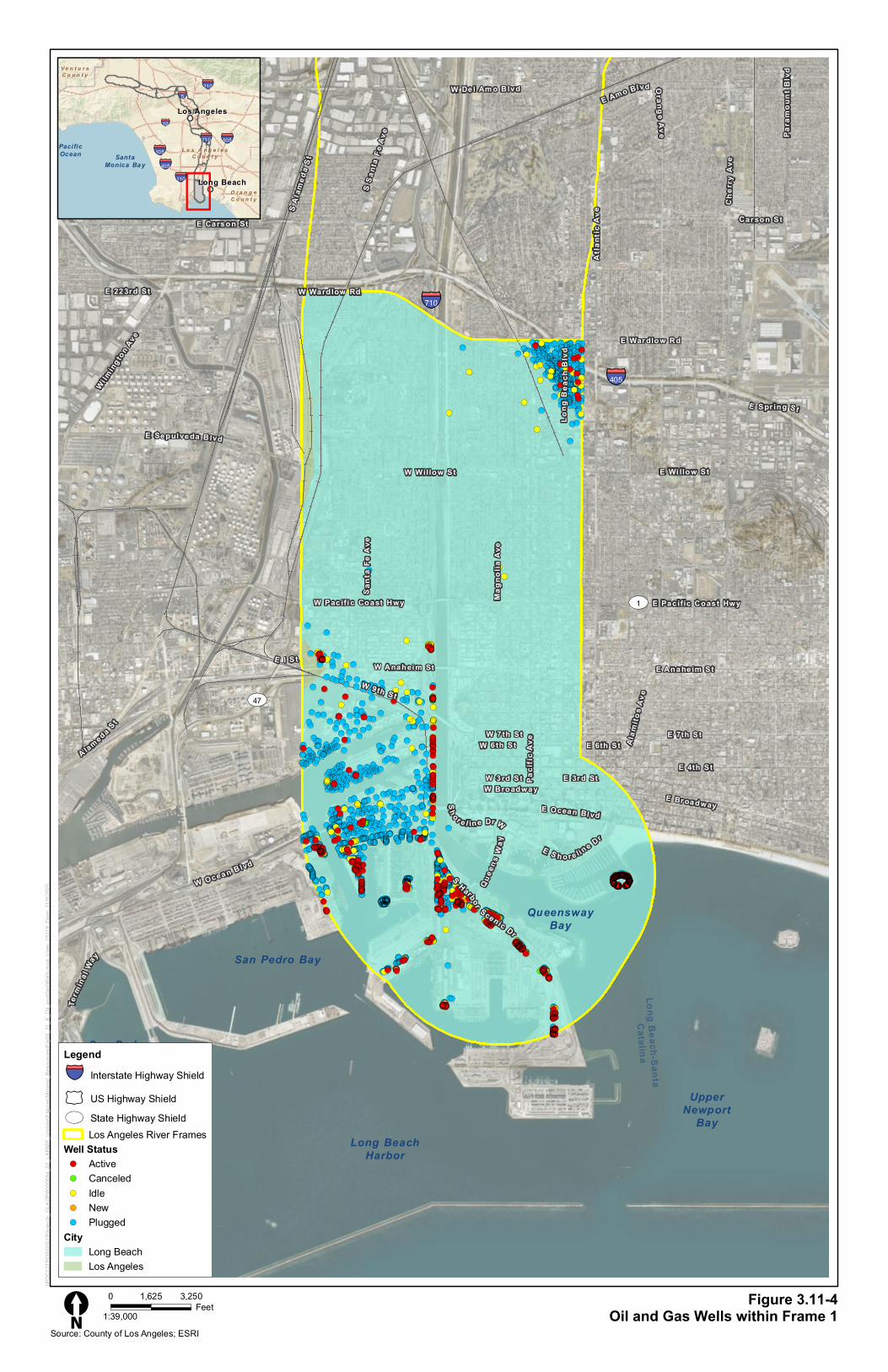
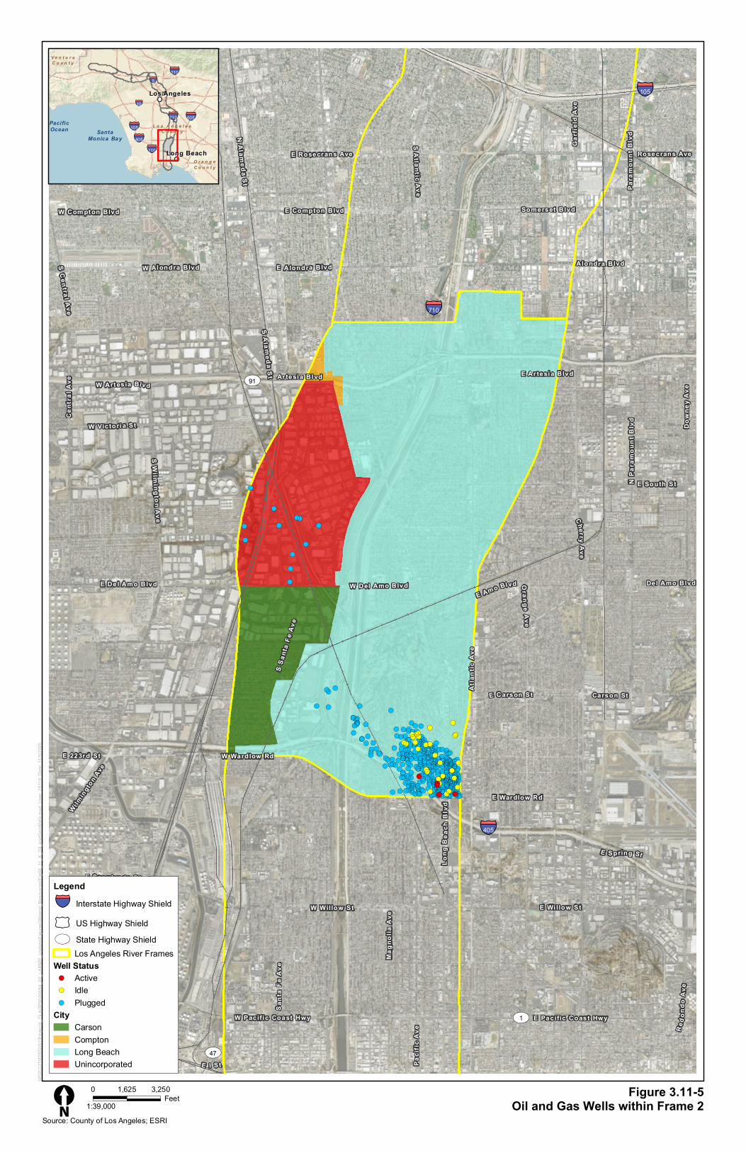
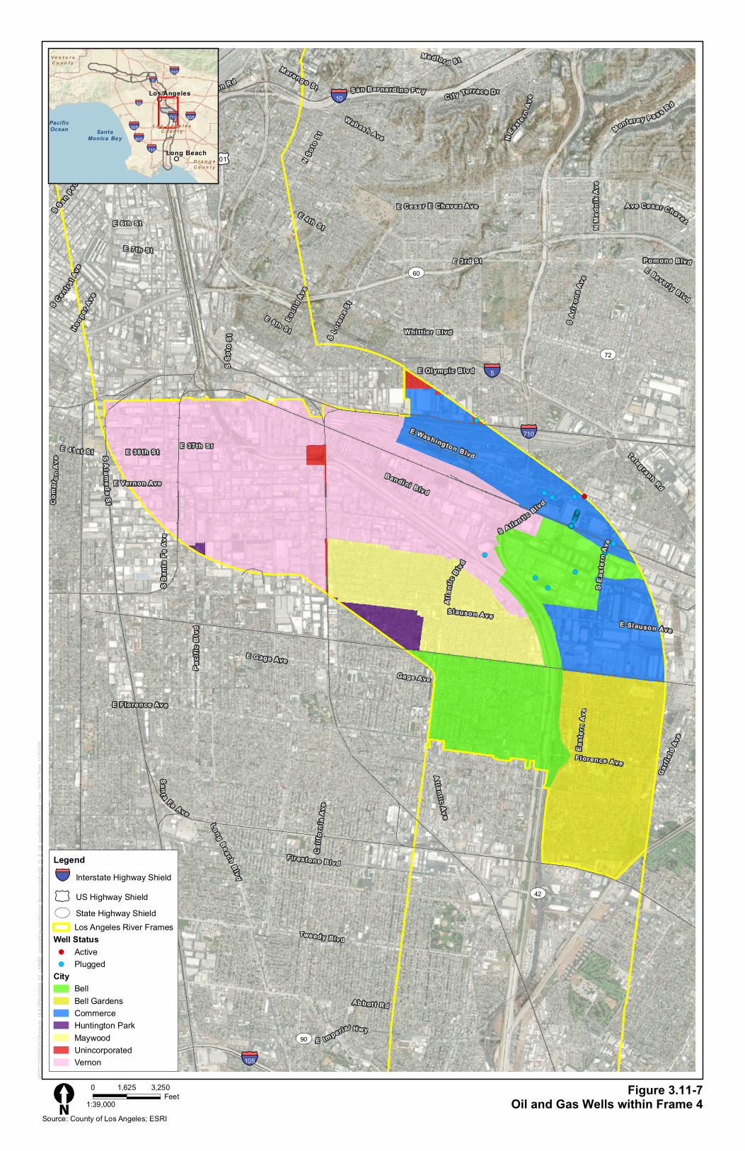
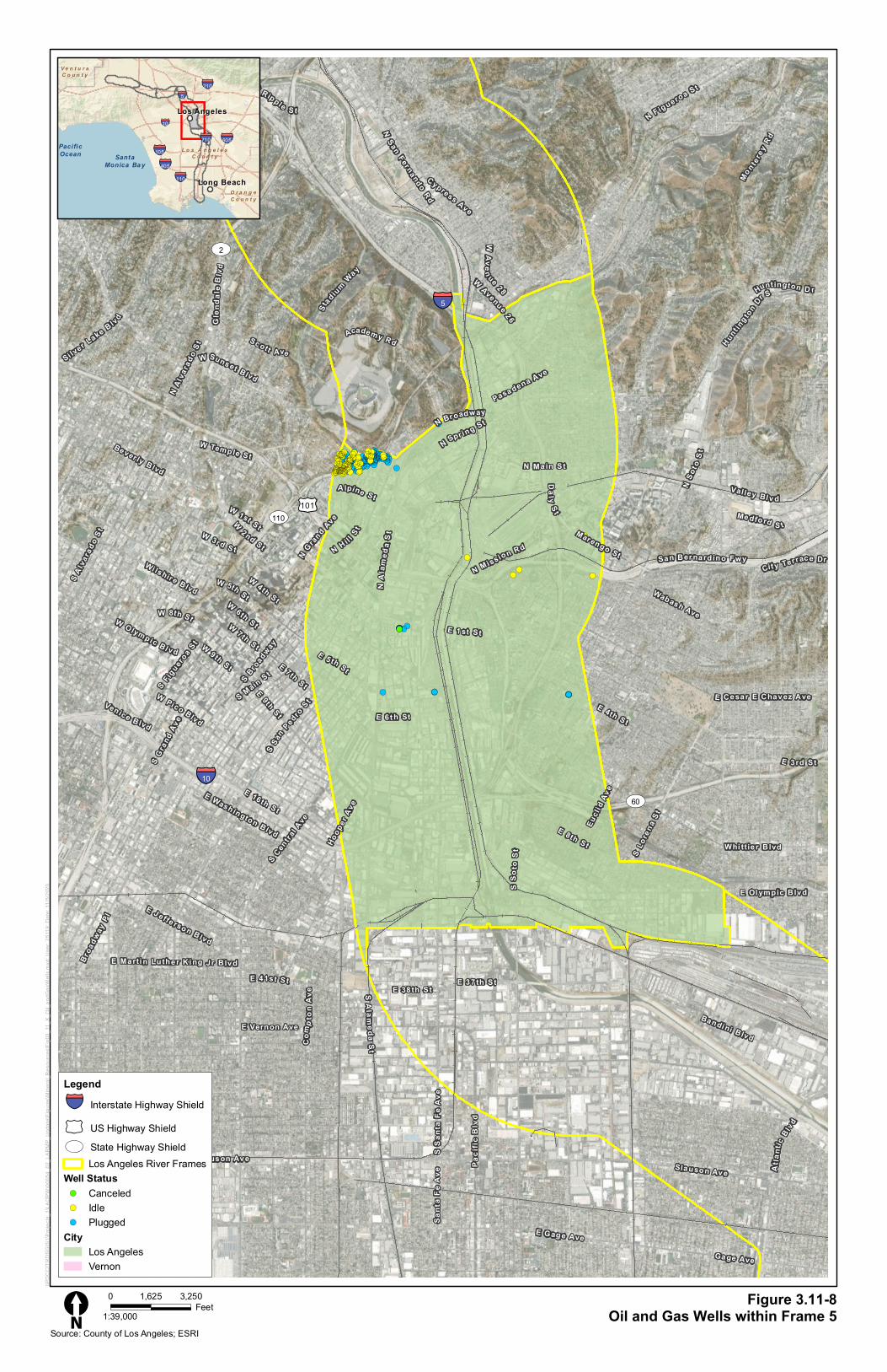
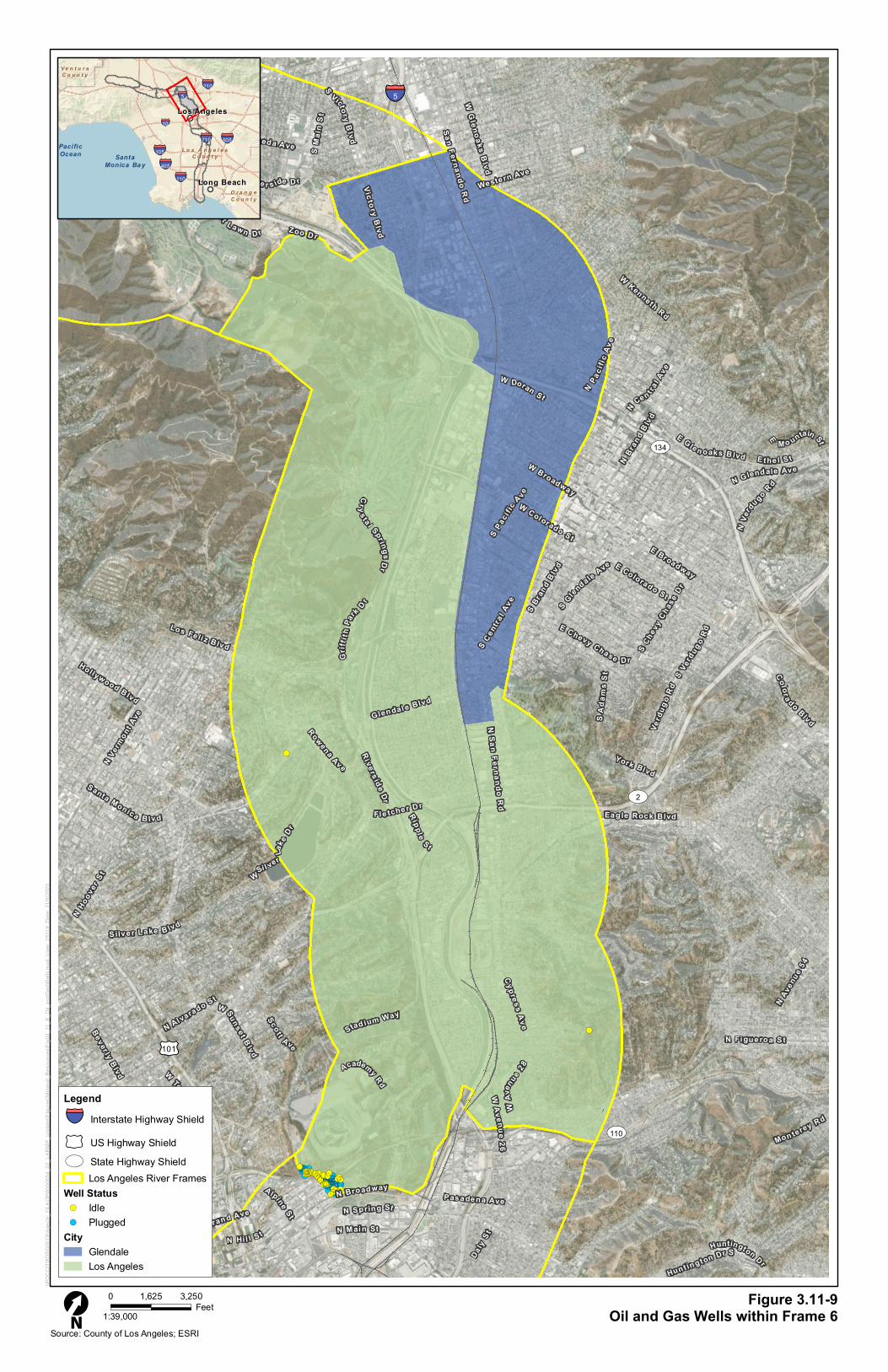
As shown on Figure 3.11-3, there are 830 active oil and gas wells located in the 2-mile-wide study
area. The majority of the active oil wells (824 active oil wells) are located in Frame 1 within the
Wilmington and Long Beach Oil Fields, which are shown on Figure 3.11-4. The Wilmington Oil Field
is the third largest oil field in the contiguous United States (City of Long Beach 2020). The Long
Beach Oil Field is largely depleted but is still operational (City of Signal Hill 2020). There are five
active oil wells in Frame 2 and one active oil well in Frame 3, as seen on Figure 3.11-5 and Figure
3.11-6. As seen on Figures 3.11-4 through 3.11-10, there are 1,792 plugged and abandoned oil and
gas wells located in the 2-mile-wide study area, with 1,270 located in Frame 1, 339 located in Frame
2, 34 located in Frame 4, 104 located in Frame 5, and 45 located in Frame 6.
3.11.2.2 Regulatory
This section identifies laws, regulations, and ordinances that are relevant to the impact analysis of
mineral resources in this PEIR.
Federal
Mining and Mineral Policy Act of 1970
The Mining and Mineral Policy Act of 1970 intended to promote and expand the development of a
domestic mineral industry. This statute established a federal policy regarding mineral resources
across the United States, covered hard rock mining and oil and gas production, and established
modern federal policy in regard to mineral resources nationally. The act applies to all minerals,
including aggregate (sand and gravel), coal, geothermal, and oil and gas, that are subject to federal
jurisdiction including Bureau of Land Management and United States Forest Service.
State
California Surface Mining and Reclamation Act of 1975
SMARA is the principle legislation addressing mineral resources in California (Public Resources
Code [PRC] §§ 2710–2719), which was enacted in response to land use conflicts between urban
growth and essential mineral production. The stated purpose of SMARA is to provide a
comprehensive surface mining and reclamation policy that will encourage the production and
conservation of mineral resources while ensuring that adverse environmental effects of mining are
prevented or minimized; that mined lands are reclaimed and residual hazards to public health and
safety are eliminated; and that consideration is given to recreation, watershed, wildlife, aesthetic,
and other related values. SMARA governs the use and conservation of a wide variety of mineral
resources, although some resources and activities are exempt from its provisions, including
Los Angeles County Public Works
3.11 Mineral Resources
2020 LA River Master Plan Program EIR 3.11-6
February 2021 ICF 54.20
excavation and grading conducted for farming, construction, or recovery from flooding or other
natural disasters.
SMARA provides for the evaluation of an area’s mineral resources using a system of MRZ
classifications that reflect the known or inferred presence and significance of a given mineral
resource, as discussed above.
Although the State of California is responsible for identifying areas containing mineral resources, the
county or city is responsible for SMARA implementation and enforcement by providing annual
mining inspection reports and coordinating with the California Geological Survey.
Mining activities that disturb more than 1 acre or 1,000 cubic yards of material require a SMARA
permit from the lead agency, which is the county, city, or board that is responsible for ensuring that
adverse environmental effects of mining are prevented or minimized. The lead agency establishes its
own local regulations and requires a mining applicant to obtain a surface mining permit, submit a
reclamation plan, and provide financial assurances, pursuant to SMARA.
Certain mining activities do not require a permit, such as excavation related to farming, grading
related to restoring the site of a natural disaster, and grading related to construction.
Mineral Resources and Mineral Hazards Mapping Program
The CGS provides geologic expertise and information about California’s diverse non-fuel mineral
resources. As required by the SMARA of 1975, the State Geologist classifies these resources in an
effort to locate economically significant mineral deposits and potential areas of deposits based upon
scientific data. Information relating to California’s non-fuel resources, naturally occurring mineral
hazards, and active and historic mining activities are collected to classify land under the Mineral
Resources and Mineral Hazards Mapping Program. As described above, the CGS defines several
geographic areas that collectively cover a single mineral classification study as P-C Regions. The CGS
identifies MRZs for each P-C Region, mine/quarry, or other geographic area included in a mineral
classification study. MRZs are areas classified by the presence or absence of significant sand, gravel,
or stone deposits which are suitable as sources of aggregate. Construction aggregate is California’s
primary mineral resource.
California Department of Conservation
The California Department of Conservation is the primary agency with regard to mineral resource
protection. The Department is charged with conserving earth resources (PRC §§ 600–690) and has
five program divisions that address mineral resource issues:
1. Division of Land Resource Protection (DLRP) – supports a number of programs designed to
promote orderly growth in coordination with agricultural endeavors.
2. California Geological Survey (CGS) – provides scientific products and services about the State’s
geology, seismology and mineral resources. They also provide the SMARA Land Classification
maps.
3. Geologic Energy Management Division (CalGem) – provides regulatory programs that
emphasize the wise development of oil, natural gas, and geothermal resources. They also
provide well location and production data.
!(
!(
!(!(!(!(!(!(!(!(!(!(!(!(!(!(!(!(
!(
!(
!(
!(!( !(
!(!(!(!(!(!(!(!(!(!(!(!(!(!(!(!(!(!(!(!(!(!(
!(!(!(!(!(!(!(!(!(
!(!(!(!(
!(!(!(!(!(
!(!(!(!(!(!(!(!(
!(!(!(!(!(
!(!(!(!(!(!(!(!(
!(!(
!(!(!(!(!(
!(
!(!(!(!(
!(
!(!(!(
!(
!(!(!(!(!(!(!(!(!(!(
!(!(!(!(!(!(
!(!(
!(!(
!(
!(!(!(
!(!(!(
!(
!(!(!(!(!(!(!(!(!(!(!(!(
!(
!(!(!(!(!(!(!(
!(
!(!(!(!(!(!(!(!(!(!(
!(!(
!( !(!(!(!(
!(
!(!(!(!(
!(!(!(
!(
!(!(
!(!(
!(
!(
!(
!(!(
!(!(!(!(
!(
!(!(!(!(
!(
!(
!(!(!(!(!(!(!(!(!(
!(!( !(!(!(
!(
!(!(!(!(!(!(
!(!(!(!(!(
!(
!(!(
!(
!(!(!(
!(!(!(
!(
!(
!(!(
!(!(
!(!(!(
!(
!(
!(
!(!(
!(!(
!(!(
!(
!(
!(
!(!(!(!(!(
!(!(
!(
!(
!(
!(
!(
!(!(!(!(!(!(!(!(!(
!( !(!(!(
!(
!(!(
!(
!(!(!(!(!(!(
!(
!(!(!(!( !(!(!(!(!(!(!(!(!(!( !(!(
!(!(
!(!(!( !(
!(!( !(
!(
!(!(
!(
!(!(!(
!(!(!(
!(!(!(!(
!(!(!(!(!(
!(!(
!(!(!(
!(
!(!(
!(!(!(!(!(!(!(!(!(
!(!(!(!(!(!(!(!(!(!(!(!(!(!(
!(!(!(!(
!(
!(!(
!(!(!(
!(!(
!(!(!(!(!(!(!(!(!(!(!(!(
!(
!( !(!(!(!(!(!(!(!(!(!(!(!(!(
!(!(!(!(!(!(!(!(!(!(!(!(!(!(!(!(!(!(
!(!(
!(!(!(
!( !(!(
!(
!(!(!(!(!(!(!(!(!(!( !(!(!(
!(!(!(!(
!(!(
!(!(
!(!(!(!(!(!(!(!(!(!(!(!(!(!(!(!(!(!(!(!(!(!(
!(
!(!(!(!(!(
!(!(!(
!(
!(
!(!(!(!(!(!(!(!(!(!(!(!(!(!(!(!(!(!(!(!(!(!(!(!(!(!(!(!(!(!(
!(!(!(!(!(!(
!(!(
!(!(!(!(!(
!(
!(!(!(!( !(!(!(!(
!(!(!( !(!(!(!(
!(!(!(!(!(!(!(!(!(!(!(!(!(!(!(!(!(
!(!(!(!(!(
!(!(!(
!(!(!(!(!(!(!(!(!(!(!(!(!(!(!(!(!(!(!(!(!(!(
!(!(!(
!( !(!(!(!(!(
!(!(!(!(!(!(
!(!(!(!(!(!(!(!(!(!(!(!(
!(!(!(!(!(!(!(
!(!(!(!(!(
!(!(!(!(!(!(!(!(!(!(!(!(!(!(!(
!(!(!(!(!(!(!(
!(!(
!(!( !(!(!(!(!(
!(!(!(
!(!(!(!(
!(!(!( !(!(!(!( !(!( !(!(!(!(!(!(
!(
!(
!(
!(!(!(!(
!(!(
!(!(!(
!(
!(!( !(!(
!(!(
!(!(!(
!(
!(!(!(!(
!(
!(!(!(
!(!(!(!(!(
!(
!(!(!(!(!(!(!(
!(!(!(!(
!(!(!(!(!(!(
!(
!(
!(
!(!(!(
!(!(!(
!(!(!(!(!(!(!(
!(!(!(!(!(!(!(!(!(!(!(!(!(!(!(!(!(
!(!(!(
!(
!(!(!(!(!(!( !(!(!(!( !(!(!(
!(!(!(!(!(
!(
!(!(
!(
!(!(
!(
!(!(!(!(!(!(
!(
!(
!(!(!(!(
!(!(
!(!(!(!(!(!(!(!(!(!(
!(
!(!(!(!(!(!(
§̈¦405
§̈¦210
§̈¦105
§̈¦710
§̈¦10
§̈¦5
£¤101
ST91
ST27
ST72
ST2
ST107
ST42
ST19
ST110
ST1
ST213
ST60
ST90
ST47
ST170
ST134
§̈¦5
Figure 3.11-3Active Wells in the Project Study Area±
Source: California Department of Conservation; Los Angeles County; ESRI StreetMap Map Prepared: 11/5/2020
0 2 41
Miles
\\PDC
CITR
DSGI
S1\Pr
ojects
_1\LA
DPW\
0005
4_02
_LAR
MP_U
pdate
\Figu
res\M
ineral
_Res
ource
s\Fig0
3_11
_3_A
ctive
_Well
s.mxd
Date
: 11/5
/2020
251
19
!( Active Wells
§̈¦ Interstate HighwayShield
£¤US HighwayShield
STState HighwayShieldLos Angeles River
CityBellBell GardensBurbankCarsonCommerceComptonCudahyDowneyGlendaleHuntington ParkLong BeachLos AngelesLynwoodMaywoodParamountSouth GateUnincorporatedVernon
!!
!!!!!!!!
! !!!!! !! !!!!!!!!!!!
!!!!!!!!!! !!!!!!!
!!!!!!!!!!!!!!
!!!!!!!!!!!!!!!!!!! !!!
!!!!!!!!!!!!! !!!!!!!!! !!!!!!!! !!!!!!!!!!!!!!!!
! !! !! !! !!!!!! !!!!!!!!!!!!!! !!!!!!!!!!!!!!!!!!!! ! !!!! !! !!!!!!! !!!!!! !!! !! !!! !! !!!! !!!!!!! !! !! !!! !!!! !!! !! !!!!!!!! !!!! ! !!! ! !! ! !!!!!!!!!! ! !! !!! !!! !! !!!! ! !!!! !!!! ! !!! ! ! !!!!!! !!!! ! !! !!! !!!!! !!! ! !! !! !!! !!! ! !!!! !!!!
! !! !!!!!!!!!! ! !!! !! !!!!! ! !!! !!! !!!
!!! !
!!
!!!!!!!! !!!!! !!!!! !!!!
! !!
!!
!!!
!! !!
!! !!
! ! !! !!! !!!! !! !!! !!!!! !!!!!! !!!!!!!!! !!!!! !! !! !!! !!! !!! !! !!! !! !!! !!! ! !! !!! !! ! !!! ! !! !!!!!! !!!!!!!!! !!!!! !! !!!!!!! !!!!!!! !! ! !! !!! ! !!! !!! !!! !!!!! !! ! ! !! !! !!! !! !! !! ! !! !!! !!! !!!!!!!!!!!!!!!! !! ! !!!! !!! !! !!! !!! !!! !!! ! !!!! !! !! !! !!! !!! ! !!!! !! ! !!!! ! !!! ! !!! !!! !!! !!! !! !! !! !! !! !!!!!! !!! !! !!!! ! !!! !! !!! !!! !! !! !! !! ! !!! !!! !!! !!!!!! !! ! !!!! !! !!! !! !! !!! !! ! !!! !! !!!! !!! ! !!!! !!! !! ! !! !!! !!! !! !!! ! !!!!!! ! !!! !! !! !! !!! !!! !!!!! !! !!!!! !!! !!! !!!! !! ! !! ! !!!!!! ! !! !!!!!! !!!! !!! ! !!! !! !! !!! !! !! !!!! !! ! !! !! !! !!!! !! ! !!! !!! !! ! !! !! !!! !!! !! !!!! ! !! !! ! !! !!!!! !!! !!! !! !! ! !! !!!! !! !! ! ! ! ! !! !!!!!!!! !!! ! !!!!!! ! !! !!!!! !! !! !!!! ! !!!
!! !!! !!!! !!!!! !! ! !!! !! !!! !! !! !
!!! !!
! !!! !!!!!!!!
!!
!
!
!!!!
! !!!!!! !!!!!! !!!!!!! !!!! !!!!!! !!!!!!! !!! !! !!!! !!!!!!!!!!!!!! !!!!!!! !!! !!!!!!!!! ! !!!! !! !! !!!!! !! !! !!! !! !!!! !!!!! !!!! !! ! !!! !! !!!! !!!!! !! ! !!!!!! ! !! !!! !!! !!!! !! !! !!! ! !!!!!!! !! !!! ! ! !!! !! !! !!! !! !! ! !!! !!!! !! !! !!! !! !! !!!! !!! ! !
((
((((((((
( ((((( (( (((((((((((
(((((((((( (((((((
((((((((((((((
((((((((((((((((((( (((
((((((((((((( ((((((((( (((((((( ((((((((((((((((
( (( (( (( (((((( (((((((((((((( (((((((((((((((((((( ( (((( (( ((((((( (((((( ((( (( ((( (( (((( ((((((( (( (( ((( (((( ((( (( (((((((( (((( ( ((( ( (( ( (((((((((( ( (( ((( ((( (( (((( ( (((( (((( ( ((( ( ( (((((( (((( ( (( ((( ((((( ((( ( (( (( ((( ((( ( (((( ((((
( (( (((((((((( ( ((( (( ((((( ( ((( ((( (((
((( (
((
(((((((( ((((( ((((( ((((
( ((
((
(((
(( ((
(( ((
( ( (( ((( (((( (( ((( ((((( (((((( ((((((((( ((((( (( (( ((( ((( ((( (( ((( (( ((( ((( ( (( ((( (( ( ((( ( (( (((((( ((((((((( ((((( (( ((((((( ((((((( (( ( (( ((( ( ((( ((( ((( ((((( (( ( ( (( (( ((( (( (( (( ( (( ((( ((( (((((((((((((((( (( ( (((( ((( (( ((( ((( ((( ((( ( (((( (( (( (( ((( ((( ( (((( (( ( (((( ( ((( ( ((( ((( ((( ((( (( (( (( (( (( (((((( ((( (( (((( ( ((( (( ((( ((( (( (( (( (( ( ((( ((( ((( (((((( (( ( (((( (( ((( (( (( ((( (( ( ((( (( (((( ((( ( (((( ((( (( ( (( ((( ((( (( ((( ( (((((( ( ((( (( (( (( ((( ((( ((((( (( ((((( ((( ((( (((( (( ( (( ( (((((( ( (( (((((( (((( ((( ( ((( (( (( ((( (( (( (((( (( ( (( (( (( (((( (( ( ((( ((( (( ( (( (( ((( ((( (( (((( ( (( (( ( (( ((((( ((( ((( (( (( ( (( (((( (( (( ( ( ( ( (( (((((((( ((( ( (((((( ( (( ((((( (( (( (((( ( (((
(( ((( (((( ((((( (( ( ((( (( ((( (( (( (
((( ((
( ((( ((((((((
((
(
(
((((
( (((((( (((((( ((((((( (((( (((((( ((((((( ((( (( (((( (((((((((((((( ((((((( ((( ((((((((( ( (((( (( (( ((((( (( (( ((( (( (((( ((((( (((( (( ( ((( (( (((( ((((( (( ( (((((( ( (( ((( ((( (((( (( (( ((( ( ((((((( (( ((( ( ( ((( (( (( ((( (( (( ( ((( (((( (( (( ((( (( (( (((( ((( ( (
!!!!!!!!
!!!
!!!
!!!!
!!!!!!!!!!!!!!!!
((((((((
(((
(((
((((
((((((((((((((((
!!!!
!!!!
! !! !!!!!!!!
!! !!!!!!!!!!
!
!!!!!
!!!!!!!!!!! !!!!
!!!!!!!!!!!!!!!!!!!!
! !!!!!!!!! !!!!!!
!!!!! !!!! !! !!!!!!!!!! !!! ! !!!
!!!!!! !! !!
!!! !!!!!! !!! !! !!!!!! !
! !!!! !!!
!!!
!!
!!! !!! !!!! !! !
!!!!!!!!!!!!!!!!
!!!!!! !
! !! !!! !!!!!!! !
!! !!!!!!
!!!
!! !! !!
!!! !!!!!!!!!!
!!! !!!!
!!! !!!!
!! ! !!!!
!
!!!!!!!!!!
!!!!!!!!!!!
!
!
!
! !
!!
!!!!! !!
! !! !!!!!!
!
!
((((
((((
( (( ((((((((
(( ((((((((((
(
(((((
((((((((((( ((((
((((((((((((((((((((
( ((((((((( ((((((
((((( (((( (( (((((((((( ((( ( (((
(((((( (( ((
((( (((((( ((( (( (((((( (
( (((( (((
(((
((
((( ((( (((( (( (
((((((((((((((((
(((((( (
( (( ((( ((((((( (
(( ((((((
(((
(( (( ((
((( ((((((((((
((( ((((
((( ((((
(( ( ((((
(
((((((((((
(((((((((((
(
(
(
( (
((
((((( ((
( (( ((((((
(
(
!!!
!!!
!
!! !!! !! !!!!!!
!!!!!!!!
!
!!!!!!!!!!
(((
(((
(
(( ((( (( ((((((
((((((((
(
((((((((((
!!!!!!!!!!!!!!!!!!!!!!
!!!!!!!!!!!!!!!!!!!!!!!!!
!!!!!!!! !!!!!!!!!
!!!!!!!
!!!!!!!!!!!!!!!!!!!!!!!!!!! !!!!!!!!
!!
!!!!!!!!!!!! !!
!! !! !!!! !!!!!! !!!! !!!!! !!!! !!!!!!!! !!! !! !!! !!!! !!!! !!!!! !! !! !! ! !! !! !!!!!!!! !! !!!!! !!! !!!!!!!!!!!!
! !!!!!!!! !! !! !!!!!!!!!!!!!!!!!!!!!!!!!!!!!!! !!
! !!!!! !! !!! !!!!!! !!!!! !!!!!! !!!!!!!!!!
!!! !!! !!! !!! !! !!!!! !! !!! !!!!!! !! !!!! !!! !!! !!
!!!!!!!
! !!!!!!!!!!!!
!!!!!!!!!!!!!!!!!!!!!
!!!!!! !!!!!!!!!
!!!!!!!! !! !!!!!!!!! !! !!!!!!!!!!!!
!! !! ! !!! !
!!!!
! !! !
!!!!!!!!!!
!! !!!!! !!
! !!
!!! !!!!
! !!!
!
!!!!
! !!! !!!! !
!!!!!!!!!!!!!!!!
!!!!!!
!!
! !!
!!
!!!
!
((((((((((((((((((((((
(((((((((((((((((((((((((
(((((((( (((((((((
(((((((
((((((((((((((((((((((((((( ((((((((
((
(((((((((((( ((
(( (( (((( (((((( (((( ((((( (((( (((((((( ((( (( ((( (((( (((( ((((( (( (( (( ( (( (( (((((((( (( ((((( ((( ((((((((((((
( (((((((( (( (( ((((((((((((((((((((((((((((((( ((
( ((((( (( ((( (((((( ((((( (((((( ((((((((((
((( ((( ((( ((( (( ((((( (( ((( (((((( (( (((( ((( ((( ((
(((((((
( ((((((((((((
(((((((((((((((((((((
(((((( (((((((((
(((((((( (( ((((((((( (( ((((((((((((
(( (( ( ((( (
((((
( (( (
((((((((((
(( ((((( ((
( ((
((( ((((
( (((
(
((((
( ((( (((( (
((((((((((((((((
((((((
((
( ((
((
(((
(
Long Beach-SantaCatalina
ST47
ST1
§̈¦405
§̈¦710
San PedroChannel
UpperNewport
Bay
San Pedro Bay
QueenswayBay
Long BeachHarbor
E Carson St
Sant
aFe
Ave
Wi lming
ton Ave
Long
B eac
hBl
vd
W 3rd St Paci
fic A
ve
W Ocea n BlvdE S h or e l in e Dr
E Broadway
E 3rd St
E 6th St
W Pac ifi c Coast Hwy
Alam
itos A
ve
W 6th St
Sh o r e l ine Dr W
E I St
S Al
amed
a St
E Ocean Bl vd
Quee
n sW
ay
W 7 th St
Term
ina l
WayE Amo Bl vdW Del Am o Blvd
Atla
ntic
Ave Ch
erry
Ave
Para
mou
nt B
lvd
W Ward low Rd
W Willow St
Carson St
E Wardlow Rd
E Wi llow St
E Anahe im St
E Spr ing St
E Pac ific Coast Hwy
E 4th St
E 7th St
S Harbor Scenic Dr
W Broadway
A lameda St
E De l Amo Blvd
W 9th St
OrangeAve
Magn
olia
Ave
S Sa
nta
Fe A
ve
S W
ilmin
gton
Ave
E 223rd St
W Anahei m St
E Sepul veda Blvd
Figure 3.11-4Oil and Gas Wells within Frame 1
\\PDC
CITR
DSGI
S1\P
rojec
ts_1\L
ADPW
\0005
4_02
_LAR
MP_U
pdate
\Figu
res\M
inera
l_Res
ource
s\Fig0
3_11
_X_O
il_an
dGas
Well
s.mxd
; Use
r: 251
19; D
ate: 1
1/5/20
20
0 3,2501,625Feet
Legend§̈¦ Interstate Highway Shield
£¤ US Highway ShieldST State Highway Shield
Los Angeles River FramesWell Status!( Active!( Canceled!( Idle!( New!( Plugged
CityLong BeachLos Angeles
Source: County of Los Angeles; ESRI
L o s A n g e l e sL o s A n g e l e sC o u n t yC o u n t y
O r a n g eO r a n g eC o u n t yC o u n t y
V e n t u r aV e n t u r aC o u n t yC o u n t y
§̈¦405
§̈¦210§̈¦5
§̈¦605
§̈¦105§̈¦710
§̈¦10
§̈¦110 Long BeachLong Beach
Los AngelesLos Angeles
SantaMonica Bay
PacificOcean
1:39,000[N
!! !! !!! !! !! !!!! !! !!! ! ! !!! !! !!! ! !!! ! !!! !! !!!! !! !!!!! ! !!!!!!! !! ! !!!!!! !! !!! !!! !!! !!! ! !!!! !! ! !!! !!! !!! !! !!!! ! ! !! !!!! ! !!!!! !! !! !!! !!! !! !!! !! !! !!! !!!!!! !!!!! ! !! !! !! !!! !!!! !!!!! ! ! !!!! !!! !! ! !!! !!! ! !!!! !! !! !!! !!! !!!! !!!! !! !!! ! !!!!!! !!!!!! !!! ! !! !!! !!! ! !!!! !! !!! !!! ! !!! ! !!!! !!!!! !! !! !!!!! !!!!! !! !! !!! !!! !! !! ! !!!! !!!!! !! !!! !!! !!!!!
!!! !
!!!
!
!
!
!!
! ! !!!
!
!
(( (( ((( (( (( (((( (( ((( ( ( ((( (( ((( ( ((( ( ((( (( (((( (( ((((( ( ((((((( (( ( (((((( (( ((( ((( ((( ((( ( (((( (( ( ((( ((( ((( (( (((( ( ( (( (((( ( ((((( (( (( ((( ((( (( ((( (( (( ((( (((((( ((((( ( (( (( (( ((( (((( ((((( ( ( (((( ((( (( ( ((( ((( ( (((( (( (( ((( ((( (((( (((( (( ((( ( (((((( (((((( ((( ( (( ((( ((( ( (((( (( ((( ((( ( ((( ( (((( ((((( (( (( ((((( ((((( (( (( ((( ((( (( (( ( (((( ((((( (( ((( ((( (((((
((( (
(((
(
(
(
((
( ( (((
(
(
!! !!
!! !!
! !!! !
!!
!! !! !!! !!! !!
!!
(( ((
(( ((
( ((( (
((
(( (( ((( ((( ((
((
! !
!!!
( (
(((
ST47
ST91
ST1
§̈¦405
§̈¦710
§̈¦105
S ant
aFe
Ave
Wi lmingto
n Ave
Atla
ntic
Ave
Long
B eac
hBl
vd
W Art es ia Blvd
W Pac ifi c Coast Hwy
E I St
Down
ey A
ve
W Com pt on Blvd
Cent
ral A
ve
Paci
fic A
ve
N Alameda St
NW
ilmington
Av e
E Amo Bl vd
E Compton Blvd
W Del Amo Blvd
Alam
eda
St
Para
mou
nt B
lvd
W Ward low Rd
W Willow St
Redo
ndo
Ave
W Vic tori a St
SCen t ra l Ave
E Rosecrans Ave
E South St
E Wardlow Rd
Del Amo Blvd
Carson St
E Spring St
E Ar tesi a Blvd
Somerset Blvd
N Pa
ram
ount
Blv
d
E Carson St
W Rosecrans Ave Rosecrans Ave
Garfi
eld
Ave
A londra Blvd
S Atlant ic Ave
E Wi llow St
E Pac ific Coast Hwy
W Al ondra Blvd
E De l Amo Blvd
E Alondra Blvd
OrangeAve
Magn
olia
Ave
S Sa
nta
Fe A
ve
Ar tesi a Bl vd
S Wilm
ington Ave
E 223rd St
SAla m
e d aS t
E Sepulveda Blvd
CherryAve
Figure 3.11-5Oil and Gas Wells within Frame 2
\\PDC
CITR
DSGI
S1\P
rojec
ts_1\L
ADPW
\0005
4_02
_LAR
MP_U
pdate
\Figu
res\M
inera
l_Res
ource
s\Fig0
3_11
_X_O
il_an
dGas
Well
s.mxd
; Use
r: 251
19; D
ate: 1
1/5/20
20
0 3,2501,625Feet
Legend§̈¦ Interstate Highway Shield
£¤ US Highway ShieldST State Highway Shield
Los Angeles River FramesWell Status!( Active!( Idle!( Plugged
CityCarsonComptonLong BeachUnincorporated
Source: County of Los Angeles; ESRI
L o s A n g e l e sL o s A n g e l e sC o u n t yC o u n t y
O r a n g eO r a n g eC o u n t yC o u n t y
V e n t u r aV e n t u r aC o u n t yC o u n t y
§̈¦405
§̈¦210§̈¦5
§̈¦605
§̈¦105§̈¦710
§̈¦10
§̈¦110 Long BeachLong Beach
Los AngelesLos Angeles
SantaMonica Bay
PacificOcean
1:39,000[N
!
!
!
(
(
(
ST90
ST42
ST19
ST91
§̈¦105
§̈¦710
Willowb ro ok Ave
E F lorence Ave
Tweedy Blvd
Fires tone Blvd
Atla
ntic
Blv
d
S Ea
ster
n Av
e
Sout h St
W Artesi a Blvd
San t a Fe Ave
Down
ey A
ve
Lake
wood
Blv
d
N Alameda St
NW
ilmington
A ve
E Gage Ave
E Compton Blvd
Wilm
ingt
on A
veSlauson Ave
Abbot t Rd
Para
mou
nt B
lvd
E S lauson Ave
E Imperial Hwy
E Rosecrans Ave
E South St
Calif
orn i
a Av
e
SS anta
Fe A ve
F lorence Ave
S Wilm
ington Ave
Eas t
ern
Ave
Rosecrans Ave
E Artes ia Blvd
N Pa
ram
ount
Blv
d
Al ondra Blvd
Somerset Blvd
S Atlant ic Ave
W Alondra Blvd
Gage Ave
E 103rd St
SAlam
ed aS t
E Al ondra Bl vd
Atl ant
i cAv
e
W Rosecrans Ave
Garfi
eld A
ve
C herryAv e
Ar tesi a Bl vd
LongBeac h
Blvd
Paci
ficBl
vd
Figure 3.11-6Oil and Gas Wells within Frame 3
\\PDC
CITR
DSGI
S1\P
rojec
ts_1\L
ADPW
\0005
4_02
_LAR
MP_U
pdate
\Figu
res\M
inera
l_Res
ource
s\Fig0
3_11
_X_O
il_an
dGas
Well
s.mxd
; Use
r: 251
19; D
ate: 1
1/5/20
20
0 3,2501,625Feet
Legend§̈¦ Interstate Highway Shield
£¤ US Highway ShieldST State Highway Shield
Los Angeles River FramesWell Status!( Idle
CityComptonCudahyDowneyLong BeachLynwoodParamountSouth GateUnincorporated
Source: County of Los Angeles; ESRI
L o s A n g e l e sL o s A n g e l e sC o u n t yC o u n t y
O r a n g eO r a n g eC o u n t yC o u n t y
V e n t u r aV e n t u r aC o u n t yC o u n t y
§̈¦405
§̈¦210§̈¦5
§̈¦605
§̈¦105§̈¦710
§̈¦10
§̈¦110 Long BeachLong Beach
Los AngelesLos Angeles
SantaMonica Bay
PacificOcean
1:39,000[N
!
! !!
! !!!
!
!!!!!!!!!!!!!!!!!!!!
! ! !!
!
(
( ((
( (((
(
((((((((((((((((((((
( ( ((
(
!(
ST72
ST90
ST42
ST60
£¤101
§̈¦710
§̈¦105
§̈¦5
§̈¦10
E Florence Ave
Tweedy Blvd
C ity Ter race D r
NA l
ame d
aSt
E 38 th St
Pomona Blvd
E 4th St
Fires tone Blvd
E 3rd St
Ave Cesar Chavez
Marengo St
S Lo
rena
St
E 6th St
E 8th St
SSo
t oSt
SEa
ste r
nAv
e
Atla
n tic
B lvd
Sa nt a Fe Ave
W Temple St
E 7 th St
N Bro a dway
E Gage Ave
Bandini Blvd
E Ol ympic Blvd
N So
to S
t
S Sa
nta
Fe A
ve
E Cesar E Chavez Ave
Monter ey Pa ss Rd
Sl auson Ave
Abbot t Rd
NEaste rn
A ve
N Main
St
E Sl auson Ave
E Imperial Hwy
Me dfor d St
E 37 th St
W 1st St
E 103rd St
Calif
orn i
a Av
e
Fl or ence Ave
Com
pton
Ave
East
ern
Ave
Eucli
d Ave
S Main
St
N Me
dnik
Ave
E Washington BlvdE 41s t St
S Cent ral A
veHo
oper
Ave
E 5th St
Whi ttie r Blvd
N M ission Rd
LongB each
Blvd
San Bernard ino Fwy
E Bever ly Blvd
Gage Ave
Wabash Ave
Wilm
ingt
on A
ve
Garfi
eld A
ve
SAr
i zon
a Ave
E 1s t St
SAlam
e daSt
Te leg raph Rd
A tl an t i cAv e
E Vernon Ave
S San Pedr
oSt
S Atlan ticBlvd
P aci
ficBl
vd
Figure 3.11-7Oil and Gas Wells within Frame 4
\\PDC
CITR
DSGI
S1\P
rojec
ts_1\L
ADPW
\0005
4_02
_LAR
MP_U
pdate
\Figu
res\M
inera
l_Res
ource
s\Fig0
3_11
_X_O
il_an
dGas
Well
s.mxd
; Use
r: 251
19; D
ate: 1
1/5/20
20
0 3,2501,625Feet
Legend§̈¦ Interstate Highway Shield
£¤ US Highway ShieldST State Highway Shield
Los Angeles River FramesWell Status!( Active!( Plugged
CityBellBell GardensCommerceHuntington ParkMaywoodUnincorporatedVernon
Source: County of Los Angeles; ESRI
L o s A n g e l e sL o s A n g e l e sC o u n t yC o u n t y
O r a n g eO r a n g eC o u n t yC o u n t y
V e n t u r aV e n t u r aC o u n t yC o u n t y
§̈¦405
§̈¦210§̈¦5
§̈¦605
§̈¦105§̈¦710
§̈¦10
§̈¦110 Long BeachLong Beach
Los AngelesLos Angeles
SantaMonica Bay
PacificOcean
1:39,000[N
! !! !!!
!!!!!!!!!
!! !!!!!! ! !!! !! ! !!! !! !!!! ! !! !!!!! !! ! !!! !!!! !! ! !! ! !!! !! !!! !! !! ! !!!! !! !!! !!!! !! !!! !!!!!! !!!
!
( (( (((
(((((((((
(( (((((( ( ((( (( ( ((( (( (((( ( (( ((((( (( ( ((( (((( (( ( (( ( ((( (( ((( (( (( ( (((( (( ((( (((( (( ((( (((((( (((
(
! !!
!
!
!! !!! ! !!!!!! !!!!! !!!!!! !!!!!! !!! !!!! !! !!!! !!!! !! !!!!! !! !!! ! !!
( ((
(
(
(( ((( ( (((((( ((((( (((((( (((((( ((( (((( (( (((( (((( (( ((((( (( ((( ( ((
!(
ST110
ST2
ST60
£¤101
§̈¦10
§̈¦5N
Grand Ave
Wi lshire Blvd
Cit y Terrace Dr
E 38th St
W Pico BlvdE 4th St
R ivers ide Dr
NAl
amed
aS t
Ripple St
E 3rd St
Scott Ave
Marengo St
S Lo
rena
St
E 6 t h St
Broa
dway
Pl
W 6 th St
E 8th St
SSo
toSt
S i lver Lake Blv d
S Alva
rado
St
Atla
n tic
B lvd
Academy Rd
W Temple St
WAvenue 26
E 7 th St
N Br oadway
Slauson Ave
S Figueroa S
t
E Gage Ave
Bandini Blvd
E Ol ympic Blvd
Huntington D r
N Figueroa St
S Sa
nta
Fe A
ve
S San Pedro
St
Paci
fic B
lvd
W 4 th St
Hunt ing ton Dr S
Mont er
eyRd
W 8th St
E Cesar E Chavez Ave
E Marti n Luther Ki ng Jr Blvd
Whi ttie r Blvd
Gage Ave
San Bernard ino Fwy
E 41st St
Me dfo rd S t
N Al
vara
do S
t
E 9th St
N Spr ing St
E 37 th St
W 1st St
NSan Fer na ndo Rd
S Gra
nd A
ve
E 16 th St
E S lauson Ave
Cypress AveGl
e nd a
l eB l
vd
WAven ue 28
W
2nd St
Eucli
d Ave
R owena Ave
W Olympic Bl vd
Valley Bl v d
Venice Blvd
WSilverLakeDr
A lpine St
Bever ly Blvd
W 3rd S t N Hil lS t
N Main St
W 9th St
Hoop
erAve
S Broadway E 5 th St
W 7th St
W 5th St
N Mission Rd
W Suns et Blvd
S Main St
Pasadena Ave
Wabash Ave
S Centra
l Ave
Com p
ton
Ave
Aval
on B
lvd
Sant
a Fe
Ave
NSo
toS t
E Washington Blvd
E 1st St
SAl am
e daSt
E J effe rso n Blvd
DalyS t
Fl et cher Dr
Stadium
Wa y
E Vernon Ave
Figure 3.11-8Oil and Gas Wells within Frame 5
\\PDC
CITR
DSGI
S1\P
rojec
ts_1\L
ADPW
\0005
4_02
_LAR
MP_U
pdate
\Figu
res\M
inera
l_Res
ource
s\Fig0
3_11
_X_O
il_an
dGas
Well
s.mxd
; Use
r: 251
19; D
ate: 1
1/5/20
20
0 3,2501,625Feet
Legend§̈¦ Interstate Highway Shield
£¤ US Highway ShieldST State Highway Shield
Los Angeles River FramesWell Status!( Canceled!( Idle!( Plugged
CityLos AngelesVernon
Source: County of Los Angeles; ESRI
L o s A n g e l e sL o s A n g e l e sC o u n t yC o u n t y
O r a n g eO r a n g eC o u n t yC o u n t y
V e n t u r aV e n t u r aC o u n t yC o u n t y
§̈¦405
§̈¦210§̈¦5
§̈¦605
§̈¦105§̈¦710
§̈¦10
§̈¦110 Long BeachLong Beach
Los AngelesLos Angeles
SantaMonica Bay
PacificOcean
1:39,000[N
!
!!
!
!!
!
!!
!
!
!
!
!
!!
!!!
!!
!
!!!!!!
!!
!!! !!!!! !!!!
!!!(
((
(
((
(
((
(
(
(
(
(
((
(((
((
(
((((((
((
((( ((((( ((((
(((
!!
!!
!
!!
!
!!
!!!
!
!
!!
!!!
!
!!!! !!!
!
!
((
((
(
((
(
((
(((
(
(
((
(((
(
(((( (((
(
(
ST2
ST134
ST110
£¤101
§̈¦5
N Gran d Ave
Verd
ugo
RdS
Verdug
oRd
Ri vers ide Dr
S Che
vy C
hase
Dr
Rippl e
St
Scott Ave
N Cen t ral A
ve
Cry s ta l Spr ing sDr
W Oli ve AveN
Hoov
er S
t
Western Ave
Silver Lake B lvd
Santa Monica B lvd
W Doran St
S Centra
l Ave
S Paci fi
c A veS
Brand
Blvd
Academy Rd
S Glendale Ave
W 4th St
Los Fe li z Blvd
W Alameda Ave
WTemple St
Gri ff
i thPa
rk
D r
WAvenue
26
NPa c
i fic A
ve
N Broadway
Hunt ington Dr S
S Ma
in S
t
Ho llywood B lvd
E M o untain St
Huntington D r
E Broadway
E Gle n oaks BlvdSan Fernando Rd
E Chevy Chase Dr
E Colorado St
N Fi gueroa St
Mon terey Rd
S
Vict oryB lvd
W3rd S t
Eagle Rock Blvd
N Alvarado St
N Spring St
W6 th St
W1st S t
N San Fernando Rd
York Blvd
Cypre ss Ave
WAv
enue 28
W2nd
St
S Ad
ams
St
Rowena Ave
WSi l ver
Lake
Dr
A lpine St
N Hi l l S t N Mai n St
NVe
rdugo Rd
Et he l S t
Victory Blvd
W
8thSt W
5th St
Bever ly Blvd
Color a do Blvd
Daly
St
N Verm
ont A
ve
W Suns et Blv d
Pasadena Ave
S Grand Ave
W Glenoaks Blvd
W Colorado St
S Figueroa St
N Av
enue
54Wil sh i re Blvd
W Broadway
W Riv e r s ide D r
Fl e tche r Dr
Zoo D r
Stad ium Wa y
N Glendale Ave
Glen dal e Blvd
NBra
ndB lv d
Fores t L awn D r
WKenneth Rd
Figure 3.11-9Oil and Gas Wells within Frame 6
\\PDC
CITR
DSGI
S1\P
rojec
ts_1\L
ADPW
\0005
4_02
_LAR
MP_U
pdate
\Figu
res\M
inera
l_Res
ource
s\Fig0
3_11
_X_O
il_an
dGas
Well
s.mxd
; Use
r: 251
19; D
ate: 1
1/5/20
20
0 3,2501,625Feet
Legend§̈¦ Interstate Highway Shield
£¤ US Highway ShieldST State Highway Shield
Los Angeles River FramesWell Status!( Idle!( Plugged
CityGlendaleLos Angeles
Source: County of Los Angeles; ESRI
L o s A n g e l e sL o s A n g e l e sC o u n t yC o u n t y
O r a n g eO r a n g eC o u n t yC o u n t y
V e n t u r aV e n t u r aC o u n t yC o u n t y
§̈¦405
§̈¦210§̈¦5
§̈¦605
§̈¦105§̈¦710
§̈¦10
§̈¦110 Long BeachLong Beach
Los AngelesLos Angeles
SantaMonica Bay
PacificOcean
1:39,000[
N
!(
ST170
ST134
£¤101
§̈¦5
Vine St
Bar ham B lvd
N Vermont Ave
Cryst a l S p r ingsDr
Western Ave
WDoran
St
N Hollywood Way
S Paci fic Ave
N Front St
Los Fe li z Blvd
W
Alameda Ave
Griff i t h Park Dr
N Vic tory Blvd
Burb
ank
Blvd
N Pacifi c Ave
W Glenoaks Blvd
S Main St
Cahu enga Blvd W
Vineland AveLankershim Blvd
Holly
wood
Blvd
Lau r e l Can yon Blvd
San Fernando R d
S Vi cto
ry
Blvd
W Magnolia Blvd
Co ldwater Cany on Dr
Vent
ura B lvd
E Olive Ave
Fran
klin
Ave W Oli ve Ave
Oxna
rd S
t
R owe
naAv
e
N Buena Vista St
W B
road
way
Mul hol land Dr
Vic tory Blvd
Chan
dler
Blv
d
S San Fernando Blvd
Cahuenga Blvd
W Burbank Blvd W
Vic
tory
Blv
d
Moor
park
St
Magn
oli a
Blv
d
WRiv e rside
D r
Rive
rsid
e Dr
N C ahuenga Blv d
Z o oDr
Co ldwater Canyon Ave
W Kenneth Rd
Forest LawnDr
Figure 3.11-10Oil and Gas Wells within Frame 7
\\PDC
CITR
DSGI
S1\P
rojec
ts_1\L
ADPW
\0005
4_02
_LAR
MP_U
pdate
\Figu
res\M
inera
l_Res
ource
s\Fig0
3_11
_X_O
il_an
dGas
Well
s.mxd
; Use
r: 251
19; D
ate: 1
1/5/20
20
0 3,2501,625Feet
Legend§̈¦ Interstate Highway Shield
£¤ US Highway ShieldST State Highway Shield
Los Angeles River FramesWell Status!( Idle
CityBurbankLos AngelesUnincorporated
Source: County of Los Angeles; ESRI
L o s A n g e l e sL o s A n g e l e sC o u n t yC o u n t y
O r a n g eO r a n g eC o u n t yC o u n t y
V e n t u r aV e n t u r aC o u n t yC o u n t y
§̈¦405
§̈¦210§̈¦5
§̈¦605
§̈¦105§̈¦710
§̈¦10
§̈¦110 Long BeachLong Beach
Los AngelesLos Angeles
SantaMonica Bay
PacificOcean
1:39,000
[
N
Los Angeles County Public Works
3.11 Mineral Resources
2020 LA River Master Plan Program EIR 3.11-7
February 2021 ICF 54.20
4. Division of Mine Reclamation (DMR) – provides oversight of local governments as they
administer SMARA within their respective jurisdictions. The primary focus is on existing mining
operations and the return of those mined lands to a usable and safe condition.
5. State Mining and Geology Board (SMGB) – develops policy direct regarding the development and
conservation of mineral resources and reclamation of mined lands.
CalGem Regulations
The California Geologic Energy Management Division (CalGEM) prioritizes protecting public health,
safety, and the environment in its oversight of the oil, natural gas, and geothermal industries, while
working to help California achieve its climate change and clean energy goals. Formerly known as
Department of Conservation's Division of Oil, Gas, and Geothermal Resources (DOGGR), CalGem was
formed in 1915 to implement regulations in the California PRC and California Code of Regulations
that pertain to the drilling, operation, maintenance, and plugging and abandonment of oil, natural
gas, and geothermal wells (California PRC §§ 2710–2719 and CCR § 3704.1).
Local
Local jurisdictions and unincorporated County area regulations containing policies regarding
mineral resources are discussed below.
City of Long Beach
City of Long Beach Municipal Code
The Long Beach Municipal Code (LBMC) was codified through Ordinance No. ORD-19-0001, enacted
January 8, 2019, first adopted December 14, 2010 (ORD-10-0037). Title 12, Long Beach Oil Code
(ORD-16-0027), regulates, “the drilling and redrilling for and the production of petroleum so that
these activities may be conducted in conformance with the California Fire Code adopted in Chapter
18.48, State statutes, regulations of DOGGR, in harmony with other City land uses, and to minimize
the economic effect of lessening land values in areas wherein drilling and redrilling for the
production of petroleum constitutes an activity which is at variance with the predominate land use”
(City of Long Beach 2019). Chapter 12.26 specifically discusses natural gas-related activities. The
management of oil activities in the Port is the responsibility of the Long Beach Energy Resources
Department (LBER); Port policies governing oil production within the Harbor District are set forth
in the Long Beach City Charter, Sections 1203c and 1203d. The Port has an Memorandum of
Understanding (MOU) with LBER, approved in 1992 and amended in 2004, that provides guidelines
for ongoing oil operations within the Harbor District.
Long Beach General Plan Program
The Long Beach General Plan Program, Conservation Element identifies goals to preserve natural
resources and areas of special interest in Long Beach (City of Long Beach 1973). According to the
General Plan, oil and gas extraction are recognized as being of economic value to the City of Long
Beach. Goals and policies relevant to this PEIR are listed below:
Los Angeles County Public Works
3.11 Mineral Resources
2020 LA River Master Plan Program EIR 3.11-8
February 2021 ICF 54.20
Conservation Element
Mineral Resources
Goal 1: To manage the petroleum resources of the City in a manner that will not only maximize their economic value but will enhance the quality of open space.
Goal 2: To continue good management practices in the production of petroleum including aesthetics, ecological compatibility and other environmental aspects.
Goal 3: To continue to take restorative measures to remedy and prevent subsidence associated with oil extraction.
City of Los Angeles
City of Los Angeles General Plan
The Conservation Element of the City of Los Angeles General Plan sets policy direction for open space
resources, including mineral production, in the City of Los Angeles (City of Los Angeles 2001).
According to this element, major local mineral resources consist of oil, rock deposits, and sand and
gravel. The element’s policies are based on the need to conserve natural amenities, protect against
natural hazards, and meet the public’s desire for open space experiences. Goals and policies relevant
to this PEIR are listed below:
Conservation Element
Objective: conserve sand and gravel resources and enable appropriate, environmentally sensitive extraction of sand and gravel deposits.
⚫ Policy 1: continue to implement the provisions of the California Surface Mining and Reclamation Act (PRC § 2710 et seq.) so as to establish extraction operations at appropriate sites; to minimize operation impacts on adjacent uses, ecologically important areas (e.g., the Tujunga Wash) and ground water; to protect the public health and safety; and to require appropriate restoration, reclamation and reuse of closed sites.
Program 1: administration and periodic updating of the 'G' Surface Mining District overlay zone provisions (LAMC 13.03).
⚫ Policy 2: continue to encourage the reuse of sand and gravel products, such as concrete, and of alternative materials use in order to reduce the demand for extraction of natural sand and gravel.
Program: recycling of construction materials.
City of Commerce
City of Commerce General Plan
The Resource Management Element of the City of Commerce 2020 General Plan focuses on four key
issue areas: cultural resources (historic and archaeological), ecological resources (plant and animal
life), natural resources (water and minerals), and open space resources used for recreation. The
following goals and policies are applicable to this PEIR
Resource Element
Policy 2.3. The city of Commerce will contact appropriate State agencies to determine whether or not the depletion of oil resources in the Bandini oilfield will create local ground subsidence problems.
Los Angeles County Public Works
3.11 Mineral Resources
2020 LA River Master Plan Program EIR 3.11-9
February 2021 ICF 54.20
City of Maywood
City of Maywood General Plan
The Conservation Element of the City of Maywood General Plan focuses on the protection and
maintenance of the State’s natural resources and prevents their wasteful exploitation and
destruction (City of Maywood 2008). The following goals and polices are applicable to this PEIR.
Conservation Element
Goal 3: Provide for the proper management of natural resources both in the city and region are so that they may be protected for the benefit of present and future residents.
City of Glendale
City of Glendale General Plan
The following policies, goals and objectives located in the Open Space and Conservation Element of
the City of Glendale General Plan are applicable to mineral resources (City of Glendale 1993).
Open Space and Conservation Element
Goal 6: Preserve and protect valuable water and mineral resources.
⚫ Objective 6: Maintain current prohibition of rock, sand, gravel, and mineral extraction in designated open space areas.
Unincorporated County
Los Angeles County Code
Los Angeles County Code, Chapter 22.190 of Title 22 states:
A. The Surface Mining Permit is established to regulate surface mining and reclamation of mined lands in compliance with the Surface Mining and Reclamation Act of 1975, Division 2, Chapter 9 of the California Public Resources Code, beginning with Section 2710.
B. It is the intent in regulating surface mining activities to ensure that:
1. The production and conservation of minerals is encouraged while addressing concerns relating to recreation, watershed, wildlife, range and forage, and aesthetic enjoyment during and after mining operations;
2. Adverse effects on the environment, including air pollution, impedance of groundwater movement and water quality degradation, damage to wildlife habitat, flooding, erosion, and excessive noise are prevented or mitigated;
3. Mined lands are returned to a usable condition readily adaptable for alternative land uses, with no residual hazards to public health or safety; and
4. Consistency is achieved with the mineral resources management policies of the General Plan.
Los Angeles County Building Code Section 110.4 also states that permits shall not be issued for
buildings or structures regulated by this code, adjacent to or within 300 feet (91.44 m) of active,
abandoned, or idle oil or gas well(s) unless provided with a methane gas protection system project
sites containing or lying within 300 feet of active, abandoned or idle oil or gas wells should provide
mitigation measures.
Los Angeles County Public Works
3.11 Mineral Resources
2020 LA River Master Plan Program EIR 3.11-10
February 2021 ICF 54.20
In addition, permits shall not be issued for a building or structure regulated by this code located
between 25 feet and 200 feet from active, abandoned, or idle oil or gas well(s) unless designed
according to the recommendations contained in a report prepared by a licensed civil engineer and
approved by the building official. Permits could also be issued if all active, abandoned, or idle oil or
gas well(s) between 25 feet and 200 feet from said building or structure are examined by a licensed
petroleum engineer to evaluate whether, in accordance with the current rules and regulations of
CalGEM, such wells are being properly operated or maintained, or are abandoned. No permits shall
be issued until certification of proper operation, maintenance, or abandonment or re-abandonment,
as determined by CalGEM, is submitted to the building official.
Los Angeles County General Plan
The Conservation and Open Space Element of the Los Angeles County General Plan sets policy
direction for open space resources, including mineral production, in unincorporated County areas
(County of Los Angeles 2015). According to the Los Angeles County General Plan, major local mineral
resources consist of oil, rock deposits, and sand and gravel. The element’s policies are based on the
need to conserve natural amenities, protect against natural hazards, and meet the public’s desire for
open space experiences. Goals and policies relevant to the 2020 LA River Master Plan are listed
below:
Conservation and Open Space Element
Goal C/NR 10: Locally available mineral resources to meet the needs of construction, transportation, and industry.
Policy C/NR 10.1: Protect MRZ-2s and access to MRZ-2s from development and discourage incompatible adjacent land uses.
Policy C/NR 10.2: Prior to permitting a use that threatens the potential to extract minerals in an identified Mineral Resource Zone, the County shall prepare a statement specifying its reasons for permitting the proposed use, and shall forward a copy to the State Geologist and the State Mining and Geology Board for review, in accordance with the PRC, as applicable.
Policy C/NR 10.3: Recognize newly identified MRZ-2s within 12 months of transmittal of information by the State Mining and Geology Board.
Policy C/NR 10.4: Work collaboratively with agencies to identify Mineral Resource Zones and to prioritize mineral land use classifications in regional efforts.
Policy C/NR 10.5: Manage mineral resources in a manner that effectively plans for access to, development, and conservation of, mineral resources for existing and future generations.
Policy C/NR 10.6: Require that new non-mining land uses adjacent to existing mining operations be designed to provide a buffer between the new development and the mining operations. The buffer distance shall be based on an evaluation of noise, aesthetics, drainage, operating conditions, biological resources, topography, lighting, traffic, operating hours, and air quality.
Policy C/NR 11.1: Require mineral resource extraction and production activities and drilling for and production of oil and natural gas to comply with County regulations and State requirements,
such as SMARA, and DOGGR1 regulations.
1 Housed within the Department of Conservation, CalGEM replaces the Division of Oil, Gas, and Geothermal Resources (DOGGR). The changes came as a result of AB 1057 which was signed by Governor Newsom in October 2019.
Los Angeles County Public Works
3.11 Mineral Resources
2020 LA River Master Plan Program EIR 3.11-11
February 2021 ICF 54.20
Other Local Jurisdictions
Other local jurisdictions located within the frames where MRZ-2 occurs (Cities of Compton, Carson,
Paramount, Lynwood, Downey, South Gate, Cudahy, Bell, Bell Gardens, Commerce, Huntington Park,
Vernon, Glendale, and Burbank) do not have any regulations or general plan goals and policies
related to mineral resources.
3.11.3 Impact Analysis
3.11.3.1 Methods
This section describes the methods used to analyze impacts on mineral resources from
implementation of the 2020 LA River Master Plan. The 51-mile-long and 2-mile-wide study area is
used to analyze impacts extending belowground to the maximum depth of disturbance that could be
encountered during construction or operation. Impacts were based on the potential for the
proposed project components to limit access to important mineral resources, as identified in MRZs
or oil fields, thereby resulting in the loss of or inability to recover such resources for economic
purposes. Impacts associated with Typical Projects (i.e., the Common Elements and Multi-Use Trails
and Access Gateways), the six kit of parts (KOP) categories, and related design components—as well
as the 2020 LA River Master Plan in its entirety—are analyzed qualitatively at a program level.
Where the two Typical Projects or the six KOP categories have similar impacts related to a specific
criteria, the discussion is combined. Where differences between the Typical Projects or the KOP
categories are identified, the impact analysis is presented separately. Furthermore, construction and
operations impacts are presented together where they largely overlap and it would not be
meaningful to discuss them separately to address a specific criterion.
3.11.3.2 Criteria for Determining Significance
Thresholds of Significance
For the purposes of the analysis in this PEIR, and in accordance with Appendix G of the State CEQA
Guidelines, the proposed Project would have a significant environmental impact if it would:
3.11(a) and (b) Result in the loss of availability of a known mineral resource or mineral resource recovery delineated on a local general plan, specific plan, or other land use plan site that would be of value to the region and the residents of the State.
Los Angeles County Public Works
3.11 Mineral Resources
2020 LA River Master Plan Program EIR 3.11-12
February 2021 ICF 54.20
3.11.3.3 Impacts and Mitigation Measures
Impact 3.11(a) and (b): Would the proposed Project result in the loss of availability of a known mineral resource or mineral resource recovery delineated on a local general plan, specific plan, or other land use plan site that would be of value to the region and the residents of the State?
Typical Projects
Common Elements and Multi-Use Trails and Access Gateways Typical Projects
Construction and Operation
Non-fuel Mineral Resources—Frames 1, 2, 3, 8, and 9
No regionally or statewide significant non-fuel mineral resources are located within Frames 1, 2, 3,
8, or 9. Construction and operation of Common Elements and Multi-Use Trails and Access Gateways
Typical Projects in these frames would not result in the loss of availability of a significant non-fuel
mineral resource, and no impact to non-fuel mineral resources would occur in these frames.
Non-fuel Mineral Resources—Frames 4, 5, 6, and 7
As discussed in Section 3.11.2, Setting, the project study area contains areas identified as MRZ-2,
which are zones that include known mineral deposits or where there is a high likelihood for their
presence. As shown on Figure 3.11-1, identified mineral resources located in the project study area
are only found in Frames 4, 5, 6, and 7.
The primary cause for loss of availability of mineral resources in the County is by placement of
incompatible land uses that either directly or indirectly make the resource inaccessible for future
extraction. Mining operations require an adequate setback from these land uses due to a variety of
environmental issues associated with mining activities, which include, but are not limited to, noise,
traffic, air quality, and visual resources impacts. At the State level, SMARA establishes policies for
conservation and development of mineral-containing lands. SMARA requires all cities and counties
to incorporate their policies and mapped MRZ into their general plans.
At the local level, the County screens development projects for the potential loss of availability of
mineral resources using MRZ classification data within the County GIS mapping applications.
Mineral resource potential is evaluated for project sites, and land use compatibility is reviewed for
sites on or near an important MRZ.
Construction of the Common Elements and Multi-Use Trails and Access Gateways Typical Projects
would include site preparation and grading. Depending on where Common Elements and Multi-Use
Trails and Access Gateways Typical Projects are sited, ground-disturbing activities could uncover or
affect mineral resources. Much of the MRZ-2 mapped area for sand and gravel in the County was
developed prior to the MRZ-2 classification and mapping, so it is already unavailable for future
extraction. Common Elements and Multi-Use Trails and Access Gateways Typical Projects would be
predominately constructed within areas that are already urbanized and disturbed and would
therefore not be available for mineral resource activities. Operations of the Common Elements and
Multi-Use Trails and Access Gateways Typical Projects would involve general recreational uses, as
well as operational uses of pavilions, cafes, hygiene facilities, restrooms, benches, emergency call
Los Angeles County Public Works
3.11 Mineral Resources
2020 LA River Master Plan Program EIR 3.11-13
February 2021 ICF 54.20
boxes, water fountains, trash and recycling, bike racks, and trails. Consequently, the likelihood of the
Common Elements and Multi-Use Trails and Access Gateways Typical Projects resulting in the loss of
non-fuel mineral resources classified MRZ-2 is minimal, and less than significant impacts on non-
fuel mineral resources are expected.
Oil Resources—Frames 4 through 9
No regionally or statewide significant fuel mineral resources are located within Frames 4 through 9.
Construction and operation of Common Elements and Multi-Use Trails and Access Gateways Typical
Projects would not result in the loss of availability of a significant fuel mineral resource in these
frames, and no significant impact to fuel mineral resources would occur.
Oil Resources—Frame 1, 2, and 3
As shown on Figure 3.11-3 and Figure 3.11-4, active wells are located in Frames 1, 2, and 3 of the
project study area, within the Cities of Los Angeles, Long Beach, and Commerce. Construction and
operations of the Common Elements and Multi-Use Trails and Access Gateways Typical Projects
would be required to comply with the County of Los Angeles Building Code, if located on County
owned land, which does not allow development to be constructed adjacent to or within 300 feet of
active, abandoned, or idle oil or gas well(s). In any case, the Common Elements and Multi-Use Trails
and Access Gateways Typical Projects would need to comply with local and County general plan
zoning restrictions. Compliance with local general plans and the Los Angeles County General Plan
would ensure that impacts on mineral resources would be less than significant. Jurisdictions that do
not contain policies regarding mineral resources in their general plan have determined these areas
are fully built-up (i.e. land is fully developed with no potential for extraction), and the applicable
general plans do not provide for extraction. There are limited available natural resources within
built-out urban communities. Compliance with local general plans and the Los Angeles County
General Plan would ensure that impacts on mineral resources would be less than significant.
Impact Determination
Impacts would be less than significant.
Mitigation Measures
No mitigation is required.
Significance after Required Mitigation
Impacts would be less than significant. No mitigation is required.
2020 LA River Master Plan Kit of Parts
KOP Categories 1 through 6
Construction and Operation
Under the 2020 LA River Master Plan, the multi-benefit design components of the KOP can be
implemented individually or in combination with other design components as subsequent projects
under the 2020 LA River Master Plan. The specific location (e.g., in-channel/off-channel, frame, etc.),
configuration, and design details of these subsequent projects would depend on numerous factors,
including the proponent of subsequent projects, the implementing agency, community needs, policy
Los Angeles County Public Works
3.11 Mineral Resources
2020 LA River Master Plan Program EIR 3.11-14
February 2021 ICF 54.20
decisions, and availability of funding. Once site-specific and project-specific details are available for
the subsequent projects informed by the multi-benefit design components of the six KOP categories,
additional CEQA analysis would be required before subsequent projects can be implemented.
Potential impacts from construction of the design components under KOP Category 1 through KOP
Category 6 would vary depending on the specific design component and its intended function.
Projects under the KOPs would likely be larger than Typical Projects.
Non-fuel Mineral Resources—Frames 1, 2, 3, 8, and 9
No regionally or statewide significant non-fuel mineral resources are located within Frames 1, 2, 3,
8, or 9. Construction and operation of KOP categories would not result in the loss of availability of a
significant non-fuel mineral resource in these frames, and no significant impact to non-fuel mineral
resources would occur.
Non-fuel Mineral Resources—Frames 4, 5, 6, and 7
KOP design components that could affect significant mineral resources, depending on where they
are sited, include construction of channel modification facilities and associated facilities from the
Channel Modification KOP; new structures associated with water diversion from the Diversion KOP;
new wells and associated infrastructure and, new solar projects from the Off-Channel Land Assets
KOP; and grading and excavation associated with habitat enhancement, management and
monitoring. These activities could result in a loss of availability by limiting access to or preventing
future development of mineral resources.
As stated above, much of the MRZ-2 mapped area for sand and gravel in Los Angeles County was
developed prior to the MRZ-2 classification and mapping, so it is already unavailable for future
extraction. Subsequent projects under the KOP categories would be predominately constructed
within areas that are already urbanized and disturbed and would therefore not be available for
mineral resource activities. For construction and operation of subsequent projects located in-
channel (bank to bank), in light of the existing predominately concrete lined river channel, the loss
of aggregate in the MRZ-2 area is remote. Although the abundance of similar materials in the County
of Los Angeles and the surrounding vicinity, there is a potential for the KOP categories to be
implemented within MRZ-2 and potentially result in the loss of availability of a known and/or
locally important mineral resource.
Construction and operation of KOP categories are required to comply with the SMARA policies for
conservation and development of mineral-containing land, Los Angeles County General Plan in
unincorporated County areas, and local jurisdiction’s general plans in incorporated cities, which
requires maintained access to mineral deposits for extraction. However, because the exact locations
of project sites are unknown at this time, mitigation is required to ensure impacts are less than
significant.
Oil Resources—Frames 4 through 9
No regionally or statewide significant fuel mineral resources are located within Frames 4 through 9.
Construction and operation of KOP categories would not result in the loss of availability of a
significant fuel mineral resource in these frames, and no significant impact to fuel mineral resources
would occur.
Los Angeles County Public Works
3.11 Mineral Resources
2020 LA River Master Plan Program EIR 3.11-15
February 2021 ICF 54.20
Oil Resources—Frame 1, 2, and 3
As shown on Figure 3.11-3 and Figure 3.11-4, 830 active oil and gas wells are located within Frames
1, 2, and 3 of the project study area. As seen in the detailed figures, active oil and gas wells in the 2-
mile-wide study area are found in Long Beach and Commerce. Construction and operations of the
KOP categories would be required to comply with the County of Los Angeles Building Code when
constructed on County-owned land, which does not allow development to be constructed adjacent to
or within 300 feet of active, abandoned, or idle oil or gas well(s). Construction and operation of KOP
categories would be required to comply with the Los Angeles County General Plan in unincorporated
County areas and local general plans when located in incorporated cities, which require maintained
access to mineral deposits for extraction and preservation of mineral resources. Compliance with
local general plans and the Los Angeles County General Plan would ensure that impacts on mineral
resources would be less than significant.
Impact Determination
Impacts would be less than significant.
Mitigation Measures
No mitigation is required.
Significance after Required Mitigation
Impacts would be less than significant. No mitigation is required.
Overall 2020 LA River Master Plan Implementation
Construction and Operation
The 2020 LA River Master Plan would involve construction of 107 projects, including recreational
facilities, that could occur anywhere in the study area over a 25-year period. The specific location
(in-channel or off-channel), configuration, and design for these components have not been
determined yet and would depend on numerous factors, including the project proponent(s) and
availability of funding. Construction and operation of projects under the 2020 LA River Master Plan
could result in impacts similar to those described above for the Typical Projects and KOP categories.
Impact Determination
Impacts would be less than significant.
Mitigation Measures
No mitigation is required.
Significance after Required Mitigation
Impacts would be less than significant. No mitigation is required.
Cumulative Impacts
The geographic context for an analysis of cumulative impacts on mineral resources is the County,
which contains the 51-mile long and 2-mile wide Project study area. As noted, major local mineral
Los Angeles County Public Works
3.11 Mineral Resources
2020 LA River Master Plan Program EIR 3.11-16
February 2021 ICF 54.20
resources in the County consist of oil, rock deposits, and sand and gravel. A description of the
regulatory setting and approach to cumulative impacts analysis is provided in Section 3.0.2.
Criteria for Determining Significance of Cumulative Impacts
The proposed Project would have the potential to result in a cumulatively considerable impact on
mineral resources, if, in combination with other projects within the defined geographic context, it
would result in the loss of availability of a known mineral resource or mineral resource recovery
delineated on a local general plan, specific plan, or other land use plan site that would be of value to
the region and the residents of the State.
Cumulative Condition
Important local mineral resources include construction materials and minerals of historical
significance, including precious gemstones and metals. Aggregate resources include rock, sand, and
gravel, which are important for the construction and manufacturing of concrete. Further
urbanization in the County could result in development on lands containing aggregate resources.
Significant potential deposit sites have been identified by the State Geologist along the floodplain
from the San Fernando Valley through downtown Los Angeles. Development generally results in a
demand for minerals, especially construction aggregate. As noted, the general plans of the Cities of
Long Beach, Los Angeles, Maywood, Commerce, and Glendale contain policies that relate to mineral
and gas resources. These goals and policies provide for conservation and maintenance of mineral
resource lands. Development in these jurisdictions would be expected to be consistent with these
goals and policies. The remaining jurisdictions have no goals and policies pertaining to mineral
resources, as they do not contain significant sources of aggregate minerals or oil and gas.
California is the largest producer of sand and gravel in the nation, and the greater Los Angeles area
is the nation’s leading producer for its geographical size. The County has high quantities of sand and
gravel, which are located close to the market. Sand and gravel deposits follow the LA River flood
plain, coastal plain, and other water bodies and courses. As noted, above, the primary cause for loss
of availability of mineral resources in the County is by placement of incompatible land uses that
either directly or indirectly make the resource inaccessible for future extraction. Mining operations
require an adequate setback from these land uses due to a variety of environmental issues
associated with mining activities, which include, but are not limited to, noise, traffic, air quality, and
visual resources impacts. Future development in areas containing mineral and oil and gas resources
would be consistent with applicable general plan policies concerning conservation of these natural
resources. At the local level, the County screens development projects for the potential loss of
availability of mineral resources using MRZ classification data within the County GIS mapping
applications. Existing policies would prevent incompatible development adjacent to mineral
resource sites that could impair extraction or redevelopment of productive mineral resource sites.
Because of these policies and screening procedures, there is no cumulative condition relative to
mineral resources in the County.
Contribution of the Project to Cumulative Impacts
The proposed Project would result in less-than-significant impacts with regard to mineral resources.
As there is no cumulative condition relative to mineral resources, the proposed Project would not
make a cumulatively considerable contribution to mineral resource impacts.
Related Documents