MINERAL OCCURRENCES IN THE CHUGACH NATIONAL FOREST, SOUTHCENTRAL ALASKA by: Uldis Jansons, Robert B. Hoekzema, Joseph M. Kurtak, and Steven A. Fechner Alaska Field Operations Center, Anchorage, Alaska Junec-.,. A1askcc - L:r-^.~. .. .- .s. . When , ************************~**************** MLA 5-84 UNITED STATES DEPARTMENT OF THE INTERIOR William P. Clark, secretary BUREAU OF MINES Robert C. Horton, Director

Welcome message from author
This document is posted to help you gain knowledge. Please leave a comment to let me know what you think about it! Share it to your friends and learn new things together.
Transcript

MINERAL OCCURRENCES IN THE CHUGACH NATIONALFOREST, SOUTHCENTRAL ALASKA
by: Uldis Jansons, Robert B. Hoekzema, Joseph M. Kurtak,and Steven A. FechnerAlaska Field Operations Center, Anchorage, Alaska
Junec-.,. A1askcc -
L:r-^.~. .. .- .s. .
When ,
************************~**************** MLA 5-84
UNITED STATES DEPARTMENT OF THE INTERIOR
William P. Clark, secretary
BUREAU OF MINES
Robert C. Horton, Director
UNITED STATES DEPARTMENT OF THE INTERIOR(BUREAU OF MINES)
SUMMARY REPORT
MINERAL OCCURRENCES IN THE CHUGACH NATIONAL FOREST,
SOUTHCENTRAL ALASKA
By
Uldis Jansons, Robert B. Hoekzema, Joseph M. Kurtak,and Steven A. Fechner
MLA 5-84
This open file report summarizes the results ofa Bureau of Mines wilderness study and will beincorporated in a joint report with the U.S.Geological Survey. The report is preliminary andhas not been edited or reviewed for conformity withthe U.S. Bureau of Mines standards and nomenclature.Work on this study was conducted by personnel fromAlaska Field Operations Center, 2221 E. NorthernLights Blvd., Suite 110, Anchorage, Alaska 99508.
CONTENTS
Page
Abstract............................. ............................................................ 1
Introduction..... ................... 2
Study area and land status ....................................... 3
Bureau of Mines studies ........................... ............... 3
Results.......................................................... ................................................ 7
Types of deposits.. . ........................ ............. ** 8
Placer gold deposits................... ..................................................... 8
Geology of placer deposits ................................... 9
Placer gold production .................. ..................... 11
Inferred placer gold reserve base ............................ 12
Lode gold deposits....................... ................................. 13
Geology of lode gold deposits ......................********* 16
Lode gold production ....... ..................... ............. 17
Inferred lode gold reserve base .............................. 19
Base metal deposits...................... ...... 20
Geology of base metal deposits ............................. 0.. 23
Base metal production ........................................ 24
Inferred base metal reserve base................****,******** 25
Coal deposits................... ........................................................ 26
Petroleum deposits ................. .".6... so ........ 000.00.0.............................. 27
Sand-and gravel and building stone deposits .................... 28
Other deposits ................................................. 29
Distribution of mineralized areas .................................. 30
Summary ....................... ................ .................... 32
i.
CONTENTS - Continued
References.......................................................
Appendix - Mines, prospects, and mineral occurrences in theChugach National Forest, Alaska................................
ILLUSTRATIONS
1. Location of Chugach National Forest, southcentral Alaska......
2. Chugach National Forest and related quadrangle map areas......
3. Mines, prospects, and mineral occurrences in the ChugachNational Forest area, Alaska.................................
4. Mineralized areas map of the Chugach National Forestarea, Alaska ..... ........... .000....... ...............
TABLES
1. Major placer gold producing streams, Chugach NationalForest area, Alaska....................................
2. Inferred placer gold reserve base at major drainages,Chugach National Forest area, Alaska.......................
3. Production from lode gold mining operations, ChugachNational Forest area, Alaska.. ............ ... ..........
4. Primary gold production (oz) Chugach National Forestand adjacent areas, Alaska.................................
5. Inferred lode gold reserve base at larger (>200 tons) minesand prospects, Chugach National Forest area, Alaska........
6. Copper mines with production records from Chugach NationalForest area, Alaska ........ .............. o...............
7. Inferred copper reserve base at major copper deposits, ChugachNational Forest area, Alaska..............................
ii.
4
5
in pocket
in pocket
Page
34
36
10
12
14
18
19
21
25

UNIT OF MEASURE ABBREVIATIONS USED IN THIS REPORT
B.t.u. British thermal unit
cy cubic yard
ft foot, feet
in inch, inches
lb pound
oz ounce
pct percent
ppm parts per million
sq mi square mile
yr year
iii

MINERAL OCCURRENCES IN THE CHUGACH NATIONALFOREST, SOUTHCENTRAL ALASKA
By Uldis JansonsjJ, Robert B. Hoekzemai), Joseph M. KurtakD.,and Steven A. Fechnerg/
ABSTRACT
A mineral investigation of the Chugach National Forest, Alaska was
conducted jointly by the U.S. Geological Survey and the U.S. Bureau of
Mines from 1979 to 1983 as part of the RARE II program. The Geological
Survey remapped the geology and distribution of mineral resources. The
Bureau investigated mines, prospects, and mineral occurrences. Gold,
copper,. coal, oil, building stone, sand and gravel, and a minor amount of
antimony have been produced. Arsenic, chromium, cobalt, lead, manganese,
molybdenum, nickel, and zinc occurrences have been identified. The
recorded gold production to date is about 265,000 oz from numerous small
placer and lode mines. An inferred gold reserve base of 11,750,000 cy
of gravel and about 108,000 tons of lode ore of historically mined grades
remains. Copper production totaled about 208,700,000 lbs from about
6,416,000 tons of ore. An inferred copper reserve base of similar
ore, totals more than 7,200,000 tons. About 20,000 tons of coal have
been produced from small mines in extensive coal deposits of varying
rank occurring in folded sediments in or near the east end of the study
area. Sand and gravel and building stone have been extracted locally as
needed. Oil production from shallow wells near the east end of the
1/ Supervisory physical scientist, Alaska Field Operations Center,Anchorage, Alaska.
2/ Physical scientist, Alaska Field Operations Center, Anchorage, Alaska.
1

study area started about 1900 and totaled 153,922 barrels by 1933 when
production ceased for economic reasons. Potential exists for ore occur-
rences of all the previously mined minerals, some of the recently
identified minerals, and for the discovery of additional mineral deposits.
INTRODUCTION
A mineral resource investigation of the Chugach National Forest (CNF)
was conducted by an interagency team made up of members of the U.S.
Geological Survey (USGS) and the Bureau of Mines (Bureau). This
investigation, initiated under the RARE II program, started in 1979 and
was completed in 1983. Because the boundaries of the CNF and study
areas in the CNF were redefined during the study the entire CNF and
adjacent areas were examined. The USGS compiled and evaluated data on
the regional geology, geochemistry, and geophysics. The Bureau compiled
and evaluated data on mines, prospects, mineral occurrences, and areas
of mineralization, which are summarized in this report. More detailed
and comprehensive Bureau open file reports on the investigations of
mines, prospects, and their geologic setting will be completed later. A
joint USGS/ Bureau summary report, to be published by the USGS as MF-1645A
(1)2J, will describe the geology, geophysics, geochemistry, and the
mineral resource potential of the study area.
2
3/ Underlined numbers in parentheses refer to references preceding theappendix.

STUDY AREA AND LAND STATUS
The CNF is located in southcentral Alaska (figure 1). Federal, state,
city, and private land holdings (including native regional corporation
selections) are present within the area studied. The surface area of the
CNF is more than 5.9 million acres. The CNF boundaries and topographic
quadrangle map boundaries are shown on figure 2.
BUREAU OF MINES STUDIES
The Bureau's contribution to the investigation of the CNF was the eval-
uation of mines, prospects, mineral occurrences, and mineralized areas.
The Bureau's field work focused on metallic deposits. Field work was not
-done on the coal, oil, gas, stone, and sand and gravel resources. Data on
these, such as locations, descriptions, and production, came from publications
and company or government reports. The coal resource in the eastern part
of the study area may be large but both the money and the time required
to evaluate this resource were beyond the scope of this project. Building
stone deposits and sand and gravel deposits are common in much of the
area. Most of the existing or proposed highway corridors have nearby
sand and gravel. Unless a specific use or a specific site is identified
the evaluation of these low unit value commodities can be done only in
general terms.
Pre-field office work and literature search was initiated in 1979.
Data compilation on mineralization, production, and mining history included
the review of commonly available literature, company files, files at the
Technical Data Section of the USGS at Menlo Park, California, records of
the Assay Office of the U.S. Mint at Seattle, Washington, and the Bureau's
3

Ian
(.4~~~~~~~~~~~~~~~~~~
0 100 200 300 mii ', l,0 200 400 km
iI Scale
-1-Chugach National Forots
. I
FU- 1.-
FIG-URE 1.- Location of Chugach National Forest, southcentral Alaska
4
IIIII
t
I

0 16 32 Miius-- F ---*1
0 ?5 50 Kilonuilars
VdulhZ
-bil
IRtugw n Whift*(V
\ 1,
; j \ Copper - Rude
. I
ind lOfduvo
I, , 1 Ifi, , " r .j s s (,~~~o '4*I
I ; . .
Swutd
, t.t
- . -- -- / m,' -/ -f~~~~~~~I
- QuudrgodruhlubOtuidory
I . - it") In.I,.. 1. I.,. dubt .- JI, .,,...J
I' 1iil 2.-- (Ubuptjch Nati ,,itl Fcr; rt- an.I rolated , .. i . ,
147,
'44,
:R iver; Aijdillioll
i
,>
I I
e0 I
lt�ul
I
I.
I
61 1 -- I-
Sct le
!II
:, I
.I I -
. q..
!.\", , II ", I
w", .....
I. I
I. .cm .-10��
It. .-- - -
I
II
. I
i
j
I
I I
.i..
I

Minerals Availability System (MAS) files in Juneau, Alaska. Requests for
information were made from individuals familiar with the area or having
historical data. All data were reviewed and evaluated to obtain an
historical overview.
Field work in 1979 was mostly of a regional reconnaissance nature with
more detailed follow-up work at mineralized areas in 1980, 1981, and
1982. Field work during this project included locating the prospects,
mapping accessible workings, and identifying and evaluating the extent
of mineralization and its geologic setting. Standard sampling procedures
were used at the lode mines. Placers were sampled either by sluicing
and panning 0.1 cy samples or by running a suction dredge for a determined
period of time. In addition to locating mines and prospects, the Bureau
investigated geochemically anomalous areas to determine if unreported
zones of mineralization were present.
The degree of the mineral assessment is not uniform across the study
area. Differences are due to the amount of historic data available,
access, topography, surface cover, and revision of study area boundaries
which limited the time that could be spent in an area. The evaluation was
most complete in areas of historic mining activity and is weakest for
the eastern part of the study area, especially for the recent (1980)
College Fiord and Rude-Copper River additions (figure 2). The new
additions to the CNF include large areas of relatively inaccessible
land, mostly ice covered or with few reported mineral occurrences and
have received the least amount of geologic field work. Mineralization
in these areas may have been by-passed or overlooked at the time of peak
exploration activity because of surface cover, location, and access
problems.
6

RESULTS
Data on specific mineralized areas, obtained from a review of available
records, publications, and field investigations, are summarized in the
appendix. Locations and distributions of mines, prospects, and mineral
occurrences as well as drainages containing anomalous placer gold samples
(>0.0005 oz/cy gold), are shown on figure 3.
Mines, prospects, and occurrences are defined as follows: mines are
mineralized localities where systematic continuous ore production has
occurred over a period of time; prospects are mineralized localities
where development work has occurred but from which ore was not shipped
for any sustained period of time; occurrences are mineralized areas
where no physical work, such as trenching or pitting, has occurred.
The appendix contains descriptions of mines, prospects, and occurrences
and rates the mineral development potential of each using one of four
levels: 'high, 'moderate," "low," or "unknown." These ratings are
estimates based on an evaluation of grades and extent of mineralization
as well as geological and geochemical factors. Areas in which mineral
deposits are concentrated are shown on Figure 4.
A deposit of high mineral development potential would, by definition,
have high grades and probable continuity of mineralization. A deposit
of moderate mineral development potential might have high metal content
but the mineralization might be distributed discontinuously in and along
structures. A deposit with low mineral development potential would
contain uneconomic grades and/or show little evidence of continuity of
mineralization. For example, a base metal deposits with grades below
0.1 pct would rank as low. Similarly, mineralized narrow fractures of
7

a few inches in width and/or with lateral extent of up to several tens
of feet with no evidence of becoming larger would rank as low.
TYPES OF DEPOSITS
Placer and lode gold, base-metal, antimony, sand and gravel, building
stone, coal, and oil extraction have taken place historically in the
CNF. Arsenic, chromium, lead, zinc, molybdenum, manganese, cobalt,
nickel, and gas resources also exist.
PLACER GOLD DEPOSITS
Placer gold appears to have been the first mineral commodity explored
for in the area. In the late 1840's, the Russian-American Company attemp-
ted to evaluate the gold potential of its concessions in North America.
The extent of this work is not well known. Gold was discovered on the
Kenai River and some of its tributaries in 1848 (2). Placer gold was
mined by that company in 1850 and 1851 near Kenai Lake in the study
area and Skilak Lake west of the study area. Abandoned mining equipment
along other drainages was reported by later prospectors and attests to
perhaps more extensive activity by Russian prospectors. After the Alaska
Purchase in 1867, individual prospectors must have been active in the
area because of the sporadic reports of gold discoveries between the
1860's and 1900's.
In the study area, a placer gold discovery on Cooper Creek (P-86)!/
was reported in 1884 and those on Resurrection (P-90) and Sixmile Creeks
4/ Numbers in parentheses reference mines, prospects, or mineraloccurrences shown on figure 3 and tabulated in the appendix. Prefix Pdesignates placers, the letters A, BS, C, S, V refer to localitiesin the Anchorage, Blying Sound, Cordova, Seward, and Valdez Quadrangles,respectively.
8

(P-72) in 1888. In about 1896 high-grade gold gravels were discovered
and mined on Bear (P-91) and Palmer (P-90) Creeks. Soon after, gold
placers were discovered on Mills (P-79), Canyon (P-76), Crow (P-93), and
other subsequently productive creeks.
In the Turnagain Arm area, placer gold prospects that could be worked
successfully by pick- and shovel-methods were exhausted by 1912 and hydrau-
lic mining was initiated to increase the volume of gravel processed.
Since 1980, 15 to 20 placer operations have been active during the 3 to
4 month mining season on the Kenai Peninsula. Operations ranged from
small (4 to 8 in.) suction dredges and pick-and-shovel operations processing
10 to 15 cy/day to a backhoe-bulldozer washing-plant operation that could
process up to 2,000 cy/day.
Currently (December 1982), approximately 1,860 placer claims are located
within the study area (3). Additionally numerous "recreational" miners
work along gold-bearing streams but their aggregate production is small.
Sampling during this study has revealed minor amounts of gold in numerous
drainages with no previously reported placer gold occurrences. These
include streams on the Kenai Peninsula as well as some in the Rude-Copper
River addition and those in northwestern Prince William Sound (2, 4).
Geology of Placer Gold Deposits
Four types of placer gold deposits derived from gold-bearing quartz
veins have developed as a result of glacial erosion, mass wasting, and
fluvial processes: 1) alluvial placers; 2) bench placers; 3) eluvial
placers; and 4) glacial placers. Alluvial and bench deposits have pro-
duced the bulk of the placer gold in the study area. Eluvial and glacial
9

deposits have potential for future production and may be genetically
related to alluvial and bench deposits.
TABLE 1. - Major placer gold producing streams, Chugach NationalForest area, Alaska.
Location Locality Estimated goldno.(1) production (oz)
Crow Creek P-93 42,500Canyon Creek P-76 37,700Resurrection/ P-90 26,800Palmer Creeks
Lynx Creek P-61 7,500Bear Creek P-91 5,000Mills Creek P-79 4,000Gulch Creek P-73 2,150Sixmile Creek P-72 1,750Cooper Creek P-86 1,150Quartz Creek P-81 800Bertha Creek P-64 700Silvertip Creek P-75 650Crescent Creek P-83 350California Creek P-92 300Hargood Creek P-82 300Seattle Creek P-70 200Falls Creek P-55 200Stetson Creek P-85 200Kenai River P-87 100
Others l 650
Total 133,000
(1) Refers to figure 3 and appendix
10

Alluvial placers consist of gravel deposits resulting from the deposi-
tional and sorting processes of existing streams and include gravel bars,
channel deposits, flood plain deposits, and alluvial fans. Gravels tend
to be sandy, poorly to moderately well sorted, and stratified, but become
increasingly consolidated and contain more clay near bedrock.
Bench placers consist of gravels deposited by streams at higher eleva-
tions within present valleys prior to the formation of the more deeply
eroded active stream channels. Some of these deposits, includ-
ing abandoned channels, were apparently deposited during interglacial
periods prior to the most recent advance. Gravels tend to be poorly to
moderately well-stratified, poorly sorted, and moderately to well con-
solidated.
Eluvial placers consist of winnowed colluvial gravels which contain
anomalous concentrations of heavy minerals due to downhill creep and
the winnowing action. Gravels occur as irregular sheets of angular bedrock
fragments and soil mantling hillside slopes below gold-bearing quartz
veins. These deposits may grade laterally or vertically into bench and/or
alluvial placers.
Glacial placers consist mostly of till deposited directly by glacial
ice. These gravels tend to be very poorly washed, largely unstratified,
and contain angular rock fragments in a clay/silt-rich matrix. Gold
tends to occur in subeconomic quantities. However, these gravels may
be a source of gold for later concentration in alluvial deposits.
Placer Gold Production
Placer gold has been produced primarily from the Kenai Peninsula in
the Hope and Sunrise areas and Girdwood from Crow (P-93), Canyon (P-76),
. 11
and Resurrection (P-90) Creeks. Placer gold is noted to be present in
the gravels of the Port Valdez area in Gold, Mineral, Solomon, and other
creeks, but production was minimal. The major producing streams and their
estimated gold production are listed on table 1 and shown on figure 3.
Placer deposits with subeconomic quantities of gold are found in many
drainages. Only minor activity is reported elsewhere in the CNF. Nearly
half of the total placer production (67,450 oz) was recovered between 1895
and 1910. More recently, mines have produced at a rate estimated to be
from 1,000 to 2,500 oz/yr.
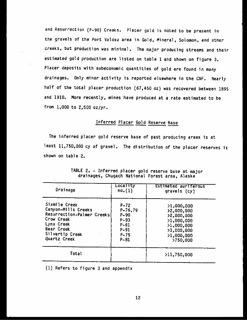
Inferred Placer Gold Reserve Base
The inferred placer gold reserve base of past producing areas is at
least 11,750,000 cy of gravel. The distribution of the placer reserves is
shown on table 2.
TABLE 2. - Inferred placer gold reserve base at majordrainages, Chugach National Forest area, Alaska
D Locality i Estimated auriferousDrainage | no.(1) gravels (cy)
_ I ~ ~~~ ISixmile Creek P-72 >1,000,000Canyon-Mills Creeks P-76,79 >2,000,000Resurrection-Palmer Creeks P-90 >2,000,000Crow Creek P-93 >1,000,000Lynx Creek P-61 >1,000,000Bear Creek P-91 >3,000,000Silvertip Creek P-75 >1,000,000Quartz Creek P-81 >750,000
Total l >11,750,000
(1) Refers to figure 3 and appendix
12

LODE GOLD DEPOSITS
Lode gold was explored for and mined on a small scale in the Kenai
Peninsula, Girdwood, Port Wells, Port Valdez, Jack Bay, Culross Island,
Bligh Island, and McKinley Lake areas. The major lode gold mines in the
area and their production are shown on table 3.
On the Kenai Peninsula, the possibility of gold-bearing veins was noted
in the Summit Creek area in 1896. Lode claims were located on Bear, Palmer,
and Sawmill Creeks in 1898. Those in the Falls Creek area were located in
1905 and in Slate and Summit Creeks in 1906. The first notable but spora-
dic production in the Falls Creek area occurred in 1911. Over the years
gold production has come periodically from the same properties. The
longest continuous lode gold production on the Kenai Peninsula came from
the Hirshey-Lucky Strike (S-289) veins on Palmer Creek. Other producers
include the Primrose (S-214), Skeen-Lechner (S-225), East Point (S-226),
Crown Point (S-227), Grant Lake (S-231), Gilpatrick Dike (S-253), Heaston-
Oracle (S-255), and Ronan & James (S-256) Mines.
In the Girdwood area, lode gold mining occurred near Crow Pass at the
headwaters of Crow Creek where several veins were mined. Remains of a
small flotation mill are present at the Monarch (A-39) and Jewel (A-38)
Mine sites near Crow Pass.
In the Port Wells area, with the exception of the Granite Mine (S-147),
lode gold prospects consist of small, widely scattered, mineralized
quartz and quartz-carbonate veins. The date of lode gold discovery in
the Port Wells area is not known. Little interest was shown in lode
gold mining in Prince William Sound until 1910 when the veins at the
Cliff Mine (V-48), discovered in 1906 at Port Valdez, proved to be excelle-t
producers. By 1911 the Golden Eagle (S-129) property was being developed.
13

TABLE 3. - Production from lode gold mining operations, ChugachNational Forest area, Alaska.
1 Locality Reported/recorded*-goldMine | no.(1) | production (oz)
Cliff V-48 51,740*Granite S 5-147 24,940*Hirshey-Lucky Strike S-289 5,545*Ramsay-Rutherford V-5 5,375*Monarch/Jewel A-39, A-38 4,932*Primrose S-214 4,000 (659*)Gilpatrick Dike S-253 3,405*Crown Point S-227 3,125*Mineral King S-156 2,783*Gold King V-63 1,997*Skeen-Lechner S-225 1,796*East Point S-226 1,725*Heaston-Oracle S-255 1,274*Big Four V-28 846*Grant Lake S-231 792*Cameron-Johnson V-62 585*Ronan & James S-256 557*Portage Bay S-168 490*Hirshey & Carlson S-292 408*Little Giant V-21 367*Hercules V-27 269*Tomboy Ledge S-162 219*Downing S-294 150*Nearhouse S-299 102Alaska Homestake A-31 83*Lansing S-163 81Rough & Tough V-64 76*Falls Creek S-224 65Seward Bonanza S-221 65Culross Mine S-102 62
..__ _ _ _ _ _ _ _ _ _ _ _ _ _ _ _ _ _ _ _ _ _ _ _ __ _ _ _ _ _ _I _ _ _ _ _ _ _ _ _ _ _ _ _ _ _ _ _ _ __ _ _ _ _ _ _ _ _ _ _ _ _ _ _ _ _ _ _ _ _ _ _ _ _ _
* Production records(1) Refers to figure 3
available.and appendix.
Major properties in the Prince William Sound area include the Granite
(S-147)s Mineral King (S-156), and Portage Bay (S-168) Mines. Ore at
the early operations was treated at stamp and gravity mills whose remains
exist near some of the mine sites.
14
In the Port Valdez area, gold deposits occur to the north of and mostly
outside the study area. The trend of the deposits extends into the CNF
west to and across Columbia Glacier and east of the Cliff Mine- (V-48)
along the Lowe and Tasnuna Rivers. By 1911, 48 mines and prospects were
located from Valdez Glacier to Columbia Glacier, a distance of about 26
miles (5).
In the Jack Bay area, located south of and adjacent to the Port Valdez
area, small pits, trenches, and adits on gold-bearing quartz veins
are reported (6). These workings are of limited extent and current
assays did not reveal significant gold content. Records of gold produc-
tion from this area have not been located.
On Culross Island, two zones of lode gold are present south of Culross
Bay. Both deposits, the Culross Mine (S-102) and the John Sells Prospect
(S-103), contain gold in quartz-filled fissures. Claims were first staked
in 1907. By 1950, at least 895 ft of underground workings existed at the
Culross Mine.
On Bligh Island, gold in quartz was noted in two areas (7). One site
is near the entrance of Cloudman Bay (C-93) and the other at the north-
east corner of Bligh Island (C-94).
In the McKinley Lake area, east of Cordova, most of the surface trench-
ing and underground work had been completed by 1912 (8). The records
show gold production as 16 oz. Although gold-bearing quartz veins and
stockw6rks are present, the gold distribution is erratic, sparse, and
discontinuous.
15

Geology of Lode Gold Deposits
In the Kenai Peninsula area, native gold occurs in epigenetic quartz
veins in metasediments and in quartz veins spatially related to felsic
dikes and sills. In the Girdwood, Port Valdez, Jack Bay, Culross Island,
Bligh Island, and McKinley Lake areas, gold occurs in epigenetic quartz
veins in metasedimentary rocks spatially associated with small granitic
stocks. Gold-bearing veins generally are small and seldom exceed several
hundred feet of strike length. Quartz veins at the Cliff Mine, the
largest lode gold mine in the Prince William Sound area, were mined for
about 800 ft vertically and about 2,000 ft horizontally. High grades,
up to several ounces or tens of ounces of gold per ton, have been a
motivating factor in prospecting for, developing, and mining vein
deposits in the study area.
The description of Port Valdez quartz-gold veins by Brooks (5) in 1911
in general applies to the other parts of the study area. The lode
gold deposits are fissure veins. A variation from this type is seen in
the mineralized zones along fractures that have, no well-defined walls.
In some parts of Port Valdez, the fracturing is pronounced and individual
fissures can be traced for long distances. Some have been traced for more
than a quarter of a mile, and there is good reason to believe that one or
two have been identified at intervals from a mile to a mile and a half.
The fissures are mostly marked by a zone of brecciation and slickensides.
In many of the veins, fragments of country rock form the majority of the
material included between the walls. In some fissures, the vein matter is
almost entirely absent for considerable distances and then reappears
16
farther along. Most of the veins that have been staked are narrow, and
although some larger veins have been found, few exceed 2 to 3 ft in thickness.
Mineralogically, the ore is simple. In most veins, pyrite, arsenopyrite,
gold, argentiferous galena, and sphalerite are the only metalliferous
minerals recognized. The gangue mineral is almost entirely quartz, but
some calcite and brown-weathering carbonate is present in many veins.
Lode Gold Production
Lode gold was produced from the Kenai Peninsula, Girdwood, Port Wells,
Port Valdez, and McKinley Lake areas. The most recent, more or less
continuous, lode gold production in the CNF was in the 1930's and.1940's
when records show that gold was sold to the U.S. Mint at Seattle. There
appears to have been little or no lode gold mining activity since 1956.
In the Kenai Peninsula area, from 1911 to 1930, lode production fluctuated
from a few hundred ounces to 1,500 oz/yr (9). During this period about
15,000 oz, or an average of 750 oz gold/yr, were produced from properties
located near the headwaters of Palmer Creek (Hirshey-Lucky Strike, S-289),
near Summit Lake (Gilpatrick, S-253; Heaston-Oracle, S-255), and the Moose
Pass area (Crown Point, S-227; Primrose, S-214; and Skeen-Lechner, S-225).
From the East Point Mine (S-226), 1,725 ounces were produced mostly during
the 1950's. Lode production in the Girdwood area occurred mostly between
1937 and 1942 from the Jewel (A-38) and Monarch (A-39) properties. Of the
total estimated 30,000 oz of lode gold production from these two areas,
25,000 oz came from the Kenai Peninsula area and 5,000 oz from the Girdwoo!
area (table 4).
Several properties produced gold from the Port Wells area of Prince
William Sound. The Granite Mine (S-147) produced at least 24,940 oz
17

gold and was the largest gold producer in the CNF. The Mineral King
Mine (S-156) reportedly recovered 2,116.6 oz gold from 3,500 tons of ore
between 1928 and 1932 and had a total recorded production of 2,783 oz
gold. The Portage Bay Mine (S-168) has- a recorded production of at least
490 oz gold. The Lansing Mine (S-163) recorded 81 oz of gold (10). The
Culross Mine (S-102) produced an estimated 62 oz of gold.
The reported production from the Port Valdez area is about 61,646 oz
gold. The Cliff Mine (V-48), located outside the CNF, produced at least
51,740 oz of gold. Other mines with sustained gold production in the
Port Valdez area include the Ramsey-Rutherford (V-5: 5,375 oz), Gold
King (V-63: 1,997 oz), Big Four (V-28: 846 oz), and Cameron-Johnson
(V-62: 585 oz).
McKinley Lake properties (C-6 to C-9) near Cordova have a recorded
production of 16 oz of gold. No notable production has come from the
other districts.
TABLE 4. - Primary gold production Chugach National Forestand adjacent areas, Alaska.
District/area Lode Placer(oz) (oz)
Girdwood 5,000 42,500Kenai Peninsula 25,000 90,500Port Wells 40,000 negligiblePort Valdez 61,646 negligibleJack Bay negligible negligibleBligh Island negligible negligibleMcKinley Lake 16 negligibleCulross Island 62 negligible
I~~~~~~~~~~~~~~TOTAL 131,724 133,000
_ _ _ _ _ _ _ _ _ _ _l l _ _ _ I _ _ _ _ _ _
18
I

Inferred Lode Gold Reserve Base
The inferred reserve base of past lode gold producers is 108,440 tons
of vein material (table 5).
TABLE 5. - Inferred lode gold reserve base at larger (>200 ton)mines and prospects, Chugach National Forest area, Alaska.
Mine/Prospect
Golden EagleCrown PointPortage BaySkeen-LechnerCulross MineSeward BonanzaNearhouseEast PointSummit VeinMonarch, JewelDonohueHirshey-Lucky StrikeGilpatrick DikeGraniteCameron-JohnsonPrimroseBrewer-AlaskaNuggetMayfieldLansingMineral KingMountainSweepstakeHirshey & CarlsonHerculesShellMinnieBahrenbergTomboy LedgeGrant LakeMcMillanIvanhoe
Total
Localityno. (1)
S-129S-227S-168S-225S-102S-221S-299S-226S-254A-39, A-38V-8S-289S-253S-147V-62S-214S-205S-136V-67S-163S-156S-133S-140S-292V-27S-266V-59A-41S-162S-231S-249V-60
IReserve base(tons)
21,00015,00010,00010,0008,6007,4007,0003,7003,4003,1002,5002,0002,0001,9001,8001,3001,100
900600500500500500500450420400340300270250210
108,440
(1) Refers to figure 3 and appendix.
19
l
BASE METAL DEPOSITS
Copper prospects have been developed in the CNF since 1897, principally
in the Latouche Island, Knight Island, Glacier Island, Copper Mountain,
Landlocked Bay, Port Fidalgo, and Cordova areas. Copper deposits with
past production are shown on table 6. Substantial amounts of copper
were produced from the Beatson (S-17), Ellamar (C-91), Schlosser (C-66),
and Midas (V-35) Mines and smaller amounts from 18 other mines or prospects.
Systematic copper mining and ore shipments started from the Beatson Mine
(S-17) in 1903 and from the Ellamar Mine (C-91) in 1906. Base metal
mining ceased in 1930 with the closure of the Beatson Mine, the largest
producer in the area. Zinc, silver, and gold are present in variable
amounts in the sulfide copper ores.
From 1929 up to about 1964, base metal investigations have been site-
specific with the aim of proving ore reserves in areas of better minera-
lization. In the 1930's, Solar Exploration explored underground at Rua
Cove and Latouche Island. In the 1950's, Northern Pyrites Company explored
the pyrite deposits of the Duke (S-3) and Duchess (S-4) Prospects on Latouche
Island as potential sources of sulfur; the Alaska Copper Company re-evaluated
copper occurrences at the Schlosser (C-66) Mine at Port Fidalgo. In the
early 1960's, limited regional reconnaissance stream sediment sampling
along highways on the Kenai Peninsula and other readily accessible nearby
streams yielded no significant anomalies (11).
In the late 1960's, the Phelps Dodge Corporation conducted an intensive
mineral survey on Latouche Island using electrical geophysical exploration
techniques. Induced-potential and electromagnetic geophysical systems
identified and traced several chargeability and conductor anomalies.
20

TABLE 6. - Copper deposits with-production records from Chugach NationalForest area, Alaska.
I Locality Ore produced lMines No. (1) or sold | Cu metal Cu
l__ _ (Tons) (lbs) (pct)
Beatson Copper Co. S-17 5,992,941 182,600,000 1.65Ellamar Mining Co. C-91 301,835 15,761,337* 2.46Schlosser Mine C-66 21,434 4,160,820* 8.70Midas Mine V-35 49,350 3,385,680* 3.32Threeman Mine C-73 6,196.5 1,159,660* 8.63Blackbird Properties S-19
Latouche Mining Co. 29,209* 52,000* 0.088Blackbird Mine 5,150* 547,118* 5.31Girdwood, Barrack 600* 72,510* 6.04
Fidalgo Copper Co. C-63 2,747 360,376 6.55Reynolds-Alaska (Boulder Bay) C-87 2,850 215,000 3.77Standard Copper Mines Co. C-77 1,100 32,000 1.45Dickey Copper Co. (Irish Cove) C-65 293* 29,346* 5.01Duchess Claim Reynolds- S-2, 4 1,850 215,000 5.8
AlaskaSouth Landlocked Bay Mining Co. C-70 928 74,240 4.0Harry Moore Mine S-47 20 1,452 3.63Alaska-Pioneer-Sourdough C-72 6 720 6.0Knights Island Copper Mining Co. S-52 1 240 12.0Hogan Bay Properties S-26
Patten Cooperating Co. 0.3 57 9.5Happy Jack Mining and Devel. +Copper Queen Mine +
Alaska Commercial Co. C-75 70Pandora Claim S-65 +Latouche Island Copper Mining S-7 +
Co. Ltd. lKnight Island Consolidated S-61 +Copper Co.
Copper Coin (Russell Ball S-50 +Copper Co.)
Chisna Consolidated C-69 +Duke Claim S-3 +
Total j 6,416,580.8 208,667,556l l__ _ _ l l__ _ _ _ _
* Estimated+ Indicated(1) Refers to
in publications as having shipped some orefigure 3 and appendix
One continuous conductor zone extended south from the Beatson Mine through
and past the Duke and Duchess Prospects, at which point the conductor
21

terminated abruptly. Two other conductor zones, conceivably southern
continuations of the "Beatson Trend" or environment, were identified
along the southwestern side of Latouche Island. Only moderate-base
metal values (a few hundred ppm) were reported in drill cores that
explored these two trends.
In the early 1970's, property owners and companies again explored the
base metal potential of the Duke and Duchess Prospects on Latouche Island.
A mineral reserve estimate, based on surface, subsurface, and diamond drill
data, indicated the presence of at least 1.5 million tons at a grade of
0.9 pct copper, 1.8 pct zinc, 0.9 oz silver/ton, and 0.04 oz gold/ton.
In about 1974, Noranda Exploration Company carried out a base metal
exploration program in a portion of Prince William Sound. As a result of
this work, a large block of claims was staked on the southern half of
Latouche Island. Three shallow core holes, drilled near the southeastern
portion of the island in 1974 and 1975, did not intercept economically
significant zones of base metal sulfide mineralization.
In the middle 1970's, Texasgulf Inc. drilled on the Copper Bullion claims
(S-67) near Rua Cove on Knight Island. These drill sites appear to have
been located on geophysical anomalies that suggested the presence of
massive sulfides. Core left on the site shows that extensive sections of
1ow-grade fracture-controlled pyrrhotite in greenstone were encountered.
X An area of zinc-lead prospects and occurrences has been newly identified
in the Miners River and Wells Bay areas. Investigations based on anomalous
1979 Bureau geochemical results led to the location of small and widely
scattered mineralized fracture zones containing sphalerite, galena, and
pyrite. Both volcanic and sedimentary host rocks occur in the area.
22

The greenstones in the Wells Bay area apparently contain more sphalertte
and pyrrhotite with minor galena, while the occurrences in sedimentary
rocks, which physically (and stratigraphically?) overlie the volcanics,
contain more galena with sphalerite and pyrite.
Geology of Base Metal Deposits
Base metal deposits are mainly epigenetic and occur in fissures and
shears in mafic volcanic and sedimentary rocks. The majority of these
copper deposits are hosted in greenstones, but the two major copper
producers in the CNF, the Beatson (S-17) and Ellamar (C-91) Mines, are
hosted in fine-grained metasedimentary rocks near edges of greenstone
masses. For these two deposits, a volcanic source of metals has been
postulated recently although early workers thought them to be hydrothermal
replacement deposits. A smaller number of epigenetic copper deposits in
fissures in arkose are located on Latouche Island.
The greenstone accumulations in the study area, described as ophiolite
complexes (19), have associated copper mineralization found mainly in
broad discontinuously mineralized, steeply-dipping, northerly-trending
shear zones such as those at Knight Island, Glacier Island, Copper Mountain,
Hinchinbrook Island, and Cordova. Most of the copper prospects and occur-
rences are located at Knight Island and at Copper Mountain, areas where
the greenstones are thick and well exposed. Iron and copper sulfide
minerals, principally pyrrhotite, chalcopyrite, and pyrite, are
present as disseminations, stringers, and massive sulfide lenses,
apparently randomly distributed in and along the shears. Copper was of
primary economic interest although zinc and occasionally lead are
present in variable, apparently uneconomic, amounts.
23

The Ragged Mountain and Hinchinbrook Island greenstones appear to be
barren of copper sulfide mineralization. Although the presence of native
copper on Hinchinbrook Island is reported, copper prospects have not been
located. A 1980 and 1981 Bureau follow-up investigation of slightly
anomalous 1979 copper geochemical values in these two areas located no
base metal sulfide deposits.
Sulfide deposits in sedimentary rocks have provided the largest
individual accumulations of copper mineralization. Gold and silver were
economically significant by-products in the ore. The largest of
these deposits are located in four areas: 1) on Latouche Island, the
Beatson (S-17), Blackbird (S-19), Duke (S-3), Duchess (5-4), and other
mines and prospects; 2) at Virgin Bay, the Ellamar (C-91) Mine and
associated deposits; 3) at Port Fidalgo, the Schlosser Mine (C-66),
Dickey (C-65) Prospect; and 4) at Lynx Creek on Kenai Peninsula, the
Ready Bullion (S-272) Prospect.
Base Metal Production
Copper was produced continuously from three localities (Latouche Island,
Ellamar, and Port Fidalgo) and sporadically from other prospects. All
but the Beatson and nearby mines on Latouche Island produced direct-
shipping ore. About 208,667,556 lbs of copper was recovered from
6,416,580.8 tons of ore. Production from 22 mines and prospects is itemized
on table 6. Zinc and minor amounts of lead are reported with copper
ore, but production of these was not recorded. Silver and gold by-products
were recovered at the smelter.
24

TABLE 7. - Inferred copper reserve base at major copper deposits,Chugach National Forest area, Alaska
Name | Locality Reserve base - Cuno.(1) -- (tons) pcpt)
|___ Volcanic-hosted
Threeman I C-73 | 1,900,000 | 1.0Rua Cove | S-67 1,320,000 1.ZPandora S-65 85,000 1.3Fidalgo Mining Co. C-63 45,000 0.3Cordova Copper Co. C-34 18,000 0.6Hemple C-74 6,300 1.3Copper Coin S-50 5,900 2.4Galena Bay C-83 5,800 7.9Standard Copper C-77 4,300 2.8Ibeck C-17 3,800 2.8Reynolds-Alaska, C-79 3,000 4.6
Landlocked BaySeattle-Alaska BS-2 2,900 3.0Jonesy S-59 1,300 3.3Chisna C-69 1,200 0.3
I ______IS 3_402,5__
Subtotal 3,402,500
Sediment-host
BeatsonDuchessEllamarDukeSchlosserMidasFour-in-OneScott Glacier
S-17S-4C- 91S-3C-66V-35A-8C-16
Subtota ITotal
Probably large2,700,000
536,000269,000224,00062,00033,50019,000
>3,843,5007,246,000
(no data1.20.61.33.21.60.21.1
to estimate)
(1) Refers to figure 3 and appendix.
Inferred Base Metal Reserve Base
The minimum inferred reserve base estimate of 22 copper deposits is
7,246,000 tons. Of this total, volcanic-hosted deposits account for
25
!d

3,402,500 tons and sediment-hosted deposits account for 3,843,500 tons.
An additional unknown but probably large reserve base may be present
at the Beatson Mine. Table 7 shows copper deposits that contain in excess
of 1,000 tons of inferred reserve base.
COAL DEPOSITS
Extensive coal occurrences which are confined to the Bering River
area, in the eastern part of the CNF, have been known since at least
1896 (13). The principal coal deposits lie in a belt extending north-
eastward of Bering Lake. The eastern half of the coal field reportedly
contains mainly anthracite and the western half contains mainly subbitum-
inous coal. The B.t.u. content of the coal as received from the field
ranges from 12,000 to 15,000 (14). Testing of Carbon Creek coal in a
beehive oven did not make satisfactory coke.
Coal-bearing rocks underlie an area estimated to be about 70 sq. mi.
Coal exposures consist mainly of isolated outcrops and prospect openings
along the main stream courses. The intervening areas are covered with
soil, moss, and other vegetation. Few coal beds have been traced for
more than short distances and little is known of the maximum extent of
the individual coal beds. Martin (14) mentioned that an anthracite seam
on the east side of Carbon Mountain was traced for 2 miles.
A review of reports indicates that rapid changes in thickness are
common features of coal beds in the Bering River field. Not all the
descriptions indicate the cause of the thickness change, but structural
deformation, in the form of squeezing and faulting, and stratigraphic
thinning are represented.
26

Twenty-two coal beds over 3-ft-thick occur in a 2,700 ft section of
the Kushtaka-Kultieth Formations (13). A coal resource estimate of this
area, suggests a reserve base of 400 million short tons of coa]. The
outcrop length of the Kushtaka-Kultieth Formation in the area of Carbon
and Monument Mountains suggests a minimum coal resource in the order of
1.2 billion short tons of coal. A coal resource of up to 3.6 billion
tons has been inferred by others (15).
PETROLEUM DEPOSITS
Oil exploration in the Gulf of Alaska had its beginning in 1900 near
Katalla in the southeastern part of the study area (16). Oil was first
produced commercially from a 40 acre tract near Strawberry Point. Oil
seeps are common throughout the Katalla-Controller Bay area. Of 44
wells drilled between 1900 and 1930, almost all had some oil shows and
18 wells produced oil commercially at one time or another. The production
of 44 degree Baume gravity paraffin-base petroleum was refined locally.
In the first decade of the 1900's, production from the field was great
enough that a small refinery was built to process the crude oil. From
1911 until 1933, the refinery operated under different owners (usually
the major holder of wells in the Katalla Field). The refined products
were marketed locally to the fishing fleet although the demand was much
greater than the supply. Production per well varied from 15 to 240
barrels per month. The better wells pumped every day, but in the smaller
ones, oil was allowed to accumulate and pumped once a week. The refinery
burned down in 1933 and was not rebuilt. Total production from the
field amounted to 153,922 barrels.
27

Occasional attempts at further development occurred in the 1960's and
at present (1982) there is renewed interest in the area. Historic levels
of production were low and should be achievable again. -
Oil occurs in the Tertiary Poul Creek Formation which consists of
complexly faulted and fractured carbonaceous shaly horizons. Twenty-three
shale and mudstone samples from all the Tertiary formations were analyzed
by techniques designed to evaluate the type and amount of organic material
contained in the sedimentary rocks and determine their source-rock potential
(1). The data suggest that the formations are thermally immature or are
approaching the threshold of maturity. Where the formations, especially
the Poul Creek, are more deeply buried, with longer burial history,
they may become thermally mature and capable of generating hydrocarbons.
SAND AND GRAVEL AND BUILDING STONE DEPOSITS
Sand and gravel deposits occur along highway and railroad corridors
in association with nearly all of the historic and potential placer gold
producing drainages. Large volumes of gravel are associated with the
Placer, Trail, Snow, Kenai, and Resurrection Rivers. Most deposits
occur as flood plain and/or bench gravels but alluvial fans are associated
with Bertha, Spokane, and Silvertip Creeks, among others, and have been
exploited as local gravel sources during construction and maintenance of
the highway system.
Thirty-two sand and gravel permits existed for extraction from the CNF
at the end of 1982 (17). Of these, 18 were free-use permits to the State
of Alaska with no accounting records kept on the volume removed. The
volume removed varies from year to year with the construction and surfacing
28

activities. Land and gravel used for private purposes averages between
5,000 and 7,000 yd3/yr.
Sand and gravel are currently being extracted from pits along the Seward
Highway from Snow River to Peterson Creek and from a pit near Hope.
During 1982, small amounts have been used from the pits near Cordova by
State of Alaska maintenance crews. The U.S. Forest Service (USFS) issued
a permit in 1978 for 720,000 cy of gravel near Spencer Glacier but no
material has yet been extracted from the area.
Metasandstone has been quarried at several sites for use as riprap,
fireplace facing stone, foundation stone, and rock panels (S-278, 309,
317, 322). Several igneous dikes (S-305, 306, 308) have recently been
located as sources of building stone. Slate has been quarried near Kenai
Lake (S-322) for use in the construction of rock panels and haydite has
been located near Moose Pass (S-232). A limestone deposit suitable for
use as a source of agricultural lime and possibly as building stone is
currently being developed near the Russian River (S-237). A similar but
smaller deposit occurs near Seward (S-202). Small quantities of stone are
purchased from the USFS each year for use as riprap, facing stone for
fireplaces, and foundation materials. The only building stone permits
currently active in the CNF are near Hope where 15 to 30 tons of rock are
extracted each year and used primarily as fireplace facing stone.
OTHER DEPOSITS
Metallic and other minerals, in addition to gold and copper, may be
produced in the future. Previous and recent work have disclosed scattered
occurrences of molybdenum (18), nickel, cobalt, manganese (19), antimony,
29
arsenic, lead, zinc, fluorine, iron, and others. These elements were not
of economic interest during the height of past mining activity. None of
the known occurrences appear to have sufficient grade and tonnage of
material to be of economic interest at this time. Data on these are
insufficient to estimate reserves.
DISTRIBUTION OF MINERALIZED AREAS
Historically, gold deposits were believed to occur mainly in metasedi-
mentary rocks of the Cretaceous Valdez Group and copper deposits to occur
in and near mafic volcanic rocks of the Tertiary Orca Group. Recent work
shows that this distinction may not hold as strongly as once believed.
These rock groups form two broad arcuate trends across the study area.
Within these broad trends are zones in which mineral deposits are concen-
trated (figure 4).
Figure 4 shows zones rated as being highly, moderately, or weakly mineral-
ized. Highly mineralized zones contain one or more deposits each with
high mineral development potential or several with moderate mineral develoz-
ment potential. Moderately mineralized zones contain one or more deposits
each with moderate mineral development potential or several with low or
unknown development potential. Weakly mineralized zones contain a few
known mineral occurrences.
The surface area of all the highly mineralized zones is about 253 sq.
mi. and that of the moderately mineralized zones is about 475 sq. mi.
These represents nearly 8 pct of the area of the CNF.
The part of the study area underlain by Valdez Group rocks contains
eight zones in which the frequency of gold deposits per unit area is high
and five with moderate frequency is moderate. The highly mineralized
30
zones are at Crow Pass, Port Wells, Palmer Creek, Summit Lake, Moose Pass,
Primrose, Coghill Lake, and Lost Creek. The five moderately mineralized
zones of gold are at Gulch Creek, Passage Canal, Avery River, the area
south of Kenai Lake, and the headwaters of Resurrection Creek. In addition
to these zones of gold deposits, two weakly mineralized zones of antimony,
one at Barry Arm of Port Wells and one near Kenai Lake; two weakly mineralized
zones of copper mineralization, one at Lynx Creek and one extending east
from Port Valdez to Copper River; one weakly mineralized zone of copper-
silver-arsenic at Surprise Cove; and two weakly mineralized zones of molyb-
denum, one at Billings Glacier near Whittier and another at Crow Pass were
identified.
The part of the study area underlain by rocks of the Tertiary Orca
Group contains copper deposits which are most common in and near areas
of greenstone accumulations. No highly mineralized zones were identified
but five areally extensive moderately mineralized copper zones were identified
in the general areas of Latouche Island, Knight Island, and Ellamar/Copper
Mountain. Those on Latouche Island and at Ellamar are hosted primarily
by sedimentary rocks. Weakly mineralized zones of copper, often of wide
aereal extent, occur peripherally to the moderately mineralized zones. A
trend of Tertiary Orca Group greenstones that extends from Hinchinbrook
Island through Cordova to Scott Glacier is also rated as weakly mineralize:
by the frequency of copper occurrences.
In addition to the base metal zones in the area underlain by rocks of the
Orca Group, a weakly mineralized zone, surrounding a moderately mineralize.
zone of zinc, lead, nickel, fluorite, silver, and copper exists near the
headwaters of Miners and Wells Bays. A moderately mineralized zone of
31

manganese occurrences exists on the northeast side of Chenega Island and
of arsenic occurrences at Main Bay. Other small isolated weakly mineralized
zones include copper at Hogg Bay, gold at Whale Bay and McKinley Lake,
copper at the south end of Culross Island as well as Glacier Island, tungsten
on Perry Island, and nickel at Miners Bay.
A moderately mineralized zone of coal deposits is present in the eastern
end of the study area north of Bering Lake. Oil occurrences exist east of
the Katalla Oil Field.
SUMMARY
Gold, copper, sand and gravel, and oil were the major materials that have
been produced commercially from the CNF. Minor amounts of antimony, building
stone, and coal have also been extracted. An estimated 8 pct of the CNF
is covered by zones of high and moderate mineralization.
The greatest frequency of gold deposits per unit afea is primarily
related to Cretaceous Valdez Group metasedimentary rocks. Areas of
greatest frequency of copper deposits are related to mafic volcanic
rocks of the Tertiary Orca Group.
Placer gold is common in areas underlain by Valdez Group metasedimen-
tary rocks. Where stream deposits were sampled systematically, such as
in the Kenai Peninsula, Girdwood, and Port Wells areas, native gold was
recovered from most gravels. To the east of, and possibly on trend with
the above named localities, placer gold was found in the Lowe and Tasnuna
River drainages, both underlain by Valdez Group rocks.
Lode gold deposits also exist in areas underlain by Valdez Group rocks.
Samples from most of the past producers still yield gold values.
32

The areas most likely to contain base metals and associated deposits
include those underlain by Orca Group rocks. Two base metal mineral
associations appear to be present. These are silver-, gold-, and zinc-
bearing copper ores in metasedimentary rocks and the massive and
disseminated copper-bearing ores in greenstones. Highly mineralized
base metal zones include portions of Latouche and Knight Islands, Ellamar,
Copper Mountain, and areas south of Port Fidalgo. An area of small
lead-zinc veins in metasedimentary rocks was identified between Port
Valdez and Unakwik Inlet.
Coal deposits in the Bering River area appear to be extensive and
large resources of coal resources have been inferred. Exploration is
under way to determine if reserves are present.
Small-scale oil production in the Katalla area occurred from 1903 to
1930. Exploration interest exists today to develop reserves for future
production. The potential production rates can not be estimated with
existing data.
Sand and gravel and building stone are abundant and available for site-
specific uses.
33

REFERENCES
1. Nelson, Steven W., David F. Barnes, J. A. Dumoulin, R. J. Goldfarb,
R. A. Koski, Marti L. Miller, C. G. Mull, W. J. Pickthorn, Uldis Jansons,
Robert B. Hoekzema, Joseph M. Kurtak, and Steven A. Fechner. Mineral
Resource Potential Map of the Chugach National Forest, South-Central
Alaska. U. S. Geological Survey MF-1645A, 1984, (in preparation).
2. Hoekzema, Robert B. Placer Sampling and Related Bureau of Mines
Activities on the Kenai Peninsula, Alaska. U.S. BuMines OFR 138-81,
1981, 28 pp.
3. U.S. Bureau of Mines. Alaska 1:250,000 Scale Quadrangle Map
Overlays Showing Mineral Deposit Locations, Principal Minerals, and
Number and Type of Claims. U.S. BuMines OFR 63-63, 1973, (updated yearly)
153 overlays.
4. Fechner, Steven A., and Mark P. Meyer. Placer Sampling and Related
Bureau of Mines Activities in the SOUND Study Area of the Chugach National
Forest, Alaska. U.S. BuMines OFR 62-82, 1982, 25 pp.
5. Brooks, A. H. Gold Deposits Near Valdez. U.S. Geol. Survey Bull.
520, 1912, pp. 108-130.
6. Johnson, B. L. Mineral Resources of the Jack Bay District and
Vicinity, Prince William Sound. U.S. Geol. Survey Bull. 692, 1919, pp.
153-173.
7. Capps, S. R., and B. L. Johnson. The Ellamar District. U.S. Geol.
Survey Bull. 605, 1915, 125 pp.
8. Richelsen, W. A. Report on the Pioneer, Lucky Strike, and Rilley
Prospects at McKinley Lake, Lower Copper River Region, Alaska, 1934, 9 pp.
Report was made available to the Bureau of Mines by Bear Creek Mining
Company, Anchorage, Alaska.
34

9. Tuck, Ralph. The Moose Pass-Hope District, Kenai Peninsula,
Alaska. U.S. Geol. Survey Bull. 849-I, 1933, pp. 469-530.
10. U.S. Bureau of Mines. Unpublished Permanent Individual Mine Record
and Production. Available at Bureau of Mines, Juneau, Alaska.
11. Jasper, M. W. Geochemical Investigations Willow Creek Southerly
to Kenai Lake Region Southcentral Alaska. Division of Mines and Minerals -
Geochemical Report No. 14, Dept. of Natural Resources, State
of Alaska, June, 1967, 47 pp.
12. Tysdal, R. G., J. E. Case, G. R. Winkler, and S. H. G. Clark.
Sheeted Dikes, Gabbro, and Pillow Basalts in Flysch of Coastal Southern
Alaska. Geology v. 5, 1977, pp. 377-383.
13. Barnes, F. F. A Review of the Geology and Coal Resources of the
Bering River Coal Field, Alaska. U.S. Geol. Survey Cir. 146, 1951, 11 pp.
14. Martin, G. C. Geology and Mineral Resources of the Controller
Bay Region, Alaska. U.S. Geol. Survey Bull. 335, 1908, 141 pp.
15. Gates, G. Analysis of Alaskan Coals. U.S. BuMines, TP 682, 1946,
pp. 1-24, 1 map.
16. Blasko, Donald P. Oil and Gas Seeps in Alaska North-Central Gulf
of Alaska. U.S. BuMines RI 8136, 1976, 123 pp.
17. Sherrod, John. Unpublished note on resources of Chugach National
Forest 1982; data available on request from U.S. Forest Service,
Anchorage, AK.
18. Hoekzema, Robert B., and Gary E. Sherman. Billings Glacier Molyb-
denum-Copper Occurrence, Whittier, Alaska. U.S. BuMines OFR 141-81,
1981, 30 pp.
19. Kurtak, Joseph M. A Manganese Occurrence on Chenega Island,
Prince William Sound, Alaska. U.S. BuMines MLA 124-82, 1982, 9 pp.
35
APPENDIX
MINES, PROSPECTS, AND MINERAL OCCURRENCES IN THECHUGACH NATIONAL FOREST, ALASKA
36

APPENDIX - Mines, prospects, and mineral occurrences in theChugach National Forest area, southcentral Alaska.
Sampling and evaluations of resource development potential of minerallocalities, if not referenced otherwise, were done by the Bureau ofMines.
Explanation of listings:
1. Localities are shown on figure 3. Letter designations for lodemines are the initial letters of the 1:250,000 scale quadrangle onwhich the locality occurs: Seward, Cordova, Valdez, Anchorage, BlyingSound, Bering Glacier. Placer locaTities are prefixied with a S",'Fegardless of quadrangle.
2. a) Names of the locality show the generally most commonly used namefirst, followed by other names that have been used to refer to theproperty.
b) Double lines under the name designate past mines.c) Single underline designates a prospect with high development
potential.d) Asterisk by name indicates newly named and/or identified occurrence.
CRM - refers to Copper River Meridian.SM - refers to Seward Meridian.
37
REFERENCES
1. Bateman, A. M. Various unpublished private company reports,
1916-1927. Made available to the Bureau of Mines by Bear Creek Mining
Co., Anchorage, AK.
2. Blasko, Donald P. Oil and Gas Seeps in Alaska North-Central Gulf
of Alaska. U.S. BuMines RI 8136, 1976, 123 pp.
3. Brooks, A. H. Gold Deposits Near Valdez. U.S. Geol. Survey Bull.
520, 1912, pp. 108-130.
4. Burnette, J. C. Report of the Primrose Mine. Unpublished company
report, Kenai Metal Corporation, 1931, available upon request from U.S.
Bureau of Mines, Juneau.
5. Capps, S. R. The Turnagain-Knik Region, U.S. Geol. Survey Bull.
612, 1916, pp. 147-194.
6. Capps, S. R., and B. L. Johnson. Mineral Deposits of the Ellamar
District, U.S. Geol. Survey Bull. 542-D, 1913, pp. 86-124.
7. -----. The Ellamar District. U.S. Geol. Survey Bull. 605, 1915,
125 pp.
8. Chapin, T. The McKinley Lake District [Alaska]. U.S. Geol. Survey
Bull. 542-C, 1912, pp. 78-80.
9. Cobb, E. H. Metallic Mineral Resource Map of the Blying Sound
Quadrangle, Alaska. U.S. Geol. Survey Misc. Field Studies Map MF-440,
1972, Scale: 1:250,000.
10. Cooper, H. M., N. H. Snyder, R. F. Abernathy, E. C. Tarpley, and
R. J. Swingle. Analyses of Mines, Tipple, and Delivered Samples. U.S.
BuMines Tech. Paper 682, 1946, pp. 19-69.
R 11. Weed, W. H. American Edition of Mines Handbook, Succeeding the
Copper Handbook, vol. 16, 1925, 2350 pp.
38
12. Crosby, W. 0. Geological Report on the Copper Properties of the
Reynolds-Alaska Development Company in Prince William Sound, Alaska.
Consultant report to Reynolds-Alaska Development Company, 1906, 10 pp;
available upon request from U.S. Bureau of Mines, Anchorage, AK.
13. Fellows, R. Compilation of Copper produced in Prince William
Sound District, undated, 3 pp. Available upon request from U.S. Bureau of
Mines, Juneau, AK.
14. Fiedler, H. L. Unpublished letter to B. D. Stewart reporting
upon visit to Sweepstake Tunnel, Harriman Fiord, 1945, available upon
request from U.S. Bureau of Mines, Juneau, AK.
15. Garrett, C. R., Jr. Report of Mineral Examination - Hartney Bay.
U.S. Dept. of Agricultural, Forest Service, Alaskan Region, R10-26, 1971,
14 pp.
16. Grant, U.S. Gold on Prince William Sound. U.S. Geol. Survey
Bull. 379, 1909, p. 97.
17. . Mining and Prospecting on Prince William Sound in 1909.
U.S. Geol. Survey Bull. 442, 1909, pp. 164-165.
18. Grant, U. S., and D. F. Higgins, Jr. Copper Mining and Prospect-
ing on Prince William Sound. U.S. Geol. Survey Bull. 379, 1909, pp.
87-93, Plate IV.
19. Grant, U.S., and D. F. Higgins, Jr. Reconnaissance of the Geology
and Mineral Resources of Prince William Sound, Alaska. U.S. Geol. Survey
Bull. 443, 1910, 89 pp.
20. Herdlick, J. A. Letter to M. F. Buler, President, Radco Inc.,
concerning Bureau of Mines sampling at Horseshoe Bay, Latouche Island,
October 1953. Available upon request from U.S. Bureau of Mines, Juneau, A(.
39

21. Johnson, B. L. The Port Wells Gold District. In Mineral Resources
of Alaska, U.S. Geol. Survey Bull. 592-G, 1914, pp. 195-236.
22. -----. Mining on Prince William Sound. U.S. Survey Bull. 622,
1915, pp. 131-139.
23. -----. Mining on Prince William Sound. U.S. Geol. Survey Bull.
642-D, 1916, pp. 137-139.
24. -----. Copper Deposits of the Latouche and Knight Island
Districts, Prince William Sound. U.S. Geol. Survey Bull. 662, 1918,
pp. 184-220.
25. -----. Mining on Prince William Sound. U.S. Geol. Survey Bull.
692-C, 1919, pp. 143-151.
26. Martin, G. C. Geology and Mineral Resources of the Controller Bay
Region., Alaska. U.S. Geol. Survey Bull. 335, 1908, 141 pp.
27. Martin, G. C. The Alaskan Mining Industry in 1918. U.S. Geol.
Survey Bull. 712, 1920, pp. 11-52.
28. Martin, G. C., B. L. Johnson, and U. S. Grant. Geology and Mineral
Resources of Kenai Peninsula, Alaska. U.S. Geol. Survey Bull. 587, 1915,
243 pp.
29. Mihelich, M., and R. R. Wells. Copper Mines and Prospects
Adjacent to Landlocked Bay, Prince William Sound, Alaska. U.S. BuMines
RI 5320, 1957, 21 pp.
30. Mitchell, Peter A. Geology of the Hope-Sunrise (Gold) Mining
District, North-Central Kenai Peninsula, Alaska. Unpublished M.A. Thesis,
Stanford, University, Palo Alto, Calif., 1979, 123 pp.
31. Moffit, F. H. Notes on Copper Prospects of Prince William Sound,
Alaska. U.S. Geol. Survey Bull. 345, 1908, pp. 176-178.
40

32. Moffit, F. H., and R. E. Fellows. Copper Deposits of the Prince
William Sound District, Alaska. U.S. Geol. Survey Bull. 963-B, 1950,
pp. 47-80, Plate V.
33. Paige, Sidney, and A. Knopf, Reconnaissance of Matanuska and
Talkeetna Basins, with Notes on the Placers of the Adjacent Regions.
U.S. Geol. Survey Bull. 314, 1907, pp. 104-125.
34. Park, C. F., Jr. The Girdwood District, Alaska. U.S. Geol.
Survey Bull. 849-G, 1933, pp. 381-424.
35. Pilgrim, E. Prince William Sound and Valdez Districts. A. D.
Thompson's Lead-Zinc Property. Terr. of Alaska Dept. of Mines MR 193-2,
1930-1931, pp. 19-21.
36. Richelsen, W. A. Report on the Pioneer, Lucky Strike, and Rilley
Prospects at McKinley Lake, Lower Copper River Region, Alaska, 1934, 9 pp;
unpublished company report available upon request from U.S. Bureau of
Mines, Juneau.
37. -----. Summary of the Portage Gold Mine Ltd., Property Portage
Bay Region, Prince William Sound - Alaska, 1950; unpublished company report,
made available to the Bureau of Mines by Bear Creek Mining Co., Anchorage,
Alaska.
38. Richter, D. H. Geology and Mineral Deposits of Central Knight
Island, Prince William Sound, Alaska. Division of Mines and Geology
Report No. 16, 1965, 37 pp.
39. -Roehm, J. C. Summary Report of Investigations in the Chistochina/S:ana
River, Nabesna, Tiekel, Valdez, Prince William Sound, and Kodiak Mining
Districts and Itinerary of J. C. Roehm, Associate Engineer to Commissioner
of Mines. Terr. of Alaska, Dept. of Mines, IR-JCR, 1936, 18 pp.
41
40. Roehm, J. C. Preliminary Report of New Hope Mine (Swetmann Property)
Palmer Creek, Hope Mining District, Alaska. Unpublished Terr. of Alaska,
Dept. of Mines Report PE-95-7, 1937; available upon request from U.S. Bureau
of Mines, Juneau.
41. -----. Summary Report of Mining Investigations in the Port Wells
District, Prince William Sound, Alaska. Territorial Dept. of Mines, 1938;
available upon request from U.S. Bureau of Mines, Juneau.
42. Rose, A. W. Geology and Mineralization of the Midas Mine and
Sulfide Gulch areas near Valdez, Alaska. State of Alaska, Div. of Mines
and Minerals Geol. Report 15, 1965, 21 pp.
43. Schrader, F. C., and A. C. Spencer. Geology and Mineral Resources
of a Portion of the Copper River District, Alaska. U.S. Geol. Survey
Report, 1901, pp. 88-89.
44. Shepard, J. G. Unpublished report concerning the Shoo Fly Claims
Prospect, Hogg Bay, Bainbridge Island, Alaska, 1926, 2 pp., available
upon request from U.S. Bureau of Mines, Anchorage.
45. State of Alaska. MinFile, unpublished Alaska mining claim index
(Kardex). Division of Geological and Geophysical Surveys, Dept. of
Natural Resources, College, Alaska.
46. Stejer, F. A. Pyrite Deposits at Horseshoe Bay, Latouche Island,
Alaska. U.S. Geol. Survey Bull. 1024-E, 1956, pp. 107-122.
47. Stewart, B. D. Report on Cooperation Between the Territory of
Alaska-and the United States in Making Mining Investigations and in the
Inspection of Mines for the Biennium Ending March 31, 1931. Including
a Report on the Operation of the Prospector's Aid Act. Terr. of Alaska,
Dept. of Mines, 1931, 145 pp.
42
48. Townsenc, R. Ore Reserves Map of Duke and Duchess Propertites,
Horseshoe Bay, Latouche Island, Alaska, 1917, unpublished company report,
available upon request from U.S. Bureau of Mines, Juneau. -
49. Tuck, Ralph. The Moose Pass-Hope District, Kenai Peninsula,
Alaska. U.S. Geol. Survey Bull. 849-I, 1933, pp. 469-530.
50. Tysdal, R. G. Mines, Prospects, and Occurrences Map of the Seward
and Blying Sound Quadrangles, Alaska. U.S. Geol. Survey Misc. Field
Studies Map MF-880-A, 1978.
51. U.S. Bureau of Mines. Unpublished Permanent Individual Mine
Record and Production, available upon request from U.S. Bureau of Mines,
Juneau.
52. U.S. Mineral Survey. U.S. Department of Interior, Bureau of Land
Management. Nos. 878, 879, 902, .1061 A-B.
53. Webber, B. S., and F. A. Rutledge. Horseshoe Bay Deposits,
Latouche Island, Prince William Sound, Alaska. U.S. BuMines unpublished
War Minerals Report, 1944, available upon request from U.S. Bureau of
Mines, Juneau.
54. Wimmler, N. L. Brewster Quartz Property. Unpublished Terr. of
Alaska, Dept. of Mines Report, 1926, available upon request from U.S. Bureau
of Mines, Juneau.
55. Winkler, G. R. and G. Plafker. Geologic Map and Cross Sections of
the Cordova and Middleton Island Quadrangles, Southern Alaska. U.S.
Geol. Survey Open File Report 81-1164, 1981.
43

Nae /ownerLocality (resource)No. location
Summary of mineralization Workings and production Sample data and resourceassessment
A-1 Columbia Claim;Columbia RedMetals Group(copper, silver,zinc, lead)
sec. 11, T. 09 S.,R. 11 W. CRM
A-2 Idle Claim;Columbia RedMetals Group(zinc, copper,silver, lead,arsenic)
sec. 10, T. 09 S.,R. 11 W. CRM
4 shear zones, from 3-in.- to 18-ft-wide, and traceable for 800ft along strike; containsulfides traceable for 200 ft.Deposits range from 1-in.-wideveinlets of chalcopyrite and pyriteto 4-ft-wide zones of chalcopyrite.Disseminated galena, sphalerite,chalcopyrite, and pyrite alsopresent.
Chalcopyrite, galena, and sphal-erite occur in shears in twofelsic dikes. Arsenopyrite occursas 1/8-in. veinlets in a 15-ft-wide felsic dike.
Open pits. No reportedproduction.
80-ft-long adit;open pits.No reported production.
Six chip samples fromfour shear zones containedfrom 700 ppm to 7% copper,11.3 ppm to 8 oz silver/ton, 0.16 to 0.87% Zinc,and 240 ppm to 0.72% lead.Grab sample contained0.12% copper, 15.4 ppmsilver, 0.18% zinc and 815ppm lead. Inferredreserves: 11,000 tons at1.57% copper and 50 ppmsilver. Low mineraldevelopment potential.
Chip samples containedfrom 370 ppm to 2.85%zinc, 205 ppm to 0.7%copper, 4.4 ppm to 22 ppmsilver, 200 ppm to 0.22%lead, and 72 ppm to 16.5%arsenic. Inferredreserves: 350 tons at2.27% zinc. Low mineraldevelopment potential.
A-3 Globe(copper)sec. 08, T. 10 S.,R. 11 W. CRM
No data No data. No reportedproduction.
Not located. Mineraldevelopment potentialunknown.
E

Name/ownerLocality (resource) Summary of mineralization Workings and production Sample data and resourceNo. location assessment
A-4 Long Bay No. 1*(zinc, lead,silver, arsenic)
sec. 14, T. 11 N.,R. 12 E. SM
A-5 Wells Bay No. 1*(fluorite)sec. 28, T. 11 N.,R. 12 E. SM
A-6 Wells Bay No. 2*(lead, copper,gold, silver,arsenic)
sec. 10, T. 11 N.,R. 12 E. SM
Mineralized shear zones, from 4-in.- to 20-ft-wide, cut greenstone,slate, and graywacke, and con-tain sphalerite, galena, pyrite,and arsenopyrite.
3- to 12-ft-wide fluorite-quartz-calcite vein, traced for 100 ft,cuts slate.
Nine shear zones, 1- to 20-ft-wide, cut slate and graywacke;felsic dike is present. Massiveand disseminated pyrite, arseno-pyrite and galena in shear zones.
None. Six chip samples containedfrom 39 ppm to 1.75% zinc,<1 ppm to 0.14% lead, 0.3to 8.2 ppm silver, and <10ppm to 1.6% arsenic.Sixteen grab samples con-tained from 36 ppm to 3.2%zinc, 5 ppm to 2.6% lead,and <0.1 ppm to 8 ozsilver/ton. Moderatemineral developmentpotential.
None. Chip sample of mineralizedzone contained 17.5%fluorine. Inferredreserves: 1,500 tonsat 17.5% fluorine.Low mineral developmentpotential.
None. Five chip samples fromshear zones contained from<1 ppm to 1.1% lead, 107ppm to 0.33k copper, 0.9to 10.6 ppm silver, and215 ppm to 0.53% arsenic.Three grab samples con-tained from 310 ppm to0.5% copper, <0.03 to 1.4ppm gold, 2,5 to 9.0 ppmsilver, and 920 ppm to5.1% arsenic. Chip sampleacross felsic dikecontained 810 ppm arsenic.Low mineral developmentpotential.
0- E I -

Name/ownerLocality (resource) Summary of mineralization Workings and production Sample data and resource
No. location assessment
A-7 Wells Bay No. 3*(zinc, lead,silver, arsenic)
sec. 03, T. 11 N.,R. 12 E. SM
Two 1- to 4-ft-wide shear zonescut slate and conglomerate.Mineralization in shears includessphalerite, galena, pyrite, andpyrrhotite.
None. Chip, grab, and shallowcore samples of mineral-ized zones contained 93to 4.6% zinc, 32 ppm to2% lead, 0.6 pp to 4.6 ppmsilver/ton, and 11 ppm to1.1% arsenic. Low mineraldevelopment potential.
A-8 Four-in-One(copper, silver,nickel)
sec. 35, T. 12 N.,R. 12 E. SM
Two mineralized shear zones, from5- to 100-ft-wide, contain sulfideveinlets and pods of chalcopyriteand pyrite.
60-ft-long adit; openpits. No reportedproduction.
Five chip samplescontained from 20 ppm to3% copper, and 2.6 to46.0 ppm silver. Fourgrab samples containedfrom 195 ppm to 0.94%copper, 2.7 to 8.8 ppmsilver, and 9 ppm to 0.18%nickel. Inferredreserves: 33,500 tonsat 0.22% copper and21.2 ppm silver. Inferredreserves are 33,500 tonsat 0.2% Cu. Lowmineral developmentpotential.
A-9 Miners River No. 1* 450-ft-wide mineralized zone,(zinc, lead, cuts slates and graywackes.copper, silver, Quartz and calcite veinletsgold, arsenic) occur in the zone. Float
sec. 33, T. 12 N., rocks in area contain sphal-R. 12 E. SM erite, galena, arsenopyrite,
and chalcopyrite.
None. Three chip samples con-tained 1.6 to 4.1 ppmsilver and 26 ppm to0.18% arsenic. Selectedgrab sample contained 4.8%zinc, 1.7% lead, 0.5%copper, 55 ppm silver,1.7 ppm gold, and 16%arsenic. Low mineraldevelopment potential.
- - - Nameowner - -- - -----Locality (resource)No. location
Summary of mineralization Workings and production Sample data and resourceassessment
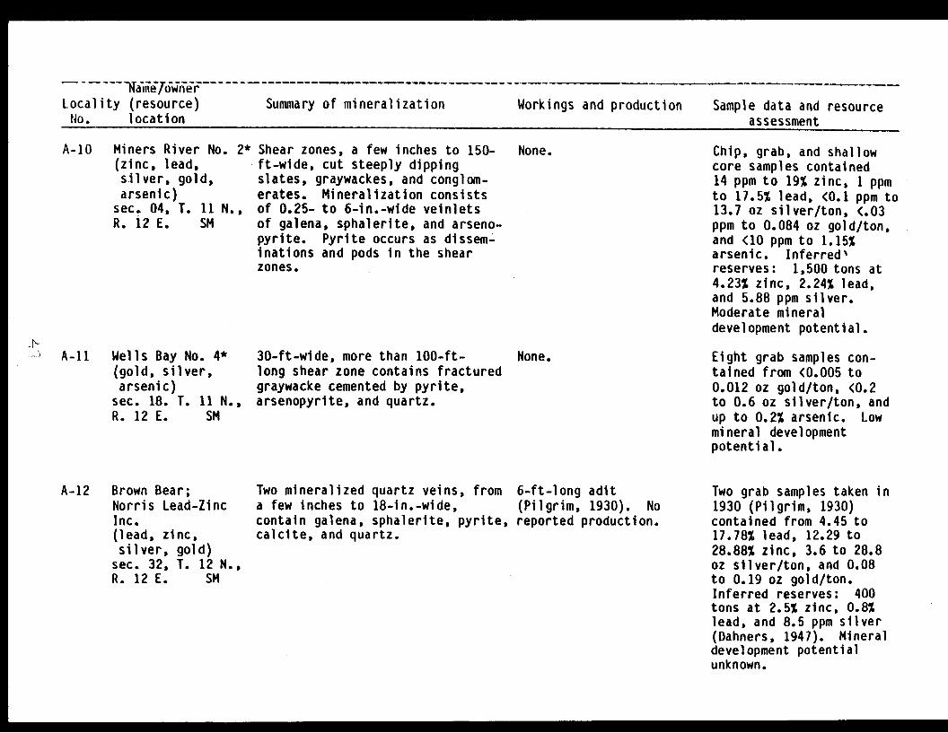
A-10 Miners River No. 2(zinc, lead,silver, gold,arsenic)sec. 04, T. 11 N.,R. i2 E. SM
> A-li Wells Bay No. 4*(gold, silver,arsenic)
sec. 18. T. 11 N.,R. 12 E. SM
Shear zones, a few inches to 150-ft-wide, cut steeply dippingslates, graywackes, and conglom-erates. Mineralization consistsof 0.25- to 6-in.-wide veinletsof galena, sphalerite, and arseno-pyrite. Pyrite occurs as dissem-inations and pods in the shearzones.
30-ft-wide, more than 100-ft-long shear zone contains fracturedgraywacke cemented by pyrite,arsenopyrite, and quartz.
None. Chip, grab, and shallowcore samples contained14 ppm to 19% zinc, 1 ppmto 17.5% lead, <0.1 ppm to13.7 oz silver/ton, <.03ppm to 0.084 oz gold/ton,and <10 ppm to 1.15%arsenic. Inferred"reserves: 1,500 tons at4.23% zinc, 2.24% lead,and 5.88 ppm silver.Moderate mineraldevelopment potential.
None. Eight grab samples con-tained from <0.005 to0.012 oz gold/ton, <0.2to 0.6 oz silver/ton, andup to 0.2% arsenic. Lowmineral developmentpotential.
A-12 Brown Bear;Norris Lead-ZincInc.(lead, zinc,silver, gold)
sec. 32, T. 12 N.,R. 12 E. SM
Two mineralized quartz veins, froma few inches to 18-in.-wide,contain galena, sphalerite, pyrite,calcite, and quartz.
6-ft-long adit(Pilgrim, 1930). Noreported production.
Two grab samples taken in1930 (Pilgrim, 1930)contained from 4.45 to17.78% lead, 12.29 to28.88% zinc, 3.6 to 28.8oz silver/ton, and 0.08to 0.19 oz gold/ton.Inferred reserves: 400tons at 2.5% zinc, 0.8%lead, and 8.5 ppm silver(Dahners, 1947). Mineraldevelopment potentialunknown.

Name/ownerLocality (resource) Summary of mineralization Workings and production Sample data and resource
No. location assessment
A-13 War Eagle(copper)sec. 17, T. 12 N.,R. 12 E. SM
No data. No data. No reportedproduction.
Not located. Mineraldevelopment potentialunknown.
A-14 Miners River Nickel(nickel, cobalt,copper)sec. 04, T. 11 N.,R. 11 E. SM
10- to 20-ft-wide fracture zonecuts quartz diorite. Pyrrhotite,chalcopyrite, and pentlanditeoccur as disseminations in quartzdiorite and in fissures.
Two adits 8-ft-long. Noproduction.
and 218-reported
Four chip samples con-tained from 400 ppm to0.2% nickel, 93 ppm to0.2% cobalt, and 100 ppmto 0.2% copper. Twenty-four surface grab samplescontained from 20 ppm to0.2% nickel, 36 to 800 ppmcobalt, and 20 ppm to 0.1%copper. A 260 pound bulksample contained 0.25%nickel, 0.02% cobalt, and0.31% copper. Inferredreserves: 11,000 tons at0.2% nickel and 0.2%copper. Webber and Rut-ledge, 1944a). Lowmineral developmentpotential.
A-15 Wells Bay(copper)sec. 27, T. 11 N.,R. 11 E. SM
No data. No data. No reportedproduction.
Not located. Mineraldevelopment potentialunknown.

Name/ownerLocality (resource) Summary of mineralization Workings and production Sample data and resourceNo. location assessment
A-16 Unnamed occurrence;*Several 2- to 12-in.-wide sub-Dartmouth Glacier parallel quartz veins in shear(gold, silver,* zones in and along margin of smallarsenic) granitic stock. Veins contain
sec. 33, T. 13 N., disseminated grains and massiveR. 10 E. SM pods of arsenopyrite with lesser
disseminated galena and pyrite.
A-17 Unnamed occurrence;*Quartz and metasedimentary floatLafayette Glacier rock contains pyrite and anomalous(gold, silver) silver values. Placer gold issec. 15, T. 11 N., present.R. 09 E. SM
A-18 Unnamed occurrence;*Quartz float contains pyrite,Crescent Glacier arsenopyrite, and chalcopyrite.(gold, silver)sec. 19, T. 11 N.,R. 09 E. SM
None. Three chip samples con-tained from 0.02 to 0.48oz gold/ton and 0.07 to1.11 oz silver/ton; aver-age 0.15 oz gold and 0.37oz silver/ton. Three grabsamples contained tracesof gold and from a traceto 0.03 oz silver/ton.Moderate mineral develop-ment potential.
None. Two samples contained atrace of gold, and 0.03and 0.12 oz silver/ton.Low mineral developmentpotential.
None. Sample contained no detec-table gold and 0.03 ozsilver/ton. Minor amountof placer gold present.Low mineral developmentpotential.
A-19 Cann and Minor(gold, silver)sec. 32, T. 12 N.,R. 09 E. SM
A-20 Griset and Benson;Eureka and SpruceGroups(gold)sec. 29, T. 11 N.,R. 08 E. SM
Two quartz veins reportedlyassociated with felsic dike.Veins up to 6-ft-wide containpyrite, sphalerite, and chalco-pyrite.
Vertical quartz vein averages3-ft-wide and is traceable for300 ft on surface.
65-ft-long adit andstripping reported(Johnson, 1914a, p. 218).No reported production.
Reported 30-ft crosscut;open cuts; stripping(Johnson, 1914a, p. 218).No reported production.
Not located. Mineraldevelopment potentialunknown.
Not located. Mineraldevelopment potentialunknown.

NameLocality (resource) Summary of mineralization Workings and production Sample data and resourceNo. location assessment
A-21 Charles Cameron(gold, silver)sec. 29, T. 11 N.,R. 08 E. SM
Quartz veins 4- to 20-in.-widein slates and argillites,reportedly contained arsenopyrite,chalcopyrite, pyrite, and gold.
25-ft-long adit; 100 ftof stripping reported in1913 (Johnson, 1914a,pp. 226-227). No reportedproduction.
Not located. Mineraldevelopment potentialunknown.
A-22 Last Chance(gold)sec. 29, T. 11 N.,R. 08 E. SM
3- to 36-in. quartz vein in massive None.metasandstone and slate is trace-able for 150 ft. Vein containslarge quartz crystals and minorarsenopyrite.
Not located. Reportedassays to $13 gold/ton in1913 (Johnson, 1914a).Mineral developmentpotential unknown.
A-23 Alaska WonderLedge; Simonton &Mills(gold, silver,copper)
sec. 07, T. 11 N.,R. 08 E. SM
A-24 Walter, Brasslin,and Atkinson(gold, silver,arsenic)sec. 08, T. 11 N.,R. 08 E. SM
Three subparallel vertical quartzveins in metasandstones. Western-most vein is more mineralized andcontains chalcopyrite, galena,sphalerite, pyrite, arsenopyrite,malachite, and azurite.
2- to 8-in.-wide quartz vein inslates and metasandstone (Johnson,1914a, p. 225). Arsenopyrite,galena, sphalerite, and goldpresent.
Some stripping on vein.No reported production.
Two adits reported - totallength 77 ft; open cuts;and stripping (Johnson,1914a, p. 225). Noreported production.
Three samples containedonly trace of gold andfrom 0.02 to 0.25 ozsilver/ton. Low mineraldevelopment potential.
Not located. Assays to $8gold/ton reported prior to1930. Mineral developmentpotential unknown.
A-25 Mt. Curtis*(gold, silver)sec. 31, T. 12 N.,R. 08 E. SM
Minor pyrite and arsenopyrite inquartz veins, from 1- to 3-ft-wide,in massive metasandstones andslates.
None. Three grab samples con-tained only traces ofgold and silver. Lowmineral developmentpotential.
C,,
0 1 __ M

Name/ownerLocality (resource) Summary of mineralization Workings and production Sample data and resourceNo. location assessment
A-26 Paymaster Lode;Golden Seal;Black and Hogan(gold)sec. 31, T.-12 N.,R. 08 E. SM
Reportedly a 1.5- to 3-ft-widequartz vein is traceable for 200to 300 ft (Johnson, 1914a, p. 225).
None. Not located. Assays to$88/ton reported in 1913.Mineral developmentpotential unknown.
A-27 Barry Arm Antimony(antimony)sec. 36, T. 12 N.,R. 07 E. SM
A-28 Capitol Hill(gold, silver)sec. 26, T. 12 N.,R. 07 E. SM
Stibnite reported in 6- to 8-ft-wide shear zone in metasandstonesand black slates (Grant andHiggins, 1910b, p. 78). Thestibnite-bearing quartz lensesare up to 2-ft-wide.
Quartz vein reportedly containsgold, silver, and copper (Martin,1920, p. 33).
Surface stripping andtrenching. 1,000 poundsof antimony ore reportedlymined circa 1913 (Grant,and Higgins, 1910b, p.78).
40-ft-long adit reported(Martin, 1920, p. 33).No reported production.
Not located. Mineraldevelopment potentialunknown.
Not located. Mineraldevelopment potentialunknown.
A-29, Dog30 (gold?)
sec. 02, T. 12 N.,R. 07 E. SM
No data. No data. Not visited. Mineraldevelopment potentialunknown.
A-31 Alaska Homestake;
Black and Hogan:Bruno 14;SSSS Mine(gold, silver)sec. 31, T. 12 N.,R. 07 E. SM
Vertical quartz vein, 2- to 8-in.-wide, along the west wall of a 3-to 6-ft-wide felsic dike inmetasandstone. Quartz is locallywell banded and contains galena,arsenopyrite, sphalerite, and gold.
Two adits, in excess of275 ft in length; 64-ftwinze. Lower level isinaccessible. Recordedproduction 83 oz goldand 33 oz silver.
Six samples collected.Contained from a traceto 0.02 oz gold/ton anda trace to 0.04 oz silver/ton. One vein sample con-tained 1.99 oz gold/tonand 0.2 oh silver/ton.Moderate mineral develop-ment potential for a smallmine if vein extensionis located.

Name/ownerLocality (resource) Summary of mineralization Workings and production Sample data and resourceNo. location assessment
A-32 Point Doran;Reiter and Olson;Bruno 1-3 1(antimony, lead,copper)sec. 02, T. 11 N.,R. 07 E. SM
Reportedly a 8- to 36-in.-widequartz vein is traceable for 200ft (Johnson, 1914a, p. 228).Other quartz veins occur nearby.Stibnite, galena, and chalcopyritereported in veins.
None. Not visited. Mineraldevelopment potentialunknown.
A-33 H. G. Cloes(gold?)sec. 23, T.R. 07 E.
11 N.,SM
A-34 Unnamed prospect;Lagoon Creek(gold, silver)sec. 32, T. 11 N.,R. 07 E. SM
A-35 Olson and Viette;Dominick Ledge(gold, silver)sec. 32. T. 11 N..R. 07 E. SM
Reportedly a quartz vein containspyrite, chalcopyrite, and galena(Roehm, 1936).
Quartz veins and stringers up to1-ft-wide in a well-developed12-ft-wide shear zone along thecontact of a 50-ft-wide felsicdike in hornfels. Disseminatedgrains and massive pods of pyrite,with lesser arsenopyrite and chal-copyrite.
Quartz-calcite vein up to 2-ft-wide, in a 43-in.-wide shear zonein metasandstones and metasilt-stones. Vein contains pyrite,sphalerite, chalcopyrite, and gold.
Minor stripping reported(Roehm, 1936). Noreported production.
15-ft-long adit. Noreported production.
200-ft-long adit; somesurface stripping. Noreported production.
Not located. Mineraldevelopment potentialunknown.
Six samples contained froma trace to 0.005 oz gold/ton and 0.01 to 0.05 ozsilver/ton. Low mineraldevelopment potential.
Five chip samples con-tained from a trace to0.08 oz gold/ton and atrace to 0.02 oz silver/ton. Low mineraldevelopment potential.
A-36 Roth and Johnson;Fiord #1 and 2(gold?)sec. 18, T. 11 N.,R. 07 E. SM
Reportedly a 30-in.-wide quartzvein is traceable 600 ft (Roehm,1938). Vein occurs between twofelsic dikes in black slate andmetasandstone. Vein containsarsenopyrite, pyrite, chalcopyrite,and galena.
None. Not located. Placer goldand sulfides occur in thevicinity. Mineraldevelopment potentialunknown.
Hi
i3
I M I 0

Name /own er,Locality (resource) Summary of mineralization Workings and production Sample data and resourceNo. location assessment
A-37 Raggedie Ann(gold?)sec. 21, T. 11 N.,R. 02 E. SM
No data. None. Not visited. Mineraldevelopment potentialunknown.
A-38 Jewel
(gold, silver,arsenic)sec. 16, T. 11 N.,R. 02 E. SM
A-39 Monarch;
Bruno, Agostino,Crow Creek MiningCo.(gold, silver,molybdenum, arsenicsec. 16, T. 11 N.,R 02 E. SM
2-in.- to 1-ft-wide quartz vein inargillite and graywacke. Arseno-pyrite, galena, chalcopyrite,pyrite, pyrrhotite, molybdenite,and gold in vein. Other sulfide-bearing veins nearby.
At least two quartz veins ininterbedded slates and graywackesintruded by felsic dikes andgranitic stock. Veins containcalcite, galena, chalcopyrite,sphalerite, arsenopyrite, molyb-)denite, gold, and silver. Addi-tional crosscutting veins containsimilar mineralization.
285-ft-long adit; 3raises; stripping.Production included withthat of the Monarch mine.(A-38)
Five adits, a total of950 ft of drifts, 125ft of crosscuts, 52 ftof winzes, and 4 raisestotalling 100 ft.Recorded production is4,932 oz gold and 996 ozsilver, some from JewelMine (A-37).
Weighted average of tenchip samples is 1.07 ozgold ton and 0.50 ozsilver/ton. Samples con-tain up to 4.7% arsenic.Reserves: 3,100 tons.High mineral developmentpotential for smalloperation. I
Forty-three chip and grabsamples contained from atrace to 6.82 oz gold/tonand trace to 3.94 ozsilver/ton. Weightedaverage grade of all chipsamples is 0.31 oz gold/ton and 0.31 oz silver/ton. Contain up-to 400ppm molybdenum and 1.34%arsenic. High mineraldevelopment potential fora small mine if veinextension can be located.

Name/ownerLocality (resource) Summary of mineralization Workings and production Sample data and resourceNo. location assessment
A-40 Brenner; Barnes;Greenback MinidgCompany(gold, silver,molybdenum,copper, arsenic)
sec. 16, T. 11 N.,R. 02 E. SM
A-41 Bahrenberg;Hottentot;Treasure Box(gold, silver,arsenic)
sec. 09, T. 11 N.,R. 02 E. SM
At least 4 veins present; twoexposed at the shaft collar. Onevein is 6- to 12-in.-wide, containscalcite, galena, sphalerite,pyrite, pyrrhotite, arsenopyrite,and gold. Other veins containsimilar mineralization.
Quartz-calcite vein containsarsenopyrite, pyrite, galena,and sphalerite. The metased-imentary country rock is contactmetamorphosed.
54-ft inclined shaft(flooded), and a caveddrift 175 ft in length.Minor production reported.
Surface cut and shortadit located. A reported65-ft-long adit wasnot located (Park, 1933,p. 417). Recorded pro-duction is 54 oz gold and21 oz silver.
Six chip samples containedfrom a trace to 0.12 ozgold/ton and from 0.02 to0.27 oz silver/ton. Grabsample contained 0.52 ozgold/ton and 0.50 ozsilver/ton. Some samplescontain up to 148 ppmmolybdenum, 0.14% copper,and 0.3% arsenic. Moderatemineral development poten-tial for a small mine.
Four samples collectedaveraged 1.65 oz gold/tonand 1.68 oz silver/ton.Contain up to 3.4%arsenic. Reserves: 344tons. Moderate mineraldevelopment potential fora small mine.
A-42 Eagle River;Mayflower Lode(silver)sec. 15, T. 12 N.,R. 02 E. SM
A-43 Unnamed occurrenceTerentiev Lake(lead, silver,arsenic)sec. 27, T. 09 S.,R. 11 W. CRM
Quartz stringers in vertical zonescontain calcite, galena, pyrite,sphalerite, arsenopyrite, chalco-pyrite, and malachite.
;*Limonite-stained quartz-cementedfractures in granite.
None.
None.
Not located. Reportedassay of 24.8 oz silver/ton (Martin and others,1915). Mineral develop-ment potential unknown.
USGS grab sample contained0.15% lead, 10 ppm silver,and 0.2% arsenic. Mineraldevelopment potentialunknown.
0 -- I I M

Name/ownerLocality (resource) Summary of mineralization Workings and production Sample data and resourceNo. location assessment
A-44 Unnamed Occurrence*(gold, silver)sec. 28, T. 13 N.,R. 11 E. SM
A-45 Unnamed Occurrence*(gold?)sec. 28, T. 13 N.,R. 10 E. SM
One quartz vein, approximately1-ft-wide and heavily limonite-stained. Local copper staining.Pyrite only sulfide observed.
One quartz vein, approximately4-in.-wide in granite. Veincontains stibnite.
None. USGS grab-sample contained30 ppm silver, 700 ppmarsenic, and 10 ppmmolybdenum. Mineraldevelopment potentialunknown.
None. One USGS grab samplecontained 0.3% arsenicand 100 ppm antimony.Mineral developmentpotential unknown.
I

Name/ownerLocality (resource) Summary of mineralization Workings and production Sample data and resourceNo. location assessment
CO Katalla Oil Field
(oil)T. 19 S., R. 05and 06 E. CRM
Hydrocarbons occur in the carbon-aceous shaly horizons in the upperpart of the Poul Creek Formation.
18 wells, 153,922 barrelsof oil produced from1900's to 1933 (Blasko,1976).
A sample of gas from aseep contained 64.3%methane, 13.4% ethane,10.6% propane, 3.1% normalbutane, 2.8% isobutane,0.6% normal pentane, 0.4%isopentane, 0.1% cyclopen-tane, 0.3% hexanes, 0.8%nitrogen, and 3.6% C02.Specific gravity 0.883.Mineral developmentpotential unknown.
C1 Wingham IslandDev. Assoc.(gold)sec. 17, T. 21 S.,R. 06 E. CRM
No data. No data. No reportedproduction.
Not located. Mineraldevelopment potentialunknown.
C2 Bering RiverCoal North(coal)T. 17 S., R. 07 &08 E. CRM
C3 Bering RiverCoal South(coal)T. 17 & 18 S.,R. 06 & 07 E.CRM
Thirty exposures of low-volatilebituminous to a semi-anthracitecoal, from 0.5- to 31-ft-thick,have been mapped in a 20 mi2
area.
Sixteen exposures of low-volatilebituminous to semi-anthracitecoal, from 0.3- to 12-ft-thick,have been mapped in 15 miarea.
Trout Creek - 3 adits;Kushtaka Ridge - 2 adits;Carbon Creek - 2 adits;Nevada Creek - 1 adit(Martin, 1908). Noreported production.
Tokun Creek - 2 adits;Dick Creek - 1 adit;Powers Creek - 1 adit;Bering Lake - 1 adit(Martin, 1908). Noreported production.
Coal contained from 1.0 to9.4% moisture, 1.8'to 15%ash, 0.6 to 4.1% sulfur,72.2 to 86.6% carbon, and12,350 to 15,000 B.t.u.(Cooper and others, 1946).Mineral development poten-tial unknown.
Coal contained from 1.0 to8.6% moisture, 2.6 to34.2% ash,'0.7 to 6.5%sulfur, 47.0 to 80.7% car-bon, and 8,390 to 14,070B.t.u. (Cooper and others,1946). Mineral develop-ment potential unknown.
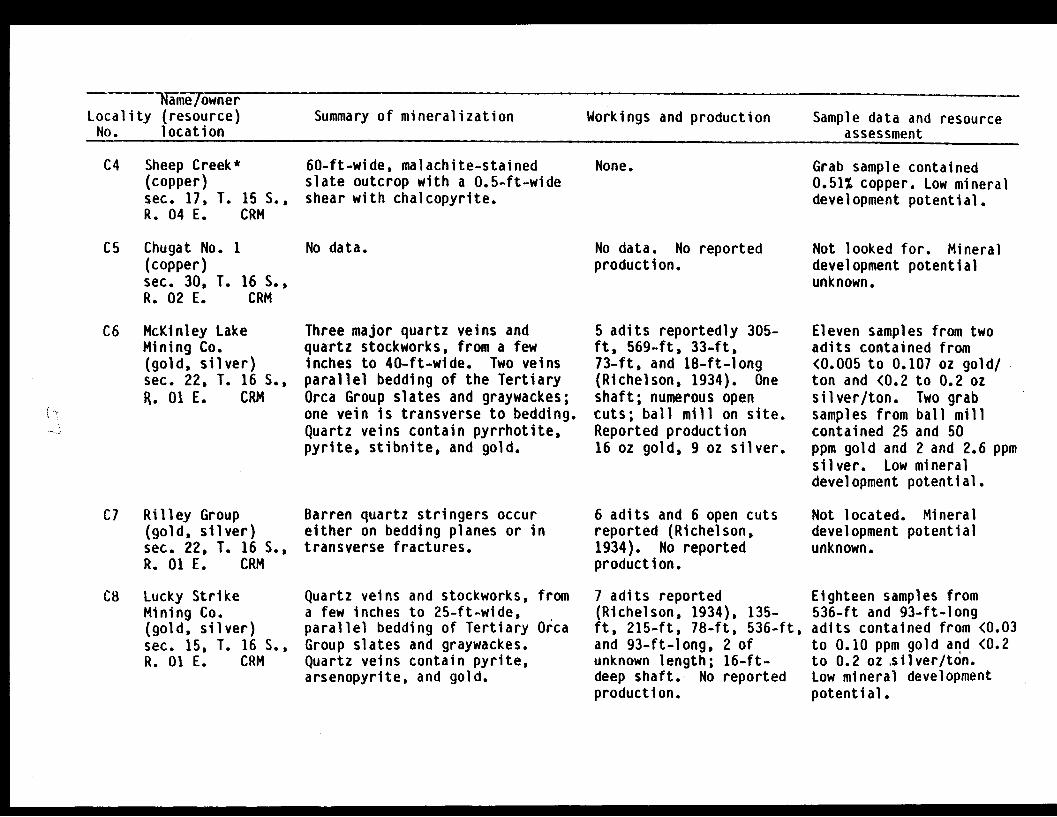
Name/ownerLocality (resource) Summary of mineralization Workings and production Sample data and resourceNo. location assessment
C4 Sheep Creek*(copper)sec. 17, T. 15 S.,R. 04 E. CRM
C5 Chugat No. 1(copper)sec. 30, T. 16 S.,R. 02 E. CRM
60-ft-wide, malachite-stainedslate outcrop with a 0.5-ft-wideshear with chalcopyrite.
No data.
None.
No data. No reportedproduction.
Grab sample contained0.51% copper. Low mineraldevelopment potential.
Not looked for. Mineraldevelopment potentialunknown.
C6 McKinley LakeMining Co.(gold, silver)sec. 22, T. 16 S.,R. 01 E. CRM
C7 Rilley Group(gold, silver)sec. 22, T. 16 S.,R. 01 E. CRM
C8 Lucky StrikeMining Co.(gold, silver)sec. 15, T. 16 S.,R. 01 E. CRM
Three major quartz veins andquartz stockworks, from a fewinches to 40-ft-wide. Two veinsparallel bedding of the TertiaryOrca Group slates and graywackes;one vein is transverse to bedding.Quartz veins contain pyrrhotite,pyrite, stibnite, and gold.
Barren quartz stringers occureither on bedding planes or intransverse fractures.
Quartz veins and stockworks, froma few inches to 25-ft-wide,parallel bedding of Tertiary OrcaGroup slates and graywackes.Quartz veins contain pyrite,arsenopyrite, and gold.
5 adits reportedly 305-ft, 569-ft, 33-ft,73-ft, and 18-ft-long(Richelson, 1934). Oneshaft; numerous opencuts; ball mill on site.Reported production16 oz gold, 9 oz silver.
6 adits and 6 open cutsreported (Richelson,1934). No reportedproduction.
7 adits reported(Richelson, 1934), 135-ft, 215-ft, 78-ft, 536-ftand 93-ft-long, 2 ofunknown length; 16-ft-deep shaft. No reportedproduction.
Eleven samples from twoadits contained from<0.005 to 0.107 oz gold/ton and <0.2 to 0.2 ozsilver/ton. Two grabsamples from ball millcontained 25 and 50ppm gold and 2 and 2.6 ppmsilver. Low mineraldevelopment potential.
Not located. Mineraldevelopment potentialunknown.
Eighteen samples from536-ft and 93-ft-longadits contained from <0.03to 0.10 ppm gold and (0.2to 0.2 oz silver/ton.Low mineral developmentpotential.
I.

Name/ownerLocality (resource) Summary of mineralization Workings and production Sample data and resourceNo. location assessment
C9 Bear CreekMining Co.(gold, silver)sec. 15, T. 16 S.,R. 01 E. CRM
CIO Childs Glacier*(copper, zinc)sec. 03, T. 14 S.,R. 03 E., CRM
Cl Grinnell Glacier*(copper)T. 13 S., R. 03 &04 E., CRM
C12 Shiels Glacier*(gold, zinc,lead, silver)
sec. 31, T. 11 S.,R. 04 E. CRM
C13 Woodworth Glacier*(copper)sec. 04. T. 11 S.,R. 01 W. CRM
No data. Development workreported (Chapin, 1913).No reported production.
Slates and greenstones withdisseminated pyrite and chal-copyrite.
Shear zones, 2- to 10-ft-wide in Imetasedimentary and volcanic rocks,contain pyrite, pyrrhotite, chalco-pyrite, and malachite.
Slates and greenstones contain Idisseminations and lenses of pyrite,pyrrhotite, and disseminatedgalena, and sphalerite.
Two shear zones, 1- and 4-ft-wide, Iin greenstone contain minor quartzand chalcopyrite veinlets.
None.
None.
None.
None.
Not looked for. Mineraldevelopment potentialunknown.
Four grab samples con-tained from 34 ppm to0.64% copper and 110 ppmto 0.17% zinc. Mineraldevelopment potentialunknown.
Four chip samples con-tained from 255 ppm to0.13% copper. Nine grabsamples contained 13 ppmto 0.19% copper. Lowmineral developmentpotential.
Two grab samples fromtalus contained: 0.03 and5.0 ppm gold, 34 ppm and0.92% zinc, 47 ppm and0.20% lead, and 5.4 and11.2 ppm silver. Mineraldevelopment potentialunknown.
Three grabsamplescontained from 0.12% to1.02% copper. Low mineraldevelopment potential.
I N

Name/ownerLocality (resource) Summary of mineralization Workings and production Sample data and resourceNo. location assessment
C14 Rude River*(tin)sec. 13, T. 13 S.,R. 01 W. CRM
C15 Northern ScottGlacier*(zinc)sec. 07, T. 14 S.,R. 01 E. CRM
C16 Scott Glacier*(copper, zinc,silver)
sec. 36, T. 14 S.,R. 01 W., andsec. 31, T. 14 S.,R. 01 E. CRM
Pyrite in sheared slate floatrocks.
Slates in talus at the base ofred-stained outcrops contain chal-copyrite, pyrite, and sphalerite;greenstQnes contain chalcopyriteand pyrrhotite.
Shear zones, up to 2-ft-wide, inslate and graywacke. Sulfidelenses and disseminations inrock and shear zones, includeschalcopyrite, pyrrhotite, bornite,and sphalerite. Mineralized zone200-ft-wide and 1,000-ft-long.
None. Grab sample0.17% tin.developmentunknown.
None.
containedMineralpotential
Three grab samples con-tained from 210 ppm to0.77% zinc. Low mineraldevelopment potential.
None. Seven chip samplescontained from 39 ppm to2.3% copper, 68 ppm to5.9% zinc, and <0.1 ppm to29 ppm silver. Seven grabsamples contained from 36ppm to 14.8% copper, 58ppm to 8.7% zinc, and <0.1ppm to 8.0 oz silver/ton.Inferred reserves: 19,300tons at 1.06% copper,2.06% zinc, and 13.6 ppmsilver. Moderate mineraldevelopment potential.
C17 Ibeck Creek(copper, zinc,lead, silver)
sec. 15, T. 14 S.,R. 01 W. CRM
14-ft-wide shear zone in green-stone contains small lenses anddisseminations of pyrrhotite,pyrite, chalcopyrite, and sphal-erite.
80-ft-long adit. Noreported production.
Five chip samples con-tained from 4 ppm to 3.4%copper, 40 ppm to 1.95%zinc, 10 ppm to 0.26%lead, and 3.6 to 11 ppmsilver. Four grab samplescontained from 0.52 to5.5% copper, 215 ppm to2.4% zinc, 30 ppm to 0.2%
\U1t
- #

Name/ownerLocality (resource) Summary of mineralization Workings and production Sample data and resourceNo. location assessment
lead, and 0.4 to 14 ppmsilver. Inferredreserves: 3,800 tons at2.8% copper, 2.2% zinc,and 10.0 ppm silver(Garrett, 1971a).Moderate mineral develop-ment potential.
C18 Ibeck Creek*(zinc)sec. 20, T. 14 S.,R. 01 W. CRM
Red-stained greenstone outcropwith disseminated pyrite.
None. Grab sample0.25% zinc.development
containedLow mineral
potential.
C19 Boswell, Holt, &Flynn(copper)sec. 01, T. 14 S.,R. 02 W. CRM
No data. No data. No reportedproduction.
Not looked for. Mineraldevelopment potentialunknown.
C20 Caledonia Group(copper)sec. 13, T. 14 S.,R. 02 W. CRM
C21 Head of Bay;Cordova-TacomaCopper Co.(copper, zinc,silver)
sec. 10, T. 14 S.,R. 02 W. CRM
Three mineralized shear zonesin greenstone contain borniteand malachite.
Four shear zones, 1- to 5-ft-wide,cut greenstones and containpyrrhotite and chalcopyrite.
Three open cuts reported.No reported production.
87-ft-longwinze. Noproduction.
adit withreported
Not looked for. Mineraldevelopment potentialunknown.
Six chip samples containedfrom 650 ppm to 4.05%copper, 35 to 310 ppmzinc, and <0.1 to 1.8 ppmsilver. Two grab samplescontained 4.6 and 15.2%copper, 360 ppm and 0.15%zinc, and 8.8 and 11 ppmsilver. Inferred re-serves: 800 tons at0.6% copper. Low mineraldevelopment potential.
I
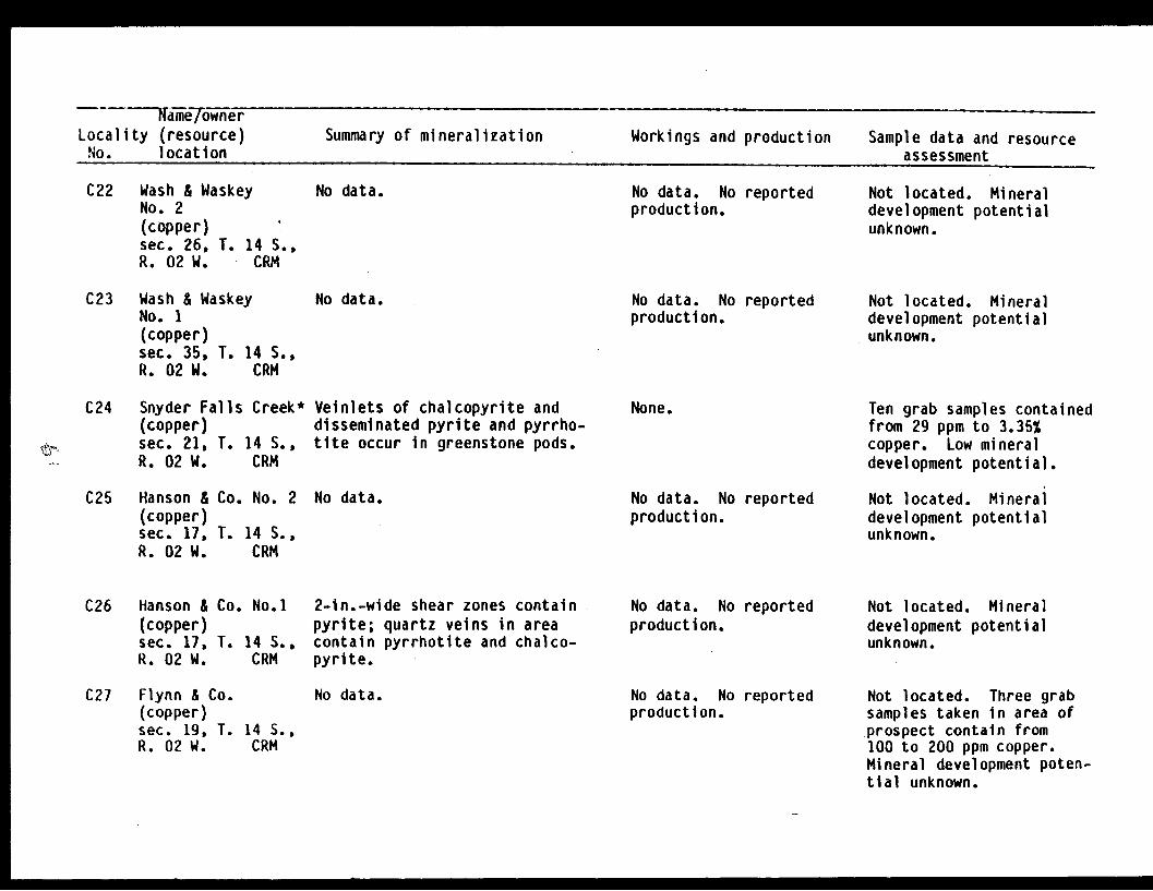
Name/ownerLocality (resource) Summary of mineralization Workings and production Sample data and resourceNo. location assessment
C22 Wash & WaskeyNo. 2(copper)sec. 26, T. 14 S.,R. 02 W. CRM
C23 Wash & WaskeyNo. 1(copper)sec. 35, T. 14 S.,R. 02 W. CRM
C24 Snyder Falls Creek(copper)sec. 21, T. 14 S.,R. 02 W. CRM
No data. No data. No reportedproduction.
No data. No data. No reportedproduction.
* Veinlets of chalcopyrite anddisseminated pyrite and pyrrho-tite occur in greenstone pods.
C25 Hanson & Co. No. 2 No data.(copper)sec. 17, T. 14 S.,R. 02 W. CRM
None.
No data. No reportedproduction.
Not located. Mineraldevelopment potentialunknown.
Not located. Mineraldevelopment potentialunknown.
Ten grab samples containedfrom 29 ppm to 3.35%copper. Low mineraldevelopment potential.
Not located. Mineraldevelopment potentialunknown.
C26 Hanson & Co. No.1(copper)sec. 17, T. 14 S..R. 02 W. CRM
2-in.-wide shear zones containpyrite; quartz veins in areacontain pyrrhotite and chalco-pyrite.
No data. No reportedproduction.
Not located. Mineraldevelopment potentialunknown.
C27 Flynn & Co.(copper)sec. 19, T. 14 S.,R. 02 W. CRM
No data. No data. No reportedproduction.
Not located. Three grabsamples taken in area ofprospect contain from100 to 200 ppm copper.Mineral development poten-tial unknown.

Name/ownerLocality (resource) Summary of mineralization Workings and production Sample data and resourceNo. location assessment
C28 Shepard -Macpherson(copper, zinc,lead)
sec. 19, T. 14 S.,R. 02 W. CRM
C29 Wilson Point(gold, silver)sec. 28, T. 14 S.,R. 03 W. CRM
Quartz veins in slate and gray-wacke contain pyrrhotite, chal-copyrite, and galena.
4-ft-wide, 20-ft-long brecciatedgraywacke zone with quartz matrix.
No data. No reportedproduction.
No data. No reportedproduction.
Not located. Grab sampletaken in area of reportedprospect contained 170 ppmcopper, 0.4% zinc, and0.36% lead. Mineraldevelopment potentialunknown.
Chip and a grab samplecontained <0.03 to 0.05ppm gold and <0.1 ppmsilver. Low mineraldevelopment potential.
C30 4Rosecrans & Co.(copper)sec. 05, T. 15 S.,R. 02 W. CRM
C31 Boswell & Lowe(copper)sec. 05, T. 15 S.,R. 02 W. CRM
C32 Emerald(copper)sec. 07, T. 15 S.,R. 02 W. CRM
C33 U.S. & MountainGroup(copper)sec. 25, T. 15 S.,R. 03 W. CRM
No data. No data. No reportedproduction.
No data. No data. No reportedproduction.
No data.
No data.
No data. No reportedproduction.
No data. No reportedproduction.
Not located. Mineraldevelopment potentialunknown.
Not looked for. Mineraldevelopment potentialunknown.
Not located. Mineraldevelopment potentialunknown.
Not located. Mineraldevelopment potentialunknown.
-1 I M

Name/ownerLocality (resource) Summary of mineralization Workings and production Sample data and resource
to. location assessment
C34 Cordova Copper Co.;Tacoma-CordovaMines; A.R.C.Industries;ArmstrongEUploration(copper)sec. 15, T. 15 S.,R. 03 W. CRM
Chalcocite, chalcopyrite, pyrr-hotite, malachite, and nativecopper occur in 1-in.- to 2-ft-wide quartz-epidote veins alongeast-northeast-trending shearzones. Shear zones occur alongcontact between slates and green-stones.
Twelve adits on sevenclaims (Bureau of LandManagement, 1982, MineralSurvey 1061A-B). Noreported production.
Seven adits sampled.Twenty chip samples con-tained from 11 ppm to15.5% copper. Nineteengrab samples containedfrom 32 ppm to 29%copper. Inferredreserves: 17,600tons at 0.64% copper.Moderate mineraldevelopment potential.
C35 Dalton; Dalton,Boswell, Lowe(copper)sec. 21, T. 15 S.,R. 03 W. CRM
C36 Cameron(copper)sec. 21, T. 15 S.,R. 03 W. CRM
C37 ArmstrongExploration Co.No. 1(copper)sec. 28, T. 15 S.,R. 03 W. CRM
C38 Glendar RockQuarry (Stone)sec. 33, T. 15 S.,R. 03 W. CRM
No data.
No data.
No data.
No data.
Two adits, house, pipe-line, flume, penstock,and dam reported (Bureauof Land Management, 1982,Mineral Survey 878,902).No reported production.
No data. No reportedproduction.
No data. No reportedproduction.
No data. No reportedproduction.
Not located. Mineraldevelopment potentialunknown.
Not located. Mineraldevelopment potentialunknown.
Not located. Mineraldevelopment potentialunknown.
Not looked for. Mineraldevelopment potentialunknown.
I5
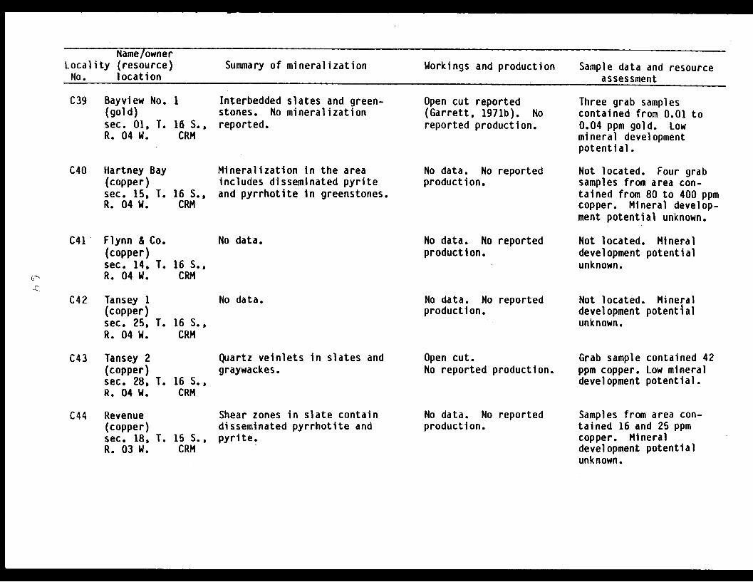
Name/ownerLocality (resource) Summary of mineralization Workings and production Sample data and resourceNo. location assessment
C39 Bayview No. 1(gold)sec. 01, T. 16 S.,R. 04 W. CRM
C40 Hartney Bay(copper)sec. 15, T. 16 S.,R. 04 W. CRM
Interbedded slates and green-stones. No mineralizationreported.
Mineralization in the areaincludes disseminated pyriteand pyrrhotite in greenstones.
Open cut reported(Garrett, 1971b). Noreported production.
No data. No reportedproduction.
Three grab samplescontained from 0.01 to0.04 ppm gold. Lowmineral developmentpotential.
Not located. Four grabsamples from area con-tained from 80 to 400 ppmcopper. Mineral develop-ment potential unknown.
C41 Flynn & Co.(copper)sec. 14, T.R. 04 W.
C42 Tansey 1(copper)sec. 25, T.R. 04 W.
No data. No data. No reportedproduction.
16 S.,CRM
No data. No data. No reportedproduction.
16 S.,CRM
Not located. Mineraldevelopment potentialunknown.
Not located. Mineraldevelopment potentialunknown.
C43 Tansey 2(copper)sec. 28,R. 04 W.
T. 16 S.,CRM
Quartz veinlets in slates andgraywackes.
Open cut.No reported production.
Grab sampleppm copper.development
contained 42Low mineralpotential.
C44 Revenue(copper)sec. 18,R. 03 W.
T. 15 S.,CRM
Shear zones in slate containdisseminated pyrrhotite andpyrite.
No data. No reportedproduction.
Samples from area con-tained 16 and 25 ppmcopper. Mineraldevelopment potentialunknown.
I N M

Name/ownerLocality (resource) Summary of mineralization Workings and production Sample data and resourceNo. location assessment
C45 Hawkins IslandNo. 1(copper)sec. 19, T. 15 S.,R. 03 W. CRM
Approximately 15% pyrite inslate.
No data. No reportedproduction.
Grab sampleppm copper.development
contained 36Low mineralpotential.
C46 Hawkins IslandNo. 2(copper)sec. 13, T. 15 S.,R. 04 W. CRM
C47 Kippen & Co.(copper)sec. 35, T. 15 S.,R. 05 W., CRM
No data.
No data.
No data. No reportedproduction.
No data. No reportedproduction.
Not located. Mineraldevelopment potentialunknown.
Not located. Mineraldevelopment potentialunknown.
C48 Flynn & Scott(copper)sec. 03, T. 16 S.,R. 05 W. CRM
C49 Kelly & MacCormac(copper)sec. 03, T. 16 S.,R. 05 W. CRM
Pyrrhotite disseminated ingreenstone.
3-ft-wide shear zone cuts slate.No mineralization noted.
30-ft-long open cut.No reported production.
15-ft-long open cut.No reported production.
Four samples containedfrom 25 ppm to 475 ppmcopper. Low mineraldevelopment potential.
Three samples contained 24to 140 ppm copper. Lowmineral development poten-tial.
C50 Hinchinbrook Is.(copper)sec. 36, T. 17 S.,R. 08 W. CRM
No data. No data. No reportedproduction.
Eight grab samples con-tained from 10 to 150 ppmcopper. Mineral develop-ment potential unknown.
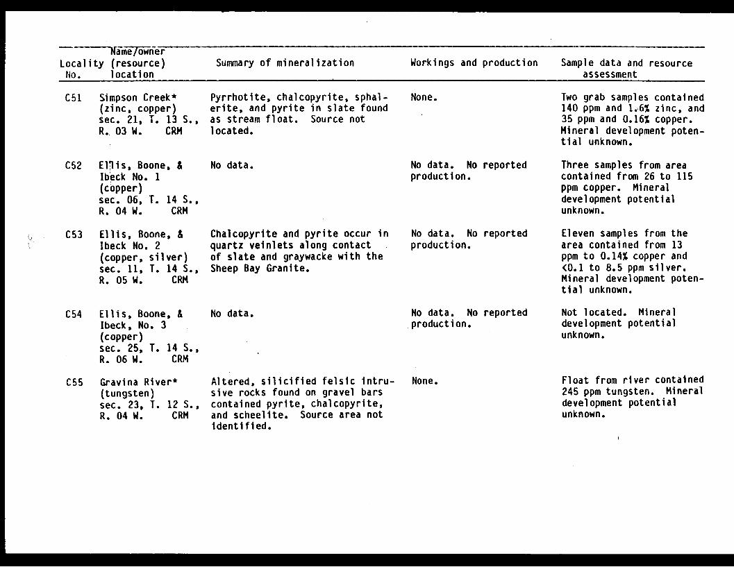
Same/owner -Locality (resource) Summary of mineralization Workings and production Sample data and resourceNo. location assessment
C51 Simpson Creek*(zinc, copper)sec. 21, T. 13 S.,R.. 03 W. CRM
C52 Ellis, Boone, &Ibeck No. 1(copper)sec. 06, T. 14 S.,R. 04 W. CRM
Pyrrhotite, chalcopyrite, sphal-erite, and pyrite in slate foundas stream float. Source notlocated.
No data.
None.
No data. No reportedproduction.
Two grab samples contained140 ppm and 1.6% zinc, and35 ppm and 0.16% copper.Mineral development poten-tial unknown.
Three samples from areacontained from 26 to 115ppm copper. Mineraldevelopment potentialunknown.
C53 Ellis, Boone, &Ibeck No. 2(copper, silver)sec. 11, T. 14 S.,R. 05 W. CRM
Chalcopyrite and pyrite occur inquartz veinlets along contactof slate and graywacke with theSheep Bay Granite.
No data. No reportedproduction.
Eleven samples from thearea contained from 13ppm to 0.14% copper and<0.1 to 8.5 ppm silver.Mineral development poten-tial unknown.
C54 Ellis, Boone, &Ibeck, No. 3(copper)sec. 25, T. 14 S.,R. 06 W. CRM
C55 Gravina River*(tungsten)sec. 23, T. 12 S.,R. 04 W. CRM
No data. No data. No reportedproduction.
Altered, silicified felsic intru-sive rocks found on gravel barscontained pyrite, chalcopyrite,and scheelite. Source area notIdentified.
None.
Not located. Mineraldevelopment potentialunknown.
Float from river contained245 ppm tungsten. Mineraldevelopment potentialunknown.
I E
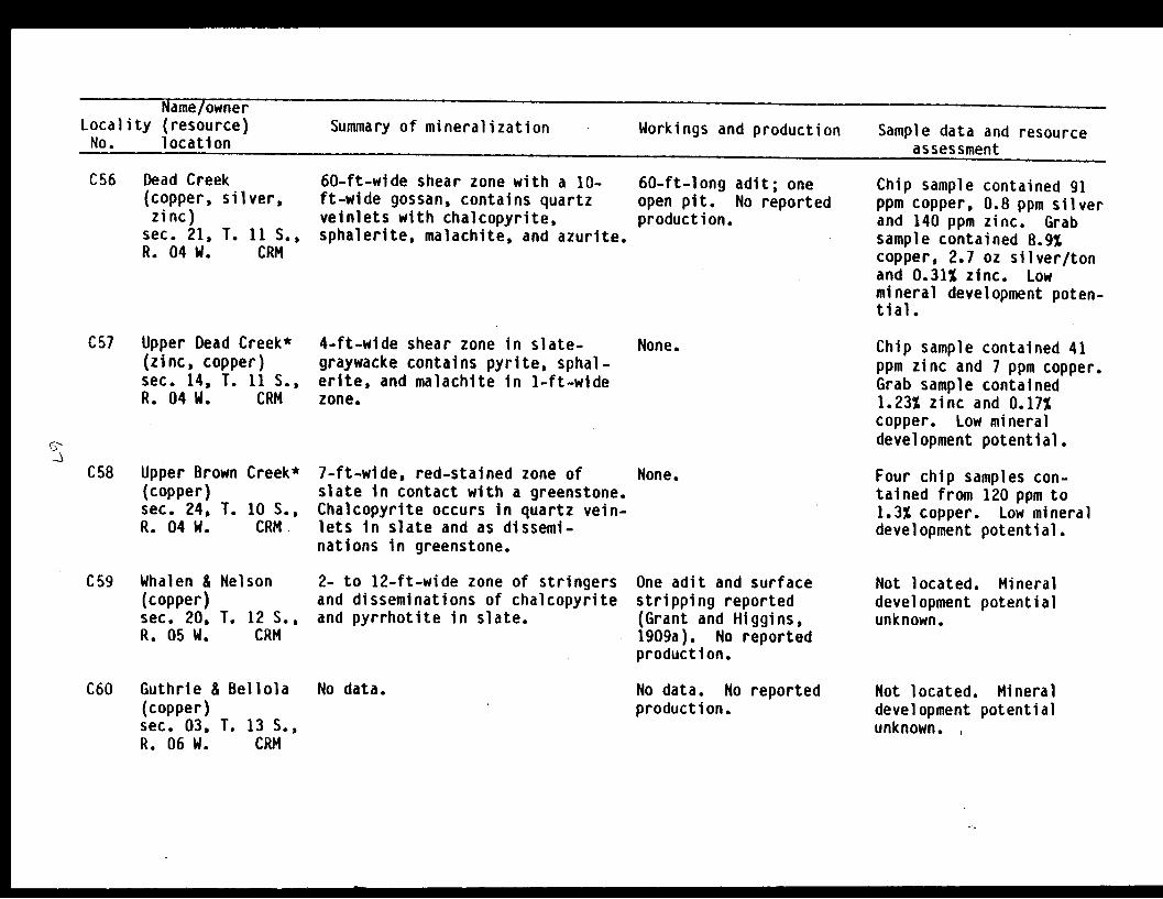
Name/ownerLocality (resource) Summary of mineralization Workings and production Sample data and resourceNo. location assessment
C56 Dead Creek(copper, silver,zinc)
sec. 21, T. 11 S.,R. 04 W. CRM
60-ft-wide shear zone with a 10-ft-wide gossan, contains quartzveinlets with chalcopyrite,sphalerite, malachite, and azurite.
60-ft-long adit; oneopen pit. No reportedproduction.
Chip sample contained 91ppm copper, 0.8 ppm silverand 140 ppm zinc. Grabsample contained 8.9%copper, 2.7 oz silver/tonand 0.31% zinc. Lowmineral development poten-tial.
C57 Upper Dead Creek*(zinc, copper)sec. 14, T. 11 S.,R. 04 W. CRM
C58 Upper Brown Creek*(copper)sec. 24, T. 10 S.,R. 04 W. CRM
4-ft-wide shear zone in slate-graywacke contains pyrite, sphal-erite, and malachite in 1-ft-widezone.
7-ft-wide, red-stained zone ofslate in contact with a greenstone.Chalcopyrite occurs in quartz vein-lets in slate and as dissemi-nations in greenstone.
None. Chip sample contained 41ppm zinc and 7 ppm copper.Grab sample contained1.23% zinc and 0.17%copper. Low mineraldevelopment potential.
None. Four chip samples con-tained from 120 ppm to1.3% copper. Low mineraldevelopment potential.
C59 Whalen & Nelson(copper)sec. 20, T. 12 S.,R. 05 W. CRM
2- to 12-ft-wide zone of stringersand disseminations of chalcopyriteand pyrrhotite in slate.
One adit and surfacestripping reported(Grant and Higgins,1909a). No reportedproduction.
Not located. Mineraldevelopment potentialunknown.
C60 Guthrie & Bellola(copper)sec. 03, T. 13 S.,R. 06 W. CRM
No data. No data. No reportedproduction.
Not located. Mineraldevelopment potentialunknown. ,
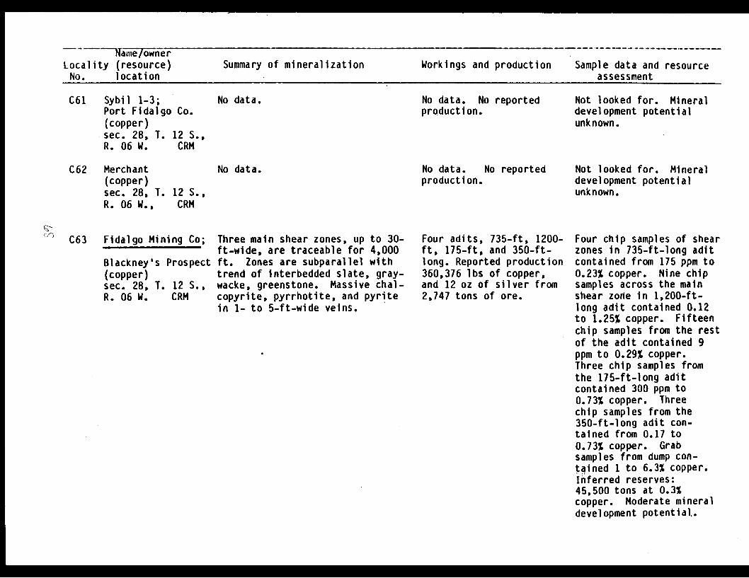
Name/ownerLocality (resource)No. location
Summary of mineralization Workings and production Sample data and resourceassessment
C61 Sybil 1-3;Port Fidalgo Co.(copper)sec. 28, T. 12 S.,R. 06 W. CRM
No data. No data. No reportedproduction.
Not looked for. Mineraldevelopment potentialunknown.
C62 Merchant(copper)sec. 28, T. 12 S.,R. 06 W., CRM
' C63 Fidalgo Mining Co;
Blackney's Prospect(copper)sec. 28, T. 12 S.,R. 06 W. CRM
No data. No data.production.
Three main shear zones, up to 30-ft-wide, are traceable for 4,000ft. Zones are subparallel withtrend of interbedded slate, gray-wacke, greenstone. Massive chal-copyrite, pyrrhotite, and pyritein 1- to 5-ft-wide veins.
No reported
Four adits, 735-ft, 1200-ft, 175-ft, and 350-ft-long. Reported production360,376 lbs of copper,and 12 oz of silver from2,747 tons of ore.
Not looked for. Mineraldevelopment potentialunknown.
Four chip samples of shearzones in 735-ft-long aditcontained from 175 ppm to0.23% copper. Nine chipsamples across the mainshear zone in 1,200-ft-long adit contained 0.12to 1.25% copper. Fifteenchip samples from the restof the adit contained 9ppm to 0.29% copper.Three chip samples fromthe 175-ft-long aditcontained 300 ppm to0.73% copper. Threechip samples from the350-ft-long adit con-tained from 0.17 to0.73% copper. Grabsamples from dump con-tained 1 to 6.3% copper.Inferred reserves:45,500 tons at 0.3%copper. Moderate mineraldevelopment potential..
E I

R Name 7wnlrILocality (resource) Summary of mineralization Workings and production Sample data and resourceNo. location assessment
C64 FM 1-26, FMFraction(copper)sec. 28, T. 12 S.,R. 06 W. CRM
No data. No reportedproduction.
Not looked for. Mineraldevelopment potentialunknown.
C65 Dickey Copper Co.;
Mason & GleasonIrish Cove CopperCo. (copper, zinc,gold, silver,lead, cobalt)
sec. 02, T. 13 S.,R. 07 W. CRM
Mineralized shear zones cuttingslate and graywacke have beentraced for 300 ft. Chalcopyrite,pyrite, sphalerite, and pyrrho-tite occur in 6- to 8-ft-wideshear zones.
4 adits reported: 500-ft, 125-ft, 35-ft (caved),and 10-ft-long. Reportedproduction 29,346 lbscopper (Fellows, undated).
Five grab samples from500-ft-long adit contain-ed 0.01 to 1.23% copper0.02 to 1.5% zinc, <0.03to 12.5 ppm gold, <0.1 to28 ppm silver, and 0.01 to0.13% lead. Selectedgrab sample contained 15.5ppm gold. Five grabsamples from 125-ft-longadit contained 0.3 to 4.3%copper, 1.43 to 14% zinc,<0.03 to 5.25 ppm gold, 25to 26 ppm silver, 80 ppmto 0.13% lead, 14 to 740ppm cobalt. Grab samplefrom the crosscut con-tained 1.6% copper, 3.1%zinc, 2.8 ppm gold and 10ppm silver. A 262 lbbulk sample from the orebunkers contained 8.65%copper, 9.6% zinc, 0.072oz gold/ton, 0.62 ozsilver/ton, and 0.04%cobalt. Moderate mineraldevelopment potential.
No data.
(,
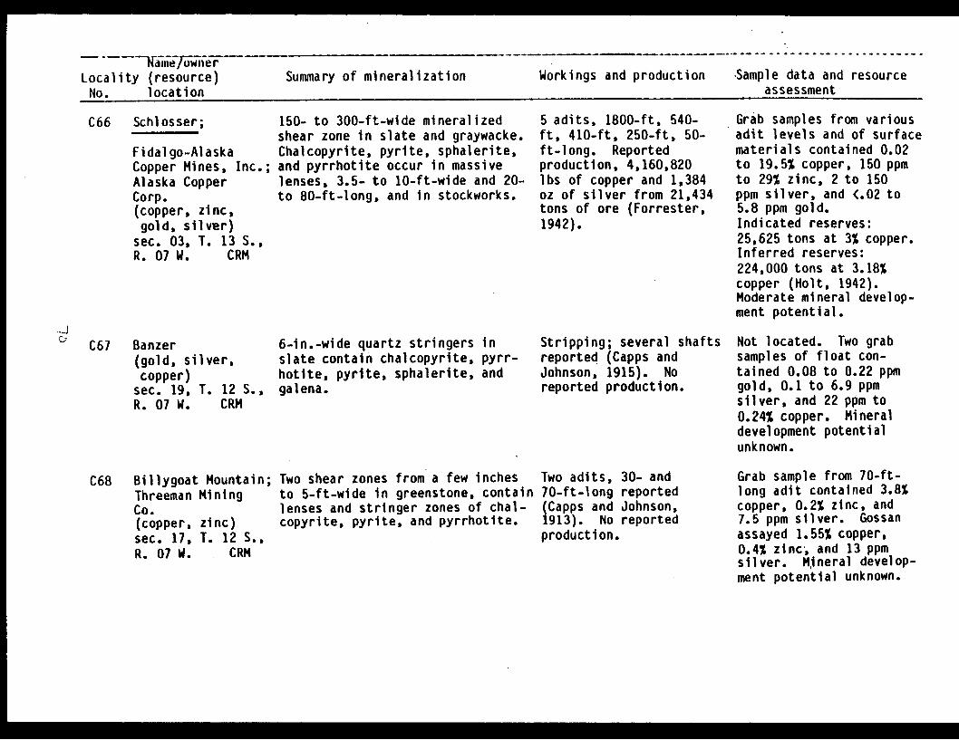
Locality (resource)No. location
Summary of mineralization Workings and production Sample data and resourceassessment
C66 Schlosser;
Fidal go-AlaskaCopper Mines, Inc.;Alaska CopperCorp.(copper, zinc,gold, silver)
sec. 03, T. 13 S.,R. 07 W. CRM
C67 Banzer(gold, silver,copper)
sec. 19, T. 12 S.,R. 07 W. CRM
C68 Billygoat Mountain;Threeman MiningCo.(copper, zinc)sec. 17, T. 12 S.,R. 07 W. CRM
150- to 300-ft-wide mineralizedshear zone in slate and graywacke.Chalcopyrite, pyrite, sphalerite,and pyrrhotite occur in massivelenses, 3.5- to 10-ft-wide and 20-to 80-ft-long, and in stockworks.
6-in.-wide quartz stringers inslate contain chalcopyrite, pyrr-hotite, pyrite, sphalerite, andgalena.
Two shear zones from a few inchesto 5-ft-wide in greenstone, containlenses and stringer zones of chal-copyrite, pyrite, and pyrrhotite.
5 adits, 1800-ft, 540-ft, 410-ft, 250-ft, 50-ft-long. Reportedproduction, 4,160,820lbs of copper and 1,384oz of silver from 21,434tons of ore (Forrester,1942).
Stripping; several shaftsreported (Capps andJohnson, 1915). Noreported production.
Two adits, 30- and70-ft-long reported(Capps and Johnson,1913). No reportedproduction.
Grab samples from variousadit levels and of surfacematerials contained 0.02to 19.5% copper, 150 ppmto 29% zinc, 2 to 150ppm silver, and <.02 to5.8 ppm gold.Indicated reserves:25,625 tons at 3% copper.Inferred reserves:224,000 tons at 3.18%copper (Holt, 1942).Moderate mineral develop-ment potential.
Not located. Two grabsamples of float con-tained 0.08 to 0.22 ppmgold, 0.1 to 6.9 ppmsilver, and 22 ppm to0.24% copper. Mineraldevelopment potentialunknown.
Grab sample from 70-ft-long adit contained 3.8%copper, 0.2% zinc, and7.5 ppm silver. Gossanassayed 1.55% copper,0.4% zinc, and 13 ppmsilver. Mineral develop-ment potential unknown.
C-,
E I 0

Name/ownerLocality (resource) Summary of mineralization Workings and production Sample data and resourceNo. location assessment
C69 ChisnaConsolidated;Buckeye Group(copper)sec. 07, T. 12 S.,R. 07 W. CRM
Two shear zones,cut greenstone.chalcopyrite andfractures in the
5- to 40-ft-wide,Thin films ofpyrite alonggreenstone.
40-ft inclined shaft;20-ft-long adit; opencuts. Some ore shipped.
Chip samples containedfrom 0.2 to 0.38% copper.Inferred reserves: 1,200tons at 0.26% copper.Inferred reserves 1,200tons at 0.3% Cu. Low min-eral development potential
C70 South Landlocked
Bay Mining Co.
Dolan and Rystrom(copper, zinc,silver)sec. 07, T. 12 S.,R. 07 W. CRM
C71 Hoodoo; ThreemanMining Co.(copper, zinc,gold, silver)
sec. 07, T. 12 S.,R. 07 W. CRM
1-ft-wide lenses of chalcopyrite,pyrite, and pyrrhotite in a 4- to15-ft-wide shear zone in green-stones.
Four 1.5- to 3-ft-wide shear zoneswhich cut greenstone, containlenses of chalcopyrite, pyrrho-tite, and sphalerite.
Four adits reported withover 900 ft of workings(Capps and Johnson, 1913).One caved adit located.Reported production74,240 lbs of copper(Mihelich and Wells,1957).
Four adits reported(Capps and Johnson,1913) 180-ft, 45-ft.15-ft (inaccessible),and 50-ft-long (sampled).No reported production.
Grab sample contained7.35% copper, 0.79% zinc,and 20.5 ppm silver. Chipsamples taken in 1955(Mihelich and Wells, 1957)contained from 1.3 to 6.8%copper, 0.8 to 3.5% zinc,and trace to 0.2 oz silver/ton. Inferred reserves:600 tons at 4.7% copperand 26% zinc. Moderatemineral developmentpotential.
Five chip samples from 50-ft-long adit containedfrom 0.11 to 2.9% copper,680 ppm to 0.95% zinc,<0.03 to 0.03 ppm gold,and 0.2 to 13.9 ppmsilver. Three selectedgrab samples contained1.14 to 19.3% copper, 0.95to 2.25% zinc, 0.15 to 44ppm gold, and 0.23 to 34ppm silver. Inferredreserves: 300 tons at1.29% copper, 0.34% zinc,and 7.97 ppm silver.Moderate m neral develop-ment potential.
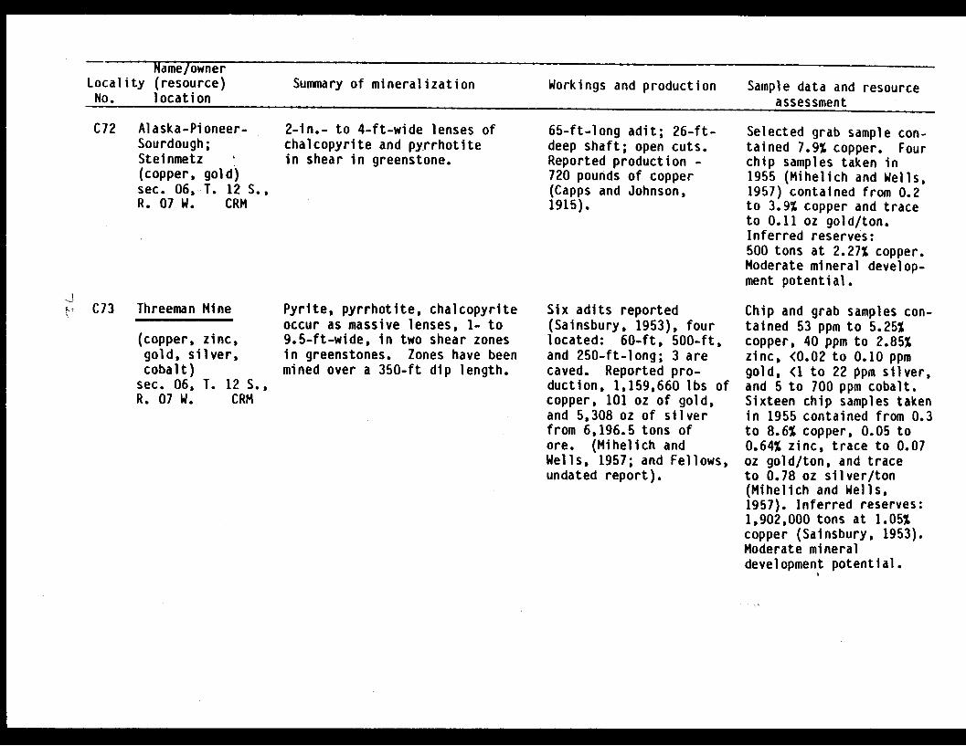
Name/ownerLocality (resource) Summary of mineralization Workings and production Sample data and resourceNo. location assessment
C72 Alaska-Pioneer-Sourdough;Steinmetz I(copper, gold)sec. 06,*T. 12 S.,R. 07 W. CRM
K. C73 Threeman Mine
(copper, zinc,gold, silver,cobalt)
sec. 06, T. 12 S.,R. 07 W. CRM
2-in.- to 4-ft-wide lenses ofchalcopyrite and pyrrhotitein shear in greenstone.
Pyrite, pyrrhotite, chalcopyriteoccur as massive lenses, 1- to9.5-ft-wide, in two shear zonesin greenstones. Zones have beenmined over a 350-ft dip length.
65-ft-long adit; 26-ft-deep shaft; open cuts.Reported production -
720 pounds of copper(Capps and Johnson,1915).
Six adits reported(Sainsbury, 1953), fourlocated: 60-ft, 500-ft,and 250-ft-long; 3 arecaved. Reported pro-duction, 1,159,660 lbs ofcopper, 101 oz of gold,and 5,308 oz of silverfrom 6,196.5 tons ofore. (Mihelich andWells, 1957; and Fellows,undated report).
Selected grab sample con-tained 7.9% copper. Fourchip samples taken in1955 (Mihelich and Wells,1957) contained from 0.2to 3.9% copper and traceto 0.11 oz gold/ton.Inferred reserves:500 tons at 2.27% copper.Moderate mineral develop-ment potential.
Chip and grab samples con-tained 53 ppm to 5.25%copper, 40 ppm to 2.85%zinc, <0.02 to 0.10 ppmgold, <1 to 22 ppm silver,and 5 to 700 ppm cobalt.Sixteen chip samples takenin 1955 contained from 0.3to 8.6% copper, 0.05 to0.64% zinc, trace to 0.07oz gold/ton, and traceto 0.78 oz silver/ton(Mihelich and Wells,1957). Inferred reserves:1,902,000 tons at 1.05%copper (Sainsbury, 1953).Moderate mineraldevelopment potential.
N

Name/ownerLocality (resource) Summary of mineralization Workings and production Sample data and resourceNo. location assessment
C74 Hemple Copper Co.(copper, zinc,gold, silver)
sec. 06, T. 12 S.,R. 07 W. CRM
C75 Alaska CommercialCo.; ThreemanMining Co.(copper, zinc,gold, silver)
sec. 06, T. 12 S.,R. 07 W. CRM
24-ft-wide shear zone cuts green-stone, slate, and graywacke, andis traceable for at least 1,500-ft along strike. Stringer zonesand lenses of pyrrhotite andchalcopyrite, 2- to 8-in.-wide,parallel foliation.
30-ft-wide shear zone cutsgreenstone. Sulfide lenses ofchalcopyrite, pyrrhotite,sphalerite, galena, and arseno-pyrite occur both in shears andas stringers in fractures inthe massive greenstone.
Four adits reported(Capps and Johnson,1913), two adits located:1,200-ft, 250-ft, 65-ft,and 18-ft-long; 2 shafts.Open cuts. No reportedproduction.
Three adits reported(Capps and Johnson,1913), 500-ft, 20-ft,and 100-ft-long. 500-ft adit located.Reported production70 tons.
Chip samples containedfrom 0.19% to 2.6% copper,800 ppm to 0.7% zinc, 2.6to 3.7 ppm silver, and<0.03 to 0.12 ppm gold.Selected grab samples con-tained 4.5 and 4.6%copper, 1.7 and 1.8% zinc,4.1 and 13 ppm silver,0.06 and 3.1 ppm gold.Five chip samples taken in1955, from the 1,200 ftadit contained from <0.1to 1.1% copper, <0.1 to1.3% zinc, trace to 0.32oz gold/ton, and 0.02 to0.32 oz silver/ton(Mihelich and Wells,1957). Inferred reserves:6,300 tons at 1.3% copper.Moderate mineral develop-ment potential.
Three chip samples fromthe 500-ft-long aditcontained 430 ppm to 1.3%copper, 330 ppm to 0.43%zinc, <0.03 to 0.05 ppmgold, and 3.8 to 27 ppmsilver. Three chipsamples from the same aditin 1955, contained from4.9 to 6.0% copper, traceto 1.4% zinc, trace to0.18 oz gold/ton, andtrace to 0.26 oz silver/

Name/ownerLocality (resource) Summary of mineralization Workings and production Sample data and resource
No. location assessment
ton (Mihelich and Wells,1957). Inferred reserves:900 tons at 1.12% copper,0.5% zinc, and 23.31 ppmsilver. Moderate mineraldevelopment potential.
C76 Montezuma;Threeman MiningCo.(copper, silver)sec. 01, T. 12 S.,R. 08 W. CRM
I-.
C77 Standard CopperMines Co.
(copper, zinc,gold, silver)sec. 01, T. 12 S..R. 08 W. CRM
Shear zones up to 20-ft-widethat cut greenstone have beentraced for 900 ft along strike.Chalcopyrite-pyrrhotite lenses1- to 4-in.-wide and quartz withdisseminated pyrite occur inshear zones.
1- to 20-ft-wide shear zones cutgreenstone and contain 1- to 5-ft-wide sulfide lenses of pyrite,chalcopyrite, and quartz.
Two adits, 400-ft and10-ft-long. No reportedproduction.
Five adits reported(Grant and Higgins,1909), three aditslocated, 175-ft, 660-ft, 290-ft, 85-ft, and28-ft-long.Recorded production,32,000 lbs copper,518 oz silver, 36 ozgold. 1,100 tonsproduced.
Chip samples contained0.74% to 3.2% copper, and3.2 to 20 ppm silver.Grab samples contained125 ppm to 0.75% copperand 0.92 ppm to 10 ppmsilver. Inferredreserves: 200 tons at1.67% copper and 9.88ppm silver. Moderatemineral developmentpotential.
Three chip samples fromthe 660-ft-long adit con-tained from 280 ppm to0.89% copper, 200 ppm to0.9% zinc, 0.01 to 0.11ppm gold, and 0.5 to 2.5ppm silver. Three grabsamples from the adit con-tained 0.70 to 2% copper,200 ppm td 2% zinc, 0.08to 0.19 ppm gold, and 2.3to 6.1 ppm silver. Chipsamples taken in 1955,yielded 0.07 to 6.1%.Inferred reserves are4.300 tons at 2.89% Cu.
I E

Name/ownerLocality (resource)No. location
Summary of mineralization Workings and production
assessment
copper, trace amounts to0.31% zinc, trace amountsto 0.04 oz gold/ton, andtrace amounts to 0.10 ozsilver/ton (Mihelich andWells, 1957). Inferredreserves: 4,300 tonsat 2.8% copper. Lowmineral developmentpotential.
C78 Falck(copper,silver)
sec. 01,R. 08 W.
zinc,
T. 12 S.,CRM
C79 Reynolds-AlaskaDevelopment Co.;Landlocked BayProperty(copper, zinc,silver)
sec. 31, T. 11 S.,R. 07 W. CRM
1- to 20-ft-wide shear zones ingreenstone contain chalcopyrite,pyrrhotite, sphalerite, quartz,and calcite.
1- to 20-ft-wide shear zones cutgreenstone. One zone is traceablefor 400 ft. 2-in.- to 4-ft-widemassive sulfide lenses of chalco-pyrite and pyrrhotite occur alongshear zones.
Two adits reported(Capps and Johnson, 1915),25-ft and 15-ft-long;25-ft adit located; opencuts. No reportedproduction.
Four adits present,170-ft, 600-ft, 30-ft,18-ft-long; 3 caved -open cuts, floodedshaft (Capps andJohnson, 1913). Noreported production.
Chip samples containedfrom 0.11 to 7.5% copper,240 ppm to 0.68% zinc, 0.7to 18.3 ppm silver. Aselected grab sample fromthe dump contained 7.7%copper, 0.77% zinc, and23 ppm silver. Inferredreserves: 200 tons at2.03% copper, 0.23% zinc,and 13 ppm silver.Moderate mineral dpvelop-ment potential.
Chip samples from opencuts contain from 0.18 to8.4% copper, 170 ppm to0.25% zinc, and 0.8 to 28ppm silver. Grab samplesfrom the workings con-tained from 100 ppm to9.75% copper, 100 ppm to1.05% zinc, and 0.8 to 9.5ppm silver. Inferred
Sample data and resource

Name/ownerLocality (resource) Summary of mineralization Workings and production Sample data and resourceNo. location assessment
reserves: 3,000 tons at4.6% copper, 0.14% zinc,and 15.65 ppm silver.Moderate mineral develop-ment potential.
C80 Steinmetz(copper, zinc,gold, silver)
sec. 36, T. 11 S.,R. 08 W. CRM
C81 Tibbitt(copper,zinc)
sec. 36,R. 08 W.
sil ver,
T. 11 S.,CRM
C82 Threeman MiningCo. Prospect(copper, zinc,silver)
sec. 36, T. 11 S.,R. 08 W. CRM
Chalcopyrite and pyrrhotite occuralong 3- to 4-ft-wide shearzones in greenstones.
1- to 8-ft-wide shear zones ingreenstones, minor slate and gray-wacke contain chalcopyrite,pyrite, and pyrrhotite.
2- to 15-ft-wide shear zone,parallels trend of the slate.Chalcopyrite and pyrrhotitelenses, 1- to 1.17-ft-wide, occuralong the shear.
One caved adit; openpits. No reportedproduction.
Four adits reported(U.S. Bureau of LandManagement, 1982, MineralSurvey 879), 45-ft, and?-ft-long; open cuts.One 20-ft adit located.No reported production.
One adit, 41-ft-long.No reported production.
Grab samples fromworkings contained from2 to 3% copper, 0.17 to6% zinc, 0.19 to 15.5 ppmgold, and 13 to 22.5ppm silver. Mineraldevelopment potentialunknown.
Two grab samples contained0.59% and 2% copper, 1.8ppm and 6.4 ppm silver.Two chip samples from the45-ft-long adit contained430 ppm and 0.93% copper,3.4 and 12.7 ppm silver,and 240 ppm and 0.13%zinc. Inferred reserves:500 tons at 0.72% copper.Low mineral developmentpotential.
Three chip samplescontained 200 ppm to 1%copper, 145 to 0.8% zinc,and <0.2 to 6 ppm silver.Grab sample from the dumpcontained 4.9% copper,0.49% zinc, and 50 ppmsilver. Low mineraldevelopment potential.
GI

- __ -_ -------Locality (resource) Summary of mineralization Workings and production Sample data and resourceNo. location assessment
C83 Galena BayMining Co.(copper, zinc,silver)
secs. 25, 26, 35,36, T. 11 S.,R. 08 W. CRM
84 Copper MountainProspect(copper, zinc,silver, cobalt)
sec. 23, T. 11 S.,R. 08 W. CRM
C85 Mogul Group(copper)sec. 22, T. 11 S.,R. 08 W. CRM
Numerous 1- to 20-ft-wide shearzones cut greenstone. Most ofworkings are along one shear thatis traceable for over 1,000 ft.
6-in.-wide shear zone cuttinggreenstone, contains chalco-pyrite and quartz veinlets.
0.5- to 4-ft-wide shear zonescut greenstone. Sulfide mineralsalong the shears include chalco-pyrite, pyrite, pyrrhotite, andsphalerite.
9 adits reported (Cappsand Johnson, 1915), 8adits located, 30-ft,400-ft, 10-ft, 80-ft,2,200-ft (caved), 31-ft,15-ft, and 18-ft-long.Open cuts. Buildings.No reported production.
20-ft-long adit.No reported production.
13-ft-deep shaft.Open cuts.No reported production.
Chip samples from shearscontained from 58 ppm to13% copper, 46 ppm to 2%zinc, <0.1. ppm to 32.8 ppmsilver. Grab samples ofvarious materials con-tained from 80 ppm to 6.1%copper, 790 ppm to 20.1%zinc, and 1.1 to 20ppm silver. Inferredreserves: 5,800 tonsat 7.9% copper, 1.3% zinc,*and 5 ppm silver.Moderate mineral develop-ment potential.
Chip sample contained1.87% copper, 800 ppmzinc, and 10.9 ppm silver.A selected grab samplecontained 11.7% copper,0.35% zinc, 43.5 ppmsilver, and 770 ppmcobalt. Inferredreserves: 300 tonsat 1.87% copper.Low mineral developmentpotential.
Six chip samples contained620 ppm to 0.37% copper.Inferred reserves: 400tons at 0.25% copper. Lowmineral developmentpotential.
CjIIll C
0

~ ~liDi'aei wr `Locality (resource)No. location
Summary of mineralization Workings and production Sample data and resourceassessment
C86 Fielder & Hemple.(copper, zinc)sec. 27, T. 11 S.,R. 08 W. CRM
C87 Reynolds-Alaska
Development Co.
Boulder-Bay(copper, silver,zinc)sec. 27, T. 11 S.,R. 08 W. CRM
C88 Rua(copper,sec. 28,R. 08 W.
zinc)T. 11 S.,
CRM
25- to 30-ft-wide shear zone cutsgreenstones and contains pyrite,chalcopyrite, pyrrhotite, andquartz.
Mineralization restricted to N.60°-65° E. trending and 780 SE.dipping shears at greenstone-slatecontact. Mineralization occursas massive lenses, veinlets,disseminations, and thin selvagesof chalcopyrite, pyrite, pyrrho-tite, and sphalerite.
Shear zone cuts greenstone, con-tains pyrite and pyrrhotite.
Two adits, 250-ft and20-ft-long.No reported production.
Four adits reported(Capps and Johnson, 1915),three adits located,2,200-ft, 200-ft, (caved)300-ft, and 5-ft-long.Reported production -215,000 lbs of copperfrom 2,850 tons ofore. (Fellows,undated).
60-ft-long adit. Noreported production.
Five grab and two chipsamples contained 50 ppmto 0.5% copper and 440ppm to 0.1% zinc. Lowmineral developmentpotential.
Chip samples contained0.6 to 1.7% copper, 225ppm to 0.61% zinc, and 2.4to 8.9 ppm silver. Grabsamples contained 60 ppmto 6% copper, 67 ppm to1.7% zinc, and 1.1 to13 ppm silver. Inferredreserves: 600 tons at1.37% copper, 0.28% zinc,and 6.67 ppm silver.Moderate mineral develop-ment potential.
Chip sample contained 900ppm copper and 0.19% zinc.Low mineral developmentpotential.
C89 Wagner(copper)sec. 28,R. 08 W.
No data. One caved adit.No reported production.
T. 11 S.,CRM
C90 McNaughton &Turner (copper)sec. 16, T. 11 S.,R. 08 W. CRM
No data. No data. No reportedproduction.
Selected grab dump samplecontained 39 ppm copper.Mineral development poten-tial unknown.
Not located. Mineraldevelopment potentialunknown.
�� M ��

Name/ownerLocality (resource) Summary of mineralization Workings and production Sample data and resourceNo. location assessment
C91 Ellamar Mine
(copper, zinc,gold, silver)
sec. 19, T. 11 S.,R. 08 W. CRM
C92 Ella(copper)sec. 29,R. 08 W.
T. 11 S.,CRM
90- to 240-ft-wide, 500-ft-longlenticular mass of sulfides inslates and graywackes was mined.35-ft-thick lens of pyrite over-lies and parallels lenses ofchalcopyrite, chalmersite, pyrr-hotite, sphalerite, and galena.
Possible extension along strikeof the Ellamar deposit.
600-ft-deep three compart-ment shaft; 9,300 ft ofworkings on 8 levels(flooded). Recordedproduction, 15,761,337lbs of copper, 51,305oz of gold, 191,615oz of silver from301,835 tons of ore.
No data. No reportedproduction.
Grab sample from the dumpcontained 50 ppm copper,0.006 oz gold/ton and 0.2oz silver/ton. Three coreholes drilled in 1955,1956: hole No. 2 cut 10-ft of 0.02% copper, 0.02oz gold/ton, and 0.02 ozsilver/ton; hole No. 3cut 28-ft of pyrite,which contained 0.5%copper, 0.085 oz gold/ton,and 0.75 oz silver/ton.Indicated reserves:36,000 tons at 2% copper,0.1 oz gold/ton, and 0.5oz silver/ton. Inferredreserves: 500,000 tonsat 0.5% copper, 0.085oz gold/ton, and 0.75oz silver/ton. Moderatemineral developmentpotential.
No data. Mineral develop-ment potential unknown.
C93 Cloudman Bay(gold, silver)sec. 07, T. 12 S.,R. 08 W. CRM
20- to 30-ft-wide quartz stockworkin slate contains chalcopyrite,pyrite, and sphalerite.
40 ft ofreportedJohnson,reported
stripping(Capps and1913). Noproduction.
Not located. Mineraldevelopment potentialunknown.
-oc

hame/ownerLocality (resource) Summary of mineralization Workings and production Sample data and resourceNo. location assessment
C94 Bligh Island;Alaska CommercialCo.(gold)sec. 36, T. 11 S.,R. 09 W. CRM
C95 Jack Bay 3(gold)sec. 27, T. 10 S.,R. 07 W. CRM
&'4 C96 Jack Bay 2(copper, gold)sec. 23, T. 10 S.,R. 07 W. CRM
Gold-bearing quartz veinin greenstone.
Arsenopyrite and gold in 0.5- to3-ft-wide quartz vein in gray-wacke. Vein is traceable forseveral hundred ft along strike.
6-ft-wide zone of quartz vein-lets contains chalcopyriteand pyrrhotite in slate.
Caved shaft (Capps andJohnson, 1913). Noreported production.
No data. No reportedproduction.
No data. No reportedproduction.
Chip samples in the areacontained from <0.03 to0.03 ppm gold. Gold upto 120 oz/ton reported(Capps and Johnson,1913). Low mineraldevelopment potential.
Not located. Mineraldevelopment potentialunknown.
Grab sample contained140 ppm copper and 0.006oz gold/ton. Low mineraldevelopment potential.
C97 Wortmann's Glacier*(zinc, copper,silver)
sec. 06, T. 11 S.,R. 02 W. CRM
C98 HinchinbrookIsland*(manganese)sec. 34, T. 17 S.,R. 07 W. CRM
Mineralized zone in greenschistcontains sphalerite, chalcopyrite,and pyrite.
Manganese-rich rock forms a30 x 90-ft rubble area.Minerals present includebementite, quartz, chalcedony,calcite, hematite, barite,rancieite, todorokite, andbirnessite.
None. USGS grab samples con-tained 1.0% zinc, 0.1 to0.55 copper, and 0.5 to 3ppm silver. Mineraldevelopment potentialunknown.
None. USGS grab samples con-tained 29 and 35%manganese. Mineraldevelopment potentialunknown.
E
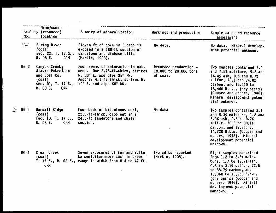
Name/ownerLocality (resource)No. location
Summary of mineralization Workings and production Sample data and resourceassessment
BG-1 Bering River(coal)sec. 22, T. 17iS.,R. 08 E. CRM
Eleven ft of coke in 5 beds isexposed in a 180-ft section ofsandstone and diabase sills(Martin, 1908).
No data. No data. Mineral develop-ment potential unknown.
BG-2 Canyon Creek;Alaska Petroleumand Coal Co.(coal)sec. 01, T. 17 S.,R. 08 E. CRM
Four seams of anthracite in out-crop. One 2.75-ft-thick, strikesN. 800 E. and dips 350 NW.Another 4.1-ft-thick, strikes N.100 E. and dips 60° NW.
Recorded production -18,000 to 20,000 tonsof coal.
Two samples contained 7.4and 7.8% moisture, 9.2 and14.4% ash, 0.6 and 0.7%sulfur, 70.1 and 74.0%carbon, and 15,310 to15,460 B.t.u. (dry basis)(Cooper and others, 1946).Mineral development poten-tial unknown.
-.- BG-3 Wardall Ridge(coal)sec. 10, T. 17 S.,R. 08 E. CRM
Four beds of bituminous coal,22.5-ft-thick, crop out in a24.5-ft sandstone and shalesection.
No data Two samples contained 3.1and 5.3% moisture, 1.2 and6.9% ash, 0.6 to 0.7%sulfur, 70.3 to 80.1%carbon, and 12,360 to14,220 B.t.u. (Cooper andothers, 1946). Mineraldevelopment potentialunknown.
1G-4 Clear Creek Seven exposures of semianthacite(coal) to semibituminous coal in creekT. 17 S., R. 08 E., range in width from 0.4 to 47 ft.
CRM
Two adits reported(Martin, 1908).
Eight samples containedfrom 1.2 to 6.6% mois-ture, 1.7 to 12.7% ash,0.6 to 3.1% sulfur, 72.5to 88.7% carbon, and15,360 to 15,960 B.t.u.(dry basis) (Cooper andothers, 1946). Mineraldevelopment potentialunknown.

Name/ownerLocality (resource) Summary of mineralization Workings and production Sample data and resource
No. location assessment
BS-1 LatoucheConsolidatedCopper Co.Prospect;Tibbits Prospect(copper, silver)sec. 02, T. 03 S.,R. 08 W. SM
BS-2 Seattle-AlaskaProspectOwen Ore Co.;Alpha Claims(copper, silver,zinc)
sec. 36, T. 02 S.,R. 08 E. SMLatouche Island
BS-3 Unnamed occurrence(copper, silver,zinc)
sec. 28, T. 02 S.,R. 09 E. SMLatouche Island
3-ft-wide shear zone cuttinggraywacke contains chalcopyritemainly as stringers in quartzveinlets.
Series of parallel shear zones,up to 5-ft-wide, cut interbeddedgraywacke and shale. Siliceouszones, up to 4-ft-wide, withinthe shears contain pyrite, pyrr-hotite, bornite, up to 5% chal-copyrite, and traces of nativecopper. Mineralization has beendrifted on for 45 ft. Mineral-ization may extend a total of 236ft vertically between levels andfor 4,300 ft along strike.
Landslide block of slate andgraywacke contains 3 bedding-conformable chalcopyrite andpyrrhotite-bearing zones, up to2-ft-thick and extending 500 ftalong strike. Additional sulfidesmay be present. Limonite-stainedparallel bedding of sedimentaryrocks exposed on slope.
6 x 6-ft water-filledshaft, depth unknown.No recorded production.
Four accessible adits:1) adit with 424 ft of
workings.2) 58-ft-long adit.3) 235-ft-long adit.4) short adit driven in
alluvium.One caved adit reportedto be 400-ft-long(Johnson, 1918, pp. 209-210) and a caved aditof unknown length. Threeopen cuts found. 12 tonsof ore shipped in 1914,yielded 2,350 lbs of coppeand 23 oz of silver.
No signs of prospecting.No production.
3-ft-wide chip sampleof the mineralized shearzone contained 1.7% copperand 8.5 ppm silver. Dumpgrab sample contained0.59% copper and 8.5 ppmsilver. Low mineraldevelopment potential.
Chip sample across a 4-ft-wide mineralized zonecontained 6.5% copper,14.2 ppm silver, and 0.12%zinc. 0.5-ft-wide chipsample contained 9.0%copper, 24.5 ppm silver,and 0.13% zinc. High-grade dump sample con-tained 0.53% zinc.Inferred reserves are2,900 tons at 3% Cu.Moderate mineraldevelopment potential.r
20-ft-wide chip samplecontained 2.5% copper,18.5 ppm silver, and0.14% zinc. Moderatemineral developmentpotential.
N E I
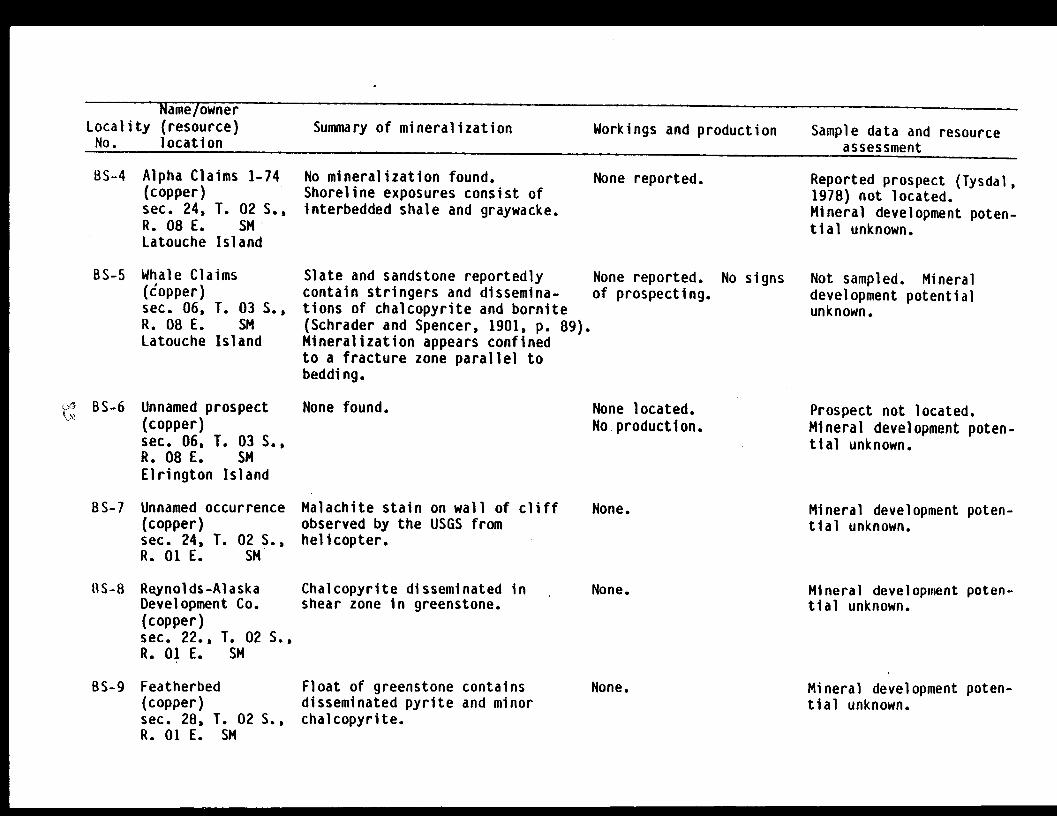
N ame/ownerLocality (resource) Summary of mineralization Workings and production Sample data and resourceNo. location assessment
BS-4 Alpha Claims 1-74(copper)sec. 24, T. 02 S.,R. 08 E. SMLatouche Island
No mineralization found.Shoreline exposures consist ofinterbedded shale and graywacke.
None reported. Reported prospect (Tysdal,1978) not located.Mineral development poten-tial unknown.
BS-5 Whale Claims(Copper)sec. 06, T. 03 S.,R. 08 E. SMLatouche Island
BS-6 Unnamed prospect(copper)sec. 06, T. 03 S.,R. 08 E. SMElrington Island
BS-7 Unnamed occurrence(copper)sec. 24, T. 02 S.,R. O E. SM
RS-8 Reynolds-AlaskaDevelopment Co.(copper)sec. 22., T. 02 S.,R. 01 E. SM
BS-9 Featherbed(copper)sec. 28, T. 02 S.,R. 01 E. SM
Slate and sandstone reportedly None reported.contain stringers and dissemina- of prospecting.tions of chalcopyrite and bornite(Schrader and Spencer, 1901, p. 89).Mineralization appears confinedto a fracture zone parallel tobedding.
None found.
No signs
None located.No production.
Malachite stain on wall of cliffobserved by the USGS fromhelicopter.
Chalcopyrite disseminated inshear zone in greenstone.
Float of greenstone containsdisseminated pyrite and minorchalcopyrite.
None.
None.
None.
Not sampled. Mineraldevelopment potentialunknown.
Prospect not located.Mineral development poten-tial unknown.
Mineral development poten-tial unknown.
Mineral development poten-tial unknown.
Mineral development poten-tial unknown.
01

Name/ownerLocality (resource) Summary of mineralization Workings and production Sample data and resourceNo. location assessment
BS-10 Featherbed(copper)sec. 22, T. 02 S.,R. 01 E. SM
Shear zone up to 7-in.-wide,contains stringers of chalco-pyrite.
None. Reportedly contains 14% to19% copper. Mineraldevelopment potentialunknown.
BS-11 Peterson(copper,sec. 33,R. 01 E.
zinc)T. 02 S.,SM
5-ft-wide zone of brecciatedgreenstones contains quartz,calcite, sphalerite, pyrite,epidote, and chalcopyrite.
Two short adits.No reported production.
Mineral development poten-tial unknown.
BS-12 Iron Mask(copper, zinc)sec. 21, T. 03 S.,R. 01 E. SM
Tuffaceous breccia; fracturedand recemented by quartz contain-ing pyrite and minor calcite,chalcopyrite, and sphalerite.
None. USGS assays show anaverage of 1.1% copperacross 13-ft-wide, 98-ft-long zone. Mineraldevelopment potentialunknown.
BS-13 Fairview(copper)sec. 22, T.03 S.,R. 01 E. SM
Breccia zone, 8- to 10-ft-wide, ingreenstone recemented by quartz,pyrite, and chalcopyrite.Sulfide zone to 6.5-ft-thick.
One short adit.No reported production.
Mineral development poten-tial unknown.
BS-14 Unnamed occurrence(silver, cadmium,cobalt, lead,zinc)
sec. 28, T. 03 S.,R. 01 E. SM
BS-15 Leitzke(copper)sec. 33, T. 03 S.,R. 01 E. SM
2-ft-wide zone of sheared andbrecciated sheeted basalt dikescontain quartz, pyrite, chalco-pyrite, and galena.
Brecciated zone of diabasecemented by quartz, pyrite, andminor chalcopyrite.
None. USGS sample contained3 ppm silver, 70 ppmcadmium, 0.15% copper,0.3% lead, and 0.92%zinc. Mineral developmentpotential unknown.
None. Mineral development poten-tial unknown.
M �1 E

Name/owner(resource)location
Summary of mineralization Workings and production Sample data and resource
V-1 Addison-Powell;Peabody-AlaskaCopper Corp. ,(copper, gold)sec. 15, ,T. 10 S.,R. 05 W. CRM
V-2 Johnson Pit(sand & gravel)sec. 19, T. 09 S.,R. 05 W. CRM
U1 V-3 Alaska Asphalt Pit(sand & gravel)sec. 36, T. 08 S.,R. 06 W. CRM
V-4 Rose Johnson(gold, lead,copper)
sec. 08, T. 08 S.,R. 05 W. CRM
Chalcopyrite with moderate toabundant pyrite and pyrrhotitein small veinlets in greenstoneand as lenses and veinlets inadjacent metasedimentary rocks.Small amounts of gold reported(Johnson, 1916).
Quaternary alluvial gravels.
Quaternary alluvial gravels.
Several quartz veins, 2- to 7-in.-wide, contain free gold, pyrite,galena, chalcopyrite, and sphal-erite.
100-ft-long adit, 150 ftof open cuts and strippingreported (Johnson, 1916).No reported production.
Sand and gravel operation.No reported production.
Sand and gravel quarryoperation.No reported production.
Several short adits;20-ft shaft; open cuts;and some strippingreported (Johnson, 1915a).Reported production of49 oz gold and 3 ozsilver.
Not located. Seven grabsamples from the areacontained from 10 ppm to0.39% copper. Mineraldevelopment potentialunknown.
Not looked for. Mineraldevelopment potentialunknown.
Not looked for. Mineraldevelopment potentialunknown.
Not located. Mineraldevelopment potentialunknown.
LocalityNo.
I assessment

Name/ownerLocality (resource) Summary of mineralization Workings and production Sample data and resourceNo. location
assessment
V-5 Ramsay-Rutherford;
Lost Hope(gold, silver)sec. 03, T. 08 S.,R. 05 W. CRM
Two well-defined quartz veins.The main, southern, vein variesin width from 1-in. to 7-ft, aver-ages 2-ft, and has been tracedfor 450 ft along strike. Thesecond vein, which averages 9-in.-wide, is exposed approximately90 ft north of the main vein.Mineralization includes gold,silver, siderite, pyrite, pyrrho-tite, chalcopyrite, sphalerite,galena, and arsenopyrite.
Four mine levels reported(Johnson, 1915a). The50-ft level has 220 ftof drifts, stopes tosurface; 100-ft levelhas 210 ft of driftsand a crosscut, stopesto the 50-ft level;150-ft level has 50 ftof drifts; the 300-ftlevel (mill level) has770-ft crosscut (caved),540 ft of drifts, 15-ftwinze, raise to thesurface. Reportedproduction of 5,375 ozgold and 1,194 oz silver.
Two grab samples con-tained 0.07 oz gold/tonand <0.01 and 2.1 ppm6ilver. Mill concentratecontained 37.5 ppm goldand 9.5 ppm silver. Goldfineness is 778. Twenty-four USGS samples con-tained 0.05 to 28.0 ppmgold. High mineraldevelopment potential.
I E

Locality (resource)No. location
Summary of mineralization Workings and production Sample data and resourceaC - -uetm
V-6 Pinocle(gold, silver)sec. 04, T. 08 S.,R. 05 W. CRM
V-7 Ibex(gold, silver)sec. 06, T. 08 S.,R. 05 W. CRM
V-8 Donohue;Valdez Mining Co.(gold, silver)sec. 06, T. 08 S.,R. 05 W. CRM
V-9 Valdez Bonanza(gold, silver)sec. 12, T. 08 S.,R. 06 W. CRM
V-10 Glacier Stream Pit(sand & gravel)sec. 26, T. 08 S.,R. 06 W. CRM
Quartz filled fissure that variesfrom stringers to 3 ft of solidquartz. Mineralization consistsof gold, silver, pyrite, pyrrho-tite, and chalcopyrite.
4-ft-wide vein of banded quartz.
Mineralized quartz vein rangesfrom 3- to 10.5-ft-wide. Veinin the lower adit is 24- to 50-in.-wide ribbon quartz and massivewhite quartz. Native gold occursin both the ribbon and massivequartz.
2- to 5-ft-wide quartz veinpinches out at depth.Mineralization is mainlypyrite with minor gold in thequartz veins.
Quaternary alluvial gravels.
Short adit (caved);a 115-ft crosscut; a10-ft shaft; andstripping (Johnson,1915a). Workingsare now caved. Noreported production.
200-ft-long adit reported(Brooks, 1912). Noreported production.
Two adits. A 470-ftadit at the 2,610 ftelevation. An adit(partially caved) at the2,860 ft elevation hasa 50-ft winze. Noreported production.
100-ft-long adit with acrosscut reported (Brooks,1912). No reportedproduction.
Sand and gravel opera-tion. No reported pro-duction.
Two chip samples contained0.13 ppm and 0.051 ozgold/ton and <0.01 ozsilver/ton. Grab samplecontained 0.503 oz gold/ton and <0.01 oz silver/ton. Low mineral develop-ment potential.
Not located. Mineraldevelopment potentialunknown.
Six chip samples con-tained from <0.003 to0.413 oz gold/ton and<0.01 to 0.10 oz silver/ton. Four grab samplescontained <0.05 to 100.2oz gold/ton and 0:5 to16.9 oz silver/ton.Inferred reserves: 2,500tons at 13 ppm gold and3.3 ppm silver. Highmineral developmentpotential.
Not located. Mineraldevelopment potentialunknown. -
Not looked for. Mineraldevelopment potentialunknown.
U43c3Z1111clit.
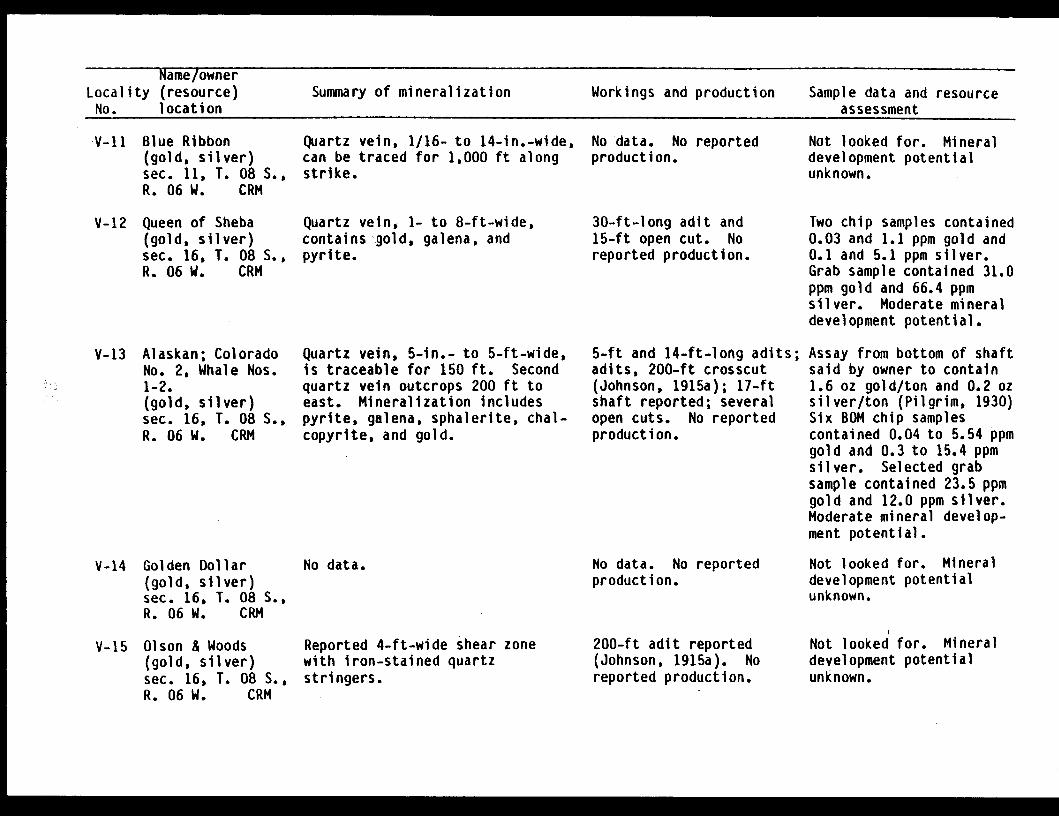
Name/ownerLocality (resource) Summary of mineralization Workings and production Sample data and resourceNo. location assessment
V-1l Blue Ribbon(gold, silver)sec. 11, T. 08 S.,R. 06 W. CRM
V-12 Queen of Sheba(gold, silver)sec. 16, T. 08 S.,R. 06 W. CRM
V-13 Alaskan; ColoradoNo. 2, Whale Nos.1-2.(gold, silver)sec. 16, T. 08 S.,R. 06 W. CRM
Quartz vein, 1/16- to 14-in.-wide,can be traced for 1,000 ft alongstrike.
Quartz vein, 1- to 8-ft-wide,containsgold, galena, andpyrite.
Quartz vein, 5-in.- to 5-ft-wide,is traceable for 150 ft. Secondquartz vein outcrops 200 ft toeast. Mineralization includespyrite, galena, sphalerite, chal-copyrite, and gold.
No data. No reportedproduction.
30-ft-long adit and15-ft open cut. Noreported production.
5-ft and 14-ft-long adits;adits, 200-ft crosscut(Johnson, 1915a); 17-ftshaft reported; severalopen cuts. No reportedproduction.
Not looked for. Mineraldevelopment potentialunknown.
Two chip samples contained0.03 and 1.1 ppm gold and0.1 and 5.1 ppm silver.Grab sample contained 31.0ppm gold and 66.4 ppmsilver. Moderate mineraldevelopment potential.
Assay from bottom of shaftsaid by owner to contain1.6 oz gold/ton and 0.2 ozsilver/ton (Pilgrim, 1930)Six BOM chip samplescontained 0.04 to 5.54 ppmgold and 0.3 to 15.4 ppmsilver. Selected grabsample contained 23.5 ppmgold and 12.0 ppm silver.Moderate mineral develop-ment potential.
V-14 Golden Dollar(gold, silver)sec. 16, T. 08 S.,R. 06 W. CRM
No data. No data. No reportedproduction.
Not looked for. Mineraldevelopment potentialunknown.
V-15 Olson & Woods(gold, silver)sec. 16, T. 08 S.,R. 06 W. CRM
Reported 4-ft-wide shear zonewith iron-stained quartzstringers.
200-ft adit reported(Johnson, l915a). Noreported production.
Not looked for. Mineraldevelopment potentialunknown.
I I E
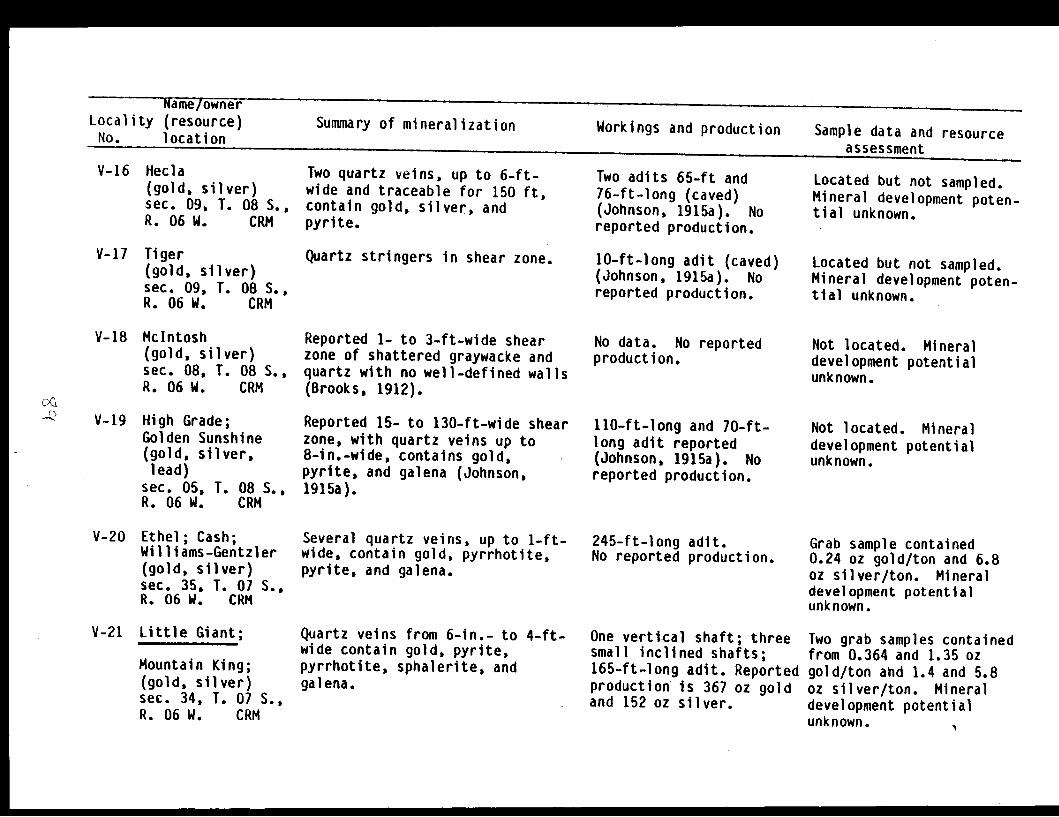
Name/ownerLocality (resource)No. location
Summary of mineralization Workings and production Sample data and resource
V-16 Hecla(gold, silver)sec. 09, T. 08 S.,R. 06 W. CRM
V-17 Tiger(gold, silver)sec. 09, T. 08 S.,R. 06 W. CRM
V-18 McIntosh(gold, silver)sec. 08, T. 08 S.,R. 06 W. CRM
V-19 High Grade;Golden Sunshine(gold, silver,lead)
sec. 05, T. 08 S.,R. 06 W. CRM
V-20 Ethel; Cash;Williams-Gentzler(gold, silver)sec. 35, T. 07 S.,R. 06 W. CRM
V-21 Little Giant;
Mountain King;(gold, silver)sec. 34, T. 07 S.,R. 06 W. CRM
Two quartz veins, up to 6-ft-wide and traceable for 150 ft.contain gold, silver, andpyrite.
Quartz stringers in shear zone.
Reported 1- to 3-ft-wide shearzone of shattered graywacke andquartz with no well-defined wall(Brooks, 1912).
Reported 15- to 130-ft-wide sheizone, with quartz veins up to8-in.-wide, contains gold,pyrite, and galena (Johnson,1915a).
Several quartz veins, up to 1-ftwide, contain gold, pyrrhotite,pyrite, and galena.
Quartz veins from 6-in.- to 4-ftwide contain gold, pyrite,pyrrhotite, sphalerite, andgalena.
Two adits 65-ft and76-ft-long (caved)(Johnson, 1915a). Noreported production.
10-ft-long adit (caved)(Johnson, 1915a). Noreported production.
No data. No reportedproduction.
Is
ir 110-ft-long and 70-ft-long adit reported(Johnson, 1915a). Noreported production.
t- 245-ft-long adit.No reported production.
One vertical shaft; threesmall inclined shafts;165-ft-long adit. Reportedproduction is 367 oz goldand 152 oz silver.
Located but not sampled.Mineral development poten-tial unknown.
Located but not sampled.Mineral development poten-tial unknown.
Not located. Mineraldevelopment potentialunknown.
Not located. Mineraldevelopment potentialunknown.
Grab sample contained0.24 oz gold/ton and 6.8oz silver/ton. Mineraldevelopment potentialunknown.
Two grab samples containedfrom 0.364 and 1.35 ozgold/ton and 1.4 and 5.8oz silver/ton. Mineraldevelopment potentialunknown. %
assessment
, 4
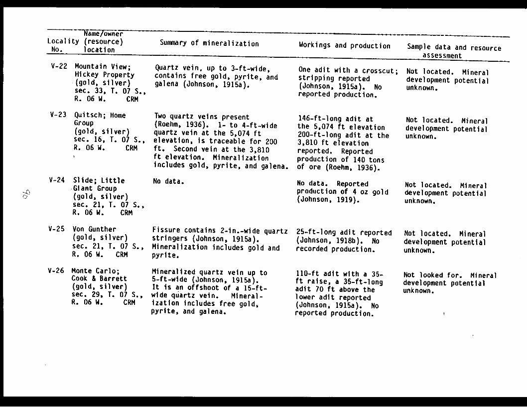
a me lone rLocality (resource)No. location
Summary of mineralization Workings and production Sample data and resourceassessment
V-22 Mountain View;Hickey Property(gold, silver)sec. 33, T. 07 S.,R. 06 W. CRM
V-23 Quitsch; HomeGroup(gold, silver)sec. 16, T. 07 S.,R. 06 W. CRM
Quartz vein, up to 3-ft-wide,contains free gold, pyrite, andgalena (Johnson, 1915a).
Two quartz veins present(Roehm, 1936). 1- to 4-ft-widequartz vein at the 5,074 ftelevation, is traceable for 200ft. Second vein at the 3,810ft elevation. Mineralizationincludes gold, pyrite, and galena.
One adit with a crosscut;stripping reported(Johnson, 1915a). Noreported production.
146-ft-long adit atthe 5,074 ft elevation200-ft-long adit at the3,810 ft elevationreported. Reportedproduction of 140 tonsof ore (Roehm, 1936).
Not located. Mineraldevelopment potentialunknown.
Not located. Mineraldevelopment potentialunknown.
V-24 Slide; LittleGiant Group(gold, silver)sec. 21, T. 07 S.,R. 06 W. CRM
No data. No data. Reportedproduction of 4 oz gold(Johnson, 1919).
Not located. Mineraldevelopment potentialunknown.
V-25 Von Gunther(gold, silver)sec. 21, T. 07 S.,R. 06 W. CRM
V-26 Monte Carlo;Cook & Barrett(gold, silver)sec. 29, T. 07 S.,R. 06 W. CRM
Fissure contains 2-in.-wide quartzstringers (Johnson, 1915a).Mineralization includes gold andpyrite.
Mineralized quartz vein up to5-ft-wide (Johnson, 1915a).It is an offshoot of a 15-ft-wide quartz vein. Mineral-ization includes free gold,pyrite, and galena.
25-ft-long adit reported(Johnson, 1918b). Norecorded production.
110-ft adit with a 35-ft raise, a 35-ft-longadit 70 ft above thelower adit reported(Johnson, 1915a). Noreported production.
Not located. Mineraldevelopment potentialunknown.
Not looked for. Mineraldevelopment potentialunknown.
D)

Name/ownerLocality (resource) Summary of mineralization Workings and production Sample data and resourceNo. location assessment
V-27 Hercules;
Millionaire;Mineral King;Mineral CreekMining Co; Chesna(gold, silver)sec. 29, T. 07 S.,R. 06 W. CRM
V-28 Big Four
(gold, silver)sec. 31, T. 07 S.,R. 06 W. CRM
V-29 Devinney & Dolan(gold, silver,lead, zinc)
sec. 25, T. 08 S.,R. 07 W. CRM
V-30 Blondeau Pit(sand & gravel)sec. 31, T. 08 S.,R. 06 W. CRM
Nine quartz veins range in widthfrom 2- to 30-in. Mineralizationincludes gold, pyrite, galena,sphalerite, pyrrhotite, andchalcopyrite.
6-in.- to 3-ft-wide quartz veinis traceable for 200 ft. Veinpinches and swells, roughlyparallels the schistosity ofcountry rock. Mineralizationconsist of free gold, pyrite,sphalerite, and galena.
Mineralized quartz veins rangein width from a few inches to2 ft (Roehm, 1936). Mineral-ization consists of gold, pyrite,and sphalerite.
Quaternary alluvial gravels.
Ten adits. 120-ft, 250-ft, 180-ft, >50-ft, 75-ft,450-ft, 60-ft, and 200-ft-long, one caved (Johnson,1915a). Reported pro-duction 269 oz goldand 44 oz silver.
One adit, caved 45 ftfrom the portal; two25-ft-deep shafts.Reported production is846 oz gold and 371 ozsilver.
238-ft-long adit witha raise; and a 38-ft-long adit reported(Roehm, 1936). Noreported production.
Sand and gravel operation.No reported production.
Two chip samples contained11.8 ppm and 1.6 oz gold/ton and 4.2 ppm and 0.7 ozsilver/ton. Grab samplecontained 11 ppm gold and9.8 ppm silver. Twenty-five USGS samples con-tained <0.05 to 1.5 ppmgold. Inferred reserves:450 tons at 22.5 ppm goldand 9.1 ppm silver.Moderate mineral develop-ment potential.
Four grab samples con-tained <0.03 ppm to 3.98oz gold/ton, and from atrace to 1.0 oz silver/ton. Moderate mineraldevelopment potential.
Not located. Mineraldevelopment potentialunknown.
Not looked for. Mineraldevelopment potentialunknown.
V-31 Yellow Bar(gold, silver)ec. 36, T. 08 S.,R. 07 W. CRM
No data. No data. No reportedproduction.
Not looked for. Mineraldevelopment potentialunknown.

Name/ownerLocality (resource) Summary of mineralizationNo. location Workings and production Sample data and resource
assessmentV-32 M-K Till Plant
(stone)sec. 13, T. 09 S.,R. 07 W. CRM
Stone quarry. Noreported production.
Not looked for. Mineraldevelopment potentialunknown.
V-33 Patten, Swanport(gold, silver,copper, nickel)
sec. 13, T. 09 S.,R. 07 W. CRM
Mineralization occurs as acontact deposit in shale whichcontains gold, silver, bornite,and nickel (Weed, 1925).
400-ft adit reported.No reported production.
Not looked for. Site ofAlyeska Pipeline Terminal.Mineral developmentpotential unknown.
V-34 Golden, Happy Days(gold, silver)sec. 25, T. 09 S.,R. 07 W. CRM
V-35 Midas Mine;
All-American Lode;Jumbo; AlaskaDevelopment andMineral Co.;Granby Mining,Smelting, andPower Co., (LTD);(copper, zinc,gold, silver)
sec. 10, T. 10 S.,R. 06 W. CRM
V-36 Bayview(copper)sec. 15,R. 06 W.
T. 10 S.,CRM
No data. No data. No reportedproduction.
Two mineralized shear zones cut Four adits.slates. Shear zones range from a -Level 1 - caved.few inches to 20-ft-wide but aver- -Level 2 - 700-ft-longage between 3- and 4-ft-wide; these caved.are traceable for at least 800 ft -Level 3 - 600-ft-long.along strike. Sulfide mineral- -Level 4 - caved.ization includes pyrite, chalco- -Also shafts and openpyrite, pyrrhotite, and sphalerite. cuts. Cumulative produc-
tion greater than3,385,680 lbs copper,2,569 oz gold, 15,157oz silver, from 49,350tons of ore (Rose, 1965).
Cubanite and chalcopyrite in No data. No reportedshear zones along south edge production.of a greenstone belt.
Not located. Mineraldevelopment potentialunknown.
Four chip samples con-tained 0.11 to 6.3%copper, 0.26 to 3.1%zinc, <0.005 to 0.066 ozgold/ton, and <0.2 to0.6 oz silver/ton. Twograb samples containedfrom 20 ppm to 3.9%copper, 4.0% zinc, 10.1ppm gold and 20 ppmsilver. Inferred reservesare 62,000 tons at 1.6%Cu. Moderate mineraldevelopment potential.
I
Not located. Mineraldevelopment potentialunknown.
-
No data.

Name/ownerLocality (resource) Summary of mineralization Workings and production Sample data and resourceNo. location assessment
V-37 Orion(gold)sec. 17, T.R. 07 W.
10 S.,CRM
V-38 Curley Kidney(gold)sec. 15, T. 10 S.,R. 08 W. CRM
V-39 Jack Bay CopperProspect(copper)sec. 01, T. 10 S.,R. 08 W. CRM
Quartz vein from 1- to 10-in.-wide,shows ribbon banding parallel tothe well-defined walls (Johnson,1918d). Mineralization includesgold, arsenopyrite, and pyrrhotite.
Shear zone, from 2- to 4-ft-wide,with a few short quartz lensesand stringers, most only a fewinches thick. Mineralizationincludes gold, pyrite, andarsenopyrite.
Mineralized sedimentary rockinclusions (slightly metamorphosed)contain sulfides and quartz withina greenstone body.
75-ft adit (caved).No reported production.
25-ft adit reported; somestripping (Johnson, 1919).No reported production.
25-ft adit reported(Johnson, 1919). Noreported production.
Workings caved, no sampleswere taken. Mineraldevelopment potentialunknown.
Nine grab samples con-tained from <0.005 to0.027 oz gold/ton. Lowmineral development poten-tial.
Not located. Mineraldevelopment potentialunknown.
V-40 Jack Bay Claim(copper, zinc,lead)
sec. 35, T. 09 S.,R. 08 W. CRM
Slightly mineralized shear zone,with well-defined walls, containsa thin gouge zone at somelocations. Quartz occurs as smallstringers, which contain arseno-pyrite, pyrrhotite, sphalerite,and galena.
40-ft adit ,elevation.production.
at 620 ftNo reported
Four grab samples from theprospect area containedfrom 10 to 190 ppmcopper, 810 ppm to 0.15%zinc, and 0.13 to0.18% lead. Low minpraldevelopment potential.
V-41 Gold CreekProspect(gold)sec. 15, T. 08 S.,R. 07 W. CRM
Quartz veins occur in a 20-ft-wide shear zone with individualveins ranging from 1/4- to 6-in.-wide. Arsenopyrite occurs inquartz.
15-ft adit; 20-fttrench. No reportedproduction.
Chip sample contained0.04 ppm gold. Grabsample contained 0.29ppm gold., Low mineraldevelopment potential.
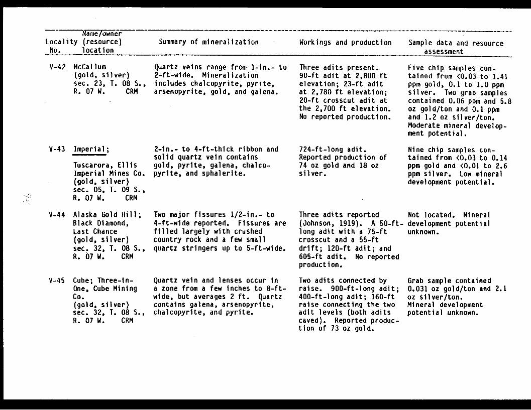
R ami e/ownerLocality (resource)No. location
Summary of mineralization Workings and production Sample data and resourceassessment
V-42 McCallum(gold, silver)sec. 23, T. 08 S.,R. 07 W. CRM
V-43 Imperial;
Tuscarora, EllisImperial Mines Co.(gold, silver)sec. 05, T. 09 S.,R. 07 W. CRM
V-44 Alaska Gold Hill;Black Diamond,Last Chance(gold, silver)sec. 32, T. 08 S.,R. 07 W. CRM
V-45 Cube; Three-in-One, Cube MiningCo.(gold, silver)sec. 32, T. 08 S.,R. 07 W. CRM
, ,.<<
Quartz veins range from 1-in.- to2-ft-wide. Mineralizationincludes chalcopyrite, pyrite,arsenopyrite, gold, and galena.
2-in.- to 4-ft-thick ribbon andsolid quartz vein containsgold, pyrite, galena, chalco-pyrite, and sphalerite.
Two major fissures 1/2-in.- to4-ft-wide reported. Fissures arefilled largely with crushedcountry rock and a few smallquartz stringers up to 5-ft-wide.
Quartz vein and lenses occur ina zone from a few inches to 8-ft-wide, but averages 2 ft. Quartzcontains galena, arsenopyrite,chalcopyrite, and pyrite.
Three adits present.90-ft adit at 2,800 ftelevation; 23-ft aditat 2,780 ft elevation;20-ft crosscut adit atthe 2,700 ft elevation.No reported production.
724-ft-long adit.Reported production of74 oz gold and 18 ozsilver.
Three adits reported(Johnson, 1919). A 50-ft-long adit with a 75-ftcrosscut and a 55-ftdrift; 120-ft adit; and605-ft adit. No reportedproduction.
Two adits connected byraise. 900-ft-long adit;400-ft-long adit; 160-ftraise connecting the twoadit levels (both aditscaved). Reported produc-tion of 73 oz gold.
Five chip samples con-tained from <0.03 to 1.41ppm gold, 0.1 to 1.0 ppmsilver. Two grab samplescontained 0.06 ppm and 5.8oz gold/ton and 0.1 ppmand 1.2 oz silver/ton.Moderate mineral develop-ment potential.
Nine chip samples con-tained from <0.03 to 0.14ppm gold and <0.01 to 2.6ppm silver. Low mineraldevelopment potential.
Not located. Mineraldevelopment potentialunknown.
Grab sample contained0.031 oz gold/ton and 2.1oz silver/ton.Mineral developmentpotential unknown.
M

Name/ownerLocality (resource) Summary of mineralization Workings and production Sample data and resourceNo. location assessment
V-46 Unnamed adit eastof the Cliff Mine(gold, silver)sec. 06, T. 09 S.,R. .07 W. CRM
V-47 Unnamed adit eastof the Cliff Mine(gold, silver)sec. 01, T. 09 S.,R. 08 W. CRM
V-48 Cliff Mine;
Chugach GoldMines Inc.(gold, silver)sec. 01, T. 09 S.,R. 08 W. CRM
V-49 Gold Bluff(gold, silver,copper)
sec. 36, T. 08 S.,R. 08 W. CRM
I-
Multiple quartz veins, allapproximately 4-in.-wide, containminor pyrite.
Shear zone, approximately 10-in.-wide, contains quartz with minorsulfides.
Gold occurs in a linked quartzvein system within fissures whichrange from 6-in.- to 5-ft-wide.Veins were mined for 1,700 ftalong strike and 775 ft down dip.Highest gold values are in bandedquartz. Mineralization includesgold, pyrite, arsenopyrite,sphalerite, and galena.
Shear zone, from 2.5- to 4-ft-wide, contains lenses andstringers of quartz. Mineral-zation inicudes gold, pyrite,pyrrhotite, and chalcopyrite.
165-ft-long adit.No reported production.
240-ft-long adit.No reported production.
Ten levels, 8,000 ftof workings by 1913(Johnson, 1915a).Production up to 1949was 51,740 oz gold and8,153 oz silver.
200-ft-long adit, with a5-ft crosscut reported(Johnson, 1915a). Noreported production.
Four grab samples con-tained from a trace to<0.005 oz gold/ton and<0.2 to 0.2 oz silver/ton.Low mineral developmentpotential.
Two grab samples contained<0.005 oz gold/ton and<0.2 oz silver/ton.Low mineral developmentpotential.
Grab sample contained0.76 ppm gold and 0.81ppm silver. Panconcentrate of tailingscontained 40 ppm goldand 7.1 ppm silver. Highmineral developmentpotential.
Not located. Mineraldevelopment potentialunknown.

I Name/ownerLocality (resource) Summary of mineralization Workings and production Sample data and resourceNo. location assessment
V-50 Sealy-Davis;Sealy-Davis MiningCo; Rising Sun(gold, silver)sec. 36, T. 08 S.,R. 08 W. CRM
V-51 Bluebird; Whistler(gold, silver)sec. 35, T. 08 S.,R. 08 W. CRM
V-52 Shoup Bay(gold, silver)sec. 35, T. 08 S.,R. 08 W. CRM
V-53 Alice Mine(gold, silver)sec. 35, T. 08 S.,R. 08 W. CRM
Quartz vein in well-defined Four adits, 20-ft,fissure zone to 5.5-ft-wide. 240-ft, 820-ft, 500-ft-Metallic minerals include gold, long; winze; raise;pyrite, arsenopyrite, chalco- stopes; stripping; andpyrite, sphalerite, galena, open cuts. Reportedand pyrrhotite. production 38 oz gold.
Poorly-defined 4- to 10-ft-wide 100-ft-long adit with amineralized shear zone filled 10-ft drift at the face,with lenticular masses of fine- and a 10-ft-long aditgrained dense greenish-black at the west end of thebasic dike (Johnson, 1915a). vein reported (Johnson,Metallic minerals include gold, 1915a). No reportedpyrrhotite, chalcopyrite, galena, production.and pyrite.
Numerous 1/2-in.-wide quartz vein- 40-ft-long adit. Nolets trend parallel with the reported production.foliation of the slate country rock.No observed metallic minerals.
Well-defined fissure, 3-in.- to 3- 260-ft-long adit; 170ft-wide, contains brecciated and ft of shafts. 30 tonssilicified country rock recemented of ore reported milled inwith pyritiferous quartz. Valdez in 1913 (Johnson,Footwall is well-defined by 1915a).slickenslides. Metallic mineralsinclude gold, pyrite, chalcopyrite,arsenopyrite, sphalerite, andgalena.
Fifteen chip samples from3 adits contained from 0.1to 7.9 ppm gold and <0.1to 1.6 ppm silver. Grabsample contained 17 ppmgold and 2.8 ppm Silver.Inferred reserves: 50 tonsat 7.9 ppm gold and 1.6ppm silver. Low mineraldevelopment potential.
Not located. Mineraldevelopment potentialunknown.
Chip sample of quartzcontained <0.03 ppm goldand 0.1 ppm silver. Lowmineral developmentpotential.
Four chip samples con-tained from 0.2 ppm to0.109 oz gold/ton and 0.2ppm to 0.18 oz silver/ton.Two grab samples contained0.005 and 0.257 oz gold/ton and <0.2 and 0.2 ozsilver/ton. Eleven USGSsamples contained 0.4 to16.0 ppm gold. Lowmineral developmentpotential.
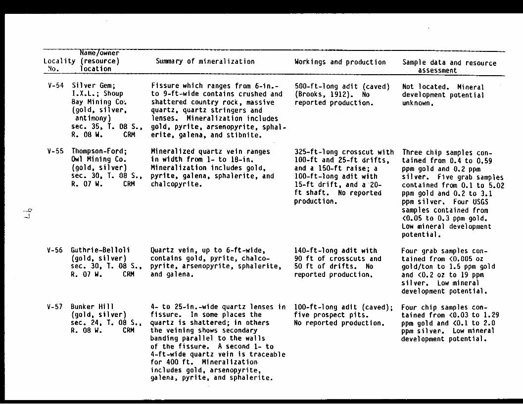
Name/ownerLocality (resource) Summary of mineralization Workings and production Sample data and resourceNo. location assessment
V-54 Silver Gem;I.X.L.; ShoupBay Mining Co:(gold, silver,antimony)
sec. 35, T. 08 S.,R. 08 W. CRM
V-55 Thompson-Ford;Owl Mining Co.(gold, silver)sec. 30, T. 08 S.,R. 07 W. CRM
V-56 Guthrie-Belloli(gold, silver)sec. 30, T. 08 S.,R. 07 W. CRM
V-57 Bunker Hill(gold, silver)sec. 24, T. 08 S.,R. 08 W. CRM
Fissure which ranges from 6-in.-to 9-ft-wide contains crushed andshattered country rock, massivequartz, quartz stringers andlenses. Mineralization includesgold, pyrite, arsenopyrite, sphal-erite, galena, and stibnite.
Mineralized quartz vein rangesin width from 1- to 18-in.Mineralization includes gold,pyrite, galena, sphalerite, andchalcopyrite.
Quartz vein, up to 6-ft-wide,contains gold, pyrite, chalco-pyrite, arsenopyrite, sphalerite,and galena.
4- to 25-in.-wide quartz lenses infissure. In some places thequartz is shattered; in othersthe veining shows secondarybanding parallel to the wallsof the fissure. A second 1- to4-ft-wide quartz vein is traceablefor 400 ft. Mineralizationincludes gold, arsenopyrite,galena, pyrite, and sphalerite.
500-ft-long adit (caved)(Brooks, 1912). Noreported production.
325-ft-long crosscut with100-ft and 25-ft drifts,and a 150-ft raise; a100-ft-long adit with15-ft drift, and a 20-ft shaft. No reportedproduction.
140-ft-long adit with90 ft of crosscuts and50 ft of drifts. Noreported production.
100-ft-long adit (caved);five prospect pits.No reported production.
Not located. Mineraldevelopment potentialunknown.
Three chip samples con-tained from 0.4 to 0.59ppm gold and 0.2 ppmsilver. Five grab samplescontained from 0.1 to 5.02ppm gold and 0.2 to 3.1ppm silver. Four USGSsamples contained from<0.05 to 0.3 ppm gold.Low mineral developmentpotential.
Four grab samples con-tained from <0.005 ozgold/ton to 1.5 ppm goldand <0.2 oz to 19 ppmsilver. Low mineraldevelopment potential.
Four chip samples con-tained from <0.03 to 1.29ppm gold and <0.1 to 2.0ppm silver. Low mineraldevelopment potential.
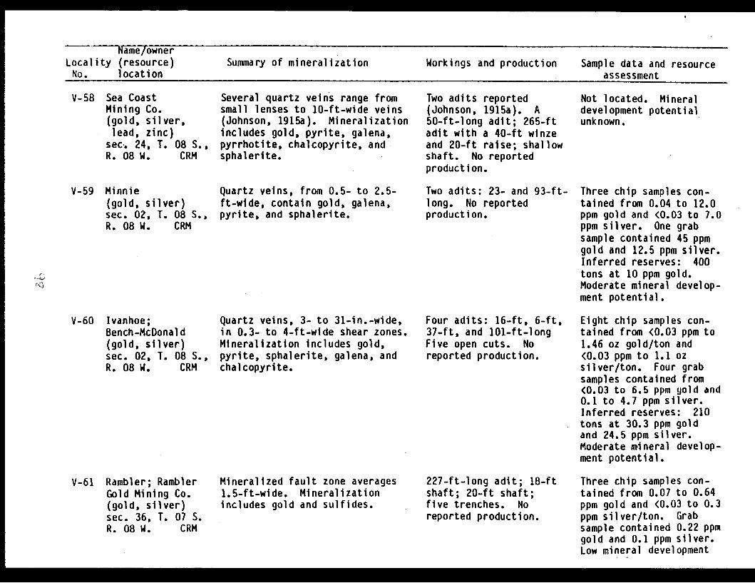
NaimielownerLocality (resource) Summary of mineralization Workings and production Sample data and resourceNo. location assessment
V-58 Sea CoastMining Co.(gold, silver,lead, zinc)
sec. 24, T. 08 S.,R. 08 W. CRM
V-59 Minnie(gold, silver)sec. 02, T. 08 S.,R. 08 W. CRM
V-60 Ivanhoe;Bench-McDonald(gold, silver)sec. 02, T. 08 S.,R. 08 W. CRM
V-61 Rambler; RamblerGold Mining Co.(gold, silver)sec. 36, T. 07 S.R. 08 W. CRM
Several quartz veins range fromsmall lenses to 10-ft-wide veins(Johnson, 1915a). Mineralizationincludes gold, pyrite, galena,pyrrhotite, chalcopyrite, andsphalerite.
Quartz veins, from 0.5- to 2.5-ft-wide, contain gold, galena,pyrite, and sphalerite.
Quartz veins, 3- to 31-in.-wide,in 0.3- to 4-ft-wide shear zones.Mineralization includes gold,pyrite, sphalerite, galena, andchalcopyrite.
Mineralized fault zone averages1.5-ft-wide. Mineralizationincludes gold and sulfides.
Two adits reported(Johnson, 1915a). A50-ft-long adit; 265-ftadit with a 40-ft winzeand 20-ft raise; shallowshaft. No reportedproduction.
Two adits: 23- and 93-ft-long. No reportedproduction.
Four adits: 16-ft, 6-ft,37-ft, and 101-ft-longFive open cuts. Noreported production.
227-ft-long adit; 18-ftshaft; 20-ft shaft;five trenches. Noreported production.
Not located. Mineraldevelopment potentialunknown.
Three chip samples con-tained from 0.04 to 12.0ppm gold and <0.03 to 7.0ppm silver. One grabsample contained 45 ppmgold and 12.5 ppm silver.Inferred reserves: 400tons at 10 ppm gold.Moderate mineral develop-ment potential.
Eight chip samples con-tained from <0.03 ppm to1.46 oz gold/ton and<0.03 ppm to 1.1 ozsilver/ton. Four grabsamples contained from<0.03 to 6.5 ppm gold and0.1 to 4.7 ppm silver.Inferred reserves: 210tons at 30.3 ppm goldand 24.5 ppm silver.Moderate mnineral develop-ment potential.
Three chip samples con-tained from 0.07 to 0.64ppm gold and <0.03 to 0.3ppm silver/ton. Grabsample contained 0.22 ppmgold and 0.1 ppm silver.Low mineral development
E
N.1

iameiownerLocality (resource) Summary of mineralization Workings and production Sample data and resourceNo. location assessment
V-62 Cameron-Johnson;
Valdez Gold Co.,Bald Mtn. Group(gold, silver)sec. 03, T. 08 S.,R. 08 W. CRM
V-63 Gold King
(gold, silver)sec, 06, T. 08 S.,R. 08 W. CRM
V-64 Rough & Tough;
Ruff & Tuff(gold, silver)sec. 02, T. 08 S.,R. 09 W. CRM
I
Seven quartz veins from 1-in.- to11.5-ft-wide. Mineralizationincludes free gold, pyrite, sphal-erite, and arsenopyrite.
Two quartz veins, from a seam to4-ft-wide, contain gold, pyrite,galena, sphalerite, chalcopyrite,and stibnite.
Quartz veins occur at or near acontact of a granitic intrusionwith metasedimentary rocks.Quartz veins, which occur in bothsedimentary rocks and the intru-sion, contain free gold, galena,pyrite, and chalcopyrite. -
Eight adits: 160-ft,125-ft, 50-ft, 8-ft,335-ft, 257-ft, 47-ft,and 15-ft-long; twoopen cuts. Reportedproduction is 585 oz goldand 18 oz silver.
Three adits present,600-ft (ice-filled),1,070-ft, 115-ft (caved).Reported production-is 1,997 oz gold and187 oz silver.
372-ft-long adit; atleast four open cuts.Reported production is76 oz gold and 20 ozsilver.
Twenty-five chip samplescontained from 0.06 to21.0 ppm gold and 0.1 to8.5 ppm silver. Twelvegrab samples containedfrom <0.03 ppm to 15.3 ozgold/ton and 0.16 ppmito4.3 oz silver/ton.Inferred reserves: 1,800tons at 5 ppm gold and1.2 ppm silver. Moder-ate mineral developmentpotential.
Five chip samples con-tained 0.09 to 3.4 ppmgold and 0.1 to 1.3 ppmsilver. Two grab samplescontained 4.85 to 45.62 ozgold/ton and 1.0 to 1.7 ozsilver/ton. Six USGSsamples contained <0.05 to9.0 ppm gold. Mineraldevelopment potentialunknown.
Seven chip samples con-tained from 0.18 ppm to2.52 oz gold/ton and 0.3ppm to 0.89 oz silver/ton.Grab sample contained 14ppm gold and 3.3 ppmsilver. Eight USGSsamples contained <0.05 to9.0 ppm gold. Moderatemineral developmentpotential.
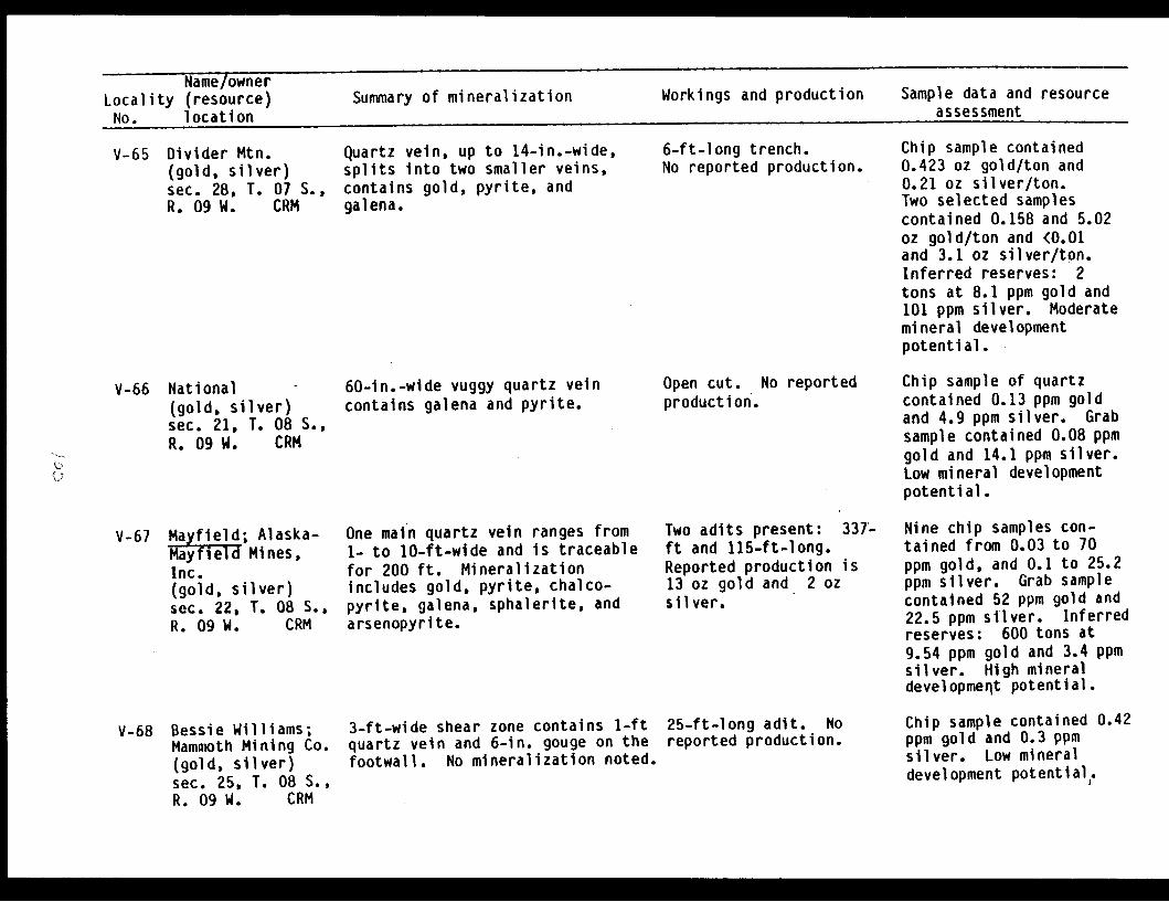
Name ownerLocality (resource) Summary of mineralization Workings and production Sample data and resource
No. location assessment
V-65 Divider Mtn.(gold, silver)sec. 28, T. 07 S.,R. 09 W. CRM
V-66 National -
(gold, silver)sec. 21, T. 08 S.,R. 09 W. CRM
V-67 Mayfield; Alaska-Mayfield Mines,Inc.(gold, silver)sec. 22, T. 08 S.,R. 09 W. CRM
V-68 Bessie Williams;Mammoth Mining Co.(gold, silver)sec. 25, T. 08 S.,R. 09 W. CRM
Quartz vein, up to 14-in.-wide,splits Into two smaller veins,contains gold, pyrite, andgalena.
60-in.-wide vuggy quartz veincontains galena and pyrite.
One main quartz vein ranges from1- to 10-ft-wide and is traceablefor 200 ft. Mineralizationincludes gold, pyrite, chalco-pyrite, galena, sphalerite, andarsenopyrite.
3-ft-wide shear zone contains 1-ftquartz vein and 6-in. gouge on thefootwall. No mineralization noted.
6-ft-long trench.No reported production.
Open cut. No reportedproduction.
Two adits present: 337ft and 115-ft-long.Reported production is13 oz gold and 2 ozsilver.
25-ft-long adit. Noreported production.
Chip sample contained0.423 oz gold/ton and0.21 oz silver/ton.Two selected samplescontained 0.158 and 5.02oz gold/ton and (0.01and 3.1 oz silver/ton.Inferred reserves: 2tons at 8.1 ppm gold and101 ppm silver. Moderatemineral developmentpotential.
Chip sample of quartzcontained 0.13 ppm goldand 4.9 ppm silver. Grabsample contained 0.08 ppmgold and 14.1 ppm silver.Low mineral developmentpotential.
Nine chip samples con-tained from 0.03 to 70ppm gold, and 0.1 to 25.2ppm silver. Grab samplecontained 52 ppm gold and22.5 ppm silver. Inferredreserves: 600 tons at9.54 ppm gold and 3.4 ppmsilver. High mineraldevelopment potential.
Chip sample contained 0.42ppm gold and 0.3 ppmsilver. Low mineraldevelopment potential,.
4.,At-

Name/ownerLocality (resource) Summary of mineralization Workings and production Sample data and resourceNo. location assessment
V-69 Anderson Glacier*(gold, silver)sec. 32, T. 08 S.,R. 08 W. CRM
V-70 Gold Standard;Hecla(silver, gold,zinc, lead,copper, arsenic)
sec. 33, T. 08 S.,R. 08 W. CRM
V-71 Palmer; W. H.Palmer Mining Co.(gold, silver)sec. 27, T. 08 S.,R. 08 W. CRM
V-72 Big Four Claim;Little Four Claim;Alder(gold, silver)sec. 33, T. 08 S.,R. 08 W. CRM
5-ft-wide shear zone containsquartz with gold, galena, chal-copyrite, and pyrrhotite.
4-ft-wide quartz vein containspyrite, arsenopyrite, galena, andchalcopyrite.
4.5-ft-wide fissure with well-defined hanging wall has a 2.5-ft-wide zone of quartz stringers.Mineralization includes gold andpyrite.
Three quartz veins contain gold,pyrite, arsenopyrite, galena,and chalcopyrite.
None. Newly reportedoccurrence.
Two adits present. One45-ft-long, length ofother unknown (Johnson,1918b). No reportedproduction.
300-ft-long adit reported(Brooks, 1912). Noreported production.
No workings. No reportedproduction.
Chip sample contained 0.67ppm gold and 2.8 ppmsilver. Selected sampleof float rock contained5.34 oz gold/ton and 16.7oz silver/ton. Mineraldevelopment potentialunknown.
Two chip samples containedfrom 0.2 oz silver/ton and54 ppm silver, 0.019 ozgold/ton and 0.99 ppm gold0.18 and 0.43% zinc, 580ppm and 0.11% lead, and3.3 and 3.4% arsenic. Oneselective grab samplecontained 54 oz silver/ton, 0.461 oz gold/ton,4.5% zinc, 2.2% lead,0.19% copper, and 1.7%arsenic. Moderatemineral developmentpotential.
Not located. Mineraldevelopment potentialunknown.
Chip sample contained 0.04ppm gold and 1.7 ppmsilver. Low mineraldevelopment potential.

Name/ownerLocality (resource) Summary of mineralization Workings and production Sample data and resourceNo. location assessment
V-73 Westbrook GlacierProspect(gold)sec. 04, T. 09 S.,R. 08 W.. CRM
V-74 Valdez ArmProspect(gold, silver)sec. 17, T. 09 S.,R. 08 W. CRM
0.5- to 2-ft-wide quartz veinpresent; no mineralizationnoted.
Numerous 0.5- to 4-in.-wide quartzveinlets present; no mineral-ization noted.
Open cut. No reportedproduction.
100-ft-long adit. Noreported production.
Chip sample contained0.06 ppm gold. Lowmineral developmentpotential.
Three chip samples con-tained <0.03 to 50 ppmgold and 0.1 to 11.7 ppmsilver. Inferred reserves200 tons at 34.8 ppm goldand 8.2 ppm silver.Moderate mineral develop-ment potential.
V-75 Clear Creek*(gold, tungsten,arsenic)
sec. 10, T. 09 S.,R. 09 W. CRM
Mineralized quartz stringers con-tain pyrite, chalcopyrite, andarsenopyrite.
No workings.production.
No reported Five grab samples con-tained from 0.03 ppm to2.34 ppm gold, 17 ppm to0.39% tungsten, and <10ppm to 4.95% arsenic.Low mineral developmentpotential.
V-76 Anderson GlacierProspect(silver, gold)sec. 36, T. 08 S.,R. 09 W. CRM
V-77 Gold Prospect;Anderson Pass(gold, silver)sec. 35, T. 08 S.,R. 09 W. CRM
2-ft-wide quartz vein containschalcopyrite and arsenopyrite.
6-in.-wide quartz vein containspyrite.
Prospect pit. Noreported production.
Prospect pit. Noreported production.
Chip sample contained0.2 ppm silver and <0.03ppm gold. Grab samplecontained 1.9 ppm silverand <0.03 ppm gold. Lowmineral developmentpotential.
Grab sample contained<0.003 oz gold/ton and<0.01 oz silver/ton. Lowmineral developmentpotential.
Name/ownerLocality (resource) Summary of mineralization Workings and production Sample data and resourceNo. location assessment
V-78 Eagle Claim(gold, silver)sec. 33, T. 08 S.,R. 09 W. CRM
6-in.-wide quartz vein containsfree gold, chalcopyrite, andgalena.
20-ft-long adit; a 15-ft trench. No reportedproduction.
Chip sample contained0.626 oz gold/ton and 4.1oz silver/ton. Grabsample contained 4.472 ozgold/ton and 1.0 ozsilver/ton. Inferredreserves: 10 tons at20.84 ppm gold and136.23 .ppm silver.Moderate mineral develop-ment potential.
V-79 Columbia; Idle(gold, silver)sec. 14, T. 09 S.,R. 10 W. CRM
No data. No data. No reportedproduction.
Not located. Mineraldevelopment potentialunknown.
V-80 Ticksit; Glory;Oma(gold, silver,copper)
sec. 09, T. 09 S.,R. 10 W. CRM
0.5-ft-wide vein with vuggyquartz and malachite staining.
No data. No reportedproduction.
Chip sample contained0.07 ppm gold, 3.9 ppmsilver, and 480 ppmcopper. Low mineral,development potential.

Name/ownerLocality (resource) Summary of mineralization Workings and production Sample data and resourceNo. location assessment
S-1 KeithClaims(copper,zinc)
sec. 18,'R. 09 E.Latouche
gol d,
T. 02 S.,SM
Island
S-2 Reynolds-AlaskaProspect(copper)sec, 17, T. 02 S.,R. 09 E. SMLatouche Island
--il S-3 Banta ShaftPatented Claims:Duke, Iron Mtn.No. 6, and amendedIron Mtn. No. 4(copper, zinc,)gold)
sec. 09, T. 02 S.,R. 09 E. SMLatouche Island
Sequence of graywacke, slate,and shale, are locally deformedinto similar folds. No mineral-ization was found.
Interbedded shale and graywackein area. No mineralizationwas found.
Massive sulfide lenses occurwithin a north-east-trendinginterbedded slate and graywackesequence. Lenses vary from4- to 27-ft-wide and are developedalong strike for 151 ft. Sulfidesare chalcopyrite, pyrrhotite,and pyrite.
None reported.
None reported.
110-ft-deep floodedshaft and 311-ft ofdrifts and crosscuts.Also reported are 2adits. One 60-ft-longand one 193-ft-long.Small tonnage shipped.
Claims staked by W.G.M.Inc. in 1976 on geophy-sical anomaly. Mineraldevelopment potentialunknown.
Reported prospect (Grantand Higgins, 1909a, PI.IV) was not located.Mineral developmentpotential unknown.
Measured reserves are68,800 tons at 1.32%copper, .06 oz gold/ton,and .05 oz silver/ton.Additional 200,000 tons ofindicated ore arereported (Crosby, 1906;Herdlick, 1953; Stejer,1956; Townsend, 1917;Webber and Rutledge,1944b). Moderate Inineraldevelopment potential.
I

Name/ownerLocality (resource) Summary of mineralization Workings and production Sample data and resourceNo. location assessment
S-4 Duchess Claim
(patented)(copper, zinc,gold, silver,sulfur)sec. 09, T. 02 S.,R. 09 E. SMLatouche Island
S-5 Tiger?; W & L?(copper, silver)sec. 10, T. 02 S.,R. 09 E. SMLatouche Island
S-6 Alameda Claims(copper, zinc)sec. 14, T. 02 S.R. 09 E. SMLatouche Island
A series of steeply-dippingmassive sulfide lenses up to 60-ft-wide and 490-ft-long, extendvertically 600 ft. paralleling theenclosing slate and graywackesequence. Disseminated sulfidesform a halo around the massivebodies. Sulfides includepyrite, pyrrhotite, chalcopyrite,and sphalerite.
A zone, a few feet wide, ofchalcopyrite and pyrrhotite, cutsgraywacke. Traces of nativecopper present.
Small bunches and stringers ofchalcopyrite reportedly scatteredthroughout the graywacke. Best zonesaid to be 4- to 10-ft-wide andtraceable for several hundred feet.To the north, a reported 4-ft-widemineralized shear zone parallelsthe strike and dip of the surround-ing country rock. Mineralizationincludes chalcopyrite, pyrrhotite,sphalerite, and quartz.
Two adits reportedlycontain a total of 3,000ft of crosscuts anddrifts. Lower adit isflooded; upper one iscaved. Recorded pro-duction: 2,850 tonsproducing 215,000 lbscopper at a grade of3.8%.
Open cut in bluff.No production.
None reported.
Measured reserves are436,500 tons at 1.4%copper. Indicatedreserves: 570,000 tons at1.2% copper. Inferredreserves: 1,720,000 at1.2% copper and 0.40%zinc. Also 0.03 ozgold/ton and 0.47 silver/ton. Sulfur: 600,000tons at 50% sulfur (Town-send, 1917; Webber andRutledge, 1944b).Moderate mineraldevelopment potential.
20-ft-long chip samplecontained 0.14% copper and19.5 ppm silver. Lowmineral development poten-tial.
Reported prospect (Johnson1918a, p. 211) was notlocated. Mineral develop-ment potential unknown.
'C,

Name/ownerLocality (resource) Summary of mineralization Workings and production Sample data and resourceNo. location assessment
S-7 Latouche IslandCopper Mining Co.(copper)sec. 11, T. 02 S.,R. 09 E. SMLatouche Island
Reported 10-ft-wide mineralizedshear zone in graywacke, slate,argillite, and chert sequence,contains "considerable" chalco-pyrite (Johnson, 1918b).
Several hundred feet oftunnels; 67-ft-deeptwo-compartment shaft.Some ore shipped.
Reported prospect (Johnson1918a, pp. 210-211) wasnot located. Mineraldevelopment potentialunknown.
S-8 Unnamed occurrence(copper, zinc)sec. 11, T. 02 S.,R. 09 E. SMLatouche Island
Reported reddish-brown and yellow,4-ft-wide 45-ft-long gossan.Pyrite and chalcopyrite reported.
None. Prospect not located.Semiquantitative spectro-graphic analysis (Tysdal,1978) shows 700 ppm copperand 500 ppm zinc. Mineraldevelopment potentialunknown.
S-9 Latouche IslandCopper Mining Co.Prospect;Alameda Claims(copper, zinc)sec. 11, T. 02 S.,R. 09 E. SMLatouche Island
S-10 Latouche IslandCopper Mining Co.Prospect;Alameda Claims?(copper, zinc)sec. 11, T. 02 S.,R. 09 E. SMLatouche Island
Few stringers of chalcopyritewith minor pyrrhotite andpyrite reported in sandstone.
3.5- to 4.5-ft-wide sulfide-richshear zone in silicified slate andgraywacke. Massive pyrrhotitezones contain up to 15% chalco-pyrite. Underground, mineral-ization is exposed intermittentlyfor 80 ft along strike.
One adit reported(Tysdal, 1978). Noreported production.
64-ft-long aditnear shoreline. No.reported production.
Prospect not located.Mineral developmentpotential unknown.
5-ft-wide chip samplecontained 0.74% copperand 0.19% zinc. Inferredreserves: 100 tons.Low mineral developmentpotential.
Niame/ownerLocality (resource) Summary of mineralization Workings and production Sample data and resourceNo. location assessment
S-11 Alameda Claims(copper, zinc)sec. 02, T. 02 S.,R. 09 E., SMLatouche Island
S-12 Carlson Prospect;Latouche IslandCopper Mining Co.(copper, zinc,silver)sec. 36, T. 01 S.,R. 09 E. SMLatouche Island
C)
5-13 LinClaims(copper, zinc)sec. 25, T. 01 S.,R. 09 E. SMLatouche Island
Graywacke with shale interbeds inarea of reported prospect(State of Alaska, "Kardex", 1982).
Mineralized fracture zone, up to5-ft-wide, roughly parallelsbedding of graywacke. Intensefracturing and brecciation locally.Massive sulfide zone, up to 1-ft-wide, and a surrounding stringersulfide zone up to 5-ft-widecontains up to 5% chalcopyrite.Mineralization can be traced for200 ft along strike.
Several small pyrrhotite, pyrite,chalcopyrite, and sphalerite-bearing shear zones cut sequenceof interbedded graywacke, slate,and shale.
No workings reported.No known production.
A 100-ft-long aditmostly flooded at hightide (Bateman, 1920).Evidence of blastingat one exposure. Noreported production.
No signs of prospecting.No production.
Prospect not located.Mineral developmentpotential unknown.
Workings not located.2-ft-wide chip samplecollected in the areacontained 2.5% copper,0.15% zinc and 20 ppmsilver. Ahother 8.5-ft-wide chip sample contained0.70% copper. Previouslyreported reserves: 1,800tons at 3.5% copper.Low mineral developmentpotential.
Chip sample from 9x1-ftsulfide lens, contained0.75% copper and 5.9%zinc. Mineral developmentpotential unknown.
S-14 Unnamed prospect(copper)sec. 04, T. 02 S.,R. 09 E. SMLatouche Island
Highly fractured slate and gray-wacke contains small quartz veinsand limonite-staining alongfractures.
Adit of unknown length,is caved 150 ftfrom portal.
No data. Mineral devLelop-ment potential unknown.

Name/ownerLocality (resource) Summary of mineralization Workings and production Sample data and resourceNo. location assessment
S-15 Bazard Tunnel;Claims: WestHillside Lode,Hillside Lode(copper)sec. 04, T. 02 S.,R. 9 E. SMLatouche Island
S-16 Hillside LodeClaim(copper)sec. 04, T. 02 S.,R. 09 E. SMLatouche Island
S-17 Beatson Mine;
patented claims:Big Bonanza andEagle(copper, zinc,gold, silver)
sec. 33, T. 01 S.,R. 09 S. SMLatouche Island
No mineralization at portal.Interbedded shale and graywackebedrock.
No sulfide mineralization found.Bedrock is graywacke with localshale interbeds. A 3-in.-widegouge zone roughly parallelsbedding.
Massive and stringer zones ofsulfides are concentrated on thefootwall of the Beatson faultwhich cuts across graywackes withinterbedded slate. Sulfides:pyrite, chalcopyrite, pyrrhotite,sphalerite, cubanite, and galena.Non-metallic gangue minerals:quartz, sericite, ankerite. Minedore body dimensions: 400-ft-wide,500-ft-vertical, and approxi-mately 1,000-ft along strike.
Flooded tunnel, drivenS. 720 E., reported tobe at least 1,400-ft-long (Grant and Higgins,1909a, p. 88). It repor-tedly was driven tointersect a possiblesouthern extension ofthe Beatson ore body,lying 0.6 mi north.
126-ft-long adit,driven S. 650 E.,presumably to cut asouthern extension ofthe Beatson ore zone,which lies 0.5 mi north.No production.
Major mine operated 1903to 1930. By 1924 over 10mi of underground workingson five main levels.Underground workings nolonger accessible.Recorded production:5,992,941 tons ore with182,600,000 lbs copper,484 oz gold, and 1,466,649oz silver. Averagegrades: 1.65% copper,0.27 oz silver/ton.
Not sampled. Mineraldevelopment potentialunknown.
No sulfides found in dump.Low mineral developmentpotential.
At shutdown ore averaged0.9% copper. No orereserve data. Moderateto high mineral develop-ment potential for lowgrade and concealed copperand zinc ore bodies atdepth along strike.
E I M 0
- W~,iame~ownpr - -- __-__P
Locality (resource)No. location
Summary of mineralization Workings and production Sample data and resource"aaCa. .aeaa1
S-18 Chenega Claim(patented)(copper, silver)sec. 34, T. 01 S.,R. 09 E. SMLatouche Island
S-19 Blackbird Mine;
Girdwood;Barrack;Ladysmith(copper, zinc,lead, silver)
sec. 34, T. 01 S.,R. 09 E. SMLatouche Island
S-20 Unnamed occurrence*(copper)sec. 01, T. 02 S.,R. 08 E. SMElrington Island
Stringers, blebs, and disseminatedpyrite and chalcopyrite areconcentrated along a 65-ft-widezone underground, in black shaleand silicified mudstone.
Sulfide-bearing shear zonereportedly cuts graywacke andshale. Massive and stringersulfide zones in a shear/faultzone up to 35-ft-wide, exposedintermittently along strike for300 ft. Massive sulfide lensesup to 10-ft-wide. Sulfides:pyrrhotite and chalcopyrite.
Interbedded mudstone and sili-ceous shale contain 1% pyriteand traces of chalcopyrite neargreenstone contact. Sedimentaryrocks are rust-colored and exposedintermittently for 400 ft alongstrike.
95-ft-long adit drivenS. 80° E.; Beatson Mineworkings extend underthe claim. Productionincluded with BeatsonMine figures.
Two caved adits withraises and sublevelsreported. Several shaftsand a short adit total1,750 ft. Surfacedevelopment consists ofseveral open cuts andcollapsed pits. In1930, 110,865 tons of0.82 to 1.10% coppermined. Recorded produc-tion: 5,150 tons oreproducing 547,118 lbs.copper (at a grade of5.3%) and 3,980 oz silver.
No workings.No production.
2.8-ft-wide chipsample contained 1.7%copper and 6.4 ppm silver.Moderate mineral develop-ment potential for largelow-grade deposit.
Chip samples contained27 ppm to 2.96% copper,105 ppm to 12.2% zinc,23 ppm to 1.25% lead, and<0.2 to 22.2 ppm silver.Reported reserves in 1920.Indicated ore: 201,450tons at 2.2%, or 759,608at 1.65% copper. Black-bird ore mined and mixedwith Beatson (Bateman,1920). Moderate mineraldevelopment potential.
5.5-ft-wide random chipsample contained 45 ppmcopper and 82 ppm zinc.Low mineral developmentpotential.
'-
Name/ownerLocality (resource) Summary of mineralization Workings and production Sample data and resourceNo. location assessment
S-21 Lucky Girl Prospect;Quartz and calcite veins carryingMurphy Prospect a little pyrrhotite are reported(copper, asbestos) in greenstone and slate. Asbestossec. 11, T. 02 S., veins up to 3-in-wide reportedR. 08 E. SM in greenstone fragments. Chalco-Elrington Island pyrite and pyrite are reported.
Adit reported (Grantand Higgins, 1910b, p.79), not located.No recorded production.
Prospect not located.Mineral developmentpotential unknown.
S-22 Unnamed occurrence(copper, zinc)sec. 02, T. 02 S.,R. 07 E. SMBainbridge Island
Greenstone is in contact withsiliceous shale and slate withup to 1% pyrite and a trace ofpyrrhotite.
None. Slate reported to contain200 ppm zinc and 100 ppmcopper (Tysdal, 1978).Low mineral developmentpotential.
S-23 Hogg Bay Prospect(copper)sec. 22, T. 01 S.,R. 07 E. SMBainbridge Island
S-24 Shoo Fly Prospect(copper, goldsilver)
sec. 14, T. 01 S.,R. 07 E. SMBainbridge Island
None found. None located.No reported production.
Shear zones (maximum width 2 ft)exposed in adit contain localizedquartz stringers and gouge insilicified mudstone. Greenstonecontains 1% pyrrhotite andapproximately 1% chalcopyrite.
Two adits, 221-ft and9-ft-long. Two opencuts, 61-ft and 6-ft-long. A reported(Shepard, 1926). 405-ft-long adit was not found.No known production.
Reported prospect (Smith,1926, p. 21) not located.Mineral developmentpotential unknown.
Random chip sample con-tained 0.07% copper. A0.9-ft-wide chip samplecontained 570 ppm copper,0.11 ppm gold, and 1.5 ppmsilver. Low mineraldevelopment potential.
E __ __

Name/ownerLocality (resource) Summary of mineralization Workings and production Sample data and resourceNo. location
assessmentC _ 9 -|_ ..
S-4D unndmeU prospect(gold)sec. 14, T. 01 N.,R. 07 E. SMWhale Bay
i
S-26 Happy Jack CopperMining & Dev. Co.;Copper QueenProspect; HelenaClaim; Ground HogClaim.(copper)sec. 17, T. 01 N.,R. 10 E. SMKnight Island
S-27 Hogan; Hemple; andEgan Prospect;Hemple Prospect(copper)sec. 06, T. 01 N.,R. 10 E. SMKnight Island
6-ft-wide shear zone, exposedin adit, cuts silicified mudstone.Zone consists mainly of 3- to 4-ft.thick hard silicified mudstonebreccia that contains approximately15% quartz veins, lenses, and pods.Up to a 2-ft-wide gouge and breccizzone is along the footwall. Selectpieces of quartz breccia on thedump contain trace amounts of gold,galena, pyrite, pyrrhotite, chalco-pyrite, and sphalerite.
1- to 4-ft-thick quartz, chalco-pyrite, sphalerite, and pyrrho-tite vein in slate, graywacke,and greenstone. An approximately2-ft-thick mineralized zonereported. A N. 250 W. trending3-in.- to 1-ft-wide gouge andbreccia zone locally containsmassive pyrite, 5 to 10% chalco-pyrite, and 1 to 2% covellite.
Several shear zones, up to 5-ft-wide in graywacke, contain sulfidezones with 1 to 5% chalcopyritestringers, up to 2% pyrite, minorpyrrhotite and bornite, plus somequartz veinlets and lenses up to1/2-ft-wide.
50-ft-long adit.No known production.
One of three reportedadits (Moffit and Fellows,1950, p. 74) located.The only working foundwas a S. 250 E. trending40-ft adit. An adit atelevation of 40 ft isreportedly 1,000- to 1,200-ft-long. Adit at 240 ftelevation was driven 260ft and contained severaldrifts and short raises.A short upper adit at450-ft reported. Productio57 lbs copper from 110tons.
Three adits, 45-ft, 60-ft, and 140-ft-long.No known production.
0.2-ft-wide chip sample ofgouge contained 1 oz gold/ton and 0.3 oz silver/ton.3.5-ft-wide chip sampleacross the shear zonecontained 0.3 oz gold/ton. Inferred reserves:200 tons at 0.12 oz gold/ton. Moderate mineraldevelopment potential.
Chip sample over a 1-ftwidth contained 7.5%copper. Shear zone, <1-ft-wide, near the reportedadits contained 2.0%copper. Low mineraldevelopment potential.
Three chip samples: 3-ft,1.8-ft, and 3-ft-longacross the shear zonescontained 0.99%, 0.89%,and 0.78% copper respec-tively. One 3.6-ft-widechip sample contained 2.2%copper. Moderate mineral- ,1 -copper. Moderate mineral

iame/owner-Locality (resource) Summary of mineralization Workings and production Sample data and resourceNo. location assessment
S-28 Wilcox Prospect;Hogan Bay-Knight Claims(copper)sec. 05,1T. 01 N.,R. 10 E. SMKnight Island
S-29 Unnamed prospect(copper, silver)sec. 32, T. 02 N.,R. 10 E. SMKnight Island
S-30 Minnie Prospect(copper)sec. 29, T. 02 N.,R. 10 E. SMKnight Island
Greenstone and porphyritic green-stone are in contact with slate.Several narrow shears containquartz stringers but no sulfides.Some disseminated chalcopyritewas reported underground.
Sulfide-bearing zones averaging2-ft-thick and exposed for 20 ftare conformable to flow layers ingreenstone. Sulfides includepyrrhotite, chalcopyrite; tracesof native copper present.
2.5- to 3-ft-wide chalcopyrite-bearing shear zone cuts green-stone and is exposed for 145 ftunderground. Sulfides are con-centrated in a 5- to 6-in.-wideband in shear; numerous quartzveinlets present. Minor amountsof native copper.
680-ft-long N. 720 W.adit at 300 ft elevation.Reported but not locatedwere a 70-ft-long adit at1,000 ft and a thirdundescribed opening(Grant and Higgins, 1909a,p. 91). No reportedproduction.
Two open cuts. One 8 ftx 20 ft and one 6 x 10 ft.No reported production.
South-trending 145-ft-long adit. Noreported production.
Underground random chipsample contained 60 ppmcopper. Low mineraldevelopment potential.
2.5-ft-wide chipsample contained 2.2%copper and 4.1 ppm silver.Random chip sample con-tained 1.4% copper, and8.2 ppm silver. Lowmineral developmentpotential.
6-in.-wide chip samplecontained 0.25% copper.Inferred reserves:200 tons. Low mineraldevelopment potential.
S-31 Unnamed occurrence(copper)sec. 36, T. 02 N.,R. 09 E. SMKnight Island
Two 10-ft-wide shear zones ingreenstone contain 5% pyrrhotiteand trace chalcopyrite.
None. Chip sample contained49 ppm copper. Lowmineral developmentpotential.
N I E I

Name/ownerLocality (resource) Summary of mineralization Workings and production Sample data and resourceNo. location assessment
S-32 Unnamed occurrence(copper, zinc,chromium)
sec. 35, T. 02 N.,R. 09 E. SMKnight Island
Reported limonite-and malachite-stained sheared greenstone.
None. Prospect not located.Reported analysis (Tysdal,1978): 100 ppm zinc, 300ppm chromium, 500 ppmcopper. Mineral develop-ment potential unknown.
S-33 Home Camp Prospect;Charles SchultzProspect(?)(copper)sec. 30, T. 02 N.,R. 10 E. SMKnight Island
S-34 Unnamed occurrence(barium, copper,chromium)sec. 30, T. 02 N.,R. 10 E. SMKnight Island
S-35 Kilbourn Prospect(copper, silver)sec. 19, T. 02 N.,R. 10 E. SMKnight Island
Sheared greenstone schist zone,6-in.- to 4-ft-wide, cuts green-stone and can be traced on thesurface intermittently for 100 ft.Schist contains up to 25% chalco-pyrite and minor pyrite.
Limonite-stained sheared green-stone.
30-ft-wide shear zone in green-stone. Pyrrhotite, pyrite, chal-copyrite, and bornite in quartz-rich isolated lenses, a few incheswide, occur locally throughout theshear. Chalcopyrite content about1%, up to 20% locally.
6 x 8 x 6-ft-deep opencut was located. A 15-ft-long adit reportednear the cut and a fewtons of ore reportedlytaken from a 10x30-ftopen cut in the area(Johnson, 1918a, p. 219).
No signs of prospecting.No production.
71-ft-long adit and 15-ft-long open cut. Noproduction.
Chip sample across a 4-ftwidth contained 17.6%copper. A few tons of oreare exposed. Moderatemineral development poten-tial.
Prospect not located.Analysis: 5,000 ppmbarium, 500 ppm copper,300 ppm chromium (Tysdal,1978). Mineral develop-ment potential unknown.
Grab sample from thedump contained 7.1% copperand 18 ppm silver. Twochip samples, 1.5- and2.5-ft-wide across theshear zone, contained0.16% copper. Low mineraldevelopment potential.

-faine/ownerLocality (resource) Summary of mineralization Workings and production Sample data and resourceNo. location assessment
S-36 H. J. HarveyProspect(copper, nickel)sec. 19, T. 02 N.,R. 10 E., SMKnight Island
S-37 Hendrix; Reavley;and McMastersProspect(copper)sec. 18, T. 02 N.,R. 10 E. SMKnight Island
S38 J. J. BettlesProspect(copper, zinc)sec. 16, T. 02 N.,R. 10 E. SMKnight Island
S-39 Sponberg; Sanberg;and SimpsonProspect(copper)sec. 16, T. 02 N.,R. 10 E. SMKnight Island
Diorite(?) surrounded by green-stone contains 2 to 3% dissemi-nated pyrrhotite and chalco-pyrite. Nickel-bearing mineralnot identified.
None found.
Caved adit reportedly150-ft-long with col-lapsed area or open cuton the slope above it(Grant and Higgins, 1910b,p. 56). A second 150-ftadit is reported in thearea.
None located.No recorded production.
3- to 5-ft-wide shear zone ingraywacke and slate. Surfaceis limonite-stained. Sulfidesmainly pyrrhotite with lesseramounts of chalcopyrite andsphalerite, with quartz infractures and breccia zones.
None found.
70-ft-long adit.No recorded production.
None located. Norecorded production.
Random chip samples fromdiorite(?) contained from0.24 to 1.0% copper and0.36 to 0.48% nickel.Moderate mineral develop-ment potential fornickel.
Reported prospect (Grantand Higgins, 1909a, PI.IV) not located. Mineraldevelopment potentialunknown.
8-ft-wide chip samplecontained 0.37% copperand 0.82% zinc. Selectgrab sample of float rockcontained 2.5% copper and8.3% zinc. Low mineraldevelopment potential.
Reported prospect (Grantand Higgins, 1909a, P1.IV) not located. Mineraldevelopment potentialunknown.
I 0

lame/ownerLocality (resource) Summary of mineralization Workings and production Sample data and resourceNo. location assessment
S-40 Graham & HarrisonProspect(copper, silver)sec. 16, T.02 N.,R. 10 E. SMKnight Island
S-41 Unnamed occurrence(copper, zinc)sec. 10, T. 02 N.,R. 10 E. SMKnight Island
S-42 Unnamed prospect(copper)sec. 07, T. 02 N.,R. lo E. SMKnight Island
S-43 Mallard Group(copper)sec. 11, T. 02 N.,R. 09 E. SMKnight Island
Shear zone cuts greenstone andcontains pyrrhotite, pyrite, andchalcopyrite blebs along shearplanes. Sulfides found along a50-ft strike length, butmineralized shear has reportedlybeen traced for several hundredfeet.
Greenstone encloses slate lensesup to 20-ft-wide x 50-ft-long.Slates contain up to 1% chalco-pyrite. 25-ft-wide hyaloclastic,aphanitic volcanic layer withinthe greenstone contained up to5% chalcopyrite.
None found.
20-ft-wide limonite-stained shearzone in greenstone. Series of 1-to 5-ft-wide northeasterly trend-ing shears cut the main zone andare exposed for approximately 200ft along strike. They containnumerous quartz veinlets <1- in.-wide. Sulfides occur as dissemi-nations and stringers, with up to10% pyrite/pyrrhotite, <5% chalco-pyrite, and trace amounts of nativecopper.
Two open cuts and a60-ft adit reported(Grant and Higgins,1909a, p. 92). Noproduction.
None.
None located.No recorded production.
Shallow shaft (Johnson,1918a, p. 217). Notlocated.
Random chip sample fromopen cut contained 1.4%copper and 20 ppm silver.Low mineral developmentpotential.
25-ft-wide random chipsample of volcanic chertcontained 0.24% copperand 1.1% zinc. Lowmineral development poten-tial.
Reported prospect (Grantand Higgins, 1909a, P1.IV) not located. Mineraldevelopment potentialunknown.
Random chip samplescontained 21 ppm to 2%copper. Low mineraldevelopment potential.

Name/ownerLocality (resource) Summary of mineralization Workings and production Sample data and resourceNo. location assessment
S-44 Larsen Prospect(copper)sec. 14, T. 02 N.,R. 09 E. SMKnight Island
None found. None located.No recorded production.
Reported prospect (Grantand Higgins, 1909a, PI.IV) not located. Mineraldevelopment potentialunknown.
S-45 Larson; Erickson;and Allen Prospect(copper, zinc)sec. 10, T. 02 N.,R. 09 E. SMKnight Island
S-46 Cathead Bay Claim(copper, zinc)sec. 10 T. 02 N.,R. 09 E. SMKnight Island
S-47 Harry MooreProspect(copper)sec. 12, T. 02 N.,R. 09 E. SMKnight Island
S-48 Unnamed occurrence(copper)sec. 01, T. 02 N.,R. 09 E. SMKnight Island
Underground workings reportedlydriven along shattered greenstonethat contains pyrrhotite, chalco-pyrite, sphalerite, and pyrite(?).
Highly fractured, limonite-stainedgreenstone contains 5 to 10%pyrite, trace amounts of chal-copyrite, and numerous quartzveinlets, up to 1/2-in.-thick.
Abundant greenstone floatcontains (1% pyrrhotite.no significant base metalization.
rockFoundmineral -
Limonite-stained, irregularlymineralized zones in greenstone.Stringers of sulfides are concen-trated along narrow shears. Up to20% sulfides; mainly of pyrrhotiteand pyrite, with some chalcopyrite.
Reported adit of unknownlength was driven justabove tideline (Johnson,1918a, p. 218). Norecorded production.
41-ft-long adit.No recorded production.
None located. One 20-tonore shipment reportedlyyielded 1,452 lbscopper (Fellows, undated).
No workings.No production.
Adit was not located.No ore body was outlinedin adit. Little mineral-ization was seen on thedump. Mineral developmentpotential unknown.
15-ft chip sample con-tained 520 ppm copper;random chip sample con-tained 0.16% zinc. Lowmineral development poten-tial.
Prospect not located.Mineral developmentpotential unknown.
Three chip samples, 5-ft,3.5-ft, and 12-ft-long,taken. 54 ppm highestcopper value. Low mineraldevelopment potential.
I

Name/ownerLocality (resource) Summary of mineralization Workings and production Sample data and resourceNo. location assessment
S-49 Hubbard and ElliotProspect?(copper, nickel)sec. 06, T. 02 N.,R. 10 E. SMKnight Island
S-50 Copper Coin Group,Russell BallCopper Co.Prospect(copper, zinc)sec. 31, T. 03 N.,R. 10 E.Knight Island
S-51 Hemple Prospect(copper)sec. 25, T. 03 N.,R. 09 E. SMKhight Island
Several shear zones, to 10-ft-wide, in greenstone containtraces of malachite; 1 to 2% pyrr-hotite and (1% chalcopyrite.
Limonite-stained shear zone, aver-aging 4-ft-wide, containsmassive and stringer sulfidesgrading 5 to 10% chalcopyrite,1% sphalerite, and minor amountsof covellite. Quartz veins, froma few inches to 1/2-ft-wide,occur within the shears andcontain most of the sulfides.Mineralization can be traced inter-mittently for 224 ft along strike.
Several 3-ft-wide shear zonesalong shoreline. Some, intenselyfractured and brecciated, containquartz and epidote veinlets. Minorpyrrhotite noted.
Two adits, 63-ft and10-ft-long. Norecorded production.
Three adits, 60-ft, 6-ft and one reported tobe 12- to 30-ft-long;small open cut andanother reportedly 12- to30-ft-long. Some smallore shipments reported(Grant and Higgins,1910b, p. 68; Johnson,1918a, pp. 216-217).
No workings were located.No recorded production.
Two random chip samplesacross the greenstone dikecontained 0.24% and 0.16%copper, 0.70% and 0.50%nickel. One 2.4-ft-widechip sample across theshear zone contained 0.14%copper. Moderate mineraldevelopment potential.
4-ft and 2-ft-wide chipsamples across shear zonecontained 2.55% and >1.6%copper, respectively. 13%copper in a 1.2 ft chip.Inferred and indicatedreserves: 5,900 tons at2.4% copper. Moderatemineral developmentpotential.
3-ft chip sample contained50 ppm copper. Lowmineral development poten-tilal.

-- N a fiiiie 76.iunr -
Locality (resource) Summary of mineralization Workings and production Sample data and resource
No. location assessment
S-52 Knight IslandCopper Mining Co.Prospect(copper, nickel)sec. 32, T. 03 N.,R. 10 E. SMKnight Island
S-53 Twentieth Century;Knight IslandCopper Co. Prospect(copper)sec. 29, T. 03 N.,R. 10 E. SMKnight Island
S-54 Unnamed prospect;Alhambra, U & 1,and Ura Claims(copper)sec. 28, T. 03 N.,R. 10 E. SMKnight Island
S-55 Unnamed prospect(copper)sec. 27, T. 03 N.,R. 10 E. SMKnight Island
Major shear zone cuts greenstone.Up to 10% disseminated pyrrhotiteand 5% chalcopyrite localizedin shear zones.
4- to 5-ft-wide shear zone ingreenstone encloses 2- to 6-in.-wide pyrrhotite and chalcopyrite-bearing zone. Mineralization isexposed along strike for 30 ft.
Shale and slate are locallysheared, limonite-stained andcontain quartz veinlets. Traceamounts of pyrite noted.
Several shear zones, locally sili-cified, and up to 12-in.-wide, cutgreenstone, and contain dissemi-nated pyrite and pyrrhotite. Chal-copyrtte blebs occur in green-stone.
Three adits, 78-ft, 113-ft, and 117-ft-long.Small prospect pit.A reported 60-ft-deepshaft, 15 ft tunnel, andanother long adit(Brooks, 1912, p. 28;Moffit and Fellows, 1950,pp. 71-72) were notlocated. Production:one ton producing 240lbs of copper, 3 ozsilver, and 2 oz gold.
68-ft adit in shear zone.No production.
Two small open cuts oneast side of a streamat the 585 ft level.No production.
Superficial pits andtrenches are reported(Richter, 1965, p. 24).No production.
4-ft chip sample acrossshear zone contained1.6% copper. Random chipsample contained 1.0%copper and 0.83% nickel.Moderate mineral develop-ment potential.
4-ft-wide chip samplecontained 2.6% copper.Inferred reserves: 30tons. Moderate mineraldevelopment potential.
5-ft chip sample from anopen cut contained 68 ppmcopper. Low mineraldevelopment potential.
Random chip sample ofmineralized greenstonecontained 1.42% copper.Low mineral developmentpotential.
E E E - I

Name/owner - ------------------Locality (resource) Summary of mineralization Workings and production Sample data and resourceNo. location assessment
S-56 Knight IslandAlaska Copper Co.(copper, silver,zinc)
sec. 28, T. 03 N.,R. 10 E. SMKnight Island
Northeast-trending shear zone,up to 20-ft-wide, in greenstoneand porphyritic greenstone, isintermittently exposed for 200ft along strike. Massivesulfide zone, 1-ft-wide, isenclosed within a 5-ft-wide dis-seminated sulfide zone. Sulfides:pyrrhotite, 5 to 20% chalcopyrite.Trace of native copper.
758-ft-long adit withseveral open cuts on thehill above. 200 tons ofore on dump.
5-ft-wide chip sampleacross an open cutcontained 0.15% copper.3-ft chip sample con-tained 0.20% copper.Selected grab samples ofmassive sulfides con-tained 1.3% copper, 11ppm silver and 0.30%zinc. Low mineraldevelopment potential.
S-57 Unnamed prospect(copper)sec. 21, T. 03 N.,R. 10 E. SMKnight Island
Silicified, chalcopyrite, andcovellite-bearing stratabound(?)zones, 6-in.- to 3-ft-thick, inslates are exposed intermittentlyfor 100 ft. Slates are partof a 300 x 1,600-ft body ofsedimentary rocks enclosed withingreenstone.
4 x 20-ft open cut.No production.
Random chiptained 3.8%1-ft width.development
sample con-copper over aLow mineral
potential.
S-58 Nellie Group Claims(copper)sec. 21, T. 03 N.,R. 10 E. SMKnight Island
S-59 Jonesy ClaimsBald Eagle Claim(copper)sec. 17, T. 03 N.,R. 10 E. SMKnight Island
9-ft-wide shear zone in greenstonecontains 2-in.-wide band ofsulfides.
60-ft-wide set of shear zones ingreenstone, with shear zones upto 16-ft-wide, is exposed under-ground on strike for 150 ft.Shears contain pyrrhotite, andlocally up to 5% chalcopyrite.
Reported workings consistof five open cuts, a 36-ft-long adit, and a 6-ft-deep shaft (Johnson,1918a, p. 217).
254-ft of workings in oneadit; open cut nearby.Small ore shipments weremade. A few tons of oreare stockpiled on theshore below the adit.
Prospect not located.Random chip sample of apyrrhotite-bearing shearedgreenstone contained 150ppm copper. Low mineraldevelopment potential.
4-ft-long chip samplecontained 3.3% copper.Inferred reserves:1300 tons. Moderatemineral developmentpotential.

Name/ownerLocality (resource) Summary of mineralization Workings and production Sample data and resourceNo. location assessment
S-60 Unnamed occurrence(copper)sec. 18, T. 03 N.,R. 10 E. SMKnight Island
S-61 Knight IslandConsolidatedCopper Co. Prospect(copper)sec. 18, T. 03 N.,R. 10 E. SMKnight Island
S-62 Monarch Prospectr') (copper)
sec. 18, T. 03 N.,R. 10 E. SMKnight Island
S-63 Unnamed occurrence(copper)sec. 08, T. 03 N.,R. 11 E., SMKnight Island
S-64 Unnamed occurrence(zinc, copper)sec. 09, T. 03 N.,R. 10 E. SMKnight Island
Reported outcrop of schistosegreenstone contains quartz,pyrite, epidote, and minorchalcopyrite (Richter, 1965,p. 30).
5.5-ft-wide shear zone ofunknown length containschlorite schist and massivequartz. Pyrite and a trace ofchalcopyrite present in quartz.
Shear zone of unknown lengthcrops out above a caved adit andcontains pyrite, covellite, tracechalcopyrite.
Reported lenses of massive pyriteand minor pyrrhotite up to 2-in.-wide; veinlets of pyrite, quartz,and epidote in schistose green-stone (Richter, 1965, p. 30).
Shear zone in a 2.5 x 25-ft out-crop of limonite-stained schistosegreenstone contains sphalerite,chalcopyrite, pyrrhotite, andpyrite. Shear zone is exposedintermittently for severalhundred feet along strike.
None reported.
10-ft-deep shaft.Small shipment made(Fellows, undated).
Caved adit reportedlycontains 350 ft of work-ings (Grant and Higgins,1909, p. 89). Noproduction.
None. No production.
Few minor diggings andscrapings. No production.
Prospect not located.Mineral developmentpotential unknown.
5.5-ft-wide sample acrossshear zone contained 470ppm copper. Low mineraldevelopment potential.
1-ft chip sample ofshear zone contained360 ppm copper. No ore-body was previouslydefined. Mineral develop-ment potential unknown.
Prospect not located.Mineral developmentpotential unknown.
2.5-ft-wide chip samplecontained 5.0% zinc and0.8% copper. Moderatemineral development poten-tial for zinc.
I -1

Name/ownerLocality (resource) Summary of mineralization Workings and production Sample data and resourceNo. location assessment
S-65 Pandora Prospect(copper)sec. 10, T. 03 N.,R. 10 E. SMKnight Island
IS-66 Marsha Bay
Claims(copper)sec. 14, T. 03 N.,R. 10 E. SMKni-ght Island
S-67 Rua Cove Prospect;Copper Bullion(copper, zinc,iron, sulfur)
sec. 13, T. 03 N.,R. 10 E. SMKnight Island
S-68 Unnamed occurrence(copper)sec. 12, T. 03 N.,R. IO E. SMKnight Island
Massive and stringer sulfide zones 95-ft-deep shaft; 150-in sheared greenstone. Zones up ft of crosscuts, severalto 15-ft-wide with an aggregate open cuts. Reportedwidth of 90 ft. They are inter- small ore shipmentmittently exposed for 250 ft along (Grant and Higgins,strike and contain pyrrhotite, 1909a, p. 93).chalcopyrite, pyrite.
Sheared chert layers cut by Small prospect pitbasaltic dikes. Dikes locally reported (Richter, 1965,contain up to 5% disseminated p. 24). No production.pyrrhotite and traces of chalco-pyrite.
Parallel massive and stringer Upper adit contains 2,420-sulfide lenses in sheared green- ft of drift and crosscut;stone. Thickest lens is up to lower adit is 590-ft-50-ft-wide, extends 200-ft long. Open cuts exposevertically, and 400-ft along mineralization abovestrike. Sulfides include pyr- adits. 1,000 lbs shippedrhotite, chalcopyrite, and sphal- for testing assayederite. 1.68% copper.
18-ft-wide shear zone is reported None. No reported(Tysdal, 1978). Diorite (?) near production.sheared greenstone containspyrrhotite and chalcopyrite; a 9-in.-thick lens contains 12% sulfides.
5-ft-wide chip samplecontained 4% copper.Inferred reserves:85,000 tons at 1.30%copper. Moderate mineraldevelopment potential.
Five chip samples fromsheared greenstone andbasaltic dikes containedup to 340 ppm copper. Lowmineral development poten-tial.
Reserves -
Measured: 25,000 tons at1.25% copper. Indicated:1,100,000 tons at 1.25%copper. Inferred: 200,000tons at 1.25% copper.Total 1,325,000 tons ofestimated reserves. Sul-fide body also contains42.4% iron, 25.8% sulfur,0.005 oz gold/ton, and 0.1oz silver/ton. Two randomsamples averaged 0.65%zinc. Moderate mineraldevelopment potential.
0.5-ft-wide chip sampleof sheared diorite(?) con-tained 0.45% copper. Lowmineral development poten-tial.

Name/ownerLocality (resource) Summary of mineralization Workings and production Sample data and resource
No. location assessment
S-69 H. A.Cl aims(copper)sec. 11, T. 03 N.,R. 10 E. SMKnight Island
S-70 Unnamed occurrence(copper)sec. 04, T. 03 N.,R. 10 E. SMKnight Island
S-71 Fergusson; Johnsonand Harvey Prospect(copper)sec. 05, T. 03 N.,R. 10 E. SMKnight Island
S-72 Kaczanowski andWilson Prospect(copper)sec. 31, T. 04 N.,R. 10 E. SMKnight Island
S-73 Unnamed prospect(copper, zinc)sec. 28, T. 04 N.,R. 10 E. SMKnight Island
None found. None located.No recorded production.
Minor amounts of pyrite occurat the contact between a narrowchert lens and graywacke.
No mineralization found.
3-in-thick, nearly flat-lying,basalt layer is sub-parallelto pillow flow attitudes.Sulfides: 10% pyrrhotite, 1%chalcopyrite.
80-ft-wide shear zone cuttinggreenstone contains minor pyrite.
None. No reportedproduction.
None found. No recordedproduction.
19-ft-long adit.No production.
Two adits 5 and 6 ftlong. No production.
Reported prospect (Stateof Alaska "Kardex", 1982)not located. Mineraldevelopment potentialunknown.
Random chip sample con-tained 125 ppm copper.Low mineral developmentpotential.
Reported prospect (Grantand Higgins, 1909a, PI.IV) not located. Mineraldevelopment potentialunknown.
Chip sample contained175 ppm copper. Lowmineral development poten-tial.
Random chip sample con-tained 95 ppm copper and150 ppm zinc. Low mineraldevelopment potential.
0

Name/ownerLocality (resource)
.. ~~~ - , . +; ASummary of mineralization Workings and production
No. IMOLIIcIup
Sample data and resourceassessment
5-74 Wallace; McPherson,and ValentineProspect(copper)sec. 27, T. 04 N.,R. 10 E. SMKnight Island
S-75 Unnamed prospect(copper)sec. 26, T. 04 N.,R. 10 E. SMKnight Island
S-76 Crown Copper Co.Prospect(copper, zinc)sec. 21, T. 04 N.,R. 10 E. SMKnight Island
S-77 Unnamed prospect(copper)sec. 21, T. 04 N.,R. 10 E. SMKnight Island
S-78 Malack Prospect(copper)sec. 21, T. 04 N.,R. 10 E., SMKnight Island
No mineralization found.
No mineralization found.
Greenstone reportedly containsquartz, pyrite, sphalerite, andchalcopyrite-filled fractures.
No mineralization found.
No mineralization found.
None found.No recorded production.
30-ft-long adit reported(Richter, 1965, p. 30).No recorded production.
25-ft, 30-ft, and 50-ftadits reported (Grantand Higgins, 1909a, p. 93Johnson, 1918a, p. 212).
None located.No recorded production.
None located.No recorded production.
Reported prospect (Grantand Higgins, 1909, P. 92)
not located. Mineraldevelopment potentialunknown.
Prospect not located.
Mineral developmentpotential unknown.
Prospect not located.Mineral developmentpotential unknown.
Reported prospect (Grantand Higgins, 1909a, p. 93)not located. Mineraldevelopment potentialunknown.
Reported prospect (Grantand Higgins, 1909a, p. 88)not located. Mineraldevelopment potentialunknown.*

Name/ownerLocality (resource) Summary of mineralization Workings and production Sample data and resource
No. location assessment
S-79 Boyle Prospect(copper)sec. 19, T. 04 N.,R. 10 E. SMKnight Island
S-80 Big PassageCopper Mining Co.Prospect(copper)sec. 14, T. 04 N.,R. 10 E. SMKnight Island
S-81 Knights IslandMining andDevelopment Co.Prospect(copper, zinc,lead)
sec. 15, T. 04 N.,R. 10 E. SMKnight Island
S-82 Von Gunther orMalack(?) Prospect(copper)sec. 02, T. 04 N.,R. 10 E. SMKnight Island
No mineralization found.
No mineralization found.
Shear zones, up to 4-ft-wide, inpillow basalts contain pyrrhotiteand, locally, up to 20% chalco-pyrite. Pyrite, sphalerite,quartz, epidote, and chloriteoccur in minor amounts. Oneshear zone contains trace amountsof native copper.
2-in.- to 2-ft-wide quartz-brecciasulfide veins in porphyriticgreenstone, contain up to 10%pyrite, <1% chalcopyrite, somepyrrhotite, malachite, epidote,and trace of sphalerite.
None located.No recorded production.
None located.No recorded production.
Four adits, 28-ft, and6-ft-long, one reportedto be 75-ft-long (Johnson,1918a, p. 212) is flooded,and one reported to be160-ft-long (Grant andHiggins, 1909a, p. 93) iscaved. No recordedproduction.
Two 10-ft-long aditsand a 14-ft open cut.No recorded production.
Reported prospect (Grantand Higgins, 1909a, Pl.IV) not located. Mineraldevelopment potentialunknown.
Reported prospect (Grantand Higgins, 1909a, Pl.IV) not located. Mineraldevelopment potential.unknown.
0.8-ft-wide chip sampleacross massive sulfidelens contained 3.25%copper. 1-ft-wide chipsample across shear zonecontained 0.48% copper,0.97% zinc and 0.83% lead.Moderate mineral develop-ment potential.
Three random chip samplescontained 0.98%, 1.0%, and1.9% copper. Low mineraldevelopment potential.
I I

Name/ownerLocality (resource) Summary of mineralization Workings and production Sample data and resourceNo. location assessment
S-83 SingletaryProspect(copper)sec. 03, T. 04 N.,R. 10 E. SMKnight Island
S-84 Unnamed prospect(copper)sec. 26, T. 05 N.,R. 10 E. SMDisk Island
S-85 Unnamed prospect(copper, zinc)sec. 08, T. 05 N.,R. 11 E. SMEleanor Island
Mineralization not found.
2.5-ft-wide, 10-ft-long green-stone breccia zone containsquartz, epidote, pyrite, andchalcopyrite.
Series of mineralized shear zonesand faults, averaging 1-ft-wide,cut mudstone and contain pyrrho-tite and chalcopyrite.
None located.No recorded production.
10-ft-long adit. Noproduction.
Two adits connectunderground; total 80 ftof workings. No produc-tion.
Reported prospect (Grantand Higgins, 1909a6 P1.IV) not located. Mineraldevelopment potentialunknown.
3-ft-long chip sample ofbrecciated greenstonecontained 0.43% copper.Low mineral developmentpotential.
5-ft-wide chip samplecontained 515 ppm copperand 460 ppm zinc. Lowmineral development poten-tial.
S-86 Unnamed occurrence(gold)sec. 06, T. 02 N.,R. 08 E. SMChenega Island
S-87 Unnamed occurrence*(chrome, nickel,manganese, iron)sec. 28, T. 03 N.,R. 08 E. SMChenega Island
Quartz vein in sandstone (Tysdal,1978). Several quartz veinlets,up to 1-in.-wide and extendinga few feet, were located. Oneveinlet contained hematite.
Greenstone with relict pillowstructure is interbedded withshale and contains quartzstringers, epidote blebs, and atrace of pyrite.
None. Quartz vein is reported tocontain 5 ppm gold. 1-in.-long chip sample of ahematite-bearing quartzveinlet contained <0.03ppm gold. Low mineraldevelopment potential.
None. Highest values from tworandom chip samples were195 ppm chromium, 175 ppmnickel and,1100 ppm man-ganese. Low mineraldevelopment potential.

Name/ownerLocality (resource) Summary of mineralization Workings and production Sample data and resource
No. location assessment
S-88 Unnamed occurrence(iron, manganese,copper)
sec. 22, T. 03 N.,R. 08 E. SMChenega Island
S-89 Unnamed occurrence(chrome, copper,nickel)sec. 16, T. 03 N.,R. 08 E. SMChenega Island
S-90 Unnamed occurrence*(manganese)sec. 12, T. 03 N.,R. 08 E. SMChenega Island
15-ft-wide shear zone in green-stone contains minor iron stainsand epidote with traces of disse-minated pyrite. Few quartz veinsand lenses have maximum widthof 4-in. and 2-ft length.
50-ft-wide area of slightlysheared and massive greenstone.Shale interbed contain dissemi-nated pyrite and some quartz veins,approximately 1-in.-wide, parallelto bedding.
Rhodochrosite, pyroxmangite andmagnetite occur within a 6 x 50-ft outcrop of calcareous chertinterbedded with calcareous shalesand phyllites.
None.
None.
None.
15-ft chip sample con-tained 125 ppm copperand 1400 ppm manganese.Random chip sample con-tained 115 ppm copper and1600 ppm manganese. Lowmineral development poten-tial.
Highest values from threerandom chip samples were580 ppm chromium, 100 ppmcopper and 150 ppm nickel.Low mineral developmentpotential.
3.5-ft-wide chip samplecontained 17% manganese.Select grab sample con-tained 37% manganese and200 ppm zinc. Moderatemineral development poten-tial.
S-91 Unnamed prospect(gold, silver,lead, zinc,copper)sec. 29, T. 03 N.,R. 07 E. SMJackpot Bay
Quartz vein 20- to 28-in.-wide,in graywacke and slate, has a6- to 11-1n.-thick central zonethat contains arsenopyrite,galena, and sphalerite(Grant, 1909, p. 97).
Reported open cutpenetrates 8-ft intoquartz vein and extends12-ft up the cliff side.Not located. Norecorded production.
Samples of quartz veinreportedly averaged 1.5 ozgold/ton and 3.1 ozsilver/ton. Float rockcontained 0.2% copper,0.5% zinc, and 0.05%lead. Mineral developmentpotential unknown.
E- E

Locality (resource)No. location
Summary of mineralization Workings and production Sample data and resource
5-92 Unnamed occurrence(copper)sec. 27, T. 05 N.,R. 05 E. SMFalling Glacier
S-93 Unnamed occurrence(copper)sec. 35, T. 05 N.,R. 05 N. SMFalling Glacier
S-94 Unnamed occurrence(gold, antimony)sec. 01, T. 04 N.,R. 06 E. SMDerickson Bay
Limonite-stained, finely laminated None.siliceous mudstone near granitecontact is locally cut by quartz-feldspar veinlets. Mudstonecontains approximately 2% pyrite asdisseminations and fracturefillings. A trace of chalcopyritepresent.
Limonite-stained granite, withlocalized bleached zones, andseveral shears up to 1/2-in.-wide,locally contains up to 2% pyrite,pyrrhotite, and arsenopyrite.Quartz veins, a few inches wide,cut the granite.
Granite contains a few smalllocalized limonite-stainedzones. Mineralization notnoted.
None.
Random chip sample ofmudstone contained 96 ppmcopper. Low mineraldevelopment potential.
Two random chip samplescontained 77 ppm and 84ppm copper. Low mineraldevelopment potential.
None. No data. Mineral develop-ment potential unknown.
S-95 Blue FiordProspect(gold, silver,arsenic)
sec. 28, T. 05 N.,R. 07 E. SMPort Nellie Juan
Fault exposed for 16-ft under-ground; barren quartz stringersoccur in hanging wall. 4-in.-wide vuggy quartz vein exposedin adit face is terminated bythe fault. 1-ft-wide quartzvein exposed near portal containsminor amounts of arsenopyrite andpyrrhotite.
16-ft-long adit witha winze near face.No recorded production.
0.3-ft-long chip sampleof vuggy quartz contained<0.005 oz gold/ton and<0.2 oz silver/ton.Random chip sample acrossa 1-ft-wide quartz veincontained 0.21% arsenic.Low mineral developmentpotential.
allip fnwn�mr_
abbessment
_
I

Locality (resource) Summary of mineralization Workings and production Sample data and resourceNo. location assessment
S-96 Unnamed prospect(gold)sec. 23, T. 05 N.,R. 07 E. SMMcClure Bay,Port Nellie Juan
S-97 Unnamed occurrence(gold, silver,arsenic)
sec. 17, T. 05 N.,R. 08 E. SMMain Bay
Interbedded graywacke and shalelocally contain vuggy quartzveinlets which average 1-in.-wideand contain 1 to 5% pyritelocalized along fractures.
Series of quartz veins, from 3-in.- to 1.3-ft-thick are exposedintermittently for 70-ft alongstrike. 2-in.-wide zone on onequartz-vein margin contains clotsof arsenopyrite and trace amountsof pyrite. Sulfide zone extendsfor approximately 20 ft alongstrike.
None found.No recorded production.
No workings.No production.
Reported prospect (Johnson1914b, p. 237) not locatedMineral developmentpotential unknown.
Random chip sample ofarsenopyrite-bearingquartz contained 0.54 ppmgold and 0.40 ppm silver,and 7.9% arsenic. Lowmineral development poten-tial.
S-98 Unnamed occurrence(tungsten)sec. 15, T. 07 N.,R. 09 E. SMPerry Island
Several granite and aplite dikesoccur at the contact of granitewith silicified mudstone/chert.Minor limonite-staining occurslocally along with some epidoteand traces of fine-grainedpyrite.
None. 2-ft chip sample from con-tact zone contained 43 ppmtungsten; random chip con-tained <5 ppm tungsten.Low mineral developmentpotential.
S-99 Unnamed prospect(copper)sec. 20, T. 07 N.,R. 09 E. SMPerry Island
Two 3-in.-wide epidote veinlets,with silicified alteration borders,occur in granite. Limonite-stainedzone contains 1/16- to 1/8-in.-wideepidote veinlets.
4 x 8-ft-long open cut. Random chip and 2.5-ft-wide chip sample con-tained 1 ppm copper.Low mineral developmentpotential.
I

a me/ownerLocality (resource)No. location
Summary of mineralization Workings and production Sample data and resource-^ c ------ Ia 3 3CbIII1Ij
S-100 Unnamed occurrence(tungsten)sec. 01, T. 07 N.,R. 08 E. SMPerry Island
S-101 Unnamed occurrence(copper)sec. 32, T. 07 N.,R. 08 E. SMCulross Island
40-ft-wide quartz stockwork zonein granite contains aplite veinsup to 1-in.-wide. Some veins havebeen brecciated and silicified.
20 x 30-ft exposure of quartzdiorite(?) contains up to 10%combined pyrite, pyrrhotite, andchalcopyrite, as clots and dis-seminations.
None. Random chip sample con-tained 99 ppm tungsten.Low mineral developmentpotential.
None. Random chip sample con-tained 0.13% copper. Lowmineral development poten-tial.
S-102 Culross Mine
(gold, silver)sec. 35, T. 08 N.,R. 07 E. SMCulross Island
S-103 John SellsProspect(gold)sec. 34, T. 08 N.,R. 07 E. SMCulross Island
4- to 8-ft-wide shear zonecontains banded quartz veins froma few inches to 3-ft-wide. It wasmined irregularly for 410 ftalong strike. Quartz-chloritesemischist wallrock containsoccasional pillow outlines.Quartz veins contain arsenopyrite,sphalerite, galena, chalcopyrite,visible gold, and calcite.
Quartz veins are exposed inter-mittently for 270 ft along shearzone in mudstone, shale, slate.Vein widths range from a fewinches to 13.5 ft. but averageapproximately 1 ft. Mineraliz-tion consists of zones of up to1% disseminated and stringerpyrite, visible gold; ribbon-banded quartz was found in floatrock near quartz outcrop.
665-ft-long adit hasa 180-ft raise to thesurface. Second adit is50-ft-long. Workingswere connected by a cabletramway to a 10-ft Lanemill at the shoreline.Reported production: 62oz gold, 53 oz silver.
100-ft-long adit;15-ft open cut; severalsmall pits. Reported32-ft-long adit (Roehm,1938) was not found.Reportedly a testshipment of gold-bearingquartz was made (Johnson,1918c, pp. 187-188).
BOM chip sampling indi-cated grades of 0.06 ozgold/ton and <0.2 ozsilver/ton. Other samplescontained to 14.8 gold and6.5 ppm silver. Indicatedreserves: 8,600 tonsat 5.5 ppm gold and 3.4ppm silver. Moderatemineral developmentpotential.
Of eleven samples; ninehad <.005 oz gold/ton,one 9-ft chip samplecontained 0.086 oz gold/ton, and one 2.5-ft chipsample across a quartzvein contained 0.374 ozgold/ton. Inferredreserves: 180 tons at0.05 oz gold/ton.Moderate mineral develop-ment potential.

rName/ownerLocality (resource) Summary of mineralization Workings and production Sample data and resourceNo. location assessment
S-104 Unnamed occurrence(silver, copper,lead, zinc, gold,arsenic)
sec. 34, T. 08 N.,R. 06 E. SMSurprise Cove
3- to 15-ft-wide shear zones,exposed along strike for up to1,000 ft. contain several quartzand quartz-calcite veins. Shearedmetasediments and quartz veinscontain disseminated and podiformmasses of pyrite, pyrrhotite,chalcopyrite, sphalerite, andgalena. Shear zone averages 1%sulfides.
None. 8-in. chip sample acrossquartz vein contained 130ppm silver. Float rocksample contained 140ppm silver, 4.25% copper,3.5% arsenic, and 0.3%zinc. Moderate mineraldevelopment potential.
S-105 Finski Bay(copper)sec. 24, T. 11 S.,R. 10 W. CRM
S-106 Nelson, Rystrom,Collins(copper)sec. 30, T. 11 S.,R. 10 W. CRM
S-107 Jensen, Wallace,Kilborn(copper)sec. 30, T. 11 S.,R. 10 W. CRM
Pyrite occurs in three 0.5- to1-ft-wide quartz veins inpillow basalts.
Quartz and pyrite occur in shearedpillow basalts and greenstones.
Quartz veinlets and disseminatedpyrite, chalcopyrite, and pyrr-hotite in sheared pillow basaltsand greenstones.
70-ft-long adit.No reported production.
No data. No reportedproduction.
12-ft-long trench, adit(caved). No reportedproduction.
Two grab samples contained11 and 70 ppm copper.Low mineral developmentpotential.
Not located. Mineraldevelopment potentialunknown.
Six grab samples containedfrom 2 ppm to 0.88% copperA chip sample contained420 ppm copper. Lowmineral developmentpotential.
E-- �E M
k;,)

(resource)location
Summary of mineralization Workings and production Sample data and resourceACCACCanf�C C�C �mftfl4 - a at. .3 � , t,
S-108 Jensen; Portsmouth;Scotia Bell(copper, silver)sec. 25, T. 11 S.,R. 11 W. CRM
'JO S-109 Unnamed occurrence-. (copper)
sec. 25, T. 11 S.,R. 11 W. CRM
0.5- to 10-ft-wide shear zone,contains chalcopyrite and pyritein quartz veins in pillow basaltsand greenstones.
No data.
Two adits, 222-ft and20-ft-long.No reported production.
None.
Two chip samples from222-ft-long adit con-tained from 300 and 600ppm copper. Grab samplecontained 3% copper and40 ppm silver. Threegrab samples from the20-ft-long adit containedfrom 1.83 to 2.65% copperand 8 to 19 ppm silver.Low mineral developmentpotential.
Not located. Mineraldevelopment potentialunknown.
S-11O Unnamed occurrence(copper)sec. 03, T. 12 S.,R. 11 W. CRM
Quartz veinlets, up to 0.3-ft-wide, in mafic sheeted dikes,contain pyrite and chalcopyrite.
None. Five grab samples fromarea contained from 10 ppmto 0.5% copper. Mineraldevelopment potentialunknown. I
S-ill Chamberlain(copper)sec. 33, T. 09 N.,R. 11 W. CRM
Chalcopyrite in quartz veinsin greenstone.
No data. No reportedproduction.
Not located. Mineraldevelopment potentialunknown.
Locality INoo. 1
II=TI7_.:I=_____

Name/ownerLocality (resource) Summary of mineralization Workings and production Sample data and resourceNo. location assessment
S-112 Chamberlain Bay(copper, cobalt)sec. 33, T. 11 S.,R. 11 W. CRM
S-113 Byers; FairmontIsland(zinc, copper,gold)
sec. 13, T. 09 N.,R. 11 E. SM
S-114 Gilnow(copper)sec. 23, T. 10 N.,R. 12 E. SM
S-115 Blackjack; CedarBay Zinc Mine;Wells Bay Copper &Gold Mining Co.(zinc, copper,lead, silver)
sec. 18, T. 10 N.,R. 12 E. SM
Quartz veins, from a few inchesto 2-ft-wide, cut mafic sheeteddikes. Pyrite, pyrrhotite, andchalcopyrite are present as solidstreaks and lenses 1/2- to 14-in.-wide in the quartz veins.
2-ft-wide shear zone in gray-wacke. Massive sulfides zonescontain pyrrhotite, pyrite,chalcopyrite, and sphalerite.
100-ft-wide shear zone, containsdisseminated pyrrhotite, cutsslate.
12-ft-wide shear zone in gray-wacke is traceable for 1 mialong strike. Zone cuts CedarBay granitic pluton. Sulfidemineralization includes pyrite,pyrrhotite, sphalerite, and chal-copyrite.
Seven trenches, totallength 150 ft.No reported production.
No data. No reportedproduction.
No data. No reportedproduction.
Two adits, 42-ft and280-f t-l ong.No reported production.
Four chip samples con-tained from 650 ppm to1.25% copper and 70 ppm to0.2% cobalt. Six grabsamples contained from 60ppm to 0.5% copper and 50ppm to 0.1% cobalt. Abulk sample contained0.85% copper and 0.11%cobalt. Inferredreserves: 400 tons at0.72% copper. Moderatemineral developmentpotential.
Chip sample contained1.7% zinc, 0.1% copper,and 1.59 ppm gold.Inferred reserves: 10tons at 0.1% copper,1.7% zinc, and 1.59 ppmgold. Low mineraldevelopment potential.
Two grab samples contained33 and 45 ppm copper. Lowmineral development poten-tial.
Thirteen grab samplescontained from 22 ppm to9% zinc, 6 ppm to 0.57%copper, 10 ppm to 0.29%lead, and 0.3 to 30 ppmsilver. Low mineraldevelopment potential.

Name/ownerLocality (resource)No. location
Summary of mineralization Workings and production Sample data and resource
S-116 Glendenning(copper)sec. 08, T.R. 12 E.
10 N.,SM
6- to 70-ft-wide shear zonein silicified graywacke. Gray-wacke is in contact with theCedar Bay granitic pluton.Mineralization consists of vein-lets of quartz, pyrite, andchalcopyrite.
700-ft-long adit.No reported production.
Three chip samplescontained from 30 to 825ppm copper. Low mineraldevelopment potential.
S-117 Long Bay*(copper, silver)sec. 33, T. 11 N.,R. 12 E. SM
S-118 Beachcomber,Anderson(copper, gold,silver, zinc)
sec. 05, T. 10 N.,R. 11 E. SM
10-ft-wide, shear zone contains1/2-in.-wide veinlets of chalco-pyrite.
Gold, silver, copper, and zincoccur in quartz vein in limestone.
None. Grab sample contained0.6% copper and 26 ppmsilver. Low mineraldevelopment potential.
65-ft-long adit reported.No reported production.
Not located. Mineraldevelopment potentialunknown.
S-119 Siwash Bay, Wagner(copper)sec. 11, T. 10 N.,R. 11 E. SM
No data. No data. No reportedproduction.
Not located. Mineraldevelopment potentialunknown.
S-120 H. Wilson(copper)sec. 11. T.R. 10 E.
10 N.,SM
12-ft-wide cupriferous veinreportedly cuts graywacke.
One adit reported.No reported production.
Not located. Mineraldevelopment potentialunknown.
5-121 Stewart & Fish(gold)sec. 36, T. 09 N.,R. 09 E. SM
Mineralization reportedly consistsof a gold-bearing quartz vein inmetasiltstone.
None Not located. Mineraldevelopment potentialunknown.
assessment
.....
A....

Name/ownerLocality (resource) Summary of mineralization Workings and production Sample data and resourceNo. location assessment
S-122 Gray Brothers(gold, silver)sec. 22, T. 09 N.,R. 09 E. SM
S-123 Eldorado(gold, silver)sec. 15, T. 09 N.,R. 09 E. SM
Extensive quartz vein, whichpinches and swells from 2-in.- to10-ft, occupies a lOin.- to 20-ft-wide shear zone in interbeddedslates, phyllites, and metasand-stones. Pyrite, arsenopyrite,and pyrrhotite are present.
12- to 48-in.-wide quartz vein inslate and metasandstone trace-able for 400 ft along strike.Calcite, arsenopyrite, pyrrhotite,pyrite, and gold are present.
15-ft-long trench;40-ft adit; prospectpit. No recordedproduction.
375 ft of workings arereported (Johnson, 1915b,p. 139). No recordedproduction.
Four grab and chip samplescontained from a trace to0.02 oz gold/ton, and atrace to 0.01 oz silver/ton. Low mineral develop-ment potential.
Not located. Three grabsamples taken nearreported prospect con-tained a trace of gold anda trace to 0.04 oz silver/ton. Mineral developmentpotential unknown.
Unnamed occurrence*(gold, silver,arsenicsec. 2, T. 09 N.,R. 09 E. SM
Numerous quartz veins associatedwith Contact fault. En echelonveins west of the ridge occur in20- to 200-ft-wide shear zones.Veins contain disseminated andpodiform pyrite and chalcopyrite.Veins east of ridge are softer,more poorly exposed, and containarsenopyrite and pyrite.
None. Nine samples containedtrace amounts of gold,from a trace to 0.03 ozsilver/ton, and from <10to 2,600 ppm arsenic.Low mineral developmentpotential.
S-125 Fish; Collinsand Stewart(gold, silver)sec. 31, T. 09 N.,R. 08 E. SM
Bluish-white quartz vein, up to2-ft-wide. Occurs along thecontact of the Esther pluton(Johnson, 1914a, p. 235). Quartzoccupies a shear zone. Pyrrhotite,chalcopyrite, and gold are present.
40-ft-long aditreported (Johnson,1914a, p. 234). Norecorded production.
Not located. Quartz veinnear reported locationcontained a trace ofgold and 0.01 oz silver/ton. Mineral developmentpotential unknown.
S-124
E 1- - - 0 -

Name/ownerLocality (resource) Summary of mineralization Workings and production Sample data and resourceNo. location assessment
S-126 Kavanaugh & Boon;Esther Group(gold, silver)sec. 36, T. 09 N.,R. 07 E. SM
S-127 Tolson and Stanton(gold)sec. 23, T. 10 N.,R. 08 E. SM
S-128 Carter, OK 11,New York(gold)sec. 23, T. 10 N.,R. 08 E. SM
S-129 Golden Eagle(gold, silver)sec. 14, T. 10 N.,R. 08 E. SM
Stringers and irregular massesof quartz occur along a 5- to6-ft-wide shear zone (Johnson,1914a, p. 234). Vein containsquartz, pyrrhotite, galena,chalcopyrite, pyrite, and gold.
Stringers and lenses of quartz,up to 2-ft-wide, occur in 2- to5-ft-wide shear zone in slateand metasandstones (Johnson,1914a, p. 225). Arsenopyrite,sphalerite, pyrite, pyrrhotite,and gold are present.
Series of quartz stringers andlenses occupy parallel shears(Johnson, 1914a, p. 225). Veinquartz is reported to carryconsiderable fine gold and assay"well ."
Mineralized quartz veins andstringers, up to 4-ft-wide, inslates and metasandstones.Pyrrhotite and arsenopyrite arepresent.
8-ft-long adit reported(Roehm, 1938). Norecorded production.
155-ft-long adit reported(Johnson, 1914a, p. 225);stripping; one arrastre.No recorded production.
Short open cut reportedin 1913 (Johnson, 1914a,p. 225). No recordedproduction.
Two adits, one with 195-ft of workings, andanother 45-ft-long.Recorded production is28 oz gold and 1 ozsilver.
Not'located. Assays to0.75 oz gold/ton reported.Mineral developmentpotential unknown.
Not located. Mineraldevelopment potentialunknown.
Not located. Mineraldevelopment potentialunknown.
Four chip samplescontained a trace to 0.06oz gold/ton and a trace to0.01 oz silver/ton. Lowmineral developmentpotential.
-- ~Name/ownlerLocality (resource)No. location
Summary of mineralization Workings and production Sample data and resourceassessment
S-130 Keynote andArrowhead Group(gold, silver)sec. 15, T. 10 N.,R. 08 E. SM
S-131 Griset(gold, silver)sec. 11, T. 10 N.,R. 08 E. SM
S-132 Golden Wonder #1;Lucky Swede(gold, silver)sec. 11, 12,T. 10 N.,R. 08 E. SM
S-133 Mountain;Golden Wonder(gold, silver)sec. 12, T. 10 N.,R. 08 E. SM
At the Keynote Group a shattered Minor stripping andquartz vein contains arsenopyrite shallow shaft reportedand pyrite (Johnson, 1914a, pp. at the Keynote. 20-ft223-225). At the Arrowhead Group, adit and some strippingreportedly stringers and masses reported at the Arrowheadof quartz along a vertical shear Group (Johnson, 1914a,zone are traceable for several pp. 223-225). Nohundred feet (Johnson, 1914a, recorded production.pp. 223-225). An 8-ft-wide quartzvein is exposed along the shore line.
A quartz vein averaging 18-in.- 10-ft adit and 6-ftwide in a shear zone 33-in.-wide shaft reported (Johnson,and traceable for 300 ft. 1914a, p. 223). No
recorded production.
At the Golden Wonder, 1- to 10-ft- 10-ft-long adit and sur-wide zone of quartz stringers and face stripping reportedveins with minor calcite recement (Johnson, 1914a, p. 222).slate and metasandstone fragments No recorded production.along a 2 1/2- to 4-ft-wide shear Minor production reported.zone. Galena, arsenopyrite, andgold are present. Mineralizationat the Lucky Swede is reportedlysimilar (Johnson, 1914a, p. 222).
Quartz cements crushed slate in 121-ft adit (accessible),shear zone. Quartz lenses, second adit (caved);to 3-ft-wide, contain pyrite, 30-ft-long open cut.arsenopyrite, chalcopyrite, pyr- No recorded production.rhotite, sphalerite, and gold. Minor past production
possible.
Not located. Streamsediment sample near theKeynote contained0.06 ppm gold and 10 ppmsilver. Mineral develop-ment potential unknown.
Not located. Mineraldevelopment potentialunknown.
Not located, may bea part of S-133. Mineraldevelopment potentialunknown.
Eight chip samples con-tained from a trace to1.6 oz gold/ton, 0.01 to0.93 oz silver/ton.Grab sample contained 0.20oz gold/ton and 0.06 ozsilver/ton. Reserves:500 tons. Moderatemineral developmentpotential. -
I I I I 0

Locality (resource)No. location
Summary of mineralization Workings and production Sample data and resourceA<Ccacem~nf- - . - a .. miI. I ,
S-134 Frondenberg &Bloom(gold)sec. 02, T. 10 N.,R. 08 E. SM
S-135 Mayflower(gold, silver)sec. 01, T. 10 N.,R. 08 E. SM
S-136 Nugget(gold, silver)sec. 12, T. 10 N.,R. 08 E. SM
10- to 18-in.-wide, 45-ft-longquartz vein occurs along ashear zone in metasandstone(Johnson, 1914a, pp. 221-222).
2- to 9-in.-wide quartz vein inan 8-ft-wide shear zone in slatesand metasandstones containsminor amounts of arsenopyrite.
Main quartz vein is from 4- to 20-in.-wide and occurs in a 4- to 30-in.-wide shear zone in interbeddedcalcareous slate and metasandstone.Minor amounts of galena, pyrrho-tite, chalcopyrite, pyrite, andgold are present.
Minor stripping reported(Johnson, 1914a, pp. 221-222). No recordedproduction.
6 x 9-ft open cut.No recorded production.
160-ft-long adit; oneshaft; and surfacetrenching. No recordedproduction, but minorproduction reported.
Not located. Mineraldevelopment potentialunknown.
Grab sample contained 0.02oz gold/ton, 0.01 ozsilver/ton, and 850 ppmarsenic. Low mineraldevelopment potential.
Ten chip samples containeda trace to 1.38 oz gold/ton and a trace to 0.3 ozsilver/ton. Overall gradewas low. Reserves: 900tons. Moderate mineraldevelopment potential fora small operation.
S-137 Gold Queen(gold)sec. 06, T. 10 N.,R. 09 E. SM
90-ft-long adit reported(Johnson, 1915b, p. 136).
Not located. Mineraldevelopment potentialunknown.
S-138 Whistler;Perseverence;Bluebell(gold, silver)sec. 05, T. 10 N.,R. 09 E. SM
Several quartz veins, up to 8-ft-wide, and traceable for aconsiderable distance, containgalena, pyrite, and chalcopyrite(Johnson, 1914a, p. 214).
40-ft-long adit onBluebell; 10-ft shafton Whistler; surfacetrenching reported(Johnson, 1914a, p. 214).
Not located. Two samplesfrom the reported locationcontained a trace of goldand silver. Mineraldevelopment potentialunknown.
No data.

Name/ownerLocality (resource) Summary of mineralization Workings and production Sample data and resourceNo. location
assessment
S-139 Beauty Bird;Mohawk(gold)sec. 06, T. 10 N.,R. 09 E. SM
S-140 SweepstakeMining Co.(gold, silver)sec. 06, T. 10 N.,R. 09 E. SM
S-141 North Star;Mohawk Group(gold, silver)sec. 31, T. 11 N.,R. 09 E. SM
A lenticular group of quartz veinswith stringer zones up to 4-in.-wide, and veins up to 3-ft-wide arereportedly present (Stewart,1931, p. 56).
Quartz and quartz-carbonate veinsin slates and metasandstones. A16- to 18-in.-wide quartz veinoccurs along a 5-ft-wide shearzone. Arsenopyrite, pyrite,pyrrhotite, chalcopyrite, and goldare present.
Several quartz veins present.The main development is on 1- to3-in.-wide vein in slate and meta-sandstone. Another vein exposedin the shaft is 6-in.-wide andoccupies a shear zone. Mineral-ization is sparse with onlyminor disseminated galena, pyrite,arsenopyrite, sphalerite, and gold.
108-ft-long adit; 50-ft-deep shaft; and 3 surfacecuts reported (Stewart,1931, p. 56).
Two adits, 110 and 22-ftin length; one shaft;trenching. No recordedproduction. Minor pro-duction likely.
270-ft-long adit;flooded shaft. Norecorded production.Minor production likely.
Not located. Assays priorto 1931 reported up to$50/ton gold. Mineraldevelopment potentialunknown.
Five grab samples con-tained from a trace ofgold and silver. A24-in. chip samplecontained 0.25 oz gold/ton and 0.24 oz silver/ton. Select grab samplecontained 1.02 oz gold/tonand 1.05 oz silver/ton.Reserves: 500 tons.Moderate mineral develop-ment potential for asmall mine.
Three chip samplescontained from a trace to0.06 oz gold/ton and from0.01 to 0.10 oz silver/ton. Select grab samplecontained 0.24 oz gold/ton and 0.27 oz silver/ton. Low mineral develop-ment potential indicatedbut additional evaluationmay be warranted.
E___ E 1- __ - E-

__ _ __ _ Allia nwnpul
Locality (resource)No. location
Summary of mineralization Workings and production Sample data and resource- I smenassessment
S-142 Morning Star;Consolidated(gold, silver)sec. 31, T. 11 N.,R. 09 E. SM
Two quartz veins, one to 4-ftand other to 2-ft-wide containgalena, pyrite, sphalerite, andgold.
Two shafts 10-ft-deep.No reported production.
Select grab samplecontained 0.36 oz gold/ton and 0.69 oz silver/ton. Low mineral develop-ment potential indicatedbut additional evaluationmay be warranted.
S-143 Vincent; GoldenSand(gold)sec. 33, T. 11 N.,R. 07 E. SM
}I. S-144 Anderson & Yannes(gold)sec. 04, T. 10 N.,R. 07 E. SM
S-145 Harris(gold)sec. 04,R. 7 E.
T. 10 N.,SM
S-146 Unnamed occurrence(gold)sec. 05, T. 10 N.,R. 07 E. SM
No data. None.
No data. None.
No data. None.
No data. None.
Not located. Mineraldevelopment potentialunknown.
Not located. Mineraldevelopment potentialunknown.
Not located. Mineraldevelopment potentialunknown.
Not located. Mineraldevelopment potentialunknown.

Name/ownerLocality (resource) Summary of mineralization Workings and production Sample data and resourceNo. location
assessment
S-147 Granite Mine;
El Primero Miningand Milling Co.(gold, silver)sec. 09, T. 10 N.,R. 07 E. SM
S-148 Snowball;Mountain View;Hamilton & Irving(gold, silver)sec. 09, T. 10 N.,R. 07 E. SM
S-149 Reed; Gauthier; andCooper;Joel; Lros(gold)sec. 17, T. 10 N.,R. 07 E. SM
Two quartz fissure veins, onegenerally 3- to 3.5-ft-wide andother 7-in.-wide, in interbeddedslates, graywackes, argillites,and granite. Bigger vein cutsboth granite and metasedimentaryrocks. It is 3-in.- to 4-ft wideand contains shattered countryrock recemented by quartz veinsor veinlets. This vein pinchesto 3-in.-wide in the granite.Smaller vein is well banded andlies entirely in slates 100 to150 ft from the granite contact.Pyrite, galena, sphalerite,arsenopyrite, stibnite, chalco-pyrite, and gold are present.
A 3- to 12-in.-wide quartz veinis traceable for 100 ft onsurface. Host rocks are graniteon the east and metasandstone onthe west. Pyrite, gold, andangular country rock fragmentsare present.
Crushed slate and quartz alonga 30- to 36-in.-wide fissurecontains quartz, carbonate, pyr-rhotite, chalcopyrite, and gold.
Three levels with inexcess of 8,200 ft ofworkings. Considerablestripping has taken place.All but the lower levelaccessible from the sur-face. Recorded productionof 24,940 oz gold and2,492 oz silver, from31,919 tons of ore.
20-ft-long adit and 27-ft-deep shaft, both inaccess-ible, occur above a lower220-ft-long adit, whichis accessible. Smallamount of productionreported (Stewart, 1931,pp. 57-58).
172-ft crosscut, 25-ft-long adit with 30-ftwinze are reported(Johnson, 1915b,p. 138).
Nineteen samples containedfrom trace to 2.07 ozgold/ton and from atrace to 0.76 oz silver/ton. Records indicate anaverage grade over thelife of the mine ofapproximately 0.75 ozgold/ton. 0.194 oz gold/ton in some mill tailingsyielded 85% recovery incyanide leach tests.Reserves: 1,860 tons ore,30,000 tons tailings.Moderate mineral develop-ment potential for a smallto medium size operation.
Sample contained a traceof gold and 0.01 ozsilver/ton. Samples takenprior to 1931 by Terri-torial geologistscontained 0.02 and 2.54 ozgold/ton and 0.1 and 0.8oz silver/ton. Mineraldevelopment potentialunknown.
Not located. Mineraldevelopment potentialunknown.
..,

Name/ownerLocality (resource) Summary of mineralization Workings and production Sample data and resource
No. location assessment
S-150 Everson(gold)sec. 17, T. 10 N.,R. 07 E. SM
Northeast-striking quartz veinreported by claim holders.
None. Not located. Mineraldevel opment potentialunknown.
S-151 Yakima Ledge(gold)sec. 13, T. 10 N.,R. 06 E. SM
S-152 Sweepstake; Imp(gold, silver)sec. 09, T. 10 N.,R. 06 E. SM
Banded 10- to 30-in.-wide quartz-calcite vein occurs in a shearzone in slate and metasandstone(Johnson, 1914a, p. 231). Pyrite,sphalerite, arsenopyrite, galena,chalcopyrite, pyrrhotite, and goldare present.
18- to 48-in.-wide, locally banded,carbonate-bearing quartz veinoccurs in interbedded metasand-stone and slates. Arsenopyrite,sphalerite, galena, chalcopyrite,stibnite, and gold are present.
Reportedly a 65-ft-longadit present (Johnson,1918c, p. 189). Norecorded production.
170-ft-long adit;trenching. No recordedproduction, minorreported production(Fiedler, 1945).
Not located. Mineraldevel opment potentialunknown.
Six grab and chip samplescontained from a trace to0.08 oz gold/ton and from0.01 to 0.09 oz silver/ton. Low mineral develop-ment potential.
S-153 Singletary-O'Neill(gold, silver)sec. 09, T. 10 N.,R. 06 E. SM
S-154 Skypilot Ledge(gold)sec. 06, T. 10 N.,R. 06 E. SM
Series of subparallel, locallybanded, quartz-calcite veins up to5-ft-wide. Mineralization isspotty, and confined to podiformmasses of pyrite, arsenopyrite,chalcopyrite, sphalerite, andgalena.
2- to 5-ft-wide vertical quartzvein in conglomerate and slatetraceable for 450 to 500 ft(Johnson, 1914a, p. 229).
None. Four chip samplescontained from a trace to0.14 oz gold/ton and froma trace to 0.05 oz silver/ton. Grab sample con-tained a trace of goldand 0.13 oz silver/ton.Low mineral developmentpotential.
None. Not located. Mineraldevelopment potentialunknown.
I __ I I -
.J

_l ame/ownerLocality (resource) Summary of mineralization Workings and production Sample data and resourceNo. location assessment
S-155 Unnamed occurrence,*Well-defined quartz vein andHarriman Glacier(gold)sec. 12, T. 10 N.,R. 05 E. SM
stockworks in a carbonaceous,pyritiferous slate and iron-stained conglomerate. Pyriteand minor galena are present.
None. Country rock containeda trace of gold andsilver. Low mineraldevelopment potential.
S-156 Mineral King Mine;
Merrill; Hermann& Eaton; Brook-Eaton(gold, silver)sec. 14, T. 10 N.,R. 06 E. SM
S-157 George & McFarland(gold, silver)sec. 24, T. 10 N.,R. 06 E. SM
S-158 Banner; Christopher(gold, silver)sec. 25, T. 10 N.,R. 06 E. SM
2- to 6-ft-wide quartz veinpinches and swells, lenses areup to 25-ft-long. Vein ishosted in metasediments andgranite. Calcite, sphalerite,pyrite, galena, chalcopyrite,gold, pyrrhotite, and arseno-pyrite in vein.
At least 2 quartz veins mergeunderground and continue alonga 4-ft-wide shear zone. Veinsrange from 3- to 13-in.-wide,are locally banded, -and containarsenopyrite, sphalerite, pyrite,galena, and gold.
Shattered felsic dike recementedby mineralized quartz; from 1- to8-ft-wide. Quartz containsgalena, sphalerite, arsenopyrite,and gold.
1,488 ft of undergroundworkings. 3 levels,100, 150, 200 all exposevein for 100, 90, and50 ft, respectively.3,500 tons mined 1928-1932, with 2,116.6 ozgold recovered. Totalreported production 2,783oz gold, 826 oz silver.
47-ft-long adit witha 20- to 30-ft raise tothe surface. No recordedproduction.
Workings reported toinclude a 400-ft-longadit (Johnson, 1919,p. 150). No recordedproduction.
Nine grab and chip samplescontained from a trace to0.15 oz gold/ton and from0.01 to 0.13 oz silver/ton. High grade portionsof the vein may have beenmined out. Reserves:496 tons. Moderatemineral development poten-tial for a small mine.
Five samples containedfrom a trace to 0.77 ozgold/ton and a trace to0.41 oz silver/ton.Low to moderate mineraldevelopment potential fora small mine.
Workings not located.Sample collected nearreported location con-tained a trace of goldand silver. Mineraldevelopment potentialunknown.
E I I M I
Name! ownerLocality (resource) Summary of mineralization Workings and production Sample data and resourceNo. location assessment
S-159 Hummer Vein(gold)sec. 35, T. 10 N.,R. 06 E. SM
Quartz stringers, 1-in.- to 1-ft-wide, in sheared slate and sand-stone, contain galena, chalco-pyrite, and gold.
40-ft-long adit withwinze; stripping reported(Johnson, 1914a, p. 232).No recorded production.
0.1 cubic yard placersample from Hummer Creekcontained 3 colors of finegold. Mineral developmentpotential unknown.
S-160 Bennett,& Heintz(gold)sec. 01,R. 06 E.
Bailey,
T. 09 N.,SM
Several quartz veins up to 3-in.-wide occur along closely spacedfractures in graphitic slates.Veins contain weathered carbonateminerals.
Surface stripping. No Two samples containedrecorded production. trace amounts of gold.
Low mineral developmentpotential.
S-161 Alaska Glacier(gold)sec. 25, T. 09 N.,
If; R. 06 E. SM
No data. None. Not located. Mineraldevelopment potentialunknown.
S-162 Tomboy Ledge;
Pigot Bay # 1-6(gold)sec. 15, T. 09 N.,R. 06 E. SM
Quartz-carbonate vein, 1- to 28-in.-wide, exposed in shear zone inextensively deformed slate andmetasiltstone. Vein pinches andswells, locally has well-developedribbon structure, and containsarsenopyrite, pyrite, chalco-pyrite, And galena.
Two adits reported(Johnson, 1915, p. 138).One 40-ft-long with a20-ft winze, other 35-ft-long. Evidence ofstripping and a 105-ft crosscut with 40 ftof drift were located.Recorded production219 oz gold and 9 ozsilver.
Seven chip samples con-tained from a trace to1.05 oz gold/ton and atrace to 0.2 oz silver/ton. Reserves: 300 tons.Moderate mineral develop-ment potential for asmall mine.
Name/ownerLocality (resource) Summary of mineralization Workings and production Sample data and resourceNo. location assessment
S-163 Lansing Mine;
Hidden Treasure;Homestake 1-4;Blue Fox Group;(gold, silver)sec. 15, T. 09 N.,R. 06 E. SM
S-164 Dunklee & Reilly(gold)sec. 16, T. 09 N.,R. 06 E. SM
I
S-165 Unnamed occurrence*Passage Canal(gold, molybdenum)sec. 31, T. 09 N.,R. 06 E. SM
S-166 Lone Star(gold)sec. 25, T. 09 N.R. 05 E. SM
Three quartz veins up to 18-in.-wide crosscut phyllites andargillites. Veins pinch and swellalong strike and contain pyrite,galena, sphalerite, arsenopyrite,and gold. Most of the minerali-zation is associated with darkgray ribbons in quartz.
Banded quartz vein in small, well-defined fissure is traceable forabout 250 ft. Vein varies from 1-to 24-in.-wide and containscalcite, chalcopyrite, pyrrhotite,arsenopyrite, sphalerite, and gold.
Gold and molybdenite-bearingpegmatitic vein in Passage Canalpluton. Anomalous bismuth content.
No data.
Two levels with a totalof 230 ft of crosscutand 110 ft of drift.40-ft shaft; open cutsRecorded production of81 oz gold and 24 ozsilver.
Short adit and strip-ping (Johnson, 1914a,p. 233). No recordedproduction.
None.
100-ft-long crosscut and50-ft drift reported(Johnson, 1918c, p. 188).No recorded production.
Four samples containedfrom 0.04 to 0.11 oz gold/ton and a trace to 0.04 ozsilver/ton. Reserves: 502tons. Moderate mineraldevelopment potential fora small mine.
Not located. Mineraldevelopment potentialunknown.
Two grab samples containeda trace and 0.07 oz gold/ton, a trace and 0.015%molybdenum, and 0.1%bismuth. Low mineraldevelopment potential.
Not located. Mineraldevelopment potentialunknown.
S-167 Unnamed occurrence* 3-in.-wide quartz vein contains(gold?) galena and pyrite.sec. 26, T. 09N.,R. 05 E. SM
None. Mineral developmentpotential unknown.
I I

Name/ownerLocality (resource) Summary of mineralization Workings and production Sample data and resourceNo. location assessment
S-168 Portage Bay Mine
(gold, silver).sec. 15, T. 09 N.,R. 05 E. SM
Quartz lenses, up to 20-in.-wideand 20- to 25-ft-long occur in astrong shear zone in slate andmetasiltstone. Quartz containspyrite, pyrrhotite, galena, sphal-erite, chalcopyrite, and gold.
278-ft crosscut, 345-ftdrift with approximately220 ft of stoping and 240ft of raises. Recordedproduction is 490 oz goldand 60 oz silver.
Thirteen chip, grab, andchannel samples contained
.from a trace to 0.6 ozgold/ton and from a traceto 0.16 oz silver/ton.Reserves: 10,000 tons.Moderate mineral develop-ment potential for asmall mine.
S-169 Billings Glacier*Molybdenum(molybdenum)sec. 28, 29,T. 09 N.,R. 05 E. SM
Molybdenite along margins ofquartz monzonite stock apparentlymainly associated with fractures.Molybdenite rosettes to 1 1/2-in.diameter are present, minor amountsdisseminated chalcopyrite andpyrite present.
None. Ten of 11 chip samplescontained only a traceof molybdenum. Selectedsample contained 0.2%molybdenum. Low mineraldevelopment potential.
S-170 Billings Glacier*
(quartz crystals)sec. 29, T. 09 N.,R. 05 E. SM
Pegmatite up to 12-ft-wide, con-tains a clay filled vug witheuhedral, doubly terminated quartzcrystals up to 18-in.-long.
Small pit. Minor extrac-tion of quartz crystalshas occurred.
High mineral developmentpotential for quartzcrystal specimens.
S-171 Golden Giant Group;Collins; Fish, andBarry(gold, silver)sec. 29, T. 09 N.,R. 05 E. SM
1.5- to 5-ft-wide dike in contactmetamorphosed sedimentary rocksrecemented by quartz-carbonateveins containing arsenopyrite,sphalerite, galena, and gold.Similar dikes occur on both sidesof Billings Creek.
None. Grab sample of quartzcontained a trace of gold0.01 oz silver/ton, and0.07% tungsten. Placergold in creek. Lowmineral developmentpotential.,
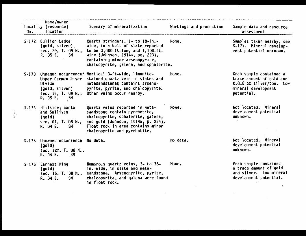
Name/ownerLocality (resource) Summary of mineralization Workings and production Sample data and resourceNo. location assessment
S-172 Bullion Ledge(gold, silver)sec. 29, T. 09 N.,R. 05 E. SM
S-173 Unnamed occurrence*Upper Carmen RiverDivide(gold, silver)sec. 19, T. 09 N.,R. 05 E. SM
S-174 Hillside; Bantaand Sullivan(gold)sec. 01, T. 08 N.,R. 04 E. SM
Quartz stringers, 1- to 18-in.- Nwide, in a belt of slate reportedto be 3,000-ft-long and 1,100-ft-wide (Johnson, 1914a, pg. 223),containing minor arsenopyrite,chalcopyrite, galena, and sphalerite.
Vertical 3-ft-wide, limonite- Nstained quartz vein in slates andmetasandstones contains arseno-pyrite, pyrite, and chalcopyrite.Other veins occur nearby.
Quartz veins reported in meta- Nsandstone contain pyrrhotite,chalcopyrite, sphalerite, galena,and gold (Johnson, 1914a, p. 234).Float rock in area contains minorchalcopyrite and pyrrhotite.
one.
one.
one.
Samples taken nearby, seeS-171. Mineral develop-ment potential unknown.
Grab sample contained atrace amount of gold and0.016 oz silver/ton. Lowmineral developmentpotential.
Not located. Mineraldevelopment potentialunknown.
S-175 Unnamed occurrence No data.(gold)sec. 12?, T. 08 N.,R. 04 E. SM
No data. Not located. Mineraldevelopment potentialunknown.
S-176 Earnest King(gold)sec. 15, T. 08 N.,R. 04 E. SM
Numerous quartz veins, 3- to 36-in.-wide, in slate and meta-sandstone. Arsenopyrite, pyrite,chalcopyrite, and galena were foundin float rock.
None. Grab sample containeda trace amount of goldand silver. Low mineraldevelopment potential.
E I I 0 I

Name/ownerLocality (resource) Summary of mineralization Workings and production Sample data and resourceNo. location assessment
S-177 Unnamed occurrence*Emerald Bay(gold, silver)sec. 09, T. 08 N.,R. 05 E. SM
S-178 Singleton, O'Neil(gold?)sec. 15, T. 08 N.,R. 05 E. SM
S-179 Unnamed occurrence*Cove Creek(gold, silver)sec. 13, T. 08 N.,R. 04 E. SM
2- to 6-in.-wide quartz veincontains pyrite and pyrrhotite.
Several thin quartz veins reportedin sheared metasiltstone and sand-stone (Tysdal, 1978). Spatiallyassociated with the Port WellsFault.
Two quartz veins up to 16-in.-widein slate and metasandstone containpyrite, and pyrite, pyrrhotite,and chalcopyrite, respectively.
None. Two 4-in. chip samplescontained a trace of goldand 0.01 oz silver/ton.Low mineral developmentpotential.
None. Not located. Mineraldevelopment potentialunknown.
None. Seven grab samples con-tained a trace to 0.08 ozgold/ton and a trace to0.02 oz silver/ton. Lowmineral developmentpotential.
S-180 Portage PassMining Co.(gold)sec. 21, T. 08 N.,R. 04 E. SM
S-181 Portage Pass(copper)sec. 20, T. 08 N.,R. 04 E. SM
No data. None.
No data. None.
Not located. Mineraldevelopment potentialunknown.
Not located. Mineraldevelopment potentialunknown.
S-182 Unnamed occurrence*Northland Glacier(gold, silver)sec 23, T. 07 N.,R. 04 E. SM
En echelon 3- to 6-in.-wide quartzveins and stockworks. Veins con-tain minor chalcopyrite and pyr-rhotite, are thin, discontinuous,and associated with Port Wellsfault.
None. Three samples contained atrace of gold and 0.01 ozsilver/ton. Anomalousplacer gold values fromcreeks draining the area.Low mineral developmentpotential.
T,

-Name/owner
Locality (resource) Summary of mineralization Workings and production Sample data and resourceNo. location assessment
S-183 Unnamed occurrence*Kings River(gold, silver)sec. 24, T. 05 N.,R. 03 E. SM
S-184 Kings Bay(gold)sec. 10, T. 04 N.,R. 04 E. SM
S-185 Unnamed occurrence*Wolverine Glacier(gold, silver)sec. 10, T. 03 N.,R. 03 E. SM
5-186 Unnamed occurrenceW. Talus Bay(chromium)sec. 14, T. 02 S.,R. 01 E. SM
S-187 Unnamed occurrenceTalus Bay(chromium, nickel)sec. 13, T. 02 S.,R. 01 E. SM
Quartz veins recement numerousfelsic dikes in carbonaceousslates and metasandstones. Dikesvary from 1- to 5-ft-wideand contain up to 15% quartz-calcite veins which contain arseno-pyrite, chalcopyrite, pyrite, andpyrrhotite.
No data.
None.
Overgrown trail.Workings believed toexist nearby.
Vertical dikes are recementedby quartz-calcite veins thatcontain pyrrhotite, pyrite, andchalcopyrite.
Mineralization reported to occurin the marginal phase of gabbronear its contact with sheeteddikes (Tysdal, 1978).
Shear zone, several yards wide,in gabbro.
None.
None.
None.
Grab sample contained0.02 oz gold/ton and 0.11oz silver/ton. Lowmineral developmentpotential.
Prospect not located.Mineral development poten-tial unknown.
Sample contained trace ofgold and 0.07 oz silver/ton. Low mineral develop-ment potential.
USGS sample contained 0.1%chromium. Low mineraldevelopment potential.
USGS sample contained0.15% chromium and 0.03%nickel. Low mineraldevelopment potential.
I I I E 0
-`tl1h, ,

Name/ownerLocality (resource) Summary of mineralization Workings and production Sample data and resourceNo. location assessment
S-188 Unnamed occurrence,N. Talus Bay(chromium, nickel)sec. 12, T. 02 S.,R. 01 E. SM
S-189 Unnamed occurrence,Day Harbor(chromium, nickel)sec. 07, T. 02 S.,R. 02 E. SM
S-190 Copper Chief;Iron Cap; RealThing(copper)sec. 10, T. 02 S.,R. 01 E. SM
S-191 Day HarborProspect(copper)sec. 05?, T. 02 S.,R. 02 E. SM
Serpentinized dunite, possiblyalong a fault zone.
Serpentinized dunite.
At the Copper Chief, a 6-ft-wide-shear zone in pillow basaltcontains quartz veinlets withdisseminated pyrite, chalcopyrite,hematite, and epidote. Iron Capdeposit contains disseminatedsulfides including chalcopyriteand pyrite with magnetite trace-able for 4,500 ft along theglacier. The Real Thing depositis a 10-ft-wide massive sulfidevein 450- to 650-ft-long containingchalcopyrite with irregular patchesof pyrite on one side of the veinand magnetite with scattered chal-copyrite on the other side.
None. USGS sample contained 0.5%chromium and 0.3% nickel.Low mineral developmentpotential.
USGS sample contained 0.3%chromium and 0.5% nickel.Low mineral developmentpotential.
None.
None.
Disseminated sulfides reported in None.a 4-ft-wide shear zone betweengabbro and peridotite (Grant andHiggins, 1910a, p. 170). Somegabbro in the zone containspyrrhotite, pyrite, and minoramounts of chalcopyrite.
Not visited. Mineraldevelopment potentialunknown.
Not visited. Mineraldevelopment potentialunknown.
-,
* X

Name/ownerLocality (resource) Summary of mineralization Workings and production Sample data and resourceNo. location assessment
S-192 Unnamed occurrence,Godwin Glacier(vanadium, copper)sec. 19, T. 01 S.,R. 02 E. SM
S-193 Unnamed occurrence,4th of July Creek(copper, zinc)sec. 14, T. 01 S.,R. 01 E. SM
S-194 Redman & Guyot(copper)sec. 10, T. 01 S.,R. 01 E. SM
S-195 Prospect #69;Godwin(copper, gold)sec. 34, T. 01 N.,R. 01 E. SM
Small limonite-stalned dissem-inated sulfide-bearing zone inmedium-grained gabbro (Tysdal,1978).
Disseminated pyrite in a limonite-stained zone in pillow basalts(Tysdal, 1978).
Vein, up to 9-ft-wide, with awell-defined gossan containingmalachite, azurite, and chalco-pyrite (Grant and Higgins, 1909b,p. 103).
Massive sulfide vein containsmainly pyrrhotite, minor chalco-pyrite. Nearby quartz vein, upto 8-ft-wide, reportedly containscopper and gold (Martin and others,1915, p. 233).
None. USGS sample contained0.01% copper and 0.2%vanadium. Low mineraldevelopment potential.
None. USGS sampled contained0.03% copper and 0.053%zinc. Low mineraldevelopment potential.
None. Not visited. Mineraldevelopment potentialunknown.
None. Not visited. Mineraldevelopment potentialunknown.
S-196 Rusty(gold)sec. 12,R. 01 W.
None.No data.
T. 01 S.,SM
Not visited. Mineraldevelopment potentialunknown.
S-197 Resurrection BayMining Company(gold, silver)sec. 09, T. 01 S.,R. 01 W. SM
Quartz-calcite veins and stringersup to 3-ft-wide, occupy shearzones in slate and metasandstone.Arsenopyrite, sphalerite, pyrite,chalcopyrite, galena, and goldin veins.
Four adits reported,lengths unknown (Martin,and others, 1915, p. 142).No recorded production.
Not visited. Mineraldevelopment potentialunknown.
I
I I I I
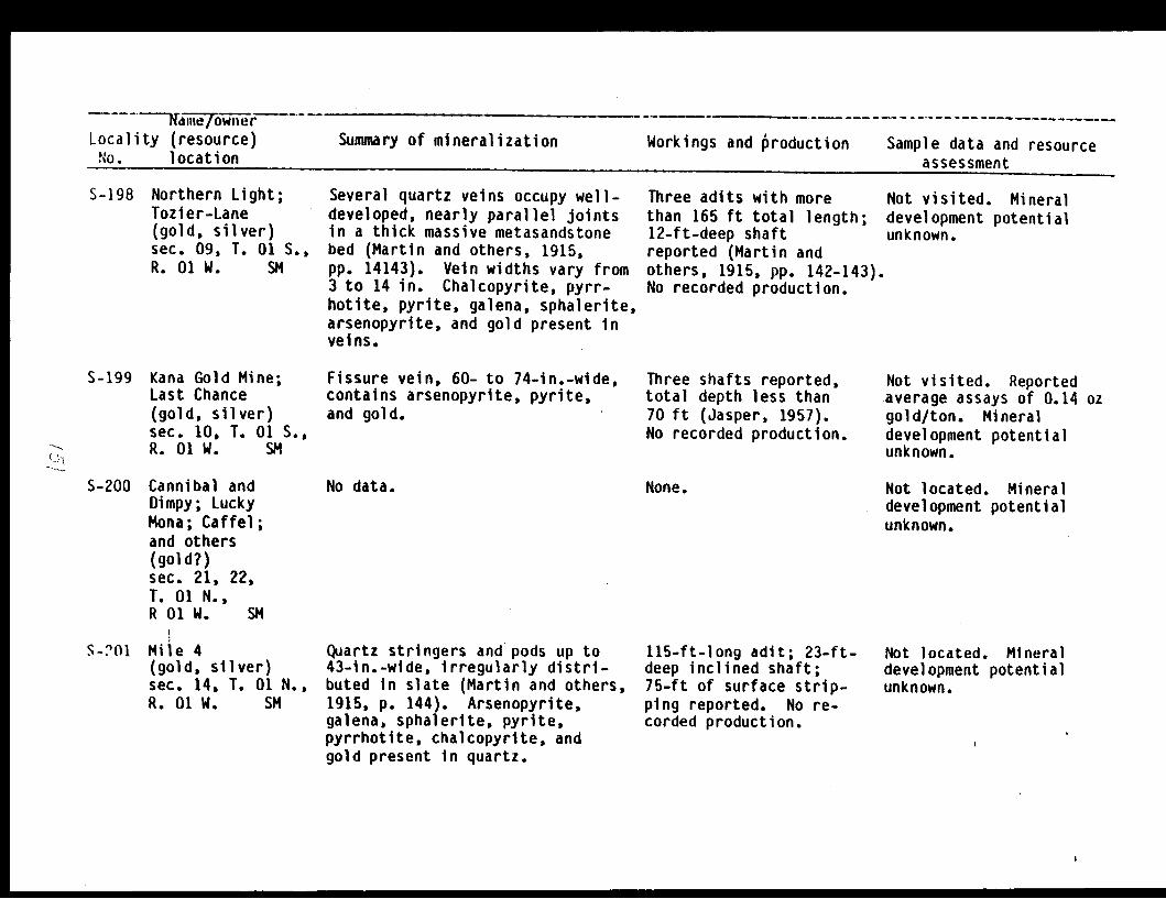
inme/ownerLocality (resource)No. location
Summary of mineralization Workings and production Sample data and resourceassessmentassessment
S-198 Northern Light;Tozier-Lane(gold, silver)sec. 09, T. 01 S.,R. 01 W. SM
S-199 Kana Gold Mine;Last Chance(gold, silver)sec. 10, T. 01 S.,R. 01 W. SM
Several quartz veins occupy well-developed, nearly parallel jointsin a thick massive metasandstonebed (Martin and others, 1915,pp. 14143). Vein widths vary from3 to 14 in. Chalcopyrite, pyrr-hotite, pyrite, galena, sphalerite,arsenopyrite, and gold present inveins.
Fissure vein, 60- to 74-in.-wide,contains arsenopyrite, pyrite,and gold.
Three adits with morethan 165 ft total length;12-ft-deep shaftreported (Martin andothers, 1915, pp. 142-143).No recorded production.
Three shafts reported,total depth less than70 ft (Jasper, 1957).No recorded production.
Not visited. Mineraldevelopment potentialunknown.
Not visited. Reportedaverage assays of 0.14 ozgold/ton. Mineraldevelopment potentialunknown.
S-200 Cannibal andDimpy; LuckyMona; Caffel;and others(gold?)sec. 21, 22,T. 01 N.,R 01 W. SM
S-?Ol Mile 4(gold, silver)sec. 14, T. 01 N.,R. 01 W. SM
No data. None.
Quartz stringers and pods up to43-in.-wide, irregularly distri-buted in slate (Martin and others,1915, p. 144). Arsenopyrite,galena, sphalerite, pyrite,pyrrhotite, chalcopyrite, andgold present in quartz.
Not located. Mineraldevelopment potentialunknown.
115-ft-long adit; 23-ft-deep inclined shaft;75-ft of surface strip-ping reported. No re-corded production.
Not located. Mineraldevelopment potentialunknown.

name/ownerLocality (resource) Summary of mineralization Workings and production Sample data and resourceNo. location assessment
S-202 Seward Limestone(limestone)sec. 14, T. 01 N.,R. 01 W. SM
4.5 x 10 x 90-ft limestonebed crops out in a small stream.Limestone is pure and porous,similar to the Russian Riverdeposits (S-237).
None. Low mineral developmentpotential.
S-203 Mile 7.5(gold, silver)sec. 02, T. 01 N.,R. 01 W. SM
No data. None. Not located. Mineraldevelopment potentialunknown.
S-204 Homestake Ledge(gold, silver,arsenic)
sec. 35, T. 02 N.,R. 01 W. SM
S-205 Brewer AlaskaSyndicate(gold, silver,arsenic)
sec. 26, T. 02 N.,R. 02 W. SM
Stringers and lenses of quartz,up to 14-ln.-wide, in a 33-in.-wide shear zone in slates(Martin and others, 1915).
12- to 20-in.-wide quartz vein,traceable for at least 300 ft,parallels foliation of slate.Arsenopyrite, galena, sphalerite,and gold present in vein.
Inaccessible adit;stripping. No recordedproduction.
Three accessible aditsoccur near creek level.Less than 230 ft oftotal workings. Norecorded production.
Two grab samples containeda trace and 0.07 oz gold/ton, a trace and 0.01 ozsilver/ton and 1,300 and9,400 ppm arsenic. Mineraldevelopment potentialunknown.
Eight samples containedfrom a trace to 0.83 ozgold/ton, a trace to 0.06oz silver/ton, and 43 to4,700 ppm arsenic.Reserves: 1,100 tons.Moderate mineral develop-ment potential for asmall mine.
S-206 Redman Creek(gold, silver)sec. 31, T. 02 N.,R. 02 W. SM
Three parallel quartz veins,total 6-ft in width in 40-ft-wide limonite-stained shearzone, in slate and metasandstone.Fresh sulfides not found.
None. 6-ft chip sample con-tained 0.01 oz gold/ton,0.04 oz silver/ton. Lowmineral development poten-tial.

1W1411CIVIVlltCI
Locality (resource)No. location
Summary of mineralization Workings and production Sample data and resourceAsscpcmant
S-207 Unnamed occurrence,*Quartz veins, with local concen-Placer Creek trations of massive sulfide pods,(gold, silver, in interbedded metasiltstones andcopper, lead, calcareous metasandstones.zinc) Sulfides include galena,
sec. 23, 24, sphalerite, and chalcopyrite.T. 02 N.,R. 03 W. SM
None. Selected grab sample con-tained 0.57 oz gold/ton,11.34 oz silver/ton, 1.25%copper, 1.75% lead, and2.6% zinc. Moderatemineral developmentpotential.
S-208 Grayson Lode(gold, silver,arsenic)
sec. 22, T. 02 N.,R. 01 W. SM
S-209 Mizpah Ledge;Kennedy; Pullen;and Davis(gold, silver,arsenic)sec. 15, T. 02 N.,R. 01 W. SM
12-in.-wide quartz vein in shearedslate contains large, disseminatedcrystals of arsenopyrite; trace-able for 150 ft along strike.
Quartz stringers and pods up to6-in.-wide, occur along a 2- to 4-ft-wide shear zone in interbeddedmetasiltstone and sandstone.Arsenopyrite, chalcopyrite,galena, sphalerite, pyrite, andgold are present.
Small prospect pit andtrench present. Norecorded production.
28-ft-long adit locatedat northern end of 5 x30-ft open cut.
Sample contained no detec-table gold, 0.06 ozsilver/ton, and 1,850 ppmarsenic. Low mineraldevelopment potential.
3- 4-in. chip sample con-tained 0.3 oz gold/ton,0.02 oz silver/ton, and3,500 ppm arsenic. Grabsample contained 3.48oz gold/ton, 2.8 ozsilver/ton, and 6,500ppm arsenic. Reserves:10 tons. Moderate mineraldevelopment potential fora small mine.
S-210 Hale; Peel &Lyngholm(gold?)sec. 01, T. 02 N.,R. 01 W. SM
No data. None. Not located. Mineraldevelopment potentialunknown.
I 1)
� - Ij 7-.-.- - -
- - - - - - - - -� �
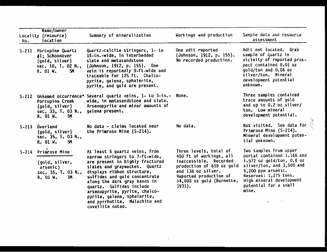
Name/ownerLocality (resource) Summary of mineralization Workings and production Sample data and resourceNo. location assessment
S-211 Porcupine Quartz11; Schoonover(gold, silver)sec. 10, T. 02 N.,R. 01 W. SM
Quartz-calcite stringers, 1- to15-in.-wide, in interbeddedslate and metasandstone(Johnson, 1912, p. 155). Onevein is reportedly 9-ft-wide andtraceable for 125 ft. Chalco-pyrite, galena, sphalerite,pyrite, and gold are present.
One adit reported(Johnson, 1912, p. 155).No recorded production.
Adit not located. Grabsample of quartz invicinity of reported pros-pect contained 0.01 ozgold/ton and 0.06 ozsilver/ton. Mineraldevelopment potentialunknown.
S-212 Unnamed occurrence*Porcupine Creek(gold, silver)sec. 33, T. 03 N.,R. 01 W. SM
S-213 Overland(gold, silver)sec. 35, T. 03 N.,R. 01 W. SM
S-214 Primrose Mine
(gold, silver,arsenic)sec. 35, T. 03 N.,R. 01 W. SM
Several quartz veins, 1- to 3-in.-wide, in metasandstone and slate.Arsenopyrite and minor amounts ofgalena present.
No data - claims located nearthe Primrose Mine (S-214).
At least 5 quartz veins, fromnarrow stringers to 7-ft-wide,are present in highly fracturedslates and graywackes. Quartzdisplays ribbon structure,sulfides and gold concentratealong the dark gray bands inquartz. Sulfides includearsenopyrite, pyrite, chalco-pyrite, galena, sphalerite,and pyrrhotite. Malachite andcovellite noted.
None.
No data.
Three samples containedtrace amounts of goldand up to 0.2 oz silver/ton. Low mineraldevelopment potential.
Not visited. See data forPrimrose Mine (S-214).Mineral development poten-tial unknown.
Three levels, total of450 ft of workings, allinaccessible. Recordedproduction of 659 oz goldand 138 oz silver.Reported production of>4,000 oz gold (Burnette,1931).
Two samples from upperportal contained 1.166 and1.572 oz gold/ton, 0.6 ozsilver/ton, and 3,500 and9,200 ppm arsenic.Reserves: 1,275 tons.High mineral developmentpotential for a smallmine.
M

Name/ownerLocality (resource) Summary of mineralization Workings and production Sample data and resourceNo. location assessment
S-215 Porcupine;Graystone;Homestake LedgL(gold)sec. 23 &-24,T. 03 N.,R. 01 W. SM
At Porcupine Prospect, a 6- to 9-in.-wide quartz-calcite vein inslate and metasandstone containsarsenopyrite, galena, sphalerite,pyrite, pyrrhotite, and gold. Atthe Graystone Prospect a sulfidebearing felsic dike is present.Homestake Ledge is made up ofa few scattered and discontinuousquartz stringers containingarsenopyrite, pyrite, and pyrrho-tite.
Open cut reported on theHomestake Ledge (Martinand others, 1915, pp.147-148). No recordedproduction.
Not visited. Mineraldevelopment potentialunknown.
S-216 Peak 5309 #1*(gold, silver)sec. 23, T. 03 N.,R. 02 W. SM
S-217 Peak 5309 12*(gold, silver)sec. 22, T. 03 N.,R. 02 W. SM
S-218 Peak 5309 #3*(gold, silver)sec. 15, T. 03 N.,R. 02 W. SM
Mineralized veins, from 2- to 48-in.-wide in interbedded slatesand metasandstones contain calcite,and minor pyrite, pyrrhotite, chal-copyrite, and galena. Longitu-dinal quartz-calcite veins containpyrite and possibly sulfosalts.
6-in.- to 6-ft-wide (average 2 ft)quartz vein is exposed for 300 ftin interbedded metasiltstone andslate. Minor amounts of arseno-pyrite, pyrite, and malachitein quartz vein.
None. Six samples contained nodetectable or only traceamounts of gold, and atrace to 0.02 oz silver/ton. Low mineraldevelopment potential.
None.
Several parallel, vuggy, hematite- None.coated quartz-calcite veins cross-cut metasiltstone at a low angle.Fresh sulfides were not noted.
Four samples contained nodetectable or only traceamounts of gold, and atrace to 0.02 oz silver/ton. Low mineraldevelopment potential.
Samples contained nodetectable gold and atrace of silver. Lowmineral developmentpotential.

Name/ownerLocality (resource) Summary of mineralization Workings and production Sample data and resourceNo. location assessment
S-219 Devil Club Ledge;Lakeside(gold)sec. 30, T. 03 N.,R. 01 E. SM
S-220 Brown Bear(gold)sec. 19, T. 03 N.,R. 01 E. SM
S-221 Seward Bonanza,
Kenai Lode(gold, silver)sec. 06, T. 03 N.,R. 01 E. SM
Two veins at Devil Club Ledge,15-in. and 4- to 8-in.-wide, occuralong joints in slate; both con-tain arsenopyrite. At Lakeside,4- to 10-in.-wide quartz vein con-tains minor amounts of arseno-pyrite and pyrite.
1.5- to 5-in.-wide, banded quartz-calcite vein roughly parallelsfoliation of slate host rock.Arsenopyrite, galena, sphalerite,and gold are present.
1.5- to 6-ft-wide quartz veinin shear zone in slate and meta-sandstone. Arsenopyrite, chalco-pyrite, galena, pyrite, sphale-rite, and gold are present.
Several open cutsreported on Devil ClubLedge (Martin and others,1915, p. 148). 30-ft ofstripping reported on theLakeside claims. Noreported production.
Short adit reported(Martin and others, 1915,p. 148). No recordedproduction.
Two adits present, one200-ft-long (accessible)and other reportedlywith 65 ft of workingsis caved at portal.Recorded production65 oz.
Not located. Mineraldevelopment potentialunknown.
Not located. Mineraldevelopment potentialunknown.
Seven chip samplescontained from a trace to0.14 oz gold/ton and from0.02 to 0.73 oz silver/ton. Reserves: 7,400tons. Moderate mineraldevelopment potential fora small mine.
S-222 Unnamed occurrenceAndy Simons Mtn.(gold, silver)sec. 33, T. 04 N.,R. 01 E. SM
,*1.0- to 1.5-ft-wide verticalquartz vein cuts slate andmetasiltstone. Chalcopyrite,galena, pyrite, and sphaleriteare present.
None. Two grab samples contained0.06 and 0.08 oz gold/ton,and 0.16 and 0.25 ozsilver/ton. Low mineraldevelopment potential.
S-223 Dunrovin(gold, silver)sec. 23, T. 04 N.,R. 01 E. SM
6-in.- to 4-ft-wide quartz veincontains pyrite and pyrrhotite.Free gold recovered by panningcrushed quartz.
Two campsites, now inruin, were located.No recorded production.
Sample contained a traceof gold ano 0.01 ozsilver/ton. Low mineraldevelopment potential.

Name/owner- -Locality (resource) Summary of mineralization Workings and production Sample data and resourceNo. location assessment
S-224 Falls Creek Mine;
California-Alaska(gold, silver)sec. 21, T. 04 N.,R. 01 E. SM
S-225 Skeen-Lechner Mine
(gold, silver)sec. 16, T. 04 N.,R. 01 E. SM
S-226 East Point Mine
(gold, silver)sec. 09, T. 04 N.,R. 01 E. SM
8-in.- to 4-ft-wide quartz veinoccupies a 5-ft-wide shear zonein slate and metasandstone.Arsenopyrite, galena, pyrite,sphalerite, and gold are present.
Two quartz veins in graywacke.Upper vein, is from 20- to 45-in.-wide in the workings. Lowervein averages about 2-ft in width.Veins contain arsenopyrite,galena, and gold.
Quartz vein along a shear zonein slate contains pyrite, arseno-pyrite, minor galena, sphalerite,and gold.
960 ft of undergroundworkings reported, allinaccessible. Recordedproduction 65 oz goldand 13 oz silver.Additional past productionpossible.
Three levels with a totalof approximately 2,000feet of undergroundworkings reported. Onlythe middle level is nowaccessible. Considerablestoping has taken place.Recorded production1,796 oz gold and 582 ozsilver, some of which mayhave come from the FallsCreek Mine, (S-224).
Caved inclined shaft withreported 170 ft ofworkings and stopedevelopment (O'Neill,1960). Recordedproduction 1,725 ozgold, 479 oz silver.
6-ft chip sample con-tained 0.09 oz gold/tonand 0.07 oz silver/ton.Mineral developmentpotential unknown.
Nineteen chip samplescontained from a trace to10.5 oz gold/ton and from0.03 to 0.87 oz silver/ton. Average grade forall samples from uppervein was 0.4 oz gold/tonand 0.26 oz silver/ton.Reserves: 10,000 tons.Moderate mineral develop-ment potential for asmall mine.
A grab and 4-in. chipsample contained 2.2 and5.83 oz gold/ton and 0.1and 0.8 oz silver/tonrespectively. Smelterreturns averaged 4.92 ozgold/ton and 1.37 ozsilver/ton. Reserves:3,700 tons. High mineraldevelopment potential fora small mine.
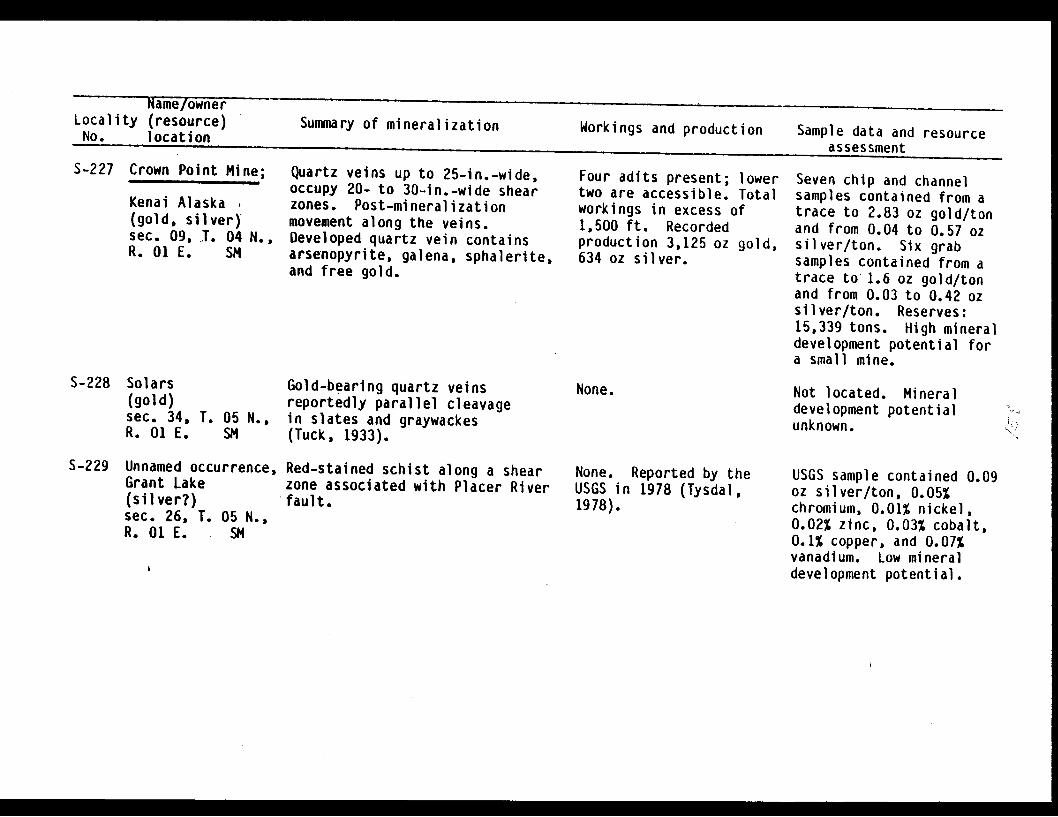
Name/ownerLocality (resource) Summary of mineralization Workings and production Sample data and resourceNo. location
assessmentS-227 Crown Point Mine;
Kenai Alaska(gold, silver)sec. 09, T. 04 N.,R. 01 E. SM
Quartz veins up to 25-in.-wide,occupy 20- to 30-in.-wide shearzones. Post-mineralizationmovement along the veins.Developed quartz vein containsarsenopyrite, galena, sphalerite,and free gold.
Four adits present; lowertwo are accessible. Totalworkings in excess of1,500 ft. Recordedproduction 3,125 oz gold,634 oz silver.
Seven chip and channelsamples contained from atrace to 2.83 oz gold/tonand from 0.04 to 0.57 ozsilver/ton. Six grabsamples contained from atrace to-1.6 oz gold/tonand from 0.03 to 0.42 ozsilver/ton. Reserves:15,339 tons. High mineraldevelopment potential fora small mine.
S-228 Solars(gold)sec. 34, T. 05 N.,R. 01 E. SM
Gold-bearing quartz veinsreportedly parallel cleavagein slates and graywackes(Tuck, 1933).
None. Not located. Mineraldevelopment potentialunknown.
S-229 Unnamed occurrence,Grant Lake(silver?)sec. 26, T. 05 N.,R. 01 E. SM
Red-stained schist along a shearzone associated with Placer Riverfault.
None. Reported by theUSGS in 1978 (Tysdal,1978).
USGS sample contained 0.09oz silver/ton, 0.05%chromium, 0.01% nickel,0.02% zinc, 0.03% cobalt,0.1% copper, and 0.07%vanadium. Low mineraldevelopment potential.

7ime/ownerLocality (resource) Summary of mineralization Workings and production Sample data and resource1Io. location assessment
S-230 Unnamed occurrence(?)sec. 30, T. 05 N.,R. 02 E. SM
Limonite-stained zone more than30-ft-wide in greenschists.
None. USGS sample contained0.3% manganese, 70 ppmchromium, and 60 ppm zinc.Low mineral developmentpotential.
S-231 Grant Lake;
Case Mine(gold, silver)sec. 29, T. 05 N.,R. 01 E. SM
Three sets of quartz veinsin interbedded slates and gray-wackes. Two highly mineralizedveins average 14- to 16-in.-widethroughout workings. Arseno-pyrite, pyrite, galena, andchalcopyrite are present locallyin veins.
Three adits, 10, 170, and40-ft-long. 30-ft-longsection of vein has beenstoped to surface.Recorded production 792oz gold and 123 oz silver.
Four grab samplescontained from a trace to0.22 oz gold/ton and froma trace to 0.5 oz silver/ton. Two chip samplesfrom the upper levelcontained from a trace to1.11 oz gold/ton and from0.04 to 0.3 oz silver/ton.Reserves: 270 tons.Moderate mineral develop-ment potential for asmall mine.
S-232 Rec. 3-9(haydi te)sec. 13, T. 04 N.,R. 01 W. SM
Pure, black, fine-grainedargillite.
None. No samples taken. Favor-able bloating character-istics reported at 2,200-2,3000 F. Reserves 50million tons. Highmineral developmentpotential.
S-233 Ballaine A Nelson(gold)sec. 22, T. 04 N.,R. 01 W. SM
No data. No data. Not located. Mineraldevelopment potentialunknown.
S-234 Unnamed occurrence*Kenai Lake(antimony)sec. 27, T. 04 N.,R. 02 W. SM
Mineralization similar to that ofK & T Prospect (S-236) issuspected. Stream sediment valuesare higher than those from streamsdraining the K & T Prospect.
None. Stream sediment samplecontained 0.0215%antimony. Mineraldevelopment potentialunknown.

Name/owner --Locality (resource) Summary of mineralization Workings and production Sample data and resourceNo. location
assessmentS-235 Vindicator Nn AtA. . .
(gold)sec. 19, T. 04 N.,R. 03 W. SM
- uW'Sa. No data. Not located. Mineraldevelopment potentialunknown.
S-236 K & T; Victory(antimony)sec. 08, T. 04 N.,R. 02 W. SM
S-237 Good Luck;Rec. I & 2(limestone)sec. 04, T. 04 N.,R. 04 W. SM
Fractured and altered felsicdike, averaging 2-ft-wide andtraceable for at least 500 ftalong strike, has been recementedby quartz containing disseminationsand stringers of stibnite.
Two travertine deposits on inter-bedded slates and graywackes.Southern deposit is banded, 2- to6-ft-thick. Northern depositis up to 9-ft-thick, buff colored,and cellular.
Small trench. Norecorded production.
Small prospect pit onsouthern deposit. Somedrilling at the northerndeposit. No recordedproduction.
Five chip samplescontained from 0.015 to0.34% antimony, trace ofgold, and from 0.01 to0.10 oz silver/ton. Analy-ses of samples from a pre-vious report indicated 1.7to 4.38% antimony. Lowmineral developmentpotential.
Reserves: 96,000 tonsof agricultural lime.High mineral developmentpotential for a smallmine.
S-238 Black Devil;Lyngholm(antimony)sec. 31, T. 05 N.,R. 02 W. SM
Highly fractured and altered dike,6- to 9-ft-wide, cuts slate.Quartz recements dike rock and con-tains both disseminated acicularcrystals and stringers of stibnite.Dike is probably a continuation ofthe mineralized dike at the K & Tprospect (S-236).
None. Not located. Similar toK & T (S-236) occurrence.Low mineral developmentpotential.
S-239 Snowshoe(gold)sec. 31, T. 05 N.,R. 02 W. SM
No data. No data. Not located. Mineraldevelopment potentialunknown.
W M 0
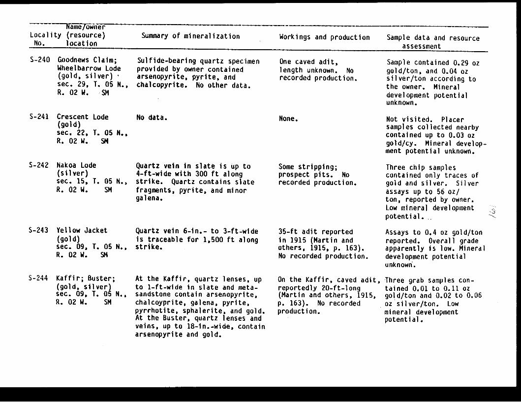
~ Name/ownerLocality (resource) Summary of mineralization Workings and production Sample data and resourceNo. location assessment
S-240 Goodnews Claim;Wheelbarrow Lode(gold, silver)sec. 29, T. 05 N.,R. 02 W. SM
Sulfide-bearing quartz specimenprovided by owner containedarsenopyrite, pyrite, andchalcopyrite. No other data.
One caved adit,length unknown. Norecorded production.
Sample contained 0.29 ozgold/ton, and 0.04 ozsilver/ton according tothe owner. Mineraldevelopment potentialunknown.
S-241 Crescent Lode(gold)sec. 22, T. 05 N.,R. 02 W. SM
No data. None. Not visited. Placersamples collected nearbycontained up to 0.03 ozgold/cy. Mineral develop-ment potential unknown.
S-242 Nakoa Lode(silver)sec. 15, T.R. 02 W.
05 N.,SM
S-243 Yellow Jacket(gold)sec. 09, T. 05 N.,R. 02 W. SM
S-244 Kaffir; Buster;(gold, silver)sec. 09, T. 05 N.,R. 02 W. SM
Quartz vein in slate is up to4-ft-wide with 300 ft alongstrike. Quartz contains slatefragments, pyrite, and minorgalena.
Quartz vein 6-in.- to 3-ft-wideis traceable for 1,500 ft alongstrike.
At the Kaffir, quartz lenses, upto 1-ft-wide in slate and meta-sandstone contain arsenopyrite,chalcoyprite, galena, pyrite,pyrrhotite, sphalerite, and gold.At the Buster, quartz lenses andveins, up to 18-in.-wide, containarsenopyrite and gold.
Some stripping;prospect pits. Norecorded production.
35-ft adit reportedin 1915 (Martin andothers, 1915, p. 163).No recorded production.
On the Kaffir, caved adit,reportedly 20-ft-long(Martin and others, 1915,p. 163). No recordedproduction.
Three chip samplescontained only traces ofgold and silver. Silverassays up to 56 oz/ton, reported by owner.Low mineral developmentpotential.
Assays to 0.4 oz gold/tonreported. Overall gradeapparently is low. Mineraldevelopment potentialunknown.
Three grab samples con-tained 0.01 to 0.11 ozgold/ton and 0.02 to 0.06oz silver/ton. Lowmineral developmentpotential.

-~~~~~~ -------animejownerLocality (resource) Summary of mineralization Workings and production Sample data and resourceNo. location assessment
S-245 Golden Zenith(gold)sec. 03, 10,T. 05 N.,R. 02 W. SM
Quartz veins similar to thoseon the Kaffir and Buster pro-perties (S-244).
None. Not visited. Mineraldevelopment potentialunknown.
S-246 Lois Lode;John's Creek Lode(gold, silver)sec. 01, T. 05 N.,R. 02 W. SM
No data; No data. Not located. Mineraldevelopment potentialunknown.
S-247 J & J Mine(gold?)sec. 31, T. 06 N.,R. 01 W. SM
S-248 Juneau Lake(gold)sec. 29, T. 06 N.,R. 03 W. SM
Several quartz-calcite veinsin metasandstone and slates.Two veins examined contained novisible sulfides.
Limonite-stained, vuggy quartzveins in sandstone.
None.
None.
Two chip samplescontained no gold andtrace amounts of silver.Low mineral developmentpotential.
Not visited. Mineraldevelopment potentialunknown.
S-249 Mctillan Mine;Columbia; Ophir(gold, silver)sec. 23, T. 06 N.,R. 02 W. SM
Several narrow quartz veins,3-in.- to 2-ft-wide, ininterbedded slates and coarsermetaclastics containinggalena, sphalerite, arseno-pyrite, and gold.
170-ft-long adit;several trenches;prospect pits. Estimatedproduction 25 oz gold.
Twelve chip samples con-tained from a trace to1.48 oz gold/ton and froma trace to 0.8 oz silver/ton. Three grab samplescontained from 0.32 to5.04 oz gold/ton and from0.09 to 1.7 oz silver/ton.Inferred reserve base is250 tons. Moderatemineral development poten-tial for a small mine.
i ¼
M

Name/ownerLocality (resource) Summary of mineralization Workings and production Sample data and resourceNo. location assessment
S-250 Henry Creek(gold, silver)sec. 20, T. 06 N.,R. 02 W. SM
S-251 Swetmann(gold, silver)sec. 14, T. 06 N.,R. 02 W. SM
S-252 Hatcher; Slate;Meat-in-the Pot,and others(gold, silver)sec. 13, T. 06 N.,R. 02 W. SM
S-253 Gilpatrick Dike
(gold, silver)sec. 14, T. 06 N.,R. 02 W. SM
Fractured felsic dike recementedby quartz vein containing minorarsenopyrite. Dike can be traced1,000 ft along strike.
Quartz vein, up to 12-in.-wide,contains arsenopyrite, pyrite,chalcopyrite, malachite, azurite,minor chalcocite, and gold.
Several quartz veins of varyingwidths and attitude in metamor-phosed sandstones and slatesspacially associated with thesouthern extension of theGilpatrick Dike. Quartz containsgalena, sphalerite, arsenopyrite,and pyrite.
Quartz veins 2- to 12-in.-wide,generally parallel GilpatrickDike. Veins are at the contactof the dike and also up to 10-ftaway, separated by slate andgraywacke country rock. Dikeis fractured and recemented byauriferous quartz. Sulfidesinclude arsenopyrite, pyrite,galena, and sphalerite. Extentof fracturing of the dike andsubsequent vein filling is highlyirregular. Gold distributiontends to be erratic.
Prospect pits. Norecorded production.
Two adits, partiallycaved, one 120-ft andother 260-ft-long.No recorded production.
Numerous trenches andopen cuts. No recordedproduction.
Three adits, total lengthin excess of 500 ft.considerable stoping.All workings caved.Recorded production3,405 oz gold and 1,099oz silver.
Chip sample contained0.01 oz gold/ton and 0.08oz silver/ton. Lowmineral developmentpotential.
Two samples contained0.005 oz gold/ton andtrace amounts of silver.Low mineral developmentpotential.
Grab sample contained0.08 oz gold/ton and 0.31oz silver/ton. Mineraldevelopment potentialunknown.
Five grab samples con-tained from 0.06 to 8.51oz gold/ton and from 0.02to 3.2 oz silver/ton. Twochip samples, 14-in.- and10-in.-long, contain 0.88and 0.89 oz gold/ton and0.73 and 0.65 oz silver/ton. Reserves: 1,942 tons.High mineral developmentpotential for a smallmine.

~~1fir ae/ownetrLocality (resource)No. location
Summary of mineralization Workings and production Sample data and resourceassessment
S-254 Summit Vein(gold, silver)sec. 14, T. 06 N.R. 02 W. SM
S-255 Heaston-Oracle
Mine
Alaska Oracle(gold, silver)sec. 12, T. 06 N.,R. 02 W. SM
Quartz vein generally 12- to 14-in.-wide over a strike lengthof at least 235 ft, in foldedslates and graywackes. Quartz,locally vuggy with some calcitecontains galena, arsenopyrite,sphalerite, pyrite, and gold.
Quartz vein in fracture in inter-bedded slates and graywackes.Post-mineralization movementgenerally parallel to vein.Quartz vein contains arsenopyrite,galena, sphalerite, molybdenite,minor chalcopyrite, and gold.
Trenching along vein.No recorded production,however a small amount,of past productionpossible.
Three adits. Main levelwith a total of 900 ft ofcrosscuts, 550 ft ofdrifting, 215 ft ofraises, 25-ft winze andconsiderable stoping.Two other adits lengthsunknown. All workingsnow inaccessible.Reported production1,274 oz gold, 256 ozsilver. Total productionbelieved to be higher.
Three grab samplescontained from 0.24 to5.15 oz gold/ton and from0.01 to 3.5 oz silver/ton.Two 18-in.-long chipsamples contained 1.18and 1.35 oz gold/ton and0.84 and 1.4 oz silver/ton. Two 8-in.-long chipsamples of hangingand footwalls contained atrace of gold and 0.02 and0.12 oz silver/ton,respectively. Averagegrade of vein materialis 2.4 oz gold/ton and 1.6oz silver/ton. Reserves:3,400 tons. High mineraldevelopment potential fora small mine.
Chip sample of vein atmain level portal con-tained 1.64 oz gold/tonand 0.71 oz silver/ton.Two chip samples ofwallrock contained from atrace to 0.05 oz gold/tonand 0.01 to 0.09 ozsilver/ton. Two grabsamples from nearbydumps contained from0.02 and 0.04 oz gold/tonand 0.02 and 0.04 ozsilver/ton. Moderatemineral development poten-tial for a small mine.
.'.

Name/ownerLocality (resource) Summary of mineralization Workings and production Sample data and resourceNo. location assessment
S-256 Ronan & James
Mine
Champion;Gladiator(gold, silver)sec. 14, T. 06 N.,R. 02 W. SM
S-257 Apex andNightingale(gold)sec. 11, T. 06 N.,R. 02 W. SM
S-258 Johnson(gold)sec. 12, T. 06 N.,R. 02 W. SM
S-259 Colorado(gold, silver)sec. 02, T. 06 N.,R. 02 W. SM
12-in.-wide quartz vein ininterbedded slates and graywackescontains arsenopyrite, pyrite,galena, sphalerite, chalcopyrite,and gold. Vein reported to belargely stoped out (Tuck, 1933,p. 510).
Northwest striking, steeplydipping quartz veins, in closeproximity to an 8-ft-wide north-striking felsic dike. Dike wasfractured and recemented byvuggy quartz-calcite veins. Veinscontain minor arsenopyrite, galena,and gold.
Quartz-calcite stringers rece-ment a fractured, 4- to 8-ft-wide, felsic dike. Stringerscontain arsenopyrite, pyrite, andgold.
Quartz-calcite veins, up to 8-in.-wide, recement fracturedportions of 4- to 15-ft-wideGilpatrick Dike. Veins containarsenopyrite, pyrite, galena,sphalerite, and gold.
Adit with 427 ft ofworkings. One 30 ftshaft. All workings nowinaccessible. Recordedproduction 557 ozgold and 137 oz silver.
Two caved adits, lengthunknown. No recordedproduction.
40-ft-long adit;prospect pits. Norecorded production.
Three adits present, twoare caved; numerous pits,trenches. No recordedproduction.
Five grab samples con-tained from 0.08 to 1.17oz gold/ton and from 0.05to 0.64 oz silver/ton.Selected grab sample con-tained 2.97 oz gold/tonand 2.73 oz silver/ton.Mineral development poten-tial unknown.
Two samples contained atrace and 0.73 oz gold/ton and 0.009 and 0.038oz silver/ton. Moderatemineral development poten-tial for a small mine.
Not sampled. Mineraldevelopment potentialunknown.
Grab sample containeda trace of gold and 0.15oz silver/ton. Two othergrab samples and one chipsample contained only atrace of gold and 0.01 ozsilver/ton. Low mineraldevelopment potential.

Name/ownerLocality (resource) Summary of mineralization Workings and production Sample data and resourceNo. location assessment
S-260 North Star(gold, silver)sec. 08, T. 06 N.,R. 02 W. SM
Vuggy quartz-calcite vein. Caved adit. No recordedproduction.
Grab sample containedtrace amounts of gold andsilver. 6-in.-long chipsample contained 0.08 ozgold/ton and a trace ofsilver. Mineral develop-ment potential unknown.
S-261 Chickaloon River(molybdenum)sec. 01, T. 06 N.,R. 04 W. SM
Quartz veins contain smallflakes of molybdenite.
None. Not located. No knownpotential host intrusivein the area. Low mineraldevelopment potential.
S-262 Johnson andSkeen; Billy-Jim 1(gold, silver)sec. 35, T. 07 N.,R. 03 W. SM
S-263 Mascot; Iron Mask(gold)sec. 27, T. 07 N.,R. 02 W.
S-264 Independence;Peel and Iverson(gold)sec. 36, T. 07 N.,R. 02 W. SM
Two northwest-striking quartzveins, vary from a few inchesto several ft wide, cutnorth striking slates andgraywackes.
Quartz veins recement fracturedfelsic dikes. Veins containpyrite and minor arsenopyrite.
Fractured felsic dike, up to 4-ft-wide, recemented by quartzstringers.
Three adits, reported tobe 50- to 90-ft in length(Tuck, 1933, p. 519),are inaccessible. Fourounces of gold producedin 1914 by use ofrocker box.
8-ft-long adit.
Few prospect pits. Norecorded production.
Two grab samples fromdump contained from 0.34and 1.5 oz gold/ton and1.8 and 1.9 oz silver/ton. sModerate mineral develop- <ment potential for a smallmine.
Not sampled. No visiblemineralization. Lowmineral developmentpotential.
Grab sample containeda trace of gold and 0.01oz silver/ton. Lowmineral developmentpotential;
I

Name/ownerLocality (resource) Summary of mineralization Workings and production Sample data and resourceNo. location assessment
S-265 Fresno 1 and 2;June Mine(gold)sec. 25, T. 07 N.,R. 02 W. SM
S-266 Shell Mine(gold, silver)sec. 25, T. 07 N.,R. 02 W. SM
S-267 Teresa 1-6(gold)sec. 35, 36,T. 07 N.,R. 01 W. SM
S-268 Seward Gold;Telluride(gold, silver)sec. 04, T. 06 N.,R. 01 E. SM
Quartz veins recement fracturedfelsic dike. Veins are limonite-stained, up to 8-in.-wide, andcontain arsenopyrite, galena,and minor gold.
Several quartz veins and at least2 felsic dikes on property.Developed vein contains arseno-pyrite, galena, pyrite, and freegold.
Several 1- to 3-in.-wide quartzveins parallel bedding of meta-mudstones and sandstones. Veinspinch and swell; contain minorpyrite. Quartz float containsgalena.
Quartz-calcite vein, up to 1-ft-wide, in a shear zone in slateand metasiltstone. Vein containshost rock fragments, pyrite,arsenopyrite, sphalerite, galena,and gold.
Numerous prospect pitsand trenches. No recordedproduction; reportedlysome ore was milled in1912 (Tuck, 1933, p. 517).
Caved adit; shaft; num-erous prospect pits. Norecorded production.
Hand tools and dynamitepresent. No workingsnoted. No recordedproduction.
Caved 90-ft-long aditwith 23 ft winze; 15 ftshaft,; trenching. Norecorded production.
Not sampled. Mineraldevelopment potentialunknown.
Six grab samplescontained from a traceto 0.4 oz gold/ton andfrom 0.01 to 0.37 ozsilver/ton. Reserves:400 tons. Moderatemineral developmentpotential for a smallmine.
Two grab samples containedtrace amounts of gold.Low mineral developmentpotential.
Two chip samples containeda trace and 0.02 oz gold/ton, and a trace dnd 0.23oz silver/ton. Two selec-ted grab samples contained0.79 and 0.99 oz gold/tonand 0.08 and 0.46 ozsilver/ton. Grab sampleof dump material containeda trace of gold and 0.02oz silver/ton. Mineraldevelopment potentialunknown.
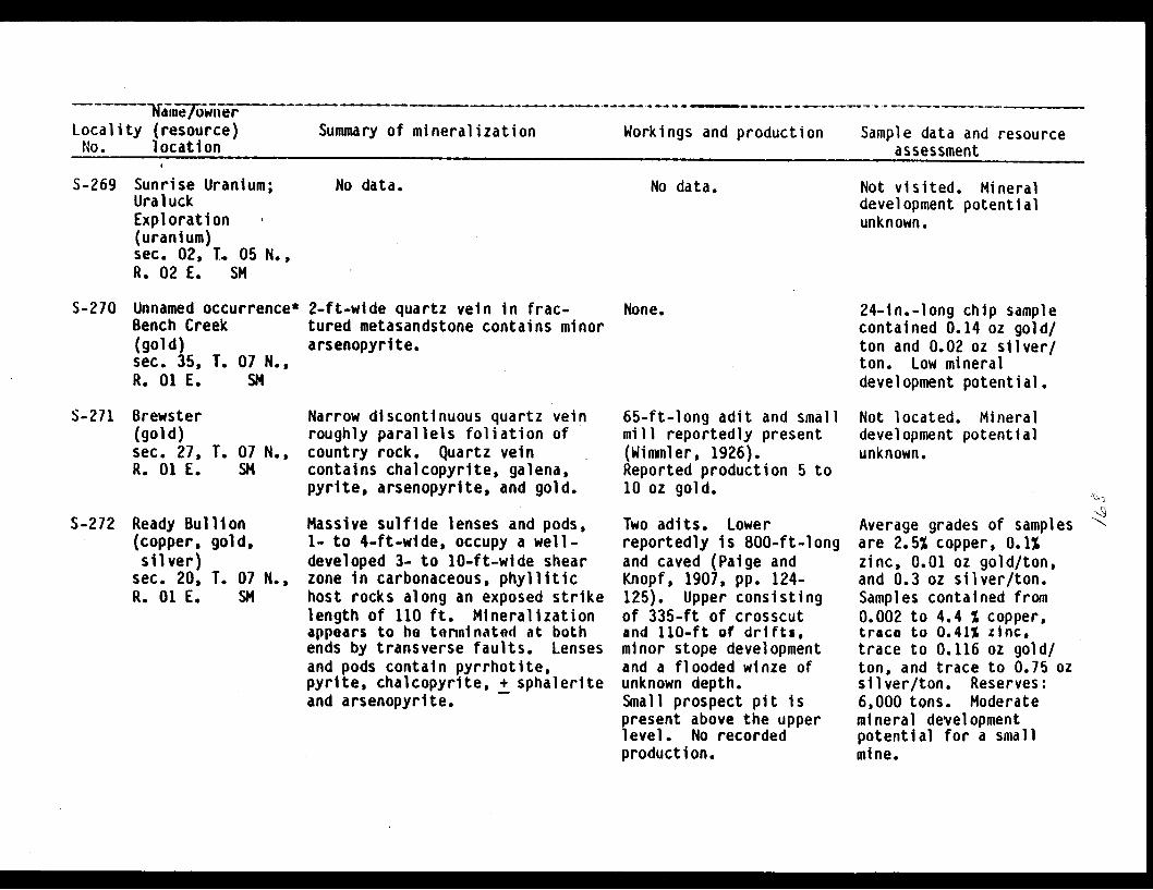
Nme/ownerLocality (resource)No. location
Summary of mineralization Workings and production Sample data and resourceassessment
S-269 Sunrise Uranium;UraluckExploration(uranium)sec. 02, T. 05 N.,R. 02 E. SM
No data. No data. Not visited. Mineraldevelopment potentialunknown.
S-270 Unnamed occurrence*Bench Creek(gold)sec. 35, T. 07 N.,R. 01 E. SM
2-ft-wide quartz vein in frac-tured metasandstone contains minorarsenopyrite.
None. 24-in.-long chip samplecontained 0.14 oz gold/ton and 0.02 oz silver/ton. Low mineraldevelopment potential.
S-271 Brewster(gold)sec. 27, T. 07 N.,R. 01 E. SM
S-272 Ready Bullion(copper, gold,silver)
sec. 20, T. 07 N.,R. 01 E. SM
Narrow discontinuous quartz veinroughly parallels foliation ofcountry rock. Quartz veincontains chalcopyrite, galena,pyrite, arsenopyrite, and gold.
Massive sulfide lenses and pods,1- to 4-ft-wide, occupy a well-developed 3- to 10-ft-wide shearzone in carbonaceous, phyllitichost rocks along an exposed strikelength of 110 ft. Mineralizationappears to be terminated at bothends by transverse faults. Lensesand pods contain pyrrhotite,pyrite, chalcopyrite, + sphaleriteand arsenopyrite.
65-ft-long adit and smallmill reportedly present(Wimmler, 1926).Reported production 5 to10 oz gold.
Two adits. Lowerreportedly is 800-ft-longand caved (Paige andKnopf, 1907, pp. 124-125). Upper consistingof 335-ft of crosscutand 110-ft of drifts,minor stope developmentand a flooded winze ofunknown depth.Small prospect pit ispresent above the upperlevel. No recordedproduction.
Not located. Mineraldevelopment potentialunknown.
Average grades of samplesare 2.5% copper, 0.1%zinc, 0.01 oz gold/ton,and 0.3 oz silver/ton.Samples contained from0.002 to 4.4 % copper,trace to 0.41% zinc,trace to 0.116 oz gold/ton, and trace to 0.75 ozsilver/ton. Reserves:6,000 tons. Moderatemineral developmentpotential for a smallmine.
I
I

Waiii�f�ii&r� - - --- - --------------- -- -- -- - -- -
Locality (resource)No. location
Summary of mineralization Workings and production Sample data and resourceACcaccmanft--. C41mINU
S-273 Keno and Hiway(gold)sec. 09, T. 07 N.,R. 01 W. SM
No data. No data. Not located. Mineraldevelopment potentialunknown.
S-274 Tributary Creek(gold)sec. 18, T. 07 N.,R. 01 W. SM
Fractured felsic dike recementedby slightly mineralized quartzveins.
None. Not located. Mineraldevelopment potentialunknown.
S-275 Gilpatrick;Frenchy Creek(gold, silver)sec. 05, T. 07 N.,R. 01 W. SM
S-276 Hillside Quartz;Frenchy Creek Mine(gold, silver)sec. 29, T. 08 N.,R. 01 W. SM
Fractured felsic dike averaging6-ft-wide, recemented by quartz-calcite veins and pods, up to10-in.-wide. Vein containsarsenopyrite, chalcopyrite, gal-ena, and sphalerite. Arseno-pyrite also occurs in dike.
Several quartz veins in meta-siltstone contain arsenopyrite,pyrite, and minor gold.
50-ft inclined shaft withcaved winze at bottom.No recorded production.
Prospect pits. Norecorded production.
Selected dump sample con-tained 0.42 oz gold/tonand 24.21 oz silver/ton.3 chip samples from theincline contained a traceof gold and 0.02 to 0.22oz silver/ton. Lowmineral developmentpotential.
Grab sample containeda trace of gold and 0.02oz silver/ton. Lowmineral developmentpotential.
S-2/7 Donaldson Creek(gold)sec. 20, T. 08 N.,R. 01 W. SM
S-278 Silvertip Quarry(stone)sec. 26, T. 08 N.,R. 01 W. SM
Reportedly a slightly mineralizedfelsic dike cuts slate andgraywacke (Tuck, 1933, p. 517).
Fractured metasandstone used forrip rap and facing stone.
None. Not located. Mineraldevelopment potentialunknown.
Open cut. Moderate mineral develop-ment potential.

~ Name/ownerLocality (resource) Summary of mineralization Workings and production Sample data and resourceNo. location _
assessmentS-279 Gold Leaf Ca pr.1 n Iam a+ - -1 -.
(gold)sec. 23, 1R. 01 W.
S-280 Julia;Silvia(gold)sec. 13, 23, 24,T. 08 N., R. 01 W.SM
- -1- %uu %,L YuI lb I 1 In ai teand graywacke contain arseno-pyrite and pyrite.
None.
Prospect pit.No recorded production.
Chip sample containeda trace of gold andsilver. Low mineraldevelopment potential.
Not sampled.Mineralization notexposed. Low mineraldevelopment potential.
S-281 Gulch Creek 11*(silver, gold,antimony)
sec. 20, T. 08 N.,R. O1 E. SM
S-282 Robin #1(gold?)sec. 19, T. 08 N.,R. Ol E. SM
S-283 Gulch Creek #2*(gold, silver)sec. 19, T. 08 N.,R. 01 E. SM
At least two 2- to 5-in.-widequartz veins in interbeddedgraywacke pebble conglomerate,and minor slate. Veins containgalena, stibnite, sphalerite,chalcopyrite, and arsenopyrite.
No data.
Two subparallel quartz-calciteveins in slates and metasilt-tones average 1.5-ft-wide andcan be traced to 200 ft alongstrike. Quartz displays well-developed ribbon structure andcontains arsenopyrite and chal-copyrite along the contact withthe wallrock.
None. Twelve samples containedfrom a trace to 0.05 ozgold/ton, from 0.01 to20.41 oz silver/ton andfrom a trace to 0.23%antimony. Moderatemineral developmentpotential for a smallmine.
Not visited. Mineraldevelopment potentialunknown.
None.
None. Four samples containedtrace amounts of gold andup to 0.01 oz silver/ton.Low mineral developmentpotential.
T. 08 N.,SM
No data.
iN,
Ind

Name/owner --
Locality (resource) Summary of mineralization Workings and production Sample data and resourceNo. location assessment
S-284 Gulch Creek #3*(gold, silver)sec. 16, R. oa N.,R. 01 E. SM
Quartz stringers and pods, up to2-ft-wide, in well-developed shearzones averaging 4-ft-wide inslate and metasiltstone. Veins arelimonite-stained and containarsenopyrite.
None. * Five samples containedtraces of gold and a traceto 0.01 oz silver/ton.Low mineral developmentpotential.
S-285 SS Lode, DoLode, SS Di(gold?)sec. 35, T.R. 01 E.
S-286 Lyon Den 11(gold?)sec. 24, T.R. 01 E.
ubleiscovery
No data. No workings.production.
No recorded
08 N.,SM
No data. None.
08 N.,SM
Not located. Placer goldpresent in Bertha Creek.Mineral developmentpotential unknown.
Vein mineralization notlocated. 0.1 cy gravelsample from Lyon Creekyielded coarse gold.Mineral developmentpotential unknown.
S-287 Babe(radi um)sec. 29,R. 02 W.
No data. No data.
T. 08 N.,SM
S-288 Unnamed prospect
sec. 23, T. 08 N,R. 02 W. SM
Several quartz veins and pods ininterbedded metasiltstone andgraywacke.
None.
Not visited. Mineraldevelopment potentialunknown.
USGS sample contained0.13% manganese, 0.2%boron, and 70 ppm zinc.Low mineral developmentpotential.

N Nime/ownerLocality (resource) Summary of mineralization Workings and production Sample data and resourceNo. location assessment
S-289 Hirshey-Lucky
Strike
Swetmann(gold, silver)sec. 24, T. 08 N.,R. 02 W. SM
S-290 Teddy Bear(gold, silver,copper)sec. 13, T. 08 N.,R. 02 W. SM
Quartz vein in slate, varies froma few in. to 5-ft-wide, aver-ages 18-in. Vein contains quartz,minor calcite and ankerite,arsenopyrite, pyrite, galena,sphalerite, and fine gold.
Fractured 3-ft-wide felsic dikerecemented by quartz-calcite veinscontaining arsenopyrite, chalco-pyrite, galena, sphalerite, andminor gold. Dike can be tracedfor 3 mi along strike.
Three adits, all inac-cessible, reportedtotal length in excessof 2,000 ft (Roehm,1937, p. 2). Consid-erable stoping reported.Recorded production5,545 oz gold and4,699 oz silver.
65-ft-long adit; surfacetrenching. No recordedproduction.
Five chip samples con-tained frqm 0.01 to 2.9oz gold/ton and 0.02 to1.9 oz silver/ton.Considerably higher gradeswere reported previously.Reserves: 2,000 tons.High mineral developmentpotential for a smallmine.
Chip sample of dike con-tained a trace of goldand silver. Select grabsample contained 0.117 ozgold/ton and 0.2 ozsilver/ton. Large lowgrade reserves possible.Moderate mineral develop-ment potential.
S-291 Unnamed prospect(gold, silver,copper)
sec. 14, T. 08 N.,R. 02 W. SM
Several quartz veins in graywacke. None. USGS sample contained0.09 oz silver/ton and0.04% copper. Lowmineral developmentpotential.
S-292 Hirshey & Carlson;
Swetmann-New Hope;(gold, silver)sec. 07, T. 08 N.,R. 01 W. SM
Two quartz veins, up to 10-in.-wide, in slate, contain sphalerite,arsenopyrite, pyrite, galena,and gold.
2 adits with total of640 ft of workings;120 ft of trenching;30-ft horizontal cut.Recorded production408 oz gold and 24 ozsilver.
Test shipment in 1936assayed 2.3 oz gold/ton.Four chip samplescontained'from 0.07 to28.08 oz gold/ton and<0.2 to 9.3 oz silver/tonReserves: 500 tons.Moderate mineral develop-ment potential for a smallmine.

-ame/ownerLocality (resource) Summary of mineralization Workings and production Sample data and resourceNo. l -Iocati on
S-293 Sunshine Mine(gold, silver)sec. 01, T. 08 N.,R. 02 W. SM
S-294 Downing Mine;
Francisco;Hershey; BonanzaWhistler;(gold, silver)sec. 31, T. 09 N.,R. 01 W. SM
S-295 Robin Red Breast(gold)sec. 29, T. 09 N.,R. 01 W. SM
S-q96 Kenai Star;French Mine(gold, silver)sec. 30, T. 09 N.,R. 01 W. SM
Two quartz veins, 2- to 12-in.-wide, in metasandstone containpyrite, chalcopyrite, and gold.
Several small quartz-calciteveins in metasiltstone.
Discontinuous 1- to 6-in.-widequartz veins in a 10-ft-wideshear zone in sjates. Quartzcontains pyrite.
Fractured felsic dike, up to 6-ft-wide, recemented by slightlymineralized quartz-calcite veins.Veins contain quartz, calcite,arsenopyrite, pyrite, chalcopyrite,sphalerite, galena, and gold.Dike contains arsenopyrite andpyrite.
Three adits. Lower levelcaved; middle level 300-ft long, partially caved;upper level 110-ft-long,accessible. No recordedproduction.
Two adits 55-ft and36-ft-long; 3 opencuts. Recorded production150 oz gold.
Underground workings,now inaccessible. Opencuts present. No reportedproduction.
Two adits - upper 60-ft-long (accessible), lower120-ft-long (inaccess-ible); trenches. Norecorded production.
assessment
Two grab samples containedtrace amounts of gold anda trace and 0.01 ozsilver/ton. Four chipsamples from upper aditcontained from nil to0.73 oz gold/ton andnil to 0.3 oz silver/ton.Low to moderate mineraldevelopment potential.
Two select grab samplesand a chip sample con-tained from nil to 0.39oz gold/ton and 0.2 ozsilver/ton. Low mineraldevelopment potential.
Not sampled. Mineraldevelopment potentialunknown.
Two chip samples containeda trace and 0.15 oz gold/ton and a trace and 0.06oz silver/ton. Lowmineral developmentpotential.

NamelownerLocality (resource) Summary of mineralization Workings and production Sample data and resourceNo. location assessment
S-297 Robinson &Bowman; LostFrontier(gold)sec. 22, T. 09 N.,R. 02 W. SM
Quartz vein, up to 6-in.-wide,in slates and graywackes containsarsenQpyrite, galena, and minorgold.
220-ft-long adit,partially caved. Norecorded production.
Not sampled. Mineraldevelopment potentialunknown.
S-298 Red Hat(gold)sec. 16, T. 09 N.,R. 02 W. SM
No data. No data. Not visited. Mineraldevelopment potentialunknown.
S-299 Nearhouse
(gold, silver)sec. 18, T. 09 N.,R. 01 W. SM
S-300 Mighty(gold, silver)sec. 12, T. 09 N.,R. 02 W. SM
Banded and brecciated quartz vein,averaging 20-in.-wide, in meta-siltstone and sandstone containsarsenopyrite, galena, sphalerite,pyrite, and gold. Vein faultedoff at both ends.
Quartz veins, up to 12-in.-wide,recement fractured felsic dike.Dike contains pyrite and arseno-pyrite.
Two adits, lower 35-ft-long, upper 450-ft-long, and an 80-ftwinze. Recorded produc-tion 102 oz gold and 3oz silver. Additionalpast production possible.
90-ft-long adit. Norecorded production.
Six chip samples containfrom a trace to 0.45 ozgold ton and from 0.02 to0.13 oz silver/ton.Selected grab samplescontained from a trace to0.2 oz gold/ton and from0.01 to 0.35 oz silver/ton. Reserves: 7,000tons. Moderate mineraldevelopment potential fora small mine.
Three chip samples con-tained only trace amountsof gold and less than 0.05oz silver/ton. Grabsample of dump materialcontained'0.05 oz gold/tonand 0.03 oz silver/ton.Low mineral developmentpotential.

Name/ownerLocality,(resource) Summary of mineralization Workings and production Sample data and resourceNo. location assessment
S-301 Gold Stamp(goldsilver)sec. 07, T. 09 N.,R. 01 W. SM
S-302 Coon and Plowman(silver)sec. 12, T. 09 N.,R. 02 W. SM
S-303 Taylor(gold)sec. 01,R. 02 W.
T. 09 N.,SM
S-304 Lucky Lode;Busted Flat(gold,silver)sec. 12, T. 09 N.,R. 02 W. SM
Quartz vein (not currently exposed)up to 16-in.-wide reportedly cutsgraywacke and a felsic dike(Moffit, 1907, pp. 47-48).Pyrite, arsenopyrite, galena,sphalerite, chalcopyrite, andgold are present in vein.
Quartz veins, 2- to 12-in.-wide,in graywackes and slates containminor calcite, arsenopyrite,pyrite, and galena.
A 10-in.-wide banded quartz veinin slate contains arsenopyrite,sphalerite, galena, and gold.
Quartz vein with trace amountsof gold and silver reported(Mitchell, 1979, p. 105).
30-ft-deep twocompartment shaft,currently flooded.recorded producton.
40-ft-long adit. Norecorded production.
130-ft-long adit drivenin 1931, inaccessible.No reported production.
Several small prospectpits. No recordedproduction.
Two grab samples of dumpmaterials contained 0.03
No and 0.18 oz gold/ton, and0.05 and 0.72 oz silver/ton. Mineral developmentpotential unknown.
Not sampled. Mineraldevelopment potentialunknown.
Not sampled. Mineraldevelopment potentialunknown.
Not visited. Mineraldevelopment potentialunknown.
S-305 Wildhorse Quarry(ornamental stone)sec. 04, T. 09 N.,R. 02 W. SM
6-ft-wide dike with an orangecolor-staining.
None. Not visited. Mineraldevelopment potentialunknown.
S-306 Cowan MountainStone(ornamental stone)sec. 34, T. 10 N.,R. 02 W. SM
No data. None. Not visited. Mineraldevelopment potentialunknown.
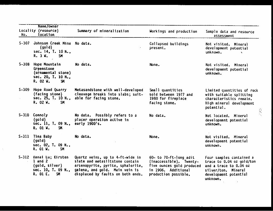
Name/ownerLocality (resource) Summary of mineralization Workings and production Sample data and resourceNo. location assessment
S-307 Johnson Creek Mine(gold)
sec. 14, T. 10 N.,R. 3 W. SM
No data. Collapsed buildingspresent.
Not visited. Mineraldevelopment potentialunknown. N
S-308 Hope MountainGrgenstone(ornamental stone)sec. 20, T. 10 N.,R. 02 W. SM
No data. None. Not visited. Mineraldevelopment potentialunknown.
S-309 Hope Road Quarry(facing stone)sec. 25, T. 10 N.,R. 02 W. SM
Metasandstone with well-developedcleavage breaks into slabs; suit-able for facing stone.
Small quantitiessold between 1977 and1980 for fireplacefacing stone.
Limited quantities of rockwith suitable splittingcharacteristics remain.High mineral developmentpotential.
S-310 Connoly(gold)sec. 11, T. 09 N.,R. 01 W. SM
No data. Possibly refers to aplacer operation active inearly 1900's.
No data. Not located. Mineraldevelopment potentialunknown.
S-311 Tina Baby(gold)sec. 02, T. 09 N.,R. 01 W. SM
No data. None. Not visited. Mineraldevelopment potentialunknown.
S-312 Kenai Lu; Kirstenl and 2(gold, silver)sec. 10, T. 09 N.,R. 01 E. SM
Quartz veins, up to 4-ft-wide inslate and metasiltstone containarsenopyrite, pyrite, sphalerite,galena, and gold. Main vein isdisplaced by faults on both ends.
60- to 70-ft-long adit(inaccessible). Twenty-five ounces gold producedin 1906. Additionalproduction possible.
Four samples contained atrace to 0.04 oz gold/tonand a trace to 0.04 ozsilver/ton. Mineraldevelopment potentialunknown.
I

Name/ownerLocality (resource) Summary of mineralization Workings and production Sample data and resourceNo. location assessment
S-313 Slate Creek #1(gold)sec. 15, T. 09 N.,R. 01 E. SM
S-314 Slate Creek #2(gold)sec. 11, T. 09 N.,R. 01 E. SM
S-315 Indian(gold)sec. 05,R. 01 W.
T. 10 N.,SM
Two quartz veins associated withfaults in slate.
Quartz stringer 1- to 2-in.-widein 4-ft-wide fault zone in slatecontains quartz, calcite, minorpyrite, and arsenopyrite.
Fractured felsic dike is re-cemented by quartz and calcitecontaining pyrite (Capps, 1916,p. 192).
None. Not sampled. Mineraldevelopment potentialunknown,.
None. Chip sample containedtrace amounts of gold asilver. Low mineraldevelopment potential.
No data. Not visited. Mineraldevelopment potentialunknown.
S-316 Bird Point;Conway, Centennial(gold, silver)sec. 30, T. 10 N.,R. 01 E. SM
S-317 Peterson CreekQuarry(rock)sec. 11, T. 09 N.,R. 02 E. SM
Currently not exposed. Reportedly2- to 16-in.-wide quartz-calcitevein parallels foliation in slateand metasiltstone (Capps, 1916,pp. 191-192). Pyrite, chalco-pyrite, galena, sphalerite, andgold are present.
Dark carbonaceous argillite andphyllite.
22-ft-deep shaft, collarbelow current sea level.Mill test of 4,200 lbsin 1912 yielded 2 1/2oz gold/ton.
Quarry. Used for con-struction of leach fieldat the Girdwood sewagetreatment plant.
Grab sample contained0.28 oz gold/ton and 0.06oz silver/ton. Mineraldevelopment potentialunknown.
High mineral developmentpotential for rip rapand fill.
S-318 Peterson Creek(gold)sec. 02, T. 09 N.,R. 02 E. SM
3-ft-wide quartz vein in slateand graywacke.
None. Not sampled. Mineraldevelopment potentialunknown.
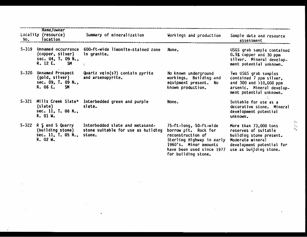
Name/ownerLocality (resource) Summary of mineralization Workings and production Sample data and resourceNo. location assessment
S-319 Unnamed occurrence(copper, silver)sec. 04, T. 09 N.,R. 12 E. SM
600-ft-wide limonite-stained zonein granite.
None. USGS grab sample contained0.5% copper and 30 ppmsilver. Mineral develop-ment potential unknown.
S-320 Unnamed Prospect(gold, silver)sec. 09, T. 09 N.,R. 06 E. SM
Quartz vein(s?) contain pyriteand arsenopyrite.
No known undergroundworkings. Building andequipment present. Noknown production.
Two USGS grab samplescontained 7 ppm silver,and 300 and >10,000 ppmarsenic. Mineral develop-ment potential unknown.
5-321 Mills Creek Slate*(slate)sec. 11, T. 06 N.,R. 01 W.
Interbedded green and purpleslate.
None. Suitable for use as adecorative stone. Mineraldevelopment potentialunknown.
S-322 R § and S Quarry(building stone)sec. 11, T. 05 N.,R. 02 W.
Interbedded slate and metasand-stone suitable for use as buildingstone.
75-ft-long, 50-ft-wideborrow pit. Rock forreconstruction ofSterling Highway in early1960's. Minor amountshave been used since 1977for building stone.
More than 73,000 tonsreserves of suitablebuilding stone present.Moderate mineraldevelopment potential foruse as building stone.
tar
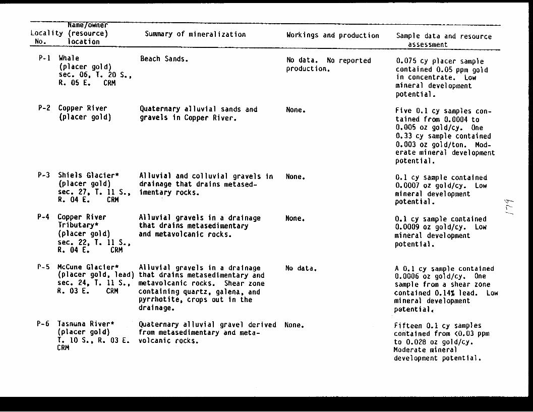
Name/ownerLocality (resource) Summary of mineralization Workings and production Sample data and resourceNo. location assessment
P-i Whale(placer gold)sec. 06, T. 20 S.,R. 05 E. CRM
P-2 Copper River(placer gold)
P-3 Shiels Glacier*(placer gold)sec. 27, T. 11 S.,R. 04 E. CRM
P-4 Copper RiverTributary*(placer gold)sec. 22, T. 11 S.,R. 04 E. CRM
P-S McCune Glacier*(placer gold, lead)sec. 24, T. 11 S.,R. 03 E. CRM
P-6 Tasnuna River*(placer gold)T. 10 S., R. 03 E.CRM
Beach Sands. No data. No reportedproduction.
Quaternary alluvial sands andgravels in Copper River.
Alluvial and colluvial gravels indrainage that drains metased-imentary rocks.
Alluvial gravels in a drainagethat drains metasedimentaryand metavolcanic rocks.
Alluvial gravels in a drainagethat drains metasedimentary andmetavolcanic rocks. Shear zonecontaining quartz, galena, andpyrrhotite, crops out in thedrainage.
Quaternary alluvial gravel derivedfrom metasedimentary and meta-volcanic rocks.
None.
None.
None.
No data.
None.
0.075 cy placer samplecontained 0.05 ppm goldin concentrate. Lowmineral developmentpotential.
Five 0.1 cy samples con-tained from 0.0004 to0.005 oz gold/cy. One0.33 cy sample contained0.003 oz gold/ton. Mod-erate mineral developmentpotential.
0.1 cy sample contained0.0007 oz gold/cy. Lowmineral developmentpotential.
0.1 cy sample contained0.0009 oz gold/cy. Lowmineral developmentpotential.
A 0.1 cy sample contained0.0006 oz gold/cy. Onesample from a shear zonecontained 0.14% lead. Lowmineral developmentpotential.
Fifteen 0.1 cy samplescontained from <0.03 ppmto 0.028 oz gold/cy.Moderate mineraldevelopment potential.
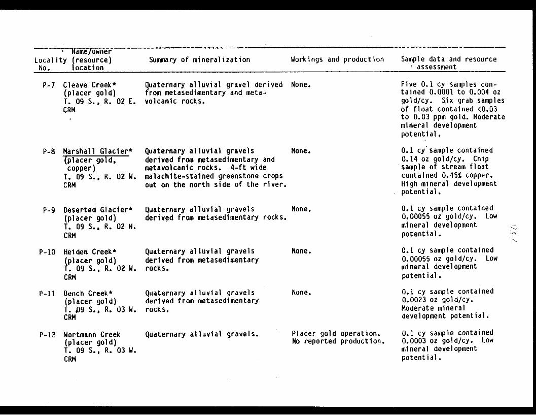
Name/ownerLocality (resource)No. location
Summary of mineralization Workings and production Sample data and resourcef assessment
P-7 Cleave Creek*(placer gold)T. 09 S., R. 02 E.CRM
P-8 Marshall Glacier*(placer gold,copper)T. 09 S., R. 02 W.CRM
P-9 Deserted Glacier*(placer gold)T. 09 S., R. 02 W.CRM
P-10 Heiden Creek*(placer gold)T. 09 S., R. 02 W.CRM
P-l Bench Creek*(placer gold)T. 09 S., R. 03 W.CRM
Quaternary alluvial gravel derived None.from metasedimentary and meta-volcanic rocks.
Quaternary alluvial gravelsderived from metasedimentary andmetavolcanic rocks. 4-ft widemalachite-stained greenstone cropsout on the north side of the river.
Quaternary alluvial gravelsderived from metasedimentary rocks.
Quaternary alluvial gravelsderived from metasedimentaryrocks.
Quaternary alluvial gravelsderived from metasedimentaryrocks.
Five 0.1 cy samples con-tained 0.0001 to 0.004 ozgold/cy. Six grab samplesof float contained <0.03to 0.03 ppm gold. Moderatemineral developmentpotential.
0.1 cy sample contained0.14 oz gold/cy. Chipsample of stream floatcontained 0.45% copper.High mineral developmentpotential.
None.
None.
None.
None.
0.1 cy sample contained0.00055 oz gold/cy. Lowmineral developmentpotential.
0.1 cy sample contained0.00055 oz gold/cy. Lowmineral developmentpotential.
0.1 cy sample contained0.0023 oz gold/cy.Moderate mineraldevelopment potential.
P-12 Wortmann Creek(placer gold)T. 09 S., R. 03 W.CRN
Quaternary alluvial gravels. Placer gold operation.No reported production.
0.1 cy sample contained0.0003 oz gold/cy. Lowmineral developmentpotential.
'.,
1 - __ I

Name -
Locality (resource) Summary of mineralization Workings and production Sample data and resourceNo. (location) assessment
P-13 Lowe River(placer gold)T. 09 S., R. 05,W.CRM
Quaternary alluvial gravelsderived from metasedimentaryrocks. Mineralization consistsof fine-grain gold and reportedscheelite near the mouth.
No data. Two 0.1 cy samples con-tained 0.56 to 1.25 ppmgold; two 0.1 cy placersamples contained from0.0002 to 0.0004 oz gold/cy. No tunsten valuesobtained in sample analy-sis. Low mineraldevelopment potential.
P-14 Black Bear No. 1-4(placer platinum)sec. 21, T. 09 S.,R. 05 W. CRM
Quaternary alluvial gravelsderived from metasedimentaryrocks.
Placer operation.No reported production.
Not looked for. Mineraldevelopment potentialunevaluated.
P-15 Brown Creek*(placer gold)T. 20 S., R. 04 W.CRM
Quaternary alluvial gravelsderived from metasedimentaryand metavolcanic rocks.
None. Two 0.1 cy samples con-tained from 19 ppm to0.0005 oz gold/cy. Three-pan sample from bedrockcontained 0.019 oz gold/cy. Moderate mineraldevelopment potential.
P-16 Sulfide Gulch(placer gold)T. 09 S., R. 05 W.CRMI
Quaternary alluvial gravelsderived from metasedimentaryand metavolcanic rocks. Otherminerals present in heavyfraction include garnet, pyrite,chalcopyrite, magnetite, zircon,and scheelite.
Placer operation.No reported production.
0.1 cy sample contained0.044 oz gold/ton. R. H.Sanders took two pansamples on the West Forkwhich yielded 0.25 to 0.35mg of gold/double pan.Low mineral developmentpotential.
P-17 Dead Creek*(placer gold)T. 11 S., R. 04 W.CRM
Quaternary alluvial gravelscontain slate, graywacke, phyllite,greenstone, and andalusite schistcobbles and boulders. 15 garnetin concentrate.
None. Five 0.1 cy samples con-tained from 0.28 ppm to0.0007 oz gold/cy. Lowmineral developmentpotential.
I
\N /..,. .
.
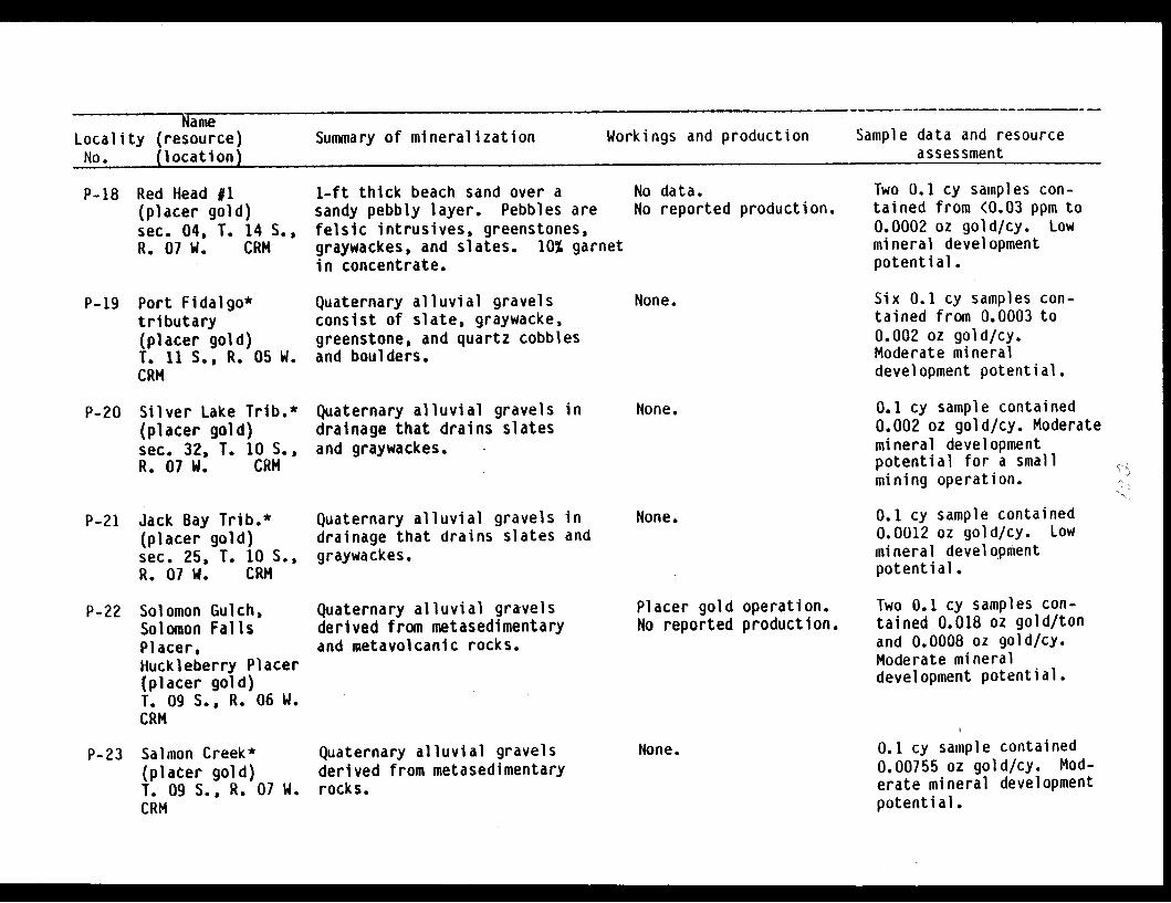
NameLocality (resource) Summary of mineralization Workings and production Sample data and resourceNo. (location) assessment
P-18 Red Head #1(placer gold)sec. 04, T. 14 S.,R. 07 W. CRM
1-ft thick beach sand over asandy pebbly layer. Pebbles arefelsic intrusives, greenstones,graywackes, and slates. 10% garnetin concentrate.
No data.No reported production.
Two 0.1 cy samples con-tained from <0.03 ppm to0.0002 oz gold/cy. Lowmineral developmentpotential.
P-19 Port Fidalgo*tributary(placer gold)T. 11 S., R. 05 W.CRM
P-20 Silver Lake Trib.*(placer gold)sec. 32, T. 10 S.,R. 07 W. CRM
P-21 Jack Bay Trib.*(placer gold)sec. 25, T. 10 S.,R. 07 W. CRM
Quaternary alluvial gravelsconsist of slate, graywacke,greenstone, and quartz cobblesand boulders.
Quaternary alluvial gravels indrainage that drains slatesand graywackes.
Quaternary alluvial gravels indrainage that drains slates andgraywackes.
None.
None.
None.
Six 0.1 cy samples con-tained from 0.0003 to0.002 oz gold/cy.Moderate mineraldevelopment potential.
0.1 cy sample contained0.002 oz gold/cy. Moderatemineral developmentpotential for a smallmining operation.
0.1 cy sample contained0.0012 oz gold/cy. Lowmineral developmentpotential.
P-22 Solomon Gulch,Solomon FallsPlacer.Huckleberry Placer(placer gold)T. 09 S., R. 06 W.CRM
Quaternary alluvial gravelsderived from metasedimentaryand metavolcanic rocks.
Placer gold operation.No reported production.
Two 0.1 cy samples con-tained 0.018 oz gold/tonand 0.0008 oz gold/cy.Moderate mineraldevelopment potential.
P-23 Salmon Creek*(placer gold)T. 09 S., R. 07 W.CRM
Quaternary alluvial gravelsderived from metasedimentaryrocks.
None. 0.1 cy sample contained0.00755 oz gold/cy. Mod-erate mineral developmentpotential.

NameLocality (resource) Summary of mineralization Workings and production Sample data and resourceNo. (location) assessment
P-24 Rainy Day;Jackson; Allison 4
(placer gold)sec. 18, T. 09 S.,R. 06 W. CRM
P-25 Mineral Creek; IThe Harley- 4
Davidson; Ethel; IHigh Ore; Icy Creek;Fine Chance(placer gold)T..08 S., R. 06 W.CRM
Quaternary alluvial gravelsderived from metasedimentaryrocks.
Quaternary alluvial gravelsderived from metasedimentaryrocks.
Placer goldNo reported
Placer goldNo reported
operation.production.
operation.production.
Alyeska Oil Terminal isbuilt on prospect site.Low mineral developmentpotential.
Gravel flats drilled in1914; reported to contain0.012 to 0.0145 oz gold/cy. Moderate mineraldevelopment potential.
P-26 Gold Creek,Bud Mining Co.(placer gold)T. 08 S., R. 07 W.CRM
Quaternary alluvial gravelscontain 5% clay, and slate,graywacke, and quartz pebblesand cobbles. Gravel are 9 to50 ft thick.
Placer gold operation.No reported production.
0.1 cy sample contained0.0005 oz gold/cy. Lowmineral developmentpotential.
P-27 McAllister Creek*(placer gold)T. 08 S., R. 08 W.CRM
P-28 Big Creek*(placer gold)T. 08 S. R. 08 W.CRM
P-29 Lake No. 1*(placer gold)T. 08 S., R. 09 W.CRM
Quaternary alluvial gravelsderived from metasedimentaryrocks.
Quaternary alluvial gravelsderived from metasedimentaryrocks.
Quaternary alluvial gravels.
None. 0.1 cy sample contained0.001 oz gold/cy. Lowmineral developmentpotential.
None. 0.1 cy sample contained0.00055 oz gold/cy. Lowmineral developmentpotential.
None. 0.1 cy sample contained0.0005 oz gold/cy. Lowmineral developmentpotential.

NameLocality (resource) Summary of mineralization Workings and production Sample data and resourceNo. (location) assessment
P-30 Columbia Glacier*(placer gold)T. 09 S., R. 10 W.CRM
Quaternary alluvial gravels. Placer gold occurrence.No reported production.
0.1 cy sample contained0.0005 oz gold/cy. Lowmineral developmentpotential.
P-31 Miners BayDiscovery*(placer gold)sec. 29, T. 12 N.,R. 12 E. SM
Quaternary alluvial gravels. None. 0.1 cy sample contained0.005 oz gold/cy gold.Moderate mineraldevelopment potential.
P-32 Western Tributaryto Unakwik Inlet(placer gold)Anchorage A2T. 11 N., R. 10 E.SM
P-33 NorthwesternTributary toJonah Bay(placer gold)Anchorage A2T. 11 N., R. 10 E.
SM
Fine gold is disseminated inpoorly washed fluvial glacialgravels containing boulders to5 ft. and moderate clay hardpan.Grade is likely low but localconcentrations of economicsignificance may exist.
Fine gold is disseminated inpoorly washed fluvial glacialgravels derived from a glacieron the north and east flanks ofUnakwik Peak. Large boulder arepresent.
No recorded production.
No recorded production.
Alluvial sample contained0.0021 oz gold/cy. Low tomoderate developmentpotential for suctiondredging and small mech-anized operations.
Alluvial sample contained0.0013 oz gold/cy. Lowmineral developmentpotential for small mech-anized and suctiondredging operations.
P-34 Siwash Bay Creek(placer gold)Seward D2T. 10 N., R. 10 E.SM
Upper Siwash Creek descendsrapidly with little gravel accum-ulation. Lower section occupies arelatively wide valley with abraided channel and flood plaindeveloped. Gravel contains con-siderable clay. Anomalous con-centrations of fine gold occur atthe lower end of the steep sectionof the creek.
None. 0.1 cy samples contained0.0036 and 0.0009 oz/cy.Mid-section of SiwashCreek has-low to moderatemineral developmenepotential for suctiondredging and smallmechanized operations.

-- Nalne
Locality (resource) Summary of mineralization Workings and production Sample data and resourceNo. (location) assessment
P-35 Eaglek Bay Uppermost section descends rapidly None.(placer gold) , from its glacialsources followedSeward D3 by a wide braided portion about 1 1/2T. 10 N., R. 9 E. mi long. Lower section occupies aSM steep narrow bedrock canyon below
which a braided channel has developed.Very fine gold occirs in gravelsaccumulating below lower falls.
0.1 cy sample contained0.001 oz gold/cy. Thegold required amalgamationto recover. Low mineraldevelopment potential forsuction dredging and smallmechanized operations.
P-36 Avery River(placer gold)Seward 03T. 10 N., R. 9 E.SM
P-37 Lafayette Glacier(placer gold)Anchorage A3T. 11 N., R. 9 E.SM
Lower half of Avery River occupies Possibly some hand placera relatively broad gentle U-shaped activity and suctionvalley filled with considerable dredging has occurred.alluvium. Middle section flowsthrough a narrow, steep bedrockcanyon with little gravel accumula-tion. Upper section occurs ina broad U-shaped valley with poorlywashed fluvial glacial gravels con-taining highly anomalous concen-trations of fine gold with particlesup to 1/8 in recovered. Uppergravels contain numerous bouldersand considerable clay.
Very fine-grained gold is dissem- No recorded production.inated in poorly washed fluvial-glacial gravels associated withLafayette Glacier. Large bouldersare present. A large volume ofgravel occurs along the stream.
Three samples from theupper section containedfrom 0.0001 to 0.008oz gold/cy; sample col-lected just below thecanyon 0.0002 oz gold/cy;other samples, traceamounts of gold. Uppersection has moderatepotential for a smallmechanized operation. Morethan 200,000 cy gravelpresent. Canyon sectionhas moderate mineraldevelopment potential forsuction dredging. I
Alluvium sample contained0.001 oz gold/cy.Lafayette drainage has lowmineral development poten-tial for small-mediumsized mechanized opera-t ions.
-

NameLocality (resource) Summary of mineralization Workings and production Sample data and resourceNo. (location) assessment
P-38 Northwest ForkCoghill River(placer gold)Anchorage A2T. 12 N., R. 10 E.SM
P-39 Bettles Baystream drainingMineral King Mine(1140)(placer gold)Seward D4T. 10 N., R. 6 E.SM
Gold is disseminated in thin,poorly to moderately sorted allu-vial gravels and concentrated onand in slate bedrock exposed in thecanyon portion of the northwestfork of the Coghill River. Minorgravel occurs in the canyon buthas accumulated above its junctionwith the main fork of the CoghillRiver. Grades are low to marginalwith good possibilites ofidentifying local'economic concen-trations of gold. Gold up to 1/16in. in diameter was recovered.
Gold is disseminated throughoutgravels with some concentrationon bedrock. Creek occupies asteep narrow bedrock channelwith little accumulation of gravelexcept at its extreme lower end.Gravel contains considerable clayand boulders.
No recorded production.
Minor prospectingreported. No knownproduction.
The three alluvium samplescontained 0.0004 to 0.0063oz gold/cy. Considerablearsenopyrite was alsorecovered. Moderatemineral developmentpotential for suctiondredging in the canyonsection, and low potentialfor a small operationbelow the canyon.
Samples collected near themouth of the canyoncontained 0.0009 and 0.018oz/cy. The second samplewas collected on bedrock.Gravel volume is limited.Low to moderate mineraldevelopment potential fora small mechanized oper-ation and suction dredging
P-40 Pirate Cove(placer gold)Seward D4T. 9 E., R. 6 E.SM
Gold is fine with a few smallflakes to 1/16 in. recovered.The main tributary to Pirate Coveoccupies a short U-shaped valleywhich has a steep gradient in itsupper portion and a relativelygentle gradient along its middleand lower sections. Gravel con-tains numerous boulders.
None. 0.1 cy sample of alluvialgravels contained 0.001 ozgold/cy. Low mineraldevelopment potential foreconomic placer mining.
1- I

Non .fla1il=
Locality (resource)No. (location)
Summary of mineralization Workings and production Sample data and resource2accn55an.U _ ,I a ca X
P-41 Billings Creek(placer gold)Seward D5T. 9 N., R. 5 E.SN
P-42 Carmen River,(North Fork)(placer gold)Seward D5T. 9 N., R. 4 E.SH
P-43 Cotterell GlacierCreek(placer gold)Seward C5T. 6 N., R. 5 E.SM
Billings Creek occupies a rela-tively short, wide, gently slopingU-shaped valley. Central sectionhas a short bedrock canyon belowwhich gravel bars containing finedisseminated gold accumulations.Gravels consist of a wide varietyof metasedimentary and graniticclasts and have a high clay content.
Upper segment of Carmen Riveroccupies a relatively broad,gently sloping U-shaped valleyexcept in its uppermost forksentrenched in steep walled bedrockcanyons. Little gravel hasaccumulated in the canyons. Theflood plain gravels grade fromboulder and clay rich at theupper portion to increasingly well-washed sandier sections near Carmenlake. Gold is present in slightlyanomalous concentrations in thealluvial gravels of the uppersection.
Cotterell Glacier Creek occupiesa relatively broad glacial valleywith flood plain developed alongmost of its course. Gravel issomewhat compacted, with a highclay and boulder content. Gold isfine and required amalgamation torecover.
None. 3-in. dredge sampleyielded 0.0014 oz gold/hrof very fine gold requir-ing amalgamation torecover. Low to moderatemineral development poten-tial for a small mechan-ized or suction dredgeoperation.
None. Three 3-in dredge samplesyielded from a trace to0.0001 oz gold/hr. One0.1 cy channel samplecollected in the east forkbedrock canyon contained0.0014 oz/cy. Sniping onbedrock yielded traces ofgold. Carmen River haslow mineral developmentpotential for economicmining operations.
None. 0.1 cy sample collectednear the terminus ofCotterell Glacier con-tained 0.0005 oz/cy. Lowmineral developmentpotential for placermining.

NameLocality (resource) Summary of mineralization Workings and production Sample data and resource
No. (location) assessment
P-44 Taylor GlacierCreek(placer gold)Seward C5T. 5 N., R. 5 E.SM
P-45 Claremont GlacierCreek(placer gold)Seward C5T. 5 N., R. 5 E.SM
P-46 Kings River(placer gold)Seward B5 andC5 Quads.T. 4 N., R. 4. E.SM
Taylor Glacier Creek occupies avery short broad valley and hasa braided channel consisting ofcompacted gravels with a highclay and boulder content. Goldup to 1/8-in diameter was reco-vered.
Claremont Glacier Creek occupiesa short, steep, narrow glaciatedvalley in its upper section witha braided alluvial channel alongits lower portion. The gravelis compacted with a high clayand boulder content. The gold isfine and required amalgamationto separate from concentrate.
None.
None.
Kings River is fed by two short None.steep gold-bearing headwater tribu-taries. Below their junction theriver flows through a relativelywide gently sloping valley with a1/4 to 1/2 mile wide flood plain.The gravels contain considerableclay with coarse angular bedrockboulders in the upper section andbecome better sorted, less compactedand finer grain as Kings Bay isapproached. Coarse gold, up to 3/16-in diameter, was recovered in theupper section of the stream. Finegrain gold in anomalous quantitieswas found in surface gravels up to5 mi from the headwaters.
0.1 cy sample collectedbelow a small waterfallcontained 0.0044 oz/cy.Low to moderate mineraldevelopment potential fora small mechanized oper-ation or suction dredging.Boulders would be aproblem.
0.1 cy sample gold con-tained 0.0013 oz/cy. Lowmineral developmentpotential for placercommercial mining.
Three 0.1 cy samplescontained from 0.0003 to0.0083 oz gold/cy. Dredgesample yielded 0.0017 ozgold/hr. Upper section ofKings River has moderatemineral developmentpotential for suctionmechanized operations.Boulders would be asignificant problem.Flood plain gravels(greater than 6 millioncy) could support a mediumto large mechanizedoperation.
I

NameLocality (resource)No. (location)
Summary of mineralization Workings and production Sample data and resourcea c CACmant
- ...It'll
P-47 Kings Rivertributary(placer gold)Seward B5 QuadT. 5 N., R. 3 E.SM
P-48 Wolverine Creek(placer gold)Seward B6
P-49 Sheppard IA, 1B, 2Puget Bay(placer gold)sec. 18, T. 2 S.,R. 6 E. SM
This tributary occupies a short None.steep, narrow bedrock canyon inits upper section. The remainderhas a narrow flood plain consistingof clay-rich gravels which containanomalous gold values. The goldrecovered was up to 1/8 in. diameter.
Wolverine Creek descends through None.a short narrow bedrock canyon withminor gravel accumulating untilnear its junction with the NellieJuan River. Gravels containconsiderable clay, numerous bouldersand small amounts of fine gold andsulfides.
Quaternary alluvial sand andgravels consist of graywackewith some disseminated pyriteand small quartz veins.
No data.
Sample collected 150 ftbelow the canyon mouthcontained 0.0035 oz gold/cy. Sample from nearjunction with the KingsRiver contained onlytraces of gold. Low tomoderate mineral develop-ment potential for suctiondredging or a smallmechanized operation inthe section just belowthe canyon mouth. Gravelreserves in the high gradeportion of the stream areestimated to be less than25,000 cy.
0.1 cy placer samplefrom surface gravels con-tained 0.0002 oz/cy gold.Low mineral developmentpotential for smallmechanized and suctiondredge operations.
Four 0.1 cy placer samplescontained from .04 ppm to1.34 ppm gold. Low mineraldevelopment potential.
-----------
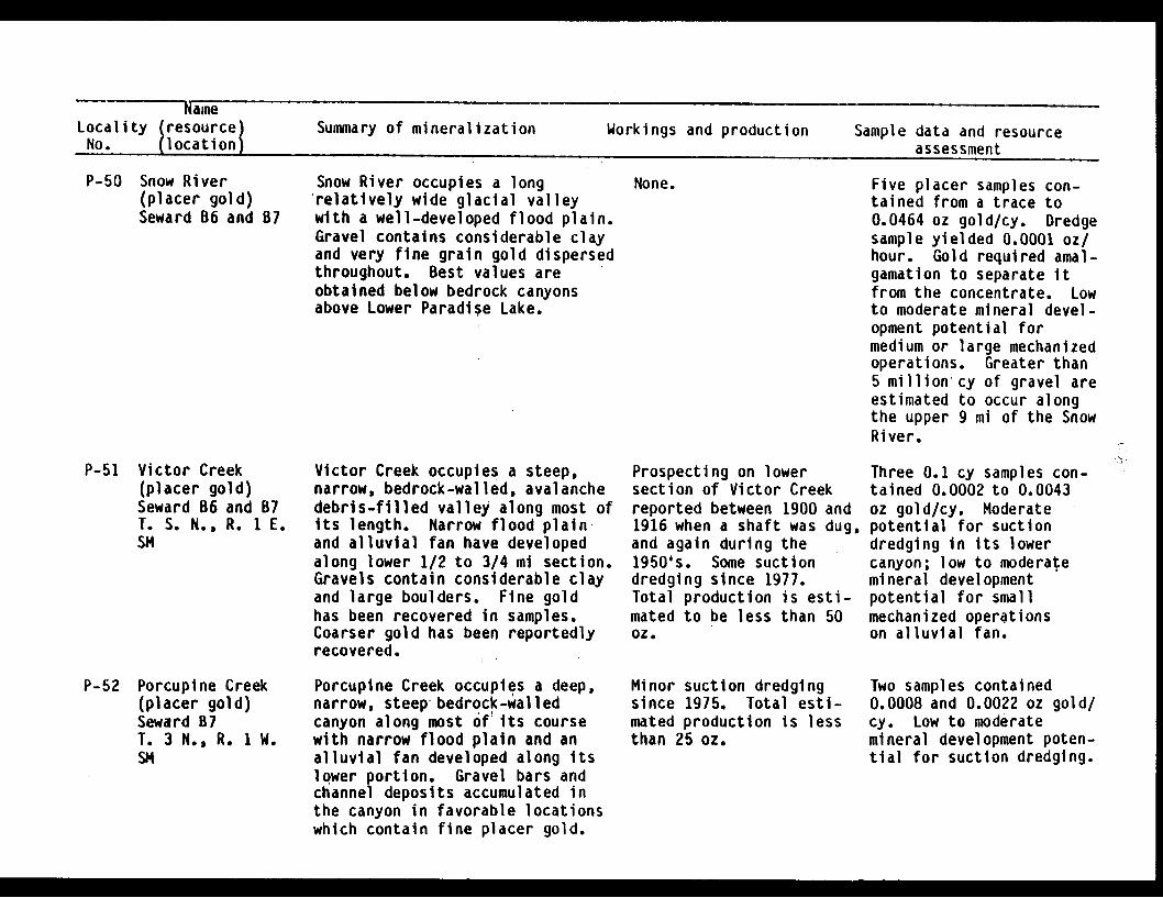
NameLocality (resource) Summary of mineralization Workings and production Sample data and resourceNo. (location) assessment
P-50 Snow River(placer gold)Seward B6 and B7
Snow River occupies a longrelatively wide glacial valleywith a well-developed flood plain.Gravel contains considerable clayand very fine grain gold dispersedthroughout. Best values areobtained below bedrock canyonsabove Lower Paradise Lake.
None. Five placer samples con-tained from a trace to0.0464 oz gold/cy. Dredgesample yielded 0.0001 oz/hour. Gold required amal-gamation to separate itfrom the concentrate. Lowto moderate mineral devel-opment potential formedium or large mechanizedoperations. Greater than5 million cy of gravel areestimated to occur alongthe upper 9 mi of the SnowRiver.
P-51 Victor Creek(placer gold)Seward B6 and B7T. S. N., R. 1 E.SM
P-52 Porcupine Creek(placer gold)Seward B7T. 3 N., R. 1 W.SM
Victor Creek occupies a steep,narrow, bedrock-walled, avalanchedebris-filled valley along most ofits length. Narrow flood plainand alluvial fan have developedalong lower 1/2 to 3/4 mi section.Gravels contain considerable clayand large boulders. Fine goldhas been recovered in samples.Coarser gold has been reportedlyrecovered.
Porcupine Creek occupies a deep,narrow, steep bedrock-walledcanyon along most of1its coursewith narrow flood plain and analluvial fan developed along itslower portion. Gravel bars andchannel deposits accumulated inthe canyon in favorable locationswhich contain fine placer gold.
Prospecting on lowersection of Victor Creekreported between 1900 and1916 when a shaft was dug,and again during the1950's. Some suctiondredging since 1977.Total production is esti-mated to be less than 50oz.
Minor suction dredgingsince 1975. Total esti-mated production is lessthan 25 oz.
Three 0.1 cy samples con-tained 0.0002 to 0.0043oz gold/cy. Moderatepotential for suctiondredging in its lowercanyon; low to moderatemineral developmentpotential for smallmechanized operationson alluvial fan.
Two samples contained0.0008 and 0.0022 oz gold/cy. Low to moderatemineral development poten-tial for suction dredging.

Locality (resource) Summary of mineralization Workings and production Sample data and resourceNo. (location) assessment
P-53 Martin Creek(placer gold)Seward A7, A8 -,and B7T. 2 N., R..2 W.SM
P-54 Ship Creek(placer gold)Seward B7T. 3 N., R. 1 W.SM
Upper Martin Creek occupies amoderately-steep narrow shallowbedrock gorge with small amountsof gravel accumulating belowplunge pools. Middle section,beginning about 1/2 to 3/4 milesbelow the junction with Mt.Ascension tributary, occupies asteep, narrow, deep bedrock gorgewith numerous falls and littleaccumulation of gravel. Narrowflood plain has developed beginningabout 1 1/2 miles above its junc-tion with the Resurrection River.Coarse gold (up to 1/4 in.) wasrecovered in gravels resting onand in bedrock fractures locatedjust below the Mt. Ascensiontributary. Significant gold wasnot located elsewhere along thedrainage.
Most of Ship Creek occupies avery narrow, steep avalanche-debris filled bedrock valley.A short narrow flood plain andalluvial fan have formed at itslower end near Kenal Lake. Gravelis poorly sorted with abundantslate fragments and some hardpacked clay near bedrock. Coarsegold (3/16 in.) was identified onthe east fork of the stream 3/4mi above large western tributary.
Minor prospecting hasoccurred along the lowersection of Martin Creek.No known production.
Some evidence of pros-pecting exists on thelower end of Ship Creek.Limited suction dredgingoccurred in 1982. Totalestimated production isless than 25 oz.
Five dredge samplesyielded from 0.0001 to0.0278 oz gold/hr. Three0.1 cy sluice samplescontained from a trace to0.0106 oz gold/cy. Pansamples of bedrock gravelsyielded 0.1537 oz gold/cy.Middle section of MartinCreek has high mineraldevelopment potential forsuction dredging and smallhand placer operations.Lower section has lowmineral development poten-tial for small equipmentoperations.
Four suction dredgesamples yielded from atrace to 0.0081 ozgold/hr.Three 0.1 cy sluicesamples contained 0.0001to 0.0304 oz gold/cy.Moderate potential forsuction dredging.Alluvial fan and lowersection has low to moder-ate mineral developmentpotential for a smallmechanized operation.
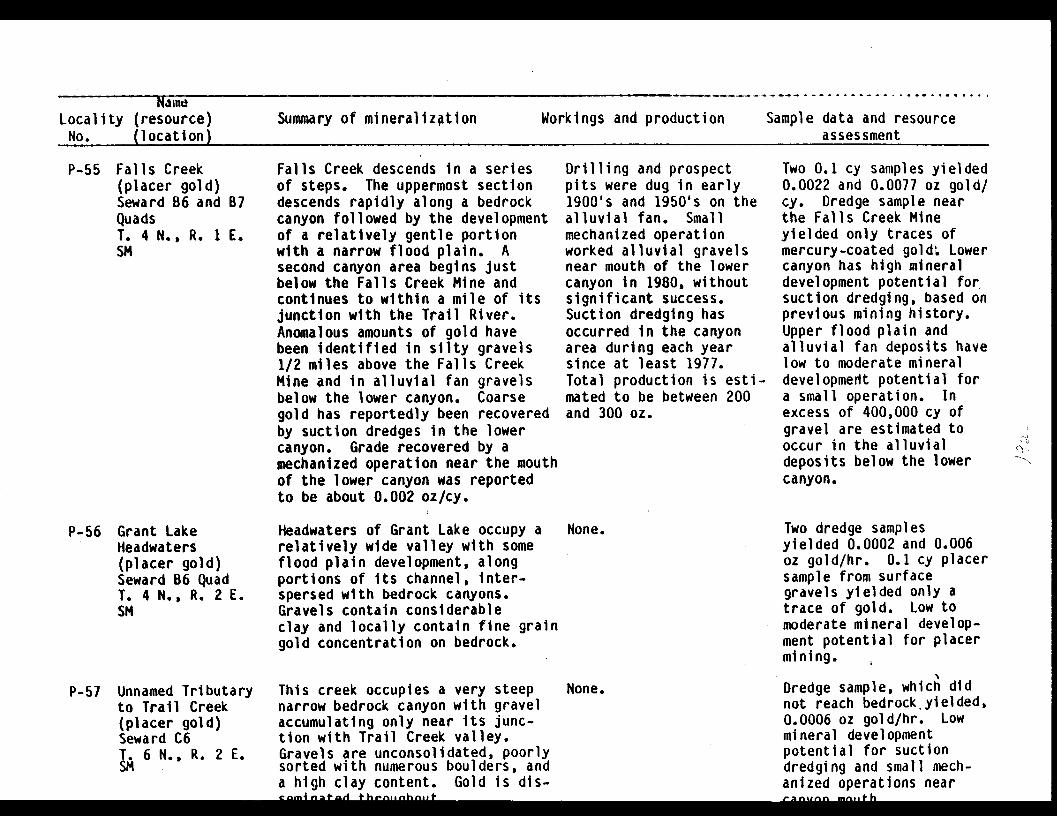
Naft
Locality (resource)No. (location)
Summary of mineralization Workings and production Sample data and resourceassessment
P-55 Falls Creek(placer gold)Seward B6 and B7QuadsT. 4 N., R. 1 E.SM
Falls Creek descends in a seriesof steps. The uppermost sectiondescends rapidly along a bedrockcanyon followed by the developmentof a relatively gentle portionwith a narrow flood plain. Asecond canyon area begins justbelow the Falls Creek Mine andcontinues to within a mile of itsjunction with the Trail River.Anomalous amounts of gold havebeen identified in silty gravels1/2 miles above the Falls CreekMine and in alluvial fan gravelsbelow the lower canyon. Coarsegold has reportedly been recoveredby suction dredges in the lowercanyon. Grade recovered by amechanized operation near the mouthof the lower canyon was reportedto be about 0.002 oz/cy.
Drilling and prospectpits were dug in early1900's and 1950's on thealluvial fan. Smallmechanized operationworked alluvial gravelsnear mouth of the lowercanyon in 1980, withoutsignificant success.Suction dredging hasoccurred in the canyonarea during each yearsince at least 1977.Total production is esti-mated to be between 200and 300 oz.
Two 0.1 cy samples yielded0.0022 and 0.0077 oz gold/cy. Dredge sample nearthe Falls Creek Mineyielded only traces ofmercury-coated gold; Lowercanyon has high mineraldevelopment potential forsuction dredging, based onprevious mining history.Upper flood plain andalluvial fan deposits havelow to moderate mineraldevelopment potential fora small operation. Inexcess of 400,000 cy ofgravel are estimated tooccur in the alluvialdeposits below the lowercanyon.
P-56 Grant LakeHeadwaters(placer gold)Seward B6 QuadT. 4 N., R. 2 E.SM
P-57 Unnamed Tributaryto Trail Creek(placer gold)Seward C6T. 6 N., R. 2 E.SM
Headwaters of Grant Lake occupy arelatively wide valley with someflood plain development, alongportions of its channel, inter-spersed with bedrock canyons.Gravels contain considerableclay and locally contain fine graingold concentration on bedrock.
This creek occupies a very steepnarrow bedrock canyon with gravelaccumulating only near its junc-tion with Trail Creek valley.Gravels are unconsolidated, poorlysorted with numerous boulders, anda high clay content. Gold is dis-
None. Two dredge samplesyielded 0.0002 and 0.006oz gold/hr. 0.1 cy placersample from surfacegravels yielded only atrace of gold. Low tomoderate mineral develop-ment potential for placermining.
Dredge sample, which didnot reach bedrock yielded,0.0006 oz gold/hr. Lowmineral developmentpotential for suctiondredging and small mech-anized operations near
None.
*�A +6�^..nhn1Jt r2nu^n -n.ifh . . 1.

NameLocality (resource) Summary of mineralization Workings and production Sample data and resourceNo. (location)
assessment
P-58 Trail Creek(placer gold)Seward C6T. 5 N., R. 1T. 6 N., R. 2SM
E.,E.
Trail Creek occupies a relatively None.wide, U-shaped valley and has awell-developed flood plain alongmost of its length. Upper TrailCreek has a narrow bedrock walledsection containing coarse gravelswith numerous boulders. Alluviumgenerally has a high clay contentbut becomes increasingly well-washedand sorted downstream. Fine graingold is distributed throughout thegravels for several miles belowTrail Glacier. Some concentrationappears to occur on bedrock.Grades tend to decrease downstream.Gold up to 1/8-in. diameter wasrecovered, amalgamation wasrequired to recover much of thegold from the samples.
Three dredge samplesyielded from 0.0005 to0.0012 oz gold/hr. Threesluice samples fromgravels adjacent to thestream channel containedfrom a trace to 0.0015oz/cy. Low mineral devel-opment potential for smallto large mechanized oper-ations and suction dred-ging. In excess of 7million cy of gravel areestimated within the floodplain of Trail Creek,between Trail Glacier andMoose Creek.
P-59 Placer River,section betweenBartlett andSkookum Glaciers(placer gold)Seward C6 QuadT. 7 N., R. 2 E.SM
Upper portion of the Placer Riveroccupies a narrow relatively steepvalley much of which is filledwith avalanche debris and till.A deep bedrock gorge extends fora mile above its confluence withSpencer Glacier valley. From therethe river occupies a broad U-shapedglacial trough with a 3/4 to 1 1/2ml wide flood plain. Auriferousgravels occur from the terminusof Bartlett Glacier to at leastSpencer Glacier valley but tendto be low in volume except at themouth of the canyon. Gravelscontain numerous large bouldersand extensive clay. Gold is finethough particles up to 3/16 inwere recovered.
Minor production fromrecent suction dredging.Total estimated produc-tion is less than 25 oz.
Four dredge samplesyielded from 0.0001 to0.0028 oz/hour. Four 0.1cy samples of gravelsadjacent to stream channelcontained 0.001 to 0.0028oz gold/cy. Evaluation ofthe 10 million cy graveldeposits in the mainvalley is recommended.Moderate mineral devel-opment potential for smallmechanized and suctiondredging operationsbetween Bartlett Glacierand Placer River Valleys.

Locality (resource) Summary of mineralization Workings and production Sample data and resourceNo. (location) assessment
P-60 Groundhog Creekincluding 1/2mile of BenchCreek belowGroundhog Creek(placer gold)Seward C6 andC7T. 7 N., R. 1 E.SM
Groundhog Creek occupies a steepnarrow avalanche-debris filledglacial valley and has a V-shapedbedrock gorge characterized bynumerous falls and cascades for a1/2 mile stretch above BenchCreek. Small amounts of gold-bearing alluvial gravels haveaccumulated at the junction ofGroundhog and Bench Creeks. Goldis disseminated throughoutgravels but concentrated on bed-rock. Particles up to 3/16 in.in diameter were recovered, butmost of the gold is finer grained.
Some evidence of suctiondredging and handplacering exists in thejunction area. Totalestimated production isless than 25 oz.
Two dredge samplescollected from the junc-tion area yielded 0.0006and 0.0042 oz gold/hr. One0.1 cy sample of gravelsadjacent to the channeland on bedrock contained0.0012 oz gold/cy. Smallcopper nugget (natural?)was recovered in onesample. Samples collectedfrom the middle and upperportions of GroundhogCreek contained traceamounts of gold. Gravelvolume is very limited.The junction area ofGroundhog and Bench Creeksis believed to have low tomoderate mineral develop-ment potential for suctiondredging or a smallhydraulic operation.
I

NameLocality (resource) Summary of mineralization Workings and production Sample data and resourceNo. (location) assessment
P-61 Lynx Creek
(placer gold)Seward C7T. 7 N., R. 1 E.SM
Lynx Creek occupies a steep narrowcanyon cut into glacial till,poorly washed glacial-fluvialgravels and bedrock. Terracesmantled with avalanche debrisextend along most of the creek.A well-developed alluvial fanhas formed between the canyonmouth and its junction with BenchCreek. The auriferous benchdeposits consist of poorlystratified and washed, partiallycemented gravels, in excess of 15ft. thick, resting on bedrock.The alluvial fan consists of well-stratified and washed gravelscontaining fine grained particlesof disseminated gold near thesurface.
Pick and shovel opera-tions occurred between1897 and 1904. Hydrau-lic operations began in1915 and mined benchdeposits sporadicallyuntil 1980. Total est-imated production is6,000 to 8,000 ouncesof gold, with less than100 ounces produced since1975.
Fourteen samples collectedfrom Lynx Creek. Four 3-in. dredge samples yielded0.001 to 0.0149 oz gold/hr. Seven 0.7 cy benchsamples contained 0.0013to 0.074 oz gold/cy.Three gravel bar 0.1 cysamples contained 0.0004to 0.0412 oz gold/cy. LynxCreek has high mineraldevelopment for smallhydraulic or mechanizedoperations and moderateto high mineral develop-ment potential in itsupper section.Inferred reserves at onetest location were 5,000cy with a grade of 0.015to 0.02 oz/cy. Lowerportion, including thealluvial fan has low tomoderate mineral develop-ment potential for amedium sized mechanizedoperation. Alluvial fancontains in excess of 1.5million cy of gravel.
�� 1;�1_
I
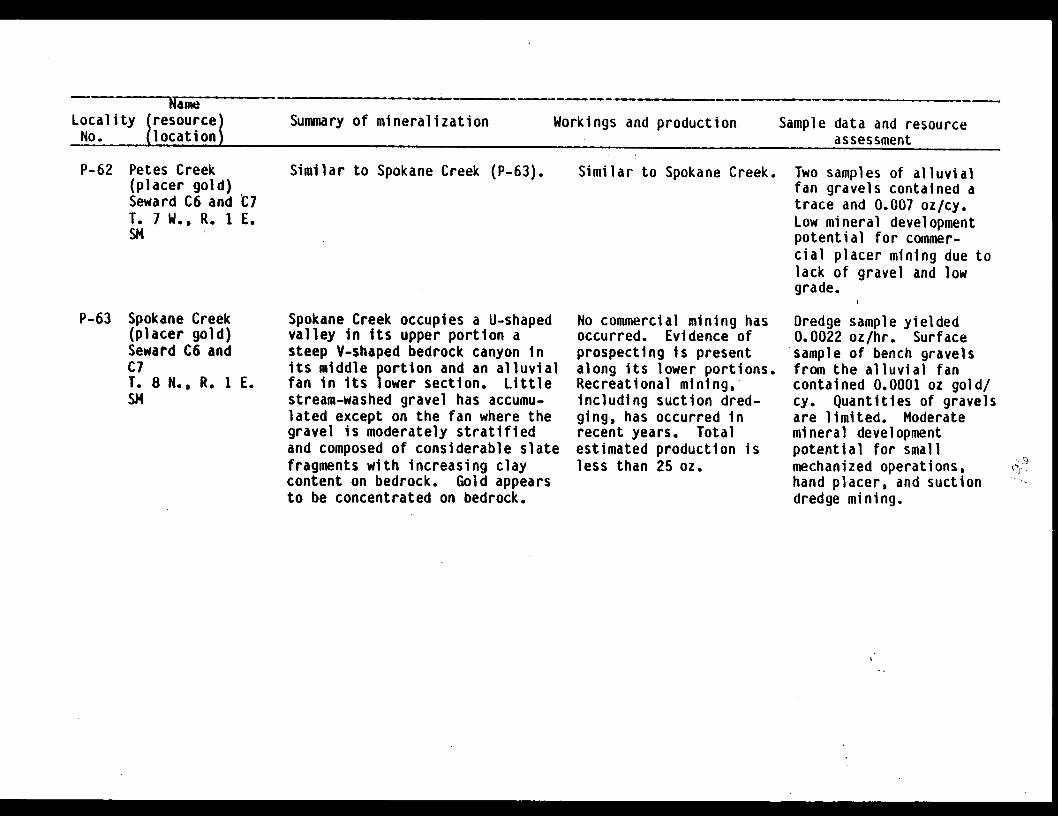
Locality (resource) Summary of mineralization Workings and production Sample data and resourceNo. (location assessment
P-62 Petes Creek(placer gold)Seward C6 and O7T. 7 W., R. 1 E.SM
P-63 Spokane Creek(placer gold)Seward C6 andC7T. 8 N., R. 1 E.SM
Similar to Spokane Creek (P-63).
Spokane Creek occupies a U-shapedvalley in its upper portion asteep V-shaped bedrock canyon inits middle portion and an alluvialfan in its lower section. Littlestream-washed gravel has accumu-lated except on the fan where thegravel is moderately stratifiedand composed of considerable slatefragments with increasing claycontent on bedrock. Gold appearsto be concentrated on bedrock.
Similar to Spokane Creek.
No commercial mining hasoccurred. Evidence ofprospecting is presentalong its lower portions.Recreational mining,including suction dred-ging, has occurred inrecent years. Totalestimated production isless than 25 oz.
Two samples of alluvialfan gravels contained atrace and 0.007 oz/cy.Low mineral developmentpotential for commer-cial placer mining due tolack of gravel and lowgrade.
Dredge sample yielded0.0022 oz/hr. Surfacesample of bench gravelsfrom the alluvial fancontained 0.0001 oz gold/cy. Quantities of gravelsare limited. Moderatemineral developmentpotential for smallmechanized operations,hand placer, and suctiondredge mining.
9'

Locality (resource)No. (location)
Summary of mineralization Workings and production Sample data and resource* assesmant
P-64 Bertha Creek
(placer gold)Seward D6 andT. 8 N., R. 1SM
C6E.
Bertha Creek occupies a U-shapedvalley in its upper portion anda steep narrow canyon cut mostlyin glacial debris and bedrock inits middle section. Below thecanyon an alluvial fan has beendeposited which has been the majorsource of gold produced to date.Gravels are poorly to moderatelystratified with a high clay andboulder content. Gold appears tobe concentrated near bedrock.
Hand placer and hydraulicmining occurred between1902 and 1904. Recrea-tional mining has beenpopular on lower BerthaCreek since 1975. Asuction dredge operationoccurred near the powerline in 1981. Totalproduction since 1902 isestimated to be 300 to600 oz with less than 35oz has been producedsince 1975.
Three samples were col-lected from lower BerthaCreek. Dredge sampleyielded 0.0142 oz/hr fromchannel deposits. Bedrockwas not reached. Twobench samples contained0.0006 and 0.01Z9 oz gold/cy. Traces of gold wererecovered from surfacegravels on upper BerthaCreek. Quantities ofgravel are limited. Mod-erate to high mineraldevelopment potentialfor small mechanized, suc-tion dredging, and handplacer activities.
P-65 Taylor Creek(placer gold)Seward D6T. 8 N., R. 1 E.SM
Taylor Creek is a short drainagesimilar to Bertha Creek and othereastern tributaries to GraniteCreek. Along its lower section itcuts glacial till, believed to bea lateral moraine.
None. Sample collected nearlower end of Taylor Creekcontained 0.0011 oz gold/cy. Low mineral develop-ment potential forcommercial mining.
----

NameLocality (resource) Summary of mineralization Workings and production Sample data and resourceNo. (location) assessment
P-66 Lyon Creek(placer gold)Seward 06T. 8 N., R. 1 E.SM
Lyon Creek occupies a narrowavalanche-filled glacial troughfor most of its length prior tocutting a steep bedrock gorge andflowing onto an alluvial fan whichcoalesces with that formed byTincan Creek. Alluvial gravelsthinly mantle bedrock in thelowermost canyon section.Relatively coarse gold (3/16 in.)was recovered on bedrock.
Evidence of prospectingis present near the mouthof the canyon. No knownproduction.
Dredge sample yielded0.0132 oz gold/hr fromchannel gravels near themouth of the canyon.Channel deposits are verylimited in quantity. Mod-erate to high mineraldevelopment potential forsuction dredging andmoderate mineral develop-ment potential for a smallmechanized operation.The alluvial fan shouldbe evaluated.
P-67 Tincan Creek(placer gold)Seward D6T. 8 N., R. 1 E.SM
Tincan Creek is similar incharacter to Lyon Creek (P-66)except that its upper valley isbroader.
Hand placeroccurred inor earlier.dredging hassince 1975.production Ibetween 50 t
operationsthe 1930'sSuctionoccurredTotals estimatedo 100 oz.
Dredge sample yielded0.0114 oz gold/hr from apreviously mined area.0.1 cy sample yielded0.0023 oz gold/cy from theupper portion of thecreek. Lower Tincan Creekhas moderate to highmineral developmentpotential for suctiondredging and hand placeroperations and moderatemineral developmentpotential for a smallmechanized operation. Thealluvial fan should beevaluated.
M� M

NameLocality (resource)No. (location)
Summary of mineralization Workings and production Sample data and resourceAccaccmant
P-68 Wolverine Creek(placer gold)Seward 06T. 8 N., R. 2 E.SM
P-69 Ingram Creek(placer gold)Seward D6T. 9 N., R. 2 E.SM
Wolverine Creek is the maintributary to and is similar inconfiguration to upper IngramCreek (P-69). Packets ofmoderately washed gravels haveaccumulated in favorable sitesand contain gold concentrated withtan clay on bedrock. The gold wasa mixture of fines, requiringamalgamation to recover, andrelatively coarse gold.
Upper Ingram Creek occupies asteep, narrow avalanche-debrisfilled glacial valley. Themiddle section is in a narrow,steep bedrock canyon with numerousfalls and cascades. The lower2 mi has a narrow flood plaindeveloped. The gravels rangefrom well-washed on the surfaceto angular blocky boulders mixedwith considerable clay near bed-rock. Fine grained gold is diss-eminated throughout but is con-centrated near bedrock.
Evidence of prospectingwas located about 1/2mile above its junctionwith Ingram Creek. Noknown production.
Evidence of prospectingis present along IngramCreek but apparently noearly attempts were madeto mine the creek.Suction dredging withdoubtful success occurredin 1981 and 1982. Totalestimated production isless than 25 ounces.
Dredge samples yielded0.0018 and 0.0036 oz gold/hr. Quantities of gravelare limited. Moderatemineral developmentpotential for suctiondredging and low potentialfor mechanized operations.
Dredge sample from upperIngram Creek yielded0.0011 oz gold/hr. Othersamples contained traceamounts of gold. Quanti-ties of gravel are limitedexcept possibly along itslower end where in excessof 100,000 cy of gravelare estimated to occur.Low mineral developmentpotential.
.... U
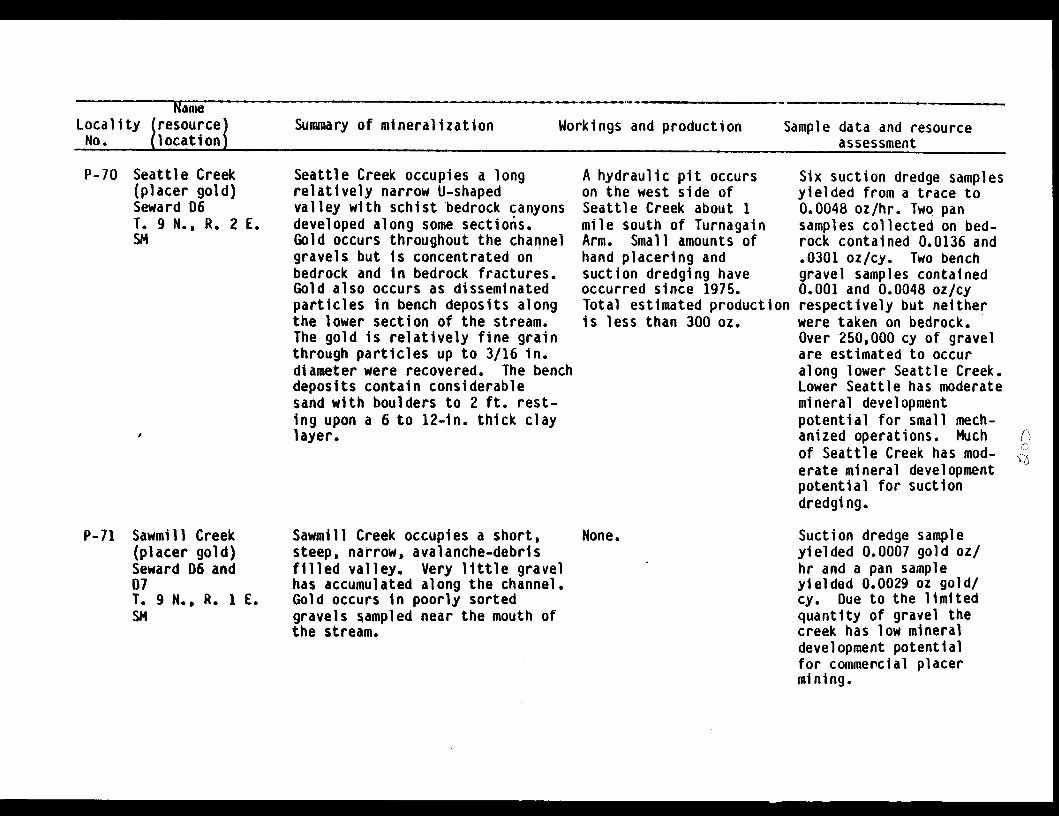
NameLocality (resource) Summary of mineralization Workings and production Sample data and resourceNo. (location) assessment
P-70 Seattle Creek(placer gold)Seward D6T. 9 N., R. 2 E.SM
Seattle Creek occupies a longrelatively narrow U-shapedvalley with schist bedrock canyonsdeveloped along some sections.Gold occurs throughout the channelgravels but is concentrated onbedrock and in bedrock fractures.Gold also occurs as disseminatedparticles in bench deposits alongthe lower section of the stream.The gold is relatively fine grainthrough particles up to 3/16 in.diameter were recovered. The benchdeposits contain considerablesand with boulders to 2 ft. rest-ing upon a 6 to 12-in. thick claylayer.
A hydraulic pit occurson the west side ofSeattle Creek about 1mile south of TurnagainArm. Small amounts ofhand placering andsuction dredging haveoccurred since 1975.Total estimated productionis less than 300 oI.
Six suction dredge samplesyielded from a trace to0.0048 oz/hr. Two pansamples collected on bed-rock contained 0.0136 and.0301 oz/cy. Two benchgravel samples contained0.001 and 0.0048 oz/cyrespectively but neitherwere taken on bedrock.Over 250,000 cy of gravelare estimated to occuralong lower Seattle Creek.Lower Seattle has moderatemineral developmentpotential for small mech-anized operations. Muchof Seattle Creek has mod-erate mineral developmentpotential for suctiondredging.
P-71 Sawmill Creek(placer gold)Seward D6 and07T. 9 N., R. 1 E.SM
Sawmill Creek occupies a short,steep, narrow, avalanche-debrisfilled valley. Very little gravelhas accumulated along the channel.Gold occurs in poorly sortedgravels sampled near the mouth ofthe stream.
None. Suction dredge sampleyielded 0.0007 gold oz/hr and a pan sampleyielded 0.0029 oz gold/cy. Due to the limitedquantity of gravel thecreek has low mineraldevelopment potentialfor commercial placermining.

NameLocality (resource) Summary of mineralization Workings and production Sample data and resourceNo. (location) assessment
P-72 Sixmile Creek
below Canyonincludingtributaries(placer gold)Seward D7T. 08 N., R. IT. 09 N., R. ISN
Creek
01 W.01 W.
Sixmile Creek occupies a rela-tively broad alluvial filledvalley with periodic developmentof bedrock canyons along itschannel. Alluvial terraces,partially covered with avalanchedebris, parallel the streamchannel. Gold is relatively finegrain with nuggets coarser than1/4 in. diameter rarely recovered.Flood plain deposits appear to berelatively thick with depthsto bedrock in excess of 70 ft.reported near the junction withCanyon Creek. Small auriferousalluvial fan deposits areassociated with several westerntributaries of Sixmile Creek,including Alder Creek, Cub Creek,and Old Woman Creek.
Several small operationsproduced gold fromSixmile Creek between1897 and 1917. Prospect-ing, drilling and limitedhydraulic mining occurredin the 1930's. Recently,the gravels just belowCanyon Creek have beentested by backhoe and 12-in suction dredge.Results are unknown.Several small suctiondredge operations haveoccurred within the last3 years. Total estimatedproduction since 1897 is1,500 to 2,000 oz ofwhich less than 250 ozhave been produced since1975.
0.1 cy sample from AlderCreek contained 0.0017 ozgold/cy. One from CubCreek contained 0.0073 ozgold/cy. Two suctiondredge samples, whichyielded 0.002 and 0.0182oz gold/hr, and one bed-rock pan sample, contain-ing 0.0214 oz gold/cy,were collected fromchannel deposits. Threebench placer samples con-tained 0.0005 to 0.0028 ozgold/cy. Bench gravelsand channel volumes areestimated to exceed 5million cy. Sixmile Creekis believed to have mod-erate mineral developmentpotential for small andmedium sized mechanizedoperations and highpotential for suctiondredging. The benchgravels and the flooddeposits near the junctionof Sixmile and CanyonCreeks may also havesignificant mineraldevelopment potential.

NameLocality (resource) Summary of mineralization Workings and production Sample data and resourceNo. (location) assessment
P-73 Gulch Creek, and
East Fork Creek
below Gulch Creek(placer gold)Seward D7T. 08 N., R. 01 W.SM
Gulch Creek and Lower East ForkCreek occupy narrow bedrockcanyons along most of their lengthand contain thin discontinuoushigh-grade gravel deposits. Atleast one abandoned channel onGulch Creek was mined in the early1900's and others may occur alonglower Gulch Creek and East ForkCreek. Channel gravels range fromloose and sandy on the surface toclay cemented with boulders to 5ft or more on bedrock. Finegrained gold is disseminatedthroughout the gravels but thepay streak occurs on and in bed-rock fractures accompanied by asticky tan clay. Relatively coarsegold, up to 5 oz nuggets, havereportedly been recovered fromGulch Creek.
Hydraulic and hand placeroperations on lower GulchCreek and on the eastside of East Fork Creekaccounted for most of theproduction prior to 1917.Suction dredging hasbecome popular along mostof Gulch Creek and lowerEast Fork Creek in thepast three years. Totalestimated production is1,000 to 2,500 oz of whichup to 250 oz have beenproduced since 1975.
Three suction dredgesamples collected from theheadwaters of Gulch Creekyielded 0.0006 to 0.0034oz gold/hr. Two additionalsamples collected fromupper Gulch Creekcontained from 0.0008 to0.0296 oz gold/cy. Nineplacer samples consistingof surface alluvium,collected from within thecanyon of lower East ForkCreek, cqntained from0.0019 to 0.015 oz gold/cy. The quantity ofgravel is limited. EastFork Creek and Gulch Creekhave high mineral develop-ment potential for suction q
dredge operations and mod-erate mineral developmentpotential for smallmechanized operations atselected locations.
I - -

NameLocality resource) Summary of mineralization Workings and production Sample data and resourceNo. location assessment
P-74 East Fork Creekabove Gulch Creekand Granite Creekto Tincan Creek.(placer gold)Seward D7 and D6T. 7 N., R. 1 E.,T. 8 N., R. I W.,T. 8 N., R. 1 E.SM
Granite and upper East Fork Creeks Significant productionoccupy a relatively wide valley has not occurred alongover most of their lengths with these drainages. Suctionbedrock exposed in only a few dredging has occasionallylocations. East Fork Creek been attempted withoutoccupies a narrow canyon beginning success.about 3/4 mile below SilvertipCreek. Stream gravels are looseand unconsolidated on the surfacewith increasing clay at depth.Bench deposits occur along portionsof these drainages which are uneval-uated except where they were minedat the mouth of Bertha Creek.
Three surface gravelsamples from East ForkCreek contained traceamounts of very fine graingold. Two suction dredgesamples on Granite Creekyielded 0.0007 and 0.0011oz gold/hr of very finegrain gold requiring amal-gamation to recover. Sign-ificant gravel reservesoccur along much ofGranite Creek and EastFork Creek. East ForkCreek above Gulch Creekand Granite Creek have lowmineral developmentpotential for small tomedium sized placer oper-ations and suction dredg-ing with moderate mineraldevelopment potentialnear their confluencewith placer producingdrainages such asSilvertip, Lynx, andBertha Creeks.
1-j.441
6n,11

NameLocality (resource) Summary of mineralization Workings and production Sample data and resourceNo. (location) assessment
P-75 Silvertip Creek(placer gold)Seward C7T. 7 N., R. 1 E.SM
The upper portion of SilvertipCreek occupies a steep narrowbedrock canyon partially filledwith avalanche debris. The lowersections occupy a slightly widerchannel with bedrQck near thesurface covered by poorly washedand stratified clay rich gravelscontaining gold. The lower mostsection occupies an alluvial fanconsisting of moderatelywell-stratified and washed gravelswhich supplied fill for construc-tion of the Seward Highway.
Pick and shovel opera-tions occurred between1897 and 1904. A smallhydraulic operation wasattempted in 1911. Smallmechanized operationshave mined sporadicallysince 1950 and suctiondredges since 1975. Totalestimated production is750 to 1,000 oz of which50 to 100 oz is estimatedto have been recoveredsince 1975.
One sample Silvertip Creekcontained 0.0019 oz gold/ton. Reserves are limitedalong the main stream. Thealluvial fan should betested as significantquantities of gravelreside there. Highmineral development poten-tial for small mechanizedand suction dredge opera-tions based upon pastactivity.

NameLocality (resource) Summary of mineralization Workings and production Sample data and resourceNo. (location) assessment
P-76 Canyon Creek
including MillsCreek below JuneauCreek(placer gold)Seward C7-D7T. 07 N., R. 01 W.T. 08 N., R. 01 W.SM
Canyon Creek occupies a bedrockcanyon deeply cuts into a broaderU-shaped glacial valley. Placergold occurs in alluvial gravelsassociated with the currentchannel of Canyon Creek and inbench gravels at elevation up toat least 100 ft. above presentstream level. The bench gravelsare locally compacted and cementedand contain considerable clay.Channel gravels are low in volumebut reported to be of high grade.Gold is flaky with recovery ofparticles up to 3/16 in. indiameter common.
Considerable hand placerand hydraulic placermining occurred on CanyonCreek, especially at itsjunction with Mills Creekbetween 1895 and 1940.Several small mechanizedand hydraulic operationsmined intermittentlyduring 1955-1961 and in1977-78. In recent years(1970-1982) suctiondredging has becomepopular and likelyaccounts for 100 to 200oz of production/year atthe present time. Totalestimated production is35,000 to 40,000 oz since1895.
Three samples from benchdeposits in the oldhydraulic pit, locatedjust below the junctionof Mills and Canyon Creekson the west side of CanyonCreek, contained from0.0001 to 0.14 oz gold/cy.Bench gravels are esti-mated to exceed 2 millioncy. Potential for loca-ting relatively high gradeabandoned channels in thebenches is good.Canyon Creek has highmineral developmentpotential for suctioddredge and small handplacer operations andmoderate mineral develop-ment potential for smallto medium sized mechanizedand hydraulic miningoperations.

NameLocality (resource) Summary of mineralization Workings and production Sample data and resourceNo. ' (location) assessment
P-77 Juneau Creek aboveMills Creek(placer gold)'Seward C7T. 7 N., R. 1 W.SM
Juneau Creek occupies a narrow,avalanche-debris filled glacialvalley. A thick bench deposit,consisting of glacial till andpoorly washed glacial-fluvialgravels occurs just above thejunction of Juneau and MillsCreek. A pay streak is reportedto occur near the top of an oldhydraulic cut in the bench.Gravels are tightly cemented byclay and contain clay lenses andlayers. Bedrock channel isbelieved to be very deep andcovered with thick avalanchedeposits and/or poorly washedgravels.
A single hydraulicoperation apparentlymined the bench depositin the 1950's. Someexploration workincluding the excava-tion of a large prospectpit has occurred recently.No records of productionare available.
Only trace amounts of goldhave been identified inpan samples and 0.1 cysamples. Low mineraldevelopment potential forcommercial placer mining.
P-78 Fresno Creek(placer gold)Seward CVT. 7 N., R. 1 W.SM
Fresno Creek occupies a steepnarrow avalanche-debris filledglacial valley with a bedrockcanyon along much of its course.Little gravel has accumulated.along the stream. Fine grainedgold is sparsely disseminatedthroughout the poorly washedgravel samples.
None. One sample contained0.0006 oz gold/cy fromsurface gravels. Lowmineral developmentpotential for commercialmining because of lowvolume and grade.
I I

NameLocality (resource)No. (location)
Summary of mineralization Workings and production Sample data and resourceassessment
P-79 Mills Creek
above junctionwith Juneau Creek(placer gold)Seward C7T. 05 N.. R. 01 W.T. 07 N., R. 01 W.SM
High and low grade placer goldoccur. High-grade alluvialdeposits occured in and alongthe current channel and narrowflood plain of Mills Creek;lower grade deposits occurred onbenches. Gravels are poorly tomoderately sorted and contain con-siderable clay. Gold is concen-trated close to and in bedrockassociated with a tan sticky claywhich fills bedrock fractures.Gold particles are relativelycoarse compared to other drainageson the Kenai Peninsula. Flakes andsmall gold nuggets up to 1 penny-weight are common in Mills Creekgravels below Timberline Creek.Only fine grain gold has beencollected above the junction ofTimberline Creek. Productiongrades in the channel gravels areestimated to average 0.0125 to0.015 oz/cy.
Hydraulic operationsbegan in Mills Creek,about 1/2 mi aboveJuneau Creek in 1938.One hydraulic or smallmechanized operation hasmined intermittentlysince that time. Totalestimated production is3,000 to 5,000 oz thoughno records are available.
Ten placer samples werecollected from MillsCreek. Seven samples4 bench samples and threestream channel samples,were collected below thejunction of TimberlineCreek. Bench samples con-tained from a trace to0.0044 oz gold/cy. Asuction dredge sampleyielded 0.0554 oz gold/hr.Two samples collected nextto the stream channel con-tained 0.0011 to 0.0869 ozgold/cy. Three suctiondredge samples aboveTimberline Creek yieldedfrom 0.0005 to 0.0012 ozgold/hr. Below TimberlineCreek bench deposits areestimated to exceed 0.5million cy and unworkedchannel gravels are esti-mated to range from 50,000to 150,000 cy. Highmineral developmentpotential for small tomedium sized mechanizedand hydraulic operationsand for suction dredgingbelow Timberline Creek.Low to moderate mineraldevelopment potentialabove Timberline Creek.

NameLocality resource) Summary of mineralization Workings and production Sample data and resourceNo. (location ) assessment
P-80 Colorado Creek(placer gold)Seward C7T. 7 N., R. 2 W.SM
Colorado Creek occupies a steepnarrow avalanche-debris filledglacial valley with a bedrockgorge developed near its lowerend and a well-developedalluvial fan near its terminus.Gravels are poorly stratifiedand contain considerable clay.Gold is disseminated throughoutthe gravels with minor concen-tration on bedrock. Gold isgenerally quite fine though smallnuggets up to 3/8 in. in diameterhave been recovered. Productiongrades of approximately 0.0015oz/cy were reported.
A small mechanizedoperation mined spora-dically on Colorado Creekbetween 1977 and 1982with little success.Total estimated productionis less than 50 oz.
Two samples yielded 0.0002and 0.0022 oz/cy. Inexcess of 200,000 cy ofgravel are estimated tooccur in the lower sectionof the creek. Low tomoderate mineral develop-ment potential for smallmechanized operation andsuction dredging.
M M
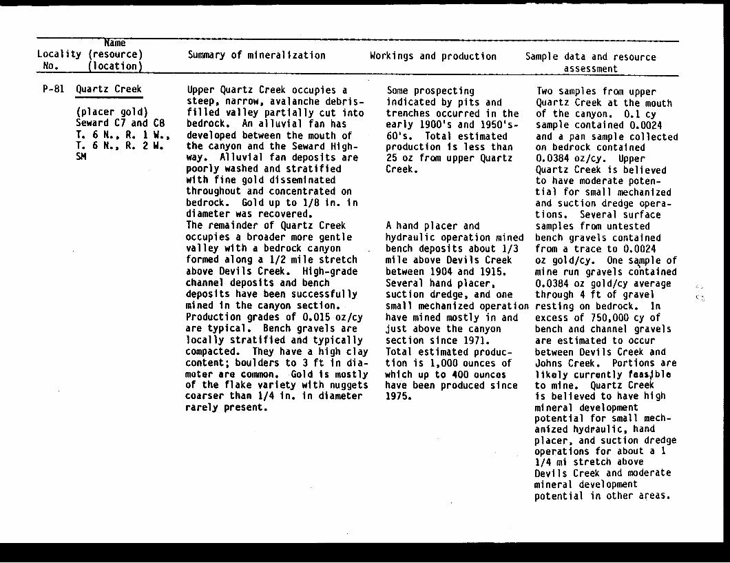
NameLocality (resource) Summary of mineralization Workings and production Sample data and resourceNo. (location) assessment
P-81 Quartz Creek
(placer gold)Seward C7 andT. 6 N., R. 1T. 6 N., R. 2SM
C8w.,W.
Upper Quartz Creek occupies asteep, narrow, avalanche debris-filled valley partially cut intobedrock. An alluvial fan hasdeveloped between the mouth ofthe canyon and the Seward High-way. Alluvial fan deposits arepoorly washed and stratifiedwith fine gold disseminatedthroughout and concentrated onbedrock. Gold up to 1/8 in. indiameter was recovered.The remainder of Quartz Creekoccupies a broader more gentlevalley with a bedrock canyonformed along a 1/2 mile stretchabove Devils Creek. High-gradechannel deposits and benchdeposits have been successfullymined in the canyon section.Production grades of 0.015 oz/cyare typical. Bench gravels arelocally stratified and typicallycompacted. They have a high claycontent; boulders to 3 ft in dia-meter are common. Gold is mostlyof the flake variety with nuggetscoarser than 1/4 in. in diameterrarely present.
Some prospectingindicated by pits andtrenches occurred in theearly 1900's and 1950's-60's. Total estimatedproduction is less than25 oz from upper QuartzCreek.
A hand placer andhydraulic operation minedbench deposits about 1/3mile above Devils Creekbetween 1904 and 1915.Several hand placer,suction dredge, and onesmall mechanized operationhave mined mostly in andjust above the canyonsection since 1971.Total estimated produc-tion is 1,000 ounces ofwhich up to 400 ounceshave been produced since1975.
Two samples from upperQuartz Creek at the mouthof the canyon. 0.1 cysample contained 0.0024and a pan sample collectedon bedrock contained0.0384 oz/cy. UpperQuartz Creek is believedto have moderate poten-tial for small mechanizedand suction dredge opera-tions. Several surfacesamples from untestedbench gravels containedfrom a trace to 0.0024oz gold/cy. One sample ofmine run gravels contained0.0384 oz gold/cy averagethrough 4 ft of gravelresting on bedrock. Inexcess of 750,000 cy ofbench and channel gravelsare estimated to occurbetween Devils Creek andJohns Creek. Portions arelikely currently foasbleto mine. Quartz Creekis believed to have highmineral developmentpotential for small mech-anized hydraulic, handplacer, and suction dredgeoperations for about a 11/4 mi stretch aboveDevils Creek and moderatemineral developmentpotential in other areas.
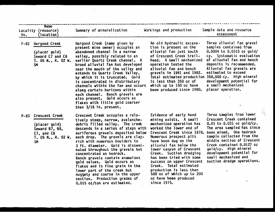
NameLocality resource)No. (location
Summary of mineralization Workings and production Sample data and resourceassessment
P-82 Hargood Creek
(placer gold)Seward C7 and C8T. 05 N., R. 02 W.SM
P-83 Crescent Creek
(placer gold)Seward B7, B8,C7, and C8T. 05 N., R. 02 W.SM
Hargood Creek (name given bypresent mine owner) occupies anabandoned channel in a narrowvalley, possibly related to anearlier Quartz Creek channel. Abroad alluvial fan has developednear the mouth of the valley andextends to Quartz Creek Valley,by which it is truncated. Goldis concentrated in distributarychannels within the fan and occursalong certain horizons withineach channel. Bench gravels arealso present. Gold occurs asflakes with little gold coarserthan 3/16 in. present.
Crescent Creek occupies a rela-tively steep, narrow, avalanche-debris filled valley. The creekdescends in a series of steps withauriferous gravels deposited beloweach drop. The gravels are clay-rich with numerous boulders to3 ft. diameter. Gold is dissemi-nated throughout the gravels butconcentrated on bedrock.Bench gravels contain anomalousgold values. Gold occurs asflakes and is fine grain in thelower part of the creek butnuggety and coarse in the uppersection. Production grades of0.015 oz/ton are estimated.
An old hydraulic excava-tion is present on thealluvial fan just southof Crescent Creek trail-head. A small mechanizedoperation tested thealluvial fan and benchgravels in 1981 and 1982.Total estimated productionis less than 350 oz ofwhich up to 150 oz havebeen produced since 1980.
Evidence of early handmining exists. A smallmechanized operation hasworked the lower end ofCrescent Creek since 1978.Numerous prospect pitshave been dug on thealluvial fan below thelower canyon of CrescentCreek. Suction dredginghas been tried with somesuccess on upper CrescentCreek. Total estimatedproduction is less than500 oz of which up to 200oz have been producedsince 1975.
Three alluvial fan gravelsamples contained from0.0004 to 0.0315 oz gold/cy. Systematic evaluationof alluvial fan and benchdeposits is recommended.Alluvial fan gravels areestimated to exceed350,000 cy. High mineraldevelopment potential fora small mechanizedplacer operation.
Three samples from lowerCrescent Creek contained0.01 to 0.031 oz gold/cy.The area sampled has sincebeen mined. One bedrocksample collected from themiddle section of CrescentCreek contained 0.0127 ozgold/cy. High mineraldevelopment potential forsmall mechanized andsuction dredge operations.
I - ____ ��

NameLocality (resource) Summary of mineralization Workings and production Sample data and resourceNo. (location) assessment
P-84 Dry Creek(placer gold)seward B7, B8T. 5 N., R. 2 W.SM
P-85 Stetson Creek
(placer gold)Seward 88T. 04 N., R. 03 W.SM
Dry Creek occupies a steep narrowavalanche-debris filled valley.The lower end cuts through alluvialgravels believed to be associatedwith a higher level of QuartzCreek. These bench gravels containanomalously high gold values.
Stetson Creek occupies a verysteep, narrow, avalanche-debrisfilled valley with a bedrock gorgedeveloped along its lower section.Gravel deposits below severalsets of falls are reported tocontain relatively abundantcoarse gold. Alluvial fangravels deposited during anearlier and higher stage ofStetson Creek remain well abovethe current creek level near itsjunction with Cooper Creek.Auriferous alluvial fan gravelsare at least 50 ft. thick,moderately stratified, and have ahigh clay content.
Very minor prospectingand no significantproduction has occurred.
Hydraulic mining of thealluvial fan depositsoccurred in the 1950's.Suction dredging hasoccurred near the junc-tion of Stetson andCooper Creeks. Totalestimated production isless than 300 oz of whichup to 100 oz have beenproduced since 1975.
0.1 cy sample of surfacegravels collected at thelower end of Dry Creekyielded 0.0005 oz gold/cy.Gravels are limited involume. Low mineraldevelopment potentialfor placer mining. Benchgravels are present inlarge volumes and havelow potential for asmall to medium sizemechanized operation.
Two samples of channelgravels from the middleportion of Stetson Creekyielded from a trace to0.0043 oz gold/cy. Smallamounts of gold wereobtained in 3 samplescollected from the oldhydraulic pit in the allu-vial fan. Gravels arelimited in volume. Low tomoderate mineral develop-ment potential for a smallhydraulic operation andmoderate to high potentialfor suction dredging.

NadmeLocality (resource) Summary of mineralization Workings and production Sample data and resourceNo. (location) assessment
P-86 Cooper Creek
(placer gold)Seward B8T. 04 N., R. 03 W.SM
P-87 Kenai River
between CooperCreek and SchoonerBend(placer gold)Seward B8T. 05 N., R. 04 W.SM
Cooper Creek occupies a verynarrow bedrock-walled gorgenearly to its junction with theKenai River. An alluvial fan hasbeen deposited along the last 1/2mi section of the creek. Aurifer-ous alluvial gravels associatedwith Cooper Creek locally formbench deposits 60 ft above thecurrent creek level. Gold occursas flakes, with some of it up to3/16-in size. Nuggets up to0.025 oz have been recovered.
This stretch of the Kenai Riverhas a well-developed flood plaincontaining considerable quantitesof moderately sorted and strati-fied alluvium. Fine flakes goldare disseminated throughout thegravels and is sometimes foundin high concentrations near theheads of river bars during periodsof low water. Overall grades arebelieved to be low. Productiongrades in 1911 & 1912 werereported to be 0.004 oz/cy.
Bench and alluvial fangravels at the mouth ofCooper Creek were workedby pick and shovel andlater by hydraulic miningtechniques between 1899and 1917. Only minorproduction has occurredsince, mostly in the formof recreational miningincluding suction dredg-ing. Total productionmay have exceeded 1,000ounces of which lessthan 50 have been producedsince 1975.
Doroshin prospected thearea in 1851. A smallbucket line dredge opera-ted during 1911 and 1912.Prospecting using dozersand drilling occurredbetween 1935 and 1956.Only recreational panninghas occurred recently.Total estimated produc-tion is less than 200 oz.
Four 0.1 cy samples frombench and bar depositsnear the mouth of CooperCreek contained 0.0018 to0.019 oz gold/cy. Theportion of the creekhas high potential for asmall mechanized orhydraulic operation.Limited quantities ofunmined gravel remain.Cooper Creek below StetsonCreek, has moderate tohigh mineral developmentpotential for suctiondreging.
Three point bar gravelsamples collected in thearea just above SchoonerBend, yielded from 0.0135to 0.0449 oz gold/cy. Twosamples collected aboveCooper Creek yielded onlytrace amounts of gold.The Kenal River betweenCooper Creek and SchoonerBend is estimated to con-tain in excess of 5million cy of alluvialgravel. This section hasmoderate mineral develop-ment potential for amedium to large scalemechanized operation andlocally for the use oflarge suction dredges.
-M

NameLocality (resource) Summary of mineralization Workings and production Sample data and resourceNo. (location) assessment
P-88 Falls Creek(placer gold)Seward C8T. 6 N., R. 3 W.SM
The upper portion of Falls Creekoccupies a relatively broad U-shaped valley containing littlealluvial gravel. The middlesection descends through a steepbedrock-walled canyon and emptiesout onto an alluvial fan at itsjunction with Juneau Creek valley.
Small prospect pit waslocated near the canyonmouth. No productionknown.
Pan sample from bedrockyielded 0.0042 oz gold/cy.Three 0.1 cy bulk placersamples of surface gravelscontained traces of veryfine grain gold. Lowmineral developmentpotential for commercialplacer mining.
P-89 Chickaloon River(upper section)placer gold)
Seward C8T. 7 N., R. 4 WSM
The upper section of theChickaloon River occupies a narrowsteep-sided avalanche-debris filledvalley. Alluvial gravels samplescontained no large boulders and amoderate to low clay content. Goldis very fine grain.
None. 0.1 cy sample of surfacegravels yielded 0.00063oz gold/cy. Low mineraldevelopment potential forcommercial placer miningin its upper portions.

NameLocality (resource) Summary of mineralization Workings and production Sample data and resourceNo. (location) assessment
P-90 Resurrection Creek
Palmer Creek(placer gold)Seward 07 and D8T. 09 N., R. 02 W.SN
Alluvial gravels occupy a floodplane 1,000 ft. wide alongResurrection Creek below PalmerCreek. High bench deposits flankthe flood plain along both sides.Gravels average 7 ft. thick andtypically rest upon a tan-yellowclay hard-pan with streaks ofblue clay present. Gold isdisseminated throughout thegravels but is concentrated onthe clay hard-pan and on bedrockin the few locations where it isexposed. The auriferous gravelsare moderately well washed andcontain boulders generally lessthan 3 ft. in diameter. Produc-tion grades of 0.01 oz/cy aretypically reported for severaloperations though higher gradesoccur locally. Upper PalmerCreek flows through a relativelybroad valley filled in withavalanche and glacial debris,including large boulders. LowerPalmer Creek occupies a narrowcanyon cut partly in bedrock andpartly in gravel terraces asso-ciated with Resurrection Creek.
Operations onResurrection and lowerPalmer Creeks date backto 1888. Extensivehydraulic and hand placermining began in 1895 andcontinued intermittently*into the 1950's. Mechan-ized mining replacedhydraulic mining in the1960's. Considerablerecreational miningcurrently occurs onResurrection Creek belowPalmer Creek. Limitedproduction has occurredfrom Resurrection Creekabove Palmer Creek. Littlemining has occurred onPalmer Creek above thelower canyon area.However, evidence ofprospecting is evident upto Bonanza Creek. Totalestimated productionsince 1895 Is 30,000 to40,000 oz. Approximately2,000 to 3,000 oz havebeen produced since 1980.
Due to the current levelof mining on ResurrectionCreek and because thedrainage occurs outside ofthe study area, placersamples were not collectedPan samples from PalmerCreek contained traces ofgold. The bench depositsare extensive and mayeventually prove to havehigh potential for goldproduction. Considerableevaluation is needed priorto their development.Based on mining history,the flood plain depositsare believed to have highmineral developmentpotential for small andmedium size mechanizedoperations, for handplacer mining, and suctiondredging.
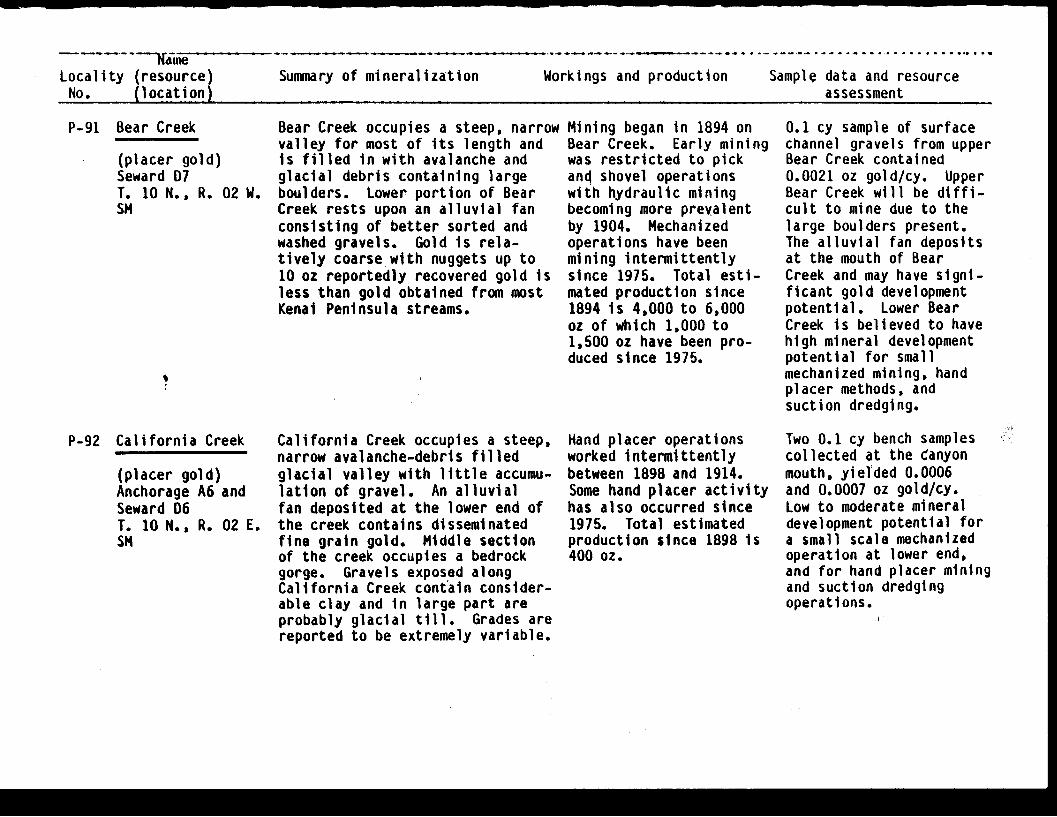
Locality (resource) Summary of mineralization Workings and production Sample data and resourceNo. (location) assessment
P-91 Bear Creek
(placer gold)Seward D7T. 10 N., R. 02 W.SM
P-92 California Creek
(placer gold)Anchorage A6 andSeward D6T. 10 N., R. 02 E.SM
Bear Creek occupies a steep, narrowvalley for most of its length andis filled in with avalanche andglacial debris containing largeboulders. Lower portion of BearCreek rests upon an alluvial fanconsisting of better sorted andwashed gravels. Gold is rela-tively coarse with nuggets up to10 oz reportedly recovered gold isless than gold obtained from mostKenai Peninsula streams.
California Creek occupies a steep,narrow avalanche-debris filledglacial valley with little accumu-lation of gravel. An alluvialfan deposited at the lower end ofthe creek contains disseminatedfine grain gold. Middle sectionof the creek occupies a bedrockgorge. Gravels exposed alongCalifornia Creek contain consider-able clay and in large part areprobably glacial till. Grades arereported to be extremely variable.
Mining began in 1894 onBear Creek. Early miningwas restricted to pickand shovel operationswith hydraulic miningbecoming more prevalentby 1904. Mechanizedoperations have beenmining intermittentlysince 1975. Total esti-mated production since1894 is 4,000 to 6,000oz of which 1,000 to1,500 oz have been pro-duced since 1975.
Hand placer operationsworked intermittentlybetween 1898 and 1914.Some hand placer activityhas also occurred since1975. Total estimatedproduction since 1898 is400 oz.
0.1 cy sample of surfacechannel gravels from upperBear Creek contained0.0021 oz gold/cy. UpperBear Creek will be diffi-cult to mine due to thelarge boulders present.The alluvial fan depositsat the mouth of BearCreek and may have signi-ficant gold developmentpotential. Lower BearCreek is believed to havehigh mineral developmentpotential for smallmechanized mining, handplacer methods, andsuction dredging.
Two 0.1 cy bench samplescollected at the Canyonmouth, yielded 0.0006and 0.0007 oz gold/cy.Low to moderate mineraldevelopment potential fora small scale mechanizedoperation at lower end,and for hand placer miningand suction dredgingoperations.

NameLocality (resource)No. (location)
Summary of mineralization Workings and production Sample data and resourceassessment
Placer gold is found in four typesof gravels on Crow Creek: highbench gravels, recent streamdeposits, glacial gravels, and
2 E. avalanche debris. Bench depositsand recent stream deposits arethe highest in' grade and havehistorically produced most of the
''; gold. Glacial deposits andavalanche debris are low gradebut may locally contain signifi-cant concentrations of gold. Thehighest grades appear to beassociated with old channels inhigh benches which likely consistof gravels deposited prior to themost last glacial advance. Thepresence of numerous largeboulders and cemented gravels maycause mining difficulties. Goldis relatively course with 0.025-0.05 oz nuggets common and nuggetsup to 1 oz occassionally obtainedby recreational miners.
One large and one smallhydraulic operationaccounted for the majorityof the production fromCrow Creek prior to 1940.Several historic build-ings are maintained atthe Erickson Gold Mineand numerous miningartifacts occur along thebanks of Crow Creek. 'Onemechanized operationmined intermittentlyin 1981 and 1982.Recreational mining iscurrently popular at theErickson Gold'Mine. Totalestimated production since1898 is 45,000 oz.Production since 1979 isestimated to be'aprpox-imately 400 oz.
Eleven bench and alluviumsamples from Crow Creekcontained from 0.0013 to1.17 oz gold/cy. Highmineral developmentpotential for suctiondredging, small handplacer operations,,forsmall to medium mechanizedand hydraulic miningoperations.
P-93 Crow Creek
(placer gold)Anchorage A6T. 11 N., R. iSM
I
I;
.,

NameLocality (resource) Summary of mineralization Workings and production Sample data and resourceNo. (location) assessment
P-94 Winner Creek
(placer gold)Seward D6T. 10 N., R. 02 ESM
P-95I
Kern Creek* (placer gold)Seward D6T. 10 N., R. 2 E.SM
Winner Creek occupies a relativelywide and gentle U-shaped valleyalong most of its length with ashort bedrock canyon and fallsnear its Junction with GlacierCreek. Gravel deposits consistof well-stratified and washedalluvium within the channel andin some bench deposits and alsoas clay rich, cemented glacialor fluvial-glacial bench depositsin other locations. Clay richgravels contained relativelycoarse (3/16 in.) gold at onesample site.
Kern Creek occupies a steep narrowavalanche-debris filled valley withnumerous falls and cascades allow-ing for little accumulation ofalluvial gravels until its junctionwith'Turnagain Arm.
Hand placer and a hydrau-lic operation recoveredgold between 1898 and1917. Hand placermethods and suctiondredges have been usedsporadically since 1975.Total estimated pro-duction, all of whichhas come from the lower1/4 mile of the creek,is 400 oz of which lessthan 25 oz has been pro-duced since 1975.
Minor production reported.
Sampling on bedrockyielded gold at 0.002 oz/hour. A bench depositsample contained 0.0283 ozgold/cy. Both sampleswere collected from thelower end of Winner Creek.Samples collected from themiddle and upper portionscontained only traceamounts of gold. WinnerCreek is believed to havemoderate to high mineraldevelopment potentialalong its lower sectionfor small mechanized orhydraulic operations andfor suction dredging.' Theremainder of the creek haslow mineral developmentpotential for commercialmining.
Samples collectedcontained only traceamounts of gold. KernCreek is believed to havelow mineral developmentpotential for mechanizedoperations and suctiondredging.

Nam - ~- - -Localty Presourcet Summary of mineralization Workings and production Sample data and resource
P-96 Peterson Creek C4-4m1 v- .v - . -,
(placer gold)Seward D6T. 9 N., R. 2 E.SM,
P-97 Upper Twenty'Mile;, River-
(placer gold)Anchorage A5T. 11 N., R. 3 E.SM
3111 m v Co Kern Lreek (P-95)except with larger alluvial fannear its terminus. Significantquantities of gold,reportedlyhave been found onbedrock and inbedrock fractures,,,
Placer gold is disseminated incurrently'uneconomic quantitiesin poorly to moderately washedglacial-fluvial gravels along theupper portions of the TwentymileRiver. Numerous large bouldersare present. Pockets of highergrade material may occur withinand adjacent to the riverchannel.,
Minor production reported.Prospecting has occurredsince 1975.
No recorded production.
.i
Samples contained onlytrace amounts of gold.Low to moderate mineraldevelopment potential fdrsmAll mechanized and -suction dredge operations.
Five alluvium samples fromthe upper portions theTwentymile River cohtainedfrom a trace to 0.0073 ozgold/cy. The upper'Twentymtile River hias lowtoi1hoderate mineral devel-opment-potentiaal'fdr smallmechanized 'hand placer andsuction dredge operations.
... . . . ....~~~I,
A ! ,lA,
.f \, ! II
J i . .I . i i
..4. . r ,i . I
!t~l :. ' .. :' 'I ' h I i 3 I;'. I !';"
I .A, I
f . . 1.1 -. .
't1
M�I - - - I
I .A . .
C)
Or!.
., I ;. ,
II . I
I �kl
I � ! . ; V . J
, ,,
Related Documents