MINERAL INVESTIGATIONS IN THE SOUTHERN CHILKAT RANGE SOUTHEAST ALASKA 1985-1986 By: Albert H. Clough and Terry J. Hayden ALASKA FIELD OPERATIONS CENTER, JUNEAU, ALASKA _~~~~~~~~~~~~p - Sampling, Chilkat Mountains west of Sullivan Isiand UNITED STATES DEPARTMENT of the INTERIOR U.S. Bureau of Mines Donald P. Hodel, Secretary BUREAU of MINES David S. Brown, Acting Director OFR 13-88

Welcome message from author
This document is posted to help you gain knowledge. Please leave a comment to let me know what you think about it! Share it to your friends and learn new things together.
Transcript

MINERAL INVESTIGATIONS
IN THE SOUTHERN CHILKAT RANGE
SOUTHEAST ALASKA
1985-1986
By: Albert H. Clough and Terry J. Hayden
ALASKA FIELD OPERATIONS CENTER, JUNEAU, ALASKA
_~~~~~~~~~~~~p -
Sampling, Chilkat Mountains west of Sullivan Isiand
UNITED STATES DEPARTMENT of the INTERIORU.S. Bureau of MinesDonald P. Hodel, Secretary
BUREAU of MINESDavid S. Brown, Acting Director OFR 13-88

1985-1986MINERAL INVESTIGATIONS IN THE
SOUTHERN CHILKAT RANGESOUTHEAST ALASKA
By: Albert H. Clough and Terry J. Hayden
U.S. Bureau of MinesAlaska Field Operations Center
Juneau, Alaska
Open File Report 13-88
UNITED STATES DEPARTMENT OF INTERIOR
Donald P. Hodel, Secretary
BUREAU OF MINES
David S. Brown, Acting Director

CONTENTS
Page
Abstract............................................................. 1
Introduction............................****** ............ 2
Acknowledgments .................................................. 2
Location, access and land status ..................................... 3
History and production............................................... 3
Purpose and scope ...................................... ....................................... 5
General geology and mineralization............................... .....0 5
Mines, prospects and mineral occurrences .................. o......... 6
West of Sullivan Island............ 6
Endy group........................ ................ 7
William Henry Mountain area ........................................ 7
William Henry Bay ................................. .. .... 8
Alaska Endicott mine............................................ ........................ 8
North of Boat Harbor ..................... o..o.......... ...... o..9
West-Northwest of St. James Bay....................................... 9
St. James Bay area ................................................ 10
Lincoln Island copper.............................................. 10
Teardrop Lake to Mt. Golub ......................................... 11
Alaska Silver King (Excursion Inlet)... ..........................- . 11
North of Point Howard ....................................... 12
Howard Bay (Buttercup) ....................................... 12
Southern study area ... o... .o.... .o..o.o.o..o..... o..00 ...... .. 13
Mineral development potential..............o ........ o..oo......... 14
i

CONTENTS- Continued
Conclusions and recommendations ...................................... 16
References........................................................... 17
Appendix- Geochemistry ............................................... 19
Sampling and analytical procedures ................................. . 19
Analytical results. ................................................ 20
ILLUSTRATIONS
1. Location of the southern Chilkat Range study area ................. 4
2. Mine and prospect locations ................................ in pocket
3. Geochemical sample locations ............................... in pocket
4. Alaska Endicott Mine, southern Chilkat Range ............... in pocket
TABLES
1. Summary of mineral development potential ratings for mines,
prospects and mineral occurrences in the southern Chilkat Range ...... 15

UNIT OF MEASURE ABBREVIATIONS USED IN THIS REPORT
elev elevation oz/st ounce per short ton
ft foot ppm parts per million
in inch % percent
mi mile yd3 cubic yard
oz troy ounce ppb parts per billion
lbs pounds

1985-1986
MINERAL INVESTIGATIONS IN THE
SOUTHERN CHILKAT RANGE
SOUTHEAST ALASKA
By Albert H. Cloughl and Terry J. Hayden2
…____-___ ________________ -___ -__-______ -______________-___-_ _ _ _
ABSTRACT
During the 1985 and 1986 field seasons the Bureau of Mines (Bureau)conducted mineral investigations in the southern Chilkat Range of northernSoutheast Alaska. These investigations were part of the Bureau's study ofmineral resources in the Juneau Mining District.
Field investigations included geologic mapping and sampling of known mines,prospects and mineral occurrences in the study area. In addition, selectedareas favorable for hosting mineral deposits were examined using geologicreconnaissance, geochemical sampling, and ground geophysics.
During field work 179 geochemical samples were collected from 116 differentlocations. Analytical results of these samples defined polymetallicgeochemical anomalies throughout the study area. Additionally, precious metalanomalies are broadly distributed in volcanic and clastic rocks, along withquartz veins, areawide. An area of special interest contains gold and basemetal mineralization in interlayered volcanic and clastic rocks. Thismineralized area crops out in mountainous terrain 3 mi to the west of SullivanIsland.
All of the old mines in the area have moderate mineral development potentialdue to their various grades of mineralization. The widespread occurrence ofgeochemical anomalies combined with favorable geology for volcanic andsediment hosted mineralization suggest the study area is favorable foreconomic mineral occurrences.
…___- _- _- ______________ -_____________ -________________ -___ -_-__ -_ - _- _
lPhysical Scientist, Alaska Field Operations Center, Juneau, Ak.
2University of Idaho, Moscow, Id.
1

INTRODUCTION
Mineral investigations in the southern Chilkat Range (fig. 1) were conductedas part of the Bureau of Mines (Bureau) Juneau Mining District Study. Thepurpose of this study was to determine the mineral development potential (MDP)of the Juneau Mining District of northern Southeast Alaska. Mineraldevelopment potential is a measure of the favorability of a given mine,prospect or mineral occurrence to become an exploitable mineral deposit. Inthis case, the individual MDP's were evaluated and used in assigning theoverall MDP for the Juneau Mining District. MDP is usually expressed in termsof high, medium or low, as a qualitative estimation based on the known factsconcerning the individual mine, prospect or mineral occurrence.
Specifically, the Juneau district study identifies the type, amount anddistribution of mineral deposits within the mining district. Additionalproject goals are to determine selected ore reserves, conduct mineralbeneficiation studies of specific deposits, complete economic feasibilitystudies, perform probabilistic computer reserve studies and address economicand legislative effects on mineral development.
To facilitate field work and reporting, the Juneau District was subdividedbased on geologic and geographic factors. The Chilkat Range area is onesubdivision.
This report presents preliminary results of the Bureau's mineralinvestigations in the southern Chilkat Range. The Bureau's field andlaboratory investigations are ongoing; additional results will be published insubsequent reports.
ACKNOWLEDGMENTS
Local Juneau prospector Mr. Dale Henkins generously allowed the Bureau tosample and map several of his prospects in the area and his cooperation isgreatly appreciated. We would also like to thank Mr. Bill Salisbury, ofSalisbury and Associates, for providing the Bureau access and informationconcerning his claims in the southern study area.
The authors were ably assisted in their field investigations by seasonalBureau employees Messrs. Rich Giraud, Edmund Fogels, Lance Miller and DennisSouthworth. Their endeavors in mapping, sampling and locating mines,prospects, and mineral occurrences made a significant contribution to thisreport.
2

LOCATION, ACCESS AND LAND STATUS
The southern Chilkat Range study area is located along the mainland to thewest of Lynn Canal, between tidewater and the Glacier Bay National Park and
Preserve boundary (fig. 1). The study area also includes many of the islandsin Lynn Canal. For purposes of this report the study area extends in anortherly direction from Pt. Couverden to the Sullivan Island area (northwestmap area, fig. 1). The only permanent settlement in the area is the villageof Excursion Inlet (fig. 1), located on the western margin of the study area.
Terrain within the study area is varied. Rocky beaches predominate alongthe coast. Elevations below 2,500 ft are generally heavily forested by mature
spruce, hemlock and cedar with dense underbrush. Lowlands are commonlymantled with thick bog and muskeg. Outcrops below 2,500 ft are scarce, exceptalong beaches. Elevations above 2,500 ft generally have much outcrop, exceptwhere covered by glacier ice or seasonal and perennial snowfields. Due to
persistent snow cover, the upper elevations can only be effectively workedafter mid summer.
The study area is accessible from Juneau by aircraft (either fixed wing orhelicopter) or by small boat. Logging operations near Excursion Inlet and Pt.
Couverden provide the only roads within the report area. Aside from loggingroads, travel within the study area is entirely by foot, boat or helicopter.
The majority of lands within the study area are within the Tongass NationalForest and administered by the U.S. Forest Service, U.S. Department ofAgriculture. Most of these lands are open to mineral entry and exploration,with the exception of the large tract which forms the Endicott RiverWilderness area (fig 2). These wilderness lands are closed to mineral entryand location. In addition, there are several patented inholdings along withstate and native lands and selections (1)3.
HISTORY AND PRODUCTION
The first reported prospecting and mining activity in the Chilkat Range areawas at the Alaska Endicott Mine near William Henry Bay (fig. 2). The originallocation date of the mine is unknown; however the mine was developed by the
Alaska Endicott Mining and Milling Company, starting in 1916 (2, pp. 28-30).
Production records for the Alaska Endicott are incomplete and confusing. Themine is reported to have yielded 200 tons of ore by 1919 which resulted in therecovery of 48.38 oz Au and 20 oz Ag (2, pp. 28-30). Bureau mine productionrecords list production as 48 oz Au ani 20 oz Ag, but these numbers are for1922 (3). No base metal production is listed for the mine except for areference in 1923 of an unstated amount of copper concentrate being shipped(5, pp. 21-22).At approximately the same time as the Alaska Endicott was being developed
the Howard Bay Mine was being explored. The first reference to this depositwas made in 1917, but the mine, with it's shoreline exposures, was likelydiscovered prior to that date.
3/Underlined numbers in parenthesis refer to items in the list ofreferences preceding the appendix at the end of this report.
3

SuI. va
Island EXPLANATIO: LACIER: a: C::t \:l 0ij00V
0 :0: t;00~jf0000 :\0:it. f t0 : nStudy Area boundary
P mvue w~~~~~LD6UISS ~ ~~4 ALASKAI
.i/. HNeLry Ia I Ia~~~~~~~~Iln
%9 d % . 7: % <is= Pitied\<SLY.' Island ~ ~ ~ ~ ~ ~ ~ Is a
bo</s *v....vqt~~~~~Pt. 1fSiCourrd* Scals
Figure 1. -Location of the Southern Chlikat Range Study Area
4

Reported production from the Howard Bay Mine is 7 tons of ore which was
shipped to the Tacoma, Washington smelter. This shipment assayed 44 oz/st Ag,
$1.50 Au (@ $20.67/oz), 3.5 % Cu and trace Zn (6). The only other reportedproduction from the Chilkat Range area came froi the Alaska Silver King Mine
(fig. 2), near Excursion Inlet. This property was located in 1938, and
developed with trenches and an aerial tram to the beach north of Excursion
Inlet. Approximately one ton of high grade silver ore was reported to havebeen hand cobbed from a narrow lens, trammed to the beach and shipped to the
Tacoma smelter. This shipment returned high silver values (7). No other work
was done on the prospect and the mining and tram equipment were lost when fire
destroyed the cannery in which they were stored (7).
Additional minerals related activity in the area has been confined to
prospecting and exploration. Mineral discoveries of uncertain significancehave been made at numerous locations. These sites include uranium, thorium
and rare-earth element mineralization in narrow carbonatite veins within a
syenite intrusive northwest of William Henry Bay (fig. 2) (8, p. 2, 9, pp.
12-17) and massive sulfide and precious metal mineralization in metasediments
and metavolcanics exposed along logging road cuts to the north of Pt.
Couverden. Furthermore, numerous geochemical anomalies identified by the U.S.
Geological Survey in their preliminary Juneau quadrangle geochemical report(10) aid in defining prospective mineralized areas.
PURPOSE AND SCOPE
The purpose of this work was to identify and catalog the known mines,prospects and mineral occurrences in the southern Chilkat Range area. In
addition to studying the known occurrences, geochemical anomalies were
evaluated and areas which were deemed favorable due to geologic, geochemical
and geophysical factors were investigated. Methods of investigation included
geologic mapping, geochemical sampling and ground geophysics.
This report is preliminary in nature and scope. Additional fieldinvestigations within the study area are ongoing with the results to be
published in subsequent reports.
GENERAL GEOLOGY AND MINERALIZATION
The area of this report (fig. 1) is bounded by the Lynn Canal-Chatham Strait
fault on the east and the Excursion Inlet-Beartrack fault on the west (11).
Lithologically, the area is part of the Alexander tectonostratigaphic terrain
and composed predominantly of metasedimentary and metavolcanic rocks along the
coastal areas, with the central part of the range containing abundant gneisses
and granites. Most of the layered rocks are north-trending with a well
developed foliation. Local ductile flow and tight folding is common,
especially in the Pt..Couverden area. The granitic rocks are predominantly
biotite hornblende granodiorite and are locally foliated (11). Similargranitic rocks also crop out along the eastern margin of Excursion Inlet.
5

Lithologically, the southern portions of the study area are characterized bythick carbonate units interbedded with shale. These units have beenmetamorphosed to marble and argillite near the granitic contacts. Argilliteprodominates over carbonate in the northern study area (north of the EndicottRiver). Furthermore, interlayered mafic and felsic volcanic rocks are common.
Green, commonly altered, slightly porphyritic andesitic dikes crosscut manyof the rock types in the area. Also noted are minor basaltic and apliticdikes which locally cut the metasedimentary units.
The region is cut by numerous steeply-dipping to vertical faults. Faultsobserved in the St. James-William Henry Bay areas tend to strike northwest,whereas the faults in the southern portions of the study area (near Pt.Couverden) tend to strike east-northeast. Shearing along many of the faultshas been intense and locally has developed internal boudinage in themetasedimentary sections.
Known base and precious metal mineralization in the area consists -predominantly of small discontinuous quartz-sulfide veins which are commonlybrecciated. Examples of these types of mineralization are present in HowardBay (Buttercup Mine) and at the Alaska Silver King Mine, to the northeast ofExcursion Inlet. Similar occurrences are also known in the St. James Bay area(fig. 2) and to the south near the Lynn Sisters. Other types ofmineralization present include the calcite-quartz-chalcopyrite veins at theAlaska Endicott Mine near William Henry Bay and the uranium occurrences southof the Endicott River (Lucky Six fig. 2) (9, pp. 12-17). Several base metalgeochemical anomalies which have yet to be~adequately explained are also knownin the area (12, pp. 25-27). Diopside-epidote-garnet skarns are common alongthe contact areas between the granitics and the surrounding country rocksthroughout the study area. To date none of these skarns are known to containeconomic mineral deposits.
MINES, PROSPECTS AND MINERAL OCCURRENCES
The following section provides descriptions of-the known mines, prospectsand mineral occurrences in the study area which the Bureau has thus farexamined. In addition to a brief summary of previous work on individualmineral localities, results of Bureau fieldwork completed to date for thisstudy is presented. Geochemical results are also highlighted. Completesample results are tabulated in the appendix of this report.
West of Sullivan Island
A traverse was made along the ridge line of the 4,720 ft peak which lies onthe mainland, immediately to the west of Sullivan Island (fig. 2).Lithologically, this area consists of a well foliated thick argillite section,locally containing interlayered chert bands. Subvolcanic dikes (dacitic incomposition) are common as well as interlayered pyritic tuffs.
6

The precipitous terrain exhibits conspicuous abundant milky quartz veins up to
several ft thick, which approximate the foliation of the argillite. A grab
sample was taken of one of the quartz veins, which is exposed in a prominentsaddle at the 3,650 ft level. This sample (7799, 3)4 analysed 1.6 ppm Au and
greater than 4,000 ppm Cu.
Endy group
The Endy group of claims is located north of the Endicott River, near the
center of the Endicott River Wilderness area (fig. 2). The group consists of
30 lode claims which were staked in 1974 (13).
The Bureau spend 1/2 day on the claim group in 1986. During this
examination much of the claim group was covered by a late summer persistent
snow cover and outcrops were scarce. A sample collected from quartz vein
float (7551, 6) analysied 18 ppm As, 20 ppb Au and 1400 ppm Cu. Lithologiesnoted in the area included gray massive limestone, volcanic tuff, and black
argillite. Additional work needs to be done to further define the mineraloccurrence at this site.
William Henry Mountain area
Anomalous Au and Ag values were reported by the USGS in their geochemicalsampling work to the northwest of William Henry Bay (10). These preciousmetal anomalies were obtained from panned concentrate stream sediment samplestaken from the area.
Bureau work in this area during the 1986 season consisted of severaltraverses and spot helicopter landings to examine local geology andmineralization. The region is composed predominantly of limestone and
argillite. The argillite is black, commonly shows well-developed lamination
and contains pyrite, locally up to several percent. One sample of argillite
(3336, 24) contained a trace of native copper and in thin-section was found to
be brecciated with minor amounts of galena and sphalerite. Carbonate unitspresent in the area included a light grey to white recrystallized limestone, a
black fossiliferous limestone, a red recrystallized limestone, and a blackmoderately to finely laminated limestone.
Rock sampling in this area by the Bureau identified several gold anomalies
which deserve further attention (table 1). A noteworthy sample (6385, 11)
returned 280 ppb Au. This sample was collected from a siliceous, altered zone
along a porphyritic andesitic dike. This altered zone contained 8 -10% pyrite
by visual estimate. Argillite in this area exhibits microbrecciation of some
of the laminae with adjacent laminae remaining unbroken. This suggests that
much of the deformation is penecontemporaneous in origin.…____- -_ --- --- ____--____________ - -____ --_ --_--__- -_--___---- ---- _
4/ Numbers in parenthesis refer to sample numbers refered to in appendix,followed by map number shown on fig. 3. This convention followed throughouttext.
7

William Henry Bay
Rocks along the eastern shoreline of William.Henry Bay (fig. 2) consist of aseries of silicified metavolcanic rocks, predominantly mafic in composition.These rocks contain abundant pyrite and local chalcopyrite. Calcareousmetasediments, which grade to a coarse-grained white marble are locallyinfolded with the mafic volcanics. These metasediments locally become verysiliceous and take on a jasperoidal appearance with accompanying disseminatedpyrite and pyrrhotite.
Rocks of similar nature crop out along the west side of the bay, though thesection there is less deformed than on the east side. Due to the closespatial and lithologic association it is likely that this section comprisesthe host for the mineralization at the Alaska Endicott mine, approximately onemile to the south of the head of William Henry Bay. The infolded carbonateunit could represent the protolith of the Alaska Endicott quartz-carbonatevein.
The shoreline area of William Henry Bay was traversed by the Bureau duringthe 1986 field season. Geochemical samples were taken of mineralized andaltered outcrops. The best sample (7168, 31) was taken from a pyrite brecciazone in a silicified limestone that crops out on the east side of the bay nearthe head. This sample returned anomalous in Au (1.1 ppm) and Zn (250 ppm).
Alaska Endicott Mine
The Alaska Endicott Mine (fig. 2) is located approximately one milesouth-southwest of the head of William Henry Bay at an elevation of 160 ft.Access to the mine site is either via helicopter, landing in an unimprovedsite approximately 100 ft east of the mine portal or overland via an overgrownlogging road from the beach at William Henry Bay.
The original claimants of the mine are unknown. The property was reportedlyaquired by the Alaska Endicott Mining and Milling Company in 1916 (2, pp.28-30). By 1918, 250 ft of drifting was completed on the vein and the aditwas reported to have been extended for 26 ft (14, p. 30). In 1921 the maindrive was completed for a distance of 1,600 ft from the portal, a 150 ftcrosscut had been driven and 80 ft of raise had been completed (15, p. 67).During 1922 a 15-stamp mill was reportedly completed and operational on theproperty (4, p. 37).
Production records for the Alaska Endicott are incomplete and unclear. Thereported mine production is 48.38 oz Au and 20 oz Ag, from 200 tons of ore(2, pp. 28-30, 3).
8

The Alaska Endicott mine was examined by Bureau personnel during the 1985
field season. During this examination the mine was surveyed using a compass
and tape and the geology mapped at a scale of 1 in to 50 ft (fig. 4).
Selected rock-chip and channel samples were collected from the underground
workings and submitted for geochemical analysis.
The geology in the vicinity of the Alaska Endicott Mine is not well defined
or understood. In general terms, rocks in the William Henry Bay area are
predominantly argillite, shale and limestone interlayered with mafic volcanic
rocks. North of the bay, greenstone predominates. The geology of the mine,
as revealed underground, consists of a well foliated greenstone, likely a
metabasalt, which is bounded on both sides by fine grained clastic rocks and
local muscovite schist. The schist likely represents a metamorphosed tuff.
The majority of the mineralization seems to be hosted by the metabasalt.
Mineralization is confined to a calcite-quartz vein which averages 10 ft
thick, strikes generally 2900 and dips generally 700 to 850 to the south.
Sulfide minerals present are chalcopyrite with subordinate pyrite. These
sulfides occur as streaks and blebs within the quartz-rich parts of the vein.
Brecciation is common throughout the vein, especially near the vein margin.
Angular fragments of greenstone are very common in the breccia zones. Country
rocks within the mine are highly deformed, but generally strikenorth-northwest and dip steeply to the south. Based on underground mapping,
the vein appears to be vertically continuous for at least 100 ft. Copper
mineralization is erratic and spotty, but appears to be concentrated along the
contacts of the quartz-carbonate vein. The best sample collected by the
Bureau in 1985 (7017, 32) analysied 1.7% Cu, 5.6 ppm Ag, and 0.04 ppm Au.
North of Boat Harbor
Approximately 0.8 mi to the north-northwest of Boat Harbor the Bureau
located several quartz veins which crop out in a stream drainage. These veins
range from 4 to 10 in wide and contain galena, chalcopyrite, malachite and
sphalerite. One sample, (7559, 39), contained 610 ppm Cu, 320 ppm Pb, 180 ppm
Zn, and 17 ppm As.
Approximately 2 mi north of the entrance to Boat Harbor, on the shoreline,
iron stained jasperoid is common. The Bureau collected several samples of
this jasperoid, one of which (7532, 34) analyzed 110 ppm As, 20 ppb Au, 200
ppm Pb, and 31 ppm Sb.
West-northwest of St. James Bay
The area to the west-northwest of St. James Bay, near the Glacier Bay
National Park and Preserve divide, is predominantly composed of folded and
faulted limestone and argillite.
9

Andesitic dikes are common, but volumetrically unimportant in the area. Thissector of the Chilkat Range area is highly glaciated and many of the higherelevations are still occupied by valley and cirque glaciers.
Bureau work in this area consisted of several geologic traverses on whichselected rock samples were collected. Anomalous metal values were obtainedfrom several of the samples. One sample (7540, 35) from a quartz veinanalysied 21 ppm As, 880 ppm Cu, 570 ppm Pb, and 710 ppm Zn. Another sample(7554, 40), from a siliceous limestone outcrop, analysied 120 ppm As, 50 ppbAu, and 45 ppm Mo. Additionaly, quartz veins and jasperoidal rocks in thearea contain variable amounts of galena, chalcopyrite, and pyrite. Not enoughdata are currently available for this area to speculate on the significance ofthese anomalies.
St. James Bay area
Mineralization in the St. James Bay area (fig. 2) consists of quartz veinscontaining base and precious metals. These veins are similar to those ofHoward Bay (quartz-carbonate veins with local chalcopyrite, sphalerite,galena, and tetrahedrite). Veins of this type have been found along the westshoreline in the central part of St. James Bay and to the south along theshoreline west of the Lynn Sisters (16). The veins in the St. James Bay areawere prospected at one time with an Wit of unknown extent (16). All vestigesof this adit have been removed by subsequent shoreline erosion.
During the 1985 field season several shoreline traverses were made by Bureaupersonnel along St. James Bay and to the south by the Lynn Sisters. Two areaswhich have quartz-carbonate veins were located along the west shore of St.James Bay, presumably one of these being the vein referenced by Roehm (16).These veins are highly vuggy, milky white and composed predominantly of quartzand calcite. Aragonite and siderite are common accessory minerals. Averagevein thickness ranges from 2 in to 2 ft. The veins occur in swarms whosegeneral strike is 3400 with vertical to near vertical dips. Country rocksurrounding the veins is predominantly carbonate and fine-grained clastic incomposition. A quartz vein sample (7114, 44) collected by the Bureau in 1985analysied 4.8 ppm Ag, 5280 ppm Pb, and 1.51% Zn. The veins described by Roehm(16) at Lynn Sisters were searched for but not located.
Lincoln Island copper
The Lincoln Island prospect (fig. 2) is located at the northern tip ofLincoln Island. Lithologically, the area is a series of chert, tuff,argillite, and mafic volcanic rocks; all of which have been infolded. Each ofthe units contain various amounts of disseminated sulfides, predominantlypyrite and pyrrhotite.
10

Locally within the mafic volcanic rocks, the sulfides are concentrated insmall blebs and stringers up to several inches thick and several feet instrike length. The sulfide mineralization is likely related to submarinevolcanism, perhaps hot springs activity in the volcanosedimentary pile.Bright red and yellow iron staining is common where the sulfide concentrationsare the greatest. Sulfide mineralization is only noted in shoreline outcrops.
The Lincoln Island area was examined by the Bureau in 1986. The beach areawas traversed at low tide to maximize visible exposures and samples were takenfrom the better mineralized intervals. In addition, a three line groundvery-low-frequency (VLF) electromagnetic (EM) geophysical survey was conductedat right angles to the strike of the mineralized mafic volcanic rocks. Thesurvey was done using a Phoenix VLF II5 instrument. These VLF lines werestarted at the shoreline and run eastward for 500 ft, well into the denselyvegetated portions of the island.
The strike extension of the best mineralization noted on the beach provideda good conductivity response (cross over). However, no additional conductorswere noted in the timbered portions of the VLF traverses. The highest gradesample collected (7174, 48), from a siliceous pyrite-pyrrhotite rich zone,analysied 30 ppb Au, 1900 ppm Cu, and 69 ppm Mo.
Teardrop Lake to Mt. Golub
Several of the ridgecrests and cirque headwalls from Teardrop Lake to thedrainage south of Mt. Golub were traversed and sampled. The core of this areais composed of a quartz diorite which has intruded limestone and argillite.Very narrow, discontinuous skarn zones are locally developed in the limestonesections within several hundred feet of the granitic contact. These skarnzones are generally devoid of significant mineralization. However, one sample(7519, 59), of limestone which contained sparse galena analysied 110 ppm Ag,
20 ppb Au, 430 ppm Cu, 1600 ppm Pb, and 1600 ppm Zn.
Alaska Silver King (Excursion Inlet)
The Alaska Silver King deposit (fig. 2) was discovered in 1938 by Messrs C.Parker, Floyd Ogden, Oren Jones, and Erwin Hubey (7). According to Thorne(7), the discovery was made in a steep walled creer at an elevation of 1,070ft.
…____ -____ -______ -__-_-_-___-_ -_ -__ -__________ -___-___ _-__ -_-_
5/ Reference to a specific product does not imply endorsement by the BureauofMines.
11

Initial development work consisted of the construction of a trail and aerialtram from the prospect to the beach on Excursion Inlet. A small quantity ofhigh-grade silver ore was selectively mined from a narrow sulfide lens on theproperty (7). No additional development work is evident or reported.Mineralization at the Alaska Silver King consists of sphalerite, galena,stibnite, tetrahedrite, and pyrite in a quartz-calcite gangue (7).
The Alaska Silver King deposit was examined by the Bureau in 1985 with 1.5days being spent in the area. No signs of the initial prospecting activitywere apparent and no evidence of any more recent activity was observed. Thelack of historical workings is not surprising since the prospect lies in themiddle of a major avalanche path. The rocks cropping out In the drainagebasin at the presumed level of the old workings are a series of thick-beddeddark gray to black, limy siltites which strike 3100 and dip 700 to thenorth. These metasediments locally contain pyrite, minor amounts of chert andin places are rich with siderite or ferroan dolomite. A traverse throughavalanche debris below the old claim site revealed minor carbonate brecciacontaining traces of pyrite and pyrrhotite. A geochemical analysis of thissample (3170, 56)4 was slightly anomalous in Ag (0.7 ppm) and Au (0.055 ppm).The ridge area to the east of the Alaska Silver King deposit is composedmostly of argillite and siltite with local carbonate interlayers. Thesemetasedimentary units are also cut by latite dikes. No mineralization oralteration was observed In this area.
North of Point Howard
Two streams, approximately 1.5 and 4 ml north of Point Howard (fig. 2), weretraversed and sampled. Lithologically, the drainages transected by thesetraverses, are composed predominantly of argillite, carbonate, and quartzite.Locally, limestone breccia is also present, likely the result of tectonism.Several samples, (3332, 71, 3333, 72 and 3334, 73), were taken of this sectionwith no anomalous results. Due to the small size of these drainage basins andthe lack of encouraging geologic or geochemical results it is unlikely thatsignificant mineralization is in the area.
Howard Bay (Buttercup)
The Howard Bay (Buttercup) deposit (fig. 2) was discovered prior to 1917.Other names for the property include Vevelstad's lode, Silverton #1 lode andMcKecknie prospect. The property is on the west side of a narrow peninsulathat juts seaward along the western shore of Lynn Canal, north of Pt.Howard. This is located between Pt. Couverden and St. James Bay. Initialexploration on the deposit took place before 1921 and included several shallowshafts and open cuts (17, 15). Reportedly, 7 tons of ore were shipped fromthe shallow opencuts on the property to the Tacoma smelter. This shipmentassayed 44 oz/st Ag, $1.50 Au (gold @ $20.67/oz equals 0.07 oz/st Au.), 3.55%Cu, and trace zinc (6).
12

The Howard Bay deposit was visited by the Bureau in 1985. All of the oldworkings are completely overgrown and sloughed. The southernmost extent ofthe vein was dug out and sampled. The richest sample (7056, 76) assayed 0.7%
Cu, greater than 2% Zn, greater than 1 oz/st Ag, and 0.08 oz/st Au.
The Howard Bay vein strikes 0200 and dips 760 south; consists of abrecciated quartz-carbonate filled structure, emplaced at an angle to thepredominantly northwesterly regional strike. The vein is truncated to thesouth by a thick mafic dike and apparently continues underneath cover to thenorth. Sulfide minerals present include chalcopyrite, sphalerite, pyrite, andminor galena. Ankerite is ubiquitous.
Country rock in the area is predominantly limestone and is folded into anasymmetrical north-plunging antiform, which is locally overturned. Thebrecciated vein of the Howard Bay prospect appears to be emplaced parallel tothe axial plane of this broad antiform, along the AC joint trend.
No additional signs of mineralization or prospecting activity were noted inthe area other than at the old workings. It is noteworthy that outside thebeach area no outcrops were observed.
Southern study area
This part of the study area comprises the terrain from Teardrop Lake, southto Pt. Couverden, exclusive of the coastal areas of Icy Strait, ExcursionInlet and Pt. Howard (fig. 2). This.area is generally forested with naturaloutcrops being predominantly limited to the stream drainages. Recently, alogging operation in the area has developed approximately 30 miles of gravelhaul roads, whose cuts and road metal pits provide much-needed lithologiccontrol for this large underexplored region.
The most prominent lithologies in this area are a black, carbonaceouslimestone and subordinate interbedded argillite. Both units are moderately toextremely deformed by folding and faulting. The layered rocks strikepredominantly to the northwest with a moderate to steep northeasterly dip.The major faults trend northeast, dip steeply to the northwest and southeast.Most of these structures appear to be strike-slip with minor dip-slipseparation.
Igneous rocks present in this area consist of northeast-trending slightlyporphyritic andesitic dikes. These dikes are commonly altered to chlorite andcarbonate. Some basaltic dikes are also noted in the area, and like theandesitic dikes are also altered, but to a lesser degree. Quartz-bearinggossans are present along a few of the andesitic dikes.
Many of the streams, logging roads, and road cuts in this area weretraversed and sampled where mineralization and alteration are present. Narrowquartz veins were locally noted in some of the exposures which containedgalena, sphalerite, chalcopyrite, and pyrite.
13

A sample (8026, 94) of one such vein analysied greater than 30 ppm Ag, 170 ppmCu, greater than 7500 ppm Pb, and greater than 3800 ppm Zn. Similarly, someof the igneous rocks and fault zones in the area are mineralized. Sample6414, 102, from an andesite porphyry, analysied 1.7 ppm Ag, 410 ppb Au, and430 ppm Zn. Sample 6415, 102, from a fault gouge zone, analysied greater than30 ppm Ag, 719 ppb Au, 210 ppm Cu, 4070 ppm Pb, and 9200 ppm Zn. Also,samples of limestone and argillite collected in the area commonly returnedwith Zn values greater than 100 ppm.
In general, the southern study area is composed predominantly of carbonatesand argillites which exhibit a widespread enrichment in precious and basemetal values. Lesser amounts of volcanic rocks also crop out in this areaand, like the metasediments, also carry anomalous metal values. Additionalwork needs to be done before assessing the significance of these anomalies.
MINERAL DEVELOPMENT POTENTIAL
Mineral development potential is a measure of the favorability of a givenmine, prospect or mineral occurrence to be developed. For purposes of thisreport MDP is expressed as either high, moderate, low, or unknown. Theseterms reflect a qualitative to semiquantitative assessment of favorabilitybased on known facts concerning the individual mineral deposit.
Mineral development potential assignments for the southern Chilkat Range arebased on four main parameters. These parameters are whether any pastproduction took place, grade of mineralization, possible tonnage ofmineralization, along with geologic, geochemical, and geophysical factors.
High MDP requires near economic grade and continuity of mineralization.Deposits of this rank are likely to have mineable reserves under currenteconomic conditions. Past production is also an important characteristic toconsider in assigning a high MDP. The information available on the mines,prospects and mineral occurrences in the study area is insufficient toaccurately calculate tonnages of mineralized rock. Potential deposit size mayonly be surmised based on geologic factors. Due to this lack on tonnage datano high MDP assignment are given in the study area.
Moderate MDP indicates that either sufficient grade or tonnage has beenidentified, but not both. Deposits of this sort are not likely to be mineableunder current economic conditions.
Low MDP dictates low grades and/or little or no evidence of continuity ofmineralization.
Unknown MDP indicates that insufficient work has been done to make anyassessment.
14

Mineral development potential assignments are flexible. They need to beupdated as additional data becomes available for any given area. Updating MDP
applies not only to scientific data availability, but also to economicchanges, such as fluctuations in metal and labor prices along withtechnological advances that could greatly alter the viability of any miningventure.
Table 1. Summary of Mineral Development Potential ratings for mines,prospects and mineral occurrences in the southern Chilkat Range.
Deposit name MDP Rationale
Alaska Silver King Moderate grade of mineralization, favorablegeology
Howard Bay Moderate grade of mineralization
St. James Bay Moderate favorable geology and geochemicalcharacter
Alaska Endicott mine Moderate favorable geology and geochemicalcharacter, grade of mineralization
Lincoln Island copper Low geochemical character, geophysics,which indicates insufficient widthof mineralization
Remaining study area unknown insufficient work and data
15

CONCLUSIONS AND RECOMMENDATIONS
The lack of a comphrensive geologic, geochemical and geophysical data basefor the southern Chilkat Range study area dictates an unknown mineraldevelopment potential rating for the area as a whole. However, the area doescontain several small mines and prospects with moderate MDP. Furthermore,numerous base and precious metal geochemical anomalies have been delineated inthe area during this investigation and by previous workers (9, 10, and 12).The presence of these anomalies combined with the known prospects in theregion suggests the southern Chilkat Range, taken as a unit, has highpotential for hosting significant mineralization. This conclusion isreinforced by the favorable geologic environment in the Chilkat Range forsediment and volcanic hosted mineralization.
Due to the favorable geologic environment of the southern Chilkat Rangefor hosting significant mineralization further work is warranted.Investigations which should be conducted include, but are not limited to, thefollowing suggestions. First, more regional and detailed geochemistry needsto be done to define the known anomalies. This includes stream, rock, andsoil sampling as conditions dictate. Second, the known geochemistry needs tobe correlated with the areal geology, which is currently only published inreconnaissance format (11). More complete and detailed regional geologicmapping, at a scale of TT125,000 or larger, would greatly benefit furthermineral investigations.
16

REFERENCES
1. Roberts, W. S. Availability of Land for Mineral Exploration andDevelopment in Southeastern Alaska, 1984. BuMines Special Report, 1985,34 pp., 16 oversized sheets.
2. Twenhofel, W. S., J. C. Reed, and G. 0. Gates. Some MineralInvestigations in Southeastern Alaska. U.S. Geol. Surv. Bull. 963-A,1949, pp. 28-30.
3. U.S. Bureau of Mines. Unpublished mine production records. 1985;available upon request from BuMines, Juneau, Alaska.
4. Brooks, A. H. The Alaskan Mining Industry in 1921. Ch. in MineralResources of Alaska, Report on Progress of Investigations in 1921. U.S. Geol.Surv. Bull. 739, 1923, pp. 1-45.
5. Brooks, A. H. The Alaskan Mining Industry in 1920. Ch.in MineralResources of Alaska, Report on Progress of Investigations in 1920. U.S. Geol.Surv. Bull. 722, 1922, pp. 7-68.
6. Shepard, J. G. McKecknie Prospect (Howard Bay). AK Territorial Dep.Mines Property Exam. PE-112-0, 1926, 2 pp.
7. Thorne, R.L. Alaska Silver King Property, Southeast Alaska. MineralsMemorandum. BuMines, 1949, 8 pp.; available upon request from BuMines,Juneau, Alaska.
8. Warner, J.D. Field Report- William Henry Bay Uranium Prospect.BuMines, 1985, 6 pp.; available from A.H. Clough, BuMines, Juneau, Alaska.
9. Eakins, G.R. Uranium Investigations in Southeastern Alaska. State ofAlaska Division of Geol. and Geophysical Surveys. Geol. Report 44, 1975, 62
PP.
10. Bailey, E. A., B. F. Arbogast, S. M. Smaglik, and T. D. Light.Analytical Results and Locality Map for Stream Sediment andHeavy-Mineral-Concentrate Samples, 1983 and 1984, Juneau, TakuRiver, Skagway and Atlin Quadrangles. U.S. Geol. Surv. Open FileReport 85-437, 1985, 89 pp.
11. Brew, D. A., and A. B. Ford. Preliminary Reconnaissance Geologic Mapof Juneau, Taku River, Atlin, and Part of the Skagway 1:250,000Quadrangles, Southeastern Alaska. U.S. Geol. Surv. Open File Report85-395, 1985, 23 pp.
12. Herbert, C. F., and W.H. Race. Geochemical Investigations of Selectedareas in Southeastern Alaska, 1964 and 1965. State of Alaska, Division ofMines and Minerals. Geochemical Report # 6., 1965, 67 pp.
17

REFERENCES- continued
13. U.S. Bureau of Mines. Alaska 1/250,000 scale quadrangle map overlaysshowing mineral deposits, principle minerals and number and type of claims.1980. BuMines OFR 20-73, 153 overlays.
14. Martin, G. C. The Alaskan Mineral Industry in 1918. Ch. in MineralResources of Alaska, Report on Progress of Investigations in 1918. U.S. Geol.Surv. Bull. 712, 1920, pp. 11-52.
15. Stewart, B. D., and B. W. Dyer. Annual Report of the TerritorialMine Inspector to the Governor of Alaska. Juneau, 1922, pp. 67-69.
16. Roehm, J. C. Saint James Bay Investigation (Lynn Canal). AKTerritorial Dep. Mines Miner. Invest. MI-112-1, 1945, 6 pp.
17. Stouss, L. W. Report on Vevelstad's Gold Prospect, Point Howard,Lynn Canal. Memo to B. L. Thane, 1917, 1 p.; available from A.H.Clough, BuMines, Juneau, Alaska.
18
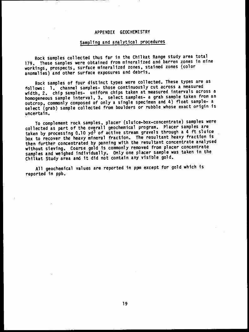
APPENDIX GEOCHEMISTRY
Sampling and analytical procedures
Rock samples collected thus far in the Chilkat Range study area total
179. These samples were obtained from mineralized and barren zones in mine
workings, prospects, surface mineralized zones, stained zones (color
anomalies) and other surface exposures and debris.
Rock samples of four distinct types were collected. These types are as
follows: 1. channel samples- those continuously cut across a measured
width, 2. chip samples- uniform chips taken at measured intervals across a
homogeneous sample interval, 3. select samples- a grab sample taken from an
outcrop, commonly composed of only a single specimen and 4) float sample- a
select (grab) sample collected from boulders or rubble whose exact origin is
uncertain.
To complement rock samples, placer (sluice-box-concentrate) samples were
collected as part of the overall geochemical program. Placer samples are
taken by processing 0.10 yd3 of active stream gravels through a 4 ft sluice
box to recover the heavy mineral fraction. The resultant heavy fraction is
then further concentrated by panning with the resultant concentrate analysed
without sieving. Coarse gold is commonly removed from placer concentrate
samples and weighed individually. Only one placer sample was taken in the
Chilkat Study area and it did not contain any visible gold.
All geochemical values are reported in ppm except for gold which is
reported in ppb.
19

SOUTHERN CHILKAT RANGEANALYTICAL RESULTS
Map Name or Sample Sample Sampleno. Location no. type lithology Ag As Au Ba Co Cr Cu Ho Pb Sb Sn Th U W Zn
001 W. of Sullivan IsI. 7795 Chip Black argillite (5 20 10 500 5 50 62 <5 8 1.4 (2 3.7 2.9 (3 150
002 W. ol Sullivan IsI. 7796 Chip Quartz vein (5 (2 (10 (150 4 9 24 (5 14 .2 (2 (.5 (.5 (3 30
003 W. of Sullivan 15I. 7799 Select Quartz vein 51 14 1600 <150 18 b >4000 (5 4 .4 B .9 (.5 5 300
004 W. of Sullivan Isl. 7797 Chip Black argillite (5 16 (10 400 3 69 87 6 18 1.1 (2 2.9 4.2 (3 150
004 W. of Sullivan Isl. 7798 Select Black argillite (5 3 (10 700 10 48 89 (5 8 .8 2 4.4 4.5 (4 180
005 Endy Group 7543 Chip lMeta tuff (5 110 10 300 2 (2 43 (5 20 1.3 (2 5.5 4.6 (3 80
006 Endy Group 7550 Select Pyritic tulf (5 29 10 400 2 3 86 (5 30 1.2 6 5.4 5.1 3 80
006 Endy Group 7551 Float Quartz vein (5 18 20 400 96 3 1400 22 20 .6 4 1.2 1.3 (3 50
007 Endy Group 7535 Chip Tufl (intermediate) (5 3 (10 700 5 7 5 14 12 1.6 2 4.1 3.2 7 20
008 S. Endicott River 7542 Chip Black argillite (5 2 (10 (150 6 260 38 5 4 .2 <2 1.9 3.1 (3 50
009 William Henry lMt. 6366 Select Quartz in slate (5 2 <10 200 2 13 (1 (5 2 .2 <2 .9 .7 (3 40
010 William Henry Mt. 7552 Chip Siliceous argillite (5 36 20 200 19 72 160 (5 6 .5 (2 2.8 2.8 (3 70
011 N. William Henry Bay 6384 Chip Agglomerate (5 6 (10 1500 5 2 8 (5 20 .3 (2 6.6 3.9 (3 70
011 N. William Henry Bay 6385 Select 6reenstone (5 150 280 1500 36 110 32 19 28 2.1 (2 4.6 2.4 7 80
012 N. William Henry Bay 638b6 Chip Nylonite (5 5 (10 (150 7 39 58 10 12 1 (2 2.3 4 (3 20
012 N. William Henry bay 6367 Select Argillite (5 4 (10 (150 15 49 97 5 6 .4 2 1.8 3.7 (3 30
013 William Henry Mt. 7571 Select Quartz vein (5 3 (10 (150 4 16 39 (5 2 .3 (2 (.5 (.5 (3 30
014 William Henry lt. 7572 Select Argillite (5 110 50 (150 50 5 110 21 12 1.3 2 3.8 5.2 (3 (30
015 N. Lance Point 7541 Chip Metachert, argillite (5 9 (10 300 20 8b6 96 <5 6 .4 (2 2.8 1.4 (3 70
016 William Henry Mt. 7573 Select Argillite (5 13 20 200 53 23 (1 <5 6 .2 (2 3.2 1.5 (3 60
016 William Henry It. 7574 Chip Black argillite (5 3 (10 300 48 11 12 (5 6 .4 (2 4.8 2.2 (3 110
017 N. William Henry Bay 6387 Float Argillite (5 4 (10 300 19 38 140 (5 6 .6 (2 3.3 1.9 (3 70
018 N. William Henry Bay 6388 Float Quartz (5 2 (10 (150 8 7 26 (5 6 .9 2 .6 .7 (3 330
019 William Henry Mt. 7570 Float Black argillite (5 4 10 300 9 62 62 <5 10 .6 (2 3.6 4.4 (3 50
020 William Henry Mt. 7564 Chip Black argillite (5 10 (10 300 11 61 29 (5 10 .6 (2 4.5 1.6 (3 90
020 William Henry Nt. 7565 Float Argillite (5 5 (10 300 17 37 29 (5 10 .4 (2 8.4 3.1 (3 40
020 William Henry Mt. 7566 Chip Andesite dike (5 3 (10 (150 35 650 61 (5 8 .4 2 2.8 1.4 (3 90
021 William Henry Mt. 7567 Chip Limestone (5 (2 (10 900 5 5 3 (5 2 .2 (2 17 5.2 (3 50
021 William Henry Mt. 7568 Select Limestone (5 6 (10 3000 8 12 (1 <5 4 2.9 (2 .6 1 (3 20

ANALYTICAL RESULTS- Continued.
map Name or Sample Sample Sampleno. Location no. type lithology Ag As Au Ba Co Cr Cu Ho Pb Sb Sn Th U W Zn
021 William Henry Mt. 7569 Select Limestone (5 16 10 2000 19 20 (I 12 8 4.7 (2 .9 3.2 (3 20022 William Henry Mt. 3339 Float Siliceous argillite (5 24 (10 200 43 26 140 (5 10 1.5 (2 3.9 1.8 (3 80023 William Henry Mt. 3337 Float Argillite (5 9 <10 700 75 39 290 (5 4 .6 (2 3.1 2.2 (3 80024 William Henry Mt. 3336 Chip Argillite .3 20 (10 - - - 72 - 4 - - - - - 92025 Lance Point 7190 Channel Quartz vein (5 (2 <10 (150 2 130 9 <5 9 (.2 (2 .7 (.5 (3 (30026 William Henry Bay 7184 Chip Black argillite (5 62 10 900 17 110 89 (5 49 2 (2 4.3 5.2 <3 140027 William Henry Bay 7183 Chip Netachert (5 (2 (10 600 4 5 7 <5 9 .2 (2 5.5 4.1 (3 90028 William Henry Bay 7187 Channel Netachert (5 53 50 300 42 33 490 (5 18 2.5 (2 4 2.6 (3 360029 William Henry Bay 7185 Chip Siliceous limestone (5 4 (10 800 6 5 99 (5 8 .2 (2 5.6 2.3 (3 130030 William Henry Bay 7182 Channel Siliceous limestone (5 50 (10 400 3 6 24 12 19 1.8 (2 3.7 1.9 (3 110031 William Henry Bay 7186 Chip Siliceous limestone (5 24 1100 (150 50 14 51 5 6 .8 2 2.4 .8 (3 250032 Alaska Endicott 3423 Chip Calcite vein 4.5 - (5 - - - 15400 - It - - - - - 24032 Alaska Endicott 3424 Channel Calcite vein .9 - (5 - - - 4050 - 6 - - - - - 12032 Alaska Endicott 3425 Channel Calcite vein .3 - (5 - - - 1530 - 9 - - - - - 37032 Alaska Endicott 3426 Channel Calcite vein <.2 - (5 - - - 985 - 9 - - - - - 13032 Alaska Endicott 3427 Channel Calcite vein (.2 - (5 - - - 520 - 13 - - - - - 9032 Alaska Endicott 7017 Channel Quartz vein 5.6 - 40 - - - 17200 - 6 - - - - - 25032 Alaska Endicott 7018 Channel Calcite vein 1.4 - (5 - - - 3340 - 3 - - - - - 30032 Alaska Endicott 7019 Channel Quartz vein .4 - (5 - - - 835 - 6 - - - - - 392032 Alaska Endicott 7020 Channel Quartz vein .5 - (5 - - - 2180 - 5 - - - - - 11032 Alaska Endicott 7021 Channel Quartz vein (.2 - (5 - - - 525 - 4 - - - - - 10032 Alaska Endicott 7060 Channel Calcite vein 1.1 - (5 - - - 1880 - 7 - - - - - 55032 Alaska Endicott 7061 Channel Calcite vein 1.1 - 20 - - - 1430 - 6 - - - - - 35033 North Boat Harbor 7529 Chip Rhyolite (5 19 (10 1900 16 7 <1 (5 16 9.8 (2 4 3.2 (3 30033 North Boat Harbor 7530 Chip Quartz vein (5 2 (10 800 4 3 3 (5 14 1.7 (2 .8 <.5 (3 30033 North Boat Harbor 7531 Chip Rhyolite (5 3 (10 2200 8 6 (I (5 14 13 6 4 2.3 (3 20034 North Boat Harbor 7532 Float Silicified volcanic (5 110 20 1000 95 3 16 5 200 31 (2 4.8 2.5 (3 60034 North Boat Harbor 7533 Channel Silicified volcanic (5 3 (10 900 4 4 (1 (5 8 5.3 2 8.3 3.9 (3 40034 North Boat Harbor 7534 Channel Silicified volcanic (5 4 (10 1600 5 2 3 (5 8 5.4 6 7 3.7 (3 20035 WNW St. James Bay 7540 Select Quartz vein (5 21 (10 (150 2 5 880 (5 570 .3 2 (.5 <.5 (3 710036 WNW St. James Bay 7553 Select Argillite (5 40 10 600 11 77 42 19 20 2.6 (2 5.4 6 (3 80

ANALYTICAL RESULTS- Continued.
map Name or Sample Sample Sampleno. Location no. type lithology Ag As Au Ba Co Cr Cu No Pb Sb Sn Th U W In
037 WNW St. James Bay 7602 Select Black slate (5 28 10 600 11 79 29 9 14 4.3 (2 5 4.9 (3 100
038 North Boat Harbor 7558 Float Breccia (5 8 (10 1800 15 33 14 (5 8 .4 4 3.2 1.8 (3 80
039 North Boat Harbor 7559 Chip Quartz vein (5 17 (10 200 13 11 610 (5 320 .2 (2 .6 (.5 (3 190
040 WNW St. James Bay 7554 Select Siliceous limestone (5 120 50 600 9 36 55 45 50 20 (2 4.7 5 (3 70
040 WNW St. James Bay 7555 Chip Quartz vein (5 3 <10 (150 4 15 27 (5 4 .4 6 1 .7 (3 80040 WNW St. James Bay 7556 Chip Jasperoid (5 14 10 600 7 110 48 7 20 2.9 8 4.5 4.4 (3 130041 WNW St. James Bay 8032 Chip Argillite (.2 - (10 - - - 47 - 15 - - - - - 90
042 W. St. James Bay 7527 Chip Greenstone (5 3 (10 700 12 250 14 <5 10 .4 (2 4.8 1.7 (3 70
043 W. St. James Bay 7528 Select Quartz vein (5 2 (10 (150 1 6 3 <5 12 .2 4 .5 (.5 (3 30
044 St. James Bay 7112 Select Quartz vein 1.4 - <5 - - - 45 2 48 - - - - - 1460
044 St. James Bay 7113 Select Quartz vein 1.4 - (5 - - - 11 2 20 - - - - - 1460
044 St. James Bay 7114 Select Quartz vein 4.8 - 10 - - - 43 2 5280 - - - - - 15100
045 St. James Bay 7115 Select Quartz vein 1.0 - <5 - - - 4 2 296 - - - - - 384
046 Lincoln Island 7173 Chip Pyritic metachert (5 (2 (10 3600 11 43 64 46 (2 .4 (2 3.2 1.7 (3 110047 Lincoln Island 7188 Chip Skarn (5 8 40 (150 76 170 2200 <5 6 3.6 <2 1.6 5 (3 80
048 Lincoln Island 7174 Channel Siliceous sinter (5 (2 30 200 140 30 1900 69 8 .7 6 1.6 3.3 10 50
048 Lincoln Island 7175 Channel Siliceous sinter (5 <2 20 4000 81 32 1600 13 4 .9 (2 1.7 1.5 66 60048 Lincoln Island 7176 Channel Siliceous sinter (5 2 20 1200 86 30 470 (5 14 .7 (2 1.9 2.6 41 70
048 Lincoln Island 7177 Channel Iron Stained argill. (5 2 (10 1700 15 130 80 <5 6 1.5 <2 2.3 2.2 <3 130049 Lincoln Island 7178 Chip 6reenstone <5 82 20 200 47 160 36 <5 6 1.5 2 .7 (.5 (3 140050 Lynn Sisters 7155 Chip Chlorite schist (5 <2 <10 (150 1 7 2 (5 4 (.2 <2 .8 (.5 <3 (20050 Lynn Sisters 7156 Chip Quartz vein (5 <2 <10 (150 5 4 2 <5 4 (.2 (2 .7 (.5 (3 (20050 Lynn Sisters 7157 Channel Breccia zone (5 16 (10 500 41 75 51 (5 8 .6 (2 2.6 1.3 (3 120051 Lynn Sisters 7158 Channel Netachert (5 120 40 700 1 - 5 (5 10 .3 8 14 6.9 (3 550
051 Lynn Sisters 7159 Select Pyritic chert <5 94 30 600 1 - 13 (5 44 1.3 <2 13 6.9 (3 90
052 E. Lynn Sisters 7506 Placer N/A (5 3 30 (150 48 150 2 (5 14 (.2 (2 6 3 4 220053 S. Lynn Sisters 7160 Chip Skarn (5 <2 (10 400 15 58 45 12 4 (.2 (2 4.5 2.6 (3 170054 S.W. Nun Mtn. 7023 Chip Skarn (.2 - (5 - - - 21 5 15 - - - - - 30
055 Lincoln Island 7179 Chip Siliceous argillite (5 (2 (10 1900 19 I1O 90 62 8 1.5 (2 3.7 10.2 (3 240056 Excursion Inlet 3170 Float Limestone breccia .7 - 55 - - - 71 6 20 - - - - 3 104

ANALYTICAL RESULTS- Continued.
map Name or Sample Sample Sampleno. Location no. type lithology Ag As Au Ba Co Cr Cu No Pb Sb Sn Th U N In
057 S. Mt. Golub 7517 Chip Altered basalt (5 (2 (10 300 51 250 160 <5 6 (.2 2 2 .B (3 130058 S. Mt. Golub 7518 Select Hornfels (skarn) <5 3 <10 500 12 120 35 8 6 .4 2 7.3 3.5 (3 80059 S. Mt. Golub 7519 Select Limestone 110 11 20 <150 21 200 430 <5 1600 75 (2 3.2 1.4 4 1600059 S. Mt. Golub 7520 Select Felsic intrusive (25 (2 <10 200 33 240 49 <5 8 .6 (2 4.7 1.7 <3 70059 S. Mt. Golub 7521 Chip Metavolcanic (5 4 <10 200 39 340 51 5 6 .7 (2 8.7 3.7 (3 100060 N. Lynn Canal 7508 Chip Fractured chert (5 9 <10 200 14 54 48 (5 12 .3 (2 4 2.6 (3 90061 N.W. Teardrop lake 7513 Select Siliceous argillite <5 (2 (10 1000 16 110 45 5 10 .6 4 6.4 2.6 (3 80062 N.W. Teardrop Lake 7514 Select Limestone (5 1100 (10 300 16 65 24 (5 6 .8 (2 2.2 .9 (3 (30063 N.W. Teardrop Lake 7526 Float Limestone (5 (2 (10 (150 3 21 (1 <5 2 .2 (2 1.2 .8 <3 (30064 N.M. Teardrop Lake 7515 Select Black argillite <5 30 (10 600 13 120 64 7 18 1.7 <2 4.9 6.1 (3 70065 N.W. Teardrop Lake 7516 Select Altered limestone (5 13 <10 500 44 340 32 <5 4 .3 <2 2.3 .9 (3 70066 N.M. Teardrop Lake 7523 Float Skarn <5 <2 <10 200 31 190 120 <5 2 (.2 <2 2.8 1.2 (3 70066 N.W. Teardrop Lake 7524 Float Quartz vein (5 <2 (10 (150 16 250 110 44 (2 (.2 (2 .6 (.5 (3 (20067 N.W. Teardrop Lake 7525 Float Quartz diorite (5 (2 <10 600 7 77 150 7 4 (.2 (2 2.1 .8 <3 <30068 N.W. Teardrop Lake 7522 Float Siliceous argillite (5 4 <10 700 22 120 44 (5 12 1.5 (2 6.5 2.6 (3 150069 W. Lynn Canal 7507 Select Rhyolite dike (5 40 10 300 30 100 33 <5 12 4.3 <2 3 1.4 (3 70070 S. Excursion Inlet 7189 Select Quartz-ankerite vein (5 8 (10 (150 3 42 5 (5 4 .6 2 1.2 (.5 (3 40071 N. Pt. Howard 3332 Chip Brecciated eudstone (5 4 (10 500 19 170 27 <5 8 .3 <2 6.9 1.7 <3 90072 N. Pt. Howard 3333 Float Sedimentary breccia (5 20 10 (150 4 17 2 (5 2 .4 (2 1.3 .6 (3 20073 N. Pt. Howard 3334 Select Chert (5 12 (10 <150 24 18 52 <5 12 .7 (2 3.6 2 (3 60073 N. Pt. Howard 3335 Chip Graywacke (5 7 <10 200 22 20 32 <5 12 .6 (2 2.9 1.8 (3 90074 E. Porpoise Islands 8024 Chip Limestone <.2 - <10 - - - 36 - 7 - - - - - 66075 S. Study Area 6394 Chip Argillite (5 24 (10 500 24 15 67 <5 14 2 (2 7 2.6 (3 100076 Buttercup 7054 Chip Quartz breccia )30 - 20 - - - 6450 - 36 - - - - - 3500076 Buttercup 7055 Chip Quartz breccia 3.8 - 10 - - - 49 - 14 - - - - - 2650076 Buttercup 7056 Select Quartz vein )30 - 80 - - - 7540 - 245 - - - - - >20000076 Buttercup 7057 Select Fault gouge 17 - 10 - - - 850 - 14 - - - - - 1860076 Buttercup 7058 Select Limestone 2.9 - (5 - - - 80 - 23 - - - - - 144077 Icy Strait 6421 Select Meta volcanic 1.5 - 10 - - - 90 - 32 - - - - - 50078 S. Study Area 8009 Chip Calcareous argillite (.2 - (10 - - - 27 - <2 - - - - - 66078 S. Study Area 8010 Chip Graywacke <.2 - 10 - - - 55 - 2 - - - - - 86078 S. Study Area 8011 Chip Volcanic dike (.2 - 10 - - - 40 - <2 - - - - - 64

ANALYTICAL RESULTS- Continued.
Map Name or Sample Sample Sampleno. Location no. type lithology Ag As Au Ba Co Cr Cu Ho Pb Sb Sn Tb U N in
079 S. Study Area 9015 Chip Andesite (.2 - (10 - - - 30 - 7 - - - - - 68
080 S. Study Area 6395 Chip Calcareous argillite (5 8 (10 300 10 81 29 (5 8 .7 (2 3.8 2.6 (3 100
080 S. Study Area 6396 Chip Tuff (5 (2 <10 400 18 37 43 (5 6 .6 <2 1.8 .9 (3 90
081 S. Study Area 8012 Chip Limestone (.2 - (10 - - - 48 - 3 - - - - - 90
081 S. Study Area B013 Chip Volcanic dike (.2 - 136 - - - 31 - 6 - - - - - 80
081 S. Study Area 8014 Chip Limestone <.2 - <10 - - - 60 - 23 - - - - - 100
082 Icy Strait 8028 Chip hylonite .8 - 136 - - - 61 - 52 - - - - - 114
083 S. Study Area 8017 Chip Limestone .2 - (10 - - - 132 - 9 - - - - - 94
083 S. Study Area 8018 Channel Limestone (.2 - 10 - - - 34 - 4 - - - - - 66
094 S. Study Area 8016 Chip Andesite porphyry (.2 - (10 - - - 55 - (2 - - - - - 102
085 S. Study Area 6412 Select Siliceous andesite (.2 - (10 - - - 15 - (2 - - - - - 66
086 S. Study Area 6397 Channel Black argillite (5 49 (10 300 19 71 50 (5 10 7 (2 4.3 2.7 (3 130
086 S. Study Area 6398 Channel Green argillite (5 19 <10 300 42 140 71 <5 10 4.7 2 .9 (.5 (3 130
086 S. Study Area 6399 Channel Siliceous argillite (5 32 (10 400 19 120 65 <5 24 4.6 (2 4.5 2.8 (3 160
086 S. Study Area 8001 Channel Green argillite (5 11 (10 300 37 100 95 (5 8 4 (2 1.4 (.5 (4 150
086 S. Study Area 8002 Channel Argillite (5 23 (10 300 43 190 85 (5 10 3.7 2 1.4 (.5 (4 150
087 S. Study Area 8003 Chip Limestone (5 17 (10 400 11 14 45 (5 6 2.5 2 2.5 .8 (3 70
088 S. Study Area 8004 Chip Rhyodacite (5 49 (10 400 25 74 63 (5 8 4.3 (2 1.7 .7 (3 100
088 S. Study Area 8005 Select Quartz vein (5 3 (10 (150 1 6 6 (5 4 .7 2 (.5 (.5 <3 (20
089 S. Study Area 8019 Channel Hylonite (.2 - <10 - - - 60 - 6 - - - - - 80
090 S. Study Area 8029 Select Limestone <.2 - (10 - - - 30 - 14 - - - - - 72
090 S. Study Area 8030 Select Calcite vein <.2 - (10 - - - 7 - 13 - - - - - 14
090 S. Study Area 8031 Select Andesite (.2 - (10 - - - 60 - 3 - - - - - 60
091 S Study Area 6422 Select Andesite <.2 - (10 - - - 52 - 5 - - - - - 80
092 S: Study Area 8027 Channel Siliceous dike .2 - <10 - - - 44 - 71 - - - - - 132
093 S. Study Area 8023 Chip Basaltic dike (.2 - (10 - - - 50 - <2 - - - - - 74
094 S. Study Area 8025 Chip Siliceous dike .8 - (10 - - - 41 - 172 - - - - - 184
094 S. Study Area 8026 Chip Quartz vein ,30 - (10 - - - 170 - '7500 - - - - - 3800
095 S. Study Area 6382 Select Andesite (5 8 (10 300 33 110 48 (5 2 1.2 (2 1.1 (.5 (5 120
096 S. Study Area 6376 Select Gossan in andesite <5 60 20 200 21 130 110 <5 280 8.6 4 1.1 e.5 (5 420
096 S. Study Area 6377 Select Gabbro (5 4 (10 200 41 140 53 <5 8 1.4 (2 1.2 <.5 (6 150

ANALYTICAL RESULTS- Continued.
map Nale or Samp1e sample Sampleno. Location no. type lithology Ag As Au Ba Co Cr Cu No Pb Sb Sn Th U d Zn
097 S. Study Area 6378 Select Andesite porphyry (5 90 30 200 24 61 19 <5 98 5.6 (2 1.4 .7 (5 170097 S. Study Area 6379 Select Diabase dike (5 9 (10 200 23 90 50 <5 10 3 (2 1.7 .5 (4 90099 S. Study Area 6391 Select Andesite breccia (5 3 (10 (150 5 26 10 (5 2 .4 (2 1.3 .9 (3 50099 S. Study Area 6383 Select Andesite (5 3 <10 700 27 34 66 <5 8 .5 (2 3.4 1.5 <4 140100 S. Study Area 6404 Select Neta-volcanic (.2 - (10 - - - 40 - <2 - - - - - 64101 S. Study Area 6375 Select Nafic-volcanic (5 3 <10 300 35 69 49 (5 6 .5 (2 1.7 (.5 (7 180102 S. Study Area 6413 Chip Limestone (.2 - (10 - - - 45 - 13 - - - - - 100102 S. Study Area 6414 Select Andesite porphyry 1.7 - 410 - - - 23 - 27 - - - - - 430102 S. Study Area 6415 Select Gouge zone )30 - 719 - - - 210 - 4070 - - - - - 9200103 S. Study Area 6390 Chip Andesite (5 (2 (10 700 32 190 86 (5 6 .2 (2 3.6 1.9 (3 110104 S. Study Area 6405 Select Liey argillite <.2 - 10 - - - 3B - B - - - - - 100104 S. Study Area 6406 Select Neta-andesite (.2 - <10 - - - 43 - (2 - - - - - 72105 S. Study Area 6374 Chip Andesite (5 10 (10 400 16 31 19 (5 6 1.7 4 2.6 1 (4 140106 S. Study Area 6407 Select Andesite porphyry <.2 - <10 - - - 40 - (2 - - - - - 50107 S. Study Area 8020 Chip Andesite <.2 - (10 - - - 59 - 11 - - - - - 119109 S. Study Area 6409 Select Siliceous andesite (.2 - (10 - - - 25 - <2 - - - - - 66109 S. Study Area 6409 Select Andesite (.2 - <10 - - - 4 - <2 - - - - - 92110 S. Study Area 6410 Select Fault gouge <.2 - (10 - - - 62 - 24 - - - - - 144111 S. Study Area 6411 Select Rhyolite dike (.2 - (10 - - - 52 - 6 - - - - - 94112 S. Study Area 6420 Select Limestone .2 - (10 - - - 56 - 27 - - - - - 126112 S. Study Area 9021 Chip Volcanic dike <.2 - (10 - - - 68 - 3 - - - - - 90113 S. Study Area 8022 Channel Volcanic dike <.2 - (10 - - - 34 - (2 - - - - - 70114 Icy Strait 7510 Select Neta-andesite (5 5 10 300 15 14 54 (5 (2 .9 2 2.9 1 (3 40115 Icy Strait 7509 Select Cherty limestone (5 6 90 900 13 76 36 (5 4 2.8 (2 5.2 3.1 (3 100116 Icy Strait 7511 Select Liey argillite (5 8 (10 300 14 75 61 (5 (2 .7 (2 4.4 2.7 (3 140116 Icy Strait 7512 Float Cherty limestone <5 11 (10 (150 12 55 9 (5 4 1 (2 1.1 (.5 (3 (30
Related Documents