Hillside Copper Mine Mine Closure Management Plan Program for Environment Protection and Rehabilitation (PEPR) MINE CLOSURE MANAGEMENT PLAN

Welcome message from author
This document is posted to help you gain knowledge. Please leave a comment to let me know what you think about it! Share it to your friends and learn new things together.
Transcript
Hillside Copper Mine
Mine Closure Management Plan
Program for Environment Protection and Rehabilitation (PEPR)
MINE CLOSURE MANAGEMENT PLAN
Hillside Copper Mine
Mine Closure Management Plan
Program for Environment Protection and Rehabilitation (PEPR)
1
Table of Contents
DOCUMENT OWNER .................................................................................................... 5
DOCUMENT APPROVER .............................................................................................. 5
REVISION HISTORY .................................................................................................... 5
DEFINITION OF TERMS ............................................................................................... 6
1. INTRODUCTION .............................................................................................. 7
1.1 ENVIRONMENTAL MANAGEMENT SYSTEM ........................................................................ 7
1.2 OBJECTIVES ............................................................................................................................ 7
2. MINE CLOSURE CONDITIONS ........................................................................ 8
3. MINE CLOSURE OUTCOMES .......................................................................... 8
4. BASELINE MEASUREMENTS AND MODELLING ........................................... 10
5. UNCERTAINTY ASSESSMENT ...................................................................... 10
6. KEY RISKS .................................................................................................... 11
7. MINE CLOSURE MEASURES & POTENTIAL LAND USE OPTIONS ............... 11
7.1 PROCESSING PLANT ............................................................................................................13
7.2 TAILINGS STORAGE FACILITY ............................................................................................14
7.3 ROCK STORAGE FACILITIES ...............................................................................................16
7.4 OPEN PIT ...............................................................................................................................19
7.5 UTILITY AND PIPELINE CORRIDORS ..................................................................................19
7.6 BORE FIELD ...........................................................................................................................20
7.7 UNDISTURBED LAND ............................................................................................................20
7.8 WASTE DISPOSAL ................................................................................................................20
7.9 INTERNAL HAUL ROADS AND PADS ..................................................................................21
7.10 SITE DRAINAGE ....................................................................................................................21
7.11 ACCESS FOR FUTURE MINING ...........................................................................................21
7.12 REHABILITATION STRATEGIES AND TIMING ....................................................................22
7.13 REHABILITATION LIABILITY ESTIMATE ..............................................................................22
8. CONSULTATION ........................................................................................... 23
9. RESPONSE PROCEDURES ............................................................................ 23
9.1 COMMUNITY RESPONSE PROCESS ..................................................................................23

Hillside Copper Mine
Mine Closure Management Plan
Program for Environment Protection and Rehabilitation (PEPR)
2
10. MONITORING PROGRAM .............................................................................. 23
11. REPORTING .................................................................................................. 36
12. PERFORMANCE INDICATORS ...................................................................... 36
13. CONTINUAL IMPROVEMENT ........................................................................ 36
14. REVIEW ......................................................................................................... 36
15. REFERENCES ................................................................................................ 36
16. APPENDICES ................................................................................................ 37
Hillside Copper Mine
Mine Closure Management Plan
Program for Environment Protection and Rehabilitation (PEPR)
3
List of Tables
Table 1 Design parameters for the Hillside Mine slope stability modelling. ..........................................10
Table 2 Actions to be taken to check Geotechnical model related assumptions during early
operations ...............................................................................................................................................11
Table 3 Closure Domains and Proposed Final Land Use at Closure ...................................................11
Table 4: Mine Closure Criteria and Outcomes...................................................................................24
List of Figures
Figure 1: Closure Cover Profile of the TSF ............................................................................................15
Figure 2 Proposed Final Landform (Section A and B) ..........................................................................17
Figure 3 Proposed Final Landform (Section C and D) ..........................................................................18
Figure 4: Potential Land Use Options within the ML ..............................................................................38
Figure 5: Location of the Closure Domains at the ML ............................................................................39
Figure 6: TSF Closure Section ...............................................................................................................40
Figure 7: TSF Spillway Configuration .....................................................................................................41
Figure 8: Surface Water Monitoring Locations .......................................................................................42
Figure 9: Native Vegetation Monitoring Sites .........................................................................................43
Figure 10: Impacted Native Vegetation ..................................................................................................44
Figure 11: Air Quality Monitoring Plan & Prevailing Wind Directions .....................................................45
Figure 12: Crop Quality Monitoring Area ................................................................................................46
Figure 13: Visual Amenity Assessment ..................................................................................................47
Figure 14: Visual Amenity Assessment (viewpoints 1, 3 and 4) ............................................................48
Figure 15: Visual Amenity Assessment (viewpoints 5, 6 and 7) ............................................................49
Figure 16: Surface Soil Textures & Monitoring Sites .............................................................................50
Figure 17: Mine Closure Contours .........................................................................................................51
Figure 18: Groundwater Monitoring Location Plan (Inc. PAF & NMD placement) .................................52
Figure 19: Declared Weeds & Monitoring Areas ....................................................................................53
Figure 20: Coastal and Marine Monitoring Locations .............................................................................54
Figure 21: Abandonment Bunds & Geotechnical Monitoring at Mine Closure .......................................55

Hillside Copper Mine
Mine Closure Management Plan
Program for Environment Protection and Rehabilitation (PEPR)
4
List of Appendices
Appendix 1 Maps / Sections / Images
Appendix 2 Correspondence Records

Hillside Copper Mine
Mine Closure Management Plan
Program for Environment Protection and Rehabilitation (PEPR)
5
Document Owner
Sustainability Manager
Document Approver
Chief Executive Officer
Revision History
Version No. Date Published Details
1.0 06/06/2017 First draft – Rex team
2.0 09/11/2017 Technical review
3.0 10/11/2017 Management review
4.0 13/11/2017 Uploaded onto HMCV website & forwarded to DPC
Hillside Copper Mine
Mine Closure Management Plan
Program for Environment Protection and Rehabilitation (PEPR)
6
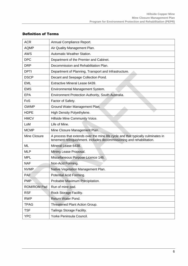
Definition of Terms
ACR Annual Compliance Report.
AQMP Air Quality Management Plan.
AWS Automatic Weather Station.
DPC Department of the Premier and Cabinet.
DRP Decommission and Rehabilitation Plan.
DPTI Department of Planning, Transport and Infrastructure.
DSCP Decant and Seepage Collection Pond.
EML Extractive Mineral Lease 6439.
EMS Environmental Management System.
EPA Environment Protection Authority, South Australia.
FoS Factor of Safety.
GWMP Ground Water Management Plan.
HDPE High Density Polyethylene.
HMCV Hillside Mine Community Voice.
LoM Life of Mine.
MCMP Mine Closure Management Plan.
Mine Closure A process that extends over the mine life cycle and that typically culminates in tenement relinquishment. Includes decommissioning and rehabilitation.
ML Mineral Lease 6438.
MLP Mining Lease Proposal.
MPL Miscellaneous Purpose Licence 146.
NAF Non-Acid Forming.
NVMP Native Vegetation Management Plan.
PAF Potential Acid Forming.
PMP Probable Maximum Precipitation.
ROM/ROM Pad Run of mine pad.
RSF Rock Storage Facility.
RWP Return Water Pond.
TPAG Threatened Plant Action Group.
TSF Tailings Storage Facility.
YPC Yorke Peninsula Council.
Hillside Copper Mine
Mine Closure Management Plan
Program for Environment Protection and Rehabilitation (PEPR)
7
1. INTRODUCTION
Rex Minerals Limited plans to develop and operate the Hillside Mine, situated 12 kilometres south of the township of Ardrossan. Conventional open cut mining techniques will be employed using trucks and excavators to deliver ore to a processing plant that will produce a copper concentrate.
Planning for mine closure will be progressively refined and adapted as the project develops. Successful closure of the mine will be achieved through the life of mine (LoM) objectives and outcomes integrated into the overall environmental management system through all stages of the mine project.
The iterative process of developing detailed closure strategies are intended to progressively remove uncertainties and assumptions prior to implementation.
The regulatory framework enables continual development of all aspects associated with mine completion, including the final detailed designs in the PEPR and the refinement of the closure strategies and designs in subsequent reviews of the PEPR. Prior to relinquishment of the ML, EML and MPL, Rex Minerals will be required to demonstrate that that all obligations associated with the tenements have been addressed.
The Hillside Mine closure plan provides a description of the measures to be implemented for mine closure and to conceptualise the Hillside Mine at completion when all the rehabilitation has been completed, balancing legal compliance with community expectations.
The Hillside Mine closure plan and potential land use options fundamentally attempts to maximise the amount of land to be returned to agriculture post closure. Native vegetation will be planted in strategic locations to reinstate and improve vegetation corridors where return to agriculture is not practical. The proposed land use options within the ML are represented in Figure 4 of Appendix 1.
1.1 ENVIRONMENTAL MANAGEMENT SYSTEM
Rex Minerals is committed to minimising the impact of its operations on the local environment and community, and is developing a comprehensive Environmental Management System (EMS), that will be based on the International Standard 14001:2015. This MCMP is a component of the Hillside Mine EMS.
1.2 OBJECTIVES
The objective of this Plan is to provide the framework for:
ensuring compliance with all relevant statutory requirements,
Rex Minerals Policies and Standards;
implementing tools and practices to manage and minimise the impact of the mine closure on the
environment and nearby land owners;
providing details on mine closure management responsibilities;
enable agreed post mining land use(s);
ensuring all mine waste materials left onsite are chemically and physically stable;
ensuring no industrial or commercial waste left onsite; and
ensuring the pit void is secured against inadvertent public access.

Hillside Copper Mine
Mine Closure Management Plan
Program for Environment Protection and Rehabilitation (PEPR)
8
2. MINE CLOSURE CONDITIONS
The following Hillside Mine ML conditions (Second Schedule) relate to mine closure.
Surface Water
24 The Tenement Holder must ensure that:
24.2 inundation of third party property and infrastructure by water (to a greater extent than would be expected to occur prior to mining operations commencing) after mine completion is not caused by mining operations;
24.3 unless the Tenement Holder obtains a registered Waiver of Exemption under the Act to undertake mining activities (inclusive of inundation).
25 The Tenement Holder must:
25.1 Ensure no surface water contaminated as a result of mining operations leaves the Land; and
25.2 ensure that, apart from water contained in the pit void:
25.2.1 no surface water contaminated prior to mine completion remains within the Land after mine completion; and
25.2.2 no contamination of surface water occurs after mine completion as a result of mining operations within the Land.
3. MINE CLOSURE OUTCOMES
The following Hillside Mine ML clauses (Sixth Schedule) relate to mine closure.
Air Quality Outcomes
2 The Tenement Holder must, in construction, operation and post mine completion, ensure no loss of abundance or diversity of native vegetation on or off the Land through:
2.1 Clearance,
2.2 dust/contaminant deposition,
2.3 fire,
2.4 reduction in water supply, or
2.5 other damage,
unless prior approval under the relevant legislation is obtained.
3 The Tenement Holder must, in construction, operation and post mine completion, ensure no impacts to agricultural productivity for third party land users on or off the Land as a result of mining operations, including:
3.1 Reduction in crop yield;
3.2 reduction in grain quality; or
3.3 adverse health impacts to livestock.
Visual Amenity Outcomes
12 The Tenement Holder must, in construction, operation and post mine completion, ensure that the form, contrasting aspects and reflective aspects of mining operations are visually softened to blend in with the surrounding landscape.
Soil and Land Disturbance Outcomes
14 The Tenement Holder must, in construction, operation and post mine completion ensure that the existing (pre-mining) soil quality and quantity is maintained.

Hillside Copper Mine
Mine Closure Management Plan
Program for Environment Protection and Rehabilitation (PEPR)
9
15 Before mine completion, the Tenement Holder must satisfy the Director of Mines that where practicable, the pre-mining land use can be recommenced after mine completion.
Soil and Land Disturbance Outcomes - TSF and WRD
19 The Tenement Holder must ensure that the WRD and TSF final landforms will be physically stable post mine completion.
20 The Tenement Holder must, in construction, operation and post mine completion, ensure that water seepage from the TSF, WRD’s or ore stockpiles does not result in adverse impacts on adjacent land uses including, but not limited to, growth of native vegetation and cropping land.
Native Vegetation Outcome
22 The Tenement Holder must, in construction, operation and post mine completion, ensure no loss of abundance or diversity of native vegetation on or off the Land through;
22.1 clearance,
22.2 dust/contaminant deposition,
22.3 fire,
22.4 reduction in water supply, or
22.5 other damage,
unless prior approval under the relevant legislation is obtained.
Weeds, Pest and Pathogens Outcome
24 The Tenement Holder must, in construction, operation and post mine completion, ensure no introduction of new species of weeds, plant pathogens or pests (including feral animals), nor sustained increase in abundance of existing weed or pest species in the Land compared to adjoining land.
Coastal and Marine Outcome
26 The Tenement Holder must ensure no loss of abundance and diversity of marine flora and fauna from contaminants and dust deposition resulting from mining operations, during operations and post mine completion.
Public Safety Outcomes
38 The Tenement Holder must demonstrate that post mine completion, the risks to the health and safety of the public so far as it may be affected by mining operations are as low as reasonably practicable.
Adjacent Land Use and Third Party Property Outcomes
42 The Tenement Holder must during construction, operation and post mine completion, ensure that there are no adverse impacts to third party land use on property adjacent to and on the Land as a result of mining operations, other than those agreed between the Tenement Holder and the affected user.
43 The Tenement Holder must, in construction, operation and post mine completion, ensure no impacts to agricultural productivity for third party land users on or off the Land as a result of mining operations, including;
43.1 reduction in crop yield;
43.2 reduction in grain quality; or
43.3 adverse health impacts to livestock.
45 The Tenement Holder must, during construction, operation and post mine completion, ensure that as a result of a geotechnical failure caused by mining;
Hillside Copper Mine
Mine Closure Management Plan
Program for Environment Protection and Rehabilitation (PEPR)
10
45.1 there are no adverse impacts to adjacent land use; and
45.2 there is no unauthorised damage to public or private property and infrastructure.
The following Hillside Mine EML clauses (Sixth Schedule) relate to Mine closure.
Air Quality Outcome
1 The Tenement Holder must, in construction, operation and post mine completion, ensure that there are no public health and/or public nuisance impacts from air emissions and/or dust generated by mining operations.
Visual Amenity Outcome
4 The Tenement Holder must, in construction, operation and post mine completion, ensure that the form, contrasting aspects and reflective aspects of mining operations are visually softened to blend in with the surrounding landscape.
Soil and Land Disturbance Outcome
5 The Tenement Holder must, in construction, operation and post mine completion, ensure that the existing (pre-mining) soil quality and quantity is maintained.
Native Vegetation Outcome
7 The Tenement Holder must not clear any native vegetation on the Land other than in accordance with the realignment of the St Vincent Highway and the realignment of the Yorke Highway.
Weeds, Pest and Pathogens Outcome
8 The Tenement Holder must, in construction, operation and post mine completion, ensure no introduction of new species of weeds, plant pathogens or pests (including feral animals), nor sustained increase in abundance of existing weed or pest species on the Land compared to adjoining land.
4. BASELINE MEASUREMENTS AND MODELLING
References to the baseline measurements, modelling and conditions are listed in Table 4 in Section 10.
5. UNCERTAINTY ASSESSMENT
Rex Minerals has designed the Pit wall abandonment bund (2m high by 5m at base) that is located 50m
from the edge of the pit. The accepted industry standard for long term pit wall geotechnical stability
requires a Factory of Safety (FoS) of 1.5. The modelled pit wall geotechnical stability has a FoS of 1.66
at the crest of the western pit wall and FoS of 1.74 along the western Hillside property boundary with third
party property which is well above the industry standard.
The geotechnical modelling on the western pit wall is modelled using the geotechnical information
accrued during exploration and the feasibility studies. It includes data on geology, hydrology, rock types,
strengths and failure modes based on the design parameters, including blasting practices and bench
heights. Some of the inputs used in developing the EFS pit design are described in Table 1.
Table 1 Design parameters for the Hillside Mine slope stability modelling.
Parameter Type/Value
Bench Height 10 metres
Perimeter Blast Hole
Diameter
152 millimetres
Hillside Copper Mine
Mine Closure Management Plan
Program for Environment Protection and Rehabilitation (PEPR)
11
Structural Model Structural mapping including geotechnical domains, major structures
Material Strength Test Uniaxial Compressive Strength (MPa)
Slope Movement Prism monitor
Fixed GPS or survey monitor
The key actions to confirm assumptions for slope stability are listed below in Table 2.
Table 2 Actions to be taken to check Geotechnical model related assumptions during early operations
Assumption Action
Final wall drill and
blast design is
representative of
modelling parameters
Review all drill and blast data through quality control processes to ensure
parameters are as per the modelling assumptions for back break.
Rock type and
strength encountered
matches modelled
data
Remodel and estimate pit stability using slope geotechnical data acquired
during excavation.
Displacement
Monitoring system
Confirm displacement monitoring confirms predicted model outcomes.
6. KEY RISKS
Key risks identified for mine closure are:
Stability of the final open pit and TSF;
PAF management; and
Company insolvency prior to mine closure.
7. MINE CLOSURE MEASURES & POTENTIAL LAND USE OPTIONS
For management purposes the Hillside Mine has been divided into domains based on the type of closure
activity required. The components of each domain are described below in Table 3 and Figure 5 Appendix
1 illustrates closure domains within the ML. The Sustainability Manager is responsibility for mine closure
until a Closure Superintendent is appointed at the later stages of decommissioning.
Table 3 Closure Domains and Proposed Final Land Use at Closure
Closure Domain
(~ Area)
Components Potential Land Use
Options Timing to
completion
Processing Plant
(45Ha)
Processing plant and supporting infrastructure (crushing plant, conveyors, stockpiles, SAG mill, tailings pumping system, flotation/concentrate plant, pipelines including the tailings pipeline, ponds/dams, bunds and tanks)
Agricultural pursuits.
If oxide or low grade ore stockpiles remain these will be
12 months

Hillside Copper Mine
Mine Closure Management Plan
Program for Environment Protection and Rehabilitation (PEPR)
12
Closure Domain
(~ Area)
Components Potential Land Use
Options Timing to
completion
Mine buildings (administrative offices, workshops sheds, fuel storage, stores shed)
ROM pad and associated hardstand areas (truck park bay, lay-down area, fuel bay, stores shed, car park and perimeter of processing plant)
Water and process water ponds including the raw water pond
Internal power lines
Explosives magazine area
Sealed roads
Stockpile footprints
Waste and waste treatment or recycling facilities
Sewage and waste water treatment plant
Fuel Farm
sown with salt tolerant native grasses.
Tailings Storage Facilities (TSF)
(168Ha)
Tailings Storage Facility
Blanket drainage system
Decant and Seepage Collection Pond (DSCP)
Native vegetation (native grasses/salt tolerant species to provide erosion protection dependant on the requirements specified in the detailed design).
6 months
Rock Storage Facilities
(773Ha)
North-eastern RSF (262Ha)
South-eastern RSF (212Ha)
Western RSF (299Ha)
Slopes suitable for agricultural pursuits (0 to 10°)
Agricultural pursuits for a portion of 10 to 15° slopes on the western RSF is proposed
Slopes suitable for native vegetation (greater than 15°).
Completed at cessation of
surface dumping.
Open Pit
(169Ha)
Pit walls
Pit lake
Pit rim bunding and fencing
Potential flora and fauna refuge. The open pit could be made available for ecotourism or aquaculture uses. Currently being workshopped with stakeholders.
Completed at cessation of pit
excavation.
Utility and Pipeline Corridors
(1Ha)
Overhead power line
SA Water pipeline
Returned original state; agriculture pursuits, access tracks or native vegetation.
SA Water pipeline remains as this is State Government infrastructure within the road reserve.
Remains unless SA Water and Electricity Provider decide to remove.
Bore Field
(1Ha)
Borefield
Pipelines
All surface infrastructure will be removed and the pre-mining land use of agriculture re-
2 months
Hillside Copper Mine
Mine Closure Management Plan
Program for Environment Protection and Rehabilitation (PEPR)
13
Closure Domain
(~ Area)
Components Potential Land Use
Options Timing to
completion
established. Buried pipeline will remain in place.
Undisturbed Land (buffer area)
(80Ha)
Monitoring sites
Road underpass
Fences and bores.
Remnant native vegetation (73Ha)
Agricultural pursuits/remnant native vegetation to remain
Road underpass to remain as integral part of road under DPTI care and control
12 months
Non-Domain Specific Closure Aspects
Waste disposal
Internal haul roads (unsealed) (55Ha)
Site drainage infrastructure
All waste removed from site and recycled were possible
Strategic haul roads and pads will be retained as firebreaks others will be revegetated to blend in with surrounds
Site drainage lines removed where appropriate and drainage returned to natural drainage system or where necessary directed into open pit
3 months
7.1 PROCESSING PLANT
The processing plant and all above ground infrastructure and buildings will be dismantled and sold,
recycled or disposed of in an appropriate manner. All tarmac and compacted road base material from
sealed roads in and around the processes plant will be ripped up, removed and reinstated with topsoil.
All sedimentation dams, drains and costeans, that are not required following closure, will be filled in and
rehabilitated. Unwanted concrete pads and footings will be removed down to an appropriate depth ~1 m
compatible with the proposed agricultural land use.
The magazine compounds, sheds and shipping containers will be dismantled and all infrastructure
removed from site for reuse or recycling. All fittings, pipes, lining and pumps, etc. will be disposed in
accordance with the EPA standards and the waste management plan operating at the time of mine
closure.
The land will be rehabilitated to be used for agricultural pursuits. In general, any concrete, compacted
clay, asphalt, plastic liners or any materials used to cover or seal the ground will be removed and recycled
or disposed in an approved manner.
If there is a downstream benefit to the local community or add value to any subsequent land use, for
example storage sheds, dams and associated water and power reticulation, these structures will be left
in place and handed over to the new owner on relinquishment who will be responsible for any future
maintenance and liability.
The ROM pad high wall will remain and the base of the walls will be filled in and contoured to blend into
the surrounding pre-mining landform. The drainage from within the plant will report to the RWP during the
operational stage. The RWP embankment consists of the same materials as the TSF embankment (i.e.
waste rock and selected low permeability upstream facing). The RWP embankment and base will be lined
with low permeability clay material which will be removed at closure and if suitable, the material will be
Hillside Copper Mine
Mine Closure Management Plan
Program for Environment Protection and Rehabilitation (PEPR)
14
used as fill during rehabilitation or placed in an RSF. Once the RWP is decommissioned the surface water
run-off will drain into the open pit at closure.
HDPE lined process water dams will be drained and pumped into the open pit or TSF depending on water
quality. The dam walls will be removed and if suitable the material will be used as fill during rehabilitation
or placed in an RSF. The exposed ground will be tested for potential contaminants. If the soil is
contaminated it will be remediated in situ or removed and disposed in an appropriate manner. After
contamination clearance, the subsoil will be treated (may involve ripping due to compaction) and covered
with 0.1 to 0.3 m of topsoil and stabilised with appropriate vegetation applicable to agricultural production.
Approximately 18.5 Mt of oxide ore unsuitable for treatment through the flotation plant will be stockpiled
in the first 6 years of pit operations. This material could be suitable for alternative treatment later in the
life of the Project. If it should remain at closure it is recognised that it is a potential source of soluble
copper and will be treated to ensure encapsulation. The stockpile will be either rounded or pushed back
into western RSF and re-profiled. The oxide will be covered (top to bottom) by:
Cover Layer 1 – 0.2 m of topsoil;
Cover Layer 2 – 1 m of rock fill (ROM waste rock material);
Oxide ore; and
Foundation clay pad.
The 1.0 m of rock fill layer to be placed over the oxide ore will be sourced from NAF material placed
directly from ex-pit waste movement. There is no requirement for selective sourcing. The topsoil material
will be sourced from the topsoil stockpiles located around the site and maintained during the LoM for the
purpose of mine closure. The topsoil will be respreads to approximately 0.2m and revegetated according
to the potential land use which is a combination of cropping, native vegetation and other agriculture uses.
This will minimise any potential for soluble copper generation and keep the resource available for later
exploitation should that prove economic.
7.2 TAILINGS STORAGE FACILITY
At mine completion, the TSF closure design will mimic the proposed deposited tailings surface which is
a concave surface that slopes towards the decant location to the west. The overall closure shape will tie
in with the overall western RSF closure surface as shown in Figure 17 (Appendix 1).
A typical section of the TSF at closure is shown in Figure 6 (Appendix 1) and the TSF spillway
configuration is presented in Figure 7 (Appendix 1). Allowance has been made for a suitably sized spillway
and outlet channel (designed to cater of a Probable Maximum Precipitation [PMP] flood event) between
the TSF western embankment crest and the RSF, which flows to the west.
All surface storm water run-offs will be collected and removed from the facility via the central outlet drain.
The tailings surface will be capped with a low water flux cover system consisting of a waste rock layer (to
be recovered from the western RSF) covered with topsoil and revegetated. Topsoil stripped from within
the impoundment area at the time of construction will have been stockpiled for this purpose. A spillway,
with appropriate erosion protection, will be constructed to cater for the peak flood resulting from the PMP.
The final tailings surface requiring a capping is estimated to be 172 ha including the proposed
embankment crest width (118 ha excluding the embankment crest width).
The purpose of a soil cover above the tailings is to minimise ingress of surface water and reduce the
development of downwards flow through the tailings which may carry contaminants to the underlying
strata and the ground water. The design of the TSF closure will result in the flattening of the embankment

Hillside Copper Mine
Mine Closure Management Plan
Program for Environment Protection and Rehabilitation (PEPR)
15
profile to an average overall slope of approximately 1:50 (vertical: horizontal). Infiltration will reduce due
to the placement of the capping and revegetation requirements. The capping layer will act as a store and
release cover that will assist to capture storm water run-off thereby reducing erosion. The overall RSF
closure has been design to take into account incident rainfall.
The cover assessment has been carried out using typical representative soil characteristics and has not
included detailed soil testing therefore the expected specific performance of the cover is beyond the
scope of the current design.
Closure will incorporate a conceptual cover strategy based on current available guidelines and mine sites
in similar climates and includes the following general configuration and nominal thicknesses, in sequence
from the tailings surface (top to bottom):
Cover Layer 1 – 0.2 m of topsoil;
Cover Layer 2 – 0.4 m of weathered rock fill;
Cover Layer 3 – 0.6 m of rock fill;
Deposited tailings 30 m;
Foundation clay 3 m; and
Sandstone/Siltstone 40 m.
The first 0.6 m of rock fill layer to be placed over the tailings will be sourced from NAF material located
within the western RSF. There is no requirement for selective sourcing. The 0.4 m of weathered rock fill
material will also be sourced from NAF material within the western RSF. However, this should be
selectively sourced to consist of mainly granular material (i.e. finer than the underlying rock fill material).
The topsoil material will be sourced from the topsoil stockpiles located around the site and maintained
during the LoM for the purpose of mine closure. Figure 1 below shows the cover profile of the TSF at
closure.
Figure 1: Closure Cover Profile of the TSF
The tailings contained in the TSF have an acid neutralizing capacity / maximum potential acidity ratio of
2.16 indicating there is a high probability that all of the tailings material will remain circum-neutral in pH.
Accordingly, decant water is unlikely to require treatment. It is anticipated that water quality in the TSF
will be suitable to be pumped to the pit to accelerate the drying process once processing has ceased and
Hillside Copper Mine
Mine Closure Management Plan
Program for Environment Protection and Rehabilitation (PEPR)
16
excess water is no longer fed back into the process water stream. The water quality in the TSF will be
checked to ensure that it is similar or better than that in the open pit receiving environment prior to any
water being pumped. If necessary, this water will be pumped to the DSCP.
At mine completion, the TSF will drain through the underdrainage blanket system to the DSCP. This water
will be retained in the DSCP until the water quality meets background water quality levels occurring in the
open pit and then discharged to the pit. If the water does not meet background water quality levels, the
water will be treated prior to discharge.
Run-off from the rehabilitated TSF will be directed via the emergency spillway and surface drains to the
RWP. Capture of this run-off within the RWP will ensure that run-off water is of an acceptable quality to
discharge into the mine pit.
The DSCP embankment and base will be lined with low permeability clay material and the embankment
will have a crest width of 15 m with a 2: 1 upstream and 3: 1 downstream slopes. Prior to rehabilitation
any sediment occurring in the dam will be tested and if the EPA SA standards (Standards for the
Production and use of Waste Derived Fill, January 2010) are met it will remain in situ. Should the
sediment not meet the appropriate standards it will be stabilised and be disposed of as required.
7.3 ROCK STORAGE FACILITIES
At mine closure, the three RSFs will extend from the main mine site access point to the south-eastern
end of the open pit, forming a bund around the processing plant, pit and Yorke Highway. The western
RSF incorporates the TSF along with the DSCP and oxide stockpile, see Figure 5 (Appendix 1).
The RSFs will be rehabilitated progressively as soon as practicable in the mine scheduling. The north-
eastern and south-eastern RSFs will reach their maximum height in Years 8 and 9 respectively. However,
progressive rehabilitation will commence soon after the lower batters are completed in years 2 and 4
respectively. Progressive rehabilitation significantly reduces mine closure costs by using mine equipment
opportunistically and taking advantage of available run of the mine materials. Progressive rehabilitation
will also provide an opportunity during the operational phase of mine life to confirm that the rehabilitation
planned for the Hillside site will work as intended.
Geochemical studies found less than <5% PAF. All such material will be contained within the RSFs west
of the open pit or over the pit.
Rehabilitation of the RSFs will consist of pushing back the batters to achieve a concave slope following
best practice erosion stability guidelines, by utilising three slope angles of 20°, 15° and 10° with the flattest
slope placed at the toe of each RSF see Figure 2 and Figure 3. The RSFs will be covered with subsoil
and topsoil to a depth dependant on their proposed final landforms. The north-eastern RSF, south-eastern
RSF and western RSF will be vegetated as per Figure 4 (Appendix 1).
The steeper slopes (20°) and inside the pit abandonment bund will be covered with a mix of topsoil and
rock to minimise erosion and stabilised with a dominant native shrub vegetation or other agriculture uses.
The desired outcome at relinquishment is to hand over a physically and chemically stable landform with
native vegetation trending towards self-sustainability and rehabilitated pastures where the new landowner
can continue agricultural pursuits in-line with local practices and minimal inputs to the remnant and
replanted native vegetation.

Hillside Copper Mine
Mine Closure Management Plan
Program for Environment Protection and Rehabilitation (PEPR)
17
Figure 2 Proposed Final Landform (Section A and B)

Hillside Copper Mine
Mine Closure Management Plan
Program for Environment Protection and Rehabilitation (PEPR)
18
Figure 3 Proposed Final Landform (Section C and D)
Hillside Copper Mine
Mine Closure Management Plan
Program for Environment Protection and Rehabilitation (PEPR)
19
7.4 OPEN PIT
Once backfill has completed (on mine closure) the remaining mine pit will be oval in shape, approximately
1760 m long and 1000 m wide with steep slopes reaching the pit base at -395mRL. A surface area of
approximately 30 Ha of the southern and eastern areas of the open pit will be backfilled and rehabilitated
for agriculture as shown in Figure 4 (Appendix 1).
Following mine closure access to the open cut pit will be restricted by the construction of a stock proof
fence and abandonment bund. The abandonment bund will be constructed and positioned in accordance
with WA mine guidelines document (ZMA048HA 1997). The bunds will be 2 m high and 5 m wide with
location determined by a geotechnical engineer before mine closure, to ensure the bunds remain in
perpetuity. The bunds will be vegetated with native species. (see Figure 21 of Appendix 1). The two 35 m
wide haul roads will remain in the pit to divert run-off water to the pit lake. The pit haul roads will link up
to haul roads from the RSFs forming an internal drainage system to divert run-off. The run-off may initially
contain sediment while landscapes are stabilising, but is not expected to have any other pollutants.
Post closure modelling of pit water level recovery shows that the pit will fill very slowly to around -300mRL
by year 62, -120mRL 110 years after mine closure and to -70mRL 157 years after mine closure. It will
reach long term equilibrium level after 550 years at -27mRL.
No groundwater from the pit lake will move off-site as open pit will act as a sink in perpetuity. Accordingly,
all groundwater will always flow towards the open pit. An assessment of the pit lake water chemistry post
closure was prepared by a consultant (Logsdon 2014). The key findings from the assessment were as
follows:
The primary source of soluble material is from the final pit walls. The amount of the pit walls that are
available for oxidation declines with time as the pit walls are inundated with water during filling. As only a
small rind of pit-wall rock remains when the pit lake reaches equilibrium, sulphide oxidation and
subsequent water-rock reactions effectively ceases when the rocks are inundated, so the submerged
portions of the pit walls are treated as un-reactive.
Water quality is near neutral pH (7.7 – 7.8) as the wall rock in the ultimate pit shell will be very low in
sulphides (~15%).
Water quality reaches the chlorinity typical of seawater sometime between 80 and 320 years, but remains
in the vicinity of seawater chlorinity for several hundred years, rising to the stead-state system value only
after about 500 years.
The low predicted levels of metals are unlikely to be available to ecological receptors. Final land uses for
the open pit void are still being considered in consultation with stakeholders and will form part of the
detailed final mine closure plan.
7.5 UTILITY AND PIPELINE CORRIDORS
The SA Water pipeline will remain as it is property of the South Australian State Government. All fences
and signage and any instrumentation on the surface will be removed and the land returned to the original
land use.
An above ground power line from the Ardrossan West power substation will be constructed along Silo
Road and south to the mine site on the western side of the Yorke Highway. There will be a power off take
to the Port Ardrossan near the Yorke Highway and Silo Road intersection.
On closure the power supply lines will be considered a valuable asset and are likely to be handed over
to the state power utilities, as will the responsibility for maintaining the power lines. If an arrangement for

Hillside Copper Mine
Mine Closure Management Plan
Program for Environment Protection and Rehabilitation (PEPR)
20
the handover of the power line is not able to be made, the power lines will be removed at closure. As
much as possible the waste will be recycled, with the remainder disposed of in an EPA licensed landfill.
7.6 BORE FIELD
An above ground power line from the existing SA Power Networks coastal power line will be installed to
the Hillside bore field (a distance of approximately 1km).
All surface infrastructure will be removed and the pre-mining land use of agriculture re-established. The
buried section of the pipeline will remain in place.
7.7 UNDISTURBED LAND
This domain includes the proposed EML and will contain the temporary stockpiles of excess cut from the
highway realignment. Prior to EML closure any remaining stockpiled material will be removed and used
off-site for the Pine Point Road diversion. This portion of land will be transferred to DPTI/YPC to take over
responsibility of the care, control and management of the proposed highway.
During the operational and mine closure phases and right through to relinquishment the native vegetation
in the area will be upgraded through a combination of weed management, pest control and selective
plantings of native vegetation endemic in the coastal zones of this region.
The vegetation selected for planting will be from seeds or propagating material from Yorke Peninsula
based on advice from local environmental groups such as TPAG. The NVMP will be refined over the mine
life to ensure that at handover the vegetation communities are established to the point that they will be
self-sustaining.
All concrete within 0.75 m of the surface and clean building rubble will be disposed in the RSFs or open
pit. All rubbish will be removed and disposed in an approved landfill. Once the buildings and concrete
pads are removed the site will be ripped and covered with topsoil were necessary and returned to land
suitable for agricultural pursuits.
The ML will include agricultural land that will be held as buffer for the mining activities. During the
operational stage this land will be managed in a manner compatible with local agricultural pursuits, no
mining vehicles, personnel or equipment will need to access these areas and will generally be delineated
by stock fences.
As mine completion nears any unnecessary fences separating the undisturbed land from the mining
operations will be removed or relocated. A weeds and pest inspection will be conducted and any remedial
action required will be undertaken. Any degraded pasture will be fertilised and sown if required to ensure
that the pasture species mix and density is compatible with local practice.
Non-Domain Specific Completion Aspects
The non-domain specific aspects during mine completion consist of waste disposal, compacted
contaminated soil, unsealed internal haul roads and pads and maintaining access to future mining as far
as practicable. These have been addressed separately in the following sections.
7.8 WASTE DISPOSAL
Mine closure waste will consist of concrete, scrap metal, plastics (mostly HDPE), batteries, tyres, wood,
putrescibles and domestic waste sewage, reagent containers and packaging materials.
Hillside Copper Mine
Mine Closure Management Plan
Program for Environment Protection and Rehabilitation (PEPR)
21
Concrete waste will be disposed in the pit, TSF or RSFs depending on the location and availability at the
time of removal. All metals, plastics and cardboard/wood and containers will be recycled where possible,
some non-recyclable materials will be sent in a closed truck to the nearest available EPA approved
landfill.
A program for separating domestic rubbish into bottles and cans, recyclables and organic waste
established during the operational phase will be continued through to mine closure. The above practices
will ensure that no chemically unstable waste will remain at mine closure after all the rehabilitation works
have been complete.
Sewage will continue to be processed through the treatment plant at the processing site will remain in
place until all other rehabilitation works have been completed. After completion of rehabilitation activities
on the Project site the sewerage treatment plants will be removed.
7.9 INTERNAL HAUL ROADS AND PADS
At the end of mine life several internal haul roads, access tracks, pond liners, concrete pads, borrow pits
and hard stands will remain and these will be removed and revegetated. All non-essential internal haul
roads, access tracks, concrete pads borrow pits and hard stands will be dismantled, or broken up and
disposed as outlined above. Any compacted ground will be ripped and sown to pastures, or planted with
native vegetation on the steeper slopes.
7.10 SITE DRAINAGE
During operations, run-off generated from RSFs and other infrastructure will be separated from the natural
drainage systems, where possible. This run-off has the potential to carry contaminants (especially
sediment) and will be directed into sediment settling dams and then reused where appropriate for process
water. After rehabilitation, once the surface run-off is shown to meet the agreed upon water standards for
the naturally occurring drainage then the diversion system separating the mine run-off from the natural
drainage will be removed. Should the run-off not meet these standards then the drainage diversions will
be retained and the run-off water diverted to the pit.
Run-off from the TSF and RSFs will potentially have a high sediment load. During the operational phase
this water will be diverted to the process water management system or a system of sediment settlement
dams and sumps to settle the sediment. Only clean run-off will be allowed to return to the natural drainage
channels.
7.11 ACCESS FOR FUTURE MINING
The South Australian government requires that access for any future mining or reprocessing is
maintained. The majority of the access haul road to the open pit will remain open and be used as drainage
channels. However, a complete geotechnical and hydrological risk assessment will be required before
any future mining was to take place.
A low grade ore stockpile will be accumulated up until year 13 of operations. At closure, it is anticipated
that no low grade ore will remain. Approximately 14 million tonne of oxide ore unsuitable for treatment
through the flotation plant will be stockpiled in the first four years of operation. This material could be
suitable for alternative treatment later in the life of the Project. If it should remain at closure it is recognised
that it is a potential source of soluble copper and will be treated to ensure encapsulation. The stockpile

Hillside Copper Mine
Mine Closure Management Plan
Program for Environment Protection and Rehabilitation (PEPR)
22
will be either rounded or pushed back into north eastern Rock Storage Facility and re-profiled. The oxide
will be treated in a similar way to the TSF by:
sealing layer of non-acid forming, low permeability compacted earth fill (0.5 m depth);
mine spoil cover of non-acid forming rockfill (1.0 m depth);
topsoil cover (0.1 – 0.3 m depth); and
stabilised by pasture species and low shrubs.
This will minimise any potential for soluble copper generation and keep the resource available for later
exploitation should that prove economic.
7.12 REHABILITATION STRATEGIES AND TIMING
A description of the process for closure activities have been provided above for each closure domain.
The description included broad strategies to be applied as part of mine closure for rehabilitation for the
components of each closure domain. As the stages of mining progress the mine closure plan will be able
to provide greater detail regarding the timing of the associated closure activities. At this stage, the
following timelines provide a conceptual outline for the closure timing of the major mine and infrastructure
components in relation to each other.
Mine scheduling will allow the southern and northern RSFs to be completed in Years 8 and 9 respectively.
With progressive rehabilitation will commence soon after the lower batters are completed in years 2 and
4 respectively. Rehabilitation of these RSFs is scheduled to be completed within 2 years to leverage
optimal seasonal timing.
Progressive rehabilitation of completed portions of the western RSF is a priority and will occur as soon
as practicable in the mine scheduling. All topsoil and subsoil stockpiles are stabilised with pasture species
on an on-going basis and any opportunity for a one-shift policy will be implemented. An assessment of
the proportion of material available to backfill the open pit will occur on an ongoing basis.
Oxides may be processed during or after mining operations have ceased. Placement of cover materials
over the TSF can commence during the final months of operations, working from the perimeter inwards
as quickly as the TSF surface dries to a condition allowing machinery access. The final TSF capping,
dismantling of the processing plant components at the mine will be undertaken once processing is
completed. Ongoing waste management throughout the life of mine will ensure that minimal additional
waste is required to be removed for closure.
7.13 REHABILITATION LIABILITY ESTIMATE
In the event of default (Company going into administration) the government has a set of costed detailed
design works and will be able to issue a tender and pay for works via the mine closure bond. This includes
any outstanding rehabilitation at mine closure that has not been completed to satisfaction of the regulator
to enable relinquishment of the lease. The bond estimate is based on reasonable third-party costs of
undertaking the rehabilitation strategies as outlined in the document and include costs for project
management, inflation, normal project variation, and contingency provision for risk associated with the
strategies and uncertainty in the cost estimates.
There is not expected to be any residual liability post mine closure once all rehabilitation has been
completed. However, if any residual liability is identified then the transfer of the liability is to be negotiated

Hillside Copper Mine
Mine Closure Management Plan
Program for Environment Protection and Rehabilitation (PEPR)
23
between the Company and the landowner. Residual liability would include ongoing maintenance or
monitoring.
8. CONSULTATION
This Plan is being prepared in consultation with the DPC, Yorke Peninsula Council, and the HMCV
consultation group and directly with local landowners.
9. RESPONSE PROCEDURES
9.1 COMMUNITY RESPONSE PROCESS
All complaints received in relation to the Hillside Mine closure will be handled through the Hillside
Complaints Management Procedure.
10. MONITORING PROGRAM
Progressive rehabilitation and ongoing performance assessment will be carried out in areas where mining
and related operations have been completed and further disturbance is unlikely.
Ongoing monitoring during operations and post closure of the mine closure measurement criteria will be
used to demonstrate the achievement of outcomes for mine closure.
The details of the mine closure measurement criteria and outcomes are given in Table 4: Mine Closure
Criteria and Outcomes) below. This is a comprehensive summary of the Hillside Mine requirements prior
to relinquishment of the ML and EML. The MPL outcomes are the responsibility of SA Water and the
Electricity Provider.
Hillside Copper Mine
Mine Closure Management Plan
Program for Environment Protection and Rehabilitation (PEPR)
24
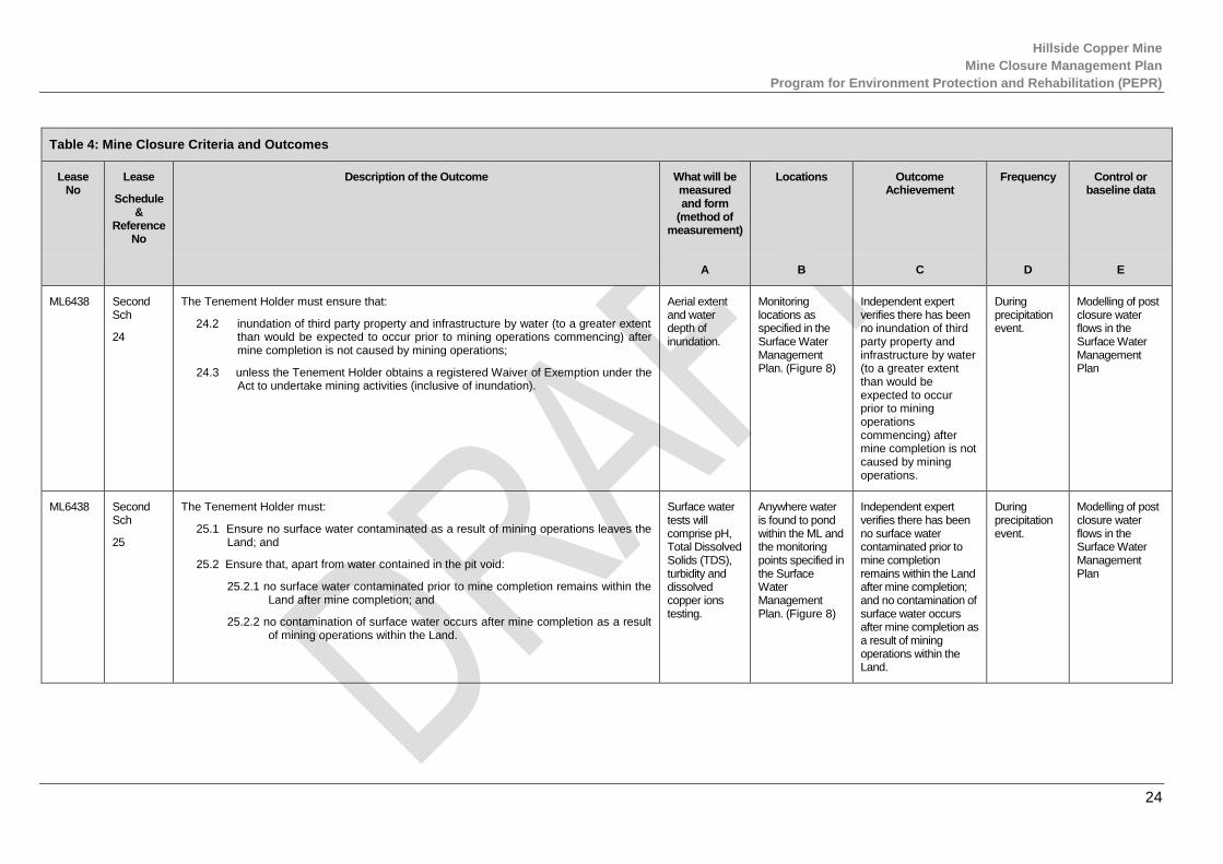
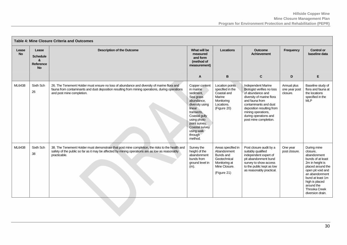
Table 4: Mine Closure Criteria and Outcomes
Lease No
Lease
Schedule &
Reference No
Description of the Outcome What will be measured and form
(method of measurement)
Locations Outcome Achievement
Frequency Control or baseline data
A B C D E
ML6438 Second Sch
24
The Tenement Holder must ensure that:
24.2 inundation of third party property and infrastructure by water (to a greater extent than would be expected to occur prior to mining operations commencing) after mine completion is not caused by mining operations;
24.3 unless the Tenement Holder obtains a registered Waiver of Exemption under the Act to undertake mining activities (inclusive of inundation).
Aerial extent and water depth of inundation.
Monitoring locations as specified in the Surface Water Management Plan. (Figure 8)
Independent expert verifies there has been no inundation of third party property and infrastructure by water (to a greater extent than would be expected to occur prior to mining operations commencing) after mine completion is not caused by mining operations.
During precipitation event.
Modelling of post closure water flows in the Surface Water Management Plan
ML6438 Second Sch
25
The Tenement Holder must:
25.1 Ensure no surface water contaminated as a result of mining operations leaves the Land; and
25.2 Ensure that, apart from water contained in the pit void:
25.2.1 no surface water contaminated prior to mine completion remains within the Land after mine completion; and
25.2.2 no contamination of surface water occurs after mine completion as a result of mining operations within the Land.
Surface water tests will comprise pH, Total Dissolved Solids (TDS), turbidity and dissolved copper ions testing.
Anywhere water is found to pond within the ML and the monitoring points specified in the Surface Water Management Plan. (Figure 8)
Independent expert verifies there has been no surface water contaminated prior to mine completion remains within the Land after mine completion; and no contamination of surface water occurs after mine completion as a result of mining operations within the Land.
During precipitation event.
Modelling of post closure water flows in the Surface Water Management Plan
Hillside Copper Mine
Mine Closure Management Plan
Program for Environment Protection and Rehabilitation (PEPR)
25
Table 4: Mine Closure Criteria and Outcomes
Lease No
Lease
Schedule &
Reference No
Description of the Outcome What will be measured and form
(method of measurement)
Locations Outcome Achievement
Frequency Control or baseline data
A B C D E
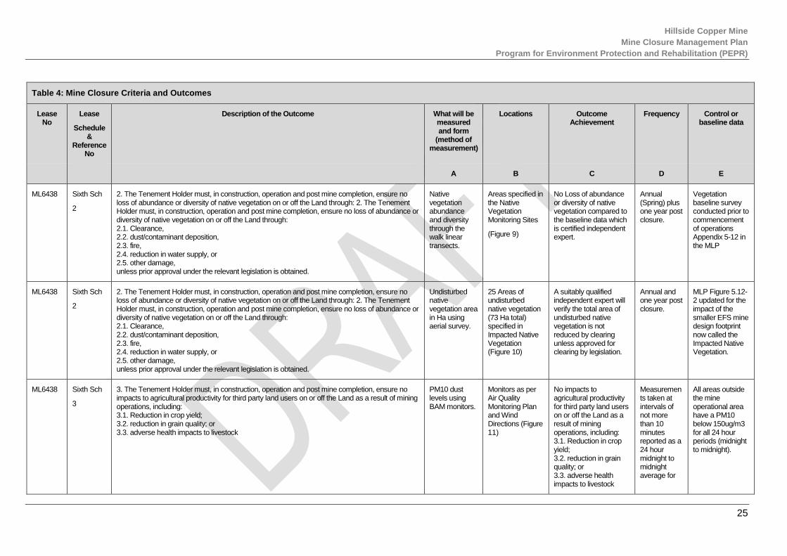
ML6438 Sixth Sch
2
2. The Tenement Holder must, in construction, operation and post mine completion, ensure no loss of abundance or diversity of native vegetation on or off the Land through: 2. The Tenement Holder must, in construction, operation and post mine completion, ensure no loss of abundance or diversity of native vegetation on or off the Land through: 2.1. Clearance, 2.2. dust/contaminant deposition, 2.3. fire, 2.4. reduction in water supply, or 2.5. other damage, unless prior approval under the relevant legislation is obtained.
Native vegetation abundance and diversity through the walk linear transects.
Areas specified in the Native Vegetation Monitoring Sites
(Figure 9)
No Loss of abundance or diversity of native vegetation compared to the baseline data which is certified independent expert.
Annual (Spring) plus one year post closure.
Vegetation baseline survey conducted prior to commencement of operations Appendix 5-12 in the MLP
ML6438 Sixth Sch
2
2. The Tenement Holder must, in construction, operation and post mine completion, ensure no loss of abundance or diversity of native vegetation on or off the Land through: 2. The Tenement Holder must, in construction, operation and post mine completion, ensure no loss of abundance or diversity of native vegetation on or off the Land through: 2.1. Clearance, 2.2. dust/contaminant deposition, 2.3. fire, 2.4. reduction in water supply, or 2.5. other damage, unless prior approval under the relevant legislation is obtained.
Undisturbed native vegetation area in Ha using aerial survey.
25 Areas of undisturbed native vegetation (73 Ha total) specified in Impacted Native Vegetation (Figure 10)
A suitably qualified independent expert will verify the total area of undisturbed native vegetation is not reduced by clearing unless approved for clearing by legislation.
Annual and one year post closure.
MLP Figure 5.12-2 updated for the impact of the smaller EFS mine design footprint now called the Impacted Native Vegetation.
ML6438 Sixth Sch
3
3. The Tenement Holder must, in construction, operation and post mine completion, ensure no impacts to agricultural productivity for third party land users on or off the Land as a result of mining operations, including: 3.1. Reduction in crop yield; 3.2. reduction in grain quality; or 3.3. adverse health impacts to livestock
PM10 dust levels using BAM monitors.
Monitors as per Air Quality Monitoring Plan and Wind Directions (Figure 11)
No impacts to agricultural productivity for third party land users on or off the Land as a result of mining operations, including: 3.1. Reduction in crop yield; 3.2. reduction in grain quality; or 3.3. adverse health impacts to livestock
Measurements taken at intervals of not more than 10 minutes reported as a 24 hour midnight to midnight average for
All areas outside the mine operational area have a PM10 below 150ug/m3 for all 24 hour periods (midnight to midnight).

Hillside Copper Mine
Mine Closure Management Plan
Program for Environment Protection and Rehabilitation (PEPR)
26
Table 4: Mine Closure Criteria and Outcomes
Lease No
Lease
Schedule &
Reference No
Description of the Outcome What will be measured and form
(method of measurement)
Locations Outcome Achievement
Frequency Control or baseline data
A B C D E
one year post closure.
ML6438 Sixth Sch
3
3. The Tenement Holder must, in construction, operation and post mine completion, ensure no impacts to agricultural productivity for third party land users on or off the Land as a result of mining operations, including: 3.1. Reduction in crop yield; 3.2. reduction in grain quality; or 3.3. adverse health impacts to livestock
Measure of mg/kg of copper in wheat and barley as per standard grain quality testing procedure.
Areas specified in Crop Quality Monitoring Area on the ML. (Figure 12)
No impacts to agricultural productivity for third party land users on or off the Land as a result of mining operations, including reduction in grain quality with maximum residual copper below the limit measured at an external laboratory.
Annual at harvest plus one year post closure.
Maximum Residue Limits for copper in grain (Barley and Wheat) of 10mg/kg of harvested grain.
ML6438 Sixth Sch
3
3. The Tenement Holder must, in construction, operation and post mine completion, ensure no impacts to agricultural productivity for third party land users on or off the Land as a result of mining operations, including: 3.1. Reduction in crop yield; 3.2. reduction in grain quality; or 3.3. adverse health impacts to livestock
Resolution of all issues regarding adverse health impacts to livestock recorded in the complaints register.
Locations specified in the landowner communication protocol
Post closure audit by a suitably qualified independent expert of the complaints register shows no unresolved issues regarding adverse health impacts to livestock.
One year post closure audit report of the complaint register.
Cases of adverse impact to the health of livestock of third party land users on/off the land received before construction in the complaints register.
Hillside Copper Mine
Mine Closure Management Plan
Program for Environment Protection and Rehabilitation (PEPR)
27
Table 4: Mine Closure Criteria and Outcomes
Lease No
Lease
Schedule &
Reference No
Description of the Outcome What will be measured and form
(method of measurement)
Locations Outcome Achievement
Frequency Control or baseline data
A B C D E
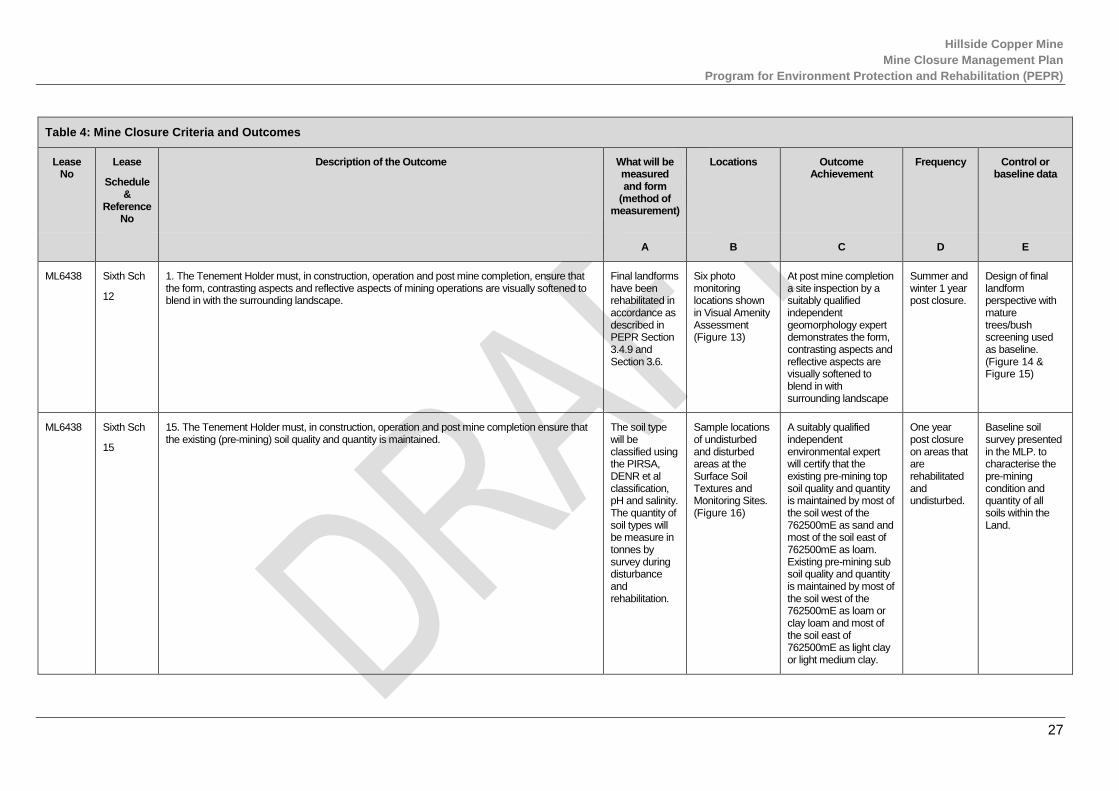
ML6438 Sixth Sch
12
1. The Tenement Holder must, in construction, operation and post mine completion, ensure that the form, contrasting aspects and reflective aspects of mining operations are visually softened to blend in with the surrounding landscape.
Final landforms have been rehabilitated in accordance as described in PEPR Section 3.4.9 and Section 3.6.
Six photo monitoring locations shown in Visual Amenity Assessment (Figure 13)
At post mine completion a site inspection by a suitably qualified independent geomorphology expert demonstrates the form, contrasting aspects and reflective aspects are visually softened to blend in with surrounding landscape
Summer and winter 1 year post closure.
Design of final landform perspective with mature trees/bush screening used as baseline. (Figure 14 & Figure 15)
ML6438 Sixth Sch
15
15. The Tenement Holder must, in construction, operation and post mine completion ensure that the existing (pre-mining) soil quality and quantity is maintained.
The soil type will be classified using the PIRSA, DENR et al classification, pH and salinity. The quantity of soil types will be measure in tonnes by survey during disturbance and rehabilitation.
Sample locations of undisturbed and disturbed areas at the Surface Soil Textures and Monitoring Sites. (Figure 16)
A suitably qualified independent environmental expert will certify that the existing pre-mining top soil quality and quantity is maintained by most of the soil west of the 762500mE as sand and most of the soil east of 762500mE as loam. Existing pre-mining sub soil quality and quantity is maintained by most of the soil west of the 762500mE as loam or clay loam and most of the soil east of 762500mE as light clay or light medium clay.
One year post closure on areas that are rehabilitated and undisturbed.
Baseline soil survey presented in the MLP. to characterise the pre-mining condition and quantity of all soils within the Land.

Hillside Copper Mine
Mine Closure Management Plan
Program for Environment Protection and Rehabilitation (PEPR)
28
Table 4: Mine Closure Criteria and Outcomes
Lease No
Lease
Schedule &
Reference No
Description of the Outcome What will be measured and form
(method of measurement)
Locations Outcome Achievement
Frequency Control or baseline data
A B C D E
ML6438 Sixth Sch
19
19. The Tenement Holder must ensure that the WRD and TSF final landforms will be physically stable post mine completion.
Annual aerial and ground surveys of mine surface (height mRL) at closure of final landform shape.
Aerial and ground locations/contours on the WRD (RSF) and TSF to be shown in the Mine Closure Contours map
(Figure 17)
The WRD and TSF has had no significant movement and is considered by an independent geotechnical and geomorphological expert to be stable.
Annually one year post closure.
Final rehabilitation design shape.
ML6438 Sixth Sch
20
20. The Tenement Holder must, in construction, operation and post mine completion, ensure that water seepage from the TSF, WRD’s or ore stockpiles does not result in adverse impacts on adjacent land uses including, but not limited to, growth of native vegetation and cropping land.
Water direction, flow rate (l/s), water quality (salinity, pH and metal concentrations (as per Table 7, GWMP).
Ground water monitoring holes, shown in the Ground Water Monitoring Location Plan. (Figure 18)
Independent qualified expert verifies that there is no water seepage from the TSF, WRD’s or ore stockpiles that results in adverse impacts on adjacent land uses including, but not limited to, growth of native vegetation and cropping land.
Water seepage measured monthly during operations and bi-annual one year post closure.
Modelled and measured ground water flow direction, quantity and quality from the GWMP.
ML6438 Sixth Sch
22
22. The Tenement Holder must, in construction, operation and post mine completion, ensure no loss of abundance or diversity of native vegetation on or off the Land through: 2. The Tenement Holder must, in construction, operation and post mine completion, ensure no loss of abundance or diversity of native vegetation on or off the Land through: 22.1. Clearance, 22.2. dust/contaminant deposition, 22.3. fire, 22.4. reduction in water supply, or 22.5. other damage, unless prior approval under the relevant legislation is obtained.
Native vegetation abundance and diversity through the walk linear transects.
Areas specified in the Native Vegetation Monitoring Sites
(Figure 9)
No Loss of abundance or diversity of native vegetation compared to the baseline data.
Annual (Spring) plus one year post closure.
Vegetation baseline survey conducted prior to commencement of operations Appendix 5-12 in the MLP
Hillside Copper Mine
Mine Closure Management Plan
Program for Environment Protection and Rehabilitation (PEPR)
29
Table 4: Mine Closure Criteria and Outcomes
Lease No
Lease
Schedule &
Reference No
Description of the Outcome What will be measured and form
(method of measurement)
Locations Outcome Achievement
Frequency Control or baseline data
A B C D E
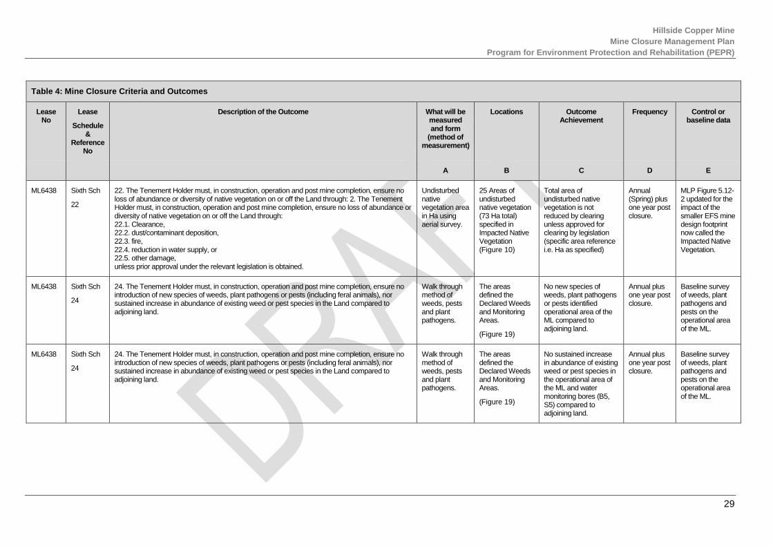
ML6438 Sixth Sch
22
22. The Tenement Holder must, in construction, operation and post mine completion, ensure no loss of abundance or diversity of native vegetation on or off the Land through: 2. The Tenement Holder must, in construction, operation and post mine completion, ensure no loss of abundance or diversity of native vegetation on or off the Land through: 22.1. Clearance, 22.2. dust/contaminant deposition, 22.3. fire, 22.4. reduction in water supply, or 22.5. other damage, unless prior approval under the relevant legislation is obtained.
Undisturbed native vegetation area in Ha using aerial survey.
25 Areas of undisturbed native vegetation (73 Ha total) specified in Impacted Native Vegetation (Figure 10)
Total area of undisturbed native vegetation is not reduced by clearing unless approved for clearing by legislation (specific area reference i.e. Ha as specified)
Annual (Spring) plus one year post closure.
MLP Figure 5.12-2 updated for the impact of the smaller EFS mine design footprint now called the Impacted Native Vegetation.
ML6438 Sixth Sch
24
24. The Tenement Holder must, in construction, operation and post mine completion, ensure no introduction of new species of weeds, plant pathogens or pests (including feral animals), nor sustained increase in abundance of existing weed or pest species in the Land compared to adjoining land.
Walk through method of weeds, pests and plant pathogens.
The areas defined the Declared Weeds and Monitoring Areas.
(Figure 19)
No new species of weeds, plant pathogens or pests identified operational area of the ML compared to adjoining land.
Annual plus one year post closure.
Baseline survey of weeds, plant pathogens and pests on the operational area of the ML.
ML6438 Sixth Sch
24
24. The Tenement Holder must, in construction, operation and post mine completion, ensure no introduction of new species of weeds, plant pathogens or pests (including feral animals), nor sustained increase in abundance of existing weed or pest species in the Land compared to adjoining land.
Walk through method of weeds, pests and plant pathogens.
The areas defined the Declared Weeds and Monitoring Areas.
(Figure 19)
No sustained increase in abundance of existing weed or pest species in the operational area of the ML and water monitoring bores (B5, S5) compared to adjoining land.
Annual plus one year post closure.
Baseline survey of weeds, plant pathogens and pests on the operational area of the ML.
Hillside Copper Mine
Mine Closure Management Plan
Program for Environment Protection and Rehabilitation (PEPR)
30
Table 4: Mine Closure Criteria and Outcomes
Lease No
Lease
Schedule &
Reference No
Description of the Outcome What will be measured and form
(method of measurement)
Locations Outcome Achievement
Frequency Control or baseline data
A B C D E
ML6438 Sixth Sch
26
26. The Tenement Holder must ensure no loss of abundance and diversity of marine flora and fauna from contaminants and dust deposition resulting from mining operations, during operations and post mine completion.
Copper content in marine sediment, Sea grass abundance, diversity using linear transects, Coastal gully using photo point survey, Coastal survey using walk through method.
Location points specified in the Coastal and Marine Monitoring Locations. (Figure 20)
Independent Marine Biologist verifies no loss of abundance and diversity of marine flora and fauna from contaminants and dust deposition resulting from mining operations, during operations and post mine completion.
Annual plus one year post closure.
Baseline study of flora and fauna at the locations specified in the MLP
ML6438 Sixth Sch
38
38. The Tenement Holder must demonstrate that post mine completion, the risks to the health and safety of the public so far as it may be affected by mining operations are as low as reasonably practicable.
Survey the height of the abandonment bunds from ground level in (m).
Areas specified in Abandonment Bunds and Geotechnical Monitoring at Mine Closure.
(Figure 21)
Post closure audit by a suitably qualified independent expert of pit abandonment bund survey to show access to the public kept as low as reasonably practical.
One year post closure.
During mine closure, abandonment bunds of at least 2m in height is placed around the open pit void and an abandonment bund at least 1m high is placed around the Throoka Creek diversion drain.

Hillside Copper Mine
Mine Closure Management Plan
Program for Environment Protection and Rehabilitation (PEPR)
31
Table 4: Mine Closure Criteria and Outcomes
Lease No
Lease
Schedule &
Reference No
Description of the Outcome What will be measured and form
(method of measurement)
Locations Outcome Achievement
Frequency Control or baseline data
A B C D E
ML6438 Sixth Sch
38
38. The Tenement Holder must demonstrate that post mine completion, the risks to the health and safety of the public so far as it may be affected by mining operations are as low as reasonably practicable.
The height of the abandonment bund from ground level in (m) via survey using electronic distance measurement.
Areas specified in Abandonment Bunds and Geotechnical Monitoring at Mine Closure.
(Figure 21)
Post closure audit by a suitably qualified independent expert of pit ramp abandonment bund survey to show access to the public kept as low as reasonably practical.
One year post closure.
After final closure a pit ramp access abandonment bund 2m in height with a with 1:2 slope is placed at the access point to the pit to prevent easy access down the ramp to the pit lake.
ML6438 Sixth Sch
38
38. The Tenement Holder must demonstrate that post mine completion, the risks to the health and safety of the public so far as it may be affected by mining operations are as low as reasonably practicable.
The displacement of prisms in (m) on abandonment bunds using survey.
Areas specified in Abandonment Bunds and Geotechnical Monitoring at Mine Closure.
(Figure 21)
An independent geotechnical expert verifies the risks to the health and safety of the public so far as it may be affected by mining operations caused by ground instability are as low as reasonably practicable.
Annually plus one year post closure.
AMC Consultant’s modelling of the pit wall displacement at the transects shows a displacement between 0-400mm over 16 years in line with a long term stable wall.
ML6438 Sixth Sch
43
3. The Tenement Holder must, in construction, operation and post mine completion, ensure no impacts to agricultural productivity for third party land users on or off the Land as a result of mining operations, including: 3.1. Reduction in crop yield; 3.2. reduction in grain quality; or 3.3. adverse health impacts to livestock
PM10 dust levels using BAM monitors.
Monitors as per Air Quality Monitoring Plan and Wind Directions
(Figure 11)
No impacts to agricultural productivity for third party land users on or off the Land as a result of mining operations, including: 3.1. Reduction in crop yield; 3.2. reduction in grain
Measure
ments taken at intervals of not more than 10 minutes reported as a 24-hour
All areas outside the mine operational area have a PM10 below 150ug/m3 for all 24 hour periods (midnight to midnight).

Hillside Copper Mine
Mine Closure Management Plan
Program for Environment Protection and Rehabilitation (PEPR)
32
Table 4: Mine Closure Criteria and Outcomes
Lease No
Lease
Schedule &
Reference No
Description of the Outcome What will be measured and form
(method of measurement)
Locations Outcome Achievement
Frequency Control or baseline data
A B C D E
quality; or 3.3. adverse health impacts to livestock
midnight to midnight average for one-year post closure.
ML6438 Sixth Sch
43
3. The Tenement Holder must, in construction, operation and post mine completion, ensure no impacts to agricultural productivity for third party land users on or off the Land as a result of mining operations, including: 3.1. Reduction in crop yield; 3.2. reduction in grain quality; or 3.3. adverse health impacts to livestock
Measure of mg/kg of copper in wheat and barley as per standard grain quality testing procedure.
Areas specified in Crop Quality Monitoring Area on the ML. (Figure 12)
No impacts to agricultural productivity for third party land users on or off the Land as a result of mining operations, including reduction in grain quality with maximum residual copper below the limit measured at an external laboratory.
Annual at harvest plus one year post closure.
Maximum Residue Limits for copper in grain (Barley and Wheat) of 10mg/kg of harvested grain.
ML6438 Sixth Sch
43
3. The Tenement Holder must, in construction, operation and post mine completion, ensure no impacts to agricultural productivity for third party land users on or off the Land as a result of mining operations, including: 3.1. Reduction in crop yield; 3.2. reduction in grain quality; or 3.3. adverse health impacts to livestock
Resolution of all issues regarding adverse health impacts to livestock recorded in the complaints register.
Locations specified in the landowner communication protocol
Post closure audit by a suitably qualified independent expert of the complaints register shows no unresolved issues regarding adverse health impacts to livestock.
One year post closure audit report of the complaint register.
Cases of adverse impact on health impacts to livestock of third party land users on an off the Land received before construction in the complaints register.

Hillside Copper Mine
Mine Closure Management Plan
Program for Environment Protection and Rehabilitation (PEPR)
33
Table 4: Mine Closure Criteria and Outcomes
Lease No
Lease
Schedule &
Reference No
Description of the Outcome What will be measured and form
(method of measurement)
Locations Outcome Achievement
Frequency Control or baseline data
A B C D E
ML6438 Sixth Sch
45
45. The Tenement Holder must, during construction, operation and post mine completion, ensure that as a result of a geotechnical failure caused by mining; 45.1. there are no adverse impacts to adjacent land use; and 45.2. there is no unauthorised damage to public or private property and infrastructure.
The displacement of prisms in (m) on abandonment bunds using survey.
Areas specified in Abandonment Bunds and Geotechnical Monitoring at Mine Closure.
(Figure 21)
An independent geotechnical expert verifies there on no adverse impacts to adjacent land use and no unauthorised damage to public or private property or infrastructure as a result of geotechnical failure.
One year post closure.
AMC Consultant’s modelling of the pit wall displacement at the transects shows a displacement between 0-400mm over 16 years in line with a long term stable wall.
EML6439 Sixth Sch
1
Air Quality Outcome 1. The Tenement Holder must, in construction, operation and post mine completion, ensure that there are no public health and/or public nuisance impacts from air emissions and/or dust generated by mining operations.
Dust type and method of measurement as per Air Quality Monitoring Plan.
Monitors as per Air Quality Monitoring Plan and Wind Directions
(Figure 11)
No public health or public nuisance impacts from air emissions and/or dust generated by mining activities.
Frequency defined the AQMP plus 6 months post closure.
ML Air Quality Conditions
EML6439 Sixth Sch
4
Visual Amenity Outcome 4. The Tenement Holder must, in construction, operation and post mine completion, ensure that the form, contrasting aspects and reflective aspects of mining operations are visually softened to blend in with the surrounding landscape.
Survey height metres and location of stockpiles
Six photo monitoring locations shown in Visual Amenity Assessment (Figure 13)
Site inspection by suitably qualified independent expert confirms that all stockpiles are removed from the EML post closure.
At road diversion project closure.
Baseline survey shows no road diversion stockpiles are present on the EML.

Hillside Copper Mine
Mine Closure Management Plan
Program for Environment Protection and Rehabilitation (PEPR)
34
Table 4: Mine Closure Criteria and Outcomes
Lease No
Lease
Schedule &
Reference No
Description of the Outcome What will be measured and form
(method of measurement)
Locations Outcome Achievement
Frequency Control or baseline data
A B C D E
EML6439 Sixth Sch
6
Soil and Land Disturbance Outcome 6. The Tenement Holder must, in construction, operation and post mine completion, ensure that the existing (pre-mining) soil quality and quantity is maintained.
The soil type will be classified using the PIRSA, DENR et al classification, pH and salinity. The quantity of soil types will be measure in tonnes by survey during disturbance and rehabilitation.
Sample locations of undisturbed and disturbed areas at the Surface Soil Textures and Monitoring Sites. (Figure 16)
A suitably qualified independent environmental expert will certify that the existing pre-mining top soil quality and quantity is maintained by most of the soil west of the 762500mE as sand and most of the soil east of 762500mE as loam. Existing pre-mining sub soil quality and quantity is maintained by most of the soil west of the 762500mE as loam or clay loam and most of the soil east of 762500mE as light clay or light medium clay.
One year post closure on areas that are rehabilitated and undisturbed.
Baseline soil survey presented in the MLP. to characterise the pre-mining condition and quantity of all soils within the Land.
EML6439 Sixth Sch
7
Native Vegetation Outcome 7. The Tenement Holder must not clear any native vegetation on the Land other than in accordance with the realignment of the St Vincent Highway and the realignment of the Yorke Highway.
Not Applicable Not Applicable No native vegetation left as all will be cleared from ML with SEB offset.
Not Applicable
Not Applicable
EML6439 Sixth Sch
8
Weeds, Pest and Pathogens Outcome 8. The Tenement Holder must, in construction, operation and post mine completion, ensure no introduction of new species of weeds, plant pathogens or pests (including feral animals), nor sustained increase in abundance of existing weed or pest species on the Land compared to adjoining land.
Walk through method of weeds, pests and plant pathogens.
The areas defined the Declared Weeds and Monitoring Areas.
(Figure 19)
No sustained increase in abundance of existing weed or pest species in the operational area of the ML compared to adjoining land.
Biannual three years post closure.
Baseline survey conducted for the MLP of weeds, plant pathogens and pests on the operational area of the ML, EML
Hillside Copper Mine
Mine Closure Management Plan
Program for Environment Protection and Rehabilitation (PEPR)
35
Table 4: Mine Closure Criteria and Outcomes
Lease No
Lease
Schedule &
Reference No
Description of the Outcome What will be measured and form
(method of measurement)
Locations Outcome Achievement
Frequency Control or baseline data
A B C D E
and adjacent areas.

Hillside Copper Mine
Mine Closure Management Plan
Program for Environment Protection and Rehabilitation (PEPR)
36
11. REPORTING
The Hillside Mine will report on the performance of the MCMP in the ACR this will be provided to the
HMCV and made available for public information on the Rex Minerals website.
12. PERFORMANCE INDICATORS
The following performance indicators will be measured against the ML and EML conditions:
Compliance with relevant mine closure standards at the mine closure domains listed in section 7.
Minimisation of mine closure complaints as evidenced by trends in the frequency and extent of complaints.
Compliance with this Plan, as indicated by internal and statutory reporting.
13. CONTINUAL IMPROVEMENT
The Hillside Mine will strive to continually improve on the mine’s environmental performance by applying
the principles of best practice to mining operations, including where cost-effective and practicable, the
adoption of new best practice technologies and improved mine closure control measures.
14. REVIEW
This Plan will be reviewed, and if necessary revised, to the satisfaction of the DPC and in consultation
with relevant government agencies, in accordance with the requirements relating to PEPR review, update
and approval:
following changes to project approval or licence conditions relating to mine closure management or
monitoring;
following any significant mine closure related incident;
when a relevant/significant improvement has been identified;
for necessary or any unforeseen changes to mine closure domains;
where a risk assessment identifies the requirement to alter the Plan;
annually.
15. REFERENCES
Assessment Report Pit Lake Water Chemistry Post Closure by Logsdon 2014.
Safety Bund Wall Around Abandoned Open Pit Mines guidelines, WA Dept. Industry and Resources document ZMA048HA.1997.

Hillside Copper Mine
Mine Closure Management Plan
Program for Environment Protection and Rehabilitation (PEPR)
37
16. APPENDICES
Appendix 1: Maps / Sections / Images
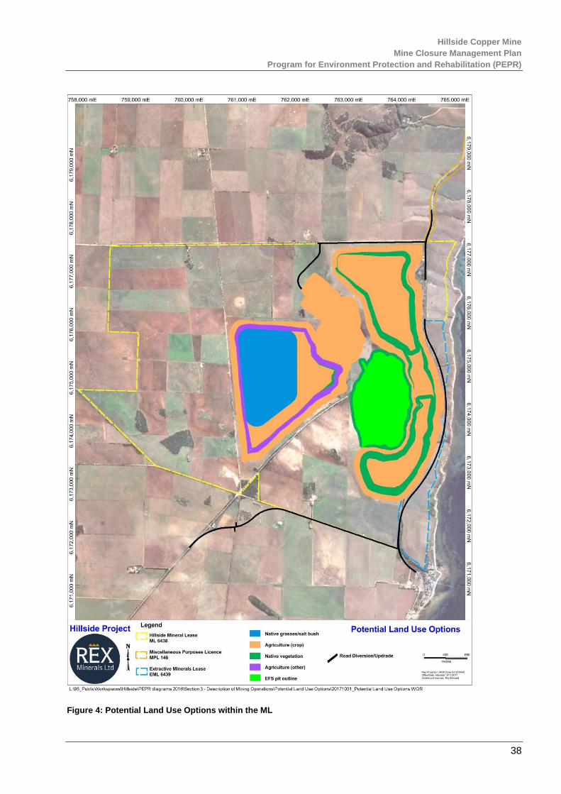
Hillside Copper Mine
Mine Closure Management Plan
Program for Environment Protection and Rehabilitation (PEPR)
38
Figure 4: Potential Land Use Options within the ML
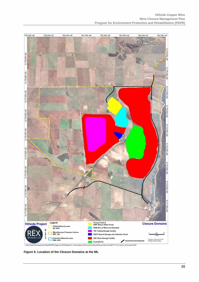
Hillside Copper Mine
Mine Closure Management Plan
Program for Environment Protection and Rehabilitation (PEPR)
39
Figure 5: Location of the Closure Domains at the ML
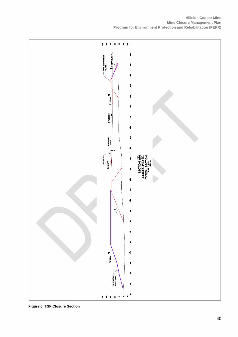
Hillside Copper Mine
Mine Closure Management Plan
Program for Environment Protection and Rehabilitation (PEPR)
40
Figure 6: TSF Closure Section

Hillside Copper Mine
Mine Closure Management Plan
Program for Environment Protection and Rehabilitation (PEPR)
41
Figure 7: TSF Spillway Configuration
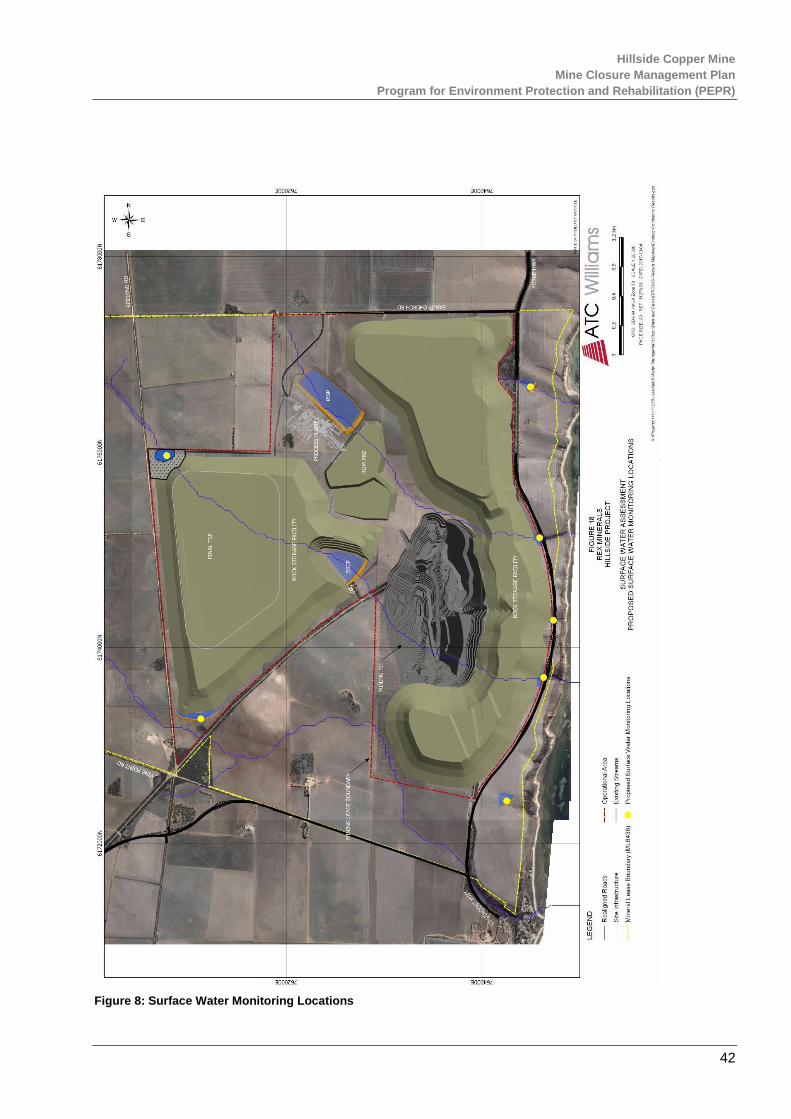
Hillside Copper Mine
Mine Closure Management Plan
Program for Environment Protection and Rehabilitation (PEPR)
42
Figure 8: Surface Water Monitoring Locations

Hillside Copper Mine
Mine Closure Management Plan
Program for Environment Protection and Rehabilitation (PEPR)
43
Figure 9: Native Vegetation Monitoring Sites

Hillside Copper Mine
Mine Closure Management Plan
Program for Environment Protection and Rehabilitation (PEPR)
44
Figure 10: Impacted Native Vegetation

Hillside Copper Mine
Mine Closure Management Plan
Program for Environment Protection and Rehabilitation (PEPR)
45
Figure 11: Air Quality Monitoring Plan & Prevailing Wind Directions

Hillside Copper Mine
Mine Closure Management Plan
Program for Environment Protection and Rehabilitation (PEPR)
46
Figure 12: Crop Quality Monitoring Area

Hillside Copper Mine
Mine Closure Management Plan
Program for Environment Protection and Rehabilitation (PEPR)
47
Figure 13: Visual Amenity Assessment
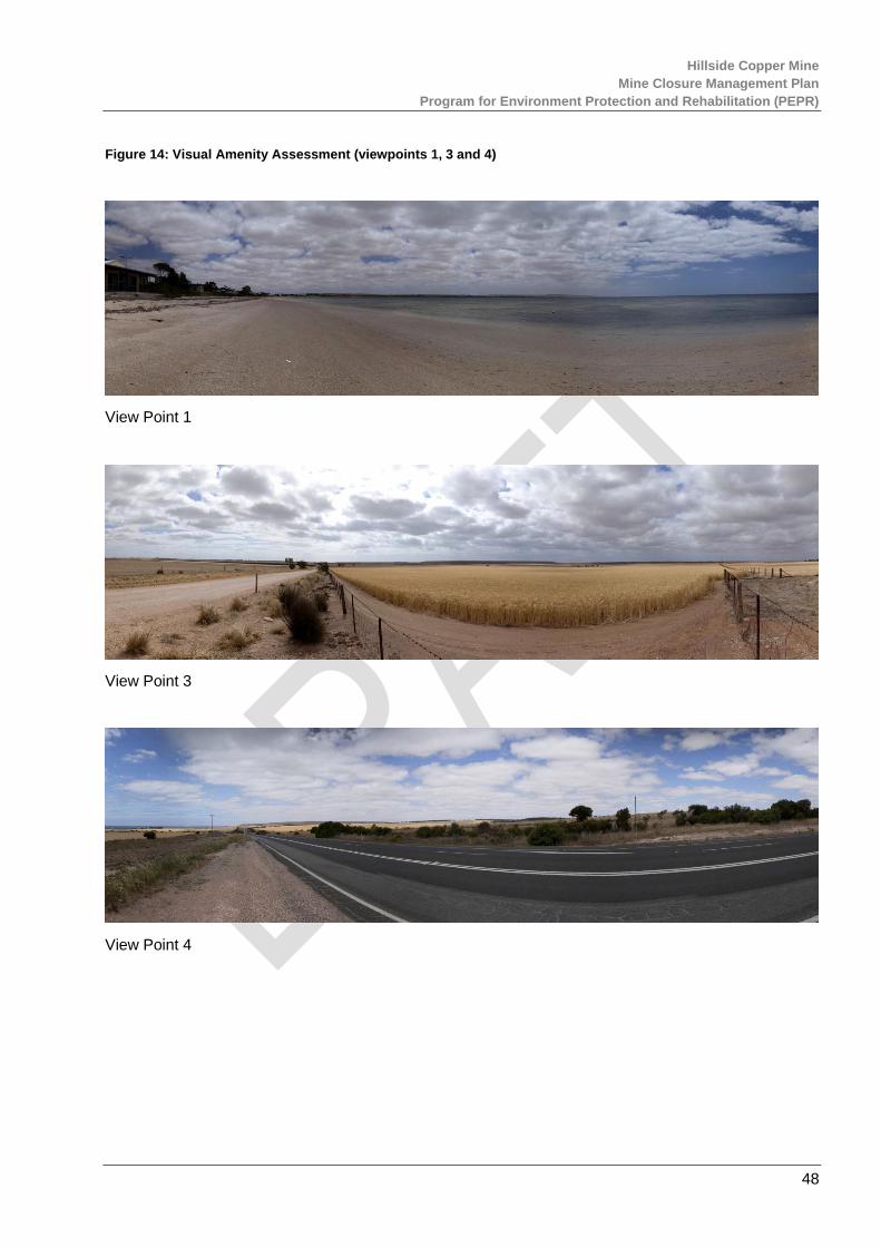
Hillside Copper Mine
Mine Closure Management Plan
Program for Environment Protection and Rehabilitation (PEPR)
48
Figure 14: Visual Amenity Assessment (viewpoints 1, 3 and 4)
View Point 1
View Point 3
View Point 4
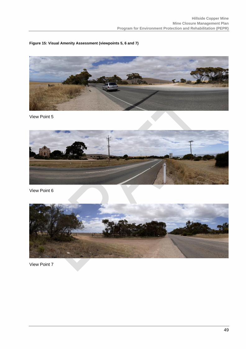
Hillside Copper Mine
Mine Closure Management Plan
Program for Environment Protection and Rehabilitation (PEPR)
49
Figure 15: Visual Amenity Assessment (viewpoints 5, 6 and 7)
View Point 5
View Point 6
View Point 7

Hillside Copper Mine
Mine Closure Management Plan
Program for Environment Protection and Rehabilitation (PEPR)
50
Figure 16: Surface Soil Textures & Monitoring Sites
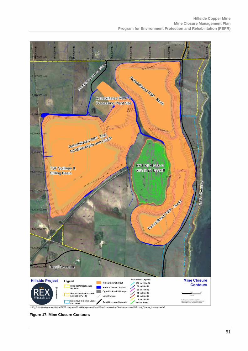
Hillside Copper Mine
Mine Closure Management Plan
Program for Environment Protection and Rehabilitation (PEPR)
51
Figure 17: Mine Closure Contours

Hillside Copper Mine
Mine Closure Management Plan
Program for Environment Protection and Rehabilitation (PEPR)
52
Figure 18: Groundwater Monitoring Location Plan (Inc. PAF & NMD placement)
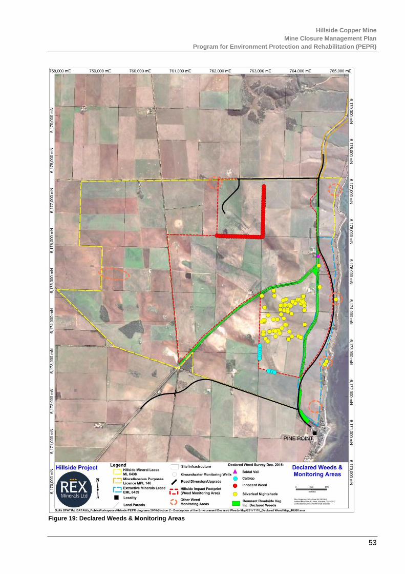
Hillside Copper Mine
Mine Closure Management Plan
Program for Environment Protection and Rehabilitation (PEPR)
53
Figure 19: Declared Weeds & Monitoring Areas
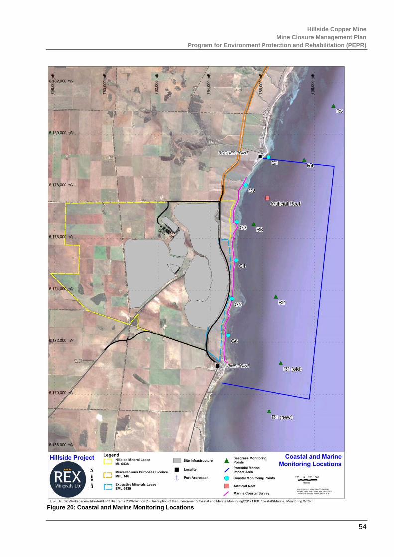
Hillside Copper Mine
Mine Closure Management Plan
Program for Environment Protection and Rehabilitation (PEPR)
54
Figure 20: Coastal and Marine Monitoring Locations
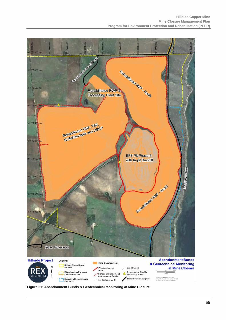
Hillside Copper Mine
Mine Closure Management Plan
Program for Environment Protection and Rehabilitation (PEPR)
55
Figure 21: Abandonment Bunds & Geotechnical Monitoring at Mine Closure

Hillside Copper Mine
Mine Closure Management Plan
Program for Environment Protection and Rehabilitation (PEPR)
56
Appendix 2: Correspondence Records
Key relevant communications with DPC and the community relating to this management plan are detailed below.
Date Communication with Action or Outcomes
7/11/17 DPC Meeting
13/11/17 HMCV Draft Plan forwarded for listing on HMCV website
13/11/17 DPC Draft Plan forwarded to DPC
Related Documents