Vol.:(0123456789) 1 3 Alp Botany (2017) 127:133–144 DOI 10.1007/s00035-017-0184-z ORIGINAL ARTICLE Migration corridors for alpine plants among the ‘sky islands’ of eastern Africa: do they, or did they exist? Desalegn Chala 1 · Niklaus E. Zimmermann 2 · Christian Brochmann 1 · Vegar Bakkestuen 1,3 Received: 12 July 2016 / Accepted: 4 January 2017 / Published online: 8 February 2017 © Swiss Botanical Society 2017 We estimated that the LGM treeline was about 1000 m lower and the alpine habitat was about eight times larger than that today. At the LGM, we found that most of the currently fragmented alpine habitat of the Ethiopian high- lands was interconnected except across the Great Rift Val- ley, whereas the solitary mountains of East/Central Africa remained isolated for exclusively alpine species. However, for drought-tolerant alpine species that today extend below the treeline, gradual migration through habitat corridors may have been possible among mountains during the dry glacial periods, and possibly also under the current climate before agriculture transformed the low-lying landscapes. Keywords Afroalpine · CART · Gene flow · Habitat connectivity · Last glacial maximum · Treeline Introduction Fragmented landscapes and isolated islands have been a central topic in evolutionary and biogeographic research since Darwin (1859) and Wallace (1876). In eastern Africa, the tropical alpine habitat with its high degree of endemism and peculiar life forms is today restricted to the highest mountain peaks. It represents a highly fragmented biological ‘sky island’ system, where populations of frost- tolerant alpine organisms are isolated from each other by tropical lowlands. A long-standing question in African biogeography is whether colonization of the mountains and subsequent intermountain gene flow mainly depend on long-distance dispersal across unsuitable lowland habitat, or whether gradual migration has been possible through habitat bridges under colder climates in the past, when the afroalpine habitat extended to lower altitudes than that today (Coetzee 1964). Here we address this question based Abstract The tropical alpine ecosystem in eastern Africa is highly fragmented among biological ‘sky islands’, where populations of frost-tolerant organisms are isolated from each other by a ‘sea’ of tropical lowlands. One-third of the species in the afroalpine flora are exclusively alpine, but the other species can to varying degrees extend into grasslands and open forests of lower vegetation belts. A long-debated question is whether colonization of the alpine zone of these mountains and subsequent intermountain gene flow entirely depend on long-distance dispersal across unsuita- ble habitats, or whether suitable habitats shifted far enough downslope under past colder climates to form bridges ena- bling gradual migration. Here we address this question using a classification tree model. We mapped the extent of the current alpine habitat and projected it to the last gla- cial maximum (LGM) climate to assess whether gradual migration was possible for exclusively alpine taxa during this glacial period, and thus potentially also during earlier Pleistocene glaciations. Next, we modelled landcover under current and LGM climates to assess whether grassland and open forests could have served as migration corridors for alpine taxa that today extend into lower vegetation belts. Electronic supplementary material The online version of this article (doi:10.1007/s00035-017-0184-z) contains supplementary material, which is available to authorized users. * Desalegn Chala [email protected]; [email protected] 1 Natural History Museum, University of Oslo, PO Box 1172, Blindern, 0318 Oslo, Norway 2 Swiss Federal Research Institute WSL, Zürcherstrasse 111, 8903 Birmensdorf, Switzerland 3 Norwegian Institute for Nature Research, Gaustadalléen 21, 0349 Oslo, Norway

Welcome message from author
This document is posted to help you gain knowledge. Please leave a comment to let me know what you think about it! Share it to your friends and learn new things together.
Transcript
Vol.:(0123456789)1 3
Alp Botany (2017) 127:133–144 DOI 10.1007/s00035-017-0184-z
ORIGINAL ARTICLE
Migration corridors for alpine plants among the ‘sky islands’ of eastern Africa: do they, or did they exist?
Desalegn Chala1 · Niklaus E. Zimmermann2 · Christian Brochmann1 · Vegar Bakkestuen1,3
Received: 12 July 2016 / Accepted: 4 January 2017 / Published online: 8 February 2017 © Swiss Botanical Society 2017
We estimated that the LGM treeline was about 1000 m lower and the alpine habitat was about eight times larger than that today. At the LGM, we found that most of the currently fragmented alpine habitat of the Ethiopian high-lands was interconnected except across the Great Rift Val-ley, whereas the solitary mountains of East/Central Africa remained isolated for exclusively alpine species. However, for drought-tolerant alpine species that today extend below the treeline, gradual migration through habitat corridors may have been possible among mountains during the dry glacial periods, and possibly also under the current climate before agriculture transformed the low-lying landscapes.
Keywords Afroalpine · CART · Gene flow · Habitat connectivity · Last glacial maximum · Treeline
Introduction
Fragmented landscapes and isolated islands have been a central topic in evolutionary and biogeographic research since Darwin (1859) and Wallace (1876). In eastern Africa, the tropical alpine habitat with its high degree of endemism and peculiar life forms is today restricted to the highest mountain peaks. It represents a highly fragmented biological ‘sky island’ system, where populations of frost-tolerant alpine organisms are isolated from each other by tropical lowlands. A long-standing question in African biogeography is whether colonization of the mountains and subsequent intermountain gene flow mainly depend on long-distance dispersal across unsuitable lowland habitat, or whether gradual migration has been possible through habitat bridges under colder climates in the past, when the afroalpine habitat extended to lower altitudes than that today (Coetzee 1964). Here we address this question based
Abstract The tropical alpine ecosystem in eastern Africa is highly fragmented among biological ‘sky islands’, where populations of frost-tolerant organisms are isolated from each other by a ‘sea’ of tropical lowlands. One-third of the species in the afroalpine flora are exclusively alpine, but the other species can to varying degrees extend into grasslands and open forests of lower vegetation belts. A long-debated question is whether colonization of the alpine zone of these mountains and subsequent intermountain gene flow entirely depend on long-distance dispersal across unsuita-ble habitats, or whether suitable habitats shifted far enough downslope under past colder climates to form bridges ena-bling gradual migration. Here we address this question using a classification tree model. We mapped the extent of the current alpine habitat and projected it to the last gla-cial maximum (LGM) climate to assess whether gradual migration was possible for exclusively alpine taxa during this glacial period, and thus potentially also during earlier Pleistocene glaciations. Next, we modelled landcover under current and LGM climates to assess whether grassland and open forests could have served as migration corridors for alpine taxa that today extend into lower vegetation belts.
Electronic supplementary material The online version of this article (doi:10.1007/s00035-017-0184-z) contains supplementary material, which is available to authorized users.
* Desalegn Chala [email protected]; [email protected]
1 Natural History Museum, University of Oslo, PO Box 1172, Blindern, 0318 Oslo, Norway
2 Swiss Federal Research Institute WSL, Zürcherstrasse 111, 8903 Birmensdorf, Switzerland
3 Norwegian Institute for Nature Research, Gaustadalléen 21, 0349 Oslo, Norway
134 Alp Botany (2017) 127:133–144
1 3
on a new analysis using alpine habitat and landcover type modelling and by hindcasting these models to the climate of the Last Glacial Maximum (LGM) to represent the gla-cial periods during the Pleistocene.
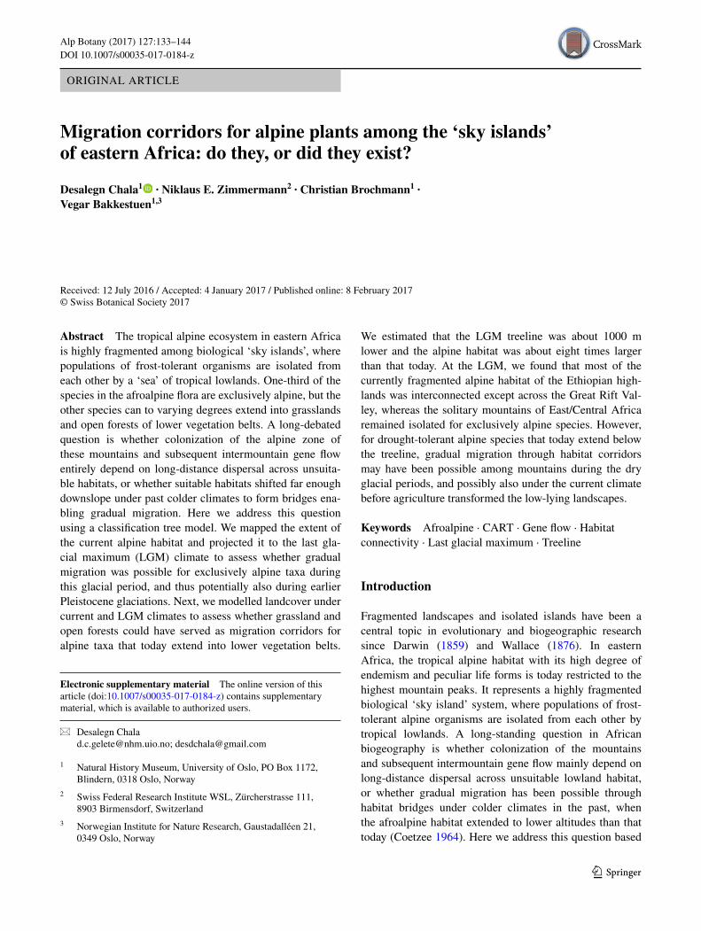
Tropical alpine ecosystems are shaped by unique cli-matic conditions, characterized by warm days alternating with freezing nights and little seasonal variation in temper-ature (Hedberg 1964; Rundel 1994). At tropical latitudes, only mountains reaching above the treeline at about 3500 m present such climatic conditions and support true alpine floras (Hedberg 1951). In eastern Africa, alpine ecosystems are found scattered in three major mountain regions, two of them located in Ethiopia and one in East/Central Africa. The contiguous and elevated Ethiopian Plateau is divided by the Great Rift Valley into one northwestern (NWE) and one southeastern (SEE) region, both characterized by high peaks and mountain ranges. The East/Central African (ECA) mountain region comprises several solitary high mountain peaks in Kenya, Tanzania, Uganda, Democratic Congo and Rwanda, separated from the Ethiopian moun-tains by the Turkana Lowlands (Fig. 1).
The high eastern African mountains harbour unique alpine floras and faunas. Endemism is remarkably high, 80% at the species level for vascular plants (Hedberg 1957;
Gehrke and Linder 2014) and 64% for mosses (Spence and Pocs 1988). In spite of the high degree of fragmentation, the mountain floras have many species in common and show close relationships with remote temperate regions in the northern and southern hemispheres (Hedberg 1951, 1970; Smith and Cleef 1988; Gehrke and Linder 2009). It has been suggested that the isolation among these moun-tain floras may be stronger than that among oceanic islands, where ocean currents may play a role as an interconnecting dispersal agent (Hedberg 1970). In particular, the Rift Val-ley is a prominent landscape feature which has long been considered to represent a strong barrier against gene flow (Hedberg 1970; Kebede et al. 2007; Gizaw et al. 2016). The Rift Valley is a continuous valley system, 6000 km in length, and runs from northern Syria in Asia to Mozam-bique in southeastern Africa, cutting through mountains and lowlands in eastern Africa. It was formed by volcanic processes that started many million years ago and con-tinued to be active well into the Pleistocene (Baker et al. 1972; Gehrke and Linder 2014).
How the sky island biotas evolved and how similari-ties among mountain systems were established and main-tained over time have been intensely discussed in the literature (Hedberg 1951, 1957, 1970; Smith and Cleef
Fig. 1 a Mountains and low-lying landscapes of eastern Africa. The eastern and western branches of the Great Rift Valley are indicated with stippled lines. b Potential habitat corridors for drought-tolerant
alpine species that today extend below the treeline, assessed based on landcover modelling (line thickness indicates potential corridor suit-ability)
135Alp Botany (2017) 127:133–144
1 3
1988; Harmsen et al. 1991; Gottelli et al. 2004; Koch et al. 2006; Ehrich et al. 2007; Umer et al. 2007; Popp et al. 2008; Gehrke and Linder 2009, 2011, 2014; Sklenář et al. 2014). The proportion of shared species generally correlates with the geographic distance among the moun-tains (Gehrke and Linder 2014; Sklenář et al. 2014). The more geographically isolated the mountains are, the more endemic taxa they harbour and the poorer they are in spe-cies number (Smith and Cleef 1988; Harmsen et al. 1991; Gehrke and Linder 2014). Colonization patterns thus seem to be closely associated with geographic distance. However, the patterns of genetic structuring and diversity within species seem to be more complex. Recent phyloge-ographic studies suggest that afroalpine species may have a dynamic history with periods of allopatric divergence often interrupted by repeated intermountain dispersal and hybridization, but the inferred histories differ consider-ably from species to species and among different moun-tains (Assefa et al. 2007; Ehrich et al. 2007; Gizaw et al. 2013, 2016; Masao et al. 2013; Wondimu et al. 2014). In some species, populations inhabiting distant mountains are genetically very similar, suggesting recent coloniza-tion or extensive gene flow. Two species that also extend to lower vegetation belts in the mountains show no geo-graphic structuring of their genetic diversity at all (Gizaw et al. 2013; Masao et al. 2013), possibly indicating that habitat connectivity through lowland corridors has been more important than long-distance dispersal.
The Pleistocene ice ages were distinct climatic events during the past 700,000 years also in eastern Africa. The vegetation belts in the mountains were oscillating in response to the changing climate, but few details are known (Bonnefille et al. 1990; deMenocal 1995; Shanahan and Zreda 2000; Thompson et al. 2002). Pollen analyses show that the African tropics were colder and drier than today during the last glaciation (Bonnefille et al. 1990; Mark and Osmaston 2008) and that the alpine zone in East Africa may have descended as much as 1000 m (Coetzee 1964). The treeline started to rise soon after the start of the Hol-ocene (11,200 cal BP) following the increase in tempera-ture and moisture and soon reached its current elevation (Umer et al. 2007). Globally, the natural treeline is asso-ciated with an isoline average temperature of 6.4 ± 0.7 °C during a growing season that lasts at least 90 days (Körner 2012). In the tropics, there is only little seasonal variation in temperature and the growing season, therefore, lasts the whole year with respect to temperature (Rundel 1994; Körner and Paulsen 2004). In our study area, the annual temperature is highly correlated with seasonal temperatures (Fig. S1, Table S1) and can, therefore, be used as a proxy for the temperature of the growing season. In tropical east-ern Africa, the temperature was reconstructed to have been 4.0 ± 2.0 °C lower during the LGM than today (Bonnefille
et al. 1990). The LGM temperature reported by Schneider von Deimling et al. (2006) falls within the same range.
Despite shifting to lower altitudes during cold periods, the afroalpine belt in East/Central Africa has been thought to have been isolated since its origin (Hedberg 1970; Harm-sen et al. 1991). This may be true for these solitary moun-tains, but it remains uncertain as to what degree this also holds for the alpine habitat in Ethiopia. In Ethiopia, vast landmasses are found at high elevations and the current alpine habitat exists on punctuated volcanic uplifts. It is, therefore, possible that the alpine zone of most of the high Ethiopian mountains became interconnected and formed one continuous habitat, at least on each side of the Rift Val-ley under colder climates.
The possibility for gradual migration through habitat corridors between the eastern African mountains under colder climates may, however, have varied considerably among different afroalpine species, which show large vari-ation in their lower elevation boundaries under the cur-rent climate. While some species are confined to areas above 4500 m, others extend into afromontane grass-lands and open montane forests, and some of them have been observed as low as 1000 m (Hedberg 1970; Gehrke and Linder 2014). Only 169 (32%) of the species in the afroalpine flora are ‘exclusively alpine’ when defined by a lower elevation limit of 3200 m (Gehrke and Linder 2014). Thirty-six percent of the species not only occur below the afroalpine zone in eastern Africa but also in tropical coun-tries that lack mountains characterized by alpine climate (Gehrke and Linder 2014). Depending on their individual traits and habitat requirements, it may thus have been pos-sible for some ‘non-exclusively alpine’ species to disperse among mountains through non-alpine habitat corridors under colder climates, and possibly even under the current climate before the landscape was strongly transformed by agriculture. Strong isolation and migration solely via long-distance dispersal may thus be restricted to the one-third of the afroalpine species that are exclusively alpine and only occur in areas experiencing nightly frosts. Since most alpine species are adapted to grow in full sunlight, grass-lands at lower altitudes are candidate for serving as migra-tory corridor for the non-exclusively alpine species that are sufficiently drought-tolerant. For afroalpine species that today stretch to the lowermost altitudes even open forests may serve as migration corridor.
Here we explore the potential for past habitat connectiv-ity under the colder climate of the LGM, to represent also earlier glacial maxima during the Pleistocene, and assess whether gradual migration corridors can help explain pat-terns in floristic and genetic similarity among the three mountain regions as well as among individual mountains. We used a classification tree model to project the treeline position as well as the land cover distribution based on
136 Alp Botany (2017) 127:133–144
1 3
paleoclimate data. We modelled the extent of the current alpine habitat and projected it to the LGM climate to assess whether the alpine habitat was widespread enough to allow gradual intermountain migration of exclusively alpine spe-cies. Next, we modelled a suite of eastern African land-cover types both under current and LGM climates to assess whether grassland and open forest types may have served as migration corridors for non-exclusively alpine species, i.e. those that today extend downslope into to the montane forest and other lower elevation vegetation types.
Methods
Defining the alpine habitat in the study region
The alpine habitat in tropical Africa covers the area situated above approximately 3500 m (Hedberg 1951). We used this elevation as a cut-off value and classified the study area into alpine and non-alpine landcover units based on the 1-km resolution DEM (Hijmans et al. 2005). We sampled both ‘alpine’ and ‘non-alpine’ habitat units randomly pro-portional to the log of their area (×1000) for generating a training and test dataset. We randomly split this dataset into 75% for training and 25% for testing.
Defining the landcover types in the study region
We used the 300-m resolution GlobCover dataset (Arino et al. 2012) to represent landcover types in our study area after simplifying and reclassifying it into seven general landcover units: (1) closed forest, (2) open for-est I, (3) open forest II, (4) shrub/grassland I, (5) shrub/grassland II, (6) flooded areas and (7) croplands and oth-ers. Almost all landcover types of the GlobCover dataset cover wide altitudinal ranges. Especially the landcover units that are categorized as open forest and shrub/grass-land are very heterogeneous in terms of their distribu-tion across elevation gradients (Figs. S1 & S2). Some of them are mainly confined to lower elevations, while oth-ers cover a large altitudinal span. To minimize hetero-geneity, those covering a large altitudinal span and thus potentially most suited as migration corridors for alpine species were reclassified as type I (shrub/grassland I and open forest I), and those mainly confined to lower eleva-tions and thus drier conditions were reclassified as type II (shrub/grassland II and open forest II; Table 1). We computed the area per landcover unit and sampled each unit randomly proportional to the log of its area (x1000) for generating a training and test dataset. The ‘croplands and other’ landcover unit was excluded from land cover
Table 1 Reclassification of GlobCover into eight classes of generalized landcover units used in the present paper
Generalized legend GlobCover Labels
Closed forest Closed (>40%) broadleaved deciduous forest (>5 m) 50Closed (>40%) needleleaved evergreen forest (>5 m) 70
Open forest I Closed to open (>15%) broadleaved evergreen or semi-deciduous forest (>5 m) 40Open (15–40%) broadleaved deciduous forest/woodland (>5 m) 60Closed to open (>15%) mixed broadleaved and needleleaved forest (>5 m) 100Mosaic forest or shrubland (50–70%) / grassland (20–50%) 110Closed to open (>15%) (broadleaved or needleleaved, evergreen or deciduous) shrubland (<5 m) 130
Open forest II Open (15–40%) needleleaved deciduous or evergreen forest (>5 m) 90Closed to open (>15%) herbaceous vegetation (grassland, savannas or lichens/mosses) 140
Shrub/grassland I Mosaic cropland (50–70%)/vegetation (grassland/shrubland/forest) (20–50%) 20Mosaic vegetation (grassland/shrubland/forest) (50–70%)/cropland (20–50%) 30
Shrub/grassland II Mosaic grassland (50–70%)/forest or shrubland (20–50%) 120Sparse (<15%) vegetation 150
Flooded areas Closed to open (>15%) broadleaved forest regularly flooded (semi-permanently or temporarily)—fresh or brackish water
160
Closed (>40%) broadleaved forest or shrubland permanently flooded—Saline or brackish water 170Closed to open (>15%) grassland or woody vegetation on regularly flooded or waterlogged soil—fresh,
brackish or saline water180
Croplands and others Post-flooding or irrigated croplands (or aquatic) 11Rainfed croplands 14Artificial surfaces and associated areas (Urban areas >50%) 190Bare areas 200Water bodies 210
137Alp Botany (2017) 127:133–144
1 3
reconstruction. Over the past 10,000 years, 50% of the ice-free terrestrial surface has been modified by humans, whereas there was little human influence prior to this period (Lambin et al. 2003). Cropland is a landcover type that has been converted from other landcover units. We decided to model ‘potential land cover units’ by let-ting other landcover units colonize the areas now cov-ered by cropland. All sample points were randomly split into 75% training and 25% test data.
Predictor variables
In order to model both alpine/non-alpine vegetation and the sampled landcover types, we used 19 bioclimatic var-iables of the current climate (~1 km resolution) obtained from the WorldClim database (Hijmans et al. 2005). We also used a DEM of ~1 km resolution from the same data source and generated two topographic variables, slope angle and slope aspect. The slope aspect was con-verted into eight categorical classes (N, NE, E, SE, S, SW, W, NW). We stacked the bioclimatic layers and the two topographic variables and overlaid the stacked ras-ter datasets with the randomly sampled points. These sample points now contained information about alpine vs. non-alpine classes for alpine habitat modelling and the six land cover units for landcover types as depend-ent variables and the 19 + 2 variables as independent predictors. Pairwise Pearson correlations were computed between all independent variables. For further analy-ses, we only retained predictor variables with a Pearson correlation threshold below |0.7| by selecting only one variable based on assumed biological importance among those correlated higher than this threshold. This resulted in ten variables selected for building both models (alpine habitat and landcover types; Fig. S3): slope angle, slope aspect, Annual Mean Temperature (BIO1), Mean Diur-nal Range (BIO2), Isothermality (BIO3), Precipitation Seasonality (Coefficient of Variation; BIO15), Precipi-tation of Wettest Quarter (Bio16), Precipitation of Dri-est Quarter (Bio17), precipitation of warmest quarter (BIO18) and precipitation of coldest quarter (BIO19).
In order to allow both alpine habitat and landcover type reconstruction of the LGM climate, we used the same eight bioclimatic variables that we selected from three different climate models of the LGM (~5 km reso-lution) from the WorldClim database (http://www.world-clim.org): CCSM4 (CC, hereafter); MICRO-ESM (MR) and MPI-ESM-P (ME). All the bioclimatic layers of the three LGM climate models were resampled to the same (1 km) resolution as the current climate variables using nearest neighbour assignment technique in a GIS.
Statistical model calibration of alpine habitat extent and landcover types
The randomly selected training data points and the selected predictor variables were used as input to fit a classification tree model to reconstruct both the alpine habitat extent and the landcover types in the rpart pack-age (Therneau and Atkinson 2015). We first fitted a full rpart model with low values for minimal complexity gain per additional split (cp = 0.001), which can be consid-ered a relaxed parameter set that allows for overfitting the resulting tree. Next, we optimized the complexity param-eter (cp) of a statistically optimized tree model through crossvalidation by identifying the cp value after which the improvement was no longer significant. The full tree was pruned at this identified cp value of the optimized model. Finally, we computed misclassification error rates and Cohen’s kappa values on both the training and test data sets to evaluate model performance. Finally, we pro-jected these models (alpine habitat extent and land cover types) to the three LGM climate models.
In addition to using the reconstructed LGM climates, we also generated an additional environmental layer to build an even simpler model of treeline shift under LGM climate. We derived an LGM mean annual temperature map by deducting 4.0 °C from each pixel of the current mean annual temperature values relying on information from Bonnefille et al. (1990), i.e., in tropics the tempera-ture was expected to be 4.0 ± 2.0 °C lower during LGM than today. We then built an additional, simpler model of alpine habitat based only on two variables: (1) annual mean temperature and (2) slope angle. This conforms to the general theory of treeline position by Körner (2012), but modified by adding one more variable, slope, which had high variable importance in the more complex model (Table 2). We used the same training and test dataset and the same procedure as in the more complex models and evaluated it accordingly. Then we hindcasted the model to the computed average annual temperature of the LGM, which had temperatures reduced by 4.0 °C. Finally, we investigated how much the treeline descended and the extent of the alpine habitat was enlarged during the LGM under the more simple treeline model applied to the cur-rent temperature map that was reduced by 4 °C. This means that we had a total of four treeline reconstructions for LGM, three originating from the more complex tree-line model that was applied to the three LGM climate models and one originating from the simpler treeline model.
138 Alp Botany (2017) 127:133–144
1 3
Results
Habitat connectivity among exclusively alpine taxa
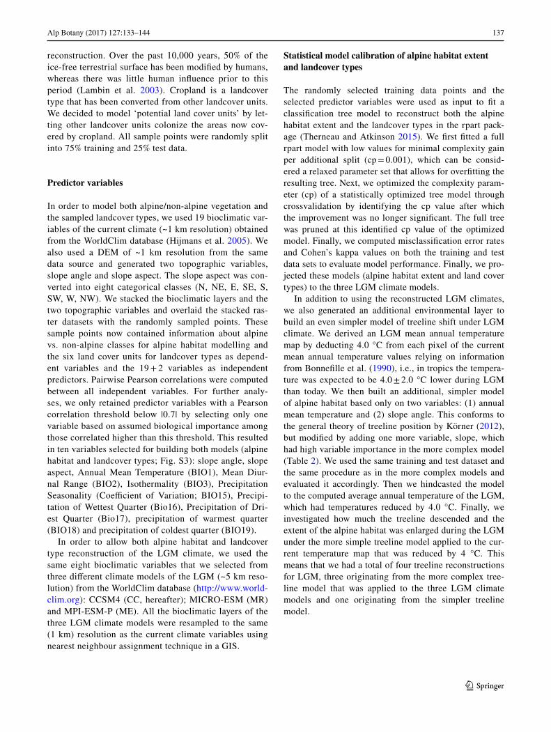
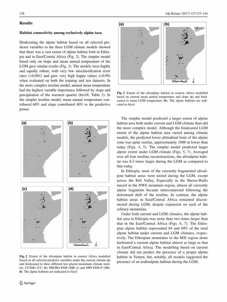
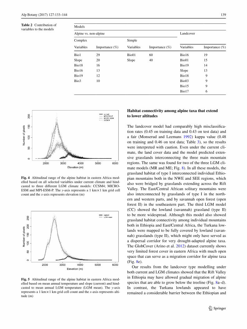
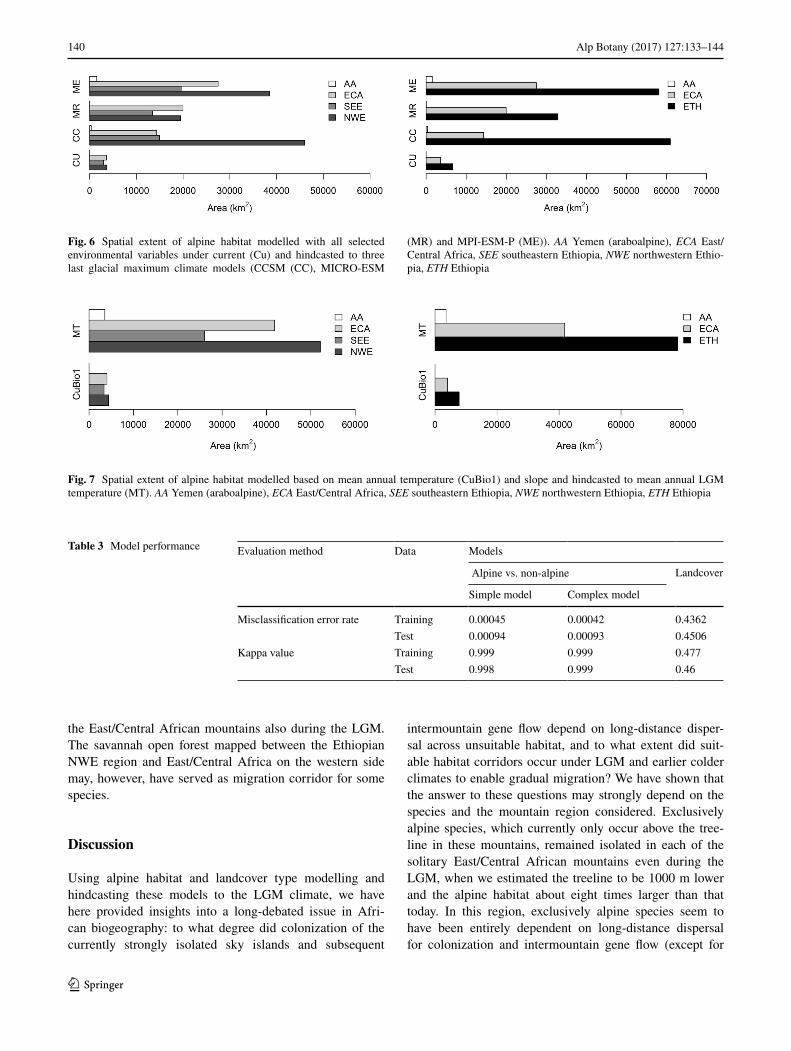
Hindcasting the alpine habitat based on all selected pre-dictor variables to the three LGM climate models showed that there was a vast extent of alpine habitat both in Ethio-pia and in East/Central Africa (Fig. 2). The simpler model based only on slope and mean annual temperature of the LGM gave similar results (Fig. 3). The models were highly and equally robust, with very low misclassification error rates (<0.001) and gave very high kappa values (>0.99) when evaluated on both the training and test datasets. In the more complex treeline model, annual mean temperature had the highest variable importance followed by slope and precipitation of the warmest quarter (bio18; Table 2). In the simpler treeline model, mean annual temperature con-tributed 60% and slope contributed 40% to the predictive power.
The simpler model predicted a larger extent of alpine habitat area both under current and LGM climate than did the more complex model. Although the hindcasted LGM extent of the alpine habitat area varied among climate models, the predicted lower altitudinal limit of the alpine zone was quite similar, approximately 1000 m lower than today (Figs. 4, 5). The simpler model predicted larger alpine extent under LGM climate (Figs. 5, 7). Averaged over all four treeline reconstructions, the afroalpine habi-tat was 8.3 times larger during the LGM as compared to that today.
In Ethiopia, most of the currently fragmented afroal-pine habitat areas were united during the LGM, except across the Rift Valley. Especially in the Shewa-Wallo massif in the NWE mountain region, almost all currently alpine fragments became interconnected following the downward shift of the treeline. In contrast, the alpine habitat areas in East/Central Africa remained discon-nected during LGM, despite expansion on each of the solitary mountains.
Under both current and LGM climates, the alpine hab-itat area in Ethiopia was more than two times larger than that in the East/Central Africa (Figs. 6, 7). The Ethio-pian alpine habitat represented 64 and 69% of the total alpine habitat under current and LGM climates, respec-tively. The Ethiopian mountains in the SEE region alone harboured a current alpine habitat almost as large as that in East/Central Africa. The modelling based on current climate did not predict the presence of a proper alpine habitat in Yemen, but, notably, all models suggested the presence of an araboalpine habitat during the LGM.
Fig. 2 Extent of the afroalpine habitat in eastern Africa modelled based on all selected predictor variables under the current climate (a) and hindcasted to three different last glacial maximum climate mod-els: CCSM4 (CC; b); MICRO-ESM (MR; c) and MPI-ESM-P (ME; d). The alpine habitats are indicated in black
Fig. 3 Extent of the afroalpine habitat in eastern Africa modelled based on current mean annual temperature and slope (a) and hind-casted to mean LGM temperature (b). The alpine habitats are indi-cated in black
139Alp Botany (2017) 127:133–144
1 3
Habitat connectivity among alpine taxa that extend to lower altitudes
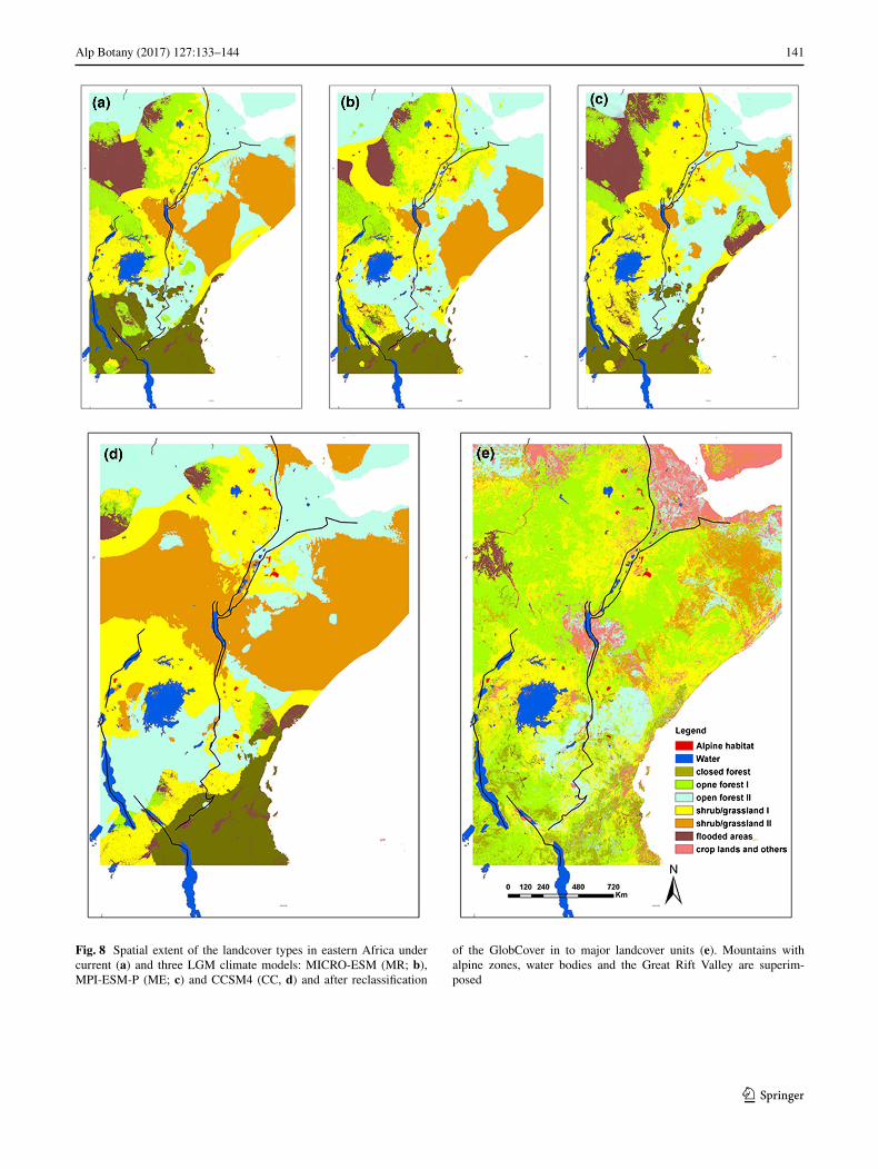
The landcover model had comparably high misclassifica-tion rates (0.45 on training data and 0.43 on test data) and a fair (Monserud and Leemans 1992) kappa value (0.48 on training and 0.46 on test data; Table 3), so the results were interpreted with caution. Even under the current cli-mate, the land cover data and the model predicted exten-sive grasslands interconnecting the three main mountain regions. The same was found for two of the three LGM cli-mate models (MR and ME; Fig. 8). In all these models, the grassland habitat of type I interconnected individual Ethio-pian mountains both in the NWE and SEE regions, which also were bridged by grasslands extending across the Rift Valley. The East/Central African solitary mountains were also interconnected by grasslands of type I in the north-ern and western parts, and by savannah open forest (open forest II) in the southeastern part. The third LGM model (CC) showed the lowland (savannah) grassland (type II) to be more widespread. Although this model also showed grassland habitat connectivity among individual mountains both in Ethiopia and East/Central Africa, the Turkana low-lands were mapped to be fully covered by lowland (savan-nah) grasslands (type II), which might only have served as a dispersal corridor for very drought-adapted alpine taxa. The GlobCover (Arino et al. 2012) dataset currently shows very limited forest cover in eastern Africa with much open space that can serve as a migration corridor for alpine taxa (Fig. 8e).
Our results from the landcover type modelling under both current and LGM climates showed that the Rift Valley in Ethiopia may have allowed gradual migration of alpine species that are able to grow below the treeline (Fig. 8a–d). In contrast, the Turkana lowlands appeared to have remained a considerable barrier between the Ethiopian and
Table 2 Contribution of variables to the models
Models
Alpine vs. non-alpine Landcover
Complex Simple
Variables Importance (%) Variables Importance (%) Variables Importance (%)
Bio1 29 Bio01 60 Bio16 19Slope 20 Slope 40 Bio01 15Bio18 16 Bio19 14Bio16 13 Slope 13Bio19 12 Bio18 9Bio3 10 Bio03 9
Bio15 9Bio17 6
Fig. 4 Altitudinal range of the alpine habitat in eastern Africa mod-elled based on all selected variables under current climate and hind-casted to three different LGM climate models: CCSM4; MICRO-ESM and MPI-ESM-P. The y-axis represents a 1 km × 1 km grid cell count and the x-axis represents elevation (m)
Fig. 5 Altitudinal range of the alpine habitat in eastern Africa mod-elled based on mean annual temperature and slope (current) and hind-casted to mean annual LGM temperature (LGM mean). The y-axis represents a 1 km × 1 km grid cell count and the x-axis represents alti-tude (m)
140 Alp Botany (2017) 127:133–144
1 3
the East/Central African mountains also during the LGM. The savannah open forest mapped between the Ethiopian NWE region and East/Central Africa on the western side may, however, have served as migration corridor for some species.
Discussion
Using alpine habitat and landcover type modelling and hindcasting these models to the LGM climate, we have here provided insights into a long-debated issue in Afri-can biogeography: to what degree did colonization of the currently strongly isolated sky islands and subsequent
intermountain gene flow depend on long-distance disper-sal across unsuitable habitat, and to what extent did suit-able habitat corridors occur under LGM and earlier colder climates to enable gradual migration? We have shown that the answer to these questions may strongly depend on the species and the mountain region considered. Exclusively alpine species, which currently only occur above the tree-line in these mountains, remained isolated in each of the solitary East/Central African mountains even during the LGM, when we estimated the treeline to be 1000 m lower and the alpine habitat about eight times larger than that today. In this region, exclusively alpine species seem to have been entirely dependent on long-distance dispersal for colonization and intermountain gene flow (except for
Fig. 6 Spatial extent of alpine habitat modelled with all selected environmental variables under current (Cu) and hindcasted to three last glacial maximum climate models (CCSM (CC), MICRO-ESM
(MR) and MPI-ESM-P (ME)). AA Yemen (araboalpine), ECA East/Central Africa, SEE southeastern Ethiopia, NWE northwestern Ethio-pia, ETH Ethiopia
Fig. 7 Spatial extent of alpine habitat modelled based on mean annual temperature (CuBio1) and slope and hindcasted to mean annual LGM temperature (MT). AA Yemen (araboalpine), ECA East/Central Africa, SEE southeastern Ethiopia, NWE northwestern Ethiopia, ETH Ethiopia
Table 3 Model performance Evaluation method Data Models
Alpine vs. non-alpine Landcover
Simple model Complex model
Misclassification error rate Training 0.00045 0.00042 0.4362Test 0.00094 0.00093 0.4506
Kappa value Training 0.999 0.999 0.477Test 0.998 0.999 0.46
141Alp Botany (2017) 127:133–144
1 3
Fig. 8 Spatial extent of the landcover types in eastern Africa under current (a) and three LGM climate models: MICRO-ESM (MR; b), MPI-ESM-P (ME; c) and CCSM4 (CC, d) and after reclassification
of the GlobCover in to major landcover units (e). Mountains with alpine zones, water bodies and the Great Rift Valley are superim-posed
142 Alp Botany (2017) 127:133–144
1 3
a few mountains in Kenya and along the Uganda/Rwanda/Congo borders; Figs. 2, 3). In contrast, the alpine fragments in Ethiopia probably fused during the LGM except across the Rift Valley, allowing for migration of such species. We also show that drought-tolerant alpine species that today extend below the treeline may have had opportunities for gradual migration through grassland and open forest corri-dors among mountains in all regions during the dry glacial periods, possibly also under the current climate before agri-culture transformed the low-lying landscapes.
Exclusively alpine species: isolated in East/Central Africa, partly connected in Ethiopia
The results from both treeline models and all LGM cli-mate data sources showed that the afroalpine habitat was considerably expanded during this (and probably earlier) glaciation(s), on average about 8.3 times larger than today. Although the spatial extent of the alpine habitat predicted by different LGM climate models differed somewhat, they consistently predicted that the LGM treeline was about 1000 m lower than today, in agreement with the results of a pollen analysis from Mount Kenya (Coetzee 1964).
Our finding of a lack alpine habitat in the low-lying land-scapes separating the East/Central African mountains dur-ing the LGM is consistent with Hedberg (1970) and Harm-sen et al. (1991), who considered their alpine zones to have been isolated since their origin. This would explain why these mountains harbour more single-mountain endemics than the Ethiopian mountains (Hedberg 1964, 1970; Knox and Palmer 1998), which our analyses showed to have been more interconnected during colder climates. Considerable intermountain gene flow among the East/Central mountains has nevertheless been inferred in several phylogeographic studies, even across the vast Ugandan gap separating the mountains along the western and eastern branches of the Rift Valley, demonstrating the importance of long-distance dispersal and hybridization (Gizaw et al. 2013, 2016; Masao et al. 2013; Wondimu et al. 2014 and unpublished data).
In Ethiopia, the Rift Valley appears to have presented a strong barrier against migration of exclusively alpine spe-cies even during the LGM (Figs. 2 and 3). Although the northwestern and southeastern mountain regions share a considerable number of alpine species (Gehrke and Linder 2014), the Rift Valley represents a distinct genetic break in several of those examined to date (Gizaw et al. 2013, 2016; Masao et al. 2013; Wondimu et al. 2014, and unpublished data). However, the phylogeographic studies have mainly focused on the geographically most separated mountain ranges in Ethiopia, the Simen Mts in the northwest and the Bale Mts in the southeast (Fig. 1), which often harbour distinct genetic groups (e.g. Gizaw et al. 2016). The study
of Wondimu et al. (2014) also included Mt Choke, which is situated in the northwestern region but much closer to the Rift Valley than the Simen Mts and showed that the populations in this mountain represented admixtures of both the Simen and Bale Mts. These results call for more extensively sampled phylogeographic studies to assess the relevance of our finding of the fusion of LGM alpine habi-tat on each side of the Rift but not across it for gene flow in exclusively alpine species in Ethiopia.
Interestingly, our models predicted the existence of an araboalpine LGM habitat in Yemen, an area that lacks proper alpine zones today. This is a significant finding since Yemen and the Arabian Peninsula have been suggested as a main migratory pathway for Eurasian lineages colonizing the mountains of eastern Africa (Koch et al. 2006; Assefa et al. 2007; Ehrich et al. 2007; Popp et al. 2008; Gehrke and Linder 2009).
In eastern Africa, we found that the alpine habitat seems mainly to be shaped by temperature-related bioclimatic variables, which is in agreement with Körner and Paulsen (2004). Mean annual temperature strongly correlates with seasonal temperature variables and was found to be the most important variable in our model. The seasonal vari-ation in temperature is minimal (Rundel 1994). Because of the high correlation with seasonal temperature variables, mean annual temperature can be used as a proxy to the tem-perature of the growing season. We found that relying only on annual temperature and slope to model the treeline and the extent of the alpine habitat in eastern Africa provided a model almost as robust as the model in which we used more variables to discriminate the alpine habitat from non-alpine lowlands.
Alpine species that extend below the treeline: potential grassland corridors
Because our landcover model had comparably high mis-classification error rates and a fair kappa value, we interpret the results with caution. Many of the landcover types in eastern Africa are today influenced by anthropogenic activ-ities, and they cover large altitudinal spans (Figs. S2, S3). This indicates that they are quite heterogeneous and that the thematic resolution of GlobCover is not very precise, and may partly explain the comparably high misclassifica-tion in our habitat model.
From the GlobCover data, it can clearly be seen that the forest cover in eastern Africa is small and highly frag-mented (Fig. 8e). In accordance, even under the current climate (when agricultural landscapes were replaced by potential natural landcover types in our models), we pre-dicted extensive grasslands interconnecting individual mountains as well as the three main mountain regions. The same was found for two of the three LGM climate
143Alp Botany (2017) 127:133–144
1 3
models. Grasslands and open forests probably intercon-nected all the Ethiopian mountains, also across the Rift Valley. In East/Central Africa, the mountains were also interconnected by grassland extending from the Virunga and Rwenzori mountains in the west to Mt Elgon and Mt Kenya in the northeast, with further extensions towards northwestern Ethiopia on the western side of the Turkana Lowlands (Figs. 1, 8). The Turkana Lowlands separating the East/Central African mountains from Ethiopia seem to present the strongest barrier for alpine species in our study region; this area was mapped to be fully covered by the driest type of grasslands (type II), which might have served as a dispersal corridor only for very drought-adapted taxa.
Regardless of the uncertainty associated with our model, it is difficult to assess to what degree grasslands may have served as migration corridors for ‘non-exclusively’ alpine species. First, such grasslands may be partly too dry to be suitable for most alpine species, especially during glacial periods. Second, it is possible that most of the alpine spe-cies that today also occur below the treeline have their pri-mary populations in the alpine zone, functioning as sources for occasional sink populations extending downslope along open patches and along watercourses. However, we tenta-tively explored occurrence data for some alpine taxa from the Global Biodiversity Information Facility (GBIF), pro-viding some support for the Rift Valley in Ethiopia, but not the Turkana Lowlands, as a potential migration corri-dor for non-exclusively alpine plants (Chala et al., unpubl. data). We found some occurrence points located in the cur-rent grasslands in the Ethiopian Rift Valley, bridging those from the northwestern and southeastern mountain regions. Our findings are also in line with phylogeographic stud-ies of some alpine species, such as Erica arborea (Gizaw et al. 2013) and Koeleria capensis (Masao et al. 2013). These species are drought-tolerant, extend to lower vegeta-tion belts in the eastern African mountains and show no geographic structuring of their genetic diversity, possibly indicating that habitat connectivity through grassland and open forest corridors has been more important than long-distance dispersal.
Although the Turkana Lowlands appear as a virtually impenetrable barrier against gradual migration of alpine species, the genetic structuring in several species points to higher levels of gene flow across this extensive lowland gap than across the Rift Valley in Ethiopia. In these species, the populations in southeastern Ethiopia belong to the same genetic group as those in East Africa, whereas another, distinct genetic group is found in northwestern Ethiopia (Gizaw et al. 2013, 2016; Wondimu et al. 2014). The most likely explanation is that this unexpected pattern is driven by long-distance dispersal directed by prevailing winds and bird migration routes.
Our results call for more detailed comparative studies of species with different traits, habitat requirements and altitu-dinal ranges using a combined phylogeographic and mod-elling approach, to further explore the relative importance of migrational corridors and long-distance dispersal in the fascinating sky island system of eastern Africa.
Acknowledgements We acknowledge financial support by the Nor-wegian State Loan Fund (Lånekassen); Natural History Museum, University of Oslo and the PET and GEco research groups at the Museum. We thank Achilleas Psomas, Swiss Federal Research Insti-tute (WSL), and all members of PET and GEco for discussions on the manuscript.
Compliance with ethical standards
Conflict of interest The authors declare that they have no conflict of interest.
Declaration of authorship DC and CB conceived the paper together with NZ and VB. DC prepared the GIS layers, wrote the R script and carried out ecological modelling under the guidance of NZ and VB. DC wrote the manuscript under the guidance of CB and with critical reviews and contributions from all coauthors.
References
Arino O, Ramos Perez JJ, Kalogirou V, Bontemps S, Defourny P, Van Bogaert E (2012) Global Land Cover Map for 2009 (GlobCover 2009). In: PANGAEA—Data Publisher for Earth and Environ-mental Science.
Assefa A, Ehrich D, Taberlet P, Nemomissa S, Brochmann C (2007) Pleistocene colonization of afro-alpine “sky islands” by the arc-tic-alpine Arabis alpina. Heredity 99:133–142
Baker BH, Mohr PA, Williams, L.A.J. (1972) Geology of the Eastern Rift System of Africa. Geol Soc Am Spec Pap 136:67
Bonnefille R, Roeland JC, Guiot J (1990) Temperature and rainfall estimates for the past 40,000 years in equatorial Africa. Nature 346:347–349
Coetzee JA (1964) Evidence for a considerable depression of the veg-etation belts during the upper Pleistocene on the East African Mountains. Nature 204:564–566
Darwin CR (1859) On the origin of species by means of natural selec-tion, or the preservation of favoured races in the struggle for life. John Murray, London
deMenocal PB (1995) Plio-Pleistocene African climate. Science 270:53–59
Ehrich D, Gaudeul M, Assefa A, Koch MA, Mummenhoff K, Nemo-missa S, Brochmann C (2007) Genetic consequences of Pleisto-cene range shifts: contrast between the Arctic, the Alps and the East African mountains. Mol Ecol 16:2542–2559
Gehrke B, Linder HP (2009) The scramble for Africa: pan-temperate elements on the African high mountains. Proc R Soc Biol Sci 276:2657–2665
Gehrke B, Linder HP (2011) Time, space and ecology: why some clades have more species than others. J Biogeogr 38:1948–1962
Gehrke B, Linder HP (2014) Species richness, endemism and spe-cies composition in the tropical Afroalpine flora. Alpine Bot 124:165–177
Gizaw A, Kebede M, Nemomissa S, Ehrich D, Bekele B, Mirré V, Popp M, Brochmann C (2013) Phylogeography of the heathers
144 Alp Botany (2017) 127:133–144
1 3
Erica arborea and E. trimera in the afro-alpine ‘sky islands’ inferred from AFLPs and plastid DNA sequences. Flora Morphol Distrib Funct Ecol Plants 208:453–463
Gizaw A, Wondimu T, Mugizi TF, Masao CA, Abdi AA, Popp M, Ehrich D, Nemomissa S, Brochmann C (2016) Vicariance, dis-persal, and hybridization in a naturally fragmented system: the afro-alpine endemics Carex monostachya and C. runssoroensis (Cyperaceae). Alpine Bot 126:59–71
Gottelli D, Marino J, Sillero-Zubiri C, Funk SM (2004) The effect of the last glacial age on speciation and population genetic structure of the endangered Ethiopian wolf (Canis simensis). Mol Ecol 13:2275–2286
Harmsen R, Spence JR, Mahaney WC (1991) Glacial interglacial cycles and development of the afroalpine ecosystem on East-African Mountains 0.2. Origins and development of the biotic component. J Afr Earth Sci 12:513–523
Hedberg O (1951) Vegetation belts of the East African mountains. Sven Bot Tidskr 45:140–202
Hedberg O (1957) Afroalpine vascular plants. A taxonomic revision. Symb Bot Ups 15:1–411
Hedberg O (1964) Features of afroalpine plant ecology. Acta Phyto-geogr Suec 49:1–144
Hedberg O (1970) Evolution of the Afroalpine flora. Biotropica 2:16–23
Hijmans RJ, Cameron SE, Parra JL, Jones PG, Jarvis A (2005) Very high resolution interpolated climate surfaces for global land areas. Int J Climatol 25:1965–1978
Kebede M, Ehrich D, Taberlet P, Nemomissa S, Brochmann C (2007) Phylogeography and conservation genetics of a giant lobelia (Lobelia giberroa) in Ethiopian and Tropical East African moun-tains. Mol Ecol 16:1233–1243
Knox EB, Palmer JD (1998) Chloroplast DNA evidence on the ori-gin and radiation of the giant lobelias in eastern Africa. Syst Bot 23:109–149
Koch MA, Kiefer C, Ehrich D, Vogel J, Brochmann C, Mummenhoff K (2006) Three times out of Asia Minor: the phylogeography of Arabis alpina L. (Brassicaceae). Mol Ecol 15:825–839
Körner C (2012) Alpine Treelines. Springer, BaselKörner C, Paulsen J (2004) A world-wide study of high altitude tree-
line temperatures. J Biogeogr 31:713–732Lambin EF, Geist HJ, Lepers E (2003) Dynamics of land-use and
land-cover change in tropical regions. Annu Rev Environ Resour 28:205–241
Mark BG, Osmaston HA (2008) Quaternary glaciation in Africa: key chronologies and climatic implications. J Quatern Sci 23:589–608
Masao C, Gizaw A, Piñeiro R, Tusiime F, Wondimu T, Abdi A, Popp M, Gussarova G, Lye K, Munishi P, Nemomissa S, Brochmann
C (2013) Phylogeographic history and taxonomy of some afro-alpine grasses assessed based on AFLPs and morphometry: Des-champsia cespitosa, D. angusta and Koeleria capensis. Alpine Bot 123, 107–122.
Monserud RA, Leemans R (1992) Comparing global vegetation maps with the Kappa statistic. Ecol Modell 62:275–293
Popp M, Gizaw A, Nemomissa S, Suda J, Brochmann C (2008) Colo-nization and diversification in the African ‘sky islands’ by Eura-sian Lychnis L. (Caryophyllaceae). J Biogeogr 35:1016–1029
Rundel PW (1994) Tropical alpine climates. Tropical Alpine Environ-ments: Plant Form and Function (ed. by P.W. Rundel, A.P. Smith and F.C. Meinzer). Cambridge University Press, Cambridge, pp 21–44
Schneider von Deimling T, Ganopolski A, Held H, Rahmstorf S (2006) How cold was the Last Glacial Maximum? Geophys Res Lett 33:L14709. doi:10.1029/2006GL026484
Shanahan TM, Zreda M (2000) Chronology of Quaternary glaciations in East Africa. Earth Planet Sci Lett 177:23–42
Sklenář P, Hedberg I, Cleef AM (2014) Island biogeography of tropi-cal alpine floras. J Biogeogr 41:287–297
Smith, J.M.B., Cleef AM (1988) Composition and origins of the worlds tropical alpine floras. J Biogeogr 15:631–645
Spence JR, Pocs T (1988) Distribution patterns in the Afroalpine moss flora of East Africa. Quaternary and Environmental Research on East African Mountains (ed. by W.C. Mahaney). Balkema, Rotterdam, pp 291–307
Therneau TM, Atkinson EJ (2015) An introduction to recursive par-titioning using the raprt routines. Available at: https://cran.r-pro-ject.org/web/packages/rpart/vignettes/longintro.pdf
Thompson LG, Mosley-Thompson E, Davis ME, Henderson KA, Brecher HH, Zagorodnov VS, Mashiotta TA, Lin PN, Mikha-lenko VN, Hardy DR, Beer J (2002) Kilimanjaro ice core records: evidence of holocene climate change in tropical Africa. Science 298:589–593
Umer M, Lamb HF, Bonnefille R, Lezine AM, Tiercelin JJ, Gibert E, Cazet JP, Watrin J (2007) Late Pleistocene and Holocene vegeta-tion history of the Bale Mountains, Ethiopia. Quatern Sci Rev 26:2229–2246
Wallace AR (1876) The Geographical Distribution of Animals: With a Study of the Relations of Living and Extinct Faunas as Elu-cidating the Past Changes of the Earth’s Surface. Harper and brothers, New York
Wondimu T, Gizaw A, Tusiime F, Masao C, Abdi A, Gussarova G, Popp M, Nemomissa S, Brochmann C (2014) Crossing barriers in an extremely fragmented system: two case studies in the afro-alpine sky island flora. Plant Syst Evol 300:415–430
Related Documents