Page 1 MEdiTerranean Introduction of GNSS (Global Navigation and Satellite System) Services METIS Demonstration for the use of GNSS and EGNOS in Tunisia, Algeria and Morocco in Dangerous Goods Transportation CADTECH. Chemsedine Sidi-Baba email: [email protected]

Welcome message from author
This document is posted to help you gain knowledge. Please leave a comment to let me know what you think about it! Share it to your friends and learn new things together.
Transcript
Page 1
MEdiTerranean Introduction of GNSS (Global Navigation and Satellite System)
Services
METIS Demonstration for the use of GNSS and EGNOS in Tunisia, Algeria and
Morocco in Dangerous Goods Transportation
CADTECH.Chemsedine Sidi-Baba
email: [email protected]
Page 2
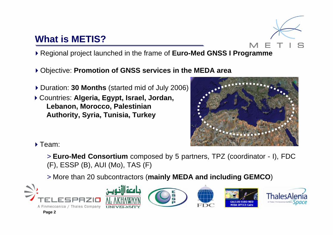
Regional project launched in the frame of Euro-Med GNSS I Programme
Objective: Promotion of GNSS services in the MEDA area
Duration: 30 Months (started mid of July 2006)
What is METIS?
Countries: Algeria, Egypt, Israel, Jordan, Lebanon, Morocco, Palestinian Authority, Syria, Tunisia, Turkey
Team:
>Euro-Med Consortium composed by 5 partners, TPZ (coordinator - I), FDC (F), ESSP (B), AUI (Mo), TAS (F)
>More than 20 subcontractors (mainly MEDA and including GEMCO)

Page 3
Outcomes: Paving the way for GNSS services in MEDA>Supporting the definition of Euro-Mediterranean policy and actions in favour of the GNSS (EGNOS/GALILEO) services market in MEDA
>Establishing cooperation and shared objectives between EU and MEDA economic actors
Main activities:
>Activity A - Preparation of a Euro-Med “GNSS Regional Plan”>Activity B - Running a “Training & Awareness” programme>Activity C - Implementation of 10 “GNSS Service Demonstrations”
METIS activities are performed in parallel with the relevant infrastructure preparation for GNSS SIS (Signal In Space) Provision Activity in the region,
undertaken by the European Space Agency (ESA)

Page 4
The METIS project is managed by the European GNSS Supervisory Authority through Euro-MED GNSS I project
METIS: Dangerous Good TransportWhat is EGNOS ?
European Geostationary Overlay Service (EGNOS), is the first E.U initiative in the field of Global Navigation Satellite System. EGNOS is the precursor of Galileo.
EGNOS allows to improve the performances of GPS and GLONASS in term of accuracy, availability, integrity.
EGNOS system is composed of 3 geostationary satellites and ground stations to improve performances over ECAC, an area including Europe and a part of north of Africa.
Contribute to EGNOS: European Space Agency, European Commission,Eurocontrol, European Organization for the security of Air Navigation

Page 5
10 GNSS Service Demonstrations
Page 6
The METIS project is managed by the European GNSS Supervisory Authority through Euro-MED GNSS I project
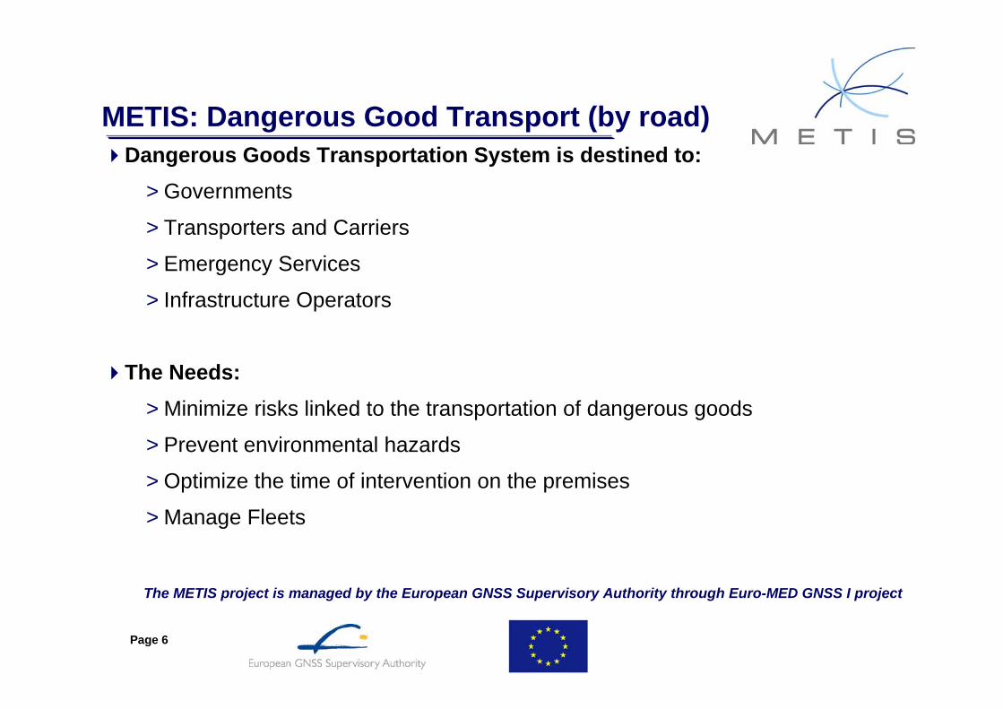
METIS: Dangerous Good Transport (by road)Dangerous Goods Transportation System is destined to:
>Governments
>Transporters and Carriers
>Emergency Services
>Infrastructure Operators
The Needs:>Minimize risks linked to the transportation of dangerous goods
>Prevent environmental hazards
>Optimize the time of intervention on the premises
>Manage Fleets

Page 7
METIS Demo : Dangerous Goods Transport
The METIS project is managed by the European GNSS Supervisory Authority through Euro-MED GNSS I project
Countries: Algeria, Morocco, Tunisia
Objectives:>Introduce tracking services based on EGNOS in those 3 countries
>Train future users and make them sensitive to new opportunities from the new RTDG system
>Demonstrate the added value from EGNOS in such application
Subcontractors and actors: Ministry of Transportation, DPC (Firedepartment), CNPAC (committee of accident prevention), OTI Tunisia, Sotramine Algeria, Petrom Morocco, Ministry of Energy and Mining…
Page 8
Demonstration and Actors
The METIS project is managed by the European GNSS Supervisory Authority through Euro-MED GNSS I project
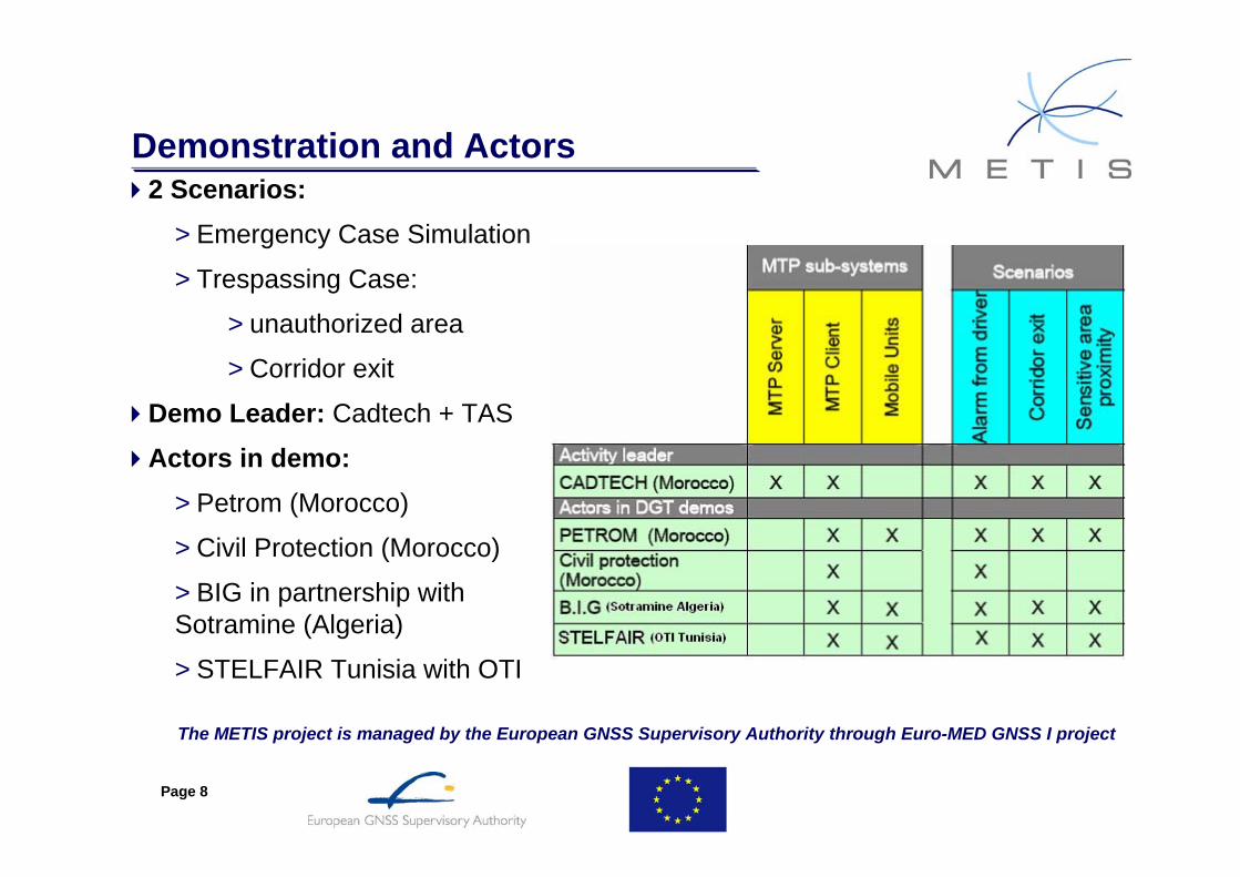
2 Scenarios:>Emergency Case Simulation
>Trespassing Case:
>unauthorized area
>Corridor exit
Demo Leader: Cadtech + TAS
Actors in demo:>Petrom (Morocco)
>Civil Protection (Morocco)
>BIG in partnership with Sotramine (Algeria)
>STELFAIR Tunisia with OTI
Page 9
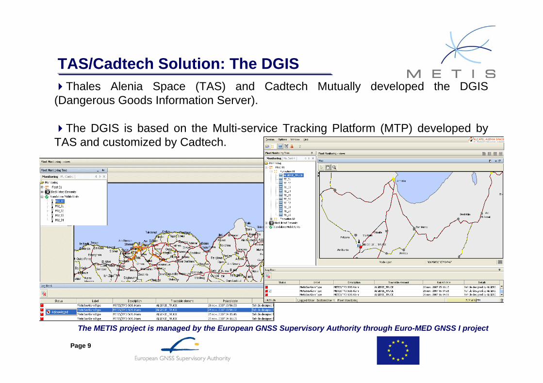
Thales Alenia Space (TAS) and Cadtech Mutually developed the DGIS (Dangerous Goods Information Server).
The DGIS is based on the Multi-service Tracking Platform (MTP) developed by TAS and customized by Cadtech.
TAS/Cadtech Solution: The DGIS
The METIS project is managed by the European GNSS Supervisory Authority through Euro-MED GNSS I project

Page 10
METIS: System Presentation dedicated to dangerous goods transportation by road

Page 11
Case 1: Emergency Case Simulation

Page 12
DGTS: SOS Alert Handling
The METIS project is managed by the European GNSS Supervisory Authority through Euro-MED GNSS I project

Page 13
Case 2: Trespassing Alert
Trespassing Simulation
10:06 Transporter Driving on the Highway
10:11 Transporter approaches a school
10:12 Transporter Enters Restricted Area
10:12 Transporter Identified in Restricted Area
10:12 GPS Localises Vehicle 10:12 EGNOS performances (accuracy, availability)
10:12 Operator Warns Driver
10:13 Transporter Leaves Restricted Area

Page 14
Case 2: Trespassing Alert Handling
The METIS project is managed by the European GNSS Supervisory Authority through Euro-MED GNSS I project
Page 15
The METIS project is managed by the European GNSS Supervisory Authority through Euro-MED GNSS I project
Dangerous Goods Transport services:Added Value to the Civil Protection
Intervene Quicker in case of Emergency:>Receive an Alert instantly in case of an accident
>Rapid Localisation of the vehicle
>Avoid False alarms and localisation of the vehicle
Intervene More Efficiently:>Identify the type of dangerous Goods Transported
>Execute the procedure of intervention that corresponds to the incident
>Send appropriate resources

Page 16
The METIS project is managed by the European GNSS Supervisory Authority through Euro-MED GNSS I project
Dangerous Goods Transport services:Added Value to Transporters
Improve Efficiency of Operations>Improve Productivity of Drivers
>Reduce Fuel Consumption
>Improve revenue by Vehicle
>Reduce Operations cost
Improve Driver’s Safety
Detect Violations into restricted areas

Page 17
The METIS project is managed by the European GNSS Supervisory Authority through Euro-MED GNSS I project
METIS: Road Transport Dangerous GoodEGNOS availability on demo areas
Following figure show, that EGNOS availability is higher than 90% in demonstration areas.
Real EGNOS availability (processing based on data acquired in June 2007)
Morocco WAD2 area
AlgeriaWAD2 area
TunisiaWAD2 area

Page 18
The METIS project is managed by the European GNSS Supervisory Authority through Euro-MED GNSS I project
METIS: Road Transport Dangerous GoodEGNOS added values
How EGNOS is acquired in such application ?
With a dedicated EGNOS data receiver:
per satellite (geostationary),
or
per web, taking data on TAS dedicated server.
Used features of EGNOS data are mainly:
Accuracy (especially to avoid false alarm related to geofencing area or in case of emergency intervention)
Integrity (for protection level processing)
Direct EGNOS impacts on such services are related to liability, responsibility in law enforcement and civil protection
Page 19
The METIS project is managed by the European GNSS Supervisory Authority through Euro-MED GNSS I project
METIS: Dangerous Goods Transport by road Perspectives and conclusion
A dedicated System prototype is under tests in Algeria, Tunisia and Morocco,
Experience return allows to define and develop a suitable operational system,
Various users and/or customers transmit their feeling and complete our requirements,
Have a fine tuned system that will help reduce the real risks ofdangerous goods transportation (especially thanks to EGNOS).

Page 20
The METIS project is managed by the European GNSS Supervisory Authority through Euro-MED GNSS I project
GLOSSARY CNPAC: Comité National de la Prévention des Accidents de CirculationDPC: Département de la Protection CivileEGNOS: European Geostationary Navigation Overlay ServiceESSP: European Satellite Service ProviderFDC: France Dévelopement ConseilGNSS: Global Navigation Satellite SystemGEMCO: Galileo-Euro-Mediterranean Cooperation OfficeGSA: European GNSS Supervisory AuthorityMEDA: Mediterranean AreaMETIS: Mediterranean Introduction of GNSS ServicesTAS: Thales Alenia SpaceTPZ: Telespazio
Page 21
Thank You!
Related Documents


