2/20/2013 1 Meteorology and Climatology 101 MARAMA Webinar February 21, 2013 Sean Nolan PA DEP Meteorologist 717.787.1454 [email protected] Table of Contents Meteorology – The Basics • The Energy Balance • Forces of Motion • Scales of Weather Air Pollution in the Mid-Atlantic Region • Pollutants of Concern • An Ozone Episode • Factors in the Variation of Ozone Episodes • Transport and Ozone Episodes • Climatology Effects of Natural Events on Air Pollution

Meteorology and Climatology 101 - MARAMA 1 Meteorology and Climatology 101 MARAMA Webinar February 21, 2013 Sean Nolan PA DEP Meteorologist 717.787.1454 [email protected] Table of Contents
May 27, 2018
Welcome message from author
This document is posted to help you gain knowledge. Please leave a comment to let me know what you think about it! Share it to your friends and learn new things together.
Transcript

2/20/2013
1
Meteorology and Climatology 101
MARAMA WebinarFebruary 21, 2013
Sean NolanPA DEP Meteorologist
Table of ContentsMeteorology – The Basics
• The Energy Balance
• Forces of Motion
• Scales of Weather
Air Pollution in the Mid-Atlantic Region
• Pollutants of Concern
• An Ozone Episode
• Factors in the Variation of Ozone Episodes
• Transport and Ozone Episodes
• Climatology
Effects of Natural Events on Air Pollution
2/20/2013
2
Why do we have weather?
Energy - Radiation from the Sun
– Temperature– Pressure
Figure from NASA
Meteorology – The Basics
The Energy Balance
2/20/2013
3
Figure from the Georgia Tech GLOBE Project
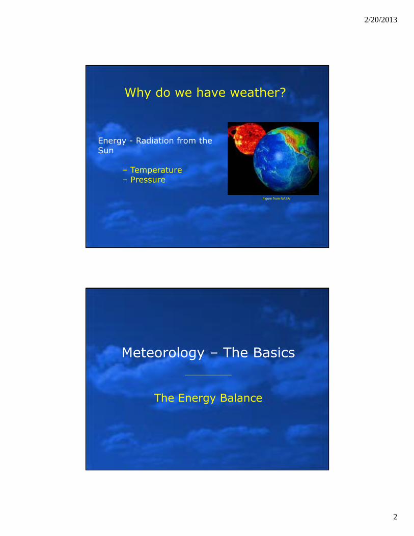
Energy and Earth’s Motion
• Orbit & Tilt create seasonal cycle
• Rotation create diurnal cycle – dark sides
Energy and Earth’s Tilt
• Radiation is distributed unevenly across the surface
• Higher latitudes have seasons of prolonged night and day
• Angle of incidence at higher latitudes creates a longer path-length through the atmosphere Figure from Ahrens
2/20/2013
4
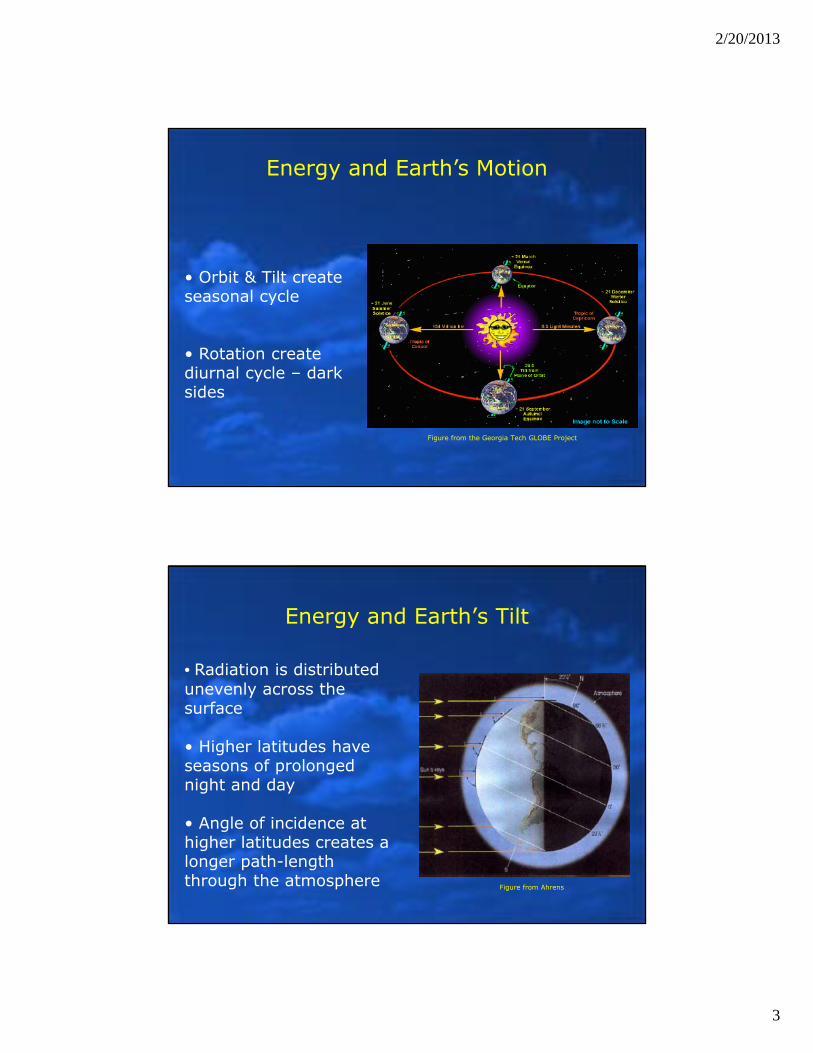
Solar and Thermal Energy
• Earth’s energy budget represented by short and long wave radiation
• Atmospheric radiation interactions include scattering, reflection, absorption, and transmission
• Greenhouse gases and cloud droplets are efficient absorbers of infrared energy
• Is this a static system? Is weather static? No –the distributions of the parameters are dynamic. (i.e. different ground surfaces, gas & cloud distributions and magnitudes)
Figure from University of Wisconsin – Stevens Point
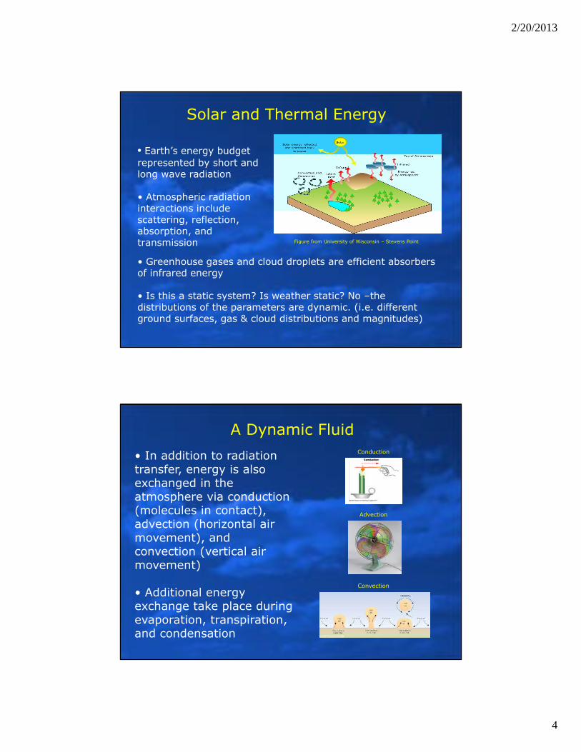
A Dynamic Fluid• In addition to radiation transfer, energy is also exchanged in the atmosphere via conduction (molecules in contact), advection (horizontal air movement), and convection (vertical air movement)
• Additional energy exchange take place during evaporation, transpiration, and condensation
Conduction
Advection
Convection
2/20/2013
5
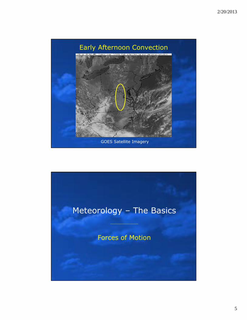
GOES Satellite Imagery
Early Afternoon Convection
Meteorology – The Basics
Forces of Motion
2/20/2013
6
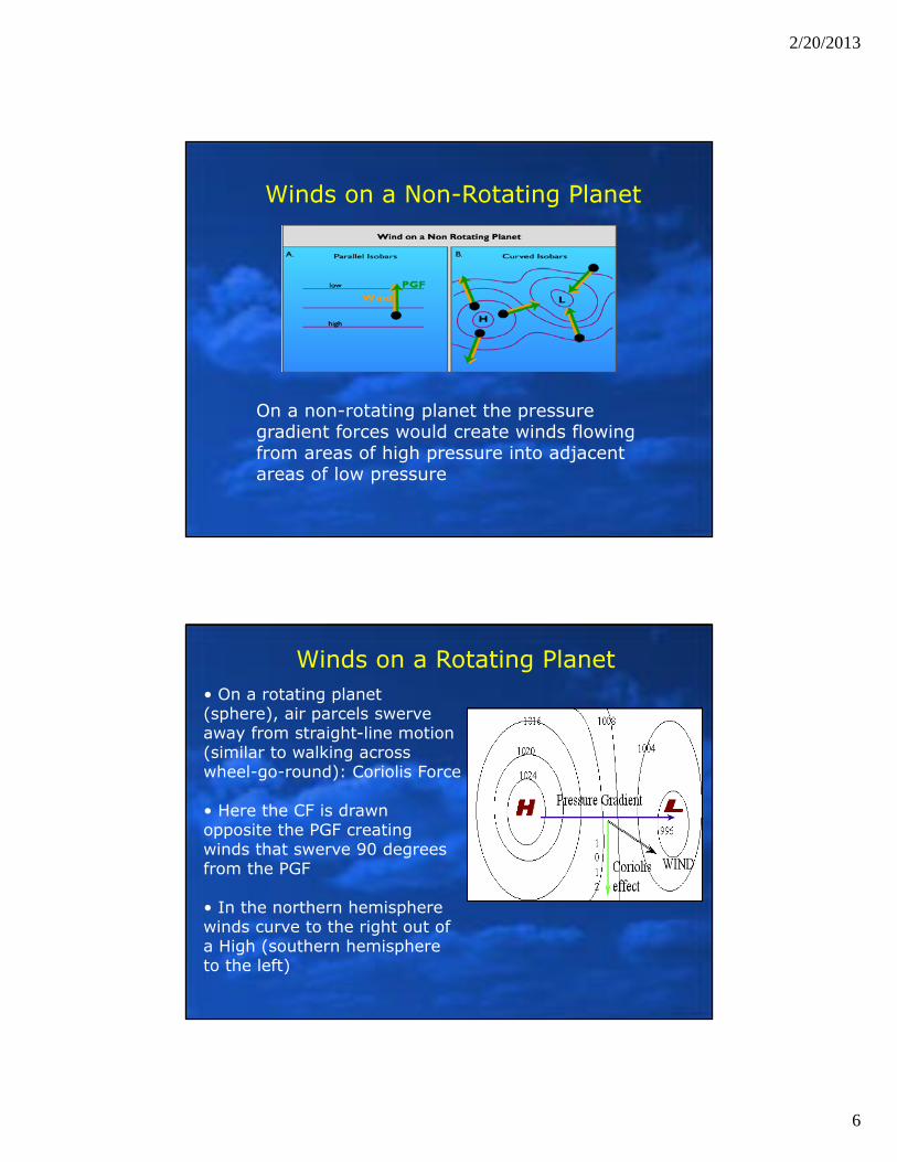
Winds on a Non-Rotating Planet
On a non-rotating planet the pressure gradient forces would create winds flowing from areas of high pressure into adjacent areas of low pressure
Winds on a Rotating Planet• On a rotating planet (sphere), air parcels swerve away from straight-line motion (similar to walking across wheel-go-round): Coriolis Force
• Here the CF is drawn opposite the PGF creating winds that swerve 90 degrees from the PGF
• In the northern hemisphere winds curve to the right out of a High (southern hemisphere to the left)
2/20/2013
7
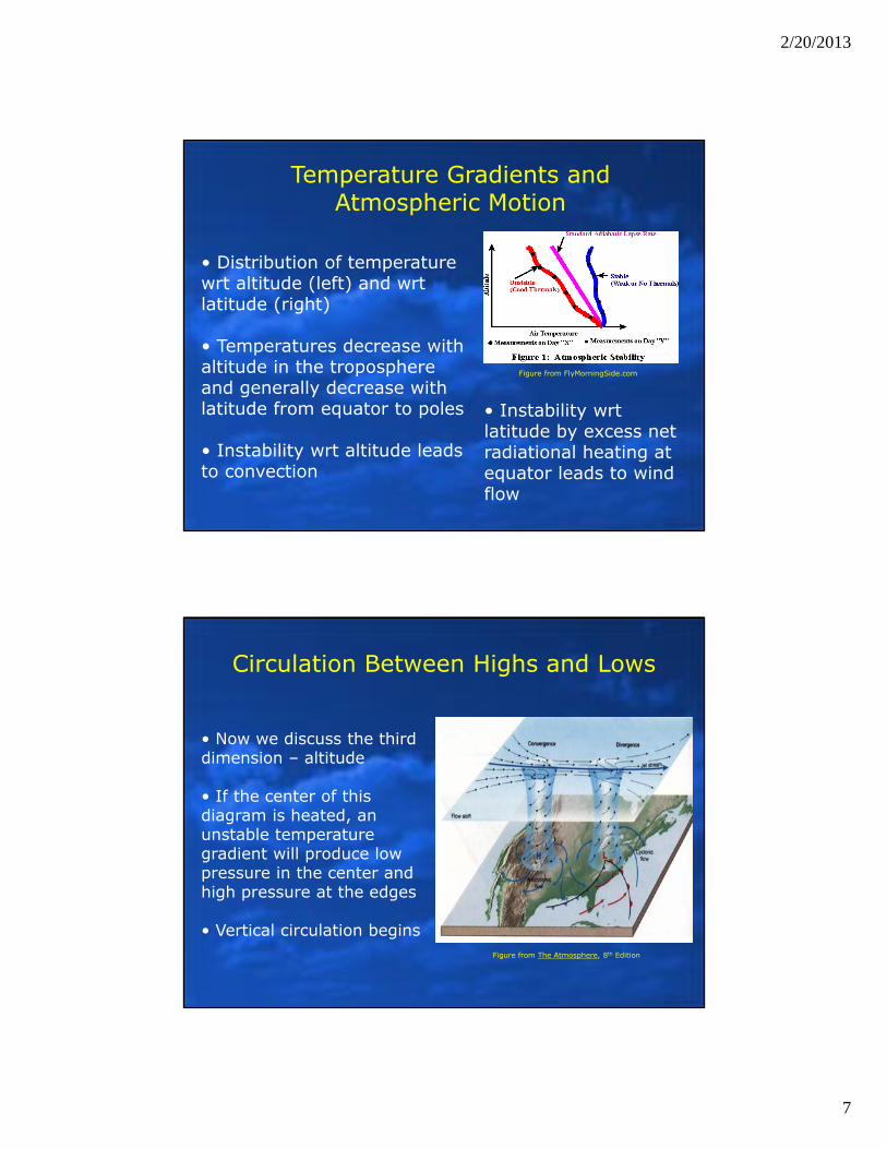
• Distribution of temperature wrt altitude (left) and wrt latitude (right)
• Temperatures decrease with altitude in the troposphere and generally decrease with latitude from equator to poles
• Instability wrt altitude leads to convection
• Instability wrt latitude by excess net radiational heating at equator leads to wind flow
Temperature Gradients and Atmospheric Motion
Figure from FlyMorningSide.com
Circulation Between Highs and Lows
• Now we discuss the third dimension – altitude
• If the center of this diagram is heated, an unstable temperature gradient will produce low pressure in the center and high pressure at the edges
• Vertical circulation beginsFigure from The Atmosphere, 8th Edition
2/20/2013
8
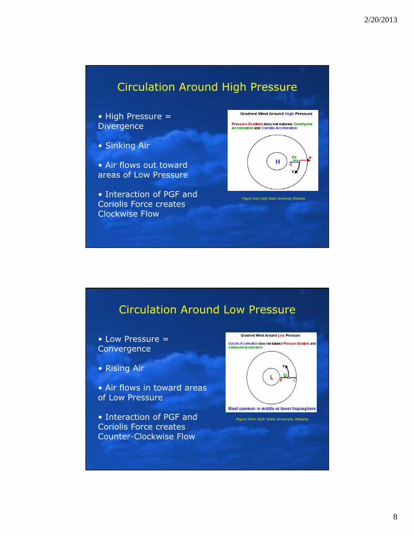
Circulation Around High Pressure
• High Pressure = Divergence
• Sinking Air
• Air flows out toward areas of Low Pressure
• Interaction of PGF and Coriolis Force creates Clockwise Flow
Figure from Utah State University Website
Circulation Around Low Pressure
• Low Pressure = Convergence
• Rising Air
• Air flows in toward areas of Low Pressure
• Interaction of PGF and Coriolis Force creates Counter-Clockwise Flow
Figure from Utah State University Website
2/20/2013
9
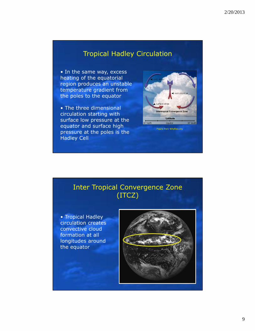
Tropical Hadley Circulation
• In the same way, excess heating of the equatorial region produces an unstable temperature gradient from the poles to the equator
• The three dimensional circulation starting with surface low pressure at the equator and surface high pressure at the poles is the Hadley Cell
Figure from Whyflies.org
Inter Tropical Convergence Zone (ITCZ)
• Tropical Hadley circulation creates convective cloud formation at all longitudes around the equator
2/20/2013
10
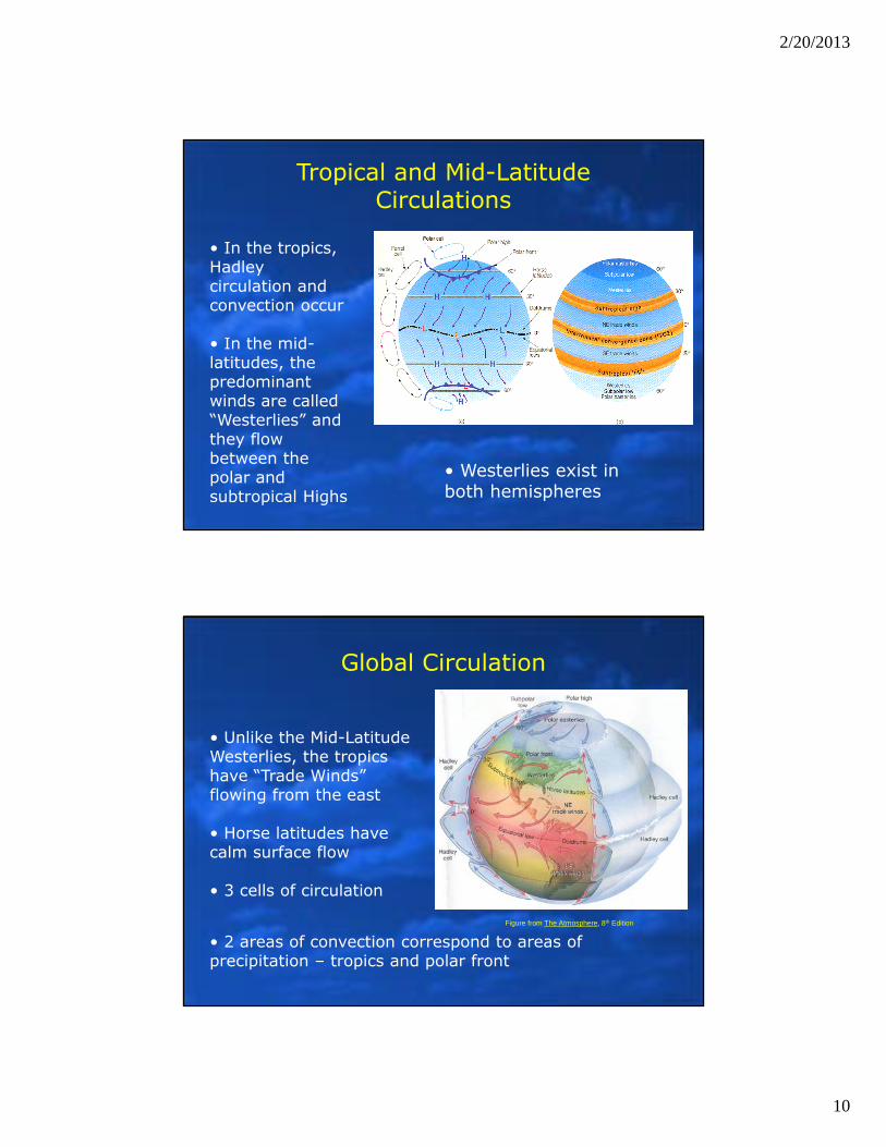
Tropical and Mid-Latitude Circulations
• In the tropics, Hadley circulation and convection occur
• In the mid-latitudes, the predominant winds are called “Westerlies” and they flow between the polar and subtropical Highs
• Westerlies exist in both hemispheres
Global Circulation
• Unlike the Mid-Latitude Westerlies, the tropics have “Trade Winds” flowing from the east
• Horse latitudes have calm surface flow
• 3 cells of circulation
• 2 areas of convection correspond to areas of precipitation – tropics and polar front
Figure from The Atmosphere, 8th Edition
2/20/2013
11
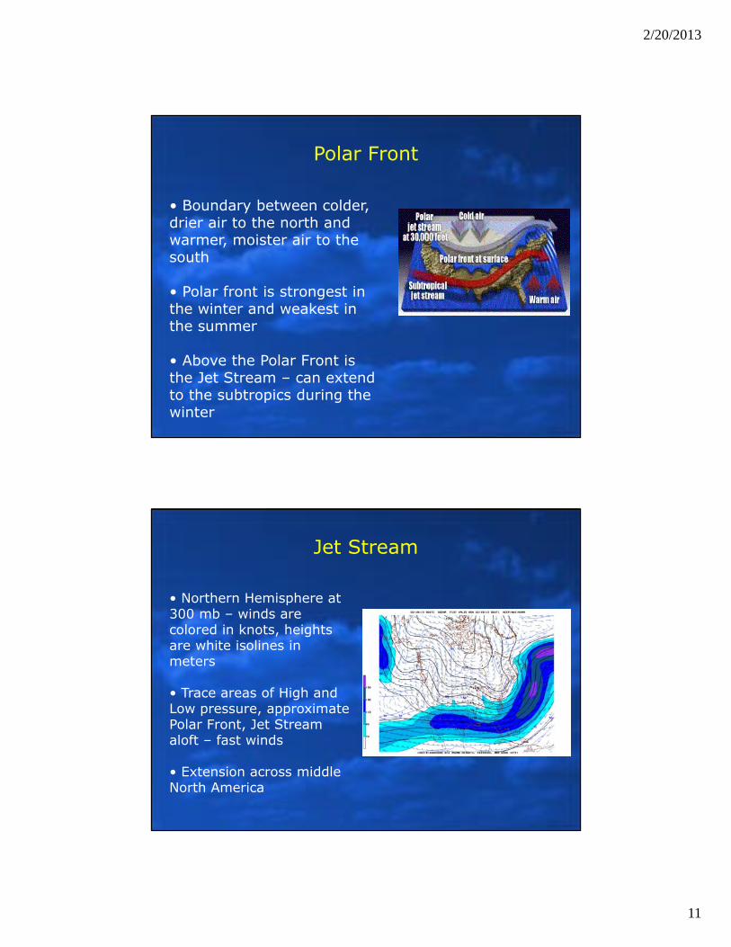
Polar Front
• Boundary between colder, drier air to the north and warmer, moister air to the south
• Polar front is strongest in the winter and weakest in the summer
• Above the Polar Front is the Jet Stream – can extend to the subtropics during the winter
Jet Stream
• Northern Hemisphere at 300 mb – winds are colored in knots, heights are white isolines in meters
• Trace areas of High and Low pressure, approximate Polar Front, Jet Stream aloft – fast winds
• Extension across middle North America
2/20/2013
12
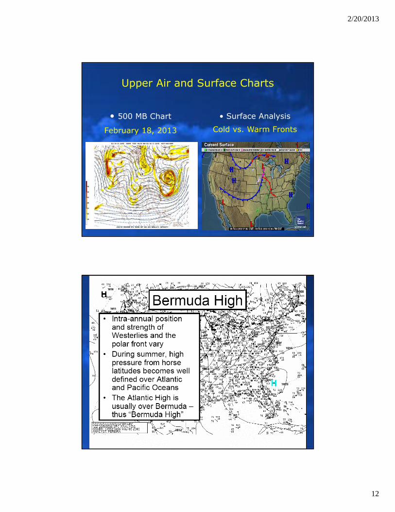
Upper Air and Surface Charts
• 500 MB Chart
February 18, 2013
• Surface Analysis
Cold vs. Warm Fronts
2/20/2013
13
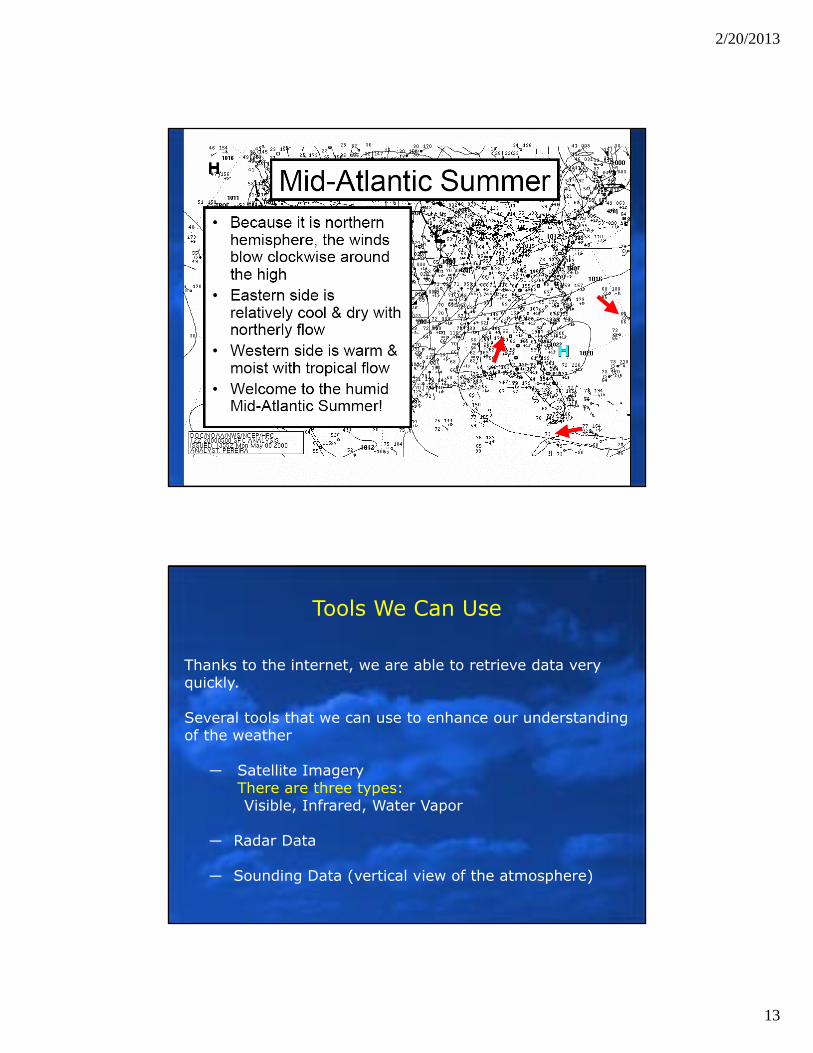
Tools We Can Use
Thanks to the internet, we are able to retrieve data very quickly.
Several tools that we can use to enhance our understanding of the weather
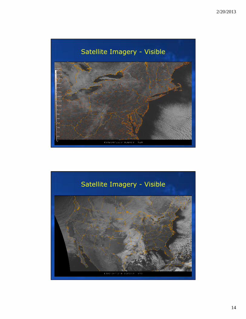
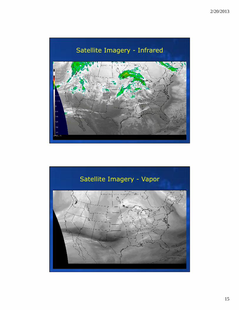
― Satellite ImageryThere are three types:Visible, Infrared, Water Vapor
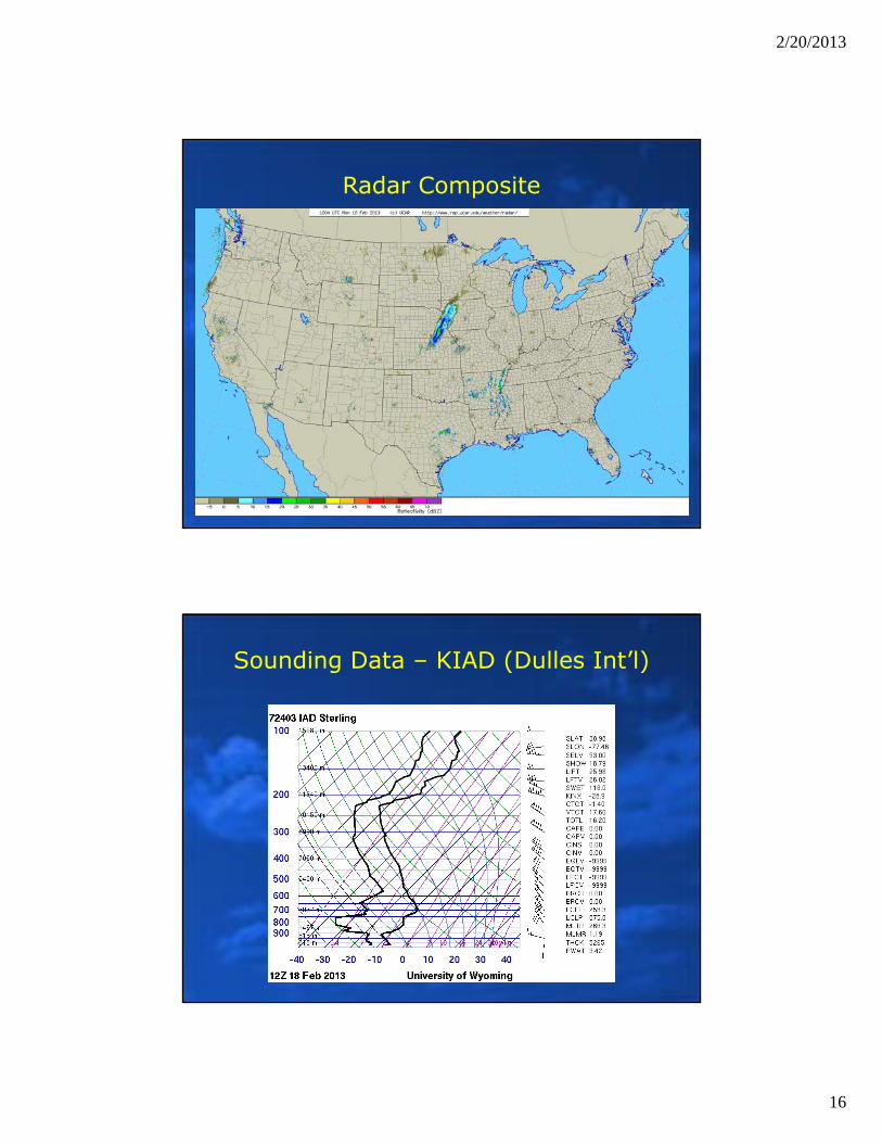
― Radar Data
― Sounding Data (vertical view of the atmosphere)
2/20/2013
14
Satellite Imagery - Visible
Satellite Imagery - Visible
2/20/2013
15
Satellite Imagery - Infrared
Satellite Imagery - Vapor
2/20/2013
16
Radar Composite
Sounding Data – KIAD (Dulles Int’l)
2/20/2013
17
Meteorology Basics
Scales of Weather
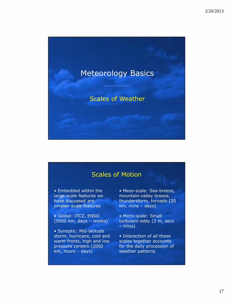
Scales of Motion
• Embedded within the large-scale features we have discussed are smaller-scale features
• Global: ITCZ, ENSO (5000 km, days – weeks)
• Synoptic: Mid-latitude storm, hurricane, cold and warm fronts, high and low pressure centers (2000 km, hours – days)
• Meso-scale: Sea-breeze, mountain-valley breeze, thunderstorm, tornado (20 km, mins – days)
• Micro-scale: Small turbulent eddy (2 m, secs – mins)
• Interaction of all these scales together accounts for the daily procession of weather patterns
2/20/2013
18
Scales of Motion
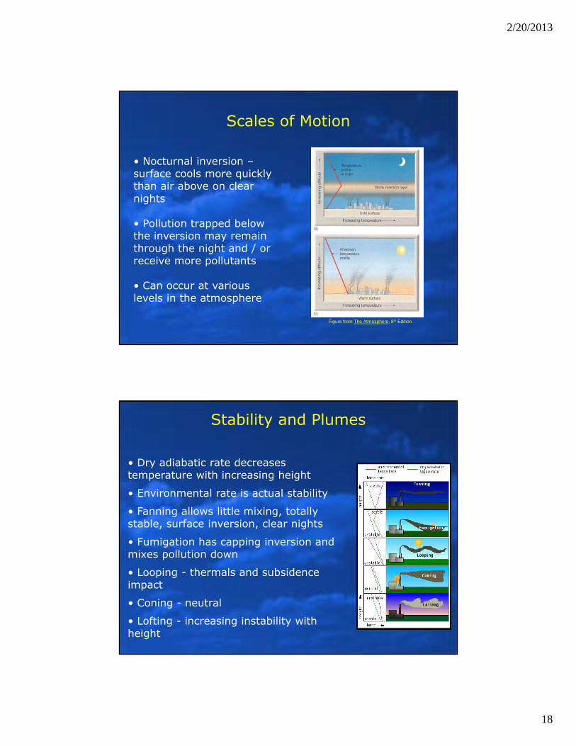
• Nocturnal inversion –surface cools more quickly than air above on clear nights
• Pollution trapped below the inversion may remain through the night and / or receive more pollutants
• Can occur at various levels in the atmosphere
Figure from The Atmosphere, 8th Edition
• Dry adiabatic rate decreases temperature with increasing height
• Environmental rate is actual stability
• Fanning allows little mixing, totally stable, surface inversion, clear nights
• Fumigation has capping inversion and mixes pollution down
• Looping - thermals and subsidence impact
• Coning - neutral
• Lofting - increasing instability with height
Stability and Plumes
2/20/2013
19
Conclusion – Complex System
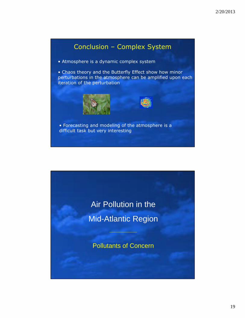
• Atmosphere is a dynamic complex system
• Chaos theory and the Butterfly Effect show how minor perturbations in the atmosphere can be amplified upon each iteration of the perturbation
• Forecasting and modeling of the atmosphere is a difficult task but very interesting
Air Pollution in the
Mid-Atlantic Region
Pollutants of Concern
2/20/2013
20
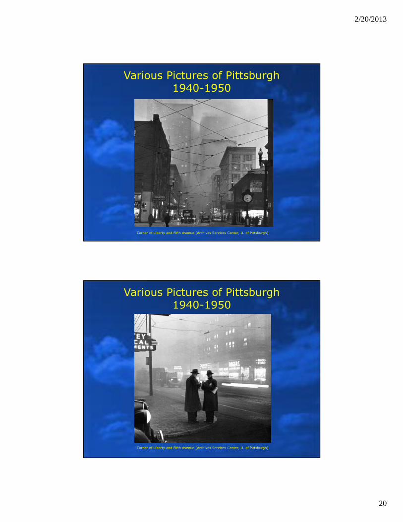
Various Pictures of Pittsburgh1940-1950
Corner of Liberty and Fifth Avenue (Archives Services Center, U. of Pittsburgh)
Various Pictures of Pittsburgh1940-1950
Corner of Liberty and Fifth Avenue (Archives Services Center, U. of Pittsburgh)
2/20/2013
21
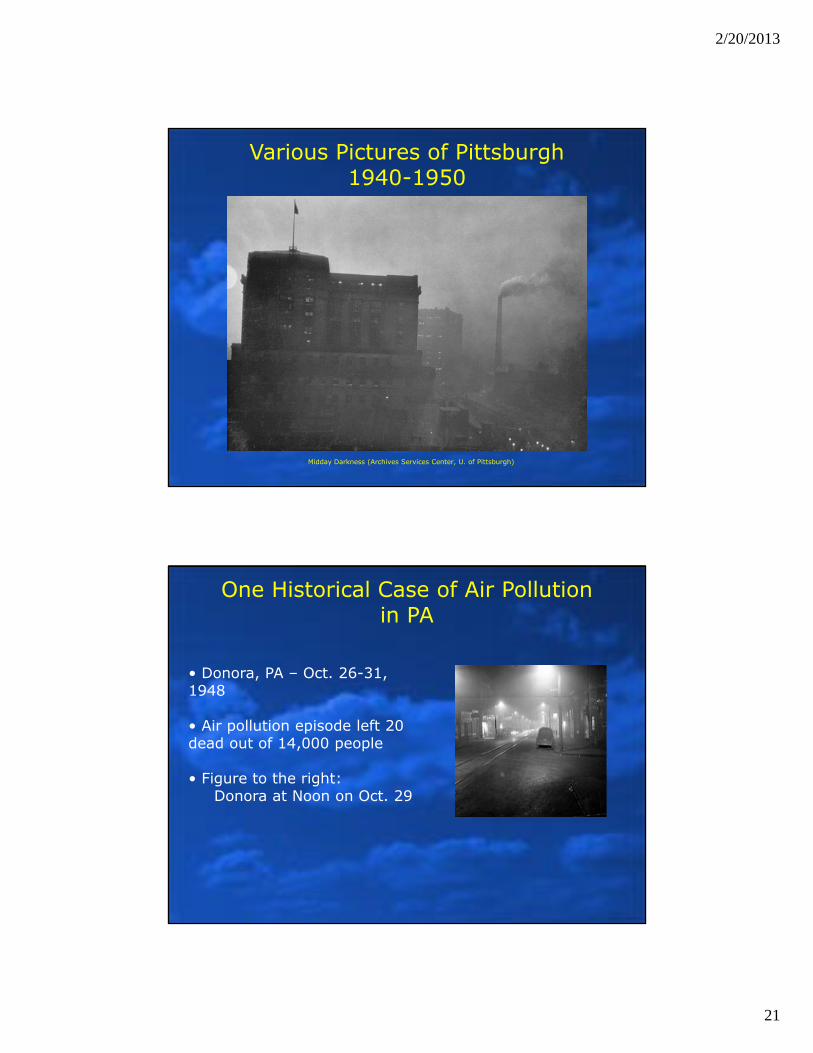
Various Pictures of Pittsburgh1940-1950
Midday Darkness (Archives Services Center, U. of Pittsburgh)
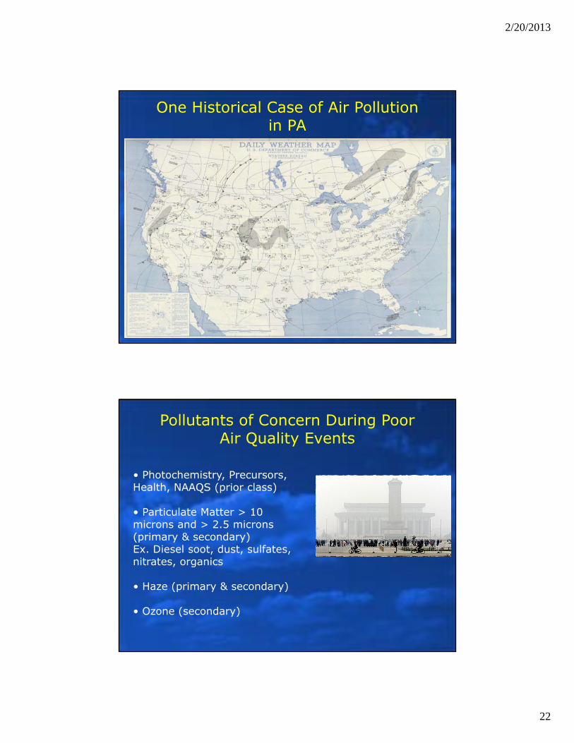
One Historical Case of Air Pollution in PA
• Donora, PA – Oct. 26-31, 1948
• Air pollution episode left 20 dead out of 14,000 people
• Figure to the right:Donora at Noon on Oct. 29
2/20/2013
22
One Historical Case of Air Pollution in PA
Pollutants of Concern During Poor Air Quality Events
• Photochemistry, Precursors, Health, NAAQS (prior class)
• Particulate Matter > 10 microns and > 2.5 microns (primary & secondary) Ex. Diesel soot, dust, sulfates, nitrates, organics
• Haze (primary & secondary)
• Ozone (secondary)
2/20/2013
23
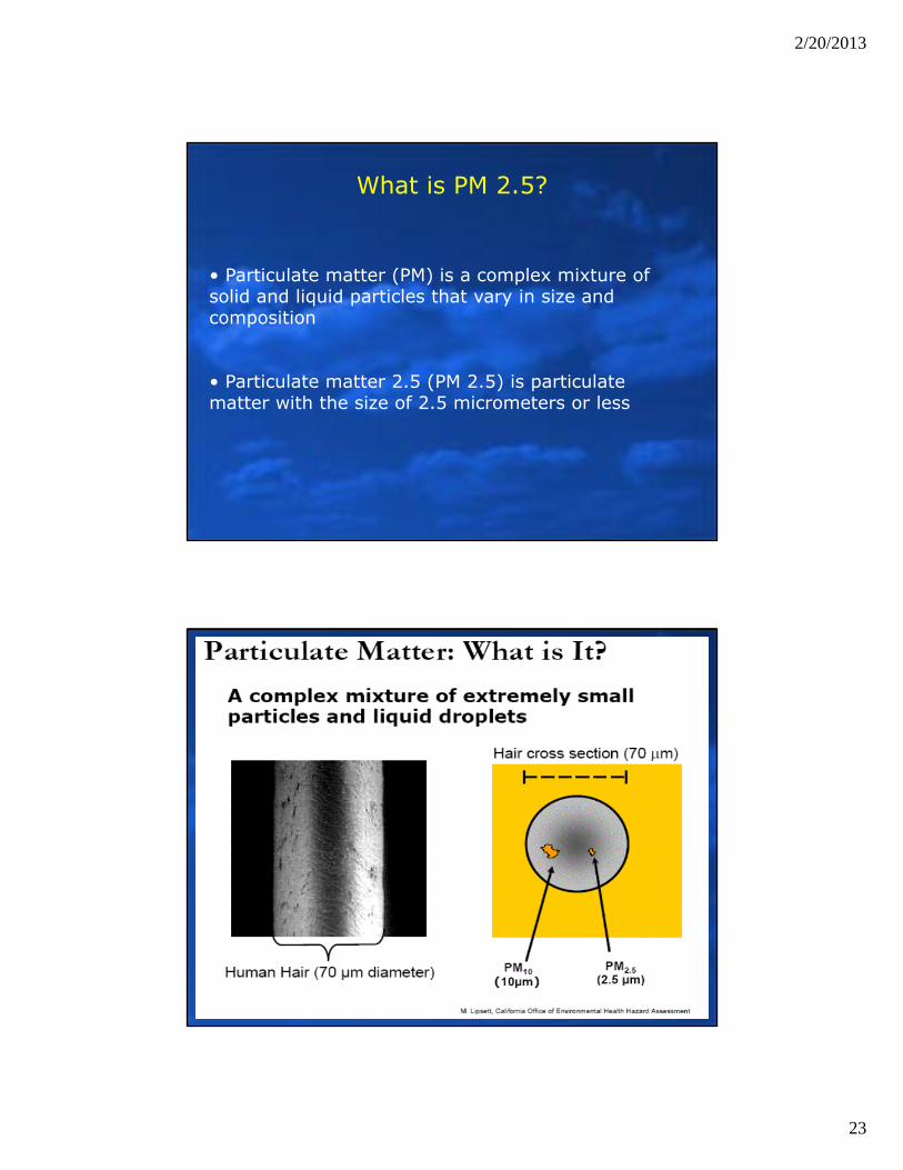
What is PM 2.5?
• Particulate matter (PM) is a complex mixture of solid and liquid particles that vary in size and composition
• Particulate matter 2.5 (PM 2.5) is particulate matter with the size of 2.5 micrometers or less
2/20/2013
24
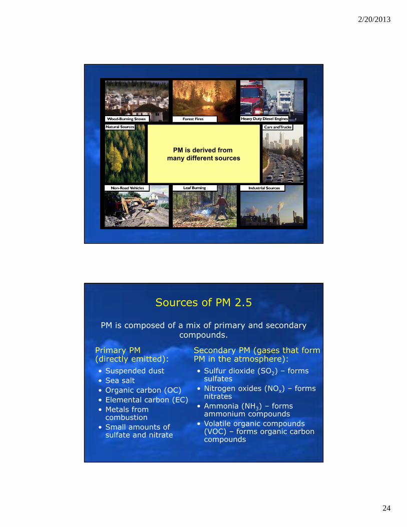
PM is derived from many different sources
Secondary PM (gases that form PM in the atmosphere):• Sulfur dioxide (SO2) – forms
sulfates• Nitrogen oxides (NOx) – forms
nitrates• Ammonia (NH3) – forms
ammonium compounds• Volatile organic compounds
(VOC) – forms organic carbon compounds
Primary PM (directly emitted):• Suspended dust• Sea salt• Organic carbon (OC)• Elemental carbon (EC)• Metals from
combustion• Small amounts of
sulfate and nitrate
PM is composed of a mix of primary and secondary compounds.
Sources of PM 2.5
2/20/2013
25
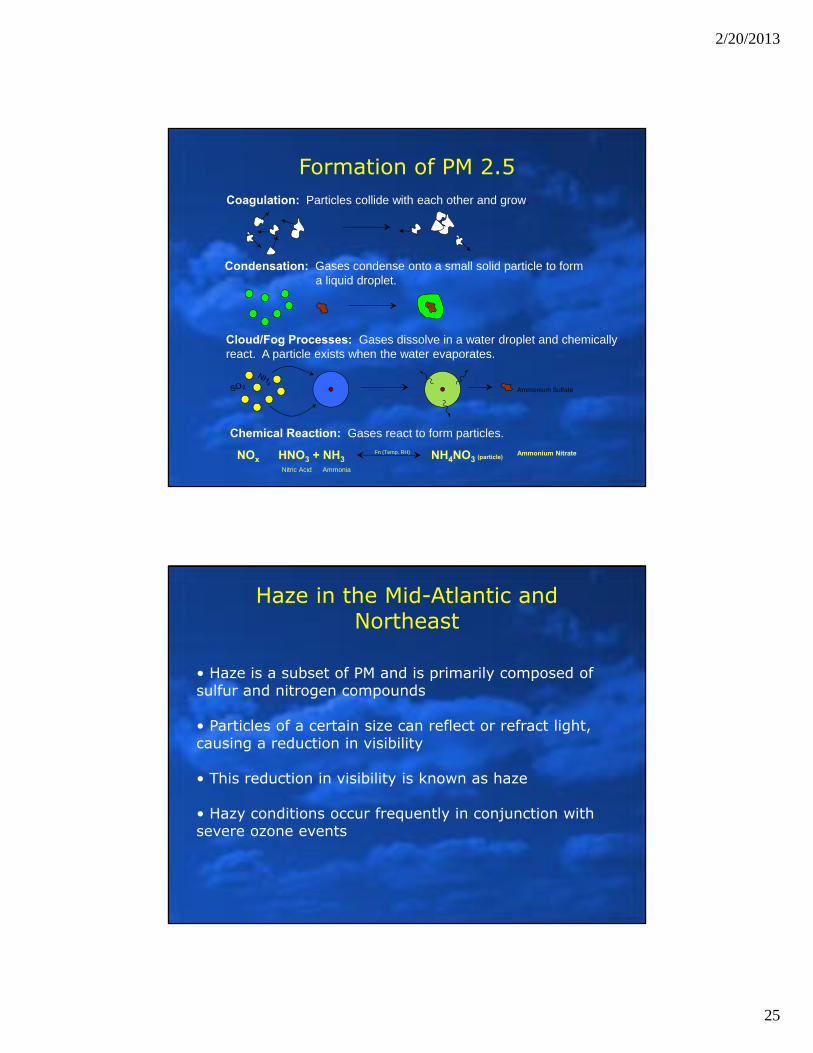
Formation of PM 2.5Coagulation: Particles collide with each other and grow.
Cloud/Fog Processes: Gases dissolve in a water droplet and chemically react. A particle exists when the water evaporates.
Ammonium Sulfate
Chemical Reaction: Gases react to form particles.
NOx � HNO3 + NH3 NH4NO3 (particle)Ammonium Nitrate
Nitric Acid Ammonia
Fn (Temp, RH)
Condensation: Gases condense onto a small solid particle to form a liquid droplet.
Haze in the Mid-Atlantic and Northeast
• Haze is a subset of PM and is primarily composed of sulfur and nitrogen compounds
• Particles of a certain size can reflect or refract light, causing a reduction in visibility
• This reduction in visibility is known as haze
• Hazy conditions occur frequently in conjunction with severe ozone events
2/20/2013
26
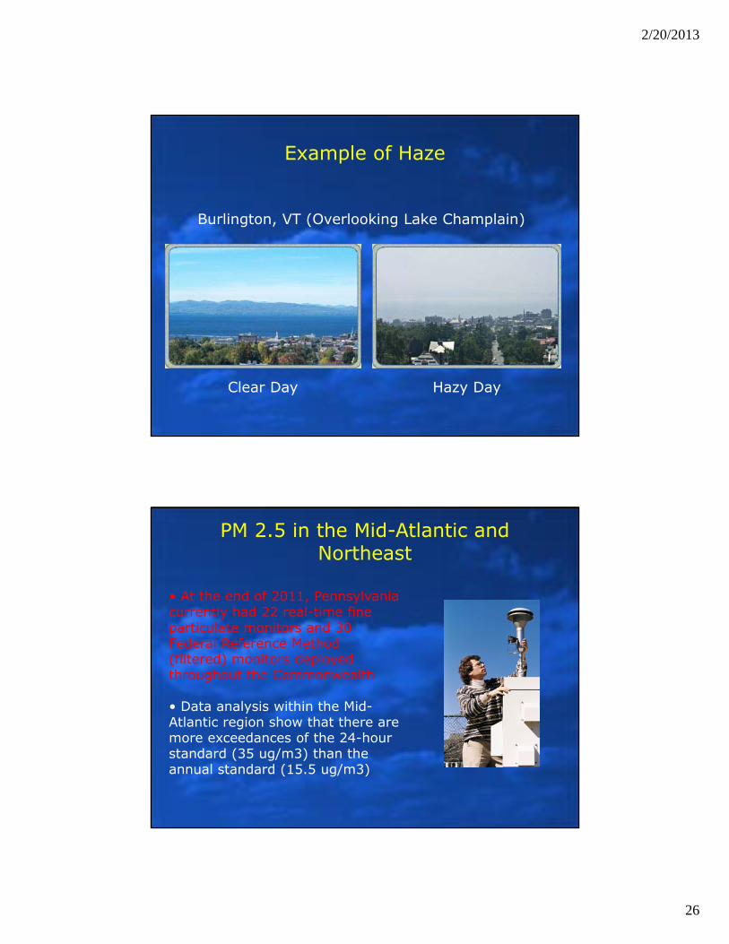
Example of Haze
Burlington, VT (Overlooking Lake Champlain)
Clear Day Hazy Day
PM 2.5 in the Mid-Atlantic and Northeast
• At the end of 2011, Pennsylvania currently had 22 real-time fine particulate monitors and 30 Federal Reference Method (filtered) monitors deployed throughout the Commonwealth
• Data analysis within the Mid-Atlantic region show that there are more exceedances of the 24-hour standard (35 ug/m3) than the annual standard (15.5 ug/m3)
2/20/2013
27
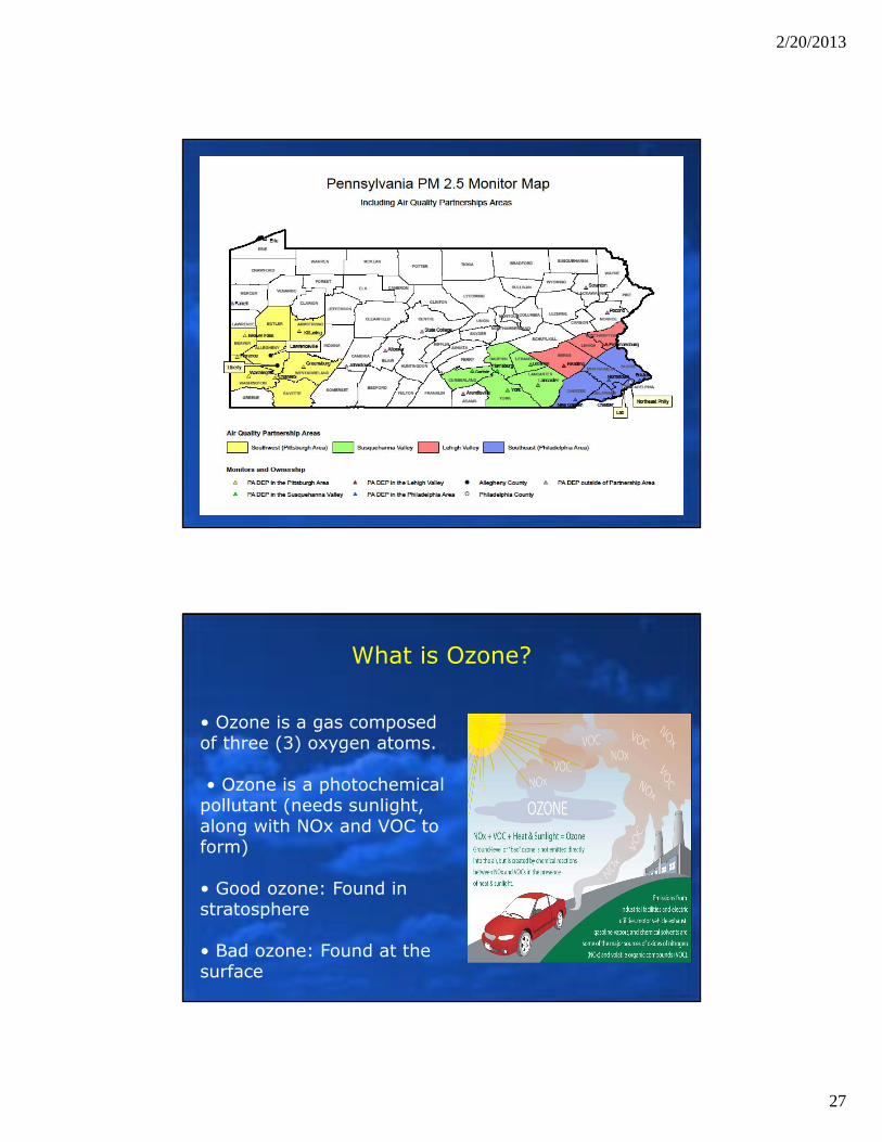
What is Ozone?
• Ozone is a gas composed of three (3) oxygen atoms.
• Ozone is a photochemical pollutant (needs sunlight, along with NOx and VOC to form)
• Good ozone: Found in stratosphere
• Bad ozone: Found at the surface
2/20/2013
28
Ozone in the Mid-Atlantic and Northeast
• At the end of 2012, Pennsylvania had 45+ monitors deployed throughout the Commonwealth
• Over the past several years, we have seen a decline in the number of exceedances over the area (as compared to the 1990s and early 2000s)
• Could be contributable to• Emission Reductions• Economic Downturn• Other Meteorological Factors
2/20/2013
29
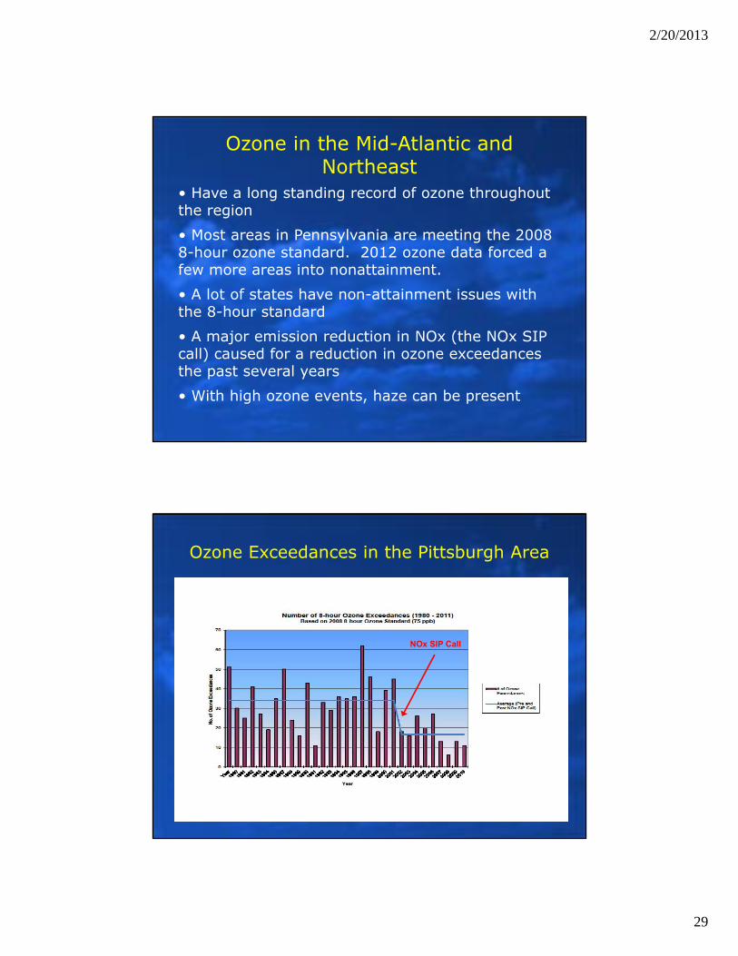
Ozone in the Mid-Atlantic and Northeast
• Have a long standing record of ozone throughout the region
• Most areas in Pennsylvania are meeting the 2008 8-hour ozone standard. 2012 ozone data forced a few more areas into nonattainment.
• A lot of states have non-attainment issues with the 8-hour standard
• A major emission reduction in NOx (the NOx SIP call) caused for a reduction in ozone exceedances the past several years
• With high ozone events, haze can be present
Ozone Exceedances in the Pittsburgh Area
NOx SIP Call
2/20/2013
30
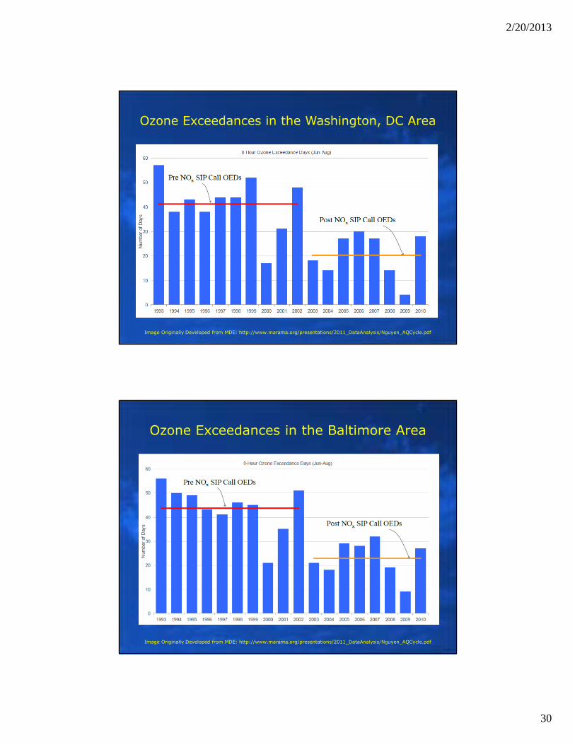
Ozone Exceedances in the Washington, DC Area
Image Originally Developed from MDE: http://www.marama.org/presentations/2011_DataAnalysis/Nguyen_AQCycle.pdf
Ozone Exceedances in the Baltimore Area
Image Originally Developed from MDE: http://www.marama.org/presentations/2011_DataAnalysis/Nguyen_AQCycle.pdf
2/20/2013
31
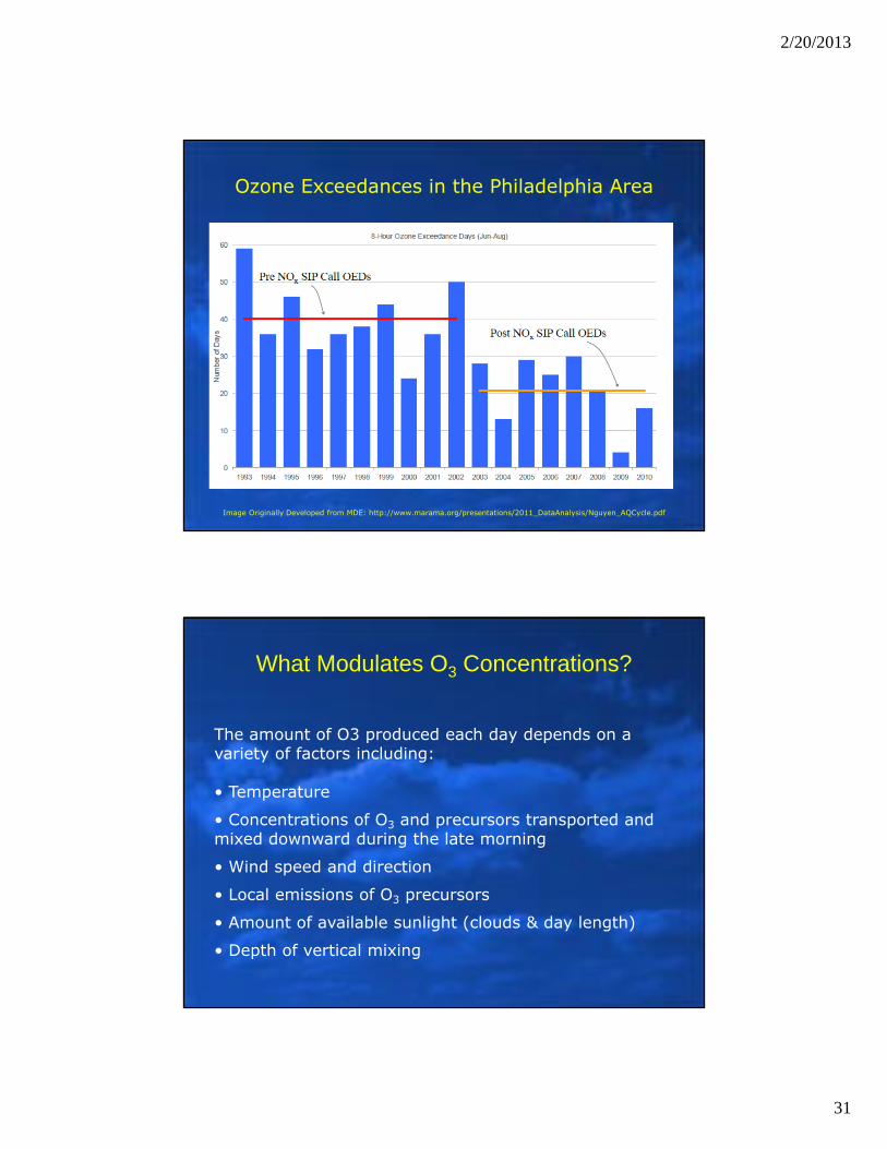
Ozone Exceedances in the Philadelphia Area
Image Originally Developed from MDE: http://www.marama.org/presentations/2011_DataAnalysis/Nguyen_AQCycle.pdf
What Modulates O3 Concentrations?
The amount of O3 produced each day depends on a variety of factors including:
• Temperature
• Concentrations of O3 and precursors transported and mixed downward during the late morning
• Wind speed and direction
• Local emissions of O3 precursors
• Amount of available sunlight (clouds & day length)
• Depth of vertical mixing
2/20/2013
32
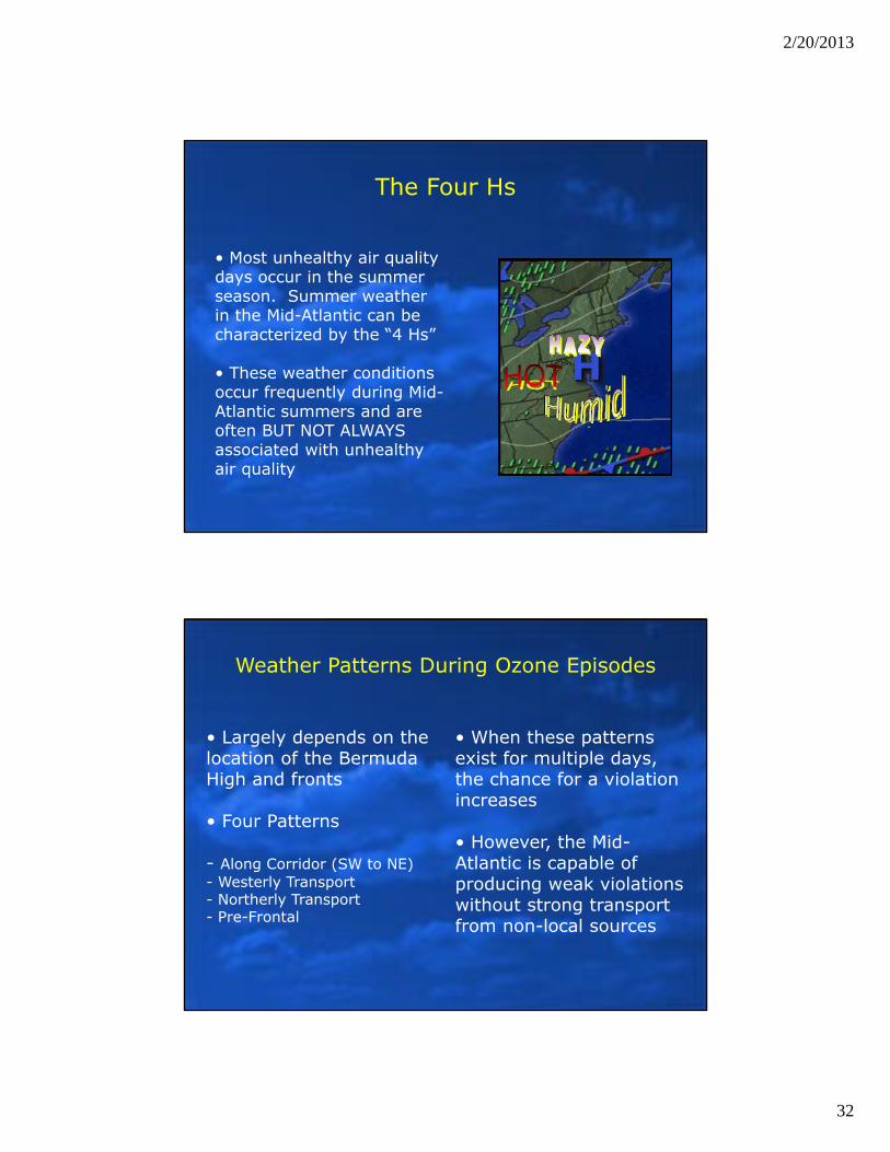
The Four Hs
• Most unhealthy air quality days occur in the summer season. Summer weather in the Mid-Atlantic can be characterized by the “4 Hs”
• These weather conditions occur frequently during Mid-Atlantic summers and are often BUT NOT ALWAYSassociated with unhealthy air quality
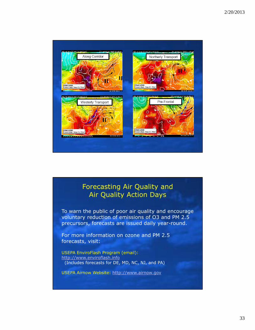
Weather Patterns During Ozone Episodes
• Largely depends on the location of the Bermuda High and fronts
• Four Patterns
- Along Corridor (SW to NE)- Westerly Transport- Northerly Transport- Pre-Frontal
• When these patterns exist for multiple days, the chance for a violation increases
• However, the Mid-Atlantic is capable of producing weak violations without strong transport from non-local sources
2/20/2013
33
Forecasting Air Quality and Air Quality Action Days
To warn the public of poor air quality and encourage voluntary reduction of emissions of O3 and PM 2.5 precursors, forecasts are issued daily year-round.
For more information on ozone and PM 2.5 forecasts, visit:
USEPA EnviroFlash Program (email):http://www.enviroflash.info(Includes forecasts for DE, MD, NC, NJ, and PA)
USEPA Airnow Website: http://www.airnow.gov
2/20/2013
34
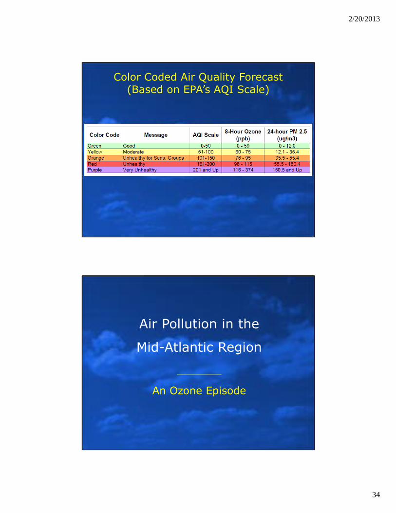
Color Coded Air Quality Forecast(Based on EPA’s AQI Scale)
Air Pollution in the
Mid-Atlantic Region
An Ozone Episode
2/20/2013
35
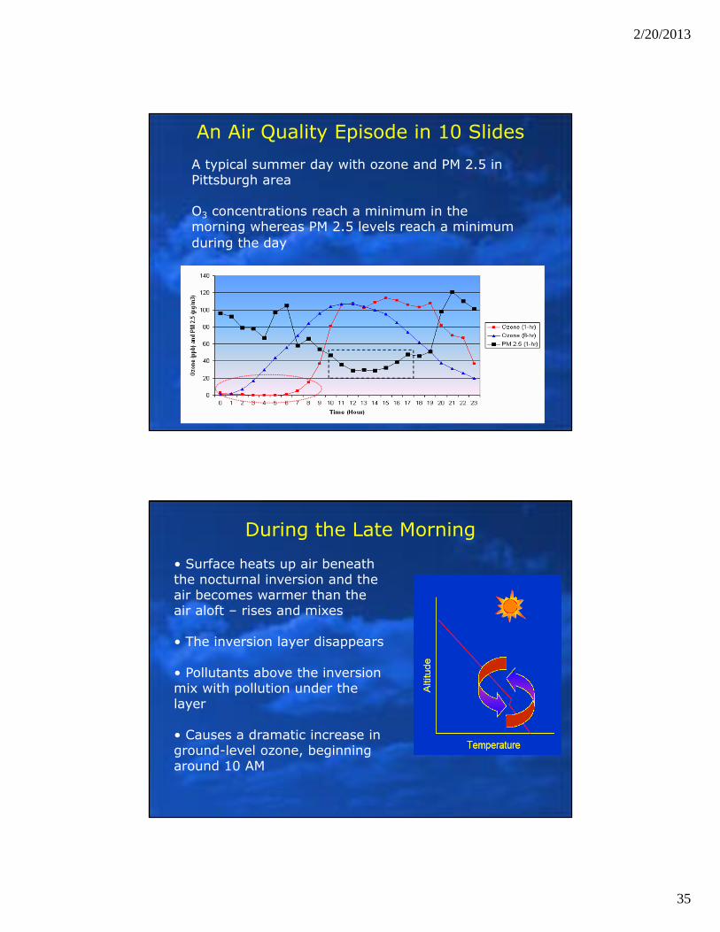
An Air Quality Episode in 10 SlidesA typical summer day with ozone and PM 2.5 in Pittsburgh area
O3 concentrations reach a minimum in the morning whereas PM 2.5 levels reach a minimum during the day
During the Late Morning
• Surface heats up air beneath the nocturnal inversion and the air becomes warmer than the air aloft – rises and mixes
• The inversion layer disappears
• Pollutants above the inversion mix with pollution under the layer
• Causes a dramatic increase in ground-level ozone, beginning around 10 AM
2/20/2013
36
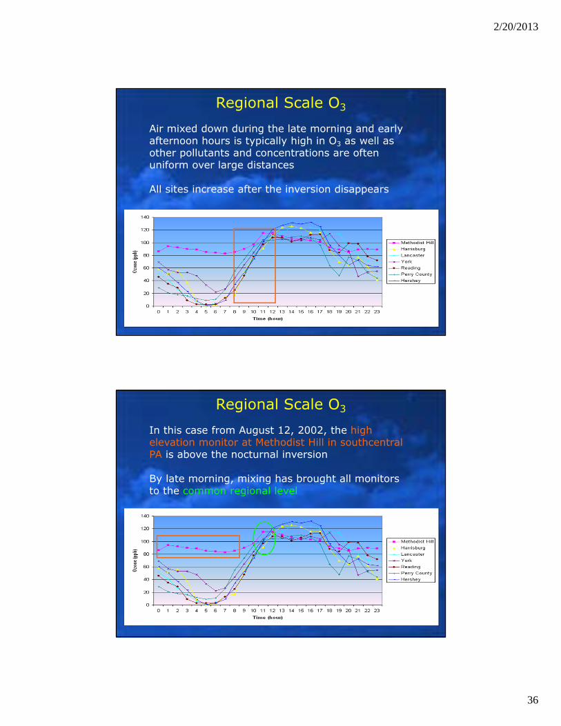
Air mixed down during the late morning and early afternoon hours is typically high in O3 as well as other pollutants and concentrations are often uniform over large distances
All sites increase after the inversion disappears
Regional Scale O3
In this case from August 12, 2002, the high elevation monitor at Methodist Hill in southcentral PA is above the nocturnal inversion
By late morning, mixing has brought all monitors to the common regional level
Regional Scale O3
2/20/2013
37
By the Afternoon
• By late morning, downward mixing of O3leads to relatively uniform concentrations across the region
• Local effects, related to emissions available, then dominate in the early afternoon hours
• O3 is formed as UV radiation drives reactions of O3 precursors
• Depending on a variety of factors, peak O3concentrations are reached during the mid to late afternoon hours
• The highest concentrations occur downwind of the urban center
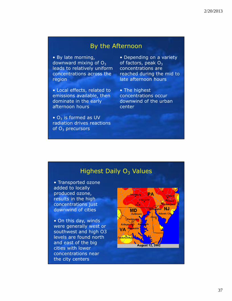
Highest Daily O3 Values
• Transported ozone added to locally produced ozone, results in the high concentrations just downwind of cities
• On this day, winds were generally west or southwest and high O3 levels are found north and east of the big cities with lower concentrations near the city centers
2/20/2013
38
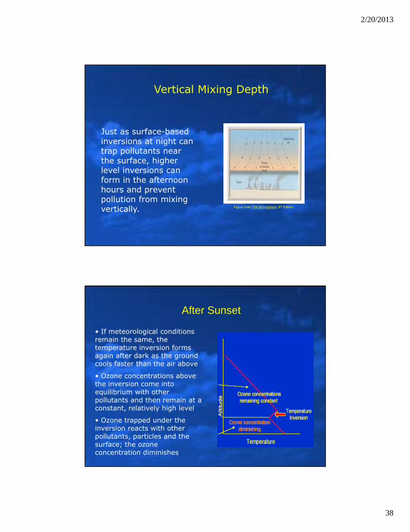
Just as surface-based inversions at night can trap pollutants near the surface, higher level inversions can form in the afternoon hours and prevent pollution from mixing vertically.
Vertical Mixing Depth
Figure from The Atmosphere, 8th Edition
After Sunset
• If meteorological conditions remain the same, the temperature inversion forms again after dark as the ground cools faster than the air above
• Ozone concentrations above the inversion come into equilibrium with other pollutants and then remain at a constant, relatively high level
• Ozone trapped under the inversion reacts with other pollutants, particles and the surface; the ozone concentration diminishes
2/20/2013
39
The End of an Ozone Episode
• An ozone episode usually ends with the arrival of a ‘clean’ air mass:
This can occur with a cold front or other low-pressure system like a tropical storm
• An episode may also end prior to the passage of a cold front if widespread thunderstorms develop ahead of the front
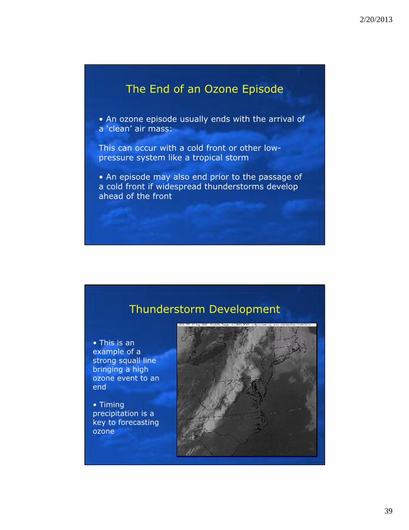
Thunderstorm Development
• This is an example of a strong squall line bringing a high ozone event to an end
• Timing precipitation is a key to forecasting ozone
2/20/2013
40
Air Pollution in the
Mid-Atlantic Region
Transport and Ozone Episodes
What Do We Know About Air Parcels Entering the Region
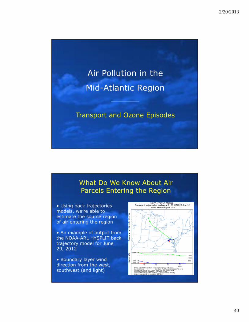
• Using back trajectories models, we’re able to estimate the source region of air entering the region
• An example of output from the NOAA-ARL HYSPLIT back trajectory model for June 29, 2012
• Boundary layer wind direction from the west, southwest (and light)
2/20/2013
41
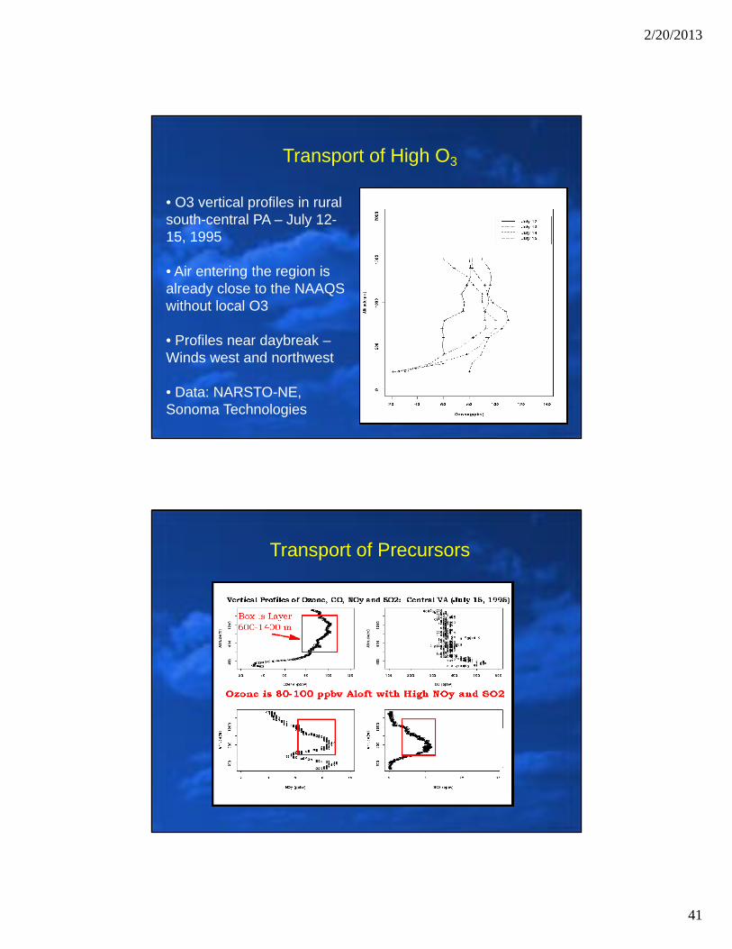
Transport of High O3
• O3 vertical profiles in rural south-central PA – July 12-15, 1995
• Air entering the region is already close to the NAAQS without local O3
• Profiles near daybreak –Winds west and northwest
• Data: NARSTO-NE, Sonoma Technologies
Transport of Precursors

2/20/2013
42
Recirculation
• On days when winds are in the opposite direction as they were the previous day, an area will experience the previous day’s air mass, often polluted, a second time
• The longer residence time for pollutants means more potential for ozone production.
Haze is Associated with Recirculated Air
Haze is seen from western MD through southeastern PA and northeastward into New England
2/20/2013
43
Recirculation
Recirculation wind patterns can occur in a number of different situations:
– A change in frontal position: Cold fronts often stall over the region in summer and return north as a warm front– Land/sea interactions: Sea breezes often push concentrate O3 and precursors back into the Philadelphia area– Changes in position of pressure system centers
Recirculation at low levels can occur in conjunction with continued westerly transport aloft
In weather patterns conducive to high O3, a strong nocturnal inversion typically develops
During the overnight hours, a region of strong west to southwest winds will develop just above the nocturnal boundary layer
Recent advances in remote sensing instruments (radar profilers) have allowed these phenomena to be observed
Intra-Regional Transport:The Low Level Jet
2/20/2013
44
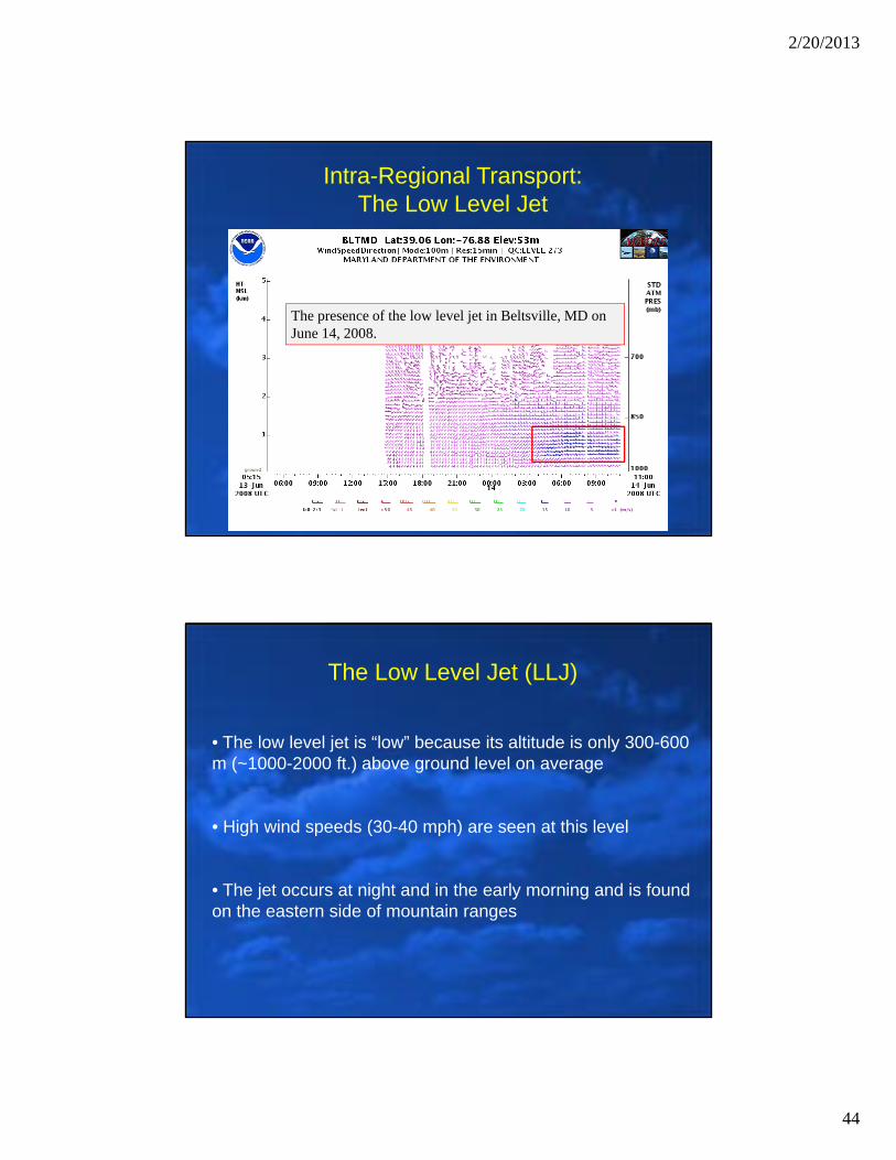
Intra-Regional Transport:The Low Level Jet
The presence of the low level jet in Beltsville, MD on June 14, 2008.
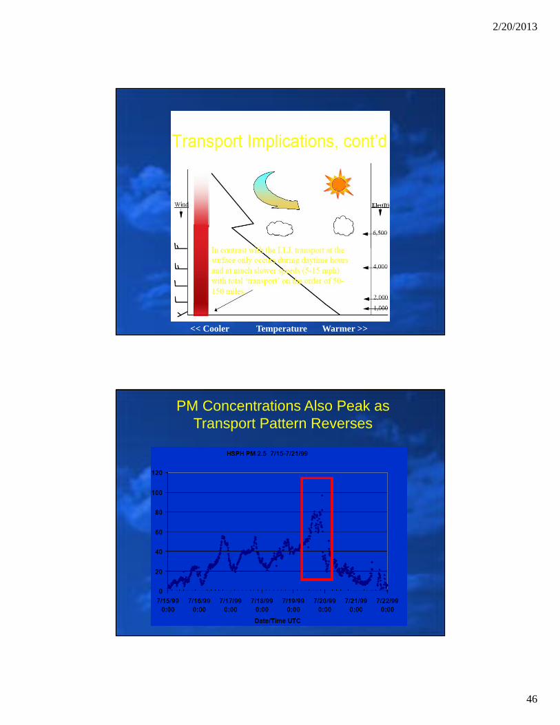
The Low Level Jet (LLJ)
• The low level jet is “low” because its altitude is only 300-600 m (~1000-2000 ft.) above ground level on average
• High wind speeds (30-40 mph) are seen at this level
• The jet occurs at night and in the early morning and is found on the eastern side of mountain ranges
2/20/2013
45
The Low Level Jet (LLJ)
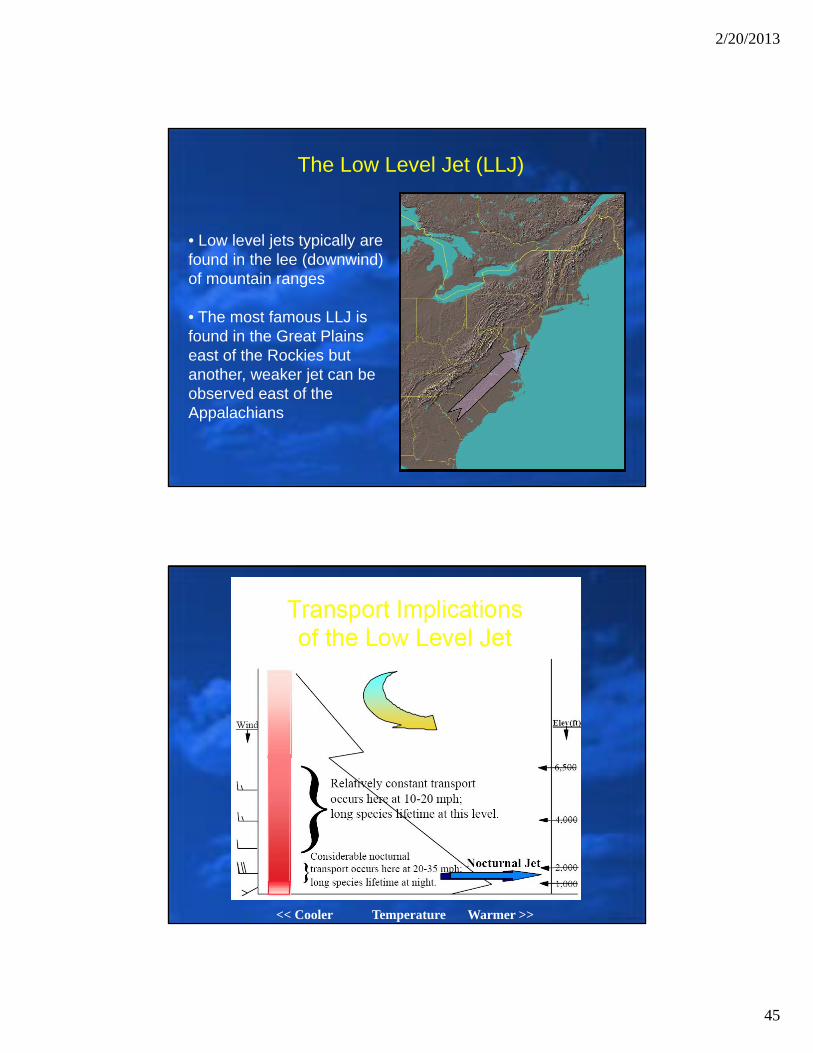
• Low level jets typically are found in the lee (downwind) of mountain ranges
• The most famous LLJ is found in the Great Plains east of the Rockies but another, weaker jet can be observed east of the Appalachians
<< Cooler Temperature Warmer >>
2/20/2013
46
<< Cooler Temperature Warmer >>
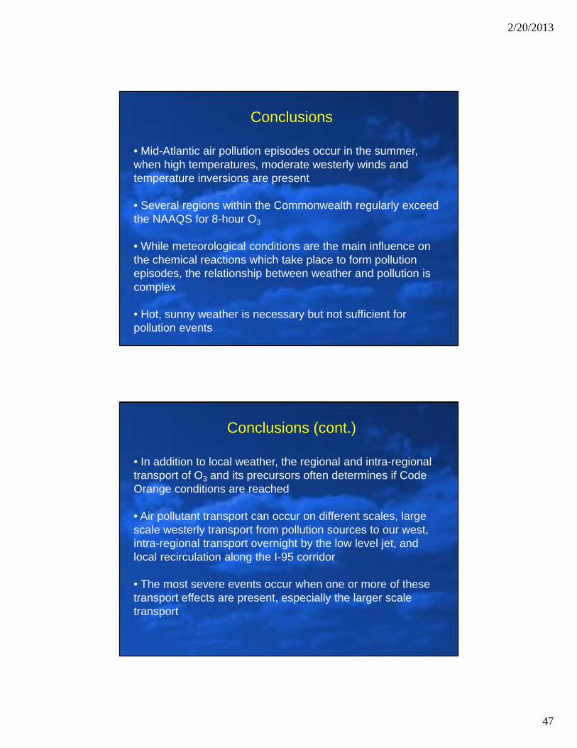
PM Concentrations Also Peak as Transport Pattern Reverses
2/20/2013
47
Conclusions
• Mid-Atlantic air pollution episodes occur in the summer, when high temperatures, moderate westerly winds and temperature inversions are present
• Several regions within the Commonwealth regularly exceed the NAAQS for 8-hour O3
• While meteorological conditions are the main influence on the chemical reactions which take place to form pollution episodes, the relationship between weather and pollution is complex
• Hot, sunny weather is necessary but not sufficient for pollution events
• In addition to local weather, the regional and intra-regional transport of O3 and its precursors often determines if Code Orange conditions are reached
• Air pollutant transport can occur on different scales, large scale westerly transport from pollution sources to our west, intra-regional transport overnight by the low level jet, and local recirculation along the I-95 corridor
• The most severe events occur when one or more of these transport effects are present, especially the larger scale transport
Conclusions (cont.)
2/20/2013
48
Air Pollution in the
Mid-Atlantic Region
Review of 2012 Episode
Review of 2012 Episode
Period of Episode: June 28-29, 2012
Discussion Includes the Following:
• The Setup
• The Event• Meteorological Conditions• Air Quality Levels
• The Finale

2/20/2013
49
Meteorological Conditions (The Setup)Wed, Jun 27, 2012
High Temps: Richmond (87), Washington DC (87), Baltimore (90), Philly (86), Pittsburgh (86)
Surface Map – 7 AM Forecasted Trajectory – 5 PM
Ozone ConditionsWed, Jun 27, 2012
Locally: Only GOOD and MODERATE Levels Out West: Levels Rising into ORANGE/RED

2/20/2013
50
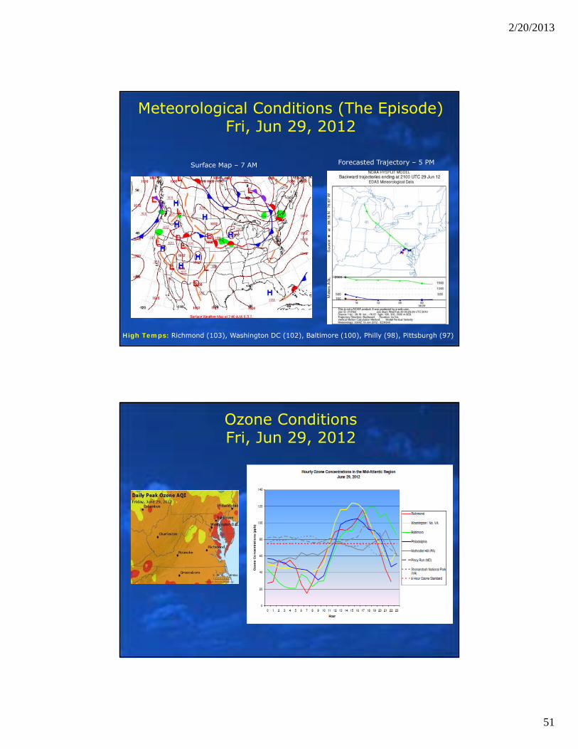
Meteorological Conditions (The Episode)Thu, Jun 28, 2012
Surface Map – 7 AM Forecasted Trajectory – 5 PM
High Temps: Richmond (96), Washington DC (93), Baltimore (96), Philly (92), Pittsburgh (95)
Ozone ConditionsThu, Jun 28, 2012
2/20/2013
51
Meteorological Conditions (The Episode)Fri, Jun 29, 2012
Surface Map – 7 AM Forecasted Trajectory – 5 PM
High Temps: Richmond (103), Washington DC (102), Baltimore (100), Philly (98), Pittsburgh (97)
Ozone ConditionsFri, Jun 29, 2012
2/20/2013
52
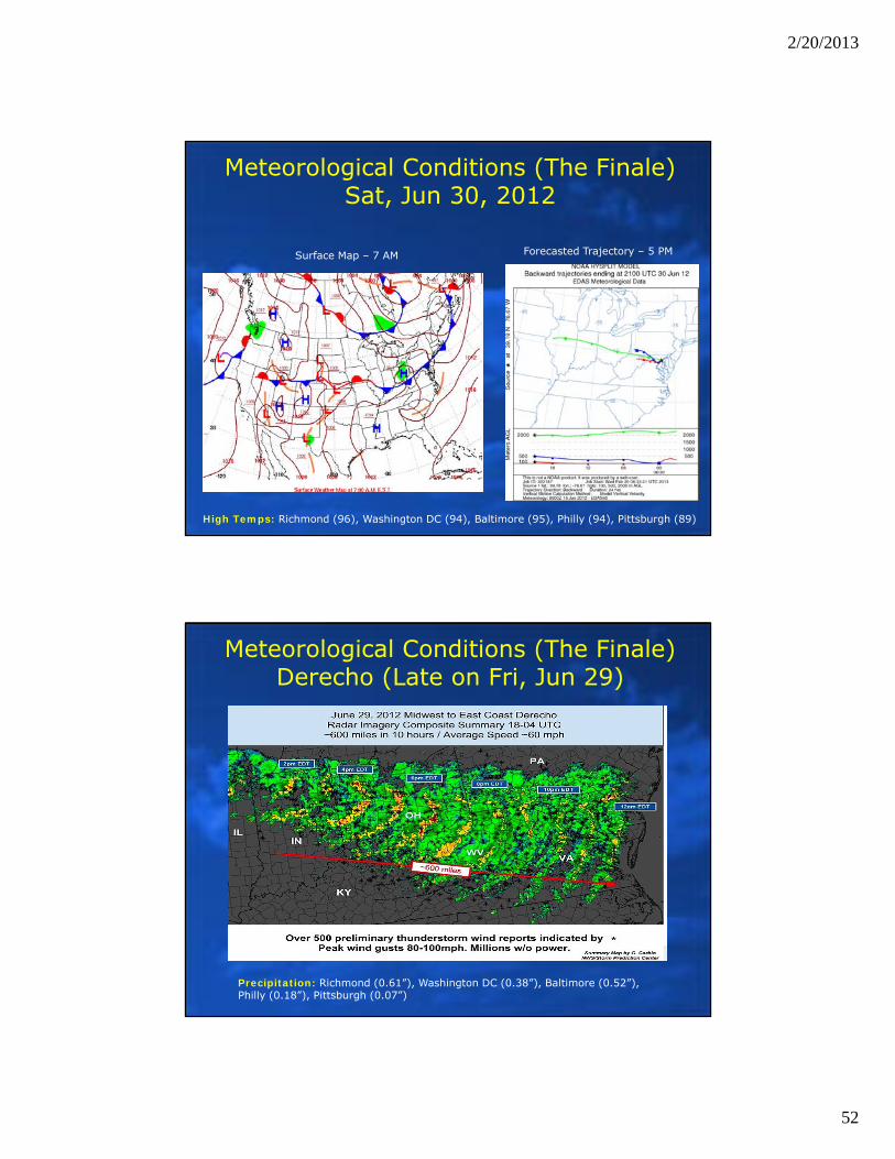
Meteorological Conditions (The Finale)Sat, Jun 30, 2012
Surface Map – 7 AM Forecasted Trajectory – 5 PM
High Temps: Richmond (96), Washington DC (94), Baltimore (95), Philly (94), Pittsburgh (89)
Meteorological Conditions (The Finale)Derecho (Late on Fri, Jun 29)
Precipitation: Richmond (0.61”), Washington DC (0.38”), Baltimore (0.52”), Philly (0.18”), Pittsburgh (0.07”)
2/20/2013
53
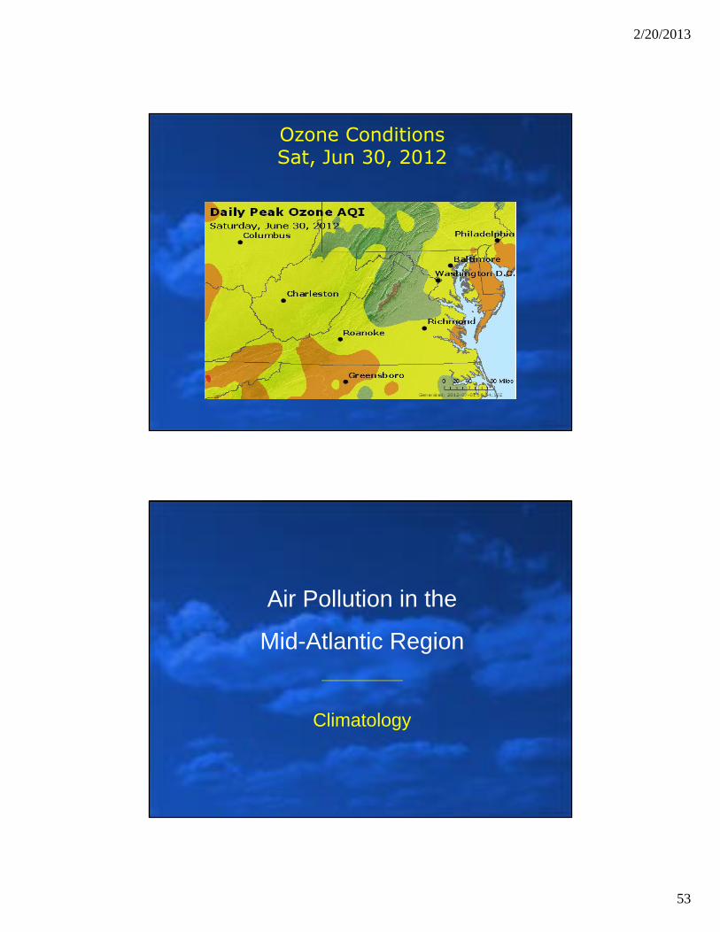
Ozone ConditionsSat, Jun 30, 2012
Air Pollution in the
Mid-Atlantic Region
Climatology
2/20/2013
54
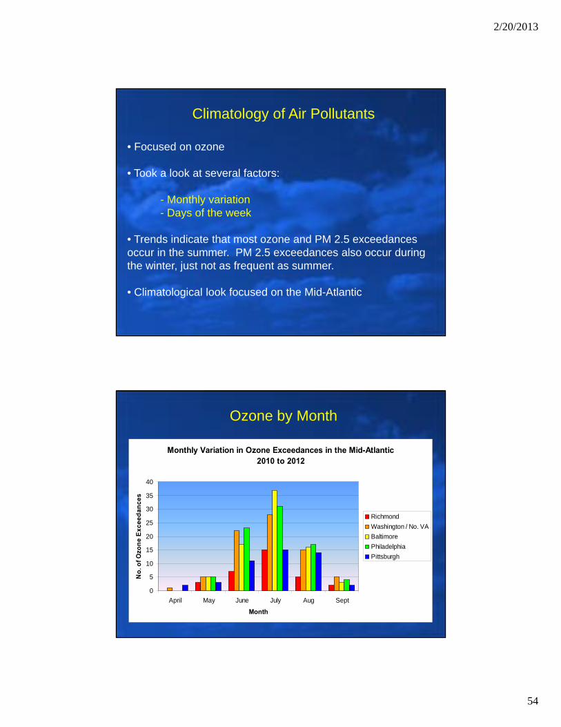
Climatology of Air Pollutants
• Focused on ozone
• Took a look at several factors:
- Monthly variation- Days of the week
• Trends indicate that most ozone and PM 2.5 exceedances occur in the summer. PM 2.5 exceedances also occur during the winter, just not as frequent as summer.
• Climatological look focused on the Mid-Atlantic
Ozone by Month
Monthly Variation in Ozone Exceedances in the Mid-Atlantic2010 to 2012
0
5
10
15
20
25
30
35
40
April May June July Aug Sept
Month
No
. of
Ozo
ne
Ex
ce
ed
an
ce
s
Richmond
Washington / No. VA
Baltimore
Philadelphia
Pittsburgh
2/20/2013
55
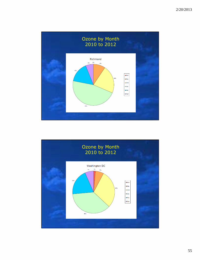
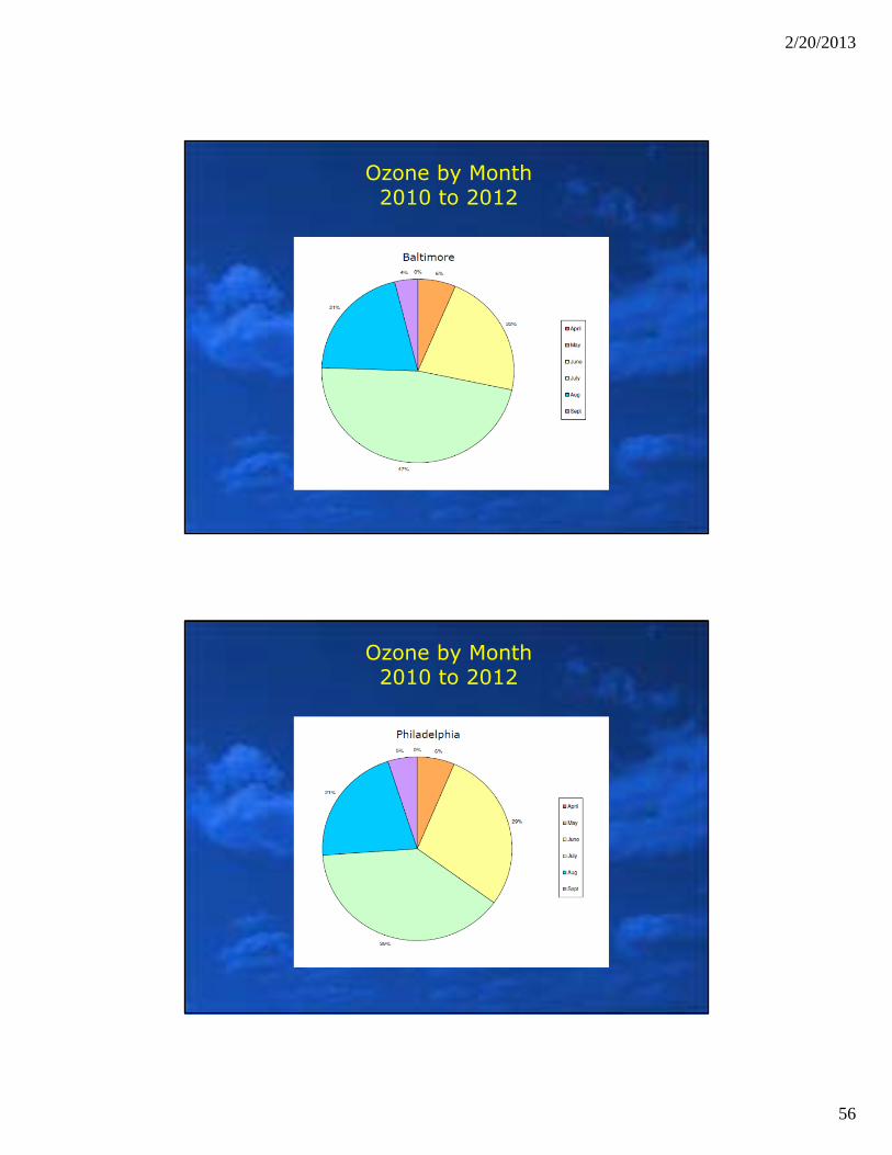
Ozone by Month2010 to 2012
Ozone by Month2010 to 2012
2/20/2013
56
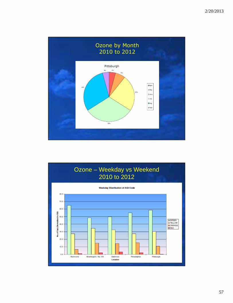
Ozone by Month2010 to 2012
Ozone by Month2010 to 2012
2/20/2013
57
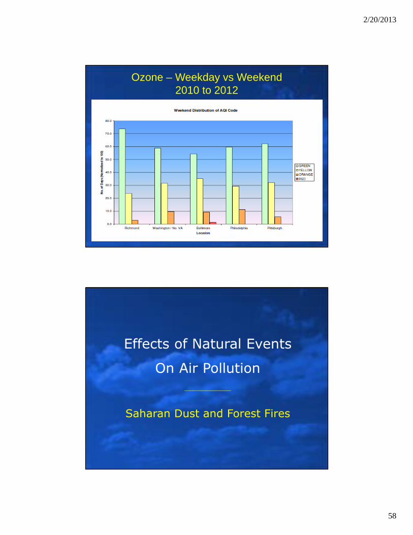
Ozone by Month2010 to 2012
Ozone – Weekday vs Weekend2010 to 2012
2/20/2013
58
Ozone – Weekday vs Weekend2010 to 2012
Effects of Natural Events
On Air Pollution
Saharan Dust and Forest Fires
2/20/2013
59
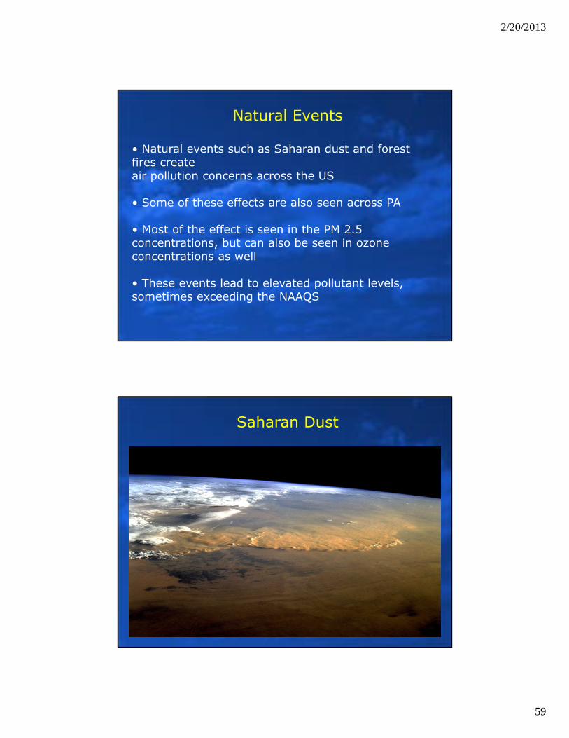
Natural Events
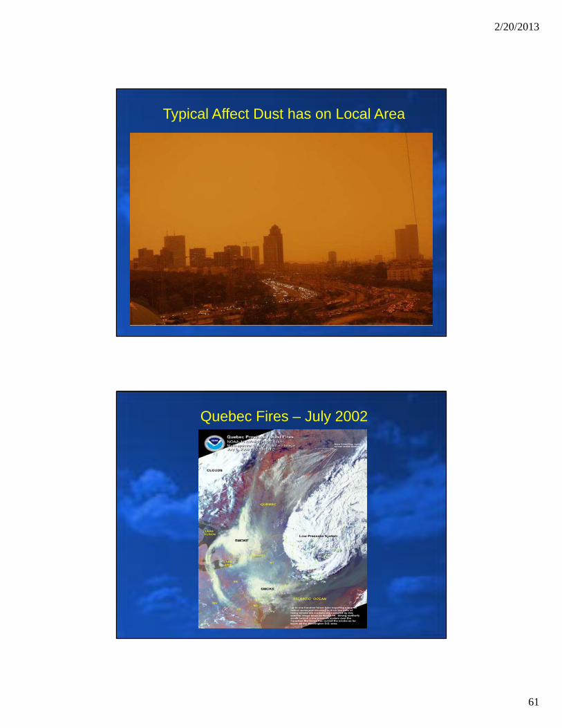
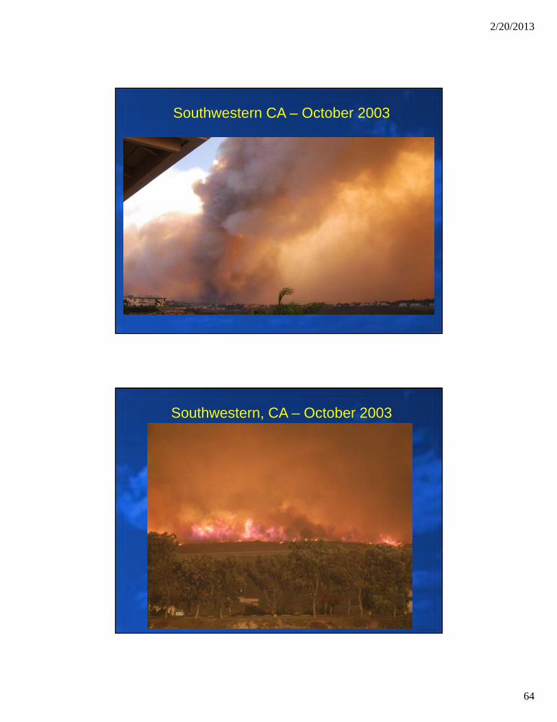
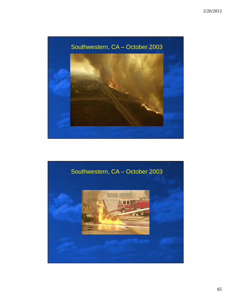
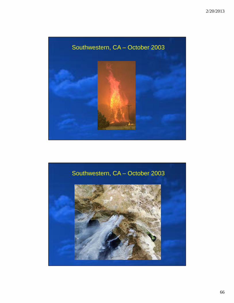
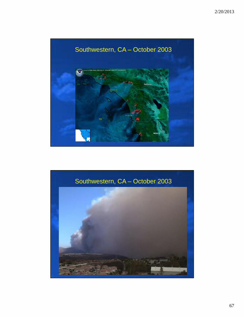
• Natural events such as Saharan dust and forest fires create air pollution concerns across the US
• Some of these effects are also seen across PA
• Most of the effect is seen in the PM 2.5 concentrations, but can also be seen in ozone concentrations as well
• These events lead to elevated pollutant levels, sometimes exceeding the NAAQS
Saharan Dust
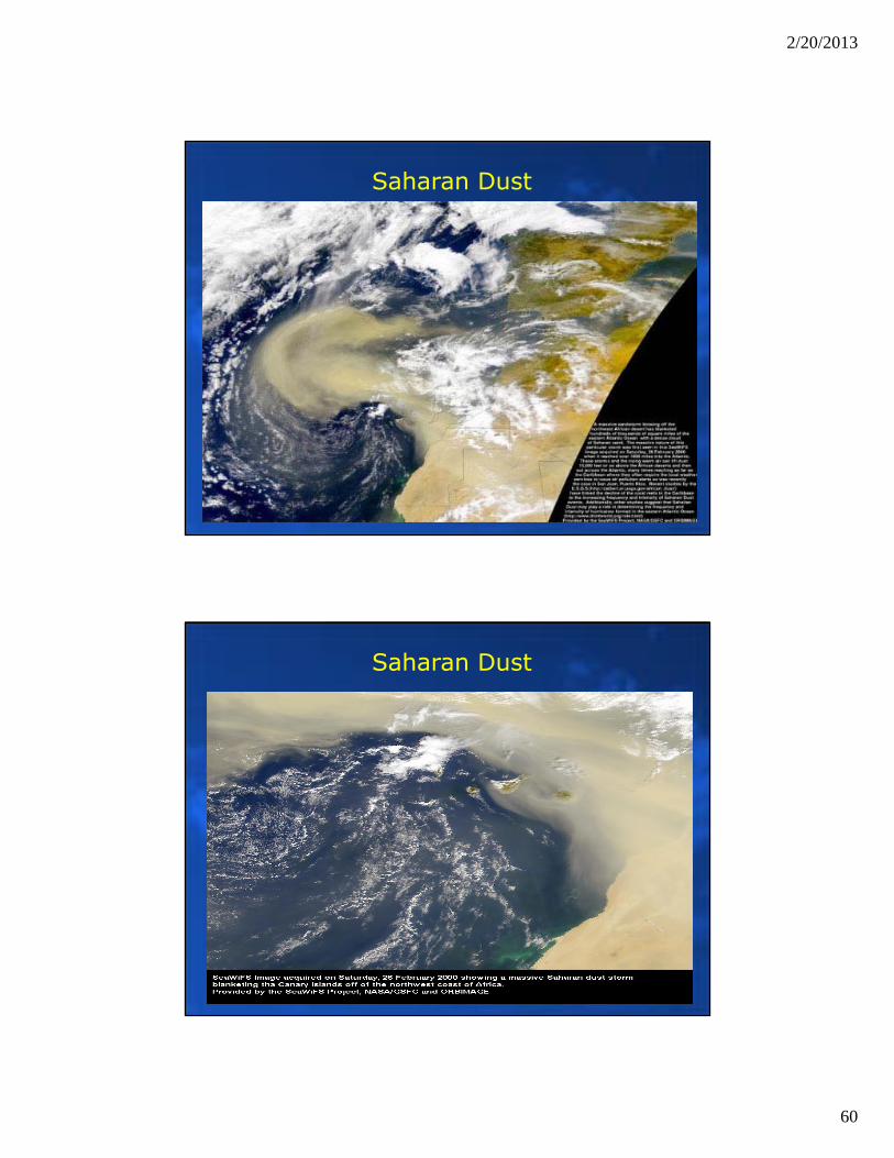
2/20/2013
60
Saharan Dust
Saharan Dust
2/20/2013
61
Typical Affect Dust has on Local Area
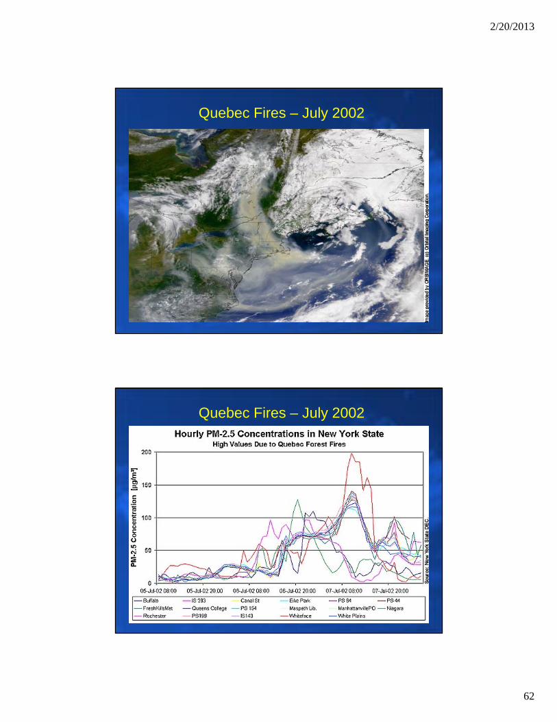
Quebec Fires – July 2002
2/20/2013
62
Quebec Fires – July 2002
Quebec Fires – July 2002
2/20/2013
63
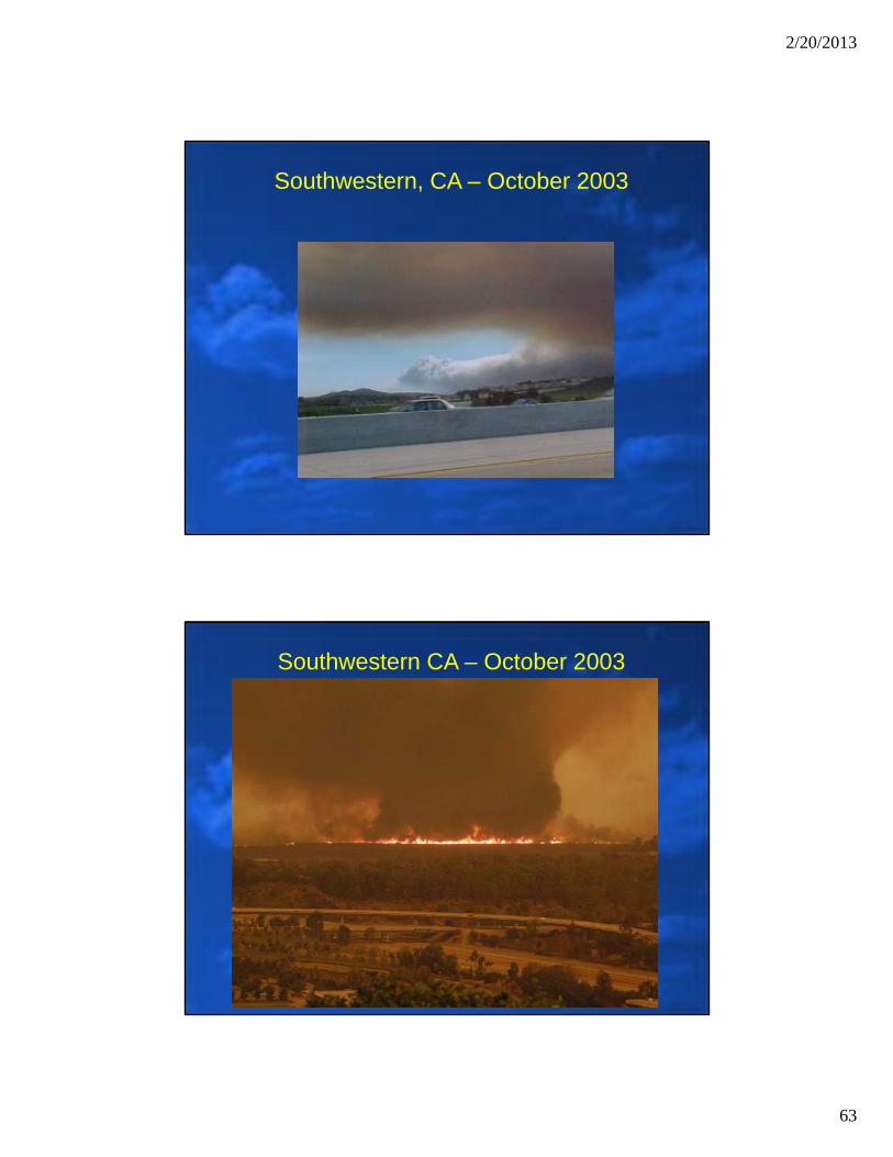
Southwestern, CA – October 2003
Southwestern CA – October 2003
2/20/2013
64
Southwestern CA – October 2003
Southwestern, CA – October 2003
2/20/2013
65
Southwestern, CA – October 2003
Southwestern, CA – October 2003
2/20/2013
66
Southwestern, CA – October 2003
Southwestern, CA – October 2003
2/20/2013
67
Southwestern, CA – October 2003
Southwestern, CA – October 2003
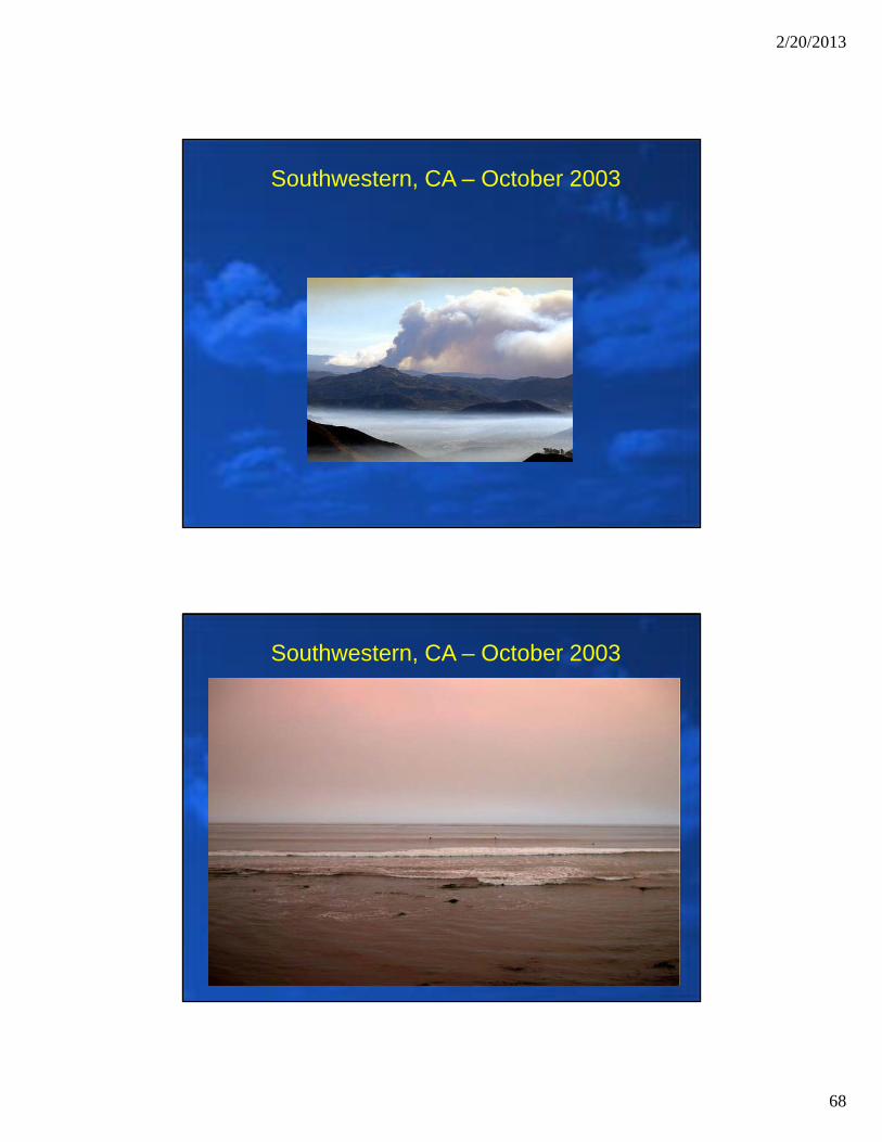
2/20/2013
68
Southwestern, CA – October 2003
Southwestern, CA – October 2003
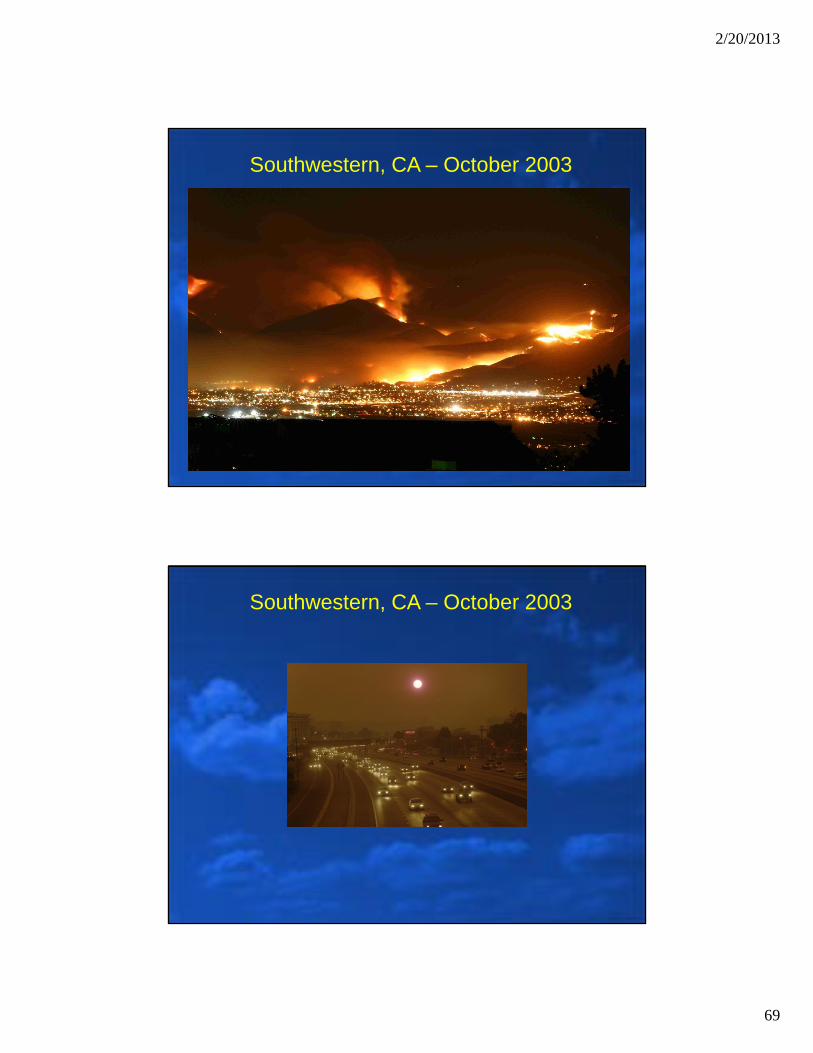
2/20/2013
69
Southwestern, CA – October 2003
Southwestern, CA – October 2003
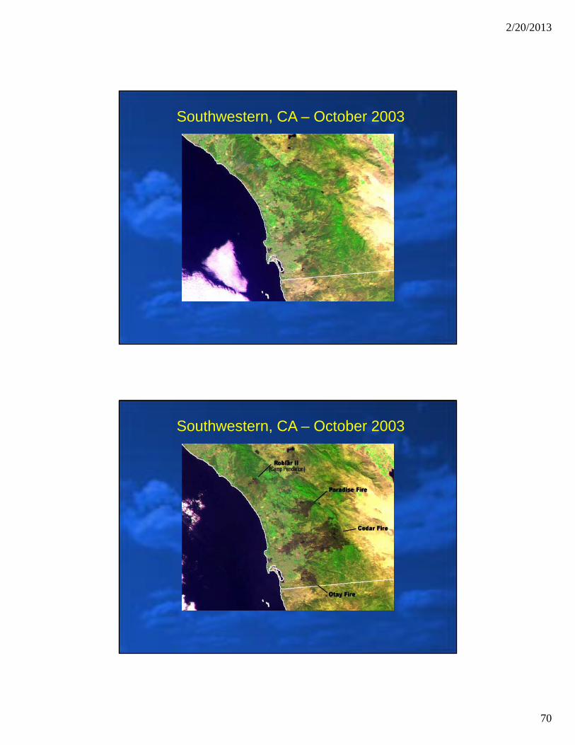
2/20/2013
70
Southwestern, CA – October 2003
Southwestern, CA – October 2003
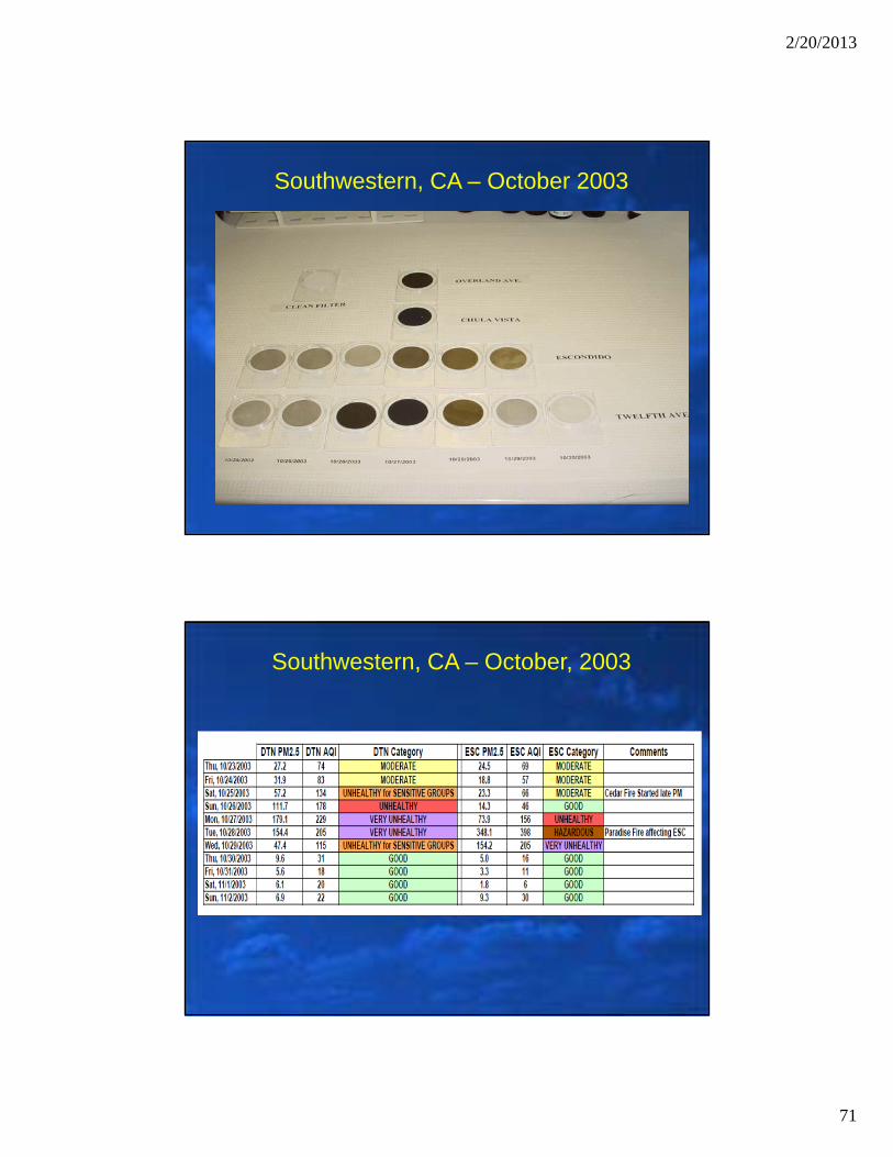
2/20/2013
71
Southwestern, CA – October 2003
Southwestern, CA – October, 2003

2/20/2013
72
The End
Picture Details: Linfen, China (taken in the 2000s)
Related Documents