MetaSAR-L Airborne SAR www.metasensing.com The MetaSAR-L enclosure is compact and light-weight, allowing for quick and flexible mounng. These high-resoluon images, along with Coherent Change Detecon techniques, can resolve even the smallest variaons in an area over me, providing informaon invisible to the human eye. The MetaSAR-L system consists of a radar elec- tronic box, characterized by its compact size and light weight as well as low power consump- on, along with dual-polarimetric flat-panel antennas and mounng fixtures as required. Details are provided in the technical specifica- ons table. The MetaSAR-L is an advanced mul-channel airborne Synthec Aperture Radar (SAR) operang at L-band radio frequencies. It provides high-resoluon SAR imaging, useful for topographic and monitoring applicaons such as wide-area cartography, vegetaon mapping, soil moisture measurements, agriculture, land cover classificaon, digital terrain model creaon, glacier analysis, and detecon of water leaks. We provide a compact radar sensor that combines high-quality L-band radar performance with flexibility in swath size and resoluon. The radar allows for all-weather observaons of the scene to be monitored, and the system enclosure can be easily installed on mulple types of aircraſt. It is the culminaon of a decade of experience in creang and developing radar soluons that MetaSensing offers. The collected airborne SAR data are processed with the MetaSAR-PRO applicaon, MetaSensing’s proprietary airborne SAR processor. This applicaon uses the Polarimetric Interferometric SAR (PolInSAR) technique to generate georeferenced GeoTiff images, the standard used by professionals worldwide.

Welcome message from author
This document is posted to help you gain knowledge. Please leave a comment to let me know what you think about it! Share it to your friends and learn new things together.
Transcript
MetaSAR-L Airborne SAR
www.metasensing.com
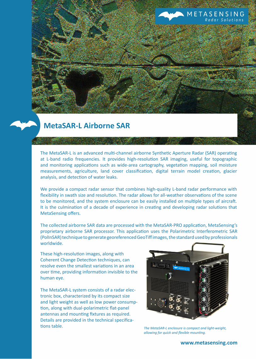
The MetaSAR-L enclosure is compact and light-weight, allowing for quick and flexible mounting.
These high-resolution images, along with Coherent Change Detection techniques, can resolve even the smallest variations in an area over time, providing information invisible to the human eye.
The MetaSAR-L system consists of a radar elec-tronic box, characterized by its compact size and light weight as well as low power consump-tion, along with dual-polarimetric flat-panel antennas and mounting fixtures as required. Details are provided in the technical specifica-tions table.
The MetaSAR-L is an advanced multi-channel airborne Synthetic Aperture Radar (SAR) operating at L-band radio frequencies. It provides high-resolution SAR imaging, useful for topographic and monitoring applications such as wide-area cartography, vegetation mapping, soil moisture measurements, agriculture, land cover classification, digital terrain model creation, glacier analysis, and detection of water leaks.
We provide a compact radar sensor that combines high-quality L-band radar performance with flexibility in swath size and resolution. The radar allows for all-weather observations of the scene to be monitored, and the system enclosure can be easily installed on multiple types of aircraft. It is the culmination of a decade of experience in creating and developing radar solutions that MetaSensing offers.
The collected airborne SAR data are processed with the MetaSAR-PRO application, MetaSensing’s proprietary airborne SAR processor. This application uses the Polarimetric Interferometric SAR (PolInSAR) technique to generate georeferenced GeoTiff images, the standard used by professionals worldwide.
2018 © MetaSensing. This publication is issued to provide outline information only and is supplied without liability for errors or omissions. No part of it may be reproduced or used unless authorised in writing. We reserve the right to modify or revise all or part of this document without notice.
MetaSensing BVHuygensstraat 442201DK NoordwijkThe Netherlands
+31 71 751 5960
www.metasensing.com
MetaSAR-L TECHNICAL SPECIFICATIONS
Frequency fc=1.3 GHz
Bandwidth 200 MHz
Antenna type Microstrip patch
Antenna gain 15 dBi
Azimuth beamwidth 20 degrees
Elevation beamwidth 40 degrees
Polarization Dual Linear: Vertical and Horizontal
Resolution max 0.75 m
Total weight < 18 Kg
Power consumption < 200 W @ 18 - 30 V DC
Dimensions Enclosure: 320x320x370 mm
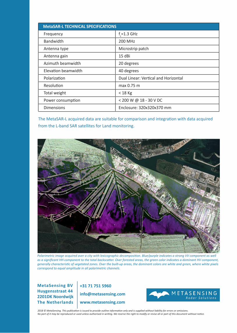
Polarimetric image acquired over a city with lexicographic decomposition. Blue/purple indicates a strong VV component as well as a significant HH component to the total backscatter. Over forested areas, the green color indicates a dominant HV component, generally characteristic of vegetated zones. Over the built-up areas, the dominant colors are white and green, where white pixels correspond to equal amplitude in all polarimetric channels.
The MetaSAR-L acquired data are suitable for comparison and integration with data acquired from the L-band SAR satellites for Land monitoring.
Related Documents