Metal-rich sites in Vendsyssel · 143 Metal-rich sites in Vendsyssel A preliminary presentation . . . . . . . . . . . . . . . . . . . . . . . . . . . . . . . . . . . . . . . . . . . . . . . . . . . . . . . . . . . Sidsel Wåhlin sance. e oldest map with detailed topographi- cal data was surveyed and drawn up in the 18th century by the Royal Danish Academy of Sciences and Letters and the oldest preserved land taxation survey was conducted in the 17th century (Chris- tian 5’s Den store matrikel, 1688). e problem in Vendsyssel is that continual sand drift has taken place since the 16th century, covering former ar- able land and, in some places, leaving it buried beneath sand dunes many metres deep, creat- ing a desolate landscape. In the west, this sand drift is still ongoing, covering land that cannot therefore be subjected to topsoil analysis. On the positive side, the sand dunes protect sites from the destructive effects of modern agriculture. At Ejstrup, a cemetery dating from the Germanic Iron Age and Viking Age was covered with metres of shifting sand, resulting in the preservation of the only turf-built grave covering ever excavated in Denmark (fig. 2) (Nilsson 1994) and, directly to the north of Liver, sand dunes cover former arable land. e coast has also changed radically and in some areas in the west it may have moved as much as a kilometre eastwards since the Viking Age, leaving all coastal sites from the period either submerged or washed away by the sea. e east coast has also changed – in this case as a result of land upheaval. ese coastal changes, sand drift and modern agri- culture have modified the watercourses, changing During the 1980s and 1990s, Vendsyssel Historiske Museum, working with a group of metal-detector enthusiasts, located a number of settlements that yielded metal finds from the topsoil. ree of these sites can now be described as metal-rich, with finds dating from the Late Roman Iron Age to the Medieval period: Stentinget, Ejstrup and Liver (fig. 1), though predominantly representing the Germanic Iron Age and Viking Age. e remaining sites have not yet been surveyed rigorously enough to justify the description metal-rich. Some finds, in- cluding pieces of scrap metal, do however indicate that several of these could, with further fieldwork, yield finds in sufficient numbers and of sufficient quality for them to deserve this label. In this paper, I will introduce the three above- mentioned metal-rich sites and present a prelimi- nary analysis of the finds. Some general notes on sources and the landscape in Vendsyssel In studies of Iron Age and Medieval central places, many non-archaeological sources are often drawn upon, such as historical maps, place names, analy- ses of topsoil chemistry, geological maps and sur- veys as well as metal-detector finds. However, in the case of Vendsyssel, landscape developments render many of these sources useless relative to a discussion of the landscape prior to the Renais-

Welcome message from author
This document is posted to help you gain knowledge. Please leave a comment to let me know what you think about it! Share it to your friends and learn new things together.
Transcript
Metal-rich sites in Vendsyssel · 143
Metal-rich sites in VendsysselA preliminary presentation. . . . . . . . . . . . . . . . . . . . . . . . . . . . . . . . . . . . . . . . . . . . . . . . . . . . . . . . . . .Sidsel Wåhlin
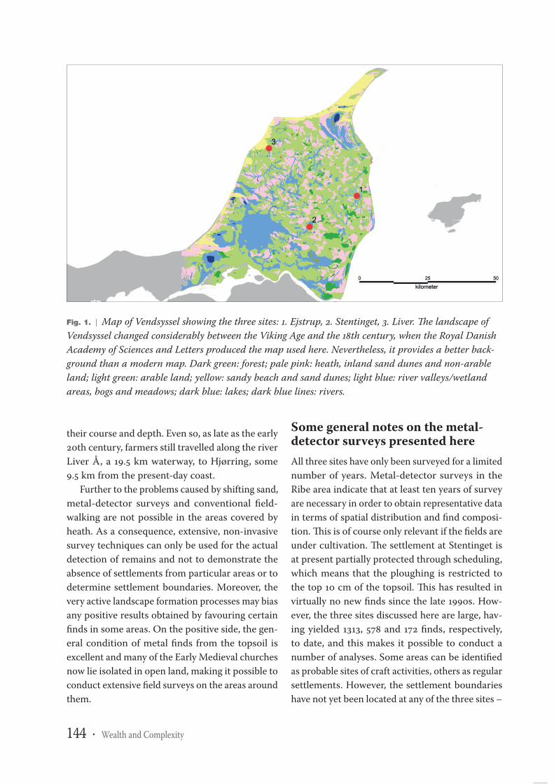
sance. The oldest map with detailed topographi-cal data was surveyed and drawn up in the 18thcentury by the Royal Danish Academy of Sciencesand Letters and the oldest preserved land taxationsurvey was conducted in the 17th century (Chris-tian 5’s Den store matrikel, 1688). The problem inVendsyssel is that continual sand drift has takenplace since the 16th century, covering former ar-able land and, in some places, leaving it buriedbeneath sand dunes many metres deep, creat-ing a desolate landscape. In the west, this sanddrift is still ongoing, covering land that cannottherefore be subjected to topsoil analysis. On thepositive side, the sand dunes protect sites fromthe destructive effects of modern agriculture. AtEjstrup, a cemetery dating from the GermanicIron Age and Viking Age was covered with metresof shifting sand, resulting in the preservation ofthe only turf-built grave covering ever excavatedin Denmark (fig. 2) (Nilsson 1994) and, directlyto the north of Liver, sand dunes cover formerarable land.
The coast has also changed radically and in someareas in the west it may have moved as much as akilometre eastwards since the Viking Age, leavingall coastal sites from the period either submergedor washed away by the sea. The east coast has alsochanged – in this case as a result of land upheaval.These coastal changes, sand drift and modern agri-culture have modified the watercourses, changing
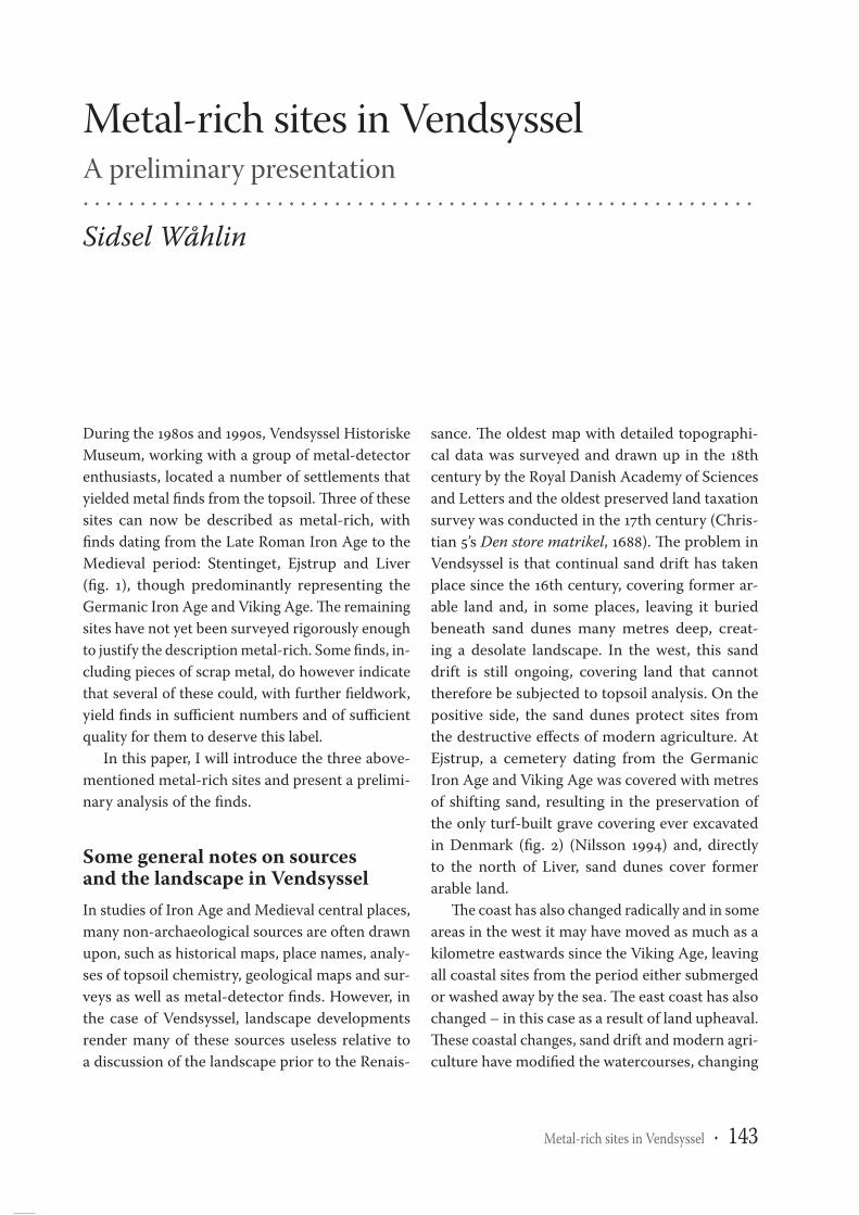
During the 1980s and 1990s, Vendsyssel HistoriskeMuseum, working with a group of metal-detectorenthusiasts, located a number of settlements thatyielded metal finds from the topsoil. Three of thesesites can now be described as metal-rich, withfinds dating from the Late Roman Iron Age to theMedieval period: Stentinget, Ejstrup and Liver(fig. 1), though predominantly representing theGermanic Iron Age and Viking Age. The remainingsites have not yet been surveyed rigorously enoughto justify the description metal-rich. Some finds, in-cluding pieces of scrap metal, do however indicatethat several of these could, with further fieldwork,yield finds in sufficient numbers and of sufficientquality for them to deserve this label.
In this paper, I will introduce the three above-mentioned metal-rich sites and present a prelimi-nary analysis of the finds.
Some general notes on sourcesand the landscape in VendsysselIn studies of Iron Age and Medieval central places,many non-archaeological sources are often drawnupon, such as historical maps, place names, analy-ses of topsoil chemistry, geological maps and sur-veys as well as metal-detector finds. However, inthe case of Vendsyssel, landscape developmentsrender many of these sources useless relative toa discussion of the landscape prior to the Renais-
Book
1
144 · Wealth and Complexity
their course and depth. Even so, as late as the early20th century, farmers still travelled along the riverLiver Å, a 19.5 km waterway, to Hjørring, some9.5 km from the present-day coast.
Further to the problems caused by shifting sand,metal-detector surveys and conventional field-walking are not possible in the areas covered byheath. As a consequence, extensive, non-invasivesurvey techniques can only be used for the actualdetection of remains and not to demonstrate theabsence of settlements from particular areas or todetermine settlement boundaries. Moreover, thevery active landscape formation processes may biasany positive results obtained by favouring certainfinds in some areas. On the positive side, the gen-eral condition of metal finds from the topsoil isexcellent and many of the Early Medieval churchesnow lie isolated in open land, making it possible toconduct extensive field surveys on the areas aroundthem.
Some general notes on the metal-detector surveys presented hereAll three sites have only been surveyed for a limitednumber of years. Metal-detector surveys in theRibe area indicate that at least ten years of surveyare necessary in order to obtain representative datain terms of spatial distribution and find composi-tion. This is of course only relevant if the fields areunder cultivation. The settlement at Stentinget isat present partially protected through scheduling,which means that the ploughing is restricted tothe top 10 cm of the topsoil. This has resulted invirtually no new finds since the late 1990s. How-ever, the three sites discussed here are large, hav-ing yielded 1313, 578 and 172 finds, respectively,to date, and this makes it possible to conduct anumber of analyses. Some areas can be identifiedas probable sites of craft activities, others as regularsettlements. However, the settlement boundarieshave not yet been located at any of the three sites –
Fig. 1. | Map of Vendsyssel showing the three sites: 1. Ejstrup, 2. Stentinget, 3. Liver. The landscape ofVendsyssel changed considerably between the Viking Age and the 18th century, when the Royal DanishAcademy of Sciences and Letters produced the map used here. Nevertheless, it provides a better back-ground than a modern map. Dark green: forest; pale pink: heath, inland sand dunes and non-arableland; light green: arable land; yellow: sandy beach and sand dunes; light blue: river valleys/wetlandareas, bogs and meadows; dark blue: lakes; dark blue lines: rivers.
Book
1
Metal-rich sites in Vendsyssel · 145
more systematic fieldwork is required before suchconclusions can be reached.
At Liver, the metal-detector surveys were con-ducted by a number of amateur archaeologistsworking with archaeologist Torben Nilsson. Un-fortunately, the finds were only recorded relative tothree general areas and were not plotted on maps.Consequently, the present finds assemblage onlypermits a very general form of spatial analysis.
At Stentinget and Ejstrup, the metal-detectorsurveys were conducted by Verner Brath, an en-thusiastic and methodical amateur detector ar-chaeologist, again working with archaeologistTorben Nilsson. The finds were marked on a map,some individually and others as small circles thateach contain a number of artefacts. As a result, itis possible to conduct a spatial analysis of thesesites aimed at locating various functions and activi-ties, living areas, craft areas and perhaps additionalcemeteries, although the latter may be the most
difficult to decipher (some of the finds from Sten-tinget have not been plotted due to missing data).It is not, however, possible to carry out micro-spa-tial analyses and to locate individual farmsteads ormetalworking workshops, as more detailed surveyprocedures and recording are required to enablethis. However, it is likely that such data would beobtainable should new, refined and perhaps modi-fied field survey methods be applied, in combina-tion with excavation.
MethodologyAll finds recovered from the three sites have beenallocated to some rather rough categories based ona methodology I developed for my master’s thesis(Wåhlin 2004, 53-62; 2006). The aim is to producea comprehensive overview of the finds and of theactivities the assemblage, as a whole, appears torepresent. There are several categories for finished
Fig. 2. | An inland dune overlying the turf cover of the grave (black and white). Taken during the exca-vation of the cemetery at Volstrup. The entire cemetery was covered by sand dunes; these had protectedit from ploughing and from the roots of trees in the modern plantation.
Book
1section
10
146 · Wealth and Complexity
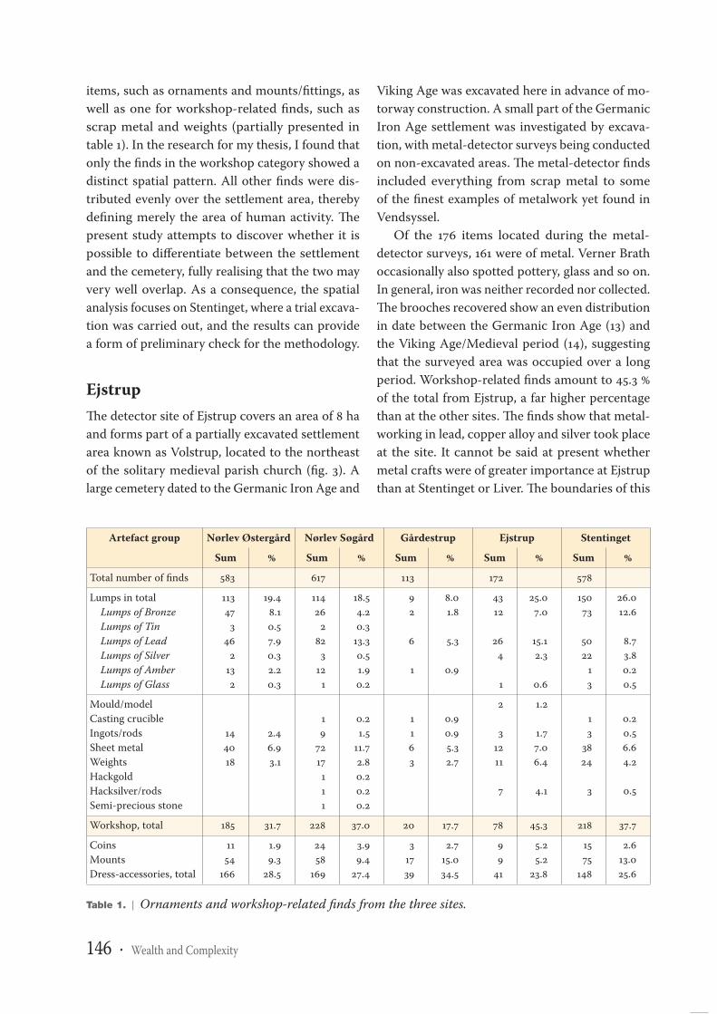
items, such as ornaments and mounts/fittings, aswell as one for workshop-related finds, such asscrap metal and weights (partially presented intable 1). In the research for my thesis, I found thatonly the finds in the workshop category showed adistinct spatial pattern. All other finds were dis-tributed evenly over the settlement area, therebydefining merely the area of human activity. Thepresent study attempts to discover whether it ispossible to differentiate between the settlementand the cemetery, fully realising that the two mayvery well overlap. As a consequence, the spatialanalysis focuses on Stentinget, where a trial excava-tion was carried out, and the results can providea form of preliminary check for the methodology.
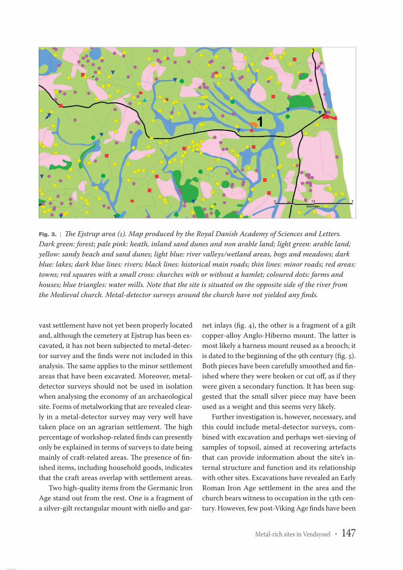
EjstrupThe detector site of Ejstrup covers an area of 8 haand forms part of a partially excavated settlementarea known as Volstrup, located to the northeastof the solitary medieval parish church (fig. 3). Alarge cemetery dated to the Germanic Iron Age and
Viking Age was excavated here in advance of mo-torway construction. A small part of the GermanicIron Age settlement was investigated by excava-tion, with metal-detector surveys being conductedon non-excavated areas. The metal-detector findsincluded everything from scrap metal to someof the finest examples of metalwork yet found inVendsyssel.
Of the 176 items located during the metal-detector surveys, 161 were of metal. Verner Brathoccasionally also spotted pottery, glass and so on.In general, iron was neither recorded nor collected.The brooches recovered show an even distributionin date between the Germanic Iron Age (13) andthe Viking Age/Medieval period (14), suggestingthat the surveyed area was occupied over a longperiod. Workshop-related finds amount to 45.3 %of the total from Ejstrup, a far higher percentagethan at the other sites. The finds show that metal-working in lead, copper alloy and silver took placeat the site. It cannot be said at present whethermetal crafts were of greater importance at Ejstrupthan at Stentinget or Liver. The boundaries of this
Table 1. | Ornaments and workshop-related finds from the three sites.
Artefact group Nørlev Østergård Nørlev Søgård Gårdestrup Ejstrup Stentinget
Sum % Sum % Sum % Sum % Sum %
Total number of finds 583 617 113 172 578
Lumps in totalLumps of BronzeLumps of TinLumps of LeadLumps of SilverLumps of AmberLumps of Glass
11347
346
2132
19.48.10.57.90.32.20.3
11426
282
312
1
18.54.20.3
13.30.51.90.2
92
6
1
8.01.8
5.3
0.9
4312
264
1
25.07.0
15.12.3
0.6
15073
5022
13
26.012.6
8.73.80.20.5
Mould/modelCasting crucibleIngots/rodsSheet metalWeightsHackgoldHacksilver/rodsSemi-precious stone
144018
2.46.93.1
19
7217111
0.21.5
11.72.80.20.20.2
1163
0.90.95.32.7
2
31211
7
1.2
1.77.06.4
4.1
13
3824
3
0.20.56.64.2
0.5
Workshop, total 185 31.7 228 37.0 20 17.7 78 45.3 218 37.7
CoinsMountsDress-accessories, total
1154
166
1.99.3
28.5
2458
169
3.99.4
27.4
31739
2.715.034.5
99
41
5.25.2
23.8
1575
148
2.613.025.6
Book
1
Metal-rich sites in Vendsyssel · 147
vast settlement have not yet been properly locatedand, although the cemetery at Ejstrup has been ex-cavated, it has not been subjected to metal-detec-tor survey and the finds were not included in thisanalysis. The same applies to the minor settlementareas that have been excavated. Moreover, metal-detector surveys should not be used in isolationwhen analysing the economy of an archaeologicalsite. Forms of metalworking that are revealed clear-ly in a metal-detector survey may very well havetaken place on an agrarian settlement. The highpercentage of workshop-related finds can presentlyonly be explained in terms of surveys to date beingmainly of craft-related areas. The presence of fin-ished items, including household goods, indicatesthat the craft areas overlap with settlement areas.
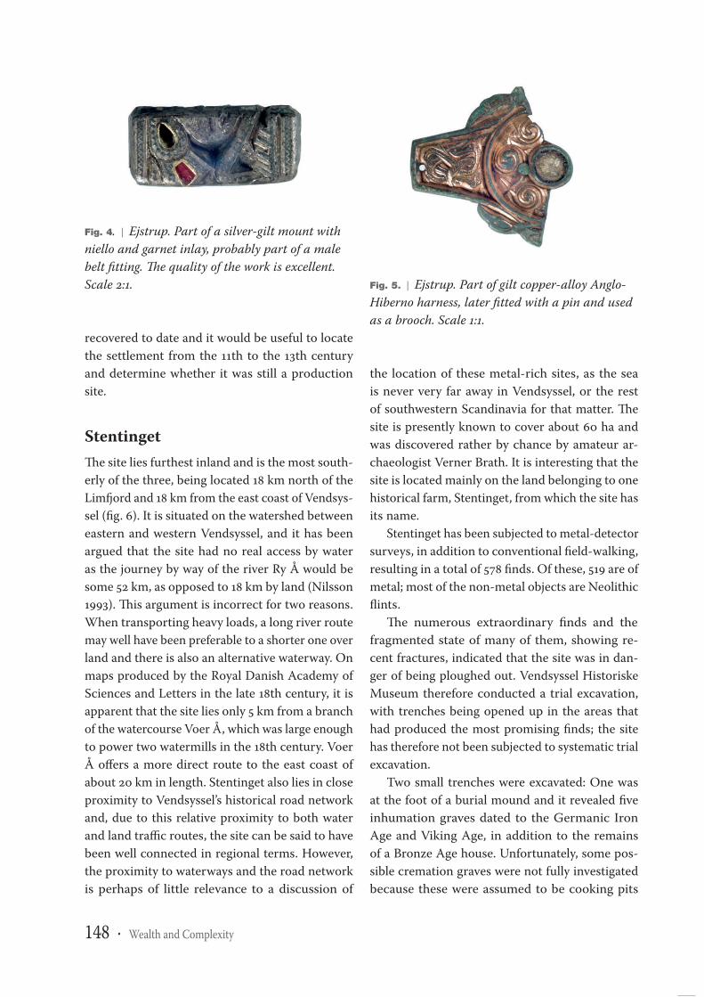
Two high-quality items from the Germanic IronAge stand out from the rest. One is a fragment ofa silver-gilt rectangular mount with niello and gar-
net inlays (fig. 4), the other is a fragment of a giltcopper-alloy Anglo-Hiberno mount. The latter ismost likely a harness mount reused as a brooch; itis dated to the beginning of the 9th century (fig. 5).Both pieces have been carefully smoothed and fin-ished where they were broken or cut off, as if theywere given a secondary function. It has been sug-gested that the small silver piece may have beenused as a weight and this seems very likely.
Further investigation is, however, necessary, andthis could include metal-detector surveys, com-bined with excavation and perhaps wet-sieving ofsamples of topsoil, aimed at recovering artefactsthat can provide information about the site’s in-ternal structure and function and its relationshipwith other sites. Excavations have revealed an EarlyRoman Iron Age settlement in the area and thechurch bears witness to occupation in the 13th cen-tury. However, few post-Viking Age finds have been
Fig. 3. | The Ejstrup area (1). Map produced by the Royal Danish Academy of Sciences and Letters.Dark green: forest; pale pink: heath, inland sand dunes and non arable land; light green: arable land;yellow: sandy beach and sand dunes; light blue: river valleys/wetland areas, bogs and meadows; darkblue: lakes; dark blue lines: rivers; black lines: historical main roads; thin lines: minor roads; red areas:towns; red squares with a small cross: churches with or without a hamlet; coloured dots: farms andhouses; blue triangles: water mills. Note that the site is situated on the opposite side of the river fromthe Medieval church. Metal-detector surveys around the church have not yielded any finds.
P14
-115
73In
dhol
dS
M10
2-
Trim
boxe
sS
heet
:10
-B
Dat
e:1-
Jul-2
014,
12:4
5:03
Book
1
148 · Wealth and Complexity
recovered to date and it would be useful to locatethe settlement from the 11th to the 13th centuryand determine whether it was still a productionsite.
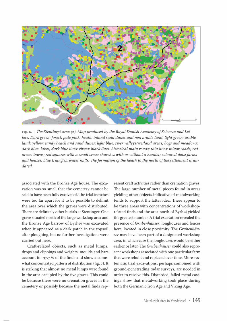
StentingetThe site lies furthest inland and is the most south-erly of the three, being located 18 km north of theLimfjord and 18 km from the east coast of Vendsys-sel (fig. 6). It is situated on the watershed betweeneastern and western Vendsyssel, and it has beenargued that the site had no real access by wateras the journey by way of the river Ry Å would besome 52 km, as opposed to 18 km by land (Nilsson1993). This argument is incorrect for two reasons.When transporting heavy loads, a long river routemay well have been preferable to a shorter one overland and there is also an alternative waterway. Onmaps produced by the Royal Danish Academy ofSciences and Letters in the late 18th century, it isapparent that the site lies only 5 km from a branchof the watercourse Voer Å, which was large enoughto power two watermills in the 18th century. VoerÅ offers a more direct route to the east coast ofabout 20 km in length. Stentinget also lies in closeproximity to Vendsyssel’s historical road networkand, due to this relative proximity to both waterand land traffic routes, the site can be said to havebeen well connected in regional terms. However,the proximity to waterways and the road networkis perhaps of little relevance to a discussion of
the location of these metal-rich sites, as the seais never very far away in Vendsyssel, or the restof southwestern Scandinavia for that matter. Thesite is presently known to cover about 60 ha andwas discovered rather by chance by amateur ar-chaeologist Verner Brath. It is interesting that thesite is located mainly on the land belonging to onehistorical farm, Stentinget, from which the site hasits name.
Stentinget has been subjected to metal-detectorsurveys, in addition to conventional field-walking,resulting in a total of 578 finds. Of these, 519 are ofmetal; most of the non-metal objects are Neolithicflints.
The numerous extraordinary finds and thefragmented state of many of them, showing re-cent fractures, indicated that the site was in dan-ger of being ploughed out. Vendsyssel HistoriskeMuseum therefore conducted a trial excavation,with trenches being opened up in the areas thathad produced the most promising finds; the sitehas therefore not been subjected to systematic trialexcavation.
Two small trenches were excavated: One wasat the foot of a burial mound and it revealed fiveinhumation graves dated to the Germanic IronAge and Viking Age, in addition to the remainsof a Bronze Age house. Unfortunately, some pos-sible cremation graves were not fully investigatedbecause these were assumed to be cooking pits
Fig. 4. | Ejstrup. Part of a silver-gilt mount withniello and garnet inlay, probably part of a malebelt fitting. The quality of the work is excellent.Scale 2:1. Fig. 5. | Ejstrup. Part of gilt copper-alloy Anglo-
Hiberno harness, later fitted with a pin and usedas a brooch. Scale 1:1.
Book
1
Metal-rich sites in Vendsyssel · 149
associated with the Bronze Age house. The exca-vation was so small that the cemetery cannot besaid to have been fully excavated. The trial trencheswere too far apart for it to be possible to delimitthe area over which the graves were distributed.There are definitely other burials at Stentinget: Onegrave situated north of the large workshop area andthe Bronze Age barrow of Byrhøj was excavatedwhen it appeared as a dark patch in the topsoilafter ploughing, but no further investigations werecarried out here.
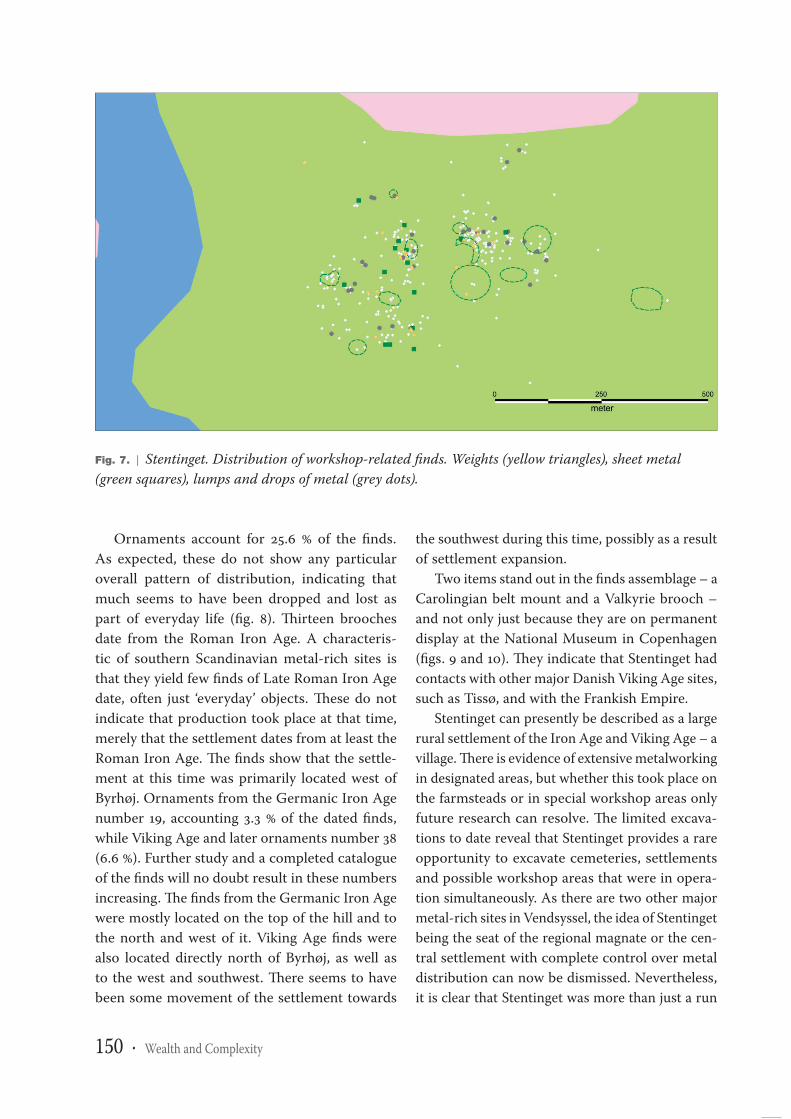
Craft-related objects, such as metal lumps,drops and clippings and weights, moulds and barsaccount for 37.7 % of the finds and show a some-what concentrated pattern of distribution (fig. 7). Itis striking that almost no metal lumps were foundin the area occupied by the five graves. This couldbe because there were no cremation graves in thecemetery or possibly because the metal finds rep-
resent craft activities rather than cremation graves.The large number of metal pieces found in areasyielding other objects indicative of metalworkingtends to support the latter idea. There appear tobe three areas with concentrations of workshop-related finds and the area north of Byrhøj yieldedthe greatest number. A trial excavation revealed thepresence of Grubenhäuser, longhouses and fenceshere, located in close proximity. The Grubenhäu-ser may have been part of a designated workshoparea, in which case the longhouses would be eitherearlier or later. The Grubenhäuser could also repre-sent workshops associated with one particular farmthat were rebuilt and replaced over time. More sys-tematic trial excavations, perhaps combined withground-penetrading radar surveys, are needed inorder to resolve this. Discarded, failed metal cast-ings show that metalworking took place duringboth the Germanic Iron Age and Viking Age.
Fig. 6. | The Stentinget area (2). Map produced by the Royal Danish Academy of Sciences and Let-ters. Dark green: forest; pale pink: heath, inland sand dunes and non arable land; light green: arableland; yellow: sandy beach and sand dunes; light blue: river valleys/wetland areas, bogs and meadows;dark blue: lakes; dark blue lines: rivers; black lines: historical main roads; thin lines: minor roads; redareas: towns; red squares with a small cross: churches with or without a hamlet; coloured dots: farmsand houses; blue triangles: water mills. The formation of the heath to the north of the settlement is un-dated.
P14
-115
73In
dhol
dS
M10
2-
Trim
boxe
sS
heet
:10
-F
Dat
e:1-
Jul-2
014,
12:4
5:02
Book
1
150 · Wealth and Complexity
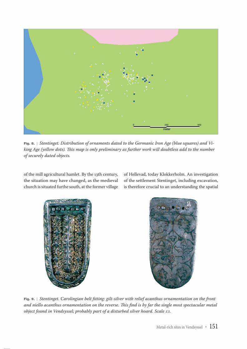
Ornaments account for 25.6 % of the finds.As expected, these do not show any particularoverall pattern of distribution, indicating thatmuch seems to have been dropped and lost aspart of everyday life (fig. 8). Thirteen broochesdate from the Roman Iron Age. A characteris-tic of southern Scandinavian metal-rich sites isthat they yield few finds of Late Roman Iron Agedate, often just ‘everyday’ objects. These do notindicate that production took place at that time,merely that the settlement dates from at least theRoman Iron Age. The finds show that the settle-ment at this time was primarily located west ofByrhøj. Ornaments from the Germanic Iron Agenumber 19, accounting 3.3 % of the dated finds,while Viking Age and later ornaments number 38(6.6 %). Further study and a completed catalogueof the finds will no doubt result in these numbersincreasing. The finds from the Germanic Iron Agewere mostly located on the top of the hill and tothe north and west of it. Viking Age finds werealso located directly north of Byrhøj, as well asto the west and southwest. There seems to havebeen some movement of the settlement towards
the southwest during this time, possibly as a resultof settlement expansion.
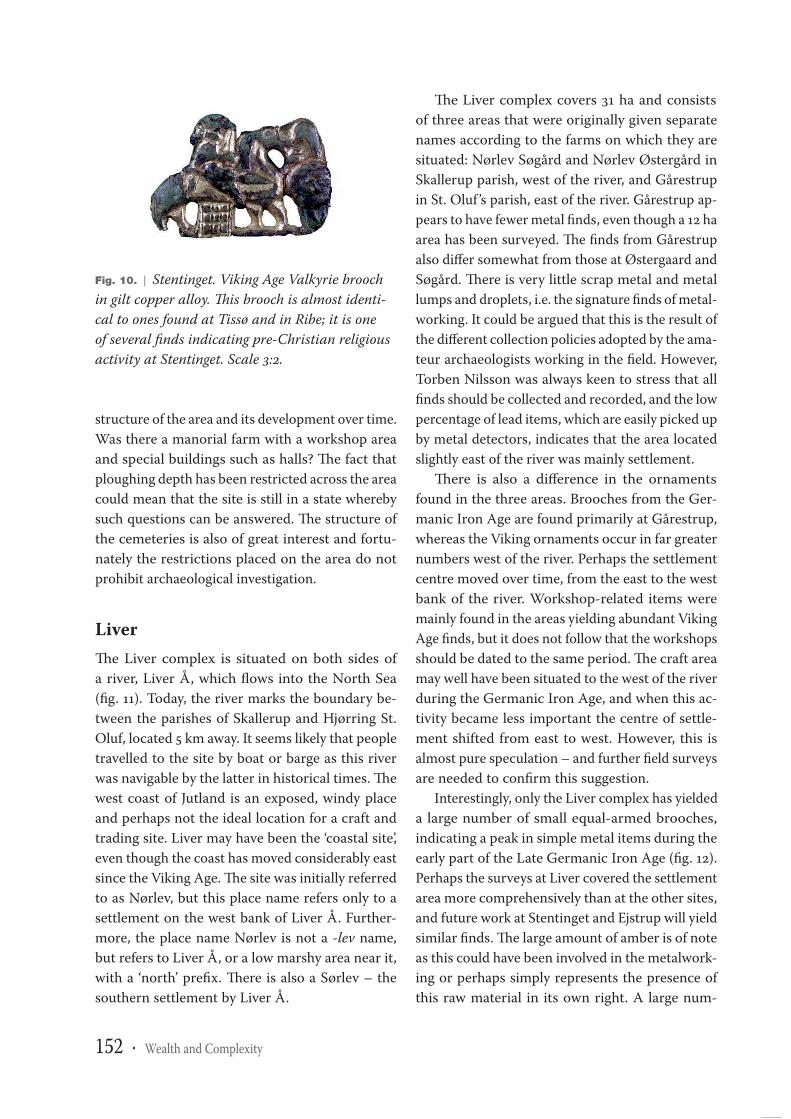
Two items stand out in the finds assemblage – aCarolingian belt mount and a Valkyrie brooch –and not only just because they are on permanentdisplay at the National Museum in Copenhagen(figs. 9 and 10). They indicate that Stentinget hadcontacts with other major Danish Viking Age sites,such as Tissø, and with the Frankish Empire.
Stentinget can presently be described as a largerural settlement of the Iron Age and Viking Age – avillage. There is evidence of extensive metalworkingin designated areas, but whether this took place onthe farmsteads or in special workshop areas onlyfuture research can resolve. The limited excava-tions to date reveal that Stentinget provides a rareopportunity to excavate cemeteries, settlementsand possible workshop areas that were in opera-tion simultaneously. As there are two other majormetal-rich sites in Vendsyssel, the idea of Stentingetbeing the seat of the regional magnate or the cen-tral settlement with complete control over metaldistribution can now be dismissed. Nevertheless,it is clear that Stentinget was more than just a run
Fig. 7. | Stentinget. Distribution of workshop-related finds. Weights (yellow triangles), sheet metal(green squares), lumps and drops of metal (grey dots).
Book
1
Metal-rich sites in Vendsyssel · 151
of the mill agricultural hamlet. By the 13th century,the situation may have changed, as the medievalchurch is situated furthe south, at the former village
of Hellevad, today Klokkerholm. An investigationof the settlement Stentinget, including excavation,is therefore crucial to an understanding the spatial
Fig. 8. | Stentinget. Distribution of ornaments dated to the Germanic Iron Age (blue squares) and Vi-king Age (yellow dots). This map is only preliminary as further work will doubtless add to the numberof securely dated objects.
Fig. 9. | Stentinget. Carolingian belt fitting: gilt-silver with relief acanthus ornamentation on the frontand niello acanthus ornamentation on the reverse. This find is by far the single most spectacular metalobject found in Vendsyssel; probably part of a disturbed silver hoard. Scale 1:1.
Book
1
152 · Wealth and Complexity
structure of the area and its development over time.Was there a manorial farm with a workshop areaand special buildings such as halls? The fact thatploughing depth has been restricted across the areacould mean that the site is still in a state wherebysuch questions can be answered. The structure ofthe cemeteries is also of great interest and fortu-nately the restrictions placed on the area do notprohibit archaeological investigation.
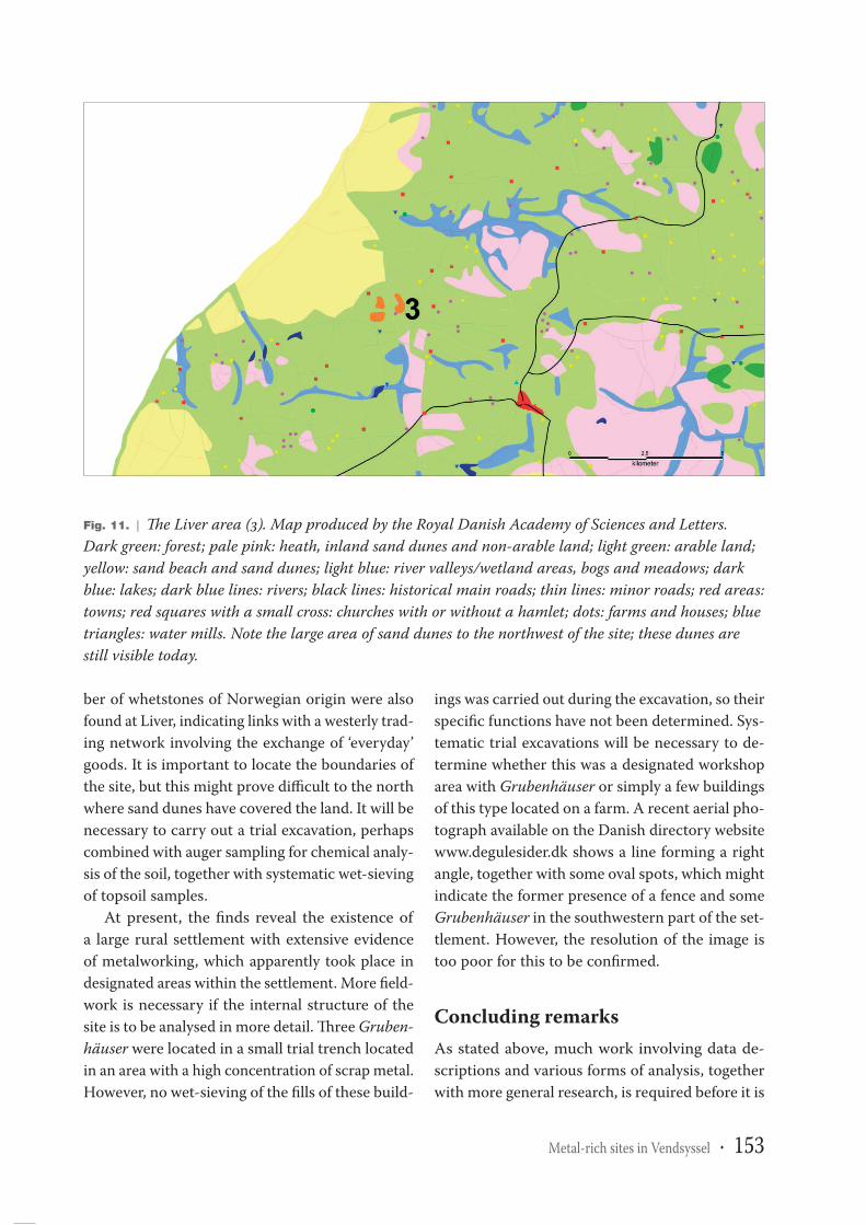
LiverThe Liver complex is situated on both sides ofa river, Liver Å, which flows into the North Sea(fig. 11). Today, the river marks the boundary be-tween the parishes of Skallerup and Hjørring St.Oluf, located 5 km away. It seems likely that peopletravelled to the site by boat or barge as this riverwas navigable by the latter in historical times. Thewest coast of Jutland is an exposed, windy placeand perhaps not the ideal location for a craft andtrading site. Liver may have been the ‘coastal site’,even though the coast has moved considerably eastsince the Viking Age. The site was initially referredto as Nørlev, but this place name refers only to asettlement on the west bank of Liver Å. Further-more, the place name Nørlev is not a -lev name,but refers to Liver Å, or a low marshy area near it,with a ‘north’ prefix. There is also a Sørlev – thesouthern settlement by Liver Å.
The Liver complex covers 31 ha and consistsof three areas that were originally given separatenames according to the farms on which they aresituated: Nørlev Søgård and Nørlev Østergård inSkallerup parish, west of the river, and Gårestrupin St. Oluf ’s parish, east of the river. Gårestrup ap-pears to have fewer metal finds, even though a 12 haarea has been surveyed. The finds from Gårestrupalso differ somewhat from those at Østergaard andSøgård. There is very little scrap metal and metallumps and droplets, i.e. the signature finds of metal-working. It could be argued that this is the result ofthe different collection policies adopted by the ama-teur archaeologists working in the field. However,Torben Nilsson was always keen to stress that allfinds should be collected and recorded, and the lowpercentage of lead items, which are easily picked upby metal detectors, indicates that the area locatedslightly east of the river was mainly settlement.
There is also a difference in the ornamentsfound in the three areas. Brooches from the Ger-manic Iron Age are found primarily at Gårestrup,whereas the Viking ornaments occur in far greaternumbers west of the river. Perhaps the settlementcentre moved over time, from the east to the westbank of the river. Workshop-related items weremainly found in the areas yielding abundant VikingAge finds, but it does not follow that the workshopsshould be dated to the same period. The craft areamay well have been situated to the west of the riverduring the Germanic Iron Age, and when this ac-tivity became less important the centre of settle-ment shifted from east to west. However, this isalmost pure speculation – and further field surveysare needed to confirm this suggestion.
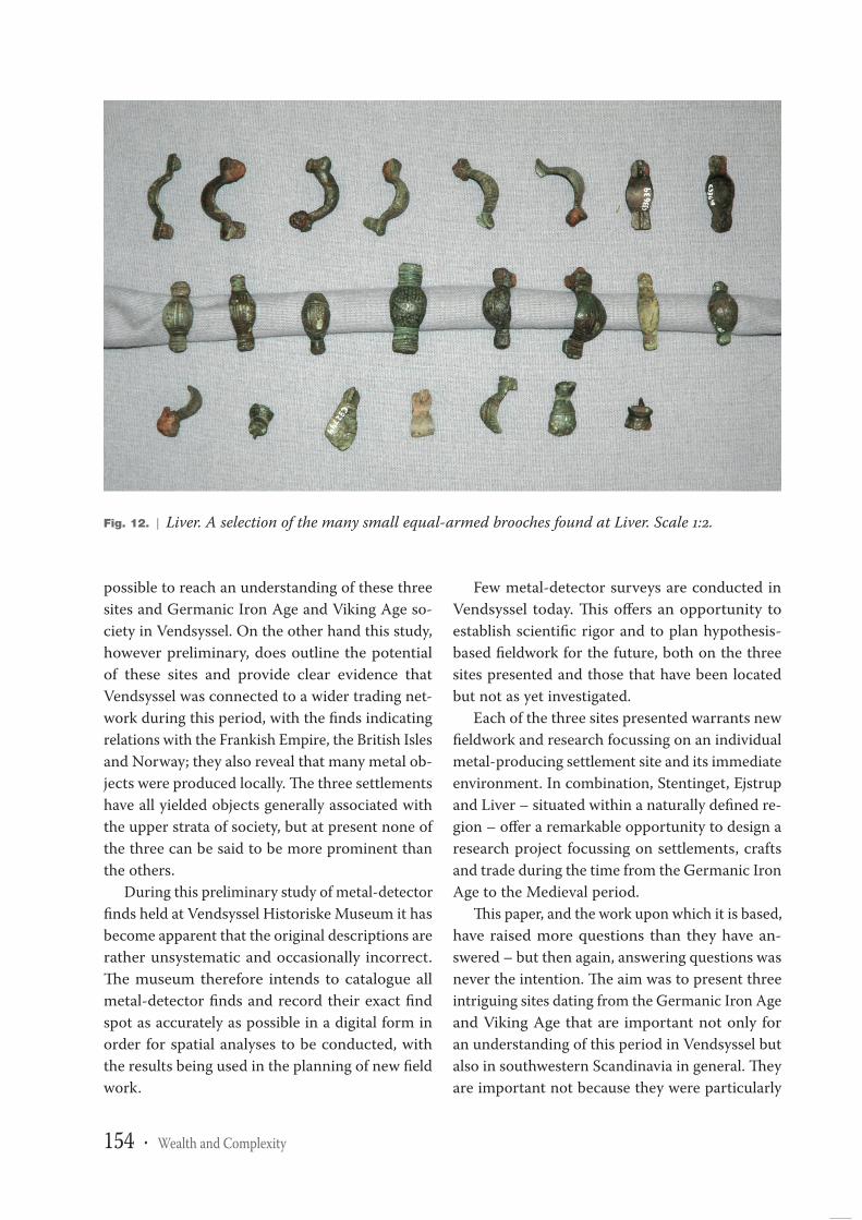
Interestingly, only the Liver complex has yieldeda large number of small equal-armed brooches,indicating a peak in simple metal items during theearly part of the Late Germanic Iron Age (fig. 12).Perhaps the surveys at Liver covered the settlementarea more comprehensively than at the other sites,and future work at Stentinget and Ejstrup will yieldsimilar finds. The large amount of amber is of noteas this could have been involved in the metalwork-ing or perhaps simply represents the presence ofthis raw material in its own right. A large num-
Fig. 10. | Stentinget. Viking Age Valkyrie broochin gilt copper alloy. This brooch is almost identi-cal to ones found at Tissø and in Ribe; it is oneof several finds indicating pre-Christian religiousactivity at Stentinget. Scale 3:2.
Book
1
Metal-rich sites in Vendsyssel · 153
ber of whetstones of Norwegian origin were alsofound at Liver, indicating links with a westerly trad-ing network involving the exchange of ‘everyday’goods. It is important to locate the boundaries ofthe site, but this might prove difficult to the northwhere sand dunes have covered the land. It will benecessary to carry out a trial excavation, perhapscombined with auger sampling for chemical analy-sis of the soil, together with systematic wet-sievingof topsoil samples.
At present, the finds reveal the existence ofa large rural settlement with extensive evidenceof metalworking, which apparently took place indesignated areas within the settlement. More field-work is necessary if the internal structure of thesite is to be analysed in more detail. Three Gruben-häuser were located in a small trial trench locatedin an area with a high concentration of scrap metal.However, no wet-sieving of the fills of these build-
ings was carried out during the excavation, so theirspecific functions have not been determined. Sys-tematic trial excavations will be necessary to de-termine whether this was a designated workshoparea with Grubenhäuser or simply a few buildingsof this type located on a farm. A recent aerial pho-tograph available on the Danish directory websitewww.degulesider.dk shows a line forming a rightangle, together with some oval spots, which mightindicate the former presence of a fence and someGrubenhäuser in the southwestern part of the set-tlement. However, the resolution of the image istoo poor for this to be confirmed.
Concluding remarksAs stated above, much work involving data de-scriptions and various forms of analysis, togetherwith more general research, is required before it is
Fig. 11. | The Liver area (3). Map produced by the Royal Danish Academy of Sciences and Letters.Dark green: forest; pale pink: heath, inland sand dunes and non-arable land; light green: arable land;yellow: sand beach and sand dunes; light blue: river valleys/wetland areas, bogs and meadows; darkblue: lakes; dark blue lines: rivers; black lines: historical main roads; thin lines: minor roads; red areas:towns; red squares with a small cross: churches with or without a hamlet; dots: farms and houses; bluetriangles: water mills. Note the large area of sand dunes to the northwest of the site; these dunes arestill visible today.
Book
1
154 · Wealth and Complexity
possible to reach an understanding of these threesites and Germanic Iron Age and Viking Age so-ciety in Vendsyssel. On the other hand this study,however preliminary, does outline the potentialof these sites and provide clear evidence thatVendsyssel was connected to a wider trading net-work during this period, with the finds indicatingrelations with the Frankish Empire, the British Islesand Norway; they also reveal that many metal ob-jects were produced locally. The three settlementshave all yielded objects generally associated withthe upper strata of society, but at present none ofthe three can be said to be more prominent thanthe others.
During this preliminary study of metal-detectorfinds held at Vendsyssel Historiske Museum it hasbecome apparent that the original descriptions arerather unsystematic and occasionally incorrect.The museum therefore intends to catalogue allmetal-detector finds and record their exact findspot as accurately as possible in a digital form inorder for spatial analyses to be conducted, withthe results being used in the planning of new fieldwork.
Few metal-detector surveys are conducted inVendsyssel today. This offers an opportunity toestablish scientific rigor and to plan hypothesis-based fieldwork for the future, both on the threesites presented and those that have been locatedbut not as yet investigated.
Each of the three sites presented warrants newfieldwork and research focussing on an individualmetal-producing settlement site and its immediateenvironment. In combination, Stentinget, Ejstrupand Liver – situated within a naturally defined re-gion – offer a remarkable opportunity to design aresearch project focussing on settlements, craftsand trade during the time from the Germanic IronAge to the Medieval period.
This paper, and the work upon which it is based,have raised more questions than they have an-swered – but then again, answering questions wasnever the intention. The aim was to present threeintriguing sites dating from the Germanic Iron Ageand Viking Age that are important not only foran understanding of this period in Vendsyssel butalso in southwestern Scandinavia in general. Theyare important not because they were particularly
Fig. 12. | Liver. A selection of the many small equal-armed brooches found at Liver. Scale 1:2.
Book
1
Metal-rich sites in Vendsyssel · 155
unique in their time, but because they have sur-vived and have been located. They did not developinto towns or ecclesiastical, noble or royal manorsand if they were once central sites, their functionsdid not prevail in the long term or were subse-quently moved elsewhere.
BibliographyNilsson, T. 1993, Stentinget – en boplads med handel
og håndværk fra germansk jernalder og vikingetid.
Vendsyssel Nu og Da 1991-1993, 64-78.
Nilsson, T. 1994, Sjælens Hus. Skalk 1994:6, 3-7.
Wåhlin, S. 2004, Hviding – en kulturhistorisk analyse af et
kystnært samfund 950-1250 AD. Unpublished mag.art.
thesis. Aarhus University.
Wåhlin, S. 2006, Gården ved havet. Arkæologi i Slesvig.
Archäologie im Schleswig 11, 127-36.
Book
1

Book
1
Related Documents


