19th World Petroleum Congress, Spain 2008 Forum 01: New frontier exploration © World Petroleum Council Mesozoics of the south western margin of India: A frontier exploration Mr Moses Nathaniel Duggirala, Petroleum Business (E&P), Reliance Industries Limited, India Dr Ravi Bastia, Petroleum Business (E&P), Reliance Industries Limited, India Mr Srinivas Tenepalli, Petroleum Business (E&P), Reliance Industries Limited, India Muralikrishna Akella, Petroleum Business (E&P), Reliance Industries Limited, India Ravi Verma, Petroleum Business (E&P), Reliance Industries Limited, India Kenneth D'Silva, Petroleum Business (E&P), Reliance Industries Limited, India Abstract The volcanic infested south-western margin of India (SWMI) is a composite tectono- stratigraphic imprint of episodic crustal unrests related to rift-drift transitions of Permo-Triassic (Karoo), Early Cretaceous (Madagascar), Cretaceous-Early Paleocene (Seychelles-India) and Miocene compressional tectonics of Himalayan orogeny. Improved plate tectonic models demonstrated: regional tilt of India as westerly during pre-deccan-volcanism indicating Antarctica-Sri Lanka-India as the major provenance; southern part of western margin was the north-eastern flank of an independent proto-oceanic basin implying sedimentation at least since the Triassic times. However, hydrocarbon exploration along the southwestern continental margin of India was mostly concentrated for Tertiary petroleum system due to confined-exploratory-thought-process to look for obvious prospects, which can be seismically imaged with little effort. Innovative exploratory efforts by implementing long offset seismics in conjunction with regional gravity and magnetics evolved a novel paradigm for Mesozoic exploration. It includes NW-SE dextral transtensional movement between East Africa and Eastern Gondwana continental assembly, resulting into formation of coast parallel right stepping extensional rift basins along the suture zones and intracratonic basins during Permo-Triassic times (Karoo Rift). This signature on the offshore basement architecture was over printed by numerous subsequent tectonic episodes pertaining to the dispersal of Eastern Gondwana continental assembly, resulting into coast transverse fault/fracture systems, responsible for generation of large-scale structural inversions/ inverted rift grabens. Considering the signatures of Mesozoic rift system from integrated studies in the region, the analogy of working source rocks from Permo-Triassic rift system in East Africa and Western Madagascar with enormous hydrocarbon potential can be applied in SWMI. Further, shallow clues for deeper hydrocarbon systems viz. seismic, multi-beam and SAR inculcate optimism for sub-basalt Mesozoic exploration. As more accessible fields of India are being depleted, focus on this Mesozoic sedimentary pile with large-scale inversion structures is imperative for exploration as expected volumes are also likely to be large. 19th WPC preprint paper. For delegate use only. Do not circulate.

Welcome message from author
This document is posted to help you gain knowledge. Please leave a comment to let me know what you think about it! Share it to your friends and learn new things together.
Transcript

19th World Petroleum Congress, Spain 2008 Forum 01: New frontier exploration
© World Petroleum Council
Mesozoics of the south western margin of India: A frontier exploration Mr Moses Nathaniel Duggirala, Petroleum Business (E&P), Reliance Industries Limited, India Dr Ravi Bastia, Petroleum Business (E&P), Reliance Industries Limited, India Mr Srinivas Tenepalli, Petroleum Business (E&P), Reliance Industries Limited, India Muralikrishna Akella, Petroleum Business (E&P), Reliance Industries Limited, India Ravi Verma, Petroleum Business (E&P), Reliance Industries Limited, India Kenneth D'Silva, Petroleum Business (E&P), Reliance Industries Limited, India
Abstract The volcanic infested south-western margin of India (SWMI) is a composite tectono-stratigraphic imprint of episodic crustal unrests related to rift-drift transitions of Permo-Triassic (Karoo), Early Cretaceous (Madagascar), Cretaceous-Early Paleocene (Seychelles-India) and Miocene compressional tectonics of Himalayan orogeny. Improved plate tectonic models demonstrated: regional tilt of India as westerly during pre-deccan-volcanism indicating Antarctica-Sri Lanka-India as the major provenance; southern part of western margin was the north-eastern flank of an independent proto-oceanic basin implying sedimentation at least since the Triassic times. However, hydrocarbon exploration along the southwestern continental margin of India was mostly concentrated for Tertiary petroleum system due to confined-exploratory-thought-process to look for obvious prospects, which can be seismically imaged with little effort. Innovative exploratory efforts by implementing long offset seismics in conjunction with regional gravity and magnetics evolved a novel paradigm for Mesozoic exploration. It includes NW-SE dextral transtensional movement between East Africa and Eastern Gondwana continental assembly, resulting into formation of coast parallel right stepping extensional rift basins along the suture zones and intracratonic basins during Permo-Triassic times (Karoo Rift). This signature on the offshore basement architecture was over printed by numerous subsequent tectonic episodes pertaining to the dispersal of Eastern Gondwana continental assembly, resulting into coast transverse fault/fracture systems, responsible for generation of large-scale structural inversions/ inverted rift grabens. Considering the signatures of Mesozoic rift system from integrated studies in the region, the analogy of working source rocks from Permo-Triassic rift system in East Africa and Western Madagascar with enormous hydrocarbon potential can be applied in SWMI. Further, shallow clues for deeper hydrocarbon systems viz. seismic, multi-beam and SAR inculcate optimism for sub-basalt Mesozoic exploration. As more accessible fields of India are being depleted, focus on this Mesozoic sedimentary pile with large-scale inversion structures is imperative for exploration as expected volumes are also likely to be large.
19th WPC preprint paper. For delegate use only. Do not circulate.

19th World Petroleum Congress, Spain 2008 Forum 01: New frontier exploration
© World Petroleum Council
Mesozoics of the south western margin of India: A frontier exploration
Introduction South western continental margin of India i.e., Kerala basin, lying within bathymetry range of 20 to 3500 meters, is one of the poorly explored basins for hydrocarbons in spite of its large prognosticated reserve base. It is bounded by NNE-SSW trending Cochin High in the north, NNW-SSE trending Comorin High in the east, Cape Comorin High in the west and open abyssal plane in the south. Six major tectonic elements were identified in the region viz. Shelfal horst graben complex, Shelf margin, Shelf margin basin, Kori- Comorin High (Cape-Comorin High), Vishnu Fracture Zone, Chagos-Laccadieve Depression and Chagos-Laccadieve Ridge to the west and Shelfal Horst Graben Complex, Shelf Margin Basin and Comorin High to the east. Comorin High, located to the south of southern tip of India separates this basin from Mannar Basin (Fig. 1).
Figure 1 - Location map of Kerala basin showing tectonic elements. Episodic break-up of Gondwana generated major crustal unrest in the geological past viz., Mid Jurassic to Late Cretaceous, Cretaceous-Tertiary boundary (Fig. 2) and finally during Himalayan orogeny. Consequently an over all NNW-SSE tectonic fabric was formed by these major rifting episodes. Regionally this trend is overprinted by a roughly north-south “hot spot” track that resulted from India’s continued drift northwards over a mantle plume during the Paleogene (Fig. 1). The north-south rift related orientation of many structures is further modified by ENE-WSW or NE-SW cross trends pertaining to strike-slip fault systems due to the transtensional character of the last two break up episodes.
19th WPC preprint paper. For delegate use only. Do not circulate.
19th World Petroleum Congress, Spain 2008 Forum 01: New frontier exploration
© World Petroleum Council
Figure 2 - Eastern Gondwana - Tectonic event chart (Ref. Gambos., 1995)
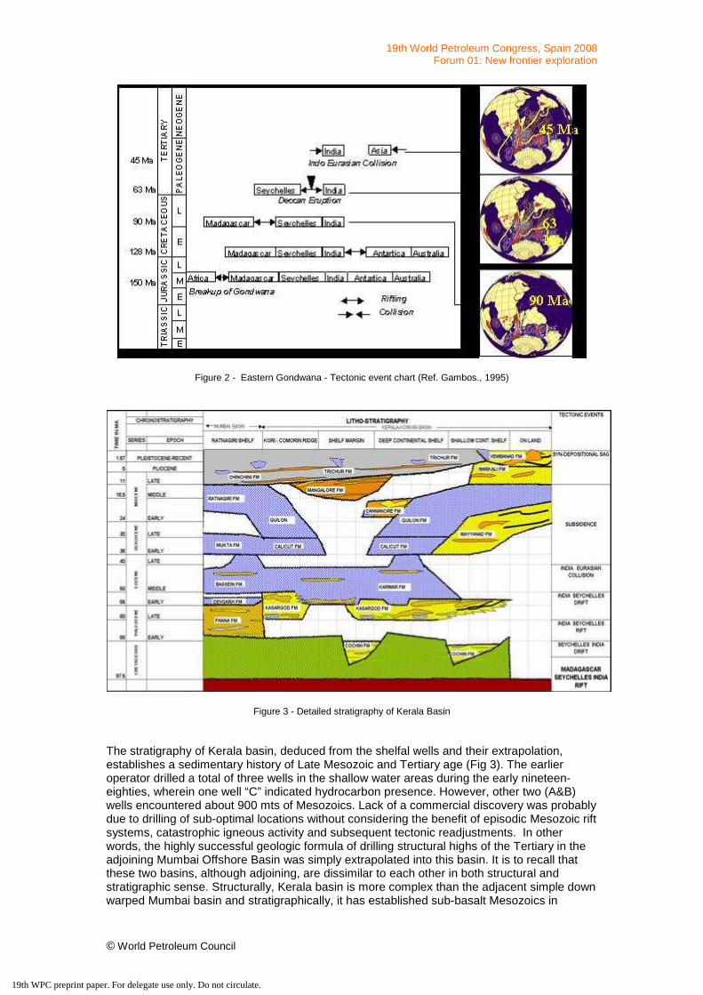
Figure 3 - Detailed stratigraphy of Kerala Basin The stratigraphy of Kerala basin, deduced from the shelfal wells and their extrapolation, establishes a sedimentary history of Late Mesozoic and Tertiary age (Fig 3). The earlier operator drilled a total of three wells in the shallow water areas during the early nineteen-eighties, wherein one well “C” indicated hydrocarbon presence. However, other two (A&B) wells encountered about 900 mts of Mesozoics. Lack of a commercial discovery was probably due to drilling of sub-optimal locations without considering the benefit of episodic Mesozoic rift systems, catastrophic igneous activity and subsequent tectonic readjustments. In other words, the highly successful geologic formula of drilling structural highs of the Tertiary in the adjoining Mumbai Offshore Basin was simply extrapolated into this basin. It is to recall that these two basins, although adjoining, are dissimilar to each other in both structural and stratigraphic sense. Structurally, Kerala basin is more complex than the adjacent simple down warped Mumbai basin and stratigraphically, it has established sub-basalt Mesozoics in
19th WPC preprint paper. For delegate use only. Do not circulate.
19th World Petroleum Congress, Spain 2008 Forum 01: New frontier exploration
© World Petroleum Council
addition to the Tertiary sedimentary pile. Consequently, this paper presents details on regional geologic setting, tectonic evolution, regional stress regimes and rift and hotspot related volcanism with special emphasis on Mesozoic depo-centres for hydrocarbon exploration. Data set for this study include 2D/3D seismics, gravity-magnetic modelling, marine-magnetic anomalies and tectonic reconstructions through a revisit to the concepts of plate-tectonics.
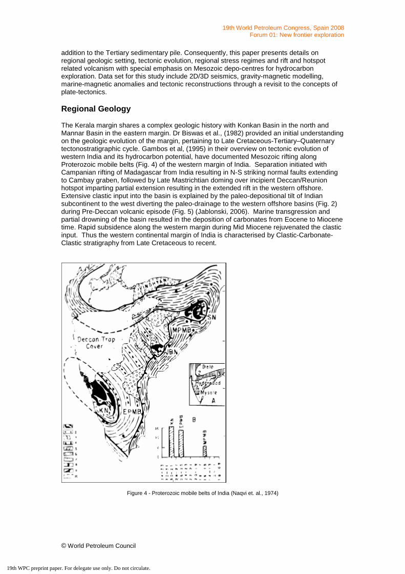
Regional Geology The Kerala margin shares a complex geologic history with Konkan Basin in the north and Mannar Basin in the eastern margin. Dr Biswas et al., (1982) provided an initial understanding on the geologic evolution of the margin, pertaining to Late Cretaceous-Tertiary–Quaternary tectonostratigraphic cycle. Gambos et al, (1995) in their overview on tectonic evolution of western India and its hydrocarbon potential, have documented Mesozoic rifting along Proterozoic mobile belts (Fig. 4) of the western margin of India. Separation initiated with Campanian rifting of Madagascar from India resulting in N-S striking normal faults extending to Cambay graben, followed by Late Mastrichtian doming over incipient Deccan/Reunion hotspot imparting partial extension resulting in the extended rift in the western offshore. Extensive clastic input into the basin is explained by the paleo-depositional tilt of Indian subcontinent to the west diverting the paleo-drainage to the western offshore basins (Fig. 2) during Pre-Deccan volcanic episode (Fig. 5) (Jablonski, 2006). Marine transgression and partial drowning of the basin resulted in the deposition of carbonates from Eocene to Miocene time. Rapid subsidence along the western margin during Mid Miocene rejuvenated the clastic input. Thus the western continental margin of India is characterised by Clastic-Carbonate-Clastic stratigraphy from Late Cretaceous to recent.
Figure 4 - Proterozoic mobile belts of India (Naqvi et. al., 1974)
19th WPC preprint paper. For delegate use only. Do not circulate.

19th World Petroleum Congress, Spain 2008 Forum 01: New frontier exploration
© World Petroleum Council
Figure 5 - Plate-tectonic reconstruction indicating longitudinal ocean adjoining southern and western sectors nearing
the geological period of Late Jurassic – Early Cretaceous. (after Dariusz Jablonski, 2006) Absence of sufficient Tertiary sedimentary pile to act as an independent play on one hand and the poor seismic imagery of sub-basalt Mesozoics in combination with outdated geological models on the other hand inhibited exploration in the basin. However, acquisition and interpretation of modern seismics and gravity in conjunction with regional studies by earlier workers has led to an optimistic conviction for the presence of a vast pile of Mesozoic sediments, to act as major contributors for hydrocarbon generation and entrapment.
Analysis and Synthesis of Earlier Works
Regional seismic interpretation in Kerala basin and adjoining areas, integration with regional gravity-magnetic data, calibration from the wells drilled in the area by different operators, results from DSDP, tectonic reconstructions, structural modelling studies, regional geophysical studies by National Research Institutes of India (NIO and NGRI) and published literature has brought out a new dimension to the geologic history of the region.
EM Studies: The anomalous distribution of electrical conductivity bordering the southern tip of India (Arora, 1990), were qualitatively interpreted to indicate channelling of induced currents through a subsurface conductor between India and Sri Lanka (Rajaram et al., 1979). Regional magnetometer array provided evidence for additional conductors (Thakur et. al., 1986), followed by quantification of the induction response and subsequent numerical modelling to locate and define the character of conductive structures (Fig. 6). Integrated modelling of electro-magnetic response functions from peninsular India and surrounding areas (Baldev et. al, 2002) has indicated a large scale induction anomaly southwest of the southern tip of Indian peninsula, characterised as South India Offshore Conductivity Anomaly (SIOCA). Integrated modelling to explain the induction pattern around southern tip of India (Mareschal et al., 1987), envisaged that the conductor beneath the Palk Strait might be connected to the development of a rift system associated with the break-up of Gondwana land (Naqvi et. al., 1974; Bruke et. al., 1978). The conductor south of India possibly marked some kind of triple junction between Comorin Ridge, India – Sri Lanka – West Coast of India rifting.
19th WPC preprint paper. For delegate use only. Do not circulate.

19th World Petroleum Congress, Spain 2008 Forum 01: New frontier exploration
© World Petroleum Council
Figure 6 - The spatial variation of conductance (logarithmic scale) in and around peninsular India, deduced from thin sheet model covering an area of 0◦–20◦N and 68◦–95◦E. derived from MAGSAT vertical field anomalies (after Singh et al., 1991)., 4d. Major rift basins of India and possible triple junction locations derived by integrating geophysical
data (Veeraswamy et al., 2004)
Magnetic and Velocity Anomalies: This anomalous character of the lithosphere south of India has also been recorded in P-wave seismic tomography (Fig. 7) (Kennet and Widiyantoro, 1999) which corresponds with the location of Marion plume outburst responsible, for the separation of India from Madagascar (Storey, 1995). The magnetisation distribution map from inversion of MAGSAT vertical field anomalies (Singh et al., 1991) also indicates well defined lows just south of peninsular India and Gulf of Cambay (Fig. 8), which in turn implies the presence of a thin magnetic crust and proximal mantle source. Interpretation of regional deep seismic (2D) data emphasized the possibility of sediments related to the Karoo Rift in the southern tip of India (Al Danforth et.al., 2007). A basis for this interpretation is the Jurassic outcrops along the west coast of Sri Lanka, wells drilled in NW of Sri Lanka and also in southern part of Cauvery basin (on land).
Figure 7 - Map view of the P wave velocities at the depth interval of 100 km, indicating low-velocity zones centered at the southern tip of peninsula, western India (Cambay) and NE India (modified from Kennet and Widiyantoro, 1999)
19th WPC preprint paper. For delegate use only. Do not circulate.

19th World Petroleum Congress, Spain 2008 Forum 01: New frontier exploration
© World Petroleum Council
Figure 8 - Magnetization distribution map for Indian sub-continent
Recent Advances
Regional Gravity Interpretation: Gravity data is one of the important tools for analyzing the regional fault geometry and basement tectonic trends (Dale Bird et al., 2001). Initial reconnaissance was carried out at regional as well as prospect level to determine the tectonic architecture, major structural trends and sediment thickness. Gravity enhancements (Rao et al, 2007) from satellite derived free-air anomaly field (Sandwell and Smith version 15.1) to improve the desired anomaly features were used to evaluate the area and unravel the evolutionary history of the basin. The bouger gravity band pass 10-200 km map (Fig. 9) (Rao, et. al., 2007) shows three major structural trends in the region viz. NW-SE, NNW-SSE and NE-SW cross trend, related to the major continental rifting episodes. Interpretation from gravity data shows a right stepping nature of the shelf margin fault (defining the basin geometry) intersected by major transforms extending to deeper offshore. Structural disposition and stepping of the shelf margin fault is interpreted to be the result of the movement along these major transforms. Major depo-centres are seen at the point of intersection of major transforms and pre-existing rift faults. Exploratory wells drilled in these depressions have indicated huge Late Cretaceous sediment and are the main loci for the Mesozoic sedimentation.
19th WPC preprint paper. For delegate use only. Do not circulate.

19th World Petroleum Congress, Spain 2008 Forum 01: New frontier exploration
© World Petroleum Council
Figure 9 - Bouger gravity anomaly (Band pass 10-200 km) showing dominant structural trends in the basin (Rao et.al.
2007).
Long offset 2D Seismics: Seismic data of earlier times (eighties and nineties) was shot with a maximum of 2.4 km streamer length. The high amplitude strong reflector appearing just 1.5 to 2.0 seconds below the mud line on the seismic data shot in present day deeper waters had been construed as the end of the sedimentary sequence (Fig. 10). This information led to wide-spread pessimism regarding the very hydrocarbon prospectivity of the basin. However, presence of Mesozoic sediments in two of the three drilled shelfal wells and evidences of similar age sediments in Madagascar had triggered the idea of Mesozoic basin camouflaged by Deccan Volcanics. The challenge, therefore, has been identified to imagine deeper targets with increased signal penetration and recovery. For the first time long offset 2D seismic technology was used to improve subsurface imaging. The data was recorded by towing 8 km streamer recording 11 seconds of data with 12.5 mts group interval and 37.5 mts shot interval (Fig. 10b,c & d) Seismic imaging in the Kerala basin faces some common reflectivity issues related to reflection ray bending in comparatively hard rock sequences. Strong density contrast between lithological boundaries cause the seismic incident energy to move away from the normal incidence. As a result, within shallow depths the critical angle is achieved. While as, long streamers enable picking and receiving of transmitted energy from deeper reflectors. The reflected part of energy from the seafloor and the hard sediments close to sea beds along with the shallow basalt generates strong short and long period multiples, which interfere with primaries at the deeper depths and mask the already weakened signals. As a result the recorded reflection events from deeper targets have low signal to noise ratio and it was important to concentrate the stacking process on the offset gathers that contained higher S/N ratio. Strong inner trace mute was applied to attenuate majority of the multiples. Also, relatively higher stacking velocities were used along with radon demultiple to remove the remaining multiples from the data. Majority of the reflected events from deep targets are
19th WPC preprint paper. For delegate use only. Do not circulate.

19th World Petroleum Congress, Spain 2008 Forum 01: New frontier exploration
© World Petroleum Council
prone to high stretching at long offsets and require very meticulous muting to avoid the effects of stretching on the stack data. With all these concerted efforts, the recently gathered long offset seismic data have shown great promise in providing information from the deeper sedimentary sequences and generated optimism for future exploration in the basin.
Figure 10 - Seismic section from Kerala basin showing poor quality data and change in the deeper imaging with better acquisition parameters in new data (Part of the seismic profile shown on regional seismic Figure. 12)
Plate-Tectonic Reconstruction: Plate tectonic reconstruction of Late Jurassic to Early Cretaceous (Fig 5) (Jablonski, 2006), demonstrates that the basin was situated in the north-eastern part of Proto-Mozambique Ocean, with Antarctica as the major provenance of sediment supply under favourable oceanic and climatic conditions for organic productivity. The Mozambique ridge acted as a barrier for deep water circulation between the Mozambique proto-ocean and Weddell Sea from 147-125 Ma, creating suitable conditions for the deposition of source rocks. Cores collected from the wells drilled during ODP leg 113, on the continental slope north of Dronning Maud Land, have indicated anaerobic bottom water conditions during Valanginian to Hauterivian. By virtue of its presence in southern hemisphere, the western margin of eastern Gondwana under the influence of oceanic upwellings would have been the zone of maximum productivity during Cretaceous.
19th WPC preprint paper. For delegate use only. Do not circulate.

19th World Petroleum Congress, Spain 2008 Forum 01: New frontier exploration
© World Petroleum Council
Figure 11 - Tectonic Map showing dominant tectonic trends in the Kerala Basin (Modified after M Raith, 1995) Regional composite tectonic map integrating onshore and offshore tectonic elements depicts three major structural trends viz. 1) NW-SE to NNW-SSE trend as pertaining to Mid Jurassic (Karoo) rift, between East Africa-Madagascar-India-Antarctica continental assemblies initiated by transtensional movement along the Davies Fracture Zone, 2) NE-SW trend related to the Cretaceous rift between Madagascar-India-Sri Lanka. This failed rift most probably formed as a failed rift in the India-Antarctica break up (140 Ma). 3) NNW-SSE trending Late Cretaceous rift between Seychelles and India (Fig. 11). Therefore, the basin had been an integral part of these tectonic events responsible for the rifting in eastern Gondwana continental assembly. Consequently, the Kerala Basin is the most important component in Gondwana rifting and is the confluence of rift systems of different ages. This qualifies the southern tip of India as Rift Junction or Dissemination point of continental assembly.
Discussion
Rifting between Africa, Madagascar and Antarctica continental assembly triggered during Mid Jurassic lead to the opening of rifts and subsequent oceanic basins along the margin. Southern tip of India is the identified as a common point that has experienced all the major episodes of rifting viz., Africa-Madagascar-Antarctica, Madagascar-India and Seychelles-India. Reconstruction studies constrained by oceanic magnetic anomalies and correlating tectonic elements place India in the southern hemisphere (20o latitude) during Mid-Late Jurassic and Cretaceous with conditions ambient for the deposition of potential source rocks before it started drifting in the north ward direction. Vishnu fracture zone, a prominent oceanic fracture zone in Indian Ocean identified as the major oceanic divide with older oceanic crust to the east and younger oceanic crust to the west. Thus the basins to the east of VFZ are older in comparison to the basins to the west (Fig. 12).
19th WPC preprint paper. For delegate use only. Do not circulate.

19th World Petroleum Congress, Spain 2008 Forum 01: New frontier exploration
© World Petroleum Council
Figure 12 - Regional Seismic Section with improved imaging below the basalt showing the 2D Basin Architecture, Vishnu Fracture Zone and Inversion Tectonics
Response from EM modelling studies indicating low conductance anomaly, anomalously low P wave velocity field and low magnetization characterize southern tip of India as a zone of crustal unrest. These zones are characterized by the intersection of crustal level deformation overprints resulted from various tectonic episodes. By virtue of sharing the same continental margin, structural trends related to various deformation events are expected to be present on the western margin of Madagascar-India-Sri Lanka-Antarctica. Regional gravity interpretation clearly defined three major structural trends viz., NW-SE (related to India-Madagascar rifting), N-S (Vishnu Fracture Zone), E-W in the Kerala basin and NE-SW (India-Sri Lanka rifting) in the Mannar basin. Thus southern tip of India is the point of confluence of various tectonic events with episodic hotspot and rift related volcanism. Seismic imaging below the basalts is one of the major issues of concern in the region. Long offset seismic acquired with concepts developed from plat tectonics and better acquisition parameters to image Mesozoic basin below the basalts had brought out significant change in the exploration scenario.
Conclusion South-western continental margin, i.e., Kerala deep water basin, is a frontier opportunity and turning it into a proven value accretion, necessitates an exploration paradigm shift in terms of concepts and technology. A synthesis of crustal scale geophysical anomalies, plate-tectonic reconstructions, long offset, gravity and magnetic results has brought out a new dimension to the geological history of the basin. Seismic signatures of sub-basalt Mesozoic rift-system with excellent inter-connectivity, type seismic facies and post depositional large-scale inversions, upgrade the frontier Kerala deep water basin as the potential case for intensive exploration for hydrocarbons.
Acknowledgements The authors are grateful to the management of Petroleum Business (E&P), Reliance Industries Ltd. for providing the infrastructure, opportunity and permission to publish the work.
19th WPC preprint paper. For delegate use only. Do not circulate.

19th World Petroleum Congress, Spain 2008 Forum 01: New frontier exploration
© World Petroleum Council
References: Al Danforth, Steve Henry, 2007, Regional Interpretation Reports from GXT profiles, southwestern continental margin of India (RIL Internal Report). Arora, B. R. and Subba Rao, P. B. V., 2002, Integrated modeling of EM response functions from Peninsular India and Bay of Bengal; Earth Planets Space, 54, 637-654. Biswas, S. K., 1982, Rift Basins in western margin of India and their hydrocarbon prospects with special reference to Kutch basin, AAPG Bull, V. 66, No. 10, pp. 1497-1513 Dale Bird, 2001, Shear Margins: Continent-ocean transform and fracture zone boundaries, Leading Edge Geologic Column. Dariusz Jablonski, 2006, Paleogeographic maps and lithofacies distribution deposited during indicated time slice, Finder Exploration. Gombos, A.M., Jr., W.G. Powell, and I.O. Norton, 1995, The tectonic evolution of western India and its impact on hydrocarbon occurrences: an overview, Sedi. Geol., v. 96, p. 119-129 Kennett, B. L. N. and S. Widiyantoro, A low seismic wavespeed anomaly beneath northwestern India: a seismic signature of the Deccan plume?, Earth Planet. Sci. Lett., 165, 145–155, 1999. Mareschal, M., G. Vasseur, B. J. Srivastava, and R. N. Singh, Induction models of southern India and effect of offshore geology, Phys. Earth Planet. Inter., 45, 137–148, 1987. Naqvi, S. M., V. Divakar Rao, and H. Narain, The proto-continental growth of Indian shield and the antiquity of its rift valleys, Precambrain Res., 1, 338–345, 1974. Rajaram, M., B. P. Singh, N. Nityananda, and A. K. Agarwal, Effect of the presence of a conducting channel between India and Sri-Lanka on the features of the Equatorial Electrojet, Geophys. J. R. Astron. Soc., 56, 127–138, 1979. Rao, Y, Integrated Gravity Magnetic modelling studies along offshore India, RIL internal report, 2007. Raval, U. and Veeraswamy. K, Chipping of cratons and breakup along the margins of a supercontinent, Earth Planets Space, 56, 491-500, 2004 Singh, B. P., Mita Rajaram, and V. J. Bapat, Definition of the continentocean boundary of India and the surrounding oceanic regions from Magsat data, Tectonophys., 192, 145–151, 1991. Storey, B. C., The role of mantle plumes in continental breakup: case histories from Gondwanaland, Nature, 377, 301–308, 1995 Thakur, N. K., M. V. Mahashabde, B. R. Arora, B. P. Singh, B. J. Srivastava, and S. N. Prasad, Geomagnetic variation anomalies in peninsular India, Geophys. J. R. Astron. Soc., 86, 839–854, 1986.
19th WPC preprint paper. For delegate use only. Do not circulate.
Related Documents