Community Land & Water Coalition Save the Pine Barrens, Inc. 158 Center Hill Preserve Plymouth MA 02360 www.savethepinebarrens.org [email protected] May 24, 2021 Comments on EENF #13940 List of Exhibits Exhibit 1: 4/1/21 Letter to AD Makepeace CEO Jim Kane from B. Cosgrove re MEPA Public Information Meeting Exhibit 2: 1/22/19 Planning Board Meeting Minutes, Town of Carver Exhibit 3: 2/1/21 Letter to Town of Wareham Conservation Commission from Community Land & Water Coalition re: Borrego Solar Notice of Intent Exhibit 4: 3/8/21 Letter to Town of Wareham Planning Board from Community Land & Water Coalition re: Borrego Solar Exhibit 5: 3/29/21 Letter to Town of Wareham Conservation Commission from Community Land & Water Coalition re: Borrego Solar Exhibit 6: 4/6/21 Request for Enforcement to Town of Carver from Save the Pine Barrens, Inc. Exhibit 7: 5/13/21 Second Request for Enforcement to Town of Carver from Save the Pine Barrens, Inc. Exhibit 8: 5/16/21; Letter to Carver Earth Removal Committee, Chairman Garretson, from B. Cosgrove re Earth Removal

Welcome message from author
This document is posted to help you gain knowledge. Please leave a comment to let me know what you think about it! Share it to your friends and learn new things together.
Transcript
Community Land & Water Coalition Save the Pine Barrens, Inc. 158 Center Hill Preserve
Plymouth MA 02360 www.savethepinebarrens.org
May 24, 2021 Comments on EENF #13940
List of Exhibits
Exhibit 1: 4/1/21 Letter to AD Makepeace CEO Jim Kane from B. Cosgrove re MEPA Public Information Meeting
Exhibit 2: 1/22/19 Planning Board Meeting Minutes, Town of Carver
Exhibit 3: 2/1/21 Letter to Town of Wareham Conservation Commission from Community Land & Water Coalition re: Borrego Solar Notice of Intent
Exhibit 4: 3/8/21 Letter to Town of Wareham Planning Board from Community Land & Water Coalition re: Borrego Solar
Exhibit 5: 3/29/21 Letter to Town of Wareham Conservation Commission from Community Land & Water Coalition re: Borrego Solar
Exhibit 6: 4/6/21 Request for Enforcement to Town of Carver from Save the Pine Barrens, Inc.
Exhibit 7: 5/13/21 Second Request for Enforcement to Town of Carver from Save the Pine Barrens, Inc.
Exhibit 8: 5/16/21; Letter to Carver Earth Removal Committee, Chairman Garretson, from B. Cosgrove re Earth Removal

Exhibit One
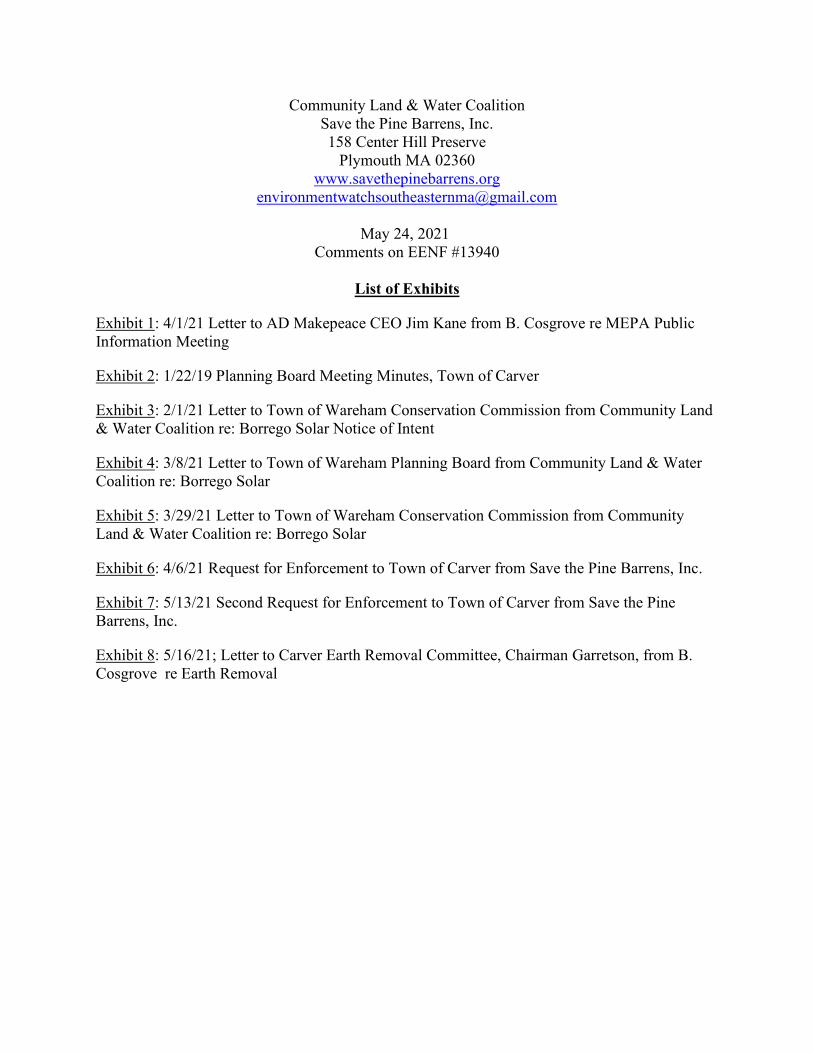
Barry C. Cosgrove 49 Blackmore Pond Circle
West Wareham, Ma 02576
SENT RETURN RECEIPT REQUESTED
April 1, 2021
Jim Kane CEO AD Makepeace Co. 158 Tihonet Road Wareham, Ma. 02571
Dear Mr. Kane
During your MEPA Public Information Meeting on March 22, 2021 you were recorded to say that you “absolutely” would meet with the public to personally account for all of the material taken from the AD Makepeace Company’s 160 Tihonet Road location. You also agreed to show where the material went for agricultural purposes.1
You also promised to conduct this meeting soon.1 Accordingly, this letter is to inquire about the date time and location of this public session.
Sincerely
Barry C. Cosgrove
1 https://www.facebook.com/103162998437962/videos/717227405638082
cc:
Wareham Board of Selectmen/Wareham Conservation Commission/ Wareham ZBA/Wareham Town Manager/Wareham Assessor/ Wareham Tax Collector

Exhibit Two
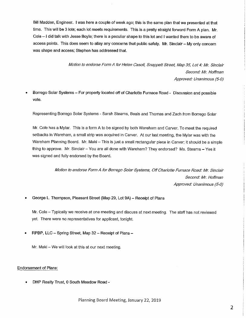


Exhibit Three
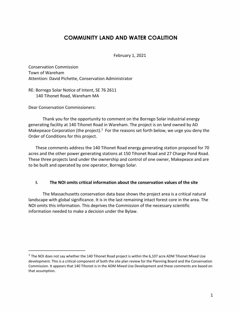
1
COMMUNITY LAND AND WATER COALITION
February 1, 2021 Conservation Commission Town of Wareham Attention: David Pichette, Conservation Administrator RE: Borrego Solar Notice of Intent, SE 76 2611 140 Tihonet Road, Wareham MA Dear Conservation Commissioners:
Thank you for the opportunity to comment on the Borrego Solar industrial energy generating facility at 140 Tihonet Road in Wareham. The project is on land owned by AD Makepeace Corporation (the project).1 For the reasons set forth below, we urge you deny the Order of Conditions for this project.
These comments address the 140 Tihonet Road energy generating station proposed for 70 acres and the other power generating stations at 150 Tihonet Road and 27 Charge Pond Road. These three projects land under the ownership and control of one owner, Makepeace and are to be built and operated by one operator, Borrego Solar.
I. The NOI omits critical information about the conservation values of the site The Massachusetts conservation data base shows the project area is a critical natural
landscape with global significance. It is in the last remaining intact forest core in the area. The NOI omits this information. This deprives the Commission of the necessary scientific information needed to make a decision under the Bylaw.
1 The NOI does not say whether the 140 Tihonet Road project is within the 6,107 acre ADM Tihonet Mixed Use development. This is a critical component of both the site plan review for the Planning Board and the Conservation Commission. It appears that 140 Tihonet is in the ADM Mixed Use Development and these comments are based on that assumption.

2
Rare species. The Bylaw requires the Commission to make findings about effects on resource areas, including but not limited to “rare species habitat including rare plant species”. Purpose, Section 1. Under the Bylaw,
The term “rare species” shall include, without limitation, all vertebrate and invertebrate animal and plant species listed as endangered, threatened, or of special concern by the Massachusetts Division of Fisheries and Wildlife, regardless of whether the site in which they occur has been previously identified by the Division.” (emphasis supplied)
Bylaw, Section III. The NOI only refers to Priority Habitat of Rare Species or Estimated Habitats of Rare Wildlife, claiming that because the site is not with an area “mapped” by Natural Heritage and Endangered Species (NHESP) no action is needed. Project Narrative 2-2, 2.2.4. The Bylaw does not limit protection of rare species to areas “mapped” by NHESP.
The Commission should require Borrego to conduct a biological survey to identify rare species for the following reasons.
First, the Massachusetts Secretary of Energy and Environmental Affairs (EOEEA or Secretary) has identified the site as “undeveloped land considered ecologically significant due to the presence of BioMap Core Habitat, Priority Habitat for rare and endangered species, and the underlying sole source aquifer.” MEPA Certificate 13940, 2012, page 1. The Secretary stated,
These areas consist primarily of undeveloped forested land, agricultural access roads and paths. Portions of the project site contain important, high quality pine barrens habitat supporting multiple state-listed species. This is part of a larger contiguous barrens system located in and around Myles Standish State Forest that is of regional and global conservation significance. Areas proposed for bog development [in 2012] include Estimated and Priority rare species habitat, including the Eastern Box Turtle (Terrapene carolina) and several pine barrens species. In addition, several areas of the site are designated as agricultural use under the Chapter 61 A program and several areas are in active forest management under an approved Chapter 61 forest management plan. (emphasis supplied) 2012 Certificate, page 3.
Second, current environmental designations on the Commonwealth’s OLIVER map data
base identify at least the following critical and core habitat features for the 140 Tihonet Road site: BioMap2 Critical Natural Landscape and BioMap2 Core Habitat Vernal Pool. The adjacent 150 Tihonet Road solar site is BioMap2 Core Habitat Forest Core and BioMap2 Critical Natural Landscape.
Third, 140 and 150 Tihonet Road border each other and Tihonet Pond. A significant river
herring fishery depends on Tihonet Pond for survival. A fish ladder provides access to the Pond for river herring annual upstream migration from the ocean to Tihonet Pond for spawning. This

3
significant fish run is just 330 feet from the edge of the 140 Tihonet Road solar project. This fishery was not identified in the NOI and the NOI does not address potential impacts from the project, including discharge of sediment and pollutants. River herring including alewife are a species that have received close examination by fisheries agencies because it has been considered for listing on the federal Endangered Species Act list and should be considered rare under the Bylaw. https://www.fisheries.noaa.gov/species/river-herring#management
Below: Borrego maps showing the 140 and 150 Tihonet Road solar projects which are on the same parcel with a utility easement through it, totaling 110 acres. The developers’ documents do not show the two projects side by side on one map giving a misleading representation.
Rare species downstream may also be impacted. See OLIVER map, below. Tihonet Pond flows to the Agawam River listed by Massachusetts as Priority Habitat Area 486 and it is connected to Wankinko River. Agawam River experiences well-documented water quality issues. The Applicant’s projects do not address how the water quality and Priority Habitat in Area 486 will be impacted by the project.
The NOI states, “The site does not contain, nor is it tributary to any Critical Areas.” This
is contrary to the OLIVER maps.

4
Fourth, the NOI’s Draft Endangered Species Certification (Application Section 3.0) in the GZA did a habitat assessment for the Northern Long-Eared Bat and Plymouth Red-Belly Turtle. Borrego Solar did not provide this habitat assessment to the Commission. It should be required to do so before the Commission makes its decision.
Narrowly defining the site. The NOI does not give an adequate overview of the landscape setting of the project. The NOI narrowly defines the site and ignores consideration of many potential impacts. As a result, there is inadequate evidence to support Borrego’s claim that “No off-site impacts to the ecology of the area are anticipated from the Project.” See, Road Beals + Thomas Site Plan Application, page 2-8.
The NOIs for all three Borrego Solar projects provide only generic descriptions of environment, ignoring thethe global, regional and local ecological documented by BioMap2 and other sources. For example, the Applicant describes the sites with such statements as, “currently undeveloped and primarily wooded.” See, NOI for 150 Tihonet Road, page 2-2. The Applicant ignores the interconnectedness of water systems, ecosystems and wildlife habitat. This is contrary to the requirements of the Bylaw and its spirit and intent.
II. Improper segmentation of projects to evade environmental review
The three Borrego Solar/Makepeace projects at 140 and 150 Tihonet (on the same
parcel) and 27 Charge Pond Road interconnected in every way. Their environmental effects on
5
resources covered by the Bylaw cannot reasonably be evaluated on a piecemeal basis, project by project, as the developers are attempting to accomplish.
The 140 and 150 Tihonet Road projects are on the same parcel of property and the 27 Charge Pond Road project is downstream. These three projects will completely deforest 174 acres of land that borders on wetlands and waterways in BioMap2 habitat. The land will be completely denuded: “scraped” as it is described by the developer. The land will lose the ability to filter groundwater and provide ecosystems services as clean water, carbon sequestering forests and soils and wildlife habitat. The developers have done no environmental impact, no biological survey and no comprehensive hydrological assessment to determine the impacts of denuding 174 acres of land and irreversibly altering surface and groundwater water flows.
The 27 Charge Pond Road solar site is in BioMap2 Core Habitat Species of Conservation Concern and is BioMap2 Core Habitat. Federally listed Northern Cooters and Long Eared Bats are located in the area of all three sites, as referenced in the three NOIs. The Applicants plan for protecting rare and endangered species is the following:
The Project will limit earthwork and vegetation clearing to the extent feasible for operation of a ground-mounted solar energy collection system. The Site will be vegetated and stabilized after construction. Areas outside of the solar array within the shade clearing area will be left to revegetate, and stumps will remain.
Therefore the fisheries, shellfisheries, wildlife habitat, and rare species habitat including rare plant species interests of the Act and By-Law will be protected.
This is inadequate.

6
Above: Borrego map showing location of the third project at 27 Charge Pond Road. This is on Parker Mill Pond downstream and hydrologically connect to Tihonet Pond where the 150 and 140 Tihonet Road projects are located.
AD Makepeace has further segmented these three projects from its 160 Tihonet Road, Wareham industrial solar energy facility consisting of 49.5 acres and under construction now. This project is on land designated as BioMap 2 “Priority Habitat” on the Frog Foot Reservoir (Priority Habitat Area #559). Frog Foot Brook is surrounded by Critical Natural Landscape, the highest level of Priority Natural Community identified by the state. This project was done without an environmental impact report.
III. NOI does not address cumulative environmental impacts
The Wareham Wetland Protective By-Law states,

7
The purpose of this bylaw is to protect the wetlands, water resources, and adjoining land areas in Wareham by controlling activities deemed by the Conservation Commission likely to have a significant or cumulative effect upon resource area values, including but not limited to the following: public or private water supply, groundwater, flood control, erosion and sedimentation control, storm damage prevention including coastal storm flowage, water quality, water pollution control, fisheries, shellfish, land containing shellfish, wildlife habitat, rare species habitat including rare plant species, aesthetics, agriculture, aquaculture, and recreation values, deemed important to the community (collectively, the “resource area values protected by this bylaw”). This bylaw is intended to utilize the Home Rule authority of this municipality to protect additional resource areas, for additional standards and procedures stricter than those of the Wetlands Protection Act (G.L.Ch. 131, §40) and Regulations thereunder (310 CMR 10.00) (emphasis supplied)
Section 1.1 of the Bylaw further states the
Commission may take into account the cumulative adverse effects of loss, degradation, isolation, and replication of protected resource areas throughout the community and the watershed, resulting from past activities, permitted and exempt, and foreseeable future activities. (emphasis supplied)
Here, in considering the impacts to “resource areas” under the Bylaw from the 140 Tihonet industrial energy facility it is imperative that the Commission take into account the cumulative impacts all of the activities undertaken by AD Makepeace in partnership with Borrego Solar/Clearway over at least the past several years to determine the cumulative impact of these projects and the additional “adverse effects of loss, degradation, isolation…of protected resource areas throughout the community and the watershed, resulting from past activities.” As well, it should consider future activities of AD Makepeace within the ADM Mixed Use Development area.
Borrego’s failure to address the cumulative impacts and of the four industrial energy installations in close proximity and abutting Wareham’s water resources protected under the Bylaw constrains the Conservation Commission’s ability to reasonable determination of the effects of the 140 Tihonet Road project.
Basic hydrology and ecology tels us that AD Makepeace’s four solar projects, due to their scale and size will have ripple effects throughout the interconnected ecosystem. The four projects are located on interconnected waterbodies and impact connected wildlife corridors and habitats. Further impacting the waterbodies and wildlife habitats, in 2012 Makepeace was permitted to construct a 140-acre bog off Tihonet Road, located east of the Wankinko River in Plymouth and flowing to Wareham, and to build a “soil blending” facility for sand and gravel aggregate operations. AD Makepeace subsidiary Read Custom Soil operates upstream from the four industrial solar energy installations. Also upstream in Carver, 87 acres of solar installations are underway by AD Makepeace and Borrego, denuding and scraping undisturbed land that
8
provides ecosystem services for the water systems downstream. These are all cumulative impacts that should be considered by the Commission, which it is authorized to do by the Bylaw, Section 1.1.
One example of the cumulative impact to wildlife resources protected by the Bylaw is the fact that each of the four Wareham industrial energy projects will be surrounded by chain link fence.
• What is the impact prohibiting wildlife from using 70 acres of habitat in the case of the 140 Tihonet Road project?
• When considered with the 150 and 160 Tihonet Road projects and the 27 Charge Pond Road projects, a total of about 220 acres of what was previously wildlife habitat for “high quality pine barrens habitat supporting multiple state-listed species” as described by the Secretary in the 2012 MEPA Certificate, is now off limits.
• What are the impacts?
While some of the NOIs refer to “wildlife gaps” in the chain link fence, the description and plans are do not adequately describe the mitigation for the loss of habitat and how the migration and habitat use by wildlife will be effected.
IV. Impacts to water bodies
The NOI for 140 Tihonet Road is does not accurately address pollution discharges to water bodies from the activities at the site. Borrego’s pollution discharges are regulated by state and federal law (NDPES Construction General Permit and SWPPP). See, NOI Section 4.0 Stormwater Management Report. There is not enough information in the draft permit applications submitted to the Commission.
First, the record does not contain a final Stormwater Report and SWPP. This makes it impossible to know the actual pollutant discharges and the specifics means proposed to an attempt to control the pollution discharges to water bodies.
• Why is there no final pollution discharge report and stormwater plan? How will the Commission evaluate the impacts to wetlands and resource areas without this information?2
2 The NOIs for 150 Tihonet and 27 Charge Pond Road NOI Borrego/Makepeace project also contain only “draft” stormwater management plans. Have the final plans been provided to the Commission? If so, was the public provided the opportunity for notice and comment on them as required by law? Are these being submitted after the fact, i.e. after the Order of Conditions is issued.
9
Second, the NOI misrepresents water quality information effects on Tihonet Pond. It describes discharge from the 140 Tihonet project as follows:
The site is currently undeveloped [i.e. forested and it its natural state] and is primarily wooded with an existing gravel cart path to the south and east. Runoff from the site drains radially outward from the existing hilltop ridge. Flows to the west go towards Tihonet Road and Tihonet Pond. Flows to the southwest are directed to an existing agricultural channel that flows southeast from Tihonet Pond into existing bogs south of the proposed array. Runoff also flows to existing bogs both on-site as well as off-site to the southeast, and easterly to an existing wetland system. See, NOI Section 2.1, Site Conditions
This description fails to acknowledge that in fact, the site will not be “primarily wooded” once the solar installation is complete. Instead, it will be stripped of all vegetation and topsoil, “scraped” as the Application describes it. This irreversibly and negatively impacts the ability of the land to absorb pollutants and filter the underlying groundwater where Wareham residents get their water. Creating stormwater detention basis irreversibly alters the flows impacting the wildlife and plants that depend on them.
The NOI does not explain how altering surface water flows will impact interconnected ecosystems on or off the site, individually or cumulatively. The applications say the sites are connected. For example, the 140 Tihonet Road NOI describes how the site is “associated with Tihonet Pond.” See, Project Narrative, 2-3. The 150 Tihonet Road NOI states the Bordering Vegetated Wetland on the site is “hydrologically associated with the adjacent pond/reservoir to the east, including a surface water connection to this waterbody.” Page 2-3.
The 150 Tihonet NOI states,
Runoff from the western most portion of the site flow to a wetland and potential vernal pool system on the west side of the property. Runoff from the southwestern portion of the site drain to a wetland system on the southwest side of the property. Runoff from the northwestern portion of the site drain to a wetland and potential vernal pool system on the northwest side of the property. Runoff from the southwest, west and northwest wetland system ultimately discharge to Tihonet Pond.” NOI Application Section 2.1, 150 Tihonet Road. (emphasis supplied)
See also NOI for 150 Tihonet Road, Section 2.5.2: “Receiving waters: Runoff from the site drains to Tihonet Pond to the west and to existing wetlands and potential vernal pools to the west which eventually flow to Tihonet Pond. Runoff flows east to an off-site wetland system. Runoff from the northern portion of the stie drains to stream on the north side of the property.”
The Site Plan Application (May 28, 2020) for 27 Charge Pond states, “The primary design point, DP-1, used for the stormwater analysis represents flows to Parker Mills Pond.”

10
The 140 and 150 Tihonet Road projects are on Tihonet Pond. This Pond flows into Parker Mills Pond and then to the Agawam River. Therefore the two Tihonet Road projects will be adding pollution to Tihonet Pond and the 27 Charge Pond Road will be adding pollution further downstream to Parker Mills Pond. Thus the three sites have potential pollution and surface water flow impacts that have not been addressed in one hydrological or water quality study.
The NOIs describe types of potential sources of pollution in the draft Stormwater Reports. See, e.g. Section 2.8. This includes sediment from “soil stripping and stockpiling” and nitrogen, phosphorous, naphta, mineral oil, benzene, ethyl benzene, toluene, xylene, MTBE, petroleum, oil and grease, napthalene, xylenes, kerosene, antifreeze and toilets. These pollutants will be discharged on site and eventually enter ground and/or surface water. They will not simply disappear. As the Secretary stated, this is a sole source aquifer and globally significant ecosystem. A much better description of the cumulative impacts of these projects is required.
Finally, the NOI misrepresents the water quality of the receiving waters – that is, the water to which the Applicant’s pollution will be discharged. The NOIs for 140 and 150 Tihonet both state,
“The site does not discharge to a surface water with a TMDL or draft TMDL.”
See, Stormwater Reports, Section 2.0. This gives the distinct impression that there is no “TMDL” for the receiving waters. A TMDL is the calculation of the maximum amount of a pollutant allowed to enter a waterbody so that the waterbody will meet and continue to meet water quality standards for that particular pollutant. A TMDL determines a pollutant reduction target and allocates load reductions necessary to the source(s) of the pollutant. https://www.epa.gov/tmdl/overview-total-maximum-daily-loads-tmdls#:~:text=approved%20by%20EPA%3F-,What%20is%20a%20TMDL%3F,standards%20for%20that%20particular%20pollutant.
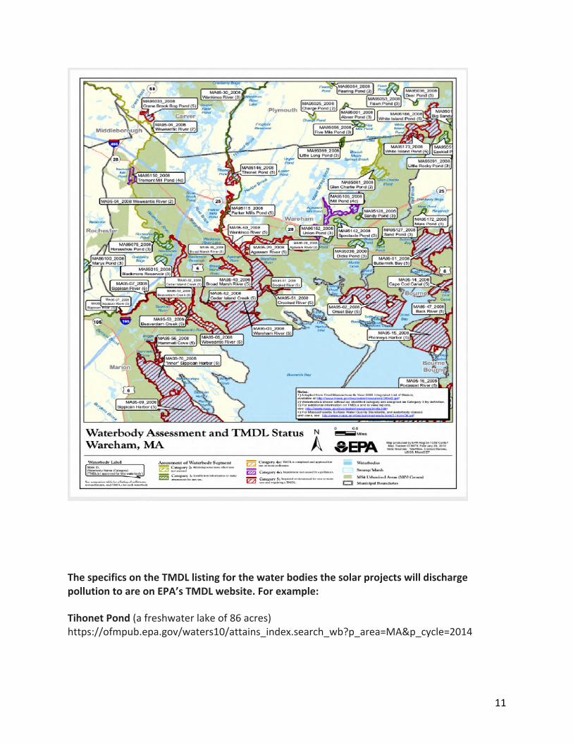
In fact, Tihonet Pond, Parker Mills Pond, the Wankinko River downstream of Parker Mills Pond and the Wareham River are all designated by US EPA as waters that are designated as impaired-that is polluted. They are identified as “Category 5: Impaired or threatened for one or more uses and requiring a TMDL.” See, Map below, Waterbody Assessment and TMDL Status, Wareham MA. EPA and Massachusetts have yet to set the “load reductions” needed to restore these water bodies. This means that the three solar projects will be adding more pollution to water bodies that are already “impaired” and that do not support one or more uses, such as fisheries or recreation.
11
The specifics on the TMDL listing for the water bodies the solar projects will discharge pollution to are on EPA’s TMDL website. For example:
Tihonet Pond (a freshwater lake of 86 acres) https://ofmpub.epa.gov/waters10/attains_index.search_wb?p_area=MA&p_cycle=2014
12
Parker Mills Pond and Wareham River: https://ofmpub.epa.gov/waters10/attains_index.search_wb?p_area=MA&p_cycle=2014
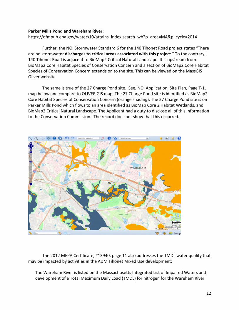
Further, the NOI Stormwater Standard 6 for the 140 Tihonet Road project states “There are no stormwater discharges to critical areas associated with this project.” To the contrary, 140 Tihonet Road is adjacent to BioMap2 Critical Natural Landscape. It is upstream from BioMap2 Core Habitat Species of Conservation Concern and a section of BioMap2 Core Habitat Species of Conservation Concern extends on to the site. This can be viewed on the MassGIS Oliver website.
The same is true of the 27 Charge Pond site. See, NOI Application, Site Plan, Page T-1, map below and compare to OLIVER GIS map. The 27 Charge Pond site is identified as BioMap2 Core Habitat Species of Conservation Concern (orange shading). The 27 Charge Pond site is on Parker Mills Pond which flows to an area identified as BioMap Core 2 Habitat Wetlands, and BioMap2 Critical Natural Landscape. The Applicant had a duty to disclose all of this information to the Conservation Commission. The record does not show that this occurred.
The 2012 MEPA Certificate, #13940, page 11 also addresses the TMDL water quality that may be impacted by activities in the ADM Tihonet Mixed Use development:
The Wareham River is listed on the Massachusetts Integrated List of Impaired Waters and development of a Total Maximum Daily Load (TMDL) for nitrogen for the Wareham River
13
Estuary is underway. Future phases of the project that require a Groundwater Discharge Permit from MassDEP will likely be subject to nitrogen offset requirements. Associated review documents will be required to include a nitrogen loading analysis and identification of offsets. Comment letters from the Buzzards Bay Coalition and Mass Audubon reiterate a request (included in comments on previous phases) that the Proponent provide a nitrogen loading analysis for the Wareham River and identify offsets for proposed projects. Because Phase C-2 does not require a Groundwater Discharge Permit and the creation of new bogs, with use of tailwater recovery ponds, to replace flow-through bogs and the construction of the bypass canal should reduce nitrogen loadings, the Proponent is not required to develop a nitrogen loading analysis, or meet nitrogen offset requirements, at this time.
The Applicant should be required to prove that these activities were completed with regard to the 2012 projects and identify the impact of adding pollutant discharges from four solar projects to the Wareham River.3
CONCLUSION: Deny the Order of Conditions
Under Section X of the Wareham Bylaw, Borrego has the “burden of proving by a preponderance of the credible evidence that the work proposed in the permit application will not have unacceptable significant or cumulative effect upon the resource area values protected by this bylaw.” Borrego’s “failure to provide adequate evidence to the Commission supporting this burden shall be sufficient cause for the Commission to deny a permit or grant a permit with conditions.” The Commission is empowered to deny a permit for failure to avoid or prevent unacceptable significant or cumulative effects upon the resource area values protected by this bylaw; and where no conditions are adequate to protect those values.
The Applicant has not met its burden and there has been no showing that conditions will prevent unacceptable significant or cumulative effects upon the resource area values protected by the Bylaw. Therefore, the Commission should deny the Order of Conditions.
3 MEPA Certificate 2012 also addresses the issue of cumulative impacts to water quality from the AD Makepeace Tihonet Mixed Use Plan. See, Page 11-12. “Comments from MassDEP indicate that the Proponent has agreed to work with MassDEP, the University of Massachusetts (UMass) Cranberry Experiment Station, and other appropriate stakeholders to design a study to quantify the pollutant reduction associated with Phase C-2. While it is recognized that construction of the new bog, in combination with abandonment of old bogs, should reduce pollutant loads, comments from MassDEP indicate that this type of bog construction has not been widely used in Massachusetts and the reduction in pollutant load has not been quantified. Further, MassDEP comments note that an analysis of project benefits will be required if the Proponent intends to employ these improvements to offset other pollutant loads that may be required in future phases of the Tihonet Project. Attainment of offsets will require permanent abandonment of flow-through and/or unimproved bogs.

14
Please contact me if you need additional information.
Very truly yours,
Meg Sheehan Volunteer 508-259-9154 [email protected]
//Urr,rfud*f /WU

Exhibit Four

1
To preserve, protect and steward our unique and finite land and water resources. They are irreplaceable. We are losing fast. www.pinebarrensalliance.org
March 8, 2021 Town of Wareham Planning Board c/o Kenneth Buckland via Email to [email protected] and Sonia Raposo [email protected] Re: 26-20 Site Plan review of BE RE, LLC, c/o Beals & Thomas, 0 North Carver Road, Wareham, Map 104, Lots 1049 A, 1049 B, 1049 D and 1050 Dear Chairman Barret and members of the Wareham Planning Board, Thank you for the opportunity to submit comments on the above project. We are an alliance of groups and individuals working to preserve and protect our land and waters in Southeastern Massachusetts. We support properly sited and permitted solar energy. There should be no land-based solar on undisturbed forested or agricultural lands until all disturbed areas (not including productive agricultural lands such as the Maple Springs bogs) rooftops, canopy areas and paved areas are used for solar. Unfortunately, Massachusetts’s poorly designed solar subsidy programs are destroying land, water, wetlands, biodiversity, wildlife habitat and the globally rare Pine Barrens ecosystems where we live. The lucrative state subsidies driving the rush to build land-based solar are poorly designed and important decisions about solar siting are left to local boards and committees. We support your efforts to implement local bylaws and acknowledge the challenge these large industrial scale projects being promoted by a range of joint venture financiers present to our local communities.
2
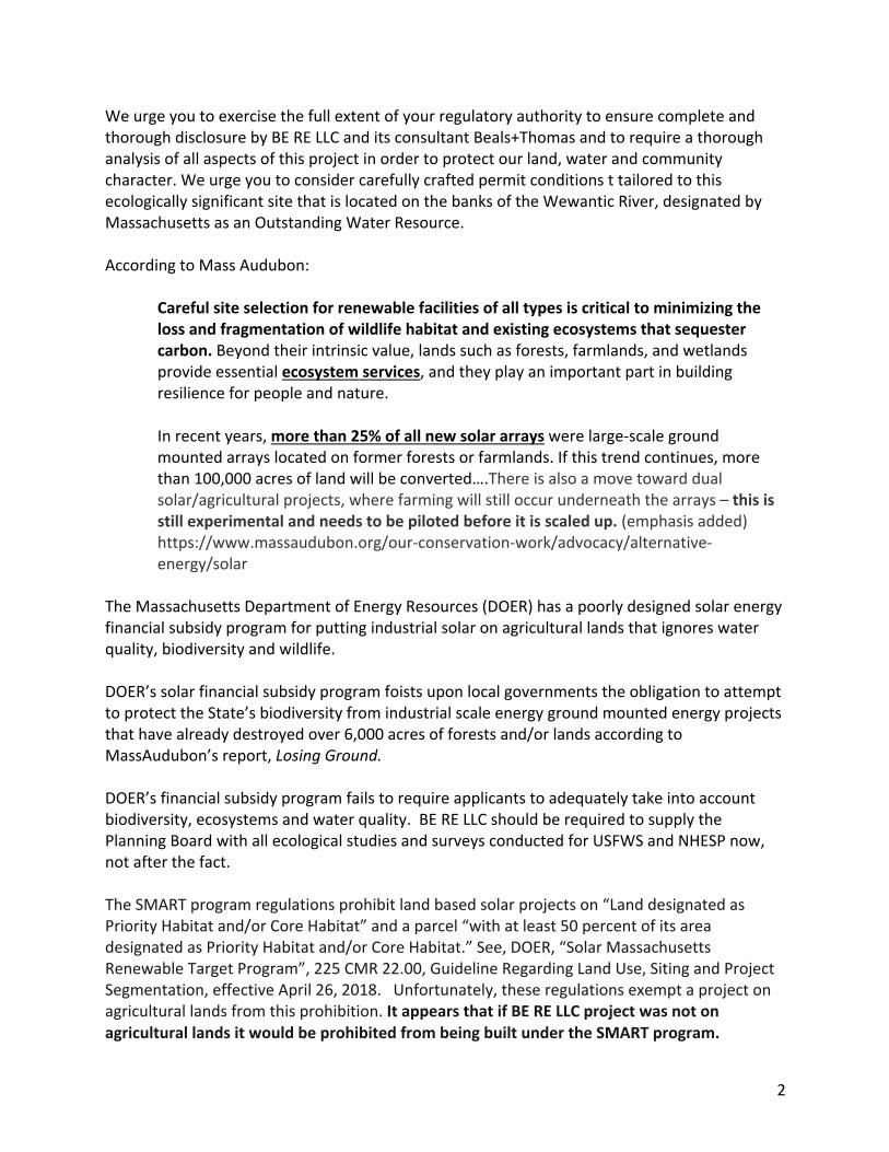
We urge you to exercise the full extent of your regulatory authority to ensure complete and thorough disclosure by BE RE LLC and its consultant Beals+Thomas and to require a thorough analysis of all aspects of this project in order to protect our land, water and community character. We urge you to consider carefully crafted permit conditions t tailored to this ecologically significant site that is located on the banks of the Wewantic River, designated by Massachusetts as an Outstanding Water Resource. According to Mass Audubon:
Careful site selection for renewable facilities of all types is critical to minimizing the loss and fragmentation of wildlife habitat and existing ecosystems that sequester carbon. Beyond their intrinsic value, lands such as forests, farmlands, and wetlands provide essential ecosystem services, and they play an important part in building resilience for people and nature. In recent years, more than 25% of all new solar arrays were large-scale ground mounted arrays located on former forests or farmlands. If this trend continues, more than 100,000 acres of land will be converted….There is also a move toward dual solar/agricultural projects, where farming will still occur underneath the arrays – this is still experimental and needs to be piloted before it is scaled up. (emphasis added) https://www.massaudubon.org/our-conservation-work/advocacy/alternative-energy/solar
The Massachusetts Department of Energy Resources (DOER) has a poorly designed solar energy financial subsidy program for putting industrial solar on agricultural lands that ignores water quality, biodiversity and wildlife. DOER’s solar financial subsidy program foists upon local governments the obligation to attempt to protect the State’s biodiversity from industrial scale energy ground mounted energy projects that have already destroyed over 6,000 acres of forests and/or lands according to MassAudubon’s report, Losing Ground. DOER’s financial subsidy program fails to require applicants to adequately take into account biodiversity, ecosystems and water quality. BE RE LLC should be required to supply the Planning Board with all ecological studies and surveys conducted for USFWS and NHESP now, not after the fact. The SMART program regulations prohibit land based solar projects on “Land designated as Priority Habitat and/or Core Habitat” and a parcel “with at least 50 percent of its area designated as Priority Habitat and/or Core Habitat.” See, DOER, “Solar Massachusetts Renewable Target Program”, 225 CMR 22.00, Guideline Regarding Land Use, Siting and Project Segmentation, effective April 26, 2018. Unfortunately, these regulations exempt a project on agricultural lands from this prohibition. It appears that if BE RE LLC project was not on agricultural lands it would be prohibited from being built under the SMART program.

3
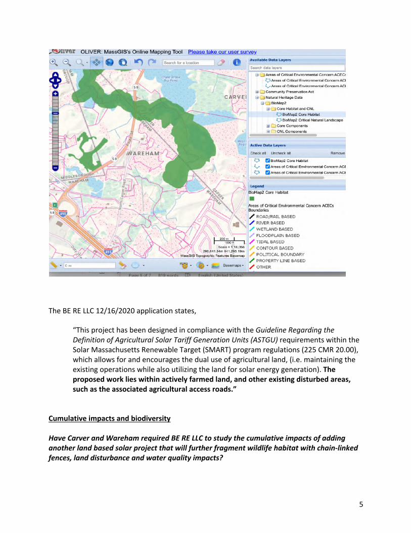
The SMART program fails to take into account that agricultural lands are being converted to industrial uses – land that is zoned residential currently being used for agricultural purposes will now be an industrial energy generating facility. BE RE LLC should be required to explain this to the Board. Under the DOER “SMART Site Evaluations” mapping tool the BE RE LLC site is “parcel with 50% or more BioMap2 Core or Priority Habitats” and “BioMap2 Core Habitat only and NHESP Priority Habitat.” This is shown on the DOER SMART mapping tool:
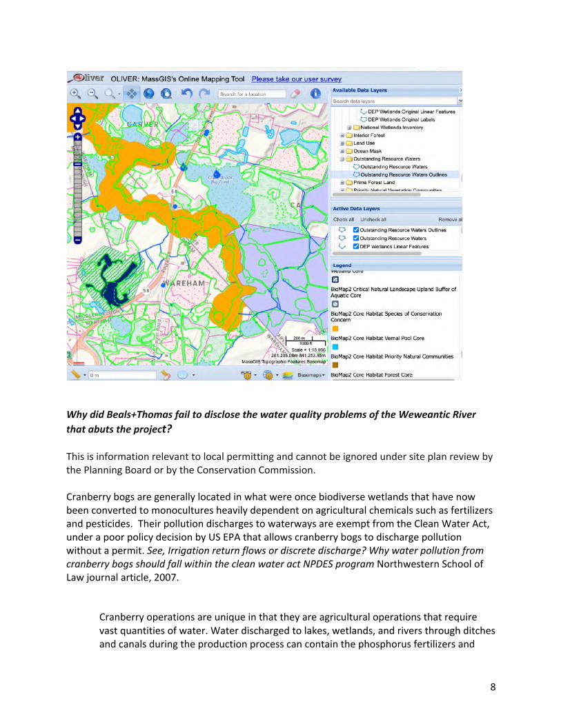
BE RE LLC site has land designated under BioMap2 as Core Habitat Species of Concern and BioMap Core Habitat. See maps from OLIVER GIS, the Massachusetts system, below.
The BE RE LLC application ignores the current environmental status of the site. The application fails to provide maps that show where the solar installation is located in relation to BioMap 2 habitat.
BE RE LLC should be required to produce a map showing the exact location of the solar installation in relation to these BioMap2 areas.
Text
BE RE LLC SOLAR

4
A thorough ecological assessment of the site and the specific location of the solar installation as it relates to BioMap2 habitat should be required.
5
The BE RE LLC 12/16/2020 application states,
“This project has been designed in compliance with the Guideline Regarding the Definition of Agricultural Solar Tariff Generation Units (ASTGU) requirements within the Solar Massachusetts Renewable Target (SMART) program regulations (225 CMR 20.00), which allows for and encourages the dual use of agricultural land, (i.e. maintaining the existing operations while also utilizing the land for solar energy generation). The proposed work lies within actively farmed land, and other existing disturbed areas, such as the associated agricultural access roads.”
Cumulative impacts and biodiversity Have Carver and Wareham required BE RE LLC to study the cumulative impacts of adding another land based solar project that will further fragment wildlife habitat with chain-linked fences, land disturbance and water quality impacts?
6
In the last several years in Carver and Wareham, destructive AD Makepeace and Borrego Solar projects as well as others have obliterated at least 250 acres of globally rare and diverse Pine Barrens habitat, including NHESP mapped habitat with no Environmental Impact Report for the solar projects. The BE RE LLC project is being called “green” but will be located on some of the Commonwealth’s most biologically diverse waterways, wetlands and lands. This is at a time when the United Nations Intergovernmental Science-Policy Platform on Biodiversity and Ecosystem Services (IPBES, 2019) reports that one million species are threatened with extinction and that loss of habitat is worsening the extinction crisis. IBPES, 2019 Summary for policymakers of the global assessment report on biodiversity and ecosystem services of the Inter-governmental Science-Policy Platform on Diversity and Ecosystem Services. S. Diaz, (eds), IPBES Secretariat, Bonn, Germany. There has been no study by the Massachusetts Environmental Policy Act (MEPA) unit or DOER of the cumulative impacts of the solar subsidy programs on the groundwater, water bodies, biodiversity, forests and wildlife in this area. This is a fundamental flaw. We call upon MEPA and DOER to undertake this study. In the meantime, there should be a moratorium on all permitting of land based solar projects such as BE RE LLC. The attached article, The use of cranberry bogs for industrial solar energy generating stations is at odds with the state programs to restore the natural habitat of these bogs. https://www.mass.gov/service-details/cranberry-bog-program-learning-agenda Over the past 10 years, working with local, state, and federal partners (such as the USDA Natural Resource Conservation Service), DER has helped to restore wetlands and streams across hundreds of acres of retired cranberry farmland. Failing to accomplish this restoration can lead to an abundance of problems such as enhanced mosquito breeding sites while diminishing stream and river connectivity, as well as lead to gross pollutions of waterways due to leaching and runoff of agricultural fertilizer and pesticide remnants.
The attached article scientific article, Environmental impacts from the installation and operation of large-scale solar power plants is one source of information calling for the study of site specific impacts from land based solar installations.
Water pollution issues The BE RE project is located on the historic, culturally and ecologically significant Weweantic River. Weweantic means wandering river in the Wampanoag language. The River historically supported an important herring run. https://buzzardsbay.org/living-resources/herring-runs/weweantic-herring-historical/

7
Massachusetts Department of Environmental Protection “Integrated Waters List” for rivers, which means the water quality of the Weweantic is impaired, or polluted and needs to be cleaned up. Beals+Thomas fails to disclose this in the application and fails to explain how the stormwater system at the site is designed with extra care to prevent further pollution of the Weweantic either through direct discharges or leaching to the aquifer. The application does not show the groundwater flow direction, the depth to groundwater as it relates to the excavation required to install stormwater basins and solar panel mounting equipment and other excavation.
8
Why did Beals+Thomas fail to disclose the water quality problems of the Weweantic River that abuts the project? This is information relevant to local permitting and cannot be ignored under site plan review by the Planning Board or by the Conservation Commission. Cranberry bogs are generally located in what were once biodiverse wetlands that have now been converted to monocultures heavily dependent on agricultural chemicals such as fertilizers and pesticides. Their pollution discharges to waterways are exempt from the Clean Water Act, under a poor policy decision by US EPA that allows cranberry bogs to discharge pollution without a permit. See, Irrigation return flows or discrete discharge? Why water pollution from cranberry bogs should fall within the clean water act NPDES program Northwestern School of Law journal article, 2007.
Cranberry operations are unique in that they are agricultural operations that require vast quantities of water. Water discharged to lakes, wetlands, and rivers through ditches and canals during the production process can contain the phosphorus fertilizers and

9
residues of pesticides that were applied during the growing season, which can cause serious water quality problems. Although the cranberry industry has not historically been subject to the Clean Water Act, cranberry bog discharges appear to fit squarely within the purview of the National Pollutant Discharge Elimination System (NPDES) program under that statute. In 2004, the Wisconsin attorney general filed a public nuisance lawsuit against a cranberry grower, alleging that the grower discharged bog water laced with phosphorus to the lake. However, provided that cranberry bog discharges do not fall within the “irrigation return flow” exemption from the Clean Water Act, the NPDES permit program may be a more cost-effective approach to addressing the water quality problems that can be caused by cranberry bog discharges.
There are documented concerns about heavy metal runoff from land-based solar installations. See Attachment A, below. What is the cumulative impact of this runoff from the hundreds of acres of land-based solar that Carver and Wareham have already permitted and that are being installed? Since the agricultural chemicals running off from the bogs are unregulated (see above), how will the flow rate of runoff change with the placement of solar panels? This should be addressed. What if the bog stops operating? How does the runoff impact change? Does the pollution to the river increase? If permitted, BE RE LLC be required to capture and treat all agricultural legacy chemicals.

10
Drinking water supply wells are located across the river from the site. Are these wells threatened?
Climate and greenhouse gas impacts of BE RE LLC As it has in dozens of other land-based solar project applications, Beals+Thomas fails to disclose the greenhouse gas and climate impacts of land based solar projects that are the subject of its applications – which are signed under oath. Beals+Thomas claims BE RE LLC will not generate any greenhouse gas emissions (GHG). That is inaccurate.
11
Attached as a PDF is a peer-reviewed scientific article Assessing the lifecycle greenhouse gas emissions from solar PV and wind energy: A critical mega-survey from 2014 that states,
This paper critically screens 153 lifecycle studies covering a broad range of wind and solar photovoltaic (PV) electricity generation technologies to identify 41 of the most relevant, recent, rigorous, original, and complete assessments so that the dynamics of their greenhouse gas (GHG) emissions profies can be determined. When viewed in a holistic manner, including initial materials extraction, manufacturing, use and disposal/decommissioning, these 41 studies show that both wind and solar systems are directly tied to and responsible for GHG emissions. They are thus not actually emissions free technologies. Moreover, by spotlighting the lifecycle stages and physical characteristics of these technologies that are most responsible for emissions, improvements can be made to lower their carbon footprint. As such, through in-depth examination of the results of these studies and the variations therein, this article uncovers best practices in wind and solar design and deployment that can better inform climate change mitigation efforts in the electricity sector.
https://www.sciencedirect.com/science/article/abs/pii/S0301421513010719?via%3Dihub Chapter 61A: Presumably a Chapter 61A, Section 14 Notice of Conversion is required before this agricultural land can be converted to an industrial use. We urge the Town to exercise its right of first refusal to secure the ecological future of this land. It can assign the right to Commonwealth which can work with the landowner to restore the bog under the state Division of Ecological Restoration “Cranberry Program” since the owner is concerned about the future financial viability of its cranberry operation, as stated at the last Planning Board hearing. In summary, we do not oppose all solar energy. However, we demand complete transparency and accountability by Beals+Thomas and BE RE LLC with regard to the environmental, health, safety and economic aspects of this project. The long term impacts of this project on our community and the environment requires this transparency and accountability and the public is entitled to expect that the Planning Board ensure that a full evaluation of all the impacts are disclosed.
12
Thank you for your consideration. Very truly yours,
Meg Sheehan Volunteer Community Land & Water Coalition [email protected] 508-259-9154 Cc: Senator Marc Pacheco Executive Office of Energy and Environmental Affairs Department of Energy Resources Department of Ecological Restoration MEPA Unit Town of Carver: Select Board, Conservation Commission, Planning Board Town of Wareham: Conservation Commission Mass Audubon, Heidi Ricci US EPA – Stormwater Program MassDEP – Stormwater Program
ATTACHMENT A Information on water pollution concerns with industrial land based solar: From Concerned Citizens of Fawn Lake, Virginia: https://sites.google.com/view/concernedcitizensspotsylvania/toxic-materials?authuser=0
The fact that cadmium can be washed out of solar modules by rainwater is increasingly a concern for local environmentalists like the Concerned Citizens of Fawn Lake in Virginia, where a 6,350 acre solar farm to partly power Microsoft data centers is being proposed.
“We estimate there are 100,000 pounds of cadmium contained in the 1.8 million panels,” Sean Fogarty of the group told me. “Leaching from broken panels damaged during natural events — hail storms, tornadoes, hurricanes, earthquakes, etc. — and at decommissioning is a big concern.”
//Urr,rfud*f /WU

13
There is real-world precedent for this concern. A tornado in 2015 broke 200,000 solar modules at southern California solar farm Desert Sunlight.
"Any modules that were broken into small bits of glass had to be swept from the ground," Mulvaney explained, "so lots of rocks and dirt got mixed in that would not work in recycling plants that are designed to take modules. These were the cadmium-based modules that failed [hazardous] waste tests, so were treated at a [hazardous] waste facility. But about 70 percent of the modules were actually sent to recycling, and the recycled metals are in new panels today."
And when Hurricane Maria hit Puerto Rico last September, the nation’s second largest solar farm, responsible for 40 percent of the island’s solar energy, lost a majority of its panels. Scientific studies show very high quantities of Cadmium can leach out in a few months in acidic conditions. Our soil and Virginia clay are acidic, so rapid and thorough cleanup of any damaged Cadmium-containing panels is critical. SPower recently stated that they will use some MonoPERC panels, which are crystalline silicon and do not contain any Cadmium. The MonoPERC panels are 10-20% more efficient than the CdTe panels, so they will require less land (hundreds of acres less). However, they are more expensive. It should be noted that the risks associated with Cadmium would be eliminated -- if sPower used more environmentally friendly panels. Toxic chemicals such as herbicides and pesticides should be carefully controlled and only applied by certified professionals.
Cleaning agents may also be toxic to the environment. sPower indicates that cleaning agents will not be used, as such would void their warranties on solar panels. https://www.chijournal.org/C428
Stormwater Flows
Two Dimensional Modeling to Simulate Stormwater Flows at Photovoltaic Solar Energy Sites, https://pubs.rsc.org/en/content/articlelanding/2016/ee/c6ee00578k#!divAbstract
The emission of silver and zinc to the aqueous environment (rain, fog, dew) from polymer solar cells installed outdoors is presented. Studies included pristine solar cells and solar cells subjected to mechanical damage under natural weather conditions in Denmark. We find the emission of silver and zinc to the environment through precipitated water for damaged solar cells, and also observed failure and emission from an initially undamaged device in an experiment that endured for 6 months. In the case of the damaged cells, we found that the drinking water limits for Ag were only exceeded on a few single days. We also progressed our studies to include end-of-life management.
14
To assess the implications of improper practices (uncontrolled disposal, landfilling) at the end-of-life, we buried different OPV types in intact and damaged forms in soil columns. In the case of high Ag emission (shredded cells), the potential for migration was confirmed, even though the soil was found to exhibit sequestration of silver. We conclude that recycling of Ag at the end-of-life is mandatory from an environmental point of view.
Cadmium risk in solar panels: https://www.cleanenergyauthority.com/solar-energy-news/cadmium-risk-in-photovoltaic-panels-041411

Exhibit Five
1
COMMUNITYLANDANDWATERCOALITION
March 29, 2021
Ms. Sandra Slavin, Chair Conservation Commission, Town of Wareham David Pichette, Conservation Administrator, Town of Wareham [email protected]
Re: 140 Tihonet Road, Wareham MA: AD Makepeace, Inc./Borrego Solar Wetlands Notice of Intent, SE 76 2611
Dear Conservation Commissioners,
We respectfully submit these additional comments for your consideration on the Borrego Solar Notice of Intent (NOI) application for 140 Tihonet Road on land owned by AD Makepeace (ADM). Our comments are in addition to those we submitted on January 25, 2021, February 1, 2021, and March 16, 2021 to the Conservation Commission (the Commission) and Planning Board.
1. The NOI should be rejected because it is a subterfuge for ADM’s continued industrial scale earth removal operations in Wareham.
It is obvious to everyone that for years ADM, often 6 days a week, 52 weeks a year, has been extracting large volumes of earth from its lands in Plymouth, Carver and Wareham and selling the material off site for commercial profit. ADM claims this is part of its agricultural operations or simply “site preparation” for the eventual use of the land for industrial solar energy utilities.
In Wareham, it appears that this has been going on at numerous sites cleared for solar without Earth Removal permits. The Board of Selectman has confirmed that at the Borrego Solar (now Clearway) site at 160 Tihonet Road (Phase C-5 of the ADM TMUD plan) an estimated 2-4 million cubic yards of earth was removed – an industrial scale earth removal operation over a number of years – without an Earth Removal permit. This deprived the Town of about $500,000.00 in fees.
The Town and our environment, including the wildlife dug up and processed through ADM’s gravel sorting equipment is being destroyed and the earth being sold for commercial profit. Dozens of tractor trailer trucks travel local roads every day area loaded with sand and gravel heading to the interstate highways. ADM’s business includes servicing 300 golf courses in New England with sand from its “vast sand reserves” and selling the earth for a variety of applications – all described in plain sight on ADM’s Read Soils website.

2
Despite what is obvious to everyone, on March 18, 2021, Mr. James Kane wrote to the Conservation Commission claiming that no Earth Removal permit is required for the 140 Tihonet Road project, stating,
“any material removed from the site, will be used for our on-going agricultural activities, and is therefore not subject to earth removal permitting….We will communicate and coordinate with the Board of Selectmen as the earth removal permit issuing authority. Should it be determined that a different volume will be removed, please be assured that the applicant will submit revised plans and associated information to the Conservation Commission for review as either a request for Amended Order of Conditions or New Notice of Intent filing for the solar project as applicable.”
This is a preposterous claim and contradicts what ADM’s engineer Beals+Thomas wrote in permit applications, submitted under oath and under pains and penalties of perjury, to this Commission. Beals+Thomas reports that “approximately 2,108,000 cubic yards of material will be removed prior to the installation of any solar panels” at the 140 Tihonet Road site. See, February 2, 2021 letter from B+T responding to the Town’s peer review by Charles L. Rowley, PE, PLS of the plans by Mr. Rowley. B+T’s sole response is “The landowner is currently coordinating with a local engineering firm regarding earth removal.” 2/2/2021 B+T Report, page 3. As of this date, no engineering firm information or application for an earth removal permit have been made public.
Under Massachusetts law, where a zoning approval is required and obtained, the project must be built according to the plans approved by the local board. Here, this means that the 140 Tihonet project must be built according to the plans which call for the removal of “approximately 2,108,000 cubic yards of material prior to installation of any solar panels.” Mr. Rowley’s March 5, 2021 report to the Planning Board recommends that the Special Permit be subject to “the receipt of approval for the removal of approximately 2,000,000 yards of sand necessary for grading the site” under the Wareham By-Laws.
ADM has not documented claims that the material removed from 160 Tihonet Road site was used for its’ “agricultural operations.” Until ADM can account for all of the earth removed from the TMUD area, the Conservation Commission has no reasonable basis for issuing an NOI that complies with the Wetlands Protection Act and Bylaw.
We have requested that the Massachusetts Environmental Policy Act (MEPA) review require ADM to prove where the volume of earth taken from 160 Tihonet Road and all the other sites actually went, given eyewitness reports that the material was removed from the area and not used on ADM agricultural lands. See attached Exhibit 1.
The Conservation Commission should not be complicit in this scheme that has destroyed and continues to destroy rivers, wetlands, ecology, biodiversity, forests, wildlife and emit greenhouse gases, all undermining climate resiliency.
3
2. ADM and Borrego’s attempt to play Town boards and officials and state regulators off each other is blatant.
Throughout the permitting process for this Project and 150 Tihonet Road and 27 Charge Pond Road, ADM and Borrego have segmented the projects to evade comprehensive environment review as we stated in our January 2021 comments. ADM and Borrego continue to play this game. Mr. Kane’s letter of March 18, 2021 attempts to forestall a decision on earth removal by claiming that the Board of Selectmen will handle it at some unknown time. This of course prevents both the Planning Board and the Conservation Commission from conducting any type of reasonable review that would withstand scrutiny since there are so many conflicting versions and ever-changing descriptions of what the project actually is, depending on who you talk to.
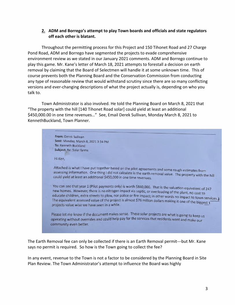
Town Administrator is also involved. He told the Planning Board on March 8, 2021 that “The property with the hill [140 Tihonet Road solar] could yield at least an additional $450,000.00 in one time revenues…” See, Email Derek Sullivan, Monday March 8, 2021 to KennethBuckland, Town Planner.
The Earth Removal fee can only be collected if there is an Earth Removal permit---but Mr. Kane says no permit is required. So how is the Town going to collect the fee?
In any event, revenue to the Town is not a factor to be considered by the Planning Board in Site Plan Review. The Town Administrator’s attempt to influence the Board was highly

4
inappropriate and undermined the Planning Board’s duty to act in an objective and independent manner in applying the Site Plan Review Bylaw.
3. At least one new state and federally protected wildlife species has been reported within range of the project.
The NOI fails to contain complete information about a newly identified species within range of the project. This siting has been reported to Natural Heritage and Endangered Species Program (NHESP). The Conservation Commission should not issue an NOI until the Applicant obtains the necessary regulatory approvals with regard to this species. This fact further highlights the inadequate nature of the Notice of Intent application and failure to conduct an ecological assessment as required by the Wetlands Bylaw.
Thank you for consideration of these comments. Please feel free to contact me with any
questions. I can be reached at [email protected] or by phone at 508-259-9154. Very truly yours,
Meg Sheehan Volunteer Community Land & Water Coalition Cc: Town Administrator, Town of Wareham via website Board of Selectmen, Town of Wareham via website Planning Board, Town of Wareham c/o Kenneth Buckland, Town Planner [email protected] [email protected] Enclosure: Email to MEPA, March 25, 2021
//Urr,rfud*f /WU
Meg Sheehan <[email protected]>
MEPA EENF 13940: AD Makepeace projects-filing 3/15/2021 1 message
Coordinator <[email protected]> Fri, Mar 26, 2021 at 12:39 PMTo: Alex Strysky <[email protected]>Cc: [email protected], [email protected], [email protected], [email protected],[email protected]: [email protected]
Dear Alex,
Thanks for returning my call today about the site visit for the EENF. As I mentioned, in order for the community tohave an adequate and meaningful opportunity to comment on the EENF, we request that the Applicant provide atleast 3 weeks notice of the MEPA site visit and that the visit occur at least 2 weeks prior to the May 10, 2021comment deadline.
We also request that the site visit cover Phases C1-12 of the TMUD project in order to assist in the assessment ofthe cumulative impacts of the Damage to the Environment of the activities to date, as required under MEPA. Thisincludes industrial sand and gravel removal activities that were not fully and accurately described by ADMakepeace and Beals and Thomas in MEPA ENF filings for Phases C1-9.
We request that the Applicant be required to address the following questions prior to the site visit.
TMUD Phase C-5 (160 Tihonet Road) At the Public Information Session on March 22, 2021 AD Makepeace CEOand President stated he would provide answers to the public's questions about where the earth removed from the50 plus acre Phase C-5 site, aka 160 Tihonet Road ended up.
The Phase C-5 (Tihonet East) site was reviewed by MEPA under the Certificate issued on April 11, 2014. The ADMakepeace ENF states that "site preparation" for the 50 acre solar installation would entail 20 vehicle trips per dayand it "is anticipated that excavated earth material will be used in the vicinity such that travel via town roadswill be avoided." Footnote 2. Before and after topographic maps show that an estimated 3-4.2 million cy wereremoved from this 50 acre site.
At the Meeting on March 22, 2021 a member of the public rebutted remarks by AD Makepeace President and CEOMr. Kane that earth removed at Phase C-5 (160 Tihonet Road) was used or stored on nearby AD Makepeaceproperty. The witness stated that he observed trucks hauling earth from this location leave the region of Makepeaceland holdings. These inconsistencies should be explained.
The video of the meeting is here: https://www.facebook.com/103162998437962/videos/717227405638082
Phase C6 Site. The Damage to the Environment from earth removal activities to "prepare" the Phase 6C site (akaGolden Field) of 50 acres also requires further explanation by AD Makepeace. At this site, the change intopography since 2017 appears to show about 2-4 million cubic yards of earth have been removed. In the ADMakepeace ENF Notice 15617 for the MEPA Certificate for Phase C6 issued on February 27, 2017, AD Makepeaceand Beals and Thomas stated in footnote 2 and on page 3:
"Specifically approximately 40,000 cubic yards of material will be excavated to accommodate the necessarygrading" and it “…will be transported and used on other ADM land…” and "take 8 weeks...." And further, “Thevolume of cut necessary is anticipated to be readily stored or used elsewhere on ADM’s overall landholdings.” This statement contradicts the topographic maps and observations of the earth removal activities at thissite and requires an explanation.
Three new sites. There is still a high degree of uncertainty about the volume of material to be removed from thePhase C10-12 sites that must be resolved in order to determine the actual extent of the cumulative past and futureDamage to the Environment and to assess the impact of the three proposed projects as required by MEPA.

In sum, the EENF should fully identify the total volume of material removed from the TMUD area.
Please consider these as preliminary comments on the EENF. We are providing these comments in order to urgeMEPA to conduct a site visit at all of the Phase C1-12 projects in the TMUD and to investigate whether the Damageto the Environment from the earth removal activities to "prepare" the solar installations and build the Phase C1 andC2 cranberry bogs was fully and accurately described in prior MEPA filings.
Other videos of the earth removal activities at the TMUD solar sites are here:https://www.facebook.com/LandWaterPlymouthArea/videos
Thank you for your assistance.Meg SheehanVolunteerCommunity Land & Water CoalitionSave the Pine Barrens, Inc.

Exhibit Six

REQUEST FOR ENFORCEMENT
Date: ______________________________________
To: Inspector of Buildings / Zoning Enforcement Officer / Board of Health Agent
I believe the Town Bylaws, Zoning Bylaws, State Building Code or State Sanitary Code (circle one) is being violated because:
__________________________________________________________________________________________
__________________________________________________________________________________________
__________________________________________________________________________________________
(Please attach additional pages if needed)
Address of Allege Violation: _______________________________________________________________
Name of Owner: _________________________________________________________________________
I am basing my allegations on the above facts and understand that as the complainant, I may be asked to participate with the Inspector of Buildings/Zoning Enforcement Officer or the Board of Health Agent by appearing jointly with him/her at court in the event the Inspector of Buildings/Zoning Officer or the Board of Health Agent is personally unable to verify my allegations, thereby requiring legal proceedings to enforce the regulation referenced above. Pursuant to the above allegations I am requesting an investigation and enforcement if applicable.
I am certifying under the pains and penalties of perjury that the information provided above is true and correct.
Complainant original signature: ____________________________________________________________
The following information is required. Failure to provide your name, address and telephone number will result in the Inspector of Buildings/Zoning Enforcement Officer or the Board of Health Agent to process the complaint at his/her discretion. (PLEASE PRINT)
Complainant Name: ______________________________________________________________________
Address of Complainant: __________________________________________________________________
Telephone Number: _______________________________________________________________________
TOWN OF CARVER Permitting Department
108 Main Street, Carver, MA 02330
508-866-3450
April 6, 2021
See attached letter dated April 6, 2021, incorporated by reference herein.
AD Makepeace earth removal sites, public roadways
AD Makepeace Company
for Save the Pine Barrens, Inc.
Save the Pine Barrens, Inc./Community Land & Water Coalition
158 Center Hill Road, Plymouth MA 02360
508-259-9154

Exhibit Seven

1
COMMUNITY LAND & WATER COALITION SAVE THE PINE BARRENS, INC.
May 13, 2021 Building Department/Permitting Department Town of Carver 108 Main Street Carver MA 02330 Via certified mail and website John Garretson, III, Chairman Earth Removal Committee, Town of Carver via website and email Dear Chair Garretson and Building Inspector, On April 6, 2021 Community Land & Water Coalition asked the Carver Earth Removal Committee (ERC) and the Building Inspector to issue a cease and desist order to AD Makepeace Company (ADM) suspending all earth removal activities in Carver and to take other steps to enforce the Earth Removal Bylaw. Under Massachusetts General Laws Chapter 40A, Section 7 the ERC was required to respond in writing with 14 days to our April 6, 2021 letter. We have not received a response granting or denying our request. We appreciate your convening ERC meetings to meet with us on April 14 and April 22 to discuss the issues and violations and your willingness to address these matters informally. In good faith we presented the ERC with information documenting violations, outlined our concerns and responded to your questions. We were scheduled to meet in person on May 5 and May 12, but you rescheduled the meeting twice now to May 26, which will be 8 weeks past the date of our April 6 letter. In the meantime, violations continue. The ADM commercial mining in Carver is causing irreparable harm to the environment. This harm extends far beyond abutters to the project sites or residents of Carver: this strip mining has global implications. The mining is destroying globally rare Atlantic Pine Barrens ecosystems, one of three on Earth and home to species of plants and animals listed as endangered, threatened or special concern under state and federal laws. One million species are threatened with extinction and this mining is contributing to the collapse in biodiversity globally. In addition, it threatens the Plymouth Carver Sole Source Aquifer by removing topsoil, vegetation and vast amounts of sand that filters and purifies our water.

2
These alleged violations warrant civil and/or criminal penalties for each day of violation under the Bylaw, Section 9.1.9d and 9.1.9.f and an order under Section 9.1.f requiring restoration of the sites. The Committee has confirmed that the AD Makepeace operations are commercial mining for profit or sale and not exempt from the Bylaw as an “agricultural operation.”
Makepeace’s expansion of commercial mining at the Golden Field Pond site at 59 Federal Road under Carver Earth Removal Permit #76 (over 4 million cubic yards) is especially
egregious. The Committee must immediately suspend this permit and all others in light of the persistent ongoing permit violations we have presented to you and that are obvious to even the
casual observer.
If the Committee does not issue a cease and desist by the close of business on May 17, 2021 we will consider that to be a denial of our April 6, 2021 request.
Violations at the Makepeace active commercial mining sites include:
x Unsafe operations as documented in the video of an accident involving a tractor trailer with Maine plates hauling sand from a Makepeace mining site. The truck flipped and hit a pole almost hitting a motorist on the winding narrow road. In the police recording the eyewitness says “This guy was flying, he almost hit me and my granddaughter” and that he travels the road all the time and the trucks are “flying.” There has been no investigation or attempt to hold anyone responsible for this egregious violation of traffic rules for trucks leaving Makepeace sites. Under the ERC Bylaw 9.1.9a, if the ERC believes operations “constitute a nuisance or public danger” it “shall order the operator to immediately cease and desist specific activities or the entire operation.” We are unaware that the ERC has done anything other than place a call to ADM.
x Violating limits on number of trucks allowed under the Earth Removal Permits. Casual observations and video documentation of the traffic on Tihonet Road/Federal Road/Farm to Market Road, the route used by AD Makepeace for the commercial mining trucks over the past several years if not decades show plainly that ADM ignores the truck limits in the Carver ERC permits. You reported at the April 22, 2021 (video starting at 1:19) meeting that CEO Kane admitted that the truck trips exceeded 50. The truck limits themselves (100 roundtrips a day per site) are unreasonable and completely arbitrary. Specific examples:
May 12, 2021 Read Custom Soils site, Lot 2-4, Federal Road, subject of three earth removal permits (total of about 3 million cubic yards 2008 to present): between the hours of 7 a.m. and 4 p.m. a total of 258 trucks entered and left the

3
site. The limit is 50 truck trips, for a total of 100 in and out. AD Makepeace exceeded the permit limit by more than 150%.
April 7, 2021 video showing one truck per minute exiting Tihonet Road on to Route 25 in Wareham. This would mean about 480 trucks a day and 2,800 trucks a week for 5.5 days of operation (the permits allow operation on Saturdays 7-12).
April 13, 2021 video showing 14 trucks in 14 minutes making 448 trucks a day and about 2,400 trucks a week.
At the meeting on April 22, 2021 you reported Makepeace CEO Jim Kane claimed the excessive truck trips resulted from “misinterpretation of the agricultural exemption” for truck trips by Makepeace. This apparently means that the truck trips and volumes reported to the ERC by Makepeace undercount the volumes and truck trips resulting in evading the payment of earth removal fees.
Even the Makepeace Truck Sheets show violations of the 50 truck trips a day limit. Here
is one example:

4
You acknowledged that CEO Kane’s “misunderstanding” of the multiple earth removal
permits his company has been operating under since 2008 “shows a weakness that we need to do something about.” You discussed a letter to permittees but have since reneged on sending that. To our knowledge there have been no penalties or sanctions for the excessive violations
5
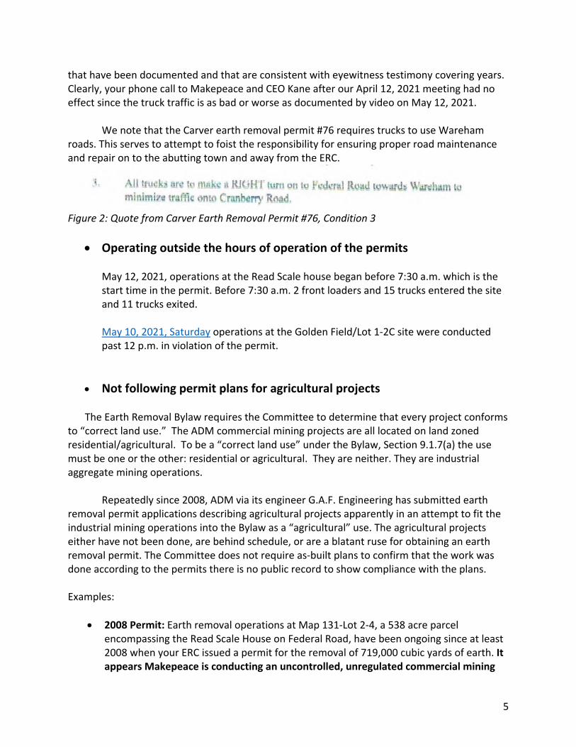
that have been documented and that are consistent with eyewitness testimony covering years. Clearly, your phone call to Makepeace and CEO Kane after our April 12, 2021 meeting had no effect since the truck traffic is as bad or worse as documented by video on May 12, 2021. We note that the Carver earth removal permit #76 requires trucks to use Wareham roads. This serves to attempt to foist the responsibility for ensuring proper road maintenance and repair on to the abutting town and away from the ERC.
Figure 2: Quote from Carver Earth Removal Permit #76, Condition 3
x Operating outside the hours of operation of the permits May 12, 2021, operations at the Read Scale house began before 7:30 a.m. which is the start time in the permit. Before 7:30 a.m. 2 front loaders and 15 trucks entered the site and 11 trucks exited. May 10, 2021, Saturday operations at the Golden Field/Lot 1-2C site were conducted past 12 p.m. in violation of the permit.
x Not following permit plans for agricultural projects
The Earth Removal Bylaw requires the Committee to determine that every project conforms to “correct land use.” The ADM commercial mining projects are all located on land zoned residential/agricultural. To be a “correct land use” under the Bylaw, Section 9.1.7(a) the use must be one or the other: residential or agricultural. They are neither. They are industrial aggregate mining operations. Repeatedly since 2008, ADM via its engineer G.A.F. Engineering has submitted earth removal permit applications describing agricultural projects apparently in an attempt to fit the industrial mining operations into the Bylaw as a “agricultural” use. The agricultural projects either have not been done, are behind schedule, or are a blatant ruse for obtaining an earth removal permit. The Committee does not require as-built plans to confirm that the work was done according to the permits there is no public record to show compliance with the plans. Examples:
x 2008 Permit: Earth removal operations at Map 131-Lot 2-4, a 538 acre parcel encompassing the Read Scale House on Federal Road, have been ongoing since at least 2008 when your ERC issued a permit for the removal of 719,000 cubic yards of earth. It appears Makepeace is conducting an uncontrolled, unregulated commercial mining
6
operation across the 538-acre parcel. (Permits total about 3 million cubic yards for this parcel)
x 2011 Permit: It is unclear whether the bogs have been built according to the plans for Map 131, Lot 2-4.
x 2017 Permit: The bog on Map 131-Lot 2-4 is not being built as of May 2021, four years later. You reported Makepeace told you they had “changed their plans” and were “working at other sites and building solar.”
x 2019 Permit: The reservoir at 0 Hammond Street is not being built. x 2020 Permit (Golden Field Pond expansion) At a time when the cranberry industry is in
an economic crisis and desperately seeking state subsidies, Makepeace claims it must excavate over 4 million cubic yards in order to expand its operations on to 100 acres and build 18 acres of cranberry bogs and an 8-acre reservoir on one of the last remaining hills in the area. A few miles away in Plymouth, Makepeace has stopped construction at the Frogfoot bogs even though it cleared 120 acres and strip mined 6.5 million cubic yards under permits intended for bog expansion. This agricultural plan appears to be a ruse for another commercial mining operation.
x Misrepresentations about volume of earth removal and lack of earth
removal permit for Golden Field solar site
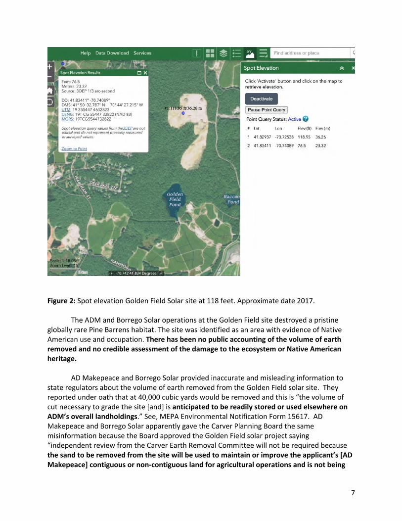
The operations at Golden Field Pond are a prime example of the failure to follow the Bylaw and the shell game being played. AD Makepeace started earth removal activities near Golden Field Pond in approximately 2016 without an Earth Removal Permit. It excavated out the entire 50-acre area for the Borrego Solar “Golden Field” (Phase C6) project. This site had elevations up to 118 feet. See Figure 2 below. ADM stripped trees, topsoil, vegetation and about 2-4 million cubic yards of sand and/or gravel. It reduced the elevation across the 50 acres by about 30 feet. This would require about 160 truck trips per day for 2-3 years to remove.
7
Figure 2: Spot elevation Golden Field Solar site at 118 feet. Approximate date 2017.
The ADM and Borrego Solar operations at the Golden Field site destroyed a pristine globally rare Pine Barrens habitat. The site was identified as an area with evidence of Native American use and occupation. There has been no public accounting of the volume of earth removed and no credible assessment of the damage to the ecosystem or Native American heritage.
AD Makepeace and Borrego Solar provided inaccurate and misleading information to state regulators about the volume of earth removed from the Golden Field solar site. They reported under oath that at 40,000 cubic yards would be removed and this is “the volume of cut necessary to grade the site [and] is anticipated to be readily stored or used elsewhere on ADM’s overall landholdings.” See, MEPA Environmental Notification Form 15617. AD Makepeace and Borrego Solar apparently gave the Carver Planning Board the same misinformation because the Board approved the Golden Field solar project saying “independent review from the Carver Earth Removal Committee will not be required because the sand to be removed from the site will be used to maintain or improve the applicant’s [AD Makepeace] contiguous or non-contiguous land for agricultural operations and is not being
8
removed for sale, trade or other consideration. (See Section 9.1.8D of the Earth Removal Bylaw).” August 9, 2016 Planning Board Special Permit & Site Plan Review.
In 2016, CEO Kane explained the AD Makepeace business strategy of clearing land,
leasing it for solar for 20 years and when the solar “fad” is over and the company removes its “junk” the land will be ready for residential development.
Your Committee is responsible for ensuring that all earth removal in the Town of
Carver complies with the Bylaw. Enforcement of the Bylaw means that Makepeace must be required to provide credible documentation to your Committee and the Carver Planning Board that the volume of earth removed from the Borrego Golden Field solar site was NOT sold for commercial purposes but was used on Makepeace land for agriculture.
The Makepeace and Borrego Solar claim that the sand removed from the Golden Field solar site was used on Makepeace properties is not credible for many reasons including that it is inconsistent with observations by the plain eye and GIS topographic maps. Another reason is that at about the same time ADM was conducting a 2-4 million cubic yard earth removal operation at Golden Field for solar it was also mining 2-3 million cubic yards at the Borrego Phase C5 solar site at 160 Tihonet Road in Wareham, MA. On March 22, 2021 Makepeace CEO Jim Kane was recorded to say he would “absolutely” meet with the public to personally account for all of the material taken from the AD Makepeace 160 Tihonet Road solar site. Mr. Kane has not responded to a written request for this public session.

9

10
For all of the reasons stated here and in our April 6 letter, we reiterate our request for a cease and desist order. If we do not receive a written response granting or denying this request by the close of business Monday, May 17, 2021 we will consider the request denied. Feel free to contact me if you have questions. Very truly yours,
Meg Sheehan Volunteer Community Land & Water Coalition Copy: Town of Carver: Building Inspector, Chair Board of Selectmen Conservation Commission representative to Earth Removal Committee MEPA, Alex Strysky, MEPA Analyst Massachusetts Attorney General’s office Board of Selectmen DEP-Johnathan Hobill

Exhibit Eight

May 16, 2021
Dear Chairman Garretson:
I received your note delaying the Carver Earth Removal Committee meeting yet again. I view this latest delay with considerable suspicion.
Here is why.
Carver Earth Removal Committee Composition
The Carver Earth Removal By-Law makes clear that "in no case shall more than two of the appointed members of the Committee represent the same trade, profession, occupation or business interest."
As you perfectly well know, more than two members of this Committee represent or possess material business interests in the cranberry industry. Indeed a majority of the Committee members have documented business interests in the cranberry industry, including owning and operating cranberry bogs.
Where the composition of this Committee is improper, the earth removal permits it has granted are flawed.
As an example, the Earth Removal Permit issued to AD Makepeace for Lot 1-2C dated July 10, 2020, is invalid because the majority of the members of the Committee who voted to approve the permit represent the same trade, profession, occupation, or business interest (see minutes of the July 9, 2020 meeting, at which the Committee voted 5-0).
Worse, as you also know, at least two Committee members disclosed that they are, or have been, third-party purchasers of sand from AD Makepeace (the cranberry behemoth you are charged with ensuring is not violating sand mining rules). Presuming these Committee members paid for this sand and were provided a receipt as required, these Committee members may themselves possess direct evidence of a violation of your Committee's permits.
Add to this, presently unconfirmed, allegations that at least one Committee member has had discussions about selling their cranberry bogs to AD Makepeace. Can you imagine Mr. Chairman?

Is your unwillingness to enforce the earth removal laws against AD Makepeace because of this overload of cranberry owners/operators/vendors/agents/advocates/representatives on your Committee?
Is the pressure or risk of backlash from fellow growers requiring sand from AD Makepeace’s mining operations too much for this Committee to do its assigned job?
Is the insatiable demand for government handouts to finance bog renovations another reason for the unlawful mining and this Committee’s indifference to the same?
Cease and Desist
The same Carver By-laws compel that this Committee order any earth removal operator it "believes" is violating a permit "to immediately cease and desist specific activities or the entire operation pending a review." This Committee has already formally confirmed violations of earth removal permits by AD Makepeace. Accordingly, any further delay in complying with your unambiguous obligation to force a stoppage of this offending conduct is wrong and deeply suspect.
Additionally, "calling" AD Makepeace by phone to "discuss" its documented violations constitutes gross neglect of your legal duty to stop this cheating. The Carver Earth Removal committee is a regulatory body with explicit compliance obligations, not an adjunct cranberry trade association or a cranberry club. Simply phoning industry friends and colleagues to discuss their cheating is disgracefully cozy.
And your assurances that AD Makepeace now "understands" its obligation to limit the daily truck trips to no more than 50 per day is hopelessly without credibility and is contrasted sharply with the massive increase in the non-conforming number of daily trucks since the moment you 'postponed’ the meeting. Who is kidding who, Mr. Garretson?
Accordingly, you and the entire Earth Removal Committee membership are directed to preserve all phone, text, and email records of all (emphasis added) communications with AD Makepeace. You and your Committee are also cautioned against any destruction of the same.
Forensic Audit
This Committee's documented findings to date confirm the need for the engagement of an independent forensic firm to:
(i) account for precisely where all of the sand and earth removed from Carver was transported, and
(ii) to determine if the entities conducting the earth removal paid the required taxes (past and present) fees and fines, where applicable.

The gross neglect this Committee has demonstrated in failing to identify the cheating is another reason why an outside firm is required. A simple reading of the reports submitted by the cheaters, loaded as they are with clear admissions of violations, could have prevented the situation from getting completely out of hand, as it is today.
It would be spectacularly improper for anyone at GAF Engineering (or any other company on the payroll of an accused wrongdoer) to perform this audit. Just as it would be unjust to utilize any funds in any account on the books of the Town of Carver to pay the audit costs. Only the identified wrongdoers should pay the full cost for this forensic work.
As you know, Mr. Chairman, the ultimate responsible party for all AD Makepeace breaches of the Carver earth mining laws is your longtime colleague, Jim Kane. Kane promised that he would "absolutely" provide citizens an open and full accounting of the earth removed from one of its sites in Wareham, where the same pattern of deliberate cheating has been alleged. To date, not surprisingly, Kane has reneged on this promise.
Residents of the Town of Carver are likewise entitled to the truth. So, without a genuinely independent forensic firm auditing the earth removal records (which function your Committee should have been doing all along), Carver taxpayers could remain in the dark and betrayed.
Cranberry Sauce (Fiction)
Allowing for the benefit of the doubt, one could conclude that the Carver Earth Removal Committee was originally hoodwinked into earth removal permits for fictitious agricultural projects. After all AD Makepeace and other parties represented in 2016 that all of the earth removed from the 50-acre 118 foot high Golden Field solar site on Federal Road would be transported solely to AD Makepeace bogs and not out of Town. The evidence now signals that the permit process was a ruse for unpermitted industrial-scale mining operations. Operations which became and remain conspicuous but which this Committee, under your supervision, failed to monitor or stop.
At some point, Mr. Garretson, we all need to stand for something. Will your legacy be standing up for the truth and protecting the Town of Carver from improper earth removal activities? Or will it be for permitting and perpetuating a cranberry sauce of cheating and untruths by unlawful mining operators?
One thing is for sure, continuing to do nothing will accelerate the spoilage of the cranberry brand you hold so dear.
BCC
Related Documents