November 2009 | Jefferson National Expansion Memorial Memorial Drive Closure Traffic Study Prepared for the National Park Service

Welcome message from author
This document is posted to help you gain knowledge. Please leave a comment to let me know what you think about it! Share it to your friends and learn new things together.
Transcript
November 2009 | Jefferson National Expansion Memorial
Memorial Drive Closure Traffic StudyPrepared for the National Park Service
Memorial Drive Closure Traffic Study
Submitted by:
675 North Washington Street, Suite 300
Alexandria, Virginia 22314 (703) 549-8728
Prepared for:
Jefferson National Expansion Memorial National Park Service
Date of Submission:
November 2009
Jefferson National Expansion Memorial
Memorial Drive Closure Traffic Study
i
TTaabbllee ooff CCoonntteennttss 1. INTRODUCTION AND SUMMARY............................................................................................................................... 1
11..11 PURPOSE OF REPORT AND STUDY OBJECTIVES ................................................................... 1 2. PROPOSED DEVELOPMENT......................................................................................................................................... 4
22..11 PROPOSED DEVELOPMENT.................................................................................................. 4 22..22 PROPOSED ROADWAY IMPROVEMENTS............................................................................... 4
3. EXISTING CONDITIONS ................................................................................................................................................ 6 33..11 EXISTING TRAFFIC NETWORK............................................................................................. 6 33..22 REGIONAL ACCESS ........................................................................................................... 11 33..33 EXISTING TRAFFIC............................................................................................................ 13 33..44 CAPACITY AND LEVEL OF SERVICE................................................................................... 14
4. FUTURE NO-BUILD CONDITIONS (YEAR 2011) ..................................................................................................... 20 44..11 FUTURE NO-BUILD CONDITIONS (YEAR 2011)................................................................. 20
5. FUTURE BUILD CONDITIONS (YEAR 2011) ............................................................................................................ 27 55..11 SCENARIO A (ONE-BLOCK CLOSURE) .............................................................................. 27 55..22 SCENARIO B (TWO-BLOCK CLOSURE).............................................................................. 29 55..33 SCENARIO C (THREE-BLOCK CLOSURE)........................................................................... 31 55..44 TRAFFIC ANALYSIS........................................................................................................... 33
6. QUEUING ANALYSIS .................................................................................................................................................... 43 7. RECOMMENDATIONS.................................................................................................................................................. 44 8. CONCLUSIONS ............................................................................................................................................................... 46
88..11 COMPARISON OF NO-BUILD ACTIONS WITH SCENARIOS A, B, AND C .............................. 46
APPENDICES Appendix A Traffic Counts Appendix B Timing Diagrams Appendix C Traffic Analysis Printouts Appendix D Response to Agency Comments
Jefferson National Expansion Memorial
Memorial Drive Closure Traffic Study
ii
TTaabbllee ooff CCoonntteennttss ((CCoonnttiinnuueedd)) LIST OF FIGURES Figure 1 – Study Area ..................................................................................................................... 2
Figure 2 – Functional Classification ............................................................................................. 10
Figure 3 – Regional Access .......................................................................................................... 12
Figure 4 – Ballpark Village Traffic Distribution .......................................................................... 21
Figure 5 – Scenario A (One-Block Closure)................................................................................. 28
Figure 6 – Scenario B (Two-Block Closure) ................................................................................ 30
Figure 7 – Scenario C (Three-Block Closure) .............................................................................. 32
LIST OF TABLES Table 1 Interstate Ramp Traffic volumes ............................................................................. 13
Table 2 Pedestrian volumes .................................................................................................. 14
Table 3 Level of Service Criteria........................................................................................... 15
Table 4 Traffic Analysis Results: Existing Conditions (Year 2009) ..................................... 15
Table 5 Ballpark Village Trip Generation ............................................................................ 20
Table 6 Traffic Analysis Results: No-Build Conditions (Year 2011) ................................... 22
Table 7 Scenario (One block Closure) Origin Destination Matrix ....................................... 27
Table 8 Scenario (Two block Closure) Origin Destination Matrix ...................................... 29
Table 9 Scenario (Three block Closure) Origin Destination Matrix .................................... 31
Table 10 Traffic Analysis Results: Build Conditions (Year 2011).......................................... 34
Table 11 Queuing Analysis Results: Comparison of No-Build Conditions with Build Scenarios A, B, and C (Year 2011)............................................................................................... 43
Jefferson National Expansion Memorial
Memorial Drive Closure Traffic Study
iii
Table 12 Comparison of No-Build Conditions 2011 with Build Conditions (Year 2011) ...... 47
Table 13 Comparison of Advantages and Disadvantages of No-Build Conditions (Year 2011) and Build Conditions Scenarios A, B, and C (Year 2011) ........................................................... 48
AAccrroonnyymmss aanndd AAbbbbrreevviiaattiioonnss JNEM Jefferson National Expansion Memorial EWGCOG East-West Gateway Council of Governments DOT Department of Transportation MoDOT Missouri Department of Transportation ADA Americans with Disabilities Act HCM Highway Capacity Manual ITE Institute of Transportation Engineers LOS Level of Service sec/veh Seconds per Vehicle s.f. Square Feet
Jefferson National Expansion Memorial
Memorial Drive Closure Traffic Study
1
11.. IInnttrroodduuccttiioonn aanndd SSuummmmaarryy
11..11 Purpose of Report and Study Objectives
EDAW/AECOM in collaboration with AECOM Transportation performed a Traffic Impact Study as part of the General Management Plan/ Environmental Impact Statement (October 2009) for the Jefferson National Expansion Memorial in St. Louis, Missouri. The preferred alternative includes the option of closing one or three blocks of Memorial Drive as part of a menu of options that could meet the stated goal of improving connectivity between the Gateway Arch and Old Courthouse specifically, and between the Memorial grounds the City of St. Louis in a broader sense. The purpose of this study is to determine the traffic impacts of closing a portion of Memorial Drive, adjacent to the Jefferson National Expansion Memorial (JNEM), to vehicular traffic. See Figure 1 for map of Study Area.
Memorial Drive consists of two one-way streets, parallel to the Memorial, separated by the below-grade I-70 that forms a high-speed pedestrian barrier between the Gateway Arch to the east, and Luther Ely Smith Square and Old Courthouse to the west. This study identifies the traffic impacts on adjacent streets, intersections and ramps in the vicinity of the Memorial in downtown St. Louis.
The study horizon year of 2011, key intersections for analysis, planned development (including Ballpark Village), and an expected traffic annual growth rate of 1% were determined in coordination with the National Park Service and transportation partners from local agencies including the Missouri Department of Transportation (MoDOT), City of St. Louis, East-West Gateway Council of Governments (EWGCOG) and Federal Highway Administration. For this road closure study, four scenarios were evaluated, in addition to the existing conditions. These scenarios are:
No-Build Scenario – A No-Build option that assumes the traffic patterns will continue as they currently exist, but traffic will increase by the expected annual growth rate of 1%. New traffic generated from nearby planned development is included with the traffic volumes in this scenario.
Scenario A – A one-block closure of Memorial Drive northbound and southbound between Market Street and Chestnut Street.
Scenario B – A two-block closure of Memorial Avenue northbound and southbound between Walnut Street and Chestnut Street.
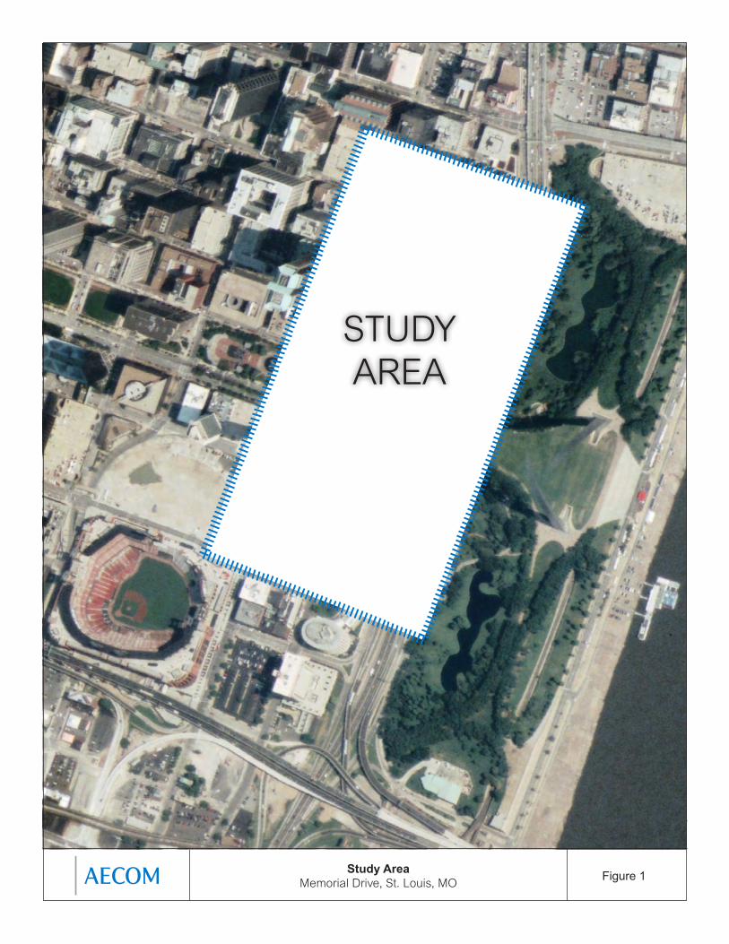
Figure 1Study Area Memorial Drive, St. Louis, MO
STUDY AREA
Jefferson National Expansion Memorial
Memorial Drive Closure Traffic Study
3
Scenario C – A three-block closure of Memorial Drive northbound and southbound between Pine Street and Walnut Street.
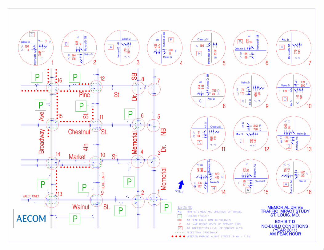
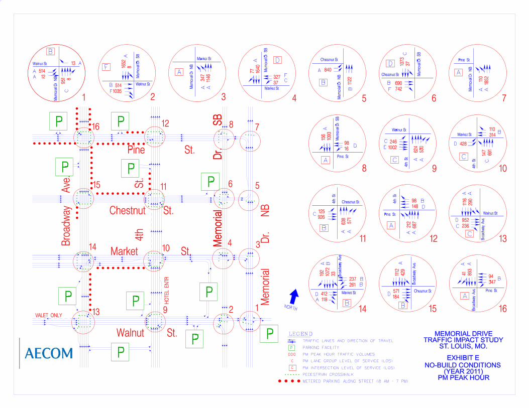
The study consists of a level of service (LOS) analysis for key intersections (See Section 3.3 for explanation of LOS and capacity). LOS was evaluated for Existing Conditions (Year 2009), Future No-Build Conditions (Year 2011), and Future Build Conditions (Year 2011) under Scenarios A, B, and C. The following 16 signalized intersections were analyzed during AM and PM peak hours, except for those intersections which were assumed to be eliminated under Scenarios A, B or C:
1. Northbound Memorial Drive & Walnut Street 2. Southbound Memorial Drive & Walnut Street 3. Northbound Memorial Drive & Market Street 4. Southbound Memorial Drive & Market Street 5. Northbound Memorial Drive & Chestnut Street 6. Southbound Memorial Drive & Chestnut Street 7. Northbound Memorial Drive & Pine Street 8. Southbound Memorial Drive & Pine Street 9. 4th Street & Walnut Street 10. 4th Street & Market Street 11. 4th Street & Chestnut Street 12. 4th Street & Pine Street 13. Broadway Avenue & Walnut Street 14. Broadway Avenue & Market Street 15. Broadway Avenue & Chestnut Street 16. Broadway Avenue & Pine Street
The study also consists of analysis of queues to determine the potential impacts to interstate ramps for Existing Conditions (Year 2009), Future No-Build Conditions (Year 2011), and Future Build Conditions (Year 2011) under Scenarios A, B, and C. The following Interstate ramps evaluated for queuing extending from traffic signals on the local roadway network onto the Interstate include the following:
1. Northbound ramp from I-70 to Memorial Drive north and 2. Southbound ramp from I-70 to Memorial Drive south.
Jefferson National Expansion Memorial
Memorial Drive Closure Traffic Study
4
22.. PPrrooppoosseedd DDeevveellooppmmeenntt
22..11 Proposed Development
Development and construction of the area surrounding the project is primarily focused on residential/commercial development. Planned since 1999, Ballpark Village is a large development sited adjacent to the project area; Ballpark Village will be a $650 million mixed-use retail/entertainment, office, and residential district being developed in partnership by the St. Louis Cardinals and a development company. Ballpark Village will cover six city blocks that will directly connect to the new Busch Stadium that opened in spring 2006. Portions of land once occupied by the old Busch Stadium will be transformed into Ballpark Village mixed-use development. Proposed ideas for Ballpark Village include offices, residential units, and a Cardinals museum. Latest information from the City of Saint Louis shows that Phase I of the project will include about 325,000 square feet (s.f.) of office space and 250,000 s.f. of retail/entertainment space. Traffic generated from Ballpark Village will be included in the 2011 analysis.
Mercantile Exchange occupies the nine square block area surrounding the former St. Louis Centre, bounded by Broadway, Olive, 8th Street, and Lucas. Mercantile Exchange will include over $450 million in redevelopment activity. Included is 525,000 square feet (SF) of new or redeveloped Class A office space, 175 residential condominiums, 120 residential apartments, a 216 room upscale hotel, and 450,000 SF of retail. This development will be completed later (2012), it is outside the study area and it will not be included in the traffic analysis.
Chouteau’s Landing is located just south of Highway 40 and Busch Stadium between South Fourth Street and the Riverfront with 58 acres slated for mixed-use redevelopment. It includes Historic Fourth Street with 19th-century commercial buildings that will merge with new construction. The launch of Chouteau's Landing's Historic Fourth Street will be followed by seven progressive years that include a 122,000-square-foot interactive arts center, art-filled green space and pedestrian friendly streetscapes. This development is outside the study area.
22..22 Proposed Roadway Improvements
The Interstate 70 Outer Road at Memorial Drive resurfacing project is currently under construction. Project completion is expected by December 2009 by MoDOT. Construction occurs primarily at night and on weekends, with occasional off-peak lane closures on weekdays.
Jefferson National Expansion Memorial
Memorial Drive Closure Traffic Study
5
This resurfacing project is among the first awarded by the Missouri Highways and Transportation Commission for approximately $5 million using federal stimulus money. Work consists of bridge rehabilitation, pavement improvements, lighting, drainage, signals, signing, and Americans with Disabilities Act (ADA) upgrades on the I-70 outer road (Memorial Drive) from the Interstate 44/55 interchange to Washington Avenue. It is planned that Memorial Drive will receive faux brick crosswalks, smooth asphalt, and brighter roadway striping for improved safety. New LED traffic signals will have a countdown clock so walkers know how long they have to cross. New sidewalks will allow those with disabilities or strollers easier access. To mimic the stainless steel look of the Arch, existing steel railings along the center median will be cleaned and treated.
Because the resurfacing project will be completed by December 2009, the traffic analysis performed for this study used the new lane configuration for the bridge crossings between northbound and southbound Memorial Drive shown on the Missouri Department of Transportation pavement marking plans. This lane configuration is slightly different from the current configuration, with the main difference being that the number of lanes are reduced from three to two since wider sidewalks are now being constructed.
Jefferson National Expansion Memorial
Memorial Drive Closure Traffic Study
6
33.. EExxiissttiinngg CCoonnddiittiioonnss
33..11 Existing Traffic Network
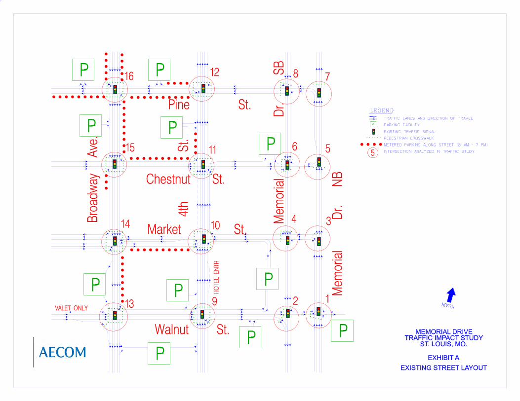
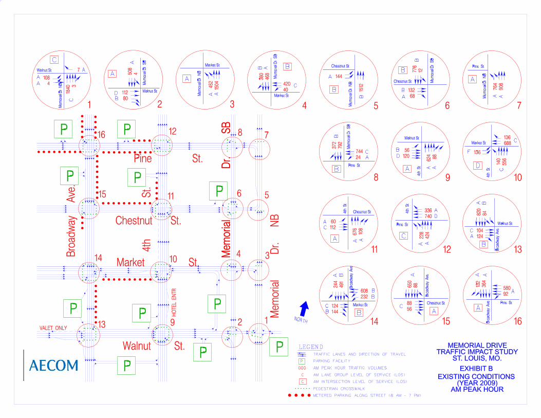
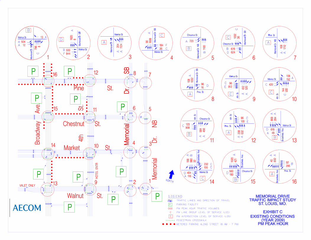
The Study Area encompasses a street grid of downtown St. Louis that includes four-block sections of north and southbound Memorial Drive, 4th Street, and Broadway Avenue, all of which run in a north-south direction. In the east-west direction, the study includes three-block sections of Walnut Street, Market Street, Chestnut Street, and Pine Street. All street intersections are controlled by a traffic signal. Exhibit A shows locations of on-street parking, parking garage entrances and exits, and pedestrian crosswalks. Roadways are classified according to their urban or rural setting and the type of service they provide based on considerations such as: connectivity, mobility, accessibility, vehicle miles traveled, average annual daily traffic, and abutting land use. The purpose of roadway functional classification is to describe how traffic is channelized through the roadway network and to determine project eligibility for inclusion in the Long Range Plan and short-range Transportation Improvement Program (TIP). Figure 2 shows the functional classification of roadways in the study area. The streets within the Study Area are described in more detail below:
Memorial Drive northbound operates as a one-way facility with no on-street parking throughout the Study Area. The functional classification for Memorial Drive northbound is minor arterial. South of Walnut Street, Memorial Drive is a four-lane street that continues to Market Street where the left lane terminates. An entrance to the Old Cathedral parking lot is located opposite the Walnut Street intersection, and there are pedestrian crosswalks on the north, south, and east sides of this intersection. Between Market Street and Chestnut Street, Memorial Drive continues north as a three-lane street. A pedestrian crosswalk is located on the north side of the Memorial Drive/Market Street intersection, and on the south side of the Memorial Drive/Chestnut Street intersection. Just north of Chestnut Street, a left turn lane to Pine Street is introduced, which ends at Pine Street. A pedestrian crosswalk is located on the north side of the Memorial Drive/Pine Street intersection. North of Pine Street, Memorial Drive continues as three lanes for approximately 400 feet where the left lane continues as a ramp to northbound I-70 and the two remaining lanes continue ahead to Washington Avenue.
Jefferson National Expansion Memorial
Memorial Drive Closure Traffic Study
8
Memorial Drive southbound also operates as a one-way facility that has no on-street parking throughout the Study Area. The functional classification for Memorial Drive southbound is minor arterial. Memorial Drive begins at Washington Avenue and joins the I-70 off-ramp to form three travel lanes through the Study Area. The Memorial Drive/Pine Street intersection includes pedestrian crosswalks on the west and north sides, while the Memorial Drive/Chestnut Street intersection has pedestrian crosswalks on the west, north, and south sides. Pedestrian crosswalks are also provided at the Memorial Drive/Market Street intersection on the west and north sides, and at the Memorial Drive/Walnut Street intersection on west, north, and south sides.
4th Street operates as a one-way street northbound and has five lanes through the Study Area, except between Market and Chestnut Streets, where six lanes are provided. The functional classification for 4th Street is principal arterial. Pedestrian crosswalks are provided at all four corners of intersecting streets. Parking is allowed on the west side of 4th Street north of Chestnut Street.
Broadway Avenue operates as a one-way street southbound and has five lanes between a point north of Pine Street and Market Street. The functional classification for Broadway Avenue is principal arterial. Four lanes are provided between Market Street and Walnut Street. Parking is allowed on the east side of Broadway Avenue between Walnut and Market Streets and north of Chestnut Street. Parking is allowed on the west side of Broadway north of Pine Street and south of Chestnut Street. Pedestrian crosswalks are located at all four corners of streets that intersect with Broadway Avenue.
Walnut Street operates as one-way eastbound and ends at the Old Cathedral parking lot, with no on-street parking allowed in the Study Area. The functional classification for Walnut Street is urban collector. Three eastbound lanes are provided up to Broadway Avenue, with one westbound valet lane also provided. Between Broadway Avenue and Memorial Drive south, five travel lanes are provided, but the left lane is non-continuous and provides access to left turn lanes and parking areas. Where Walnut Street crosses I-70, construction is underway to reduce the current three-lane roadway to two lanes with a pedestrian sidewalk. Pedestrian crosswalks are provided at all four corners at the Walnut Street intersections with Broadway Avenue and 4th Street; on the south, north, and west sides at Memorial Drive south; and on the south and west sides at Memorial Drive north.
Market Street is a six-lane, divided street west of Broadway Avenue and has four lanes with a flush median between Broadway and 4th Street, with parking permitted on the south side of the street. The functional classification for Market Street is principal arterial. East of 4th Street the street becomes one-way and has three westbound lanes (no parking is allowed), but provides an eastbound parking garage access lane. The I-70 overpass is
Jefferson National Expansion Memorial
Memorial Drive Closure Traffic Study
9
currently under construction to provide two thru lanes and one left turn lane. Pedestrian crosswalks are provided at all four corners at the Market Street intersections with Broadway Avenue and 4th Street; on the north, and west sides at Memorial Drive south; and on the north side at Memorial Drive north.
Chestnut Street carries four eastbound lanes between Broadway Avenue and 4th Street, with parking permitted on the north side. The functional classification for Chestnut Street is urban collector. East of 4th Street, the street becomes three lanes with no parking permitted. Along with the other I-70 crossings to the south, Chestnut Street is reduced to two left turn lanes with a sidewalk. Pedestrian crosswalks are provided at all four corners at the Chestnut Street intersections with Broadway Avenue and 4th Street; on the south, north, and west sides at Memorial Drive south; and on the south side at Memorial Drive north.
Pine Street operates as four lanes westbound between Broadway Avenue and Memorial Drive south. The functional classification for Pine Street is urban collector. The right outside lane is non-continuous through intersections and serves as an exclusive right turn lane. Parking is allowed on the south side from west of Broadway to 4th Street, and on the north side west of 4th Street. Pine Street between Memorial Drive north and south has two thru lanes and one left turn lane. Pedestrian crosswalks are provided at all four corners at the Pine Street intersections with Broadway Avenue and 4th Street, on the north and west sides at Memorial Drive south, and on the north side at Memorial Drive north.
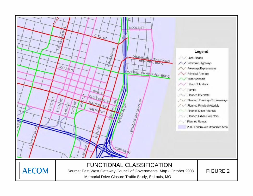
FUNCTIONAL CLASSIFICATIONFIGURE 2
Memorial Drive Closure Traffic Study, St Louis, MOSource: East West Gateway Council of Governments, Map - October 2008
MARKET ST
PINE STCHESTNUT ST
Jefferson National Expansion Memorial
Memorial Drive Closure Traffic Study
11
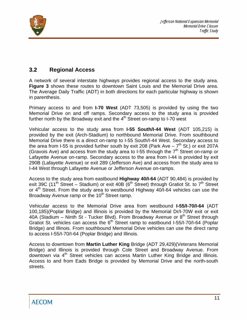
33..22 Regional Access
A network of several interstate highways provides regional access to the study area. Figure 3 shows these routes to downtown Saint Louis and the Memorial Drive area. The Average Daily Traffic (ADT) in both directions for each particular highway is shown in parenthesis.
Primary access to and from I-70 West (ADT 73,505) is provided by using the two Memorial Drive on and off ramps. Secondary access to the study area is provided further north by the Broadway exit and the 4th Street on-ramp to I-70 west
Vehicular access to the study area from I-55 South/I-44 West (ADT 105,215) is provided by the exit (Arch-Stadium) to northbound Memorial Drive. From southbound Memorial Drive there is a direct on-ramp to I-55 South/I-44 West. Secondary access to the area from I-55 is provided further south by exit 208 (Park Ave – 7th St.) or exit 207A (Gravois Ave) and access from the study area to I-55 through the 7th Street on-ramp or Lafayette Avenue on-ramp. Secondary access to the area from I-44 is provided by exit 290B (Lafayette Avenue) or exit 289 (Jefferson Ave) and access from the study area to I-44 West through Lafayette Avenue or Jefferson Avenue on-ramps.
Access to the study area from eastbound Highway 40/I-64 (ADT 90,484) is provided by exit 39C (11th Street – Stadium) or exit 40B (6th Street) through Gratiot St. to 7th Street or 4th Street. From the study area to westbound Highway 40/I-64 vehicles can use the Broadway Avenue ramp or the 10th Street ramp.
Vehicular access to the Memorial Drive area from westbound I-55/I-70/I-64 (ADT 100,185)(Poplar Bridge) and Illinois is provided by the Memorial Dr/I-70W exit or exit 40A (Stadium – Ninth St - Tucker Blvd). From Broadway Avenue or 8th Street through Gratiot St. vehicles can access the 6th Street ramp to eastbound I-55/I-70/I-64 (Poplar Bridge) and Illinois. From southbound Memorial Drive vehicles can use the direct ramp to access I-55/I-70/I-64 (Poplar Bridge) and Illinois.
Access to downtown from Martin Luther King Bridge (ADT 29,429)(Veterans Memorial Bridge) and Illinois is provided through Cole Street and Broadway Avenue. From downtown via 4th Street vehicles can access Martin Luther King Bridge and Illinois. Access to and from Eads Bridge is provided by Memorial Drive and the north-south streets.
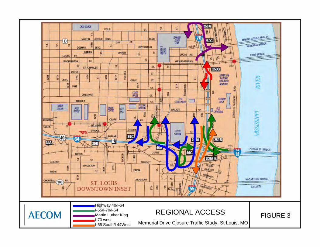
REGIONAL ACCESS FIGURE 3Memorial Drive Closure Traffic Study, St Louis, MO
Highway 40/I-64 I-55/I-70/I-64 Martin Luther King I-70 westI-55 South/I 44West
Jefferson National Expansion Memorial
Memorial Drive Closure Traffic Study
13
33..33 Existing Traffic
To determine existing traffic operations in the study area, traffic turning movement, truck and pedestrian counts were taken on Thursday August 20, 2009, during the AM (6:30-8:30) and PM (3:30-5:30) peak periods at sixteen intersections. Appendix A shows the raw turning movement count printouts. These traffic turning movement volumes are shown in Exhibits B and C. A determination of the AM and PM peak hours was made based on these peak-period counts. Turning movement counts were analyzed to determine the four highest consecutive 15-minute volumes (the peak hour) during each peak period. The peak hours were determined to be:
• AM Peak Hour: 7:30-8:30 AM
• PM Peak Hour: 4:30-5:30 PM
24-hr tube counts at the study area Intestate ramps were conducted also on Thursday August 20, 2009. Appendix A shows the raw tube counts and Table 1 summarizes the AM and PM peak hour traffic and the Average Daily Traffic (ADT) ramp volumes.
Table 1 Interstate Ramp Traffic volumes
Interstate Ramp AM peak Hour PM peak Hour Average Daily Traffic (ADT)
1. I-55 NB off ramp to NB Memorial Drive 1,304 485 10,315
2. I-70 NB off ramp to NB Memorial Drive 197 122 2,414
3. NB Memorial Drive on ramp to I-70 NB 196 889 6,990
4. SB I-70 off ramp to SB Memorial Drive 615 145 4,860
5. SB Memorial Drive on ramp to EB I-55/I-70/I-64 118 508 7,793
6. SB Memorial Drive on ramp to SB I-55 344 1,961 12,536
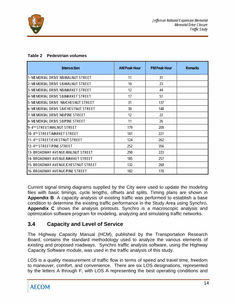
Pedestrian Counts were also conducted on Thursday August 20, 2009, during the AM (6:30-8:30) and PM (3:30-5:30) peak periods at sixteen intersections. Table 2 shows the number of pedestrians at each intersection.
Jefferson National Expansion Memorial
Memorial Drive Closure Traffic Study
14
Table 2 Pedestrian volumes
Intersection AM Peak Hour PM Peak Hour Remarks
1- MEMORIAL DRIVE NB/WALNUT STREET 11 31 2- MEMORIAL DRIVE SB/WALNUT STREET 10 23 3- MEMORIAL DRIVE NB/MARKET STREET 12 44 4- MEMORIAL DRIVE SB/MARKET STREET 17 51 5- MEMORIAL DRIVE NB/CHESNUT STREET 31 137 6- MEMORIAL DRIVE SB/CHESTNUT STREET 30 148 7- MEMORIAL DRIVE NB/PINE STREET 12 22 8- MEMORIAL DRIVE SB/PINE STREET 11 26 9- 4TH STREET/WALNUT STREET 179 209 10- 4TH STREET/MARKET STREET 141 221 11- 4TH STREET/CHESTNUT STREET 124 262 12- 4TH STREET/PINE STREET 252 356 13- BROADWAY AVENUE/WALNUT STREET 290 223 14- BROADWAY AVENUE/MARKET STREET 185 257 15- BROADWAY AVENUE/CHESTNUT STREET 132 268 16- BROADWAY AVENUE/PINE STREET 182 170
Current signal timing diagrams supplied by the City were used to update the modeling files with basic timings, cycle lengths, offsets and splits. Timing plans are shown in Appendix B. A capacity analysis of existing traffic was performed to establish a base condition to determine the existing traffic performance in the Study Area using Synchro. Appendix C shows the analysis printouts. Synchro is a macroscopic analysis and optimization software program for modeling, analyzing and simulating traffic networks.
33..44 Capacity and Level of Service
The Highway Capacity Manual (HCM), published by the Transportation Research Board, contains the standard methodology used to analyze the various elements of existing and proposed roadways. Synchro traffic analysis software, using the Highway Capacity Software module, was used in the traffic analysis of this study.
LOS is a quality measurement of traffic flow in terms of speed and travel time, freedom to maneuver, comfort, and convenience. There are six LOS designations, represented by the letters A through F, with LOS A representing the best operating conditions and
Jefferson National Expansion Memorial
Memorial Drive Closure Traffic Study
15
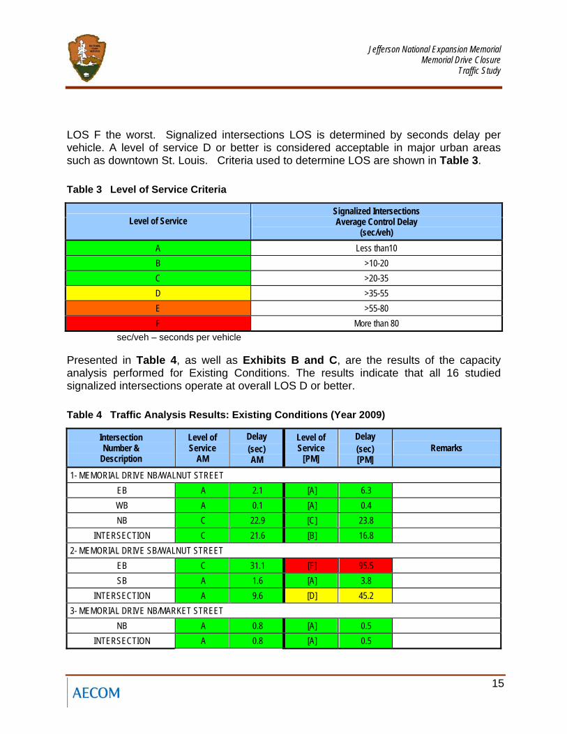
LOS F the worst. Signalized intersections LOS is determined by seconds delay per vehicle. A level of service D or better is considered acceptable in major urban areas such as downtown St. Louis. Criteria used to determine LOS are shown in Table 3.
Table 3 Level of Service Criteria
Level of Service Signalized Intersections Average Control Delay
(sec/veh) A Less than10 B >10-20 C >20-35 D >35-55 E >55-80 F More than 80
sec/veh – seconds per vehicle
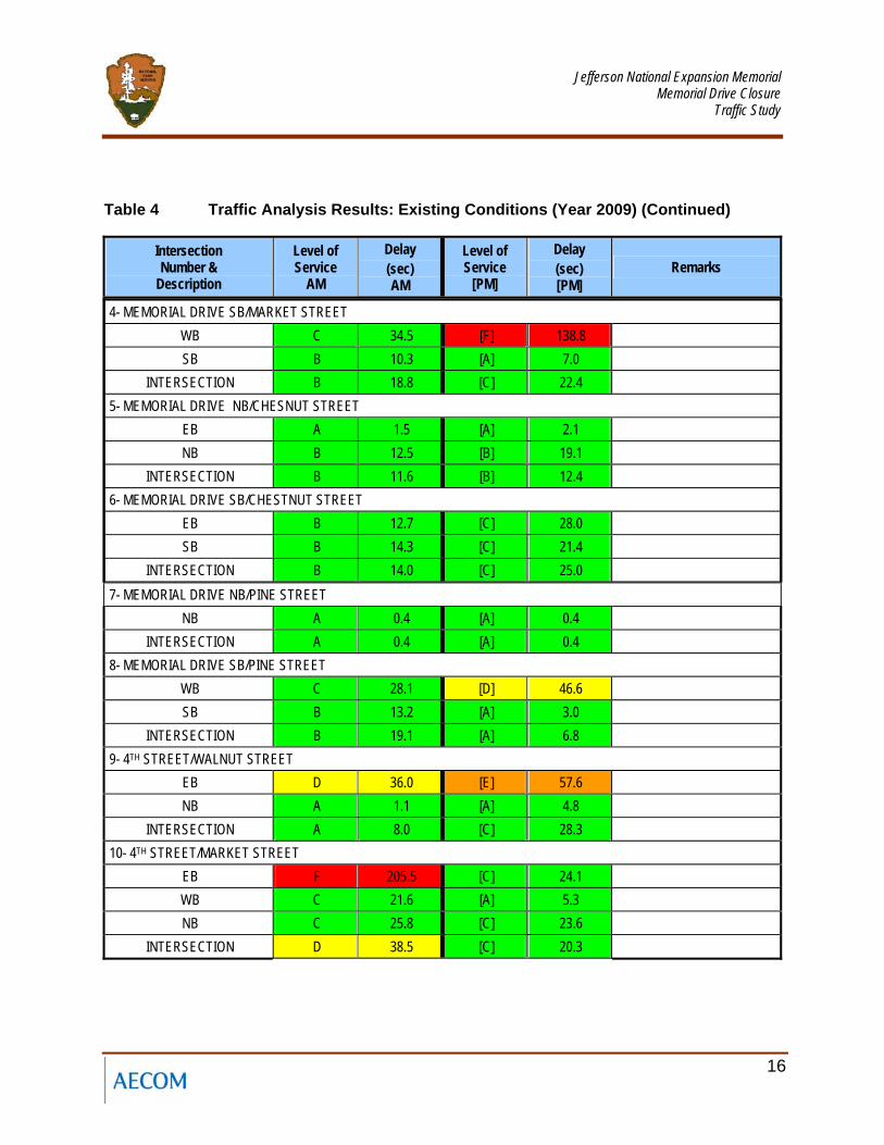
Presented in Table 4, as well as Exhibits B and C, are the results of the capacity analysis performed for Existing Conditions. The results indicate that all 16 studied signalized intersections operate at overall LOS D or better.
Table 4 Traffic Analysis Results: Existing Conditions (Year 2009)
Intersection Number &
Description
Level of Service
AM
Delay (sec) AM
Level of Service
[PM]
Delay (sec) [PM]
Remarks
1- MEMORIAL DRIVE NB/WALNUT STREET EB A 2.1 [A] 6.3 WB A 0.1 [A] 0.4 NB C 22.9 [C] 23.8
INTERSECTION C 21.6 [B] 16.8 2- MEMORIAL DRIVE SB/WALNUT STREET
EB C 31.1 [F] 95.5 SB A 1.6 [A] 3.8
INTERSECTION A 9.6 [D] 45.2 3- MEMORIAL DRIVE NB/MARKET STREET
NB A 0.8 [A] 0.5 INTERSECTION A 0.8 [A] 0.5
Jefferson National Expansion Memorial
Memorial Drive Closure Traffic Study
16
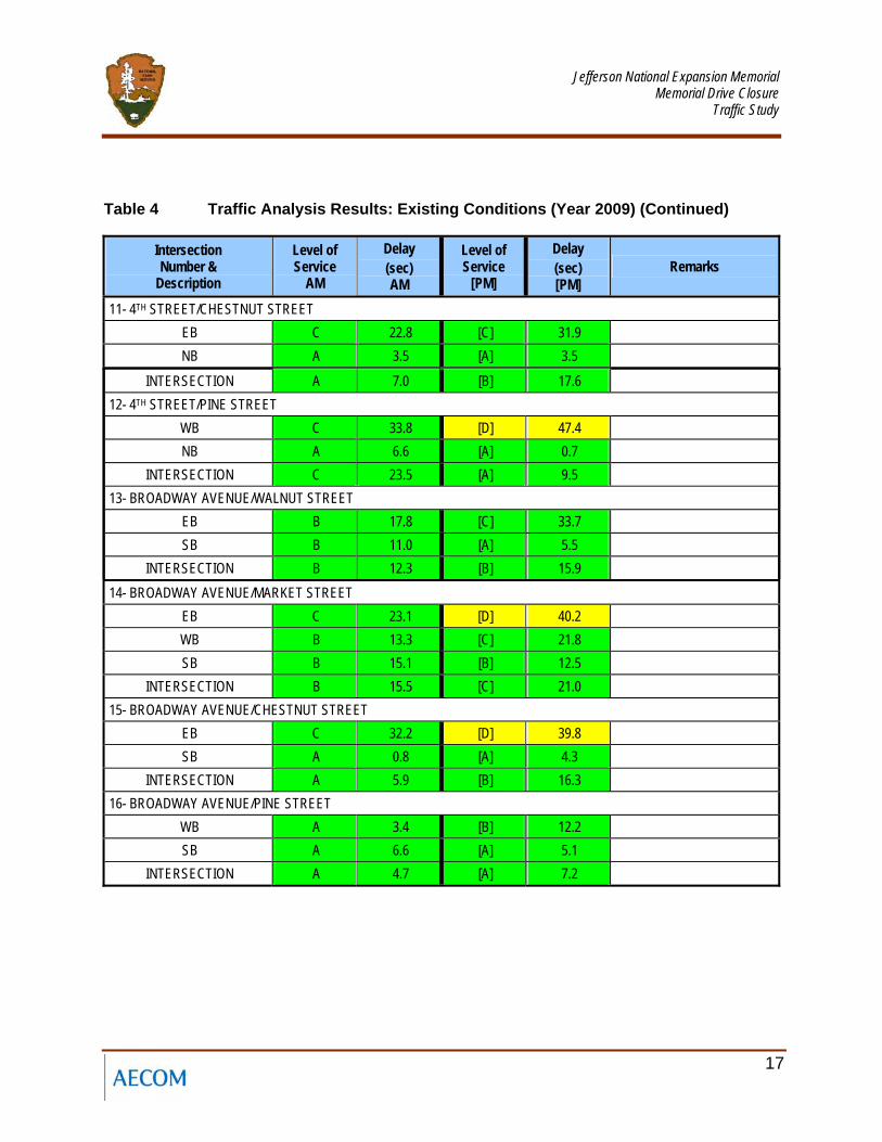
Table 4 Traffic Analysis Results: Existing Conditions (Year 2009) (Continued)
Intersection Number &
Description
Level of Service
AM
Delay (sec) AM
Level of Service
[PM]
Delay (sec) [PM]
Remarks
4- MEMORIAL DRIVE SB/MARKET STREET WB C 34.5 [F] 138.8 SB B 10.3 [A] 7.0
INTERSECTION B 18.8 [C] 22.4 5- MEMORIAL DRIVE NB/CHESNUT STREET
EB A 1.5 [A] 2.1 NB B 12.5 [B] 19.1
INTERSECTION B 11.6 [B] 12.4 6- MEMORIAL DRIVE SB/CHESTNUT STREET
EB B 12.7 [C] 28.0 SB B 14.3 [C] 21.4
INTERSECTION B 14.0 [C] 25.0 7- MEMORIAL DRIVE NB/PINE STREET
NB A 0.4 [A] 0.4 INTERSECTION A 0.4 [A] 0.4
8- MEMORIAL DRIVE SB/PINE STREET WB C 28.1 [D] 46.6 SB B 13.2 [A] 3.0
INTERSECTION B 19.1 [A] 6.8 9- 4TH STREET/WALNUT STREET
EB D 36.0 [E] 57.6 NB A 1.1 [A] 4.8
INTERSECTION A 8.0 [C] 28.3 10- 4TH STREET/MARKET STREET
EB F 205.5 [C] 24.1 WB C 21.6 [A] 5.3 NB C 25.8 [C] 23.6
INTERSECTION D 38.5 [C] 20.3
Jefferson National Expansion Memorial
Memorial Drive Closure Traffic Study
17
Table 4 Traffic Analysis Results: Existing Conditions (Year 2009) (Continued)
Intersection Number &
Description
Level of Service
AM
Delay (sec) AM
Level of Service
[PM]
Delay (sec) [PM]
Remarks
11- 4TH STREET/CHESTNUT STREET EB C 22.8 [C] 31.9 NB A 3.5 [A] 3.5
INTERSECTION A 7.0 [B] 17.6 12- 4TH STREET/PINE STREET
WB C 33.8 [D] 47.4 NB A 6.6 [A] 0.7
INTERSECTION C 23.5 [A] 9.5 13- BROADWAY AVENUE/WALNUT STREET
EB B 17.8 [C] 33.7 SB B 11.0 [A] 5.5
INTERSECTION B 12.3 [B] 15.9 14- BROADWAY AVENUE/MARKET STREET
EB C 23.1 [D] 40.2 WB B 13.3 [C] 21.8 SB B 15.1 [B] 12.5
INTERSECTION B 15.5 [C] 21.0 15- BROADWAY AVENUE/CHESTNUT STREET
EB C 32.2 [D] 39.8 SB A 0.8 [A] 4.3
INTERSECTION A 5.9 [B] 16.3 16- BROADWAY AVENUE/PINE STREET
WB A 3.4 [B] 12.2 SB A 6.6 [A] 5.1
INTERSECTION A 4.7 [A] 7.2
Jefferson National Expansion Memorial
Memorial Drive Closure Traffic Study
20
44.. FFuuttuurree NNoo--BBuuiilldd CCoonnddiittiioonnss ((YYeeaarr 22001111))
44..11 Future No-Build Conditions (Year 2011)
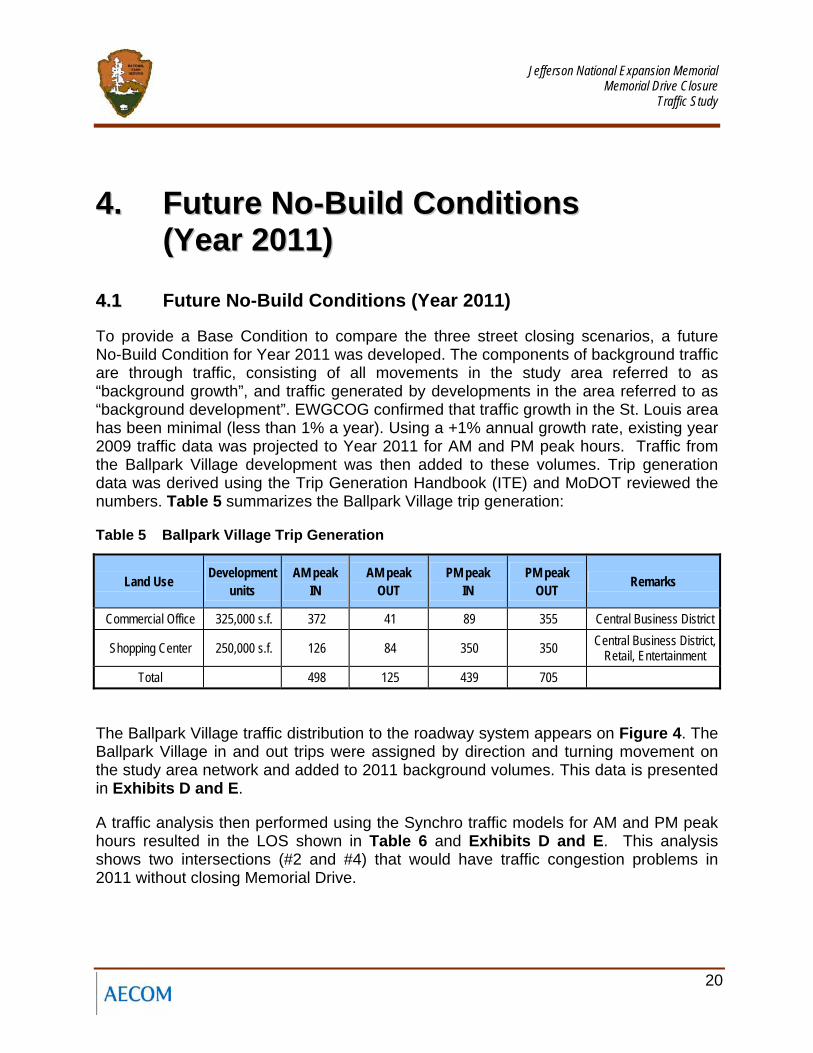
To provide a Base Condition to compare the three street closing scenarios, a future No-Build Condition for Year 2011 was developed. The components of background traffic are through traffic, consisting of all movements in the study area referred to as “background growth”, and traffic generated by developments in the area referred to as “background development”. EWGCOG confirmed that traffic growth in the St. Louis area has been minimal (less than 1% a year). Using a +1% annual growth rate, existing year 2009 traffic data was projected to Year 2011 for AM and PM peak hours. Traffic from the Ballpark Village development was then added to these volumes. Trip generation data was derived using the Trip Generation Handbook (ITE) and MoDOT reviewed the numbers. Table 5 summarizes the Ballpark Village trip generation:
Table 5 Ballpark Village Trip Generation
Land Use Development units
AM peak IN
AM peak OUT
PM peak IN
PM peak OUT Remarks
Commercial Office 325,000 s.f. 372 41 89 355 Central Business District
Shopping Center 250,000 s.f. 126 84 350 350 Central Business District, Retail, Entertainment
Total 498 125 439 705
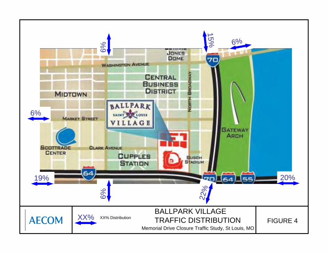
The Ballpark Village traffic distribution to the roadway system appears on Figure 4. The Ballpark Village in and out trips were assigned by direction and turning movement on the study area network and added to 2011 background volumes. This data is presented in Exhibits D and E.
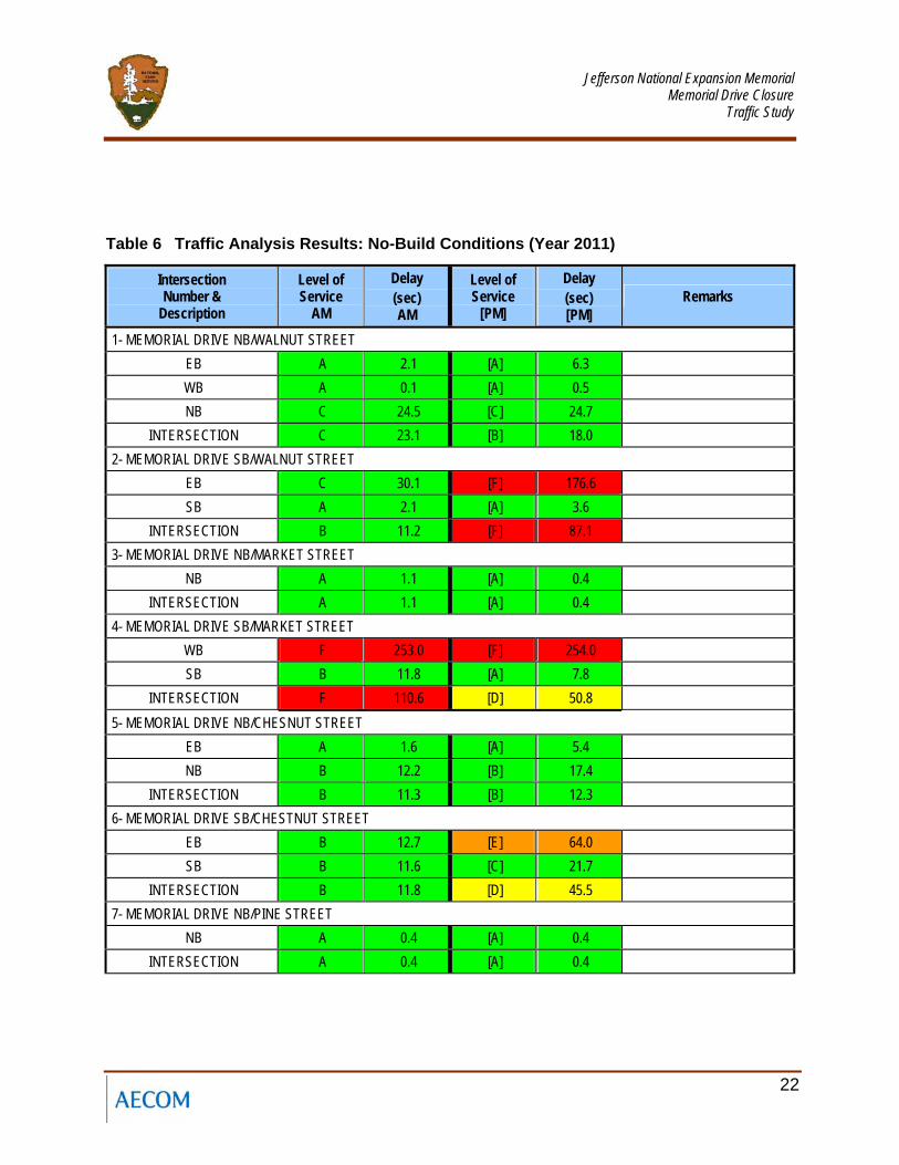
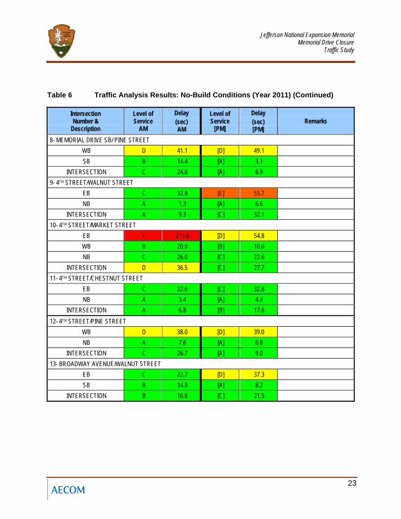
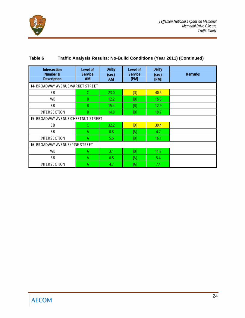
A traffic analysis then performed using the Synchro traffic models for AM and PM peak hours resulted in the LOS shown in Table 6 and Exhibits D and E. This analysis shows two intersections (#2 and #4) that would have traffic congestion problems in 2011 without closing Memorial Drive.
BALLPARK VILLAGE TRAFFIC DISTRIBUTION FIGURE 4
Memorial Drive Closure Traffic Study, St Louis, MO
XX% Distribution XX%
15% 6%
22%
6%6%
19% 20%
6%
Jefferson National Expansion Memorial
Memorial Drive Closure Traffic Study
22
Table 6 Traffic Analysis Results: No-Build Conditions (Year 2011)
Intersection Number &
Description
Level of Service
AM
Delay (sec) AM
Level of Service
[PM]
Delay (sec) [PM]
Remarks
1- MEMORIAL DRIVE NB/WALNUT STREET EB A 2.1 [A] 6.3 WB A 0.1 [A] 0.5 NB C 24.5 [C] 24.7
INTERSECTION C 23.1 [B] 18.0 2- MEMORIAL DRIVE SB/WALNUT STREET
EB C 30.1 [F] 176.6 SB A 2.1 [A] 3.6
INTERSECTION B 11.2 [F] 87.1 3- MEMORIAL DRIVE NB/MARKET STREET
NB A 1.1 [A] 0.4 INTERSECTION A 1.1 [A] 0.4
4- MEMORIAL DRIVE SB/MARKET STREET WB F 253.0 [F] 254.0 SB B 11.8 [A] 7.8
INTERSECTION F 110.6 [D] 50.8 5- MEMORIAL DRIVE NB/CHESNUT STREET
EB A 1.6 [A] 5.4 NB B 12.2 [B] 17.4
INTERSECTION B 11.3 [B] 12.3 6- MEMORIAL DRIVE SB/CHESTNUT STREET
EB B 12.7 [E] 64.0 SB B 11.6 [C] 21.7
INTERSECTION B 11.8 [D] 45.5 7- MEMORIAL DRIVE NB/PINE STREET
NB A 0.4 [A] 0.4 INTERSECTION A 0.4 [A] 0.4
Jefferson National Expansion Memorial
Memorial Drive Closure Traffic Study
23
Table 6 Traffic Analysis Results: No-Build Conditions (Year 2011) (Continued)
Intersection Number &
Description
Level of Service
AM
Delay (sec) AM
Level of Service
[PM]
Delay (sec) [PM]
Remarks
8- MEMORIAL DRIVE SB/ PINE STREET WB D 41.1 [D] 49.1 SB B 14.4 [A] 3.1
INTERSECTION C 24.6 [A] 6.9 9- 4TH STREET/WALNUT STREET
EB C 32.8 [E] 55.7 NB A 1.3 [A] 6.6
INTERSECTION A 9.3 [C] 32.1 10- 4TH STREET/MARKET STREET
EB F 215.6 [D] 54.8 WB B 20.0 [B] 10.6 NB C 26.0 [C] 22.6
INTERSECTION D 36.5 [C] 27.7 11- 4TH STREET/CHESTNUT STREET
EB C 22.6 [C] 32.8 NB A 3.4 [A] 4.4
INTERSECTION A 6.8 [B] 17.6 12- 4TH STREET/PINE STREET
WB D 38.0 [D] 39.0 NB A 7.6 [A] 0.8
INTERSECTION C 26.7 [A] 9.0 13- BROADWAY AVENUE/WALNUT STREET
EB C 22.7 [D] 37.3 SB B 14.9 [A] 8.2
INTERSECTION B 16.6 [C] 21.5
Jefferson National Expansion Memorial
Memorial Drive Closure Traffic Study
24
Table 6 Traffic Analysis Results: No-Build Conditions (Year 2011) (Continued)
Intersection Number &
Description
Level of Service
AM
Delay (sec) AM
Level of Service
[PM]
Delay (sec) [PM]
Remarks
14- BROADWAY AVENUE/MARKET STREET EB C 23.0 [D] 40.5 WB B 12.2 [B] 15.3 SB B 15.4 [B] 12.9
INTERSECTION B 14.8 [B] 19.7 15- BROADWAY AVENUE/CHESTNUT STREET
EB C 32.2 [D] 39.4 SB A 0.8 [A] 4.7
INTERSECTION A 5.6 [B] 16.1 16- BROADWAY AVENUE/ PINE STREET
WB A 3.1 [B] 11.7 SB A 6.8 [A] 5.4
INTERSECTION A 4.7 [A] 7.4
Jefferson National Expansion Memorial
Memorial Drive Closure Traffic Study
27
55.. FFuuttuurree BBuuiilldd CCoonnddiittiioonnss ((YYeeaarr 22001111))
55..11 Scenario A (One-Block Closure)
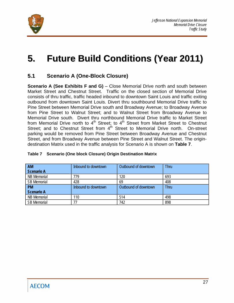
Scenario A (See Exhibits F and G) – Close Memorial Drive north and south between Market Street and Chestnut Street. Traffic on the closed section of Memorial Drive consists of thru traffic, traffic headed inbound to downtown Saint Louis and traffic exiting outbound from downtown Saint Louis. Divert thru southbound Memorial Drive traffic to Pine Street between Memorial Drive south and Broadway Avenue; to Broadway Avenue from Pine Street to Walnut Street; and to Walnut Street from Broadway Avenue to Memorial Drive south. Divert thru northbound Memorial Drive traffic to Market Street from Memorial Drive north to 4th Street; to 4th Street from Market Street to Chestnut Street; and to Chestnut Street from 4th Street to Memorial Drive north. On-street parking would be removed from Pine Street between Broadway Avenue and Chestnut Street, and from Broadway Avenue between Pine Street and Walnut Street. The origin-destination Matrix used in the traffic analysis for Scenario A is shown on Table 7.
Table 7 Scenario (One block Closure) Origin Destination Matrix
AM Scenario A
Inbound to downtown Outbound of downtown Thru
NB Memorial 779 120 693 SB Memorial 428 69 408 PM Scenario A
Inbound to downtown Outbound of downtown Thru
NB Memorial 110 514 498 SB Memorial 77 742 898
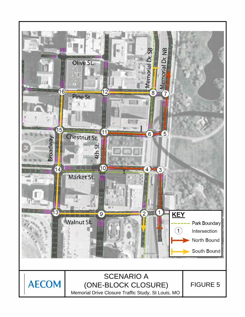
SCENARIO A (ONE-BLOCK CLOSURE) FIGURE 5
Memorial Drive Closure Traffic Study, St Louis, MO
Jefferson National Expansion Memorial
Memorial Drive Closure Traffic Study
29
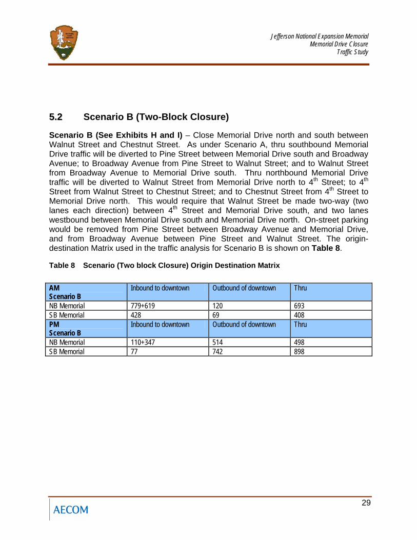
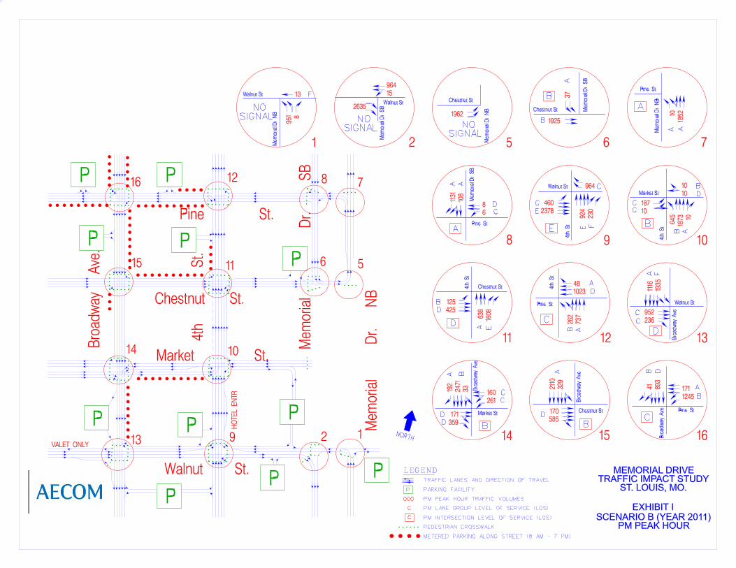
55..22 Scenario B (Two-Block Closure)
Scenario B (See Exhibits H and I) – Close Memorial Drive north and south between Walnut Street and Chestnut Street. As under Scenario A, thru southbound Memorial Drive traffic will be diverted to Pine Street between Memorial Drive south and Broadway Avenue; to Broadway Avenue from Pine Street to Walnut Street; and to Walnut Street from Broadway Avenue to Memorial Drive south. Thru northbound Memorial Drive traffic will be diverted to Walnut Street from Memorial Drive north to 4th Street; to 4th Street from Walnut Street to Chestnut Street; and to Chestnut Street from 4th Street to Memorial Drive north. This would require that Walnut Street be made two-way (two lanes each direction) between 4th Street and Memorial Drive south, and two lanes westbound between Memorial Drive south and Memorial Drive north. On-street parking would be removed from Pine Street between Broadway Avenue and Memorial Drive, and from Broadway Avenue between Pine Street and Walnut Street. The origin-destination Matrix used in the traffic analysis for Scenario B is shown on Table 8.
Table 8 Scenario (Two block Closure) Origin Destination Matrix
AM Scenario B
Inbound to downtown Outbound of downtown Thru
NB Memorial 779+619 120 693 SB Memorial 428 69 408 PM Scenario B
Inbound to downtown Outbound of downtown Thru
NB Memorial 110+347 514 498 SB Memorial 77 742 898
SCENARIO B (TWO-BLOCK CLOSURE) FIGURE 6
Memorial Drive Closure Traffic Study, St Louis, MO
Jefferson National Expansion Memorial
Memorial Drive Closure Traffic Study
31
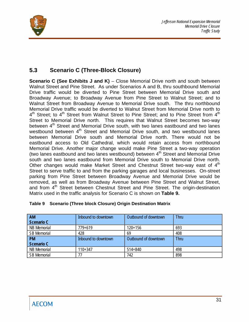
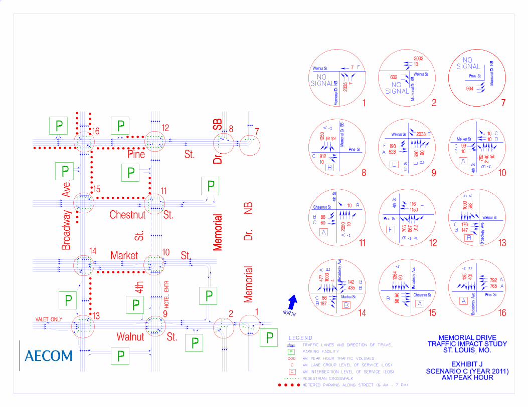
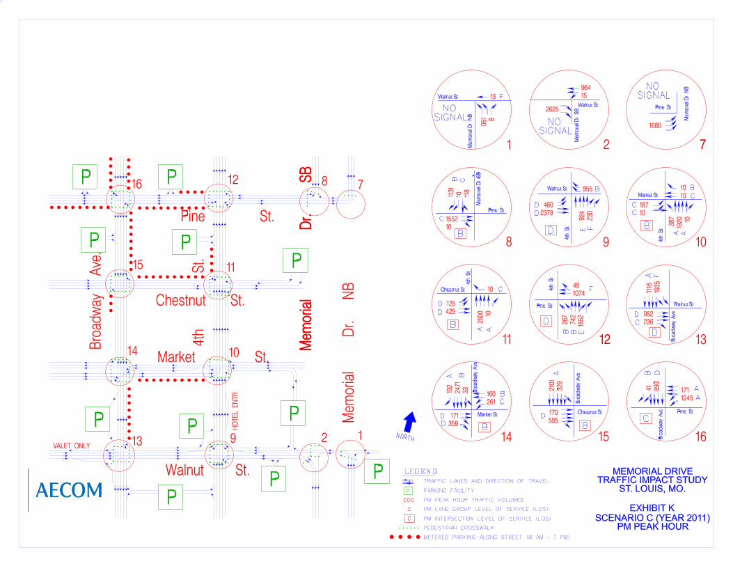
55..33 Scenario C (Three-Block Closure)
Scenario C (See Exhibits J and K) – Close Memorial Drive north and south between Walnut Street and Pine Street. As under Scenarios A and B, thru southbound Memorial Drive traffic would be diverted to Pine Street between Memorial Drive south and Broadway Avenue; to Broadway Avenue from Pine Street to Walnut Street; and to Walnut Street from Broadway Avenue to Memorial Drive south. The thru northbound Memorial Drive traffic would be diverted to Walnut Street from Memorial Drive north to 4th Street; to 4th Street from Walnut Street to Pine Street; and to Pine Street from 4th Street to Memorial Drive north. This requires that Walnut Street becomes two-way between 4th Street and Memorial Drive south, with two lanes eastbound and two lanes westbound between 4th Street and Memorial Drive south, and two westbound lanes between Memorial Drive south and Memorial Drive north. There would not be eastbound access to Old Cathedral, which would retain access from northbound Memorial Drive. Another major change would make Pine Street a two-way operation (two lanes eastbound and two lanes westbound) between 4th Street and Memorial Drive south and two lanes eastbound from Memorial Drive south to Memorial Drive north. Other changes would make Market Street and Chestnut Street two-way east of 4th Street to serve traffic to and from the parking garages and local businesses. On-street parking from Pine Street between Broadway Avenue and Memorial Drive would be removed, as well as from Broadway Avenue between Pine Street and Walnut Street, and from 4th Street between Chestnut Street and Pine Street. The origin-destination Matrix used in the traffic analysis for Scenario C is shown on Table 9.
Table 9 Scenario (Three block Closure) Origin Destination Matrix
AM Scenario C
Inbound to downtown Outbound of downtown Thru
NB Memorial 779+619 120+156 693 SB Memorial 428 69 408 PM Scenario C
Inbound to downtown Outbound of downtown Thru
NB Memorial 110+347 514+840 498 SB Memorial 77 742 898
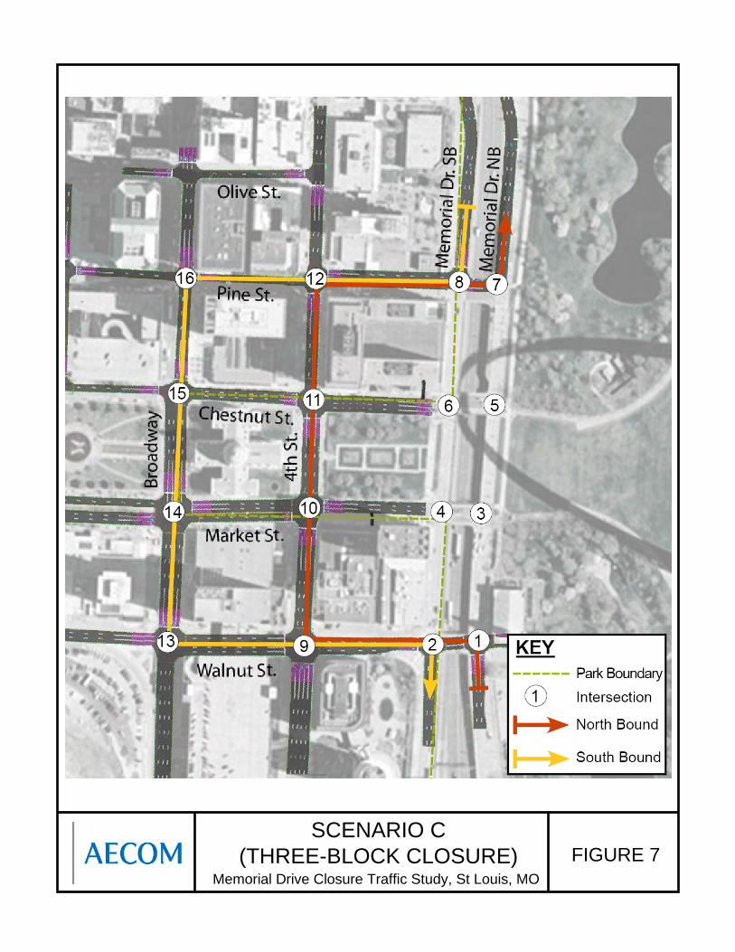
SCENARIO C (THREE-BLOCK CLOSURE) FIGURE 7
Memorial Drive Closure Traffic Study, St Louis, MO
Jefferson National Expansion Memorial
Memorial Drive Closure Traffic Study
33
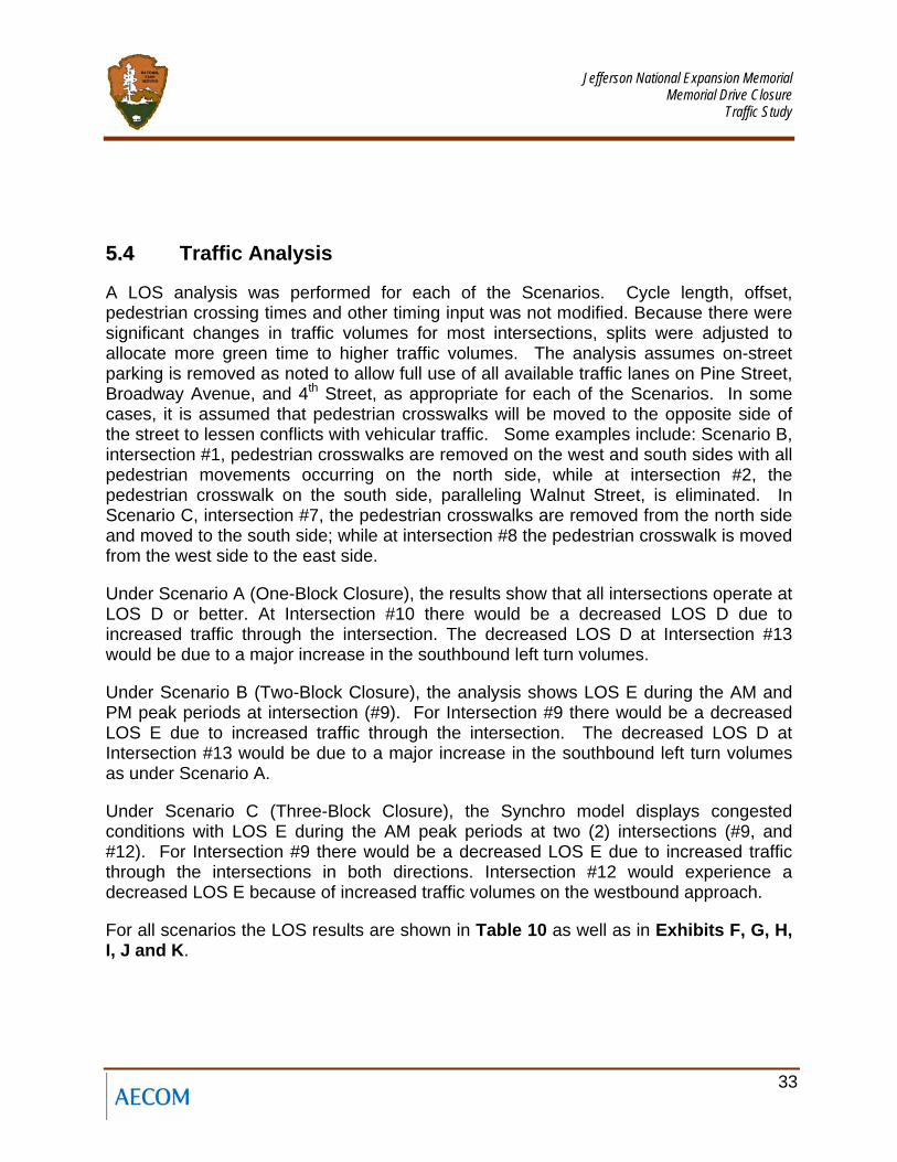
55..44 Traffic Analysis
A LOS analysis was performed for each of the Scenarios. Cycle length, offset, pedestrian crossing times and other timing input was not modified. Because there were significant changes in traffic volumes for most intersections, splits were adjusted to allocate more green time to higher traffic volumes. The analysis assumes on-street parking is removed as noted to allow full use of all available traffic lanes on Pine Street, Broadway Avenue, and 4th Street, as appropriate for each of the Scenarios. In some cases, it is assumed that pedestrian crosswalks will be moved to the opposite side of the street to lessen conflicts with vehicular traffic. Some examples include: Scenario B, intersection #1, pedestrian crosswalks are removed on the west and south sides with all pedestrian movements occurring on the north side, while at intersection #2, the pedestrian crosswalk on the south side, paralleling Walnut Street, is eliminated. In Scenario C, intersection #7, the pedestrian crosswalks are removed from the north side and moved to the south side; while at intersection #8 the pedestrian crosswalk is moved from the west side to the east side.
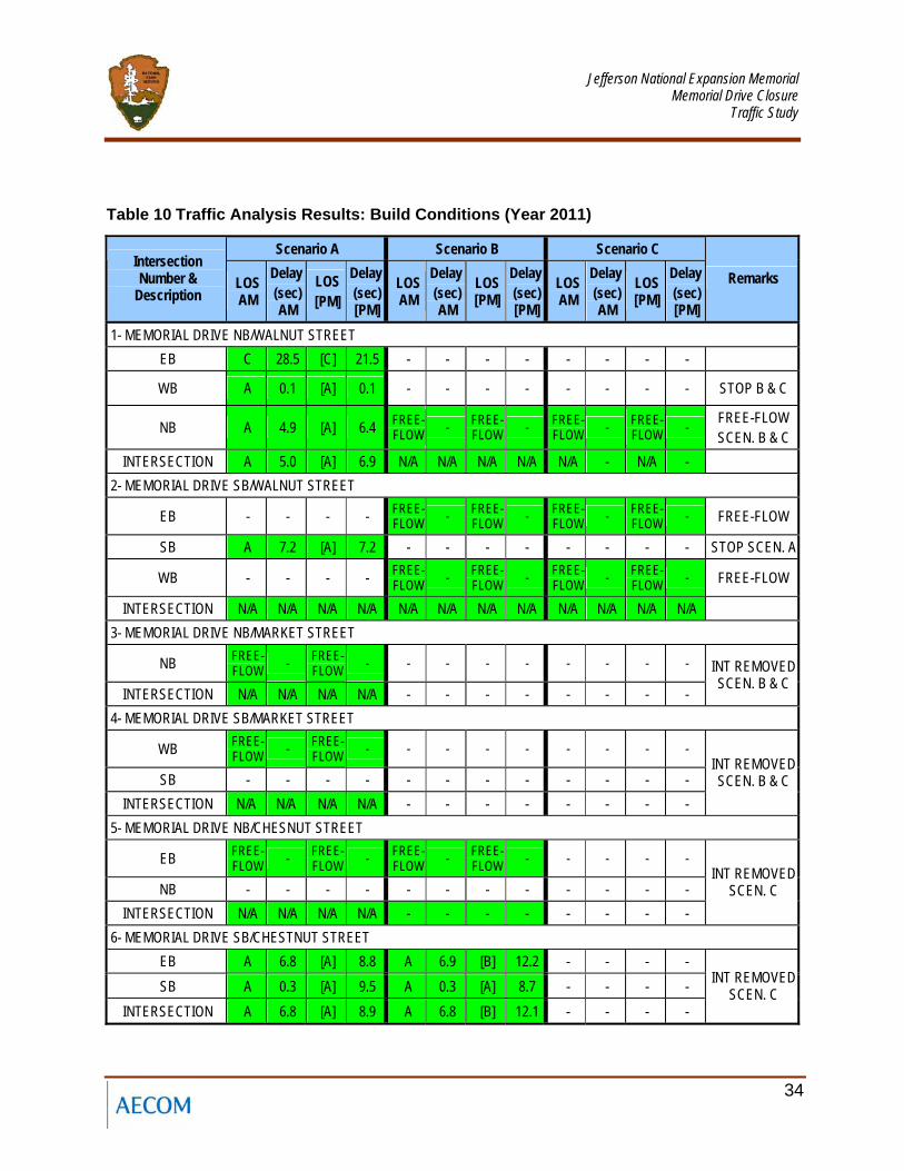
Under Scenario A (One-Block Closure), the results show that all intersections operate at LOS D or better. At Intersection #10 there would be a decreased LOS D due to increased traffic through the intersection. The decreased LOS D at Intersection #13 would be due to a major increase in the southbound left turn volumes.
Under Scenario B (Two-Block Closure), the analysis shows LOS E during the AM and PM peak periods at intersection (#9). For Intersection #9 there would be a decreased LOS E due to increased traffic through the intersection. The decreased LOS D at Intersection #13 would be due to a major increase in the southbound left turn volumes as under Scenario A.
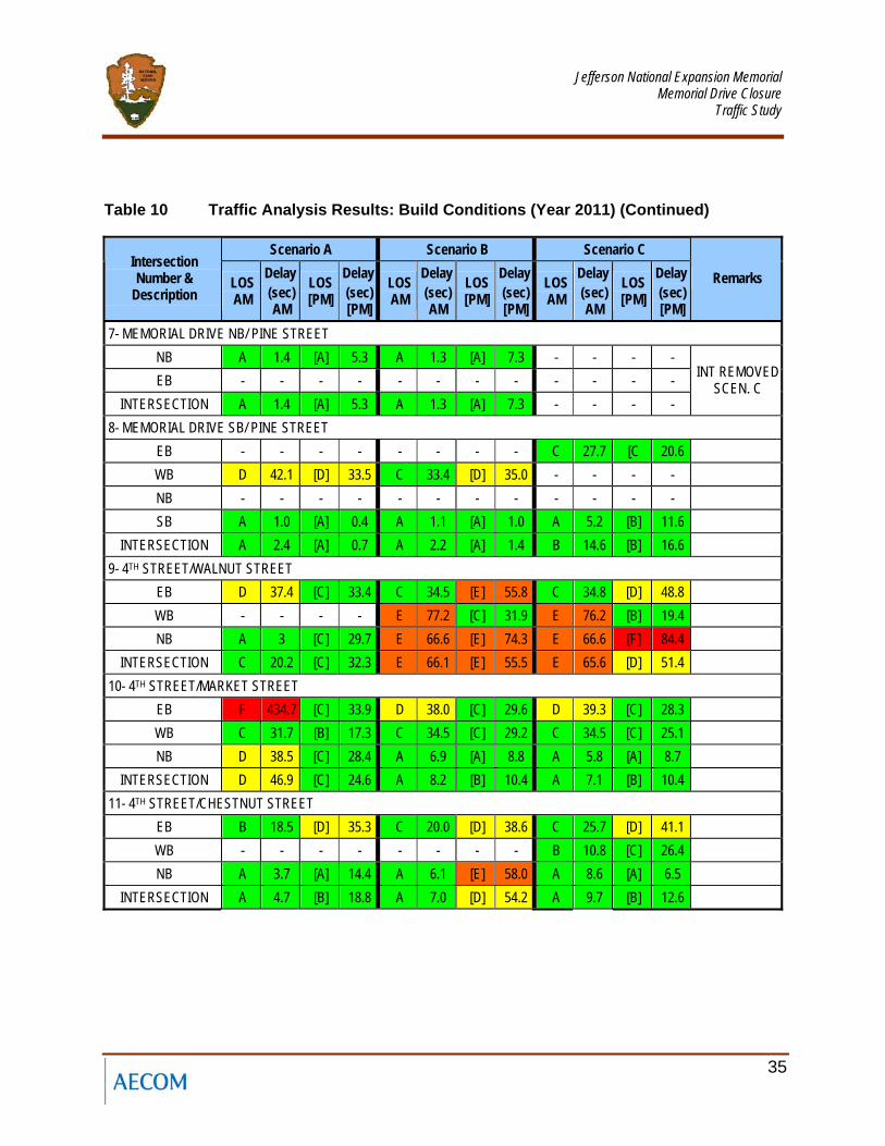
Under Scenario C (Three-Block Closure), the Synchro model displays congested conditions with LOS E during the AM peak periods at two (2) intersections (#9, and #12). For Intersection #9 there would be a decreased LOS E due to increased traffic through the intersections in both directions. Intersection #12 would experience a decreased LOS E because of increased traffic volumes on the westbound approach.
For all scenarios the LOS results are shown in Table 10 as well as in Exhibits F, G, H, I, J and K.
Jefferson National Expansion Memorial
Memorial Drive Closure Traffic Study
34
Table 10 Traffic Analysis Results: Build Conditions (Year 2011)
Scenario A Scenario B Scenario C Intersection Number &
Description LOS AM
Delay (sec) AM
LOS [PM]
Delay (sec) [PM]
LOS AM
Delay (sec) AM
LOS [PM]
Delay (sec) [PM]
LOS AM
Delay (sec) AM
LOS [PM]
Delay (sec) [PM]
Remarks
1- MEMORIAL DRIVE NB/WALNUT STREET EB C 28.5 [C] 21.5 - - - - - - - -
WB A 0.1 [A] 0.1 - - - - - - - - STOP B & C
NB A 4.9 [A] 6.4 FREE-FLOW - FREE-
FLOW - FREE-FLOW - FREE-
FLOW - FREE-FLOW SCEN. B & C
INTERSECTION A 5.0 [A] 6.9 N/A N/A N/A N/A N/A - N/A - 2- MEMORIAL DRIVE SB/WALNUT STREET
EB - - - - FREE-FLOW - FREE-
FLOW - FREE-FLOW - FREE-
FLOW - FREE-FLOW
SB A 7.2 [A] 7.2 - - - - - - - - STOP SCEN. A
WB - - - - FREE-FLOW - FREE-
FLOW - FREE-FLOW - FREE-
FLOW - FREE-FLOW
INTERSECTION N/A N/A N/A N/A N/A N/A N/A N/A N/A N/A N/A N/A 3- MEMORIAL DRIVE NB/MARKET STREET
NB FREE-FLOW - FREE-
FLOW - - - - - - - - -
INTERSECTION N/A N/A N/A N/A - - - - - - - -
INT REMOVED SCEN. B & C
4- MEMORIAL DRIVE SB/MARKET STREET
WB FREE-FLOW - FREE-
FLOW - - - - - - - - -
SB - - - - - - - - - - - - INTERSECTION N/A N/A N/A N/A - - - - - - - -
INT REMOVED SCEN. B & C
5- MEMORIAL DRIVE NB/CHESNUT STREET
EB FREE-FLOW - FREE-
FLOW - FREE-FLOW - FREE-
FLOW - - - - -
NB - - - - - - - - - - - - INTERSECTION N/A N/A N/A N/A - - - - - - - -
INT REMOVED SCEN. C
6- MEMORIAL DRIVE SB/CHESTNUT STREET EB A 6.8 [A] 8.8 A 6.9 [B] 12.2 - - - - SB A 0.3 [A] 9.5 A 0.3 [A] 8.7 - - - -
INTERSECTION A 6.8 [A] 8.9 A 6.8 [B] 12.1 - - - -
INT REMOVED SCEN. C
Jefferson National Expansion Memorial
Memorial Drive Closure Traffic Study
35
Table 10 Traffic Analysis Results: Build Conditions (Year 2011) (Continued)
Scenario A Scenario B Scenario C Intersection Number &
Description LOS AM
Delay (sec) AM
LOS [PM]
Delay (sec) [PM]
LOS AM
Delay (sec) AM
LOS [PM]
Delay (sec) [PM]
LOS AM
Delay (sec) AM
LOS [PM]
Delay (sec) [PM]
Remarks
7- MEMORIAL DRIVE NB/ PINE STREET NB A 1.4 [A] 5.3 A 1.3 [A] 7.3 - - - - EB - - - - - - - - - - - -
INTERSECTION A 1.4 [A] 5.3 A 1.3 [A] 7.3 - - - -
INT REMOVED SCEN. C
8- MEMORIAL DRIVE SB/ PINE STREET EB - - - - - - - - C 27.7 [C 20.6 WB D 42.1 [D] 33.5 C 33.4 [D] 35.0 - - - - NB - - - - - - - - - - - - SB A 1.0 [A] 0.4 A 1.1 [A] 1.0 A 5.2 [B] 11.6
INTERSECTION A 2.4 [A] 0.7 A 2.2 [A] 1.4 B 14.6 [B] 16.6 9- 4TH STREET/WALNUT STREET
EB D 37.4 [C] 33.4 C 34.5 [E] 55.8 C 34.8 [D] 48.8 WB - - - - E 77.2 [C] 31.9 E 76.2 [B] 19.4 NB A 3 [C] 29.7 E 66.6 [E] 74.3 E 66.6 [F] 84.4
INTERSECTION C 20.2 [C] 32.3 E 66.1 [E] 55.5 E 65.6 [D] 51.4 10- 4TH STREET/MARKET STREET
EB F 434.7 [C] 33.9 D 38.0 [C] 29.6 D 39.3 [C] 28.3 WB C 31.7 [B] 17.3 C 34.5 [C] 29.2 C 34.5 [C] 25.1 NB D 38.5 [C] 28.4 A 6.9 [A] 8.8 A 5.8 [A] 8.7
INTERSECTION D 46.9 [C] 24.6 A 8.2 [B] 10.4 A 7.1 [B] 10.4 11- 4TH STREET/CHESTNUT STREET
EB B 18.5 [D] 35.3 C 20.0 [D] 38.6 C 25.7 [D] 41.1 WB - - - - - - - - B 10.8 [C] 26.4 NB A 3.7 [A] 14.4 A 6.1 [E] 58.0 A 8.6 [A] 6.5
INTERSECTION A 4.7 [B] 18.8 A 7.0 [D] 54.2 A 9.7 [B] 12.6
Jefferson National Expansion Memorial
Memorial Drive Closure Traffic Study
36
Table 10 Traffic Analysis Results: Build Conditions (Year 2011) (Continued)
Scenario A Scenario B Scenario C Intersection Number &
Description: LOS AM
Delay (sec) AM
LOS [PM]
Delay (sec) [PM]
LOS AM
Delay (sec) AM
LOS [PM]
Delay (sec) [PM]
LOS AM
Delay (sec) AM
LOS [PM]
Delay (sec) [PM]
Remarks
12- 4TH STREET/PINE STREET WB D 43.6 [D] 53.6 D 43.9 [D] 48.0 F 171.0 [F] 112.3 NB A 3.0 [A] 5.7 A 4.7 [A] 9.8 A 8.0 [C] 32.3
INTERSECTION C 25.1 [C] 31.1 C 23.0 [C] 29.6 E 65.2 [D] 54.8 13- BROADWAY AVENUE/WALNUT STREET
EB C 20.4 [D] 36.3 C 21.8 [C] 32.0 C 20.4 [C] 34.9 SB A 5.5 [E] 57.1 A 9.3 [E] 59.5 A 9.0 [D] 51.4
INTERSECTION A 7.9 [D] 51.3 B 11.3 [D] 51.8 B 10.9 [D] 46.8 14- BROADWAY AVENUE/MARKET STREET
EB B 18.1 [D] 37.2 B 19.7 [D] 37.2 B 18.6 [D] 37.2 WB A 6.1 [C] 20.9 B 17.1 [C] 21.6 B 18.6 [B] 19.8 SB B 20.0 [A] 9.9 B 11.3 [B] 10.8 B 11.3 [B] 10.3
INTERSECTION B 14.3 [B] 15.2 B 13.8 [B] 15.9 B 13.9 [B] 15.3 15- BROADWAY AVENUE/CHESTNUT STREET
EB C 24.0 [D] 42.0 C 25.1 [D] 42.0 B 19.7 [D] 42.0 SB A 2.9 [A] 7.6 A 1.6 [A] 6.5 A 1.1 [A] 8.2
INTERSECTION A 5.2 [B] 15.7 A 3.6 [B] 14.9 A 2.5 [B] 16.2 16- BROADWAY AVENUE/ PINE STREET
WB A 1.5 [A] 8.2 A 4.1 [A] 8.5 A 4.8 [A] 4.6 SB B 10.6 [C] 21.3 B 13.2 [D] 44.2 B 13.5 [D] 49.9
INTERSECTION A 4.4 [B] 13.4 A 6.4 [C] 22.7 A 7.0 [C] 22.6
Jefferson National Expansion Memorial
Memorial Drive Closure Traffic Study
43
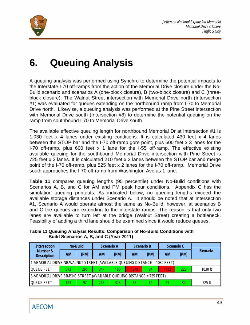
66.. QQuueeuuiinngg AAnnaallyyssiiss A queuing analysis was performed using Synchro to determine the potential impacts to the Interstate I-70 off-ramps from the action of the Memorial Drive closure under the No-Build scenario and scenarios A (one-block closure), B (two-block closure) and C (three-block closure). The Walnut Street intersection with Memorial Drive north (Intersection #1) was evaluated for queues extending on the northbound ramp from I-70 to Memorial Drive north. Likewise, a queuing analysis was performed at the Pine Street intersection with Memorial Drive south (Intersection #8) to determine the potential queuing on the ramp from southbound I-70 to Memorial Drive south.
The available effective queuing length for northbound Memorial Dr at Intersection #1 is 1,030 feet x 4 lanes under existing conditions. It is calculated 430 feet x 4 lanes between the STOP bar and the I-70 off-ramp gore point, plus 600 feet x 3 lanes for the I-70 off-ramp, plus 600 feet x 1 lane for the I-55 off-ramp. The effective existing available queuing for the southbound Memorial Drive intersection with Pine Street is 725 feet x 3 lanes. It is calculated 210 feet x 3 lanes between the STOP bar and merge point of the I-70 off-ramp, plus 525 feet x 2 lanes for the I-70 off-ramp. Memorial Drive south approaches the I-70 off-ramp from Washington Ave as 1 lane.
Table 11 compares queuing lengths (95 percentile) under No-Build conditions with Scenarios A, B, and C for AM and PM peak hour conditions. Appendix C has the simulation queuing printouts. As indicated below, no queuing lengths exceed the available storage distances under Scenario A. It should be noted that at Intersection #1, Scenario A would operate almost the same as No-Build; however, at scenarios B and C the queues are extending to the interstate ramps. The reason is that only two lanes are available to turn left at the bridge (Walnut Street) creating a bottleneck. Feasibility of adding a third lane should be examined since it would reduce queues.
Table 11 Queuing Analysis Results: Comparison of No-Build Conditions with Build Scenarios A, B, and C (Year 2011)
No-Build Scenario A Scenario B Scenario C Intersection Number &
Description AM [PM] AM [PM] AM [PM] AM [PM] Remarks
1-MEMORIAL DRIVE NB/WALNUT STREET (AVAILABLE QUEUING DISTANCE = 1030 FEET) QUEUE FEET 373 296 347 180 1349 84 1132 223 1030 ft 8-MEMORIAL DRIVE SB/PINE STREET (AVAILABLE QUEUING DISTANCE = 725 FEET) QUEUE FEET 183 97 263 328 65 64 69 80 725 ft
Jefferson National Expansion Memorial
Memorial Drive Closure Traffic Study
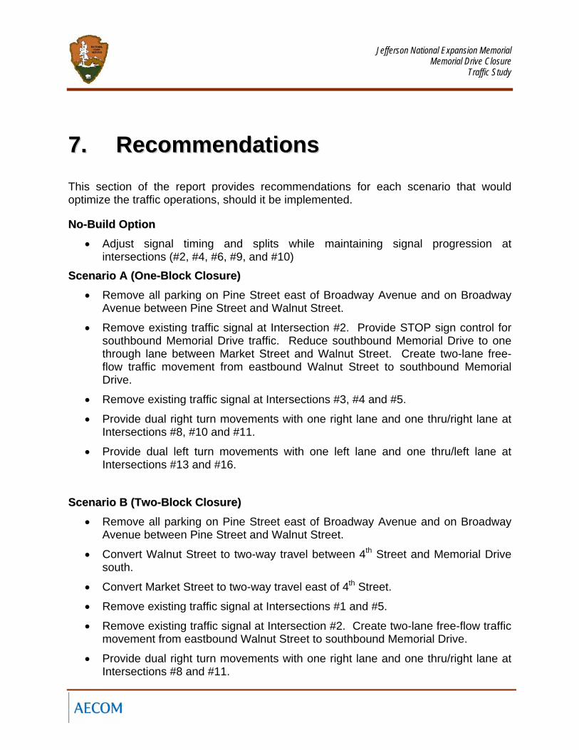
77.. RReeccoommmmeennddaattiioonnss This section of the report provides recommendations for each scenario that would optimize the traffic operations, should it be implemented.
NNoo--BBuuiilldd OOppttiioonn • Adjust signal timing and splits while maintaining signal progression at
intersections (#2, #4, #6, #9, and #10)
SScceennaarriioo AA ((OOnnee--BBlloocckk CClloossuurree)) • Remove all parking on Pine Street east of Broadway Avenue and on Broadway
Avenue between Pine Street and Walnut Street.
• Remove existing traffic signal at Intersection #2. Provide STOP sign control for southbound Memorial Drive traffic. Reduce southbound Memorial Drive to one through lane between Market Street and Walnut Street. Create two-lane free-flow traffic movement from eastbound Walnut Street to southbound Memorial Drive.
• Remove existing traffic signal at Intersections #3, #4 and #5.
• Provide dual right turn movements with one right lane and one thru/right lane at Intersections #8, #10 and #11.
• Provide dual left turn movements with one left lane and one thru/left lane at Intersections #13 and #16.
SScceennaarriioo BB ((TTwwoo--BBlloocckk CClloossuurree))
• Remove all parking on Pine Street east of Broadway Avenue and on Broadway Avenue between Pine Street and Walnut Street.
• Convert Walnut Street to two-way travel between 4th Street and Memorial Drive south.
• Convert Market Street to two-way travel east of 4th Street.
• Remove existing traffic signal at Intersections #1 and #5.
• Remove existing traffic signal at Intersection #2. Create two-lane free-flow traffic movement from eastbound Walnut Street to southbound Memorial Drive.
• Provide dual right turn movements with one right lane and one thru/right lane at Intersections #8 and #11.
Jefferson National Expansion Memorial
Memorial Drive Closure Traffic Study
• Modify Intersection #9 to provide dual westbound right turn movements and dual eastbound left turn movements.
• Provide dual left turn movements with one left lane and one thru/left lane at Intersections #13 and #16.
SScceennaarriioo CC ((TThhrreeee--BBlloocckk CClloossuurree)) • Remove all parking on Pine Street east of Broadway Avenue and on Broadway
Avenue between Pine Street and Walnut Street.
• Convert Walnut Street to two-way travel between 4th Street and Memorial Drive south.
• Convert Market Street to two-way travel east of 4th Street.
• Convert Chestnut Street to two-way travel east of 4th Street.
• Convert Pine Street to two-way travel between 4th Street and Memorial Drive south.
• Remove existing traffic signal at Intersections #1 and #7.
• Remove existing traffic signal at Intersection #2. Create two-lane free-flow traffic movement from eastbound walnut Street to southbound Memorial Drive.
• Modify Intersection #9 to provide dual westbound right turn movements and dual eastbound left turn movements.
• Provide dual northbound right turn movements at Intersection #12.
• Provide dual left turn movements with one left lane and one thru/left lane at Intersections #13 and #16.
Jefferson National Expansion Memorial
Memorial Drive Closure Traffic Study
88.. CCoonncclluussiioonnss
88..11 Comparison of No-Build Actions with Scenarios A, B, and C
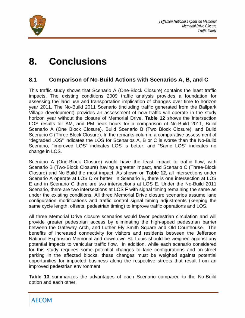
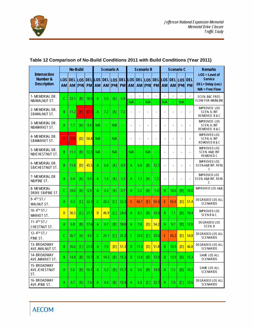
This traffic study shows that Scenario A (One-Block Closure) contains the least traffic impacts. The existing conditions 2009 traffic analysis provides a foundation for assessing the land use and transportation implication of changes over time to horizon year 2011. The No-Build 2011 Scenario (including traffic generated from the Ballpark Village development) provides an assessment of how traffic will operate in the study horizon year without the closure of Memorial Drive. Table 12 shows the intersection LOS results for AM, and PM peak hours for a comparison of No-Build 2011, Build Scenario A (One Block Closure), Build Scenario B (Two Block Closure), and Build Scenario C (Three Block Closure). In the remarks column, a comparative assessment of “degraded LOS” indicates the LOS for Scenarios A, B or C is worse than the No-Build Scenario, “improved LOS” indicates LOS is better, and “Same LOS” indicates no change in LOS.
Scenario A (One-Block Closure) would have the least impact to traffic flow, with Scenario B (Two-Block Closure) having a greater impact, and Scenario C (Three-Block Closure) and No-Build the most impact. As shown on Table 12, all intersections under Scenario A operate at LOS D or better. In Scenario B, there is one intersection at LOS E and in Scenario C there are two intersections at LOS E. Under the No-Build 2011 Scenario, there are two intersections at LOS F with signal timing remaining the same as under the existing conditions. All three Memorial Drive closure scenarios assume lane configuration modifications and traffic control signal timing adjustments (keeping the same cycle length, offsets, pedestrian timing) to improve traffic operations and LOS.
All three Memorial Drive closure scenarios would favor pedestrian circulation and will provide greater pedestrian access by eliminating the high-speed pedestrian barrier between the Gateway Arch, and Luther Ely Smith Square and Old Courthouse. The benefits of increased connectivity for visitors and residents between the Jefferson National Expansion Memorial and downtown St. Louis should be weighed against any potential impacts to vehicular traffic flow. In addition, while each scenario considered for this study requires some potential changes to lane configurations and on-street parking in the affected blocks, these changes must be weighed against potential opportunities for impacted business along the respective streets that result from an improved pedestrian environment.
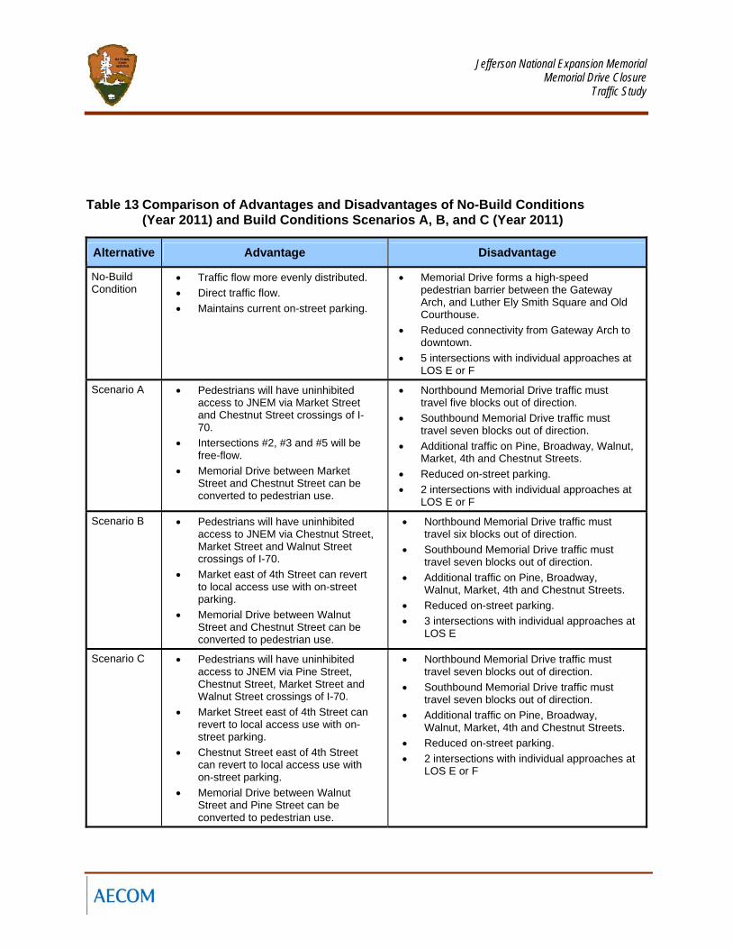
Table 13 summarizes the advantages of each Scenario compared to the No-Build option and each other.
Jefferson National Expansion Memorial
Memorial Drive Closure Traffic Study
Table 12 Comparison of No-Build Conditions 2011 with Build Conditions (Year 2011)
No-Build Scenario A Scenario B Scenario C Intersection Number &
Description LOS AM
DEL AM
LOS [PM]
DEL PM
LOS AM
DEL AM
LOS [PM]
DEL PM
LOS AM
DEL AM
LOS [PM]
DEL PM
LOS AM
DEL AM
LOS [PM]
DEL PM
Remarks LOS = Level of
Service DEL= Delay (sec) N/A = Free Flow
- - - - - - - - 1- MEMORIAL DR. NB/WALNUT ST. C 23.1 [B] 18.0 A 5.0 [A] 6.9
N/A - N/A - N/A - N/A - SCEN. B&C FREE-
FLOW FOR MAINLINE
2- MEMORIAL DR. SB/WALNUT ST. B 11.2 [F] 87.1 A 7.2 [A] 7.2 - - - - - - - -
IMPROVED LOS SCEN. A; INT
REMOVED B & C
3- MEMORIAL DR. NB/MARKET ST. A 1.1 [A] 0.4 N/A - N/A - - - - - - - - -
IMPROVED LOS SCEN. A; INT
REMOVED B & C
4- MEMORIAL DR. SB/MARKET ST. F 110 [D] 50.8 N/A - N/A - - - - - - - - -
IMPROVED LOS SCEN. A; INT
REMOVED B & C
5- MEMORIAL DR. NB/CHESTNUT ST. B 11.3 [B] 12.3 N/A - N/A - N/A - N/A - - - - -
IMPROVED LOS SCEN. A&B; INT
REMOVED C
6- MEMORIAL DR. SB/CHESTNUT ST. B 11.8 [D] 45.5 A 6.8 [A] 8.9 A 6.8 [B] 12.1 - - - -
IMPROVED LOS SCEN.A&B INT. REM.
C
7- MEMORIAL DR NB/PINE ST. A 0.4 [A] 0.4 A 1.4 [A] 5.3 A 1.3 [A] 7.3 - - - -
IMPROVED LOS SCEN. A&B INT. REM.
C
8- MEMORIAL DRIVE SB/PINE ST. C 24.6 [A] 6.9 A 2.4 [A] 0.7 A 2.2 [A] 1.4 B 14.6 [B] 16.6 IMPROVED LOS A&B;
9- 4TH ST./ WALNUT ST. A 9.3 [C] 32.1 C 20.2 [C] 32.3 E 66.1 [E] 55.5 E 65.6 [D] 51.4 DEGRADED LOS ALL
SCENARIOS
10- 4TH ST./ MARKET ST. D 36.5 [C] 27.7 D 46.9 [C] 24.6 A 8.2 [B] 10.4 A 7.1 [B] 10.4 IMPROVED LOS
SCEN B & C.
11- 4TH ST./ CHESTNUT ST. A 6.8 [B] 17.6 A 4.7 [B] 18.8 A 7.0 [D] 54.2 A 9.7 [B] 12.6 DEGRADED LOS
SCEN. B
12- 4TH ST./ PINE ST. C 26.7 [A] 9.0 C 25.1 [C] 31.3 C 23.0 [C] 29.6 E 65.2 [D] 54.8 DEGRADED LOS ALL
SCENARIOS
13- BROADWAY AVE./WALNUT ST. B 16.6 [C] 21.5 A 7.9 [D] 51.3 B 11.3 [D] 51.8 B 10.9 [D] 46.8 DEGRADED LOS ALL
SCENARIOS
14- BROADWAY AVE./MARKET ST. B 14.8 [B] 19.7 B 14.3 [B] 15.2 B 13.8 [B] 15.9 B 13.9 [B] 15.3 SAME LOS ALL
SCENARIOS
15- BROADWAY AVE./CHESTNUT ST.
A 5.6 [B] 16.1 A 5.2 [B] 15.7 A 3.6 [B] 14.9 A 2.5 [B] 16.2 SAME LOS ALL SCENARIOS
16- BROADWAY AVE./PINE ST. A 4.7 [A] 7.4 A 4.4 [B] 13.4 A 6.4 [C] 22.7 A 7.0 [C] 22.6 DEGRADED LOS ALL
SCENARIOS
Jefferson National Expansion Memorial
Memorial Drive Closure Traffic Study
Table 13 Comparison of Advantages and Disadvantages of No-Build Conditions (Year 2011) and Build Conditions Scenarios A, B, and C (Year 2011)
Alternative Advantage Disadvantage
No-Build Condition
• Traffic flow more evenly distributed. • Direct traffic flow. • Maintains current on-street parking.
• Memorial Drive forms a high-speed pedestrian barrier between the Gateway Arch, and Luther Ely Smith Square and Old Courthouse.
• Reduced connectivity from Gateway Arch to downtown.
• 5 intersections with individual approaches at LOS E or F
Scenario A • Pedestrians will have uninhibited access to JNEM via Market Street and Chestnut Street crossings of I-70.
• Intersections #2, #3 and #5 will be free-flow.
• Memorial Drive between Market Street and Chestnut Street can be converted to pedestrian use.
• Northbound Memorial Drive traffic must travel five blocks out of direction.
• Southbound Memorial Drive traffic must travel seven blocks out of direction.
• Additional traffic on Pine, Broadway, Walnut, Market, 4th and Chestnut Streets.
• Reduced on-street parking. • 2 intersections with individual approaches at
LOS E or F
Scenario B • Pedestrians will have uninhibited access to JNEM via Chestnut Street, Market Street and Walnut Street crossings of I-70.
• Market east of 4th Street can revert to local access use with on-street parking.
• Memorial Drive between Walnut Street and Chestnut Street can be converted to pedestrian use.
• Northbound Memorial Drive traffic must travel six blocks out of direction.
• Southbound Memorial Drive traffic must travel seven blocks out of direction.
• Additional traffic on Pine, Broadway, Walnut, Market, 4th and Chestnut Streets.
• Reduced on-street parking. • 3 intersections with individual approaches at
LOS E
Scenario C • Pedestrians will have uninhibited access to JNEM via Pine Street, Chestnut Street, Market Street and Walnut Street crossings of I-70.
• Market Street east of 4th Street can revert to local access use with on-street parking.
• Chestnut Street east of 4th Street can revert to local access use with on-street parking.
• Memorial Drive between Walnut Street and Pine Street can be converted to pedestrian use.
• Northbound Memorial Drive traffic must travel seven blocks out of direction.
• Southbound Memorial Drive traffic must travel seven blocks out of direction.
• Additional traffic on Pine, Broadway, Walnut, Market, 4th and Chestnut Streets.
• Reduced on-street parking. • 2 intersections with individual approaches at
LOS E or F
Related Documents