APPENDIX 8.6 ADVICE FROM DAVID COMPTON‐MOEN, SINCLAIR KNIGHT‐ MERTZ ON COMMERCIAL CHAPTER MEMO To: Josie Schroder / Mark Stevenson From: David Compton-Moen / Josie Schroder Date: 21 October 2013 Re: District Plan Review - Commercial centres - Key Activity Frontages Purpose To identify and map 'Key Activity Frontages' located within the Business 2 zones of the city to incorporate within the District Plan, for which specific rules would apply that recognise primarily pedestrian oriented street frontages. (Auckland Unitary Plan has a similar approach with key retail frontages). Key Activity Frontages are street frontages within the Business 2 zones that are more pedestrian and retail focused and should therefore have greater consideration given to the private space interaction with the street. The following Streetscene rule is proposed for the Christchurch City District Plan. Proposed Streetscene Rule for the Christchurch City District Plan 15.5.4.5 Streetscene (a) Buildings located along Key Activity Frontages identified on the Planning Maps and Appendix xxx or within the commercial areas of New Neighbourhood Zones (as identified on the relevant ODP) shall: (I) Be built up to the road boundary, with buildings occupying the full road frontage of the site, except: (a) Where necessary to provide pedestrian or vehicle access to the rear of the site and; (ii) Provide a minimum of 60% and a maximum of 90% of visually transparent glazing at the ground floor and a minimum of 20% and a maximum of 90% visually transparent glazing at each floor above the ground floor. (iii) Provide pedestrian access directly from the road boundary. (iv) Provide a veranda or other means of weather protection along the full width of the building fronting a road. (b) Buildings located outside of Key Activity Frontages and Commercial Areas of New Neighbourhood Zones shall: (i) Be built up to the road boundary for a minimum width of 40% of the site’s frontage; and (ii) Provide a minimum of 60% and a maximum of 90% of visually transparent glazing at the ground floor level; and (iii) Where buildings are not built up to the road boundary they shall: (a) be set back a minimum of 3 metres from the road boundary; and

Welcome message from author
This document is posted to help you gain knowledge. Please leave a comment to let me know what you think about it! Share it to your friends and learn new things together.
Transcript

APPENDIX 8.6 ADVICE FROM DAVID COMPTON‐MOEN, SINCLAIR KNIGHT‐MERTZ ON COMMERCIAL CHAPTER
MEMO
To: Josie Schroder / Mark Stevenson
From: David Compton-Moen / Josie Schroder
Date: 21 October 2013
Re: District Plan Review - Commercial centres - Key Activity Frontages
Purpose
To identify and map 'Key Activity Frontages' located within the Business 2 zones of the city to incorporate within the District Plan, for which specific rules would apply that recognise primarily pedestrian oriented street frontages. (Auckland Unitary Plan has a similar approach with key retail frontages). Key Activity Frontages are street frontages within the Business 2 zones that are more pedestrian and retail focused and should therefore have greater consideration given to the private space interaction with the street. The following Streetscene rule is proposed for the Christchurch City District Plan. Proposed Streetscene Rule for the Christchurch City District Plan 15.5.4.5 Streetscene
(a) Buildings located along Key Activity Frontages identified on the Planning Maps and Appendix xxx or within the commercial areas of New Neighbourhood Zones (as identified on the relevant ODP) shall: (I) Be built up to the road boundary, with buildings occupying the full road frontage of
the site, except: (a) Where necessary to provide pedestrian or vehicle access to the rear of the
site and; (ii) Provide a minimum of 60% and a maximum of 90% of visually transparent glazing
at the ground floor and a minimum of 20% and a maximum of 90% visually transparent glazing at each floor above the ground floor.
(iii) Provide pedestrian access directly from the road boundary.
(iv) Provide a veranda or other means of weather protection along the full width of the
building fronting a road.
(b) Buildings located outside of Key Activity Frontages and Commercial Areas of New Neighbourhood Zones shall: (i) Be built up to the road boundary for a minimum width of 40% of the site’s frontage;
and (ii) Provide a minimum of 60% and a maximum of 90% of visually transparent glazing at
the ground floor level; and (iii) Where buildings are not built up to the road boundary they shall:
(a) be set back a minimum of 3 metres from the road boundary; and

(b) include tree planting of at least one tree for every 10 metres of built frontage or part thereof (e.g. 10 metres of built frontage = 1 tree, 11 metres of built frontage = 2 trees); and
(c) incorporate 20% modulation across the extent of the front façade above the ground floor.
Criteria and Rationale for Identifying Key Activity Frontages
The recognition of Key Activity Frontages is an important aspect of creating a legible, well defined urban form in the commercial centres of Christchurch. Where buildings are built up to the street boundary they provide a clearly defined edge to the street environment (public space) and a development (private space). This positioning, by its nature, forces a relationship between the building and the street, for the two elements to interact. When this interaction results in an active edge with an attractive streetscape, it positively contributes to street definition and enclosure enhancing pedestrian amenity. It results in buildings being accessible by providing convenient and direct access between the street and building for people of all ages and abilities. Studies have shown that the urban design of an area has a signification impact on how an area is used by people and that good street design often results in economic benefits for retailers (CABE 2007).
“Continuous building lines along a block edge are more successful at providing good enclosure to a street or square and generating ‘active frontage’, with frequent doors and windows animating the public realm. In centres, a direct frontage to pavement relationship assists commercial viability and street vitality.”
Urban Design Compendium, English Partnerships (2000) Unfortunately, with design emphasis often placed on private car users and their needs, the relationship between buildings and the street can be dissolved resulting in developments which are poorly positioned for pedestrian access. A report recently prepared by Beca on behalf of the NZTA, Reallocation of Road Space, highlighted some findings which support the protection and promotion of Key Activity Frontages. The following bullet points are considered key findings of this report, in support of the identification of key activity frontages:
The data from the study showed that sustainable transport users accounted for 40% of the total spend in the shopping area. It also showed that pedestrians and cyclists contribute a higher economic spend proportionately to the modal share and are important to the economic viability of local shopping centres.
A higher spend of $44 per person (compared to all sites) was observed on arterial sites.
The data indicated that cycle trips account for the highest sustainable transport spend in central locations and only account for 2% of total travel.
To support the identification of Key Activity Frontages, the following criteria have been developed based on recognised good urban design principles with the intention of improving the streetscene environment of Christchurch’s commercial centres. For each criterion, the rationale for its inclusion follows:
1) Is the Business 2 zoning located in a District Centre, Neighbourhood Centre or a Local Centre? It is proposed that Key Activity Frontages are identified for all B2 zoned land located within a District Centre, Neighbourhood Centre (large and small) or a Local Centre. The Key activity frontage requirement would not apply to standalone B2 areas which are outside of an identified centre. The scale and placement of B2 buildings can have an adverse effect on the character and continuity of a commercial centre if sited poorly with little interface with the main street due to the placement of carparking. This is particularly apparent in smaller centres where a greater number of people travel to the centre either by foot or bicycle. This is opposed to district centres and Neighbourhood centres (large) where
a greater proportion of visitors arrive by private motor vehicle due to the larger catchment these centres cater too. However the built character of the larger commercial centres is equally important, particularly as the centres evolve and there becomes a greater use of public transport. Using the commercial centre at Merivale (Neighbourhood Centre – Large) as an example, the built character of the centre is typified by buildings built up to the street edge with carparking and service areas accessed from the rear. Any placement of buildings back from the street boundary would have a detrimental effect on the character of the centre, reducing continuity of built frontages or a sense of enclosure.
It is not anticipated that standalone B2 areas (outside of a commercial centre) would be identified as having Key activity frontages as there is not the need for a continuation of a building frontage or relationship with adjoining B1 developments. An example of this is the B2 zoning on Stanmore Road in Richmond, which is currently occupied by New World. This development is standalone, physically separate from the B1 zoned centre further along the road and boarders onto residential areas.
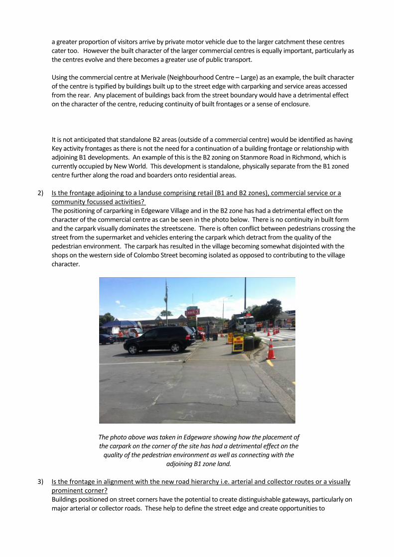
2) Is the frontage adjoining to a landuse comprising retail (B1 and B2 zones), commercial service or a community focussed activities? The positioning of carparking in Edgeware Village and in the B2 zone has had a detrimental effect on the character of the commercial centre as can be seen in the photo below. There is no continuity in built form and the carpark visually dominates the streetscene. There is often conflict between pedestrians crossing the street from the supermarket and vehicles entering the carpark which detract from the quality of the pedestrian environment. The carpark has resulted in the village becoming somewhat disjointed with the shops on the western side of Colombo Street becoming isolated as opposed to contributing to the village character.
The photo above was taken in Edgeware showing how the placement of the carpark on the corner of the site has had a detrimental effect on the quality of the pedestrian environment as well as connecting with the
adjoining B1 zone land.
3) Is the frontage in alignment with the new road hierarchy i.e. arterial and collector routes or a visually prominent corner? Buildings positioned on street corners have the potential to create distinguishable gateways, particularly on major arterial or collector roads. These help to define the street edge and create opportunities to
differentiate a place from another, to create a local landmark or focal point. A corner can be visually reinforced with architectural elements such as verandahs, awning, roof form, cornice, pediment or similar. Ideally buildings on corner sites should have both street frontages with windows and doors, with the main entry point located at the corner or on the primary street. Arterial and collector roads, as mentioned above, have a tendency to be public transport routes as well as catering to relatively high numbers of pedestrians and cyclists. While pedestrian numbers are not available for many Christchurch streets, people tend to take the shortest route which is often provided by the major road.
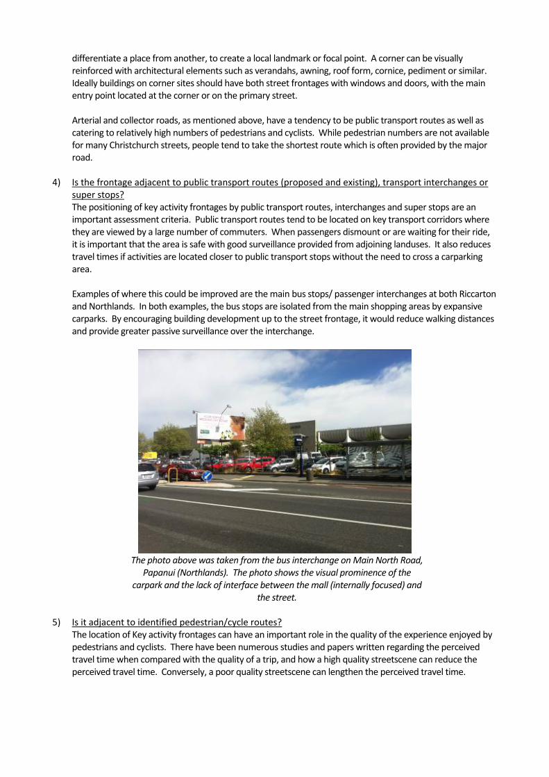
4) Is the frontage adjacent to public transport routes (proposed and existing), transport interchanges or super stops? The positioning of key activity frontages by public transport routes, interchanges and super stops are an important assessment criteria. Public transport routes tend to be located on key transport corridors where they are viewed by a large number of commuters. When passengers dismount or are waiting for their ride, it is important that the area is safe with good surveillance provided from adjoining landuses. It also reduces travel times if activities are located closer to public transport stops without the need to cross a carparking area. Examples of where this could be improved are the main bus stops/ passenger interchanges at both Riccarton and Northlands. In both examples, the bus stops are isolated from the main shopping areas by expansive carparks. By encouraging building development up to the street frontage, it would reduce walking distances and provide greater passive surveillance over the interchange.
The photo above was taken from the bus interchange on Main North Road,
Papanui (Northlands). The photo shows the visual prominence of the carpark and the lack of interface between the mall (internally focused) and
the street.
5) Is it adjacent to identified pedestrian/cycle routes? The location of Key activity frontages can have an important role in the quality of the experience enjoyed by pedestrians and cyclists. There have been numerous studies and papers written regarding the perceived travel time when compared with the quality of a trip, and how a high quality streetscene can reduce the perceived travel time. Conversely, a poor quality streetscene can lengthen the perceived travel time.

Key activity frontages promote the inclusion of verandahs (providing continuous shelter), glazing (providing passive surveillance as well as visual interest) and typically reduce the number of vehicle crossings (providing a continuous, uninterrupted and safer travel route). The following extract is taken from an American Urban designer’s blog: “The misplaced assumption that Americans like automobile traffic more than walkable streets has created some pretty awful disconnections within our communities. One of them has been the unfortunate dogma that places (and in some cases requires) parking lots in front of the businesses, civic institutions and apartment/condo buildings that they serve, between the buildings and the street. This creates longer and more dangerous walking routes for pedestrians as well as a visual incoherence that is anti‐community. It also makes public transit less attractive and viable, since the transit user’s journey from the bus stop to the store or apartment must take place through a sometimes‐large parking lot instead of simply to a door on a sidewalk”.
For walkability and community, put the building on the street and the parking in back, Kaid Benfield’s Blog (April 20, 2010)
I feel the above extract summarises the lack of ‘key activity frontages’ well and that there is a strong correlation been key pedestrian and cycle routes and key activity frontages to minimise travel time for pedestrians and cyclists as well as providing safer environments. As mentioned above, the NZTA research report on Road Space Allocation highlights the disproportional amount (positively) which is spent by sustainable transport modes compared to their overall modal share. By improving the quality of the streetscene for cyclist and pedestrians, it is highly likely that the commercial viability of a centre would improve.
The photo above was taken at the St Martins New World on Wilsons Road.
While pedestrian facilities have been provided across the carpark, the building has a poor street interface providing no shelter or visual interest
for passing pedestrians or cyclists. 6) Is the frontage a main pedestrian street or centre?
Rotherham Street in Riccarton is a main pedestrian street, and while only a local road, it is an important retail street with a number of restaurants, cafes or shops. The street has wide paved footpaths on both sides with outdoor café tables, amenity lighting, seating and tree planting. The street generally works well with carparking limited to the Maxwell Street end (parking buildings) or behind buildings. There are some exceptions to this where carparking creates a break in the building line, weakening the street’s sense of cohesion and continuity.

The photo above was taken from the carparking building at the Maxwell Street end of Rotherham Street. The wide footpaths and street tree
planting provide a high level of pedestrian amenity.
7) Does the frontage overlook a civic open space?
Buildings at the edge of civic open spaces require key activity frontages to ensure that buildings enhance the amenity of a space as opposed from detracting from its character. By creating an interface between the building and the space there is an opportunity for activities to ‘spill out’ from the building into the space, adding vitality to the public realm.
Location of each of the key activity frontages and their extent
The location of the proposed key activity frontages and their extent is shown in the attached drawings.
Relevant assessment criteria
The following assessment criteria are recommended for assessing a proposal against when it does not meet the Key Activity Frontage Rule as stipulated above:
a. Is the proposal located within a District or Neighbourhood Centre? b. Is the proposal adjoining a landuse comprising of retail (B1 or B2 zone), commercial
service or a community focussed activity? c. Is the proposal located on/front an arterial, collector road or a visually prominent
corner? d. Is the proposal adjacent to public transport routes (existing and proposed), transport
interchanges or super stops? e. Is the proposal adjacent to identified pedestrian or cycle routes? f. Does the proposal front a main pedestrian street? g. Does the proposal adjoin a civic open space? h. Does the development provide greater ground floor heights to maximise building
adaptability to a range of uses

i. Does the development avoid blank walls with sufficient glazing on Key activity frontages
j. Does the development provide easily accessible pedestrian entrances with direct access from the street?
k. Does the development erect frontages of sufficient height to frame the street l. Is continuous weather protection for pedestrians provided along key activity frontage
Conclusions (Anticipated Outcomes)
If the recommendations outlined above were implemented, it is anticipated the following outcomes would be achieved over time:
1. Gradual in-fill of sites to create a stronger built edge, with well defined main streets. 2. Improved linkages to internally focused malls. 3. Discouragement of large blank walls facing main streets. 4. Stronger corner definition to create a local landmark, improved visual legibility. 5. A gradual shift from a ‘car based, perimeter parking’ design model to a model which is pedestrian /
public transport focused. 6. Promotion of carparking being placed behind buildings to create a better interaction between the
street and buildings.

MEMO
To: Adele Radburnd/ Mark Stevenson
From: David Compton-Moen / Josie Schroder
Date: 10 October 2013
Re: District Plan Review - Commercial centres (B1 and B2 zones)
Overview
The following memo has been prepared to inform the review of policies, objectives and rules relating to B1 and B2 zones as part of the District Plan Review. The aim of this review is to:
Investigate the potential scope for simplifying the existing development rules for B1 and B2 zones, consistent with the aim of encouraging effective recovery and future growth within the City’s commercial centres;
To facilitate higher standards of urban design, appearance and amenity in the Business 1 and Business 2 zones;
To update existing rules and policies relating to Christchurch’s commercial centres to better reflect the current form of development and anticipated environmental outcomes in these zones; and
To give effect to the implementation of appropriate policies outlined in Plan Change 56 relating to form and scale.
While restricted to identifying issues regarding form and scale, this memo also looks at the role of the LURP and the Christchurch City Recovery Plan with the identification of Key Activity Centres for the further intensification of larger commercial centres within the city. This memo focuses on form and scale, with each existing commercial centre having been analysed in a ‘broad-brush’ manner looking at:
Building Height
Bulk / Scale
Corner Sites
Building Setback
Carparking location
Review of Existing Commercial Development
The analysis was completed using a combination of desktop study, site visits and existing knowledge of each commercial centre. A summary of each commercial centre is attached to this memo. It was generally
found that the full development potential in either the B1 or B2 zones is not fulfilled, either in terms of height or plot ratio. It almost examples, it appeared the market played a bigger role in what was developed on a site than the rules or maximums allow. There were some examples of buildings, in Riccarton and Hornby where the full 20m was utilised but often these are stand-alone developments, often looking out of context with the surrounding developments. Plot ratio appears to have little influence on the form and scale of buildings, and in many cases would be an impediment to achieving the full height or form allowed for in the zone standards. In some cases the plot ratio restrictions would promote poor urban design outcomes with taller blocks allowed surrounded by large expanses of carparking/open spaces. It was observed that older B1 developments, constructed right up to the street boundary had a better relationship to the street than some new developments which are positioned behind carparking or landscaping or both. A zero setback requires any proposal to address the street. Settlements such as Addington, Woolston and Ferrymead (mostly B4 zoning) often had inconsistent building setbacks which created a sense of disunity and clutter. The location of carparking had a significant influence on the character of each commercial centre. In many cases the prominence of carparking at the front of developments, on corners or mid-block weakened the character of the centre and the quality of the pedestrian environment. The centres tend to be car-dominant visually. What was particularly apparent was the move for newer developments to place carparking at the front of their development, breaking any defined street edge that may have existed prior. This was particularly noticeable on corner sites where there is a preference (developer) to place carparking on the corner of the site with retail buildings located along the internal boundaries. In the majority of centres surveyed corner sites were poorly articulated, forgettable or underwhelming, failing to contribute to way-finding or the character and legibility of the commercial centre, particularly in the context of the Christchurch street grid of the inner suburban areas. There are examples of this in Fendalton, Edgeware and Beckenham where the built form of the commercial area has been weakened by this type of site layout. The location and extent of surface carparking has a major impact on the character and feel of the streetscape within commercial or small business zones. Large expanses of carparking have occurred as a result of the desire to have visible carparking for customers and create the most cost effective car-park design. Also, designers in the past have tended to focus on fulfilling carparking requirements, often at the expense of good urban design principles. Unfortunately the creation of carparks has often been at the expense of creating a sense of enclosure, edge definition and overall quality of the public realm. The lack of controls on setbacks has resulted in fragmented building lines along road frontages and a lack of a definite edge as well as the inability for buildings to interact with the street environment. In some cases this has been further weakened by the complete demolition of buildings to provide carparking. The legibility of the street layout improves with zero building setbacks as well as improving the possibility for active edges to the footpath. It is good practice for all on-site carparking to be sited at the rear of the building in commercial areas, particularly those local centres where a high number of visitors/customers arrive by either foot or bicycle, allowing for active street frontages to be developed / retained. The key aspect is getting strong, well defined built edges and corners to our main streets. Also noted was the placement of supermarkets, currently zoned B2, in smaller commercial centres where their siting, bulk and detailing can have a detrimental effect on the visual quality of an area mainly for the reasons outlined above.
Rationale for rezoning of Commercial Centres (Alternate Approach)
The overall desire is to simplify the rules while providing rules which are more consistent with the context in which a proposal will sit. Directing this change to the current plan, there are main reasons behind the rationale to rezone some of the commercial centres currently zoned B1 and B2. These are the:
Land Use Recovery Plan (LURP) developed by Environment Canterbury (ECan), working with
strategic partners, looks at the impacts of the earthquakes on residential and business land use, and provides a pathway for the transition from rebuild to longer term planning. The draft LURP sets a framework and provides delivery mechanisms necessary to:
Rebuild existing communities
Develop new communities
Meet the land use needs of businesses
Rebuild and develop the infrastructure needed to support these activities
Take account of natural hazards and environmental constraints that may affect rebuilding and recovery
The Draft LURP identifies what needs to be done in the short and medium term to co-ordinate land use decision-making, identify who is responsible and the timelines for carrying out the actions identified in the plan. It includes proposed amendments to Environment Canterbury’s Regional Policy Statement, the Christchurch City District Plan, the Selwyn District Plan and the Waimakariri District Plan. The Draft LURP does not include the Residential Red Zones or the area covered by the Christchurch Central Recovery Plan. The Land Use Recovery Plan (LURP) seeks to create a centre based approach where the main suburban centres are developed as Key Activity centres. During consultation for the LURP, a key theme was recognised that Key Activity Centres need to be more clearly defined and recognised as part of a hierarchy of centres that recognise local centres and support rebuilding communities and the ‘urban village’ concept. The following text is from the LURP, Chapter 4: A Plan to Lead Recovery, 4.1.2 Revitalise Centres:
“Central Christchurch remains the prime urban centre in the region. However patterns of movement and commercial investment have created more prominent local centres serving the suburbs and surrounding rural catchments. These KACs may differ from one another in overall size and form and also in the scale and balance of the activities they offer. For example, although many KACs contain commercial malls, the presence of a mall does not define a KAC nor is it an overriding priority in assessing the recovery‐related needs of a KAC. The amount of public and private investment as part of recovery can be matched appropriately to the needs of each centre. This Recovery Plan locates KACs in the Christchurch inner suburbs, Christchurch outer suburbs and the main satellite towns of greater Christchurch. They are a sufficient distance from one another in order to reduce (but not eliminate) the overlap of catchments that could lead to investment inefficiencies. The central city is given primacy over KACs due to its roles as a regional commercial centre and a key economic hub for the South Island.”
The KACs are dispersed through the city and are designed to support the Central city. This move to a ‘centres’ based approach is the main rationale behind the changes outlined below, particularly with regard to height and scale, where there is an opportunity to direct development more appropriately to different centres. This centres based approach is recommended to be adopted further, to develop a hierarchy of centres, similar to what was in the previous City Plan, but with more specific context related height and scale requirements.
Christchurch Central Recovery Plan (CCRP) outlines the future development of central
Christchurch. It incorporates a spatial Blueprint Plan developed by a professional consortium working with the Canterbury Earthquake Recovery Authority's Christchurch Central Development Unit (CCDU) and was released to the public on 30 July 2012. A key design element of the Blueprint was Lower buildings

“Lower buildings will become a defining central city feature in the
medium term. A lower‐rise city fits in with the community’s wishes and takes account of the economic realities and market demand for property in the Core. It also recognises the character and sensitivity of certain areas, such as New Regent Street, and reduces wind tunnels and building shade.”
In the CCRP height limits have been substantially reduced from pre-earthquake limits, where prior to the earthquakes development in the central city could be up to 80m in height in the Frame (1) zone; 40m in the Fringe and 20m in City South zone. With the development of the CCRP, maximum height limits in central city commercial zones have been reduced to:
o Central City Business 28m o Central City Mixed Use 17m
The two documents above outline the importance of promoting commercial development in the Central city and key activity areas, recognising that there is a hierarchy of centres which should support each other to achieve better efficiencies for supporting infrastructure. The other point of note is the reduction in building heights for the central city, recognising the communty’s wishes but also that market demand is limited. It would therefore make sense for height limits across smaller centres to be reduced, maintaining the central city as the most visually important centre. A sketch is appended in Appendix two showing how the proposed height profiles would appear across the city, with the intention of commercial centres being local landmarks/focal points. The following section outlines the proposed Centre Heirarchy along with proposed changes to the B1 and B2 rules. ‘Centre’ specific rules are outlined first, followed by changes to all commercial zone rules.
Proposed Centre Hierarchy
Utilising the existing B1 and B2 zones while incorporating the rationale from the Land Use Recovery Plan (LURP) to create a ‘centres’ based approach, the following hierarchy has been proposed for commercial centres in Christchurch City.
1. District Centres District Centres (Key Activity Centres) have primacy outside the Central City by ensuring new commercial development does not undermine their function and viability. A range of activities are to be encouraged in KACs including commercial, cultural, educational, health and other community facilities, and higher density residential development consistent with the ‘urban village’ concept and that contribute to their role as community focal points providing for a diversity of needs. Policies will ensure development is integrated with land uses and development to enable connectivity within the KAC and to the surrounding area. Under the LURP, the following centres are considered KACs, and have been adopted accordingly:
Hornby Shirley/ The Palms Riccarton Linwood/ Eastgate Belfast Papanui/Northlands Sparks Road
a. Specific recommendations for District Centres include:
Existing City Plan provision
Proposed change Potential Gain / Loss
Zones present in a Centre
B1, B2 No change No change
Height B2 – 20m (for all District Centres
listed above, except
B2 – 20m (no bonus storey
allowed)
There is an increase in development potential with the increase in the B1 zones

Existing City Plan provision
Proposed change Potential Gain / Loss
Shirley and Belfast which are 16m)
B1 – 8m
B1 – 12m (3 storey) + (bonus storey
allowed)
from two stories to three + bonus. The Shirley and Styx
centres will also have an increase potential for the B2
zone. Minimum ground floor to ceiling height requirement
- 3.5m Higher construction costs but will allow for greater future flexibility as well as giving
commercial buildings more visual prominence. It is also consistent with Central city requirements, albeit lower.
Ground residential activity
- Restrict residential to above the ground floor
No change to development potential (Adopt proposed
PC56 Policy 3.4.5) Bonus storey allowance (B1 zone only)
- An additional storey would be
allowed for corner sites or where a
site adjoins a Living 3 zone
Gain of additional development potential
Plot Ratio B2 – 1.5 B1 – 1.0
Removal of plot ratio
Gain of additional development potential
Positioning of carparking
- Adopt proposed PC56 Policy 3.4.5 to
promote well-defined street
edges
No change to development potential (Adopt proposed
PC56 Policy 3.4.5)
b. Rationale for proposed changes
The proposed changes simplify the height rules across all of the District Centres while allowing for greater development potential. This is consistent with the LURP, allowing for development to intensify in these areas to fully utilise existing and proposed infrastructure, whether it is community facilities or transport networks. The bonus storey allowance would be allowed on corner sites and where properties adjoin higher density residential areas as a way of strenghtening the visual identity of commercial centres, to create visual focal points. The bonus allowance for corner sites is to create an incentive for developers to build up to the street boundary on their sites, adopting proposed PC56 Policy 6.3.4, to create a strong, well defined boundary. The following text is taken from the Urban Design Compendium (English Partnerships, 2000): ”Continuous building lines along a block edge are more successful at providing good enclosure to a street or square and generating ‘active frontage’, with frequent doors and windows animating the public realm. In centres, a direct frontage to pavement relationship assists commercial viability and street vitality.” Incentivising the development of corner sites will assist in strengthening the visual character of a commercial centre and discourage the placement of surface carparking on high-profile sites. The
implementation of the street scene requirement will by default position carparking in less visible/prominent locations, to improve the interface between buildings and the street.
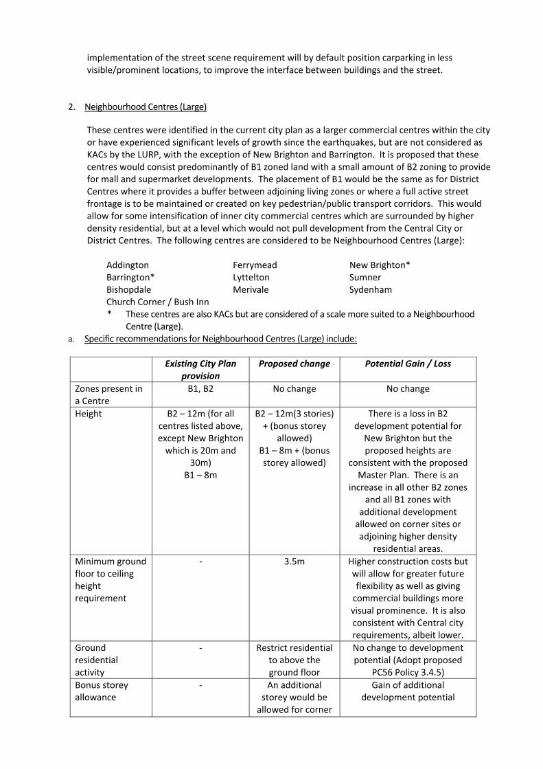
2. Neighbourhood Centres (Large)
These centres were identified in the current city plan as a larger commercial centres within the city or have experienced significant levels of growth since the earthquakes, but are not considered as KACs by the LURP, with the exception of New Brighton and Barrington. It is proposed that these centres would consist predominantly of B1 zoned land with a small amount of B2 zoning to provide for mall and supermarket developments. The placement of B1 would be the same as for District Centres where it provides a buffer between adjoining living zones or where a full active street frontage is to be maintained or created on key pedestrian/public transport corridors. This would allow for some intensification of inner city commercial centres which are surrounded by higher density residential, but at a level which would not pull development from the Central City or District Centres. The following centres are considered to be Neighbourhood Centres (Large):
Addington Ferrymead New Brighton* Barrington* Lyttelton Sumner Bishopdale Merivale Sydenham Church Corner / Bush Inn * These centres are also KACs but are considered of a scale more suited to a Neighbourhood
Centre (Large). a. Specific recommendations for Neighbourhood Centres (Large) include:
Existing City Plan
provision Proposed change Potential Gain / Loss
Zones present in a Centre
B1, B2 No change No change
Height B2 – 12m (for all centres listed above, except New Brighton
which is 20m and 30m)
B1 – 8m
B2 – 12m(3 stories) + (bonus storey
allowed) B1 – 8m + (bonus storey allowed)
There is a loss in B2 development potential for
New Brighton but the proposed heights are
consistent with the proposed Master Plan. There is an
increase in all other B2 zones and all B1 zones with
additional development allowed on corner sites or adjoining higher density
residential areas. Minimum ground floor to ceiling height requirement
- 3.5m Higher construction costs but will allow for greater future flexibility as well as giving
commercial buildings more visual prominence. It is also consistent with Central city requirements, albeit lower.
Ground residential activity
- Restrict residential to above the ground floor
No change to development potential (Adopt proposed
PC56 Policy 3.4.5) Bonus storey allowance
- An additional storey would be
allowed for corner
Gain of additional development potential

Existing City Plan provision
Proposed change Potential Gain / Loss
sites or where a site adjoins a Living
3 zone Plot Ratio B2 – 1.5
B1 – 1.0 Removal of plot
ratio Gain of additional
development potential Positioning of carparking
- Adopt proposed PC56 Policy 3.4.5 to
promote well-defined street
edges
No change to development potential (Adopt proposed
PC56 Policy 3.4.5)
b. Rationale for proposed changes
Many of the reasons given above for District Centres apply to the changes promoted for Neighbourhood Centres (Large) with a view to simplifying the rules while promoting good urban design outcomes. All centres, with the exception of New Brighton will gain development potential, but to a level where it will not be at the expense of a district centre or the central city. All other proposed changes promote good urban design principles, looking to create active edges, well defined street boundaries and a strong interface between the street and buildings. Corner incentives promote creating visual focal points or landmarks, thereby strengthening the visual character of a commercial centre.
3. Neighbourhood Centres (Small)
These centres were identified in the current city plan as being small commercial centres, usually consisting of only B1 land and sometimes including a small area of B2 to provide for a supermarket development. It is recommended that these centres are classified solely as B1 to ensure that if larger developments were to occur in these locations, it could be assessed against more relevant criteria. It would ensure maximum building heights are more relevant to their surrounding context and there is a greater likelihood that the character of ‘main streets’ would be retained with built frontage/street scene requirements.
Akaroa Ilam / Clyde St Martins Avonhead Parklands Sydenham south Edgeware Redcliffs Wairakei/ Greers Fendalton and surrounds Richmond Woolston Halswell Worcester / Stanmore
a. Specific recommendations for Neighbourhood Centres (Small) include:
Existing City Plan
provision Proposed change Potential Gain / Loss
Zones present in a Centre
B1, B2 B1 only, rezoning of existing B2
There would be some perceived loss of development potential but this is offset by the bonus storey allowance.
Height B2 – 12m B1 – 8m
B1 – 8m + (bonus storey allowed)
There is a loss in B2 development potential but
this is offset by the additional development potential
allowed on corner sites or adjoining higher density
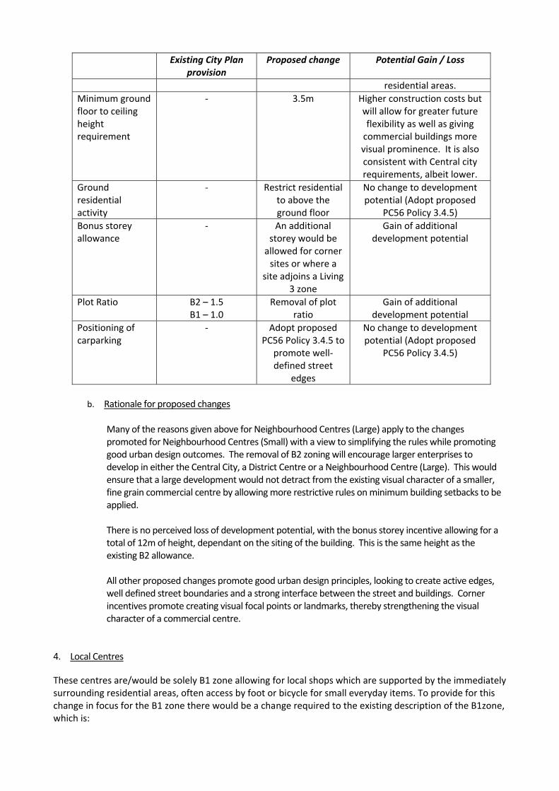
Existing City Plan provision
Proposed change Potential Gain / Loss
residential areas. Minimum ground floor to ceiling height requirement
- 3.5m Higher construction costs but will allow for greater future flexibility as well as giving
commercial buildings more visual prominence. It is also consistent with Central city requirements, albeit lower.
Ground residential activity
- Restrict residential to above the ground floor
No change to development potential (Adopt proposed
PC56 Policy 3.4.5) Bonus storey allowance
- An additional storey would be
allowed for corner sites or where a
site adjoins a Living 3 zone
Gain of additional development potential
Plot Ratio B2 – 1.5 B1 – 1.0
Removal of plot ratio
Gain of additional development potential
Positioning of carparking
- Adopt proposed PC56 Policy 3.4.5 to
promote well-defined street
edges
No change to development potential (Adopt proposed
PC56 Policy 3.4.5)
b. Rationale for proposed changes
Many of the reasons given above for Neighbourhood Centres (Large) apply to the changes promoted for Neighbourhood Centres (Small) with a view to simplifying the rules while promoting good urban design outcomes. The removal of B2 zoning will encourage larger enterprises to develop in either the Central City, a District Centre or a Neighbourhood Centre (Large). This would ensure that a large development would not detract from the existing visual character of a smaller, fine grain commercial centre by allowing more restrictive rules on minimum building setbacks to be applied. There is no perceived loss of development potential, with the bonus storey incentive allowing for a total of 12m of height, dependant on the siting of the building. This is the same height as the existing B2 allowance. All other proposed changes promote good urban design principles, looking to create active edges, well defined street boundaries and a strong interface between the street and buildings. Corner incentives promote creating visual focal points or landmarks, thereby strengthening the visual character of a commercial centre.
4. Local Centres
These centres are/would be solely B1 zone allowing for local shops which are supported by the immediately surrounding residential areas, often access by foot or bicycle for small everyday items. To provide for this change in focus for the B1 zone there would be a change required to the existing description of the B1zone, which is:
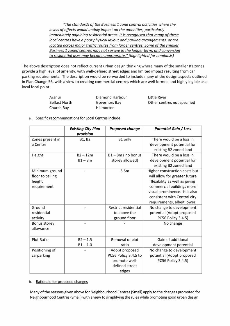
“The standards of the Business 1 zone control activities where the levels of effects would unduly impact on the amenities, particularly immediately adjoining residential areas. It is recognised that many of these local centres have a poor physical layout and parking arrangements, or are located across major traffic routes from larger centres. Some of the smaller Business 1 zoned centres may not survive in the longer term, and conversion to residential uses may become appropriate.” (highlighted for emphasis)
The above description does not reflect current urban design thinking where many of the smaller B1 zones provide a high level of amenity, with well-defined street edges and limited impact resulting from car parking requirements. The description would be re-worded to include many of the design aspects outlined in Plan Change 56, with a view to creating commercial centres which are well formed and highly legible as a local focal point.
Aranui Diamond Harbour Little River Belfast North Governors Bay Other centres not specified Church Bay Hillmorton
a. Specific recommendations for Local Centres include:
Existing City Plan
provision Proposed change Potential Gain / Loss
Zones present in a Centre
B1, B2 B1 only There would be a loss in development potential for
existing B2 zoned land Height B2 – 12m
B1 – 8m B1 – 8m ( no bonus
storey allowed) There would be a loss in
development potential for existing B2 zoned land
Minimum ground floor to ceiling height requirement
- 3.5m Higher construction costs but will allow for greater future flexibility as well as giving
commercial buildings more visual prominence. It is also consistent with Central city requirements, albeit lower.
Ground residential activity
- Restrict residential to above the ground floor
No change to development potential (Adopt proposed
PC56 Policy 3.4.5) Bonus storey allowance
- - No change
Plot Ratio B2 – 1.5 B1 – 1.0
Removal of plot ratio
Gain of additional development potential
Positioning of carparking
- Adopt proposed PC56 Policy 3.4.5 to
promote well-defined street
edges
No change to development potential (Adopt proposed
PC56 Policy 3.4.5)
b. Rationale for proposed changes
Many of the reasons given above for Neighbourhood Centres (Small) apply to the changes promoted for Neighbourhood Centres (Small) with a view to simplifying the rules while promoting good urban design

outcomes. The removal of B2 zoning will encourage larger enterprises to develop in either the Central City, a District Centre or a Neighbourhood Centre (Large). This would ensure that a large development would not detract from the existing visual character of a smaller, fine grain commercial centre by allowing more restrictive rules on minimum building setbacks to be applied. There would be a loss of development potential for existing B2 sites in a local centre, but it is considered that activities such as large supermarkets or larger retail activities which draw on a wider catchment are not appropriate for these smaller centres where there is not the level of infrastructure to support it. By allowing for large development in local centres, it can result in either the inefficient development of infrastructure or adverse effects on the visual character of a centre. All other proposed changes promote good urban design principles, looking to create active edges, well defined street boundaries and a strong interface between the street and buildings.
Anticipated Outcomes – All Centres (in terms of form and scale)
If the recommendations outlined above were implemented, it is anticipated the following outcomes would be achieved over time:
7. Gradual in-fill of sites to utilise the maximum building height, with the removal of the plot ratio for all zones.
8. Well defined main street edges (by buildings). Promotion of zero or maximum building setbacks; 9. Active frontages on designated main streets/arterials, moving away from internally focused malls.
Discouragement of large blank walls facing main streets. 10. Stronger corner definition to create a local landmark using development incentives to allow greater
height/floor space. Promotion of designs which promote strong corner prominence on key intersections. Incentives to allow for additional development space/height on a corner;
11. A gradual shift from a ‘car based, perimeter parking’ design model to a model which is pedestrian / public transport focused.
12. Promotion of carparking being placed behind buildings to create a better interaction between the street and buildings;
13. Promotion of landscape treatment on boundaries facing Living zones.

Commercial Centre Analysis 1. District Centres
Centre KAC (LURP)
Current Zoning
Indicative Classification
Community Facilities
Current Form / Description Does the current zoning fit?
Hornby Y B2/B1 (Map 44)
District Centre
Library Height / Stories Generally 2-3 storey buildings in the B2 zone with roof carparking, approximately 9m in height. B1 zone generally single storey (4m) with the exception of clock tower which is 5-stories (17-20m) Bulk/Scale Generally large scale buildings, strong horizontal form. Set Back The Hub: 32m; Dressmart:0m; Small retail:0m Carparking position in front of buildings on main street frontages with the exception of Dressmart which has parking located at the rear with access off a side road.
There is a large portion of B2 zoning with B1 zoning on the outskirts. B2 does front onto main streets though which has allowed the streetscape to be dominated by expansive carparking and buildings generally set well back from the street edge. The key issue for this centre is trying to achieve a better relationship between buildings and the street, with design controls proposed to influence future in-fill development. To the east is a BRP zone which contains a Countdown, Mitre 10 Mega and other large format retail stores.
Linwood/Eastgate
Y B2/B1
District Centre
Library Height / Stories B2 zone buildings are typically 8-9m in height, with a large entrance canopy extending out into the road reserve. B1 zone, mix of single and two storey retail (4-8m) Bulk/Scale Generally large scale buildings, strong horizontal form. Internally focused buildings with no/few active frontages. Set Back 0m, with the exception of the Warehouse which is orientated towards the carpark and has its service area along the Buckleys Road frontage. Carparking position Behind the mall or on-street
The mall is zoned B2 which is appropriate for the scale of the development. However the mall has a poor relationship to Buckleys Road with large expanses of blank walls. The development turns its back on the adjoining B1 zones.
Papanui/Northlands B2 / B1 Height / Stories Generally 2-3 storey buildings in the B2 zone with a 3 storey carparking building located behind the mall. There is also a large 5 storey commercial building on Winston Ave. B1 zone generally single storey (4m) with fine grain shops Bulk/Scale The B1 zone has fine grain buildings, typically less than 10m wide. Northlands Mall has an internal focus with blank walls facing onto the carpark and main street. Set Back Varies, inconsistent. B1 zone is typically 0m. The mall is set back from Main North Road by a large carpark (approximately 30m) Carparking position B1 – positioned behind buildings with access from side streets. B2 (the mall) – in front. Other B2 – mixed.
Generally the zoning works well with B1 areas providing a strong built form to the street edge. This works well on the Papanui Road section of this centre. Unfortunately, the edge has become diluted with the demolition of a heritage building on the intersection with Harewood Road. Further north the B2 zone immediately abuts Main North Road where the mall is set back approximately 50m from the street, behind four rows of carparking. A more appropriate zoning would be to provide B1 style buildings along this section.
Riccarton Y B2/B1 (Map 38)
District Centre
The library is located at Upper Riccarton
Height / Stories Generally 2-3 storey buildings in the B2 zone with a few four storey buildings (8-16m). The tallest building is the carparking building fronting Clarence St, which is approximately 20m. Bulk/Scale Generally large scale buildings in the mall development with carparking fronting the Maxwell Street frontage. B1 zone is characterised by smaller buildings, typically with shop frontages less than 10m in width. Set Back Generally zero setback along Riccarton Road with the exception of the large surface carpark (see below). The mall development treats Rotherham Street as its main frontage Carparking position B1 – carparking positioned behind buildings; B2 – large carparking buildings accessed from side roads as well as a large surface carpark fronting Riccarton Road and Matipo Streets.
The area of B1 zoning appears to be larger in reality than what is actually zoned in the district plan. There are a high number of businesses, including motels, which give the appearance that the zone is much bigger than it actually is. The B1 zoning along Riccarton Road provides a strong build edge to the corridor and it is important this maintained as new buildings develop. The B2 zone is positioned on the southern side of Riccarton Road but is largely built to the street boundary (with carparking behind). The exception to this is the large surface carpark in front of the mall which faces onto Riccarton Road. It is noticeable that at this location, the quality of the streetscape weakens with a more open character.
Shirley/The Palms Y B2/B1 District Centre
Library Height / Stories B2 - Generally 2-3, 9-16m in height; B1 consists of a Z service station and attached Burger King and a KFC (all single storey).
The B2 zone in the location is much larger than the supporting B1 zone, reflecting the character of the area

Bulk/Scale Strong horizontal form, single structure fronting Marshland Road with few vertical elements. Set Back B1 – Buildings set back from street frontage with the exception of the KFC which directly fronts the street. Carparking position B2 – carparking buildings and surface carparking are positioned in front of the mall.
where the mall is the predominant feature, supported a small number of other businesses. The Palms has a strong internal focus, largely separated from Marshland Road by a multi-level carpark. The parking building stops short of the corner, replaced by a surface carpark and landscape planting on the corner. The mall opens out into a private courtyard at this end with a number of bars and restaurants. There is an internal access road along the front and the mall building does respond to this corner with additional height.
Belfast Y B2 District Centre
To be developed Recommended that the future B1 zoning is used to provide a buffer around B2 where there is a residential boundary or a pedestrian/public transport main street.
Sparks Road Y District Centre
To be developed Recommended that the future B1 zoning is used to provide a buffer around B2 where there is a residential boundary or a pedestrian/public transport main street.
2. Neighbourhood Centres - Large
Centres KAC (LURP)
Zoning Indicative Classification
Community Facilities
Current Form / Description Does the current zoning fit?
Addington B2/B1 (Map 46)
Neighbourhood Centres - Large
Nil Height / Stories Buildings range in height from single storey (older developments) to three-four storey business parks. It should be noted that the business park buildings tend to be sited in the B4 zone. Bulk/Scale Older buildings typically have a finer grain, less than 10m in width. Newer business parks are 15-20m in width or greater, often surrounded by carparking and landscaping Set Back Varied, 0m in some locations but some exceptions such as Burger King, Subways development and car yards. Carparking position Mixed, in front or to the side of buildings.
Since the earthquakes the character of Addington has changed dramatically with a number of new ‘business-park’ style buildings under construction in the B4 zone, adjoin the B1 zone. The B2 zone is located on the southern side of Lincoln Road but is of a similar character to the B1 zone. It is recommended that the zone properties and corresponding rules are changed to reflect the underlying zone. The existing B2 zone could be amended to be B1 as the existing character matches the existing B1 area, ensuring that a strong built edge, with a consistent set back is retained along Lincoln Road.
Barrington B2/B1(Map 46)
Neighbourhood Centres - Large
Library / service centre
Height / Stories 1-2 storey buildings, 5-12m in height. Bulk/Scale Fine grain shops front Barrington Street and Milton St in the B1 Zone Ave but are part of a single mall development. For the most part buildings are single storey with shops being less than 10m in width. The mall has an active edge fronting onto the carpark, the Athelstan St frontage being treated as the back with few windows. The bulk of the building along this frontage has been soften to a degree by the façade treatment. Set Back Generally buildings are built up to the street edge. Carparking position The main carparks are positioned to the side of the mall and off a smaller side street. The main mall entrance has been positioned with direct access off the carpark as opposed to the Barrington Road
Generally the existing zone provisions work well in this location with the B1 zone providing a high level of fine grain retail on the busiest corner (Milton/Barrington) and a strong built edge. There is also sufficient room for buildings to become two storied if there are growth pressures. The weakest part is the corner of Athelstan and Barrington where a small carpark has been positioned on the corner.
Bishopdale B2 (Map 24)
Neighbourhood Centres - Large
Library / service centre
Height / Stories 1-2 storey buildings, 5-9m in height. Internal (outdoor) mall design. Bulk/Scale Fine grain shops front Farrington Ave but are part of a single mall development. For the most part buildings are single storey with shops being less than 10m in width. Set Back Parts of the mall directly front Farrington Ave, but the main part of the mall is positioned behind a large carpark, with a set- back in excess of 50m. Carparking position Carparking is positioned on the main corner of the site and on the
The current zoning currently fits well with the existing character of the mall allowing for a mix of business development. However the current design is weak in terms of corner placement with the mall having a very internal focus (even though it is outdoors).

western side providing direct access to the library. Church Corner / Bush Inn
B2 (predominantly)/ B1 (southeast corner)(Map 38)
Neighbourhood Centres - Large
Height / Stories 1-2 storey buildings, 8-9m in height. Bulk/Scale Fine grain shops along Riccarton Road, north of Waimari Road. Bush Inn and Countdown are large scale buildings with a strong horizontal form. A row shops has recently been developed extending out from the mall (facing onto the carpark) providing an active edge. Set Back The Bush Inn and Countdown both have large setbacks in excess of 50m. Corner definition is provided though by the Bush Inn Hotel. West of Waimari Road there is a strong street definition with buildings built up to the street boundary and parking behind Carparking position Carparking is positioned at the front of building generally (Bush Inn and Countdown).
The current zonings reflect the character of development at Church Corner with the exception of the block between Waimari Road and Brake Street which is more in keeping with the B1 zone rules. In this location there is a strong built edge with carparking located behind, accessed from smaller local streets. The existing Bush Inn Hotel provides a strong corner lankmark but has been redeveloped to face internally into the carpark. A recommended change to assist with reducing/retaining zero set backs and creating a strong built edge would be to rezone the block between Waimari and Brake to B1 as well as looking at the lots fronting Riccarton Road (in front of the Bush Inn Centre and Countdown.
Ferrymead B2/B4 (Map 48)
Neighbourhood Centres - Large
Height / Stories Generally single storey warehouse style building, 10-12m, smaller single storey building fronting Ferry Road Bulk/Scale Large scale buildings, Countdown (demolished) and Mitre 10 mega Set Back Large setbacks, generally in excess of 50m. There is no consistent building line with most building surrounded by carparking. Carparking position Carparking is positioned around all sides of buildings.
The character of Ferrymead is more influenced by development which has occurred in the surrounding B4 zones than the B2 zone. It is notable that there is no B1 zoning in this location supporting the B2 zone resulting in large setbacks and a poor interface between developments and the street (Ferry Road). A possible option would be to rezone the allotment fronting Ferry Road to B1 to create a better defined street edge.
Lyttelton Town Centre
Neighbourhood Centres - Large
Library / service centre
Merivale B2/B1 Neighbourhood Centres - Large
Nil Height / Stories 1-2 storey buildings, about 60% two storey. 4-12m Bulk/Scale Fine grain shops facing Papanui Road, buildings typically less than 10m wide. Mall positioned behind shops with relatively narrow entrance. Set Back 0m setback Carparking position Behind main street frontage with access from Office and Aikmans Road
The current zoning works well with B1 zone providing a well-defined street edge along Papanui Road as the principle pedestrian/public transport route. The B2 zone is positioned behind the mall with carparking further to the rear, feed from adjoin side roads. There is pressure on the current B1 zoning with businesses starting to encroach into residential zones along Papanui Road.
New Brighton Y B2/B1 (Map
Neighbourhood Centres - Large
Library Height / Stories Predominantly single storey buildings, 4-8m. Library is a major local landmark Bulk/Scale Fine grain shops facing the main pedestrian street, buildings typically less than 10m wide. The supermarket is positioned behind shops with relatively narrow entrance onto the main street. Set Back 0m setback but gaps. Carparking position On street parking or located on side roads
Sumner B2/B1 Neighbourhood Centres - Large
Sydenham B2 (Map 46)
Neighbourhood Centres - Large
Height / Stories Predominantly two buildings up to 9m in height, with two 4-5 storey buildings up to 20m in height Bulk/Scale Predominantly fine grain shops facing the main pedestrian street, with the
Prior to the demolition of a large number of heritage buildings along Colombo Street, the current zoning provisions worked well as the heritage buildings provided a
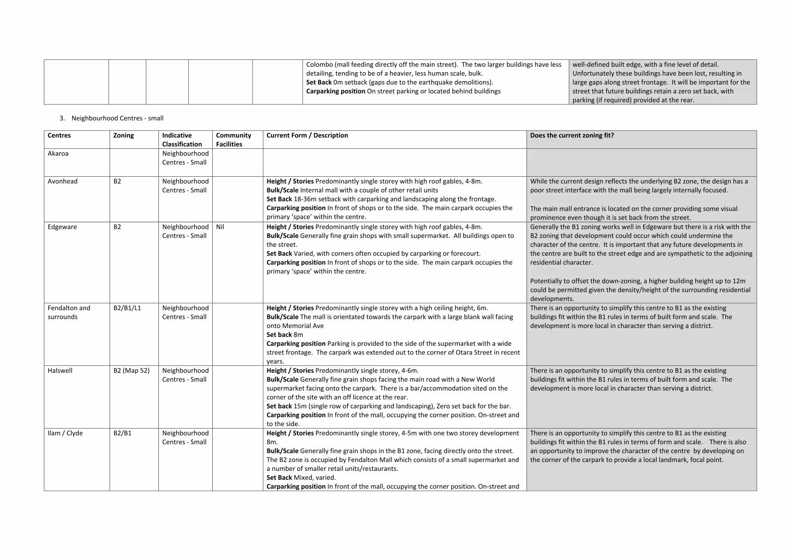
Colombo (mall feeding directly off the main street). The two larger buildings have less detailing, tending to be of a heavier, less human scale, bulk. Set Back 0m setback (gaps due to the earthquake demolitions). Carparking position On street parking or located behind buildings
well-defined built edge, with a fine level of detail. Unfortunately these buildings have been lost, resulting in large gaps along street frontage. It will be important for the street that future buildings retain a zero set back, with parking (if required) provided at the rear.
3. Neighbourhood Centres - small
Centres Zoning Indicative Classification
Community Facilities
Current Form / Description Does the current zoning fit?
Akaroa Neighbourhood Centres - Small
Avonhead B2 Neighbourhood Centres - Small
Height / Stories Predominantly single storey with high roof gables, 4-8m. Bulk/Scale Internal mall with a couple of other retail units Set Back 18-36m setback with carparking and landscaping along the frontage. Carparking position In front of shops or to the side. The main carpark occupies the primary ‘space’ within the centre.
While the current design reflects the underlying B2 zone, the design has a poor street interface with the mall being largely internally focused. The main mall entrance is located on the corner providing some visual prominence even though it is set back from the street.
Edgeware B2 Neighbourhood Centres - Small
Nil Height / Stories Predominantly single storey with high roof gables, 4-8m. Bulk/Scale Generally fine grain shops with small supermarket. All buildings open to the street. Set Back Varied, with corners often occupied by carparking or forecourt. Carparking position In front of shops or to the side. The main carpark occupies the primary ‘space’ within the centre.
Generally the B1 zoning works well in Edgeware but there is a risk with the B2 zoning that development could occur which could undermine the character of the centre. It is important that any future developments in the centre are built to the street edge and are sympathetic to the adjoining residential character. Potentially to offset the down-zoning, a higher building height up to 12m could be permitted given the density/height of the surrounding residential developments.
Fendalton and surrounds
B2/B1/L1 Neighbourhood Centres - Small
Height / Stories Predominantly single storey with a high ceiling height, 6m. Bulk/Scale The mall is orientated towards the carpark with a large blank wall facing onto Memorial Ave Set back 8m Carparking position Parking is provided to the side of the supermarket with a wide street frontage. The carpark was extended out to the corner of Otara Street in recent years.
There is an opportunity to simplify this centre to B1 as the existing buildings fit within the B1 rules in terms of built form and scale. The development is more local in character than serving a district.
Halswell B2 (Map 52) Neighbourhood Centres - Small
Height / Stories Predominantly single storey, 4-6m. Bulk/Scale Generally fine grain shops facing the main road with a New World supermarket facing onto the carpark. There is a bar/accommodation sited on the corner of the site with an off licence at the rear. Set back 15m (single row of carparking and landscaping), Zero set back for the bar. Carparking position In front of the mall, occupying the corner position. On-street and to the side.
There is an opportunity to simplify this centre to B1 as the existing buildings fit within the B1 rules in terms of built form and scale. The development is more local in character than serving a district.
Ilam / Clyde B2/B1 Neighbourhood Centres - Small
Height / Stories Predominantly single storey, 4-5m with one two storey development 8m. Bulk/Scale Generally fine grain shops in the B1 zone, facing directly onto the street. The B2 zone is occupied by Fendalton Mall which consists of a small supermarket and a number of smaller retail units/restaurants. Set Back Mixed, varied. Carparking position In front of the mall, occupying the corner position. On-street and
There is an opportunity to simplify this centre to B1 as the existing buildings fit within the B1 rules in terms of form and scale. There is also an opportunity to improve the character of the centre by developing on the corner of the carpark to provide a local landmark, focal point.

to the side. Parklands B2 Neighbourhood
Centres - Small
Redcliffs B2/B1 Neighbourhood Centres - Small
Richmond B2/B1 (Maps 33,40)
Neighbourhood Centres - Small
St Martins B2 Neighbourhood Centres - Small
Sydenham south B1/B4/L3 Neighbourhood Centres - Small
Wairakei/ Greers B2/B1 (Map 31)
Neighbourhood Centres - Small
Nil Height / Stories Predominantly single storey, 4-5m. Bulk/Scale Generally fine grain shops with small supermarket and applicance store. All buildings open to the street. Set Back Zero setback with the exception of one corner where carparking is located and one corner is a residential dwelling (L1 zone) Carparking position On-street with angle parking provided.
There is an opportunity to simplify this centre to B1 as the existing buildings fit within the B1 rules in terms of form and scale. There is a good street interface and the centre would benefit from commercial development all four corners.
Woolston B2/B1 (Map 47)
Neighbourhood Centres - Small
Height / Stories Mix of single and two storey buildings, 4-8m. Bulk/Scale Generally fine grain shops with small supermarket and storehouse style buildings. All buildings open to the street. Set Back Mixed, varied. Carparking position In front of buildings, to the side and to the rear.
The centre has been greatly affected by the earthquake and the loss of heritage buildings which provided a good sense of place to the streetscape. There is little difference between the character, in terms of form and scale, of the buildings in the B1 and B2 zones. It is recommended these could be simplified into a single B1 zone, with the hope that this would achieve a better street-building interface.
Worcester / Stanmore
B2(east side of Stanmore)/B1 (Map 40)
Neighbourhood Centres - Small
Height / Stories Mix of single and two storey buildings, 4-8m. Bulk/Scale Generally fine grain shops with small supermarket and storehouse style buildings. All buildings open to the street. Set Back Zero, all corners are built up to the street edge Carparking position To the rear and side of buildings
The centre has been greatly affected by the earthquake with the loss of a number of the larger, two storey buildings which gave the village its character. With their loss there is the potential for the well defined street scene to be lost, with inappropriate development. It is recommended that this centre is simplified into a single B1 zoning which will promote a good street-building interface.
4. Large format centre
Centres KAC (LURP)
Zoning Indicative Classification
Community Facilities
Current Form / Description Does the current zoning fit?
Belfast Northwood / Supa centa
BRP and L1 Height / Stories Predominantly two buildings up to 9m in height, with two 4-5 storey buildings up to 20m in height Bulk/Scale Predominantly fine grain shops facing the main pedestrian street, with the Colombo (mall feeding directly off the main street). The two larger buildings have less detailing, tending to be of a heavier, less human scale, bulk. Set Back 0m setback (gaps due to the earthquake demolitions). Carparking position On street parking or located behind buildings

Related Documents