MEADE COUNTY, KENTUCKY SUBDIVISION REGULATIONS Prepared For and By MEADE COUNTY PLANNING COMMISSION July 15, 1999 (As amended) This is a transcript of the Meade County Subdivision Regulation enacted on July 15, 1999 by the Meade County Planning Commission which incorporates all changes and amendments to date as of May 31, 2011 . The Official copy of this document and the incorporated amendments is recorded in the Office of the Meade County Clerk, 516 Hillcrest Drive, Brandenburg, KY 40108. SECTION I INTRODUCTION 1.1 Title This regulation shall be known as and cited as the MEADE COUNTY SUBDIVISION REGULATIONS. 1.2 Purpose: The purpose of these regulations is to protect the public health, safety, convenience and general welfare of the citizenry and to establish rules and standards to guide and integrate land subdivision within Meade County in order to ensure orderly growth and development by implementing or facilitating the provisions in the Meade County Comprehensive Plan, Meade County Zoning Ordinance and the Meade County Zoning District Map. 1.3 Authority: Pursuant to the authority granted by the State of Kentucky to cities and counties by the Kentucky Revised Statutes (KRS) 100.273 to 100.291 and 100.334 and upon adoption of these regulations, the Meade County Planning Commission does hereby exercise the power and authority to review, approve and disapprove plats for the subdivision of land. 1.4 Jurisdiction: The rules contained herein governing the subdivision of land shall be applicable within unincorporated areas of Meade County. 1.5 Fees: Reasonable fees sufficient to recover incurred costs may be charged by the Meade County Planning Commission. 1.6 Future Updates When necessary to further its purposes, this ordinance shall be amended by the Meade County Planning Commission. 1.7 Interpretation, Conflict, and Separability Clause 1. In their interpretation and application, the provisions of this regulation shall be held to the minimum requirements. More stringent provisions may be required if it is demonstrated that different standards are necessary to promote the public health, safety and welfare. 2. Where the conditions imposed by any provisions of this ordinance are either more restrictive or less restrictive than comparable conditions imposed by any other provisions of this regulation or of any applicable law, ordinance, resolution, rule, or regulation of any kind, the regulations which are more restrictive and impose higher standards or requirements shall govern. 3. The provisions of this regulation are separable. If a section, sentence, clause, or phrase of this regulation is adjudged by a court of competent jurisdiction to be invalid, the decision shall not affect the remaining portions of this regulation.

Welcome message from author
This document is posted to help you gain knowledge. Please leave a comment to let me know what you think about it! Share it to your friends and learn new things together.
Transcript

MEADE COUNTY, KENTUCKY
SUBDIVISION REGULATIONS
Prepared For and By
MEADE COUNTY PLANNING COMMISSION
July 15, 1999 (As amended)
This is a transcript of the Meade County Subdivision Regulation enacted on July 15, 1999 by the Meade
County Planning Commission which incorporates all changes and amendments to date as of May 31,
2011. The Official copy of this document and the incorporated amendments is recorded in the Office
of the Meade County Clerk, 516 Hillcrest Drive, Brandenburg, KY 40108.
SECTION I
INTRODUCTION
1.1 Title This regulation shall be known as and cited as the MEADE COUNTY SUBDIVISION REGULATIONS.
1.2 Purpose: The purpose of these regulations is to protect the public health, safety, convenience and
general welfare of the citizenry and to establish rules and standards to guide and integrate land
subdivision within Meade County in order to ensure orderly growth and development by implementing
or facilitating the provisions in the Meade County Comprehensive Plan, Meade County Zoning Ordinance
and the Meade County Zoning District Map.
1.3 Authority: Pursuant to the authority granted by the State of Kentucky to cities and counties by the
Kentucky Revised Statutes (KRS) 100.273 to 100.291 and 100.334 and upon adoption of these
regulations, the Meade County Planning Commission does hereby exercise the power and authority to
review, approve and disapprove plats for the subdivision of land.
1.4 Jurisdiction: The rules contained herein governing the subdivision of land shall be applicable within
unincorporated areas of Meade County.
1.5 Fees: Reasonable fees sufficient to recover incurred costs may be charged by the Meade County
Planning Commission.
1.6 Future Updates When necessary to further its purposes, this ordinance shall be amended by the
Meade County Planning Commission.
1.7 Interpretation, Conflict, and Separability Clause
1. In their interpretation and application, the provisions of this regulation shall be held to the minimum
requirements. More stringent provisions may be required if it is demonstrated that different standards
are necessary to promote the public health, safety and welfare.
2. Where the conditions imposed by any provisions of this ordinance are either more restrictive or less
restrictive than comparable conditions imposed by any other provisions of this regulation or of any
applicable law, ordinance, resolution, rule, or regulation of any kind, the regulations which are more
restrictive and impose higher standards or requirements shall govern.
3. The provisions of this regulation are separable. If a section, sentence, clause, or phrase of this
regulation is adjudged by a court of competent jurisdiction to be invalid, the decision shall not affect the
remaining portions of this regulation.

SECTION II
DEFINITIONS
2.1 Interpretation
For the purposes of these regulations, certain terms or words used herein shall be interpreted as
follows. All words used in the present tense include the future tense. All words used in the singular
include the plural, and all words in the plural include the singular. The word “shall” is mandatory. The
word “used” shall be deemed to include “designed, intended, or arranged to be used.” The word
“building” shall include structure.
2.2 Definition of Terms
Unless otherwise specifically provided, or unless clearly required by the context, the words or phrases
defined in this section shall have the meaning indicated when used in these regulations.
Administrative Official: any department, employee, advisory, elected or appointed body which is
authorized to administer any provision of the Subdivision Regulations.
ADT: Average Daily Traffic - the average number of vehicles per day that pass over a given point.
Agricultural Use (farm): the use of a tract of land of at least five (5) contiguous acres for the production
of agricultural or horticultural crops, including but not limited to livestock, livestock products, poultry,
poultry products, grain, hay, pastures, soybeans, tobacco, timber, orchard fruits, vegetables, flowers or
ornamental plants, including provision for dwellings for persons and their families who are engaged in the above agricultural use on the tract, but not including residential building development for sale or lease to the public. Alley: any public or private way used for public travel, which is twenty (20) feet, or less in width. Block: a unit of property entirely surrounded by public highways, streets, railroad rights-of-way, waterways, public parks, cemeteries corporate boundary lines or other barriers (except alleys or crosswalks) or any combination thereof. Buffering: the landscaping of an area intended to separate and partially obstruct the view of two adjacent land uses or properties from one another. Building Line (Building Setback Line): a line, parallel to the property line adjoining the street, beyond, which a building cannot extend. It denotes the location of the front yard or street side yard. Clear Sight Triangle: a triangular-shaped portion of land established at street intersections in which nothing is allowed to be placed in such a manner as to limit or obstruct the sight distance of motorists entering or leaving the intersection. Commission: the Meade County Planning Commission. Comprehensive Plan: Meade County Comprehensive Plan as adopted by the Commission. Construction: The act of clearing, dredging, excavating and grading of land associated with buildings, structures or other types of real property such as bridges, dams and roads.
Constructed: The state of construction where all activities associated with the construction of a structure, building or other real property such as bridges, dams and roads are complete and placed into final service. Construction Plan: a document prepared by an engineer showing how the physical improvements for a subdivision are to be constructed. County Clerk: the County Clerk of Meade County. Cul-de-sac: a short, local street having one end open to traffic and the other end permanently terminated by a vehicular turnaround. Dedication: the transfer or appropriation of property from private to public ownership. Deed Restrictions: private legal restrictions on the use of land contained in the deed to the property and/or otherwise formally recorded in the County Clerk’s Office. Design: the arrangement of land for lots, rights-of-way, easements, setback lines and improvements to include alignment, grade, length and width of these elements. Developer: the legal or beneficial owner or owners of a lot or any land included in a proposed development. Also, the holder of an option or contract to purchase, or any other person having enforceable proprietary interest in such land. Dimensional Variance: a departure from the terms of the subdivision regulations pertaining to width, depth or area of lots or setback lines where such departure will not be contrary to the safety and convenience of the general public or the intent of the Subdivision Regulations. Drainage Right-of-Way: the land required for the installation of storm water sewers or drainage ditches providing for the flow of water within a natural stream or from surface runoff to safeguard the public against flood damage. Easement: a grant by the property owner of the use of a strip of land for a specific purpose by the general public or utility companies. Engineer: a person licensed to practice engineering by the Commonwealth of Kentucky. Exempt Agricultural Operation: Any use of of land that falls within the parameters of KRS Chapter 413.072. Floodplain: an area susceptible to being inundated with water from a flood having a one percent chance of being equaled or exceeded in any given year (a 100 year flood). Flood-Hazard Area: all land subject to periodic inundation by the overflow of natural waterways. Health Department: the commonwealth of Kentucky or Meade County Health Department. Homeowners Association: a formally constituted nonprofit association or corporation made up of property owners and/or residents of a fixed area. It may take permanent responsibility for costs and upkeep of private or semiprivate community facilities. Improvements: the totality of grading, crosswalks, culverts, bridges, sanitary or storm sewers, water mains, street pavements, curbs and gutters, pedestrian ways, or all other appropriate

improvements required to render land use suitable for the proposed use. Legislative Body: the chief body of the County, (Fiscal Court). I&: a plotted parcel of land devoted to a common use or occupied by a single principal building and its accessory structures having its principal frontage upon a public, improved street or road. Corner Lot: a lot situated at the intersection of two (2) or more streets or roads. Lot Depth: the horizontal distance between front and rear lot lines measured along the median between the two (2) side lot lines. Lot Width: the horizontal distance between the side lot lines measured at right angles to the lot depth at a point midway between the front and rear lot lines. Monument: an object (concrete, iron pin or pipe) set in the ground to mark the boundaries of real estate or to mark a survey station. the map of a subdivision. Plat. Preliminary: a map or plan of a proposed land subdivision containing the information and materials specified in Section 5.1. Plat, Final (Record Plat): the record plat of a subdivision prepared by a certified land surveyor in accordance with the requirements of Section 5.2. Also known as the final map of all or a portion of a subdivision which is presented for final approval and recording. Public Sanitary Sewer: A common sewer controlled by a governmental agency or public utility. In general, the public sewer shall include the main sewer in the main utility right-of-way and the service branch to the property line, or a main sewer on private property and the service branch to the extent of ownership by public authority. Public Sanitary Sewer also includes properly approved and constructed cluster and cluster-type septic systems, the maintenance of which has been assumed in writing by a government agency or public utility. Combination Plat: a plat required to combine two or more previously recorded lots (or portions thereof) for the purpose of eliminating interior lot lines. All pertinent easements must be released or eliminated in writing by the appropriate utility companies or interested parties. Public Improvements: construction associated with subdivision development of a public or semipublic nature, involving the construction of public streets and private roads, drainage improvements, soil and erosion control features, sidewalks, and electric, water and sewer services and lines. Right-of-Way: the land opened or dedicated for a street, road, sidewalk, drainage way, railroad or other public purpose (refer to section 6.4). Setback Line: that line that is the minimum required distance from the street right-of-way line or any other lot line that establishes the area within which the principal and accessory structures must be erected or placed. Sinkhole: a depression caused by natural subsurface drainage conditions (karst topography). Such depressions have regulations pertaining to them enforced by the County Health Dept. Shall: the word “shall” as herein used is always mandatory and not merely directory.
Street: any vehicular way that: 1) is an existing federal, state, or Meade County (shown on the County Road map as adopted by the Meade County Fiscal Court) roadway; or (2) is shown upon a plat approved by the Meade County Planning Commission pursuant to subdivision regulations and recorded in the Meade County Clerk’s Office, or is approved by official action of a court of competent jurisdiction; or (3) is shown on a plat duly filed and recorded in the Office of the Meade County Clerk’s Office prior to the adoption of the Meade County Subdivision Regulations July 15, 1999) and has been adopted by Meade County Fiscal Court. Street includes the land between the rights-of-way lines. The term road is synonymous with the term Street.
Approved Street: any vehicular way approved by the Planning Commission as providing access to a lot included in this definition are: Public streets/road: roads dedicated to the public use, constructed to the Meade County Road Standards as adopted by the Meade County Fiscal Court and which are to be maintained by a public governmental body. Private street/road: a pass way, built to the standards set forth in the Meade County Road Standards as adopted by the Meade County Fiscal Court, and providing access to three (3) or more lots. Previously recorded private road: a road that was previously recorded as private on a record plat recorded in the Meade County Clerk’s Office prior to the adoption of the Meade County Subdivision Regulations July 15, 1999, which is maintained by the property owners that front the street, but may might not meet current county road standards. Arterial Street: streets serving the major traffic movements entering, leaving or moving within an area. The principal function is to move traffic and, in cases of high traffic volumes, requires limited access or controlled points of access. Access to property is of secondary importance. These streets are normally characterized by traffic controls and parking restrictions. Arterial streets are further divided into two (2) classes, “principal” and “minor”. Principal arterial streets carry the major portion of trips entering and leaving the urban areas, as well as the majority of through movements through or around the urban area. Minor arterial streets interconnect with and augment the principal arterial streets and provide service for trips of moderate length at a somewhat lower level of average daily traffic (ADT). Collector Street: streets which provide for traffic movement between arterials and local streets and direct access to abutting properties. Local Street: a street designed to provide vehicle access to abutting properties and designed to discourage through traffic. Continuous, cul-de-sac, dead end, loop, and service (also called access) streets and alleys are classified as local streets. Alley: a service roadway providing a secondary means of public access to abutting property and not intended for general traffic circulation. Continuing street: local streets having two open ends; each and generally connected with different streets; one or more other streets may intersect it between its two open ends; and property fronting on both sides of the street. Cul-de-sac Street: a Street with a single common ingress and egress and with a turnaround at the end.
Dead end Street: a street with a single common ingress and egress without a turnaround at the end. Dead end streets are not permitted as a street in any provision of the subdivision regulations. Stub streets with temporary turnarounds, planned for future continuation, are not considered to be dead end streets. Loop Street: a local street that has its only ingress and egress at two points on the same collector street. Service or access Street: a street running parallel to an arterial or collector street and serving abutting properties.
Subdivider: the owner or authorized agent for the owner of a subdivision. Subdivision: the division of a deeded piece of land into three or more lots since March 1, 1998, for the purpose, whether immediate or future of sale, lease, or building development, or if a new public or private roadway is involved, any division of a parcel of land; provided that a division of land for agricultural use and not involving a new public or private street shall not be deemed a subdivision. The term includes resubdivision and when appropriate to the context, shall relate to the process of subdivision or to the land subdivided; any division or redivision of land into parcels of less than one (1) acre occurring within twelve (12) months following a division of the same land shall be deemed a subdivision within the meaning of this section. Any division of land where the purpose is sale, lease or building development or where the parcel being divided is part of a previously recorded subdivision of land. Major Subdivision: a subdivision of land into six or more lots, or any subdivision involving a new public street or new private road. Minor Subdivision: a subdivision of land into not more than five lots, and not involving a new public street or new private road, and: 1 .conveys the right-of-way necessary for road widening and maintenance of county roads, where the granting of such right-of-way can be given without undue hardship. Surety: a financial guarantee to ensure that all improvements, facilities or work required by these regulations will be completed in compliance with the regulations and the approved plans and specifications of the development. Surveyor: a person licensed to practice land surveying by the Commonwealth of Kentucky. Variance: a device which grants a property owner relief from certain provisions of the zoning ordinance where such action will not be contrary to the public interest and where, owing to conditions peculiar to the property and not the result of the actions or the situation of the property owner, a literal enforcement of the ordinance would result in unnecessary and undue hardship (granted by either the Board of Adjustment or Planning Commission). Waiver: a relaxation by the Commission of certain provisions of the subdivision regulations where such action will not be contrary to the public interest and where justification due to extreme hardship, or design innovation and large scale development can be demonstrated. Zoning Ordinance: Meade County Zoning Ordinance as approved by the legislative body.

SECTION III GENERAL REQUIREMENTS 3.1 Subdivision of Land No person or his agent shall subdivide any land within the regulated limits before securing the approval of the Commission of the plat designating the areas to be subdivided. The division or combination of any parcel of land that is part of a recorded subdivision must be documented by a Revised or Amended Plat, prepared and certified in accordance with this regulation for minor or major plats as appropriate and recorded in the Office of the Meade County Clerk.(Rev.09.01) 3.2 Recording of Plats No plat of a subdivision of land within the jurisdiction of this regulation shall be recorded by the Meade County Clerk until the plat has been approved by the Commission and the approval entered thereon in writing by the Chairman, Secretary or other duly authorized officer of the Commission. 3.3 Sale Prior to Approval of Final Plat No person owning land composing a subdivision, or his agent, shall transfer, sell or agree to sell any lot or parcel of land located within a subdivision by reference to, or by exhibition, or by any other use of a plat of such subdivision before such plat has received final approval of the Commission and has been recorded. Any such instrument of transfer sale or contract shall be void and shall not be subject to be recorded, but all rights of such purchaser to damages are hereby preserved. The description of such lot or parcel by metes and bounds in any contract or instrument of transfer or other document used in the process of selling or transferring same shall not exempt the person attempting to transfer from penalties provided or deprive the purchaser of any rights or remedies he may otherwise have. 3.4 Injunction The Commission shall have the power to apply for an injunction against any type of subdivision construction by a subdivider or a landowner in violation of the provisions of this regulation. 3.5 Improvements No improvements, such as sidewalks, water supply system, storm water drainage, sewerage lines and treatment facilities, gas service, electric service or street lighting, or grading, paving, or surfacing of any street shall be made within any such subdivision by any owner or owners or his or their agent, or by any public service corporation at the request of said owner or owners or by his or their agent until the plats for the subdivision and the plans for the improvements have been properly reviewed and approved by the Commission. 3.6 Development in Phases Where a tract of land is proposed to be subdivided in several stages over a period of years and the subdivider requests approval in parts, he shall, at the time of submission of the first part, submit a preliminary plan of the entire tract to be eventually developed, with appropriate sectioning to demonstrate to the Commission that the total design as proposed for the entire subdivision is feasible. The Commission shall give preliminary approval or disapproval to the overall plan and final approval or disapproval on the parts as submitted from time to time. In the event of disapproval of the overall plan or any part or parts thereof, the action shall be written upon the record of the Commission stating the specific regulation or regulations of
nonconformance. 3.7 Remainder Surveys (residual tracts) Where a portion of a large tract of land 15 acres or greater is being subdivided or developed per this regulation, that remaining 10 acres or greater shall not be required to be surveyed and platted as long as it exceeds the requirements contained in the zoning ordinance and/or health department requirements. A note regarding the specific size and frontage of the residual tract shall be placed on the record plat. Access to the residual tract shall be verified prior to plat submittal. Residual tracts smaller than 10 acres must be surveyed and platted. 3.8 Land Surveys All land surveyed and platted under this regulation shall conform to the Standards of Practice per the Commonwealth of Kentucky - Kentucky Administrative Regulations (KAR) and Kentucky Revised Statutes (KRS). As of June 1999 KRS 322 and 201 and KAR 18.150.
SECTION IV PROCEDURES 4.0: General Procedures for All Subdivisions of Land: 4.0(1): The Meade County Planning Commission, pursuant to KRS Chapter 100.281, shall be empowered to hear and finally decide applications variances when a proposed development requires a subdivision and one (1) or more variances. 4.0(2): The Meade County Planning Commission shall assume all powers and duties otherwise exercised by the Board of Adjustments pursuant to KRS chapter 100.231, 100.233, 100.237, 100.241, 100.247 and 100.251 where the the conditions in section 4.0(1) apply.
4.0(3): The applicant for a subdivision where a variance is required may elect, at the time the
application for subdivision is submitted, to have the Planning Commission hear and finally
decide the variance at the same public hearing set for the subdivision or by the board of
adjustments as otherwise provided by law. 4.1 Minor Subdivisions
A. All subdivision of land shall be subject to the preliminary and final plat requirements presented herein except where a subdivision is deemed a minor subdivision, or with the exception of the divisions for agricultural use of a tract that existed prior to March 1, 1998 (recorded in the Meade County Clerk’s Office prior to that date), and that the division does not require the construction of a private or public road or Street, per the definitions (such an exception must follow the final plat approval procedure). Such a division must meet current subdivision regulations. B. Upon request by the subdivider, a subdivision may be classified as a minor subdivision by the Commission as defined in Section II. C. Upon meeting the requirements established in Section II or 4.1 B, the subdivider may follow the final plat procedure presented in 4.3 & 5.2. D. The owner or subdivider of land that has been subject of at least four (4) minor divisions (resulting in the creation of five (5) lots, including the parent tract) shall be required hereafter to comply with the provisions pertaining to preliminary and final plats. E. Combination Plats must follow the final plat procedure presented in 4.3 & 5.2.
4.2 Preliminary Plat
A. it is suggested that the subdivider should meet and consult informally with the Commission or its administrative official or planning director prior to the preparation of a preliminary pint for familiarization with these regulations and to ascertain the location of proposed major streets, water and sewer systems and other pertinent public facilities.
B. The preliminary plat shall be prepared by a licensed land surveyor in accordance with the format design and improvement requirements of these regulations. All required engineering data shall be prepared by a licensed professional engineer. Utility companies and other concerned city and county agencies shall be consulted prior to the preparation of the preliminary plat. C. Eight (8) copies of the preliminary plat and supplementary materials specified in Section V shall be submitted to the Commission with a written application (secured from the Administrative Official) and fees a minimum of thirty (30) working days prior to the meeting at which the preliminary plat is to receive consideration. D. The Commission shall review the preliminary plat and supplementary materials for conformity with these regulations and within forty-five (45) days approve, approve with conditions or disapprove said plat. Failure of the Commission to act on the preliminary plat within forty-five (45) days shall constitute approval. E. The action of the Commission regarding the preliminary plat shall be recorded in the minutes of the meeting. The Commission may authorize the administrator to approve the final plat for recording when submitted or when all conditions are met.
4.3 Final Plat
A. The final plat shall be prepared by a licensed land surveyor and all required engineering data shall be prepared by a licensed professional engineer in accordance with these regulations subject to all conditions placed upon the preliminary plat by the Commission. B. Eight (8) copies of the final pint, supplementary materials specified in Section V, and a fee sufficient to record the final plat shall be submitted to the administrator or planning director a minimum of thirty (30) working days prior to the meeting at which the final plat is to receive consideration. C. The administrator or planning director shall have up to thirty- (30) working days to either approve or disapprove the final plat. D. The administrative official or planning director shall review the final plat and supplementary materials for conformity with these regulations and the conditions for approval placed on the preliminary pint by the Commission. The administrative official shall approve the final pint only if the subdivider has met all of the regulations pertaining to the final plats and all the conditions for approval placed on the preliminary plat by the Commission. E. The action of the Commission regarding the final pint shall be recorded in the minutes of the meeting and for final plats receiving approval; the appropriate signatures shall be a1lxed to three (3) copies of the final plat. One (1) signed copy of the final plat shall be retained by the commission, one (1) signed copy shall be returned to the subdivider and one (1) signed copy shall be forwarded to the appropriate legislative body. F. The administrator shall notify the subdivider in writing, of the decision to approve or deny the final plat. If the decision is denial of the final plat, the administrative official shall set out the reasons for denial in the notice to the subdivider and reimburse the subdivider of the recording fee.
G. The subdivider may appeal in writing to the Commission, the decision of disapproval by the administrative official. The appeal shall state the reasons for the appeal and the reasons why the Commission should reverse the decision of the Administrative Official and grant approval of the final plat. The appeal, with a fee sufficient to record the final plat, shall be submitted ten (10) days after the Commission meeting at which the denial of final plat took place. H. The action of the administrative official regarding the final plat shall be reported to the Commission at its next meeting and shall be recorded in the minutes of the meeting. When the final pint is approved, the appropriate signatures shall be affixed to three (3) copies of the final pint. One (1) signed copy of the final plat shall be retained by the Commission, one (1) signed copy shall be retained to the subdivider and one (1) signed copy shall be forwarded to the appropriate legislative body. I. One copy of the final plat shall be filed for recording by the administrative official in the Office of the County Clerk within ten (10) days after approval of said final plat by the Commission. J. Approval by the Commission of the final plat shall not constitute the acceptance by the applicable legislative body of the dedication of any streets, roads or grounds, unless the streets, roads or grounds meet or exceed or are constructed to meet the Meade County Road requirements or applicable requirements.
4.4 Additional procedures for Subdivision Improvements: The following additional documentation is required prior to construction on all subdivision improvements which begins subsequent to June 15, 1999. Improvements which require permitting include Water Lines, Public Sewage Disposal Systems, Roadways and pre-positioned electric infrastructure. Developers of subdivisions platted prior to adoption of these requlations in which construction has not commenced shall be required to submit appropriate design plans for approval according to the procedures for minor plats.
4.4(a): Improvement Construction Permits Required: Prior to commencing any construction or excavation for the construction of a proposed roadway the developer shall obtain a construction permit from the administrative official. 4.4(b): Additional Documents Required for Road Construction Permit: The following prerequisite documents are required for issuance of a road construction permit:
4.4.(b)(1): Recorded subdivision plat 4.4.(b)(2): Notice of Intent filed with the Kentucky Environmental Cabinet 4.4.(b)(3): Road Design Plan. For subdivisions platted prior to adoption of the Meade County Subdivision Regulations a road plan must be prepared in accordance with the procedures and specification contained in the Subdivision Regulations and submitted according to the procedures for Minor Plat Approval to the administrator of the Planning Commission. No permit for road construction may be issued unless the road plan has been reviewed and accepted by the Meade County Road Supervisor and the Meade County Planning Commission. 4.4.(b)(4): Proof of Performance Guarantee accepted by the C omission. 4.4.(c)(5): Approved encroachment permit from the Meade County Road Department or Kentucky Department of Transportation as appropriate. 4.4.(b)(6): All subdivision improvement must be completed within 24 months of issuance of the improvement construction permit.

SECTION V PLAT FORMAT AND CONTENT 5.1 Preliminary Plat A. Format and Identification
1. Scale & thawing sizes - The preliminary plat shall be prepared at the scale of one (1) inch equals two hundred (200) feet or less on durable paper or mylar in a clear and legible manner (utilizing a minimum sized paper of eighteen (18) inches by twenty-four (24) inches up to twenty-four (24) inches by thirty-six (36) inches). 2. Vicinity map - A vicinity map, indicating the general location of the subdivision relative to that portion of the county, shall be placed in the upper right or left corner of the sheet. 13 3. Title block - The title block shall be placed at the bottom of the sheet and shall contain the following information:
a. Subdivision name - The name of the proposed subdivision, which shall not duplicate or approximate the name of any other subdivision within Meade County. b. Subdivider - The name and address of the owner of the land to be subdivided and the name and address of the subdivider if other than the owner. c. Surveyor - The name, address and number of the licensed land surveyor responsible for the preparation of the plat. d. Legend - A legend containing a graphic and written scale, north arrow, date of plat preparation, current zoning and acreage of land to be subdivided.
B. Site Data
1. Subdivision boundaries - The preliminary pint shall indicate the subdivision boundaries with bearings and distances, all existing easements and railroad, street and road rights-of-way. 2. Adjoining property owners - The names, addresses, & deed book & page of all property owners adjoining the boundaries of the subdivision. 3. Existing utilities - Existing water, sewer and storm drainage facilities on and adjacent to the subdivision showing size, elevation and direction of flow. (Can be provided upon separate sheet at the same scale of subdivision if necessary). 4. Elevation pattern - Contours referenced to the United States Geological Survey (USGS) data at an interval of not greater than ten (10) feet for lots less than five (5) acres. For lots exceeding five (5) acres, data may at an interval of not greater than twenty (20) feet (or the interval USGS provides). (Can be provided upon separate sheet at the same scale of subdivision if necessary). 5. Watershed, Water & other natural features - Existing drainage channels, water courses, ponds, sinkholes, springs, poorly drained areas, 100 year flood plains, wetlands or other environmentally sensitive or hazardous areas such as soils which might affect the design of the subdivision. The boundary or limit of wooded areas, and other significant physical features. (Can be provided upon separate sheet at the same scale of subdivision if necessary).
a. Approximate delineation of the watershed (surface water flow) flowing into the proposed Subdivision and the number of acres within that part of the watershed, delineation of the watershed flowing out of the proposed Subdivision and the number of acres within that part of the watershed. (Can be provided upon separate sheet at the same scale of subdivision if necessary). 6. Existing streets - The location, right-of-way and pavement widths and names of all existing improved streets, roads or alleys on or within five hundred (500) feet of the subdivision. Private roads or recorded but unimproved streets or roads shall be indicated with dashed lines and labeled. 7. Soil information - Initial soils review statement from Meade County Health Department, and any pertinent sewage disposal problem areas that may exist shall be shown on the plat to allow lot revisions to be made and/or required. 8. Acreage - The total acreage of subdivision, total area in lots, and the approximate acreage of all residual land (if any). 9. Variances - List of variances obtained, required or requested waivers. 10. Driveways and Entrances: The lot designs should show the location of all proposed driveway entrances to proposed roadways within subdivisions. In Major Subdivisions where new roads are created all driveway entrances must be located on the proposed subdivision roadway. The Road Department Supervisor of KY Department of Transportation may approve entrances to the main artery on a case-by-case basis when warranted by the topography of a particular lot.
C. Proposed Design and Improvements
1- All lots shall be consecutively numbered and shall indicate the approximate dimensions and area in square feet or acreage. 2. Setbacks - The location of front and side yard setback lines shall be indicated for each lot. 3. Proposed streets - The location, width, approximate grades and names of all proposed streets shall be shown with an example cross-section. Approximate elevations at the centerline of each street shall be shown at the beginning, end and intersection of all streets, to assure that the minimum sight distances are maintained. Names of proposed streets shall not duplicate or approximate the name of any other public street or road within Meade County. 4. Proposed Street cross sections - The typical cross-section of the right- of-way shall be shown for proposed streets indicating the width and type of pavement and, if applicable, the size and type of street gutters and the location and width of sidewalks. 5. Monuments - The location and type of all existing and proposed property corner monuments shall be shown. 6. Utility easements - The approximate location and dimensions of all existing and proposed utility easements shall be indicated.

7. Proposed drainage - The proposed drainage system shall be illustrated with a drainage plan showing direction of run-off and any proposed artificial drainage facilities if required. Artificial facilities such as piping, swales, ditches, retention ponds, detention ponds, etc., along with existing features such as sinkholes, creeks, branches, dry wells, or other pertinent features shall be preserved by establishing easements on the record plat encompassing said facilities. The drainage plan may be created on a separate sheet.
D. Additional Data Required
1. One (1) copy of an application for approval of the subdivision and a receipt or the appropriate fees. 2. Two (2) copies of any deed restrictions or covenants proposed by the subdivider. 3. A letter from the appropriate authority having jurisdiction indicating the availability of water or sewerage service if the subdivision is to be connected to a public water or sewer system. 4. Engineering Feasibility Report - A brief report covering sewage, water and drainage facilities and streets to serve the subdivision, including but not limited to the following:
I. Existing system - If the developer proposes to connect to an existing public sewer and/or water supply system, a letter from the utility shall be submitted indicating the ability of the utility to service the Subdivision; however, if the developer does not propose to connect to an existing public sewer or water supply system, a report on the feasibility of a connection shall be made. The report shall include the distance from the nearest public sewer and water mains, the capacity of the existing systems intended to handle the additional load and the estimated costs II. Street system - A preliminary report on the type of street construction based on the latest standards adopted by the Fiscal Court or Commission.
5. Drainage Plan Requirements - The drainage plan will consist of:
1. The contours of the project, the street layout and street names, lotting pattern with lot numbers and the location of all drainage structures. Street centerline stationing should be indicated. Note: All culverts not otherwise terminated will be provided with headwalls. Where culverts are on lot lines between dwellings, the necessary easements must be shown. 2. Drainage along roadways shall be facilitated and shown per typical roadway cross-sections showing pavement, shoulder, and ditch slopes. Roadway profiles shall show the existing ground surface and the proposed finished surface along centerlines. Roadway grades, stationing of vertical P.I.’s, and length of vertical curves shall be shown. A construction detail of headwalls shall be shown.
3. The following drainage data is necessary for a drainage plan review. Much of this data may be detailed on the drawing described under Paragraph I:
I. A statement of criteria used in the drainage design including rate of precipitation, formula used in sizing drainage structures and any constants or factors involved. II. Size, invert elevations and percent grade of all storm drains, catch basins and inlets. Indicate whether pipe will be concrete, metal or clay. III. If drainage ditches are used, indicate design, velocity and method of erosion control to be used on banks and bottoms. IV. Show plan, dimensional cross-section, and flow line profiles of all proposed and existing ditches, including right and left bank profiles. V. Indicate the drainage area contributing to the channel at control points, including off-site area. VI. Show complete information with respect to out-fall pipes or ditches including off-site areas. VII. Furnish the maximum flood stage elevations on any stream flowing through or adjacent to the property, or whose proximity may affect the drainage or access to the property. VII. All elevations indicated on the drainage plan must be based on Mean Sea Level Datum, as established by U.S.C. and G.S., or the difference in datum indicated.
4. Sodding of Drainage Ditches Topsoil shall be replaced on all disturbed soil areas along roadways, drainage structures, etc. These areas shall be seeded, fertilized, mulched and/or sodded to prevent erosion. Straw bail silt checks shall be used as necessary. In problem areas or during the rainy season, additional methods shall be required such as sodding, riprap or other methods to reduce erosion such as where the ditch grade may exceed 10-15 percent. Seeding, fertilizing, mulching, sodding, riprap, etc., shall be performed in accordance with the standard specifications for construction of Meade County or the Kentucky Department of Highways. 5. Construction Methods
I. Preparation of sub grade: All boulders, organic material, soft clay, spongy material, and any other objectionable material shall be removed and replaced with approved material. The sub grade shall be properly shaped, rolled and uniformly compacted to conform with the accepted cross sections and grades. II. Forms of concrete: The forms for the concrete shall be of wood or metal, straight free from warps or kinks and of sufficient strength. They shall be staked securely enough to resist the

pressure of the concrete without spring. When ready for the concrete to be deposited they shall not vary from the approved line and grade shall be kept so until the concrete has set. III. Placing and Finishing concrete: Just prior to placing the concrete, the sub grade shall be moistened. The concrete mixed to the proper consistency shall be placed i8n the forms and thoroughly tamped in place so that all honeycombs will be eliminated and sufficient mortar will be brought to the surface. After this, surface shall be brought to a smooth, even finish by means of a wooden float. All faces adjacent to the forms shall be spaced so that after the forms are stripped the surface of the faces will be smooth, even and free of honeycomb. All edges shall be tool rounded. IV. Expansion and contraction joints for concrete: Half-inch (1/2”) expansion joints shall be spaced at intervals not exceeding 60 feet. At intervals not greater than ten (10) feet or less than five (5) feet, the concrete shall be scored for a depth equal to one-third the total depth of the concrete. V. Curing Concrete: When completed, the concrete shall be kept moist for a period of not less than three (3) days and longer if necessary and shall be protected from the elements in a satisfactory manner. VI. Backfilling: Backfill shall be of suitable selected material and shall be placed and tamped in layers of not over 6 inches in depth until firm and solid. Backfilling shall follow immediately after the concrete forms have been removed. VII. Seasonal Limits: No concrete shall be poured on a frozen or thawing sub grade or during unfavorable weather conditions, or when the temperature is 38 degrees F. and falling. VIII. Inspection: The Administrative Official or a designee shall make density checks on the sub grade and dense-grade aggregate at locations to be selected by said inspector or official; provided, however, that the location shall not be less than once per two hundred feet of street or road. In addition to the density test, the subdivider and/or contractor must submit waybills of the purchased materials to verily’ that the quantity and content of the materials used in construction is in accordance with these regulations. The subdivider is required to notify the Administrative Official at least one day prior to actual construction.
5.2 Final Plat A. Format and Identification
1. Scale - The final plat shall be legibly drawn in dark waterproof ink on mylar or similar reproducible material at a desired scale no smaller than one (1) inch equals one hundred (100) feet or thereabouts. 19
2. Label - The final plat shall be labeled RECORD PLAT in large letters immediately above the name of the subdivision. 3. Vicinity map - A vicinity map, indicating the general location of the subdivision relative to that portion of the county shall be placed in the upper right or left corner of the sheet. 4. Legend - The legend shall contain the graphic and written scale, north arrow, date of plat preparation and total acreage of the land contained within the subdivision. 5. Variances - List of variances obtained, required or requested waivers. 6. Acreage - The total acreage of subdivision, total area in lots, and the approximate acreage of all residual land (if any).
B. Design Data
1. Lot dimensions - The final plat shall indicate lot dimensions in feet to hundredths of a foot, bearings to the nearest one (1) second and the number of each lot in consecutive order if possible. 2. Reference monuments - The plat shall indicate the accurate location of all permanent reference monuments. Monuments or reference monuments shall be placed per state standards. 3. Building setbacks - The minimum front yard building setback line shall be indicated for each lot (including adjusted setback lines for corner lots: sight triangle). 4. Proposed streets - The plat shall indicate the names, bearings and angles of intersection and width for each proposed street or road right-of-way. 5. Adjacent streets - The plat shall show the exact location of streets adjacent to the subdivision and the width along the property lines for existing or recorded streets intersecting or paralleling the boundaries of the subdivision. 6. Proposed utility easements - The plat shall show the location and width of all proposed utility and drainage easements. 7. Driveways and Entrances: The lot designs should show the location of all proposed driveway entrances to proposed roadways within subdivisions. In Major Subdivisions where new roads are created all driveway entrances must be located on the proposed subdivision roadway. The Road Department Supervisor of KY Department of Transportation may approve entrances to the main artery on a case-by-case basis when warranted by the topography of a particular lot.
C. Additional Data Required
1. Deed restrictions - Three (3) copies of any deed restrictions or covenants proposed by the developer shall be submitted as part of the final plat.
2. As Built Plan/drawings - Drawings showing required improvements as they were completed shall be submitted as part of the final plat for the following, if required:
a. Streets or Roads Plan b. Drainage Plan c. Erosion or Sedimentation Control Plan d. Pertinent plans approved during Preliminary Plat submission
3. Potential Sewage Disposal Problem Areas. Soil information - Areas where pertinent sewage disposal problem areas may exist as identified by the Meade County Health Department. Information to include the initial soils review statement from Meade County Health Department, and any pertinent sewage disposal problem areas that may exist shall be shown on the plat to allow lot revisions to be made and/or required. 4. Deeds of Correction/Amendment: Each Final Plat will be accompanied by an appropriate deed instrument amending the legal description of the property to coincide with the lots-and-blocks designations depicted on the final plat to be recorded. The administrative official will record the deed instrument at the time of recording the final plat and will be responsible for ensuring that the plat book and page number is accurately depicted on each document on recording. (Amendment 2010-02)
D. Certifications
The following certification blocks shall be shown on the final plat and signed prior to recording of the plat. The owner’s certificate must include all signatures of those who have been conveyed the property by deed and must be notarized by a notary public.
OWNER’S CERTIFICATION I (we) do hereby certify that I am (we are) the owner(s) of record of the property shown and described hereon which is recorded in Deed Book , page __________, in the Office of the
Meade County Clerk of the State of Kentucky; and do hereby adopt this plan of lots with my (our) free consent; do establish the minimum building restriction line; and do hereby dedicate all streets, rights-of-way, and any other spaces so indicated to public use; except those specifically indicated as private; that I or my successors in title will maintain all such areas until the offer of
dedication is accepted by the appropriate authority, and do establish and reserve the easements indicated for public utility and drainage purposes.
Owner(s) Date I, the undersigned Notary Public in and for the County and State afore said do hereby certify that aforesaid owners personally appeared before me and acknowledged the due execution of this document. Witness my hand and seal this day of Notary Public’s name, number & Seal Date My Commission expires:
CERTIFICATION OF SUR VEYAND ACCURACY I hereby certify that the survey depicted by this plat was done by persons under my direct
supervision by the method shown in the notes. The unadjusted precision ration of the traverse
exceeds the class of survey listed in the notes. The traverse was adjusted. The accuracy and precision of this survey meets all the specifications of this class. The information shown hereon is correct to the best of my knowledge and belief to my knowledge; the Subdivision Regulations
of Meade County have been complied with. Surveyor’s name, number & Seal Date
ENVIRONMENTAL CERTIFICATION
I hereby certify that I have made a physical inspection of the subdivision shown hereon and have identified with the subdivider / developer any pertinent sewage disposal problem areas
that may exist and have made proper plat revision recommendations. All sewage disposal utility systems installed in this subdivision shall fully meet the requirements of the Commonwealth of Kentucky on site disposal regulations. This certification does not relieve individual lot owners from the responsibility of obtaining an individual subsurface sewage disposal permit and site
evaluation, nor does it guarantee approval of each individual lot.
Environmentalist, Meade County Health Department Date
CERTIFICATION OF IMPRO VEMENTS I hereby certify that street improvement and/or drainage plans for this subdivision have been reviewed by me and are in conformance with the Meade County Subdivision Regulations. I further certify that all streets and other improvements shown on this plat meet the design
requirements and construction standards contained in the Meade County Subdivision Regulations and the road specifications for new roads as adopted by the Meade County Fiscal
Court; or that their installation, within two years of the date below, has been assured by the posting of a sufficient surety bond in the amount of$______________________ has been
posted with the Meade County Fiscal Court or Planning Commission. The purpose of this surety is to assure completion of all required improvements in case of default.
Date Authorized Representative
CERTIFICATION OF COMMISSION I hereby certify that this RECORD PLAT has been found to comply with the Meade County
Subdivision Regulations, with the exception of waivers as set out on this plat ant that this record plat was approved by the Meade County Planning and Zoning Commission on
______________ ______ 20 _________ and is now eligible for recording in the Office of the County Clerk.
Zoning Administrator Date Meade County Planning Commission Chairperson or Vice Chairperson Date Meade County Planning Commission
PRIVATE ROAD DISCLOSURE STATEMENT
The road in the shown Subdivision is declared to be PRIVATE and subject to the following. 1. The road may not be constructed to the standards established by the Kentucky Department of Transportation to permit inclusion in the State System for maintenance. 2. The road shall be maintained to the construction standards established in the Meade County Road Specifications in effect at the time of approval and construction of the private road. 3. The maintenance of the road shall be the responsibility of 4. The right of access to all lots in this subdivision shall be guaranteed. 5. The access provided by the road may not be considered acceptable by lending institutions. 6. This certificate shall be an attachment to the deed of each lot and shall be an attachment to

each future deed of transfer. 7. All rights and responsibilities contained herein shall be transferred with each change of ownership. IN TESTIMONY WHEREOF, THE Declarant(s), has caused this instrument to be signed and (his) (her) (their) seal(s) to be hereto affixed this day of_____________________ State of Kentucky, County of Meade Owner(s) Date I, the undersigned Notary Public in and for the County and State afore said do hereby certify that aforesaid owners personally appeared before me and acknowledged the due execution of this document. Witness my hand and seal this day of Notary Public’s name, number & Seal Date My Commission expires: Certification of Purchaser(s) I (We), purchaser(s) of the Lot(s) in this afore named Subdivision have read and agree to the provisions of this Disclosure Statement and by my (Our) hand so acknowledge this day of State of Kentucky, County of Meade Owner(s) Date I, the undersigned Notary Public in and for the County and State afore said do hereby certify that aforesaid owners personally appeared before me and acknowledged the due execution of this document. Witness my hand and seal this day of Notary Public’s name, number & Seal Date My Commission expires: (Notes to be placed on the Final Plat)
GENERAL UTILITY/DRAINAGE NOTES - There is a 20ft. general utility easement across the front of each lot. - There is a loft, general utility across the rear of each lot. - There is a loft, general utility and drainage easement centered on each side lot line, being 5 ft. on each side of said line. - Easements grant and convey to the telephone company, and its successors, the right to trim or remove any and all trees, structures and obstacles located on the easements or in such proximity thereof that in falling they might interfere with the operation and maintenance of said facilities. No building or other structure shall be erected, and no landfill or excavation or other change of grade shall be performed upon said easements after installation of said facilities. Be it also granted that the right of ingress and egress be granted to the users of the utility easements as required to construct, operate, maintain, and reinforce facilities within said easements. - Electric Easement - A distance of 15ft. on the property side of the road R/W (running parallel to the road R/Won both sides of the streets. Also a guying easement 10 ft, wide (5ft. on each side of property line) and 30 ft. deep (from road R/H9 wherever a utility pole is erected. - All entrances providing access to State and Federal right-of-way must receive an entrance permit from the Kentucky Department of Highways. Approval of the plat does not relieve property owners of the responsibility to obtain an entrance permit, nor does it guarantee approval of an access permit even if properly applied for. - Drainage Easements - Drainage Easements over all watercourses, drainage ways, channels, streams or sinkholes are hereby granted. Said easements are 20 feet in width, centered on each primary drain, being 10 fret on each side of said flow line or a 20-foot radius around the center of a sinkhole. The storm water easement is a non-buildable area. This does not prohibit pond or retention basin construction in the area. No building or structure may be constructed within or protrude into this non-buildable area. Designation of said easement does not imply that other areas of the property will not flood. Meade County assumes no liability for property
damage because of storm water. (Restrictions to be placed on the Final Plat)
UTILITY EASEMENTS RESTRICTIONS The undersigned hereby grants unto the below named utility companies, easements over the spaces indicated by dashed lines and marked “utility easements” said easement to include.’ 1. The right to construct, maintain, operate, replace, upgrade or rebuild any and all underground utilities. 2. The right of ingress and egress over all lots from said easements indicated. 3. The right to trim or remove any tree necessary to maintain proper service. 4. The right to keep said easements free of any structures or obstacles that the company deems a hazard to the utility companies. 5. The right to prohibit any excavation within five (5) fret of any underground utility or change of grade that interferes with overhead or underground lines. Lot owners may use and enjoy said land included in easement shown hereon by the right herein granted to the companies including the use of the land for planting, cultivating, and maintenance of shrubbery and other small plants and plantings, construction and maintenance of hard surfaced streets, sidewalks, driveways, roads, parking lots or areas, or of private or public facilities and drains, on, access, or through the above described easement areas, but may not construct any buildings or similar structures upon the easement areas. D. CERTIFICATION — Added 4/20/06 - The Planning Commission approved the addition of the wording in bold to include to Environmentalist, Meade County Health Department or Licensed Professional Engineer — License Number. The following certification is used on subdivision plats when full site evaluations for on-site sewage disposal systems are performed on each proposed lot of a subdivision. As established in KRS 211.350, site evaluations and approval of septic system designs by licensed professional engineer is allowed.
CERIFICATION FOR ON-SITE SEWAGE DISPOSAL SYSTEMS I certify that the sewage disposal systems proposed for installation in this subdivision fully meet the requirements of Kentucky On-Site Sewage Disposal Systems Regulation (902 KAR 10:085)
and are approved. _______________________________ Date: ___________
Meade County Health Center Official
CERTIFICATION OF PUBLIC UTILITY FOR SEWAGE DISPOSAL SYSTEMS I hereby certify that (Name of Public Utility or Government Agency) has reviewed the sewage disposal plans for this deyelopment and, on final approved construction of the proposed waste disposal system, agree to accept the sanitary sewage disposal system for permanent maintenance including all required improvements, repairs and replacement as required for sustained operation of the system. Printed name of Public Utility Official Signature of Public Utility Official DATE Witness my hand and seal this day of Notary Public Name. Number and Seal Date My Commission expires:
SECTION VI DESIGN AND IMPROVEMENT STANDARDS 6.1 Lots
A. Width/Frontage required — Each lot shall front on an approved public maintained road, private road meeting standards, or previously recorded private road and shall conform to the minimum road frontage or lot width requirement of the zoning district in which the lot is located. The Planning Commission may approve a onetime division of land off a sixty (60) foot wide recorded easement as the frontage for one lot. This one-time division is limited to existing lots and the applicant must show unusual circumstances or hardship. Lot width shall be measured at either the front property line or at the minimum front building setback line as stated in the zoning ordinance. In cases where lots are located on the outside edge of curved streets or cul-de-sac radii, the measurement shall be taken at the minimum front building line specified in the zoning ordinance as measured by the chord distance, i.e.: a lot fronting on the curved portion of a cul-de-sac may be reduced to a minimum of 3cvcnty five (75) feet provided the lot is one hundred fifty (150) feet wide at the front yard setback line one-half the required frontage provided the required width is met at the front yard setback line. A. Width/Frontage required - Each lot shall front on an approved public maintained road, private road meeting standards, or previously recorded private road and shall conform to the minimum road frontage or lot width requirement of the zoning district in which the lot is located. Lot width shall be measured at either the front property line or at the minimum front building setback line as stated in the zoning ordinance. In cases where lots are located on the outside edge of curved streets or cul-de-sac radii, the measurement shall be taken at the minimum front building line specified in the zoning ordinance as measured by the chord distance i.e. a lot fronting on the curved portion of a cul-de-sac may be reduced to a minimum of seventy-five (75) feet provided the lot is one hundred-fifty (150) feet wide at the front yard setback line. B. Lot line orientation - Lot lines shall be substantially close to a right angle to a road centerline or radial to a curved street centerline. Lot lines can display an organized building pattern, and should follow the land’s natural topography and features. C. Flag lots - For lots fronting on state or county roads, lot widths greater than the minimum are encouraged to preserve the rural character. “Flag lots” are prohibited unless topographic constraints cannot be overcome, and “piano key” development is strongly discouraged. D. Area required with public sanitary sewer — Lot dimensions shall comply with the requirements of the zoning district, however, one-family residential lots served by a public sanitary sewer system shall contain a minimum of twenty two thousand (22000) square feet with a depth of less than two hundred feet. Lots within the pro existing Doe Valley Estates Subdivision may be developed with a minimum of 14,500 square feet .30 (1/3) Acres and 150 feet depth to maintain the character of that subdivision with an average density of .50 (1/2) acres across the entire subdivision area including roadway areas. Any plat containing a proposed public sewer system must contain the Certification of Public Utility for Sewage Disposal Systems. E. Hazards - Lots located on land subject to flooding, subsidence, sinkholes or other hazards to the health and safety of potential users may be declared unsuitable for residential development by the Commission and such plans or portions thereof may be

disapproved by the Commission. These hazards may be mediated as approved by the Commission. F. Corner lot widths - Corner lots shall be of sufficient width to permit compliance with the required minimum side yard setback line in addition to the two front yard setbacks on the yards fronting the streets or roads. G. Double frontage/Local street access - Double frontage lots should be avoided except to provide a separation of residential development from arterial streets and highways or to overcome specific topographic and orientation constraints. Access shall come off the lowest order street (Local Street vs. collector or arterial) which the lot fronts.
6.2 Blocks A. Residential blocks - Residential blocks shall not exceed twelve hundred (1,200) feet nor be less than four hundred (400) feet in length. B. Block width - The width of blocks shall be sufficient to provide two (2) tiers of lots of appropriate depth except where reverse frontage lots are used to alleviate conflicting traffic or uses. C. Non-residential blocks - Blocks used for non-residential purposes shall be of such length, width and design to incorporate adequate provision of off-street parking, loading and unloading and control of vehicular access to adjacent streets.
6.3 Utility and Drainage Easements
A. Utility Easements required - Utility easements twenty (20) feet in width may be required between, at the rear or across lots. Easements of a greater width may be required if deemed appropriate by the Commission. B. Drainage Easements - Storm water easements or drainage rights-of-way may be required if necessary to provide proper drainage within or through a subdivision. C. Connectivity - Utility and drainage easements shall connect with existing easements on adjoining properties.
6.4 Streets
A. Adhere to Transportation Plan - The location of all streets in a proposed subdivision shall conform in general alignment to the Major Street Plan or Transportation Plan located in the Meade County Comprehensive Plan. B. Stub/street connections - The proposed street layout shall provide for the continuation of existing streets to adjoining tracts. C. Street layout design - Streets shall be designed with respect to topography to provide proper drainage and grades. D. Street names - Proposed streets in alignment with existing streets shall bear the name of the existing street. Proposed street names shall not duplicate, approximate, or sound like the name of any other public Street within Meade County.
E. Right-of-Way dedication - The entire minimum right-of-way shall be dedicated when new lots in a subdivision are located on one or both sides of a street, regardless of the location of the title property line along or within said roadway. F. Intersections - Intersections involving more than four (4) basic street approaches shall be prohibited. G. Street jog limit - Street jogs with centerline offsets of less than one hundred fifty (150) feet shall be prohibited. H. Street Intersections - Intersections shall meet the following standards:
1. Minimum intersection angle - Street intersections shall be as nearly at right angles as possible and in no case shall be less than 75 degrees. 2. Minimum centerlines offset of adjacent intersections - New intersections along one side of an existing street shall, if possible, coincide with any existing intersections on the opposite side of each street. The use of “T” intersections shall be encouraged. To avoid corner cutting when inadequate offsets exist between intersections, offsets shall measure at least 175 to 200 feet between centerlines. 3. Minimum curb radius - Intersections shall be rounded at the edge of pavement, with all intersections having a minimum twenty-five (25) foot curb radius. 4. Grade - Intersections shall be designed with a minimum grade of 1% wherever practicable. Maximum grade within intersections shall be 5 percent except for collectors, which shall be 3 percent. 5. Minimum centerline radius: minimum tangent length between reverse curves; and curb radii - Requirements shall be as shown the table on the following page: 6. Sight triangles - Sight triangle easements shall be required and shall include the area on each street corner that is bounded by the line which connects the sight or “connecting” points located on each of the right-of- way lines of the intersecting street. The planting of trees or other plantings or the location of structures exceeding thirty (30) inches in height that would obstruct the clear sight across the area of the easements shall be prohibited, and a public right-of-entry shall be reserved for the purpose of removing any object, material or otherwise, that obstructs the clear view or sight. The required distances located in the zoning ordinance shall be used according to the road classification found on the Comprehensive Plan Road Functional Classification Map. Reserve strips prohibited/Private Street requirements - No private streets or reserve strips shall be allowed except as they meet the following criteria:
1. All new private roads that serve three (3) or more lots must be built according to the standards set forth in the Meade County Road Ordinance. 2. The minimum right-of-way width and base density and materials, per the County Road Ordinance. 3. All lots within the proposed subdivision shall meet the regulations set forth for that zoning district in the Meade County Zoning Ordinance, or the
required minimums set by the Health Department, whichever is more stringent. 4. The warranty deed of each lot in the proposed subdivision containing a private street shall contain a covenant providing for the maintenance of the street and right-of-way (Private Road Disclosure Statement). 5. No lot having immediate access from a private street shall be resubdivided for any use other than agricultural or residential until the private street and right-of-way is constructed to Meade County road standards and is made a public street by proper dedication by the owners and accepted by the applicable legislative body. 6. No private street and right-of-way shall be accepted for maintenance by any legislative body unless the pavement and base meets the minimum requirements of the applicable legislative body. 7. No further subdivision development shall be permitted unless the right-of- way, base and pavement meets the minimum requirements of the applicable Subdivision Regulations at the time of request. 8. The provisions of these Subdivision Regulations may be liberally applied by the Commission where strict application would result in practical difficulties and/or unnecessary hardships upon the owner of such property. In applying such liberal applications, the Planning and Zoning Commission may impose such conditions, as it deems appropriate.
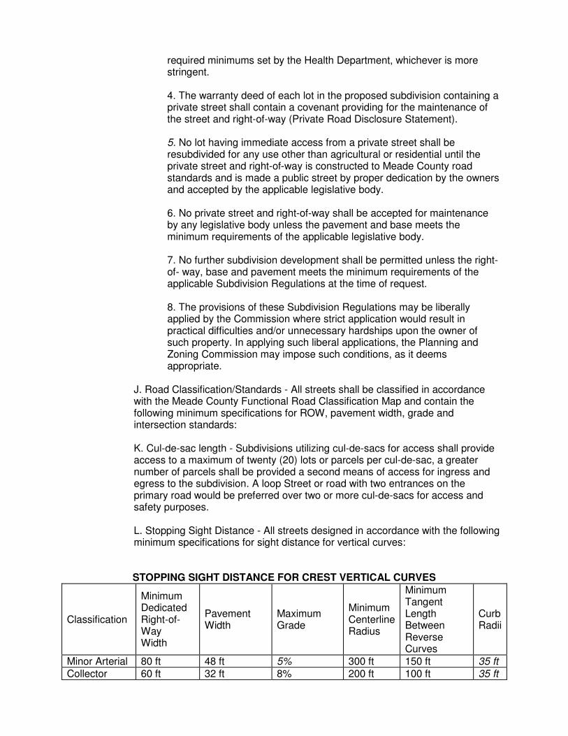
J. Road Classification/Standards - All streets shall be classified in accordance with the Meade County Functional Road Classification Map and contain the following minimum specifications for ROW, pavement width, grade and intersection standards: K. Cul-de-sac length - Subdivisions utilizing cul-de-sacs for access shall provide access to a maximum of twenty (20) lots or parcels per cul-de-sac, a greater number of parcels shall be provided a second means of access for ingress and egress to the subdivision. A loop Street or road with two entrances on the primary road would be preferred over two or more cul-de-sacs for access and safety purposes. L. Stopping Sight Distance - All streets designed in accordance with the following minimum specifications for sight distance for vertical curves: STOPPING SIGHT DISTANCE FOR CREST VERTICAL CURVES
Classification
Minimum Dedicated Right-of-Way Width
Pavement Width
Maximum Grade
Minimum Centerline Radius
Minimum Tangent Length Between Reverse Curves
Curb Radii
Minor Arterial 80 ft 48 ft 5% 300 ft 150 ft 35 ft Collector 60 ft 32 ft 8% 200 ft 100 ft 35 ft
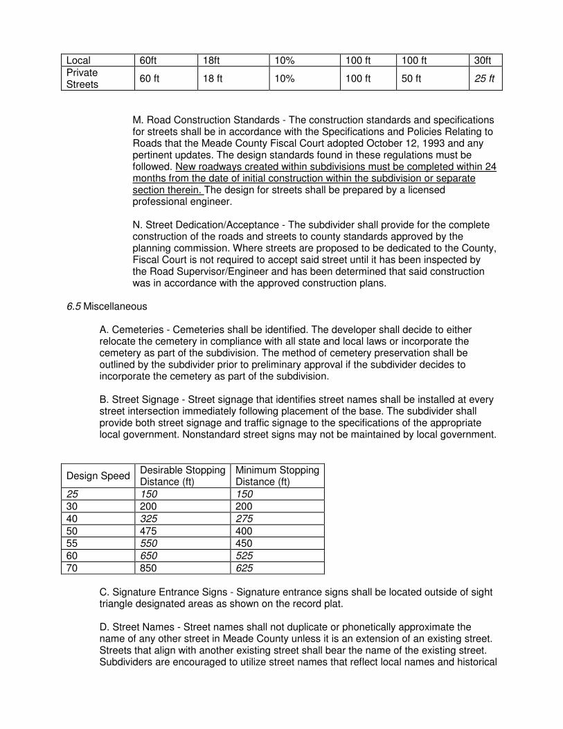
Local 60ft 18ft 10% 100 ft 100 ft 30ft Private Streets
60 ft 18 ft 10% 100 ft 50 ft 25 ft
M. Road Construction Standards - The construction standards and specifications for streets shall be in accordance with the Specifications and Policies Relating to Roads that the Meade County Fiscal Court adopted October 12, 1993 and any pertinent updates. The design standards found in these regulations must be followed. New roadways created within subdivisions must be completed within 24 months from the date of initial construction within the subdivision or separate section therein. The design for streets shall be prepared by a licensed professional engineer. N. Street Dedication/Acceptance - The subdivider shall provide for the complete construction of the roads and streets to county standards approved by the planning commission. Where streets are proposed to be dedicated to the County, Fiscal Court is not required to accept said street until it has been inspected by the Road Supervisor/Engineer and has been determined that said construction was in accordance with the approved construction plans.
6.5 Miscellaneous
A. Cemeteries - Cemeteries shall be identified. The developer shall decide to either relocate the cemetery in compliance with all state and local laws or incorporate the cemetery as part of the subdivision. The method of cemetery preservation shall be outlined by the subdivider prior to preliminary approval if the subdivider decides to incorporate the cemetery as part of the subdivision. B. Street Signage - Street signage that identifies street names shall be installed at every street intersection immediately following placement of the base. The subdivider shall provide both street signage and traffic signage to the specifications of the appropriate local government. Nonstandard street signs may not be maintained by local government.
Design Speed Desirable Stopping Distance (ft)
Minimum Stopping Distance (ft)
25 150 150 30 200 200 40 325 275 50 475 400 55 550 450 60 650 525 70 850 625
C. Signature Entrance Signs - Signature entrance signs shall be located outside of sight triangle designated areas as shown on the record plat. D. Street Names - Street names shall not duplicate or phonetically approximate the name of any other street in Meade County unless it is an extension of an existing street. Streets that align with another existing street shall bear the name of the existing street. Subdividers are encouraged to utilize street names that reflect local names and historical
associations. E. Improvement Guarantees - Improvement guarantees shall be provided to ensure the proper installation and maintenance of required street, utility, drainage and other improvements. The nature and duration of the guarantee shall be structured to achieve this goal without adding unnecessary costs to the developer.
1. Application of Guarantee - Before the recording of the final or record plat, or as a condition of final approval, the planning commission may require and shall accept in accordance with the standards adopted by ordinance the following guarantees: A. The furnishing of a performance guarantee in an amount not to exceed 120 percent of the cost of installation for improvements. B. Provision for a maintenance guarantee for a period not to exceed (2) years after final acceptance of the improvement, in an amount not to exceed 15 percent of the improvement. In the event that other governmental agencies will own the utilities to be installed, or the improvements are covered by a performance guarantee to another governmental agency, no performance guarantee shall be required by the planning commission. 2. Installation time - The time allowed for installation of the improvements for which the performance guarantee has been provided may be extended by the planning commission upon request. 3. Substantial Completion – Upon substantial Completion of all required improvements, the developer may notify the commission, in writing, by certified mail or by personal delivery of notice of the completion or substantial completion of improvements and shall send a copy to the administrative official or appropriate county official for inspection. The administrative official for the Commission shall send a copy of the request to the appropriate county official for inspection. The appropriate county official shall inspect all improvements of which notice has been given and shall file a detailed report, in writing with the planning commission indicating either approval, partial approval, or rejection of such improvements with a statement of reasons for any rejection. The cost of improvements as approved or rejected shall be set forth in the report. 4. Approval/rejection – The administrative official of the Commission, on receipt of the detailed report of inspection from the appropriate official shall present the report of inspection to Fiscal Court. The Fiscal court shall either approve, partially approve, or reject the improvements on the basis of the report of the appropriate official, and shall notify the developer in writing, by certified mail, of the contents of the report and the action taken no later than thirty (30) days forty-five (45) days after receipt of the notice from the developer of completion of the improvements. Notice to the developer by the administrative official of the Commission shall constitute compliance with the notification requirements of the governing body. Failure of the governing body to send or provide such notification to the developer within (30) days forty-five(45) days shall be deemed to constitute approval of the improvements, and the obliger and surety, if any, shall be released from all liability pursuant to such performance guarantee for such improvements. In cases where extenuating circumstances exist as a result of physical, climatic or natural disaster or emergency which preclude inspection of improvements and notification to the developer within the forty-five(45) day period from the date the developer requests inspection the County Judge

Executive may grant a one-time extension of not more than thirty(30) days. The Judge Executive must personally notify the developer in writing delivered in person or by certified mail of the reason for any extension and the specific period of the extension. Such notification of extension must be delivered or post-marked prior to the expiration of the normal inspection period. 5. Performance and maintenance mechanisms - Performance maintenance guarantees shall be provided by a variety of means including, but not limited to the following:
A. Security bond - The applicant may obtain a security bond from a surety bonding company authorized to do business in the state. B. Letters of credit - The applicant may provide irrevocable letter of credit from a bank or other reputable institution. (Rev.09-01) C. Escrow account - The applicant shall deposit cash, or other instruments readily convertible into cash at face value, either with the municipality, or in escrow with a bank. (Rev.09.01)
6. Storm Water Disposal/Drainage - Every subdivision shall provide satisfactory drainage of storm water by means of underground pipes, surface ditches and/or curbs and gutters. The basic standard for design of drainage systems for subdivisions will be to keep run-off characteristics after development at the same level as existed prior to development. To achieve these objectives, storm water detention systems may be required. Where special problem areas exist, the developer will be required to provide storm drainage improvements that will prevent aggravation of the existing downstream problem considering both the instantaneous flow rate (CFS) and flood elevations caused by the increased quantity of water from the development. On-site storm water detention facilities should be required to accomplish the following:
(1) A reduction in storm water discharges from development sites to a level and velocity of that prior to development; (2) To hold and retain sediment loads from being deposited off-site; and (3) To filter solids and runoff prior to entering the immediate watershed of lakes, ponds or water impoundments downstream. Facilities shall be sized based on a minimum 10-year storm event, with a 1 00-year storm used to check that water does not overtop roads or flood residential units. Where conditions and engineering calculations indicate benefit would not occur, storm drainage detention facilities may be deleted from development requirements in favor of channel improvements, off- site improvements to improve flow, or other alternatives. Storm water cross drains shall be required to have headwalls. The builder of any lot within a subdivision shall be required to grade the lot so that cross-lot drainage is in conformance with the approved composite Drainage Plan for the subdivision with all drainage from the lot being directed to the public drainage facility in an easement or right-of- way. Where required, a minimum of 15-inch diameter corrugated metal pipe or equivalent 20 feet long shall be used for all driveway entrance pipes for proper drainage.
7. On-site Sewage Disposal - On-site sewage disposal systems may be

permitted in areas where public sanitary sewers are not immediately available. For any proposed subdivision utilizing on-site systems, the Meade County Health Department shall review the general suitability of the site for septic tank or alternative use prior to Planning Commission action. In areas of questionable suitability, the Commission may postpone action on the subdivision plan until the developer has obtained additional information from the Health Department to ascertain whether on-site systems will function properly. In cases of unusual soil conditions or physical factors which may impair the health and safety of the neighborhood in which a subdivision may be located, the Commission may increase lot area requirements as necessary.
SECTION VII ADMINISTRATION AND ENFORCEMENT 7.1 Administrative Official The Commission shall designate, with the concurrence of the appropriate legislative bodies, an Administrative Official to be charged with and provided the authority to enforce these regulations. 7.2 Filing Fee The Planning Commission shall establish a uniform schedule of fees proportioned to the cost of checking and verifying the proposed Preliminary and Final plats. The subdivider shall pay the specified fee at the time of filing the application for preliminary plat approval. Contact the Commission for the current fee schedule. 7.3 Waiver The Commission may vary the requirements of these regulations where strict application would result in extreme practical difficulties because of exceptional or unique topographic conditions or other physical conditions. 7.4 Penalties Any person who violates the provisions of this regulation shall, upon conviction, be lined not less than ten dollars ($10.00) nor more than five hundred dollars ($500.00) for each offense. Each day of violation shall constitute a separate offense. 7.5 Liabilities Any member of the Commission or any employee thereof, shall not render himself liable personally in the discharge of his duties. Any legal suit brought against any member of the Commission or employee because of such act performed by him in the enforcement of any provision of this regulation shall be defended by legal representation of the Commission until the final termination of the proceedings. SECTION VIII EFFECTiVE DATE This regulation is hereby declared to be a measure necessary in the interest and for the promotion of safety, convenience and public welfare. This regulation shall be in full force and effect from and after its passage and approval as provided by law. Approved this June 15, 1999 CHAIRPERSON, MEADE COUNTY PLANNING COMMISSION ATTEST: Secretary
SUBDIVISION AMENDMENT NO. 00.01 AN AMENDMENT TO THE MEADE COUNTY SUBDIVISION REGULATIONS TO AMEND SECTION 6.1(A) DESIGN AND IMPROVEMENT STANDARDS, LOTS, WIDTHIFRONTAGE REQUIRED. — WHEREAS, the Meade County Planning Commission has determined it to be in the public interest to amend Section 6.1(A), Design and Improvement Standards, Lots, Width/Frontage Required, of The Meade County Subdivision Regulations; — NOW THEREFORE, BE IT ORDAINED BY THE MEADE COUNTY PLANNING COMMISSION THAT THE FOLLOWING WILL BE AMENDED IN THE DESIGN AND IMPROVEMENT STANDARDS OF SECTION 6.1(A). Deletions will be stricken, additions will be underlined. SECTION 6.1 DESIGN AND IMPROVEMENT STANDARDS: 6.1 Lots A. Width/Frontage required — Each lot shall front on an approved public maintained road, private road meeting standards, or previously recorded private road and shall conform to the minimum road frontage or lot width requirement of the zoning district in which the lot is located. The Planning Commission may approve a onetime division of land off a sixty (60) foot wide recorded easement as the frontage for one lot. This one-time division is limited to existing lots and the applicant must show unusual circumstances or hardship. Lot width shall be measured at either the front property line or at the minimum front building setback line as stated in the zoning ordinance. In cases where lots are located on the outside edge of curved streets or cul-de-sac radii, the measurement shall be taken at the minimum front building line specified in the zoning ordinance as measured by the chord distance, ie: a lot fronting on the curved portion of a cul-de-sac may be reduced to a minimum of 3cvcnty five (75) feet provided thc lot ia one hundred fifty (150) feet wide at the front yard aetback line one-half the required frontage provided the required width is met at the front yard setback line. This Amendment, having been read and approved at the September 21, 2000 meeting of the Meade County Planning Commission; shall be effective upon passage. MEAI5E COUNTY PLANNING COMMISSION Jess Mills, Chairman Planning Commission Secretary 5.2 FINAL PLAT D. CERTIFICATION — Added 4/20/06 - The Planning Commission approved the addition of the wording in bold to include to Environmentalist, Meade County Health Department or Licensed Professional Engineer — License Number. The following certification is used on subdivision plats when full site evaluations for on-site sewage disposal systems are performed on each proposed lot of a subdivision. As established in KRS 211.350, site evaluations and approval of septic system designs by licensed professional engineer is allowed. CERIFICATION FOR ON-SITE SEWAGE DISPOSAL SYSTEMS I certify that the sewage disposal systems proposed for installation in this subdivision fully meet the requirements of Kentucky On-Site Sewage Disposal Systems Regulation (902 KAR 10:085) and are approved. _______________________________ Date: ___________
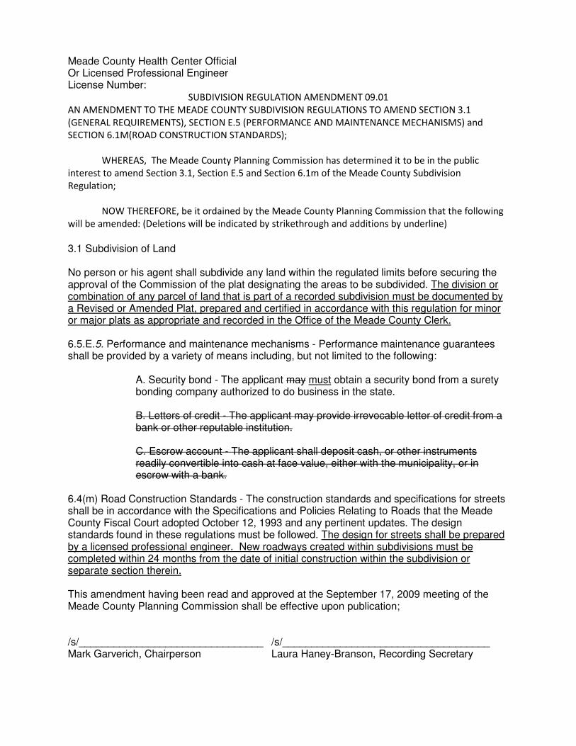
Meade County Health Center Official Or Licensed Professional Engineer License Number:
SUBDIVISION REGULATION AMENDMENT 09.01
AN AMENDMENT TO THE MEADE COUNTY SUBDIVISION REGULATIONS TO AMEND SECTION 3.1
(GENERAL REQUIREMENTS), SECTION E.5 (PERFORMANCE AND MAINTENANCE MECHANISMS) and
SECTION 6.1M(ROAD CONSTRUCTION STANDARDS);
WHEREAS, The Meade County Planning Commission has determined it to be in the public
interest to amend Section 3.1, Section E.5 and Section 6.1m of the Meade County Subdivision
Regulation;
NOW THEREFORE, be it ordained by the Meade County Planning Commission that the following
will be amended: (Deletions will be indicated by strikethrough and additions by underline)
3.1 Subdivision of Land No person or his agent shall subdivide any land within the regulated limits before securing the approval of the Commission of the plat designating the areas to be subdivided. The division or combination of any parcel of land that is part of a recorded subdivision must be documented by a Revised or Amended Plat, prepared and certified in accordance with this regulation for minor or major plats as appropriate and recorded in the Office of the Meade County Clerk. 6.5.E.5. Performance and maintenance mechanisms - Performance maintenance guarantees shall be provided by a variety of means including, but not limited to the following:
A. Security bond - The applicant may must obtain a security bond from a surety bonding company authorized to do business in the state. B. Letters of credit - The applicant may provide irrevocable letter of credit from a bank or other reputable institution. C. Escrow account - The applicant shall deposit cash, or other instruments readily convertible into cash at face value, either with the municipality, or in escrow with a bank.
6.4(m) Road Construction Standards - The construction standards and specifications for streets shall be in accordance with the Specifications and Policies Relating to Roads that the Meade County Fiscal Court adopted October 12, 1993 and any pertinent updates. The design standards found in these regulations must be followed. The design for streets shall be prepared by a licensed professional engineer. New roadways created within subdivisions must be completed within 24 months from the date of initial construction within the subdivision or separate section therein. This amendment having been read and approved at the September 17, 2009 meeting of the Meade County Planning Commission shall be effective upon publication; /s/________________________________ /s/____________________________________ Mark Garverich, Chairperson Laura Haney-Branson, Recording Secretary
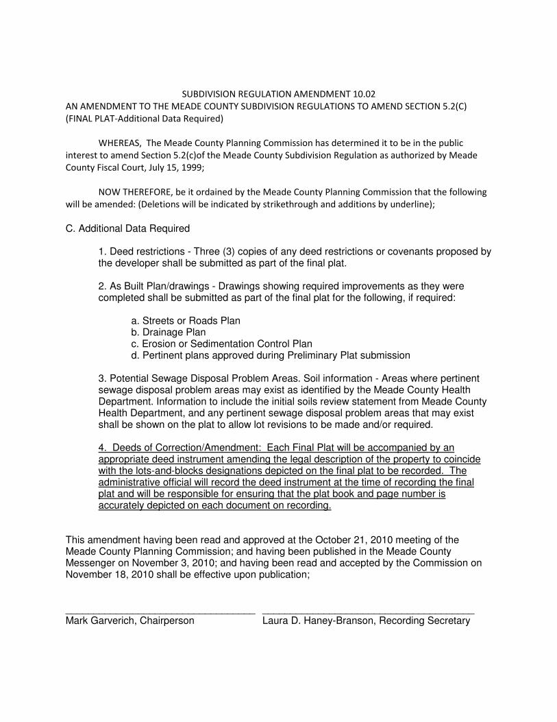
SUBDIVISION REGULATION AMENDMENT 10.02
AN AMENDMENT TO THE MEADE COUNTY SUBDIVISION REGULATIONS TO AMEND SECTION 5.2(C)
(FINAL PLAT-Additional Data Required)
WHEREAS, The Meade County Planning Commission has determined it to be in the public
interest to amend Section 5.2(c)of the Meade County Subdivision Regulation as authorized by Meade
County Fiscal Court, July 15, 1999;
NOW THEREFORE, be it ordained by the Meade County Planning Commission that the following
will be amended: (Deletions will be indicated by strikethrough and additions by underline);
C. Additional Data Required
1. Deed restrictions - Three (3) copies of any deed restrictions or covenants proposed by the developer shall be submitted as part of the final plat. 2. As Built Plan/drawings - Drawings showing required improvements as they were completed shall be submitted as part of the final plat for the following, if required:
a. Streets or Roads Plan b. Drainage Plan c. Erosion or Sedimentation Control Plan d. Pertinent plans approved during Preliminary Plat submission
3. Potential Sewage Disposal Problem Areas. Soil information - Areas where pertinent sewage disposal problem areas may exist as identified by the Meade County Health Department. Information to include the initial soils review statement from Meade County Health Department, and any pertinent sewage disposal problem areas that may exist shall be shown on the plat to allow lot revisions to be made and/or required. 4. Deeds of Correction/Amendment: Each Final Plat will be accompanied by an appropriate deed instrument amending the legal description of the property to coincide with the lots-and-blocks designations depicted on the final plat to be recorded. The administrative official will record the deed instrument at the time of recording the final plat and will be responsible for ensuring that the plat book and page number is accurately depicted on each document on recording.
This amendment having been read and approved at the October 21, 2010 meeting of the Meade County Planning Commission; and having been published in the Meade County Messenger on November 3, 2010; and having been read and accepted by the Commission on November 18, 2010 shall be effective upon publication; __________________________________ ______________________________________ Mark Garverich, Chairperson Laura D. Haney-Branson, Recording Secretary

SUBDIVISION REGULATION AMENDMENT 10.04
AN AMENDMENT TO THE MEADE COUNTY SUBDIVISION REGULATIONS TO AMEND SECTION IV
(PROCEDURES);
WHEREAS, The Meade County Planning Commission has determined it to be in the public
interest to amend IV of the Meade County Subdivision Regulation as authorized by Meade County Fiscal
Court, July 15, 1999;
WHEREAS, KRS Chapter 100.281 provides that the Commission may be assume the duties of the
Board of Adjustments to hear and finally decide variance requests when a proposed development
requires a subdivision and one (1) or more variances;
NOW THEREFORE, be it ordained by the Meade County Planning Commission that the following
will be amended: (Deletions will be indicated by strikethrough and additions by underline);
4.0: General Procedures for All Subdivisions of Land:
4.0(1): The Meade County Planning Commission, pursuant to KRS Chapter 100.281, shall be
empowered to hear and finally decide applications variances when a proposed development
requires a subdivision and one (1) or more variances.
4.0(2): The Meade County Planning Commission shall assume all powers and duties otherwise
exercised by the Board of Adjustments pursuant to KRS chapter 100.231, 100.233, 100.237,
100.241, 100.247 and 100.251 where the the conditions in section 4.0(1) apply.
4.0(3): The applicant for a subdivision where a variance is required may elect, at the time the
application for subdivision is submitted, to have the Planning Commission hear and finally
decide the variance at the same public hearing set for the subdivision or by the board of
adjustments as otherwise provided by law.
This amendment having been read and approved at the October 21, 2010 meeting of the Meade County Planning Commission; and having been published in the Meade County Messenger on November 3, 2010; and having been read and accepted by the Commission on November 18, 2010 shall be effective upon publication; __________________________________ ______________________________________ Mark Garverich, Chairperson Laura D. Haney-Branson, Recording Secretary
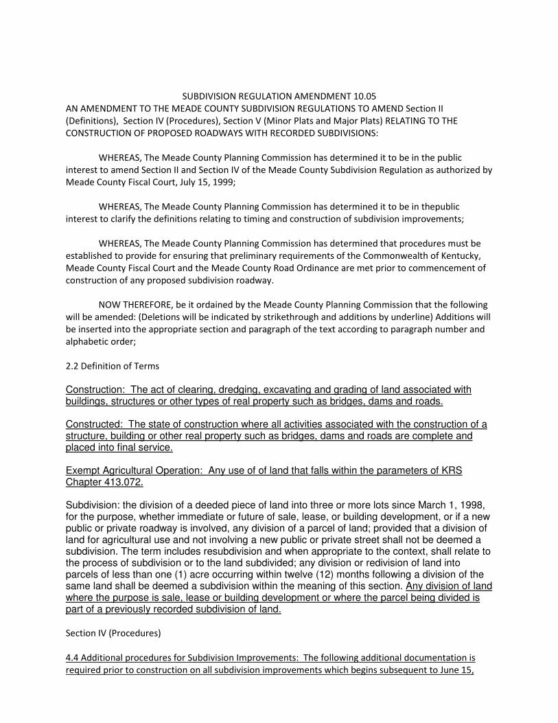
SUBDIVISION REGULATION AMENDMENT 10.05
AN AMENDMENT TO THE MEADE COUNTY SUBDIVISION REGULATIONS TO AMEND Section II
(Definitions), Section IV (Procedures), Section V (Minor Plats and Major Plats) RELATING TO THE
CONSTRUCTION OF PROPOSED ROADWAYS WITH RECORDED SUBDIVISIONS:
WHEREAS, The Meade County Planning Commission has determined it to be in the public
interest to amend Section II and Section IV of the Meade County Subdivision Regulation as authorized by
Meade County Fiscal Court, July 15, 1999;
WHEREAS, The Meade County Planning Commission has determined it to be in thepublic
interest to clarify the definitions relating to timing and construction of subdivision improvements;
WHEREAS, The Meade County Planning Commission has determined that procedures must be
established to provide for ensuring that preliminary requirements of the Commonwealth of Kentucky,
Meade County Fiscal Court and the Meade County Road Ordinance are met prior to commencement of
construction of any proposed subdivision roadway.
NOW THEREFORE, be it ordained by the Meade County Planning Commission that the following
will be amended: (Deletions will be indicated by strikethrough and additions by underline) Additions will
be inserted into the appropriate section and paragraph of the text according to paragraph number and
alphabetic order;
2.2 Definition of Terms
Construction: The act of clearing, dredging, excavating and grading of land associated with buildings, structures or other types of real property such as bridges, dams and roads. Constructed: The state of construction where all activities associated with the construction of a structure, building or other real property such as bridges, dams and roads are complete and placed into final service. Exempt Agricultural Operation: Any use of of land that falls within the parameters of KRS Chapter 413.072. Subdivision: the division of a deeded piece of land into three or more lots since March 1, 1998, for the purpose, whether immediate or future of sale, lease, or building development, or if a new public or private roadway is involved, any division of a parcel of land; provided that a division of land for agricultural use and not involving a new public or private street shall not be deemed a subdivision. The term includes resubdivision and when appropriate to the context, shall relate to the process of subdivision or to the land subdivided; any division or redivision of land into parcels of less than one (1) acre occurring within twelve (12) months following a division of the same land shall be deemed a subdivision within the meaning of this section. Any division of land where the purpose is sale, lease or building development or where the parcel being divided is part of a previously recorded subdivision of land.
Section IV (Procedures)
4.4 Additional procedures for Subdivision Improvements: The following additional documentation is
required prior to construction on all subdivision improvements which begins subsequent to June 15,

1999. Improvements which require permitting include Water Lines, Public Sewage Disposal Systems,
Roadways and pre-positioned electric infrastructure. Developers of subdivisions platted prior to
adoption of these requlations in which construction has not commenced shall be required to submit
appropriate design plans for approval according to the procedures for minor plats.
4.4(a): Improvement Construction Permits Required: Prior to commencing any construction or
excavation for the construction of a proposed roadway the developer shall obtain a construction permit
from the administrative official.
4.4(b): Additional Documents Required for Road Construction Permit: The following
prerequisite documents are required for issuance of a road construction permit:
4.4.(b)(1): Recorded subdivision plat
4.4.(b)(2): Notice of Intent filed with the Kentucky Environmental Cabinet
4.4.(b)(3): Road Design Plan. For subdivisions platted prior to adoption of the Meade
County Subdivision Regulations a road plan must be prepared in accordance with the procedures and
specification contained in the Subdivision Regulations and submitted according to the procedures for
Minor Plat Approval to the administrator of the Planning Commission. No permit for road construction
may be issued unless the road plan has been reviewed and accepted by the Meade County Road
Supervisor and the Meade County Planning Commission.
4.4.(b)(4): Proof of Performance Guarantee accepted by the C omission.
4.4.(c)(5): Approved encroachment permit from the Meade County Road Department
or Kentucky Department of Transportation as appropriate.
4.4.(b)(6): All subdivision improvement must be completed within 24 months of
issuance of the improvement construction permit.
Section 5.1Preliminary Plat 5.1(b)(10): Driveways and Entrances: The lot designs should show the location of all proposed driveway entrances to proposed roadways within subdivisions. In Major Subdivisions where new roads are created all driveway entrances must be located on the proposed subdivision roadway. The Road Department Supervisor of KY Department of Transportation may approve entrances to the main artery on a case-by-case basis when warranted by the topography of a particular lot. Section 5.2 Final Plats
5.2(b)(7): Driveways and Entrances: The lot designs should show the location of all proposed driveway entrances to proposed roadways within subdivisions. In Major Subdivisions where new roads are created all driveway entrances must be located on the proposed subdivision roadway. The Road Department Supervisor of KY Department of Transportation may approve entrances to the main artery on a case-by-case basis when warranted by the topography of a particular lot. This amendment having been read and approved at the October 21, 2010 meeting of the Meade County Planning Commission; and having been published in the Meade County Messenger on November 3, 2010; and having been read and accepted by the Commission on November 18, 2010 shall be effective upon publication; __________________________________ ______________________________________ Mark Garverich, Chairperson Laura D. Haney-Branson, Recording Secretary

Related Documents