Prepared for: TOLSON AND ASSOCIATES, LLC 24024 Frederick Road Clarksburg, Maryland 20871 PHASE I REPORT PROPOSED EXPANSION OF TOLSON & ASSOCIATES RUBBLE LANDFILL CROFTON, ANNE ARUNDEL COUNTY, MARYLAND Prepared by: 10211Wincopin Circle, 4 th Floor Columbia, Maryland 21044 Project Number: ME1606 Document Number: MD18235 May 2019 Professional Certification: I hereby certify that this document was approved by me, and that I am a duly licensed Professional Engineer under the laws of the State of Maryland, License No. 32252, Expiration Date: 09-08-2019.

Welcome message from author
This document is posted to help you gain knowledge. Please leave a comment to let me know what you think about it! Share it to your friends and learn new things together.
Transcript

Prepared for: TOLSON AND ASSOCIATES, LLC
24024 Frederick Road Clarksburg, Maryland 20871
PHASE I REPORT
PROPOSED EXPANSION OF TOLSON & ASSOCIATES RUBBLE LANDFILL
CROFTON, ANNE ARUNDEL COUNTY, MARYLAND
Prepared by:
10211Wincopin Circle, 4th Floor Columbia, Maryland 21044
Project Number: ME1606 Document Number: MD18235
May 2019
Professional Certification: I hereby certify that this document was approved by me, and that I am a duly licensed Professional Engineer under the laws of the State of Maryland,
License No. 32252,
Expiration Date: 09-08-2019.
Cpendleton
Maryland P.E. + Signature

Phase I Permit Application Proposed Expansion of Tolson & Associates Rubble Landfill MDE Refuse Disposal Permit No. 2003-WRF-0580
ME1606/MD18235 i May 2019
TABLE OF CONTENTS
1 INTRODUCTION................................................................................................. 1
1.1 Terms of Reference ...................................................................................... 1
1.2 Existing Conditions ...................................................................................... 1
1.3 Description of Proposed Expansion .............................................................. 3
2 PHASE I REPORT REQUIREMENTS ................................................................. 4
2.1 Overview ..................................................................................................... 4
2.2 Phase I Report Requirements (COMAR 26.04.07.06.B) ............................... 4
2.3 Additional Requirements .............................................................................. 5
3 SITE DESCRIPTION............................................................................................ 7
3.1 Current Land Use ......................................................................................... 7
3.2 Site Topography ........................................................................................... 7 3.3 Zoning ......................................................................................................... 8
4 NARRATIVE DESCRIPTION OF SOILS ............................................................ 9
5 NARRATIVE DESCRIPTION OF THE GEOLOGY .......................................... 10
5.1 Regional Geology ...................................................................................... 10
5.2 Site Geology .............................................................................................. 11
5.3 Hydrogeology ............................................................................................ 12
6 DESCRIPTION OF PROPOSED ACTIVITIES .................................................. 13
7 REFERENCES ................................................................................................... 14

Phase I Permit Application Proposed Expansion of Tolson & Associates Rubble Landfill MDE Refuse Disposal Permit No. 2003-WRF-0580
TABLE OF CONTENTS (continued)
ME1606/MD18235 ii May 2019
FIGURES
Figure 1: Area Map Figure 2: Existing Conditions Plan Figure 3: Proposed Expansion Plan Figure 4: Conceptual Final Grading Plan Figure 5: Zoning Map Figure 6: USDA Soil Distribution Map Figure 7: Surficial Geology Map of Anne Arundel County
ATTACHMENTS
Attachment 1: Refuse Disposal Permit Application Form Attachment 2: Property Owners within 1,000-ft Radius of Site Attachment 3: FAA Determination of No Hazard to Air Navigation

Phase I Permit Application Proposed Expansion of Tolson & Associates Rubble Landfill MDE Refuse Disposal Permit No. 2003-WRF-0580
ME1606/MD18235 1 May 2019
1 INTRODUCTION
1.1 Terms of Reference
The Code of Maryland Regulation (COMAR) of Water Supply, Sewage Disposal, and Solid Waste, COMAR 26.04.07, requires a person who will construct or operate a sanitary landfill to obtain a permit from the Approving Authority, Maryland Department of the Environment (MDE). A Phase I report is required to be submitted along with the request for a permit. In accordance with this requirement, this report was prepared to notify MDE of the intention to apply for expansion of Tolson & Associates Rubble Landfill (also referred to as Tolson Rubble Landfill or TRL), which operates under existing Permit No. 2003-WRF-0580, issued 24 November 2014, and to provide general information about the site.
The location of TRL is presented in Figure 1. The waste footprint of the proposed expansion will be increased from approximately 72.38 acres to approximately 118.5 acres (Figure 2) and a vertical expansion is proposed to increase the height of the landfill from the current permitted height of 230 feet above mean sea level (ft-msl) to 244 ft-msl (with top of waste at 240 ft-msl).
This report was prepared by Geosyntec Consultants (Geosyntec) of Columbia, Maryland, on behalf of Tolson And Associates, LLC (Tolson And Associates), the owner and operator of the TRL.
This Phase I Report is organized in a manner that is intended to address the specific requirements of COMAR 26.04.07.06. The remainder of this report is organized as follows:
• Section 2 describes how this report addresses and meets the regulatory requirements for the Phase I report;
• Section 3 presents the current layout of the facility and topographic features;
• Section 4 presents a description of soils at the site and surrounding area;
• Section 5 presents the site geology;
• Section 6 presents general information regarding the proposed expansion; and
• Section 7 presents relevant references.
1.2 Existing Conditions
As shown on the area map provided as Figure 1, the existing TRL facility is located in Anne Arundel County, Maryland, approximately one mile northwest of Maryland Route 3, and accessed via Capitol Raceway Road. The existing TRL currently comprises a permitted waste footprint of

Phase I Permit Application Proposed Expansion of Tolson & Associates Rubble Landfill MDE Refuse Disposal Permit No. 2003-WRF-0580
ME1606/MD18235 2 May 2019
72.38 acres with one constructed active waste disposal cell (Phase 1 Cell A). Its topography and current conditions are presented in Figure 2.
The TRL property encompasses four parcels with a combined area of approximately 313.84 acres. Tolson And Associates own three of the four parcels and have a 30-year lease for the fourth parcel, Parcel 262, which contains the 32.8-acre closed Cunningham Rubble Landfill (CRL). These four parcels are outlined in Figure 2 and listed in the table below.
Parcel Owner Area (acres)
Tax Map 36, Grid 10, Parcel 262 Liber 3026, folio 00275
Capitol Raceway Promotion, Inc. 11555 Haughs Church Rd. Key Mar, MD 21757
50.59
Tax Map 36, Grid 4, Parcel 9 Liber 28096, folio 00273
Tolson And Associates, LLC 24024 Frederick Rd. Clarksburg, MD 20871
129.5
Tax Map 36, Grid 35, Parcel 239 Liber 28096, folio 00301
Tolson And Associates, LLC 24024 Frederick Rd. Clarksburg, MD 20871
1.76
Tax Map 36, Grid 4, Parcel 10 Liber 28096, folio 00301
Tolson And Associates, LLC 24024 Frederick Rd. Clarksburg, MD 20871
131.99
In addition, Tolson And Associates have a perpetual deeded easement through Parcel 37 to provide access to the site. Details for Parcel 37 are outlined in the table below.
Tax Map 36, Grid 17, Parcel 37 Liber 27935, folio 00388
Ventura Properties, LLC 11555 Haughs Church Rd. Keymar, MD 21757
117.0
The TRL site area is 204.6 acres of the property. Of the TRL site area, 203.25 acres are part of a special exception issued by Anne Arundel County, which allows Tolson And Associates to operate the landfill and sand and gravel operations under the existing zoning for the property. The special exception covers a total area of 203.25 acres, of which 184.25 acres was included in the original special exception approval in 1993, with an additional 19 acres approved as an expansion to the original special exception area in 2016. The Anne Arundel County Office of Planning and Zoning was not able to provide Tolson And Associates with a figure showing the approved special exception boundary. Therefore, an estimated boundary for the limit of special exception is shown in Figure 2. Geosyntec prepared this boundary by following the rural agricultural (RA) zoning limit within the property boundary (this special exception is only approved for areas zoned as RA); the area covered by this estimated boundary is 198.6 acres, which is smaller than the approved

Phase I Permit Application Proposed Expansion of Tolson & Associates Rubble Landfill MDE Refuse Disposal Permit No. 2003-WRF-0580
ME1606/MD18235 3 May 2019
203.25 acres. The existing and proposed facility areas are located within the special exception area.
1.3 Description of Proposed Expansion
The proposed expansion encompasses the current footprint of the TRL, as shown in Figure 3. The proposed final grading for the facility is shown in Figure 4. The proposed expansion includes the following:
(i) a lateral expansion, primarily to the north and northeast into the existing mining area, and to the east, west, and south, to an approximate 118.5 acres within the special exception area, which includes approximately 7.7 acres of landfill constructed over the closed CRL;
(ii) a vertical expansion to a maximum final elevation of 244 ft-msl (with a top of waste elevation of 240 ft-msl), which complies with the special exception requirement and Anne Arundel County Code 18-11-129(12) that operations on the site be limited to a height of 30 feet above grade (maximum surrounding grade is at elevation 210 ft-msl, as shown on Figure 2);
(iii) a reconfiguration of the disposal cells as compared to the existing permit; (iv) lowering of the base grades from the currently permitted minimum elevation of 122 ft-
msl to a minimum elevation of 100 ft-msl, which complies with the special exception requirements that: (1) the excavation not exceed 50 feet below the existing surrounding grade (surrounding grade within the footprint of the proposed expansion is as low as approximately 115 ft-msl, as shown on Figure 2); and (2) excavations may not enter into the clay layer base for the site (the subsurface clay layer for the site is generally present below an elevation of 100 ft-msl); and
(v) addition of a herringbone pattern cap to maximize airspace.

Phase I Permit Application Proposed Expansion of Tolson & Associates Rubble Landfill MDE Refuse Disposal Permit No. 2003-WRF-0580
ME1606/MD18235 4 May 2019
2 PHASE I REPORT REQUIREMENTS
2.1 Overview
COMAR 26.04.07.14 requires the applicant to submit a Phase I Report in accordance with the requirements of COMAR 26.04.07.06. In this Section, a summary of the Phase I Report requirements is provided (in italic type), followed by a brief description of how the requirement is met or addressed in this report.
2.2 Phase I Report Requirements (COMAR 26.04.07.06.B)
(1) Completed and signed application form referenced in Regulation (26.04.07.05.B).
The application form is included as Attachment 1.
(2) Current U.S.G.S. 7.5-minute quadrangle map with the proposed site outlined.
An area map reproduced from the United States Geological Survey (USGS) 7.5-minute quadrangle map is shown in Figure 1.
(3) Current topographic map, which is an accurate depiction of the site at the time of application, at a scale not smaller than 1 inch equals 200 feet, which depicts the property boundaries, on-site buildings and structures, and pertinent surficial features including but not limited to: (a) Springs, (b) Seeps, (c) Streams, (d) Rock outcrops, (e) Sink holes, (f) Surface impoundments, (g) Water wells, (h) Forested areas, and (i) The location of any buried or overhead power transmission lines, utility pipelines, or storage tanks on the property.
The current topography of the site is shown in Figure 2. A narrative description of the topographic features is presented in Section 3 of this report.
(4) Map which depicts the surrounding zoning and land use within 1/2 mile of the site boundaries.
Zoning of the surrounding area is shown in Figure 5. A narrative description is presented in Section 3 of this report.
(5) Map showing the distribution of the soils at the site.
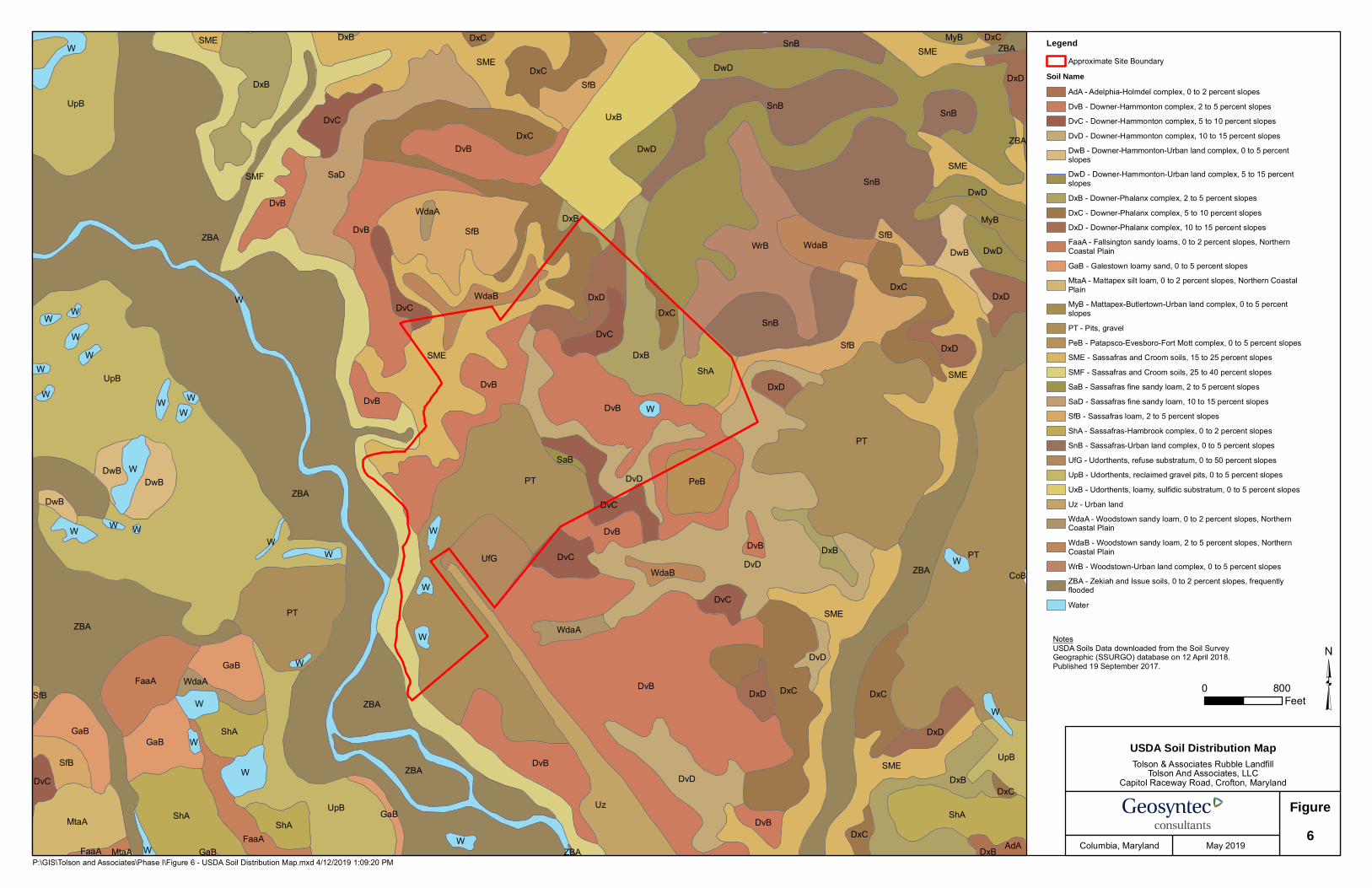
A U.S. Department of Agriculture (USDA) soil distribution map for the site and surrounding area is shown in Figure 6.
Phase I Permit Application Proposed Expansion of Tolson & Associates Rubble Landfill MDE Refuse Disposal Permit No. 2003-WRF-0580
ME1606/MD18235 5 May 2019
(6) Narrative description of the soils at the site.
A narrative description of the soils at the site is presented in Section 4 of this report.
(7) Map showing the geology at the site based on available data.
The geology for the site and surrounding Anne Arundel County is shown in Figure 7.
(8) Narrative description of the geology at the site based on available data.
A narrative description of the site geology is presented in Section 5 of this report.
(9) Description of the proposed activity including: (a) Type of facility, (b) Area served, (c) Capacity, and (d) Types of waste accepted.
A brief description of the proposed activity is provided in Section 6 of this report.
2.3 Additional Requirements
The following additional attachments are included with this report:
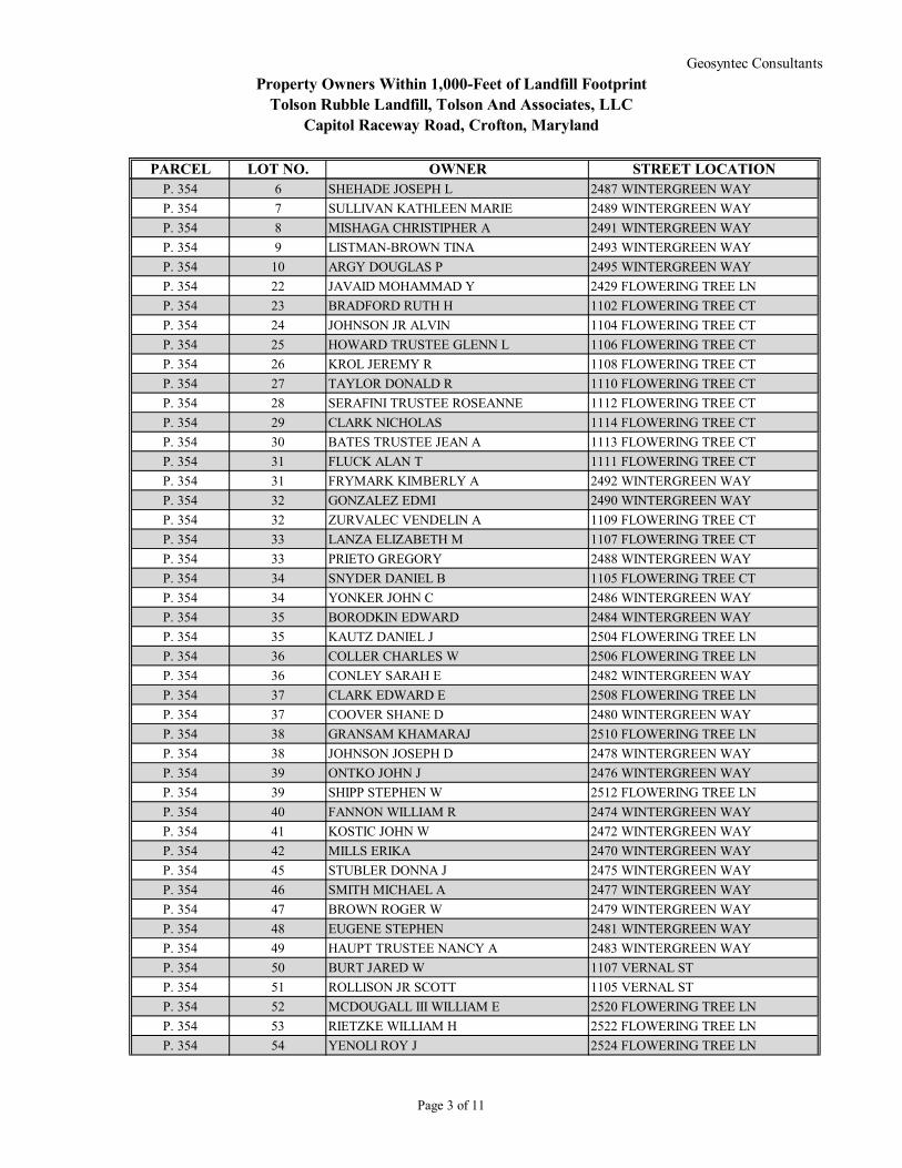
(1) Property Owners within 1,000-ft Radius of the Site containing the Proposed Expansion
A tabulated list of property owners within a 1,000-ft radius of the site is provided in Attachment 2. The list was compiled based on information provided by Anne Arundel County. Relevant portions of the map showing the site boundary, the location of the landfill expansion, and the parcels/lots of land conservatively identified to be within (or just beyond) a 1,000-ft distance of the site area are reproduced in Figure A included in Attachment 2.
(2) Notification to Federal Aviation Administration (FAA)
On 14 December 2018, Geosyntec submitted to the FAA an online notification, using FAA Form 7460-1, of Tolson And Associates’ intention to construct TRL with final elevation not to exceed 245 ft-msl. A total of seven notifications were submitted for various portions of TRL. These notifications were processed by the FAA under the following Aeronautical Study Numbers:

Phase I Permit Application Proposed Expansion of Tolson & Associates Rubble Landfill MDE Refuse Disposal Permit No. 2003-WRF-0580
ME1606/MD18235 6 May 2019
Aeronautical Study Number (ASN) TRL Study Area 2018-AEA-15497-OE North Corner 2018-AEA-15498-OE East Corner 2018-AEA-15499-OE Southwest Corner 2018-AEA-15500-OE West Corner 2018-AEA-15501-OE Northwest Corner 2018-AEA-15502-OE North-northwest Corner 2018-AEA-15503-OE High Point
On 4 February 2019, the FAA issued Tolson And Associates with a “Determination of No Hazard to Air Navigation” (FAA Determination), a copy of which is provided as Attachment 3.

Phase I Permit Application Proposed Expansion of Tolson & Associates Rubble Landfill MDE Refuse Disposal Permit No. 2003-WRF-0580
ME1606/MD18235 7 May 2019
3 SITE DESCRIPTION
3.1 Current Land Use
The existing waste disposal facility at the TRL is a reclamation of the sand and gravel surface mining operations, located northwest of Crofton, Maryland. The total permitted landfill area of the existing facility is approximately 72.38 acres (approximately ten acres are currently constructed as one waste disposal cell) within the special exception area. The site is currently occupied by an operating sand and gravel mining, washing, and distribution quarry and the approximately 32.8-acre former CRL, which has been closed and capped. The Little Patuxent River borders the site to the west and flows from north to south past the property. The site is bordered to the east by a residential community and to the north by an unnamed tributary to the Little Patuxent River. The southern boundary of the site borders woods, several residences, and Capitol Raceway, which is used for automotive drag racing. The site is accessed via the north end of Capitol Raceway Road, adjacent to Capitol Raceway.
Site access from Capitol Raceway Road is provided at the southwestern corner of the property. A scalehouse, used to control access to the facility and disposal of waste, is located to the west of the gravel pits near the gated entrance to the facility. An access road to the active filling operations within the property runs approximately parallel to the southern property boundary. Leachate is collected and stored in an on-site leachate storage tank. The site also contains two metal storage containers adjacent to the site entrance.
The TRL currently receives rubble and services primarily Anne Arundel County and surrounding areas (ERM, 2016). It is reportedly the only rubble facility operating in Anne Arundel County, although refuse from areas outside Anne Arundel County will not be restricted with the proposed development. Currently the site comprises a single waste disposal area divided only by operations. On-site ancillary operations to disposal of rubble include composting, natural wood waste recycling, concrete crushing, and soil blending. The existing landfill is constructed over 72.38 acres on a 184.25-acre site, and measures approximately 2,400 feet (east to west) by 1,600 feet (north to south) with a tapering to approximately 500 feet (north-south) in the western portion of the site.
3.2 Site Topography
The current topography in the vicinity of TRL is based on a survey conducted on 11 January 2019 and is shown in Figure 2. The majority of the site is currently being mined, or has been recently mined and is open space, and is awaiting future TRL cell construction. To the west of the existing landfill cell is an existing stormwater management pond, Basin A, and in the southwest corner of the site are two wash ponds. There are two aggregate stockpiles within the lower middle portion

Phase I Permit Application Proposed Expansion of Tolson & Associates Rubble Landfill MDE Refuse Disposal Permit No. 2003-WRF-0580
ME1606/MD18235 8 May 2019
of the site. A 2,000-foot screening berm, approximately 30 feet in height, borders the eastern side of the site.
Based on the USGS map (Figure 1), topographic map for the area (Figure 2), and various site inspections, no springs, seeps, rock outcrops, or sinkholes are present on or near the site. There are wooded areas bounding TRL to the northwest and west, generally following the Little Patuxent River and its tributaries, which are illustrated on Figure 2.
3.3 Zoning
Figure 5 shows a zoning map of the surrounding area. The proposed landfill expansion (as indicted by the red line in Figure A in Attachment 2) is located within a rural agricultural (RA) zoning district and also within the special exception area. There are four parcels that make up the site and they are listed in Attachment 1. The area south of the site in the vicinity of the drag strip and to the east of it, as well as a portion to the north of the site, is zoned low density residential (RLD). To the west and northwest of the site is open space (OS) and to the east and northeast is residential (R1, R5, R15). Pockets of heavy industrial (W3) zoning are located to the east and to the west of the site. Further west, within 0.5 miles distance of the site is additional land designated rural agricultural.

Phase I Permit Application Proposed Expansion of Tolson & Associates Rubble Landfill MDE Refuse Disposal Permit No. 2003-WRF-0580
ME1606/MD18235 9 May 2019
4 NARRATIVE DESCRIPTION OF SOILS
The USDA soil distribution map for the site and surrounding area is shown as Figure 6. According to the map, the proposed development area and the surrounding area have top soils classified in the Downer-Hammonton and Downer-Phalanx complex at slopes up to 15 percent. These are comprised of a coarse, loamy material. Gravel pits are also identified within the central western portion of the site. It should be noted however that much of the surficial soils have or will be removed as part of the current mining and landfilling operations.
A Phase II Site Geology Report (ERM, 2006) and Phase III Engineering Report (ERM, 2016) describe the site as lying within the Coastal Plain Physiographic Province and dominated by interbedded sands, silts, and gravels.
The lithology observed through various drilling investigations describe the shallow soils at the site as medium to coarse sands with some gravel and silt material, classified in the laboratory as SP-SM and ML under the Unified Soil Classification System.
As part of the Phase II investigation in 2006, eight soil borings were installed to depths of 43 feet in addition to eight borings previously installed to depths of 86.5 to 100 feet in 1991. Currently there are 40 monitoring wells surrounding the site.
Tolson And Associates is planning to perform additional soil borings within and surrounding the expansion area as part of the Phase II exploration of the site. Results of this investigation will be presented in the Phase II Application Report.

Phase I Permit Application Proposed Expansion of Tolson & Associates Rubble Landfill MDE Refuse Disposal Permit No. 2003-WRF-0580
ME1606/MD18235 10 May 2019
5 NARRATIVE DESCRIPTION OF THE GEOLOGY
Several investigations have been conducted at the site in support of existing site operations. Below is a summary of information that has been excerpted and distilled from those reports.
5.1 Regional Geology
The TRL is located in the Atlantic Coastal Plain physiographic province, which is bounded by the Piedmont Province to the west and the Atlantic Ocean Continental Shelf to the east. The Coastal Plain sediments in the Anne Arundel County area consist predominantly of unconsolidated sediments, known as the Potomac Group, which overlie crystalline bedrock that dips in a southeasterly direction from the Piedmont Province.
The Potomac Group is made up of three distinct lithologic formations. In descending order from the surface, these are the Patapsco, Arundel, and Patuxent Formations. These formations are composed of varying percentages of gravel, sand, silt, and clay derived from a continental source from erosion of the uplifted Piedmont Province.
The Patapsco Formation was deposited under continental conditions and is discussed in the literature as three units: the upper Patapsco unit, the confining bed unit, and the lower Patapsco unit. The sediments of this formation consist of interbedded clays, silts, and sands, with clay and silt typically comprising 40 to 60 percent of the formation. The sands are almost entirely quartz with trace amounts of feldspar and heavy minerals and occur as fine to coarse-grained particles, poorly to well-graded, clean to very clayey, and may be cross-bedded, flat, or massively bedded. The clays are composed of kaolinite and illite. Below the site, the Patapsco Formation may be approximately 200 feet thick.
The Arundel Formation was deposited in a low energy meandering stream environment to continental marsh conditions. The sediments of this formation consist of red, red-yellow to brown clay with rare thin lenses of silt and sands. The predominant clay minerals are kaolinite and illite. This formation may be 100 or more feet thick beneath the site.
The Patuxent Formation consists of lenticular beds of sand, fine gravel, and clay with some silt. Lenses within the formation generally exhibit fining upward sequences and clay occlusions are commonly found in the sand and gravels. The Patuxent sands and gravels are predominantly quartzose. The clays are composed entirely of kaolinite and illite in varying proportions. Fragments of lignitized wood are common throughout the formation. In the vicinity of the site, the Patuxent Formation may be over 200 feet thick.
The bedrock surface upon which the Potomac Group lies is estimated to slope in a southeasterly direction at approximately 80 feet per mile. The pre-Cambrian-Paleozoic crystalline basement
Phase I Permit Application Proposed Expansion of Tolson & Associates Rubble Landfill MDE Refuse Disposal Permit No. 2003-WRF-0580
ME1606/MD18235 11 May 2019
rock consists predominantly of gabbro and meta-gabbro along with gneiss, granite, pegmatite, diorite, and serpentine.
5.2 Site Geology
The geology of the site is classified as silt-clay facies of the Potomac Group overlying granular deposits of the Patuxent River Terraces (ERM, 2016). This is consistent with the surficial geology of the site and Anne Arundel County, as shown on Figure 7, which has the site straddling fine-grained sands and silts in the northeast and sands and gravels to the southwest. Within the site boundary, the northeast area contains argillaceous, micaceous, glauconitic fine-grained sands and silts. The southwestern area of the site contains quaternary alluvium and tertiary terraces consisting of quarzitic sands, gravels, silts, and clays.
From the Phase III report for the TRL (ERM, 2016), the site is underlain by a sand and gravel unit with less permeable lenses, which is then underlain by a silt and clay confining unit interspersed with lenses of sand. The shallow unconfined aquifer is present at depths ranging from approximately 15 to 40 feet below the landfill and is underlain by the confining unit at a depth of approximately 80 feet below the landfill.
Boring logs and cross-sections from the Phase II Site Geology Report (ERM, 2006) indicate that there is a silt-clay confining unit at an approximate elevation ranging from 80 to 100 ft-msl. The geologic and stratigraphic units are consistent across the site and are described in ERM (2006, 2016) as follows:
The geologic map of Anne Arundel County illustrates that the western portion of the site contains surficial Quaternary sediments characterized by inter-stratified deposits of sands and gravels referred to in previous reports as the Patuxent River Terrace. These sediments lie unconformably above the Cretaceous sediments described below. However, most of these coarse sands and gravels, on the order of 20 to 70 feet in thickness at the site, have been removed during the mining activities at the site. On the northeastern third of the site are surficial deposits of the Magothy Formation, some of which have also been removed during mining activities. The lower area of the Magothy Formation is characterized by interbedded layers of sand and white to light gray clay, with some coarse gravel. Underlying both the Magothy Formation and the Patuxent River Terrace deposits are the Patapsco, Arundel, and Patuxent Formations of the Potomac Group. The Patapsco Formation contains alternating aquifers and confining units, whereas the Arundel Formation is a thick confining bed of clay and the Patuxent Formation consists of interbedded sands and clays.
The upper sediments represent deposits associated with the Patuxent River Terrace, as well as some similar deposits of the Magothy Formation and the Potomac Group. These
Phase I Permit Application Proposed Expansion of Tolson & Associates Rubble Landfill MDE Refuse Disposal Permit No. 2003-WRF-0580
ME1606/MD18235 12 May 2019
silts, sands, and gravels compose the upper unconfined aquifer in the area. The extensive continuous confining unit underlies the entire site, and is interpreted as a confining bed of the Potomac Group. Below this confining unit are several alternating layers of confined aquifers and confining units (aquitards).
5.3 Hydrogeology
The Phase II Geology Report (ERM, 2006) describes the site as being in the area of three aquifers – the Magothy, Patapsco, and Patuxent. All three aquifers increase in thickness to the southeast, towards the Chesapeake Bay. The majority of the precipitation at the site percolates in to the unconfined aquifer that either discharges to the Little Patuxent River to the southwest, or to the regional aquifer which flows to the southeast, towards pumping stations in Crofton and Annapolis (ERM, 2016). Site cross-sections in the Phase II Geology Report (ERM, 2006) illustrate the unconfined aquifer groundwater elevation to be approximately 10 to 30 feet above the silt-clay confining unit in the vicinity of the proposed expansion.
Within the upper profile of soils within the shallow aquifer there are discontinuous clay and silt pockets that can retain groundwater from infiltrating precipitation. However, these conditions do not indicate permanent sources of groundwater or presence of an aquifer (ERM, 2006).

Phase I Permit Application Proposed Expansion of Tolson & Associates Rubble Landfill MDE Refuse Disposal Permit No. 2003-WRF-0580
ME1606/MD18235 13 May 2019
6 DESCRIPTION OF PROPOSED ACTIVITIES
The existing TRL, including the proposed expansion, will continue to serve as a rubble landfill for Anne Arundel County and the surrounding areas. The lateral expansion will increase the footprint of TRL from 72.38 acres to approximately 118.5 acres and, together with the vertical expansion to increase the height of the landfill from the current permitted height of 230 ft-msl to 244 ft-msl (with top of waste at 240 ft-msl), and lowering of the base grades from 122 ft-msl to 100 ft-msl, will provide a total of approximately 16 million cubic yards of disposal capacity. This expansion also includes a piggyback of approximately 7.7 acres overtop the closed CRL in the southern portion of the site.
The TRL facility will continue to accept limited commercial waste (waste from businesses, stores, and offices), bulky waste (household appliances and white goods), scrap automobile and truck tires, land clearing debris and yard waste, and construction and demolition debris. Development and operation of the proposed landfill unit as planned will include the following activities:
• Construction of a liner and leachate collection system (LCS) in the expansion area and in any currently permitted, but undeveloped areas of the site;
• Connection of the new LCS to the existing leachate transmission system; and
• Construction of stormwater and sedimentation features to manage site runoff.
Phase I Permit Application Proposed Expansion of Tolson & Associates Rubble Landfill MDE Refuse Disposal Permit No. 2003-WRF-0580
ME1606/MD18235 14 May 2019
7 REFERENCES
Environmental Resources Management (ERM), 2006. Phase II Site Geology Report, Tolson Rubble Landfill, Crofton, Maryland. Prepared for Tolson & Associates, LLC. November 1.
Environmental Resources Management (ERM), 2016. Phase III Engineering Report, Tolson Rubble Landfill, Crofton, Maryland. Prepared for Tolson & Associates, LLC. May 31.
Maryland Geological Survey (http://www.mgs.md.gov/indexgeo.html)

FIGURES

P:\GIS\Tolson and Associates\Phase I\Figure 1 - Area Map.mxd 4/12/2019 4:45:43 PM
0 1,680Feet
³Tolson & Associates Rubble Landfill
Tolson And Associates, LLCCapitol Raceway Road, Crofton, Maryland
Area Map
Figure1
Columbia, Maryland May 2019
LegendApproximate Site Boundary
Notes© OpenStreetMap (and) contributors, CC-BY-SASources: Esri, HERE, Garmin, Intermap, increment P Corp., GEBCO, USGS, FAO, NPS, NRCAN, GeoBase, IGN, KadasterNL, Ordnance Survey, Esri Japan, METI, Esri China (Hong Kong), swisstopo, © OpenStreetMap contributors, and the GIS UserCommunityCopyright:© 2013 National Geographic Society, i-cubed

x
x
x
x
x
x
x
x
x
x
x
xx x
x
x
x
x
x
x
x
x
x
x
x
x
x
x
x
x
x
xx
xx
xx
xx
xx
xx
xx
xx
xx
xx
xx
x
x
xx
xx
xx
xx
x
x
x
x
x
x
x
x
x
x
x
x
x
x
x
x
x
xx
x
x
x
x
x
xxx
x
x
x
xx
x
x
xx
x
x
x
x
x
x
x
xx
xxx
xx
xx
xx
xx
x
x
xx
xx
xx
x
x
x
x
x
x
x
xx
xx
xx
xx
xx
xx
x
UE
UE UE
E
E
E
E
E
E
E
EE
EE
EE
EE
EE
EE
E
E
E
E
E
E
E
E
E
MINING AREA "B"
MINING AREA "A"
MINING AREA "B"
MINING AREA "A"
504000
503000
502000
501000
500000
499000
1393
000
1394
000
1395
000
1396
000
1397
000
1398
000
MINING AREA "C"
LIMIT OFSPECIAL EXPANSION
BA 127-055 2005-0278-6(SEE NOTE 3)
MINING AREA "C"
LITTLE PATUXENT RIVER
CLOSED CUNNINGHAMRUBBLE LANDFILL
GRAVELSTOCKPILE
STORMWATERPOND
PHASE 1, CELL AACTIVE DISPOSAL AREA
(SEE NOTE 4)
SAND ANDGRAVEL
WASH POND
SAND AND GRAVELWASH POND
SEDIMENTTRAP
WOOD WASTE/COMPOSTING
AREA
FUTURECONCRETE
CRUSHING AREA
GRAVELSTOCKPILE
SOILSTOCKPILE
SOILBLENDING
AREA
SCALES AND SCALE HOUSE
SAND AND GRAVELWASH PLANT
LEACHATESTORAGE TANK
(NOTE 7)
EQUIPMENT STORAGEAREA (NOTE 6)
GATE
GATE
LOADING PAD
LEACHATESUMP CONTROLS
AND PUMPS
SEDIMENT TRAP
TOLSON ANDASSOCIATES,
LLC, TAX MAP 36,GRID 4, PARCEL 10
(131.99 ACRES)
TOLSON ANDASSOCIATES, LLC
TAX MAP 36,GRID 35, PARCEL
239(1.76 ACRES)
CAPITOLRACEWAY
PROMOTIONTAX MAP 36, GRID10, PARCEL 262(50.59 ACRES)
TOLSON ANDASSOCIATES,
LLC TAX MAP 36,GRID 4, PARCEL 9
(129.5 ACRES)
SEE NOTE 8
15016
017018
0190
130
130
140
150
160
130
140
150
140
150
160170
170 180
190
200
210 220
190
200
210
220230
180
190
200
210
130140
150
160
9010
0110
120130
140
150
160
100
110120
130
70
8090
100
160
170
180
130
140
150
150
130
140
150
160
60
7080
90100
110120
130130
140140
60
7080
90100
110 120 13
0 140
150
160
8090
100
110
120
130
140
150
160
170
170180190
200
210
BGE ELECTRIC DROP
MW-17A
MW-4A
MW-27A
MW-4B
MW-16BMW-16A
MW-22
MW-29A
MW-28A
MW-21A
MW-26A
MW-19AMW-19B
MW-20AMW-20B
MW-2BMW-2A
MW-8B
MW-8A
MW-15BMW-15A
MW-12A
MW-23A
MW-17A
MW-17B
MW-18A
MW-18B
MW-31A
MW-6A
MW-7BMW-7A
MW-5A
MW-5BMW-1A
MW-1B
PW-03
PW-01
PW-02
MW-3B
MW-12AR
MW-30AMW-30B
MW-21B
UE
N
0 200 400
SCALE IN FEET
LEGEND
EXISTING CONTOURS(FEET, MSL)
LIMIT OF SPECIAL EXPANSION AREAAND MINING AREA "C" (NOTE 3)
PROPERTY BOUNDARY
MONITORING WELL
TREE LINE
PARCEL BOUNDARIESAND IDENTIFIERS
CURRENT PERMITTEDWASTE BOUNDARY
EXISTING WASH POND
EXISTING WASTEDISPOSAL CELL
SECURITY FENCE
SECURITY FENCE AND GATE
ELECTRIC POLES
ELECTRIC LINE
UNDERGROUND ELECTRIC LINE
LIMIT OF SPECIAL EXCEPTION (NOTE 10)
NOTES:
1. EXISTING TOPOGRAPHY IS FROM AN AERIAL SURVEY BY QUANTUM SPATIAL,DULLES, VA, PERFORMED ON 11 JANUARY 2019.
2. PROPERTY AND PARCEL BOUNDARIES FROM BAY ENGINEERING "FILENAME TOGEOSYNTEC 06-01-2018 15-5132 EXHIBITS FOR ZONING 1-3".
3. LIMIT OF SPECIAL EXPANSION BA 127-055 2005-0278-6 OBTAINED FROM SURFACEMINE PERMIT/ MINE EXTENSION/ SEDIMENT AND EROSION CONTROL PLANS FORRESOURCE CONSERVATION GROUP, CROFTON, MARYLAND MDE PERMIT NO.78-SP-0087-C, BAY ENGINEERING, FEBRUARY 2017.
4. LIMIT OF PHASE 1 CELL A BOUNDARY OBTAINED FROM CONSTRUCTIONCOMPLETION REPORT TOLSON RUBBLE LANDFILL PHASE I CELL A CROFTON,MARYLAND, 13 MARCH 2017, APPENDIX C, AS-BUILT DRAWINGS.
5. NO SPRINGS, SEEPS, ROCK OUTCROPS, OR SINKHOLES EXIST ON SITE.
6. THE EQUIPMENT STORAGE AREA INCLUDES TWO METAL STORAGE BOXES.
7. THERE IS ONE METAL STORAGE BOX LOCATED ADJACENT TO THE LEACHATESTORAGE TANK THAT CONTAINS THE ELECTRICAL AND CONTROLS EQUIPMENTFOR THE LEACHATE SYSTEM.
8. IN LOCATIONS WHERE THE PROPERTY BOUNDARY IS NOT APPARENT, THE LIMITOF SPECIAL EXCEPTION AND PROPERTY BOUNDARY ARE COINCIDENTAL.
9. LOCATION OF UNDERGROUND ELECTRIC IS APPROXIMATE.
10. THE LIMIT OF SPECIAL EXCEPTION LINE SHOWN ON THIS PLAN WAS ESTIMATEDBY GEOSYNTEC BECAUSE THERE IS NO BOUNDARY DRAWING WITH THEAPPROVED SPECIAL EXCEPTION. THE BOUNDARY IS ESTIMATED BASED ON THECOUNTY ZONING BOUNDARIES AS THIS SPECIAL EXCEPTION IS ONLY APPROVEDWITHIN THE RA ZONED AREA. THE TOTAL ACREAGE OF THE SPECIAL EXCEPTIONAREA SHOWN ON THIS PLAN IS 198.6 ACRES.
170
MW-26A
x x x
E E E
UE
Columbia, Maryland
Figure
\\CO
LUM
BIA-
01\D
ATA\
CAD
D\P
RO
JEC
TS\T
\TO
LSO
N\C
ON
CEP
TUAL
\FIG
UR
ES\F
002_
EXIS
TIN
G_T
OPO
GR
APH
Y
May 20192
EXISTING CONDITIONS PLAN
Tolson & Associates Rubble LandfillTolson And Associates, LLC
Capitol Raceway Road, Crofton, Maryland

503000
502000
501000
500000
499000
1394
000
1395
000
1396
000
1397
000
1398
000
150
150
150
150
200
200
200
150
150
150
150
100150
100
150
100
150
150
150
150
150
150150
100
100
150
SCALES AND SCALE HOUSE
LEACHATESTORAGE TANK
GATE
GATE
LOADINGPAD
LEACHATESUMP, CONTROLS,
AND PUMPS
SEDIMENT TRAP
CLOSED CUNNINGHAMRUBBLE LANDFILL
STORMWATERPOND
PHASE 1, CELL AACTIVE DISPOSAL AREA
SEDIMENTTRAP
LITTLE PATUXENT RIVER
MW-4A
MW-27A
MW-4B
MW-16BMW-16A
MW-22
MW-29A
MW-28A
MW-21A
MW-26A
MW-19AMW-19B
MW-20AMW-20B
MW-2BMW-2A
MW-8BMW-8A
MW-15B
MW-15A
MW-12A
MW-17B
MW-18A
MW-18B
MW-31A
MW-5AMW-5B
MW-1A
MW-1B
PW-03
PW-01
PW-02
MW-3B
MW-12AR
MW-30AMW-30B
MW-21B
MW-17A
MW-23A
Columbia, MD
Figure
\\CO
LUM
BIA-
01\D
ATA\
CAD
D\P
RO
JEC
TS\T
\TO
LSO
N\C
ON
CEP
TUAL
\FIG
UR
ES\F
003
- Las
t Sav
ed b
y: b
ferri
ck o
n 4/
17/1
9
May 2019
N
0 500 1000
SCALE IN FEET3
LEGEND
EXISTING CONTOURS(FEET, MSL)
PROPERTY BOUNDARY
MONITORING WELL
TREE LINE
CURRENT PERMITTEDWASTE BOUNDARY
PROPOSED EXPANSION(LIMIT OF WASTE)
PROPOSED SITE BOUNDARY
EXISTING WASTEDISPOSAL CELL
SECURITY FENCE
SECURITY FENCE AND GATE
RISER POLES
LIMIT OF SPECIAL EXCEPTION
170
MW-26A
x x x
PROPOSED EXPANSION PLAN
Tolson & Associates Rubble LandfillTolson And Associates, LLC
Capitol Raceway Road, Crofton, Maryland
NOTES:
1. IN SOME LOCATIONS, THE PROPERTYBOUNDARY, SITE BOUNDARY, ANDLIMIT OF SPECIAL EXCEPTION ARECOINCIDENTAL. AT THESE LOCATIONS,ALL THREE BOUNDARIES MAY NOT BEAPPARENT.

235
235235
150
150
100100
150
150 150
150
200
200
150
150
50
100
150
150
150
230
235
235
240
240
240
240
240
240
240
240
240
503000
502000
501000
500000
499000
1393
000
1394
000
1395
000
1396
000
1397
000
1398
000
LITTLE PATUXEN
T
RIVER
125
150
175200
225
175200225
140
200225
NOTES:
1. CONTOURS SHOWN REPRESENT TOP OFWASTE GRADES.
2. IN LOCATIONS WHERE THE PROPERTYBOUNDARY IS NOT APPARENT, THE SITEBOUNDARY AND PROPERTY BOUNDARYARE COINCIDENTAL.
Columbia, MD
FIGURE
\\CO
LUM
BIA-
01\D
ATA\
CAD
D\P
RO
JEC
TS\T
\TO
LSO
N\C
ON
CEP
TUAL
\FIG
UR
ES\F
IGU
RE4
May 2019
N
0 500 1000
SCALE IN FEET
CONCEPTUAL FINAL GRADING PLAN
Tolson & Associates Rubble LandfillTolson And Associates, LLC
Capitol Raceway Road, Crofton, Maryland
4
LEGEND
EXISTING CONTOURS(FEET, MSL)
PROPOSED SITE BOUNDARY
170
175 PROPOSED CONTOURGRADE (FEET, MSL)
PROPERTY BOUNDARY

R15R5
RA
R2
R15
R10R10C3
R5 R5R5
W1W1 R5
R5R5 R10
R5
RLD
R5
W3
R2R15
C4W3 C4
R15
W1
W3
R1C3
RLD
W3
MXD-CRA
RA
R1
OS
OS
MXD-R
RA
OS
C3
C2C4
R5
R1
R1
R5R5
R5
R1R1
P:\GIS\Tolson and Associates\Phase I\Figure 5 - Zoning Map.mxd 4/12/2019 1:11:24 PM
0 2,200Feet
³Tolson & Associates Rubble Landfill
Tolson And Associates, LLCCapitol Raceway Road, Crofton, Maryland
Zoning Map
Figure5
Columbia, Maryland May 2019
LegendApproximate Site BoundaryHalf-Mile Site Boundary BufferC2 Commercial - OfficeC3 Commercial - GeneralC4 Commercial - HighwayMXD-C Mixed Use CommercialMXD-R Mixed Use ResidentialOS Open SpaceR1 ResidentialR10 ResidentialR15 ResidentialR2 ResidentialR5 ResidentialRA Rural AgriculturalRLD Residential Low DensityW1 Industrial ParkW3 Industrial - Heavy
NotesZoning information provided by AnneArundel County GIS on 12 April 2018.Zoning adopted March 2018.Source: Esri, DigitalGlobe, GeoEye,Earthstar Geographics, CNES/Airbus DS,USDA, USGS, AeroGRID, IGN, and theGIS User Community
CoB
AdA
DxD
DxDDxD
DxD
DxD
DxD
DxD
FaaAFaaA
FaaA
DxC
DxC
DxC DxC
GaB
GaB
GaBGaB
GaB
DvB
DvB
DxC
DxC
DxC
DxC
DxC
DvD
DvD
DvD
DvD
DvC
DvC
DvC
DvC
DvC
DvC
DvC
DxC
DwB
DwBDwB
DwB
DvBDvB
DvBDvB
DvB
DvB
DvB
DvB
DvB
DxB
DxB
DxB
DxB
DxB
DxB
DxB
DwD
DwD
DwD
DwD
MtaA
MtaA
SME
SMESME
SME
SME
SME
SME
WdaB
WdaB
WdaB
MyB
MyB
PeB
SaD
UpB
UpB
UpB
SMF
SfB
SfB
SfB
SfB
SfB
ShA
ShA
WW
W
W
W
W
W
W W W
W
W
W
W
WW
W
W
WW
W
W
ShA
ShAShA
SfB
WrB
PT
PT
UpB
WW
W
W
W
W
SME
PT
PT
SaB
UxB
WdaA
WdaA
WdaA
UfG
Uz
SnB
SnB
SnBSnB
SnB
ZBA
ZBA
ZBA
ZBA
ZBA
ZBA
ZBA
ZBA
ZBA
W
P:\GIS\Tolson and Associates\Phase I\Figure 6 - USDA Soil Distribution Map.mxd 4/12/2019 1:09:20 PM
0 800Feet ³
Tolson & Associates Rubble LandfillTolson And Associates, LLC
Capitol Raceway Road, Crofton, Maryland
USDA Soil Distribution Map
Figure6
Columbia, Maryland May 2019
LegendApproximate Site Boundary
Soil NameAdA - Adelphia-Holmdel complex, 0 to 2 percent slopes
DvB - Downer-Hammonton complex, 2 to 5 percent slopes
DvC - Downer-Hammonton complex, 5 to 10 percent slopes
DvD - Downer-Hammonton complex, 10 to 15 percent slopes
DwB - Downer-Hammonton-Urban land complex, 0 to 5 percentslopes
DwD - Downer-Hammonton-Urban land complex, 5 to 15 percentslopes
DxB - Downer-Phalanx complex, 2 to 5 percent slopes
DxC - Downer-Phalanx complex, 5 to 10 percent slopes
DxD - Downer-Phalanx complex, 10 to 15 percent slopes
FaaA - Fallsington sandy loams, 0 to 2 percent slopes, NorthernCoastal Plain
GaB - Galestown loamy sand, 0 to 5 percent slopes
MtaA - Mattapex silt loam, 0 to 2 percent slopes, Northern CoastalPlain
MyB - Mattapex-Butlertown-Urban land complex, 0 to 5 percentslopes
PT - Pits, gravel
PeB - Patapsco-Evesboro-Fort Mott complex, 0 to 5 percent slopes
SME - Sassafras and Croom soils, 15 to 25 percent slopes
SMF - Sassafras and Croom soils, 25 to 40 percent slopes
SaB - Sassafras fine sandy loam, 2 to 5 percent slopes
SaD - Sassafras fine sandy loam, 10 to 15 percent slopes
SfB - Sassafras loam, 2 to 5 percent slopes
ShA - Sassafras-Hambrook complex, 0 to 2 percent slopes
SnB - Sassafras-Urban land complex, 0 to 5 percent slopes
UfG - Udorthents, refuse substratum, 0 to 50 percent slopes
UpB - Udorthents, reclaimed gravel pits, 0 to 5 percent slopes
UxB - Udorthents, loamy, sulfidic substratum, 0 to 5 percent slopes
Uz - Urban land
WdaA - Woodstown sandy loam, 0 to 2 percent slopes, NorthernCoastal Plain
WdaB - Woodstown sandy loam, 2 to 5 percent slopes, NorthernCoastal Plain
WrB - Woodstown-Urban land complex, 0 to 5 percent slopes
ZBA - Zekiah and Issue soils, 0 to 2 percent slopes, frequentlyflooded
Water
NotesUSDA Soils Data downloaded from the Soil SurveyGeographic (SSURGO) database on 12 April 2018.Published 19 September 2017.

Howard County
Prince George's County
P:\GIS\Tolson and Associates\Phase I\Figure 7 - Surficial Geologic Map of Anne Arundel County.mxd 4/12/2019 1:05:48 PM
0 3Miles
³Tolson & Associates Rubble Landfill
Tolson And Associates, LLCCapitol Raceway Road, Crofton, Maryland
Surficial Geology Map of Anne Arundel County
Figure7
Columbia, Maryland May 2019
LegendApproximate Site Boundary
LithologyArgillaceous, micaceous, glauconitic fine-grained sands and silts (Monmouth, Matawan,Magothy, Nanjemoy, Aquia, and BrightseatFormations).Mainly quartzitic sands, gravels, silts, andclays, often micaceous (Potomac Group).Mixed metamorphics, with metagabbro andultramafics dominant NE of Baltimore;metagabbro and granitic rocks more commonSW of Baltimore; unconsolidated (mainlyCretaceous) sands, gravels, silts and claysunconformably overlie crystalline bedrock.Mostly fine to medium sand, often micaceous,and gravel; lesser amounts of silt and clay(mostly Kent Island Fm., formerly Talbot Fm.).Quaternary alluvium and Tertiary terracesconsisting mainly of quartzitic sands, gravels,silts, and clays; may include reworkedargillaceous, glauconitic, or micaceous sandsand silts.Quaternary alluvium consisting mainly ofquartzitic sands, gravels, silts, and clays.Sand, silt, clay, gravels; cemented in places.Sands, silts, clays, marls, gravels; cemented inplaces (formations of the Chesapeake Group).
Unconsolidated sands, silts, and clays on theBay bottom.
NotesPhysiographic Geology provided by the MarylandDepartment of Natural Resources. September 2008.

ATTACHMENT 1
REFUSE DISPOSAL PERMIT APPLICATION FORM
MARYLAND DEPARTMENT OF THE ENVIRONMENT Land and Materials Administration ● Solid Waste Program
1800 Washington Boulevard ● Suite 605 ● Baltimore Maryland 21230-1719
410-537-3315 ● 800-633-6101 x3315 ● www.mde.maryland.gov
Form Number: MDE/LMA/PER.001 11-Jul-2018 Page 1 of 2 TTY Users: 1-800-735-2258
Refuse Disposal Permit Application Authority: Title 9, Environment Article, Annotated Code of Maryland, and Code of Maryland Regulations (COMAR) 26.04.07
Municipal landfills also see 40 CFR Part 258 and EPA guidance for additional requirements.
Application for: ❒ New Permit ❒ Renewal Permit
Existing Permit No. ______ - ______ - ______ Issued Date: _____ / _____ / ______ Expiration Date: _____ / _____ / ______
Applicant's Legal Name: ___________________________________________________________________________________________
Applicant’s Status: ❒ Individual ❒ Corporation ❒ Government ❒ Other:
_______________________________________
Proof of workers’ compensation coverage is required under § 1-202 of the Environment Article. Please provide one of the following: (1) A copy of a Certificate of Compliance issued by the Maryland Workers’ Compensation Commission; or(2) Workers’ Compensation Insurance Policy/Binder Number: _________________
Applicant's Mailing Address: _________________________________________ City: ______________ State: ______ Zip Code: _______
Applicant's Telephone No. ( ) ________ - ___________ Facsimile No.: ( ) _______ - ____________
Emergency Contact Name & Title: ______________________________________ Telephone No.: ( ) _______ - ____________
Facility/Site Name: _____________________________________________________________________________________________
Facility/Site Address: _______________________________________________ City: _______________ State: ______ Zip Code:_______
County: _______________________________ Maryland Grid Coordinates: ________ , _________N /_______ , ________E
County Zoning Map No.: __________________ Lot/Parcel No.: _______________ Deed/Liber/Folio No.: _______________
State Legislative District: _________________ Local Council / Election District: __________________________________
Bay Tributary Watershed Code: ____________ Latitude/Longitude (Deg/Min/Sec): _____-_____-____ / _____-_____-_____
Site Acreage: ___________________________ Facility Acreage (Estimated): ______________________________________
Type of Solid Waste Acceptance Facility
❒ Municipal Landfill 1 ❒ Rubble Landfill
1,3 ❒ Industrial Landfill 1 ❒ Land Clearing Debris Landfill
1 ❒ Incinerator 1,2
❒ Transfer Station 1 ❒ Processing Facility
2 ❒ Processing Facility & Transfer Station 1,2
Notes: 1. Financial Security is required for a privately owned facility. 2. Air Quality Permit may be required. 3. Groundwater Discharge Permit may be required.
Proposed Days & Hours of Operation: __________________________________________________________________________________
Provide a brief description of solid waste handling and other activities to be conducted at this facility:
____________________________
__________________________________________________________________________________________________________________
If available, attach the following documentation required for permit issuance:
A written statement from the County in which the proposed facility is to be located, demonstrating that the proposed facility
meets all applicable County zoning and land use requirements and is in conformity with the County Solid Waste Management Plan, in accordance with §9- 210(a)(3) of the Environment Article.
For an incinerator, a written statement from the County where the proposed facility is to be located, demonstrating that the
County has an approved Recycling Plan in accordance with §9-204.1 and §9-505 of the Environment Article.
For a rubble landfill, a written statement from the County in which the proposed facility is to be located, demonstrating that the
County has specified in the County Solid Waste Plan the types of waste that may be disposed of in the facility, in accordance with §9-210(c) of the Environment Article.
Provide the estimated amount of solid waste to be accepted in Tons (T) or Cubic Yards (CY) from the following facilities and sources:
A. Intermediate Facilities: B. Origin Of Waste By Region:
Processing Facilities ____________________ Within Jurisdiction ______________________
Transfer Stations ____________________ Out-of-County in Maryland ______________________
Incinerators ____________________ Out-of-State (Specify Name) ______________________
Federal Employer Identification No.: ______________________________
Maryland State Department of Assessments and Taxation (SDAT) ID No.: ________________________________________ Please note that a business/entity must be registered to do business in Maryland before a permit can be issued. The business or
entity’s information provided in this application must match the information in the SDAT register.
X
2003 WRF 0580 Nov 24 2014 Nov 23 2019Tolson And Associates, LLC
Limited Liability CompanyX
30 191406
W06952717
ZAWC19389702
24024 Frederick Road Clarksburg MD 20871
301 428 0800 301 428 1736
301 428 0800
end of Capitol Raceway Road Crofton MDAnne Arundel Map 12 H11
See Exhibit 1 See Exhibit 1 See Exhibit 1
33A 4
021311050947 and01311050946 199.5
39 02 30 76 42 30
X
Monday to Friday 7 am to 5 pm
Rubble landfill activities to include disposal of land clearing, construction, and building demolition rubble (concrete, brick, lumber, wood, brush, tree limbs, etc.) mulching and recycling activities
10%
0%
0%
60%30%
10%
118.5
21114
Mike Ensor, Sr. VP
Tolson & Associates Rubble Landfill
(DC, DE, NJ, PA, VA)


Exhibit 1
Tolson And Associates, LLC
Refuse Disposal Permit Application
Property Identification
There are 4 parcels encompassed by the site identified on the application.
1. Tax Map 36, Grid 10, Parcel 262 Liber 3026, folio 00275 Owner: Capitol Raceway Promotion, Inc. 11555 Haughs Church Rd. Key Mar, MD 21757
2. Tax Map 36, Grid 4, Parcel 9 Liber 28096, folio 00273 Owner: Tolson And Associates, LLC 24024 Frederick Rd. Clarksburg, MD 20871
3. Tax Map 36, Grid 35, Parcel 239 Liber 28096, folio 00301 Owner: Tolson And Associates, LLC 24024 Frederick Rd. Clarksburg, MD 20871
4. Tax Map 36, Grid 4, Parcel 10 Liber 28096, folio 00301 Owner: Tolson And Associates, LLC 24024 Frederick Rd. Clarksburg, MD 20871

ATTACHMENT 2
PROPERTY OWNERS WITHIN 1,000-FT RADIUS OF
SITE

P.10
P.9
P.262
P.4
P.158
P.37
P.35
P.235
P.196
P.237P.265
P.8
P.167
P.213
P.3
P.72
P.239
P.35
P.232
P.34
P.101
P.101
P.292
P.101
P.101
P.108
P.3,L.REC00
P.3,L.OS006
P.59,L.9
P.22,L.2
P.3,L.OS002
P.22,L.PT002
P.291,L.3
P.289,L.1
P.290,L.2
P.60,L.10
P.297,L.5
P.293,L.1
P.298,L.6
P.296,L.4
P.294,L.2
P.295,L.3
P.299,L.7
P.218,L.11
P.3,L.PS001
P.247,L.8
P.251,L.11
P.3,L.OS007
P.7,L.7
P.3,L.REC01
P.214,L.11
P.267,L.11
P.268,L.11
P.3,L.REC04
P.100,L.OS000
0 600FeetLegend
Facility Boundary (Limit of waste)
Site Boundary
1000 ft Radius from Site Boundary
Parcel Boundary Tolson & Associates Rubble LandfillTolson And Associates, LLC
Capitol Raceway Road, Crofton, Maryland
Adjacent Properties
AFigure
May 2019Columbia, Maryland
Note:1. See attached Table A to identify parcel and property owner.2. Parcel boundary obtained from Maryland's Mapping & GIS Data Portal
of the Maryland Department of Information Technology and the Site Boundary was drawnfrom information obtained from a field survey of the property boundary provided by Bay Engineering;the parcel boundary and the Bay Engineering survey do not line up.
P.3,L.OS000
P.3,L.9
P.3,L.21
P.3,L.18
P.3,L.34
P.3,L.38
P.3,L.29
P.3,L.33
P.3,L.49
P.3,L.54
P.3,L.55
P.3,L.48
P.3,L.45
P.3,L.22P.3,L.12
P.3,L.44
P.3,L.26
P.3,L.37
P.3,L.30 P.3,L.OS009
P.3,L.OS008
P.3,L.OS010
P.3,L.11P.3,L.43
P.3,L.53P.3,L.19
P.3,L.20
P.3,L.28
P.3,L.31
P.3,L.32
P.3,L.51
P.3,L.47
P.3,L.46
P.3,L.35
P.3,L.50
P.3,L.41
P.3,L.40
P.3,L.42
P.3,L.27
P.3,L.36
P.3,L.39
P.3,L.10
P.3,L.23
P.3,L.52
P.3,L.5
P.3,L.6
P.3,L.64
P.3,L.71
P.3,L.91
P.3,L.78
P.3,L.70
P.3,L.95
P.3,L.90
P.3,L.84
P.3,L.77
P.3,L.83
P.3,L.96
P.3,L.11
P.3,L.25
P.3,L.32
P.3,L.10
P.3,L.46
P.3,L.55
P.3,L.26
P.3,L.37
P.3,L.59
P.3,L.31
P.3,L.50P.3,L.60
P.3,L.51
P.3,L.18
P.3,L.45
P.3,L.54
P.3,L.63
P.3,L.19
P.3,L.111P.3,L.112
P.3,L.118
P.3,L.103
P.3,L.102
P.3,L.106
P.3,L.107
P.3,L.9
P.3,L.7P.3,L.8
P.3,L.65
P.3,L.69
P.3,L.97
P.3,L.85
P.3,L.89
P.3,L.94
P.3,L.67
P.3,L.99
P.3,L.82P.3,L.80
P.3,L.74P.3,L.76
P.3,L.75
P.3,L.81
P.3,L.72
P.3,L.79
P.3,L.73
P.3,L.92
P.3,L.87
P.3,L.66
P.3,L.98
P.3,L.86
P.3,L.68
P.3,L.88
P.3,L.93
P.3,L.24
P.3,L.16
P.3,L.43
P.3,L.13
P.3,L.21
P.3,L.12
P.3,L.20
P.3,L.23
P.3,L.15
P.3,L.42
P.3,L.61
P.3,L.52
P.3,L.34
P.3,L.29P.3,L.28
P.3,L.35
P.3,L.48P.3,L.47
P.3,L.53
P.3,L.56P.3,L.57
P.3,L.49
P.3,L.58
P.3,L.27
P.3,L.30
P.3,L.33
P.3,L.36P.3,L.62
P.3,L.14
P.3,L.22
P.3,L.41
P.3,L.44
P.3,L.17
P.3,L.116
P.3,L.113P.3,L.114P.3,L.115 P.3,L.117
P.3,L.110
P.3,L.101
P.3,L.105
P.3,L.109P.3,L.108
P.3,L.100
P.3,L.104
0 200Feet
P.99,L.1R
P.354,L.41
P.356,L.20
P.99,L.152R
P.99,L.146
P.356,L.4
P.99,L.183R
P.99,L.147
P.99,L.3R
P.99,L.145
P.356,L.18
P.356,L.5
P.99,L.143
P.99,L.149
P.354,L.56
P.99,L.2RA
P.99,L.144
P.99,L.141P.99,L.142
P.356,L.9
P.99,L.180
P.354,L.58
P.356,L.3
P.99,L.151R
P.356,L.17
P.354,L.43A
P.99,L.179
P.99,L.181R
P.354,L.31
P.354,L.30
P.99,L.148P.99,L.182R
P.356,L.1
P.354,L.49
P.354,L.40
P.354,L.44A
P.99,L.150R
P.354,L.42
P.356,L.2
P.355,L.18
P.356,L.8
P.356,L.10
P.355,L.33
P.354,L.57
P.356,L.19
P.356,L.3
P.354,L.51
P.353,L.12
P.354,L.3P.354,L.1
P.354,L.2
P.354,L.26
P.354,L.48
P.356,L.11
P.353,L.14
P.356,L.6
P.356,L.9
P.353,L.11
P.354,L.52
P.356,L.21
P.356,L.3
P.356,L.6
P.354,L.45
P.354,L.50
P.354,L.4
P.355,L.20
P.354,L.47
P.354,L.24
P.354,L.72
P.354,L.28
P.356,L.7
P.354,L.31
P.355,L.1
P.355,L.19
P.354,L.54
P.354,L.6
P.356,L.1
P.354,L.53
P.354,L.1
P.354,L.46
P.356,L.4
P.354,L.32
P.354,L.25
P.354,L.38
P.356,L.30
P.353,L.13
P.356,L.10
P.354,L.9
P.354,L.7
P.354,L.71
P.356,L.8
P.356,L.16
P.354,L.29
P.356,L.11
P.355,L.34
P.354,L.36
P.354,L.33
P.354,L.5
P.355,L.34
P.356,L.7
P.354,L.23
P.354,L.27
P.99,L.4R
P.356,L.25
P.355,L.21
P.354,L.33
P.355,L.17
P.354,L.73
P.355,L.20
P.354,L.38
P.356,L.2
P.355,L.32
P.356,L.2
P.356,L.14
P.354,L.8
P.354,L.39
P.354,L.55
P.354,L.39
P.356,L.5
P.354,L.59
P.354,L.61
P.356,L.23
P.354,L.35
P.356,L.12
P.354,L.68
P.354,L.34
P.356,L.24
P.353,L.11
P.356,L.26
P.354,L.64
P.356,L.13
P.356,L.28
P.356,L.13
P.356,L.15
P.354,L.37
P.356,L.22
P.354,L.32
P.354,L.10
P.354,L.22
P.354,L.60
P.356,L.27
P.354,L.34
P.355,L.33
P.354,L.66
P.353,L.10
P.353,L.12
P.354,L.36
P.354,L.35P.354,L.69
P.354,L.37
P.354,L.70
P.354,L.62
P.354,L.67
P.353,L.13
P.355,L.25
P.354,L.65
P.356,L.29
P.P.0354,L.74
P.354,L.63
P.356,L.14
P.353,L.14
P.355,L.42
P.355,L.35
P.P.0353,L.15
P.355,L.22
P.355,L.31
P.355,L.36
P.355,L.5
P.355,L.3
P.355,L.2
P.355,L.22
P.355,L.8
P.355,L.9
P.355,L.3
P.355,L.7
P.355,L.6
P.355,L.17
P.355,L.9
P.355,L.5
P.355,L.4
P.355,L.23
P.355,L.6
P.355,L.7
P.355,L.4
P.355,L.15
P.355,L.21
P.355,L.8
P.355,L.29
P.355,L.87
P.355,L.30
P.355,L.10
P.355,L.86
P.355,L.28
P.355,L.85
P.355,L.97
P.355,L.11
P.355,L.14
P.355,L.26
P.355,L.94
P.355,L.89
P.355,L.16
P.355,L.23
P.355,L.28
P.355,L.22
P.355,L.93P.355,L.23
P.355,L.25
P.355,L.91
P.355,L.30
P.355,L.25
P.355,L.98
P.355,L.11
P.355,L.27 P.355,L.88
P.355,L.99
P.355,L.29
P.355,L.24
P.355,L.26
P.355,L.12
P.355,L.92
P.355,L.31
P.355,L.13
P.355,L.30
P.355,L.21P.355,L.29
P.355,L.96
P.355,L.18
P.355,L.28
P.355,L.10
P.355,L.20
P.355,L.19
P.355,L.95
P.355,L.32
P.355,L.12
P.355,L.27
P.355,L.90
P.355,L.27
P.355,L.24
P.355,L.100
P.355,L.104
P.355,L.105
P.355,L.103
P.355,L.102
P.355,L.101
P.356,L.A
P.355,L.44
P.355,L.10
P.356,L.12
P.355,L.19
P.355,L.11
P.355,L.35
P.355,L.43
P.355,L.36
P.355,L.18
P.P.0354,L.21
P.355,L.16P.355,L.15
P.355,L.14
P.355,L.40
P.355,L.13
P.355,L.38
P.355,L.17
P.355,L.41
P.355,L.12
P.355,L.39
P.355,L.37
P.355,L.107
P.355,L.106
P.P.0355,L.84
³³
0 200Feet
³

Property Owners Within 1,000-Feet of Landfill FootprintTolson Rubble Landfill, Tolson And Associates, LLC
Capitol Raceway Road, Crofton, Maryland
Geosyntec Consultants
PARCEL LOT NO. OWNER STREET LOCATIONP. 3 OS002 MAPLE RIDGE AT PINEY ORCHARD 9025 CHEVROLET DR
P. 3 OS006 SUMMIT CHASE AT PINEY ORCHARD C/O AMERICAN COMM MGMT
P. 3 OS007 SUMMIT CHASE AT PINEY ORCHARD C/O AMERICAN COMM MGMT
P. 3 PS001 SUMMIT CHASE AT PINEY ORCHARD 7484 CANDLEWOOD RD
P. 3 REC00 CONSTELLATION HOLDINGS LLC C/O KYLE KENDRICK
P. 3 REC01 DOLBEN ORCHARD LLC 25 CORPORATE DR
P. 3 REC04 DOLBEN ORCHARD LLC 25 CORPORATE DR
P. 4 ANNE ARUNDEL COUNTY DEPT OF REC & PARKS
P. 7 00007 BBSS INC 1 CHURCHVIEW RD
P. 8 SHUNNEY PATRICIA A 2419 BLOOMING WAY
P. 9 TOLSON AND ASSOC LLC 24024 FREDERICK RD
P. 10 TOLSON AND ASSOC LLC 24024 FREDERICK RD
P. 22 00002 REDLAND GENSTAR INC ATTN: LAND DEPARTMENT
P. 22 PT002 REDLAND GENSTAR INC ATTN: LAND DEPARTMENT
P. 34 ANNE ARUNDEL COUNTY C/O ARUNDEL CENTER
P. 35 ANNE ARUNDEL COUNTY DEPT OF REC & PARKS
P. 37 VENTURA PROPERTIES LLC 11555 HAUGHS CHURCH RD
P. 59 00009 CAMPBELL BARBARA 4714 PARMELEE RD
P. 60 00010 MANUEL RAYMOND W 2664 EVERGREEN RD
P. 72 B B S S INC 1 CHURCH VIEW RD
P. 100 OS000 PINEY STATION AT PINEY ORCHARD C/O PROF COMM MANAG INC
P. 101 KNEPPER EDWARD A 2605 CLARION CT
P. 101 KUHNER JEFFREY 65 FEDERICO DR
P. 101 TYRON BETSY 2604 CLARION CT UNIT 101
P. 101 VANDEREEDT ANNE R 2602 CLARION CT UNIT 301
P. 108 HOWARD RUTH P PO BOX 66
P. 158 B B S S INC 2410 EVERGREEN RD
P. 167 ANNE ARUNDEL COUNTY C/O REAL ESTATE MGMNT
P. 196 SOUTH SHORE DEVELOPMENT CO 2410 EVERGREEN RD STE 104
P. 213 COATES TIMOTHY M 2667 EVERGREEN RD
P. 214 00011 WEHUNT KATHRYN M 2669 EVERGREEN RD
P. 218 00011 SANFORD LAND HOLDINGS LLC 8600 SNOWDEN RIVER PKWY
P. 232 HALL FRANKIE D 2677 EVERGREEN RD
P. 235 ANNE ARUNDEL COUNTY C/O OFFICE OF REAL EST MGT
P. 237 SOUTH SHORES DEVLPMT CO INC 2410 EVERGREEN RD STE 104
P. 239 TOLSON AND ASSOC LLC 24024 FREDERICK RD
P. 247 00008 B B S S INC 1 CHURCHVIEW RD
P. 251 00011 DEREFAKA BEATRICE P O BOX 51
P. 262 CAPITOL RACEWAY PROMOTION INC 11555 HAUGHS CHURCH RD
P. 265 VENTURA PROPERTIES LLC 11555 HAUGHS CHURCH RD
P. 267 00011 HECTOR AMILCAR F 7920 WYNNWOOD DR
P. 268 00011 CHADWICK WILLIAM J 2681 EVERGREEN RD
P. 289 00001 OBARO MORONKE A ETAL 914 PRESERVE DR
P. 290 00002 SOUTH SHORE DEVELOPMENT CO 2410 EVERGREEN RD STE 104
P. 291 00003 LANDBANK LLC 2410 EVERGREEN RD
Page 1 of 11

Property Owners Within 1,000-Feet of Landfill FootprintTolson Rubble Landfill, Tolson And Associates, LLC
Capitol Raceway Road, Crofton, Maryland
Geosyntec Consultants
PARCEL LOT NO. OWNER STREET LOCATIONP. 292 SMITH EARLINE C/O JOHNSON
P. 293 00001 B B S S INC 1 CHURCH VIEW RD
P. 294 00002 B B S S INC 1 CHURCH VIEW RD
P. 295 00003 SMITH TYLER C/O JOHNSON
P. 296 00004 GARLAND MARY B 13571 CASTLEBRIDGE LN
P. 297 00005 WHITTMORE JAMES C/O JOYCE COUCH
P. 298 00006 SMITH EARLINE C/O JOHNSON
P. 299 00007 SMITH ELEANOR 7903 DELLWOOD AVE
PROPERTIES FROM BLUE BLOWUP
P. 99 141 BRADEN MICHAEL R 1111 RED HARVEST RD
P. 99 142 DUSTIN STEVEN B 1113 RED HARVEST RD
P. 99 143 GRIMMETT WILLIAM R 1115 RED HARVEST RD
P. 99 144 SWIDRAK JOHN P 1117 RED HARVEST RD
P. 99 145 MCKENZIE ROSS A 1119 RED HARVEST RD
P. 99 146 CLARK DEBORAH A 1121 RED HARVEST RD
P. 99 147 ASLAKSEN JR MICHAEL L 1122 RED HARVEST RD
P. 99 148 MALDONADO KEREN 1120 RED HARVEST RD
P. 99 149 BOSLEY JR RICHARD D 1118 RED HARVEST RD
P. 99 179 HOFFMAN JR RONALD G 1121 AUTUMN GOLD DR
P. 99 180 KINSINGER JR EDWARD J 1123 AUTUMN GOLD DR
P. 99 1R STARKS CHRISTOPHER 1128 AUTUMN GOLD DR
P. 99 3R DIORIO DAVID M 1124 AUTUMN GOLD DR
P. 99 4R BLACHLY LINDA J 1122 AUTUMN GOLD DR
P. 99 2RA FLYNN JR ROGER L 1126 AUTUMN GOLD DR
P. 99 150R LANHAM DANIEL J 1116 RED HARVEST RD
P. 99 151R COTTEN RICHARD M 2491 FALL BREEZE CT
P. 99 152R BENTON JR DAVID R 2489 FALL BREEZE CT
P. 99 181R JENKINS MICHAEL A 1125 AUTUMN GOLD DR
P. 99 182R DEHAN JEFFREY M 1127 AUTUMN GOLD DR
P. 99 183R PETRY STEPHAN 1129 AUTUMN GOLD DR
P. 353 10 PERRY FELICE K 2535 SYMPHONY LN
P. 353 11 NINE ROBERT T 2523 SYMPHONY LN
P. 353 11 RICCIUTI JOHN V 2533 SYMPHONY LN
P. 353 12 REED PATRICIA A 2521 SYMPHONY LN
P. 353 12 SIDWELL DANIEL 2531 SYMPHONY LN
P. 353 13 BEACHY CHRISTOPHER R 2519 SYMPHONY LN
P. 353 13 FABER RICHARD G 2529 SYMPHONY LN
P. 353 14 FLOYD SCOTT A 2517 SYMPHONY LN
P. 353 14 RYAN GERALDINE M 2498 WINTERGREEN WAY
P. 354 1 BELLANDI TRUSTEE GERARD J 2514 FLOWERING TREE LN
P. 354 1 LOWE GREGORY 2496 WINTERGREEN WAY
P. 354 2 MCGUCKIN MARK D 1104 VERNAL ST
P. 354 3 BAUER MARK E 1106 VERNAL ST
P. 354 4 THOMAS KERWIN W 1108 VERNAL ST
P. 354 5 YUROW BRENDA D 2485 WINTERGREEN WAY
Page 2 of 11
Property Owners Within 1,000-Feet of Landfill FootprintTolson Rubble Landfill, Tolson And Associates, LLC
Capitol Raceway Road, Crofton, Maryland
Geosyntec Consultants
PARCEL LOT NO. OWNER STREET LOCATIONP. 354 6 SHEHADE JOSEPH L 2487 WINTERGREEN WAY
P. 354 7 SULLIVAN KATHLEEN MARIE 2489 WINTERGREEN WAY
P. 354 8 MISHAGA CHRISTIPHER A 2491 WINTERGREEN WAY
P. 354 9 LISTMAN-BROWN TINA 2493 WINTERGREEN WAY
P. 354 10 ARGY DOUGLAS P 2495 WINTERGREEN WAY
P. 354 22 JAVAID MOHAMMAD Y 2429 FLOWERING TREE LN
P. 354 23 BRADFORD RUTH H 1102 FLOWERING TREE CT
P. 354 24 JOHNSON JR ALVIN 1104 FLOWERING TREE CT
P. 354 25 HOWARD TRUSTEE GLENN L 1106 FLOWERING TREE CT
P. 354 26 KROL JEREMY R 1108 FLOWERING TREE CT
P. 354 27 TAYLOR DONALD R 1110 FLOWERING TREE CT
P. 354 28 SERAFINI TRUSTEE ROSEANNE 1112 FLOWERING TREE CT
P. 354 29 CLARK NICHOLAS 1114 FLOWERING TREE CT
P. 354 30 BATES TRUSTEE JEAN A 1113 FLOWERING TREE CT
P. 354 31 FLUCK ALAN T 1111 FLOWERING TREE CT
P. 354 31 FRYMARK KIMBERLY A 2492 WINTERGREEN WAY
P. 354 32 GONZALEZ EDMI 2490 WINTERGREEN WAY
P. 354 32 ZURVALEC VENDELIN A 1109 FLOWERING TREE CT
P. 354 33 LANZA ELIZABETH M 1107 FLOWERING TREE CT
P. 354 33 PRIETO GREGORY 2488 WINTERGREEN WAY
P. 354 34 SNYDER DANIEL B 1105 FLOWERING TREE CT
P. 354 34 YONKER JOHN C 2486 WINTERGREEN WAY
P. 354 35 BORODKIN EDWARD 2484 WINTERGREEN WAY
P. 354 35 KAUTZ DANIEL J 2504 FLOWERING TREE LN
P. 354 36 COLLER CHARLES W 2506 FLOWERING TREE LN
P. 354 36 CONLEY SARAH E 2482 WINTERGREEN WAY
P. 354 37 CLARK EDWARD E 2508 FLOWERING TREE LN
P. 354 37 COOVER SHANE D 2480 WINTERGREEN WAY
P. 354 38 GRANSAM KHAMARAJ 2510 FLOWERING TREE LN
P. 354 38 JOHNSON JOSEPH D 2478 WINTERGREEN WAY
P. 354 39 ONTKO JOHN J 2476 WINTERGREEN WAY
P. 354 39 SHIPP STEPHEN W 2512 FLOWERING TREE LN
P. 354 40 FANNON WILLIAM R 2474 WINTERGREEN WAY
P. 354 41 KOSTIC JOHN W 2472 WINTERGREEN WAY
P. 354 42 MILLS ERIKA 2470 WINTERGREEN WAY
P. 354 45 STUBLER DONNA J 2475 WINTERGREEN WAY
P. 354 46 SMITH MICHAEL A 2477 WINTERGREEN WAY
P. 354 47 BROWN ROGER W 2479 WINTERGREEN WAY
P. 354 48 EUGENE STEPHEN 2481 WINTERGREEN WAY
P. 354 49 HAUPT TRUSTEE NANCY A 2483 WINTERGREEN WAY
P. 354 50 BURT JARED W 1107 VERNAL ST
P. 354 51 ROLLISON JR SCOTT 1105 VERNAL ST
P. 354 52 MCDOUGALL III WILLIAM E 2520 FLOWERING TREE LN
P. 354 53 RIETZKE WILLIAM H 2522 FLOWERING TREE LN
P. 354 54 YENOLI ROY J 2524 FLOWERING TREE LN
Page 3 of 11

Property Owners Within 1,000-Feet of Landfill FootprintTolson Rubble Landfill, Tolson And Associates, LLC
Capitol Raceway Road, Crofton, Maryland
Geosyntec Consultants
PARCEL LOT NO. OWNER STREET LOCATIONP. 354 55 FROEHLY MARK G 2526 FLOWERING TREE LN
P. 354 56 BELLAMY JUDE ANNE 2528 FLOWERING TREE LN
P. 354 57 PICCININI LAWRENCE A 2531 FLOWERING TREE LN
P. 354 58 MEHTA SANJAY 2529 FLOWERING TREE LN
P. 354 59 MIKESH CHRISTOPHER J 2527 FLOWERING TREE LN
P. 354 60 WISNIEWSKI JUDY M 2525 FLOWERING TREE LN
P. 354 61 YAHYAVI SHURLEEN 2523 FLOWERING TREE LN
P. 354 62 MCELWANEY HILLRY S 2521 FLOWERING TREE LN
P. 354 63 RANDALL GEORGE 2519 FLOWERING TREE LN
P. 354 64 FOWLER MICHAEL R 2517 FLOWERING TREE LN
P. 354 65 MCELROY PATRICIA A 2515 FLOWERING TREE LN
P. 354 66 ROBERSON GERALD A 2513 FLOWERING TREE LN
P. 354 67 ORNER RANDALL E 2511 FLOWERING TREE LN
P. 354 68 QUIGLEY RAYMOND D 2509 FLOWERING TREE LN
P. 354 69 MURRAY MAMIE M 2507 FLOWERING TREE LN
P. 354 70 FELLOWS WILLIAM S 2505 FLOWERING TREE LN
P. 354 71 DOMBROSKY FRANCIS J 2503 FLOWERING TREE LN
P. 354 72 KUHBLANK FREDERICK C SR 2501 FLOWERING TREE LN
P. 354 73 THORNTON JESSIE W 2430 FLOWERING TREE LN
P. 354 43A SHATZER TRUSTEE CLINTON W 2471 WINTERGREEN WAY
P. 354 44A FISCHER PETER T 2473 WINTERGREEN WAY
P. 355 1 SORRELLS JENNIFER L 2613 VIVALDI LN
P. 355 2 PUTNAM LOGAN P 2527 VIVALDI LN
P. 355 3 BEARD KATHRYN L 2529 MAYTIME DR
P. 355 3 MCCONKEY BRIAN P 2525 VIVALDI LN
P. 355 4 CRUZ LELIA A 2523 VIVALDI LN
P. 355 4 QUEEN WILLIAM M 2527 MAYTIME DR
P. 355 5 BROWN LISA R 2521 VIVALDI LN
P. 355 5 GOODALL LONNI J 2525 MAYTIME DR
P. 355 6 ALSTON BRANDON 2523 MAYTIME DR
P. 355 6 THOMPSON PATRICK L 2519 VIVALDI LN
P. 355 7 SQUIRES TRUSTEE JAMES W 2517 VIVALDI LN
P. 355 7 TOLLIVER MICHAEL 2521 MAYTIME DR
P. 355 8 GAITHER MARK K 2519 MAYTIME DR
P. 355 8 HOLBERT CHRISTOPHER J 2515 VIVALDI LN
P. 355 9 SOUMAH IBRAHIME 2513 VIVALDI LN
P. 355 9 SUMAMAL STEVE 2517 MAYTIME DR
P. 355 10 REMSON SHANNON L 2511 VIVALDI LN
P. 355 10 ROWELL DOUGLAS E 2668 APRIL DAWN WAY
P. 355 10 SMITH GREGORY C 2515 MAYTIME DR
P. 355 11 CORDOBA JORGE 2509 VIVALDI LN
P. 355 11 DOWNING BRIAN G 2666 APRIL DAWN WAY
P. 355 11 KENNEDY GIAL J 2513 MAYTIME DR
P. 355 12 FITZGERALD PATRICK M 2507 VIVALDI LN
P. 355 12 MAZCKO JR STEPHEN 2664 APRIL DAWN WAY
Page 4 of 11
Property Owners Within 1,000-Feet of Landfill FootprintTolson Rubble Landfill, Tolson And Associates, LLC
Capitol Raceway Road, Crofton, Maryland
Geosyntec Consultants
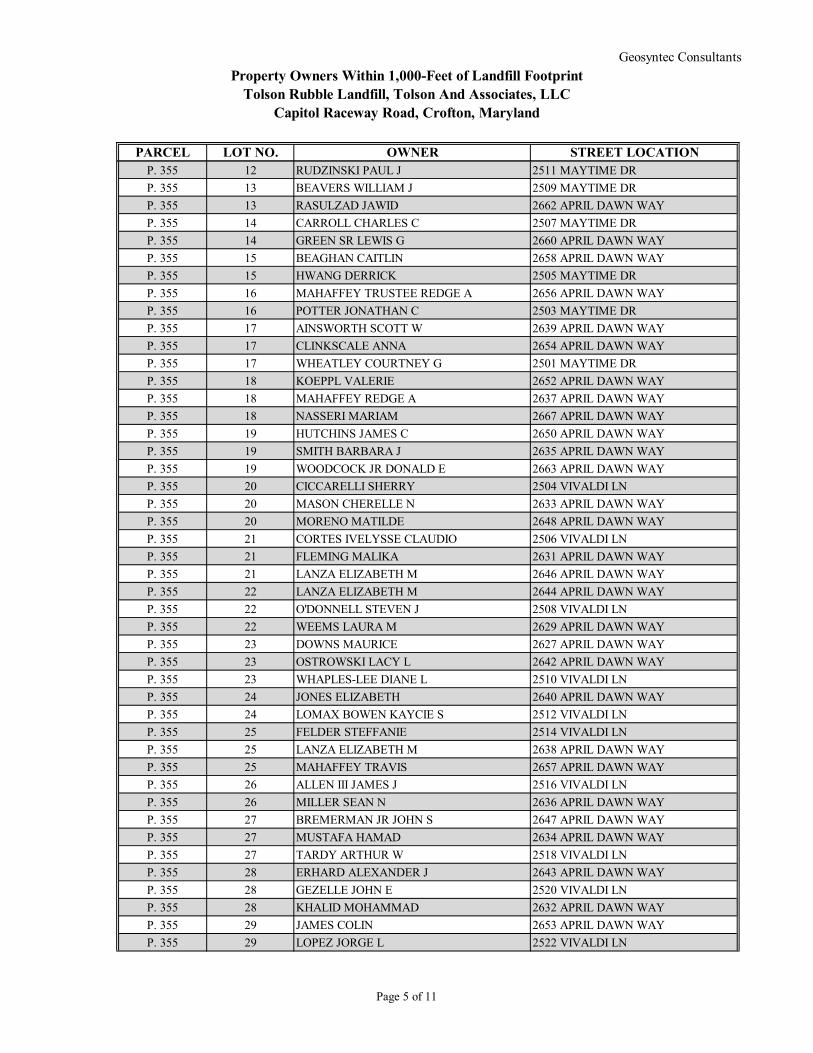
PARCEL LOT NO. OWNER STREET LOCATIONP. 355 12 RUDZINSKI PAUL J 2511 MAYTIME DR
P. 355 13 BEAVERS WILLIAM J 2509 MAYTIME DR
P. 355 13 RASULZAD JAWID 2662 APRIL DAWN WAY
P. 355 14 CARROLL CHARLES C 2507 MAYTIME DR
P. 355 14 GREEN SR LEWIS G 2660 APRIL DAWN WAY
P. 355 15 BEAGHAN CAITLIN 2658 APRIL DAWN WAY
P. 355 15 HWANG DERRICK 2505 MAYTIME DR
P. 355 16 MAHAFFEY TRUSTEE REDGE A 2656 APRIL DAWN WAY
P. 355 16 POTTER JONATHAN C 2503 MAYTIME DR
P. 355 17 AINSWORTH SCOTT W 2639 APRIL DAWN WAY
P. 355 17 CLINKSCALE ANNA 2654 APRIL DAWN WAY
P. 355 17 WHEATLEY COURTNEY G 2501 MAYTIME DR
P. 355 18 KOEPPL VALERIE 2652 APRIL DAWN WAY
P. 355 18 MAHAFFEY REDGE A 2637 APRIL DAWN WAY
P. 355 18 NASSERI MARIAM 2667 APRIL DAWN WAY
P. 355 19 HUTCHINS JAMES C 2650 APRIL DAWN WAY
P. 355 19 SMITH BARBARA J 2635 APRIL DAWN WAY
P. 355 19 WOODCOCK JR DONALD E 2663 APRIL DAWN WAY
P. 355 20 CICCARELLI SHERRY 2504 VIVALDI LN
P. 355 20 MASON CHERELLE N 2633 APRIL DAWN WAY
P. 355 20 MORENO MATILDE 2648 APRIL DAWN WAY
P. 355 21 CORTES IVELYSSE CLAUDIO 2506 VIVALDI LN
P. 355 21 FLEMING MALIKA 2631 APRIL DAWN WAY
P. 355 21 LANZA ELIZABETH M 2646 APRIL DAWN WAY
P. 355 22 LANZA ELIZABETH M 2644 APRIL DAWN WAY
P. 355 22 O'DONNELL STEVEN J 2508 VIVALDI LN
P. 355 22 WEEMS LAURA M 2629 APRIL DAWN WAY
P. 355 23 DOWNS MAURICE 2627 APRIL DAWN WAY
P. 355 23 OSTROWSKI LACY L 2642 APRIL DAWN WAY
P. 355 23 WHAPLES-LEE DIANE L 2510 VIVALDI LN
P. 355 24 JONES ELIZABETH 2640 APRIL DAWN WAY
P. 355 24 LOMAX BOWEN KAYCIE S 2512 VIVALDI LN
P. 355 25 FELDER STEFFANIE 2514 VIVALDI LN
P. 355 25 LANZA ELIZABETH M 2638 APRIL DAWN WAY
P. 355 25 MAHAFFEY TRAVIS 2657 APRIL DAWN WAY
P. 355 26 ALLEN III JAMES J 2516 VIVALDI LN
P. 355 26 MILLER SEAN N 2636 APRIL DAWN WAY
P. 355 27 BREMERMAN JR JOHN S 2647 APRIL DAWN WAY
P. 355 27 MUSTAFA HAMAD 2634 APRIL DAWN WAY
P. 355 27 TARDY ARTHUR W 2518 VIVALDI LN
P. 355 28 ERHARD ALEXANDER J 2643 APRIL DAWN WAY
P. 355 28 GEZELLE JOHN E 2520 VIVALDI LN
P. 355 28 KHALID MOHAMMAD 2632 APRIL DAWN WAY
P. 355 29 JAMES COLIN 2653 APRIL DAWN WAY
P. 355 29 LOPEZ JORGE L 2522 VIVALDI LN
Page 5 of 11

Property Owners Within 1,000-Feet of Landfill FootprintTolson Rubble Landfill, Tolson And Associates, LLC
Capitol Raceway Road, Crofton, Maryland
Geosyntec Consultants
PARCEL LOT NO. OWNER STREET LOCATIONP. 355 29 PENA EDWIN C 2630 APRIL DAWN WAY
P. 355 30 BOSCH CHRISTOPHER D 2623 APRIL DAWN WAY
P. 355 30 MCCRAW BERNICE A 2628 APRIL DAWN WAY
P. 355 30 O'HALLORAN TIMOTHY S 2524 VIVALDI LN
P. 355 31 LEVINE ROBERT D 2526 VIVALDI LN
P. 355 31 TOMLINSON GARY E 2626 APRIL DAWN WAY
P. 355 32 ETHEREDGE ANETRA 2624 APRIL DAWN WAY
P. 355 32 FOWLKES DOLORES THERESA 2528 VIVALDI LN
P. 355 33 MAY EVA 2530 VIVALDI LN
P. 355 33 PAYNE SR TRUSTEE GEORGE A 2622 APRIL DAWN WAY
P. 355 34 KARAMBELAS KIMBERLY S 2620 APRIL DAWN WAY
P. 355 34 STANLEY ALEC 2607 APRIL DAWN WAY
P. 355 35 BUNN PATRICK J 2533 MAYTIME DR
P. 355 35 SWINGLE GEORGE J JR 2618 APRIL DAWN WAY
P. 355 36 ALRIDGE TANYA Y 2531 MAYTIME DR
P. 355 36 DAVIS KEVIN 2616 APRIL DAWN WAY
P. 355 37 PATTERSON MICHAEL E 2614 APRIL DAWN WAY
P. 355 38 JENKIN BRYAN L 2612 APRIL DAWN WAY
P. 355 39 BOSLEY GARY S 2610 APRIL DAWN WAY
P. 355 40 ZIMMERMAN JOSEPH 2608 APRIL DAWN WAY
P. 355 41 HOWELL HERBERT K 2606 APRIL DAWN WAY
P. 355 42 DOWNS PATRICIA A 2604 APRIL DAWN WAY
P. 355 43 SHOEMAKER ROBERT B 2602 APRIL DAWN WAY
P. 355 44 SERIO JEREMY J 2600 APRIL DAWN WAY
P. 355 85 TERWILLIGER MARVIN A 2500 MAYTIME DR
P. 355 86 MCELHENNON STEPHEN H 2502 MAYTIME DR
P. 355 87 CLOPPER J GILBERT 2504 MAYTIME DR
P. 355 88 THOMPSON PHILIP M 2506 MAYTIME DR
P. 355 89 NEVITT LAWRENCE L 2508 MAYTIME DR
P. 355 90 WHITE MICHAEL K 2510 MAYTIME DR
P. 355 91 WHITE MICHAEL K 2512 MAYTIME DR
P. 355 92 ST LOUIS PATRICIA M 2514 MAYTIME DR
P. 355 93 DIMAGIBA HANAPHIA V 2516 MAYTIME DR
P. 355 94 MCCALL KENNETH L 2518 MAYTIME DR
P. 355 95 RICHARDSON WILLIE D 2520 MAYTIME DR
P. 355 96 HYATT ELAINE L 2522 MAYTIME DR
P. 355 97 LACHANCE RICK A 2524 MAYTIME DR
P. 355 98 LANZA ELIZABETH M 2526 MAYTIME DR
P. 355 99 BAUKHAGES V FREDERICK E 2528 MAYTIME DR
P. 355 100 WRIGHT JAMES E 2530 MAYTIME DR
P. 355 101 THOMAS DOLENTE 2532 MAYTIME DR
P. 355 102 MILLER BEVERLY A 2534 MAYTIME DR
P. 355 103 DAVIS CHARLES B 2536 MAYTIME DR
P. 355 104 LEWIS JOSEPH E 2538 MAYTIME DR
P. 355 105 BURNETT FRANK W 2540 MAYTIME DR
Page 6 of 11

Property Owners Within 1,000-Feet of Landfill FootprintTolson Rubble Landfill, Tolson And Associates, LLC
Capitol Raceway Road, Crofton, Maryland
Geosyntec Consultants
PARCEL LOT NO. OWNER STREET LOCATIONP. 355 106 MAHAFFEY TRUSTEE REDGE A 2542 MAYTIME DR
P. 355 107 BROWN IV DAVID E 2544 MAYTIME DR
P. 356 1 LANZA ELIZABETH M 2417 BLOOMING WAY
P. 356 1 MADSEN CYNTHIA A 2412 BLOOMING WAY
P. 356 2 PRUSKI ANDREW C 2417 SUNSHINE WAY
P. 356 2 SMITH JR MICHAEL A 1102 RED FALL LN
P. 356 2 WAKE MARTIN L 2415 BLOOMING WAY
P. 356 3 DORSEY LESLIE H 2415 SUNSHINE WAY
P. 356 3 MINOR FLOYD T 2413 BLOOMING WAY
P. 356 3 VIADO GLEN A 1104 RED FALL LN
P. 356 4 MOBLEY SR DAVID A 1106 RED FALL LN
P. 356 4 SIERCO FREDERICK L 2411 BLOOMING WAY
P. 356 5 HOGUE CHRISTOPHER J 1108 RED FALL LN
P. 356 5 ZIMMERLI RICHARD A 2409 BLOOMING WAY
P. 356 6 AGUILAR JEROME 1113 RED FALL LN
P. 356 6 JETT DARRELL L 1110 RED FALL LN
P. 356 7 KINSEY GARY 1111 RED FALL LN
P. 356 7 VEYERA LIANE M 1112 RED FALL LN
P. 356 8 MAYER ANDREW 1109 RED FALL LN
P. 356 8 RITTER MARK A 2403 BLOOMING WAY
P. 356 9 JORGENSEN JONATHAN P 2490 RED FALL CT
P. 356 9 PIERCY RAY A 2420 SUNSHINE WAY
P. 356 10 STENNETT JEFFREY S 2488 RED FALL CT
P. 356 10 WILSON JARROD M 2422 SUNSHINE WAY
P. 356 11 KLEIN PETER M 2414 BLOOMING WAY
P. 356 11 MINK RONALD G 2486 RED FALL CT
P. 356 12 DURM DEANE H 2406 BLOOMING WAY
P. 356 12 WILLIAMSON GARY W 2484 RED FALL CT
P. 356 13 ROMERO ISMAEL A 2482 RED FALL CT
P. 356 13 SCHIEMAN GEORGE K 2408 BLOOMING WAY
P. 356 14 HOETZEL CHARLES J 2480 RED FALL CT
P. 356 14 SHAEFFER PETER W 2410 BLOOMING WAY
P. 356 15 HUMMEL TRUSTEE KEITH A 2478 RED FALL CT
P. 356 16 MCCUBBIN MELISSA E 2476 RED FALL CT
P. 356 17 RAY DULANY WALTER R 2474 RED FALL CT
P. 356 18 DAMICO FRANK T 2472 RED FALL CT
P. 356 19 AKSELROD KONSTANTIN G 2470 RED FALL CT
P. 356 20 MOGEL DAVID S 2469 RED FALL CT
P. 356 21 CHADWICK JR ROBERT A 2471 RED FALL CT
P. 356 22 COSTA NICHOLAS S 2473 RED FALL CT
P. 356 23 BLIGHT SARA E 2475 RED FALL CT
P. 356 24 FEIBEL JOSEPH M 2477 RED FALL CT
P. 356 25 DONAHUE PATRICK J 2479 RED FALL CT
P. 356 26 LEWIS GREGORY E 2481 RED FALL CT
P. 356 27 CERESA MICHAEL B 2483 RED FALL CT
Page 7 of 11

Property Owners Within 1,000-Feet of Landfill FootprintTolson Rubble Landfill, Tolson And Associates, LLC
Capitol Raceway Road, Crofton, Maryland
Geosyntec Consultants
PARCEL LOT NO. OWNER STREET LOCATIONP. 356 28 LOGAN JOHN 2485 RED FALL CT
P. 356 29 CHAPMAN THOMAS P 2487 RED FALL CT
P. 356 30 WISE THOMAS A 2489 RED FALL CT
P. 356 A WASHINGTON HOMES INC PL 4 BLOOMING WAY
P. P.0353 15 BELL ROBERT R 2515 SYMPHONY LN
P. P.0354 21 MORANO JOHN B 2427 FLOWERING TREE LN
P. P.0354 74 ANDREWS STANLEY D 2428 FLOWERING TREE LN
P. P.0355 84 HARMON JASON J 2433 MAYTIME DR
PROPERTIES FROM GREEN BLOWUP
P. 3 5 HAYAKAWA SARAH 2664 MERLIN CT
P. 3 6 REGALIA JENNIFER 2666 MERLIN CT
P. 3 7 WORCESTER KEY S C 2668 MERLIN CT
P. 3 8 SADARA BEN D 2670 MERLIN CT
P. 3 9 DUVALL DWAINE K 7673 PORCELAIN TILE CT
P. 3 9 SINGER JOEL 2672 MERLIN CT
P. 3 10 PILZER TRUSTEE ARTHUR 7671 PORCELAIN TILE CT
P. 3 10 VENDEMMIA PHILLIP 2674 MERLIN CT
P. 3 11 ERLEWINE CHRISTOPHER 7669 PORCELAIN TILE CT
P. 3 11 MAZZARELLO ROBERT J 1070 PIPISTRELLE CT
P. 3 12 RUBIN JASON S 1068 PIPISTRELLE CT
P. 3 12 SR KITCHEN MCARTHUR 7667 PORCELAIN TILE CT
P. 3 13 DICKENS KAILON 1066 PIPISTRELLE CT
P. 3 14 ARBELO CARLOS M 1064 PIPISTRELLE CT
P. 3 15 GOMEZ ANDRES J 1062 PIPISTRELLE CT
P. 3 16 REYNOLDS JR WALTER 1060 PIPISTRELLE CT
P. 3 17 PENIEL MFB LTD 1058 PIPISTRELLE CT
P. 3 18 DILLARD MICHAEL 7656 MILK GLASS CT
P. 3 18 KEATING SHEILA 1056 PIPISTRELLE CT
P. 3 19 BUCCO ANNETTE L 7654 MILK GLASS CT
P. 3 19 ICE DAVID 1054 PIPISTRELLE CT
P. 3 20 CHI-MING KING JONATHAN 1052 PIPISTRELLE CT
P. 3 20 MERCER SHARON L 7652 MILK GLASS CT
P. 3 21 GUPTA SANDEEP 1050 PIPISTRELLE CT
P. 3 21 SONDE TRUSTEE SUSAN 7650 MILK GLASS CT
P. 3 22 LIM OK KYUNG 1048 PIPISTRELLE CT
P. 3 22 NAZIR MUNIR 7648 MILK GLASS CT
P. 3 23 DUSPIVA PETER H 7646 MILK GLASS CT
P. 3 23 GATLING SHIRLEAN 1046 PIPISTRELLE CT
P. 3 24 MARSHALL TWYLA A 1044 PIPISTRELLE CT
P. 3 25 ROSE NICHOLAS W 1042 PIPISTRELLE CT
P. 3 26 CHUTE MICHAEL K 7655 MILK GLASS CT
P. 3 26 MASON MICHAEL 2669 MERLIN CT
P. 3 27 DUTTON JR JOHN A 7653 MILK GLASS CT
P. 3 27 SINGER ODED 2667 MERLIN CT
P. 3 28 COSBY ANTHONY T 2665 MERLIN CT
Page 8 of 11

Property Owners Within 1,000-Feet of Landfill FootprintTolson Rubble Landfill, Tolson And Associates, LLC
Capitol Raceway Road, Crofton, Maryland
Geosyntec Consultants
PARCEL LOT NO. OWNER STREET LOCATIONP. 3 28 TIPTON DAVID G 7651 MILK GLASS CT
P. 3 29 EDWARDS BELINDA TRUSTEE 2663 MERLIN CT
P. 3 29 PETTEBONE JOHN E 7649 MILK GLASS CT
P. 3 30 DROBEK DEBRA LEE 7647 MILK GLASS CT
P. 3 30 HEBER JR ROBERT A 2661 MERLIN CT
P. 3 31 VARGAS VIVIAN A 2659 MERLIN CT
P. 3 31 ZURMUHLEN LISA M 7645 MILK GLASS CT
P. 3 32 ESPIRITU RONALD G 2654 DIDELPHIS DR
P. 3 32 HALL MONA S TRUSTEE 7643 MILK GLASS CT
P. 3 33 BERENSON MARK 7641 MILK GLASS CT
P. 3 33 JOHNSTON JEREMY M 2652 DIDELPHIS DR
P. 3 34 ENGL JEFFREY R 7640 FOUND ARTIFACT DR
P. 3 34 SCULLY WHITNEY 2650 DIDELPHIS DR
P. 3 35 BEAVERS NICHOLAS R 2648 DIDELPHIS DR
P. 3 35 GLADDEN GARY M 7638 FOUND ARTIFACT DR
P. 3 36 FRASER GREGORY A 7636 FOUND ARTIFACT DR
P. 3 36 HAWTHORNE MARY C 2646 DIDELPHIS DR
P. 3 37 LOCKWOOD BRIAN J 7634 FOUND ARTIFACT DR
P. 3 37 VO MY THI 2644 DIDELPHIS DR
P. 3 38 LACOSS SCOTT DARREN 7632 FOUND ARTIFACT DR
P. 3 39 RAGLAND JAMES W 7630 FOUND ARTIFACT DR
P. 3 40 MCNALLY JAMES F 7628 FOUND ARTIFACT DR
P. 3 41 AGORSOR CHARITY DELA 1034 VERDIGRIS WAY
P. 3 41 ROSARIO-FELIX TRUSTEE MIGUEL A 7626 FOUND ARTIFACT DR
P. 3 42 BOOTH VINCENT E 7624 FOUND ARTIFACT DR
P. 3 42 BOYKIN WILLIAM H JR 1032 VERDIGRIS WAY
P. 3 43 SCHWAB TRUSTEE JAY H ETAL 7622 FOUND ARTIFACT DR
P. 3 43 SHEPHERD DOUGLASS W 1030 VERDIGRIS WAY
P. 3 44 VARDAREDIAN PETER 1028 VERDIGRIS WAY
P. 3 44 ZERNICK TIMOTHY J 7620 FOUND ARTIFACT DR
P. 3 45 HELLER TRUSTEE JONATHON 7639 FOUND ARTIFACT DR
P. 3 45 PHAM PHUHAO 1026 VERDIGRIS WAY
P. 3 46 WILLIAMS TRUSTEE DAVID E 7637 FOUND ARTIFACT DR
P. 3 46 ZHOU JINGSONG 2657 DIDELPHIS DR
P. 3 47 PADGETT ROBERT W 2655 DIDELPHIS DR
P. 3 47 RACKIS REBECCA A 7635 FOUND ARTIFACT DR
P. 3 48 BUDOFF FRED R 7633 FOUND ARTIFACT DR
P. 3 48 HENDERSON LISA D 2653 DIDELPHIS DR
P. 3 49 BARBERIO JOSEPH 7631 FOUND ARTIFACT DR
P. 3 49 LOPEZ ANGELIQUE E 2651 DIDELPHIS DR
P. 3 50 DEAUSEN RYAN L 2649 DIDELPHIS DR
P. 3 50 MUHL BONITA D 7629 FOUND ARTIFACT DR
P. 3 51 LASKEY ROBERT P 7627 FOUND ARTIFACT DR
P. 3 51 SCULLY WHITNEY C 2647 DIDELPHIS DR
P. 3 52 BELL ARNOLD E 7625 FOUND ARTIFACT DR
Page 9 of 11

Property Owners Within 1,000-Feet of Landfill FootprintTolson Rubble Landfill, Tolson And Associates, LLC
Capitol Raceway Road, Crofton, Maryland
Geosyntec Consultants
PARCEL LOT NO. OWNER STREET LOCATIONP. 3 52 USMAN MOHAMMAD ALI 2645 DIDELPHIS DR
P. 3 53 PEARSON MICHAEL A 2643 DIDELPHIS DR
P. 3 53 QUICK MARTIN E 7623 FOUND ARTIFACT DR
P. 3 54 KOWAL HENRY J 7621 FOUND ARTIFACT DR
P. 3 54 ZAHID SADIA 2641 DIDELPHIS DR
P. 3 55 LUSBY JAMES R 7618 VULPE CT
P. 3 55 TUFTS CARRIE M 2642 RAPTOR DR
P. 3 56 GREENBERG DAVID S 2640 RAPTOR DR
P. 3 57 WANG YINGCHUN 2638 RAPTOR DR
P. 3 58 BUTLER YAHARI HASSAN TRUSTEE 2636 RAPTOR DR
P. 3 59 COX EARL G 7610 VULPE CT
P. 3 60 KURIAN VALLAYIL G 2632 RAPTOR DR
P. 3 61 WENDKOS DAVID S 2630 RAPTOR DR
P. 3 62 ABRAHAM SKARIA P 2628 RAPTOR DR
P. 3 63 PADDEN MARY C 2626 RAPTOR DR
P. 3 64 BOTZUM STEPHEN J 2639 RAPTOR DR
P. 3 65 BRANNON SAMUEL L 2637 RAPTOR DR
P. 3 66 BENTON TRUSTEE PATRICK J ETAL 2635 RAPTOR DR
P. 3 67 HARRIS BRADLEY E 2633 RAPTOR DR
P. 3 68 KONDURU NAGARJUNA 2631 RAPTOR DR
P. 3 69 GRAY JEANNETTE 2629 RAPTOR DR
P. 3 70 BRACKENS CHRISTOPHER L 2627 RAPTOR DR
P. 3 71 SCHWIKERT RICHARD D 1024 VERDIGRIS WAY
P. 3 72 CLARK JR WILLIAM T 1022 VERDIGRIS WAY
P. 3 73 BOWEN MATTHEW M 1020 VERDIGRIS WAY
P. 3 74 PEEBLES SCOTT C 1018 VERDIGRIS WAY
P. 3 75 MEEKS III GEORGE O 1016 VERDIGRIS WAY
P. 3 76 CUSUMANO ZACHARY T 1014 VERDIGRIS WAY
P. 3 77 BROWN BAYNE R 1012 VERDIGRIS WAY
P. 3 78 STONESIFER WILLIAM A 1010 VERDIGRIS WAY
P. 3 79 PARIKH NINA D 1008 VERDIGRIS WAY
P. 3 80 WILLIAMS STEPHEN WAYNE 1006 VERDIGRIS WAY
P. 3 81 VARADARAJAN RUPESHKUMAR 1004 VERDIGRIS WAY
P. 3 82 CHAN ALBERT H 1002 VERDIGRIS WAY
P. 3 83 YENDALL LINDA P 1000 VERDIGRIS WAY
P. 3 84 PARENT DALE R 2624 SOUR DOCK DR
P. 3 85 CHOU MING-DAH 2622 SOUR DOCK DR
P. 3 86 KIM JONG GUN 2620 SOUR DOCK DR
P. 3 87 FITZSIMMONS SEAN 2618 SOUR DOCK DR
P. 3 88 STAPLETON JAMES 2616 SOUR DOCK DR
P. 3 89 WESTON CHARLENE 2614 SOUR DOCK DR
P. 3 90 FREY PATRICK J 2612 SOUR DOCK DR
P. 3 91 HEIDARI SHERVIN Y 2610 SOUR DOCK DR
P. 3 92 DING I-KANG 2608 SOUR DOCK DR
P. 3 93 RICHARDS THOMAS A 2606 SOUR DOCK DR
Page 10 of 11

Property Owners Within 1,000-Feet of Landfill FootprintTolson Rubble Landfill, Tolson And Associates, LLC
Capitol Raceway Road, Crofton, Maryland
Geosyntec Consultants
PARCEL LOT NO. OWNER STREET LOCATIONP. 3 94 ADAMS BETH 2604 SOUR DOCK DR
P. 3 95 VARANO JR ANTHONY J 2602 SOUR DOCK DR
P. 3 96 STRICKLER KATHY L 2625 SOUR DOCK DR
P. 3 97 MASON THOMAS R 2623 SOUR DOCK DR
P. 3 98 HENDERSON SUSANNA 2621 SOUR DOCK DR
P. 3 99 VOIGHT BRADLEY M 2619 SOUR DOCK DR
P. 3 100 NITHIANANDAM DIVYA 2617 SOUR DOCK DR
P. 3 101 KITA MICHEAL A 2615 SOUR DOCK DR
P. 3 102 MORAN MICHAEL 2613 SOUR DOCK DR
P. 3 103 LEE TRUSTEE RALPH H 2611 SOUR DOCK DR
P. 3 104 WHITAKER JOSHUA J 2609 SOUR DOCK DR
P. 3 105 KIM CHANG H 2607 SOUR DOCK DR
P. 3 106 SMALL JOHN R 2605 SOUR DOCK DR
P. 3 107 WALTERS CHRISTOPHER J 900 KESTREL CT
P. 3 108 MALEK MICHAEL R 902 KESTREL CT
P. 3 109 PACKIANATHAN DAVID R 904 KESTREL CT
P. 3 110 CLARK LISA A 906 KESTREL CT
P. 3 111 KNARR MICHAEL 908 KESTREL CT
P. 3 112 BOZEMAN MONICA 910 KESTREL CT
P. 3 113 PERONA CHRISTOPHER J 912 KESTREL CT
P. 3 114 ANDRADE JEFFREY R 914 KESTREL CT
P. 3 115 CUSHENETTE ERIC C 916 KESTREL CT
P. 3 116 BRUNO MICHAEL S 918 KESTREL CT
P. 3 117 HEICHELBECH STEPHEN W 920 KESTREL CT
P. 3 118 SHAH NIHIR R 922 KESTREL CT
P. 3 OS000 MAPLE RIDGE AT PINEY ORCHARD OPEN SPACE/GREEN SPACE
P. 3 OS008 SUMMIT CHASE AT PINEY ORCHARD OPEN SPACE
P. 3 OS009 SUMMIT CHASE AT PINEY ORCHARD OPEN SPACE
P. 3 OS010 SUMMIT CHASE AT PINEY ORCHARD OPEN SPACE
Page 11 of 11

ATTACHMENT 3
FAA DETERMINATION OF NO HAZARD TO AIR
NAVIGATION

125
175
130
135
140 170
180125
125
150
5050
75
100
125
150
100
100
125
185
125
120
130
135
140
145
140
160
135
140
175
180
185
185
190
190
N 39.0489W 76.7037
N 39.0437W 76.6982
N 39.0404W 76.7077
N 39.0408W 76.7092
N 39.0426W 76.7099
N 39.0459W 76.7074
N
PROJECT NO:
FIGURE
P:\C
ADD
\PR
OJE
CTS
\T\T
OLS
ON
\CO
NC
EPTU
AL\F
IGU
RES
\ME1
606F
005-
FAA
NO
TIC
E O
F PR
OP
CO
NST
R -
Last
Sav
ed b
y: A
Mal
ek o
n 11
/15/
18
SITE LOCATION FIGURE FORFEDERAL AVIATION ADMINISTRATION
NOTICE OF PROPOSED CONSTRUCTIONTOLSON LANDFILL, CROFTON, MARYLAND
ME16061
NOVEMBER 2018
3000
SCALE IN FEET
+MAX. ELEV. 245.0
TOLSONLANDFILL

Mail Processing CenterFederal Aviation AdministrationSouthwest Regional OfficeObstruction Evaluation Group10101 Hillwood ParkwayFort Worth, TX 76177
Aeronautical Study No.2018-AEA-15503-OEPrior Study No.2018-AEA-14104-OE
Page 1 of 4
Issued Date: 02/04/2019
Tolson And Associates, LLCMike Ensor24024 Frederick RoadClarksburg, MD 20871
** DETERMINATION OF NO HAZARD TO AIR NAVIGATION **
The Federal Aviation Administration has conducted an aeronautical study under the provisions of 49 U.S.C.,Section 44718 and if applicable Title 14 of the Code of Federal Regulations, part 77, concerning:
Structure: Landfill Tolson Landfill High PointLocation: Odenton, MDLatitude: 39-02-42.59N NAD 83Longitude: 76-42-07.02WHeights: 175 feet site elevation (SE)
70 feet above ground level (AGL)245 feet above mean sea level (AMSL)
This aeronautical study revealed that the structure does not exceed obstruction standards and would not be ahazard to air navigation provided the following condition(s), if any, is(are) met:
It is required that FAA Form 7460-2, Notice of Actual Construction or Alteration, be e-filed any time theproject is abandoned or:
_____ At least 10 days prior to start of construction (7460-2, Part 1)__X__ Within 5 days after the construction reaches its greatest height (7460-2, Part 2)
As a result of this structure being critical to flight safety, it is required that the FAA be kept appraised as to thestatus of the project. Failure to respond to periodic FAA inquiries could invalidate this determination.
This aeronautical study included evaluation of a structure that exists at this time. Action will be taken to ensureaeronautical charts are updated to reflect the most current coordinates, elevation and height as indicated in thecase description.
Based on this evaluation, marking and lighting are not necessary for aviation safety. However, if marking/lighting are accomplished on a voluntary basis, we recommend it be installed in accordance with FAA Advisorycircular 70/7460-1 L Change 2.
This determination is based, in part, on the foregoing description which includes specific coordinates, heights,frequency(ies) and power. Any changes in coordinates, heights, and frequencies or use of greater power, exceptthose frequencies specified in the Colo Void Clause Coalition; Antenna System Co-Location; Voluntary Best
Page 2 of 4
Practices, effective 21 Nov 2007, will void this determination. Any future construction or alteration, includingincrease to heights, power, or the addition of other transmitters, requires separate notice to the FAA.Thisdetermination includes all previously filed frequencies and power for this structure.
If construction or alteration is dismantled or destroyed, you must submit notice to the FAA within 5 days afterthe construction or alteration is dismantled or destroyed.
This determination does include temporary construction equipment such as cranes, derricks, etc., which may beused during actual construction of the structure. However, this equipment shall not exceed the overall heights asindicated above. Equipment which has a height greater than the studied structure requires separate notice to theFAA.
This determination concerns the effect of this structure on the safe and efficient use of navigable airspaceby aircraft and does not relieve the sponsor of compliance responsibilities relating to any law, ordinance, orregulation of any Federal, State, or local government body.
If we can be of further assistance, please contact our office at (404) 305-6645, or [email protected]. On anyfuture correspondence concerning this matter, please refer to Aeronautical Study Number 2018-AEA-15503-OE.
Signature Control No: 392416350-395375043 ( DNE )Lan NorrisSpecialist
Attachment(s)Case DescriptionMap(s)

Page 3 of 4
Case Description for ASN 2018-AEA-15503-OE
Expansion of existing Tolson Rubble Landfill

Page 4 of 4
TOPO Map for ASN 2018-AEA-15503-OE

Mail Processing CenterFederal Aviation AdministrationSouthwest Regional OfficeObstruction Evaluation Group10101 Hillwood ParkwayFort Worth, TX 76177
Aeronautical Study No.2018-AEA-15503-OEPrior Study No.2018-AEA-14104-OE
Page 1 of 4
Issued Date: 02/04/2019
Tolson And Associates, LLCMike Ensor24024 Frederick RoadClarksburg, MD 20871
** DETERMINATION OF NO HAZARD TO AIR NAVIGATION **
The Federal Aviation Administration has conducted an aeronautical study under the provisions of 49 U.S.C.,Section 44718 and if applicable Title 14 of the Code of Federal Regulations, part 77, concerning:
Structure: Landfill Tolson Landfill High PointLocation: Odenton, MDLatitude: 39-02-42.59N NAD 83Longitude: 76-42-07.02WHeights: 175 feet site elevation (SE)
70 feet above ground level (AGL)245 feet above mean sea level (AMSL)
This aeronautical study revealed that the structure does not exceed obstruction standards and would not be ahazard to air navigation provided the following condition(s), if any, is(are) met:
It is required that FAA Form 7460-2, Notice of Actual Construction or Alteration, be e-filed any time theproject is abandoned or:
_____ At least 10 days prior to start of construction (7460-2, Part 1)__X__ Within 5 days after the construction reaches its greatest height (7460-2, Part 2)
As a result of this structure being critical to flight safety, it is required that the FAA be kept appraised as to thestatus of the project. Failure to respond to periodic FAA inquiries could invalidate this determination.
This aeronautical study included evaluation of a structure that exists at this time. Action will be taken to ensureaeronautical charts are updated to reflect the most current coordinates, elevation and height as indicated in thecase description.
Based on this evaluation, marking and lighting are not necessary for aviation safety. However, if marking/lighting are accomplished on a voluntary basis, we recommend it be installed in accordance with FAA Advisorycircular 70/7460-1 L Change 2.
This determination is based, in part, on the foregoing description which includes specific coordinates, heights,frequency(ies) and power. Any changes in coordinates, heights, and frequencies or use of greater power, exceptthose frequencies specified in the Colo Void Clause Coalition; Antenna System Co-Location; Voluntary Best

Page 2 of 4
Practices, effective 21 Nov 2007, will void this determination. Any future construction or alteration, includingincrease to heights, power, or the addition of other transmitters, requires separate notice to the FAA.Thisdetermination includes all previously filed frequencies and power for this structure.
If construction or alteration is dismantled or destroyed, you must submit notice to the FAA within 5 days afterthe construction or alteration is dismantled or destroyed.
This determination does include temporary construction equipment such as cranes, derricks, etc., which may beused during actual construction of the structure. However, this equipment shall not exceed the overall heights asindicated above. Equipment which has a height greater than the studied structure requires separate notice to theFAA.
This determination concerns the effect of this structure on the safe and efficient use of navigable airspaceby aircraft and does not relieve the sponsor of compliance responsibilities relating to any law, ordinance, orregulation of any Federal, State, or local government body.
If we can be of further assistance, please contact our office at (404) 305-6645, or [email protected]. On anyfuture correspondence concerning this matter, please refer to Aeronautical Study Number 2018-AEA-15503-OE.
Signature Control No: 392416350-395375043 ( DNE )Lan NorrisSpecialist
Attachment(s)Case DescriptionMap(s)

Page 3 of 4
Case Description for ASN 2018-AEA-15503-OE
Expansion of existing Tolson Rubble Landfill
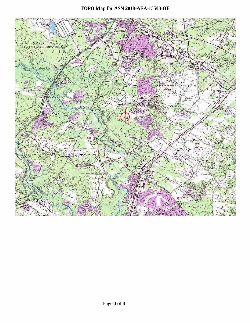
Page 4 of 4
TOPO Map for ASN 2018-AEA-15503-OE

Mail Processing CenterFederal Aviation AdministrationSouthwest Regional OfficeObstruction Evaluation Group10101 Hillwood ParkwayFort Worth, TX 76177
Aeronautical Study No.2018-AEA-15503-OEPrior Study No.2018-AEA-14104-OE
Page 1 of 4
Issued Date: 02/04/2019
Tolson And Associates, LLCMike Ensor24024 Frederick RoadClarksburg, MD 20871
** DETERMINATION OF NO HAZARD TO AIR NAVIGATION **
The Federal Aviation Administration has conducted an aeronautical study under the provisions of 49 U.S.C.,Section 44718 and if applicable Title 14 of the Code of Federal Regulations, part 77, concerning:
Structure: Landfill Tolson Landfill High PointLocation: Odenton, MDLatitude: 39-02-42.59N NAD 83Longitude: 76-42-07.02WHeights: 175 feet site elevation (SE)
70 feet above ground level (AGL)245 feet above mean sea level (AMSL)
This aeronautical study revealed that the structure does not exceed obstruction standards and would not be ahazard to air navigation provided the following condition(s), if any, is(are) met:
It is required that FAA Form 7460-2, Notice of Actual Construction or Alteration, be e-filed any time theproject is abandoned or:
_____ At least 10 days prior to start of construction (7460-2, Part 1)__X__ Within 5 days after the construction reaches its greatest height (7460-2, Part 2)
As a result of this structure being critical to flight safety, it is required that the FAA be kept appraised as to thestatus of the project. Failure to respond to periodic FAA inquiries could invalidate this determination.
This aeronautical study included evaluation of a structure that exists at this time. Action will be taken to ensureaeronautical charts are updated to reflect the most current coordinates, elevation and height as indicated in thecase description.
Based on this evaluation, marking and lighting are not necessary for aviation safety. However, if marking/lighting are accomplished on a voluntary basis, we recommend it be installed in accordance with FAA Advisorycircular 70/7460-1 L Change 2.
This determination is based, in part, on the foregoing description which includes specific coordinates, heights,frequency(ies) and power. Any changes in coordinates, heights, and frequencies or use of greater power, exceptthose frequencies specified in the Colo Void Clause Coalition; Antenna System Co-Location; Voluntary Best

Page 2 of 4
Practices, effective 21 Nov 2007, will void this determination. Any future construction or alteration, includingincrease to heights, power, or the addition of other transmitters, requires separate notice to the FAA.Thisdetermination includes all previously filed frequencies and power for this structure.
If construction or alteration is dismantled or destroyed, you must submit notice to the FAA within 5 days afterthe construction or alteration is dismantled or destroyed.
This determination does include temporary construction equipment such as cranes, derricks, etc., which may beused during actual construction of the structure. However, this equipment shall not exceed the overall heights asindicated above. Equipment which has a height greater than the studied structure requires separate notice to theFAA.
This determination concerns the effect of this structure on the safe and efficient use of navigable airspaceby aircraft and does not relieve the sponsor of compliance responsibilities relating to any law, ordinance, orregulation of any Federal, State, or local government body.
If we can be of further assistance, please contact our office at (404) 305-6645, or [email protected]. On anyfuture correspondence concerning this matter, please refer to Aeronautical Study Number 2018-AEA-15503-OE.
Signature Control No: 392416350-395375043 ( DNE )Lan NorrisSpecialist
Attachment(s)Case DescriptionMap(s)
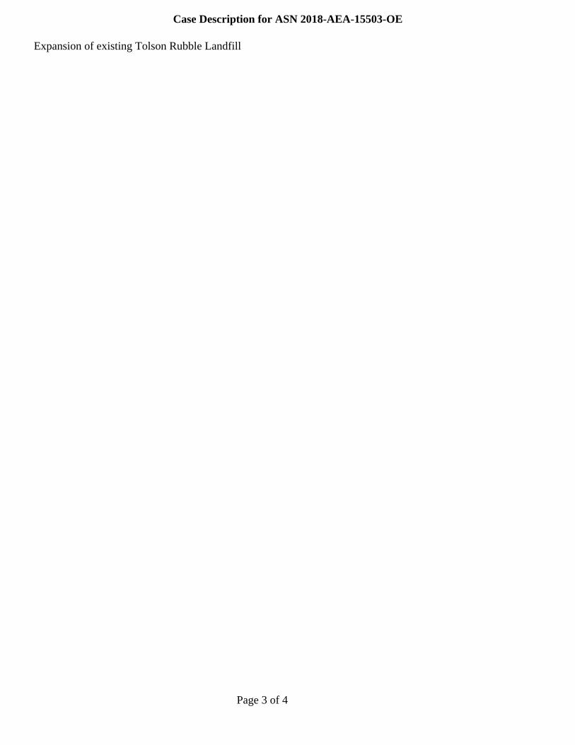
Page 3 of 4
Case Description for ASN 2018-AEA-15503-OE
Expansion of existing Tolson Rubble Landfill

Page 4 of 4
TOPO Map for ASN 2018-AEA-15503-OE
Related Documents


