
Welcome message from author
This document is posted to help you gain knowledge. Please leave a comment to let me know what you think about it! Share it to your friends and learn new things together.
Transcript

May the road
rise to meet you,
May the wind
always be at your back,
May the sun
shine warm upon your face,
May the rains
fall softly upon your fields…

JOHNSTOWN/MILLIKEN PARKS, TRAILS,
RECREATION AND OPEN SPACE MASTER PLAN
TABLE OF CONTENTS
ACKNOWLEDGMENTS .....................................................................................I-IV
INTRODUCTION.............................................................................................1-16Purpose of Plan 1Contents of this Plan 1How to Use this Plan 2Planning Process 5Update/Amendment Process 6Five-Year Action Plan 7Parks, Trails, Recreation and Open Space Master Plan Map 9
GOALS AND OBJECTIVES FOR THE PARKS, TRAILS,RECREATION AND OPEN SPACE MASTER PLAN ..........................................10-11
OUR CHILDREN’S DREAMS ..........................................................................12-14
PARKS, TRAILS, RECREATION AND OPEN SPACEDESIGN GUIDELINES ....................................................................................15-16Introduction 15Design Guidelines 15
COMMUNITY SETTING, CHARACTER AND HERITAGE................................17-20Regional Setting 17History of the Communities 17Population Characteristics 18Key Trends 18Regional Context Map 20
RESOURCE ASSESSMENT...............................................................................21-25Soils and Topography 22Water Resources 22Vegetation 23Scenic and Cultural Resources 24Wildlife 24
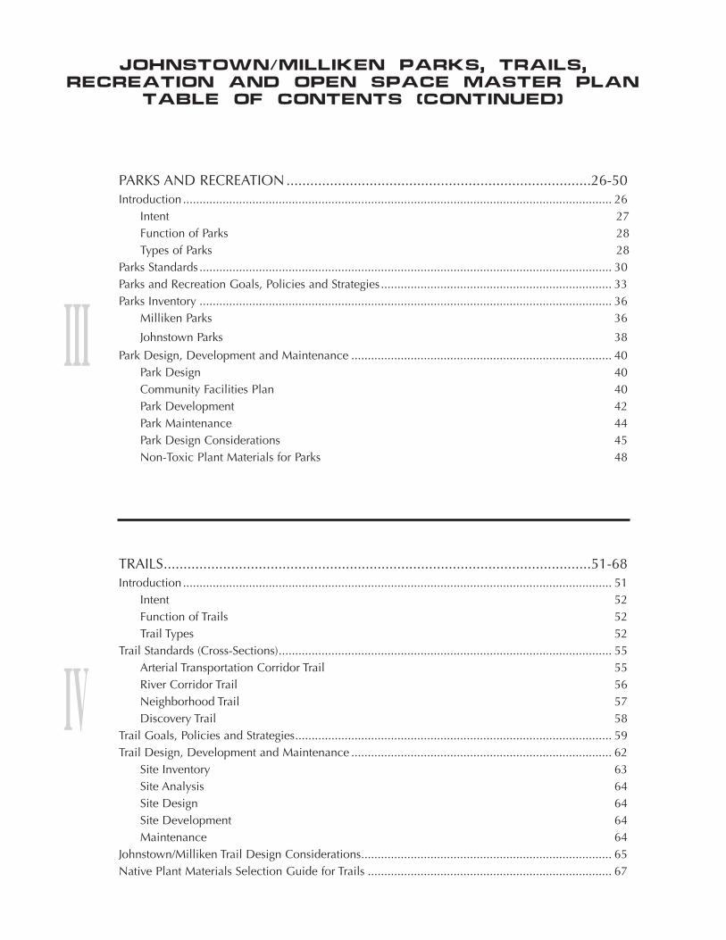
PARKS AND RECREATION.............................................................................26-50Introduction .................................................................................................................................. 26
Intent 27Function of Parks 28Types of Parks 28
Parks Standards ............................................................................................................................. 30Parks and Recreation Goals, Policies and Strategies...................................................................... 33Parks Inventory ............................................................................................................................. 36
Milliken Parks 36
Johnstown Parks 38
Park Design, Development and Maintenance ............................................................................... 40Park Design 40Community Facilities Plan 40Park Development 42Park Maintenance 44Park Design Considerations 45Non-Toxic Plant Materials for Parks 48
TRAILS............................................................................................................51-68Introduction .................................................................................................................................. 51
Intent 52Function of Trails 52Trail Types 52
Trail Standards (Cross-Sections)..................................................................................................... 55Arterial Transportation Corridor Trail 55River Corridor Trail 56Neighborhood Trail 57Discovery Trail 58
Trail Goals, Policies and Strategies................................................................................................ 59Trail Design, Development and Maintenance ............................................................................... 62
Site Inventory 63Site Analysis 64Site Design 64Site Development 64Maintenance 64
Johnstown/Milliken Trail Design Considerations............................................................................ 65Native Plant Materials Selection Guide for Trails .......................................................................... 67
JOHNSTOWN/MILLIKEN PARKS, TRAILS,
RECREATION AND OPEN SPACE MASTER PLAN
TABLE OF CONTENTS (CONTINUED)

OPEN SPACE ..................................................................................................69-87Introduction .................................................................................................................................. 69
Open Space Protection 69Public Acessability 70Prioritizing Open Space Preservation 70Community Buffer 70Intent 70The Benefits of Open Space 71
Open Space Functions and Uses .................................................................................................. 73Open Space Goals, Policies and Strategies ................................................................................... 74How to Manage and Maintain Open Space .................................................................................. 75
Environmentally Significant Lands 76Water Features 77Community Character and Heritage Lands 78Agricultural Lands 78Open Space Management Plan 79
Open Space Protection Methods................................................................................................... 81Annexation 82Environmental Hazard Areas 82Planned Development 82Conservation Easement 82Obtain Partial Interest in Property 82
Aquisition 83
Contact Information.......................................................................................................................83Legacy Land Trust 83Colorado Open Lands 83American Farmland Trust 83Colorado Cattlemen’s Agricultural Land Trust 83
Plant Materials Selection Guide for Open Space (Plant Species with High Wildlife Values) .......... 84
APPENDICESCoordinated Planning AgreementPark InventoryGravel Mining/Reclamation StandardsAnimal Species Potentially Inhabiting the Johnstown/Milliken Planning AreaOpen Space InformationBest Management Practices
JOHNSTOWN/MILLIKEN PARKS, TRAILS,
RECREATION AND OPEN SPACE MASTER PLAN
TABLE OF CONTENTS (CONTINUED)
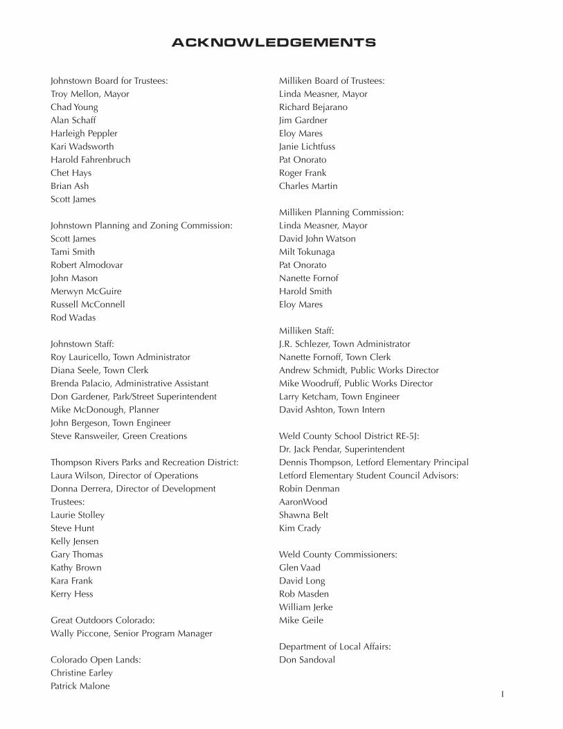
ACKNOWLEDGEMENTS
I
Johnstown Board for Trustees:Troy Mellon, MayorChad YoungAlan SchaffHarleigh PepplerKari WadsworthHarold FahrenbruchChet HaysBrian AshScott James
Johnstown Planning and Zoning Commission:Scott JamesTami SmithRobert AlmodovarJohn MasonMerwyn McGuireRussell McConnellRod Wadas
Johnstown Staff:Roy Lauricello, Town AdministratorDiana Seele, Town ClerkBrenda Palacio, Administrative AssistantDon Gardener, Park/Street SuperintendentMike McDonough, PlannerJohn Bergeson, Town EngineerSteve Ransweiler, Green Creations
Thompson Rivers Parks and Recreation District:Laura Wilson, Director of OperationsDonna Derrera, Director of DevelopmentTrustees:Laurie StolleySteve HuntKelly JensenGary ThomasKathy BrownKara FrankKerry Hess
Great Outdoors Colorado:Wally Piccone, Senior Program Manager
Colorado Open Lands:Christine EarleyPatrick Malone
Milliken Board of Trustees:Linda Measner, MayorRichard BejaranoJim GardnerEloy MaresJanie LichtfussPat OnoratoRoger FrankCharles Martin
Milliken Planning Commission:Linda Measner, MayorDavid John WatsonMilt TokunagaPat OnoratoNanette FornofHarold SmithEloy Mares
Milliken Staff:J.R. Schlezer, Town AdministratorNanette Fornoff, Town ClerkAndrew Schmidt, Public Works DirectorMike Woodruff, Public Works DirectorLarry Ketcham, Town EngineerDavid Ashton, Town Intern
Weld County School District RE-5J:Dr. Jack Pendar, SuperintendentDennis Thompson, Letford Elementary PrincipalLetford Elementary Student Council Advisors:Robin DenmanAaronWoodShawna BeltKim Crady
Weld County Commissioners:Glen Vaad David LongRob MasdenWilliam JerkeMike Geile
Department of Local Affairs:Don Sandoval

Larimer County Commissioners:Kathay RennelsTom BenderGlenn GibsonColorado Division of Wildlife:Courtney Crawford
People who attended public meetings:Alamar VillarealBarb TokunagaBruce GillamDavid KleinDebbie ShableDuane ShableErnie DerreraGary ThomasKaryl KleinKathy WoodcockKerry HessLaura CoppockLorraine PeavyMaddy PeavyMarti FrankMichael MuellerMichelle HessMike PaetzelMolly Orcild-LarsonRon BrownRuss McConnellShirley GamezTim Woodcock
High School Students who attended public work-shops:Andrea Guillory, 12th GradeAndrew Derrera, Age 8Desiree Rodriguez, 11th GradeErika Valeriana, 11th GradeJared Derrera, Age 11Maddy Peavy, Age 11Marina Mendoza, 12th GradeMelissa Hunter, 11th GradeMike Sparling, 12th GradeRose Garcia, 12th GradeVanessa Gomez, 11th Grade
Letford Elementary School Student Council:3rd GradeTyler Trobe – Johnstown, Age 9Skylar Gibler- Johnstown, Age 9McKenzie Leonard – Johnstown. Age 9Elizabeth Velasquez – Milliken, Age 9Nathan DePriest – Milliken, Age 9Sam Ballard – Johnstown, Age 9Mariah Thompson – Johnstown, Age 9Scott Gardner – Johnstown, Age 9Angel Sanchez – Milliken, Age 9
4th GradeShelby Placke – Johnstown, Age 10Tess Ostermiller – Johnstown, Age 10Anna Clow – Johnstown, Age 9Ty Murphy – Johnstown, Age 10Emily Albright – Johnstown, Age 9Rachelle Petersen – Johnstown, Age 10Andrea Freehling – Johnstown, Age 10Whitney LaNear – Johnstown, Age 9Travis Wheeler – Johnstown, Age 10Hannah Lage – Johnstown, Age 9Jalana White – Johnstown, Age 9Allyson Emmel – Johnstown, Age 10Laura Stewart – Milliken, Age 10Brooke Wells – Johnstown, Age 10
5th GradeSara Heizer – Milliken, Age 11Lauren Woods – Milliken, Age 11Alfred Castillo – Johnstown, Age 11Bobby Schlagel – Johnstown, Age 11Candace Spreng – Milliken, Age 11Lauren Johnson – Johnstown, Age 11Melanie Russo – Johnstown, Age 11Enrique Vazquez – Milliken, Age 10Amber Thompson – Johnstown, Age 10
ACKNOWLEDGEMENTS Continued
II
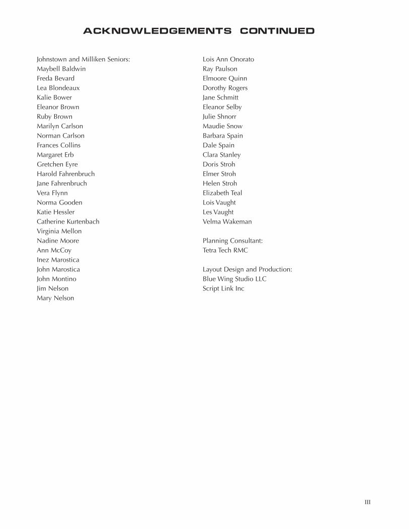
Johnstown and Milliken Seniors:Maybell BaldwinFreda BevardLea BlondeauxKalie BowerEleanor BrownRuby BrownMarilyn CarlsonNorman CarlsonFrances CollinsMargaret ErbGretchen EyreHarold FahrenbruchJane FahrenbruchVera FlynnNorma GoodenKatie HesslerCatherine KurtenbachVirginia MellonNadine MooreAnn McCoyInez MarosticaJohn MarosticaJohn MontinoJim NelsonMary Nelson
Lois Ann OnoratoRay PaulsonElmoore QuinnDorothy RogersJane SchmittEleanor SelbyJulie ShnorrMaudie SnowBarbara SpainDale SpainClara StanleyDoris StrohElmer StrohHelen StrohElizabeth TealLois VaughtLes VaughtVelma Wakeman
Planning Consultant:Tetra Tech RMC
Layout Design and Production:Blue Wing Studio LLCScript Link Inc
III
ACKNOWLEDGEMENTS Continued
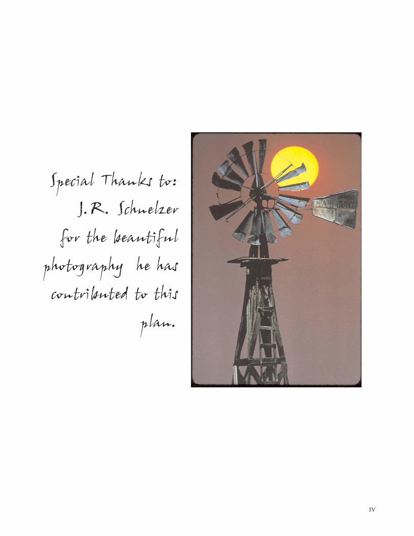
Special Thanks to:
J.R. Schnelzer
for the beautiful
photography he has
contributed to this
plan.
IV

SECTION I
INTRODUCTION
Purpose of Plan . . . . . . . . . . . . . . . . . . . . . . . . . . . . . . . . . . . . . . . . . . . . . . . . . . . Page 1
Contents of this Plan . . . . . . . . . . . . . . . . . . . . . . . . . . . . . . . . . . . . . . . . . . . . . . . Page 1
How to Use this Plan . . . . . . . . . . . . . . . . . . . . . . . . . . . . . . . . . . . . . . . . . . . . . . . Page 2
Planning Process . . . . . . . . . . . . . . . . . . . . . . . . . . . . . . . . . . . . . . . . . . . . . . . . . . Page 5
Update/Amendment Process . . . . . . . . . . . . . . . . . . . . . . . . . . . . . . . . . . . . . . . . . Page 6
Five-Year Action Plans . . . . . . . . . . . . . . . . . . . . . . . . . . . . . . . . . . . . . . . . . . . . . . Page 7
PARKS, TRAILS, RECREATION, AND OPEN SPACE MASTER PLAN MAP . . . . . . . Page 9
GOALS AND OBJECTIVES FOR THE PARKS, TRAILS, RECREATIONAND OPEN SPACE MASTER PLAN . . . . . . . . . . . . . . . . . . . . . . . . . . . . . . . . . . . Page 10
OUR CHILDREN’S DREAMS . . . . . . . . . . . . . . . . . . . . . . . . . . . . . . . . . . . . . . . . Page 12
PARKS, TRAILS, RECREATION AND OPEN SPACEDESIGN GUIDELINES . . . . . . . . . . . . . . . . . . . . . . . . . . . . . . . . . . . . . . . . . . . . . Page 15
Introduction . . . . . . . . . . . . . . . . . . . . . . . . . . . . . . . . . . . . . . . . . . . . . . . . . . . . . Page 15
Design Guidelines . . . . . . . . . . . . . . . . . . . . . . . . . . . . . . . . . . . . . . . . . . . . . . . . Page 15

PAGE1
Iespecially feel this way. Thus, whenever
“community” is mentioned in this plan, it denotes
the combined Milliken/Johnstown planning areas.)
Parks, trails and open space provide the foundation
for recreational opportunities in the community.
They provide the locations and facilities for
different types of recreational activities and events.
However, the Master Plan is not meant to provide
recreational programming. Rather, it is intended to
function in conjunction with the Thompson
Rivers Parks and Recreation District’s (TRPRD)
programs. The TRPRD offers a wide variety of
sports, crafts, cultural and educational activities for
all age groups.
Leisure, some degree of it is necessary for the
health of every man’s spirit.
HARRIETTE MARTINEAU
INTRODUCTION
Purpose of the Master Plan
Milliken, Johnstown and the Thompson Rivers Parks
and Recreation District partnered with Larimer
County, Weld County, Weld County School District
RE-5J, Colorado Division of Wildlife, Colorado
Open Lands and Tetra Tech RMC to prepare the
Johnstown/Milliken Parks, Trails, Recreation and
Open Space Master Plan. This plan sets forth
standards for parks, trails and open space. It also
maps many of the community’s significant
resources including: the South Platte, Big
Thompson and Little Thompson river corridors,
archaeological features, geologic features and
wildlife habitat.
The Master Plan identifies general locations of
future and existing parks, trails and open space in
order to help the community plan for staffing,
budgeting, acquisition, construction, and
maintenance and avoid duplicating facilities. The
Plan will also form the basis for a fee structure that
is tied to the planned facilities. This will enable
developers to incorporate new parks and trails into
the design of their projects and help Johnstown
and Milliken ensure all new development is
integrated into the community.
The community hopes this plan will help promote
collaboration amongst the entities that helped
develop the plan, citizens and developers. (Note:
the vast majority of citizens who participated in the
public workshops view the Milliken/Johnstown
area as a single community. The children
Johnstown/milliken parks, trails,
recreation and open space master plan
Introduction: The introduction presents the purpose andunderlying premise of the Master Plan.
Parks, Trails, Recreation and Open Space Map: This mapillustrates important natural and historical features in theplanning area, existing and proposed parks, trails and openspace.
Goals and Objectives: This section contains the overall goalsand objectives for the Parks, Trails, Recreation, and Open SpaceMaster Plan.
Our Children’s Dreams: This section presents the children’sideas about parks, trails, recreation, and open space.
Parks, Recreation, Trails and Open Space Design Guidelines:This element presents general guidelines that should be referredto prior to designing any park or trail.
Community Setting, Character and Heritage: This sectionincludes information on the history, demographics and naturalresources in the area.
Resource Assessment: This section contains designconsiderations for the natural and cultural resources inJohnstown and Milliken.
Parks and Recreation: This section contains an inventory ofexisting parks, identifies community parks and recreation goals,contains a palette of facilities for each type of park, and definespark standards.
Trails: This element defines the community’s trail goals andstandards and provides criteria for trail design, development andmaintenance.
Open Space: This section details some of the benefits of openspace, lists the community’s open space goals, discusses how tomanage and maintain open space, defines open spacestandards, and discusses open space protection methods.
Contents of This Plan
I
PAGE2
The Master Plan should be reviewed by Johnstown,
Milliken, and the Thompson Rivers Parks and
Recreation District annually and updated as
necessary to reflect changes in the community and
in park, trails, recreation, and open space needs.
This plan should be used in conjunction with the
Milliken and Johnstown Comprehensive Plans, as
together they form the basic framework for the
community.
How to Use the Master Plan
This Master Plan sets forth the community’s visionfor the parks, trails and open space network. ThisPlan is a tool to help the community ensure that itgrows in a manner that is consistent with thisvision. The Parks, Trails, Recreation and OpenSpace Map shows the general locations of futureparks and trails as well as potentially sensitiveareas and historic areas that should be protected.Johnstown and Milliken have adopted the ParksStandards, Trails Standards and the Parks, Trails,Recreation and Open Space Map by ordinance.The remainder of the Master Plan is similar to acomprehensive plan. It is important to meet theintent of the document, but there is more flexibilityin how that is achieved.
Conflicts:
If there is a conflict between the intention of theMaster Plan and something on the land, thelandowner/developer should collaborate with thetown to arrive at an appropriate solution. Forexample, if there is a water line running adjacentto an arterial travel lane making it impossible toplant trees within the right-of-way, the developermight consider planting trees on the opposite sideof the trail, in the front yard setback. If there arepark/trail location conflicts with developers’ plans,discuss an alternative location on the property forthe park/trail that meets the intent of the plan.
Citizens
Use this Master Plan as a guide for what citi-zens can expect for parks, trails, recreation andopen space in the future. The Overall Goals
and Objectives for the Parks, Trails, Recreationand Open Space Master Plan and the intro-ductions and goals, policies and strategies setforth in the Parks and Recreation, Trails andOpen Space elements define the community’svision. Our Children’s Dreams discusses theyouths’ hopes for the community’s parks andtrails system. The Parks, Trails, Recreation andOpen Space Design Guidelines express thefour key principles that emerge in the MasterPlan and discusses design principles thatshould be used in the design of every park,trail and open space. The Parks, Trails,Recreation and Open Space Map shows thegeneral location of existing and future parksand trails, sensitive areas and historical areasthat citizens identified in the public work-shops. If you want to participate in the landdevelopment review process, the map andPark and Trail Standards help you know whatto expect from both the developer and thecommunity. The Action Plans show what thetowns’ priorities are. The Parks Inventory listssuggestions for enhancement opportunities foreach of the existing parks in the community.
The Master Plan also contains educationalinformation. For example, you can learn aboutwater conservation, landscaping and xeriscapeprinciples in the Park Design and Trails Goalssections of the Master Plan. You can refer tothe Plant Lists in the Parks and Recreation,Trails and Open Space elements to learn aboutnon-toxic plants, native plants and plants withhigh wildlife values.
I
PAGE3
Town Staff and Town Officials
Review the Parks and Recreation, Trails andOpen Space goals, policies and strategiesannually to evaluate the community’s progressand to ensure they are still valid. Review theAction Plan each year when the community issetting priorities and budgeting for the comingyear. Work with the Thompson Rivers Parksand Recreation District and the School Districtto determine the demand for services in thecommunity. Consider what upgrades are need-ed in existing parks and for existing trails andopen lands (i.e. more barbeque pits, signage,landscaping, etc.). (Note: the Parks Inventorylists suggestions for enhancement opportunitiesfor each of the existing parks in the communi-ty. There is also a Community Facilities Planin the Parks Design, Development andMaintenance Section.) Identify what has beenaccomplished, what tasks still need to be com-pleted and add new tasks (prioritize and identi-fy who is responsible for completing eachtask).
Park, Trail and Open Space Design:
Review the Parks, Trails, Recreation and OpenSpace Design Guidelines and the Park Design,Development and Maintenance and TrailsDesign, Development and Maintenance sec-tions for guidance in designing and maintain-ing new facilities. These sections also containsuggested plant lists. The Open Space elementdiscusses how to manage and maintain openspace and is a tool to help protect significantopen lands that the public does not want tosee developed. The appendix contains conser-vation tax credit information and sampleOpen Lands Property Evaluation Forms to helpprioritize open space preservation.
Gravel Applications:
The appendix contains criteria for reviewingUse By Special Review applications for aggre-gate mining operations.

I
PAGE4
Development Applications:
The Town is responsible for ensuring that thelandowners/developers have clearly demon-strated that their development applicationmeets the intent of this Master Plan.
1. Locate the landowners’/developers’ prop-erty on the Parks, Trails, Recreation andOpen Space Map. Determine if there areany proposed parks or trails, potentiallysensitive areas or historic areas on theproperty. Note that the map is conceptualand is to be used for planning purposesonly. Also, pocket parks are not shown onthe map. (A minimum of 1 one-acre pock-et park is required for every 250 units.)
2. Ensure the landowners/developers havedemonstrated that they have identified thesite’s resources and integrated them intothe overall site design. Ensure that theyhave adequately addressed the design con-siderations in the Resource Assessmentsection.
3. Ensure that the landowners/developershave demonstrated that park, trail and/oropen space design meets the intent of theParks, Trails, Recreation and Open SpaceDesign Guidelines.
Parks:
4. Review the Parks Standards with thedevelopers/landowners and determine thepark type, size, facilities and landscapingto be installed by the developer, and whowill own the park (i.e. the town or thehomeowners’ association). Note that thetown will determine park locations andsizes in cooperation with the landownerat the time of preliminary plat. However,the town should discuss general parkrequirements during the sketch planprocess.
5. Ensure the landowners/developers haveclearly demonstrated how the proposed
park meets the intent of the Parks andRecreation Goals, Parks Design,Development and Maintenance and ParkDesign Considerations sections.
Trails:
6. Review the Trails Standards with thelandowner/developer and determine thetrail type, width, materials and landscapingrequirements. Note that the town willdetermine specific trails requirements incooperation with the landowner at thetime of preliminary plat. However, thetown should discuss general trail require-ments during the sketch plan process.
7. Ensure the landowners/developers haveclearly demonstrated how they have metthe intent of the Trails Design,Development and Maintenance and TrailDesign Considerations sections. Alsoensure the application helps the town ful-fill applicable trails goals.
Community Green/Open Space:
8. Review the Open Space ProtectionMethods with the landowner/developer forsuggestions on how to protect open areasif the parcel has sensitive areas or is in thearea designated as community green/openspace area.
Consider contacting a land trust if neces-sary for assistance in preserving a sensitivearea and in developing an Open SpaceManagement Plan.
Developers/Landowners
It is the developers’/landowners’ responsibilityto demonstrate that their project has met theintent of this Master Plan in their applicationmaterials.
Locate your property on the Parks, Trails,
Recreation and Open Space Map. Determine

I
PAGE5
if there are any proposed parks or trails, poten-
tially sensitive areas or historic areas on your
property. Note that the map is conceptual and
is to be used for planning purposes only. Also,
pocket parks are not shown on the map. (A
minimum of 1 one-acre pocket park is
required for every 250 units.)
Conduct a site inventory prior to designing
your development to identify the resources on
a site so they can be integrated into the overall
site design. Be sure to describe your effort in
your application materials (i.e. subdivision or
planned unit development application). Refer
to the Resource Assessment section for a
general description of the area’s resources (i.e.
soils, water, vegetation, scenic and cultural
resources and wildlife) and information on
design considerations.
Read the Parks, Trails, Recreation and Open
Space Design Guidelines. These principles
should be considered in the design of every
park, trail and open space property. This will
help unify the community’s parks, trails and
open space system.
Parks:
Review the Parks Standards with Town Staff
and determine the park type, size, facilities
and landscaping to be installed by the
developer, and who will own the park (i.e. the
town or the homeowners’ association). Note
that the town typically determines specific
requirements in cooperation with the
landowner at the time of preliminary plat.
However, general park requirements should be
discussed in the sketch plan process as well.
For example, if your property has a
neighborhood park designated on it, discuss
the proposed park’s size, location, access, how
the park relates to your plans for the
development, park land dedication
requirements/cash-in-lieu, types of
improvements the developer/town is
responsible for, such as who provides utilities
and streets for the park, etc.
Review the Parks Design, Development and
Maintenance, Park Design Considerations, and
Non-Toxic Plant Materials for Parks sections
for guidance on designing parks.
Trails:
Review the Trails Standards with the
developer/landowner and determine the trail
type, width, materials and landscaping
requirements. Note that the town will
determine specific trail requirements in
cooperation with the landowner at the time of
preliminary plat. However, the town should
discuss general trail requirements with the
applicant during the sketch plan process (i.e.
trail type, location, width, surface and
landscaping requirements).
Review the Trails Design, Development and
Maintenance, Trail Design Considerations, and
Native Plant Selection Guide for Trails sections
for guidance on designing trails.
Community Green/Open Space:
If your parcel has sensitive areas or is in thearea designated as community green/openspace area, review the Open Space ProtectionMethods for suggestions on how to protectopen areas (i.e. land dedication, conservationeasement, buffering, etc.).
Refer to the section titled Open SpaceManagement Plan for guidelines on develop-ing a management plan if necessary.
Planning Process
The Johnstown/Milliken Parks, Trails, Recreation
and Open Space Master Plan is the product of the
cooperative visioning of the:

I
PAGE6
• Citizens of Milliken
• Citizens of Johnstown
• Property owners within Johnstown’s Planning Area
• Property owners within Milliken’s Planning Area
• Milliken Planning Commission
• Johnstown Planning Commission
• Johnstown Board of Trustees
• Milliken Board of Trustees
• Thompson Rivers Parks and Recreation District
• Weld County School District RE-5J
Tetra Tech RMC facilitated the effort to develop this
plan. This process was initiated in 2000 with
Johnstown, Milliken, and the Thompson Rivers
Parks and Recreation District collaborating on a
Great Outdoors Colorado (GOCO) Planning Grant
Application. Other partners included: Weld
County School District Re-5, Larimer County, Weld
County, Colorado Open Lands and Colorado
Division of Wildlife. The grant was awarded
funding.
Project team members immediately met with
Johnstown and Milliken’s staffs to define the
objectives for the Plan and perform a resource
inventory. Next, team members researched and
analyzed available information. The project team
met with the Planning Commissions and Town
Boards of Trustees to discuss ideas for the Plan and
prepare for the community meetings. In an effort
to include everyone in both communities, bilingual
notices were sent home with school-age children,
notices were published in the Johnstown Breeze,
flyers were posted and distributed around the
towns, notices were posted on the electronic
message board at the bank in Johnstown, a banner
was hung on the side of the liquor store in
Milliken, notices were broadcast on the local cable
channel, and articles were printed in the
Johnstown Breeze.
During the fall of 2001, the project team hosted
several public participation meetings to obtain
citizen input on parks, trails, recreation, open
space, community character, heritage, and the
environment. High school students attended two
of the workshops and worked with young children
that attended the workshops with their parents to
get their ideas for the plan. The project team also
met with the 3rd, 4th and 5th grade student
councils at Letford Elementary School. The student
council members polled their classmates and
shared their ideas and drawings for the
community’s master plan.
After the public participation meetings, Tetra Tech
RMC compiled the information and prepared a
draft document. Next, the Milliken and Johnstown
Boards of Trustees and Planning Commissions and
the Thompson Rivers Parks and Recreation District
Boards and the public were invited to review and
comment on the document. The culmination of
this effort follows.
Update/Amendment Process
This Master Plan is a citizen-based plan which
outlines the community’s vision for Johnstown and
Milliken parks, trails and open space. As attitudes
change and the community grows, this Master Plan
must be able to adapt accordingly. The Planning
Commissions, Boards of Trustees and Thompson
Rivers Parks and Recreation District should
reevaluate and update the Plan in response to
major changes in the community or at least every
three to five years. Citizens may also
request changes to the Master Plan. Both the
written and the graphic elements of the Master
Plan may be amended.
Both the Milliken and Johnstown Planning
Commissions must review all requests to amend
the Plan. If an amendment is suggested, the
Boards of Trustees and the Planning Commissions
must determine if the suggested change is in the
best interests of the community and hold a public
I
PAGE7
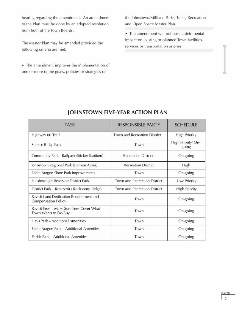
JOHNSTOWN FIVE-YEAR ACTION PLAN
the Johnstown/Milliken Parks, Trails, Recreation
and Open Space Master Plan.
• The amendment will not pose a detrimental
impact on existing or planned Town facilities,
services or transportation arteries.
hearing regarding the amendment. An amendment
to the Plan must be done by an adopted resolution
from both of the Town Boards.
The Master Plan may be amended provided the
following criteria are met:
• The amendment improves the implementation of
one or more of the goals, policies or strategies of
TASK RESPONSIBLE PARTY SCHEDULE
Highway 60 Trail Town and Recreation District High Priority
Sunrise Ridge Park TownHigh Priority/ On-
going
Community Park - Ballpark (Sticker Stadium) Recreation District On-going
Johnstown Regional Park (Carlson Acres) Recreation District High
Eddie Aragon Skate Park Improvements Town On-going
Hillsborough Reservoir District Park Town and Recreation District Low Priority
District Park – Reservoir ( Rocksbury Ridge) Town and Recreation District High Priority
Revisit Land Dedication Requirement andCompensation Policy Town On-going
Revisit Fees – Make Sure Fees Cover WhatTown Wants to Do/Buy Town On-going
Hays Park – Additional Amenities Town On-going
Eddie Aragon Park – Additional Amenities Town On-going
Parish Park – Additional Amenities Town On-going
I
PAGE8
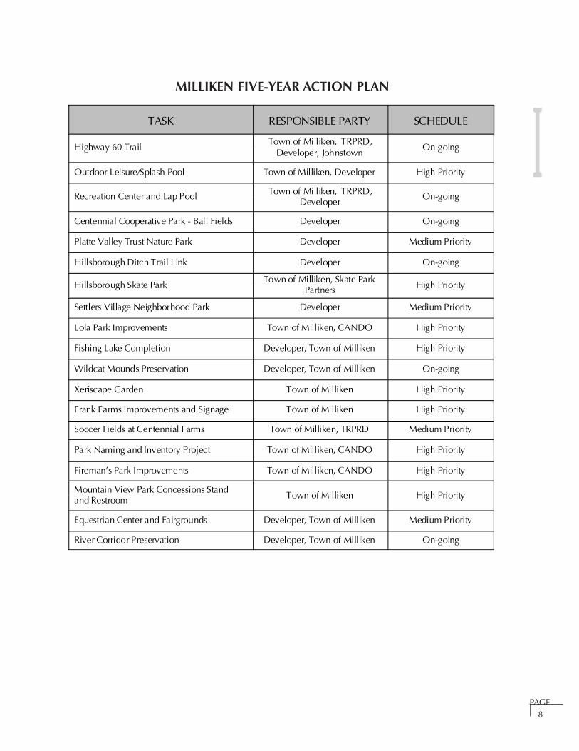
MILLIKEN FIVE-YEAR ACTION PLAN
TASK RESPONSIBLE PARTY SCHEDULE
Highway 60 TrailTown of Milliken, TRPRD,
Developer, JohnstownOn-going
Outdoor Leisure/Splash Pool Town of Milliken, Developer High Priority
Recreation Center and Lap Pool Town of Milliken, TRPRD,Developer
On-going
Centennial Cooperative Park - Ball Fields Developer On-going
Platte Valley Trust Nature Park Developer Medium Priority
Hillsborough Ditch Trail Link Developer On-going
Hillsborough Skate ParkTown of Milliken, Skate Park
Partners High Priority
Settlers Village Neighborhood Park Developer Medium Priority
Lola Park Improvements Town of Milliken, CANDO High Priority
Fishing Lake Completion Developer, Town of Milliken High Priority
Wildcat Mounds Preservation Developer, Town of Milliken On-going
Xeriscape Garden Town of Milliken High Priority
Frank Farms Improvements and Signage Town of Milliken High Priority
Soccer Fields at Centennial Farms Town of Milliken, TRPRD Medium Priority
Park Naming and Inventory Project Town of Milliken, CANDO High Priority
Fireman’s Park Improvements Town of Milliken, CANDO High Priority
Mountain View Park Concessions Standand Restroom Town of Milliken High Priority
Equestrian Center and Fairgrounds Developer, Town of Milliken Medium Priority
River Corridor Preservation Developer, Town of Milliken On-going

I
PAGE9
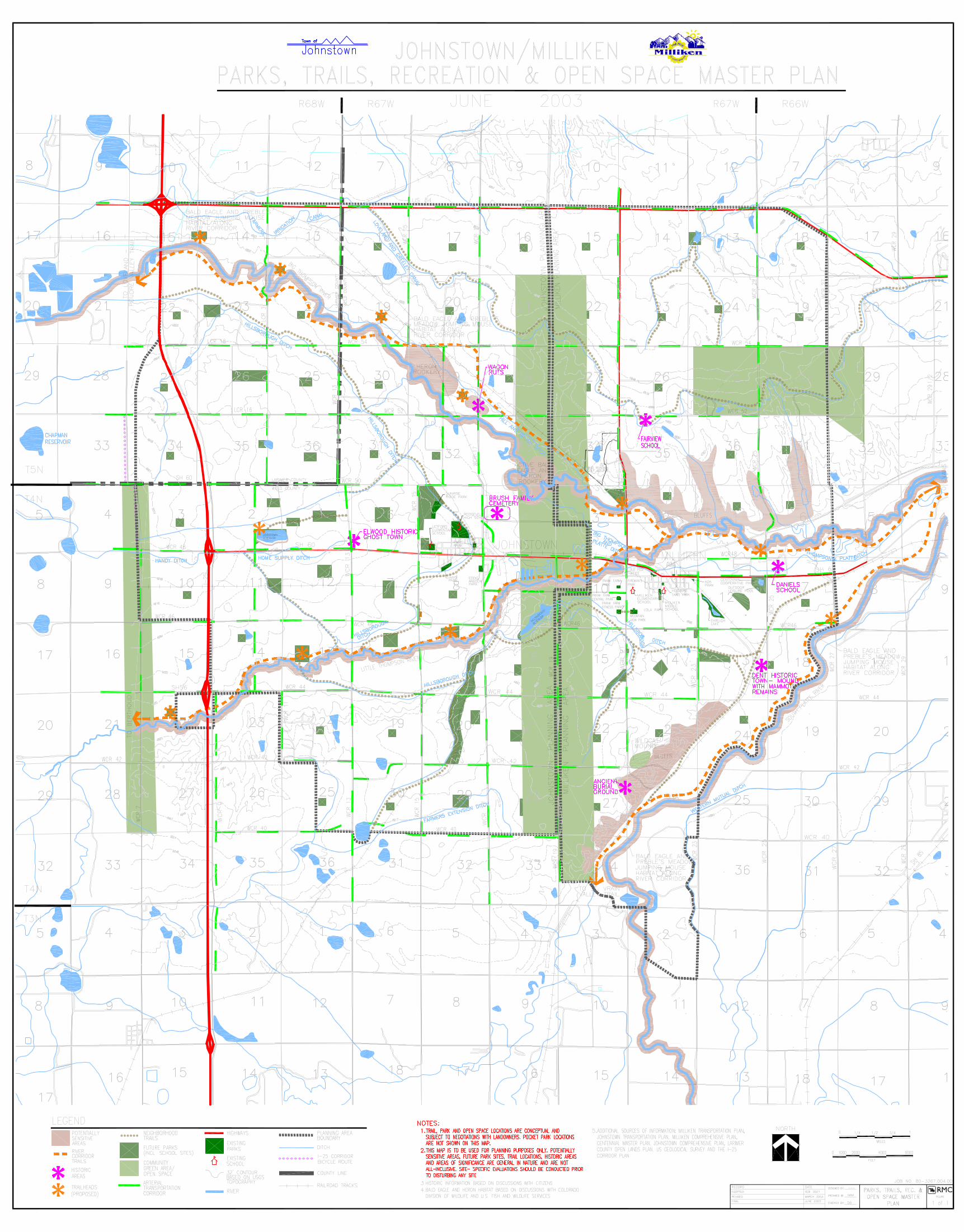
Parks, Trails, Recreation and Open Space Master Plan Map
PAGE10
GOAL: Create a parks, trails,
recreation and open space
master plan for Milliken and
Johnstown to ensure these communities will
have a sufficient and unified system of parks,
trails and open space to continue the area’s
high quality of life and provide an equitable,
uniform standard for all new development.
overall GOALS AND
OBJECTIVES FOR THE
PARKS, TRAILS, Recreation
and OPEN SPACE MASTER PLAN: I

PAGE11
Ensure implementation of theplan by:
a. Including the public in the planning process
so citizens are vested and support
implementation of the plan;
b. Prioritizing park, trail, recreation and open
space needs and identifying joint funding
opportunities and other options to acquire the
land and construct the facilities necessary to
meet these needs;
c. Determining general maintenance costs for
parks, trails, recreation and open space
so that long term funding can be
appropriately budgeted;
d. Maintaining consistency in decision-making
among the communities, even when changes
in leadership occur, by enacting an
intergovernmental agreement among
Johnstown, Milliken, Larimer County, Weld
County, Weld County School District RE-5J
and the Thompson Rivers Parks and
Recreation District; and
e. Updating the plan regularly to ensure it
continues to reflect the citizen’s goals.
Plan a parks, trails, recreation andopen space system that will:
a. Provide a variety of parks offering recreation
opportunities for diverse age groups that draw
the community together;
b. Establish a safe, comprehensive trail system that
connects Milliken and Johnstown to the
Northern Front Range communities and enables
citizens, especially school children, to safely
travel to schools, parks, commercial areas and
other neighborhoods;
c. Designate and preserve important wildlife
habitat, view corridors and community gateways
and create special destinations within each
community;
d. Protect and enhance the integrity and quality of
the surrounding natural environment; and
e. Incorporate opportunities for environmental
education in the design of every park, trail, and
open space property.
OBJECTIVES
1.
2.I

PAGE12
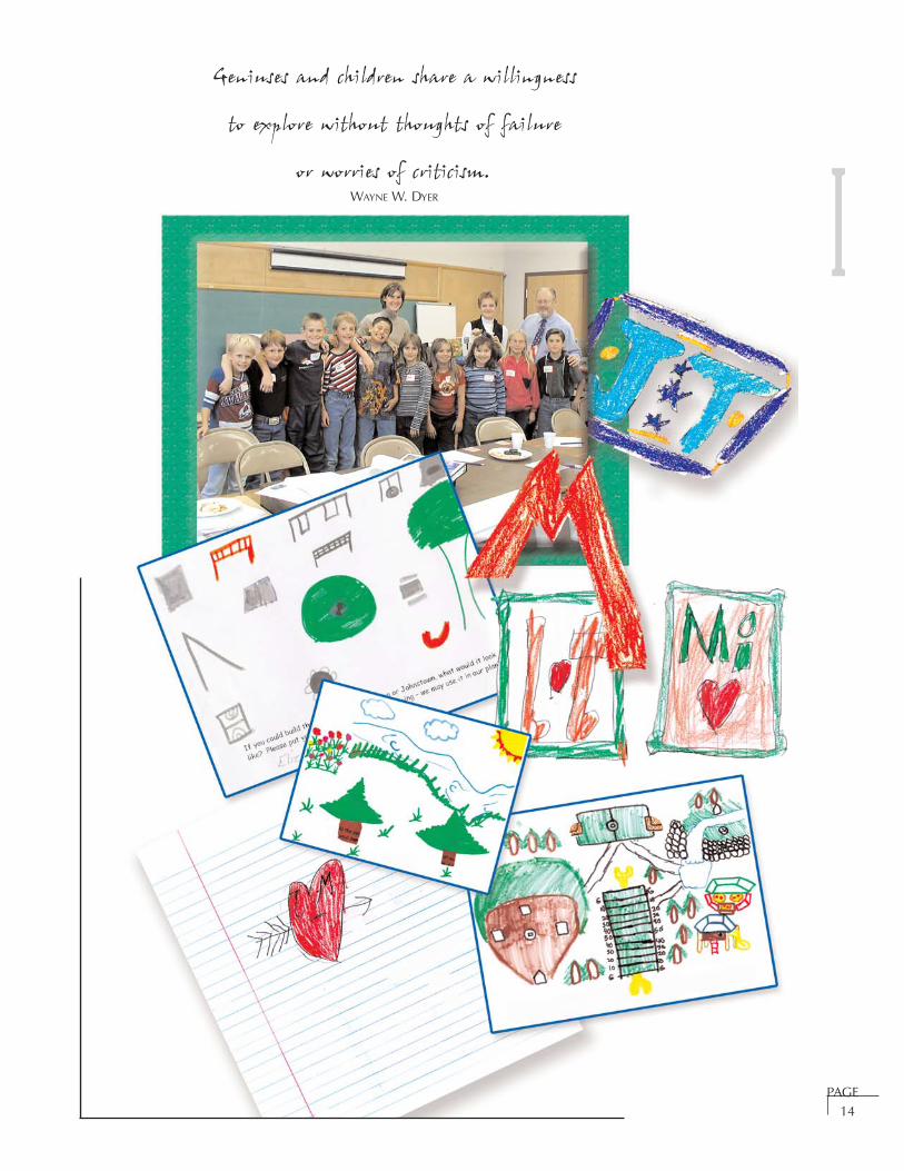
Geniuses and children share a willingness to
explore without thoughts of failure or worries of
criticism.
WAYNE W. DYER
Numerous high school students participated in the
public workshops and their input has been
integrated into the entire document. This section
contains the younger children’s ideas. To gather
input from the children in the community, Tetra
Tech RMC met with the 3rd, 4th and 5th grade
student councils at Letford Elementary School.
Before visiting the school, Tetra Tech RMC sent a
survey to the classes asking the children to:
• Imagine their dream park or play area and
describe it;
• Name and describe their favorite park;
• Describe how often they use parks and what
they like to do there;
• Indicate whether they liked trails and what they
use them for;
• Determine their interest in learning more about
wildlife and vegetation; and
• Think of an icon for Milliken and Johnstown.
The student council members polled their classes
and reported the results of the survey to Tetra Tech
RMC, including some sketches the children had
prepared. Tetra Tech RMC met with each of the
student councils individually to discuss the results
of the poll and to obtain their feedback. The
children colored pictures and expanded on some
of the responses their classmates provided. Some
of their pictures are included in this document. A
list of the student council members Tetra Tech RMC
met with is included in the Acknowledgement
section.
In addition, several high school students worked
with young children that attended the workshops
with their parents and discussed their ideas and
colored pictures.
The children want:
• A safe trail system for them to bike or walk,
including a trail between Johnstown and
Milliken with resting stops;
• To learn more about: plants, animals, history of
the area, archaeology (dinosaurs), geology and
farming in the parks and on trails;
• Places to gather;
• Parks with water fountains, bathrooms with
running water, trash cans and benches, age
appropriate play equipment (i.e. tot lots and
equipment for larger children), trees, pet areas,
playing fields for sports;
• Easily accessible parks for the children living in
the country;
• A recreation center;
• A public swimming pool; and
• A working farm where they can learn about and
participate in farming activities.
Children’s ideas for icons included:
• Mr. Parish for Johnstown;
Our Children’s Dreams
I
PAGE13
• Two hands shaking; and
• Using the initials of the two communities.
Children currently use trails and roads for bike
riding, hiking, traveling around town, visiting
friends and skating.
The children really appreciate the parks in town
and generally use them quite often.
• Lola Park in Milliken is popular because of its
size, the little stream, bridge, and open grassy
areas;
• Parish Park in Johnstown is frequented because
of its playground equipment and picnic areas;
• Eddie Aragon Park in Johnstown is popular
because of the tire swing and place for scooters
and rollerblades; and
• Hays Park in Johnstown is used because of the
basketball courts, volleyball court, and the room
to play.
The children enjoyed other parks outside of town
for a variety of reasons:
• Loveland Park because of the swim beach at the
lake, ducks, climbing dome, sitting areas and the
cannon;
• Snake River, Idaho because of the riverfront with
a large fountain and nature trail;
• Rocky Mountain National Park because of the
trails;
• Island Grove Park in Greeley because of the tire
swing;
• Legoland in California because of the
playground made of legos and the opportunity
to build things;
• Bittersweet Park in Greeley because of tennis
courts and play structures;
• Edora Park in Fort Collins because of the
rollerblading, mazes, and Frisbee golf. The Epic
Center is located in this park.
Children currently use parks:
• At least 3-5 times a week for most children in
town;
• Seldom for some children in town and less often
for the children in the country.
I
PAGE14
Geniuses and children share a willingness
to explore without thoughts of failure
or worries of criticism.WAYNE W. DYER I

PAGE15
INTRODUCTION
Four key principles have emerged in the
development of this Master Plan:
cooperation, connections, environmental
sensitivity and education.
Cooperation: it is important that Johnstown,
Milliken, the Thompson Rivers Parks and
Recreation District and the School District work
together with Weld and Larimer Counties,
landowners, developers, citizens and children to
design, develop and maintain parks, trails,
recreational facilities and open spaces.
Connections: the purpose of the Master Plan is to
create a unified, interconnected parks, trails,
recreation and open space system. Consider how
each park, trail, recreational facility and open
space is connected to the community with safe
pedestrian access.
Environmental Sensitivity: it is critical to protect
and enhance the integrity and quality of the natural
environment. It is important to site parks, trails
and recreational facilities in a manner that protects
sensitive areas and wildlife habitat. Work with an
environmental expert to lessen the impact of new
facilities and to enhance the habitat.
Education: incorporate educational opportunities
in the design of every park, trail and open
space property.
The following guidelines shall be considered in the
design of every park, trail and open space area.
This will help ensure conformance to the Master
Plan’s overall goals. It will also help unify the
parks and trails system. Projects will also be
evaluated based on the design considerations for
the particular facility, refer to Park Standards (page
30), Park Design Considerations (page 45), Trail
Design Considerations (page 65), and Open Space
Function and Uses (page 73).
DESIGN GUIDELINES
• Integrate the elements of gateway, pathway
and destination into the overall plan for the
park and trails system.
Gateways are the entries that transition space
from one realm to another. In the overall view,
as one enters Johnstown or Milliken, the open
space in the community reflects a rural,
agricultural feel. The open space separates the
community from neighboring communities and
is valued by citizens. The transition into town
comes at the edge of the open land. The
following intersections are key gateways into
the community:
• Interstate 25 and Highway 60
• Highway 60 and Highway 257
• Highway 60 and County Road 25
• Highway 257 and County Road 52
Pathways are the routes that one travels.
Historically, travel into the community has
come from many directions, primarily
following county roads and train routes. This
Plan will expand the pathways into Town by
providing a trail system for pedestrians,
bicyclists and horseback riders.
parks, trails, recreation, and
open space design guidelines
I

PAGE16
Destination points are the places at the end of
the journey. Significant community
destinations include the business districts, the
cemetery, ponds, local parks, open spaces,
recreation facilities and schools.
Almost every structure, from cathedrals to cottages,
uses this triad as an organizing design principle.
Because this configuration mirrors the source,
journey, and goal of the human spirit’s adventure,
this elemental pattern shows up whenever we give
architectural form to inner stirrings of thought and
feeling.
ANTHONY LAWLOR
• Design all improvements to respond to the
community’s unique setting, character
and heritage.
• Design parks and trails to fit together as a
unified whole. Consider the color, texture,
scale and context of each element.
• Signage for park entrances, trailheads, trail
markers, interpretive information and park
and trail safety should be standardized
and include either the Johnstown, Milliken
or Master Plan logo.
• Include a gateway with a display of flowers at
all park entrances and trailheads. This display
can be formal or informal, depending on the
surrounding improvements. Include both
annuals and perennials to ensure that
the display will bloom throughout
the growing season.
• Integrate flowering plants into the design of all
parks and trails. Include native plantings and
wildflowers in all trail corridors. Parks
should have more formal areas of
annuals and perennials.
• Include public art and water features whenever
possible. These elements can be man made or
natural. They can be designed to look
at or play on.
• Design in terms of all three dimensions,
keeping in mind the senses. How will you feel
when you enter the site, sit on the benches,
play on the equipment and walk along the
trails? What will you see, hear, smell, touch?
Will you feel safe?
• Enhance and preserve open space areas that
help form the gateway to the community,
contribute to connections throughout the
community and create special destinations
within the community.
• Design for safety, maintainability, access for all
users including the disabled, and in
accordance with the Town standards.
These design considerations should help guide
decisions when determining which open spaces
should be preserved and protected and how parks
and trails should be designed and developed.
I
SECTION II
COMMUNITY SETTING, CHARACTER AND HERITAGE
Regional Setting . . . . . . . . . . . . . . . . . . . . . . . . . . . . . . . . . . . . . . . . . . . . . . . . . . Page 17
History of the Communities . . . . . . . . . . . . . . . . . . . . . . . . . . . . . . . . . . . . . . . . . Page 17
Population Characteristics . . . . . . . . . . . . . . . . . . . . . . . . . . . . . . . . . . . . . . . . . . Page 18
Key Trends . . . . . . . . . . . . . . . . . . . . . . . . . . . . . . . . . . . . . . . . . . . . . . . . . . . . . Page 18
Regional Context Map . . . . . . . . . . . . . . . . . . . . . . . . . . . . . . . . . . . . . . . . . . . . . Page 20
RESOURCE ASSESSMENT
Soils and Topography . . . . . . . . . . . . . . . . . . . . . . . . . . . . . . . . . . . . . . . . . . . . . Page 22
Water Resources . . . . . . . . . . . . . . . . . . . . . . . . . . . . . . . . . . . . . . . . . . . . . . . . . Page 22
Vegetation . . . . . . . . . . . . . . . . . . . . . . . . . . . . . . . . . . . . . . . . . . . . . . . . . . . . . . Page 23
Scenic and Cultural Resources . . . . . . . . . . . . . . . . . . . . . . . . . . . . . . . . . . . . . . . Page 24
Wildlife . . . . . . . . . . . . . . . . . . . . . . . . . . . . . . . . . . . . . . . . . . . . . . . . . . . . . . . . Page 24
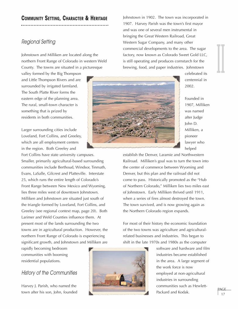
PAGE17
Johnstown in 1902. The town was incorporated in
1907. Harvey Parish was the town’s first mayor
and was one of several men instrumental in
bringing the Great Western Railroad, Great
Western Sugar Company, and many other
commercial developments to the area. The sugar
factory, now known as Colorado Sweet Gold LLC,
is still operating and produces cornstarch for the
brewing, food, and paper industries. Johnstown
celebrated its
centennial in
2002.
Founded in
1907, Milliken
was named
after Judge
John D.
Milliken, a
pioneer
lawyer who
helped
establish the Denver, Laramie and Northwestern
Railroad. Milliken’s goal was to turn the town into
the center of commerce between Wyoming and
Denver, but this plan and the railroad did not
come to pass. Historically promoted as the “Hub
of Northern Colorado,” Milliken lies two miles east
of Johnstown. Early Milliken thrived until 1911,
when a series of fires almost destroyed the town.
The town survived, and is now growing again as
the Northern Colorado region expands.
For most of their history the economic foundation
of the two towns was agriculture and agricultural-
related businesses and industries. This began to
shift in the late 1970s and 1980s as the computer
software and hardware and film
industries became established
in the area. A large segment of
the work force is now
employed at non-agricultural
industries in surrounding
communities such as Hewlett-
Packard and Kodak.
COMMUNITY SETTING, CHARACTER & HERITAGE
Regional Setting
Johnstown and Milliken are located along the
northern Front Range of Colorado in western Weld
County. The towns are situated in a picturesque
valley formed by the Big Thompson
and Little Thompson Rivers and are
surrounded by irrigated farmland.
The South Platte River forms the
eastern edge of the planning area.
The rural, small-town character is
something that is prized by
residents in both communities.
Larger surrounding cities include
Loveland, Fort Collins, and Greeley,
which are all employment centers
in the region. Both Greeley and
Fort Collins have state university campuses.
Smaller, primarily agricultural-based surrounding
communities include Berthoud, Windsor, Tinmath,
Evans, LaSalle, Gilcrest and Platteville. Interstate
25, which runs the entire length of Colorado’s
Front Range between New Mexico and Wyoming,
lies three miles west of downtown Johnstown.
Milliken and Johnstown are situated just south of
the triangle formed by Loveland, Fort Collins, and
Greeley (see regional context map, page 20). Both
Larimer and Weld Counties influence them. At
present most of the lands surrounding the two
towns are in agricultural production. However, the
northern Front Range of Colorado is experiencing
significant growth, and Johnstown and Milliken are
rapidly becoming bedroom
communities with booming
residential populations.
History of the Communities
Harvey J. Parish, who named the
town after his son, John, founded
II
PAGE18
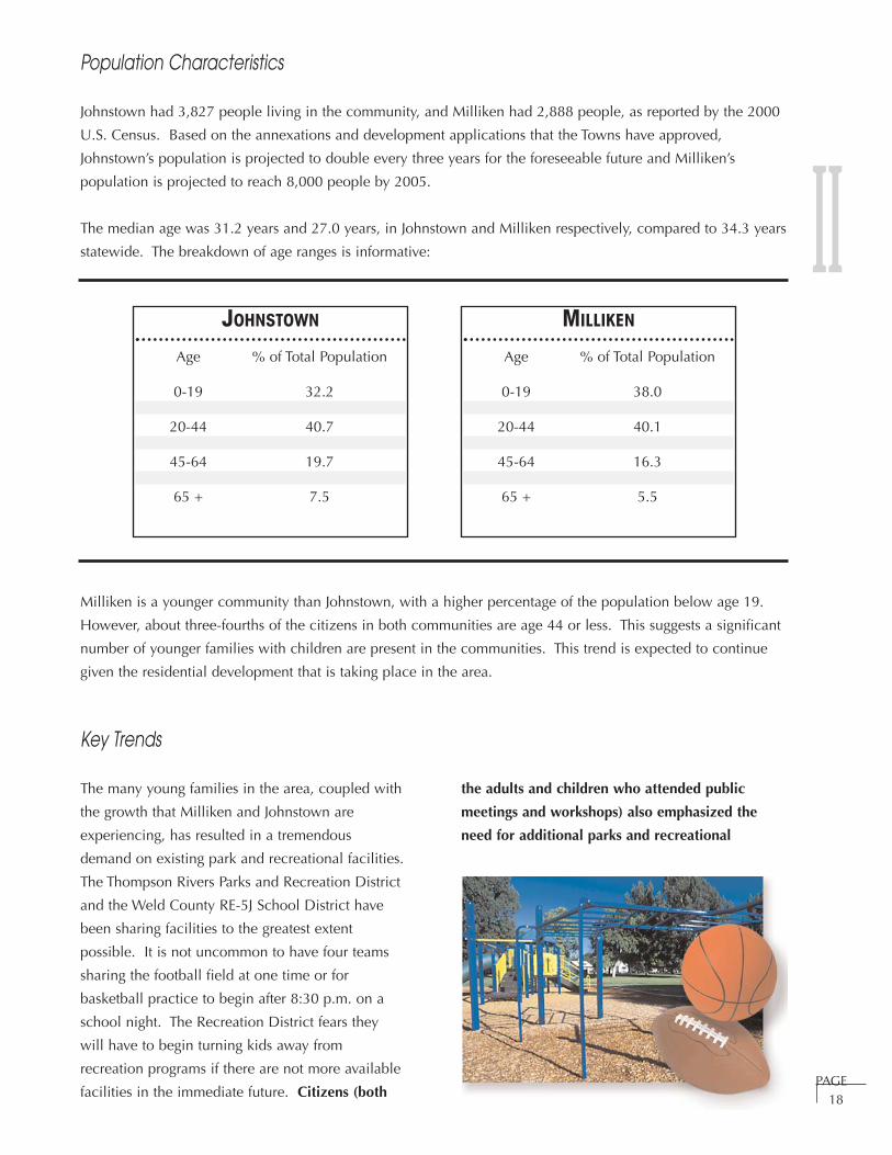
Population Characteristics
Johnstown had 3,827 people living in the community, and Milliken had 2,888 people, as reported by the 2000
U.S. Census. Based on the annexations and development applications that the Towns have approved,
Johnstown’s population is projected to double every three years for the foreseeable future and Milliken’s
population is projected to reach 8,000 people by 2005.
The median age was 31.2 years and 27.0 years, in Johnstown and Milliken respectively, compared to 34.3 years
statewide. The breakdown of age ranges is informative:
Milliken is a younger community than Johnstown, with a higher percentage of the population below age 19.
However, about three-fourths of the citizens in both communities are age 44 or less. This suggests a significant
number of younger families with children are present in the communities. This trend is expected to continue
given the residential development that is taking place in the area.
Key Trends
The many young families in the area, coupled with
the growth that Milliken and Johnstown are
experiencing, has resulted in a tremendous
demand on existing park and recreational facilities.
The Thompson Rivers Parks and Recreation District
and the Weld County RE-5J School District have
been sharing facilities to the greatest extent
possible. It is not uncommon to have four teams
sharing the football field at one time or for
basketball practice to begin after 8:30 p.m. on a
school night. The Recreation District fears they
will have to begin turning kids away from
recreation programs if there are not more available
facilities in the immediate future. Citizens (both
the adults and children who attended public
meetings and workshops) also emphasized the
need for additional parks and recreational
JOHNSTOWN
Age % of Total Population
0-19 32.2
20-44 40.7
45-64 19.7
65 + 7.5
MILLIKEN
Age % of Total Population
0-19 38.0
20-44 40.1
45-64 16.3
65 + 5.5
II

PAGE19
facilities (refer to the Parks and Recreation Section
for further details). Additional trends include:
• Emphasis on creating public spaces and
recreational and educational opportunities for
all age groups within the community;
• Collaboration amongst Johnstown, Milliken,
the Recreation District, the School District and
the counties;
• Greater focus on open space planning,
preservation of significant riparian areas,
agricultural land, wildlife habitat and cultural
resources;
• Growing number of private/public partnerships
to provide public facilities; and
• Increasing demand for community services and
competition within the community for allocation
of limited resources and funds.
II

PAGE20
Regional Context Map
II

MILLIKEN/JOHNSTOWN
PARKS, TRAILS, RECREATION AND OPEN SPACE
MASTER PLAN
MILLIKEN/JOHNSTOWN
PARKS, TRAILS, RECREATION AND OPEN SPACE
MASTER PLAN
MILLIKEN/JOHNSTOWN
PARKS, TRAILS, RECREATION AND OPEN SPACE
MASTER PLAN
MILLIKEN/JOHNSTOWN
PARKS, TRAILS, RECREATION AND OPEN SPACE
MASTER PLAN
N.T.S.
PREPARED BY: TETRA TECH RMCPREPARED BY: TETRA TECH RMC
REGIONAL CONTEXT MAPREGIONAL CONTEXT MAP
H:\3267_004\RegionalVicinity.cdr
FORT
COLLINS
LOVELAND GREELEY
BERTHOUD
WINDSOR
EVANS
LA SALLE
GILCREST
PLATTEVILLE
NOTE: ALL TRAIL ALIGNMENTS ARE CONCEPTUAL AND ARE FOR PLANNING PURPOSES ONLY.NOTE: ALL TRAIL ALIGNMENTS ARE CONCEPTUAL AND ARE FOR PLANNING PURPOSES ONLY.
BIG THOMPSON RIVER
BIG THOMPSON RIVER
SOUTH
PLAT
TERIVE
R
SOUTH
PLAT
TERIVE
R
ST. VRAIN RIVER
ST. VRAIN RIVER
CACHE
LAPO
UDRE
RIV
ER
CACHE
LAPO
UDRE
RIV
ER
INTERSTATE
25
LONGMONT
STATE HIGHWAY 66
U.S
.HIG
HW
AY
287
U.S
.HIG
HW
AY
287
U.S
.HIG
HWAY85
U.S
.HIG
HWAY85
MILLIKEN
STATE HIGHWAY 60
STATE
HIG
HW
AY
257
HILLS
BOROUGH
DITC
H
LEGEND:LEGEND:
I-25 Corridor PlanWeld County Open Space PlanLarimer County Open Lands PlanCity of Loveland Open Lands PlanTown of Windsor Parks and Recreation Master PlanGreeley Parks and Trails Master PlanTown of Berthoud Parks Plan
Milliken Planning Area
Johnstown Planning Area
Longmont Open Space and Trails Comprehensive PlanPoudre River Trail Corridor
Milliken/Johnstown Parks, Trails, and Open Space Master PlanNorthern Colorado Community Separator PlanProposed Community Separator
U.S. HIGHWAY 34U.S. HIGHWAY 34
STATE HIGHWAY 56LITT
LETHOMPSON RIVER
TIMNATH
CACHE LA POUDRE RIVER
JOHNSTOWN
PAGE21
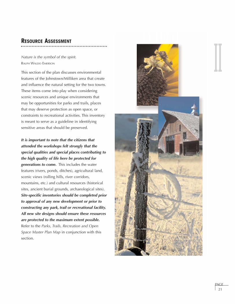
RESOURCE ASSESSMENT
Nature is the symbol of the spirit.
RALPH WALDO EMERSON
This section of the plan discusses environmental
features of the Johnstown/Milliken area that create
and influence the natural setting for the two towns.
These items come into play when considering
scenic resources and unique environments that
may be opportunities for parks and trails, places
that may deserve protection as open space, or
constraints to recreational activities. This inventory
is meant to serve as a guideline in identifying
sensitive areas that should be preserved.
It is important to note that the citizens that
attended the workshops felt strongly that the
special qualities and special places contributing to
the high quality of life here be protected for
generations to come. This includes the water
features (rivers, ponds, ditches), agricultural land,
scenic views (rolling hills, river corridors,
mountains, etc.) and cultural resources (historical
sites, ancient burial grounds, archaeological sites).
Site-specific inventories should be completed prior
to approval of any new development or prior to
constructing any park, trail or recreational facility.
All new site designs should ensure these resources
are protected to the maximum extent possible.
Refer to the Parks, Trails, Recreation and Open
Space Master Plan Map in conjunction with this
section.
II

PAGE22
Soils and Topography
The topography is characterized by flat to gently
rolling slopes in most areas. The elevations
generally increase to the north and south of the
communities with the low-lying flat areas around
Milliken and Johnstown. Bluffs are located along
the north side of the Big Thompson River (north of
Milliken) and northwest of the South Platte River
(known as Wildcat Mound).
Design Considerations
There are several potential geologic
considerations that could affect the
development of parks, trails or recreation
facilities. These include expansive soils,
compressible soils, shallow groundwater and
erosion. A site-specific geological assessment
should be conducted before a facility is
constructed.
Milliken
The surficial soils around Milliken and
approximately one mile to the south are
comprised of alluvial (river) deposits. The
alluvial soils consist of silty and clayey sands
overlying sandy gravels and gravelly sands.
These soils will compress significantly and are
susceptible to erosion. Moving further south,
eolian soils (wind deposited) are the major
surficial soils. This soil consists of clayey sands
and sandy clays. These soils are moderately
compressible and will collapse when wetted.
These soils are moderately susceptible to
accelerated erosion. They are increasingly
susceptible to erosion when the vegetative
cover is disturbed for development. Expansive
swelling clays are found at Wildcat Mound.
Milliken’s planning area north of Weld County
Road (WCR) 54 drains to the north. The area
between WCR 54 and the Big Thompson River
drains south-southeasterly towards the Big
Thompson River. The area from Wildcat
Mound to the Town drains north-northeasterly
towards the Little Thompson and Big
Thompson Rivers. The southernmost portion of
the planning area drains south into the South
Platte River.
Johnstown
The soils in the Johnstown planning area are
comprised of alluvial deposits. The Nunn soils
found south and southwest of the existing town
generally exhibit severe shrink-swell
characteristics and low strength, according to
the Soil Survey of Weld County, Colorado,
Southern Part.
North of the Big Thompson River, Johnstown’s
planning area drains to the south-southwest.
The portion of the planning area between the
Big Thompson River and the existing town
drains north-northeast to the Big Thompson
River. The area between the existing town and
the Little Thompson River drains south-
southeast into the Little Thompson River.
The planning area south of the Little Thompson
River drains northeast to the Little Thompson
River.
Water Resources
Water is the most critical resource issue of our
lifetime and our children’s lifetime. The health of
our waters is the principal measure of how we live
on the land.
LUNA LEOPOLD
The Milliken/Johnstown planning area contains
three important rivers: The Big Thompson River,
the Little Thompson River and the South Platte
River. The confluence of the Big and Little
Thompson Rivers is in Milliken’s planning area.
The confluence of the Big Thompson River and the
South Platte River is just east of Milliken’s planning
area. These scenic rivers are tremendous assets to
II
PAGE23
this arid community. Each river hosts plains
cottonwood galleries, willow thickets, forbs, and
grasses that provide food, cover and breeding
grounds for a variety of wildlife. This includes the
endangered Preble’s Meadow Jumping Mouse that
has been trapped at several locations along the Big
Thompson River in both Milliken and Johnstown.
The rivers also provide routes for animal migration
and regional recreational
opportunities.
The rivers are also the source of
water for the numerous irrigation
ditches that course through the
community. These ditches
include:
• Beeline Ditch;
• Big Thompson and Platte Ditch;
• Farmers Extension Ditch;
• Farmers Irrigation Canal;
• Hill and Brush Ditch;
• Hillsborough Ditch;
• Handy Ditch;
• Home Supply Ditch;
• Johnstown Reservoir; and
• Loveland and Greeley Canal.
The planning area also contains several small
ponds and reservoirs, three of which are or will be
available for some public use – the fishing ponds
in Settler’s Village and Colony Pointe in Milliken
and Johnstown Reservoir.
Design Considerations
It is important to work with the Colorado
Division of Wildlife or a town-approved
ecologist when designing trails, parks and
recreational facilities. This will help ensure
that critical habitat is protected and is not
fragmented and will help prevent erosion and
impacts to water quality and quantity. It is
equally important to work closely with the
appropriate ditch company when designing a
facility along or near a ditch. Especially in
riparian corridors, the challenge is to minimize
impacts from trail construction while still
allowing trail users to enjoy and experience
being adjacent to a waterway and its
associated vegetation.
Vegetation
The majority of the combined planning area is in
agricultural production. The most common crops
include: corn, sugar beets, beans, onions, alfalfa,
wheat and sunflowers. Undeveloped lands that are
not cultivated for agriculture include (but are not
limited to): Wildcat Mound, the bluffs along the
Big Thompson and South Platte Rivers, and riparian
corridors.
The bluff areas are dominated by grass species.
Common grass species native to the Colorado
plains include: foxtail barley, big bluestem, little
bluestem, sand bluestem, prairie dropseed, blue
grama, green needlegrass, switchgrass, red three-
awn, and western wheatgrass.
Riparian ecosystems occur along the banks of
rivers, ditches, and other bodies of flowing water.
II

PAGE24
They include floodplain woodlands and marshes
with various types of grasses, herbs, shrubs and
trees that depend on a more or less continuous and
accessible water supply. These narrow ecosystems
represent a transition zone between aquatic and
terrestrial ecosystems but usually have distinct
vegetation and soils. Trees found in the Thompson
Rivers and South Platte River riparian corridors
include: plains cottonwood, peach-leaved willow,
box elder, American elm, green ash, and Russian
olive. Several shrubs that flourish are wild plum,
hawthorn, currant, wild rose, snowberry, and
shrubby willows. Common grasses include
saltgrass and sand dropseed.
Design Considerations
It is important to work with the Soil
Conservation District or a town-approved
landscape architect when designing,
developing or maintaining parks, trails, open
space and recreational facilities. At a
minimum, topics to address include:
preservation of existing stands of established
grasslands and riparian ecosystems, weed
control, removal of invasive species, use of
native plants, use of xeriscape principles,
proper revegetation of disturbed areas,
plantings for multi-seasonal interest and
wildlife habitat, fuse of appropriate site
specific designs to preserve a sense of place,
protection of existing vegetation,
buffering/screening techniques, erosion control
techniques, maintenance goals, storm drainage
issues and safety concerns.
Scenic and Cultural Resources
The entire planning area contains breathtaking
views of the Rocky Mountains to the west. Rolling
hills and acres of open farmland surround
Johnstown and Milliken. These hills overlook the
South Platte River Valley to the east and south, the
Big Thompson River valley to the north and the
Rocky Mountains to the west. Citizens also spoke
of many important archaeological and historical
features in the area. The Parks, Trails, Recreation
and Open Space Master Plan Map illustrates the
general locations of the Brush family cemetery,
Elwell historic ghost town, and old wagon ruts in
Johnstown as well as an Indian burial ground,
several old schools and the historic town of Dent
(where Wooly Mammoth remains were discovered)
in Milliken.
Design Considerations
The Johnstown/Milliken Planning Area includes
many unique features that characterize the
area. Carefully consider view corridors and
obtain a Colorado Historical Society report
prior to siting trails or developing a park or
recreational facility. The scenic and cultural
resources should form the underlying basis for
the design.
Wildlife
There is considerable wildlife habitat in the
planning area. As mentioned above, the river
corridors and ditches provide food, cover and
shelter to a host of wildlife. It is critical to protect
these corridors because approximately 75% of the
wildlife species known or likely to occur in
Colorado are dependent on riparian areas during
all or a portion of their life cycle. This is
especially significant when we realize that riparian
areas make up less than 1% of the land mass in
Colorado (according to Natural Diversity
Information Source, funded by GOCO and the
Colorado Division of Wildlife, Web address:
http://ndis.nrel.colostate.edu/ndis/riparian/ripwetdef.htm).
The local wildlife is also dependent on the
agricultural land in the area. According to the
American Farmland Trust, farmland provides more
than 70 percent of the habitat for America’s
animals. It will become increasingly important to
consider preservation of agricultural land for
wildlife’s benefit as well as for the rural character
II
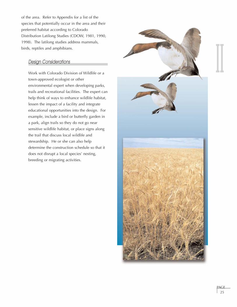
PAGE25
of the area. Refer to Appendix for a list of the
species that potentially occur in the area and their
preferred habitat according to Colorado
Distribution Latilong Studies (CDOW, 1981, 1990,
1998). The latilong studies address mammals,
birds, reptiles and amphibians.
Design Considerations
Work with Colorado Division of Wildlife or a
town-approved ecologist or other
environmental expert when developing parks,
trails and recreational facilities. The expert can
help think of ways to enhance wildlife habitat,
lessen the impact of a facility and integrate
educational opportunities into the design. For
example, include a bird or butterfly garden in
a park, align trails so they do not go near
sensitive wildlife habitat, or place signs along
the trail that discuss local wildlife and
stewardship. He or she can also help
determine the construction schedule so that it
does not disrupt a local species’ nesting,
breeding or migrating activities.
II

SECTION III
PARKS AND RECREATION
Introduction . . . . . . . . . . . . . . . . . . . . . . . . . . . . . . . . . . . . . . . . . . . . . . . . . . . . Page 26
Intent Page 27
Function of Parks Page 28
Types of Parks Page 28
Parks Standards . . . . . . . . . . . . . . . . . . . . . . . . . . . . . . . . . . . . . . . . . . . . . . . . . . Page 30
Parks and Recreation Goals, Policies and Strategies . . . . . . . . . . . . . . . . . . . . . . Page 33
Parks Inventory . . . . . . . . . . . . . . . . . . . . . . . . . . . . . . . . . . . . . . . . . . . . . . . . . . Page 36
Milliken Parks Page 36
Johnstown Parks Page 38
Park Design, Development and Maintenance . . . . . . . . . . . . . . . . . . . . . . . . . . . Page 40
Park Design Page 40
Community Facilities Plan Page 40
Park Development Page 42
Park Maintenance Page 44
Park Design Considerations Page 45
Non-Toxic Plant Materials for Parks Page 48

III
Leap and the net will appear.ZEN SAYING
PARKS AND RECREATION
Introduction
Residents in Milliken and Johnstown are very
proud of the existing park system, as evidenced by
its heavy use. For example, the park shelters in
Johnstown are so busy that citizens must sign up
for them, and by April they are usually booked for
the summer. The children really appreciate the
parks in town and generally use them quite often.
The elementary school student council found that
most children who live in Town reported using the
parks at least three to five times a week. Families
come from throughout the recreation district to
enjoy the parks in the older parts of the
communities because there are no facilities within
walking distance of their homes.
The citizens strongly support the development of
new parks. They feel the demand placed on the
parks will only continue to grow because the
majority of people moving into the area are young
families with children. They feel parks serve as
gathering places for community members of all
ages and they will help new citizens meet long-
time residents. The Recreation District feels it is
important to expand the park system because there
are insufficient facilities for practicing sports and
playing pick-up games.
The community’s highest priority is the need for
more recreation opportunities close to home.
Many people currently travel to nearby
communities for their indoor and outdoor
recreation needs. This is true for all ages and user
groups. The most commonly requested facilities
that citizens would like to have include: additional
playing fields (for soccer, football, softball/baseball,
and non-organized sports), a gymnasium or field
house, classrooms/meeting rooms, an indoor
swimming pool, a teen center, and a library.
Several people also requested a theater, fishing
ponds and a shooting range. The activities most
frequently requested by citizens include:
competitive youth sports, non-competitive sports
for teens, special interest classes for adults and
youths (such as photography, nutrition/health, arts
and crafts, and dance), adult fitness programs (such
as aerobics, kickboxing and weight training) and
adult athletics (especially softball and basketball).
It is clear that the current mill levy will not fund
new recreational facilities. In order to get support
from the community for any sort of tax increase,
the proposed facilities would need to benefit
people of all ages (not just children). Citizens
recommend the following funding options for
recreational facilities: corporate sponsorships, PAGE26
Parks and Recreation
IIIgrants, bonds, sales tax (need more commercial
uses to make this option work), increase
development impact fees, Colorado Rockies for
baseball fields, privately funded facilities (i.e.
bowling alleys, movie theaters, health clubs).
This plan does not address programming for
recreation activities within the community. It will
serve as a guide for the development of adequate
parks and recreation facilities to support the
citizen’s programming needs. The Recreation
District currently provides the programming and
organization of activities. The Towns and the
School District develop, own and maintain the
facilities. The Towns and the Recreation District
cooperate with the School District to share
facilities and are still unable to meet the demand.
This arrangement will continue to evolve as the
communities grow and the demands for services
increase with the population.
Cooperation is essential to meet the increasing
demand for services. The citizens want to
reinforce and nurture this spirit of cooperation. It
is important to develop partnerships with
businesses, service groups and organizations,
landowners and developers. For example,
teachers, Girl Scouts, Boy Scouts and Future
Farmers of America are cooperating with the Town
of Johnstown to help build Sunrise Ridge Park. This
cooperation helped the community get financial
support from a Great Outdoor Colorado grant. The
Town of Milliken partnered with Hall-Irwin and
Bestway Concrete to develop two fisheries. This
cooperation made possible a $260,000 grant from
Colorado Division of Wildlife’s Fishing is Fun
program to stock the ponds and install trails,
parking lots, restrooms and educational signage.
Continued support from other State agencies such
as the Division of Local Governments and
Colorado State University will extend limited
resources. By sharing facilities with the School
District, maintenance costs can be shared.
Cooperation is also a key component of the design
process for all parks and recreation facilities. The
community must cooperate with the Recreation
District and school districts to identify needs and
determine the best location for facilities.
The citizens of Milliken and Johnstown feel that
all parks should:
• Serve as community gathering spaces to foster
strong connections within and between
Johnstown and Milliken;
• Provide a variety of activities for different age
groups and users;
• Include open areas for group activities and
smaller, quiet spaces for individuals;
• Be connected to the community and each other
with safe pedestrian access;
• Include grass, shrubs, trees, annuals and
perennials, and where possible, water;
• Provide educational opportunities; and
• Be developed as shared, multi-purpose facilities.
Intent:
The purpose of this section is to:
• Define the community’s vision for
Milliken/Johnstown’s park system;
• Help ensure the parks system will provide
adequate facilities to support existing and
future recreation opportunities;
• Ensure parks and recreational facilities are
available to all citizens and foster both
individual and family activities;
• Put standards in place for new
development and to help the towns
estimate park development costs soPAGE
27
IIIMilliken/Johnstown can more easily
explore funding opportunities;
• Ensure each park is a unique, special place
and includes education opportunities; and
• Provide design guidelines and
development standards that ensure all
facilities are sensitive to the environment
and context within the community.
Function of Parks
Parks fulfill a variety of needs within the
community. They provide opportunities for
passive and active recreation. They help
reinforce a sense of community by providing
places for members of the community to
gather and interact. Parks also enhance the
community’s image and quality of life.
Types of Parks
Pocket Parks are small (minimum one
acre) sites within walking distance of
residential units. They are designed to fit
the style and needs of the homes they
serve, are installed by the developer and
owned and maintained by homeowners’
associations. A pocket park for a senior
community may include a contemplative
garden and a picnic area while a pocket
park for a multi-family project with young
families may include playground
equipment for small children, a picnic
area and a basketball or volleyball court.
Because pocket parks are within walking
distance of most users, restrooms and
parking areas are not typically provided.
Neighborhood Parks provide places for
informal recreation and gathering places
within 1/2 mile of most residences in the
neighborhood they serve. They often serve
more than one type of residential unit,
including single family homes, apartments
and senior housing. Neighborhood parks
are often linked via the trail system. They
are 7 to 10 acres in size and may include
multi-use lawn areas, picnic areas,
shelters, playground equipment, small
court games, restrooms, parking, and
community gardens. They are designed to
fit the needs of the neighborhood they
serve and provide places for both
individual and group activities.
Community Parks are larger parks
(approximately 25 acres or more) designed
to be used by the residents of more than
one neighborhood and the community at
large. They serve as a focus for community
activities and events (i.e. town greens,
outdoor concerts, amphitheaters, family
gatherings) and typically include many of
the ammenities in neighborhood parks.
They provide places for organized group
activities, (could be indoor or outdoor) as
well as individual activities and family
gatherings. They may also take advantage
of unique natural settings and provide
recreational facilities compatible with the
site (i.e. fishing where there is a pond).
Regional Parks will include special places
with unique geographic characteristics
such as Johnstown Reservoir or the
Community Green. They may also include
areas that need preservation and limited
public access such as the Sparrow property
in Milliken.
Linear Parks will include the Little
Thompson, Big Thompson and South Platte
River Corridors. They may also function as
links between special places. Please refer
to the Parks Standards on page 30 for
more details about each type of park.
PAGE28

III
PAGE29
III
PAGE30
PAR
KS
STA
ND
AR
DS

III
PAGE31
PAR
KS
STA
ND
AR
DS
(CO
NTI
NU
ED)
III
PAGE32
Park
loca
tions
and
siz
es w
ill b
e de
term
ined
in c
oope
ratio
n w
ith la
nd o
wne
rs a
t the
tim
e of
pre
limin
ary
plat
.
PAR
KS
STA
ND
AR
DS
(CO
NTI
NU
ED)
PAGE33
Parks and Recreation Goals, Policies
and Strategies
GOAL P1:
Provide a comprehensive parks and recreation
system that provides for a variety of activities
and serves all age groups.
Policy P1.1:
Develop and maintain pocket parks,
neighborhood parks, community parks,
regional parks and linear parks to serve the
present and future needs of
Milliken/Johnstown residents. All parks
shall be multi-purpose, safe and accessible
to all citizens.
Strategy P1.1.1:
Locate parks in accordance with the
Parks, Trails, Recreation and Open
Space Master Plan Map and the
Milliken and Johnstown
comprehensive plans.
Strategy P1.1.2:
Ensure that all new parks comply with
the design standards, parks standards
and community facilities plan set forth
in this section of the Plan.
Strategy P1.1.3:
Develop parks as integral parts of
other public facilities such as schools
to avoid duplicating services.
Strategy P1.1.4:
Include trailheads in parks located near
neighborhood and river corridor trails.
Strategy P1.1.5:
Design all parks and recreation areas in
accordance with Americans with
Disabilities Act requirements.
Policy P1.2:
Work with local governments, the land
development community and government
agencies to develop parks and
recreation facilities.
Strategy P1.2.1:
Work with Larimer and Weld Counties
to plan and construct strategically
located regional and linear parks
along the Big Thompson, Little
Thompson and South Platte River
corridors.
Strategy P1.2.2:
Cooperate with the Weld County RE-5J
and Thompson RE-5J School Districts
to allow joint use of existing facilities
and to develop new facilities.
Strategy P1.2.3:
Cooperate with landowners and Weld
County to incorporate community
gathering spaces in the area identified
as the community green between
Johnstown and Milliken.
Strategy P1.2.4:
Cooperate with State and Federal
agencies to develop and enhance
fisheries in existing and future ponds
and along the river corridors where
appropriate.
Strategy P1.2.5:
Require the development community
to design and install drainage facilities
that will also function for informal
activities and practice fields.
Strategy P1.2.6:
Investigate the potential for
cooperative agreements with
developers to install needed facilities.
III
PAGE34
IIIStrategy P2.2.4:
Incorporate a community theater into
one of the planned or existing
facilities.
Strategy P2.2.5:
Continue to support senior centers and
expand recreation opportunities for
seniors.
Strategy P2.2.6:
Cooperate to fund and build athletic
fields to meet the needs of local
organized sports groups.
GOAL P3:
Use parks to enhance the quality of life in
Milliken and Johnstown.
Policy P3.1:
Design parks to draw the members of the
community together by providing locations
for community activities.
Strategy P3.1.1:
Develop a multi-purpose pavilion to
allow for concerts and movies in the
park, a farmer’s market, a place for
festivals, large group picnics and other
community events and activities.
Strategy P3.1.2:
Ensure that every park has at least one
trail connection and is easily
accessible by residents. Include
trailheads in park design as
appropriate.
Policy P3.2:
Design all parks to reflect Milliken and
Johnstown’s unique character and context.
GOAL P2:
Develop a comprehensive network of multi-
purpose recreation facilities to expand
recreation opportunities for the community.
Policy P2.1:
Cooperate with the Recreation District and
various activity groups to plan, fund and
develop a recreation center or centers to
serve the recreation needs of the
community.
Strategy P2.1.1:
Build a multi-purpose field house that
can function for indoor sports, special
interest classes for youth and adults,
and fitness/exercise programs.
Strategy P2.1.2:
Cooperate with the school districts to
build an indoor swimming pool.
Policy P2.2:
Cooperate with the Recreation District and
various activity groups to plan, fund and
build additional recreation facilities
throughout the community.
Strategy P2.2.1:
Cooperate with the Weld County
Library District to expand library
facilities.
Strategy P2.2.2:
Investigate ways to develop new
facilities and expand use of
existing community facilities for
classrooms and meeting rooms.
Strategy P2.2.3:
Cooperate to fund, build
and operate a teen center.

PAGE35
Strategy P3.2.1:
Obtain neighborhood and community
input when designing parks to
determine individual park
components. Be sure to encourage
children to participate in this process.
Strategy P3.2.2:
Ensure that proposed parks address the
design elements outlined in the parks
design, development and maintenance
standards section of this Plan.
Policy P.3.3:
Integrate oil and gas facility setbacks into
the parks and open space network.
Strategy P.3.3.1:
Work with oil and gas companies to
locate new facilities to limit impacts
on parks, open space and
environmental resources.
Strategy P3.3.2:
Work with oil and gas companies and
developers to locate new facilities in
residential areas so that the well
setback can function within the
neighborhood until the well is capped
and abandoned.
Strategy P3.3.3:
Work with the oil and gas companies
to ensure that facilities within
residential neighborhoods are fenced
and screened to increase safety and
limit visual impacts.
Policy P3.4:
Continue to foster the spirit of cooperation
that allows for shared facilities and the
provision of services.
Strategy P3.4.1:
Continue quarterly summit meetings
with the Weld County Re-5J School
District, Thompson Rivers Parks and
Recreation District, Milliken and
Johnstown. Invite the Thompson
Valley School District to attend the
meetings.
Strategy P3.4.2:
Include language regarding shared
facilities in the Intergovernmental
Agreement between the entities.
Strategy P3.4.3:
Design and locate facilities so that
they are spread throughout both
III
IIIcommunities and are accessible to all
residents.
Strategy P3.4.4:
Continue to involve the public in
discussions regarding the provision of
parks and recreation facilities.
Parks Inventory
Existing parks are described below with a list of
enhancement opportunities for each site. A complete
inventory of each park is included in the appendix.
Milliken Parks
Frank Farms #1
Lilac Street and Rachel Court
Enhancement Opportunities
• Install a xeriscape demonstration
garden and home idea garden.
Provide bird habitat for bird watching,
a picnic area, and possibly a trailhead.
• Design the area within the oil and gas
setback to function as a pocket park.
At a minimum, seed the area and
install street trees.
Frank Farms #2
Between Rachel Avenue and Tamara
Avenue
Enhancement Opportunities
• Install trash receptacles, restroom
facility, lighting, picnic structure, and
additional plantings.
• Incorporate activity areas for older
children.
• Add more imaginative play areas using
natural materials and interesting
spaces created with plants and
structures.
PAGE36
PAGE37
IIILola Park
Irene and Forest to Josephine and Forest
Enhancement Opportunities
• Install a more prominent park
identification sign.
• Install additional trash receptacles.
• Plant additional trees on the east side
of the park.
• Coordinate with middle school
regarding educational elements that
could be incorporated and used by
the children.
• Transition the elevation of the
sidewalk onto turf more smoothly.
Mountain View Park
Juneberry and Olive Street
Enhancement Opportunities
• Install trash receptacles, bathroom
facilities, barbeque grills, trees and
two park identification signs with
entrance plantings for Katsura and
Juneberry access.
• Install landscaping between the
different areas to identify the separate
uses.
• Install street trees along Katsura Street.
• Install educational signage about the
pipeline running through the park.
ADA Park
Aragon Court
Enhancement Opportunities
• Install additional trash receptacles.
• Install a metal picnic table to replace
the existing damaged table.
• Install a park identification sign and a
sign indicating park rules.
• Add landscaping throughout the park,
including street trees along the edge.

III• Install flowering shrubs and perennials
to add color to the park.
Avila Park
Adjacent to Town Hall on Grace Avenue
Enhancement Opportunities
• Install landscaping such as canopy
trees along the side of the park to
screen the side of Town Hall and the
parking lot from the park.
• Install security lighting (perhaps foot
lighting would be effective).
• Install trash receptacles and a
barbeque grill.
Johnstown Parks
Parish Park
Raymond Place and Charlotte Street
Enhancement Opportunities
• Create a gateway by installing plantings
and signage at the intersection of
Raymond and Charlotte streets.
• Separate uses by planting trees along
the west edge of the volleyball court
and the west end of the picnic
shelters.
• Install enclosures for dumpster and
port-a-let.
• Install additional picnic tables.
• Install smaller trees to begin
regenerating the tree canopy layer.
• Create outdoor rooms within the park
by planting more small trees and
shrubs to define distinct spaces.
• Control volunteer seedlings of White
Poplar trees.
• Add alternative activity features to
playground equipment, taking
inspiration from nature and the history
of the town to inspire more
imaginative play.
Hays Park
Country Acres Drive
Enhancement Opportunities
• Install additional plantings to create a
theme and define spaces within the park.
• Build enclosures for trash dumpsters.
PAGE38

PAGE39
III• Install a walking path around the
perimeter of the park or within the
park to get from one activity area to
the next.
• Define an entrance with a park sign
and landscaping.
• Install barbeque grills for the eastern
picnic shelter.
• Incorporate interpretation of
agriculture (i.e. corn or sunflower
plantings) into an educational element
in the park.
• Install additional street trees.
Eddie Aragon Park
Weld County Road 17 and Johnstown
Center Drive
Enhancement Opportunities
• Repaint the wood benches in the
picnic structure.
• Provide trash receptacles.
• Repair the skating rink sign.
• Add plantings and maintain the
park identification sign.
• Use xeriscaping principles and zone
the irrigation so that it isn’t the same
in all places. Install low water plants
rather than Aspen trees to match the
other plants.
• Plant more shade trees along the
perimeter to help define the spaces
within the park.
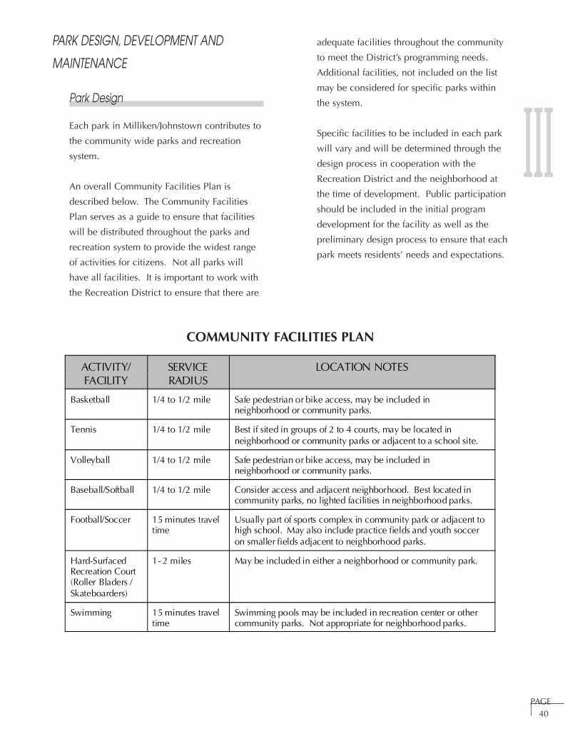
III
PAGE40
PARK DESIGN, DEVELOPMENT AND
MAINTENANCE
Park Design
Each park in Milliken/Johnstown contributes to
the community wide parks and recreation
system.
An overall Community Facilities Plan is
described below. The Community Facilities
Plan serves as a guide to ensure that facilities
will be distributed throughout the parks and
recreation system to provide the widest range
of activities for citizens. Not all parks will
have all facilities. It is important to work with
the Recreation District to ensure that there are
COMMUNITY FACILITIES PLAN
adequate facilities throughout the community
to meet the District’s programming needs.
Additional facilities, not included on the list
may be considered for specific parks within
the system.
Specific facilities to be included in each park
will vary and will be determined through the
design process in cooperation with the
Recreation District and the neighborhood at
the time of development. Public participation
should be included in the initial program
development for the facility as well as the
preliminary design process to ensure that each
park meets residents’ needs and expectations.
ACTIVITY/FACILITY
SERVICERADIUS
LOCATION NOTES
Basketball 1/4 to 1/2 mile Safe pedestrian or bike access, may be included inneighborhood or community parks.
Tennis 1/4 to 1/2 mile Best if sited in groups of 2 to 4 courts, may be located inneighborhood or community parks or adjacent to a school site.
Volleyball 1/4 to 1/2 mile Safe pedestrian or bike access, may be included inneighborhood or community parks.
Baseball/Softball 1/4 to 1/2 mile Consider access and adjacent neighborhood. Best located incommunity parks, no lighted facilities in neighborhood parks.
Football/Soccer 15 minutes traveltime
Usually part of sports complex in community park or adjacent tohigh school. May also include practice fields and youth socceron smaller fields adjacent to neighborhood parks.
Hard-SurfacedRecreation Court(Roller Bladers /Skateboarders)
1- 2 miles May be included in either a neighborhood or community park.
Swimming 15 minutes traveltime
Swimming pools may be included in recreation center or othercommunity parks. Not appropriate for neighborhood parks.
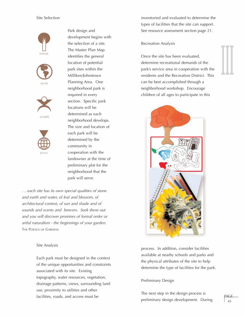
IIISite Selection
Park design and
development begins with
the selection of a site.
The Master Plan Map
identifies the general
location of potential
park sites within the
Milliken/Johnstown
Planning Area. One
neighborhood park is
required in every
section. Specific park
locations will be
determined as each
neighborhood develops.
The size and location of
each park will be
determined by the
community in
cooperation with the
landowner at the time of
preliminary plat for the
neighborhood that the
park will serve.
. . .each site has its own special qualities of stone
and earth and water, of leaf and blossom, of
architectural context, of sun and shade and of
sounds and scents and breezes. Seek these out
and you will discover promises of formal order or
artful naturalism - the beginnings of your garden.
THE POETICS OF GARDENS
Site Analysis
Each park must be designed in the context
of the unique opportunities and constraints
associated with its site. Existing
topography, water resources, vegetation,
drainage patterns, views, surrounding land
use, proximity to utilities and other
facilities, roads, and access must be
inventoried and evaluated to determine the
types of facilities that the site can support.
See resource assessment section page 21.
Recreation Analysis
Once the site has been evaluated,
determine recreational demands of the
park’s service area in cooperation with the
residents and the Recreation District. This
can be best accomplished through a
neighborhood workshop. Encourage
children of all ages to participate in this
process. In addition, consider facilities
available at nearby schools and parks and
the physical attributes of the site to help
determine the type of facilities for the park.
Preliminary Design
The next step in the design process is
preliminary design development. DuringPAGE
41

IIIthis process, specific activities and
facilities are
organized on the site.
Another community
workshop or design
charrette should be
included at this
point in the
process.
At a
minimum,
each park site
should have a
distinct entry,
destinations within
the facility and
pathways connecting
the activities.
Include trees,
shrubs, annuals and
perennials,
and grass or
appropriate
ground cover in every
park. Park design
considerations are outlined on
page 45. Each park within
Milliken/Johnstown will have a unique
context, site attributes, and user groups.
The design and development of each
facility should reflect this unique set of
circumstances.
Consider long term maintenance in the
design process. The types of materials
selected for site furnishings, the extent of
irrigated turf, types of plant materials, and
the transition from one material to the next
can all have a significant impact on the
overall costs of maintaining park facilities.
All park improvements should be sensitive
to the setting and minimize potential
impacts to environmental resources.
Include water conservative landscaping
which incorporates the following xeriscape
principles in the design of all parks.
• Turf Alternatives: Consider alternatives
to turf grass such as native and low
water-use plantings. Native turf
grasses should be used in areas where
intense traffic is not anticipated.
• Mulches: Use mulches to cover the
soil, minimize evaporation, reduce
weed growth and slow erosion.
• Zoning of Plants: Group plantings
based on their water use and locate
them to take advantage of
microclimates and their specific needs.
• Soil Improvements: Prior to planting,
enhance soils with organic matter to
allow for better water absorption and
improved water holding capacity.
• Appropriate Maintenance: Apply
water according to plant needs rather
than a schedule; prune, weed and
fertilize as necessary to further water
savings.
Park Development
From this preliminary design, construction
drawings detailing all park components can be
completed. Once complete plans have been
developed and reviewed by the Town, site
development can begin. Construct facilities
that are consistent with all applicable town,
state and federal standards in place at the time
of development.
Construction of park facilities may be
accomplished in phases. Develop phasing
plans in the context of the surrounding land
use and create interim plans for the site.PAGE
42

PAGE43
IIICarefully consider the impacts of future
improvements on initial improvements. This
will help to avoid additional costs due to
damage to existing improvements when future
phases are constructed.
The community is willing to participate in both
the design and construction of park facilities.
Include public participation at several points
in the process. For example, a community
group could be responsible for planting the
flower beds in the park or a community work
day could be organized to help install a piece
of equipment. The graphic below illustrates
how the Girl Scouts helped design the butterfly
garden in Sunrise Ridge Park, a project funded
in cooperation with GOCO.
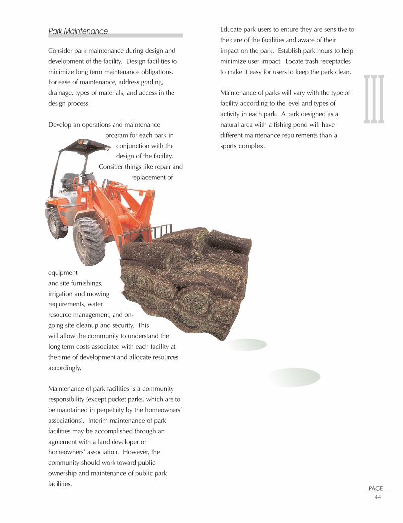
III
PAGE44
Park Maintenance
Consider park maintenance during design and
development of the facility. Design facilities to
minimize long term maintenance obligations.
For ease of maintenance, address grading,
drainage, types of materials, and access in the
design process.
Develop an operations and maintenance
program for each park in
conjunction with the
design of the facility.
Consider things like repair and
replacement of
equipment
and site furnishings,
irrigation and mowing
requirements, water
resource management, and on-
going site cleanup and security. This
will allow the community to understand the
long term costs associated with each facility at
the time of development and allocate resources
accordingly.
Maintenance of park facilities is a community
responsibility (except pocket parks, which are to
be maintained in perpetuity by the homeowners’
associations). Interim maintenance of park
facilities may be accomplished through an
agreement with a land developer or
homeowners’ association. However, the
community should work toward public
ownership and maintenance of public park
facilities.
Educate park users to ensure they are sensitive to
the care of the facilities and aware of their
impact on the park. Establish park hours to help
minimize user impact. Locate trash receptacles
to make it easy for users to keep the park clean.
Maintenance of parks will vary with the type of
facility according to the level and types of
activity in each park. A park designed as a
natural area with a fishing pond will have
different maintenance requirements than a
sports complex.
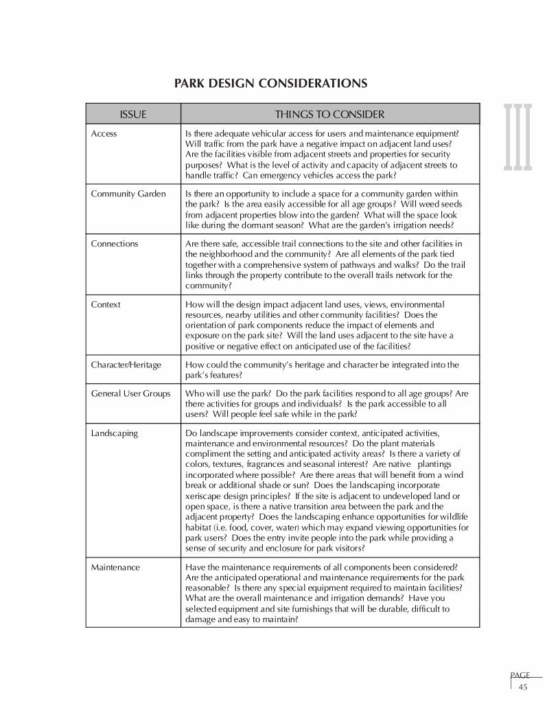
PAGE45
IIIPARK DESIGN CONSIDERATIONS
ISSUE THINGS TO CONSIDER
Access Is there adequate vehicular access for users and maintenance equipment? Will traffic from the park have a negative impact on adjacent land uses? Are the facilities visible from adjacent streets and properties for securitypurposes? What is the level of activity and capacity of adjacent streets tohandle traffic? Can emergency vehicles access the park?
Community Garden Is there an opportunity to include a space for a community garden withinthe park? Is the area easily accessible for all age groups? Will weed seedsfrom adjacent properties blow into the garden? What will the space looklike during the dormant season? What are the garden’s irrigation needs?
Connections Are there safe, accessible trail connections to the site and other facilities inthe neighborhood and the community? Are all elements of the park tiedtogether with a comprehensive system of pathways and walks? Do the traillinks through the property contribute to the overall trails network for thecommunity?
Context How will the design impact adjacent land uses, views, environmentalresources, nearby utilities and other community facilities? Does theorientation of park components reduce the impact of elements andexposure on the park site? Will the land uses adjacent to the site have apositive or negative effect on anticipated use of the facilities?
Character/Heritage How could the community’s heritage and character be integrated into thepark’s features?
General User Groups Who will use the park? Do the park facilities respond to all age groups? Arethere activities for groups and individuals? Is the park accessible to allusers? Will people feel safe while in the park?
Landscaping Do landscape improvements consider context, anticipated activities,maintenance and environmental resources? Do the plant materialscompliment the setting and anticipated activity areas? Is there a variety ofcolors, textures, fragrances and seasonal interest? Are native plantingsincorporated where possible? Are there areas that will benefit from a windbreak or additional shade or sun? Does the landscaping incorporatexeriscape design principles? If the site is adjacent to undeveloped land oropen space, is there a native transition area between the park and theadjacent property? Does the landscaping enhance opportunities for wildlifehabitat (i.e. food, cover, water) which may expand viewing opportunities forpark users? Does the entry invite people into the park while providing asense of security and enclosure for park visitors?
Maintenance Have the maintenance requirements of all components been considered? Are the anticipated operational and maintenance requirements for the parkreasonable? Is there any special equipment required to maintain facilities? What are the overall maintenance and irrigation demands? Have youselected equipment and site furnishings that will be durable, difficult todamage and easy to maintain?

III
PAGE46
PARK DESIGN CONSIDERATIONS (CONTINUED)
ISSUE THINGS TO CONSIDER
Overall Site Design Do all of the elements fit together into a unified whole? Has the designintegrated the elements of gateway, pathway and destination into theoverall plan for the park? Does the design respond to the town’s uniquesetting, character and heritage? Is the design consistent with the goals andpolicies and standards outlined in the Parks, Trails, Recreation and OpenSpace Master Plan and all other town rules and regulations? Does thedesign work in terms of all three dimensions? Does the site respond to thesenses? How will you feel when you enter the site, sit on the benches,play on the equipment and walk along the trails? What will you see, hear,smell, touch? Will you feel safe or exposed? Will you know that you arein Johnstown or Milliken, Colorado?
Park Entry Does the entrance to the park create an distinctive gateway to the facilityand encourage entry? Is there a gateway with an entry feature, signageand plantings? Consider developing a signature park entry structure (i.e.pillar, arch).
PhysicalCharacteristics
What are the physical opportunities and constraints (i.e. size, topography,drainage, vegetation, soils, water resources)? Can the site accommodatethe intended uses? What are the physical constraints that will limit thetypes of activities that can be accommodated in the park or present uniqueopportunities for special activities (i.e. is there a protected east-facing slopethat could accommodate a sledding hill; is there enough level area for anopen play area for softball or soccer)?
PlaygroundEquipment
Will the playground equipment serve all age groups? Is the equipmentsafe, sturdy, and durable? What are the maintenance requirements for theequipment? Does the equipment provide a variety of activities for a varietyof age groups? Does the equipment meet Americans with Disabilities Actstandards? Have natural features been incorporated as play elements (i.e.shrub maze or rocks)?
Public Art Is there an opportunity to include public art in the park? Can the publicinteract with the art? Is there a location for public art within the park thatwill also be visible to people passing by the park on a trail or street? Canthe art be climbed on or played in without damage?
Safety Do all improvements conform to Consumer Product Safety CommissionStandards, American Society for Testing and Materials Standards,Americans with Disabilities Act standards, and all Federal, State, and localordinances? Think about possible safety issues: what happens when kidschase a ball, will the ball roll all the way to the street or will somethingkeep it within the park; is there a maintenance plan for de-icing thesidewalks in the winter; is the park safe at night; is there appropriate safetysurfaces under all equipment; are the plants non-toxic and thornless?
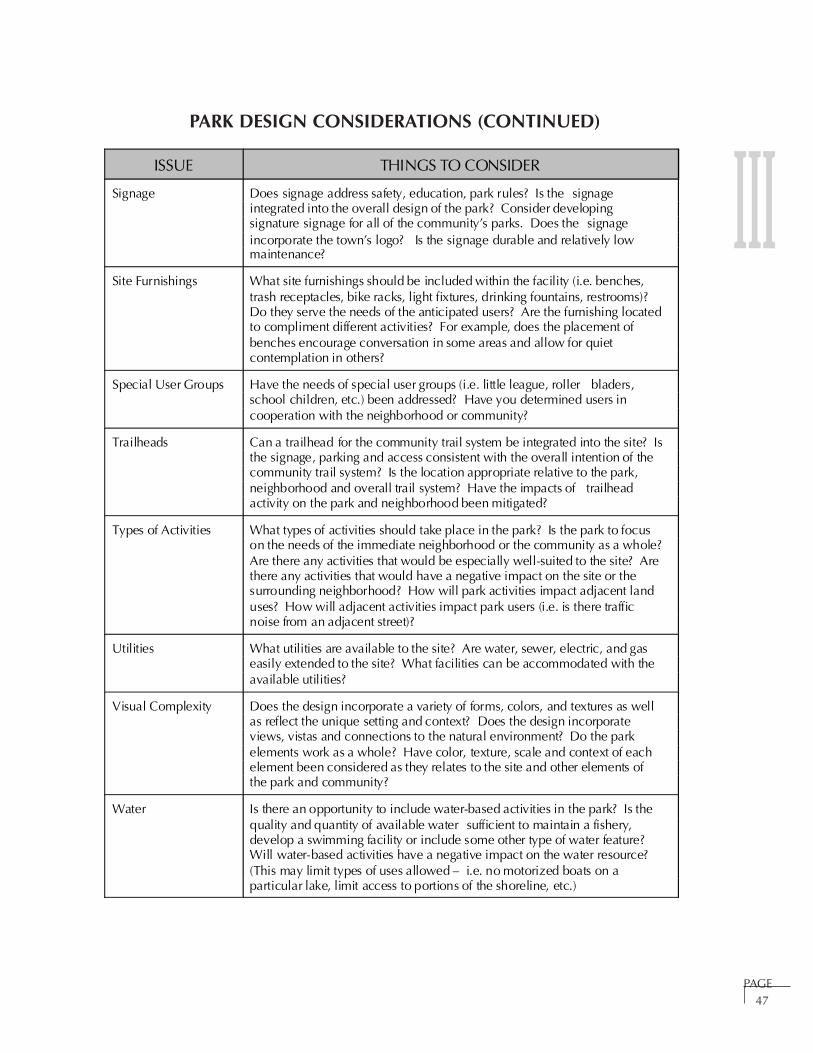
III
PAGE47
ISSUE THINGS TO CONSIDER
Signage Does signage address safety, education, park rules? Is the signageintegrated into the overall design of the park? Consider developingsignature signage for all of the community’s parks. Does the signageincorporate the town’s logo? Is the signage durable and relatively lowmaintenance?
Site Furnishings What site furnishings should be included within the facility (i.e. benches,trash receptacles, bike racks, light fixtures, drinking fountains, restrooms)? Do they serve the needs of the anticipated users? Are the furnishing locatedto compliment different activities? For example, does the placement ofbenches encourage conversation in some areas and allow for quietcontemplation in others?
Special User Groups Have the needs of special user groups (i.e. little league, roller bladers,school children, etc.) been addressed? Have you determined users incooperation with the neighborhood or community?
Trailheads Can a trailhead for the community trail system be integrated into the site? Isthe signage, parking and access consistent with the overall intention of thecommunity trail system? Is the location appropriate relative to the park,neighborhood and overall trail system? Have the impacts of trailheadactivity on the park and neighborhood been mitigated?
Types of Activities What types of activities should take place in the park? Is the park to focuson the needs of the immediate neighborhood or the community as a whole? Are there any activities that would be especially well-suited to the site? Arethere any activities that would have a negative impact on the site or thesurrounding neighborhood? How will park activities impact adjacent landuses? How will adjacent activities impact park users (i.e. is there trafficnoise from an adjacent street)?
Utilities What utilities are available to the site? Are water, sewer, electric, and gaseasily extended to the site? What facilities can be accommodated with theavailable utilities?
Visual Complexity Does the design incorporate a variety of forms, colors, and textures as wellas reflect the unique setting and context? Does the design incorporateviews, vistas and connections to the natural environment? Do the parkelements work as a whole? Have color, texture, scale and context of eachelement been considered as they relates to the site and other elements ofthe park and community?
Water Is there an opportunity to include water-based activities in the park? Is thequality and quantity of available water sufficient to maintain a fishery,develop a swimming facility or include some other type of water feature? Will water-based activities have a negative impact on the water resource? (This may limit types of uses allowed – i.e. no motorized boats on aparticular lake, limit access to portions of the shoreline, etc.)
PARK DESIGN CONSIDERATIONS (CONTINUED)

III
PAGE48
BOTANICAL NAME COMMON NAME
Trees:
Acer species (no rubrum) Maple varieties
Aesculus octandra Yellow Buckeye
Betula platphylla ‘Whitespire ’ Whitespire Birch
Cercus canadensis Eastern Redbud
Fraxinus species Ash varieties
Gleditsia triacanthos var. inermis species Honeylocust varieties
Koelreuteria paniculata Golden Rain Tree
Pinus species Pine varieties
Quercus gambelli Gambel Oak
Syringa reticulata Japanese Lilac Tree
Tilia species Linden varieties
Juniperus scopulorum Rocky Mountain Juniper
Shrubs:
Amorpha species Leadplant varieties
Artemisia species Sagebrush varieties
Buddleja davidii species Butterfly Bush varieties
Caragana species Peashrub varieties
Caryopteris x clandonensis Bluemist Spirea
Cerocarpus species Mahogany varieties
Cornus species Dogwood varieties
Cytisus x 'Lena' Lena Broom
Euonymus alata species Burning Bush varieties
Euonymus fortunei species Euonymus varieties
Euonymus klautschovica ‘Manhattan’ Manhattan Euonymus
Fallugia paradoxa Apache Plume
Neomexicana forestiera species (no savina) New Mexico Privet
Select plant materials that are thornless and nontoxic for all parks. Below is a plant list intended to actas a selection guide. Additional plantings may be considered if they do not pose a hazard to park users.
NON-TOXIC PLANT SELECTION GUIDE FOR PARKS

III
PAGE49
NON-TOXIC PLANT SELECTION GUIDE FOR PARKS (CONTINUED)
BOTANICAL NAME COMMON NAME
Shrubs (continued)
Juniperus species Juniper varieties
Lonicera species (no tatarica or xylosteum) Honeysuckle varieties
Philadelphus species Mockorange varieties
Pinus species Pine varieties
Prunus americana Wild Plum
Prunus besseyi Western Sand Cherry
Prunus tomentosa Nanking Cherry
Ribes species Currant varieties
Salix species Willow varieties
Shepherdia argentea Buffaloberry
Spirea species Spirea varieties
Syringa species Lilac varieties
Viburnum species (no opulus) Viburnum varieties
Perennials:
Achillea species Yarrow varieties
Agastache cana Double Bubble Mint
Callirhoe involucrata Poppy Mallow
Coreopsis species Coreopsis varieties
Gallardia species Blanket Flower varieties
Gallium odoratum Sweet Woodruff
Geranium species Cranesbill varieties
Hemerocallis species Daylily varieties
Liatris species Gayfeather varieties
Penstemon species Penstemon varieties
Phlox paniculata species Phlox varieties
Salvia species Salvia varieties
Sedum species Sedum varieties
Silene laciniata Indian Pink
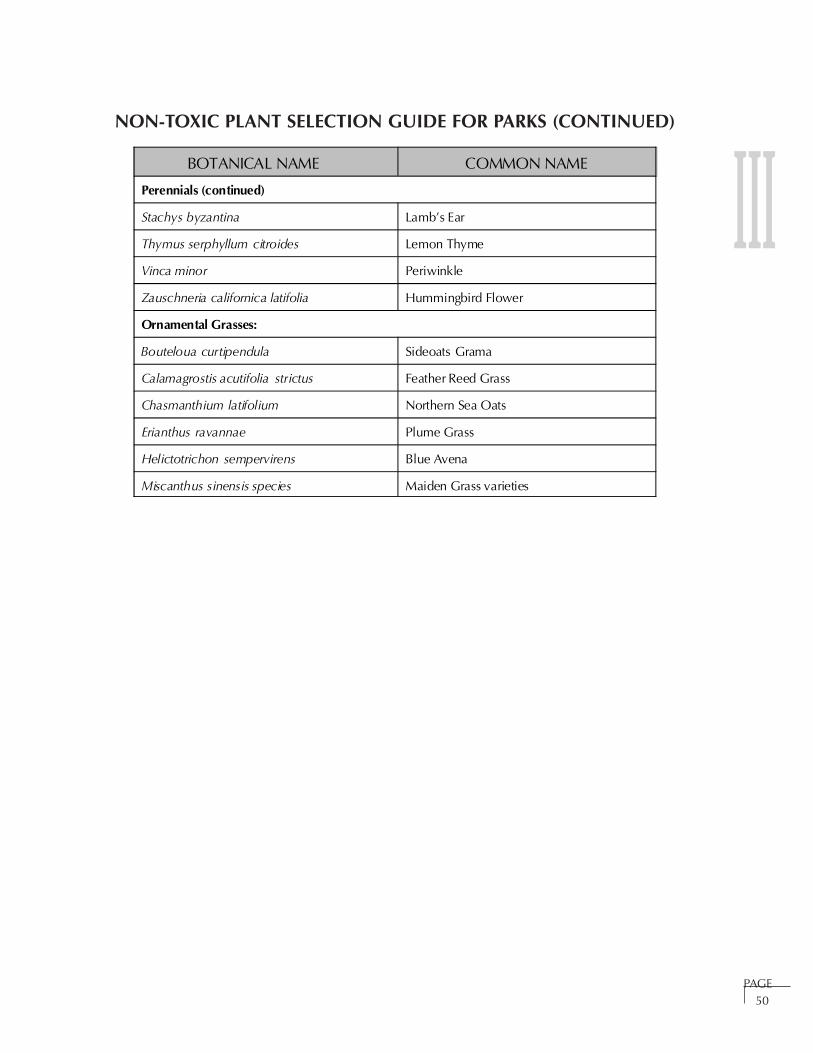
III
PAGE50
BOTANICAL NAME COMMON NAME
Perennials (continued)
Stachys byzantina Lamb’s Ear
Thymus serphyllum citroides Lemon Thyme
Vinca minor Periwinkle
Zauschneria californica latifolia Hummingbird Flower
Ornamental Grasses:
Bouteloua curtipendula Sideoats Grama
Calamagrostis acutifolia strictus Feather Reed Grass
Chasmanthium latifolium Northern Sea Oats
Erianthus ravannae Plume Grass
Helictotrichon sempervirens Blue Avena
Miscanthus sinensis species Maiden Grass varieties
NON-TOXIC PLANT SELECTION GUIDE FOR PARKS (CONTINUED)
SECTION IV
TRAILS
Introduction . . . . . . . . . . . . . . . . . . . . . . . . . . . . . . . . . . . . . . . . . . . . . . . . . . . . Page 51
Intent Page 52
Function of Trails Page 52
Trail Types Page 52
Trail Standards (Cross-Sections) . . . . . . . . . . . . . . . . . . . . . . . . . . . . . . . . . . . . . Page 55
Arterial Transportation Corridor Trail Page 55
River Corridor Trail Page 56
Neighborhood Trail Page 57
Discovery Trail Page 58
Trail Goals, Policies and Strategies . . . . . . . . . . . . . . . . . . . . . . . . . . . . . . . . . . . Page 59
Trail Design, Development and Maintenance . . . . . . . . . . . . . . . . . . . . . . . . . . . Page 62
Site Inventory Page 63
Site Analysis Page 64
Site Design Page 64
Site Development Page 64
Maintenance Page 64
Trail Design Considerations . . . . . . . . . . . . . . . . . . . . . . . . . . . . . . . . . . . . . . . . . Page 65
Native Plant Materials Selection Guide for Trails . . . . . . . . . . . . . . . . . . . . . . . . Page 67
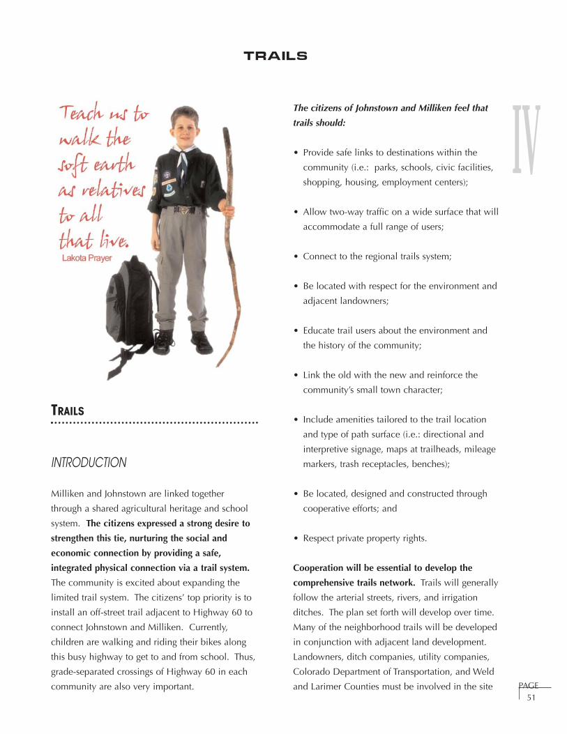
IV
TRAILS
INTRODUCTION
Milliken and Johnstown are linked together
through a shared agricultural heritage and school
system. The citizens expressed a strong desire to
strengthen this tie, nurturing the social and
economic connection by providing a safe,
integrated physical connection via a trail system.
The community is excited about expanding the
limited trail system. The citizens’ top priority is to
install an off-street trail adjacent to Highway 60 to
connect Johnstown and Milliken. Currently,
children are walking and riding their bikes along
this busy highway to get to and from school. Thus,
grade-separated crossings of Highway 60 in each
community are also very important.
The citizens of Johnstown and Milliken feel that
trails should:
• Provide safe links to destinations within the
community (i.e.: parks, schools, civic facilities,
shopping, housing, employment centers);
• Allow two-way traffic on a wide surface that will
accommodate a full range of users;
• Connect to the regional trails system;
• Be located with respect for the environment and
adjacent landowners;
• Educate trail users about the environment and
the history of the community;
• Link the old with the new and reinforce the
community’s small town character;
• Include amenities tailored to the trail location
and type of path surface (i.e.: directional and
interpretive signage, maps at trailheads, mileage
markers, trash receptacles, benches);
• Be located, designed and constructed through
cooperative efforts; and
• Respect private property rights.
Cooperation will be essential to develop the
comprehensive trails network. Trails will generally
follow the arterial streets, rivers, and irrigation
ditches. The plan set forth will develop over time.
Many of the neighborhood trails will be developed
in conjunction with adjacent land development.
Landowners, ditch companies, utility companies,
Colorado Department of Transportation, and Weld
and Larimer Counties must be involved in the site PAGE51
Trails

IVselection and design process so that the new
neighborhoods can be linked together. It may be
possible to share a right-of way with a ditch or
utility company to limit the amount of land
necessary for a trail to provide those links.
Cooperation will also be essential to fund and
maintain the trails.
Intent
This section of the Master Plan provides a
framework for good planning and design of
community trails to ensure that Milliken and
Johnstown develop a safe, interconnected trail
network. It should serve as a reference to
guide future trail-related decisions.
Function of Trails
Trails have numerous important functions:
• Trails form a cohesive community
network by connecting residential
neighborhoods, community facilities,
shopping, parks, employment centers,
recreational facilities and open space;
• They allow for safe movement
between and throughout the
communities and provide an
alternative to automobile
transportation;
• They link important places and
activities in the community and out-of-
town destinations by connecting to
regional trail networks;
• They provide outdoor recreational
opportunities and enhance the area’s
quality of life;
• They enhance property values and
strengthen neighborhoods; and
• They provide an opportunity to
communicate the community’s history
and value of its natural resources
through interpretive educational signage.
Trail Types
The trail system in Milliken/Johnstown will
include the following types of trails (see trail
cross-sections on page 55).
Arterial Transportation Corridor Trail
Arterial Transportation Corridor trails will
facilitate commuting between the
communities and across town for non-
vehicular modes of transportation. These
trails will be within the right-of-way
adjacent to major arterials (streets).
Highway 60 and Weld County Road 46 1/2
will provide the main east - west
connections between Johnstown and
Milliken. The remainder of the arterial
street network generally follows the
existing county road network and will be
improved over time in association with
adjacent development. Coordination with
the Colorado Department of Transportation
will be required during the design and
construction process. Typical activities onPAGE
52
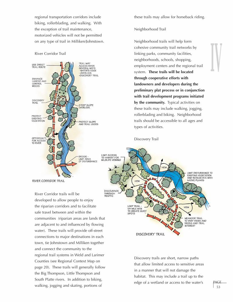
IVregional transportation corridors include
biking, rollerblading, and walking. With
the exception of trail maintenance,
motorized vehicles will not be permitted
on any type of trail in Milliken/Johnstown.
River Corridor Trail
River Corridor trails will be
developed to allow people to enjoy
the riparian corridors and to facilitate
safe travel between and within the
communities (riparian areas are lands that
are adjacent to and influenced by flowing
water). These trails will provide off-street
connections to major destinations in each
town, tie Johnstown and Milliken together
and connect the community to the
regional trail systems in Weld and Larimer
Counties (see Regional Context Map on
page 20). These trails will generally follow
the Big Thompson, Little Thompson and
South Platte rivers. In addition to biking,
walking, jogging and skating, portions of
these trails may allow for horseback riding.
Neighborhood Trail
Neighborhood trails will help form
cohesive community trail networks by
linking parks, community facilities,
neighborhoods, schools, shopping,
employment centers and the regional trail
system. These trails will be located
through cooperative efforts with
landowners and developers during the
preliminary plat process or in conjunction
with trail development programs initiated
by the community. Typical activities on
these trails may include walking, jogging,
rollerblading and biking. Neighborhood
trails should be accessible to all ages and
types of activities.
Discovery Trail
Discovery trails are short, narrow paths
that allow limited access to sensitive areas
in a manner that will not damage the
habitat. This may include a trail up to the
edge of a wetland or access to the water’s PAGE53
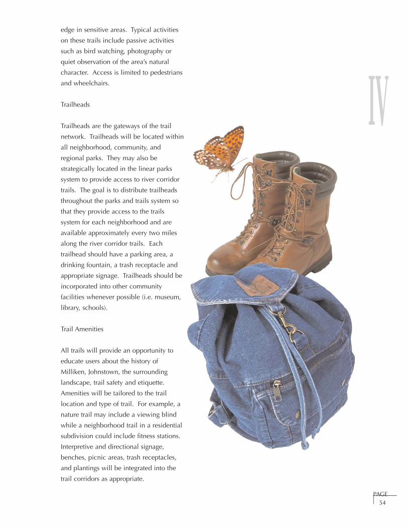
IVedge in sensitive areas. Typical activities
on these trails include passive activities
such as bird watching, photography or
quiet observation of the area’s natural
character. Access is limited to pedestrians
and wheelchairs.
Trailheads
Trailheads are the gateways of the trail
network. Trailheads will be located within
all neighborhood, community, and
regional parks. They may also be
strategically located in the linear parks
system to provide access to river corridor
trails. The goal is to distribute trailheads
throughout the parks and trails system so
that they provide access to the trails
system for each neighborhood and are
available approximately every two miles
along the river corridor trails. Each
trailhead should have a parking area, a
drinking fountain, a trash receptacle and
appropriate signage. Trailheads should be
incorporated into other community
facilities whenever possible (i.e. museum,
library, schools).
Trail Amenities
All trails will provide an opportunity to
educate users about the history of
Milliken, Johnstown, the surrounding
landscape, trail safety and etiquette.
Amenities will be tailored to the trail
location and type of trail. For example, a
nature trail may include a viewing blind
while a neighborhood trail in a residential
subdivision could include fitness stations.
Interpretive and directional signage,
benches, picnic areas, trash receptacles,
and plantings will be integrated into the
trail corridors as appropriate.
PAGE54

IV
PAGE55
Arterial Transportation Corridor Trail Cross Section

IV
PAGE56
River Corridor Trail Cross Section
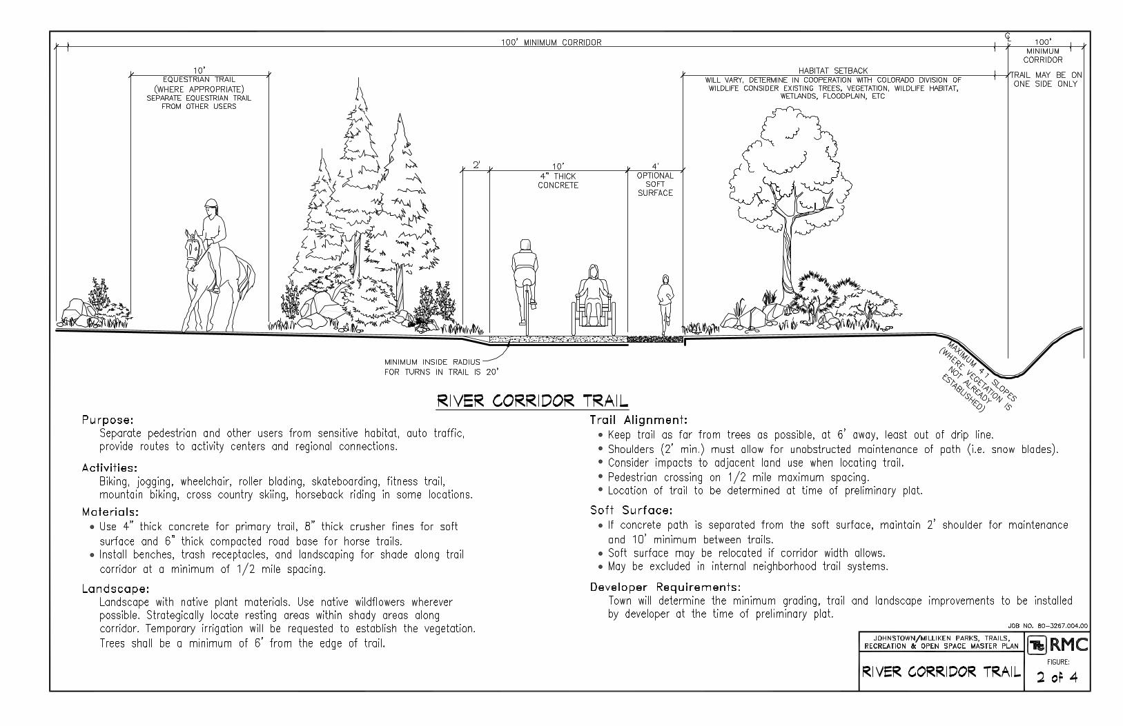

IV
PAGE57
Neighborhood Trail Cross Section
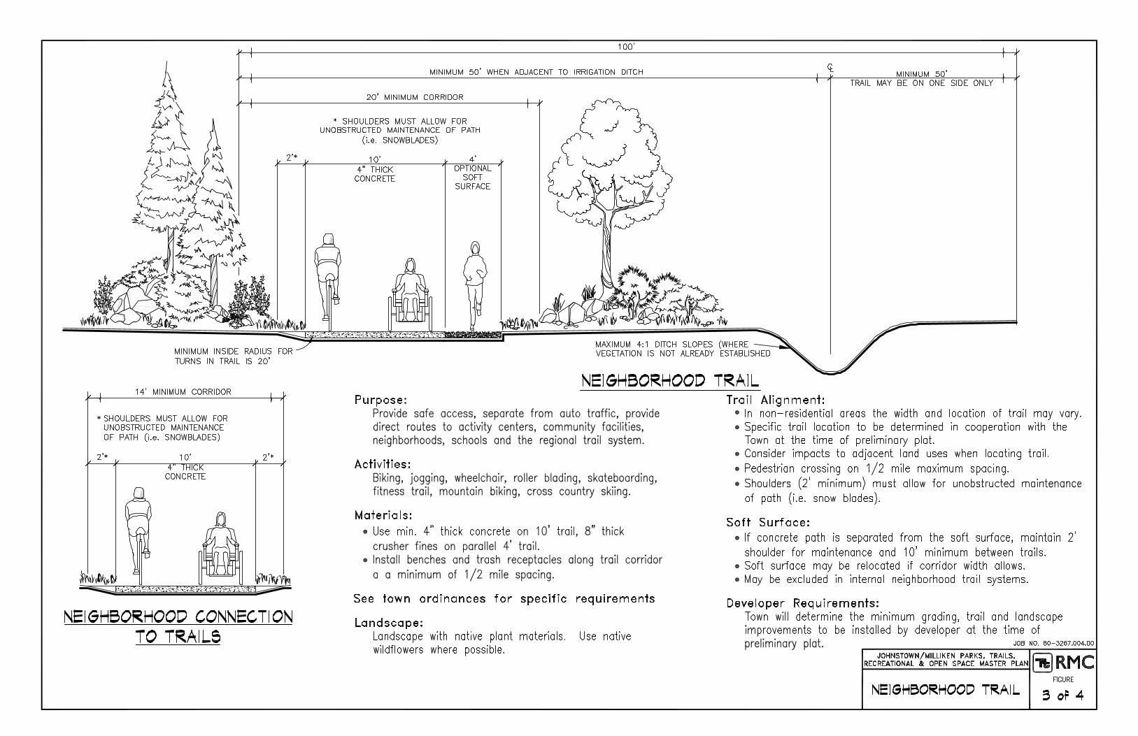

IV
PAGE58
Discovery trail

IV
GOAL T1:
Build a safe, multi-purpose, comprehensive
trail network in Milliken and Johnstown.
Policy T1.1: Link the towns,
neighborhoods, parks, schools, open
spaces, employment centers, community
facilities and adjacent communities with a
multi-purpose trail system.
Strategy T1.1.1: Make the trails wide
enough to minimize conflict among
trail users. See trail cross-sections on
pages 55 to 58.
Strategy T1.1.2: Include access for
equestrians where appropriate
throughout the trail system. Work
with the neighborhood and Town
when designing the trail to determine
if there is a need for equestrian access
and if it will be compatible with the
adjacent land use.
Strategy T1.1.3: Encourage
preservation of the railroad rights-of-
way for commuter rail and trails.
Strategy T1.1.4: Work with the ditch
companies to preserve existing ditch
corridors for irrigation purposes and as
trail corridors.
Policy T1.2: Develop on- and off-street
pedestrian and bicycle trails that provide
safe access throughout the communities.
The general location of the trail network
is shown on the Master Plan Map
on page 9.
Strategy T1.2.1: Develop streets in
accordance with Johnstown’s and
Milliken’s adopted transportation plans
to ensure streets are bicycle- and
pedestrian-friendly.
Strategy T1.2.2: Work with the
development community to provide
bikeways and sidewalks in new
developments. New developments
shall follow the standards set forth in
this plan to ensure the ultimate trail
system is consistent and connected.
PAGE59
TRAIL GOALS, POLICIES AND STRATEGIES
IVStrategy T1.2.3: Require all trails to
comply with American Disability Act
(ADA) standards for accessibility.
Strategy T1.2.4: Design different types
of trails to come together at strategic
points to allow travelers several
different choices to reach a desired
location.
Policy T1.3: Develop trailheads so they are
distributed throughout the park and trail
system, are available every two miles
along river corridor trails, and provide
access to every neighborhood.
Strategy T1.3.1: Strategically locate
trailheads in areas that are centrally
located (i.e. they are easily accessible
from neighborhoods, parks, schools,
other trails).
Strategy T1.3.2: Include trailheads in
every neighborhood, community and
regional park.
GOAL T2:
All trails should be sensitive to the
environment.
Policy T2.1: When siting trails, avoid
sensitive areas and minimize impacts to
wildlife and wetlands.
Strategy T2.1.1: Use appropriate
setbacks from riparian corridors,
valuable habitat and other sensitive
areas. Work with the Colorado
Division of Wildlife or qualified
ecologist to determine appropriate
setbacks (see resource assessment
section on page 21 and trail cross
sections on pages 55 to 58).
Strategy T2.1.2: Site trails in areas that
have already been disturbed or are less
sensitive (i.e. on an abandoned farm
road or through an upland area
instead of through a wetland).
Strategy T2.1.3: Close portions of
trails in sensitive habitat areas as
necessary during periods when species
are extra sensitive to human
encroachment (such as nesting
season).
PAGE60

IVStrategy T2.1.4: Enlist the help of the
Colorado Division of Wildlife, local
conservation groups and ecologists
when planning and designing trails.
Strategy T2.1.5: Educate trail users on
the importance of “leaving no trace”
and staying on trails through signage
at trailheads, educational curriculum
at the local schools and articles in the
local paper.
Policy T2.2: Design trail improvements to
fit into the natural environment.
Strategy T2.2.1: Design new trails in a
manner that responds to the natural
environment, fits into the setting and
protects scenic view corridors.
Consider issues such as topography,
erosion, natural drainage, view
corridors, sensitive areas and the
transition between the trail and the
surrounding landscape.
Strategy T2.2.2: Design trails to take
advantage of the diversity in the
landscape through which they pass.
As the landscape changes, ensure that
dominant features can be clearly seen
from the paths. Locate trails to take
advantage of good views and vistas
toward landmarks.
Policy T2.3: Use native, drought-tolerant
species for landscaping whenever possible.
Strategy T2.3.1: Incorporate the
following xeriscape principles in trail
design:
• Turf Alternatives: Consider alternatives
to turf such as native and low water-
use plantings. Native turf should be
used in areas where intense traffic is
not anticipated.
• Mulches: Use mulches to cover the
soil, minimize evaporation, reduce
weed growth and slow erosion.
• Zoning of Plants: Group plantings
based on their water use and locate
them to take advantage of
microclimates and their specific needs.
• Soil Improvements: Prior to planting,
enhance soils with organic matter to
allow for better water absorption and
improved water holding capacity.
• Appropriate Maintenance: Apply water
according to plant needs rather than a
schedule; prune, weed and fertilize as
necessary to further water savings.
PAGE61
IVGOAL T3:
Pursue trail development with a spirit of
cooperation.
Policy T3.1: Cooperate with federal, state
and local governments, private
landowners, developers, the school
districts, the Recreation District, non-profit
organizations and citizens to facilitate trail
connections and to acquire funding.
Strategy T3.1.1: Work with Weld and
Larimer Counties and neighboring
municipalities to link communities,
facilitate land acquisition, pursue
funding opportunities and
construct trails.
Strategy T3.1.2: Monitor trail initiatives
within the planning area and adjacent
communities to maximize potential for
connections and cooperative funding
(see Regional Context Map on page 20
for current status of planned trails
within the planning area).
Strategy T3.1.3: Develop cooperative
agreements with ditch companies
regarding joint use of ditch rights-of-
way for trails. Address safety,
maintenance and liability issues
in the agreements.
Policy T3.2: Acquire right-of-way through
negotiation and consensus.
Strategy T3.2.1: Work with landowners
to determine appropriate locations for
trails.
Strategy T3.2.2: Keep the public
informed of decisions regarding trail
design and location.
Policy T3.3: Encourage community
participation in trail design, development
and management.
Strategy T3.3.1: Work with the
Recreation District, the school
districts, teachers, and citizens to
create educational trails near the
schools and integrate educational
elements into the trail corridors.
Strategy T3.3.2: Cooperate with the
Weld County Youth Conservation
Corps to hire local youth to help build
and maintain the trails.
Strategy T3.3.3: Host community
events such as community walks and
guided nature walks (with volunteer
naturalists).
GOAL T4:
Use trails to enhance the quality of life in
Milliken/Johnstown.
Policy T4.1: Design all trails to reflect
Johnstown/Milliken’s unique character.
Strategy T4.1.1: Ensure that proposed
trails reflect the design elements (for
materials, signage, benches,
landscaping, trailheads, rural
character, etc.) outlined in the Trail
Design Considerations section of this
plan (pages 65 and 66).
TRAIL DESIGN, DEVELOPMENT AND MAINTENANCE
Site trails in Milliken and Johnstown as the
communities grow according to the purpose that
they will serve within the overall trail system. The
trail corridors are identified on the Parks, Trails,
Recreation and Open Space Master Plan Map. ThePAGE
62

IVmap depicts general locations of the trail corridors.
Specific locations will be determined in
cooperation with the landowner after the resources
along the corridor have been evaluated (see
resource assessment section on page 21).
Following are a basic design process and general
design considerations for developing a trail.
I. Site Inventory
Identify the resources, unique features,
opportunities and constraints that the proposed
site offers. The inventory will likely address:
• Neighborhood and Community
Context – Note adjacent land uses and
identify possible trail locations that
provide convenient access to
neighborhoods and other community
destinations. Minimize conflicts
between trails and incompatible uses.
For example, if the trail is planned to
go through the heart of sensitive
habitat or near people’s homes,
identify alternative routes or buffer the
trail from the habitat/homes as
necessary.
• Vegetation and Wildlife Habitat – Map
habitat types and determine how
sensitive each area is to human
intrusion. Also determine where there
are opportunities to improve habitat
quality in conjunction with trail
development.
• Aesthetic Characteristics – Note both
immediate and distant views from the
proposed trail area (i.e junkyard 100
yards away versus tremendous view of
mountains), the quality of the natural
environment, and adjacent land uses.
Also note the overall character of thePAGE
63
proposed site. The trail should fit into
the existing landscape (i.e. more formal
design adjacent to a residential
subdivision versus a nature trail along
a river corridor).
• Accessibility – Consider how people
will be able to enter the trail corridor
from adjacent properties, other trails
and nearby roads.
• Floodplains – Identify the limits of the
floodplain on the proposed site and
what precautions may be necessary
(i.e. flood gates to close trail during
events, bridges, bank stabilization)
when laying out the trail.
• Topography – Note the topography
and opportunities and constraints it
may pose.
• Water Resources – Evaluate river or
ditch hydrology, water quality and
bank stability as necessary.
• Property Ownership – If the town does
not own the proposed portion of the
trail corridor, coordinate with property
owners for trail right-of-way
acquisition.

IV
PAGE64
• Unique Features – Map special areas
such as interesting geologic
formations, historic sites, or wetlands
and determine how sensitive these
areas are to human intrusion.
• Hazardous Areas – Map areas that
pose safety or environmental hazards.
II. Site Analysis
Evaluate the site inventory and make
recommendations to improve the area,
minimize conflicts and maximize trail benefits.
III. Site Design
Site the trail taking the site inventory and
analysis into consideration. Design the trail to
fit within the natural environment and take
advantage of the diversity in the landscape
through which it passes. Design the trail to
reflect Milliken/Johnstown’s unique character
(refer to Parks, Trails, Recreation and Open
Space Design Guidelines for information
regarding Milliken/Johnstown’s character).
Consider who will use the trail and what type
of experience the user will have when
determining the type of trail materials and
amenities to be placed along the trail.
Develop an operations and maintenance
(O&M) plan at the time of site design to
facilitate the allocation of resources. Address
necessary equipment, anticipated maintenance
tasks (i.e. mowing, snow removal, trash
removal, weed management, trail repair and
replacement) and discuss who will be
responsible for each task.
Involve the public. Citizens are interested in
participating in trail construction. This
involvement will lead toward a feeling of
connection to the community and evoke a
positive attitude towards the trails system.
IV. Site Development
Consider the development parameters outlined
on the following page prior to designing
the site. Develop a construction cost estimate
to establish a preliminary budget for the design
and development of the trail.
V. Maintenance
Consider trail maintenance during site design.
Design trails to minimize long term
maintenance obligations. Educate trail users to
respect the community’s trail network and
invoke a “leave no trace” ethic.

IV
PAGE65
ITEM DESIGN CONSIDERATION
Access Consider the proposed trail’s relationship to planned trailheads and streets to facilitatemaintenance. Consider how people will be able to enter the trail corridor from adjacentproperties, other trails and nearby roads. All trails should meet the ADA standards.
Aesthetics Note both immediate and distant views from the proposed trail area (i.e. junkyard 100 yardsaway vs. tremendous view of mountains), the quality of the natural environment, etc.
Alignment Align the trail to take advantage of land forms and other features. Install landscaping atappropriate locations to create interest along the corridor. Curves in trail should be smoothand respond to land forms, landscaping and other features along the trail.
Clearance Think of the trail design in all three dimensions. Trails should be clear of tree limbs andtrunks, rocks and brush.
Trail Horizontal Clearance Vertical Clearance
Crusher fines 2' for limbs, logs, & brush 7' - 8'
Horse / Bike 6' for trees & rock ledges 10'3' for limbs & logs
Connectivity Use trails to connect homes and businesses to destinations within neighborhoods andthroughout the community. Cross creeks and ditches in strategic locations to connectneighborhoods and destinations within the community. Maximum distance between ditchand river crossings to be ½ mile. Town to review type of crossing at preliminary plat todetermine if a pedestrian or maintenance vehicle crossing will be required.
Context Note adjacent land uses and site the trail to provide convenient access to neighborhoods,and other community destinations and to minimize conflicts.
Drainage The edge of the trail should match the adjacent ground. Provide appropriate conveyance fordrainage that crosses the trail corridor to allow nuisance flows over the trail where possible. Piping run off under trails is not preferable as it will add maintenance. Establish minimumgrades to assure proper drainage.
Education Integrate opportunities for education to the maximum extent possible along the trailcorridors. Install interpretive signage to educate trail users about the community and theenvironment (i.e.: native plants, history, agriculture, birds, sensitive habitat).
Facilities Place picnic tables, benches, trash receptacles along River Corridors with a maximumspacing of ½ mile. Choose furnishings that are long lasting, durable, and compliment thenatural environment.
Floodplain Identify what portions of the proposed trail will be in the floodplain and what precautionsare necessary. Install signage and gates to limit access to flooded trails during storm events.
Landscaping Use native materials outlined on the plant list in this plan when ever possible. Strategicallylocate resting areas near shade with maximum spacing of 1/4 mile between rest areas. Avoidwinter shade on the walk where possible. Use a variety of colors, textures, fragrances andprovide visual interest for all seasons.
Maintenance Design trails considering the ease in which they may be maintained. Limit pesticide andherbicide use. Do not apply de-icing materials to the trail.
Orientation Orient trails so that the user’s relationship with the sun and the surrounding landscape variesas he/she travels.
TRAIL DESIGN CONSIDERATIONS

IV
PAGE66
ITEM DESIGN CONSIDERATIONS
Overall TrailDesign
Ensure that all of the trail elements fit together into a unified whole. The design shouldrespond to the area’s unique setting, character and heritage.
Phasing Build trails in logical places from one connection point to the next. Consider usinginterim connections such as streets to avoid dead ends.
Public Art Incorporate public art throughout the trail system. Choose locations that are visible topeople both on and near the trail.
Setbacks Please refer to trail cross-sections for appropriate setback guidelines. Work with anecologist or Colorado Division of Wildlife to determine appropriate setbacks fromexisting vegetation and wildlife habitat. Keep trail as far away from existing trees aspossible – at least out of drip line.
Slope Consider both linear grade and cross-slope when developing trail. Maximum 1% cross-slope; maximum 5% grade (may need handrail for roller bladers), try to keep grade below5%. All trails should meet Americans with Disabilities Act standards.
Special Areas Locate overlooks, discovery trails and rest stops to take advantage of unique landmarksand features.
Trailheads Combine trailheads with parks and other community facilities where ever possible. Everyneighborhood, community and regional park shall contain a trailhead. River Corridortrails should have trailheads every two miles unless a trailhead in an adjacent park willprovide this access. Locate trailheads with access to major streets. Amenities shouldinclude: parking (with adequate room for horse trailers if horses are allowed), signage(trail rules, directional and interpretive), bicycle racks, garbage cans, plastic bags (toencourage dog and horse manure removal) signature plantings that are appropriate forthe area. Also consider providing water fountains, trail maps and restrooms.
Trail Safety Provide adequate shoulders to ensure there is a sufficient fall zone (at least 4'). Avoidblind curves. Place protective railing in areas with steep slopes and on bridges. Prunedead and damaged trees to protect trail users.
TurningRadius
Turns should be wide enough to accommodate maintenance vehicles (minimum insideradius 20'). Avoid blind curves.
Vegetation Evaluate existing vegetation along trail prior to trail construction. Limit disturbance tohigh quality vegetative cover (i.e. cottonwoods, willows, cherry and plum trees, grassyareas). Prune dead and damaged trees to protect trail users.
Visibility Ensure visibility is adequate from adjacent land uses so people feel safe on trails.
VisualComplexity
Design trails to take advantage of the diversity in the landscape through which they pass. As the landscape changes, ensure that dominant features can be clearly seen from thepaths. Create good views and vistas to landmarks.
WaterResources
When crossing ditches and drainage areas minimize disturbances by using bridges andboardwalks where possible rather than regrading the site to accommodate the trail.
Wildlife Take appropriate measures to protect habitat areas while building the trail. Site and buildtrails away from sensitive habitat. Try to construct trails between September 1st and April30th if nesting birds are in close proximity.
TRAIL DESIGN CONSIDERATIONS (CONTINUED)

IV
PAGE67
COMMONNAME
SCIENTIFICNAME
HEIGHT SPREAD PLANTINGSIZE
WATERREQUIREMENTS
SUNREQUIREMENTS
ShrubsAmerican Plum Prunus americana 15' 10' 5 gallon low full sunApache Plume Fallugia paradoxa 3' to 5' 3' to 5' 5 gallon low full sunBig WesternSage
Artemisiatridentata
3' to 4' 3' to 4' 5 gallon low to moderate full sun
BoulderRaspberry
Rubus deliciosus 3' to 6' 3' to 6' 5 gallon adaptable to low sun
Buffaloberry Shepherdiasorbifolia
8' to 15' 6' to 12' 5 gallon low sun
Coyote Willow Salix exigua 6' to 12' 4' to 8' 5 gallon high to adaptable sunCranberrybushViburnum
Viburnumtrilobum
10' 6' 5 gallon low to moderate full sun
Fernbrush Chamaebatiariamillefolium
3' to 5' 3' to 5' 5 gallon low full sun
Four-wingSaltbush
Atriplexcanescens
4' to 5' 3' to 4' 5 gallon very low to low full sun
Golden Current Ribes aureum 2' to 5' 2' to 4' 5 gallon moderate full sun to fullshade
HorizontalJuniper
Juniperushorizontalis
1' to 2' 4' to 8' 5 gallon adaptable to low full sun to filteredshade
Leadplant Amorphacanescens
to 4' to 4' 2 gallon low to moderate full sun
Lewis'sMockorange
Philadelphuslewisii
6' to 8' 5' to 6' 5 gallon moderate full sun to fullshade
MountainMahogany
Cercocarpusmontanus
4' to 6' 4' to 6' 5 gallon low sun to filteredshade
New MexicoPrivet
Forestieraneomexicana
10' to15'
10' 5 gallon moderate full sun to partshade
Ninebark Physocarpusopulifolius
5' to 10' 6-10' 5 gallon adaptable full sun to partshade
Rabbitbrush Chrysothamnusnauseosus
2' to 4' 2' to 4' 5 gallon low full sun
Red Coralberry Symphoricarposorbiculatus
3' to 6' 3' to 6' 5 gallon adaptable filtered shade
RedtwigDogwood
Cornusstolonifera
8' to 10' 8' to 10' 5 gallon high full sun to fullshade
Rocky MountainSumac
Rhus glabracismontana
2' to 3' 2' to 3' 5 gallon adaptable to low full sun to filteredshade
ShrubbyCinquefoil
Potentillafruticosa
2' to 4' 2' to 3' 5 gallon moderate to high full sun to fullshade
Three-leafSumac
Rhus trilobata 2' to 5' to 25' 5 gallon low to moderate full sun to fullshade
Western SandCherry
Prunus besseyi 4' to 6' 4' to 6' 5 gallon adaptable to low sun
WhiteSnowberry
Symphoricarposalbus
3' to 4' 3' to 5' 5 gallon adaptable shade
Woods Rose Rosa woodsii 3' to 6' 3' to 6' 5 gallon adaptable to low full sun
NATIVE PLANT SELECTION GUIDE FOR TRAILS
IV
PAGE68
COMMONNAME
SCIENTIFICNAME
HEIGHT SPREAD PLANTINGSIZE
WATERREQUIREMENTS
SUNREQUIREMENTS
TreesBristlecone Pine Pinus aristata 20' to
40'20' to 40' 5' and 7' adaptable to low sun to part shade
Bur Oak Quercusmacrocarpa
70' to80'
70' to 80' 2.0" moderate full sun
Colorado Spruce Picea pungens 30' to60'
20' to 30' 6' moderate to high full sun
CommonHackberry
Celtis ocidentalis 50' to60'
50' 2.0" moderate to high full sun
DownyHawthorn
Crataegus mollis 20' to25'
20' to 25' 2.5" adaptable to low sun
Green Ash Fraxinuspensylvanica
35' to75'
15' to 35' 2.5" moderate to high full sun
Honeylocust Gleditsiatriacanthos F.inermis
30' to70'
30' to 70' 2.0" moderate to high full sun
Kentucky CoffeeTree
Gymnocladusdioica
50-60' 40-50' 2.0" low sun
LanceleafCottonwood
Populus xaccuminata
40' to60'
30' to 40' 2.5" adaptable full sun
NarrowleafCottonwood
Populusangustifolia
30' to50'
20' to 30' 2.5" adaptable full sun
Pinon Pine Pinus edulis 20' to30'
20' to 25' 5' and 7' very low to low full sun
PlainsCottonwood
Populusdeltoides
75' to100'
50' to 75' 2.0" moderate to high full sun to partshade
Ponderosa Pine Pinus ponderosa 60' to100'
25' to 30' 5' and 7' adaptable full sun
Rocky Mt.Juniper
Juniperusscopulorum
15' to20'
15' to 20' 15 gal and6'
very low to low full sun
SaskatoonServiceberry
Amelanchieralnifolia
6' to 12' 6' to 12' 6.0' clump low to moderate sun to part shade
ThornlessCockspurHawthorn
Crataegus crus-galli 'inermis'
15' to25'
15' to 20' 2.0" adaptable sun
NATIVE PLANT SELECTION GUIDE FOR TRAILS (CONTINUED)
SECTION V
OPEN SPACE
Introduction . . . . . . . . . . . . . . . . . . . . . . . . . . . . . . . . . . . . . . . . . . . . . . . . . . . . Page 69
Open Space Protection Page 69
Public Accessibility Page 70
Prioritizing Open Space Preservation Page 70
Community Buffer Page 70
Intent Page 70
The Benefits of Open Space Page 71
Open Space Functions and Use . . . . . . . . . . . . . . . . . . . . . . . . . . . . . . . . . . . . . . Page 73
Open Space Goals, Policies and Strategies . . . . . . . . . . . . . . . . . . . . . . . . . . . . . Page 74
How to Manage and Maintain Open Space . . . . . . . . . . . . . . . . . . . . . . . . . . . . . Page 75
Environmentally Significant Lands Page 76
Water Features Page 77
Community Character and Heritage Lands Page 78
Agricultural Lands Page 78
Open Space Management Plan Page 79
Open Space Protection Methods . . . . . . . . . . . . . . . . . . . . . . . . . . . . . . . . . . . . . Page 81
Annexation Page 82
Environmental Hazard Areas Page 82
Planned Development Page 82
Conservation Easement Page 82
Obtain Partial Interest in Property Page 82
Acquisition Page 83
Contact Information . . . . . . . . . . . . . . . . . . . . . . . . . . . . . . . . . . . . . . . . . . . . . . Page 83
Legacy Land Trust Page 83
Colorado Open Lands Page 83
American Farmland Trust Page 83
Colorado Cattlemen’s Agricultural Land Trust Page 83
Plant Materials Selection Guide for Open Space . . . . . . . . . . . . . . . . . . . . . . . . Page 84
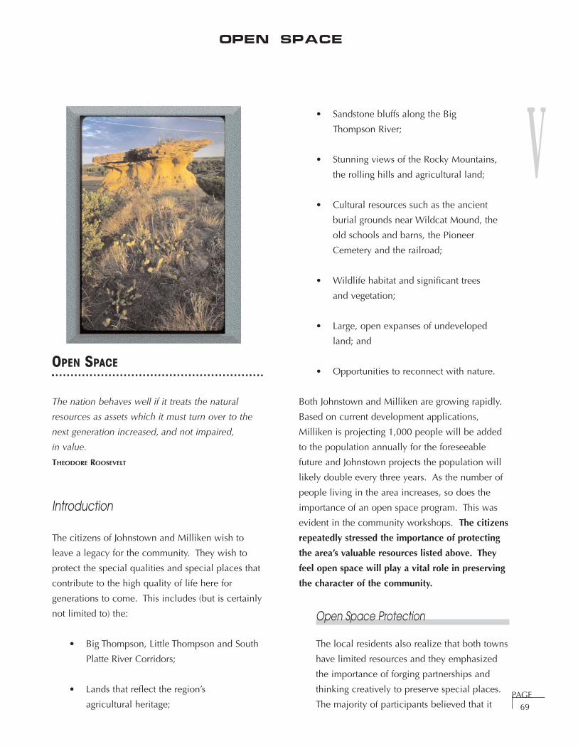
V
PAGE69
OPEN SPACE
The nation behaves well if it treats the natural
resources as assets which it must turn over to the
next generation increased, and not impaired,
in value.
THEODORE ROOSEVELT
Introduction
The citizens of Johnstown and Milliken wish to
leave a legacy for the community. They wish to
protect the special qualities and special places that
contribute to the high quality of life here for
generations to come. This includes (but is certainly
not limited to) the:
• Big Thompson, Little Thompson and South
Platte River Corridors;
• Lands that reflect the region’s
agricultural heritage;
• Sandstone bluffs along the Big
Thompson River;
• Stunning views of the Rocky Mountains,
the rolling hills and agricultural land;
• Cultural resources such as the ancient
burial grounds near Wildcat Mound, the
old schools and barns, the Pioneer
Cemetery and the railroad;
• Wildlife habitat and significant trees
and vegetation;
• Large, open expanses of undeveloped
land; and
• Opportunities to reconnect with nature.
Both Johnstown and Milliken are growing rapidly.
Based on current development applications,
Milliken is projecting 1,000 people will be added
to the population annually for the foreseeable
future and Johnstown projects the population will
likely double every three years. As the number of
people living in the area increases, so does the
importance of an open space program. This was
evident in the community workshops. The citizens
repeatedly stressed the importance of protecting
the area’s valuable resources listed above. They
feel open space will play a vital role in preserving
the character of the community.
Open Space Protection
The local residents also realize that both towns
have limited resources and they emphasized
the importance of forging partnerships and
thinking creatively to preserve special places.
The majority of participants believed that it
Open Space
V
PAGE70
will be important to use a combination of both
regulatory methods (i.e. open space dedication
requirements, limiting development in the
floodplains, requiring setbacks from sensitive
areas) and financial incentives (i.e. grants,
conservation easements, impact fees, leasing
land back to farmers, etc.) to meet the citizens’
goals. They felt it was reasonable to strengthen
the floodplain regulations to protect the open
areas because the rivers were well known for
their periodic flooding. The citizens repeatedly
emphasized the importance of respecting
landowners’ property rights and that all open
space preservation plans must be cooperative
efforts with the landowners.
Public Accessibility
When asked if open space should be
publically accessible, the majority of citizens
believed that some access is typically
desirable. Currently, the vast majority of open
lands are privately owned and thus,
inaccessible to the general public. In addition,
the citizens (including the school children)
emphasized their strong desire to learn more
about the area’s history, geology, agricultural
heritage and plant and animal communities.
They want every open area the community
protects to contain an educational component
– even if it is merely an informative sign at the
perimeter of farmland. They also felt that
access should be based on the site’s sensitivity
and that it is important to restrict the uses
allowed on open lands.
Prioritizing Open Space Preservation
Many participants want to protect all of the
open lands and felt is was difficult to prioritize
what should be protected. They agreed that
the more qualities a site had, the better. For
example, agricultural land along the Big
Thompson River with good wildlife habitat and
view corridors would receive priority over
agricultural land that is surrounded by
development. Several residents (many of
whom were farmers) voiced their concerns
about the increasing conflicts between
development and agriculture and the
likelihood that it may not always be feasible to
farm and ranch in the area. Most people felt
strongly about protecting significant natural
areas, wildlife habitat and “irreplaceable
things” such as bald eagle roosts and fossils.
The citizens encouraged Tetra Tech RMC to
include examples of Open Lands Property
Evaluation Forms in this Master Plan (refer to
Appendix for Larimer County’s and the City of
Longmont’s forms).
Community Buffer
The vast majority of participants view the
Johnstown/Milliken area as a single
community. They stated they’re working very
hard to make it this way. The children
especially feel this way. Many people disliked
the term “community buffer”. They do not
want to see continuous development as one
travels down Highway 60. Rather, they wish to
have a “community green area” between the
towns that would serve as a community
gathering place.
Intent
The purpose of this section is to:
• Define the benefits of open space
protection;
• Document the community’s open space
goals and provide strategies to help the
towns achieve them;
• Help the towns employ creative protection
techniques to preserve and protect the
community’s significant resources;

V
PAGE71
• Set forth proposed tools and protection
strategies that Johnstown and Milliken may
use to accomplish open space protection
goals;
• List guidelines for management and
stewardship of open lands; and
• Provide contact information for assistance
in open space preservation.
The Benefits of Open Space
This section prepared by Colorado Open Lands
and taken in part from “The Economic Benefits
of Parks and Open Space”, © 1999, Trust for
Public Land.
Colorado Open Lands (COL) attended a
community workshop in Johnstown and a
community workshop in Milliken to educate
citizens about open space benefits and
preservation methods and to help document
the citizens’ vision for open space. COL’s
mission is to “preserve the significant open
lands and diminishing natural heritage of
Colorado through private and public
partnerships, innovative land conservation
techniques, and strategic leadership”.
COL discussed the following benefits of open
space at each workshop. Open space
preservation provides:
Environmental Benefits
• Recharge aquifers (water quantity) –
particularly important in arid climates
like ours;
• Protect water quality by filtering runoff
and pollutants;
• Moderate climate change by absorbing
carbon dioxide;
• Control soil erosion;
• Maintain or improve air quality; and
• Protect wildlife habitat and ecological and
genetic diversity.
Human Benefits
• Prevent flood damage by protecting
floodplains;
• Provide recreational opportunities;
• Maintain the quality of life and
community character;
• Preserve valuable views that often
contribute to a community’s identity; and
• Provide relief from nearby development.
Economic Benefits
• Protect agricultural lands and safeguard
the future of farming economies and
communities;
• Increase the value of nearby
residential properties;
• Lower infrastructure costs;
• Save tax dollars – the cost of supporting
growth can be greater than tax revenues
(when one considers the cost of providing
infrastructure such as roads and utility
lines and the cost of providing public
services such as schools, recreational
facilities, libraries, emergency services and
police and fire protection);
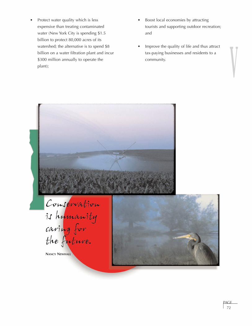
V
PAGE72
• Protect water quality which is less
expensive than treating contaminated
water (New York City is spending $1.5
billion to protect 80,000 acres of its
watershed; the alternative is to spend $8
billion on a water filtration plant and incur
$300 million annually to operate the
plant);
• Boost local economies by attracting
tourists and supporting outdoor recreation;
and
• Improve the quality of life and thus attract
tax-paying businesses and residents to a
community.
NANCY NEWHALL

V
PAGE73
OPEN SPACE FUNCTION AND USES
TYPE OF OPENSPACE
PURPOSE POSSIBLE RECREATIONAL
USES
POTENTIALFACILITIES
COMMENTS
EnvironmentallySignificant(grasslands,wetlands, riparianareas)
Protect valuablewildlife habitat ortravel corridors,riparian/wetlands, encourage adiversity of plantand animal types,improve waterquality or protectunique naturalfeatures.
Uses will vary basedon the site’ssensitivity.
• Environmentaleducation
• Plant and wildlifeidentification/observation
• Photography
• Discoverytrail aroundedge ofhabitat
• Observationblinds
• If publicaccess isallowed,integrate atrailhead withparking intothe design
Emphasis onpreservation ofresources. Restrictpublic access andgrazing (asappropriate) tominimize erosionand disturbance towildlife. Ensureadequate setbacksand buffers fromtrails and adjacentland development.
Water FeatureArea (Rivers,ponds, reservoirs)
These lands willlikely haverecreationalvalues, as well asagricultural andenvironmentalvalues.
Water-basedrecreation with anemphasis onresourcepreservation.
• Non-motorizedboating
• Fishing• Environmental
education• Nature
observation• Photography• Picnicking
• Park alongportion
• Recreationaltrail/discoverytrail
• Dock • Picnic tables• Observation
blinds• Restrooms• Benches• Trailhead with
parking
Protect ecosystemfunctions andprovide adequatesetbacks and buffersfrom sensitive areas.
CommunityCharacter/Heritage Land
Protect lands thatare important tocitizens becauseof their historicalor archaeologicalvalue.
Uses will vary basedon the site’ssensitivity. • Education/ interpretation• Nature
observation• Photography
Depends on use.• Discovery
trail• Restrooms• Benches• Trailhead with
parking
Work with local andstate historicalgroups to develop amanagement plan.Stabilize landmarksto preventdeterioration andprotect landmarksfrom vandalism.
Agricultural Land(Pastures, cropland)
Provideseconomic benefitsand preserves thearea’s ruralcharacter. Mayalso help preserveview corridors andhabitat and bufferdevelopment.
• Education on theperimeter of thesite
Minimal Emphasis onagriculturalpreservation andcontinuedagriculturaloperations. Restrictpublic access. Ensure adequatesetbacks and buffersfrom trails andadjacent landdevelopment.
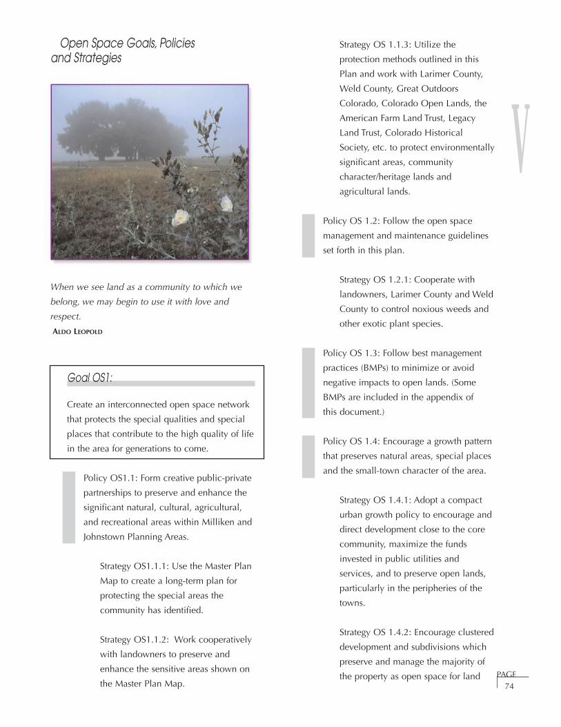
V
PAGE74
Open Space Goals, Policies and Strategies
When we see land as a community to which we
belong, we may begin to use it with love and
respect.
ALDO LEOPOLD
Goal OS1:
Create an interconnected open space network
that protects the special qualities and special
places that contribute to the high quality of life
in the area for generations to come.
Policy OS1.1: Form creative public-private
partnerships to preserve and enhance the
significant natural, cultural, agricultural,
and recreational areas within Milliken and
Johnstown Planning Areas.
Strategy OS1.1.1: Use the Master Plan
Map to create a long-term plan for
protecting the special areas the
community has identified.
Strategy OS1.1.2: Work cooperatively
with landowners to preserve and
enhance the sensitive areas shown on
the Master Plan Map.
Strategy OS 1.1.3: Utilize the
protection methods outlined in this
Plan and work with Larimer County,
Weld County, Great Outdoors
Colorado, Colorado Open Lands, the
American Farm Land Trust, Legacy
Land Trust, Colorado Historical
Society, etc. to protect environmentally
significant areas, community
character/heritage lands and
agricultural lands.
Policy OS 1.2: Follow the open space
management and maintenance guidelines
set forth in this plan.
Strategy OS 1.2.1: Cooperate with
landowners, Larimer County and Weld
County to control noxious weeds and
other exotic plant species.
Policy OS 1.3: Follow best management
practices (BMPs) to minimize or avoid
negative impacts to open lands. (Some
BMPs are included in the appendix of
this document.)
Policy OS 1.4: Encourage a growth pattern
that preserves natural areas, special places
and the small-town character of the area.
Strategy OS 1.4.1: Adopt a compact
urban growth policy to encourage and
direct development close to the core
community, maximize the funds
invested in public utilities and
services, and to preserve open lands,
particularly in the peripheries of the
towns.
Strategy OS 1.4.2: Encourage clustered
development and subdivisions which
preserve and manage the majority of
the property as open space for land
V
PAGE75
outside of urban areas to enable
conservation of open lands.
Strategy OS 1.4.3: Update Milliken
and Johnstown land use regulations to
encourage open space preservation.
For example, require special resources,
wildlife habitat,
archaeological/historically significant
areas, etc. to be identified and
discussed at the initial stages of
development applications.
Policy OS 1.5: Work with Colorado
Division of Wildlife and other town-
approved experts to ensure there is an
adequate buffer between development and
natural areas, water bodies, wetlands,
and floodplains.
Strategy OS 1.5.1: Review
Johnstown and Milliken floodplain
regulations to ensure they sufficiently
limit the amount a floodplain can be
modified.
Strategy OS 1.5.2: Encourage new
development along Interstate 25,
Highway 60, Highway 257 and in
highly visible areas (i.e. on rolling
hills) to provide view corridors and fit
within the character of the area.
Strategy OS 1.5.3: Prevent major
alterations to the natural landscape
and protect natural landforms
whenever possible to maintain rural
character. For example, preserve
significant wildlife habitat, require
major trees to be preserved, limit
grading, prevent major alterations to
floodplains, etc.
Policy OS 1.6: Integrate areas that have
been impacted by oil and gas development
into the open space network.
Strategy OS 1.6.1: Develop screening
and buffering standards for existing
and proposed facilities in cooperation
with landowners and oil and gas
companies.
Policy OS 1.7: Require oil and gas
companies to revegetate disturbed areas
and control weeds.
HOW TO MANAGE ANDMAINTAIN OPEN SPACE
Open space can vary in appearance, function and
size. It may protect important environmental
resources such as wildlife habitat and water. It
may have prominent view corridors, it may help
contribute to the community’s special qualities
such as its agricultural and railroad heritage, or it
may perform a combination of these functions.
Each parcel of open space is unique and may
perform numerous functions. Proper land
stewardship will help ensure that our rich natural
heritage is passed on to future generations.
To facilitate good stewardship, we have
classified Johnstown/Milliken open space into
four categories:
• environmentally significant lands;
• water feature areas;
• community character/heritage lands;
and
• agricultural lands.
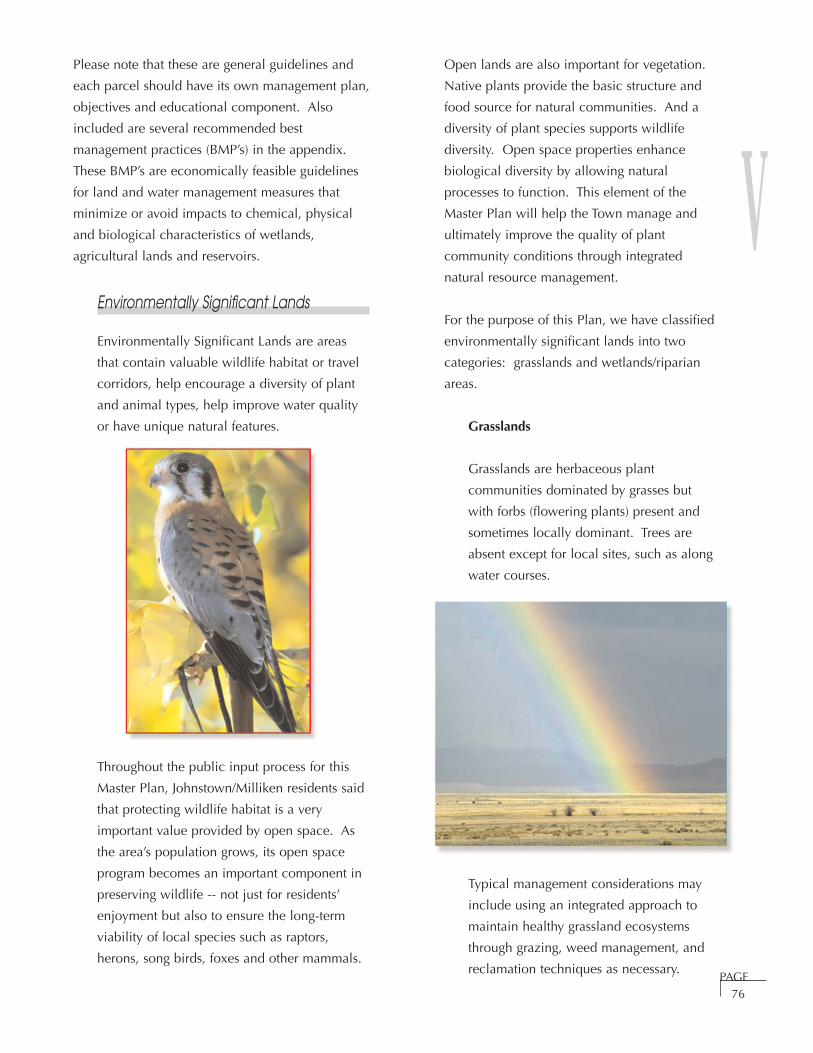
V
PAGE76
Please note that these are general guidelines and
each parcel should have its own management plan,
objectives and educational component. Also
included are several recommended best
management practices (BMP’s) in the appendix.
These BMP’s are economically feasible guidelines
for land and water management measures that
minimize or avoid impacts to chemical, physical
and biological characteristics of wetlands,
agricultural lands and reservoirs.
Environmentally Significant Lands
Environmentally Significant Lands are areas
that contain valuable wildlife habitat or travel
corridors, help encourage a diversity of plant
and animal types, help improve water quality
or have unique natural features.
Throughout the public input process for this
Master Plan, Johnstown/Milliken residents said
that protecting wildlife habitat is a very
important value provided by open space. As
the area’s population grows, its open space
program becomes an important component in
preserving wildlife -- not just for residents’
enjoyment but also to ensure the long-term
viability of local species such as raptors,
herons, song birds, foxes and other mammals.
Open lands are also important for vegetation.
Native plants provide the basic structure and
food source for natural communities. And a
diversity of plant species supports wildlife
diversity. Open space properties enhance
biological diversity by allowing natural
processes to function. This element of the
Master Plan will help the Town manage and
ultimately improve the quality of plant
community conditions through integrated
natural resource management.
For the purpose of this Plan, we have classified
environmentally significant lands into two
categories: grasslands and wetlands/riparian
areas.
Grasslands
Grasslands are herbaceous plant
communities dominated by grasses but
with forbs (flowering plants) present and
sometimes locally dominant. Trees are
absent except for local sites, such as along
water courses.
Typical management considerations may
include using an integrated approach to
maintain healthy grassland ecosystems
through grazing, weed management, and
reclamation techniques as necessary.

V
PAGE77
Wetlands/Riparian Lands
Wetlands are areas that are inundated or
saturated by surface or ground water for
long enough during the growing season to
support vegetation adapted for life in
saturated soil conditions. Riparian areas
are lands that are adjacent to and
influenced by flowing water.
Typical management considerations for
wetlands and riparian areas may include:
• minimizing disruption of water (both
in quantity and quality);
• weed control;
• restrict public access and grazing to
minimize erosion and disturbance
of wildlife;
• ensure adequate setbacks and/or
buffers from trails and adjacent land
development to prevent water quality
impacts, erosion and wildlife habitat
degradation; and
• enhance and/or maintain riparian
cottonwood and willow communities.
Water Features
This element includes canals, ditches, ponds
and reservoirs. These lands will likely have
recreational values as well as agricultural and
environmental values. For example, it may be
possible to fish, hike, bike, canoe or ride
horses on/around a reservoir. Management
costs may be somewhat higher for a property
that receives recreational use because it may
be necessary to provide amenities such as
restrooms, parking, garbage collection, picnic
tables, boat docks, etc.
Canals and Ditches – Typical management
considerations include working with
adjacent landowners to limit impacts to
water quality from adjacent areas,
cooperating with ditch companies to limit
the removal of trees and shrubs along
canals and ditches, managing weeds, and
keeping ditches, canals and banks free of
trash and debris.
Reservoirs and Ponds – Management
issues may include maintaining water
quality and adequate water levels to
support aquatic life, fish management,
controlling weeds and using best
management practices to minimize

V
PAGE78
erosion and sedimentation into the bodies
of water.
Community Character and Heritage Lands
This category includes lands that are important
to citizens because of their historical or
archaeological value. For example, both
Milliken and Johnstown citizens spoke about
the significance of Wildcat Mound to the
community. Wildcat Mound has archaeologic
significance – it contains a sandstone panel
with Indian petroglyph motifs and historic
signatures, numerous stone tools have been
found there, it has fossilized sea shells, and it
contained human burials that have dated from
145 B.C. to 1240 A.D. (and have been
excavated). It has geologic significance – the
mound is underlain by the Fox Hill sandstone
which has formed several pedestal or
mushroom rock features. It also has scenic
qualities – the mound slopes down to the
South Platte River and offers tremendous views
of the river corridor, rolling agricultural land
and the Rocky Mountains.
Management considerations for community
character and heritage lands include working
with landowners and local and state historical
groups to develop a management plan,
stabilizing landmarks to prevent deterioration,
educating citizens about stewardship, and
protecting landmarks from vandalism.
Agricultural Lands
Agricultural lands include pastures, irrigated
cropland and dryland. Agricultural lands are
an important part of the community’s heritage
and quality of life. These lands are valued for
their open, natural and productive landscapes
and the rural character they give to the area.
Keeping these lands open may provide
additional benefits like preserving scenic
vistas, buffering between neighboring
communities and preserving wetlands and
wildlife habitat. Typical management costs
may include pasture and irrigation system
inspection, weed management, and costs
associated with managing farming or grazing
leases. These costs will be offset with revenue
generated from leasing land for farming.
Pasture Land – Typical management
considerations for pasture land may
include preventing overgrazing,
maintaining healthy forage production by
ensuring adequate water supply and
delivery, managing weeds, resting, and
rotating grazing activities as necessary.
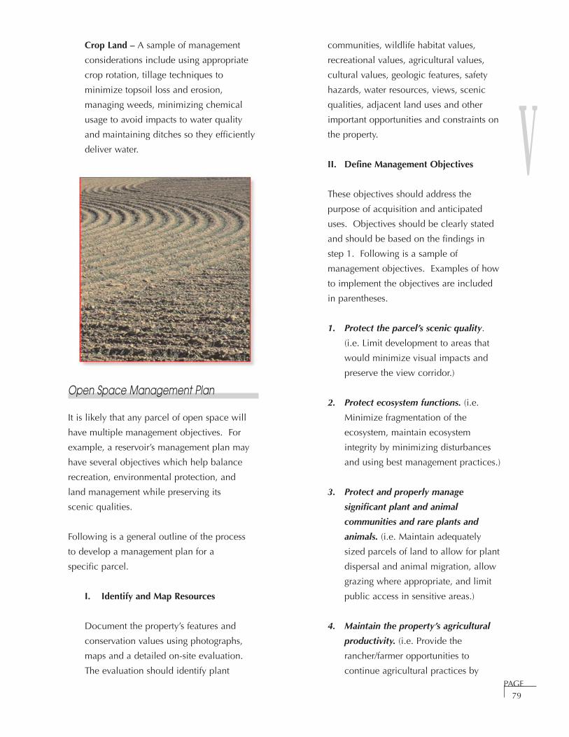
V
PAGE79
Crop Land – A sample of management
considerations include using appropriate
crop rotation, tillage techniques to
minimize topsoil loss and erosion,
managing weeds, minimizing chemical
usage to avoid impacts to water quality
and maintaining ditches so they efficiently
deliver water.
Open Space Management Plan
It is likely that any parcel of open space will
have multiple management objectives. For
example, a reservoir’s management plan may
have several objectives which help balance
recreation, environmental protection, and
land management while preserving its
scenic qualities.
Following is a general outline of the process
to develop a management plan for a
specific parcel.
I. Identify and Map Resources
Document the property’s features and
conservation values using photographs,
maps and a detailed on-site evaluation.
The evaluation should identify plant
communities, wildlife habitat values,
recreational values, agricultural values,
cultural values, geologic features, safety
hazards, water resources, views, scenic
qualities, adjacent land uses and other
important opportunities and constraints on
the property.
II. Define Management Objectives
These objectives should address the
purpose of acquisition and anticipated
uses. Objectives should be clearly stated
and should be based on the findings in
step 1. Following is a sample of
management objectives. Examples of how
to implement the objectives are included
in parentheses.
1. Protect the parcel’s scenic quality.
(i.e. Limit development to areas that
would minimize visual impacts and
preserve the view corridor.)
2. Protect ecosystem functions. (i.e.
Minimize fragmentation of the
ecosystem, maintain ecosystem
integrity by minimizing disturbances
and using best management practices.)
3. Protect and properly manage
significant plant and animal
communities and rare plants and
animals. (i.e. Maintain adequately
sized parcels of land to allow for plant
dispersal and animal migration, allow
grazing where appropriate, and limit
public access in sensitive areas.)
4. Maintain the property’s agricultural
productivity. (i.e. Provide the
rancher/farmer opportunities to
continue agricultural practices by

V
PAGE80
ensuring adequate facilities -- access,
water delivery, fencing, etc. -- are
available to facilitate farming.)
5. Preserve the cultural, geological and
archaeological integrity of the area.
(i.e. Develop an interpretive trail
system, involve local and state
historical societies in site design,
development and maintenance.)
6. Where appropriate, provide safe,
passive recreational opportunities that
are compatible with preservation
objectives. (i.e. Provide buffers and
setbacks when developing trails and
site trails away from sensitive areas.)
7. Restore and enhance degraded areas.
(i.e. Plant native species, control the
invasion and spread of undesirable
non-native plants.)
8. Manage conflicts between people and
the natural areas through the design
of public use areas, public education
and habitat manipulation. (i.e. Site
trail accesses away from sensitive
areas and include signage to call
attention to preservation efforts.)
9. Provide educational opportunities.
(i.e. Install educational signage and
educational trails.)
Achieving the management objectives will
require a strong commitment from the
Johnstown/Milliken community.
Development and management of open
space should be an inclusive, cooperative
process. Coordinate with local officials,
community organizations, land owners,
local businesses and individual volunteers
to develop and implement the action plan.
Citizen involvement may evoke a more
positive attitude toward the community
and lead to a feeling of responsibility and
connection to the community.
III. Develop Site Management Plan
The site management plan should discuss
methods to accomplish the management
objectives and define site needs. Issues
may include:
Access – Discuss access both to the site
and throughout the site. Where (if
anywhere) will public access be
appropriate? Is the site handicap
accessible?
Security – Where is fencing needed? How
will the site be secured? Does the site
have adequate police and fire protection?
Visual Aesthetics – How can visual
aesthetics be protected or enhanced?
Wildlife – What wildlife management
actions are needed to preserve and
enhance wildlife use of the site? For
example, are there threatened and
endangered species on the site or prairie
dog issues?
Plant Communities – What is the weed
management plan for the site? What
areas need to be revegetated, enhanced
or protected?
Agriculture – Who will manage the
property? How will the site be managed
(discussion may include crop selection,
use of fertilizers, harvesting, grazing,
irrigation, pasture management, etc.)?

V
PAGE81
Water – Are there water rights or well
permits associated with the property?
How does this impact the management
plan?
Character and Heritage – Are there any
restoration or enhancement projects? How
can unobtrusive interpretive information
be included?
Recreation – What recreational activities
are appropriate? Where should these
activities take place? (Be sure to address
dogs and horses.) What provisions need to
be made to ensure resources are protected
and users have safe, pleasant experiences?
Facilities – What facilities are necessary on
site (i.e. information kiosks, shelters, picnic
tables, trash cans, parking facilities,
signage, storage facilities, water fountains,
etc.)?
Legal Issues – What legal issues need to
be considered?
Education – How can the public be
enlightened about the values and benefits
of preserving open space? How can the
public be educated to help provide a safe
environment for wildlife and humans and
to minimize conflicts between people and
natural areas? Is it possible to coordinate
with local schools for outdoor education?
Maintenance – What maintenance
activities are necessary to properly
maintain the site? Who will perform
these activities?
IV. Action Plan
Devise an action plan to meet the parcel’s
management objectives. The plan
should prioritize activities, estimate
costs, state who will be responsible for
performing tasks and propose an
implementation schedule.
Open Space Protection Methods
The citizens agreed that it will be critical to the
community’s quality of life to protect some of the
open land in the area. Everyone understood that
the towns have limited resources available for open
space protection. All groups felt strongly that the
community should:
• be as creative as possible in finding ways
to protect open space;
• form partnerships amongst the towns,
Weld County, Larimer County, land trusts
and landowners; and
• use a combination of regulatory and
market-driven methods to help protect
open space.
V
PAGE82
Following are some suggestions on how to
protect open space. This is not meant to be an
all-inclusive list, but rather a starting point for
creative ideas.
Annexation
The towns should negotiate with landowners at
the time of annexation to identify and protect
valuable open space resources.
Environmental Hazard Areas
Both Johnstown and Milliken have floodplain
regulations which limit development in
floodplains. The community should also
strongly discourage modifications to the
floodplains so that these areas remain
protected.
Planned Development
It may be possible to protect open space and
allow limited development by clustering and
carefully siting structures on the property. This
should be done in conjunction with deed
restrictions or public dedications that
sufficiently protect the open space features of a
property. The Planned Development
regulations can be used to encourage
development patterns that foster continued
agricultural use and protect the area’s rural
character and open space while meeting
development expectations.
Conservation Easement
Conservation easements are legal documents
that permanently limit a property’s uses in
order to protect its open space values. The
landowner and the easement holder (typically
a land trust or government entity) determine
the conditions and value of the easement
together. The landowner would continue to
hold the title to the property and retain all
rights to use the land for any purpose that is
not prohibited by the terms of the easement.
For example, an easement on land containing
significant wildlife habitat might prohibit
development and public access, while one on
agricultural land might allow farming or
grazing and the construction of agricultural
buildings. In addition, the easement may be
written to apply to an entire property or a
portion of a property.
Landowners who donate conservation
easements may receive the following
tax benefits:
• federal income tax deduction
(qualified conservation contributions
may be treated as charitable gifts);
• state income tax credit - 100% of the
first $100,000 and 40% of the next
$400,000 may be applied to taxes, for
up to a 20 year period or sold to the
Conservation Tax Credit Exchange (for
more details refer to Appendix); and
• estate tax benefits - 40% of the value
of land subject to a qualifying
conservation easement may be
excluded from a taxable estate. This is
in addition to the reduction in value of
the land as a result of the easement
(for more details refer to Appendix).
Obtain Partial Interest In Property
If none of the above tools sufficiently protect a
parcel’s open space values, consider
purchasing a conservation easement or a
partial interest in the property to protect its
open space values.

V
PAGE83
Acquisition
Town Officials may determine that the above
tools do not sufficiently protect the open space
values of a property. If the open space values
are so special that they should be protected,
work in conjunction with the property owner
to determine the best method and most
advantageous terms for purchasing a partial
interest (i.e. buy development rights, water
rights, access rights or mineral rights) or the fee
simple purchase of the property.
Contact Information
For assistance in preserving open space contact:
Legacy Land Trust
Mission: The Legacy Land Trust facilitates the
preservation of open space, agricultural and
environmentally sensitive lands that are
important for present and future generations.
236 Linden Street
Fort Collins, CO 80524-2424
Phone: (970) 266-1711 Fax: (970) 407-1356
Area of Operation: Larimer, Jackson
and Weld Counties
Founded: 1993
Email: [email protected]
Webpage: www.legacylandtrust.org
Colorado Open Lands
Mission: To preserve the significant open lands
and diminishing natural heritage of Colorado
through private and public partnerships,
innovative land conservation techniques, and
strategic leadership.
274 Union Boulevard, Suite 320
Lakewood, Colorado 80228
Phone: (303) 988-2373 Fax: (303) 988-2383
Area of Operation: Colorado
Founded: 1982
E-mail: [email protected]
Webpage: www.coloradoopenlands.org
American Farmland Trust
Mission: American Farmland Trust is the only
nationwide nonprofit organization dedicated to
protecting agricultural resources. Founded by a
group of concerned farmers in 1980, AFT's
mission is to stop the loss of productive
farmland and to promote farming practices
that lead to a healthy environment.
Fort Collins Office
P. O. Box 1417236
Linden Street
Fort Collins, CO 80524
Phone: 970-484-8988 Fax: (970) 407-1356
Colorado Cattleman’s Agricultural Land Trust
Mission: To help Colorado's ranchers and
farmers protect their agricultural lands and
encourage continuing agricultural production
for the benefit of themselves, their families and
all of Colorado's citizens.
8833 Ralston Road
Arvada CO 80002
Phone: (303) 431-6422 Fax: (303) 431-6446
Agricultural lands throughout the state
Founded: 1995
E-mail: [email protected]
Webpage: cca.beef.org/pages/ccalt-home.htm
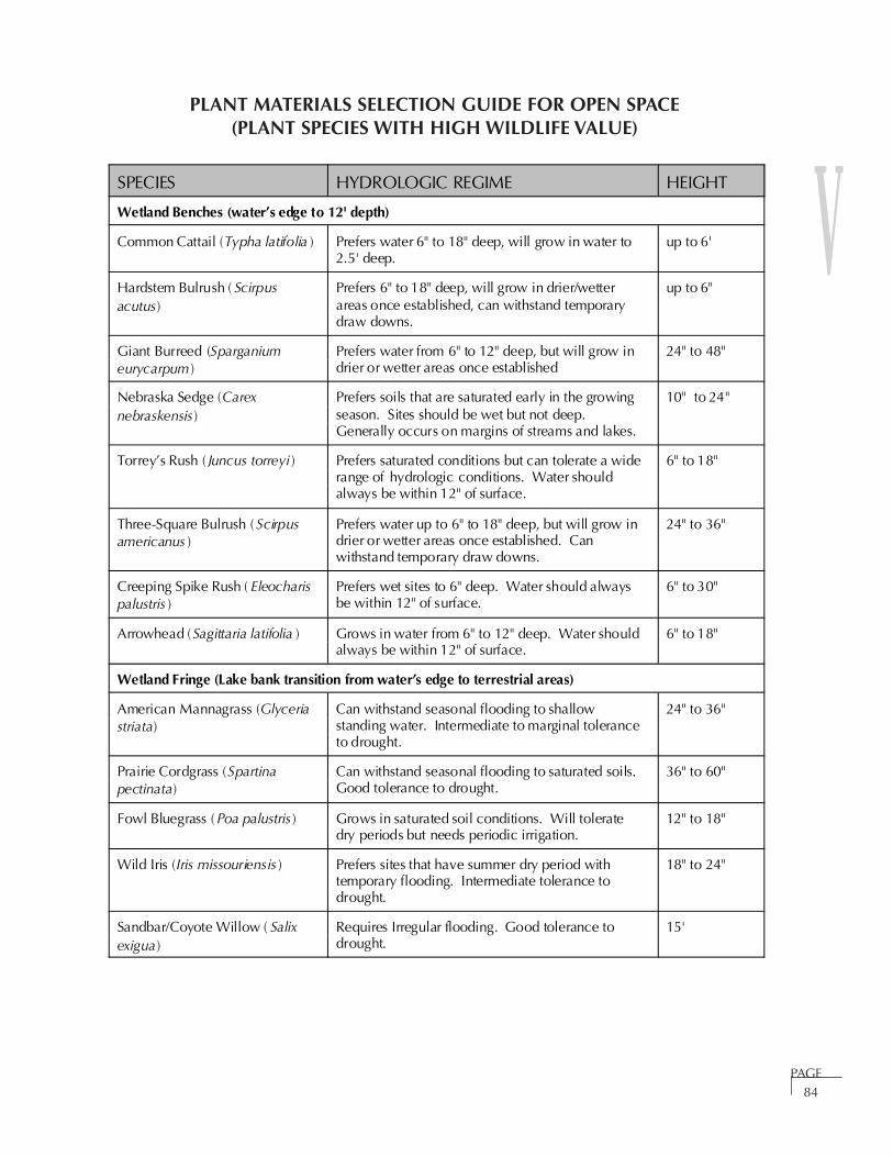
V
PAGE84
SPECIES HYDROLOGIC REGIME HEIGHT
Wetland Benches (water’s edge to 12' depth)
Common Cattail (Typha latifolia ) Prefers water 6" to 18" deep, will grow in water to2.5' deep.
up to 6'
Hardstem Bulrush ( Scirpusacutus)
Prefers 6" to 18" deep, will grow in drier/wetterareas once established, can withstand temporarydraw downs.
up to 6"
Giant Burreed (Sparganiumeurycarpum )
Prefers water from 6" to 12" deep, but will grow indrier or wetter areas once established
24" to 48"
Nebraska Sedge (Carexnebraskensis)
Prefers soils that are saturated early in the growingseason. Sites should be wet but not deep. Generally occurs on margins of streams and lakes.
10" to 24"
Torrey’s Rush ( Juncus torreyi ) Prefers saturated conditions but can tolerate a widerange of hydrologic conditions. Water shouldalways be within 12" of surface.
6" to 18"
Three-Square Bulrush ( Scirpusamericanus )
Prefers water up to 6" to 18" deep, but will grow indrier or wetter areas once established. Canwithstand temporary draw downs.
24" to 36"
Creeping Spike Rush ( Eleocharispalustris )
Prefers wet sites to 6" deep. Water should alwaysbe within 12" of surface.
6" to 30"
Arrowhead (Sagittaria latifolia ) Grows in water from 6" to 12" deep. Water shouldalways be within 12" of surface.
6" to 18"
Wetland Fringe (Lake bank transition from water’s edge to terrestrial areas)
American Mannagrass (Glyceriastriata)
Can withstand seasonal flooding to shallowstanding water. Intermediate to marginal toleranceto drought.
24" to 36"
Prairie Cordgrass (Spartinapectinata)
Can withstand seasonal flooding to saturated soils. Good tolerance to drought.
36" to 60"
Fowl Bluegrass ( Poa palustris ) Grows in saturated soil conditions. Will toleratedry periods but needs periodic irrigation.
12" to 18"
Wild Iris (Iris missouriensis ) Prefers sites that have summer dry period withtemporary flooding. Intermediate tolerance todrought.
18" to 24"
Sandbar/Coyote Willow ( Salix exigua)
Requires Irregular flooding. Good tolerance todrought.
15'
PLANT MATERIALS SELECTION GUIDE FOR OPEN SPACE(PLANT SPECIES WITH HIGH WILDLIFE VALUE)

V
PAGE85
PLANT MATERIALS SELECTION GUIDE FOR OPEN SPACE (CONTINUED)(PLANT SPECIES WITH HIGH WILDLIFE VALUE)
SPECIES HYDROLOGIC REGIME HEIGHT
Peachleaf Willow (Salix amygdaloides)
Requires seasonal flooding. Intermediate toleranceto drought.
30'
Whiplash Willow ( Salixlasiandra )
Requires seasonal flooding. Marginal tolerance todrought.
45'
Plains Cottonwood ( Populusdeltoides)
Requires seasonal flooding. Good tolerance todrought.
80'
Narrow-leaf Cottonwood(Populus angustifolia )
Requires seasonal flooding. Intermediate toleranceto drought.
50'
Common Chokecherry ( Prunusvirginiana )
Moist soils. Good tolerance to drought. 30' to 50'
Red-osier Dogwood (Cornussericea)
Moist soils. Intermediate tolerance to drought. 10'
Golden Current ( Ribes aureum ) Seasonal saturation. Intermediate tolerance todrought.
5'
Leadplant (Amorpha fruticosa ) Irregular flooding. Good tolerance to drought. 5'
Upland Areas (riparian/wetland fringe to terrestrial areas)
American Plum (Prunusamericana )
Dry to moist soils. Good tolerance to drought. 12'
Wax Current (Ribes cereum) Mesic to dry soils. Intermediate tolerance todrought - needs periodic irrigation.
2' to 5'
Silver Buffaloberry ( Shepherdia argentea )
Mesic to dry soils. Good tolerance to drought. 4' to 20'
Threeleaf Sumac ( Rhus trilobata) Mesic to dry soils. Excellent tolerance to drought. 2' to 8'
Western Snowberry(Symphoricarpos occidentalis )
Moist to dry soils. Good tolerance to drought. 3'
Common Snowberry(Symphoricarpos albus )
Moist to dry soils. Good tolerance to drought. 3'
Western Sand Cherry ( Prunusbesseyi/P. pumila)
Dry to moist soils. Excellent tolerance to drought. 4' to 6'
Woods Rose (Rosa woodsii) Seasonal moisture. Good tolerance to drought. 2' to 8'

V
PAGE86
PLANT MATERIALS SELECTION GUIDE FOR OPEN SPACE (CONTINUED)(PLANT SPECIES WITH HIGH WILDLIFE VALUE)
PROPOSED SEED MIXES
COMMON NAME SCIENTIFIC NAME VARIETY %OF
MIX
PLSAPPLICATION
RATE(LBS/ACRE)
Upland Areas
Western Wheatgrass Pascopyrum smithii Arriba, Barton 20% 3.00
Green Needlegrass Stipa viridula Lodorm 15% 2.25
Little Bluestem Schizachyrium scoparium 15% 2.25
Indian Ricegrass Achnatherumhymenoides
Nezpar/Paloma 10% 1.50
Sideoats Grama Bouteloua curtipendula Vaughn/Butte 10% 1.50
Big Bluestem Andropogon gerardii Kaw 10% 1.50
Sand Bluestem Andropogon hallii 10% 1.50
Purple Prairieclover Dalea purpurea 5% 0.75
Blue Grama Bouteloua gracillis Lovington/Hachita
5% 0.75
TOTAL lb/ac 15.0
Wetland Areas
Prairie Cordgrass Spartina pectinata native 25% 4.0
Western Wheatgrass Pascopyrum smithii Arriba, Barton 20% 3.2
Fowl Bluegrass Poa palustris 15% 2.4
Mannagrass Glycera striata 10% 1.6
Alkali Sacaton Sporobolus airoides 10% 1.6
American Sloughgrass Beckmannia syzigachne 10% 1.6
Blue Vervain Verbana hastata 5% 0.8
Marsh Sunflower Helianthus nuttallii 5% 0.7
TOTAL lbs/ac 15.9
V
PAGE87
Those who contemplate the beauty of the earth find
reserves of strength that will endure as long as life lasts.
There is something infinitely healing in the repeated
refrains of nature – the assurance that dawn comes after
night, and spring after
the winter.
RACHEL CARSON
Related Documents


