Welcome message from author
This document is posted to help you gain knowledge. Please leave a comment to let me know what you think about it! Share it to your friends and learn new things together.
Transcript
Ministère de l'Education, la Recherche, la Jeunesse et le Sport L’Université Valahia Târgovi şte
Faculté de Sciences Humaines
D’UNIVERSITÉ VALAHIA TARGOVI ŞTE
SECTION
d’Archéologie et d’Histoire
TOME XII Numéro 1
2010
ValahiaValahiaValahiaValahia University Press University Press University Press University Press Târgovişte
COLLEGE DE REDACTION Rédacteur en chef: Prof. univ. dr. Marin Cârciumaru Rédacteurs responsables: Secretaires de rédaction: Prof. univ. dr. Mircea D. Matei Lect. univ. dr. Denis Căprăroiu Prof. univ. dr. Ion Stanciu Lect. univ. dr. Radu Cârciumaru Prof. univ. dr. Ion Calafeteanu Lect. univ. dr. Marian Cosac Prof. univ. dr. Ioan Opriş Lect. univ. dr. Monica Mărgărit Conf. univ. dr. Mircea Anghelinu Lect. univ. dr. Iulian Oncescu Conf. univ. dr. Silviu Miloiu Drd.Elena-Cristina Niţu Conseil de rédaction: Prof. univ. dr. Răzvan Teodorescu, Membre de l’Académie Roumaine Prof. univ. dr. Alexandru Vulpe, Membre de l’Académie Roumaine Prof. univ. dr. Victor Spinei, Membru Corespondent de l’Académie Roumaine Prof. univ. dr. Dan Bălteanu, Membru Corespondent de l’Académie Roumaine Prof. univ. dr. Marcel Otte - Université de Liege Prof. univ. dr. Jaques Jaubert - Université de Bordeaux I, Directeur de l’Institut de Géologie du Quaternaire et Préhistoire Bordeaux Prof. univ. dr. Eric Boëda – Université Paris X Nanterre Département Ethnologie et Préhistoire UMR 7041 ArScAn Paris, France Prof. univ. dr. Kalervo Hovi – University of Turku, Finlanda Prof. univ. dr. Jean-Philippe Rigaud – Université de Bordeaux I Dr. Marie-Hélène Moncel – L’Institut de Paléontologie Humaine Paris Prof. univ. dr. Alain Tuffreau - Directeur du Laboratoire de Préhistoire et Quaternaire (USTL) Dr. Alain Turq - l’Institut de Géologie du Quaternaire et Préhistoire Bordeaux - Mussée de Les Eyzies Prof. univ. dr. Arpad Ringer – University of Miskolc Maître de Conference Jean-Guillaume Bordes – Université de Bordeaux I Dr. Vasile Chirica - Cherch. pr. I – l’Institut d’Archéologie Iaşi Prof. univ. dr. Sabin Adrian Luca – l’Université “ Lucian Blaga” Sibiu Prof. univ. dr. Ilie Borziac – Institut of Archaeology of the Academy of Sciences; Rep. Moldova Dr. Alexandru Suceveanu – Cherch. pr. I - Institutul de Arheologie “Vasile Pârvan” Bucureşti Dr. Roxana Dobrescu - Cherch. pr. II - Institutul de Arheologie “Vasile Pârvan” Bucureşti Prof. univ. dr. Alexandru Florin Platon – l’Université “Al. I. Cuza” Iaşi Prof. univ. dr. Karl Zeno Pinter – l’Université “ Lucian Blaga” Sibiu Conf. univ. dr. Sorin Liviu Damean – l’Université de Craiova Lect. univ. dr. Dragomir Popovici – Mussée National d’Histoire de la Roumanie, Bucarest Technorédacteur: Viorel-Aurelian Sora
ISSN: 1584-1855
www.annalesfsu.ro
Sommaire ARTICLES ET ÉTUDES
Perluigi Rosina, Sara Cura-Interpretation of lithic remains in fluvial terrace contexts: an example from Central Portugal............................................................................................... Adrian Bălăşescu, Emmanuelle Vila, Valentin Radu, Ruben Badalyan, Christine Chataigner-
Production animale et économie de subsistance au Néolithique dans la plaine de l'Ararat (Arménie) ................................................................................................................................
Marin Cârciumaru - Contributions à la connaissance de l'art pariétal préhistorique de Roumanie……………………………………………………………………………………..
Liviu Măruia, Dorel Micle, Adrian Cîntar, Angelica Bălos, Adriana Pescaru,Andrei Stavil, Lavinia Bolcu- „M ăgura” Uroiului (Hunedoara County, Romania). An Archaeological Site from the perspective of Landscape Archaeology.....................................
Radu Cârciumaru- Negru Vodă reflected in several less known historiographic sources from the end of the 19th century and the beginning of the 20th century……………………...
Florin Gabriel Petrică- La cour princière et la ville dans la Moldavie médiévale. La recherche de l’espace soci…………………………………………………………………...
NOTES ET DISCUSSIONS
Livian Rădoescu - Quelques considerations sur la plastique anthropomorphe de la culture Vădastra...................................................................................................................................
Alin Frînculeasa, Monica Mărgărit, Ioan Elek Popa - About the organic material industry from the Gumelniţa settlement Seciu - Prahova District...........................................
Dorel Micle, Liviu Măruia, Adrian Cîntar, Ovidiu Bozu, Eduard Nemeth, Andrei Stavilă, Lavinia Bolcu - Non-invasive archaeological research in the Roman Castrum from Vărădia, „Rovină” (Caraş-Severin County). A topographic and geophysical study….
Erik Gonthier, Ida Gonthier, Anera Zivkovic- Analyses lithoacoustiques de concrétions stalactitiques en milieux endokarstiques et périkarstiques à Java Est et en Dordogne……..
Daniela Iamandi- De l’empirisme à la restauration scientifique……….…………………..
Marin Cârciumaru, Roxana Dobrescu- Recherches sur le terrain et sondages archéologiques dans la Vallée du Sighiştel,commune de Câmpani, département de Bihor...........................................
Mugur Andronic- Étude de cas : L’évolution de l’habitat humain préhistorique dans le bassin hidrographique de la rivière Ilişeşti………………………..………………………
Norme de redactare................................................................................................................
Printing normes .....................................................................................................................
7
25
39
85
97
101
111
123
139
155
175
185
191
199
203
„M ăgura” Uroiului (Hunedoara County, Romania). An Archaeological Site from the perspective of Landscape Archaeology
Tome XII, Numéro 1
85
Annales d’Université Valahia Targoviste, Section d’Archéologie et d’Histoire, Tome XII, Numéro 1, 2010, p. 85-96 ISSN: 1584-1855 www.annalesfsu.ro „M ăgura” Uroiului (Hunedoara County, Romania). An Archaeological Site from the
perspective of Landscape Archaeology
Liviu Măruia*, Dorel Micle*, Adrian Cîntar*, Angelica Bălos** , Adriana Pescaru***
Andrei Stavilă**** , Lavinia Bolcu****
* Department of History, West University of Timisoara, Bd. V. Pârvan, No. 2-4, Timişoara, Timiş County, Romania. ** The Board of Culture, Cults and National Cultural Heritage of the Hunedoara County. P-ţa Unirii, No. 9, Deva, Hunedoara County, Romania. *** University of Petrosani, Str. Universitaţii No. 20, Petroşani, Hunedoara County, Romania **** Department of History, West University of Timisoara, Bd. V. Pârvan, No. 2-4, Timişoara, Timiş County, Romania (student teams)
Abstract: „M ăgura” Uroiului (Hunedoara County, Romania). An Archaeological Site from the perspective of Landscape Archaeology. The archaeological site of “Magura Uroiului” (Hunedoara County) is one of the most complex sites in Romania due to its geomorphologic qualities and continuously habitation from prehistory through the Middle Ages. It is a hill with volcanic origin and a series of natural platforms. It was a favorable place both for military fortifications, for civil settlements, and also for quarrying stone. In 2008 a wide-landscape archaeology study was started that includes a detailed digital cartography of the terrain and a 3D reconstruction of the whole archaeological complex and a paleomorphology study. Integrated remote sensing methods (satellite images analysis and geophysical prospects) were used. The first step was a detailed topographical measurement of the site’s surface with the help of a total station (over 100 hectares) in order to reveal all micro-relief details, both natural and man-made. The second step was the editing of GIS spatial data, 2D and 3D graphic reconstructions. The third step was the analysis of the geomorphologic evolution of the terrain, the identification and interpretation of man-made features, the recognition of the ways of human intervention in the environment and of the causes and effects generated in the local ecosystem. The fourth step was a interdisciplinary analysis combining remote sensing and geophysical prospects in order to establish the exact inhabited areas, fortification system, road network, etc. Our study is meant to be a multidisciplinary analysis and aims to establish the relationship between man and environment, the difficult part being the extraordinary complexity of this site and its dimensions. Key words: GIS, total station, landscape archaeology, field archaeology, cultural heritage Introduction
From a geographic point of view, the archaeological site at „Măgura” Uroiului (Hunedoara County, Romania) is situated in the Mureş Corridor at the confluence of Strei River with Mureş River, rivers that mark important
access corridors towards the center of Transilvania and Orăştie Mountains (the political and administrative center of the Dacian kingdom in the period between kings Burebista and Decebal, centuries I B.C. to I A.D.).
Its favorable geographic location is even more important because, from this point forward start up numerous roads towards the rich gold ore
Liviu Măruia, Dorel Micle, Adrian Cîntar, Angelica Bălos, Adriana Pescaru,Andrei Stavilă, Lavinia Bolcu
Tome XII, Numéro 1
86
area of Apuseni Mountains over the slow slopes of Metaliferi Mountains. The eruptive morphology of the hill on which the site is located, represented by a volcanic massive which dominates the Mures Corridor and the Inferior Strei Valley with over 215 meters relative altitude and the fact that the South, East and West versants are almost vertical, make from Măgura Uroiului an observation point with an exceptional strategic position (fig. 1).
Next to the strategic importance of its location, Măgura Uroiului also had an important economic role, given its eruptive geologic constitution, made up of stone represented by andesites, microlites of feldspar, augite and magnetite, part of these resources have been extracted during the historic ages through quarries and surface extractions.
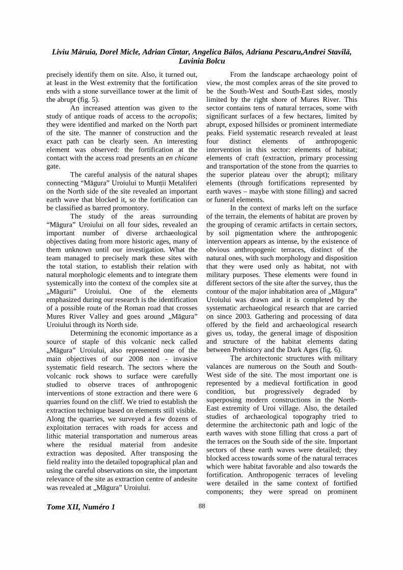
The archaeological potential of the area became known through surveys and surface research which revealed numerous discoveries from prehistory until modern ages (fig. 2).
History
The oldest mention regarding prehistoric artifacts at „Măgura” Uroiului belongs to G. Téglás (1884, p. 59) at the end of the XIXth century. I. Marţian (1921, p. 21), in a study published in 1921, mentions the existence of a fortification on „M ăgura” Uroiului and he attributes it to Dacians.
The Repertorium published by M. Roska (1942, p. 127-130) mentions pottery fragments belonging to Wietenberg Culture and the discovery of two Transylvanian bronze Celtic pots on the Uroiu Hill. In the monograph of Hunedoara region, O. Floca (1957, p. 111-112) describes the area of „M ăgura” Uroiului as being inhabited since prehistory. Also, he discusses the existence of a Roman fortification and of a medieval fortress. In the 70’s, some hazardous findings bring up evidences of Roman and Byzantine (I. Andriţoiu, 1979, p. 28) ages.
During an air surveying program in the late 90’s that was meant for Middle Mures Valley, Professor W.S. Hanson from Glasgow University and I.A. Oltean took a series of air photos and some of them comprised „Măgura” Uroiului. Analyzing those images, the authors suggested that the site belonged to the first Iron Age (W. S. Hanson, I. A. Oltean, 2000, p. 43-49) and the Latène fortress of
Petris (I. A. Oltean, 2007, p. 29, 39, 151-154, 195 and 221) from Tabula Peutingeriana.
In 2001 a new step is made in knowing this site due to a rescue excavation on one of its terraces in the East side of the site. The research revealed that it was inhabited at the beginning of the Iron Age and during the Dacian period. In 2003 systematic research of a larger surface was initiated in order to clarify more elements of habitat and fortification system (A. Ardeu, A. Bălos, 2002, p. 67-81). Thus, more terraces and the fortification situated on the superior plateau were researched (A. Bălos et al., 2004, p. 250-251, A. Pescaru et al., 2005, p. 287-288, A. Pescaru et al., 2006, p. 281-282, A. Pescaru et al., 2007, p. 286-287, A. Pescaru et al., 2009, p. 181-182, S. A. Luca, 2005, p. 162). The following year’s excavation revealed that the site was inhabited during even for a longer period and for different historic ages on the terraces at the base of the hill; they were concentrated on different terraces and dating between Eneolithic and Roman time. The superior plateau fortification was built, most probably, in the first Iron Age, its last phase dating in late Latène. Methodology
In 2008 a team from the West University of Timisoara took topographical surveys of the whole site and identified new anthropogenic elements (fortification systems, staple extraction areas, antique roads and new archaeological sites dating from more historic ages).
Non-invasive archaeological field research done during the summer and winter of 2008 were meant to identify and emphasize archaeological complexes that were visible at the soil’s surface with the purpose of creation of an assembly map of the numerous anthropogenic interventions on the site in order to establish the methodology of approach in the future throughout systematic research.
The research methodology implied more steps during 3 weeks while the site was carefully investigated step-by-step, almost exhaustively. The first step dealt with the detailed topographical surveys of the entire objective at „Măgura” Uroiului, with a total station Leica TC 407 and its accessories (tripod, poles and prisms). The first operation regarded the identification of the site and its limits and this was made through a surface
„M ăgura” Uroiului (Hunedoara County, Romania). An Archaeological Site from the perspective of Landscape Archaeology
Tome XII, Numéro 1
87
survey. After establishing the limits of the site the total station was installed, using geographical coordinates (lat/long) which were later converted to the Stereo 70 coordinate system (Romanian standard).
From the beginning, being such a large and complex site, the team had to adapt its archaeological topography methodology to the site’s realities; it has a surface of 305 hectares and an altitude difference between its extremes of 215 meters. The whole site topographical surveys gathered more than 7500 points and required 52 different base point changes of the total station; all due to the present time site morphology (steep areas, numerous natural terraces, rocks, ravens etc.) and to elements that blocked visibility (thick vegetation, constructions, great altitude differences). The team was made up of four members (one total station operator and three prism handlers). The prism handlers had to be familiarized with differencing anthropogenic elements within the landscape (earth waves, anthropogenic terraces, antique roads, staple extraction areas, site spreading based on soil pigmentation and ceramic fragments dispersion etc.). Also, in the context of the following 3D reconstruction of the site, they had to be aware of the way the characteristic points had to be read in order to mark the specific elements of the natural morphology (terraces, terrace noses, ravines, swampy valleys, abrupt, plateaus, versants etc.). An extremely important element within the field investigation process was the moment and period of work. Thus, there were two distinct periods: summer time – when the superior plateau was analyzed and surveyed and winter time – when the other more complex and numerous sectors of the site were analyzed and surveyed. The difference between the two work moments is substantial because of the numerous thick bushes that cover a large part of the site mostly in the summer and it blocks the visibility and access both for identification of archaeological complexes and for surveys with the total station. This is why winter is the best season for such activity and so, we continued our investigation during December 2008.
Results and Discutions
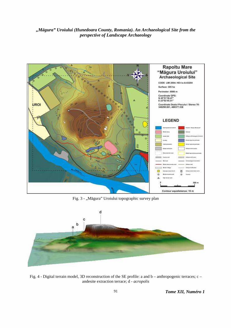
In the context of the total station topographical surveys, the team also developed a detailed study on landscape archaeology (D. F. Dincauze, 2000, p. 193-201 and 213-226, F. Cambi, N. Terrenato, 2006, p. 87-167, L. Drăguţ, 2000, p. 14-15, M. Johnson, 2007, p. 134-161, A. Bejan, D. Micle, 2006, p. 105-116) in order to integrate in the surrounding environment the known and newly discovered archaeological complexes (fig. 3).
Thus, the team delimited the acropolis situated on the superior plateau of “Măgura” Uroiului, which was related to the special strategic elements offered by its location: exceptional visibility over Mures Corridor in the sector between Deva and Orăştie; visibility over Strei Corridor from its confluence with Mures River – which occurs exactly on the South side of “M ăgura” Uroiului – to Depresiunea Haţegului at Subcetate; visibility over the inferior and middle valley of Grădişte River (also called Apa Oraşului at its inferior course) which is the main access towards the Dacian kings’ capital – Sarmizegetusa; a very good visibility over summit roads that climb towards Platforma Luncanilor – the easiest route for construction materials (molded blocks of limestone for fortifications or andesite plinths for sanctuaries) to Dacian fortifications and settlements in the Orăştiei Mountains; visibility and control over summit roads that head North towards the gold extraction area Bucium – Zlatna – Săcărâmb – Almaşu Mare.
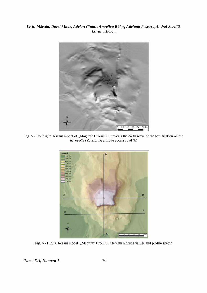
The team also identified carved in stone the shape of the wood poles that probably supported the surveillance tower, on the South side of the acropolis above abrupt faces that dominate the confluence of Strei River with Mures River (fig. 4).
Important elements discovered during these research sessions revealed the complete path of the fortification with ditch and earth wave that blocked access from the North side to the site’s acropolis. The path of the fortification and the relation between it and natural morphology elements were cleverly speculated by their builders, and we could
Liviu Măruia, Dorel Micle, Adrian Cîntar, Angelica Bălos, Adriana Pescaru,Andrei Stavilă, Lavinia Bolcu
Tome XII, Numéro 1
88
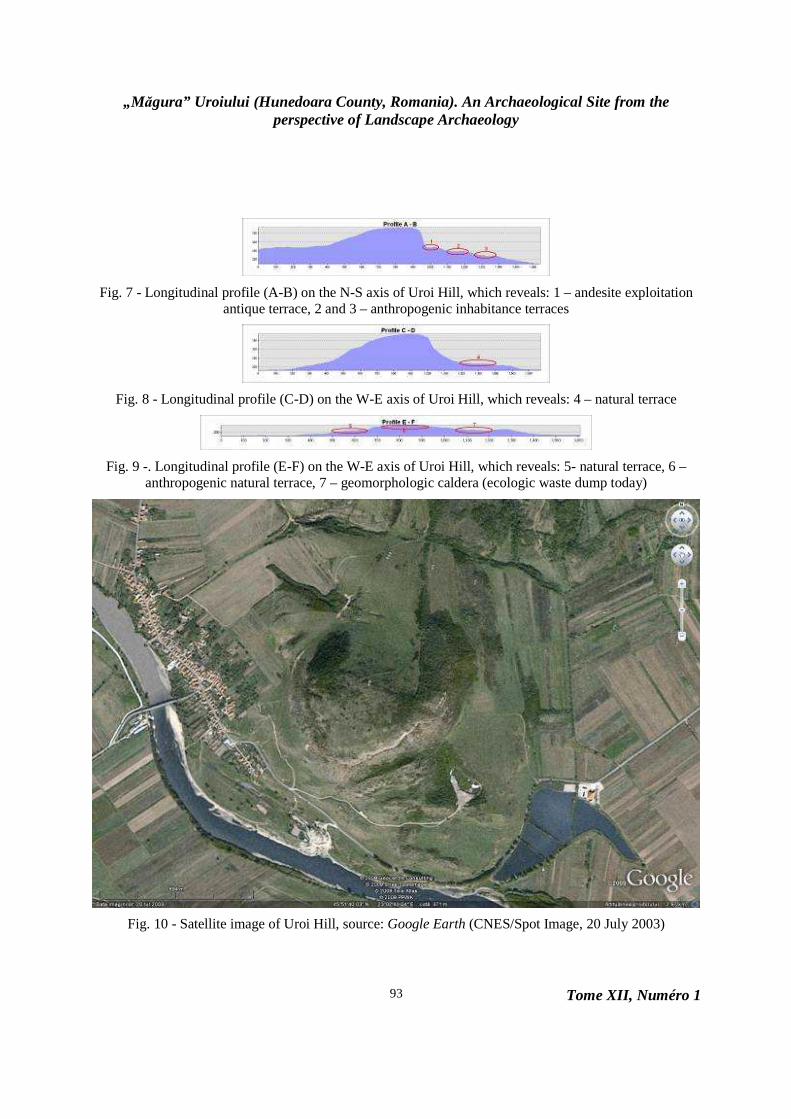
precisely identify them on site. Also, it turned out, at least in the West extremity that the fortification ends with a stone surveillance tower at the limit of the abrupt (fig. 5).
An increased attention was given to the study of antique roads of access to the acropolis; they were identified and marked on the North part of the site. The manner of construction and the exact path can be clearly seen. An interesting element was observed: the fortification at the contact with the access road presents an en chicane gate.
The careful analysis of the natural shapes connecting “Măgura” Uroiului to Munţii Metaliferi on the North side of the site revealed an important earth wave that blocked it, so the fortification can be classified as barred promontory.
The study of the areas surrounding “M ăgura” Uroiului on all four sides, revealed an important number of diverse archaeological objectives dating from more historic ages, many of them unknown until our investigation. What the team managed to precisely mark these sites with the total station, to establish their relation with natural morphologic elements and to integrate them systemically into the context of the complex site at „M ăgurii” Uroiului. One of the elements emphasized during our research is the identification of a possible route of the Roman road that crosses Mures River Valley and goes around „Măgura” Uroiului through its North side.
Determining the economic importance as a source of staple of this volcanic neck called „M ăgura” Uroiului, also represented one of the main objectives of our 2008 non - invasive systematic field research. The sectors where the volcanic rock shows to surface were carefully studied to observe traces of anthropogenic interventions of stone extraction and there were 6 quarries found on the cliff. We tried to establish the extraction technique based on elements still visible. Along the quarries, we surveyed a few dozens of exploitation terraces with roads for access and lithic material transportation and numerous areas where the residual material from andesite extraction was deposited. After transposing the field reality into the detailed topographical plan and using the careful observations on site, the important relevance of the site as extraction centre of andesite was revealed at „Măgura” Uroiului.
From the landscape archaeology point of view, the most complex areas of the site proved to be the South-West and South-East sides, mostly limited by the right shore of Mures River. This sector contains tens of natural terraces, some with significant surfaces of a few hectares, limited by abrupt, exposed hillsides or prominent intermediate peaks. Field systematic research revealed at least four distinct elements of anthropogenic intervention in this sector: elements of habitat; elements of craft (extraction, primary processing and transportation of the stone from the quarries to the superior plateau over the abrupt); military elements (through fortifications represented by earth waves – maybe with stone filling) and sacred or funeral elements.
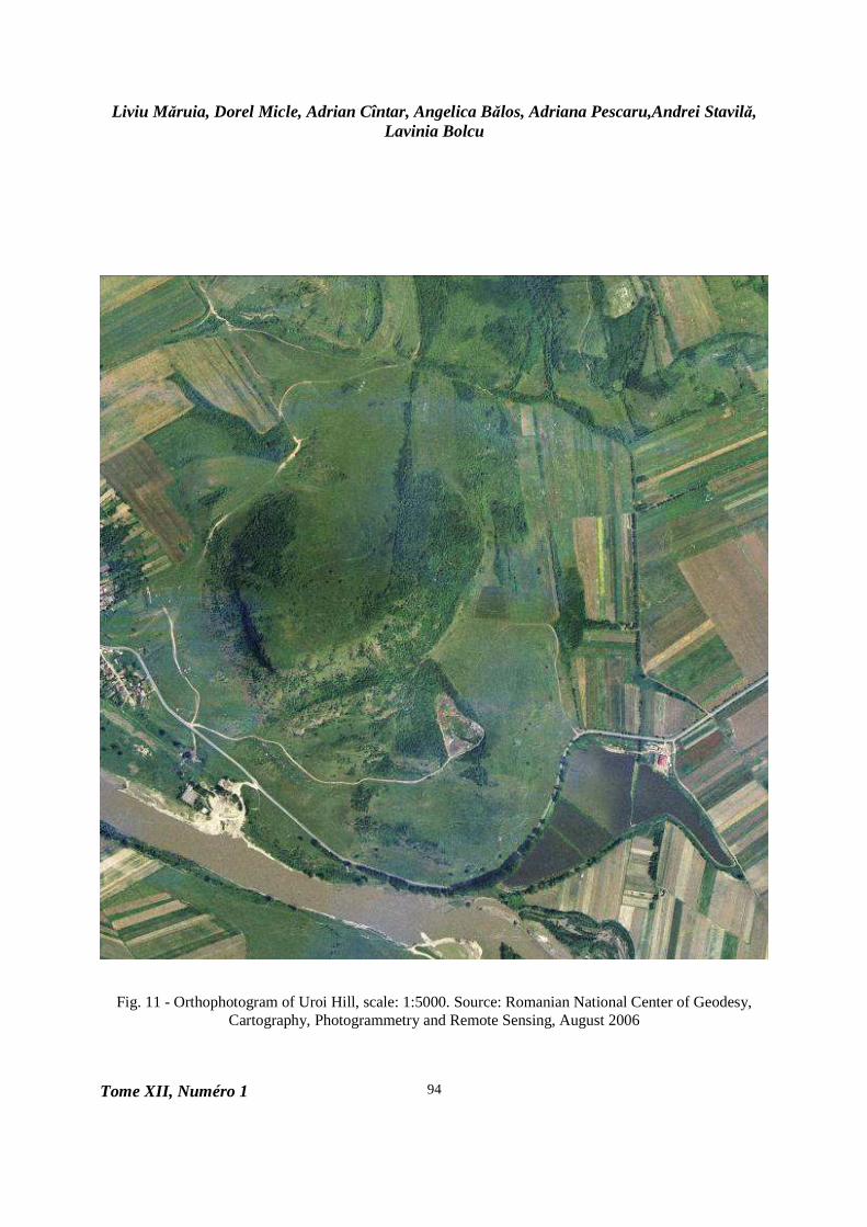
In the context of marks left on the surface of the terrain, the elements of habitat are proven by the grouping of ceramic artifacts in certain sectors, by soil pigmentation where the anthropogenic intervention appears as intense, by the existence of obvious anthropogenic terraces, distinct of the natural ones, with such morphology and disposition that they were used only as habitat, not with military purposes. These elements were found in different sectors of the site after the survey, thus the contour of the major inhabitation area of „Măgura” Uroiului was drawn and it is completed by the systematic archaeological research that are carried on since 2003. Gathering and processing of data offered by the field and archaeological research gives us, today, the general image of disposition and structure of the habitat elements dating between Prehistory and the Dark Ages (fig. 6).
The architectonic structures with military valances are numerous on the South and South-West side of the site. The most important one is represented by a medieval fortification in good condition, but progressively degraded by superposing modern constructions in the North-East extremity of Uroi village. Also, the detailed studies of archaeological topography tried to determine the architectonic path and logic of the earth waves with stone filling that cross a part of the terraces on the South side of the site. Important sectors of these earth waves were detailed; they blocked access towards some of the natural terraces which were habitat favorable and also towards the fortification. Anthropogenic terraces of leveling were detailed in the same context of fortified components; they were spread on prominent
„M ăgura” Uroiului (Hunedoara County, Romania). An Archaeological Site from the perspective of Landscape Archaeology
Tome XII, Numéro 1
89
promontories or on intermediate peaks, with an obvious strategic role. The beginning of systematic archaeological investigations over these areas will clear their exact functionality and age.
Regarding the sacred or funeral structures, these are based exclusively on logic deductions, which are connected to the unique, natural morphology of the volcanic caldera on the central-South side of the site – unfortunately, the caldera is totally filled in its inferior part with millions of tones of domestic waste because this is the “ecologic” dump of localities on Valea Muresului. To sustain the hypothesis of a possible sacred area in the volcanic caldera, the main argument is given by its lower area, improper for habitation or fortifications, and by the initial ambient landscape dominated by the impressive rocky cliff on the North part of the caldera. Also, systematic field research determined the existence of important anthropogenic terraces located on two of the prominent secondary peaks that dominate the caldera, the slope connecting them is fortified by an earth wave with stone filling which is sectioned by the modern road leading to the dump. The hypothesis will probably never be verified due to the huge amount of domestic waste that covers this part of the site (fig. 7, 8 and 9).
Along these anthropogenic complexes succinctly mentioned in this presentation, there were discovered other numerous traces of human intervention dating in different historic ages, all of them being transposed to the topographical plan of the site.
In order to complete the data acquired on site throughout non-invasive systematic research, the team used satellite images offered by Google Earth. These were processed along the othophotoplans of the site which were geo-referenced and allowed detailed data integration of the topographical survey in the general context of geographic landscape at the confluence of Strei River with Mures River (fig. 10 and 11).
The laboratory processing work is an extremely important step in the economy of the study of landscape archaeology. Data resulted from surveys were converted from the native format of the total station acquisition software into a GIS software accessible format. Each survey represented a separate job. Files with .gsi extension (native format) were exported by the total station communication software - Leica Geo Office Tools in a M.S. Excel .csv format and were primarily edited for ArcMap (ArcGIS 9.1). The editing of the file consists in inserting a header row before the data strings with the name of the column: id, x, y, z. The file is ready to be imported for further editing in ArcMap, using Add Data. At this point, a data check was made in order to discover any sort of mismatches with the terrain reality, before the 2D and 3D editing. The check tracked aspects such as: points’ coordinates, altitude, topographical map concordance etc. (fig. 12 and 13). Conclusions
The results of the archaeological field study represents the creation of topographic detailed plans and maps that reveal all morphological, natural and anthropogenic elements which were identified on site. The maps offer a general image of elements in such a complex site, they allow the establishments of relations between archaeological structures and they offer an important starting point in managing systematic research in the future.
As a whole, the systemic approach through the lens of landscape archaeology of the „Măgura” Uroiului site offers a first general image of a true ecosystem which, following further research, will take its place between the important archaeological sites of Romania.
Liviu Măruia, Dorel Micle, Adrian Cîntar, Angelica Bălos, Adriana Pescaru,Andrei Stavilă, Lavinia Bolcu
Tome XII, Numéro 1
90
Fig. 1 - Hundeoara County, Romania
Fig. 2 - Măgura” Uroiului Hill during the topographic surveys
„M ăgura” Uroiului (Hunedoara County, Romania). An Archaeological Site from the perspective of Landscape Archaeology
Tome XII, Numéro 1
91
Fig. 3 - „Măgura” Uroiului topographic survey plan
Fig. 4 - Digital terrain model, 3D reconstruction of the SE profile: a and b – anthropogenic terraces; c – andesite extraction terrace; d - acropolis
Liviu Măruia, Dorel Micle, Adrian Cîntar, Angelica Bălos, Adriana Pescaru,Andrei Stavilă, Lavinia Bolcu
Tome XII, Numéro 1
92
Fig. 5 - The digital terrain model of „Măgura” Uroiului, it reveals the earth wave of the fortification on the acropolis (a), and the antique access road (b)
Fig. 6 - Digital terrain model, „Măgura” Uroiului site with altitude values and profile sketch
„M ăgura” Uroiului (Hunedoara County, Romania). An Archaeological Site from the perspective of Landscape Archaeology
Tome XII, Numéro 1
93
Fig. 7 - Longitudinal profile (A-B) on the N-S axis of Uroi Hill, which reveals: 1 – andesite exploitation antique terrace, 2 and 3 – anthropogenic inhabitance terraces
Fig. 8 - Longitudinal profile (C-D) on the W-E axis of Uroi Hill, which reveals: 4 – natural terrace
Fig. 9 -. Longitudinal profile (E-F) on the W-E axis of Uroi Hill, which reveals: 5- natural terrace, 6 – anthropogenic natural terrace, 7 – geomorphologic caldera (ecologic waste dump today)
Fig. 10 - Satellite image of Uroi Hill, source: Google Earth (CNES/Spot Image, 20 July 2003)
Liviu Măruia, Dorel Micle, Adrian Cîntar, Angelica Bălos, Adriana Pescaru,Andrei Stavilă, Lavinia Bolcu
Tome XII, Numéro 1
94
Fig. 11 - Orthophotogram of Uroi Hill, scale: 1:5000. Source: Romanian National Center of Geodesy, Cartography, Photogrammetry and Remote Sensing, August 2006
„M ăgura” Uroiului (Hunedoara County, Romania). An Archaeological Site from the perspective of Landscape Archaeology
Tome XII, Numéro 1
95
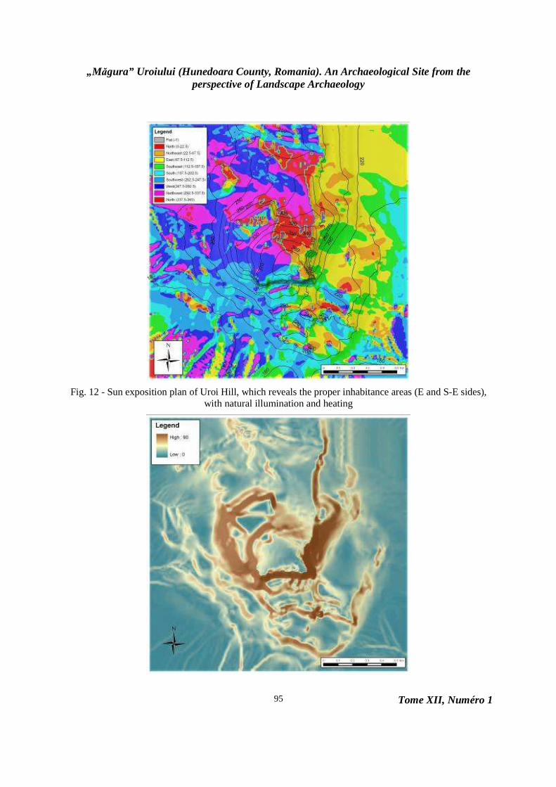
Fig. 12 - Sun exposition plan of Uroi Hill, which reveals the proper inhabitance areas (E and S-E sides), with natural illumination and heating
Liviu Măruia, Dorel Micle, Adrian Cîntar, Angelica Bălos, Adriana Pescaru,Andrei Stavilă, Lavinia Bolcu
Tome XII, Numéro 1
96
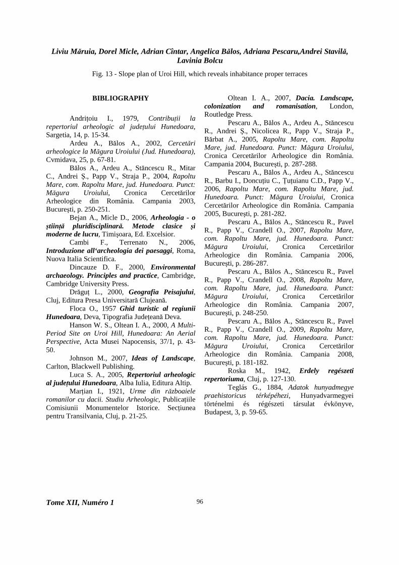
Fig. 13 - Slope plan of Uroi Hill, which reveals inhabitance proper terraces
BIBLIOGRAPHY
Andriţoiu I., 1979, Contribuţii la
repertoriul arheologic al judeţului Hunedoara, Sargetia, 14, p. 15-34.
Ardeu A., Bălos A., 2002, Cercetări arheologice la Măgura Uroiului (Jud. Hunedoara), Cvmidava, 25, p. 67-81.
Bălos A., Ardeu A., Stăncescu R., Mitar C., Andrei Ş., Papp V., Straja P., 2004, Rapoltu Mare, com. Rapoltu Mare, jud. Hunedoara. Punct: Măgura Uroiului, Cronica Cercetărilor Arheologice din România. Campania 2003, Bucureşti, p. 250-251.
Bejan A., Micle D., 2006, Arheologia - o ştiin ţă pluridisciplinară. Metode clasice şi moderne de lucru, Timişoara, Ed. Excelsior.
Cambi F., Terrenato N., 2006, Introduzione all‘archeologia dei paesaggi, Roma, Nuova Italia Scientifica.
Dincauze D. F., 2000, Environmental archaeology. Principles and practice, Cambridge, Cambridge University Press.
Drăguţ L., 2000, Geografia Peisajului, Cluj, Editura Presa Universitară Clujeană.
Floca O., 1957 Ghid turistic al regiunii Hunedoara, Deva, Tipografia Judeţeană Deva.
Hanson W. S., Oltean I. A., 2000, A Multi-Period Site on Uroi Hill, Hunedoara: An Aerial Perspective, Acta Musei Napocensis, 37/1, p. 43-50.
Johnson M., 2007, Ideas of Landscape, Carlton, Blackwell Publishing.
Luca S. A., 2005, Repertoriul arheologic al judeţului Hunedoara, Alba Iulia, Editura Altip.
Marţian I., 1921, Urme din războaiele romanilor cu dacii. Studiu Arheologic, Publicaţiile Comisiunii Monumentelor Istorice. Secţiunea pentru Transilvania, Cluj, p. 21-25.
Oltean I. A., 2007, Dacia. Landscape,
colonization and romanisation, London, Routledge Press.
Pescaru A., Bălos A., Ardeu A., Stăncescu R., Andrei Ş., Nicolicea R., Papp V., Straja P., Bărbat A., 2005, Rapoltu Mare, com. Rapoltu Mare, jud. Hunedoara. Punct: Măgura Uroiului, Cronica Cercetărilor Arheologice din România. Campania 2004, Bucureşti, p. 287-288.
Pescaru A., Bălos A., Ardeu A., Stăncescu R., Barbu I., Doncuţiu C., Ţuţuianu C.D., Papp V., 2006, Rapoltu Mare, com. Rapoltu Mare, jud. Hunedoara. Punct: Măgura Uroiului, Cronica Cercetărilor Arheologice din România. Campania 2005, Bucureşti, p. 281-282.
Pescaru A., Bălos A., Stăncescu R., Pavel R., Papp V., Crandell O., 2007, Rapoltu Mare, com. Rapoltu Mare, jud. Hunedoara. Punct: Măgura Uroiului, Cronica Cercetărilor Arheologice din România. Campania 2006, Bucureşti, p. 286-287.
Pescaru A., Bălos A., Stăncescu R., Pavel R., Papp V., Crandell O., 2008, Rapoltu Mare, com. Rapoltu Mare, jud. Hunedoara. Punct: Măgura Uroiului, Cronica Cercetărilor Arheologice din România. Campania 2007, Bucureşti, p. 248-250.
Pescaru A., Bălos A., Stăncescu R., Pavel R., Papp V., Crandell O., 2009, Rapoltu Mare, com. Rapoltu Mare, jud. Hunedoara. Punct: Măgura Uroiului, Cronica Cercetărilor Arheologice din România. Campania 2008, Bucureşti, p. 181-182.
Roska M., 1942, Erdely regészeti repertoriuma, Cluj, p. 127-130.
Teglás G., 1884, Adatok hunyadmegye praehistoricus térképéhezi, Hunyadvarmegyei történelmi és régészeti társulat évkönyve, Budapest, 3, p. 59-65.
Adiu
Text Box
This study was conducted within the project "Transnational network of integrated postdoctoral research in science communication. Capacity building (postdoctoral school) and scholarship program (CommScie)" POSDRU/89/1.5/S/63663
Non-invasive archaeological research in the Roman Castrum from Vărădia, „Rovină” (Caraş-Severin County). A topographic and geophysical study
Tome XII, Numéro 1 139
Annales d’Université Valahia Targoviste, Section d’Archéologie et d’Histoire, Tome XII, Numéro 1, 2010, p. 139-154 ISSN: 1584-1855 www.annalesfsu.ro
Non-invasive archaeological research in the Roman Castrum from Vărădia,
„Rovin ă” (Cara ş-Severin County). A topographic and geophysical study
Dorel Micle*, Liviu Măruia*, Adrian Cîntar*, Ovidiu Bozu**, Eduard Nemeth***, Andrei Stavilă****, Lavinia Bolcu****
* Department of History, West University of Timisoara, Bd. V. Pârvan, No. 2-4, Timişoara, Timiş County, Romania. ** County Museum of Etnography and Boarder Regiment of Caransebeş,. P-ţa Gen. I. Dragalina, No. 2, Caransebeş, Caraş-Severin County, Romania. *** Department of History, „Babeş-Bolyai” University of Cluj Napoca, Mihail Kogalniceanu Street No. 1, Cluj-Napoca, Cluj County, Romania **** Department of History, West University of Timisoara, Bd. V. Pârvan, No. 2-4, Timişoara, Timiş County, Romania (student teams) Abstract: Non-invasive archaeological research in the Roman Castrum from Vărădia, „Rovină” (Cara ş-Severin County). A topographic and geophysical study The historic of the archaeological research of Vărădia locality (Caraş-Severin County) is very complex, as the historiographical debates regarding the archaeological objectives here are older than one century. In 1932, Grigore Florescu conducts an excavation campaign in the „Rovină” (or “Pustă”) point castrum, unveiling the superior part of the path of the fortified wall and a part of the commandment building (Principia). Starting with 1996, Ovidiu Bozu also begins systematic research archaeological campaigns for the „Rovină”/„Pustă” point. Since 1999 Eduard Németh from „Babeş-Bolyai” University of Cluj Napoca, joined the research team.
At the end of July 2008 a team from the West University of Timisoara (Dorel Micle, Liviu Măruia and the student Lavinia Bolcu) performs a topographical survey with the total station of the „Rovină” point castrum, and for another week the team performs a geophysical prospection of the same objective.
The topographical survey precisely revealed many morphological aspects of the Vărădia „Rovină” castrum as they are visible nowadays on the terrain: oriented on the SSE-NNW direction, exact dimensions (140x160 m), the relevance of the area’s microrelief (the castrum builders speculated a higher terrace located between divagating windings of Caraş River, but which were affected by modern earthworks of territory layout), and the defining of positioning landmarks reporting to present anthropic and natural structures (roads, bridges, canals, etc.). The high precision topographical plans will be used in the future for correct excavation plans layout (sections, cassettes, etc.) for further systematic archaeological research.
The results of the magnetometric prospection revealed many aspects and feature with technical and historic nature: a) it allows the correct identification of the archaeological sections excavated in time; b) it allows the identification of structures affected by older archaeological excavations; c) proves the existence of a double enclosure wall; d) it allows the identification of the E tower of the Porta Praetoria; e) it is spectacular the revelation of the stone foundation traces of the centurion houses, and their orientation and dimensions, the barracks that flanked Via Praetoria; f) it allows the observation of anomalies caused by metal presence in the barracks area which could indicate a workshop (Fabrica); g) some curtain towers are also visible on the S, N and W sides; h) it allows the identification of intersecting roads in front of Principia, Via Praetoria and Via Principalis; i) it proves the existence of only one defense ditch, visible on the N side. Key words: GIS, total station, landscape archaeology, field archaeology, magnetometric prospecting
Dorel Micle, Liviu Măruia, Adrian Cîntar, Ovidiu Bozu, Eduard Nemeth, Andrei Stavilă, Lavinia Bolcu
Tome XII, Numéro 1
Short historic
The historic of the archaeological research of Vărădia locality (Caraş-Severin County) is very complex, as the historiographical debates regarding the archaeological objectives here are older than one century. The main issue was to identify the antique Arcidava, mentioned by Ptolemy in Geographia, III, 8, 4 (V. Pârvan, 1926, p. 81, 262; C. Daicoviciu, 1945, p. 46; R. Vulpe, 1960, p. 557-564; I. H. Crişan, 1977, p. 105-107). Important vestiges were found in the points: „Dealul Chilii” and „Rovină”. In both locations there are Roman castra that were archaeologically investigated starting from the beginning of the XXth century by the curator of Vrsač Museum, the tireless Bódog (Felix) Mileker (B. Mileker, 1897, p. 120-121; B. Mileker, 1906, p. 153-154). In the interwar period, in 1932, Grigore Florescu conducts an excavation campaign in the „Rovină” point castrum, unveiling the superior part of the path of the fortified wall and a part of the commandment building (Principia) (Gr. Florescu, 1934, p. 71-78). More surveys and field research are done in the 1970s on the inferior Caraş River, in Vărădia’s case the focus was on the pluristratified archaeological objective on „Dealul Chilii” (E. Iaroslavschi, Gh. Lazarovici, 1979, p. 452-454). Starting with 1974 until present day, the systematic research of „Dealul Chilii” was done by Ovidiu Bozu and Eugen Iaroslavschi, resulting remarkable results, but most of them still inedited (O. Bozu, E. Iaroslavschi, 1996, p. 123; E. Iaroslavschi, O. Bozu, 2003, p. 295-300). In parallel with this research, starting with 1996, Ovidiu Bozu also begins systematic research archaeological campaigns for the „Rovină”/„Pustă” point. Starting with 1999 Eduard Németh (E. Németh, 2006, p. 689-696; E. Németh, O. Bozu, 2000, p. 112; E. Németh, O. Bozu, 2001, p. 267; E. Németh, O. Bozu, 2002, p. 328-329; E. Németh, O. Bozu, 2005, p. 401-402; E. Németh, O. Bozu, 2005, p. 201-210; A. Ardeţ, E. Iaroslavschi, O. Bozu, 2003, 1, p. 309-315; E. Iaroslavschi, O. Bozu, 2003, p. 297) from „Babeş-Bolyai” University of Cluj Napoca, joined the research team.
At the end of July 2008 a team from the West University of Timisoara (Dorel Micle, Liviu Măruia and the student Lavinia Bolcu) performs a topographical survey with the total station of the „Rovină” point castrum, and for another week the team performs a geophysical prospection of the same objective.
Geographic description
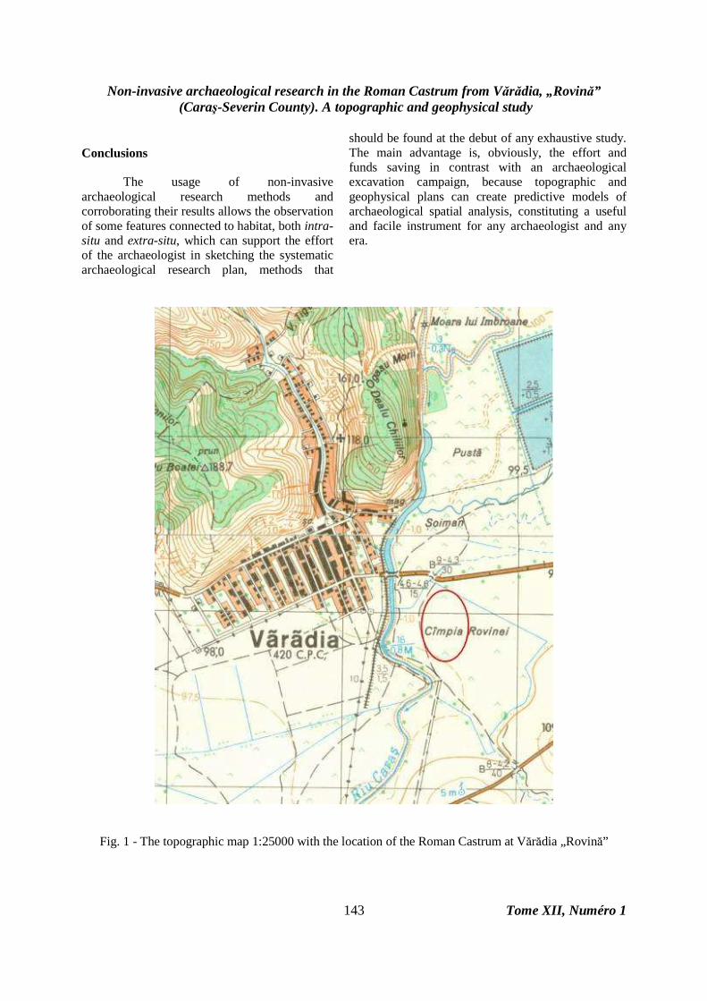
The Roman castrum at Vărădia „Rovină” is placed at 760 meters SE from the Orthodox Church in Vărădia; at 360 meters SE from the bridge over Caraş River on the road DJ 573 B Greoni – Vărădia and at 2.26 kilometers NE from the Orthodox Church in Mercina, at 300 meters E of the left side of Caraş River (fig. 1). The GPS coordinates are: 45.04.44 N, 21.33.07 E and 97.5 meters altitude.
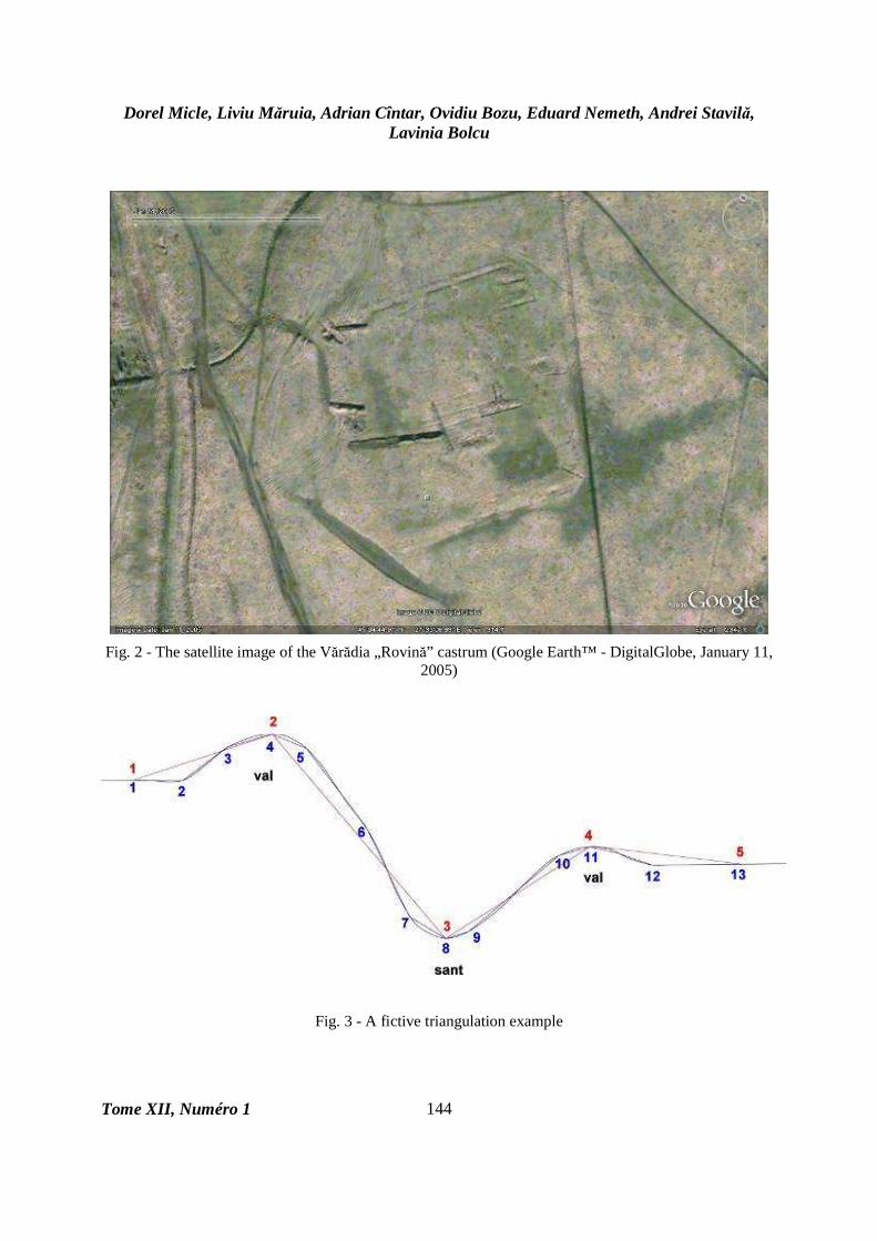
From a geomorphologic point of view, the castrum is placed in the riverside of the Caraş River, on its left side. The Roman military builders speculated an erosion terrace, positioned between more ramble arms of Caraş, so the castrum was protected of floods. Nowadays the initial landscape is radically transformed by land and hidroamelioration works done in the modern age (fig. 2 - The Google Earth image’s technical data: Catalog No.: 1010010003819402, Acquisition date: January 11, 2005, Image center coordinates: Lat/Long: 45.102° N / 21.523° E, Nadir angle: 14°, Azimuth angle: 275°, Satellite sensor: QB02, Stripe: Pan_MS1).
Work methodology First step: The topographical measurements with the Total Station
The Total Station is partially based on a principle used at traditional theodolites, were angles are calculated by vertical and horizontal gradations at 360º. The Total Station uses topographical degrees for its measurements, i.e. 400º for a circle. The station uses a device called EDM (Electronic Distance Measurer) that sends out a laser signal that reflects of the prism after a time interval, which is used to calculate the distance. The Total Station has a built-in microprocessor which automatically collects these angles and distances measurements, calculates the trigonometric equations and converts it to coordinates.
Instead of a supervisor who gathers the data on paper, it is sent to a data collector and it can be
Non-invasive archaeological research in the Roman Castrum from Vărădia, „Rovină” (Caraş-Severin County). A topographic and geophysical study
Tome XII, Numéro 1 141
downloaded to a computer in order to create a tridimensional points structure (x, y, z).
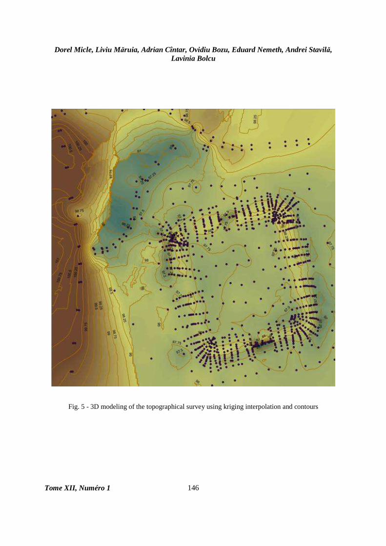
The larger the number of acquired points on site, the more realistic triangulation and more precise 3D representation we get that is closer to terrain reality. Also, the interpolation method used (lagrange, kriging, spline, etc.) can contribute to a better, real representation (fig. 3.).
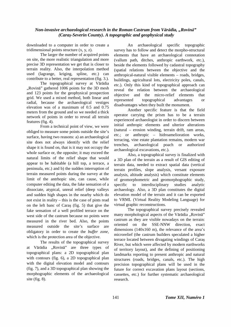
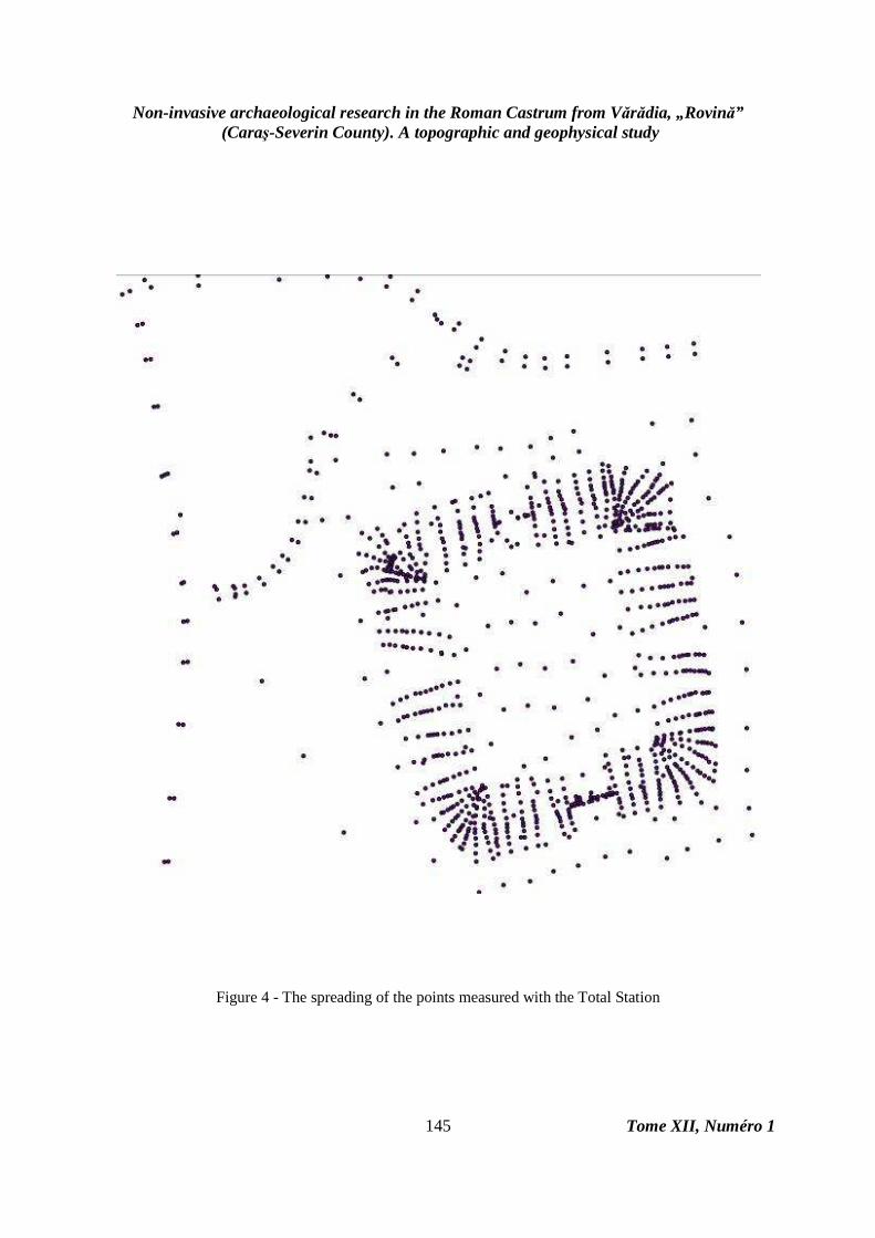
The topographical survey at Vărădia „Rovină” gathered 1006 points for the 3D mesh and 123 points for the geophysical prospection grid. We used a mixed method, both linear and radial, because the archaeological vestiges elevation was of a maximum of 0.5 and 0.75 meters from the ground and so we needed a thick network of points in order to reveal all terrain features (fig. 4).
From a technical point of view, we were obliged to measure some points outside the site’s surface, having two reasons: a) an archaeological site does not always identify with the relief shape it is found on, that is it may not occupy the whole surface or, the opposite; it may exceed the natural limits of the relief shape that would appear to be habitable (a hill top, a terrace, a peninsula, etc.) and b) the sudden interruption of terrain measured points during the survey at the limit of the antrhopic site, can cause, while computer editing the data, the fake sensation of a dissociate, atypical, unreal relief (deep valleys and sudden high shapes in the nearby which do not exist in reality – this is the case of pints read on the left banc of Caraş (fig. 5) that give the fake sensation of a well profiled terrace on the west side of the castrum because no points were measured in the river bed. Also, the points measured outside the site’s surface are obligatory in order to create the buffer zone, which is the protection area of the objective.
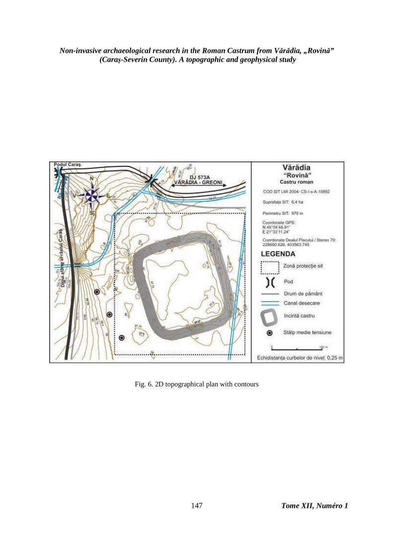
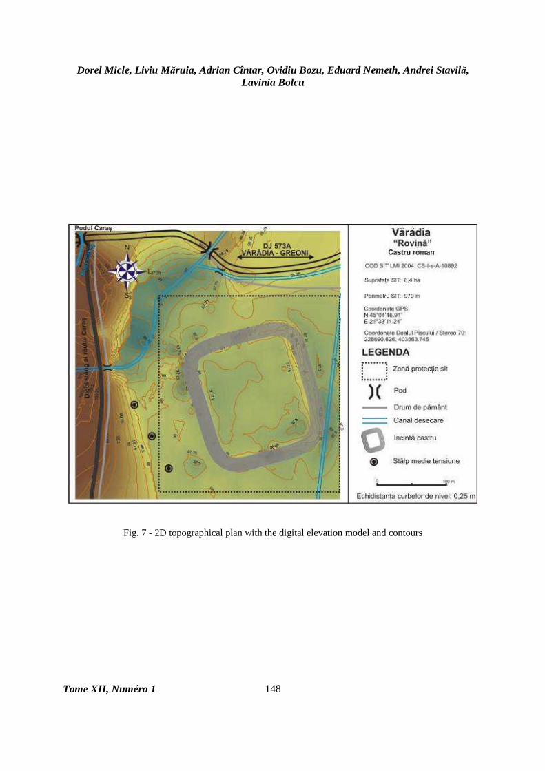
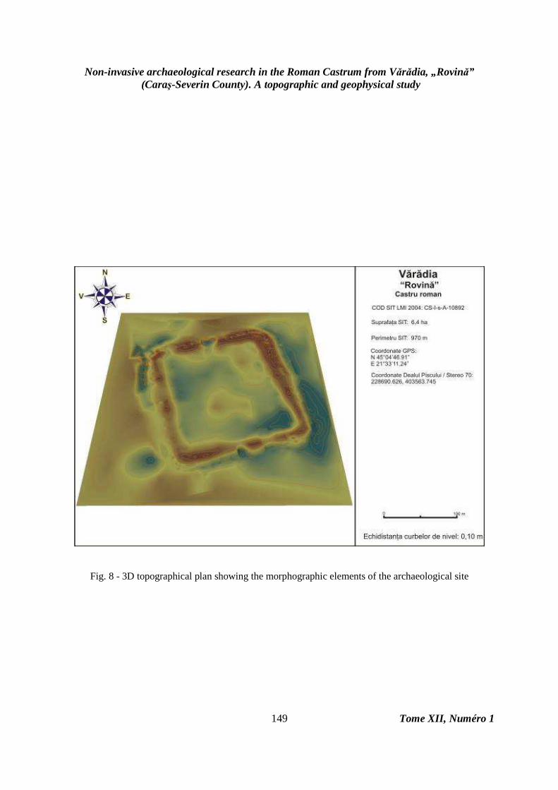
The results of the topographical survey at Vărădia „Rovină” are three types of topographical plans: a 2D topographical plan with contours (fig. 6), a 2D topographical plan with the digital elevation model and contours (fig. 7), and a 3D topographical plan showing the morphographic elements of the archaeological site (fig. 8).
An archaeological specific topographic survey has to follow and detect the morpho-structural elements that have an archaeological connotation (vallum path, ditches, anthropic earthwork, etc.), beside the elements followed by cadastral topography (spatial relations between the objective and the anthropical-natural visible elements – roads, bridges, buildings, agricultural lots, electricity poles, canals, etc.). Only this kind of topographical approach can reveal the relation between the archaeological objective and the micro-relief elements that represented topographical advantages or disadvantages when they built the monument.
Another specific feature is that the field operator carrying the prism has to be a terrain experienced archaeologist in order to discern between initial anthropic elements and ulterior alterations (natural – erosion winding, terrain drift, ram areas, etc.; or anthropic – hidroamelioration works, terracing, vine estate plantation remains, modern war trenches, archaeological poach or authorized archaeological excavations, etc.).
Also, a topographical survey is finalized with a 3D plan of the terrain as a result of GIS editing of terrain data, needed to extract spatial data (vertical terrain profiles, slope analysis, versant exposure analysis, altitude analysis) which constitute elements of geomorphometric and geomorphographic study, specific to interdisciplinary studies analytic archaeology. Also, a 3D plan constitutes the digital elevation model of the terrain and it can be exported to VRML (Virtual Reality Modeling Language) for virtual graphic reconstructions.
The topographical survey precisely revealed many morphological aspects of the Vărădia „Rovină” castrum as they are visible nowadays on the terrain: oriented on the SSE-NNW direction, exact dimensions (140x160 m), the relevance of the area’s microrelief (the castrum builders speculated a higher terrace located between divagating windings of Caraş River, but which were affected by modern earthworks of territory layout), and the defining of positioning landmarks reporting to present anthropic and natural structures (roads, bridges, canals, etc.). The high precision topographical plans will be used in the future for correct excavation plans layout (sections, cassettes, etc.) for further systematic archaeological research.
Dorel Micle, Liviu Măruia, Adrian Cîntar, Ovidiu Bozu, Eduard Nemeth, Andrei Stavilă, Lavinia Bolcu
Tome XII, Numéro 1
142
The second step: Magnetometric prospecting. Fluxgate method
The magnetometric prospection consists in evaluating the magnetic field of the soil, which is influenced by the magnetic properties of the rocks. This method is efficient especially for ferrous metal detection.
For these prospections we frequently use a Cesium gradiometer that assures 11 measurements per second. The sensors are disposed on a device connected to a harness at approximately 0.3 meters of the ground. The measurements are linear with a frequency of 1 meter and the results are saved to a computer. Three persons are needed to handle the equipment (one carries the device and the other two move the grid), but it has the advantage of covering between 6000 and 10000 m² per day. Other magnetometer types are based on protons (they follow the way in which the protons react as they orient to the force lines of the local magnetic field), based on Rubinium or with Gamma radiations.
The “fluxgate” instruments are sensible from a directional point of view and must be config.d as a gradiometer in order to create practical applications. The “fluxgate” instruments are capable of measuring only the vertical component of the magnetic field. This kind of instrument is constantly a subject of “de-calibration”, that is a systematic change in the zero point of the instrument, this takes place with the variation of the external natural factors, and in this case a re-calibration is necessary (J. C Alldred, 1964, p. 15).
Bartington GRAD601 (ArcheoSurveyor- User Manual, 2007), the two sensors version, register data on two lines for each traverse and it reduces the prospection time to half of the time needed for a one-sensor model. The instrument can also be used as a prospection instrument if it is set on parallel or zigzag mode or as a search instrument if using the acoustic part in scanning
mode, in order to localize and mark the path of a pipe, for example, without data saving.
When the instrument is used in prospection mode, the data are stored as a grid, measuring the magnetic variation along a series of spatial lines at 0.25, 0.5 or 1 meter, depending of the desired resolution. The instrument memory can store up to 30 grids of 30x30 meters with a traverse distance of 1 meter and a resolution of 4 readings/meter. The information obtained from the prospection can be downloaded as separate files, so the different grid size is not a problem.
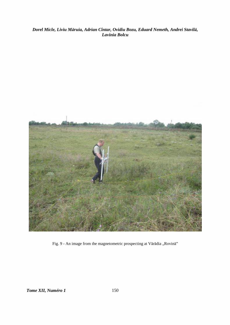
The measured surface was divided depending on the topographic surface, in grids of 20x20 meters with an N-W orientation. The method used was zigzag with a density of 9 readings/meter and a data collection interval of 1 meter between traverses (fig. 9.).
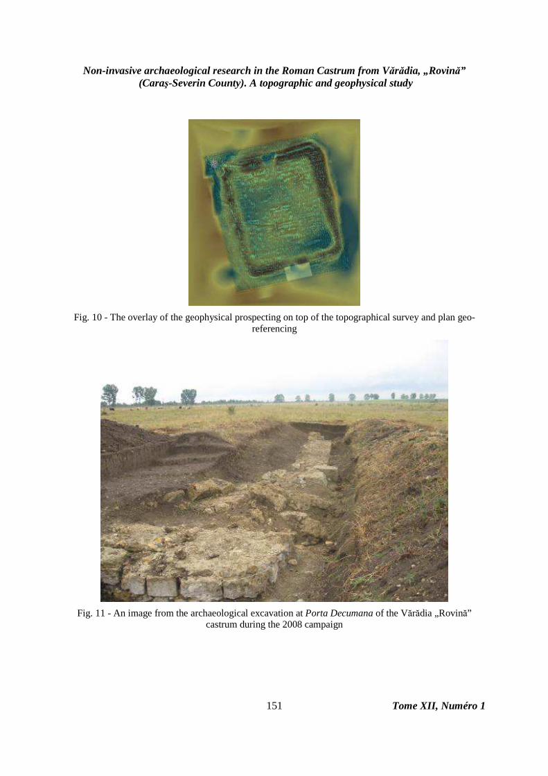
We measured 88 grids which were geo-referenced with the Total Station and they were laid in plan over the topographic survey (fig. 10.). We did not perform measurements in two successive grids in the South gate area (Porta Decumana) as the surface was under systematic archaeological research (fig. 11.).
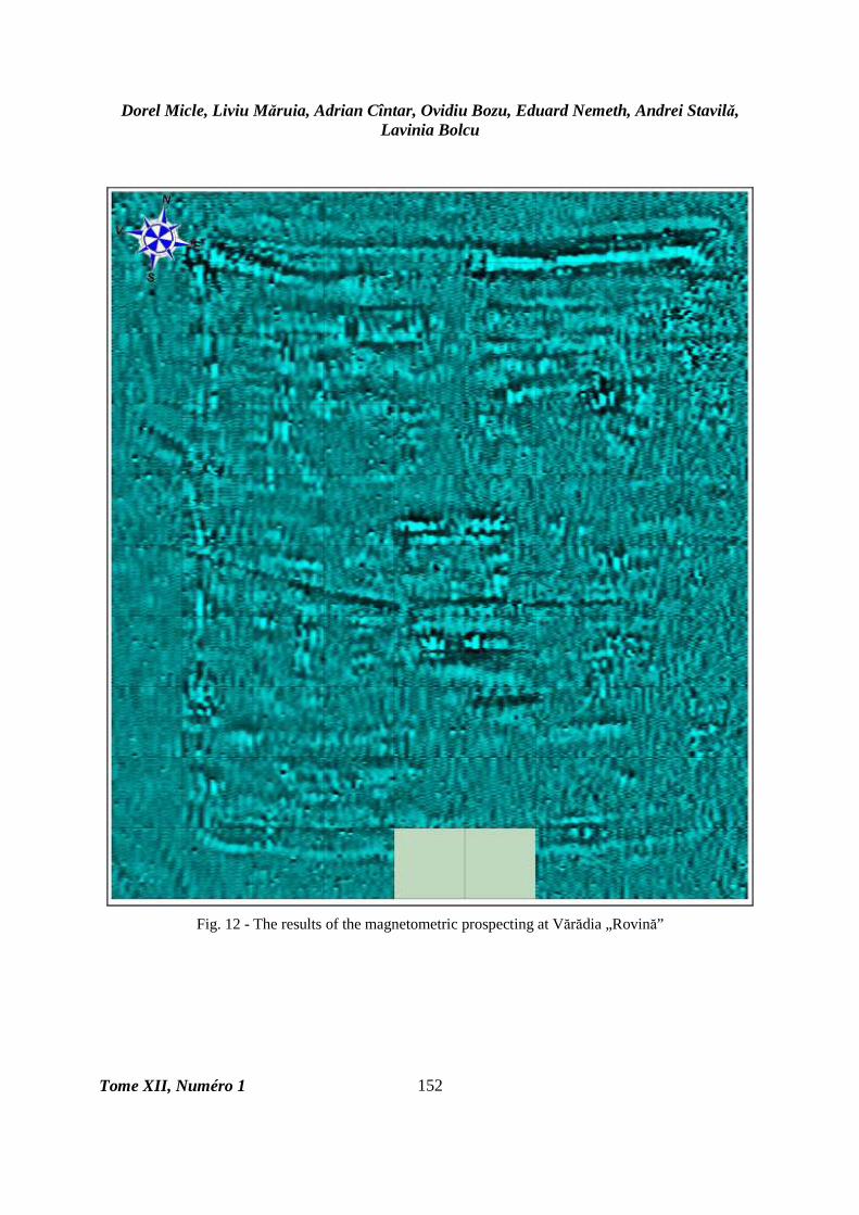
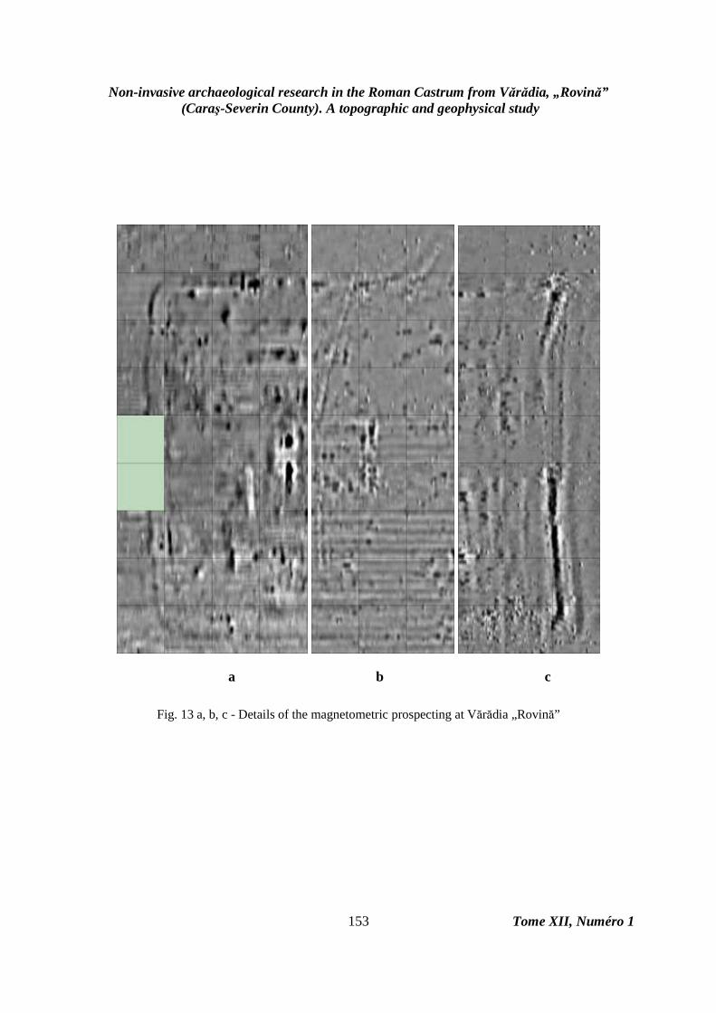
The results of the magnetometric prospection revealed many aspects and feature with technical and historic nature (fig. 12 and 13): a) it allows the correct identification of the archaeological sections excavated in time and are no longer visible on the ground; b) it allows the identification of structures affected by older archaeological excavations the tried to expose the walls (see Principia); c) proves the existence of a double enclosure wall, especially visible on the S and N sides and also on the round castrum corners; d) it allows the identification of the E tower of the Porta Praetoria; e) it is spectacular the revelation of the stone foundation traces of the centurion houses, and their orientation and dimensions, the barracks that flanked Via Praetoria (it can be visible for the rest of the barracks, but they probably have a wooden foundation - they don’t have such visible traces); f) it allows the observation of anomalies caused by metal presence in the barracks area which could indicate a workshop (Fabrica); g) some curtain towers are also visible on the S, N and W sides; h) it allows the identification of intersecting roads in front of Principia, Via Praetoria and Via Principalis; i) it proves the existence of only one defense ditch, visible on the N side.
Non-invasive archaeological research in the Roman Castrum from Vărădia, „Rovină” (Caraş-Severin County). A topographic and geophysical study
Tome XII, Numéro 1 143
Conclusions
The usage of non-invasive archaeological research methods and corroborating their results allows the observation of some features connected to habitat, both intra-situ and extra-situ, which can support the effort of the archaeologist in sketching the systematic archaeological research plan, methods that
should be found at the debut of any exhaustive study. The main advantage is, obviously, the effort and funds saving in contrast with an archaeological excavation campaign, because topographic and geophysical plans can create predictive models of archaeological spatial analysis, constituting a useful and facile instrument for any archaeologist and any era.
Fig. 1 - The topographic map 1:25000 with the location of the Roman Castrum at Vărădia „Rovină”
Dorel Micle, Liviu Măruia, Adrian Cîntar, Ovidiu Bozu, Eduard Nemeth, Andrei Stavilă, Lavinia Bolcu
Tome XII, Numéro 1
144
Fig. 2 - The satellite image of the Vărădia „Rovină” castrum (Google Earth™ - DigitalGlobe, January 11,
2005)
Fig. 3 - A fictive triangulation example
Non-invasive archaeological research in the Roman Castrum from Vărădia, „Rovină” (Caraş-Severin County). A topographic and geophysical study
Tome XII, Numéro 1 145
Figure 4 - The spreading of the points measured with the Total Station
Dorel Micle, Liviu Măruia, Adrian Cîntar, Ovidiu Bozu, Eduard Nemeth, Andrei Stavilă, Lavinia Bolcu
Tome XII, Numéro 1
146
Fig. 5 - 3D modeling of the topographical survey using kriging interpolation and contours
Non-invasive archaeological research in the Roman Castrum from Vărădia, „Rovină” (Caraş-Severin County). A topographic and geophysical study
Tome XII, Numéro 1 147
Fig. 6. 2D topographical plan with contours
Dorel Micle, Liviu Măruia, Adrian Cîntar, Ovidiu Bozu, Eduard Nemeth, Andrei Stavilă, Lavinia Bolcu
Tome XII, Numéro 1
148
Fig. 7 - 2D topographical plan with the digital elevation model and contours
Non-invasive archaeological research in the Roman Castrum from Vărădia, „Rovină” (Caraş-Severin County). A topographic and geophysical study
Tome XII, Numéro 1 149
Fig. 8 - 3D topographical plan showing the morphographic elements of the archaeological site
Dorel Micle, Liviu Măruia, Adrian Cîntar, Ovidiu Bozu, Eduard Nemeth, Andrei Stavilă, Lavinia Bolcu
Tome XII, Numéro 1
150
Fig. 9 - An image from the magnetometric prospecting at Vărădia „Rovină”
Non-invasive archaeological research in the Roman Castrum from Vărădia, „Rovină” (Caraş-Severin County). A topographic and geophysical study
Tome XII, Numéro 1 151
Fig. 10 - The overlay of the geophysical prospecting on top of the topographical survey and plan geo-
referencing
Fig. 11 - An image from the archaeological excavation at Porta Decumana of the Vărădia „Rovină”
castrum during the 2008 campaign
Dorel Micle, Liviu Măruia, Adrian Cîntar, Ovidiu Bozu, Eduard Nemeth, Andrei Stavilă, Lavinia Bolcu
Tome XII, Numéro 1
152
Fig. 12 - The results of the magnetometric prospecting at Vărădia „Rovină”
Non-invasive archaeological research in the Roman Castrum from Vărădia, „Rovină” (Caraş-Severin County). A topographic and geophysical study
Tome XII, Numéro 1 153
Fig. 13 a, b, c - Details of the magnetometric prospecting at Vărădia „Rovină”
a b c
Dorel Micle, Liviu Măruia, Adrian Cîntar, Ovidiu Bozu, Eduard Nemeth, Andrei Stavilă, Lavinia Bolcu
Tome XII, Numéro 1
154
BIBLIOGRAPHY
ArcheoSurveyor - User Manual, 2007,
Program version 2.4.0.X, DW Consulting Geophysics in Archaeology, Issue 4, Barneveld, Holland.
Ardeţ A., Iaroslavschi E., Bozu O., 2003, Noi ştampile de amforă de la Vărădia, Banatica, 16, 1, p. 309-315.
Bozu O., Iaroslavschi E., 1996, Vărădia – „Dealul Chilii”, jud. Cara ş – Severin, Situri arheologice cercetate în perioada 1982-1992, Brăila, p. 123.
Crişan I. H., 1977, Burebista şi epoca sa, Bucureşti.
Daicoviciu C., 1945, La Transylvanie dans l’Antiquité , Bucureşti.
Florescu Gr., Le camp romain de Arcidava, Istros, 1, 1934, p. 71-78.
Iaroslavschi E., Bozu O., 2003, Raport preliminar privind principalele rezultate ale cercetărilor arheologice din castrul de pământ de pe Dealul Chilii (comuna Vărădia, judeţul Caraş Severin), Banatica, 16, p. 295-300.
Iaroslavschi E., Bozu O., 2003, Raport preliminar privind principalelor rezultate ale cercetărilor arheologice din castrul de pământ de pe Dealul Chilii (comuna Vărădia, judeţul Caraş-Severin), Banatica, 16, 1. p. 297.
Iaroslavschi E., Lazarovici Gh., 1979, Vestigii arheologice din bazinul Caraşului, Acta Musei Napocensis, 16, p. 452-454.
Alldred J. C, A Fluxgate Gradiometer for Archaeological Surveying, Archaeometry, 7, 1964, p. 15.
Mileker B. 1897, Délmagyaroszág regiségletei honfoglalàs ellötti idökböl, vol. I, Temesvár.
Mileker B. 1906, Délmagyaroszág regiségletei honfoglalàs ellötti idökböl, vol. III, Temesvár.
Németh E., 2006, Die neuen Ausgrabungen im Auxiliarkastell von Varadia-Pusta, in Limes XIX. Proceedings of the XIXth International Congress of Roman Frontier Studies, Pécs, Hungary, September 2003, Pécs, p. 689-696.
Németh E., Bozu O., 2000, Vărădia, com. Vărădia, jud. Caraş-Severin, Cronica Cercetărilor Arheologice din România – campania 1999, Bucureşti, p. 112.
Németh E., Bozu O., 2001, Vărădia, com. Vărădia, jud. Caraş-Severin, Cronica Cercetărilor Arheologice din România – campania 2000, Bucureşti, p. 267.
Németh E., Bozu O., 2002, Vărădia, com. Vărădia, jud. Caraş-Severin, Cronica Cercetărilor Arheologice din România – campania 2001, Bucureşti, p. 328-329.
Németh E., Bozu O., 2005, Noile săpături din castrul roman de la Vărădia-Pustă (jud. Caraş-Severin), Banatica, 17, p. 201-210.
Németh E., Bozu O., 2005, Vărădia, com. Vărădia, jud. Caraş-Severin. Punct: Pustă, Cronica Cercetărilor Arheologice din România – campania 2004, Bucureşti, p. 401-402.
Pârvan V., 1926, Getica. O protoistorie a Daciei, Bucureşti.
Vulpe R., 1960, in Omagiu lui Constantin Daicoviciu la împlinirea vârstei de 60 ani, Bucureşti, p. 557-564.
Adiu
Text Box
This study was conducted within the project "Transnational network of integrated postdoctoral research in science communication. Capacity building (postdoctoral school) and scholarship program (CommScie)" POSDRU/89/1.5/S/63663
Related Documents