FINAL REPORT US Army Corps of Engineers St. Paul District Mississippi Valley Division Feasibility Report and Environmental Assessment Marsh Lake Ecosystem Restoration Project Minnesota River Big Stone, Lac qui Parle, and Swift Counties, Minnesota Photo by Ron Bolduan Completed in conjunction with the Minnesota Department of Natural Resources July 2011

Welcome message from author
This document is posted to help you gain knowledge. Please leave a comment to let me know what you think about it! Share it to your friends and learn new things together.
Transcript

FINAL REPORT
US Army Corps of Engineers St. Paul District Mississippi Valley Division
Feasibility Report and Environmental Assessment
Marsh Lake Ecosystem Restoration Project
Minnesota River
Big Stone, Lac qui Parle, and Swift Counties, Minnesota
Photo by Ron Bolduan
Completed in conjunction with the Minnesota Department of Natural Resources
July 2011

FINAL REPORT
[This page intentionally left blank]
FINAL REPORT
1
Summary Introduction This report was prepared in response to the study authorization contained in a
Resolution of the Committee on Public Works of the U.S. House of Representatives,
May 10, 1962. The resolution reads as follows:
“Resolved by the Committee on Public Works of the House of Representatives, United
States, that the Board of Engineers for Rivers and Harbors be, and is hereby, requested
to review the report of the Chief of Engineers on the Minnesota River, Minnesota,
published as House Document 230, 74th Congress, First Session and other pertinent
reports, with a view to determining the advisability of further improvements in the
Minnesota River Basin for navigation, flood control, recreation, low flow augmentation,
and other related water and land resources.”
In response to the study authority the reconnaissance phase of the study was
completed in December 2004 (USACE 2004) and approved in January 2005. The
reconnaissance study resulted in the finding of Federal interest in and potential solutions
to several existing water resources problems that warrant feasibility studies, including
ecosystem restoration at Marsh Lake.
The Minnesota Department of Natural Resources (DNR) as the non-Federal
sponsor, and the U.S. Army Corps of Engineers, St. Paul District (Corps) initiated the
feasibility phase of the study on February 2, 2006. The feasibility phase study cost was
shared equally between the Corps and the sponsor.
This summary is intended to describe the major factors which were considered in
the investigation and influenced the decisions and recommendations documented in this
report.
Planning Process and NEPA Starting in November 2000 through 2002, the DNR conducted a planning
process with interagency coordination and public participation to identify ways to restore
the Marsh Lake ecosystem.
FINAL REPORT
2
In collaboration with the DNR and making use of the information generated from
the DNR's earlier planning for Marsh Lake, we identified the problems and opportunities,
set project objectives, identified and evaluated a number of alternative measures for
Marsh Lake ecosystem restoration, formulated alternative plans, assessed the costs,
benefits, environmental and social impacts of the alternative plans, coordinated with
agencies and the public, recommended a plan and documented this planning process in
this draft integrated Feasibility Report and Environmental Assessment (FR/EA).
This FR/EA has been prepared to meet Corps of Engineers planning guidance
and National Environmental Policy Act (NEPA) requirements. Following agency and
public review, a final FR/EA will be prepared. The St. Paul District Commander will
consider signing a Finding of No Significant Impact for the Marsh Lake Ecosystem
Restoration Project to conclude the National Environmental Policy Act (NEPA) process.
This planning process has been subject to Value Engineering Review, Agency
Technical Review; review by interested agencies and the public, and review by the
Corps of Engineers Mississippi Valley Division and by Corps Headquarters.
Major Conclusions and Findings Planning Objectives The investigation of the problems and opportunities led to the establishment of
the following planning goals and objectives for ecosystem restoration in the Marsh Lake
study area.
Goal: A return of the Marsh Lake area ecosystem to a less degraded and more natural
and functional condition
Objectives:
1. Reduced sediment loading to Marsh Lake over the 50-year period of analysis
2. Restored natural fluctuations to the hydrologic regime of Marsh Lake over the 50-year
period of analysis
FINAL REPORT
3
3. Restored geomorphic and floodplain processes to the Pomme de Terre River over the
50-year period of analysis
4. Reduced sediment resuspension within Marsh Lake over the 50-year period of
analysis
5. Increased extent, diversity and abundance of emergent and submersed aquatic plants
within Marsh Lake over the 50-year period of analysis
6. Increased availability of waterfowl habitat within Marsh Lake over the 50-year period
of analysis
7. Restored aquatic habitat connectivity between Marsh Lake, the Pomme de Terre
River and Lac Qui Parle over the 50-year period of analysis
8. Reduced abundance of aquatic invasive fish species within Marsh Lake over the 50-
year period of analysis
9. Increased diversity and abundance of native fish within Marsh Lake and the Pomme
de Terre River over the 50-year period of analysis
Alternatives A wide range of alternative measures were identified to address the planning
objectives. Alternative plans were formulated. Alternative measures evaluated as a part
of this study are as follows:
• Modifications to the Marsh Lake Dam to enable passive and active water level
management.
• Provide for fish passage between Lac qui Parle Lake and Marsh Lake and the
Pomme de Terre River. Restore the Pomme de Terre River to its former channel
near its confluence with the Minnesota River. Construct a bridge over the
Pomme de Terre River to maintain access to the Marsh Lake Dam.
• Construct rock wave-break islands in Marsh Lake to reduce wind fetch, wave
action, and sediment resuspension to restore aquatic vegetation.
FINAL REPORT
4
• Reconnect the abandoned fish rearing pond next to the Marsh Lake Dam with
the upper end of Lac qui Parle.
• Install gated culverts in the Louisburg Grade Road to enable water level
management in upper Marsh Lake.
• Modify the Reservoir Regulation Plan for the Lac qui Parle Flood Control Project
to include growing season drawdowns of Marsh Lake as needed to restore
aquatic vegetation in years when river discharge allows.
• Construct recreational and educational features including a trail bridge over
Marsh Lake Dam to connect with the Minnesota State Trail, fishing access on
Marsh Lake, canoe access on the Pomme de Terre River, and an improved
recreation area at Marsh Lake Dam.
• Monitor the ecological effectiveness of the Marsh Lake ecosystem restoration
features to provide information for future adaptive ecosystem management.
Local Support The non-Federal sponsor, the Minnesota Department of Natural Resources, has
expressed the desire for implementing ecosystem restoration and sponsoring project
construction in accordance with the items of local cooperation that are set forth in this
report. The financial analysis indicates that the non-Federal sponsor is financially
capable of participating in the project.
Recommended Plan
The Recommended Plan recommended for implementation is Alternative Plan 4
which consists of the following:
• Restore the Pomme de Terre River to its historic channel
• Breach dike at abandoned fish pond
• Construct drawdown structure
• Construct Louisburg Grade Road gated culverts
• Modify the Marsh Lake Dam, construct fishway
Through the planning process outlined in this report, it was determined that Alternative
Plan 4, consisting of the measures noted above, provided the greatest increase in
benefits, addressing each planning objective, at the least cost. The Recommended Plan
will provide an increase of approximately 8400 Habitat Units at an average annual cost

FINAL REPORT
5
of $474,000. In addition, a number of recreation features will be constructed (highlighted
in Section 7.2) that will provide approximately $225,000 of economic benefit at an 8.6
benefit-cost ratio with an average annual cost of $26,000. The total project costs of the
ecosystem and recreation features equals $9,967,000 with an annualized cost of
$500,000. The costs and benefits of the Recommended Plan are summarized below:
EcosystemRestoration
9,967,000$ 214,000$
10,181,000$
500,000$ 35,000$
8400225,000$ Total Annual Benefits (Recreation)
Breakout of Total Project Costs and BenefitsMarsh Lake Ecosystem Restoration - Recommended Plan
Total Project First CostsInterest During Construction (4.125%)Present Worth of Investment
Annualized Total Project CostsAnnual Operations and Maintenance Costs
Total Annual Benefits (Habitat Units)
Rounded to nearest $1000

FINAL REPORT
6
Ecosystem Restoration Features of the Recommended Plan

FINAL REPORT
7
Recreation Features of the Recommended Plan

FINAL REPORT
8
[This page intentionally left blank]

FINAL REPORT
9
Table of Contents
Summary ......................................................................................................................... 1
Table of Contents ............................................................................................................ 9
1. Introduction ............................................................................................................... 14
1.1 Purpose of Report ................................................................................................ 14
1.2 Study Authority .................................................................................................... 14
1.3 Minnesota River Basin Reconnaissance Study .................................................... 14
1.4 Purpose of the Marsh Lake Ecosystem Restoration Project ................................. 16
1.5 Project Scope ...................................................................................................... 17
1.5.1 Location .......................................................................................................... 17
1.5.2 Geographic Scope .......................................................................................... 20
1.5.3 Temporal Scope ............................................................................................. 21
1.6 Project Planning ................................................................................................... 21
1.7 Existing Water Projects, Prior Studies and Reports ............................................. 22
1.7.1 Existing Projects ............................................................................................. 22
1.7.2 Prior Studies and Reports ............................................................................... 28
2. Existing and Future Without-Project Conditions ........................................................ 29
2.1 Marsh Lake .......................................................................................................... 29
2.1.1 Marsh Lake Dam ............................................................................................ 33
2.2 Hydrology ............................................................................................................ 33
2.2.1 Minnesota River Hydrology ............................................................................. 34
2.2.2 Pomme de Terre River Hydrology ................................................................... 34
2.2.3 Marsh Lake Hydrology .................................................................................... 36
2.2.4 Lac qui Parle Hydrology .................................................................................. 38
2.3 Sediment Loading to Marsh Lake......................................................................... 39
2.4 Wind-generated Waves and Sediment Resuspension on Marsh Lake ................. 40
2.5 Shoreline Erosion on Marsh Lake ........................................................................ 44
2.6 Water Quality ....................................................................................................... 46
2.7 Historic and Cultural Resources ........................................................................... 49
2.8 Natural Resources ............................................................................................... 50
2.8.1 Climate ........................................................................................................... 50
2.8.2 Land Use and Land Cover .............................................................................. 51
2.8.3 Marsh Lake Ecosystem State ......................................................................... 53
2.8.4 Historic and Recent Conditions in Marsh Lake................................................ 55

FINAL REPORT
10
2.8.5 Aquatic Vegetation ......................................................................................... 55
2.8.6 Fish Community .............................................................................................. 62
2.8.7 Macroinvertebrates ......................................................................................... 65
2.8.8 Mussels .......................................................................................................... 66
2.8.9 Wildlife ............................................................................................................ 69
2.8.10 Endangered and Threatened Species........................................................... 73
2.8.11 Contaminants, Hazardous, Toxic and Radioactive Waste ............................. 73
2.9 Social and Economic Conditions .......................................................................... 73
2.9.1 Land Use ........................................................................................................ 73
2.9.2 Transportation ................................................................................................ 74
2.9.3 Regional Economy ......................................................................................... 75
2.9.4 Employment ................................................................................................... 76
2.9.5 Income............................................................................................................ 76
2.9.6 Demography .................................................................................................. 77
2.9.7 Education ....................................................................................................... 77
2.9.8 Housing .......................................................................................................... 78
2.9.9 Recreation ...................................................................................................... 78
2.10 Future Conditions Without an Ecosystem Restoration Project ........................... 90
2.10.1 Future Social and Economic Conditions ....................................................... 90
2.10.2 Future Land Use and Land Cover ................................................................. 91
2.10.3 Future Hydrology .......................................................................................... 92
2.10.4 Future Hydraulic Condition of Marsh Lake and Pomme de Terre River and
Lac Qui Parle ..................................................................................................... 92
2.10.5 Future Ecosystem State............................................................................... 93
2.10.6 Future Water Quality ..................................................................................... 94
2.10.7 Future Fish Community ................................................................................ 94
2.10.8 Future Wildlife ............................................................................................... 95
2.11 Planning Assumptions ....................................................................................... 96
3. Problems and Opportunities ...................................................................................... 97
3.1 Problem: Degraded Marsh Lake Ecosystem State .............................................. 98
3.2 Problem: Low-Diversity Fish Community ............................................................ 102
3.3 Problem: Degraded Pomme de Terre River Ecosystem State ............................ 104
3.4 Project Goals and Objectives ............................................................................. 107
3.5 Planning Constraints .......................................................................................... 108

FINAL REPORT
11
3.6 Significance of Resources and Significance of Ecosystem Outputs ................... 109
4. Alternative Measures ............................................................................................... 115
4.1 Description of Alternative Ecosystem Restoration Measures ............................. 117
4.1.1 Watershed Best Management Practices (BMPs) .......................................... 117
4.1.2 Wetland Restorations in Watershed .............................................................. 117
4.1.3 Stream Bank Stabilization in Watershed ....................................................... 117
4.1.4 Restore the Lower Pomme de Terre River to its Former Channel ................. 117
4.1.5 Modify Marsh Lake Dam to Attain Target Water Levels and Construct a
Fishway (Passive water level management) ..................................................... 122
4.1.6 Construct Water Level Control Structure to Allow Drawdowns to Restore
Emergent Aquatic Plants and Reduce Carp Abundance (Active Water Level
Management) ................................................................................................... 125
4.1.7 Install Gated Culverts on Louisburg Grade Road .......................................... 129
4.1.8 Install Gated Culverts and Pump System on Abandoned Fish Pond ............. 131
4.1.9 Breach Dike on Abandoned Fish Pond ......................................................... 131
4.1.10 Breach or Remove Marsh Lake Dam .......................................................... 132
4.1.11 Construct Islands in Marsh Lake ................................................................. 132
4.1.12 Construct Exclosures to Prevent Grazing and Plant Submersed Aquatic
Vegetation ........................................................................................................ 133
4.2 Screening of the Alternative Measures .............................................................. 134
4.3 Alternative Plans ................................................................................................ 139
4.3.1 Stand Alone Measures ................................................................................. 139
5. Optimization and Best Buy Analysis ........................................................................ 140
6. Evaluation and Comparison of Alternative Plans .................................................... 148
6.1 Alternative Plans ................................................................................................ 148
6.2 Evaluation of the Alternative Plans ..................................................................... 149
6.4 Completeness, Effectiveness, Efficiency, Acceptability ...................................... 164
6.5 Comparison of Effects of the Alternative Plans .................................................. 166
6.6. Summary of Environmental Effects of the Alternative Plans .............................. 167
6.7 Effects on Environmental Resources ................................................................. 171
6.7.1 Aesthetic Values ........................................................................................... 172
6.7.2 Recreational Opportunities ........................................................................... 173
6.7.3 Transportation .............................................................................................. 173
6.7.4 Public Health and Safety .............................................................................. 173

FINAL REPORT
12
6.7.5 Community Growth and Development .......................................................... 173
6.7.6 Business and Home Relocations .................................................................. 174
6.7.7 Public Facilities and Services ....................................................................... 174
6.7.8 Air Quality ..................................................................................................... 174
6.7.9 Wetland Resources ...................................................................................... 174
6.7.10 Aquatic Habitat ........................................................................................... 174
6.7.11 Habitat Diversity and Interspersion ............................................................. 175
6.7.12 Biological Productivity ................................................................................. 175
6.7.13 Surface Water Quality ................................................................................. 176
6.7.14 Endangered Species .................................................................................. 176
6.7.15 Cultural Resources ..................................................................................... 177
6.7.16 Environmental Justice ................................................................................. 179
6.7.17 Cumulative Effects ...................................................................................... 179
7. RECOMMENDED PLAN ......................................................................................... 181
7.1 National Ecosystem Restoration Plan Description ............................................. 182
7.2 Recreation-Related Project Features ................................................................. 189
7.2.1 Description of Proposed Recreational Features ............................................ 190
7.2.2 Benefit Computation ..................................................................................... 198
7.3 Real Estate Requirements ................................................................................. 199
7.4 Monitoring and Adaptive Management ............................................................... 199
7.5 Cost Estimates ................................................................................................... 200
8 Compliance with Environmental Laws and Regulations ............................................ 201
8.1 Review of Federal Laws, Regulations, Policies and Executive Orders ............... 201
8.2 Economic and Environmental Principles and Guidelines .................................... 203
8.3 USACE Environmental Operating Principles ...................................................... 204
8.4 Lessons Learned from Hurricanes Katrina and Rita ........................................... 205
9. Implementation Responsibilities .............................................................................. 206
9.1 Federal (Corps)/Non-Federal Sponsor Implementation ...................................... 206
9.2 Real Estate Requirements ................................................................................. 208
10 Coordination ........................................................................................................... 208
10.1 Public Involvement ........................................................................................... 208
10.2 Federal Agencies ............................................................................................. 209
10.3 State Agencies ................................................................................................. 209
10.4 Native American Tribes .................................................................................... 210

FINAL REPORT
13
10.5 Local Units of Government and Non-Governmental Organizations .................. 211
11 Recommendation ................................................................................................... 211
12 Finding of No Significant Impact ............................................................................. 217
13 List of Preparers .................................................................................................... 220
References .................................................................................................................. 221
Appendices ................................................................................................................. 228

FINAL REPORT
14
1. Introduction
1.1 Purpose of Report
The purpose of this Feasibility Report and Environmental Assessment is to
document the planning process for ecosystem restoration of the Marsh Lake area on the
Minnesota River, to provide opportunity for participation in the planning process for river
management partners and the public, to meet Corps of Engineers planning guidance
and to meet National Environmental Policy Act (NEPA) requirements.
1.2 Study Authority
The Marsh Lake feasibility study was authorized by a Resolution of the
Committee on Public Works of the U.S. House of Representatives, May 10, 1962. The
resolution reads as follows:
“Resolved by the Committee on Public Works of the House of
Representatives, United States, that the Board of Engineers for Rivers
and Harbors be, and is hereby, requested to review the report of the Chief
of Engineers on the Minnesota River, Minnesota, published as House
Document 230, 74th Congress, First Session and other pertinent reports,
with a view to determining the advisability of further improvements in the
Minnesota River Basin for navigation, flood control, recreation, low flow
augmentation, and other related water and land resources.”
1.3 Minnesota River Basin Reconnaissance Study
Funds were appropriated in Federal fiscal year 2003 to initiate the
reconnaissance study. The reconnaissance study was completed in December 2004
(USACE 2004) and approved by the Corps Mississippi Valley Division in January 2005.
The purpose of the reconnaissance study was to evaluate the potential for Federal
interest in implementing solutions to flooding, navigation, low flow augmentation,
recreation, ecosystem restoration, and other related water resource problems and
opportunities in the Minnesota River Basin (MRB) in Minnesota, South Dakota, North
Dakota, and Iowa.

FINAL REPORT
15
The reconnaissance investigation was conducted in close coordination with the
many agencies active in land and water resources management in the MRB, including
the U.S. Fish and Wildlife Service (USFWS); Natural Resources Conservation Service
(USDA); U.S. Geological Survey (USGS); Minnesota Department of Natural Resources
(DNR); Minnesota Pollution Control Agency (MPCA); Minnesota Board of Water and Soil
Resources (BWSR); University of Minnesota; Minnesota State University at Mankato;
MRB Joint Powers Board; Metropolitan Council of the Twin Cities; local watershed
districts; Clean Up the River Environment (CURE); Ducks Unlimited; and The Nature
Conservancy. These agencies are committed to a Basin-wide watershed framework to
address water resources problems and needs in the MRB. An electronic copy of the
reconnaissance study report can be found at the following location:
http://www.mvp.usace.army.mil/environment/default.asp?pageid=93
The reconnaissance study resulted in the finding of Federal interest in and
potential solutions to several existing water resources problems that warrant feasibility
studies including this Marsh Lake Ecosystem Restoration Project, the Blue Earth River
Ecosystem Restoration Project, and an Integrated Watershed, Water Quality and
Ecosystem Restoration Analysis for the MRB. The Blue Earth River Watershed is
located a considerable distance downstream from the Marsh Lake area and is unrelated
to the Marsh Lake Ecosystem Restoration Project. The Minnesota River Integrated
Watershed Study will provide a comprehensive evaluation of existing watershed
conditions and may result in implementation measures that could further enhance
ecosystem conditions at Marsh Lake. The Minnesota River Integrated Watershed Study
is currently scheduled for completion in 2015.
The geographic scope of this project was negotiated between the sponsor and
the Corps and includes Marsh Lake, adjoining floodplain and shorelines, the confluence
of the Pomme de Terre River, Marsh Lake Dam and Lac qui Parle reservoir (Figure 1-2).
A Project Management Plan (PMP) was developed in coordination with study partners
and stakeholders for the Marsh Lake Ecosystem Restoration Project (Appendix A). A
Feasibility Cost Sharing Agreement was signed in May 2007 with the DNR to conduct
this study (Appendix B).

FINAL REPORT
16
1.4 Purpose of the Marsh Lake Ecosystem Restoration Project
The purpose of this project is to restore the aquatic and riparian ecosystems in
the Marsh Lake project area. Impoundment of Lac qui Parle and Marsh Lake, diversion
of the Pomme de Terre River into Lac qui Parle, and river regulation have significantly
altered the ecosystem state.
Aquatic ecosystem restoration is a primary mission of the Corps’ Civil Works
program, and is defined as achieving a “return of natural areas or ecosystems to a close
approximation of their conditions prior to disturbance, or to less degraded, more natural
conditions“(EP 1165-2-502.)
In some circumstances, as at Marsh Lake, a return to pre-disturbance conditions
may not be feasible. In those instances, “the goal is to partially or fully reestablish the
attributes of a naturally functioning and self regulating system.” The goal of this project
is to return the Marsh Lake area ecosystem to less degraded, more natural conditions by
restoring natural functions and processes.
The original construction of the Marsh Lake Dam was intended to serve as a
flood damage reduction measure as well as a recreational feature to the region, primarily
through the creation of a static pool on the river. The intended flood damage reduction
benefits provided by the Marsh Lake Dam are minor due to effectiveness of the Lac qui
Parle Dam downstream. Marsh Lake is a popular recreation destination in the region as
shown by visitor numbers. As with many projects constructed at the time, a full
understanding of the ecology of the system was not of primary concern.
Since impoundment, Marsh Lake has undergone significant degradation of
aquatic habitat due to a number of stressors including high sediment and nutrient
loading, a fixed crest dam that prevents low seasonal water levels, high turbidity from
wind-driven sediment resuspension, and abundant common carp that increase turbidity
and graze off submersed aquatic vegetation and macroinvertebrates. Although Marsh
Lake provides an open water area for migratory waterfowl to rest and islands for nesting
colonial waterbirds, degradation of the aquatic ecosystem there limits habitat suitability
for many species of fish and wildlife.

FINAL REPORT
17
The underlying purpose and need for this project is to restore the degraded
Marsh Lake ecosystem.
The stated goal of Marsh Lake Ecosystem Restoration Project is to “return the
Marsh Lake area ecosystem to a less degraded and more natural condition by restoring
ecosystem structure and functions.” The intent of the Marsh Lake ecosystem restoration
project is to increase variability in ecosystem processes, restore a more natural water
level regime, aquatic habitat connectivity, and a vegetated lake ecosystem state.
1.5 Project Scope
1.5.1 Location
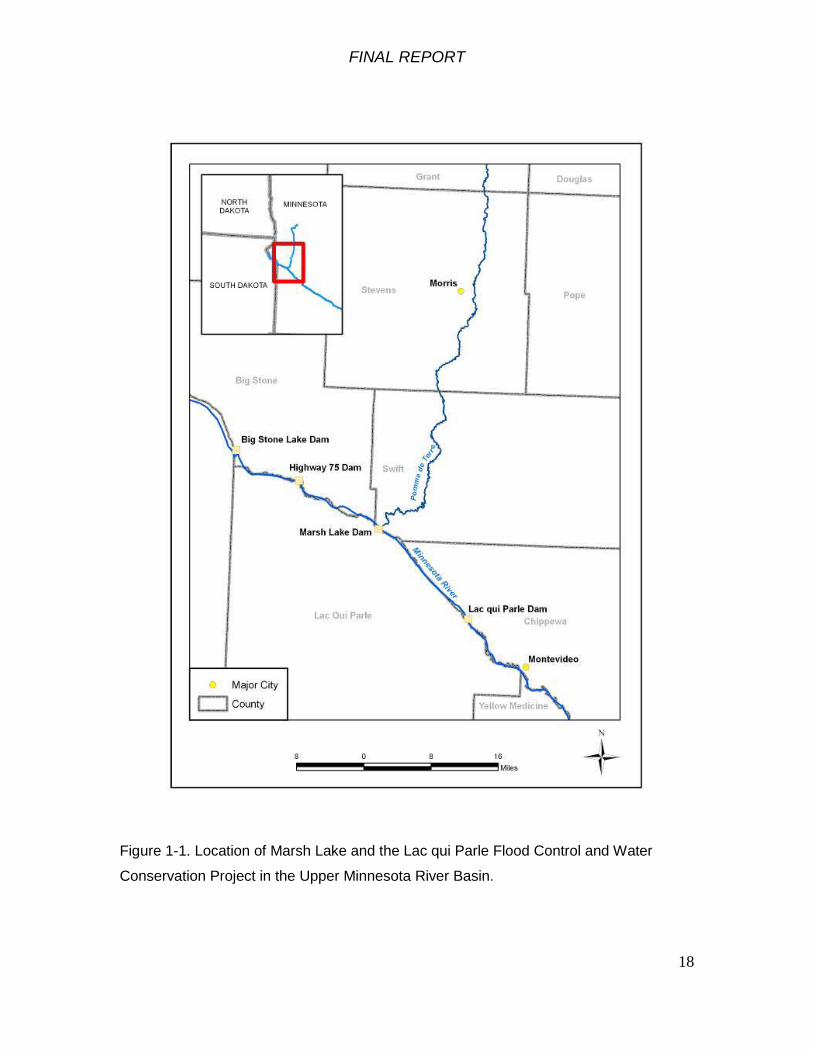
Marsh Lake Dam is located on the Minnesota River in western Minnesota (Figure
1-1). Lac qui Parle and Marsh Lake Reservoirs form boundaries for Lac qui Parle, Swift,
and Big Stone Counties.
FINAL REPORT
18
Figure 1-1. Location of Marsh Lake and the Lac qui Parle Flood Control and Water
Conservation Project in the Upper Minnesota River Basin.

FINAL REPORT
19
Figure 1-2. Marsh Lake project area boundary. Minnesota River flowing left to right. Marsh Lake Dam at right center. Pomme de
Terre River entering from upper right. Farm Service Agency 2003 photo.

FINAL REPORT
20
1.5.2 Geographic Scope
The geographic scope of this project includes Marsh Lake, adjoining floodplain
and shorelines, the confluence of the Pomme de Terre River, Marsh Lake Dam and Lac
qui Parle reservoir (Figure 1-2). There are many opportunities for ecosystem restoration
present in the study area. The DNR is the non-Federal cost share sponsor for this
study. The DNR has authority, funding and staff for ecosystem restoration and
management of the Lac qui Parle Wildlife Management Area.
Because the condition of the Minnesota River ecosystems affects migratory birds
and a flyway of international importance, the geographic scope of the project extends in
effect to the range of the many species of migratory birds that breed in, migrate through
and that stop to feed and rest in the Marsh Lake area. The project area is important to
many species of migratory waterfowl with effects that extend beyond the immediate
project area.
Condition of the Marsh Lake area ecosystems are greatly affected by land use in
the upper Minnesota River Basin. Modification of the hydrology and land use in the
Minnesota River Basin has been profound, converting former prairie, streams and
wetlands into an extensively drained agricultural landscape dominated by row crops.
This report does not address watershed and water quality management in the upper
Minnesota River Basin. As documented in the Minnesota River Basin Reconnaissance
Study report (USACE 2004), we recognize that many of the problems in the Marsh Lake
area ecosystem are symptoms of larger watershed issues. Opportunities to further
restore and contribute to the sustainability of Marsh Lake area ecosystems through
actions in the greater watershed are being explored in the ongoing Minnesota River
Basin Watershed, Water Quality and Ecosystem Restoration Study as recommended in
the Minnesota River Basin Reconnaissance Report (USACE 2004). A feasibility cost
share agreement for the Minnesota River Basin Watershed, Water Quality, and
Ecosystem Restoration Study was signed by the Corps and the Minnesota River
Environmental Quality Board in February 2009. That watershed study is currently under
way and will identify ecologically and cost-effective alternatives for watershed
improvement, water quality management, and ecosystem restoration throughout the
Minnesota River Basin.

FINAL REPORT
21
As a result of the reconnaissance study, the Lac qui Parle Wildlife Management
Area (WMA) became the original geographic focus of the Feasibility Study due to the
presence of Corps owned and operated structures at Lac qui Parle and Marsh Lake,
ownership by the DNR over the WMA lands, and the willingness of the DNR to serve as
the non-Federal Sponsor on the study. As the Feasibility Study progressed and
alternative measures were screened (see Section 4), the scope of the study was further
limited to a smaller geographic area within the WMA where a series of measures could
be implemented that would improve the aquatic and riparian conditions primarily in and
around Marsh Lake (Figure 1-2). This geographic area is referred to throughout the
report as the Marsh Lake project area, which includes Marsh Lake, the Pomme de Terre
River outlet, the Marsh Lake Dam, and the upper portion of the Lac qui Parle reservoir.
While the Feasibility Study utilizes a watershed approach, additional measures to reduce
sediment loading from sources within the watershed are being investigated as a part of
the Minnesota River Basin Integrated Watershed Study.
1.5.3 Temporal Scope
The temporal scope of the project is a period of analysis of 50 years.
1.6 Project Planning
The Marsh Lake Ecosystem Restoration Project is being planned following the
standard Corps of Engineers six-step planning process:
1. Identify problems, opportunities and constraints.
2. Inventory existing conditions and forecast future conditions.
3. Formulate alternatives.
4. Evaluate alternatives.
5. Compare alternatives.
6. Select a recommended plan.
This study has also been drafted to comply with NEPA, with an integrated environmental
assessment.

FINAL REPORT
22
1.7 Existing Water Projects, Prior Studies and Reports
1.7.1 Existing Projects
Lac qui Parle Flood Control and Water Conservation Project The Marsh Lake Dam was built in the late 1930’s by the State of Minnesota and
the Federal Works Progress Administration as part of the multi-purpose Lac qui Parle
Water Control Project. The project was authorized by the Flood Control Act of 1936,
Public Law 74-738 and was partially constructed by the Works Progress Administration.
The Corps of Engineers completed project construction between 1941 and 1951.
Operation of the project was transferred from the State of Minnesota to the Corps of
Engineers in 1950.
Components of the Lac qui Parle project include the Lac qui Parle Dam (Figure
1-4), the Chippewa River Diversion (Figure 1-5), and the Marsh Lake Dam (Figure 1-6).
An overview of the project components is included below in Figure 1-3.
Figure 1-3. Overview of Lac qui Parle Project Components
FINAL REPORT
23
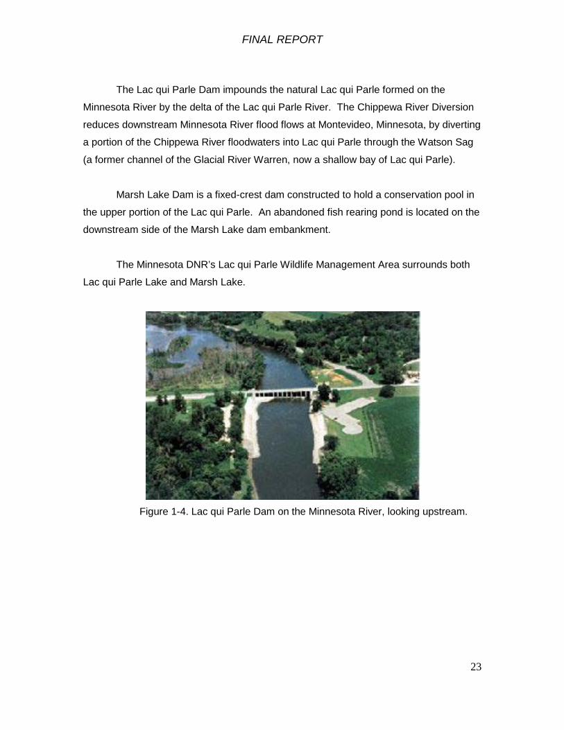
The Lac qui Parle Dam impounds the natural Lac qui Parle formed on the
Minnesota River by the delta of the Lac qui Parle River. The Chippewa River Diversion
reduces downstream Minnesota River flood flows at Montevideo, Minnesota, by diverting
a portion of the Chippewa River floodwaters into Lac qui Parle through the Watson Sag
(a former channel of the Glacial River Warren, now a shallow bay of Lac qui Parle).
Marsh Lake Dam is a fixed-crest dam constructed to hold a conservation pool in
the upper portion of the Lac qui Parle. An abandoned fish rearing pond is located on the
downstream side of the Marsh Lake dam embankment.
The Minnesota DNR’s Lac qui Parle Wildlife Management Area surrounds both
Lac qui Parle Lake and Marsh Lake.
Figure 1-4. Lac qui Parle Dam on the Minnesota River, looking upstream.
FINAL REPORT
24
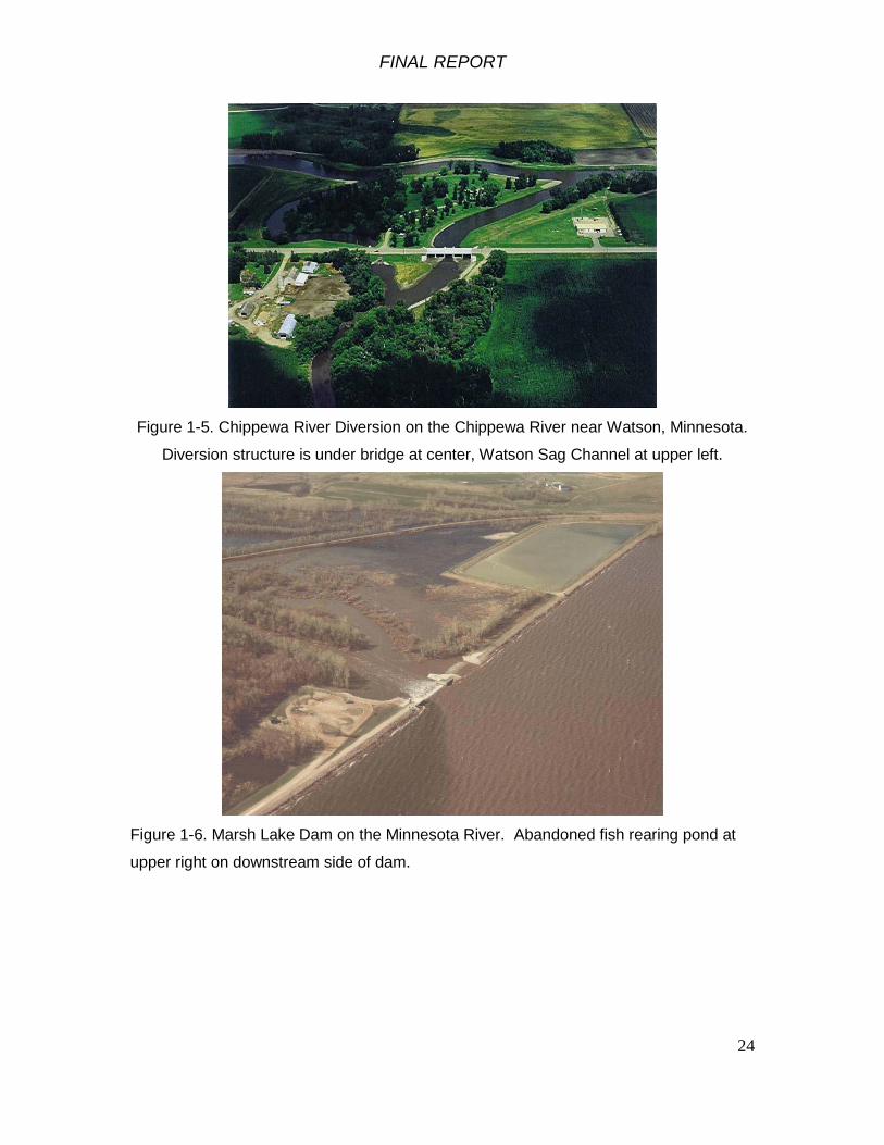
Figure 1-5. Chippewa River Diversion on the Chippewa River near Watson, Minnesota.
Diversion structure is under bridge at center, Watson Sag Channel at upper left.
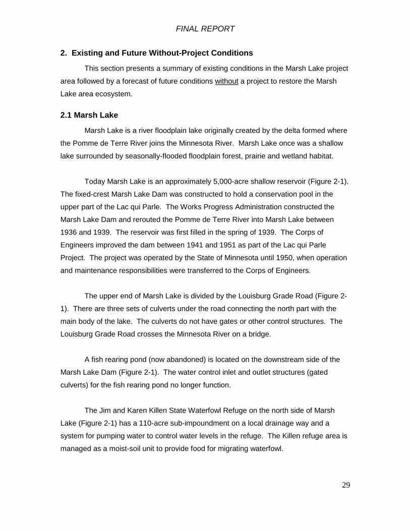
Figure 1-6. Marsh Lake Dam on the Minnesota River. Abandoned fish rearing pond at
upper right on downstream side of dam.

FINAL REPORT
25
Table 1-1. Pertinent data about Lac qui Parle and Marsh Lake.
Lac qui Parle Dam Concrete dam 237 ft long with 4 17 ft-wide bays: Bay
2 with 3 4 ft x 4 ft vertical lift gates for low flow
regulation. Bays 1, 3, 4 with 2 6 ft x 8 ft vertical lift
gates. Spillway with crest at 934.2 ft and 8 17-ft wide
bays. Bays 5, 6, and 7 are uncontrolled. Bays 8
through 12 have moveable steel bulkheads. Dam is
32 ft high. Emergency spillway 2500 ft long surfaced
roadway
Lac qui Parle Conservation pool elevation 933.0 ft in summer,
934.0 in fall and winter.
Full pool elevation 941.1 ft
Reservoir area at conservation pool 7700 acres
Maximum depth 17 ft
Marsh Lake Dam 11,800 ft-long rolled earth dam
112 ft – long concrete overflow spillway crest
elevation 937.6 ft (not an operable spillway)
2 ft x 2 ft vertical lift gate low flow outlet sill at 932.6 ft
90 ft long emergency spillway with crest at 940.0 ft
Marsh Lake Reservoir Conservation pool elevation 937.6 ft
Full pool elevation 941.5 ft
Reservoir area at conservation pool 5,000 acres
Modifications to River Regulation at the Lac qui Parle Project The water control plan (USACE 1995) for the Lac qui Parle Project describes low
flow, routine, and flood control regulation of the project. The water control plan provides
a history of river regulation at the project.

FINAL REPORT
26
Following completion of the Lac qui Parle dam in 1939, the conservation pool
was set at 934.2 feet year-round. The State of Minnesota lowered the conservation pool
elevation to 932.0 ft in 1946 in an effort to provide more flood water storage. Following
meetings with stakeholders the conservation pool elevation was reset to 932.1 ft that
same year.
The project was transferred to the Corps of Engineers in 1950 and a spring
drawdown to 926.0 ft was adopted. Starting in 1968, the pool was raised in the fall to
934.2 ft from 15 October to 15 November and held there over winter to help prevent fish
kills. The spring drawdowns to 931.2 ft or lower were done between 15 January and 15
March. In 1970 the regulation plan was changed to start the fall pool rise on 1 August.
In 1979 the summer conservation pool elevation was changed to a band between
932.75 and 933.0 ft. In 1982 the spring drawdown period was changed to 21 February to
10 March.
Following completion of a Reservoir Operating Plan Evaluation (USACE 1989),
the regulation plan for the Lac qui Parle project was changed to reduce the duration of
high stages on the reservoir and to reduce flood damages downstream. The current
plan has a summer conservation pool elevation of 933+/- 0.2 ft and a fall and winter pool
level of 934.0 +/- 0.2 ft. The spring drawdown occurs from 1 March to 15 March.
The Marsh Lake dam does not have an operable spillway. It is a fixed-crest dam
with a crest elevation of 937.6 ft. A two-foot gated box culvert low flow outlet has a sill
elevation of 932.6 ft.
Existing Projects Upstream on the Minnesota River Big Stone Lake
Big Stone Lake is a 26-mile-long 12,610-acre natural floodplain lake at the
headwaters of the Minnesota River formed by the delta of the Whetstone River. A
stoplog water control structure was built by the State of Minnesota in the mid-1930s to
control the level of Big Stone Lake. The Whetstone River was diverted to discharge into
the Minnesota River between Big Stone Lake and the water control structure. The State
ceased operating the water control structure in 1947. The Big Stone Lake-Whetstone

FINAL REPORT
27
River Modification Project was authorized by the Flood Control Act approved 27 October
1965. The Big Stone Dam was replaced by the Corps of Engineers as part of the Big
Stone Lake-Whetstone River Flood Control Project. The new dam and channel
modifications were completed in 1985. The Upper Minnesota River Watershed District
owns and operates Big Stone Dam.
Highway 75 Dam Highway 75 Dam was constructed by the Corps of Engineers as part of the Big
Stone Lake-Whetstone River Flood Control Project and was completed in 1974 (Figure
1-7). The authorized project purposes are flood damage reduction and water
conservation. The Highway 75 Dam impounds approximately 5,000 acres of water. A
water control structure was included in the dam to allow manipulation of water levels in
the large wetland impoundment. Lands for the project were initially acquired by the
Corps of Engineers in 1971, and were then transferred to the U.S. Fish and Wildlife
Service in 1975. All the lands (11,115 acres) acquired by the Fish and Wildlife Service
were incorporated into the land base for Big Stone National Wildlife Refuge. The Corps
of Engineers operates and maintains the Highway 75 Dam
Figure 1-7. Highway 75 Dam on the Minnesota River.

FINAL REPORT
28
1.7.2 Prior Studies and Reports
Reports pertinent to the Marsh Lake ecosystem restoration project include those
listed in the References section below. The Corps conducted a number of studies to
identify solutions for reducing flood damages on the upper Minnesota River that led to
the Big Stone Lake – Whetstone River Project and the Lac qui Parle Project (USACE
1950, 1960, 1961, 1966). The Corps conducted a Reservoir Operating Plan Evaluation
(ROPE) study of the Lac qui Parle project and produced a report (USACE 1989) that led
to modifications of the reservoir operating plan. The Minnesota River Basin
Reconnaissance Study report (USACE 2004) was completed in December 2004 and
approved in January 2005. The Marsh Lake Ecosystem Restoration feasibility study was
recommended in that report.
This feasibility study and environmental assessment is not a supplement to an
earlier action. There have been only three National Environmental Policy Act (NEPA)
environmental assessments prepared about the Lac qui Parle project in recent years:
• Reservoir Operating Plan Evaluation (ROPE) Environmental Assessment, 1989.
• Long-Term Maintenance Dredging Plan of the Chippewa River and Chippewa River Diversion Channel Environmental Assessment, December, 2004
• Watson Sag Diversion Channel Levee Repair Environmental Assessment, September 2005.
There have been many studies of the hydrology, sediment movement, water
quality and aquatic habitat conditions in the Minnesota River Basin including USACE
(1969), Southern Minnesota Rivers Basin Commission (1977), Van Alstine (1987),
MPCA (1994), James and Barko (1995). A compilation of Minnesota River Basin data,
information, and reports is maintained by the Minnesota River Basin Data Center at
Mankato State University: http://mrbdc.mnsu.edu/
FINAL REPORT
29
2. Existing and Future Without-Project Conditions
This section presents a summary of existing conditions in the Marsh Lake project
area followed by a forecast of future conditions without a project to restore the Marsh
Lake area ecosystem.
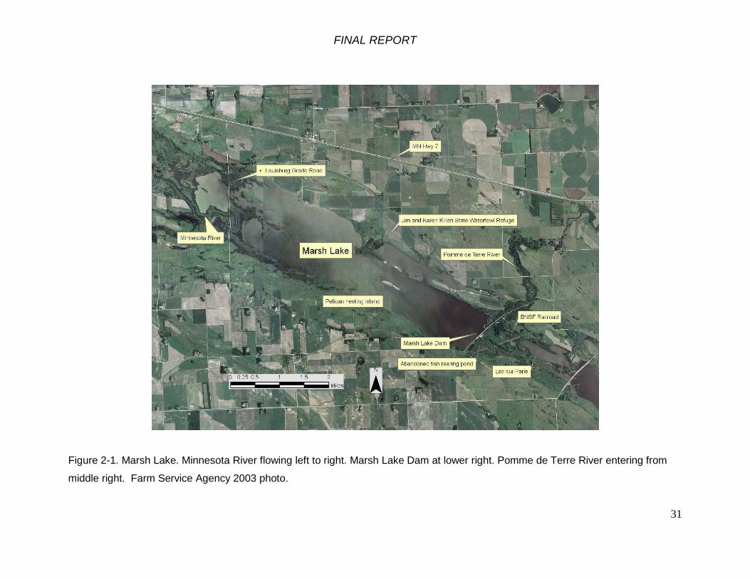
2.1 Marsh Lake
Marsh Lake is a river floodplain lake originally created by the delta formed where
the Pomme de Terre River joins the Minnesota River. Marsh Lake once was a shallow
lake surrounded by seasonally-flooded floodplain forest, prairie and wetland habitat.
Today Marsh Lake is an approximately 5,000-acre shallow reservoir (Figure 2-1).
The fixed-crest Marsh Lake Dam was constructed to hold a conservation pool in the
upper part of the Lac qui Parle. The Works Progress Administration constructed the
Marsh Lake Dam and rerouted the Pomme de Terre River into Marsh Lake between
1936 and 1939. The reservoir was first filled in the spring of 1939. The Corps of
Engineers improved the dam between 1941 and 1951 as part of the Lac qui Parle
Project. The project was operated by the State of Minnesota until 1950, when operation
and maintenance responsibilities were transferred to the Corps of Engineers.
The upper end of Marsh Lake is divided by the Louisburg Grade Road (Figure 2-
1). There are three sets of culverts under the road connecting the north part with the
main body of the lake. The culverts do not have gates or other control structures. The
Louisburg Grade Road crosses the Minnesota River on a bridge.
A fish rearing pond (now abandoned) is located on the downstream side of the
Marsh Lake Dam (Figure 2-1). The water control inlet and outlet structures (gated
culverts) for the fish rearing pond no longer function.
The Jim and Karen Killen State Waterfowl Refuge on the north side of Marsh
Lake (Figure 2-1) has a 110-acre sub-impoundment on a local drainage way and a
system for pumping water to control water levels in the refuge. The Killen refuge area is
managed as a moist-soil unit to provide food for migrating waterfowl.

FINAL REPORT
30
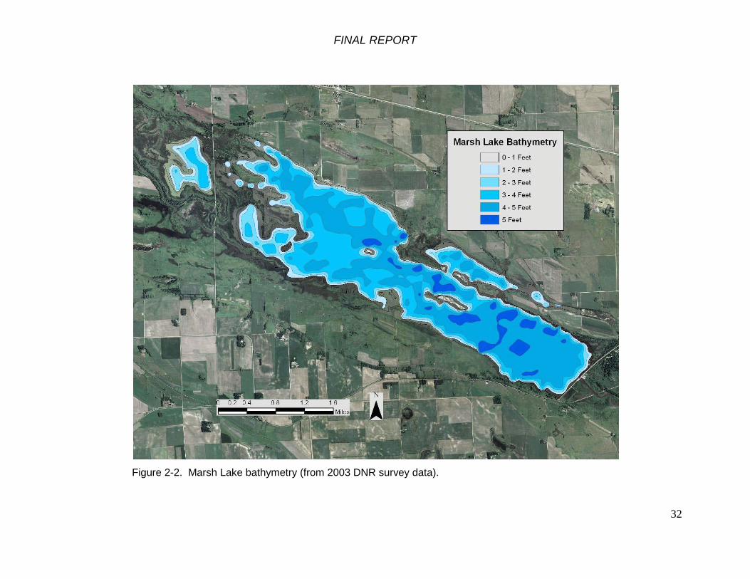
Average annual water level on Marsh Lake is 938.3 ft. The crest elevation of the
fixed crest spillway in the Marsh Lake Dam is 937.6 ft. Approximately 3,000 of the 5,000
acres of Marsh Lake are less than 3 feet deep when the lake is at the level of the fixed
crest spillway (Figure 2-2).
FINAL REPORT
31
Figure 2-1. Marsh Lake. Minnesota River flowing left to right. Marsh Lake Dam at lower right. Pomme de Terre River entering from
middle right. Farm Service Agency 2003 photo.
FINAL REPORT
32
Figure 2-2. Marsh Lake bathymetry (from 2003 DNR survey data).

FINAL REPORT
33
2.1.1 Marsh Lake Dam
The Marsh Lake Dam is an earth-fill structure 11,800 feet long with an average
top elevation of 950.0 feet (Figure 2-1). The service spillway is a concrete fixed-crest
overflow section 112 feet wide with a crest elevation of 937.6 feet. A grouted riprap
emergency spillway immediately southwest of the service spillway is 90 feet wide with a
crest elevation of 940.0 feet. The dam also has a 2-foot-square gated low flow outlet
conduit with a sill elevation of 923.6. Unlike the Lac qui Parle Dam downstream, the
Marsh Lake Dam cannot be operated to manage water levels in Marsh Lake (Figure 2-
2).
Figure 2-3. Marsh Lake Dam.
2.2 Hydrology
The hydrologic regime of the Upper Minnesota River Basin has been changed
markedly by conversion of prairie to cropland, extensive drainage of wetlands,
FINAL REPORT
34
expansion of the artificial drainage network for agriculture with ditches and subsurface
drains, and by impoundment and river regulation.
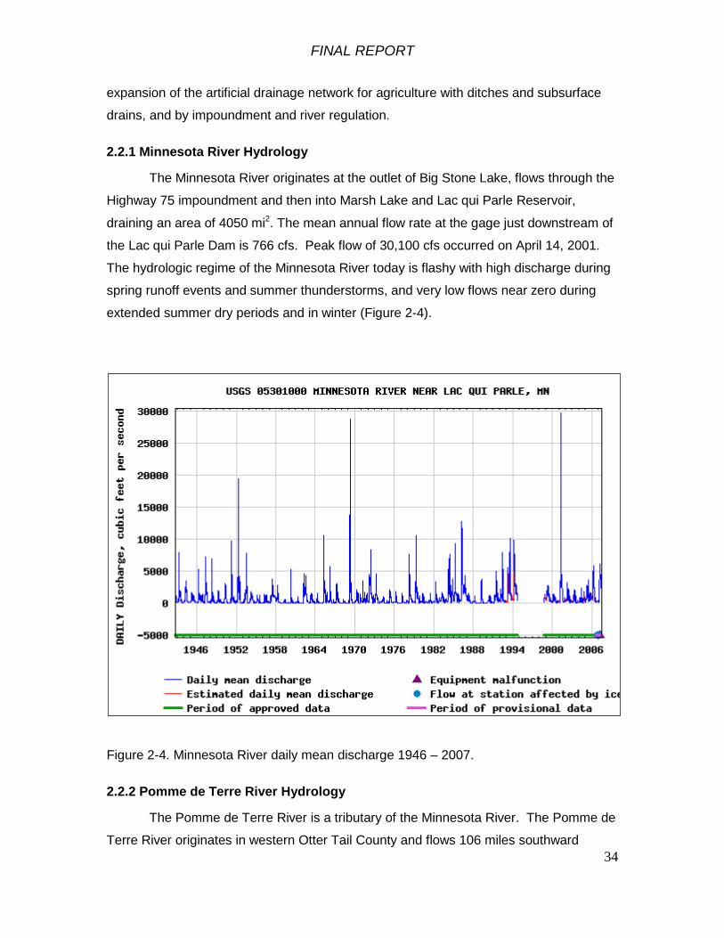
2.2.1 Minnesota River Hydrology
The Minnesota River originates at the outlet of Big Stone Lake, flows through the
Highway 75 impoundment and then into Marsh Lake and Lac qui Parle Reservoir,
draining an area of 4050 mi2. The mean annual flow rate at the gage just downstream of
the Lac qui Parle Dam is 766 cfs. Peak flow of 30,100 cfs occurred on April 14, 2001.
The hydrologic regime of the Minnesota River today is flashy with high discharge during
spring runoff events and summer thunderstorms, and very low flows near zero during
extended summer dry periods and in winter (Figure 2-4).
Figure 2-4. Minnesota River daily mean discharge 1946 – 2007.
2.2.2 Pomme de Terre River Hydrology
The Pomme de Terre River is a tributary of the Minnesota River. The Pomme de
Terre River originates in western Otter Tail County and flows 106 miles southward

FINAL REPORT
35
through the cities of Barrett, Morris and Appleton to its confluence with the Minnesota
River southwest of Appleton in Swift County. Most of the 875 mi2 watershed was
formerly prairie, but now row crop agriculture is the predominant land use on 81 percent
of the watershed. Many of the former wetlands and non-contributing areas in the
watershed have been drained. The total length of the stream network is 751 miles of
which 616 miles are intermittent streams and 134.6 miles are perennial streams. There
are a number of small dams in the watershed including a dam on the Pomme de Terre
River in Morris.
Table 2-1. Streams in the Pomme de Terre River watershed (USGS data).
Stream Name Total Stream Miles
Total Perennial Stream Miles
Total Intermittent Stream Miles
Artichoke Creek 2.7 0.0 2.7
Dry Wood Creek 10.1 3.2 6.9
Muddy Creek 31.5 11.1 20.4
Pelican Creek 12.4 12.4 0.0
Pomme de Terre River 105.9 105.9 0.0
Total Named Streams 162.6 132.6 30
Total Major Watershed Streams 750.7 134.6 616.1
The annual mean flow rate at Appleton during the 1936 – 2006 period of record
was 134 cfs. The highest flow rate was 8,890 cfs on April 7, 1997, and occurred in part
due to a dam failure at Appleton. Peak flows occur during spring runoff. Groundwater
base flow maintains river discharge at about 100 cfs much of the time. The river flow
occasionally ceases in winter and during extended periods of dry weather.
The lower part of the Pomme de Terre River was diverted into Marsh Lake when
the Marsh Lake Dam was constructed.

FINAL REPORT
36
Figure 2-5. Pomme de Terre daily mean discharge at Appleton 1936 – 2007.
2.2.3 Marsh Lake Hydrology
Marsh Lake (Figure 2-2) covers approximately 5000 acres at the project pool
elevation. The minimum project pool elevation, set by the fixed-crest Marsh Lake Dam,
is 937.6 ft. At the average annual water level of 938.3, Marsh Lake covers 6100 acres.
Water levels on Marsh Lake are characterized by rapid rises during spring runoff and
thunderstorm events (Figure 2-6).
Marsh Lake provides flood water storage. The stage on Marsh Lake is
dependent on inflow and outflow from the reservoir. The pool rises when inflow is higher
than outflow. High pool elevations in Lac qui Parle Reservoir can affect stages in Marsh
Lake by reducing the rate of outflow from Marsh Lake Dam.
Marsh Lake provides some flood damage reduction benefit because of the head
loss across the Marsh Lake Dam during high water events. Head losses through the

FINAL REPORT
37
Marsh Lake Dam during floods are quite variable but commonly about two feet. Head
losses of 4.7 and 1.2 feet were observed for the large 1997 and 2001 floods
respectively. The variability in head loss between Marsh Lake and Lac qui Parle is due
to the timing and magnitude of discharge from the inflowing rivers (Minnesota River,
Pomme de Terre River and Lac qui Parle River). The pool elevation of Marsh Lake is
always higher than on Lac qui Parle. The floodwater storage in Marsh Lake provides
some flood damage reduction benefits to downstream areas.
Because of the fixed crest Marsh Lake Dam, there is no 'normal pool' elevation.
The pool level is typically around elevation 938.3 feet with a tailwater of around 934.0
feet during normal non-flood conditions.
Figure 2-6. Marsh Lake stage hydrograph October 1, 1988 to October 1, 2008.

FINAL REPORT
38
2.2.4 Lac qui Parle Hydrology
Lac qui Parle reservoir covers approximately 7,700 acres at the conservation
pool elevation of 933.0 ft. As described for Marsh Lake, the stage hydrograph of Lac qui
Parle is flashy, with periods of high water during spring runoff and summer thunderstorm
events (Figure 2-7). The water control plan specifies discharge as necessary starting
March 1 to achieve a drawdown to elevation 933.0 ft by March 15. From March 16
through May 15, discharge inflow and hold pool elevation at 933.0 +/- 0.2 ft or discharge
the minimum flow of 20 cfs whichever is greater. From May 16 through August 31,
discharge inflow to hold the pool at 933.0 ft +/- 0.2 ft. Starting on September 1, raise the
pool to elevation 934.0 ft, and then hold this pool elevation through February.
During non-flood periods, the maximum release from Lac qui Parle Dam is 2500
cfs. During times when inflows are greater, the pool level rises. Maximum flood control
storage when Lac qui Parle is at 941.1 ft and Marsh Lake is at 941.5 ft is 162,000 acre-
feet.
Figure 2-7. Stage hydrograph of Lac qui Parle January 2000 through July 2007. Note the
summer water levels at elevation 934 and March drawdowns to elevation 933.0.

FINAL REPORT
39
2.3 Sediment Loading to Marsh Lake
Loadings of seston (suspended sediment and particulate organic matter) to
Marsh Lake generally increase in conjunction with higher Minnesota River flow. During
high inflow periods, the Minnesota River exhibited higher loading rates of suspended
sediment than the Pomme de Terre River (James and Barko 1995). During the 1991-
1992 June – September period studied by James and Barko (1995), the Minnesota and
the Pomme de Terre Rivers each contributed about 50 percent of the average daily
seston load to Marsh Lake. During the June-September period monitored in 1991, the
Minnesota River contributed 439,200 kg (473 tons) of seston and the Pomme de Terre
River contributed 378,200 kg (306 tons) of seston to Marsh Lake.
Based on suspended sediment monitored on the Chippewa River by the U.S.
Geological Survey (USGS) and adjusted for drainage area, the Pomme de Terre is
estimated to yield 19,161 tons/year, or 8.2 acre-feet of suspended sediment annually.
Under existing conditions, the Pomme de Terre River delivers its entire sediment load to
the Marsh Lake reservoir, where the bed load settles out and forms the delta at the
mouth of the river (Figure 2-8). A dam failure event on the Pomme de Terre River at
Appleton in 1997 mobilized a large volume of sediment, contributing to the delta in
Marsh Lake. Most of the suspended sediment delivered by the Pomme de Terre River
flows from the delta area along Marsh Lake Dam to the overflow spillway, where it enters
the Minnesota River at the upper end of Lac qui Parle.
The Minnesota River delivers little bed load sediment into Marsh Lake because
of the trapping effect of the Highway 75 impoundment upstream. Rates of total (bed load
and suspended) sediment loading and sediment accumulation in Marsh Lake have not
been measured.

FINAL REPORT
40
Figure 2-8. Pomme de Terre River delta where it enters Marsh Lake. Looking north from
the Marsh Lake Dam.
2.4 Wind-generated Waves and Sediment Resuspension on Marsh Lake
Marsh Lake is a 7-mile long lake oriented southeast to northwest in a windy area.
Wind fetch is the length of open water in the direction that the wind is blowing. Wind-
driven wave action on Marsh Lake can be powerful, resuspending bottom sediment and
causing shoreline erosion (James and Barko 1995)
James and Barko (1995) found that sediment resuspension was low in Marsh
Lake in 1991 when submersed aquatic vegetation was densely established. In 1992,
vegetation was almost completely absent and sediment was readily resuspended by
wind-driven wave action.
Storm inflows during the summer of 1991 and 1992 caused increases
in the pool elevation and thus the wave length required to resuspend the sediment

FINAL REPORT
41
surface. Mean daily wind velocities were generally lower during June through August,
further reducing the potential for sediment resuspension. In contrast, mean daily wind
velocities and sediment resuspension were generally greatest in Marsh Lake during the
late spring (i.e., May and early June) and the autumn (i.e., late August and September) of
both years.
Measurements taken by Barko and James (1995) indicated that high wind
velocities greater than 12 km/hr (7.5 mph) from any direction caused sediment
resuspension in Marsh Lake when it was unvegetated in 1992 (Table 2-2). In 1991
when the lake was vegetated, the critical wind speed for sediment resuspension was 20
km/hr (12.5 mph).
Export of resuspended sediment from Marsh Lake to Lac qui Parle Lake
occurred primarily when winds were blowing from the northwest toward the dam, with
maximums of around 150,000 kg/d (165 T/d). Wind set-up raises water level at the dam,
contributing to discharge of water and sediment over the fixed-crest dam. While
sediment resuspension occurred relatively frequently in Marsh Lake during 1992 (i.e., 32
percent of the time during the April through July growing season), discharge of
resuspended sediment occurred much less frequently (i.e., 15 percent) in 1991, due to
the role of wind direction and vegetation in regulating sediment resuspension and
discharges (Barko and James 1995).
A wind fetch model (Rhoweder et al. 2008) was applied to Marsh Lake to
simulate wind-driven waves and potential for sediment resuspension (Appendix J) The
wind fetch model incorporates the wind speed and direction data (Figure 2 – 8) and
simulates threshold wind speeds for sediment resuspension for different fetch lengths
and water depths. The wind fetch model simulates the shear force exerted on the lake
bed from rotational wave currents. Sediment is resuspended at relatively low wind
speeds when the wind direction is on the long axis of the lake, either from the northwest
or from the southeast (Figure 2-10).

FINAL REPORT
42
Figure 2-9. Wind direction and speed at Montevideo, Minnesota during April through July
1998 – 2007.
Table 2-2. Estimated percent of the Marsh Lake bed disturbed by wave action at various
wind speeds and directions in 1992 when Marsh Lake was unvegetated (from James
and Barko 1995).
Wind Speed km/h
Wind Direction NE SE SW NW
5 22 22 17 17
10 49 67 37 75
15 86 95 81 100
20 100 100 100 100
Wind Direction FrequencyMontevideo, MN
0
30
60
90
120
150
180
210
240
270
300
330
Wind Speed Duration CurveMontevideo, MN
0
5
10
15
20
25
0% 20% 40% 60% 80% 100%
Percent of Time Flow Was Equaled or ExceededAv
g Da
ily W
ind
Spee
d (m
ph)
Montevideo Station 1998-2007, April-July
James Data 1995 Report 1992 May-September

FINAL REPORT
43
Figure 2 – 10. Threshold wind speeds for sediment resuspension in Marsh Lake.

FINAL REPORT
44
2.5 Shoreline Erosion on Marsh Lake
Wind-driven wave action has eroded islands and shorelines on Marsh Lake. The
eroding shorelines are mostly in the northern part of the lake where wind fetch is the
greatest and where emergent plants are not present along the shoreline (Figure 2 - 11).
Several islands that were present following impoundment have been eroded away. The
large island used by nesting American pelicans has also been eroded. The rates of
shoreline erosion have not been measured.
On an October 2008 site visit, we examined many of the eroding shoreline areas
(Figures 2-12, 2-13). Marsh Lake has an abundance of large boulders in the lake bed,
a legacy from the Glacial River Warren and the granite outcroppings in the area. Wave
action and ice push has, over time, effectively rip-rapped and stabilized the eroding
shoreline areas. It does not appear that shoreline erosion on Marsh Lake will continue.
Figure 2 - 11. Eroding shorelines on Marsh Lake shown in red. The red dots in the
center are the locations where islands have eroded away.

FINAL REPORT
45
Figure 2-12. Eroding shoreline along the north side of Marsh Lake armored by native
boulders. October 9, 2008 photo.
Figure 2-13. Eroding shoreline on an island in Marsh Lake armored by native boulders.
October 9, 2008 photo.
FINAL REPORT
46
2.6 Water Quality
The Minnesota River, Marsh Lake and the Pomme de Terre River are usually
turbid with suspended sediment. Secchi disc transparency is typically less than one
foot.
According to accounts of early explorers, when the watersheds of the upper
Minnesota and Pomme de Terre Rivers were mostly covered with prairie, the rivers were
vegetated and ran clear (Waters 1977).
Today, the system receives considerable loading of sediments and the plant
nutrients nitrogen and phosphorus from the intensively row-cropped watershed.
Alteration of the stream drainage network by subsurface drain tiles, ditching and stream
channelization has altered the hydrology of tributaries to the Minnesota River, making
them more flashy and caused sediment to be mobilized from the bed and banks of the
tributaries.
The upper Minnesota River is alkaline, with total alkalinity generally over 250
mg/L. Sulfate concentrations are high, generally over 150 mg/L. These alkaline
conditions are characteristic of prairie water bodies in the region and influence the
species of plants and zooplankton that can grow in Marsh Lake.
The Minnesota River in Marsh Lake and Lac qui Parle are on the Minnesota
Pollution Control Agency's (MPCA) Section 303(d) Clean Water Act list of impaired
waters. The impairment shown on the 2006 list is for mercury, which prompted a fish
consumption advisory for walleye of not more than 1 meal per week for the general
population and not more than 1 meal per week of carp, northern pike, yellow perch and
walleye for women who are or may become pregnant and for children under 15 years of
age (Minnesota Department of Health 2008).
The Pomme de Terre River is on the MPCA's 2006 impaired waters list with
impairments by fecal coliform bacteria, fish IBI (index of biological integrity), mercury and
turbidity.

FINAL REPORT
47
The Minnesota Department of Health (2008) has issued fish consumption
advisories for the Minnesota River and the Pomme de Terre River because of mercury
contamination in fish. The current advisory cautions the general population to eat no
more than one meal per week of walleye and not more than 1 meal per week of carp,
northern pike, yellow perch and walleye for women who are or may become pregnant
and for children under 15 years of age.
Dissolved oxygen in the Minnesota River, the Pomme de Terre River and Marsh
Lake is usually higher than the standard of 5 mg/l for protection of aquatic life. In the
winter during ice and snow cover, Marsh Lake becomes hypoxic with low dissolved
oxygen levels. The low winter dissolved oxygen levels are a significant stressor on fish
in Marsh Lake. The Pomme de Terre River may provide dissolved oxygen refugia for
fish in Marsh Lake during winter. Winter fish kills occurred historically in Marsh Lake
prior to impoundment (Moyle 1941). There have not been significant fish kills in Marsh
Lake since one winter in the early 1990’s when large numbers of common carp were
killed (Chris Domeier, DNR Fisheries, Ortonville, MN, personal communication
December 2010).
Chlorophyll a concentration is a measure of active green plant pigment that
indicates the biomass of algae in fresh water. Chlorophyll a is essential to
photosynthesis and is the primary basis for primary production by algae. Primary
production in most lake ecosystems is dominated by planktonic algae. Benthic (attached
to the bottom) algae, submersed and emergent aquatic plants and terrestrial vegetation
also contribute organic matter to lake ecosystems. High concentrations of chlorophyll a
in lake water indicates high planktonic algal biomass and eutrophic conditions. Many
lakes and rivers in the Minnesota River Basin are eutrophic with high concentrations of
chlorophyll a due to phosphorous loading from non-point sources.
The combination of algae, non-living particulate organic matter, dissolved solids
and inorganic suspended sediment reduces light penetration into the water and primary
production by submersed aquatic plants and benthic algae.
James and Barko (1995) reported that algal biomass in Marsh Lake represented
by chlorophyll a concentrations appeared to be affected by high wind velocities during

FINAL REPORT
48
both 1991 and 1992. Chlorophyll a concentrations increased substantially (i.e., > 50
ug/L) during high winds in September of both years, coinciding with concomitant
increases in total phosphorus (P) concentrations in the water column. In contrast,
chlorophyll a concentrations were lower, less than 50 ug/L during the calmer summer
months of both years.
Available Corps of Engineers water quality monitoring records for Marsh Lake
documented chlorophyll a concentrations (Figure 2-14) ranging from approximately
0.015 to 0.1 mg/l (15 to 100 ug/l) during summer conditions in 2000 through 2003. Most
of the measured chlorophyll a concentrations in Marsh Lake during that time were within
the 25th to 75th percentile range for lakes in the Western Corn Belt Plains ecoregion
(Berry and German 1999).
Figure 2-14. Chlorophyll a concentrations in Marsh Lake during the summers of 2000
through 2003. U.S. Army Corps of Engineers water quality monitoring data.
FINAL REPORT
49
2.7 Historic and Cultural Resources
Previous cultural resources investigations at Marsh Lake include a 1993 survey
of Corps fee title and leased lands at Marsh Lake Dam (Ollendorf and Mooers 1994a), a
1993 survey of one potential bank protection area on the north side of Marsh Lake
(Ollendorf and Mooers 1994b), a 1998 survey of flowage easement lands along the
south side of Marsh Lake between Marsh Lake Dam and the Louisburg Grade Road
(Kolb et al. 1999), and a 1999 survey of Marsh Lake flowage easement lands between
Louisburg Grade Road and Highway 75 Dam (Harrison 2000).
Minnesota Department of Natural Resources (DNR) archeologists conducted
cultural resources surveys of small areas of DNR-administered lands (Marsh Lake Wild
Management Area) surrounding Marsh Lake in 1996 and 2002 to 2008 (Emerson and
Magner 2002:71-73; 2003:33-36; 2004:107-110; 2005:33-35; Magner et al. 2007:94-97;
Magner and Allan 2008:133-138; Skaar 1997).
In 2008, Minnesota Department of Natural Resources archeologists conducted a
Phase I cultural resources survey of areas specifically connected with the proposed
Marsh Lake ecosystem restoration project along the pre-dam Pomme de Terre River
channel both above and below the Marsh Lake dam embankment, at three proposed
cutoff dike locations above the dam embankment; and at six potential lakeshore and
island shoreline reaches where bank protection was proposed (Magner 2008). The
proposed bank protection measures have since been dropped from the ecosystem
restoration project due to natural armoring of the shorelines with rocks and cobbles that
have eroded out of the soils in these areas.
Known cultural resources sites at Marsh Lake include the Marsh Lake Dam itself
(SW-APT-003), as well as two prehistoric archeological sites (21LP33, 21BS67) and one
prehistoric and historic archeological site (21BS35) between Marsh Lake Dam and the
Louisburg Grade Road, and six prehistoric archeological sites (21BS41, 21BS43,
21BS44, 21BS45, 21BS46, 21LP36), one prehistoric and historic archeological site
(21BS47), and two historic archeological sites (21BS42 and Area J Granite Quarry)
between the Louisburg Grade Road and the Highway 75 Dam upstream. Sites 21BS41,
21BS42, 21BS43, 21BS44, 21BS45, and 21BS46 have been determined not eligible to
the National Register of Historic Places (Minnesota SHPO letter dated January 16,
FINAL REPORT
50
2002). Sites 21LP33, 21LP36, 21BS47, 21BS67 and the Area J Granite Quarry need
further testing and research to determine their National Register eligibility.
Marsh Lake Dam (SW-APT-003) was determined individually eligible to the
National Register of Historic Places in 1994 as part of the Lac qui Parle Flood Control
Project, a flood control and water conservation system consisting of the Lac qui Parle
Dam, the Marsh Lake Dam, and the Chippewa River Diversion. The Lac qui Parle
Project was constructed as a Works Progress Administration (WPA) project under the
sponsorship of the State of Minnesota beginning in 1936. It was one of the most
extensive work projects of its kind undertaken by the State and the largest flood control
project at the time of construction. Marsh Lake Dam is eligible for inclusion on the
National Register under Criterion A for its association as a WPA project of the Federal
Relief Programs following the Great Depression of 1929. Marsh Lake Dam consists of
three contributing structures and one contributing object: the 1939 dam and
embankment with a concrete fixed-crest main spillway and a grouted-riprap auxiliary
spillway, two 1939 concrete stage recorder houses on the downstream side of the
northeast embankment and the upstream side of the southwest embankment, and a rock
with a plaque describing the intentions of the entire Lac qui Parle Flood Control Project.
Marsh Lake Dam retains its integrity of original location, design, setting, materials,
workmanship, feeling and association. While the Corps has added a metal structure to
the upstream side of the northeast embankment in the 1970s and made emergency
repairs to the grouted riprap overflow spillway in 1999, these minor repairs do not impact
on the integrity of the structure.
2.8 Natural Resources
2.8.1 Climate
The climate is continental, with cold dry winters and warm wet summers.
Average annual precipitation is 24 to 26 inches with two thirds normally falling in the five
months from May through September. Average annual runoff is estimated at 1-2 inches.
Average monthly temperatures recorded at Madison range from 12.40 F in Jan., to 68.80
F in July.

FINAL REPORT
51
2.8.2 Land Use and Land Cover
Land use in the study area is primarily agricultural use and state-owned wildlife
management area. Land cover within the study area is primarily emergent wetland
vegetation, open water, agricultural cropland, pasture and hay, grassland, woody
wetlands and deciduous forest (Figure 2-15, Table 2-3). The emergent wetland
vegetation is largely single-species stands of reed canary grass (Phalaris arundinacea)
and cattail (Typhus spp.) except in the upper end of Marsh Lake west of the Louisburg
Grade Road.

FINAL REPORT
52
Figure 2 -15. Land cover and land use in the Marsh Lake project area (Minnesota DNR 2001 data). Dark line is the study area
boundary.

FINAL REPORT
53
Table 2-3. Land use and land cover classes within the Marsh Lake study area.
Acres Land Use/Land Cover Class5584 Open Water475 Developed, Open Space 22 Developed, Low Intensity 6 Developed, Medium Intensity
82 Barren Land 217 Deciduous Forest 636 Grassland/Herbaceous
1891 Pasture/Hay 4288 Cultivated Crops1325 Woody Wetlands
12391 Emergent Herbaceous Wetlands
2.8.3 Marsh Lake Ecosystem State
Figure 2-16. Conceptual model of the Marsh Lake ecosystem.

FINAL REPORT
54
Shallow freshwater lakes are complex ecosystems. The ecosystem state of
shallow lakes can shift from vegetated with clearer water and a mixed fish community to
a turbid un-vegetated state dominated by blue-green algae blooms and bottom-feeding
fish (Scheffer, 1998).
Figure 2-16 is an illustrative conceptual model of the Marsh Lake ecosystem. In
a clear-water, vegetated state in the lake (on left in Figure 2-16), submersed aquatic
plants dominate, providing food for migratory waterfowl, sheltering zooplankton and
supporting a diverse fish community. The clearer water conditions and a diverse fish
community support fish eating birds that rely on sight to prey on fish. White pelicans nest
on islands in Marsh Lake where they are protected from predators and they forage
widely for fish.
With increased loading of nutrients (nitrogen, phosphorus; N and P at left in the
conceptual model), excessive algae grows on the leaves of submersed aquatic plants
and limits their growth. Increased nutrient loading also supports planktonic algae
blooms that limit light penetration into the water and further reduce submersed aquatic
plants. As submersed aquatic plants become sparse, they no longer suppress wave
action, allowing wind-generated waves to resuspend bottom sediment, further reducing
light penetration into the water. Common carp thrive in turbid lakes and further reduce
submersed aquatic plants by grazing and resuspending sediment. The turbid ecosystem
state can persist for many years.
Drivers that can shift the ecosystem state back to the clear water vegetated
condition include lower lake levels, reduced sediment loading, reduced nutrient loading,
reduced wind fetch, sediment resuspension, and reduced carp populations.
Further explanation of historic, existing and forecasted future ecosystem
conditions in Marsh Lake are provided in the sections that follow.
FINAL REPORT
55
2.8.4 Historic and Recent Conditions in Marsh Lake
Immediately after construction of the Marsh Lake Dam, Marsh Lake had good
habitat with extensive stands of submersed and emergent aquatic vegetation (Moyle
1941), but the aquatic and riparian ecosystems have degraded over the last 68 years.
Today Marsh Lake is a shallow, turbid environment (about 3,000 of 5,000 acres
are less than 3 feet deep). Because the Marsh Lake Dam has a fixed crest and is not
operable, the continuous minimum water surface has disrupted natural flooding and
drying cycles. As a result, emergent aquatic plants that require exposed mudflat
conditions to germinate from seed have declined in the lake. Reduced stands of
emergent plants have increased the wind fetch. Wind induced wave action and non-
native carp resuspend sediments, blocking sunlight and reducing opportunity for
submersed aquatic plant growth (Figure 2-16). Wave action has eroded the shoreline,
islands and points where emergent plants used to grow.
Aquatic plants and many other life forms in floodplain rivers like the Minnesota
River are adapted to characteristic annual changes in flow and water levels (Junk et al.
1989, Bayley 1995).
2.8.5 Aquatic Vegetation
Aquatic plants are important components of the river ecosystem. Aquatic plants
provide food and habitat for macroinvertebrates, fish and wildlife. They are a major
source of primary production in the river system. Epiphytic algae grow on aquatic
plants, providing another important source of primary production. Aquatic plants provide
food for furbearers and food and habitat for macroinvertebrates, which in turn provide
food for fish and birds. Aquatic plants cycle nutrients between the sediment and the
water. Aquatic plants remove suspended sediment from the water, anchor substrate,
attenuate wave action and reduce sediment resuspension. Aquatic plants remove
nitrogen from the water and promote denitrification (conversion of nitrate and nitrite to
nitrogen gas). Aquatic plants inhibit growth of planktonic algae, resulting in clearer water
that favors sight-feeding fishes. Aquatic plants form patches of different habitat types
needed by many fish and wildlife species. Aquatic plants provide a major source of food
for migrating waterfowl. Aquatic plants contribute to the scenic beauty of the river.

FINAL REPORT
56
Perennial Emergent Aquatic Plants
Perennial emergent aquatic plants like arrowhead, bulrush, cattail, and rice
cutgrass can grow vegetatively for years from their root systems. Extended periods of
high water, grazing by muskrats and waterfowl, ice and wind-driven wave action reduce
the abundance of perennial emergent aquatic plants over time. In years with low
summer water levels, perennial emergent aquatic plants have opportunity to germinate
from seed in dewatered mud flats. The new plants grow to full size over the course of a
couple growing seasons. Extensive stands of emergent aquatic plants are re-
established and can persist for years.
Prior to impoundment, the Marsh Lake area was a frequently inundated and
dewatered low floodplain with perennial smartweed (Polygonum sp.), reed canary grass
(Phalaris arundinacea) and slough grass (Spartina pectinata). Following impoundment
in 1937, in 1941 the emergent perennial plants around Marsh Lake included river
bulrush (Scirpus fluviatalis), common cattail (Typha latifolia), narrow-leafed cattail
(Typha angustifolia), wild millet (Echinochloa crusgalli), bur reed (Sparganium
urycarpum), slough grass (Spartina pectinata), softstem bulrush (Scirpus validus), and
giant reed grass (Phragmites australis) (Moyle 1941).
Historic aerial photography was interpreted by the Minnesota DNR to quantify the
extent of emergent aquatic vegetation in Marsh Lake. The 1988-1989 droughts caused
low water levels in Marsh Lake that enabled emergent aquatic plants to germinate in the
dewatered areas of the lake bed. In 1991 there were 1574 acres of emergent aquatic
plants around the periphery of Marsh Lake (Figure 2-17). After a number of years of
stable and higher water levels and the flood year of 1998 when Marsh Lake water levels
were very high, the extent of emergent aquatic plants on Marsh Lake declined to 1032
acres (Figure 2-18).

FINAL REPORT
57
Figure 2-17. Emergent aquatic vegetation covering 1571 acres in Marsh Lake in
1991, interpreted from aerial photography by the Minnesota DNR.
Figure 2-18. Emergent aquatic vegetation in Marsh Lake covering 1032 acres in
1999, interpreted from aerial photography by the Minnesota DNR.
FINAL REPORT
58
Years of maintaining a minimum water level on Marsh Lake has caused
emergent perennial aquatic plants to decline in extent, diversity and abundance. Today,
the perennial emergent plant community is dominated by a narrow band of hybrid cattail
with occasional river bulrush with a band of dense reed canary grass on the landward
side around the periphery of the lake.
Submersed Aquatic Plants
Submersed aquatic plants require underwater light to thrive. In years of extended
high water and turbid conditions, the submersed aquatic plants in Marsh Lake are nearly
absent. In rare years with lower spring and summer water levels and little wind-driven
sediment resuspension, more light reaches the bottom and submersed aquatic plants
have the opportunity to grow.
Low summer water levels dewater sand bars and mud flats, oxidizing and
consolidating sediment. Upon reflooding, the consolidated sediment is more resistant to
resuspension by wind-driven wave action. Decomposition of organic matter in dewatered
sediment releases nutrients for plant growth.
Submersed aquatic plants in Marsh Lake have varied markedly in abundance
from one year to another. Following impoundment, Moyle (1941) reported that in 1941,
approximately 10 percent of the area of Marsh Lake had submersed aquatic plants.
Sago pondweed (Stuckenia pectinatus) and coontail (Ceratophyllum demersum) were
the most common species. In 1991, Marsh Lake had near-complete coverage with
sago pondweed, but it was not present in 1992 (James and Barko 1995).
Sago pondweed is the dominant submersed plant (Table 2-4) in Marsh Lake due
primarily to its ability to withstand a wide range of turbidity levels compared to other
submersed macrophytes (Stuckey 1971). Sago pondweed produces tubers that are an
important food source for migrating diving ducks and geese in the fall. Sago pondweed
frequency of occurrence in Marsh Lake can vary markedly. In 2002, 72.2% of the
stations sampled (n=277) recorded sago pondweed whereas in 2007, only 11.5%
(n=165) recorded sago pondweed (Table 2-4).

FINAL REPORT
59
When sago pondweed is abundant (e.g. 2002, Fig. 2-19), plant distribution is
throughout the entire lake even in the deepest water zones. In years of limited
abundance (e.g. 2007, Fig. 2-20), plant distribution is restricted to protected bays and
shallow water zones on Marsh Lake. James and Barko (1995) documented the positive
role sago pondweed can have on reducing sediment resuspension by dampening wave
action on Marsh Lake.
Aside from sago pondweed, submersed aquatic plant diversity is extremely low
and other species were limited to a few individual plants found only in the most protected
bays and shallow water zones on Marsh Lake (Table 2-2, Fig. 2-20). The primary
factors limiting overall submersed aquatic plant abundance in Marsh Lake appears to be
high spring and summer water levels, abnormal timing and magnitude of water level
fluctuations, wind-driven wave-induced sediment resuspension limiting underwater light
and grazing by common carp.
A bioenergetics plant growth model (POTAM) for sago pondweed was used to
simulate existing and with-project conditions for submersed aquatic plant growth in
Marsh Lake (Appendix J). Using information on wind speed, wind direction, water
depth, experiments to determine the critical shear stress for Marsh Lake sediment
resuspension, and application of the POTAM plant growth model indicate that current
conditions in Marsh Lake do not allow the persistence of sago pondweed. The
availability of underwater light is the primary limiting factor.

FINAL REPORT
60
Table 2-4. Frequency of occurrence of submersed aquatic plants in Marsh Lake, 1962-
2007. MN-DNR Wildlife Lake Habitat and Game Lake Survey Reports.
Species Frequency of Occurrence %
1962 1968 2002 2004 2007
Sago pondweed 46.0 37.0 72.2 22.4 11.5
Coontail (Ceratophyllum
demersum) 4.0 1.0 3.6 0.6 1.2
Greater bladderwort
(Utricularia vulgaris)
0.6
Leafy pondweed
(Potamogeton foliosus) 9.0
Illinois pondweed (P.
illinoensis) 2.0
Narrowleaf pondweed (P.
strictifolius) 2.0
Narrowleaf pondweed group
(P. NL spp.)
0.7 0.6

FINAL REPORT
61
Figure 2-19. Distribution of submersed vegetation in Marsh Lake, 2002. Minnesota
DNR survey data.
Figure 2-20. Distribution of submersed vegetation in Marsh Lake, 2007. Minnesota
DNR survey data.

FINAL REPORT
62
Annual Emergent Aquatic Plants
Annual emergent aquatic plants also germinate from seed in mudflats dewatered
during low water periods during the growing season. These plants grow rapidly, provide
food and shelter for wildlife, and then die at the end of the growing season. The
senescent plants provide an abundance of organic matter for zooplankton, which in turn
provide food for small fish.
Prior to impoundment, the frequently inundated low floodplain that became
Marsh Lake supported extensive areas of "rank herbaceous vegetation" of annual
emergent aquatic plants, including smartweed (Polygonum spp.), nut grass (Cyperus
spp.) and sticktight (Bidens spp.) (Moyle 1941). Following impoundment in 1937, Moyle
(1941) reported that because of little fluctuation in water levels, the margin of Marsh
Lake was taken over with mostly perennial emergent aquatic plants.
Today, sparse annual emergent aquatic plants occur around the edges of Marsh
Lake. Their extent and abundance varies with water level fluctuations during the growing
season.
2.8.6 Fish Community
The Minnesota River and its tributaries support a diverse native fish community.
The DNR found 25 fish species during a 2006 survey of Marsh Lake, using gill nets and
trap nets for adult fish, and fine mesh trap nets for young-of-year and small fish
(Minnesota DNR 2006).
Common carp are the most abundant fish in Marsh Lake, dominating the
community by both numbers and biomass (Tables 2-5 and 2-6). Common carp were
brought from Europe to the U.S. in 1831 and invaded the Minnesota River by the late
1800s. Carp have fluctuated in abundance between 62 per 24-hour gill net set in 2000
to a low of 3.7 per gill net in 1997. The 2006 catch was 28.5 carp per gill net. These
catch rates for carp are considerably higher than in other similar lakes in Minnesota.

FINAL REPORT
63
Table 2-5. Results of DNR 2006 gill net survey on Marsh Lake Community Community
No. Fish Composition (%) by Total Weight (lbs) Composition (%) byFish Species 6 Gill Net Sets Number 6 Gill Net Sets Weight
Bigmouth Buffalo 33 6.8 47 5.1Black Bullhead 39 8.0 9 1.0Black Crappie 27 5.5 7 0.8Brown Bullhead 24 4.9 16 1.7Channel Catfish 15 3.1 40 4.3Common Carp 171 35.0 629 67.9Freshwater Drum 16 3.3 16 1.7Northern Pike 30 6.1 30 3.2Shorthead Redhorse 9 1.8 9 1.0Walleye 62 12.7 62 6.7White Bass 38 7.8 38 4.1White Sucker 19 3.9 19 2.0Yellow Bullhead 1 0.2 1 0.1Yellow Perch 4 0.8 4 0.4 Table 2-6. Results of DNR 2006 trap net survey on Marsh Lake.
Community Community No. Fish Composition (%) by Total Weight (lbs) Composition (%) by
Fish Species 15 Trap Net Sets Number 15 Trap Net Sets WeightBigmouth Buffalo 3 0.8 17.6 2.0Black Bullhead 31 7.8 3.3 0.4Black Crappie 35 8.8 14.8 1.7Bluegill 1 0.3 0.1 0.0Brown Bullhead 8 2.0 6.8 0.8Channel Catfish 2 0.5 2.2 0.3Common Carp 96 24.2 619.5 71.9Common Shiner 1 0.3 0.1 0.0Freshwater Drum 103 26.0 37.6 4.4Green Sunfish 1 0.3 0.1 0.0Northern Pike 22 5.6 80.6 9.3Orangespotted Sunfish 1 0.3 0.1 0.0Quillback 1 0.3 0.4 0.0Shorthead Redhorse 14 3.5 29.2 3.4Walleye 20 5.1 18.3 2.1White Bass 43 10.9 20.4 2.4White Sucker 3 0.8 6.1 0.7Yellow Bullhead 8 2.0 3.3 0.4Yellow Perch 3 0.8 1.7 0.2 Northern pike are moderately abundant, similar to other shallow lakes in
Minnesota. Some natural reproduction of northern pike in Marsh Lake was evident with
young-of-year in the fine mesh trap samples. Northern pike spawn in the upstream end
of Marsh Lake, in the extensive areas of emergent aquatic plants above the Louisburg
Grade Road.

FINAL REPORT
64
One and two-year-old walleye constituted most of the walleye catch. Previous
stocking studies using oxytetracycline tracer indicated that downstream migration of
walleyes stocked in Big Stone Lake contribute substantially (50 percent of the 2006 year
class) to the walleye population in Marsh Lake. Other game fish are low in abundance.
Yellow perch grow fast in Marsh Lake, reaching quality size for the sport fishery
(10 to 11 inches long) in three years. They have been historically abundant in Marsh
Lake but were not in 2006.
Habitat Connectivity and Fish Migrations
Lac qui Parle provides good habitat for native walleyes, northern pike, white bass
and white suckers but the Marsh Lake Dam prevents their access to prime spawning
areas in the Pomme de Terre River (walleyes, white bass, white suckers) and in the
upper end of Marsh Lake (northern pike) (Figure 2-21). The dam also prevents the
transport of native mussel glochidia (small larval stage mussels that temporarily
parasitize fish by attaching to their gills) from Lac qui Parle to the Pomme de Terre
River.
Figure 2-21. Conceptual model of blocked fish migration routes from Lac qui Parle into
Marsh Lake and the Pomme de Terre River.
FINAL REPORT
65
Fish persist in Marsh Lake despite hypoxic (low dissolved oxygen concentration
< 5 mg/l) conditions in winter and high turbidity and high water temperatures in summer.
In winters with little or no inflow from the Minnesota River and with ice and snow cover
preventing photosynthesis by algae, inflowing Pomme de Terre River water may provide
oxygen refugia for carp. Winterkill of fish historically occurred in Marsh Lake (Moyle
1941). Winter dissolved oxygen monitoring by the DNR has found periods of hypoxia,
but the last winter fish kill in Marsh Lake occurred in the early 1990s when dead carp
were found (Chris Dohmeier, DNR Fisheries, Ortonville MN, personal communication,
December 2010). The winter aquatic habitat conditions created by the diversion of the
Pomme de Terre River into Marsh Lake favors non-native carp over native northern pike.
Northern pike are more tolerant of hypoxic conditions than are carp.
2.8.7 Macroinvertebrates
The benthic macroinvertebrate community in Marsh Lake in 1990 was dominated
by chironomid and ceratopogonid midge larvae with some mayflies, caddisflies and
dragonflies (Montz 1990). Fingernail mussels (Sphaeriidae) are an important food for
fish and waterfowl. They were not present in Marsh Lake in 1990. A 1989 survey of the
Minnesota River Basin (Zischke et al. 1990) found that the macroinvertebrate community
in the Minnesota River downstream of Lac qui Parle dam was dominated by amphipods.
Very few insects were present.
The Pomme de Terre River supports a diverse macroinvertebrate community.
Invertebrates were collected by the Minnesota DNR from the Pomme de Terre River
over the period of June 25-July 1, 1991 using a kick-net. Samples were not quantified,
but invertebrates were identified and presence noted. Fingernail clams (order
Pelecypoda) were found at all stations and were the only invertebrates found at Station
6, located 32.8 miles from the mouth. In contrast, sampling of stations 2 and 7 found the
presence of six different insect orders. Insect larvae were most abundant in areas with
coarser substrates such as gravel or rubble. Additional species collected from the river
outside of specific sampling stations included a snail from the genus Ferrissia, the leech
Placobdella parasitcia, and a stonefly from the family Pteronarcidae. The most
abundant insect larvae were mayflies (order Ephemeroptera.)

FINAL REPORT
66
2.8.8 Mussels
The Minnesota DNR conducted mussel surveys of Marsh Lake and the Pomme
de Terre River in 2007 and 2010. A detailed report of the DNR mussel surveys is
provided in Appendix Q. Only one live mussel was found in Marsh Lake, a pink
heelsplitter (Potamilus alatus), a species adapted to living in soft substrate.
A diverse and abundant mussel community was found in the lower Pomme de
Terre River. The river mussel community there is dominated by threeridge (Amblema
plicata). The survey results suggest the river has a regionally significant assemblage of
freshwater mussels as compared to the Minnesota River Basin as a whole. Abundance
of mussels in the Pomme de Terre River, in terms of qualitative search catch per unit
effort (CPUE, mussels/hour), was substantially higher than in the Minnesota River main
stem or elsewhere in the entire Minnesota River Basin. The Pomme de Terre River also
has regionally significant populations of elktoe (Alasmidonta marginata - MN
Threatened), black sandshell (Ligumia recta - MN Special Concern) (Figure 2-22), three
ridge (Amblema plicata), and Wabash pigtoe (Fusconaia flava), as these are the largest
populations of these species in the entire Minnesota River system, based on statewide
mussel survey data collected to date. The highest densities of mussels were found at
stations in the diverted reach of the lower Pomme de Terre River just upstream of Marsh
Lake.
No invasive zebra mussels (Dreissena polymorpha) have been found the project
area.

FINAL REPORT
67
Figure 2-22. State-listed mussels from the lower Pomme de Terre River, August 2007.
Minnesota DNR photo.

FINAL REPORT
68
Table 2-7. Mussels found in Marsh Lake and the Lower Pomme de Terre River during an August 2007 survey. Minnesota DNR data.
Species Common Name MN Listing Status Marsh Lake 2136 2137 3042 3034 2138 2135 3035
Alasmidonta marginata elktoe threatened 2 2Amblema plicata threeridge unclassified 461 153 63 46 7 14 1Fusconaia flava Wabash pigtoe unclassified 26 14 17 1 2 7Lampsilis cardium plain pocketbook unclassified 39 49 147 76 25 20 3Lampsilis siliquoidea fat mucket unclassified 52 3 30 7 15 1Lasmigona complanata white heelsplitter unclassified 4 8 2 2 1 5 1Leptodea fragilis fragile papershell unclassified 5 5 5 2 8 4 1Ligumia recta black sandshell special concern 9 4 28 9 5 13Potamilus alatus pink heelsplitter unclassified 1 9 4 4 6 7 9Pyganodon grandis giant floater unclassified 2 1 1Quadrula quadrula mapleleaf unclassified 1Strophitus undulatus creeper unclassified 1 1 6 1 1 1Truncilla truncata deertoe unclassified 53 41 23 9 104 9 2
Total number live mussels 1 609 331 292 187 171 100 10Number of sites sampled 3 1 1 1 1 1 1 1Avg. CPUE (mussels/hr) 0.7 365.4 220.7 116.8 83.1 60.4 44.4 6.7
Lower Pomme de Terre RiverDiversion Reach Upstream of Diversion Reach

FINAL REPORT
69
2.8.9 Wildlife
The Marsh Lake project area lies within the 32,990-acre Lac qui Parle Wildlife
Management Area, managed by the Minnesota DNR. The adjacent 11,521-acre Big Stone
National Wildlife Refuge is upstream and is managed by the U.S. Fish and Wildlife Service. The
Nature Conservancy owns two preserves adjacent to the Lac qui Parle Wildlife Management
Area totaling 2,436 acres. Together these three natural areas provide over 46,000 acres of
protected wildlife habitats in the upper Minnesota River valley.
The habitat is a diverse mixture of shallow lakes, prairie potholes, cattail marshes, native
prairie grasslands - some of the largest remaining in west-central Minnesota – restored
grasslands, old field habitats, floodplain forests, rock outcrops, and cropland. This habitat
diversity supports a rich assemblage of animal species.
Birds
The Audubon Society has recognized the Lac qui Parle – Marsh Lake – Bigstone Refuge
area as an Important Bird Area of national significance. The upper Minnesota River valley is
located in one of the most heavily traveled duck migration corridors in the United States
(Bellrose 1976). Most migrants originate from Alberta, Manitoba, North Dakota, and Minnesota,
but others come from subarctic and arctic-nesting grounds in western Canada and Alaska.
Waterfowl (Geese) – the Lac qui Parle Wildlife Management Area has the largest
concentration of migrating Canada geese in the state. In November, as many as 120,000 to
150,000 Canada geese use the State Game Refuge at one time, accounting for over 800,000
goose-use days (September – December; MN-DNR, unpublished data). Canada goose use of
Marsh Lake peaks at around 5,000 to 10,000 during this time period. Approximately 65% of
these geese are from the Eastern Prairie Population, which nests near the southwestern shore
of Hudson Bay and traditionally wintered on or near Swan Lake National Wildlife Refuge in
Missouri. The Canada geese are accompanied by smaller flocks of snow, cackling, and white-
fronted geese. Ross’s geese are uncommon visitors.
Waterfowl (Ducks) – Blue-winged teal, mallard, and wood duck are the most abundant
breeding ducks. The ruddy duck is the most common nesting diving duck, but secure nests
sites are limited due to fluctuating water levels. Blue-winged teal, green-winged teal, mallard,

FINAL REPORT
70
and wood duck are the most common puddle ducks early in the fall migration. American
wigeon, gadwall, northern shoveler, and pintail are common but tend to be less abundant.
Mallard numbers build as the fall progresses reaching a peak in mid-November while
other puddle duck numbers decline. Counts of peak mallard numbers normally range between
40,000 to 80,000+ between the Lac qui Parle Wildlife Management Area and Big Stone National
Wildlife Refuge. This large concentration of migratory waterfowl lasts for a week or two and is
not related to food resources within the Big Stone National Wildlife Refuge, Marsh or Lac qui
Parle Lakes, but is due to the security from predators that these large water bodies provide.
The large flocks of migratory waterfowl feed on waste grain in surrounding agricultural fields and
roost at night on the lakes. This fact is further borne out by weekly waterfowl surveys on Marsh
Lake held in October 2006 and 2007, which documented mallard and teal numbers averaging
<500 birds each. However, on an adjacent moist-soil unit with abundant native aquatic plant
food resources, puddle ducks numbered in the thousands (David Trauba, personal
communication).
Diving duck-use, primarily ring-necked duck, redhead, and lesser scaup, is very low on
Marsh and Lac qui Parle Lakes. It is well documented that heavy diving duck-use is related to
the amount of aquatic food resources available. Marsh Lake in its present form, with its turbid
waters and correspondingly low plant diversity and abundance, is not attractive diving duck
habitat.
Shorebirds – Thousands of shorebirds migrate through the Marsh Lake area in the
spring and late summer. The Big Stone National Wildlife Refuge with its managed pools is a
focal point and in 2004 over 100,000 individual shorebirds were counted within the boundaries
of the Lac qui Parle – Big Stone Important Bird Area. Marsh Lake with its stable water regime
receives limited shorebird use.

FINAL REPORT
71
Colonial Waterbirds – Marsh Lake contains the largest breeding colony of American
pelicans in North America. In 2006, waterbirds nested on 5 islands and one peninsula in Marsh
Lake. The following numbers were estimated from aerial photography (DiMatteo and
Wollenberg, unpublished data):
American pelicans: 19,396 breeding pairs
Double-crested cormorant: 1,550 breeding pairs
Ring-billed gulls: 4,083 breeding pairs
Great egret: 212 breeding pairs
Forster’s terns, black crowned night herons, great blue herons, and occasionally cattle
egrets are also associated with these nesting islands.
Bird Species Diversity – Over 250 species of birds are recorded on an annual basis
within the upper Minnesota River valley. Grassland birds associated with our native prairie
tracts include: northern harrier, short-eared owl, greater prairie chicken (restoration), sharp-
tailed grouse, upland sandpiper, marbled godwit, eastern kingbird, clay-colored sparrow,
savannah sparrow, Henslow’s sparrow, Le Conte’s sparrow, bobolink, western meadowlark,
loggerhead shrike, Brewer’s blackbird, and the exotic ring-necked pheasant. Neotropical
songbirds such as warblers and vireos use the floodplain forests. American bitterns, sora, red-
winged and yellow-headed blackbirds are found along the cattail zone on Marsh Lake; western
grebes previously nested on Marsh Lake but have been absent in recent years. As many as 50
bald eagles use the area during the spring and fall migration and 5-8 pairs nest here. Golden
eagles are uncommon.
Mammals
Fifty-two mammal species are known to or probably occur within the upper Minnesota
River valley. Mule deer, pronghorn antelope, and elk are rare visitors today but were present
prior to European settlement. Sightings of moose, which are mostly transient animals, occur
almost every year. The large herds of bison are gone.
White-tailed deer, eastern cottontail, white-tailed jackrabbit, gray and fox squirrels are
common and hunted during authorized seasons. Beaver, muskrat, mink, raccoon, short and
longtail weasels, badger, striped skunk, red fox, coyote, and opossum are common furbearers;
river otters were successfully reintroduced and are now common.

FINAL REPORT
72
Because small mammals are inconspicuous, their distribution and abundance is difficult
to assess. The most common small mammals include: white-footed mouse, deer mouse, short-
tailed shrew, meadow jumping mouse, meadow vole, prairie vole, masked shrew, and
redbacked vole.
Reptiles and Amphibians
Rocky outcropping and other dry areas provide habitat for reptiles, while in the wetlands
a variety of amphibians can be found. The following is a list of reptiles and amphibians that may
be observed in the upper Minnesota River valley spring through fall:
Spiny soft-shell turtle Fox snake
Snapping turtle Mudpuppy
Western painted turtle Eastern tiger salamander
Prairie Skink American toad
Red-bellied snake Great Plains toad
Red-sided garter snake Canadian toad
Plains garter snake Cope’s gray tree frog
Bull snake Northern leopard frog
Western hog-nosed snake Western chorus frog
Butterflies and Insects
Several rare butterfly species are known to be inhabitants of our native prairie plant
communities that still exist in the upper Minnesota River valley. These species include: Dakota
skipper, poweshiek skipper, arogos skipper, pawnee skipper, and the regal fritillary, one of the
state’s showiest butterflies. One record exists of the ottoe skipper in Big Stone County.
There is much less information about moths than about butterflies, but there are also
prairie-restricted moths, perhaps a large number. Examples are the under wing moths Catocala
abbreviatella and C. whitneyi, and the small Noctuid schinia lucens. All of these feed on
leadplant as larvae. Other important orders that are known to contribute elsewhere to a
distinctive prairie fauna are beetles (Coleoptera) and the leafhoppers (Homoptera). The
grasshoppers and crickets (Orthoptera) may also have a few highly restricted representatives in
prairie remnants.

FINAL REPORT
73
Open sedge meadow wetlands that have not suffered much disturbance also support
some restricted butterflies (and probably members of other orders) such as the mulberry wing,
the broad-winged skipper, and the dion skipper. However, there are no records from the
vicinity.
Aquatic habitats are prominent features of the upper Minnesota River valley. Major
aquatic insect orders should be well represented, including stoneflies (Plecotpera), mayflies
(Ephemeroptera), caddisflies (Trichoptera), and dragonflies (Odonata). Other orders that
contribute significantly to the aquatic and shoreline fauna are beetles, flies (Diptera), and true
bugs (Hemiptera). The highly disturbed character of aquatic habitats probably means that there
are no rare or narrow habitat specialists present. There are several small calcareous seepage
fens present in the river valley that might harbor some rare specialists.
2.8.10 Endangered and Threatened Species
No Federally-listed threatened or endangered species occur in the Marsh Lake project
area. Bald eagles nest and feed in the area. They are no longer listed as a Federal endangered
species, but they are still protected.
The bald eagle is a state-listed threatened species. The Dakota skipper is a rare prairie
butterfly that is a candidate for state listing that occurs in the project area. The Pomme de Terre
River has regionally significant populations of elktoe mussels (Alasmidonta marginata - MN
Threatened) and black sandshell (Ligumia recta - MN Special Concern).
2.8.11 Contaminants, Hazardous, Toxic and Radioactive Waste
A Phase 1 HTRW Assessment has been conducted in areas potentially affected by
construction of a project. The Phase 1 HTRW is a stand-alone document included in Appendix
F. No known issues related to HTRW are present at the site.
2.9 Social and Economic Conditions
2.9.1 Land Use
Big Stone County covers approximately 528 square miles (338,281 acres). According to
the Minnesota database of land use statistics (January 2000), Big Stone County’s largest single
land use category is cultivated land with 74.6 percent of the total, followed by
hay/pasture/grassland at 11.6 percent. Lac qui Parle County covers approximately 778 square
miles (498,324 acres). Lac qui Parle County’s largest single land use category was also

FINAL REPORT
74
cultivated land with 82.5 percent of the total, followed by hay/pasture/grassland at 9.9 percent.
Swift County covers approximately 752 square miles (481,439 acres). Swift County’s largest
single land use category was also cultivated land with 83.4 percent of the total, followed by
hay/pasture/grassland at 8.7 percent. Table 2-8 provides total land use and cover statistics by
county.
Table 2 - 8. Land use and cover statistics by County
Land use/cover categories Big Stone Lac qui Parle Swift Urban and rural development 1.4% 1.7% 1.6%
Cultivated land 74.6 82.5 83.4 Hay/pasture/grassland 11.6 9.9 8.7
Brush land 0.2 0.2 0.3 Forested 2.7 2.7 2.8
Water 5.7 1.7 1.4 Bog/marsh/fen 3.7 1.3 1.7
Mining 0.1 0.1 0.1 Source: Minnesota Land Management Information Center – Database of land use statistics, January 2000
2.9.2 Transportation
Major highways in Big Stone County include U.S. Highway 12, which goes east-west
through the County connecting Ortonville to Minneapolis/St. Paul located 175 miles to the east,
and U.S. Highway 75 which goes north-south through the County connecting Ortonville to
Fargo/Moorhead located 110 miles to the north. Major highways in Lac qui Parle County include
U.S. Highway 212, which goes east-west through the County, and U.S. Highway 75 which goes
north-south through the County connecting Madison to Fargo/Moorhead located approximately
137 miles to the north. Major highways in Swift County include U.S. Highway 12, which goes
primarily east-west through the County connecting Benson to Minneapolis/St. Paul located 110
miles to the east, and U.S. Highway 59 which goes north-south through the County.
There are two active rail lines in Big Stone County. Burlington Northern/Santa Fe
(BNSF) operates a class two rail line that runs along the northern edge of the County, along the
northern side of State Highway 28 through the communities of Johnson, Graceville, Barry and
Beardsley. The other rail line in Big Stone County is operated by Twin Cities & Western Railroad
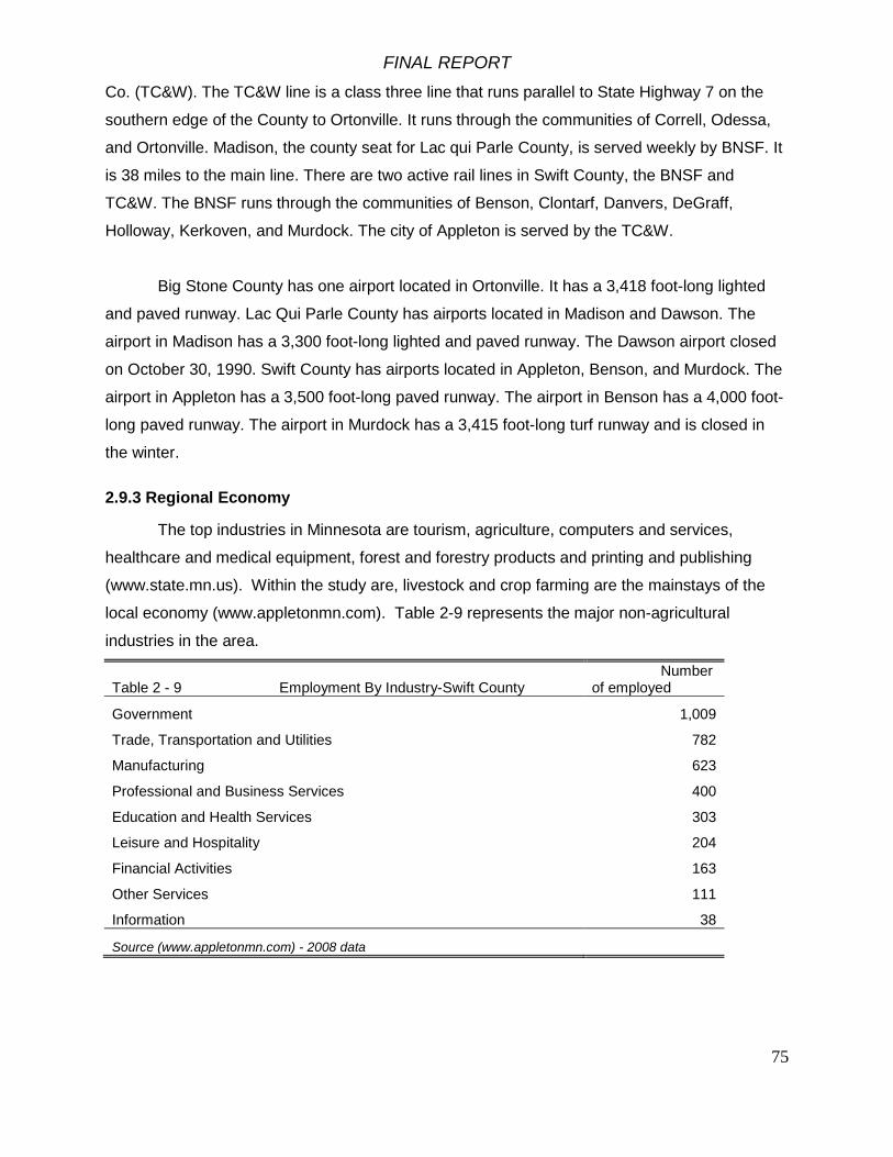
FINAL REPORT
75
Co. (TC&W). The TC&W line is a class three line that runs parallel to State Highway 7 on the
southern edge of the County to Ortonville. It runs through the communities of Correll, Odessa,
and Ortonville. Madison, the county seat for Lac qui Parle County, is served weekly by BNSF. It
is 38 miles to the main line. There are two active rail lines in Swift County, the BNSF and
TC&W. The BNSF runs through the communities of Benson, Clontarf, Danvers, DeGraff,
Holloway, Kerkoven, and Murdock. The city of Appleton is served by the TC&W.
Big Stone County has one airport located in Ortonville. It has a 3,418 foot-long lighted
and paved runway. Lac Qui Parle County has airports located in Madison and Dawson. The
airport in Madison has a 3,300 foot-long lighted and paved runway. The Dawson airport closed
on October 30, 1990. Swift County has airports located in Appleton, Benson, and Murdock. The
airport in Appleton has a 3,500 foot-long paved runway. The airport in Benson has a 4,000 foot-
long paved runway. The airport in Murdock has a 3,415 foot-long turf runway and is closed in
the winter.
2.9.3 Regional Economy
The top industries in Minnesota are tourism, agriculture, computers and services,
healthcare and medical equipment, forest and forestry products and printing and publishing
(www.state.mn.us). Within the study are, livestock and crop farming are the mainstays of the
local economy (www.appletonmn.com). Table 2-9 represents the major non-agricultural
industries in the area.
Table 2 - 9 Employment By Industry-Swift County Number of employed
Government 1,009
Trade, Transportation and Utilities 782
Manufacturing 623
Professional and Business Services 400
Education and Health Services 303
Leisure and Hospitality 204
Financial Activities 163
Other Services 111
Information 38
Source (www.appletonmn.com) - 2008 data

FINAL REPORT
76
2.9.4 Employment
Big Stone County’s labor force totaled 2,859 in March 2005, with an unemployment rate
of 6.6 percent, compared to 5.0 percent (unadjusted) for the State of Minnesota and 5.4 percent
(unadjusted) for the United States. Lac qui Parle County’s labor force totaled 4,273 in March
2005, with an unemployment rate of 5.1 percent. Swift County’s labor force totaled 5,525 in
March 2005, with an unemployment rate of 6.1 percent
2.9.5 Income
Median household income is the mid-point at which one half of the households earn
more and one half earn less. According to information from the U.S. Census Bureau, the 1999
median household money income for Big Stone County was $30,721, for Lac qui Parle County it
was $32,626, and for Swift County it was $34,820. This compares to $47,111 for the State of
Minnesota and $41,994 for the United States.
Per capita income represents total income divided by the population to derive a per
person income estimate. According to 2000 census figures, per capita income (1999 dollars) for
Big Stone County was $15,708, for Lac qui Parle County it was $17,399, and for Swift County it
was $16,360. This compares to $23,198 for the State of Minnesota and $21,587 for the United
States.
Families and persons are classified as below poverty level if their total family or
unrelated individual income was less than the poverty threshold specified for the applicable
family size, age of householder, and number of children under 18 present. The Census Bureau
uses the Federal government’s official poverty definition. For example, the poverty threshold in
1999 for a family of four with two children less than 18 years of age was $16,895.
According to 2000 census figures, in Big Stone County, 12.0 percent of the population
was below the poverty level, for Lac qui Parle County it was 8.5 percent, and for Swift County it
was 8.4 percent. This compares to the state average of 7.9 and the national average of 12.4
percent.

FINAL REPORT
77
2.9.6 Demography
Table 2-10 describes the population of the study area.
Table 2-10 Demographics of Study Area Study Area U.S. Total population 35,979 304,059,724 White persons, percent, 2008 (a) 95.19% 79.80% Black persons, percent, 2008 (a) 1.34% 12.80% American Indian and Alaska Native persons, percent, 2008 (a) 0.85% 1.00% Asian persons, percent, 2008 (a) 0.83% 4.50% Native Hawaiian and Other Pacific Islander, percent, 2008 (a) 0.61% 0.20% Persons reporting two or more races, percent, 2008 1.25% 1.70% Persons of Hispanic or Latino origin, percent, 2008 (b) 3.01% 15.40% White persons not Hispanic, percent, 2008 92.43% 65.60% Female persons, percent, 2008 48.37% 50.70% Source - US Census Bureau State and County Quick Facts 2008
Population totals for the study area are presented in table 2-11.
Table 2-11 Study Area Population Swift Lac Qui Parle Big Stone Chippewa Study Area Total
2000 11956 8067 5820 13088 38931 2008 11035 7165 5365 12414 35979
% Change -7.70% -11.18% -7.82% -5.15% -7.58% Source - US Census Bureau State and County Quick Facts 2008, Census 2000
It is estimated that the four-county area lost between .1% and 9.9% of its population from 1990 to
2000 (US census- Population Change and Distribution).
2.9.7 Education
Among persons 25 years and over, 79.0 percent of Big Stone County’s population has
achieved high school or higher educational attainment, for Lac qui Parle County it was 80.8
percent, and for Swift County it was 80.4 percent. This compares to 87.9 percent for the State of
Minnesota, and 80.4 percent for the United States (U.S. Census Bureau 2000).
Of Big Stone County’s population, approximately 11.4 percent of the adults 25 years and
over possess bachelor’s degrees or higher, for Lac qui Parle County it was 13.0 percent, and for
Swift County it was 14.0 percent. This compares with 27.4 percent for the State of Minnesota
and 24.4 percent for the United States (U.S. Census Bureau 2000).

FINAL REPORT
78
While there is no institution of post-secondary education in Big Stone, Lac qui Parle, or
Swift Counties, Minnesota West Community and Technical College is located 26 miles away
from Madison in Canby, Minnesota. Ridgewater Community and Technical College is located 30
miles away from Benson with facilities in Hutchinson and Willmar, Minnesota. The University of
Minnesota, Morris is an undergraduate liberal arts campus of the University of Minnesota and is
located 25 miles away from Benson and 50 miles from Ortonville.
2.9.8 Housing
According to 2000 census figures, there are a total of 3,171 housing units in Big Stone
County. There were 2,022 owner-occupied (63.8 percent), 355 renter-occupied (11.2 percent),
and 794 (25.0 percent) vacant housing units. The vacancy rate for single-family housing units
was 5.3% and 20.4% for rental housing units. The median value of owner-occupied housing
units is $41,900. Median rent totaled $231 and the median mortgage is $580.
According to 2000 census figures, there are a total of 3,774 housing units in Lac qui
Parle County. There were 2,683 owner-occupied (71.1 percent), 633 renter-occupied (16.8
percent), and 458 (12.1 percent) vacant housing units. The vacancy rate for single-family
housing units was 3.6% and 9.7% for rental housing units. The median value of owner-occupied
housing units is $43,100. Median rent totaled $348 and the median mortgage is $572.
According to 2000 census figures, there are a total of 4,821 housing units in Swift
County. There were 3,353 owner-occupied (69.6
percent), 1,000 renter-occupied (20.7 percent), and
468 (9.7 percent) vacant housing units. The vacancy
rate for single-family housing units was 2.6% and
13.1% for rental housing units. The median value of
owner-occupied housing units is $58,200. Median
rent totaled $362 and the median mortgage is $632.
2.9.9 Recreation
The Minnesota River corridor is rich in
history, culture, natural and scenic beauty offering
exceptional recreational opportunities for outdoor
enthusiasts of all ages. The Marsh Lake project area
supports a variety of recreational activities including

FINAL REPORT
79
canoeing, kayaking, fishing, hunting, wildlife viewing, boating, bicycling and cross-country
skiing.
Improving the area around Marsh Lake improves the recreational connectivity of the
upper portion of the Minnesota River corridor—from Big Stone Lake near Ortonville to Marsh
Lake to Lac qui Parle Reservoir near Montevideo. This corridor is approximately 47 miles long
and includes Lac qui Parle, Swift, Big Stone, and Chippewa Counties with an approximate
combined population of 35,979 (US Census Bureau, 2008 estimates).
There are 12 municipalities in the project region of which the cities of Ortonville and
Appleton are the largest, about 5,000 people. Tourism dollars provide an important contribution
to the local economy but regional recreation opportunities also help to sustain a high quality of
life to residents in the area.
*2006 National
Survey of
Fishing, Hunting
and Wildlife
Associated
Recreation –
Minnesota. U.S.
Fish & Wildlife
Service
Fishing
Most angling on Marsh Lake occurs through the ice in winter and in the spring. Anglers
primarily fish for walleye and northern pike. Winter creel surveys were conducted by the
Minnesota DNR in 2002 and 2004. Anglers and spear-fishermen (for northern pike) spent an
estimated 2112 hours in the winter of 2002 to catch 531 fish of which most were yellow perch

FINAL REPORT
80
and walleye and 22 were northern pike. During the winter of 2004, anglers spent an estimated
1681 hours to catch 229 walleye and yellow perch. No northern pike were observed caught.
Lac qui Parle supports a popular sport fishery, primarily for walleyes and northern pike.
Angler effort has varied over the years, mostly due to weather, lake level and fish abundance
(Table 2-12).
Table 2-12. Lac qui Parle Sport Fishing (Minnesota DNR data).
Date Open water angler hours (one SE)
Ice angler hours (one SE)c
Number of fish harvested (one SE)
Pounds of fish harvested (two SE)
Non-fishing recreation hours (one SE)b
May 13-Oct. 24, 1989 100,734 (7,869)a 21,302 (1,060)a 31,617 (1,822) 2,932Dec. 9, 1989-Feb. 15, 1990 165 (74)a 38,814 2,226 5,872May 14-Oct. 31, 1994 75,285 (16,543)a 18,016 (7,059)a 25,649Dec. 1, 1994-Feb. 19, 1995 73,618 (17,356)a 16,706 (6,752)a 23,621May 13-Oct. 31, 1995 81,787 (8,684) 22,449 (4,157) 40,819 58 (35)Dec. 1, 1995-Feb. 18, 1996 40,054 (6,962) 3,813 (948) 5,210May 12-Oct. 31, 2001 59,871 (5,999) 9,070 (1,062) 18,025 1,951 (399)Dec. 1, 2001-Feb. 17, 2002 28,493 (3,391) 1,951 (319) 3,551May 10-Oct. 31, 2003 56,565 (5,615) 6,577 (717) 11,026 1,742 (332)Dec. 1, 2003-Feb. 15, 2004 30,872 (5,385) 2,451 (691) 4,471aMeasure of variability was calculated as two standard errors.bNon-fishing recreation activities consisted of swimming, water-skiing, canoeing, pleasure boating, sailing, jet skiing, and waterfowl hunting.cIce fishing estimates include spearers.
Hunting
Minnesota wildlife management areas are used for public hunting, trapping, fishing,
wildlife viewing and other activities compatible with wildlife and fish management. Hunting has
always accounted for the largest share of public use on the Lac qui Parle Wildlife Management
Area, but the area is also used for fishing, wildlife viewing, cooperative farming, cooperative
grazing and haying, rough fish harvest and environmental education.
The Lac qui Parle area is considered a “major destination point” for wildlife related
activities due to the area’s large public land-base and proximity to the Twin Cities metropolitan
area. Beyond Canada goose hunting, the economic impact of wildlife related recreation has not
been measured for the Lac qui Parle Wildlife Management Area specifically.
The U.S. Fish and Wildlife Service (2005) estimated Waterfowl Production Areas in
Minnesota generated $19.8 million in spending by all visitors in 2004. The Morris Wetland
Management District, which includes counties in the Upper Minnesota River Valley, generated
the most spending by waterfowl hunters in the state at $8.7 million. In 2001, Minnesota ranked
first in the nation for the number of waterfowl hunters, generating an economic impact of $132.5
million for the state of Minnesota (Henderson 2005). In 2006, 87.5 million U.S. residents 16

FINAL REPORT
81
years old and older participated in wildlife-related recreation. During that year, 30.0 million
people fished, 12.5 million hunted, and 71.1 million participated in wildlife viewing spending an
estimated $122.3 billion on their activities (U.S. Department of Interior 2006).
Hunters pursue various wildlife species at Lac qui Parle. Foremost are Canada geese,
waterfowl, deer, and pheasants. The pursuit of rabbits, squirrels, turkeys, and furbearers also
provides important recreational opportunity.
Visitor-use records spanning an entire hunting season do not exist, except for Canada
goose hunters. The visitor information for ducks and pheasants is for opening day only on the
Lac qui Parle Wildlife Management Area. Deer hunting estimates are taken from MN-DNR 2006
Deer Harvest Report.
Canada Goose Hunting - The Lac qui Parle Wildlife Management Area lies within
Minnesota’s West Central Goose Zone. For a five-year period (1990-1994) all goose hunters in
the West Central Goose Zone were required to purchase a permit before hunting. A
postseason survey of randomly selected permit holders was then conducted to determine
Canada goose harvest, hunter activity, and success. In addition, hunters using state blinds at
the Lac qui Parle Refuge are required to register in person to use a blind, and report their
success at the completion of their hunt. Based on the West Central Goose Zone survey in
1994, it was determined that 11,121 persons spent a total of 60,581 hunter-use days pursuing
Canada geese. The state blinds accounted for 4,271 hunters-use days – an average of 142
hunters/day. Of the state blind hunters, 603 were under 18 years of age. Most hunters (39.1%)
were from the southern portion of Minnesota, with 22.5% from the Twin Cities and 10.7% from
the West Central Goose Zone.
The total economic value of the goose hunt was estimated at $2.2 million in 1985 with
over half the goose hunter expenditures ($1.2 million) being made in the local area (Hiller &
Kelly 1987). Private land hunters paid nearly $410,000 to property owners for hunting privileges
that same year. It is important to note that the above figures are based on an estimate of 5,446
hunters or 30,546 goose-hunting days in the Lac qui Parle Zone. From the 1990-94 West
Central Goose Zone permit, it was determined that 7,500-10,600 hunters spend 30,500-43,200
goose-hunting days in the Lac qui Parle Goose Zone. Based on permit data, it appears the
1987 report, although the numbers are substantial, underestimated the economic impact of the
goose hunt.

FINAL REPORT
82
Duck Hunting - Marsh Lake is the focal point for duck hunting, especially the western
half (motorized zone). From 1997-2006, the opening day car count has averaged 183 vehicles
or an estimated 371 hunters. The peak opening day car count occurred in 1998 with 262
vehicles for an estimated 547 hunters. Hunting pressure remains heavy on the weekends
throughout the waterfowl season, but is light to moderate during the week. Eighty percent of the
opening day duck hunters were from the Twin Cities metropolitan area.
Pheasant Hunting - From 1998-2007, the opening day car count has averaged 166
vehicles for an estimated 352 hunters. The peak opening day car count occurred in 2006 with
254 vehicles for an estimated 519 hunters. Sixty percent of the opening day pheasant hunters
were from the Twin Cities metropolitan area.
Deer Hunting - The Lac qui Parle Wildlife Management Area lies within Permit Area 433,
which is 402 square miles in size. In 2006, 2,526 firearm hunters were estimated to have
hunted in Permit Area 433 for 6.3 hunters per square mile. Although not specifically measured,
wildlife personnel believe much of this pressure occurred between the Lac qui Parle Wildlife
Management Area and Big Stone National Wildlife Refuge. This hunter density estimate is
slightly higher than the statewide average of 5.6 hunters per square mile. Hunter density
estimates do not exist for archery or muzzleloader hunters but we do know archery and
muzzleloader hunters harvested 108 and 229 deer, respectively, in 2006.
Trapping - Trappers are required to receive a trapping permit from the resident manager,
and provide an annual harvest report. Fur prices are the driving force behind trapper numbers
and for the past 3 years trapping permits have ranged from 7 to 15. This is down from an
average of 26 trapping permits, 1965-75.
Wildlife Viewing - No estimate has been made for wildlife viewing visitation rates. These
activities are year-round, dispersed, and very difficult to monitor. In 2006, an estimated 1.9
million Minnesota residents 16 years and older, or 48% of the total population, took part in
wildlife-watching activities spending $698 million on equipment and trip related expenses within
Minnesota (U.S. Department of Interior 2006).
The upper Minnesota River Valley is a popular destination for wildlife watchers because
of the abundance and diversity of wildlife that can be seen. A number of specific sites provide

FINAL REPORT
83
wildlife viewing opportunities. The Lac qui Parle Management Area and the Marsh Lake Dam
site are popular wildlife viewing areas located within the geographic scope of the study.
Wetland and prairie species can be observed in the Lac qui Parle Wildlife Management Area. A
diversity of migratory waterfowl can be observed in the fall. The Marsh Lake Dam is a popular
spot for birdwatching.
There are other sites that provide wildlife viewing opportunities within the Minnesota
River corridor in Big Stone, Swift, Lac qui Parle and Chippewa counties. The Minnesota River
Valley Birding Trail maps existing roads, paths and bike trails to link 132 birding sites within the
Minnesota River Watershed. Recommended routes and sites are mapped for birders to follow.
A variety of wildlife including, prairie chickens, upland sandpipers, and marbled godwits can be
observed at Plover Prairie, a 655 acre wet prairie owned by The Nature Conservancy. The
1,143 acre Chippewa Prairie is a mesic prairie. Some species that can be observed here
include migrating flocks of geese, ducks, sandpipers, godwits and other shorebirds; upland
sandpiper, short-earred owl, and marbled godwit.
Wildlife watching is one of the most popular activities at the Big Stone National Wildlife
Refuge. Seventeen species of ducks and 23 species of shorebirds can be observed during
spring and fall. Mallards, blue-winged teal, northern shoveler, and Canada geese can be seen.
Shorebirds include least and semipalmated sandpipers, and lesser yellow legs. It is also home
to a diversity of seasonal, resident wildlife including great-blue heron, common egrets, and
several species of ducks. A population of reintroduced river otters can be observed. The
refuge serves as an important wintering area for white-tailed deer. In 2006, an estimated
22,050 visits were for wildlife watching and 14,300 visits in 2007. Visits were lower in 2007 due
to the fact the auto tour loop was closed, which is a primary facility that visitors use to view
wildlife.
Boating
The boating resources are Big Stone Lake, Marsh Lake, and Lac qui Parle. The vast
majority of the boating activity in the area is associated with hunting and angling. There are 5
boat accesses within the geographic scope of the project. A 2007 visitation estimate recorded
by the Corps of Engineers for Boyd Landing on Marsh Lake was 1,800.
Canoeing

FINAL REPORT
84
The Minnesota River is designated as a Canoe and Boating route between Ortonville
and Fort Snelling. The Pomme de Terre River, tributary of the Minnesota River, is also a
designated Canoe and Boating Route. The Department of Natural Resources publishes canoe
maps with descriptions of river segments, location of public access points, campsites, rest
areas, navigational features and river miles.
The Minnesota River, Marsh Lake and Lac qui Parle are located within the geographic
scope of this project and are a segment of the designated canoe route. Approximately five
miles of the Pomme de Terre Canoe Route is also within the geographic scope of this project.
Within the geographic scope of the project there are five canoe accesses on the Minnesota
River and Marsh Lake and one on the Pomme de Terre. There are no use estimates for
canoeing.
Hiking/Bicycling Trails
While there are no existing bicycle trails within the geographic scope of the project, there
are several existing bicycle trails within the Minnesota River Valley corridor in Big Stone, Lac qui
Parle and Swift Counties. The Marsh Lake area holds the potential to be integrated into a broad
regional network of existing natural areas, recreational opportunities, and educational amenities
through links between present and future trail systems.
Nearby Natural Areas with Recreational Opportunities
• Big Stone National Wildlife Refuge • Big Stone State Park • Lac qui Parle WMA • Lac qui Parle State Park • Lac qui Parle County Park • Plover Prairie Preserve • Fort Renville State Historic Park • Upper Sioux Agency State Park
Present (P) and Future (F) Trail Systems
• MN State Bike Trail System (P, F) • MN River Canoe Trail (P) • National Scenic Byways MN River Valley Auto Tour (P) • Audubon Society MN River Valley Birding Trail (P) • Appleton Community Bike Trail (P) • Watchable Wildlife Sites (P) • Historic/Cultural/Heritage Trail (F)

FINAL REPORT
85
Figure 2-24. Official Trails and recreational opportunities in the project area.
Various area trails include:
Milan to Milan Beach
This 3 mile paved trail connects Milan Beach Resort on Lac qui Parle to Milan. It
is envisioned that in the future, this segment would be part of the Minnesota River State
Trail. There are no use statistics available for this trail.
FINAL REPORT
86
Appleton community trail system
A 1.5 mile paved trail starts at Riverside Park and follows the banks of the
mill pond, past the Appleton Athletic Field, hospital and nursing home and
assisted living complex on the east end of town and connects back into town
west to TH 7 via Reuss Avenue.
County 32 adjacent to Lac qui Parle State Park
Paved shoulders along County 32 connect the upper and lower portions
of the park and can be used for biking.
Ortonville to Big Stone National Wildlife Refuge
A segment of the legislatively authorized Minnesota River State Trail was
completed in the spring of 2008. This trail begins at the ouitlet of Big Stone Lake
and travels through the southern part of Ortonville. It crosses the Minnesota
River and exits the community in the southeastern corner. The trail parallels TH
75 until it connects with the Big Stone Refuge’s 5.5 mile auto tour route.
There are no use estimates available for these bicycle trails, which are
also used for hiking and skiing.
Cross-country Skiing
There are no groomed cross-country ski trails within the geographic scope of this
project. However there are some trails within the Minnesota River Valley Corridor in Big
Stone, Swift, and Lac qui Parle counties. Cross-country skiing is allowed in the Big
Stone National Wildlife Refuge, although no trails are designated and managed for this
use. Lac qui Parle State Park has 5 miles of cross-country ski trails.
Horseback Riding
Lac qui Parle State Park has 5 miles of horseback riding trails. Lac qui Parle
County Park has horseback riding trails.

FINAL REPORT
87
Snowmobiling
There are 460 miles of Grant In Aide snowmobile trails in Big Stone (122 miles), Lac
qui Parle (184), and Swift (154) Counties. These trails are developed and maintained by
local snowmobile clubs with the support of grants provided by Minnesota DNR through the
local unit of government.
Off highway vehicle riding
The Appleton Off-Highway Vehicle Area provides recreation opportunities for off-
highway vehicle riders. There are 10 miles of off-road vehicle trails, 15 miles of all terrain
vehicle/off-highway motorcycle trails, 1.5 miles of off-highway motorcycle tracks and 3
enduro tracks. Visiting Historic Sites
The history of the area also attracts recreationists to the area. Three significant sites
visited are:
Fort Renville Site – location of Joseph Renville’s fur trading post established in 1822 at a
Wahpeton Dakota village
Lac qui Parle Mission State Historic Site
Big Stone County Museum -- displays from the area’s past including a historic boat that
traveled Big Stone Lake.
Recreation User Data
Use data for the recreational activities described above is limited. Several
recreational facilities keep visitor data that serve as an indicator of the recreational activity in
the area of the project. Data from Big Stone National Wildlife Refuge, Big Stone and Lac qui
Parle state parks, and Corps of Engineers is displayed in Tables 2- 13 through 2-16.

FINAL REPORT
88
Table 2-13. Lac qui Parle State Park attendance history.
Table 2-14. Big Stone Lake State Park attendance history
Year Total Attendance Overnight Visits
2006 53,663 3,266
2005 55707 3,531
2004 52,946 2,933
2003 52,444 2,870
2002 32,545 2,832
2001 29,079 3,188
2000 35,268 3,261
1999 36,559 3,730
1998 33,748 3,335
1997 28,581 3,432
Year Total Attendance Overnight Visits
2006 115,525 7,697
2005 111,835 7,678
2004 64,610 5,900
2003 69,426 5,477
2002 71,600 5,638
2001 48,786 2,998
2000 71,396 6,169
1999 68,965 5,908
1998 64,273 5,623
1997 71,942 3,765
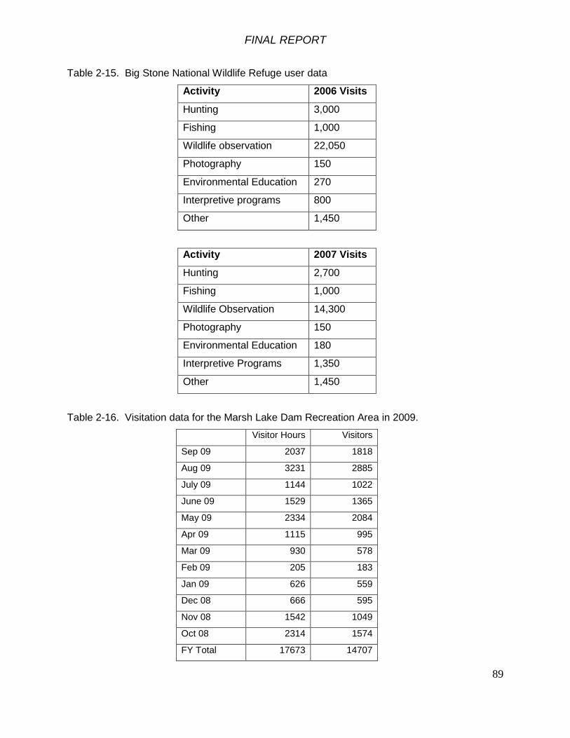
FINAL REPORT
89
Table 2-15. Big Stone National Wildlife Refuge user data
Activity 2006 Visits
Hunting 3,000
Fishing 1,000
Wildlife observation 22,050
Photography 150
Environmental Education 270
Interpretive programs 800
Other 1,450
Activity 2007 Visits
Hunting 2,700
Fishing 1,000
Wildlife Observation 14,300
Photography 150
Environmental Education 180
Interpretive Programs 1,350
Other 1,450
Table 2-16. Visitation data for the Marsh Lake Dam Recreation Area in 2009.
Visitor Hours Visitors
Sep 09 2037 1818
Aug 09 3231 2885
July 09 1144 1022
June 09 1529 1365
May 09 2334 2084
Apr 09 1115 995
Mar 09 930 578
Feb 09 205 183
Jan 09 626 559
Dec 08 666 595
Nov 08 1542 1049
Oct 08 2314 1574
FY Total 17673 14707

FINAL REPORT
90
The Corps of Engineers maintains a recreation area at Marsh Lake Dam consisting
of a parking area, picnic tables, rest rooms and a fishing platform.
Minnesota River State Trail
The Marsh Lake Dam is a vital connection for the alignment of the Minnesota River
State Trail. The Minnesota River State Trail is a legislatively authorized state trail that will
connect Big Stone Lake State Park to Le Sueur (Minnesota Statutes, Chapter 85.015, Subd.
22). The Draft Master Plan for the Minnesota River State Trail identifies a corridor that
parallels Marsh Lake and the Lac qui Parle Management Area on the south, veering north at
the location of the Marsh Lake Dam to connect into Appleton. The best alternative for
crossing the river north into Appleton is the Marsh Lake Dam, due to the constraints of
surrounding land ownership patterns and geography. In addition to providing an opportunity
for a trail alignment, a crossing at this location also provides trail users access to the natural
and cultural resources at this location.
2.10 Future Conditions Without an Ecosystem Restoration Project
The forecasted future conditions provide a baseline by which alternative plans are
evaluated. The planning period of analysis for this project is 50 years and for the purposes
of this report, the base year is defined as the year of proposed project completion,
scheduled in 2014. Implementation of ecosystem improvements within the Marsh Lake
project area by others was considered as a part of the future conditions, however, no known
plans exist which would significantly alter future conditions from the assessment below.
2.10.1 Future Social and Economic Conditions
From 1990 to 2000, the population of the study area decreased by up to 10%. From
2000 to 2008 the study area lost 7.58% of its population. The most likely explanation for the
overall decline in population in the study area is migration from rural to urban communities.
This trend will presumably persist to some degree in the coming years as nearby
metropolitan areas such as the Twin Cities and Fargo-Moorhead continue to draw rural
populations.
FINAL REPORT
91
2.10.2 Future Land Use and Land Cover
Terrestrial land use and vegetative cover on private land in the project area is
expected to remain much in its present condition, dominated by annual row-crop agriculture,
primarily corn and soybeans. The land use within the Minnesota River Watershed upstream
of the project site is over 90% agricultural. The productivity of Minnesota agriculture is
highly dependent on the hydrologic alteration that permits drainage of agricultural lands to
maintain ideal agronomic growing conditions. While much of the drainage system within the
basin was completed over the last 100 years, drainage improvements continue today.
Professional experience within the basin and work with agriculture experts on the Minnesota
River Integrated Watershed Study has shown that drainage improvements are on-going.
These alterations have a substantial effect on the hydrology of the watershed and are often
performed at a large scale. Future watershed change based on the amount of perennial
cover on the landscape will depend on national Farm Bill policy. Provided the Conservation
Reserve Program is reauthorized, and a market for perennial-based biomass emerges, it is
possible the amount of perennial cover (e.g., native warm season grasses) on private land
may increase. For the purposes of this Feasibility Study, however, existing land use is
assumed to remain dominated by row crop agricultural.
That portion of the project area located on the state-owned Lac qui Parle Wildlife
Management Area will continue to be managed to provide diverse wildlife habitats, healthy
wildlife populations, and outdoor recreation. Land cover is diverse: open water, emergent
wetlands, grassland, pasture and hayland, agricultural cropland, and deciduous floodplain
forests. No major changes in land cover are anticipated.
As recommended by the Minnesota River Reconnaissance Study, a Minnesota River
Integrated Watershed Study is currently being conducted by the Corps in conjunction with
State and Federal study partners. This study will examine the root of problems related to
hydrology, sediment transport, nutrient loading and flooding throughout the basin and
recommend comprehensive solutions for implementation. The study is currently in its initial
stages and it is not possible at this time to speculate how the outcome of this study may
impact future watershed conditions. The Integrated Watershed Study is scheduled to be
completed in 2015.

FINAL REPORT
92
2.10.3 Future Hydrology
Climate change is expected to cause hotter, dryer summers and warmer winters in
western Minnesota (Union of Concerned Scientists 2009). Climate change is forecast to
result in shorter duration of ice cover, less snow, higher winter river discharge, more intense
summer thunderstorm events, hotter summer temperatures, and generally more variable
hydrology in the upper Minnesota River Basin. Inflows to Marsh Lake will probably decline
and summer lake stages may be lower. Climate change is expected to bring about more
extreme precipitation events, leading to larger floods and longer droughts.
2.10.4 Future Hydraulic Condition of Marsh Lake and Pomme de Terre River and Lac Qui Parle
The delta at the mouth of the Pomme de Terre River in Marsh Lake is expected to
increase in area with time. Wind-driven sediment resuspension in Marsh Lake should
maintain the same approximate geometry and volume of the lake, balanced between
sediment inflows and export. The former channel of the Pomme de Terre River that was re-
routed when the Marsh Lake Dam was constructed will probably accumulate sediment and
rise slightly in elevation over time. Sediment from Marsh Lake will continue to accumulate in
Lac qui Parle, primarily in the upper end of the lake.
The Marsh Lake Dam will continue to be operated over time as with passive
discharge, in the same manner it is today. Recreational activity around the dam does pose
a risk to public safety, as evidenced by a drowning death at the site in 1991.
The dam will continue to provide a conservation pool for boaters, which does provide
a recreational benefit at the site. In its current condition, however, the dam provides little
flood damage reduction benefit to downstream communities. Hydraulic modeling of the river
shows that the dam itself is partially inundated with a 1% chance flood event (947.4’). The
consequences of failure at Marsh Lake Dam are relatively minor as it lies above the Lac qui
Parle Reservoir, which contains more storage than Marsh Lake. A flowage easement up to
elevation 945 exists for the Lac qui Parle Reservoir, and there is no population below that
elevation. Detailed modeling results are provided in Appendix J of this report.

FINAL REPORT
93
2.10.5 Future Ecosystem State
Emergent aquatic plants have declined to a limited band of hybrid cattails, sparse
river bulrush and dense reed canary grass on the periphery of Marsh Lake. This extent of
emergent aquatic plants is expected to continue in the future, covering approximately 1032
acres as in 1999 (Figure 2-18 above).
In rare years when conditions allow, such as occurred in 1991, submersed aquatic
vegetation can grow in Marsh Lake. In most years however, water levels and turbid
conditions caused by wind-driven sediment resuspension and by carp will prevent growth of
submersed aquatic plants. The abundant carp in Marsh Lake will also graze back
submersed aquatic plants. The frequency of occurrence of submersed aquatic plants in
Marsh Lake is expected to be less than 15 percent as was found in the 2007 survey (Table
2-7).
Biomass of the most abundant submersed aquatic plant, Sago pondweed, is
expected to remain low and therefore existing and without-project future conditions are
assumed to be equivalent. Application of a wind fetch model (Rohweder et al. 2008) and a
bioenergetics plant growth model, POTAM for sago pondweed (Best and Boyd 2003)
provided an estimate of existing and future without-project sago pondweed shoot and tuber
biomass production in Marsh Lake (Appendix J, Table 2-17).
Table 2-17. Simulated production of sago pondweed in Marsh Lake under existing and
without-project future conditions (existing and future-without assumed to be equivalent). Lakewide Peak Biommass (Tons)
Shoots Tubers Shoots Tubers0.5 (0 - 0.75) 751 1364 1071 204 731 1391 (0.75 - 1.25) 1371 2541 840 173 1067 220
1.5 (1.25 - 1.75) 1430 502 371 171 93 43Total 1891 401
Average Wind Fetch (m)Depth Class (m) Area in Depth
Class (acres)Peak Biomass (lb/ac)
Vegetation in the abandoned channel area of the Pomme de Terre River
downstream of the Marsh Lake Dam is expected to shift toward flood-tolerant woody
vegetation as sediment accumulates there, including sandbar willow, black willow,
cottonwood and silver maple.
Conditions of the Lac qui Parle ecosystem are not expected to change in the future.
It is assumed the Lac qui Parle pool is similar in ecosystem condition to that of Marsh Lake
FINAL REPORT
94
with high susceptibility to wind and wave driven sediment resuspension resulting in a turbid
environment with low levels of submersed aquatic vegetation.
2.10.6 Future Water Quality
Climate change will probably result in less ice cover, better winter dissolved oxygen
concentrations and warmer summer water temperatures. Continued row crop agriculture
and further expansion of the agricultural drainage network in the watershed will cause the
future hydrologic regime to become flashier with more rapid increases in tributary discharge
during runoff events. Loadings of sediment and plant nutrients to Marsh Lake are expected
to remain the same or increase.
If a change in the agricultural economy and associated land use shifts toward
increased perennial cover crops, infiltration of water on the land would increase and
loadings of sediment, nitrogen and phosphorus would be significantly reduced, leading to
improved water quality conditions in the project area.
Without restoration, Marsh Lake is expected to continue to accumulate sediment that
is later transported via the Minnesota River to Lac qui Parle Lake during wind-driven
resuspension events. Low primary production will continue because of high turbidity and a
lack of aquatic plants.
2.10.7 Future Fish Community
The expected future water quality conditions described above are conducive to fish
communities dominated by non-native fish, primarily common carp and freshwater drum.
The absence of submersed aquatic plants will continue to limit spawning success and
juvenile growth of northern pike and other native fish. Low numbers of large predatory fish
will allow non-native species, especially common carp, to remain abundant. In addition, the
lack of sufficient resources from primary production and larger sized zooplankton will
continue to limit the survival of young-of-year native fish.
Without restoration of the Pomme de Terre River and fish passage through Marsh
Lake Dam, fish habitat will continue to be fragmented. Native fish from Lac qui Parle such
as walleye and northern pike will continue to be excluded from the Pomme de Terre River

FINAL REPORT
95
and its high-quality spawning habitat. Likewise, fish from the Pomme de Terre River will
continue to be excluded from the winter refugia in the Minnesota River and Lac qui Parle.
Overall, without restoration of the Marsh Lake ecosystem, the future fish community
will consist primarily of non-game species that are expected to maintain or increase in
abundance. However, conditions will continue to be less favorable for popular game fish
species, and their abundance will stay the same or decline. The result will be a declining
fishery resource that is unattractive and undesirable to users of the area.
2.10.8 Future Wildlife
Without restoration, Marsh Lake will continue to exist in its turbid water state.
Emergent vegetation will be dominated by a narrow band of hybrid cattail with reed canary
grass on the periphery. Submersed vegetation will consist of only one species, sago
pondweed, and in most years be limited to a few plants (<15% frequency of occurrence)
found in sheltered bays. Overall future aquatic vegetation in Marsh Lake will provide only
limited food and cover for wildlife.
Waterfowl numbers are expected to remain low. In certain years field-feeding
mallard and Canada goose numbers will be impressive, but their numbers are related to the
security the lake provides for resting and not the waterfowl food present. Most species of
waterfowl, especially diving ducks, will pass through quickly spending at most a day or two
on the lake. This rapid turn-over in numbers is directly related to the lack of waterfowl foods,
primarily sago pondweed, low species diversity in the perennial emergent zone and few
annual emergent aquatic plants due to static water levels.
Colonial waterbird numbers and diversity are expected to remain stable. Long term
population fluctuations are more related to region-wide environmental conditions, meta-
population dynamics, and not conditions in the lake itself. American pelicans, cormorants,
and gulls are attracted to Marsh Lake due to lack of human disturbance and the security of
the nesting islands, not water quality. Western grebes previously nested on Marsh Lake but
have been absent in recent years. Without restoration, it is doubtful western grebes will
return to Marsh Lake.

FINAL REPORT
96
Shorebird numbers are expected to remain very low. Shorebird numbers and food
availability are directly related to the quantity and quality of available mud flat habitats.
Climate change may result in hotter, dryer summers, lower lake stages and hence mud flats,
but extreme precipitation events will most likely negate this potential benefit for shorebirds.
Agricultural drainage is expected to continue in the watershed and will result in the
hydrologic regime to become even flashier with increased episodic tributary inflows. Without
restoration, mud flat conditions are expected to be rare and confined to only those years of
extreme drought throughout the growing season.
Furbearer numbers are expected to remain similar with no major changes in species
composition. Furbearer numbers fluctuate based on broad environmental conditions,
disease, and in-lake water levels fluctuations. For example, successive years of stable
water levels allow muskrat numbers to increase with a corresponding increase in mink
numbers a few years later (predator prey relationship). Conversely, widely fluctuating water
levels should result in a gradual decline in muskrat and hence mink numbers in the Marsh
Lake basin. Climate change complicates these relationships but again no major population
changes expected.
2.11 Planning Assumptions
Planning assumptions underlie the logic of the planning process. Although these
states of nature and anticipated human activities are not certain, they are assumed to apply
in the future:
1. The Lac qui Parle Flood Control Project (including the Marsh Lake Dam) will
continue to be operated and maintained by the Corps of Engineers for the
foreseeable future.
2. The hydrologic regime of the Minnesota and Pomme de Terre Rivers will remain
within historic seasonal ranges of flow.
3. The Lac qui Parle Wildlife Management Area will continue to be maintained and
managed by the DNR.

FINAL REPORT
97
4. The beneficial uses of the Marsh Lake ecosystem (flood damage reduction, fish
and wildlife management, recreation) will continue to provide benefit to the public.
5. The value of flood damage reduction to downstream urban and agricultural areas
will continue or increase in the future.
6. Loss of habitat over time within the watershed will increase the value of Marsh
Lake and Lac qui Parle as a protected area for wildlife.
7. The value of the project area for recreation and frequency of use is expected to
be maintained over time.
3. Problems and Opportunities
One of the critical steps in the initial planning process is the identification of problems
and opportunities associated within the geographic scope of the project area. Problem
statements are concise characterizations of the broad issue that will be addressed with the
project. Opportunity statements follow each problem and consist of an array of opportunities
presented by the virtue of planning and construction activities occurring at the site of the
problem. Opportunities can be directly related to solving the problem at hand, but can also
be ancillary to the identified problem. From the list of opportunities, objectives for the project
are drafted. The success of the project planning is determined by the fulfillment of the
objectives through identified alternative measures (Sections 4-Section 6).
Because ecosystem restoration authority is the guiding authority for the Marsh Lake
Ecosystem Restoration Project, objectives drafted for this study are primarily related to
ecosystem outputs. As noted in the preceding Sections, construction of the Marsh Lake
Dam in 1939 inundated natural floodplain habitats, increased reservoir fish and wildlife
habitat and created new colonial water bird nesting habitat by creating islands. However, it
also disrupted natural river functions and processes, affecting sediment movement and
floodplain function, blocking fish movements, and reducing river and floodplain habitats.
Natural flooding and drying cycles were disrupted, reducing emergent aquatic plants and
associated fish and wildlife habitats found in the area prior to the impoundment. Taking the
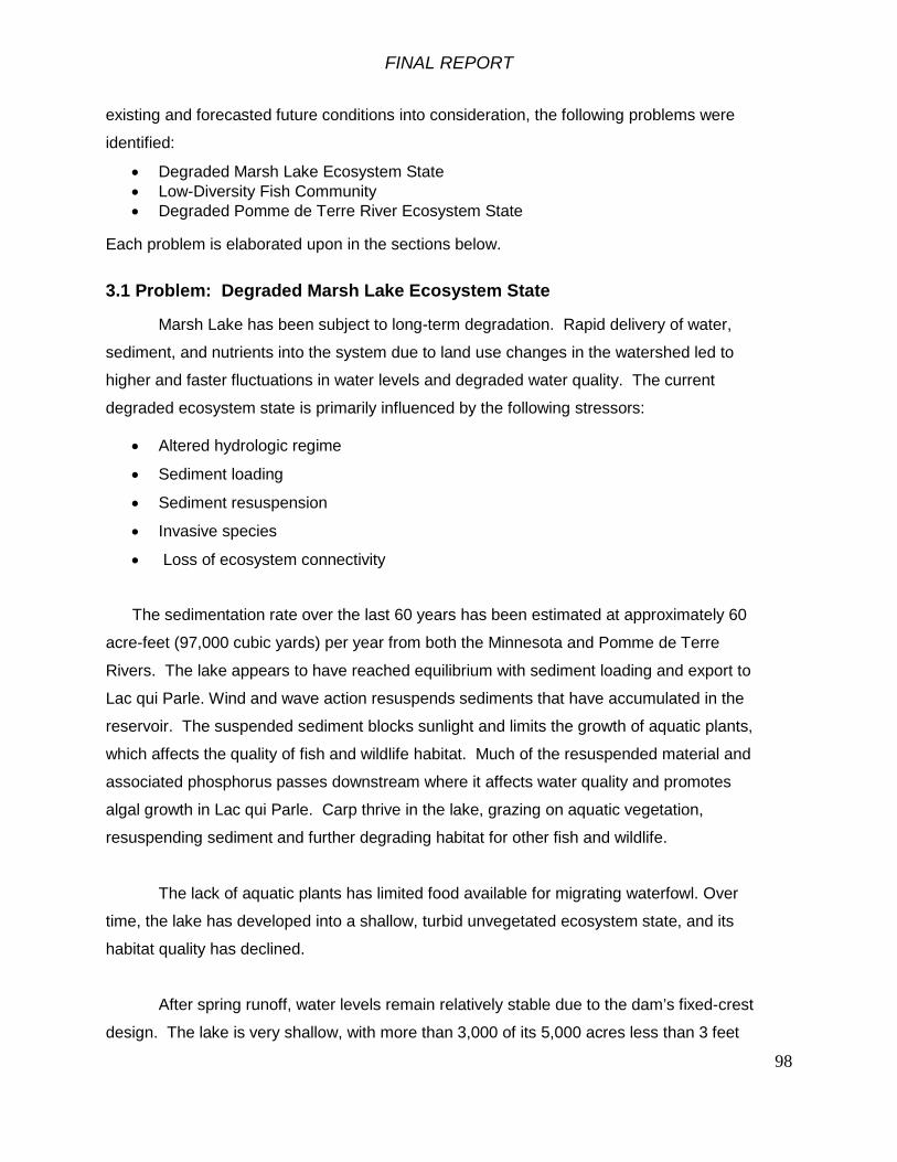
FINAL REPORT
98
existing and forecasted future conditions into consideration, the following problems were
identified:
• Degraded Marsh Lake Ecosystem State • Low-Diversity Fish Community • Degraded Pomme de Terre River Ecosystem State
Each problem is elaborated upon in the sections below.
3.1 Problem: Degraded Marsh Lake Ecosystem State
Marsh Lake has been subject to long-term degradation. Rapid delivery of water,
sediment, and nutrients into the system due to land use changes in the watershed led to
higher and faster fluctuations in water levels and degraded water quality. The current
degraded ecosystem state is primarily influenced by the following stressors:
• Altered hydrologic regime
• Sediment loading
• Sediment resuspension
• Invasive species
• Loss of ecosystem connectivity
The sedimentation rate over the last 60 years has been estimated at approximately 60
acre-feet (97,000 cubic yards) per year from both the Minnesota and Pomme de Terre
Rivers. The lake appears to have reached equilibrium with sediment loading and export to
Lac qui Parle. Wind and wave action resuspends sediments that have accumulated in the
reservoir. The suspended sediment blocks sunlight and limits the growth of aquatic plants,
which affects the quality of fish and wildlife habitat. Much of the resuspended material and
associated phosphorus passes downstream where it affects water quality and promotes
algal growth in Lac qui Parle. Carp thrive in the lake, grazing on aquatic vegetation,
resuspending sediment and further degrading habitat for other fish and wildlife.
The lack of aquatic plants has limited food available for migrating waterfowl. Over
time, the lake has developed into a shallow, turbid unvegetated ecosystem state, and its
habitat quality has declined.
After spring runoff, water levels remain relatively stable due to the dam’s fixed-crest
design. The lake is very shallow, with more than 3,000 of its 5,000 acres less than 3 feet

FINAL REPORT
99
deep when the lake is at the spillway elevation. Lake levels tend to fluctuate between 938
and 942 in normal conditions however due to hydrologic alteration in the watershed, peak
stages tend to consist of short-duration, flashy peaks followed by stabilization of pool
elevation at the crest elevation of 937.6’. As evidenced by the 20-year period of record
(Figure 2-6), the lake seldom drops below the spillway crest elevation of 937.6’ for
substantial periods of time. This regime is in stark contrast to natural riverine conditions
which fluctuated with climate conditions and allowed for periodic drought and low water
conditions in the lake prior to impoundment. Emergent aquatic plants require dewatered
mud flat conditions to germinate from seed. Stable growing season water levels have
prevented re-establishment of emergent aquatic plants in Marsh Lake.
Opportunity: Restore Marsh Lake Aquatic Ecosystem Processes and Connectivity A key to restoring freshwater aquatic ecosystems is restoring a more natural
hydrologic regime. On a river lake like Marsh Lake, a more natural hydrologic regime
includes lower lake levels in some years to enable aquatic vegetation to re-establish.
Growing season drawdowns to naturalize the hydrologic regime of shallow lakes and
reservoirs have been conducted on Upper Mississippi River Pools 5, 8, 13, 24, 25, and 26,
on Mud Lake at the Lake Traverse Flood Control Project on the Bois de Sioux River along
the Minnesota-South Dakota border, at Swan Lake in south-central Minnesota, and on many
other shallow lakes in the region. These drawdowns have resulted in increased extent,
diversity, and abundance of aquatic vegetation, increased food for waterfowl, and improved
water quality conditions, providing significant ecological benefits. Figure 3-1 illustrates the
change in ecosystem state that a growing season drawdown, reduced wind-driven sediment
resuspension, and reduced abundance of carp can produce.
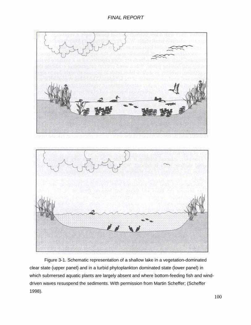
FINAL REPORT
100
Figure 3-1. Schematic representation of a shallow lake in a vegetation-dominated
clear state (upper panel) and in a turbid phytoplankton dominated state (lower panel) in
which submersed aquatic plants are largely absent and where bottom-feeding fish and wind-
driven waves resuspend the sediments. With permission from Martin Scheffer; (Scheffer
1998).

FINAL REPORT
101
Low water levels during the growing season can contribute to a shift in ecosystem
state of shallow lakes and reservoirs from turbid conditions with dense blue-green algal
blooms dominated by plankton and detritus-feeding fish to clearer water condition with
aquatic plants and game fish (Sheffer 1998, Strange 2007). Marsh Lake has exhibited such
shifts in the past when in some years, lower water levels and ambient turbidity allowed
aquatic plants to grow, dampening wave action and sediment resuspension. However, in
most years, Marsh Lake has been in the turbid state without much aquatic vegetation
(Figure 3-1 bottom panel), and a fish community dominated by common carp.
Opportunity exists to change the ecosystem state of Marsh Lake by naturalizing the
water level regime, reducing wind fetch, reducing the abundance of common carp and by
restoring aquatic vegetation. This can be done through modifying the dam to allow water
level management, constructing islands to reduce wind fetch and by restoring the Pomme
de Terre River to its former channel.
Opportunity exists for water level management that would simulate a more natural
hydrologic regime through modification of the Marsh Lake Dam, the abandoned fish rearing
pond area, and the Louisburg Grade Road culverts.
Marsh Lake has the potential to again be an important migration and feeding stop for
many species of migratory waterfowl including ducks, geese, swans and shorebirds. With
an increase in water clarity to levels experienced in 1991, Marsh Lake has the potential to
grow significantly more sago pondweed tubers (Best and Boyd 2007) that are the preferred
food for many waterfowl species during fall migration.

FINAL REPORT
102
Opportunity: Enhance recreational opportunities in and around Marsh Lake As noted in Section 2.9.9, Big Stone State Park, Lac qui Parle State Park and the Wildlife
Management Area adjacent to Marsh Lake provide numerous opportunities for hunting,
angling, active and passive recreation. The opportunity exists to enhance existing
recreational opportunities with an ecosystem restoration project through three primary
means:
1. Increase connectivity between recreational areas
2. Upgrade existing facilities and create new facilities where needed
3. Provide interpretation and education to visitors to the site
A detailed plan for improvement and enhancement of recreation facilities is included in
Section 7.2 and has also been included in the overall cost estimates for the project.
Opportunity: Reduce public safety risks at Marsh Lake Dam
The Marsh Lake Dam has an ogee crest spillway with a strong hydraulic back-roller
on the downstream end. Many people visit the Marsh Lake Dam and fish there. A drowning
death occurred at the Marsh Lake Dam in July 1991. Alterations to the ogee crest spillway
with measures to reduce the slope would eliminate the hydraulic roller and the public safety
hazard in the immediate tailwater. The opportunity to address public safety risks is not in
and of itself justification for the project, however, consideration towards addressing and
minimizing the public safety risks is an opportunity presented if ecosystem restoration
features are to be implemented at the site.
3.2 Problem: Low-Diversity Fish Community
The fish community in Marsh Lake is dominated by non-native common carp. Over
two thirds of the biomass of fish in Marsh Lake is carp. Native game fishes like yellow
perch, walleye, white bass, black crappies, and northern pike occur but in relatively low
abundance.
Carp exacerbate the turbidity problem in Marsh Lake by bioturbation of sediment.
Carp graze submersed aquatic plants, helping maintain an unvegetated and turbid
ecosystem state in the lake.

FINAL REPORT
103
Winter conditions in Marsh Lake favor carp. Water from the Pomme de Terre River
maintains an oxygen refugia for carp during the winter. Northern pike are more tolerant of
low dissolved oxygen than are carp. The fish community in the Pomme de Terre River is
limited by access to suitable winter habitat in Lac qui Parle.
Diversion of the Pomme de Terre River has blocked fish migrations between Lac qui
Parle and the Pomme de Terre River. Because Marsh Lake is shallow and has low winter
dissolved oxygen conditions, fish in the Pomme de Terre River are denied access to
suitable winter habitat.
Walleye and northern pike in Lac qui Parle do not have access to high quality
spawning habitat because their historic migration pathways to Marsh Lake and the Pomme
de Terre River have been blocked by the Marsh Lake Dam.
Opportunity: Restore the Native Fish Community Opportunity exists to restore the native fish community by changing the ecosystem
state of Marsh Lake toward a condition with clearer water and more aquatic plants. This
would favor native fishes over the non-native common carp. Increased abundance of
northern pike and walleyes in Marsh Lake would increase predation on common carp,
contributing to improved water quality conditions.
Restoring the Pomme de Terre River to its former channel would provide walleyes
and white suckers from Lac qui Parle access to rock and gravel spawning habitat in the
Pomme de Terre River, eliminate the winter oxygen refugia for carp in Marsh Lake, reduce
their abundance through winterkill, and would favor northern pike. Fish from the Pomme de
Terre River would have access to suitable winter habitat in Lac qui Parle.
Restoring connectivity at the Marsh Lake Dam would enable fish from Lac qui Parle
to migrate to high quality spawning areas (Figure 3-2). Northern pike would make use of the
extensive marshes in upper Marsh Lake, and walleyes would migrate up the Pomme de
Terre River to spawning areas with rock and gravel substrate. Restoring connectivity of
habitats in river systems has been shown to be effective in increasing the abundance and
spatial distribution of many species of native fishes (Hart et al. 2002).

FINAL REPORT
104
Figure 3-2. Conceptual model of fish migration routes restored from Lac qui Parle into the
Pomme de Terre River and with a fishway at Marsh Lake Dam.
The U.S. Commission on Fish and Fisheries (1895) noted that a fishway was needed
at the Appleton dam on the Pomme de Terre River. That dam failed and was replaced with
a rock ramp fishway in 1996. Opportunity exists to restore fish migrations from Lac Qui
Parle back into the Pomme de Terre River system, with 56 miles of river up to the dam at
Marshall, Minnesota.
With improved fish passage, the native mussel community in Marsh Lake, Lac qui
Parle and the Pomme de Terre River should receive benefits from the presence of their
glochidial (larval stage) host fish species.
3.3 Problem: Degraded Pomme de Terre River Ecosystem State
The Pomme de Terre River was diverted into Marsh Lake when the dam was built in
the 1930's. The river diversion was intended to conserve water in Marsh Lake. Water and
suspended sediment from the Pomme de Terre River short circuits to the Marsh Lake Dam.
Sediment from the Pomme de Terre has been depositing to form a delta in Marsh Lake
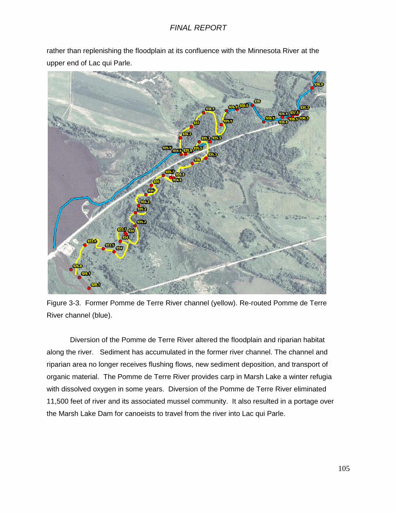
FINAL REPORT
105
rather than replenishing the floodplain at its confluence with the Minnesota River at the
upper end of Lac qui Parle.
Figure 3-3. Former Pomme de Terre River channel (yellow). Re-routed Pomme de Terre
River channel (blue).
Diversion of the Pomme de Terre River altered the floodplain and riparian habitat
along the river. Sediment has accumulated in the former river channel. The channel and
riparian area no longer receives flushing flows, new sediment deposition, and transport of
organic material. The Pomme de Terre River provides carp in Marsh Lake a winter refugia
with dissolved oxygen in some years. Diversion of the Pomme de Terre River eliminated
11,500 feet of river and its associated mussel community. It also resulted in a portage over
the Marsh Lake Dam for canoeists to travel from the river into Lac qui Parle.

FINAL REPORT
106
Opportunity: Restore Pomme de Terre River ecosystem processes and connectivity Restoring river ecosystems by returning rivers to their former channels has proven to
be ecologically effective worldwide. Opportunity exists to restore the Pomme de Terre River
to its former channel and to restore its floodplain and riparian habitat in the upper end of Lac
qui Parle. Restoring the Pomme de Terre River to its former channel would contribute to
winter hypoxia in Marsh Lake, which would help reduce the abundance of carp, sediment
resuspension and grazing on aquatic plants. Walleyes and white suckers from Lac qui Parle
would have access to rock and gravel spawning habitat in the Pomme de Terre River. Fish
in the Pomme de Terre River would have access to winter refugia in Lac qui Parle. A
restored Pomme de Terre River would provide a canoe route linking the Pomme de Terre
River with Lac qui Parle.
Opportunity: Enhance recreational opportunities on the Pomme de Terre River Restoring the Pomme de Terre River to its former channel would enable canoeists
and kayakers to follow the river to its confluence with the Minnesota River at the upper end
of Lac qui Parle without having to portage over Marsh Lake Dam. Recreational use of the
Pomme de Terre River within the project area is primarily by anglers and canoeists. A
series of existing canoe launches and landings extends up the Pomme de Terre for open
access and use. The opportunity exists to enhance the existing access to the river,
particularly near the outlet with the Minnesota River, a primary takeout point for canoeists.

FINAL REPORT
107
Table 3-1: Summary of Problems and Opportunities Goal Problem Stressors Opportunity
Sediment Loading
Sediment Deposition
Ecosystem Connectivity
Degraded Pomme de Terre Ecosystem State
1. Restore Pomme de Terre ecosystem function, processes and connectivity2. Enhance recreational opportunities on the Pomme de Terre River
A return of the Marsh Lake area ecosystem to a less
degraded, more natural and functional condition.
Degraded Marsh Lake Ecosystem State
1. Restore Marsh Lake ecosystem function, processes and connectivity2. Enhance recreational opportunities in and around Marsh Lake3. Reduce public safety risks at the Marsh Lake Dam
Sediment Resuspension
Altered Hydrologic Regime
Ecosystem Connectivity
Low-Diversity Fish Community
Invasive Species1. Restore native fish community2. Enhance recreational fishing opportunities in and around Marsh Lake
Ecosystem Connectivity
3.4 Project Goals and Objectives
The Marsh Lake Ecosystem Restoration Project study team considered the initial
DNR goal and objectives and the team worked closely with the DNR to identify the following
goal and objectives for the Marsh Lake Ecosystem Restoration Project:
Goal: A return of the Marsh Lake area ecosystem to a less degraded and more natural and
functional condition.
Objectives: 1. Reduced sediment loading to Marsh Lake over the 50-year period of analysis 2. Restored natural fluctuations to the hydrologic regime of Marsh Lake over the 50-year
period of analysis 3. Restored geomorphic and floodplain processes to the Pomme de Terre River over the 50-
year period of analysis 4. Reduced sediment resuspension within Marsh Lake over the 50-year period of analysis
FINAL REPORT
108
5. Increased extent, diversity and abundance of emergent and submersed aquatic plants
within Marsh Lake over the 50-year period of analysis 6. Increased availability of waterfowl habitat within Marsh Lake over the 50-year period of
analysis 7. Restored aquatic habitat connectivity between Marsh Lake, the Pomme de Terre River
and Lac Qui Parle over the 50-year period of analysis 8. Reduced abundance of aquatic invasive fish species within Marsh Lake over the 50-year
period of analysis 9. Increased diversity and abundance of native fish within Marsh Lake and the Pomme de
Terre River over the 50-year period of analysis
While improving public safety, the recreation experience and public education at the
Marsh Lake are not ecosystem restoration objectives and are therefore not included in the
list above. They are, however, additional planning objectives to be considered in
conjunction with the ecosystem restoration objectives.
3.5 Planning Constraints
Planning constraints are temporary or permanent limits imposed on the scope of the
planning process and choice of solutions and include ecological, economic, engineering,
legal, and administrative constraints. Some are states of nature; some are based on the
design of built structures and other engineering considerations. Legislation and policy-
making impose other constraints. The human-imposed constraints are possible to change.
Following are the planning constraints identified in this study:
1. The planning process must be consistent with all applicable Federal laws,
Executive Orders, Agency Regulations and other applicable policy.
2. The formulation of alternative measures should avoid, to the greatest extent
possible, the reduction of the flood damage reduction benefits provided by the dams.
3. In its existing condition, Marsh Lake and the Pomme de Terre River provide
functional habitat for a number of species. A universal constraint in the planning of
ecosystem restoration projects is the maxim that the restoration activities should not
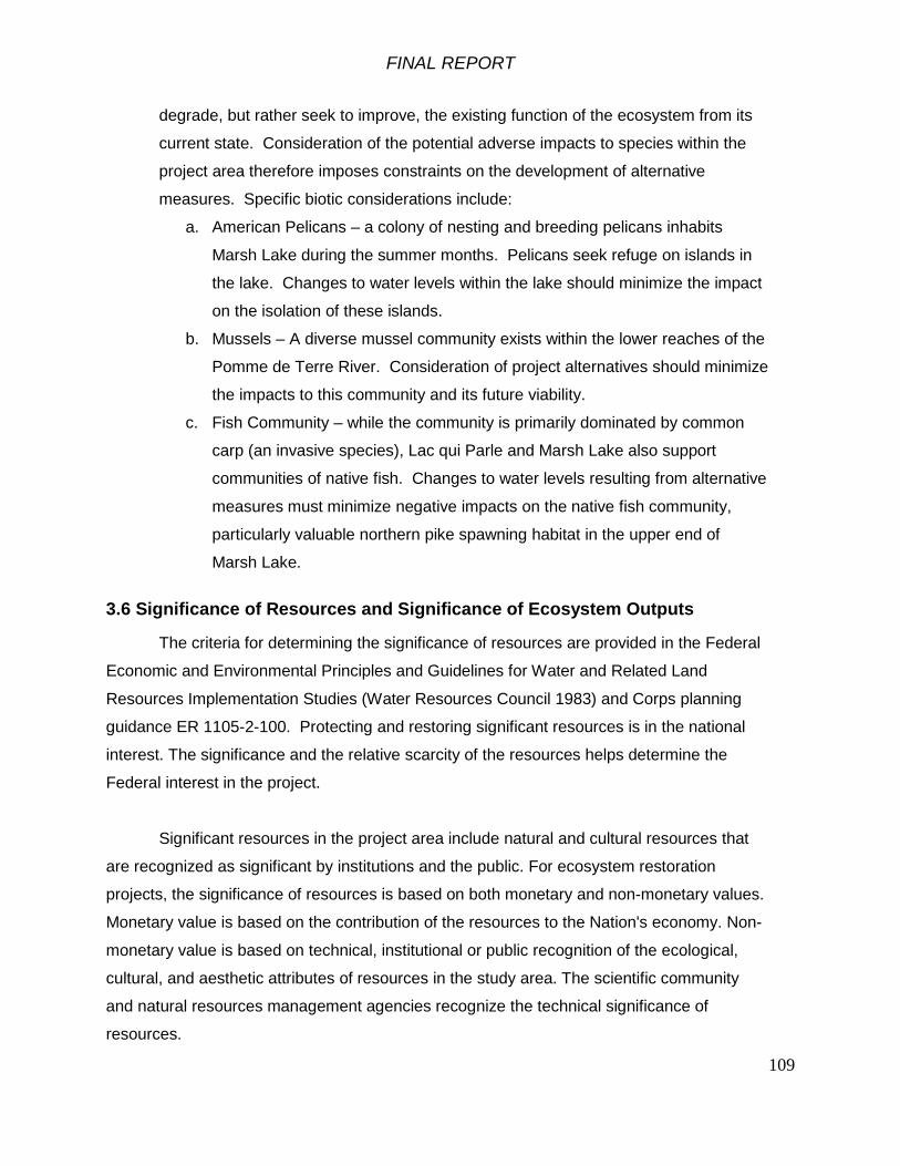
FINAL REPORT
109
degrade, but rather seek to improve, the existing function of the ecosystem from its
current state. Consideration of the potential adverse impacts to species within the
project area therefore imposes constraints on the development of alternative
measures. Specific biotic considerations include:
a. American Pelicans – a colony of nesting and breeding pelicans inhabits
Marsh Lake during the summer months. Pelicans seek refuge on islands in
the lake. Changes to water levels within the lake should minimize the impact
on the isolation of these islands.
b. Mussels – A diverse mussel community exists within the lower reaches of the
Pomme de Terre River. Consideration of project alternatives should minimize
the impacts to this community and its future viability.
c. Fish Community – while the community is primarily dominated by common
carp (an invasive species), Lac qui Parle and Marsh Lake also support
communities of native fish. Changes to water levels resulting from alternative
measures must minimize negative impacts on the native fish community,
particularly valuable northern pike spawning habitat in the upper end of
Marsh Lake.
3.6 Significance of Resources and Significance of Ecosystem Outputs
The criteria for determining the significance of resources are provided in the Federal
Economic and Environmental Principles and Guidelines for Water and Related Land
Resources Implementation Studies (Water Resources Council 1983) and Corps planning
guidance ER 1105-2-100. Protecting and restoring significant resources is in the national
interest. The significance and the relative scarcity of the resources helps determine the
Federal interest in the project.
Significant resources in the project area include natural and cultural resources that
are recognized as significant by institutions and the public. For ecosystem restoration
projects, the significance of resources is based on both monetary and non-monetary values.
Monetary value is based on the contribution of the resources to the Nation's economy. Non-
monetary value is based on technical, institutional or public recognition of the ecological,
cultural, and aesthetic attributes of resources in the study area. The scientific community
and natural resources management agencies recognize the technical significance of
resources.

FINAL REPORT
110
Through discussion with stakeholders and study participants, significant resources in
the study area were identified. Significant infrastructure features in the project area include the following:
• Lac qui Parle Dam
• Marsh Lake Dam
• Chippewa River Diversion
• Lac qui Parle State Park
• Lac qui Parle State Wildlife Management Area
• Fish rearing pond below the Marsh Lake Dam
• Jim and Karen Killen State Waterfowl Refuge
• Highway 75 Dam and low flow structure
• Big Stone National Wildlife Refuge
• Burlington Northern Santa Fe railroad track, embankment and bridge
• Minnesota State Highways 75, 119 and 7
• Louisburg Grade Road (Township road) and culverts
• Northern Natural Gas pipeline Significant ecological and cultural resources in the project area include the following:
• Scenic beauty of the river
• Native American cultural resources in the floodplain
• Floodplain forest wetlands
• Emergent marsh wetlands
• Fish populations and a popular sport fishery supported by northern pike and
walleyes
• Freshwater mussels in the Pomme de Terre River
• Migratory birds that use the Lac qui Parle Wildlife Management Area
including ducks, Canada geese, swans, American pelicans, warblers, raptors,
colonial-nesting pelicans, cormorants, herons and egrets
• Native prairie
• Bald eagles

FINAL REPORT
111
Significance of ecosystem outputs are evaluated by institutional, technical and public
criteria as provided in ER 1105-2-100 Appendix E-37. This guidance assists in addressing
the challenge of dealing with non-monetized benefits associated with ecosystem restoration
and provides context for the selection of the recommended plan.
Institutional Recognition Criteria: Constitutes significance of an environmental
resource as acknowledged by laws, adopted plans and other policy statements of public
agencies, tribes, or private groups. For the Marsh Lake Ecosystem Restoration Project,
institutionally-recognized significant resources include the following:
A. Minnesota Department of Natural Resources (DNR): The State of Minnesota has
made on-going investments in managing the Lac qui Parle State Park and the Lac
qui Parle Wildlife Management Area. Marsh Lake is also one of the primary sites of
the DNR Shallow Lakes long term evaluation and monitoring program. In addition,
the DNR has also contributed to the development of several statewide conservation
plans which address wildlife management broadly, but specifically focus on the loss
of quantity and quality of shallow lakes for wildlife management. These include:
1. Minnesota Statewide Conservation and Preservation Plan
2. A Fifty-Year Vision – Minnesota Campaign for Conservation
3. Tomorrow’s Habitat for the Wild and Rare
4. The Minnesota Department of Natural Resources Long-Range Duck
Recovery Plan
The DNR serves as the non-Federal Sponsor for the study and its input as a team is
provided with deference to the plans noted above. It is assumed that improvement
to the ecosystem function of Marsh Lake will assist the DNR in meeting the goals of
its multiple planning efforts.
B. The Minnesota State Historic Preservation Office (SHPO) considers the Marsh Lake
Dam to be a significant resource eligible for listing on the National Register of
Historic Places in connection with the Lac qui Parle Flood Control Project. The Dam
typifies the type of design implemented under Works Progress Administration efforts.
Coordination with SHPO is on-going throughout the Feasibility phase and overall
project development.

FINAL REPORT
112
C. The U.S. Fish and Wildlife Service (USFWS) recognizes the significance of the
ecological resources in the project area, in particular migratory birds and their
habitats. The project area is an important migration stop on a major flyway for
waterfowl as well as part of a corridor for neotropical migrating songbirds. The study
area is internationally significant as an important migratory bird resting and feeding
area on the Mississippi flyway as recognized in the North American Waterfowl
Management Plan by the Office of Migratory Bird Management. Many migratory
species noted in Section 2.8.9 are also listed in the Office of Migratory Bird
Management’s official list. Coordination with USFWS is on-going throughout the
Feasibility phase and overall project development.
D. The National Audubon Society recognizes the project area as part of a nationally
significant Important Bird Area (IBA). IBA extends from Montevideo in Chippewa
County along the Minnesota River northwest through Lac qui Parle Lake, Marsh
Lake, Big Stone Lake, Lake Traverse, and Mud Lake. It extends to the east to
include almost all of Big Stone County and the southwest portion of Traverse County.
Included within this IBA are Lac qui Parle Wildlife Management Area, Chippewa
Prairie Wildlife Management Area, Big Stone National Wildlife Refuge, Big Stone
Lake State Park, Lac qui Parle State Park, and Bonanza Prairie State Natural Area.
The habitat in the Minnesota River IBA is a diverse mixture of lakes, prairie potholes,
prairie grasslands, river bottom lakes, riparian woodlands, cattail marshes, rocky
pastures and cropland. This IBA includes large waterbird nesting areas and some of
the highest quality tallgrass prairie in the Midwest. This has resulted in a rich
diversity of species including some of Minnesota’s largest concentrations of Canada
Geese and other waterfowl, the world’s largest American American pelican breeding
colony, and other waterbirds, shorebirds and grassland songbirds. Ecosystem
outputs associated with restoration efforts within the project area will presumably
enhance the values noted by the IBA through increased habitat suitability.
E. The Nature Conservancy has also provided technical and institutional recognition of
the Minnesota River, including the Marsh Lake project area, as a conservation
priority area (The Nature Conservancy 2003). While recognizing the highly altered
ecosystems in the Minnesota River Basin, The Nature Conservancy notes that there
are still areas of high biological diversity and habitat quality, largely confined to the

FINAL REPORT
113
main-stem floodplain and lower portions of tributaries. These areas harbor a large
variety of remnant terrestrial and semi-aquatic communities, including prairies,
upland and lowland hardwood forests, marshes, fens, seepage wetlands and other
unique natural features. Ecosystem outputs associated with restoration efforts will
complement the recognition of the conservation priority area by improving the quality
of resources and habitat suitability.
F. Ducks Unlimited Inc. (DU) works to restore habitat conditions for waterfowl in
Minnesota through its Living Lakes Initiative (LLI). The LLI recognizes the project
area as a critical migratory stop-over for waterfowl and has utilized public and private
funds to help restore 110-acres of wetland around Marsh Lake itself. DU has
contributed feedback on the Feasibility Report through the Minnesota DNR and is
supportive of ecosystem restoration of Marsh Lake.
In addition to institutional recognition, the public recognizes the significance of
certain environmental resources. Public recognition of the significance of a resource may
involve membership in a conservation organization, financial contributions to resource-
related efforts, providing volunteer labor, and correspondence regarding the importance of
the resource. As noted above, several non-profit organizations have indicated interest in
improving the ecosystem quality and function of the Marsh Lake and Lac qui Parle
(Audubon, The Nature Conservancy, DU). Several citizens groups have also formed around
improving conditions on the Minnesota River as well as within the project area including:

FINAL REPORT
114
A. Clean Up the River Environment (CURE) B. Friends of the Minnesota Valley C. Coalition for a Clean Minnesota River D. Minnesota River Board; consisting of delegates from each of the Counties within the
Minnesota River Basin
Coordination with the general public and non-profit groups active within the project
study area will occur during public review of the Feasibility Report.
In addition to institutional and public recognition of significant resources, technical
recognition means that a resource qualifies as significant based on its merits, which are
based on scientific knowledge or judgment of critical resource characteristics. Some
technical reasons that resources in the study area are considered significant include:
A. Status and Trends – 90% of Minnesota prairie wetlands have been lost due
to hydrologic alteration of the landscape, primarily for agricultural use. Those
wetlands that remain are often larger basins that were more difficult to drain.
Given the reduced storage capacity within watersheds, the remaining
wetlands in the project area are under increasing stress from runoff carrying
sediments, nutrients and other contaminants which impact overall water
quality and ecosystem health.
B. Connectivity – Marsh Lake and Lac qui Parle are artificially constructed
impoundments on the main stem of the Minnesota River. Given their direct
hydrologic connection to upstream and downstream river reaches as well as
tributaries such as the Pomme de Terre, the project area serves a critical
connective function for aquatic fauna such as fish and amphibians,
particularly for reproduction and forage. As noted in previous sections of the
report, the project study area is a critical stopover for both ducks and geese.
Peak numbers of 150,000 Canada geese and 20,000 mallards have been
recorded within the Wildlife Management Area which in part is managed as a
Migratory Feeding and Resting Area (DNR). Ecosystem restoration features
are targeted at improving connectivity and function of the system for aquatic
species and birds.
FINAL REPORT
115
C. Limiting Habitat – There are relatively few remaining wetland and shallow
lake habitat areas in western Minnesota. Marsh Lake and Lac qui Parle
provide habitat for an active breeding colony of white pelicans, one of only
two in the entire state. White pelicans, in addition to 30 other identified
species within the study area, are listed as a species of special concern by
the Minnesota Department of Natural Resources.
D. Biodiversity – Even with the presence of invasive species such as common
carp, the project area supports a rich and diverse abundance of wildlife,
detailed in Section 2.8.8. A number of the stated project objectives relate to
increasing the diversity and impact of invasive species through the
implementation of identified measures. Invasive species have thrived in the
project study area primarily due to the human-induced conditions.
Restoration of the natural form and function of the ecosystem will tend to
favor habitat conditions and production of native species and natural
biodiversity.
4. Alternative Measures
Alternative measures are management actions that singly or in combination may
contribute to attaining the project objectives. Each project objective has a set of potential
management actions (Table 4-1). Most of the potential alternative measures listed in Table
4-1 were considered in the 2000 – 2002 DNR Marsh Lake planning process. Some
management actions would contribute to attaining more than one objective.

FINAL REPORT
116
Table 4-1. Alternative measures that could contribute to attaining project objectives. Goal Problem Sub-Category Objective Output Alternatives
Sediment Loading Reduced sediment loading to Marsh Lake over the 50-year period of analysis
1. Reduced turbidity2. Increased aquatic plan growth3. Increased availabil ity of forage for waterfowl
• Watershed BMPs• Wetland restorations in watershed• Stream bank stabil ization in watershed• Reroute lower Pomme de Terre River to its former channel
Sediment Deposition Reduced sediment loading to Marsh Lake over the 50-year period of analysis
1. Reduced turbidity2. Increased aquatic plan growth3. Increased availabil ity of forage for waterfowl
• Watershed BMPs• Wetland restorations in watershed• Stream bank stabil ization in watershed• Reroute lower Pomme de Terre River to its former channel
Ecosystem Connectivity
1. Increase the diversity and abundance of native fish in the Pomme de Terre River2. Restored geomorphic and floodplain processes to the Pomme de Terre River over the 50-year period of analysis3. Restored aquatic habitat connectivity between Marsh Lake, the Pomme de Terre River and Lac Qui Parle over the 50-year period of analysis
1. Increase the frequency of immigration of native fish between Lac qui Parle and Marsh Lake2. Increase availabil ity of spawning habitat for walleye
• Reroute lower Pomme de Terre River to its former channel
• Construct a fishway in the Marsh Lake Dam• Restore the lower Pomme de Terre River to its former channel• Breach dike in abandoned fish pond• Breach or remove the Marsh Lake Dam
Low-Diversity Fish Community
Invasive Species
1. Reduced abundance of aquatic invasive fish species within Marsh Lake over the 50-year period of analysis2. Increased diversity and abundance of native fish within Marsh Lake and the Pomme de Terre River over the 50-year period of analysis
1. Increase availabil ity of spawning habitat for northern pike2. Increase availabil ity of spawning habitat for walleye3. Reduce abundance of invasive fish species
• Construct a fishway in the Marsh Lake Dam• Restore the lower Pomme de Terre River to its former channel• Winter drawdowns to reduce carp abundance
Ecosystem Connectivity
Restored aquatic habitat connectivity between Marsh Lake, the Pomme de Terre River and Lac Qui Parle over the 50-year period of analysis
Ecosystem Connectivity
Restored aquatic habitat connectivity between Marsh Lake, the Pomme de Terre River and Lac Qui Parle over the 50-year period of analysis
1. Increase the frequency of immigration of native fish between Lac qui Parle and Marsh Lake2. Increase quality of habitat for piscivores
A return of the Marsh Lake ecosystem to a less
degraded, more natural and functional condition
Marsh Lake Ecosystem State
Sediment Resuspension
1. Reduced sediment loading to Marsh Lake over the 50-year period of analysis2. Increased extent, diversity and abundance of emergent and submersed aquatic plants within Marsh Lake over the 50-year period of analysis3. Reduced sediment resuspension within Marsh Lake over the 50-year period of analysis4. Increased availabil ity of waterfowl habitat within Marsh Lake over the 50-year period of analysis
1. Reduced turbidity2. Increased aquatic plan growth3. Increased availabil ity of forage for waterfowl
Degraded Pomme de Terre Ecosystem State
• Growing season drawdowns to restore emergent aquatic plants• Construct islands to reduce wind fetch• Construct exclosures to prevent grazing and plant submersed aquatic vegetation
Lake Level Variability
1. Restored natural fluctuations to the hydrologic regime of Marsh Lake over the 50-year period of analysis2. Increased extent, diversity and abundance of emergent and submersed aquatic plants within Marsh Lake over the 50-year period of analysis
1. Increase l ight attenuation2. Increase frequency of consolidation of bottom sediments3. Increase frequency of germination of aquatic plant seedbed4. Increased aquatic plant abundance and diversity5. Increased availabil ity of forage for waterfowl
• Modify Marsh Lake Dam to attain target water levels• Growing season drawdowns to restore emergent aquatic plants• Winter drawdowns to reduce carp abundance• Install gated culverts in the Louisburg Grade Road to manage water levels in upper Marsh Lake • Install gated culverts in abandoned fish pond to manage water levels• Breach dike in abandoned fish pond• Breach or remove the Marsh Lake Dam

FINAL REPORT
117
4.1 Description of Alternative Ecosystem Restoration Measures
4.1.1 Watershed Best Management Practices (BMPs)
A variety of watershed BMPs can be implemented to reduce sediment and nutrient
loading to Marsh Lake and Lac qui Parle. These include nutrient management on farms,
installation of grassed waterways and buffer strips along streams, conservation tillage, and
conversion of row crop land to perennial cover. Watershed BMPs are implemented by
landowners with cost share assistance from state and USDA soil and water conservation
programs.
4.1.2 Wetland Restorations in Watershed
Restoration of wetlands that have been drained for agriculture can be very effective
at restoring the hydrologic regime, reducing loading of sediment and nutrients, and providing
habitat for wildlife. Restorations of drained wetlands are implemented by landowners with
cost share assistance from the U.S. Fish and Wildlife Service and from state and USDA soil
and water conservation programs.
4.1.3 Stream Bank Stabilization in Watershed
Agricultural drainage and ditching has altered the stream drainage network in the
Upper Minnesota River watershed and tilling perennial grasslands has led to destabilization
of stream channels. Measures to restore the hydrologic regime and to stabilize stream
channels can reduce loading of sediment and nutrients to Marsh Lake and Lac Qui Parle.
Restorations of stream channels are implemented by landowners with cost share assistance
from state and USDA programs.
4.1.4 Restore the Lower Pomme de Terre River to its Former Channel
Currently, the channelized lower Pomme de Terre River flows into Marsh Lake and
short circuits to the overflow spillway at Marsh Lake Dam. The bed sediment has been
depositing a delta in Marsh Lake, and the suspended sediment flows toward the Marsh Lake
Dam and on into Lac qui Parle. Rerouting the lower Pomme de Terre River to its former
channel and floodplain at the confluence with the Minnesota River downstream of Marsh
Lake Dam (Figure 4-1) would restore natural floodplain processes. Sediment from the
Pomme de Terre River would be deposited overbank in the floodplain during higher

FINAL REPORT
118
discharge events. The sediment in the former river channel is currently about 0.5 feet of silt
over the former sand/gravel substrate. This fine material would be scoured out in the first
year following restoring flow to the former channel therefore no excavation will be required
to reestablish the historic channel.
The Pomme de Terre River would be re-routed into its former channel in a meander
loop upstream of Marsh Lake Dam and into the longer former channel downstream of the
Marsh Lake Dam by constructing three earthen cut-off dikes (Figure 4-1). The total length of
river channel that would be restored would be 11,500 feet. With an average 80-ft wide
channel, approximately 21 acres of river channel would be restored. This would restore
floodplain processes to the Pomme de Terre River delta downstream of the Marsh Lake
Dam, a 293-acre area.
The upstream cut-off dike would be armored with rock on the upstream side to
withstand river currents. The top of the upstream cut-off dike would be about one foot
higher than the surrounding floodplain, allowing it to be overtopped during floods. The top of
the downstream cut-off dike and the west cut-off dike would be at the same elevation as the
Marsh Lake Dam embankment, at 950 ft. The west cut-off dike would involve raising a
township road, also to 950 ft. The downstream and west cut-off dikes would effectively
become part of the Marsh Lake Dam embankment. A total of 39,800 cubic yards of earth fill
would be used to construct the cut-off dikes.
Clay material to construct the cut-off dikes would be borrowed from the field
northwest of the downstream cut-off dike within the Lac Qui Parle Wildlife Management
Area. The borrow area would be approximately 5.7 acres, excavated to a depth of 4 feet.
Lake bed material excavated from the approach to the drawdown structure in Marsh Lake
Dam would be used to partially fill and top dress the borrow area. The borrow area would
be planted to native grasses following construction.
FINAL REPORT
119
Figure 4-1. Pomme de Terre River existing channel (purple), realignment into former
channel (blue), earthen cut-off dikes (green), 2007 mussel sampling locations (red).
The lower Pomme de Terre River supports an abundant and diverse mussel
community with two state-listed species (See Section 2.8.7 above). Mussels in the lower
reach of the channelized Pomme de Terre River below the lower cut-off dike would no
longer be in a flowing river and would probably die. Mussels in the locations of the cut-off
dikes would be buried.
Based on discussions with the DNR, this alternative measure would include a survey
of the existing mussel community in the lower Pomme de Terre River and monitoring the
recolonization of the restored river channel as part of the Marsh Lake project. There is not a
Federal interest in a large-scale mussel relocation effort for a native mussel community
containing no Federally-listed endangered or threatened species.
If the DNR chooses to do so, the DNR may harvest mussels from the impact area in
the lower Pomme de Terre River and temporarily relocate the mussels to selected areas in
the Pomme de Terre River upstream. PIT (passive integrated transponder) tags could be

FINAL REPORT
120
attached to relocated mussels and then used to find them later. Following a year or two of
flow through the restored channel to allow the fine-grained sediment to be scoured down to
the underlying sand-gravel substrate, the mussels in the temporary relocation sites could be
removed and stocked into the restored river channel above and downstream of the Marsh
Lake Dam. Parts of the restored channel would not receive relocated mussels and would
serve as a control to enable monitoring of mussel recruitment and recolonization. A
reference reach of the Pomme de Terre River upstream of the impact area was surveyed for
mussels in 2010 (Appendix Q).
Survey of the Existing Lower Pomme de Terre River and Mussel Community
A systematic survey of the impact area of the lower Pomme de Terre River was done
in 2010 by collecting 0.25 m2 randomly located quadrat samples (Appendix Q). Additional
sites not sampled in the 2007 survey were sampled by qualitative timed searches to better
assess the species richness of the mussel community. From these data a population
estimate, population demographics and community composition descriptors were generated
and will be used as perspective when characterizing the recruitment of mussels into the
restored channel over time. A map of the river showing the density of mussels, number of
mussels <3 years old, and number of species found at each collection site was generated
(Appendix Q).
A cursory survey of several sites within the old channel consisting of wading and
snorkeling where needed will be done to support or refute the assumption that there are no
live mussels currently in the former Pomme de Terre River channel to be restored. The
former Pomme de Terre River channel to be restored has had six or more inches of silt
deposited there since the river was diverted when the Marsh Lake Dam was built. Mussels
are unlikely to occur there now. Following three years of flow through the restored areas
above and below the Marsh Lake Dam, biologists will survey the restored river channel
using qualitative timed searches at a minimum of 5 sites to assist in finding all species
present and systematic quantitative sampling similar to that used within the impact area. At
least 100 0.25 m2 quadrat samples will be collected as described above to allow for a
population estimate of mussels that may have been recruited since restoration of flows.
Mussels collected during this sampling will be identified to species, measured (TL) and
growth arrest lines counted. Qualitative information on the substrate types represented at
each sample will be estimated and recorded as a percent among 7 substrate categories:

FINAL REPORT
121
Woody debris, Organic Detritus, Silt, Sand, Gravel, Cobble, or Boulder. A map of the river
showing the density of mussels, number of mussels <3years old, and number of species
found at each collection site will be generated.
Consideration (assessment of the existing and monitoring to assess reestablishment
in restored channel) of the existing mussels, their habitat, and the ecosystem services they
provide is an important part of this project to the DNR. Approaches to accomplish that, to
the best of existing knowledge, are currently being worked on are partially listed above.
These may include: organism identification, enumeration, and valuation using American
Fisheries Society (AFS) replacement numbers; habitat mapping and valuation, and
ecosystem service identification and valuation. The DNR’s involvement in accomplishing
this aspect of the project can be assumed. A more complete experimental design will be
developed in the detailed design phase of the project.
Estimated cost for the lower Pomme de Terre pre-project survey and three years of
post-project monitoring was provided by the Minnesota DNR (Table 4-2). The estimated
total cost of $128,000 includes data analysis and reporting.
Table 4-2. Estimated cost of Pomme de Terre River survey and monitoring mussel
recolonization in the restored Pomme de Terre River channel.
Tasks Days # CrewsPer Day/one
crew Report TotalEst. Current Channel Pop & Reference site 6 2 2,000.00$ 2,000.00$ 26,000.00$ Evaluate New Channel 1 2 2,000.00$ 2,000.00$ 6,000.00$ Cutoff Channel Mussel Salvage 2 2 2,000.00$ 1,000.00$ 9,000.00$ Yr3 Monit; New Channel/Reference site 6 2 2,000.00$ 5,000.00$ 29,000.00$ Yr6 Monit; New Channel/Reference site 6 2 2,000.00$ 5,000.00$ 29,000.00$ Yr10 Monit; New Channel/Reference site 6 2 2,000.00$ 5,000.00$ 29,000.00$
Total 128,000.00$ Bridge Over the Pomme de Terre River
A bridge over the re-routed Pomme de Terre River channel would be constructed to
maintain access to Marsh Lake Dam (Figure 4-2). The bridge would be 450 feet long with 5
spans and be constructed of 46” deep concrete I-girders. The bridge would be designed to
carry cars, trucks, materials and equipment needed to provide continued public access and
to maintain the Marsh Lake Dam. The deck of the bridge would be 40 feet wide to carry two
lanes of traffic.

FINAL REPORT
122
Figure 4-2. Conceptual design of a bridge over the re-routed Pomme de Terre River.
4.1.5 Modify Marsh Lake Dam to Attain Target Water Levels and Construct a Fishway (Passive water level management)
Marsh Lake Dam could be modified with a fishway structure to provide a passive
weir that would increase water level variability on Marsh Lake, attain the target water level
regime and to allow year-round fish passage (Figure 4-4). The fishway would be
constructed in the existing fixed crest spillway in Marsh Lake Dam. The fishway was
designed by comparing a number of alternatives to optimize the time that the lake is in the
target range of water levels (Objective 2) and to have suitable velocities within the fishway to
allow upstream fish passage to provide habitat connectivity for fish through the Marsh Lake
Dam (Objective 7). In order to maintain desired pool elevations for protection of nesting
waterfowl, through discussions with the DNR, the average September Marsh Lake water
level of 937.7 ft was selected as the target water level elevation (Figure 4-5).
Nature-like fishways are effective in re-establishing fish migration routes past dams
and other hydraulic obstacles. Nature-like fishways simulate natural river channels and the
hydraulic conditions that fish have evolved to swim through. Nature-like fishways can be
simple rock ramps that look like natural rapids or bypass channels with riffles and pools.
Many nature-like fishways have been constructed in Minnesota and have been very
effective in restoring migratory fishes to stream networks (Figure 4-3) (L. Aadland,
Minnesota DNR, personal communication).

FINAL REPORT
123
Figure 4-3. Rock ramp fishway at a lake outlet. Minnesota DNR photo.
The fishway would be constructed in the location of the existing fixed ogee crest
spillway in the Marsh Lake Dam. The fishway would have a series of arched rock riffles
(Figure 4-4). This would concentrate flow toward the middle of the fishway. Shallow areas
on the sides would have slower current velocities and would allow upstream passage by
smaller and weaker-swimming fish. The riffles would be made of boulders imbedded into
smaller rock, with pools of deeper water between the riffles. Water would flow between the
boulders in the riffles at velocities that fish could still swim through. Each riffle would produce
a head loss of approximately 0.8 ft.
The fishway would be constructed with a rock fill base at a 4% slope, nine boulder
weir “steps” of 0.8-ft head each, 20-ft spacing between the boulder weirs, a 30-ft wide notch
in the existing spillway from 937.6 ft down to 935.5 ft, a 30-ft wide V-notch in base rock, with
invert of 936.0 ft.

FINAL REPORT
124
Figure 4-4. Conceptual design of a Marsh Lake fishway. Flow from upper left to lower right.
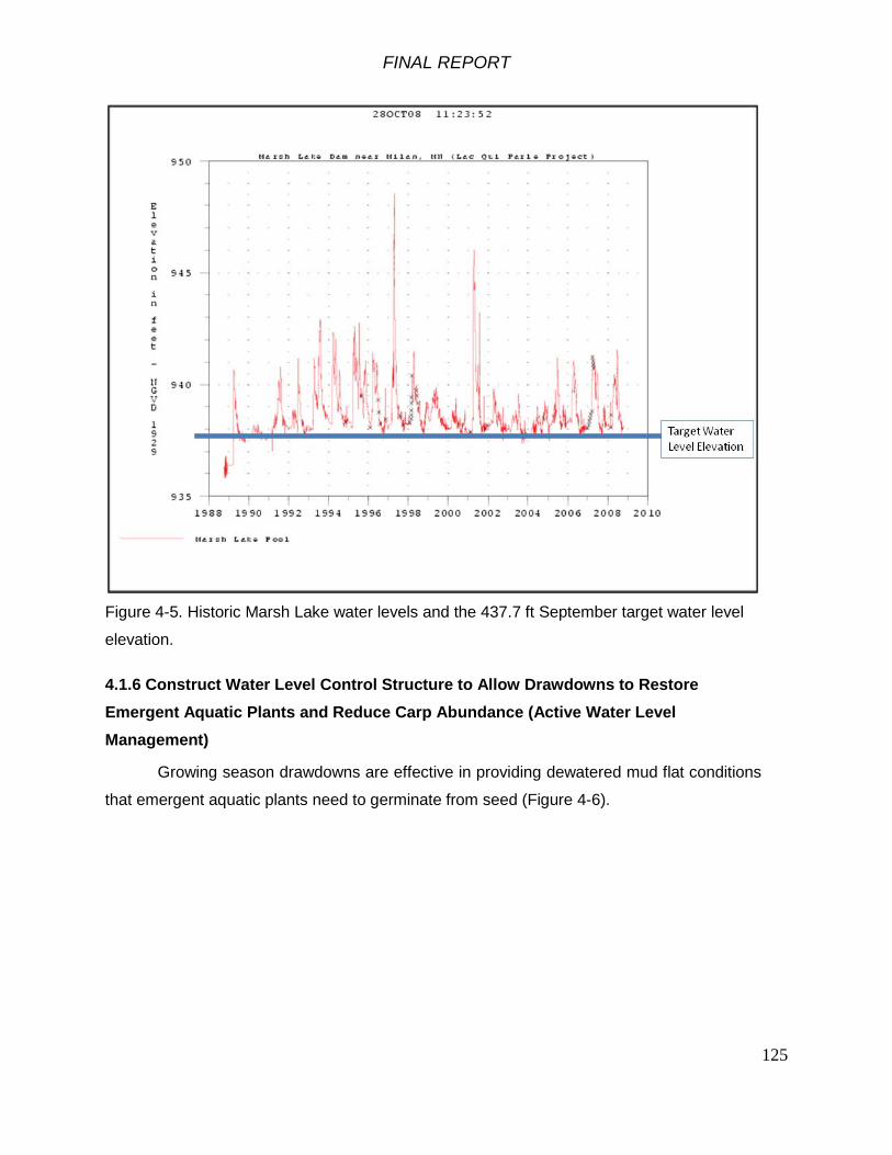
FINAL REPORT
125
Figure 4-5. Historic Marsh Lake water levels and the 437.7 ft September target water level
elevation.
4.1.6 Construct Water Level Control Structure to Allow Drawdowns to Restore Emergent Aquatic Plants and Reduce Carp Abundance (Active Water Level Management)
Growing season drawdowns are effective in providing dewatered mud flat conditions
that emergent aquatic plants need to germinate from seed (Figure 4-6).
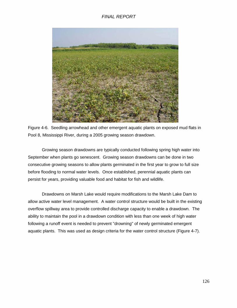
FINAL REPORT
126
Figure 4-6. Seedling arrowhead and other emergent aquatic plants on exposed mud flats in
Pool 8, Mississippi River, during a 2005 growing season drawdown.
Growing season drawdowns are typically conducted following spring high water into
September when plants go senescent. Growing season drawdowns can be done in two
consecutive growing seasons to allow plants germinated in the first year to grow to full size
before flooding to normal water levels. Once established, perennial aquatic plants can
persist for years, providing valuable food and habitat for fish and wildlife.
Drawdowns on Marsh Lake would require modifications to the Marsh Lake Dam to
allow active water level management. A water control structure would be built in the existing
overflow spillway area to provide controlled discharge capacity to enable a drawdown. The
ability to maintain the pool in a drawdown condition with less than one week of high water
following a runoff event is needed to prevent "drowning" of newly germinated emergent
aquatic plants. This was used as design criteria for the water control structure (Figure 4-7).

FINAL REPORT
127
Figure 4-7. Conceptual design of a drawdown water control structure for the Marsh Lake
Dam.
The drawdown structure would be 113.5-feet wide with 10 bays. The water control
structure would have a 16-ft wide walkway across the top that could serve a secondary
purpose as part of a trail across the dam in the future.

FINAL REPORT
128
The structure would enable drawdown of approximately 90 percent of the lake to
elevation 935 ft for winter drawdowns, dewatering approximately 3,569 acres of lake bed
(Figure 4-8).
Figure 4-8. Marsh Lake flooded area outline at different water surface elevations.
Growing season drawdowns of the Marsh Lake pool should maintain a minimum
elevation of 936.0 ft to prevent mainland predators from accessing the colonial bird nesting
islands. Growing season drawdowns would expose 2625 acres of lake bed, allowing
germination of emergent aquatic plants.
The frequency of drawdowns would be based on the extent of emergent aquatic
vegetation. When the area of emergent aquatic vegetation in Marsh Lake falls below 1500
acres (see Objective 5 above), a growing season drawdown would be conducted the next
year if river discharge allows.
FINAL REPORT
129
Winter Drawdowns to Reduce Carp Abundance Winter drawdowns would reduce the volume of water in Marsh Lake and the amount
of available dissolved oxygen, imposing hypoxia stress and winterkill on carp. Winter
drawdowns would stress other fish species and would kill most submersed aquatic plants
except sago pondweed, which is the most common submersed aquatic plant in Marsh Lake
and the target species for structural enhancement to the ecosystem. Sago pondweed is
resistant to freezing if snow covers the dewatered sediment. Winter drawdowns on Marsh
Lake would also require a water control structure in the Marsh Lake Dam to allow active
water level management as described above. Winter drawdowns would be implemented
following growing season drawdowns or separately as needed to limit carp abundance in
Marsh Lake and meet project Objective 8. As noted above, winter drawdowns will stress the
existing fish community, primarily dominated by invasive carp, but will allow native fish to
reestablish within the lake in the following spring, ultimately shifting the dominance from
invasive species to the native community. Winter drawdowns would be to the sill elevation of
the stoplog control structure, 935.0 ft, leaving 2425 acres of water in Marsh Lake, most of
which would freeze to the bottom.
4.1.7 Install Gated Culverts on Louisburg Grade Road
The existing culverts under the Louisburg Grade Road (Figures 4-9, 4-10) drain
water from the upper end of Marsh Lake. The Louisburg Grade Road is owned and
maintained by Akron Township of Big Stone County. The culverts are deteriorating and
should be replaced. A natural river levee of higher ground exists along the Minnesota River
upstream of the Louisburg Grade Road. New culverts with stoplogs would allow active
management of water levels in the upper end of Marsh Lake.
Water levels in the upper part of Marsh Lake could be managed separately from the
main body of the lake. For example, high water levels could be maintained for a time in
early spring to provide flooded marsh habitat upstream of the Louisburg Grade Road for
spawning northern pike and to improve survival of young-of-year fish. The stop logs could
then be removed to allow the fish to return to Marsh Lake.

FINAL REPORT
130
Figure 4-9. Culverts under the Louisburg Grade Road at the upper end of Marsh Lake.
Figure 4-10. Location of culverts under the Louisburg Grade Road at the upper end of
Marsh Lake.
Water levels in the upper part of Marsh Lake could also be managed separately from
the main body of the lake to provide deeper marsh habitat during years when growing

FINAL REPORT
131
season drawdowns are implemented on Marsh Lake. This would provide habitat for nesting
waterfowl and furbearers when much of the rest of Marsh Lake is dewatered.
4.1.8 Install Gated Culverts and Pump System on Abandoned Fish Pond
The abandoned fish pond on the downstream side of the Marsh Lake Dam (Figure 4-
11) currently is shallow un-vegetated aquatic habitat without connection to Lac qui Parle. If
the existing inlet and outlet structures were rehabilitated or new ones installed, the
abandoned fish pond could be operated as a moist soil management area to produce food
for shorebirds and waterfowl, and/or to provide spawning habitat for northern pike. If it were
to be operated as a moist soil management unit, a pump would be needed to maintain low
water levels for emergent plant germination.
4.1.9 Breach Dike on Abandoned Fish Pond
Breaching the dike in one or more places on the abandoned fish pond would allow
water levels within it to be the same as in the upper end of Lac qui Parle, and would allow
fish access to the area. The shallow abandoned fish pond area would also provide
shorebird habitat during times when Lac qui Parle water level is low.
Figure 4-11. Marsh Lake Dam with abandoned fish rearing pond at upper right.
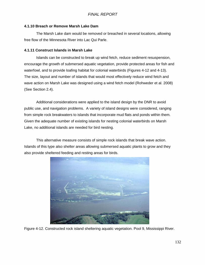
FINAL REPORT
132
4.1.10 Breach or Remove Marsh Lake Dam
The Marsh Lake dam would be removed or breached in several locations, allowing
free flow of the Minnesota River into Lac Qui Parle.
4.1.11 Construct Islands in Marsh Lake
Islands can be constructed to break up wind fetch, reduce sediment resuspension,
encourage the growth of submersed aquatic vegetation, provide protected areas for fish and
waterfowl, and to provide loafing habitat for colonial waterbirds (Figures 4-12 and 4-13).
The size, layout and number of islands that would most effectively reduce wind fetch and
wave action on Marsh Lake was designed using a wind fetch model (Rohweder et al. 2008)
(See Section 2.4).
Additional considerations were applied to the island design by the DNR to avoid
public use, and navigation problems. A variety of island designs were considered, ranging
from simple rock breakwaters to islands that incorporate mud flats and ponds within them.
Given the adequate number of existing islands for nesting colonial waterbirds on Marsh
Lake, no additional islands are needed for bird nesting.
This alternative measure consists of simple rock islands that break wave action.
Islands of this type also shelter areas allowing submersed aquatic plants to grow and they
also provide sheltered feeding and resting areas for birds.
Figure 4-12. Constructed rock island sheltering aquatic vegetation. Pool 9, Mississippi River.

FINAL REPORT
133
Figure 4-13. Location of potential rock breakwater islands (red) in Marsh Lake.
The rock islands would be constructed of local rock (quarry scrap and from farm
fieldstone piles, not "mined" from native prairie areas). The rock islands would likely be built
during winter when the lake is drawn down. The rock islands would be built to a top
elevation of 940.3 ft, with a top width of 5 ft and side slopes of 3 to 1. Breakwater A
(northernmost) would be 2647 ft long. Breakwater B (middle) would be 2153 feet long, and
Breakwater C (southernmost) would be 2466 feet long. A total of 41,045 cubic yards of rock
would be used to construct the breakwater islands.
4.1.12 Construct Exclosures to Prevent Grazing and Plant Submersed Aquatic Vegetation
Submersed aquatic vegetation can be planted in shallow lakes where the seed bank
is exhausted or propagules are scarce. Seeds and propagules can be obtained from
commercial nurseries or harvested from the wild. After seeds and propagules have been
planted, they require protection from grazing. Exclosures are typically netting suspended
from stakes to exclude carp. Once sufficient area of submersed aquatic vegetation is
established, the exclosures can be removed and the vegetation cover may expand.

FINAL REPORT
134
4.2 Screening of the Alternative Measures
Identified alternative measures must be evaluated in their effectiveness in achieving
planning objectives while simultaneously complying with administrative, policy, legal and
environmental constraints. From Section 3, objectives and constraints were identified as
follows:
Objectives Constraints1. Reduced sediment loading to Marsh Lake over the 50-year period of analysis
7. Restored aquatic habitat connectivity between Marsh Lake, the Pomme de Terre River and Lac Qui Parle over the 50-year period of analysis
8. Reduced abundance of aquatic invasive fish species within Marsh Lake over the 50-year period of analysis
9. Increased diversity and abundance of native fish within Marsh Lake and the Pomme de Terre River over the 50-year period of analysis
2. Restored natural fluctuations to the hydrologic regime of Marsh Lake over the 50-year period of analysis
3. Restored geomorphic and floodplain processes to the Pomme de Terre River over the 50-year period of analysis 2. The formulation of alternative measures should avoid, to the greatest extent
possible, the reduction of the flood damage reduction benefits provided by the dams.4. Reduced sediment resuspension within
Marsh Lake over the 50-year period of analysis
5. Increased extent, diversity and abundance of emergent and submersed aquatic plants within Marsh Lake over the 50-year period of analysis
6. Increased availabil ity of waterfowl habitat within Marsh Lake over the 50-year period of analysis
3. In its existing condition, Marsh Lake and the Pomme de Terre River provide functional habitat for a number of species. A universal constraint in the planning of ecosystem restoration projects is the maxim that the restoration activities should not degrade, but rather seek to improve, the existing function of the ecosystem from its current state. Consideration of the potential adverse impacts to species within the project area therefore imposes constraints on the development of alternative measures. Specific biotic considerations include:
a. American Pelicans – a colony of nesting and breeding pelicans inhabits Marsh Lake during the summer months. Pelicans seek refuge on islands in the lake. Changes to water levels within the lake should minimize the impact on the isolation of these islands.
b. Mussels – A diverse mussel community exists within the lower reaches of the Pomme de Terre River. Consideration of project alternatives should minimize the impacts to this community and its future viabil ity.
c. Fish Community – while the community is primarily dominated by common carp (an invasive species), Lac qui Parle and Marsh Lake also support communities of native fish. Changes to water levels resulting from alternative measures must minimize the negative impact on the native fish community, particularly valuable northern pike spawning habitat in the upper end of Marsh Lake.
1. The planning process must be consistent with all applicable Federal laws, Executive Orders, Agency Regulations and other applicable policy.
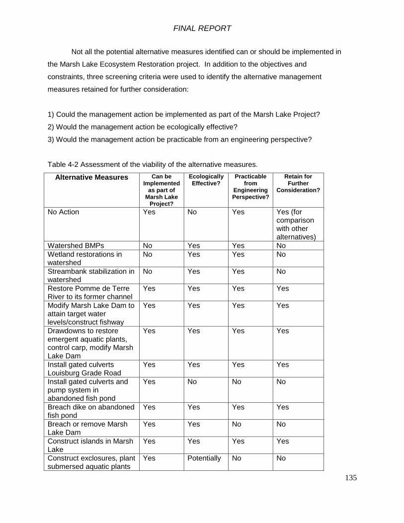
FINAL REPORT
135
Not all the potential alternative measures identified can or should be implemented in
the Marsh Lake Ecosystem Restoration project. In addition to the objectives and
constraints, three screening criteria were used to identify the alternative management
measures retained for further consideration:
1) Could the management action be implemented as part of the Marsh Lake Project?
2) Would the management action be ecologically effective?
3) Would the management action be practicable from an engineering perspective?
Table 4-2 Assessment of the viability of the alternative measures.
Alternative Measures Can be Implemented
as part of Marsh Lake
Project?
Ecologically Effective?
Practicable from
Engineering Perspective?
Retain for Further
Consideration?
No Action Yes No Yes Yes (for comparison with other alternatives)
Watershed BMPs No Yes Yes No Wetland restorations in watershed
No Yes Yes No
Streambank stabilization in watershed
No Yes Yes No
Restore Pomme de Terre River to its former channel
Yes Yes Yes Yes
Modify Marsh Lake Dam to attain target water levels/construct fishway
Yes Yes Yes Yes
Drawdowns to restore emergent aquatic plants, control carp, modify Marsh Lake Dam
Yes Yes Yes Yes
Install gated culverts Louisburg Grade Road
Yes Yes Yes Yes
Install gated culverts and pump system in abandoned fish pond
Yes No No No
Breach dike on abandoned fish pond
Yes Yes Yes Yes
Breach or remove Marsh Lake Dam
Yes Yes No No
Construct islands in Marsh Lake
Yes Yes Yes Yes
Construct exclosures, plant submersed aquatic plants
Yes Potentially No No

FINAL REPORT
136
No action to restore the Marsh Lake ecosystem continues to impose unnaturally high
water levels with only passive water level variability, relying on droughts to reduce inflows to
zero and lower water level in Marsh Lake below the level of the fixed crest weir. This
alternative measure would not meet the project objectives. It will be retained for further
consideration because it is part of the without-project future baseline condition.
A variety of watershed BMPs can be implemented to moderate the hydrologic regime
and reduce sediment and nutrient loading to Marsh Lake and Lac qui Parle. These are all
actions that can and hopefully will be implemented by private landowners, other agencies
and organizations under other programs. These alternative measures are being evaluated
in the Minnesota River Basin Integrated Watershed Study. These alternative measures will
not be retained for further consideration in the Marsh Lake project. They are actions that
extend throughout the Upper Minnesota River Basin and are beyond the scope of the Marsh
Lake project.
Lowering the water level within the abandoned fish pond area to below the level of
Lac qui Parle would require pumping. Given the small size (10 acres) of this area, lack of
DNR interest in active water level management in this area and the relatively high cost of
pumps and operation and maintenance, this alternative measure has been dropped from
further consideration.
Removing Marsh Lake dam would continuously lower the water level of Marsh Lake,
allowing it to fluctuate along with the water level in Lac qui Parle reservoir. Much of Marsh
Lake would become dewatered, reverting to wet meadow and marsh with the Minnesota
River channel running through it. The potential for extensive areas of emergent and
submersed aquatic vegetation providing food for migratory waterfowl would be significantly
reduced. The colonial waterbird nesting islands would become vulnerable to predation and
the colonial waterbirds would have restricted foraging area. In its current state, the Marsh
Lake Dam does provide a minor benefit to flood damage reduction by storing the head of
minor flooding in the upstream portion of the reservoir. Removing the hydraulic constriction
of the Marsh Lake dam would reduce the head and storage upstream and would have the
potential to increase the risk of downstream flooding damages. For these reasons, this
alternative measure was dropped from further consideration.

FINAL REPORT
137
Constructing exclosures to prevent carp grazing and planting submersed aquatic
plants would be difficult in Marsh Lake due to fluctuating water levels and the wind and wave
conditions that occur there. A sufficiently abundant seed and propagule bank for sago
pondweed is present that allows abundant growth in years when growing conditions permit,
so the seed bank is not a problem. For these reasons, this alternative measure was
dropped from further consideration.
The alternative measures retained for further consideration (Table 4-3) derive from
the ecosystem objectives for the project and are considered promising for implementation;
potentially ecologically effective and practicable from an engineering perspective. Estimated
costs of these alternative measures are provided in Table 4-3 and in Appendix G. The
alternative measures will be combined into the alternative plans.
FINAL REPORT
138
Table 4-2. Alternative measures retained for further consideration.
1) No Action 2) Restore Pomme de Terre River to its former channel 3) Modify Marsh Lake Dam to attain target water levels, construct fishway 4) Construct a drawdown water control structure to enable water level drawdowns and restore aquatic plants 5) Install gated culverts in Louisburg Grade Road 6) Breach dike at abandoned fish pond 7) Construct islands in Marsh Lake
Table 4-3. Costs of the alternative measures.
Alternative Measure Number Alternative Measures
Net Benefit (AAHU)
First Costs of Construction O&M Cost
Planning, Engineering
& Design (PED)
Construction Management
(CM)Total First
Project CostsAverage
Annual Costs1 No Action 0 -$ -$ -$ -$ -$ -$
2Restore Pomme de Terre River to its former channel 6567 $ 3,448,212 $ 11,508 $ 387,945 $ 193,973 $ 4,030,130 203,588$
3 Modify Marsh Lake Dam to attain target 483 1,399,695$ 7,245$ 154,433$ 77,216$ 1,631,344$ 85,382$
4Construct drawdown water control structure 725 2,594,217$ 13,503$ 278,993$ 139,496$ 3,012,706$ 157,782$
5Install gated culverts in Louisburg Grade Road 610 448,902$ 800$ 52,815$ 26,408$ 528,125$ 26,105$
6 Breach dike at abandoned fish pond 5 6,426$ 50$ 870$ 435$ 7,731$ 421$ 7 Construct islands in Marsh Lake 239 4,006,254$ 20,376$ 448,875$ 224,438$ 4,679,567$ 244,535$
FINAL REPORT
139
4.3 Alternative Plans
Alternative plans are combinations of alternative measures that would contribute
to attaining the planning objectives. A stand alone measure is an alternative measure that
can be implemented independently of others, resulting in some positive amount of
ecosystem restoration output. Optional measures are those measures that would have
limited utility by themselves, but can be implemented with other measures.
4.3.1 Stand Alone Measures
Measure 1 – No Action The Corps is required to consider the option of “No Action” as one of the alternatives.
With the No Action plan, which is synonymous with the “Without Project Condition,” we
assume that no project would be implemented by the Federal Government or by local
interests to achieve the planning objectives. The No Action plan forms the basis from which
all other alternative plans are measured.
Measure 2 – Restore the Pomme de Terre River to its former channel This is a stand-alone measure that could be implemented independently of other
restoration alternatives. Earthen berms would be constructed to re-route the river into its
former channel both upstream and downstream of the Marsh Lake Dam access road
embankment. This alternative would include a bridge over the river to maintain access to
the Marsh Lake Dam and monitoring of the mussel community as described in Section 4.1.4
above.
Measure 3 - Modify Marsh Lake Dam to attain target water levels, construct fishway This is a stand-alone measure that could be implemented independently of other
restoration alternatives. Marsh Lake Dam would be modified with a fixed-crest weir fishway
that would allow passive attainment of target water levels in most years and also allow
continuous fish passage between Lac qui Parle and Marsh Lake.
Measure 4 – Construct a drawdown water control structure in Marsh Lake Dam
This is a stand-alone measure that could be implemented independently of other
restoration alternatives. Marsh Lake Dam would have to be modified with a water control
structure to enable water level management. Growing season drawdowns to elevation
936.0 ft would be done to encourage reestablishment of emergent aquatic plants and to

FINAL REPORT
140
increase the extent of submersed aquatic plants, particularly sago pondweed, an important
source of forage for waterfowl. Following growing season drawdowns, winter drawdowns to
elevation 935.0 ft could be implemented to reduce carp abundance.
Measure 5 – Install gated culverts in Louisburg Grade Road
. Installing stoplog control structures on the Louisburg Grade Road culverts would
enable holding water in upper Marsh Lake in years when a growing season drawdown was
conducted, allowing northern pike to successfully spawn in the flooded marsh vegetation
and the young to grow into juveniles. Implementation of this measure is dependent on the
construction of a drawdown structure and would only be effective in drawdown years on the
lake. The measure is considered stand alone, but will only be combined with Alternative
Plan combinations that include the drawdown structure for the purpose of plan formulation.
Measure 6 – Breach dike at abandoned fish pond
This is a stand-alone measure that could be implemented independently of other
restoration alternatives. Breaching the fish pond dike on the downstream side of the Marsh
Lake Dam would provide connectivity between the fish pond area and the upper end of Lac
qui Parle, allowing native floodplain vegetation to become established and providing
seasonally variable habitat for fish and shorebirds.
Measure 7 – Construct islands in Marsh Lake This is a stand-alone measure that could be implemented independently.
Constructing islands to break up wave action and reduce sediment resuspension would
improve conditions for submersed aquatic plant growth. Although this is a stand-alone
measure, it would be best to construct islands in Marsh Lake in conjunction with growing
season and winter drawdowns (Measure 4) and modifying Marsh Lake Dam to attain target
water levels (Measure 3). Growing season drawdowns would consolidate lake bed
sediment, reducing sediment resuspension. Winter drawdowns would reduce carp
abundance and grazing on submersed aquatic plants.
5. Optimization and Best Buy Analysis
Environmental plan evaluation consists of a comparison of the environmental
outputs and the economic costs of alternative plans. The cost effectiveness and

FINAL REPORT
141
incremental cost analysis procedures provide a framework to assist in environmental plan
evaluation. The following analysis was accomplished using the planning methodology
incorporated in the Institute of Water Resources Cost Effectiveness and Incremental Cost
Analysis program (IWR-PLAN). Combinations of solutions were derived and a total cost and
total output is calculated for each combination. The program then conducts cost
effectiveness analysis; first identifying the least cost combination for every possible level of
output, and then identifying the cost effective set of combinations by screening out plans
where more output could be provided by another combination at the same or less cost.
Once the cost effective set of combinations is identified, the program calculates the
incremental cost and incremental output of moving from each combination to the next larger
combination. The program also identifies the subset of the cost effective set which is the
most efficient in production, or “best-buys”, as scale increases from the smallest to the
largest combination.
Alternatives evaluated include the no action alternative and various combinations
of restoration measures. The ecosystem output variable is stated in average annual habitat
units (AAHU). Project outputs were determined by estimating the additional amount of
enhanced Marsh Lake aquatic habitat, Marsh Lake emergent marsh habitat, Pomme de
Terre River aquatic habitat, and floodplain wetland habitat that would be provided by each
alternative using a Habitat Evaluation Procedures (HEP) analysis (Appendix E).
Representative species and guilds used in the HEP analysis were diving ducks
for Marsh Lake aquatic habitat, walleye for Lac qui Parle and Pomme de Terre River aquatic
habitat, northern pike for Lac qui Parle and upper Marsh Lake aquatic habitat and great blue
heron for the abandoned fish pond wetland habitat. U.S. Fish and Wildlife Service "Blue
Book" models and an Upper Mississippi River diving duck habitat model were used in the
HEP analysis No relative value weighting of the habitat type areas potentially affected by
the Marsh Lake project was conducted. Details of the HEP analysis are provided in
Appendix E.
Cost estimates for the alternative plans were based on October 2011 price levels.
Details of the cost estimate are provided in Appendix G. The first costs of implementation
include detailed design, contracting, construction, planting, and monitoring. Recurring
operation and maintenance activities following construction and habitat restoration were

FINAL REPORT
142
estimated over the 50-year project life and included in the cost estimate. Average annual
costs were calculated by multiplying the first costs with operation and maintenance
(OMRR&R) costs by an Interest and Amortization Factor for 4 1/8 percent (0.04125) over
the 50 year period of analysis.
Plan formulation through IWR-Plan generated 48 alternative plans. Table 5 -1
presents the alternative plan combinations and Table 5-2 presents individual alternative
measure average annual cost estimates at March 2011 price levels, as well as the
estimated benefits (in average annual habitat units, AAHU’S). Alternative plans range from
the no action alternative with no costs and no benefits to the 48th combination (identified as
Alternative Plan 5) that has an average annual cost of $717,831with benefits of 8,508
AAHU’s.

FINAL REPORT
143
Table 5-1. Alternative plans with average annual benefits and average annual costs
1 0 ‐$ ‐$ *2 X 5 421$ 84.20$ 3 X 239 244,535$ 1,023.16$ 4 X X 244 244,956$ 1,003.92$ 5 X 483 85,382$ 176.77$ 6 X X 488 85,803$ 175.83$ 7 X X 722 329,917$ 456.95$ 8 X 725 157,782$ 217.63$ 9 X X X 727 330,338$ 454.39$
10 X X 730 158,203$ 216.72$ 11 X X 964 402,317$ 417.34$ 12 X X X 969 402,738$ 415.62$ 13 X X 1208 243,164$ 201.29$ 14 X X X 1213 243,585$ 200.81$ 15 X X X 1326 487,699$ 367.80$ 16 X X X X 1331 488,120$ 366.73$ 17 X X 1335 183,887$ 137.74$ 18 X X X 1340 184,308$ 137.54$ 19 X X X 1574 428,422$ 272.19$ 20 X X X X 1579 428,843$ 271.59$ 21 X X X 1818 269,269$ 148.11$ 22 X X X X 1823 269,690$ 147.94$ 23 X X X X 1936 513,804$ 265.39$ 24 X X X X X 1941 514,225$ 264.93$ 25 X 6567 203,588$ 31.00$ *26 X X 6572 204,009$ 31.04$ *27 X X 6806 448,123$ 65.84$ 28 X X X 6811 448,544$ 65.86$ 29 X X 7050 288,970$ 40.99$ 30 X X X 7055 289,391$ 41.02$ 31 X X X 7289 533,505$ 73.19$ 32 X X 7292 361,370$ 49.56$ 33 X X X X 7294 533,926$ 73.20$ 34 X X X 7297 361,791$ 49.58$ 35 X X X 7531 605,905$ 80.45$ 36 X X X X 7536 606,326$ 80.46$ 37 X X X 7775 446,752$ 57.46$ 38 X X X X 7780 447,173$ 57.48$ 39 X X X X 7893 691,287$ 87.58$ 40 X X X X X 7898 691,708$ 87.58$ 41 X X X 7902 387,475$ 49.04$ 42 X X X X 7907 387,896$ 49.06$ *43 X X X X 8141 632,010$ 77.63$ 44 X X X X X 8146 632,431$ 77.64$ 45 X X X X 8385 472,857$ 56.39$ 46 X X X X X 8390 473,278$ 56.41$ *47 X X X X X 8503 717,392$ 84.37$ 48 X X X X X X 8508 717,813$ 84.37$ *
No.
Rest
ore
Pom
me
de T
erre
Mod
ify M
arsh
Lak
e D
am
Dra
wdo
wn S
truct
ure
Louis
bur
g G
rade
Roa
d G
ated
Culv
erts
Ave
rage
Cost
s per
AA
HU
Best Buy Plan
Mod
ify A
ban
don
ed
Fis
h P
ond
Con
stru
ct Is
land
s in
Mars
h
Lake
Ave
rage
Annual
Hab
itat
Units
(AA
HU
)
Ave
rage
Annual
Cost
s

FINAL REPORT
144
Table 5-2. Cost and benefits (Average Annual Habitat Units) of alternative measures
(October 2011 price levels).
Alternative Measure Number Alternative Measures
Net Benefit (AAHU)
Total First Project Costs
Average Annual Costs
Annualized Cost
(per AAHU)1 No Action 0 -$ -$ -$
2Restore Pomme de Terre River to its former channel 6567 4,030,130$ 203,588$ 31$
3Modify Marsh Lake Dam to attain target water levels, construct fishway 483 1,631,344$ 85,382$ 177$
4Construct drawdown water control structure 725 3,012,706$ 157,782$ 218$
5Install gated culverts in Louisburg Grade Road 610 528,125$ 26,105$ 43$
6 Breach dike at abandoned fish pond 5 7,731$ 421$ 84$ 7 Construct islands in Marsh Lake 239 4,679,567$ 244,535$ 1,023$
Interest and Amoritization on Factor for 4-1/8% interest (0.04125) over the 50 year payment period.
FINAL REPORT
145
To further refine the number of alternative plans remaining, criteria to distinguish
the cost effectiveness of each alternative were established. The screening for cost
effectiveness included the following:
• The same output level could be produced by another plan at less cost;
• A larger output level could be produced at the same cost; or
A larger output level could be produced at less cost.
Five alternative plans (including the “No Action” alternative) emerged as cost-
effective and were identified as "Best Buy" plans through incremental and cost effectiveness
analysis using the Corps of Engineers IWR Planning Suite (Table 5-1, Figure 5-1). In the
figure below, a blue best-fit straight line is included to identify the trend in cost-effective
plans, while a red best-fit curve is included to illustrate the array of best buy plans within
chart.

FINAL REPORT
146
Figure 5-1 Results of incremental and cost effectiveness analysis of the alternative plans.
Average annual costs (y-axis costs) versus average annual habitat units (x-axis benefits)
Figure 5-15 further highlights information included in Table 5-1 by illustrating the
average annual cost per unit (cost of one AAHU) for each plan contrasted with the
corresponding cumulative ecosystem benefits of each plan. Best Buy/Alternative Plans are
specifically identified within the graph.

FINAL REPORT
147
Figure 5-2 Average annual costs per average annual habitat units (Best Buy Plans
Identified)
A best buy plan is a cost effective plan that has the greatest increase in output or
benefit for the least increase in cost. Each cost effective plan was first compared to the no
action alternative and ranked. This ranking provided the first best buy plan. From here,
each remaining plan was compared to the first best buy plan and ranked. This analysis
yielded the second best buy and so on. There can be multiple best buy plans and any of
them can be chosen as the preferred alternative.

FINAL REPORT
148
6. Evaluation and Comparison of Alternative Plans
6.1 Alternative Plans
The five best buy plans and the no action alternative are carried forward in the
analysis and further described as alternative plans.
Alternative Plan 0 (IWR Formulated Plan #1): No Action
The no action alternative assumes that no project would be implemented by
either the Corps or local interests to achieve the planning objectives. The no action
alternative is synonymous with the without-project future condition.
Alternative Plan 1 (IWR Formulated Plan #25)
Alternative Plan 1 is the restoration of the Pomme de Terre River to its historic
channel. The average annual cost of this plan is $203,588 and would result in 6,567 AAHU
over 50 years.
Alternative Plan 2 (IWR Formulated Plan #26)
Alternative Plan 2 is a combination of restoration of the Pomme de Terre River
described in Alternative Plan 1 with the addition of breaching the dike at the Abandoned
Fish Pond in order to connect this area to the downstream area of Lac qui Parle. The
average annual cost of this plan is $204,009 (average and would result in 6,572 AAHU over
50 years.
Alternative Plan 3 (IWR Formulated Plan #42)
Alternative Plan 3 is a combination of the restoration measures included in
Alternative Plan 2 with the addition of a drawdown structure to lower lake levels periodically
and construction of culverts with stoplogs at Louisburg Grade Road. The average annual
cost of this plan is $387,896 and would result in 7,907 AAHU over 50 years.
Alternative Plan 4 (IWR Formulated Plan #46)
Alternative Plan 4 is a combination of Alternative 3 with the addition of modifying
Marsh Lake Dam to meet target water levels and construct a fishway. The average annual
cost of this plan is $473,278 and would result in 8,390 AAHU over 50 years.

FINAL REPORT
149
Alternative Plan 5 (IWR Formulated Plan #48)
Alternative Plan 5 is a combination of all the alternative measures including
constructing islands in Marsh Lake. The average annual cost of this plan is $717,813 and
would result in 8508 AAHU over 50 years.
6.2 Evaluation of the Alternative Plans
The alternative plans are evaluated for their potential to contribute to achieving
project objectives:
1. Reduced sediment loading to Marsh Lake over the 50-year period of analysis 2. Restored natural fluctuations to the hydrologic regime of Marsh Lake over the 50-year
period of analysis 3. Restored geomorphic and floodplain processes to the Pomme de Terre River over the 50-
year period of analysis 4. Reduced sediment resuspension within Marsh Lake over the 50-year period of analysis 5. Increased extent, diversity and abundance of emergent and submersed aquatic plants
within Marsh Lake over the 50-year period of analysis 6. Increased availability of waterfowl habitat within Marsh Lake over the 50-year period of
analysis 7. Restored aquatic habitat connectivity between Marsh Lake, the Pomme de Terre River
and Lac Qui Parle over the 50-year period of analysis 8. Reduced abundance of aquatic invasive fish species within Marsh Lake over the 50-year
period of analysis 9. Increased diversity and abundance of native fish within Marsh Lake and the Pomme de
Terre River over the 50-year period of analysis
The narrative below discusses the degree to which the alternative plans would
contribute to attaining the project objectives.
Objective 1: Reduced sediment and nutrient loading to Marsh Lake Alternative Plan 0: No Action
The no-action plan would not meet this objective. Sediment and nutrient loading to
Marsh Lake and Lac qui Parle would continue at high rates.

FINAL REPORT
150
Alternative Plan 1: Restore the Pomme de Terre River to its Historic Channel
This alternative plan would significantly reduce sediment and nutrient loading to
Marsh Lake. Sediment and nutrients conveyed by the Pomme de Terre River would enter
the upper end of Lac qui Parle via the historic Pomme de Terre River delta. Much of the
sediment and nutrient load would be retained in overbank areas in the floodplain,
contributing to natural floodplain processes and reducing sediment and nutrient loading to
Lac qui Parle.
Alternative Plan 2: Restore Pomme de Terre River to its Historic Channel + Breach Dike at
Abandoned Fish Pond
This alternative plan would significantly reduce sediment and nutrient loading to
Marsh Lake as described for Alternative Plan 1. In addition, breaching the abandoned fish
pond dike would reconnect the fish pond area to the upper end of Lac qui Parle, providing
the opportunity for retaining sediment and processing nutrients within the fish pond area.
Alternative Plan 3: Alternative Plan 2 + Drawdown Structure + Gated Culverts at Louisburg
Grade Road
This alternative plan would significantly reduce sediment and nutrient loading to
Marsh Lake as described for Alternative Plan 2. The drawdown structure would enable
drawdowns on Marsh Lake to restore aquatic vegetation. Increased extent of aquatic
vegetation would retain sediments and nutrients in Marsh Lake, reducing sediment and
nutrient loading to Lac qui Parle. Stoplog structures under the Louisburg Grade Road would
only be operated during years when Marsh Lake is drawn down to enable successful
spawning by northern pike in upper Marsh Lake. This would have a minor positive
contribution to Objective 1 by retaining sediment and nutrients in upper Marsh Lake during
the years when Marsh Lake is drawn down.
Alternative Plan 4 – Alternative Plan 3 + Modify Marsh Lake Dam to Attain Target Water
Levels and Construct Fishway
This alternative plan would significantly reduce sediment and nutrient loading to
Marsh Lake as described for Alternative Plan 3. In addition, Modifying Marsh Lake Dam
with a fishway would result in lower late summer and winter water levels in Marsh Lake. This
would encourage aquatic vegetation in Marsh Lake, trapping sediment and nutrients in
Marsh Lake, thereby reducing sediment and nutrient loading to Lac qui Parle.

FINAL REPORT
151
Alternative Plan 5 – Alternative 4 + Construct Islands in Marsh Lake (All alternative
measures)
This alternative plan would significantly reduce sediment and nutrient loading to
Marsh Lake as described for Alternatives 4. Constructing islands in Marsh Lake would
further promote aquatic vegetation in Marsh Lake, trapping sediment and nutrients in Marsh
Lake, thereby reducing sediment and nutrient loading to Lac qui Parle.
Objective 2: Restored natural fluctuations the water level regime in Marsh Lake Alternative Plan 0: No Action
The no action plan would not meet the objective of restoring a more natural water
level regime in Marsh Lake.
Alternative Plan 1: Restore Pomme de Terre River to its Historic Channel
Restoring the Pomme de Terre River to its former channel would help restore a more
natural water level regime in Marsh Lake by moderating water level fluctuations induced by
storm runoff events in the Pomme de Terre River watershed. This would be a minor but
positive effect. The fixed crest Marsh Lake Dam would continue to limit the low side of the
water level regime in Marsh Lake.
Alternative Plan 2: Restore Pomme de Terre River to its Historic Channel + Breach Dike at
Abandoned Fish Pond
This alternative plan would help restore a more natural water level regime in Marsh
Lake as described for Alternative Plan 1. Breaching the dike on the abandoned fish pond
would have no effect on the water level regime in Marsh Lake.
Alternative Plan 3: Alternative Plan 2 + Drawdown Structure + Gated Culverts at Louisburg
Grade Road
This alternative would meet the objective of restoring a more natural water level
regime in Marsh Lake by enabling drawdowns of Marsh Lake to consolidate sediment and
restore emergent aquatic plants. The drawdowns would simulate natural low water events
that occurred on Marsh Lake prior to impoundment. The gated culverts at the Louisburg
Grade Road would allow successful spawning of northern pike in upper Marsh Lake in years
FINAL REPORT
152
when Marsh Lake is drawn down. Northern pike spawn in flooded emergent marsh
vegetation.
Alternative Plan 4 – Alternative Plan 3 + Modify Marsh Lake Dam to Attain Target Water
Levels and Construct Fishway
This Alternative Plan would meet the objective of restoring a more natural water level
regime as described for Alternative Plan 3. In addition, modifying Marsh Lake Dam with a
fishway would result more natural lower late summer and winter water levels in Marsh Lake
nearly every year through passive water level management.
Alternative Plan 5 – Alternative 4 + Construct Islands in Marsh Lake (All alternative
measures)
This Alternative Plan would meet the objective of restoring a more natural water level
regime as described for Alternative Plan 4 above. Constructing islands would have no effect
on the Marsh Lake water level regime, however islands would be effective in reducing wind-
driven waves and sediment resuspension, thereby promoting growth of submersed aquatic
plants (Objectives 4 and 5).
Objective 3: Restored natural geomorphic and floodplain processes in Pomme de Terre River
Alternative Plan 0: No Action
The no-action plan would not restore geomorphic and floodplain processes in the
Pomme de Terre River.
Alternative Plan 1: Restore Pomme de Terre River to its Historic Channel
This alternative plan would restore geomorphic and floodplain processes in the
Pomme de Terre River and its delta at its historic confluence with the Minnesota River in
upper Lac qui Parle. The Pomme de Terre River would flow through its former channel in its
confluence with the Minnesota River, resuming the fluvial processes that form the complex
channel and floodplain habitats in that area. Sediment conveyed by the river would be
deposited overbank in the delta area during higher discharge events, enriching floodplain
soils, enhancing floodplain habitats and reducing sediment and nutrient loading into Lac qui
Parle.

FINAL REPORT
153
Alternative Plan 2: Restore Pomme de Terre River to its Historic Channel + Breach Dike at
Abandoned Fish Pond
This alternative plan would restore geomorphic and floodplain processes as
described for Alternative Plan 1. In addition, breaching the dike at the abandoned fish pond
would reconnect the fish pond area with the upper end of Lac qui Parle, enabling movement
of water, materials and organisms between that area and the rest of the floodplain.
Although not directly contributing to restoring geomorphic and floodplain processes in the
Pomme de Terre River, it would restore floodplain processes in upper Lac qui Parle across
the Minnesota River from the Pomme de Terre River confluence.
Alternative Plan 3: Alternative Plan 2 + Drawdown Structure + Gated Culverts at Louisburg
Grade Road
This alternative plan would also restore geomorphic and floodplain processes in the
Pomme de Terre River and its delta as described for Alternative Plan 2.
Alternative Plan 4 – Alternative Plan 3 + Modify Marsh Lake Dam to Attain Target Water
Levels and Construct Fishway
This alternative plan would also restore geomorphic and floodplain processes in the
Pomme de Terre River and its delta as described for Alternative Plan 2.
Alternative Plan 5 – Alternative 4 + Construct Islands in Marsh Lake (All alternative
measures)
This alternative plan would also restore geomorphic and floodplain processes in the
Pomme de Terre River and its delta as described for Alternative Plan 2.
Objective 4: Reduced sediment resuspension in Marsh Lake
Alternative Plan 0: No Action
The no action alternative would not meet the objective for reduced sediment
resuspension in Marsh Lake.
Alternative Plan 1: Restore Pomme de Terre River to its Historic Channel

FINAL REPORT
154
Alternative Plan 1 would not meet the objective for reduced sediment resuspension
in Marsh Lake.
Alternative Plan 2: Restore Pomme de Terre River to its Historic Channel + Breach Dike at
Abandoned Fish Pond
Alternative Plan 2 would not meet the objective for reduced sediment resuspension
in Marsh Lake.
Alternative Plan 3: Alternative Plan 2 + Drawdown Structure + Gated Culverts at Louisburg
Grade Road
Alternative Plan 3 would contribute to achieving reduced sediment resuspension in
Marsh Lake. Drawdowns would consolidate sediment and encourage the reestablishment
of emergent aquatic vegetation which upon return to normal water levels would greatly
reduce wind fetch and sediment resuspension in Marsh Lake.
Alternative Plan 4 – Alternative Plan 3 + Modify Marsh Lake Dam to Attain Target Water
Levels and Construct Fishway
Alternative Plan 4 would also contribute to achieving reduced sediment resuspension
as described for Alternative Plan 3. In addition, modifying Marsh Lake Dam with a fishway
would result more natural lower late summer and winter water levels in Marsh Lake nearly
every year through passive water level management. This would encourage the
establishment and persistence of emergent aquatic vegetation that would reduce wind fetch
and sediment resuspension.
Alternative Plan 5 – Alternative 4 + Construct Islands in Marsh Lake (All alternative
measures)
This alternative plan would greatly contribute to reducing sediment resuspension as
described for Alternative Plan 4. In addition, rock wave barrier islands are very effective in
reducing wind fetch, wave action and sediment resuspension and have been designed to
optimally reduce wind fetch and wave action on Marsh Lake.

FINAL REPORT
155
Objective 5: Increased extent, diversity and abundance of emergent and submersed aquatic plants in Marsh Lake
Alternative Plan 0: No Action
The no action plan would not meet this objective. Submersed aquatic plants would
remain sparse and emergent vegetation would be limited to a narrow fringe around the
shores.
Alternative Plan 1: Restore Pomme de Terre River to its Historic Channel
This alternative plan would contribute to increased submersed aquatic vegetation in
Marsh Lake by reducing sediment loading from the Pomme de Terre River and by
moderating the water level regime in Marsh Lake. Reduced sediment loading would reduce
turbidity, allowing more underwater light necessary for submersed aquatic plant growth. A
more natural water level regime would reduce periods of high water, also contributing to
submersed aquatic plant growth.
Alternative Plan 2: Restore Pomme de Terre River to its Historic Channel + Breach Dike at
Abandoned Fish Pond
Like Alternative Plan 1, this alternative plan would contribute to increased submersed
aquatic vegetation in Marsh Lake. Breaching the dike in the abandoned fish pond may
increase submersed aquatic plant growth in that area.
Alternative Plan 3: Alternative Plan 2 + Drawdown Structure + Gated Culverts at Louisburg
Grade Road
Alternative Plan 3 would greatly contribute to increased aquatic vegetation in Marsh
Lake. In addition to the positive effects of re-routing the Pomme de Terre River on
submersed aquatic plants in Marsh Lake as described for Alternative Plan 2, drawdowns
would enable reestablishment of emergent aquatic plants. Drawdowns consolidate bottom
sediment, reducing sediment resuspension and allowing the seeds of emergent aquatic
plants to germinate in the dewatered area. Upon return to normal water levels, the
increased extent of emergent aquatic plants would reduce wind fetch and sediment
resuspension, allowing more submersed aquatic plant growth. Winter drawdowns would
reduce abundance of common carp that graze on submersed aquatic plants.
FINAL REPORT
156
Alternative Plan 4 – Alternative Plan 3 + Modify Marsh Lake Dam to Attain Target Water
Levels and Construct Fishway
Alternative Plan 4 would increase the extent and abundance of aquatic vegetation in
Marsh Lake as described for Alternative Plan 3. In addition, modifying Marsh Lake Dam
with a fishway would result in more natural lower late summer and winter water levels in
Marsh Lake nearly every year through passive water level management. This would
encourage the establishment and persistence of emergent aquatic vegetation.
Alternative Plan 5 – Alternative 4 + Construct Islands in Marsh Lake (All alternative
measures)
This alternative plan would increase the extent and abundance of aquatic vegetation
as described for Alternative Plan 4. In addition, the rock wave barrier islands would
physically reduce wind fetch, wind-driven wave action and sediment resuspension over
much of Marsh Lake, greatly contributing to growth of submersed aquatic plants.
Objective 6: Increased availability of waterfowl habitat within Marsh Lake
Alternative Plan 0: No Action
The no action plan would not contribute to increased waterfowl habitat in Marsh
Lake.
Alternative Plan 1: Restore Pomme de Terre River to its Historic Channel
This alternative plan would contribute to increased availability of waterfowl habitat by
increasing submersed aquatic vegetation needed by fall migrating waterfowl. Submersed
aquatic vegetation would increase due to reduced sediment loading from the Pomme de
Terre River and a moderated the water level regime in Marsh Lake.
Alternative Plan 2: Restore Pomme de Terre River to its Historic Channel + Breach Dike at
Abandoned Fish Pond
This alternative plan would contribute to increased availability of waterfowl habitat as
described for Alternative Plan 1. In addition, breaching the dike on the abandoned fish pond

FINAL REPORT
157
would restore habitat connectivity with the rest of Lac qui Parle, providing a shallow foraging
area for fish-eating waterfowl.
Alternative Plan 3: Alternative Plan 2 + Drawdown Structure + Gated Culverts at Louisburg
Grade Road
This alternative plan would greatly contribute to increased availability of waterfowl
habitat as described for Alternative Plan 2. In addition, drawdowns would enable
reestablishment of emergent aquatic plants. Increased extent of emergent aquatic plants
would provide sheltered shallow water for nesting waterfowl and for migrating waterfowl.
Drawdowns consolidate bottom sediment, reducing sediment resuspension and allowing
more submersed aquatic plant growth. Increased submersed aquatic vegetation like sago
pondweed and water celery would provide important food for fall migrating waterfowl.
Alternative Plan 4 – Combination of Alternative Plan 3 + Modify Marsh Lake Dam to Attain
Target Water Levels and Construct Fishway
This alternative plan would greatly contribute to increased availability of waterfowl
habitat as described for Alternative Plan 3. In addition, modifying Marsh Lake Dam with a
fishway would result in more natural lower late summer and winter water levels in Marsh
Lake nearly every year through passive water level management. This would encourage
the establishment and persistence of emergent aquatic vegetation, providing increased
habitat and food for waterfowl.
Alternative Plan 5 – Alternative 4 + Construct Islands in Marsh Lake (All alternative
measures)
This would be the most ecologically effective plan for restoring waterfowl habitat in
Marsh Lake. In addition to the benefits of Alternative Plan 4, the rock wave barrier islands
would allow more consistent growth of submersed aquatic vegetation and would provide
wave-sheltered areas for resting migrating waterfowl.
Objective 7: Restored habitat connectivity for fish to migrate between Marsh Lake, the Pomme de Terre River and Lac Qui Parle
Alternative Plan 0: No Action
The no action plan would not improve habitat connectivity for fish.
FINAL REPORT
158
Alternative Plan 1: Restore Pomme de Terre River to its Historic Channel
Alternative Plan 1 would significantly improve habitat connectivity for fish between
Lac qui Parle and the Pomme de Terre River. Walleye, white bass, white suckers,
shorthead redhorse and many other species would be able to migrate up the Pomme de
Terre River to high quality spawning and nursery habitat. This alternative plan would not
improve aquatic habitat connectivity between Lac qui Parle and Marsh Lake.
Alternative Plan 2: Restore Pomme de Terre River to its Historic Channel + Breach Dike at
Abandoned Fish Pond
As with Alternative Plan 1, this alternative plan would improve habitat connectivity
for fish between Lac qui Parle and the Pomme de Terre River, but it would not improve fish
passage opportunity between Lac qui Parle and Marsh Lake. Breaching the dike on the
abandoned fish pond would allow fish access into the abandoned fish pond from Lac qui
Parle.
Alternative Plan 3: Alternative Plan 2 + Drawdown Structure + Gated Culverts at Louisburg
Grade Road
Alternative Plan 3 would significantly improve habitat connectivity for fish between
Lac qui Parle and the Pomme de Terre River as described for Alternative Plan 2. In
addition, the gated culverts at the Louisburg Grade Road would allow northern pike in Marsh
Lake to successfully spawn in upper Marsh Lake in years when the lake is drawn down.
Alternative Plan 4 – Combination of Alternative Plan 3 + Modify Marsh Lake Dam to Attain
Target Water Levels and Construct Fishway
Alternative Plan 4 would significantly improve habitat connectivity for fish between
Lac qui Parle, the Pomme de Terre River and Marsh Lake. The fishway in the Marsh Lake
Dam would provide year-round aquatic habitat connectivity between Lac qui Parle and
Marsh Lake.
FINAL REPORT
159
Alternative Plan 5 – Alternative 4 + Construct Islands in Marsh Lake (All alternative
measures)
This alternative plan would significantly improve fish habitat connectivity as
described for Alternative Plan 4. The rock wave barrier islands in Marsh Lake would not
impede fish movements.
Objective 8: Reduced abundance of aquatic invasive fish species in Marsh Lake
Alternative Plan 0: No Action
The no action plan would not contribute to increased abundance of native fish in
Marsh Lake. Common carp would remain abundant.
Alternative Plan 1: Restore Pomme de Terre River to its Historic Channel
Alternative Plan 1 would contribute to increased abundance of native fish and
reduced abundance of common carp in Marsh Lake. Reduced sediment loading would
improve water clarity in Marsh Lake to the benefit of native fish. Diverting the Pomme de
Terre River would reduce winter dissolved oxygen in Marsh Lake, reducing over-winter
survival of common carp. Native fish like northern pike are better adapted to winter hypoxic
conditions than are carp.
Alternative Plan 2: Restore Pomme de Terre River to its Historic Channel + Breach Dike at
Abandoned Fish Pond
Alternative Plan 2 would contribute to increased abundance of native fish and
reduced abundance of common carp as described for Alternative Plan 1. In addition,
breaching the dike in the abandoned fish pond would add 15 acres of shallow aquatic
habitat accessible by fish in Lac qui Parle.
Alternative Plan 3: Alternative Plan 2 + Drawdown Structure + Gated Culverts at Louisburg
Grade Road
Alternative Plan 3 would contribute to increased abundance of native fish and
reduced abundance of common carp as described for Alternative Plan 2. In addition, Marsh
Lake drawdowns would restore aquatic vegetation and reduce carp abundance in Marsh
Lake, increasing water clarity and providing increased food and cover for native fish. Winter

FINAL REPORT
160
drawdowns would be very effective in reducing the abundance of carp in Marsh Lake. The
gated culverts under the Louisburg Grade Road would enable successful spawning by
northern pike in upper Marsh Lake in years when the lake is drawn down.
Alternative Plan 4 – Combination of Alternative Plan 3 + Modify Marsh Lake Dam to Attain
Target Water Levels and Construct Fishway
Alternative Plan 4 would contribute to increased abundance of native fish and
reduced abundance of common carp as described for Alternative Plan 3. In addition, the
fishway in the Marsh Lake Dam would provide year-round aquatic habitat connectivity
between Lac qui Parle and Marsh Lake to the benefit of native fish populations.
Alternative Plan 5 – Alternative 4 + Construct Islands in Marsh Lake (All alternative
measures)
Alternative Plan 5 would contribute to increased abundance of native fish and
reduced abundance of common carp as described for Alternative Plan 4. The rock wave
barrier islands would not impede fish movement in Marsh Lake and would provide hard
substrate for macroinvertebrates that fish prey upon.
Objective 9: Increased diversity and abundance of native fish within Marsh Lake the
Pomme de Terre River
Alternative Plan 0: No Action
The no action plan would not contribute to increased abundance of native fish in
Marsh Lake or the Pomme de Terre River.
Alternative Plan 1: Restore Pomme de Terre River to its Historic Channel
Alternative Plan 1 would increase the diversity and abundance of native fish in the
Pomme de Terre River. Walleye, white bass, white suckers, shorthead redhorse and many
other species would be able to migrate up the Pomme de Terre River to high quality
spawning and nursery habitat. Reliable access to high quality spawning habitat should
improve reproductive success and contribute to increased migratory fish populations.

FINAL REPORT
161
Alternative Plan 2: Restore Pomme de Terre River to its Historic Channel + Breach Dike at
Abandoned Fish Pond
This alternative measure would increase diversity and abundance of fish in the
Pomme de Terre River as described for Alternative 1. Breaching the dike at the abandoned
fish pond would provide fish access to that area from Lac qui Parle.
Alternative Plan 3: Alternative Plan 2 + Drawdown Structure + Gated Culverts at Louisburg
Grade Road
Alternative Plan 3 would increase the diversity and abundance of native fish in the
Pomme de Terre River as described for Alternative Plan 2.
Alternative Plan 4 – Alternative Plan 3 + Modify Marsh Lake Dam to Attain Target Water
Levels and Construct Fishway
Alternative Plan 4 would increase the diversity and abundance of native fish in the
Pomme de Terre River as described for Alternative Plan 2. Construction of a fishway in the
Marsh Lake Dam would effectively expand the area of aquatic habitat accessible to Pomme
de Terre River fish, contributing to more optimal foraging, growth, survival and population
sizes.
Alternative Plan 5 – Alternative 4 + Construct Islands in Marsh Lake (All alternative
measures)
Alternative Plan 5 would contribute to increased abundance of native fish in the
Pomme de Terre River as described for Alternative Plan 4. The rock wave barrier islands
would not impede fish movements and would provide hard substrate for macroinvertebrates
that fish prey upon.
6.3 Alternative Plan Comparison: Incremental Cost Analysis
Incremental cost analysis compares the relative costs of alternative plans against
each other. Incremental cost begins with the No Action Alternative and successively
compares the cost per unit output of each plan to derive the additional benefit provided by
each plan as well as the cost per unit incurred resulting from the selection of a given plan.
The goal of this exercise is to identify which plans optimize efficiency of outputs in regards to

FINAL REPORT
162
cost. IWR Plan software is typically used for the purpose of this analysis. Results are
included in Table 6-2 and Figure 6-1 below:
Table 6-2 Incremental costs of Best Buy/Alternative Plans
0 0 -$ -$ -$
1 X 6567 203,588$ 31.00$ 31.00$
2 X X 6572 204,009$ 31.04$ 84.20$
3 X X X X 7907 387,896$ 49.06$ 137.74$
4 X X X X X 8390 473,278$ 56.41$ 176.77$
5 X X X X X X 8508 717,813$ 84.37$ 2,072.33$ A
vera
ge A
nnua
l Cos
ts
Mod
ify A
band
oned
Fis
h P
ond
Con
stru
ct Is
land
s in
M
arsh
Lak
e
Ave
rage
Ann
ual H
abita
t U
nits
(AA
HU
)
No.
Res
tore
Pom
me
de
Terr
e
Mod
ify M
arsh
Lak
e D
am, F
ishw
ay
Dra
wdo
wn
Stru
ctur
e
Loui
sbur
g G
rade
Roa
d G
ated
Cul
verts
Ave
rage
Cos
ts p
er
AA
HU
Incr
emen
tal I
ncre
ase
in
Cost
per
AA
HU
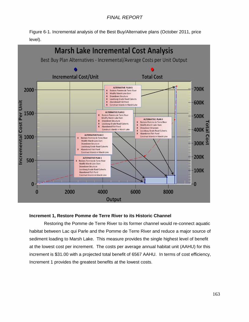
FINAL REPORT
163
Figure 6-1. Incremental analysis of the Best Buy/Alternative plans (October 2011, price
level).
Increment 1, Restore Pomme de Terre River to its Historic Channel Restoring the Pomme de Terre River to its former channel would re-connect aquatic
habitat between Lac qui Parle and the Pomme de Terre River and reduce a major source of
sediment loading to Marsh Lake. This measure provides the single highest level of benefit
at the lowest cost per increment. The costs per average annual habitat unit (AAHU) for this
increment is $31.00 with a projected total benefit of 6567 AAHU. In terms of cost efficiency,
Increment 1 provides the greatest benefits at the lowest costs.

FINAL REPORT
164
Increment 2, Breach Dike at Abandoned Fish Pond Increment 2 is the additional measure of breaching the abandoned fish pond dike.
The incremental increase in costs per average annual habitat unit (AAHU) for this increment
is $84.20 and a total cumulative benefit of 6572 AAHU.
Increment 3, Drawdown Structure + Gated Culverts at Louisburg Grade Road Increment 3 is the construction of a stoplog water control structure to lower lake
levels periodically and construction of culverts at Louisburg Grade Road. The incremental
increase in costs per average annual habitat unit (AAHU) for this increment is $137.74 and a
total cumulative benefit of 7907 AAHU.
Increment 4, Modify Marsh Lake Dam to Attain Target Water Levels and Construct Fishway
Increment 4 is the modification of the Marsh Lake dam for passive water level
management as well as construction of a fishway. The incremental increase in costs per
average annual habitat unit (AAHU) for this increment is $176.77 and a total cumulative
benefit of 8390 AAHU.
Increment 5, Construct Islands in Marsh Lake Increment 5 is the addition of breakwater islands in Marsh Lake in combination with
the full array of alternatives. The incremental increase in costs per average annual habitat
unit (AAHU) for this increment is $2072.33 and a total cumulative benefit of 8508 AAHU.
6.4 Completeness, Effectiveness, Efficiency, Acceptability
USACE ER 1105-2-100 states that the selected plan should meet “planning
objectives and constraints and reasonably maximize environmental benefits while passing
tests of cost effectiveness and incremental cost analysis, significance of outputs,
acceptability, completeness, efficiency and effectiveness.” These terms are defined as the
following:
Completeness – the extent to which an alternative plan provides and accounts for all
necessary investments or other actions to ensure the realization of all planned effects.

FINAL REPORT
165
Effectiveness – The extent to which an alternative plan alleviates the specified problems and
achieves the specified opportunities, as established in the planning objectives.
Efficiency – the extent to which an alternative plan is the most cost effective means of
alleviating the specified problems and realizing the specified opportunities as established in
the planning objectives, consistent with protecting the nation’s environment.
Acceptability – the workability and viability of the alternative plan with respect to acceptance
by state and local entities and the public compatibility with existing laws, regulations and
public policies.
An ordered ranking of the five plans is included in Table 6-3. (1=Highest Rank, 5=Lowest
Rank)
Table 6-3. Rank order of the Marsh Lake project alterative plans by completeness,
effectiveness, efficiency and acceptability.
Com
plet
enes
s
Effe
ctiv
enes
s
Effic
ienc
y
Acce
ptab
ility
Aver
age
Alternative Plan 1 1 5 1 5 3.0Alternative Plan 2 1 4 2 4 2.8Alternative Plan 3 1 3 3 3 2.5Alternative Plan 4 1 2 4 2 2.3Alternative Plan 5 1 1 5 1 2.0
Ordered Ranking of Plan AlternativesCriteria
While Alternative Plan 5 is the plan which maximizes the net environmental
benefits, it is even more important to recognize that the Marsh Lake is a dynamic system
that is influenced by a combination of factors that result in its current degraded state.
Improving conditions within the lake is contingent upon fully addressing each of the
ecosystem restoration objectives outlined in Section 3.4. Acknowledging that
implementation of any of the identified measures alone or in combination would provide
benefits to the lake ecosystem, Alternative Plan 5 is the only plan which would include the

FINAL REPORT
166
full array of measures to address all of the problems and ecosystem restoration objectives
identified by this Feasibility Study. Implementation of these alternative measures in
combination would provide the greatest potential for successfully changing the Marsh Lake
ecosystem state. While Alternative Plan 4 is slightly more efficient than Alternative Plan 5,
the latter plan ultimately ranks higher in each of the remaining selection criteria.
6.5 Comparison of Effects of the Alternative Plans
Table 6.2 is a summary of relative impacts of the alternative plans. Each
resource category has a relative impact range from -6 to +6 for long term and short term
effects. The relative impacts for each plan are combined (added) to identify the relative
cumulative effects for each alternative plan.
Negative values indicate negative impacts, 0 depicts no effect, and positive
values represent benefits. The values indicate relative level of impact. N/A indicates not
applicable. The values do not distinguish temporal or spatial scales, but are provided as
a relative indicator of the magnitude of impacts. The sum of all the values provides a
general overall comparison of the alternative plans. Alternative Plan 5 would have the
most overall benefits in addition to the largest summation of long-term benefits.
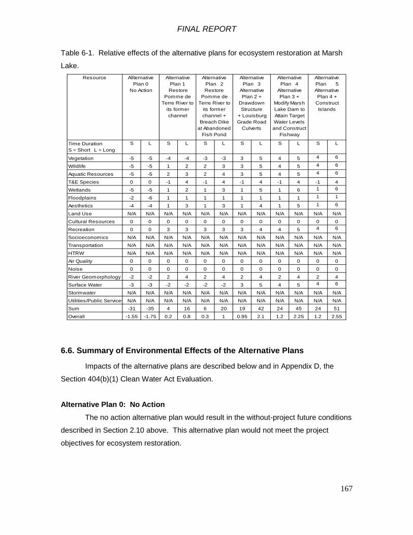
FINAL REPORT
167
Table 6-1. Relative effects of the alternative plans for ecosystem restoration at Marsh
Lake. Resource
Time Duration S = Short L = Long
S L S L S L S L S L S L
Vegetation -5 -5 -4 -4 -3 -3 3 5 4 5 4 6
Wildlife -5 -5 1 2 2 3 3 5 4 5 4 6
Aquatic Resources -5 -5 2 3 2 4 3 5 4 5 4 6
T&E Species 0 0 -1 4 -1 4 -1 4 -1 4 -1 4
Wetlands -5 -5 1 2 1 3 1 5 1 6 1 6
Floodplains -2 -6 1 1 1 1 1 1 1 1 1 1
Aesthetics -4 -4 1 3 1 3 1 4 1 5 1 6
Land Use N/A N/A N/A N/A N/A N/A N/A N/A N/A N/A N/A N/A
Cultural Resources 0 0 0 0 0 0 0 0 0 0 0 0
Recreation 0 0 3 3 3 3 3 4 4 5 4 6
Socioeconomics N/A N/A N/A N/A N/A N/A N/A N/A N/A N/A N/A N/A
Transportation N/A N/A N/A N/A N/A N/A N/A N/A N/A N/A N/A N/A
HTRW N/A N/A N/A N/A N/A N/A N/A N/A N/A N/A N/A N/A
Air Quality 0 0 0 0 0 0 0 0 0 0 0 0
Noise 0 0 0 0 0 0 0 0 0 0 0 0
River Geomorphology -2 -2 2 4 2 4 2 4 2 4 2 4
Surface Water -3 -3 -2 -2 -2 -2 3 5 4 5 4 6
Stormwater N/A N/A N/A N/A N/A N/A N/A N/A N/A N/A N/A N/A
Utilities/Public Services N/A N/A N/A N/A N/A N/A N/A N/A N/A N/A N/A N/A
Sum -31 -35 4 16 6 20 19 42 24 45 24 51
Overall -1.55 -1.75 0.2 0.8 0.3 1 0.95 2.1 1.2 2.25 1.2 2.55
Alternative Plan 5 Alternative Plan 4 +
Construct Islands
Alternative Plan 4
Alternative Plan 3 +
Modify Marsh Lake Dam to Attain Target Water Levels and Construct
Fishway
Allternative Plan 0
No Action
Alternative Plan 1
Restore Pomme de
Terre River to its former channel
Alternative Plan 2 Restore
Pomme de Terre River to
its former channel +
Breach Dike at Abandoned
Fish Pond
Alternative Plan 3
Alternative Plan 2 +
Drawdown Structure
+ Louisburg Grade Road
Culverts
6.6. Summary of Environmental Effects of the Alternative Plans
Impacts of the alternative plans are described below and in Appendix D, the
Section 404(b)(1) Clean Water Act Evaluation.
Alternative Plan 0: No Action The no action alternative plan would result in the without-project future conditions
described in Section 2.10 above. This alternative plan would not meet the project
objectives for ecosystem restoration.

FINAL REPORT
168
Alternative Plan 1: Restore Pomme de Terre River to its Historic Channel Restoring the Pomme de Terre River to its former channel would re-connect
aquatic habitat between Lac qui Parle and the Pomme de Terre River. A number of
native fish species like walleye, white suckers, white bass, and northern pike would be
able to gain access to the relatively high quality habitat in the Pomme de Terre River for
spawning and feeding. This increased access to higher quality habitat would have
positive effects on the size and fitness of the fish populations and resiliency of the fish
community.
Although mussels in the lower reach of the Pomme de Terre River between the
cut-off embankment and Marsh Lake would be killed by construction and lack of river
flow, native mussels are expected to colonize the newly restored channel.
Fish in Marsh Lake would be subject to more severe low dissolved oxygen
conditions during winter with the Pomme de Terre River diverted back into its former
channel. This would reduce abundance of carp which contribute to turbidity and
sediment resuspension. Northern pike are tolerant of low dissolved oxygen conditions
during winter and the project would create conditions that generally favor native species.
Sediment loads originating from the Pomme de Terre River would be eliminated within
Marsh Lake as a result of the restoration of the Pomme de Terre to its historic channel.
This reduction in sediment load will have a beneficial impact on the turbidity and overall
water quality within the lake.
Restoring the Pomme de Terre River to its former channel would directly disturb
the soil in the borrow area where material to construct the cut-off embankments would
be removed. The area is currently an upland agricultural field. The borrow area would
be covered with topsoil and planted with native vegetation. The borrow area would
become more prone to flooding and would support native wet meadow vegetation.
Placing fill for the channel cut-off embankment to divert the Pomme de Terre
River into its original channel would directly cover approximately 0.3 acres of the
diverted portion of the river channel. All macroinvertebrates in the filled area would be
killed. The area would be converted from aquatic habitat to terrestrial habitat.

FINAL REPORT
169
No excavation of the historic channel will be required in order to reroute the
Pomme de Terre River. Once rerouted into its former channel, the lower Pomme de
Terre River would scour out approximately 1425 cubic yards of fine silty sediment that
has accumulated in its former channel through natural processes. Some of that material
would be deposited over-bank in the river floodplain; the rest of the material would be
transported into Lac qui Parle.
Pomme de Terre River flow would be diverted into the historic river channel
flowing into the Minnesota River downstream of the existing Marsh Lake Dam. The
reach of the existing channel between the cut-off embankment and Marsh Lake would
cease to flow. Most of the macroinvertebrates and mussels in that channel would die
due to lack of flow and low dissolved oxygen. In addition, sediment loads previously
entering Marsh Lake would flow into Lac qui Parle. Suspended sediment loading to Lac
qui Parle would not change given the proximity of the existing Pomme de Terre outlet to
the Marsh Lake Dam spillway. During higher levels of river discharge, sediment from the
Pomme de Terre River would flow overbank and be deposited in the floodplain near the
confluence with the Minnesota River.
Alternative Plan 2: Restore Pomme de Terre River to its Historic Channel + Breach Dike at Abandoned Fish Pond This alternative plan would have the same impacts as Alternative Plan 1
described above. The additional measure of breaching the abandoned fish pond dike
would not have adverse environmental effects and would provide fish in Lac qui Parle
access to the fish pond area. The fish pond area would provide habitat for shorebirds
and fish-eating birds.
Alternative Plan 3: Alternative Plan 2 + Drawdown Structure + Gated Culverts at Louisburg Grade Road Alternative Plan 3 would have the effects described for Alternative Plan 2 above.
Constructing the water control structure and replacing the culverts at Louisburg Grade
Road would include temporary and localized increased suspended solids during
construction. Growing season drawdowns of Marsh Lake would be done to restore
emergent aquatic vegetation and winter drawdowns would be done to reduce carp
abundance. Drawdowns would not be done every year, but as needed to restore

FINAL REPORT
170
vegetation and reduce carp abundance. Winter drawdowns should reduce carp
abundance, grazing by carp on aquatic vegetation and macroinvertebrates, and
sediment resuspension by carp. Drawdowns of Marsh Lake water level would kill benthic
macroinvertebrates and some species of submersed aquatic plants in the dewatered
areas. Sago pondweed, the target species of forage for migratory waterfowl, should
persist through winter conditions noted above, thereby increasing in abundance within
the lake.
The increased extent and abundance of emergent aquatic plants would provide
food and habitat for many wetland species and would reduce wind-driven wave action
and sediment resuspension.
Drawdowns of Marsh Lake water level would not go below elevation 936.0 to
avoid dewatering the area between the colonial nesting bird islands and the shoreline to
maintain protection of the islands from predators like foxes, coyotes, raccoons and
skunks.
Installing water control structures in the Louisburg Grade Road culverts would
allow northern pike to gain access to upper Marsh Lake and successfully spawn in years
when Marsh Lake is drawn down.
Alternative Plan 4: Alternative Plan 3 + Modify Marsh Lake Dam to Attain Target Water Levels and Construct Fishway
This alternative plan would have the impacts as described for Alternative Plan 3.
Construction of the fishway weir structure would result in localized and temporary
increases in suspended solids. The fishway weir would provide passive water control for
Marsh Lake water levels, restoring a more natural annual stage hydrograph. The
fishway weir would provide target late summer and winter water levels that are lower
than currently occur. This would improve growth of aquatic vegetation in Marsh Lake.
The fishway would provide habitat connectivity for fish to move between Lac qui Parle
and Marsh Lake, increasing the available habitat. Construction of a fishway weir would
remove the dangerous ogee-crest spillway, improving safety at the dam for visitors.
FINAL REPORT
171
Alternative Plan 5: Alternative Plan 4 + Construct Islands in Marsh Lake This alternative plan would have impacts as described for Alternative Plan 4. In
addition, construction of islands in Marsh Lake would result in localized and temporary
increases in suspended solids. Benthic macroinvertebrates in the footprint of the islands
would be killed. The islands would effectively reduce wind fetch, wave action and
sediment resuspension in a large area in Marsh Lake, providing conditions more
conducive to growth of submersed aquatic plants. Increased growth of submersed
aquatic plants would provide food for waterfowl. The submersed plants would further
reduce wind fetch and sediment resuspension resulting in clearer water for native fish.
The rock islands would provide hard substrate for filter-feeding macroinvertebrates like
caddisflies that are food for fish. The rock islands would provide sheltered resting areas
for migrating waterfowl.
6.7 Effects on Environmental Resources
Table 6-2 is an environmental impact assessment matrix which provides a
cursory overview contrasting the social, natural resource, economic, and cultural effects
between the Action Alternative Plans (Alternative Plans 1-5) and the No-Action
Alternative. All Action Alternative Plans are included categorically within the matrix and
are assumed to bear effects increasing incrementally between plans.

FINAL REPORT
172
Table 6-2. Environmental impact assessment matrix for the Marsh Lake project. IMPACT ASSESSMENT MATRIX
NO ACTION ALL ACTION ALTERNATIVE PLANS MAGNITUDE OF PROBABLE IMPACT MAGNITUDE OF PROBABLE IMPACTNAME OF PARAMETER <----- INCREASING INCREASING -----> <----- INCREASING INCREASING -----> BENEFICIAL ADVERSE BENEFICIAL ADVERSE
A. SOCIAL EFFECTS SIG
NIF
ICA
NT
SUB
STA
NTI
AL
MIN
OR N
O
APP
REC
IAB
LE
EFFE
CT
MIN
OR
SUB
STA
NTI
AL
SIG
NIF
ICA
NT
SIG
NIF
ICA
NT
SUB
STA
NTI
AL
MIN
OR N
O
APP
REC
IAB
LE
EFFE
CT
MIN
OR
SUB
STA
NTI
AL
SIG
NIF
ICA
NT
1. Noise Levels X X 2. Aesthetic Values X X 3. Recreational Opportunities X X 4. Transportation X X 5. Public Health and Safety X X 6. Community Cohesion (Sense of Unity) X X 7. Community Growth & Development X X 8. Business and Home Relocations X X 9. Existing/Potential Land Use X X10. Controversy X XB. ECONOMIC EFFECTS 1. Property Values X X 2. Tax Revenues X X 3. Public Facilities and Services X X 4. Regional Growth X X 5. Employment X X 6. Business Activity X X 7. Farmland/Food Supply X X 8. Commercial Navigation X X 9. Flooding Effects X X10. Energy Needs and Resources X XC. NATURAL RESOURCE EFFECTS 1. Air Quality X X 2. Terrestrial Habitat X X 3. Wetlands X X 4. Aquatic Habitat X X 5. Habitat Diversity and Interspersion X X 6. Biological Productivity X X 7. Surface Water Quality X X 8. Water Supply X X 9. Groundwater X X10. Soils X X11. Threatened or Endangered Species X XD. CULTURAL EFFECTS 1. Historic Architectural Values X X 2. Pre-Hist & Historic Archeological Values X X
6.7.1 Aesthetic Values
With the no action alternative, degradation of the existing natural resources at the
site currently does and will continue to have a minor adverse impact on aesthetics for
visitors to the site. Implementation of any of the Action Alternative Plans will increase
the resource values and subsequent aesthetics of the site through improvements to area
natural resources, namely Marsh Lake and the Pomme de Terre River. As the Action
Alternative Plans increase in scale, the beneficial impact to resources increases. Winter
fish kills will likely result in a temporary impact to aesthetics at the site, however, the
rural nature of the management area will not present any lasting impact to area residents
in the form of odor or other aesthetics.

FINAL REPORT
173
6.7.2 Recreational Opportunities
With the no action alternative, recreational users of the site will experience a
lower quality recreational experience in the future due to aging recreation infrastructure
and degraded ecosystem values. Implementation of the stand-alone Recreation Plan
will increase the resource value and recreational experience at the site through
improvements to area natural resources and recreational infrastructure. As the Action
Alternative Plans increase in scale, the beneficial impact to resources increases. The
recreation plan proposed for the site will substantially improve opportunities for wildlife
viewing, fishing and hunting at the site. Recreation will be temporarily impacted during
construction, particularly around the dam. An existing canoe landing on the Pomme de
Terre River will be relocated to the historic channel, but full recreational use of the site
will be restored following project completion.
6.7.3 Transportation
None of the Alternative Plans impact any major roads or waterways. During
construction, the hauling of materials and equipment may cause brief and temporary
detours.
6.7.4 Public Health and Safety
As with all water control structures, there is an inherent risk of drowning,
particularly in areas where recreation and water control structures coexist, as in the case
of Marsh Lake Dam. As noted previously in Section 3, a drowning death did occur at the
dam in 1991. While such incidents are infrequent, the dam does pose a minor threat to
the safety of visitors to the site. Any of the Action Alternative Plans involving the
modification of the Marsh Lake Dam (Alternative Plans 3-5) will improve the safety at the
site through alteration to the hydraulic roller on the downstream portion of the dam,
resulting from construction of the fishway. Reducing the hydraulic roller will have a minor
increase to public safety at the site, but risk of accidental drowning will always remain.
6.7.5 Community Growth and Development
The recommended plan will likely benefit local income and employment due to
construction activities.

FINAL REPORT
174
6.7.6 Business and Home Relocations
None of the Alternative Plans are expected to have impact to housing, as the project
area is not near any development and occurs entirely on public lands. During
construction, temporary lodging may be needed in nearby communities for non-local
workers.
6.7.7 Public Facilities and Services
As noted above in Section 6.7.2, with the no action alternative recreational users will
experience a decline in the quality of public facilities over time due to aging infrastructure
and degraded ecosystem values. Improving recreation with the Action Alternative Plans,
as noted above, improves public facilities and the user experience offered by the
Minnesota Department of Natural Resources as well as the U.S. Army Corps of
Engineers.
6.7.8 Air Quality
Any construction activity at the site will result in a minor impact to local air quality. The
effects will be temporary during the duration of construction.
6.7.9 Wetland Resources
Effects on aquatic and wetland resources are described in detail in Appendix D
Section 404(b)(1) Clean Water Act Evaluation. Riparian wetlands along Marsh Lake, Lac
qui Parle and the Pomme de Terre River will benefit from the ecosystem variability
provided by natural resource improvements of the Action Alternative Plans
recommended. Greater variation in water levels will allow for seasonal variability,
consolidation of bottom sediments, reduced light attenuation from suspended sediment,
increased abundance of submersed aquatic vegetation and increased abundance of
emergent aquatic vegetation. Implementation of any of the Action Alternative plans
would increase habitat quality for many wetland species by increasing the area of
vegetated wetlands within the designated project area.
6.7.10 Aquatic Habitat
Aquatic habitat is substantially impact by the current conditions in Marsh Lake
resulting from the multiple stressors of sediment loading, sediment resuspension, and
lack of ecosystem connectivity and the dominance of invasive species. Implementation
FINAL REPORT
175
of any of the Action Alternative Plans will increase the aquatic habitat values of the site
through addressing and alleviating stressors within Marsh Lake and the Pomme de
Terre River. As the Action Alternative Plans increase in scale, the beneficial impact to
resources increases (as summarized in Section 6.6).
6.7.11 Habitat Diversity and Interspersion
Similar to aquatic habitat noted above, habitat diversity and interspersion is
substantially impact by the current conditions in Marsh Lake resulting from the multiple
stressors of sediment loading, sediment resuspension, lack of ecosystem connectivity
and the dominance of invasive species. Implementation of any of the Action Alternative
Plans will increase both submersed and aquatic vegetation throughout Marsh Lake
through addressing and alleviating stressors to the ecosystem. As the Action Alternative
Plans increase in scale, the beneficial impact to resources increases (as summarized in
Section 6.6).
6.7.12 Biological Productivity
Similar to aquatic habitat noted above, habitat diversity and interspersion is
substantially impact by the current conditions in Marsh Lake resulting from the multiple
stressors of sediment loading, sediment resuspension, lack of ecosystem connectivity
and the dominance of invasive species. Implementation of any of the Action Alternative
Plans will improve habitat quantity and quality and subsequently improve the biological
productivity of waterfowl, fish and other organisms that depend on aquatic vegetation.
As the Action Alternative Plans increase in scale, the beneficial impact to resources
increases (as summarized in Section 6.6). Winter fish-kills occur periodically at the site
in its existing condition and will continue to occur in the future with Action Alternative
Plan implementation. Biological productivity of fish in Marsh Lake will be temporarily
impacted during winters following drawdowns, however, improved ecosystem
connectivity will allow for spring migration of fish from both the Minnesota River and
Louisburg Grade Road area upstream as well as Lac qui Parle from the downstream
end, ultimately improving the structure of the fishery from the current carp-dominated
system. There is currently no plan to physically remove dead fish from the water
following a winter fish-kill. Fish-kills under the ice are not assumed to impact biological
oxygen demand as the majority of decomposition will occur simultaneously with spring
flows and snow melt where dissolved oxygen levels within the lake will increase.

FINAL REPORT
176
6.7.13 Surface Water Quality
Similar to aquatic habitat noted above, surface water quality is substantially
impacted by the current conditions in Marsh Lake resulting from the multiple stressors of
sediment loading, sediment resuspension, lack of ecosystem connectivity and the
dominance of invasive species. Implementation of any of the Action Alternative Plans
will improve long-term surface water quality throughout Marsh Lake by addressing and
alleviating stressors to the ecosystem. As the Action Alternative Plans increase in scale,
the beneficial impact to resources increases (as summarized in Section 6.6).
Rerouting the Pomme de Terre River into its historic channel will result in a
temporary increase in sediment loading to Lac qui Parle. It is assumed that the historic
channel will scour latent sediment over the course of the first season. Construction
activities such as the diversion dikes of the Pomme de Terre River, the construction of a
drawdown structure, the breaching of the abandoned fish pond dike, and the
replacement of culverts at Louisburg Grade Road will result in exposed soil and bare
slopes near surface waters. Erosion potential will be mitigated through the
implementation and use of best management practices such as silt fence, erosion
control blanket and temporary seeding during construction to minimize the negative
impact on surface waters. Through use of best management practices, no adverse
effects are anticipated from soil erosion near project features during construction.
6.7.14 Endangered Species
No Federally-listed threatened or endangered species occur in the Marsh Lake
project area. Bald eagles nest and feed in the area. They are no longer listed as a
Federal endangered species, but they are still protected by the Bald and Golden Eagle
Protection Act. None of the alternative plans would affect any Federally-listed
threatened or endangered species.
The bald eagle is a state-listed threatened species. The Dakota skipper is a rare
prairie butterfly that occurs in the project area that is a candidate for state listing. The
Pomme de Terre River has regionally significant populations of elktoe mussels
(Alasmidonta marginata – state-listed as threatened) and black sandshell (Ligumia recta
– state-listed as special concern). Mussels living near the existing outlet of the Pomme
de Terre River would be adversely affected by the rerouting of the river. Re-routing the

FINAL REPORT
177
Pomme de Terre River would include monitoring of mussels in the restored channel and
the mussel population is expected to fully recover following project completion.
6.7.15 Cultural Resources
The area of potential effects for the Marsh Lake ecosystem restoration project
consists of Marsh Lake dam and embankment, the pre-dam/restored Pomme de Terre
River channel above and below the dam embankment, the cutoff dike locations above
the dam embankment, the culverts along Louisburg Grade Road, the locations in Marsh
Lake where three breakwater islands would be constructed, the abandoned fish rearing
pond below the dam, and a proposed borrow area for material to construct the cutoff
dikes for re-routing the Pomme de Terre River. The lakeshore and island shorelines at
Marsh Lake is part of the area of potential effects for future growing season drawdowns,
which can only occur after installation of the proposed water management structure at
Marsh Lake Dam’s existing emergency spillway and installation of stoplog structures at
the culverts through Louisburg Grade Road.
Marsh Lake Dam (SW-APT-003) is currently the only historic property listed on or
determined eligible to the National Register of Historic Places which will be directly
affected by any modifications to the dam. When Marsh Lake Dam was built, the Pomme
de Terre River was diverted to enter the reservoir above its dam embankment.
Restoring the river to its pre-dam channel would involve cutting a notch through the
Marsh Lake Dam embankment at the old river channel and constructing a bridge over
the channel notch to allow continued access to the dam. The restored channel would
not be dredged or otherwise modified so no disposal area would be needed. The flow of
the Pomme de Terre River would be allowed to scour accumulated sediment and debris
from the old channel. The diverted river channel would be abandoned. Earthen cutoff
dikes or plugs would be constructed across two low areas and the diverted river channel
above the dam embankment to prevent Marsh Lake from spilling into the restored river
channel at times of high water. No archeological sites were located along the pre-
dam/restored Pomme de Terre River channel or the cutoff dike locations during the 2008
Phase I cultural resources survey of these areas (Magner 2008). Any potential borrow
area to be used for cutoff dike construction material will have a cultural resources survey
conducted and coordination under Section 106 of the National Historic Preservation Act
FINAL REPORT
178
completed with the Minnesota SHPO prior to its use for project construction. Any
proposed borrow area containing archeological site(s) will not be used.
The existing fixed-crest spillway of Marsh Lake Dam would be modified into a
rock nature-like fishway which will allow for fish passage between Marsh Lake and Lac
qui Parle Lake downstream. A new water management structure with 12 stoplog bays
would be constructed at the existing emergency spillway to allow future manipulation of
Marsh Lake’s water levels. Future growing season drawdowns of Marsh Lake would be
used as needed to restore aquatic vegetation beneficial to waterfowl. A pedestrian and
bicycle bridge would be constructed over the fishway and the new water management
structure to allow passage over the dam as part of the Minnesota State Trail. These
proposed changes will alter the overall appearance and design of Marsh Lake Dam and
embankment, but will not change the original purpose of the dam or the overall Lac qui
Parle Flood Control Project. A Memorandum of Agreement to cover mitigation of
adverse effects of the ecosystem restoration project to Marsh Lake Dam will be
negotiated with the Minnesota State Historic Preservation Officer (SHPO) and Advisory
Council on Historic Preservation, with mitigation to be completed prior to beginning
construction on the proposed modifications to the dam and its embankment.
Archeological sites 21LP33 and 21BS67 in lower Marsh Lake (between Marsh
Lake Dam and Louisburg Grade Road) and archeological sites 21LP36, 21BS47 and the
Area J Granite Quarry site in upper Marsh Lake (between Louisburg Grade Road and
Highway 75) may be eligible to the National Register of Historic Places. None of these
five sites will be directly affected by construction of the proposed ecosystem restoration
features at Marsh Lake. Construction of the breakwater islands in Marsh Lake are
intended to reduce wave-caused sediment resuspension and should reduce erosion of
the shoreline and islands in the lake and thus should protect island site 21BS67 from
further erosion. In addition, natural armoring of the lakeshore and island shorelines
against future erosion has been taking place as past erosion has exposed and deposited
rocks and cobbles from the glacial soils in these areas. Future water level drawdowns of
lower Marsh Lake would expose land presently inundated along the current lakeshore
and island shorelines. Such a drawdown would not directly affect site 21LP33, which is
located on a ridgetop back from the current shoreline. Site 21BS67 should not be
adversely affected as a drawdown of lower Marsh Lake should not induce further erosion
FINAL REPORT
179
at that island site’s location. Future water level drawdowns on upper Marsh Lake would
not affect sites 21LP36, 21BS47, or the Area J Granite Quarry due to their locations on
raised areas within or adjacent to the marshes covering most of the bottomlands
between Louisburg Grade Road and Highway 75.
The archeological survey identified additional sites that were determined not
eligible to the National Register (site 21BS35 in lower Marsh Lake and sites 21BS41,
21BS42, 21BS43, 21BS44, 21BS45, and 21BS46 in upper Marsh Lake) (Minnesota
SHPO letter dated January 16, 2002). No further cultural resources investigations need
be conducted at their locations.
Coordination between the Corps and SHPO resulted in the determination that
mitigation is required for impacts resulting from modifications to the Marsh Lake Dam.
As a part of this agreement, the historical conditions of the Marsh Lake Dam will be
properly documented prior to any construction or alternation at the site.
6.7.16 Environmental Justice
Executive Order 12898, "Federal Actions to Address Environmental Justice in
Minority Populations and Low-Income Populations," provides that "each Federal agency
shall make achieving environmental justice part of its mission by identifying and
addressing, as appropriate, disproportionately high and adverse human health or
environmental effects of its programs, policies, and activities on minority populations and
low-income populations." The Executive Order makes clear that its provisions apply fully
to programs involving Native Americans.
The proposed project will not have a disproportionately high adverse effect on minority
or low income populations and is in compliance with EO 12898. The project is located in
a rural area with few residents nearby. Native American communities in the region do
not use Marsh Lake or Lac qui Parle for subsistence hunting, gathering or fishing. The
project would generally have beneficial social and economic effects and would generally
affect all persons equally.
6.7.17 Cumulative Effects
Cumulative effects are the impacts on the environment that result from the
incremental impact of the action when added to other past, present, and reasonably
foreseeable future actions, regardless of what agency (Federal or non-Federal) or
FINAL REPORT
180
person undertakes the actions. Cumulative impacts can result from individually minor
but collectively significant actions taking place over a period of time.
The cumulative effects of past actions on natural resources in the Marsh Lake
project area have been large. Land cover has been altered from native prairie to
intensive agriculture. Streams and rivers in the Upper Minnesota River Basin have been
impounded, channelized, and regulated for flood damage reduction. The economy of the
area has changed markedly in the last two centuries.
For this feasibility study and environmental assessment, the effects of the Marsh
Lake ecosystem restoration project are addressed for cumulative impacts. The future
without-project condition is described in Section 2 above. Some reasonably foreseeable
actions and related ecosystem conditions that are either being planned or considered by
other agencies or groups in the project area include the following:
• Continued operation and maintenance of the Lac qui Parle Flood Control Project
• Continued use and management of the Lac qui Parle Wildlife Management Area
as a wildlife and hunting area
• Continued agricultural use of much of the Upper Minnesota River Basin.
• Improving water quality conditions in the Minnesota River through watershed and
water quality management efforts in the basin to reduce nutrient and
sediment loading
• Continued management of the popular walleye fishery in Lac qui Parle by the
DNR
• Continued and increasing recreation activity
Impacts of the alternative plans are summarized in this report under Section 6.6
for adverse and beneficial effects. The intent of the Marsh Lake project is to maximize
the extent and impact of beneficial effects on Marsh Lake, Lac qui Parle and the Pomme
de Terre River to achieve the project objectives and the goal of returning the Marsh Lake
area ecosystem to a less degraded and more natural and functional condition.
Individually, each management measure would have a beneficial effect to counteract the
stressors acting upon the Marsh Lake area ecosystem.

FINAL REPORT
181
Anthropogenic influences within the watershed will not change as a result of
project implementation. Sediment and nutrient loading will continue from both the
Minnesota and the Pomme de Terre Rivers. Future efforts at watershed and water
quality management are expected to reduce sediment and nutrient loading to the
Minnesota River. Implementation of the project will minimize the adverse impacts of
sediment and nutrient loading on the resources within the project area leading towards
achievement of the project objectives.
The habitat and land cover changes that would occur are described above. The
Pomme de Terre River channel would be restored to its former channel and should
remain in that geometry for the foreseeable future. The Marsh Lake Dam would be
modified with a fixed crest fishway and a controllable outlet structure. Approximately
41,045 cubic yards of rock would be removed from nearby field stockpiles and placed in
Marsh Lake to construct islands. Nonrenewable petroleum fuel would be used to power
trucks, excavators, towboats, and other equipment used in the construction.
7. RECOMMENDED PLAN
The alternative plan that reasonably maximizes the benefits in relation to cost
and meets the overall planning objects is Alternative Plan 4. Alternative Plan 4 is
recommended as the National Ecosystem Restoration Plan (NER Plan), described
below in Section 7.1. On a relative scale, the incremental increase between Alternative
Plans 3 to 4 is high; however, when viewed relative to the costs of similar ecosystem
restoration projects, the average costs per habitat unit are relatively low. The $56.41 per
AAHU created by the project is extremely efficient in achieving the stated ecosystem
objectives (see Figure 5-15) and therefore deemed reasonable in cost. While Alternative
5 maximized ecosystem outputs, the last increment (per Section 6) of $2072.33 was not
found to be cost efficient for inclusion in the NER Plan. Future monitoring detailed in
Appendix R will provide information on the need for the last increment through future
analysis. The NER Plan has strong support from the non-Federal sponsor and is
consistent with regional and State planning for the area.

FINAL REPORT
182
7.1 National Ecosystem Restoration Plan Description
Alternative Plan 4 is a combination of five of the stand alone restoration
measures which include:
• Restore the Pomme de Terre River to its historic channel - The Pomme de Terre
River will be rerouted into its former channel in a meander loop upstream of
Marsh Lake Dam and into the longer former channel downstream of the Marsh
Lake Dam by constructing three earthen cut-off dikes (Figure 4-1). The total
length of river channel that would be restored is approximately 11,500 feet. With
an average 80-ft wide channel, approximately 21 acres of river channel would be
restored. This action will reduce sediment loading, restore floodplain processes
to the Pomme de Terre River delta downstream of the Marsh Lake Dam, a 293-
acre area as well as restore connectivity between Lac qui Parle and the Pomme
de Terre River.
• Breach dike at abandoned fish pond - Breaching the dike in the abandoned fish
pond will allow water levels within it to be the same as in the upper end of Lac qui
Parle, and would allow fish access to the area. The shallow abandoned fish
pond area will also provide shorebird habitat during times when Lac qui Parle
water level is low.
• Construct drawdown water control structure - A water control structure will be
built in the existing overflow spillway area to provide controlled discharge
capacity to enable a drawdown. Growing season drawdowns are typically
conducted following spring high water into September when plants go senescent.
Growing season drawdowns can be done in two consecutive growing seasons to
allow plants germinated in the first year to grow to full size before flooding to
normal water levels. Once established, perennial aquatic plants can persist for
years, providing valuable food and habitat for fish and wildlife. The drawdown
structure would be 113.5-feet wide with 10 bays. The water control structure
would have a 16-ft wide walkway across the top that could serve a secondary
purpose as part of a trail across the dam in the future. Operation of the
drawdown structure will be conducted consistent with the Monitoring and
Adaptive Management Plan included in this report.
• Construct Louisburg Grade Road gated culverts - Water levels in the upper part
of Marsh Lake will be managed separately from the main body of the lake,
FINAL REPORT
183
particularly in drawdown conditions. For example, high water levels can be
maintained for a time in early spring to provide flooded marsh habitat upstream of
the Louisburg Grade Road for spawning northern pike and to improve survival of
young-of-year fish. The stop logs would subsequently be removed to allow the
fish to return to Marsh Lake. Implementation of this measure is designed to
enhance both the fishery throughout Marsh Lake and promote native fish
dominance.
• Modify the Marsh Lake Dam, construct fishway - Marsh Lake Dam will be
modified with a fishway structure to provide a passive weir that would increase
water level variability on Marsh Lake, attain the target water level regime and to
allow year-round fish passage (Figure 4-4). The fishway will be constructed in
the existing fixed crest spillway in Marsh Lake Dam. Nature-like fishways are
effective in re-establishing fish migration routes past dams and other hydraulic
obstacles. Nature-like fishways simulate natural river channels and the hydraulic
conditions that fish have evolved to swim through. Nature-like fishways can be
simple rock ramps that look like natural rapids or bypass channels with riffles and
pools. Many nature-like fishways have been constructed in Minnesota and have
been very effective in restoring migratory fishes to stream networks. The fishway
design contains a series of arched rock riffles that concentrate flow toward the
middle of the fishway. Shallow areas on the sides would have slower current
velocities and would allow upstream passage by smaller and weaker-swimming
fish. The riffles would be made of boulders imbedded into smaller rock, with
pools of deeper water between the riffles. Water would flow between the
boulders in the riffles at velocities that fish could still swim through.
With cost figures rounded to the nearest thousand, the estimated first project
costs of the ecosystem restoration plan are $9,463,000 (average annual cost of
$474,000 with OMRR&R) and would result in the creation of approximately 8400 AAHU
over 50 years. A plan view of the recommended plan is included below in Figure 7-1:

FINAL REPORT
184
Figure 7-1, Plan view of the recommended plan project features

FINAL REPORT
185
Problems and stressors addressed by the recommended plan include:
Marsh Lake Ecosystem State:
• Sediment Loading – Restoring the Pomme de Terre to the historic
channel will serve to reduce sediment loading into Marsh Lake. Since
turbidity is a limiting factor in the light attenuation and primary production
in the aquatic community, sediment loading must be addressed in order
to provide forage for migratory waterfowl that are limited by the availability
of food within the lake. Rerouting the river to its historic channel will
eliminate the Pomme de Terre as a sediment source to Marsh Lake and
thereby decrease the turbidity within the lake, specifically near its current
outlet.
• Sediment Resuspension – Modification of the Marsh Lake Dam to
attain target water levels will induce seasonally lower levels in the lake
and allow for consolidation of bottom sediments as well as light
penetration to both exposed sediments for emergent plants and deeper
depths for aquatic vegetation. Construction of a water control drawdown structure will allow lake managers to artificially mimic natural
riverine drought conditions by periodically conducting drawdowns to lower
water levels below the current outlet elevation which will assist in
consolidating sediments for up to 90% of the lake area, germinate seeds
within the lake sediments and allow for the penetration of light to the lake
bottom sediments to enable plant growth. In combination, each of the
identified measures for addressing sediment resuspension complements
one another through synergistic relationships to ensure the establishment
of healthy habitats and robust plant communities. The presence of
aquatic vegetation and consolidated bottom sediments will ultimately
reduce the frequency of high turbidity resulting from sediment
resuspension and subsequently increase emergent and aquatic plant
growth which is critical to support both fish and waterfowl communities.
• Lake Level Variability - Modification of the Marsh Lake Dam to attain
target water levels will create greater variability in lake levels, allowing the
lake to mimic more natural historical riverine conditions. As a result, lake
levels will fluctuate with climatic conditions, creating greater ecosystem
flux thereby increasing the functionality of floodplain and riparian areas.

FINAL REPORT
186
Construction of a water control drawdown structure will allow lake
managers to mimic natural riverine drought conditions by periodically
conducting drawdowns to consolidate sediments for up to manage
sediment resuspension (noted above) and enable plant growth.
Introducing greater variability will benefit both floral aquatic and emergent
communities within the lake and the fauna that depends on it, particularly
waterfowl.
• Ecosystem Connectivity – Restoring the Pomme de Terre River to its
former channel would provide walleye, white suckers, white bass and
other migratory fish species in Lac qui Parle access to high quality
spawning and nursery habitat in the Pomme de Terre River. Improved
reproduction success and growth of juvenile fish in the Pomme de Terre
River would increase the abundance of naturally-reproduced walleye in
Lac qui Parle and would increase the diversity of the fish community.
Installation of gated culverts at Louisburg Grade Road is a measure
dependent upon construction of a water control drawdown structure.
When growing season drawdowns are artificially conducted through the
drawdown structure, the culverts at Louisburg Grade Road would be
closed, impounding approximately 1100 acres of water upstream. This
impounded area would serve as winter refuge for fish and preserve
critical spring spawning habitat for northern pike. In the spring following
drawdowns, the gates would be reopened. Native fish released from
upstream of Louisburg Grade Road in addition to those migrating
upstream from Lac qui Parle will benefit from reduced competition in the
lake due to the lack of over-wintering populations of invasive common
carp (see below). Breaching the abandoned fish pond adjacent to the
Marsh Lake Dam will also provide additional connectivity to a currently
isolated impoundment within the river previously managed by the DNR as
a fish rearing pond. The fish pond area serves as valuable habitat for
birds such as the great blue heron who fish this area frequently.
Breaching the dike for the fish pond will allow fish access to the pond
which will subsequently increase the food availability for herons and
enhance the habitat value.
FINAL REPORT
187
Low-Diversity Fish Community:
• Invasive Species - Construction of a water control drawdown structure to induce artificial drawdowns will serve to eliminate winter
refuge for common carp within the lake. As an invasive species, carp are
notoriously voracious foragers on aquatic plants. Elimination of carp in the
wintertime will serve to both restore plant communities and augment the
lake with native fish species through displacement in the spring following
drawdowns. Modification of the Marsh Lake Dam to a lower elevation
in conjunction with the construction of a fishway will enable passage of
native fish between Lac qui Parle and Marsh Lake annually during
spawning season, but particularly in the spring after artificial drawdowns.
This effort is intended to displace invasive common carp with native fish
throughout Marsh Lake. Restoring the Pomme de Terre to its historic
channel will eliminate both a winter oxygen source within Marsh Lake as
well as the physical connection between over-wintering carp communities
in Marsh Lake with spawning habitat upstream on the Pomme de Terre.
While common carp would still have availability and access to the Pomme
de Terre from the restored outlet at Lac qui Parle, abundance and
frequency of carp within Marsh Lake itself will decrease due to the
cumulative effects of the combined measures noted above.
• Ecosystem Connectivity - Restoring the Pomme de Terre to the historic
channel will provide access to walleye from Lac qui Parle to spawn. The
walleye population within Lac qui Parle is stocked but healthy and
available spawning habitat has been determined to be the limiting factor
in the abundance of walleye within Lac qui Parle and Marsh Lake.
Modification of the Marsh Lake Dam to a lower elevation in conjunction
with the construction of a fishway will enable passage of native fish
between Lac qui Parle and Marsh Lake. This will allow the northern pike
community within Lac qui Parle to gain access to the spawning areas
upstream of the Louisburg Grade Road. The subsequent effect will be
healthier communities of pike within both Marsh Lake and Lac qui Parle.
Installation of gated culverts at Louisburg Grade Road will ensure
that lake elevations within the critical pike spawning area upstream of the
Louisburg Grade Road are maintained as Marsh Lake water levels are

FINAL REPORT
188
subjected to increased variability from the implementation of measures
noted above.
Degraded Pomme de Terre Ecosystem State:
• Sediment Deposition - Restoring the Pomme de Terre to the historic
channel will eliminate sediment deposition within Marsh Lake and restore
a more natural, free flowing, meandering channel to the Pomme de Terre
River. In its current state, the outlet of the Pomme de Terre into Marsh
Lake occurs at a low gradient which is prone to deposition of sediment
conveyed by the river at the outlet. This sediment becomes actively
available for resuspension from physical force (wave, wind) and
contributes to turbidity issues within Marsh Lake. Restoration of the
historic channel will increase channel slope, channel length, the overall
area of habitat availability, and will alter the composition of the river
bottom through natural geomorphic processes from a system dominated
by deposition of small grain size particles to a rocky, cobble substrate.
The change in geomorphic form and habitat structure will provide critical
spawning areas for walleye and other fish from Lac qui Parle.
• Ecosystem Connectivity - Restoring the Pomme de Terre to the historic
channel will open new areas upstream of Lac qui Parle to the community
of walleye who are limited by spawning habitat availability. As noted
above, habitat suitability and access for walleye within Pomme de Terre
are constrained by the presence of the Marsh Lake Dam and the current
geomorphic condition. Rerouting the Pomme de Terre will have a
substantial beneficial effect for walleye as well as other fish within Lac qui
Parle.

FINAL REPORT
189
7.2 Recreation-Related Project Features
The U.S. Army Corps of Engineers policy for ecosystem restoration projects
recognizes that the lands used for project construction can also provide a low cost
opportunity to provide recreation facilities. Recreation at ecosystem restoration projects
should:
• Be compatible with ecosystem restoration and enhance the visitation experience.
• Build upon the ecosystem restoration objective rather than distract from it.
• Take advantage of the education and recreation potential of the ecosystem
project.
Consistent with these purposes, a stand-alone Recreation Plan was developed
and is detailed below. This Recreation Plan has been prepared through meetings
among the US Army Corps of Engineers, the US Fish and Wildlife Service, and the
Minnesota DNR. The team used Value Engineering techniques to brainstorm existing
and potential recreational features then weigh the advantages, disadvantages and cost
of each feature to develop an overall concept to include:
1. Pedestrian Bridge across Marsh Lake Spillway for improved safety, to provide angler access to both sides of the river, and as a future state bike trail connection.
2. U.S. Army Corps of Engineers Day Use Facility at Marsh Lake Dam
Improvements to include a Pomme de Terre Canoe Access Point, a portage area, picnic tables, and shoreline fishing platforms.
3. Shoreline Access Upgrades to include shoreline fishing and interpretive
signage.
All of the recreational features took into consideration the objectives of the
Ecosystem Restoration project and also the Minnesota State Comprehensive Outdoor
Recreation Plan’s (SCORP) goal of increasing participation in outdoor recreation by
Minnesotans and visitors.
Providing future recreational opportunities is an important goal of this region, as
recreation would provide tourism dollars to the local economy and helps maintain a
higher quality of life by providing opportunities for recreational experiences.

FINAL REPORT
190
The major parts of the Recreation Plan are to:
(1) Increase connectivity to existing and future trail systems in the area. (2) Upgrade existing facilities and create new facilities where needed. (3) Provide interpretation and education at Marsh Lake.
Implementation of recreation features will help the State of Minnesota reach its
goals of providing economic and recreational opportunities to its citizens.
Future conditions without recreational features will result in lost opportunities to:
• Provide connectivity of at least four different trail systems –National Scenic Byway, Minnesota State Bike Trail, Minnesota River Water Trail, and the Minnesota River Valley Prairie Waters Birding Trail.
• Increase the quality of life for local residents who use these recreational features
throughout the year by updating day use facilities and boat ramps, and creating trail connections. In some cases, improving the recreation facilities will increase safety of users.
• Educate the public through interpretive panels on a variety of subjects which could
include: shallow lake ecosystems, restoration efforts, agency cooperation, safety, wildlife, history, and recreational opportunities.
• Increase the economic vitality of the area through tourism dollars from both in state
and out of state recreationalists. A positive economic state and improved quality of life should help maintain and possibly boost population in this area rather than seeing a decline.
7.2.1 Description of Proposed Recreational Features
Feature 1 - Pedestrian Bridge across Marsh Lake Spillway
An immediate benefit to building a bridge over the spillway is that it will provide a
safe location for fisherman and other recreationalists to cross the Minnesota River. In the
future this feature would facilitate the Minnesota River State Bike Trail development and
connectivity.

FINAL REPORT
191
Figure 7-1. Existing Marsh Lake spillway looking south.
It is envisioned that this area will have accessible shoreline fishing platforms both
on the upstream and downstream side of the spillway and dike (see Feature 2, Figures
7-2 and 7-3). Currently, recreationalists are tempted to wade or swim across the river
or, in low water, walk across the structure itself. One drowning has been reported at this
site. A bridge will create a safe way to cross. Conversion of the spillway to a fishway weir
structure (Figure 4-4 above) would eliminate the hydraulic backroller that forms below
the existing ogee crest spillway and would improve recreational public safety.
Figure 7-2. Proximity of Marsh Lake to population centers. Blue pin = Marsh Lake.
Green = 40 mile radius, Blue = 80 mile radius, Yellow = 160 Mile Radius
Map 2. Blue Pin = Marsh Lake
Green = 40 Mile Radius
Blue = 80 Mile Radius

FINAL REPORT
192
Fishing is a popular activity at Marsh Lake. In 2006, 1.1 million state residents 16
years old and older fished in Minnesota. (National Survey of Fishing, Hunting, and
Wildlife-Associated Recreation.) Within a 40 mile radius of Marsh Lake there are over
25,000 people who would have immediate access to the recreation features of this
project (Figure 7-2).
The future Minnesota River State Bike Trail is broken down into segments.
Segment 2 Ortonville to Appleton is located within the geographical scope of this project.
Future trail alignment for this segment can be described in two parts: a loop around Big
Stone National Wildlife Refuge and then, east of the refuge, an alignment on the south
side of the river to the foot of Marsh Lake. It is at this point that a pedestrian bridge will
provide connectivity to the State Trail which will continue south into Lac qui Parle Wildlife
Management Area and connect to existing trails in Appleton. Generally the trail follows
road corridors. However, it is envisioned that the Minnesota River Trail will be partially
located on alignments that are separate from road rights-of-way, providing access to
natural and cultural amenities along scenic routes that showcase Minnesota River valley
landscape. (Minnesota River State Trail Master Plan, June 2007)

FINAL REPORT
193
Feature 2 - U.S. Army Corps of Engineers Day Use Facility at Marsh Lake Dam
Improvements
Figure 7-3. Existing day use recreation area at Marsh Lake Dam (A). Blue = Historic
Pomme de Terre River channel to be restored.
The current day use facility built in 1938 needs improvements. The Ecosystem
Restoration recommended plan includes rerouting the Pomme de Terre River, which will
block the existing canoe landing on the Pomme de Terre River, approximately 0.5 miles
east/northeast of the Marsh Lake spillway. A new canoe landing is recommended at the
day use area to provide a canoe landing for both the Pomme de Terre and Minnesota
Rivers. The canoe landing could be as simple as a mowed foot path leading to the
water’s edge with a primitive landing. When the Pomme de Terre is restored to its
former channel, paddlers will then be able to paddle directly into the Minnesota River
from the Pomme de Terre River without a portage. However, most paddlers will probably
want to use the day use area as an exit/entry point or rest stop.
With the rerouting of the Pomme de Terre River to its historic location, the day
use area will eventually be located between two flowing rivers. So in addition to the
canoe access point mentioned above, it is recommended that the upgraded day use
facility include:

FINAL REPORT
194
• Picnic tables and park benches • Vault toilets (handicapped-accessible) which have the capacity to withstand
flooding. • Shoreline fishing stations - Most should be handicapped-accessible. (See
Figures A and B.) • A safe portage across the Marsh Lake Dam from Marsh Lake to the Minnesota
River in the day use area. • Interpretive kiosk. • Short foot path and ramp will be needed to access the pedestrian bridge across
the spillway. Note that not all public access areas on Marsh Lake are handicapped-accessible
which is why more handicapped-accessibility features are recommended for the day use
area.
The Marsh Lake Dam area will have a number of accessible shore fishing
stations located above and below the dam on both sides of the spillway and near the
mouth of the Pomme de Terre River. A safe area will be created for walk-in winter
access along the dike. Flat rock/rustic fishing platforms will be installed as well as
accessible concrete fishing platforms as shown in Figure 7-5.
Figure 7-4. Accessible fishing platform made from a box culvert section turned on end.

FINAL REPORT
195
Figure 7-5. Example of an accessible shore fishing platform.
Feature 3 - Boat Landing Improvements
The Minnesota DNR maintains a number of boat landings around Marsh Lake
(Figure 7-6). Improvements will consist mainly of shoreline fishing structures and
interpretive signage using kiosks.
Figure 7-6. Boat landings at Marsh Lake used for hunting, fishing, and wildlife viewing.
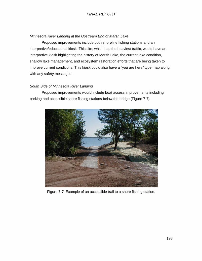
FINAL REPORT
196
Minnesota River Landing at the Upstream End of Marsh Lake
Proposed improvements include both shoreline fishing stations and an
interpretive/educational kiosk. This site, which has the heaviest traffic, would have an
interpretive kiosk highlighting the history of Marsh Lake, the current lake condition,
shallow lake management, and ecosystem restoration efforts that are being taken to
improve current conditions. This kiosk could also have a “you are here” type map along
with any safety messages.
South Side of Minnesota River Landing
Proposed improvements would include boat access improvements including
parking and accessible shore fishing stations below the bridge (Figure 7-7).
Figure 7-7. Example of an accessible trail to a shore fishing station.

FINAL REPORT
197
North Side of Minnesota River Landing
Flat rock shore fishing stations would be installed (Figure 7-8).
Figure 7-8. Examples of flat rock type of shore fishing stations.
Upper Pool Landing
Proposed Improvements include accessible fishing platforms similar to the
Minnesota River Landing above and an interpretive/educational kiosk.
Other Four Landings: Correll, Peterson, Killen, and Cabin Site
These sites would each have a simple educational/information kiosk which would
not be as elaborate as the Minnesota River Landing kiosk. The kiosks could have the
same “You are Here” maps showing other boat landings but then each landing could
have different educational & interpretive material such as waterfowl migration, wildlife,
waterfowl feeding and resting areas, islands, wave barriers, and types of emergent
vegetation. These sites would also include shoreline fishing structures which could also
be used by wildlife watchers.

FINAL REPORT
198
It is important to note that the boat landings around Marsh Lake are also the
main stopping points for wildlife viewers and visitors traveling along the National Scenic
Byway and Audubon Minnesota River Valley Birding Trail. Birders flock to the area. This
stretch is located in one of the major waterfowl flyways in North America with thousands
of birds such as blue-winged teal, mallards, pintails, and wood ducks. Marsh Lake has
the largest white pelican rookery in Minnesota and one of only two nesting colonies of
the white pelican in the state. As many as 10,000 pelicans, tundra swans, snow geese,
and sandhill cranes can be seen migrating through the area in a single day. The Lac qui
Parle Wildlife Management Area is a major stop for hundreds of thousands of Canada
geese. There are over 2 million resident and non-resident wildlife watching participants
in Minnesota (2006 National Survey of Fishing, Hunting, and Wildlife Associated
Recreation.) A 160 mile radius around the Marsh Lake project area, or less than a 2.5
hour drive away, includes over 3.5 million people from four states (Figure 7-2).
7.2.2 Benefit Computation
Recreation benefits attributable to the proposed trail system were based on
projected demand for the recreational activities listed in Table 7-8. These demand
estimates over the period of analysis were used in conjunction with Unit Day Values
developed for each of the recreational activities. Demand for each project year was
multiplied by the appropriate Unit Day Value for each recreation activity. The value of
the recreation activity at each project year was converted to a present worth value using
a 4 1/8 percent annual interest rate. The sum of these present worth values, by
recreational activity, were converted to an average annual dollar value, given a 50 year
project life and a 4 1/8 percent annual interest rate.
Table 7-8 – Project recreation average annual benefit.
Picnicking 14,500$ Wildlife Viewing 84,400$ Fishing 89,300$ Canoe/kayak 36,800$
TOTAL ANNUAL AVG BENEFITS 225,000$ Rounded to nearest $1000
The present value of estimated construction costs, contingencies, engineering, design,
construction management, and interest during construction were calculated to be

FINAL REPORT
199
$516,000. This present value was amortized at 4 1/8 percent over the 50-year life of the
project. The resulting annualized cost of $24,000 was added to the estimated annual
operation, maintenance, repair, replacement, and rehabilitation (OMRR&R) cost of
$2,000 for a total annual cost of $26,000. The net annual benefits, or the annual
benefits minus the annual costs, are $199,000. The benefit-cost ratio, or the annual
benefits divided by the annual costs, was calculated to be 8.6. Therefore, the Marsh
Lake proposed recreation plan is economically justified. The Federal costs of the Marsh
Lake Ecosystem Restoration project with the recreation facilities would be approximately
0.4 percent greater than the Federal costs of the project without the recreation facilities,
less than the 10 percent limit, in accordance with ER 1105-2-100.
7.3 Real Estate Requirements
The Minnesota Department of Natural Resources (DNR) is the non-Federal
sponsor for the study. The DNR has fee title to the entire lake area northwest of the
dam and southeast of Corps fee title land in and around the dam. Together, the
Minnesota Department of Natural Resources and U.S. Army Corps of Engineers own all
land required for the project in fee title.
7.4 Monitoring and Adaptive Management
A Monitoring and Adaptive Management Plan is included in Appendix R.
System Hydrology
The Corps will continue to maintain gages at Marsh Lake Dam and at Lac qui
Parle Dam and a continuous record of water levels and discharge.
Native Mussels in the Pomme de Terre River
A plan for monitoring the effects of restoring the Pomme de Terre River to its
former channel on native mussels is detailed in Section 4.1.4. The 2010 mussel survey
was conducted by the DNR. The post-construction monitoring will be done by the DNR.

FINAL REPORT
200
Aquatic Vegetation in Marsh Lake
Following project construction, the DNR will conduct annual surveys of aquatic
vegetation in Marsh Lake by aerial photo interpretation and by sampling from a boat as
shown in Section 2.8.5. Should submersed aquatic vegetation not increase in response
to the measures implemented in the tentatively recommended plan after five years, rock
islands will be constructed to meet project objectives 4 and 5: Reduced sediment
resuspension in Marsh Lake and Increased extent, diversity and abundance of emergent
and submersed aquatic plants in Marsh Lake. A determination of the need for the rock
islands will be documented through monitoring and may be recommended for
construction based on adaptive management criteria found in Appendix R.
7.5 Cost Estimates
Cost estimates for the recommended plan are summarized below:
Table 7-9. Economic summary of the recommended plan (October 2011 price levels).
EcosystemRestoration
9,967,000$ 214,000$
10,181,000$
500,000$ 35,000$
8400225,000$ Total Annual Benefits (Recreation)
Breakout of Total Project Costs and BenefitsMarsh Lake Ecosystem Restoration - Recommended Plan
Total Project First CostsInterest During Construction (4.125%)Present Worth of Investment
Annualized Total Project CostsAnnual Operations and Maintenance Costs
Total Annual Benefits (Habitat Units)
Rounded to nearest $1000

FINAL REPORT
201
8 Compliance with Environmental Laws and Regulations
8.1 Review of Federal Laws, Regulations, Policies and Executive Orders
The St. Paul District, U.S. Army Corps of Engineers has conducted this feasibility
study and NEPA process in accordance with Corps of Engineers planning guidance (ER
1105-2-100) and requirements of applicable laws and regulations (Table 8-1). We have
assessed the environmental effects of the alternative plans and the proposed action on
the environment (Section 6.4 above and Table 8-2).
Compliance with applicable environmental quality statutes is summarized in the
table below. Full compliance for this EA is defined as having met all requirements of the
statute for the current stage of planning. In some cases, further authorization and
certification will be required prior to and during construction. Partial compliance
indicates that information is still being collected or disseminated to and from proper
agencies. Further explanation for each statute is provided below. Table 8.1 Laws, regulations and Executive Orders applicable to planning the Marsh Lake
Project and current compliance status.
Federal Policy Compliance
Status
Bald and Golden Eagle Protection Act, 42 USC 4151-4157 Partial
Clean Air Act, 42 USC 7401-7542 Full Clean Water Act, 33 USC 1251-1375 Full1 Comprehensive Environmental Response, Compensation, and Liability
Act, 42 USC 9601-9675 Partial
Endangered Species Act, 16 USC 1531-1543 Partial
Farmland Protection Policy Act, 7 USC 4201-4208 Full Federal Actions to Address Environmental Justice in Minority
Populations and Low-Income Populations (EO 12898) Full
Federal Water Project Recreation Act, 16 U.S.C. 460-1(12), et seq. Full Fish and Wildlife Coordination Act, 16 USC 661-666c Partial
Floodplain Management (EO 11988 as amended by EO 12148) Full1
Food Security Act of 1985, 7 USC varies Full

FINAL REPORT
202
Invasive Species (EO 13112) Partial Land and Water Conservation Fund Act, 16 USC 460d-461 Full Migratory Bird Treaty Act of 1918, 16 USC 703-712 Full1
National Environmental Policy Act, 42 USC 4321-4347 Partial National Economic Development (NED) Plan Full National Historic Preservation Act, 16 USC 470 et seq. Partial Noise Control Act, 42 USC 7591-7642 Full Prevention, Control, and Abatement of Air and Water Pollution at
Federal Facilities (EO 11282 as amended by EO’s 11288 and 11507) Full
Protection and Enhancement of the Cultural Environment (EO 11593) Partial Protection of Wetlands (EO 11990 as amended by EO 12608) Full1 Protection and Enhancement of Environmental Quality (EO 11991) Full Protection of Migratory Birds (EO 13186) Full1
Resource Conservation and Recovery Act, 42 USC 6901-6987 Full Rivers and Harbors Act, 33 USC 401-413 Full1 Water Resources Development Acts of 1986, 1990, 2000 and 2007 Full Wild and Scenic Rivers Act, 16 U.S.C. 1271, et seq. Full 1 Further certification or authorization required prior to construction.
FINAL REPORT
203
8.2 Economic and Environmental Principles and Guidelines
The Federal objective of water and related land resources planning is to
contribute to national economic development consistent with protecting the Nation's
environment, pursuant to national environmental statutes, applicable executive orders,
and other Federal planning requirements. Achievement of the Federal objective is
measured in terms of contribution to Federal accounts intended to track the overall
benefits of a given project. The two accounts applicable to the Marsh Lake Ecosystem
Restoration are the National Economic Development (NED) account and the
Environmental Quality (EQ) account.
National Economic Development (NED) Account
Contributions to national economic development (NED) are increases in the net
value of the national output of goods and services, expressed in monetary units.
Contributions to NED are the direct net benefits that accrue in the planning area and the
rest of the nation. For an ecosystem restoration project with accompanying recreation
features, the NED is calculated by the sum of the average annual costs of the
ecosystem restoration features, plus the average annual benefits of the recreation
features, minus the average annual costs of the recreation features. The results for the
Marsh Lake Ecosystem Restoration Project are as follows:
Total Average Annual Recreation Benefits 225,000$ - Total Average Annual Recreation Costs 26,000$
Contribution to National Economic Development Account 199,000$ Rounded to nearest $1000
Environmental Quality (EQ) Account
EQ attributes are the ecological, cultural, and aesthetic properties of natural and
cultural resources that sustain and enrich human life. Evaluation of EQ in the planning
process consists of the assessment and appraisal of effects. Four general actions—
define, inventory, assess, appraise—are the phases of these procedures. For
ecosystem restoration projects, contributions to the EQ account are detailed through
NEPA compliance and calculation of net ecosystem benefits. The Marsh Lake
Ecosystem Restoration Project includes an integrated Environmental Assessment where
the necessary components of a NEPA evaluation are combined within each of the
planning steps. This evaluation is summarized in a qualitative summary of
FINAL REPORT
204
environmental effects detailed in Table 6-1 as well as Section 6.6 of this report. In
addition, Section 5 and Appendix E of this report contain quantitative information
regarding net ecosystem benefits through use of Habitat Evaluation Procedures/Habitat
Suitability Index. The credit to the EQ account is the quantified benefits resulting from
the project, which, in the case of the recommended plan provides a net gain of 8400
average annual habitat units over the 50-year period of analysis.
8.3 USACE Environmental Operating Principles
Properly formulated ecosystem restoration projects should be consistent with
USACE Environmental Operating Principles. The analysis included in the Marsh
Lake Ecosystem Restoration Project Feasibility Study report shows that
implementation of the recommended plan will have a substantial benefit to the
ecosystem of Marsh Lake while balancing the existing use and function of the
previously authorized project. Environmental Operating Principles are listed below
for reference:
1. Strive to achieve environmental sustainability. An environment maintained in a
healthy, diverse and sustainable condition is necessary to support life.
2. Recognize the interdependence of life and the physical environment. Proactively
consider environmental consequences of Corps programs and act accordingly in
all appropriate circumstances.
3. Seek balance and synergy among human development activities and natural
systems by designing economic and environmental solutions that support and
reinforce one another.
4. Continue to accept corporate responsibility and accountability under the law for
activities and decisions under our control that impact human health and welfare
and the continued viability of natural systems.
5. Seeks ways and means to assess and mitigate cumulative impacts to the
environment; bring systems approaches to the full life cycle of our processes and
work.
6. Build and share an integrated scientific, economic, and social knowledge base
that supports a greater understanding of the environment and impacts of our
work.

FINAL REPORT
205
7. Respect the views of individuals and groups interested in Corps activities, listen
to them actively, and learn from their perspective in the search to find innovative
win-win solutions to the nation’s problems that also protect and enhance the
environment.
8.4 Lessons Learned from Hurricanes Katrina and Rita
Following the devastation of Hurricanes Katrina and Rita, the U.S. Army Corps of
Engineers drafted twelve actions for change to ensure that a systems based approach is
incorporated into project planning, risk informed decision making is adopted throughout
the organization, risks are adequately communicated to the public, and agency technical
expertise is sufficiently leveraged. Below is a brief assessment of which of the twelve
actions for change have been incorporated into the Marsh Lake Ecosystem Project
Planning Process:
Theme 1: Comprehensive Systems Approach
– Action 1: Employ integrated, comprehensive and systems-based
approach
– Action 5: Employ adaptive planning and engineering systems
– Action 6: Focus on sustainability
Theme 2: Risk Informed Decision Making
– Action 2: Employ risk-based concepts in planning, design, construction,
operations, and major maintenance
– Action 7: Review and inspect completed works
Theme 3: Communication of Risk to the Public
– Action 9: Effectively communicate risk
– Action 10: Establish public involvement risk reduction strategies
Theme 4: Professional and Technical Expertise
– Action 3: Continuously reassess and update policy for program
development, planning guidance, design and construction standards
– Action 4: Employ dynamic independent review
– Action 8: Assess and modify organizational behavior
– Action 11: Manage and enhance technical expertise and
professionalism
– Action 12: Invest in research

FINAL REPORT
206
9. Implementation Responsibilities
9.1 Federal (Corps)/Non-Federal Sponsor Implementation
When implementation funds are appropriated, a non-Federal sponsor will be
identified. The State of Minnesota, Department of Natural Resources (DNR) served as
the non-Federal sponsor for the Feasibility phase and will likely serve as the non-Federal
sponsor for the Construction phase. Cost-sharing for plan implementation is subject to
the rules for ecosystem restoration projects established in Section 210 of WRDA 1996.
Accordingly, the non-Federal share will be 35 percent of the implementation costs.
Recreation features would be cost shared 50%/50% with OMRR&R a local responsibility
in accordance with the cost sharing established by WRDA 1986, as amended. Non-
Federal sponsors are responsible for 100 percent of lands, easements, rights-of-way,
utility or public facility relocations, and dredged or excavated material disposal areas
(LERRD), and operation, maintenance, repair, rehabilitation, and replacement
(OMRR&R). The value of LERRD is credited to the 35 percent share.
A breakdown of the project Federal and non-Federal sponsor costs is included below:

FINAL REPORT
207
Table 9-1, Anticipated Project First Costs Allocated by Fiscal Year
Estimated Amount Plus Contingency
Total Cost plus Interest During Construction FY12 FY13 FY 14 FY 15 Total Project
Federal Preconstruction Engineering, Design 645,000$ 669,000$ 669,000$ -$ -$ -$ 669,000$ Construction Management 405,000$ 405,000$ -$ 163,000$ 196,000$ 47,000$ 405,000$ Construction 5,346,000$ 5,459,000$ -$ 2,289,000$ 2,953,000$ 217,000$ 5,459,000$ Federal LERRD 7,000$ 7,000$ 7,000$ -$ -$ -$ 7,000$
Total Federal 6,403,000$ 6,540,000$ 676,000$ 2,452,000$ 3,149,000$ 264,000$ 6,540,000$
Non-Federal Preconstruction Engineering, Design 359,000$ 373,000$ 373,000$ -$ -$ -$ 373,000$ Construction Management 224,000$ 224,000$ -$ 88,000$ 105,000$ 31,000$ 224,000$ Construction 2,977,000$ 3,040,000$ -$ 1,232,000$ 1,590,000$ 217,000$ 3,040,000$ Non-Federal LERRD -$ -$ -$ -$ -$ -$ -$ Federal LERRD Cost Share 4,000$ 4,000$ 4,000$ -$ -$ -$ 4,000$
Total Non-Federal 3,564,000$ 3,641,000$ 377,000$ 1,320,000$ 1,695,000$ 248,000$ 3,641,000$
Total Project 9,967,000$ 10,181,000$ 1,053,000$ 3,772,000$ 4,844,000$ 512,000$ 10,181,000$
Anticipated Project First Costs Allocated by Fiscal Year (Rounded to nearest $1000)
Table 9-2, Apportionment of Project First Costs
Federal Non-Federal
Preconstruction Engineering, Design 619,000$ 333,000$ 952,000$ Construction Management 392,000$ 211,000$ 604,000$ Construction 5,133,000$ 2,764,000$ 7,897,000$ LERRD 7,000$ 3,000$ 10,000$
Total Ecosystem Restoration 6,151,000$ 3,311,000$ 9,463,000$
Preconstruction Engineering, Design 26,000$ 26,000$ 52,000$ Construction Management 13,000$ 13,000$ 26,000$ Construction 213,000$ 213,000$ 426,000$ LERRD -$ -$ -$
Total Recreation Features 252,000$ 252,000$ 504,000$
Total Project 6,403,000$ 3,563,000$ 9,967,000$ Rounded to nearest $1000
Ecosystem Restoration Features
Apportionment of Project First Costs Between Federal and Non-Federal Sponsor
Total
Recreation Features

FINAL REPORT
208
9.2 Real Estate Requirements
A real estate plan is included in this report as a stand-alone document in
Appendix M. Because the entire project will be constructed on lands owned by the State
and Federal government, no real estate acquisition is required for this project.
10 Coordination
10.1 Public Involvement
The State of Minnesota, Department of Natural Resources (DNR) has been
actively involved in planning the Marsh Lake project over the course of the previous
twelve years. Public involvement regarding conditions at Marsh Lake pre-dates the
Marsh Lake Feasibility study. The Corps and the DNR worked together in 1999 and
2000 to consider potential modifications to the Marsh Lake Dam. As a part of that effort,
approximately 50 citizens attended a public meeting on July 27, 2000 and provided 39
written comment sheets. No consensus was reached on desired actions at that time, but
the public input was used to inform further discussions within the DNR. The DNR began
a public planning process on November 9, 2000 to define problems and issues at Marsh
Lake. This planning process ultimately served as the foundation for the current Corps
Feasibility Study Report and State-Federal partnership.
A public review period was conducted from May 17, 2011 to June 25, 2011. A
press release was issued, the project web site was updated with a copy of the project
report and a video overview, and hard copies of the report were made available at two of
the local libraries near the project location.
On May 26, 2011, project delivery team members conducted a series of
meetings on site with stakeholders and the public to solicit input on the draft Feasibility
Study Report during the public review period. Organizations in attendance included U.S.
Fish and Wildlife Service staff, the Appleton Sportsman’s Club, the Lac qui Parle
Association, Coalition for a Clean Minnesota River (CCMR), Ducks Unlimited, the Upper
Minnesota Valley Regional Development Commission, CURE (Clean Up the River
Environment) as well as members of the general public. The project delivery team
provided presentations about the project development process, the problems and
opportunities, and the recommended plan. A question and answer period followed the
presentation. The project was generally well-received with many of the participants

FINAL REPORT
209
showing support for the recommended plan. No negative comments were subsequently
received during the review period and therefore no outstanding issues requiring
resolution were identified during the review.
10.2 Federal Agencies
The U.S. Fish and Wildlife Service has participated in the planning of the Marsh
Lake project and has been consulted on endangered species and has provided a letter
in compliance with the Fish and Wildlife Coordination Act.
The U.S. Environmental Protection Agency, the U.S. Geological Survey, and the
U.S. Department of Agriculture will be provided copies of this draft Feasibility Report and
Environmental Assessment for review.
Per 36 CFR § 800.6, the Corps will notify the Advisory Council on Historic
Preservation of the adverse effects of the ecosystem restoration measures on the
National Register-eligible Marsh Lake Dam and request their participation in the
Memorandum of Agreement to mitigate those adverse effects.
10.3 State Agencies
The DNR has been actively involved in planning the Marsh Lake project and has
provided much of the information contained in this report. Public involvement regarding
conditions at Marsh Lake pre-dates the Marsh Lake Feasibility study. The Corps and
the DNR worked together in 1999 and 2000 to consider potential modifications to the
Marsh Lake Dam. As a part of that effort, approximately 50 citizens attended a public
meeting on July 27, 2000 and provided 39 written comment sheets. No consensus was
reached on desired actions at that time, but the public input was used to inform further
discussions within the DNR. The DNR began a public planning process on November 9,
2000 to define problems and issues at Marsh Lake. A public meeting was held on
March 1, 2001 that generated 30 written comment sheets from over 50 attendees.
Following the meeting, the DNR assembled a 10-member Marsh Lake Citizen Group to
serve as a "sounding board," assist with generating ideas, develop public participation
strategies, and communicate with other citizens and stakeholder groups. The Citizen
Group met on April 3, 2001; July 13, 2001; February 6, 2002; and June 30, 2003. Press
releases and informational mailings were sent periodically to a list of over 100

FINAL REPORT
210
individuals, news organizations, environmental organizations, local governmental units
and state agencies. On June 12, 2003, DNR officials signed an internal "Agreement in
Principle" to document the strategies that were discussed by the Citizen Group and
supported by the DNR's Divisions of Ecological Services, Fisheries and Wildlife to
improve conditions on Marsh Lake. A final public meeting was held on August 26, 2003
to share the results of the DNR's planning process with the public.
The 2008 Phase I cultural resources survey of the Marsh Lake ecosystem
restoration feature locations conducted by DNR archeologists was coordinated with the
Minnesota State Historic Preservation Office. The SHPO responded that a Phase II
evaluation of the National Register eligibility of site 21BS67 is needed prior to shoreline
protection along that island’s shoreline and the effects of the project on Marsh Lake Dam
need to be assessed (SHPO letter dated February 20, 2009). The Corps has since
consulted with the Minnesota SHPO and has prepared a Memorandum of Agreement
covering mitigation of adverse effects to the National Register-eligible Marsh Lake Dam
in order to comply with Section 106 of the National Historic Preservation Act and its
implementing regulations, 36 CFR Part 800, Protection of Historic Properties.
A 401 Water Quality Certification is currently in the process of being obtained
from the Minnesota Pollution Control Agency. A Minnesota Pollution Control Agency
National Pollutant Discharge Elimination System (NPDES) Construction Stormwater
(CSW) Permit for construction activities associated with the Recommended Plan may
also be required.
10.4 Native American Tribes
Letters to initiate consultation of the Marsh Lake ecosystem restoration project
with the Sisseton-Wahpeton Oyate of Lake Traverse Reservation in South Dakota, the
Upper Sioux Community of Minnesota, and the Lower Sioux Indian Community of
Minnesota under Section 106 of the National Historic Preservation Act, as amended,
were sent to their tribal chairmen on December 12, 2008. Copies of these signed letters
were sent to their respective Tribal Historic Preservation Officer or tribal cultural
resources point-of-contact. The tribes were contacted again as part of the public review
process. As of June 25, 2011, there has been no response from any of these tribes.
FINAL REPORT
211
10.5 Local Units of Government and Non-Governmental Organizations
Local units of government in the counties adjoining the Marsh Lake project area
and non-governmental organizations participated in early stages of project planning in a
series of meetings with the DNR. Local governments and non-governmental
organizations will be provided copies of this draft report for review and comment. They
will also be invited to a public meeting to discuss the proposed project.
11 Recommendation
As District Engineer, I have considered the environmental, social, and economic effects,
the engineering feasibility, and comments received from the other resource agencies,
the non-federal sponsors, and the public, and have determined that the selected plan
presented in this report is in the overall public interest and is technically sound,
environmentally acceptable, and economically feasible. I recommend that the selected
plan and associated features described in this report be authorized for implementation
as a federal project.
The selected plan is the National Ecosystem Restoration Plan with a separately
formulated recreation plan and appropriate mitigation measures as generally described
in this report. The plan includes ecosystem restoration features including but not limited
to rerouting the Pomme de Terre River to its historic channel, modifying the Marsh Lake
Dam to achieve target water levels and fish passage, construction of a drawdown water
control structure at the Marsh Lake Dam, installation of gated culverts at Louisburg
Grade Road, and the breaching of a dike at an abandoned fish pond adjacent to the
Marsh Lake Dam. The plan also contains recreation features including but not limited to
shoreline fishing access structures, interpretive signage, a canoe landing, benches,
picnic tables, trash receptacles, toilets, and parking lot improvements.
The estimated total project first costs of the selected plan is $9,967,000 and the
estimated annual operations, maintenance, repair, rehabilitation, and replacement
(OMRR&R) cost is $35,000. The Federal portion of the estimated total project first costs
is $6,403,000. The non-Federal sponsor’s portion of the required cost share of total
project first costs is $3,564,000. The estimated costs of the ecosystem restoration
portion of the project are $6,151,000 Federal and $3,311,000 non-Federal. The
estimated costs of the recreation features are $252,000 Federal and $252,000 non-
FINAL REPORT
212
Federal. The ecosystem restoration features of the selected plan will provide an
estimated 8400 net increase in average annual habitat units (AAHU’s) and the recreation
features have an overall benefit-cost ratio of 8.6.
The project will modify one existing Federal project at the Marsh Lake Dam, authorized
as the Lac qui Parle Water Control Project under the Flood Control Act of 1936, Public
Law 74-738. The modification of this project will not impact its authorized purpose.
These recommendations are made with the provision that, prior to implementation, the
non-federal sponsors will agree to comply with the following requirements:
a. Provide 35 percent of total ecosystem restoration costs as further specified below:
1. Provide 25 percent of design costs allocated by the Government to ecosystem restoration in accordance with the terms of a design agreement entered into prior to commencement of design work for the recreation features; 2. Provide, during the first year of construction, any additional funds necessary to pay the full non-federal share of design costs allocated by the Government to ecosystem restoration; 3. Provide all lands, easements, and rights-of-way, including those required for relocations, the borrowing of material, and the disposal of dredged or excavated material; perform or ensure the performance of all relocations; and construct all improvements required on lands, easements, and rights-of-way to enable the disposal of dredged or excavated material all as determined by the Government to be required or to be necessary for the construction, operation, and maintenance of the project; 4. Provide, during the design and implementation phase, any funds necessary to make its total contribution equal to 35 percent of total project costs;
b. Provide 50 percent of total recreation costs as further specified below:
1. Provide 25 percent of design costs allocated by the Government to recreation in accordance with the terms of a design agreement entered into prior to commencement of design work for the recreation features;

FINAL REPORT
213
2. Provide, during the first year of construction, any additional funds necessary to pay the full non-federal share of design costs allocated by the Government to recreation;
3. Provide all lands, easements, and rights-of-way, including those required for relocations, the borrowing of material, and the disposal of dredged or excavated material; perform or ensure the performance of all relocations; and construct all improvements required on lands, easements, and rights-of-way to enable the disposal of dredged or excavated material all as determined by the Government to be required or to be necessary for the construction, operation, and maintenance of the recreation features;
4. Provide, during construction, any additional funds necessary to make its total contribution for recreation equal to 50 percent of total recreation costs;
5. Provide, during construction, 100 percent of the total recreation costs that exceed an amount equal to 10 percent of the Federal share of total ecosystem restoration costs;
c. Provide, during the design and implementation phase, 100 percent of all costs of
planning, design, and construction for the project that exceed the Federal share of the total project costs;
d. Shall not use funds from other Federal programs, including any non-Federal contribution required as a matching share therefore, to meet any of the non-Federal obligations for the project unless the Federal agency providing the Federal portion of such funds verifies in writing that expenditure of such funds for such purpose is authorized by Federal law;
e. Prevent obstructions or encroachments on the project (including prescribing and enforcing regulations to prevent such obstructions or encroachments) such as any new developments on project lands, easements, and rights-of-way or the addition of facilities which might reduce the outputs produced by the project, hinder operation and maintenance of the project, or interfere with the project’s proper function;
f. Shall not use the project or lands, easements, and rights-of-way required for the project as a wetlands bank or mitigation credit for any other project;
g. Comply with all applicable provisions of the Uniform Relocation Assistance and Real Property Acquisition Policies Act of 1970, Public Law 91-646, as amended (42 U.S.C. 4601-4655), and the Uniform Regulations contained in 49 Code of Federal Regulations (CFR) Part 24, in acquiring lands, easements, and rights-of-way required for construction, operation, and maintenance of the project, including those necessary for relocations, the borrowing of materials, or

FINAL REPORT
214
the disposal of dredged or excavated material; and inform all affected persons of applicable benefits, policies, and procedures in connection with said Act;
h. For so long as the project remains authorized, operate, maintain, repair, rehabilitate, and replace the project, or functional portions of the project, including any mitigation features, at no cost to the Federal Government, in a manner compatible with the project’s authorized purposes and in accordance with applicable Federal and State laws and regulations and any specific directions prescribed by the Federal Government;
i. Give the Federal Government a right to enter, at reasonable times and in a reasonable manner, upon property that the non-Federal sponsor owns or controls for access to the project for the purpose of completing, inspecting, operating, maintaining, repairing, rehabilitating, or replacing the project;
j. Hold and save the United States free from all damages arising from the design, construction, operation, maintenance, repair, rehabilitation, and replacement of the project and any betterments, except for damages due to the fault or negligence of the United States or its contractors;
k. Keep and maintain books, records, documents, or other evidence pertaining to costs and expenses incurred pursuant to the project, for a minimum of 3 years after completion of the accounting for which such books, records, documents, or other evidence are required, to the extent and in such detail as will properly reflect total project costs, and in accordance with the standards for financial management systems set forth in the Uniform Administrative Requirements for Grants and Cooperative Agreements to State and Local Governments at 32 CFR Section 33.20;
l. Comply with all applicable Federal and State laws and regulations, including, but not limited to: Section 601 of the Civil Rights Act of 1964, Public Law 88-352 (42 U.S.C. 2000d) and Department of Defense Directive 5500.11 issued pursuant thereto; Army Regulation 600-7, entitled "Nondiscrimination on the Basis of Handicap in Programs and Activities Assisted or Conducted by the Department of the Army”; and all applicable Federal labor standards requirements including, but not limited to, 40 U.S.C. 3141- 3148 and 40 U.S.C. 3701 – 3708 (revising, codifying and enacting without substantial change the provisions of the Davis-Bacon Act (formerly 40 U.S.C. 276a et seq.), the Contract Work Hours and Safety Standards Act (formerly 40 U.S.C. 327 et seq.), and the Copeland Anti-Kickback Act (formerly 40 U.S.C. 276c et seq.);
m. Perform, or ensure performance of, any investigations for hazardous substances that are determined necessary to identify the existence and extent of any hazardous substances regulated under the Comprehensive Environmental Response, Compensation, and Liability Act (CERCLA), Public Law 96-510, as amended (42 U.S.C. 9601-9675), that may exist in, on, or under lands,

FINAL REPORT
215
easements, or rights-of-way that the Federal Government determines to be required for construction, operation, and maintenance of the project. However, for lands that the Federal Government determines to be subject to the navigation servitude, only the Federal Government shall perform such investigations unless the Federal Government provides the non-Federal sponsor with prior specific written direction, in which case the non-Federal sponsor shall perform such investigations in accordance with such written direction;
n. Assume, as between the Federal Government and the non-Federal sponsor, complete financial responsibility for all necessary cleanup and response costs of any hazardous substances regulated under CERCLA that are located in, on, or under lands, easements, or rights-of-way that the Federal Government determines to be required for construction, operation, and maintenance of the project;
o. Agree, as between the Federal Government and the non-Federal sponsor, that the non-Federal sponsor shall be considered the operator of the project for the purpose of CERCLA liability, and to the maximum extent practicable, operate, maintain, repair, rehabilitate, and replace the project in a manner that will not cause liability to arise under CERCLA;
p. Provide, during the design and implementation phase, 35 percent of all costs that exceed $50,000 for data recovery activities associated with historic preservation for the project; and
q. Comply with Section 221 of Public Law 91-611, Flood Control Act of 1970, as amended (42 U.S.C. 1962d-5b), and Section 103(j) of the Water Resources Development Act of 1986, Public Law 99-662, as amended (33 U.S.C. 2213(j)), which provides that the Secretary of the Army shall not commence the construction of any water resources project or separable element thereof, until each non-Federal interest has entered into a written agreement to furnish its required cooperation for the project or separable element.

FINAL REPORT
217
12 Finding of No Significant Impact
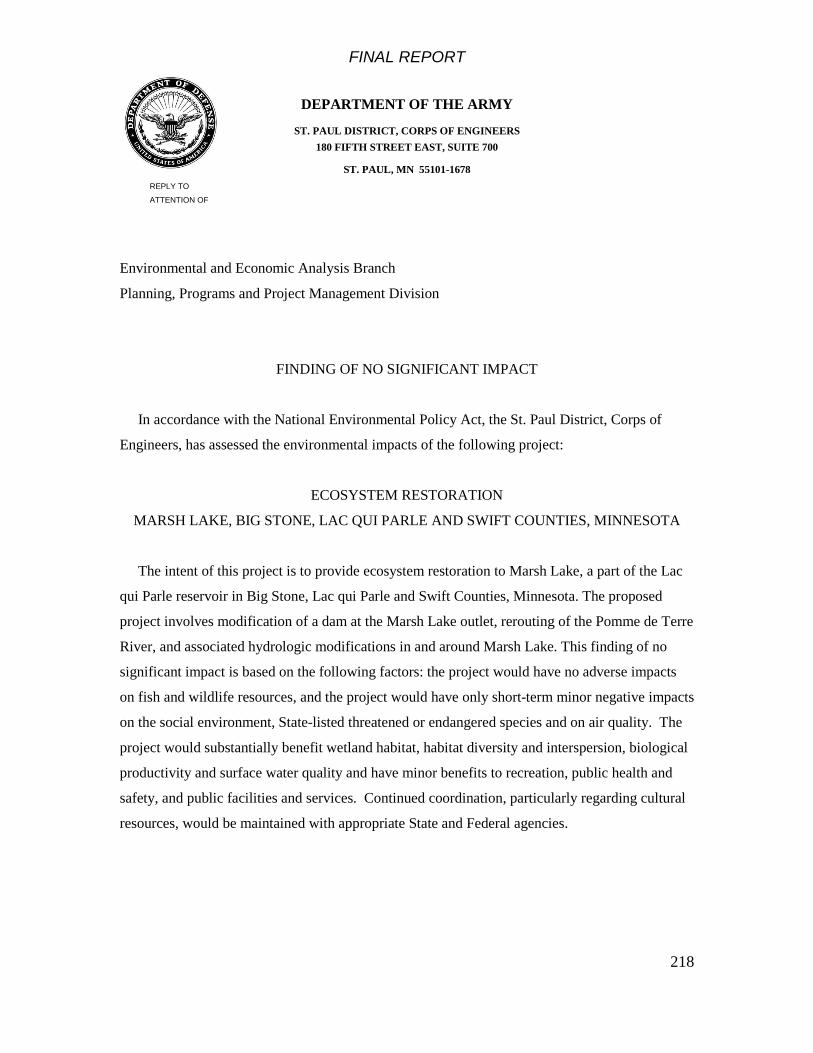
FINAL REPORT
218
DEPARTMENT OF THE ARMY
ST. PAUL DISTRICT, CORPS OF ENGINEERS 180 FIFTH STREET EAST, SUITE 700
ST. PAUL, MN 55101-1678 REPLY TO
ATTENTION OF
Environmental and Economic Analysis Branch
Planning, Programs and Project Management Division
FINDING OF NO SIGNIFICANT IMPACT
In accordance with the National Environmental Policy Act, the St. Paul District, Corps of
Engineers, has assessed the environmental impacts of the following project:
ECOSYSTEM RESTORATION
MARSH LAKE, BIG STONE, LAC QUI PARLE AND SWIFT COUNTIES, MINNESOTA
The intent of this project is to provide ecosystem restoration to Marsh Lake, a part of the Lac
qui Parle reservoir in Big Stone, Lac qui Parle and Swift Counties, Minnesota. The proposed
project involves modification of a dam at the Marsh Lake outlet, rerouting of the Pomme de Terre
River, and associated hydrologic modifications in and around Marsh Lake. This finding of no
significant impact is based on the following factors: the project would have no adverse impacts
on fish and wildlife resources, and the project would have only short-term minor negative impacts
on the social environment, State-listed threatened or endangered species and on air quality. The
project would substantially benefit wetland habitat, habitat diversity and interspersion, biological
productivity and surface water quality and have minor benefits to recreation, public health and
safety, and public facilities and services. Continued coordination, particularly regarding cultural
resources, would be maintained with appropriate State and Federal agencies.

FINAL REPORT
219
For the reasons stated above, the proposed action does not constitute a major Federal action
significantly affecting the quality of the human environment. Therefore, an environmental impact
statement will not be prepared.
____________________
Date Michael J. Price
Colonel, Corps of Engineers
District Engineer
FINAL REPORT
220
13 List of Preparers
The following table includes the St. Paul District Corps of Engineers and Minnesota DNR
Project Delivery Team members who contributed to this report and EA.
Team Members Discipline
Corps of Engineers Michael Wyatt Planner/Project Manager
Corby Lewis
Scott Goodfellow
Hydraulic Engineering
Daniel Wilcox Aquatic Ecology, Planning Lance Awsumb Economics, Sociology
Ginny Gnabasik Cultural Resources
Rodney Peterson Real Estate
Dave Tschida
Chris Behling BJ Siljenberg
Renee McGarvey
Dorie Bollman
Design/Civil Engineering
Geotechnical Engineering Structural Engineering
Recreation
Minnesota DNR
Mark Matuska Regional Director
Ken Varland Wildlife, Planning
David Trauba Wildlife Jack Lauer Fisheries
Norm Haukos
Chris Domeier
John Schladweiler Ecological Services
Luther Aadland
Dave Luethe Waters
Skip Wright Waters Shane Rustin Engineering
Craig Mitchell Trails and Waterways
Other Partners Josh Kavanagh Ducks Unlimited
Dick Kroger CURE
Shannon Fisher Mankato State University
FINAL REPORT
221
References
American Sportfishing Association. 2001. Sportfishing in America: Values of our
traditional pastime. http://www.iafwa.org/Attachments/fish_eco_impact.pdf
Alexandria, Virginia.
Bayley, P.B. 1995. Understanding large river-floodplain ecosystems. BioScience 45:
153-158.
Berry, C.R., and D. German. 1999. Revegetation of shallow lakes: A case study of
Heron Lake, Minnesota. Minnesota Waterfowl Association. Minneapolis, Minnesota.
127 pp.
Best, E.P.H. & Boyd, W.A., 2003. A simulation model for growth of the submersed
aquatic macrophyte Sago pondweed (Potamogeton pectinatus L.). ERDC/EL TR-03-
6. U.S. Army Engineer Research & Development Center, Environmental Laboratory,
Vicksburg, Mississippi.
Best, E. and W. Boyd. 2007. Estimating SAV tuber density of sago pondweed in Marsh
Lake, Minnesota. Letter report to the St. Paul District, U.S. Army Corps of Engineers.
Environmental Laboratory, U.S. Army Engineer Research and Development Center.
Vicksburg, Mississippi.
Cordell, H.K., G.T. Greeen, and C.J. Betz. 2009. Long-Term National Trends in Outdoor
Recreation Activity Participation –1980 to Now.
Emerson, P. M. and M. A. Magner. 2002. Minnesota Department of Natural Resources
Division of Wildlife and Fisheries Cultural Resources Program: Annual Report –
2001. Archaeology Department, Minnesota Historical Society, St. Paul.
Emerson, P. M. and M. A. Magner. 2003. Minnesota Department of Natural Resources
Division of Wildlife and Fisheries Cultural Resources Program: Annual Report – 2002.
Archaeology Department, Minnesota Historical Society, St. Paul.

FINAL REPORT
222
Emerson, P. M. and M. A. Magner. 2004. Minnesota Department of Natural Resources
Division of Wildlife and Fisheries Cultural Resources Program: Annual Report – 2003.
Archaeology Department, Minnesota Historical Society, St. Paul.
Emerson, P. M. and M. A. Magner. 2005. Minnesota Department of Natural Resources
Division of Fish and Wildlife Cultural Resources Program: Annual Report – 2004.
Archaeology Department, Minnesota Historical Society, St. Paul.
Engstrom, D., and J. Almendinger. 2000. Historical changes in sediment and
phosphorus loading to the Upper Mississippi River: Mass-balance reconstructions
from the sediments of Lake Pepin. St. Croix Watershed Research Station, Science
Museum of Minnesota, St. Paul, Minnesota.
Hart, D.D., T.E. Johnson, K.L. Bushaw-Newton, R.J. Horwitz, A.T. Bednarek, D.F.
Charles, D.A. Kreeger, and D.J. Velinski6 2002. Dam removal: challenges and
opportunities for ecological research and river restoration. BioScience 52:8 (669-
682).
Harrison, C. 2000. Report on Phase I Cultural Resources Investigation of Selected
Flowage Easement Lands at the Lac qui Parle Flood Control Project, Lac qui Parle
and Big Stone Counties, Minnesota with Preliminary Assessments of Significance for
Identified Archaeological Sites. Archaeological Research Services, Minneapolis,
Minnesota. Prepared for the St. Paul District, U.S. Army Corps of Engineers, St.
Paul, Minnesota.
Harwell, M. A., V. Meyers, T. Young, A. Bartuska, N. Grassman, J. H. Gentile, C. C.
Harwell, S. Appelbaum, J. Barko, B. Causey, C. Johnson, A. McLean, R. Somla, P.
Tamplet, and S. Tosini. 1999. A framework for an ecosystem report card. BioScience
49:543-556.
James, W., and J. Barko. 1995. Wind-induced sediment resuspension and export in
Marsh Lake, western Minnesota. Technical Report W-95-1. U.S. Army Corps of
Engineers, Waterways Experiment Station.

FINAL REPORT
223
Junk, W.J., P.B. Bayley, and R.E. Sparks. 1989. The flood pulse concept in river-
floodplain systems. Special Publication of the Canadian Journal of Fisheries and
Aquatic Sciences 106: 110-127.
Kelly, T. 2005. 2004 Outdoor Recreation Participation Survey of Minnesotans – Report
on Findings. Office of Management and Budget Services, Minnesota Department of
Natural Resources, St. Paul, Minnesota.
Kolb, M. F., R. F. Boszhardt and B. J. Bielefeldt. 1999. A Phase I Archaeological
Survey of the Lac qui Parle Flood Control Project, Lac qui Parle County, Minnesota.
Strata Morph Geoexploration, Inc., Sun Prairie, Wisconsin and Mississippi Valley
Archaeology Center, University of Wisconsin, La Crosse. Prepared for the St. Paul
District, U.S. Army Corps of Engineers, St. Paul, Minnesota.
Magdalene, S. 2004. Sediments and Nutrients in Agricultural Drainage within the MRB.
Abstract of a seminar presented at Borlaug Hall, University of Minnesota, St. Paul, on
March 29, 2004.
Magner, M. A. 2008. Report of Archaeological Reconnaissance Survey: Marsh Lake
Ecosystem Restoration, Lac qui Parle WMA, Big Stone, Lac qui Parle, and Swift
Counties, Minnesota. Minnesota Department of Natural Resources, Division of Fish &
Wildlife, Cultural Resources Program, Grand Rapids, Minnesota.
Magner, M. A., S. Allan and L. Gonsior. 2007. Minnesota Department of Natural
Resources Division of Fish and Wildlife Cultural Resources Program: Annual Report –
2006. Archaeology Department, Minnesota Historical Society, St. Paul.
Magner, M. A. and S. Allan. 2008. Minnesota Department of Natural Resources
Division of Fish and Wildlife Cultural Resources Program: Annual Report – 2007.
Archaeology Department, Minnesota Historical Society, St. Paul.
Miller, A. C., R. Whiting, and D. B. Wilcox. 1989. An evaluation of a skimmer dredge for
collecting freshwater mussels. Journal of Freshwater Ecology, 5(2):151-154.

FINAL REPORT
224
Minnesota Pollution Control Agency. 1994. Minnesota River assessment project report.
Report to the Legislative Commission on Minnesota Resources. Volume 1 Work plan
and summary, Volume II Physical/chemical assessment, Volume III
Biological/toxicological assessment, Volume IV Land use assessment. St. Paul,
Minnesota.
Minnesota Department of Health. 2008. Fish consumption advice. Site-specific advice
for tested lakes and rivers.
http://www.health.state.mn.us/divs/eh/fish/eating/sitespecific.html
Montz, G.R. 1990. Benthic macroinvertebrates of the Upper Minnesota River. Minnesota
Department of Natural Resources. St. Paul, Minnesota.
Moyle, J.B. 1941. Natural vegetational trends observed in two recently flooded areas in
Minnesota; Marsh Lake in Lac qui Parle and Chippewa Counties and Thief Lake in
Marshall County. Investigational Report No. 36. Minnesota Division of Game and
Fish. St. Paul, Minnesota.
Mulla, D. 1997. Minnesota River Basin water quality overview. St. Paul, MN:
Minnesota Extension Service, University of Minnesota.
Ollendorf, A. L. and H. D. Mooers. 1994a. Phase I Cultural Resources Investigation of
U.S. Army Corps of Engineers Fee Title Lands and Leased Lands, Lac qui Parle
Flood Control Project, Lac qui Parle, Chippewa, Swift, and Big Stone Counties,
Minnesota. Institute for Minnesota Archaeology, Minneapolis. Prepared for the St.
Paul District, U.S. Army Corps of Engineers, St. Paul, Minnesota.
Ollendorf, A. L. and H. D. Mooers. 1994b. Phase I Cultural Resources Investigation of
Four Proposed Bank Protection Areas, Lac qui Parle Flood Control Project, Lac qui
Parle, Chippewa, and Big Stone Counties, Minnesota. Institute for Minnesota
Archaeology, Minneapolis. Prepared for the St. Paul District, U.S. Army Corps of
Engineers, St. Paul, Minnesota.
FINAL REPORT
225
Rohweder, Jason, Rogala, James T., Johnson, Barry L., Anderson, Dennis, Clark,
Steve, Chamberlin, Ferris, and Runyon, Kip, 2008, Application of wind fetch and
wave models for habitat rehabilitation and enhancement projects: U.S. Geological
Survey Open-File Report 2008–1200, 43 p.
Scheffer, M. 1998. The ecology of shallow lakes. Springer, Netherlands. 256 pp.
Skagen, S.K. 1997. Stopover ecology of transitory populations: The case of migrating
shorebirds. In: Knopf, F.L., and F.B. Samson, (eds.). Ecology and Conservation of
Great Plains Vertebrates. New York, NY: Springer-Verlag. p. 244-269.
Skaar, K. A. 1997. Minnesota Department of Natural Resources Trails and Waterways
Cultural Resources Program: Annual Report – 1996. Archaeology Department,
Minnesota Historical Society, St. Paul.
Southern Minnesota Rivers Basin Commission. 1977. Minnesota River Basin report.
Strange, C.J., 2007. Facing the brink without crossing it. BioScience 57:11 (920 – 926).
The Nature Conservancy. 2003. Conservation priorities for freshwater biodiversity in
the Upper Mississippi River Basin. Nature Serve and The Nature Conservancy.
Arlington, Virginia.
Union of Concerned Scientists. 2009. Confronting climate change in the Midwest U.S.
Minnesota. http://www.ucsusa.org/assets/documents/global_warming/climate-
change-minnesota.pdf
Urban Research and Development Corporation, Guidelines for Understanding and
Determining Optimum Recreation Carrying Capacity, Prepared for the U.S.
Department of the Interior, 1977.
Urban Research and Development Corporation, Recreation Carrying Capacity
Handbook – Methods and Techniques for Planning, Design, and Management,
Prepared for the U.S. Army Corps of Engineers, July 1980.

FINAL REPORT
226
U.S. Commission on Fish and Fisheries. 1895. Report of the Commissioner for the year
ending June 30, 1893. Minnesota River, pages 353-358.
U.S. Army Corps of Engineers (USACE). 1950. Report on survey of Minnesota River,
Minnesota, for flood control and allied purposes. St. Paul District, U.S. Army Corps of
Engineers. St. Paul, Minnesota.
U.S. Army Corps of Engineers (USACE). 1960. Interim report on survey of Big Stone
Lake-Whetstone River Project, Project Modifications, Minnesota and North Dakota.
St. Paul District, U.S. Army Corps of Engineers. St. Paul, Minnesota.
U.S. Army Corps of Engineers (USACE). 1961. General Design Memorandum,
Minnesota River , Minnesota, In the interest of navigation and related purposes. St.
Paul District, U.S. Army Corps of Engineers. St. Paul, Minnesota.
U.S. Army Corps of Engineers (USACE). 1966. Phase 1 report for flood control and
related purposes, Minnesota River Basin, Minnesota and South Dakota. St. Paul
District, U.S. Army Corps of Engineers. St. Paul, Minnesota.
U.S. Army Corps of Engineers (USACE). 1969. Water supply and water quality control
study, Minnesota River Basin reservoirs, Minnesota. St. Paul District, U.S. Army
Corps of Engineers. St. Paul, Minnesota.
U.S. Army Corps of Engineers (USACE). 1973. Flood control, Big Stone Lake –
Whetstone River, Minnsota-South Dakota. Design Memorandum 3. St. Paul District,
U.S. Army Corps of Engineers. St. Paul, Minnesota.
U.S. Army Corps of Engineers (USACE). 1989. Reservoir operating plan evaluation for
Highway 75-Lac qui Parle Reservoirs, Minnesota River. St. Paul District, U.S. Army
Corps of Engineers. St. Paul, Minnesota.
U.S. Army Corps of Engineers (USACE). 1995. Water control manual. Lac qui Parle
Project. St. Paul District, U.S. Army Corps of Engineers. St. Paul, Minnesota.

FINAL REPORT
227
U.S. Army Corps of Engineers (USACE). 2004. Minnesota River Basin reconnaissance
study. Section 905(b) analysis (WRDA 1986). Minnesota, South Dakota, North
Dakota and Iowa. St. Paul District, U.S. Army Corps of Engineers. St. Paul,
Minnesota.
U.S. Army Corps of Engineers (USACE). 2010. Economics Guidance Memorandum 10-
03, Unit Day Values for Recreation, Fiscal Year 2010.
Van Alstine, J. 1987. Sedimentation rates and changing water quality – Pomme de Terre
River Watershed, West Central Minnnesota. Geology Department, University of
Minnesota, Morris.
Water Resources Council 1983. Economic and environmental principles and guidelines
for water and related land resources implementation studies. Washington, D.C.
Waters, Thomas F. 1977. The Streams and Rivers of Minnesota. Minneapolis: University
of Minnesota Press.
Wilcox, D.W., E.L. Stefanik, D.E. Kelner, M.A. Cornish, D.J. Johnson, I.J. Hodgins,
S.J. Zigler, and B.L. Johnson. 2004. Improving fish passage through navigation
dams on the Upper Mississippi River System. Upper Mississippi River – Illinois
Waterway Navigation Study. ENV Report 54. U.S. Army Engineer District, Rock
Island, Illinois.
Zischke, J.A., G. Ericksen, D. Waller, and R. Bellig. 1990. Analysis of benthic
macroinvertebrate communities in the Minnesota River watershed. Report prepared
for the Minnesota Department of Natural Resources, St. Paul, Minnesota.
FINAL REPORT
228
Appendices
A. Project Management Plan
B. Federal Cost Sharing Agreement
C. Correspondence
D. Clean Water Act, Section 404(b)(1) Evaluation
E. Habitat Benefits Evaluation
F. Hazardous, Toxic, and Radioactive Waste Documentation Report
G. Cost Estimate
H. Geotechnical Considerations
I. Recreation
J. Hydrology and Hydraulics
K. Structural Considerations
L. Distribution List
M. Real Estate Plan
N. Plates
O. Public Comments Received
P. Sediment Resuspension/Aquatic Plant Growth
Q. Mussel Surveys
R. Monitoring and Adaptive Management Plan
Related Documents