MARK TWAIN LAKE MASTER PLAN CLARENCE CANNON DAM AND MARK TWAIN LAKE MONROE CITY, MISSOURI CHAPTER 1 INTRODUCTION 1.1 AUTHORIZATION Federal laws provide that land and water areas of Department of the Army reservoirs, constructed for the primary purposes of flood risk management, navigation and/or hydropower, shall be administered to encourage and develop all collateral uses such as water supply, public parks and recreation, conservation of fish and wildlife resources, pollution abatement, and other purposes in the public interest. The Flood Control Act of 28 June 1938 authorized a dam and reservoir on the Salt River near Joanna, Missouri, as part of a general comprehensive plan for flood control in the Upper Mississippi River Basin. A restudy of the project indicated the feasibility of a multi-purpose development, including hydroelectric power. The project was authorized as such by Sec. 203 of the Flood Control Act of 23 October 1962 (PL 87-874), as recommended by the Chief of Engineers in House Document No. 507, 87th Congress, 2nd Session. The reservoir, originally named the Joanna Reservoir, was officially renamed Clarence Cannon Dam and Reservoir by Public Law 89-298, 89th Congress, 3rd Session on 27 October 1965. Clarence Cannon Dam and Reservoir was officially renamed Clarence Cannon Dam and Mark Twain Lake by PL 97-128, 97th Congress, 29 December 1981. 1.2 PROJECT PURPOSES The authorized purposes of the project are flood risk management in the Salt River Basin, hydroelectric power generation, water supply, fish and wildlife conservation, recreation, and incidental navigation. 1.3 PURPOSE AND SCOPE OF THE MASTER PLAN This revised Master Plan replaces The Master Plan, Design Memorandum No. 9, Clarence Cannon Dam and Mark Twain Lake, that was updated in 2004. A master plan is the strategic land use management document that guides the comprehensive management and development of all project recreational, natural, and cultural resources throughout the life of the water resource project. The Master Plan guides the efficient and cost-effective management, development, and use of project lands. It is a vital tool for the responsible stewardship and sustainability of project resources for the benefit of present and future generations. 2

Welcome message from author
This document is posted to help you gain knowledge. Please leave a comment to let me know what you think about it! Share it to your friends and learn new things together.
Transcript

MARK TWAIN LAKE MASTER PLAN
CLARENCE CANNON DAM AND MARK TWAIN LAKE MONROE CITY, MISSOURI
CHAPTER 1 INTRODUCTION
1.1 AUTHORIZATION
Federal laws provide that land and water areas of Department of the Army reservoirs, constructed for the primary purposes of flood risk management, navigation and/or hydropower, shall be administered to encourage and develop all collateral uses such as water supply, public parks and recreation, conservation of fish and wildlife resources, pollution abatement, and other purposes in the public interest.
The Flood Control Act of 28 June 1938 authorized a dam and reservoir on the Salt River near Joanna, Missouri, as part of a general comprehensive plan for flood control in the Upper Mississippi River Basin. A restudy of the project indicated the feasibility of a multi-purpose development, including hydroelectric power. The project was authorized as such by Sec. 203 of the Flood Control Act of 23 October 1962 (PL 87-874), as recommended by the Chief of Engineers in House Document No. 507, 87th Congress, 2nd Session. The reservoir, originally named the Joanna Reservoir, was officially renamed Clarence Cannon Dam and Reservoir by Public Law 89-298, 89th Congress, 3rd Session on 27 October 1965. Clarence Cannon Dam and Reservoir was officially renamed Clarence Cannon Dam and Mark Twain Lake by PL 97-128, 97th Congress, 29 December 1981.
1.2 PROJECT PURPOSES
The authorized purposes of the project are flood risk management in the Salt River Basin, hydroelectric power generation, water supply, fish and wildlife conservation, recreation, and incidental navigation.
1.3 PURPOSE AND SCOPE OF THE MASTER PLAN
This revised Master Plan replaces The Master Plan, Design Memorandum No. 9, Clarence Cannon Dam and Mark Twain Lake, that was updated in 2004. A master plan is the strategic land use management document that guides the comprehensive management and development of all project recreational, natural, and cultural resources throughout the life of the water resource project. The Master Plan guides the efficient and cost-effective management, development, and use of project lands. It is a vital tool for the responsible stewardship and sustainability of project resources for the benefit of present and future generations.
2

Mark Twain Lake Master Plan The Master Plan guides and articulates Corps responsibilities pursuant to federal laws to preserve, conserve, restore, maintain, manage, and develop the project lands, waters, and associated resources. The Master Plan is a dynamic operational document projecting what could and should happen over the life of the project and is flexible based upon changing conditions. The Master Plan deals in concepts, not in details, of design or administration. Detailed management and administration functions are addressed in the Operational Management Plan (OMP), which implements the concepts of the Master Plan into operational actions. The Master Plan will be developed and kept current for Civil Works projects operated and maintained by the Corps and will include all land (fee, easements, or other interests) originally acquired for the projects and any subsequent land (fee, easements, or other interests) acquired to support the operations and authorized missions of the project. The Master Plan is not intended to address the specifics of regional water quality, shoreline management, or water level management; these areas, if applicable, are covered in other project plans. However, specific issues identified through the Master Plan revision process can still be communicated and coordinated with the appropriate internal Corps resource (i.e. Operations for shoreline management) or external resource agency (i.e. Missouri Department of Natural Resources for water quality) responsible for that specific area.
1.4 WATERSHED AND PROJECT DESCRIPTION
Mark Twain Lake is located in Monroe and Ralls Counties on the Salt River in Northeast Missouri, approximately 63 miles upstream from its confluence with the Mississippi River. The Mark Twain Lake Watershed is comprised of 2,318 square miles with an additional 29 square miles draining into the re-regulation pool. (See Figure 1-1, Mark Twain Lake Watershed.) The North Fork of the Salt River is the major drainage channel, draining 626 square miles and is 88.0 miles in length. The Middle Fork, Elk Fork and South Fork of the Salt River are the other major tributaries to Mark Twain Lake. The Middle Fork drains 356 square miles and is 65.4 miles in length. The Elk Fork drains 262 square miles and is 34.8 miles in length. The South Fork drains 298 square miles and is 38.0 miles in length. The Salt River watershed is primarily agricultural with a gently undulating plain in the upstream portion and it becomes more rolling and hilly in the downstream reaches. High rock bluffs border the streams at various locations. The river valleys are characterized by fairly narrow, tortuous courses interspersed by areas of widened bottomlands. Hickory and oak groves are scattered among crop and grazing lands. The Mark Twain Lake Watershed is primarily agricultural with a gently undulating plain in the upstream portion and it becomes more rolling and hilly in the downstream reaches. High rock bluffs border the streams at various locations. The river valleys are characterized by fairly narrow, tortuous courses interspersed by areas of widened bottomlands. Hickory and oak groves are scattered among crop and grazing lands. The total area contained in the Mark Twain Lake Project, including land and water surface consists of 54,741 acres. An additional, 9,740 acres are for flowage easement. Construction of the Clarence Cannon Dam and Mark Twain Lake Project began in 1969 and was completed by August of 1983. There are 15 recreation areas around Mark Twain Lake; thirteen parks are
3

Mark Twain Lake Master Plan managed by the Corps of Engineers and two are leased to the Missouri Department of Natural Resources.
Figure 1-1 Mark Twain Lake Watershed
1.5 PRIOR PERTINENT DESIGN MEMORANDA
The 1991 and 2004 Master Plan Updates and their supplements are listed below. Additionally, a listing of prior design memorandums and accompanying supplements are provided in Appendix C and with the release of this Master Plan, are considered incorporated into this document.
1991 Master Plan Update. The 1991 update of the Master Plan was supplemented eight times. The following is a brief summary of those eight supplements.
• Supplement 1, 1991, requested that the Spillway Recreation Area be renamed the Warren G. See Spillway Area. Total estimated cost was $1500. Approved by CELMV-PD-R on 4 April 1991.
• Supplement 2, 1994, presented the request by the Northeast Missouri Area Vietnam Veterans Inc. to construct a memorial at the M. W. Boudreaux Memorial Visitor Center for Northeast Missouri soldiers who died in the Vietnam War. Total estimated cost of the project was $45,000. Approved by CELMV-PE-R on 28 October 1994
• Supplement 3, 1995, requested approval of a three-year road improvement and maintenance project for paved surfaces with a request for special funding. The three-year
4
Mark Twain Lake Master Plan
project cost was estimated at $1,586,621. The project without the special funding was approved on 18 October 1995 by CELMV-ET-PR.
• Supplement 4, 1995, proposed a marina development at the North Extension lease area of Mark Twain State Park, fish cleaning stations in several recreation areas, an amphitheater at Frank Russell campground, a vault toilet and multi-purpose shelter in the Warren G. See South Spillway Recreation Area, a wetland restoration project in the North Fork area, and high water accesses at three locations. Total estimated cost was $186,013. CELMV-ET-PR approved the supplement on 12 January 1996.
• Supplement 5, 1997, proposed a shooting range with a parking lot, road maintenance on an existing unsurfaced access road, and three minimum facilities for public health and safety including a five car/trailer access lot, and a 20 car gravel access lot. It also reflected a boundary change due to a recent land acquisition. Total estimated cost for all projects was $155,250. The St. Louis District Engineer approved the supplement on 23 July 1997.
• Supplement 6, 1999, proposed six comfort station shower additions at Ray Behrens and Indian Creek, two handicapped fishing accesses in the Spillway, an extension to the Joanna Trail, land acquisition for the Joanna Trail, relocation of the John F. Spalding bathhouse and the Indian Creek comfort station to higher ground, expansion of the Spalding Wastewater Treatment Plant, continuation of special emphasis programs for youth, seniors and physically challenged individuals in various recreation areas, construction of a non-discharge sewage treatment lagoon and upgrade of the vault toilet to waterborne with a shower facility in the South Spillway Recreation Area, and designation of the Joanna Loop in the Frank Russell Campground for equine use. Total cost of proposed items was $1,560,436. The supplement was approved by the St. Louis District Engineer on 16 February 1999.
• Supplement 7, 2001, proposed re-designating the Mark Twain State Park marina site as a beach, adding a swimming facility at Camp Colborn, Mark Twain State Park, upgrading the campsite electrical service at the Indian Creek and Ray Behrens Recreation Areas, adding two shelters and an earthen berm with a concrete retention wall at the special events area of the South Spillway Recreation Area, adding an archery range at the Ray Behrens Recreation Area, and installing full hookups at campsites in the Indian Creek and Ray Behrens Recreation Areas. Total estimated cost was $1,163,750. Supplement was approved by St. Louis District Engineer on 24 August 2001.
• Supplement 8, 2002 proposed renaming the M.W. Boudreaux Group Use Area in recognition and memory of John C. “Jack” Briscoe for his outstanding leadership, contributions and support to Northeast Missouri and to the Clarence Cannon Dam and Mark Twain Lake Project. Total estimated cost was $1300.00. Supplement was approved by St. Louis District Engineer on 12 March 2002.
2004 Master Plan Update. The 2004 update of the Master Plan was supplemented seven times. The following is a brief summary of those seven supplements.
5

Mark Twain Lake Master Plan
• Supplement 1, 2007, requested the construction of the Mark Twain Birth Site Trail adjacent to Florida, Missouri through an easement with the Monroe County Commission. Total estimated cost of the project was $33,000. The supplement was approved by the St. Louis District Engineer on 23 July 2007.
• Supplement 2, 2009, proposed relocation of facilities out of the flood zone to include replacement of vault toilets with a water-borne comfort station in the North Spillway, replacement of vault toilets with a water-borne comfort station in the South Spillway, replacement of vault toilets at the Bluffview Recreation Area with one vault toilet, replacement of vault toilets at Robert Allen, South Fork, Stoutsville, and the Indian Creek (east ramp) Recreation Areas, and the addition of a business center at the Administration Building. The total estimated cost of all the projects was $660,000. The supplement was approved by the St. Louis District Engineer on 7 May 2009.
• Supplement 3, 2010, proposed replacement of three vault toilets in the Frank Russell Campground and two vault toilets in the Indian Creek Campground, facility consolidation and shower building replacement in the Ray Behrens Campground, modification of the Ray Behrens Boat Ramp, replacement of the Ray Behrens Fee Booth, installation of a new picnic shelter in the Frank Russell Recreation Area through partnership with the Northeast Missouri Environmental Stewardship Consortium, conversion of existing campsites to ADA accessible campsites in the Indian Creek, Ray Behrens, and Frank Russell Recreation Areas, replacement of wooden playground systems at the Warren See Spillway, John Briscoe Group Camp, Frank Russell, and Ray Behrens Recreation Areas, installation of an equipment storage building at the Mark Twain Lake Project Office, installation of a floating wave attenuator at the Blackjack Marina, and installation of ADA Accessible fishing pier in the Warren See Spillway Recreation Area. Total estimated cost of all the projects was $5,608,125. The supplement was approved by the St. Louis District Engineer on 16 February 2010.
• Supplement 4, 2010, proposed rehabilitation of the existing unimproved earthen Eagle Nature Trail located at the M.W. Boudreaux Visitor Center to an ADA accessible trail. Total estimated cost of the project was $69,512. The supplement was approved by the St. Louis District Engineer on 18 September 2010.
• Supplement 5, 2011, proposed three equine campsites, trail, and small comfort station in the Frank Russell Recreation Area, a small comfort station at the John F. Spalding Recreation Area to be funded through grants and partnerships. The total estimated costs of all the projects was $168,592. The supplement was approved by the St. Louis District Engineer on 9 November 2011.
• Supplement 6, 2013, proposed construction of the Indian Creek Multi-Use Trail through grants and partnerships. The total estimated cost of the project was $247,715. The supplement was approved by the St. Louis District Engineer on19 July 2013.
6

Mark Twain Lake Master Plan
• Supplement 7, 2013, proposed development of five equine campsites through grants and partnerships. Total estimated cost of the project was $24,000. The supplement was approved by St. Louis District Engineer on 3 December 2013.
1.6 PERTINENT PROJECT INFORMATION
Table 1-1 Project Information
Project Data
Location 15 miles south of Monroe City, MO & 120 miles north of St. Louis
Total Acreage 54,741 acres Lake Surface Normal Pool 18,600 acres - 606 ft. NGVD Lake Surface Flood Pool 38,400 acres - 638 ft. NGVD Recreation Areas 15 Recreation Area Acreage 9,780 acres Estimated Annual Visitation 2.2 Million Dam Construction Began 1969
Construction Completion Date of Dam/Gates Closed August 1983
Date Lake Reached Normal Pool March 1984 Dedication September 1984
Main Dam Statistics
Location 63 miles upstream from confluence of Salt River with Mississippi River
Length 1,940 feet Width at Crest 30 feet
1 Concrete Powerhouse/Spillway Section 450,000+ yards of concrete
1 Earthen Section 3,000,000+ yards of fill
Re-Regulation Dam Statistics Location 9.5 miles downstream from main dam Height 40 feet Length 1,500 feet Watershed 29 square miles Lake Acreage 800 surface acres The Re-Regulation Dam consists of an Earth structure with 2 flow control gates.
The Re-Regulation Dam is required to raise the tail water at the main dam to a level suitable for pump-back with the Francis Unit.
7

Mark Twain Lake Master Plan
8

MARK TWAIN LAKE MASTER PLAN
CLARENCE CANNON DAM AND MARK TWAIN LAKE MONROE CITY, MISSOURI
CHAPTER 2 SETTING AND FACTORS INFLUENCING
MANAGEMENT AND DEVELOPMENT
2.1 DESCRIPTION OF RESERVOIR Mark Twain Lake is a civil works project consisting of a lake/reservoir impounded by an earthen and concrete dam structure, power generation plant, outlet works, spillway, re-regulation dam, and public use lands and facilities. Clarence Cannon Dam, and its associated features, became operational in 1984. Approximately 54,762 acres of land were acquired in fee title for the reservoir, downstream operational areas, and recreation areas. An additional 9,740 acres of flowage easement was acquired to accommodate a flood elevation of 642.0 feet NGVD1. The operational facilities at Mark Twain Lake are described as follows: Location. Clarence Cannon Dam and Mark Twain Lake are located on the Salt River in northeastern Missouri, generally in Monroe and Ralls Counties. The main dam site is located in Ralls County at mile 63.0 on the Salt River, approximately 12 miles southeast of Monroe City, Missouri. A re-regulation dam is located approximately 9.5 miles downstream from the main dam site. The project area is served on the north by U.S. Highway 24, and on the south by State Highway 154. State Highway 107 bisects the project area from north to south, and provides a major reservoir crossing near Florida, Missouri. State Highway J crosses the main dam, and is the primary north-south transportation corridor on the eastern side of the lake. Clarence Cannon Dam. Clarence Cannon Dam consists of a compacted earth embankment, a gated concrete spillway, a concrete hydroelectric power plant and a water temperature control weir. State Highway J crosses the top of the dam. The total length of the dam is 1,940 feet with the centerline of the dam running in a near north-south direction. The concrete portion of the dam is 845.75 feet in length, and abuts the southern rim of the valley.
• Earth Embankment. The compacted earth embankment has a crest elevation of 653.0 feet NGVD. The embankment is about 1,094 feet in length.
• Spillway. The spillway is part of the concrete portion of the dam, and is 230 feet in length. It begins 360 feet from the southern rim of the valley. The spillway is topped by
1 Note: All elevations cited are in terms of the National Geodetic Vertical Datum (NGVD)
9

Mark Twain Lake Master Plan
four 50-foot wide by 39-foot high tainter gates separated by 10-foot wide piers. The spillway crest elevation is 600.0 feet NGVD. A 230-foot wide by 198.86-foot long stilling basin, with two rows of baffle piers and an end sill is provided for the purpose of energy dissipation. The stilling basin floor is at elevation 508 feet NGVD.
• Power Plant. The power plant is part of the concrete portion of the dam, and is located immediately north of the spillway. The power plant is 222.75 feet in length. The power plant contains a Kaplan 27,000-KW turbine generator and a Francis 31,000-KW pump turbine generator. The invert elevation of the intake structure is 520.0 feet NGVD. The invert elevation of the outlet structure is 483.0 feet NGVD.
• Water Temperature Control Weir. A water temperature control weir, constructed of rolled earth, is located 400 feet upstream of the centerline of the concrete portion of the dam. The crest elevation of the weir is 580.0 feet NGVD, and is approximately 780 feet in length.
Re-Regulation Dam. The re-regulation dam is located 9.5 miles downstream from the main dam, and consists of a compacted earth embankment, a gated concrete spillway, a sluice and an operating house. The total length of the dam is 1,550 feet.
• Earth Embankment. The crest elevation of the compacted earth embankment is 537.0 feet NGVD. The embankment is 1430 feet in length.
• Spillway.The concrete spillway is 119.5 feet in length. The spillway is topped by two 32 by 31 foot-high tainter gates separated by an 8 foot wide pier. The spillway crest elevation is 499.0 feet NGVD. A 68 foot by 40 foot stilling basin with an end wall is provided for the purpose of energy dissipation. The stilling basin floor is at elevation 494.0 feet NGVD. The operating house is located at the west end of the spillway.
Saddle Dams. Two small saddle dams are located just north of the entrance to the Frank Russell Recreation Area.
Lake Shoreline, Length, and General Character. The reservoir covers approximately 18,600 acres and has a shoreline of approximately 285 miles at the pool level of 606 feet NGVD. The average depth of the pool at 606 feet NGVD is 29 feet.
Park and Recreation Facilities. Several areas have been developed at Mark Twain Lake for the visiting public to enjoy a variety of outdoor recreational experiences. The most common activities engaged in are fishing, boating, water-skiing, sailing, camping, picnicking, swimming and hunting. Developed facilities available at the lake include a visitor center, four campgrounds, three group camping areas, five picnic areas, 21 boat launching areas, five nature trails, two marinas, and three beaches. Hunting and fishing opportunities are available on all Corps of Engineers lands and waters except where restricted and posted due to recreational development or safety. (Chapter 5 presents a complete description of all recreational facilities.) 2.2 HYDROLOGY
10

Mark Twain Lake Master Plan The Mark Twain Lake watershed is comprised of 2,318 square miles with an additional 29 square miles draining into the re-regulation pool. The North Fork of the Salt River is the major drainage channel, draining 626 square miles (27% of the drainage area). The North Fork is 88.0 miles in length, has an average gradient of 4.5 feet per mile and has a maximum elevation of approximately 1,000 feet. The Middle Fork, Elk Fork and South Fork of the Salt River are the other major tributaries to Mark Twain Lake. The Middle Fork drains 356 square miles (15%), is 65.4 miles in length, has an average gradient of 5.1 feet per mile and has a maximum elevation of approximately 940 feet. The Elk Fork drains 262 square miles (11%), is 34.8 miles in length, has an average gradient of 7.9 feet per mile and has a maximum elevation of approximately 880 feet. The South Fork drains 298 square miles (13%), is 38.0 miles in length, has an average gradient of 7.2 feet per mile and has a maximum elevation of 880 feet. Combined, the North Fork, Middle Fork, Elk Fork and South Fork drain a total of 1,542 square miles, which is 66% of the Mark Twain Lake watershed. The Mark Twain Lake watershed is a gently undulating plain in the upstream portion and it becomes more rolling and hilly in the downstream reaches. High rock bluffs border the streams at various locations. The river valleys are characterized by fairly narrow, tortuous courses interspersed by areas of widened bottomlands. Hickory and oak groves are scattered among crop and grazing lands. Strip mining in the South Fork watershed may produce acid runoff. Several clay pits in the southwestern portion of the Mark Twain Lake watershed account for some colloidal suspension, which increases the turbidity of the lake. Mark Twain Lake is a flood control reservoir with multiple purposes. There are also incidental benefits to Mississippi River navigation. The pool at elevation 606.0 feet NGVD retains 100 percent of available flood control storage and 100 percent of the joint-use storage for the other project purposes, namely hydroelectric power generation, water supply, fish and wildlife and recreation. 2.3 SEDIMENTATION AND SHORELINE EROSION The rate of sedimentation within the reservoir is influenced by regional and site specific conditions, including annual and seasonal precipitation patterns and associated storm water runoff, as well as river bank erosion and agricultural runoff. Sedimentation is unavoidable for reservoirs like Mark Twain Lake due to tributary sedimentation contribution, high water events, and wind and wave action. Accounting for sedimentation was included in the design and management of the reservoir. According to the last re-survey in May 2010, 26,318 ac-ft of storage had been depleted of the 457,000 ac-ft of original storage in the joint-use pool, a reduction of 5.8 percent. It was the opinion at that time that the existing water supply contract allocation of 20,000 ac-ft not be modified due to the small amount of storage depleted. Overall, the May 2010 re-survey found a deposition rate of 2,061 ac-ft/yr since the beginning of the project, close to the anticipated rate of 1,740 ac-ft/yr.
2.4 WATER QUALITY
11

Mark Twain Lake Master Plan Water quality sampling is conducted with a watershed approach to establish trend analysis and maintain water quality at or above state and federal regulations. Water quality monitoring is conducted to assure safe conditions for human recreation, wildlife, and aquatic life as maintained and managed within the lake system. The water quality management program for the lake includes monitoring of baseline parameters, ecological trends, swimming beach E. coli, and investigation of problem areas to keep the lake within state and federal standards. The sampling and analysis which are conducted at the Mark Twain Lake sites reflect the minimal set of parameters needed to analyze the current status of water quality for the Mark Twain Lake system. Excellent coordination and cooperation exists between the Corps of Engineers, Missouri Department of Conservation, Missouri Department of Natural Resources, and the Southwestern Power Administration concerning lake levels and water quality affecting aquatic life and fish spawning.
2.5 PROJECT ACCESS Major Highways. Primary transportation corridors providing regional access to Mark Twain Lake are U. S. Highway 36, an east-west four-lane accessible highway located north of the lake, and U. S. Highway 61, a north-south four-lane accessible highway located east of the lake. The immediate Project Area is served on the north by U.S. Highway 24, and on the south by State Highway 154. State Highway 107 bisects the project area from north to south, and provides a major reservoir crossing near Florida, Missouri. State Highway J crosses the main dam, and is the primary north-south transportation corridor on the eastern end of the lake. These highways provide the public with safe and adequate access to all areas of the Project. Local/County Roads. Local authorities are responsible for the maintenance of several off-project roads that provide the public with access from major highways to recreation areas. The condition of these roads varies, however, most can be considered as adequately maintained. The following roads with access descriptions are the primary routes of travel used by the visiting public.
• State Route J from Highway 154.This road provides access to the Ray Behrens, South Spillway, John C. “Jack” Briscoe, North Spillway, Frank Russell, and John Spalding Recreation Areas, as well as the Mark Twain Lake Project Office. Ralls County.
• State Route EE from Highway 19. This road leads from Highway 19 west to Route J. Ralls County.
• State Route BB from Route J. This road leads to the Route BB boat ramp and Hunter Fisherman Access 60. Ralls County.
• John F. Spalding Access Road (Old State Route J) from Route J. This road provides access to the John F. Spalding Recreation Area. Ralls County.
• State Route N from Highway 24. This road leads to Route N Boat Ramp and Hunter Fisherman Access 11. Monroe County.
• State Route HH from Highway 24. Leads to Indian Creek Access Road, Shell Branch Recreation Area and Hunter Fisherman Access 15. Monroe County.
• Indian Creek Access Road (County) from State Route HH. Leads to Indian Creek Recreation Area. Monroe County.
12

Mark Twain Lake Master Plan
• State Route U from Highway 107. Leads to Mark Twain State Park and Historic Area. Monroe County.
• Robert C. Allen Access Road (County) from Highway 154. Leads to Robert E. Allen Recreation Area. Monroe County.
2.6 CLIMATE The climate of the Mark Twain Lake region is considered moderate. The following is representative of the weather conditions that are encountered. Temperature. Summers are generally mild with occasional temperatures slightly in excess of 100 degrees Fahrenheit. Periods of extreme heat are usually short, if accompanied by sufficient rainfall. Winters are usually moderate, although periods of extremely cold weather are experienced. Weather changes and temperature fluctuations are frequent throughout the year with the extremes varying from 116 to -31 degrees Fahrenheit. Average temperatures by months during the recreation season in counties contiguous to the reservoir in degrees Fahrenheit are as follows: April 54o, May 64o, June 74o, July 78o, August 76o, and September 68o. Wind. The maximum wind movement occurs in March and the minimum in August. The average wind velocity is about 10.3 miles per hour. The prevailing winds over the basin are generally from the south. Humidity. The relative humidity varies from about 59 percent to 86 percent in the winter and from 51 percent to 89 percent during the remainder of the year. Precipitation. The annual average precipitation over the drainage area above the dam site is about 37.1 inches. Two-thirds of the annual rainfall normally occurs during the spring and summer, with local cellular storms occurring generally in July and August. Average annual snowfall amounts to about 21 inches and is usually limited to the period from November to March. The snow cover seldom lasts for more than a few days at a time. 2.7 TOPOGRAPHY, GEOLOGY, AND SOILS Topography. The topography at Mark Twain Lake reaches a maximum elevation of about 780 feet NGVD in the southwestern portion of the project to a minimum of approximately 520 feet NGVD along the main stream of the Salt River. The North Fork, Middle Fork, Elk Fork and South Fork are the main tributaries of the Salt River within the project boundaries and have a maximum elevation of 675 feet NGVD in the western part of the project. The sides of the major valleys are dissected by short tributaries whose gradients extend from the flat uplands to the valley bottoms. The divides between these tributaries form a continuous belt of hills along either side of the major valleys. The land adjoining the project is relatively flat farmland. Geology. The predominant geologic structure controlling the local dip of rock strata at the project is the Lincoln Fold, a complex plunging asymmetrical anticline located in northeast Missouri. The project area is located in the Dissected Till Plains Section of the Central Lowlands Physiographic Province. The geologic formations occurring at the surface within the
13

Mark Twain Lake Master Plan project area include Paleozoic sedimentary rocks (primarily limestone and shale) Pleistocene glacial drift, and recent alluvium. The area is characterized by low to moderate relief in the uplands with locally high relief (up to 200 feet) occurring in the bluffs along the Salt River and its tributaries. Some karst features are present in the project area, most notably, solution cavities in the limestone bluffs. The geologic formations’ stratigraphy in the area consists essentially of nearly flat-lying sedimentary strata of Mississippian and Pennsylvanian formations on the uplands. These in turn, are overlain by Pleistocene deposits of glacial till, residuum, or on the floodplains, by recent alluvium. Frequently observed formations found in differing regions of the project include the Hannibal Formation, Chouteau Formation, Burlington-Keokuk formation, Warsaw Formation, Pennsylvanian Age Strata, and Pleistocene and Recent Deposits. The nature of significant economic mineral deposits within the project area makes any protective measures beyond slope or erosion protection unnecessary. Sufficient reserves of fire clay, coal, and other geologic resources are present outside the project area to preclude the exploitation of any deposits within Government property lines. Geologic items of a collectible nature such as the geodes present in the Keokuk Limestone and its weathered residuum, and the rather unique pyritized fossils of the Hannibal Shale may be deemed significant enough to consider them a resource that warrants management. Soils. Soil surveys have been prepared by the United States Department of Agriculture – Natural Resources Conservation Service (NRCS) for the counties encompassing Mark Twain Lake (Ralls and Monroe, MO Counties). Engineering as well as other land use interpretations for each soil unit encountered in the respective counties are included in these soil surveys. The predominant soil units within the project area are the Armstrong-Leonard Association and the Goss-Gorin-Lindley Association. The soils of the area present several problems. They are erosive particularly when the shoreline of the lake is subjected to periods of high water combined with windy conditions; bank erosion and caving can occur. Many of the soil deposits are in an area of glacial origin, and include rocks and boulders of large to moderate size at or immediately beneath the ground surface. These conditions can complicate foundation and utility trench design and placement.
2.8 RESOURCE ANALYSIS (Level 1 Inventory Data) Wildlife Resources. The wildlife species known or expected to occur on the Mark Twain Lake area are those common to the region in general. The land and its plant association support an upland game population, predators and a variety of non-game mammals and birds. Although the project is located in the Mississippi Flyway, the major flights of waterfowl normally pass down the Mississippi to the east and the Grand River to the west. There are; however, sufficient numbers of waterfowl using the lake to have a huntable population. Some "threatened" or "rare and endangered" species do occur in the area; these are discussed in Section 2.8.3 and Table 2-1. Land management procedures on public lands benefit many of the species present and attract other species to the area. Such procedures are beneficial to songbirds, game birds, and mammals. Trees and shrubs have been and will continue to be planted to provide nesting cover and food for
14

Mark Twain Lake Master Plan all wildlife species. Wildlife food plots varying in shape, size and species composition are planted in areas to increase available foods for wildlife. Succession control in the form of mowing, disking, and prescribed fire eliminates woody plants while providing diversity among herbaceous plants, in contrast to adjacent untreated areas. Nest boxes provide additional nesting spaces for wood ducks, purple martins, house wrens, tree swallows, bluebirds, bats, and squirrels. Together, the private farms and the public wildlife areas provide a proper balance of food and cover for wildlife over much of the project. Areas that are in the agricultural lease program provide additional food and cover for wildlife species. Civic and private organizations in partnership with the Corps of Engineers assist in the development of structures beneficial to all wildlife on public lands.
Project management practices will be used to maximize the support value of the project for fish and wildlife production, while at the same time maximizing recreational opportunities for hunters and fishermen. Waterfowl management objectives will be fully coordinated with other agencies and should be consistent with the North American Waterfowl Management Plan. The lake's future potential for commercial fishing activity should not be over-looked. The Corps needs to continually monitor the lake's water quality, and to alert regulatory authorities of identified sources of contamination and of the need for implementing rectifying measures to control such pollution.
Fish Resources. The impoundment of Mark Twain Lake has caused a decrease in fast-water adapted fish species, and an increase in slow-water adapted fish species. Species found in the lake pool include the following: black bass, white bass, black crappie, white crappie, bluegill, green sunfish, channel catfish, blue catfish, flathead catfish, walleye, and several species of minnows including common carp, several species of suckers, gars, freshwater drum, and gizzard shad. The tailwater downstream of the re-regulation dam yields sizable concentrations of crappie, white bass, channel catfish, flathead catfish and walleye. The Mark Twain Lake Project Office coordinates with the MDC on the management of the fisheries resource at the project area. Water regulation aspects at the project having a potential effect on fish include (1) water level fluctuations governed by annual precipitation patterns and power generation demands (2) a weir at the front of the dam that keeps the water released through the turbines close to the natural river temperatures, (3) tainter gates used during high water periods and a concrete apron with force diffusers, and (4) a re-regulation dam that impounds a 9.5 mile pool downstream from the main dam to provide storage for pump-back power generation and dampen fluctuations downstream. The re-regulation pool normally can fluctuate up to eight feet. To support fisheries habitat, standing timber was left in coves, along some shorelines, and portions of the main lake basin. The lake's fish population is periodically sampled and evaluated by MDC, with age and growth rates of key species determined annually. Periodic checks of reproductive success are made with a comprehensive sample being taken in the fall. In the future, if large numbers of commercial fish species reach a marketable size, a limited commercial fishing program may be considered. Such a program would utilize that portion of the fisheries not highly desirable or susceptible to sport fishing. Predator species not showing adequate
15

Mark Twain Lake Master Plan survival or contribution to the creel will not be considered for future supplemental stockings. Sport fish species may be stocked periodically if natural reproduction is insufficient to maintain fishable populations and if such stockings are supported by scientific evaluation and research. The MDC has completed several studies in the lake that increase our understanding of biotic and abiotic variables that influence Gizzard Shad, Crappies, and Largemouth Bass population dynamics in the lake. Current studies are being conducted on Blue Catfish in the lake. The Corps of Engineers developed and operates a brood pond in the Sandy Creek Area of Mark Twain Lake. It is a 3.5 acre nursery pond, supported by two minnow ponds. The purpose of the pond is to raise sport fish such as Channel Catfish and hybrid Blue Gill to support nine recreational pond and youth fishing programs on project lands. Vegetative Resources. Prior to construction of the lake, about half of the present fee-owned project land was forested. The majority of this land was located above the lake pool elevation. The white oak-black oak-northern red oak (Forest Cover Type No. 52) is the most common association on upland sites. The white oak association (Forest Cover Type No. 53) also occurs frequently. Shagbark hickory comprises a substantial stocking on most upland sites. Dominant trees include White Oak, Northern Red Oak, and Black Oak. Hickory (Carya spp.), and Ash (Fraxinus spp.) usually occupy the co-dominant or intermediate class. Sugar Maple, Elm, Black Cherry, Red Bud, Flowering Dogwood, and Serviceberry are the predominant understory species. Understory shrub species include Fragrant Sumac, Corralberry, Greenbriar, and various forms of shade tolerant grasses. Floodplain forests of the Salt River basin are predominately Silver Maple and American Elm (Forest Cover Type No. 62); however, local variations do occur in the area with such species as Eastern Cottonwood, Sycamore, River Birch, Pin Oak, Green Ash, Persimmon, Hackberry and Black Willow being common. Openlands are comprised of cool season/forb grasslands, warm season native prairies, agricultural lands, and early to mid-successional fields. Openlands are managed through various means to provide diverse wildlife habitat. Mechanical manipulations (mowing, successional disking, and supplemental food resource development), agricultural lease, and prescribed burning are employed to manage and maintain open lands. Even with these practices, portions of open land have reverted to natural succession with the invasion of such species as Hawthorn, Blackberry, Elm, Oaks and Sassafras. Threatened and Endangered Species. Specific management practices formulated for the project's operations and maintenance will take into account the need to protect and enhance conditions for federally listed and state listed endangered species provided in Table 2-1. Additional observations and field study are needed to determine the presence or absence of endangered species. Management practices will also take into account carrying capacities for developed recreation areas. Management and maintenance practices will include regulating visitor numbers and erosion/site deterioration repairs.
16

Mark Twain Lake Master Plan Table 2-1 - Federal and/or State Threatened and Endangered Plants, Animal Species, and Ecological Communities Known to Occur, or That May Potentially Occur Within The Mark Twain Lake Area* Common Name Scientific Name State Rank State Status Federal
Status Dry –Mesic Loess/Glacial Till Forest
Vulnerable
Dry Limestone/Dolomite Woodland
Vulnerable
Dry Sandstone Woodland
Vulnerable
Dry-Mesic Limestone/Dolomite Forest
Vulnerable
Mesic Bottomland Forest
Imperiled
American Badger Taxidea taxus Vulnerable Bald Eagle Haliaeetus
leucocephalus Vulnerable Protected
Barn Owl Tylo alba Vulnerable Indiana Bat Myotis sodalis Critically
Imperiled Endangered Endangered
Gray Bat Myotis grisescens Critically Imperiled
Endangered Endangered
Northern Long-Eared Bat
Myotis septentrionalis Threatened
Eastern Foxsnake Pantherophis vulpinus
Critically Imperiled
Black Sandshell Ligumia recta Imperiled Ghost Shiner Notropis buchanani Imperiled Silver Chub Macrhybopsis
storeiana Vulnerable Species of Concern
Mississippi Silvery Minnow
Hybognathus nuchalis Vulnerable
River Darter Percina shumardi Vulnerable Western Sand Darter Ammocryta clara Imperiled Regal Fritillary Speyeria idalia Vulnerable Sheepnose mussel Plethobasus
cyphyus Imperiled Endangered Endangered
Spectaclecase Cuberlandia monodonta Vulnerable Endangered
Fat Pocketbook Potamilus capax Critically Imperiled
Endangered Endangered
Ebonyshell Fusconaia ebena Critically Imperied
Endangered
Rock Pocketbook Arcidens Vulnerable
17

Mark Twain Lake Master Plan
confagosus Elusive Clubtail Stylurus notatus Imperiled Large Seeded Mercury Acalypha Deamii Critically
imperiled Species of Concern
Hickorynut Obovaria olivaria Vulnerable Wartyback Quadrula nodulata Vulnerable Western Wall Flower Erysimum
capitatum Vulnerable
Prairie Dandelion Microseris cuspidate Imperiled
Ditch Grass Ruppia maritime var rostrata
Critically Imperiled
Wild Sarsaparilla Aralia nudicaulis Vulnerable Running Buffalo clover Trifolium
stoloniferum
Endangered Endangered
Eastern Prairie Fringed Orchids
Platanthera leucophaea
Endangered Threatened
Western Prairie Fringed Orchids
Platanthera praeclara
Endangered Threatened
Decurrent False Aster Boltonia decurrens
Endangered Threatened
*Information provided by the Missouri Heritage Database Invasive Species. Invasive species continue to pose significant threats to project resources. Infestations of invasive plants, diseases, animals, and insects are fast becoming one of the greatest threats to the earth’s biological diversity, as well as human health. Invasive species are defined as species that do not naturally occur in a specific area and whose introduction causes or is likely to cause economic or environmental harm, or harm to human health. Many species pose relatively minor risk to altering native systems, while others have the potential for great impact. There are a number of invasive plant species that suppress regeneration whether they are exotic or native in origin. They do this by out-competing the native vegetation for water, sunlight, nutrients, and space. While the overall number of invasive plant species is very large and continues to grow, managers have identified a select number of invasive and/or weedy species of special concern.
18

Mark Twain Lake Master Plan Some plant species include Reed Canary Grass, various species of Honeysuckle, Black Locust, Crown Vetch, Eastern Red Cedar, Elm, Sassafras, Shingle Oak, Autumn Olive, Honey Locust, Sericea Lespedeza, Blackberry, Multi-flora Rose, various species of Sumac, Purple Loose Strife, and Trumpet Creeper. This is not an all inclusive invasive species list for the Project, but instead a handful of the hundreds of invasive species that has already infested and continues to arrive. Another invasive species of concern noted by MDC biologists is the Asian Carp in the re-regulation pool and the re-regulation dam’s tail water. This list will likely grow in the future and managers must remain vigilant and act quickly as new threats arise. Exotic species did not evolve with the ecosystem they invade and their introduction usually irreversibly degrades the native ecosystem, and may ultimately affect the survival of native species. Zebra Mussels, Feral Hogs, Gypsy Moth, Asian Long-horned Beetle and Emerald Ash Borer are not yet within the Project area, but are expected to be in the future and will have tremendous consequences both in actual cost to manage and overall dynamic change to the ecosystem they invade. The Operational Management Plan contains additional information on the invasive species. Invasive species control programs are closely coordinated with appropriate-agencies to insure that the environmental effects are adequately considered. Ecological Setting. Mark Twain Lake and the re-regulation pool provide a significant fish and wildlife resource for northeast Missouri. Constructed on the three main forks to the Salt River, the lake provides habitat for many species of plants and animals some of which are threatened, endangered, or concerned. Lands around the lake have four designated environmentally sensitive areas.
Wildlife population limiting factors at Mark Twain Lake appear to be minimal. Although about half of the fee lands are forested, there is a significant portion in grassland or open lands. The ratio of open land to forest creates the desirable edge effect. Food and cover are both abundant and well-interspersed. Woodlots, lake shore, timber, and brushy field borders furnish all the requirements necessary to support viable wildlife populations. Large habitat complexes allow for the introduction of species such as Osprey, Barn Owl, and River Otter.
The Corps has designated and manages 14,536 acres of land exclusively for fish and wildlife purposes at Clarence Cannon Dam and Mark Twain Lake, Missouri. In 1978, the MDC notified the St. Louis District that they could not accept a license at the project for fish and wildlife management. Accordingly, the St. Louis District accepted the responsibility to implement and manage the program with its personnel and resources.
The development of recreational facilities and associated accesses has provided visitors with quality outdoor recreational opportunities with minimal effect on the environment. Campgrounds, picnic areas, boat ramps, etc. have been designed and developed in order to retain the outstanding esthetic quality on the lake and surrounding area. Waste collection and treatment is stringently regulated in compliance with state and local regulations. Recreation management including regulating visitor use has kept site deterioration to a minimum. Vegetative and landscape management practices have controlled erosion and prevented potential environmental degradation. Developed roads and hunter fisherman parking areas have controlled off-road
19

Mark Twain Lake Master Plan vehicle use while providing visitors with access to trails and underdeveloped wooded areas with minimal environmental impact.
Wetlands. Nine wetland sub-impoundments have also been developed to provide for waterfowl management. These areas are managed by periodically manipulating water levels to provide resting and feeding areas for migratory waterfowl. 2.9 DISPOSAL AREAS The project has four major disposal areas within its boundaries. One of the areas is inundated by the lake. Two of the sites are immediately downstream of the dam along the exit channel. These sites are now recreation areas with roads, parking and boat launching facilities. Two other sites have been re-vegetated. One of these sites is located near a water tower just off County Road J where it crosses the lake and the other location is downstream of the exit channel. These sites can be developed, however, subsurface conditions can have extreme variations (boulders, rocks, debris, etc.) and cause additional design and construction costs. Any development such as parking lots, roads and buildings should consider the past use of the land, loads, potential settlements, and excavation techniques required (boulders, rocks, etc.). Disposal areas should be investigated thoroughly before development. 2.10 MINERAL AND TIMBER RESOURCES The pre-project exploitation of mineral and timber resources near the project area was not considered detrimental to public use and enjoyment of the resource base, nor does it constrain or influence resource development and management. Mineral Resources. No economically viable deposits of metallic minerals occur within the project area. However, there are other deposits of economic or potentially economic grade resources within the reservoir area. These include fire-clay, limestone, sand and gravel, and coal.
• Fire-Clay. The Cheltenham Clay is the chief source of high-grade ceramic clay in the region, and is known to occur within the project area, and adjacent uplands. At present, clay is only being produced locally in the Goss area, approximately 14 miles west of the dam site. These deposits generally occur at elevations above maximum flood pool; however, it is possible that some of the clay pits may be deep enough to be impacted by prolonged periods of high pool. Sump pits in some of the excavations are below maximum flood pool, but it is believed that seepage into these pits from the reservoir will be minimal due to the short periods of high water and natural topographic boundaries between the pits and the reservoir.
• Limestone. Limestone is suitable for use as flagstone. Crushed stone is common in the
reservoir area and outcrops are numerous. To be commercially useful, limestone should be chert free with relatively shallow overburden, accessible to transportation, and relatively free of impurities. The potential economic limestone units within the project area are the Chouteau and the lowest portion of the Burlington Formations. There are a
20

Mark Twain Lake Master Plan
few limestone quarries in the area, but no known active quarry will be impacted by even extended periods of maximum pool. The quarry previously operated by the State of Missouri for resurfacing Highway J is now inundated by the reservoir.
• Sand and Gravel. There were, at the time the dam was under construction, several
producers of sand and gravel operating in the project area. Production of sand and gravel is generally accomplished by locating a suitable bar or deposit in the riverbed, and removing the material by dragline or similar procedure. After depletion of the deposit, or location of more economically exploitable deposits elsewhere, the operation is moved. The worked sites are sometimes replenished during seasonal periods of high water, and may be reworked following sufficient re-deposition. The completion of the dam and reservoir has virtually eliminated this cycle of replenishment, to the extent that production will be limited to existing deposits downstream of the dam without significant renewal. Because of the method of operation, all of the areas upstream of the dam have been impacted by the reservoir. Those areas inundated by the pool are no longer accessible to exploitation.
• Coal. There are no economically viable coal deposits known to exist within the reservoir
area; however, there have been small coal strip mining operations on lands near the project area southeast of the reservoir. The mining has been of low sulfur coals in the discontinuous Pennsylvanian Cabannis Subgroup. Minor discontinuous coal seams exist within the reservoir area in the Tebo, Scammon, and Weir cyclothems of the Cabannis Subgroup. These deposits outcrop along some of the tributaries of the Salt River in the southern and western portions of the reservoir area west of Highway 107, along Highway 154. These deposits are found at elevations from 640 to 690 feet NGVD, generally above the maximum flood pool.
Timber Resources. Major forest types of commercial value found within the project area are oak-hickory, and bottomland hardwoods. At present the timber resources can be classified as pole timber or immature saw timber. The existing timber quality is a direct result of past land management practices prior to purchase. There is, however, the potential to support local mills with limited intermediate cutting practices, establishing a solid timber base for future planning.
• Oak-Hickory Forest Type. The white oak-black oak-northern red oak (Forest Cover Type No. 52) is the most common association on upland sites. The white oak association (Forest Cover Type No. 53) also occurs frequently. Shagbark Hickory comprises a substantial stocking on most upland sites. Dominant trees include White Oak, Northern Red Oak, and Black Oak. Hickory (Carya spp.). and Ash (Fraxinus spp.). usually occupy the co-dominant or intermediate class. Sugar Maple, Elm, Black Cherry, Red Bud, Flowering Dogwood, and Serviceberry are the predominant understory species. Understory shrub species include Fragrant Sumac, Corralberry, Greenbriar, and various forms of shade tolerant grasses.
• Bottomland Hardwoods Forest Type. Flood plain forests of the Salt River Basin are
predominately Silver Maple and American Elm (Forest Cover Type No. 62); however, local variations do occur in the area with such species as Eastern Cottonwood, Sycamore,
21
Mark Twain Lake Master Plan
River Birch, Pin Oak, Green Ash, Persimmon, Hackberry, and Black Willow being common.
2.11 CULTURAL RESOURCES The St. Louis District Historic Properties Management Report No. 47, Historic Properties Data Synthesis, Mark Twain Lake, Missouri, September 1995 provides site information to project personnel on the subject of identified archaeological sites, material and remains. The Historic Properties Management Report documents archaeological investigations in the Mark Twain Lake region, prior to impoundment. The pre-impoundment archaeological research in the project region is divided into four phases:
• Phase 1, 1959-64, the University of Missouri surveyed and excavated archaeological sites under a cooperative agreement with the National Park Service.
• Phase 2, 1967-68, University of Missouri, under contract with the National Park Service, excavated nine archaeological sites.
• Phase 3, 1974-May 1977, University of Nebraska, under contract with the U.S. Army Corps of Engineers, St. Louis District, conducted further survey and testing.
• Phase 4, May 1977 - August 1980, the Cannon Reservoir Human Ecology Project (CRHEP) was executed.
The combined archaeological research efforts performed in the Mark Twain Lake Project area identified over 1500 prehistoric sites and 300 historic sites ranging in age from 12,500 to 100+ years old. In addition to the subsurface remains, a total of 225 historic buildings were evaluated prior to impoundment. Of these, a total of 25, were recorded to standards established by the Historic American Building Survey (H.A.B.S.) standards. Prior to impoundment, and following completion of the H.A.B.S. documentation, all historic structures were razed and removed from the project area. It is the policy of the St. Louis District to manage historic properties at the same level as other programs (i.e. recreation, wildlife, flood control, etc.). The St. Louis District Historic Properties Management Plan, Mark Twain Lake, September 1994, serves as a reference to assist lake personnel in managing identified cultural resources and meeting federal regulations concerning cultural resource management. 2.12 INTERPRETATION/VISUAL QUALITIES The Interpretive Services and Outreach Program (ISOP) is an essential part of the Corps Civil Works program. Through this program the project can communicate Corps missions and accomplishments, achieve management objectives, and foster environmental stewardship. Reaching diverse audiences and partners, it can improve visitor and employee safety, help with team cohesiveness, and enhance visitor's experiences by providing interpretive resources to meet their needs. It is one of the most effective tools to connect with the general public, user groups, and stakeholders. The Corps' Interpretive Services and Outreach Program (ISOP) regulations are found in ER 1130-2-550 and EP1130-2-550. The Corps defines interpretation as "communication and education processes provided to internal and external audiences, which
22

Mark Twain Lake Master Plan support the accomplishments of the agency's missions, tell the agency's story and reveal the meanings of and the relationships between natural, cultural, and created environments and their features." The key is to help people connect to and relate to project sites, leading to their involvement and support. This can be done through displays, brochures, visitor center exhibits, and interpersonal contacts, among other ways.
Interpretive services are provided by highly trained and motivated Park Rangers, many of who are professionally certified interpreters. They have the skills to help visitors relate to project sites, promote safety, encourage stewardship, and understand the role of the Corps. Mark Twain Lake’s ISOP communicates to the public through various resources including but not limited to guided tours, self-guided trails, Visitor Center exhibits, virtual tours on the website, on and off-site educational programs, campfire programs, safety fairs, special events and through the M.W. Boudreaux Memorial Visitor Center. The program also uses news releases and billboards to communicate mission and safety messages in addition to social media such as Facebook and email. Water Safety continues to be a top priority.
Geologic Qualities. The site of the Clarence Cannon Dam is on the Salt River in northeastern Missouri, 63 river miles west of the Mississippi River. Mark Twain Lake is principally located in Ralls and Monroe Counties, and at normal pool extends 34 miles upstream on the North Fork of the Salt River, which is the main stem. The highest altitudes in the project area are on the flat upland divides, which reach a maximum altitude of about 780 feet. The local relief is about 100 feet along the major tributaries and increases to about 200 feet along the main stem. The sides of the major valleys are dissected by short tributaries whose gradients extend from the flat upland to the valley bottoms; and the divides between these tributaries form a continuous belt of hills along either side of the major valleys. The Salt River and its major tributaries flow through meandering valleys bordered by steep rocky walls. Nearly all the valley meanders occur where the valleys are incised into limestone strata of the Mississippian age, or, near the Clarence Cannon Dam, into limestone above and below shale. An unusual feature of the valley bottoms along the Salt River is their great variability in width that is now reflected in the variable width of Mark Twain Lake. Vegetative Qualities. The vegetative types are discussed in paragraph Chapter 2.8 entitled “Vegetative Resources.” These different vegetative types combine to form moderate scenic qualities. Land-Uses. Land management on project lands is, for the most part, complementary to scenic qualities. The majority of the adjacent lands are forested, but there is also a significant portion in open land. Visual Qualities. The combination of features listed in the above paragraphs form the overall visual qualities of the lake area. For Mark Twain Lake, the overall esthetic qualities are moderate. The primary reasons for this are the moderate relief topography, exposed rock, the interspersion of forest and open land constituting the majority of adjacent land, and moderately turbid waters. 2.13 DEMOGRAPHICS
23

Mark Twain Lake Master Plan The following is a brief demographic analysis of Monroe and Ralls Counties, Missouri. Table 2-2 below reveals a 5.1% decrease in population for Monroe County and a 5.6% increase for Ralls County from 2000 to 2010. The study area as a whole experienced an increase in population of less than 1.0% for this period. According to the Missouri SCORP (Statewide Comprehensive Outdoor Recreation Plan 2013-2017), Missouri is home to nearly 6 million people and growing steadily at 6% per decade, yet lagging behind the National growth projection of 10% per decade.
Table 2-2 - County Populations By Decade
2010 2000 1990 1980 1970
Monroe County 8,840 9,311 9,104 9,716 9,499 Ralls County 10,167 9,626 8,476 8,911 7,846 TOTAL 19,007 18,937 17,580 18,627 17,345
Both Monroe and Ralls County follow the State of Missouri’s racially and ethnically diverse population trends with 83% of Missourians identifying as white, nearly 12% as black, and 3.5% as Hispanic. According to the 2010 U.S. Census, Missouri’s total minority population increased from 16% in 2000 to 19% in 2010.
According to the Missouri SCORP, Missouri’s population is also aging. The number of children under 20 will remain steady over the next decade, but those 65 and older will increase from less than 14% to nearly 17%. By 2030, more than one in five Missourians, 1.4 million people, will be over the age of 65, an 87% increase over 2000. The dramatic change in the elderly population is due to increased longevity and aging of the baby-boomer generation. This trend causes recreation professionals to rank the age group 55+ second (after teens) in unmet needs. This trend will continue to grow, as baby-boomers age, unless additional efforts are made to serve seniors. The Monroe and Ralls County median age in 2010 was 43-44 years of age while the median age for Missouri is 38 years of age.
2.14 REGIONAL ECONOMICS Manufacturing, food and medical services, retail trade, construction and agriculture comprise the major employment sectors in northeast Missouri. The unemployment rate for the northeast Missouri region at is 5.5%, slightly lower than the statewide rate of 5.8%.
2.15 RECREATION FACILITIES, ACTIVITIES AND NEEDS Visitation Profile. Mark Twain Lake is one of the most popular water based recreation locations in northeast Missouri. On average, Mark Twain Lake entertains approximately two million visits per year. Peak visitation at Mark Twain Lake occurs April through September and accounts for 80% of the total visitation. Visitors at Mark Twain Lake recreate through boating, fishing, swimming, camping, hiking, walking, biking, hunting, geo-caching, picnicking, and horse-back riding.
24

Mark Twain Lake Master Plan
Table 2-3 - Visitation At Clarence Cannon Dam And Mark Twain Lake
Year Visitation 2000 1,777,302
2001 1,929,223
2002 2,705,622
2003 2,380,194
2004 2,403,402
2005 2,701,026
2006 2,432,628
2007 2,163,912
2008 1,814,165
2009 1,895,516
2010 1,787,090
2011 2,083,884
2012 1,891,245
2013 1,891,245
2014 1,891,245
Visitation Data presented in OMBIL for Clarence Cannon Dam and Mark Twain Lake.
Zone of Influence. The Zone of Influence is the surrounding geographic area that the site impacts in terms of origins for visitors. The camping zone of influence is composed of a 200 mile radius from the Clarence Cannon Dam; this radius accounts for 95% of the total camping and day-use visitation. This area includes parts of Iowa, Illinois, and most of northeastern and central Missouri. Major cities in this zone include Columbia, Osage Beach and St. Louis in Missouri and Springfield in Illinois. The local zone of influence primarily includes Audrain, Boone, Clark, Marion, Monroe, Pike, Ralls, Randolph and Shelby Counties in Missouri and Adams and Pike Counties in Illinois. It also includes portions of Davis, Lee and Van Buren Counties in Iowa.
1,000,000
1,250,000
1,500,000
1,750,000
2,000,000
2,250,000
2,500,000
2,750,000
3,000,000
2000
2001
2002
2003
2004
2005
2006
2007
2008
2009
2010
2011
2012
2013
2014
Visitation
1,000,000
1,250,000
1,500,000
1,750,000
2,000,000
2,250,000
2,500,000
2,750,000
3,000,000
2000
2001
2002
2003
2004
2005
2006
2007
2008
2009
2010
2011
2012
2013
2014
Visitation
1,000,000
1,250,000
1,500,000
1,750,000
2,000,000
2,250,000
2,500,000
2,750,000
3,000,000
2000
2001
2002
2003
2004
2005
2006
2007
2008
2009
2010
2011
2012
2013
2014
Visitation
25

Mark Twain Lake Master Plan Table 2-4 – Zone of Influence Mapping
Visitor zip codes collected from the ORMS reservation program and annual Customer Comment Card Surveys.
Recreation Analysis The Statewide Comprehensive Outdoor Recreation Plan (SCORP) is an integral part of capturing the history and popular activities to enhance recreation opportunities in Missouri. The SCORP ties together voices from the users of recreation sites, planners and developers, government officials, agency managers and elected officials. This collaboration effort is in place to lay out a plan to guide recreation development in a useful, beneficial, and sustainable manner. Missouri SCORP Data (2013-2017). A telephone survey of Missouri residents was conducted in July 2011. A total of 768 surveys were completed, half in urban and half in rural regions of the state, providing a 95% (+/- 5%) confidence interval for each. Results were combined and weighted based on the urban/rural ratio (70/30) of the state’s population. The survey focused on residents who had participated in outdoor recreation at a public facility at least once in the past year; those who had not participated in the past year were screened out of the survey.
26

Mark Twain Lake Master Plan
Availability of Outdoor Recreation
Available Activities. According to Missouri SCORP data, residents are satisfied with the availability of outdoor recreation activities in Missouri overall and more than a third are very satisfied. They are less satisfied, however, with the availability of organized and supervised outdoor recreation programs and only one in five residents are very satisfied. In particular, residents who are not satisfied with programs want more opportunities for walking, biking and youth related activities. Available Facilities. Most Missourians are satisfied with the number and availability of outdoor recreation facilities in the state, but those who are not satisfied want more walking trails, water parks/pools and parks. One in ten Missourians has limited access to sidewalks, and more than half of those residents would use sidewalks if they were available in their neighborhoods. Young Americans nationwide expressed similar desires for sidewalks during President Obama’s America’s Great Outdoors (AGO) Initiative, suggesting that communities use sidewalks and pathways to link neighborhoods to parks and green spaces. Missouri residents who visit certain types of facilities at least once a year say more of these facilities are needed -- gardens, trails, outdoor swimming pools, camping sites, outdoor aquatic complexes, target shooting sites, ATV/ORV riding areas, outdoor basketball courts, tennis courts and disc golf courses. Popularity of Outdoor Recreation Popular Activities. The most popular outdoor recreation activity among Missourians is walking – more than a third of residents walk daily. More than one in five Missourians enjoy daily gardening, wildlife observation/birding and dog walking. Most Missouri residents walk for recreation, join in outdoor family gatherings, drive for sightseeing, visit local parks and garden at least once a year. More than half enjoy picnicking, outdoor swimming, visiting historic/education sites, wildlife observation/birding, fishing and boating at least annually. Walking, bicycling, playing baseball and playing golf are more popular among urban residents while rural Missourians are more likely to be fishing, boating, target shooting, hunting and ATV riding. Table 2-5 lists the most popular activities from the Missouri SCORP Data. Popular Facilities. Walk-able streets/sidewalks, local parks, gardens, fishing sites and outdoor swimming pools are the most popular facilities used by Missourians monthly. More than one in five residents visit playgrounds, lakes, trails, boat access sites, rivers, picnic areas and historic/education sites at least once a month. Three out of four Missourians use local parks and walk-able streets/ sidewalks at least once a year. More than half of Missourians visit historic/education sites, lakes, gardens, picnic areas, and/or state parks once or more annually. A recent national study showed that people place a greater priority on having sidewalks and places to take walks than on living within walking distance of specific places in a community, such as stores and restaurants. Not surprisingly, urban residents are more likely to use walk-able streets/ sidewalks and local parks while rural residents are more likely to use fishing sites, lakes and rivers.
27

Mark Twain Lake Master Plan Table 2-5 - Missourians Recreational Activities
Recreational Carrying Capacity. Utilization rates of camping and day use areas at Mark Twain Lake vary and are impacted by environmental, geographic, and facility development factors. During the main recreation season (May-August) on holiday weekends most of the campgrounds and developed day use areas are utilized at or beyond the physical carrying capacity of the current infrastructure. Additionally, when environmental factors such as the weather or prevalence of fish and game are favorable, several areas experience heavy use similar to that of a holiday weekend. However, on week days not leading into or following a holiday, for camp-loops with reservations, utilization numbers tend to be lower. Campsites with full service hook-ups and/or 50 Amp electrical service tend to have higher utilization rates than standard campsites. According to utilization data and customer comment card survey results, additional full service
28

Mark Twain Lake Master Plan hook-up campsites and 50 Amp service campsites are needed, desired by the customer, and would improve carrying capacity. Resource managers continually balance area usage to sustain high quality recreation opportunities and respond to the increasing and fluid demand for water-based resources to minimize negative impacts to environmental resources, safety, or visitor experiences. 2.16 RELATED RECREATIONAL, HISTORICAL, AND CULTURAL AREAS The Mark Twain Lake Project is the primary source of outdoor recreational activities for the area. Hunnewell Lake administered by the Missouri Department of Conservation and the Route J Reservoir run by Monroe City are the two closest lakes to Mark Twain Lake and both lakes are very small. Although these lakes have camping, picnicking and boating opportunities, they do not compete nor compare to the opportunities offered at Mark Twain Lake. The Mississippi River is approximately 30 miles from Clarence Cannon Dam and provides the public with numerous outdoor recreational opportunities on a large river environment. Hannibal, Missouri, located 28 miles northeast of Clarence Cannon Dam, is the site of Mark Twain's Boyhood Home. A shrine commemorating the birthplace of Mark Twain is located on Mark Twain State Park lands near Florida, Missouri. The Union Covered Bridge State Historic Site is home to one of the four remaining covered bridges in Missouri that represents the Burr-arch truss design. These three historical areas provide visitors to the lake with supplementary points of interest. 2.17 REAL ESTATE Acquisition Policy. The acquisition policy for the Clarence Cannon Dam and Mark Twain Lake Project was the purchasing of a fee area encompassing the majority of lands at or below 642.0 feet NGVD, which is four feet above the top of the flood pool elevation. Additional lands were purchased above this elevation to support project missions and/or operations including recreation, and mitigation. The total fee title real estate interest at the Clarence Cannon Dam and Mark Twain Lake Project is 54,742 acres. The total flowage easement interest at Mark Twain Lake is 9,740 acres. The majority of fee title land is managed by the U.S. Army Corps of Engineers in accordance with its authorized purposes and regulatory requirements. The Missouri Department of Natural Resources leases 1,559 acres for use as a State park. Other lessees include the Clarence Cannon Wholesale Water Commission, Blackjack Marina, and the Indian Creek Marina. 2.18 PERTINENT PUBLIC LAWS
Development and management of Federal reservoirs for various purposes is provided under several statutes. These laws cover development of recreation facilities, licensing of project lands for fish and wildlife purposes, protection of natural resources, and leasing of project lands for incidental uses other than recreation. In addition, applicable legislation for cultural resource protection at this project is listed.
29

Mark Twain Lake Master Plan Recreation. Development and management of recreation facilities by the Corps, other governmental agencies, local groups, or individuals is authorized under the following public laws:
• Section 4 of the Flood Control Act, approved 22 December 1944 (PL 78-534), authorizes providing facilities for public use, including recreation, and conservation of fish and wildlife.
• The River and Harbors Act, approved 2 March 1945 (PL 79-14), specifies the rights and interests of the states in watershed development and water utilization and control, and the requirements for cooperation with state agencies in planning for flood control and navigation improvements.
• Section 209 of the Flood Control Act of 1954 (PL 83-780), approved 3 September 1954, amended the Flood Control Act of 1944. It authorized the Secretary of the Army to grant leases to federal, state or governmental agencies without monetary considerations for use and occupation of land and water areas under the jurisdiction of the Department of the Army for park and recreation purposes when in the public interest.
• The Land and Water Conservation Fund Act of 1965 (PL 88-578), approved 1 September 1964, contains provisions by which the Corps may charge for admission and use of its recreation areas under prescribed conditions.
• The Federal Water Project Recreation Act (PL 89-72), approved 9 July 1965, contains cost sharing provisions for acquisition of lands and development of recreation facilities for water resource projects authorized after 1965. It also provides for cost sharing development of new areas that were not part of initial project construction.
• The Architectural Barriers Act of 1968 (PL 90-480), together with the acts and amendments listed in 7, 8, and 9 below, provides information and guidance regarding universal accessibility for persons with disabilities to Corps recreation facilities and programs.
• The Rehabilitation Act of 1973 (PL 93-112) and the Rehabilitation Act Amendments of 1974 (PL 93-516) (see Architectural Barriers Act above).
• The Rehabilitation, Comprehensive Services, and Developmental Disabilities Amendments of 1978 (PL 95-602) (see Architectural Barriers Act above).
• The Americans with Disabilities Act of 1990 (PL 101-336) (see Architectural Barriers Act above).
• Architectural Barriers Act (ABA) standards and guidelines for accessible design, 2004.
• Accessibility Guidelines for Outdoor Developed Areas, 26 September 2013.
30

Mark Twain Lake Master Plan
• The Water Resources Development Act of 1992 (PL 102-580), approved 31 October 1992, authorized the Challenge Cost Sharing Program (Section 225) that permits the Corps to develop and implement a program to accept contributions of funds, materials and services from non-Federal public and private entities to be used in managing recreation facilities and natural resources. This is now known as the Challenge Partnerships programs.
• The Omnibus Budget Reconciliation Act - Day Use Fees, approved 10 August 1993 (PL 103-66), contains provisions by which the Corps may collect fees for the use of developed recreation sites and facilities, including campsites, swimming beaches, and boat launching ramps but excluding boat launching ramps in undeveloped or lightly developed areas with minimum security and illumination.
• The Water Resources Development Act of 1996 was approved 12 October 1996. Section 208 (Recreation Policy and User Fees) directed the Corps to put increased emphasis on recreation opportunities at Corps projects and specifies that a portion of recreation fees collected at Corps projects remain for use at the project where they are collected. Section 519 (Recreation Partnership Initiative) directed that, in general, the Corps is to promote federal, non-federal, and private sector cooperation in creating public recreation opportunities at Corps projects.
Fish and Wildlife. Fish and wildlife resources are maintained and protected in compliance with the following public laws:
• The Fish and Wildlife Coordination Act, enacted 10 March 1934, as amended, 14 August 1946 (PL 79-732), 1958 (PL 85-624), provides authority for making project lands of value for wildlife purposes available for management by interested federal and state wildlife agencies. It further provides for more effective integration of a fish and wildlife conservation program with federal water resources developments.
• The National Environmental Policy Act of 1969, as amended (42 USC 4321 et seq), declares a national environmental policy and requires that all federal agencies shall, to the fullest extent possible, use a systematic, interdisciplinary approach which integrates natural and social sciences and environmental design arts in planning and decision making.
• The Endangered Species Act of 1973 as amended (16 USC 1531 and 1536) requires that federal agencies shall, in consultation with the U.S. Fish and Wildlife Service (USFWS) (or the National Marine Fisheries Service), use their authorities in furtherance of conserving endangered and threatened species and take such action as necessary to assure that their actions are not likely to jeopardize such species or destroy or modify their critical habitat.
• The Water Resource Development Act of 1986, Section 1135, provides for modifications in the structures or operations of a project, consistent with authorized project purposes to improve the quality of the environment, i.e. restoration of fish and wildlife habitat.
31

Mark Twain Lake Master Plan
WRDA 1996 amended Section 103 of WRDA 1986 by specifying that the non-federal share of environmental restoration and protection projects shall be 35 percent.
• Executive Order 12962, 7 June 1995, entitled Recreational Fisheries directs Federal agencies to improve the quantity, function, sustainable productivity, and distribution of U.S. aquatic resources for increased recreational fishing opportunities by means of a number of duties. In addition, it establishes a National Recreational Fisheries Coordination Council consisting of seven members (including one designated by the Secretary of Defense). The “Coordination Council” is charged with developing a comprehensive Recreational Fishery Resources Conservation Plan. This EO also directs all Federal agencies to identify and minimize conflicts between recreational fisheries and their responsibilities under the Endangered Species Act of 1973 and expands the role of the Sport Fishing and Boating Partnership Council.
Forest Resources - Protection and Improvement of Natural Resources.
• The Forest Conservation Act (PL 86-717) approved 6 September 1960, provides for the protection of forest cover in reservoir areas, and specifies that reservoir areas of projects for flood control, navigation, hydroelectric power development, and other related purposes, owned in fee and under the jurisdiction of the Secretary of the Army and the Chief of Engineers, shall be developed and maintained so as to encourage, promote and assure fully adequate and dependable future resources of readily available timber through sustained yield programs, reforestation, and accepted conservation practices, and to increase the value of such areas for conservation, recreation and other beneficial uses; provided, that such development and management shall be accomplished to the extent practicable and compatible with other uses of the project. The law further provides that in order to carry out the national policy declared in the first section of this Act, the Chief of Engineers, under the supervision of the Secretary of the Army, shall provide for the protection and development of forest or other vegetative cover and the establishment and maintenance of other conservation measures on reservoir areas under his jurisdiction, so as to yield the maximum benefit and otherwise improve such areas. Programs and policies developed pursuant to the preceding sentence shall be coordinated with the Secretary of Agriculture, and with appropriate state conservation agencies.
• Other Incidental Uses. Title 10, United States Code, Section 2667, authorizes the lease of land at water resource projects for any commercial or private purpose not inconsistent with other authorized purposes, subject to specific restrictions thereupon, as set out in regulations, policy, and Delegations of Authority. Title 16, United States Code, Section 460d, authorizes use of public lands for any public purpose, including fish and wildlife, if it is in the public interest. Such uses are also subject to regulations, policy and Delegations of Authority. The use of project lands for easements and licenses is authorized in various Congressional Acts and codified in Titles 10, 16, 30, 32 and 43 of the United States Code. Lands and rights-of-way will be acquired pursuant to provisions of the Uniform Real Property Acquisition and Relocation Assistance Act of 1970, PL 91-646, as amended.
32

Mark Twain Lake Master Plan
• Cultural and Historical Considerations. A number of laws mandating the protection of cultural resources on public lands have been passed during the past 95 years. These laws and Executive Orders are summarized in Appendix A of the St. Louis District Cultural Resource Management Policy (April 1982). The following laws subsume, clarify or supersede all previous cultural resource law:
• The National Historic Preservation Act of 1966 (PL 89-665) approved 15 October 1966, as amended through 2000 (PL 91-243, PL 93-54, PL 94-422, PL 94-458, PL96-1999, PL 96-244, PL 96-515, PL98-483, PL 99-514, PL 100-127, PL 102-575, PL 103-437, PL 104-333, PL 106-113, PL 106-176, PL 106-208, and PL 106-355), states a policy of preserving, restoring, and maintaining cultural resources and requires that federal agencies take into account the effect any undertaking may have on sites that may be eligible for inclusion on the National Register of Historic Places.
• The Archaeological and Historic Preservation Act of 1974 [as amended (16 USC 469-469c)], amended the 1960 Reservoir Salvage Act (PL 86-523), and provides for the preservation of historical and archaeological data that might otherwise be lost or destroyed as the result of flooding or any alteration of the terrain caused as a result of any federal construction projects.
• American Indian Religious Freedom Act of 1978 (PL 95-341) enacted on 11 August 1978, protects the rights of Native Americans to exercise their traditional religions by ensuring access to sites, use and possession of sacred objects, and the freedom to worship through ceremonials and traditional rites.
• The Archeological Resources Protection Act of 1979 (16 USC 470 et seq.), PL 96-95, 96th Congress Revision and update of 1906 Antiquities Act protects archaeological resources and sites that are on public lands and Indian land, and fosters increased cooperation and exchange of information between governmental authorities, the professional community, and private individuals.
• The Native American Graves Protection and Repatriation Act (PL 101-601) was enacted on 16 November 1990 and requires federal agencies and museums to inventory and summarize human remains, funerary objects, sacred objects, and objects of cultural patrimony and to provide this information to potentially affiliated Native American Tribes. The Act requires repatriation of these items, upon request and following the guidelines in 43 CFR Part 10, to the cultural affiliated tribe(s) and establishes a grant program within the Department of the Interior to assist tribes with repatriation and museums in preparing the inventories and collection summaries. The act also outlines the procedures that Federal agencies must follow in the event of an inadvertent discovery or intentional excavation of human remains and funerary objects from federal or tribal lands.
• Indian Sacred Site, Executive Order 13007, signed on 24 May 1996, directs federal land-managing agencies to accommodate Native American use of sacred sites for religious purposes and to avoid adversely affecting the physical integrity of sacred sites. Agencies
33

Mark Twain Lake Master Plan
are required to develop procedures for reasonable notice to tribes of a proposed action or land management policy that may restrict access to, or ceremonial use of, a sacred site or adversely affect its physical integrity.
• The Water Resources Development Act of 2000, Section 208, authorizes the army to rebury Native American human remains that were discovered on Civil Works project lands and have been rightfully claimed by a tribe on those lands.
34

MARK TWAIN LAKE MASTER PLAN
CLARENCE CANNON DAM AND MARK TWAIN LAKE MONROE CITY, MISSOURI
CHAPTER 3 RESOURCE OBJECTIVES
The purpose of this section is to define and prescribe a series of resource objectives for Clarence Cannon Dam and Mark Twain Lake. Resource objectives provide general guidance and direction for the use, development, and management of project resources. The objectives listed below have been determined through study and analysis of regional needs, public input, and resource capabilities and potentials.
As stated in Chapter 1, the authorized purposes for Clarence Cannon Dam and Mark Twain Lake are flood control, hydropower generation, recreation, fish and wildlife conservation, water supply, and incidental navigation. Certain project purposes by their nature can be in conflict. The development of sound resource objectives increases user satisfaction, and mitigates conflicts that are inherent to project purposes.
Resource objectives applicable to the project are presented below. They are formulated to provide general guidance and direction to the overall management and development of Clarence Cannon Dam and Mark Twain Lake resources. The objectives are grouped into three categories: General, Recreation, and Environmental Stewardship.
3.1. GENERAL Administration and Management. Ensure administration and management of all Project lands, waters and other associated man-made and natural resources are consistent and thorough. Seek to continually increase efficiency, cost effectiveness, and innovation in projects while maintaining public use and enjoyment as a goal as well. All Project administrative and management decisions/actions will comply with applicable laws, regulations, policies, and agreements. Consistent coordination, both internally and with other applicable federal, state, and local government agencies, private organizations and individuals, will be maintained.
All actions and/or plans will be implemented compatible with authorized project purposes and all applicable social and environmental factors to insure maximum benefits. Compromise will be used to minimize conflicts in project uses and development.
Regional Economic Growth. Develop and invest in partnerships with communities, agencies, groups, and individuals with the common goal of lake and regional tourism and economic development. The Mark Twain Lake region is nationally recognized as the birthplace and boyhood home of author Samuel Clemens. Promotion of the historical significance of the
35

Mark Twain Lake Master Plan
region, and recreational opportunities available can be efficiently accomplished through the joint effort of the Corps and other groups, local communities, and individuals.
Current partnerships have successfully yielded increased visitation, facility development, and economic benefit to the region. Cooperative agreements with the Mark Twain Lake FOREST Council (Friends of Recreation and Environmental Stewardship), the Mark Twain Lake Visitors and Educational Resources Center Committee, and partnerships with other regional groups have demonstrated great benefit to the public through additional development of facilities and special events. Continued investment and advancement of partnership initiatives are imperative to regional vitality.
The use of volunteer services to assist with the operation and management of Project recreational and natural resource assets has yielded great benefit and efficiency. This program will continue to be fully implemented, and expanded when feasible and meeting the mission requirements of the Project. Furthermore, when appropriate, monetary, service, and resource contributions will be accepted under the Contributions Program or the Challenged Cost-Share Program to improve recreational and natural resource assets, and to support regional initiatives commensurate with Project mission.
3.2. RECREATION ER 1130-2-550 states that programs and activities related to outdoor recreation have, as their design base, the following mission statement:
"The Army Corps of Engineers is the steward of the lands and waters at Corps water resources projects. Its Natural Resources Management Mission is to manage and conserve those natural resources, consistent with ecosystem management principles, while providing quality public outdoor recreation experiences to serve the needs of present and future generations.
In all aspects of natural and cultural resources management, the Corps promotes awareness of environmental values and adheres to sound environmental stewardship, protection, compliance, and restoration practices.
The Corps manages for long-term public access to, and use of, the natural resources in cooperation with other Federal, State, and local agencies as well as the private sector.
The Corps integrates the management of diverse natural resource components such as fish, wildlife, forests, wetlands, grasslands, soil, air, and water with the provision of public recreation opportunities. The Corps conserves natural resources and provides public recreation opportunities that contribute to the quality of American life."
Recreation Objectives The national recreation program objectives are:
1. To provide a quality outdoor recreation experience, which includes an accessible, safe and healthful environment for a diverse population.
2. To increase the level of self sufficiency for the Corps recreation program. 3. To provide outdoor recreation opportunities on Corps of Engineers administered land and
water on a sustained basis.
36

Mark Twain Lake Master Plan
4. To optimize the use of leveraged resources to maintain and provide quality public experiences at Corps water resources projects.
General
• Provide outdoor recreation opportunities on Corps administered land and water on a sustained basis.
• Contribute to partnerships with agencies, groups, local communities, and individuals with the common goal of quality regional tourism and sustainable economic development with effective environmental protection.
• Provide a setting for schools to safely utilize Project lands and facilities for environmental education.
• Increase the level of self-sufficiency for the Corps recreation program. • Accomplish the program objectives in cooperation with federal, state, regional
government agencies, community organizations, and volunteers by optimizing the use of leveraged resources to provide quality public outdoor experiences.
• Evaluate the extent to which the Corps is competing with the private sector by offering marinas, and other commercial services.
Quality Recreational Experiences
• Provide quality outdoor recreation experiences, which include an accessible, safe and healthy environment for a diverse population of Project visitors/users.
• Seek to increase the quality of visitor’s experience by maintaining and developing purposeful, functional recreation facilities and services that meet the needs of visitors, while maintaining the aesthetic and ecological integrity of Project lands and waters.
• Maintain as a top priority facility and asset rehabilitation efforts designed to stop environmental degradation, facility deterioration, and reduction of high pool elevation impacts.
• Provide public health and safety facilities and services, such as sanitary toilets, drinking water, trash collection, law enforcement, directional-regulatory signage, and vehicle parking.
Public Access Areas and Trails
• Provide facilities that will enhance the visitor’s experience such as picnic areas, observation areas, and adequate resting areas for visitors commensurate with fiscal availability.
• Evaluate and monitor demand for improved public access to and on Project managed lands and water for walking, hiking, biking, boating/paddling, hunting, fishing, wildlife viewing, etc. Evaluate and monitor demand for traditional public recreation facilities (campsites, picnic facilities, over looks, trails, boat ramps, interpretive signs/exhibits, and parking lots) commensurate with fiscal availability.
• Conduct comprehensive evaluation of public access on project lands and waters and correct deficiencies in a manner that is responsive to public and agency needs while protecting and enhancing ecological values of the Project.
• Utilize partnership initiatives to pursue additional trail and recreational initiatives.
37

Mark Twain Lake Master Plan
User Conflicts
• Measure current public visitation levels and evaluate impacts from overuse and crowding on recreational use and environmental quality. Implement a plan of action where necessary to reduce any identified impacts.
• Evaluate and monitor recreational use zoning and regulations for both consumptive and non-consumptive activities, such as hunting, trapping, fishing, camping, boating and wildlife viewing.
• Evaluate and monitor recreational use zoning and regulations for designated no-wake areas with emphasis on natural resource protection, quality recreational opportunities, and public safety concerns.
• Consider the physical and biological changes/impacts known to be associated with recreational use of the project for all water based management activities and plans.
Facilities Management
• Maintain, develop and/or modify cost effective facilities in order to meet the changing and diverse use patterns of Project visitors.
• Provide Project visitors with the necessary facilities or services to support a diverse range of outdoor recreation activities, such as boating, picnicking, swimming, hunting, fishing, wildlife viewing and environmental education commensurate with fiscal availability.
• Evaluate and provide facilities that meet the needs of the visitors to the Project. • As funds become available, renovate and upgrade recreation areas to improve available
facilities and reduce maintenance costs. • All developed recreation areas designated for recreation use are regularly evaluated for
the presence of safety hazards and environmental compliance with the Environmental Review Guide for Operations (ERGO) guidelines. As any detrimental conditions are identified, they will be given priority for evaluating and implementing feasible corrective actions.
• The need for additional concession services including resort and marina developments have been identified through market feasibility studies and efforts will be made to meet this critical demand.
Barrier-Free Access Increase outdoor recreational opportunities for disabled visitors by providing barrier free access by building, modifying, and redesigning areas to promote accessibility required by law. Development and modifications shall be considered while protecting environmental quality.
All persons must be given access to a wide range of outdoor recreation activities through careful and appropriate planning, design and program implementation. Accordingly, consideration is given to accessible facilities and services for disabled persons in the planning, design, and operations of existing recreation areas, and the development of future public use areas at the project. Shoreline fishing access for the physically challenged and the elderly continues to be a need that warrants attention. Efforts to meet this need have been executed through the development of a small accessible lake in the Frank Russell Recreation Area. Additionally, proposals for the construction of accessible fishing piers in the North and South Spillway Recreation Areas have been developed. Special hunts for the physically challenged are offered to enhance recreational opportunities for these needs.
3.3 VISITOR ASSISTANCE
38

Mark Twain Lake Master Plan
Visitor assistance is a management program designed to protect natural resources and government property, while assisting Project visitors. Park rangers serve as a regulation enforcer with full citation authority contained in Title 36, Part 327. Available use-of-force options include visual presence, verbal persuasion, and unarmed self-defense. States, counties, and other political subdivisions retain the statutory authority and inherent responsibility to enforce appropriate state and local laws. Contracts are administered with appropriate local (county or city) law enforcement agencies to provide these necessary services on public lands. The development of visitor services for information and recreation purposes facilitates a safe, expedient, and enjoyable experience in relation to the Project resources.
Visitor Assistance Objectives
• Provide opportunities for communication between agencies, special interest groups and the general public.
• Provide the stimulus for cooperation with local communities to develop strong linkages between them and the Project.
• Provide necessary directional information to enable visitors to easily find the Project facilities.
• Assist visitors with an understanding of other tourism facilities and attractions in the area. • Establish uniform, clearly written fishing, hunting and boating regulations throughout the
Project service area. • Effectively inform recreational users about special concerns and regulations regarding the
use of Project lands and waters. • Increase public awareness that special use permits or other authorizations are required for
bass tournaments and other organized special events and commercial activities on Project lands and waters.
• Establish a well coordinated process for collecting/utilizing data concerning boating accidents and other mishaps to improve visitor safety on Project lands and waters.
3.4 INTERPRETIVE SERVICES AND OUTREACH PROGRAM (ISOP) ER 1130-2-550 states that an Interpretive Services and Outreach Program (ISOP) shall be implemented at each Corps-operated project. The type and magnitude of this program shall be determined by the District Commander and shall be commensurate with the type and size of the project, project visitation, funding, and personnel resources. In addition, all ISOP efforts shall provide for universal accessibility where practical.
The goal of the Mark Twain Lake Interpretive Service and Outreach Program is to enhance the visitors’ understanding and appreciation of public lands and waters, communicate the Corps of Engineers’ mission, instill visitors with a sense of proprietorship, and promote environmental stewardship to preserve the natural and cultural resources of the region for future generations. Through effective communication, education, and collaborative processes provided to internal and external audiences, the ISOP will seek the public’s understanding of the resources managed, and to incorporate the Corps stakeholders and partners in managing those resources.
An effective interpretive program, serving diverse audiences, will be implemented to engage both on-site visitors, and community entities beyond the physical boundaries of Corps facilities on the natural resources and outdoor opportunities available at Mark Twain Lake. The National Environmental Policy Act encourages federal agencies to “enrich the understanding of the
39

Mark Twain Lake Master Plan
ecological systems and natural resources important to the Nation.” By virtue of the land and water resources under its administration, the Corps has a responsibility to take an active part in the process of creating a more knowledgeable public and educating the next generation about environmental and recreational resources relevant to the Project. This strategy is essential to sustaining project resources, perpetuating our relevance to the region, and proactively addressing impacts where visitor use dictates.
The Mark Twain Lake Interpretive Service and Outreach Program staff also provides the “Face of the Corps” to our regional constituency. Serving as the Project information conduit, the ISOP staff is responsible for daily interaction with regional visitors, community organizations, media outlets, and national and international tourists. Furthermore, it will be the strategy of the Mark Twain Lake ISOP to actively contribute to regional tourism through community collaboration, and managing the M.W. Boudreaux Visitor Center as a progressive tourism asset, providing visitors an interactive experience, enhancing their connection to the region, and stimulating the regional economy.
Special Events hosted at Mark Twain Lake are valued by the region, and serve the mission of the Corps and promote regional economic benefit. Community collaboration, partner engagement, and available funding resources will provide the path forward to implement engaging and informative Special Events. Events such as “Mark Twain Lake Waterfest”, Pirate Day, GO Day, National Water Safety Week, and the “Women in the Outdoors” will be conducted to promote public safety. Events, such as “Primitive Artifacts Weekend”, “An Adventure in Astronomy”, and the “Salt River Folklife Festival” will be hosted to promote public awareness about scientific discovery, the regional cultural heritage, and the historical perspective of the area. Regional tourism and economic benefit will be promoted by supporting the “Mark Twain Lake Rodeo”, and annual event that attracts approximately 20,000 visitors annually.
Interpretive Services & Outreach Program Objectives
• Provide environmental education to foster public stewardship of natural and cultural resources through community education and outreach opportunities.
• To improve public awareness of the Corps’ civil works and military missions through effective, proactive communication.
• To improve availability of public lands for use as an outdoor classroom and provide educational opportunities that help develop science, technology, engineering, and math skills.
• Implement educational and research programs. Topics should include water quality and quantity, history, culture, safety, recreation, nature and ecology.
• To partner with multiple agencies and organizations to leverage financial and staff resources.
• Encourage partnerships and sponsorships that will promote the interpretation of local values and a sense of proprietorship by local communities.
• Establish a network among local, state and federal conservation agencies concerning exchange of related information for public education and management purposes.
• Enhance the visitors' experience and enjoyment by anticipating their needs and providing interpretive resources to meet those needs.
• Improve visitor and employee safety using interpretive techniques.
40
Mark Twain Lake Master Plan
• Utilize the resources provided by the through the Mark Twain Lake Visitors and Educational Resource Center Committee Cooperative Association, a 501c3 partner, to further ISOP activities and events.
3.5 ENVIRONMENTAL COMPLIANCE ER 200-2-3 establishes the policy for the management of environmental compliance-related operations and maintenance (O&M) activities for the U.S. Army Corps of Engineers (USACE).
USACE shall fully comply with all applicable Federal, State, and local environmental laws and regulations, Executive Orders (EOs) and policies. The ER affirms the USACE commitment to environmental compliance (EC) and establishes additional environmental protection policies and practices pertaining to O&M activities at Civil Works projects, facilities (including out-grants), and USACE owned facilities as appropriate. USACE fully recognizes the importance of environmental protection and strives to comply with environmental laws and regulations, and to achieve sustainable operations by incorporating the prevention of pollution and other sound environmental management practices in all environmentally significant mission activities, products, and services.
USACE Real Estate shall execute acquisition, out-grant and disposal transactions at Civil Works projects in compliance with applicable Federal, state, and local environmental laws and regulations, including performance of environmental due diligence. This regulation establishes USACE requirements for compliance with CERCLA in the acquisition, out-grant and disposal of real property in support of O&M activities at Civil Works projects and facilities.
USACE Environmental Operating Principles (EOPs), as specified in ER 200-1-5, are incorporated by reference into this ER. The EOPs shall be incorporated in all environmentally significant USACE business. USACE shall ensure that this policy is communicated to, and implemented by, all affected staff, contractors and grantees, and that all relevant activities are overseen by qualified USACE personnel at all USACE facilities, projects, and associated lands and waters. This policy will be implemented at out-granted facilities and in all contract actions for work on the water resources projects to the extent provided by law, regulation, and executive order.
ER 1110-2-8154, Water Quality and Environmental Management for Corps Civil Works Projects is incorporated by reference into this ER as the source for practices and procedures to be followed by the Corps of Engineers to ensure compliance with the specific statutes governing Army Civil Works operations and maintenance. Water quality management shall be achieved via the management of water resources by the Corps of Engineers to improve, restore, conserve, and protect the physical, chemical and biological quality of the water for natural and human use.
The Corps audits its operations and work place through an Environmental Review of Government Operations (ERGO). This is a comprehensive internal inspection of our facilities and management practices aimed at assuring compliance with all applicable laws and regulations. This audit is applicable not only to Corps operated and maintained facilities and lands, but also to those that are operated and maintained through outgrants (lease, license, easement, etc.). Real Estate Division will review the final report for these areas and will transmit the findings to the appropriate representative for development of a Corrective Action Plan. The formal ERGO inspection is performed every 5 years with an internal audit accomplished on an annual basis.
41

Mark Twain Lake Master Plan
Any Corps maintenance activities performed on or near the water must comply with the same regulatory permit process as the general public or private enterprise requiring the proper Section 404 permit and Section 10 permit, if applicable, from the St. Louis District Corps of Engineers Regulatory Division. In addition, if applicable, the Corps must secure the proper Section 401 Water Quality Certification from EPA.
Environmental Compliance Objectives General
• Maintain an overall quality environment on project lands. • Give equal consideration to economic, environmental and social impacts associated with
all plans. • Improve cooperation between city, state and federal agencies to resolve and mitigate
environmental problems. • Stop unauthorized uses of public lands, such as agricultural trespass, timber theft,
structures, clearing of vegetation, unauthorized roadways, off-road vehicle (ORV) use, trash dumping, poaching, and placement of advertising signs that create negative environmental impacts.
• Assess and manage all human activities on Project managed lands and waters. • Ensure that all activities, developments and other management actions comply with
National Environmental Policy Act requirements. • Ensure all activities occurring on Project lands fully comply with federal, state and local
laws, regulations, ordinances and other environmental protection requirements.
Water Resources
• Coordinate with partner agencies and customer to manage water resources to sustain healthy fish and wildlife populations, habitat conditions, recreation opportunities, public health and mitigate impacts to public water supply.
• Seek ways to coordinate with the NRCS and other affiliated agencies to contribute to the watershed system serving the Mark Twain Lake Area.
• Coordinate with local units of government to find ways to improve sewage and sanitation standards for public and private developments within the project watershed.
Rare and Endangered Species
• Complete inventories and identify existing populations of federal and state endangered and threatened plant and animal species and develop and implement recovery actions in cooperation with the USFWS and state agencies.
• Aggressively seek and/or develop management techniques and strategies where populations of endangered species exist to enhance these populations while permitting other compatible management activities to occur.
Unique or Endangered Habitats
• Inventory Project lands and waters to identify and protect unique or endangered habitats in cooperation with the USFWS and state agencies.
42
Mark Twain Lake Master Plan
• Implement techniques to protect and maintain unique or endangered habitats wherever they are found. (Examples of habitats types of concern are limestone bluffs, hill prairies, unique bottomland forest communities, and fisheries.)
Environmentally Sound Public Use Areas
• Provide a quality experience for visitors and enhance ecological integrity by continually monitoring, maintaining and improving the aesthetic and environmental quality of Project resources.
• Upgrade existing public use facilities that do not meet required minimum health and safety standards.
• Evaluate existing, and future public use needs to develop strategies to avoid resource degradation, and sustain and/or increase current levels of recreation/open space opportunities.
• Develop Project facilities and opportunities utilizing sustainable methods and sound environmental standards. Use aesthetic site designs, site impact hardening, vegetative buffers, natural landscaping and other practices to accomplish this objective.
• Monitor site deterioration and take actions through the ERGO process to prevent or rehabilitate areas before site impacts have any negative effects on visitor’s experiences, public health and safety, or the environment.
Outgrants
• Only outgrants that are compatible with the Project missions should be pursued. • Conduct periodic inspections of outgrants to ensure full environmental, safety, and
administrative compliance with all applicable leases, licenses, permits, regulations and federal, state and local laws. Changes in existing uses of outgranted areas may be warranted when the general public’s needs are not being met, and the land is needed for higher public purposes.
3.6 ENVIRONMENTAL STEWARDSHIP ER 1130-2-540 states that programs and activities related to environmental stewardship and the management of natural resources shall implement and be consistent with the Corps’ Environmental Stewardship mission statement. “The Army Corps of Engineers is the steward of the lands and waters at Corps water resources projects. Its Natural Resources Management Mission is to manage and conserve those natural resources, consistent with ecosystem management principles, while providing quality public outdoor recreation experiences to serve the needs of present and future generations. In all aspects of natural and cultural resources management, the Corps promotes awareness of environmental values and adheres to sound environmental stewardship, protection, compliance, and restoration practices. The Corps manages for long-term public access to, and use of, the natural resources in cooperation with other Federal, State, and local agencies as well as the private sector. The Corps integrates the management of diverse natural resource components such as fish, wildlife, forests, wetlands, grasslands, soil, air, and water with the provision of
43

Mark Twain Lake Master Plan
public recreation opportunities. The Corps conserves natural resources and provides public recreation opportunities that contribute to the quality of American life."
The Mark Twain Lake Environmental Stewardship Program is chartered through laws and regulations to manage public lands under its jurisdiction in such a manner which “conserves fish and wildlife,” “benefits wetlands,” and “provides a safe and healthy environment for visitors." The stewardship authorities afforded through the National Environmental Policy Act of 1969 (PL 91-190), Water Resource Development Acts, Forest Cover Act, and numerous engineering regulations offer natural resource managers several methods to accomplish their role.
National Environmental Stewardship Program Objectives (1) To manage natural resources on Corps of Engineers administered land and water in accordance with ecosystem management principles, to ensure their continued availability. (2) To provide a safe and healthful environment for project visitors. General Environmental Stewardship Management Objectives
• Protect and enhance threatened and endangered species habitat.
• In order to provide the opportunity for a quality recreational experience, it is essential to consider the aesthetic impact of planned improvements as well as the economic and functional requirements. Plan and design all management actions and activities with consideration to visual enhancement, impacts, and aesthetics. Each design, construction or maintenance action will be considered according to its visual impact to the environment.
• Develop and maintain partnerships with Federal and State agencies, wildlife support groups, community organizations, and volunteers to collaborate on management goals for terrestrial and aquatic resources.
Wildlife Management Objectives Based on the concept of sustaining and enhancing ecosystems, the objectives of the wildlife management program is to manage public lands for the provision of vegetative habitat to encourage optimal utilization of a diversity of game and non-game wildlife species. Management strategies will be in accordance with the authorized project purposes. The methodologies used will consider public use demands, environmental conditions, regional need and applicable state and federal laws. They will be implemented with accepted management techniques.
• Non-consumptive uses of wildlife, such as hiking and photography will receive equal consideration with consumptive uses, such as hunting and fishing
• The concept of ecosystem management or landscape management will be employed to manage wildlife communities, promote regional environmental values, and sustain or enhance habitats.
44

Mark Twain Lake Master Plan
• Forest management will be applied to develop, maintain, protect, and/or improve vegetative conditions for wildlife and recreation uses.
• Special status wildlife species and wildlife species specified by laws and national focus plans/agreements, such as Endangered Species Act and the North American Waterfowl Plan will receive special emphasis.
• Proactive and beneficial management techniques will be implemented whenever the opportunity exists to promote openland, grasslands and prairie communities utilizing current applicable scientific and professional standards and practice.
• The outdoor recreational opportunities will consider the needs of the physically challenged community. Mark Twain Lake will conduct, in cooperation with community volunteers, physically challenged special events (Fall Deer Hunt and Spring Turkey Hunt) in the Indian Creek Recreation Area.
Forest Resources Objectives Forest resources at Mark Twain Lake will be managed in accordance with Public Law 86-717, the Forest Cover Act. The objectives of the forest resource management program will encourage, promote, and assure fully adequate and dependable future resources of readily available timber through sustained yield programs. Goals will be accomplished to the extent practicable and compatible with other uses of the Project.
• Forest management will be founded in sustained yield management, providing for diversity in all age groups and species composition.
• Use scientifically sound silvicultural practices to enhance forest health.
• Maintain forest cover for its scenic, recreational, water quality, fishery, and wildlife values.
Cultural Resources Objectives
The cultural resource management objects of Mark Twain Lake are to preserve significant archaeological and historical sites occurring on Project lands in accordance with the Historic Properties Management Plan, and applicable Federal and State laws.
• Implement established procedures for inadvertent discoveries of Native American burials.
• Preserve and protect the Crigler Mounds Complex, listed on the National Register of Historic Places.
• Implement Historic Properties Management Plan to identify, evaluate, mitigate, and manage cultural significant sites and resources for future generations.
Soil Resource Objectives All land management activities will be based on suitable soil types, soil characteristics and land use capabilities.
• Minimize effects of wind, water, and mechanical erosion through sound conservation practices.
45

Mark Twain Lake Master Plan
• Develop sedimentation management strategies to preserve water quality.
• Collaborate with Federal and State agencies to coordinate suitable management practices commensurate with regional initiatives.
Wetland Resource Objectives Establish, maintain, and protect high quality wetlands to improve water quality and provide habitat for wetland flora and fauna.
• Develop and/or restore high quality wetland habitat, and establish wetland vegetation in degraded moist soil units to support a diversity of wildlife species.
• Develop and manage opportunistic wetlands in reservoir area where conditions support this habitat.
• Manage the Middle Fork and Elk Fork Waterfowl Refuge as a seasonal resting and feeding resource for migratory waterfowl.
Fisheries Resource Objectives. The objectives of the fisheries management program will be accomplished using practices that will be in concurrence with the authorized project purposes. Methodologies shall improve the quantity, function, sustainable productivity, and distribution of aquatic resources for increased recreational fishing opportunities to the extent permitted by law, and in compliance with State and Federal laws. Coordination efforts and management objectives will focus on optimizing a quality fishery and fishing success.
• Foster sound aquatic conservation and restoration endeavors to benefit recreational fisheries.
• Coordinate and collaborate with the Missouri Department of Conservation (MDC) on the management of a viable and productive fishery population. Cooperate with MDC as studies continue to increase understanding of biotic and abiotic variables and population dynamics associated with gizzard shad, crappie, largemouth bass, and blue catfish.
• Coordinate fisheries management requirements with external partners and stakeholders in compliance with the Mark Twain Lake Water Control Plan.
• Provide supplemental sport fish for the ponds of the Mark Twain Lake project through the management and maintenance of a nursery pond.
Grassland Resources Objectives Grassland management objectives will maintain and enhance diverse openland habitats, promoting diversity in composition that support wildlife management initiatives, improving stabilization of soil, and providing water quality benefits.
• Manage native grass and forb communites to closely reflect historic prairie ecosystems.
• Manage openland ecosystems to provide optimal wildlife habitat.
Resource Protection Objectives
46

Mark Twain Lake Master Plan
The objectives of the Resource Protection Program are to monitor Project resources to ensure protection against fire, overuse, abuse, insect and disease infestation, encroachments, and trespasses. Corrective actions will be implemented to resolve problems.
• Strive to achieve environmental sustainability and recognize the interdependence of life and the physical environment.
• Seek balance between facility development activities and natural systems by designing economic and environmental solutions that support and reinforce one another.
• Accept corporate responsibility and accountability under the law for activities and decisions under our control that impact human health and welfare and the continued viability of natural systems.
• Seek ways and means to assess and mitigate cumulative impacts to the environment.
• Build and share an integrated scientific, economic, and social knowledge base that supports a greater understanding of the environment and impacts of our work.
• Respect the views of individuals and groups interested in Corps activities and our projects. Listen to them actively and learn from their perspective in the search to find innovative solutions to the problems that also protect and enhance the environment.
• Foster partnerships toward resolving water resources and erosion problems in the Salt River watershed.
Fire Management Objective Fire Management Policy. Fire is a critical natural process of the ecosystem. Many natural resource values can be enhanced by allowing fire to play its natural role where safe and applicable, providing for the protection of private property and social values. The wildland fire management program at Mark Twain Lake will be consistent with the needs of the public and the management objectives of the project. Wildland fire management will comply with guidance supplied in ER 1130-2-540, EP 1130-2-540 and the 2001 Federal Wildland Fire Management Policy. The following are the tenets of the fire management activities executed at Mark Twain Lake:
• Fire Management and Ecosystem Sustainability – Wildland fires and prescribed fires management policies will be implemented to achieve ecosystem sustainability, including its interrelated ecological and social components.
• Protection Priorities – Fire fighter and public safety is the first priority in every fire management activity.
• Planning – Fire management plans are developed to define a program to manage wildland and prescribed fires based on the land management objectives.
• Science – Fire management will be based on a foundation of sound, current science.
• Preparedness – The Mark Twain Lake staff will ensure their capability to provide safe, cost–effective fire management programs in support of land and resource management plans through appropriate planning, staffing, training, equipment, and management oversight.
47

Mark Twain Lake Master Plan
• Suppression – Wildfires will be suppressed or contained immediately and safely, considering fire fighter and public safety, benefits, and values to be protected, consistent with resource objectives.
• Prevention – Mark Twain Lake personnel will work with other agencies and affected groups to prevent unauthorized ignition of wildland fires.
• Cooperation and Coordination – Fire management planning, preparedness, prevention, suppression, prescribed burn application, and education will be conducted with involvement of cooperating agencies.
Wildfire Management All wildfires upon project lands shall be suppressed or contained immediately in a manner that provides for the safety of the fire fighter, protection of the public, protection of public facilities, and protection of private property. A fire protection plan that will serve as a guide for the prevention and suppression of wildfires at Mark Twain Lake is contained in the OMP. The objective of the fire protection plan is three-fold: Fire Prevention, Pre-suppression, and Suppression. These objectives should be based on the following guidelines:
• Fire Prevention – Reduce the number of man-caused fires. Fire problem areas must be determined, and prevention programs must be established to create public awareness of the destruction caused by wildfires.
• Pre-suppression – Pre-suppression planning will establish an efficient fire control organization utilizing project personnel and equipment. This fire fighting force will operate in close coordination with similar units provided by local fire protection agencies and personnel from the State of Missouri.
• Suppression – Established procedures are outlined in detail in the OMP.
Prescribed Fire Management Prescribed fire management is used to approximate the natural vegetative disturbance of periodic fire occurrence. This vegetative management tool is used to maintain fire dependent ecosystems and restore ecosystems that are outside their natural balance. It is also used to reduce hazardous fuel loads and for preparation for other management practices. Extensive planning and preparation is necessary to successfully and safely execute prescribed fires. Details of specific prescribed fire management practices are contained in the OMP.
48
MARK TWAIN LAKE MASTER PLAN
CLARENCE CANNON DAM AND MARK TWAIN LAKE MONROE CITY, MISSOURI
CHAPTER 4
LAND ALLOCATION, LAND CLASSIFICATION, WATER SURFACE, AND EASEMENT LANDS
This Master Plan is a land use plan. Specific parcels of land are classified into land use categories based on resource capability. This Plan provides a conceptual guide for use, management, and development of all Corps lands. EP 1130-2-550, 30 Jan 2013, provided guidance utilized to delineate Project lands at Mark Twain Lake based on Land Allocation and Land Classification. The delineation of these lands into individual management areas was an integral part of the planning process and facilitated identification of the most appropriate land and resource uses of the various project areas. The boundaries of the management areas are based on physical, administrative, and operational characteristics. 4.1. LAND ALLOCATION Land Allocation identifies the congressionally authorized purposes for which Corps lands were acquired. For specific locations and delineations, reference Plate No. 1. There are four categories of allocation applicable to Corps projects: Operations (i.e. flood control, hydropower, multiple resource management, etc.) Lands acquired for the congressionally authorized purpose of constructing and operating the Project. Recreation Lands acquired specifically for the congressionally authorized purpose of recreation. These lands are referred to as separable recreation lands. Allocated recreation lands can only be given a land classification of Recreation. Fish and Wildlife Lands acquired specifically for the congressionally authorized purpose of fish and wildlife management. These lands are referred to as separable fish and wildlife lands. Allocated fish and wildlife lands can only be given a land classification of Wildlife Management. Mitigation Lands acquired or designated specifically for the congressionally authorized purpose of mitigating losses associated with the development of the Project.
49
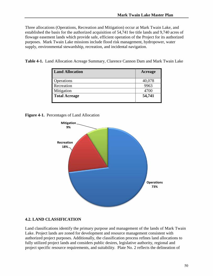
Mark Twain Lake Master Plan
Three allocations (Operations, Recreation and Mitigation) occur at Mark Twain Lake, and established the basis for the authorized acquisition of 54,741 fee title lands and 9,740 acres of flowage easement lands which provide safe, efficient operation of the Project for its authorized purposes. Mark Twain Lake missions include flood risk management, hydropower, water supply, environmental stewardship, recreation, and incidental navigation. Table 4-1. Land Allocation Acreage Summary, Clarence Cannon Dam and Mark Twain Lake
Land Allocation Acreage
Operations 40,078 Recreation 9963 Mitigation 4700 Total Acreage 54,741
Figure 4-1. Percentages of Land Allocation
4.2. LAND CLASSIFICATION Land classifications identify the primary purpose and management of the lands of Mark Twain Lake. Project lands are zoned for development and resource management consistent with authorized project purposes. Additionally, the classification process refines land allocations to fully utilized project lands and considers public desires, legislative authority, regional and project specific resource requirements, and suitability. Plate No. 2 reflects the delineation of
Operations 73%
Recreation 18%
Mitigation 9%
50

Mark Twain Lake Master Plan
Project lands according to the following classifications. Project Operations This classification includes lands required for the dam and associated structures, powerhouse, re-regulation pool, re-regulation dam, administrative offices, maintenance compounds, and other areas that are used to operate and maintain Mark Twain Lake. Where compatible with operational requirements, Project Operations lands may be used for wildlife habitat management, recreational use or agricultural activities. Licenses, permits, easements or other out-grants are issued only for uses that do not conflict with operational requirements. High Density Recreation These lands are designated for intensive levels of recreational use to accommodate and support the recreational needs and desires of visitors. They include lands on which existing or planned major recreational facilities are located and allow for developed public recreation facilities, concession development, and high-density or high-impact recreational use. In general, any uses of these lands that interfere with public enjoyment of recreation opportunities are prohibited. Low-density recreation and wildlife management activities compatible with intensive recreation use are acceptable, especially on an interim basis. No agricultural uses are permitted on those lands except on an interim basis for maintenance of scenic or open space values. Permits, licenses, and easements are not issued for non-compatible manmade intrusions such as pipelines, overhead transmission lines, and non-project roads, except where warranted by the public interest and where no viable alternative area or route is available.
Mitigation This classification is used for lands allocated for mitigation, and that were acquired specifically for the purposes of offsetting losses associated with development of the Project. Mark Twain Lake possesses lands allocated for mitigation, and subsequently classified as Wildlife Management Areas. Environmentally Sensitive Areas Lands in this classification are designated as sensitive areas based on their scientific, ecological, cultural or aesthetic features. Designation of these lands is not limited to just lands that are otherwise protected by laws such as the Endangered Species Act, the National Historic Preservation Act or applicable State statues. These areas must be considered by management to ensure they are not adversely impacted. Environmental Stewardship management techniques may be implemented within environmental sensitive areas with full consideration for protecting the ecological or cultural aspect of these areas. Limited or no development of public use is generally contemplated on land in this classification. No agricultural or grazing uses are permitted on these lands unless necessary for a specific resource management benefit, such as prairie restoration. These areas are typically distinct parcels located within another, and perhaps larger, land classification area. Multiple Resource Management Lands Lands in this classification are designated based on their predominate use as described below with the understanding that alternate compatible uses may also occur within the delineations.
• Low Density Recreation. These lands are designated for dispersed and/or passive
51
Mark Twain Lake Master Plan
recreation use. Development of facilities and infrastructure on these lands is minimal. Recreation experiences provided on these lands include trails, geo-caching, walking, fishing, hunting, primitive camping, nature study, and other outdoor activities commensurate with the purposes of the area. Facilities may include boat ramps, boat docks, trails, parking areas and vehicle controls, vault toilets, picnic tables, and fire rings. Manmade intrusions, including power lines, non-project roads, and water and sewer pipelines, may be permitted under conditions that minimize adverse effects on the natural environment. Vegetation management, including agricultural activities, that do not greatly alter the natural character of the environment, are permitted for a variety of purposes, including erosion control, retention and improvement of scenic qualities, and wildlife management. Hunting and fishing are allowed pursuant to state fish and wildlife management regulations where these activities are not in conflict with the safety of visitors and project personnel.
• Wildlife Management. These lands contain valuable wildlife habitat components that are maintained to sustain habitat suitable for diversity of wildlife species. Licenses, permits, and easements for public infrastructure (utilities and public roads) may be permitted under conditions that minimize adverse effects on the natural environment. Wildlife Management lands are available for sightseeing, wildlife viewing, nature study, and hiking. Consumptive uses of wildlife, including hunting, fishing, and trapping, are allowed when compatible with the wildlife objectives for a given area and with both Federal and state fish and wildlife management regulations.
• Vegetation Management. Lands in this classification are designated for the stewardship
of forest, prairie, or other native vegetative cover. Mark Twain Lake does not have lands classified as Vegetation Management.
• Future or Inactive Recreation Areas. This classification consists of lands that have the
characteristics compatible with future recreational development. Portions of existing recreation areas possess future development potential as shown on the corresponding plates or in Chapter 5, Resource Plan. Water Surface Mark Twain Lake administers a surface water zoning program that has four sub-classifications:
• Restricted. Water areas are restricted for project operations, safety, and security purposes.
• Designated No-Wake. This classification is used to protect environmentally
sensitive shoreline areas and recreational water access areas from disturbance, and/or for public safety.
• Fish and Wildlife Sanctuary. The Middle Fork Waterfowl Refuge has a seasonal
restriction to protect migrating waterfowl. • Open Recreation. These waters are available for year-round or seasonal water-
based recreational use.
52

Mark Twain Lake Master Plan
Table 4-2. Land Classification Acreage Summary, Clarence Cannon Dam and Mark Twain Lake
Land Classification No. of Areas
Acreage
Project Operations 7 2082 High Density Recreation 15 10234 Environmentally Sensitive Areas 4 3633 MRMA – Low Density Recreation 9 5656 MRMA – Wildlife Management Areas 1 14536 Water Surface 1 18600 Total Acreage 54,741
Figure 4-2. Percentages of Land Classification
EASEMENT LANDS
Project Operations 4%
High Density Recreation
19%
Environmentally Sensitive Areas
7% MRMA -
Low Density Recreation
10% MRMA - Wildlife
Management Areas 26%
Water Surface 34%
53

Mark Twain Lake Master Plan
These are lands on which easement interests are held, but no fee title ownership was acquired. Planned use and management of easement lands will be in accordance with the terms and conditions of the easement acquired for Project purposes.
• Flowage Easement. These are easements purchased by USACE granting the right to temporarily inundate flowage easement lands during flood risk management operations. There are 9,740 acres of flowage easement lands located at Mark Twain Lake.
• Roadway Easement. Mark Twain Lake has three roadway easements. These roadway
easements permit Government personnel, vehicles, and equipment to access Corps-managed lands and facilities. The easements and operational status are noted below.
1. Spalding Sewage Treatment Plant Access Road – Operational 2. Joanna Ridge/Little Indian Creek Access Road – Not developed 3. Bluffview Radio Tower Access Road – Not developed
54

MARK TWAIN LAKE MASTER PLAN
CLARENCE CANNON DAM AND MARK TWAIN LAKE MONROE CITY, MISSOURI
CHAPTER 5
RESOURCE PLAN
5.1 INTRODUCTION The Mark Twain Lake Master Plan provides guidance for the orderly development, use and management of Project resources. Resource planning takes into consideration authorized Project purposes, public interests, regional needs, and opportunities and constraints that influence development and management. All proposed development is designed to be compatible with the project’s natural and cultural resources. Project planning and land classification deals with several factors: seasonal flooding, soils, ecological conditions, existing and projected recreation demand, state and local participation and interest, and applicable laws, regulations and policies.
5.2 RESOURCE PLANS – GENERAL Implementation of resource management objectives is dependent upon land classification, anticipated concurrent use, and upon innumerable environmental, geologic, and topographic variables. The Operational Management Plan (OMP) subdivides the identified classification into management units based upon land use objectives, and natural and constructed delineations, and provides comprehensive stewardship guidance and establishes achievable goals to sustain or improve ecological conditions and outdoor recreational experiences. Paragraphs 5-3 thru 5-6 identify the overall management policy and applied intensity per land classification unit. Each area description includes a listing of existing facilities and proposed future actions. Proposed future actions are intended to be completed within ten years or by the next scheduled update. The Mark Twain Lake Land Classifications are:
• Project Operations • Recreational Lands • Environmentally Sensitive Areas (ESA) • Multiple Resource Management • Flowage Easement Lands
The management plans identified are presented in broad terms. A more descriptive plan for managing these lands can be found in the Mark Twain Lake OMP. Management tasks described
55

Mark Twain Lake Master Plan
in the OMP must support the Resource Objectives, Land Classifications, and Resource Plan set forth in this Master Plan. 5.3 RESOURCE PLANS - PROJECT OPERATIONS. The objective of this resource allocation is to provide adequate land for safe and efficient operation and management of the project land and water resources for all authorized purposes. Lands zoned in this category include the main dam, the powerhouse, the outlet channel, the re-regulation pool and dam, and lands required for administrative and maintenance needs. Environmental stewardship management activities will be permitted when it does not conflict with intent of authorized purposes and operational requirements. The OMP contains further details on this land resource allocation and use. Seven areas are classified in this allocation and are depicted on Plate 2 and in Table 5-1 below. TABLE 5-1 ACREAGE-PROJECT OPERATIONS Area Area No. Acreage Plate No. Environmental
Stewardship Recreation
Main Dam/Saddle Dam/Management Office
O-1 260 2 Moderate Minimal
Clarence Cannon Wholesale Water Commission Treatment Facility
O-2 5 2 Minimal Minimal
Mark Twain State Park North Extension Sewage Treatment Facility
O-3 5 2 Minimal Minimal
Indian Creek Sewage Treatment Facility
O-4 26 2 Minimal Minimal
John F. Spalding Sewage Treatment Facility
O-5 20 2 Minimal Minimal
Re-Regulation Pool O-6 1766 2 Intensive Minimal
Re-Regulation Dam O-7 10 2 Minimal Minimal
Total Operations 2092
Main Dam/Saddle Dams and Outlet Works/Corps Management/Maintenance Complex. The Clarence Cannon Dam, powerhouse and outlet works are located in this area of approximately 260 acres. The Clarence Cannon Dam was built in two sections consisting of an earthen embankment approximately 1,100 feet long and a concrete monolith structure measuring approximately 845 feet in length. The concrete section includes the powerhouse substructure and a gated spillway section with four 50 feet by 39 feet tainter gates used for flood control. To the extent practical, all releases are directed through the hydroelectric generator turbines rather than the tainter gates. The crest of the dam embankment is at elevation 653 feet NGVD.
56

Mark Twain Lake Master Plan
The project administrative area is located just north of the main dam. Facilities include the project office, a maintenance complex, a fenced vehicle compound, material storage, fuel tanks, weather station, and employee/visitor parking areas. Located downstream of the main dam, in the Warren G. See North Spillway Recreation Area, is the electrical switchyard owned and maintained by Northeast Missouri Power Cooperative in Palmyra, Missouri on lands leased from the Corps. The switchyard directs electrical power generated by the Clarence Cannon Power Plant to Northeast Power Cooperative transmission lines located east of the dam. Two small earthen saddle dams with a total area of approximately four acres are located north of the Frank Russell Recreation Area. Water Treatment Plant, Clarence Cannon Wholesale Water Commission. This regional water treatment plant is located four miles west of Florida, Missouri off of State Highway U. This facility was constructed in 1991and1992. The production and sale of water to members began on June 16, 1992. The Clarence Cannon Wholesale Water Commission (CCWWC) entered into a three party contract with the US Army Corps of Engineers and the State of Missouri to purchase water storage space in Mark Twain Lake. The contract allows for removal of a maximum of 16 million gallons of raw water per day with an allowance for a failure rate of 2 years out of every 100 years for not being able to supply the full 16 million gallons per day. The CCWWC owns the rights to 5.0 million gallons of storage space, while the remaining 11.0 million gallons of water per day are available to them through contract with the State of Missouri. The CCWWC facilities consists of a 4.5 million gallons per day surface water treatment plant, which uses flocculation, sedimentation, and filtration to purify raw water to acceptable standards for drinking purposes. In addition to the main facilities, the infrastructure consists of 325 miles of transmission mains, four booster pumping stations, a raw water intake structure located on the North Fork Branch of Mark Twain Lake, and daily storage space for 4.5 million gallons of drinking water. The CCWWC currently serves potable water for use by 15 cities, 14 counties, 9 water districts and 72,942 people. Expansion is underway to serve additional customers. Land Irrigation Type Sewage Treatment Facilities, North Extension of Mark Twain State Park. Operated by the Missouri Department of Natural Resources, the acreage comprised by the facility is included in the acreage figures for the state park lease with the Corps of Engineers for recreational purposes. Land Irrigation Type Sewage Treatment Facilities, Indian Creek Recreation Area. These sewage treatment facilities comprise approximately 26 acres and serve the Indian Creek campground, picnic area, group use area, and Indian Creek Marina. This facility is a no
57

Mark Twain Lake Master Plan
discharge storage and irrigation system comprised of a two-cell aerated lagoon with an aerated vault waste tank and a 16.9-acre irrigation area. Land Irrigation Type Sewage Treatment Facilities, John F. Spalding Recreation Area. These sewage treatment facilities comprise approximately 20 acres and serve the facilities located at the Ray Behrens Recreation Area, Blackjack Marina, M.W. Boudreaux Visitor Center, John C. "Jack" Briscoe Group Use Area, Frank Russell Recreation Area, Mark Twain Lake Project Office, Clarence Cannon Dam, and the John F. Spalding Recreation Area. This facility is a no discharge storage and irrigation system comprised of a two-cell aerated storage lagoon with a fourteen-acre irrigation area. Re-Regulation Pool. A total of approximately 1,766 acres of land and water located downstream from the dam are designated for project operations. These lands lie along both sides of the re-regulation pool over most of its 9.5-mile length. This area is in the historic floodplain of the Salt River and was primarily acquired to enable operation of the re-regulation pool for hydropower operations. The re-regulation pool is used to store and regulate large releases of water from the generation of hydroelectric power and to store water for the potential use of the pump-back feature of the hydropower plant. This area was evaluated for wetland development as part of the North American Waterfowl Management Plan and contains developed wetlands constructed through the authorities of this plan and project resource use objectives.
The area along the re-regulation pool is also used for low density recreational activities including fishing, boating, hunting, hiking, and nature study. Gravel roads, hunter/fisherman lots and two boat ramps provide visitors access to the area. A paved two-lane boat-launching ramp with an associated paved parking area is located just below the main dam in the Warren G. See South Spillway Recreation Area and provides visitor access to the western portion of the pool. A second one-lane paved ramp and associated Hunter/Fisherman Lot # 70 is located upstream of the re-regulation Dam and provides access to the eastern portion of the pool. Hunter/Fisherman Lot #71 is also upstream of the re-regulation Dam and provides walk-in access to the pool, several wetlands and a wildlife viewing tower. Re-Regulation Dam. The re-regulation dam is located 9.5 miles from the main dam, and is in the Bluff View Recreation Area. It consists of a compacted earth embankment, a gated concrete spillway, a sluice, and an operating house. The dam and its associated structures comprise approximately 10 acres. The total length of the dam is 1,550 feet.
5.4 RESOURCE PLANS - RECREATIONAL LANDS. The objective of this zoning classification is to allocate lands, by virtue of location and natural resources, to intensive recreational use. Park and recreation lands are developed to provide for the intensive recreational activities of the visiting public. Factors such as road access, natural resources, recreational facility design, and management practices make these lands conducive to accommodating public use. Lands in this classification include areas for existing, proposed and future commercial concessions, recreational development, and group use. Environmental stewardship management techniques may be implemented within intensive use recreation areas to sustain and enhance biological communities and ecosystems, to prevent vector and disease
58

Mark Twain Lake Master Plan
problems, and to promote the scenic qualities of the area. Any agricultural use must comply with applicable soil conservation practices.
A description of all recreational development at Clarence Cannon Dam and Mark Twain Lake is presented in this section. A summarization of development at these areas, including existing, previously approved, proposed, and future, are presented below. The following subparagraphs describe recreation areas in a clockwise order around the lake as shown on Plate 2, "Land Classification Map" and in Table 5-2 below. Proposed facilities are those facilities that may be completed within a ten-year period following the update and approval of this Master Plan.
The future plans provided in the area descriptions describe what may occur in the area beyond the ten-year time frame. All developments are subject to current rules and regulations applicable at the time of development. TABLE 5-2 ACREAGE-RECREATION LANDS Area Name Area
No. Acres Plate No. Environmental
Stewardship Recreation
M.W. Boudreaux Recreation Area 1 268 3 Moderate Intensive Ray Behrens Recreation Area 2 858 4 Minimal Intensive Robert Allen Recreation Area 3 1083 5 Moderate Intensive South Fork Recreation Area 4 176 6 Moderate Intensive Mark Twain State Park 5 1073 7 Intensive Stoutsville Recreation Area 6 486 8 Minimal Intensive North Fork Recreation Area 7 703 9 Intensive Minimal Mark Twain State Park – North Extension
8 486 10 Intensive
Shell Branch Recreation Area 9 377 11 Intensive Minimal Sandy Creek Recreation Area 10 594 12 Intensive Minimal Indian Creek Recreation Area 11 2775 13, 14 Moderate Intensive John F. Spalding Recreation Area 12 506 15 Intensive Intensive Frank Russell Recreation Area 13 578 16 Minimal Intensive Warren G. See Spillway Recreation Area
14 226 17 Moderate Intensive
Bluff View Recreation Area 15 45 18 Minimal Moderate Total Recreation Areas 10,234 M. W. Boudreaux Recreation Area. This 268-acre multi-use area is located on the east shore of the lake, just south of the main dam on Missouri State Highway J. The area is divided into two distinct sub-areas, one featuring the M. W. Boudreaux Visitor Center and the other a group use development. The northern portion of this area contains the M. W. Boudreaux Visitor Center, which was replaced in 2010 with a Class B Visitor Center that includes two overlooks; a visitor lobby, an exhibit room and a 75-seat multi-purpose community room. The Mark Twain Lake Visitor and Education Resource Center Committee (MTLVERCC), a Cooperating Association, operates a
59
Mark Twain Lake Master Plan
book store inside the visitor center. Other features include the Northeast Missouri Vietnam War Memorial, an outdoor education amphitheatre, a universally accessible waterborne comfort station, an accessible nature trail with two overlooks, and a paved parking area. Currently, four picnic sites have been developed for public use, with authority for up to 14 sites. Authority to install additional sites must be commensurate with need, fiscal availability, and mission requirements. Previously approved plans, but not yet executed include installation of a play facility at the Visitor Center area. There are no proposed or future plans for the Visitor Center area.
The southern portion of this area was renamed the John C. "Jack" Briscoe Group Use Area and is developed for group use activities. Facilities in the group use area include 20 campsites with electric hookups, a shower building, a group picnic shelter, a nature trail, a playground, two combination fountain/hydrants, and a group fire ring.
Previously approved plans, but not yet executed include replacement of the play facility at the Group Use Area.
Proposed plans for the group use area include improving individual campsites from 30 Amp to 50 Amp service and conversion of campsites to full service. Additional future plans include the addition of group campsites and a playfield. A site plan that illustrates all development at the M. W. Boudreaux Recreation Area is presented on Plate 3. Ray Behrens Recreation Area. This 858-acre multi-use recreation area is the most highly visited area on the lake and provides a diverse range of facilities for boaters, picnickers, hikers and campers. The area is located on the south shore of the lake approximately eight miles north of Perry. The area features 165 campsites with 50 Amp electric hookups (43 full service sites), a full service marina, a four lane boat launching ramp with an associated fish cleaning station and parking area, a courtesy boat loading dock, a 15-site picnic area that includes a group picnic shelter and the Lick Creek Trail Head with parking for trailers. Support facilities include four playgrounds, a potable water supply distribution system consisting of fountain/hydrant units, two overlooks/tri-lateration stations, an outdoor amphitheatre with fire ring, four shower buildings, four waterborne comfort stations, one waterborne comfort/changing station, a trailer dumping station, a fee booth, three nature trails, and a paved parking area for 156 cars and 170 car-trailers. An additional 240 car parking spaces are located adjacent to the full-service marina in this area and is operated and maintained by Blackjack Marina. An area near Blackjack Marina was identified as a cultural sensitive area and was protected. Development approved in previous supplements but not yet constructed includes conversion of three campground comfort stations to shower buildings, and conversion of seven existing campsites to full service hookup sites (43 of the original 50 authorized have been completed).
60

Mark Twain Lake Master Plan
Additional approved items include consolidation of buildings in the Deer Run Camp loop into one large shower building, modification of the Ray Behrens Boat Ramp to reduce congestion and improve operation/maintenance issues, add three additional parking spaces at each comfort station and shower building, convert five existing campsites into ADA campsites (one completed), replacement of wooden playground equipment and a floating breakwater for Blackjack Marina to be funded by others. Proposed facilities include a two-lane high-water boat ramp, and converting 50 existing campsites into full service sites.
Future plans for the area include expanding the campground by 65 campsites with electric hookups and providing support facilities, i.e., three shower buildings, a playground, fountain/hydrants and 30 parking spaces. This campground expansion was previously approved and proposed in previous master plans. Due to current visitor use and trends, this area was selected over the Indian Creek Campground as the preferred location for additional camping development. Approximately 160 acres located in the northwest portion of this area is held in reserve for the potential development of resort concession facilities. Additional future plans include a boat ramp and ancillary parking located near the western side of the recreation area if project utilization warrants additional facilities. Implementation methods may require partners to fund these developments.
A site plan that illustrates all development at the Ray Behrens Recreation Area is presented on Plate 4. Robert Allen Recreation Area. This 1,083-acre area located on the south side of the lake about midway along the main body of the pool area has been developed as a multi-use area. Recreational developments include a four-lane boat-launching ramp, two courtesy boat loading docks, a two-lane high-water boat launching ramp for use at 625 feet NGVD and above, a vault toilet, and parking spaces for 160 car-trailers and ten cars. Included in the parking space total are 60 car-trailer spaces located in an overflow parking lot. Currently, one picnic site is available for public use, with authority for up to three sites. Authority to install additional sites must be commensurate with need, fiscal availability, and mission requirements. Future plans include the addition of group facilities, fish cleaning station, and a vault toilet.
Approximately 207 acres located on the western most peninsula of the Robert Allen area north of Missouri State Highway 154, is being held in reserve for the potential development of a resort concession.
A site plan that illustrates all development at the Robert Allen Recreation Area is presented on Plate 5. South Fork Recreation Area. This 176 acre multi-use recreation area is located at the northeastern point of the South Fork of the Salt River as it joins the main body of the lake. Facilities located here include a four-lane boat launching ramp, two courtesy loading docks, a vault toilet, and a 120 car-trailer and 15-car spaces parking lot. Currently, one picnic site is
61

Mark Twain Lake Master Plan
available for public use, with authority for up to three sites. Authority to install additional sites must be commensurate with need, fiscal availability, and mission requirements. Proposed development includes enlarging the parking lot by 30 spaces. Future plans include installation of a fish cleaning station.
The area also has the potential to accommodate an additional commercial concession marina. A site plan that illustrates all development at the South Fork Recreation Area is presented on Plate 6. Mark Twain State Park. Recreation Area 5, an area of approximately 1,073 acres, comprises the central portion of the 2,700-acre Mark Twain State Park and is leased to the Missouri Department of Natural Resources. The State Park contains 1,559 acres leased from the Corps of Engineers, while the remaining acreage is owned in fee title by the State of Missouri. Recreation Area 8 (Mark Twain State Park – North Extension) forms the northern portion of the park, while an area owned by the State of Missouri forms the southern boundary of the park. Existing development in Recreation Area 5 is shown on Plate 7, which includes a paved access road, a four-lane boat launching ramp, a 100-car and 145-car/trailer parking area, and a vault toilet. A visitor contact station is also proposed for development on state park property at the intersection of Highway 107 and Route U.
An area of land south of Recreation Area 5 is owned in fee title by the State of Missouri and is operated as part of Mark Twain State Park. This portion of the park contains a 103-site campground, a one-lane boat ramp, an overlook, 20 picnic sites, one playground, six miles of hiking trails, two picnic shelters, two washhouses, five vault toilets, one amphitheatre,, a scout camping area, fish cleaning station and a boat ramp parking lot.
Development proposed for this area includes four to six cabins in the existing campground, construction of a fee booth, development of 50 additional campsites, an additional washhouse, installation of electric service to campsites that currently do not have electric service and development of mountain bike trails in open areas and hiking trails in wooded areas just south of State Route U.
Future plans include a cabin development east of the Route U boat ramp. Stoutsville Recreation Area. This 486-acre multi-use recreation area has been developed for day-use recreational activities. The area is located on the North Fork Branch of Mark Twain Lake. A portion of the area has been developed for intensive recreational use while the remainder of the area is held in reserve for future development. Facilities located here include a four-lane boat launching ramp, two courtesy boat loading docks, a high water boat launching ramp for use at 625 feet NGVD and above, one vault toilet, one fish cleaning station, and 35 car and 145-car/trailer parking spaces. Currently, one picnic site is available for public use, with authority for up to three sites. Authority to install additional sites must be commensurate with need, fiscal availability, and mission requirements.
62
Mark Twain Lake Master Plan
There are no proposed plans for this area.
Future development planned for this area includes expanding the picnic area and support facilities. The area also contains a potential marina-concession site.
A site plan that illustrates all development at the Stoutsville Recreation Area is presented on Plate 8. North Fork Recreation Area. This 703-acre area is located on the North Fork Branch of the Salt River adjacent to the southeastern portion of the Stoutsville Recreation Area. The area is zoned for recreational use with most of the site reserved for future development. Existing development is limited to a gravel access road, a 20 car-trailer parking lot, and a four-lane boat-launching ramp.
Development previously approved for this area includes a vault toilet.
There is no proposed development for this area.
Future development planned for this area includes a paved access road, group picnic shelter, picnic sites, vault comfort station, and additional car and car/trailer parking spaces.
A site plan that illustrates all development at the North Fork Recreation Area is presented on Plate 9. Mark Twain State Park-North Extension. This area includes 486 acres of land leased to the Missouri Department of Natural Resources which comprises the northernmost portion of the Mark Twain State Park. Existing recreational facilities are shown on Plate 10, and include a four-lane boat launching ramp ,150-car and 120-car/trailer space parking area, 1 vault toilet, fish cleaning station, 13 picnic sites and a swimming beach with an associated changing house. Other facilities include the “Si” Colborn Group Camp with four barracks-style cabins, a washhouse, a kitchen and dining hall, an office/infirmary, swimming facility, play areas, and land irrigation sewage treatment plant.
This location was approved for marina development in 1995 at the request of the MDNR, but no marina development occurred. In 1998, the MDNR requested that the area be re-designated as a swimming beach and it was re-opened as such in 2000. Proposed development includes an equestrian trailhead and parking area to tie into the Corps of Engineers Joanna Multi-use Trail, an equestrian campground, restroom facilities, associated parking, and a beach shower facility near the Rt. 107 boat ramp. Also proposed is the completion of the Camp Colborn area to include four sleeping cabins, a washhouse, and a recreation hall.
There are no future developments planned for this area.
63

Mark Twain Lake Master Plan
Shell Branch Recreation Area. The developed portion of this 377-acre area features a four-lane concrete boat launching ramp, a 15 car-trailer parking lot and a courtesy boat dock.
There is no proposed development.
Future development includes a day use area with picnic sites, a picnic shelter, vault toilet, a large car/trailer parking area and a paved access road. A site plan that illustrates all development at the Shell Branch Recreation Area is presented on Plate 11. Sandy Creek Recreation Area. Current recreational development in this 594-acre area includes an access road, a hunter/fisherman parking lot, a recreational fishing pond and a nursery pond.
A number of undisturbed Indian burial mounds were discovered in this area by a University of Missouri archaeological survey team and they are now known as the Crigler Mound Group Archeological Site. The site is listed in the National Register of Historic Places as provided by the Historic Preservation Act of 1966, Public Law 89-665.
There is no proposed or future development planned for this area.
A site plan that illustrates all development at the Sandy Creek Recreation Area is presented on Plate 12.
Indian Creek Recreation Area. This 2,775-acre multi-use area is the largest recreational area on the lake. Located on a large peninsula in the east central portion of the north shore of the lake, the area is accessed from Missouri State Highway HH and an off-project county connector road. Several day use areas, a full service marina, a major campground, boat ramp, amphitheater/day use area, and a group camping facility are all located within this recreation area. The main campground at Indian Creek features 190 campsites with 50 Amp electrical hookups (65 full service sites), 20 hike-in tent camping sites, a single lane boat-launching ramp, and a beach. Support facilities include five shower buildings, four waterborne comfort stations, two playgrounds, a campground fee booth, two vault toilets, a system of hydrant/fountains, a fish cleaning station, a camp loop and beach connector trail system, and two trailer dumping stations. A group camping area located outside of the main campground provides 25 trailer camping sites, one shower building, one waterborne comfort station, a group picnic shelter, combination hydrant/fountains, and a playground.
Day use areas located within Indian Creek Recreation Area feature a four-lane boat launching ramp with an associated fish cleaning station, two courtesy boat loading docks, a high water boat launching ramp for use at 625 feet NGVD and above, a waterborne comfort/changing station, a waterborne comfort station, a playground, a nature trail, 12 picnic sites, a full service marina, a group picnic shelter, an outdoor amphitheatre with an associated fire ring, combination
64

Mark Twain Lake Master Plan
fountain/hydrants and a recreational fishing pond. A land irrigation sewage treatment plant and parking for 370 cars and 207 car-trailers support the entire Indian Creek Recreation Area. The marina area also features a 150-car parking lot and a two-lane boat-launching ramp that is operated and maintained by Indian Creek Marina.
Development plans previously approved for the Indian Creek Recreation Area include adding showers to three campground comfort stations, upgrading electrical service to individual campsites from 30 to 50 Amp (primary campground upgrade is complete, the group camp remains), convert five existing campsites to ADA accessible campsites (one has been completed), up to three additional parking spaces at each comfort station and shower building, phases three and four of the Indian Creek Trail System, and relocation of the west boat ramp comfort station out of the flood pool. Proposed development in this plan includes converting up to 50 existing campsites to full service sites, development of a vault comfort/changing station near the existing Indian Creek beach, a playground, and a universally accessible fishing pier at Henderson Lake. Implementation methods may require partners to fund these developments. Future development plans for the area include the expansion of the concession area with overnight accommodations and an additional expansion of the campground. Additional future plans include expansion of the Indian Creek Campground by 75 trailer sites. This plan was proposed and approved in Supplement No. 7, Additional Recreational Facilities Design Memorandum No. 9, The Master Plan, 1982. Support facilities for the campsite development will include two shower buildings, one waterborne comfort station, nine combination hydrant/fountains, a playground, and an additional campground fee booth. If traditional campground expansion becomes necessary due to visitor trends and preferences, priority will be given to developing a newly proposed 65 campsite expansion at the Ray Behrens Campground. Implementation methods may require partners to fund these developments. A site plan that illustrates all development in the Indian Creek Recreation Area is included on Plates 13 and 14. John F. Spalding Recreation Area. This 506-acre multi-use recreation area is located eight miles north of the main dam on the northeastern end of the lake. Missouri State Highway J provides the primary access to the area. The area has been subdivided into two use categories; Operations and Recreation. The recreation area features a boat ramp and parking area, picnic facilities and a swimming beach. A project operations area, O-5, that includes a wastewater land treatment site and saddle dam is located in the easternmost portion of the Spalding area. The wastewater land treatment site provides services to all facilities on the eastern end of the lake.
A four-lane concrete boat-launching ramp with paved parking area for 40 cars and 155 car-trailers is featured in a portion of this area. A gravel parking lot with a 20 car-equestrian trailer capacity and an associated universally accessible loading ramp provides access to the Joanna Multi-purpose trail that meanders through the western portion of the area. Support facilities at the boat ramp include two courtesy boat loading docks, a fish cleaning station, a two-lane high
65

Mark Twain Lake Master Plan
water boat launching ramp for use at 625 feet NGVD and above, a combination fountain/hydrant, a small waterborne comfort station, and a waterborne comfort/changing station.
Facilities for the swimming beach and picnic area include two picnic shelters, one picnic shelter with waterborne comfort station, one waterborne comfort station, one waterborne bathhouse, one playground, 33 picnic sites, and parking for 430 cars and 30 car-trailers. Development plans previously approved for this area include relocation of the bathhouse out of the flood plain.
There are no proposed plans for this area.
Future plans include setting aside a portion of the recreation area, approximately 200 acres in size, as a potential resort site. A site plan that illustrates all development at the John F. Spalding Area is located on Plate 15. Frank Russell Recreation Area. This 578-acre recreation area lies adjacent to the northern abutment of the dam and has been developed primarily for camping. Currently the area contains 72 campsites with electrical hook-ups (65 sites have 30 ampere service and seven equine campsites have 50 Amp service), a fee booth, one centrally located shower building, two vault toilets, two playgrounds, an amphitheatre, a trailer dumping station, and parking for ten vehicles. Other development within the recreation area includes a horse corral/shelter with access to the Joanna Trail, a universally accessible fishing pond with a fishing pier, picnic shelter, environmental demonstration area, and trail. Approved actions from previous supplements include replacing existing vault-toilets with new vault toilets, convert three existing campsites to ADA accessible campsites, replace wooden playgrounds, install eight new equine campsites with 50 Amp electric (seven completed with partnership implementation), and an archery range.
Proposed actions include the replacement of existing vault-toilets with water borne comfort stations, upgrading of electrical service to 50 Amp at individual sites and water and sewer hookups for 40 campsites.
A portion of the Frank Russell Recreation Area is proposed as a potential resort site. Approximately 467 acres is available for the development of a resort facility featuring hotel accommodations, formal/casual dining, boat mooring facilities, conference center, and on/off season recreational opportunities. Future development plans for the area include additional campsites with electrical service, a shower building and comfort stations. A site plan that illustrates all development at the Frank Russell Recreation Area is presented on Plate 16.
66
Mark Twain Lake Master Plan
Warren G. See Spillway Recreation Area. This 226-acre recreation area lies contiguous to Clarence Cannon Dam along the north and south sides of the re-regulation pool and is accessed by Highway J. The Corps administration and maintenance compound form the northern border of the area. The area features opportunities for many day use recreational activities including fishing, picnicking, boating, shooting and special event activities.
Facilities on the north side of the re-regulation pool are in the Warren G. See North Spillway Recreation Area and include one water borne comfort station, 57 parking spaces, five universally accessible parking spaces and a playground. A parking area is provided for visitors to the Cannon Dam Power Plant Exhibit Area.
Recreational facilities on the south side of the re-regulation pool are in the Warren G. See South Spillway Recreation Area and include a two-lane boat launching ramp, a water borne comfort station overlook, several combination fountain/hydrants, a playground, 45 parking spaces, seven universally accessible parking spaces, 104 car/trailer parking spaces, a shooting range, and two group picnic shelters and a multi-purpose building with a no-discharge waste water infiltration system. This area is utilized as a special event activities area by a variety of groups and organizations.
The shooting range has been named in honor of the late Assistant Operations Manager, David C. Berti. The shooting range will be known as the David C. Berti Shooting Range and consists of 25, 50 and 100 yard ranges.
Development plans previously approved for this area include universally accessible fishing piers, shelter, and replacement of wooden playground facility.
There are no proposed plans for this area.
Future plans for the area include development of a clay target shooting area and picnic sites.
A site plan that illustrates all development at the Warren G. See Spillway Recreation Area is presented on Plate 17. Bluff View Recreation Area. This 45 acre recreation area is located downstream of the Re-regulation Dam and is developed for a variety of day use activities. Improvements in the area include a one-lane boat launching ramp, a group picnic shelter, one vault toilet, a playground, and parking spaces for 71 cars and seven car-trailers. Currently, one picnic site is available for public use, with authority for up to 14 sites. Authority to install additional sites must be commensurate with need, fiscal availability, and mission requirements. There are no proposed development plans for this area. Future development plans for this area include a fish cleaning station.
A site plan that illustrates this development is presented on Plate 18.
67

Mark Twain Lake Master Plan
5.5 ENVIRONMENTALLY SENSITIVE AREAS (ESA). Lands classified as environmentally sensitive areas contain significant scientific, ecological, cultural or esthetic features. These areas are normally located within one of the other classification categories and must be taken into consideration by management to insure the integrity of the environmentally sensitive areas are not adversely impacted due to conflicting management activities or objectives. Environmental Stewardship management objectives and techniques may be implemented within environmentally sensitive areas with full consideration for protecting the ecological or cultural aspect of these areas. Limited or no development of public use is generally contemplated on land in this classification. Eight areas are classified as environmentally sensitive areas. Of these, four are considered ecological areas (ES-1, etc.) and four areas considered cultural areas (CS-1, etc.).
The following paragraphs describe the areas classified as environmentally sensitive areas (ESA). These areas are described in clockwise progression around the lake beginning at the main dam and are displayed on Plate 2 and in Table 5-3 below. The zoning of cultural sites as environmentally sensitive areas insures their protection.
TABLE 5-3
ACREAGE - ENVIRONMENTAL AND CULTURAL SENSITIVE LANDS Area Name Area No. Acres Plate No. Environmental
Stewardship Recreation
Lick Creek Ecological Sensitive Area ES-1 1404 2 Moderate Minimal Quarry Lake Ecological Sensitive Area ES-2 10 2, 6 Moderate Minimal Indian Creek Ecological Sensitive Area ES-3 987 2, 13 Intensive Minimal Little Indian Creek Drainage Area ES-4 1232 2, 15 Intensive Minimal Hatten Mounds Cultural Sensitive Area CS-1 * 2 Minimal Minimal Pollard Cemetery Cultural Sensitive Area CS-2 * 2, 7 Minimal Minimal Shell Branch Village Site Cultural Sensitive Area
CS-3 * 2, 10 Minimal Minimal
Crigler Mounds Cultural Sensitive Area CS-4 * 2, 12 Minimal Minimal Total Recreation Areas 3,633
*-Acreages for cultural sensitive areas are incorporated into other land classifications. ES-1 Lick Creek Ecological Sensitive Area. The 1,404-acre Lick Creek Ecological Sensitive Area features a variety of natural attributes that make it a unique area in the Salt River Basin. Vegetative and scenic qualities of the area make it an ideal location for ecological study. Extending southward along both sides of Lick Creek, on the east from the John C. “Jack” Briscoe Group Use Area and on the west from the Ray Behrens Recreation Area, the area is easily accessed by hikers and equestrian users. The 7.5 mile Lick Creek Trail currently extends through a portion of the area. The diverse Lick Creek drainage area contains a broad cross section of the plant types found in the Salt River Basin. Of particular note is the Western Wall-Flower (Erysimum capitatum), found in 1974 on limestone outcroppings in this area. Many of the limestone bluffs provide scenic vistas of the lake. The area is managed to provide diverse vegetative structure.
68

Mark Twain Lake Master Plan
ES-2 Quarry Lake Ecological Sensitive Area, South Fork Salt River. Located at the northern tip of the South Fork Recreation Area, the Quarry Lake Ecological Sensitive Area comprises 10 acres and features an abandoned quarry that forms a small clear lake. Surrounding the lake, 30-40 feet high vertical walls of limestone are reflected in the very clear water and many forms of aquatic life are visible. Although the lake is man-made, the overall scenic effect is of great interest and charm. Narrow-leaved cat-tail (Typha angustifolia), which grows along the edge of the pond, is identified as a Missouri rare and endangered species. The area is managed to provide diverse vegetative structure. ES-3 Indian Creek Ecological Sensitive Area. The 987-acre Indian Creek Ecological Sensitive Area lies along both sides of the Indian Creek Branch of Mark Twain Lake. Ecological features of the area are noteworthy and will be preserved under this designation. The bluffs located in the area are largely wooded and feature a good representative cross section of the flora of this region of Missouri. Another feature of this ecological zone is an unnamed cave, which will be protected under this classification.
The Indian Creek Ecological Sensitive Area contains some of the largest expanses of native prairie grassland on the Mark Twain Lake Project. Prescribed burns and other management techniques are implemented to maintain and provide diverse vegetative structure within the area.
The area lies adjacent to the highly developed Indian Creek Recreation Area and affords visitors excellent opportunities for hiking and ecological study. ES-4 Little Indian Creek Drainage Area (Joanna Ridge). The Little Indian Creek Drainage Area comprises 1,232 acres and is located along the eastern shoreline of the Little Indian Creek Branch that is composed of diverse ecosystems. Scenic limestone bluffs rim the area, while the plateau areas above the bluff feature a glade type ecosystem with post oak, white oak, and red cedar as the dominant species. Open land species include prairie grass, lichens and mosses. The southeastern portion of the area (S 1/2 Sec. 15, Section 16 T 55 N, R 7W) provides an extremely interesting prairie remnant ecosystem of which Big Bluestem and Little Bluestem prairie plants are typical. These large tracts of warm season grass prairies are managed through a prescribed burn program. The area is managed to preserve its diverse vegetative habitat structure. The majority of the Joanna Trail traverses this area.
Previously approved facilities that have been installed in this area include signs and bulletin boards. CS-1 Hatten Mounds. These mounds are located on the South Fork of the Salt River one and a half miles south of State Highway 154. Excavation has been done on both sites and identification indicates occupation since Archaic times (CA. 3,500 years ago). These salvage excavations, conducted by Dr. Dale R. Henning were done between 1960 and 1962 under the auspices of the University of Missouri. The mounds were used by Archaic and Late Woodland peoples. The hillside is expected to yield further burial sites and evidence of habitation. The location provides a vista over the South Fork area.
69

Mark Twain Lake Master Plan
CS-2 Pollard Cemetery. This site is located east of State Highway 107 and north of the town of Florida. Three identified mounds make up the site. Members of the Pollard family are buried in the larger mound. These mounds are of interest to archaeologists because of their proximity to numerous prehistoric villages. The vista is perfectly located for viewing the lake and provides an opportunity for interpretation of the significance of Native American occupancy.
CS-3 Shell Branch Village Sites. The Shell Branch Village Sites are located on the southernmost side of Shell Branch Creek where it enters Mark Twain Lake. Dr. Dale R. Henning (University of Missouri) tested these two sites in 1961. Both sites were extensively occupied, judging from the amount of surface material recovered. Although Archaic (CA 3,500 years ago) materials are found on both, the principal occupations appear to have been by Late Woodland peoples. Evidence of funerary practices, food resource development and house form and use has come from these sites. This site yielded valuable archeological information and is also of great interest to the general public.
CS-4 Crigler Mounds. These Native American burial mounds are known as the Crigler Mound Group Archaeological Site. The site was listed on the National Register of Historic Places in 1974 (Federal Register, Vol. 29, No. 108, June 4, 1974) and is located in Monroe County, Missouri, two miles east of the town of Florida in the undeveloped portion of the Sandy Creek Recreation Area. The Crigler Mound Group Archeological Site is composed of seven mounds that were investigated by a University of Missouri survey team in 1960. Dr. Dale R. Henning was the field archaeologist in charge of the investigation. The mound group, known locally as “Crigler Cemetery,” is possibly the largest and best-preserved group within the Mark Twain Lake project. 5.6 RESOURCE PLAN - MULTIPLE RESOURCE MANAGEMENT. The objective of this zoning classification is to allocate lands to one or more of the following uses based on their location and their natural resources: (a) recreation low density, (b) wildlife management general, (c) vegetative management and (d) inactive and/or future recreation areas. Nine areas are classified as recreation low density, and one area is classified wildlife management. No lands were classified as vegetative management or future recreation. The following ten areas have been classified as Multiple Resource Management Lands with primary classifications as listed below. These areas are depicted on Plate 2 and shown in Table 5-4 below. TABLE 5-4 ACREAGE-MULTIPLE RESOURCE MANAGEMENT AREAS, LOW DENSITY RECREATION AND WILDLIFE MANAGEMENT Area Name Area No. Acres Plate No. Environmental
Stewardship Recreation
Lick Creek Multiple Resource Area ML-1 560 32 Intensive Minimal Pigeon Roost Multiple Resource Area ML-2 1609 2 Intensive Minimal Allen Multiple Resource Area ML-3 345 2 Intensive Minimal North Fork Multiple Resource Area ML-4 643 2 Intensive Minimal
70

Mark Twain Lake Master Plan
Shell Branch Multiple Resource Area ML-5 614 2 Intensive Minimal Crigler Multiple Resource Area ML-6 242 2 Intensive Minimal Sandy Creek Multiple Resource Area ML-7 259 2 Intensive Minimal Indian Creek - Upper Drainage Multiple Resource Area
ML-8 517 2 Intensive Minimal
Little Indian Creek Multiple Resource Area ML-9 867 2 Intensive Minimal Upper End - Multiple Resource Area MW-1 14536 2 Intensive Minimal Total Recreation Areas 20,192 Recreation - Low Density ML-1 Lick Creek Multiple Resource Area (MRA). The 560-acre Lick Creek MRA forms the southern boundary of public lands lying on Lick Creek adjacent to State Route J, approximately one mile north of the town of Perry, MO. The area is characterized by a small area of bottomlands with steep bluffs or steep banks on the opposing side of the creek. Pool elevations lie within the confines of the historic creek channel. Included within the area is a hunter/fisherman parking lot, the Lick Creek Trail, and a one-lane boat ramp. The primary vegetative cover of the area is oak-hickory forest, and occupies the upland ridges and slopes. Past land management practices have created a forest of varying size classes, species composition, and conditions. Small pockets of bottomland hardwoods occur in drainage areas, and areas directly adjacent to the Lick Creek river system, and have been detrimentally impacted to repetitive and prolonged inundation. Sustainable forest management practices are implemented in the upland areas. The open land component of this area, characterized as early to mid succession is managed to provide diverse vegetative habitat. Hunting, trail riding/hiking, and other low density recreation activities are popular pursuits in this area. ML-2 Pigeon Roost Multiple Resource Area. The 1,609-acre Pigeon Roost MRA lies between the Ray Behrens and Robert Allen Recreation Areas, and acts as a buffer zone between these two areas that have been developed for intensive recreational use. The area embraces the Pigeon Roost and Ely Branches, which flow into the lake from the south. The primary vegetative cover of the area is oak-hickory forest, and occupies 1,100 acres on the uplands and slopes. Past land management practices have created a forest of varying size classes, species composition, and conditions. Small pockets of bottomland hardwoods occur in drainage areas, and areas directly adjacent to the lake, and have been detrimentally impacted to repetitive and prolonged inundation. Sustainable forest management practices are implemented in the upland areas. The open land component of this area is characterized warm season grasslands, and old field habitat maintained in early to mid succession. These areas are managed to provide diverse vegetative habitat.
71

Mark Twain Lake Master Plan
The area contains a gravel access road and a hunter/fisherman parking lot with a boat-launching ramp designed for small fishing boats. The lot and boat-launching ramp provide access for low density recreational activities, such as hunting, fishing, hiking, and nature study. ML-3 Allen Multiple Resource Area. The 345-acre Allen MRA lies between Robert Allen Recreation Area and Mark Twain State Park and acts as a buffer zone between these two areas that have been developed for intensive recreational use. Ground elevations range from the top of the conservation pool (El. 606 feet NVGD) to over 690 feet NVGD. The original vegetative cover in the area was forest. The tops of the ridges were cleared and in agricultural production prior to the formation of the lake. These areas are currently managed in various grasslands and old field habitats, and provide diverse vegetative habitat. The slopes and drainages are vegetated with oak-hickory forest. Past land management practices have created a forest of varying size classes, species composition, and conditions. Sustainable forest management practices are implemented in the upland areas. Hunting, fishing, boating, and nature study are popular recreational pursuits in the area. ML-4 North Fork Multiple Resource Area. The North Fork MRA comprises 643 acres and lies between the North Fork Recreation Area and the North Extension of the Mark Twain State Park. The original vegetative cover in the area was forest. The tops of the ridges were cleared in agricultural production prior to the formation of the lake. These areas are currently managed in various grasslands and old field habitats, and provide diverse vegetative habitat. The slopes and drainages are vegetated with oak-hickory forest. Past land management practices have created a forest of varying size classes, species composition, and conditions. Sustainable forest management practices are implemented in the upland areas. Hunting, fishing, boating, and nature study are popular recreational pursuits in the area. ML-5 Shell Branch Multiple Resource Area. This 614-acre area lies between the North Extension of the Mark Twain State Park and the Shell Branch Recreation Area. The area acts as a buffer between the eastern edge of the state park and between private lands and the lakeshore. Gravel access roads provide continuous access for hunting, hiking, fishing, boating, and nature study. The Shell Branch MRA also features a cultural resource site consisting of two Indian Village sites. (See description of CS-3.) These sites contain material from the Archaic period through the Woodland period with the principal occupation being in the Woodland Period. The tops of the ridges were cleared and in agricultural production prior to the formation of the lake. These areas are currently managed in various grasslands and old field habitats, and provide diverse vegetative habitat. The slopes and drainages are vegetated with oak-hickory forest. Past land management practices have created a forest of varying size classes, species composition, and conditions. Sustainable forest management practices are implemented in the upland areas. Hunting, fishing, boating, nature study, and other low density recreation activities are popular pursuits in the area. ML-6 Crigler Multiple Resource Area. The approximately 242-acre Crigler MRA lies between the Sandy Creek Recreation Area and the Shell Branch Recreation Area. Past land management practices have created a forest of varying size classes, species composition, and conditions. Small pockets of bottomland hardwoods occur in drainage areas, and areas directly
72

Mark Twain Lake Master Plan
adjacent to the lake, and have been detrimentally impacted to repetitive and prolonged inundation. Sustainable forest management practices are implemented in the upland areas. The open land component of this area is characterized warm season grasslands, and old field habitat maintained in early to mid succession. These areas are managed to provide diverse vegetative habitat. Autumn Olive intrusion/invasion is a significant problem in this area. The area contains a minor access site with a gravel road and parking lot, and a trail to the lake. The area is used for hunting, fishing, hiking, and other low density recreational pursuits. ML-7 Sandy Creek Multiple Resource Area. The 259-acre Sandy Creek MRA serves as a buffer between private lands and the Indian Creek Recreation Area. The area consists of a series of former agricultural fields interspersed with forested ridges. The open land component of this area is currently managed in various grasslands and old field habitats, and provide diverse vegetative habitat. Autumn Olive intrusion/invasion is a significant problem in these open lands. The peripheral ridges and slopes are vegetated with oak-hickory forest. Past land management practices have created a forest of varying size classes, species composition, and conditions. Sustainable forest management practices are implemented in the upland areas. The entire area is available for the low density recreation activities. ML-8 Indian Creek - Upper Drainage Multiple Resource Area. The 517-acre Indian Creek Multiple Resource area comprises the upper limits of public land on the Indian Creek tributary to the lake. The area is comprised bottomland habitat with the lake being confined to its ancestral channel, except during high water events. The original vegetation was oak-hickory forest on the uplands with bottomland hardwoods in the lower areas and along stream courses. The majority of the upland and bottomland areas was cleared previous to Government ownership, and utilized for agricultural purposes. Management in the open land component of this area is maintaining late stage succession, with planned occupation of native forest species. The ridges and slopes are vegetated with oak-hickory forest. Past land management practices have created a forest of varying size classes, species composition, and conditions. Sustainable forest management practices are implemented in the upland areas. The area is currently being managed for low density recreation use and contains a Hunter/Fisherman Lot with gravel access. ML-9 Little Indian Creek Multiple Resource Area. The Little Indian Creek MRA lies along the Indian and Little Indian Creek branches of Mark Twain Lake. Comprising 867 acres, the area features plateaus and limestone bluffs dominated by oak-hickory forests. Sustainable forest practices are implemented in these habitats. The upland interior of this area is occupied in warm season grasslands with an interspersion of early succession old fields. These areas are managed to provide diverse grassland habitat. The area is used for hunting, fishing, hiking, and other low density recreational pursuits. A portion of the Joanna Multi-use Trail is located within ML-9. MW-1 Upper End Multiple Resource Area. An area encompassing a total of 14,536 acres, the Upper End MRA encompasses project lands west of the Stoutsville and South Fork recreation areas. The area includes all project lands found along the upper reaches of the North Fork,
73

Mark Twain Lake Master Plan
Middle Fork, Elk Fork, South Fork and Long Branch tributaries of the Salt River and thus contains a large amount of riparian lands. To facilitate a description of this diverse area, it will be divided into three sub-areas as follows: 1) South Fork and Long Branch Sub-Area, 2) Elk Fork and Middle Fork Sub-Area, and 3) North Fork Sub-Area. South Fork and Long Branch Sub-Area. The South Fork and Long Branch Sub-Area extends southward on both sides of South Fork Branch from the South Fork Recreation Area (Rt. 154) to near the community of Santa Fe, Missouri. It includes the South Fork, Long Branch, and Brush Creek tributaries to Mark Twain Lake. The original vegetative cover in this area was generally forest; however, the tops of the ridges and areas with gentler slopes were cleared and farmed after settlement of the area. The open lands are now in various stages of succession with some areas being managed for native warm season grasses. The flatter areas, which are not susceptible to flooding, are being managed under the agricultural lease program. The peripheral ridges and slopes are occupied with oak-hickory forest. Sustainable practices are implemented in the forested areas. The area is used for low density recreation with hunting, fishing, hiking, and nature study being popular pursuits. Elk Fork and Middle Fork Sub-Area. The Elk and Middle Fork Sub-Area includes the lands along the South and Middle Forks westward of the juncture of the South and Middle Fork branches. The original vegetative cover in the area was forest. The tops of the ridges were cleared and in agricultural production prior to the formation of the lake. These areas are currently managed in various grasslands and old field habitats, and provide diverse vegetative habitat. The peripheral ridges and slopes are vegetated with oak-hickory forest. Past land management practices have created a forest of varying size classes, species composition, and conditions. Sustainable forest management practices are implemented in the upland and slope areas, with an objective to maintain the integrity of the riparian zone. A portion of this area is designated as a seasonal waterfowl refuge. The refuge is comprised of approximately 3,000 acres of land and water that have been set-aside as a resting area for the migrating waterfowl. Waterfowl hunting and boating is prohibited in the area from October 15 through December 31. The area remains open for other recreation pursuits. North Fork Sub-Area. The North Fork Sub-Area includes lands along the North Fork west of the Stoutsville Recreation Area and Mark Twain State Park. It includes the Otter Creek, Crooked Creek, and Buck Creek tributaries to Mark Twain Lake. The North Fork Wetland Restoration Area is located in this area. The original vegetative cover in the area was forest. The tops of the ridges were cleared and in agricultural production prior to the formation of the lake. These areas are currently managed in various grasslands and old field habitats, and provide diverse vegetative habitat. The peripheral ridges and slopes are vegetated with oak-hickory forest. Past land management practices have created a forest of varying size classes, species composition, and conditions. Sustainable forest management practices are implemented in the upland and slope areas, with an objective to maintain the integrity of the riparian zone. A tract of land (O-2) in the southern most section of this area near Mark Twain State Park is leased to the Clarence Cannon Wholesale Water Commission for operation of a water treatment
74

Mark Twain Lake Master Plan
plant. This area possesses the pumping facility, pipeline, and maintenance corridor for facility operation. The remainder of the area is available for low density recreation activities.
75
MARK TWAIN LAKE MASTER PLAN
CLARENCE CANNON DAM AND MARK TWAIN LAKE MONROE CITY, MISSOURI
CHAPTER 6 SPECIAL TOPICS/ISSUES/CONSIDERATIONS
This chapter discusses the special topics, issues, and considerations identified as necessary to the future management of Mark Twain Lake. Special topics, issues, and considerations are defined in this context as items that are unique to the Project and not covered in other parts of the plan. For simplicity, the topics are discussed below under generalized headings. 6.1 PARTNERING The Corps of Engineers has control and oversight of stewardship activities on the public lands and waters at Mark Twain Lake. The MDNR has responsibility for recreation management at Mark Twain State Park. The MDC is responsible for fisheries management.
Increasingly, competition for the use of project lands and waters and their natural resources can create conflicts and concerns among stakeholders. The need to coordinate a cooperative approach to protect and sustain these resources is compelling. Many opportunities exist to increase the effectiveness of federal programs through collaboration among agencies and to facilitate the process of partnering between government and non-government organizations.
To sustain healthy and productive public lands and waters with the most efficient approach requires that individuals and organizations recognize their unique ability to contribute to commonly held goals. The key to progress is building on the strengths of each sector, achieving goals collectively that could not be reasonably achieved individually. Partnering opportunities exist and can promote the leveraging of limited financial and human resources. Partnering aids the identification of innovative approaches to deliver acceptable levels of service, defuses polarization among interest groups and leads to a common understanding and appreciation of individual roles, priorities and responsibilities.
To the extent practicable, this Master Plan and a proactive approach to partnering will position the Mark Twain Lake Project to aggressively leverage project financial and human resources in order to identify and satisfy customer expectations, protect and sustain natural and cultural resources and recreational infrastructure, and sustain Corps management efforts and outputs at an acceptable level of service.
Memorandums of Agreement and, Legislative Authorities for Partnering and Coordination, or both are established to define partnering arrangements with other agencies or organizations. These partnerships have become vital in providing the levels of service that users of project
76
Mark Twain Lake Master Plan related resources demand. The Mark Twain Lake Project continues to seek new partnerships and strengthen existing ones to accomplish project initiatives. The Mark Twain Lake Project maintains many forms of partnerships such as Volunteer Agreements, Memorandums of Agreements, Memorandums of Understanding, and Cooperative Agreements. Currently, the Friends of Recreation and Environmental Stewardship Council (FOREST Council) a 501c3 “Friends” group, serves as a local clearing house for partnership initiatives at the Project and includes regional government agencies, community organizations, and individuals.
6.2 UTILITY CORRIDORS A variety of utility corridor outgrants exist at the Clarence Cannon Dam and Mark Twain Lake Project. Public utilities for electricity, water, phone, fiber optics, natural gas, and petroleum products currently have outgrants that traverse portions of the Project. In 2009, the Corps issued a Non-Recreational Outgrant Policy (USACE, 2009a) stating that the primary rationale for authorizing any future non-recreational outgrant request for use on Corps lands or waters will be (1) no viable alternative to the activity or structure being located on civil works lands or waters, or (2) a direct benefit to the government. Requests for utility outgrants are managed through the St. Louis District Real Estate Division. Requests must meet all regulatory and Real Estate Division requirements for consideration of an outgrant. Additionally, requests must not interfere with the authorized purposes or public use of the project. 6.3 WATER CONTROL MANUAL The Master Plan does not cover lake regulation, shoreline management, water quality, or operational structures. As a result, lake regulation is covered in detail in the Mark Twain Lake Water Control Manual that was approved on February 28, 2011 which supersedes the Water Control Manual dated November 1991. The purpose of the Water Control Manual is to present the detailed plan of water regulation and pertinent information relative to Mark Twain Lake. It presents a description of the multi-purpose reservoir project features; the responsibilities of the personnel and organizations involved in the regulation of the project; the means of receiving hydrologic, stream flow and water quality data; the methods of data analysis and data communication; and the plan of regulation. Mark Twain Lake water level is regulated by the Water Control Section, Hydrologic and Hydraulics Branch of the St. Louis District Engineering and Construction Division. 6.4 BARRIER-FREE ACCESSIBLE SHORELINE ACCESS The provision of a universally accessible fishing pier on the project shoreline is difficult with a pool fluctuation of over 50 feet and the steep topography of the project. Due to these difficult conditions, development of lake-based accessibility has not been feasible. Lack of accessible fishing is one of the most significant customer complaints that are received at the project office. In response to customer feedback, approval was obtained for the installation of accessible fishing piers in the Spillway Recreation Area. Currently, funding and implementation partners for installation of the accessible piers are not available. Additionally, accessible fishing facilities are provided at the recreational fishing pond within the Frank Russell Recreation Area.
77

Mark Twain Lake Master Plan Ambulatory fishing opportunities on Mark Twain Lake exist at many developed recreation areas and hunter fisherman access lots on the project. Additionally, stocked fishing ponds exist on project lands that are easily accessible from developed recreation areas and hunter fisherman access lots.
Currently, ambulatory overnight docking facilities exist at the Blackjack and Indian Creek Marinas located on Mark Twain Lake. Accessible docking and fishing facilities may be provided by the marinas. Accessibility at these locations may be limited during certain lake elevations.
6.5 SHORELINE MANAGEMENT The Shoreline Management Policy, in accordance with Title 36 Code of Federal Regulations 327.30 states that it is USACE policy to protect and manage shorelines of USACE water resource development projects "in a manner which will promote the safe and healthful use of the shorelines by the public while maintaining environmental safeguards to ensure a quality resource for use by the public." The policy recognizes the need to balance competing interests present at multi-purpose properties. The Shoreline Management Policy regulations prohibit private shoreline uses on water resource projects where construction was initiated after December 13, 1974, or where no private shoreline uses existed as of that date. USACE projects with private development prior to December 13, 1974, are managed in accordance with a shoreline management plan. Currently, private development does not exist at the Mark Twain Lake Project, however, commercial development potential exists. Development is possible at Mark Twain Lake through its leasing or outgrant program. Before federal property could be made available for development, the following documentation would need to be prepared: 1) marketability study; 2) feasibility study; 3) environmental/cultural resources evaluations. Currently, USACE does not have the resources to prepare this documentation. If interested, individual developers or groups would be required to prepare the documentation for USACE review to support additional development at the Mark Twain Lake Project. 6.6 REGIONAL WASTEWATER TREATMENT. Expansion in the distribution of potable water has had positive impacts on the quality of life and growth in Northeast Missouri. Future needs for the Mark Twain Lake region should address issues such as wastewater requirements necessary for additional growth. In 2013, the Cannon Water Supply District No. 1 attempted to develop an initiative to deliver a Regional Sewer System in Ralls County adjacent to State Routes J and EE. The initial meetings were well attended by interested parties. The initiative lacked funding to continue pursuit of an Engineering Report that would have identified alternatives and cost for the project. The economies of many communities and continued growth in the area will be hampered until a regional wastewater system is provided to address these needs. Additionally, the Corps may potentially be interested in treatment options if a regional public wastewater system was developed within proximity to the Mark Twain Lake COE facilities.
78

Mark Twain Lake Master Plan 6.7 RESORT NOTICE OF AVAILABILITY ( NOA) AT FRANK RUSSELL The St. Louis District and Mark Twain Lake Project Corps of Engineers are pursuing the development of a commercial resort facility providing expanded, shoreline-accessible recreational opportunities. Twelve potential development locations were identified. Based on utility infrastructure, transportation networks, regional commerce trends, and visitor use patterns, it has been determined that the Frank Russell Recreation Area possesses the salient characteristics and capabilities necessary to meet market needs. Regional market analysis supports the economic feasibility and benefit of a resort facility proposed for the area. This resort concession, developed with commercial funding sources, would be initiated under a Notice of Availability action (NOA). The NOA would establish the minimum development criteria for the proposed facility, including: a resort/hotel complex with a minimum of 100 rooms, casual/formal dining amenities, a conference facility with accommodations for 300, 25 boat mooring slips, paved parking and road surfaces, utility infrastructure, and LEED qualification – Silver Certified. 6.8 MODERNIZATION OF FACILITIES Various facilities at the Mark Twain Lake Project have been recently modernized and/or replaced as a result of funding availability from sources other than the annual basic Operations and Maintenance funding allocation for the project. Facilities that have been modernized, replaced, or consolidated as a result of flood supplemental funding include; replacement of vault toilets with water borne comfort stations in the Warren G. See North and South Spillways, and vault toilet replacement at Bluffview, Robert Allen, South Fork, Stoutsville and the Indian Creek East Boat Ramp. Examples of facilities that have been modernized or replaced as a result of the American Recovery and Reinvestment Act of 2009 (ARRA) supplemental funding include replacement of the M.W. Boudreaux Visitor Center, a safety buoy line at the Clarence Cannon Dam, and a portion of the Indian Creek Recreation Road. The remainder of the roads in the Indian Creek Recreation Area, John Briscoe Group Camp and Stoutsville Recreation Areas were improved utilizing Federal Highway Administration funding through the Federal Lands Transportation Program. It should be noted that fiscal availability through the National Recreation Business Line for the basic annual Operations and Maintenance funding requirements for the project has diminished in recent years and is not expected to increase in the near future. As a result, efficiencies in annual operations have been deployed to insure availability of recreation opportunities at the Mark Twain Lake Project. It is anticipated that it would be difficult to provide additional future modernizations without availability of supplemental funding sources or partnerships. 6.9 HYDROPOWER The Clarence Cannon Power Plant has an installed nameplate capacity of 58,000 KW of electrical power that is delivered through two hydroelectric turbines and is operated as a peaking plant. Hydropower is an authorized purpose of the project and provides peaking power to the regional market of the Southwestern Power Administration. The Southwestern Power Administration is a power marketing administration that delivers power from COE Hydropower
79

Mark Twain Lake Master Plan plants to power cooperatives and municipalities within the southwestern region of Missouri, Arkansas, Kansas, Oklahoma, Louisiana, and Texas. A Memorandum of Agreement (MOA) has been entered into by and between Department of the Army acting through the U.S. Army Corps of Engineers (Corps), the Southwestern Power Administration (SWPA), and the Centennial Bank, Trustee of the Southwestern Preference Customer Trust, which is part of the customer group served by SWPA. The purpose of this MOA is to establish a framework governing the respective activities at hydroelectric facilities of the Corps districts in the SWPA marketing region. Pursuant to this MOA, the parties shall enter into sub-agreements that will allow the Corps to accomplish properly identified and prioritized work items and will allow the customer group to provide funding through the Centennial Bank, Trustee of the Southwestern Preference Customer Trust for such work items. Such work items will include efforts for maintenance, rehabilitation, and modernization work at hydroelectric facilities owned by the Corps districts within the SWPA marketing region.
80

MARK TWAIN LAKE MASTER PLAN
CLARENCE CANNON DAM AND MARK TWAIN LAKE MONROE CITY, MISSOURI
CHAPTER 7 AGENCY AND PUBLIC COORDINATION
Public involvement and coordination within the Corps and with other affected agencies and organizations is a critical feature required in the updating of the Clarence Cannon Dam and Mark Twain Lake Project Master Plan. Throughout the process the Corps involved the public, and coordinated with Federal, state, and local agencies, and communities. The Master Plan revision process was initiated during the late winter of 2015. Coordination and input meetings were held with other Federal, State and Local agencies, special interest groups, and the general public to identify project issues and concerns to guide the master plan development. Many different means have been utilized to obtain public and agency input into the master planning process, these included:
• Web Page: The Clarence Cannon Dam and Mark Twain Lake Master Plan page invited comments using an online comment form; fact sheets were posted along with a copy of the 2004 Master Plan Update.
• Focus Groups: Letters were mailed to local groups, agencies, congressional
representatives and local governments inviting participation in meetings and requesting comment.
• News Releases: Mailed to local and state newspapers, television, and radio stations in March 2015 in preparation for the public meeting. Additionally, interviews with several newspapers, radio stations and air time on local television stations were conducted.
• Comment Boxes and One-on-One Communication: Questionnaires and master planning fact sheets were distributed to the public at the M.W. Boudreaux Visitor Center and the Mark Twain Lake Project Office.
7.1. PUBLIC OPEN HOUSE SUMMARY AND COMMENT PERIODS A public open house meeting was conducted in April of 2015 at the M.W. Boudreaux Visitor Center to solicit comments on the Clarence Cannon Dam and Mark Twain Lake Project Master Plan revision. Written comments on the plan were received through 25 April 2015. Key agency partner meetings were held during April of 2015 to make plan revisions as well.
81

Mark Twain Lake Master Plan The Draft Master Plan update was completed in August 2015. This revised plan will be posted on the Mark Twain Lake Project Master Plan website for 30 days to allow the public to, once again, provide comments. A news release was sent out, as well as letters to various partners, stakeholders, political leaders, and public members that had previously provided comments, advising them of the documents release for a public review period and how to access the document. A mailing list was developed and added to throughout the master planning process. Informational master plan letters and newsletters were prepared and sent out during each major phase of the process. The Draft Master Plan has been placed on the Mark Twain Lake Internet homepage for review purposes. Federal, state and local political office holders with jurisdiction within the Mark Twain Lake Project service area have been kept informed and given opportunities to comment throughout the master planning process. 7.2. SUMMARIZATION OF PUBLIC COMMENTS RECEIVED Written comments were collected from the public during the public open house in April of 2015. Additional written comments were received through the comment form on the Mark Twain Lake Project Master Plan website as well as comment boxes and through the mail. Comments were received on a variety of topics with the following examples identified: additional equine and/or multi-purpose trails and associated amenities at various locations, additional full service campsites within campgrounds, rehabilitation of the Ray Behrens Boat Ramp, request for a resort and advertisement of a Notice of Availability with a 50 year lease, water quality, invasive species, and general support for the Mark Twain Lake Project. All public comments received are attached as an appendix to this document.
82

MARK TWAIN LAKE MASTER PLAN
CLARENCE CANNON DAM AND MARK TWAIN LAKE MONROE CITY, MISSOURI
CHAPTER 8 SUMMARY OF RECOMMENDATIONS
8.1 SUMMARY This Master Plan conceptually establishes and guides the orderly development, administration, preservation, enhancement and management of all natural, cultural, and recreational resources at Clarence Cannon Dam and Mark Twain Lake consistent with the capabilities of the resource and public needs. The new update format is a land use management document and does not address water management operations, water quality, associated prime facilities (dam, spillway etc), or shoreline management as those topics are outlined in separate documents. It is stewardship-driven and seeks to balance recreational development and use with protection and conservation of natural and cultural resources dependent upon funding availability. This Master Plan is also considered to be a flexible living document providing latitude through formal supplementation to address emerging issues identified through periodic review. 8.2 LAND CLASSIFICATIONS
There are no changes proposed to land classification for the 2015 Master Plan update for Clarence Cannon Dam and Mark Twain Lake. Chapter 5 describes in detail the ‘balanced’ approach in maintaining the land classifications. The team evaluated numerous factors and public comments when evaluating land classification for the 2015 Master Plan update, which included but are not limited to: how lands were previously classified in the 2004 Master Plan update; current public use patterns; what kind of development or non-development was taking place adjacent to Corps property; and what kinds of activities are currently taking place in those areas. Throughout this master plan process, the Corps focused on the modernization and update of current recreation areas and facilities within their existing footprints. No new recreation areas are being proposed at this time. The Corps also focused on resource protection and management in accordance with Engineering Regulation 1130-2-540 and Engineering Pamphlet 1130-2-540. 8.3 RECOMMENDATION
This updated Master Plan presents an inventory of land resources and how they are classified, existing park facilities, an analysis of resource use, anticipated influences on project operation and management, and an evaluation of existing and future needs. It is recommended that this Master Plan be approved as the basis for future development and management of the Clarence Cannon Dam and Mark Twain Lake land and water resources.
83

MARK TWAIN LAKE MASTER PLAN
CLARENCE CANNON DAM AND MARK TWAIN LAKE MONROE CITY, MISSOURI
CHAPTER 9 BIBLIOGRAPHY
U.S. Army Corps of Engineers. 2004. Clarence Cannon Dam and Mark Twain Lake, Salt River, Missouri, Updated Master Plan, Design Memorandum No. 9., Original Master Plan 1969, Updated 1991, 2004. U.S. Army Corps of Engineers. 2011. Upper Mississippi River Basin, Water Control Manual, Mark Twain Lake, Salt River Basin, Missouri. U.S. Army Corps of Engineers. 2013. Engineer Regulation 1130-2-550, Project Operations, Recreation Operations and Maintenance, Guidance and Procedures. HQUSACE. U.S. Army Corps of Engineers. 2013. Engineer Pamphlet 1130-2-550, Project Operations, Recreation Operations and Maintenance, Guidance and Procedures. HQUSACE. U.S. Army Corps of Engineers. 2008. ER 1130-2-540, Environmental Stewardship Operations and Maintenance Guidance and Procedures. HQUSACE. U.S. Army Corps of Engineers. 2008. EP 1130-2-540, Environmental Stewardship Operations and Maintenance Guidance and Procedures. HQUSACE. Missouri Department of Parks and Tourism. 2013. Statewide Comprehensive Outdoor Recreation Plan. January 2013 through December 2017. United States Census Bureau. 2013. Easy Facts Website. Accessed at: http://www.census.gov/easystats/. Geospatial Data Gateway. United States Department of Agriculture Natural Resources Conservation
Service. Retrieved May 4, 2015, from https://gdg.sc.egov.usda.gov/GDGHome.aspx
84
Related Documents