December 2014, Volume 79:156–166 THEMED SECTION Maritime deserts of the Australian northwest Peter Veth, Kane Ditchfield and Fiona Hook School of Social Sciences, Faculty of Arts, The University of Western Australia, 35 Stirling Highway, Crawley WA 6009, Australia <[email protected]> <[email protected]> <[email protected]> Abstract This paper reports on the first season of work on the Barrow Island Archaeology Project. It contextualises new findings within a review of what is now known of the archaeology of the Carnarvon bioregion. A reliance on coastal resources for over 42,000 years is indicated from excavations and open sites from Cape Range, the Montebello Islands, the Onslow coastline and Barrow Island. The continuous use of marine resources, blended with largely arid zone terrestrial assemblages, from 17,000 cal. BP until the modern era, attests to a deep chronology for hybrid maritime desert societies in the Australian northwest. Introduction Australia is the most arid continent settled by modern humans and, in the northwest, large deserts abut the Indian Ocean. These coastal deserts are where Aboriginal people have developed ‘hybrid’ societies focusing on the bounty of the littoral zone alongside the more scattered resources of the arid interior (Veth et al. 2007). The tension between ‘coastal coalescence’ and ‘interior fissioning’ has permeated many archaeological narratives for northwest Australia, as well as Chile, Patagonia, South Africa and Botswana (see Smith 2013; Veth et al. 2005). It is precisely this tension we focus on here, both theoretically and with new archaeological data from the northern Carnarvon bioregion (Figure 1). The northern Carnarvon bioregion covers 2.5M ha (Kendrick and Mau 2002) and there is now a considerable number of radiocarbon dates for this area spanning 41,000 years (see Appendix in online supplementary material). These are based on charcoal features and anthropogenic shellfish samples recovered from caves, rockshelters and open middens located within Cape Range (North West Cape), the Montebello and Barrow Islands, and along the Onslow coastline. The high diversity of near-continental shelf rockshelters, islands and prograding shorelines provides a unique window into marine resource-use through long periods of glacio-eustatic and climate changes, allowing models about the nature and use of marine resources from colonisation until contact to be tested. The climate of the bioregion is arid, with variable summer and winter rainfall. Cape Range and the Barrow and Montebello Islands are comprised of limestone, while the Onslow coast comprises Quaternary beach dunes and mud flats. The caves and gorges of Cape Range, and the Montebello and Barrow Island groups, are listed as refugia for marsupials, turtles, seabirds and plants (Morton et al. 1995). The Case for Productive Coasts during Periods of Glacio-Eustatic Change Beaton (1995) examined the case for a blended littoral and arid zone economy in northwest Australia during the Pleistocene-Holocene transition, a condition he saw as universal due to shared global glacio-eustatic changes. He posed a number of questions, including: • Did people gravitate naturally to the rich and easily obtained molluscan resources of marine intertidals? • When and how did fishing become important? • What role did watercraft play in coastal life? • How do coastal economies relate to adjacent terrestrial environments and resources found there? His discussion recalled elements of the coastal time- lag hypothesis (Beaton 1985) and forecast more recent arguments for a delayed maritime adaptation due to precipitous and depauperate coastlines, the early depletion of high-ranked coastal resources by colonising groups, and the lack of evidence for early maritime economies throughout Sahul (sensu O’Connell and Allen 2012). Data presented here from the northern Carnarvon bioregion can be used to examine species depletion and time-lag models. We profile a recent model for higher coastal productivity during periods of glacio-eustatic fluctuation and present new evidence for Pleistocene-aged marine resource exploitation from Cape Range (see also O’Connor and Veth 2000; Ulm 2011). Figure 1 The northern Carnarvon bioregion and four study locations. 156

Welcome message from author
This document is posted to help you gain knowledge. Please leave a comment to let me know what you think about it! Share it to your friends and learn new things together.
Transcript
December 2014, Volume 79:156–166
TH
EM
ED
SE
CT
ION
Maritime deserts of the Australian northwestPeter Veth, Kane Ditchfield and Fiona HookSchool of Social Sciences, Faculty of Arts, The University of Western Australia, 35 Stirling Highway, Crawley WA 6009, Australia
<[email protected]> <[email protected]> <[email protected]>
Abstract
This paper reports on the first season of work on the Barrow Island Archaeology Project. It contextualises new findings within a review of what is now known of the archaeology of the Carnarvon bioregion. A reliance on coastal resources for over 42,000 years is indicated from excavations and open sites from Cape Range, the Montebello Islands, the Onslow coastline and Barrow Island. The continuous use of marine resources, blended with largely arid zone terrestrial assemblages, from 17,000 cal. BP until the modern era, attests to a deep chronology for hybrid maritime desert societies in the Australian northwest.
Introduction
Australia is the most arid continent settled by modern humans and, in the northwest, large deserts abut the Indian Ocean. These coastal deserts are where Aboriginal people have developed ‘hybrid’ societies focusing on the bounty of the littoral zone alongside the more scattered resources of the arid interior (Veth et al. 2007). The tension between ‘coastal coalescence’ and ‘interior fissioning’ has permeated many archaeological narratives for northwest Australia, as well as Chile, Patagonia, South Africa and Botswana (see Smith 2013; Veth et al. 2005). It is precisely this tension we focus on here, both theoretically and with new archaeological data from the northern Carnarvon bioregion (Figure 1).
The northern Carnarvon bioregion covers 2.5M ha (Kendrick and Mau 2002) and there is now a considerable number of radiocarbon dates for this area spanning 41,000 years (see Appendix in online supplementary material). These are based on charcoal features and anthropogenic shellfish samples recovered from caves, rockshelters and open middens located within Cape Range (North West Cape), the Montebello and Barrow Islands, and along the Onslow coastline. The high diversity of near-continental shelf
rockshelters, islands and prograding shorelines provides a unique window into marine resource-use through long periods of glacio-eustatic and climate changes, allowing models about the nature and use of marine resources from colonisation until contact to be tested.
The climate of the bioregion is arid, with variable summer and winter rainfall. Cape Range and the Barrow and Montebello Islands are comprised of limestone, while the Onslow coast comprises Quaternary beach dunes and mud flats. The caves and gorges of Cape Range, and the Montebello and Barrow Island groups, are listed as refugia for marsupials, turtles, seabirds and plants (Morton et al. 1995).
The Case for Productive Coasts during Periods of Glacio-Eustatic Change
Beaton (1995) examined the case for a blended littoral and arid zone economy in northwest Australia during the Pleistocene-Holocene transition, a condition he saw as universal due to shared global glacio-eustatic changes. He posed a number of questions, including:
• Did people gravitate naturally to the rich and easily obtained molluscan resources of marine intertidals?
• When and how did fishing become important?
• What role did watercraft play in coastal life?
• How do coastal economies relate to adjacent terrestrial environments and resources found there?
His discussion recalled elements of the coastal time-lag hypothesis (Beaton 1985) and forecast more recent arguments for a delayed maritime adaptation due to precipitous and depauperate coastlines, the early depletion of high-ranked coastal resources by colonising groups, and the lack of evidence for early maritime economies throughout Sahul (sensu O’Connell and Allen 2012). Data presented here from the northern Carnarvon bioregion can be used to examine species depletion and time-lag models. We profile a recent model for higher coastal productivity during periods of glacio-eustatic fluctuation and present new evidence for Pleistocene-aged marine resource exploitation from Cape Range (see also O’Connor and Veth 2000; Ulm 2011).
Figure 1 The northern Carnarvon bioregion and four study locations.
156

December 2014, Volume 79:156–166
TH
EM
ED
SE
CT
ION
Peter Veth, Kane Ditchfield and Fiona Hook
Increasing evidence for aggregation behaviour in the past, and the intensive use of marine resources, now comes from the wider North West Shelf. This evidence includes: surface middens containing the mudwhelk Terebralia sp. which date to >9000 cal. BP from the outer islands of the Dampier Archipelago (Clune and Harrison 2009; McDonald and Veth 2009, 2012, 2013), early phase engravings of marine fauna, such as turtles (dated by relative methods), and mid-Holocene archaeofaunas from the Montebello Islands (McDonald and Veth 2009; Veth 1999; Veth and O’Connor 2013; Veth et al. 2000, 2007).
Recently, Ward et al. (2013) argued that the productivity of past coastlines should not be predicted solely on the basis of relative sea-levels or processes occurring on modern coastlines. Past changes in sea-level will always result in regionally unique coastal and marine sedimentary regimes and it is these that will determine coastal resource productivity and site preservation (Ward et al. 2013, in press a). For example, large tidal regimes are modelled for the North West Shelf during the Last Glacial Maximum (LGM) and subsequent transgression, and may have been up to 6 m in height. Such large tidal ranges would have resulted in a productive marine zone during the Pleistocene-Holocene transition. Like Ward et al. (in press b), we suggest that generalist continental-scale models that posit ‘productive versus unproductive’ coastal resource zones during rising or falling sea-levels or still-stands fail to recognise such variability (e.g. Beaton 1995; O’Connell et al. 2010).
A recent model for the colonisation of Sahul argued for the rapid depletion of highly-ranked coastal resources by colonists which then acted as a trigger for the movement of people inland (O’Connell and Allen 2012). Increasingly productive coastal economies are forecast during post-glacial transgression which continue through to the time of sea-level stabilisation. One of the predictions is that intertidal marshes, mangroves and tidal creeks will be lost as a result of sea-level fluctuations. However, as Erlandson (2012:17) argued in a reply, this model likely overestimates the vulnerability of these ecosystems to sea-level fluctuations. As Ward et al. (in press a) have argued, these ecosystems will generally respond quickly to sea-level change and, as long as sediments are available, they will be in dynamic equilibrium with the contemporary coast and shelf (e.g. Bryce et al. 1998, 2003; Longhurst and Pauly 1987; Wolanski and Chappell 1996). Broad, low-relief coastal plains abutting wide continental shelves tend to provide greater opportunities for sediment accumulation and more productive aquatic environments overall (Perlman 1980). It follows that many coastal habitats, and not just shallow gradient ones, are likely to have been more productive through long periods of sea-level change than previously envisaged (see also Erlandson 2001:323).
A large tidal range of up to 6 m during the LGM on the North West Shelf may have enabled the formation of major tidal inlets and lagoons which, together with large intertidal flats, would have hosted abundant marine resources for coastal foragers. Thus, rather than being relatively diminished in terms of resources, there may have been significant areas of potentially exploitable intertidal habitats along the northwest coastline during the LGM (Ward et al. 2013). This new scenario for LGM and post-LGM littoral productivity is relevant to coastal foragers and presents a radical departure from existing archaeological LGM models and their assumptions, including those of coastal abandonment.
Here we summarise data for the northern Carnarvon bioregion, including:
a. Excavations and open site analyses from Cape Range by Morse (1988, 1993a, 1993b, 1996, 1999) and Przywolnik (2002, 2005);
b. Excavations from the Montebello Islands (Veth 1993; Veth et al. 2007; Ward et al. in press b);
c. Excavations and open site analyses from the current ARC-funded Barrow Island Archaeology Project (BIAP); and,
d. Excavations and dating of Holocene-aged middens from the Onslow coastline (Hook 2014a, 2014b; Veitch and Warren 1992).
Sample locations range from caves within karst formation opposite the Ningaloo fringing reef, to islands on the North West Shelf, through to middens on the contemporary coastline. When treated as a once contiguous landscape, these sites are optimally located to capture evidence for marine resource usage through long periods of sea-level oscillation.
Steep Shelf Scenarios: Rockshelters of Cape Range
Rockshelters occur within the karst formations of Cape Range (Figure 2). With Ningaloo reef at its doorstep, the offshore profile from the Cape is so steep that these exceptionally productive Pleistocene shorelines were never far from the rockshelters. Investigations by Morse (1988, 1993a, 1993b, 1996, 1999) at the sites of Mandu Mandu Creek, Pilgonaman Creek and Yardie Well provide a record of more than 35,000 years of occupation, with increasing degrees of reliance on marine fauna. Morse (1999:77) concluded:
Occupation of the Cape Range Peninsula appears to have always focused on the coast and its resources. During the arid conditions of the last glacial period people followed and adapted to the changing Pleistocene coastline making rare visits to the coastal hinterland, and re-emerging in the archaeological record with a comprehensive and sophisticated knowledge of coastal resources as sea level stabilised during Holocene times.
Subsequent excavations by Przywolnik (2002, 2005) at the C99 and Jansz rockshelters provided sequences of mixed-terrestrial and marine fauna back to ca 40,000 cal. BP. A hiatus in deposition was noted between approximately 21,000 and 10,700 cal. BP, with the observation that, during the LGM,
Figure 2 Location of major archaeological sites from Cape Range in the Carnarvon bioregion.
157

December 2014, Volume 79:156–166
TH
EM
ED
SE
CT
ION
Maritime deserts of the Australian northwest
‘sediment and artefact accumulation rates show that deposition either stopped completely, or slowed dramatically … This supports the conclusion that human use of the sites at this time all but ceased’ (Przywolnik 2002:300). A lacunae in occupation coincident with the LGM is a commonly observed phenomenon in the northwest (Veth 1995; Williams et al. 2013).
Cape Range was directly connected via a sand plain to Barrow Island and the Montebello Islands for much of the period of their occupation by people. The Cape Range sites sample human use of a fluctuating and relatively narrow coastal plain due to the steep shelf morphology. In contrast, the Barrow and Montebello Islands contain rockshelters and caves which once overlooked expansive sand plains, with the coastline retreating as much as 40 km during the LGM (see bathymetric contours in Figure 3).
Low Limestone Islands Sampling a Rich Transitional Coastline: The Montebello Islands
Occupation is registered from two rockshelters on the Montebello Islands—Noala Cave and Hayne’s Cave—to between 31,273 and 8327 cal. BP (Figure 3 and Appendix). The lower archaeological assemblage from Noala Cave dates to between approximately 31,000 and 14,500 cal. BP and is sparse and episodic in nature (Veth et al. 2007). Melo sp. and Terebralia sp. occur amongst a predominantly terrestrial assemblage. This lower unit was interpreted as reflecting both utilitarian and economic shellfish use from the coastal zone during the terminal Pleistocene. After approximately 11,600 cal. BP, increased discard in cultural materials occurred, with a significant marine component peaking between ca 10,000–8300 cal. BP as the sea approached its current position.
Noala and Hayne’s Caves both have flaked stone artefacts manufactured from a diverse range of raw materials. Artefacts made on silicified limestone are present throughout both sites; this material is presumed to come from local sources, such as quarries (recently relocated) on nearby Barrow Island (see below). The majority of artefacts are made from ‘exotic’ materials almost certainly derived from geological suites now found on the mainland, some 100 km distant (see regional geology in Figure 4). River-borne colluvium now underwater may extend this range out from the present mainland. Several cores made from a basic volcanic rock, including a large discoidally flaked single platform ‘horsehoof’ core, provide evidence for more carefully controlled reduction. However, artefacts made from exotic raw materials are noticeably absent from the upper five excavation units of Hayne’s Cave. These units are assumed to date to the final phase of transgression, during which the land bridge to the contemporary Pilbara coastline was lost and replaced by a gradually widening water barrier. The presence of three possible shell beads and a bone point in Hayne’s Cave is consistent with similar finds made by Morse (1993b) from Mandu Mandu. Przywolnik (2002:203–205) also recovered one complete and three bone point tips made on macropod long bones from the Holocene levels of C99. These sparse finds give a limited but tantalising glimpse into more perishable components of the material culture.
The mammalian fauna recovered from the Montebello sites are highly diverse and significantly richer than those currently recorded today on nearby Barrow Island. The diversity of medium-sized mammals is also higher than in the contemporaneous Cape Range faunas, primarily owing to the presence of sand plain species that inhabited the now-submerged coastal plains. It appears that the coastal plain went through a phase of positive water balance, allowing herbaceous plant growth and, of special note, a southwesterly range expansion of the Kimberley northern nail-tail wallaby (Onychogalea unguifera).
The Pleistocene faunal assemblages suggest broad-spectrum exploitation of a wide variety of mammals and reptiles, drawn from all locally available terrestrial habitats, including dunefields, sand plains and rocky plateaux. Similarly, the stone artefact assemblages point to strong links with the hinterland, either through long-distance movements of groups or exchange networks. Whatever their specific history, the human populations that occupied the Montebello Islands through this period were well versed with survival in an arid environment, irrespective of their degree of proximity to the coast.
A marked increase in the exploitation of marine resources is registered at Noala Cave by 11,561 cal. BP, when shellfish—and particularly the mangrove mudwhelk Terebralia sp.—became abundant. The dense midden of Hayne’s Cave, dated to between 9173–8327 cal. BP, accumulated when the coast came close to the sites. The final phase of occupation at Hayne’s Cave was characterised by the loss of most terrestrial faunas, coupled with the amplified use of marine resources. Species from all marine habitats appear to have been exploited, including mature reef flats, rocky foreshore substrates, intertidal mudflats and mangrove communities. There are also mangrove shellfish, crab and saltwater crocodile recorded from this period. The littoral zone was clearly being systematically exploited during a transgressive phase, with a gradual reduction in the use of terrestrial fauna.
Figure 3 Bathymetric contours in relation to Barrow Island and the Montebello Islands.
158
December 2014, Volume 79:156–166
TH
EM
ED
SE
CT
ION
Peter Veth, Kane Ditchfield and Fiona Hook
When the coastal plain was drowned, and the Montebello Islands were isolated from the mainland, the islands were abandoned. Current evidence suggests abandonment prevailed through to the historic period. The drowned coastal plain is unlikely to represent an extant or analogous landscape to that found in the wider region today.
Barrow Island: A New Record for Marine Exploitation Dating to the Terminal Pleistocene
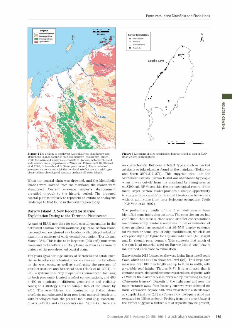
As part of BIAP, new data for early coastal occupation in the northwest has now become available (Figure 5). Barrow Island has long been recognised as a location with high potential for examining patterns of early coastal occupation (Dortch and Morse 1984). This is due to its large size (202 km2), numerous caves and rockshelters, and its optimal location as a remnant plateau of the now-drowned coastal plain.
Ten years ago a heritage survey of Barrow Island established the archaeological potential of some caves and rockshelters on the west coast, as well as confirming the presence of artefact scatters and historical sites (Hook et al. 2004). In 2013 a systematic survey of open sites commenced, focusing on both previously located artefact concentrations, and 400 x 400 m quadrats in different geomorphic and visibility zones; this strategy aims to sample 15% of the island by 2015. The assemblages are dominated by flaked stone artefacts manufactured from non-local material consistent with lithologies from the present mainland (e.g. ironstone, quartz, silcrete and chalcedony) (see Figure 4). There are
no characteristic Holocene artefact types, such as backed artefacts or tula adzes, as found on the mainland (Holdaway and Stern 2004:212–274). This suggests that, like the Montebello Islands, Barrow Island was abandoned by people when it was cut-off from the mainland by rising seas at ca 8300 cal. BP. Given this, the archaeological record of the much larger Barrow Island provides a unique opportunity to study a ‘time capsule’ of terminal Pleistocene behaviours without admixture from later Holocene occupation (Veth 1993; Veth et al. 2007).
The preliminary results of the first BIAP season have identified some intriguing patterns. The open site survey has confirmed that most surface stone artefact concentrations are dominated by non-local materials. Initial examination of these artefacts has revealed that 30–55% display evidence for retouch or some type of edge modification, which is an exceptionally high figure for any Australian site (M. Basgall and D. Zeenah pers. comm.). This suggests that much of the non-local material used on Barrow Island was heavily maintained until close to exhaustion.
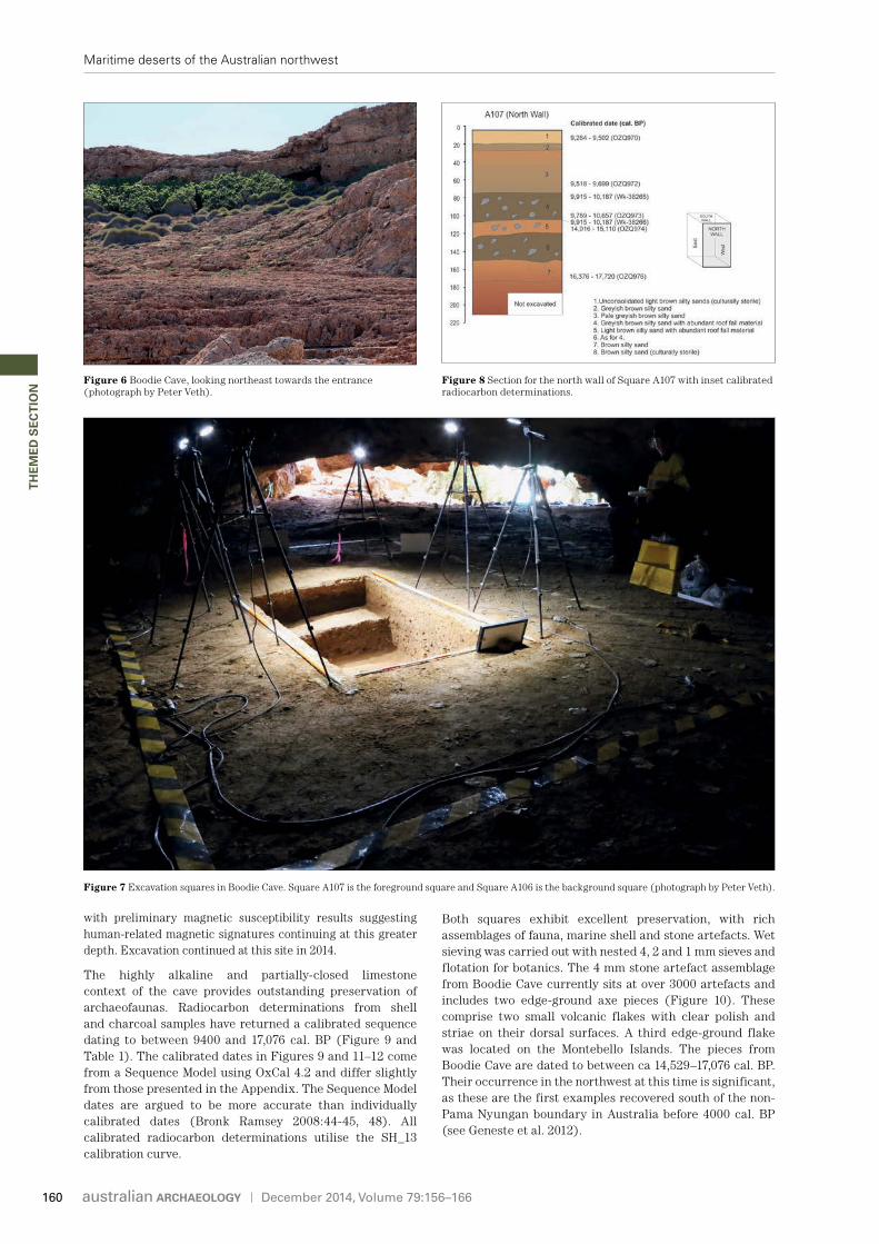
Excavation in 2013 focused on the west-facing limestone Boodie Cave, which sits at 40 m above sea level (asl). This large cave measures over 100 m in length and up to 20 m in width, with a variable roof height (Figures 5–7). It is estimated that it contains several thousand cubic metres of cultural deposits, with ca 20% in the darker recesses reworked by burrowing bettong (Bettongia lesueur). Deposits in the ‘light zone’ and near the main entrance away from bettong burrows were selected for initial excavation. Square A107 was excavated to a sterile layer at a depth of just over 2.02 m (Figure 8), while Square A106 was excavated to 0.50 m in depth. Probing from the current base of the former suggests a further 2 m of deposits may be present,
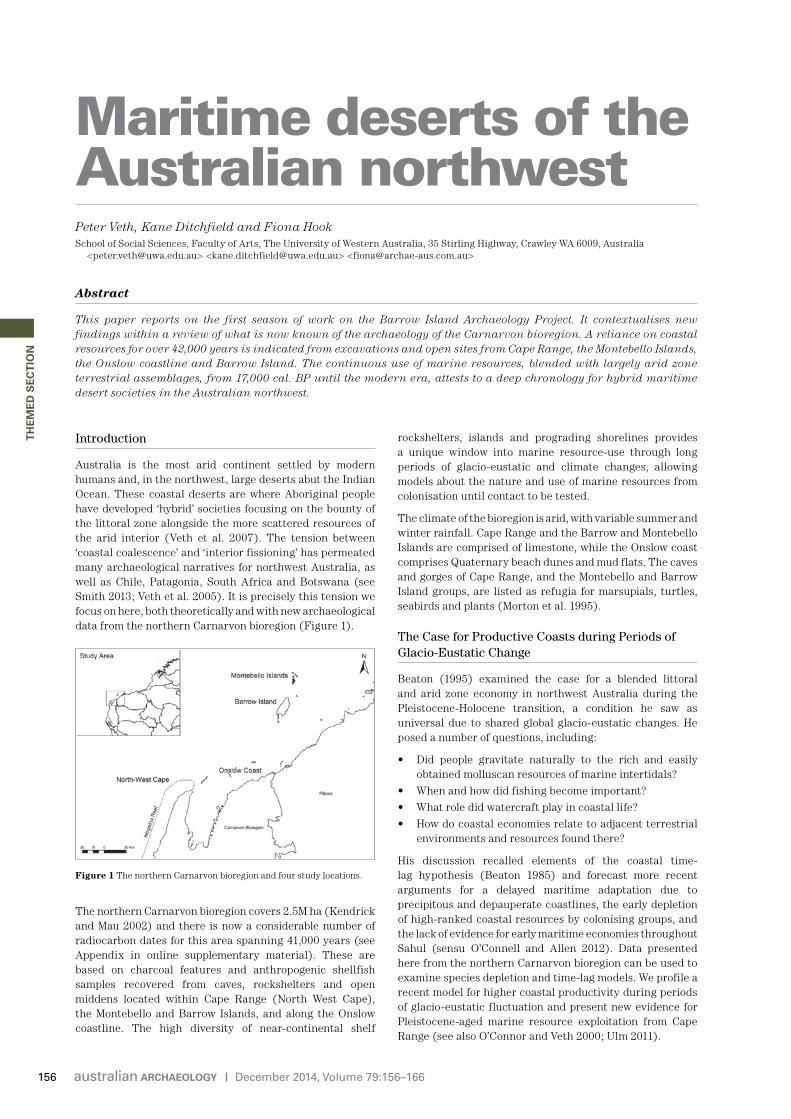
Figure 4 The geology of northwest Australia. Note that Barrow and Montebello Islands comprise only sedimentary (calcarenite) suites while the mainland supply zone consists of igneous, metamorphic and sedimentary units (Department of Mines and Petroleum 2007; Stewart et al. 2008; D. Zeanah and D. Glover pers. comm.). These mainland geologies are consistent with the non-local artefact raw material types observed in archaeological contexts on these off-shore islands.
Figure 5 Locations of sites recorded on Barrow Island as part of BIAP. Boodie Cave is highlighted.
159
December 2014, Volume 79:156–166
TH
EM
ED
SE
CT
ION
Maritime deserts of the Australian northwest
with preliminary magnetic susceptibility results suggesting human-related magnetic signatures continuing at this greater depth. Excavation continued at this site in 2014.
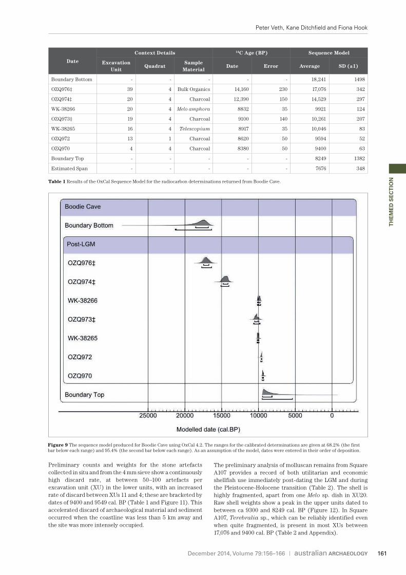
The highly alkaline and partially-closed limestone context of the cave provides outstanding preservation of archaeofaunas. Radiocarbon determinations from shell and charcoal samples have returned a calibrated sequence dating to between 9400 and 17,076 cal. BP (Figure 9 and Table 1). The calibrated dates in Figures 9 and 11–12 come from a Sequence Model using OxCal 4.2 and differ slightly from those presented in the Appendix. The Sequence Model dates are argued to be more accurate than individually calibrated dates (Bronk Ramsey 2008:44-45, 48). All calibrated radiocarbon determinations utilise the SH_13 calibration curve.
Both squares exhibit excellent preservation, with rich assemblages of fauna, marine shell and stone artefacts. Wet sieving was carried out with nested 4, 2 and 1 mm sieves and flotation for botanics. The 4 mm stone artefact assemblage from Boodie Cave currently sits at over 3000 artefacts and includes two edge-ground axe pieces (Figure 10). These comprise two small volcanic flakes with clear polish and striae on their dorsal surfaces. A third edge-ground flake was located on the Montebello Islands. The pieces from Boodie Cave are dated to between ca 14,529–17,076 cal. BP. Their occurrence in the northwest at this time is significant, as these are the first examples recovered south of the non-Pama Nyungan boundary in Australia before 4000 cal. BP (see Geneste et al. 2012).
Figure 7 Excavation squares in Boodie Cave. Square A107 is the foreground square and Square A106 is the background square (photograph by Peter Veth).
Figure 8 Section for the north wall of Square A107 with inset calibrated radiocarbon determinations.
Figure 6 Boodie Cave, looking northeast towards the entrance (photograph by Peter Veth).
160
December 2014, Volume 79:156–166
TH
EM
ED
SE
CT
ION
Peter Veth, Kane Ditchfield and Fiona Hook
Preliminary counts and weights for the stone artefacts collected in situ and from the 4 mm sieve show a continuously high discard rate, at between 50–100 artefacts per excavation unit (XU) in the lower units, with an increased rate of discard between XUs 11 and 4; these are bracketed by dates of 9400 and 9549 cal. BP (Table 1 and Figure 11). This accelerated discard of archaeological material and sediment occurred when the coastline was less than 5 km away and the site was more intensely occupied.
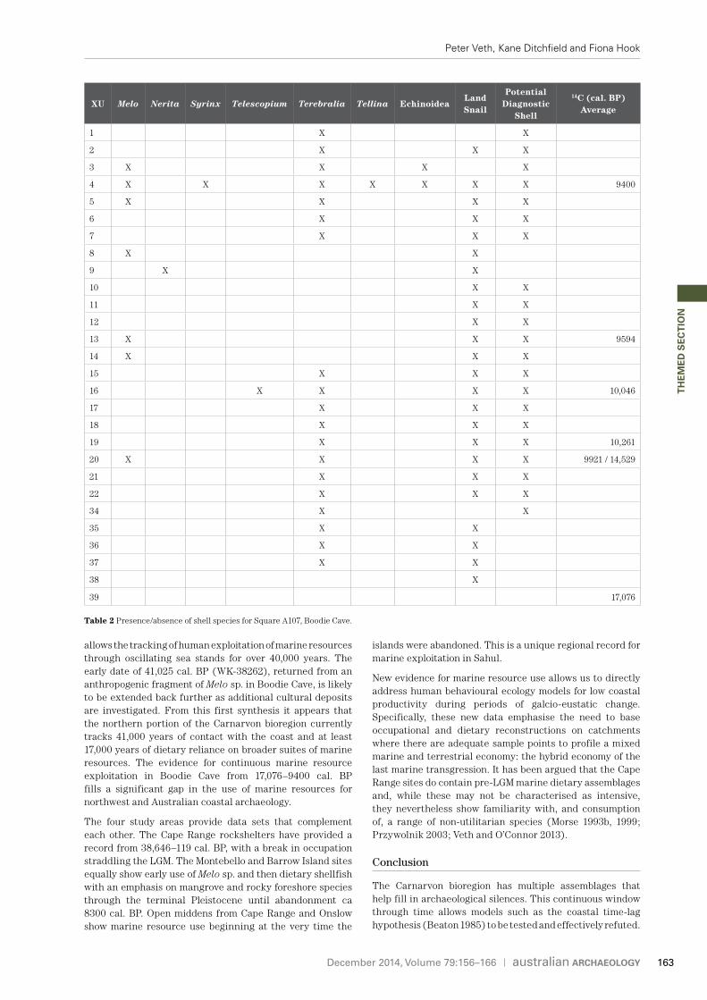
The preliminary analysis of molluscan remains from Square A107 provides a record of both utilitarian and economic shellfish use immediately post-dating the LGM and during the Pleistocene-Holocene transition (Table 2). The shell is highly fragmented, apart from one Melo sp. dish in XU20. Raw shell weights show a peak in the upper units dated to between ca 9300 and 8249 cal. BP (Figure 12). In Square A107, Terebralia sp., which can be reliably identified even when quite fragmented, is present in most XUs between 17,076 and 9400 cal. BP (Table 2 and Appendix).
Figure 9 The sequence model produced for Boodie Cave using OxCal 4.2. The ranges for the calibrated determinations are given at 68.2% (the first bar below each range) and 95.4% (the second bar below each range). As an assumption of the model, dates were entered in their order of deposition.
Date
Context Details 14C Age (BP) Sequence Model
Excavation Unit
QuadratSample
Material Date Error Average SD (±1)
Boundary Bottom - - - - - 18,241 1498
OZQ976‡ 39 4 Bulk Organics 14,160 230 17,076 342
OZQ974‡ 20 4 Charcoal 12,390 150 14,529 297
WK-38266 20 4 Melo amphora 8832 35 9921 124
OZQ973‡ 19 4 Charcoal 9100 140 10,261 207
WK-38265 16 4 Telescopium 8917 35 10,046 83
OZQ972 13 1 Charcoal 8620 50 9594 52
OZQ970 4 4 Charcoal 8380 50 9400 63
Boundary Top - - - - - 8249 1382
Estimated Span - - - - - 7676 348
Table 1 Results of the OxCal Sequence Model for the radiocarbon determinations returned from Boodie Cave.
161

December 2014, Volume 79:156–166
TH
EM
ED
SE
CT
ION
Maritime deserts of the Australian northwest
Based on available evidence (e.g. Veth 1993; Veth et al. 2007; Ward et al. 2013) the sea likely came close to Barrow Island’s current western coastline after 10,000 years ago. It is precisely at this time that the Boodie Cave sequence shows greater discard rates and displays the greatest range of marine fauna. A single Melo whorl from Square A107 XU9 has been dated to 41,025 cal. BP; however, it is out of stratigraphic order and is either reworked or an heirloom piece.
Of note, immediately to the south of the Carnarvon bioregion are the excavations by Bowdler (1999) at Shark Bay, which yielded dates on Melo sp. from the Silver Dollar open site between 34,292 and 22,063 cal. BP and then later Terebralia sp. dates ranging from 7755–7060 cal. BP (Appendix).
The Onslow Coastline: Continuity in Marine Resource Use during the Holocene
The Onslow coast is unusual within the context of the larger Pilbara region in that it is located within a sedimentary belt. It contains both terminal Pleistocene and emergent Holocene sand dunes and therefore has the ability to preserve both older and more recent coastal occupations. Previous heritage surveys of the Onslow coastal region, stretching from the eastern coast of the Exmouth Gulf in the west to Cane River in the east, have recorded over 100 middens (see, for example, Hook et al. 2006; Mulvaney 1984; Veitch et al. 1993; Veth et al. 1990). Research has focused on the timing of economic shellfish exploitation and the extent to which changes in species reflect either cultural preference or coastal productivity (Veitch and Warren 1992).
Veitch and Warren (1992) excavated five shell middens and collected surface shell samples from an additional three sites along a linear transect from the coast to 1 km inland. Mangrove shellfish (Terebralia sp.) were exploited between 5261 and 4333 cal. BP, while mudflat shellfish (Anadara granosa) were dated to between 4685 and 812 cal. BP, and the coral oyster (Hyotissa spp.) between 5174 and 1168 cal. BP (Appendix). These dates fall within the time range described for the adjacent Abydos Plain (Clune and Harrison 2009). The results show a cline from the youngest sites close to the contemporary coastline through to the oldest sites inland. This likely reflects progradation of the coastline through time, as also recorded for the successive chronology of middens from the Roebuck Plains near Broome (O’Connor and Sullivan 1994).
In 2013 surface samples of shellfish were collected from 12 sites near Onslow (Hook 2014a, 2014b). The radiocarbon dates show a slightly different pattern to that observed by Veitch and Warren (1992). The exploitation of the coral oyster occurred between 5993 and 513 cal. BP, while, in contrast, the Terebralia sp. dates are younger, with Anadara sp. dated to between 4518 and 551 cal. BP.
The time-span of dates returned from open area middens and shell scatters in the Onslow area and Cape Range (Kendrick and Morse 1982; Morse 1996, 1999) demonstrate that the exploitation of shellfish (re)commenced immediately after sea-level stabilisation. Indeed, the earliest dates for shell scatters from Cape Range at the Warroora and Mulanda sites are 8607 and 7997 cal. BP, respectively. These early dates neatly straddle the abandonment phase of the Montebello and Barrow Islands, currently sitting at ca 8300 cal. BP (see online Appendix).
There is unequivocal evidence for continuity of shellfish procurement throughout the Holocene from contiguous sites within the Carnarvon bioregion.
Discussion
The northern section of the Carnarvon bioregion samples an area of northwest Australia where the desert meets the sea. Because of the unique morphology and geology of the region it
Figure 10 Dorsal and polished surface of one of two edge-ground axe flakes from Boodie Cave. Inset image shows a polished edge under magnification (photographs by Kane Ditchfield).
Figure 11 Preliminary artefact counts per excavation unit with calibrated radiocarbon determinations for Square A107, Boodie Cave. Continuous numbering used for XUs between Squares A107 and A106.
Figure 12 Preliminary shell weights (g) per XU with calibrated radiocarbon determinations for Square A107, Boodie Cave. Continuous numbering used for XUs between Squares A107 and A106.
162
December 2014, Volume 79:156–166
TH
EM
ED
SE
CT
ION
Peter Veth, Kane Ditchfield and Fiona Hook
allows the tracking of human exploitation of marine resources through oscillating sea stands for over 40,000 years. The early date of 41,025 cal. BP (WK-38262), returned from an anthropogenic fragment of Melo sp. in Boodie Cave, is likely to be extended back further as additional cultural deposits are investigated. From this first synthesis it appears that the northern portion of the Carnarvon bioregion currently tracks 41,000 years of contact with the coast and at least 17,000 years of dietary reliance on broader suites of marine resources. The evidence for continuous marine resource exploitation in Boodie Cave from 17,076–9400 cal. BP fills a significant gap in the use of marine resources for northwest and Australian coastal archaeology.
The four study areas provide data sets that complement each other. The Cape Range rockshelters have provided a record from 38,646–119 cal. BP, with a break in occupation straddling the LGM. The Montebello and Barrow Island sites equally show early use of Melo sp. and then dietary shellfish with an emphasis on mangrove and rocky foreshore species through the terminal Pleistocene until abandonment ca 8300 cal. BP. Open middens from Cape Range and Onslow show marine resource use beginning at the very time the
islands were abandoned. This is a unique regional record for marine exploitation in Sahul.
New evidence for marine resource use allows us to directly address human behavioural ecology models for low coastal productivity during periods of galcio-eustatic change. Specifically, these new data emphasise the need to base occupational and dietary reconstructions on catchments where there are adequate sample points to profile a mixed marine and terrestrial economy: the hybrid economy of the last marine transgression. It has been argued that the Cape Range sites do contain pre-LGM marine dietary assemblages and, while these may not be characterised as intensive, they nevertheless show familiarity with, and consumption of, a range of non-utilitarian species (Morse 1993b, 1999; Przywolnik 2003; Veth and O’Connor 2013).
Conclusion
The Carnarvon bioregion has multiple assemblages that help fill in archaeological silences. This continuous window through time allows models such as the coastal time-lag hypothesis (Beaton 1985) to be tested and effectively refuted.
XU Melo Nerita Syrinx Telescopium Terebralia Tellina EchinoideaLand Snail
Potential Diagnostic
Shell
14C (cal. BP) Average
1 X X
2 X X X
3 X X X X
4 X X X X X X X 9400
5 X X X X
6 X X X
7 X X X
8 X X
9 X X
10 X X
11 X X
12 X X
13 X X X 9594
14 X X X
15 X X X
16 X X X X 10,046
17 X X X
18 X X X
19 X X X 10,261
20 X X X X 9921 / 14,529
21 X X X
22 X X X
34 X X
35 X X
36 X X
37 X X
38 X
39 17,076
Table 2 Presence/absence of shell species for Square A107, Boodie Cave.
163
December 2014, Volume 79:156–166
TH
EM
ED
SE
CT
ION
Maritime deserts of the Australian northwest
In other parts of northern Australia, studies of late Holocene coastal adaptations have shown that Beaton’s time-lag hypothesis did not accommodate the complexities of coastal adaptations (e.g. Ulm 2006:250). These studies showed that people also used the coastal resources of a transgressive coastline (Barker 1995, 1996; McNiven 1999; Ulm 2006:253). Similarly, the systematic consumption of economic shellfish from at least 17,000 ya in the Carnarvon bioregion, and persistence in their use through the Pleistocene-Holocene transgression through to the modern era, demonstrates that, for over 10,000 years of marine transgression, these coastal habitats were productive. This is precisely what would be expected if tidal ranges were indeed as high as predicted for the Northwest Shelf (Ward et al. in press a).
If oscillating sea-levels were not inhibitors for economic marine suites then why are these dietary remains sparse in sites dating to before the LGM in the Carnarvon bioregion? Expanded excavations on Barrow Island in 2014 will target pre-LGM units and it is hoped that these may contain the elusive earlier assemblages. Preservation conditions and the role of caves within the coastal catchment should not have altered dramatically during the course of the LGM.
As the most arid continent colonised by maritime-adapted peoples it should not be surprising that the resources of the coastal zone were systematically targeted during the Pleistocene. It is our expectation that pre-LGM assemblages will be recovered but that these will only occur in limited and discrete sample areas, such as the large caves of Barrow Island. These are larger than the rockshelters from Cape Range and the Montebello Islands and were likely central places forming a habitus for communities of coastal plain foragers and fishers.
Acknowledgements
BIAP is funded by an ARC Discovery Grant (DP130100802) 2013–2015 awarded to Peter Veth, Tiina Manne, Alistair Paterson, Mark Basgall, David Zeanah and Christa Placzek. Veth holds a DORA 3 under the Discovery Grant scheme. Research Associates include Peter Kendrick, Alex Baynes and Fiona Hook. Department of Parks and Wildlife, Chevron Australian Business Unit and WA Oil are thanked for their logistical and personnel support both in the planning process and in the field. Project Managers Emilie Dotte-Sarout and Sean Winter are thanked for their ongoing contributions. Bob Sheppard provided support in the preparation of Health, Environmental Safety and Quarantine Plans, as well as the construction and operation of the BIAP camp. Russell Lagdon and Kris Holmes are thanked for their detailed advice and support for the Barrow Island fieldwork. Earlier drafts of this paper were kindly reviewed by Kate Morse, Joe Dortch, Peter Kendrick, Alistair Paterson, Jo McDonald and Harry Butler, though the authors accept full responsibility for the final text. Mark Basgall and David Zeanah are thanked for access to their preliminary data on surface artefact scatters. Special thanks go to the UWA School of Social Sciences Manager Tim Stewart for his able support of budgets and thirst for sourcing optimal camping equipment. We acknowledge the participation and support of Buurabalayji Thalanyji Aboriginal Corporation.
References
Barker, B. 1995 The Sea People: Maritime Hunter-Gatherers on the Tropical Coast—A Late Holocene Maritime Specialisation
in the Whitsunday Islands, Central Queensland. Unpublished PhD thesis, School of Social Science, The University of Queensland, St Lucia.
Barker, B. 1996 Maritime hunter-gatherers on the tropical coast: A social model for change. In S. Ulm, I. Lilley and A. Ross (eds), Australian Archaeology ’95: Proceedings of the 1995 Australian Archaeological Association Annual Conference, pp.31–43. Tempus 6. St Lucia: Anthropology Museum, The University of Queensland.
Beaton, J.M. 1985 Evidence for a coastal occupation time-lag at Princess Charlotte Bay (north Queensland) and implications for coastal colonisation and population growth theories for Aboriginal Australia. Archaeology in Oceania 20(1):1–20.
Beaton, J.M. 1995 The transition on the coastal fringe of Greater Australia. Antiquity 69(265):798– 806.
Bowdler, S. 1995 The excavation of two small rockshelters at Monkey Mia, Shark Bay, Western Australia. Australian Archaeology 40:1–13.
Bowdler, S. 1999 Research at Shark Bay, WA, and the nature of coastal adaptations in Australia. In J. Hall and I.J. McNiven (eds), Australian Coastal Archaeology, pp.79–90. Research Papers in Archaeology and Natural History 31. Canberra: ANH Publications, Department of Archaeology and Natural History, Research School of Pacific and Asian Studies, The Australian National University.
Bronk Ramsey, C. 2008 Deposition models for chronological records. Quaternary Science Reviews 27(1–2):42–60.
Byrce, S., P. Larcombe and P.V. Ridd 1998 The relative importance of landward-directed tidal sediment transport versus freshwater flood events in the Normanby River estuary, Cape York Peninsula, Australia. Marine Geology 149(1–4):55–78.
Byrce, S., P. Larcombe and P.V. Ridd 2003 Hydrodynamic and geomorphological controls on suspended sediment transport in mangrove creek systems, a case study: Cocoa Creek, Townsville, Australia. Estuarine, Coastal and Shelf Science 56(3–4):415–431.
Clune, G. and R. Harrison 2009 Coastal shell middens of the Abydos Coastal Plain, Western Australia. Archaeology in Oceania 44(Supplement):70–80.
Department of Mines and Petroleum 2007 1:500 000 Tectonic Units of Western Australia. Preliminary Version, 2007-06-30 Edition. Perth: Department of Mines and Petroleum.
Dortch, C.E. and K. Morse 1984 Prehistoric stone artefacts on some offshore islands in Western Australia. Australian Archaeology 19:31–47.
Erlandson, J.M. 2001 The archaeology of aquatic adaptations: Paradigms for a new millennium. Journal of Archaeological Research 9(4):287–350.
Erlandson, J.M. 2012 On a fast-track: Human discovery, exploration and settlement of Sahul. Australian Archaeology 74:17–18.
Geneste, J-M., B. David, H. Plisson, J-J. Delannoy and F. Petchey 2012 The origins of ground-edge axes: New findings from Nawarla Gabarnmang, Arnhem Land (Australia) and global implications for the evolution of fully modern humans. Cambridge Archaeological Journal 22(1):1–17.
Holdaway, S.J. and N. Stern 2004 A Record in Stone: The Study of Australia’s Flaked Stone Artefacts. Canberra: Aboriginal Studies Press and Museum Victoria.
Hook, F. 2014a Report Detailing the Radiocarbon Dating of Surface Marine Shells from Shell Scatters along the Macedon Gas Pipeline. Unpublished report prepared for Archae-Aus.
Hook, F. 2014b Report Detailing the Radiocarbon Dating of Surface Marine Shells from Shell Scatters along the Wheatstone Gas Pipeline. Unpublished report prepared for Archae-Aus.
Hook, F., A. Dias, A. Di Lello and M. Jimenez-Lozano 2006 Addendum report to C. Hammond, M. Jimenez-Lozano and A. Dias 2005 A Report of an Aboriginal Archaeological Heritage Assessment of BHP Billiton Petroleum’s proposed Pilbara LNG Plant and Material Offload Facility, Onslow, Western Australia.
164
December 2014, Volume 79:156–166
TH
EM
ED
SE
CT
ION
Peter Veth, Kane Ditchfield and Fiona Hook
Unpublished report prepared for Buurabalayji Thalanyji Association and BHP Billiton Petroleum.
Hook, F., E. McDonald, A. Paterson, C. Souter and B. Veitch 2004 Cultural Heritage Assessment and Management Plan: Proposed Gorgon Development, Pilbara, Northwestern Australia. Unpublished report prepared for Environmental Resources Management Australia and ChevronTexaco Australia.
Kendrick, P.G. and K. Morse 1982 An Aboriginal shell midden deposit from the Waroora coast, northwestern Australia. Australian Archaeology 14:6–12.
Kendrick, P.G. and R. Mau 2002 Carnarvon 1 (CAR 1 Cape Range Subregion). Retrieved 26 March 2014 from <http://www.dec.wa.gov.au/pdf/science/bio_audit/carnarvon01_p69-86.pdf>.
Longhurst, A.R. and D. Pauly 1987 Ecology of Tropical Oceans. San Diego: Academic Press.
McDonald, J. and P. Veth 2009 Dampier Archipelago petroglyphs: Archaeology, scientific values and National Heritage listing. Archaeology in Oceania 44(Supplement):49–69.
McDonald, J. and P. Veth 2012 The social dynamics of aggregation and dispersal in the Western Desert. In J. McDonald and P. Veth (eds), Companion to Rock Art, pp.90–102. Oxford: Wiley-Blackwell.
McDonald, J. and P. Veth 2013 Rock art in arid landscapes: Pilbara and Western Desert petroglyphs. Australian Archaeology 77:66–81.
McNiven, I. 1999 Fissioning and regionalisation: The social dimensions of changes in Aboriginal use of the Great Sandy region, southeast Queensland. In J. Hall and I.J. McNiven (eds), Australian Coastal Archaeology, pp.157–168. Research Papers in Archaeology and Natural History 31. Canberra: ANH Publications, Department of Archaeology and Natural History, Research School of Pacific and Asian Studies, The Australian National University.
Morse, K. 1988 Mandu Mandu Creek Rockshelter: Pleistocene human coastal occupation of North West Cape, Western Australia. Archaeology in Oceania 23(3):81–88.
Morse, K. 1993a New radiocarbon dates from North West Cape, Western Australia: A preliminary report. In M.A. Smith, M. Spriggs and B. Fankhauser (eds), Sahul in Review: Pleistocene Archaeology in Australia, New Guinea and Island Melanesia, pp.155–163. Occasional Papers in Prehistory 24. Canberra: Department of Prehistory, Research School of Pacific and Asian Studies, The Australian National University.
Morse, K. 1993b West Side Story: Towards a Prehistory of the Cape Range Peninsula, Western Australia. Unpublished PhD thesis, Centre for Prehistory, The University of Western Australia, Crawley.
Morse, K. 1996 Coastal shell middens, Cape Range Peninsula, Western Australia: An appraisal of the Holocene evidence. In P. Veth and P. Hiscock (eds), Archaeology of Northern Australia: Regional Perspectives, pp.9–25. Tempus 4. St Lucia: Anthropology Museum, The University of Queensland.
Morse, K. 1999 Coastwatch: Pleistocene resource use on the Cape Range Peninsula. In J. Hall and I.J. McNiven (eds), Australian Coastal Archaeology, pp.73–80. Research Papers in Archaeology and Natural History 31. Canberra: ANH Publications, Department of Archaeology and Natural History, Research School of Pacific and Asian Studies, The Australian National University.
Morton, S.R., J. Short and R.D. Baker 1995 Refugia for Biological Diversity in Arid and Semi-Arid Australia. Biodiversity Series Paper 4. Canberra: Biodiversity Unit of the Department of Environment, Sport and Territories.
Mulvaney, K.J. 1984 Archaeological Survey J84A Seismic Program, Urala Station, West Pilbara, WA. Unpublished report prepared for ESSO Australia.
O’Connell, J.F. and J. Allen 2012 The restaurant at the end of the universe: Modelling the colonisation of Sahul. Australian Archaeology 74:5–31.
O’Connell, J.F., J. Allen and K. Hawkes 2010 Pleistocene Sahul and the origins of seafaring. In A. Anderson, J. Barrett and K. Boyle (eds), The Global Origins and Development of Seafaring, pp.57–68. Cambridge: McDonald Institute for Archaeological Research.
O’Connor, S. 1999 30,000 Years of Aboriginal Occupation: Kimberley, Northwest Australia. Terra Australis 14. Canberra: Department of Archaeology and Natural History and Centre for Archaeological Research, The Australian National University.
O’Connor, S. and M. Sullivan 1994 Distinguishing middens and cheniers: A case study from the southern Kimberley, WA. Archaeology in Oceania 29:16–28.
O’Connor, S. and P. Veth 2000 The world’s first mariners: Savannah dwellers in an island continent. In S. O’Connor and P. Veth (eds), East of Wallace’s Line: Studies of Past and Present Maritime Societies in the Indo-Pacific Region, pp.99–137. Rotterdam: A.A. Balkema.
Perlman, S.M. 1980 An optimum diet model, coastal variability and hunter-gatherer behaviour. Advances in Archaeological Method and Theory 3:257–310.
Przywolnik, K. 2002 Patterns of Occupation in Cape Range Peninsula (WA) over the Last 36,000 Years. Unpublished PhD thesis, Department of Archaeology, The University of Western Australia, Crawley.
Przywolnik, K. 2003 Shell artefacts from northern Cape Range Peninsula, northwest Western Australia. Australian Archaeology 56:12–21.
Przywolnik, K. 2005 Long-term transitions in hunter-gatherers of coastal northwestern Australia. In P. Veth, M. Smith and P. Hiscock (eds), Desert Peoples: Archaeological Perspectives, pp.177–205. Oxford: Blackwell.
Smith, M. 2013 The Archaeology of Australia’s Deserts. Cambridge: Cambridge University Press.
Stewart, A.J., I.P. Sweet, R.S. Needham, O.L. Raymond, A.J. Whitaker, S.F. Liu, A.J. Retter, D.P. Connolly and G. Stewart 2008 Surface Geology of Australia 1:1,000,000 scale, Western Australia. Canberra: Geoscience Australia.
Ulm, S. 2006 Coastal Themes: An Archaeology of the Southern Curtis Coast, Queensland. Terra Australis 24. Canberra: ANU E Press.
Ulm, S. 2011 Coastal foragers on southern shores: Marine resource use in northeast Australia since the late Pleistocene. In N.F. Bicho, J.A. Haws and L.G. Davis (eds), Trekking the Shore: Changing Coastlines and the Antiquity of Coastal Settlement, pp.441–461. New York: Springer.
Veitch, B. and L. Warren 1992 A Report of an Archaeological Recording and Salvage Programme at Tubridgi, Near Onslow. Western Australia. Unpublished report prepared for Doral Resources.
Veitch, B., F. Hook and P. Greenfeld 1993 A Report of an Archaeological Survey of Two Pipeline Routes for the Griffin Gas Development, Tubridgi, near Onslow. Unpublished report prepared for BHP Petroleum.
Veth, P. 1993 The Aboriginal occupation of the Montebello Islands, northwest Australia. Australian Aboriginal Studies 1993(2):39–50.
Veth, P. 1995 Aridity and settlement in northwest Australia. Antiquity 69:733–746.
Veth, P. 1999 The occupation of arid coastlines during the terminal Pleistocene of Australia. In J. Hall and I.J. McNiven (eds), Australian Coastal Archaeology, pp.65–72. Research Papers in Archaeology and Natural History 31. Canberra: ANH Publications, Department of Archaeology and Natural History, Research School of Pacific and Asian Studies, The Australian National University.
Veth, P. and S. O’Connor 2013 The past 50,000 years: An archaeological view. In A. Bashford and S. Macintyre (eds), The Cambridge History of Australia, Volume 1, pp.17–42. Melbourne: Cambridge University Press.
165
December 2014, Volume 79:156–166
TH
EM
ED
SE
CT
ION
Maritime deserts of the Australian northwest
Veth, P., K. Aplin, L.A. Wallis, T. Manne, T. Pulsford, E. White and A. Chappell 2007 The Archaeology of the Montebello Islands: Late Quaternary Foragers on an Arid Coastline. BAR International Series 1668. Oxford: Archaeopress.
Veth, P., L. Strawbridge and P. Moore 1990 Report of an Archaeological and Ethnographical Survey of the Tubridgi Pipeline, Onslow, Western Australia. Unpublished report prepared for Worley Engineering (Australia) and the Centre for Prehistory, The University of Western Australia.
Veth, P., M. Smith and P. Hiscock (eds) 2005 Desert Peoples: Archaeological Perspectives. Oxford: Blackwell.
Veth, P., S. O’Connor and L.A. Wallis 2000 Perspectives on ecological approaches in Australian archaeology. Australian Archaeology 50:54–66.
Ward, I., P. Larcombe and P. Veth in press a A new model for coastal resource productivity and sea-level change: The role of physical sedimentary processes in assessing the archaeological potential of submerged landscapes from the northwest Australian continental shelf. Accepted for publication in Geoarchaeology.
Ward, I., P. Larcombe, K. Mulvaney and C. Fandry 2013 The potential for discovery of new submerged archaeological
sites near the Dampier Archipelago, Western Australia. Quaternary International 308–309:216–229.
Ward, I., P. Veth and T. Manne in press b To the islands born: The research potential of submerged landscapes and human habitation sites from the islands of northwestern Australia. In J. Harff, G. Bailey and F. Luth (eds), Geology and Archaeology: Submerged Landscapes of the Continental Shelf. Geological Society, London, Special Publications 411. <http://dx.doi.org/10.1144/SP411.4>.
Williams, A.M., S. Ulm, A.R. Cook, M.C. Langley and M. Collard 2013 Human refugia in Australia during the Last Glacial Maximum and terminal Pleistocene: A geospatial analysis of the 25–12 ka Australian archaeological record. Journal of Archaeological Science 40:4612–4625.
Wolanski, E. and J. Chappell 1996 The response of tropical Australian estuaries to a sea level rise. Journal of Marine Systems 7(2–4):267–279.
Appendix
See online supplementary material at <http://australianarchaeology.com/our-journal/>.
166
Related Documents