
Welcome message from author
This document is posted to help you gain knowledge. Please leave a comment to let me know what you think about it! Share it to your friends and learn new things together.
Transcript

GENERAL CATALOGUE
MARINERS’
CHARTS
AND BOOKS
CORRECTED TO APRI L 1 . 1919
PUBLISH ED BY TH E HYDRO GRAPH IC O FFIC E UNDER
TH E AUTHORITY O F TH E S ECRETARY O F TH E NAVY
WASHINGTONGOVERNMENT PRINTING OFFICE
1919
CONTENTS .
Branch Hydrographic Offices
List of Agents for the sale of Charts , etc
List of Books for Navigation Purposes , etc .
Pilots
ExplanationsCatalogue of Charts in Geograp
hical Order (see arrangement in SectionsIndex of Charts , alphab
O
eti ca Iy arran dIndex of Charts , numerically arrange
ARRANGEMENT OF CHARTS IN SECT IONS .
S E CT ION I .
— Index Charts , Charts of the World , Track , Variation , GeneralSailing, Route , Gnomonic , Pilot, and Miscellaneous charts .
S E CT IO N I I .
-Charts of the Coasts, Harbors , and Islands of the North AtlanticOcean west of the 45th Meridian,
including the Great Lakes .
S E CT IO N III .
—SouthAtlantic Ocean : Coasts , Harbors, and Islands l n the 1mmediate vicinity ”
S E CT IO N IV .
—The Pacific Oeean : Pacific Coast of America from Cape Horn toBering
.
St1°ait, With adjacent Islands;the Strait of Magellan;and the ArcticOcean in the vicinity of Bering Strait .
S E CT IO N V .
—The Pacific Ocean : Pacific Coast of Asia from Bering Strait toMalakka Strait;With Japan
S E CT ION VI —The Pacific Ocean : Philippine Islands,Australia ,
New Zealand ,
the E astern Archi
gelago and ad jacent Islands; including Sumatra ,
JavaeBorneo , Celebes , W Guinea, the Bismarck Archipela
g
go , and SolomonIslands
SE C T I O N VI I -The Pacific Ocean : The Islands of the Pacific Ocean,except
the E astern Archipelago , Japan Australia,etc . , and Islands adjacent to
their coast
SE CT I O N VI I I .
—Arctic and North Atlantic Oceans : Coasts and I slands east ofthe 45th Meridian and north of Strait of Gibraltar
,including North Sea
,
Skagerrak, Kattegat, the Baltic , British Isles , English Channe1, Irish Channe1, Bay of Biscay, and Azores .
SE CT I O N IX — Mediterranean Sea : South Coast of Europe , Asia Minor , andNorth Coast of Africa; including Strait of Gibraltar, Gulfs of Lyons andGen oa , Tyrrhenian Sea, the Adriatic , and Mediterranean Archipela
y
go
SECT I O N X —North and South Atlantic Oceans : East of the 3oth Meridian;from Gibraltar Strait to Cape of Good Hope ; including Madeira, Salvage ,Can ary , and Cape Verde Islands;West Coast of Africa .
S E CT I O N X I .
— Indian Ocean : South and East Coasts of Africa, South Coast ofAsia to Lon 105
° E . , and the Islands of the Indi an Ocean,including Mada
gas ear and ergu

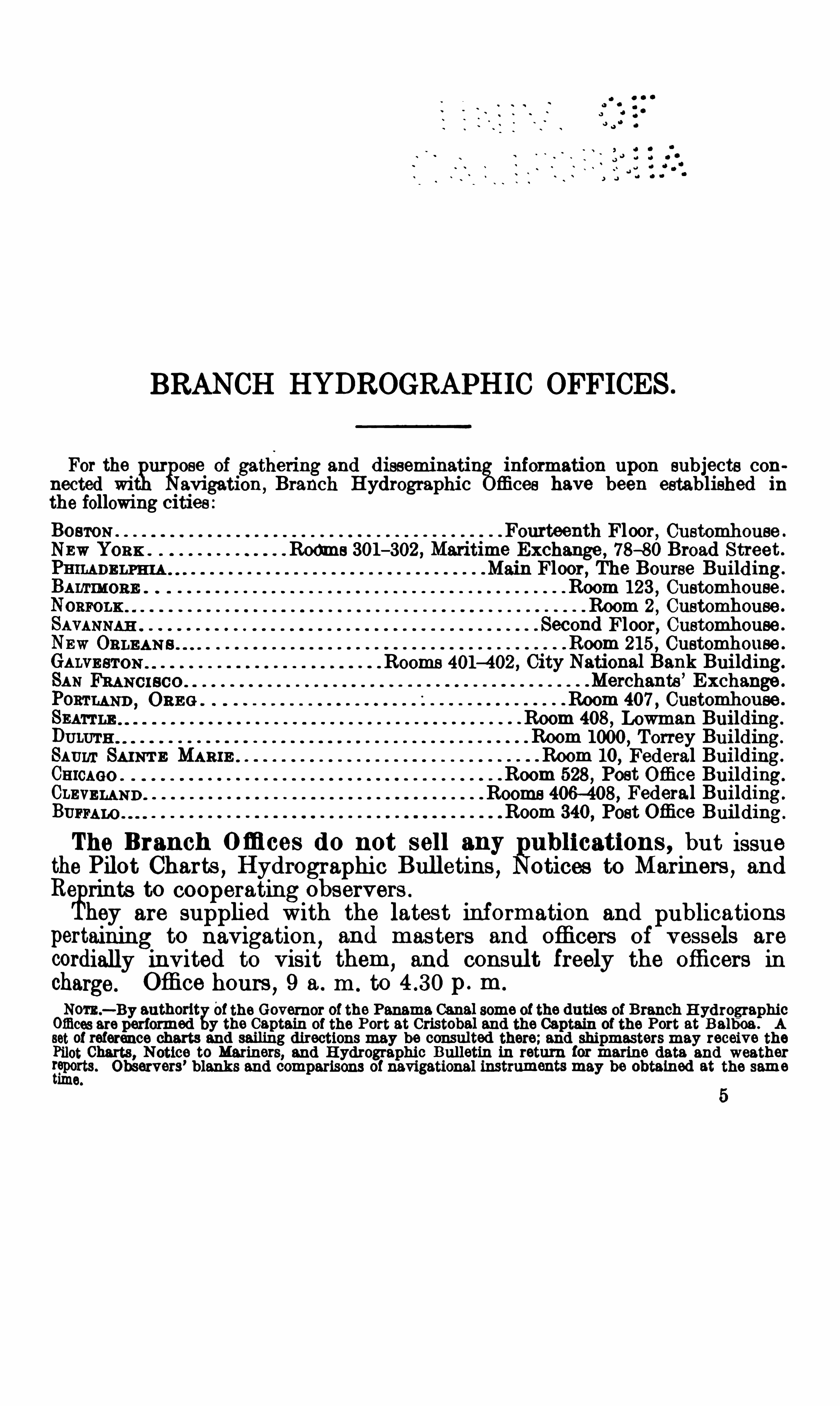
BRANCH HYDROGRAPH IC OFFICES .
For thetgur
goee of gathering and disseminatin
%information upon subjects con
nected wi avigation,Branch Hydrographic ffices have been established in
the following cities :BOSTON Fourteenth Floor, Customhouse .
Nnw YORK . Rooms 301—302 , Maritime Exchange , 78—80 Broad Street .
Main Floor, The Bourse Building.
Room 123 , Customhouse .
Room 2 , Customhouse .
Second Floor, Customhouse .
Room 215 , Customhouse .
Rooms 401—402 , City National Bank Building.
Merchants ’
Exchange .
Room 407 , Customhouse .
Room 408 , Lowman Building.
DULUTH Room 1000 , Torrey Building.
SAuur SAINT E MARI E Room 10, Federal Building.
CHICAGO . Room 528 , Post Office Building.
CLEVELAND Rooms 406—408, Federal Building .
BUFFALO Room 340, Post Office Building .
The Branch O ffi ces do not sell any etions , but 18811 9
the Pilot Charts , Hydrographi c Bulletins , to Mermers , andRe rinte to Cooperating observers .
hey are supplied With the latest information and publications
pertaining to navigation,and masters and officers of vessels are
cordially invited to visit them,and consul t freely the officers in
charge. Office hours , 9 a . m . to p . m .
Nom.—By authorit of the Governor of the Panama Canal some of the duties of Branch H ydrographic
Offices are performed y the Captain of the Port at Cristobal and the Captain of the Port at Balhoa . Asetof reference charts and sailing directions may be consulted there;and shipmasters may receive thePilot Charts, Notice to Mariners, and H ydrographic Bulletin in return for marine data and weather
{gporta Observers’ blanks and comparisons of navigational instruments may be obtained at the same
ime.
AGENTS FOR THE SALE OF HYDROGRAPH IC OFFICEPUBLICAT IONS .
IN THE UNITED STATE S AND ISLANDS .
ABERDE E N,WASH .
— The Evans Drug Co .
BALBOA H E IGHT S,CANAL ZO N E — The Captain of the Port.
BALTIMORE ,M1) — John E . Hand Sons Co .
,17 South Gay Street .
BELLINGHAM,WA SH .
— E . T . Mathes Book Co .
,110West Holly Street.
BOSTON,MAss — Charles C . Hutchinso11 , 154 State Street .
W. E . Hadlock Co . , 132 State Street .
CHARLE STON, S . C -H en1
°
)f B . Kirk
,10 Broad Street .
CHICAGO,ILL .
-A . C . McClurg Co .
,330 E ast Ohio Street.
CLEVELAND, 0 1110 .
— UpsonWalton Co .,1294—1310 West E leventh Street.
CRISTOBAL,CANAL ZO NE -The Captain of the Port.
DULUTH , MINN .
— Joseph Vande acht.
EASTPORT , ME — S L .
pWadswort Son ,
5—8 Central Wharf .GALVESTON
, TE X— Cha.rles F . Trube ,
2415 Market Street .
Purdy Bros, 2217 Market Street”
GLOUCE STER ,MA S S — Jerem1ah Foster, 150 Main Street.
Geo . H . Bibber, 161 Main Street.
HONOLULU,HAWAII .
— Hawa.iian News Co .
JACKSONVILLE,FLA .
-H . W. B . Drew Co .
,45 West Bay Street.
KETCHIKAN,ALASKA -Ryus Drug Cc .
KEY WE ST,FLA — A lfred Brost.
MANILA,PHILIPPINE S s— Luzon Stevedoring Co .
MOBILE, ALA — The Emerald Co . ,
207 Dauphin Street.
NEWORLEAN S,LA .
— Woodward ,Wight Howard Avenue and Constance Street.Rolf Seeberg S
ghip Chandlery Co .
,P . .O Box 1230 .
J . S . Sareussen ,211 South Peters Street.
NEWPORT,R . I -
.W H . Tibbetts 185 Thames Street.
NEWPORT NEWS , VA-
.W L . Shumate Co .,133 Twenty-fifth Street.
NEW YORK , N . Y .
— T . S . J . D . Negus , 140 Water Street.
John Bliss Co .,128 Front Street .
Michael Rupp Co .
,112 Broad Street .
C . S . Hammond Co .,30 Church Street .
NORFOLK, VA
— William Freeman,243 Granby Street.
PENSACOLA,FLA r
—McK enzie Oetting Co .,603 South Palafox Street.
PHILADELPHIA ,PA — Riggs Bro .
,310 Market Street.
John E . Hand Sons C0 Chestnut Street .
PORTLAND,ME —
.Wm Senter Co . , 51 Exchange Street.
PORTLAND,ORE G .
— The J . K . Gill Co .,Third and A lder Streets .
The Beebe Co ., 182 Morrison Street.
PORT TOWNSE ND,WA SH .
-W. J . Fritz,320 Water Street .
ROCKLAND,ME — Huston-Tuttle Book Co .
,405 Main Street.
SAINT THOM,
AS VIRGIN I SLAND S, U . S . A .
—S . Fischer, Harbormaster.
SAN DIEGO,CAL -Arey-Jones Co .
,933 Fourth Street.
SAN FRANCI SCO , CAL .—Geo . E . Butler
,A1as <a. Commercial Building .
LouisWenle Co .,6 California Street.
H . J . H . Lorenzen,12 Market Street.
A . Lietz Co .,61 Post Street .
SAN JUAN,P0 3 1 0 R 100 — Joseph A . Rose, Lighthouse Service .
SAN PEDRO . GAL .
— Ma.ri11e H ardware Co . , 509 Beacon Street.
SAVANNAH, GA r
—Savannah Ship Chandlery Supply Co .,25 East Bay Street.
HY DROGRAPH IC : OFFICE PUBL ICAT IONS8"
.E
SE ATTLE,W58 1;
Tfiqwmanmes; B anforaCo . 616—620 FirstAvenue .
2 :°
KlinciC0 1 8“ First Avenue .
TACOMA, WASH -Co'le
“Martin Cos , Avenue .
TAMPA,FLA —
. Tampa Book Stationery Co ., 513 Franklin Street.
WASH INGTON,D . C .
—W. H . Lowdermilk Co .,1418 F Street NW.
Brentanos,F . and Twelfth Streets NW.
WILMINGTON, N . C .
— Thos . F . Wood,1—5 Princess Street.
IN FORE IGN COUNTR IES .
BELIZE ,BRITI SH H ONDURAS —
.A E . Morlan .
BuE Nos AIRE S,ARGE NT INA —Rodolfo Boesenberg, 824 Victoria Street.
CANso ,N . S .
-A . N . Whi tman Son .
HABANA,CUBA -E duardo Mencio
,10 Mercaderes .
HALIFAX,N . S — Crei hton Marsha11, 0 1
°dnance Square .
MAN ZANILLO,CUB A . h rique Lauten
,Marti 44 .
MONTRE AL , CANAD A .
— H a1°
rison Co .,53 Metcalfe Street.
PORT H AWKE SBURY ,C . B . I .
, N . S .
— A1exander Bain .
PRINCE RUPE RT ,B . C . , CANADA
— McRae Bros” P . 0 . Drawer 1690
QUE B E C , CANADA -.T J . Moo1°e Co .
,118—120 Mountain H ill .
ST . JOHN N . B —.J A . McMillan . 98 Prince William Street.
PILOTS , MANUALS , AND TABLES
PUBLISHED BY TH E
U. S . HYDROGRAPHIC OFFICE .
NOTE .— The only books sold by the H ydro raphic O ffice are listed below. O thet° nautical publications
must be obtained from the Department 0 the Government by which they are published , or fromitheSuperintendent of Documents , Government Printing O ffi ce.
fi —n
T rrLE 0 1°
110 0 11 . PRICE .
73 Newfound land Pilot. 1919 $0 . 90
84 M exican and Central American Pilot (Pacific C oast). Fromthe United States to Colombia , including the Gulf of Californiaand Panama . 1918
99 N ova S cotla Pilot, including the Bay of Fundy and all of CapeBreton Island , as Well as the off-Iying banks and the Great Bankof Newfoundland . 1918
100 S t . Lawrence Pilot. Gulf and River St. Lawrence to Montreal .1917
105 A frica Pilot. Vol . 1 . West Coast, Cape Palmas to Cape of GoodHope . 1916
122 Asiatic Pilot. Vol . I . East Coast of Siberia , Sakhalin I sland and
Chosen. 1918
123 Asiatic Pilot. Vol . I I . The Japan Islands . 1910
124 Asiatic Pilot. Vol . I I I . Coast of China, Yalu R iver to Hongkong ,
and Island of Formosa . 1909
125 Asiatic Pilot. Vol . IV . Singapore Strait to Hongkong . 1915
126 Asiatic Pilot. Vol . V . Sunda Strai t and the Southern A preachesto China Sea,
with West and North Coasts of Borneo an off—lyingdangers . 1915
128 West Indies Pilot. Vol . I . Bermudas , Bahamas , and the GreaterAntil les . 1918
129 West Ind ies Pilot. Vol . I I . LesserAntilles and Venezuela . 1918 .
130 Central America and Mexico Pilot (East Coast). H orn GallinasPoint, Colombia, to the Rio Grande . 1918
[Norm— Nos . 1 2 8 , 1 2 9 , and 1 3 0 canceled former Nos . 6 4 and 8 6 . With theexee
gtion of the Gulfcoasts of theUnited States they cover the area formerly treated
by t e canceled booksJ
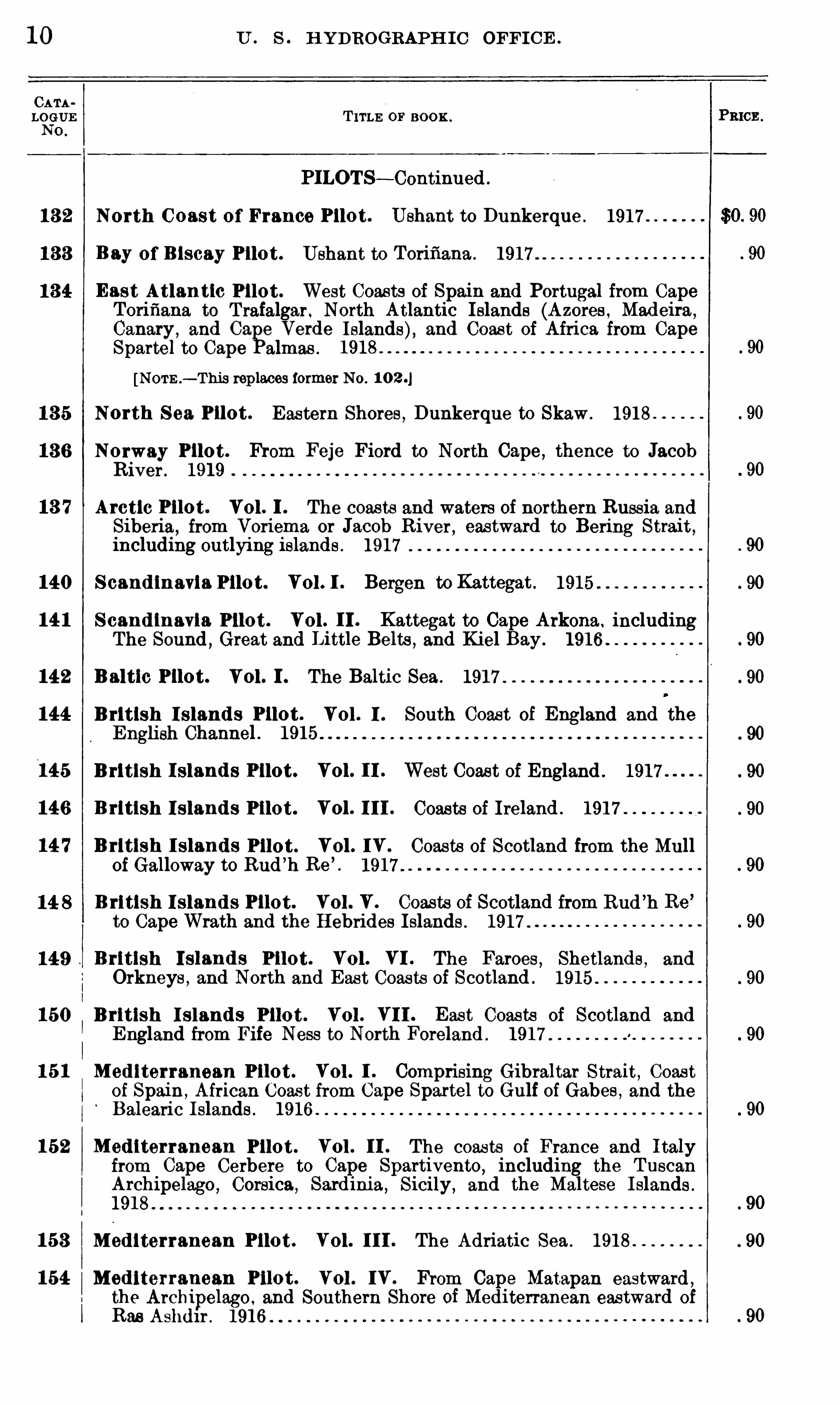
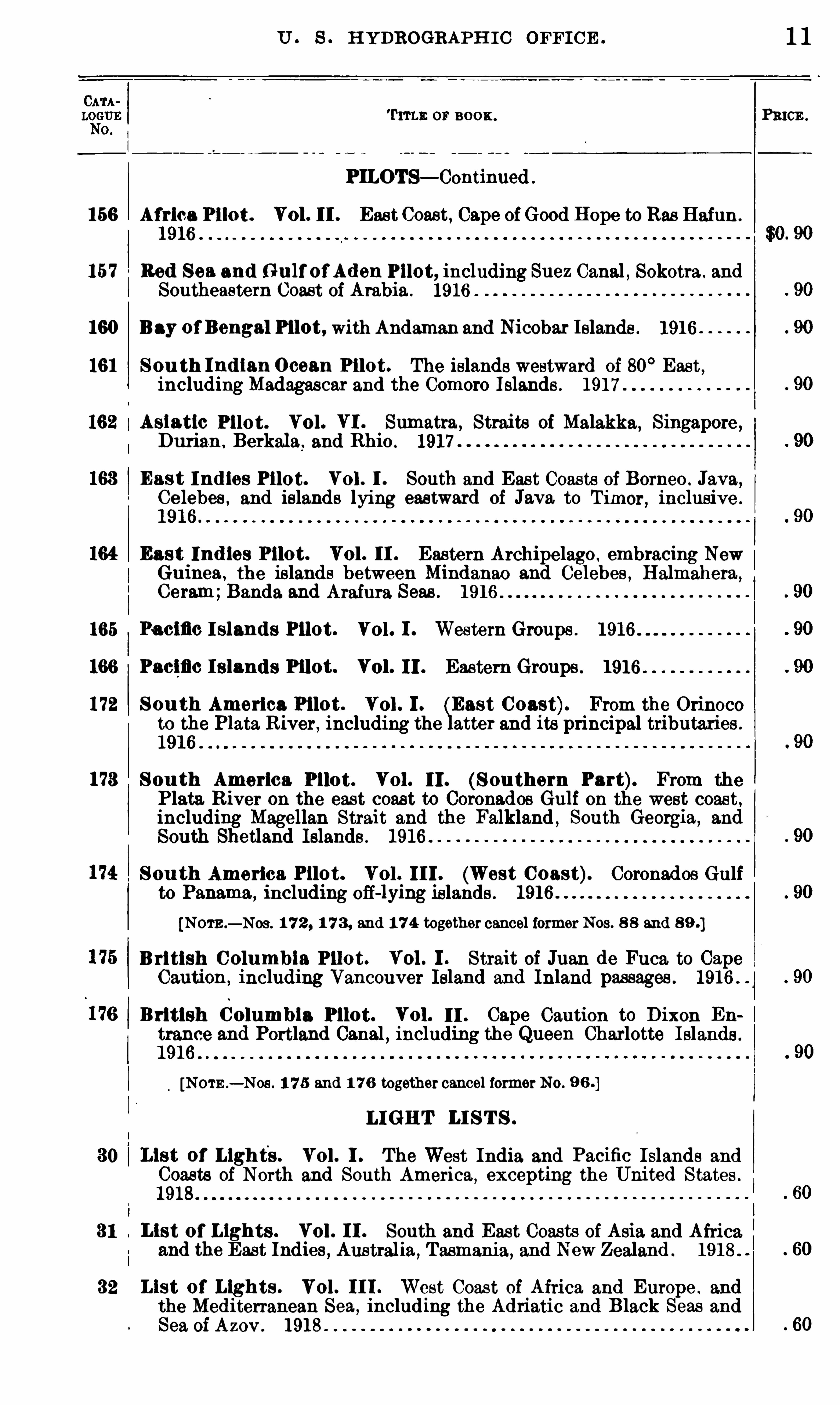
10 U . s . H YDROGRAPH IC OFFIC E .
T ITLE OF BOO K .
PILOTS— Continued .
13 2 North C oast of France Pilot . Ushant to Dunkerque . 1917
Bay of B lseay Pilot . Ushant to Torifiana . 1917
East Atlantic Pilot . West Coasts of Spain and Portugal from CapeTorifiana to T rafalgar . North Atlantic Islands (Azores ,
Madeira,
Canary , and Ca e Verde Islands), and Coas t of Africa from CapeSpartel to Cape almas .
[NOTE .— This replaces former No .
North S ea. Pilot . Eastern Shores , Dunkerque to Skaw . 1918
Norway Pilot. From Feje Fiord to North Cape , thence to JacobR iver . 1919
13 7 Arctic Pilot. Vol . I . The coas ts and waters of northern Russia andSiberia,
from Voriema or Jacob R iver, eastward to Bering Strait ,including outlying islands . 1917
140 S cand inavia Pilot. VOL I . Bergen to Kattegat . 1915
14 1 S cand inavia Pilot . Vol I I . Kattegat to Cape Arkona . includingThe Sound
, Great and L1ttle Belts , and Kiel Bay. 1916
142 Baltic Pilot. Vol . I . The Baltic Sea . 1917 .
144 British I sland s Pilot. Vol . 1 . South Coas t of England and the
English Channel . 1915
145 British I sland s Pilot. Vol . I I . West Coast of England . 1917
146 B ritish I sland s Pilot. Vol . I I I . Coasts of Ireland . 1917
14 7 B ritish I sland s Pilot. Vol . IV . Coasts of Scotland from the Mullof Galloway to Rud ’
h Re’
. 1917
B rltlsh I sland s Pilot. Vol . V . Coasts of Scotland from Rud’
h Re’
to Cape Wrath and the Hebrides I slands . 1917 .
British I sland s Pilot. Vol . VI . The Faroes , Shetlands , and
Orkneys , and North and Eas t Coas ts of Scotland . 1915 .
British I sland s Pilot . Vol . VI I . Eas t Coasts of Scotland and
England from Fife Ness to North Foreland . 1917
Mediterranean Pilot . Vol . I . Comprising Gibraltar Strait, Coas tof Spain , African Coast from Cape Spettel to Gulf of Gabes , and theBalearic Islands . 1916
152 Med iterranean Pilot . Vol . I I . The coas ts of France and Italyfrom Cape Cerbere to Cape Spartivento, including the Tuscan
Archipelago , Corsica , Sardinia , Sicily , and the Maltese I slands .
1918
153 Mediterranean Pilot . Vol . I I I . The Adriatic Sea . 1918
154 Med iterranean Pilot . Vol . IV . From Cape Matapan eastward ,
the Archipelago , and Southern Shore of Mediterranean eastward of
Rae Ashdl r . 1916
PRICE .
U . S . H YDROGRAPH I C OFFIC E .
0 1°
110 0 11 .
PILOTS— Continued
156 Africa Pilot . Vol . I I . East Coast, Cape ofGood Hope to Rae Hafun .
1916
157 Red Sea and Gu lf of Aden Pilot, including Suez Canal , Sokotra . and
Southeastern Coast of Arabia . 1916
160 Bay of Bengal Pilot, with Andaman and Nicobar Islands . 1916
161 S ou th Ind ian Ocean Pilot. The islands westward of 80° East
,
including Madagascar and the Comoro Islands . 1917
162 Asiatic Pilot. Vol . VI . Sumatra , Straits of Malakka, Singapore ,Durian . Berkala . and Rhio . 1917
163 East Indies Pilot. Vol . I . South and East Coasts of Borneo . Java,Ce lebes . and islands lying eastward of Jave, to Timer, inclusive .
1916
164 Eas t Ind ies Pilot. Vol . I I . Eastern Archipelag o . embracing NewGuinea , the islands between Mindanao and Celebes , Halmahera,
Ceram;Banda. and Arafura Seas . 1916 .
165 Pacific I sland s Pilot. Vol . I . Western Groups . 1916 .
166 Pacific I slands Pilot. Vol . 11 . Eastern Groups . 1916
172 Sou th America Pilot . Vol . 1 . East Coast). From the Orinocoto the Plate. R iver, including the atter and its principal tributaries .
1916 .
173 S ou th America Pilot . Vol . 11 . (S ou thern Part). From thePlate. River 0 11 the east coast to Coronados Gulf on the west coast,including Magellan Strait and the Falkland , South Georgia,
and
South Shetland Islands . 1916
S ou th America Pilot. Vol 111 . (West Coast). Coronados Gulfto Panama,
including off-lymg islands . 1916
[NOTE .— NOS . 1 7 2 , 1 7 3 , and 1 74 together cancel former Nos . 8 8 and
B ritish C olumbia Pilot. Vol . I . Strait of Juan de Fuca. to CapeCaution , including Vancouver Island and Inland passages . 1916 .
British Columbia Pilot. Vol . 11 . Cape Caution to D ixon En
trance and Portland Canal , including the Queen Charlotte I slands .
[NOTE .— NOS . 1 75 and 1 7 6 together cancel former No.
LIGHT LI S T S .
30 List of Lights . Vol . I . The West India and Pacific Islands and
Coas ts of North and South America, excepting the United States .
31 List of Lights . Vol . I I . South and East Coasts of Asia and Africa
and the East Indies , Australia,Tasmania, and New Zealand . 1918 .
32 List of Lights . Vol . I I I . West Coast of Africa and Europe . and
the Mediterranean Sea , including the Adriatic and Black Seas and
Sea of Azov. 1918
1 1
PR ICE .
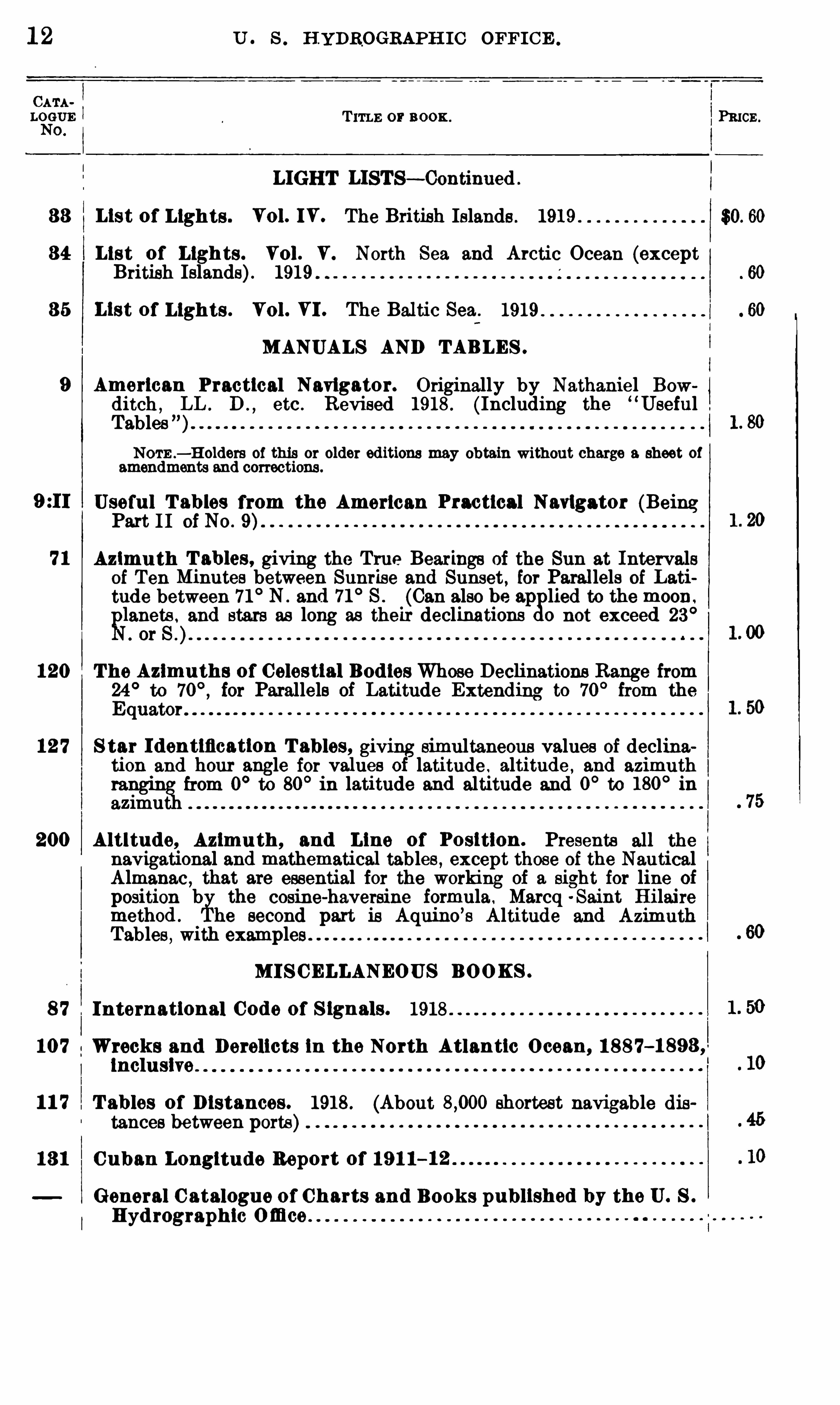
1 2 U . s . H YDROGRAPH IC OFFIC E .
T ITLE or 110 0 11 . PRICE .
LIGHT LISTS— Continued .
33 List of Lights . Vol . IV . The British Islands . 1919 .
34 List of Ligh ts . Vol . V . North Sea and Arctic Ocean (exceptBritish Islands). 1919
3 5 List of Lights . Vol . VI . The Bal tic Sea . 1919
MANUALS AND TABLES .
9 American Practical Navigator. Originally by Nathaniel Bowditch , LL . D . , etc . Revised 1918 . (Including the
“Useful .
TablesNOTE —H olders of this or older editions may obtain without charge a sheet of
amendments and corrections .
Useful T ables from the American Practical Navigator (BeingPart I I of No .
71 Azimu th T ables , giving the True Bearings of the Sun at Intervalsof Ten Minutes between Sunrise and Sunset, for Parallels of Lati
tude between 71 ° N . and 71° S . (Can also be ap lied to the moon.
gllanets . and stars as long as their declinations 0 not exceed 23°. or
120 The Azimuths of Celestial Bod ies Whose Declinations Range from24° to for Parallels of Latitude Extending to 70
° from theEquator
12 7 S tar I dentification T ables, giving simultaneous values of declination and hour angle for values of latitude . altitude , and azimuthta from 0
°to 80
° in latitude and altitude and 0°to 180
° in
azimu
200 Altitude, Azimu th , and Line of Position . Presents all the
navigational and mathematical tables , except those of the NanticalAlmanac , that are essential for the working of a sight for line of
position b the cosine-haversine formula . Marcq -Saint H ilairemethod . he second part is Aquino
’s Altitude and Azimuth
Tables , with examples
MI S CELLANEOUS BOOKS .
8 7 International Code of S ignals. 1918
107 Wrecks and Derelicts in the North Atlantic Ocean, 1 88 7—1 893 ,lncluslve . .
1 1 7 T ables of D istances . 1918 . (About shortest navigable distances between ports)
13 1 Cuban Longitude Report of 19 1 1—12
General C atalogue of Charts and Books published by the U. S .
Hyd rographic
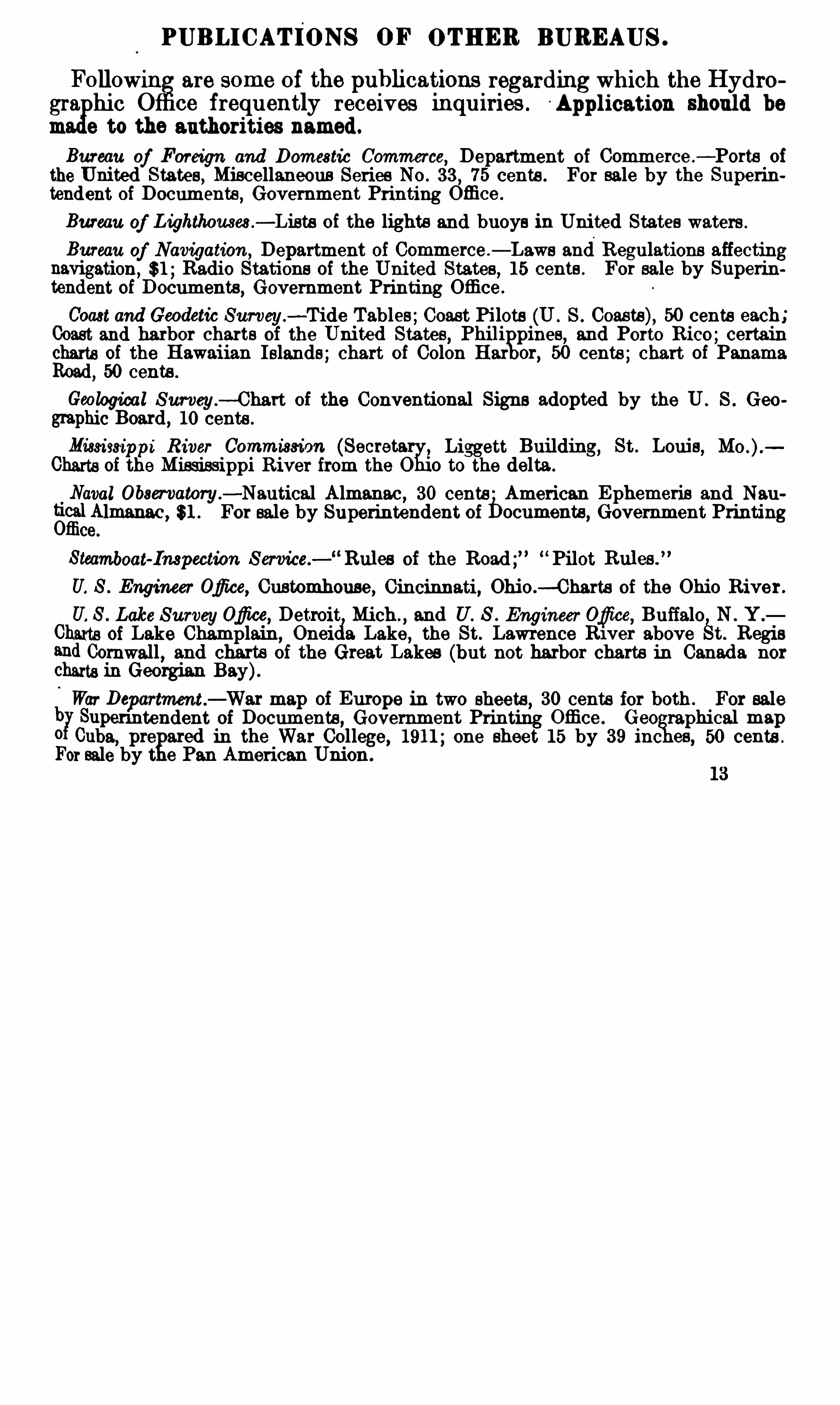
PUBLICATIONS OF OTHER BUREAUS .
Followin are some of the publications regarding which the Hydro
gra hie O ce frequently receives inquiries . A pplication should be
m e to the authorities named.
Bureau of Foreign and Domestic Commerce, Department of Commerce .
— Ports ofthe United States, Miscellaneous Series No . 33 , 75 cents . For sale by the Superintendent of Documents
, Government Printing Office .
Bureau of Lighthouses .
— Lists of the lights and buoys in United States waters .
Bureau of Navigation ,Department of Commerce — Laws and Regulations affecting
navigation, $1 ;Radio Stations of the United States , 15 cents . For sale by Superintendent of Documents, Government Printing Othee .
Coast and Geodetic Survey.
—Tide Tables;Coast Pi lots (U . S . Coasts), 50 cents each;Coast and harbor charts of the United States, Phili
fipines, and Porto Rico;certain
charts of the Hawaiian Islands; chart of Colon Har 50 cents ; chart of PanamaRoad
, 50 cents .
Geological Survey.— Chart of the Conventional Signs adopted by the U . S . Geo
graphic Board , 10 cents .
Mississippi River Commission (Secretary;Liggett Building, St . Louis,
Charts of the Mississippi River from the O°
o to the delta .
Naval 0 b3m atory.
-Nautical Almanac , 30 cents American Ephemeris and Nau
gc
fit
itl Almanac , 81 . For sale by Superintendent of bocuments, Government Printingce.
Steamboat-Inspection S ervice. Rul es of the Road;” “ Pilot Rul es .
U. S . Engineer Ofi ce, Customhouse, Cincinnati , Ohio .-Charts of the Ohio River .
U. S . Lake S urveyOfi ce, Detroit Mich ., and U. S . Engineer Ofice
,Buffalo N . Y .
Chmts of Lake Champlain, Oneicia Lake, the St. Lawrence R1ver above St. Regisand Cornwall , and charts of the Great Lakes (but not harbor charts in Canada nor
Charts in Georgian Bay).
War Departnwnt.
— War map of EurOpe in two sheets , 30 cents for both . For saleb Supenntendent of Documents , Government Printing Office . Geo raphical map0 Cuba, pre ed in the War College, 1911 ; one sheet 15 by 39 inc es, 50 cents .
For sale by t e Pan American Union .
EXPLANATIONS .
Alphab etical index .— An al habetical index of the names of localities of which
charts are published by this 0 ce is given on page 185 .
Num erical index .-A numerical index ,
showing chart numbers , will befound on
gages 269 to 293 . Opposite each number is given the page on which the chart maye found and the price of the chart.
Order of catalogu ing .—The lists of charts are divided into eleven sections .
The charts of the world and of the oceans appear only in Section I , but all charts of
larger scales (coast , harbor, and special charts)are arranged as nearly as possible inexact geographical order in each section, thus : Coasts , harbors , and adjacent island s ,then grou s and detached islands . Each chart follows that of next larger area ,
but
which inc ndes the area of the smaller . For example , No . 968 [p . 53] covers the coastof Guiana; No . 1155 following is a chart covering the approaches to the Demerara
and E ssequibo Rivers;while 1168 is the chart of the entrances to the rivers and
harbor of Georgetown .
T o find a chart .—T o find a chart of a particular place , look up its title in the
alphabetical index , or its number (ii known) in the numerical index . Generallocalities (such as West Indies, Brazil, Japan)may be found by consulting the al ha
betical index . Charts covering certain required areas may be most easily foun byconsulting the index charts .
T itl e .—The titles are not
o
ao
lways given in the title column exactly as they appearon the charts , but such add1t10na1 information or explanation has been added as wasdeemed desn'
able to give a clear 1dea of the contents of the chart .
Scal e .— The scale of each chart is expressed in the Catalogue by the length on the
chart in inches (to the nearest tenth) of : First, the length of a degree of Ion°
tude
(D long.) for ocean and coasting charts of considerable area; second ,the lengt of a
degree in the midd le latitude of chart (D lat .)for coasting charts of moderate extent;
and third , by the length of 9. nautical mi le on the chart or a scale of yards , in the case
ofharbor or special charts . Plans of orts and harbors in the Great Lakes are provid edeach with a scale of statute miles am?one of nautical miles , except where the scale islarge , when a scale of yards is given .
Scal e of charts .—In order to render it more easy to distinguish charts of wid ely
different scales , the publication numbers of the charts are given in three kinds of
type . In ocean and general sailing charts and charts of large areas (coasts or island s),on a scale of less than 4 inches to a degree of longitude , the publication number is inheavy
-faced type, thus, 1 50; in charts of more moderate extent and scales of 4 to 20inches to a degree of longitude the number is given in medium t e , thus, 6 2 1 ; all
charts of a larger scale than 20 inches to the degree of longitu e are given in the
ordinary type, thus , 992 .
United S tates coas t .—Qf the United States coast this office publishes general
coast charts only . The deta1l or harbor charts may be obtained from the U . 8 . Coast .
Survey or l ts agents .
14
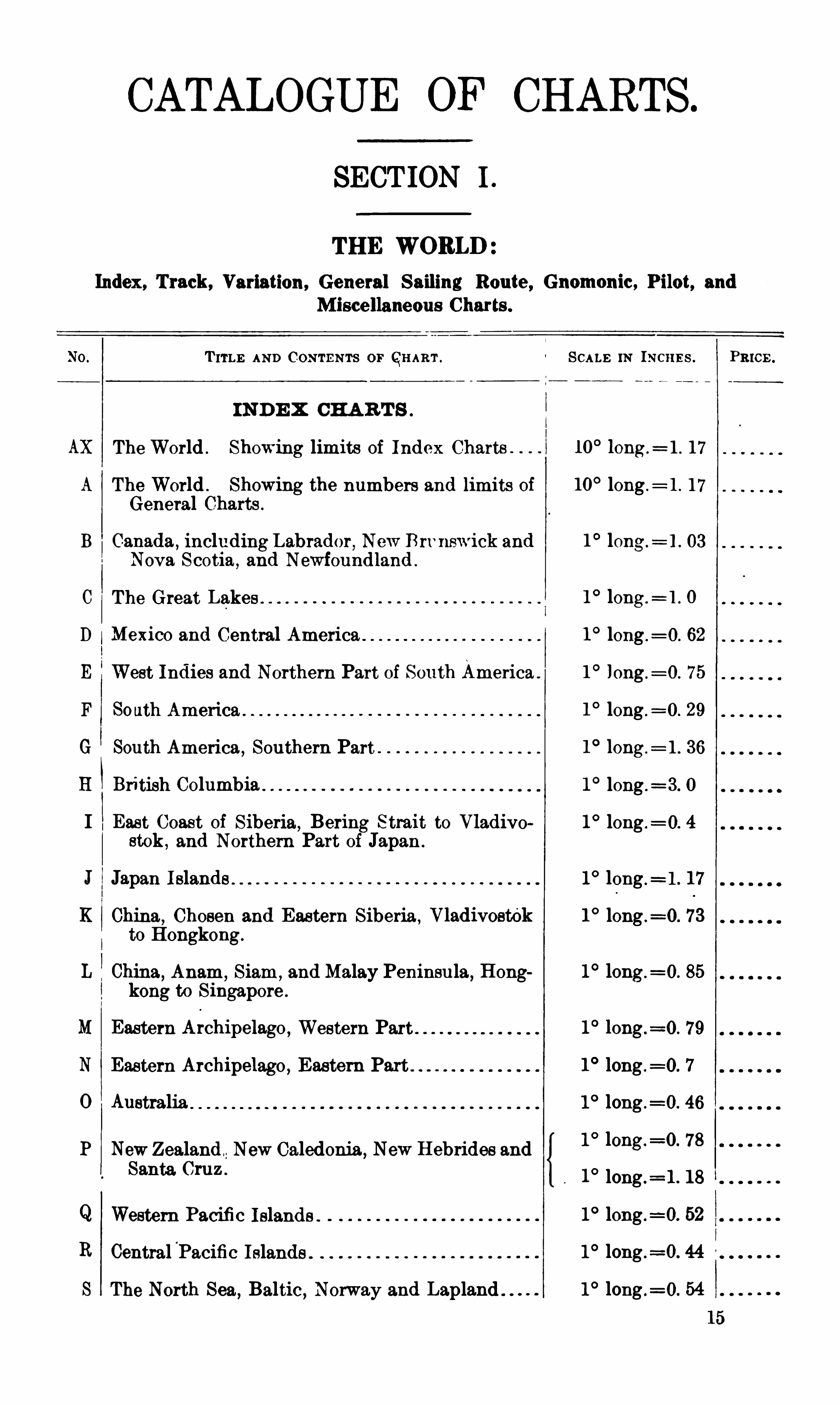
CATALOGUE OF CHARTS.
SECTION I .
THE WORLD
Index, Track, Variation, General Sailing Route , Gnomonic, Pilot, andM iscellaneous Charts .
I
T ITLE AND C ONTENTS 0 1°
QHAE T . SCALE IN INCHE S . PRICE .
IND E X CHA R T S .
AX The World . Showing limits of Index Charts 10° 10ng .
= 1 . 17
A The World . Showing the numbers and limits of 10° long .
= 1 . 17
General Charts .
B Canada ,including Labrador New Brvnswick and 1 ° long.
= 1 . 03
Nova Scotia , and Newfound land .
C The Great Lakes 1° long .
= 1 . 0
D Mexico and Central America 1° long .
= 0. 62
E West Indies and Northern Part of South America . 1° long .
= 0. 75
F South America 1° long .
= 0 . 29
G South America ,Southern Part 1
° long .= l . 36
H British Columbia 1° long .
= 3. 0
I East Coast of Siberia,Bering Strait to Vladivo 1° long .
= 0. 4
stok ,and Northern Part of Japan .
J Japan I slands 1° leng .
= 1 . 17
K China, Chosen and Eastern Siberia , Vladivost0k 1° long .
=0. 73to Hongkong.
L China,Anam , Siam ,
and Malay Peninsula,Hong 1
° 10ng .=0. 85
kong to Singapore .
M Eastern A1chipelago ,Western Part 1° 79
N Eastern Archipelago , Eastern Part 1° long .
=0. 7
0 Australia 1° long .
=0. 46
P NewZealand New Caledonia ,New Hebrides and 1
0 long.=0 ’ 78
Santa Cruz .
1° long .
=1 . 18
Q Western Pacifi c I slands . 1° long .
=0. 52
R CentralPacific Islands . 1° long .
=0. 44
S The North Sea, Baltic, Norway and Lapland 1° long .
=0. 54
16
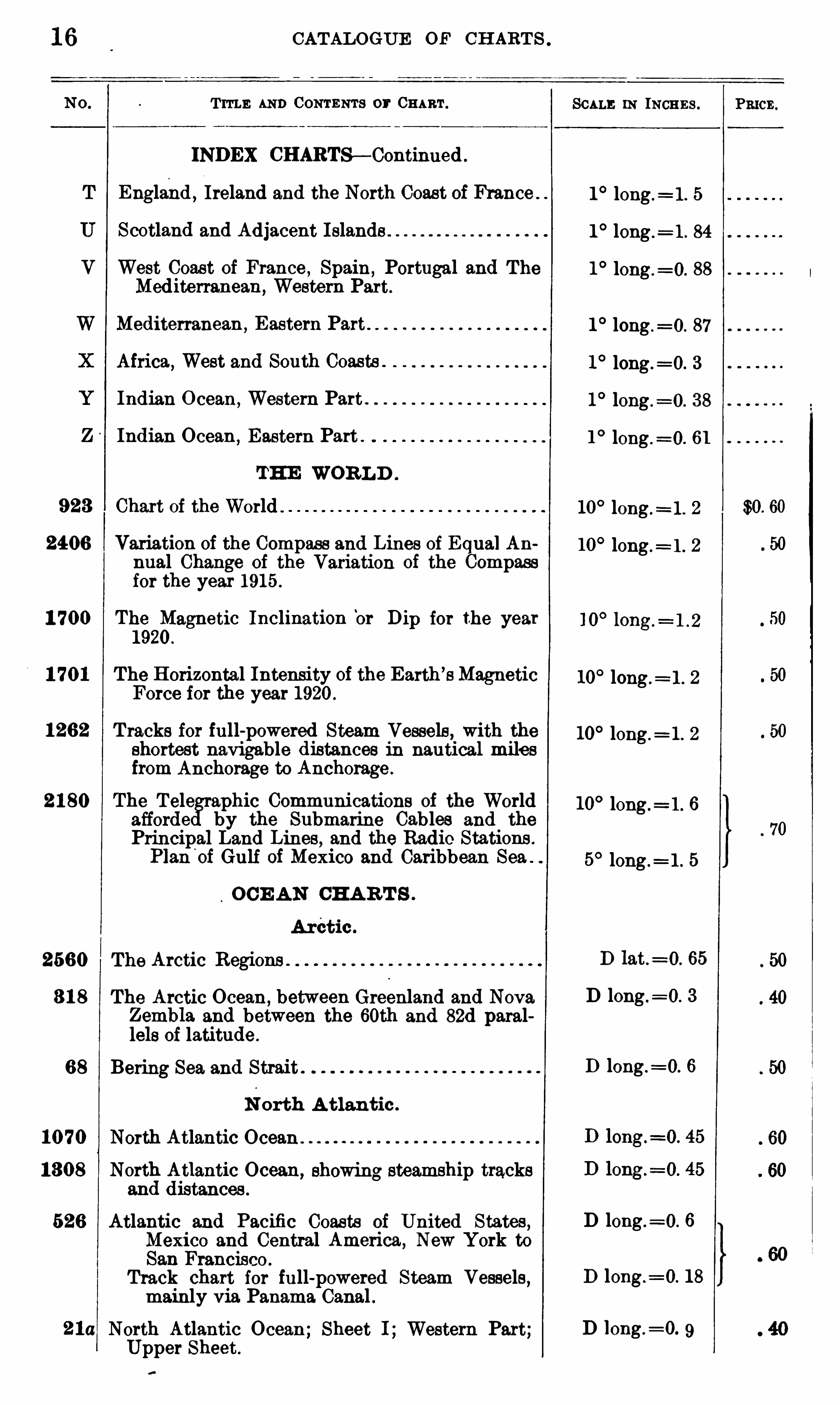
T ITLE AND CONTENTS or CHART .
INDEX CHARTS— Continued .
England ,Ireland and the North Coast of France .
Scotland and Ad jacent Islands
West Coast of France , Spain ,Portugal and The
Mediterranean, Western Part.
Mediterranean ,E astern Part
Africa , West and South Coasts .
Indian O cean ,Western Part
Indian Ocean ,Eastern Part .
THE WORLD .
923 Chart of the World .
2406 Variation of the Compass and Lines of Equal Annual Change of the Variation of the Compassfor the year 1915 .
1 700 The Magnetic Inclination‘
or D ip for the year1920 .
The Horizontal Intensity of the Earth’
sMagneticForce for the year 1920 .
1262 T racks for full-powered Steam Vessels , with theshortest navigable distances in nautical milesfrom Anchorage to Anchorage .
he T ele aphic Communications of the Worldafforde by the Submarine Cables and the
Principal Land Lines , and the Radio Stations .
Planp
'
of Gulf of Mexico and Caribbean
OCE AN CHA R T S .
Arctic .
2560 The Arctic Regions .
3 1 8 The Arctic Ocean,between Greenland and Nova
Zembla and between the 6oth and 82d parallels of latitude .
68 Bering Sea and Strait .
N orth A tlantic .
North Atlantic Ocean .
North Atlantic Ocean, showing steamship tracksand distances .
Atlantic and Pacific Coasts of United States ,Mexico and Central America, New York toSan Francisco .
Track chart for full-powered Steam Vessels,
mainly via Panama Canal .North Atlantic Ocean; Sheet I ;Western Part;Upper Sheet .
2 1 80
CATALOGUE OF CH ART S .
SCALE IN INCHES .
1° long .
= 1 . 5
1° long .
= 1 . 84
1° long .=0. 88
1 ° long .=0. 87
1° long .
=0. 3
1° long .= 0. 38
1° long .
=0. 61
10° long .= 1 . 2
10° long .
= 1 . 2
10° long .
= 1 . 2
10° long .= 1 . 2
10° long .
=1 . 6
5° long .= 1 . 5
D 1at.=0. 65
D long .= 0. 3
D long .=0. 6
D long .=0. 6
D long.= 0. 18
D long .=0. 9
Pmcn.
$0. 60

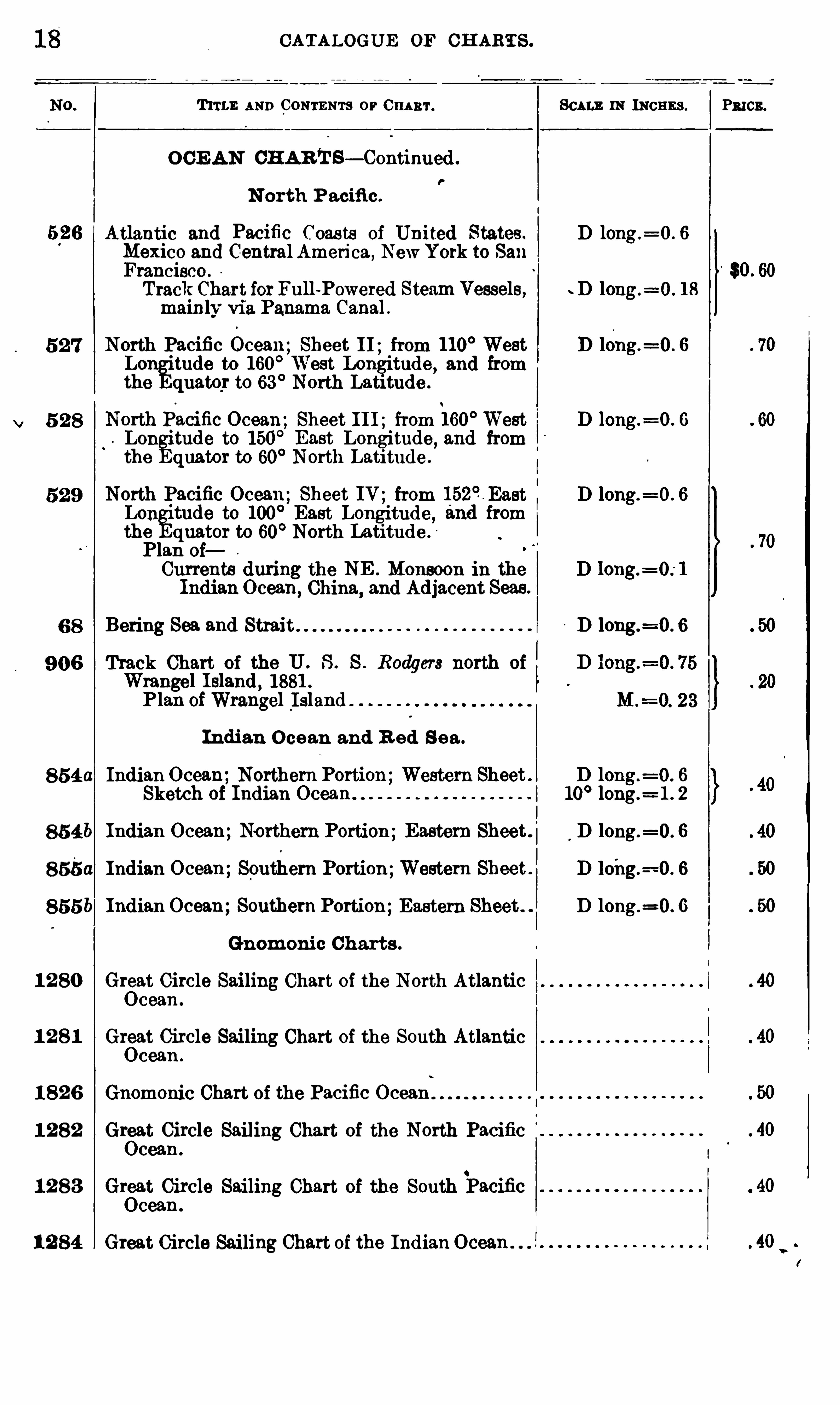
CATALOGUE OF CH ARTS .
T1T1 1: AND CONTENTS or 0 1111111 . SCALE 11: INCHES . P3 103 .
O CE AN CHARTS— Continued .
P
N orth P acifi c .
Atlantic and Pacific Coas ts of United States . D long .=0 . 6
Mexico and Central America , NewYork to SanFrancisco .
TrackChart for Full-Powered Steam Vessels, D long .=0 . 18
mainly° via Panama Canal .
North Pacific Ccean; Sheet 11; from 110° West D long .
=0 . 6
Lon
gitude to 160
° West Longitude , and fromthe quatqr to 63
°North Latitude .
NorthPacific Ocean; Sheet I I I ; from 160°West D long .=0 . 6
L0 11°
tude to 150°East Longitude, and from
the quator to 60° North Latitude .
North Pacific Ocean; Sheet IV ; from 152° East D long.=0 . 6
LOI1°
tude to 100° East Longitude , and from
the quator to 60° North Latitude .
Plan oi
Currents during the NE . Monsoon in the DIndianOcean,
China,and Adjacent Seas.
Bering Sea and Strai t D long.=0 . 6
Track Chart of the U . S . S . Rodgers north ofWrangel I sland , 1881 .
Plan ofWrangel I sland
Indian O cean and R ed S ea .
854a Indian Ocean;Northern Portion;Western Sheet . D long .=0 . 6
Sketch of Indian Ocean . 10° long.
= 1 . 2
85 46 Indian Ocean;Northern Portion;Eastern Sheet . D long .=0 . 6
855a Indian Ocean;Southern Portion;Western Sheet . D loi1g.=-0 . 6
855b Indian Ocean;Southern Portion;Eastern Sheet . . D long .=0 . 6
Gnomonic Charts .
1 2 80 Great Circle Sailing Chart of the North AtlanticOcean .
1 2 8 1 Great Circle Sailing Chart of the South AtlanticOcean .
1 8 2 6 Gnomonic Chart of the Pacific OceanI
1 2 8 2 Great Circle Sailing Chart of the North PacificOcean .
1 2 83 Great Circle Sailing Chart of the South PacificOcean .
1 2 84 Great Circle Saili11g Chart of the Indian Ocean .
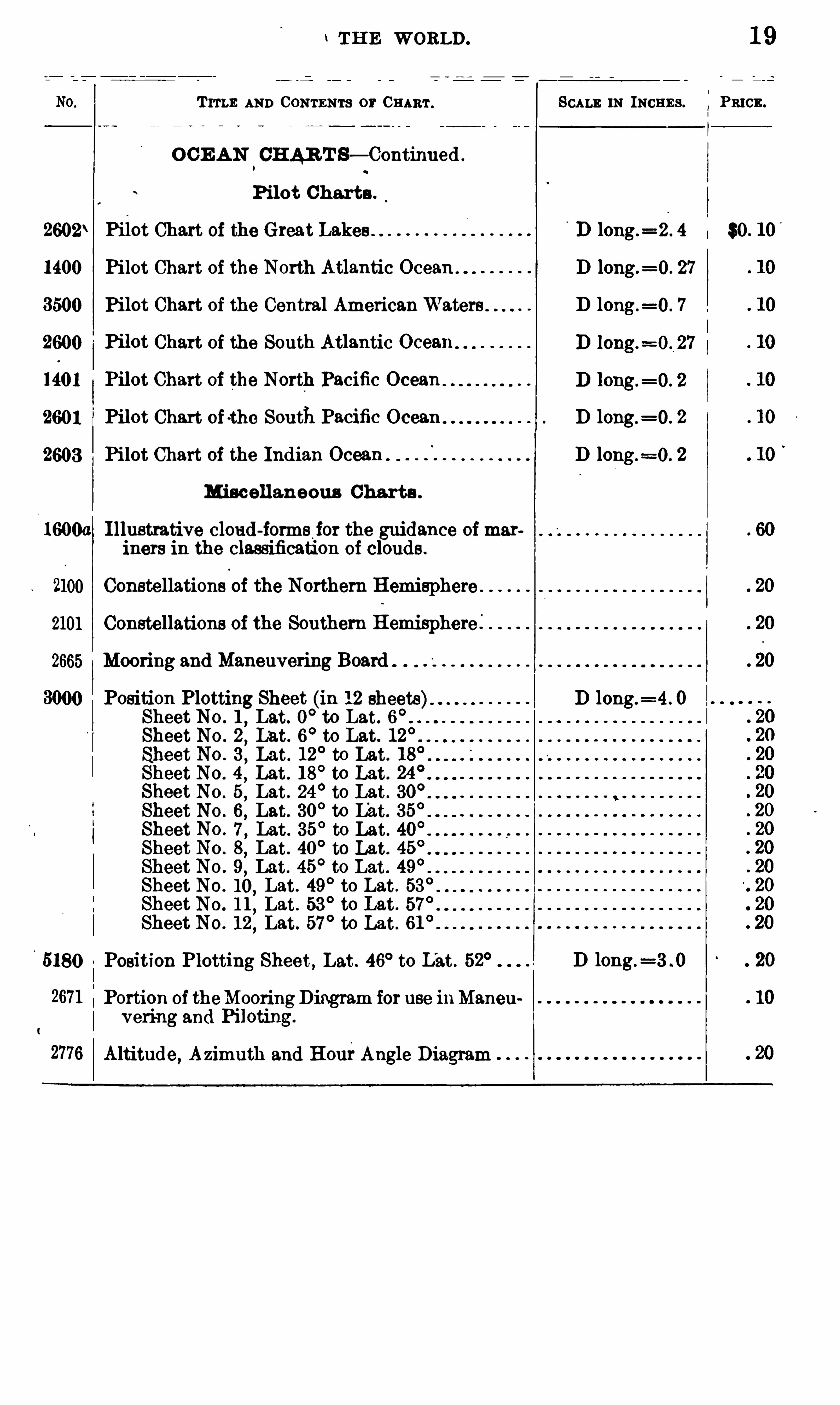
1 TH E WORLD . 1 9
T ITLE AND CONTENTS or CHART . SCALE 1N INCHES . PRICE .
O CE AN.
CHAR T S— Continued .
Pilot Charts .
2602\ Pilot Chart of the Great Lakes n long .=2 . 4 se. 10
1400 Pilot Chart of the North Atlantic Ocean . D long .=0 . 27
3500 Pilot Chart of the Central AmericanWaters D long .=0 . 7
2600 Pilot Chart of the South Atlantic Ocean
1401 Pilot Chart of the North Pacific Ocean
2601 Pilot Chart of the South Pacific Ocean D long.=0 . 2
2603 Pilot Chart of the Indian Ocean D long .=0 . 2
Mi scellaneous Charts .
1600a I llustrative cloud-iorms ior the guidance ofmariners in the classification of clouds .
2100 Constellations
i
of the Northern Hemisphere
2101 Constellations of the Southern Hemisphere l
2665 Mooring and Maneuvering Board
Position Plotting Sheet (in 12 sheets). D long.=4. 0
Sheet No . 1,Lat. 0
°to Lat . 6
°
Sheet No . 2,Lat. 6
°to Lat. 12
°
Sheet No . 3,Lat . 12
°to Lat. 18
°
Sheet No . 4 , Lat. 18°to Lat. 24
°
Sheet No . 5,Lat . 24
°to Lat. 30
°
Sheet No . 6, Lat. 30°to L
'
at. 35°
Sheet No . 7,Lat . 35
°to Lat. 40
°
Sheet No . 8,Lat . 40
°to Lat. 45
°
Sheet No . 9,Lat. 45
°to Lat . 49
°
Sheet No . 10,Lat. 49
°to Lat . 53
°
Sheet No . 1 1 , Lat . 53°to Lat . 57
Sheet NO . 12,Lat. 57
°to Lat . 61
°
5180 Position Plotting Sheet, Lat . 46° to L'
at. 52° D long .=3 . 0
2671 Portion of theMooringDiagram for use inManen
y ering and Piloting.
2776 Altitude, Azimuth and Hou1°Angle Diagram
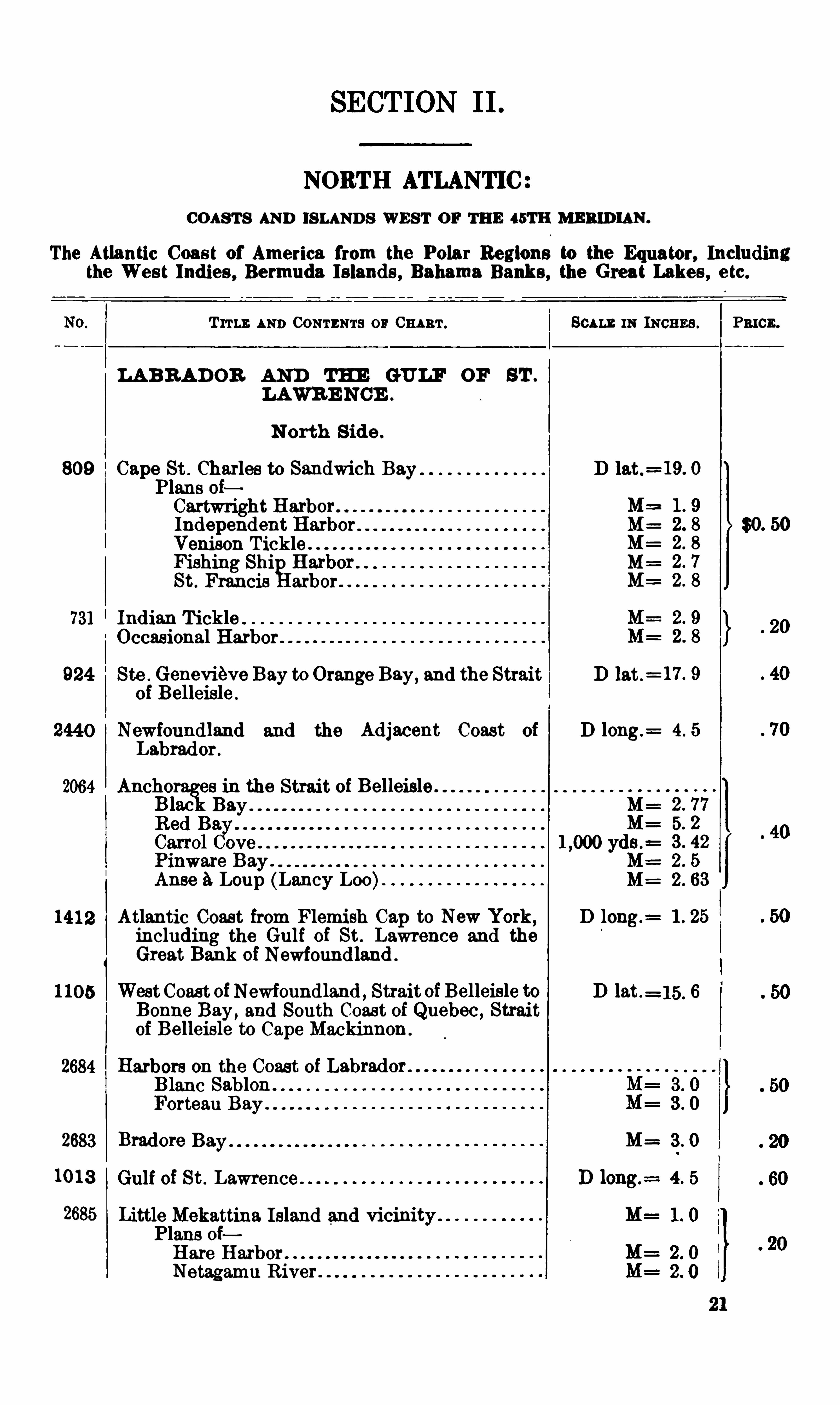
SECTION II .
NORTH ATLANTIC
CO ASTS AND ISLANDS WEST O F THE 45TH MERID IAN .
The Atlantic Coast of America from the Polar Regions to the Equator, Includingthe West Indies , Bermuda Islands , Bahama Banks , the Great Lakes , etc.
T ITLE AND CONTENTS o1r CHART . SCALE lN INCE Es . Pmcn.
LA B RAD OR AND THE GULF OF ST .
LAWRE NCE .
N orth S ide .
809 Cape St . Charles to Sandwich Bay D lat.
Plans of9
1
Independent Harbor M= 2
Venison Tickleg
.
2
Fishing Shi Harbor M=
St . Francis arbor
731 Ind ian Tickle .
Occasional Harbor .
924 Ste . Genevieve Bay to Orange Bay,and the Strait D lat .
= 17 . 9
of Belleisle .
2440 Newfoundland and the Adjacent Coast of D long .= 4 . 5
Labrador .
2064 Anchor es in the Strait of Belleisle .
Blac M= 2 . 77
5. 2
3 . 42
Pinware Bay . M: 2 . 5
Anse aLoup (Laney Loo M= 2 . 63
1412 Atlantic Coast from Flemish Cap to New York, D long .=
including the Gulf of St . Lawrence and the
Great Bank of Newfound land .
1 105 WestCoast ofNewfoundland , Strait of Belleisle to D lat .=15. 6
Bonne Bay,and South Coast of Quebec , Strait
of Belleisle to Cape Mackinnon .
2684 Harbors on the Coast ofBlane Sablon .
Forteau Bay .
2683 Bradore M= 3 . 0
10 13 Gulf of St .
2685 Little Mekattina Island and vicinityPlans ofHare HarborNetagamu River .
22
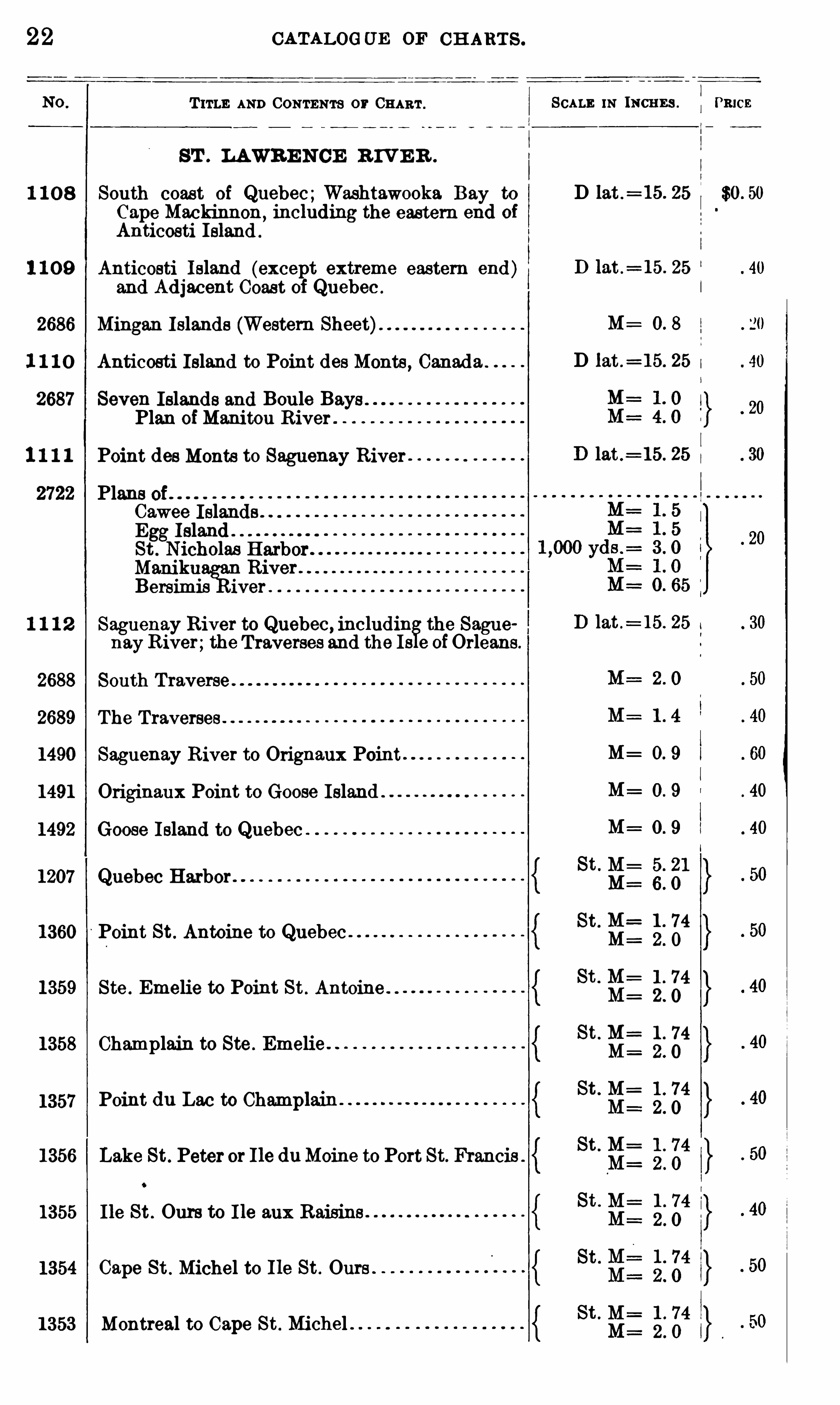
T ITLE AND CONTENTS or CHART .
ST . LAWRE N CE R IV E R .
1 1 0 8 South coast of Quebec;Washtawooka Bay to
Cape Mackinnon, including the eastern end of
Anticosti Ieland .
1 1 0 9 Anticosti Island (except extreme eastern end)and Adjacent Coast of Quebec .
2686 Mingan Islands (Western Sheet).
1 1 1 0 Anticosti Island to Point des Monte, Canad a
2687 Seven Islands and Boule Bays .
Plan ofManitou River
1 1 1 1 Point des Monte to Saguenay River
2722 Plans 0 fCawee Islands .
Egg IslandSt . Nicholas HarborMam
'ku River
Bersimis iver
1 1 1 2 Saguenay River to Quebec, includin the Sague
nayRiver;the Traverses and the Is 9 ofOrleans .
2688 South Traverse
2689 The Traverses
1490 Saguenay River to Orignaux Point
1491 Originaux Point to Goose Island .
1492 Goose Island to Quebec
1207 Quebec Harbor
1360 Point St . Antoine to Quebec
1359 Ste . Emelie to Point St . Antoine . .
1358 Champlain to Ste . Emelie
1357
1356 Lake St. Peter or I le duMoine to Port St. Francis .
1355 I le St . Ours to I le aux Raisins
1354 Cape St . Michel to I le St. Ours
1353 Montreal to Cape St . Michel .
CATALOGUE OF CH ART S .
Point du Lac to Champlam
SCALE 1N INCHE S .
D lat .= 15 . 25
D lat .= 15 . 25
M_
D lat .= 15. 25
D lat .= 15. 25
D lat .= 15. 25
M=
M=
M=
St . M= 5. 21
M=
St.
St . M= 1 . 74
St. 1 . 74
St . M= 1 . 74
St . 1 . 74
M=
St . M= 1 . 74
St . M= 4
O
q
PRICE
$0 . 50
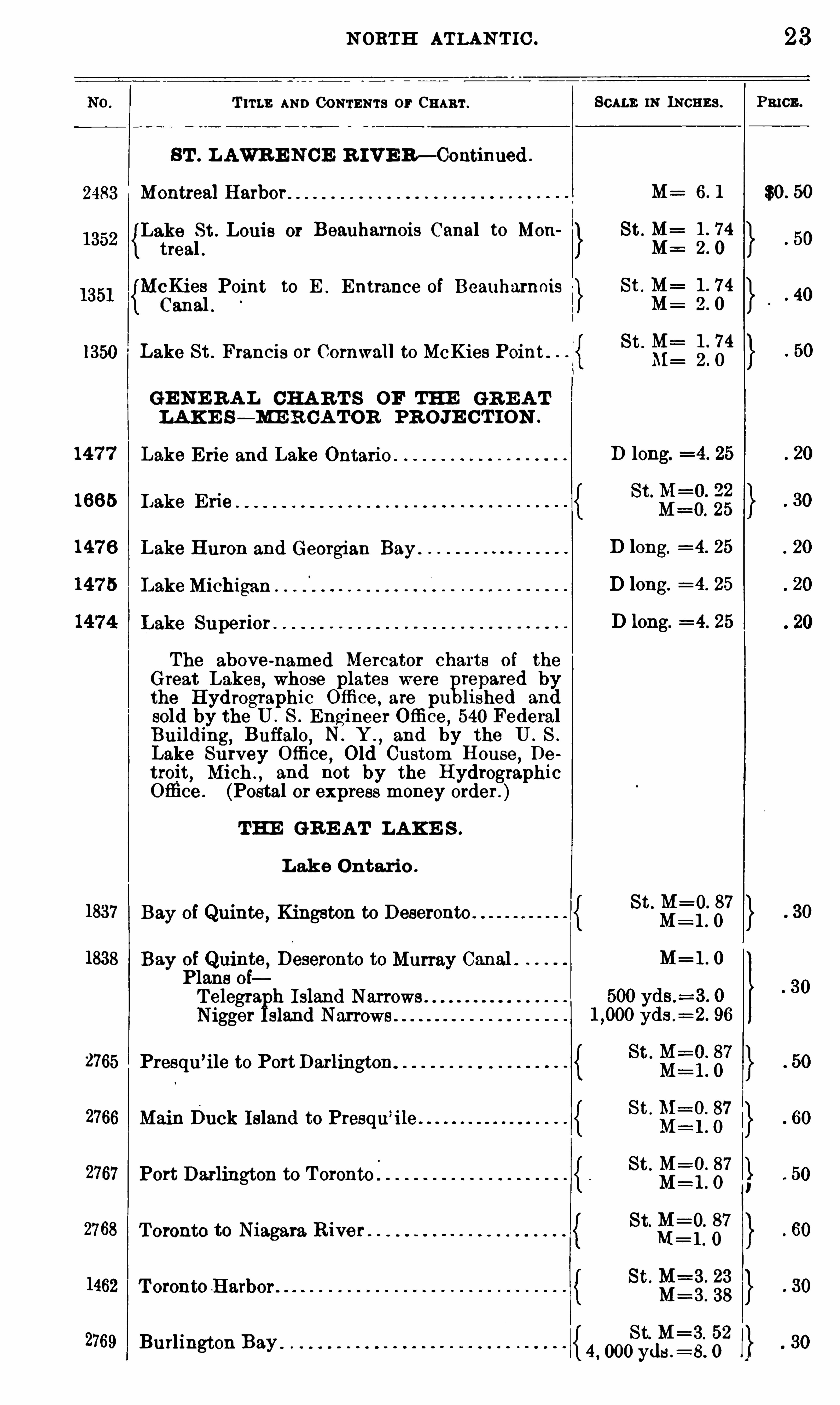
2483 Montreal Harbor
1350 Lake St . Francis or Cornwall to McKies Point .
147 7
1665
147 6
147 5
1837
1838
2765 Presqu ’ile to PortDarlington
2766 Main Duck Island to Presqu’ile
2767 Port Darlington to Toronto
2768
1462 T oronto Harbor .
2769 Burlington Bay
N ORTH ATLAN T IC .
T rrLE AND CONTENTS 0 1° CHART .
8 T . L AWR E N CE R IVE R — Continued .
Lake St . Louis 0 1° Beauharnois Canal to Mon
treal .
McKies Point to E . Entrance of Beauharnois
Canal .
GE NE R A L CHA R T S OF THE GR E A T
LAK E S — ME R CA TOR PR OJE C T ION .
Lake E rie and Lake Ontario
IJake Erie
Lake Huron and Georgian Bay
Lake Michigan
Lake Superior .
The above-named Mercator charts of the
Great Lakes, whose plates were repared bythe Hydrographic Office , are pu lished and
sold by the U . S . Engineer Othee ,540 Federal
Building, Buffalo, N . Y .
, and by the U . S .
Lake Survey O ffice , Old Custom House,De
troit,Mich .
, and not by the HydrographicOtfice . (Postal or express money order. )
Bay of Quinte, Kingston to Deseronto
Bay of Quinte , Deseronto to Murray Canal .Plans ofTelegra h I slandNigger sland Narrows
Toronto to Niagara River
L ake Ontario .
THE GR E AT LAK E S .
SCALE IN INCHES .
D long.=4. 25
D long.=4. 25
D long.=4. 25
23
PRICE .
$0 . 50
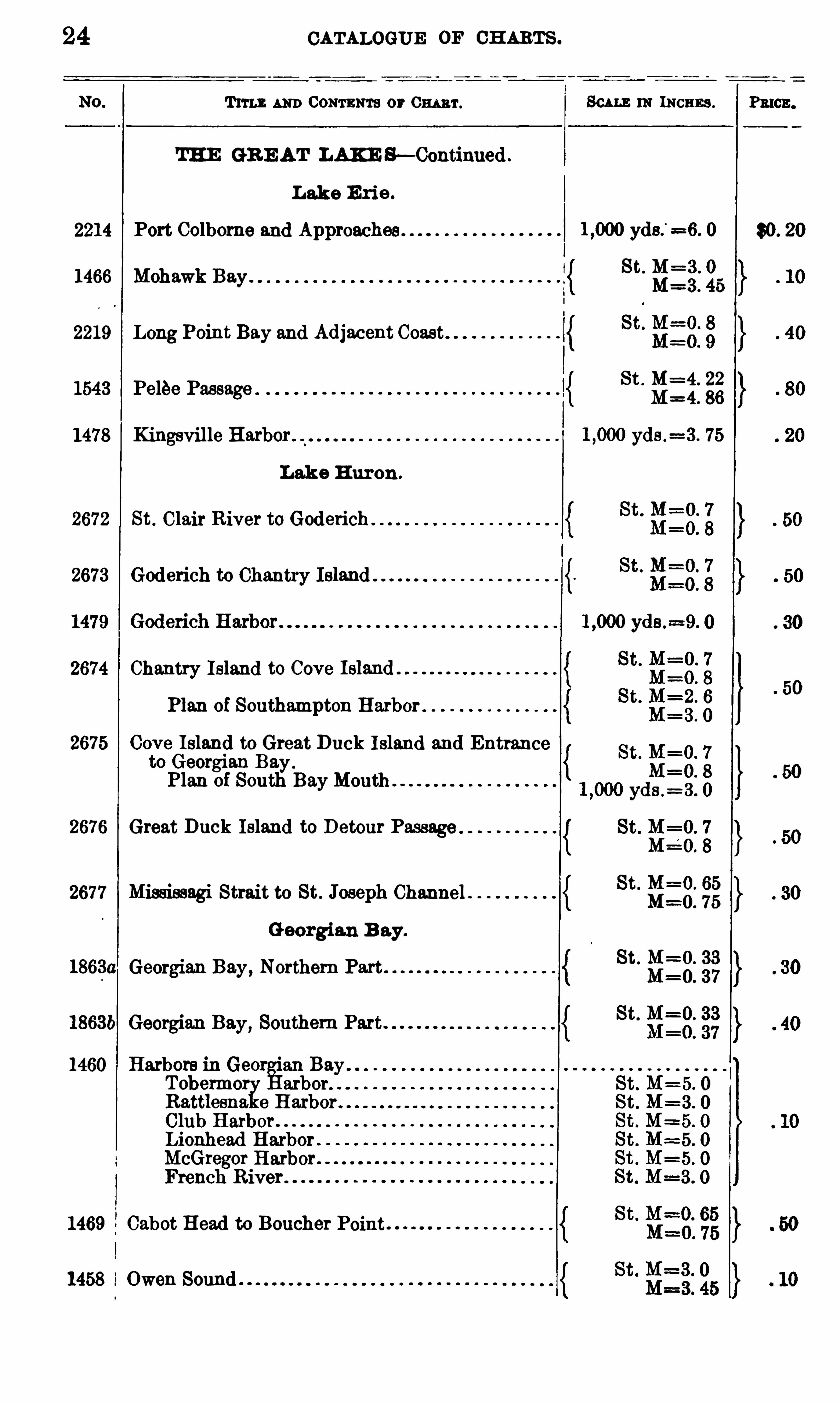
24 CATALOGUE 0 1°CH ARTS .
Tum AND CONTENTS or 0 1111111 .
THE GR E AT LAKE S—Continued .
Lake E rie .
2214 Port Colborne and Approaches
1466 Mohawk Bay.
2219 Long Point Bay and Adjacent Coast
1543 Pelee Passage
1478 Kingsville Harbor
Lake H uron .
2672 St . Clair River to Goderich
2673 Goderich to Chantry
2674 Chantry Island to Cove
Plan of Southampton Harbor
2675 Cove Island to Great Duck Island and Entranceto Georgian Bay.
Plan of South BayMonth
2676 Great Duck Island to Detour Passage
2677 Mississagi Strait to St. Joseph Channel
Georgian B ay.
1863a Georgian Bay, Northern
18636 Georgian Bay, Southern Part
1460 Harbors in Geer °
an BayTobermor arbor.
Rattlesna e Harbor .
Club HarborLionhead Harbor .
McGregor HarborFrench River .
1469 Cabot Head to Boucher Point
1458 i Owen Sound . .
SCALE 111 means .
yds.
’ =6. 0
St. M=3 . 0
M=3 . 45
St . M=4. 22
M=4. 86
yds .=3 . 75

26 CATALOGUE 0 1°CH ARTS .
T ITLE AND CONTENTS or CHART . SCALE IN INCHES . PRICE .
NEWFOUND LAND
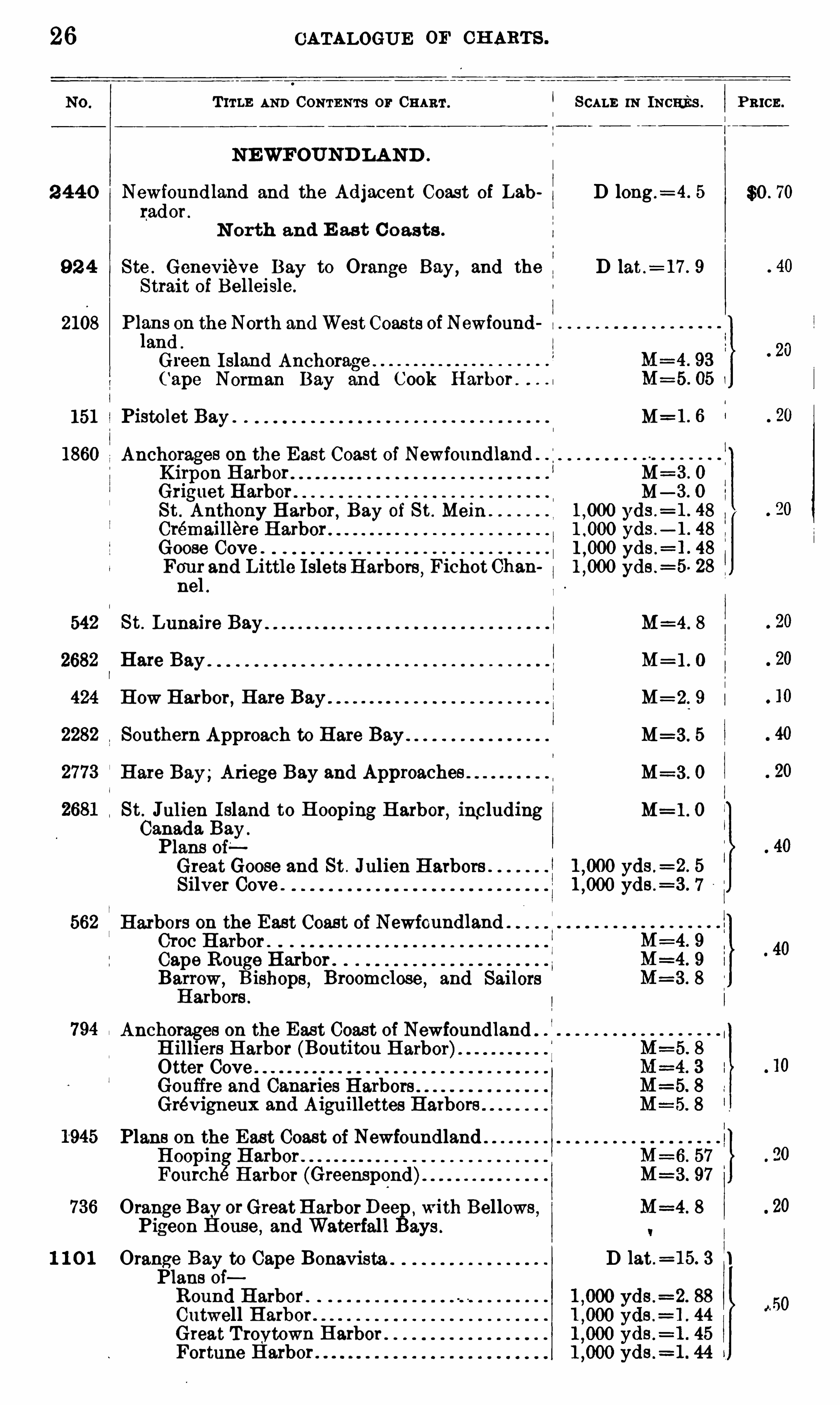
2 440 Newfoundland and the Adjacent Coast of Lab D long .= 4 . 5 $0 . 70
rador .
N orth and E as t C oasts .
92 4 Ste . Genevieve Bay to Orange Bay,and the D lat .
= 17 . 9
Strait of Belleisle .
2108 Pl
l
ans on the North andWest Coasts ofNewfound n
and .
Green Island Anchorage .
Cape Norman Bay and Cook Harbor .
151 Pistolet Bay . . M II
1860 Anchorages on the East Coast of NewfoundlandKirpon Harbor MGriguet Harbor MSt . Anthony Harbor, Bay of St . Mein yds . 8
Crémaillere H arbor yds . 8
Goose Cove . yds . 48
Four and Little Islets Harbors,Fichot Chan yds .
— 5. 28
nel .
542 St . Lunaire Bay M=4 . 8
Hate Bay M= 1 . 0
H ow Harbor, Hare Bay M= 2. 9
Southern Approach to Hare Bay M=3 . 5
III
I
IIM
r
r
ww
A
&
O
O
Hare Bay;Ariege Bay and Approaches M=3 . 0
St. Julien Island to H ooping H arbor,including M= 1 . 0
Canada Bay .
Plans oiGreat Goose and St . Julien Harbors yds .
=2 . 5
Silver Cove . yds .=3 . 7
562 Harbors on the East Coast of NewfcundlandCroc H arbor .
Cape Rouge Harbor .
Barrow,B ishops
,Broomclose
,and Sailors
Harbors .
Anchorages on the East Coast of NewfoundlandH ilhers Harbor (Boutitou HarborOtter CoveGouffre and Canaries H arbors .
Grévigneux and Aiguillettes Harbors .
Plans on the East Coast of NewfoundlandH oopin H arborFoutch Harbor (Greenspond)
Orange Bay orGreatH arbor Deep,with Bellows ,
Pigeon H ouse ,and Waterfall Bays .
1 1 0 1 Orange Bay to Cape Bonavista D lat .= 15. 3 1
Plans ofRound H arbor .
Outwell H arbor .
Great Troytown HarborFortune Harbor .
N ORTH ATLAN T IC .
T1°1°LE AND CONTENTS or Om ar .
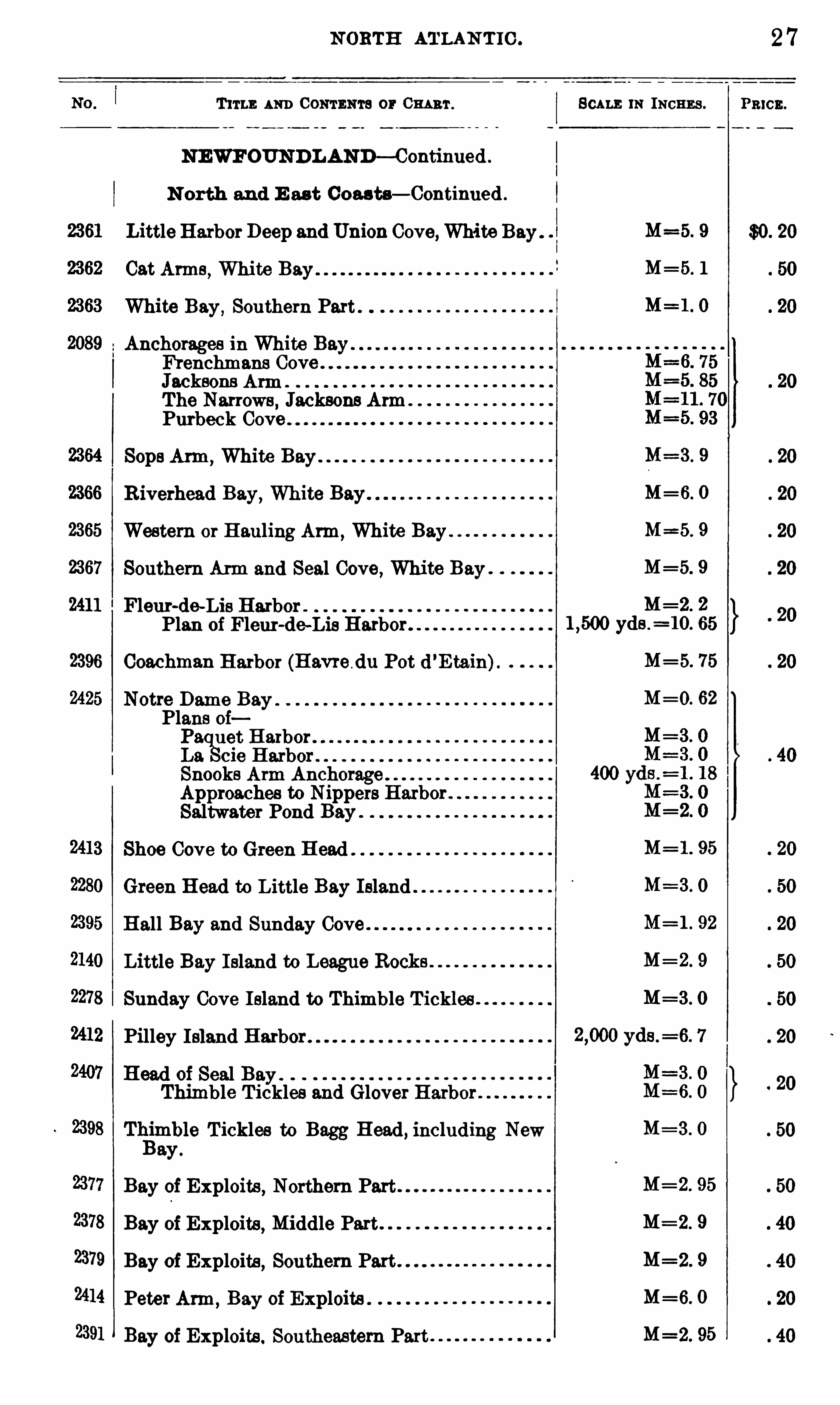
NEWFOUNDLAND—C ontinued .
N orth and E ast Coasts— Continued .
Little HarborDeep and Union Cove,White Bay .
Cat Arms , White Bay . .
White Bay,Southern Part .
Anchorages in White Bay .
H enchmans CoveJacksons ArmThe Narrows , Jacksons ArmPurbeck Cove
Sops Arm,White Bay
R iverhead Bay,White Bay
Western or Hauling Arm ,White Bay .
Southern Arm and Seal Cove , White Bay
Fleur-de-Lis HarborPlan of Fleur-de—Lis Harbor.
Coachman Harbor (Havre du Pot d ’E tain).
Notre Dame Bay .
Plans ofPa uet HarborLa cie Harbor .
Snooks Arm AnchorageApproaches to Nippers HarborSaltwater Pond Bay
Shoe Cove to Green H ead .
Green Head to Little Bay Island
Hall Bay and Sunday Cove
Little Bay Island to League Rocks .
Sunday Cove Island to Thimble T ickles
Pilley Island Harbor
Head of Seal Bay .
Thimble T ickles and Glover Harbor
T lgmble T ickles to Bagg Head, including Neway .
Bay of Exploits , Northern Part
Bay of Exploits , Middle Part
Bay of Exploits , Southern Part
Peter Arm ,Bay of Exploits .
Bay of Exploits . Southeastern Part
SCALE 11: INCHES .
M=3 . 9
M=6. O
M=5. 9
M=5. 9
M=2. 2
yds .= 10. 65
M=5. 75
M=O. 62
M= 1 . 95
M= 1 . 92
M=2 . 95
M=2. 9
M=2 . 9
M=6. 0
M=2. 95
2 7
PRICE .
28 CATALOGUE OF CHARTS .
T 11°LE AND CONTENTS or Om ar . SCALE 1N INCHES .
N EWFO'
UNB LAND—Continued .
N orth and E ast Coas ts— Contmued .
M=6. 0
=2 . 9
M=4. 0
Lewisport Harbor, Bay of Exploits
Bay of Exploits,Northeastern Part
Twillingate (Toulinguet)Harbors
Harbors on the East Coast of NewfoundlandChange Island Tickles .
Hare Bay,Fogo Island .
Fogo Harbor .
Seldom-come-by and Stag Harbor Tickle .
E ast C oast .
580 Approaches to Pools Harbor and Greenspond .
562
1 1 0 2
9 8 0
1 1 3 8
583
2368
2369
584
585
2139
1114
2054
Catalina Harbor
Harbors on the East Coast of Newfoundland01 0 0 HarborCape Rou e Harbor .
Barrow,ishops, Broomclose , and Sailors
SoutheastCoast ofNewfoundland . fromBonavista D lat .= 14. 7
Bay to Placentia Bay , including Bonavista .
Trinity, and Conception Bays, and the Avalon
Peninsula .
Great Banks ofNewfoundland ,with Adjacent
Coast from Cape Bonavista to Cape St . Mary .
The Flemish Cap (sup lemont to 980 , continuation to the Eastwardg
)
Trinity Harbor and Bays to English HeadRound HarborDeer and St . Jones Harben
Smith and Random Sounds , Eastern Part
Smith and Random Sounds, Western Part
Harbcm in Trinity BayBull Arm, including Tickle Bay .
Hearts Content and New PerlicanOld Perlican
Carbonear to B Bay,including Harbor
Grace , Spaniard ay, Roberts Bay and Harbor,and Bay de Grave .
Motion Head to Flat Rock Point, with the Appreaches to St . Johns Harbor .
St . Johns Harbor
BayCape
yds .=11 . 8
Pawn .
1 10 3
2408
N ORTH ATLAN TIC .
T ITLE AND CONTENTS or CHART .
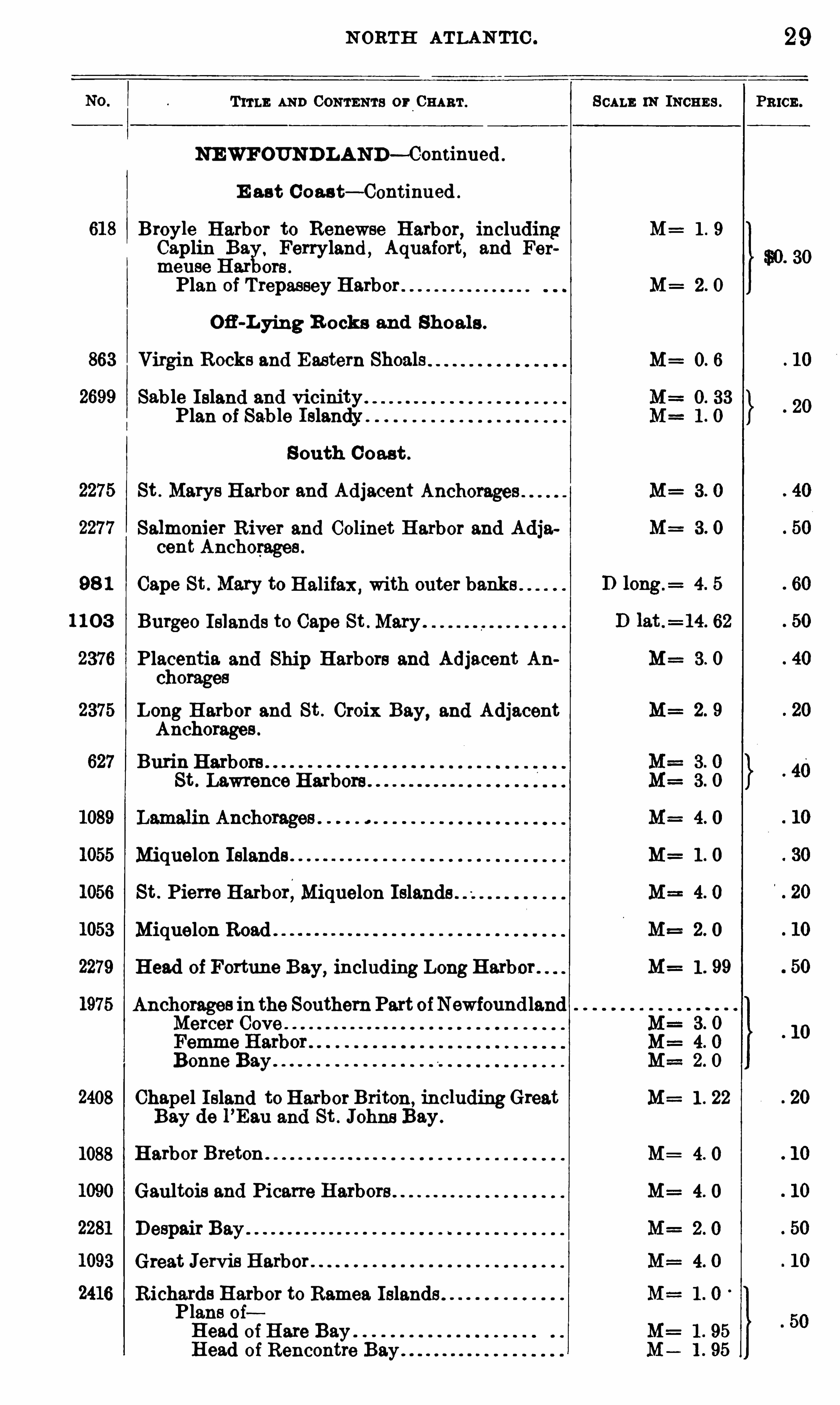
NEWFOUNDLAND— C-ontinued .
E ast C oas t— Continued .
Broyle Harbor to Renewse Harbor,including
Caplin Ba . Ferryland ,Aquafort, and Fer
meuse Har ors .
Plan of Trepassey Harbor
Ofi -Lying R ocks and Shoals .
Virgin Rocks and Eastern Shoals
Sab le Island and vicinityPlan of Sable Islandy
S outh C oast .
St . Marys Harbor and Adjacent Anchorages
Salmonier River and Colinet Harbor and Adjacent Anchorages .
Cape St . Mary to Halifax ,with outer banks
Burgeo I slands to Cape St . Mary
Placentia and Ship Harbors and Adjacent Anchorages
Long Harbor and St . Croix Bay, and AdjacentAnchorages .
Burin Harbors .
St . Lawrence Harbors .
Miquelon Islands .
St . Pierre Harbor,Miquelon Islands
Miquelon Road
Head of Fortune Bay, including Long Harbor .
Anchorages in the SouthernPart ofNewfoundlandMercer Cove
Bonne Bay
Chapel Island to Harbor Briton, includingGreatBay de l
’Eau and St . Johne Bay .
1088 Harbor Breton .
Gaultois and Picarte Harbors
Despair BayGreat Jervis Harbor
Richards Harbor to Ramea Islands .
Plans 0 1Head of Hate BayHead of Rencontre Bay
SCALE 1N INCHES .
1 . 99
1 . 22
29
PRICE .
30
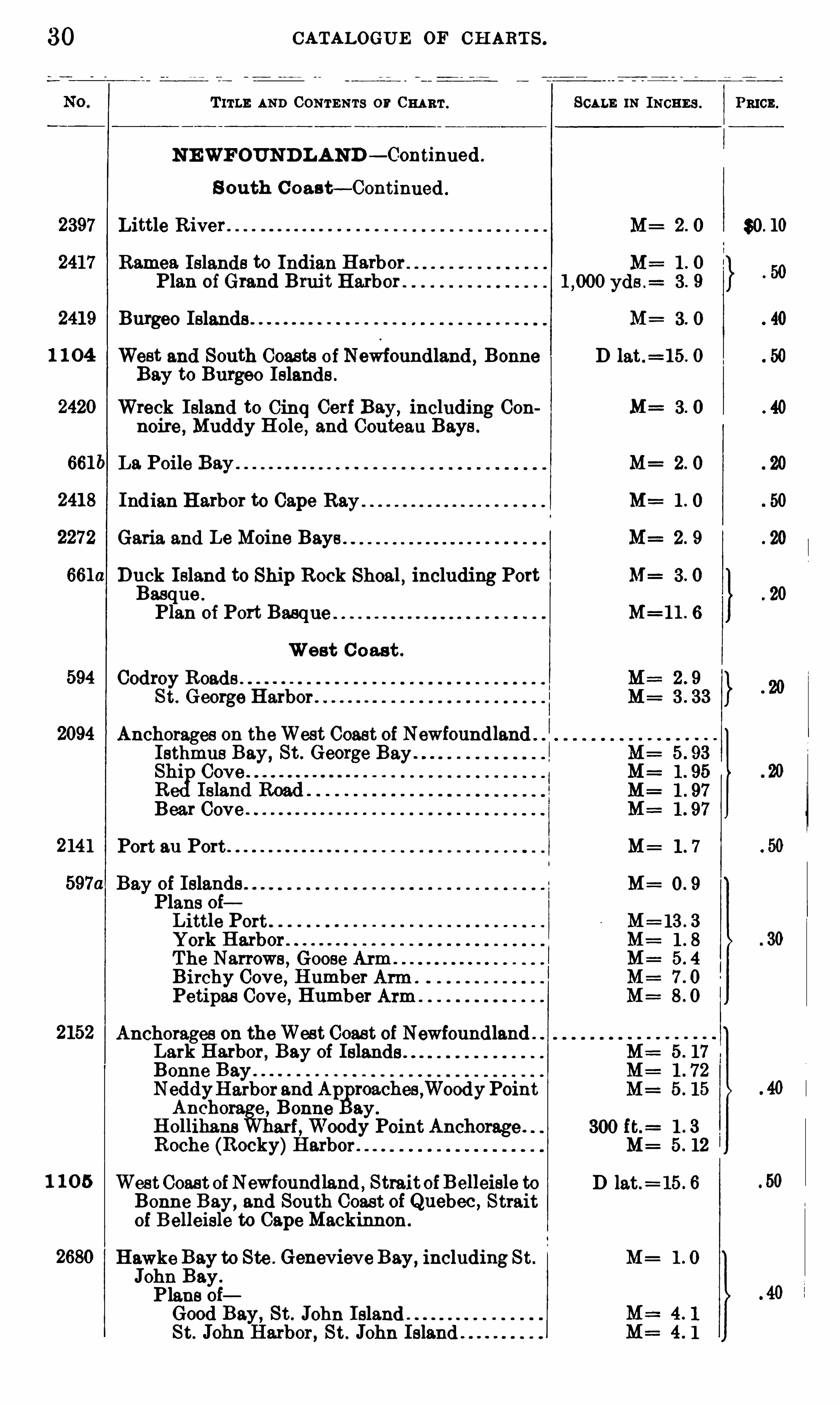
2397
1 1 04
661b
2418
2272
6610
594
2094
2141
2152
1 1 0 5
2680
CATALOGUE OF CH ART S .
T ITLE AND CONTENTS 0 11° CHART .
NEWFOUND L AND — C-oh tinned .
S outh C oast— Continued .
M=
M=
yds .=
Little R iver
Ramea Islands to Indian Harbor .
Plan of Grand Bruit Harbor .
Burgeo Islands M :
West and South Coasts of Newfoundland ,Bonne
Bay to Burgeo Islands .
Wreck Island to Cinq Cerf Bay, including Con M=noire, Muddy Hole
,and Couteau Bays .
La Poile Bay M=
Indian Harbor to Cape Ray M=
Garia and Le Moine Bays . M
Duck Island to Ship Rock Shoal,including Port
Basque .
Plan of Port Basque .
West C oast .
Codroy Roads .
St. George Harbor .
Anchorages on theWest Coast of NewfoundlandIsthmus Bay, St . George Bay
Bear Cove
Port eu Port M=
Bay of IslandsPlans ofLittle PortYork HarborThe Narrows , Goose ArmBirchy Cove , Humber ArmPetipas Cove , Humber Arm .
Anchorages on theWest Coast of Newfoundland .
Lark Harbor, Bay of
Bonne BayNeddyHarbor and Ap roaches ,WoodyPointAnchora e , Bonne ay .
H ollihans arf,Woody Point Anchorage .
Roche (Rocky)Harbor
WestCoast ofNewfoundland , StraitofBelleisle toBonne Bay, and South Coas t of Quebec , Straitof B elleisle to Cape Mackinnon .
300 ft.=
Hawks Bay to Ste . Genevieve Bay, including St . M=
John Bay.
Plans ofGood Bay, St . John IslandSt. John Harbor, St . John Island
SCALE 1N INCHES .
D lat .=15 . 0
M=
M=
D lat.= 15 . 6
PRICE .
$0. 10
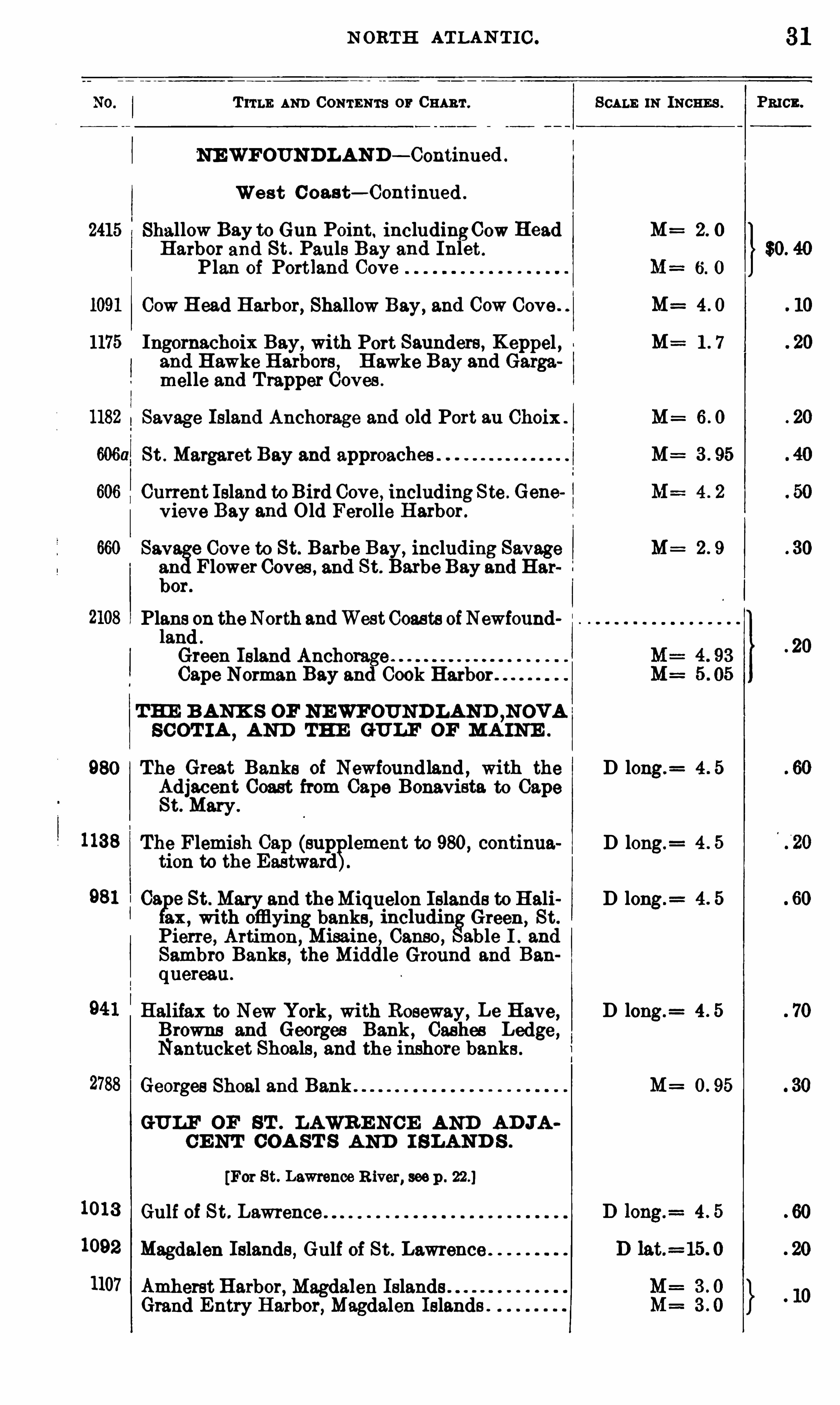
N ORTH ATLAN T IC .
T ITLE AND CONTENTS or CHART .
NEWFOUNDLAN D — Continued .
Wes t C oast— Continued .
2415 Shallow Bay to Gun Point. includingCow HeadHarbor and St . Pauls Bay and Inlet .
Plan of Portland Cove
Cow H ead Harbor, Shallow Bay, and Cow Cove .
Ingornachoix Bay, with Port Saunders, K eppel ,and Hawke Harbors , Hawke Bay and Gargamelle and T rapper Coves .
Savage Island Anchorage and old Port au Choix .
St . Margaret Bay and approaches .
Current I sland to Bird Cove , including Ste . Genevieve Bay and Old Ferolle Harbor.
660 Sav e Cove to St. Barbe Bay, including Savagean Flower Coves , and St. Barbe Bay and Harbor.
Plans on theNorth andWestCoasts ofNewfoundlandGreen Island AnchorageCape Norman Bay and Cook Harbor
THE B ANK S OF NEWFOUNDLAND ,N OVA
SC OT IA,AND THE GULF OF MA INE .
980 The Great Banks of Newfoundland , with theAdjacent Coast from Cape Bonavista to CapeSt. Mary .
tion to the Eastward1138 The Flemish Cap (sup
plement to 980, continua
Ca 0 St. Mary and theMiquelon Islands to Haliax , with offlying banks , includin Green,
St.
Pierre , Artimon,Misaine, Canso, able I . and
Sambro Banks , the Middle Ground and Ban
quereau.
Halifax to New York, with Roseway , Le Have,Browns and Georges Bank, Cashes Ledge,Nantucket Shoals , and the inshore banks .
Georges Shoal and Bank .
GULF OF ST . LAWR E NCE AND AD JACE NT COA ST S AND I SLAND S .
[For St. Lawrence R iver, seep .
1013 Gulf of St. Lawrence
1092 Magdalen Islands , Gulf of St . Lawrence
1107 Amherst Harbor, Magdalen IslandsGrand Entry Harbor, Magdalen Islands
SCALE 1N INCHES .
M= 2 0
M= 4 0
M= 1 7
M= 6 0
M=
M=
D long.=
D long.=
D long.=
D long.=
M=
31
CATALOGUE OF CH ARTS .
T ITLE AND CONTENTS or CHART .
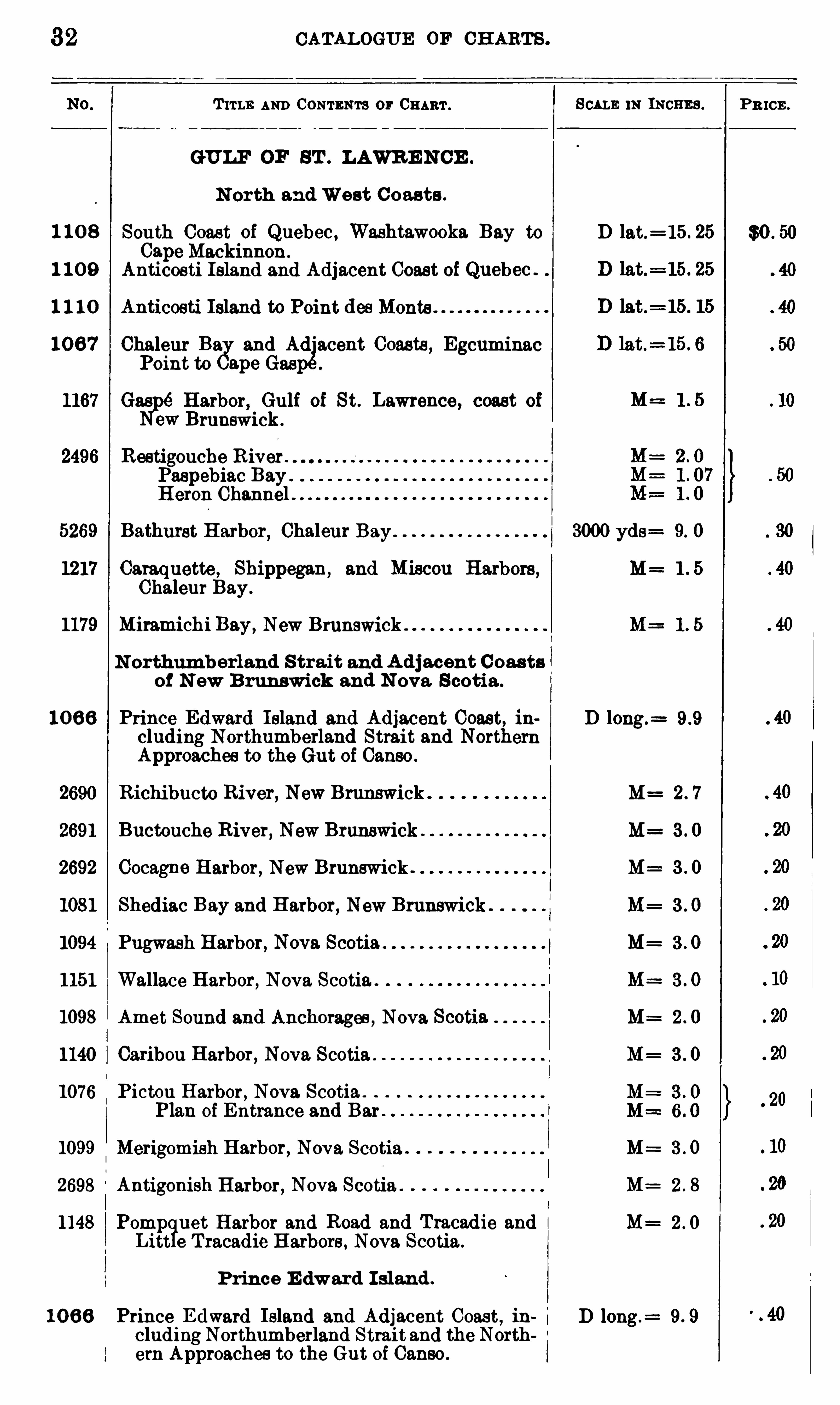
GULF OF ST . LAWR E N CE .
N orth and West C oasts .
SCALE 1N INCHEs . P R ICE .
$0 . 501 10 8 South Coast of Quebec , Washtawooka Bay to D lat.= 15 . 25
CapeMackinnon .
1 10 9 Anticosti Island and Adjacent Coast of Quebec .
1 1 1 0 Anticosti Island to Point des Monte.
10 6 7 Chaleur Bag
and Adjacent Coasts , Egcuminac
Point to ape Gasp
1167 Gas Harbor, Gulf of St. Lawrence, coast of
ew Brunswick .
2496 Restigouche R iver .
Paspebiac Bay .
H eron Channel .
5269 Bathurst Harbor, Chaleur Bay 3000 yds= 9. O
1217 Caraquette, Shippegan,and Miscon Harbors , M= 1 . 5
Chaleur Bay.
1179 Miramichi Bay, New Brunswick . M= 1 . 5
N orthumberland S trait and A d jacent C oas tsof N ew B runswick and N ova Scotia .
10 66 Prince Edward Island and Adjacent Coast, in D long.=
eluding Northumberland Strait and NorthernApproaches to the Gut of Canso .
2690 Richibucto River, New Brunswick M= 2 . 7
2691 Buctouche River, New Brunswick . M= 3 . O
2692 Cocagne Harbor, New Brunswick . M= 3 . 0
1081 Shediac Bay and Harbor, New Brunswick . M= 3 . O
1094 Pugwash Harbor, Nova Scotia M: 3 . 0
1151 Wallace Harbor, Nova Scotia . M= 3 . 0
1098 Amet Sound and Anchorages , Nova Scotia M= 2 . O
1140 Caribou Harbor, Nova Scotia . M= 3 . 0
1076 Pictou Harbor, Nova Scotia .
Plan of Entrance and Bar
1099 Merigomish Harbor, Nova Scotia M= 3 . 0
2698 Antigonish Harbor, Nova Scotia . M= 2 . 8
1148 Pomp uet Harbor and Road and Tracadie and M=Litt e T racadie Harbors , Nova Scotia.
Prince E dward I sland .
10 66 Prince E dward Island and Adjacent Coas t, in i D long .=
eludingNorthumberland Strait and the Northern Approaches to the Gut oi Canso .

CATALOGUE OF CH ARTS .
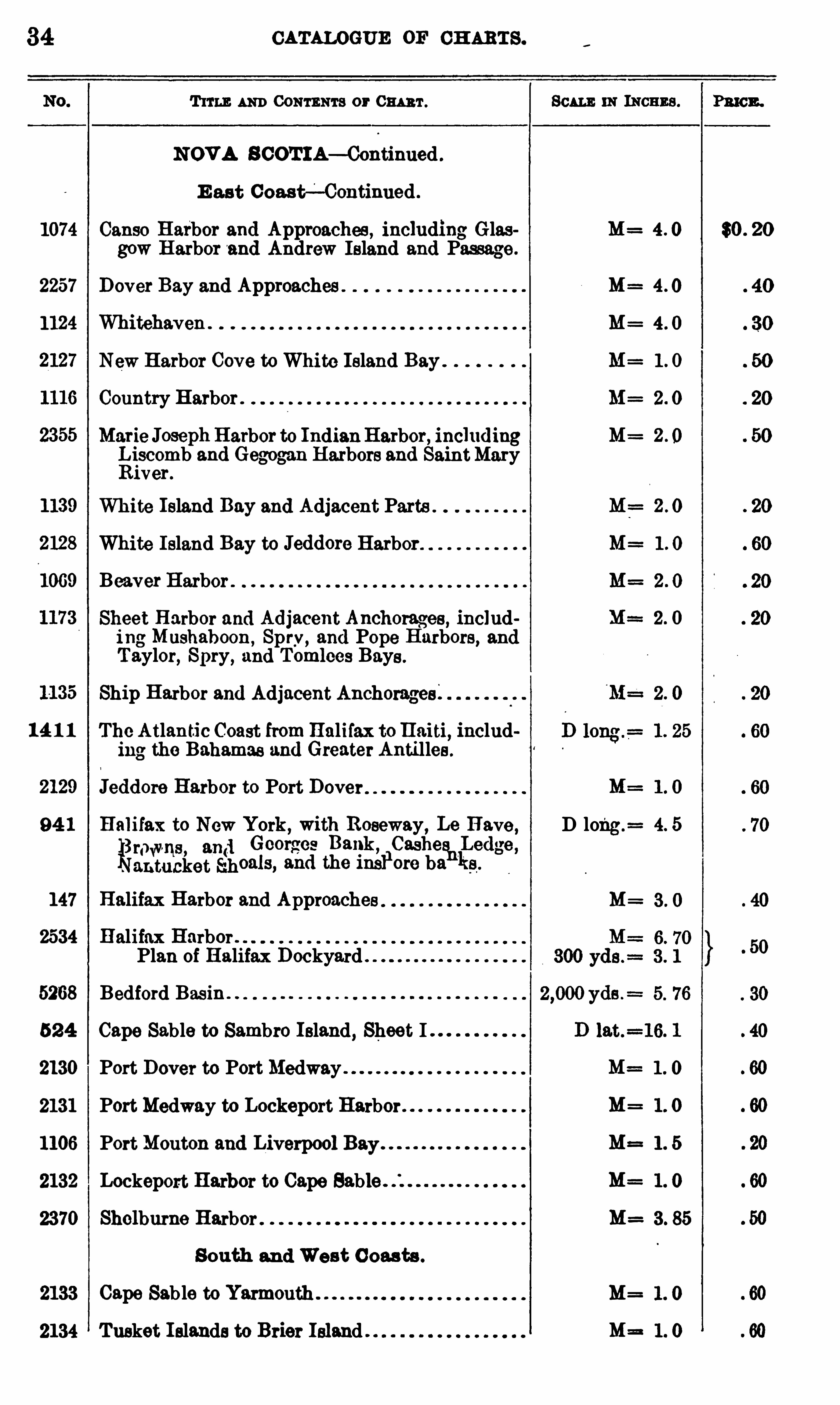
T ums AND CONTENTS 0 1° CHART .
NOVA S COT IA— Continued .
E as t Coast— Continued .
1074 Canso Harbor and Approaches , including Glasgow Harbor and Andrew Island and Passage .
2257 Dover Bay and Approaches
1124 Whitehaven .
New Harbor Cove to White Island Bay
Country Harbor .
Marie JosephHarbor to IndianHarbor, includingLiscomb and Gegogan Harbors and SaintMaryRiver .
White Island Bay and Adjacent Parts
White Island Bay to Jeddore Harbor
1069 Beaver Harbor .
Sheet Harbor and Adjacent Anchorages , including Mushaboon, Spry, and Pope Harbors, andTaylor
, Spry, and Tomlces Bays .
Ship Harbor and Adjacent Anchorages;
14 1 1 The Atlantic Coast fromHalifax toHaiti,includ
ing the Bahamas and Greater Antilles .
Jeddore Harbor to Port Dover
94 1 Halifax to New York,with Roseway, Le Have ,
1
1
322132136203 $221
5113569
51 13“
147 Halifax Harbor and Approaches
2534 Halifax Harbor .
Plan of Halifax Dockyard
5268 Bedford Basin
52 4 Cape Sable to Sambro Island, Sheet I
2130 Port Dover to PortMedway
2131 PortMedway to Lockeport Harbor .
1106 PortMouton and Liverpool Bay
2132 Lockeport Harbor to Cape Sable .
2370 Shelburne Harbor
South and Wes t C oasts .
2133 Cape Sab le to
2134 Tusket I slands to Brier Island .
SCALE 1N IncE Es .
M=
M=
M=
M=
M=
M=
M=
M=
2 0
D long.= 4 5
M=
M==
M=
M=
M=
M=
M=
P3 10 3 .
$0 . 20
NORTH ATLAN TIC .
Tau m Com m or em f .
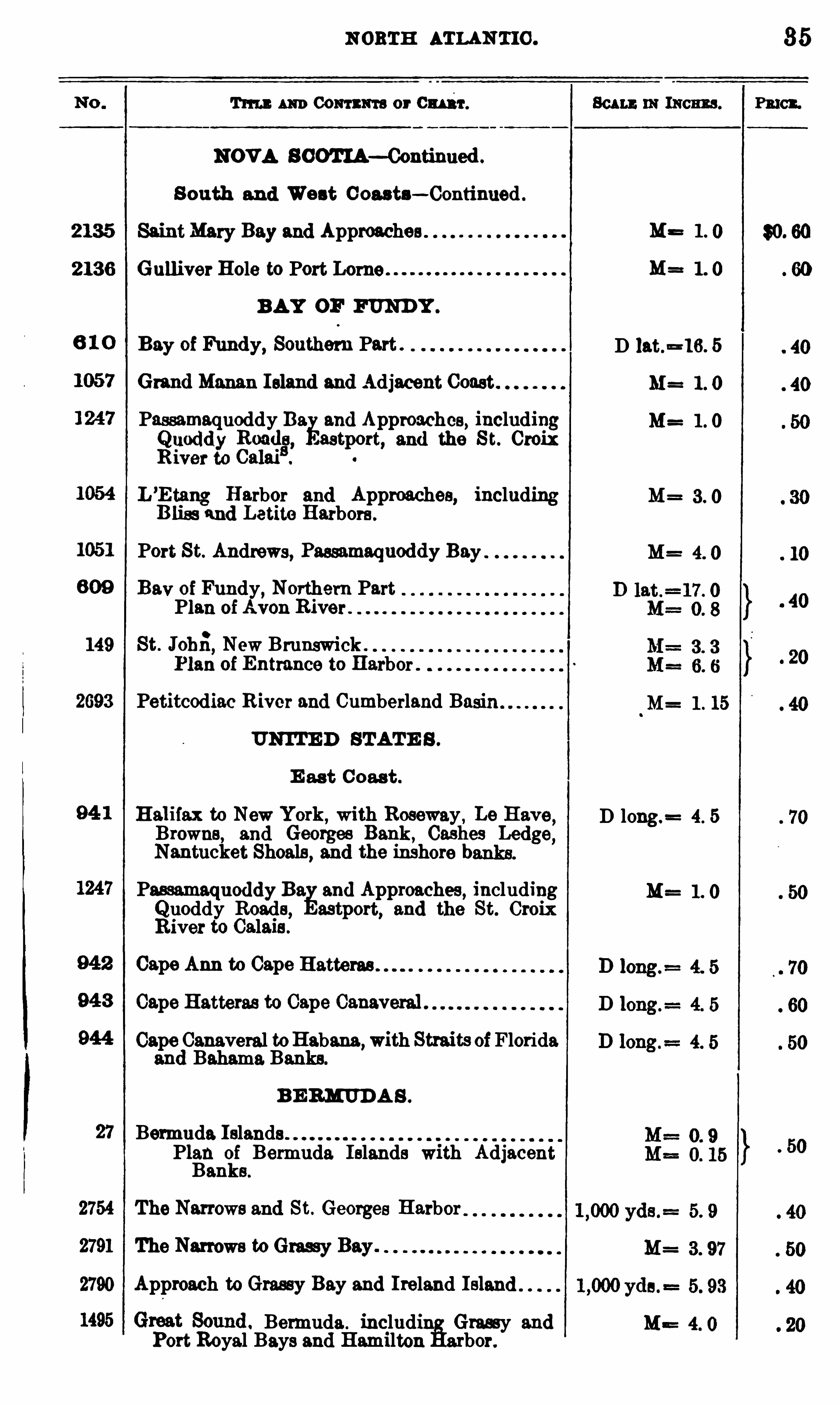
NOVA S COTIA—Continued .
S outh and West C oasts—Continued .
2135 SaintMary Bay and Approaches
2 136 Gulliver Hole to Port Lorne .
BAY OF FUND Y .
Bay of Fundy, Southern Part .
Grand Manan Island and Adjacent Coast
Passamaquoddy Ba and Approaches, including311
3235553388 , .astp
c
ort, and the S t. Croix
L’E tang Harbor and Approaches, includingB liss and Letite Harbors .
Port St. Andrews, Passamaquoddy Bay
Bav of Fundy, Northern Part
Plan ofAvon River .
149 St. Johfi,New Brunswick .
Plan of Entrance to Harbor .
2693 Petitcodiac River and Cumberland Basin
UNITE D STATE S .
E ast Coast .
Halifax to New York,with Roseway , La Have
Browne, and Georges Bank , Cashes LedgeNantucket Shoals
,and the inshore b
Passamaquoddy Eu and Approaches, includingQ uoddy Roads, astport, and the St. CroixRiver to Calais .
Cape Ann to Cape
Cape Hatteras to Cape Canaveral .
Cape Canaveral toHabana,with Straits ofFloridaand Bahams. Banks.
B E RMUD A S .
Bermuda. Islands .
Plan of Bermuda Islands with AdjacentBanks .
2754 The Narrows and St. Georges Harbor
2791 The Narrows to Grassy Bay .
2790 Approach to Grassy Bay and Ireland Island
Bermuda . including Grassy andPort Royal Bays and Hamilton Harbor.
MB
M=
D lat.=16. 5
M= 1 . 0
M= 1 . 0
M=
M=
M= 1 . 15
D long.= 4. 5
M==
35
36 CATALOGUE OF CH ARTS .
T im : AND CONTENTS or Cmuu'.
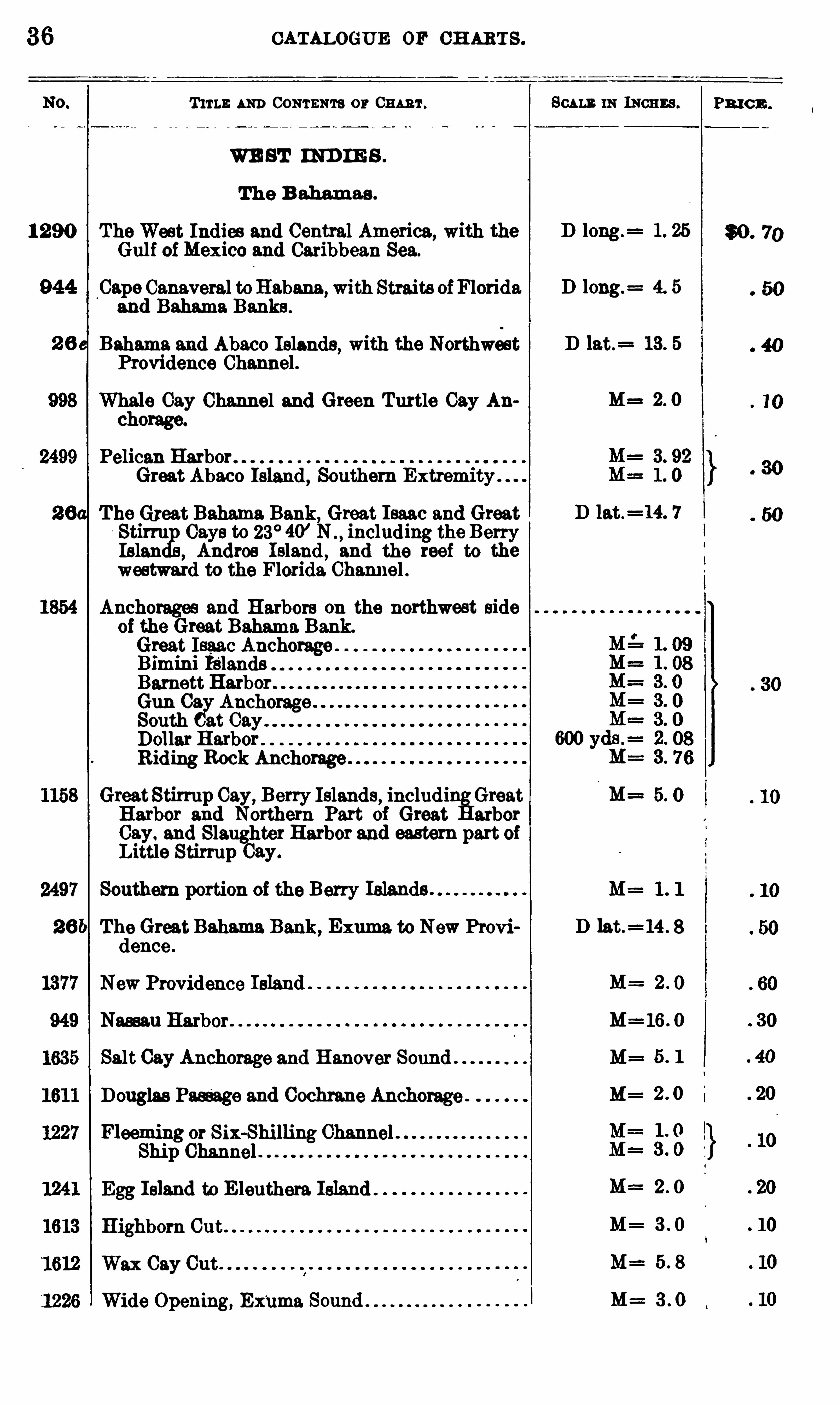
WE ST IND IE S .
The B ahamas .
1 290 The West Indies and Central America, with theGulf ofMexico and Caribbean Sea.
Cape Canaveral toHabana,with Straits ofFloridaand Bahama Banks .
Bahama and Abaco Islands, with the NorthwestProvidence Channel .
Whale Cay Channel and Green Turtle Cay Anchorage.
Pelican Harbor .
Great Abaco Island,Southern Extremity .
he Greet Bahama Bank, Great Isaac and GreatStirru Gays to 23° 40’ N including the BerryIslan Andros Island , and the reef to thewestward to the Florida Channel .
Anchorages and Harbors on the northwest sideof the Great Bahama. Bank.
Great Isaac AnchoBimini Islands
rageBarnett HarborGun Os Anchorage
South at
Dollar HarborRiding Rock Anchorage
GreatStirrup Cay,Berry Islands, includi Great
Harbor and Northern Part of Great arborGay. and Slaughter Harbor and eastern part ofLittle Stirrup Cay.
Southern portion of the Berry Islands .
The Great Bahama Bank , Exuma to New Providence .
New Providence Island
Nassau Harbor
Salt Cay Anchorage and Hanover Sound
Douglas Passage and Cochrane Anchorage
Fleeming or Six-Shilling ChannelShip Channel
Egg Island to E leuthera Island
Highborn Cut
Wax Cay Cut .
Wide Opening, Ex‘
uma
SCALE IN INCHES .
D long .=
D long.= 4. 5
D lat.= 13. 5
M= 2 0
D lat .=14. 7
M=
M= 1 1
D lat.=14 . 8
M=
M= IG. O
M=
M :
M== 2 0
M=
M
M=
PR I C E .
N ORTH ATLAN T IC .
Tm : m CONTENTS or 0mm . Ben n inmeans .
WE ST IND IE B— Continued .
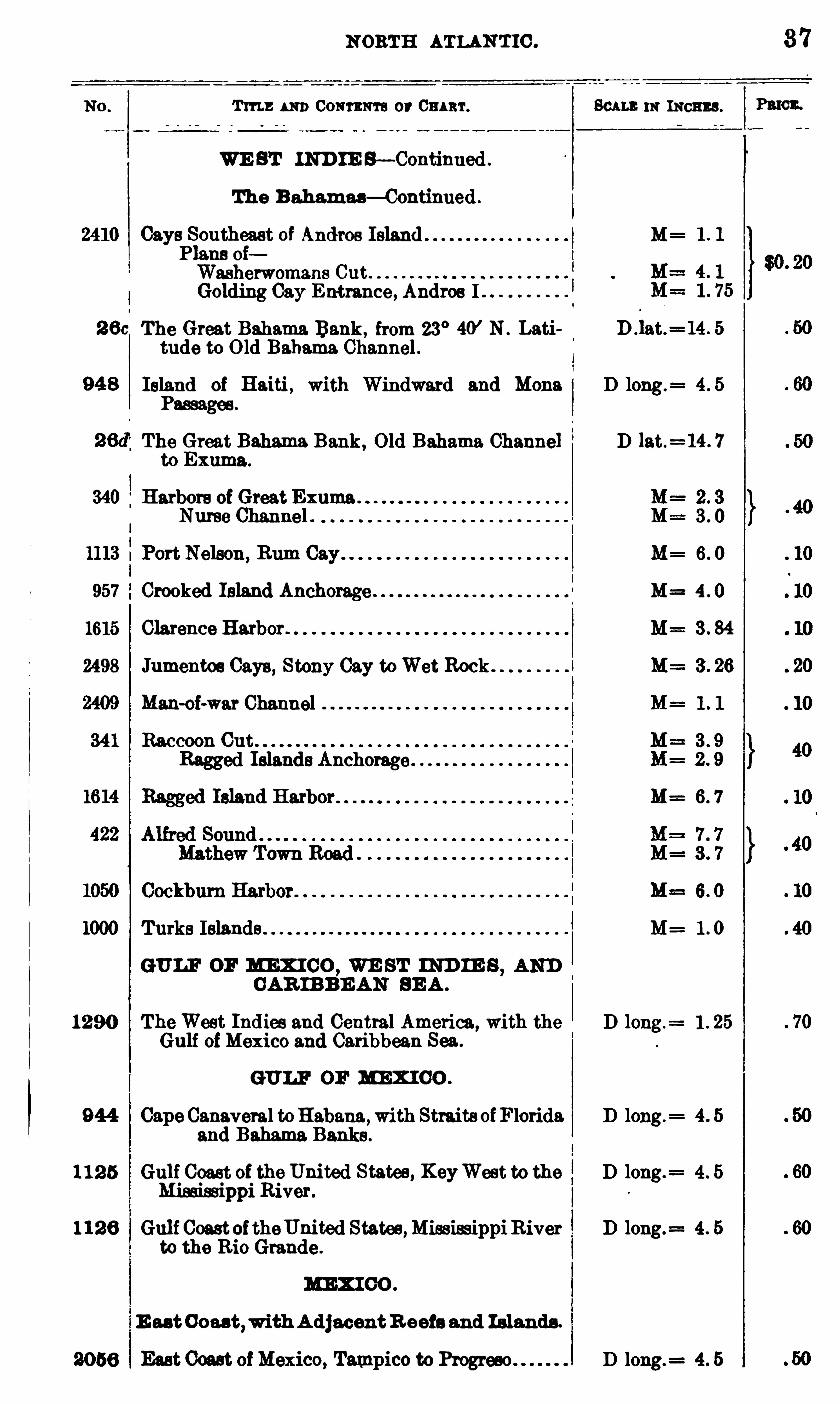
The B ahamas— Continued .
a s Southeast of MPlans oiWasherwomans CutGolding Cay Entrance , Andros I
The Great Bahama. Bank , from 23°40’ N . Lati 5
tude to Old Bahama Channel .
Island of Haiti , with Windward and Mona D long. 4. 5
Passages .
The Great Bahama Bank , Old Bahama Channel D lat.= 14. 7
to Exuma .
340 Harbors of Great ExumaNurse Channel .
M= 6 . 0
957 Crooked Island
1615 Clarence Harbor . M= 3 . 84
2498 Jumentos Gays , Stony Cay toWet Rock
Man-oi-war Channel
34 1 Raccoon CutRagged Islands Anchorage
M= 6 7
1000 Turks Islands M= 1 . 0
GULF OF MEX I CO ,WE ST IND IE S
,AND
CAR IB BE AN BE A .
1290 TheWest Ind ies and Central America,with the D long.
= 1 . 25
Gulf ofMexico and Caribbean Sea.
GULF OF MEX I CO .
944 Cape Canaveral toHabana ,with Straits ofFlorida. D long. 4 . 5
and Bahama Banks .
1 1 25 Gulf Coast of the United States, KeyWest to the D long.= 4 . 5
Misd seippi River.
1 1 2 6 Gul f CoastoftheUnited States ,MississippiRiver D long. 4 . 5
to the Rio Grande .
M EX I CO .
E as t Coast,with A d jacentR eefs and Is lands .
2056 East Coast ofMexico, Tampico to Program D long.= 4 . 5
37
38
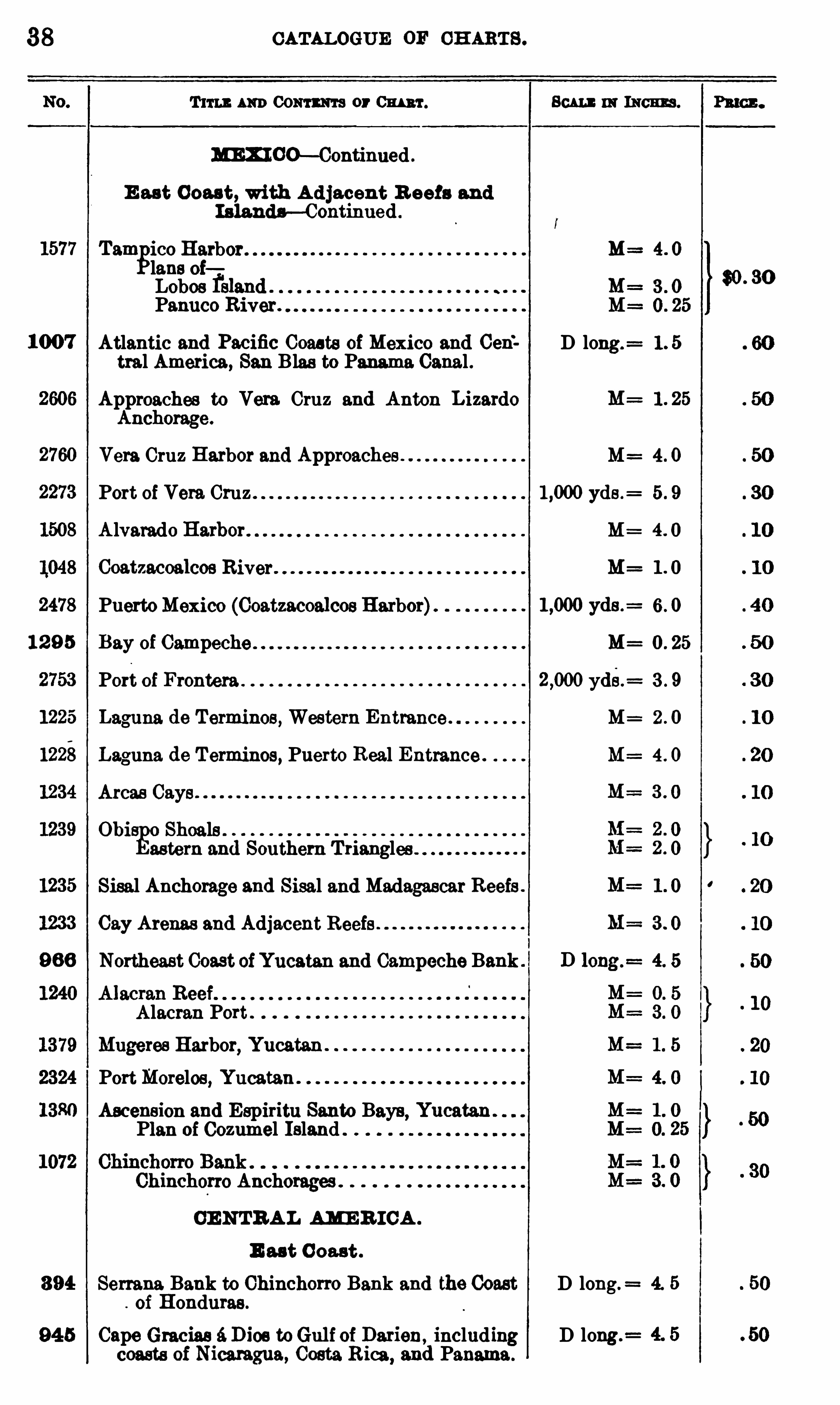
1577
1007
12 9 5
1225
1222
CATALOGUE OF CH ARTS .
T im Aim Comm a or Ben : w N ew .
m co—Continued .
E ast Coast, with A d jacent R eefs andI slands— Continued .
Tamgico Harbor M==lane oiLobos fsland . . 3 . oPanuco River . M= 0 . 25
Atlantic and Pacific Coasts of Mexico and Cen’ D long.
= 1 . 5
tral America, San Blas to Panama. Canal .
Approaches to Vera. Cruz and Anton LizardoAnchorage .
Vera Cruz Harbor and Approaches . . M= 4 . 0
Port of Vera Cruz yds .= 5 . 9
A lvarado Harbor M=
Coatzacoalcoe M=
PuertoMexico (Coatzacoalcos Harbor) 6 . 0
Bay of Campeche M= 0 . 25
Port of Frontera yde.= 3 . 9
Laguna de Termines, Western Entrance M= 2 . 0
Laguna de T ermines, Puerto Real Entrance . M= 4 . 0
Areas Gays
Obi Shoals .
astern and Southern Triangles
Sisal Anchorage and Sisal and Madagascar Reefs .
Cay Arenas and Adjacent Reefs
Northeast Coast ofYucatan and Campeche Bank .
Alacran Port .
Mugeres Harbor, YucatanPortMorelos, Yucatan .
Ascension and Espiritu Santa Bays, Yucatan .
Plan of Cozumel Island .
Chinchorro Anchorages
CE NTRAL AMER ICA .
E ast C oast .
Serrana Bank to Ohinchorro Bank and the Coast D long.
of Honduras .
Cape Gracias é D ies toGul f of Darien,including D long.
=
coasts of Nicaragua, Costa Rica, and Panama.
$0 . 30
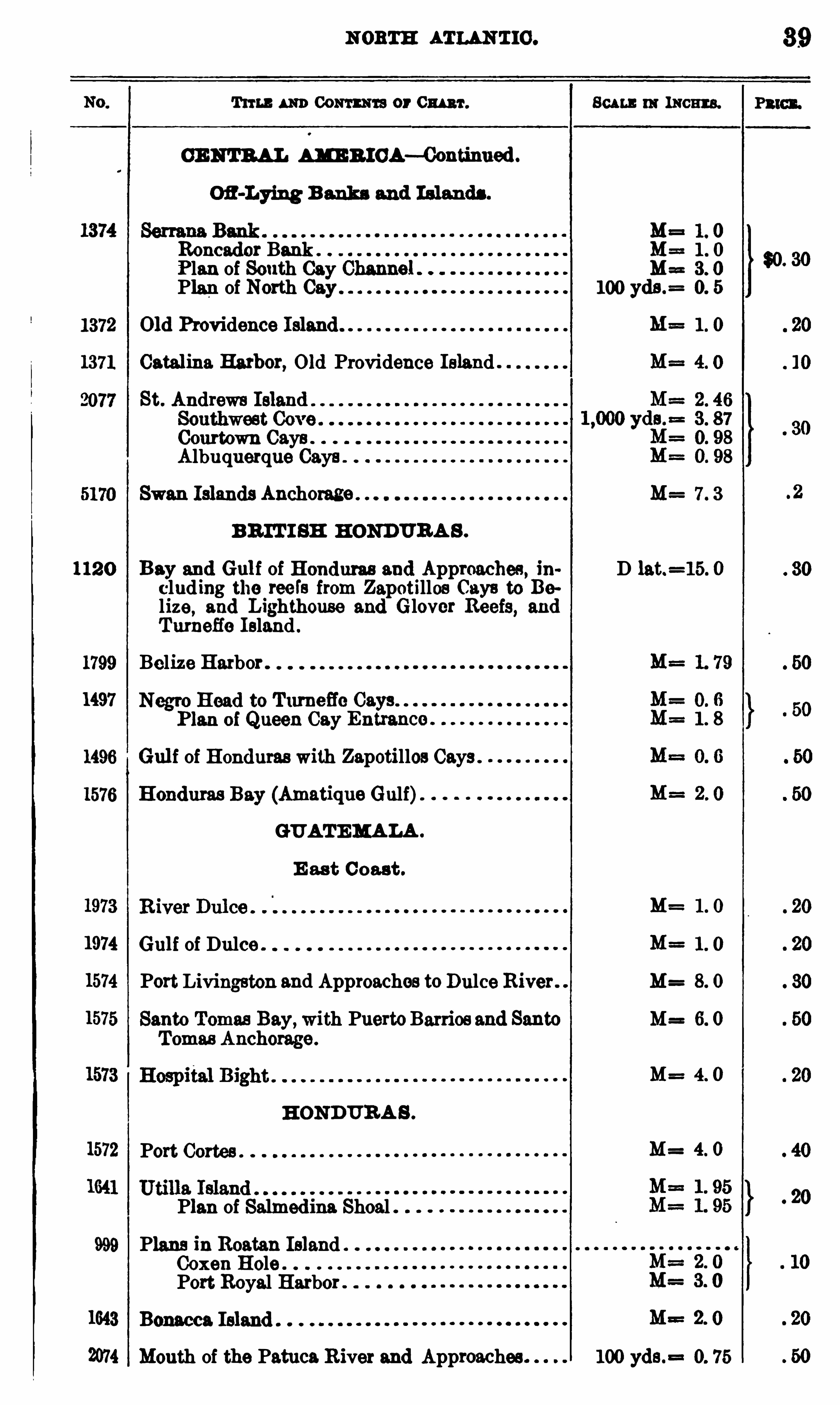
N ORTH ATLAN TIC .
Tum m Com m or Cm ‘r. Bu t: m N ow
CENTRA L AME R ICA—Continued .
M= 1 . 0Roncador Bank . M==1 . 0
f lan of South Cay M==3. 0
Plan of North Cay 100 yds.= 0. 5
1372 Old Providence Island 1 . 0
1371 Catalina Harbor, Old Providence Island
2077 St. Andrews Island
Courtown Gays .
Albuquerque Gays
5170 Swan Islands Anchorage M==7 . 3
BR IT I SH HONDURA S .
112 0 Bay and Gul f of Honduras and Approaches , ih D lat.=15. 0
clud ing the reefs from Zapotillos Cays to Belize, and Lighthouse and Glover Reefs, andTu meffe Island .
1799 Belize Harbor .
“97
1496 Gulf of Honduras with Zapotillos Gays .
1576 Honduras Bay (Amatique Gulf).
GUATEMALA .
E as t Coast .
1 . 0
1974 Gulf of Dulce . 1 . 0
1574 Port Livingston and Approaches to Dulce River. M= 8. 0
1575 Santa Tomas Bay, with PuertoBarrios and Santa M= 6. 0
Tomas Anchorage .
M= 4 0
H ONDURA S .
1572 Port Cortes .M= 4. 0
Plan of Salmedina. Shoal .
999 Plans in Roatan IslandCoxen Hole .
Port Royal Harbor
1643 Bonacca Island
2074 Month of the Patuca River and Approaches . 100 yds.= 0. 75
39
P3 10] .
40 CATALOGUE or CH ARTS .
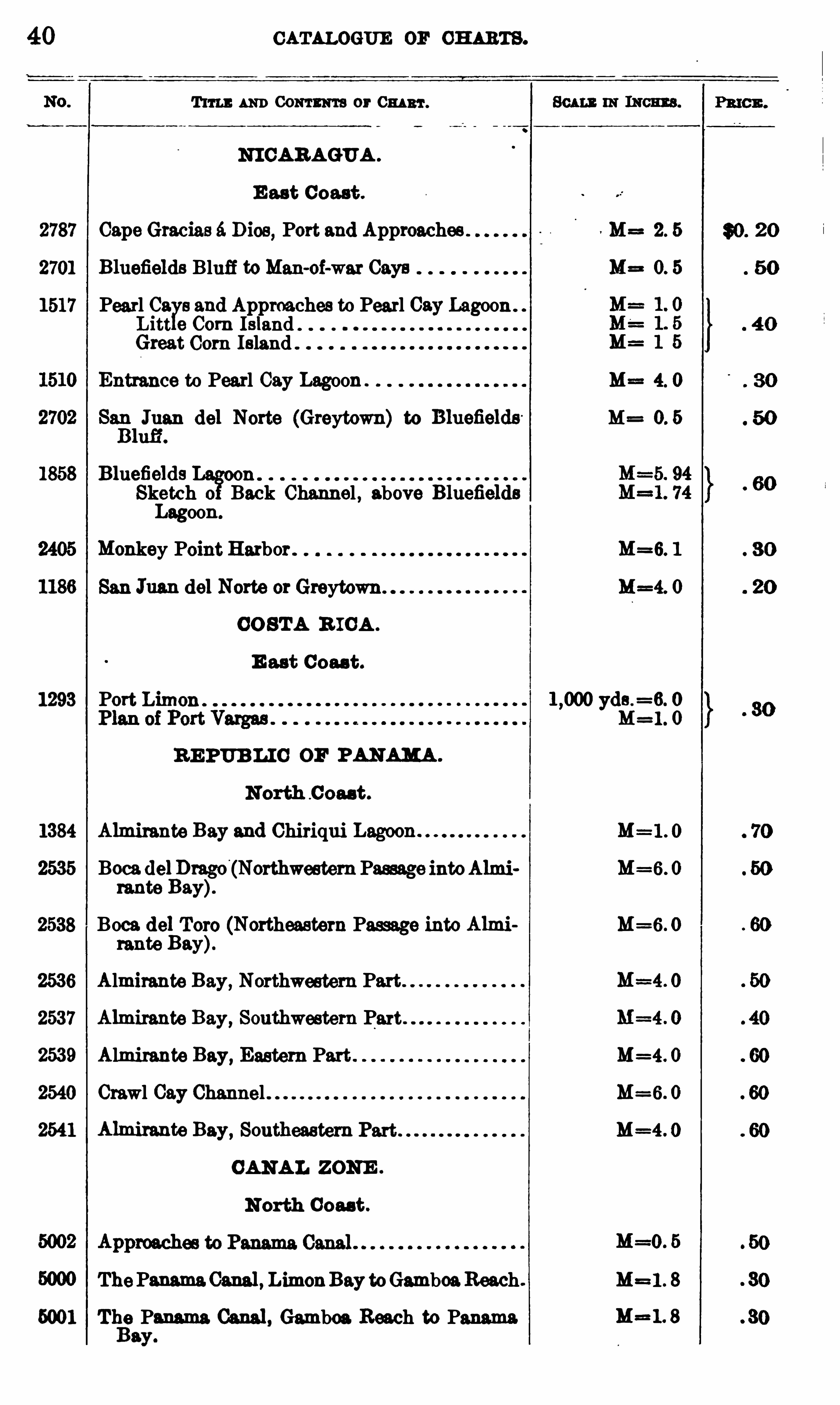
T ITLE AND CONTENTS OF CHART .
NI CARAGUA .
E ast Coast .
2787 Cape Gracias 6. D ies, Port and Approaches M==2. 5
2701 B luefields Bluff toMan-oi-war Gays M= 0. 5
1517 Pearl Os 8 and Approaches to Pearl Cay Lagoon .
Litt e Corn Island .
Great Corn Island
Entrance to Pearl Cay Lagoon . M==4. 0
$3 1! del Norte (Greytown) to Bluefields M= 0. 5
Bluefields n .
Sketch 0 Back Channel , above BluefieldsLagoon.
Monkey Point Harbor . M=6. 1
San Juan del Norte orGreytown M=4. 0
CO STA R ICA .
E ast Coas t .
1293 Port Limon . yds .=6. 0
M=1 . 0
RE PUB LIC OF PANAMA .
North C oaat .
1384 Almirante Bay and Chiriqui M=1 . 0
2535 Boca del Dmgo (Northwestern Passage intoAlmi M=6. 0
rante Bay).
2538 Boca. del Toro (Northeastern Passage into Almi M=6. 0
rante Bay).
2536 Almirante Bay, Northwestern Part
2537 Almirante Bay, Southwestern Part
2539 Almirante Bay, Eastern Part . M=4. 0
2540 Crawl Cay Channel M=6. 0
2541 Almirante Bay, Southeastern M=4 . O
CANAL ZONE .
N orth Coast .
=0 . 5
ThePanama.Canal , LimonBay toGamboaReach . M=1 . 8
5001 The Panama Canal , Gamboa. Beach to Panama.Bay.

42 CATALOGUE OF CH ARTS .
Tm ] : AND CONTENTS or CHART.
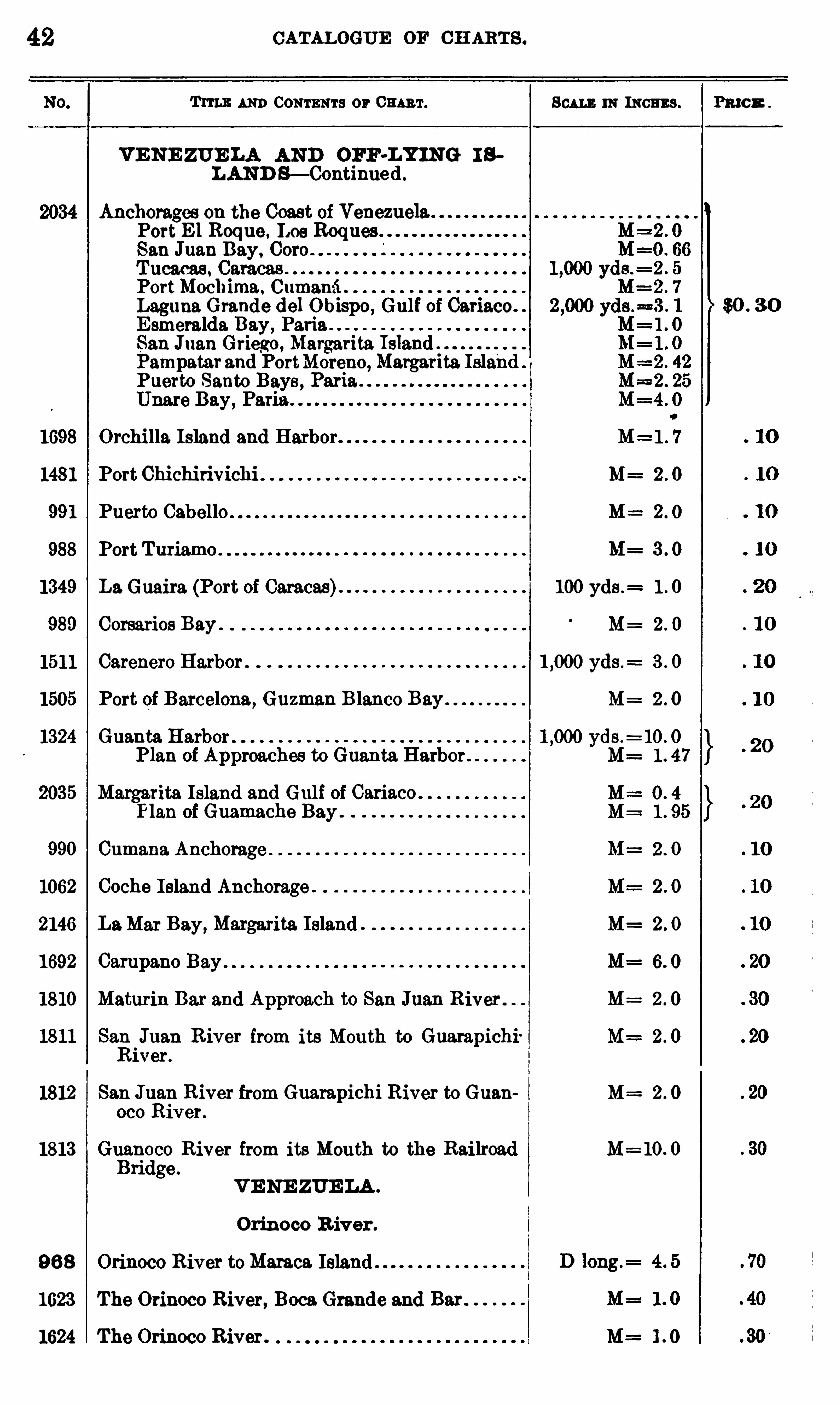
VE NE ZUB LA AND OFF-LY ING 1 8
LAND S— Continued .
Anchorages on the Coast of Venezuela .
Port E l Roque , Les RoquesSan Juan Bay,
PortMochima. CumanfiLaguna Grande del Obispo, Gulf of Cariaco.
E smeralda Bay, PaviaSan Jnan Griego, Margarita IslandPampaterand PortMoreno ,Margarita IslandPuerto Saute Bays ,
SCALE IN INCHES .
1698 Orchilla Island and Harbor
1481 Port Chichi rivichi M= 2 0
991 Puerto Cabello M= 2 O
988 Port M= 3 0
1349 La Guaira. (Port of Caracas) 100 yds .= 1 . 0
989 Corsarios Bay . M= 2 . 0
1511 Carenero Harbor . yds .= 3 . 0
1505 Port of Barcelona, Guzman B lanco Bay M= 2 . 0
1324 Guanta Harbor yds .= 10 . 0
Plan of Approaches to Guanta Harbor M= 1 . 47
2035 Margarita Island and Gulf of CariacoPlan of Guamache Bay .
990 Cumana Anchorage M= 2 . 0
1062 Coche Island Anchorage . M= 2 . 0
2146 LaMar Bay,Margarita Island . M 2 . 0
1692 Campano M=
1810 Maturin Bar and Approach to San Juan River . M= 2 . 0
1811 San Juan River from its Mouth to Guarapichi M= 2 . 0River.
1812 San Juan River from Guarapichi River to Guan M= 2 . 0
oco River.
1813 Guanoco River from its Mouth to the Railroad M= 10 . 0
Bridge .
V E NE ZUE LA .
Orinoco R iver .
9 6 8 Orinoco River toMaraca Island
1623 The Orinoco River, Boca.Grande and Bar
1624 The Orinoco River . M= 1 0
Pmcn
$0 . 3 0
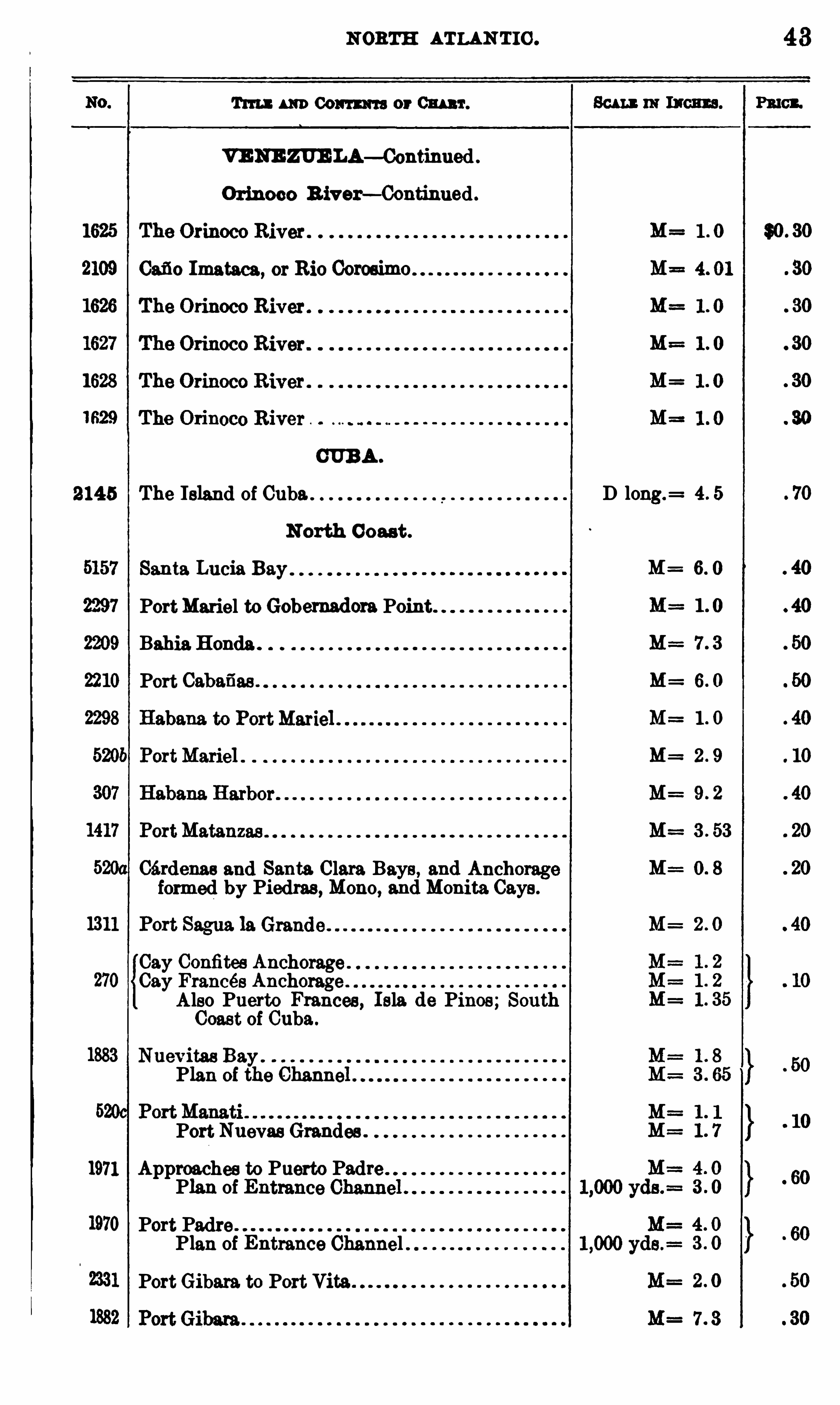
NORTH ATLAN T IC .
Tm : m Com or M r.
VENE ZUE LA—Continued .
Orinoco B iver— Continued .
Cafio Imataca , or Rio Coroeimo
CUBA .
2145 The Island of Cuba.
North Coast .
Santa Lucia Bay
PortMariel to Gobermdora Point
Bahia.Honda
Port Cabafias .
Cérdenas and Santa. Clara Bays, and Anchformed by Piedras , Mono, and Monita Cays .
Cay Confitee Anchorage .
Cay Frances AnchorageAlso Puerto Frances , Isla de Pines; SouthCoast of Cuba .
Nuevitas Bay .
Plan of the Channe
Port Nuevas Grandea.
1971 Approaches to Puerto PadrePlan of
Port Padre .
Plan of Entrance Channel
PortGibara. to Port Vita
D long.=
M=
M=
M=
43
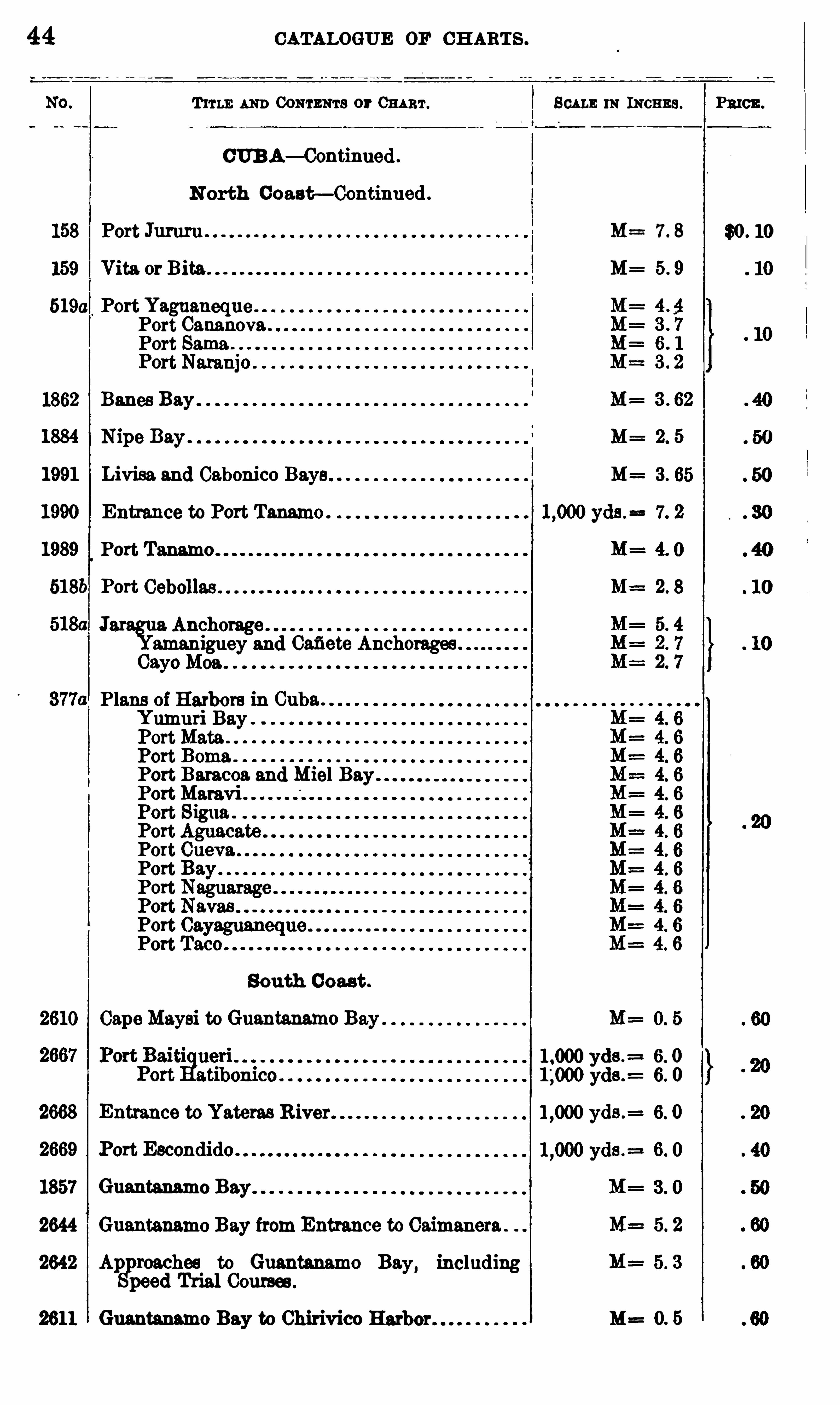
44 CATALOGUE or CH ARTS .
T um AND CONTENTS or CHART . SCALE m INCHES .
CUBA— Continued .
N orth Coast— Continued .
158 Port Jururu M= 7 . 8
159 Vita or Bita M= 5 . 9
5190 Port YaguanequePort CananovaPort Same.
1862 Banes Bay M: 3 . 62
1884 Nipe Bay . 2. 5
1991 Livisa and Cabonico Bays
1990 Entrance to Port Tanamo .
1989 Port
518b Port M=
Jar Anchorageamaniguey and Cafiete Anchorages .
Gaye Moa .
Plans of Harbors in Cuba .
Yumuri BayPortMata .
Port Boma .
Port Baracoa. and Miel BayPortMaravi .
Port Sigua .
PortPortPortPortPortPortPort
South Coast .
2610 CapeMaysi to GumM o Bay
yds .= 6. 0
yds .: 6. 0
2668 Entrance to Yateras River yds .= 6. 0
2669 Port Escondido .
1857 Guantanamo Bay
2644 Guantanamo Bay from Entrance to Caimanera
2642 Ap reaches to Guantanamo Ba. includingSppeed Trial Courses .
y
2611 Guantanamo Bay to Chirivico M==0. 5
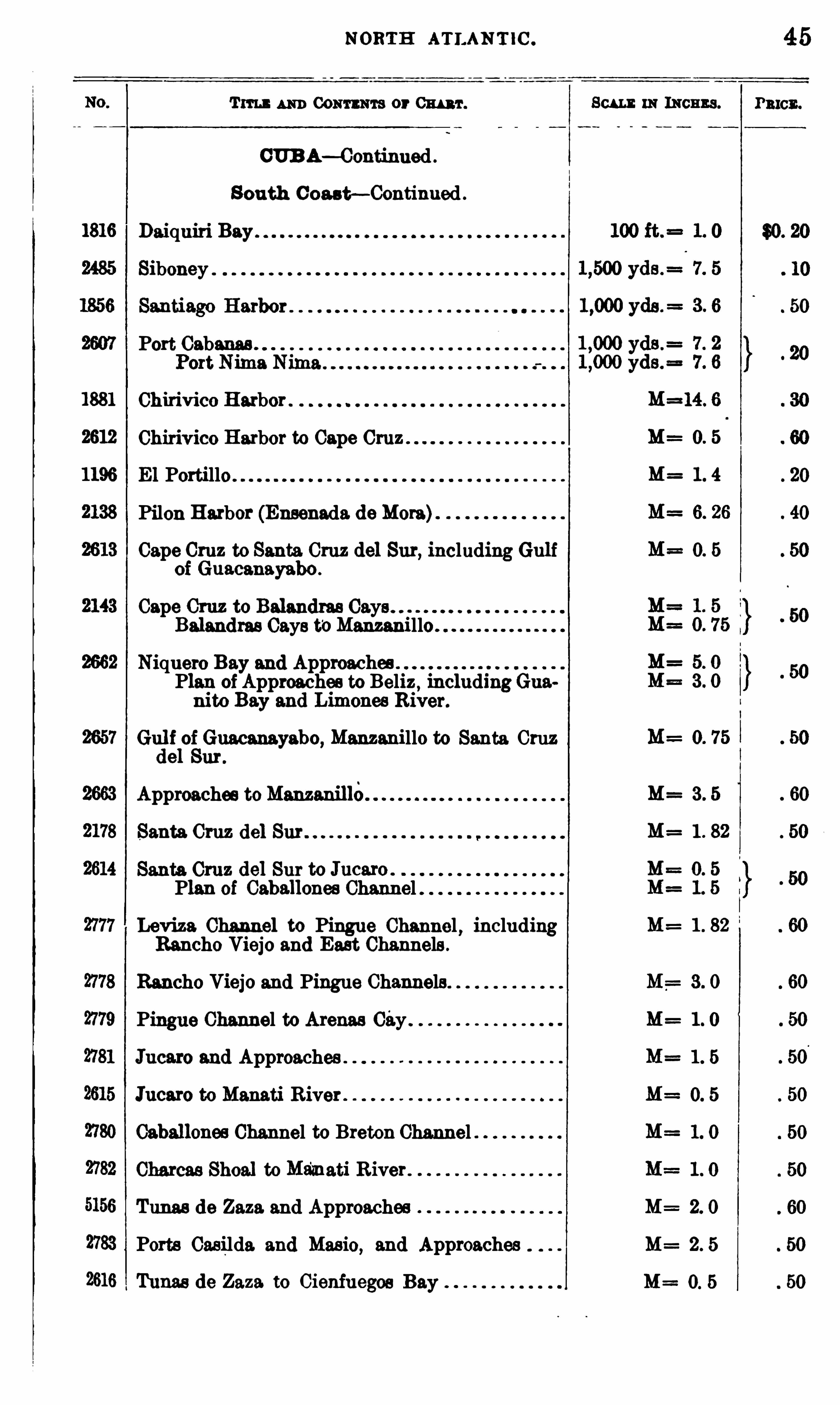
1816
1881
2612
1196
NORTH ATLAN T IC .
Tm um Conn ms or Cm r .
CUB A— Continued .
S outh Coast—Continued .
Daiquiri Bay
Siboney
Port Cabanas .
Chirivico Harbor
Chirivico Harbor to Cape Cruz
El Portillo
Pilon Harbor (Ensenada. doMore)
Cape Cruz to Santa Cruz del Sur, including Gulfof Guacanayabo .
Cape Cruz to Belandres Gays .
Balandras Gays t‘
oManzanillo
Niquero Bay and ApproachesPlan ofApproaches to Beliz ,
includingGuanito Bay and Limones River.
Gul f of Guacm yabo, Manzanillo to Santa Cruzdel Sur .
Approaches toManzanille
Santa Cruz del Sur
Santa Cruz del Sur to Jucaxo .
Plan of Caballonee Channel
Loviza Channel to Pingue Channel , includingRancho Viejo and East Channels .
Rancho Viejo and Pingue Channels
Pingue Channel to Arenas City
Jucaro and Approaches
Jucaro to Manati River
Caballonee Channel to Breton Channel
Charcas Shoal to Ma'
znati R iver .
Tunas de Zaza. and Approaches
Ports Casilda. and Masio, and Approaches
Tunas de Zaza to Cienfuegos Bay
Scum inmeans .
M= O 5
M=
M=
M=
M=
M= 3 0
M= 1 0
M= 1 5
M= O 5
M=
M=
M=
45
PRICE .
46 CATALOGUE 0 14'CH ARTS .
TITLE AND CONTENTS or Cm r. m INCHES .
CUBA— Continued .
South Coast— Continued .
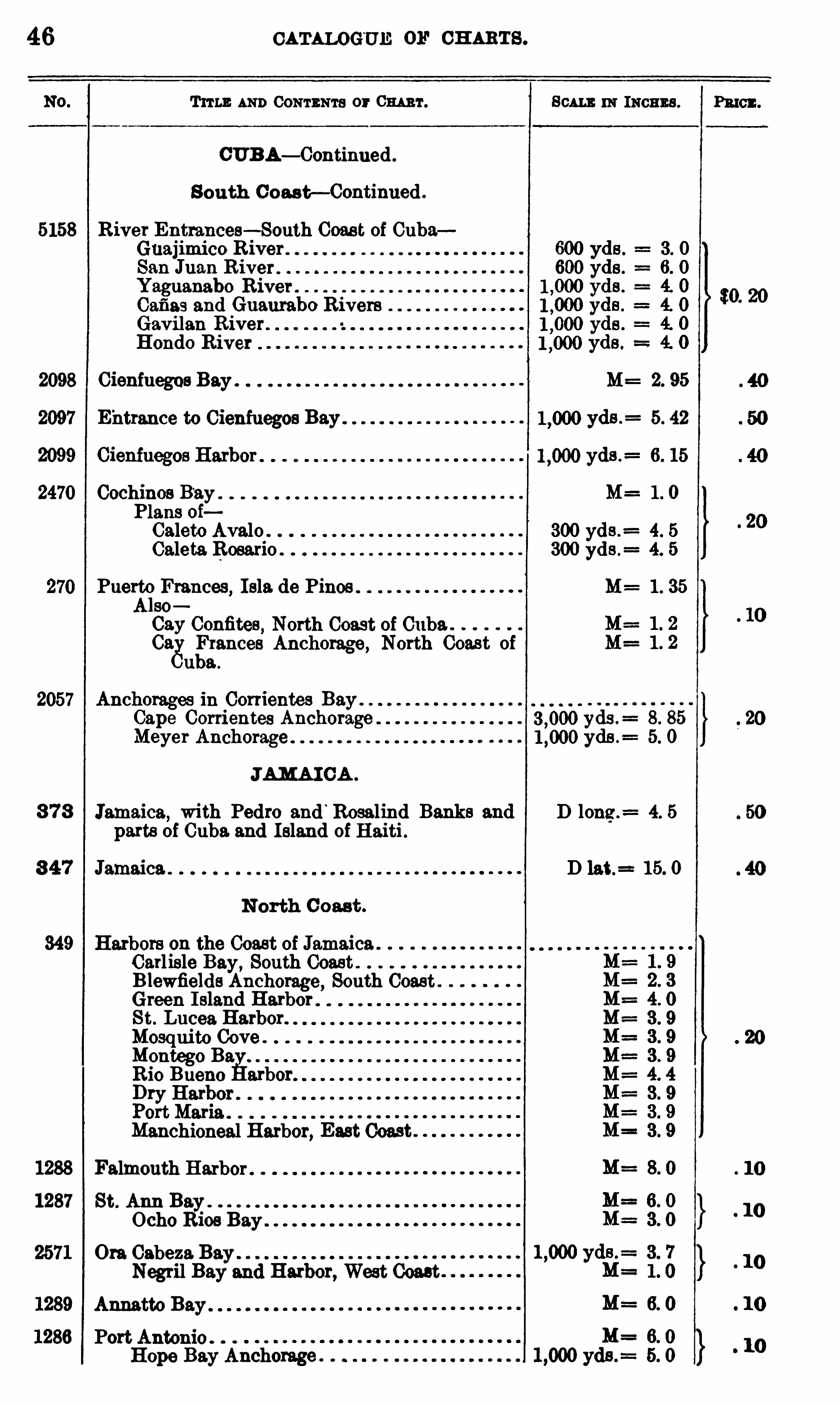
5158 River Entrances— South Coas t of CubaGuajimico River .
San J112 11 R iver .
Yaguanabo River .
Cefis s and Guaurabo RiversGavilan RiverHondo River
2098 Cienfuegos Bay . M= 2. 95
Entrance to Cienfuegos Bay yds .= 5. 42
yds .= 6. 15
2470 Cochinos B‘
ay . M== 1 . 0
Plans oiCalete Avalo . 300 yds .
= 4. 5
Caleta Rosario . 300 yds .= 4. 5
Puerto Frances, Isla. de Pines M= 1 . 35
Also
Cay Confites , North Coast of Cuba.GagFrances Anchorage , North Coast of
uba .
2057 Anchorages in Corrientes Bay .
Cape Corrientes Anchorage yds .= 8. 85
Meyer Anchorage yds . 5. 0
JAMAI CA .
8 78 Jamaica, with Pedro and‘
Rosalind Banks and D long .= 4. 5
parts of Cuba. and Island of Haiti .
3 47 Jamaica . D 15. 0
N orth C oast .
349 Harbors on the Coast of JamaicaCarlisle Bay, South Coast .
B lewfields Anchorage, South CoastGreen I sland HarborSt. Lucea Harbor.
Mosquito Cove .
Montage BavR io Bueno Harbor
Manchioneal Harbor, East Coast
Falmouth HarborSt. Ann BayOcho Rios Bay .
Ora Cabeza. Bay .
Negril Bay and Harbor, West Coast
Annatto Bay
Port AntonioHope Bay Anchorage
Pmcz .
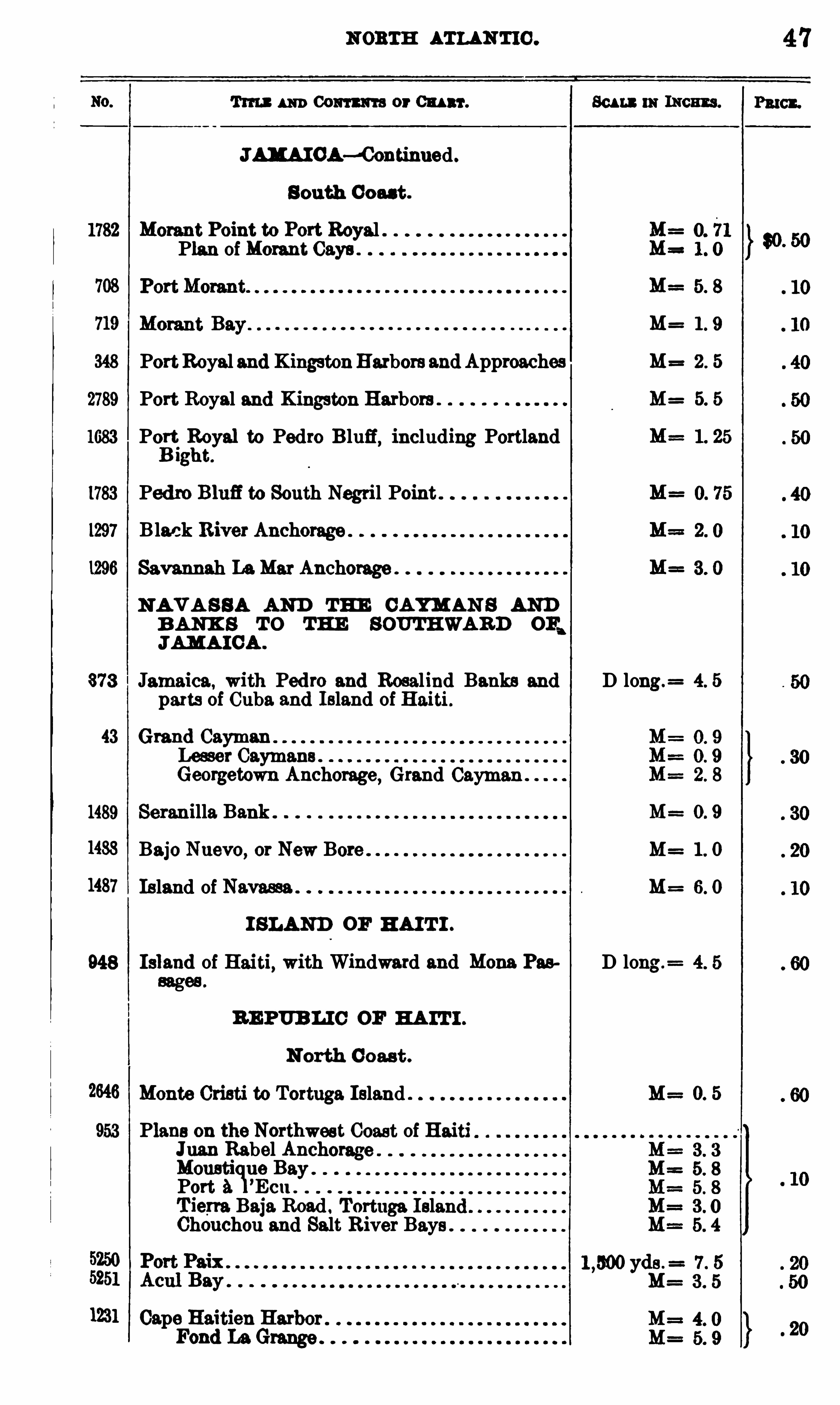
NORTH ATLAN TIC .
Tm um Comm or Cl Al ‘l‘. Scam in 11mm .
JAH A IOA—‘Continned .
S outh Coast .
1782 Morant Point to Port Royal .Plan of Morant Cays
348 PortRoyal and KingstonHarbors and Approaches M= 2 . 5
2789 Port Royal and Kingston Harbors . M= 5. 5
1683 Pol
l
;l
éoyal to Pedro B luff, including Portland
1g t.
1783 Pedro Blufi to South Nagtil Point
1297 Black River Anchorage
1296 Savannah LaMar Anchorage
N A V A S S A AND THE CAYM AN S ANDB ANK S T O THE SOUTHWARD or
,
JAMA ICA .
373 Jamaica, with Pedro and Rosalind Banks and D long.= 4. 5
parts of Cuba and Island of Haiti .
43 Grand Cayman
mhn fiehomge, Grand Cayman1489 Serenilla Bank . M= 0. 9
1483 Bajo Nuevo, or New Bore M= 1 . 0
1487 Island of Navassa M= 6. 0
I SLAND OF H AI T I .
948 Is]and of Haiti, with Windward and Mona Pas D long.=
sages .
RE PUB LIC OF HA IT I .
N orth C oast .
2646 Monte Cristi to Tortuga Island . M= 0. 5
953 Plans on the Northwest Coast of HaitiJnan Rabel Anchorage .
Mousticiue Bay .
Port A ’Ecu .
T iem Baja. Road: Tortuga IslanChouchou and Salt River Bays .
1231 Cape Haitian HarborFond La Grange
47
Paton.
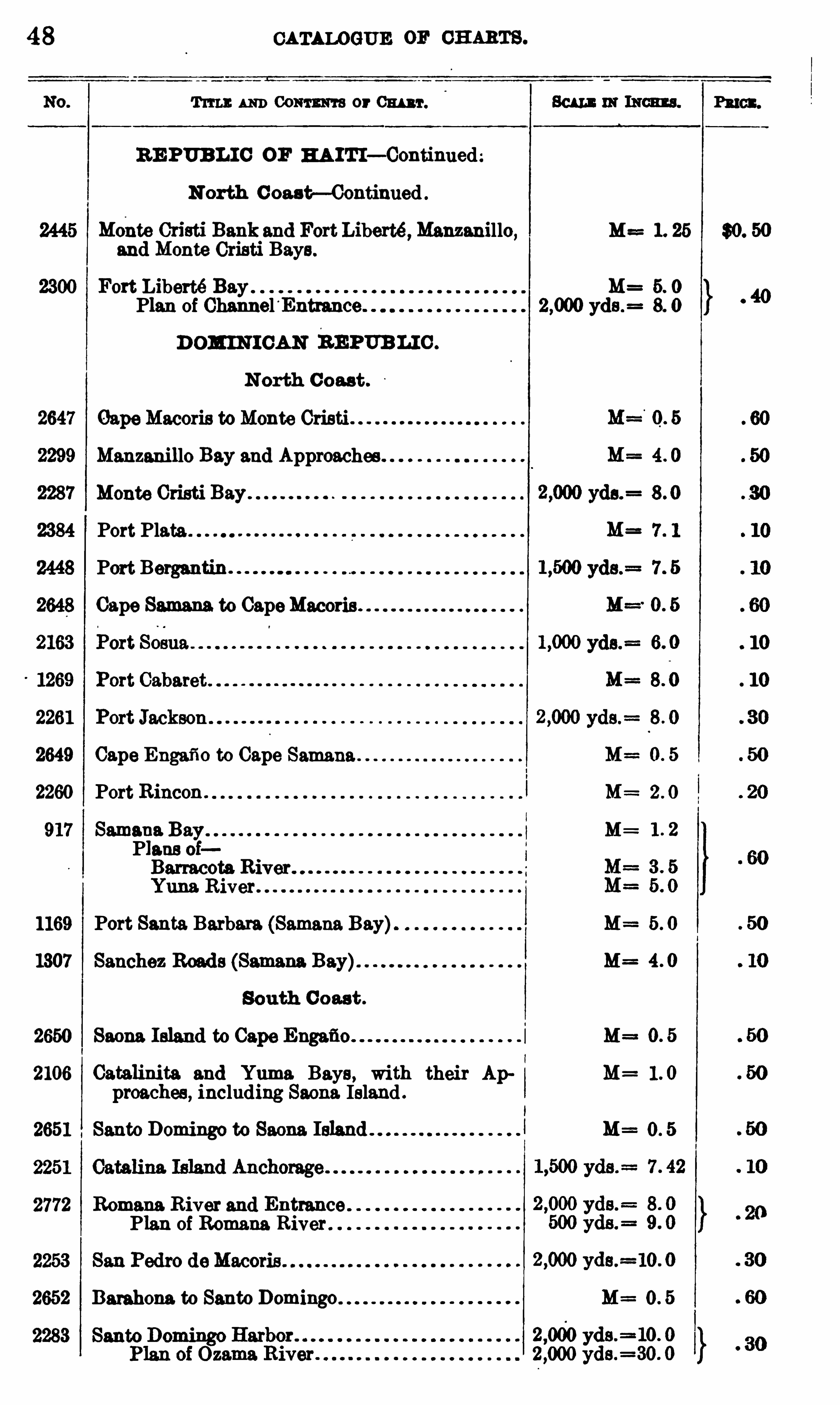
48 CATALOGUE 0 11 CH ARTS .
Tum: AND Comm or Cm r.
RE PUBL IC OF HA ITI— Continued
N orth C oast—C ontinued .
Monte Cristi Bankand Fort Liberté ,Manzanillo, M==1. 25 30. 50
and Monte Cristi Bays .
2300 Fort Liberté Bay M= 5. 0
Plan of Channel Entrance 2,000 yds .
D OM INI CAN REPUBLI C .
N orth C oast .
OapeMacoris toMonte Cristi
Manzanillo Bay and Approaches
Monte Cristi Bay
Port Plate
Port Bergantin.
Cape Samana. to CapeMacoris
2649 Cape Engafio to Cape Samana
2260 Port Rincon . 2 . 0
917 Samana M=Plans oiBarracota River .
Yuna River
1169 Port Santa Barbara (Samaria Bay) M==5 . 0
1307 Sanchez M=
South C oast .
2650 Sauna M==
2106 Catalinita and Yuma. Bays, with their Ap M= 1 . 0
preaches , including Saona. Island
2651 Santo Domingo to Saona Island M= 0 . 5
2772 Romans River and EntrancePlan of Romans River
2652 Danbena to Santo Domingo M= 0 . 5

50 CATALOGUE OF CH ARTS .
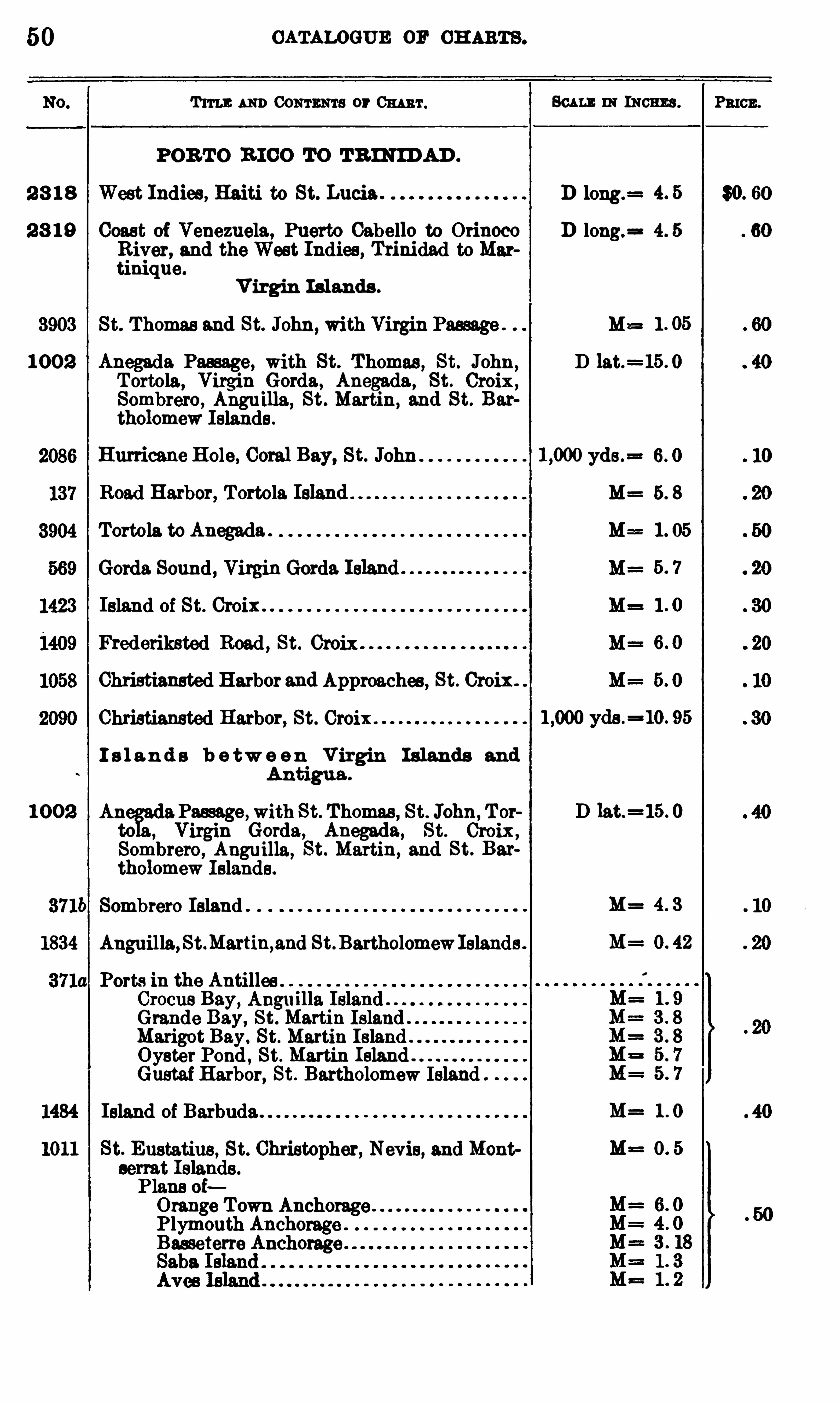
T m: AND Comma s or 0111 111 .
POR TO R ICO TO TR IN IDAD .
801 11 : IN INCHES .
2 8 1 8 West Indies , Haiti to St. Lucia . D long.=
2 8 1 9 Coast of Venezuela, Puerto Cabello to Orinoco D long.= 4. 5
River, and the West Indies , Trinidad to Martinique.
V irgin Islands .
St. Thomas and St. John , with Virgin Passage . M==
1 00 2 Anegada Passage, with St. Thomas , St. John, D lat.=15 . 0
Tortola, Virgin Gorda, Anegada, St. Croix ,Sombrero, Anguilla ,
St . Martin, and St. Bartholomew Islands .
Hurricane Hole, Coral Bay, St. John yds .= 6. 0
Road Harbor, Tortola Island M= 5. 8
Tortola to Anegada . M== 1 . 05
Gerda. Sound , Virgin Gorda M=
Island of St. Croix . . M=
Frederiksted Road , St. Croix M=
Christiansted Harbor and Approaches , St. Croix . M= 5. 0
Christiansted Harbor, St. Croix .
I s l a n d s b e tw e e n V irgin I slands and
Antigua .
1 0 02 Ah Passage ,with St. Thomas , St. John, Torto Virgin Gorda, Anegada, St. Croix ,
Sombrero, Anguilla, St. Martin, and St. Bartholomew Islands.
371b Sombrero Island .
1834 Anguilla,St.Martin,and St. BartholomewIslands .
Ports in the Antilles .
Crocus Bay,Anguilla Island"
Grande Bay, St. Martin IslandMarigot Bay. St. Martin Island . .
Oyster Pond , St. Martin Island"Gustaf Harbor, St. Bartholomew Island
1484 Island of Barbuda .
1011 St. Eustatius, St. Christopher, Nevis, and Montserrat Islands .
Plans oiOrange Town Anchorage .
Plymouth Anchorage .
Basseterre Anchorage
yds .=10. 95
D lat.=15 . 0
M= 4 3
M=
M= 1 0
M==
PRICE .
$0. 60
N ORTH ATLANTIC .
TITLE AND Comm or 0 111 3 1 . 801 11 in 13 03 3 3 .
POB 'I‘O 3 10 0 TO TR INID AD— Contimied .
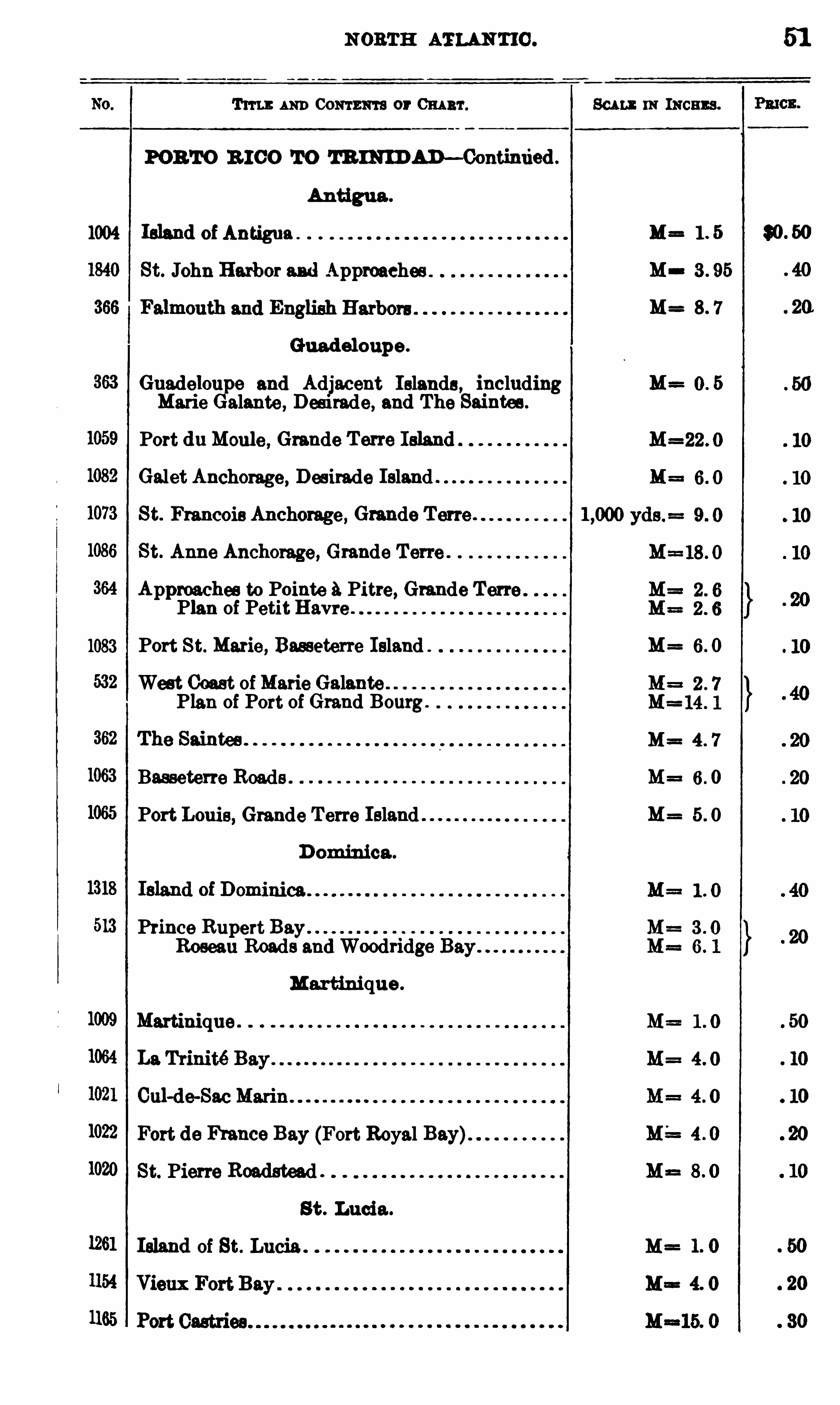
Antigua .
1004 Island Ma
St. John Harbor and Approaches M 3 . 95
M= 8 7
Guadeloupe .
Guadelou e and Adjacent Islands , including M= 0 . 5Marie alante , Desirade, and The Saintea.
Port duMoule , Grande T erre Island
Galet Anchorage, Desirade Island .
St. Francois Anchorage , Grande Terre .
St. Anne Anchorage, Grande Terre .
Approaches to Pointe 9. Pitre, Grande TerraPlan of PetitHavre .
1083 Port St. Marie , Basseterre Island M= 6. 0
West Coast ofMarie GalantePlan of Port of Grand Bourg .
M= 4 7
1063 Basseterre Roads . M= 6 . 0
1065 Port Louis, Grande T erre Island M 5 . 0
D ominica .
513 Prince RupertRoseau Roads and Woodridge
Martinique .
1009 Martinique .
1022 Fort de fi ance Bay (Fort Royal Bay)1020 St. Pierre Roadstead .
St . Lucia .
1261 Island of St. Lucia .
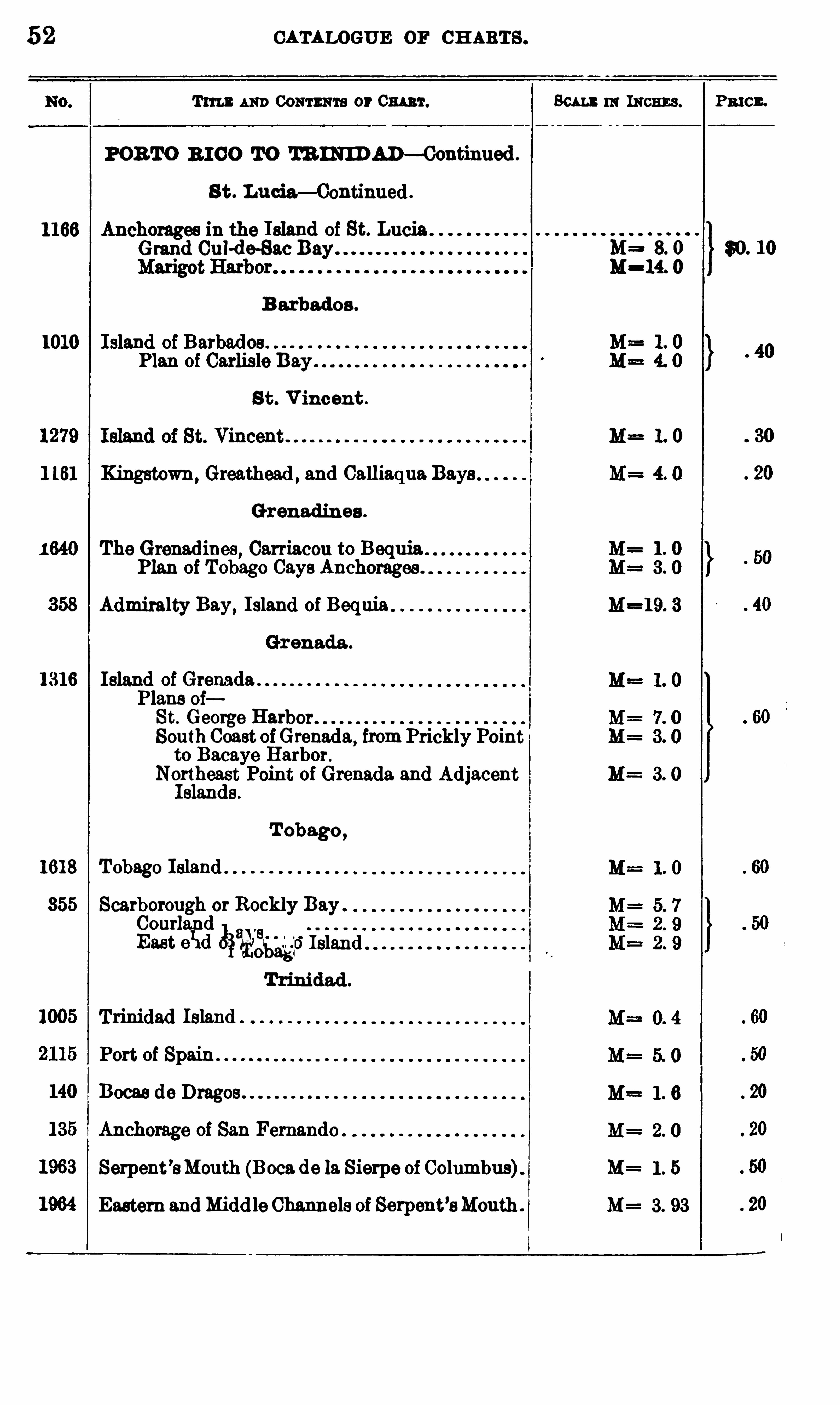
52 CATALOGUE or CH ARTS .
T im AND Comnm s or Cm 'r.
POB TO 3 10 0 TO TR INID AD—Oontinued .
S t . Lud a— Continued .
1166 Anchorages in the Island of St. LuciaGrand Cul-de—Sac Bay
B arbados .
1010 Island of Barbad osPlan of Carlisle Bay .
S t . V ineent .
1 161 Kingstown, Greathead , and Calliaqua Bays
Grenadin es .
1 640 The Grenadines , Carriacou to BequiaPlan of Tobago Gays Anchorages .
358 Admiralty Bay,I sland of Bequia
Gr enada .
1316 Island of GrenadaPlans oiSt. George HarborSouth Coast ofGrenada
,from Prickly Point
to Bacaye Harbor.
Northeast Point of Grenada and AdjacentIslands .
T obago ,
1618 Tobago Island
355 Scarborough or Rockly Bay .
$2251
3111
51
0
13
311552250.
Island
T rinidad .
Trinidad Island
Port of Spain .
Bocas de Dragos
Anchorage of San Fernando
Serpent ’sMouth (B00 11 de la Sierpe of Columbus)Eastern and Middle Channels of Serpent’aMouth .
Scum in means .
M= 8. 0
M=14. 0
M= 1 . 5
M= 3. 93
Pmcn.
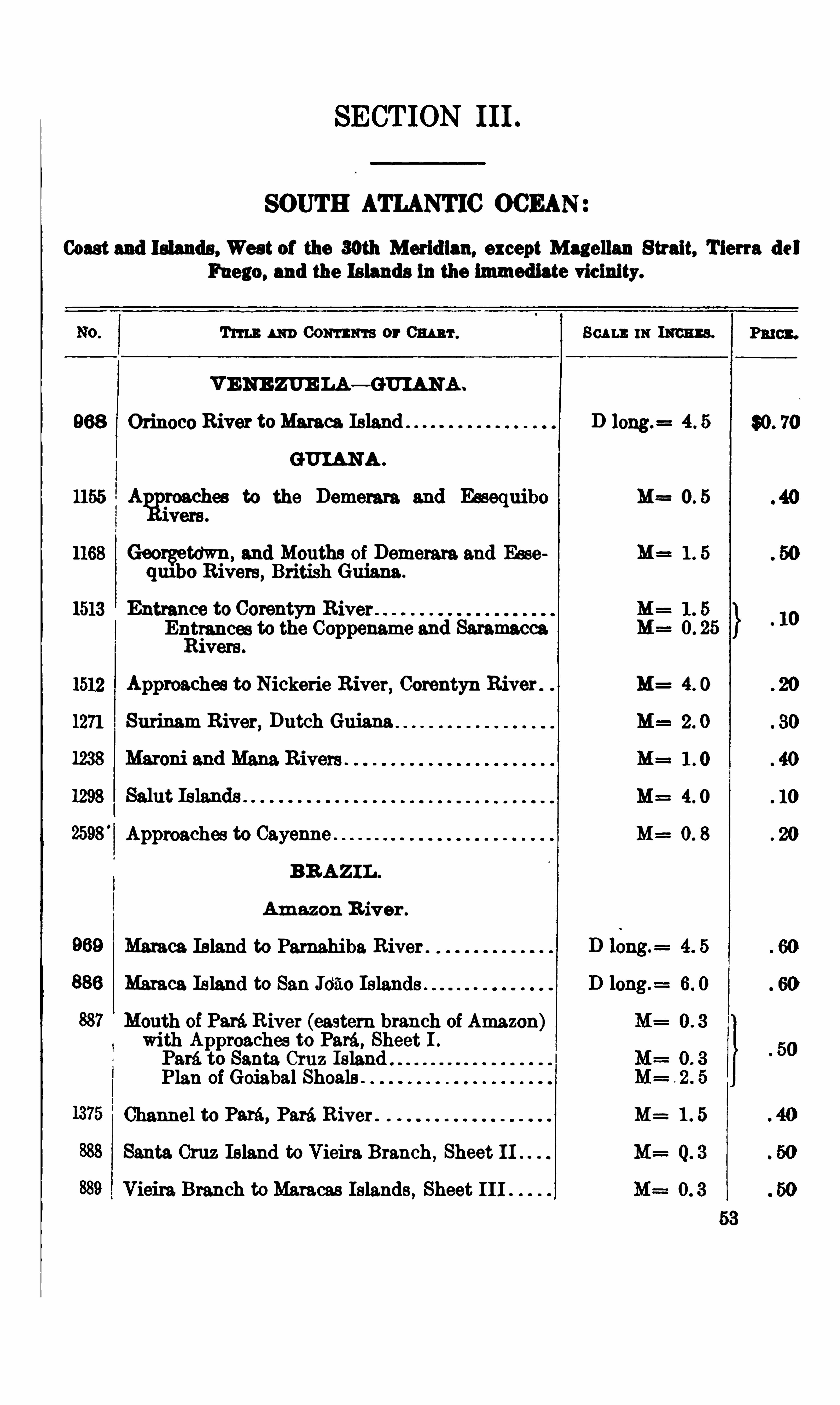
SECTION 111 .
SOUTH ATLANTIC OCEAN
Coast and Islands , West of the 3oth Meridian, except Magellan Strait, Tierra del
Fuego, and the Islands 111 the immediate vicinity.
Tum m Com ma or Cm r .
VENE ZUE LA — GUI ANA .
968 Orinoco River toMan es Island
GUIANA .
1155 Aggroachee to the Demerara and Essequibowere.
1168 Georgetown, and Mouths of Demerara and Easeqmbo Rivers , British Guiana .
1513 Entrance to Corentyn RiverEntrances to the Coppename and SaramaccaRivers .
1512 Approaches to Nickerie River, Corentyn River
1271 Surinam River, Dutch Guiana
1298 Saint Islands
2598'
Approaches to Cayenne
BR AZI L .
Amazon R iver .
Maraca Island to Parnahiba River
Maraca Island to San J650 Is lands
Mouth of Paré. River (eastern branch of Amazon)with Approaches to Paré , Sheet I .
Paré. to Santa Cruz IslandPlan of Goiabal Shoals .
Channel to Para, Paré. River .
Santa Cruz Island to Vieira. Branch , Sheet 11
Vieira. Branch to Maracas Islands , Sheet I I I
Scu mm 1m m.
D long.= 4 . 5
M= O 5
M= 1 5
M= 4 O
M= 4 O
M= 0 8
M= 1 5
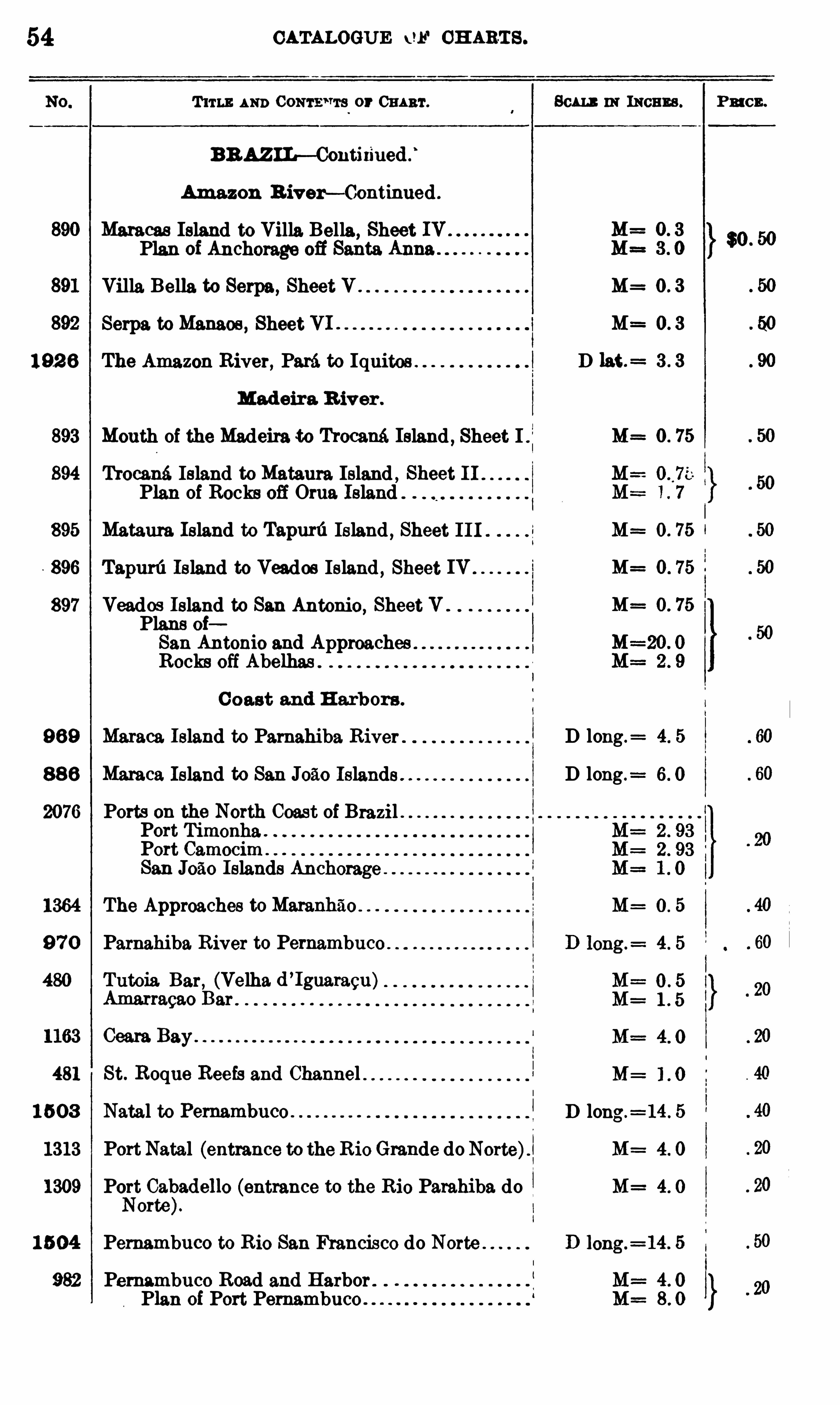
54 CATALOGUE w CH ARTS .
T um : AND CONTE ‘TTS or CHART .
BRAZIL— Contixiued .
‘
Amazon B iver— Continued .
Maracas Island to Villa Bella, Sheet IVPlan of Anchorage 03 Santa Anna
Villa Bella to Serpa, Sheet V .
Serpa to Menace, Sheet VI .
192 8 The Amazon River, Paré to Iquitos
Madeira R iver .
893 Mouth of the Madeira to Trocami Island , Sheet 1 .
894 h ocané. Island to Mataura Island , Sheet 11Plan of Rocks off Orua Island
895 Mataura Island to Tapurfi Island , Sheet I I I
896 Tapurfi Island to Veados Island , Sheet IV
897 Veados Island to San Antonio, Sheet V .
Plans oiSan Antonio and ApproachesRocks off Abelhas .
C oast and H arbors .
9 89 Maraca. Island to Parnahiba River
8 8 8 Maraca Island to San J0510 Islands
2076 Ports on the North Coast of BrazilPort TimonhaPort CamocimSan J050 Islands Anchorage
1364 The Approaches toMaranhz‘l o
9 7 0 Parnahiba. River to Pernambuco
480 Tutoia Bar, (Velha. d ’Iguaracu)
Amarragao Bar
1163 Ceera Bay
481 St. Roque Reefs and Channel
1 503 Natal to Pemambuco
1313 Port Natal (entrance to the R io Grande do Norte)
1309 Port Cabadello (entrance to the Rio Parahiba doNorte).
1 5 04 Pernambuco to Rio San Francisco do Norte
982 Pernambuco Road and Harbor .
Plan of Port Pernambuco .
80m m means .
M= 0 3
D lat .= 3 3
M=
M=
M= 0 . 75
M==0 . 75
D long .= 4. 5
D long .=
M= 0 5
M=
M=
D long.= 14 . 5
M= 4 0
M= 4 0
PRI CE .
SOUTH ATLANT IC OCEAN . 55
80m in Imu s. Pmcl .
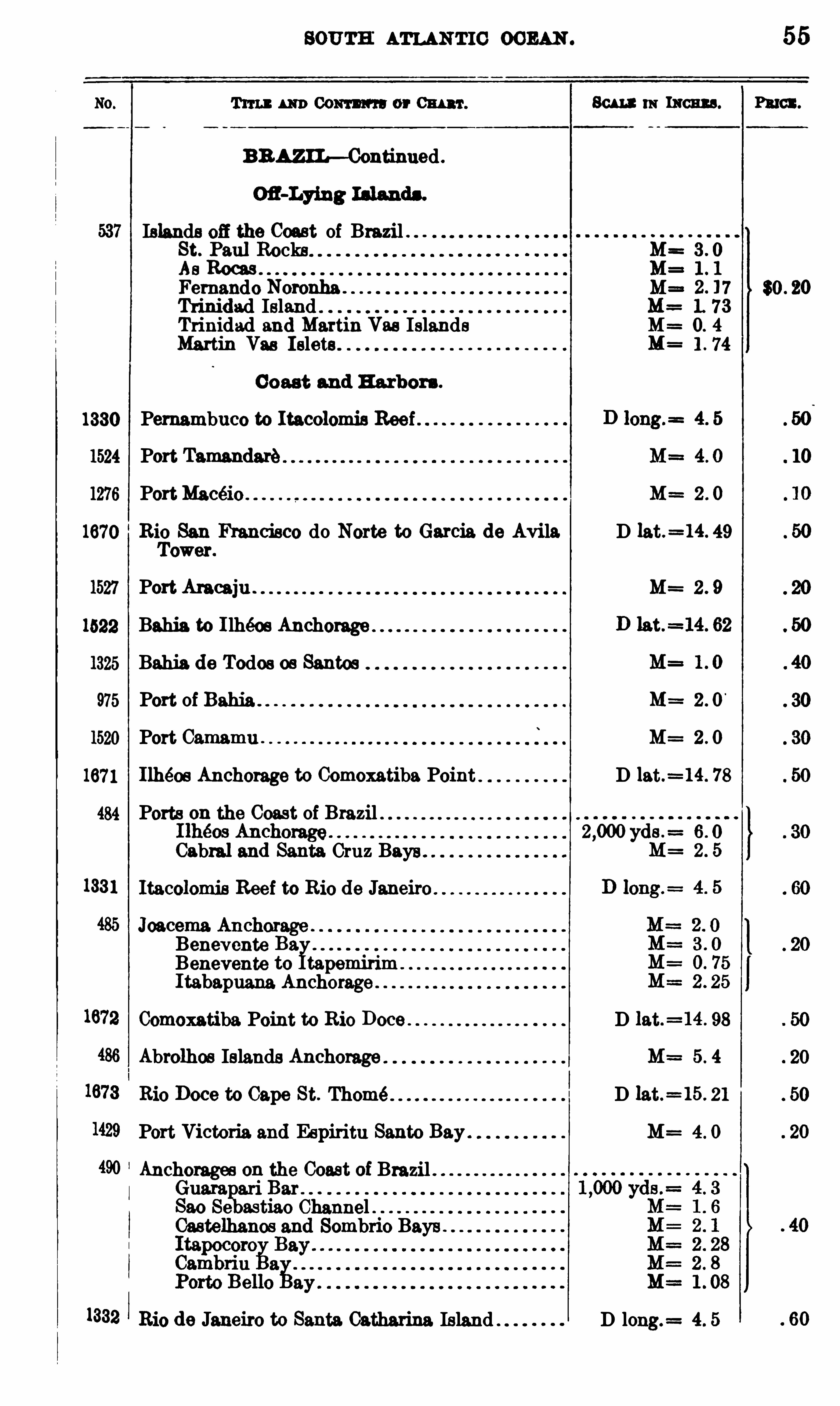
BRAZIL—Continued .
Islands off the Coast of Brazil .St. Paul Rocks M=As Roms M=Fernando Nomnha . M= $0 . 20Trinidad Island M= 1. 73Trinidad and Martin Vas Islands M= 0. 4
Martin Van I slets . l . 74
Coast and H arbors .
1330 Pernambuco to Itacolomis Reef
1524 Port Tamandaré
1276 PortMacéio u M== 2 . 0
1670 Rio San Francisco do Norte to Garcia de Avila D lat.=14. 49
Tower.
1527 Port Ames iu . M=
1522 Bahia to I lheos Anchorage
1325 Bahia. de Todos os Santos
975 Port of M= 2 . 0
1520 Port Camamu . M= 2 . 0
1671 Ilheos Anchorage to Comoxatiba Point D lat.=14. 78
484 Ports on the Coast of Brazil2 ,000 yds . 6 0
Cabral and Santa Cruz Bays
1331 Itacolomis Reef to Rio de Janeiro
Benevente Ba.Benevente to tapemirimI tabapuana. Anchorage"
Comoxatiba Point to Rio Doce D lat.=14. 98
Abrolhos Islands Anchorage M= 5 . 4
Rio Doce to Cape St. Thome D lat.=15. 21
Port Victoria. and Espiritu Santo Bay M= 4 . 0
Anchorages on the Coast of BrazilGuam ari BarSao Se astiao Channel .Castelhanos and Sombrio Bays .
1332 Rio de Janeiro to Santa. Catharina Island D long.= 4. 5
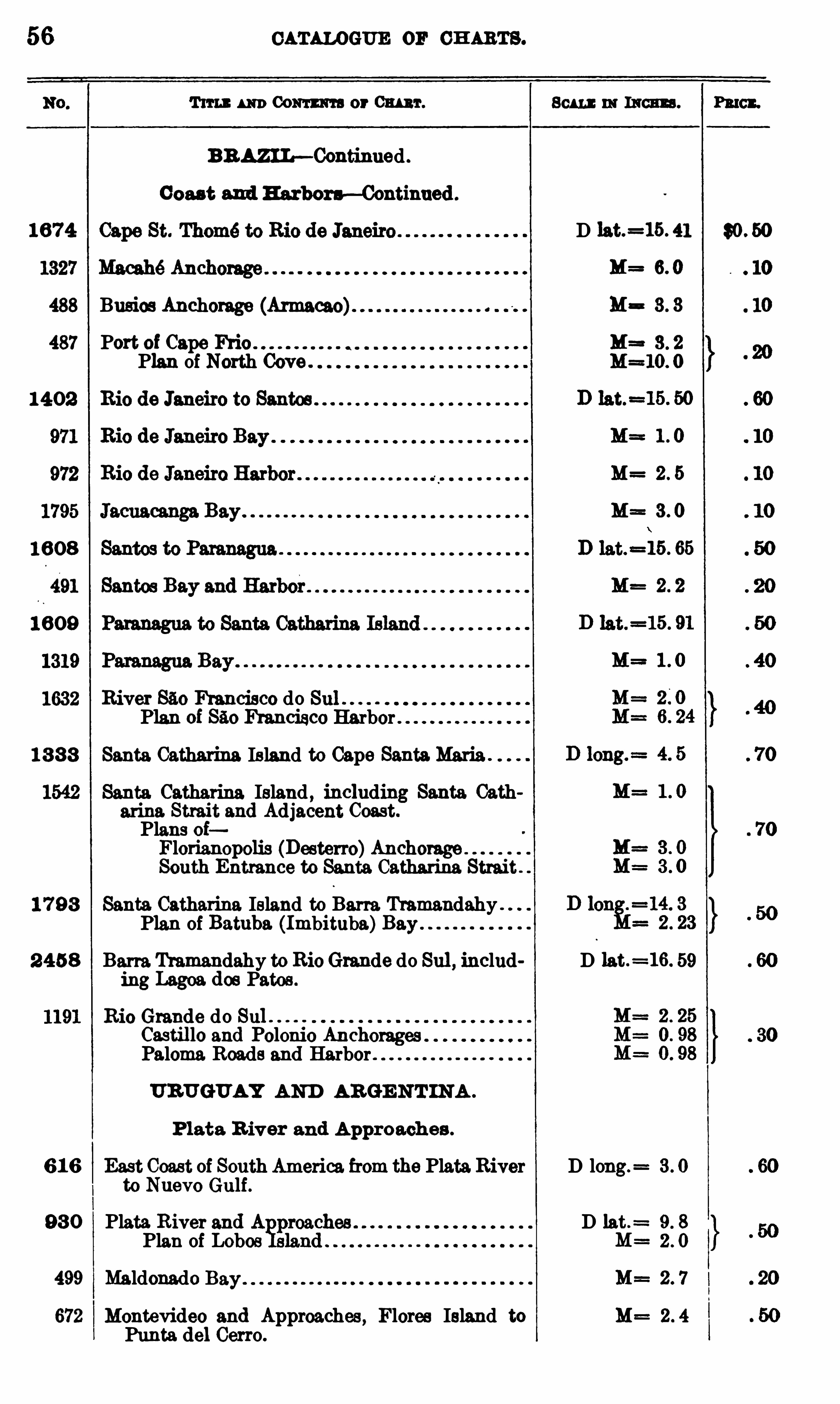
56 ou w oema or CH ARTS .
T im m Comm or 01mm. 801 1 : 11: mean . Pinon.
BRAZIL—Continued .
Coas t and H arbors —Continued .
1674 D lat.=15. 41 $0 . 50
M= 6. 0
488 Busies Anchorage (Armacao) M= 3 . 3
487 Port of Cape Ffi'io M= 3 . 2
Plan of North Cove . M=10. 0
1402 Rio de Janeiro to Santos
M=
M=
1 608
1 609
River 850 Francisco do Sul .
Plan of Francisco Harbor
1 8 8 8 Santa Catharina Island to Cape Santa.Maria
Santa Catharina Island , including Santa Oatharina. Strait and Adjacent Coast.
Plans oiFlorianopolis (Desterro)AnchorageSouth Entrance to Santa Catharina Strait .
1 7 98 Santa Catharina Island to Berra. Tramandahy .
Plan of Batuba. (Imbituba)Bay .
2 458 Berra Tramandahy to RioGrande do Sul , includ D lat.=16. 59
ing Lagos. dos Patos .
Rio Grande do SulCastil lo and Polonio AnchoragesPaloma Roads and Harbor
URUGUAY AND ARGE NT IN A .
Plate. Rivar and Approaches .
6 1 6 East Coast of South America from the Plate.River D long. 3 . 0
to Nuevo Gulf .
98 0 Plata River and A D lat .= 9 . 8
Plan of Lobos 2 . 0
499 Maldonado M= 2 . 7
672 Montevideo and Approaches , Flores Island to M= 2 . 4
Punta del Cerro .

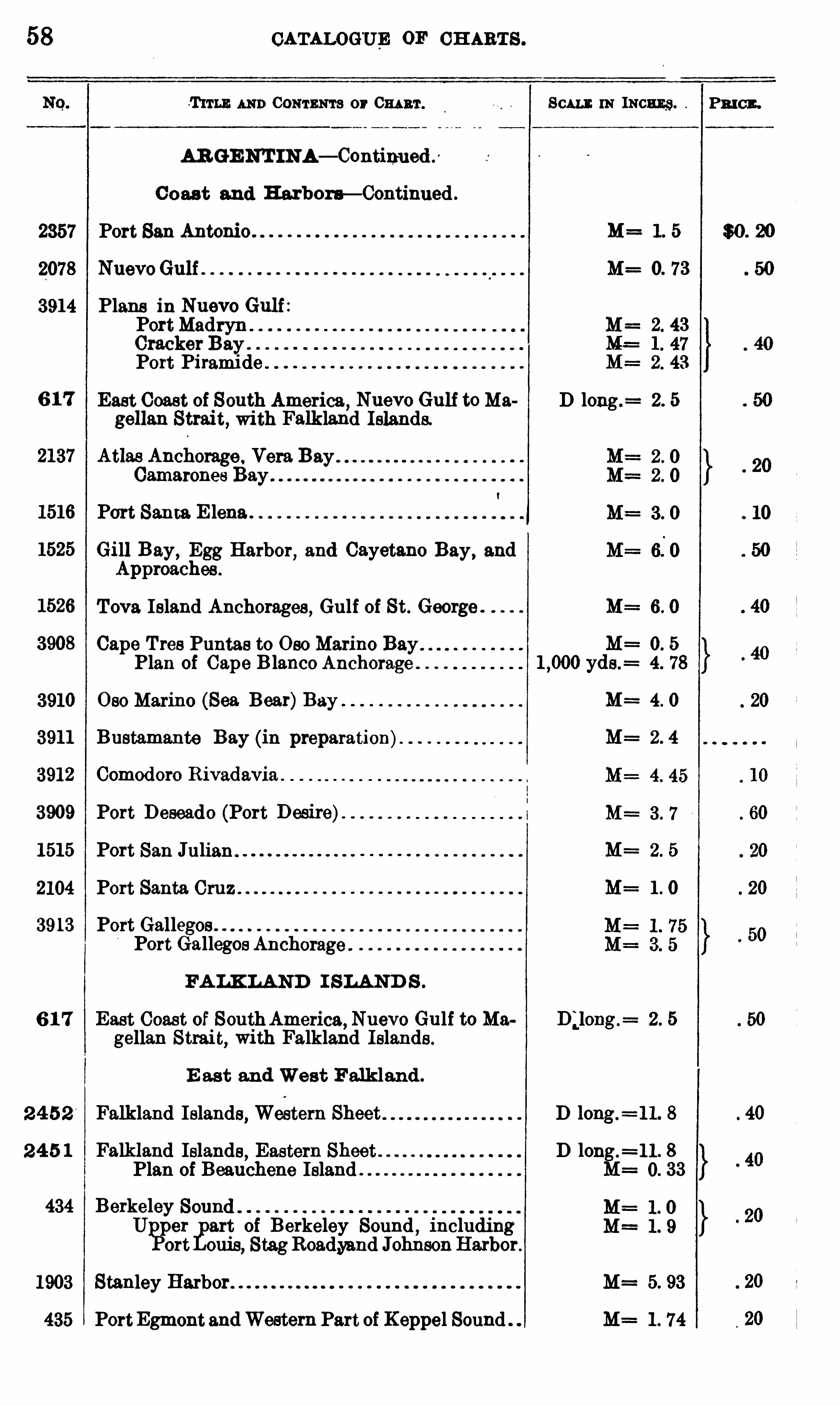
58 CATALOGUE OF CH ARTS .
T um AND CONTENTS or 0 111 3 1 . Scum: m Incu g.
AR GE NT INA— Continued .
0 0 act and Harbora— Continued .
2357 Port San Antonio . M= 1. 5
2078 NuevoGulf 0. 73
3914 Plans in Nuevo Gulf :PortMadryn . .
Cracker BayPort Piramide"
East Coast of South America, Nuevo Gulf toMa D long .= 2. 5
gellan Strait, with Falkland Islands.
Atlas AnchorageCamarones Bay .
Port Santa E lena .
Gill Bay,Egg Harbor, and Cayetano Bay, and
Approaches .
Tova Island Anchorages , Gulf of St. George . M= 6. 0
Cape Tres Puntas to 0 30 Marine Bay M= 0. 5
Plan of Cape Blanco Anchorage yds .= 4. 78
3910 0 80 Marine (Sea Bear)Bay M= 4. 0
3911 Bustamante Bay (in preparation). M= 2 . 4
3912 Comodoro Rivadavia .
3909 Port Deseado (Port Desire)
1515 Port San Julian . M= 2. 5
2104 Port Santa Cruz . M= 1 . 0
3913 Port Galleg .o .s
Port Gallego
os Anchorage
FA LK LAND I SLAN D S .
6 1 7 East Coast of SouthAmerica, Nuevo Gulf to Ma B;long .= 2 . 5
gellan Strait, with Falkland Islands .
E ast and West Falkland .
2 4 5 2 Falkland Islands, Western Sheet D long.=11. 8
2 4 5 1 Falkland Islands,Eastern Sheet D long .
=11 . 8Plan of Beauchene Island M= 0. 33
434 BerkeleyU per art of Berkeley Sound
,including
ort ouis, StagRoad,yand JohnsonHarbogr.
1903 Stanley Harbor. M= 5. 93
435 PortEgmont andWestern Part of Koppel Sound M= 1 . 74
PRI CE .
$0 . 20
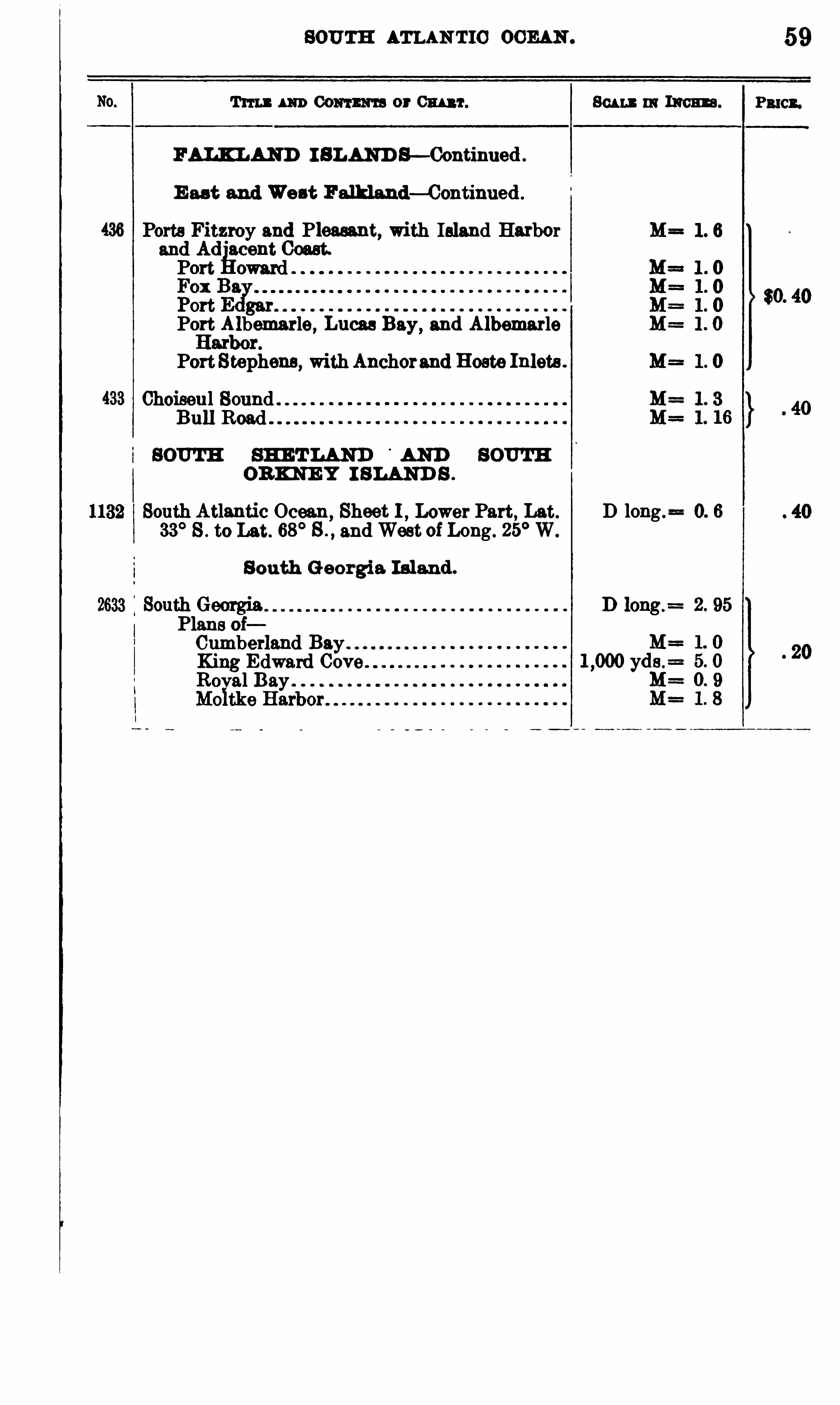
SOUTH ATLAN TIC OCEAN .
BALI LAHD I SLAND S—Continued .
E ast and West Falkland—Continued .
Ports Fitzroy and Pleasant, with Island Harborand Ad
°
acent Coast.Port eward
Port Albemarle, Lucas Bay,and Albemarle
Port Stephens , withAnchorand Hoste Inlets .
Choiseul Sound .
Bull Road
SOUTH SH ET LAND°
AND SOUTH
ORKNE Y I SLAND S .
1132 South Atlantic Ocean, Sheet 1 , Lower Part, Lat.
33°8 . to Let. 68
°S .
,and West of Long . 25
°W.
S outh Georgia Is land .
2633 South GeorgiaI Plans oi
Cumberland Bay .
King Edward CovRoyal Bay
Sou s m 11mm .
D long .= 0. 6
59
P3 101 .

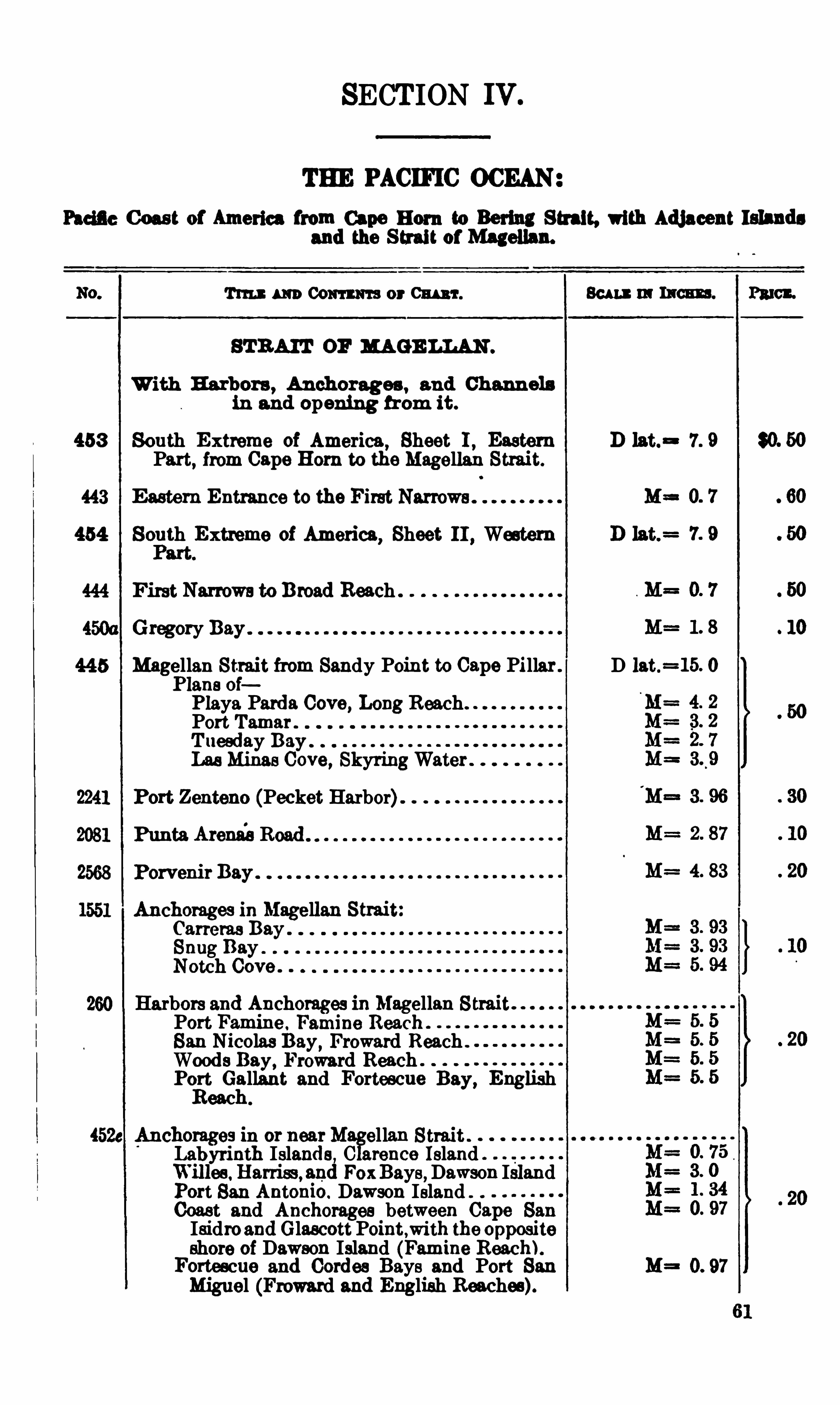
SECT ION IV .
THE PACIFIC OCEAN
Facil e C oast of America from Cape B orn to Bering Strait, with Adjacent Islandsand the S trait of Magellan.
Tm m Com m-a or CHART . Bu u m ntcm . Pmct .
STRAIT OF R AGE LLAN .
With Harbors , Anchorages , and Channelsin and opening from it .
453 South Extreme of America , Sheet 1 , Eastern D lat.= 7. 9Part
,from Cape Hem to the Magellan
443 E astern Entrance to the First Narrows .
454 South Extreme of America, Sheet II , Western
First Narrows to Broad Reach
Gregory Bay .
Magellan Strait from Sandy Point to Cape Pillar . D lat.=15. 0g
Plans ofPlaya Parda Cove, Long ReachPort Tamar"T uesday Bay .
LaaMinas Cove, SkyringWater
Port Zenteno (Pecket Harbor)
Punta Arena'
aRoad
Porvenir Bay
chorages in Magellan StraitCarreras Bay .
Snug BayNetch Cove ”
Harbors and Anchorages 111 Megellan StraitPort Famine . Famine Reach .
N1colas Day,Froward Reach .
Woods Bay, Froward ReachP01?Gallant and Fortescue Bay, English
eac
chorages m or nearM ellan Strait .
Labyrinth Islands , C arence Island .
Willee. Ha1-riss, and FoxBays,Dawson Island
Port San Antoh io. Dawson Island ”
Coast and Anchorages between Cape SanIsidroand Glascott Point,with the oppositeshore of Dawson Island (Famine Reach).Fortescue and Cordes Bays and Port 81111 M= 0. 97
Miguel (Froward and English Reaches).
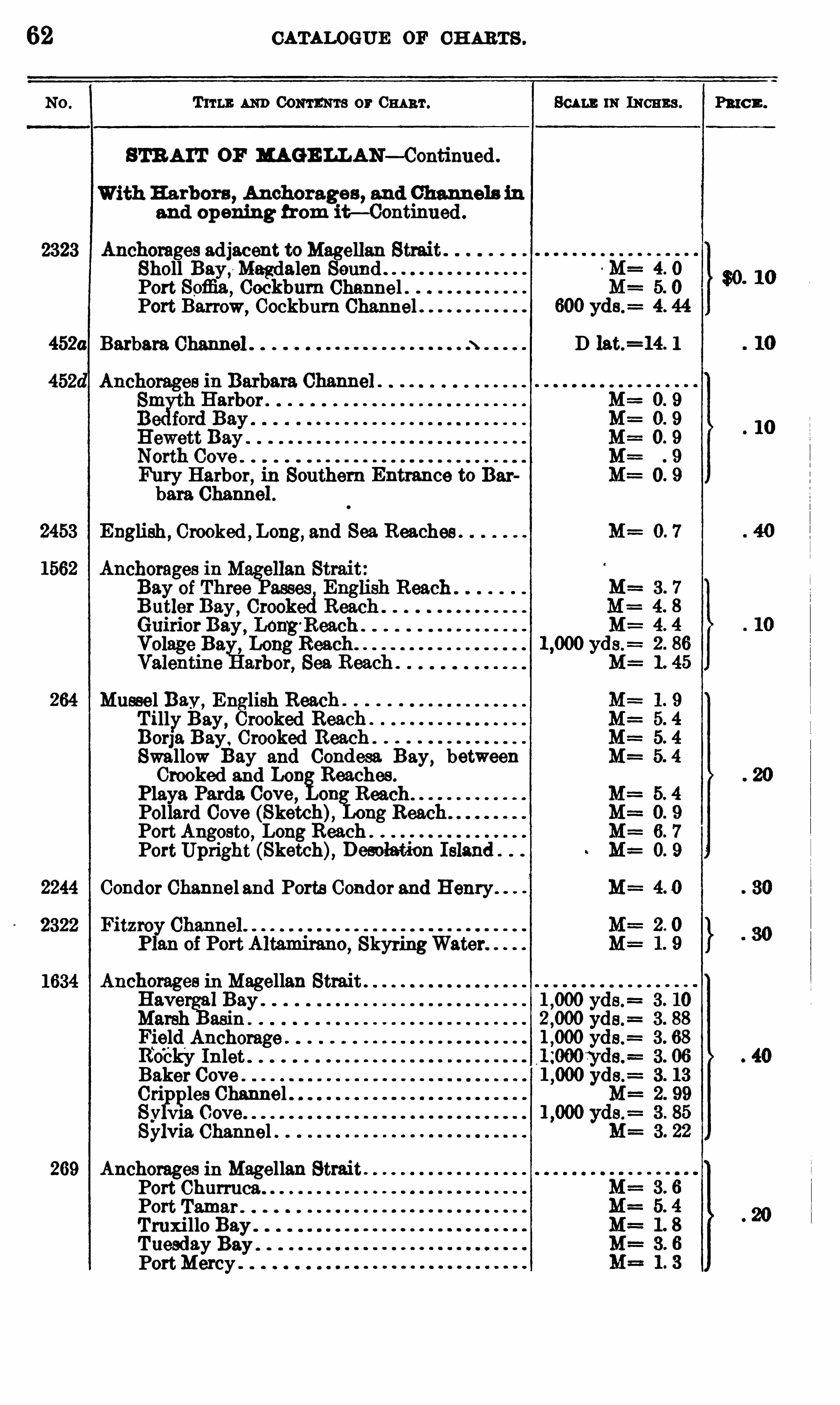
62 CATALOGUE OF CH ARTS .
T 11 1 1; 1 1m CONTENTS or 0 1111111 .
STR A IT OF MAGE LLAN—Continued .
nchorages adjacent toMagellan StraiSholl Bay,
-Magdalen SoundPort Sofiia, Cockbum Channel .Port Barrow,
Cockburn Channel
452a Barbara Channel
Fury Harbor, in Southern Entrance to Barbara Charm
English , Crooked , Long, and Sea Reaches
ssel Bay ,English Reach
TillyBay , Crooked Reach .
Borja Bay . Crooked Reach .
Swallow Bay and Condesa Bay , betweenCrooked and Lon Reaches .
Playa Parda. Cove , on Reach.
Pollard Cove (Sketch), 11g B eecPort Angosto, Long Reach .
PortUpright (Sketch), Desolatio
Condor Channel and Ports Condor and Henry .
SkyringWater
chorages in MagellanHave 1Bay .
Marsh asin
FieldAnchorageRocky Inlet .
Baker CoveCri ples ChannelSy v1a Cove . .
Sylvia Channel .
Anchorages in Magellan StraitPort ChurrucaPort Tamar .
Truxi llo Bay .
Tuesday Bay .
PortMercy
SCALE m IN CHE S .
~ M=
D lat.=14. 1
Pmcn.
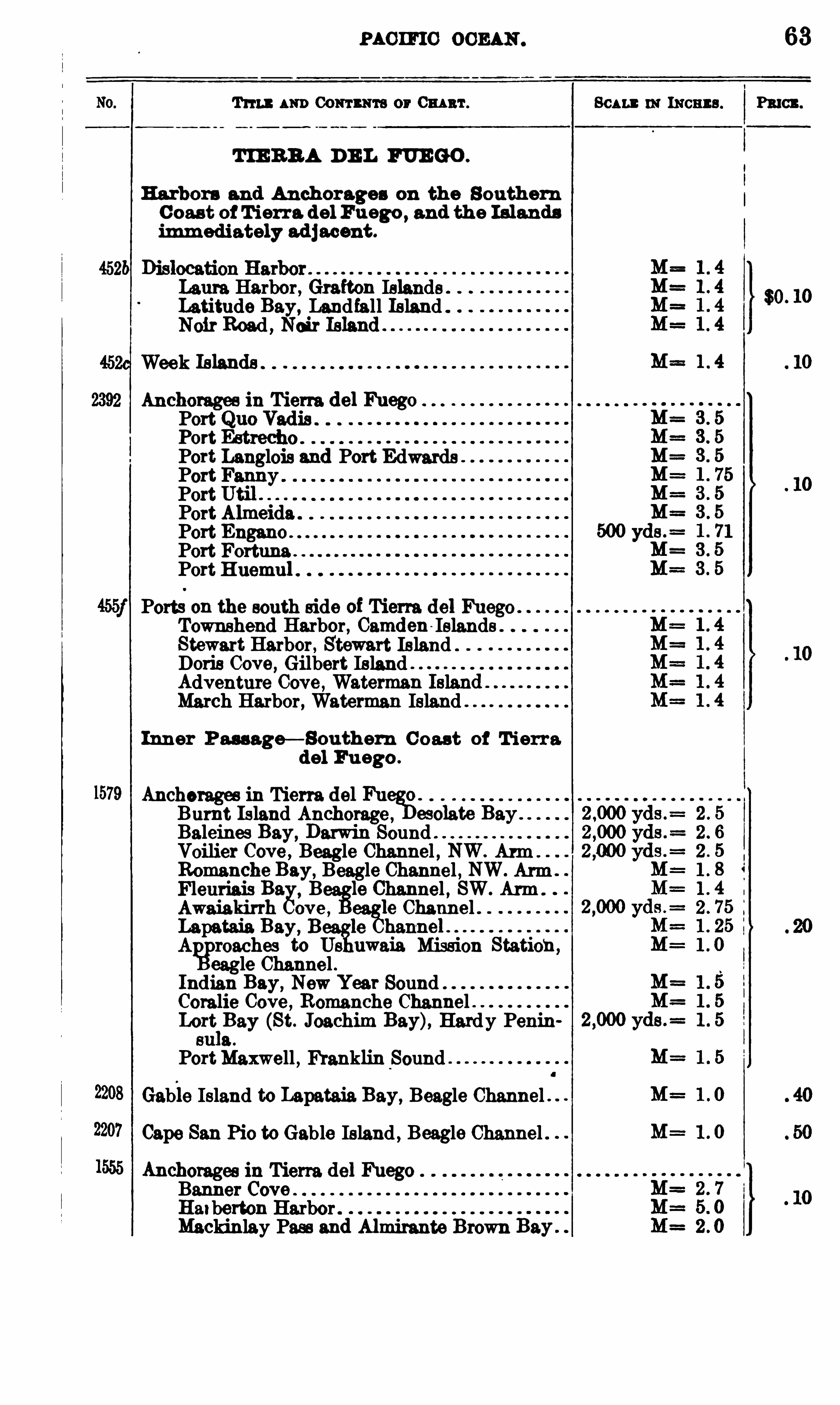
mem o 0 0 2 1 11 . 63
Tms 1 111) Coutu re or 0mm . Ben : 11: 1110113 9 . Fn en.
TIE RB A D E L FUEGO .
Harbors and Anchorages on the S outhern
C oas t of T ierra del Fuego , and th e Islands
imm ediately ad j acent .
Laura Harbor , Grafton IslandsLatitude Bay, Landfall Island .
Noir Road , Nair
Week
Anchorages in Tierra del FuegoPortPort
Port Langlois and Port EdwardsPortPortPort AlmeidaPort EnganoPort FortunePort Huemul .
Ports on the south side of Tierra del FuegoTownshend Harbor , Camden IslandsStewart Harbor , Stewart Island .
Doris Cove, Gilbert IslandAdventure Cove , Waterman IslanMarch Harbor , Waterman Island
Inner Pm age— Bouthem C oast of T ierra
del Fu ego .
Anchoragee in Tiem del FuegB.
Burnt Island Anchorage , esolate BayBaleines Bay,
Darwin SoundVoilier Cove , Beagle Channel , NW. Arm .
Romanche Bay, Beagle Channel , NW. ArmFleuriais Ba. B lo Channel , SW. Arm .
Awaiakirrh ove ,le Channel .
Lapataia Bay, Beaglle hanne1. .
A reaches to Us uwaia Mission Stationeagle Channel .
Indian Bay, New Year SoundCoralie Cove , Romanche Channel .Lort
l
Bay (St. Joachim Bay), Hardy Penineu 3 .
PortMaxwell , Franklin Sound
Gabie Island to Lapataia. Bay, Beagle Channel .
Cape San Pio to Gable Island , Beagle Channel .
Anchorages in Tierra. del FuegoBanner CoveHatberton HarborMackinlay Pass and Almirante Brown Bay .
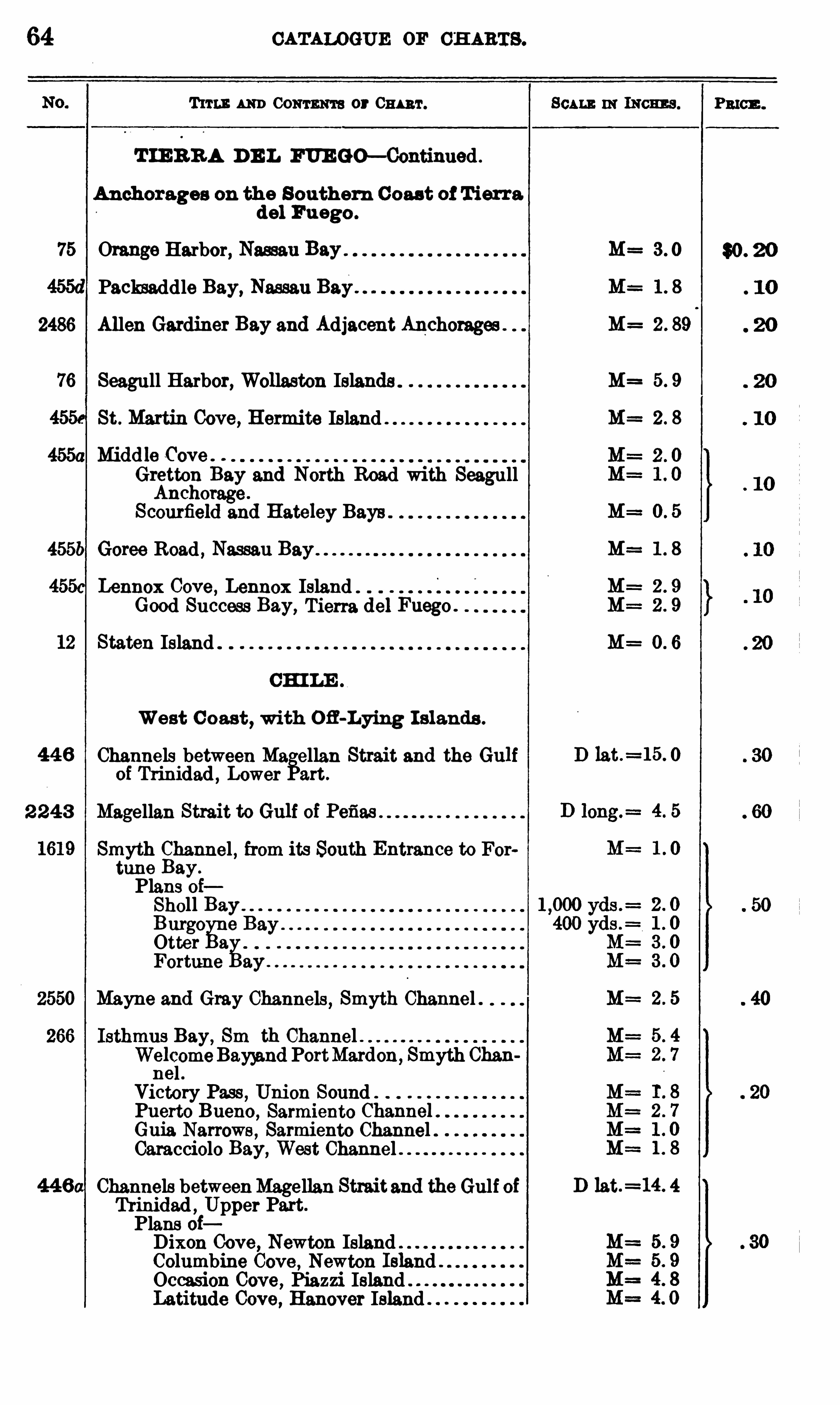
64 CATALOGUE or CH ARTS .
T um: 1 111) CONTENTS or 0111 111 .
T IE RR A D E L FUE GO—Continued .
Anchorages on the S outhern Coast of T ierradel Fuego .
75 Orange Harbor, Nassau Bay
Packsaddle Bay, Nassau Bay .
2486 Allen Gardiner Bay and Adjacent Anchorages
Seagull Harbor, Wollaston Islands
St . Martin Cove, Hermite Island
M1ddle Cove ”
Gretton Bay and North Road with SeagullAnchorage .
Scourfield and Hateley Bays .
455b Goree Road , Nassau BayLennox Cove , Lennox Island
Good Success Bay, Tierra del Fuego .
Staten Island
CH I LE .
West C oast,with Ofi -Lying I slands .
Channels between Magellan Strait and the Gulfof Trinidad , Lower Part .
2 2 4 3 Magellan Strait to Gulf of Pefias
Smyth Channel , from its South Entrance to Fortune Bay.
Plans oiSholl Bayurge
Otter a
e
fiFortune ay . .
Mayne and Gray Channels , Smyth Channel .
Isthmus Bay , 8 111yth Channel .Welc
iomyeBayyand PortMardon, Smyth Chan
ne
Victory Pass , Union Sound .
Puerto Bueno ,Sarmiento Channei.
Guia Narrows Sarmiento Channel .Caracciolo Bay,
West Channel
Channels betweenMagellan Straitand the Gulf ofTrinidad , Upper Part.
Plans oiDixon Cove, Newton IslandColumbine Cove , Newton Island .
Occasion Cove , Piazzi IslandLatitude Cove , Hanover Island
m INcn s .
M= 3 0
M=
M=
M=
M= 1 8
M=
D lat.=15. 0
D lat.=14. 4

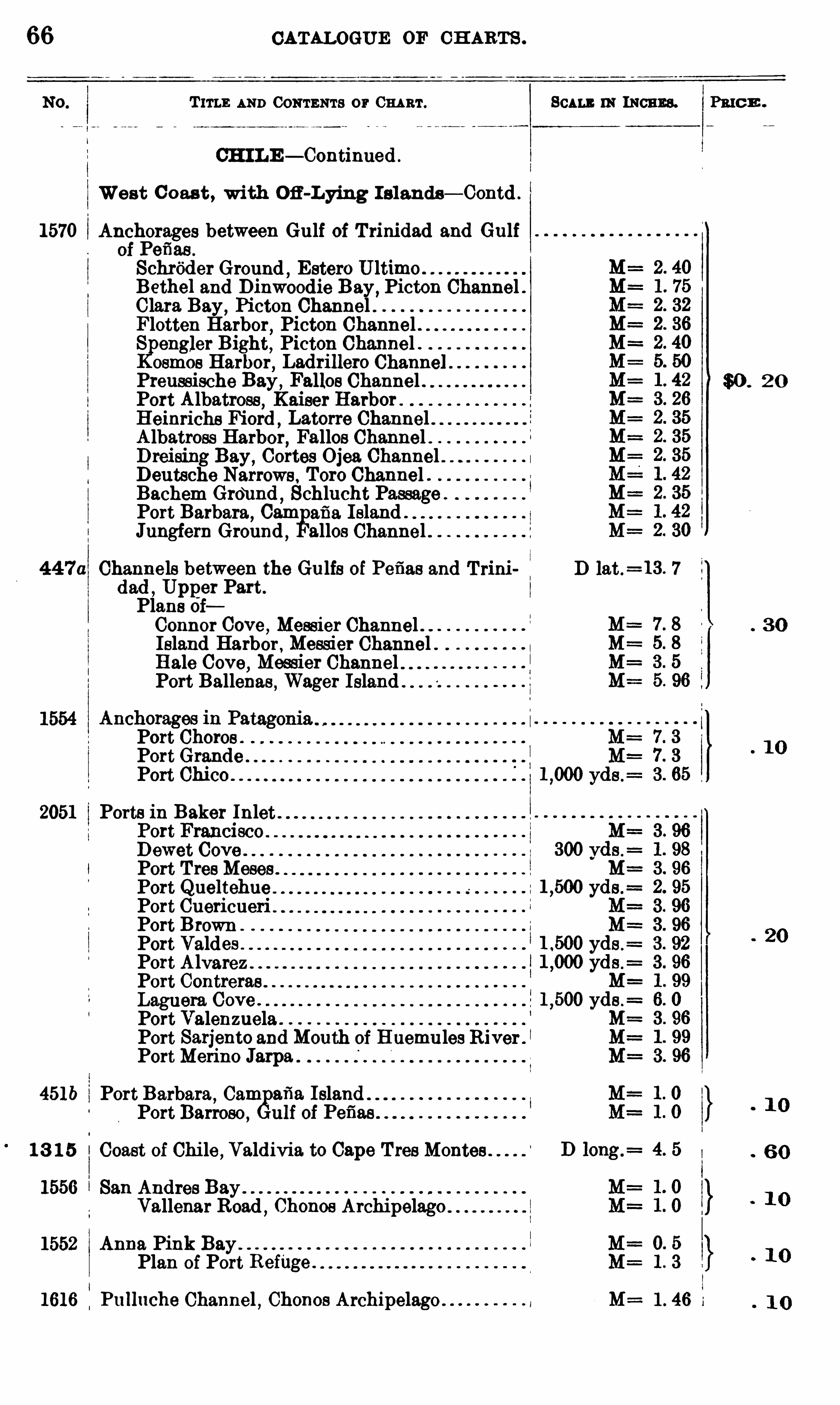
66 CATALOGUE OF CH ARTS .
T 111 1 : AND CONTENTS or CHART. 11: INCHES. Pmcn .
CH ILE — Continued .
West C oast , with Ofi -Lying' I slands— Contd .
1570 Anchorages between Gulf of T rinidad and Gulfof Pefias .
Schrfider Ground,Estero Ultimo .
Bethe] and Dinwoodie Bay , Picton Channel .Clara Bay
,Picton Channel
Flotten Harbor,Picton Channel .
S engler Bight, Picton Channel .osmoe Harbor
,Ladrillero Channel
Preussische Bay ,Falloe Channel . $0 . 2 0
Port Albatross,Kaiser Harbor .
Heinrichs Fiord,Latorre Channel
Albatross Harbor,Fallos Channel
Dreising Bay , Cortes Ojea. ChannelDeutsche Narrows , Toro Channel .Bachem Groi md
, Schlucht Passage .
Port Barbara, Cam 2 5 21 Island .
Jungfern Ground , allos Channel
44 7a Channels between the Gulfs of Pefias and T rini D lat.=13 . 7
dad, Upget Part.
Plans oiConnor Cove , Messier ChannelIsland Harbor , Messier ChannelHale Cove, Messier ChannelPort Ballenas
,Wager Island .
Port ChoresPortGrandePort Chico
2051 Ports in Baker Inlet .
B ewet CovePort TreeMeses .
Port Cuericueri .
Port BrownPort ValdesPort Alvarez .
Port Contreras .
Laguera Cove .
Port ValenzuelaPort Sarjento and Mouth of Huemules River .
I
PortMerino Jarpa
451b Port Barbara,Cam afia. Islan
Port Barroso ,ulf of Pefias
1 3 1 5 Coast of Chi le ,Valdivia to Cape TreeMontes .
1556 San Andres BayVallenar Road
,Chonoe Archipelago
1552 Anna Pink BayPlan of Port Refflge .
1616 Pulluche Channel , Chonos Archipelago . 1 . 46 1
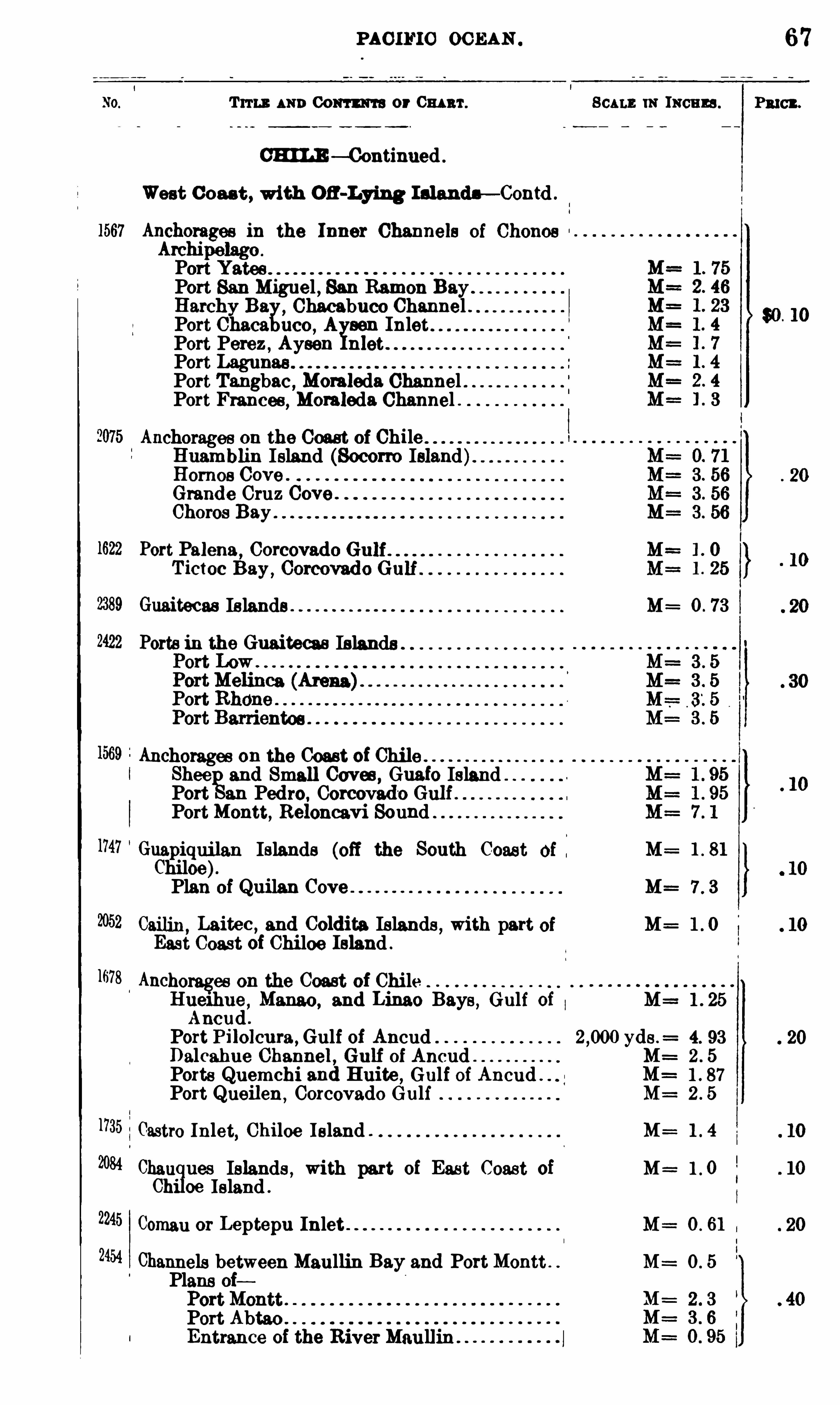
2422
1678
2245
2454
PAC IFIC OC EAN
Trru . AND 00 111 1 1173 or 0 111 111 . SCALE m Incum .
CHILE — Continued .
West Coast , with OH-Lying Inlandn— Contd .
Port San Miguel , San Ramon Bay .
Harchy Ba
y, Chacabuco Channel .
Port Chaca uco ,A son Inlet
Port Perez ,Aysen nlet
PortPort Tangbao,
Moraleda ChannelPort Frances
,Moraleda Channel .
Anchorages on the Coast of ChileHuamblin Island (Socorro Island)Hom es Cove .
Grande Cruz Cove .
Chores Bay .
Port Palena, Cor
T ictoc Bay ,
Guaitecas Islands M=
Ports in the Guaiteeas Islands
Anchorages on the Coast of ChileShee and Small Caves , Guafo IslandPort an Pedro, Corcovad ‘
o GulPortMontt, Reloncavi Sound
Guapiquj lan Islands (off the South Coast M=Chiloe).Plan of Quilan Cove M= 7 . 3
0311111 , Laitec , and Coldita Is lands , with part M= 1 . 0
East Coast of Chiloe Island .
Anchorages on the Coast of Chi leHue1hue ,
Mango , and Lim e Bays , Gulf of M==1Ancud .
Port Pilolcura , Gulf of Ancud yds . 4.
Dalcahue Channel , Gulf of Ancud M= 2 .
Ports Quemchi and Huite , Gulf of Ancud . 1
Port Queilen,Corcovado Gulf M= 2
1Castro Inlet,Chiloe Island . M=
Chau ues Islands , with part of East Coast of M= 1 .
Ch'
oe Island .
Coman or Leptepu Inlet M
Channels between Maullin Bay and PortMontt . M : 0 . 5
Plans oi
Port AbtaoEntrance of the River Maullin .
67
PRICE .
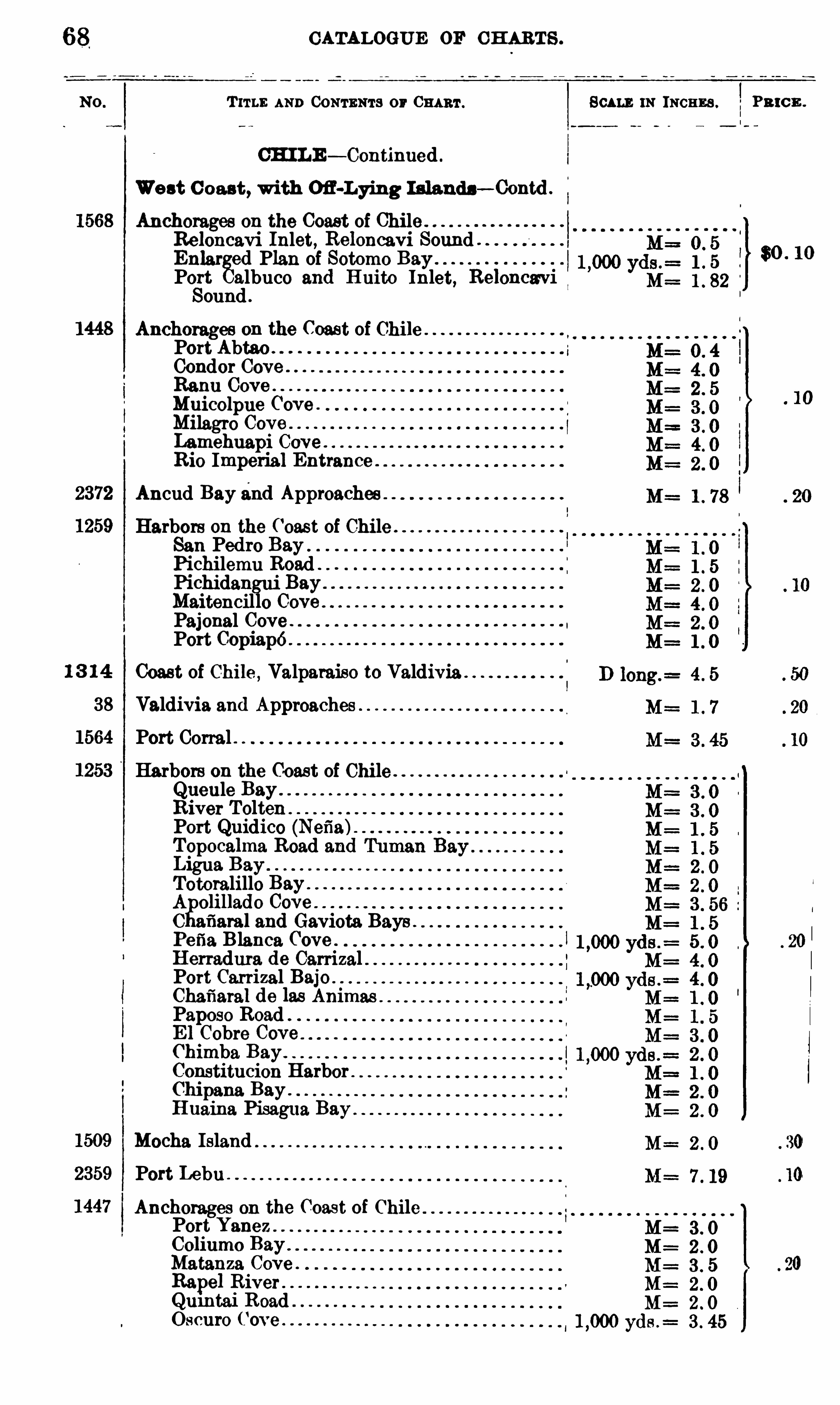
CATALOGUE OF CHARTS .
T 11 11 : AND CONTENTS or SCALE IN INCHES . Pn cn .
CH ILE — Continued .
West C oast , with Ofl-Lying I slands— Contd .
Anchorages on the Coast of ChileReloncavi Inlet, Reloncavi Sound .
Enlar ed Plan of Sotomo Bay 30 10
Port albuco and H uito Inlet, Relonca'viSound .
Anchorages on the Coast of ChilePort Abtao .
Condor CoveRanu CoveMuicolpue Cove .
Milagro CoveLamehuapi Cove .
Rio Imperial Entrance .
Ancud Bay zind ApproachesHarbors on the ( ‘oast of Chile
San Pedro BayPichilemu RoadPichidangui BayMaitencillo CovePajonal Cove .
Port Cepiapé .
Coast of Chile , Valparaiso to ValdiviaValdivia and Approaches
Port Corral
Harbors on the Coast of ChileQueule BayRiver ToltenPort Quidico (Nefia)Topocalma Road andLigua BayTotoralillo BayA olillado CoveC afiaral and Gaviota Bays .
Pefia. Blanca ( ‘oveHerradura de CarrizalPort Carrizal BajoChafiaral de las AnimasPaposo RoadE 1 Cobre CoveChimba BayConstitucion HarborChipana Bay .
Huaina Pisag ua BayMocha Island
Port LebuAnchorages on the Coast of ChilePort Yanez M=Coliumo Bay M=Matanza Cove . 3 . 5Rape] River . M 2 . 0
Qumtai Road . M= 2 . 0Oscuro Cove . yds .
= 3 . 45
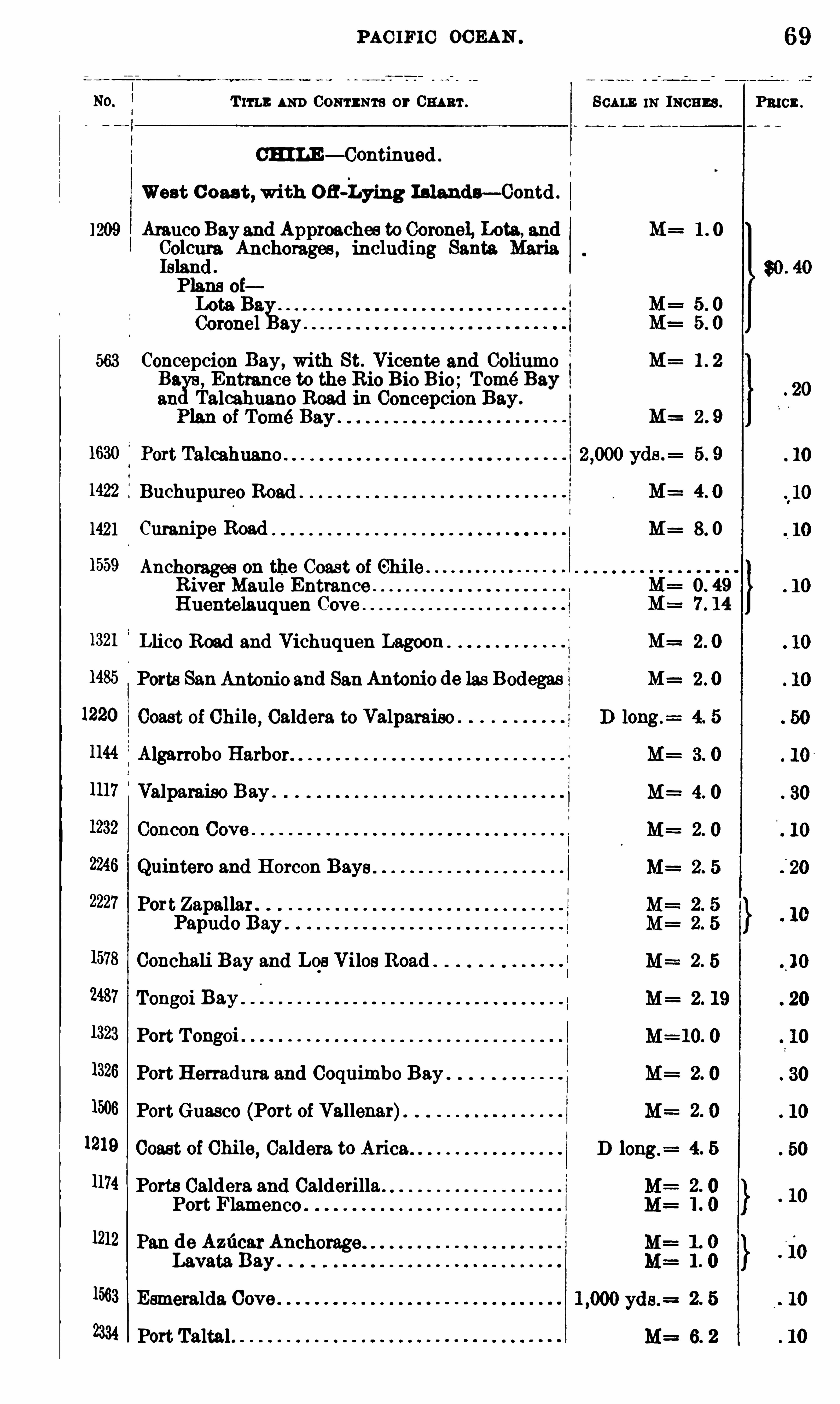
PAC IFIC OCEAN .
Tm : 1110 ) CONTENTS or 0 111 111 .
CHI LE — Continued .
West C oas t,with oa-Lying I slands- Contd .
1209 Amuco Bayand Approaches to Coronal, Lots , andColcura Anchorages , including Santa MariaIsland .
Plans oiLota B9.Coronel ay .
563 Concepcion Bay, with St. Vicente and ColiumoBa Entrance to the Rio Bio Bio; Tomé Bayan Talcahuano Road in Concepcion Bay.
1422 Buchupureo Road .
1421 Curanipe Road
1559 Anchorages on the Coast of Chi leRiver Maule EntranceHuentelauquen Cove
1321 Llico Road and Vichuquen Lagoon
1485 Ports SanAntonio and San Antonio de las Bodegas
1220 Coast of Chile, Caldera to Valparaiso .
1144 Algarrobo Harbor.
1117 Valparaiso Bay .
Concon Cove .
Quintero and Horcon Bays
Port Zapallar .
Papudo Bay
Conchali Bay and Los Vilos Road .
Tongoi Bay
Port Tongoi
1326 Port Herradura and Coquimbo Bay .
1506 Port Guasco (Port of Vallenar)1219 Coast of Chi le
, Caldera to Arica1174 Ports Caldera and Calderilla.
Port Flamenco1212 Pan de Azficar Anchorage
Lavata Bay
1563 Esmeralda Cove .
2334 Port Taltal
M=
M=
M=
M=
M==
M=
M=
M=
M=
M==
SCALE 11: INCHES .
69
Pmcz .
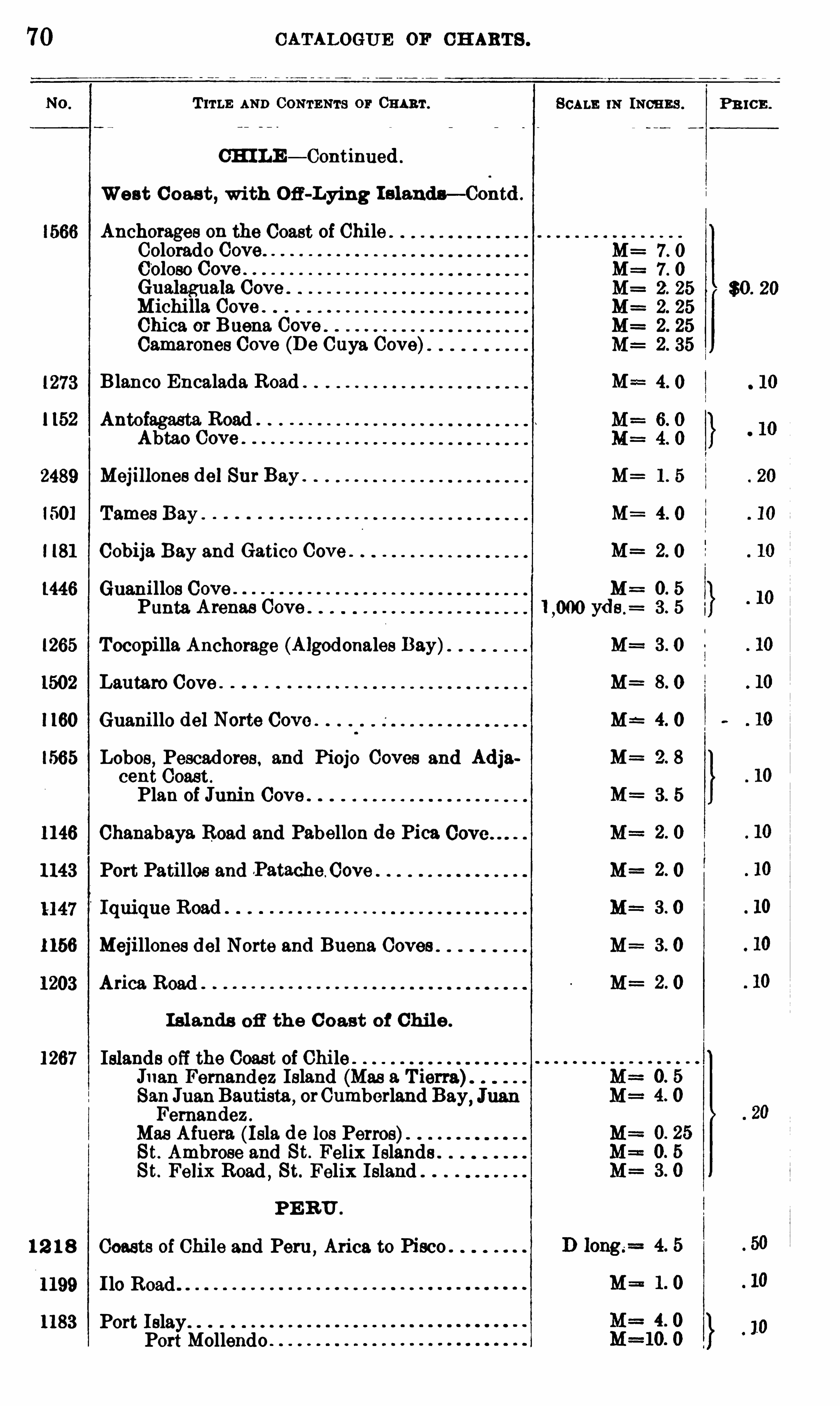
70 CATALOGUE OF CH ARTS .
T ITLE AND CONTENTS or CHART.
CH I LE — Continued .
West C oast , with Ofi -Lying I s landn— Contd .
Anchorages on the Coast of ChileColorado Cove0010 50 CoveGualaguala Cove .
Michi lla CoveChica or Buena CoveCamarones Cove (De Cuya Cove)
Blanco Encalada Road M==
1152 Antofagasta RoadAbtao Cove
2489 Mej l llonee del Sur Bay . M=
150] Tames Bay . M=
I [81 Cobl ja Bay and Gatico Cove . M=
1446 Guenilles Cove .
Punta Arenas Cove ,000 yde
1265 Tocopilla Anchorage (Algodonales Bay) M==
1502 Lautaro Cove . M=
1160 Guanillo del Norte Cove M
1565 Lobos , Pescadores , and Piojo Coves and Adja M=cent Coast .
Plan of Junin Cove . M=
1146 Chanabaya. Road and Pabellon de Pica
1143 Port Patillos and .PatacheC ove M
1156 Mej i llones del Norte and Buena Coves
1203 Arica Road
I slands off the C oast of Chil e .
1267 Islands off the Coast of Chile .
Jnan Fernandez Island (Mas 9. T ierra).
JuanBautista,orCumberland Bay
,
Fernandez .
Mas Afuera (Isla de los Perros)St. Ambrose and St. Felix I slands .
St. Felix Road , St. Felix Island .
PE RU .
1 2 1 8 Coasts of Chi le and Peru ,Arica to Pisco .
1199 Ho Road
1183 Port Islay .
PortMollendo
SCALE 1N INCH ES .
z“
N
N
N
N
S
?’
o
wwwwo
o
war
mer
PR ICE .
$0 . 20
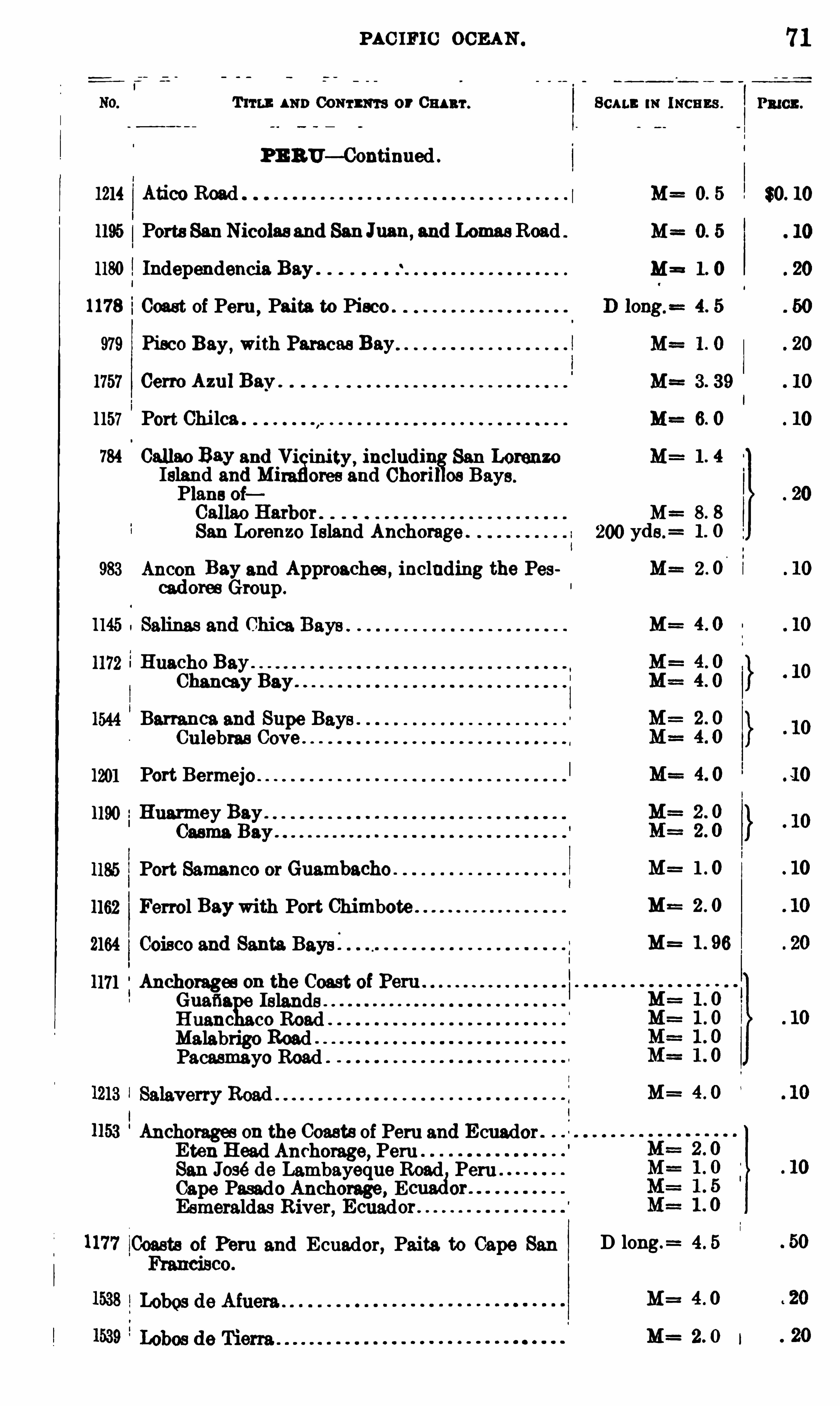
PAC IFIC OCEAN .
Trru : AND Comm or Om ar .
PE BU—Continued .
1214 Atico Road
1195 Ports SanNicolas and SanJuan,and Low Road
1180 Independencia Bay
1178 iCoast of Peru,Paita to Piece .
979 Pisco Bay,with Pm cas Bay
1757 Gene Azul Bay .
1157 Port Chi lca
784 01111110 Bay andmining includiIsland and MiPlans oi
San Lorenzoores and Choril os Bays.
M=San Lorenzo Island Anchorage . 200 yde.
=
983 Ancon Bay and Approaches , including the Pescadoree Group .
1172 Huacho Bay .
Chanoay Bay .
1544 Barranca. and Supe BaysCulebras Cove
1201 Port Bermejo
1190 Huarmey Bay .
Casma Bay .
1185 Port Samanco or Guambacho
1162 Ferrel Baywith Port Chimbote
2164 Coisco and Santa Bays .
1171 Anchorages on the CoastGuafia Islands .
Huanc co RoadMalabrigo Road .
Pacasmayo Road
1153 Anchorages on the Coasts of Peru and E cuadorEten Head Anchorage, PeruSan José de Lambayeque Road Peru .
Cape Pasado Anchorage , E or
Esmeraldas River, Ecuador .
1177 Coasts of Peru and E cuador, Paita to Cape San
11: INCHES .
2 . 0
1 . 96
D long.= 4 . 5
M==
M=
71
PRIOR .
$0. 10
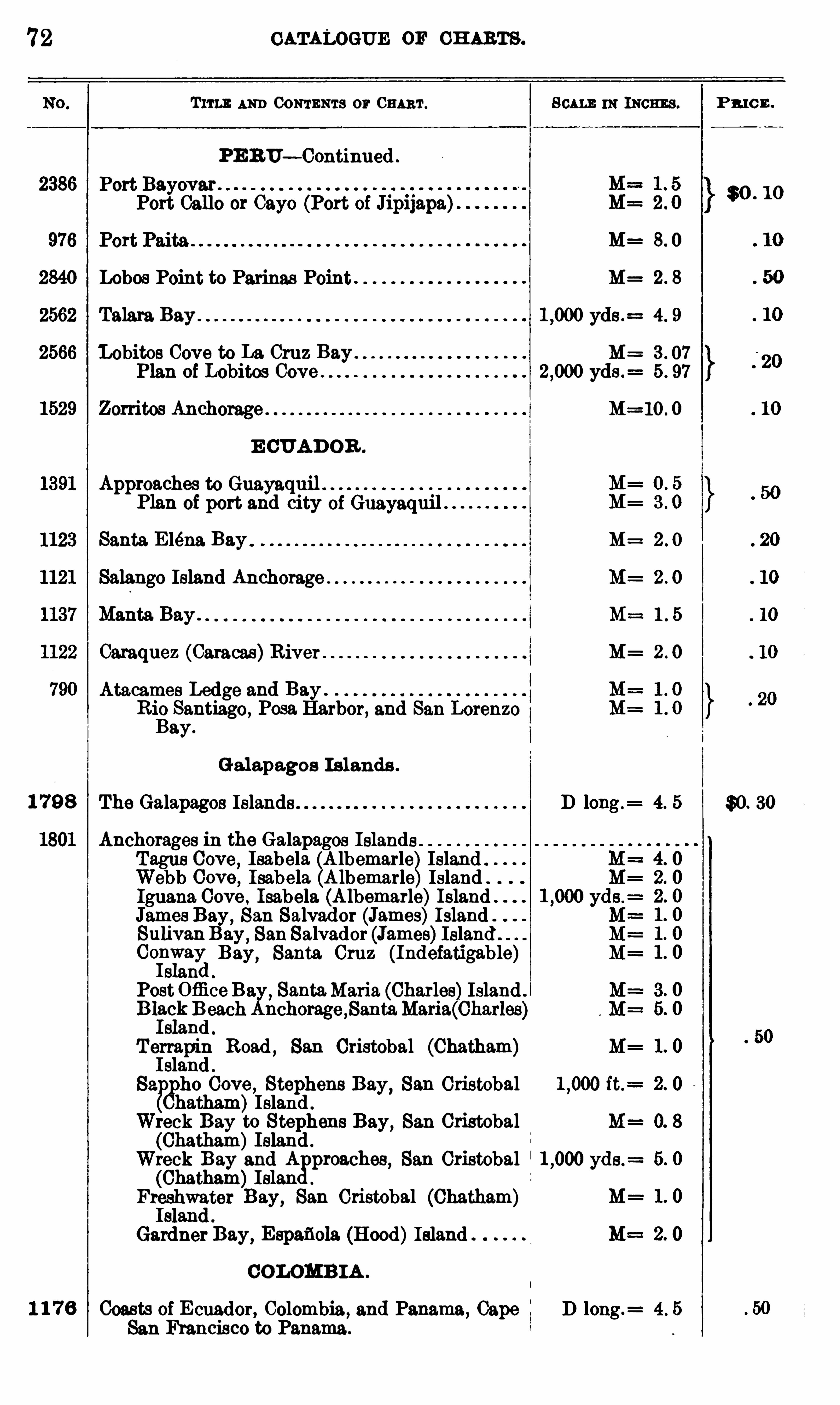
72
2386
2840
2562
2566
1529
1 7 9 8
1 1 7 6
CATALOGUE OF CH ARTS .
Tum 1 111) CONTENTS or 0 111 111 . 11: INCHES .
PE 1117— ContinuedPort Bayovar .
Port Gallo or Cayo (Port of Jip11apa)
M= 8 . 0
Lobos Point to Parinas Point M= 2 . 8
Talara Bay yds .= 4 . 9
Lobitos Cove to La Cruz Bay M= 3 . 07
Plan of Lobitos Cove yds . 5 . 97
Zorritos Anchorage . M=10 . 0
E CUAD OR .
Applglzhh
g?$3111? 2111
3
1r of Guayaquil
Santa. E lena Bay M= 2 . 0
Salango Island Anchorage M= 2 . 0
Manta. Bay . M==1 . 5
Caraquez (Caracas)River M= 2 . 0
Atacames Ledge and Bay .
Rio Santiago, Posa Harbor , and San LorenzoBay.
Gal apagos I s lands .
The Galapagos Islands D long . 4. 5
Anchorages in the Galapagos IslandsTagus Cove, Isabela (A lbemarle)IslandWebb Cove, Isabela (A lbemarle)IslandIguana Cove . Isabela (A lbemarle)Island .
James Bay, San Salvad or (James)Island
SulivanBay , San Salvador (James)Island .
Col
nv
i
va
ylBay
, Santa Cruz (Indefatigable)s an
PostOffice Bay, SantaMaria. (Charles)Island
E llec
ikBdeachAnchorage ,SantaMaria(0harles
s an
Terrapin Road , San Cristobal (Chatham)I sland .
89. pho Cove , Stephens Bay, San Cristobal ft.=
Chatham)Island .
Wreck Bay to Stephens Bay , San Cristobal(Chatham)Island .
Wreck Bay and A
sproaches, San Cristobal yds .
=
(Chatham)IslanFr
fs
lhwgter Bay, San Cristobal (Chatham)
s an
Gardner Bay,Espaflola (Hood)Island
COLOMB IA .
Coasts of E cuador , Colombia, and Panama ,Cape I D long .
= 4 . 5
San Francisco to Panama.
P R IC E .
$ 0 . 10
$0. 30

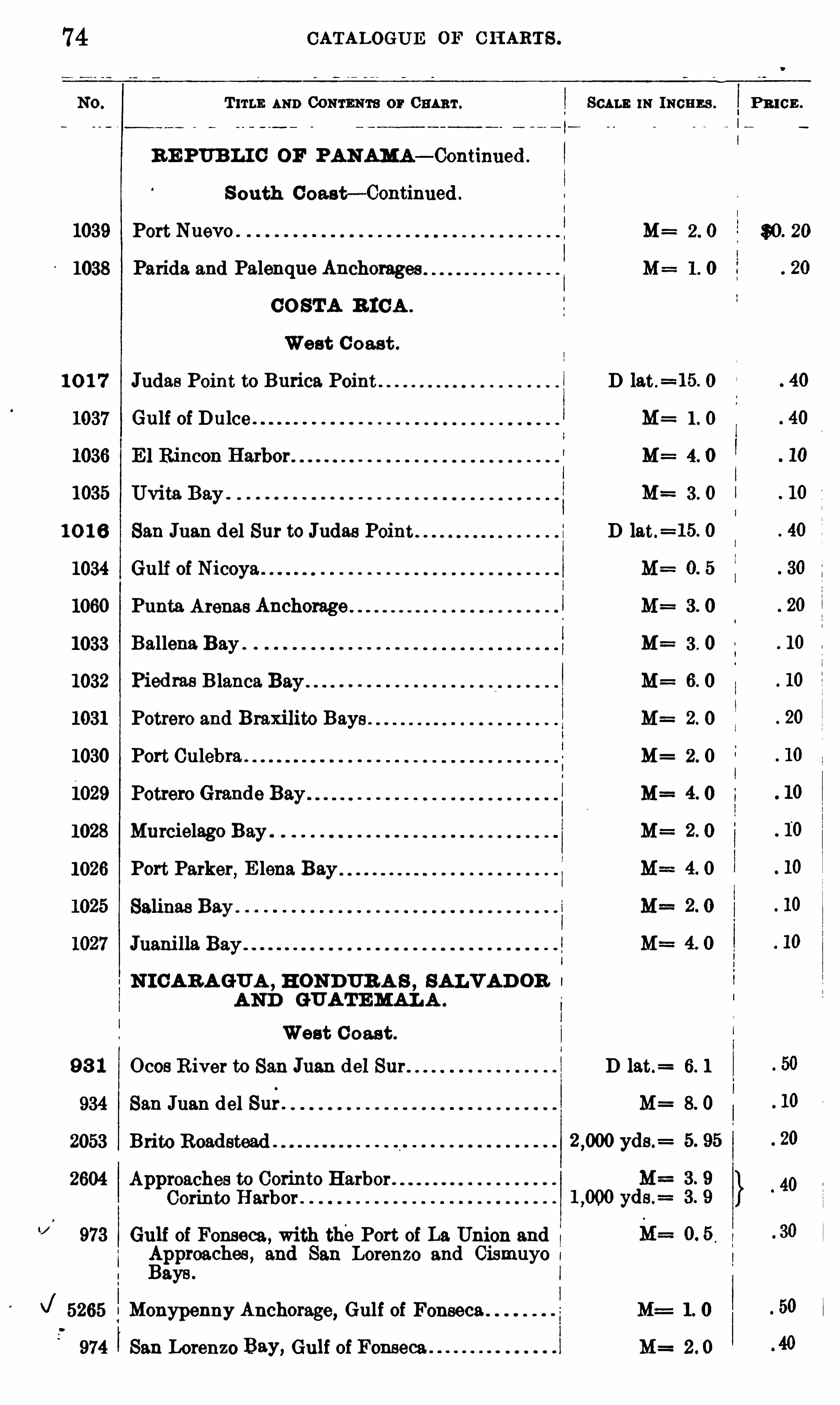
CATALOGUE OF CH ARTS .
T ITLE AND CONTENTS OF CHART . SCALE IN INCHES . PR I CE .
RE PUB LI C OF PANAMA— Continued .
S outh C oast— Continued .
1039 Port Nuevo M= 2 . 0 $0. 20
1038 Parida and Palenque Anchorages M= 1 . 0
CO STA R ICA .
West C oast .
1 0 1 7 Judas Point to Burica Point D lat.=15. 0
1037 Gulf of Dulce . M= 1 . 0
M= 4. 0
1035 Uvita Bay M= 3 . 0
1 0 16 San Juan del Sur to Judas D lat.=15. 0
1034 Gulf of Nicoya
1060 Punta Arenas Anchorage
1033 Ballena Bay . M= 3 . 0
1032 Piedms Blanca Bay .
1031 Potrero and Braxilito Bays
1030 Port Culebra . M= 2 . 0
1028 Murcielago Bay
1026 Port Parker, E lena Bay
Salinas Bay .
Juanilla Bay
N I CAR AGUA , H ONDUR A S , SALV AD OR
AND GUATEMAL A .
West C oas t .
Ocos R iver to San J del Sur D lat.= 6. 1
San Juan del Sur . M= 8. 0
Brito Roadstead .
2604 Approaches to Corinto HarborCorinto Harbor .
973 Gulf of Fonseca , with thePort of La Union and
fipproaches , and San Lorenzo and Cismuyo a
aye .
5265 Monypenny Anchorage, Gulf of Fonseca M= 1. 0
974 ISan Lorenzo Bay, Gulf of Fonseca M= 2 . 0
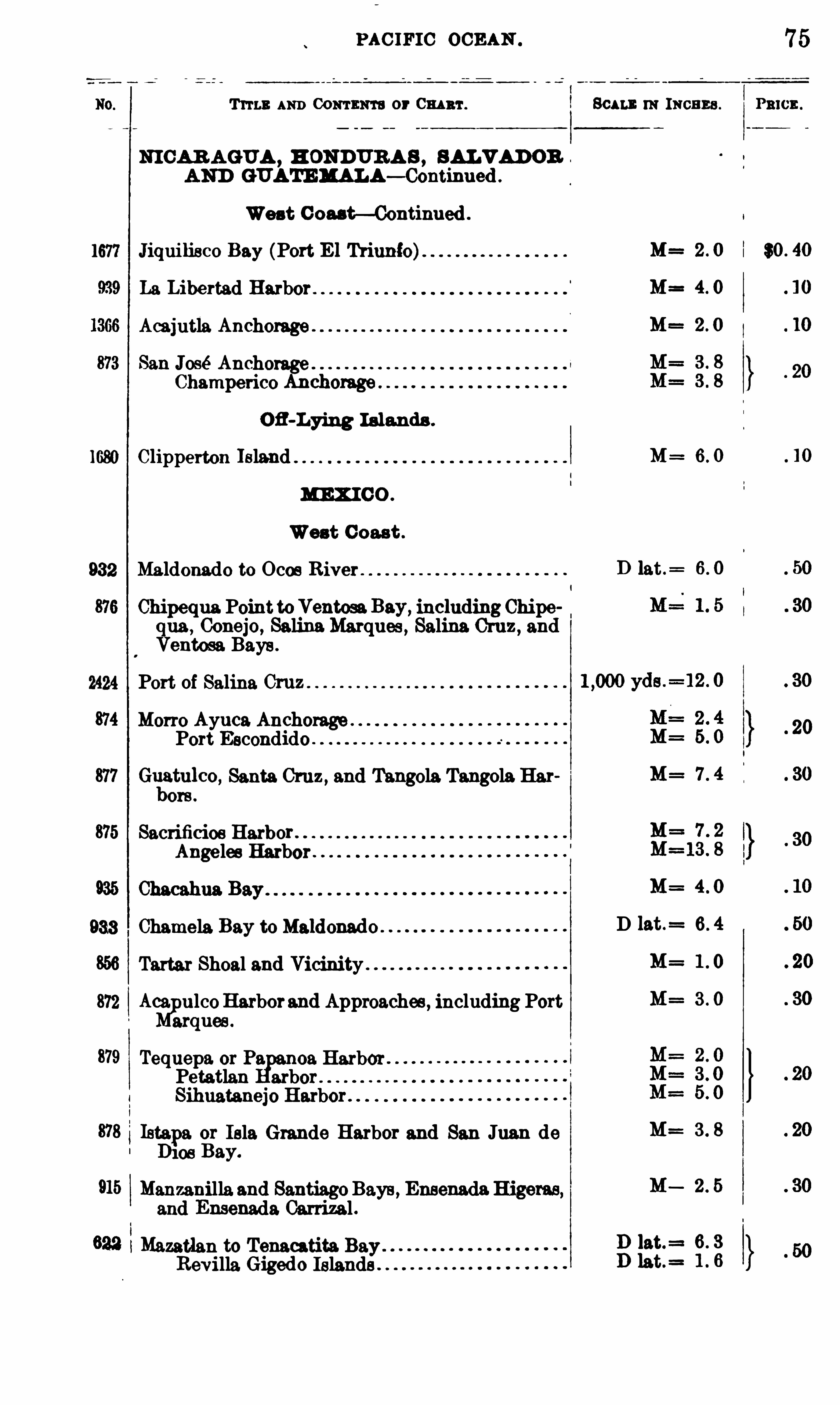
PAC IFIC OCEAN .
T ITLE AND Comnm or m r.
NICAR AGUA , H ONDURA S , SALVAD OR
AND GUATEMALA— Continued .
West Oou t—Continued .
1677 Jiquilisco Bay (Port E l Triunfo)
La Libertad Harbor
Acajutla Anchorage .
José Anchorage .
Champerico Anchorage
Ofl-Lying Is lands .
1680 Clipperton Island
MEX I CO .
West C oast .
932 Maldonado to Ocos River .
Chipequa PointtoVentoeaBay, including Chipequa , Conejo, SelinaMarques , Selina. Cruz , andVentosa Bays .
2424 Port of Salina. Cruz
Morro Ayuca AnchoragePort Escondido
Gliatulco , Santa Cruz , and Tangola Tangola Harore.
Sacrificioe Harbor .
Angeles Harbor .
933 Chamela Bay to Maldonado
Tartar Shoal and Vicinity .
872 Aca ulcoHarborand Approaches , including Portarquee.
Tequepa or Pa 0a. HarborPetatlan arborSihuatanejo Harbor
Istapa or Isle Grande Harbor and San Jnan deD108 Bay.
Manzanilla and SantiagoBays , Ensenada Higeras,and Ensenada Carrizal .
Mazatlan to Tenacatita. BayRevilla Gigedo Islands
Scumm moans .
D 1at .=
3 II
d
b
E»?
II
I!
3 .
H
O)
a
w
8
PB!CE
$0 . 40
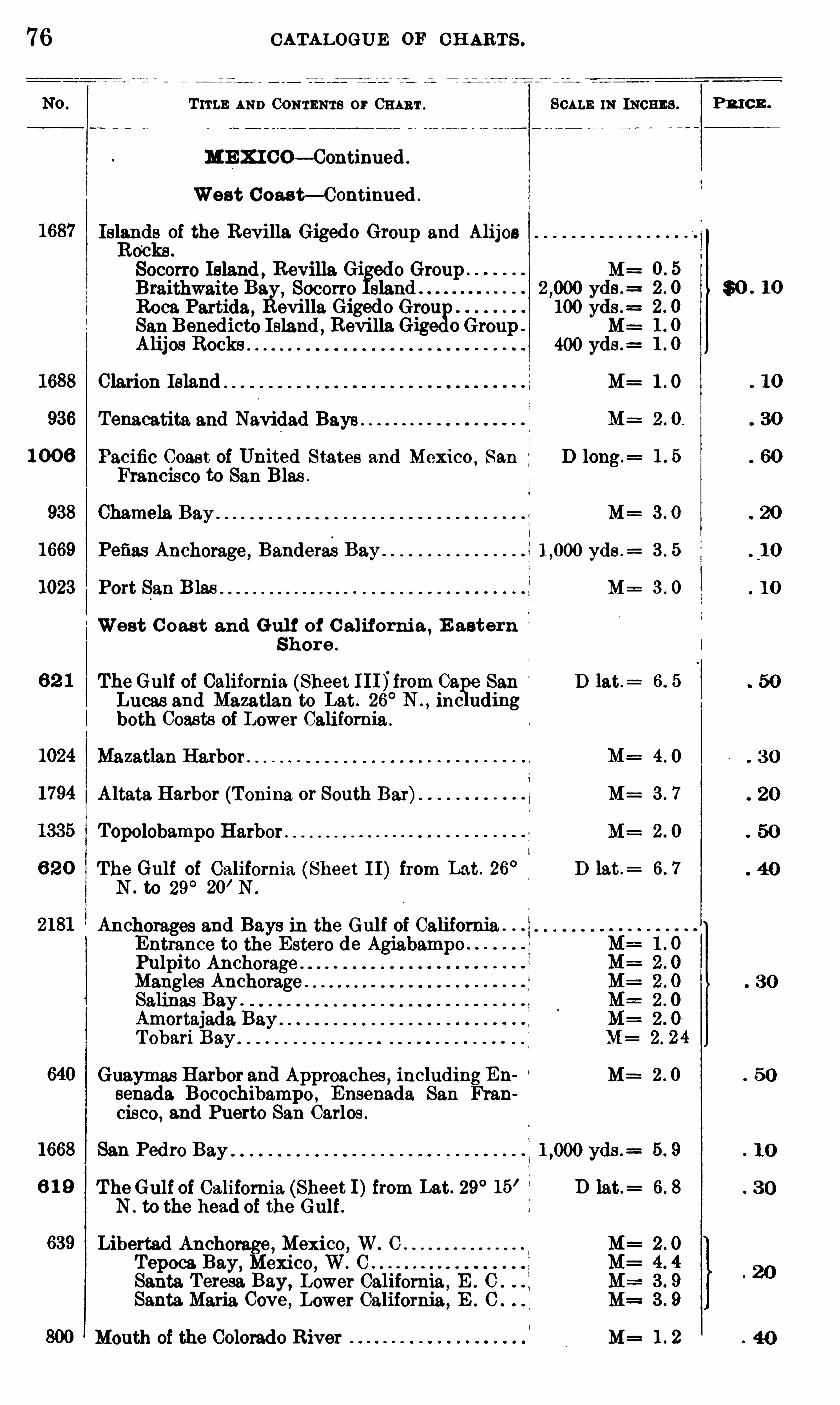
1 0 0 6
938
1669
1023
1668
6 1 9
639
CATALOGUE OF CH ART S .
Trrw AND CONTENTS or CHART . SCALE m INCHES .
ME X I CO— Continued .
West C oas t— Continued .
Islands of the Revilla Gigedo Group and AlijosRo
‘
cks .
Socorro Island , Revilla Gi edo Group M=
Braithwaite Ba. Socorro slandRoca Partida , evilla Giged o Gre
gg) 100 yds .
=
San Benedicto Island ,Revi lla Gig 0 Group M=
Alijes Rocks 400 yds .=
Clarion Island M=
Tenacatita and Navidad Bays
Pacific Coast of United States and Mexico,San D long .
=
Francisco to San Blas .
Chamela M=
Pefias Anchorage , BanderaeBay yds .:
Port San Blas M=
West C o ast and Gul f of C alifornia ,E astern
Shor e .
TheGulf of California (Sheet I I I)'
from 09. e San D lat.=
Lucas and Mazatlan to Lat. 26°N . , inc uding
both Coasts of Lower California .
Mazatlan Harbor .
Altata Harbor (Tonina or South Bar) M=
Topolobampo Harbor M :
The Gulf of California (Sheet 11) from Lat . 26° D lat .
=
N to 29°20’ N
Anchorages and Bays in the Gulf of California .
Entrance to the Estero de AgiabampoPulpito AnchorageMangles Anchorage .
Salinas Bay .
Amortajada BayTobari Bay
Guaymas Harbor and Approaches , including En M=senada Bocochibampo , Ensenada San Fran
cisco , and Puerto San Carlos .
San
TheGulf of California (Sheet 1)from Lat. 29°15’
i
N . to the head of the Gulf .
Libertad Anchorage, Mexico, W. O .
Tepoca Bay, Mexico, W. CSanta. Teresa. Bay,
Lower California ,E . 0
Santa.Maria Cove ,Lower California ,
E . O
Mouth of the Colorado River M=
E
?
?
N
N
P
o
o
o
o
c
u
P R I C E .
$0 . 10
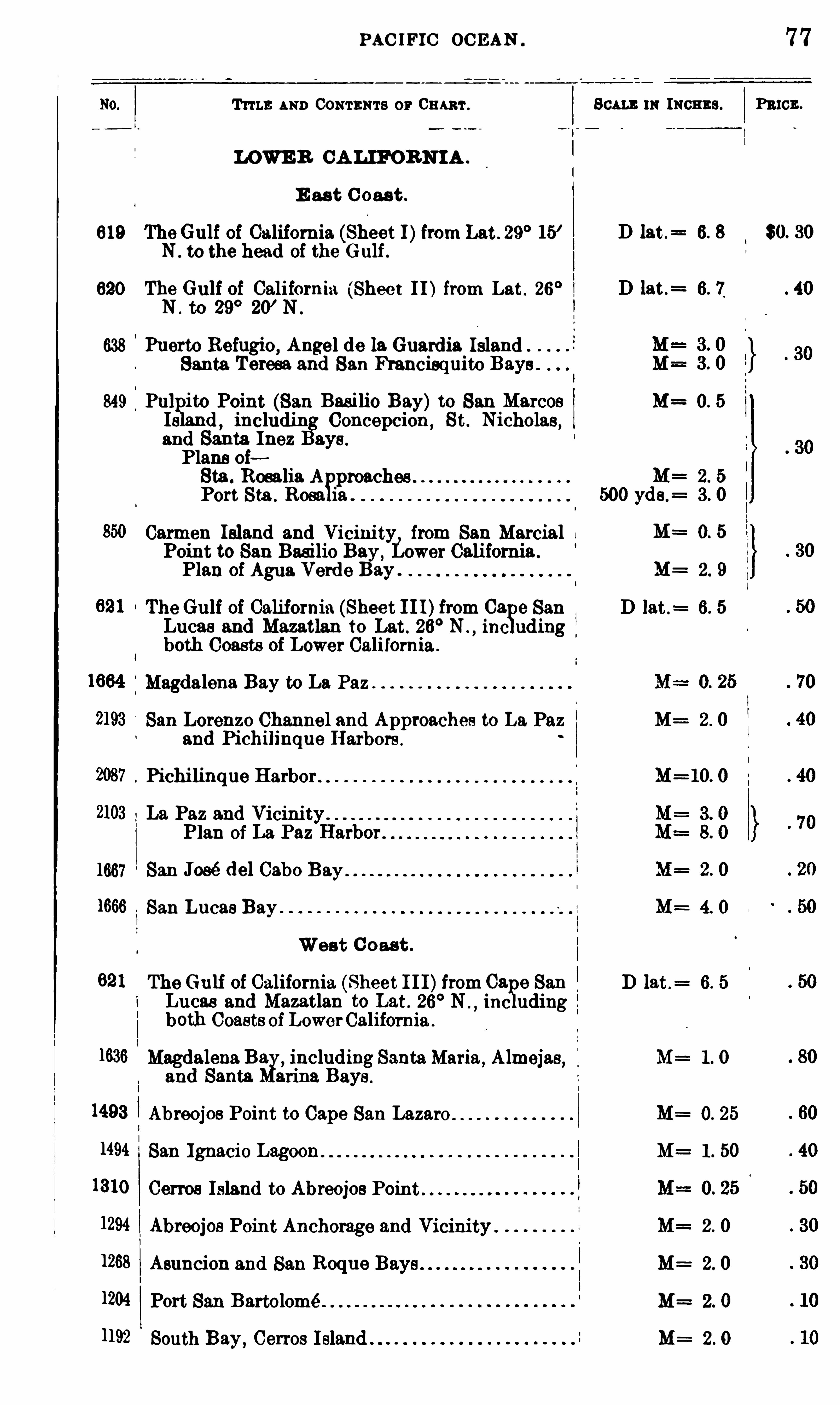
PAC IFIC OC EAN .
TITLE AND CONTENTS or 03 1m .
LOWE R CA LIFORNIA .
SCALE m INCHES .
E as t C oas t .
619 TheGulf of California (Sheet I)from Lat . 29° 15’ D lat .
= 6. 8
N . to the head of the Gulf .
620 The Gulf of California (Sheet I I) from Lat . 26° D lat .
= 6. 7
N . to 29° 20’ N .
638 Puerto Refugio, Angel de la Guardia IslandSanta Teresa and San Francisquito Bays
849 Pu] ito Point (San Basilio Bay)to San Marcos M= 0. 5
Is d,including Concepcion,
St . Nicholas,
and Santa Inez Bays .
Plans ofSta . Rosalia A M= 2 . 5
Port Sta . Rosa ia . 500 yda.= 3 . 0
Carmen Island and Vicinity,from San Marcial I M= 0. 5
Point to San Basilio Bay,Lower California .
Plan of Agua Verde Bay . M= 2. 9
The Gulf of California (Sheet I I I)from Ca e San D lat .= 6. 5
Lucas and Mazatlan to Lat . 26° N .
,inc uding
both Coasts of Lower California .
Magdalena Bay to La Paz
San Lorenzo Channel and Approaches to La Paz M= 2 . 0
and Pichilinque Harbors .
Pichilinque Harbor M= 10. 0
2103 La Paz and VicinityPlan of La Paz Harbor .
1667 San José del Cabo Bay .
1666 San Lucas Bay M= 4. 0
West C oast .
621 The Gulf of California (Sheet I I I)from Ca e San D lat .= 6. 5
Lucas and Mazatlan to Lat . 26° N inc uding
both Coasts of LowerCalifornia .
1636 Magdalena B33
],including SantaMaria
,Almejas
,M= 1 . 0
and Santa arina Bays .
1493 Abreojos Point to Cape San Lazaro M= 0. 25
1494 San Ignacio Lagoon M= 1 . 50
1310 Cerros Island to Abreojos Point .
1294 Abreojos Point Anchorage and Vicinity . M= 2. 0
1268 Asuncion and San Roque Bays M= 2. 0
1204 Port San Bartolomé M= 2. 0
1192 South Bay,Cerros Island M= 2 . 0
77
PRICE .
$0. 30
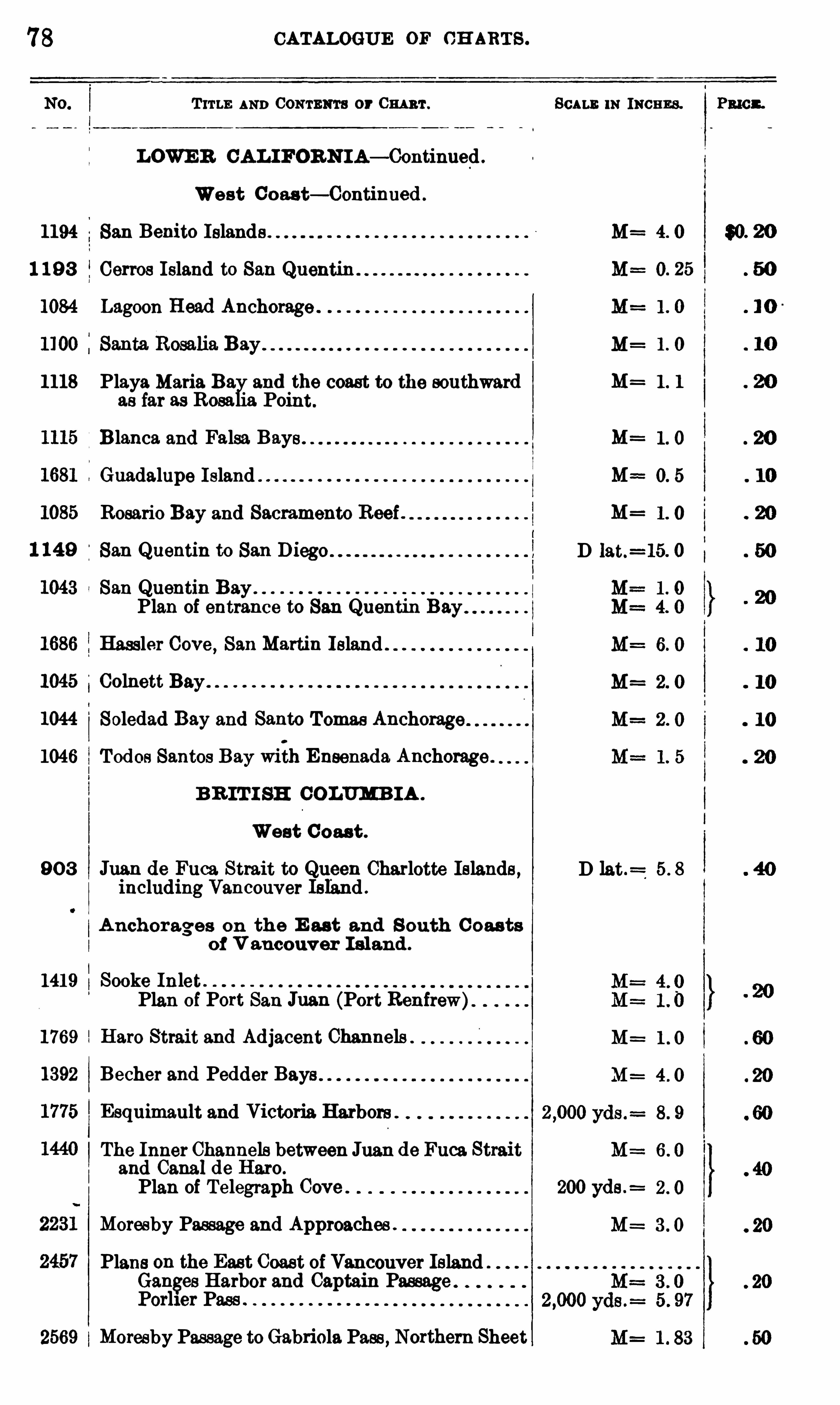
78 CATALOGUE OF CH ARTS .
T ITLE AND Comnm or Cm 'r .
LOWE R CAL IFORNI A— Continued
West Coas t— Continued .
1194 San Benito Islands
1 19 3 Cerros Island to San
1084 Lagoon Head Anchorage .
1118 Playa Maria Bay and the coast to the southward M=as far as Rosalia Point .
B lanca and Falsa Bays . M=
Guadalupe I sland . M==
Rosario Bay and Sacramento Reef . M=
1 149 San Quentin to San .
iSan Quentin Bay
I
Plan of entrance to San Quentin BayHassler Cove
,San Martin Island .
Colnett Bay .
1044ISoledad Bay and Santo Tomas Anchorage
1046 Todos Santos Bay with Ensenada. Anchorage .
B R IT I SH COLUMB IA .
West C oas t .
90 3 Jnan de Fuca Strait to Queen Charlotte Islands ,including Vancouver Island .
D lat.=
A nchorages on the E ast and S outh C oas tsof V ancouver I sland .
1419 Sooke InletPlan of Port San Juan (Port Renfrew)
1769 Hare Strait and Adjacent Channels .
1392 Becher and Pedder Bays
Esquimault and Victoria Harbors .
M=
The Inner Channels between J113 11 de Fuca. Straitand Canal de Hero .
Plan of Telegraph Cove 200 yds .=
Moresby Passage and Approaches .
Plans on the East Coast of Vancouver IslandGanges Harbor and Captain PassagePorher Pass
2569 Moresby Passage toGabriela Pass , Northern Sheet
SCALE m INCHES .
D lat.=15. 0
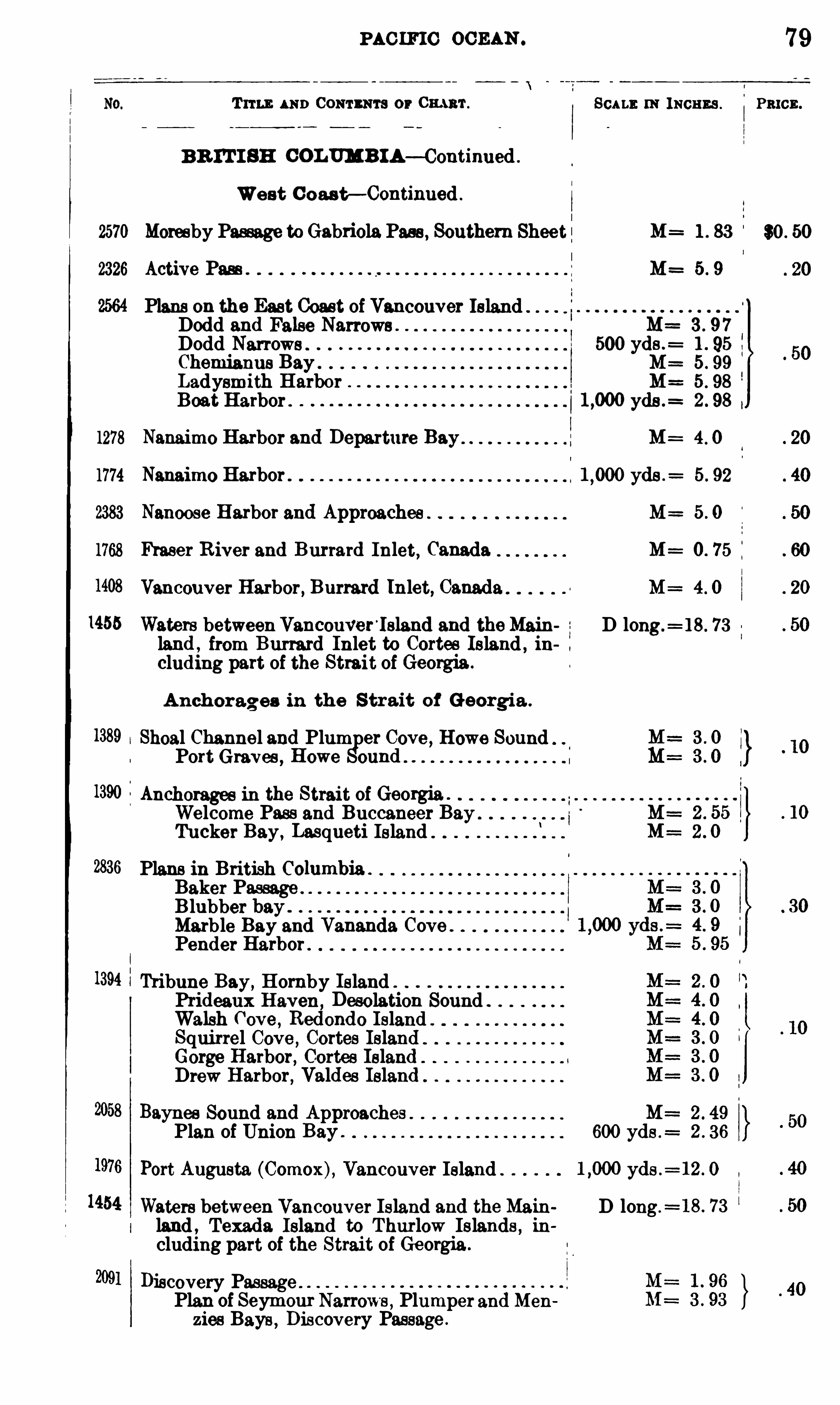
PAC IFIC OCEAN .
Trru : AND Comnm s or Cmuu‘. Scu m. 0 : means .
BR IT I SH COLUMBIA— Continued .
West C oas t— Continued .
2570 Moresby Passage to Gabriela Pass , Southern Sheet : M= 1 . 83
2326 Active Pass . M= 5 . 9
Plans on the East Coast of Vancouver Island -I
Dodd and False Narrows M== 3 . 97
Dodd Narrows . 500 yds .= 1 . 95
Chemianus Bay . 5 . 99
Ladysmith Harbor 5. 98
Boat Harbor . yde .= 2 . 98
1278 Nanaimo Harbor and Departure Bay M= 4 . 0
1774 Nanaimo Harbor . yds .= 5. 92
2383 Nanoose Harbor and Approaches 5 . 0
1768 Fraser R iver and Burrard Inlet, Canada M= 0 . 75
Vancouver Harbor, Burrard Inlet, Canada M= 4 . 0
1455 Waters betweenVancouver ’
lsland and theMain D long .= 18 . 73
land , from Burrard Inlet to Cortes Island , including part of the Strait of Georgia .
Anchorages in the S trait of Georgi a .
1389 Shoal Channel and Plum er Cove , Howe SoundPort Graves , Howe ennd
1390 Anchorages in the Strait of Georgia .
Welcome Pass and Buccaneer BayTucker Bay, Lasqueti Island
2836 Plans in British Columbia .
Baker PassageBlubber bay .
Marble Bay and Vananda Cove .
Pender Harbor .
1394 Tribune Bay, Hornby Island .
Prideaux Haven ,Desolation Sound .
Walsh Cove ,Redondo Island
Squirrel Cove ,Cortes Island
Gorge Harbor, Cortes IslandDrew Harbor, Valdes Island
Baynee Sound and Approaches M= 2 . 49
Plan of Union Bay . 600 yds .= 2 . 36
Port Augusta (Comox), Vancouver Island yds .= 12 . 0
Waters between Vancouver Island and the Main D long .= 18 . 73
land , Texada Island to Thurlow Islands , ihcluding part of the Strait of Georgia .
Discovery PassagePlan of Seymour Narrows , Plumper and Men
zies Bays , Discovery Passage .
79
PRICE .
$0 . 50
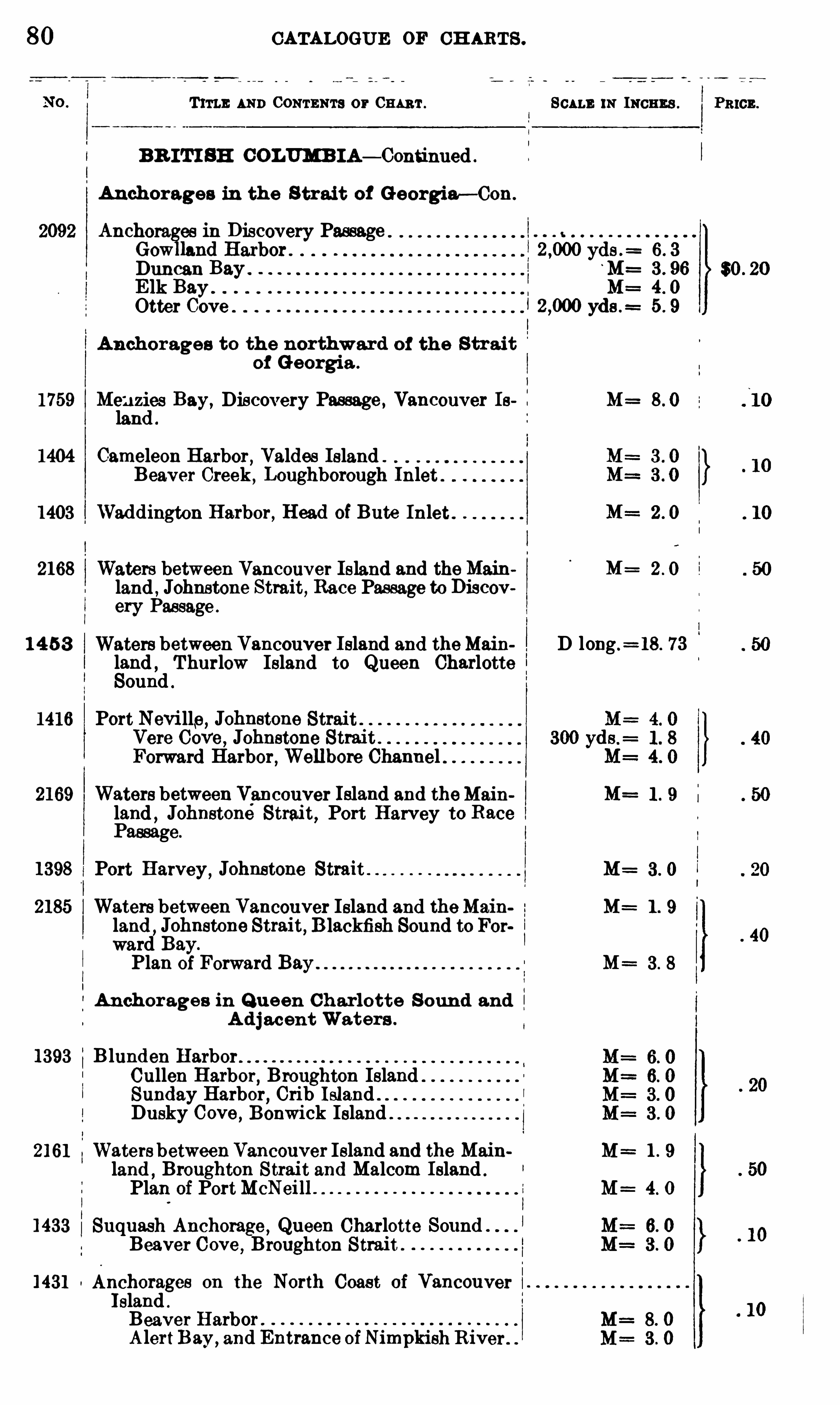
80 CATALOGUE OF CH ARTS .
T ITLE AND CONTENTS or Can 't .
BR IT! SE COLUMB IA— Continued .
Anchorages in the S trait of Georgia— Con.
2092 Anchorages in Discovery Passage t
Gowlland Harbor . yds .=
Duncan BayElk Bay .
Otter Cove
Anchorages to the northward of the S tr aitof Georgia .
1759 Menzies Bay, Discovery Passage , Vancouver Ie M=land
1404 Cameleon Harbor, Valdes Island .
Beaver Creek , Loughborough Inlet .
1403 Waddington Harbor, Head of Bute Inlet .
2168 Waters between Vancouver Island and theMainland , Johnstone Strait, Race Passage to Discovery Passage .
1 4 53 Waters between Vancouver Island and theMainland ,
Thurlow Island to Queen CharlotteSound
1416 Port Nevi lle,Johnetone Strait
Vere Cove , Johnstone StraitForward Harbor , Well bore Channel
2169 Waters between Vancouver Island and theMain M=land , Johnstoné Strai t, Port Harvey to Race 1Passage.
1398 Port Harvey,Johnstone Strait M
2185 Waters between Vancouver Island and theMain
land,Johnstone Strait, B lackfish Sound to For
ward Bay.
Plan of Forward Bay M=
Anchorage s in Q u een Charlotte S ound andA d j acent Waters .
1393 Blunden HarborCullen Harbor
,Broughton Island
Sunday Harbor , Crib Island .
Dusky Cove,Bonwick Island
2161 Waters betweenVancouver Island and the Mainland
,Broughton Strait and Malcom Island .
Plan of PortMcNeil] M=
1433 Suquash Anchorage , Queen Charlotte SoundBeaver Cove ,
Broughton Strait .
1431 Anchorages on the North Coast of VancouverIsland .
Beaver Harbor .
A lertBay,and Entrance ofNimpkishRiver .
SCALE m INCHES .
D long .=18. 73
PRICE .
$0 . 20

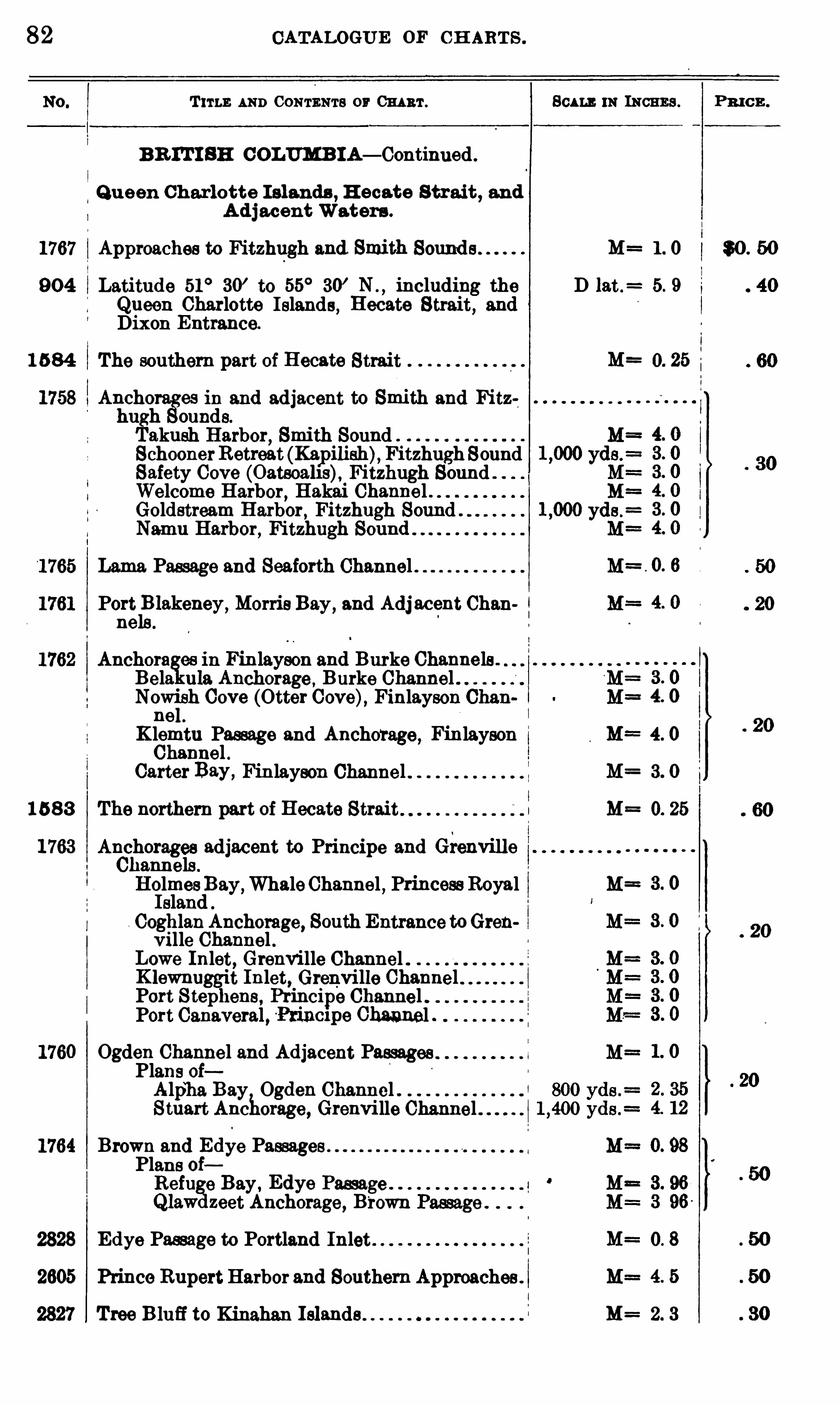
82 CATALOGUE OF CH ART S .
T ITLE AND CONTENTS or CHART . 801m m INCHES . Pm cn.
B R IT I SH COLUMB IA— Continued .
Q u een Charlotte I slands , H ecate Strait , and
A d jacent Waters .
1767 Approaches to Fitzhugh and Smith Sound s M= 1 . 0 $0 . 50
90 4 Latitude 51°30’ to 55
°30
’ N . ,including the D 5. 9
Queen Charlotte Islands, Hecate Strait, andDixon Entrance.
1 5 84 The southern part of Hecate Strait M= 0. 25
Ancho es in and adjacent to Smith and Fitzhugh ounds.
Takush Harbor, Smith Sound
SchoonerRetreat (Kapilieh) Fitzhugh SoundSafety Cove (Oatsoahs), Fitzhugh Sound .
Welcome Harbor , Hakai Channel .Goldstream Harbor
,Fitzhugh Sound .
Nemu Harbor, Fitzhugh Sound
Lama Passage and Seaforth Channel
Portl
Iglekeney,
Morris Bay,and Adj acent Chan 1
ne
Auchora es in Finlayson and Burke Channels .
Bela ula Anchorage ,Burke Channel .
Nowish Cove (Otter Cove), Finlayson Chan
ne
K lemtu Passage and Anchorage , Finlayson M==4. 0
Channel .Carter Bay,
Finlayson Channel M= 3. 0
1 5 8 3 The northern part of Hecate Strait M 0. 25
Anchorages adjacent to Principe and GrenvilleChannels .
HolmesBay,WhaleChannel , Princess RoyalIsland
CoghlanAnchorage, South Entrance toGrenville Channel .
Lowe Inlet, Grenvi lle Channel .K lewnuggit Inlet, Grenvi lle ChannelPort S tephens , Prihcipe Channel .Port Canaveral , Puncxpe Channel .
Ogden Channel and Adjacent PassagesPlans oiAlpha Bay Ogden Channel .Stuart Anchorage, Grenville Channel
Brown and Edye PassagePlans oiRefuge Bay ,
Edye Passage .
Q lawdzeet Anchorage, Brown
Edye Passage to Portland Inlet M= 0. 8
Prince RupertHarbor and Southern Approaches .
Tree B lufi to Kinahan Islands M= 2. 3
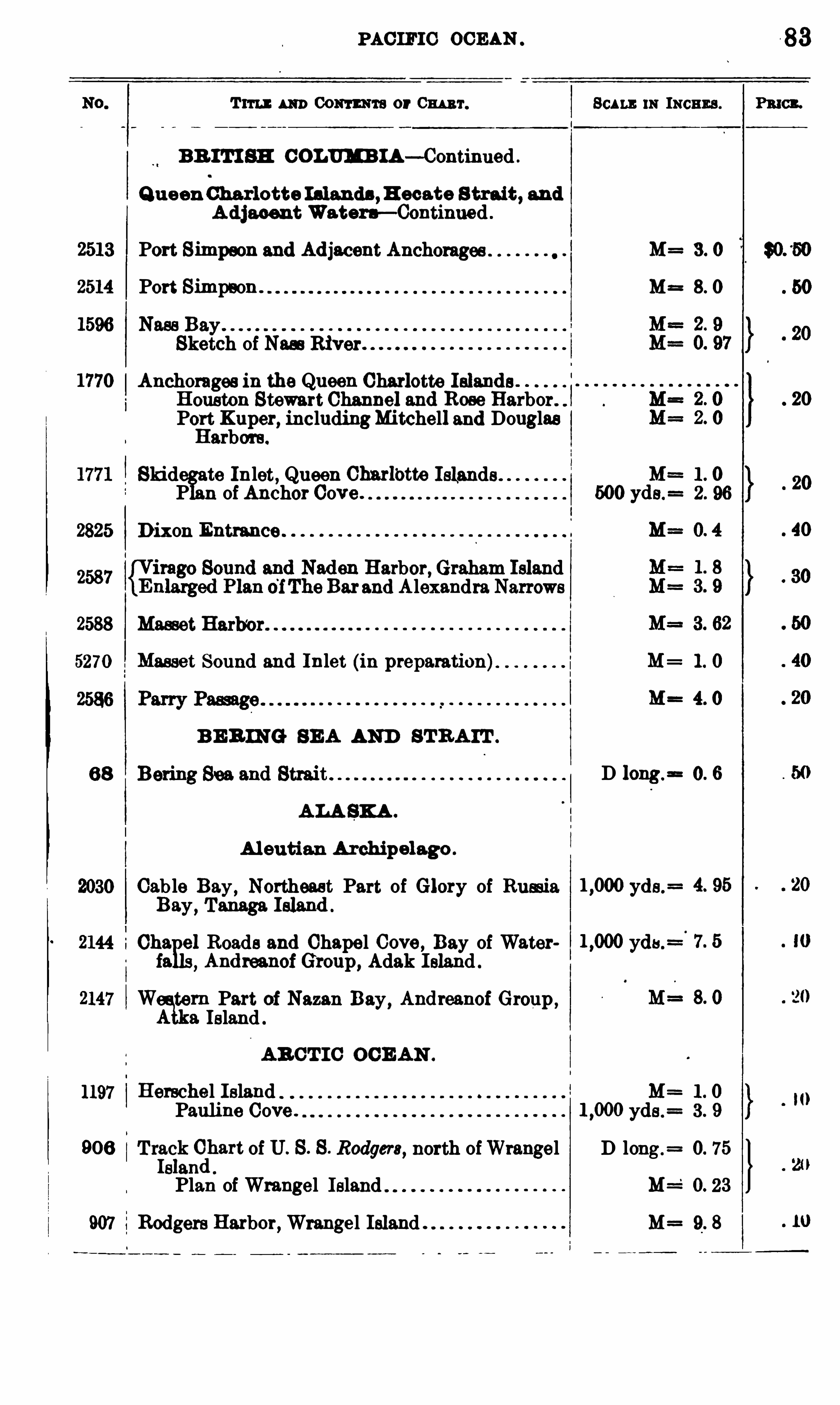
2825
2588
5270
1197
906
907
PAC IFIC OCEAN
Tun : m Com m or Cm 'r. Scum: m moans .
BR I TI SH COLUMB IA— Continued .
Q ueen Charlotte Islands ,H ecate S trait , andA djacent Watera— Continued
Port Simmon and Adjacent Anchorages M= 3 . 0
Port Simpson . M= 8. 0
N BaySketch of Nas River
Anchorages in the Queen Charlotte IslandsHouston Stewart Channel and Rose Harbor.
Port Kuper, includingMitchell and DouglasHarbors.
Skid te Inlet, Queen Charlbtte Islands Mn 1 . 0P n of Anchor Cove . 500 yds.
= 2 . 96
Dixon Entrance
Harbor,Graham IslandBarand Alexandra Narrows
Masset Harb’
or
Masset Sound and Inlet (in preparation) M= 1. 0
M= 4. 0
B E B ING SEA AND ST RA IT .
D long .=r=0. 6
ALA SK A .
A leutian Archipelago .
Cab le Bay, Northeast Part of Glory of Rumia yds.
Bay, Tanaga Island .
Cha el Roads and Chapel Cove , Bay of Water yds .
fa Andreanof Group, Adak I sland .
H
W tern Part of Nazan Bay,Andreanof Group ,ma. Island .
AR CT I C OCE AN .
Herschel Island M= 1 . 0
Pauline Cove . yds .= 3 . 9
T rfik (Elbart of U. S . S . Rodgers, north ofWrangel D long .
= 0. 75
s an
Plan of Wrangel Island M=‘
0. 23
Rodgers Harbor, Wrangel Island . M= 9. 8
8 3
PRIOR.

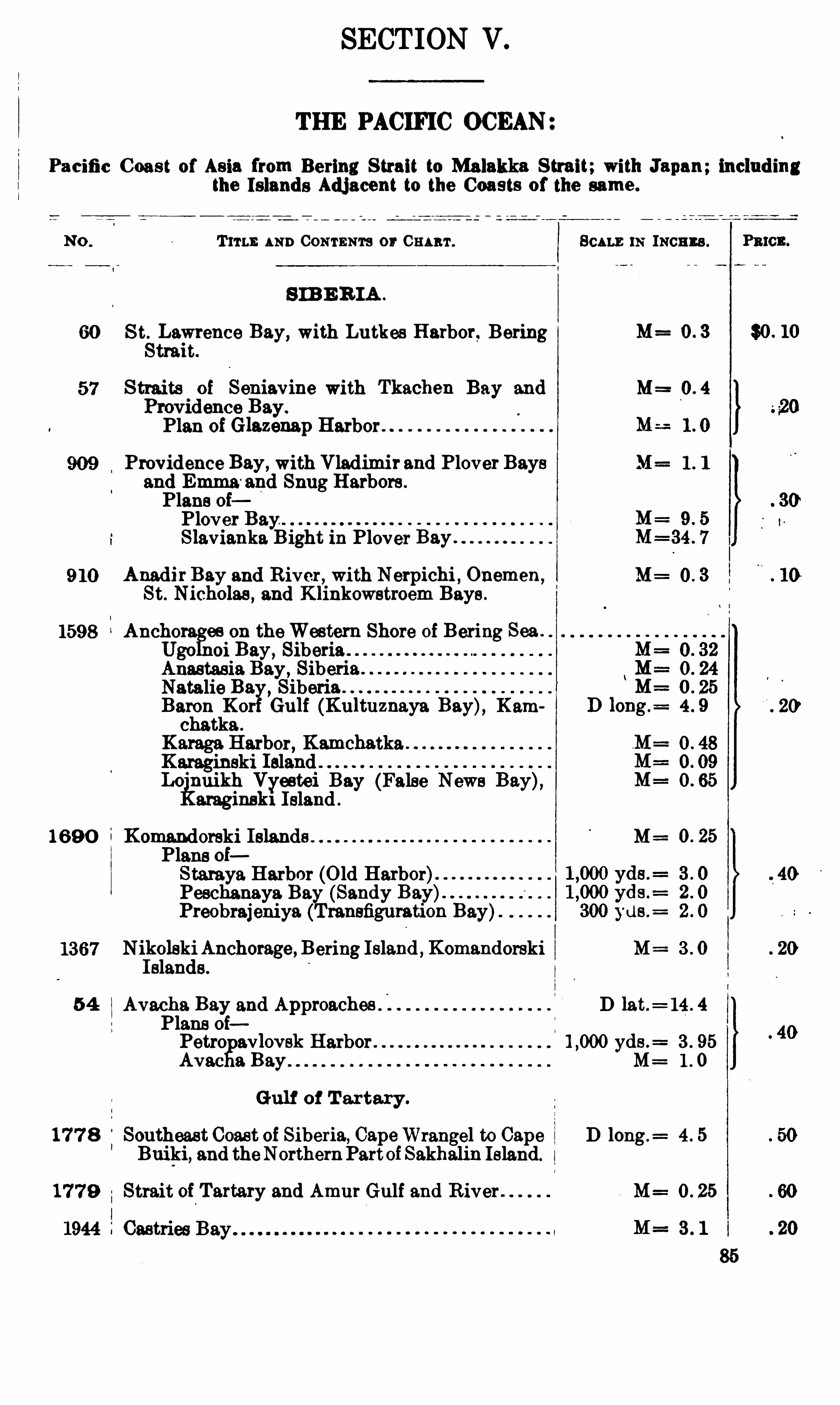
SECTION V .
THE PACIFIC OCEAN
Pacific C oast of Asia from Bering S trait to Malakka S trait;with Japan; includingthe Islands Adj acent to the Coasts of the same .
T ITLE AND Com snrs or 0mm . SCALE m INCHES . a cu.
S IB E R IA .
60 S t.
sLawrence Bay, with Lutkes Harbor. Bering I M= 0 . 3 $0 . 10
trait.
S traits of Sefiiavine with Tkachen Bay and M=
os ay.
Plan of Glazenap Harbor.
Providence Bay, with Vladimir and Plover Bays M= 1 . l
and Emma and Snug Harbors .
Plans oiPlover Bay.
Slavianka Bight in Plover Bay .
AnadirBay and River, with Nerpichi , Cuemen,M= 0 . 3
St. Nicholas , and Klinkowstroem Bays
Ancho es on theWestern Shore of Bering Sea .
Ugo oi Bay, SiberiaAnastas ia Bay , Siberia.Natalie Ba SiberiaBaron Kor Gulf (Kultuznaya Bay), Kam
KChatka
fi b K ha karaga ar or, m e t a
Karaginski IslandLo
'
nuikh Vyestei Bay (False News Bay),araginski Island .
16 9 0 Komandorski Islands M=Plans oiStaraya Harbor (Old Harbor)Peschanaya. Ba
%(Sandy Bay)
Preobrajeniya ransfiguration Bay)
N ikolskiAnchorage, Bering Island ,Komandorski M 3 . 0
Islands .
5 4 Avacha Bay and Approaches D lat.= 14 . 4
Plans oiPetro avlovsk Harbor . yds .
= 3 . 95
Avac 3 Bay M= 1 . 0
Gulf of T artary.
17 7 8 Southeast Coast of Siberia, CapeWrangel to Cape D long .= 4 . 5
Buiki, and theNorthernPartofSakhalin Island.
17 7 9 Strait of Tartary and Amur Gulf and R iver . M= 0 . 25
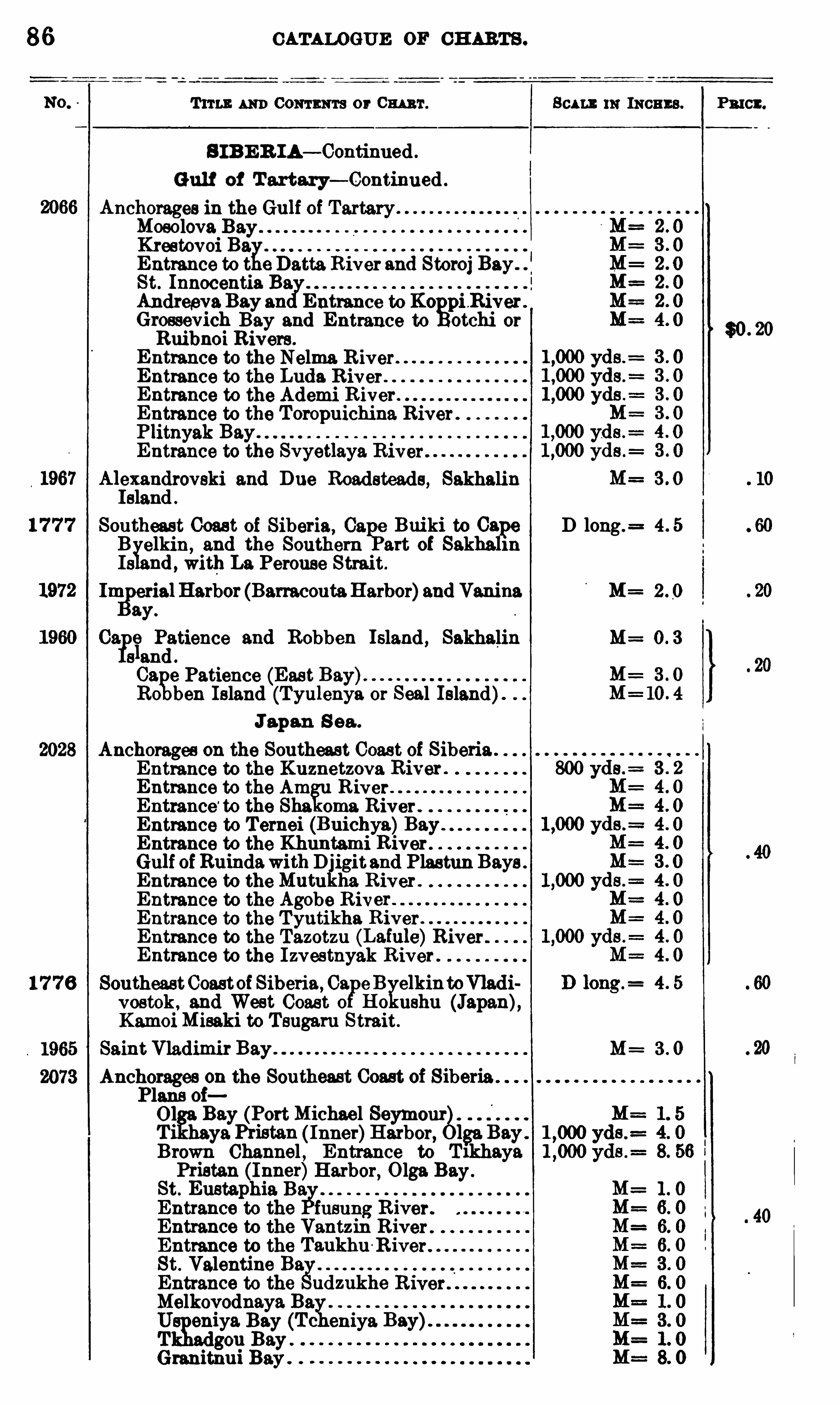
86 CATALOGUE OF CH ARTS .
T ITLE AND Com m a or Cm 'r. Scu m 11: INCHES .
S I B E R IA— Continued .
Gul f of T artary— Continued .
Anchorages in the Gulf of TartaryMosolova BayKrestovoi Ba
gEntrance to t e Datta River and Storoj BaySt. Innocentia.AndreevaBay an Entrance to Ko
gpiB iver .
Grossevich Bay and Entrance to otchi orRuibnoi Rivers .
Entrance to the Nelma R iver .
Entrance to the Luda R iver .
Entrance to the Ademi R iver .
Entrance to the Toropuichina River .
Plitnyak Bay.
Entrance to the Svyetlaya River"
Alexandrovski and Due Roadsteads, SakhalinIsland .
1 7 7 7 Southeast Coas t of Siberia, Cali?Buiki to Cape D long .
= 4 . 5
B elkin, and the Southern art of SakhalinIs nd , with La Perouse Strait.
ImlyerialHarbor (Barracouta.Harbor)and Vanina M= 2 . 0
ay.
Ca. (13 I
ziatience and Robben Island , Sakhalin M= 0 . 3
s an
Cafge Patience (Eas t Bay).
R0 ben Island (Tyulenya or Seal Island).
Japan S ea .
Anchorages on the Southeast Coas t of Siberia .
Entrance to the Kuznetzova River .
Entrance to the Am R iverEntrance
‘
to the Sha oma River .
Entrance to Ternei (Buichya)BayEntrance to the Khuntami RiverGulf ofBuindawithDjigitand Plastun Bays .
Entrance to theMutukha R iver .
Entrance to the Agobe R iverEntrance to the Tyutikha R iverEntrance to the Tazotzu (Lainle)River .
Entrance to the I zvestnyak River .
17 7 6 SoutheastCoastei Siberia, Ca eB elkinto adivostok , and West Coas t 0 Ho ushu (Japan),KamoiMisaki to Tsugaru Strait.
Saint Vladimir Bay M= 3 . 0
Anchorages on the Southeast Coast of Siberia .
P1
818 Of]; (P M
' hael Sa. ort 1c eymourT ifiaya
yPristan ( Inner)Harbor,0139. BayBrown Channel , Entrance to l haye
Pristan Inner)Harbor, Olga. BaySt. Eustap ia. Ba
gEntrance to the fusung River .
Entrance to the Vantzin R iver .
Entrance to the Taukhu -River .
St. Valentine BagEntrance to the udzukhe R iver .
Melkovodnaya Bax1U eniya Bay (Tc eniya
T 30 11 Bay .
Granitnui Bay .
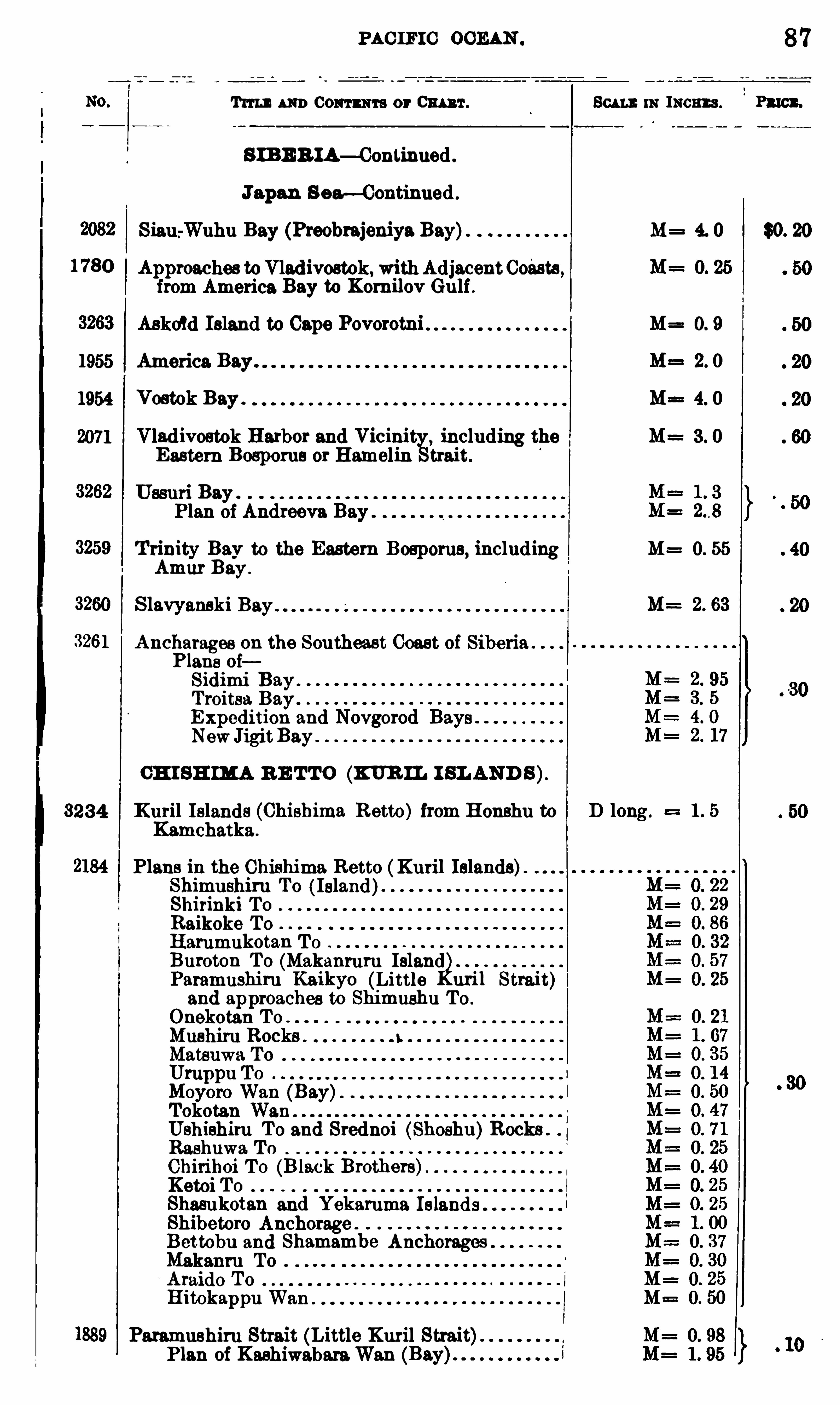
PAC IFIC OCEAN . 87
Tun m o Commi t s or Cm 'r . Scan : m 1mm . Pmcx.
S IBE R IA— Continned .
Japan S ear—Continued .
Siau .
-Wuhu Bay (Preobrajeniya Bay) M= 4. 0 $0. 20
1780 Approaches toVladivostok, withAdjacentCoésts ,from America Bay to Kom ilov Gulf .
Askew Island to Cape Povorotni M= 0. 9
1955 America.Bay. M= 2. 0
1954 Vostok Bay . M= 4. 0
2071 Vladivostok Harbor and Vicinit including the M= 3 . 0
Eastern Bospoms or Hamelin trait.
Ussuri Bay .
Plan of Andreeva Bay .
T rinity Bay to the Eastern Bosporus, including M= 0. 55
Amur Bay .
S lavyanski 2. 63
Ancharages on the Southeast Coast of Siberia .
Plans oiSidimi BayTroitsa BayExpedition and Novgorod BaysNewJigitBay .
CH I SH IMA R E TTO (K UR IL I SL AND S).
3234 Kuril Islands (Chishima Retto) from Honshu to D long .
Kamchatka .
Plans in the Chishima Retto (Kuril Islands)Shimushiru To ( Island)Shirinki To
Raikoke To
Harumukotan ToBuroton To (Makanruru IslandParamushiru Kaikyo (Little uril Strait)and approaches to Shimushu To .
Onekotan ToMushiru RocksMatsuwa ToUmppu ToMoyoro Wan (Bay)Tokotan Wan
Ushishiru To and Srednoi (Shoshu)Rocks .
Rashuwa T 0
Chirihoi To (B lack Brothers)Ketoi ToShasukotan and Yekaruma. IslandsShibetoro Anchorage .
Bettobu and Shamambe AnchoragesMakanru ToAtaide ToHitokappu Wan
Paramushiru Strait (Little Kuril Strait)Plan of KashiwabaraWan
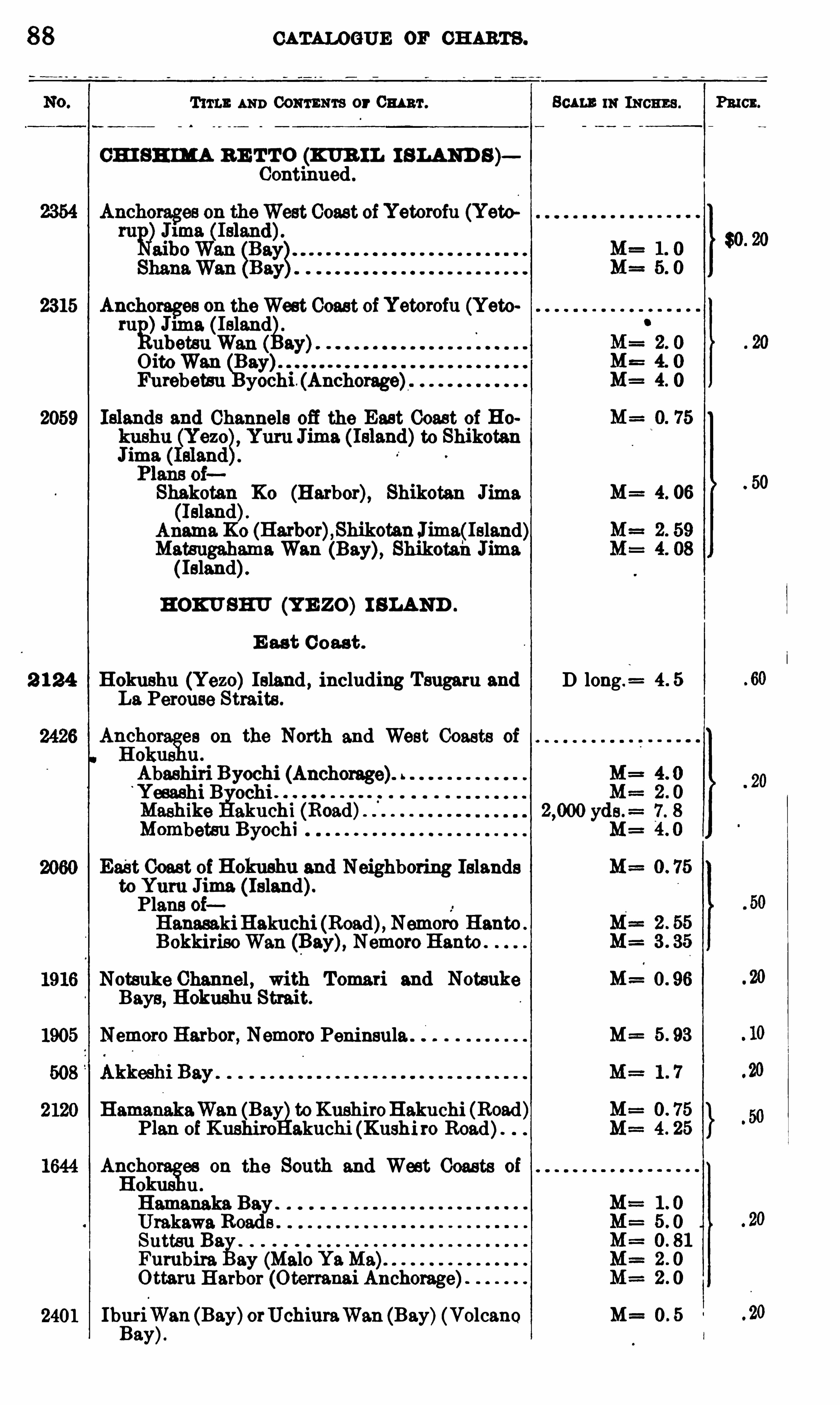
88 CATALOGUE or CH ARTS .
T um. AND CONTENTS or 0mm .
CH I SH IMA B E TTO (KUR IL I SLAND S)Continued .
east ofYetorofu (Yew
2315 nchorages on theWest Coast ofYetorofu (Yetoru
g)J11113 ( IslandubetsuWan ay)OitoWan (g
ay)Furebetsu yochi . (Anchorage)
2059 Islands and Channels off the East Coast of Ho
J“
to Shikotan1m
Shakotan K0 (Harbor), Shikotan Jima(Island).
Anama.K0 (Harbor),ShikotanJima(Island)MatsugahamaWan (Bay), Shikotah Jima( Island).
HOKU SHU (YE ZO) I SLAND .
E ast C oast .
2 1 24 Holmsbu (Yezo) Island , including Tsugaru andLa. Perouse Straits .
Aliirh
fies on the North and West Coasts of
o u .
Abashiri Byochi (Anchorage).‘
Yesashi B ochiMashike akuchi (Road)Mombetsu Byochi
East Coast of Hokushu and Neighboring Islandsto Yum Jima (Island).Plans oiHanasakiB akuchi (Road), Nemoro HantoBokkirisoWan (Bay), Nemoro Hanto .
Notsuke Channel , with Tomari and NotsukeBays, Hokushu Strait.
Nemoro Harbor, Nemoro Peninsula .
Hamanaka.Wan (Bay toKushiroB akuchi (Road)Plan of Kushiro akuchi (Kushi ro Road)
Arfiho es on the South and West Cou ts ofo uHamanaka Bay .
Urakawa RoadsSuttsu Ba
fiFumbira ay (Malo YaMa)Ottaru Harbor (Oterranai Anchorage)
Ibfiri
gVan (Bay)orUchiuraWan (Bay)(Volcano
ay
Scum. m INCHES .
4. 06
D long .=
M=
M=
Pmcn.

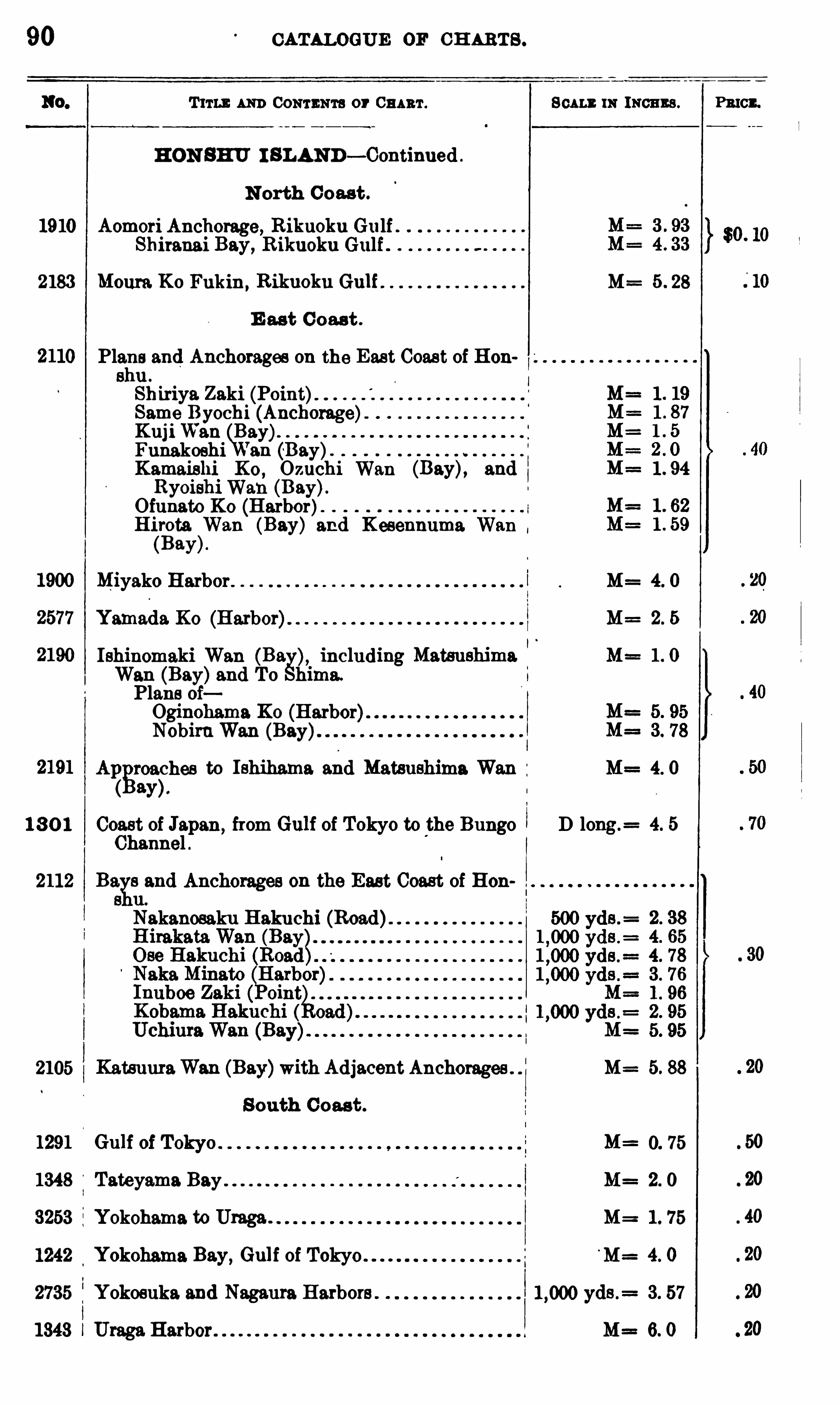
90 CATALOGUE or CH ARTS .
T ITLE AND CONTENTS or CHART . Scu mm means .
HON SHU I SLAND— Continued .
N orth Coast .
1910 Aomori Anchorage, Rikuoku Gulf .Shiranai Bay,
R ikuoku Gulf
2183 Moura Ko Fukin,R ikuoku Gulf M= 5 . 28
E ast Coas t .
Plans and Anchorages on the East Coas t of Honshu .
Shiriya. Zaki (Point)Same Byochi (Anchorage)KujiWan Bay)Funakoshi ’
a.n (Bay).
Kamaishi K0 , Ozuchi Wan (Bay), and,
RyoishiWan (Bay).Ofunato K0 (Harbor)H irota Wan (Bay) and Kesennuma. Wan
(Bay).
Miyako Harbor M= 4. 0
Yamada K0 (Harbor) M= 2. 5
Ishinomaki Wan (Ba including Matsushima M= 1 . 0
Wan (Bay)and To hima.
Plans oiOginohama K0 (Harbor)NobiruWan (Bay)
Al
zgroa
fhes to Ishihama. and Matsushima Wan M= 4. 0
ay
1 3 0 1 Coast of Jspan,from Gulf of Tokyo to the Bungo D long.
= 4. 5
Channel .
2112 Ba
fand Anchorages on the East Coast of Hon
s u.
Nakanosaku B akuchi (Road)
2105 KatsuuraWan (Bay)with Adjacent Anchorages . M= 5. 88
S outh Coast .
1291 M=
1348 Tateyama. Bay M= 2. 0
3253 Yokohama to Umga . 1 . 75
1242 Yokohama Bay, Gulf of Tokyo'
M= 4. 0
2735 Yokosuka. and Nageurs Harbors . yds .= 3. 57
1343 Uraga Harbor M= 6. 0
PRICE.
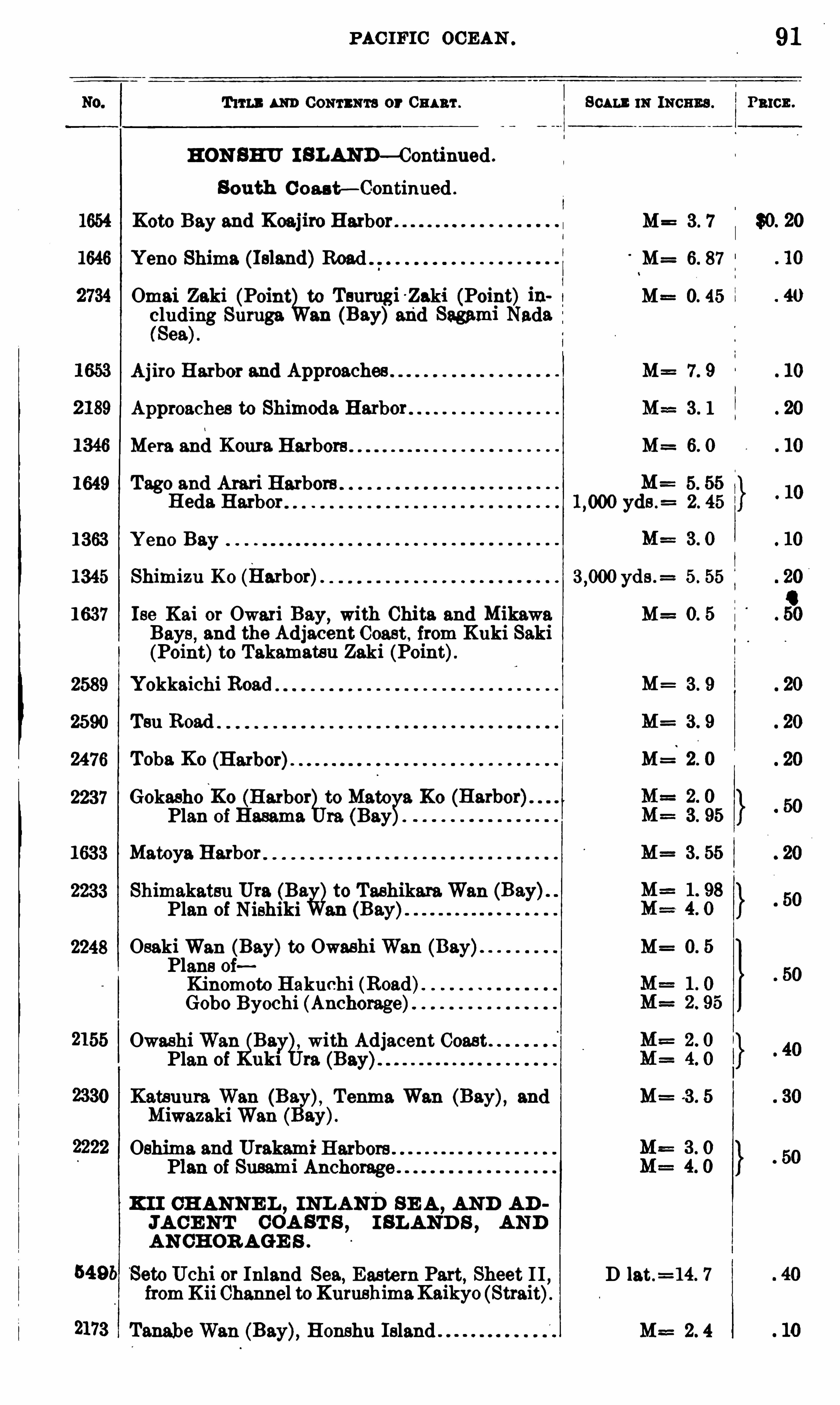
PAC IFIC OCEAN .
T um m Goun n a or Gna rr. Scum: 11: moms .
HON SHU I SLAND—Continued .
South C oas t— Continued .
Koto Bay and Koaj lro Harbor M= 3 . 7
Yeno Shima (1sland)Road M= 6. 87
Omai Zaki (Point to Tsumgi Zaki (Point) ih M= 0. 45
eluding Suruga an (Bay)mid Sagami Nada(Sea).
Apro Harbor and Approaches M= 7. 9
Approaches to Shimoda Harbor M== 3 . 1
M9 13 and Koura. Harbors M= 6. 0
1649 Tago and Atari Harbors 5. 55
B eds. Harbor yds .= 2. 45
1363 Y eno Bay
1345 Shimizu K 0 (Harbor). yds .= 5 . 55
1637 Ise Kai or Owari Bay,with Chita and Mikawa M= 0. 5
Bays, and the Adjacent Coast , from Kuki Saki
(Point)to Takamatsu Zaki (Point).2589 Yokkaichi Road 3 . 9
2590 Ten Road M= 3 . 9
2476 Toba K0 M= 2. 0
2237 Gokasho‘
Ko (Harbor to Mate 9. K0Plan of Em ma re. (Bayg
’
.
1633 Matoya Harbor M= 3 . 55
2233 Shimakatsu Uta Ba&to TashikaraWan
Plan of Nishiki an
2248 OsakiWan (Bay)to Owashi Wan (Bay) M= 0. 5
Plans oiKinomoto B akuchi (Road)Gobo Byochi (Anchorage)
OwashiWan
11with Adjacent Coast
Plan of uk1 to.
Katsuura Wan (Ba Tenma Wan (Bay), and M= 3 . 5
MiwazakiWan ay).
Oshima and Urakami HarborsPlan of Susami Anchorage
K I I CH ANNE L , INLAND SE A ,AND AD
JA CE NT COA ST S , I SLAND S ,AND
AN CH OR AGE S .
SetoUchi or Inland Sea, Eastern Part, Sheet I I D lat .=14. 7
fromKii Channel toKurushimaKaikyo (Strait).
2173 TanabeWan (Bay), Honshu Island M== 2. 4
91
PRICE .
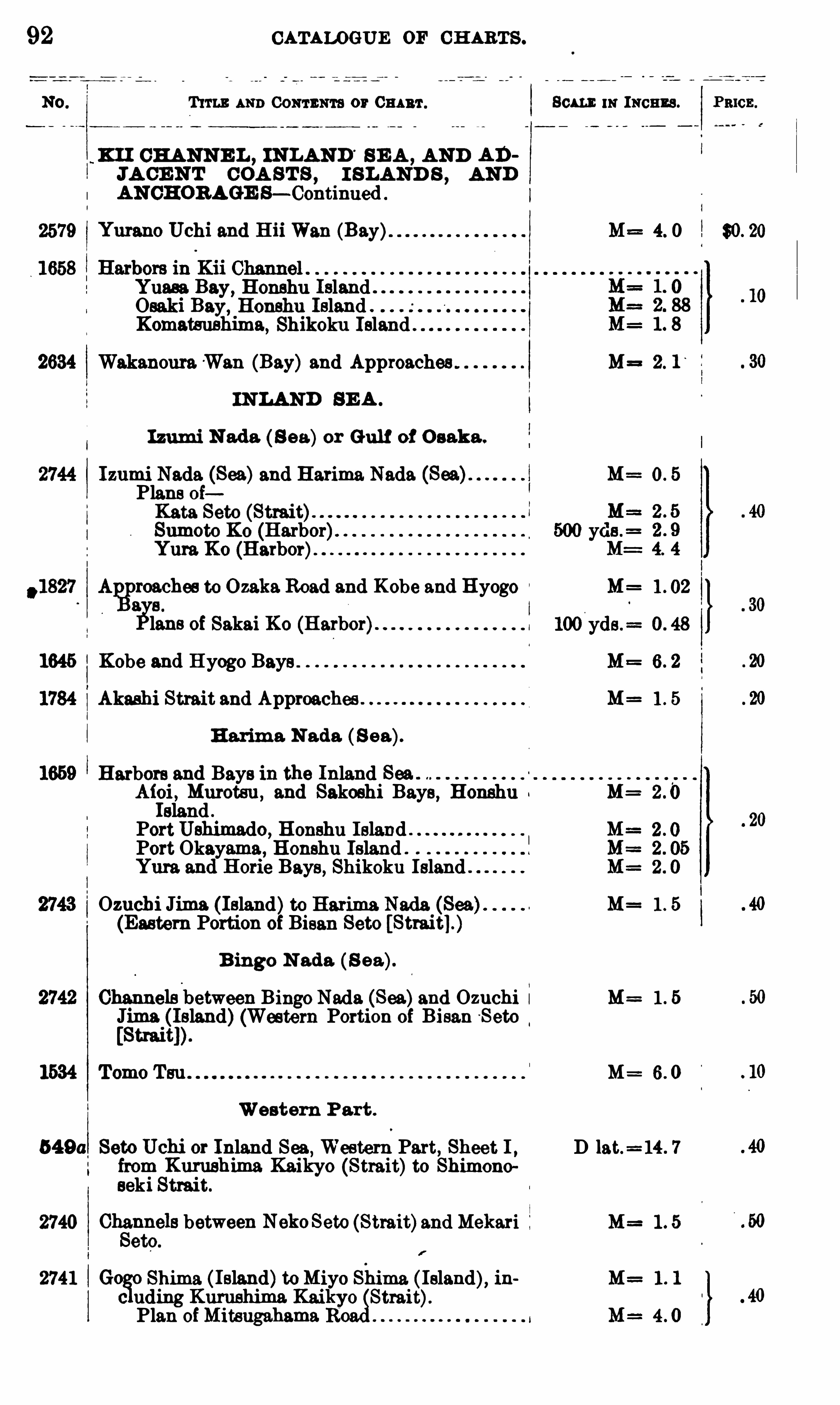
92 CATALOGUE OF CH ARTS .
T um: AND 0 0 11 1 1111 13 or 80m 11: INCHES . Pmcz .
x11 CHANNE L , INLAND SE A , AND ADJA CE N T COA ST S , I SLAND S , AND
AN CHORAGE S— Continued .
2579 Yurano Uchi and H 11 Wan (Bay) M= 4. 0 $0. 20
Yuasa Bay, Honshu Island .
Osaki Bay,Honshu Island .
Komatsushims , Shikoku Island .
2634 Wakanoura.Wan (Bay)and Approaches M= 2. 1‘
IN LAND BE A .
Izumi N ada ( 8 9 51)or Gulf of O saka .
Izumi Nada (Sea)and Harima Nada (Sea) M==0 . 5
Plans ofKata Seto (Strait).
Sumoto K0 (Harbor)Yum K0 (Harbor).
? :o
zehes to Ozaka.Road and Kobe and Hyogo M= 1 . 02
glans of Sakai K0 (Harbor) I
1645 Kobe and Hyogo Bays .
Akashi Strait and Approaches M= 1 . 5
H arima N ada ( S ea).
Harbors and Bays in the Inland SeaAioi , Murotsu , and Sakoshi Bays, Honshu M=Island .
PortUshimado, Honshu IslandPort Okayama, Honshu Island .
Yum and Horie Bays, Shikoku Island
Ozuchi Jima ( Island)to Harima Nada (Sea) M= 1 . 5
(Eastern Portion of Bisan Seto
B ingo N ado. (S ea).
Channels'
between Bingo Nada (Sea)and Ozuchi i M= 1 . 5Jima (Island)(Western Portion of Bisan S eto[Strait])
1534 Tomo Tsu M= 6. 0
Western Part .
549 0 Seto Uchi or Inland Sea, Western Part, Sheet 1 , D lat.= 14 . 7
from Kurushima Kaikyo (Strait)to Shimonoseki Strait.
2740 Ohé
mnels between NekoSeto (Strait)and Mekari M= 1 . 5
etc.
2741 Goio Shima ( Island)toMiyo Shims. ( Island), ih M . 1 . 1
c uding Kurushima Kaiktrait).
Plan ofMitsugahama R M= 4 0
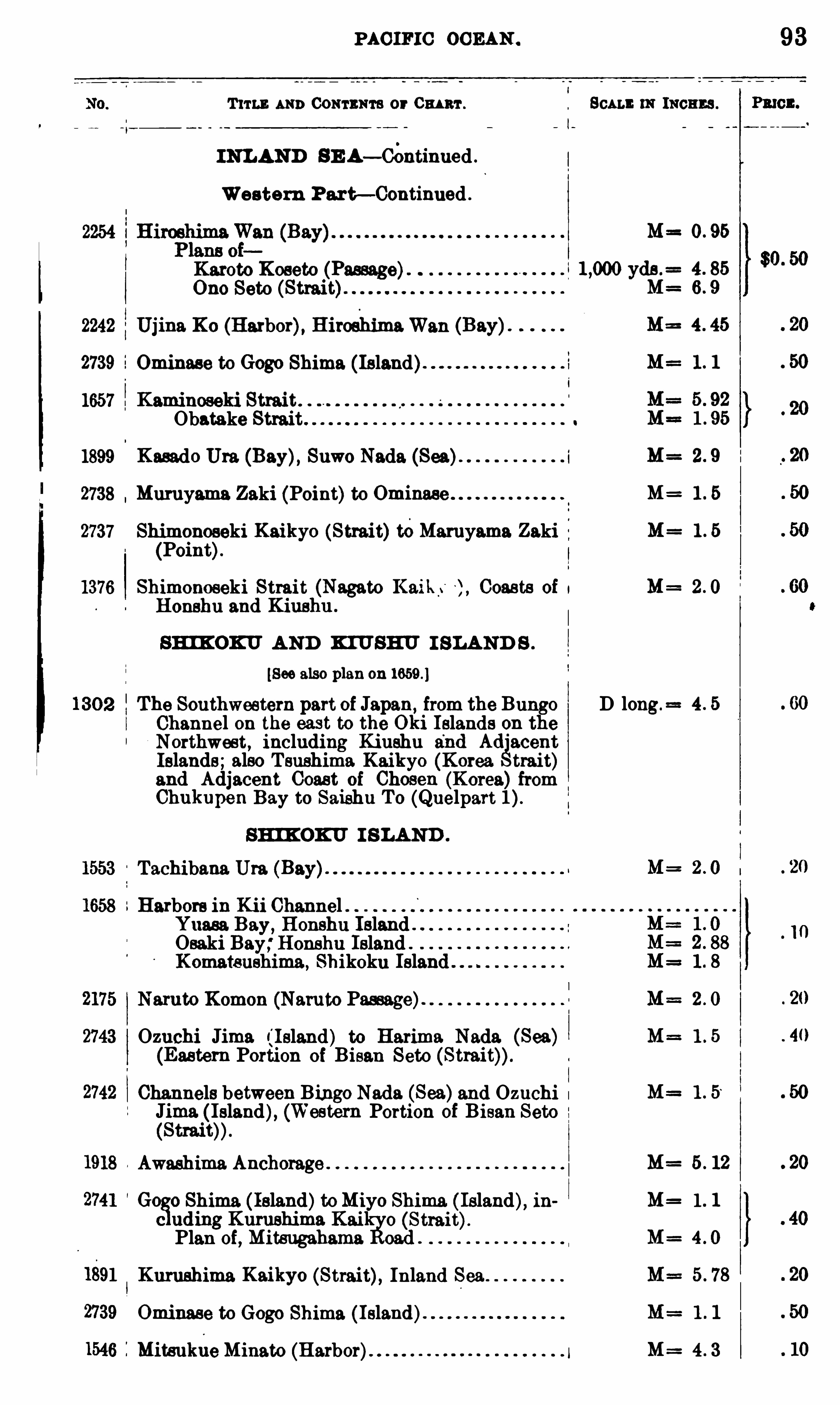
PAC IFIC OCEAN .
T 11 13 AND CONTENTS or Om ar .
INLAND SE A— Continued .
Western Part— Continued .
Karoto Roseto
Ono Seto (Strait
2242 Ujina Xc (Harbor), HiroshimaWan (Bay).
2739 i
1657
1899
2738
2737
1376
Ominase to Gogo Shima (Island) 1
Obatake Strait o
Kasado Ura (Bay), Suwo Nada (Sea)
Muruyama Zaki (Point)to Ominase
Shimonoseki Kaikyo (Strait)15Maruyama Zaki(Point)
Shimonoseki Strait (Nagato Kaik.‘ Coasts of 1
Honshu and Kiushu .
SHI KOKU AND KIUSHU I SLAND S .
[See also plan on
The Southwestern part of Japan from the Bung0Channel 0 11 the east to the Oki Islands on theNorthwest, including Kiushu and Ad acent
Islands;also T sushima Kaikyo (Korea trait)and Adjacent Coast of Chosen (Korea) fromChukupen Bay to Saishu To (Quelpart
SHI KOKU I SLAND .
Tachibana Ura (Bay).
Harbors in Kii ChannelYuasa Bay, Honshu Island"Osaki Bay;Honshu Island ”
Komatsushima, Shikoku Islan
Naruto Komon (Naruto Passage).
Ozuchi Jima ¢ l eland) to Harima Nada (Sea)(Eastern Portion of Bisan Seto
Channels between Bingo Nada (Sea)and OzuchiJima ( Island), (Western Portion of Bisan Seto
Awashima Anchorage
Go 0 Shima ( Island)toMiyo Shima ( Island), i hc uding Kumshima Kai o (Strait).
Plan oi, Mitsugahama oad .
Kurushima Kaikyo (Strait), Inland Sea
Ominase to Gogo Shima ( Island).
MitsuklieMinato (Harbor)
D long.
m 111011115 .
1 . 5“
5 . 12
1 . 1
93
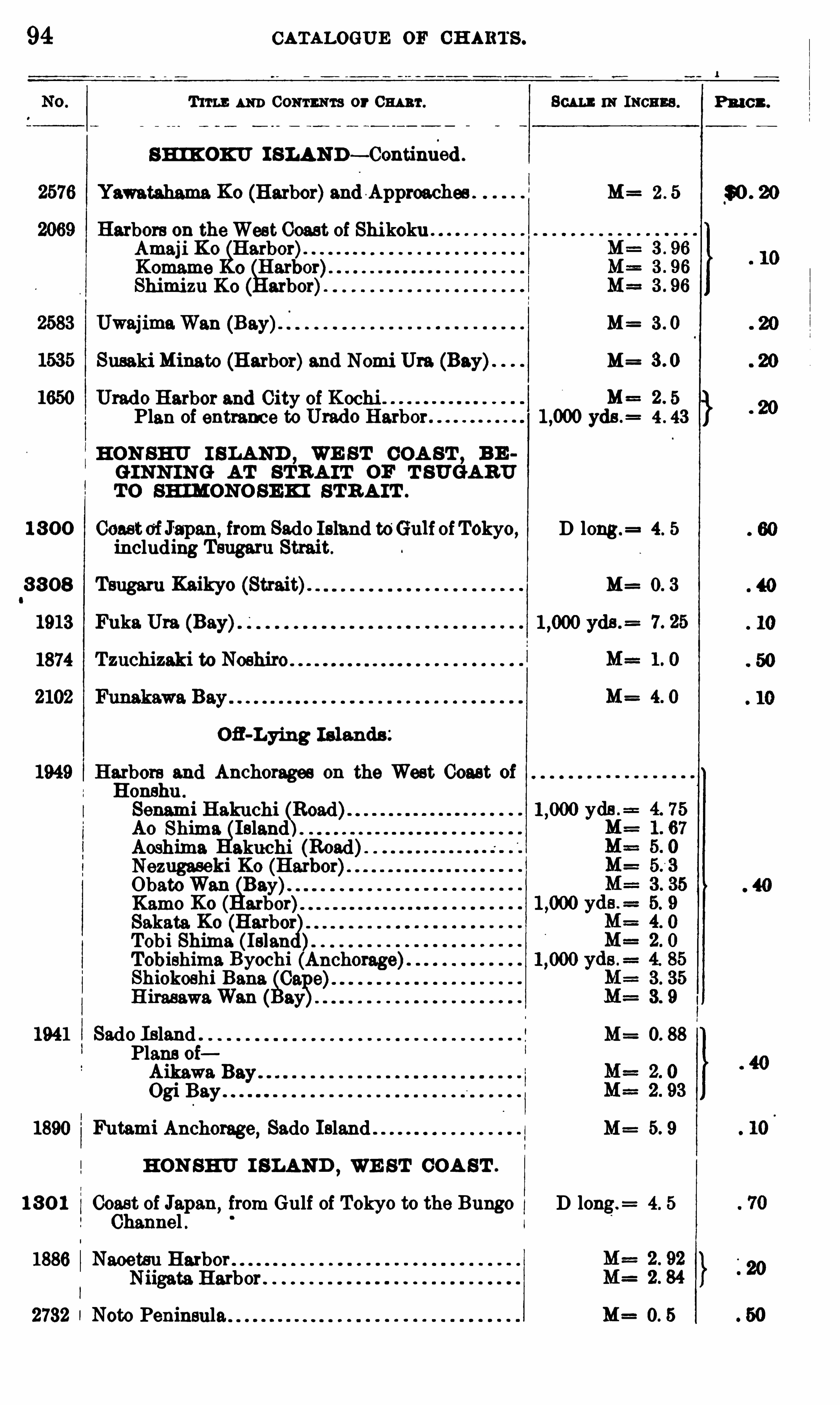
94 CATALOGUE 0 11 CH ARTS .
Tm : AND 0 0 171111111 3 or 0 111 111 . Scu mm Ixcnzs .
sm oxv I SLAND— Continded .
Yawatahama Ko (Harbor)andA pproaches M= 2 . 5
Harbors on theWest Coast of ShikokuAmaji Ko Harbor)"Komame Ho arbor).
Shimizu Koo
arbor).
UwajimaWan M= 3 . 0
Susaki Minato (Harbor)and Nomi Ura (Bay). M=
Urado Harbor and City of Kochi . . 5
Plan of entrance to Urado Harbor 1 ,000 yds . 4 . 43
HON SHU I SLAND , WE ST COA ST ,BE
GINN ING AT STR A IT OF T SUGARUTO SHIMONOSEK I STR A IT .
1 3 0 0 Coastof1apan, from Sado Island to‘
Gulf of Tokyo, D long . 4. 5
including Tsugaru Strait.
3 3 08 Tsugaru Kaikyo (Strait). M= 0. 3
1913 Fuka Ura (Bay)
1874 Tzuchizaki to Noshiro
Ofl-Lying Islands ;
Harbors and Anchorages on the West CoastHonshu .
Senami B akuchiAo Shima IslandAoshima akuchi (Road)Nezugaseki Ko (ObatoWan Bay)Kamo Ko ( arbor)Sakata Ko
((Harbor
Tobi Shima (IslanTobishima Byochi (Anchorage)Shiokoshi 133 118 0
8231?
H irasawaWan
1941 Sado Island . M= 0. 88
Plans ofAikawa Bay.
Ogi Bay"
1890 IMtami Anchorage, Sado Island M= 5. 9
HON SHU I SLAND,WE ST COA ST .
1 3 0 1 Coast of Japan from Gulf of Tokyo to the Bungo D long.= 4. 5
Channel .
1886 Naoetsu HarborNiigata Harbor .
2732 Noto Peninsula M= 0. 5
Pu on.
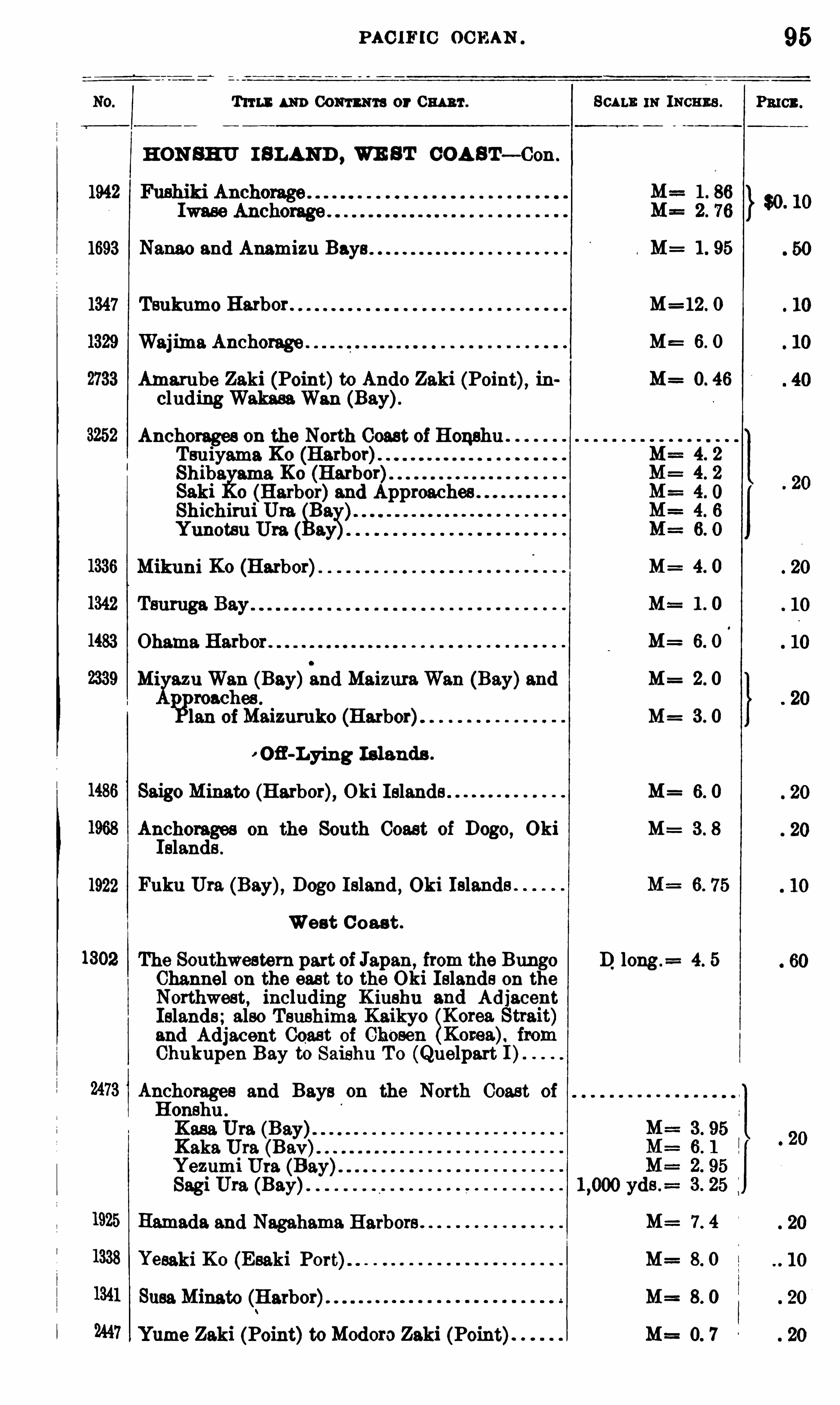
PAC IFIC OC EAN
Trru : um Com m or Cw 't .
HON SHU I SLAND , WE ST COA ST— Con.
1693 Nanao and Anamizu
1347 Tsukumo Harbor .
Waj lma Anchorage .
Amarube Zaki (Point)to Ando Zaki (Point), lncluding WakasaWan (Bay).
Anchorages on the North Coast of HonshuTsuiyama KoShiba ama XcSaki o ((Harbor)and ApproachesShichirui Ura
Ba;Yunotsu Ura ( a
Mikuni Ko (Harbor)
Ohama Harbor .
Mi azu Wan (Bay)and MaizuraWan (Bay)and{iPmachas .
Ian ofMaizumko (Harbor)
Ofl-Lying Islands .
Saigo Minato (Harbor), Oki Islands .
Anchorages on the South Coast of Dogo, OkiIslands .
1922 Fuku Ura (Bay), Dogo Island , Oki Islands
West C oast .
The Southwestern part of Japan from the BungoChannel on the east to the Oki Islands on theNorthwest
,including K iushu and Adjacent
Islands; also Tsushimaand Adjacent Coast ofChukupen Bay to Saishu To (Quelpart
Anchorages and Bays on the North Coast of
Honshu .
Kasa Ura (Bay)Kaka Ura (Bav)Yezumi UraSagi Ura (Bay)
Hamada and Nagahama Harbors
Yesaki Ko (Esaki Port)
Susa Minato (B arbor).
Yume Zaki (Point)toModoro Zaki (Point)
Scu m. 111 INCHES .
M 1 . 95
M=12. O
M= 6. 0
M= 0. 46
M= 4. 0
M= 1 . 0
M= 6. 0
M= 2. 0
M= 3 . 0
M= 6. 0
M= 3 . 8
D long .= 4. 5
M= 7. 4
M= 8 . 0
M= 8. 0
M== 0. 7
95
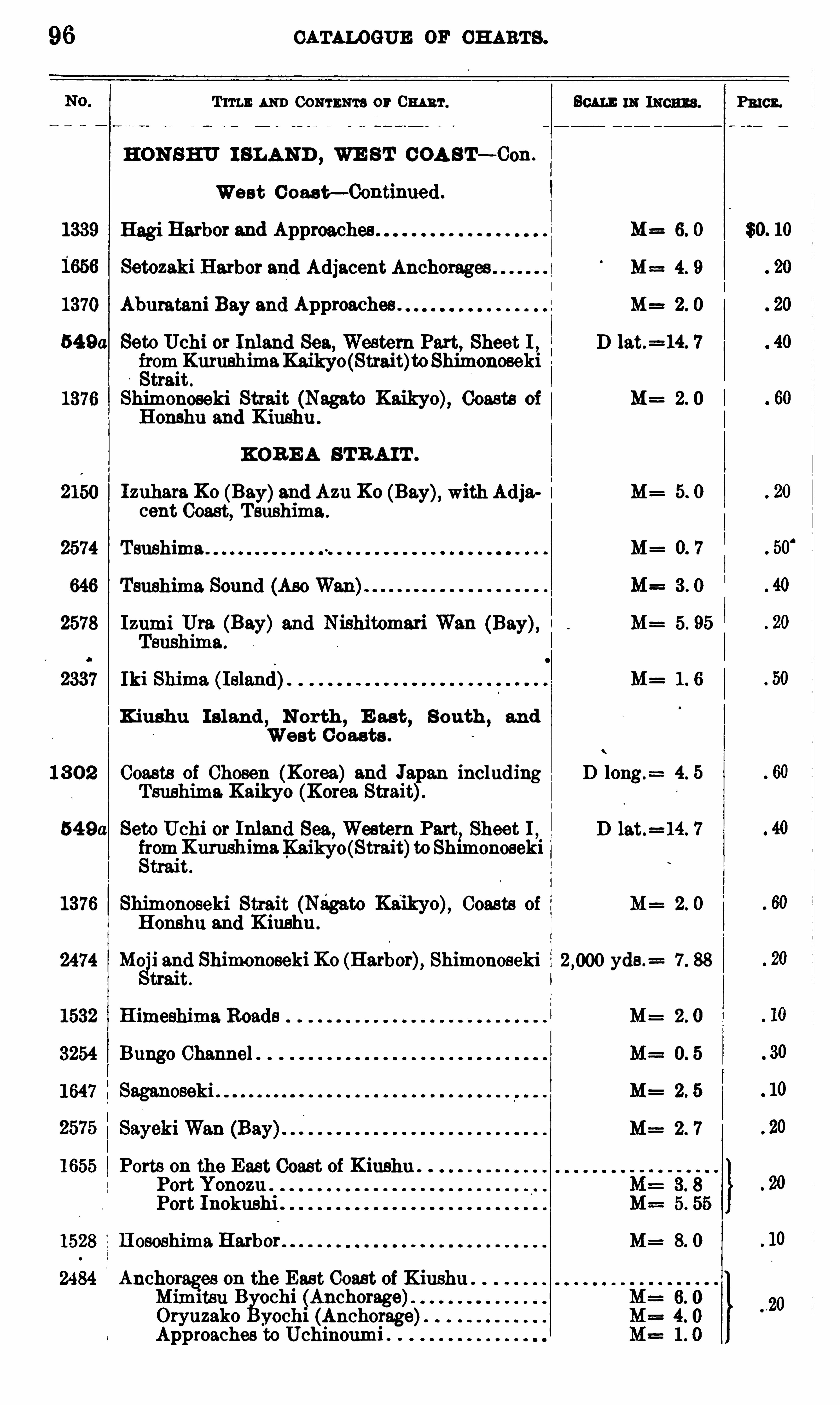
CATALOGUE OF CH ARTS .
T 11 1 1 : AND 00 111 11171 3 or 0 1111111 .
HON SHU I SLAND , WE ST COA S T— Con .
West Coas t— Continued .
1339 Hagi Harbor and Approaches 6. 0
Setozaki Harbor and Adjacent Anchorages M== 4. 9
1370 Aburatani Bay and Approaches . M= 2. 0
54 9a Seto Uchi or Inland Sea, Western Part, Sheet I , D lat.=14. 7
fsrom KurushimaKaikyo (Strait)toShimonosekitrait .
1376 Shimonoseki Strait (Nagato Kaikyo), Coasts of M==2. 0
Honshu and Kiushu
KOR E A STR A IT .
2150 Izuhara Ko (Bay)and Azu Ko (Bay), with Adja i M= 5. 0cent Coast, Tsushima .
2574 Tsushima M= 0. 7
646 Tsushima Sound (Ase Wan)
2578 Izumi Ura (Bay) and Nishitomari Wan (Bay), I M= 5. 95
Tsushima.
2337 Iki Shima (Island). M= 1 6
Kiushu I sland,N orth
,E ast
,S outh ,
and
West Coas ts .
1 3 0 2 Coasts of Chosen (Korea) and Japan including D long.= 4. 5
Tsushima Kaikyo (Korea Strait).
54 9a Seto Uchi or Inland Sea, Western Part.Sheet 1 , D lat.
=14. 7
fromKurushimaKaikyo(Strait)toShimonosekiStrait .
1376 Shimonoseki Strait (Nagato Kaikyo), Coasts of M= 2. 0Honshu and Kiushu .
2474 Mo 1 and Shimonoseki Ko (Harbor), Shimonoseki yds .= 7. 88
trait.
1532 Himeshima Roads M= 2 . 0
3254 Bungo Channel . M= 0. 5
1647 M= 2. 5
M= 2 . 7
1655 Ports on the East Coast of KiushuPort Yonozu .
Port Inokushi .
1528 Hososhima Harbor M= 8. 0
2484 Anchorages on the East Coast of Kiushu .
Mimitsu B ochi (Anchorage)Oryuzako yoch1 (Anchorage)Approaches to Uchinoumi .
Scum 111 111011113 . PRICE.
$0. 10

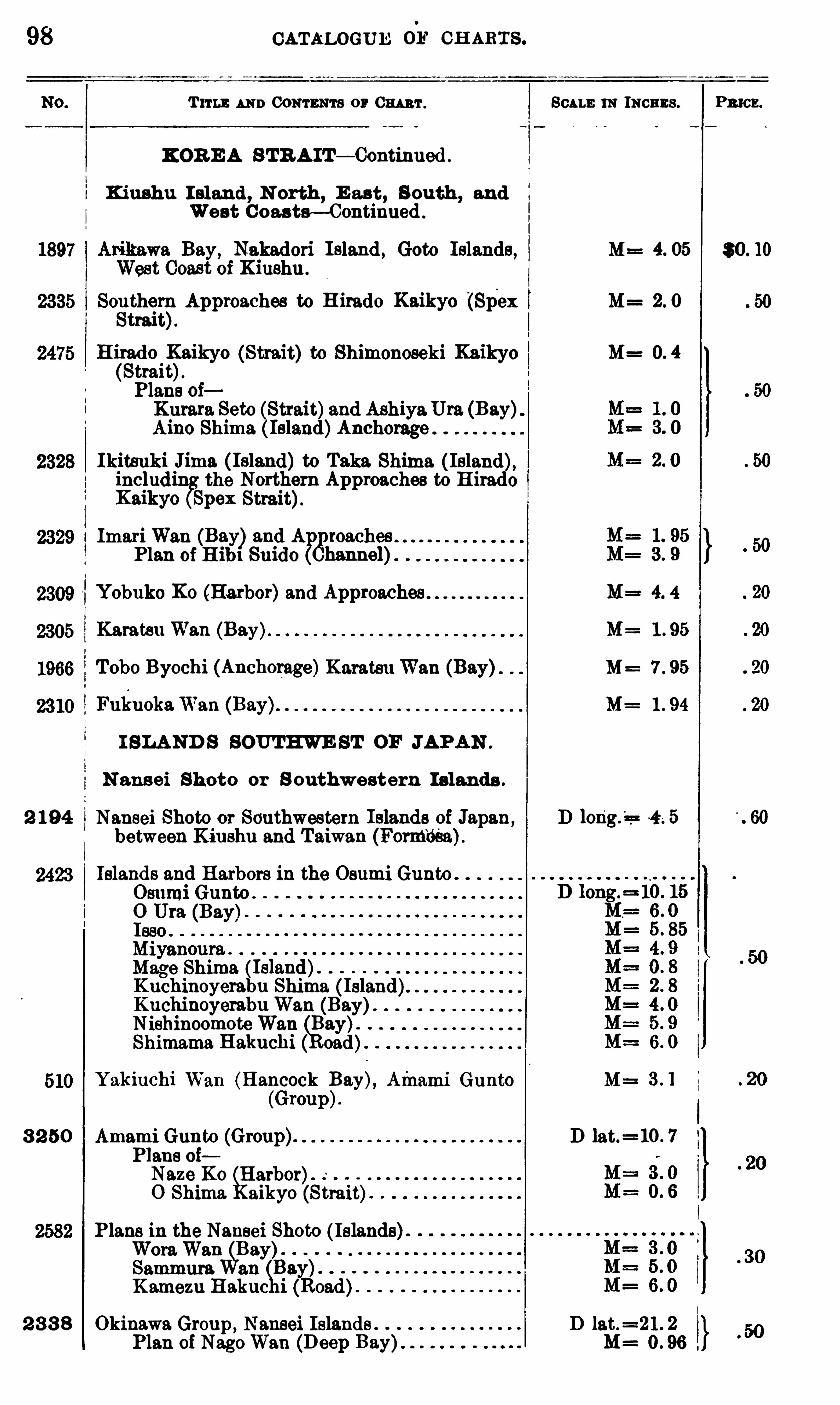
98 CATALOGUE 0 1‘
CH ARTS .
Tums AN D 00 111 111713 or 0 111 111 . Son s 111 INCHES . Pmcz.
KOR E A STR A IT— Continued .
Kiushu I sland , N orth E as t, S outh , andWest C oas ts— Continued .
Bay, Nakadori I sland , Goto Islands, M= 30 . 10West Coast of Kiushu .
Souther
hApproaches to H irado Kaikyo (Spex M= 2. 0
Strait
H i
gdo 1
)( aikyo (Strait) to Shimonoseki Kaikyo M=
traitPlans oiKurara Seto (Strait)and AshiyaUra (Bay)Aino Shima ( Island)Anchorage . .
Ikitsuki J1ma ( Island)to Taka Shima ( Island),includin
gsthe Northern Approaches to H irado
Kaikyo pex Strait).
ImariWan (Bay)and A? han1-oaches . .
Plan of(Hib1 Suido hann . .el)
Yobuko Ko (Harbor)and Approaches M= 4. 4
Karatsu Wan (Bay) M= 1 . 95
Tobo Byochi (Anchorage)KaratsuWan (Bay) M= 7 . 95
FukuokaWan (Bay) M= 1 . 94
I SLAND S SOUTHWE ST OF JAPAN .
N ansei Shoto or S outhwestern Is lands .
2 194 Nausei Shoto or Southwestern Islands of Japan,D 4 ; 5
between Kiushu and Taiwan (Form‘
déa)
Islands and Harbors in the Osumi Gunto .
Osumi Gunto .
O Ura (Bay)Isso . .
Miyanoura . .
Mage ShimaKuchinoyerabu Shima ( Island)Kuchinoyerabu Wan (Bay)N ishinoomoteWan Bay).
Shimama Hakuchi oad)
Yakiuchi Wan (Hancock Bay), Afnami Gunto M=
(Group).
3 2 50 Amami Gunto (Group). D lat.=10 . 7
Plans oiNaze Ko Harbor).
0 Shima aikyo (Strait)
Plans in the Nausei Shoto (Islands
WoraWan Bay)”
Sammura an Bay1K amezu Hakuc oad)
2 3 3 8 Okinawa Group , Nansel Islands D lat.=21 . 2
Plan of NagoWan (Deep M= 0 . 96
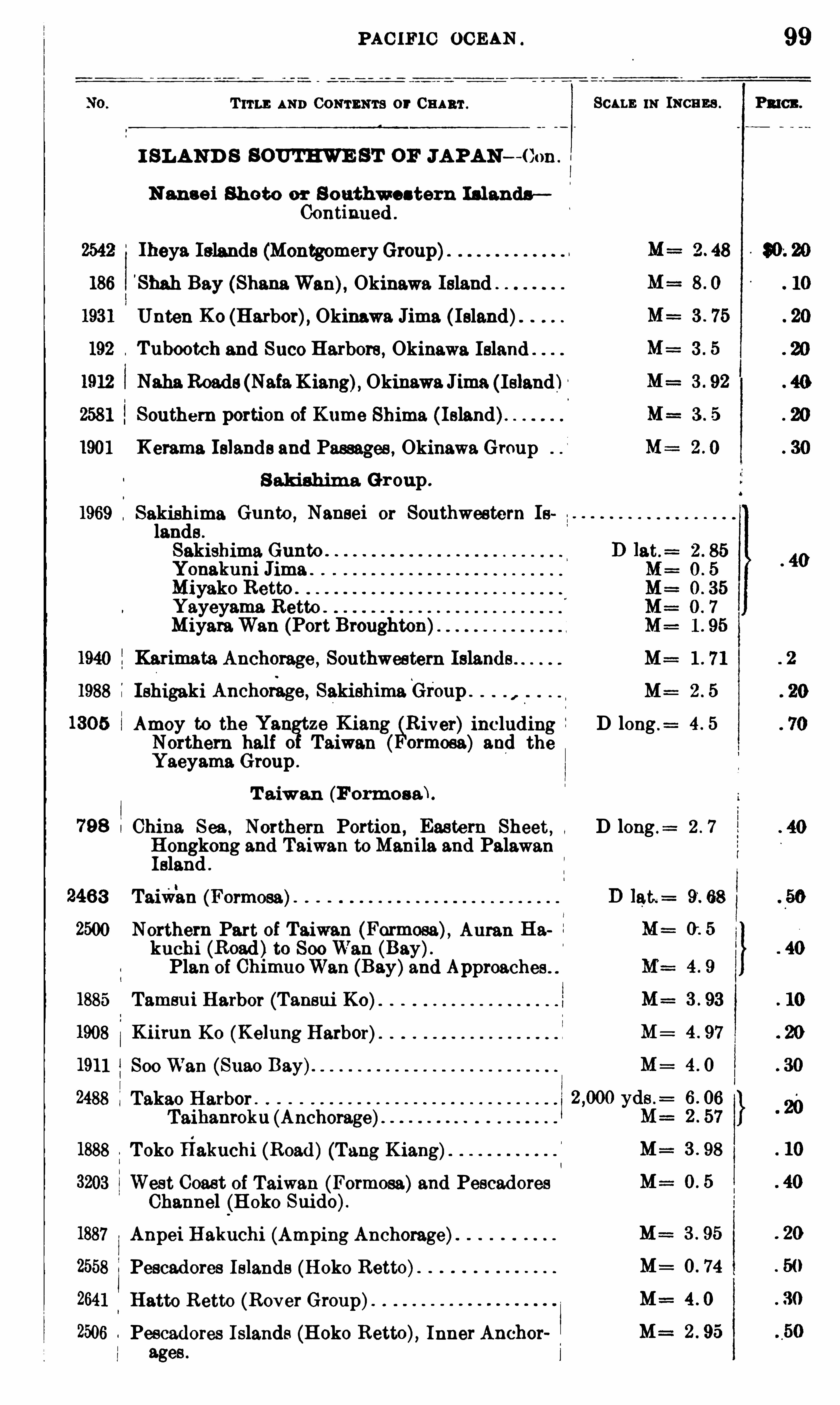
PAC IFIC OC EAN
T ITLE AND CONTENTS or 0 1111111 . SCALE 111 means .
I SLAND S SOUT HWE ST OF JAPAN -Con .
N ans e i Shoto or S outhwes tern Isl andsContinued .
Iheya Islands (Montgomery Group)S hah Bay (Shana Wan), Okinawa IslandUnten Ko (Harbor), Okinawa Jima ( Island)Tubootch and $ 1100 Harbors, Okinawa IslandNaha Roads (NataKiang), Okinawa Jima (Island)Southern portion of Kume Shima ( Island).
K emma Islands and Passages , Okinawa GroupS akishim a Gr oup .
Sakishima Gunto ,Nausei or Southwestern Is
lands .
Sakishima Gunto .
Yonakuni Jima .
Miyako Retto . .
Yayeyama Retto.
MiyaraWan (Port Broughton)Karimata Anchorage ,
Southwestern IslandsIshigaki Anchorage , SakishimaGroup .
Amoy to the Yangtze K iang
B&River) including
Northern half Taiwan ormosa) and theYaeyama Group .
T aiwan (Formosafi.
China Sea , Northern Portion, Easte rn Sheet,Hongkong and Taiwan to Manila and PalawanIsland .
Taiwan (Formosa)
Northern Part of Taiwan (Formosa), Auran Hakuchi (Road)to 800 Wan (Bay).Plan of ChimuoWan (Bay)and Approaches"
Tamsu i Harbor (Tansui K0 )Kiirun K 0 (Kelung Harbor).
Soo Wan (Suao Bay).
Takao Harbor . .
Taihanroku (Anchorage)
Toko 11akuchi (Road)(Tang Kiang)West Coast of Taiwan (Formosa)and PescadoresChannel (H oko Suido).
Anpei Hakuchi (Amping Anchorage)Pescadores Islands (Hoko Retto)Hatto Retto (Rover Group)Pescadores Islands (Hoko Retto), Inner Anchorages .
D long .
D long .= 2 . 7
99
PRICE .
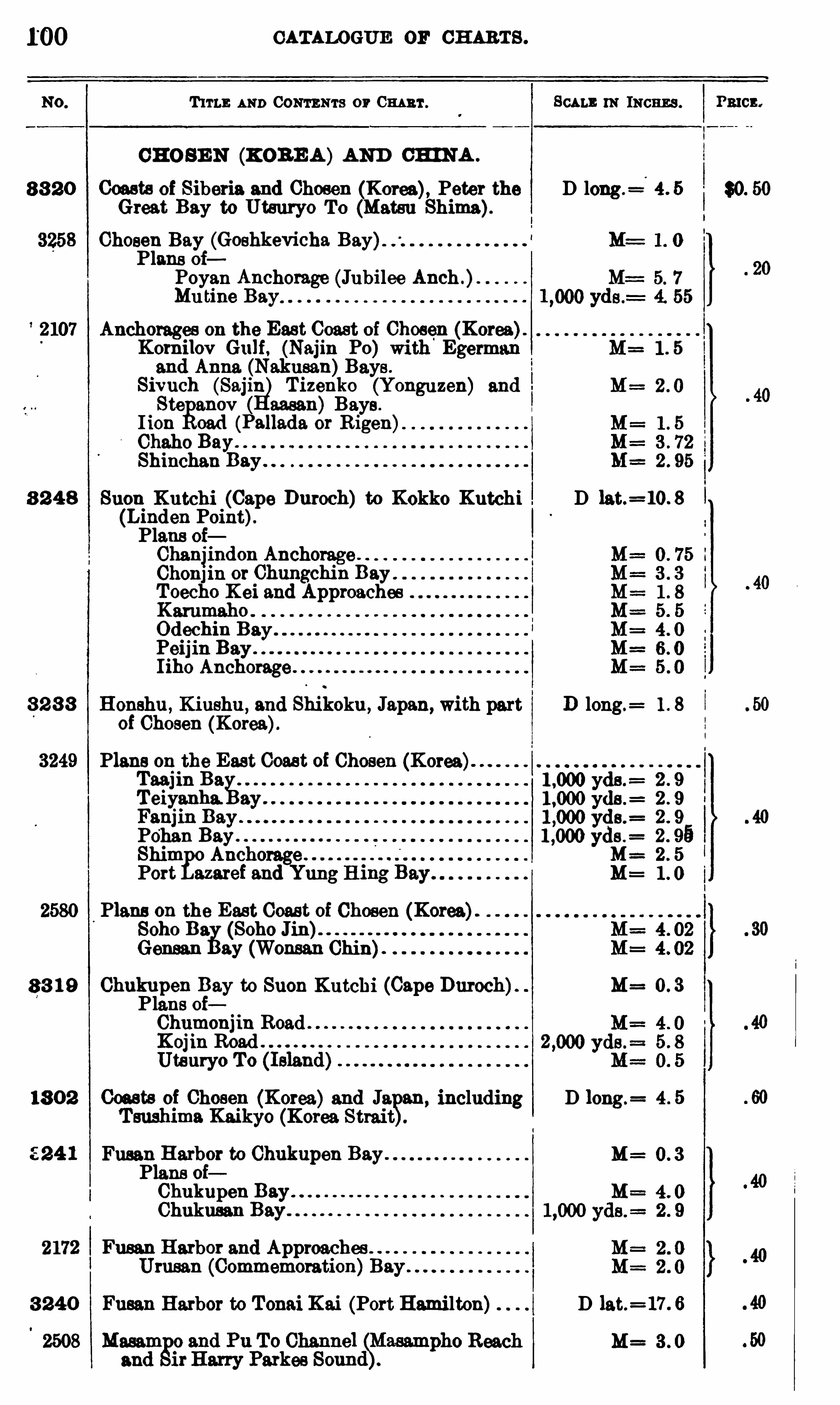
CATALOGUE or CHARTS .
T 11 1 1; AND 0 0 111 3 111 3 or 0 1111111 . SCALE m INCHES . Pmcx.
CHO SE N (KORE A )AND CH INA .
8 3 2 0 Coasts of Siberia and Chosen (Korea), Peter the D long.=
Great Bay to Utsuryo To (Matsu Shima)Chosen Bay (Goshkevicha Bay)Plans oi
Poyan Anchorage (Jubilee Anch .)Mu tine Bay
2107 Anchorages on the East Coast of Chosen (Korea)Kom ilov Gulf , (Najin Po) Egermanand Anna. (Nakusan)Bays .
Sivuch (Sajin Tizenko (Yonguzen) andStefianov aasan) Bays .
I ion cad (Pallada or R igen
Chaho BayShihchan Bay.
8 2 4 8 Suon Kutchi (Cape Baroch) to Kokko Kutchi D lat.= 10. 8
(Linden Point).Plans oiChanjindon Anchorage .
Chonj in or Chungchin BayToecho K ei and ApproachesKammaho .
Odechin BayPeijin BayI iho Anchorage
8 2 8 8 Honshu , Kiushu ,and Shikoku , Japan, with part D long.
= 1 . 8
of Chosen (Korea).
Plans on the East Coast of Chosen (Korea)Taajin BaTeiyanha. ayFanjin BayPo'han BayShim Anchorage .
Port azarei and Yung H
~rr~
0
0
01
0!
r
wp
www
Q
CR
QD
CO
GO
G
Plans on the East Coast of Chosen (Korea).
Soho Da (Soho Jin)Gensan ay (Wonsan Chin)
8 3 1 9 Chukupen Bay to Suon Kutchi (Cape Duroch). M= 0 . 3Plans oiChumonjm RoadKoj in RoadUtauryo To
18 0 2 Coasts of Chosen (Korea)and Ja an, including D long.= 4 . 5
T sushima Kaikyo (Korea Strai t
M=Plans oiChukupen BayChukussu
Fusan Harbor and Approaches .
Urusan (Commemoration)B
3 240 Fusan Harbor to Tonai Kai (Port Hami lton) D lat.=17 . 6
M= 3 . 0

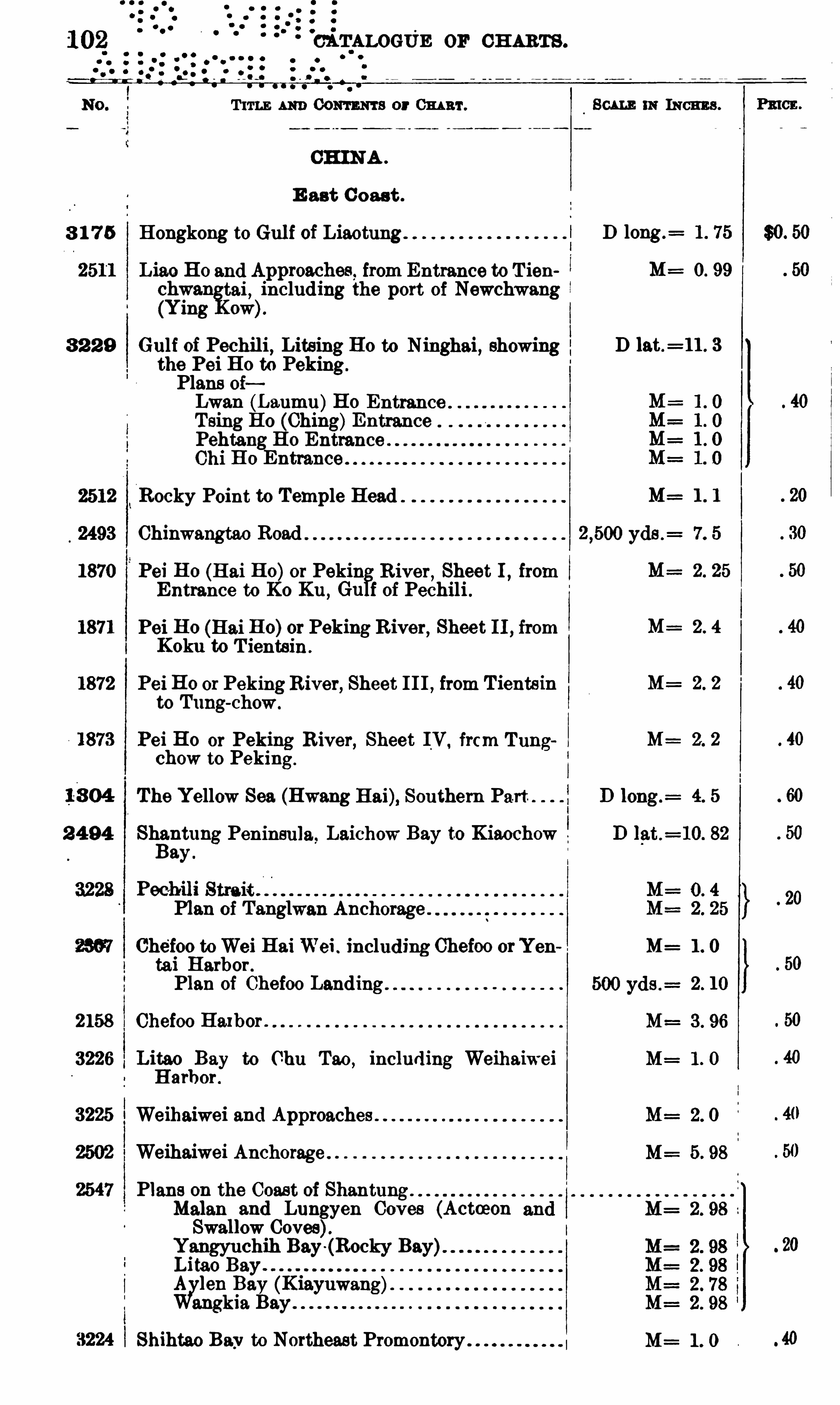
CATALOGIiE 0 11 CH ARTS .
T 11 13 m Com m a or Om ar.
CHINA .
E ast C oast .
8 1 7 5 Hongkong to Gul f of Liaotung
Liao Ho and Approaches from Entrance to T iench nwa. tai
,including the port of Newchwang
(Ying ow).
8 2 2 9 Gulf of Pechili, Litsi11g Ho to Ninghai, showingthe Pei Ho to PekingPlans 0 1Lwan (Laumu)Ho Entrance .
Tsing Ho (Ching)EntrancePehtang Ho Entrance “
Chi H o
gEntrance
2512 Rocky Point to Temple Head
2493 Chinwangtao Road
1870 Pei Ho (Hai Ho)or Pekin River,Sheet I
,from
Entrance to K0 Ku, Gu f of Pechili ,
1871 Pei Ho (Hai Ho)or Peking River, Sheet I I , fromKoku to T ientsin .
1872 Pei Ho 0 1 PekingRiver, Sheet III , from Tientsinto Tung
-chow.
Pei Ho or Peking River, Sheet IV frcm Tungchow to Peking.
The Yellow Sea (Hwang Hai), Southern Part
2 4 94 Shantung Peninsula. Laichow Bay to KiaochowBay .
Pecihili Strait .
Plan of Tanglwan Anchorage .
Che’foo toWei HaiWei . including Chefoo orYentai Harbor .
Plan of Chefoo Landing .
2158 Chefoo Ha1bor .
3226 Litao Bay to Chu Tao,including Weihaiwei
Harbor .
3225 Weihaiwei and Approaches .
Weihaiwei Anchorage .
Plans on the Coast of Shantung .
Malan and Lunggyen Coves (ActmonSwallow Coves).
Yangyuchih Bay (Rocky Bay)Litao Bayy .
Bay (Kiayuwang).
kia Bay
Shihtao Bay to Northeast Promontory
8 0m 111 INCHE S .
D long.= 1 . 75
M=
D lat.= 11 . 3
M= 1 1
M= 2 . 4
M= 2 . 2
M= 2. 2
M= 1 . 0
M= 1 . 0
M= 2. 0
M= 5. 98
M= 2 . 98
M= 1 . 0
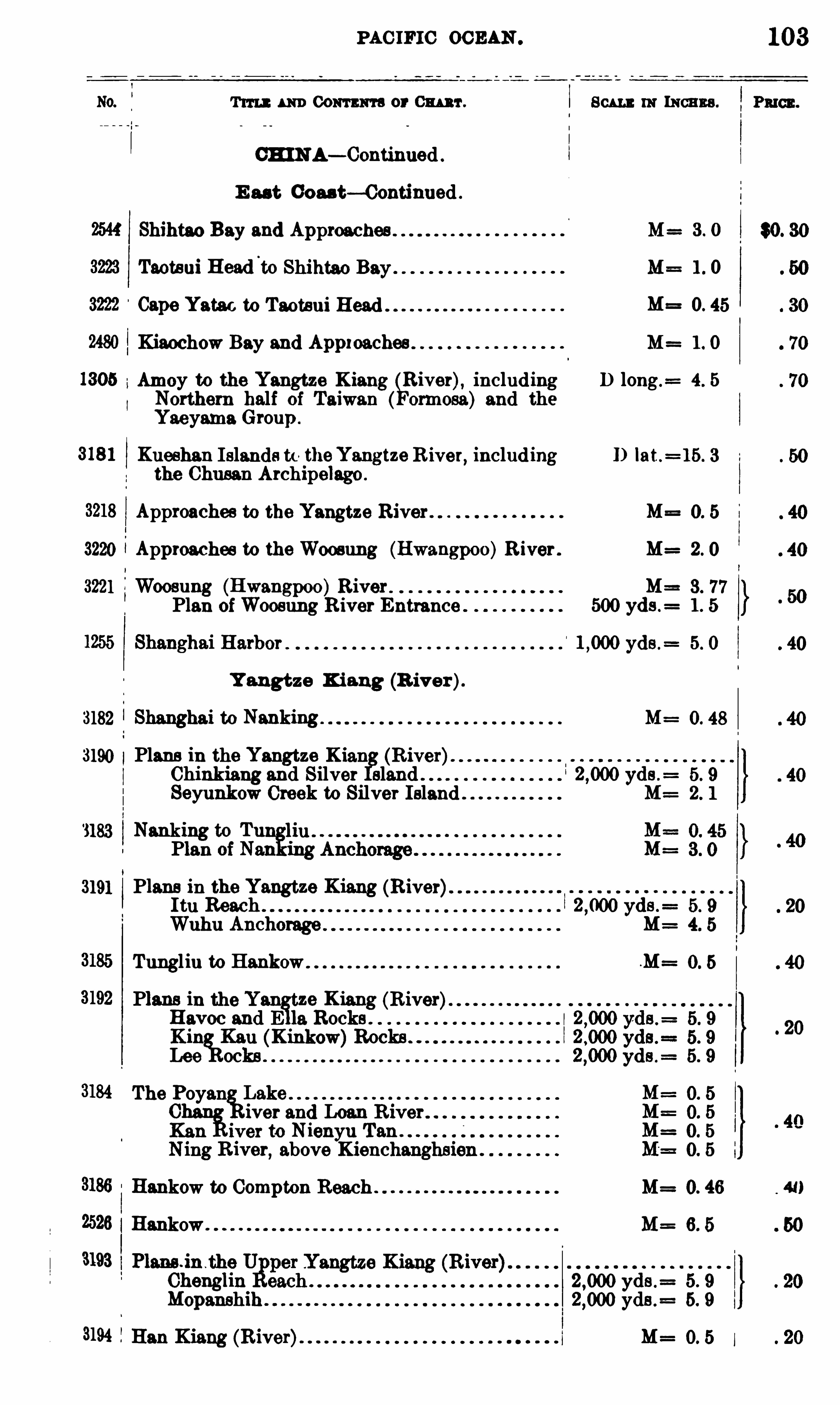
PAC IFIC OCEAN .
T 11 11 : 1 1m Com m a or M r . Scu m111 INCHES .
CHINA— Continued
E ast Gou t— Continued .
Shihtao Bay and Approaches M=
Taotsui Head'
to Shihtao Bay M=
M=
Kiaochow Bay and Appxoaches M=
Amoy to the Yangtze Kiang River), including D long .=
Northern half of Taiwan and theYaeyama Group .
Xueshan I slands to theYangtze River, including I) lat.
the Chusan Archipelago .
Approaches to the Yangtze River M=
3220 Approaches to the Woosung (Hwangpoo)R iver . M=
3221 Woosung (Hwangpoo)RiverPlan ofWoosung R iver Entrance 500 yds .
yds
Y angtze K iang (R iver).
3182 Shanghai to Nanking M=
3190 Plans in the Yangtze Kian (R iver).
Chinkiang and Silver Bland yds .=
Seyunkow Creek to Silver Island M:
3183 Nanking to Tu 1111 .
Plan of Nan ing
3191 Plans in the Yangtze Kiang (River)It11 Reach yds .
=
Wuhu Anchorage M=
Tungliu to Hankow .M=
Plans in the Y ze Kiang (River)Havoc and E 19. Rocks .
K in Kau (Kinkow)Rocks .
Lee ochs
The Poyan LakeChan
fiiver and Loan R ive
Kan iver to Nienyu Tan .
Ning R iver, above Kien
Hankow to Compton Reach . M=
2526 Hankow . M=
3193 Plans j nth
Chengl ydsMopanshih yds .
=
3194 Han Kiang (R iver) M=
3 . 0
l . 0
0. 45
1 . O
4. 5
O. 48
r-lco
103
P111c11.
$0. 30
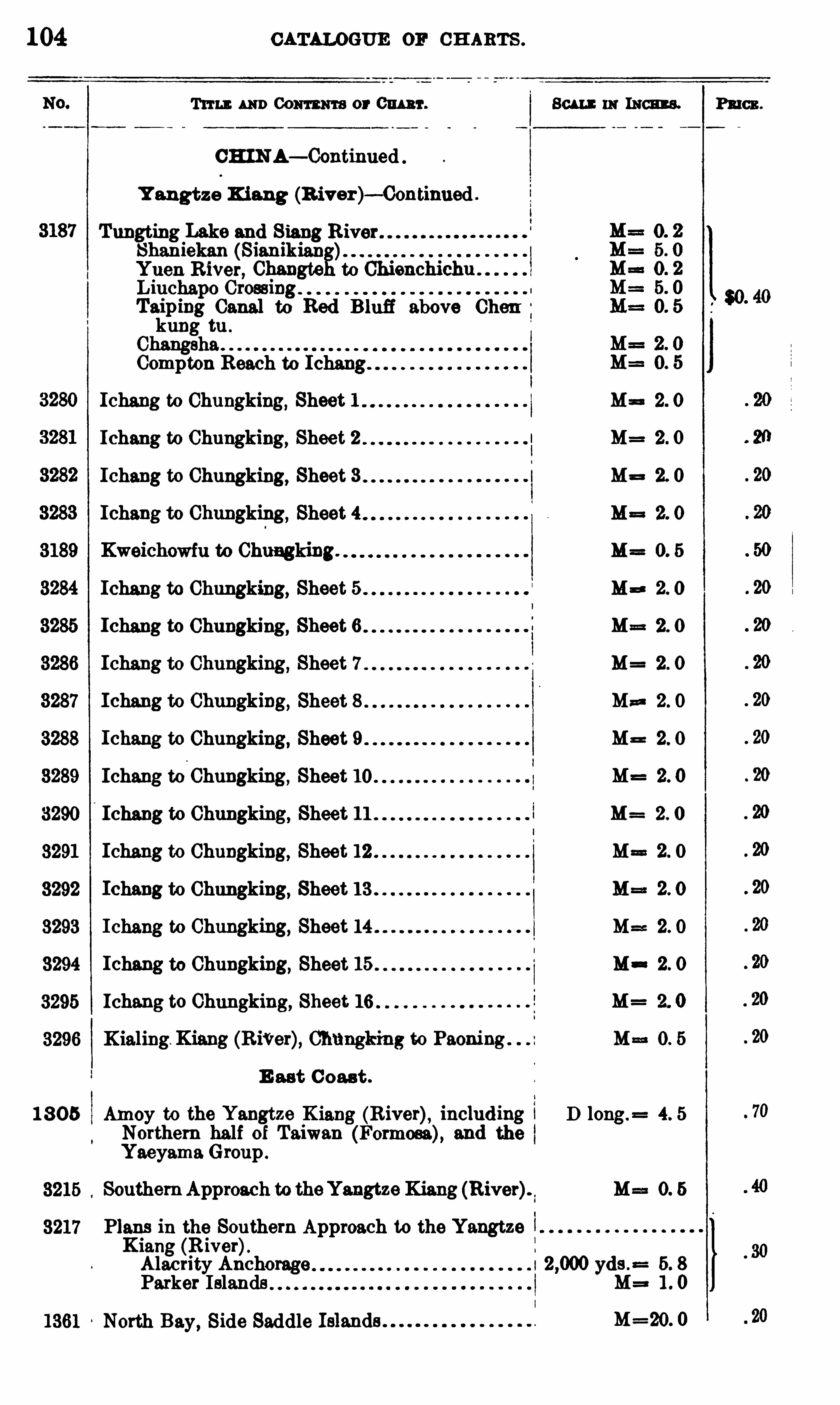
104 CATALOGUE or CH ARTS .
Tum: 111m Com m or 0mm . Son : 11: Ism s. Paws .
CHIN A— Continued
Y angtze K iang (B iver) -Continned .
Tungting Lake and RiverShaniekan (Sianikian
g)
Yuen River Changte to ChienchichuLiuchapo CrossingTaip111g Canal to Red Blufi above Chenkung tu .
ChangshaCompton B each to Ichang
Ichang to Chungking, Sheet 1 Ma 2. 0
Ichang to Chungking, Sheet 2 M= 2 . 0
Ichang to Chungking, Sheet 3 M= 2. 0
Ichang to Chungking, Sheet 4 M= 2. 0
Kweichowfu to Chungking. M= 0. 5
Ichang to Chungking, Sheet 5 M= 2. 0
Ichang to Chungking, Sheet 6 M= 2 . 0
Ichang to Chungking, Sheet 7 M= 2 . 0
Ichang to Chungking, Sheet 8 M= 2. 0
Ichang to Chungking, Sheet 9 M= 2. 0
Ichang to Chungking, Sheet 10 M= 2. 0
Ichang to Chungking, Sheet 11 M= 2. 0
Ichang to Chungking, Sheet 12 Ma 2. 0
Ichang to Chungking, Sheet 13 M==2. 0
Ichang to Chungking, Sheet 14 M==2. O
Ichang to Chungking, Sheet 15 M 2. 0
Ichang to Chungking, Sheet 16 M= 2. 0
X ialing. Kiang (RiVer), Chungking to Paom'
ng M==0. 5
E ast C oast .
1 8 05 Amoy to the Yangtze K iang (R iver), includi11g D long.= 4. 5
Northem half of Taiwan (Formosa), and theYaeyama Group .
SouthernApproach to theYangtze Kiang (River) M==0. 5
Plans m the Southern Approach to the Yangtze !Kiang (R iver).Alacrity Anchorage I 2
,000 yds . 5. 8
Parker Islands M= 1 . 0
North Bay, Side Saddle M=2O. 0

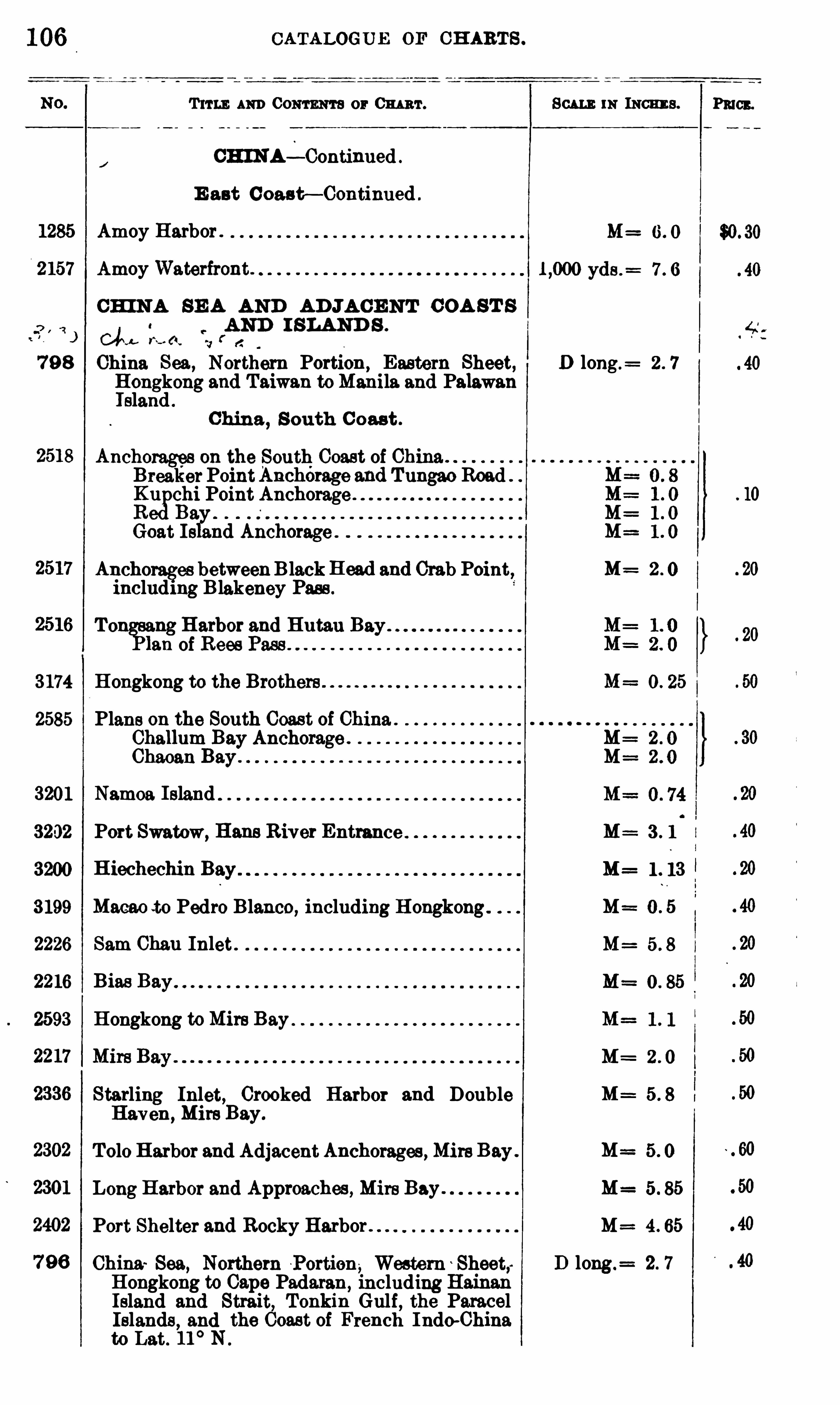
106
T 11 1 1: AND CONTENTS or 0 1mm .
cmNA4-continued .
E ast C oas t— Continued .
1285 Amoy Harbor .
2157 Amoy Waterfront.
CH IN A SE A AND AD JA CE NT C OA ST S0 AND I SLAND S .
OLJ v ( t .
fa
79 8 China Sea, Northern Portion,Eastern Sheet,
Hongkong and Taiwan toManila and PalawanI sland .
China,S outh C oast .
Anchorages on the South Coast of China .
BreakerPointAnchérage and Tungao RoadKu chi Point Anchorage .
RegBa.Goat I s aht nchorage .
Anchorages betweenBlack H ead and Crab Point,including Blakeney Pass .
To ng Harbor andof B ees
3174 Hongkong to the Brothers .
2585 Plans on the South Coast of China .
Challum Bay Anchorage .
Chaoan Bay .
3201 Namoa Island
3202 Port Swatow, Hans River Entrance
3200 H iechechin Bay
3199 Macao to Pedro Blanco, including H ongkong .
2226 Sam Chan Inlet
2216 Bias Bay
2593 Hongkong toMire Bay
Starling Inlet, Crooked Harbor and DoubleHaven, Mire Bay.
Tolo Harbor and AdjacentAnchorages , MireBay .
Long Harbor and Approaches , Mire Bay.
Port Shelter and Rocky Harbor .
China Sea, Northern Portion, Western Sheet;Hongkong to Cape Padaran,
including HainanIsland and Strait, Tonkin Gulf , the ParacelIslands
,and the Coast of French Indo—China
to Lat. 11° N .
CATALOGUE OF CH ARTS .
111 INCHE S .
M=
yds .=
D long .=
M=
M=
M=
M=
M=
M=
M=
M=
M=
M=
M==
M=
D long.= 2 . 7
$0. 30

PAC IFIC OCEAN .
T11 11 : 111111 Com m 0 : 0 1111111 . Scu m: 111 1110111 3 .
CH I NA SE A AND AD JA CENT COA ST S
AND I l LAN D S— Continued .
Ching , S outh Coast— Continued .
J
929 Hongkong Harbor and Apgroachee . M= 2 . 4
P lan of Fotau Mun otong Pass) 600 yds .= 1 . 8
HongkongWaters, East . M= 5. 95
1254'
Hongkong Harbor . M= 12. 0
2221 Hongkong Waters,West 5. 95
Wan Chu Chau (Stonecutters)to Brothers Point . M= 5. 9
2215 Taitam Bay . M= 6. 0
2327 East Lamma Channel
2599 Aberdeen Harbor .
2223 Boddam Cove ,Tor
igho yds .
= 5. 8
Namaha Bay , ongho Island 800 yds .= 6. 0
C anton R iver (Chu Kiang).
Canton River (Chu Kiang) with its Western M= 4. 5
Branches to Samshui .Plan of Sheung Lung Rock . M= 2. 2
KapsingMun to Boca T igris (Southern Sheet) M 1 . 5
KapsingMun to Boca. T igris (Northern Sheet). M= 1 . 5
Canton River Delta . M= 0. 79
Lankit Spit to Tiger Island , Canton R iver M= 3 . 0
Tiger Island to Second Bar Pagoda, CantonRiven ; 3 . 0
Second Bar Pagoda to Whampoa Barrier and M 2. 9
Changshan Island , Canton River.
Whampoa to Canton,Eastern Part, CantonR iver . 6. 0
Whampoato Canton,WesternPart
,CantonR iver . ! M : 6. 0
Whampoa Barrier and Changshan Island to Can M= 2 . 95
ton, Canton R iver .
Canton Harbor .
Si Kiang or West R iver, Samchow to Kaikwan M= 0. 7
Shek .
Si Kiang or West R iver, Kaikwan Shek to W11 M=
chow.
3198 Plans in the Si Kiang orWest River .
107
Pmcn.
$0. 40
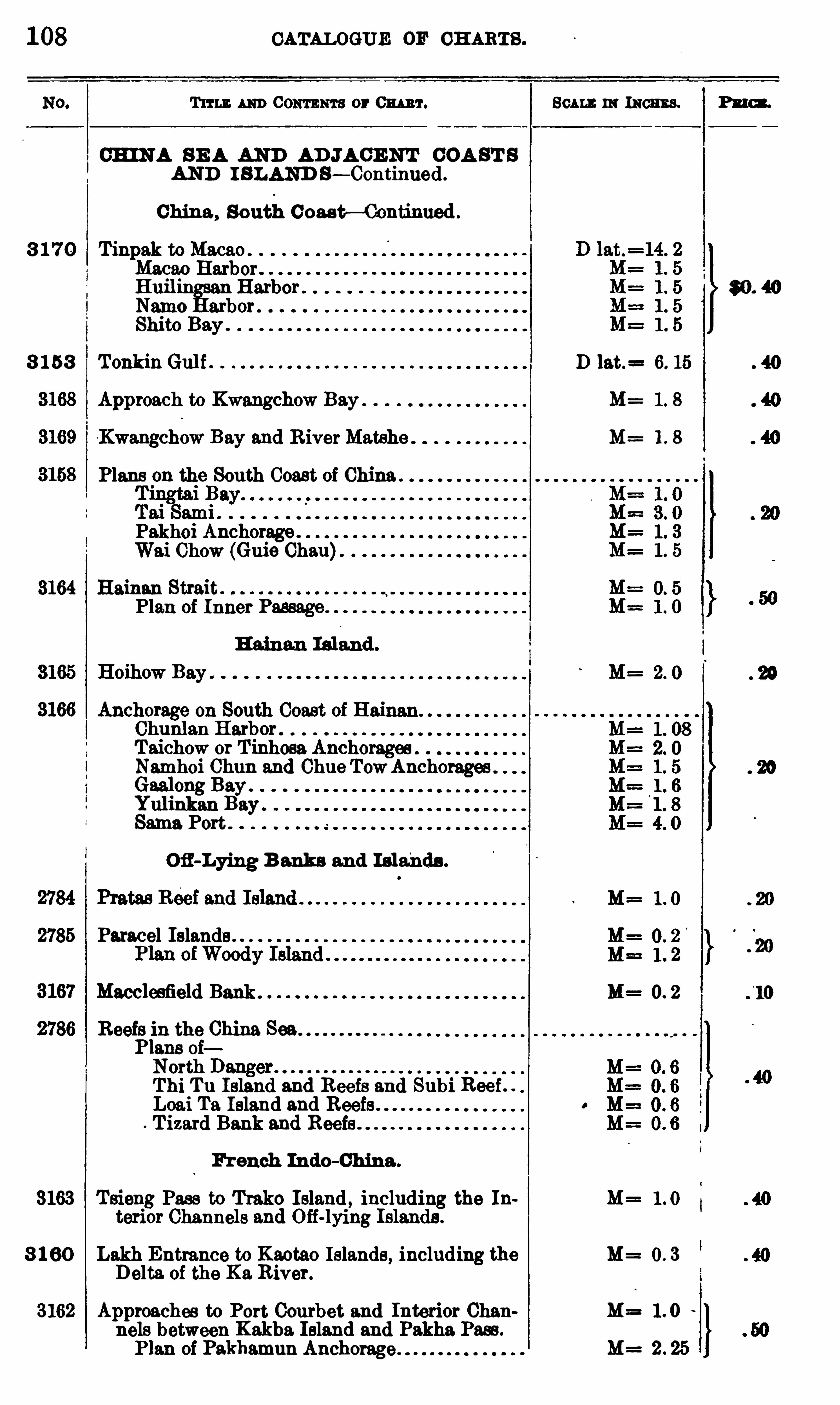
108 CATALOGUE OF CH ARTS .
T11 13 m Com m or Om ar. Beau : 111 INCHES. Pn cs .
CHIN A SE A AND AD JA CE NT COA ST S
AND I SLAND S— Continued .
China , South Coast— Continued .
3 1 7 0 Tinpak to MacaoMacao HarborHuil
°
Harbor 80 . 40Namo arbor .
Shito Bay .
8 1 58 TonkinGul f D lat.= 6. 15
M=
Kwangchow Bay and RiverMatshe M= 1 . 8
Plans on the South Coast of China.
Pakhoi Anchorage .
Wai Chow (Guie Chan)
3164 Hainan Strait .
Plan of Inner Passage .
3166 Anchorage on South Coast of HaiChunlan Harbor .
Taichow or T inhosa AnchoragesNamhoi Chun and Chue TowAnchorages .
Gaalong Bay .
Yul inkan BaySame. Port .
Ofl-Lying B anks and Islands .
2785 Paracel Islands .
Macclesfield Bank . M= 0. 2
Reefs in the China Sea.l of
North DangerThi Tu Island and Reefs and Subi Reef . .
Loai Ta Island and ReefsT izard Bank and Reefs
French Indo-Ohina .
3163 Tsieng Pass to Treko Island , including the In M= Itariot Channels and Off-lying Islands .
8 1 60 Lakh Entrance to Kaotao Islands , including the M= 0 . 3Delta. of the Ka River.
3162 Approaches to Port Courbet and Interior Chan M== 1 . 0nels between Kakba. Island and Pakha. Pass .
Plan of Pakhamun Anchorage M= 2 . 25

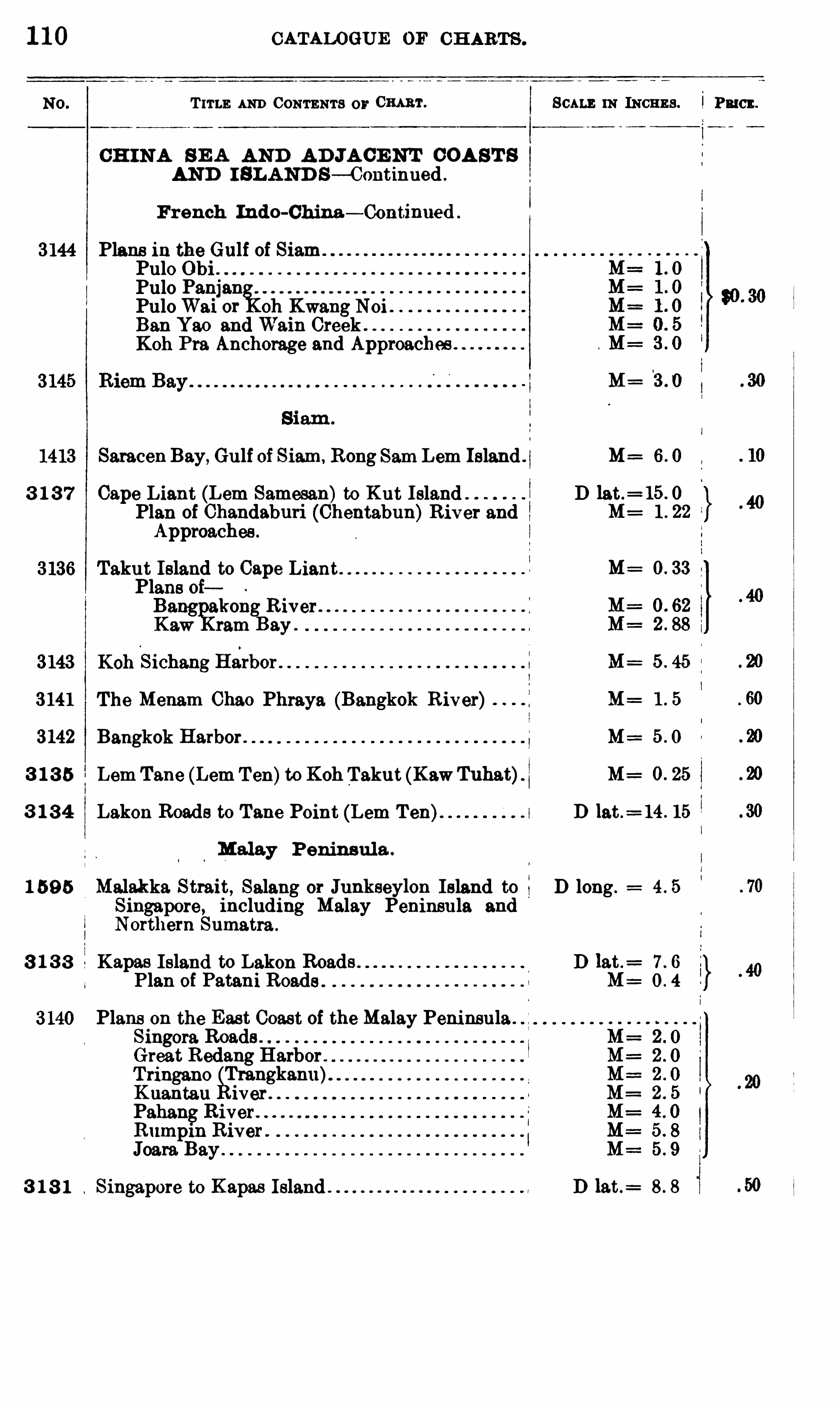
1 10 CATALOGUE OF CH ARTS .
T 11 1 1; AND CONTENTS 0 11 0 1111111 .
CH INA S E A AND AD JA CE NT COA ST S
AND I SLAND S— Continued .
French Indo-China— Continued .
3144 Plans in the Gulf of SiamPulo ObiPulo Panjan
giPuloWai or oh Kwang NoiBan Yao and Wain Creek .
Koh Pra. Anchorage and Approaches
Saracen Bay, Gulf of Siam, Rong Sam Lem Island .
3 1 3 7 Cape Liant (Lem Samesan)to Kut IslandPlan of Chandaburi (Chentabun)River andApproaches .
Takut Island to Cape LiantPlans oiBang akong R iver .
Kaw ram Bay .
3143 Koh
.
Sichang Halrbor
3 141 The Menam Chao Phraya (Bangkok R iver)
3142 Bangkok Harbor .
3 1 3 5 Lem Tane (Lem T en)to Koh Takut (KawTuhat)
3 1 3 4 Lakon Roads to Tane Point (Lem T en)
Malay Peninsula .
1 59 5 Malakka Strait, Salang or Junkseylon Island toSingapore, including Malay Peninsula andNorthern Sumatra .
3 1 3 3 Kapas Island to Lakon RoadsPlan of
Plans on the East Coast of the Malay Peninsula . . 1
Singora RoadsGreat Redang HarborTringano Trangkanu)K uantan iver .
PahangRiverRumpm River .
Joars. Bay3 1 8 1 Singapore to Kapas Island
SCALE IN INCHE S .
M=
M==
D lat .= 15 . 0
M :
M :
M=
M=
M==
M= O. 25
D lat .= 14 . 15
D long .
D 1at .=
M :
D 1at.=
i Pu en.
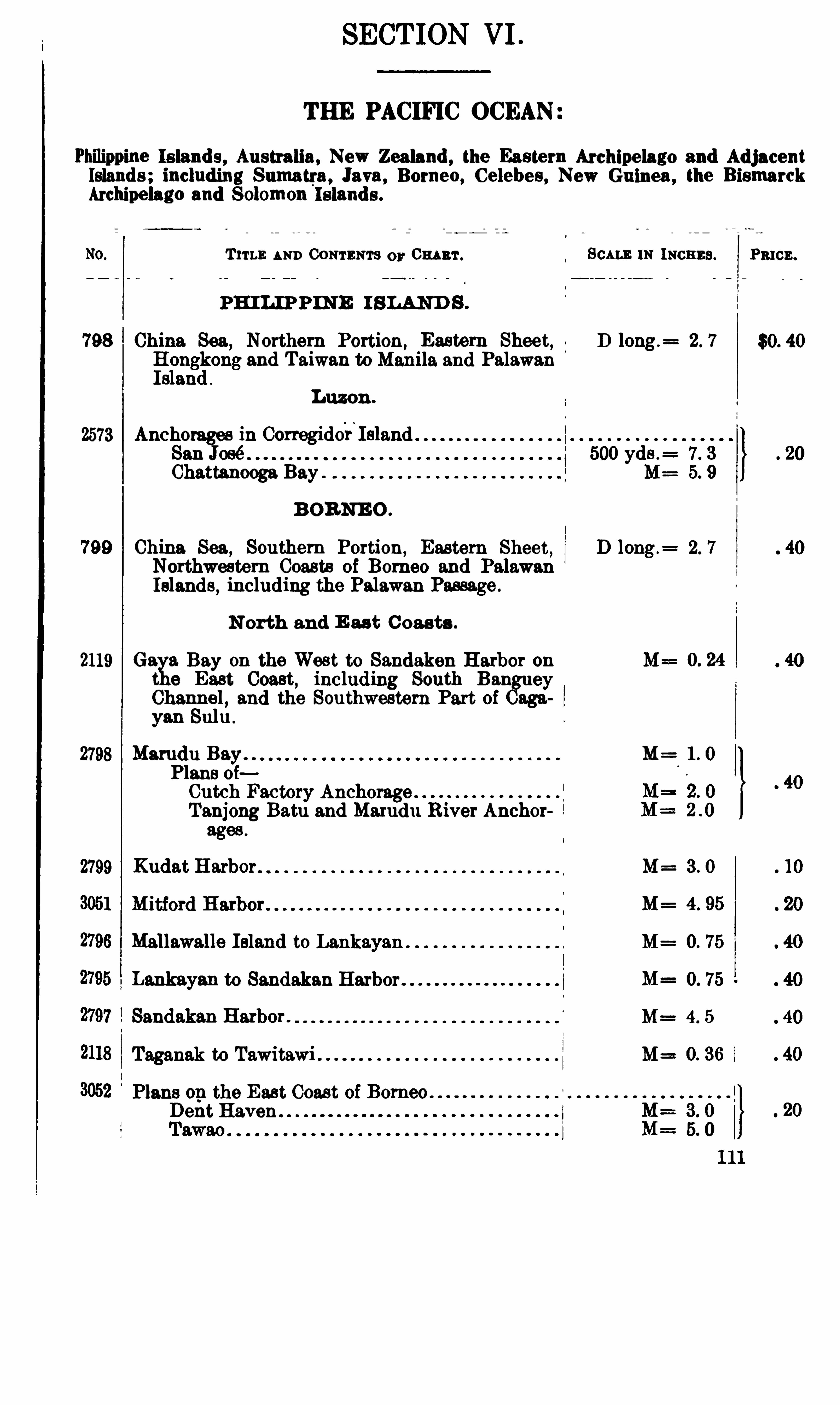
SECTION VI .
THE PACIFIC OCEAN
Philippine Is lands , Australia , New Zealand , the Eastern Archipelago and AdjacentIslands ; including Sumatra , Java , Borneo, Celebes , New Guinea , the BismarckArchipelago and Solomon 1818 11111 .
T 11 1 1: AND CONTENTS 0 11 0 1111111 . SCALE 1N INCHES .
PH ILIPPINE I SLAND S .
798 China Sea,Northern Portion, Eastern Sheet, D long .
= 2 . 7
Hongkong and Taiwan to Manila and PalawanIsland .
Luzon .
2573 Anchorages in Corregiddri
l slandSan José 500 7. 3
Chattanooga Bay . M= 5. 9
B ORNE O .
799 China Sea , Southern Portion,Eastern Sheet
,D long .
= 2 . 7
Northwestern Coasts of Borneo and PalawanIslands
,including the Palawan Passage .
N orth and E as t C oasts .
2119 Goals. Bay on the West to Sandaken Harbor on M== 0. 24
9 East Coast, including South BangueyChannel , and the Southwestern Part of Cagayan Sulu .
2798 Marudu Bay. . M=Plans oiCutch Factory Anchorage fTanjong Batu and Marudu River Anchorages .
2799 Kudat Harbor M= 3 . O
M= 4. 95
Mallawalle Island to Lankayan M= O. 75
Lankayan to Sandakan Harbor O. 75
Sandakan Harbor . M= 4. 5
Taganak to Tawitawi M= O. 36
Plans op the East Coast of BorneoDent Haven
PRICE .
$0. 40
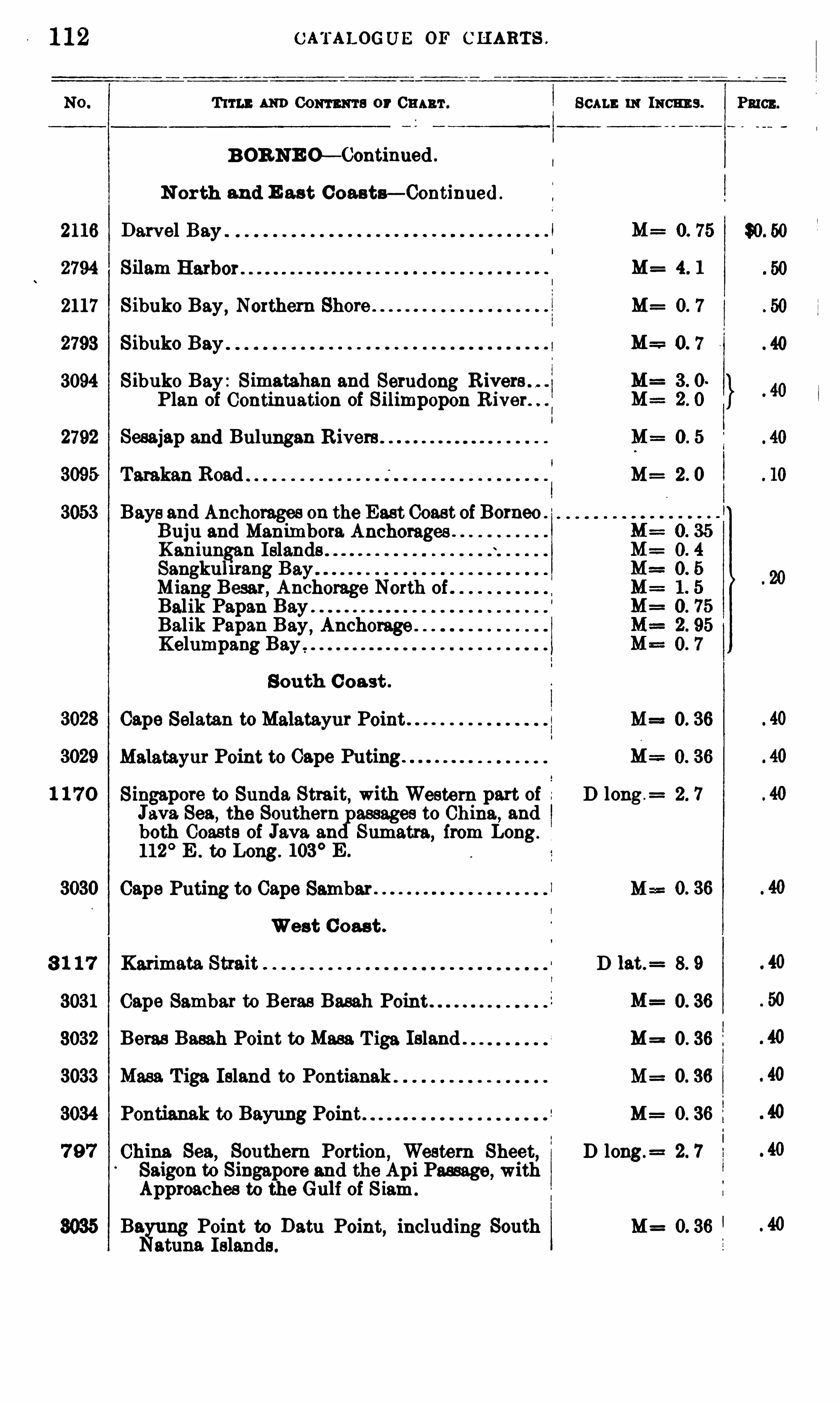
1 12 C ATALOGUE OF C H ARTS .
T 11 14: AND Com m a or 0 1111111 .
B OR NE O— Continued .
N orth and E ast Coasts— Continued .
Begum; Point to Datu Point, including Southatuna Islands.
SCALE 11: INCHE S .
2116 Darvel Bay 0. 75
2794 Silam M= 4 1
2117 Sibuko Bay , Northern Shore M= O 7
2793 Sibuko Bay 0 7
3094 Sibuko Bay : Simatahan and SerudongPlan of Continuation of Silimpopon River.
2792 Sesajap and Bulungan M= 0 . 5
3095 Tarakan Road M= 2 0
3053 Bays and Anchorages on the East Coast of BorneoBuju and Manimbora AnchoragesKaniungan IslandsSangkuhrang BayMiang Besar, Anchorage North ofBalik Papan BayBalik Papan Bay , AnchorageKelumpang Bay ,
South C oast .
Cape Selatan to Malatayur Point M==0. 36
Malatay111' Point to Cape Puting
1 1 7 0 Singapore to Sunda Strait, with Western part of D long .= 2. 7
Java. Sea,the Southern passages to China, and
both 00 3818 of Java and Sumatra, from Long.
112°E . to Long. 103
° E .
Cape Puting to Cape Sambar M==
West C oast .
3 1 1 7 Karimata Strait D 1at.= 8. 9
3031 Cape Sambar to Betas Basah Point
3032 Betas Basah Point to Mass T iga Island . M==
3033 Mass. T iga Island to Pontianak . M= 0. 36
3034 Pontianak to Bayung Point M=
7 9 7 China Sea,Southern Portion
,Western Sheet, D long.
= 2. 7
Saigon to Singapore and the Api Passage, withApproaches to the Gulf of S iam.
M= O. 36
PRICE.

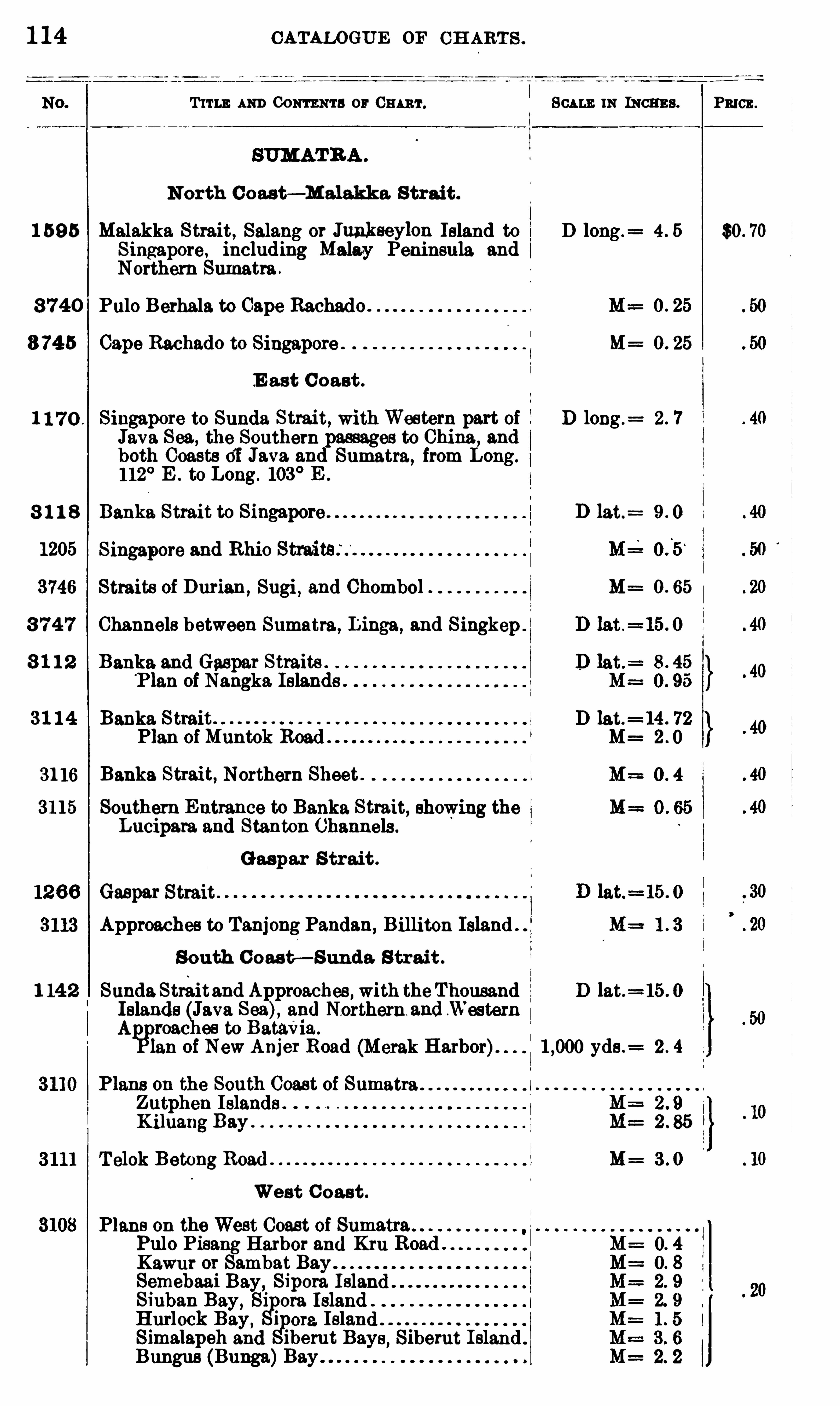
1 14 CATALOGUE OF CH ART S .
T 11 1 1; 111111 Com ma 0 1 0 111 111 . SCALE 111 mamas.
N orth C oast— Malakka S trai t .
1 59 5 Malakka Strait, Salang or Junkseylon Island to D long .= 4 . 5
Singapore, including Malay Peninsula andNorthern Sumatra .
8 740 Pulo Berhala to Cape Rachado
8 745 Cape Rachado to Singapore . M= O. 25
E ast C oast .
1 1 7 0 . Singapore to Sunda Strait, withWestern part of D long .= 2 . 7
Java Sea, the Southern passages to China, andboth Coasts 01 Java. and Sumatra, from Long .
112° E . to Long . 103
° E .
8 1 1 8 D lat.=
1205 Singapore and Rhio
3746 Straits of Durian ,Sugi , and Chombol M= O. 65
3 7 4 7 Channels between Sumatra, Linga, and Singkep .
8 1 1 2 Banka. and Gaspar Straits .
‘Plan of Nangka Islands
3 1 1 4 Banka S trait D lat.=14 . 72
Plan of Muntok Road . . M==
31 16 Banks. Strait, Northern Sheet . 1
3115 Southern Entrance to Banka Strait, showing theLucipara and Stanton Channels .
Gaspar S trait .
Gaspar Strait .
Approaches to Tanjong Pandan, Billiton Island .
South C oast— Sunda. S trait .
1 14 2 Sunda Streitand Approaches , with theThousand D lat. 15 . 0
Islands Java Sea), and Northern. and .Western
A roac es to BataVia .
Ian of NewA 11jer Road (Merak Harbor). yds .= 2 . 4
Plans on the South Coast of Sumatra l
Zutphen Islands .
K iluang Bay
T elok Betong Road M= 3 . 0
West C oast .
Plans on the West Coast of SumatraPulo Pisang Harbor and Kru Road .
Kawur or Sambat BaySemebaai Bay, Sipora. IslandSiuban Bay , Sipora IslandHurlock Bay , Si 0 19. IslandSimalapeh and iberut Bays
,Siberut I sland .
Bungus (Bunga)Bay
PRICE .
$0. 70
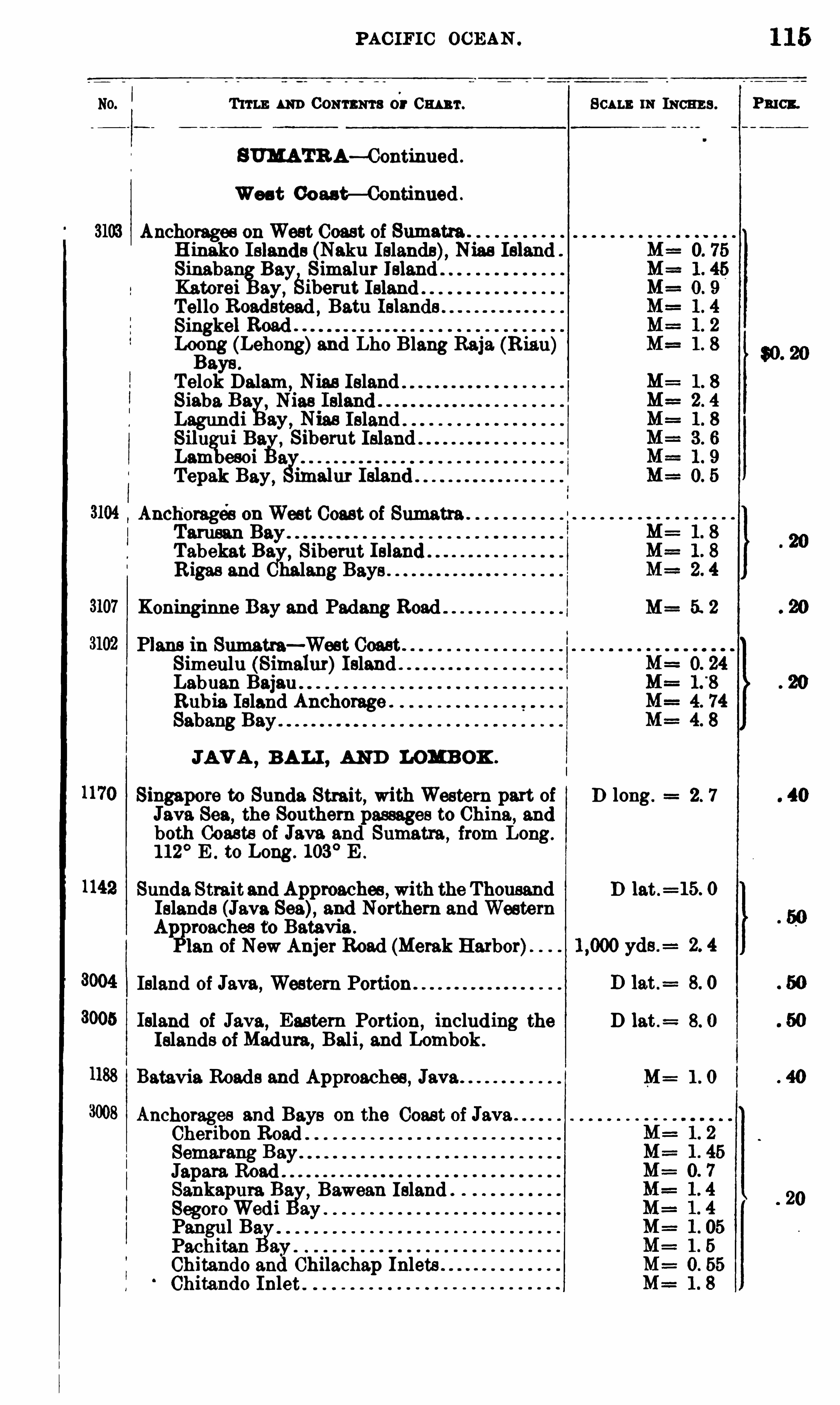
PAC IFIC OCEAN .
T 11 1 1; m 0 0 11 1 11111 3 or 0 1111111 . 111 111011113 . Pmcx.
BUMATR A—Continued .
Wes t Coas t— Continued .
Anchorages onWest Coast of Sumatra .
H inako Islands (Naku Islands), Nias IslandSinaban
%Bay, Simalur IBland
Katorei ay,Sibe111t Island “
Tello Roadstead , Batu Islandn
s
Singkel Road "Logng (Lehong
u
)and Lho Blang Raja (Riau)aye.
Telok Dalam ,Nias Island "
Siaba. Ba ,Nias
Lagundi ay,Nias Island . .
81111 ui Bia ,ZSiberut IslandLam eso
Tepak
efl0
Bay ,a
imalur Island
Anchorages onWest Coast of SumatraTarusanTabekat Ba ,
8iber11t IslandR igas and halang Bays
Koninginne Bay and Padang Road M= 5. 2
Plans m Sumatra—West Coast"Simeulu (Simalur)IslandLabuan BajauRubia. Island Anchorage .
Sabang Bay
JAV A ,BALI , AND LOMBOK .
Singapore to Sunda Strait, with Western part of D long. 2. 7
Java Sea, the Southern passages to China, and
both Coasts of Java and Sumatra,from Long.
1 12° E . to Long . 103
° E .
Sunda Straitand Approaches , with the Thousand D lat .= 15. 0
Islands (Java Sea), and Northern and WesternAliP
roaches to Batavia .
Ian of New Anjer Road (Merak Harbor)
Island of Java,Western Portion
005 Island of Java, Eastern Portion,including the D lat .
= 8. 0
Islands ofMadura,Bali
,and Lombok.
1188 Batavia. Roads and Approaches, Java . M= 1 . 0
Anchorages and Bays on the Coast of Java
Sheribon
ematang ayJapara RoadSankapura Ba. ,
Bawean IslandSegoro
pWedi ay
Pangul BPachitanChitando an Chilachap InletsChitando Inlet .
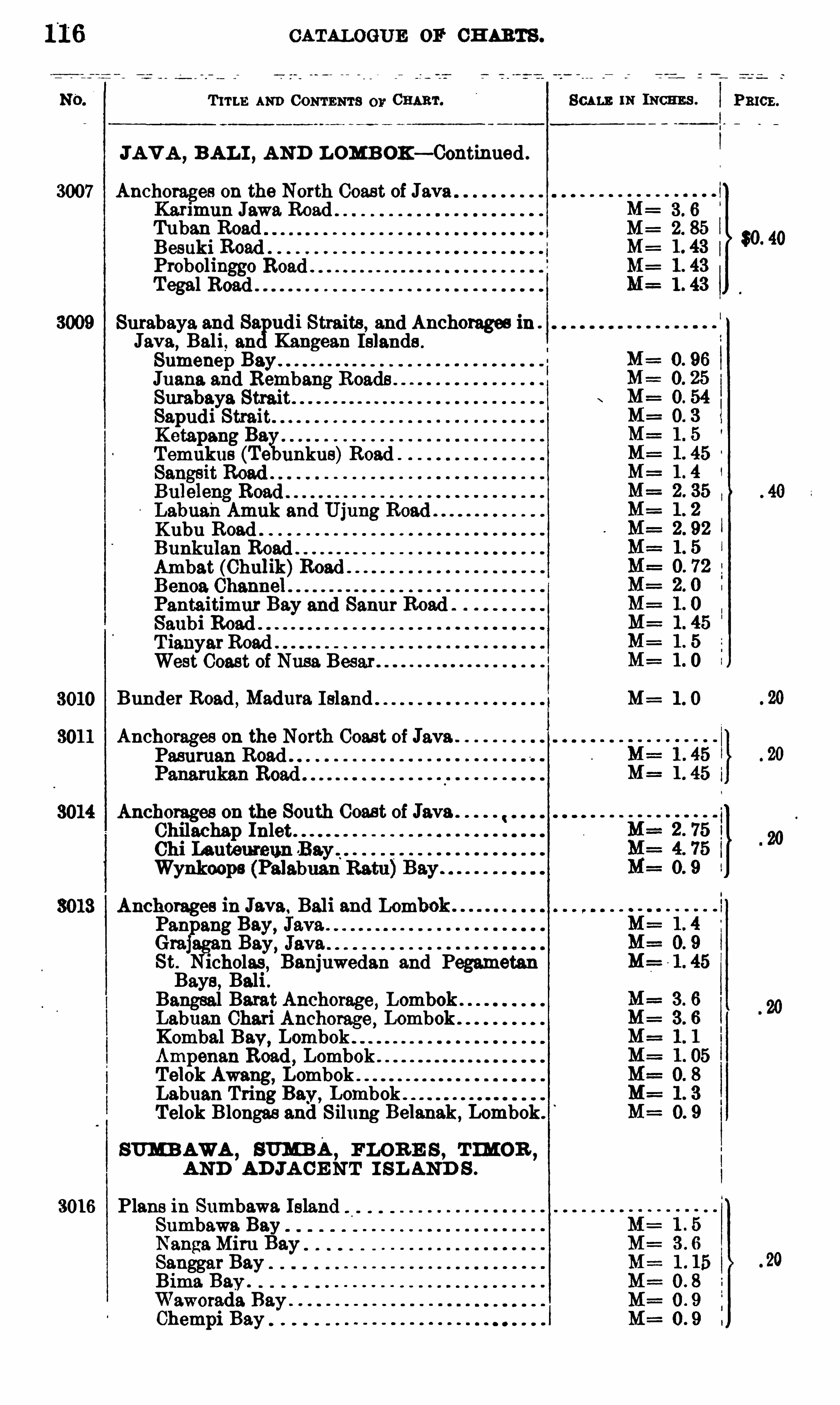
CATALOGUE OF CH ARTS .
T 11 1 1: AND CONTENTS 0 11 01111111 . 111 INCHES .
JAV A , BAL I , AND LOMB OK— Continued .
3007 Anchorages 0 11 the North Coast of JavaKarlmun Jawa Road 3 . 6
Tuban Road M= 2. 8
Besuki Road M= 1 . 4
Probolinggo M=Tegal 1 4
Surabaya and Sa udi Straits , and Anchorages inJava
,Bali, Kangean Islands .
Sumenep BayJuana and Rembang Roads .
Surabaya StraitSapudi StraitKetapang Ba.Temukus (Te nukus)Road
Kubu RoadBunkulan RoadAmbat (Chulik)Road
Pantaitimur Bay and Sanur RoadSanbi RoadT ianyarRoadWest Coast of Nusa Besar
Bunder Road,Madura Island . M= 1 . O
Anchorages on the North Coast of Java.Pasuruan Road
Anchorages on the South Coast of JavaChilachap InletChi Ia utemeun .Bay ‘
Wynkoops (Palabuan Batu
Anchorages in Java. Bali and LomPanpang Bay,Graj 11 Bay,St. lobolas
,Banjuwedan and Pegametan
Bays , Bali .Bangsal Barat Anchorage, LombokLabuan Chari Anchorage, LombokKombal Bay,
LombokAmpenan Road
,Lombok
Telok Awang, LombokLabuan Tring Bay,
LombokTelok Blongas and Silung Belanak, Lombok .
SUMBAWA, 3 11mm,
FLOR E S , T IMOB ,
AND AD JA CE NT I SL AND S .
3016 Plans in Sumbawa. IslandSumbawa. BayNangaMiru Ba.Sanggar BayBima Bay .
Waworada BayChempi Bay
Pmcz .

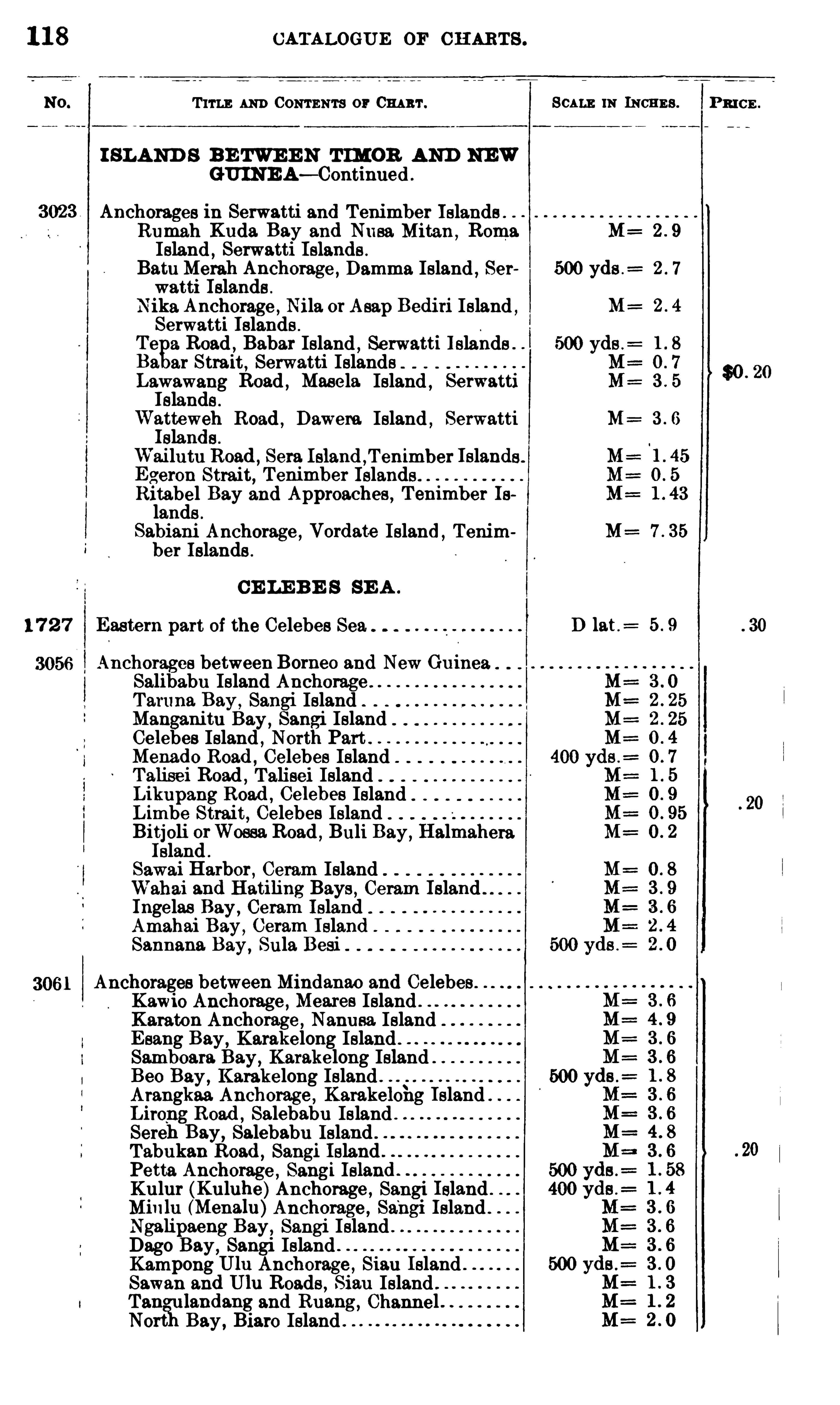
1 1 8 CATALOGUE OF CH ARTS .
Trru ; AND CONTENTS or 0 1111111 .
I SLAND S BE TWE E N T IMOR AND NEWGUINE A— Continued .
Anchorages 1n Serwatti and T enimber I slands .
Rumah Kuda. Bay and Nusa Mitan ,Roma
Island, Serwatti
y.Islands
Batu Mei'ah Anchorage , Damma Island , SerWatti Islands .
Nika Anchorage ,Nila orAsap Bediri Island ,
Serwatti Islands .
Te 9. Road , Babar Island , Serwatti Islands .
Ba 3 1 Strait,Serwatti Islands
Lawawang Road , Masela Island , SerwattiIslands .
Watteweh Road,Dawera Island
,Serwatti
Islands .
Wai lutu Road ,Sera Island ,
T enimber IslandsEgeron Strait, Tenimber Islands . .
Ritabel Bay and Approaches , T enimber Islands .
Sabiani Anchorage ,Vordat-e Island ,
Tenimber Islands .
CE LE B E S SE A .
1 7 2 7 Eastern part of the Celebes Sea
Anchorages betweenBorneo and New GuineaSalibabu Island AnchorageTaruna Bay ,
Sangi IslandManganitu Bay,
Sangi IslandCelebes Island , North PartMenado Road , Celebes IslandTalisei Road , Talisei IslandLikupang Road , Ce1ebes IslandLimbe Strait, Celebes Island .
Bitjoli orWossa Road , Buli Bay,Halmahera
Island .
Sawai Harbor , Ceram IslandWahai and Hatiling Bays , Ceram Island . .
Ingelas Bay , Ceram Island .
Amahai Bay ,Oeram Island
Sannana Bay,Sula Besi
Anchorages between Mindanao and Celebes “
Kawio Anchorage , Meares Island “
Karaton Anchorage ,Namusa Island
E sang Bay, Karakelong Island ”
Samboam.
yBay,
Karakelong Island “
Beo Bay ,Karakelong Island ”
Arangkaa Anchorage ,Karakeloi1g Island
Lirong Road , Salebabu Island ”
SerehgBay,
Salebabu Island .
Tabukan Road , Sangi Island .
Petta Anchorage ,Sangi Island
Kulur (Kuluhe)Anchorage , Sangi Island .
Minlu (Menalu)Anchorage ,Sangi Island .
Ngahpaeng Bay,Sangi Island ”
Dago Bay,Sangi Island ”
Kampong UI11 Anchorag e ,Siau Island “
Sawan and UI11 Roads , Siau Island ”
Tang ulandang and Ruang,m
ChannelNort
t
hBay,Biaro Island “
SCALE 11: INCHE S .
M=
500 yds .=
M=
M=
M=
D lat .=
P RI CE .
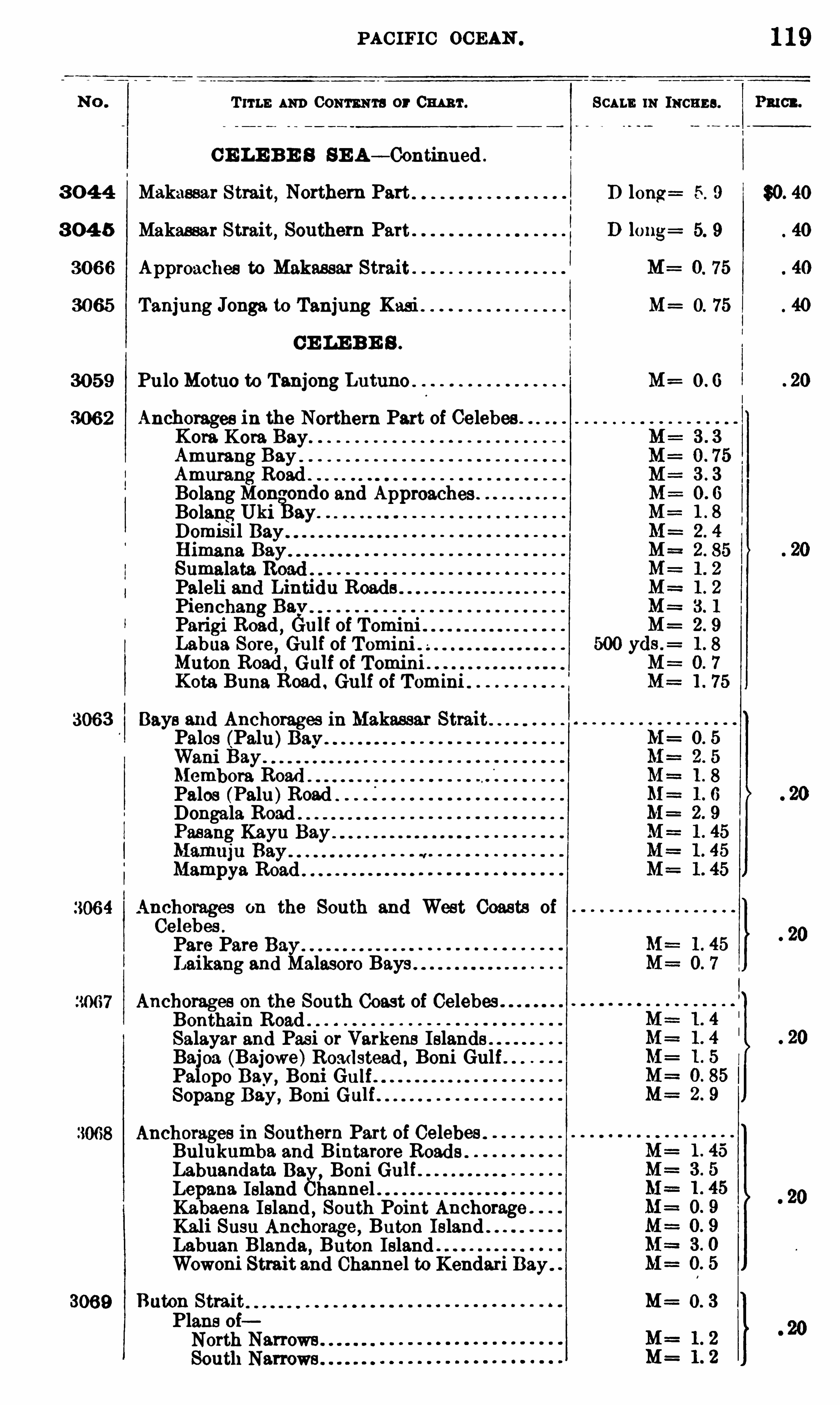
PACIFIC OCEAN .
Tum AND 0 0 111 11111 3 or Cw r. SCALE 111 1110115 3 .
C E LE B E S SE A— Continued .
3 0 4 4 Makassar Strait, Northern Part D long 5. 9
3 0 4 5 Makassar Strait, Southern Part
3066 Approaches to Makassar Strait
3065 Tanjung Jonga to Tanjung Kasi M= O. 75
CE LE B E S .
3059 Pulo Motuo to Tanjong Lutuno M= 0 . G
3062 Anchorages in the Northern Part of Celebes .
Kora. Kora Bay.
Amurang BayAmmang Road .
Bolang Mono ondo and Approaches .
Bolang Uki ay.
Domisil BayHimana BaySumalata RoadPaleli and Lintidu RoadsPienchang BayParigi Road , Gulf of TominiLabua Sore
, Gulf of Tomini .
Muton Road , Gulf of TomimKota Buna Road . Gulf of Tomini
3063 Bays a nd Anchorages in Makassar StraitPalos (Palu) M= 0. 5
Wani BayMembora RoadPalos (Palu)RoadDongala RoadPasang Kayu
Mampya Road
Anchorages on the South and West Coasts ofCelebes .
Pare Pare BayLaikang and Malasoro Bays .
Anchorages on the South Coast of CelebesBonthain RoadSalayar and Pas i or Varkens IslandsBajoa (Bajowe)Roadstead , Boni GulfPalopo Bay,
Boni GulfSopang Bay, Boni
Anchorages in Southern Part of Celebes .
Bulukumba and Bintarore RoadsLabuandata Bav,
Boni GulLepana Ieland Channel .Kabaena Island , South Point Anchorage .
Kali Susu Anchorag e , Baton Island .
Labuan Blanda, Buton IslandWowoni Strait and Channel to Kendari Bay.
3069 Baton Strait M 0 . 3
Plans oiNorth Narrows .
South Narrows .
1 19
PmC‘ o
$0. 40
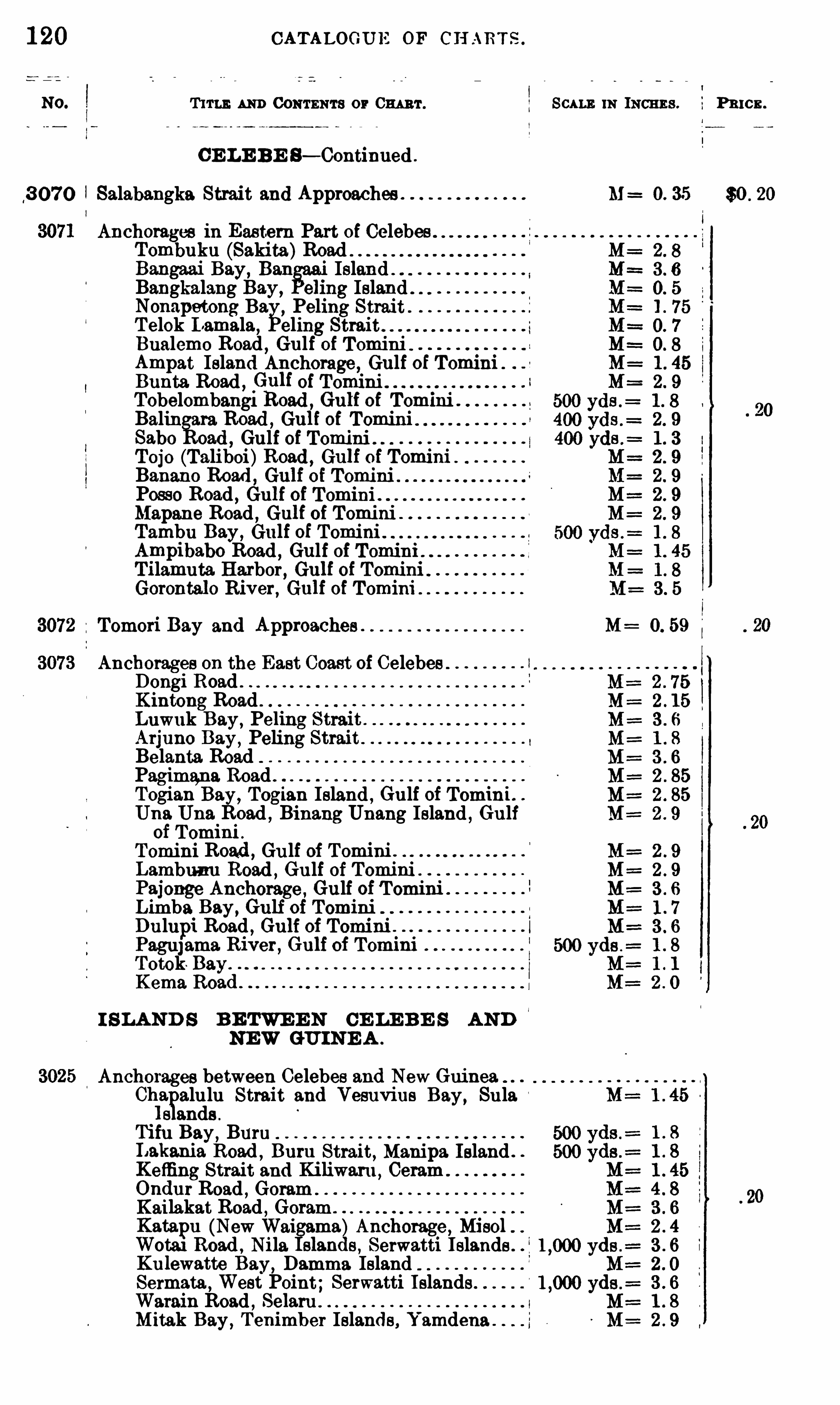
1 20 CATALOGUE OF CH ART S .
T um AND CONTENTS or 0 111 3 1 . SCALE m INCHES . P 3 10 2 .
C E LE BE S— Continued .
3 0 7 0 Salabangka Strait and Approaches M 0. 35 $0 . 20
Anchorages in Eastern Part of Celebes .
Tombuku (Sakita)RoadBangaai Bay, Ban Island "Bangkalang Bay, elimg Island
.
Nonapetong Ba ,Peling Strait .
T elok I amala, eling Strait
Bualemo Road, Gulf of Tomim
Ampat Ieland Anchorage, Gulf of Tomini .
Bunta Road , 6q of TominiTobelombangi Road , Gu1f of Tomini .
Balin ara Road , Gu1f of TominiSabo oad , Gulf of TominiTojo (Taliboi)Road , Gu1f of Tomini .
Banano Road , G111f oi TominiPosso Road , Gulf of TominiMapane Road
, Gulf of TominiTambu Bay, Gulf of TominiAmpibabo Road , Gulf of Tomini .
Tilamuta Harbor, Gulf of Tomini
Gorontal o River, Gulf of Tomini
Tomori Bay and Approaches . M : O. 59
Anchorages on the East Coast of CelebesDongi Road .
Kintong RoadLuwuk Bay, Peling Strait .
Arjuno Bay,Peling Strait
Belanta. RoadPagimana Road ”
Togian Bay, Togian Island , Gulf of Tomini.Una Una Road , Binang Unang Island , Gulfof Tomini .
Tomini Road ,Gu lf of Tomini .
Lambunu Road , Gulf of Tomini . .
Pajonge Anchorage , Gulf of T omini
Limba Bay,Gulf of Tomini
Dulupi Road , Gulf of TominiPagu]ama. River, G111f of Tomini .
TotokKema Road
.
I S LAND S B E TWE E N CE LE B E S AND‘
NEW GU INE A .
Anchorages between Celebes and New Guinea.Chl
a alulu Strait and Vesuvius Bay,Sula
s ands .
Tifu Bay,Buru
LakaniayRoad , Bur11 Strait, Manipa Island .
Keffing Strai t and Kiliwaru , Ceram .
OndurgRoad , Goram
Kailakat Road , Goram “
Katapu (New Wai ma)Anchorage , Misol .
Wota1 Road , Nila s ,lands Serwatti Islands .
Ku lewatte Bay, Damma IslandSermata ,
West Point; Serwatti Islands .
Warain Road , SelaruMitak Bay,
T enimber Islands , Yamdena .

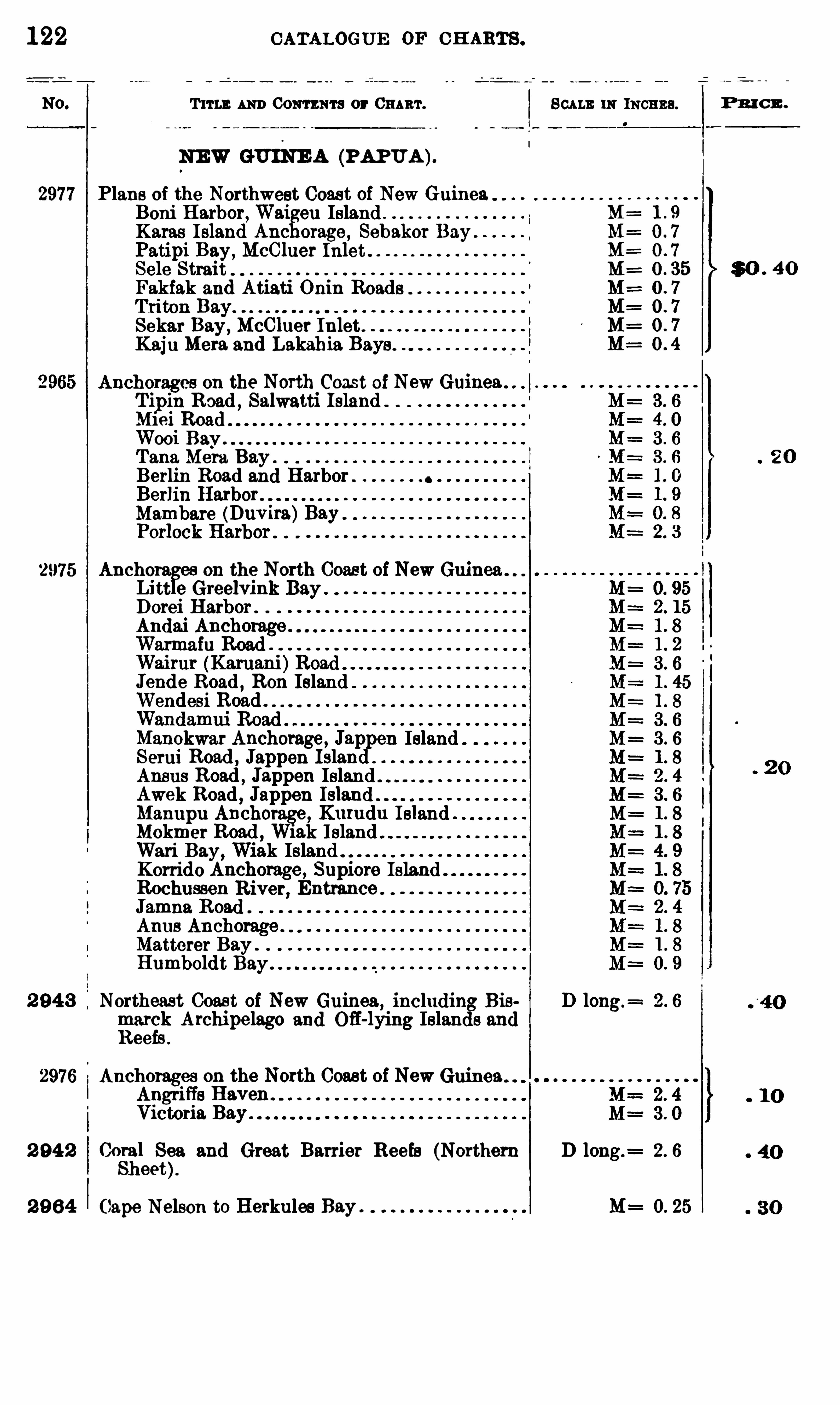
122 CATALOGUE OF CH ARTS .
T um. AND Com ma or 0 111 111 . SCALE 111 INCHES .
NEW GUINE A (PAPUA ).
2977 Plans of the Northwest Coast of New GuineaBoni Harbor,Waigeu IslandKaras Island Anchorage , Sebakor BayPatipi Bay,
McCluer InletSele Strait M=Fakfak and Atiati Onin Roads M=
U1
Sekar Bay, McC luer Inlet .
Kaju Meta and Lakahia Bays .
Anchorages 0 11 the North Coast of New Guinea .
Tipin Road , Salwatti Island .
Ml aiWooi BayTana Meta Bay .
Berlin Road and Harbor .
Berlin HarborMambere (Duvira)Bay
2975 Auchora on the North Coast of New Guinea .
Litt e Greelvink BayDotei Harbor .
Andai Anchorage .
Warmafu Road .
Jende Road,R0 11 Island
Wendesi Road .
Manokwar Anchorage , Jappen IslandSerui Road , Jappen Island .
Ansus Road,Jappen Island
Awek Road , JappenManupu Anchorage , K111udu IslandMokmer Road , W1ak Island .
Wari Bay, Wiak IslandKorrido Anchorage, Supiore IslandRochussen River, EntranceJamna Road .
Anus Anchorage .
Matterer Bay .
Humboldt Bay .
2 94 3 Northeast Coast of New Guinea,includin Bis D long.
=
marck Archipelago and Off-lying Islan s andReefs .
2976 Anchorages on the North Coast of NewAngriffs Haven .
Victoria Bay.
2 94 2 8
339. and Great Barrier Reefs (Northern D long .
= 2 . 6
eet
2 9 64 Cape Nelson to Herkules Bay . M= 0. 25
P R I C E .
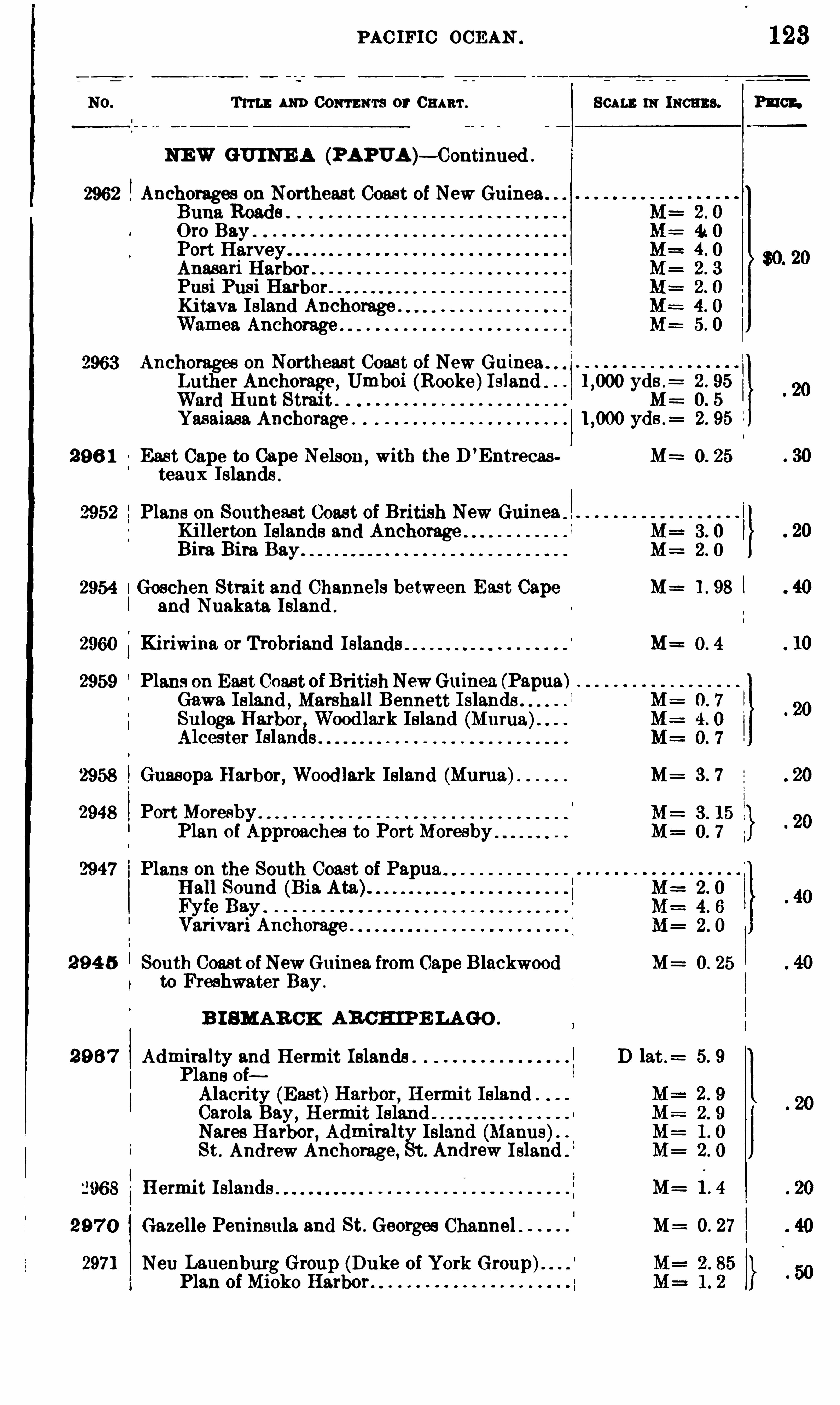
PACIFIC OCEAN
T im 111m Com ma or 0 1111111 . 111 111011113 .
NEW GU INE A (PAPUA )— Continued .
2962 Anchorages on Northeast Coast of New Guinea .
Buna Roads . .
Oro BayPort HarveyAnasari HarborPusi PusiKitava Island Anchorage .
2963 Anchorages on Northeast Coast of New Guinea .
Luther Anchorage , Umboi (Rooke)Island . yds .= 2 . 95
Ward Hunt Strait . 0. 5
Yasaiasa Anchorage . yds .= 2. 95
29 6 1 East Cape to Cape Nelson, with the D’
Entrecas M= 0. 25
teaux Islands .
2952 Plans on Southeast Coast of British New GuineaKillerton Islands and AnchorageBira Bira Bay .
2954 Goschen Strait and Channels between East Cape M==1 . 98and Nuakata Island .
2960 Kiriwina or Trobriand M=
2959 Plans on East Coast of BritishNewGuinea (Papua)Gawa Island , Marshall Bennett Islands .
Suloga Harbor, Woodlark Island (Murua).Alcester Islands .
2958 Guasopa Harbor, Woodlark Island (Murua) M= 3 . 7
2948 Port MoresbyPlan of Approaches to PortMoresby
2947 i Plans on the South Coast of PapuaHall Sound (Bia Ata).Fyfe Bay .
Varivari Anchorage .
2 9 4 5 South Coast ofNewGuinea from Cape Blackwood M= 0 . 25
to Freshwater Bay .
B I SMAR CK AR CH IP E LAGO .
29 6 7 Admiralty and Hermit Islands . D lat.= 5. 9
Plans oiAlacrity (East)Harbor, Hermit IslandCarola Bay,
Hermit IslandNares Harbor, Admiralt Island (Manus).
St . Andrew Anchorage, Andrew Island .
"968 Hermit Islands . M= 1 . 4
29 7 0 Gazelle Peninsula and St . Georges Channel M= 0 . 27
2971 Non Lauenburg Group (Duke of York Group).Plan of Mioko Harbor .
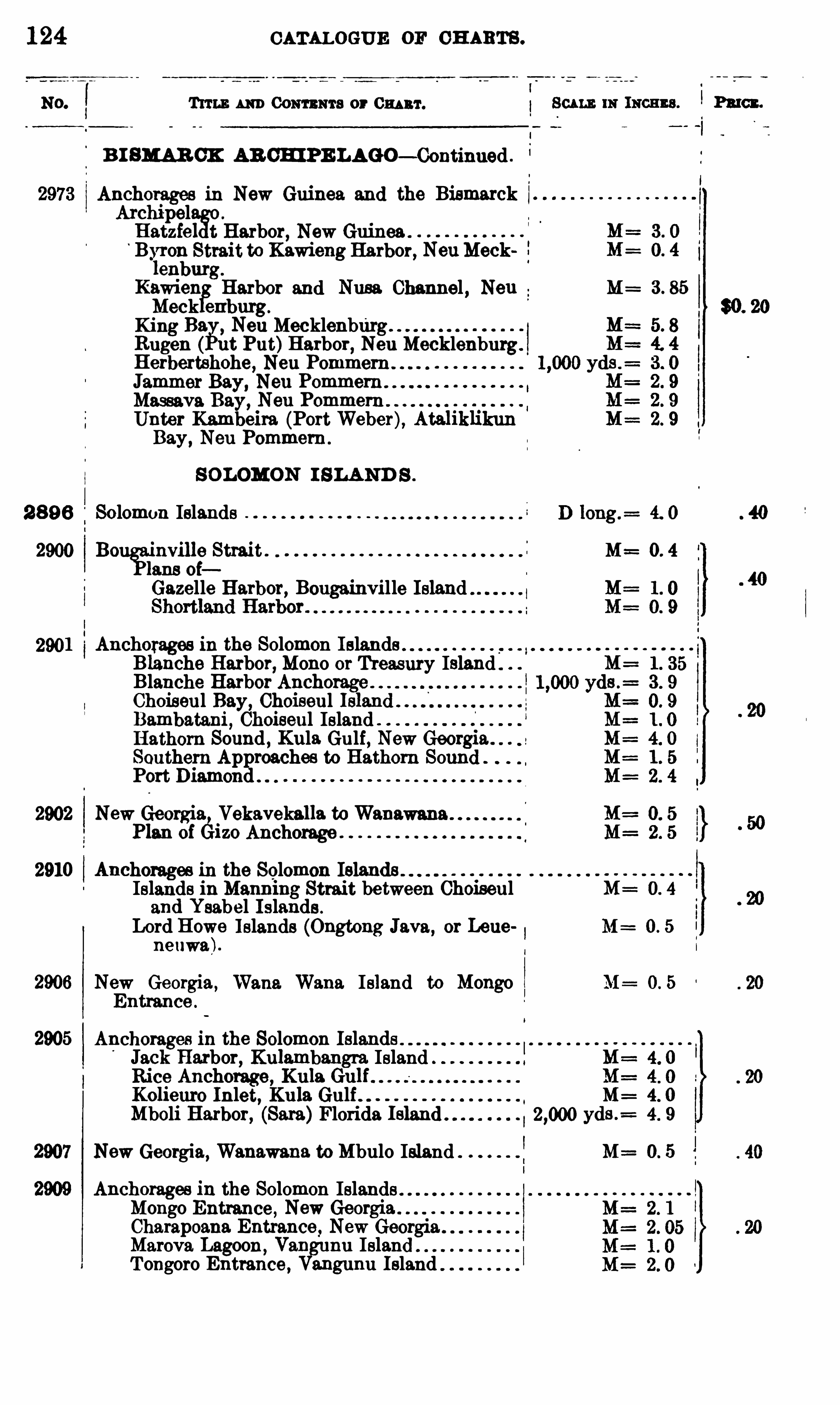
124 CATALOGUE or CH ARTS .
Tum m Com ma or 0 1111111 .
B I SMAR CK AB CH IPE LAGO— Continued .
Anchorages in New Guinea and the BismarckArchipelHatzfel t Harbor, New GuineaByron Strait to Kawieng Harbor, NeuMecklenburg.
Kawien Harbor and Nusa Channel , Neu M= 3 . 85
Meek enburg.
King Ba Neu MecklenburgRugen (gut Put)Harbor, Ne11 Mecklenburg.
Herbertshohe, Neu Pommem .
Jammer Bay, Neu Pommem . .
Massava Bay, Neu Pommem .
Unter Kambeira (PortWeber), AtaliklikunBay, Neu Pommem .
SOLOMON I SLA ND S .
2 8 9 6 Solomon Islands
2900 B0°
nville Strait . M= 0. 4
lans oi
Gazelle Harbor, Bougainville Island
2901 Anchorages in the Solomon Islands . .
Blanche Harbor, Mono or Treasury IslandBlanche Harbor AnchorageChoiseul Bay, ChoiseulBambatani , Choiseul IslandHathorn Sound , Kula Gulf, New Georgia . . 5
Southern Approaches to Hathorn SoundPort Diamond
2902 New Georgia Vekavekalla toWanawaxmPlan of éizo Anchorage
2910 Anchorages in the Solomon IslandsIslands in Manning Strait between Choiseul M= 0. 4
and Ysabel Islands .
Lord Howe Islands (Ongtong Java, or Lene M : 0 . 5
neuwa).
2906 New Georgia,Wane. Wana Island to Mongo M= 0 . 5
Entrance .
2905 Anchorages in the Solomon Islands .
Jack Harbor, Kulambangra Island M= 4. 0
Rice Anchorage, Kula GulfKolieuro Inlet, Kula Gulf M= 4. 0
Mboli Harbor, (Sara)Florida yds .= 4 . 9
New Georgia, Wanawana to Mbulo Island M= 0. 5
Anchorages in the Solomon IslandsMongo Entrance , New GeorgiaCharapoana Entrance, New Georgia .
Marova Lagoon,Van nu Island
T ongoro Entrance , fingunu Island .

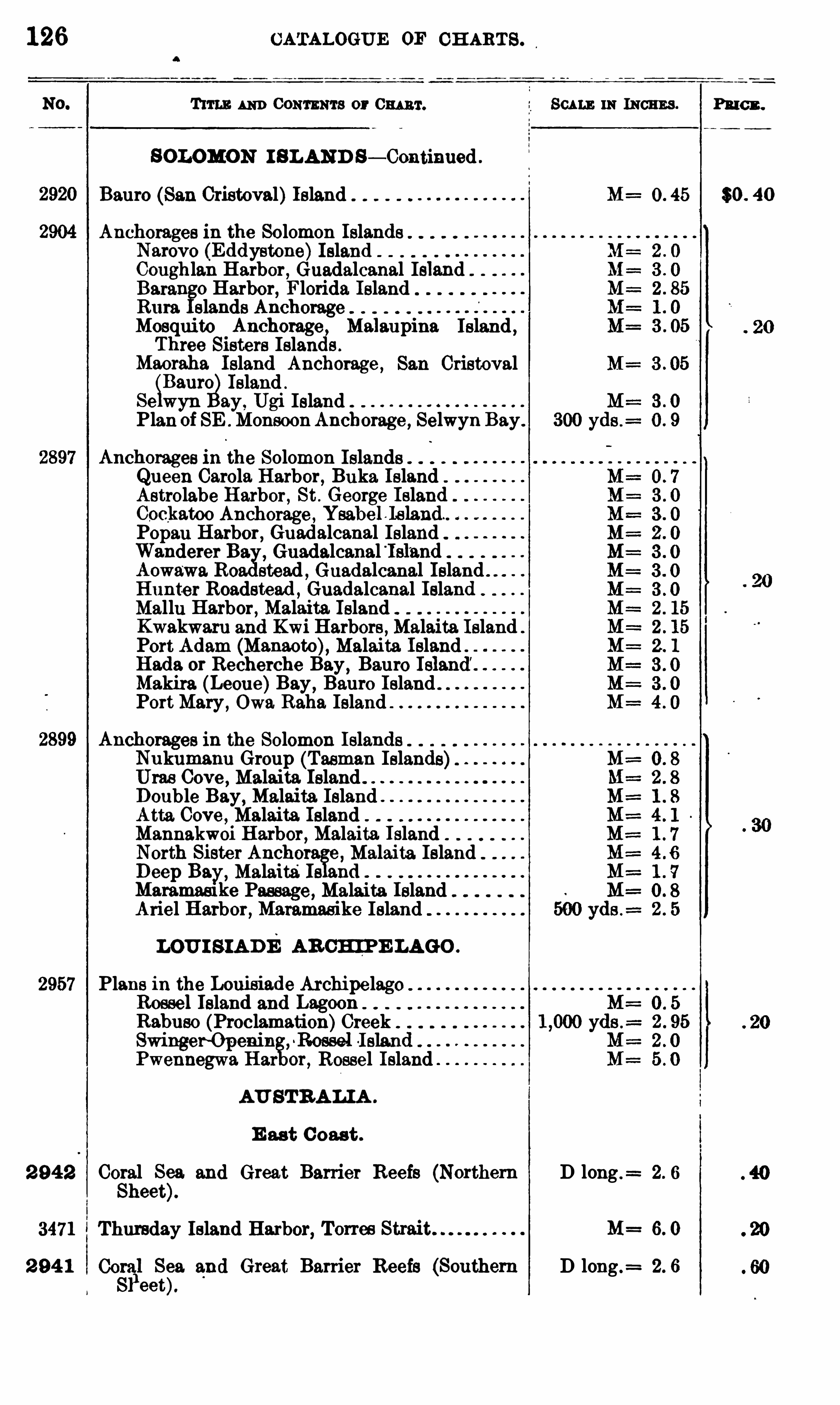
126 CATALOGUE OF CH ARTS .
TITLE AND CONTENTS or 0 1111111 . SCALE 11: INCHES . P3 10 3 .
SOLOMON I SLAND S— Continued .
Bauro (San Cristoval)Island 0 . 45 $0 . 40
Anchorages in the Solomon IslandsNarovo (Eddystone)IslandCoughlan Harbor , Guadalcanal IslandB3 1 3 0 Harbor, Florida IslandRum Glands AnchorageMosquito Anchorage M3 13upina Island ,Three Sisters Islan s .
Maoraha Island Anchorage ,San Cristoval
SBauro Island .
Se wyn ay, Ugi IslandPlan of SE . Monsoon Anchorage , Selwyn Bay.
Anchorages in the Solomon IslandsQueen Carola Harbor, Buka IslandAstrolabe Harbor, St . George IslandCockatoo Anchorage , Ysabel . leland. .
Popan Harbor, Guadalcanal IslandWanderer B3 Guadalcanal °
Isl’
3ndAowa
‘
wa. R0 stead , Guadalcanal Island . .
Hunter Roadstead ,Guadalcanal Island
Mallu Harbor, Malaita. IslandKwakwaru and Kwi Harbors ,Malaita IslandPort Adam (Manaoto), Malaita Island .
H 3d3 or Recherche Bay , Bauro IMakira (Leone)Bay , Bauro Island .
PortMary, Owa Raha Island
Anchorages in the Solomon IslandsNukumanu Group (Tasman Islands)Uras Cove Malaita IslandDouble Bay, Malaita IslandAtta Cove , Malaita IslandMannakwoi Harbor, Malaita. IslandNorth Sister Anchors. e , Malaita IslandDeep Bay, Malaita;Is andMammasl ke Passage , Malaita IslandAriel Harbor, Mammasike Island
LOU I S IADE AR CH IPE LAGO .
2957 Plans in the Louisiade ArchipelagoRoesel Island and LagoonRabuso (Proclamation)CreekSwinger Openin ,
~Rossel 1 513 11Pwennegwa Har or, Rossel Island
AU STRA LIA .
E ast C oast .
2 942 Coral Sea. and Great Barrier Reefs (Northern D long .=
Sheet).
3471 Thursday Island Harbor, Torres M= 6. 0
2 94 1 00311 S
333 and Great Barrier Reefs (Southern D long .
= 2. 6
eet
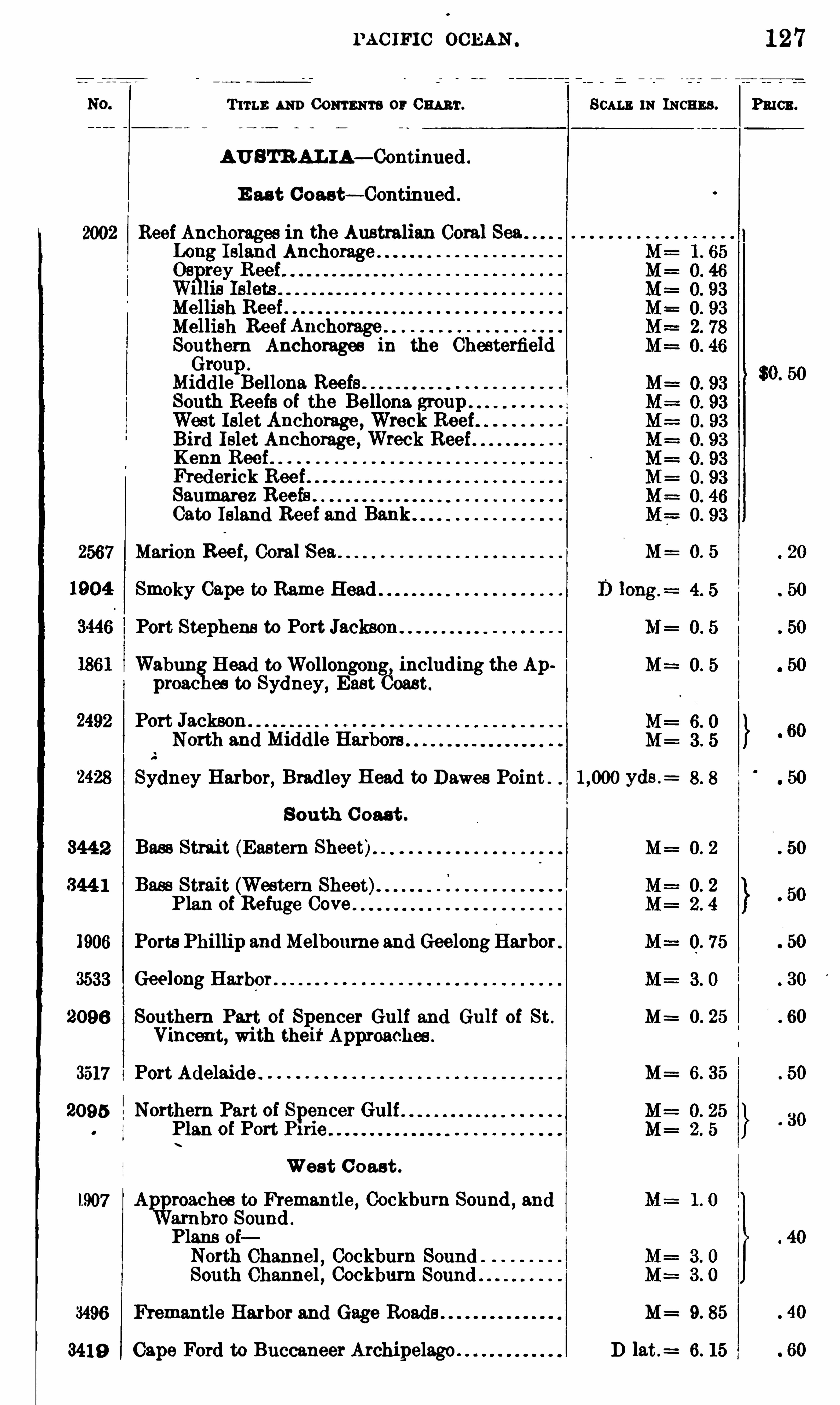
PAC IFI C OCEAN
Tum: AND CONTENTS or 0 1111111 . Scm m INCHES . Pmcn.
AU STR AL IA— Continued .
E as t C oast— Continued .
2002 Reef Anchorages in the Australian Coral SeaLo Island Anchorage
Mellish ReefMellish Reef Anchorage .
Southern Anchorages in the ChesterfieldGroup .
Midd le Bellona Reefs .
South Reefs of the Bellona groupWest Islet Anchorage , Wreck ReefBird Islet Anchorage , Wreck ReefKenn ReefFrederick ReefSaumarez ReefsCato Island Reef and Bank
2567 Marion Reef, Coral M= O. 5
Smoky Cape to Rame Head
Port Stephens to Port
Wabun Head toWollongong, including the Approac es to Sydney, East Coast
Port Jackson .
North and Middle Harbors
Sydney Harbor, Brad ley Head to Dawes Point . yds .=
South C oast .
3442 Bass Strai t (Eastern Sheet)
344 1 Bass Strait (Western Sheet)Plan of Refuge Cove
Ports Phillip and Melbourne and GeelongHarbor .
Geelong Harbor
2096 Southern Part of Spencer Gulf and Gulf of St . M= 0. 25
Vincent, wi th theirApproaches .
3517 Port Adelaide . M= 6. 35
2095 Northern Part of Spencer GulfPlan of Port P1rie
West 0 0 3 8 11.
l907 Ap roaches to Fremantle , Cockburn Sound , andarnbro Sound .
Plans oiNorth Channel , Cockburn SoundSouth Channel , Cockbum Sound . .
3496 Fremantle Harbor and Gage Roads . M= 9. 85
3419 Cape Ford to Buccaneer Archipelago . D lat .= 6. 15
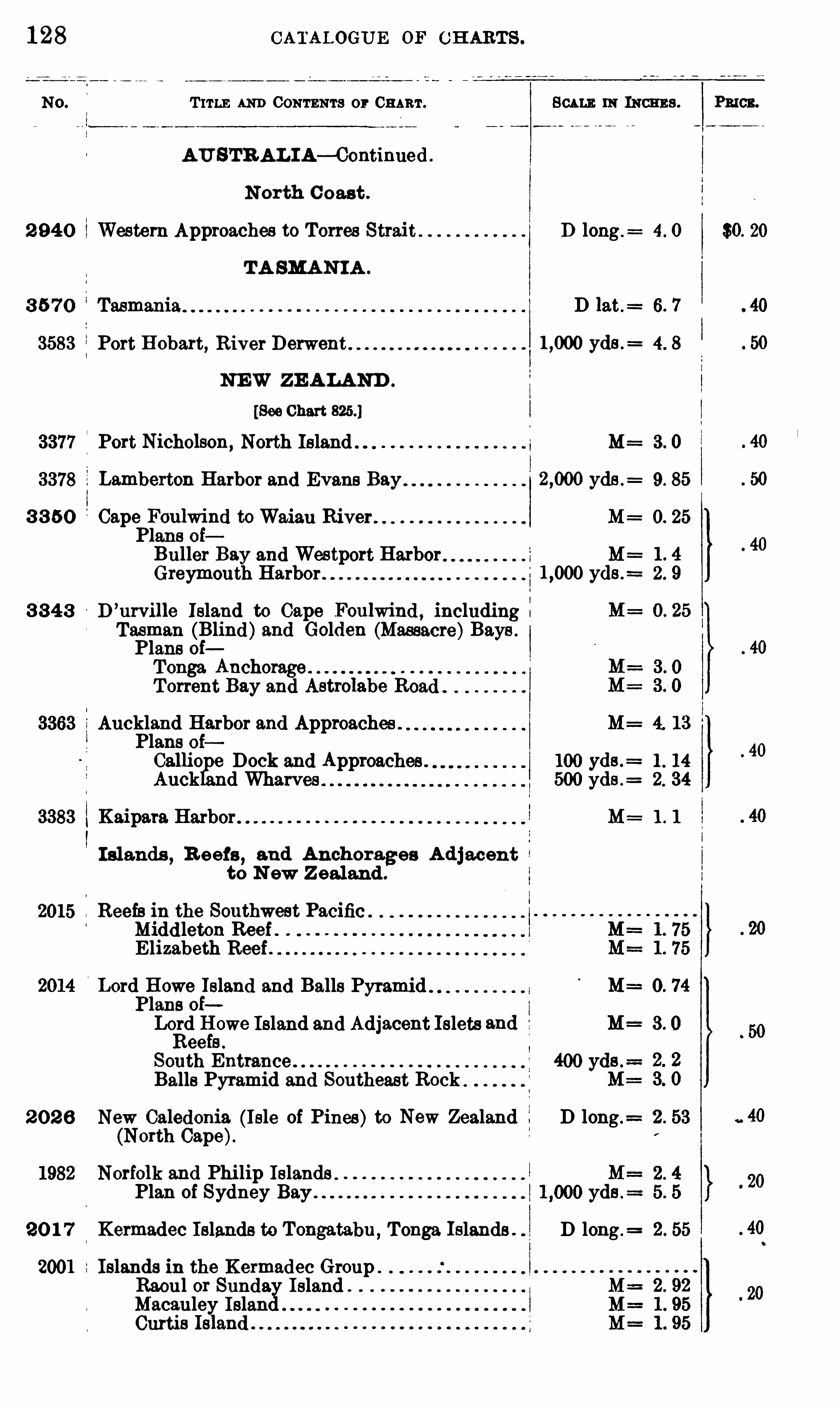
128 CATALOGUE OF CH ARTS .
T ITLE AND CONTENTS or CHART. SCALE m INCHES . Pmcn.
AU STR AL IA— Continued .
N orth C oast .
2 94 0 Western Approaches to Torres Strait D long .= 4. 0 $0. 20
TA SMAN IA .
3 5 7 0 Tasmania D lat.= 6. 7
3583 Port Hobart, River yds .= 4. 8
NEW ZE ALAND .
[See Chart
Port Nicholson, North Island M= 3 . 0
Lamberton Harbor and Evans Bay yds .= 9. 85
3 3 5 0 Cape Foulwind toWaiau River M 0. 25
Plans oiBuller Bay and Westport Harbor M 1 . 4
Greymouth Harbor yds .= 2 . 9
3 3 4 3 D’urville Island to Cape Foulwind , includingTasman (Blind)and Golden (Massacre)Bays .
Plans oiTonga AnchorageTorrent Bay and Astrolabe R0 3
Auckland Harbor and Approaches . M= 4. 13
Plans 0 1Callio e Dock and Approaches . 100 yds .
= 1 . 14
Auck d Wharves 500 yds .= 2. 34
3383 Kaipara Harbor M : 1 . 1
I slands,R eefs
, 3 nd Anchorages A djacentto N ew Z ealand .
2015 Reefs in the Southwest Pacific .
Midd leton Reef .E lizabeth Reef
Lord Howe Island and Balls PyramidPlans oiLord Howe Island and Adjacent Islets 3ndReefs .
South Entrance
Balls Pyramid and Southeast Rock
2 0 2 6 New Caledonia (Isle of Pines)to New Zealand D long .=
(North Cape).
orfolk and Phi lip Islands .
Plan of Sydney Bay .
20 1 7 Kermadec Islands to Tongatabu , Tonga Islands . D long .=
Islands in the Kermadec GroupRaoul or Sunday IslandMacauley IslandCurtis


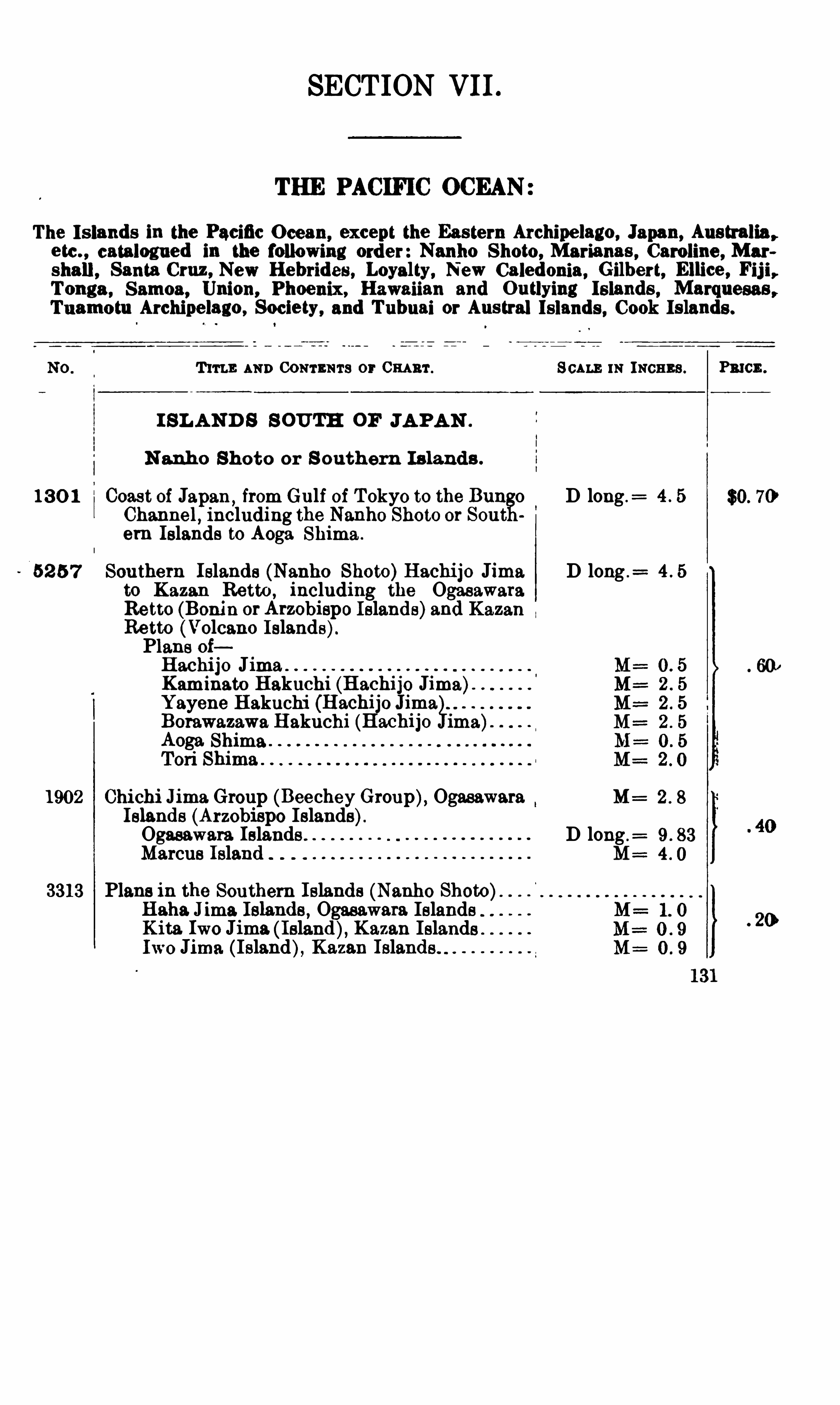
SECTION VII .
THE PACIFIC OCEAN
The Is lands in the Pacific O cean, except the Eastern Archipelago , Japan, Australia ,
etc . , catalogued in the following order : Nanho Shoto, Marianas , Caroline , Mar
shall , Santa Cruz , New Hebrides , Loyalty, New Caledonia, Gilbert, Ellice , Fij i,Tonga , Samoa, Union, Phoenix, Hawaiian and Outlying Islands , Marquesas ,Tuamotu Archipelago , Society, and Tubuai or Austral Islands , Cook Islands .
Tum; AND CONTENTS or 0 1111111 . m INCHES . Pmcn.
I SL AND S S OUTH OF JA PAN .
N anho Shoto or S outhern Is lands .
13 0 1 Coast of J3 p3 n ,from Gulf of T okyo to the Bun o D long .
=
Channel,including the Nanho Shoto or Sout
em Islands to Aoga Shima .
52 5 7 Southern Islands (Nanho Shoto)Hachijo Jima D long .=
to Kazan Retto ,including the Ogasawara
Retto (Benin orArzobispo Islands)and KazanRetto (Volcano Islands).Plans oiHachijo JimaKaminato B akuchi (Hachijo Jima)Yayene B akuchi (HachijoBorawazawa B akuchi (Hachijo imAoga. ShimaTori Shima
l
l
A
GO
191902 Chichi Jima Group (BeecheyGroup), Ogasawara M
Islands (Arzobispo Islands)Ogasawara Islands D long .
Marcus Island M
3313 Plans in the Southern Islands (Nanho Shoto)Haha Jima Islands , Ogasawara IslandsKita Iwo Jima ( Island), Kazan IslandsIwo Jima (Island), Kazan Islands
o
oo
oo
OD
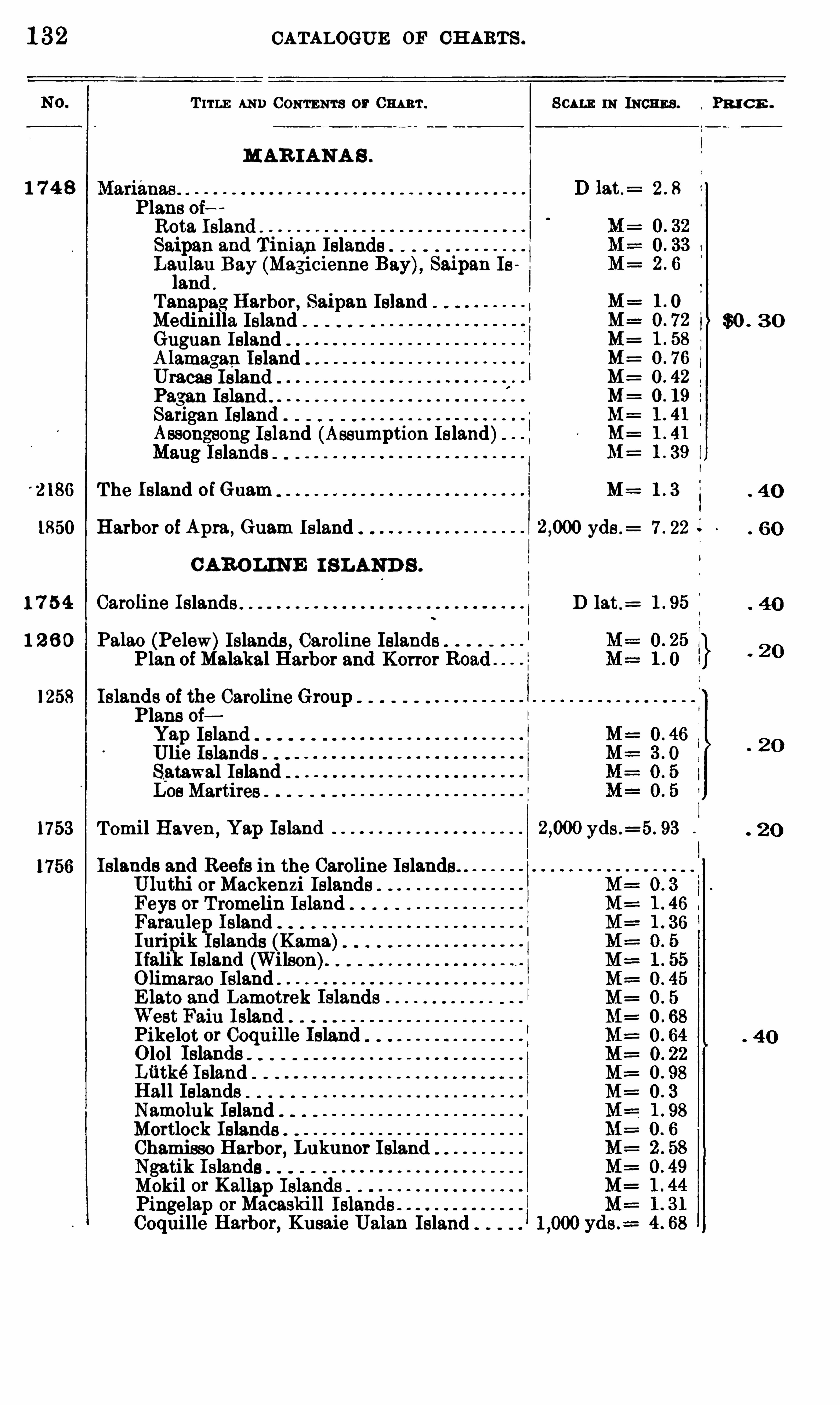
1 32 CATALOGUE OF CH ARTS .
T 11 11 ; AND CONTENTS or 0 111 111 . SCALE 11: INCHES . PR I C E .
MAR IANA S .
1 7 4 8 D 13 t.= 2 . 8
Plans oiRota IslandSaipan 3 nd Tinian Islands .
Laiula
cil
.
Bay (Magicienne Bay), Saipan In
s
.
an
Tanapag Harbor , Saipan IslandMedinilla IslandGuguan I slandA lfmagan IslandUracas
c
Island . .
Pagan Island . .
Sarigan Island“
Assongsong Island (Assumption Island)Maug Islands
The Island ofGuam M= 1 . 3
1850 Harbor of Apm , Guam Island yds .= 7 . 22
C AROLINE I SLAND S .
1 7 5 4 Caroline Islands D 13 t .=
1 2 6 0 P3 13 0 (Pelew)Islands , Caroline IslandsPlan of M3 13k3 1Harbor and Kon or Road
1258 Islands of the Caroline GroupPlans oiYap IslandUlie IslandsSatawal IslandLos Martires
1753 Tomi l Haven , Yap Island yds .=5 . 93
Islands and Reefs in the Caroline IslandsUluthi orMackenzi IslandsFeys or Tromelin IslandFaraulep IslandIuri ik Islands (Kama)Ifali IslandOlimarao IslandE lato 3nd Lamotrek IslandsWest Fain Island .
Pikelet or Coquille Island0 101 IslandsLfitké Island .
Hall IslandsNamoluk IslandMortlock IslandsChamisso Harbor , Lukunor IslandNgatik Islands .
Mokil or Kallap Islands .
Pingelap orMacaski ll Isl3nCoquille H 3 1bor, Kusaie Ualan Island
MMMMMMMMM

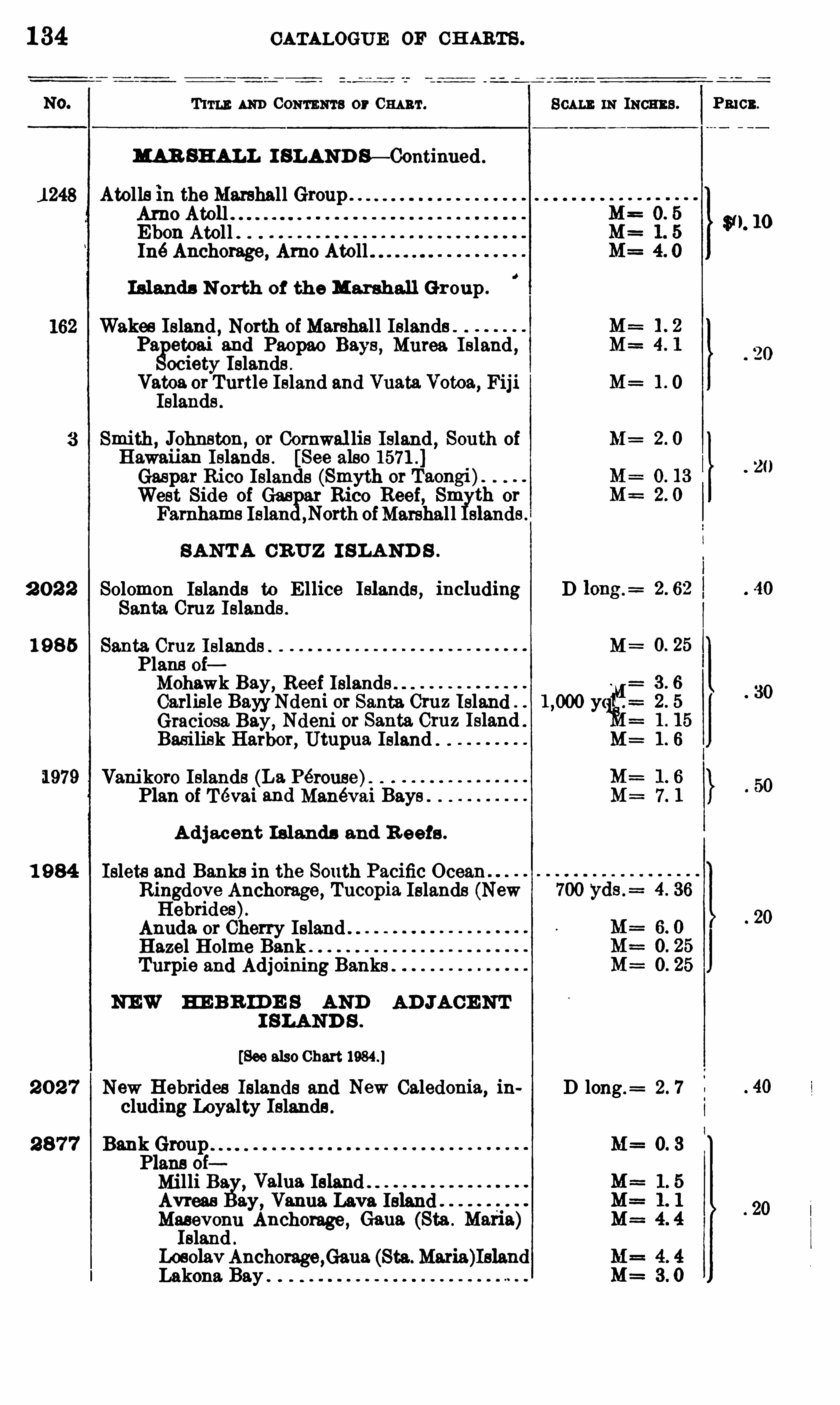
1 34 CATALOGUE OF CH ARTS .
T um AND CONTENTS or m r. m INCHES .
MAR SHALL I SLAND S— Continued .
1 248 Atollsm the Marshall Group . .
Arno AtollEbon Atoll . .
Iné Anchorage, Arno Atoll
Islands N orth of the Marshall Gr oup .
Wakes Island , North of Marshal l IslandsP3 etoai 3nd Paopao B3y ,
s Murea Island ,ociety Islands .
Vatoa or Turtle Island and Vu3 t3 Votoa, FijiIslands .
mith,Johnston,
or Cornwal lis Island , South of M=
Hawaiian Islands . [See also 1571 .
Gaspar Rico Islands (Smyth orWest Side of Gaspar Rico Reef, Sm th or
Farnhams Island ,North ofMarshal l slands
SANTA CRUZ I SLAND S .
2 0 2 2 Solomon Islands to E llice Islands, includi11g DSanta Cruz Islands .
1 9 8 5 Santa Cruz I slands . MPlans oiMohawk Bay, Reef Islands .
(1
1
21
Carlisle BayyNdeni or Santa. Cruz Island ” yGraciosa. Bay, Ndem 0 1
' Santa Cruz Island .
Basilisk Harbor, Utupua Island “ M=
1979 Vani koro Islands (L3 Pérouse)“
Plan of Tevai 3nd Manévai Bays"
A d jacent Islands and R eefs .
1 9 84 Islets and Banks in the South Pacific OceanRingdove Anchorage, Tucopia Islands (NewHebrides).
Anuda or Cherry Island"Hazel Holme BankTurpio and Adjoining Banks
NEW H EB R ID E S AND AD JACE NTI SLAND S .
[See also Chart
2 0 2 7 New Hebrides Islands and New Caledonia, in D long .= 2 . 7
eluding l oyalty Islands .
2 8 7 7 Bank Group M= 0. 3
Plans oiMilli B3 ,
V3 1u3 IslandAvreas 3y, V3 11u3 Lava IslandMasevonu Anchorage, G3 u3Island .
LoeolavAnchor3ge ,G3 u3 (Sta. M3 113 )IslandLakona Bay ”
P3 103 .
$ 0. 10
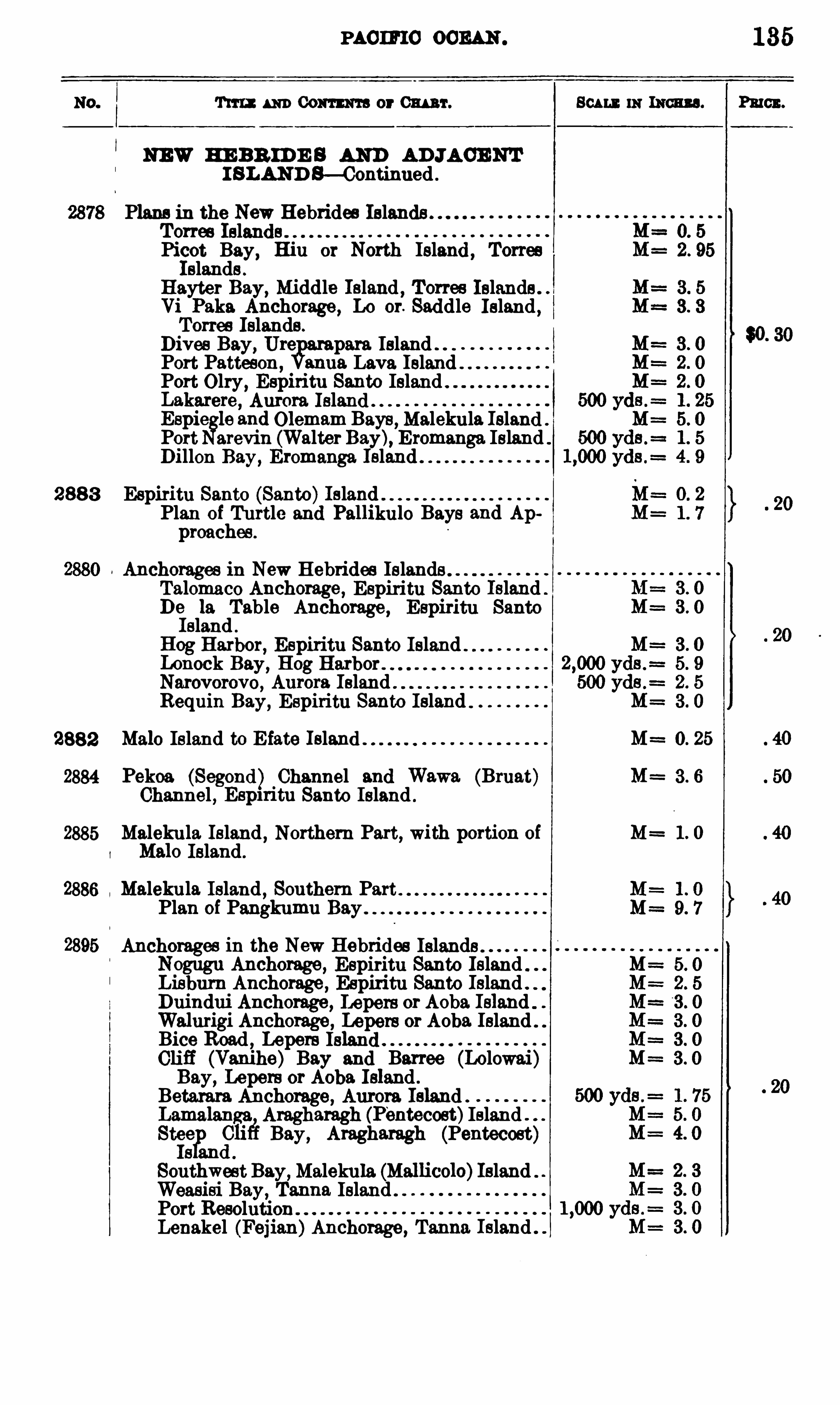
PAC IFIC OCEAN .
Tm : m Comm a or 0 111 111 . 803 11 1 111 111011113 . Pmcx.
NEW HE BR ID E S AND AD JACENTI SLAND B—Continued
Plans in the New Hebrides IslandsTorres IslandsPicot Bay, Hiu or North Island TorresIslands .
Hayter Bay, Middle Island , Torres Islands .
Vi P3 113 Anchorage , Lo or. Saddle Island ,Torres Islands .
Dives Bay, Ure para IslandPort Patteson ,
3nu3 Lava IslandPort Olry , Espiritu Santo IslandL3k3 1'ere, Aurora IslandEspic
l
a
gle 3nd Olemam Bays ,Malekula Island
Port arevin (Walter Bay), Eromanga IslandDillon Bay, Eromanga Island
288 3 Espiritu Santo (Santa)IslandPlan of Turtle and Pallikulo Bays 3nd Appreaches .
Anchorages in New Hebrides Islands .
Talomaco Anchorage, Espiritu Santo Island .
De 13 Table Anchorage, Espiritu SantoIsland .
Hog Harbor, Espiritu Santo IslandIo h ock Bay, Hog Harbor .
Narovorovo, Aurora Island .
Requin Bay, Espiritu Santo Island
2882 M3 10 Island to E fate Island M==0. 25
2884 Pekoa (Segond) Channel and Wawa (Bruat) M= 3 . 6
Channel , Espn'itu Santo Island .
2885 Malekula Island , Northern Part, with portion of M 1. 0
M3 10 Island .
Malekula Island , Southern PartPlan of Pangkumu Bay
Anchorages in the New Hebrides Islands .
Nogugu Anchorage, Espiritu Santo Island .
Liebum Anchorage , Espiritu Santo Island .
Duindui Anchorage , Lepers or Aoba IslandWalmigi Anchorage , Lepers or Aoba. IslandBice Road , Lepers IslandCliff (Vanihe) Bay and Barree (Lolowai)Bay, Lepers or Aoba Island .
Betarara Anchorage, Aurora IslandLamalanga Aragharagh (Pentecost)IslandStel
ae Bay, Aragharagh (Pentecost)s an
Southwest Bay,Malekula (Mallicolo)Island
Weasisi Bay, T3nn3 Island .
Port ResolutionLenakel (Fejian)Anchorage, T3nn3 Island .
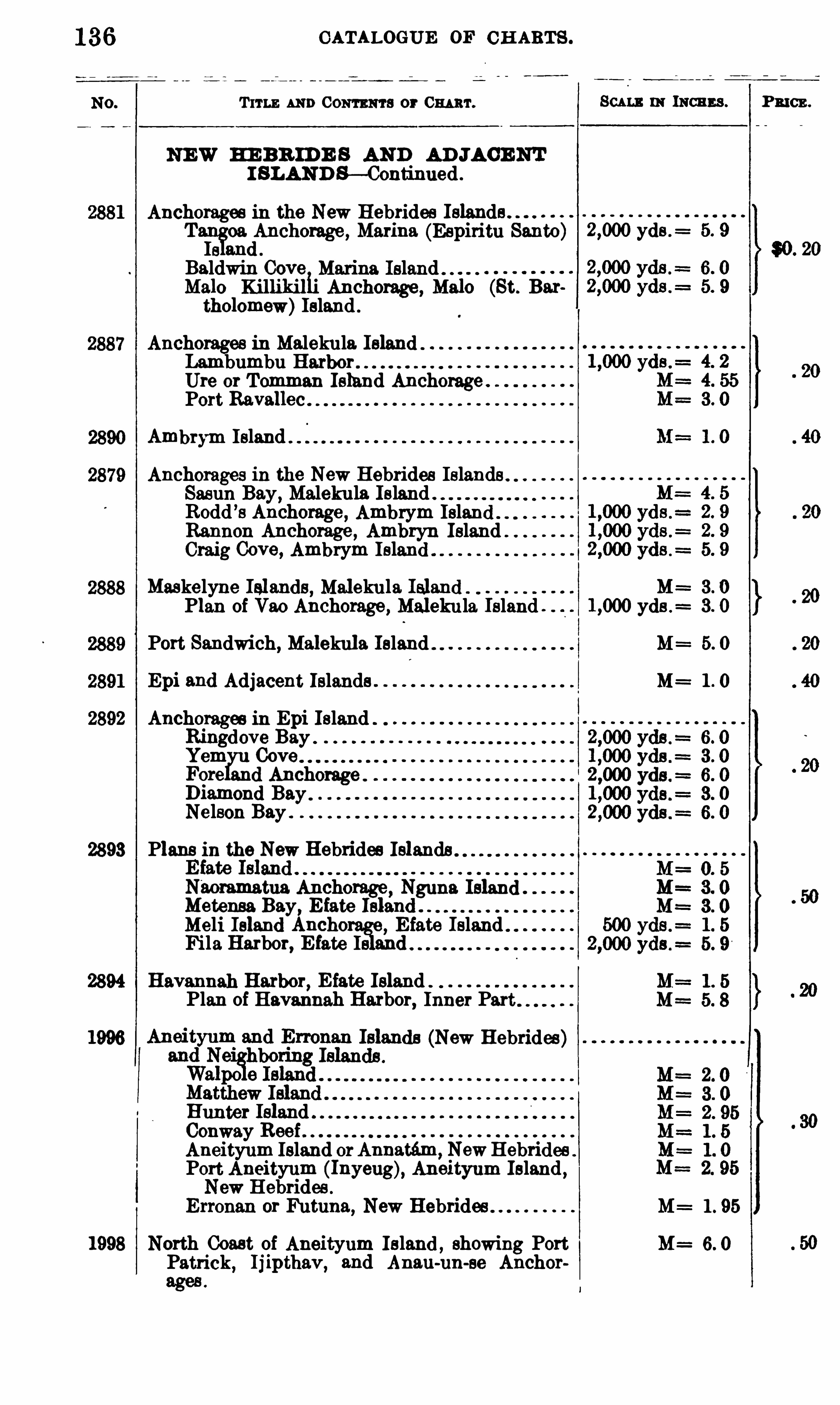
CATALOGUE OF CH ARTS .
T ITLE AND Com ma or 0 111 111 .
NEW HE BR ID E S AND AD JACENTI SLAND S— Continued .
Anchorages in the New Hebrides IslandsTaih
!oa Anchorage , Marina (Espiritu Santa) yds .
=
a 3nd .
Baldwin Cove Marina IslandM3 10 KillikilhAnchorage , M3 10 (St. B3 1
tholomew)Island .
Anchorages in Malekula IslandLambumbu HarborUre or Tomman Island AnchoragePort Ravallec
Ambrym Island
Anchorages in the New Hebrides IslandsSasun Bay, Malekula Island .
Rodd ’s Anchorage , Ambrym Island
Rannon Anchorage , Ambryn IslandCraig Cove, Ambrym Island
Maskelyne Islands , Malekula IslandPlan of Vao Anchorage, Maleku la Island .
Port Sandwich, Malekula Island
Epi 3nd Adjacent Islands .
2892 Anchorages in Epi IslandRingdove BayYem Cove
q e and AnchorageD13mond BayNelson Bay .
2893 Plans in the New Hebrides Islands
N“
act Ancho Nguna IslandMetensa Bay, Efate
n
igle
and "Meli Island Ancho E fate IslandFila Harbor, E fate Is and
2894 H3 V 3nn3h Harbor, E fate IslandPlan of Havannah Harbor
,Inner Part
da (New Hebrides)
Hunter IslandConway ReefAneityum Island orAnnatém , NewHebridesPort Aneityum (Inyeu Aneit m Island
,
New Hebrides .
g yu
Erronan or Futuna, New Hebrides
1998 North Coast of Aneityum Island ,showing Port
Patrick, Ij ipthav,3nd Anat1-nu-se Anchor
SCALE 0 1 111011113 .
M :
yds .=
1 . 95
P RICE .

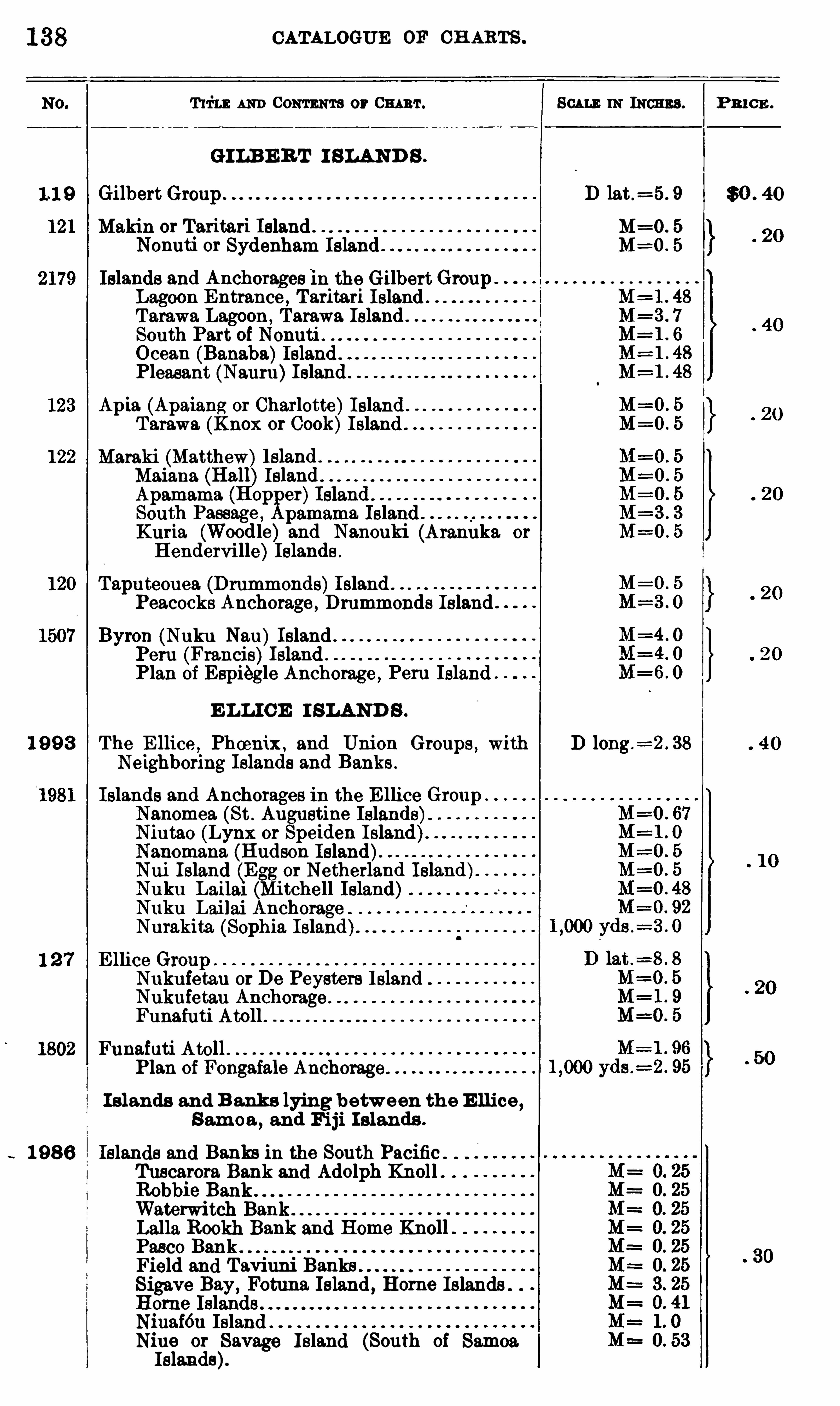
1 38 CATALOGUE OF CH ARTS .
AND Com m or 03 11111 . 803 111: IN INCHES . P 3 10 3 .
GILB E R T I SLAND S .
Gilbert D 13 t .=5 . 9 $0 . 40
Makin or Taritari Island . . M=O. 5
Nonuti or Sydenham Island . M=O. 5
Islands and Anchorages m the GilbertGroupLagoon Entrance , T 3 1
'it3 1'i IslandT 3 13wa Lagoon , Tarawa Island . .
South Part of N0nuti . .
Ocean (Banaba)Island .
Pleasant (Nauru)Island
Apia (Apaiang or Charlotte)IslandT 3 13W3 (Knox or Cook)Island
M3 13ki_(M3 ttheW)1sland . .
MaianaApamama (HopK
er)Isl3nci:South P3 ss3ge , 3m3m3 IslandKuria. (Wood le) 3nd Nanouki (Aranuka or
B enderville)Islands .
Taputeouea (Drummonds)Island “
Peacocks Anchorage , Drummonds Island
Byron (Nuku Nau) Island . .
Peru (Francis)Island . .
Plan of E spiegle Anchorage ,
.
Peru Island
E LLI CE I SLAND S .
1 9 9 3 The E llice,Phoenix , and Union Groups , with D long .
=2 . 38
Neighboring Islands and Banks .
Islands and Anchorages ln the E llice Groupanomea (St . A11gustine Islands)intao (Lynx or Speiden Island)3nom3n3 (Hudson Island)”ui Island (Egg or Netherland Island)
Nuku L3 113 1 (Mi tchell Island)uku Lai lai Anchorage
Nurakita (Sophia Island)E llice Group
Nukufetau or De Peysters IslandNukufetau AnchorageFunafuti Atoll .
Funafuti Atoll “Plan of Fongaiale Anch013ge
I s lands and B anks lying betw een the E llice,
Sam oa,and Fi ji I slands .
1 98 6 Islands and Banks m the South Pacific .
Tuscarora Bank and Adolph Knoll .
Robbie BankWaterwitch BankLalla Rookh Bank and Home KnollPasco BankField and Taviuni BanksSigave B3y, Fot11n3 Island , Hom e Islands “
Horne IslandsNiuaféu IslandNiue or Savage Island (South of SamoaIslands).
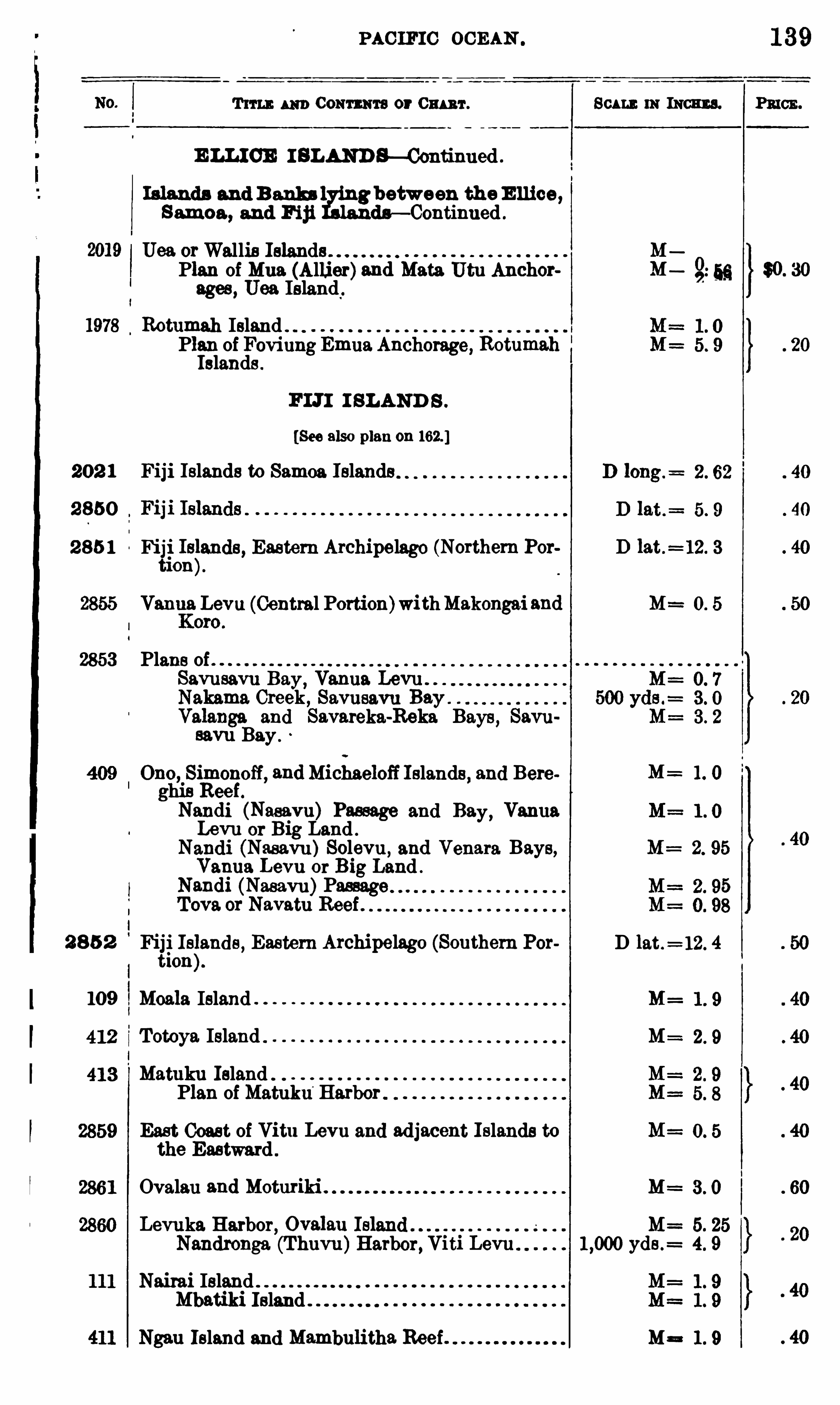
PAC IFIC OCEAN
T im 3 111) Coum 'ta or Cm 'r .
E LLIOE I BLAND S—Continued .
Islands and 3 3 11113 1 g between the E ll ice ,Samoa , and Fiji da— Continued .
Uea orWallis IslandsPlan of Mua (Allier)3nd Mata Utu Anchorages , Uea Island .
Rotumah IslandPlan of Foviung Emua Anchorage, RotumahIslands .
FLTI I SLAND S .
[See also plan on 162 ]
202 1 Fiji Islands to Samoa Islands
2 850
2 85 1 Fiji Is§3nds, Eastern Archipelago (Northem Por
ti on
Vanna Levu (Central Portion)withMakongai 3nd
2853 Plans ofSavusavu B3 y,
Vanna Levu . .
Nakama Creek , Savusavu BayV3 13 11g3 and Savareka-Reka Bays, Savusavu Bay .
Ono, Simonoff, 3ndMichaeloff Islands, and Bereghiv
s 1139
k P3 11 i asavu assage and B3 VannaLevu or Big Land .
y
N3ndi (Nasavu)Solevu, and Venata Bays,Vanna Levu or Big Land .
N3ndi (Nasavu)PassageTova or Navatu Reef .
2 8 5 2 Fiji Is§3 nds , Eastern Archipelago (Southern Por
tion
109 MO3 13 Island
Totoya Island
Matuku Island .
Plan of Matuku‘
Harbor
East Coast of Vitu Levu and adjacent Islands tothe Eastward .
Ovalau 3nd Moturiki .
Levuka Harbor, Ov3 13 11
Scu nm lncmns.
z
zIIII
10
9
29
1
82
D lat .= 12. 4
M=
M=
M=
M= 5. 25Nandronga (Thuvu)Harbor, Viti Levu yds .
= 4. 9
Nairai IslandMbatiki Island
Ngau Island and Mambulitha Reef . M=
1 39
PRICE .
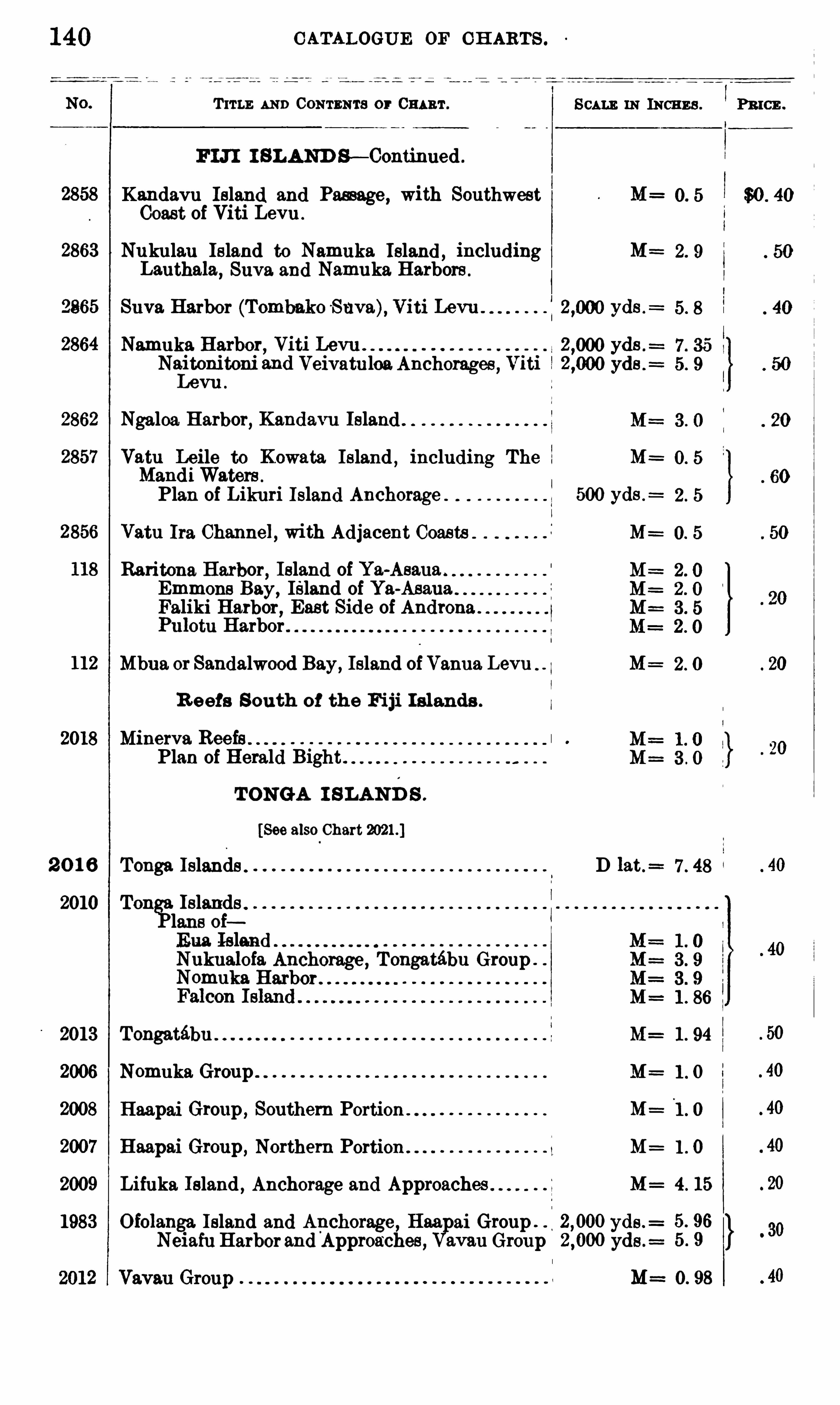
140
2858
2863
9865
2864
112
2018
2 0 1 6
2010
2013
2006
2008
2007
2009
1983
C ATALOGUE OF C H ARTS .
T ITLE AND CONTENTS or CHART .
FIJI I SLAND S — Continued .
Kandavu Island and Passage , with Southwest M=Coast of Viti Levu .
Nukulau Island to Namuka Island ,including M=
L3uth3 13,Suva and Namuka Harbors .
Suva Harbor (Tombako Suva), Viti Levu . yds .=
N3muk3 Harbor, Viti Levu . yds .
N3 itonit0 11i 3nd Veivatuloa.Anchorages , Viti yds .=
Levu .
Ngaloa. Harbor, Kandavu Island
V3 tu Leile to Kowata Island,including The M=
MandiWaters .
Plan of Likuri Island Anchorage . 500 yds .=
Vatu 11 3 Channel , with Adjacent Coasts M
Baritona Harbor, Island of Y3 -Asau3Emmons Bay, Island of Ya-AsauaFaliki Harbor, East Side of AndronaPulotu Harbor
Mbua or Sandalwood Bay,Island of Vanna Levu M=
R eefs South of the Fiji I slands .
Minerva ReefsPlan of Herald Bight.
TONGA I SLAN D S .
[See also Chart
Tonga Islands . D 13 t .=
Ton?Islands .
lane oiEua IslandNukualofa Anchorage, Tongatébu Group .
Nomuka HarborM=
Tongatébu M=
Nomuka Group M=
Haapai Group , Southern Portion M=
H3 3p3 i Group , Northern Portion . M=
Lifuka Island,Anchorage and Approaches M=
Ofolanga Island and Anchorage, H3 3 ai Group . yds .=
Neiafu Harbor and Approaches , 3v3 u Group yds .=
S CALE IN INCHES .
l . 86
1 . 94
1 . 0
1 . 0
1 . 0
4. 15
5. 96
5 . 9
M==0. 98

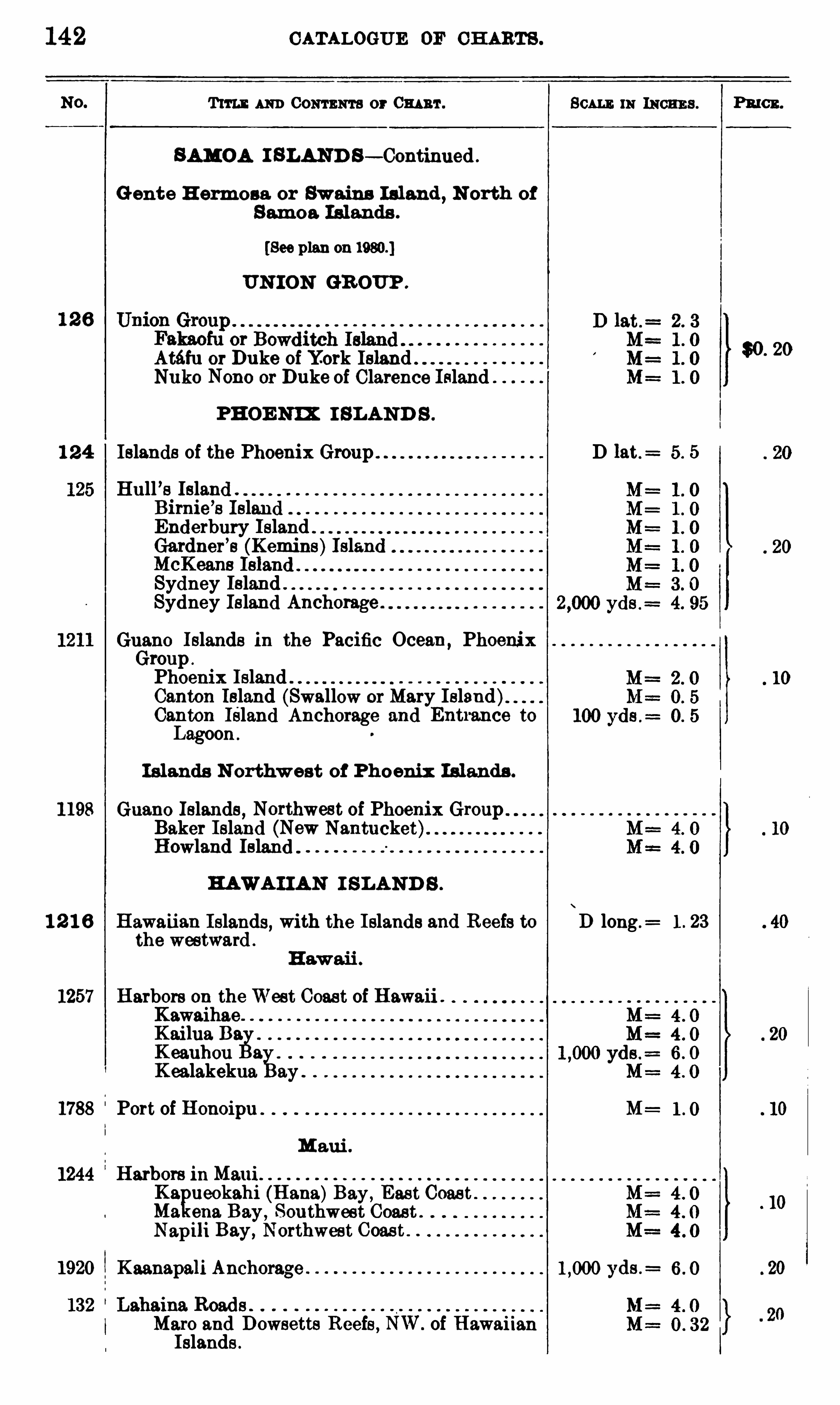
142 CATALOGUE OF CH ARTS .
T11 11 : 111m 0 0 111 11111 3 or 0mm . SCALE 111 1110113 3 . Pmcn.
SAMOA I BLAND S — Continued .
Gente H ermon or Swains Island , N orth of
S amoa Islands .
[See plan on
UN ION GR OUP .
Atéfu or Duke of York Island" $0 20
N11110 Nono or Duke of Clarence Island”
PHOE NIX I SLAND S .
1 2 4 Islands of the Phoenix Group D 13 t.= 5. 5
Hull ’s IslandBirnie
’
s IslandEnderbury Island .
Gardner’
s (Kemine)Island
Sydney Island "Sydney Island Anchorage .
Guano Islands in the Pacific Ocean ,Phoenix
Group .
Phoenix Island ”
Canton Island (swallow or Mary Island)Canton Island Anchorage and Ent1 3nce toLagoon .
I slands N orthw est of Phoenix Islands .
1198 Guano Islands , Northwest of Phoenix GroupBaker Island (New Nantucket)Howland Island
HAWA I IAN I SLAND S .
1 2 1 6 Hawaiian Islands, with the Islands and Reefs to\
D long .= 1 . 23
the westward .
1257 Harbors 0 11 theWest Coast of Hawaii .
KawaihaeK 3 i1u3 D3Keauhou 3
K ealakekua 3y .
1788 Port of Honoipu M=
M aui .
1244 Harlkors 1 11 Maui
I
l
égfiueokahfl(Hana)Bay,
Eas t Coas ten3 Bay Southwest Coast .
Nap1l1 Bay, Northwest Coast . .
1920 K 3 3n3 p3 1i Anch0 1'
3ge yds .=
M3 10 and Dowsetts Reefs , NW. of HawaiianIslands .
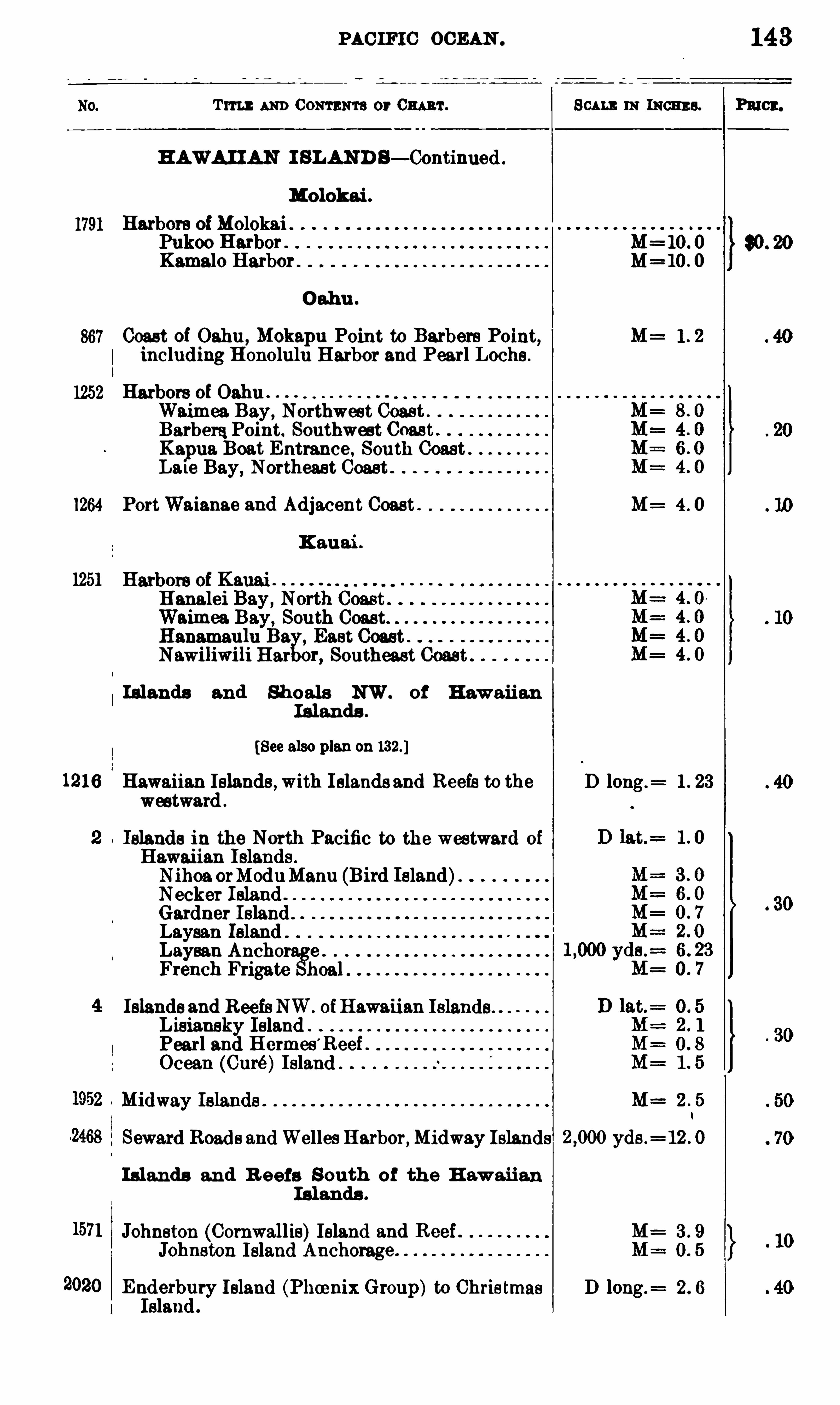
1791
867
1252
1264
1251
1216
PAC IFIC OCEAN .
Tm AND Com ma or Om ar . 111 Ism s.
HAWA I IAN I BLAND B— Continued .
Molokai .
Harbors ofMolokaiPukoo Harbor . M= 10 . 0
Kamalo Harbor M
Oahu .
Coast of Oahu ,Mokapu Point to Barbers Point, M= 1 . 2
including Honolulu Harbor and Pearl Loche.
Harbors of 0 3 1111Waimea Bay , Northwest Coast .
BarberaPoint. Southwest Coast .
Kapua Boat Entrance , South Coast .
La le Bay , Northeast Coast .
PortWaianae 3nd Adjacent Coast . M= 4 . 0
K auai .
Harbors of Kauai .
Hanalei Bay ,Waimea Bay, South Coast.
Hanamaulu Eu East CoastNawiliwili B ar or, Southeast 0
Islands and Sh oals NW. of H awai i an
I slands .
[See also plan on
Hawaiian Islands , With I slands and Reefs to the D long .= 1 . 23
westward .
Islands in the North Pacific to the westward of
Hawaiian Islands .
Nihoa orModuManu (Bird Island)Necker Island .
Gardner Island .
Laysah IslandLaysan Anchor e .
French Frigate 1103 1 .
Islands and Reefs NW. ofHawaii an IslandsLisiansky Island .
Pearl and H ermes’
Reef .
Ocean (Curé)Island
Midway Islands . M=
Seward Roads andWelles Harbor,Midway Islands yds .= 12 . 0
Islands and R eefs South of the H awau an
I slands .
Johnston (Cornwallis)Island and ReefJohnston Island Anchorage .
Enderbury Island (Phoenix Group) to Christmas D long .
Island .
Pmcx.
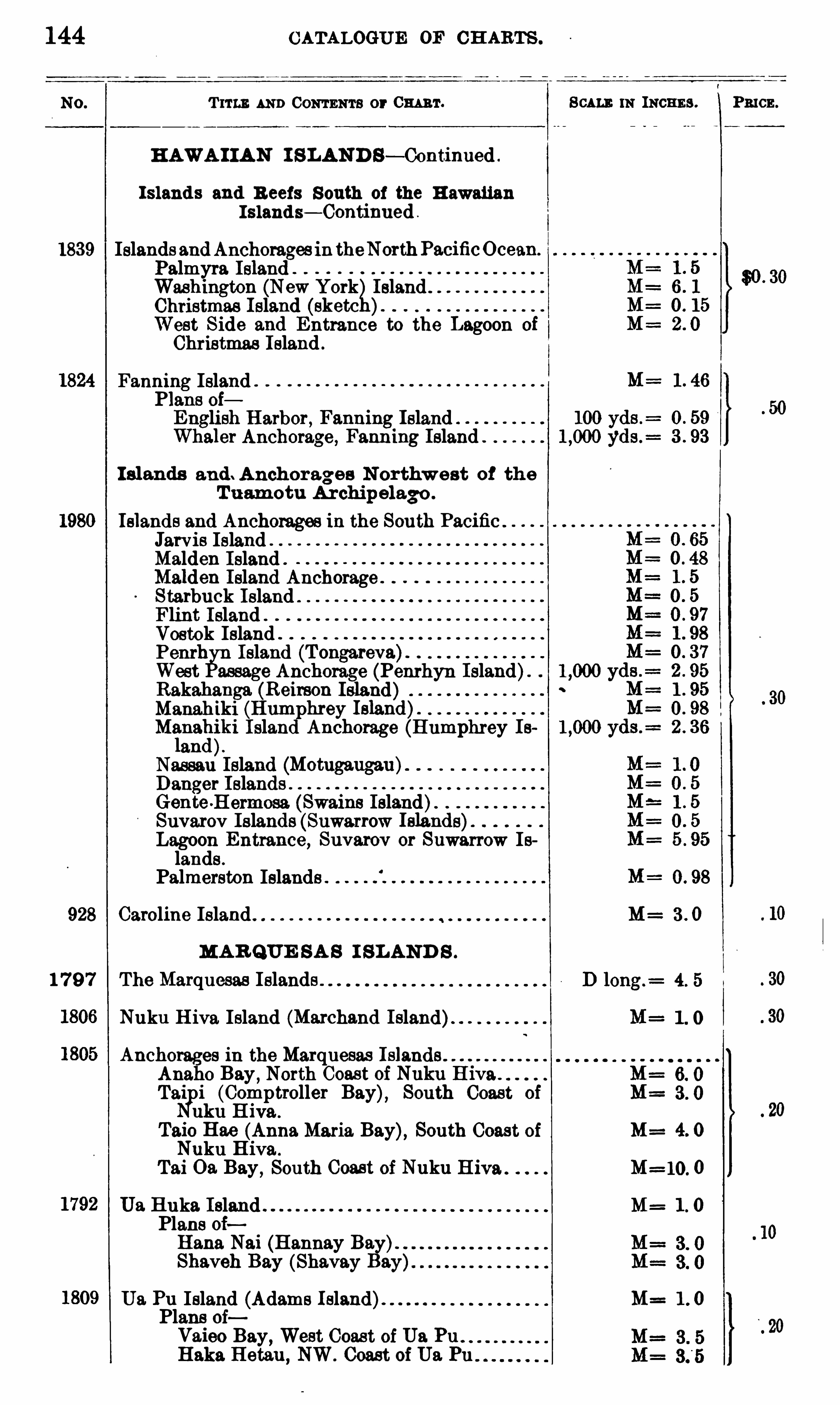
144 CATALOGUE OF CH ARTS .
T 11 13 . AND CONTENTS or 0 111 1111. Scum. m INCHES . Pn cn.
H AWA I IAN I S LAND S— Continued .
I sland s and R eefs South of the H awaiianI sland s— Continued
1839 Islands andAnchorages ln theNorthPacificOcean.
Palmyra Islando
Washington (NeW York Island .
Christmas I sland (sketcWest Side and Entrance to the Lagoon of
Christmas Island .
Fanning IslandPlans oiEnglish H 3 1bor, F3 nning Island .
Whg31er Anchorage, Fanning Island .
I slands and . Anchorages N orthw est of the
T uam otu A rchipelago .
Islands and Anchorages in the South PacificJarvis IslandMalden Island .
Maiden Island Anchorage . .
Starbuck Island . .
Flint Island .
Vostok IslandPenrh Island (T ongarevaWest assage Anchorage (Penrhyn Island).
Rakahanga (Reimon Isl3 nd) .
Manahiki (HumphreyM?.na
giki Island Anchorage (Humphrey Is
ah
Nassau Island (Motugaugau)Danger IslandsGente H ermosa. (Swains Island)”
Suvarov Islands (Suwarrow Ielancis)Lagoon Entrance, Suvarov or Suwarrow Islands .
Palmerston Islands
928 Caroline Island M= 3 . 0
MA R Q UE SA S I SLAND S .
1 7 9 7 The Marquesas Islands
Nuku H iva Island (M3 rch3nd Island)
Anchorages in the Marquesas IslandsAnaho Bay
,North Coast of Nuku H iva
Taipi (Comptroller Bay), South Coast of
Nuku H iv3 .
Taio H 3 e (Anna Maria Bay), South Coast of M= 4. 0Nuku H iva .
T 3 i 0 3 Bay,South Coast of Nuku H iya . M=10. 0
U3 Huka Island M= 1 . 0Plans ofHana Nai (Hannay Bay).
Shaveh Bay (Sh3v3y Bay
U3 Pu Island (Adams Island) M= 1 . 0Plans ofV3 ieo Bay , West Coas t of U3 PuHaka Hetau , NW. Coast of U3 Pu

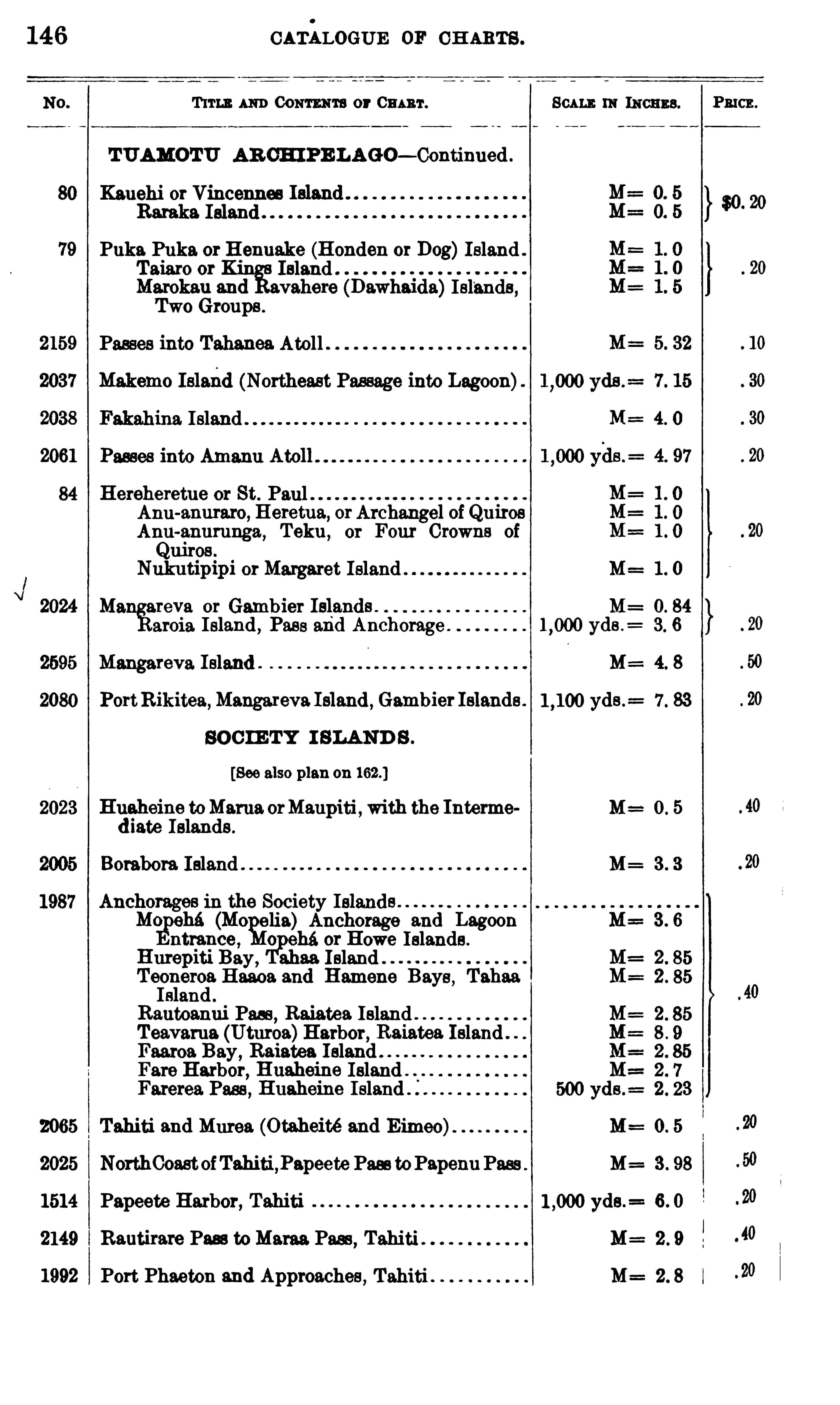
146 CATALOGUE or CH ARTS .
T 11 11: 1 111) CONTENTS or 0 3 1 111 . Scum. 111 111011113 . Pn cn.
TUAMOTU AR CHIPE LAGO— Continued .
80 Kanehi or Vincennes Ieland . .
Baraka Island
Puka Puka or Henuake (Honden or Dog)Island .
Taiaro or Island .
Marokau 3nd vahere (Dawhaida)Islands ,Two Groups .
Passes into T3h3ne3 Atoll
Makemo Islalid (Northeast Passage into Lagoon)
F3k3hin3 Island
2061
84 Hereheretue or St. PaulAnu-anuraro, Heretua, orArchangel of QuirosAnu-anurunga, Teku , 0 1 Four Crowns ofQuiros
Nukutip1pi orMargaret Island . M= 1 . 0
2024 M3 areva or Gambier Isiand l . M=3 1013 Island , Pass and Anchorage yds .
= 3. 6
2695 Mangareva Island . M: 4. 8
2080 PortRikite3 ,M3ng3 1 ev3 1313nd ,Gambier Islande. yds .
= 7 . 83
SOC IE TY I S LAND S .
[See also plan on
2023 Huaheine toMama orMaupiti ,with the Interme M= 0 . 5
diate Islands .
Borabora Island . M= 3 . 3
Anchorages in the Society I913 1111Mcgmh3 (Mo elia) Anchorage and Lagoon M= 3 . 6
ntrance , o eh3 or Howe Islands .
Hurepiti Bay , abaa IslandTeoneroa 11 3 3 0 3 and Hamene Bays , T 3h3 3IBland .
Rautoanui Pass, Raiatea Island .
Te3v3 ru3 (Uturoa)Harbor, Raiatea IslandFaaroa Bay , Raiatea IslandFare Harbor, Huaheine IslandFarerea Pass , Huaheine Island I
2065 Tahiti 3nd Murea (Otaheité 3nd Eimeo) M 0 . 5
2025 NorthCoastofTahiti ,P3peete Pass toPapeunPass M= 3 . 98
1514 Papeete Harbor, Tahiti yds .= 6 . 0
2149 Rautirare Pass toMam Pass,Tahiti .
1992 Port Phaeton 3nd Approaches , Tahiti
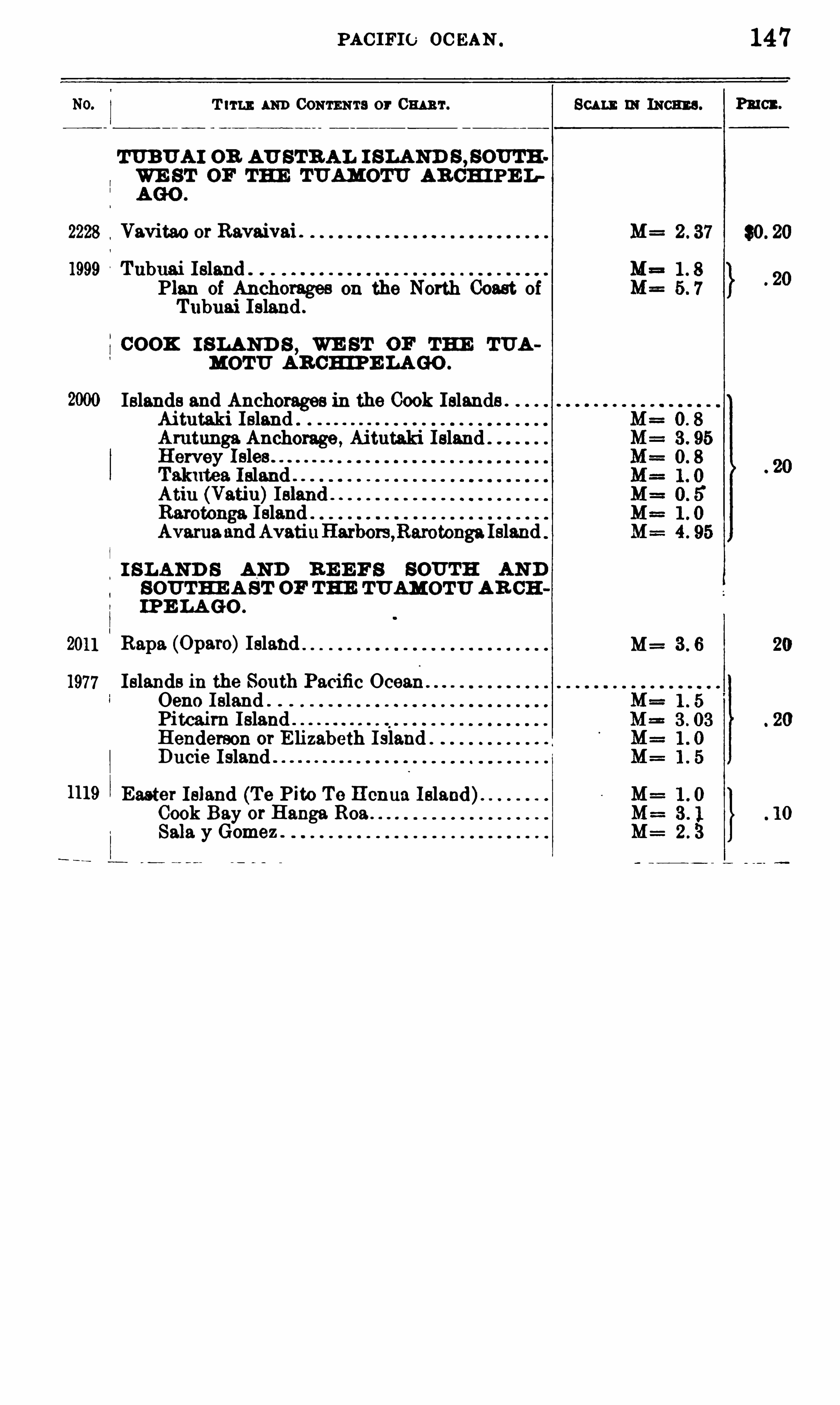
PAC IFIC 0 0 BAN .
T 111 1: AND CONTENTS or Cm 'r.
m um on AU STR AL I SLAND s ,somWE ST or THE 1 1113 1110 1
11: AR CH IPE L
2228 Vavitao or Ravaivai .
1999 Tubuai Island .
Plan of Anch01-3geeon the North Coast ofTubuai Island .
COOK I SLAND S,WE ST OF THE TUA
MOTU AR CH IPE LAGO .
Islands and Anchorages in the Cook Islands .
Aitutaki Island .
Amtunga Anchorage , Ai tutaki IslandH ervey IslesT 3k1113 3 IslandAtiu (Vatin)IslandRarotonga I slandAvarua z1udAvati11Harbors ,Rarotong3 Island
I SLAND S AND R E E F S SOUTH AN DSOUTHE A ST OF THE TUAMOTU AR CHIPE LA GO .
2011 Rapa (0 p3 1'o)Island
1977 Islands in the South Pacific OceanOeno I sland .
Pitcairn Island .
Henderson or E lizabeth I sland .
Ducie Island .
1119 Easter Island (Te Pito Te c ua Island)Cook Bay or Hangs. R0 383 13 y Gomez .
Scu mmmoans .
M=
M=
M= 3 6
147
PRICE .
$0 . 20


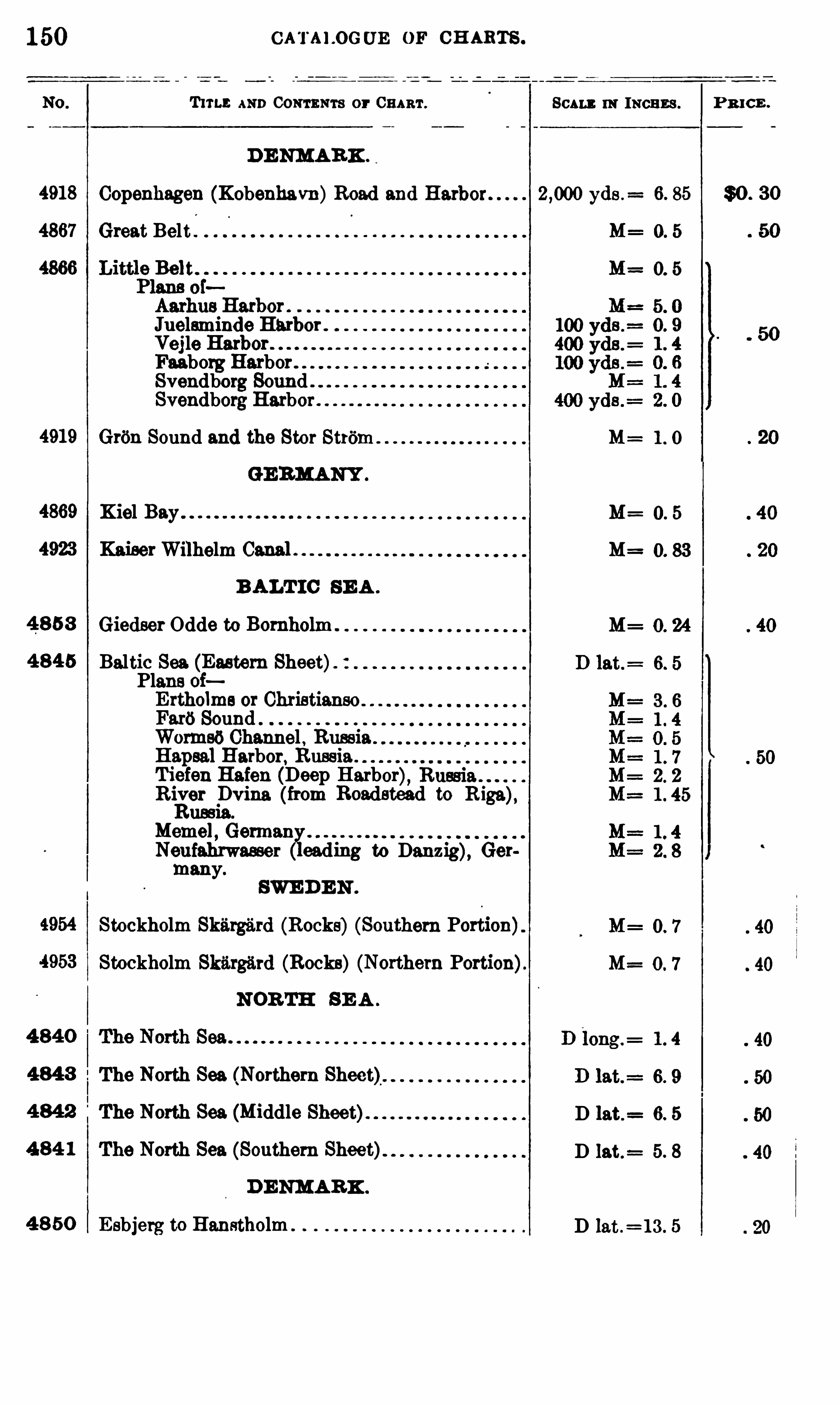
1 50
4918
4867
4919
4869
4923
4 8 5 3
4 8 45
4954
4953
4 840
484 3
4 8 42
4 8 4 1
4 8 50
CATALOGUE OF CH ARTS .
T11 1 3 AND CONTENTS or CHART.
DE NMARK .
SCALE m INCHES .
Copenhagen (Kobenhavn)Road and Harbor yds .= 6. 85
Great Belt
Juelsminde HarborVej le HarborFaaborg Harbor.
Svendborg Sound .
Svendborg Harbor
GrimSound and the Stor Strom
Kiel Bay
KaiserWilhelm Can3 1. .
B ALT IC SE A .
Giedser Odde to Bomholm .
Baltic Sea. (Eastern Sheet)Plans ofErtholms or OhristiansoF3 16 SoundWormsb Channel , RussiaHapsal Harbor, Russia .
Tiefen Hafen (Deep Harbor),River Dvina ( from Roadstead to R iga),Russia.
Meme] , GermanyNeufahrwasser ead ing to Danzig), Ger
many.
SWE D EN .
Stockholm Skargard (Rocks) (Southern Portion)Stockholm Skiirgfird (Rocks) (Northern Portion).
NOR TH SE A .
The North Sea Northern Sheet).The North Sea (Middle
The North Sea (Southern Sheet)
D ENMARK .
E sbjerg to Hanstholm .
M=
M=
0. 5
D 13 t .= 6. 5
D 13 t.= 5. 8
D lat .=13 . 5
P R I C E .
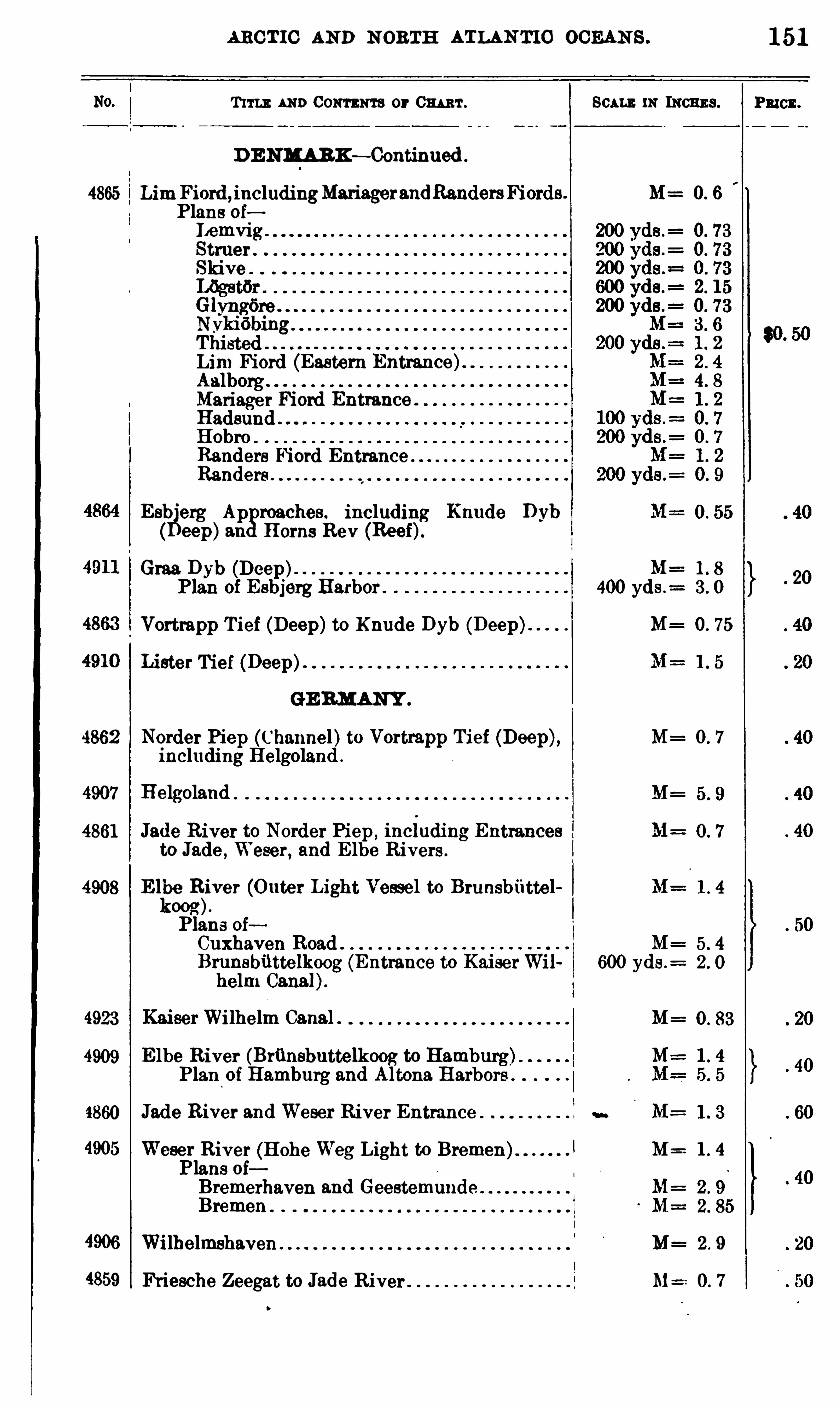
ARC TIC AND N OBTH ATLAN TIC OCEAN S .
T 111 1: AND CONTENTS or 03 1 111 .
D ENMARK— Continued
4865 Lim Fiord ,inc1udingMariager3ndRandersFiords .
Plans oiI 1emvig .
Struer .
Skive .
GlyngfireNykifibingThistedLim Fiord (Eastern Entrance)AalborgMariager Fiord EntranceHadsundHobroRandere Fiord EntranceRanders
Esh'
erg Ap roaches . including Knude Dybeep)3 11 Horns Rev (Reef)
Graa Dyb (Deep)Plan of Esbjerg Harbor
Vortmpp Tief (Deep)to Knude Dyb (Deep)
Lister Tief (Deep)
GE RMANY .
4862 Norder Piep (Channel)to Vortrapp Tief (Deep),including Helgoland .
4907 Helgoland
4861 Jade River to Norder Piep ,inciuding Entrances
to Jade , Weser, and E lbe Rivers .
4908 E111?R
iiver (Outer Light Vessel to Brunsbuttel
oogPlans oiCuxhaven RoadBrunsbilttelkoog (Entrance to KaiserWilhelm Canal).
4923 KaiserWilhelm Canal .
4909 E lbe River (Brunsbuttelkoog to Hamburg)Plan of Hamburg and Altona Harbors
.
4860 Jade River and Weser River Entrance
4905 Weser River (Hohe Weg Light to Bremen) 1
Plans oiBremerhaven 3nd GeestemundeBremen .
4906 Wilhelmshaven
4859 Friesche Zeegat to J3 de River
11: 111011119 .
M= 0 6
M=400 yds .
=
M= 0 . 75
M= 0 7
600 yds .=
M=
M: 1 4
M= 1 4
M= 2 9
M==0 7
151
PRICE .
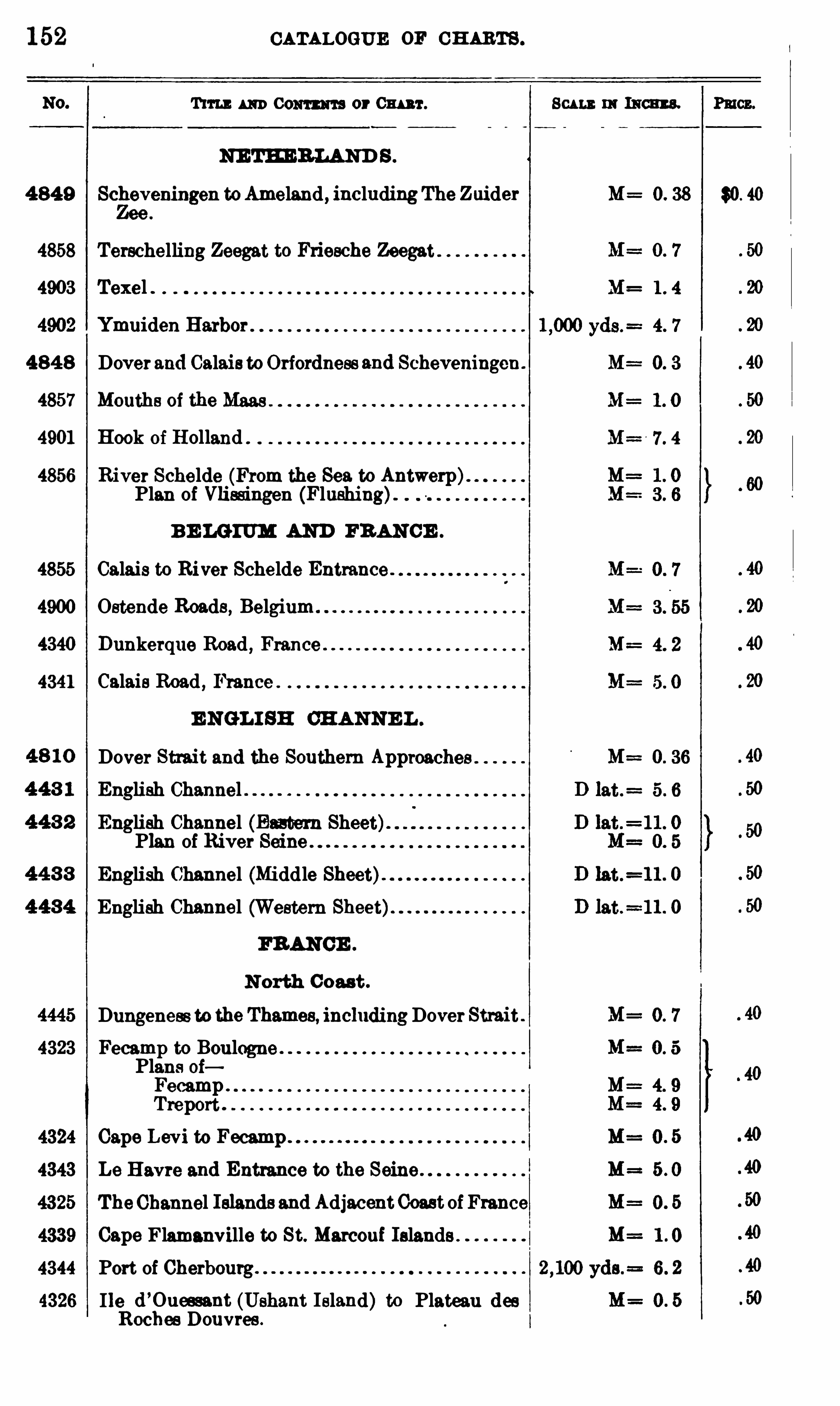
152 CATALOGUE 0 11 CH ARTS .
Tun 111111 0 01111 111 3 or Cm r . Scum 111 Ism s. Pmcz.
NE TE ERLAND S .
4 849 Scheveningen toAmeland , includingThe Zuider M= 0. 38 $0. 40
4858 Terschelling Zeegat to Friesche Zeegat
4903 Texel .
4902 Ymuiden Harbor
484 8 Doverand Calais to Orfordness 3nd Scheveningen.
4857 Mouths of the M3 3 9
4901 B ook of Holland .
4856 River Schelde (From the Sea to Antwerp)Plan of Vlied ngen (Flushing).
B E LGIUM AND FRANCE .
4855 Calais to River Schelde Entrance .
4900 Ostende Roads , Belgium
4340 Dunkerque Road , France
4341 Calais Road , France .
E NGL I SH CHANNE L .
Dover Strait and the Southern ApproachesEnglish Channel
English Channel (Eastern Sheet)Plan of River Seine .
English Channel (Middle
English Channel (Western
FRANCE .
N orth Coast .
Dungeness to the Thamee, inc111dingDover StraitFecamp to BoulognePlans oiFecampTreport
Cape Levi to
Le Havre 3nd Entrance to the Seine
TheChannel Islands and AdjacentCoast of France
Cape Flamanville to St. Marconi Islands .
Port of Cherbourg.
I le d’
Oueesant (Ushant I sland) to Plateau desRochee Douvres .

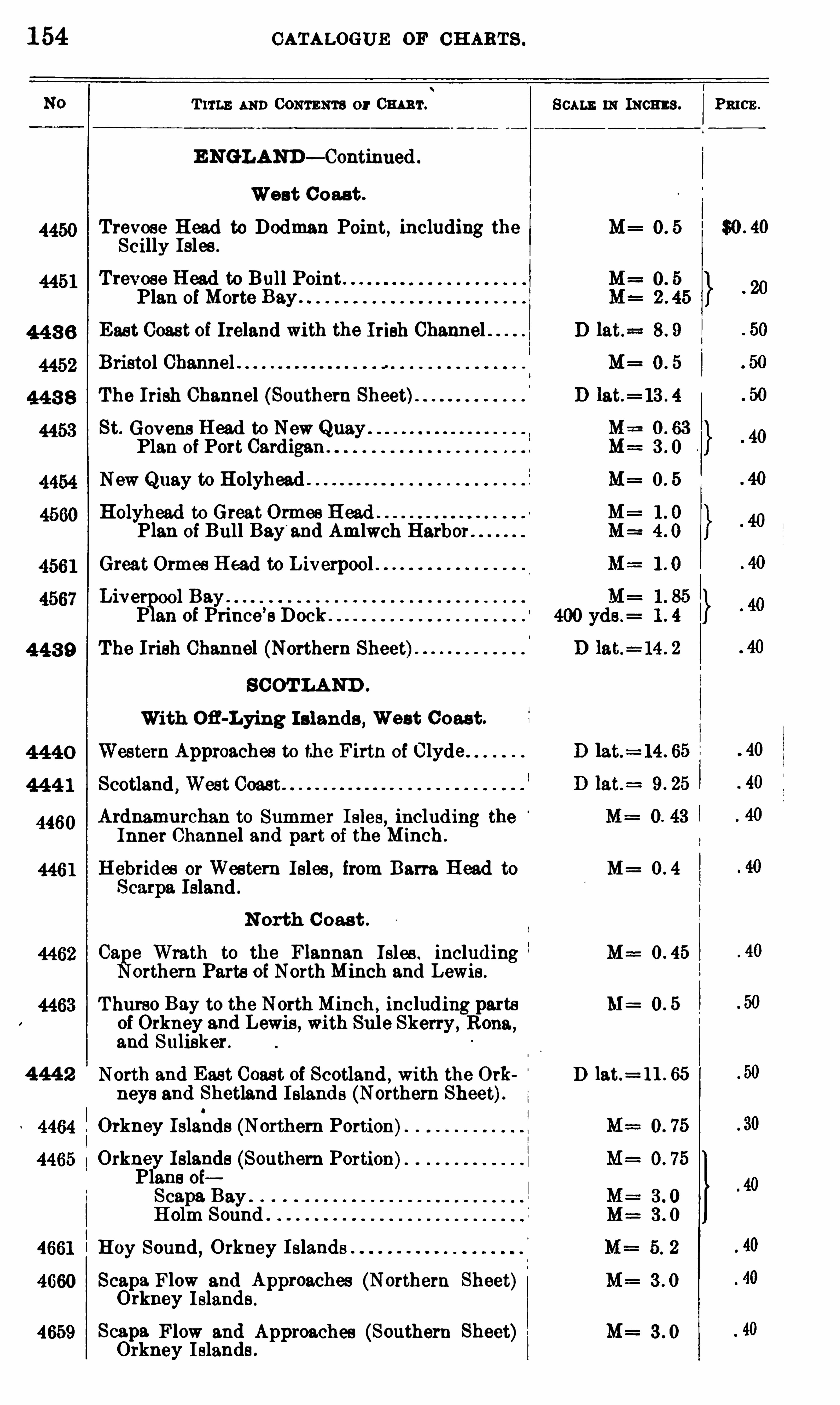
1 54 CATALOGUE OF 0 11 113 1 3 .
T ITLE AND CONTENTS or Cm 'r. Scam 111 means . P3 103 .
E NGLAND — Continued
West C oast .
Trevose Head to Dodman Point, including the M=Scilly Isles .
Trevose Head to Bull Point .
Plan ofMorte Bay .
East Coast of Ireland with the Irish ChannelBristol Channel .
The Irish Channel (Southern Sheet)St. Govene Head to New QuayPlan of Port Cardigan
New Quay to HolyheadHolyhead to Great Ormes H ead
Plan of Bull Bay'
and Amlwch Harbor
Great Ormes H ead to Liverpool .
Live 0 0 1 Bay .
P 3 11 of Prince’
s Dock
4 43 9 The Irish Channel (Northern Sheet)
SCOT LAND .
With Ofl-Lying I slands , West C oast .
Western Approaches to the Firth of ClydeScotland
,West Coast
Ardnamurchan to Summer I sles, including theInner Channel and part of the Minch .
H ebrides or Western Isles , from Barra Head to M=Scarpa Island .
N orth C oast .
0 3 e Wrath to the Flannan Isles . including M==orthern Parts of NorthMinch and Lewis .
Thurso Bay to the NorthMinch, including parts M 0 . 5
of Orkney and Lewis , with Sule Skerry , Rona,
3 nd Sulisker .
4 44 2 North and East Coast of Scotland , with the 0 111 D lat.= 11 . 65
neys and Shetland I slands (Northern Sheet).Orkney Islahds (Northern Portion)Orkney Islands (Southern Portion)Plans oiSc3 p3 Bay .
Holm Sound
Hoy Sound , Orkney I slands .
Scapa Flow and Approaches (Northern Sheet)Orkney I slands .
Sc3 p3 Flow and Approaches (Southern Sheet) M=Orkney I slands .
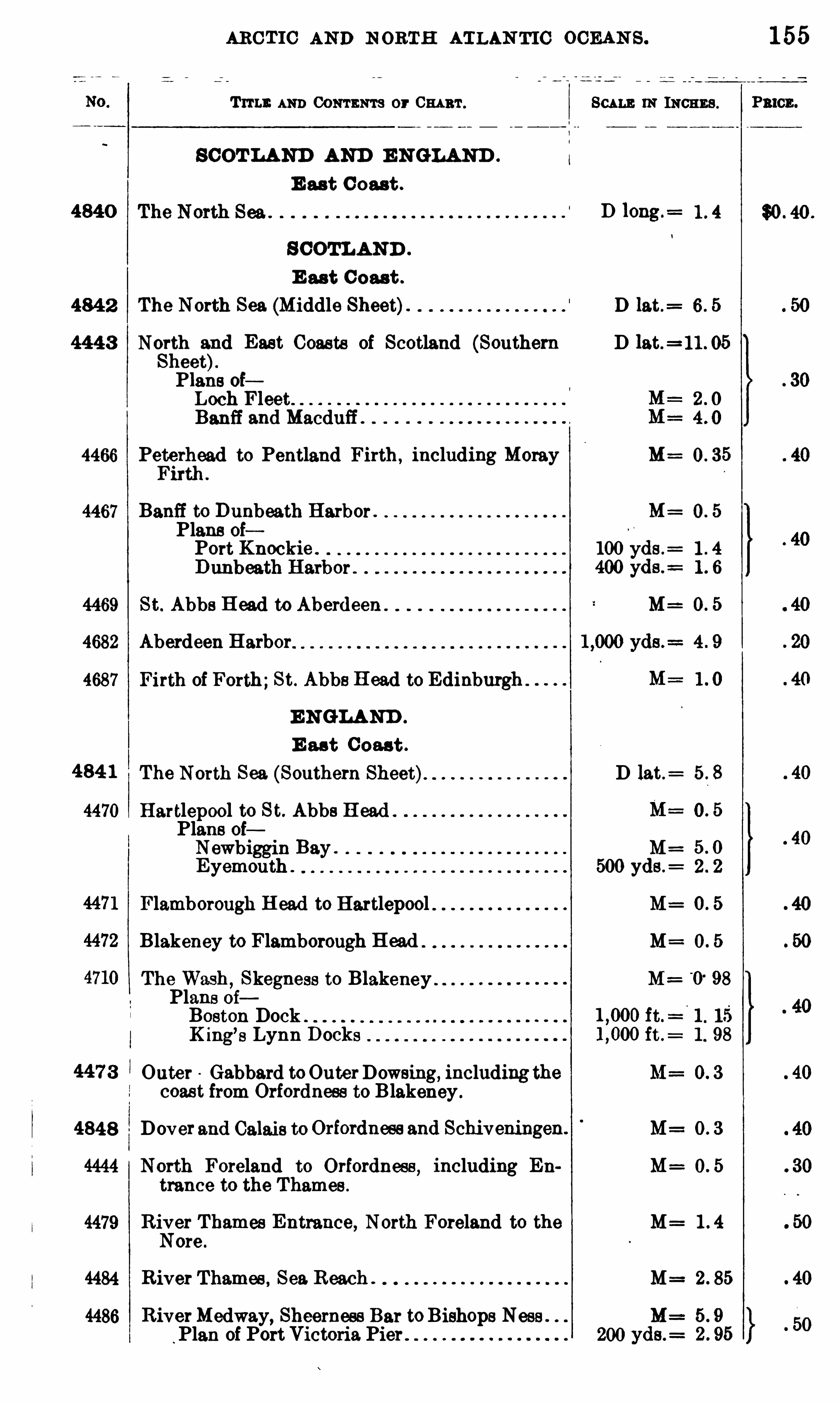
ARC T IC AND 110 1113131 ATLAN TIC OCEAN S . 1 55
Trru : AND CONTENTS or 0 1111111 . SCALE 0 1 INCHES . Pmcn.
SCOT LAND AND E NGLAND .
E ast C oast .
4840 D 10ng.=
SCOTLAND .
E ast C oast .
484 2 The North Sea (Middle Sheet). D 13 t.= 6 . 5
444 3 North and East Coasts of Scotland (Southern D lat.=l 1 . 05
Sheet).Plans oiLoch FleetBanff 3nd Macduff .
4466 Peterhead to Pentland Firth, including Moray M=Firth .
4467 Banff to Dunbeath Harbor . M= 0 . 5
Plans oiPort Knockie . 100 yds .
= 1 . 4
400 yds .=
4469 St. AbbaH ead to Aberdeen . M=
4682 Aberdeen Harbor
4687 Firth of Forth;St. AbbeH ead to Edinburgh
ENGLAND .
E ast C oast .
484 1 The North Sea (Southern Sheet) D 13 t.= 5 . 8
4470 Hartlepool to St. Abbe H eadPlans oiNewbiggin Bay . M=Eyemouth . 500 yds .
= 2 . 2
Flamborough H ead to Hartlepool M= 0 . 5
Blakeney to Flamborough H ead M 0 . 5
The Wash,Skegness to Blakeney M=
'
0. 98
Plans oiBoston Dock . ft.
= 1 . 15
K ing’s Lynn Docks ft .
= 1 . 98
Outer Gabbard to OuterDowsing, including the M= 0 . 3
coast from Orfordnees to Blakeney .
4848 Dover and 03 13 18 to Orfordneee 3nd Schiveningen. M= O. 3
North Foreland to Orfordnees , including En M= 0 . 5
trance to the Thames .
4479 River Thames Entrance, North Foreland to the M= 1 . 4
Nore .
4484 River Thames , Sea. Reach . M= 2 . 85
4486 RiverMedway, Sheerness Bar toBishops Nese . M= 5 . 9
Plan of Port Victoria Pier 200 yds.= 2 . 95
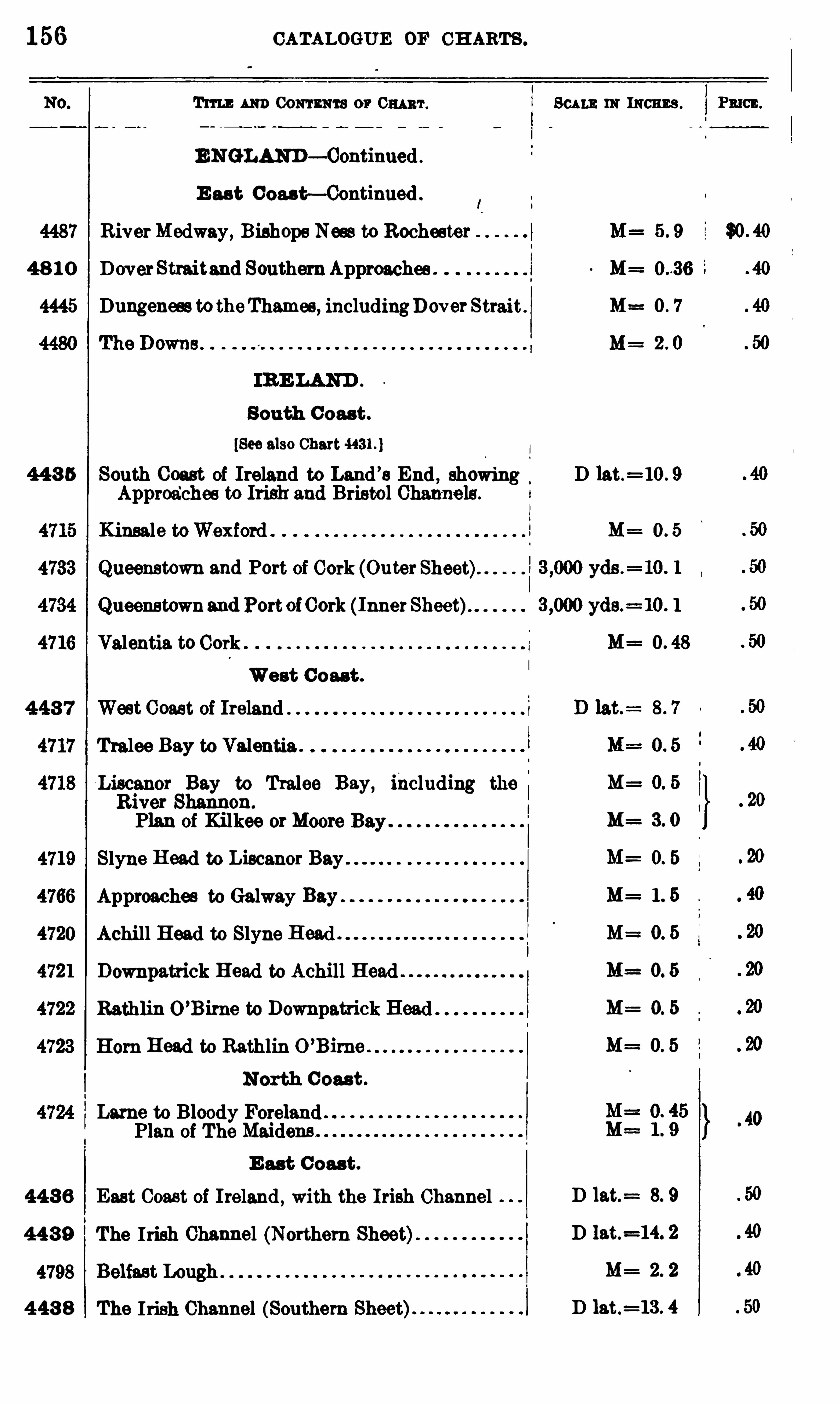
156 CATALOGUE DE CH ARTS .
T11 11 : AND CONTENTS or 0 111 111 .
E NGLAND— Continued
E ast Coast—Continued
4487 RiverMedway, Bishops Ness to Rochester
4 8 1 0 DoverStraitand SouthernApproaches .
4445 Dungeness totheThames, includingDover Strait
South C oast .
[See also Chart
44 3 6 South Coast of Ireland to Land ’
s End , showingApproa‘
ches to Irish and Bristo l Channels .
Kinsale toWexford .
Queenstown and Port of Cork (OuterSheet)
Queenstownand Port ofCork ( InnerSheet)
Valentia to Cork
West Coast .
4 43 7 West Coast of Ireland
Tralee Bay to Valentia .
Liscanor Bay to Tralee Bay, including the
River Shannon.
Plan of Kilkee orMoore Bay
Slyne Head to Liscanor Bay
Approaches to Galway Bay
Achill Head to Slyne Head .
Downpatrick Head to Achill Head
Kathlin O ’Bime to Downpatrick Head
Horn Head to Kathlin O ’Birne
North C oast .
Lame to Bloody ForelandPlan of The Maidens
E ast C oast .
443 6 East Coast of Ireland , with the Irish Channel
44 3 9 The Irish Channel (Northern Sheet)
4 43 8 The Irish Channel (Southern Sheet)
SCALE IN INCHES .
M=
M= 0 7
M= 2 0
D 13 t.=10 . 9
M=
M= 0 5
M= 3 0
M= 1 5
M==0 5
M= 0 5
M= 0 5
M= 0 5
D 13 t.= 8. 9
D 13 t.=14. 2
M=
D 13 t.=13 . 4

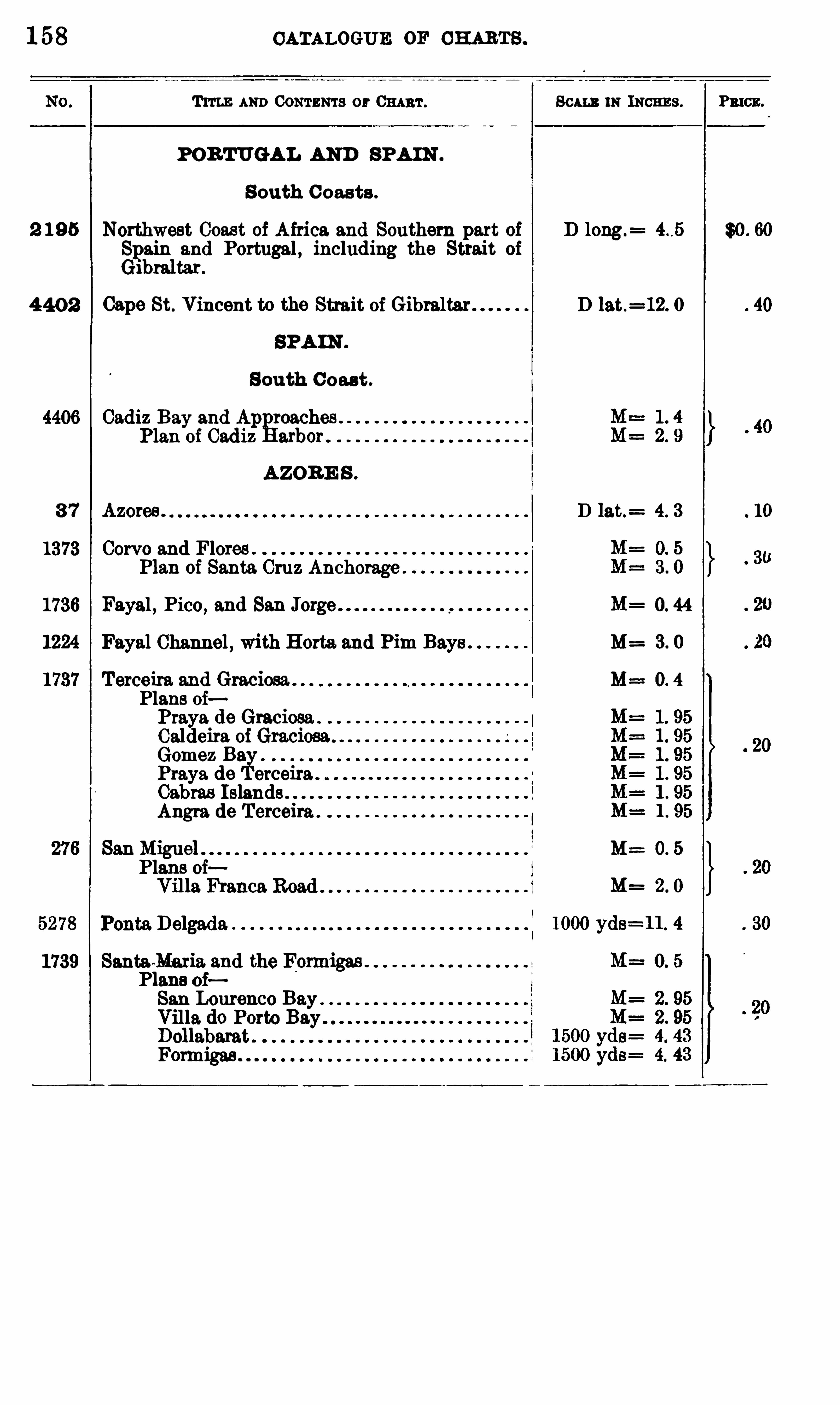
1 58 CATALOGUE OF CHARTS .
TITLE AND CONTENTS or CHART . Sam m INCHE S . Pmcn.
POR TUGAL AND SPAIN .
S outh C oasts .
2 1 95 Northwest Coas t of Africa and Southern part of D long.= $0 . 60
Spa;and Portugal , including the Strait of
1 tar.
4 40 2 Cape St. Vincent to the Strait of Gibraltar. D lat.=12. 0
SPA IN .
South C oast .
4406 Cadiz Bay and Ap roachesPlan of Cad iz arb
AZOR E S .
3 7 Azores . D lat. 4 . 3
1373 Corvo and Flores .
Plan of Santa Cruz Anchorage
1736 Fayal , Pico, and San Jorge 0. 44
1224 Fayal Channel , with Horta. and Pim Bays M= 3. 0
Terceira and Graciosa . M==0. 4
Plans oiPraya de Graciosa .
Caldeira of Grac'
Gomez BaPraya de erceiraCabras I slands .
Angra de Terceira .
San M=Plans oi
1739 Santa-Maria and the FonmgasPlans oiSan Lourenco BayVilla do Porto BayDollabarat .
Formigas .
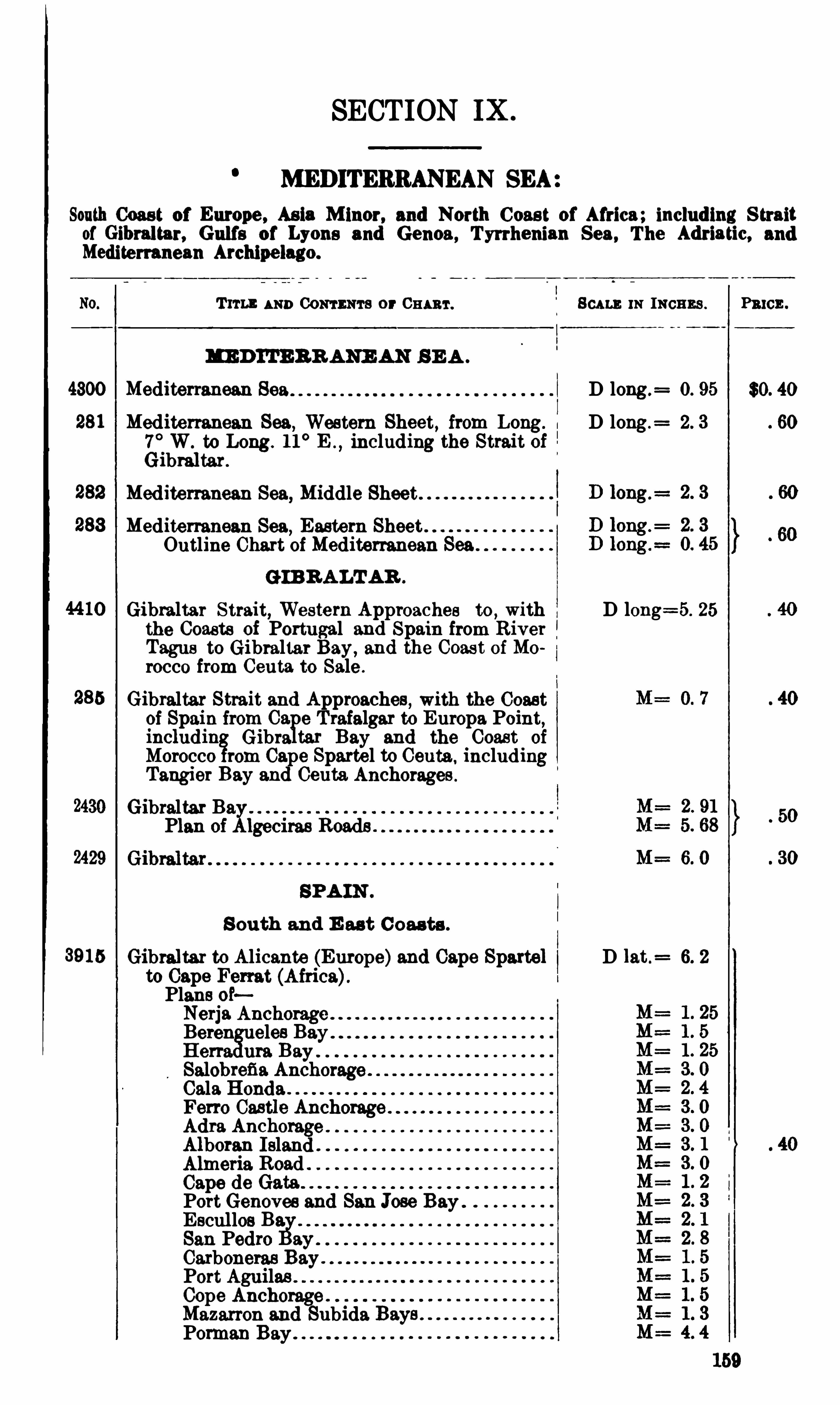
SECTION IX .
MEDITERRANEAN SEA
South Coast of Europe , Asia M inor, and North Coast of Africa; including S traitof Gibraltar, Gulfs of Lyons and Genoa, Tyrrhenian Sea , The Adriatic, andMediterranean Archipelago.
Tm : u mCONTENTS or CHART . 8 01m;m INCHES . Pmcn.
MED I TERR ANE AN S E A .
Mediterranean Sea D long .= O. 95 $0. 40
Mediterranean Sea,Western Sheet, from Long.
I D long.= 2. 3 60
7° W. to Long . 11
° E .,including the Strait of
Gibraltar.
Med iterranean Sea, Middle SheetMediterranean Sea,
Eastern SheetOutline Chart ofMediterranean Sea
GIB RALTAR .
Gibraltar Strait, Western Approaches to,with D long=5. 25
the Coasts of Portugal and Spain from River
Tagus to Gibraltar Bay, and the Coast of Morocco from Ceuta to Sale .
Gibraltar Strait and Approaches , with the Coastof Spain from Ca e Trafalgar to Europa Point,includin Gibre ta: Bay and the Coast of
Morocco rom Cape Spettel to Ceuta ,including
Tangier Bay and Ceuta. Anchorages .
Gibraltar BaxPlan of lgeciras Roads .
SPA IN .
S outh and E ast C oas ts .
Gibraltar to Alicante (Europe)and Cape Sparta] D 1at .= 6. 2
to Cape Fem t (Africa).Plans ofNerja AnchorageBeren eles BayHerra ura BaySalobrefia Anchorage .
Cale HondaFerro Castle AnchorageAdra AnchorageAlboran IslandAlmeria RoadCape de GatePortGenoves and San Jose BayE scul los Ba.San Pedro ay .
Carboneras Bay .
Port AguilasCope Anchorage .
Mazarron and SubidaPorman Bay
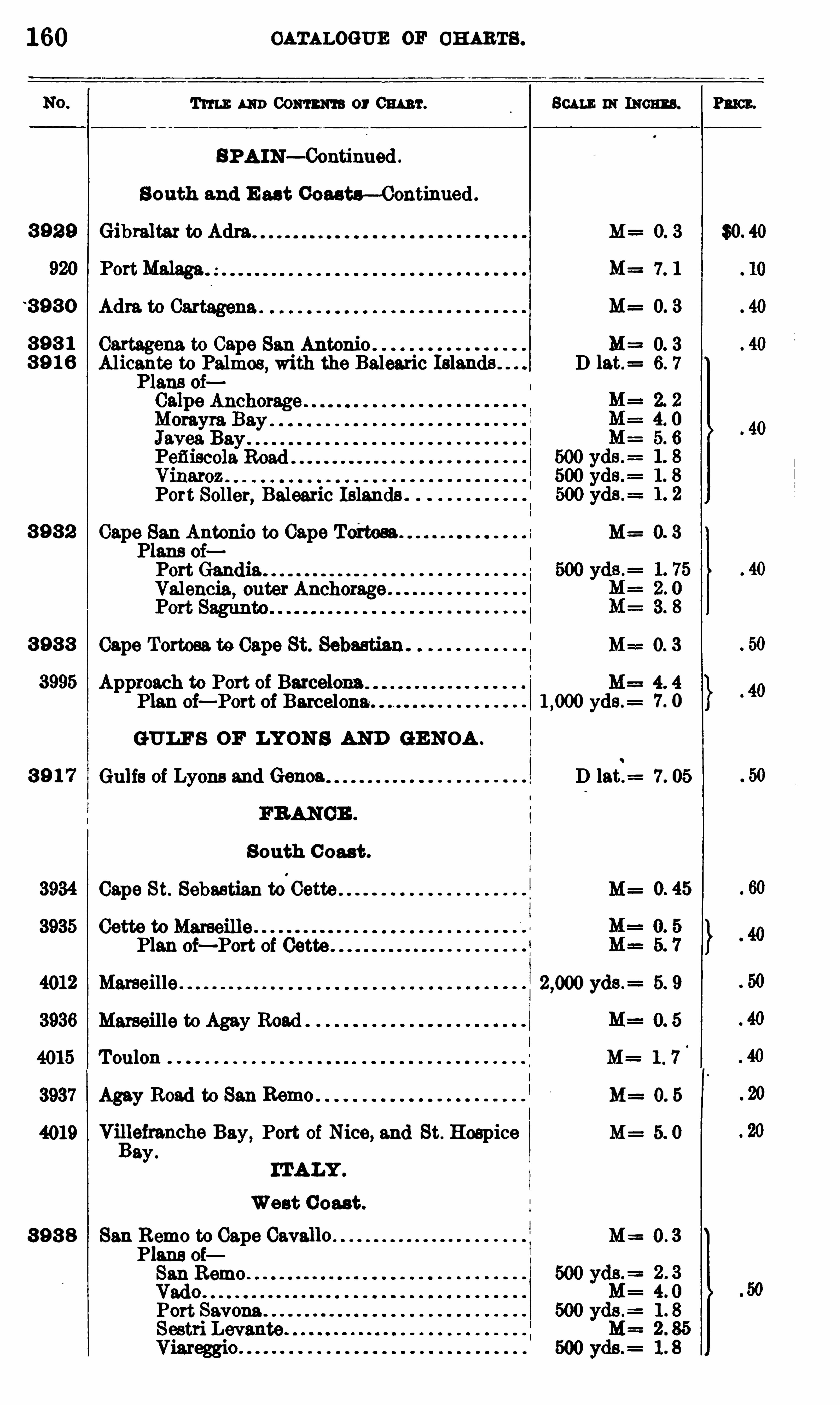
160
3 92 9
920
3 9 3 0
3 9 3 1
3 9 1 6
3 9 3 2
3 9 3 3
3995
3 9 1 7
3934
3935
4012
3936
3937
4019
3 9 3 8
CATALOGUE OF CH ARTS .
Tum: um Comm or Cw t . Beau : IH mam .
SPA IN— Continued .
S outh and E ast Coasta—Continued .
Gibraltar to Adm M 0. 3
PortMalaga 7. 1
M= 0. 3
Cartagena to Cape San Antonio M 0. 3
Alicante to Palmos,with the Balearic D 1at. 6. 7
Plans oi
Port Soller, Balearic Islands .
Cape San Antonio to Cape Toi'tosa . M= 0 3
Plans oiPort GandlaValencia
, outer Anchorage
Cape Tortosa to Cape St. 80a . M==0. 3
Approach to Port of Barcelona M= 4. 4
Plan oi— Port of Barcelona. yds .=
GULF S OF LYON S AND GE NOA .
Gulfs of Lyons and Genoa D latt= 7. 05
South C oast .
Cape St. Sebastian to‘
Cette M=
Cette to MarseillePlan oi—Port of
Marseille . yds .= 5. 9
Marseille to Agay Road
Toulon M= 1 . 7
Agay Road to San Remo M= 0. 5
VilBlefranche Bay, Port of Nice, and St. Hospice M= 5. 0
ayIT ALY .
West C oast .
San Remo to Cape Cavallo M= 0 . 3
Plans oiSan Remo .
VadoPort Savona
P2 163 .

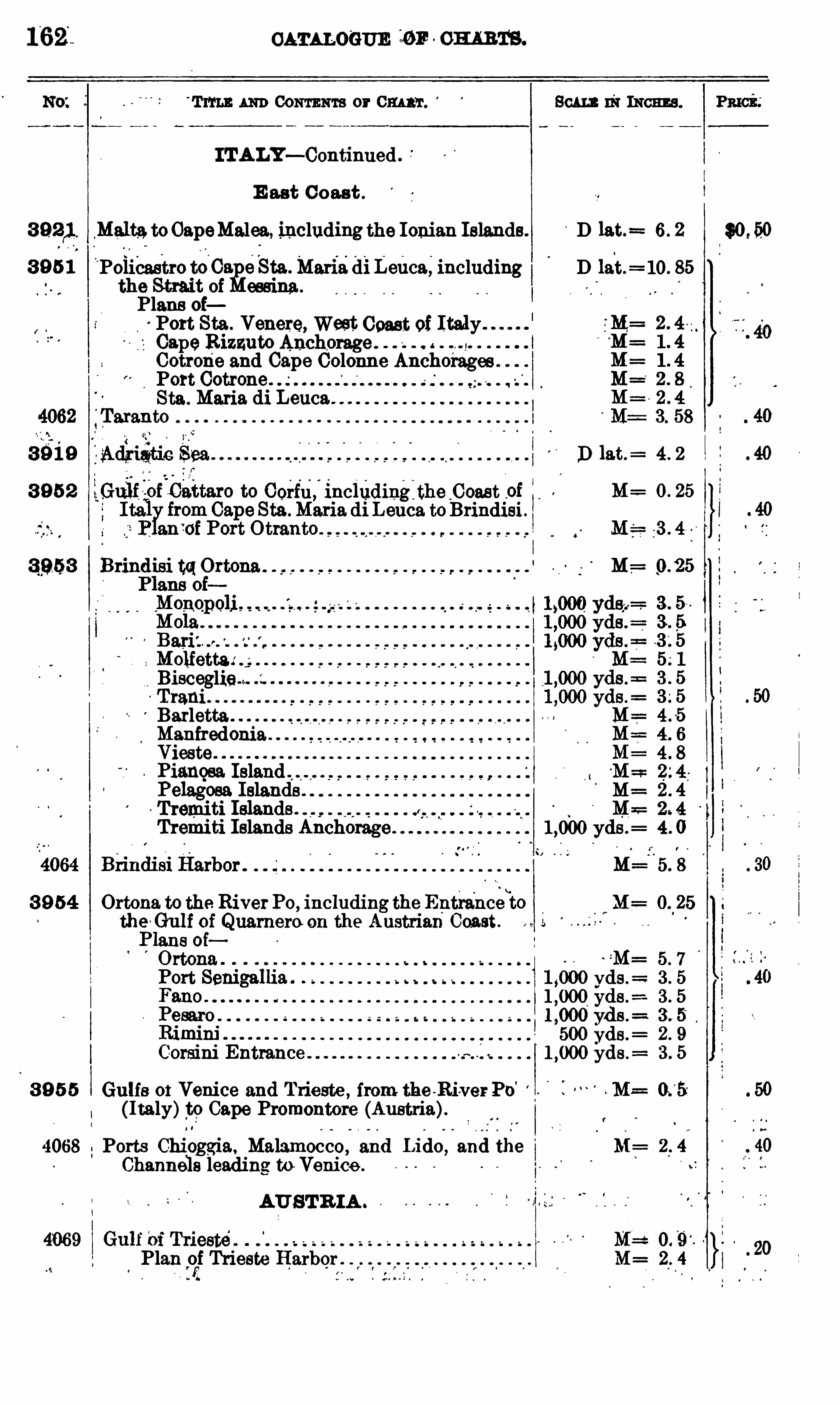
162 CATALOGUE 10 10 0m m.
ITALY— Continued .
E ast C oast .
Mal ta.toCapeMalea, including the Ionian Islands. D 13 t.= 6 . 2 $0 ,
‘Policastro toCaafieSta.Maria diLeuca, including D lat. 10 . 85
the Strait ofPlans oiPort Sta . Venere, West Coast of ItalyCapeRizzuto Anchorage . I
Cotrone and Cape Colonne Anchorages “
Port Cotrone .
Sta . Maria. di Leuca.
1
'
Taranto
D 13 t.= 4 . 2
orfu , includingjthecoast _oi M : o. 25
Leuca toBrindisi .
r ° r ° ~ r r r r -z
BisceglieTraniBarletta"ManfredoniaViestePianqsa Island"Pelagosa. Islands . M= 2 . 4
Tremiti Islands .
Tremiti Islands Anchorage yds .= 4 . 0
3 9 54 Ortona. to the RiverPo, inc1uding the Entranceto M= O. 25
th<193 1
Gulf ce
i Quarnero on the Austrian Coast.
ans 0
M= 5 7
1 ,000 yds .= 3 5
500 yds .=
Corsini Entrance 1,000 d . 3 5
0 53 9 5 5 Gulfs 0 1 Venice and Trieste , from the -Ri-ver Po M( Italy)to Cape Promontore (Austria).
4068 Ports Chioggia, Malamocco, and Lido, and the M:
Channels leading to Venice .
AUS TR IA .
II
Plan of Trieste Harbor M= 2 . 4
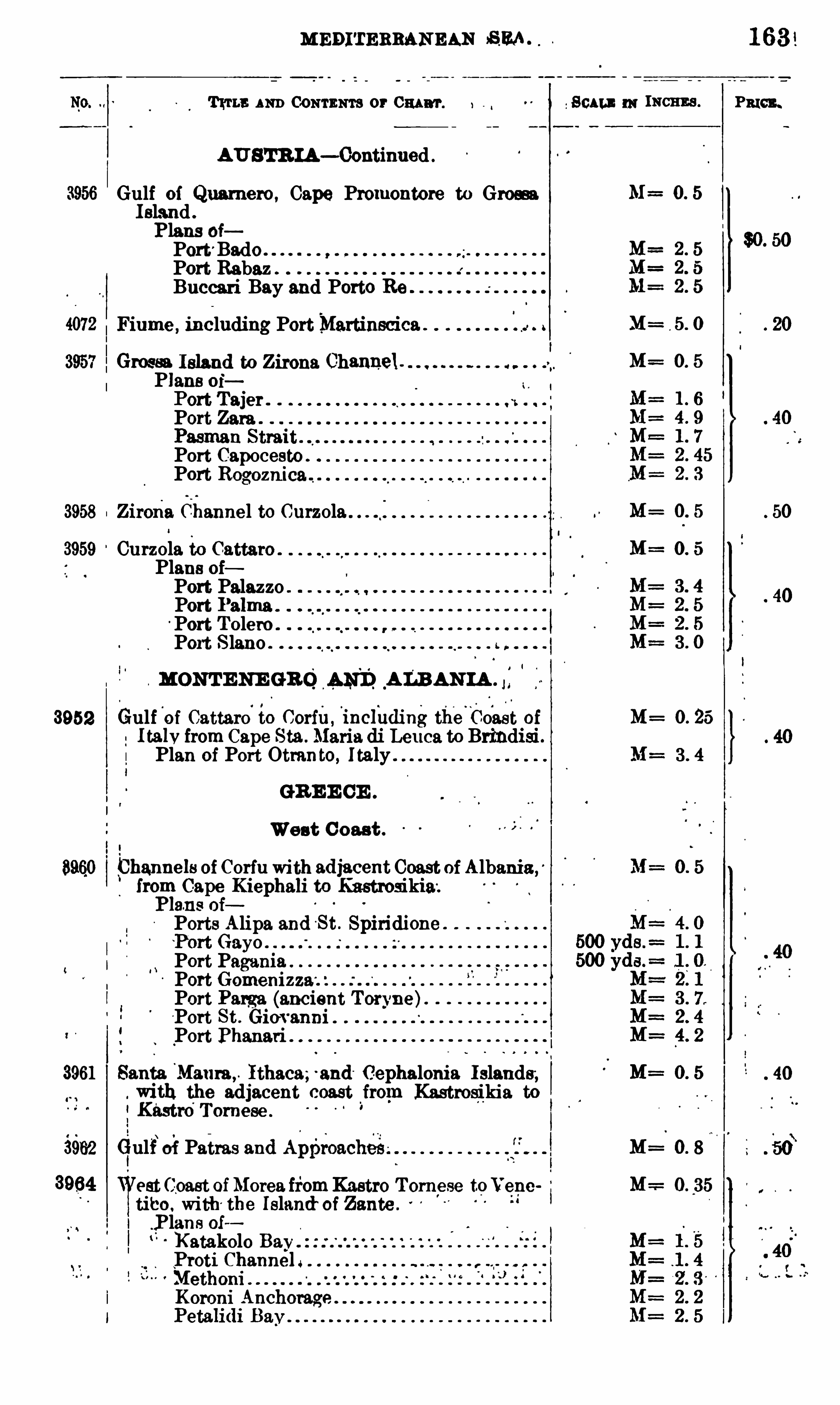
MEDITERRANEAN SEA
Tum; AND CONTENTS or 0 111 117 .
AU STR IA— Continued
Gulf of Quamero , Cape Promontore to GromIsland .
Plans oiPort'Bade .
Port RabazBuccari Bay aud Porto
Fiume , including PortMartinscica .
Groesa Island to Zirona Channel .
Plans 0 1'POl'trTajer .
Port Zara
Port Capocesto .
Port Rogoznica
3958 Zirona Channel to Curzola
3959 Curzola to Cattaro .
Plans oiPort PalazzoPort I ’alma .
°Port Tolero .
Port S lano .
c o q o o o o w o
MONT E NE GRO4 15115, ALBAN IA .
3952 Gulf'
of Cattaro to Corfil , inclhdingtheCoast ofI talvfrom Cape Sta. Maria di Leuca to Brindisi .Plan of Port Ottunto, Italy
GR E E CE .
West C oast .
Lhannels of Corfu with adJacent Coast of Albania ,3
from Cape Kiephali to Kastrosikia.
P19me oiPorts Alipa and St . Spiridione .
GayoPort Pagania ”
Port GomenizzaPort Pam'
s. (ancient To n'ne)“
Port St . Gim anni .
Port Phanari
3961 Santa Mat1ra ,Ithaca; and Cephalonia I slands ,
. With the adjacent coast from Kastrosikia to
Kastro Tom ese
3962 Gulf of Patras and A1)est Ceast ofMorea fromKastro Tom ese toVene
tibo With the Island of Zante .
Plans 0 1
o ‘ l ‘
5
Katakolo BayProtiMethoni ”
Koroni Anchorage.
P
Scan 114! INCHES .
Lf=
M=
M=
M=
M=
M= 0 . 25
M=
M=
M=
PRICE .
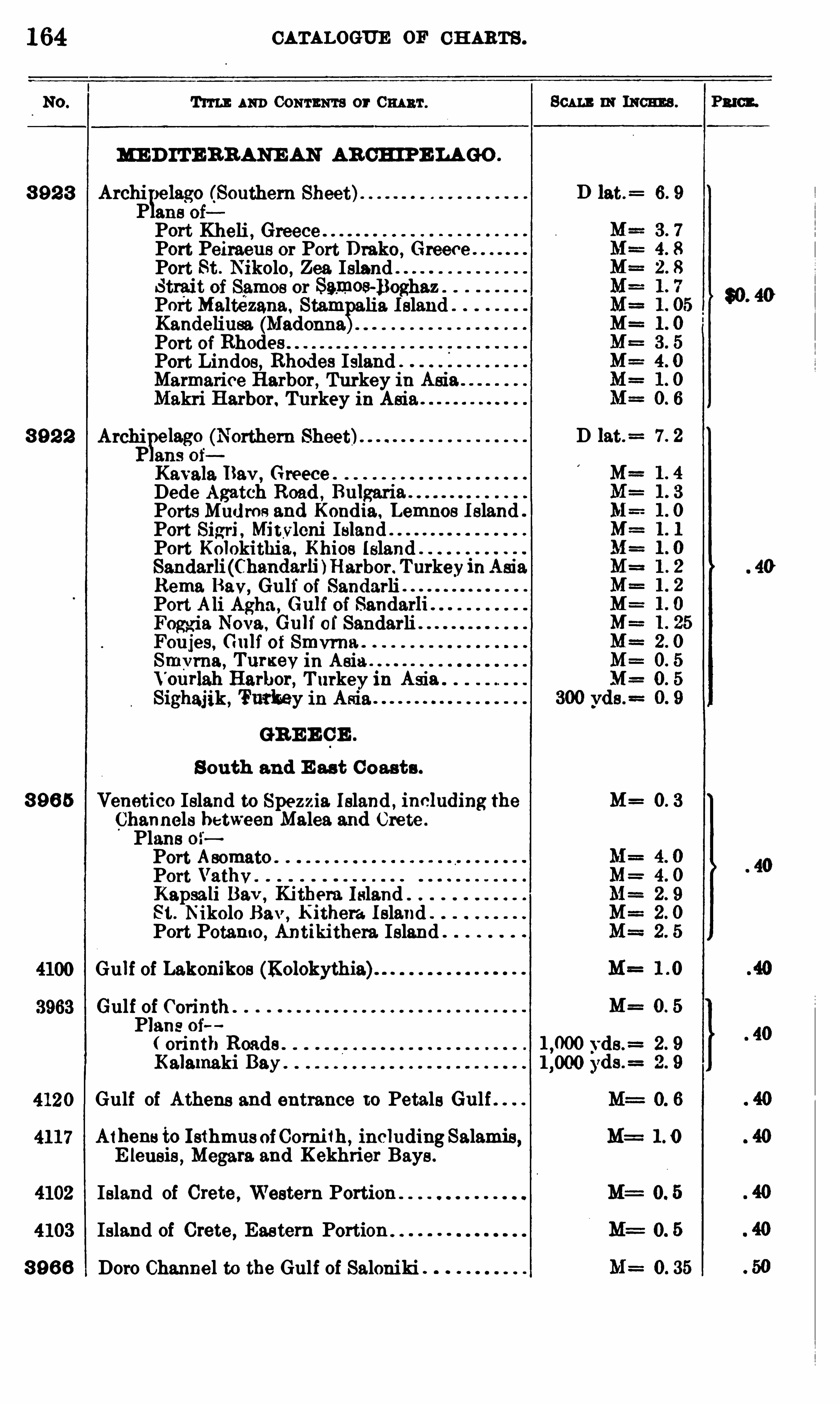
164 CATALOGUE OF CH ARTS .
Tm ] : AND CONTENTS or 0 111 111 .
ME D IT E RRANE AN AR CHIPE LAGO .
3 92 3 ArchiYelago (Southern Sheet)
P ans oi
Port Kheli , GreecePort Peiraeus or Port Drake ,
GreecePort St . Nikola,
Zea. IslandStrait of Samos orn os-Boghaz ”
Port Maltézana Stam lia. I sland .
Kandeliusa (Madonnagm
.
Port of RhodesPort Lindos, Rhodes IslandMarmarice Harbor, Turkey in Asia .
Makri Harbor. Turkey in Asia
3 9 2 2 Archi elago (Northern Sheet)P ans of
Kav1119. Rev,Greece .
Dede Agatch Road , Bulgar1Ports Mu
gac
l
j me and Kondia, Lemnos I sland .
Port Sigri , Mitvleni IslandPort Kolokithia,
Khios IslandSandar1i (Cha.ndarli Harbor. TurkeyinAsia.Rema Bav, Gult of SandarliPort Ali Agha , (nulf of Sandarh
Foggl a Nova, Gu11 ol'
Sandarli "Foujes, G111f of v w a.
v ma, Tumevm Asia
ourlah Harbor, T urkey 111 AsiSighajik , Turkey in Asia
GR E E CE .
S outh and E ast Coasts .
3 96 5 Venetico Island to Spezzia. Island , innluding theChannels between Malea and Crete .
Plans 0 1'
Port AsomatoPort Vathv.
Kapsali Bav, Kithera Island .
St . Nikolo Bav,Kithera I sland .
Port Potamo ,Antikithera. Island
Gulf of Lakonikos (Kolokythia)
Gulf of CorinthPlans oi
orinth Roads .
Kalamaki Bay .
Gulf of Athens and entrance to Petals Gulf . .
A1hens to Isthmus ofCornifh, includingSalamis,E leusis
,Megara. and Kekhrier Bays .
Island of Crete ,Western Portion
Island of Crete , Eastern Portion
3 9 6 6 Doro Channel to the Gulf of Saloniki
SCALE IN INCHES .
D lat.=
D lat.=
vds .=
M=
M=
de. 2 911 3000 ds . 9
M=
P2 10 2 .

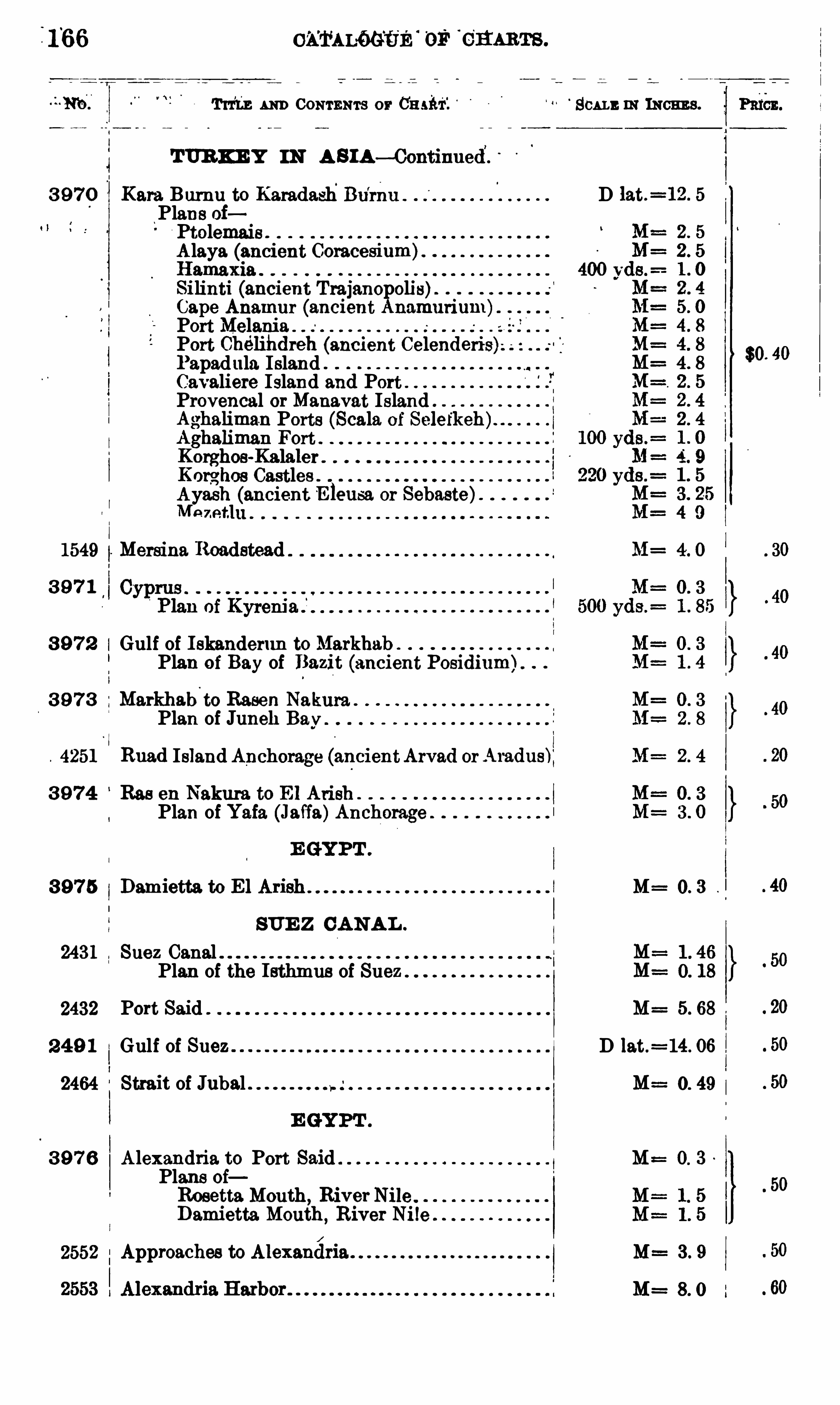
0 1114116 65 3 OF 5 11s .
Tuitn 1 111) CONTENTS or'
SCALE m INCHES .
TUR KE Y m A sm—Continued.
3 9 7 0 Kara Burnu to Karadash Bu’
rnu . D lat.=12 . 5
Plans oiPtolemais .
A laya (ancient Coracesium)HamaxiaSilinti (ancient Trajanopolis)Cape Anamur (ancient Anamurim h
PortMelaniePort Chélihdreh (ancient Celendei'is)l ’apadula. Island “
Cayeliete Island and PortProvencal or Manavat IslandAghaliman Ports (Scale of
Aghaliman Fort .
Korghos-KalalerKor
ghos Castles .
Ayash (ancient E leusa or Sebaste)
1549 Mersina Roadstead M= 4 . 0
3 9 7 1
3 9 7 2 Gulf of I skanderun to Markhab .
Plan of Bay of Bazit (ancient Posidium).
3 9 7 3 Markhab’
to Rasen Nakura .
Plan of Juneh Bay
4251 Ruad Island Anchorage (ancientArvad orAradus)
3 9 7 4 Rae eu Nakura to E1 Arish .
Plan of Yafa (Jaffa)Anchorage
3 9 7 5 Damietta to El M= 0. 3
SUE Z CANA L .
2431 Suez Canal .Plan of the Isthmus of Suez
2432 Port Said M= 5. 68
2 4 9 1 Gulf of Suez D lat.= 14. 06
2464 Strait of Jubal M: 0. 49
3 9 7 6 Alexandria to Port Said 0. 3
Plans oiRosetta Mouth , RiverNileDamietta Mouth,
River Ni le
2552 Approaches to Alexanéria M 3 . 9
M=
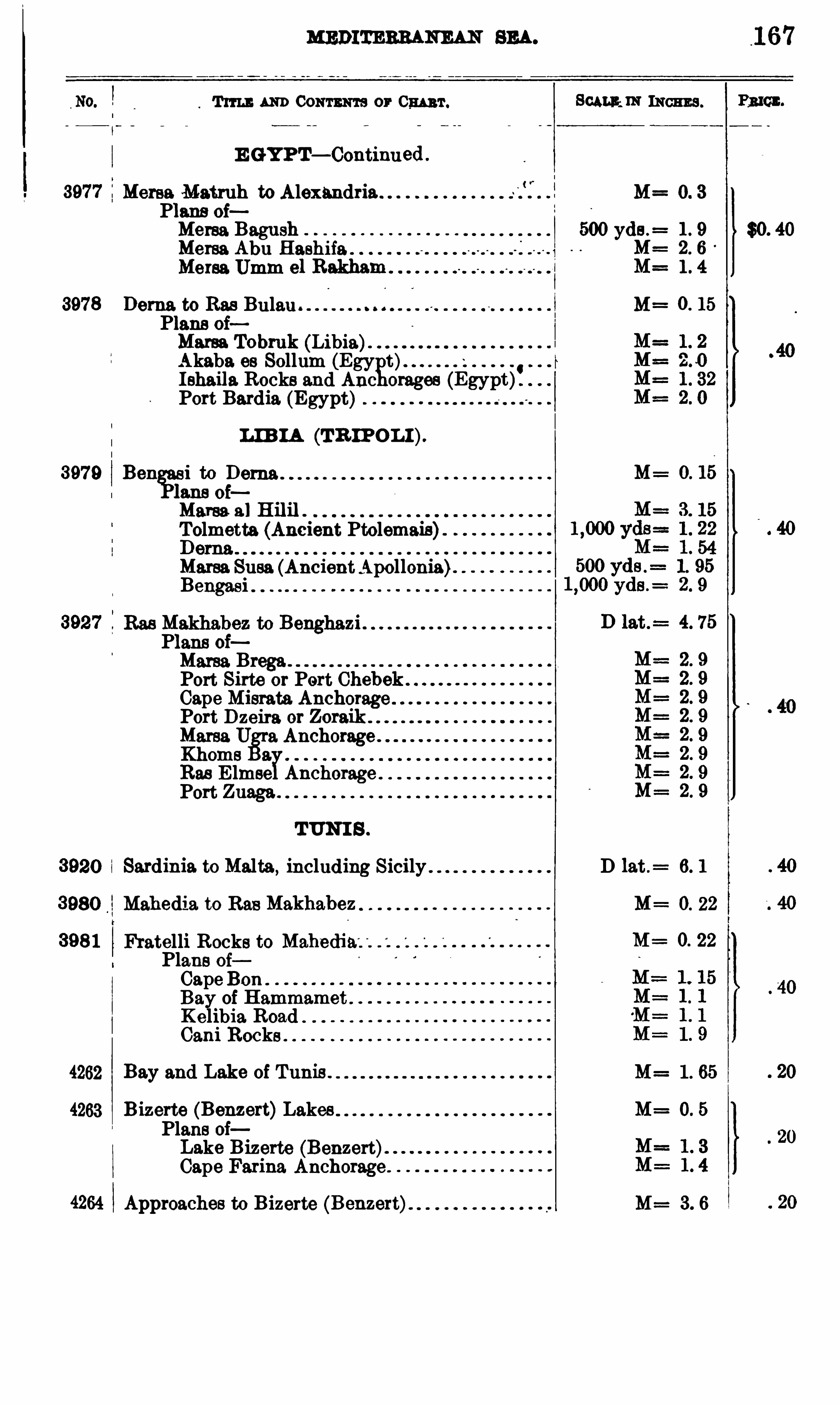
MEDITERRANEAN SEA.
Tum AND 00mm or Cw 't . Sum m INCHES . Pmcn.
E GYPT— Continued
Meme. Matruh to Alexandria MPlans oiMersa Bagash 500 yds .
=
Mersa Abu Hashifa 1 MMensa Umm el Rakham
$0. 40
9
E
N
!"9
A
ca
ca
o:
U!
Dema to Rae Bulau MPlans oiMarsa Tobruk (Libia)Akaba os Sollum (Egy t)I shaila. Rocks and Anc orages
Port Bardia (Egypt)
m m (TR IPO L I).
3979 Ben i to M=
oiMama 3 ] H ilil .
Tolmetta (Ancient Ptolemais)
Marga Susa (AncientApollonia)Bengasi
Plans oiMarsa Brega .
Port Sirte or Port ChebekCape Misrate AnchoragePort Dzeira or ZoraikMama U a AnchorageKhomsRas E lmseYAnchoragePort Zuaga .
TUNI S .
Sardinia. to Malta,including Sicily D lat .
= 6. 1
Mahedia to Ras Makhabez M= O. 22
Fratelli Rocks to M= O. 22
Plans oiCape BonBay of HammamKelibia Road
Books
4262 Bay and Lake of Tunis . M= 1 . 65
4263 B izerte (Benze1-t)Lakes M= 0. 5
Plans oiLake Bizerte (Banzart)Cape Farina Anchorage .
4264 Approaches to Bizerte (Benzert) M= 3. 6
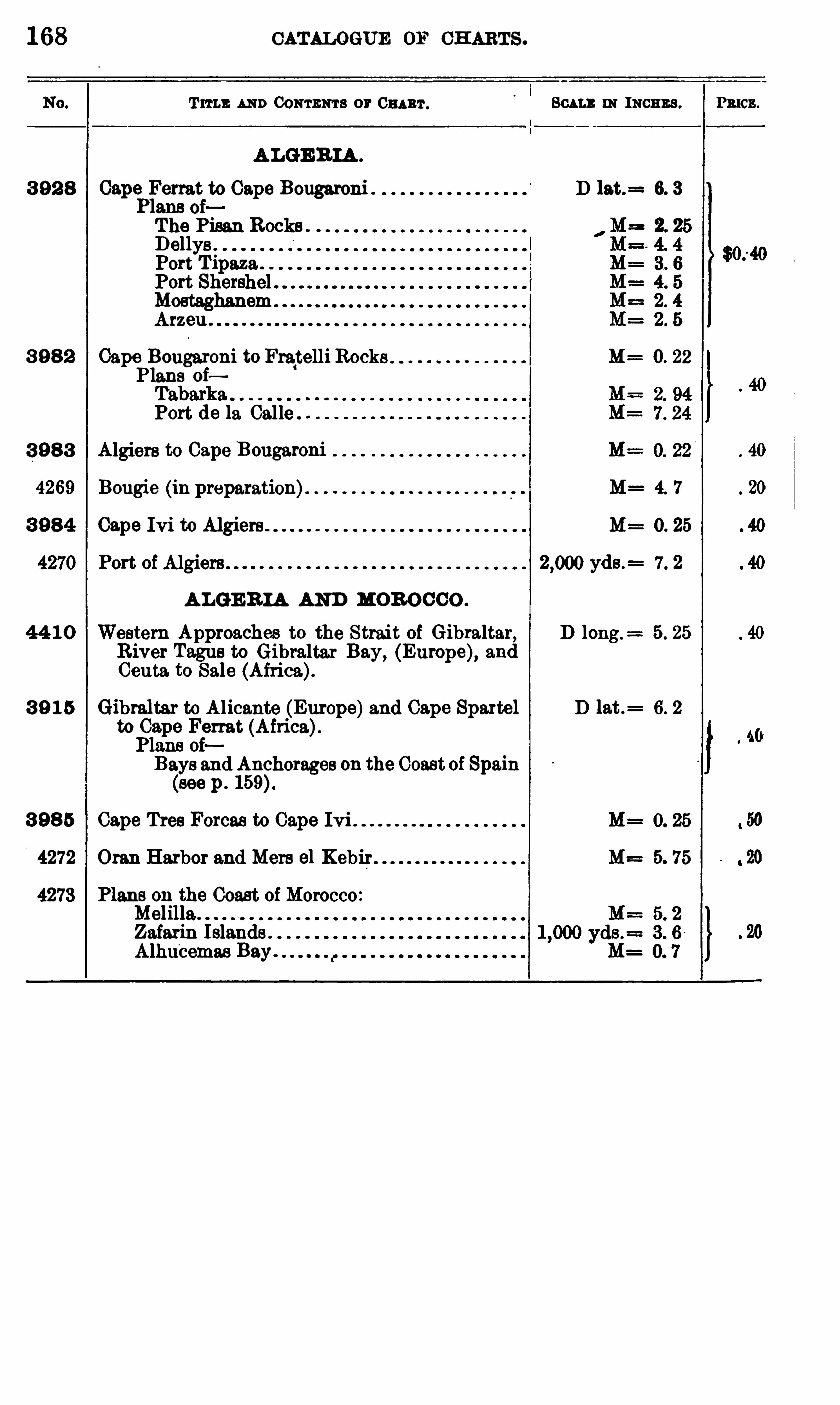
168 CATALOGUE OF CH ARTS .
Tum: AND CONTENTS or 0 1111111 . Beau : IN INCHES .
A LGE R IA .
3 92 8 Ferret to Cape Bougaroni . D 13 t.= 6. 3
The Pisan Rocks .
DellysPort T ipaza .
Port ShershelMostaghanemArzeu
3 9 8 2 Cape Bougaroni to Fra‘telli Rocks 0. 22
Plans oi
Port de la Calle
3 9 8 3 Algiers to Cape Bougaroni
Bougie (in preparation) M= 4. 7
3 98 4 Cape Ivi to Al giers M= 0. 25
Port of Algiers . . yds .= 7. 2
A LGE R IA AND MOR OCCO .
44 1 0 Western Approaches to the Strait of Gibraltar, D long .= 5. 25
River Tagus to Gibraltar Bay, (EurOpe), andCeuta. to Sale (Africa).
3 9 1 5 Gibraltar to Alicante (Europe)and Cape Spaxtel D 1at.= 6. 2
to Cape Ferret (Africa).Plans oiBays and Anchorages on the Coast of Spain(see p . 159)
3 98 5 Cape Tree Forces to Cape Ivi
4272 Oran Harbor and Mere ol Kebir 5. 75
4273 Plans on the Coast of MoroccoMelilla .
Zafarin Islands .
Alhu ‘
cemas Bay.
PRICE .

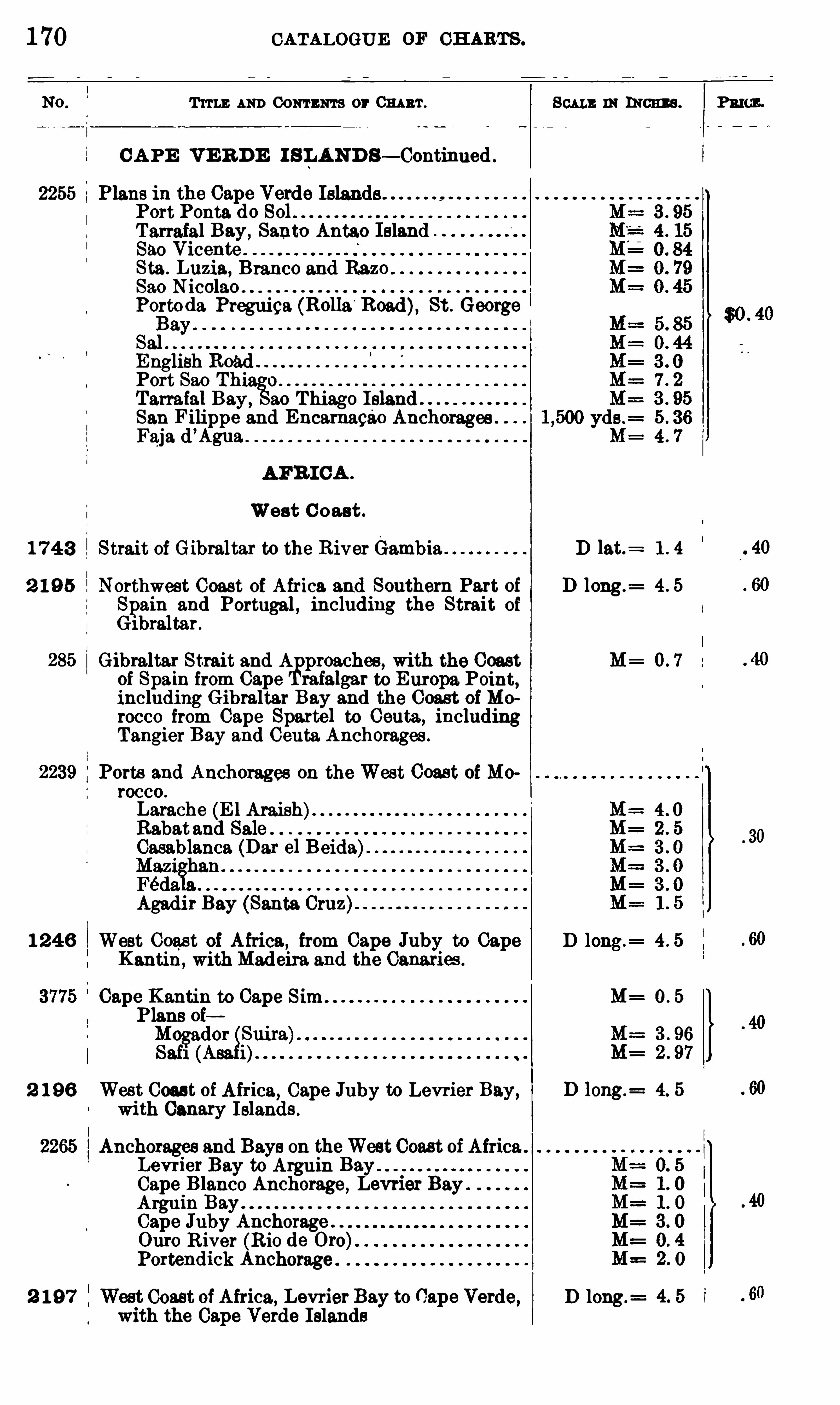
1 70 CATALOGUE OF CH ARTS .
T ITLE AND Comma s or Cm n'r.
CA PE V E R D E I S LAND S— Continued .
2255 Plans in the Cape Verde IslandsPort Ponta do SolTarrafal Bay,
Santo Antao Island .
850 VicenteSta . Luzia, Branco and RazoSao NicolaoPortoda St . George
EnglishPort Sao Thi o
Tam ial Bay, ao Thiago IslandSan Filippe and Encamagao Anchorages .
Faja d’Agua.
AFR I CA .
West C oast .
1 7 4 3 Strait of Gibraltar to the RiverGambia .
2 1 9 5 Northweet Coast of Africa and Southern Part ofSpain and Portugal , including the Strait of
Gibraltar .
Gibraltar Strait and A preaches , with the Coastof Spain from Cape rafalgar to Europa. Point,including Gibraltar Bay and the Coast ofMorocco from Cape Spartel to Ceuta , includingTangier Bay and Ceuta Anchorages .
Ports and Anchorages on the West Coast of Morocco .
Larache E 1Araish)Rabatand SaleCasablanca (Dar el Beida).
Agadir Bay (Santa Cruz)
1 2 4 6 West Coast of Africa,from Cape Juby to Cape
Kantin, withMadeira and the Canariw .
Cape Kantin to Cape Sim .
Plans oiMogador SuiraSaf1 (A
2 1 96 West Coast of Africa, Cape Juhy to Levrier Bay,
with Canary Islands .
Anchorages and Bays on theWest Coast of Africa .
Levrier Bay to Arguin
Cape Blanco Anchorage , Levrier BayArguin BayCape Juhy Anchorage .
Ouro River (Rio de Oro)Portendick Anchorage .
2 1 9 7 West Coast of Africa, Levrier Bay to Cape Verde,with the Cape Verde Islands
SCALE IN INCHES . PRICE .
D 13 t.=
D long.=
M= 0 7
D long .=
M=
D 10ng.= 4. 5
D long.= 1
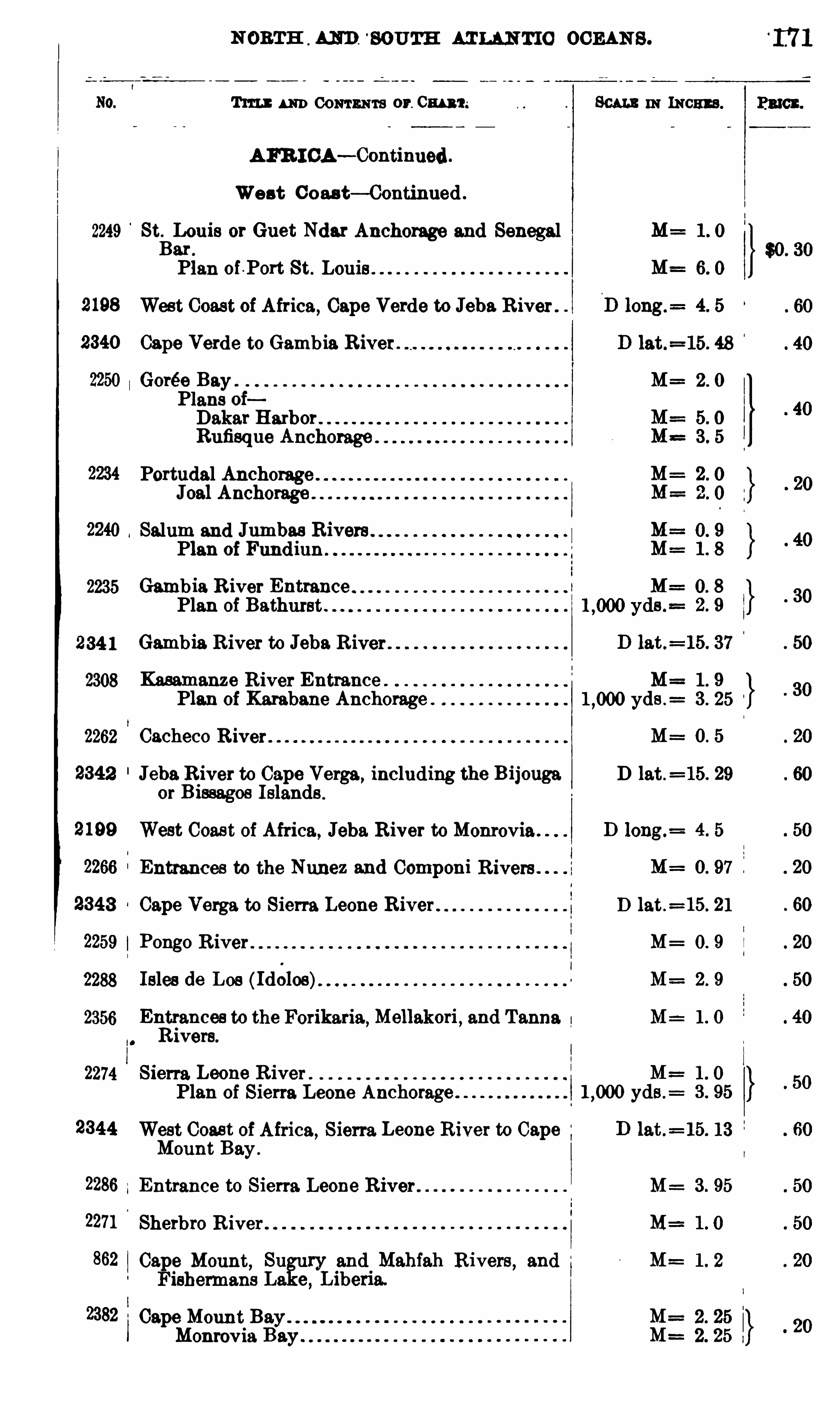
S OUTH ATLANTIC OCEAN S .
Tm ] : um Commas or. 0m m SCALE m mom .
AFR I CA— Continued .
West Coast— Continued .
2249 StBLouis or Guet Ndar Anchorage and Senegalar .
Plan of .Port St. Louis
West Coast of Africa, Cape Verde to Jeba River .
Cape Verde to Gambia River.
Gorée Bay . M= 2 . 0
Plans oiDakar Harbor .
Rufisque Anchorage
Portudal AnchorageJ Anchorage
Salum and Jumbas Rivers .
Plan of Fundiun .
2235 Gambia R iver EntrancePlan of Bathurst .
234 1 Gambia River to Jeba River
2308 Kammanze River Entrance . M= 1 . 9
Plan of Karabane Anchorage . yds .= 3 . 25
2262 Cacheco R iver M= O. 5
Jeba River to Cape Verge ,including the B i jouga D lat .
= 15. 29or B issagos Islands .
West Coas t of Africa, Jeba River to Monrovia .
Entrances to the Nunez and Componi R ivers
Cape Verga to Sierra Leone River D lat .=15. 21
Pongo R iver M= 0 . 9
2288 Isles de Los ( Id6los) M= 2 . 9
2356 Entrances to the Forikaria,Mellakori
,and Tanna M= 1 . 0
Rivera.
2274 Sierra Leone R iver .
Plan of Sierra Leone Anchorage
2344 West Coast of Africa, Sierra Leone River to CapeMount Bay .
2286 Entrance to Sierra Leone River . M : 3 . 95
2271 Sherbro River
862 Cape Mount, Su ry and Mahfah Rivers , andFishermans La e
,Liberia.
2382 Cape Mount BMonrovia Bay .
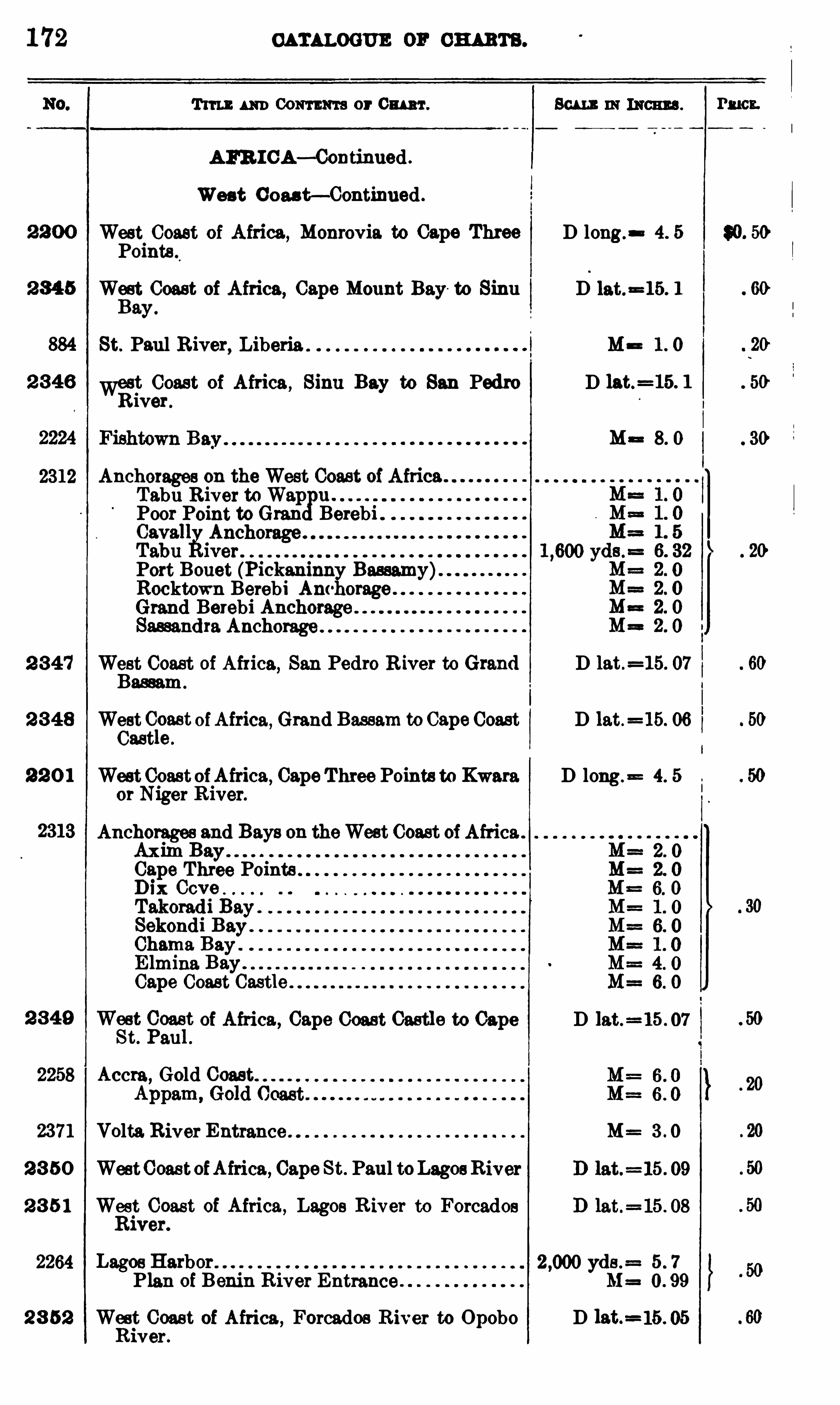
1 72 CATALOGUE or ow n .
Tun um Com ma or 0mm . Scummman s .
AFR I CA— Continned .
West C ou t— Continued .
West Coast of Africa ,Monrovia. to Cape Three D long. 4. 5
Points .
West Coast of Africa, Cape Mount Bay to Sinu D lat.
=15. 1
ay.
St. Paul R iver, Liberia l Ma 1 . 0
2 346 Want Coast of Africa , Sinu Bay to San Pedro Dlver.
Ma
2312 Anchorages on the West Coast of AfricaTabu River toWap u .
Poor Point to Gran Berebi .
Port Bouet (Pickaninn Bassamy)Rocktown Berebi Am orage . .
Grand Berebi AnchorageSassandra Anchorage .
2 347 West Coast of Africa, San Pedro River to Grand D let .=15. 07
Bassam .
2 3 48 West Cloast ofAfrica, Grand Bassam to Cape Coast D lat.
=15. 06ast e .
2 2 0 1 West Coast ofAfrica, Cape Three Points to Kwara D long. 4. 5
or Niger R iver.
Anchorages and Bays on theWest Coast of Africa .
Axim BayCape Three PointsDix CoveTakomdi Bay .
Sekondi Bay .
Chama Bay .
E lmina Bay .
Cape Coast
2 3 49 nt
goas
lt of Africa, Cape Coast Castle to Cape D lat.
=15 . 07
au
2258 Accra, Gold Coast
2371 Volta. River Entrance M= 3 . 0
2 3 50 WestCoastofAfrica, Cape St. Paul toLagosRiver
2 3 5 1 West Coast of Africa, Lagos R iver to ForcadosRiver.
2264 Lagos Harb yds .= 5 . 7
Plan of Benin River Entrance M= 0 . 99
2 8 52 Want Coast of Africa , Forcados R iver to Opobo D 13 t.
=1ver .
Pmcx.

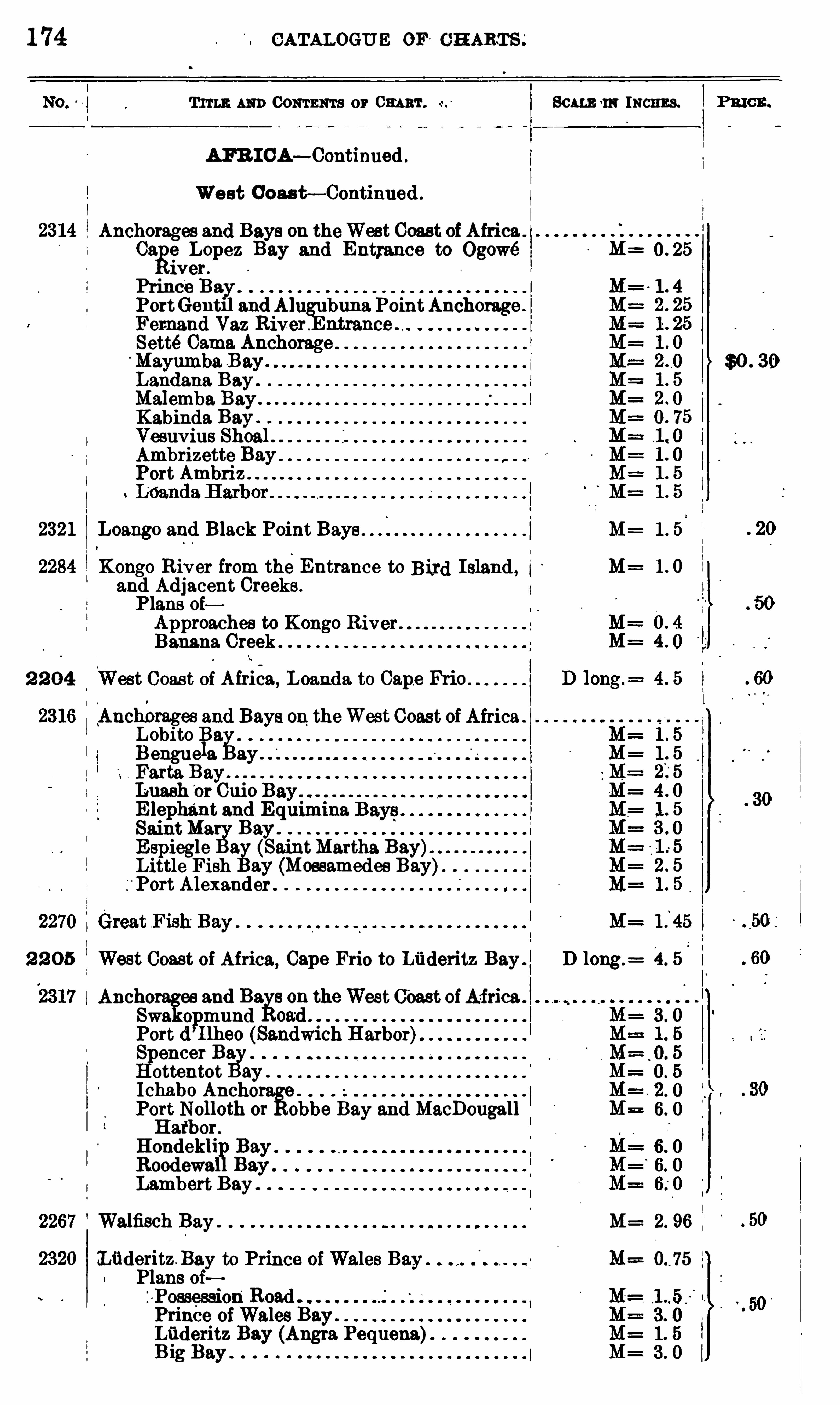
1 74 CATALOGU E OF ' CH ART S ;
Tum um Com ma or m r. 80m 1 11 Incnns.
AFB I CA— Continued .
We st Coas t— Continued .
Anchorages and Bays on theWest Coast ofAfrica .
Ca e Lepez Bay and Entrance to Ogowé 0 . 25
wet .
Prince Bay .
PortGent11 andAlu buna PointAnchorage .
Femand Vaz River . ntrance .
SetteCame AnchorageMayumba B ay . $0 . 30Landana Bay .
Malemba Bay.
Kabinda Bay .
Vesuvius Shoal .Ambrizette BayPort Ambriz
t
2321 Loango and Black Point Bays M= 1 . 5
Kongo River from the Entrance to Bird Island , i M= 1 . 0
and Adjacent Creeks .
Plans 0 1Approaches to Kongo River .
Banana Creek .
2 2 04‘
West Coas t of Airiea, Loanda. to Cape Frio
Anchm'
ages and Bays on theWest Coast ofAfrica .
1Isobito 1
133
engue a ay .
Farta BayLuash
‘
or Cuio BE lephant and ESaint Mary BayE spiegle Ba. (S tMartha Bay)Little Fish ay (Mossamedes Bay)Port Alexander .
2 2 05 West Coast of Africa, Cape Frio to Liideritz Bay . D long .= 4 . 5 l
Anchorages and Ba. 8 on theWest ofAfrica .
Swakopmund 0
Port d ’I lheo (Sandwich Harbor)
S encer 131
g.
ottentot ay .
Ichabo Anchors. e .
Port Nolloth or obbe Bay and MacDougallHatbor .
Hondeklip Bay .
Roodewall BayLambert Bay .
Walfisch Bay . M= 2. 96
CLiideritzB ay to Prince ofWales Bay 75
Plans oiZoPossession
'
Road .
Prince ofWales BayLiideritz Bay (Angra Pequena)B ig Bay .
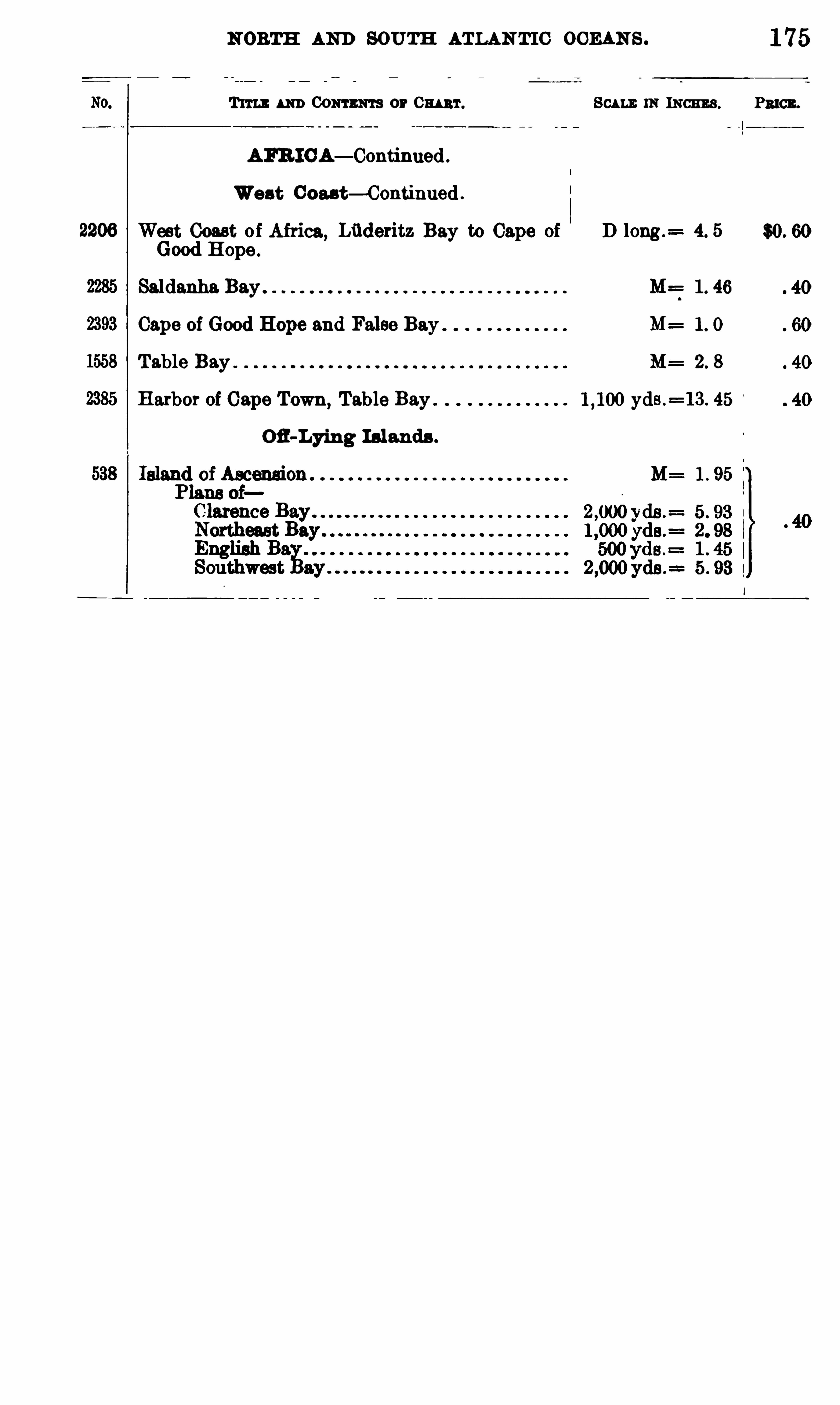
N ORTH AND SOUTH ATLAN TIC OCEAN S .
T im um Commas or Cw 't . Scum: 11: INCHES .
AFR ICA— Continued .
West Cou t— Continued .
West Coast o f Africa, Lfideritz Bay to Cape of D long .= 4. 5
Good H ope .
Saldanha Bay M== 1 . 46
M=
Table Bay M= 2 . 8
Harbor of Cape Town,Table Bay yds .
=13 . 45
Ofl-Lying Islands .
M= 1 . 95
1 75


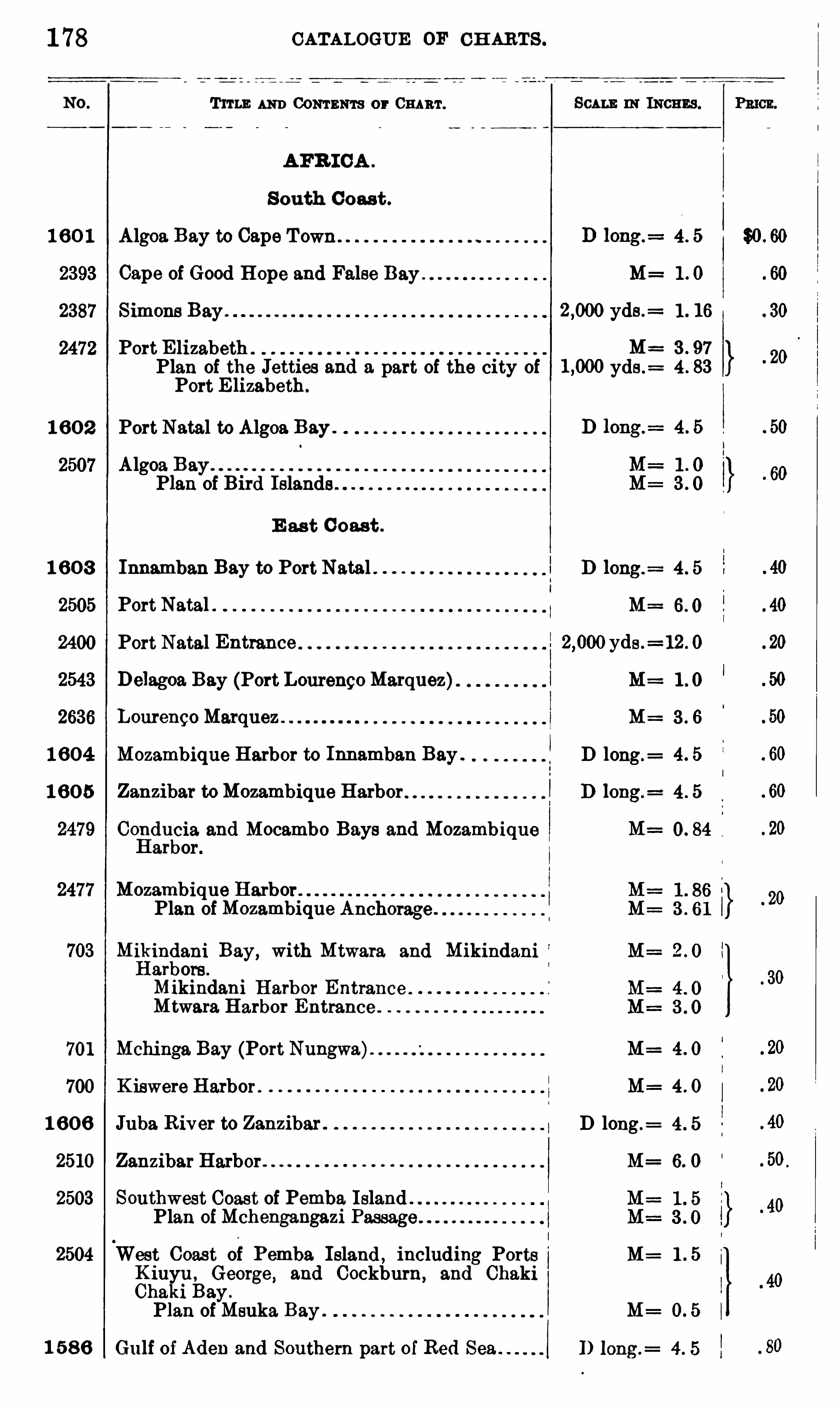
1 78
1 6 0 1
2393
2387
2472
1 6 0 2
2507
1 6 0 3
2505
2400
1 604
1 6 0 5
2477
703
701
700
1 60 6
2510
2503
2504
1 5 8 6
CATALOGUE OF CH ARTS .
TITLE AND CONTENTS or CHART.
AFR ICA .
S outh Coast .
Algoa Bay to Cape T own 4 . 5
Cape of Good Hope and False M=
Simone Bay .
Port E lizabeth
Port E lizabeth.
Port Natal to Algoa Bay .
Algoa BayPlan of Bird Islands
E as t C oast .
Innamban Bay to Port Natal
Port Natal
Port Natal Entrance yds .=12 . 0
M==1 . 0
3 . 6
D long .= 4 . 5
Delagoa Bay (Port Lourengo Marquez)Lourengo Marquez
Mozambique Harbor to Innamban Bay .
Zanzibar toMozambique Harbor
Conducia and Mocambo Bays and MozambiqueHarbor.
Mozambique Harbor.
Plan of Mozambique Anchorag e .
Mikindani Bay, with Mtwara and MikindaniHarbors .
Mikindani Harbor Entrance .
Mtwara Harbor Entrance
Mchinga Bay (Port Nungwa) M= 4 . 0
K iswere Harbor . M= 4 . 0
Juba. River to Zanzibar D long .
ZanzibarHarbor M= 6. 0
Southwest Coast of Pemba. Island .
Plan ofMchengangazi
West Coast of Pemba. Island , including Ports M= 1 . 5K iuyu , George , and Cockburn, and ChakiChaki Bay .
Plan of Msuka Bay .
Gu lf of Aden and Southern part of Red Sea
yds .= 1 . 16
M=
Plan of the Jetties and a. part of the city of yds .= 4 . 83
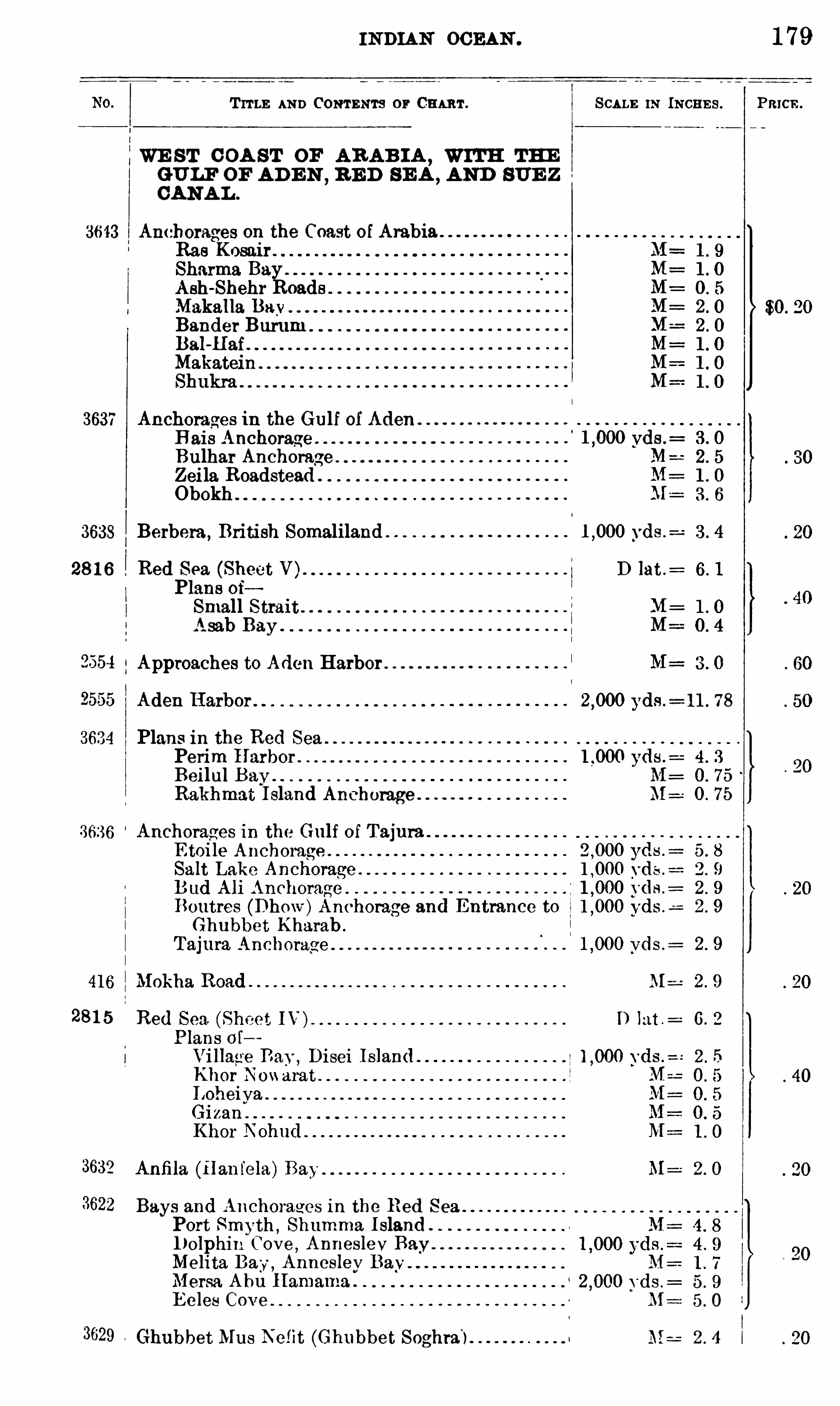
IN DIAN OCEAN . 1 79
T ITLE AND CONTENTS or CHART . SCALE IN INCHE S . Pmcn.
WE ST C OA ST or AR AB IA,WITH THE
GULF OF AD E N,B E D SE A ,
AND SUE Z
CANA L .
3643 Anchorages on the Coast of Arabia .
Rae KosairSharma Bay .
Ash-Shehr RoadMakalla BayBander Burum .
Bal-Haf
Makatein
3637 Anchorages in the Gulf of AdenB ais Anchorage . vds .
= 3 . 0
Bulhar AnchorageZei la RoadsteadObokh
3638 Berbera ,British Somaliland vds .
28 1 6 Red Sea. (Sheet V). D lat .
Plans 0 1Small StraitAsab Bay
l
!
2 554 Approaches to Aden Harbor
yds .= 11 . 78
3634 Plans in the Red SeaPerim Harbor . yds .
= 4 . 3
Beilul Bay M= 0 . 75
Rakhmat I sland Anchorage M : O. 75
3636 Anchorages in the Gulf of TajuraE toile Anchorage 5 . 8
Salt Lake Anchorage . yds . 2 . 9
B ud Ali Anchorage . 2 . 9
Boutres (Dhow)Anchorage and Entrance to yds .: 2 . 9
Ghubbet Kharab .
Tajura Anchorage . Vds .= 2 . 9
416 Mokha Road . . ML 2 . 9
28 1 5 Red Sea, (Sheet IV) D lat : 6 . 2
Plans 0 1
Vi llagre Bay ,
Disei I sland 2 . 5
Khor N0 “aratLoheiva .
GizanKhor Nohud
3632 Anfi la (Hanfela) M= 2 . O
3622 Bays and Anchorages in the Red Sea
Port Smyth , Shumma IslandD olphin Cove
,AnneslevBay
Melita Bay ,Anneslev
Mersa Abu Hamama .
E eles Cove
3629 Ghubbet Mus Nefit (Ghubbet Soghra'
) M== 2 . 4 l
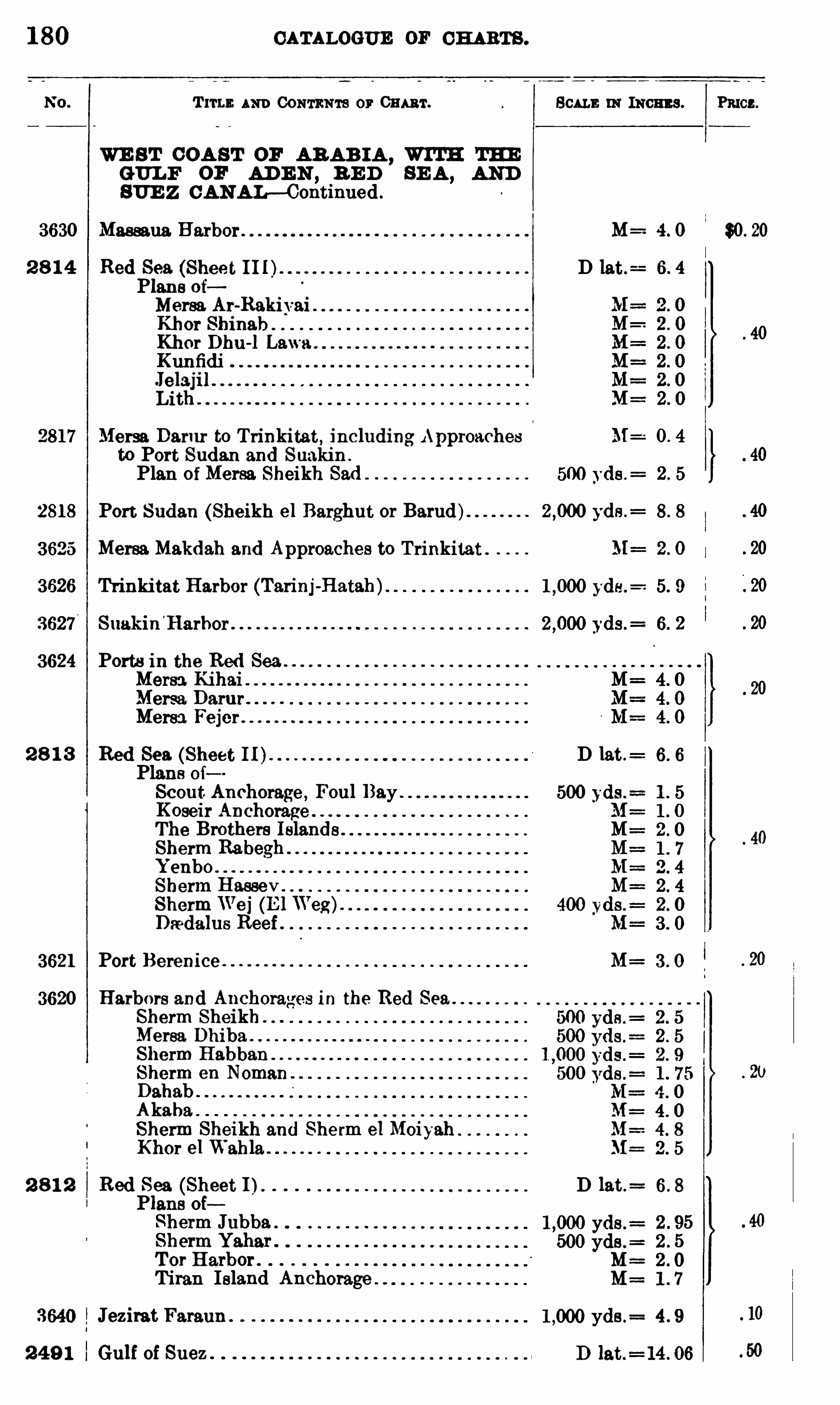
1 80 CATALOGUE OF CH ARTS .
T rru : AND CONTENTS or 0mm . SCALE 11: means .
WE S T COA ST or AR AB I A ,WITH THE
GUL F or AD E N , B E D SE A , AND
SUE Z C ANAL—Continued .
3630 Massaua. Harbor M :
2 8 1 4 Red Sea. (Shee t DPlans oiMersa Ar-RakivaiKhor ShinabKhor Dhu-l Lawa .
Kunfidi
Lith
2817 Mersa Darur to Trinkitat, including Approaches M=
to Port Sudan and Suakin .
Plan of Mersa Sheikh Sad 500 yds .=
2818 Port Sudan (Sheikh el Berghut or Barud) yds .=
3625 Mersa Makdah and Approaches to Trinkitat .
3626 Trinkitat Harbor (Tarinj-Hatah)
3627 Suakin'
Harhor yds .=
3624 Ports in the Red Sea . .
Mersa KihaiMersa. DarurMersa Fej er .
2 8 1 3 Red Sea. (Sheet I I ) D lat .
Plans 0 1Scout Anchorage , Foul BayKoseir Anchorage .
The Brothers Islands .
Sherm RabeghYenboSherm Hassev
ShermWei (E l Weg).
Daadalus Reef
3621 Port Berenice M=
3620 Harbors and Anchorages in the Red Sea .
Sherm SheikhMerea DhibaSherm Habban . .
Sherm eu NomanDahabAkaha.Sherm Sheikh and Sherm e1MoiyahKhor el Wahla
2 8 1 2 Red Sea (Sheet I). D 13 t.=
Plans oi
T or Harbor .
Titan Island Anchorage
Jezirat Fatanu .
2 4 9 1 Gulf of Suez .
Pmcz.
$0 .
0

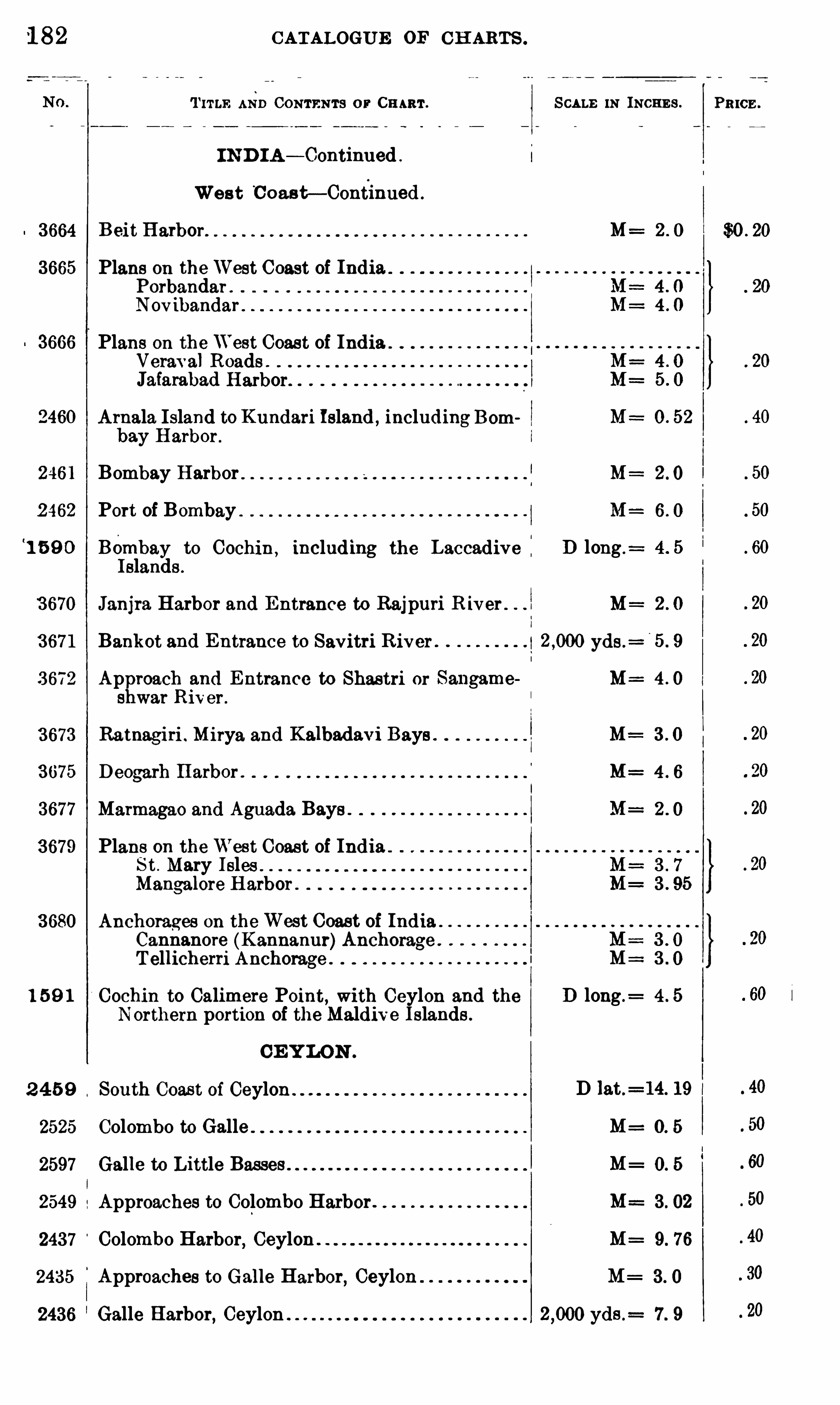
1 82 CATALOGUE OF CH ARTS .
T ITLE AND CONTENTS or CHART .
I N D I A — Continued
Wes t C oasF —Continued .
3664 B eit Harbor.
3665 Plans on theWest Coast of IndiaPorbandar .
Novibandar .
3666 Plans on theWest Coast of IndiaVeraval Roads .
Jafarabad Harbor.
2 460 Arnala. Island to Kundari Island , includingBombay Harbor .
2461 Bombay Harbor
2 462 Port of Bombay‘
1 5 9 0 Bembay to Cochin , including the Laccadive :Islands .
3 670 Janjra Harbor and Entrance to Rajpuri R iver .
3 671 Bankot and Entrance to Savitri R iver
3 672 Approach and Entrance to Shastri or Sangameshwar River .
3673 Ratnagiri . Mirya and Kalbadavi Bays
3675 D eogarh Harbor .
3677 Marmagao and Aguada Bays .
3679 Plane on theWest Coast of IndiaS t . Mary Isles .
Mangalore Harbor .
3680 Anchorages on theWest Coast of IndiaCannanore (Kannanur)Anchorage .
T ellicherri Anchorage
1 5 9 1 Cochin to Calimere Point, with Ceylon and theNorthern portion of the Maldive Islands .
CE Y LON .
2 4 5 9 South Coast of Ceylon .
2525 Colombo to Galle
2597 Galle to Little Basses .
2549 Approaches to Colombo Harbor
2437 Colombo Harbor, Ceylon .
2435 Approaches to Galle Harbor, Ceylon
2436 Galle Harbor,Ceylon
SCALE IN INCHE S .
M :
M= 4 0
M=
M=
M=
D long .
M=
yds .=
M :
M=
M=
D long .=
D lat .= 14. 19 l
M=
M=
M==
M=
M=
yds .= 7 . 9
PR ICE .
$0 . 20
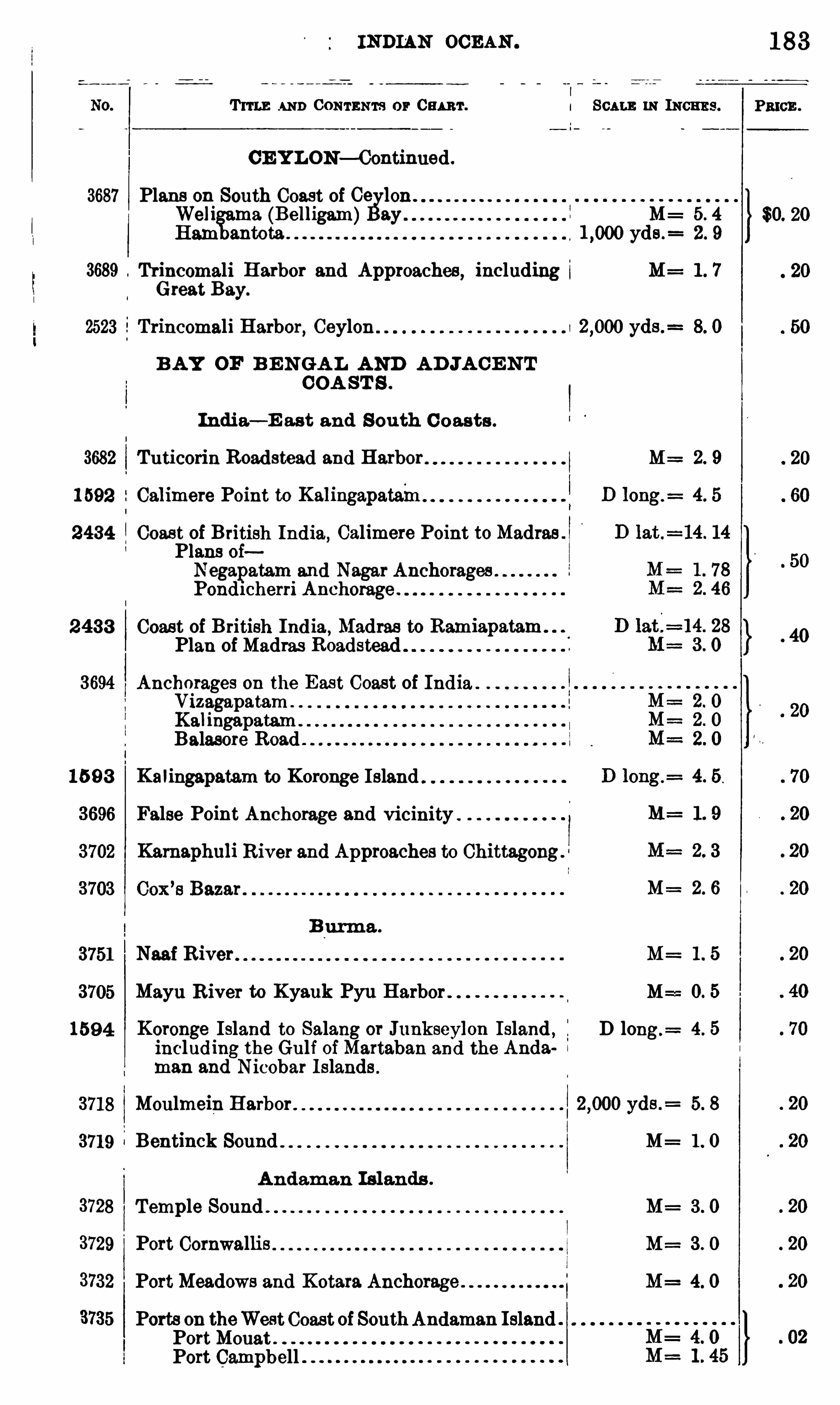
INDIAN OCEAN .
T ITLE AND CONTENTS or Cu m . I SCALE IN INCHES .
CE Y LON— Continued .
3687 Plans on South Coast of Ge lonWeli ma (Belligam) ay M : 5. 4
Ham yds .= 2. 9
3689 Trincomali Harbor and Approaches , including M= 1 . 7Great Bay.
2523 Trincomali Harbor, Ceylon yds .= 8. 0
B AY OF B E NGA L AND A D JA CE N TCOA ST S .
India— E ast and South C oasts .
3682 Tuticorin Roadstead and Harbor M= 2. 9
1 592 Calimere Point to Kalingapatain
2434 Coas t of British India, Calimere Point toMadras .
Plans oiNegapatam and Nagar AnchoragesPond1cherri Anchorage .
2 433 Coas t of British India ,Madras to Ramiapatam
Plan of Madras Roadstead
3694 Anchorages on the East Coast of India .
VizagapatamKalingapatamBalasore Road
15 9 3 Kalingapatam to Koronge Island
3696 False Point Anchorage and vicinity .
3702 Karnaphuli River and Approaches to Chittagongs
M= 2 6
B urma .
3751 Naai R iver M= 1 . 5
3705 Mayu River to Kyauk Pyu Harbor M==0. 5
1594 Koronge Island to Salang or Junkseylon Island , D long.= 4. 5
including the Gulf ofMartaban and the Anda
man and Nicobar Islands .
3718 Moulmein Harbor yds .= 5. 8
3719 Bentinck Sound M= 1 . 0
Andam an Islands .
Temple Sound M= 3 . 0
Port Cornwallis M : 3 . 0
PortMeadows and Kotara Anchorage M= 4. 0
Ports on theWestCoast of SouthAndaman IslandPortMouatPort Campbell
183
PRICE .
$0. 20
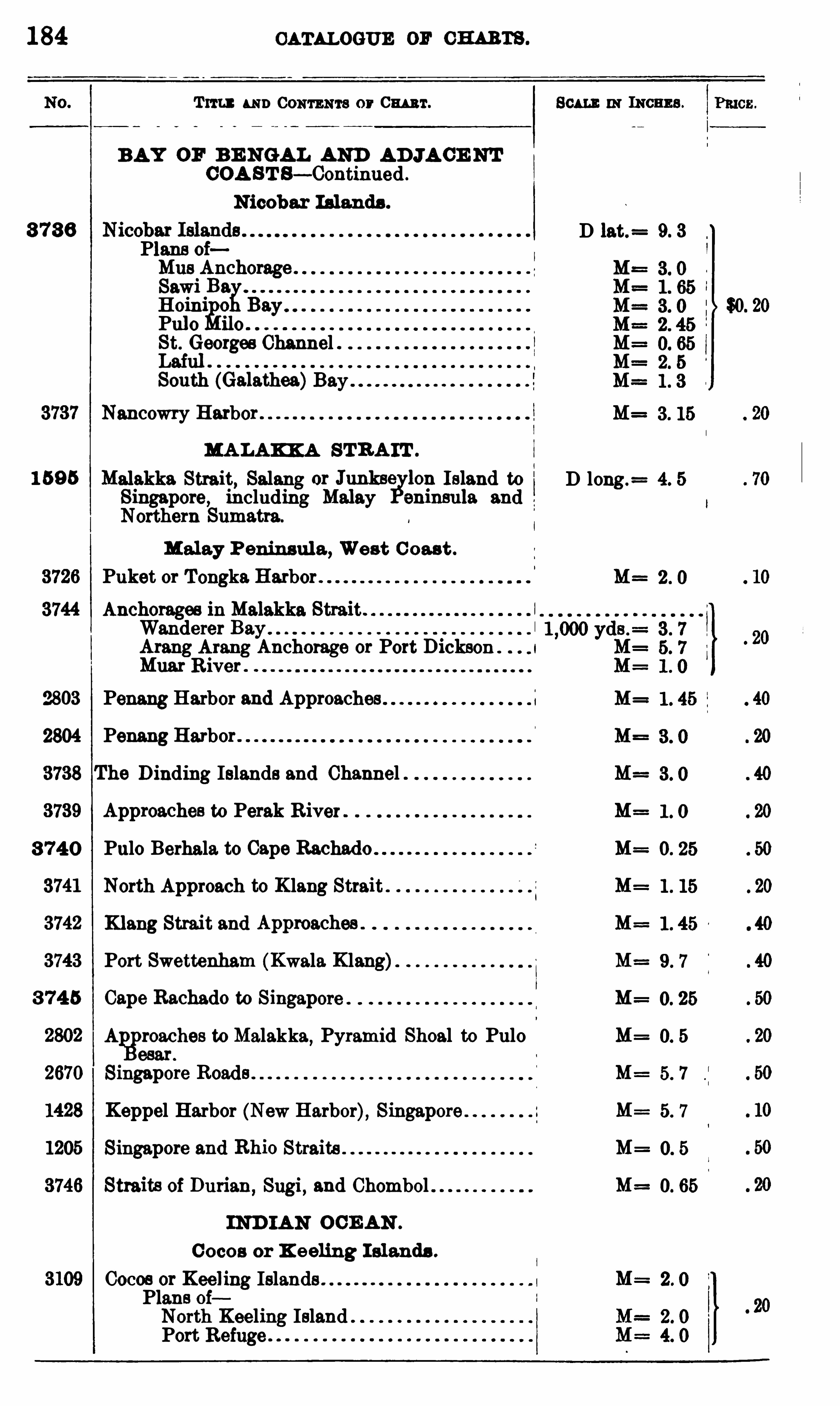
184 CATALOGUE or cm rs .
Tm : u mCONTENTS or Cm r.
BAY OF B E NGAL AND AD JA CE NT
COA S T S— Continued .
N icobar Islands .
3 7 3 6Plans oiMus Anchorage .
Sawi BaH oini 0
Pulo iloSt. Georges ChannelLaiulSouth (Galathea)Bay '
Nancowry Harbor
MA LAKK A STR A IT .
alakke Strait, Salang or Junksciylon Island to
Singapore, including Malay eninsula andNorthern Sumatra.
Malay P eninsul a , Wes t C oas t .
Puket or Tongka Harbor
Anchorages in Malakka Strait .
Wanderer BayArang Arang Anchorage or Port Dickson . 1
Muar R iver
1 59 5
% 03 Penang Harbor and Approaches
2804 Penang Harbor .
The D inding Islands and Channel .
Approaches to Perak River
3 74 0 Pulo Berhala to Cape Rachado
North Approach to K lang Strait
Klang Strait and Appmaches .
Port Swettenham (Kwala Klang)
3 74 5 Cape Rachado to Singapore
A roaches to Malakka,Pyramid Shoal to Pulo
esar .
Singapore Roads
Keppel Harbor (New Harbor), Singapore
Singapore and Rhio Straits
Straits of Durian,Sugi , and Chombol
IND IA N OCE AN .
C ocos or K eeling I slands .
Cocos or Keeling IslandsPlans ofNorth Keeling IslandPort Refuge
Scum: m Incnns .
D 13 t.= 9. 3
D long.= 4. 5
1 . 0
0. 25

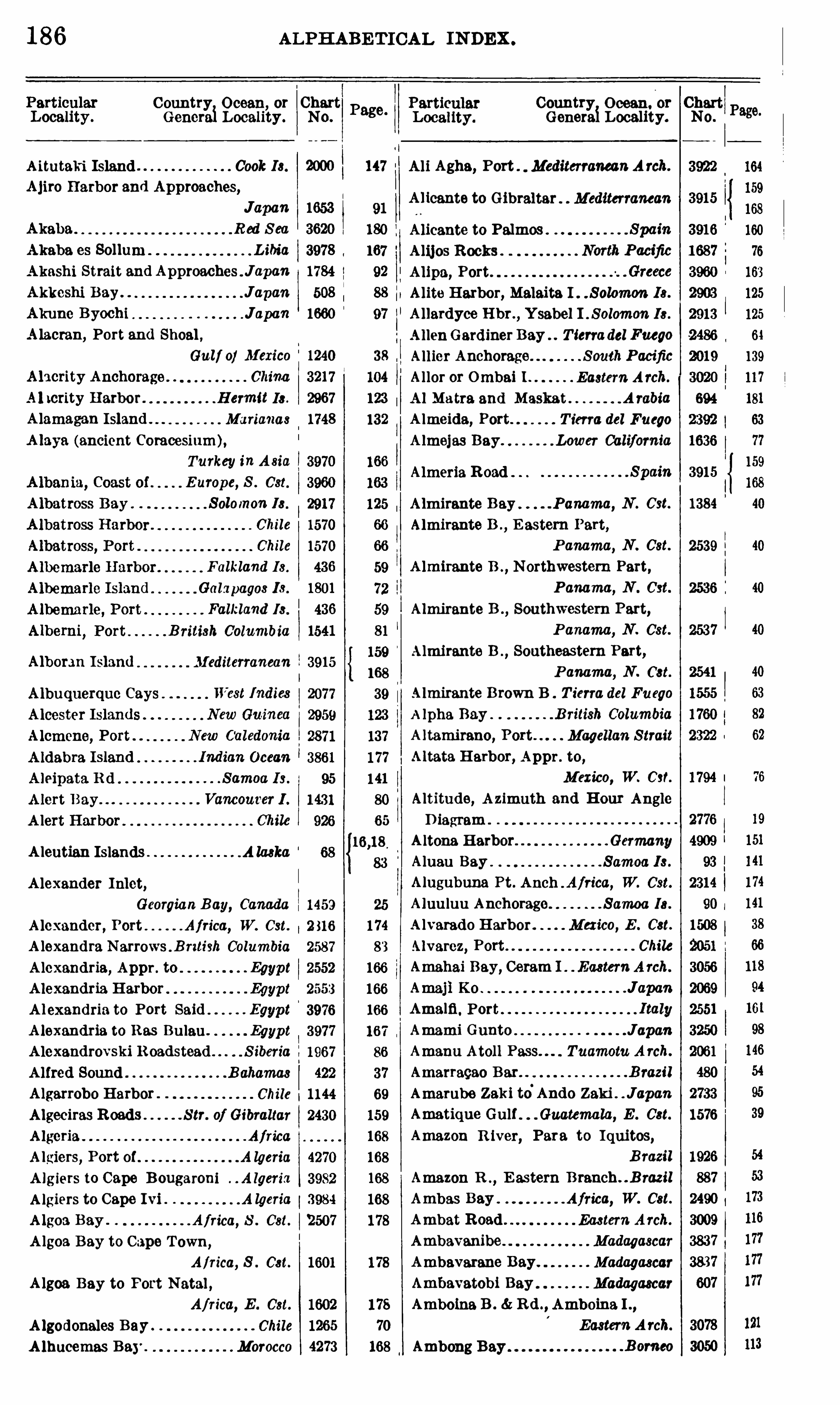
186 ALPH ABE T ICAL IN DEX .
Country Ocean, or Chart Country Ocean. or ChartGeneraiLocality . No. Genera Locality. No.
A itutaki Island Cook Is. A li Agha, Port . MediterraneanA rch.
Ajiro Harbor and Approaches,A licante to Gibraltar MediterraneanJapan
Akaba R ed S ea
Akaba es Sollum L ibia
Akashi Strait and ApproachesJ apan
Akkeshi Bay Japa'nAkume Byochi JapanA lacran, Port and Shoal ,
Gulf of Mexico
Ah crity Anchorage China
Ah crity Harbor. H ermit Is .
A lamagan Island . Marianas
A laya (ancient Coracesium),
Turkey inA sia
B umpe, S . Cst.
Solomon Is .
Chile
Chile
Falkland I s .
Galapagos Is .
Falkland Is .
B ritish Columbia
Almeria Road
Albomn I sland Mediterranean
A leutian Islands .A laska
A lexander Inlet,
Georgian B ay, Canada
A lexander, Port Africa, W. Cst.
A lexandra Narrows . B rztish Columbia
Alexandria, Appr . to Egypt
A lexandria Harbor Egypt
Alexandria to Port Said Egypt
A lexandria to R es Bulau Egypt
A lexandrovski R oadstead S iberia
A lfred Sound B ahamas
Algarrobo Harbor Chile
Algeciras Roads S tr. of Gibraltar
A lgeria Africa.
A lgiers, Port of A lgariu
A lgiers to Cape B ougaroni . . Algeria
A lgiers to Cape Ivi A lgeria
A lgoa Bay . . . Africa, 8 . Cat.
A lgoa Bay to Cape Town,
Africa, S . Cat.
A lgoa Bay to Port Natal ,
Africa, E . Cst.
A lgodonales Bay . Chile
A lhucemas Bay . Morocco Ambong Bay
Alicante to PalmosAlijos Rocks
A lipa, Port
Alite Harbor, Malaita I Solomon Is.
Allardyce Hbr . ,Ysabel I . Solomon Is .
A llenGardiner Bay Tierradel Fuego
Allier Anchorage S outhPacific
Al lor or Ombai 1 Eastern Arch.
Al Matra and Maskat A rabia
A lmeida, Port T ierra del Fuego
Almejas Bay Lower California
Spain
Almirante Bay Panama, N . Cst.
Almirante B . ,E astern Part,
P anama, N . Cst.
A lmirante B . , Northwestern Part,
Panama, N Cst.
Almirante B . , Southwestern Part,
P anama, N . Cst.
Almirante B ., Southeastern Part,
P anama, N . Cat.
Almirante Brown B T ierra del Fuego
A lpha Bay B ritish Columbia
A ltamirano, Port Magellan S trait
Altata Harbor, Appr. to,
Mexico, W. 0 37.
Altitude, A zimuth and Hour AngleD iagram .
A ltona H arbor Germany
Alueu Bay Samoa I s .
Alugubuna Pt. Anch . A/rica, W. 031.
Aluu luu Anchorage Samoa Ia.
A lvarado Harbor Mexico, E . Cat.
Alvarez, Port Chile
Amahai Bay, Ceram 1 Eastern A rch.
Japa'n
Amalfi . Port
Amami Gunto JapanAmanu Atoll Pass Tuamotu A rch.
Amarraqao Bar B razil
Amarube Zaki to°
Ando Zaki JapanAmatique Gulf Guatemala, E . Cat.
Amazon R iver, Para to I quitos,
B razil
Amazon R . , E astern B ranch B razil
Ambas Bay Africa, W. Cat.
Ambat Road Eastern Arch.
Ambavanibe Madagascar
Ambavarane Bay Madagascar
Ambavatobi Bay Madagascar
Amboina B . R d . , Amboina I . ,
Eastern A rch.
B orneo
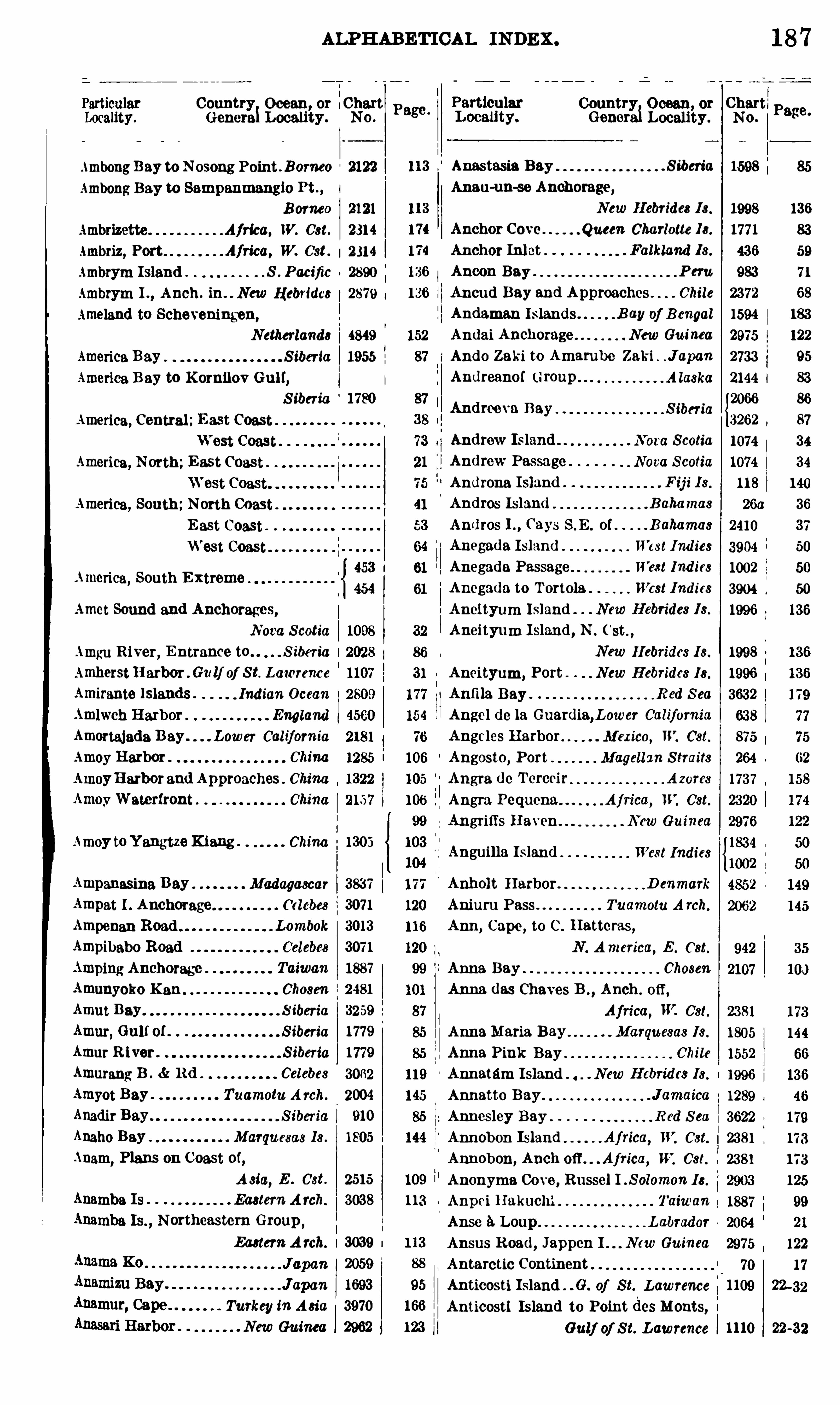
ALPH ABETICAL INDEX .
Country Ocean, or :ChartGenera1Locality . No .
AmbongBay to Nosong Point Bomeo 2122
Ambong Bay to Sampanmangio Pt . , I
B orneo 2121
Ambrizette . Africa, W. Cat. 2314
Ambriz, Port Africa, W. Cat . 2314
Ambrym Island . . S . Pacific 2890
Ambrym I . , Anch. in. . New Hebrides 2879
Ameland to Scheveningen,
Netherlands 4849
America Bay S iberia 1955
America B ay to KornilovGulf,
S iberia 1780
America, Central;E ast Coast
America, North;East Coast
America, South;North Coast
E ast Coast
West Coast
America, South E xtreme
Amet Sound and Anchorages,
Nova Scotia
Amgu River, E ntrance to . . . S iberia I
AmherstH arbor G1: 1] of S t. Lawrence
Amirante Islands . . Indian Ocean
Amlwch Harbor England
Amortajada B ay. Lower California
Amoy Harbor . China
AmoyHarborand Approaches China
AmovWaterfront China
Amoy toYangtzeKiang . China 1303
Ampanasina Bay Madagascar 3837
Ampat I . Anchorage (”d ebes 3071
Ampenan Road Lombok 3013
Ampibabo Road 3071
Amping Anchorage Taiwan 1887
Amunyoko Kan . Chosen 2481
Amut Bay S iberia 3259
Amur, Gulf of S iberia 1779
Amur R iver . S iberia 1779
Amurang B . R d . Celebes 3062
Amyot Bay . Tuamotu A rch. 2004
Anadir Bay S iberia 910
Anaho Bay Marquesas Is . 1805
Anam, Plans on Coast of,
A sia,E . Cst. 2515
Anamba Is Eastern A rch. 3038
Anamba Is. ,Northeastern Group ,
Eastern A rch. 3039
Jown 2059
Japan 1693
Turkey in A sia 3970
New Guinea 2962
Page .
Country Ocean, or Chart'
Genera1
Anguilla Island West Indies
Locality . No.
. S ibm'
a 1598
S iberia
18 7
Page.
Anastasia Bay
Anau-un-se Anchorage,
New H ebrides Is.
Anchor Cove Queen Charlotte 18 .
Anchor Inlet Falkland Is .
Ancon Bay P eru
Ancud Bay and Approaches Chile
Andaman Islands B ay of B engal
Andai Anchorage New Guinea
Ando Zaki to Amambe Zaki JapanAndreanof ( 1map
Andrew IslandAndrew Passage
Nora S cotia
Nova Scotia
Androna Island F ij i I s .
Andrw Island B ahamas
Andros I . ,(‘
ays S . E . of B ahamas
West Ind ies
11’
e.ct Ind ies
Anegada Island
Anegada Passage
Ancgada to T ortola West Indies
Aneityum Island New H ebrides Is .
Aneity um I sland , N .
New H ebrides I s .
Aneityum, Port New H ebrides Is .
Anfi la Bay R ed S ea
Angel (10 la Guardia,Lower California
Angeles Harbor Mexico, W. Cat.
Angosto, Port Magellan S traits
Angra dc Tercmr . A zorcs
Angra Pequena Aj rica, W. Cst.
Angrifls Haven New Guinea
Anholt Harbor D enmark
Aniuru Pass Tuamotu A rch.
Ann, Cape, to C . Hatteras,
N . America, E . Cat.
Anna Bay Chosen
Anna das Chaves B . ,Anch . off ,
Africa, W. Cst.
AnnaMaria Bay Marquesas 18 .
Anna Pink Bay Chile
Annatam Island New c t s Is .
Annatto Bay Jamaica
Annesley Bay . R ed S ea
Annobon Island Africa, W. Cst.
Annobon,Anch 0 11 Africa, W. 0 31.
Anonyma Cove, Russel I . S olomon I s .
Anpei H akuchi
. Taiwan
Anse 9. Loup L abradorAnsus Road
,Jappen I Ncw Guinea
Antarctic Continent
Anticosti Island 0 . of S t. L awrence
Anticosti Island to Point des Monts,Gulf of S t. Lawrence
A laska 2144 l
1998 136
1771 83
436 59
983 71
2372 68
1594 183
2975 122
2733 95
83
2066 86
3262 87
1074 34
1074 34
118 140
26a 36
2410 37
3904 50
1002 50
3904 50
1996 136
1998
1996
3632
638
875
264
1737
2320
2976
1834
1002
942
2107
238 1
1805
1552
1996
1289
3622
2381
2381 173
125
1887 99
2064 21
2975 122
70 17
1109 22-32
1110 22-32
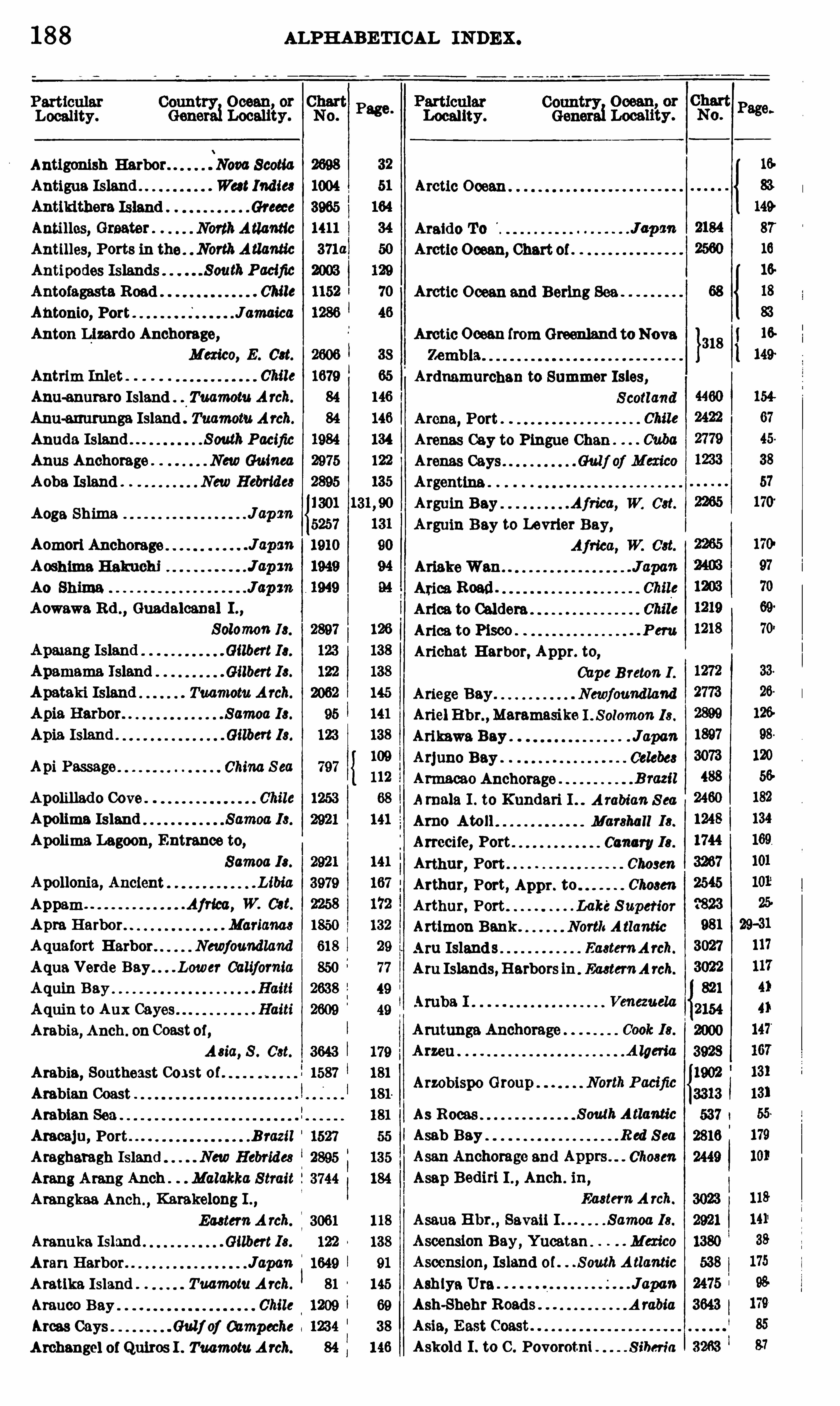
188 ALPH ABE TICAL INDEX.
Locality.
Antigonish Harbor Nova Scotia
Antigua Island Wa t IndiesAntikithera Island Greece
Antilles, Greater NorthAtlantic
Antilles, Ports in the . NorthAtlantic
Antipodes Islands SouthPacific
Antofagasta Road Chile
Antonio, Port JamaicaAnton Lizardo Anchorage,
Mexico, E . Cat.
Antrim Inlet
Anu—enuraro Island Tuamotu Arch.
Anu-mmrunga Island Tuamotu Arch.
Anuda Island . . SouthPacific
Anus Anchorage . . New Guinea
Aoba Island New Hebrides
Aoge Shima
Aomori Anchorage
Aoshima B akuchi
Ao Shima
Aowawa Rd . , Guadalcanal I . ,
8 010man 13 .
Gilbert Ia.
Gilbert Is.
Tuamotu Arch.
Samoa Is.
Gilbert 18 .
Api Passage . China S ea
Apolillado Cove
Apolima Island
Apolima Lagoon, Entrance to,
Samoa Is.
Apollonia, Ancient Libia
Appam Africa, W. Cat.
Apm HarborAquafort Harbor Newfoundland
Aqua Verde Bay. . . Lower California
Aquin Bay Haiti
Aquin to Aux Haiti
Arabia,Anch . on Coastoi,
A sia, 8 . Cat.
Arabia, Southeast Cos t of .
Arabian Coast
Arabian Sea
Aracaju, Port .B razil
Aragharagh Island New Hebrides
Arang Arang Anch Malakka S trait
Arangkaa Anch . ,Karakelong I . ,
EasternA rch.
Aranuka Island Gilbert Is.
Aran Harbor JapanAmtlka Island Tuamotu A rch.
Arauco Bay
Areas Cays Gulj oj Campmhe 1
Archangel of Quiros I . Tuamotu Arch.
Page.
Locality.
Arctic Ocean
Araido To
Arctic Ocean, Chart of
Arctic Ocean and Bering Sea
ArcticOcean fromGreenland to Nova
Ardmmurchan to Summer Isles,
S cotland
Arena, Port
Arenas Cay to Pingue Chan .
Arenas Cays
Argentina .
Arguin Bay Africa, W. Cat.
Arguin Bay to Levrier Bay,
. P em
Askold I . to C . Povorotni S iberia
AriakeWan
Ariea Road .
Arlee to Caldera
Arica to Pisco
Arichat Harbor, Appr. to,
Cape B reton I .
Ariege Bay Newfoundland
Ariel Hbr. ,Maramasike I . Solomon Is .
Arikawa Bay JapanArjuno BayArmacao Anchorage
Amale I . to Kundari I A rabian S ea
Arno Atoll Marshall Is .
Arrecife, Port Canary Is .
Arthur, Port Chosen
Arthur, Port, Appr . to Chosen
Arthur, Port LakeS uperiorArtimon Bank North A tlantic
Aru Islands Eastem A rch.
Aru Islands,Harbors in EasternA rch.
As Races .
Asab Bay R ed S ea
Asan Anchorage and Apprs Chosen
Asap Bediri I . , Anch . in,
Eastern A rch.
Asaua Hbr. ,Savaii I Samoa Ia.
Ascension Bay, Yucatan Mexico
Ascension, Island 0 1 S outh A tlantic
Ash iya Ura JapanAsh-Shehr Roads A rabia

190 ALPH ABETICAL INDEX .
Country Ocean, or Chart1 No.Genera Locality.
Bahia de T odos os Santos B razil
Bahia H onda Cuba
Bahia H onda Colombia, N . Cst.
Bahia H onda Panama, W. Cat.
Bahia, Port of . B razil
Bahrein Harbor P ersian GulfBahrein Hbr. and Appr . P ersian GulfBnie dc R igny . Madagaschr
Baitiqueri, Port CubaBajoa Roadstead Celebes
Bajo Nuevo Bank Caribbean S ea
Bajowe Roadstead Celebes
Baker Cove Magellan S trait
Baker Inlet Chile
Baker Island NorthPacific
Baker Passage B ritish Columbia
Belandres Cays to Cape Cruz . Cuba
Belandres Gays toManmnillo CubaBalasoreRoadBaldwin Cove New H ebrides
Balearic Islands Mediterranean
Baleines Bay Tierra del Fuego
Bal-Haf. A rabia
Bali Island Eastern A rch.
Bali Island , Anchs . in EasternA rch
Balik Papan Bay and Anch . B omeo
Balingara Road . Celebes
Ballena Bay Costa R ica,W. Cst.
Ballonas Bay Lower California
Ballenas , Port Chile
Ball’
s Pyramid S outh Pacific
Baltic Sea ( Eastern Sheet).
Baltic Sea (Western Sheet)Balua Islands Gulf of S iamBambatani, Choiseul I . . S olomon Is .
Banaba Island S outh Pacific
Banana Creek Africa,W. Cst.
Banano R oad . . Celebes
Banare Bay . NewCaledonia
Banda Hbr. ,Banda I EasternA rch.
B andar Abbas P ersian GulfB ender B urum . Ambia
Banderas Bay Mexico, W. Cst.
B anes Bay Cuba
Banff S cotland
B anfi to D unboath I Ibr S cotland
Bangue i B . ,Baugeai I Celebes
Bangkalang B . , Peling I Celebes
Bangkok H arbor S iam
Bangpakong R S iam
Bangsal Beret Anch L ombok
Banguey Channel , South B orneo 2119
Banjuwedan Bay
Banka Strait
Country Ocean, or ChartGenerai Locality . No.
Banka Str. ,Southern Entr. to,
Eastern A rch. 3115
Banks Str. to Singapore,
Eastern A rch.
Bari] , Point 3 11 , H br. ,
Georgian B ay, Can .
Baring Island Marshall I s.
Barkley Sound Vancouver I .
Barkley Sd . to N ootka Sd . ,
Vancouver I .
114
Bankot
Banks Group NewHebrides
Banner Cove Tierra del Fuego
Banquereau NorthA tlantic
Ban Yao River French Indo China
Bare Bay, Bouro I Eastern A rch.
Baraeoa, Port Ouba
Baradaires Bay Haiti
Baradaires B . to Aux Cayes Haiti
Baradaires B . to St.MarcChan Haiti
Barahona Harbor Haiti
Barahona to Jacmel Bay Haiti
Barabona to Santo Domingo Haiti
Barango E hr. ,Florida I Solomom Is .
Barbados Island WestIndies
Barbara, Port Chile
Barbara, Port Chile
Barbara Channel MagellanS trait
Barbers Point Hawanan I s.
Barbers Point to Mokepa Point
( Oahu) Hawai i an Is .
Barbuda Islands West Ind ies
Barcelona, Port Venezuela
Barcelona, Appr. to Port Spain
Barcelona, Port of Spain
Bard ia,Port L ibia
Barletta
Barnett Harbor B ahamaéBaron K ori Gulf S iberia
B erra T ramandahy to R io Grande doSul . B razil
Barre T ramandahy to Santa. Catha
rina Island . B razil
Barracota R 1ver Haiti
Barracouta H arbor S iberia
B erra H ead to Scarpa I S cotland
Barram Point toNosoagPoint B orneo
Barranca Bay
Barrce Bay NewHebrides
Barrientos , Port Chile
Barroso,Port Chile
Barrow Harbor Newfoundland
Barrow,Port Chile
Basidu and Approaches P ersianGulf
Basidu Anchorage P ersian GulfBasilisk Harbor . S anta Cruz Is . , S . P . j
ALPH ABETICAL INDEX .
Particular Country Ocean, or ChartGenerai Locality . No.
Basque, Port Newfoundland
BasseterreAnchorage West India
Basseterre Roads West Ind ies
BassStrait (Eastern Sheet). Auetralia
Baas Strait (Western Shoot). Auatralia
Bats,Approaches to . Africa, W. Cat.
BataviaRoads and Approaches J ava
Batavia Roads, N . andW . ApprJ ava
Bate Passage Vancouver I
Bathurst Africa, W. Cat.
Bathurst Harbor . Gulj oj S t. Lawrence
Battanta I . , Anch. 111 Eastern A rch.
BatuBan Rd . , T imor I EasternA rch.
Batu Islands Sumatra
BatuMerah Anch . ,Damma I . ,
Eastern A rch.
B razil
. S olomon Is .
Bauro I . ,Anchorages in . . S olomon Is.
Bawean Island . J ava
BayofExploits Newfoundland
BayofIslands Newfound land
Bayof— S ee index of proper names .
Bay, Port CubaBaynes Sd . and Appr . B rit£ 3nColumbia
Bayoneta Island . . . Pamma, W. Cst.
Bayovar, Port Peru
BayungPt. to Datu Pt B orneo
BayungPt. to Pontianak Borneo
Bazit, Bay of Turkey in A sia
Beachy R d . to Owers England
Beagle Channel T ierra del Fuego
Bear Cove Newfound land
Beauchene Falkland I s .
Beaufort B Guadalcanal I . ,
S olomon Is.
Beauharnois Canal toMcK ies Point,
S t. LawrenceR .
Beauhamois Canal to Montreal,S t. LawrenceR .
Beautemps-Beaupre I Loyalty 13 .
Beaver Cove B ritish Columbia
BeaverCreek B ritish Columbia
BeaverHarbor Nova Scotia
BeaverHarbor Vancouver I
Becher Bay B ritish Columbia
Country Ocean, or ChartGenera1Locality .
Berengueles Bay Spain
No.
1105 21-30
3915
Red S ea 3621
Haiti
Komandorski Is .
North Pacific
2448
1367
Bedeque Harbor P rince Edward I .
Bedford B asin Nova S cotia
Bedford Bay Magellan S trait
Beechey Group Ogaeawara Ia.
Behring’
s Sea— S ee B ering S ea.
Beilul Bay R ed S ea
BeitHarbor India
BelakulaAnchorage. B ritish Columbia
Belanta Road Celebes
Belfast Lough
Belgium Europe, N . Cat.
Belgrano, A rgentina
Benz, Approaches to CubaBelize Harbor B ritish H onduras
Belize to Zapatillos Gays,G. of Honduras
Belleisle, Strait of Newfoundland
Belleisle, Str . 0 1, to Bonne B . ,
Gulf of S t. LawrenceBelleisle
,Strait of, toCapeMackinnon ,
Gu lf of S t. Lawrence
Belligam Bay Ceylon
Bellona Reefs S outhPacific
Bellows Bay Newfoundland
Belvy Bay Newfoundland
Benevente Bay B razil
Benevente to Itapemirim B razil
Bengal , Bay of Indian Ocean
. L ibia
Bengasi to Derna . L ibia
Bengasi to R as Makhabcz L ibia
Benguela Bay Africa,W. Cat.
Benin R iver Entr Africa , W. Cat.
Benoa Chan Eastern A rch.
Bentinck Sound I ndia
Benzert, Apprs . to Tunis
Benzert Lakes Tunis
Beo B ay, Karankelong I .,
Eas tern A rch.
Bequia Island . West Indies
Bequia to Carriacou West Indics
Berard , Port Caroline Is .
B et as Basah Pt . to Cape Sambar,
B orneo
Beras Basa h Pt . to Masa T iga IB orneo
B ritish S omaliland
192
Country Ocean, or ChartGenerai Locality . No.
Page.
16
Bering Strait B ering S ea 68 18
83
Berkeley Sound Falkland Is . 434 58
BerlinRoadand Harbor . NewGuinea 2965 122
Bermejo, Port .P eru 1201 71
Bermeo, Spain 795 157
Bermuda Islands NorthA tlantic 27 35
26a; 36Berry Islands Bahamas {1158 36
Berry I s . , Southern Portion,
B ahamas 2497 36
Bersimis R iver 2722 22
Besuki Road J(100 3007 116
Betarara Anchorage" New Hebrides 2895 135
Bethel Bay Chile 1570 66
Betsey Cove Indian Ocean 602 177
Bettobu and Shamambe Anchs . ,
Japan 2184 87
B 18 Ata NewGuinea 2947 123
B iaro Island, Anch . ih . Eastern A rch. 3061 118
B ias Bay China 2216 106
B ice Road New Hebrides 2895 135
B1en Shon Anchorage,
French Indo China 2594 109
B ig Africa, W. Get. 2320 174
B ig Land orVanna Levu ,Anch . ln,
409 139
B igbury Bay to E xmouth . . England 4499 153
B igie Bay 2661 49
B ijouga Islands Africa, W. Cat. 2342 171
B iker Marshall Is. 2031 133
B illiton Island Sumatra 3113 114
E lm Bay, Sumbawa I . Eastern A rch. 3016 116
B imini Islands Bahamas 1854 36
B inang Unang I . , Anch . in . Celebes 3073 120
Bingo Nada Channel Japan 2742 92—93
B ingo Nada. Japan 549b 91
B ingo Nada. and Mishima Nada ,
Channels between Japan 2742 92—93
B inkang B ay French Indo China 3149 109
B iuki Cape to Cape Byelkin . . S iberia 1777 86
B intarore Road Celebes 3068 119
B ira B ira Bay New Guinea 2952 123
B irchy Cove Newfoundland 597a 30
B ird Cove to Current Island,Newfoaadland 606 31
B ird Island North Pacific 2 143
B ird 8 . Get. 2507 178
Bird Islet . South Pacific 2002 127
B irnies 18 land Phaniz Is . 125 142
B isan Seto, E astern Portion . J apan 2743 92-93
B isan Seto, Western Portion J apan 2742 92-93
B iscay, B ay of Europe, W. Cat. i4321 157
B isceglie . . Italy 3953 162
Bishops Harbor Newfoundland 562 26-28
ALPH ABE TICAL INDEX .
ParticularGenerai Locality.
Bishops Ness to R ochester. England
B ishops Ness to Sheerness Bar,
England
B ismarck Archipelago . SouthP acific
B ismarck Arch . ,Anch . in,
South P acific
B issagos Islands Africa, W. Cat.
B itjoli R d , . H almahera I . ,
EasternArch.
B lakeney, Port B ritish ColumbiaB lakeney to Flamborough H d
E ngland
Boca del Drago P anama. N . Cat.
Country Ocean, or ChartNo.
B izerte, Apprs . to
B izerte Lakes
B lack Bay Labrador
B lack BeachAnchorage Galapagos Is.
Black B rothers Japan
Blackfish Sd . to Forward Bay,
British ColumbiaBlack H ead and Crab Pt. , Anchs . be
tween
B lack Point Bay Africa, W. Cat.
B lack R iver Anchorage Jamaica
B lackwood, Cape, to Freshwater BNewGuinea
B lakeney to Orfordness,
B lakeney to Skegness
B lane Sablon .
B lanca, Bahia A rgentina
B lanca Bay Lower CaliforniaB lanche Harbor Solomon Is .
B lanco, Cape, Anch Africa, W. Cat.
B lanca, Cape, Anchorage . A rgentina
B lanca Encalada Cove Chile
B lewfields Anchorage Jamaica
B lind Bay New Zealand
B liss Harbor New B runswick
B londe Group Chosen
B loody Foreland to Lame Ireland
B lubber Bay British ColumbiaB luefields B lufi to Man ofWar Gays ,
N icaragua, E . Cat.
B luefields B lufi to San Juandel Norte
(Greytown) N icaragua, E . Cat.
B luefields Lagoon . N icaragua , E . Cat.
B lunden Harbor British ColumbiaBoat Harbor British ColumbiaBoavista Island (Jape Verde Is .
Bohano B . , Halmahera I . ,
Eastern A rch.
Boca Oblea Panama, W. Cat.
Boca de la S ierpe of Columbus,

194 ALPHABETI CAL INDEX .
Country Ocean, or
mi‘
Gene Locality .
British NotthAmerica
B ritish Columbia, Plans in,0
NorthAmerica
British 'Guiana SouthAmericaB ritish India, Coast of. .A 3i0, 8 . Cat.
B ritish Isles NorthAtlantic
B ritish Somalfland . . Alried , E . 087.
Brita W. Cat.
Brittania Island Loyalty Is.
Broad Reach . “MagellanS trait
B road Reach té FirstNapkov’
zs;‘
Magellan StraitBrooks Bay" Vdmouver
'
I .
Broomclose Harbor" NewfoundMM
B rothers Islands R ed S ea
Brothers Pt. toWanCfiu Cha'
u . ChinaBrothers, The, to H ongkong; China
Brothers, The, to Ockseil I s'
. ChinaB roughton Island . L.B
'
titiish Cdlumbia
Broughton S trait. . Bn’
tiah. .C’ol;
Broughton Str. i'
o Gofietas Chain;B ritiéh Col;
0 0 0 0 0
B rown Passage Bh’
tieh Columbia
Bro'
yle HarborE thyle E hr. to
‘
Renewse E hr. ,
Bruat Channel New Hebrides
Bruit, Grande,Harbor“
. Newfoundland
Bruni River’
B orneo
Brunl R . to Muam Hbi'. a'
n'
d Apprs.
Borneo
Brunsbfittelkoog. Germany
Brunswick, New, N . and N
B runswick, New, 8 . Cst . ,
Da Island , Anchorage in,
EasternArch.
Buabemo RoadBuccaneerArch. to C . Ford
Buccaneer Bay . . B ritiéh ColumbiaB liccari Bay AustriaBuchupureo Road . Chile
Buétouche River . New B runswickBud A li . Gulf of Taj ura
Buenaventura MClot. f
Newfqu'mlland
Country Ocean, or ChartGenerai Locality .
Bungus (Bungal)
Bunkulan
Emits Road'
Burml Bay . . New Caledonia
Burgeo Islands Newféuhd land
Burgeo Is. to Bonne Bay,
Newfound land
Burgeo Is. to C . St. Mary,
B'
ufint Island Anchorage,T ierra del Fuego
Buroton To Japan
No.
Buem vent.
ura,Port (b lombia,W. Cat.
Bueno, Port Chlte
Buenos Aires Roads A rgentina
Bugotu Island ,
'
Eastem Part,
Salamon'
Is.
Buichyn Bay, Entrance to‘ ‘
S ib‘en
'
a
Bui ld , Cape, to Cape Byendnfl iberia
Bui ld , Cape, to‘
Cap‘
eWrangel . S iberia
Buja Anchorage Bom‘
eo
BukaBay, Rotti Island Eaatem Arch.
B'
uka Island , Anch . in Solomon I s .
Bula Bay, Comm I Eastern Arch.
Buleleng Rd EasternA rch.
Bulgaria Europe, S . Cat.
Bulhar Anchorage Gulf ofA de‘n
BunBay, Halmahera 1 . Eastern A rch.
Bull Arm Newfound land
Bull BayBull Point to Trevose Head . England
,Bull Roa
‘
d
Bullet Bay NewZealaMBulls, Bay Newfou
'
nd lahd
Bulukumba Road Celeb'
es
Bu1ungan R1ver B orneo
‘
Buna Roads New Guinea
3mde Fiord Norwdy.Bunder Road Java
Bungo Channel JapanBungo Channel to Gulf of Tokyo,
JapanBungo Channel to Oki Islands,
Japan
Sumatra
Eastefli Arch.
Burgoyne BayBu
’
rica Pt. to Judas Pt . ,
C. America, W. Cat.
Burica Point to Morro Puercbs,P anama , W. Cat“
Burin Harbors Newfoundland
Burke Channels, Anch . in,
British ColumbiaBurling 1 . to c. E spichel P onuga
’
z
Hurling Islands P ortugal
Burl ington B ay Lake Ontario
ALPH ABETICAL INDEX .
ParticularGenerai Locality .
Burrard Inlet and Appr. ,
British ColumbiaBarrard Inlet to Cortes L ,
British ColumbiaBurnL, Anchorage in EasternA rch .
DusicaAnchorage B razil
a tamante Bay . 2 AmmanBute Inlet B ritish Columbia
Buton Island, Anch. in Celebes
Buton Strait .
Byelkin (h pe to Cape. Buikl . Siberia .
Byelkin Cape to V ladivostok. 8 £bm‘
a
Byron Island Gilbert Ia.
Byron Str. to Kawieng Hbr. ,
B ismarckA rch.
Caalayti Sand to .Corrientes,
Param aR .
Caalayti Sand to Parent , . Param R .
Caballones Chan. Cuba
Caballones Chan to Breton Chum,
Cabafias , Ensemda .
Cabaret, PortCabedello, Port gBmzil
Cabana, P . , to G. of Darlen,
SouthAmerica, N . Cat.
Cabita Bay Colombia, JV. Cat.
Chhle Bay A leutian Is.
Cables (Submarine Telegraph)01 the
Cabonico, 'Port
Cabot Head to BouchenPolnt,‘
GeoryianBay, Can.
Cabot Head to Little Current,Georgian B ay, a m.
Cabral Bay; B razil
Gabras Islands .A zorea
Gabras, Port . amary Ia.
Cacheo River. -.Africa, W. Cat.
Oadxz Bay and Appr SpainCadiz Harbor . . SpainCagayan Sulu,
Southwestem .Part,
Philippine I s.
Chile
Cuba
Calabar River, New . . Africa, W. Cat.
Calabar River 1
Calabar River;andAfiriea, JV. Cst.
Country Ocean, or ChartNo.
2710
2709
2614
Page .
57
Particular CountryLocality. Generai Locality .
Calais Maine, United S tates
Calais Road ?Calais and Dover to Orfordness and
Scheveningen North S ea
Calms to River Schelde Ent. ,
Franceand B elgium
Chile
A zorea
o
California, W. Cat.
57 California, Gulf Mexico, W. Cat.
45
Campeche
Campeche Bay
Canada Bay
Ocean, or ChartNo.
1 95
Page .
Calbuco, PortCaldiera of Graciosa
Caldera Bay
Caldera, Port Chile
Caldera to Arlca Chile
Caldera. to Valparaiso Chile
Calderilla. Port Chue
CaledoniaH arbor Panama, N . Cat.
Caleta Avalo
California, Anch . 1n Gulf of,Mexico, W. Cat.
Calimere Pt . toCochin BayofB engal
Calimere Point to Kalmgapatam,
Bayof Bengal
CalimerePt . toMadras . B ayof B engal
Callao Harbor and Bay Peru
Calie , Port de la Algeria
Calliaqua Bay West India 1161
Calla, Port. Ecuador 2386
Calpe Anchorage Spain 3916
Camamu, Port B razil 1520
Camarones Bay A rgemina 2137
Cdmarones Oove Chile 1566
Cambay, Gul f of A rabian S ea 1589
Cambriu Bay B razil 490
Camden Islands T ierradel Fuego 455]
Cameleon H arbora . .B ritish Columbia 1404
Camocim, Port . .B razil 2076
Camp Cove Sou th Pacific 2003
cm.»
1570
Campbell Island SouthPacific 2 003
Campbell, Port, 8 . Andaman,
Indian Ocean 3735
Gulf of Mexico
Gulfof Mexico 1295
Newfoundland
British Columbia 1440
Central America
Cuba 5190
Newfoundland 794
196
Country 0 09311 , orGenerai Locality.
A tlantic
Canary Islands, l in.NartbAauntie
Canary Islands to Portsmouth,Europe and Africa
Cams and Guaurabo Rivers . CubaCanaveral, C . , to C . Hatteras,
NorthAmerica, E . Cat.
Canaveral, Cape, to Habana,NorthAmerica, E . Cat.
Canaveral, Port B ritish columbia
Candelaria N . Cat.
Cannanore Anchorage IM 10
0 350 Imataca, Ofinocofitl'
. Venezuela
Canso Bank North Aauntie
Canso, Cape, to NewHarbor Cove,
Cause, Cape, to Sambro Island,
Canso, Gut of Nova ScotiaCanso, Out of, N . Approach,
Nova ScotiaCanso, Gut 0 1,8 .Approach .NovaScotiaCaruso Harbor Nova ScotiaCantonHarbor . OMM
Canton Island and Anchorage,P lank 13.
China
Canton River DeltaCanton R iver to SamshuiCanton to Changshan I
Canton toWhampoa China
Canton toWhampoa Barrier. . ChinaCap de laChevre toPoints deCarson,
Frame
Cape—S ee tude: of propernames .
CapeBreton Island. G. of S t. Lawrence
Cape Coast W. Cat
Cape Coast Castle to C . St. Paul ,
Cape Coast Castle to Grand Basmm,
Africa, W. Cat.
Cape Corrientes Anch Cuba
Cape Cruz to Balandras Gays . Cuba
2349
2348
2143
Page.
33
33
33
172
172
46
45t (3m'1aoo, Gulf of
ALPHABETICAL INDEX .
ParticularLocality. General Local
CapeCruz to Santa Crui del Sur. Cuba
Cape Duroch to Kokko Kutchi
Cape Farina Anch .
Cape Finisterroto Ban CiprianBSpam
Cape Frio, Port of B razil
Cope Gracias 4 Dice, Port Nicaragua
Cape Kantin, to Cape Juby. . . .Afrlcc
CapoKantin to Cape 81m. Africa
Cape Liant to Kut I S iam
Cape L iant to TalmtCape Nelson to E ast Capo,
Cape Putlng toCapeBambar Borneo
Cspo’
Puting toMillata'
yurmmCape Norman Bay Newfoundland
Capo Ray to Indian Harbor,
Cape Sambar to Betas Basah Pt. ,B orneo
Cape Sambar to Cape Puting . Bomeo
Cape Selatan toMalatayur Pt
Borneo
Cape Sim to Cape Kantin Africa
Cape Three W. Cat.
Cape Town W. Cat.
Cape Town to Algoa Bay,Africa, 8 . Cat.
Cape Tres Puntano O soMarine B . ,
Carbonear B . to Brlgus B . ,
Cardigan Bay
Cardigan. Port
Venezuela
ty.
Country, Ocean or Chart1 No.
1246
313 0
I
Page.
112
112
Cape Verde Islands NorthAtlantic
Caplin Bay NewfoundlandCapocesto, Port Austria
Captain Passage B ritish Cblumbia
Caracas Bay CaribbeanS ea
Caracas, Port of Caribbean S ea
Caracas River
Oamoclolo BayCamcoles BayGaraquette Harbor. 0 . of S i . Lawrence
Camquez River

Country Ocean, or Chart
Generai Locality .
Cerros Island Lower California 1192
Cerros I . to Abreojos Pt. ,
Lower California 1310
Cerros I . to San Q uentin,
Lower California
Cette, Port ofCette to C . St . Sebastian
Cette toMarseille
Ceuta Anchorages . Morocco
Ceuta to Cape Spettel Morocco
Ceylon B ay of B engal
Ceylon, South Coast ot. B ay of B engalCezimbra Bay . SpainChebrol Harbor Caroline Is .
Chebml Island . Loyalty Ie.
Chacebuco Bay Chile
Chacabuco, Port Chile
Cha‘
cahua Bay Mexico. W. Cat.
Chagos Arch . to Madagascar,
Indian Ocean
Africa, E . Cat.
Sumatra
Chaleur Bay amada
Challum Bay Anchorage ChinaChama Bay . .
Chame Bey . . . Panama,W. Cat.
Chamele Bay W. Cat.
Chamela B . toMaldonado,
Mexico, W. Cat.
Chamisso Harbor Caroline Ie.
Champerico Guatemala, W. Cat.
Champlain to Point da Lac . Canada
Champlain to Ste. Emelie" . Canada
ChanabayaR oad Chile
Chanaral, Port “ Chile
Chanarel de les Animas . Chile
Chancay Bay . . Peru
Chandaburi R . and Apprs SiamChanderli Harbor . Turkey inA sia
Chang R . ChimChange Island T ickles . Newfoundland
Changsha ChinaChangshan I . to Canton . ChinaChangshan I . to Second Bar Pagoda,
ChinaChangteh to Chlenchichu China0 11t Hbr . . ChinaChanj indon Anch . Chosen
Channel Islands . France
Channels , Inner. . Vancouver 1 . l
011t I . to Cove I Lake Huron
Chantry I . to Goderich . . Lake Huron
N O .
Page .
77
A-LPH ABET ICAL IN DEX
Country Ocean, or ChartGeneraiLocality . No
2585
Chapelq Strait EasternA rch. 3025
Chapel I . to Harbor Briton,
Chapel Roads and Cove. A Ind ian I s.
Charepoane Entr. , New Georgia,
Charcas 8111. to Hana“R CubaCharles Island Galapagos Is .
Charlotte Island . .Gilbert 13 .
Charlottetown Harbor,P rince Edward I .
Chedebucto Bay . Nova Scotia
Chefoo Landing ChinaChefoo toWei H al Wei 67mmChellndreh, Port . . .Turkey inA sia
Chemainus Bey. . . B ritish ColumbiaChempi Bay, Sumbawa I . ,
EasternArch.
Chemulpo Anchorage ” " Chosen
Chen kuang tu, Taiping Canal ,
Chengl in Remh Yangtze Kiang
Chepo River, Mouth of,Panama, W. Cat.
France
rt
0 0 0 0 0 0 0 0 0 0 0 0
106
120
Cherbourg, Port of.Cheribon R oad
Cherry IslandChesterfield GroupChi H o Entr
Chi Lauteureum Bay
Chica Bay P eru
Chica Cove (Mile
Chichl Jima Group Oaaaawara Ia.
Chlchlrivichi, Port Caribbean. S ea
Chico, Port Chile
Chienchichu to Changteh ChinaChilachap Inlet Java
Chilca, Port P eru
Chile
Chjmbe Bay
Chimbote, Port.Chimmo Bay
ChimuoWan and Apprs
China
China Sea
ALPHABETICAL INDEX.
Countrfl
y;iOcean, or
iCheri;Gene Locality.
China Sea, Northem Portion .
Chinchorro Anchorage,
Chribbean S ea
Chlnchorro Bank Caribbean Sea
Chinchorro Bank to“
Som e Bank,
Chribbean S ea
Chlnchu HarborChinhal to Ningpo.
Chinkiang Island .
Chinwangtao Road .
Chioggia, PortChipana Bey L. Chile
Chipeqna Bey Mexico, W. Cat.
Chipequa Pt. to Ventosa B . ,
Mexico, W. Cat.
Chlri Chiri Bay . Colombia, W. Cat.
Chlrihoi To Japan
Chinquj Lagoon . N . Cat.
ChlrivicoHarbor Cuba
Chirivico E hr . to C . Cruz CubaChlrivico E hr. to Guantanamo B . ,
Chlseppo
Chishima B ette .
Chita BayChj tando Inlet .
Chittagong to Karnaphull B India
Choiseul Bay Solomon Is.Choiseul Sound Falkland Is.
Chelsea] and Y sabel Is . , Anch. be
tween.
Chombol , Strait of. Malay P eninsula
Chonjin Bey Chosen
Chonos Archipelago
Choppeki Point to Yalu R iver,Chosen
Chosen
E . Cat.
Asia, E . Cat.
Chosen E . Cat.
529 18
798 99—106
796 106
111
113
109
112
Particular Country Ocean, or
Locality. Genemi Locality.
Chouchou Bay Haiti
Christchurch Bay England
Christchurch to Owers England
Christchurch to Port‘and England
Christianie Fiord , Head of Norway
Christianla to Jaeloen. Norway
Baltic S ea
Chfistiansted Harboi', Appr. to,
West Indies
Christmas Harborfl. . Indiavi Ocean
Christmas Island NorthPacific
Christmas I, to Enderbury I . ,
P_acij ic Ocean
Chu Kiang;to Samshul ChinaChu Tao to L
'
itao Bay ChinaChue TowAfichora
'
ge ChinaChukupenBey
Chukupen B . to Fusan E hr . Chosen
Chnkupen Bay to Saisha To,
Chosen
ChukupenBayto Saishu To . Chosen
ChukupenB . to SuonKutchl Chosen
Chukusen Bay Chosen
ChumorijinRoad Chosen
Changchiu Bay
Chungkieng to Iehang. YangtzeKiang
C larence
199
Chungkleng to Kweichowfu,
YangtzeK fang
Chungking to Paomng China
ChunlanHarbor, Hainan I ChinaChurruca, Port Magellan Strait
China
Chusan Arch. 8 . Portion ChinaCienfuegos Bay Cuba
Ciem'uegos Bay, Entrance to Cuba
Cienfuegos Harbor Cuba
C ienfuegos Bay to Tunas de Zeza,
ChinaCinq Cerf Bay toWreck I . .
Newfoundland
Cismuyo Bay Honduras, W. Cat.
Cispata, Port Goldmine , N . Cat.
Ol vita Vecchia to Cape Cavallo Italy
Civlta Vecchla to Naples Italy
C lapperton Channel Lake Huron
C lara Bay Chile
C larence Bay Africa, W. Cat.
C larence Bay 8 . A tlanticC larenceHarbor Bahamas
C larence Island, Duke of,South Pacific
Magellan S trait
ALPHABETICAL INDEX .
Locality.
Clarion Island North Pacific
Clayoquot Sound . .B rmeh ColumbiaClem ent Tonnere Island ,
Tuamotu Arch.
ClifLBay New Hebrides
Clifi ord Islands Chosen
Clifford I s. toDalkokuzanGrp. Chosen
Clipperton Island North Pacific
Club Harbor GeorgianBay, can.
CoachmanHarbor Newfoundland
Coast -lca, W. Cat.
Coast Castle, Cape, to Grand Bassam,
Africa, W. C'et.
Coast Castle,Cepe, to Cape St. Paul ,
Afn’
ea, W. Cat.
CoatzacoalcoeHarbor . Mexico, E . Cat.
Coetzacoalcos River . Mexico, E . Cat.
Cobija Bay C’lzile
Cobre Cove, El Chile
Cocagne Harbor NewB runswick
Cocalita Point toMetro Puercos,Panama, W. Cst.
Cache Island Anchorage . Venezuela
Cochin to Canmore Point,Bayof B engal
Cochin to Bombay A rabian S ea
Cochinos Bay Cuba
Cochrane Anchorage BahamasCockatooAnch. ,Ysabel 13 01011105 13 .
Cockburn Channel Magellan Strait
Cockburn Harbor BahamasCockburn, Port Africa, E . Cat.
Cockburn Sound , Appr. to .Austraua
Cockburn Sound , N . Chem o] ,
Australia
Cockburn Sound, 8 . Channel,
Australia
Cockle Cove Chile
Cocos Island .
Cocos Islands Indian Ocean
Codroy Road Newfound land
Comu Group Ogasawara Is.
Coghlan Anchorage. B ritisk ColumbiaCoiba W. Cat.
Colborne, Port L'
ake Erie
Colours Anchorage Chile
Coldita Island Chile
Coleridge Bey, Melalte I . S olomon Is.
ColinetHarbor and Adjacent Anchs. ,
Newfoundland
Collumo Bay
Collingwood Harbor and Approaches,Georgian B ay, 00 11.
Particular Country Ocean, orLocality. Generai Locality.
Colnett Bey Lower California
Colombia, North CoastWest Coast
Colombo Harbor Ceylon
ColomboHarbor,Approach to. Ceylon
Colombo to Gallo Geylan
0 010 11 to Nombre de D ios,Panama, N . Cat.
o
Concepcion Channel , Anch. ln. Chile
Concepciondel Uruguayto Concordia,UruguayR .
ConcepciondelUruguay toJuncal I .
UruguayR .
Coneepclon to Let. 21°40‘ S . ,
Condesa Bey
Condor Channel
Connoire Bey Newfoundland
Colonia R oad
Colonne, Cape, Anch
Colorado Cove
Colorado River, Mouth of,G. of California
Chile
Colombia, N . Cat.
Chile
Chile
Mediterranean
Chosen
Argentina
ComoxatibaPt. to l lheosAnch. B razil
Comoxatiba Pt. to Rio D oce B razil
Componi R Entr. to .Aj rlea, W. Cat.
Compton Beach to H ankow. ClaimCompton B each to Ichang ChinaComptroller Bay Marquesas Is.
Concepcion Bay Chile
Concepcion B . to San B las Pt. ,
Panama, N . Cat.
Concepcion to Pareguayml R . ,
ParaguayR .
Concepcion Bay Lower California
Concepcion Bey Newfoundland
Conchali Bey Chile
Concon Cove
Concordiato ConcepciondelUruguay,UruguayR .
Magellan StraitChile
Chi!e
Chile
.Aj rica, E. Cat.
Mexico, W. C'st.

'
ALPHABETICAL IN DE X.
Country Ocean, or
Generai Locality .
C rooked Island Anchorage. . B ahamas
C rooked Reach Ma
'
gezzan Strait
Crossover Island. Chile
_Crossoyer Island to GorgonReef. Chile‘
C ruz, Cape, to Chlrivico E hr . Cuba
.
Cruz, Cape, to Manzanillo . CubaC uba, Island of West Indies
Cpericueri, Port Chile
Cueva, Port
Cuio Africa, W. Cat.
Cul-de-Sac Bay, Grand . West Ind ies
Cul-de-SacMarin West Indies
C ulebra, Port Costa R ica,W. Cst.
Culebras Cove Peru
Cullen H arbor British ColumbiaC umana Anchorage Venezuela
C umberland Basin Nova ScotiaCumberland Bay South PacificCumberland Bay S outhA tlanticCupica Bay, Colombia, W. Cat.
‘Curacao Island . Caribbean S ea
Curacao Island , L ittle Chribbean S ea
Curanipe Road . Chile
Q uré Island North Pacific
Current Island to B ird Cove ,Newfoundland
C urrent, L ittle , toMississauga Str. ,
Lake Huron
South Pacific.Auam
'
a
B orneo
Newfound land
LiGer’mGnyBritish ColumbiaTurkey in Asia
Red S ea
Eastern A rch.
R ed S ea
Daido K o and Approaches . Chosen
D aikokuzan Orp . to Kekureppi Is .,
Chosen 3238"
D aikolmzan Grp. to Tonai Kei
D aiquiri Bay.
D airen Bay
D aisei Group
D akar Harbor Afi l m, W.
’
Cat.'
D alcahue Channel Chile
D alolo Anchorage, Ombai I n'
Emma A rch.
Country Ocean, or
Generai Locality .
Madagascar
EgyptDemma I Anch. ln . .
,EaatemA rch.
Danae B . , Guadalcanal I . Solomon Is.
Danger Islands South PacificDardanelles, W . Entr. to
“
Derdanelles to These Island ‘
Turkey
Der el Beida‘
Afl ica, W. Cat.
Darien, Gulfef Colombia, N . Cst.
Darien, G. of, to Cape Gracies .6 Dias .
Central America . E . Cat.
Darieti, G. of, to Puerto Cabello,
South America, N .
DarienHarbor Panama , W. Cat.
Darlington, Port, to Presqu’ile
,
Lake OntarioD arlington,
Port, to Toronto,
Lake Ontario
Dartmouth, Appr. to England
Darvel Bay B orneo
Darwin Sound Tierra del Fuego'
Datu Pt. to Bayung Pt Borneo
Datta River, Entrance to S iberia
Dauphin, Fort Madagascar
Dewem I . , Plan in EasternA rch.
Dawes Pt. to Brad ley Hd AustraliaD awhaida Group Tu-amotu A rch.
Dawson Island Magellan Str.Dawson Island Marshal l Is.
De Cuya Cove
De Gate, Cape
De Peyster IslandD ede AgatonRoadDeep Bay
Deep Bay, Malaita IDeep HarborDeerHarbor Newfoundland
Delagoa Bay Africa, E . Cat.
De la R oche Anch. , Mare I .,
Loyalty Is.
De la. Table Anch New Hebrides
Dellys A lgeria
Demerara River, Apprs . to GuianaDemerera R iver, Mouth of GuianaDenmark Europe, N . Cat.
Dent Haven B orneo
D ’Entrecasteeux Is New Guinea
Deogarh H arbor.
Departure Bay
D epot Anchorage
Berna
ALPH ABET ICAL INDEX
Country Ocean, or Chart Country, Ocean, or
Genera1Locality . No. General Locality .
Dome to Bengasi L ibia 1 Loyalty Ia.
Dema to Res Bulau . Libla
Derwent River Tasmania
Deseado,Port Argentina
.
Deseronto to K ingston. . Lake Ontario
Deseronto toMurray Canal ,Lake 0 7450 750 e
West Indies
Argentina
T ierra del Fuego
Mayeaan Str.
Desolation Sound .B ritish Cblumbia
DeSpaxr Bay. Newfoundland
Desterro Anchorage . .B razil
Detour Passage to Great Duck I . ,
Lake Huron
Deutsche Narrows Chile
D evil Bay Newfoundland
0 0 0 0 0 0 0 0 0 0 0 0
Dickson, Port Malakka S tr.
D ilhi Hbr. , Timer EasternA rch.
D over Strait English Chem.
D inawan A r chorage . B omeo
Dindlng Is. and Chen ,
Malay Peninsu la 184 D over Strait, S . Apprs . English Chan.
Dinwoodie Bay. Chile 66
Disappointment Group,
TuamomA rch.
D iscovery Passage . . B ritish ColumbiaD iscovery Passage, Anch. In,
B ritish ColumbiaDiscovery Passage to R30 0 Passage ,
British CblumbiaDisei Island Red S ea
Dislocation Harbor . T ierra del Fuego
Distances , Table of
Dives Bay
Dlx Cove
Dixon CoveD ry D ocks, Nagasaki Harbor J apan
Dixon Entrance B ritish ColumbiaDngit Bey S iberia
DoboHarbor, Aru Is . Eas tern A rch.
Dodd Narrows British ColumbiaDodinga B . , Helmahera I . ,
Eastern A rch.
DodmanPt. to T revoseH ead England
DogIsland Tuamotu A rah.
Dogol ., Anchs. on the S . Cst. (Oki
J apan
Dorei H arbor New Guinea
Doris Cove Tierra del Fuego
Doro Chan. to G. of Saloniki Greece
Double B Malena I Solomon Is.
Double Haven China
Douglas Harbor Queen Charlotte 13 .
Do uglass Road Baham a
Douro River Entr Portugal
Dover and Calais to Oxfordness and
Scheveningen NorthSea
Dover Bay and Apprs Nova ScotiaDover, Port, to Jeddore E hr. ,
Nova ScotiaD over, Port, to PortMedway,
Nova Scotia
D owns, The
D ownpatrick R d . to Achill H d . ,
Ireland
D ownpatrick H d .to Rathlin O ’B irne,
I reland
NorthPacific
Greece
Norway
C’hile
British ColumbiaMagellan Strait
Gilbert Is.
D ryHarbor Jamaica
D uala H arbor Africa, W. Cst.
Ducle Island Pacific Ocean
Duck Island Newfoundland
D uck 1 . to Ship Rock Sh . ,
Newfoundland
D ue Roadstead . S iberia
Duindui Anchorage New Hebrides
D uke of Clarence Island . SouthPacific
Duke ofYork Island South PacificD uke of York Group . B iemarckA rch.
D uke T own Anch Africa, W. Cat.
O4 ALPHABETICAL INDEX .
Country Ocean or ChartGenerai Locali’ty . No.
Dulce Gulf Costa Rica, W. on. 1037
Dulce Gulf Guatemala, E . Cat. 1974
Dulce River, Appr. to,
Guatemala, E . Cat.
Dulce River Guatemala, E . 031.
Dulupi Road Celebes
Da Moule Port— S ee Moule.
Dumml Pt. to Gaye Heed . . B omeo
Dunbeath E hr ScotlandDunbeath l-I br. to Bani! . ScotlandDuncan Bay (Discovery Passage),
B ritish ColumbiaDungeness to Owers England
Dungeness to the Thames . England
Dunkerque Road France
Durlan, Straits Eastern A rch.
B aroch , C . , to Chukupen Chosen
D ’urville I . , to C . Foulwind ,
NewZealand
Dusky Cove B ritish ColumbiaDutch Guiana . 8 0uthAmerica, N . Cat.
B uyira Bay New Gu inea
Dvina River .Rueeia
D zeira, Port Libia
East Bay
East Cape and Nuakata I . Chane. be
tween
EastCape toCapeNelson. NewGuinea
East Channel Cuba
East Fain Island . Caroline Ia.
East Harbor, Hermit Is. ,
Easter Island '
. South Pacific.
Eastern Bosporus. S iberia
Eastern Bosporus to Trinity BS iberia
Eastern Shoals Newfoundland B ank
Eastern T riangles . Gulf of Campeche
Eastport
Ebon Atoll . Marshall 18 .
Ben, Port
Ecuador SouthAmericaE ddystone Island Solomon Is.
Eddystone to Portland England
E ddystone R ocks England
EdenHarbor . Chile
Edgar, Port Falkland 18 .
Edinburgh to St. AbbsHeadfi cotland
E dwards, Port . Tierra del Fuegol
E dye Passage British Columbia
Page.
74
39
Particular Country Ocean, or
Locality. Generei Locality .
Edye Passage to Portland Inlet ,British (Jolumbia
Eeles Cove R ed S ea
Erato Island . New Hebrides
Erato Island toMale I . Soutb Pacific
E fbeAnchorage, 14180 1I . EasternA rch.
Egcumlpac Pt. to C . Gaspe,
Gulj of St. Lawrence
d Japan
E l Amish
El Arish to Damletta
E l Arish to Res en Nakura,
Turkey inA sia
Germany
E lliot GroupElmina.Bey.
E lmore Island .
E l PortilloE l Puerto Caribbean S ea
E l R inconHarbor . Costa R ica,W. Cat.
Egerman BayEgeron Str. , Tenlmber Is. ,
EasternA rch.
Egg Harbor A rgentina
Egg Island E llice Ia.
Egg Island S t. LawrenceR .
Egg Island to E leuthera Island,B ahamas
Egmont, Port
Egmont, PortEgypt
Eimeo
Ekarma IslandEkor Rd . , H elmahera I . ,
EasternA rch.
Africa, W. Cat.
Egypt
E lbe River, Entrance to Germany
E1 Cobre Cove Chile
E lena Cove Chile
E lena Bey Costa R ica, W. Cat.
Elephant Bay Africa , W. Cat.
E leusis Bay Greece
E leuthera Island to Egg Island,Bahamas
E lizabeth Island South PacificE ll zabeth I Tuamotu A rch.
E lizabeth, Port Africa , 8 . Cat.
E lizabeth Reef South PacificE lk Bay B ritish ColumbiaE lla Rocks YangtzeK fang
E llice Group , Anch . in South PacificE lliceGroup and Island . South Pacific
E llice Is. to Solomon I s SouthPacificE llice Islands to Union Is. ,
South PacificChina
Africa, W. Cat.
Marshal l Is.

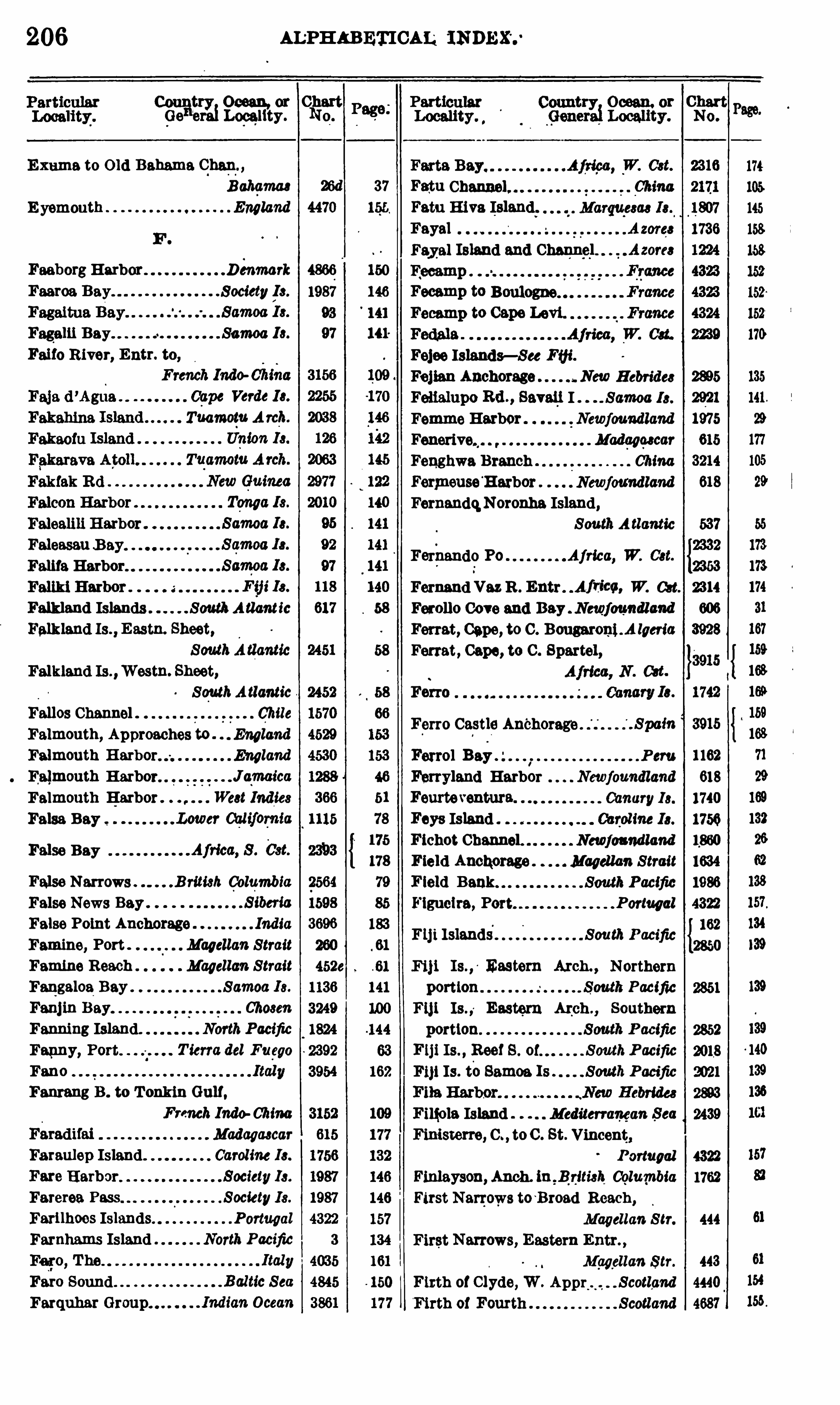
206 ALPHABETICAL
0821
1
1
12310Loeelitg
r 0113?
Exume to O ld Bahama Chem,
Bahemae 26d 37 Fatu
E yemouth England 4470 155. Fatu Hive Island.FayalFaye] Island and Chanfiel
FaeborgHarbor Denmark 4866 150
Faeroe Bay Society/
h . 1987 146 Fecamp to
93 141 Fecamp to Cape Levi.
Fagalii Bay Samoa 13 . 97 141'
Faifo River, Entr. to,
Tuamotu A rch.
Faleasau B ay.
Falifa Harbor Fernando Po
Falkland Islands South A tlant icFalkland Is .
,Eastn. Sheet,
SouthA tlanticFalkland Is . Wastu. Sheet,
SouthAtlantic Ferro
Fallos Channel . Chile
Falmouth, Approaches to . EnglandFerro Castle Anchorage
Falmouth England
Falmouth Harbor Jajmaica
Falmouth Harbor . West Indies a.
False Bay
False Bay
False Narrows British ColumbiaFalse News Bey .
False Point Anchorage India
Famine, Port Magellan StraitFamine Reach Magellan StraitFangaloa Bay Samoa Is.
Fenj in Bay Chosen
Fanning Island. NorthPacific
Fanny, Port . Tierra del Fuego
Fano
Fantang B . to T onkin Gulf,
French Indo-ChimMadagascar
Faraulep Island Caroline 13 .
Fare Harbor. Society 13 .
Farerea Pass SocietyIs.
Ferilhoes Islands Portugal
Farnhams Island North Pacific
Faro Sound
Farquhar Group. .
Fejee Islands- See Fifi.
Fej ien Anchorage New Hebrides
Fenalupo Rd . , SevenI Samoa 13 .
Femme Harbor Newfoundland
Madeoescar
Fenghwa Branch ChinaFermeuseH arbor Newfoundland
FernandqNorouba Island,SouthA tltmticAfrica, W. Cat.
2332
2353
Fernand Vez R . Entr Africe, W. Get. 2314
Ferolle Cove and Bay Newfoundland
Ferret, Cape, to C . Bougaroni .A lgeria
Ferret, Cape, to C . Spartel,
SpamFerrel Bay
1. Peru
Ferryland Harbor Newfoundland
Fourteventura Canary13 .
Faye Island 03 :30am 13 .
Fichot Channel. Newfoundland
Field Anchorage Magellan StraitField Bank South PacificFigueira, Port Portugal
Fiji Islands South PacificFij i Eastern Arch , Northern
portion .
F111 Is . ,o Eastern A1:ch . ,
Southern
portion.
F1ji Is . , Reef 8 . P acific
F1} ! Is. t'
o Samoa Is South Pacific
Finola Island Mediterranean Sea
Finisterre, C . , toC . St. Vincent,
Portugal
Finlayson, Anch. in B d tish ColumbiaFirst Narrows to
~
Broed Reach,
Magellan S tr.
First Narrows, Eastern Entr. ,
Magellan Str.
Firth of Clyde, W . Appr ScotlandFirth of Fourth Scotland
606
3928
3915
1162
618
1740
1750
1634
1986
4322
162
2850
1762
444
443
4440
4687
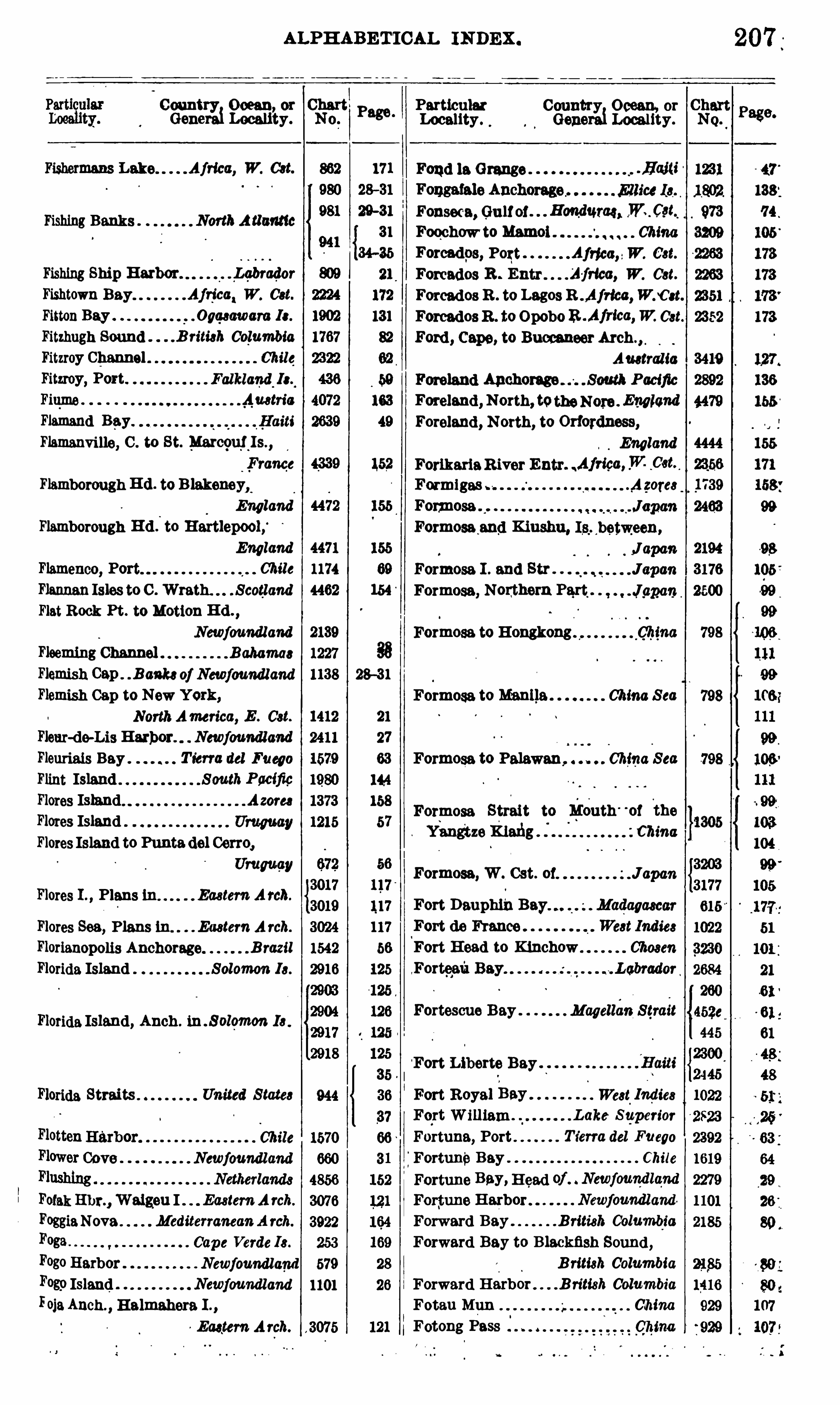
ALPHABETICAL INDEX .
Country Ocean or
Genem1Locali’ty .
Fishermans Lake Africa, W. Cat.
fi shing Banks NorthA tlantic
Fishing Ship Harbor. . q rador
Fishtown Bay Afrjca‘W. Cat.
FittonBay .q wwara Ie.
Fitzhugh Sound .B riti3h ColumbiaFitzroy Channel . Chile
Fitzroy, Port.
Fiqme AustriaFlamend Bey.
Flamanvi lle, C . to St. Marcguj j s,France
Flamborough R d . to B lakeneyx
England
Flamborough H d .
’
to Hartlepool,‘
England
Flamenco, Chile
FlannanIsles to C . Wrath. . ScotlandFlat Rock Pt . to Motion H d .
Newfoundland
Fleeming Channel B ahamas
Flemish Cap . B ankeof Newfoundland
Flemish Cap to New York,NorthAmerica, E . Cat.
Fleur-de-Lis Harbor. Newfoundland
Fleuriais Bay . Tierra del Fuego
Flint Island SouthPacificFlores Island Azom
Flores IslandFlores Island to Punta del Cerro,
Umwav
Flores I . , Plans in Eastern Arch.
Flores Sea, Plans tu. EasternA rch.
Florianopolis Anchorage B razil
Florida Island Solomon I3 .
Florida Island, Anch . 1n . S olomon I3 .
Florida Straits United S tate3
Chile
Newfoundland
FotakEhr. , Walgeu I EasternA rch.
FoggiaNova MediterraneanA rch.
Foga Cape Verde Is .
FogoHarborF089 Island NewfoundlandFOjaAnch . , Halmahera I . ,
Eastern Arch.
Falklaztd.
Is.,
660
4856
3076
3922
253
Newfoundland 579
1101
, 3075
Page .
8
88
28—31
21
144
158
Particular Country Ocean, orm1Locality . Gene Locality .
Fond la Grange . .Haiti
Formosa I . end Str . .
Formosa, Nonthern Part,
Formosa to Hongkong ,
Chma
Formosa to Manila . China S ea
Formosa to Palawan, China S ea
Formosa Strait to l ieuth ' °
of c e
YangtzeKlefig zcmna
Formosa, W. Cat. 01.
Fort DauphinFort de France
Fort H ead to Kiuchow
Forteafi Bay
Fortescue Bay Magellan Strait
Fort Liberte Bay
Fonseca, Gulfof Honduras, ,W. _Cgi
Foochow to Mamol ChinaForcadps, Fogt AIdea”W. Cat.
Forcados R . Entr Africa, W. Oct.
Forcados R . to Lagos R .Africc,WnCet.
ForcadosR . to OpoboR .Africa,W. Cat.
Ford , Cape, to Buccaneer
Auetralia
Foreland Anchorage South PacificForelend , North, totheNore England
Foreland , North, to Orfordness,
England
ForikariaRiver Entr Africa,W. _03t. ,
Formigas Azores
Formosa
Formosa end Kiushu, Is between,
J apanJapan
Japan
Fort Royal Bey We3t.
Indies
q t William Lake Swperior
Fortune, Port Ts’
erra del Fuego
FortuneBay Chile
Fortune Bay, H ead of Newfoundlqnd
For‘tune Harbor Newfoundland
Forward Bay British ColumlgiaForward Bay to B lackfish Sound ,
British ColumbiaForward Harbor British ColumbiaFotau Mun ChinaFotong Pass
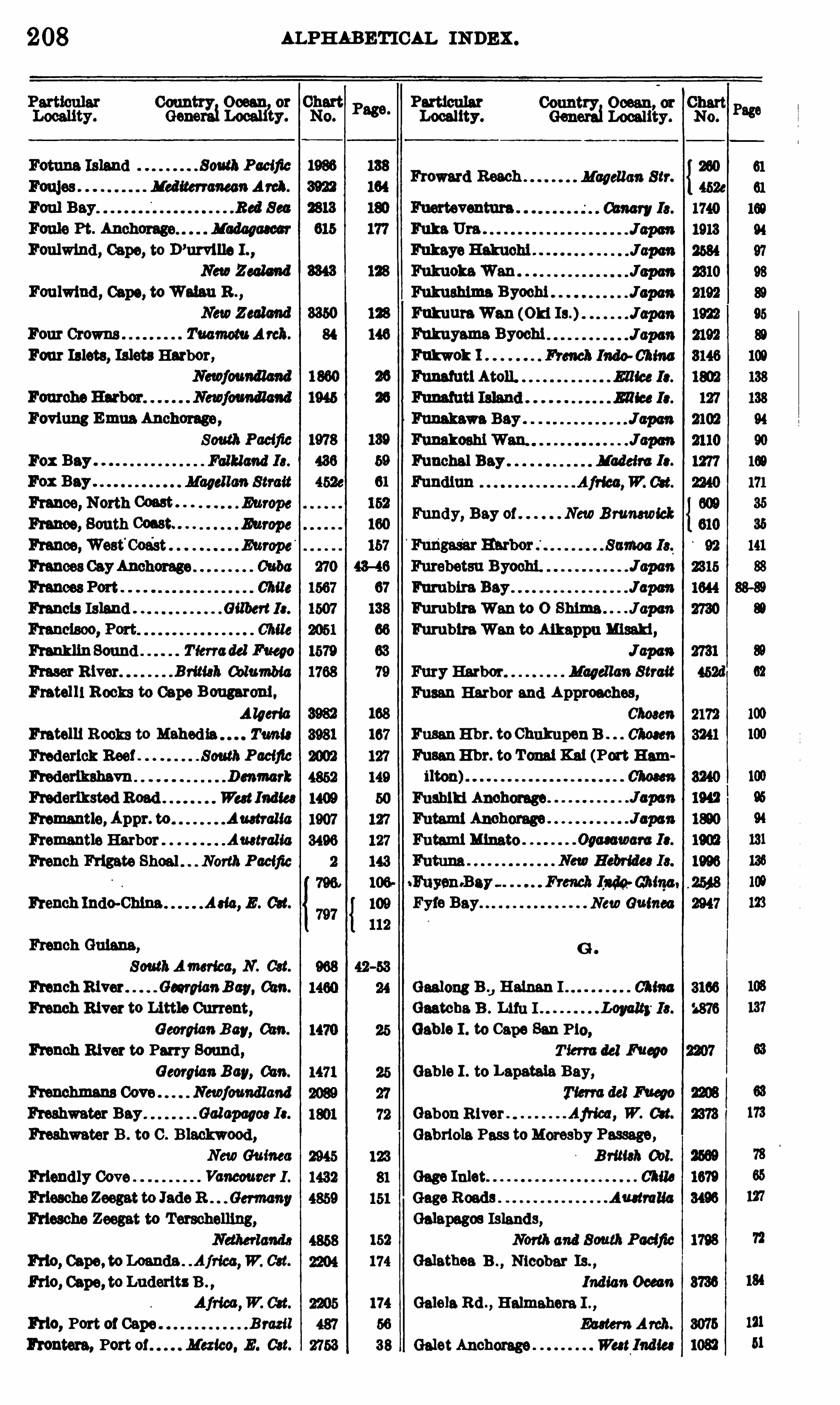
208 ALPHABETICAL INDEX .
2 333“3333 93?
. . Héaerfzzn
p
frgc
Froward Reach Magellan Str.
Foulwlnd , Cape, to D’urville I . ,
NewZealand
Foulwlnd , Capo, toWuhu B . , Fukushima Byochi
Fukuure Wan (Old Is.)Four Crowns Tuamotu Areh. Fukuyema Byochi
Four Islets, Islets Harbor, M o]: 1
Funafuti Atoll.
Fovlung Emua Anchom e,
South PacificFox Bay Falkland 13 . Funchal Bey Madeira Ia.
mgolf;m; 2z Fundy, Bay of NewB runswick
France,West'
Coa'
stFrances CayAnchorage
Francis Island Gilbert 13 .
FranklinSound Tierradel Fuego
Fraser River Brimh ColumbiaFretelll Rocks to Cape Bougaroni.
A lgeria
En telli B ooks to Tum:Frederick Ree! SouthPacific
Frederlkshavn Denmark
Frederiksted Road Wa tIndia Fushlkl Anchorage
Fremantle, Appr. to Australia Futeml Anchorage
Fremantle Harbor Australia Futaml Minato
French Frigate Shoal . North Pacific
French Inda China,
French Indo-Chlne Ada, E . Oct. New Guinea
French Guiana,
SouthAmerica, N . Cat.
French River GeorgianBay, a m. Geelong B .J Helnan I
French River to Little Current, Gaatcha B . Lifu IGeorgianBay, a m. Gable I . to Cape San P10 ,
French River to Parry Sound , Tierra del Fueyo
Georgian Bay, Gable I . to Lapatale Bay,
Frenchman Cove Newfoundland
Freshwater Bey Galapagw Ie. Gabon River AjHea, W. eu.
Freshwater B . to C . Blackwood , Gabriele Pass toMoresby Passage,NewGuinea British 0 11.
Friend ly Cove Vancouver I Gage Inlet Chile
Australia
Galapagos Islands,152 North and South Pacific 1798 72
Frio, W. Cat. 174 Galathea B . , Nicobar Is. ,
Indian 0 000 71 8736 134
174 Galois Rd . , Halmahera I . ,
F110 , Port 01 Cape B razil 56 Eastern Arch. 3075 121
Promote, Port of Mexico. E . Cat. 38 Gelet Anchorage West Indies 1082 51
Frio, Cape, to Luderitz B .
Furubira Bay .
FumbiraWen to 0 Shima JapanFumblraWan to Aikappumam ,
J apan
Fury Harbor Magel lan Strait
Pusan Harbor and Approaches,Choeen
Fusan E hr. to ChukupenB 011033»
Fusan E hr. to Tonal Kat (Port Ham

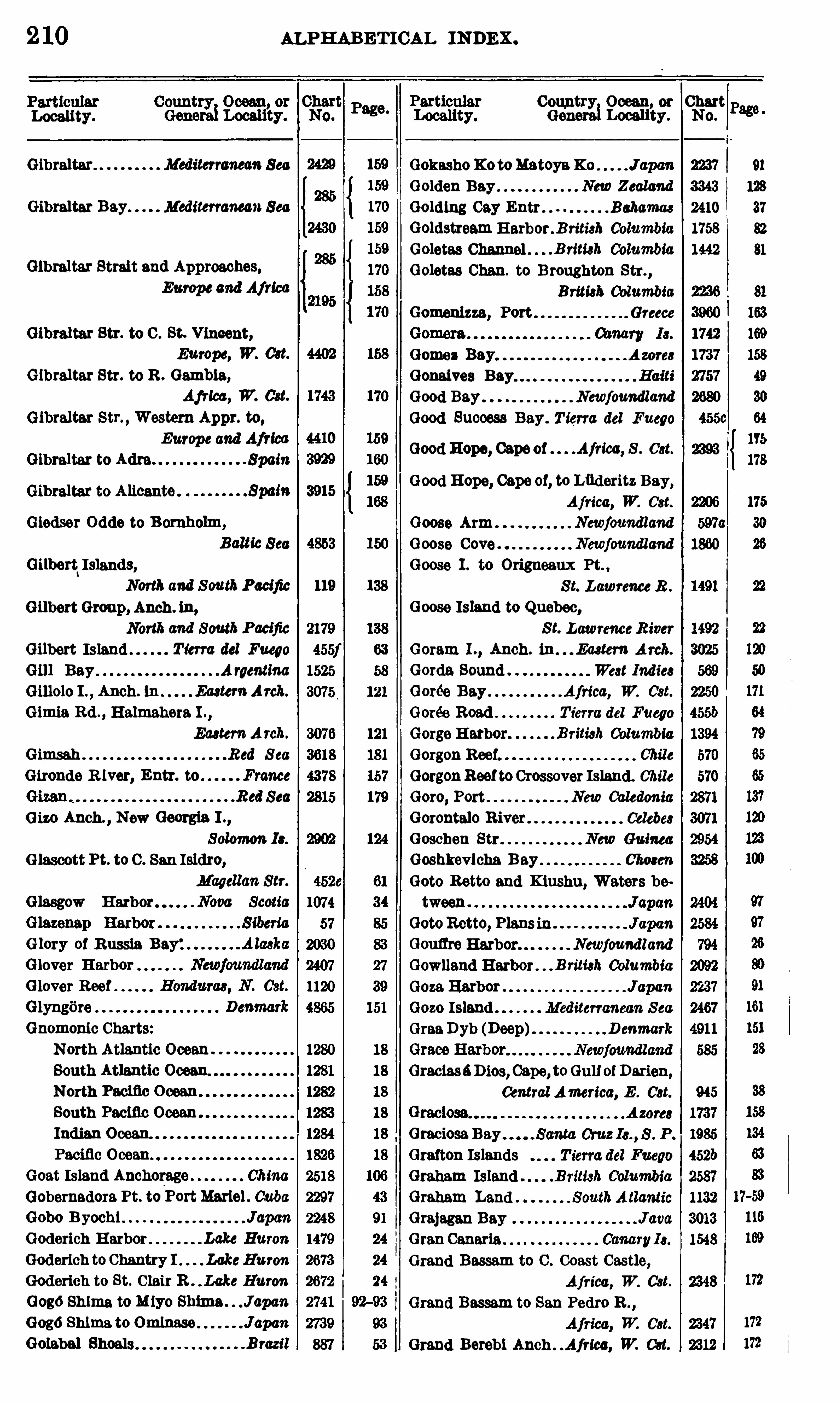
2 10 ALPHABETICAL INDEX .
Locality.
Gibraltar Mediterranean Sea
Gibraltar Bay Mediterranean Sea
Gibraltar Strait and Approaches,Europeand Africa
Gibraltar Str. to C . St. Vincent,
Europe, W. 03t.
Gibraltar Str. to R . Gambia,
Africa, W. Cat.
Gibraltar Str. ,Western Appr. to,
Europe and Africa
Gibraltar to Adm Spain
Gibraltar to Alicante .
Giedser Odde to B omholm,
BalticSea
Gilbert‘Islands,
North and SouthPacificGilbertGroup, Anch . in,
North and SouthPacificGilbert Island T ierra del Fuego
Gill Bay A raentim
0 1110 10 I . Anch. in EasternArch.
Glmia Rd . , Halmahera I .,
EasternA rch.
Gimsah Red S ea
Gironde R iver, Entr. to France
Red Sea
0 130 Anch . ,New Georgia I . ,
Solomon 13 .
Glascott Pt. to C . San Isidro,
Magellan Str.
Glasgow Harbor . Nova Scotia
Glory of Russia Bay:Glover HarborGlover Reef
Glyngore
Gnomonic Charts
North Atlantic Ocean
South Atlantic Ocean
North Pacific Ocean
South Pecine OceanIndian Ocean.
Pecine Ocean
Goat Island Anchorage ChinaGobernadora Pt. to
,
PortMartel . CubaGobo B yochi JapanGoderich Harbor Lake Huron
Goderich to Chantry I . LakeHuron
Goderich to St. C lair R . . Lcke Huron
GogoShima to Miyo Shima . J apan
Gogo Shima.to Omlnase JapanGolabal Shoals B razil
CountxgiwOcean, or Chart
No.
Gokasho X 0 toMatoynK0 J apan 2237
Golden Bay New Zealand 3343
Golding Cay Entr Bahama 2410
Goldstream Herbor . B ritish Columbia 1758
Goletes Channel .
Goletas Chan. to Broughton Str. ,
British ColumbiaGomenizza, Port Greece
Azore3
Q Q Q Q Q Q Q Q Q Q Q Q
Grecias4D103 , Cape, toGulfof Dm-ien,
Central America, E . Cst.
.B rimh Columbia 1442
91
128
37
81
Gomez BeyGonaives Bay
Good Bay Newfoundland
Good Success Bay . T ierra del Fuego
Good HOpe, Capeof Africa, S . 031.
Good Hope, Cape of, to Luderitz Bay,Africa, W. Cat.
Goose Arm Newfoundland
Goose Cove Newfoundland
Goose I . to Origneaux Pt. ,
S t. Lawrence R .
Goose Island to Quebec,S t. LawrenceR iver
Goram I . , Anch. in Eaetem Arch.
Gorda Sound We3t Indie3Gorée Bay Africa, W. Cst.
Gorée Road T ierra del Fuego
GorgeHarbor B riti3h ColumbiaGorgon Reef Chile
GorgonReeftoCrossover Island. Chile
Goro, Port New Caledonia
Gorontalo R iver Celebe3
Goschen Str New Guinea
Goshkevicha Bay Choeen
Goto Retto and Kiushu, Waters be
tween
GotoRetto, Plans in JapanGouflre Harbor. Newfoundland
Gowlland Harbor B riti3h ColumbiaGoza Harbor Japan
Gozo Island Mediterranean Sea
GraaDyb (Deep) D enmark
GraciosaBay
Grafton IslandsGraham IslandGraham Land
Grajagan BayGranCanaria .
Grand Bassam to C . Coast Castle,
Africa, W. Cst.
Grand Bassam to San Pedro B . ,
Africa, W. Cst.
Grand Berebi Anch Africa, W. C3t.
ALPHABETICAL IN DEX .
Country Ocean, or Clgarto.Genera Locality.
Grand Berebi to Poor Pt. ,
Grand Bourg We3t India
Grand Bruit Harbor . Newfoundland
Grand Cayman Caribbean Sea
Grand Cul-de-Sac Bay. We3t IndiaGrand EntryHbr G. efSt.Lawfence
Grand Hanan Island .B . of Fundy
Grand Pierre Bay
Grand River P rince Edward I .
Grande West Ind iaGrande Cruz Cove
Grande do Norte, Entr. to R iver,
B razil
Grande, Port Chile
Grande
Gmnitnui BeyGrappler, PortGmppler Reach
Grassy Bay B ermudas
Grassy Bay, Apprs . to B ermuda
Grassy B . to theNarrows . . B ermuda3
Gran Cove. Chile
Grave, Bay Newfoundland
Graves, Port B ritish Cblumbia
Gray Harbor Chile
Great Abaco I SouthernExtremity,
Bahama
Great Banks of Newfoundland ,
N . A tlantic
Great Barrier Pacific
Great Bay .
Great Bay de l’E au . Newfoundland
GreatBelt D enmark
Great Bras d ’Or Cape B reton 1 .
Great Circle North A tlanticGreat C ircle Sailing . . S outhA tlanticGreat Circle Sailing Pacific Ocean
Great Circle Sailing North Pacific
Great Circle Sai ling" . . South Pacific
Great Circle Sailing Indian Ocean
Great Corn Island . . Caribbean S ea
Great Duck I . to Cove I . Lake Huron
Great Duck I . to Detour Passage,
Lake Huron
Great Exuma H arbors . . Bahamas
Great Fish W. Cst.
GreatGoose E hr Newfound land
Great Harbor Bahamas
Great Harbor Cay (northern part),Bahamas
Great Harbor Deep . Newfoundland
Page.
CountryiOcean, or Chart
Genera
Grenada, S . Cst. (part of) West Indies
Guadalcanal I . ,Anch . in . Solomon Is.
Guadeloupe Island West Indies
Locality . No.
2602
4560
1101
2280
2413
998
580
1316
Greathead Bay West Indies
Great Inagua Island Baham a
Great Isaac Anchorage Bahamas
Great Isaac Cay B ahamas
Great Jorvis Harbor Newfoundland
Great Lakes
Gmat Lakes , Pilot Chart,NorthAmerica
Great Ormes H d . to H olyhead ,
England
Great Ormes H d . to Liverpool ,
England
Great Redang E hr. Malay Peninw la
Great Sound B ermudas
Great Stirrup Cay Bahamas
Great Troytown Harbor,Newfoundland
Greece Europe, S . Cst.
Green Bank NorthA tlanticGreen H ead to L ittle Bay I . ,
Newfoundland
Green Head to Shoe Cove ,
Newfoundland
Green Island Anchorage ,Newfoundland
Green Island H erbor JamaicaGreenland A rctic OceanGreen T urtle Cay Anchorage,
L ittle Bahama BankGreenspond Harbor,
Newfoundland, E . Cst.
Greenspond Harbor,Newfoundland, NE . Cst.
Magellan StraitWest Indies
West Indies
Grenadines West Indies
Gretton Bay T ierra del Fuego
Grévignpux Harbor Newfoundland
Greymouth H br New Zealand
Greytown H arbor. N icaragua, E . Cst.
Griguet Harbor Newfoundland
Grfin Sound D enmark
Grossa I . to C . Promontore Au3 tria
Grossa I . to Zirona Chan Austria
Grossevich Bay . S iben’
a
Guacanayabo, Gulf of CubaGuadalcanal Island S olomon 13 .
2 1 2
Country Ocean, or ChartGenerai Locality.
Guadalupe Island North Pacific
Guaine Plsagua Bay— See Hwaina.
Chile .
Guaiteees Islands Chile
Guaitecas Is. , Ports in Chile
Guaj imico R iver CubaGualeguala Cove Chile
Guam Island Mariam”
Guamache Bay Venezuela
Guambacho, Port
Guafiape IslandsGuanine del Norte
Guanl llos Cove
Guanito Bay .
Guano Islands,North and South Pacific
Guanoco R iver Venezuela
Guanta Hathor end Apprs Venezuela
Guantanamo B . , from Ent. to Cei
manem
Guantanamo B . , Appr. to and Speed
Trial Courses Cuba
Guantanamo B . to C . Maysl . Cuba
Guantanamo B . to Chlrlvlco E hr. ,
Guepiqul lan IslandsGuarapari Bar.
Guero Bay . . New Caledonia
Guasco, Port . Chile
Guasopa E hr. , Wood lark I
NewGuinea
Central America
Chile
Guatulco Harbor Mexico, W. C3t.
Guaurabo and 08 113 8 R ivets. CubaGuayaquil, Approaches to. Ecuador
Guaymas Harbor . Mexico, W. C3t.
Guet Ndar Anch Africa, W. Cst.
Guguan Island Marianas
Guia Narrows
Guiana. SouthAmericaGuie Chan ChinaGuirior Bay Chile
Gulf of— See index of proper names.
Gulliver H ole to Port Lorne ,
Nova ScotiaGun Cay Anchorage Bahamas
Gun Point to Shallow Bay,
Newfoundland
Gunong Sudi Anch. , Ceram I . ,
Ea3tem A rch.
Gurapien Anch. , Halmahera I . ,
Eaetem A rch.
Gustaf H arbor West Indies
Gut of Canso Nova Scotia
Page .
ALPHABETICAL INDEX .
Particular Country Ocean, or ChartLocality. Genera Locality. No.
Guysborough HarborGuzman B lanco B
Haapai Group, Northern Portion,
Tonga 13 .
Haapal Group , Southern Portion,140
Hal H o China
Haiti, Island of .
Haiti, Republic of
Haiti to Halifax,
NorthAmefiea, E . 033.
Haiti to St. Lucia We3 t 1ndie3Haitian Harbor, CapeHaiyung Tao
Haiyung T ao to Terminal Hd . ,
Choeen
Hake Hetu . Marque3ae I 3 .
Hakodate Bay JapanHale Cove Chile
Halifax Dockyard Nova ScotiaH elltax Harbor Nova ScotiaHalifax H arbor and Apprs .
,
Nova Scotia31 H alifax to CapeSt. Mary,
North America, E . C3t.
Halifax to Haiti.NorthAmerica, E . 033
121 Halifax to New York, 31—34
50 NorthAmerica, E . 031. 35
33 Hall Bay Newfoundland 2395 27
33 H all Island Gilbert 13 . 122 138
981 29-31
121
1411 34
H ebana HarborHabana to C . Canaveral ,
N . America, E . Cst.
Habana to Port Mariel Cuba
Hachijo Jima to K azanRettoJ apan
Hada Bay, Bauro 1 Solomon 13 .
H adsund D enmark
JapanHahaJ1ma Islands . Southern13 .Japan
Heifong end Apprs . ,
French Indo ChinaHainen Island ChinaHainan Island and Strait ChinaHainan Strait ChinaHais Anchorage Gulf of AdenHaitan Strait China
H aitan Strait, The Narrows of . ChinaHaiti, Anch . onW . Coast 0 1,
West Indies
Haiti, Harbors on Coast of,West IndiaWest. Indies
West Indies

2 14 ALPHABETICAL INDEX .
Country Ocean, or ChartGenera1Locality. No.
Hecate Channel. Vancouver 1 . 1440
Hecate Cove Vancouver 1 . 1541
Hecate Strait . NorthAmerica, W. 03t. 904
Hecate Str. ,NorthernPart .B rimhtkt. 1583
Hecate Stn. ,SouthernPert,Brm'
3h001. 1584
B ede. H arbor Japan 1649
Heinrichs Fiord Chile 1570
Helgoland North S ea 4907
Helsingborg Sweden 4868
Helsingor Harbor Denmark 4868
Henderson Inlet Chile 10
Henderson . South Pacific 1977
Henderville Islands Gilbert 13 . 122
H enjam Sound P ereian Gulf 3659
913H enry, Port 671113 {2244Henneke Island Tuamotu Arch. 1 79
Herald Bight South Pacific 2018
H erbertshohe B ismarckA rch. 2973
Hereheretue Islands TuamomAreh. 84
Heretua Tuamotu A 7011. 84
Herkules B . to C . N0130 11 . NewGuinea
NorthPacific 4
Hermit Islands B i3marckArch.
2967
2968
Hermite Island T ierra del Fueao 455e
Heron Channel Gulf of S t. Lawrence 2496
Herradura Bey Spain 3915
Herradura, Port Chile 1326
Herradura de Carrizal Chile 1253
Herschel Island A relic Ocean 1197
H ervey Isles 0ook 13 . 2000
H ervedero Pass UruguayR . 2706
Hesquiat Harbor Vancouver 1 . 1388
Hewett Bay Magellan Strait 452d
B ibi Suido 2329
H iechechln Bay China 3200
H ienghene Port‘
. New Caledonia 2869
Hierro 1742
Mexico, W. 03t. 915
Highborn Cut . 1613
H illsborough Bay . . P rince Edward 1 . 1068
H illiers Harbor Newfoundland 794
Himana Bay Celebee 3062
mmeshima 1532
Hinako Is . (Neku Nias I . Sumatra 3103
Hipolito Bay, San . . . Lower California 1310
H iredo Kaikyo, Northern Apprs. to,
Japan 2328
Hirado Kaihyo, Southern Apprs . to,
Japcm 2335
H iredo Kaikyo to Shimonoseki
Kaikyo Japan 2475
H irado Strait
Count Ocean or
Gener
rfi Locali’
ty.
H og Harbor NewHebrides
B ogolu Islands Caroline I3 .
Hoihow Bay, Helm I ChinaHoinlpoh B . N icobar Is . 1nd£cmOcean
Hoko Retto
H oko Suido
Hokushu Yew) Island
Kokusha, Anchorages in
Hokoshu, W . Coast 01 Jupon
Hongkong to Taiwan
Hongkong to Manila China Sea
Hongkong to Hire Bey ChinaHongkong to Palawan Island,
China Sea
Hokushu to Shikotan J apan
Holllhans Wharf Newfoundland
Holm Sound Orkney I3 .
Holmes Bay B ritieh ColumbiaHolyhead toGreatOrmesHd England
Ho]yhead to New Quay England
Home Knoll South PacificHomtrey Channel B riti3h ColumbiaHondskllp Bey Afrlea, W. Cet.
Honden Tuamotu A rch.
Hondo R iverHonduras, Gulf ol, and Apprs.
Honduras, N . Cst.
Honduras, East Gou tHonduras, West Coast
Honduras Guatemala, E . Cst.
Honduras , Gulf of,Central Amen
'
ea, E . Cat.
Hongkong Harbor Chma
Hongkong Harbor and Approaches,China
Hongkong to Cape Padaren ChinaHongkong to Gulf of Liaotung . ChinaHongkong to the Brothers China
ALPHABETICAL INDEX .
Particular Country Ocean, or iChm-t
Genera1Locality.
HongkongWaters, East ChinaHongkongWaters,West ChinaBoukebo Bay. French Indo ChinaHonma French Indo China
J apan
Honshu,Anchorages 1n. . J apan
p ing E hr. to St. Julien I . ,
Newfoundland
Hope Bay J amaicaHopper Island Gilbert 13 .
Horcon Bay Chile
Horie Bay .
Horizontal Intensity of the Earth’s
Horn, Cape, to Magellan Str.
SouthAmericaHorn Head to Rethlin O ’Blme,
Ireland
B rim}; ColumbiaSouthPacific
Chile
Horns Rev (Reef) Denmark
Berta .Azore3
Chile
Hososhima Herbor J apan
Hospital N . Cat.
Hospital Bay. . . HcmHaste Inlet Falkland 13 .
Hottentot Bay Africa, W. 031.
Houston Stewart Chan.
Newfoundland
Falkland 13
2681
1286
122
1659
Page .
46
138
$
8
Particular Country Ocean, orLocality. Gen Locality.
Hurepiti
Hurlock Bay. .
Huron, Lake North Amemo
HurricaneH ole.St. 101m. Weet IndiaHutau Bay. ChinaB utt , Port . C'hatham 13
HwangHaKYellowSea) NorthPacific
Hyogo Bay JapanHyogo Bay, Approaches to . J apan
latte Anch, LimI
Ibrahim , Port
IburiWan.
Ichabo Anchorage" .Africa, W. 031
Ichang toChungking Yangtze K itwa
Ichang to Compton B each,Yangtze K iang
IdolosIero, Entr. to Port . Turkey in A311:
Itallk Islands Oarolim 13 .
Iguana Cove Galapagoe 13 .
Iheya Islands Japan
IjipthavAnchorage . New Hebridee 13 .
Iki Shima JapanIldtsuki Jima to Take Shima J apan
Ile d ’Ouessant end the Mainland ,
Channels between France
Ile d ’Ouessant to Plateau des 1ls
HuemulesR iver,Modth of Chile
Huemul, Port Tierra del Fueyo
Huenteleuquen Cove Owe
Hugh Bay Chile
11t Harbor China
Huite, Port Chile
Huito Inlet Chile
Hull ‘s IslandHumberArm Newfoundland
Humboldt Bay NewGuinea
Humphrey Island South PacificHunter Island New Hebrides 13 .
Hunter Rd . , Guadalcanal I .
Solomon 13 .
He du 110a to Port St. Francis,St. LawrenceR .
Ilheo,Port de Africa, W. Oct.
Ilheos Anchorage B razil
Ilheos Anchorage to Bahia Brazil
IlheosAnch. toComoxatibaPt. B razil
I lick Harbor Caroline 13 .
110 Road Peru
Ilwaki Road , Wetta I Ea3tem Arch.
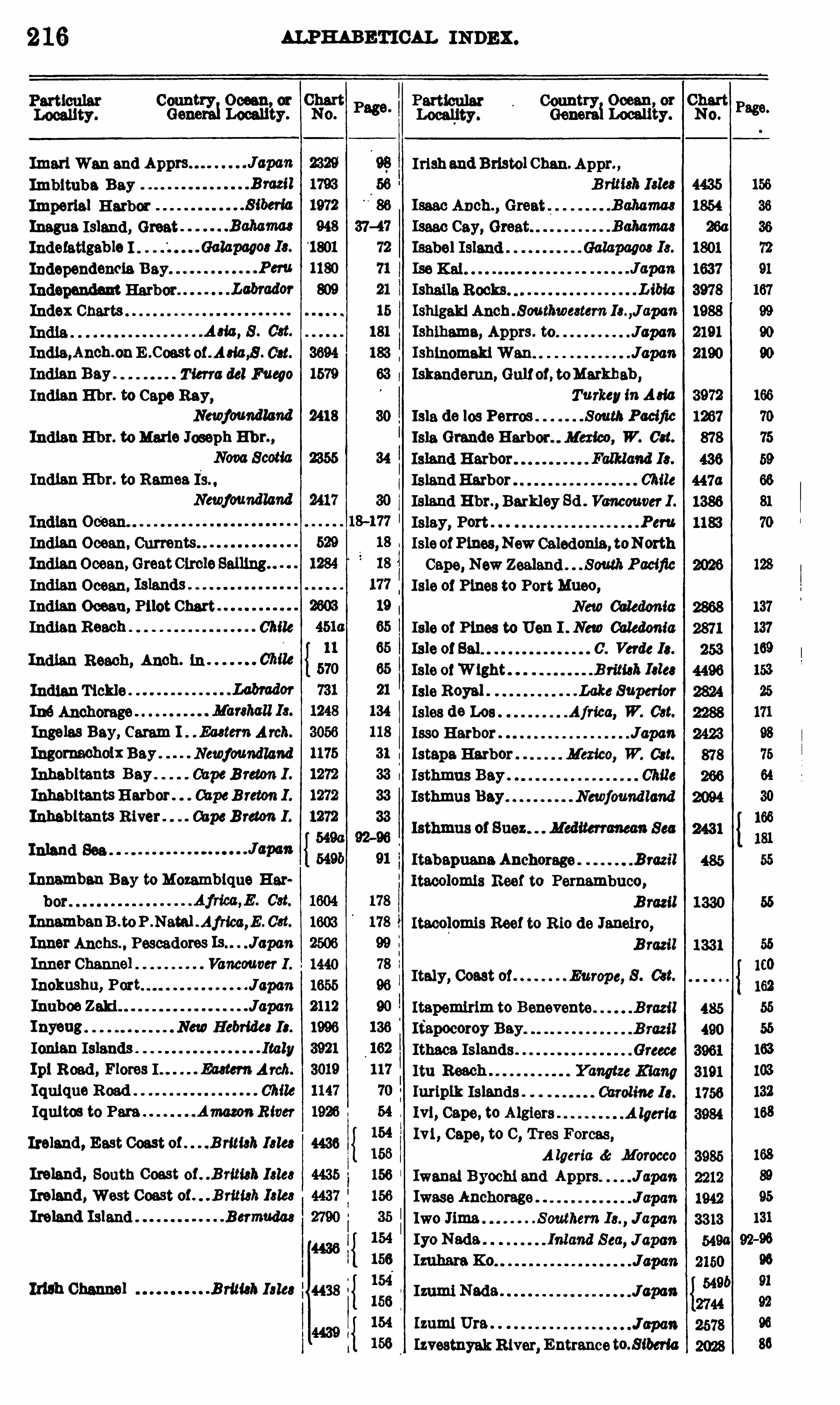
2 16 m m nn cu INDEX .
C393"233 33? 223 Pase Em c
fifif‘
Imarl Wan and Irish and Bristol Chan. Appr. ,
Imbituba BeyImmrlal HarborInagua Island, GreatIndelatigable I .
Independencie Bay
Independent HarborIndex Charts Ishlgakl Anch . Southwe3tem 13 . ,J apan
India,Anch.onE .Coast of . Ada,8 . 03t.
Indian Bay . Tierra del Fueyo
Indian E hr. to Cape Ray,
Newfoundland
Indian E M. to Marie Joseph Ebb ,
IndianHbr. to Remea Is. ,
Newfoundland
IndianOcean, Currents"
IndianOcean, GreatCircleSelling"
Indian Ocean.
Indian Ocean, Pilot ChartIndianReach Chile
Indian Reach, Anch. in
IndianTickle
Iné Anchorage
Insoles Bay, Caram I . . Eaetem Arch.
IngomeeholxBay Newfoundland
Inhabitants Bay OapcB reton I .
InhabitantsHarbor . CapeB reton 1 .
Inhabitants River . CapeB reton I .
Inland See .
Innamban Bay toMozambique Her
InnambenD . toP .Natal .Africa,E . C3t.
Inher Anons. , Pescadores J apan
Inner Channel Vancouver 1 .
Inokushu, Port JuponInuboe Zaki JapanInyeug NewHebride: 13 .
Ionian Islands ItalyIpl Road , Flores I Ea3ternArch.
Iquique Road Chile
Iquitos to Para AmazonRiver
Ireland , East Coast of . .B rmah l 3 le3
Ireland , South Gou t of. .B ritieh 132e3
Ireland , West Gou t of . . . B ritieh Islee
Ireland Island Bermudas
Ir'll h Channel B ritish 13133
Ishlhama, Apprs . to Japa'n
IshlnomakiWen JapanIskanderun, Gulfof, toMarkhab ,
TurkeyinA310
Isla de los Perms South PacificIsle Grende Harbor. Mexico, W. 031.
3 1.
Isthmus Bey Newfoundland
ItabapuanaAnchorage Brazil
Itacolomis Reef to Pernambuco,
Itaeolomis Reef to R io de Janeiro,B razil
Italy, Coast of Europe, 8 . C31.
Izumi Nada .
Izumi Uta .
IzvestnyakRiver, Entrancet ibefla
IslandHarbor C'
ule
Island E hr. , Barkley Sd . Vancouver 1 .
Islay, Port Peru
IsleofPines,NewCaledonia, toNorth
Cape, New Zealand South PacificIsle of Pines to PortMueo,
New Caledonia
Isle of Pines to Uen I . New Caledonia
Isle 01 83 1 0 . Verde 13 .
Isle 01W ight Brim}; 131e31810 Royal Lake Superior
[ 3108 de Los Afried, W. Cat.
1330 Harbor Japcm[ steps Harbor Mexico, W. 031.
Itapemirim to Benevente
Ifapocoroy Bay
Ithaca IslandsItu Reach
Iuriplk IslandsIvl, Cape, to Algiers
Ivi , Cape, to C , Tres Forces,
A lgeria dc Morocco
Iwanai Byochi and Apprs JapanIwase Anchorage
Iwo JimaIyo Nada.

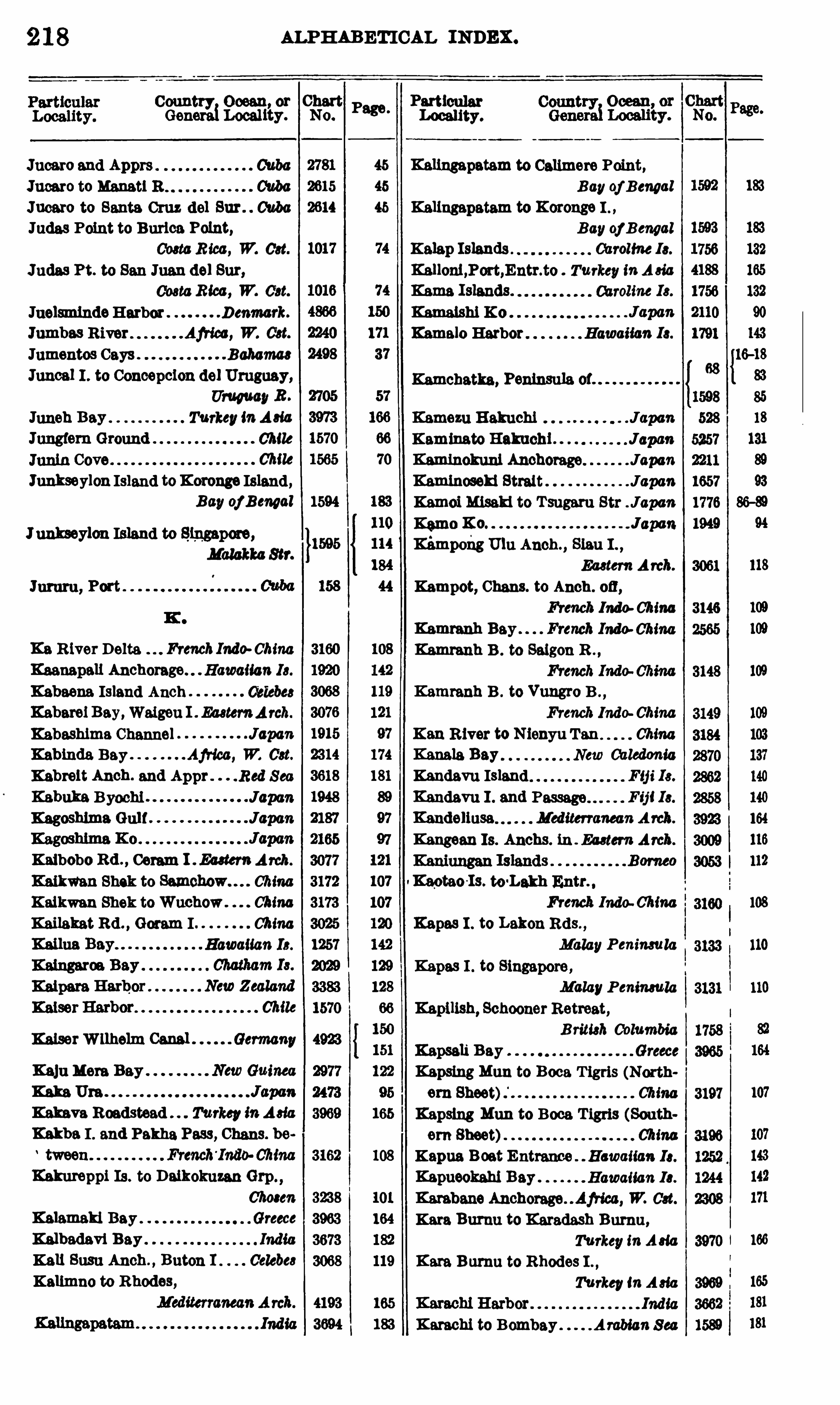
2 18 ALPHABETICAL INDEX .
Conn Ocean, or Chart( 1:0t
TyLocality. No.
Page .
Locality.
Jucaro and Apprs Cuba Kanngapatam to Canmore Point,
Juw o to Manet! R C‘uba Bay oj Bengal
Jnearo to Santa Cruz del Sur . Cuba Kallngapatem to Koronge I .
Judas Point to Burlea Polnt, Bay oj B engal
R ice , W. Oat. Kalep Islands . Oarollm 13 .
Judas Pt. to San Juan del Sur, Kellon1,P0rt,Entr.t0 Turkey inA 310
003mR100 , W. 03t. Kama Islands. Chrolim 13 .
JuelsmindeHarbor Denmark. Kamaishi K 0
Jumbes River Afried , W. 03t. Kamelo Harbor Hawaiian 13 .
Jumentos Gays . Bahama
Juncel I . to Concepcion del Uruguay, Kamchatka, Peninsula of"UruguayR .
Juneh Bay Turkey inA 310
Jungfem Ground Chile
Chile
Junkseylon Island toKoronge Island,Bay oj BeMal 1594
Junkseylon Island to Singapore,Malakka Str.
Jumru,
K0 R iver Delta FrenchIndo ChinaKaenapali Anchorage. Hawaiian 13 .
Kabaena Island Anch 0313563 Kammnh B . to Vungro B . ,
Kabarel Bey,WaigonI . EasternArch. French Indo ChinaKabeshima Channel Japan Kan River to N ienyu Tan ChinaKablnde. Bay Africa , W. 03t. Kanala Bay New Caledonia
Kabrelt Anch. and Appr . .Red Sea Kandavu Island F ij i 13 .
Kebuke Byochi Japan Kandavu I . and F ij 113 .
Kagoshlma Gulf Japan Kandeliusa Mediterranean A rch.
Kangean Is. Anchs. ih . En ter»Arch.
Kaibobo Rd . , Cam I . Ea ter»Arch.
Kaikmn Shek to China Kaotao'Is. te tLakh Entr. .
Kaikwan Shek toWuchow. China French Indo Chim 108
Kailakat Rd . , Gorem I China Kepes I . to Lakon Rds. ,
Hawaiian 13 . MalayPenimula 110
Kepes I . to Singapore ,
MalayPeninsula 110
Kapilish, Schooner Retreat,
KaiserWllhelm Canal Germany 4923B ram}; Calambac
KainMere BayKaka Um 107
Kalmva Roadstead Turkey inA 310
Kakba I . and Pakha Pass, Chane. be
Kelmreppi Is . to DaikokuzanGrp
C'hocen
Kelamakl Bay . Greece
Kalbadevi Bay . India I 166
Kali Susu Anch . , Buton I . Celebe3
Kalimno to Rhodes,
K arachi to Bombay A rabianS ea
Kamezu B akuchi JapanKaminato Hakuchi JaptmKaminokuni Anchorage JapartKamlnoseki Strait JapanKamoi Misaki to T sugaru Str J apan
Kemo K 0 . J apan
KémpohgUlu Anch. , Slau I . ,
Eaetem Arch.
Kampot, Chans. to Anch . 0 11,
French Indo ChinaKemmnh Bay . . French Indo ChinaKemranh B . to Sugon B . ,
Kapsali B ey
Kapsing Mun to Boca T igris (North
ern Sheet) ChinaKapsing Mun to Boca T igris (Southem Sheet) ChinaKapua Boat Entrance Hawaiian 13 .
Kapueokehi Bay Hawaiian I 3 .
Km bane Anchorage Africa, W. 03t.
Kara Burnu to Karadash Burnu,Turkey inA 310
Kare Bumu to Rhodes I . ,
TurkeymA 310
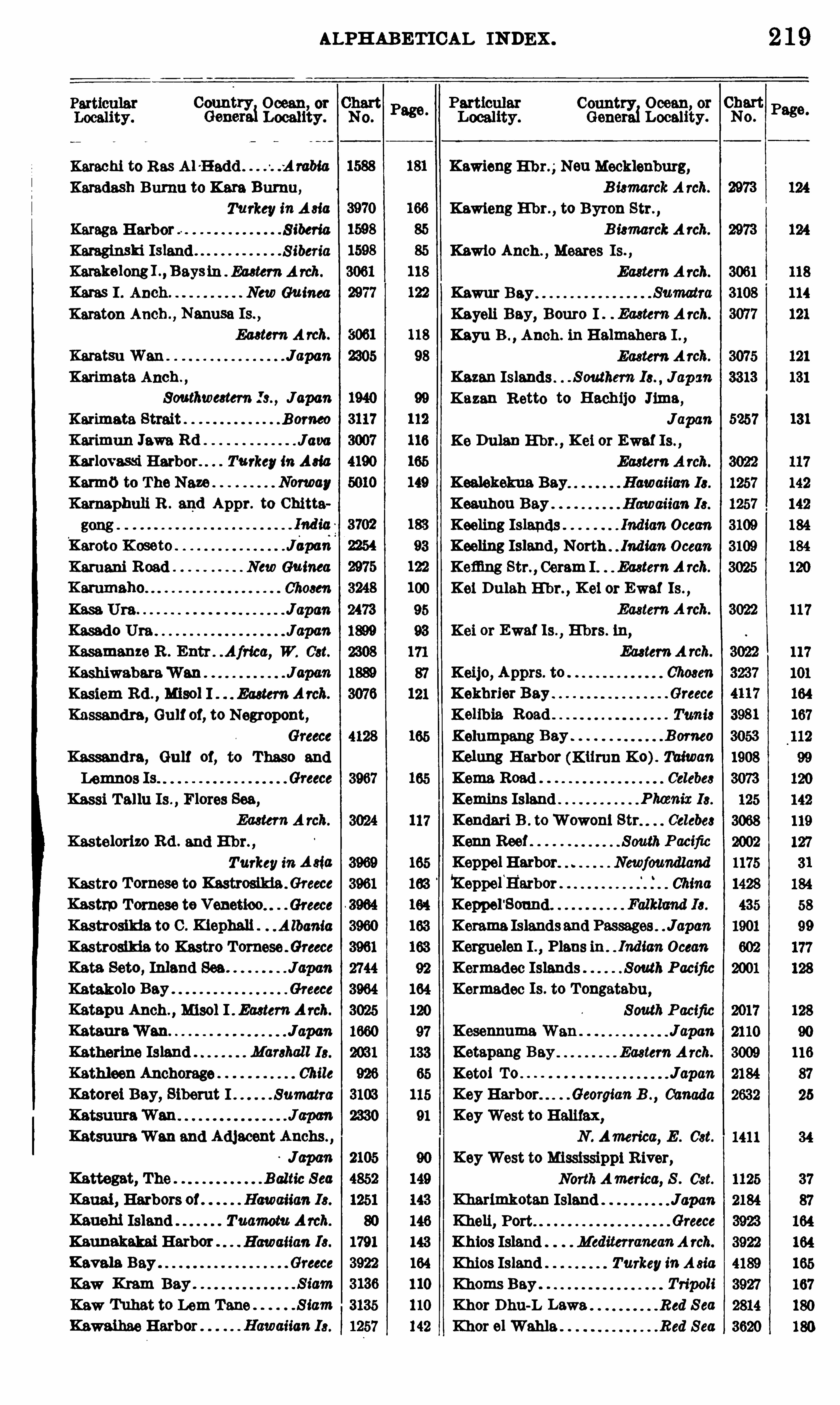
ALPHABET ICAL INDEX .
0323231823113
?
2222318823313? C
IR?
Karachi to Res A l -H add .
-A rabla Kawieng E hr. NonMecklenburg,
Karadash Burnu to Kate Bumu, B i3marckA rch.
Turkey inA 310 Kawieng E hr. , to Byron Str. ,
Karaga Harbor S iberia B i3marckA rch.
Karaginski Island S iberia Kawio Anch ., Meeres Is. ,
Karekelongl . , Bays in Ea3tem A rch. Eastern A rch.
Karas I . Anch New Guinea
Karaton Anch . , Nanusa Is. ,
Ea3tem A rch.
Kemtsu Wan JapanKarimata Anch . ,
Southweatem JapanKarimata Strait . B omeo
Karimun Jewa Rd . . J ava
Karlovassi Harbor. . Turkey in A310
Karmb to The New Norway
Kamaphuli R . and Appr. to Chitta
Karoto K oseto . Jdpawi
Karuani Road New Guinea I .
K ammaho 01103311.
Kass Ura Japan
Kasado Uta J apan
Kasamanze R . Entr . .Africa, W. 03t.
Kashiwabara“
Wan
Kasiem Rd . , M130 1 I . Eastern Arch.
Kassandra, Gulf of, to Negropont,
Kassandra, Gulf of, to Thaso and
Lemnos Is.
Kassi Tallu Is ., Flores Sea,
Ea3 tem A rch.
Kastelorizo Rd . and E hr. ,
Turkey in A sia
Kas tro Tomese to Kestrosikiafl reece
Kastrp Tomose te Venetioo. Greece dKastrosikia to C . Kiephali . . Albania
Kastrosikia to Kastro Tomose Greece
Kata. Seto, Inland Sea JapanKatakolo Bay Greece
Katapu Anch . , 141301 I Eu3tern Arch.
Kataura“
Wan JapanKatherine Island Manhal l 13 .
Kathleen Anchorage Chile
Katorei Bey, Siberut I Sumatra
KatsuuraWan and Adjacent Anchs . ,
Japa'n
Kattegat, The Baltic S ea
Kauai , Harbors of Hawaiian 13 .
Kauehi Island Tuamotu Arch.
Kaunakakai Harbor Hawaiian 13 .
Kevala Bay Greece
Kaw
Kaw Tuhet to Lem Tane SiamKawaihae Harbor Hawamm13 .
Kawur Bey.
Kayeli Bay, Bouro I Ea3 tem A rch.
Kayu B . ,Anch. in Halmahera I . ,
Eastern A rch.
Kazan Islands S outhern JapsmKazan R etto to Hachijo Jima,
JapanK 0 Dulan E hr. , K ei or Ewe! Is . ,
Ea3tem A rch.
Ked ekekua Bay Hawaiian 13 .
Keauhou Bay Hawauan I3 .
Keeling Islands Indian OceanKeeling Island, North Ind ian OceanKemng Str. , Ceram I EasternA rch.
Kei Dulah E hr. ,K ei or Ewe! Is. ,
Eastern Arch.
Kei or Ewe! Is.
,E hrs . tu,
Ea3 tem A rch.
Keijo, Apprs. to 0110331:
K ekhrier Bay Greece
Kelibia. RoadKelumpang Bay B orneo
Kelung H arbor (K iimn X 0). Taiwan
Kema Road Celebes
Kemins Island t nix 13 .
Kendari B . toWowoni Str Celebe3
Kenn Reef SouthPacificKeppel Harbor Newfoundland
Kepperfl'
arbor ChinaKeppel
'
Sound Falkland 13 .
Kerame Islandsand Passages JapanKerguelen I Plans in Indian OceanKermadec Islands South PacificKermadec Is . to Tongatebu ,
South PacificKesennuma Wan Japan
Ketapang Bey Eastern A rch.
Ketoi TO . JapanKey Harbor Georgian B . , Canada
KeyWest to Halifax,N . America, E . Cst.
KeyWest to Mississippi River,NorthAmerica, S . Cst.
Kherlmkotan Island JapanKheli, Port Greece
Khios Island MediterraneanA rch.
Khios Island TurkeyinA sia
Khoms Bey Tripoli
Khor Dhu-L Laws. Red S ea
Khor al Wahla Red Sea
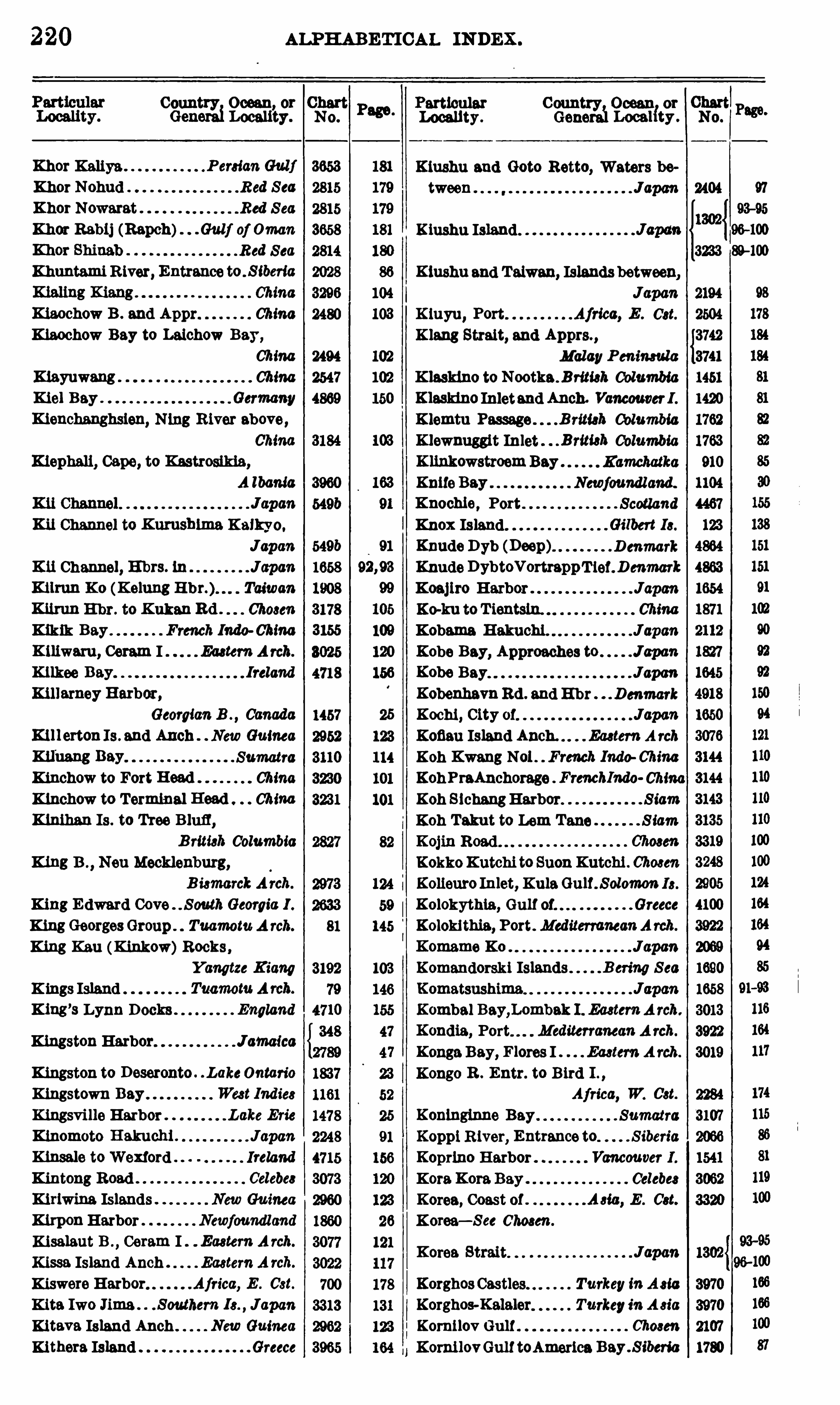
220 ALPHA BETICAL INDEX .
Count Ocean or ChartGene
r
rgj Locality. N 0 .
Khor Kaliya F enian Gulf
Khor Nohud R ed S ea
Khor Nowarat Red S ea
Khor Rablj (Rapch) . Gulf of Oman
. Red S ea
Khuntami R iver, Entrance to , sweria
Kiaochow B . and Appr ChinaKhochow Bay to Laichow Bay,
ChinaKiayuwang ChinaKiel Bay Germany
Kienchenghslen, N1113 River above,
China
Kiephali, Cape, to Kastrosikia,
A lbania
KitChannel to Kumshlma Kaikyo.
Japa'n
Kii Channel, H‘
brs. tn Japa'n
Kilmn X 0 (Kelung Taiwan
Kfirun E hr. to K ukanRd . Chem :
Kikik Bay French Indo China
K iliwam , Ceram I Eaetem Arch.
Kilkee Bay. Ireland
Killarney Harbor,
Georgian B . , CanadaK111ert0n l s . and Anch . NewGuinea
Kilimng Bay Sumatra
K iuchow to Fort Head ChinaKiuchow to Terminal Head ChinaKinihan Is . to Tree B lufl ,
B rim]: ColumbiaKing B . , Neu Mecklenburg,
B i3m0 rckArch.
King E dward Cove" S outhGeorgia 1 .
King GeorgesGroup . TuamomA rch.
King Ken (Kiukow)Rocks ,Yangtze Kiang
K ings Island TuamomA rch.
King’s Lynn Docks England
Kingston Harbor J amaica
Kingston to Deseronto . . LakeOntario
Kingstown Bay We3 t 1'nd ie3
K ingsvi lle Harbor Lake Erie
Kinomoto B akuchi JapanKinsale toWexford Ireland
Kintong Road Celebe3
Kiriwina Islands New Guinea
KlrponHarbor Newfoundland
Kisalaut B ., Ceram I Eastern A rch.
Kissa Island Anch EasternA rch.
Kiswere Harbor Africa, E . Cst.
Kite Iwo Jima . . S outhem JapanKiteva Island Anch . New Guinea
Klthera Island Greece
103
Conn Ocean or
Locality. (101331Localfty .
Kiushu and Retto, Waters be
tween J apan
Kiushu Island
d
hi
Korea Strait Japan
Korghos Castles. Turkey inA 310
Korghos-Kalaler Turkeyin A 310
KomilovGulf 07103311
Komi lovGulf toAmerica Bay . S iberia
Kiushu and Taiwan, Islandsbetween,
JapanKluyu, Port Africa, E . 033.
K laus Strait, end Apprs. ,
Malay Penimula
K lasldno to Nootka . Briti3h ColumbiaKlasldno Inletend Anch. Vancouver1 .
Klemtu Passage B rita): ColumbiaKlewnugglt Inlet Brim): ColumbiaK linkowstroemBay KamchatkaKnifeBay Newfoundl and.
Knochle, Port ScotlandKnox Island Gilbert 13 .
Knude Dyb (Deep) D enmark
KnudeDybtoVortreppT ier. D enmark
Koajiro Harbor JapcmXc-ku to T ientsln. China
Kobama B akuchi. JapanKobe Bey, Approaches to J apan
Kobe Bay Japart
KobenhevnRd . and Ehr Denmark
Kochi , City 0! Japa'n
Kofiau Island Anch. Eu tem A rch
Koh Kwang N01 French Indo China
KohPraAnchorage FrenchI'ndo China
Koh S ichengHarbor SiamKoh Takut to Lem Tana Siam
KokkoKutchi to SuonKutchi . 0h03en
Kolieuro Inlet, KulaGulf . Solom0n 13 .
Kolokythia, Gulf of Greece
Kolokithis , Port . MediterraneanA rch.
Komame K0 Japan
Komandorski Islands B en’
ng S ea
Komatsushima JuponKombal Bay,L0mbak I . Ea3 tem A rch.
Kondia, Port MediterraneanA rch.
KongaBey, Flores I Eaetem A rch.
Kongo R . Entr. to Bird I . ,
Africa, W. 03t.
Konlnginne Bay Sumatra
Koppi River, Entrance to S iberia
K0pr1no Harbor Vancouver 1 .
Kora.Kora Bay Celebes
Korea, Coast 0 1 A 310 , E . Cst.
Korea—S ee Chosen.

222
Country Ocean, or ChartGenerai Locality.
La Libertad H arbor Salvador
La Luz Harbor Canary 13 .
La Mar Bay Venezula
La Paz, Appr. . Lower Cal iforniaLa Paz Harbor Lower California
La Paz to Magdalena B . ,
Lower CaliforniaLa Perouse South PacificLa Perouse Strait J01203:
La Place Str. and Apprs . ,
Ea3tem A rch.
La Plata, Port A rgentina
La. Poile Bay Newfoundland
La 8 010 Harbor Newfoundland
La T rinite Bay West India
La Union, Port S alvador
Lam'
s. Turkey in A 310
Las t Bay, Kofiau I . Ea3 temA reh.
Labrador N . America, E . Cst.
Labradox and Adjacent Coast of,
Newfound land NorthAme'
n'
ca
Labua. Sore .
Labuan Amuk EasternA rch.
Labuan Bajau SumatraLabuan Bajo, Flores I . . EasternA rch.
Labuan Blanda, Buton I Celebes
Lebuan Cheri Anch., Lombok I . ,
Ea3 tem A rch.
Labuan Island Borneo
Labuan Kora. Kore, Bouro I . ,
Ea3 tem A rch.
Labuen Potah, Flores I .,
Ea3 tem Arch.
Labuan T ring, B . , Lombok I . ,
Ea3 tem A rch.
Labuandata Bay Celebes
Labuha Road , Bachian I . ,
Eu tem A rch.
Labyrinth Islands . MagellanStraitLaccadives, The, Islands,
A rabian S eaLadrillero Channel Chile
Ladysmith H arbor , B ritieh ColumbiaLee Island Marchall I 3 .
Lam],Nicobar Is Indian Ocean
Lafule R iver, Entrance to . S ihm’
a
Lagoa dos Patos B razil
Lagoon Entrance S outh Pacific
Lagoon Entrance Gilbert 13 .
Lagoon H ead Anch . ,
Lower CaliforniaLagoon Head to San Q uentin,
Lower Cal ifornia
Lagos Harbor Africa, W. 03t.
Lagos R . to Cape St. Paul ,
Africa, W. 031.
NO .
3077
3019
1084
2350
ALPHABETICAL I N DEX .
Country Ocean, or ChartGenera Locality.
Lagos R . to Forcados B . ,
Afried, W. 033.
Laguna de T erminos, Entrances ,
Mexico, E . 03t.
LagunaGrande del Obispo . s wela
Legundi Bay, N ias I Sumatra
Lahaina Roads Hawaiian I s .
Lalchow B . to Kiachow B ChinaLeie Bay Haw(man 13 .
Leikang Bay Celebe3
Laltec IslandLakahia Bay NewGuinea
LakaniaRd .,Manipa I Eu tem A rch.
Lake B izerte (Benzert) Tanie
Lakh Entr. to Kaotao Is. ,
French Indo ChinaLakon Rds . to Kapes I . ,
Malay PeninsulaLakon R ds . to Tane Pt SiamLakona B .
, Banks Group,New Hebrides
Larache
N 0 .
Lakonikos, Gulf ofLane Rookh Bank South PacificLamalanga New Hebride3
Lama Passage B ritish ColumbiaLamalin Anchorages Newfoundland
Lambayeque Roads, San Jose (10 ,
Peru
Lambert Bay Africa, W. Cst.
Lambert Channel B ritish ColumbiaLamberton Harbor NewZealandLambesoi Bey Sumatra
Lambumbu Harbor South P acificLambunu Road 0313033
Lamehuapl Cove Chile
Lemma Chem,E ast China
Lamotrek Islands Caroline 13 .
Laney Loo Labrador
Landam. Bay Africa, W. Cst.
Landfall Island T ierra del Fuego
Land ’s End to S . Cst. 0 1 Ireland ,
B riti3h Isles
Landslip SoundLangalanga E hr. ,
Malaite I . ,
Solomon 13 .
Langlois, Port T ierra del Fuego
Lenkit Spit to T iger Island ChinaLankayan to Mallawal le I Borneo
Lankayan to Sendakan E hr B orneo
Lanzarote
Lapataia Bay T ierra del Fuego
Lapataia Bay to Gable Island ,Tierra del Fuego
Africa, W. cet.
ALPHAB ETICAL INDEX .
Particular Country Ocean or
Generai Loeeuiy .
Larentuka Rd . , Flores
M eta A rch.
LarkHarbor Newfoundland
Lame to Bloody Forelmd . . I tetema
LesMinas Cove Magellan S trait
LasPalm Bay Canary 13 .
L& quetl Island . . B rituh ColumbiaLatitude Bay T ierra del Puepe
Latitude Cove Chile
Letorre Channel G'Mle
Laulan Bay
Laura HarborLent Island.
Lautaro Cove
Laveissiere Bay New Caledonia
Laveta Bay Chile
Lawak B . ,Waigeu I . . Ea3tem A rch.
LawawangRd . ,Masela I . EastemArch.
Laysah Anchorage. North Pacific
Laysen Island North Pacific
Lazaret, Port 07mmLezarefl Islands TuamomA rch.
League Bks . to Little Bay Is .
,
Le Have Bank . North A tlantic
Lo Molne Bey Newfoundland
L ’E au , Great Bay de. . Newfoundland
L’E cu ,Port 3
L ’ E tang Harbor NewBmmwick
Lee R ocks Yangtze K iang
Leghorn, Port 01 .
Leghorn Roadstead
Lehong Bay . Sumatra
Leixoes, Port. . PormgalLem T ane (Lem T en)to Koh Tekut,
SiamLemnos Island Mediterranean Arch.
Lemnos to GulfofKassandra. Greece
Lemvig Denmark
Lenakel Anch. . New Hebride3
Lengo to T etere, Guadalcanal I .,
Solomon 13 .
T ierra del Fuego
Cape B reton I3 .
Particular Country Ocean, or ChartLocality Generai Locality No
8
LibrevilleAnchorage
Lido, Port. Africa, W. 03t.
. 1taly
LimIsland, Anch . . Loyalty 13 .
Lifuka Island, Anch. and Appr. ,
170
Lesser Cayman Chrlbbean Sea
Letite Harbor and Passage,NewBmmwiek
Letti Island Anch. Ea3 tem A rch.
Lueeneuwa . Solomon 13 .
Levi, Cape, to Fecamp France
Levin Chen. to Pingue Chan Cuba
Levrier Bay to Arguin B . ,
A frica, W. 03t.
Levrier Bay to C . Juby,Africa, W. 031.
Levrier Bay to C . Verde,
Africa, W. 03t.
Levuka E hr. Ovalau I Fij i 13 .
Lewis ScotlandLewis, Northern part of ScotlandLewisport Harbor Newfoundland
Lho Blang Reja Bay Sumatra
L13 0 H 0 and Approaches. ChinaLiaotung, Gulf of ChinaLlaotung, Gulf of, to Hongkong,
China
Lighthou80 Beef Hondura3 , E . 03t.
Ligua Bey Chile
Likleb Group . Marshall 13 .
Lik upang Rd Celebee
Likurl IslandAnch.
Lim Fiord
l ba Bay
Limbo Strait
Limon Bay to Gamboa Reach,Canal Zone
L imon, Port 00310 R ica, E . 0st.
Limones River CubaL inao Bay Chile
Linden Pt. to SuonKutchi Chosen
Lindos, Port Mediterranean Arch.
Linge Chan Sumatra
Lingah Persian GulfLintidu RoadLionhead Harbor,
Georgian B . , Canada
Lip Island Marshall 13 .
Lira!) Island, Anch . in Ea3 tem A rch.
L irong Road, Salebabu I . ,
Ea3 tem A rch.
Portugal
224
Country Ocean, or ChartGen Locality.
Lisbm'
nAnchorage
Lipscomb HarborListensky IslandLiscanor B . to SlyneH d
Liscanor B . to Tralee B
Lister T lef (Deep)
t ao Bay
Litao B . to Chu Tao
Litsing H 0 to Ninghai
LittleBasses Gallo
L ittle Bay I . to Green Head ,
Newfoundland
L ittle Bay I . to League Rks. ,
Newfoundland
Little Belt D enmark
LittleCorn Island . Nicaragua, E . 031.
Little Curacao Island . Caribbean Sea
Little Current . . Lake Huron, Canada
Little Current to 'French R iver,
Georgian B ay, Canada
Little Current to Mississagi Strait,Lake Huron, armada
Little Detroit. Lake Huron, Canada
Little E lobey Anchorage,
Africa, W. 031.
L ittle Fish Bey'
. Africa, W. 031.
Little Greelvink Bay. New‘
Guinea
Little Harbor D eep. Newfoundland
Little Islets Harbor Newfoundland
Little Kurll Strait Japan
Little Port Newfoundland
Little R iver Newfoundland
Little Tracadle H br Nova ScotiaLiuchapo Crossing. Yangtze KiangLiverpool Bay England
Liverpool Bay Nova ScotiaLiverpool to Great Ormes Hd . ,
England
Livingston, P0rt. . Guatemala, E . 03 1.
CubaLivorno, Port 01 ItalyLivorno R oadstead ItalyLizard H ead to Start Pt England
Chile
Lo Island New Hebride3
LO3 1 Ta Island and Reefs. China SeaChina
Loanda Harbor Africa, W. 031.
Loandato Cape IM O . . Africa, W. 031.
Loanda to Cape Lopez,
Africa, W. 031.
Lomgo Bay Afries , W. 031.
Lobito B ey Africa, W. 031.
Lob ltos Cove to La Cruz Peru
No.
ALPHABETICAL INDEX .
253373313?
Lod , Port
Loheiya .
Lojnulkh Vyestei BayLollo HarborLolode Bay.H elmanere I .
,
Eu tem A rch.
Lolowai Bay. NewHebrides
Lomas
Lombok Island Ea31em Arch.
Long Harbor ChinaLong Harbor Newfound land
LongIslandAnchorage SouthPacificLong Point Bay Lake E rie
Long B each. Magellan Strait
Long B each, Anch. in,
Magellan Strait
Lobos de AmenLobos de T ierre.
Lobos IslandLobos Island Mexico, E . 031.
Lobos P1 . to Permas Pt Peru
Loch Fleet ScotlandLockeport E hr. to C . Sab le,
Nova ScotiaLockeport Ehr. to P . Medway,
Nova ScotiaCaroline 13 .
D enmark
Red Sea
S iberia
Caroline I3 .
Lohock Bay .
Loong Bay Sumatra
Lopez Bay, Cape Africa, W. 031.
Lopez, Cape, to Cape St. John,
Africa, W. 031.
L0pez,'Cape, to Kwaraor N iger R .
Africa, W. 031.
Lopez, Cape, to Loanda,
Afriea, W. 03 1.
Lord Howe Island South PacificLord Howe Islands Solomon 13 .
Lorne, Port, to Gulliver B ole,Nova Scotia
Lort Bey Tierra del Fuego
Losap Islands Caroline 13 .
Los Martires Caroline 13 .
Los Roques Caribbean Sea
Los Vilos Road .
Losolav Anch . Banks Group,New Hebrides
Lossop Islands Caroline 13 .
Lots Anchorage and Approaches,
Chile
Chile
Caroline I3 .
Madagmear

ALPHABETICAL INDEX .
Particular Country Ocean or
General Locali’
ty.
Maine, 0 111101 . NortbAmerlea, E . 031.
Maitencillo Cove
MaizuraWan end Appr
Mejuro IslandsMakalla Bay .
Makanru T 0
Makasser Str. Anch. in Celebee
Makassar Str. Appr. to'
0elebee
Makassar Str. ,Northorn Part Celebee
Makassar Str. , Southern Part 0313033Makatea Island . Tuamotu A rch.
ArabiaM
’
akomo I . , NE . Passage,
Tuamotu Arch.
Hawaiian I3 .
Solomon 13 .
Makran Coast, Plans on the
Mam Harbor . Turkey in A310
MakurazaklWan
Makyan I . , Anch . 1n . . . Ead em Arch.
Malabrigo Road Peru
Malaga, Port . SpainMalaita I .
,SW. Cst. 01. . Solomtm 13 .
M 13 I . , Portion of . . Solomon 13 .
Malaita I . , Anch. ln Solomon 13 .
Malakal Harbor Caroline 13 .
Malakka Strait ~MalayP enimula
Malakka, Appr. to . MalayPeninsulaMalakka Str. ,
Anch . ln,
Malay PenimulaMalamocco, Port.
ChinaMalasoro B ey. Celebes
Maleteyur P1 . to Cape Puting,
B orneo
Malatayur Pt . to Cape Selatan,
B orneo
Malaupina I .,Anch . 1n. . . S olomon I3 .
Malay Peninsula B ritish Ind ia
Malcolm Island B ri11’
3h ColombiaMalden Island . S outh Pacific
Halden Island Anchorage,South Pacific
143
142
138 Maleknla I . , Northern Part,123
117
139
Locality.
Maldive I s. , Northern portion,
Maldonado Bay P1010 R iver
Maldonado Point to Chamela Bay,Mexico, W. 031.
Maldonado Point to 0 003 R iver,Mexico. W. 031.
Melee, Cape, toMalta,Mediterranean Sea
M3 103 and Crete, Channels between,
Malekula I . , Anch. in New Hebrides
Maleku la I . , Southern Part,
Malemba Bay Africa, W. 031.
Mallawalle I . , to Lankayan . . . Bomeo
1181110010 Island New Hebride3
Mallu E hr. , Malalta I . -Solomon I3 .
M3 10 Island New Hebridea
M3 10 Island to Erato I NewHebridea
M3 10 Kwikilli Anch . New Hebridee
M3 10 Ya Ma. .
South P acificManan Island, Grand . . B ay of Fundy
Malpelo Island North Pacifi~
Malpeque Bay Prince Edward I .
Malta Island Mediterranean S ea
Malta, Northern Part,Mediterranean Sea
Malta, Southeast Part,Mediterranean S ea
Malta, South Coast of,Mediterranean Sea
Malta to Cape Males ,Mediterranean Sea
Maltezana, Port . MediterraneanA rch.
Mambare Bay New Guinea
Mambulitha Reef F ij i Ia.
Mamoi to Foochow ChinaMampya Road Celebea
Mamuju Bay Celebea
Mans River Guiana
Manafiafi Madagascar
Manahiki Island South PacificManahiki Island Anch
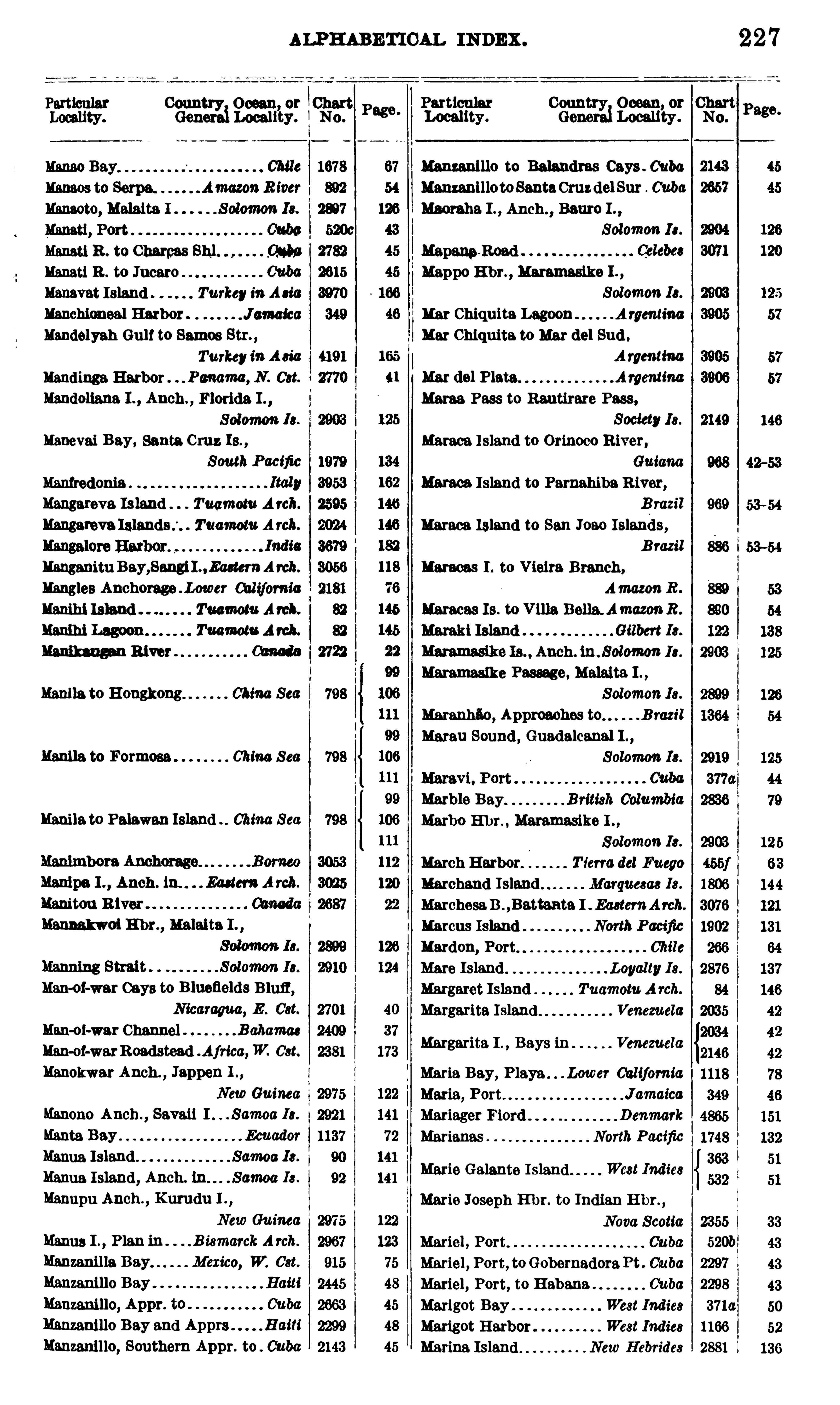
ALPH ABETIOAL INDEX .
Particular
Manna R . to CharmsManati R . to JucaroManavat Island . Turkey inAmManchiomeal Harbor . J amaica
Mandelyah Gulf to Samoa Str. ,
TurkeyinA sia
l andings Harbor . Pm ma , N . Cat
Mandoliana I . , Anch . , Florida I . ,
Solomon Is .
Manevai Bay, Santa Cruz Is . ,
South PacificManfredonia .
Mangareva Is land TuamomA rch.
Mangareva Tuamotu A rch.
Manganitu Bay,SangiL .Eaetem Arch.
Mangles Anchorage . L0wer Chlc‘
fomic
Manila! Island Tuamotu Aml .
mum Lagoon TuamomA rah.
Manih ugm River
Manila to Hongkong China Sea
Manila to Formosa China S ea
Manilato Palawan Island China S ea
Manipa I . ,Anch . ia . . Edam A rch.
Manitou R iver"Manmkwoi E hr. , Malaita I . ,
Man-or-war Gays to B luefields Bluff,Nicaragua, E . Cst.
Man-ol-war Channel B ahamas
Man-of-warRoadstead . Africa,W. Cat.
Manokwar Anch ., Jappen L ,
New Guinea
Manono Anch . ,Savaii I . Samoa Ia.
Manta Bay EcuadorManna Island Samoa Ia.
Manna Island , Anch. . Samoa Is .
Manupu Anch .,Kurudu I .
,
New Gu inea
Manna I ., Plan in . . B ismarckA rch.
Manmnil la Bay Mexico, W. Cst.
Mmzanillo Bay HaitiManzanillo, Appr. to CubaManzanillo Bay and Apprs HaitiManzanillo, Southern Appr. to . Cuba
Conn Ocean, or‘Chart
Gena Locality.I No.
Page.
798
122
123
75
48
45
48
45
Particular Country Ocean, or ChartLocality . GeneraiLocality . N0 .
Manzanlllo to Balandras Cays . Cuba
ManzanlllotoSantaCruzdel Sur Cuba
Macu ba I . , Anch. ,Baum I . .
Solomon I s.
a
2149
968
969
886
Maraoas I . to Vieira Branch,Am anR .
Maracas Is. to Villa Bella. AmazonR .
Harald Island Gilbert Ia.
Maramasike Is Anch. in . Solomon Ia.
Maramaslke Passage. Malaita I . ,
Solomon Is .
Maranhflo, Approaches to B razil
Marau Sound , Guadalcanal L ,
Solomon Is.
Margarita I . Bays in Venezuela
Maria Bay, Playa . . . Lower CaliforniaMaria, Port JamaicaMariager Fiord D enmark
Marianas North Pacific
Marie Galante Island West Indies
Marie Joseph Hbr. to Indian H br. ,
Nova Scotia 2355
Marie] , Port. Cuba 520b
Mariel , Port, toGobernadoraPt . Cuba 2297
Mariel, Port, to Habana Cuba 2298
Marigot Bay . West Indies 3710
Marigot Harbor West Indies 1166
Marina Island New Hebrides 2881
227
33
43
43
52
136
Mappo E hr., Maramasike I .
,
Solomon 13 .
Mar Chiquita Lagoon A rgentina
Mar Chlquita to Mar del Sud .
A rgentina
Mar del Plata. Argen una
Mama Pass to Rautirare Pass.Society Is .
names Island to Orinoco R iver,Guiana
Mama; Island to Parnahiba R iver,B razil
Maraca Island to San 10 30 Islands ,
B razil
Marble Bay British ColumbiaMarbo E l m, Maramasike I
Solomon Is.
March Harbor T ierra del Fuego
Marchand Island Marquesas Is.
MarchesaB .,Battanta I EasternArch.
Marcus Island NorthPacific
Mardon, Port Chile
Mare Island Loyalty 18 .
Margaret Island Tuamotu A rch.
Margarita Island Venezuela

228 ALPH ABETICAL INDEX .
Country, Ocean or ChartGeneral Locality . N o .
Maringe Lagoon,Y sabel I . Solom¢mIs.
Marion Reef 8 . Pacific
Markhamto Gulf of I skanderun,
Turkey in A sia
Markhah to RasenNakura,
Turkey inA sia
. India
Turkey inAsia
North Pacific
Tuamotu Arch.
Guiana
Marova Lagoon, Vangunu I .,
Solomon Is .
Marques, Port Mexico, W. Cat.
Marquesas Islands South Pacific
Marquesas Is. ,Anch. 1n . S outh Pacific
Marss Brega LibiaMama 3 ] mm Libia
. LibiaMarsa Tobruk LibiaMarsa Ugra Anch. LibiaMarseille
Marseille to Agay Rd France
Marseille to Cette a ce
Marsh Basln. Magellan StraitMarshall Bennett Is . NewGuinea
Marshall Group, Islands tu,
Marshall Islands North Pacific
Marshall Islands, Anch. ln,
Martaban, Gulf of B ay of B engal
Martin Garcia I . to Sauce Pt. ,
P lato R .
Martin Vas Islets South AtlanticMartinique Islands West Indies
Martinique to Trini dad West Indies
Martinsclca, Port Awtria
Marthes Islands, Los Caroline Ie.
Mama to Huahoine Society Is .
Mm'
udu Bay B orneo
Marudu R iver Anch B orneo
Mamnga E hr.,Bauro I . Solomon Is .
Maruyama Zaki to Shimonoseki Kalkyo, Inland Sea JapanMary Island Phanix Is .
Mary, Port , Owa Raha. I . Solomon Is.
Mas Afuera Island. South PacificMas a T ierra South PacificMass T iga I . to Betas Basah Pt . ,
B orneo
Masa Tiga I . to Pontianak . B omeo
Masam Po and Apprs . Chosen
Masampo Channel Chosen
Masanpho Reach Chosen
Country Ocean or
Gen Locali’
ty.
“3 3013 I . , Plan in, SerwattlEasternA rch.
Masovonu Anch. Banks Group,
Masio, Port
Maskat and A ] Man'
s . . A rabkm Sea
Maskelyne Islands . . SouthPacific
Maspalomas Anchorage Cam ry Io.
Massacre Bay NewZealand
Red Sea
Massava B Neu Pommem ,
B ismarckA rch.
Massefao, Tutuila I Samoa Ia.
Masset Harbor . . Queen Charlotte Ia.
Masset Sound and Inlet,
Queen Charlotte Ia.
MataUtui Anch . , Uea I SouthPacific
Maupiti to Huaheine
Maxwell , Port
Matahiva Island . Tm Arch.
MatanzaAnchorage Chile
Mateu ss . Port Cuba
Matauru I . to Tapurfl I . MaderiaRiver
Mataum I . to TrocanaI . ,
Madeira R iver
Mata Utui Anchorages. South PacificMathew Town Road Bahamas
Matoya HarborMatoya K0 to Goltasho X 0 Japan
ChinaMatsusahamaWan J apan
Matsu Shima to Peter the Great B .,
Chosen and S iberia
Matsushlma Channel J apan
Matsushima Wan J apan
Matsushima Wan, Apprs. to J apan
Matsuwa To J apan
Matterer Bay New Guinea
Matthew Island Gilbert Ia.
Matthew Island New Hebrides Ie.
Matuku Island and Harbor F ij i Ie.
MatumbaBay, Florida I . Solomon Is.
Maturin Bar and Approach to SanJuan River Venezuela
Maug Islands Marianas
Maui Island, E hrs. in Hawaiian Is.
Mauls River Entrance Chile
Maullin B . and Port Montt, Chans .
between Chile
MaullinR iver, Entrance ofthe Chile
Maumere Road , Flores I .
,
Eastern A rch.
Society Is .
Tierra del Fuego

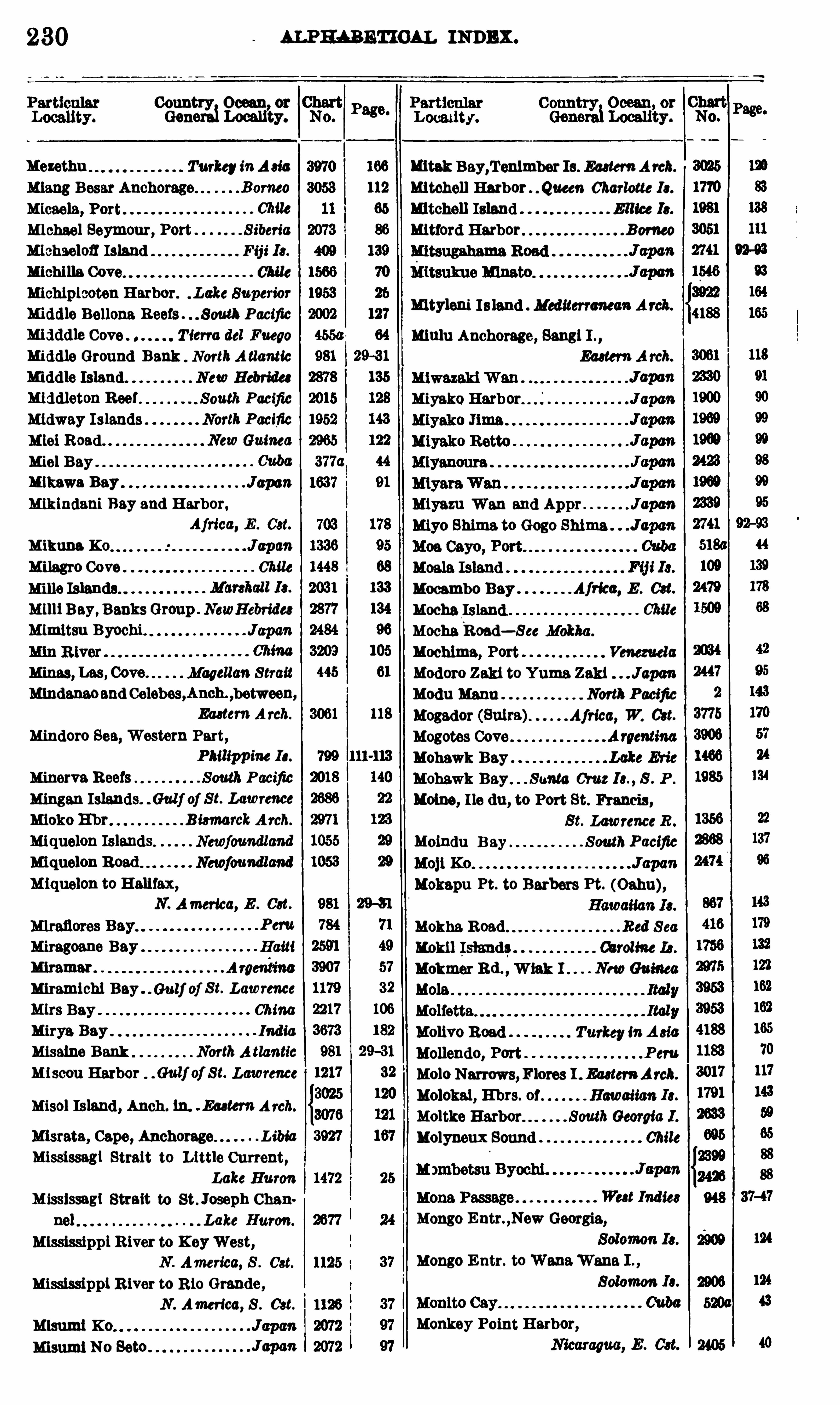
230 ALPHABETICAL INDEX .
CoumngiOcean
zy.
Mezethu TurkeyinA sic
Mlang Besar Anchorage" .B omeo
Micaela, Port.
Michael Seymour, Port S iberia
Mlehaelofl Island F ij i Ia.
Michilla Cove Chile
Michiplcoten Harbor. . Lake Superior
Middle Bellona Reefs . . South Pacific
mi dd le Cove T ierra del Fuego
Middle Ground Bank NorthA tlanticMiddle Island. New Hebrides
Middleton Reef . South PacificMidway Islands North Pacific
M101Road" . . NewGuinea
M101 Bay
Mikawa Bay JuponMikindani Bay and Harbor,
Africa, E . Cat.
Mikuna K 0 JapanMilagro Cove Chile
Mills Islands. .
M1111Bay, Banks Group . NewHebrides
Mimltsu Byochi. Japan
Minas, Las , Cove. Magellan S trait
Mindanaoand Celebes,Anch. ,between
Eastern A rch.
Mindoro Sea, Western Part,
Philippine Ia.
Minerva Reefs South PacificMingan Islands. . Gulf of Se. Lawrence
Mioko Ehr B ismarckA rch.
Miquelon Islands Newfoundland
Miquelon Road Newfoundland
Miquelon to Halifax,N. America, E . Cat.
Peru
Miragoane Bay Haiti
mramar" Argentina
Miramichi Bay . . 6 141} of S t. Lawrence
e s Bay . ChinaMirya Bay India
Misaine Bank NorthA tlanticMiscou Harbor . Gulf of S t. Lawrence
Misol Island, Anch . ln. . Eaetem A rch.
Misrata, Cape, Anchorage.. L ibia
Mississagi Strait to L ittle Current,
Lake Huron
Mississagl Strait to St. Joseph Chan
nel Lake Huron.
Mississippi River to K eyWest,
N . America, S . Cst.
Mississippi R iver to R io Grande,N . America, 8 . Cat.
Misumi K 0 Japart
mtak Bay,’1‘en1mber Is. EasternArob.
Mitchell Harbor Queen Charlotte Ia.
Mitchell Island E llice Is.
Mitford Harbor B orneo
Mityleni Is land Mediterranean A rch.
mulu Anchorage, Sang1 1 . ,
Eastern A rch.
MiyakoHarbor Japan
Miyazu Wan and Appr Japtm
myo Shima to Gogo Shima . J apan
Afrka, E . Cat.
Chile
Moindu B ay
Mokapu Pt. to Barbers Pt. (Oahu),
Mokha Road Red Sea
Kokil Island; 00mm 14 .
Mokmer Rd . ,W131: Guinea
M015
Molivo Road Turkey inA sia
Mollendo, Port Peru
M010 Narrows,Flores 1 . EasternArch.
Molokai, E hrs. of Hawaiian Ia.
Moltke . SouthGeorgia I .
Molyneux Sound Chite
Mongo Entr. ,New Georgia,
Mango E ntr. to“
Wana“Wane I . ,
Solomon Is.
Monkey Point Harbor,
Mocambo BayMocha Island
MochaRoad—S ee Mokha .
Mochlma, Port Venezuela
Modoro Zaki to Yuma Zaki JspanModu Mann North Pacific
Mogador (Sulra) Africa, W. Cst.
Mogotes Cove .
Mohawk Bay .
Mohawk Bay Santa Cruz te. , S . P .
Homo, I le du , to Port St. Francis ,
S t. LawrenceR .
SouthPacific
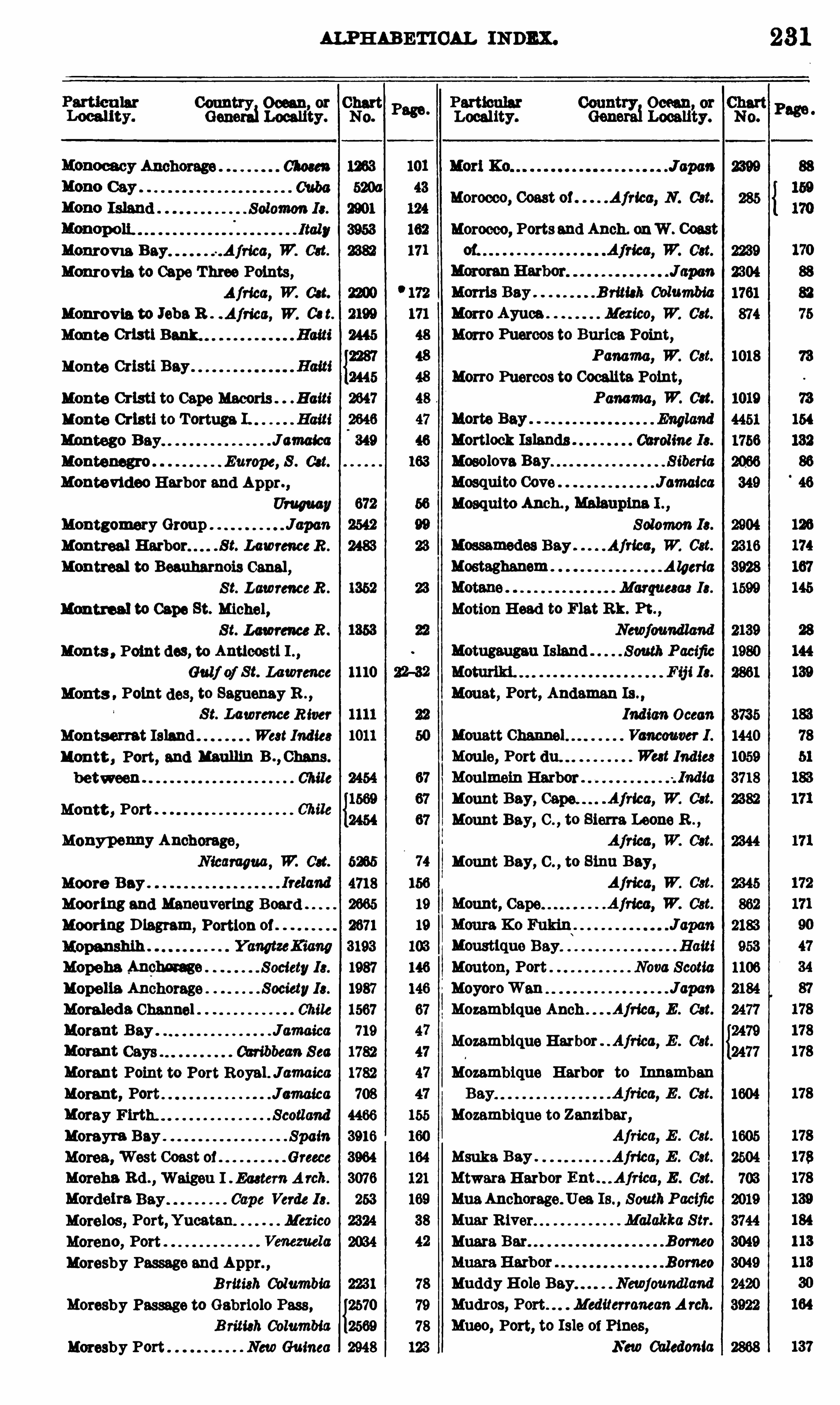
ALPHABETICAL INDEX .
Country 0 000 11, or ChartGeneraiLocauty. No.
Monrovm Bay .Africa, W. Cat.
Monrovia to Cape Three Points,Africa, W. Cat.
Monrovia to JohnR . . Africa, W. Ce t.
Monte Cristi
Monte Cristi Bay .
Monte Cristi to Cape Macoris . . B aits’Monte Cristi to Tortuga I. HaitiMontego B ay JamaicaMontenegro Europe, 8 . Cat.
Montevideo Harbor and ApprUruguay
Montgomery Group JuponMontreal . S t. LawrenceR .
Montreal to Beauharnois Canal ,Se. LawrenceR .
Montreal to Cape St. Michel,S t. Lawrence R .
Moms , Point dos, to Anuoost1 1 . ,
Gulf of St. Lawrence 1110
Monts Point (108, to Saguenay B . ,
S t. LawrenceR iver
Montserrat Island West Indies
Montt , Port, and mumn B ., Chans .
between Chile
Montt , Port
Monypenny Anchorage,
N icaragua, W. Oct. 6265
Moore Bay 4718
Mooring and Maneuvertng Board 2665
Mooring D iagram,Portlon of 2671
3193
Mopeha ,Anphnmge Society 13 . 1987
Mopelia Anchorage Society13 . 1987
Moraleda Channel Chile 1567
Morant Bay . Jamaica 719
l 10t Cays Caribbean Sea 1782
Morant Point to Port Royal . Jamaica 1782
Morant , Port Jamatca 708
Moray Firth. Scotland 4466
Homyra Bay Spain 3916
Mama, West Coast 01 Greece 3964
Morena Rd . , Waigon I Eastern A rch. 3076
Mordelra Bay Cape Verde Is. 263
Morelos , Port,Yucatan Mexico 2324
Moreno, Port . 2034
Moresby Passage and Appr. ,
B ritish Columbia 2231
Moresby Passage to Gabriolo Pass ,{2570
B ritish Columbia 2569
Moresby Port NewGuinea 2948
Page.
Locality.
Morocco, Coast 0 1 Africa, N . Cot.
Morocco, Portsand Anch. onW . Coast
Morris Bay B ritish ColumbiaMon o Ayuca Mexico, W. Cst.
Mon o Puercos to Burica Point,
Panama, W. Cst.
Mon o Puercos to Cocalita Point,Panama, W. on.
Mossamedes BayMostaghanem
Motugaugau Island
Moust, Port, Andaman Is . ,
Indian Ocean
Mcnatt Vancouver I .
Moule, Port (111 West IndiesMoulmein HarborMount Bay, . Africa, W. Cat.
Mount Bay, C . , to Sierra Leone B . ,
Mount Bay, C . , to 81m: Bay,Africa, W. Cst.
Mount, Cape
Moust uo Bay. HaitiMouton, Port Nova ScotiaMoyoroWan JapanMozambique Anch . . Aj rica, E . Cat
Mozambique Harbor . Africa, E . Cat
Mozambique Harbor to Innamban
Mozambique to Zanzibar,Africa, E . Cst.
Msuka Bay . Africa, E . Cat.
Mtwara H arbor E . Cat.
MuaAnchorage. Uea Is. , SouthPacificMuar River Malakka Str.Muara Bar B orneo
Muddy H ole Bay. Newfoundland
Mudros, Port . MediterraneanA rch.
Mueo, Port, to Isle of Pines,
New Caledonia
23 1
Mortlock IslandsMosolova BayMosquito CoveMosquito Anch. , Malaupina L ,
Solomon Is.
Africa, W. Cst.
Algeria
Marquesas 13 .
Motion Head to Flat Bk. Pt. ,
Newfoundland
South Pacific
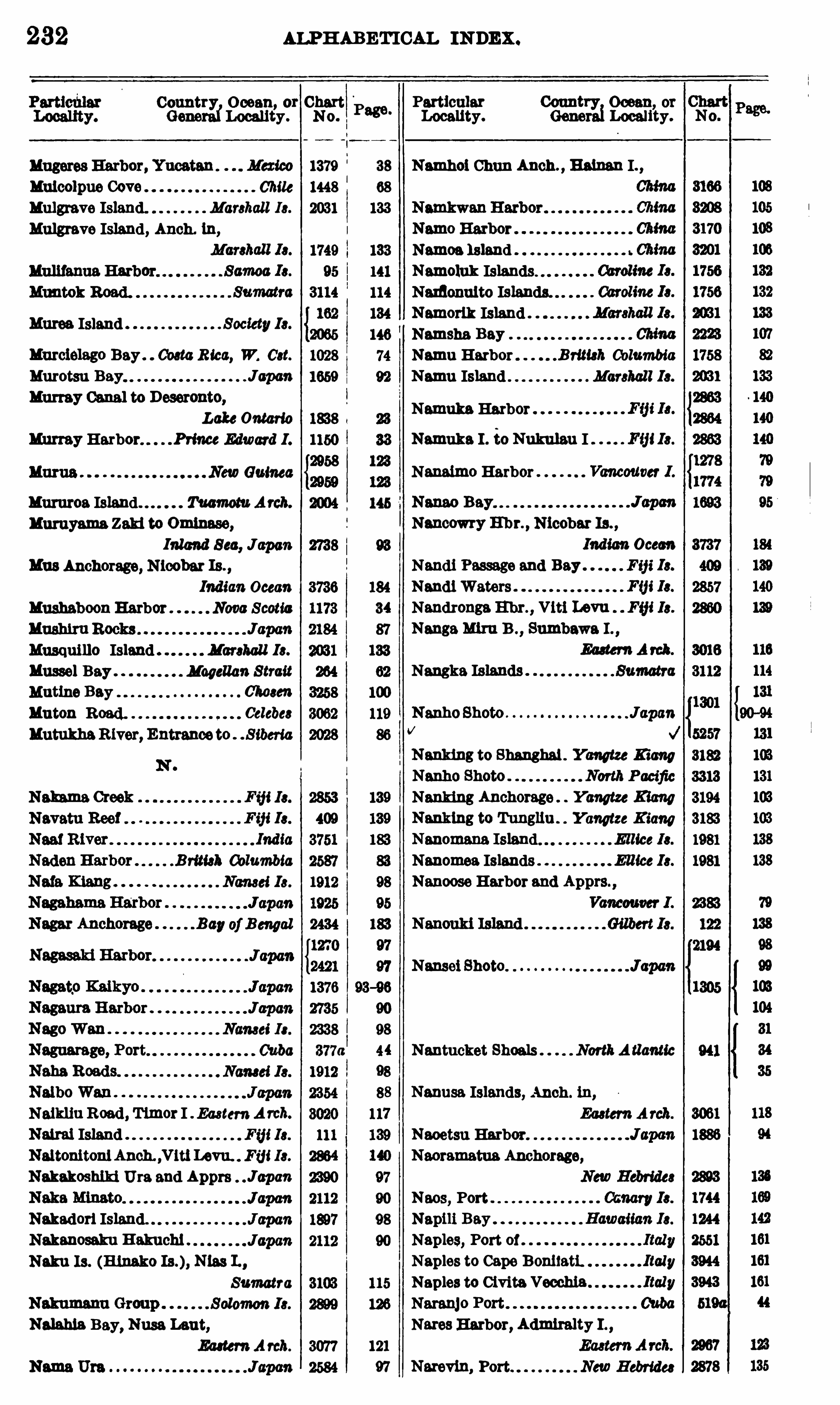
232 ALPHABETICAL INDEX .
Country Ocean, or ChartNo.GenerafLocality .
Mulcolpue Cove Chile
Mulgrave Island. Marshal l Is.
Mulgrave Island, Anch. in,
Huron. Island Society Ia
Murclelago Bay . Coeta Rica, W. Cat.
Murotsu Bay JuponMurray Canal to Deseronto,
Lake Ontario
Murray Harbor Prince Edward I .
Guinea
Mamros Island m m Arch.
nuruyama Zaki to Omlnase,Inland Sec, Jupon
Mus Anchorage, Nloobat Is . ,
Indian Ocean
Mushaboon Harbor Nova Scotia
Musquillo Island Marshall Is.
Mussel Bay Magellan Strait
Mntine Bay 01mm
Mnton Road. Celebes
MutukhaRiver, Entrance to . S iberia
Naikliu Road , Timor I EasternA rcb.
Nattai IslandNaltonitonl Anch. ,V1t1Levu. Fij i Ia.
Nakakoshlki Ura and Apprs J apan
Nakadori Island.Nakanosaku B akuchi
Nuku Is . (Hlnako Nlas L,
Sumatra
Nah hia Bay, Nusa Lent,EasternA rch.
Page.
1379
1448
121
97 v m, Port NewHebrides
3077
2584
Particular Country Ocean, orLocality. Genet Locality.
38 Namhoi Chun Anch . , B alnan I
Namoa Island
Namoluk IslandsNamonuito Islands.
Namorlk IslandNamsha BayNamu Harbor British ColumbiaNamu Island Marshall Is.
Namuka HarborNamuka 1 . ia Nukulau I
Nmaimo Harbor
Nancowry 111m , Nicobar Is. ,
Indian Ocean
Nandi Passage and Bay F ij i Is.
Nandi Waters Fm13 .
Nandronga Ema, Viti Levu FmIs.
NangaM1111 B . ,Sumbawa I . ,
EasternA rah.
Nangka Islands
NanhoShoto . JapanV
Nanking to Shanghai . Yangtze B ang
Nanking Anchorage Yangtze Kiang
Nanktng to Tungllu . Yangtze KiangNanomana
Nanomea Islands E llice Ia.
Nanoose Harbor and Apprs. ,
Nantucket Shoals NorthAauntie
Nanusa Islands, Anch . tu,
EasternArch.
Naoetsu Harbor.
Naoramatua Anchorage,
Naos, PortNapili BayNaples Port ofNaples to Cape Bonitati.Naples to Civita Vecchia
Nares Harbor, Admiralty I . ,

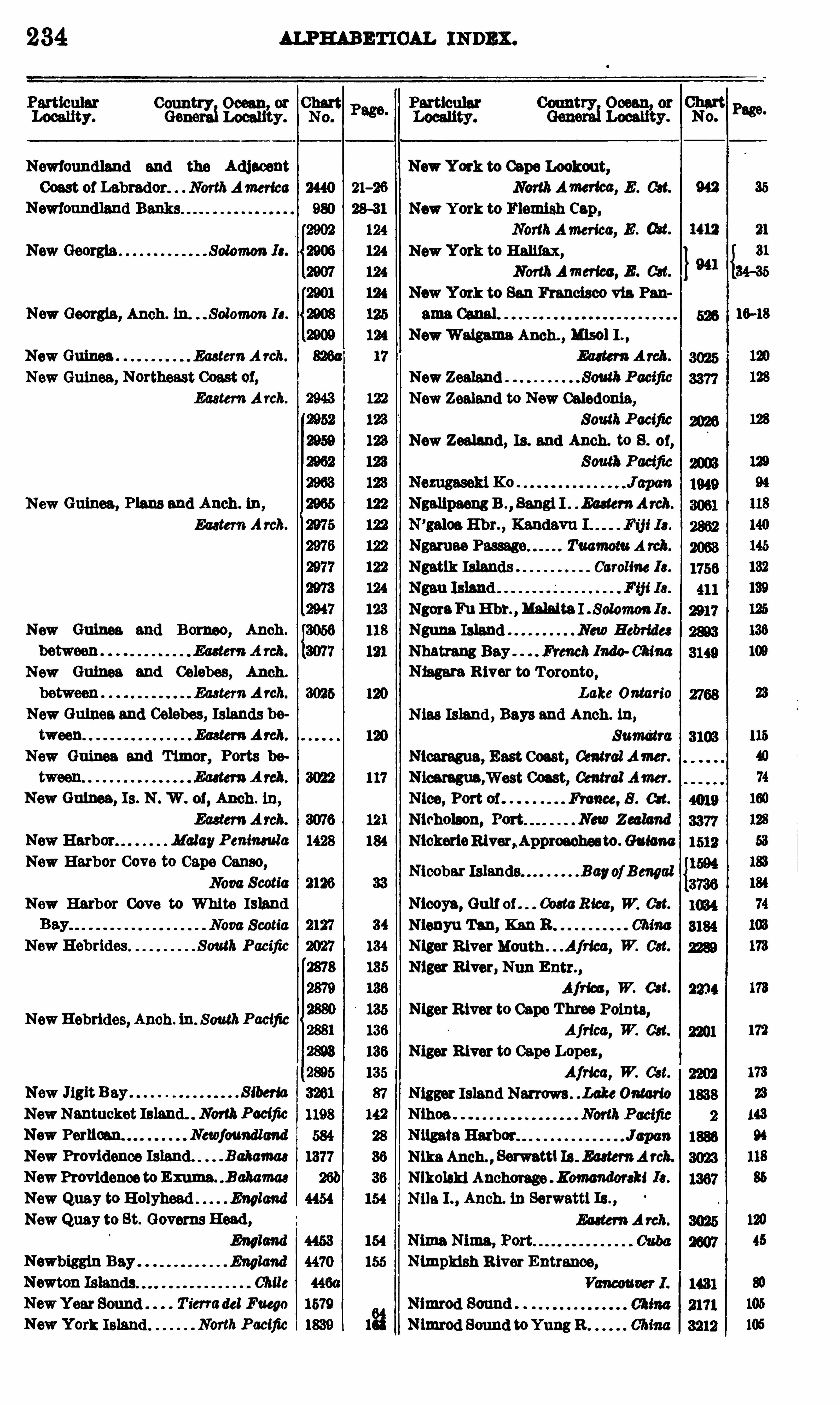
234
Conn Ocean or
Locau’
ty.
Newfoundland and the Adjacent
Coast of Labrador. NorthAmerica
New Georgia Solomon Is.
New Georgia, Anch. ln. . Solomon Is.
New Guinea Eastern A rch.
New Guinea, Northeast Coast 01,
Eastern Arch.
New Guinea, Plans and Anch . ln,
EasternArch.
New Guinea and Borneo, Anch .
New Guinea and Celebes, Anch .
between EasternA rch.
New Guinea and Celebes, Islands between
New Guinea and Timor, Ports be
New Guinea, Is. N . W . 0 1, Anch . ln,
New Harbor MalayPenineula
New Harbor Cove to Cape Censo,Nova Scotia
New Harbor Cove to White IslandNova Scotia
New Hebrides South Pacific
NewHebrides, Anch. in. S outhPacific
New Jigit Bay . S iberia
NewNantucket Island. NorthPacific
New Perlican Newfoundland
New Providence Island. -Bchamaa
NewProvidence to Emma B ahamas
New Quay to Holyhead England
New Quay to St. Govems Head ,
England
England
Chile
T ierradel Fuego
North Pacific
154
155
$
8
2
1
ALPHABETICAL INDEX .
New York to Cape Lookout,NorthAmerlca, E . cu.
New York to Flemish Cap,NorthAmerica, E . (M .
New York to Halifax,Noflh Amertcc, E . Get.
New York to San Francisco via Pan
NewWalgame Anch. , 11150 1 I . ,
NewZealand
New Zealand to New Caledonia,
SouthPacific
New Zealand , Is. and Anch. to 8 . 0 1,
Ngelipaeng B . ,Sangi l . . Eaatem A rch.
Ngemee Passage Tuamotu A rch.
Ngetlk Islands Caroline Ia.
Niger River to Cape Lepez,
Africa, W. Cst.
Nigger Island Narrows . .Lake Ontario
Nlhoe
J apan
Nike Anch . 80m m13 . EasternA rch.
Nikolski Anchorage Komemdoreki Ie.
N113 I . , Anch. in Serwatti Is. ,
Eastern A rch.
Nlmpkleh River Entrance,
Nimrod Sound .
Nimrod Sound toYung R .
No.
Page.
942
1412
525 16—18
m
NgoraFu E hr. m mI . SolomonIs.
Ngune Island New Hebrides
Nhatrang Bay . French Indo ChinaNiagara R iver to Toronto,
Lake Ontario
N138 Island, Bays and Anch. m,
Sumatra
Nicaragua, East Coast, Central Amer.
Nicaragua,t Coast, 0e1ural Amer.
Nice, Port of France, 8 . Cat.
Nicholeon, Port New Zealand
NickerieRiver,Approaches to. Guiana
BayofBengal
Nleoya, Gulf of 00m R ica, W. Cat.
Nlenyu Tan, Ken R Chinan er River Mouth Africa, W. Cat.
Niger River, Nun Entr. ,
Africa, W. Cat.
Niger River to Cape Three Points,
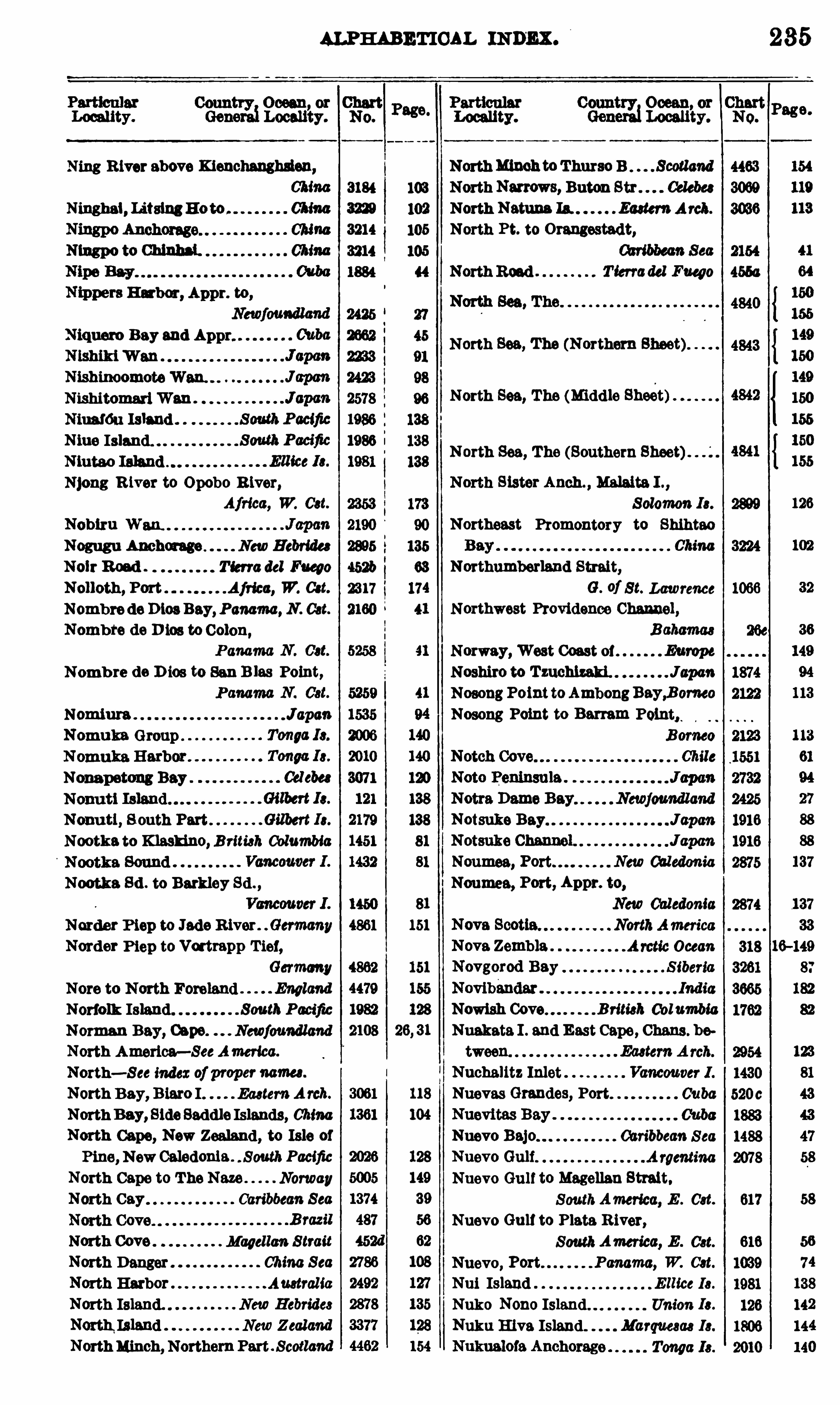
ALPHABETICAL INDEX .
Locality.
Ning R iver above Kienehanghslen,
3184
Ninghel , LitsingHo to . 3229
China 3214
Ningpo to Chlnhsl. 3214
Nmpers Hu ber, Appr. to,
Niquero Bay and Appr.
Nishinoomote
NishitomariWan .
Nitmfdu Ishnd .
Niue Island.N1utao
Njong R iver to Opobo R iver,Africa, W. Cat.
Nogugu Anchorage NewHebrides
Nolr Road . Tierra del Fuego 4521:
Nolloth , Port Africa, W. Cot. 2317
Nombre de D ios Bey,Panama, N . Cat.
Nombre de D 105 to Colon,
Nomb re de D ies to San B las Point,
Nomiura J apan
Nomuka Group .
Nonspetong Bay
Nonu ti, S outh Part Gilbert Ia.
Nootke to Klaskino, B ritish Columbia
Nootka Sd . to Barkley Sd . ,
Norder Piep to Jade River . .Germany
Norder Piep to Vortmpp T ier,Germany
Nore to North Foreland England
Norfolk Island. South Pacific
Norman Bay, Ospe. Newfoundland
North America—SeeAmerica.
North—See index of proper names .
North Bay, B iaro I Eastern A rch.
North Bay, Side Saddle Islands, ChinaNorth Cape, New Zealand , to Isle of
Pine, NewCaledonia . . SouthPacific
North Cape to The Neze Norway
North Cay Caribbean Sea
North Cove Magellan S trait
North Danger China S eaNorth Harbor Auatral ia
North Island. NewHebrides
North Island NewZealandNorthMinch, NorthernPart Scotland
103
105
105
08
174
Loeeuty.
NorthMinoh toThurso B . . Scotlcmd
NorthNarrows, Baton Str . Celeb“
North Netune Ia. EasternArch.
North Pt. to Orangestadt,
North Road T ierradel Fueoo
North Sea, The (Northern Sheet)
North Sea, The (Midd le Sheet)
North Sea, The (Southern Sheet)
North Sister Anch. , Malaita I . ,
Northeast Promontory to Shihtao
Northumberland Strait,G. of St. Lawrence
Northwest Providence Channel,
Norway, West Coast 01 Europe
Noshiro to Tzuchlzeld . JapanNosongPointtoAmbongBay,Bomeo
Nosong Point to Berram Point,
Notsuke Bay Jopen
Noumea, Caledonia
Noumea, Port, Appr. to,
Nowish Cove B ritish 00 1umbia
Nuakata I . and East Cape, Chens . be
Nuchalitz Inlet
Nuevas Grendes, Port
Oan'
bbean S ea
235
Nuevo BajoNuevo Gulf
Nuevo Gulf to Magellan Strait.
SouthAmerica, E . Cat.
Nuevo Gult to Plate R iver,
SouthAmerica, E . Cst.
Nuevo, Port Panama, W. Cat.
Nui Island E llice Is .
Nuke Nono Island Union Ia.
Nuku E lva Island. Marquesas Is.
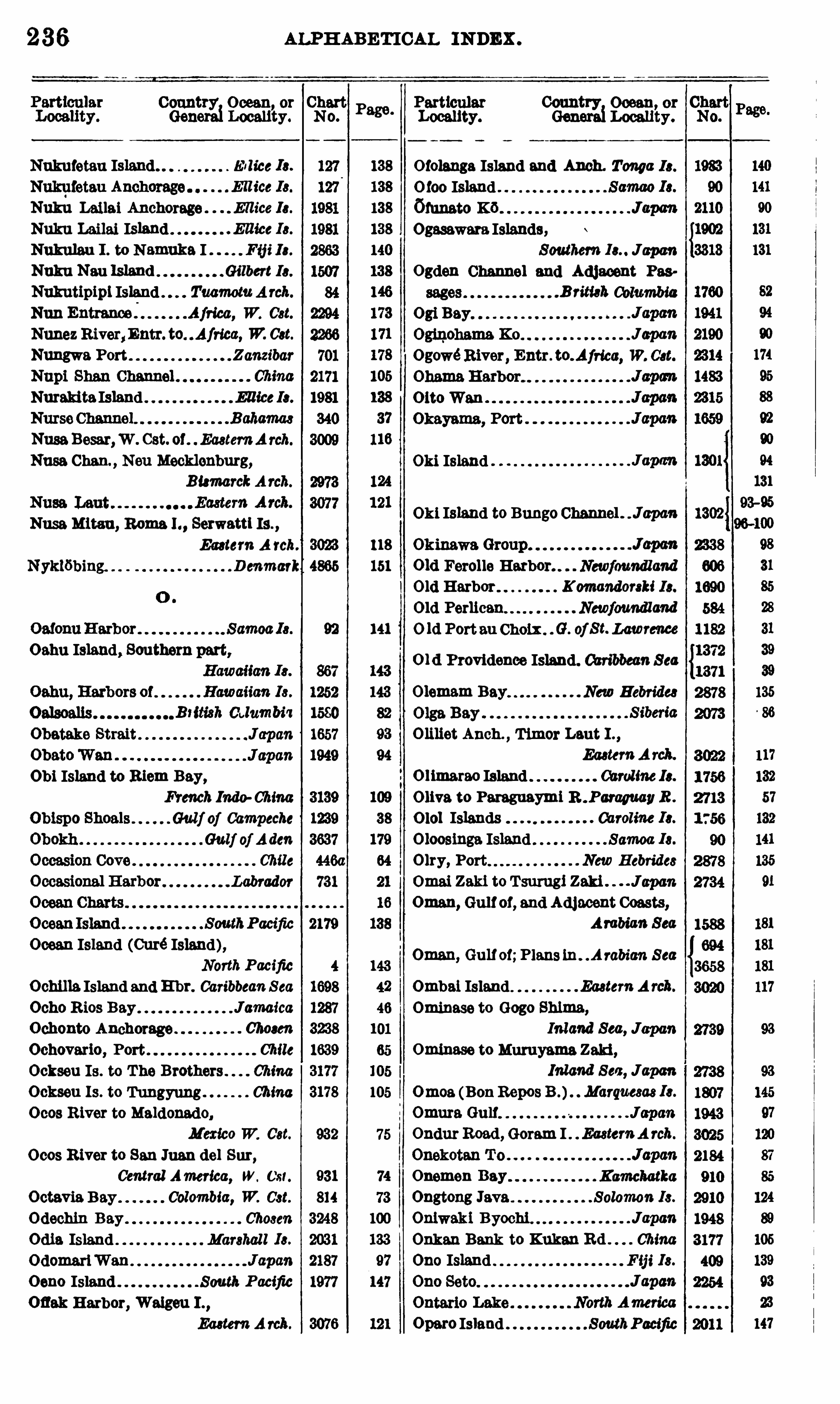
236
Country Ocean or ChartGenerei Locality. No.
Page.
Nukufetau Island. . E l lice Is.
NukhLanai Anchorage . E llice Ia.
Nuku Leilai Island . .Ellice Is.
Nukulau I . to N emuke I Fifi Ia.
Nuku Neu Island Gilbert 10 .
Nukutipipl Island . TuamomA rch.
Nun Entrance . Africa, W. ca .
Nunez R1ver,Entr. to Africa, W. Cat.
Nungwa Port Zanzibar
NmakitaIsland ElliceIa.
NusaBesar,W . Cst. of . EasternArch.
Nusa.Chan. Non Mecklenburg,
B ismarckA rch.
Nuse Mitan, R0ma 1. , Serwattl Is. ,
Eastern A rch. 3023
Nykwbing. D enmark 4865
118
151
92 141
Oahu Island, Southern part,
Obi Island to Biem Bay,
French Indo ChinaGulf of Campeche
Gulf of AdenChile
Labrador
Ocean Island (Curé Island),North Pacific
Ochilla.Island and H br. CaribbeanS ea
Ocho Rios Bay JamaicaOchonto Anchorage 07mm
Ochoverio, Port Chile
Ockseu Is . to The Brothers . 01mmOckseu Is . to Tungyung China0 008 River to Maldonado,
Mexico W. Cst.
Ocos River to San Juan del Sur,Central America, W. Cst.
Octavia B ay Colombia, W. Cst.
Odochin Bay Chosen
Odie Island Marshall Is.
OdomariWan
Oeno Island South P acific
Ofiek Harbor, Walgeu I . ,
Eastern A rch.
ALPHABETICAL INDEX .
Country Ocean, or
Generai Locality.
Otolenga Island and Anch. Tonga I0 .
0 100 Island . .
60m mK6 .
Ogasawara Islands,Southern Jupon
Ogden Channel and Adjacent Pas
.B n’
tieh ColumbiaOsi Bey
J apan
Ogowé River Entr. to.Africa, W. Cat.
OttoWen
Oki Island
Oki Island to Bungo Channel . J apan
old Ferolle Harbor. Newfoundland
Old Harbor K omandorski I 3 .
Old Perlican Newfowndland
0 1d Porteu Choix . G. ofSt. Lawrence
old Providence Island. Caribbean S ea
Olemam Bay New Hebrides
Oman, Gulf of;Plans ln. .A rabian S ea
Ombai Island Eastern A rck.
Ominase to Gogo Shima,Inland Sea, Japan
Ominase to Murayama Zaki,Inland Sea, Jcpm
Omoa (BonRepos B .) Marquesas Ie.
Omure Gulf JapanOndur Road , Goram I EasternA rch.
Ouemou Bay Kamchatka
Ongtong Java Solomon Is.
Oniwaki Byochi J0pmOnken Bank to Kukan Rd . ChinaOno Island F ij i Is.
Oparo Island SouthPacific
O liliet Anch.,Timer Lent I . ,
EasternA rch.
O limareo Island 00rd lne 10.
Olive to Pareguaymi R . ParaguayR .
0 101 Islands Caroline Ia.
O loosinga Island Samoa I s.
Olry, Port New Hebrides
Omai Zaki to T surugi Zaki JcpmOman, Gulfof, end Adjacent Coasts,
Arabian Sea

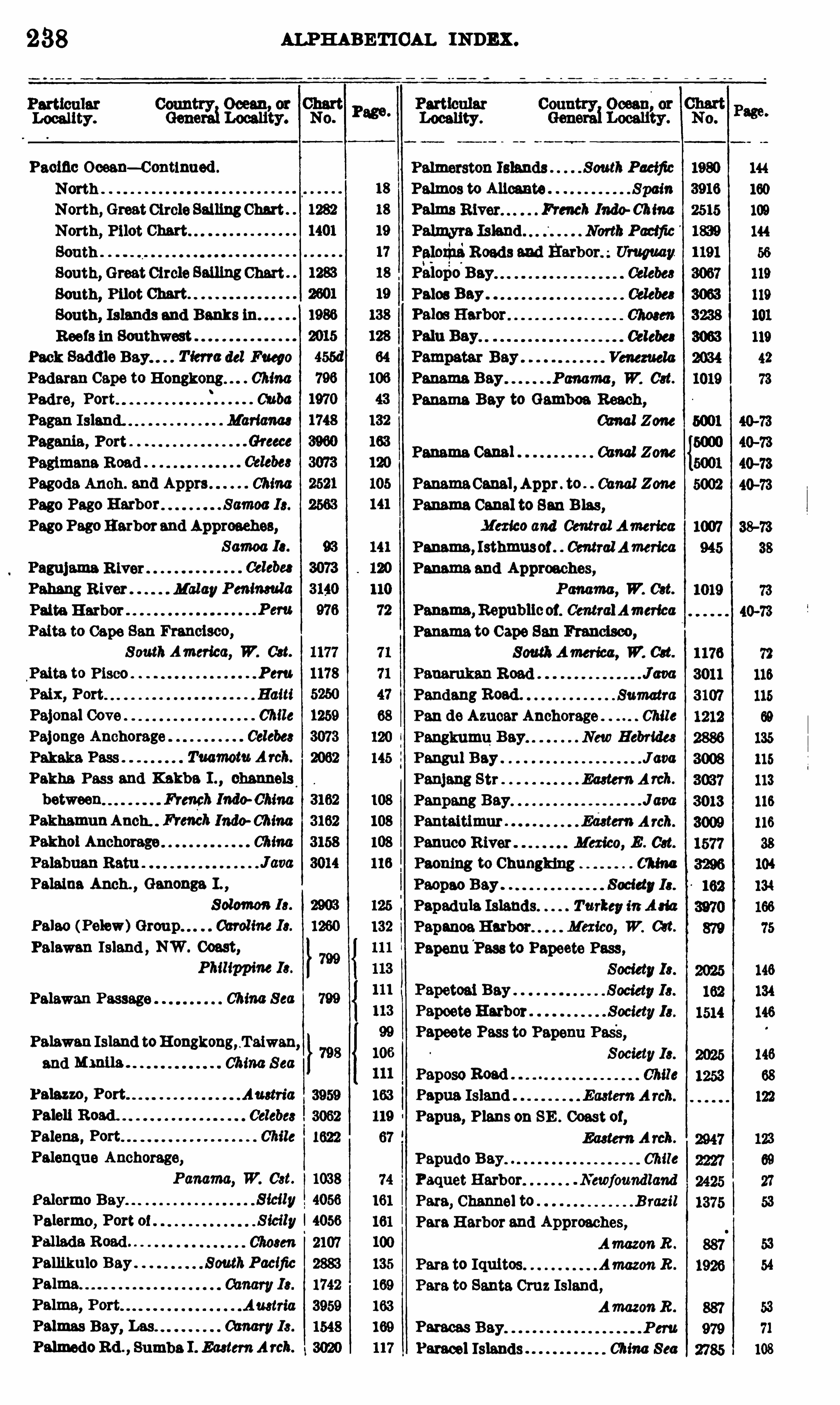
238
Locality.
f ag“
Pecine Oeean—Centlnued .
North .
North, Great Circle SailingChart
North, Pilot Chart.
South .
South, Great Circle SamngChartSouth, Pilot Chart.
South, Islands and Banks in
Ree1s in Southwest
Peck Saddle Bay. Tierre del Fuego
Padaran Cape to Hongkong. 07mmPadre, Port Cuba
Pagan I sland. Marianas
Pagania, Port Greece
Pagimana Read
Pagoda Anch . and Apprs ChinaPage Page Harbor Samoa 13 .
Page Page Harbor and Approaches,
Samoa Ia.
Pagnjama R iver
Pahang River MalayPeninsula
Palta Harbor
Palta to Cape San Francisco,
S outhAmerica, W. Cst.
Paita to Pisco . . Peru
Paix, Port . Haiti
Pajonal Cove Chile
Pajenge Anchorage Celebes
Pakha Pass and Kakba I . , channels
between French Indo ChinaPakhamunAnch. Freneh Indo ChinaPakhol Anchorage China
Palaina Anch. , Ganenga I . ,
S olomon Is.
Palae (Pelew)Group Cbroline Ia.
Palawan Island , NW. Coast,
Philippine Ia.
Palawan Passage China S ee
Palawan Island toH engkeng, .Ta1wan
and “ China S eaPalazzo, Port
Palell Road .
Palena,Port
Palenque Anchorage,
Panama, W. Cst. 1038
Palermo Bay S icily 4056
Palermo, Port 0 1 Sicily I 4056
Pamkulo Bay SouthPacific
Palmas Bay, Les amen; Is .
Palmedo Rd . Sumba 1 . EasternArch.
ALPHABETICAL INDEX .
Locality.
Palmerston Islands SouthPacific
Palmos to Alienate SpainPalms French 10 00-07mmPalmyra Island . NorthPacific
PalexhaRoads and
Pelee Bay
0 mmVenezuela
Panama Bay Panama, W. Cat.
Panama Bay to Gambea Reach,00m ! Zone
Panama Canal 00 0 0! Zone
ad
s.
Papetoai Bey .
Papeete Harbor . Society 13 .
Papeete Pass to Papeun Pas'
s,
Society13 .
Paposo Road
Papua IslandPapua, Plans on SE . Coast 0 1,
Eastern A rch.
Papudo Bay. Chile
Paquet Harbor Newfoundland
Para, Channel to B razil
ParaHarbor and Approaches,
AmazonR .
Para to Iquitos Amazon R .
Para to Santa Cruz Island,AmazonR .
Paracas Bay.
Paracel Islands China Sea
PanamaCanal ,Appr . to Canal Zone
Panama Canal to San Blas,Mexico and Central America
Panama, Isthmus01. Central America
Panama and Approaches,Panama, W. Cat.
Panama,Republic01. CentralAmeme
Panama to Cape San Francisco,SouthAmerica, W. 0d .
Pandang Read . Sumatra
Pan de Azuear Anchorage Chile
Pangkumu Bey New Hebrides
Pangu l Bay J0 00Panjang Str Eastern A rch.
Panpang Bay J 0 00
Pantaitimur Edetem A 100.
Panuce River Mexico, E . Cat.
Paoning to Chungklng China
Paepao Bay Society13 .
Papedule Islands Turkey in AmPapanoa Harbor Mexico, W. 0et.
Papenu‘
Pass to Papeete Pass,
ALPHAB ETICAL INDEX .
Ceun Ocean 0 :
Geog !Loeau’
ty.
Paraguayml B . to Concepcion,
ParaguaymiB . to Olive .m R .
Parahiba do Norte, River, Entr.
Brazil
Parana Guam to PuertoNuevo,
Parana River Entrance Uruguay
Paranagua to Santa Catharina I . ,
B razil
Paranagua to Santos B razil
.B raza
Parde Cove, Playa Magellan S trait
Parga, Port
Paflnas Pt. to Lobos Pt Peru
Parker, Port . abate R ica,Weet CoastParnahlba R . to Ham 1 . . . B razil
ParnahibaR . to Permmbuce Brazil
Parry Passage . Queen Charlotte 13 .
Parry Sound toFrench River. armada
Pasang Kayu Bay.
Pasco Bank
Past Islands
Paslr PutinAnch . , Halmahera I . ,
EasternA rch.
Pusman Strait
Paspargo Islet to Samoa Strait,Turkey in A 010
Paspebiac Bay . .G. of S t. Lawrence
Passemaquoddy Bay . . B ay of FundyPasuruan Road J0 00
Chile
Patagonia, Anch . iu Chile
Patagonia, English Narrows . Chile
Patanl Rds MalayPeninsula
Patience, Cape S iberia
Patillos Bay and Port Chile
Patipi Bay New Guinea
Patras , Gulf 01 Greece
Patrick, Port New Hebrides Ia.
Patteson,Port New Hebrides
Patuca R . and Apprs. , Month 0 1,
Honduras , N . Cat.
3
21
3
21
8
2
Particular Country Ocean, or ChartGenerai Localitty. No.
1197
Pabellon de Plea Cove 0 t 1146
Pavuvu Islands. Solomon Is.
Peyahe Rd . , Halmahera I . ,
Payta, Port—See Pawn:Peacock Anchorage Gilbert 10 .
Peacock Island Tmmotu A rch.
Pearl Cay Lagoon,Entrance to,
Pearl Gays and Appr. ,
Pedro B laneo to Macao Chine
Pedro Blufl to Port Royal . . J cmaice
Pedro B lufl to S . Negril Point,
J amm’
ca
Pei H e to Peking .
Peij in BayPeiraeus, Port
Peking, Pei Ho to ChinaPeking R iver—S eePei H0 .
Peflas Anchorage
2908
3076
120
82
fi
70
125
121
138
145
Pedro Gonzales Island,Panama, W. Cst.
Peel Island Ogasawara Ia.
Pelee Passage Lake Erie
Pegametan B . , Ball I Eastern A rch.
Pehtang Ho, Entr 07mmPel H o, 1rem Entrance to Ke-lm,
ChinaPei H e, 1rom Ko-ku to Tientsin,
ChinaPei Ho, from Tientsin to Tung-chow,
ChinaPei He, 1rem Tung-ehew to Peking,
ChinaChinaChosen
Pelagoea IslandsPelew Group—S ee P 0100 .
Pelican Harbor B ahamas
Peling Strait, Anch . in Celebes
Peling Strait and Island , Anch. in,
Celebes
Pemba I .,W. Coast 01. . Africa, E . 081.
Pemba Island , SW. Coast 01,
Africa, E . Cat.
Pefia B lanca Cove Chile
Penang Harbor Malay Peninsula
Penang Harbor and Appr. ,
M0100 Peninsuta
MexicoW. Cat.
240
Locality.
Panes, Cape, to Rio B ldasoa. . Speia
Pom , euuor, toMagellanStr . awe
Georgian Bay, 00 0040
Peniche, Peninsula 01 Portugal
Penrhyn Island . . SM Pacific
Pentecost Island NewHebrides
Pentland Firth toPeterhead. Scotland
Perak River, Appr. to,
Perlgot Bay Marquesas Ia.
Perlas Islands Panama, W. Cat.
Perlican,O ld and New. Newfoundland
PernambucoRead and Harbor. B razil
Pernambuce to Itacolomi Reef. B razil
Pemambuce to Pamahiba River,B razil
Pernambuee to R10 San Francisco do
Norte .B razil
Perres, Isla de
Perseverance Harbor . South Pacific
Persian Gulf, Anch. in Asia, S . 031.
Pescadores Cove
Pescadores Islands Taiwan
Pescadores Is . , Inner Anch . Taiwan
Petalid l Bay Greece
Petatlan Mexico, W. Cst.
Peter
Peter the Great B . to Utsurye T e,
S iberia and Chosen
Peterhead to Pentland Firth. Scotland
Petipas Cove Newfoundland
Petit Goave Bay HaitiPetit Hevre Anchorage. West Indies
Petitcodiac R lver Nova S cotia
Petropavlovsk H arbor. Kamchatka
Pctta Anchorage ,Sangi I,
I‘msung R iver, Entrance
1567
3634
1789
584
982
1330
1500
970
5970
157
157
$
8
3
2
8
8
1
157
160
144
135
155
75
27
ALPHAB ETICAL INDEX .
Phaeton, Port,and App“ . . Society Ie.
Phanari, Port
Philip Island . Pacific
Piapis E hr.,Watson EasternA rch.
Plehmnque B erber, Approaches to,
Pickanlnny W. 001.
Piedra B lanca Bay,
00010 R ica, W. Cat.
Pikelet Island CarolineIe.
Pillar, Cape, to Sandy Pt
Pilley Island Harbor . Newfoundland
Pilelcura, Port
PilonHarbor
Pilot Chart,CentralAmericanWaters
Pilot Chart, Indlan Ocean
Pilot Chart, North Atlantic Ocean"
Pilot Chart, North Pecine Ocean
Pilot Chart, South Atlantic Ocean. .l
Pilot Chart, South Pecine Ocean .
Pingelap Islands Caroline Ia.
Pingue Chan. to Arenas Cay. CubaPingue Chen. to
Pingyang Inlet, Apprs . te . Chosen
Pingyang Inlet, Southern Appr. to,
Pines Island Anchorage,Panama, N . Cst.
Pinware Bay Labrador 2064
2601
1224
1756
2778
2779
1565
Piramide, Port Argentina 3914

242 ALPHABETICAL men .
Locality.
Port Dover to Jeddore E hr. ,
Nova Scotia
Port Dover to Port Medway,
Nova Scotia
Caribbean S ea
Panama, N . Cst.
EasternA rch.
New Caledonia
Port Hamilton to Fuean E hr 01mm
Port Harvey NewGuinea
Port Hobart Tasmania
Port Hood 00pe B reton I .
Port B utt, Chatham Is . South Pacific
Port Jackson Austral iaPort Jackson to Port Stephens,
Austral iaPort Knochie
Port Kue New 001ed0m’
0
Port Lorne to Gulliver Hole,
Nova Scotia
Port Mary, Owe Babe 1 . . Solomen I 3 .
Port Masio 0 0 00
Port Medway to Lockeport E hr.
Nova Scotia
Port Medway to Port D over,
Nova Scotia
Port Moresby New Guinea
Port Mouton. Nova Scotia
Port Nicholson NewZealandPort Noumea New Oeledenia
Port Noumea, Appr. to,
00310 R ica,W. Cst.
Austral ia
Port Puebo New Caledonia
Port Purvis, Florida I . Solemon Is.
Port Renfrew B ritish Oelumbia
Port Rikitea, Mange Reva I . ,
TuamomA 101 .Port Ross, Auckland 13 . South Pacific
Port Royal.
Port Royal Bay B ermuda
Port Royal Harbor, B eaten L ,
Caribbean S ea
Port Royal E hr Jem ica
Port Royal toMorant Point. JemeicePort Royal to Pedro
Port Said . Mediterranean S ea
Wm Indies
Port Stephens to Port Jackson,
Australia
34 Port Swettenham MalayPeninsula
Port V00 , 1810 01 Pines,
PortWalanae, Oahu . Hawaiian 10 .
PortWaitangl , Chatham Is. ,
South Pacific
PortWeber B ismarckA 700 .
Port—S ee indexto propernames.
Porto Saute Island . Madeira Ie.
Porvenir Bay
PosaHarbor
Position Plotting sheets
2973
2869
1246
2265
Portillo, E l. 1196
Portland Bay 695
Portland Bight. 1683
Portland Cove Newfoundland 2415
Portland Inlet to Edye Passage,
British 0010 10010 2828
4497
Portland to Eddystone England 4448
Portland to Owers England 4447
Portland to Straight Point England 4498
Porto Belle Panama, N . Oct. 2213
Porto Belle Bay Brazil 490
Porto da Preguica Cape Verde Is . 2255
PortoGrande Cape Verde Is. 253
Porto Praia Chpe Verde Is . 253
Porto Santo. 1312
Porto Santo Bay Madeira Is . 1275
Portsmouth to Canary Islands,Europe and Africe 4320
Portsmouth Harbor England 4507
Portudal Anchorage Africa, W. a t. 2234
Portugal Europe, W. Cst.
Portugal , Southern Part 01,
Europe, W. 001.
MagellanS tr. 2568
Ecuador 790
3000
5180
Pom ssion Road Afried, W. 081. 2320
Posse Road . 3071
Post 0 11100 Bay Galapagos Ie. 1801
Pet d ’E tain, Havre de . Newfoundland 2396
Petamo, Port 3965
Potrero Bay Costa R ica, W. 031.
Potrero Grande Bay,
Costa R ica, W. Oct. 1029
Povorotnl , Cape, to Askold I S iberia 3263
Powati Anch. , Mahyan I .
EasternA rch. 3076
Poyan Anchorage 3258
Poyang Lake 01mm 3184
Praia, Porto Cape Verde Is. 253
Pratas Reef and Island . China Sea 2784
Praya de Grad osa. Azores 1 737
ALPHABETICAL INDEX .
Count Ocean or
000 021 ty.
Progulca, Porto Cbpe Verde Ia.
Preobmjenlya Bay. Kommzdonki Ia.
Preobraieniya Bay S iberia
Presqu’ile to Main Duck I . ,
LakeOntario
Preaqu’fle to Port Darljngtetn,
Lake Ontario
Prickly Pt. to Little Baeaye,
West IndiesPrideaux Haven" " B ritish Columbia
Prince E dward Island.
Prince Rupert Bay
Prince Rupert Harbor,
B ritish Columbia
Prince 01Wales W. 031.
Prince 0 1Wales B . to Laderltz B
Africa, W. 001.
Prince 0 1“
Wales Reach ,
B ritish 0010 10010
Prince’s Dock .
Prlnees Island. Aj ftoa, W. 031.
Princess Royal Reach ,
B ritish 0010 70510
Principe, I lha do Africa, W. 031.
Progreso to Tampico,Gulf of Mexico
Promontore, Cape, to River Po,
AdriaticPremontore, Cape, to Grease I .
Austria
Provencal Island
Providence Bay . . S iberia
Providence Chan , Northwest,
Bahamas
Providence Island, New .Bahamas
Providence, Port S iberia
Ptolemais Turkey in A 310
Ptolemais, Ancient LibiaPu T o Channel Chosen
Pua Man Bay Marquesas Ia.
Puebo, Port . New Caledonia
Puerto Barrios Anch.
Guatemala, E . 031.
Puerto Bueno Chile
Puerto Cabello
Puerto Cabello to 0 0 11 01 Darien,
S . America, N . Cst.
N0 .
P331“Particular Country Ocean or
Locality. Generai Locality.
Puerto Cabelle to Orinoco B . ,
rage.
243
Puerto Colombia Pier,Colombia, N . 031.
Puerto de Orotava 00mm10 .
Puerto del Metro Chile
Puerto Frances, Isla de Pines Cuba
PuertoMexico Mexico, E . 001.
Puerto Nuevo to Parana Guam,
P arana R .
Puerto Padre, Approach to Cuba
Puerto Real Entrance . Mexico, E . 001.
Puerto Refugio Lower California
Puerto SanCarlos Mexico, W. 001.
Puerto Saute Bays Venezuela
PugwashHarbor Nova 8 00110
Puke Puke Island TuamotuA rah.
Pukaruha Island TuamemArch.
PuketHarbor MalayPeninsula
Pukoo Harbor Hawaiian Is .
Pulantien Klang
Pulluche Channel
Pulo Berhala to Cape Rachado,
Malakka S tr.
Pulo Besar to Pyramid Shoal,MalayPeninsula
Pulo Cendore Group ,French Indo China
Pulo Dame Group , Frt Inde ChinaPuloM110 , N lcobar Is IndianOceanPulo Motuo to Tanjong Lutano,
Celebes
Pulo Obi French Inde ChinaPulo Panjang French Inde ChinaPulo Pisang Harbor Sumatra
Pulo Saiang (Sadang) Eastern A rch.
Pulo Wal French Inde ChinaPulotu Harbor Fij i Ie.
Pulpito Anchorage Lower Cal ifornia
Pulpito Point to SanMarcos Island ,
Lower 0011/emia
Punta Arenas Anch .
00 310 R ica, W. 031.
Punta Arenas Cove Chile
Punta Arenas Road Chile
Punta del Cerro to Flores Island,Uruguay
Purbeck Cove Newfoundlcmd
Purvis, Port, Florida I S ol omon Is.
Pusi Pusi Harbor New Guinea
Put Put Hbr .,Neu Mecklenburg,
B ismarckA rch.
Pwennegwa E hr. , Rossel Is. ,
L ouisiadeA rch.
Pyramid Shoal to Pulo Besar,Mal ayPeninsula
44
212223232113?
3323 Page
Q .
Q lawdzeet Anch . . .B ritish Columbia
Quamero, Entrance to 0 0 1101. Auatria
Quarnaro, Gul1 01.
Quatsino Sound Vancouver I .
Quebec, Province of,
S t. Lawrence Gulf and R iver
Quebec Harbor . S t. Lawrence R iver
Quebec to Goose Island,S t. LawrenceR .
Quebec to Point St. Antoine,
S t. Lawrence R .
Quebec to SaguenayRiver,
St. Lawrence R .
Q ueen Carola E hr. , Buka I . ,
S olomon Is.
Q ueen Cay Entrance,
B ritish Honduras 1497
Queen Charlotte Channel,
British Columbia 1455
Q ueen Charlotte Islands,
B ritish Columbia 904
Queen Charlotte Islands, Anch. ln,
B rmeh Columbia 1770
Queen Charlotte Is lands to Juan de
Fuca Strait B rim}; 0010 70010 903
Queen Charlotte Sound ,
British Columbia 1433
Queen Charlotte Sound , Passages
leading .B rmeh Columbia 1442 l 81
Queen Charlotte Sound and Scott Is
lands B ritish Columbia 1452
Q ueen Charlotte Sound toThurlow I .
B ritish Columbia 1453 80
Q ueen’s Cove British 0010 10010 1430 81
Q ueen’s Reach . .B rmeh Columbia 1455 79
4733 156Ireland
4734 156
Chile 1678 67
Quelpart Island to Chukupen Bay, 93—95Chosen 96-100
Queltehue, Port Chile 66
QuemoyHarbor China 1676 105
Quemchl ,Port Chile 1678 67
Queule Bay Chile 1253 68
Quibe Island . Panama, W. 081. 1041 73
Quidico, Port, or Nona Chile 1253 68
Qullan Cove Chile 1747 67
Quintai Road Chile 1447
1837 23QuintaBay Canada
23
Quintero Bay Chile 2246 69
Quoddy Roads . 1247 35
Quo Vadis, Port . T ierra del Face 0 2392 63
ALPHABETICAL INDEX .
Particular Country Ocean, or
Locality. Generai Locality.
Rebaz, Port Austria
Rabuso Creek Louieiade A rch.
Race Passage to Discovery Passage,
B ritish 001.
Race Passage to Port Harvey,
B ritish 00 1.
Rachado, Cape, to Pulo Bethale ,
Rachade, Cape, to Singapore,
S tr.
Raccoon Cut
Bede de Brest
Raefl'ski Islands. Tuamotu Arch.
Radio Stations 01 theWorld
Refiles Anchorage Borneo
Ragged Island Harbor B ahamas
Ragged Islands Anchorage. Bahamas
Rahlroa Island Tuamotu A rch.
Raletea Island . Society 10 .
Raisins , Ile aux , to Ile St. Ours,
S t. Lawrence R .
Rajpurl R iver, Entrance to. . . Indic
Rakahanga Island . . South Pacific
Rakhmat Island Anch Red Sea
Ramea Island to Indian Harbor,
Ramea Is. to Richards E hr. ,
Rame Head to Smoky Cape,Australia
Ramlapatam to Madras,
B ay of B engal
Ranai Cove to Selahang Cove,
EasternArch.
~
Rancho Viejo Channel 0000
Renders Fiord D enmark
Random Sound , Eastern Part,
Random Sound , Western Part,
Rangiroa Island . Tuemotu A rch.
68 Rannon Anchorage New Hebrides
Baraka Island Tuamotu Arch.

246
Locality.
l lnl
Rtncon Harbor, E 1,00810 R100 , W. 081.
B lueon, Port
Ringdove Anchorage. " 8 00 11 Pacific
B lngdove Bay South Pacific
01118
R10 B ldasoe to Cape Ponas . " SpamR10 1110 1310 ®a Chile
R 10 BuonoHarbor JameleaR10 Coroelmo, Orinoco River,
Venezuela
Rio do la Plate and Appr. ,
SouthAm , E . 081.
B io do Janette Bay Brazil
Rio do Janolro Harbor B razil
B iodoJanoiro to C . St. Thomo'
. B raz11
3 10 do Janoiro to Iteoelomis Roof,Brazil
R10 do Janette to Santa Catharlna I . ,
B razil
R10 do Janoiro to Santos B razil
R 10 do Ore .
R10 D000 to Cape St. Theme .B reea
R io Decoto Comoxatiba Point . B raztl
R io Grande to Mississippi River,United Statee, S . 081.
R io Grande do Norte B razil
Rio Grando do . .B rozil
R10 Grands do 80 1 to Barre Traman
B razil
R10 Negro to Bahia B lanca . Argentina
B io Parahiba do Norte, Month 01,
B razil
R10 San Francisco do Norte to Garcia
do Avila Tower. B razil
R10 Santiago
R lo Strait
Blottie,
Bishiri Island Anchorages JopenR itabel B . and Appr. , Tonimbor Is. ,
EasternArch.
Riung Bay, Flores I . . Eaetem A rch.
Rlver— See indexof proper name8 .
Rivethood Bay Newfoundland
River Seine France
Bamto, Capo, Anchorage Italy
R 0 Bay, Mare I Loyalty 18 .
Road Harbor West Indies
Roatan Island ,
Central America, E . 081.
Afried, W. 081.
S iberia
South P 00 1fie
Page .
ALPHABETICAL INDEX .
Locality.
Roca Partlda,
11801110 Gigedo N. Pacific
Roms, As
Rocu’
y Bay Wm 1480.
Books, Bay CapeB reton I .
Rock t Berebi Anch. ,
Africa, W. 081.
Boot y Inlet Maoeuen StraitRocky Pt. to Temple Head . 0him
Bodd ’s Anchoeago NewHebridee
Rodgers Ocean
Roma L , Bays in, Sorwotfl Is. ,
E0818";Arch.
Romano B Dominican Republic
Romanche Bay Terra del Fuego
Romapzov Islands Manhau18 .
Ron I'land , Anch. ia. . NewGuinea
Bongorlk Atoll H arem I8 .
Bong Sam Lem Island 8 10m
Ronldti 11even Oarolme 18 .
Roodowall Bay Africa, W. 081.
B ook Island , Anch. NewGuinea
Rooko Island , Anch . in, Umboi I . ,
2943 122
Rosalie Point to PlayaMarla Bay,
Lower California
Rosario Island Lower 00111010 10
Roseway Bank North A tlantic 941
2008 129
Rossol I . and Lagoon . LeuieicdeArch. 2957 126
Rosetta Mouth E9111” 3976 166
1748 132
Reteava Anchorage Tuamotu A rch. m3 145
Rotti Island , Anch. in . Eaetem A rch. 3020 117
Rotumah Island South Pacific 1978 139
Rouge Harbor, Cape Newfoundland 562 26-23
ALPHABETICAL INDEX .
880Part icular
Locality. Locality.
28 .Afrlce, West Cst.
Round Harbor (Lo Grand Coup do Emmi Neda"26 Saganosoki . .
99 Bag!Uta
Royal Bay, S . Georgia l fl outhAtumtie 50 Saga Bay, Adunara L . Eeetem A rch.
47Royal
,Port and Harbor J0 100 100
47
Royal Bay, . Bermuda 35 8 1. LcwrenceR iver
Royal Harbor, Port, B eaten I Saguenay River to Pt. dos Monte,m enu See 81. Lawrence R .
Royal, Port, toMou ntPoint,J0100100Royal , Port, to Pedro B lufl . J amaica
Royalist Haven. Beeten A rch.
Royalist E hr. ,Malaita1 . . Solomon18 .
Read Island Anch. . Turkey 10 A 810
Rub ia I . Aneh Sumatra
Eugen E hr. Neu Mecklenburg,
B iemarchA rch.
Rugged I . and Rod Y it, Chane. be
ChinaRuibnoi River, Entrance to. . S iberia
Ruinda, Gulf 01. S iberia
.Bahamae
Rumah Kuda B . , Roma I . ,
Eu tem A rch.
R umein River Malay Peninsula
Rum Island Anch. 8 01010011 18 .
Russol l Island,Anch. in . Selomen Ia.
R yoishiWan Japan
R yojun K 0 , Appr. to Chine
Saba IslandSabang
Sabiani Anch . , Verdato I . ,
Eauem Arch.
Sab ine Channel B ritish Columbia
Sable Island. NorthA tlanticSab le, Capo, to Lockeport Harbor,
Nova Scotia
Sab le, Capo, to Sambre Island,Nova 8 00110
Sablo,Cape, toYarmouth,NovaScotia
Sabo Road .
Sa’boga Anchorage . . Panama, W. 081.
Sacramento R001. . Lower California
Sacrificies Harbor Mexico, W. 081.
Sad dle Island New Hebrides
Sade Island JapanSad e Island to Gu11 01 Tokyo . J apan
Sa1ata Harbor Samoa I8 .
Sa1ety Cove B riti8h Columbia
Saguenay River to Quebec,
8 1. LawrenceR .
Sagunto, Port
Sahib Port Turkey 10 A 810
Said , Port, to Alexandria Egypt
Said , Port. Mediterranean Sea
8013 0 Minato
Saigon R . to Kemranh'
B
French Indo ChinaSalgonto Singapore 0510 0 S ee
Salgon to Api Passage China Sea
Sailors Harbor Newfoundland
Ckoeen
St. AbbsHead to Aberdeen. Scotland
St. AbbeHead toEdinburgh, Scotland
St. AbbeHead toHartlepool, England
St. Agnes Head to Gerrans Bay,
St. Ambrose l eland Pacific
St. AndrewAnch . . B iemerckA rch.
St. Andrews Island West. IndiaSt
°
drews Port. NewB runswick
St A Bay Jamcicc
St. Bartholomew I New Hebride8
St. Charles Cape to Sandwich Bay,
L abrador
St. Christine 1 Marquesas I8 .
St. Christopher West IndiesSt. Clair R iver to Goderich,
Lake Huron
St. Croix Bay Newfound land
247.
St. Anne Harbor 0 . B reton I .
St. Antao Island 00pe Verde 18 .
St. Anthony Harbor Newfoundland
St. Antoine, P01nt, to Quebec,
8 1. LawrenceR .
St . Antoine, Point, to Ste. Emelie,S t. LawrenceR .
St. Augustine Islands E llice 18 .
St. Barbe Bay and Harbor,Newfoundland
St. BartholomewIsland WestInd ies
248
Country Ocean, er ChartGenerai Locality.
St. Crolx Island W881 Indies
St. Croix River to Calais MemeSt. Eustaphla Bay S iberia
St. Eustatius 17881 1110188
St. 14?o Island. South Pacific
St. Felix Road. South Pacific
St. Frond s . Labrador
St. Francis. Lake . . St. Lawrence R .
St. Francis, Port, to 110 do Meme,St. LawrenceR .
St. Francois Anchorage West Ind iee
St. Genevieve Bay Newfoundland
St. Genevieve Bay to Orange Bay,
St. George
St. George
St. George, 0 0 1101,Anch. inArgentine
St. George Harbor and the Narrows,B ermudae
St. George Harbor West IndiesSt. George Harbor. Newfoundland
St. George L , Anch. ih . . Selomon 18
St. Georges Channel . . B ismarckA rch.
St. Georges Channel , N icobar
Indian Ocean
St. Giovanni, Port .
St. Govene Head to New Quay.England
St. Hospice
St. Innecontia Bay S iberia
St. Joachim Bay . T ierradel Fuege
St. John, Capo, to Cape Lopez,Africa, W. 081.
St. John Harbor Newfoundland
St. JohnH arbor . New B runswick
St. John Harbor and Approaches,West Indiee
St. John Island We81 IndiesSt. Johns Bay. . Newfoundland
St. Johns Harbor Newfoundland
St. Johns Harbor, Apprs . to,
St. Jones H arbor Newfoundland
St. Joseph Channel Lake Huron
St. Joseph Channel toMississagi St. ,
Lake Huron
St. Julien H er Newfoundland
Bt. Julien I . to H eeping Hbf . ,
Newfoundland
St. Lawrence Bay . S iberia
St. Lawrence, 0 0 11 01,
NorthAmerica, E . 081.
St. Lawrence Harbors . Newfoundland
No.
Page .
ALPHABETICAL INDEX .
Particular CountryLocality. GmoraiLocality.
St. Lawrence River and 0 1111,
St. Louis Anchorage . .Afr100 , W. 081.
St. Louis Bay
St. Louis, Lake St. LawrenceR .
St. Louis, Port 01. . . Africa, W. 081.
St. Lucas, Capo, to 26° N . ,
Lower California
St. Lueea HarborSt. Lucia Bay
St. Lucia Island .
St. Lucia Island, Anch. ih ,
West India
Newfoundland
rt
St. Martin Island . We81 11141188
St. Mary Bay Africa, W. 081.
St. Mary Bay and Approaches,
Nova Scotia
St. Mary, Cape, to Burgeo Islands,
St. Mary, Cape, to Cape Bonavista,Newfoundland
St. Mary, Capo, to Halifax,North America, E . 081.
Ocean, er ChartN0 .
2135
St. Lunaire Bay
8 1. Marc Bay
St . Marc Chan. to Baradaires B . Haiti
St. Marc Chan. to Tortuga I HaitiSt. MarcoufIs . toFlamanville . h ence
St. Margaret Bay Newfoundland
St. Maria, Port W881 IndiesSt. Martha W. 081.
St. Martin Cove T ierra del Fuege
St. Mary Isles
St. Mary River Nova Scotia
St. Marys E hr Newfoundland
St. Mein,Bay of Newfoundland
St. Michel , Cape, to Ile St. Ours,
S t. L awrence R .
St. Michel , Capo, to Montreal ,8 1. Lawrence R .
St . N icholas Bay K0mch01ka
St. Nicholas Bay. . Lower California
St. N icholas, B . , Bali I . ,
EasternA rch.
St. Nicholas Harbor . 8 1. Lawrence R .
St. N icolas Mole HaitiSt. N ikola Bay . Greece
St . N ikelo, Port Greece
St . Ours, I le, to C . St. Michel,
S t. LawrenceR .
St. Ours, 110 , to Ile aux Raisins,
8 1. LawrenceR .
St. Paul , C . , to 0 . Coast Castle,
Africa, W. 081.

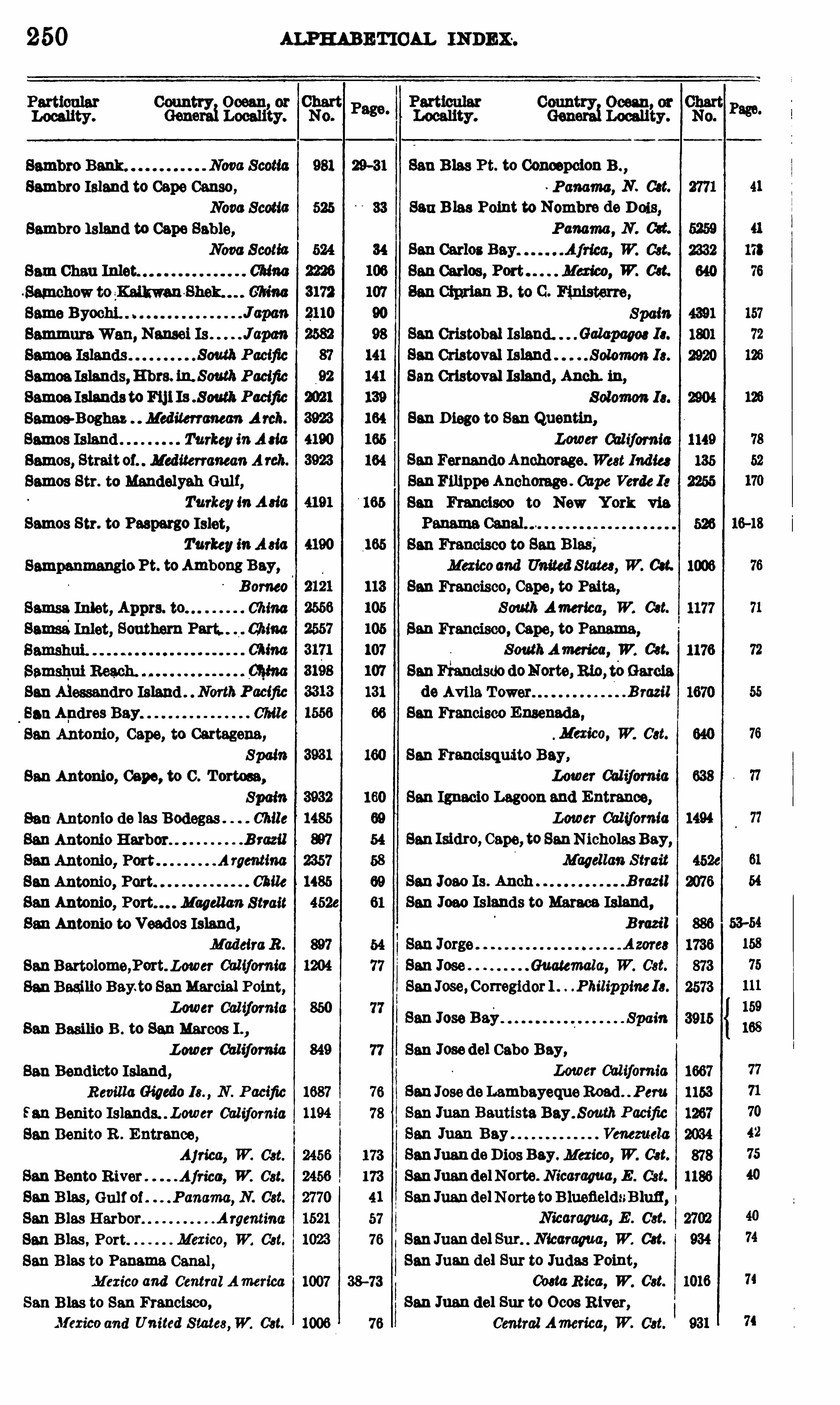
250 ALPHABETICAL meme.
Locality.
Sambro Island to Cape Cause,Nova 8 00110
Sambro Island to Cape Sable,Now 8 00110
01000
SammuraWan, Nausei Is
Samoa Islands,Hbrs. Pacific
Samoa Islands toF11118 .S outh Paelfic
Samoe-Boghaz Mediterranean A rch.
Samoa Island Turkey inA 810
Samos, Strait 01. MediterraneanAreh.
Samoa Str. to Mandolyah Gulf,Turkey 10 A 810
Semos Str. to Paspargo Islet,
Turkey inA 810
Samsa Inlet, Apprs. to ChinaSamsa
'
Inlet, Southern China
San Alessandro Island . NorthPacific
SanApdros Bay 078118
San Antonio, Capo, to Cartagena,
SpamSan Antonio, 0090 , to C . Tortoea,
SpainSan Antonio de las Bodegas . Chile
SanAntonio Harbor B razil
SanAntonio, Port A rgemmaSan Antonio, Port Chile
San Antonio, Port. . Magellan 8 11 0 11
San Antonio to Veodos Island,Madeira 11.
SanBartelomo,P0rt. Lower California
San Baeilio Bay.to SanMarcia] Point,
Lower Cal ifornia
San Basilie B . to SanMarcos I .,
.Lower Cal ifornia
San Bendieto Island,Revilla Gigedo Is. , N . P acific
San Benito Islands. . Lower Cal ifornia
San Benito R . Entrance,
Africa, W. 081.
San Bento River Africa, W. 081.
San B las, ( 11111 0 1. . Panama, N. 081.
San B las Harbor Argentine
San B las , Port Mexico, W. 081.
San B las to Panama Canal ,Mexico and Central America
San B las to San Francisco ,
Al exico and United S tates,W. 081.
38-73
San B las Pt. to Concepcion B . ,
~ Pamma, N . 081.
San B las Point to Nombre do D 018,Panama
,N . 081.
SanCarlos, W. 081.
San Cipxian B . to C . Finisterre,Spam
San Cristobal Island. Galapapee 18 .
San Cristoval Island Solomon 18 .
San Cristoval Island, Anch . ih ,
San D iego to San Quentin,
Lower 00117000 10
SanFernandoAnchorage. W881 1110188SanFilippoAnchorage Cape Verde 18
San Francisco to New York via
San Ignacio Lagoon and Entrance,
Lower California
San Isidro, Cape, to SanNicholas Bay,
Magellan 8 170 11
San 1000 Is . Anch B razil
San Joao Islands to Maroon Island,B razil
San Jose Guatemala, W. 081.
SanJose, Corregidor l .Philippine18 .
San Jose Bay Spain
San Francisco to San B las,Mexicoand 0 0 1180 8 10188 , W. 081.
San Francisco, Cape, to Paita,
S outh America, W. 081.
San Francisco, Cape, to Panama,SouthAmerica, W. 081.
SanFianeisdo doNorte,mo, teGarcia
do Avila T ower B razil
San Francisco Ensenada,
. Mexice, W. 081.
San Francisque’
to Bay,
San Jose del Cabo Bay,Lower California
SanJose doLambayeque Road . Peru
San Juan Bautista Bay. 8 0uth Pacific
San Juan Bay Venezuela
SanJuandoDies Bay. Mexico, W. 081.
San JuandelNorto. Nicaragua, E . 081.
SanJuandel Norte to B luefieldsB lufl ,
Nicaragua, E . 081.
SanJuandel Sur. Nicaragua, W. 081.
San Juan del But to Judas Point,00810 R ica, W. 081.
San Juan del Sur to 0 008 R iver,
Central America, W. 08 1.
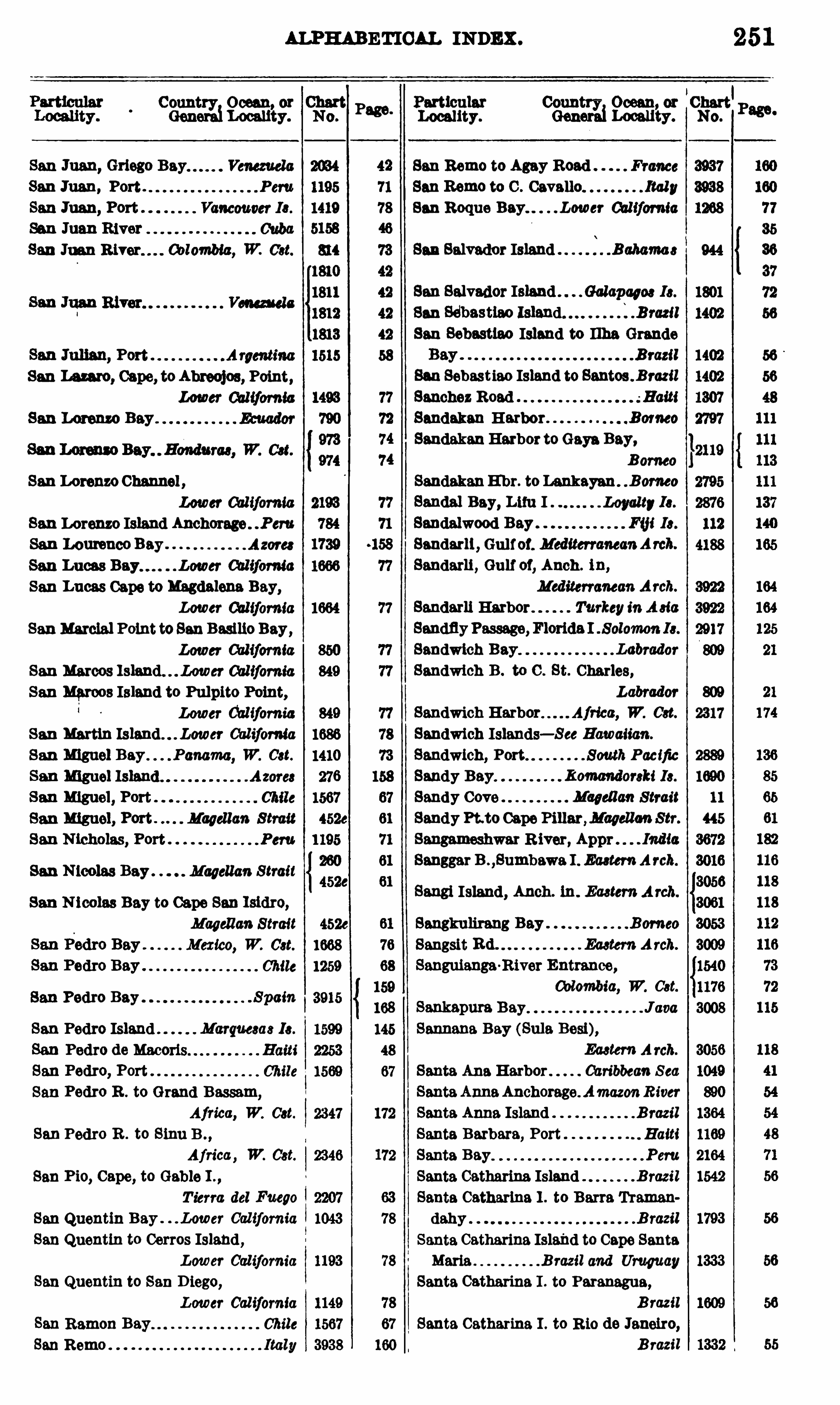
ALPHABETICAL INDEX .
Count Ocean or
0 00 031Localfizy.
San Juan, Grloge Bay
San Juan, Port .
San Juan, Port .
Son Juan River
San Juan Colombia, W. 081.
San Lam e, Cape, toAbroojoe, Point,Lower 0010011 110
San Lorenzo Bay .
San Lorenzo Channel ,
Lower 00111010 10
San Lorenzo Island Anchorage . Peru
San Lemence BaySan Lucas . Lower California
San Lucas Capo to Magdalena Bay,Lower 001110 10110
SanMarcia] Point toSan Basilio Bay,Lower California
San Marcos Cal ifornia
San Marcos Island to Pulpito Point,Lower California
San Martin California
San Miguel W. 081.
San Miguel Island . .
San Miguel, Port
San Miguel, Port . Magellan S trait
San N icholas, Port .
San N icolas Bay . Magellan Strait
San N icolas Bay to Cape San Isidro,Magellan 8 110 11
Mexico, W. 081.
Chile
San Pedro Bay . 8 p0m
San Pedro Island Marqueeas 18 .
San Pedro de Macoris.
San Pedro, Port . .
San Pedro R . to Grand Bassam,
Africa, W. 081.
San Pedro R . to Sine B . ,
Africa , W. 081.
San Pie, Cape, to Gable I . ,
T ierra del Fuego
San Quentin Bay . . . Lower Cal ifornia
San Quentin to Corros Island,Lower California
San Quentin to San D iego,
Lower California
Chile
Italy
San Ramon
San Remo
4526
1668
1259
3915
Page.
ParticularLocality.
San Rome to Agay Road France
San Rome to C . Cavallo Italy
San Reque Bay. . . Lower 0011f0m10
San Salvador Island 8 050 010 8
Conn 0 0000 or Charteeng
r
ryd Locau
’
ty. No.
251
San Salvador Island 0 010110908 I8 .
San Seibastiao Island B razil
San Sebastlao Island to Ilha GrandeB razil
Ban Sebastieo Island to Santos . B razil
Sanchez Read -3 0111
Sandakan Harbor B emeo
SandakanHarbor toGaye Bay,B orneo
SandakanE'
hr. to Lankayan Borneo
Sandal Bay, LimI . Loyalty 18 .
Sandalwood Bay F111 18 .
Sandarli , 0 0 1101. MediterraneanArch.
Sandarli , 0 0 11 01, Anch . ih ,
Mediterranean Arch.
Bandarll Harbor TurkeyinA 810
SandflyPassage, Florida I 8 010 1110 11 18 .
Sandwich Bay Labrador
Sandwich B . to C . St. Charles,
Labrador
Sandwich Harbor Aj rice, W. 081.
Sandwich Islands—See Hawaiian.
Sandwich, Port South Pacific
Sandy Bay Komendereki 18 .
Sandy Cove Magel lan 8 11 0 11
Sandy Pt to Capo Pillar ,Magellan Str.
Sangameshwar R iver , Appr . . India
Sanggar B . ,Bumbawa 1 . E 0818”: A rch.
Sangi Island, Anch. 1n. Eaetem A rch.
Sangkulirang Bay Borneo
Sangsit Rd . Eastern A rch.
Senguianga-Rivor Entrance,
Colombia, W. 081.
Sankapura Bay J0 00Sannena Bay (Sula Bosi),
Ea8 1em A rch.
Santa Ana Harbor Caribbean S ea
SantaAn aAnchorage. AmazonR iver
Santa An a Island B razil
Santa Barbara, Port Haiti
Santa Bay Peru
Santa Catharina Island B razil
Santa Catharina I . to Barre Tremen
dahy B razil
Santa Catharina Island to Cape SantaMaria B razil and Uruguay
Santa Catharina I . to Paranagua,
B razil
Santa Catharina I . to R io do Janeiro,B razil
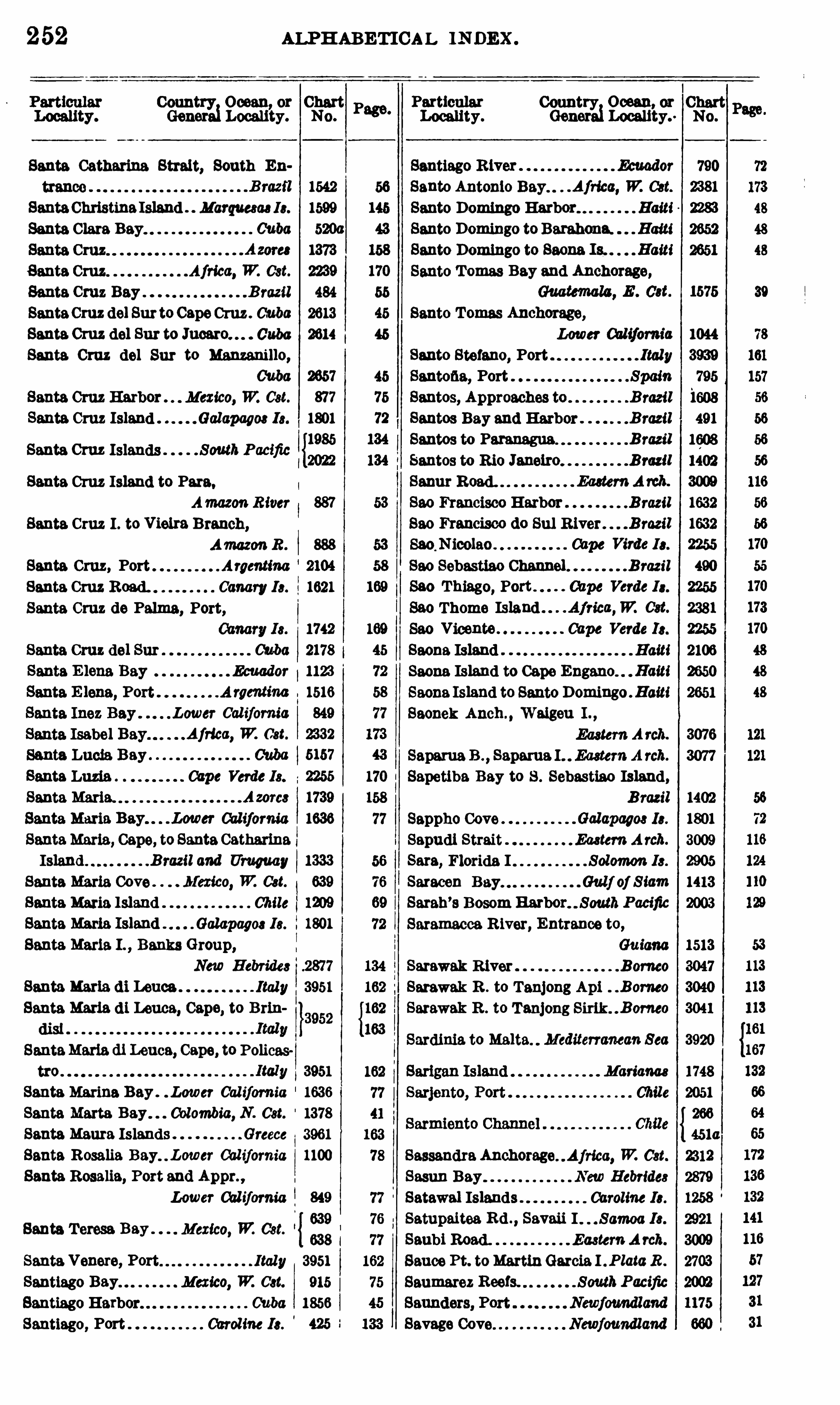
252 ALPHABETICAL IN DEX .
Country Ocean, or ChartGeneraiLocality. No.
Santa Catharina Strait, South Eu
1542
SantaChristinaIsland . . Marquesaa18 . 1599
Santa Clara Bay Cuba 520a
1373
Santa Cruz Africa, W. Cst. 2239
Santa Cruz Bay B razil 484
SantaCruz del Sur to CapeCruz . Cuba 2613
Santa.Cruz del Sur to Juoaro. Cuba 2614
Santa. Cruz del Sur to Manzanillo,Cuba 2657
Santa Cruz Harbor . . Mexico, W2 Cst. 877
Santa Cruz Island . Galapagm 18 . 1801
Santa Cruz Islands South Pacific 38
;Santa Cruz Island to Para,
Amazon River 887
Santa.Cruz 1 . to V ielra Branch,
AmazonR . 888
Santa Cruz, Port Argmtina 2104
Santa Cruz Road. Canary 18 . 1621
Santa Cruz de Palma, Port,1742
Cuba 2178
. Ecuador 1123
A rge'ntina 1516
Cal ifornia 849
Africa, W. Cst. 2332
5157
Santa Luna Cape Verde 18. 2255
Santa Maria. Azorcs 1739
Santa Maria Bay. . . Lower Cal ifornia 1636
SantaMaria, Cape, to Santa CatharinaIsland B razil and Uruguay 133
Santa Maria Cove . Mexico, W. C ”. 639
Santa Maria Island Chile 12 19
Santa Maria Island Galapagos I8 . 1801
Santa.Maria. I . , Banks Group,New Hebrides 2877
Santa Maria (11 Leuca Ital y 3951
Santa Maria (11 Leuca, Cape, to Brin
dist
SantaMaria dl Leuca, Cape, to Polices
tro . 3951
Santa Marina Bay . . Lower Cal ifornia 1636
Santa Marta. Colombia, N. Cst. 1378
Santa Maura Islands Greece 3961
Santa Rosalia Bay. . Lowcr California 1100
Santa Rosalia, Port and Appr. ,
Lower Cal ifornia 849
639
638
Santa Venere, Port I taly 3951
Santiago Mexico, W. 081. 915
Santiago Harbor Cuba 1856
Santiago, Port Caroline I8 . 425
Santa Teresa. Mexico, W2 Cst.
Country Ocean, or ChartLocality . GeneraiLocality. No.
Santiago R iver Ecuador 790
Santa Antonio Bay. . .Africa, W2 C8t. 2381
Santo Domingo Harbor Haiti 2283
Santo Domingo toBarahona. Haiti 2652
Santo Domingo to Saona Is. . Haiti 2651
Santo T omas Bay and Anchorage,
Savage Cove
Santa Tomas Anchorage,Lower Cal ifornia 1044
Santo Stefano, Port I taly 3939
Santana, Port Spain 795
Santos, Approaches to B razil 1608
Santos Bay and Harbor B razil 491
Santos to Paranagua. B razil 1608
Santos to Rio Janeiro B razil 1402
Sanur Road. Eu tem A rch. 3009
Sac Francisco Harbor B razil 1632
83 0 Francisco do 8111 R iver B razil 1632
Sac,Nicolao Cape Virde 18 . 2255
Sac Sebastiao Channel . B razil 490
Sec Thiago, Port Cape Verde 18 . 2255
Sac Thoma Island Africa,W. ( M. 2381
Sac Vicente Cape Verde 18 . 2255
Saona Island Haiti 2106
Saona Island to Cape Engano Haiti 2650
Saona Island to Santo Domingo . Haiti 2651
Saonek Anch . , Walgeu I . ,
EasternA rch. 3076
Saparua B . ,Saparua I . EasternA rch. 3077
Sapetiba Bay to S . Sebastiao Island,1402
Sappho Cove Galapagm 18 . 1801
Sapudi Strait EasternA rch. 3009
Sara, Florida I Solomon 18 . 2905
Saracen Bay Gulf of Siam 1413
Sarah’s Bosom Harbor SouthPacific 2003
Saramacca River, Entrance to,Guiana 1513
Sarawak River Borneo 3047
Sarawak R . to Tanjong Api B orneo 3040
Sarawak R . to Tanjong Sirik B orneo 3041
Mariam 1748
Chile 2051
266
451a
SassandraAnchorage Africa, W. Cst. 2312
Sasun Bay New Hebrides 2879
Satawal Islands Caroline I8 .
Satupaitea Rd . , Savaii I Samoa 18 . 2921
Sanbi Road . Eastern A rch. 3009
Sauce Pt. toMartinGarcia I . Plata R . 2703
Saumarez Reefs. SouthPacific 2002
1175
Newfoundland 660


54 ALPHABETICAL 11mm .
Seychel les Group Indian,Ocean
Seymour ColumbiaSeyunkow Creek to Silver I .
Yemme E mShadwel l Passage Vancouver 1.
Shah Bay, Nanso1 I s JapanShakoma River, Entranceto . . Sa
’
beria
Shallow Bay Newfoundland
Shallow Bay to Gun Point,
ShanaWan, Kwi! Is
ShanaWan,Nausei Is
ChinaShannon, R1var Ireland
Shantung Penlnsula. ChinaShantung, Plans on Cst. ChinaShantung Promontory China
Shastri Appr. and Entr. to . . India
ShasukomnT o Japan
Shedlao Bay and Harbor,NewBmmwick 1081
1569
Sheerness Bar to B ishops Ness ,England 4486
Sheet Harbor and Adjacent Anchor
Sheikhel BarghatorBarud . . Red S ea
Shelburne Harbor Nova ScotiaShelter, Port ChinaShepeneheAnch. Llfu I Loyalty18 .
Shepherd Harbor . . P tmama, N . Cst.
Sherbro River Africa,W. 081.
Sherm el Molyah Red S ea
Sherm en Noman Red Sea
Sherm Habban Red S ea
Sherm Hassey Red S ea
Sherm Jubba Red S ea
Sherm Rabegh Red S ea
Sherm Shaikh Red Sea
ShermWe] Red S ea
Sherm Yahar Red S ea
Shershel, Port A lgeric
Shetland British 18288Shetland Islands, South,
SouthAtlanticSheung Lung Rock, Canton R . ChinaShibayama K0 JapanShibetoro Anchorage JapanShichlml Ura JcpanBhlhpu Rd . 6: E hr China
32
67
156
Shlhtao Bay and Approaches ChinaShihtao B . to N W. Promontory,
Shihtao B . to Taotsui Bay ChinaShikoku Island J apan
8h1kotanJimatoYuru Jims . . J apan
Shimakatsu Uta to TaéhlliataWan,
Shimizu X c, Honshu . J apan
Shimoda Harbor, Approaches to,
Shimonoseki Kaikyo to Hirado
Shimonoseki Kaihyo to MaruyamaZaki Inland Sea, Japan
Shimonou kl Strait.
Ship Cove Newfoundland
Ship Harbor Newfoundland
Ship Harbor and Adjacent Anchor
Nova ScotiaShippigan Harbor,
Gulf of St. LawrenceShip Rock Shoal Newfoundland
Ship Rock Shoal to Duck I . ,
Shirlnki To.
Sh riya ZakiShito Bay
Shoal Channel
Shoe Cove to GreenHead,Newfoundland
Sholl B ay ( Smyth Channel) Chile
Sholl Bay (Magel lan Chile
Shortland Harbor Solomon 18 .
Shumma IslandSiaba Bay, N ias ISiam, Approaches to Gulf of,
China Sea
Siam, Gulf of, Plans in,French Indo China
Siangshan Kin g to Yung R . China
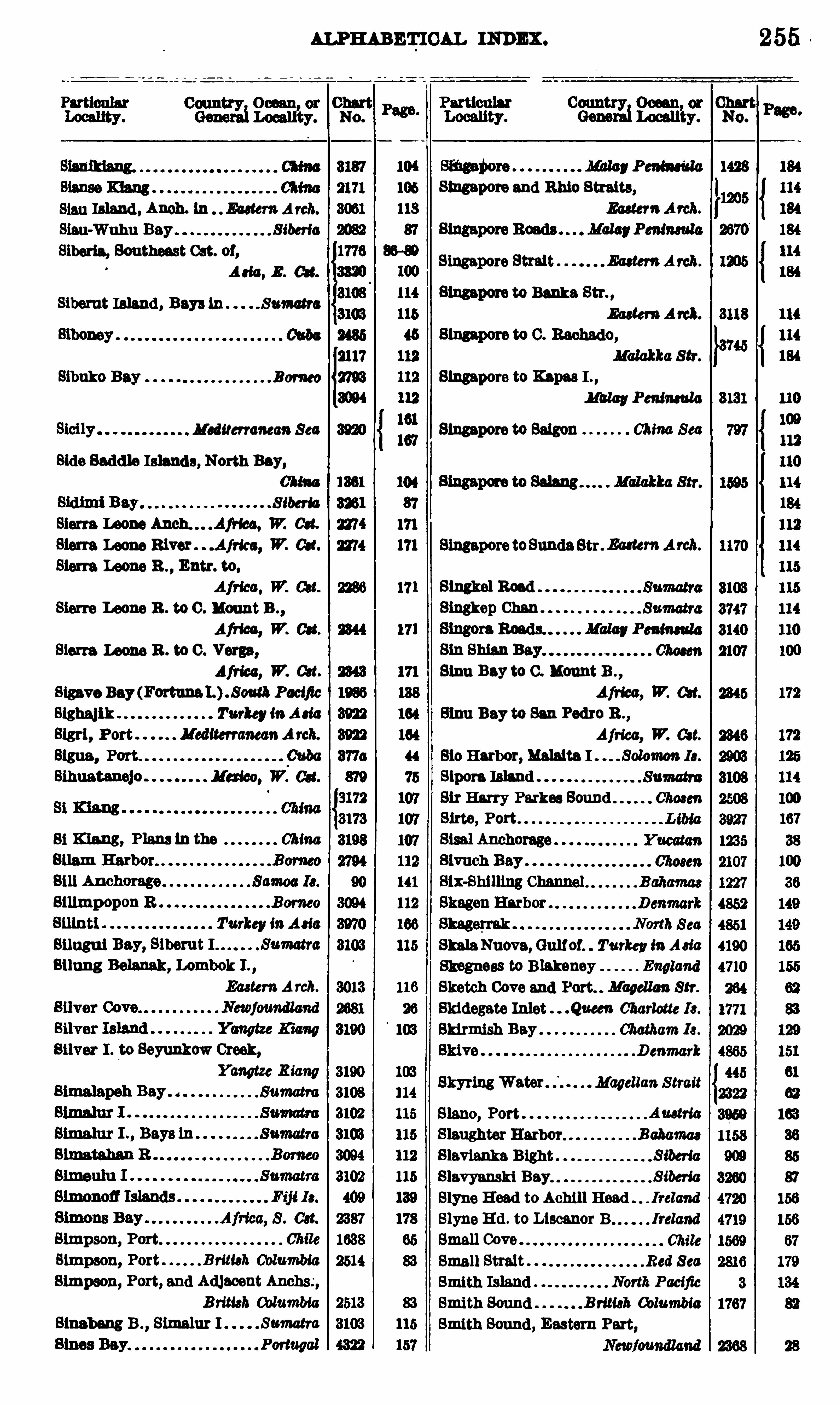
ALPHABETICAL INDEX .
8180 Island , Anch. In . . Eu tem A rch.
Sinu-Wuhu Bay S iberia
Siberia, Southeast Cat. 01,
Ad a, E . Gut.
Sibemt Island, Bays 1n "Sumatra
Borneo
Mediterranean Sea
Side Saddle Islands, North Bay,
. S iberia
Sierra Leone W. Get.
Sierra Leone W. 081.
Sierra Leone B . , Entr. to,
Sierra Leone R . to 0 . Mount B . ,
Afi lm, W. 084.
Sierra Leone R . to C . Vorga,
Afries , 17 . Get.
Sigave Bay (Forums . South Pacific
Slghaj l k Turkey inAd a
Sigrl , Port MediterraneanArch.
Signs , Port Cuba
81 Kiang, Plans In the ChinaGuam Harbor. .
SilimpOpon R
Turkey inAd a
811113111 Bay, Siberut I Sumatra
Bllung Belanak, Lombok I .
Eastern A rch.
Silver I . to Seyunkow Creek,
Slmpson, Port Chile
Simpson, Port B rim}; ColumbiaSimmon, Port, and Adlaoent Anchs;,
B rim); ColumbiaSim bang B . ,
Simalur I Sumatra
smapore and Ento Straits,
Ea ter»Arch.
Singapore Strait Ea ten: A rch.
Sma pore to Banks Str. ,
Ea ten: A rch.
Malakka Str.
Singapore to Knpas I
W ayPeninsula
Singapore to Saigon China Sea
104
87
171
171 SingaporetoSunda Str Eaatem Arcb.
11 1 Slngkel Road
Bingkep Chan
Sinu Bay to 0 . Mount B . ,
Africa, W. Get.
811m Bay to San Pedro B . ,
Africa, W. Get.
BioHarbor, M alta I . Solomou 18 .
Sipotu IslandSir Harry Parkes SoundSitte, Port
SkalaNuova, Gulfof. Turkey inA 818
Skegness to B lakeney England
Sketch Cove and Port. Magellan Stf .
Skidegate Inlet .Queen Charlotte 18 .
Skirmish Bay Chatham I8 .
Denmark
Magellan StraitO O O O O O O O O O O O O O O O O O
255
SkyringWaterSlano, Port AmtmSlaughter Harbor. .Bahaflm
Slavianka B ight S iberia
Slavyanski Bay S iberia
Slyne Head to Achi ll Head Ireland
Slyne Hd . to Llscanor B Ireland
Small CoveSmall Strait Red S ea
Smith Island North Pacific
Smith Sound B rim}: ColumbiaSmith Sound , Eastern Part,
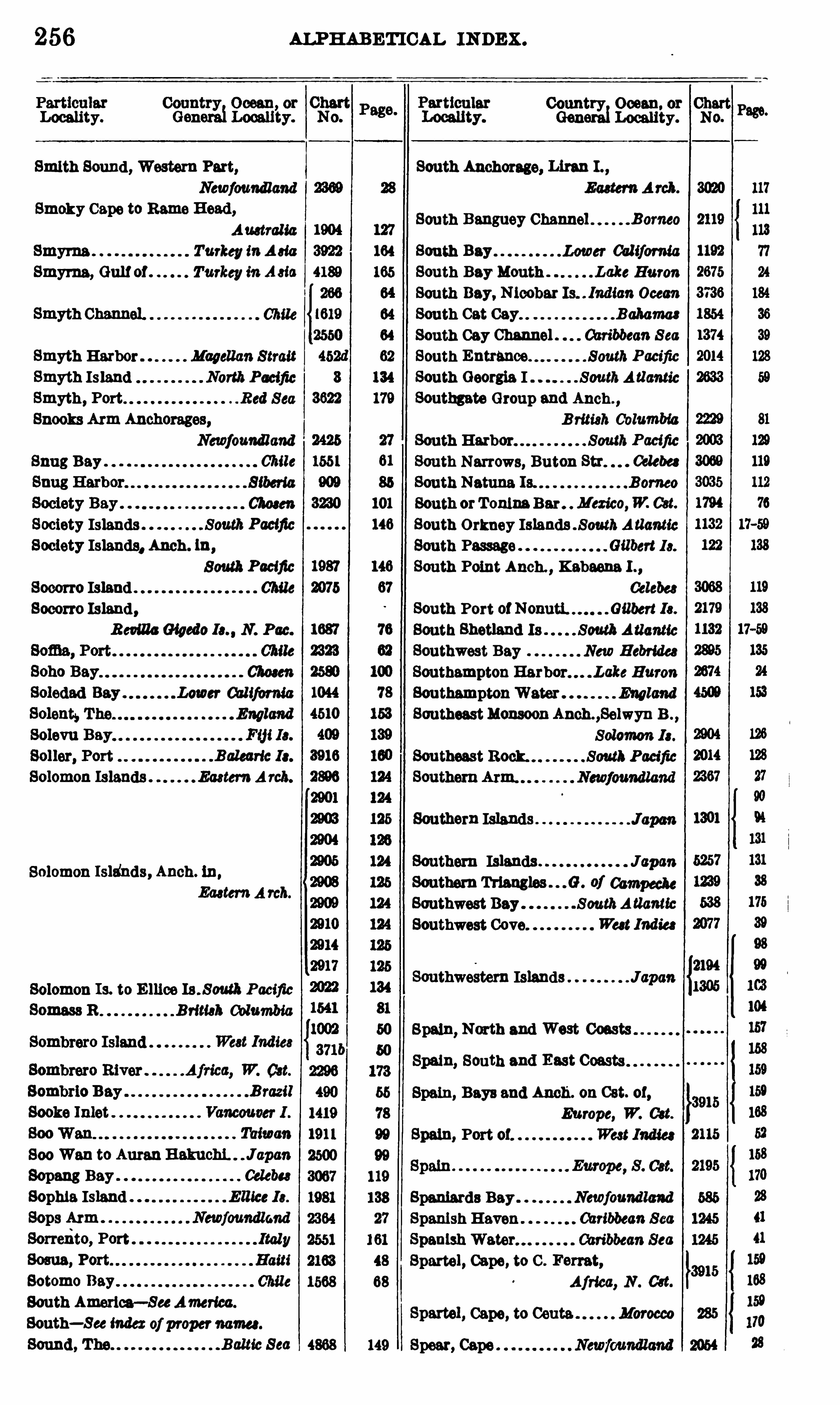
256 ALPHABETICAL INDEX .
Locality.
Smith Sound , Western Part,
Newfoundland
Smoky Cape to Rams Head,Amtral ia
Smyrna . Turkey inA 818
Smyrna, Gulf of . Turkey in A 818
Smyth HarborSmyth IslandSmyth, PortSnooks Arm Anchorages,
Newfoundland
Snug Bay Chile
Society Islands South PacificSociety Islands. Anch. In,
South Pacific
Socorro Island .
Socorro Island,12mmGigedo N. Pac.
Lower California
EasternA rcb.
Solomon Isldnds, Anch. ln,
Eactem A rch.
Solomon I s. to E llice Pacific
Somass B . . . . Brimb Columbia
800 Wan to AuranHakuchL . J apan
Sopang Bay Celebe8
Sophia IslandSops Arm Newfoundland
Sorrexito, Port308118 , Port.
Sotomo
South America—SeeAmerica.
South—See indexof propermum .
Sound , The Baltic Sea
Country Ocean. or ChartGeneralLocality.
South Anchorage, Linn 1
South Banguey Channel Borneo
Southeast Rock.
Southern Islands
Southern Islands JspanSouthern of Campeche
Southwest Bay SouthA tlanticSouthwest Cove Wa t Indies
Southwe8tern Islands Japan
Spain, North and West Coasts
Spain, South and East Coasts
Spain, Bays and Anch. on Cst. of,
Europe, W. 08t.
Spain, Port of.Spain .
Spaniards Bay Newfoundland
Spanish Haven Chribbean S ea
SpanlshWater. Caribbean Sea
Sparta] , Cape, to C . Fem t,
Africa, N C81.
Spartel , Capo, to Ceuta. Morocco
Spear, Cape
No.
Page.
South Bay Lower Cal ifornia
South Bay Mouth Lake Huron
South Bay, N icobar Is. . 1ndian Ocean
South Cat Cay BahamaSouth Cay Channel Caribbean S ea
South Entrance. . South Pacific
South Georgia I SouthAauntieSouthgate Group and Anch . ,
B ritish ColumbiaSouth Harbor South PacificSouth Narrows, Buton Str Celeba
South Natuna Is. B orneo
South orTonlna Bar Mexico,W. Oat.
South Orkney Islands . South Aauntie
South Passage Gilbert 18.
South Point Anch. , Kabaena I . ,
Celebee
South Port 01Nonuti. Gilbert 18 .
South Shetland Is South AtlanticSouthwest Bay New Hebrides
Southampton Barbor Lake Huron
SouthamptonWater England
SoutheastMonsoon Anch. ,Selwyn B . ,
Salem 18 .
SouthPacific

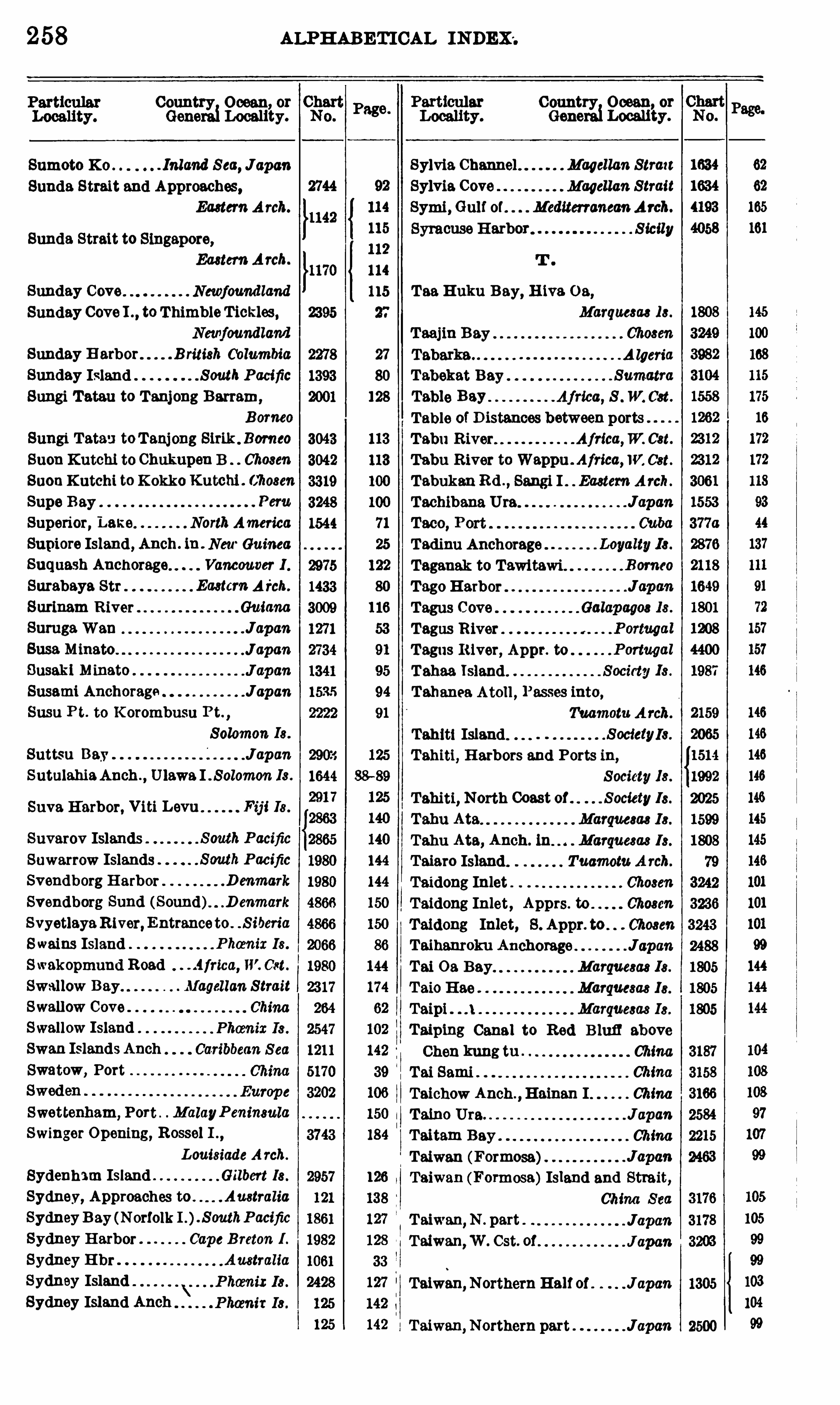
258 ALPHABETICAL INDEX .
Country Ocean or
Generai Locali’
ty.
Sumoto X c . . Inland S ea, JapanSunda Strait and Approaches,
Eastern A rch.
Sunda Strait to Singapore,Eastern Arch.
Sunday Cove Newfoundland
Sunday Cove I . . toThimbleTickles ,Newfoundland
Sunday H arbor B ritish ( blumbia
Sunday Island SouthPacificSungi Tatau to Tanjong Barram,
Borneo
Sungi Tata-J toTanj ong Sirik . Bomeo
Suon Kutchi to Chukupen B Chosen
SuonK utchi to K okko Kutchi . Chosen
Supe Bay
Superior, Lake NorthAmerica
Supiore Island , Anch . in . NewGuinea
Suquash Anchorage Vancouver 1 .
Surabaya Str Eaetcm A i'ch.
Surinam River GuianaSutugaWan JapanSusa Minato J apan
Susaki Minato . J apan
Susami Anchoraga JapanSusu P t. to K orombusu Pt. ,
Solomon Is .
Suttsu Bay J apanSutulahiaAnch .
, Ulawa I . Solomon Is .
Suva H arbor, Viti Levu Fij i Is .
Suvarov Islands SouthPacific
Suwarrow Islands South Pacific
Svendborg Harbor . D enmark
Svendborg Sund ( Sound). .D enmark
SvyetlayaR iver, Entranceto . . S iberia
Swains Island Phamix 18 .
Swakopmund Road . .4frica, W. Cst.
Swallow Bay Magellan StraitSwallow Cove
Swallow IslandSwan Islands AnchSwatow, Port
Swettenham,Port . MalayP eninsula
Swinger Opening, Rossel I .,
Louisiade A rch.
Sydenham Island Gilbert 18 .
Sydney, Approaches to . AustraliaSydneyB ay (Norfolk I .). S outhPacific
Sydney Harbor Cape B reton 1 .
Sydney E hr AustraliaSydney IslandSydney Island Anch
Country Ocean or
Generai Localiiy.
Sylvia Channel Magellan Strazt
Sylvia Cove Magellan StraitSymi , Gulf of . MediterraneanArch.
Syracuse H arbor Sicily
Taa Huku B ay, H ive. O s ,Marquesae 18 .
O O O O O O O O O O O O O O O O
T aiwan,N . part
Taiwan,W . Cst. of
Taiwan, NorthernHalf of J apan
Taiwan,Northern part Japcm
Taajm B ay
Tabarka A lgeria
Tabekat Bay Sumatra
Table Bay Afried , S . W. Cst.
Table of D istances between portsTabu River Africa,W. Cst.
Tabu River to Wappu . Africa,W. Cst.
TabukanRd .
,Sangi I Eastern Arch.
Tachibana Uta Japan
Tadinu Anchorage
Taganak to Tawitawi .
Tago HarborTagus Cove
Tagus River
Tagus River, Appr. to
Tahaa IslandTahanea Atoll , Passes into,
Tuamotu. A rch.
Tahiti Island S ocietyIs.
Tahiti, H arbors and Ports ih ,
S ociety 18 .
Tahiti, North Coast of Society 18 .
Tahu Ata Marqm ae 18 .
Tahu Ata, Anch. in Marquesas 18 .
Taiaro Island Tuamotu A rch.
Taidong Inlet Chosen
Taidong Inlet , Apprs. to Chosen
Taidong Inlet, S . Appr. to Chosen
Taihanroku Anchorage JapanTai 0 3 Bay Marquesas 18 .
T aio H ae Marquesas 18 .
Taipi Marquesas 18 .
Taip‘
mg Canal to Red B luff above
Chen kung tu ChinaTai Sami ChinaTaichow Anch .
,Hainan I China
Taino Uta. J apan
Taitam Bay ChinaTaiwan (Formosa) J apanTaiwan (Formosa)Island and Strait,
China S eaJapcmJ apa'n
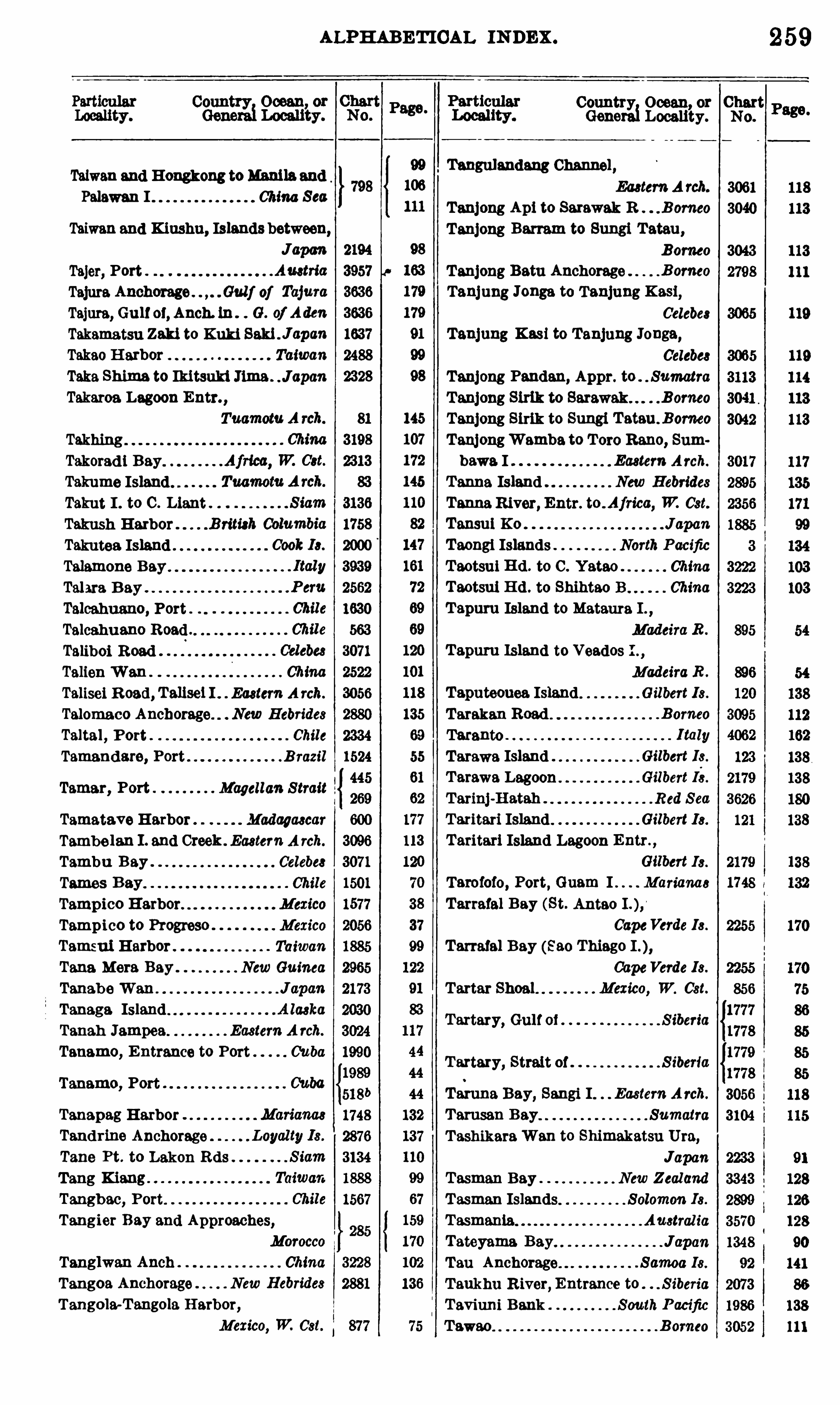
ALPHABETICAL IN DEX .
Taiwan and Hongkong toManilaandPalawan I China Sea
Taiwan and Kiushu, Islands between,Japcm
Tajer, PortTajura Anchorage . . Gulf of Tajum
Tajura, Gulf oi, Anch. ih . G. of Aden
Takamatsu Zaki to Kuki SakiJ apan
Takao H arbor Taiwan
Taka Shima to Iki tsuki Jima . J apan
Takaros Lagoon Entr. ,
Tuamotu A rcb.
Takhing
Takorad i Bay.
Takume IslandTakut I . to C . Liant .
Takush HarborTakutea Island .
Talamone Bay.
Talara B ay
Talcahuano, PortTalcahuano Road
Taliboi R oadTalien Wan ChinaTalisei R oad , Talisel I . Eastern A rch.
Talomaco Anchorage. New Hebrides
Taltal , Port . Chile
Tamandare, Port B razil
Tamar, Port Magellan StraitTamatave Harbor Madagascar
Tambe lan I . and Creek . Eastern A rch.
Tambu Bay Celebe8
Tamas B ay Chile
Tampico Harbor Mexico
Tampico to Progreso Mexico
Tamsui Harbor Taiwan
Tana Mora Bay . NewGuinea
Tanab e Wan J apan
Tamaga Island . A laska
Tanah Jampea. Eastern A rch.
Tanamo, E ntrance to Port Cuba
Tanamo, Port
Tanapag HarborTand rine Anchorage .
Tane Pt. to Lakon Rds
Tang KiangTangbao, Port.
Tangier Bay and Approaches,
MoroccoTanglwan Anch . ChinaTangoa Anchorage New Hebrides
Tangola-T angola H arbor,
Mexico, W. Cst.
Country Ocean or ChartGenerai Locality.
Tangulandang Channel
Tartar Shoal
Tartary, Gulf of S iberia
Tartary, Strait of S iberia
No.
259
Ea8tem A rch.
Tanjong Api to Sarawak R B orneo
Tanjong Barram to Sungi Tatau ,
Bomeo
Tanjong Batu Anchorage B orneo
Tanjung Jonga to Tanjung Kasi,Celebes
Tanjung Kasi to Tanjung Jonga,Celebe8
Tanjong Pandan, Appr. to SumatraTanjong Sirik to Sarawak B orneo
Tanjong Sirik to Sungi Tatau . Bomeo
TanjongWamba to Tom Rano,Sum
bawa. I Eastern Arch.
Tanna Island New Hebrides
Tanna River, Entr. to . Afn‘
ca, W. Cst.
Tansul Ko J apan
Taongi Islands North Pacific
Taotsai Hd . to C . Yatao ChinaTaotsul H d . to Shihtao B China
T apuru Island to Mataura I .,
Madeira R .
Madeira R .
Taputeouea Island Gilbert 18 .
Tarakan Road . B omeo
Taranto I taly
Tarawa Island Gilbert 18 .
T arawa Lagoon Gilbert 18.
T arinj-H atah Red S ea
Taritari Island Gilbert 18 .
Taritari Island Lagoon Entr .,
Gilbert 18 .
Tarofofo, Port, Guam I Marianas
Tarrafal Bay (St. Antao
CapeVerde 18 .
Tarrafal Bay (88 0 Thiago
CapeVerde 18 .
Mexico, W. Cst.
Taruna Bay, Sangi I Eastern A rch.
Tamsau B ay SumatraT ashikaraWan to Shimakatsu Uta,
JapanTasman Bay New ZealandTasman Islands Solomon Is .
Tasmania. Austral iaTateyama Bay JapanTau Anchorage Samoa 18 .
Taukhu River,Entrance to S iberia
Taviuni Bank South P acific
T awao B omeo
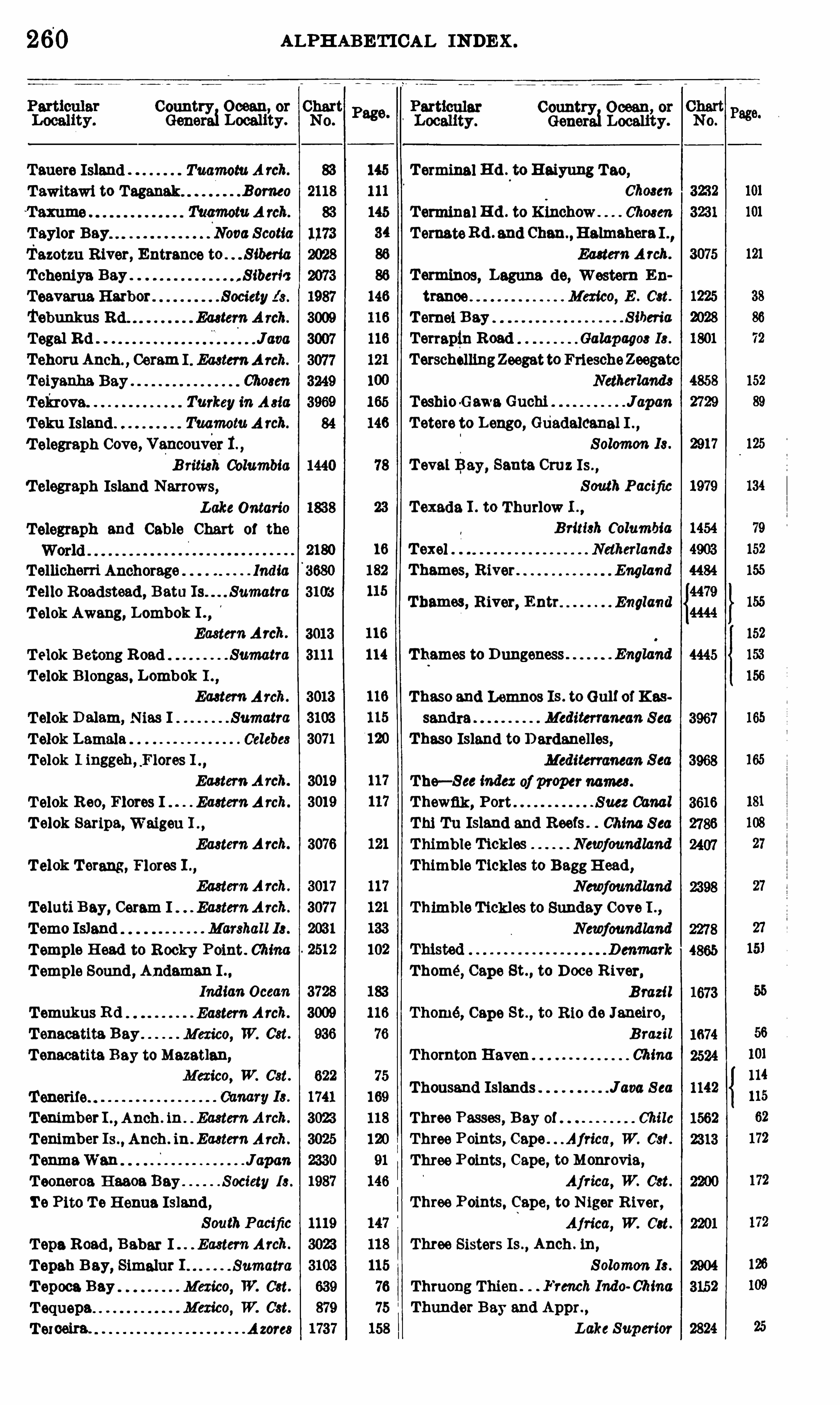
260
Country Ocean, or ChartGenerai Locality. No.
Tauere Island Tuamotu A rch.
Tawitawi to Taganak Bomeo
T aylor Bay Nova ScotiaTazotzu River, Entrance to . . S iberia
Tcheniya Bay . , S iberic
Teavarua.Harbor . . Society 18 .
Tebunkus Eaetem A rch.
Tegal Rd JavaTehoru Anch . Ceram I . EasternArch.
Teiyanha Bay Ch08en
Toh ova Turkey in Asia
T eku Island Tuqmotu A rch.
T elegraph Cove, Vancouver 1.
B ritish ColumbiaT elegraph Island Narrows,
Lake Ontario
Telegraph and Cable Chart 01 the
2180
Tellicherri Anchorage India 3680
T ello Roadstead , Batu Is Sumatra 3103
T elok Awang, Lombok I .,
EasternArch. 3013
T elok B etong Road Sumatra 3111
Telok B longas , Lombok I .,
Ea8tem Arch.
Telok D alam, N I SumatraT elok Lamala Celebes
Telok I inggeh , ,Flores I . ,
Eastern A rch.
T elok Reo, Flores I Ea8tem A rch.
T elok Saripa, Waigan I . ,
EasternA rch.
T elok Terang , Flores I . ,
EasternArch.
T eluti Bay, Ceram I Ea8tem A rch.
T emo Island Marshall 18 .
T emple H ead to R ocky Point. ChinaT emple Sound , Andaman I
Indian Ocean
T emukus R d Eastern Arch.
T enacatita Bay Mexico, W. Cst.
T enacatita Bay toMazatlan,
Mexico, W. Cst.
Tenerife. .
T enimber I . ,Anch . ih . Eastern A rch.
T enimber Is . , Anch . ih . Eu tern Arch.
T enmaWan JapanT ooneroa H aaoa Bay Society 18 .
Te Pito T e H enna Island,SouthPacific
T epa Road , Babar I . E cstew Arch.
T epah B ay, Simalur . Sumatra
T epoca Bay Mexico, W. Cst.
T equepa
T exoeira. A zore8
ALPHABETICAL INDEX .
Country Ocean, or
Generai Locality.
T eval Bay, Santa Cruz Is .,
South PacificTexada I . to Thurlow L ,
B ritish Columbia16 T exel Netherlands
182 Thames, River . England
115Thames, River, Entr England
116
114 Thames to Dungeness
Thomé, Cape St. , to Doce R iver,
B razil
Thomé, Cape St ., to R io de Janeiro,
B razil
Thornton Haven ChinaThousand Islands Java S ea
T erminal R d . to Haiyung Tao,
Choaen
Terminal R d . to Kinchow Chosen
TomatoRd . and Chan ,Halmshera I .
,
Eastern A rch.
T erminos, Laguna de, Western En
trance Mexico, E . Cst.
T emei B ay S iberia
Terrapin Road Galapagos 18 .
TerschemngZeegatto FriescheZeegatcNetherlands
Teshio-GawnGuchi JapanT etere to Lengo, Guadalcanal I .
,
Solomon Is .
Thaso and Lemnos Is . to Gulf of K as
sandra Mediterranean Sea
Thaso Island to D ardanelles,Mediterranean S ea
The—S ee index of propername8 .
Thewfik, PortThi Tu Island and R eefs China S eaThimble Tickles Newfoundland
Thimble T ickles to BaggH ead ,
Newfoundland
Thimble Tickles to Sunday Cove I . ,
Newfoundland
Three Passes , Bay of Chile
Three Points, Cape Aj rica, W. Cst.
Three Points, Cape, to Monrovia,
Africa, W. Cst.
Three Points, Cape, to N iger R iver,
Africa, W. Cat.
Three Sisters Is .,Anch . iu ,
Solomon I8 .
Thruong Thien French Indo ChinaThunder Bay and Appr. ,
Lake Superior

262
Country Ocean or
Generai Localiiy.
Tonkin Gulf to Femeng Bay,French Indo China
Tonoure, Apprs. to Japcm
TepolobammHarbor,Mexico, W. Cst.
Tor Bay, Approaches to England
Red S ea
Tori Shima J apan
Chile
Toro Reno to Tanjong Wambe,Sumbewa Island Eaatem Arch.
Toronto Harbor . Lake Ontario
Toronto to P . Darlington,LakeOntario
Toronto to N iagara R iver,LakeOntario
Toropuichina R iver, Entrance to,
S iberia
Torre del Greco .
Torrent B ey
T orres Islands.
Torres StraitTorres Strait, Appr. to
West Ind ies
Tortola to West Indies
Tortosa, Cape , to C . St. Sebastian,
Spain
Tortosa, Cape, to C . San Antonio,
Spain
Tortuga Island Weet India
Tortuga Island to St. Marc Chan. HaitiTo Shima Japan
Celebes
Totoralillo Bay Chile
Totoya IslandToulinguet Harbors Newfoundland
Toulon France
ChinaTourane, Port ChinaT ove. Island Anchorages .A rgentina
T own, Cape, to A lgoa Bay,
Africa, 8 . Cat.
Townshend Harbor. . T ierra del Fuego
Tracadie H arbor Nova ScotiaTracadie H arbor, Little . Nova ScotiaTraceyHarbor B ritish ColumbiaTrack Chart , New York to San Fran
cisco vie Panama. CanalTracks for Full-Powered Steam Ves
sels
Track Chart, U . S . S . Rodgers,
Arctic O .
Trafalgar, Cape, to EurOpa Point,Gibraltar Strait
ALPHABETICAL INDEX .
Gene
Traitors Bay Alarm 18 .
Treko I . to Tsiang Pass,
French Indo China
Tralee B . to Liscanor B Ireland
Tralee B . to Valentie Ireland
Trangkenu (Tringano),MalayPeninsula
TransfigurationBay. Komandorski 18 .
Trapper Cove Newfoundland
Traverse, . S t. LawrenceR .
Traverses, The
Treasury Island.Tree B luff to Kinahan Is .
,
British ColumbiaTremiti Islands Italy
Tres Forces, Cape, to Cape Ivi,
Africa, N . Cst.
TreeMeses, Port Chile
T res Montes, Cape, to Valdivia . Chile
Trevose H ead to Bull Pt England
Trevose H ead to Dodman Pt. ,
Triangles, E . and S . Gall o] Campeche
Tribune Bay B ritish Columbia
Trieste, Gulf of . AdriaticT riesteH arbor.
Trincomali H arbor.
Trincomali H arbor and Appr . Ceylon
Tringano (Trangkanu),
MalayPeninsula
Trinidad Channel
o o o o o o o o
Country Ocean, or ChartLocality . No.
3953
618
4323
82
162
29
152
Trinidad , Gulf of, and Gull of Penas,
Anchorages between. Chile
Trinidad , Gulf of, and Gulf of Penas,Channels between Chile
Trinided ,Gq of,andMagellanStrait,
Channels between Chile
Trinidad Island West IndiesT rinidad Island South AtlanticTrinidad to Martinique West IndiesTrinity Bey Newfoundland
Trinity Bey, Harbors Ih ,
Newfoundland
Trinity Bay to Eastern Bosporus,S iberia
T rinity Harbor Newfoundland
Trinity Harbor to English Head ,Newfoundland
TrinkitatHarbor R ed S ea
Trinkitat toMorse Darur Red Sea
ALPHABETICAL INDEX .
Country Ocean, at
Generai Locality.
Trinkitat to Mam Mahdah . .Red S ea
Tripoli . See Libic"Tristomos, Port, to Kalu va Roed
Turkey in A 810
NewGuinea
Triunfo, Port E l Salvador
Trobrland Islands NewGuinea
Trocana I .toMeteure I . MadeiraR iver
Trocana Island to Month of Madeira
Troitse Bay S iberia
Tromelin Island Caroline I8 .
Truk'
Islands Garonne 18 .
Truxlllo Bey. Magellan S trait
Tsiang Pass to Treko I . ,
French Indo China
China
Caroline 18 .
Tsugaru StraitTsugaru Kaikyo . J apanTsugaru Strait to Kernel Misakl ,
JapcnTsuiyama K 0 JapanTsukumo HarborTsuruga Bay
Tsu R oad JapanTsurugi Zaki to Omai Zaki . J apan
Tsushima Kaihyo (Korea
Tsushima Sound , Tsushima . .J apcm
1302
Fsushlma, Korea Strait Japan
Tuamotu Archipelago . Pacific Ocean
Tuban Road JavaTubootch H arbor Name! 18 .
Tubuai Island and Anch . ,
South Pacific
Tuesday Bay Magellan StraitTuilagl , Anch. in Solomon 18 .
Tulag'
i Harbor, Florida I . Solomon 18 .
Tumaco Road Colombia, W. C81.
Tuman Bay . . Chile
Tunas de Zaza and Apprs Cuba
Tunas deZaze to Cienmegos B CubaTung-chowto Peking ChinaTung-chow to T ientsin China
China
Tungliu to Hankow ChinaTungliu to Nanking . Yangtze KiangTungting Lake China
Page.
ParticularLocality. Genera Locality.
Tungyung to Ockseu l s China
T lmgyung toWenchow Bey. China
Tunis Afries , N . a t.
Tunis, Bay and Lake 0 1 Tuna
Tunnibuli, Ysabel I Solomon 18 .
Turiamo, Port Venezuela
Turkey Europe, 8 . Cd .
Turkey in Asia A sia, W. Cst.
. Bahamae
CountryiOcean, or Chart
No.
263
Turnefle Cays B rimh HondmmTurnefl
'e Cays to Negro H d .
B ritish Hondurtu
Turnad'o Islands B rim};Honduras
Turpio Bank South PacificTurtle Bay South PacificTurtle Island South Pacific
Tuscarora Bank South PacificTusket Is . to Brier Island . Nova ScotiaTuticorin Roadstead and E hr India
Tutoia Bar BrazilTutuila IslandTutuila I . , Bays and Hbrs . 1n. ,
Samoa 18 .
Tuyra R iver Panama, W. Cst.
Twillingate Harbors Newfoundland
Two Groups Tuamotu Arch.
Tyrrhenian Sea Mediterranean S ea
T yulenye Island S iberia
T yutikha River, Entrance to . S iberia
T zeki B ranch. China
T zuchizeki to Noshiro Japan
Ue Huka Island Marquesas 18 .
Ua Pu Island Marque8e8 18 .
Uafato Harbor Samoa 18 .
Ualan Island Caroline 18 .
Uelen Island, E hr. in Caroline I8 .
Uchinoumi, Approaches to JapanUchiuraWan, Honshu JapanUchiuraWan, H okushu JcpanUchucklesit Harbor Vancouver 1 .
Udot R oad Caroline 18 .
Uea Islands. South Pacific
Uen Island to Isle of Pines,New Caledonia
Uen Island to St. V incent B . ,
New Cal edonia
S olomon 18 .
S iberia
New Caledonia
Marshall 18 .
64 ALPHABETICAL INDEX .
Country Ocean or Chart Country Ocean, orGenerai Locali
’
ty. No. Generai Locality.
Ulawa Island, Anch. in . . Solomon 18 . Uvita Bey 008mR ica, W. 081. 1035
Ulie Islands Caroline 18 . 2583
Ulu Road , S lau I EasternArch. Uzuchl Jime Channel Japan 2742
Uluthi Islands Caroline 18
Umboi I . , Anch . in Eastern A rch
Una Una Road .
Unare Bey . Venezuela
Union Bay. B ritish ColumbiaUnion Cove Newfoundland
Union Group South PacificUnion Islands to E llice Is . ,
South Pacific
Union Sound Chile
United States, East Coast
Gulf Coast
Lake CoastAtlantic and Pacific
Coasts of 526
Unten K0 Namei 18 . 1931
Unter Kembelre. B ismarckA rch. 2973
Upola Island. Samoa 18 . 89
Upright, Port Magellan Strait 264 d
Urecas Island Marianas 1748
Uredo Harbor Japan 1650
Uraga Harbor Japan 1343 a
Urage to Yokohama Japan 3253
2222
Urakawa Roads Japan 1644
Cove, Malalte I Solomon 18 . 2899
Ure Island Anchorage . . South Pacific 2887
Ureparapara Island . NewHebrides 2878
Um Island Anch. , Malaita I . ,
Solomon 18 . 2903
Uruguay SouthAmericaUm ”mm Entm m ' Unwuay 2704
Vancouv'
er Island, Anch. and PlansUruppu To Japan 2184
Urusan Bey 01mm 2172Bmwh Columbia
Ushant Island France 4364
UshibukaHarbor and Appr. J apan 1933
Ushimado, Port Japan 1659
Ushishlru To Japan 2184
Ushuweia Mission Station,Tierra del Fuego 1579
Uspeniya Bay S iberia 2073
Ussuri Bay S iberia 3262
Usukan Bay . B omeo 3050
Util, Port Tierra del Fuego 2392Venue Lava Island New Hebrides
Utilla Island Caribbean S ea 1641
Utrla, Port Colombia, W. 081. 814
Utsuryo To Chosen 3319
Utsm'
yo To to Peter The Great B . ,
Venue. Levu ,Anch. m.
Chosen and S iberia 3320 V ao Anchorage .
Utuha Harbor, Florida I . . SalamonIs . 2903 Vao, Port, Isle of Pines,Utupua Island. . South Pacific 1985 New Caledonia 2871
Uturoa Harbor. . S ociety 18 . 1987 Vargas, Port Costa R ica, E . Get. 1293
Uvee Atoll . Loyal ty 18 . 2230 Variation of the Compass 2406
Marqua ae I 8 .
Marque8a8 18 .
Samoa I8 .
Valdes, Port
Valdivia, Port Chile
Valdivia to Cape Tres Montes Chile
Valdivia to Valparaiso Chile
Valencia, Outer Anchorage Spain
Valentie to Cork
Valentie to Tralee B
Valentine HarborValenzuela, Port
Vallenar, Port 01Vallenar Road . Chile
VallettaHarbors MaltaVelparaiseBey Chile
Valparaiso to Caldera. Chile
Valparaiso to Valdivia. Chile
Value Island, Banks Group ,.New Hebridee
B ritieh Cblumbia
B ritieb Columbia
Ireland
Chile
Chile
Chile
Vananda Cove
Vancouver HarborVancouver Island,
NorthAmerica, W. 081.
Vancouver Island,Northwest Part of,B ritish Columbia
Vancouver Island and the Mainland;waters between . B riti8h ColumbiaVangunu I . , Anch . ln . . . Solomon 18 .
Vanihe Bay New Hebride8
Vanikoro Island, Santa Cruz Is. ,
S outh Pacific
Venina Bey S iberia
Ventzm R iver, Entrance to
Venue Levu (Central Portion),‘
F ij i 18 .
409F ij i 18 .
SouthPacific
{1394
3938
1809
1808
95
2853
1404
Chile 2051
38
1315
1314
3932
4716
4717
1562
2051
1506
1556
2466
1117
1220
1314
2877
2836
1408
903
1979
1972
S iberia 2073
{2877
2878
2855
2853
2888

266
Country Ocean, or ChartGenera Locality.
VoltaR1ver Entmnee . Africa, W. Cst.
Vordate I . , Anch . in, Tanimbar Is . ,
Ea8tem A rch.
Vortmpp T ie! to Norder Piep,Germany
Vortrapp T ie! to Khude Dyb, .
D enmark
Vostok S iberia
Vostok SouthPacificVourlak H arbor Turkey inA 882:
Vuata Vatoa Island . . South Pacific
Vulavu Anch . , Y sabel I . S olomon 18 .
Vunggang Bay French Indo ChinaVungro B . to Kammnh B . ,
French Indo ChinaVuraAnch .
,Florida I . . S olomon Is .
Wahung H ead to Wollongong,
Australia
Weddington Harbor,B ritish Columbia
Wager Island . Chile
Wahai Bay, Ceram I . Ea8tem A rch.
Wei Chow ChinaWei Pelau Anch . ,
Bouro I
Eastern A rch.
Waianae, Port. Hawaiian 18 .
Waieu R . to C . Foulwind ,
NewZealand
Waigeu I .,Anch . in. . Eastern A rch.
Wailutu Road , Sera I . Eastern A rch.
Waimea Bay (Oahu) Hawaiian 18 .
Waimea Bay (Kauai). Hawaiian 18 .
Wain Creek French Indo China
Waingapu Rd . , Sumba I . .
Ea8tem Arch.
Wairur Road NewGuinea
Waisissi H arbor, Meleite I
Solomon 18 .
Waitangi, Port Chatham 18 .
Wajima Anchorage. J apan
Wakamatsu Ura . J apan
WakanouraWan and Appr. ,
WakasaWan (Bay)
Wakes Island .
Welfisch
Wallace HarborWallis IslandsWalpole IslandWelsh Cove
Walter Bay
Walurigi Anch New Hebrides
Wamea Anch New Guinea
Wan Chu Chan to B rothers Pt . China
No.
3023
ALPHABETICAL INDEX .
Particular CountryLocality. Generei Locality.
Watling Island . Bahama
Ocean, or ChartNo .
Wane Wane I . to Kongo Entr. , New
Georgia
Wanawane toMbulo I . , NewGeorgia,
Solomon 18 .
Wenawana to Vekavekalla, New
Georgia
Wendamui R oad New Guinea
Wanderer Bay Malakka S tr.
Wanderer Bey, Guadalcanal I . ,
Solomon 18 .
Wangkai Bey ChinaWango Bay, Baum I S olomon 18 .
Wappu to Tabu R iver.Africa, W. Cst.
Warain Road , Selaru I . Eaetem A rch.
Ward Hunt Strait NewGuinea
Weri Bay, Wiak I New Guinea
Warmelu Road New Guinea
Warnbro Sound , Appr. to Auetralia
Wash, The England
Washerwomans Cut B ahama8
Washington Island NorthPacific
Washtawooka Bay to Cape Mack
innon Gulf of S t. Lawrence
Waterfall Bay Newfound land
Waterfalls, Bay 0 1 A laeka
Waterman Island T ierra del Fuego
Waterwitch Bank South Pacific
Watts Island , Plan in . Eastern A rch.
Watteweh R oad , Dawera I . ,
Ea ter);A rch.
Wawa Channel New Hebridee
Waubeushene,Approachesto . Canada
Wax Cay Cut B ahama
Weasisi Bay New Hebrides
Webb Cove Galapagm 18 .
Weda Road , Halmahera I
Ea8tem A rch.
Week Islands T irera del Fuego
Weihaiwei Anchorage ChinaWeihaiwei and Apprs . ChinaWeihaiwei Harbor. ChinaWeihaiwei to Chifu ChinaWelcome Bay Chile
Welcome H arbor B ritish ColumbiaWelcome Pass B rim]; ColumbiaWeligama Bay Ceylon
Wellbore Channel B ritish ColumbiaWelles H arbor M idway I8 .
Wenchow B . to Xueshan Is China
Wenchow B . to Tungyung China
Wenchow Port and Apprs ChinaWendesi Road New Guinea
Weser River, Entr. to Germany
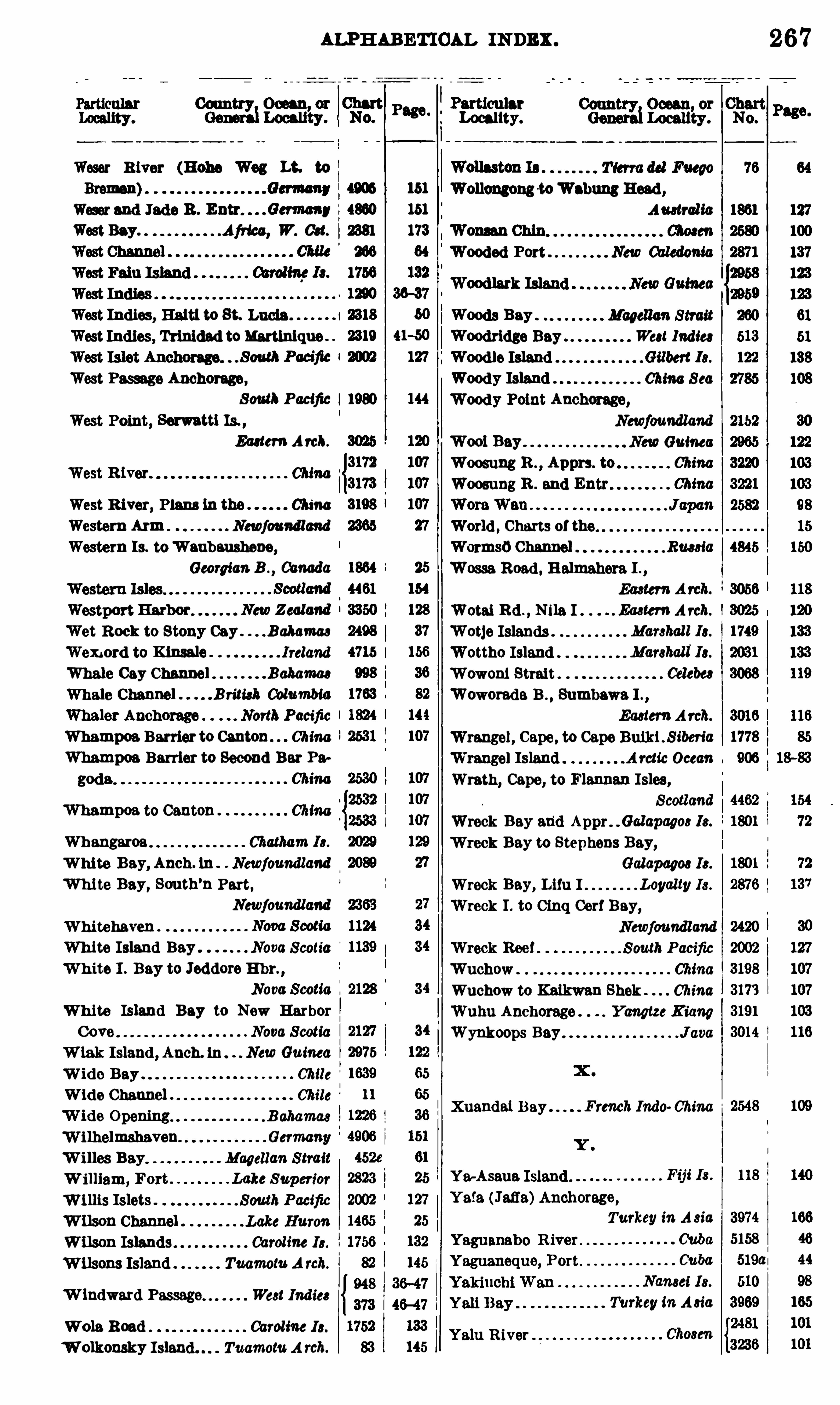
ALPHABETICAL INDEX .
Weser R iver (Hohe Wag Lt. to
Weser 8nd Jade B . i4860West Bay Afriea, W. 081.
West Indies, Haiti to St. Lucia 1
West Indies, Trinidad toMartinique
Westn o Anchorage,
South Pacific 1980
West Point, Serwattl Is.
Eauem A rch.
West River. China
West R iver, Plans in the China
Western Ann Newfoundland
Western Is. toWeubeushene,
Georgian B .
,Canada
Wet Rock to Stony Cay . . B ahama8
Wemord to Klmale Ireland
Whale Cay Channel Bahama
Whale Channel B rim); ColumbiaWhaler Anchorage North Pacific
Whampoe Barrier to Canton . ChinaWhampoe Barrier to Second Bar Pa
goda Chma
Whampoe to Canton ChinaWhangaroa C
'hatham 18 .
Whi te Bey, Anch. In Newfoundland
Whi te Bay, South’n Part,
Newfoundland
Whitehaven .
White Island Bey . Nova Scotia
W hite I . Bay to Jeddore E hr. ,
Nova ScotiaWhite Island Bay to New HarborCove Nova ScotiaW iak Island, Anch. ln . NewGuinea
W ide Bay Chile
Wide Channel . Chile
W ide open1ng. . . B ahama8
W i lhelmshaven. Germany
W illes Bay Magellan StraitW illiam, Fort . . Lake Superior
W i llis Islets . . South Pacific
W ilson Channel Lake Huron
Wilson Islands Caroline 18 .
W ilsons Island Tuamotu A rch.
W indward Passage West India
Wole Road Caroline 18 .
W olkonsky Island . . Tuamotu A rch.
Locality.
Wollongong-toWoman Heed ,
Auetral ic
Wooded Port New Caledonia
Magellan StraitWee! India
China S ea
W00 1 Bay
Woosung B . ,Apprs. to
Woosung R . and Entr
World . Charts 0 1 the
WormsoChannel Ran iaWesse Road . Halmahera I . ,
Ea8 ten A rch.
. . Ea8ten A rch.
Marshall 18 .
Marehall 18 .
Celeb”
Wreck Bey, Lifu I
Wreck I . to Cinq Cerf Bey,
Newfoundland
Wreck Reef . South Pacific
Wuchow ChinaWuchow to Keikwan Shek China
Wuhu Anchorage Yangtze KiangWynkOOps Bey J(100
Xuandai Bay French IM o China
Y e~Aseue IslandY ata (Jafia)Anchorage,
Turkey in A sia
CubaCuba
Namei 18 .
Turkey in Asia
Yalu R iver
267
Woods Bey
Woodridge Bay
Woodie IslandWoody IslandWoody Point Anchorage,
Newfoundland
NewGuinea
China
China
Wotai Rd .,N ile I
Wotje IslandsWottho IslandWowoni Strait
Woworade B . , Sumbawa I . ,
EasternArch.
Wrangel, Cape , to Cape Bu1k1. S iberia“
Wrangel Island Arctic Ocean
Wrath, Cape, to Flannan Isles ,
Scotland
Wreck Bay and Appr Galapagw 18 .
Wreck Bay to Stephens Bey,
Galapagm 18 .
Loyalty 18 .
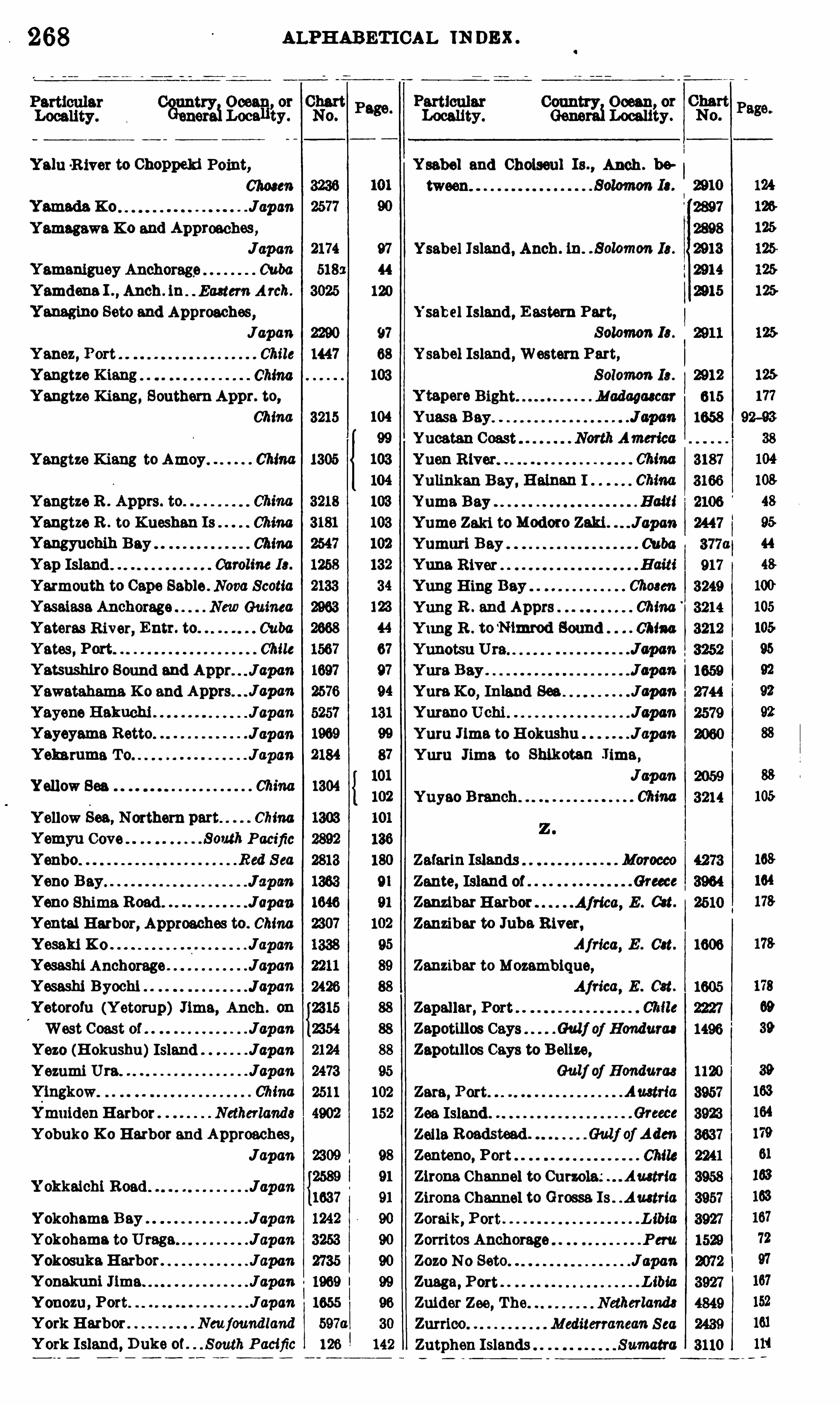
ALPHABET ICAL IN DEX
“8232511382313
? Clef
t P
mmwmg:
C&‘
f‘
fi me?
23?
Yelu R iver to Choppeld Point, Ysabel and Choiseul Is. , Anch . 1»
67408614 tween
Yameda K 0 Jcpm 2897
Yamagawa K 0 and Approachw,2898
Japan 97 Ysabel Island , Anch . In. £ 0m 18 . 2913
Yamaniguey Anchorage Cuba 44 2914
Yamdena I . , Anch . 1n Ba8tem Arch. 120 2915
Yanegino Seto and Approaches , Ysabel Island, E astern Part,Japan 9? Solomon 18 .
Y anez, Port Chile 68 Ysabel Island, Western Part,Yangtze K iang 103 Solomon 18 . 2912
Y angtze Kiang, SouthernAppr. to, Madagascar 615
China 1658
Yangtze Kiang to Amoy China
Y angtze R . Apprs. to.
Y angtze R . to X ueshan Is China aki.
Yangyuehih Bey ChinaYap Island Caroline 18 .
Yarmouth to Cape Sable . Nova ScotiaYeseiase Anchorage NewGuinea
Yateras R iver, Entr. to. Cuba
Yates , Port Chile
Yatsushlro Sound and Appr. . J apan
Y awatahama K o and Yum K 0,Inland See. Japan
Yayene Hekuchj Japan Yureno Uchi Japa'nYayeyama Retto Japan Yum Jlme to H okushu JopenYelmrume To Japan Yuru Jima to Shlkoten Jime ,
Japa'n
Yellow See Chma
Yuyao Branch .
Y ellow See ,Northern part China
Y emyu Cove . . . South Pacific
Yenbo Red S ea Zefarin IslandsYeno B ay J apan Zante, Island of Greece
Yeno Shima Road . J apan ZanzibarHarbor Africa, E . O n.
Yental Harbor, Approaches to. China Zanzibar to Jube River,
Yoseki K 0 Japan Afried, E . Get. 1606
Yesashi Anchorage Japa'n Zanzibar to Mozambique,Y esashi Byochi J apan Africa, E . Cst.
Y etorofu (Y etorup) Jlme, Anch . on Zapallar, PortWest Coast of Japan Zapotillos Cays Gulf of Hondurae
Yezo (H okushu)Island Japan Zapotl llos Ceys to Belize,
Y ezami Ura Japan Gulf of Honduras
ChinaYmuiden Harbor Netherland s d
Yobuko K o Harbor and Approaches, teed .
JapanIa.
1 okkeichi Road Japan
Yokohama Bey JapanYokohama to Urege JapanY okosukaHarbor JapanY onekuni J1me JapanY onozu , Port JapanYork Harbor Newfoundland
York Island, D uke of . . S outh Pacific
Y tepere BightYuase B ey
Yucatan Coast
Yuen River
Yulinkan Bay, Helnan I
Yuma BayYume Zaki toModoro Zaki JapanYumuri Bay Cuba
Yune River
Yung Hing Bay 01mm
Yung R . and Apprs ChinaYung R . to
‘Nimbod Bound China
Yunotsu Ura
Zara, Port
Zea Island2 0118 Roadstead .
Zenteno, Porte ona Channel to Curzola.
’ Austria
Zirona Channel to Grosse. Is Austria
Zoreik, Port LibiaZorritos Anchorage P eru.
Zozo No Seto Jspan
Zuega, Port LibiaZuider Zee, The Netherland8
Zurrico Mediterranean S ea
Zutphen Islands Sumatra

270
PAGE . Pmcx.
NUMERICAL INDEX .
PAGE. PRICE .
NUMERICAL INDEX .
P3 103 .
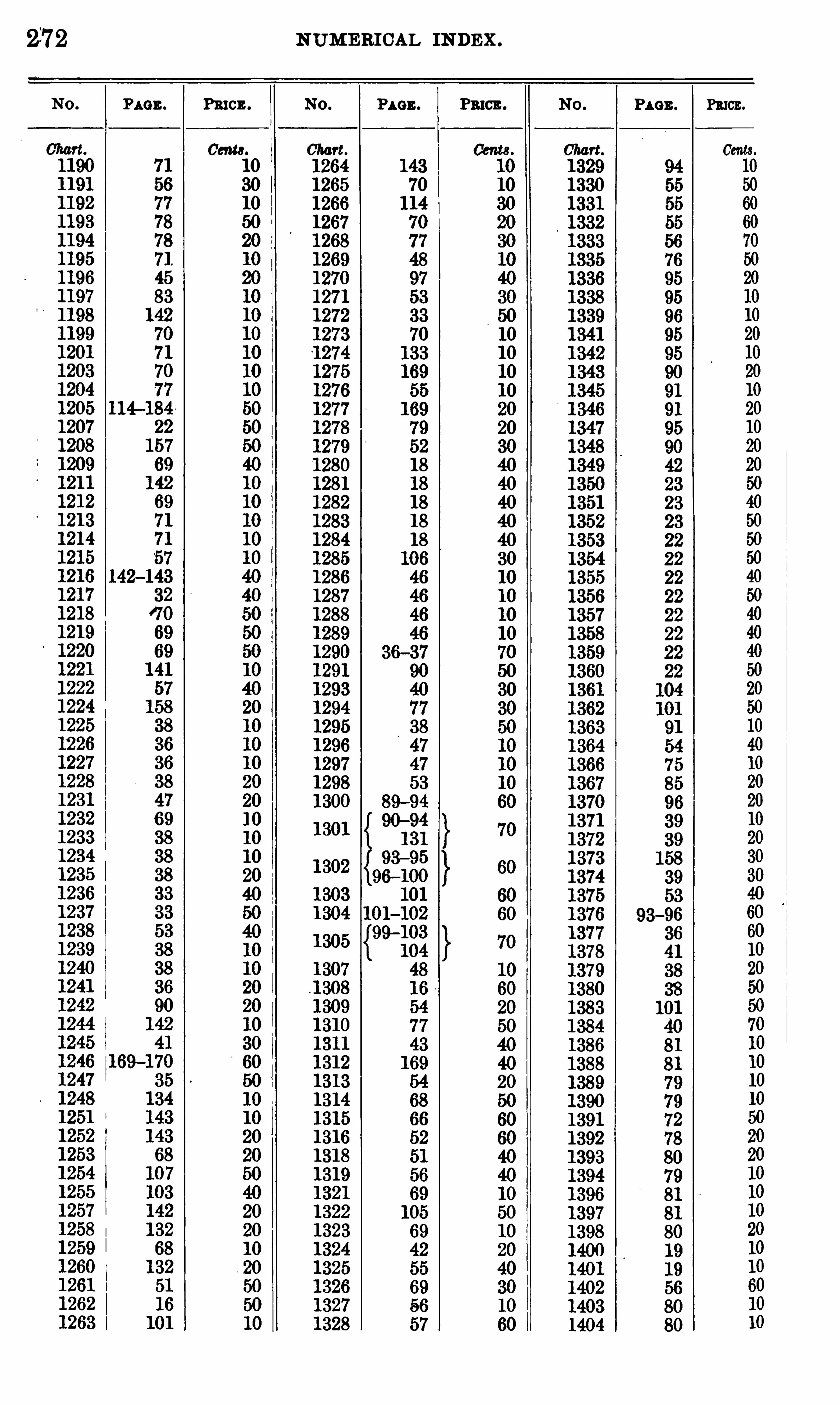
272
PAGE . Pmcn.
NUM ERICAL INDEX .
PAGE . Pn cn. PAGE .
93—96
PRICE .

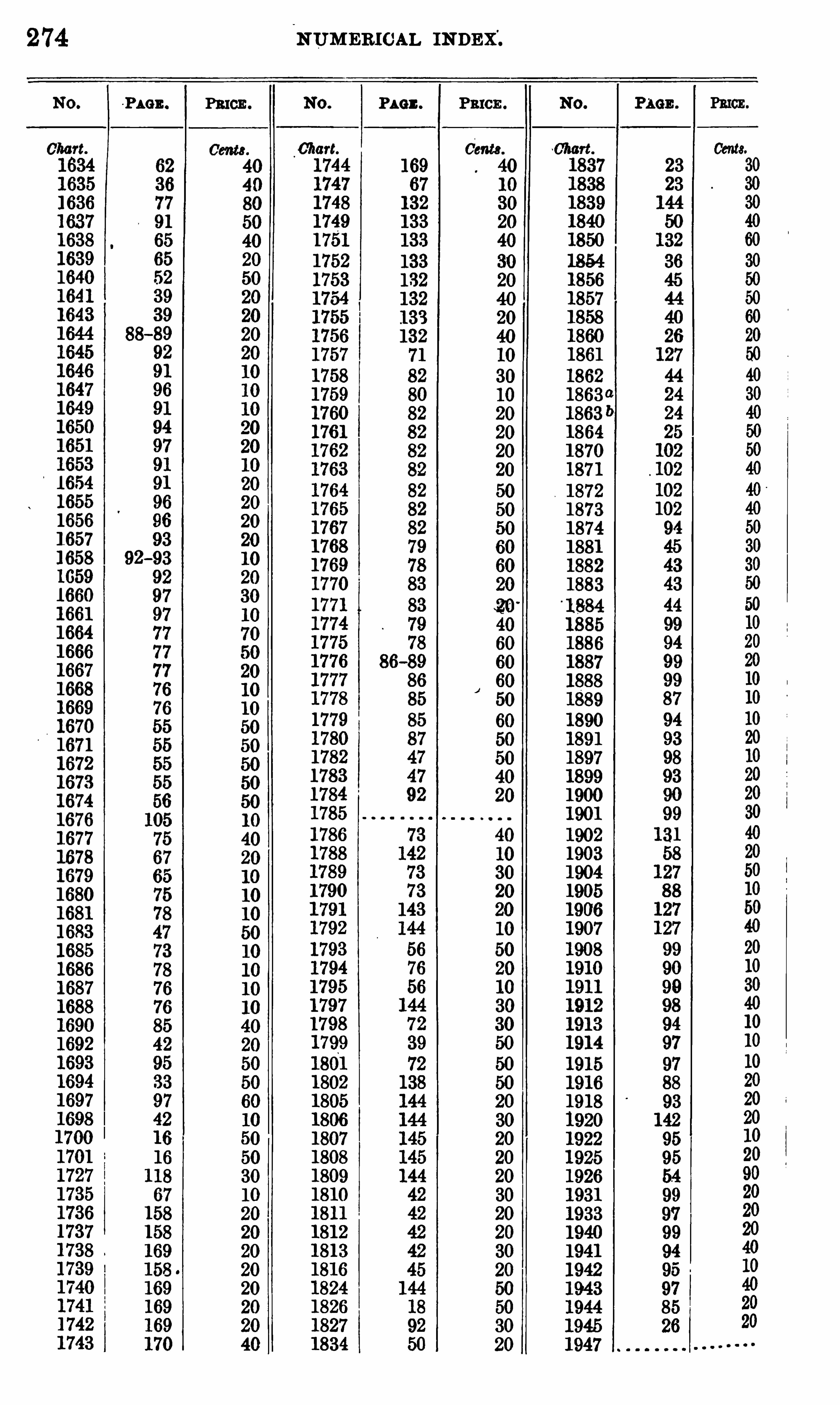
274
~PAGE . PRICE .
NUM ERICAL INDEX".
Pact .
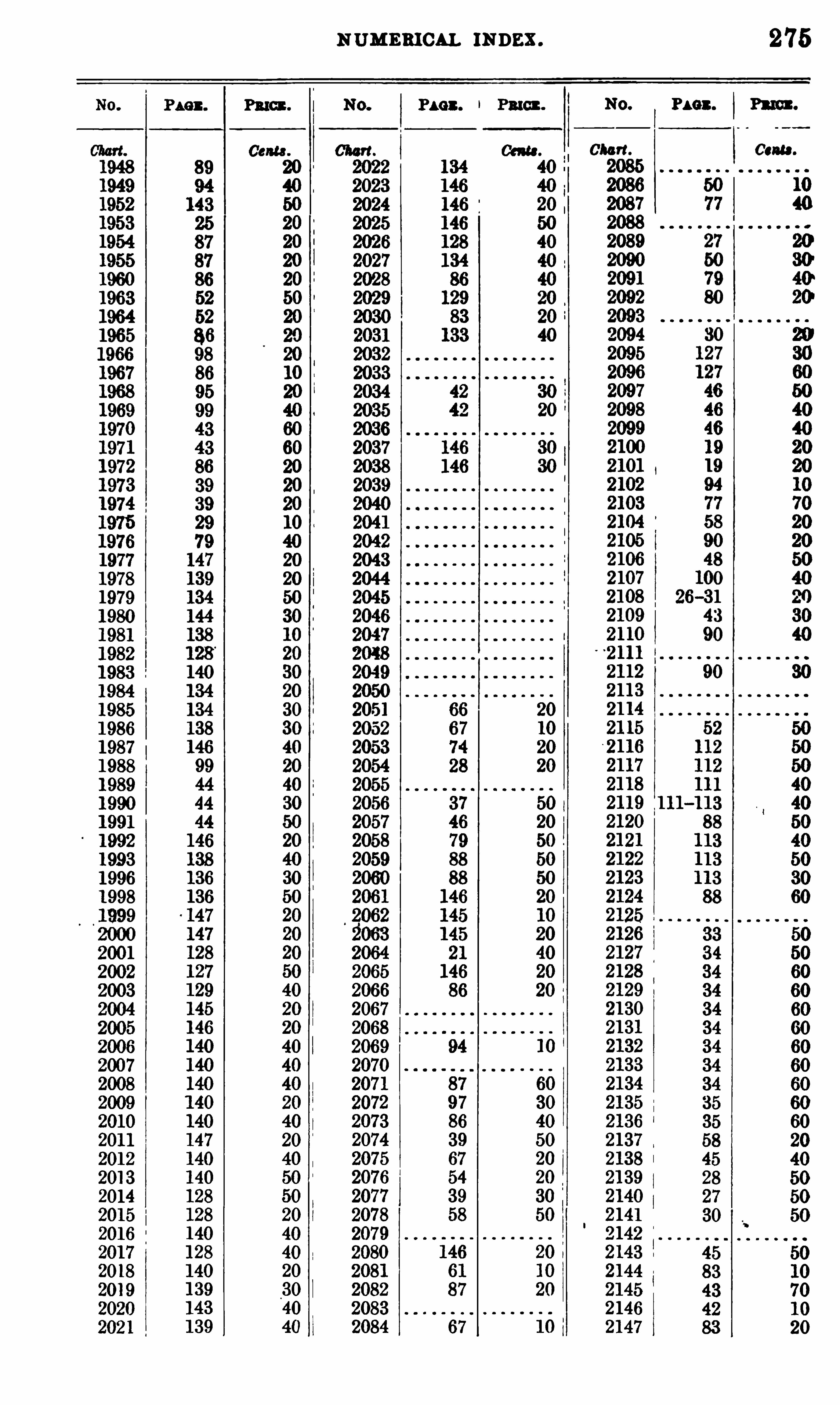
NUMEBICAL INDEX . 275
08m .
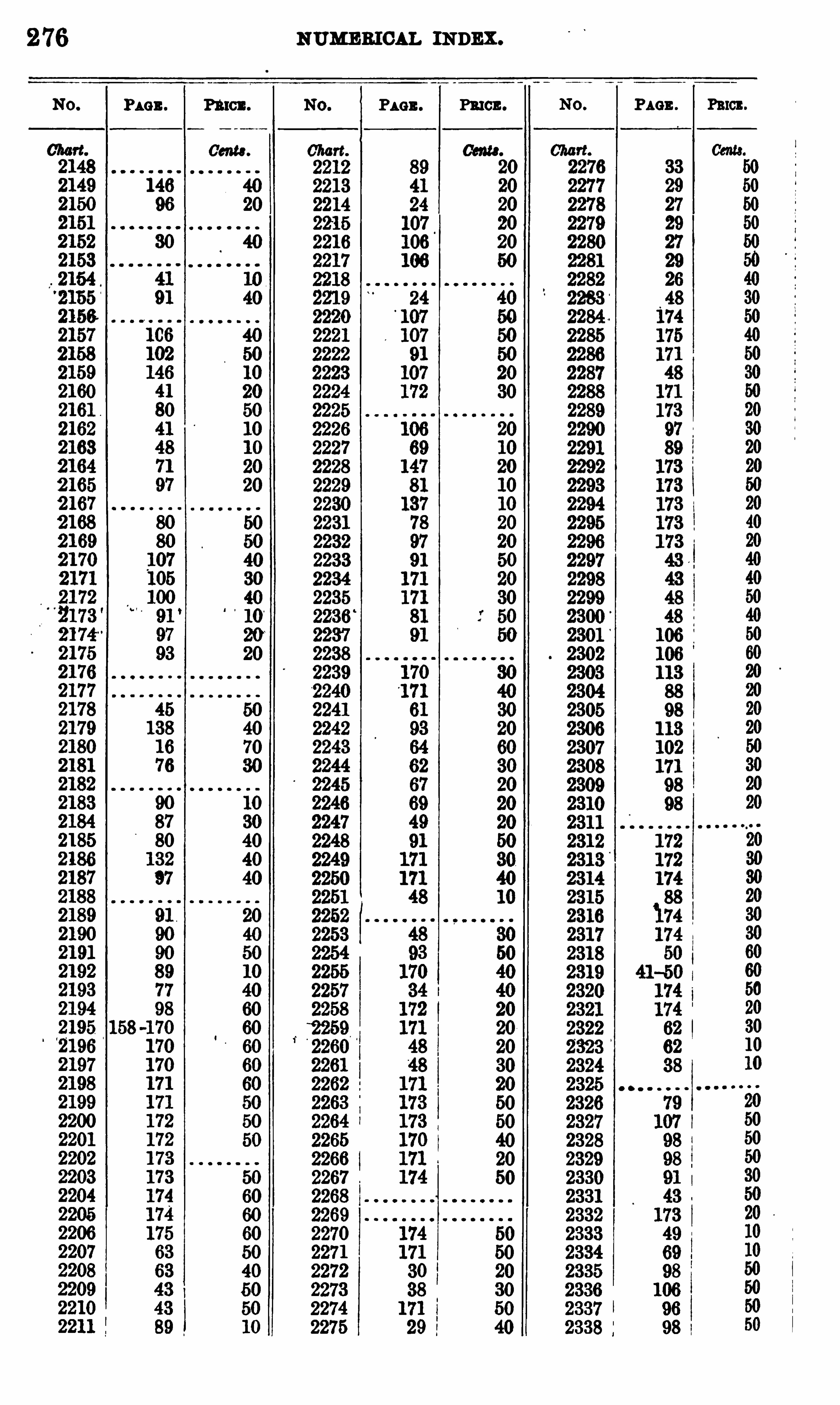
2 76
PAGE . n !“ 0
Gen“.
NUMEBI CAL INDEX .
PAGE . PRICE . PAGE . Peron.

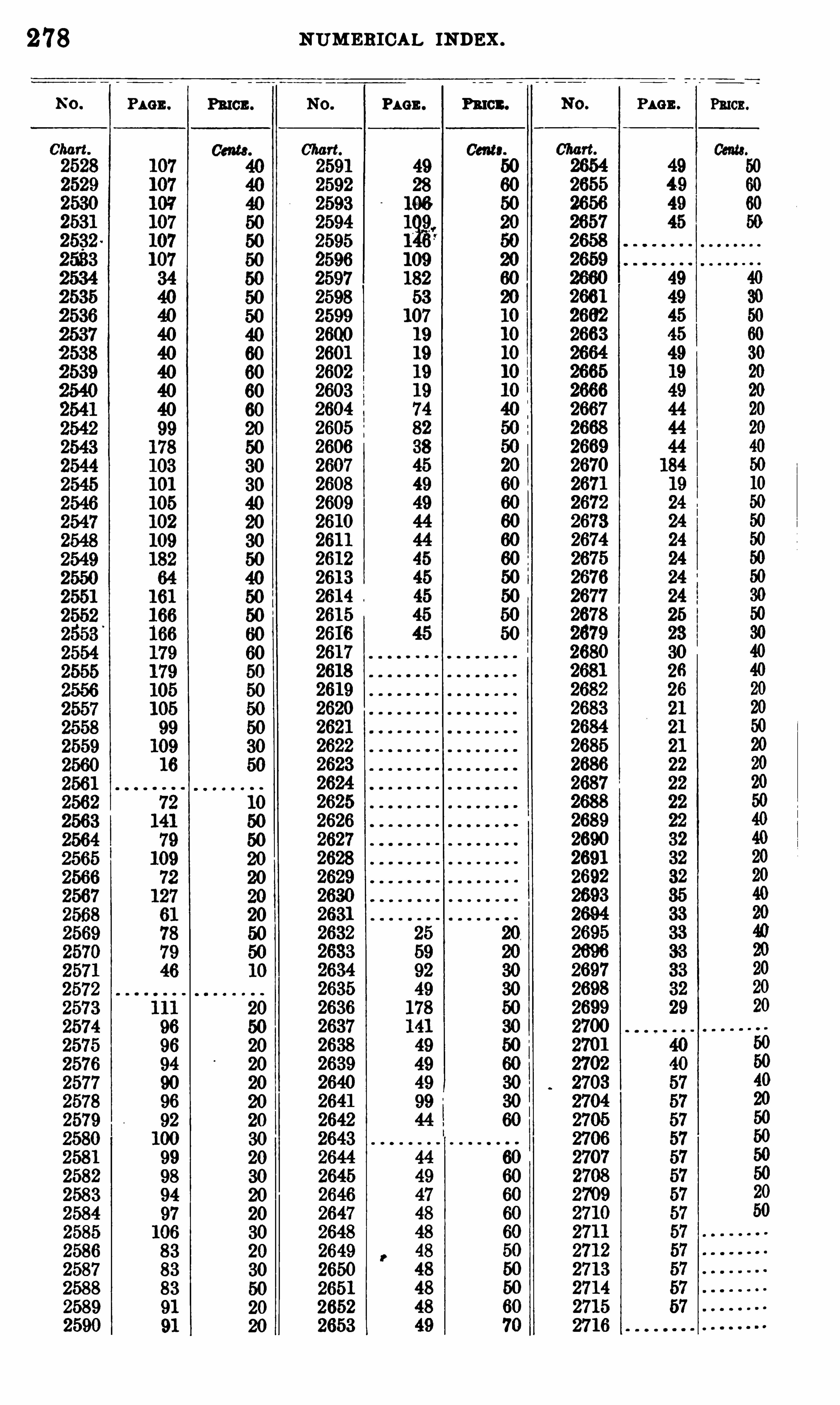
278
PAGE . m en.
NUM ERICAL INDEX .
PAGE . Fn en. PAGE . Puon.
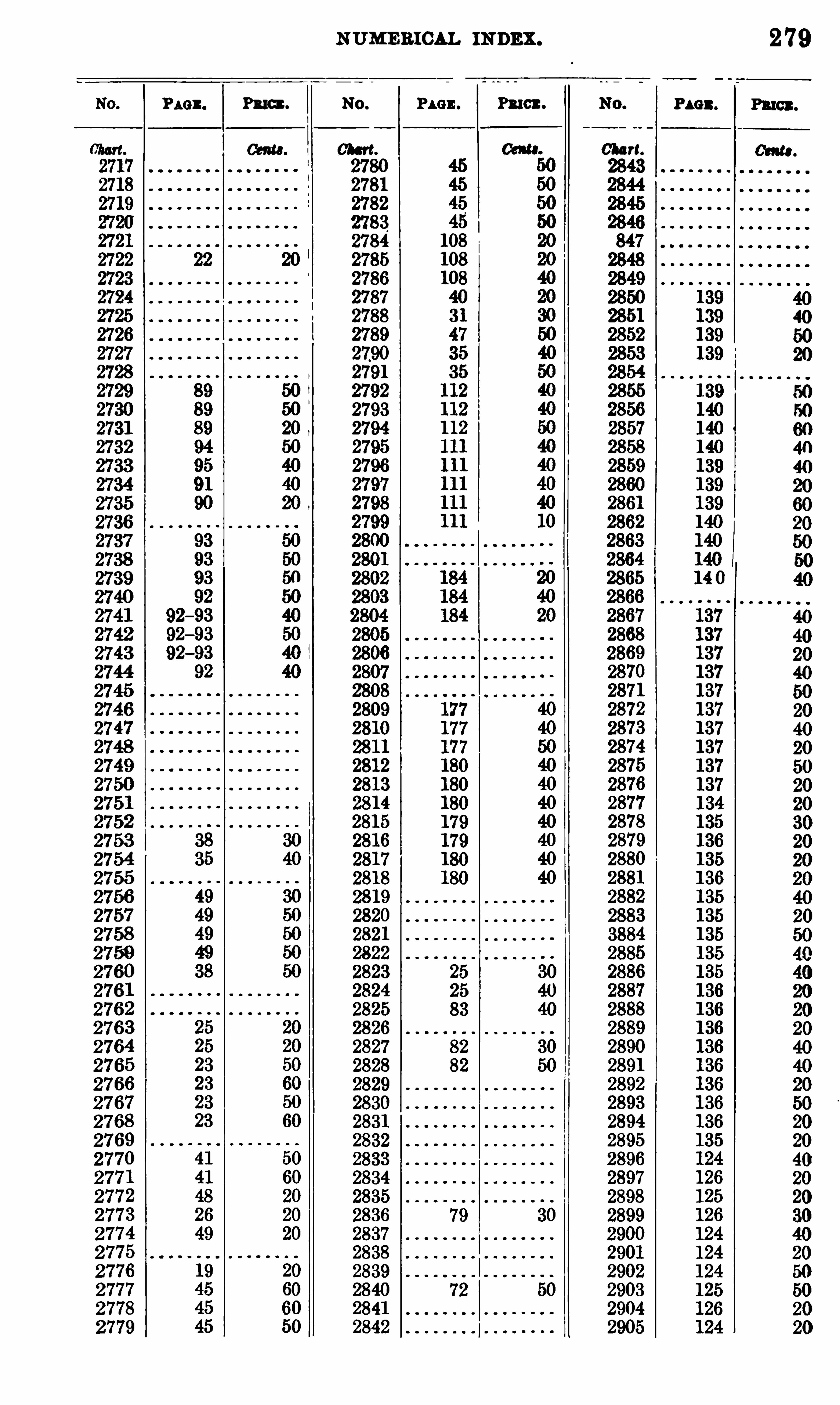
PAGE . PBIGI .
NUMERICAL INDEX .
PAGE . Pu n .
279
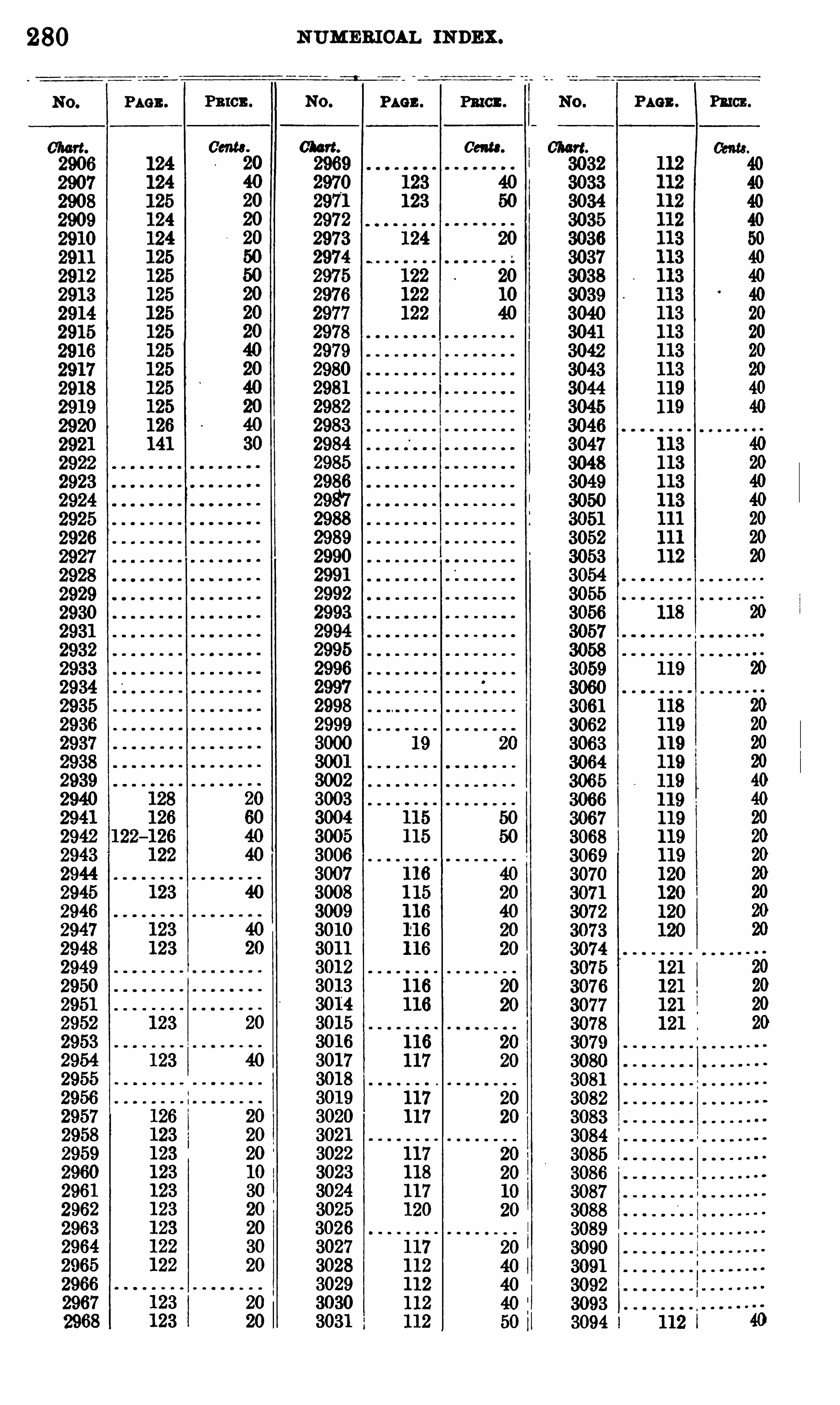
280
PAGE .
NUM ERIOAL INDEX .
PAGE . PRICE .
0am.
Pmcn.

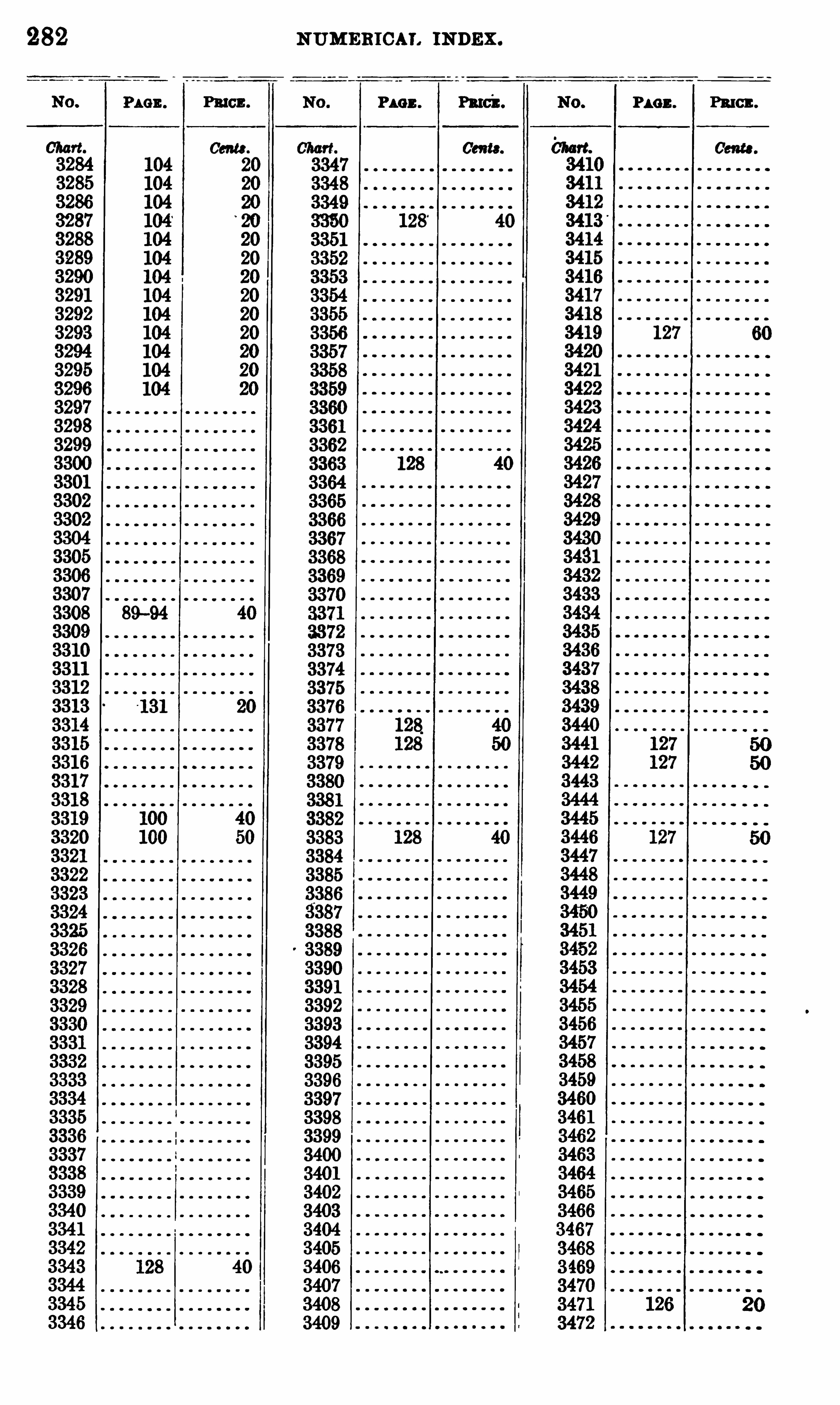
282 NUMERICAL INDEX .
PAGE . Pmcz . P1 0 3 . Patch. P1 0 3 . Pawn.
Cm .
3308 89—94
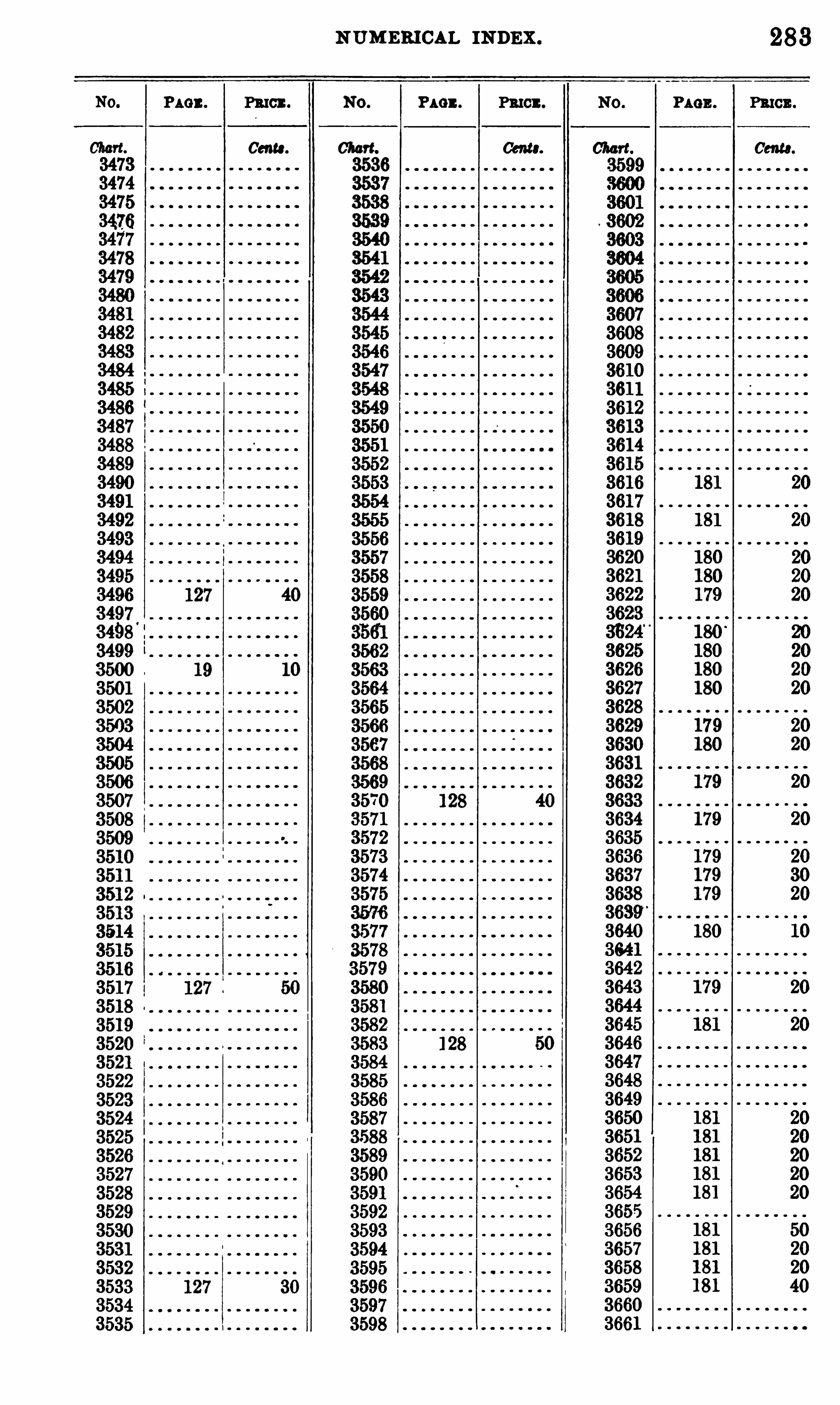
NUMERICAL INDEX . 283
PAGE . PRICE . PAGE . PRICE . PAGE . PRICE .
Germ. Cente. Cam.
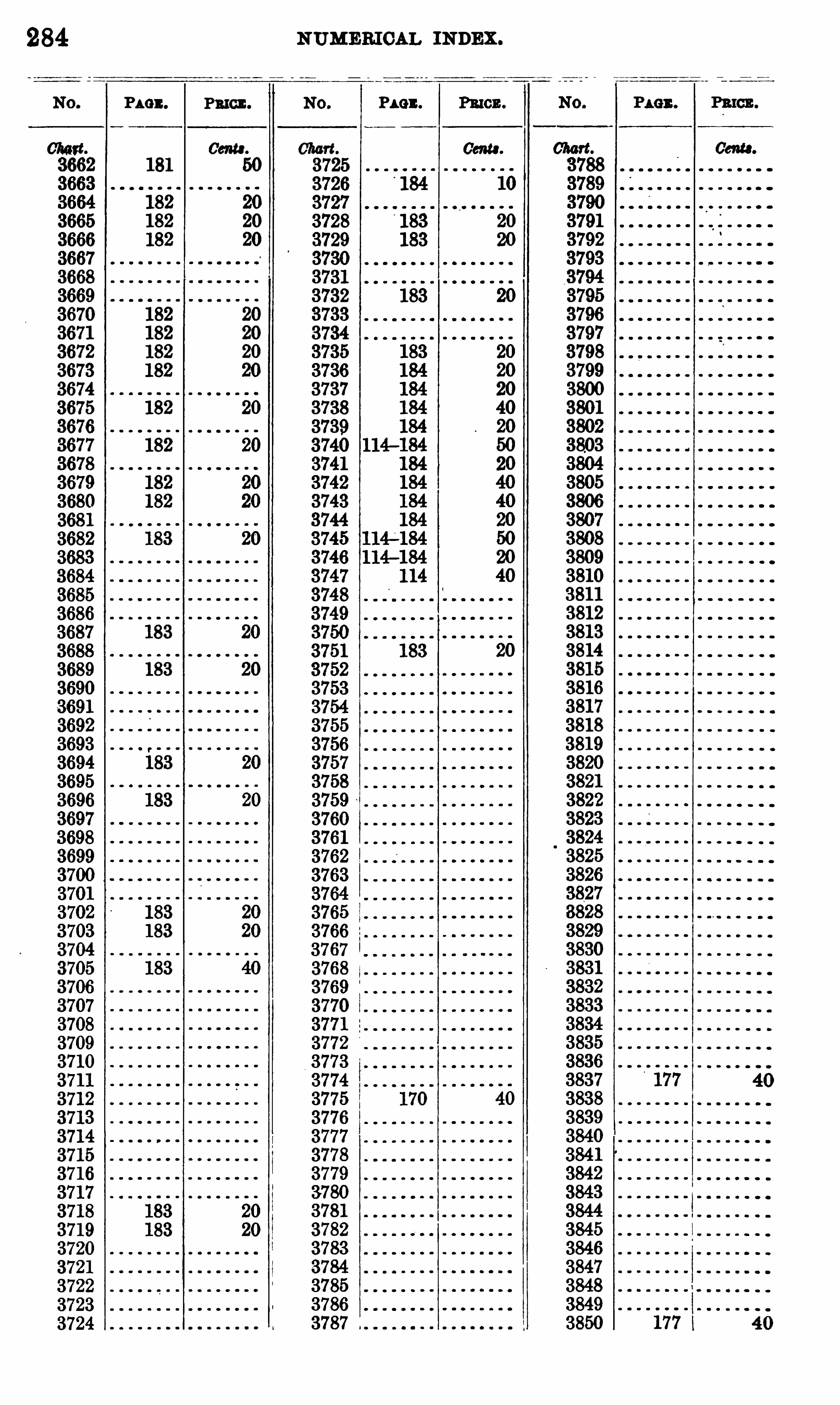
284
P4 0 11. PRICE .
NUMERI CAL INDEX .
P1 0 2 . Pmcn.
Gena .

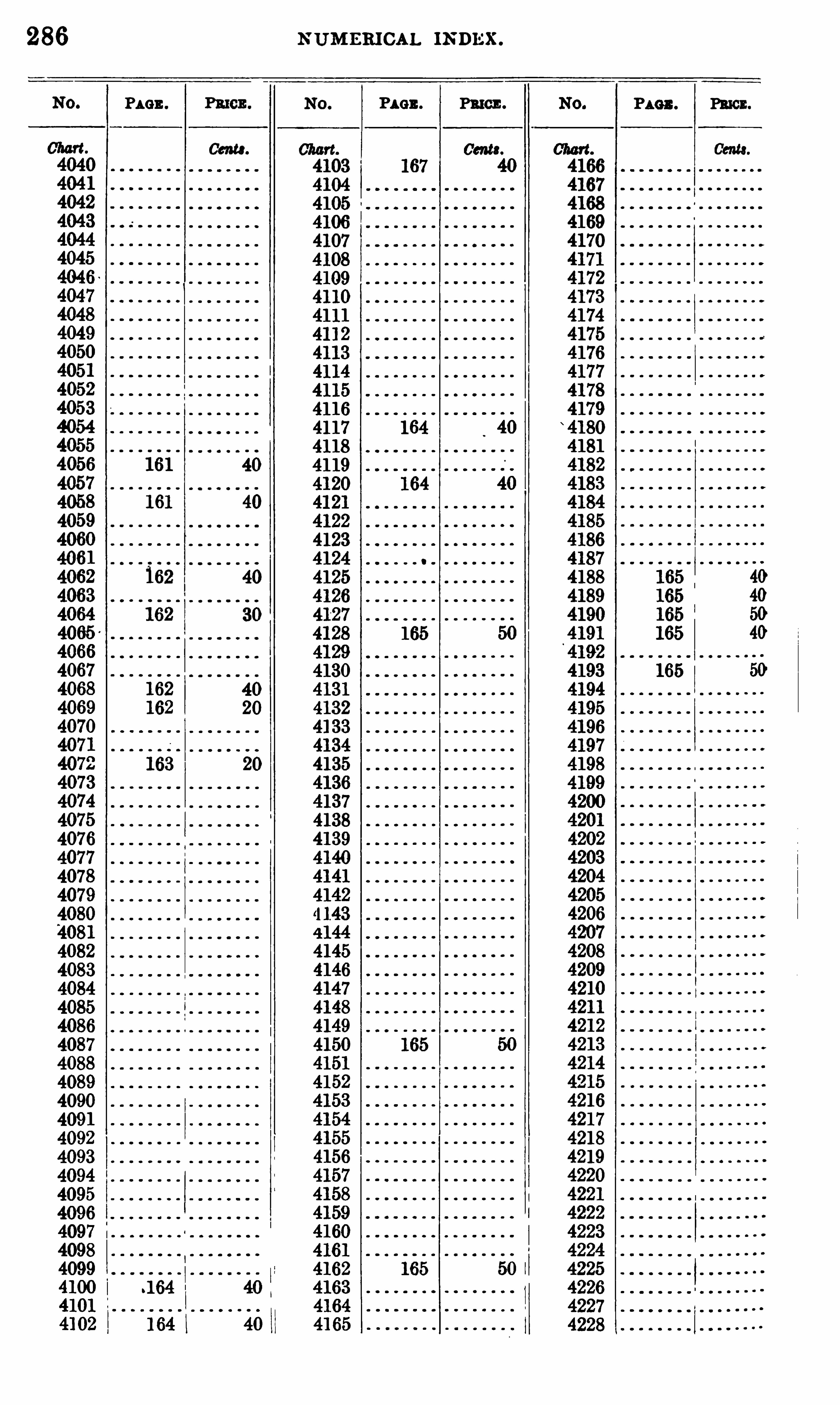
286 N UM ERICAL mmsx.
PAGE . Pmcn. PAGE . PRICE . P110 3 .
Cam.
PRICE .
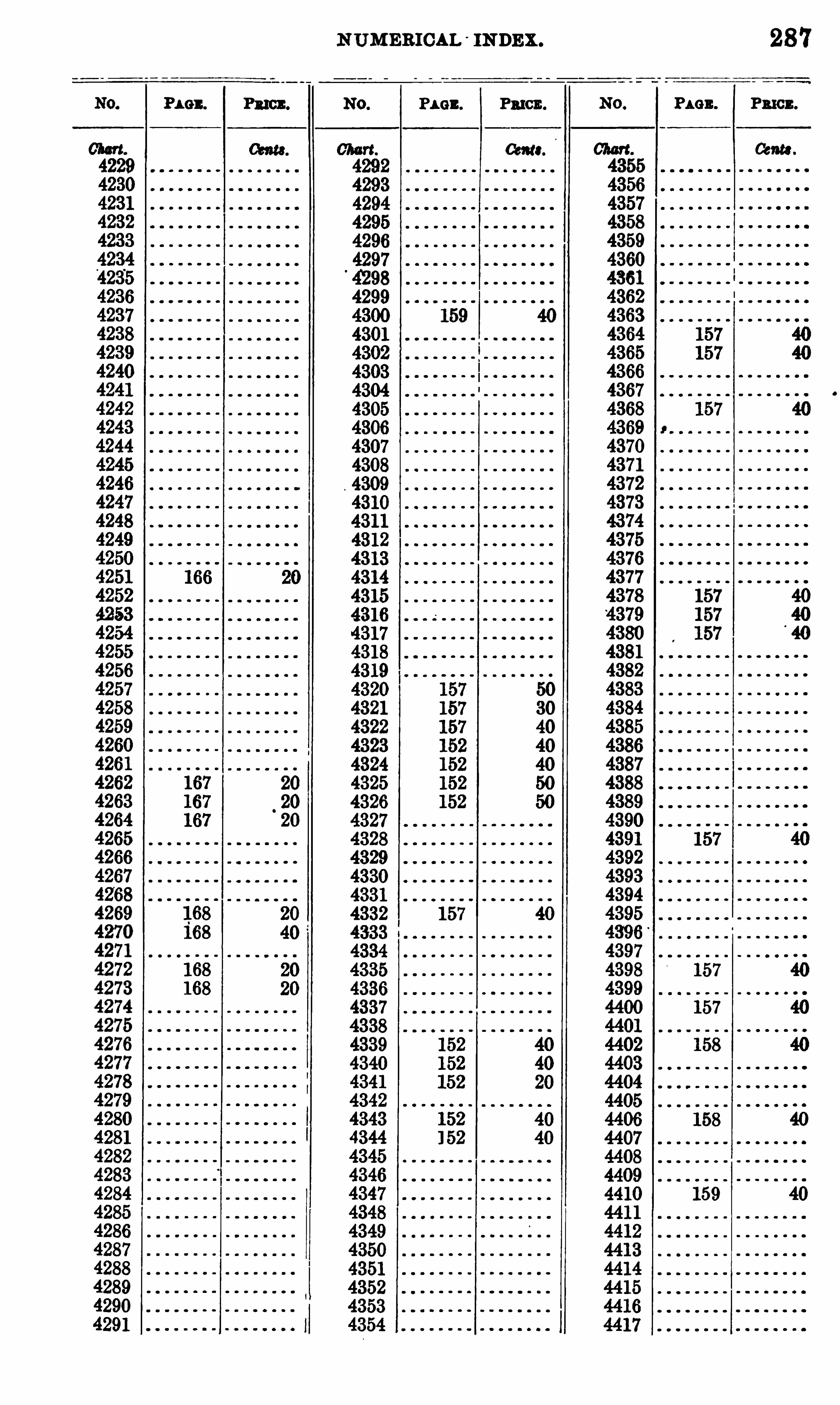
NUMEB ICAL INDEX .
Penna PAGE.
287
PRICE .
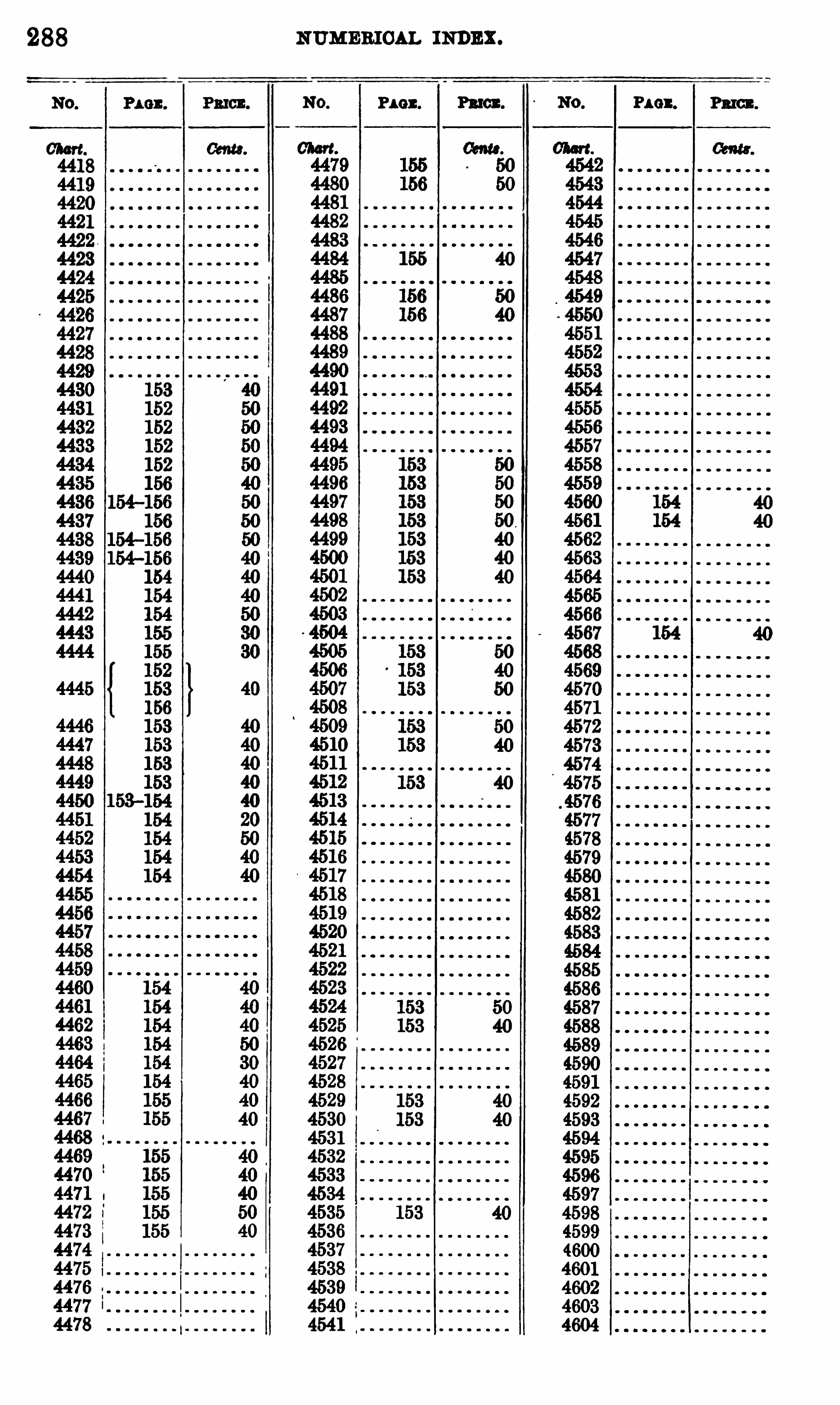
288 NUMERIOAL INDEX.
Pun . Paton. PAO1 . Pm .

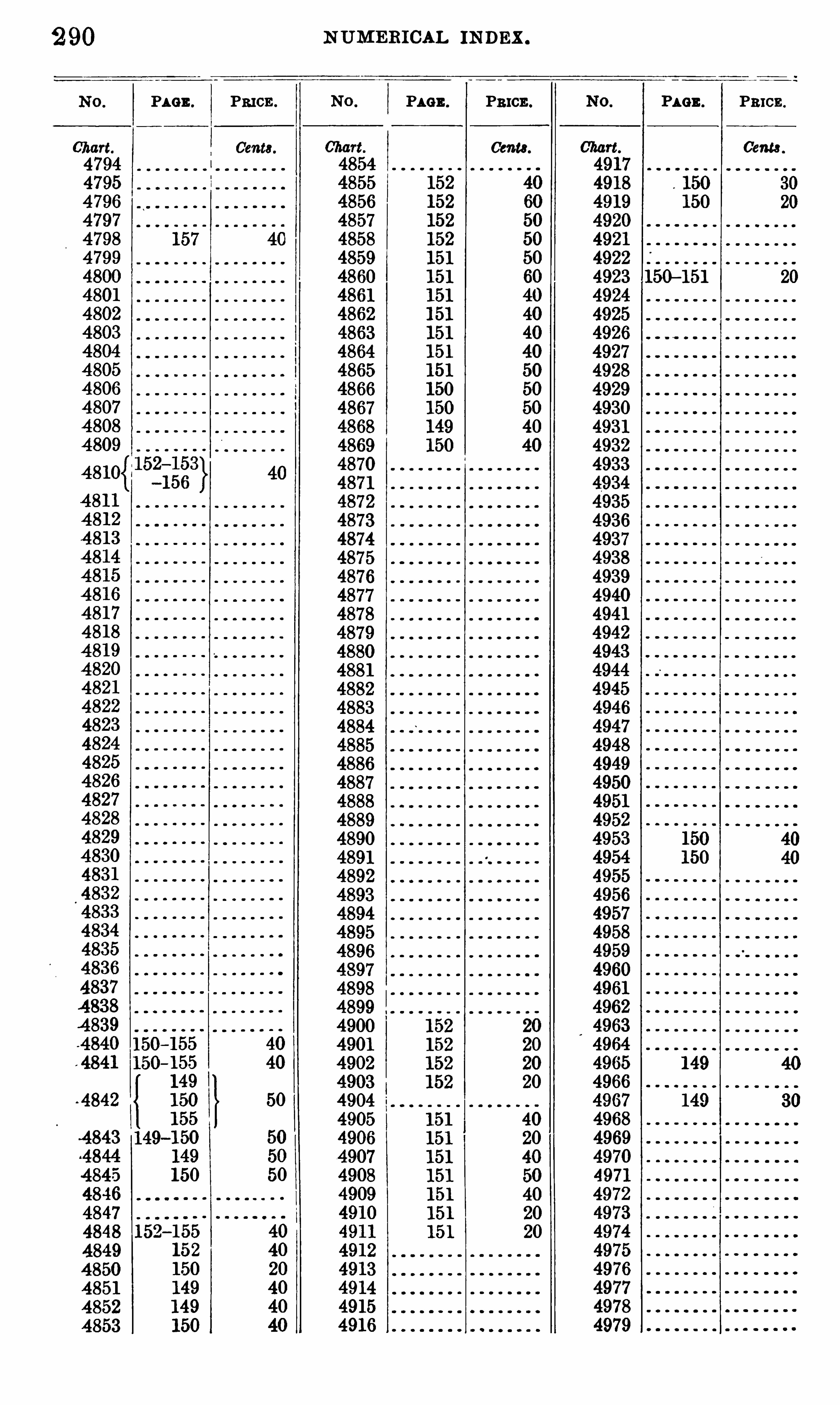
N UMEB ICAL INDEX .
PAGE . PRICE . PAGE . PRICE . PAGE . PRICE .
Cents . Cents . Ceme
150—151
-4842
Related Documents


