MARINE SAFETY INVESTIGATION No. 192 Independent investigation into the grounding of the Liberian registered bulk carrier Pactrader in the port of Thevenard, South Australia 1 March 2003

Welcome message from author
This document is posted to help you gain knowledge. Please leave a comment to let me know what you think about it! Share it to your friends and learn new things together.
Transcript

MARINE SAFETY INVESTIGATION No. 192
Independent investigation into the grounding ofthe Liberian registered bulk carrier
Pactrader
in the port of Thevenard, South Australia1 March 2003
MARINE SAFETY INVESTIGATION
No. 192
Independent investigation into thegrounding of the Liberian registered
bulk carrier
Pactraderin the port of Thevenard, South Australia
on 1 March 2003
Released under the provisions of the Navigation (Marine Casualty) Regulations under theNavigation Act 1912.

ii
ISBN 1 877071 72 2 June 2004
This report was produced by the Australian Transport Safety Bureau (ATSB), PO Box 967, Civic Square ACT2608.
Readers are advised that the ATSB investigates for the sole purpose of enhancing safety. Consequently, reports areconfined to matters of safety significance and may be misleading if used for any other purpose.
As ATSB believes that safety information is of greatest value if it is passed on for the use of others, copyright restrictions do not apply to material printed in this report. Readers are encouraged to copy or reprint for fur-ther distribution, but should acknowledge ATSB as the source.

CONTENTS
1 SUMMARY 1
2 SOURCES OF INFORMATION 2
Acknowledgment
3 NARRATIVE 2
Pactrader 3
Thevenard Port 3
Pilotage 4
The Pilot 5
The incident 6
4 COMMENT AND ANALYSIS 9
Evidence 9
Port/wharf design 9
The un-berthing operation 10
Bridge resource management 11
Tug operations 12
Tug power 13
Training 13
Charts 13
Safety Actions 15
Drugs and Alcohol 15
5 CONCLUSIONS 17
6 RECOMMENDATIONS 19
7 SUBMISSIONS 21
8 PACTRADER 23
iii

iv

1 SUMMARY
On the morning of 26 February 2003, the Liberian flag bulk carrier, Pactrader, arrivedat Thevenard from Lumut in Malaysia and embarked a pilot for berthing atThevenard wharf. The ship entered the port and made fast, without incident, port-side-to the northern side of the wharf to load a cargo of gypsum for Auckland, NewZealand. The cargo was loaded as planned and completed during the early hours of28 February. Pactrader remained alongside the wharf after completion of cargooperations waiting to sail on the high tide predicted for early the next morning, 1March.
The pilot boarded Pactrader again at midnight, 28 February for the departure. Thepilot and master discussed the outward pilotage and, at 0006 on 1 March, the shipcommenced singling up the mooring lines as per the departure plan. A single tug waspushing up on the ship’s starboard side at about midships. The wind was from aboutthe south-south-west at 20 knots.1 The tide was setting to the north (the last of theflood) at up to 0.5 knots.
At 0012 the last mooring line was let go and the ship started moving from the berth.As the ship moved ahead it was set to starboard by the tide and wind and, a short timelater, it ran aground along its starboard side when its stern was just clear of the endof the wharf. It had only moved about one ship length ahead.
At 0224 on 4 March, the ship was refloated with the assistance of a salvage tugdespatched from Adelaide, and returned alongside the wharf. Divers and a classifica-tion society surveyor inspected the ship and, when they indicated that there was nosignificant damage and that the ship was seaworthy, Pactrader was released by AMSA2
to continue its voyage to New Zealand.
The report’s conclusions include:
• The pilot did not make sufficient allowance for the significant forces acting onthe beam of the ship at sailing time.
• The tug was not used to best advantage given the prevailing circumstances.
• The planning of the sailing operation was inadequate in that neither the masternor the pilot reviewed alternative strategies for unberthing, such as tugutilisation, engine movements and rudder usage.
• The ‘soft nose’ at the end of the wharf discouraged the pilot from remainingclose to the wharf during his outward movement.
The report makes a recommendation that:
Flinders Ports should undertake a risk assessment of the Port of Thevenard, takinginto account the variable environmental factors, together with infrastructure andpilotage ongoing training experience issues.
1
11 knot = 1 nautical mile (1852 metres) per hour.
2AMSA is the Australian Maritime Safety Authority.

2 SOURCES OF INFORMATION
The master, officers and crew of Pactrader and ship’s records.
The pilot
The master of tug Wiabuna
Transport South Australia
Flinders Ports South Australia
The Hydrographer, RAN
AcknowledgmentThe ATSB acknowledges the advice and assistance of Austow Pty Ltd in assessingissues relevant to tug operation.
The chart section in this publication is reproduced by permission of the AustralianHydrographic Service.
© Commonwealth of Australia 13 October 2002. All rights reserved.
Other than for the purposes of copying this publication for public use, the chartinformation from the chart sections may not be extracted, translated, or reduced toany electronic medium or machine readable form for incorporation into a derivedproduct, in whole or part, without the prior written consent of the AustralianHydrographic Service.
2
3 NARRATIVE
PactraderPactrader is a Liberian flagged, geared bulk carrier of 28 426 tonnes deadweight at asummer draught of 9.760 m. The ship has a gross tonnage of 16 794. It has an overalllength of 169.03 m and a moulded breadth of 27.20 m. The main engine is a HitachiB&W 5S50MC, 2 stroke diesel producing 5 816 kW which drives a single, right handturning propeller giving the ship a service speed of 14.0 knots. The ship is not fittedwith a bow thruster. Pactrader was built in 1996 by the Imabari ShipbuildingCompany, Japan and delivered in early 1997. It is owned by Trans-Pacific ShippingCompany and managed and operated by Lasco Shipping Company, USA. The ship iscurrently classed by the American Bureau of Shipping (ABS).
Pactrader is a standard ‘handysized’ bulk carrier with its five cargo holds forward ofthe accommodation block. To service the cargo holds there are four cranes along themain deck, each with a safe working load of 25 tonnes. The distance from the bow tothe bridge is 143.7 m and from the bridge to the stern is 25.3 m. The ship was alsoequipped with the required navigational aids, including two radars, one a JMA 9000and one JMA 7000. The ship was not equipped with a course recorder. All bridge andengine room equipment was operating normally.
At the time of the incident, Pactrader had a total crew of 20. All were Filipinonationals. All the watchkeeping officers were appropriately qualified. The master hadbeen on the ship for about three months on his current contract and had served fourprevious contracts with this company. He had been at sea since 1977 and had held hisFilipino master’s qualification since 1998.
Both the forecastle and the poop were equipped with self-stowing mooring winches.The poop was equipped with four ropes housed on self-tensioning drums. Atmooring stations three deckhands were under the direction of a deck officer aft.
Thevenard PortThevenard port is located at the entrance to Murat Bay, South Australia at about32°09S 133°39E. It is on the eastern side of, and near the head of, the Great AustralianBight. It is primarily a bulk export port and a total of 1 355 918 tonnes of gypsum wasexported through this port in 2002. Other bulk exports included wheat, salt, barleyand oats. Bulk fertiliser is the main import. In that same year, 2002, a total of 107 shipcalls were made at Thevenard. These comprised 99 bulk carriers, five general cargoships and three others. The maximum permitted size of ship for this port is 180 mlength overall or 28 m beam.
3
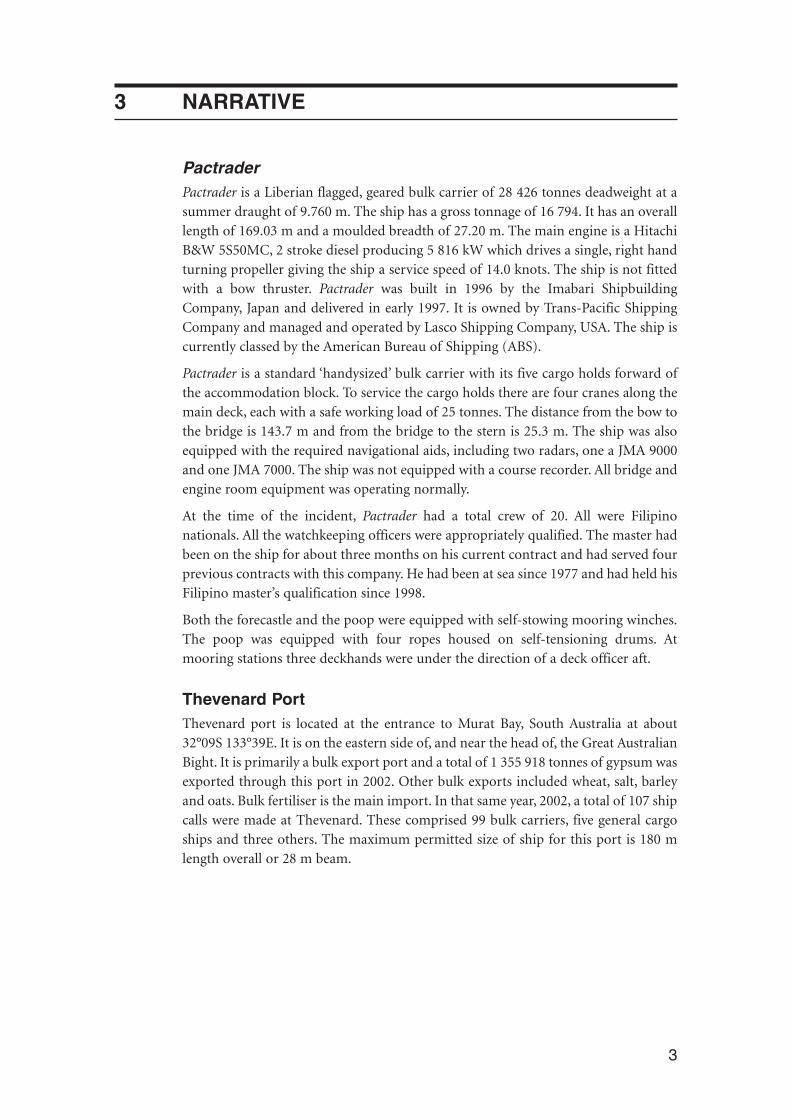
Two Australian charts are published for this port. Chart Aus 341 is a smaller scalemetric chart (1: 300 000) for use in the approach to the port. Aus 120 is the largerscale metric chart at a scale of 1: 75 000, with inserts on the approach channel and theberth at scales of 1: 25 000 and 1: 5 000 respectively. Both charts are published by theAustralian Hydrographic Service.
FIGURE 1:Insert from Chart Aus 120 showing approximate grounding position of Pactrader
From the pilot boarding ground, an inbound ship follows the multi-legged YatalaChannel, marked by beacons, for a distance of approximately 6.5 nautical miles. Thechannel skirts the south and eastern edges of a large shoal area before joining themanoeuvring area between the end of the channel and the wharf at Thevenard. Shipsusually swing in this area so as to berth ‘head out’. The main channel has a maintainedminimum depth of 8.2 metres at chart datum. The manoeuvring area is also dredgedas required to maintain a minimum charted depth of 8.2 m in the main channel area(See figure 1). Adjacent to this deeper area, near the end of the wharf, is an area ofshoal water the minimum depth of which is maintained to 5.5 m.
4
Not to be used for navigational purposes
WA
SA
NT
Qld.
NSW
ACT
Tas.
Location ofincident
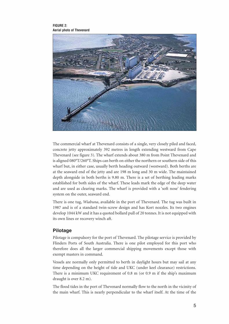
FIGURE 2:Aerial photo of Thevenard
The commercial wharf at Thevenard consists of a single, very closely piled and faced,concrete jetty approximately 392 metres in length extending westward from CapeThevenard (see figure 3). The wharf extends about 380 m from Point Thevenard andis aligned 080°T/260°T. Ships can berth on either the northern or southern side of thiswharf but, in either case, usually berth heading outward (westward). Both berths areat the seaward end of the jetty and are 198 m long and 30 m wide. The maintaineddepth alongside in both berths is 9.80 m. There is a set of berthing leading marksestablished for both sides of the wharf. These leads mark the edge of the deep waterand are used as clearing marks. The wharf is provided with a ‘soft nose’ fenderingsystem on the outer, seaward end.
There is one tug, Wiabuna, available in the port of Thevenard. The tug was built in1987 and is of a standard twin-screw design and has Kort nozzles. Its two enginesdevelop 1044 kW and it has a quoted bollard pull of 20 tonnes. It is not equipped withits own lines or recovery winch aft.
PilotagePilotage is compulsory for the port of Thevenard. The pilotage service is provided byFlinders Ports of South Australia. There is one pilot employed for this port whotherefore does all the larger commercial shipping movements except those withexempt masters in command.
Vessels are normally only permitted to berth in daylight hours but may sail at anytime depending on the height of tide and UKC (under keel clearance) restrictions.There is a minimum UKC requirement of 0.8 m (or 0.9 m if the ship’s maximumdraught is over 8.2 m).
The flood tides in the port of Thevenard normally flow to the north in the vicinity ofthe main wharf. This is nearly perpendicular to the wharf itself. At the time of the
5

incident the tidal range was 1.2 m and the tidal rate was about 0.5 knots. On 28February the last low water was predicted for 1950 (summer time) at 0.6 m and thenthe next predicted high water was at 0120, 1 March (1.8 m).
Real-time and historical data on both the wind direction and strength and the actualheight of the tide is available in the local harbour master’s office, located at the shoreend of the wharf. This is used by the pilot to compare actual conditions withpredictions.
The pilotThe pilot assigned to Pactrader had been at sea, from deck cadet to master, since 1984.Most of his seagoing career had been on bulk carriers and all his marine qualifica-tions, up to and including master Class 1, were obtained through the AustralianMaritime College (AMC) in Launceston, Tasmania. During his time in command onthe Australian coast he obtained a pilotage exemption for the port of Adelaide,
The pilot started his pilotage career with Flinders Ports early in 2002. He holdspilotage licences from Flinders Ports for Port Adelaide, Thevenard and Port Lincoln.At the time of the incident he had completed about 100 ship movements in and outof the port of Thevenard.
The incidentOn 15 February 2003 Pactrader completed the discharge of its previous grain cargo inthe port of Lumut, Malaysia. The ship then sailed for Australia to load a cargo of bulkgypsum for export to Auckland, New Zealand. Prior to the ship’s arrival at Thevenard,the master had requested a copy of the Australian charts Aus 341 and Aus 120 fromhis managers. A copy of chart Aus 341 was subsequently supplied in sections, via theship’s fax machine, and assembled using adhesive tape on board. The managers sent
6
FIGURE 3:Thevenard wharf

a request for Aus 120 to Kelvin Hughes, chart suppliers in the United Kingdom, butthey were advised by the chart agent that chart Aus 120 was permanently withdrawnand hence unavailable. The ship managers forwarded this information to the ship.
On the morning of 26 February 2003, the ship arrived at Thevenard in ballast. A pilotwas embarked on arrival for the inward passage and berthing at the wharf. The samepilot was to conduct the vessel on its departure.
The master advised the pilot about the characteristics of his ship and provided himwith a pilot card detailing the ship’s arrival condition. The pilot, in turn, supplied themaster with the standard chartlet of the port as part of his normal procedure and theythen discussed the inward passage plan. After this information exchange, the shipcontinued inward and made fast port-side-to the northern side of the wharf, withoutincident. The wind (as recorded in the ship’s log book) was from the south at forcefive (17-21 knots).
The cargo of 24 188 tonnes of bulk gypsum was loaded as planned, with cargooperations completed at 0324 on 28 February. The sailing draughts were 9.00 mforward and aft and 8.998 m midships giving the ship a displacement of31 182 tonnes. After completion of loading Pactrader remained alongside the wharfwaiting for the high tide predicted for 0120 the next morning, 1 March, at 1.80 metresabove datum.
At about 2330, the pilot arrived at the harbour master’s office, about half an hourbefore the scheduled sailing time of midnight, as was his usual practice. He checkedthe tidal heights on his computer readout which are transmitted from the local tidegauges. These were about 10 centimetres higher than the official predictions for thattime – a high water of 1.914 m would occur at 0126. He also checked the windinformation (from S to SSW at about 20 knots, gusting to 25 knots) and, satisfiedwith these conditions, he continued down the wharf to the ship.
The pilot boarded Pactrader again at about midnight, 28 February/1 March 2003, forthe departure. The ship’s officers had checked the bridge equipment about one hourearlier. The main engine was also tested and the master informed that all was satis-factory for the departure. The pilot was presented with the departure pilot card andinformed that all equipment and machinery were operating correctly. The pilot andmaster discussed the outward pilotage.
The master made enquiries during these discussions about the strength and directionand effects of the wind. The pilot told him that the wind had persisted for the lastweek and that he had sailed other vessels in the same conditions. He pointed out thatwith the wind off the jetty, the wind direction would assist the un-berthing.
At 0006, the engines were put on standby and the crew commenced singling up themooring lines to one headline, one sternline and an aft breastline as agreed in thedeparture plan. The third mate and a helmsman were ‘on standby’ on the bridge forthe departure. Hand steering was engaged with two steering pumps running. Thetwin-screw tug Wiabuna had also arrived at midnight. It was not made fast but waspushing up on the ship’s starboard side at about midships. The pilot established com-munications with the tug via his handheld VHF radio.
The ship now let go the last headline and sternline but held on to the aft breastline.The tug was instructed to move aft to push up at a position adjacent to number five
7
hold, just forward of the bridge. The pilot’s intention was to allow the ship’s head toopen away from the wharf using the effect of the wind but to hold the accommoda-tion and aft end away from the shallow water close to starboard while this happened.
At 0012, the aft breast line was let go and, at 0015.5, after the line was clear of thewater, the engine was put ahead, firstly to ‘dead slow’, then two minutes later to ‘slowahead’. The tug master heard over his VHF radio that the mooring lines were clear sohe reduced to minimum power. As the ship started to move ahead, the tug proceededto the starboard bow of the ship where the tug master expected his next task wouldbe.
The first, and only, rudder order by the pilot was for ‘Port 20 degrees’. This wasordered when the ship had about half of its length clear of the end of the wharf.Slowly the ship cleared the end of the wharf and was exposed to the unhamperedforce of the wind and tide. During this time, the pilot was mostly on the port bridgewing observing the berthing leads over the port quarter as well as the distance off thewharf. Both the last of the flood tide, which sets to the north, and the wind on theport beam as well as the effect of the rudder continuously set the ship over tostarboard. At 0018, Pactrader ran aground, along its starboard side, on the 5.5 metreshoal area adjacent to the manoeuvring area. By this time the ship’s stern was justahead (about 30 metres) of the seaward end of the wharf and about 70 metres off tostarboard. The ship’s head settled on 276°T. The line of the leads ran up the length ofthe ship but well over to starboard of the centre line.
The pilot realised that something was amiss when the ship did not respond as heexpected. At the same time, the team on the bridge observed that the speed, asindicated on the GPS3, had dropped to zero and the echo sounder indicated zeroUKC.
The pilot, knowing that there was still a little time left with the tide increasing inheight, tried several different manoeuvres using various tug positions and actions,and the ship’s engine, rudder and mooring line in an attempt to free the ship. Thesewere all unsuccessful and, after a few hours, when the tide was falling, these attemptswere aborted.
On 4 March, at 0224, the ship was refloated and returned alongside the wharf withthe assistance of a salvage tug brought from Adelaide. The ship was detained byAMSA and then inspected by divers and a classification society surveyor. When theyindicated that there was no significant damage and that the ship was seaworthy,Pactrader was released by AMSA to continue its voyage to New Zealand.
8
3GPS is the Global Positioning System

4 COMMENT AND ANALYSIS
EvidenceInterviews were conducted with the master, officers and relevant crew members onboard Pactrader . The pilot, tug master and other observers were interviewed ashore.
Copies of various ship’s documents and official statements from the relevant peoplewere also reviewed. The ship’s main engine movement logger was checked and a copymade of its printout. The ship was not equipped with a course recorder but the rec-ollections of rudder commands varied little. There were no engine room alarmsrecorded.
Records from ashore relating to the pilot, procedures, weather and tidal conditionswere collected and reviewed. VHF conversations are not recorded. There was noevidence of any mechanical problems with either the ship or tug prior to the incident.The issue of fatigue was examined but was not considered to be a contributing factor.
The evidence from all persons involved is consistent and the accounts of all parties,in general, are not subject to any dispute. It appears that no one on the bridge wasunduly concerned about the ship’s progress until the ship was observed to be nolonger moving.
The grounding occurred within eight minutes of the last line being released and fourand a half minutes of the first engine movement of ‘dead slow ahead’.
According to the ship’s records the last line, the stern line, was released at 0012. Thefirst engine movement was not made until 0015.5. How accurately the clocks weresynchronised at the time is not known, but it is apparent there was a period betweenthe release of the last line and the start of forward impulsion. It was during this timethat the tug held the stern against the jetty and the bow was allowed to lift off.
Port/wharf designThe maintained depths around the jetty area (see figure 1) allow vessels in ballast aguaranteed safe area to manoeuvre when berthing. For loaded ships, sailing atdraughts greater than 5.5 m, the available water north and south of the jetty is morerestricted. To the north the width of unrestricted water is about 70 m.
The pilot’s options for sailing were also limited, to a degree, by the design of the wharffenders. The outer end of the wharf consisted of a ‘soft nose’ designed to protect theend of the wharf as a ship berths. The fendering is proud of the line of the jetty. The‘soft nose’ fender is seen as being vulnerable if contacted by a ship leaving the jetty(see figure 3). An incident involving previous damage to the outer end of the wharfwas a factor the pilot took into account. The tendency was to ensure that ships sailingfrom the berth did not contact this fendering. The pilot, therefore, did not considerthe option of warping the ship along the jetty, or staying very close to the jetty ondeparture. His main concerns in conning the ship, as he perceived it, were on his portside. The pilot remained on the port bridge wing as Pactrader cleared the berth.
Both the northern and southern berths of the jetty have sets of ‘berthing leads’(leading beacons indicating the limits of deep water). The line of the northern set of
9

leads is aligned over the 5.5 m dredged area north of the berth. These leads aredesigned and installed specifically for use during berthing manoeuvres, particularlyfor ships drawing less than 5.5 m, typically handy size bulk carriers in ballast. Onsailing the leads had to be maintained in an open aspect (front lead appearing wellnorth of the rear lead) to ensure the ship remained in clear water.
The un-berthing operationThe pilot had been a licensed pilot for Thevenard for some two years. He hadconducted in the region of 100 inward or outward passages at the port.
The pilot’s assessment of the conditions was that the wind would assist in liftingPactrader clear of the jetty and he confirmed this with the master during themaster/pilot exchange. His main concern was that the wind acting on the accommo-dation block would make the stern difficult to control. He did not, apparently, givesufficient consideration to the overall effect of the tidal set acting on the hull, thereduced under keel clearance, or of the wind on the bow and the ship’s hull as the shipcleared the lee of the jetty.
The pilot was well aware of the shoal water close to the north of the berth and thatthe ‘berthing leads’ were not ‘leading marks’4 in the accepted sense. The last of theflood tide and the wind direction and strength, meant that Pactrader wouldexperience significant set and drift towards the shoal water. Pactrader ’s beam of 27 mmeant that the ship had about 40 m of clear water to the north. The pilot relied on avisual assessment of the ship’s distance off the jetty.
To compensate for the wind effect on the accommodation block, the pilot positionedthe tug at the after end of the main deck. In all other respects he treated the departurefrom the berth as a routine departure. The pilot stated that he had on one occasionused the tug Wiabuna towing from forward, but on that occasion he had haddifficulty in controlling the stern. He was quite confident that the routine of havingthe tug holding up the stern while the bow lifted off the jetty was a safe option for un-berthing.
The circumstances were, therefore, that all the control was at the ship’s stern, - the tugand the ship’s propeller and rudder. The bow was uncontrolled until steerage-waycould be achieved. The priority was to achieve steerage-way as soon as possible.
The pilot, on the port bridge wing, was observing the berthing leads as well asestimating the distance off the face of the wharf. He did not, however, make sufficientallowance for the beam of the ship. It is well known that darkness can affect theperception of depth and distance and on the port side of the ship the leads were opento the south indicating that the pilot was inside the line of deep water. But, on thestarboard bridge wing the leads were in transit indicating that that side of the shipwas in shallow water.
10
4‘Leading marks’ – a set of marks that when in line will lead a vessel clear of local danger.
The environmental conditions were acting to push the ship away from the jetty andthe fenders. Under these circumstances, it is difficult to understand why the pilotdelayed increasing the engine revolutions from dead slow to slow ahead for twominutes. According to the ship’s records the last line, the stern line, was released at0012. The first engine movement was not made until 0015.5.
In submission the pilot stated that in his recollection there was no time lag betweenthe last line being cast off and the first engine movement being requested.
In these conditions, it was important to gain steerage-way as soon as possible once themooring ropes aft could not foul the propeller. Given sensible planning, with fourmen at the after station and ropes recovered on mooring winch drums, there shouldhave been no delay in retrieving the last after breast line and no reason why the breastline should have been in the water for any length of time. The mooring ropes werestowed on drums and the after breast line was the final rope to be released; the engineshould have been available for use at a very early stage. Once making headway atwhich the ship could steer (4 to 41⁄2 knots) the ship would have pivoted about a pointabout one third its length from the stem. The desired manoeuvre would have beenfacilitated by having the tug forward on a line to control the bow. The danger wouldthen be any excessive rudder angle that may swing the stern into the shoal area.
The pilot conducted the ship’s sailing, using the standard procedure, suited to morebenign conditions.
The pilot did not plan the departure with sufficient regard to the dynamic effects thattidal flow and the weather conditions would have on the ship. Both the tidal flow andthe wind would have set the ship to the north, towards the shoal water. The priorityshould have been to achieve steerage way as quickly as possible and to have a meansof minimising the effect of any set towards the shoal water. In the event the piloteffectively followed a normal routine departure procedure without making sufficientallowance for the circumstances of the day, or how the tug may best be used.
Bridge resource managementThe pilot briefed the master in accordance with the Flinders Ports procedures. Themaster and his officers were restricted in their input into the planning or monitoringof the ship’s arrival or departure from Thevenard. The ship was not supplied chartAus 120 (approaches to Thevenard) although the ship manager had provided theship, en route, with a copy in pieces over the ships fax machine, of chart Aus 341(Headof the Great Australian Bight to Streaky Bay). The crew had reassembled these chartportions as best they could on board, using adhesive tape, for use on the approach tothe port. The managers also forwarded a message from their British based chartagents to the ship stating that chart Aus 120 was withdrawn and hence unavailable.The pilot however informed the master that chart Aus 120 was available during theirinward pilotage.
Chart Aus 120 shows the Yatala Channel on a scale of 1:25 000 and includes an insetof Thevenard Wharf on a scale of 1:5000. Planning of the pilotage section of thepassage was limited in as much as these charts were required. Monitoring of the shipsprogress was also severely limited by the absence of the correct charts.
When the pilot boarded his ‘Pilot Passage Plan’ included small, black and whitechartlets of the Yatala Channel and the port of Thevenard. Although neither chart was
11

suitable for navigation they illustrated the approaches to Thevenard and the layout ofthe jetty and available water. However, these charts lacked the colour contrasts of theapproved navigation charts and the extent of the shoal water and the limit of thefairway may not have been obvious. They were also at an inappropriate scale for usein voyage monitoring or planning.
On departure the master and pilot discussed the probable effect of the wind. The pilotapparently reassured the master that the effect of the wind would be to assist the shipin lifting clear of the berth. It was agreed that the after breastline should be the lastmooring rope let go. However, although the proximity of the shoal water wasdiscussed, alternative positions or uses for the tug were not.
The difference in the width of the fairway north of the berth from arriving in a lightcondition to that of a deep draught vessel was significant. The fairway was effectivelyhalved from 140 m to 70 m. Also, when sailing the pilot and bridge team had to ensurethat the berthing leads, which led over the 5.5 m dredged area, remained open withthe ‘back’ lead open to the south by a reasonable margin. This was essentially a ‘back’lead, which could best be seen from the starboard bridge wing. While the number ofpersons on the bridge is limited on a merchant ship, some way of monitoring the‘berthing leads’ could have been considered.
In submission:
The ship management company pointed out that it was the master and bridge teamthat first realised that the ship had taken the ground.
The pilot claimed that the reason the master and bridge team realised the ship wasaground was because he asked for them to provide a speed check to confirm hisown suspicions.
Flinders Ports procedures provide that:
The marine pilot is required to ….. conduct the pilotage in an efficient andresponsible manner having due regard to the weather conditions, port limitations andother port users and local regulations.
The decision whether to sail or to remain alongside in adverse or marginal weatherconditions is the master’s in conjunction with the pilot and port authority. There arenecessarily commercial factors to be taken into account both by the ship interests andthe port authority. No ships were due in the port in the following few days and itwould have been possible to delay sailing. However, the pilot was not undulyconcerned and after letting go, the operation was proceeding normally.
Tug operationsBefore letting go the sternline the pilot ordered the tug to push up at the after end ofthe main deck to hold the ship’s stern against the jetty. The tug was not made fast tothe ship in any way. While the ship was stopped in the water the tug could exert itsmaximum pushing power. But as the ship starts to move ahead, the ability of the tugto remain square onto the ship and push would rapidly decline. Without being made
12

fast it would have been more difficult to remain square on and there was also nooption of the tug providing braking power.
In the event, the pilot used the tug to hold the stern against the wharf until the firstengine movement. Thereafter, until after the grounding the tug played no part in theunberthing manoeuvre. The tug master, anticipating that the next order would be tomove forward, started to move to the bow area on his own initiative. He did notadvise the pilot of his actions. There was minimum communication between the pilotand the tug master. This was probably because the pilot and master treated thedeparture as a ‘routine’ manoeuvre, without allowance for the conditions or how thetug may best be used to counter any set and drift towards the shoal water. The tugmaster, with no indication to the contrary, also treated this departure as routine.
Had the tug been positioned to control the bow, it may have been better able to assistby holding the ship’s bow up to windward. Also, with a degree of control over thebow, the pilot could have conned the ship closer to the jetty and the ‘soft nose’fendering. Control over the stern could have been achieved by the use of engine andrudder.
Tug powerThere are a number of ‘rule-of-thumb’ methods of estimating the tug power requiredin port. Much depends on the nature of the port itself, its exposure to wind and tide,the number of tugs available and the type and size of vessels using the port. There isa significant variation in the calculation of the desirable tug power and tug numbers.The assessment must be made on a port by port basis.
The formula often referred to for bulk carriers and other larger displacement ships,and quoted by Hensen (1997)5 and used in some Japanese ports gives a bollard pulltowards the higher end of the scale. A Swedish formula6, based on windage area andwind speed is suitable for high sided vessels. Other formulae such as that used inEuropoort produce lower figures. None of these formulae are suitable for single tugoperations. These formulae are more appropriate to multiple tug use. Guidance as tothe adequacy of tug power at remote, single tug ports is determined by experience andthe environmental constraints.
Tug power, as a general rule, is critical when berthing, bringing a ship to a stop andmanoeuvring alongside without damage to the ship or infrastructure. When sailing ina relatively unconfined port, tug power is normally not be so critical. When operatingwith one tug the issue is, ‘where to put the tug’?
Tugs are used at the pilot’s direction, ideally in informed discussion with the master.Where a single tug is used the decision on positioning may be more critical than whenusing multiple tugs. The pilot, based on one past experience, was discouraged fromusing the tug towing at the bow, a decision into which the tug master had no input.
Although the wind was gusting to over 25 knots at times, the Inspector considers thatthe wind was not so strong that the ship could not have been successfully unberthed.The main consideration would have been the UKC in the Yatala Channel given anyswell conditions.
13
5Tug Use in Port’ by Captain Henk Hensen, FNI published by The Nautical Institute
6Force Technology (2003)

TrainingThe pilot had experience in ship handling as a pilot-exempt master. His appointmentto Flinders Ports was his first post as a port authority pilot. When the pilot joinedFlinders Ports, he initially received general pilotage and port specific training for PortAdelaide under the guidance of a number of qualified pilots. In addition to on-the-job training, he also attended simulator training and undertook familiarisation tripson board tugs there. As part of his continuing education he undertook BridgeResource Management training in July 2002.
In June 2002, soon after obtaining his licence, the pilot was assessed as competentunder the Flinders Ports check pilots program. Ongoing professional developmentwould, in time, include the Advanced Marine Pilots Course followed, at some time,by a Competency Audit as developed by the Australian Marine Pilots Association. Thetraining was documented, monitored and overseen by the General Manager, MarineOperations, at Flinders Ports.
Having acquired his Port Adelaide licence he undertook the necessary qualifying tripsinto and out of Thevenard. The pilot did not have an opportunity to observe theoperations from the tug, for either berthing or unberthing at Port Lincoln orThevenard since gaining his licences for these ports.
Flinders Ports procedures regarding training state that:
Further, efforts will be made for the new pilot to observe other pilots licensed forthat port.
The aim is to give a new pilot access to a full breadth of experience involving differentpilots. However, all the qualifying trips the pilot undertook to gain the Thevenardlicence were overseen by only one pilot, who had been the pilot in Thevenard for theprevious six months. At Thevenard, therefore, the pilot did not benefit from theexperience of a variety of pilots.
At each berthing and unberthing, pilots must make a number of decisions. Whenconditions are within the bounds of those normally experienced the degree ofdecision making is minimal. When conditions fall outside the normal parametersand/or other factors fall outside the norm (location of berth, type of ship, and thelike) planning and decision making test the skill and experience of the pilot.
Decision making is an acquired skill and can be thought of as occurring on acontinuum between ‘analytical’ and ‘intuitive’7. Analytical decision making isassociated with the novice, where a person is dependent upon knowledge basedactions, which is time consuming, has a high workload and needs serial evaluation.Intuitive decision making is associated with the expert, who has a large fund ofexperience on which to base decisions, which are made rapidly and evaluated con-currently. Somewhere near the midpoint of the continuum is the competent operator,not yet expert, but not a novice. Such people base their decisions on rule-based con-siderations, but do not have the intuitive confidence to adapt fully to conditions thatdo not fit the norm.
Given the pilot’s level of experience and his usage of the tug, the probability is that hefell within the ‘competent’, but not yet intuitive, decision making area.
14
7Wiggins, M., & O’Hara, D. (1993). A skill based approach to training aeronautical decision making. In R Telfer (Ed), Aviation Instruction and Training, England: Aldershot. See also: Simpson, P., (2001), NaturalisticDecision Making in Aviation Environments, Defence Science & Technology Organisation.

ChartsPactrader was not provided with the correct navigational charts for either the arrivalat the port or the berthing operations. Under SOLAS Chapter 5 (Regulation 20), allships are required to carry adequate and up-to-date charts to assist in navigation. TwoAustralian charts, Chart Aus 341(Head of the Great Australian Bight to Streaky Bayon a scale of 1:300 000) or Chart Aus 120 (approaches to Thevenard) are current andavailable for this port and approaches. Chart Aus 120 shows the Yatala Channel on ascale of 1:25 000 and includes an inset of Thevenard Wharf on a scale of 1:5000. Themaster was not provided with either of these publications prior to arrival in the portalthough he had requested them from his managers. Neither the ship nor its managerrequested either chart from the local Australian agent prior to arrival or whilst theship was alongside in Thevenard (for the departure).
The ship manager had provided the ship, en route, with a copy in pieces over the shipsfax machine, of chart Aus 341. The crew had reassembled these chart portions as bestthey could on board, using adhesive tape, for use on the approach to the port. Themanagers also forwarded a message from their British based chart agents to the shipstating that chart Aus 120 was withdrawn and hence unavailable.
This information is not correct and this chart is available from any Australian chartagent. Chart Aus120 was not reprinted by the United Kingdom Hydrographic Officeunder the current bilateral agreement so has never been withdrawn from theAdmiralty portfolio. It is not available from all chart suppliers but should have beenavailable from this supplier, who is also an agent for the supply of Australian charts.The pilot informed the master that these charts were still current during the inwardpassage.
In two previous reports (Sea Crane, Incidents at Sea No. 87 and Western Winner,Incidents at Sea No. 118) the lack of charts have been identified as significant causalfactors in groundings. In this case the lack of the charts was not directly causative interms of navigational error, however, it did restrict the ship’s ability to plan ormonitor the voyage from berth to berth in accordance with Reg 34 of SOLAS Ch 5and the recommendations contained in Resolution A.893 (21).
15

Safety actionsFlinders Ports have, since this incident, made some alterations to the soft nose atThevenard wharf. These alterations – the addition of rollers at the wharf face end ofthe system - will allow pilots to stay closer to the wharf without fear of damage duringberthing/un-berthing operations. See photo below.
FIGURE 4:Rollers at ‘soft nose’
The pilot boat is now used in this port to stand at the limits of the deeper waternear the berth for departing loaded ships as a visual aid to the pilot.
As a result of this investigation the Australian Hydrographic Office will discuss themanner of listing of Australian charts in the Admiralty catalogue (NP131) andsuitable notices in publications and websites about supply of these charts.
Drugs and alcohol The Inspector is satisfied that neither alcohol nor drugs, prescribed or illicit, weretaken by any of those involved in the grounding.
16

5 CONCLUSIONS
These conclusions identify the different factors contributing to the incident andshould not be read as apportioning blame or liability to any particular individual ororganisation.
The ship machinery and equipment were all in working order and operated asrequired.
Based on the evidence available, the following factors are considered to havecontributed to the incident:
1. The planning was deficient in that insufficient allowance was made by the pilotand master for the significant forces, due to tidal flow and wind strength, actingon Pactrader ’s port beam.
2. The lack of planning resulted in:
• the tug not being positioned to best advantage given the prevailingconditions;
• a delay of up to three minutes between the letting go the last mooring lineand the first engine movement of ‘dead slow ahead’ and;
• a delay of a further two minutes between the first engine movement of‘dead slow ahead’ and the second movement of ‘slow ahead’ therebyreducing the ship’s ability to gain steerage way.
3. The pilot relied on visual assessment to judge the ship’s distance from the jetty;the berthing leads were not monitored from the starboard side to ensurePactrader remained in the fairway.
4. The allowance made by the pilot for the ‘soft nose’ fenders was excessive.
5. Alternative un-berthing strategies were not properly considered.
6. The lack of Chart 120 and Chart 341 limited the ship’s staff in their ability toplan or monitor the inward and outward passages. The absence of the charts,however, can only be considered as marginal in terms of causal factors.
17

18
FIGURE 5:Pactrader: Events and causal factor chart

6 RECOMMENDATIONS
MR20040020
Flinders Ports should undertake a risk assessment of the Port of Thevenard, takinginto account the variable environmental factors, together with infrastructure andpilotage ongoing training experience issues.
19

20

7 SUBMISSIONS
Under sub-regulation 16(3) of the Navigation (Marine Casualty) Regulations, if areport, or part of a report, relates to a person’s affairs to a material extent, theInspector must, if it is reasonable to do so, give that person a copy of the report or therelevant part of the report. Sub-regulation 16(4) provides that such a person mayprovide written comments or information relating to the report.
The final draft of the report, or relevant parts thereof, was sent to the master andmanagers of the ship, Flinders Ports and the pilot and Australian Maritime SafetyAuthority.
Where appropriate the text has been change to correct the draft or reflect thesubmissions where appropriate.
21

22

8 PACTRADER
IMO Number 9157363
Flag Liberia
Port of Registry Monrovia
Classification Society American Bureau of Shipping (ABS)
Ship Type Geared Bulk Carrier
Builder Imabari Shipbuilding Company, Japan
Year Built 1996 - delivered 1997
Owners Trans-Pacific Shipping Company
Ship Managers Lasco Shipping USA
Gross Tonnage 16 794
Net Tonnage 10 492
Deadweight (summer) 28 426 tonnes
Summer draught 9.760 m
Length overall 169.03 m
Breadth 27.20 m
Moulded depth 13.60 m
Engine 1 x Hitachi B&W 5S50MC(mark III)
Total power 5 816 kW
Crew 20 (Filipino)
23

24

Ind
epen
den
t investigatio
n in
to th
e gro
un
din
g o
f the L
iberian
registered
bulk carrier
Pactrad
erin
the p
ort o
f Th
evenard
,So
uth
Au
stralia on
1 March
2003
ISB
N 1 877071 72 2
ww
w.a
tsb.
gov.
au18
00 6
21 3
72
Pactrader 6.04
Related Documents