Resolution date: July 2021 Mahere Whakaritenga Maringi Hinu ki te Moana 2021 Marine Oil Spill Contingency Plan 2021

Welcome message from author
This document is posted to help you gain knowledge. Please leave a comment to let me know what you think about it! Share it to your friends and learn new things together.
Transcript

• Resolution date: July 2021
Mahere Whakaritenga Maringi
Hinu ki te Moana 2021
Marine Oil Spill Contingency
Plan 2021

Marine Oil Spill Contingency Plan |
GISBORNE TAIRĀWHITI DISTRICT
MARINE OIL SPILL CONTINGENCY
(TIER 2 Response) PLAN 2021
Introduction & Operations
All reports of oil spills within the Coastal Marine Area of the
Gisborne/East Coast Area are to be reported to:
The Gisborne District Council
Ph: 06 867 2049 or 0800 653 800 (24/7)
Prepared by
Gisborne District Council
Approved by
Director Maritime New Zealand
This Plan consists of two parts:
* Operational - guides the overall response
*Annexes - contain supporting regional information
that will assist with each stage of the response
Important Supporting Documents
National Marine Oil Spill Contingency Plan October 2020
Te Papa Tipu Tuanaki o Te Tairāwhiti Resource Management Plan 2017
Emergency Operations Centre (ECC) Set-Up (CDEM Office obj. id: A861324)
New Zealand Nautical Almanac
Hydrographic Charts Web EOC File Library
ROSC Powers, Sections 300-328 of the MARITIME TRANSPORT ACT 1994

Marine Oil Spill Contingency Plan |
Record of Reviews and Revisions (Document Control)
No. Date By Comments
1 27/03/2021 A. Heays– Alt
ROSC
Inserted a table for the purpose of document control on
pg. 2.
2 12/07/2021 S. Ali – ROSC Approval received from MPRS – Final for use

Marine Oil Spill Contingency Plan |
Table of Contents
INTRODUCTION .......................................................................................................................................... 1
PURPOSE OF THE PLAN ................................................................................................................................ 2
OBJECTIVES OF REGIONAL MARINE OIL SPILL RESPONSE ................................................................................ 2
MARITIME NEW ZEALAND WEB EOC DATABASE ............................................................................................. 3
FIGURE 2 .................................................................................................................................................... 4
Standard Operating Procedures Flow Chart ......................................................................................... 4
FIGURE 3 .................................................................................................................................................... 5
Regional Council Oil Spill Notification Procedure ................................................................................. 5
MARINE OIL SPILL DEFINITION ....................................................................................................................... 6
MARITIME TRANSPORT ACT (MTA) VS RESOURCE MANAGEMENT ACT (RMA) MARINE OIL SPILL SCENARIOS ... 6
Marine Oil Spill that moves In-land ....................................................................................................... 6
An Oil Spill from an In-land or Land-based Source that enters the Internal or Marine Waters ............. 6
FIGURE 4 .................................................................................................................................................... 6
AN OIL SPILL FROM AN IN-LAND OR LAND-BASED SOURCE THAT DOESN'T ENTER THE INTERNAL OR MARINE
WATERS ...................................................................................................................................................... 7
Spills inside 12 Nautical Miles ............................................................................................................... 7
Spills outside 12 Nautical Miles ............................................................................................................. 7
Outside 200 Nautical Miles ................................................................................................................... 7
Standard Operating Procedures ........................................................................................................... 7
PHASE ONE - DISCOVERY, NOTIFICATION, EVALUATION, IDENTIFICATION, DECLARATION,
ACTIVATION ................................................................................................................................................ 8
DISCOVERY AND NOTIFICATION OF MARINE OIL SPILL INCIDENT TO TAIRĀWHITI GDC ....................................... 8
EVALUATION AND IDENTIFICATION OF MARINE OIL SPILL INCIDENT ................................................................... 8
No Response Required ......................................................................................................................... 8
No Immediate Response Required = Standby Mode ........................................................................... 8
Response Required ............................................................................................................................... 9
DECLARATION – TIER 1, TIER 2 OR TIER 3 .......................................................................................... 10
TIER 1 RESPONSE - OIL TRANSFER SITES .................................................................................................... 10
TIER 2 RESPONSE - REGIONAL COUNCIL ...................................................................................................... 10
REQUEST FOR A TIER 3 RESPONSE ............................................................................................................. 10
FIGURE 5 .................................................................................................................................................. 11
TIER ESCALATION MATRIX .............................................................................................................. 11
DECLARATION OF A TIER 2 RESPONSE WITH AN ADJOINING REGION .............................................................. 12
ACTIVATION OF TAIRĀWHITI GDC MARINE OIL SPILL RESPONSE TEAM ........................................................... 12
INCIDENT MANAGEMENT TEAM (IMT) AND EMERGENCY OPERATIONS CENTRE (EOC) ..................................... 12
NOTIFICATION OF INTERESTED PARTIES ...................................................................................................... 14
PHASE TWO - DEVELOPMENT OF AN INCIDENT ACTION PLAN (IAP) ................................................................ 15
IAP Development Team Tasks ........................................................................................................... 15
PHASE THREE - INCIDENT ACTION PLAN IMPLEMENTATION .......................................................................... 16
Safety .................................................................................................................................................. 16
Cost Tracking and Accounting ............................................................................................................ 16
Cost Recovery ..................................................................................................................................... 16
FINANCIAL AUTHORITY ............................................................................................................................... 17
Charging of Time and External Expenditure ....................................................................................... 17
Invoicing .............................................................................................................................................. 17
Media Relations ................................................................................................................................... 18

Marine Oil Spill Contingency Plan |
Media Releases during Tier 3 Response ............................................................................................ 18
Documentation .................................................................................................................................... 18
Sampling and Evidence....................................................................................................................... 18
Security ............................................................................................................................................... 18
PHASE FOUR - RESPONSE TERMINATION & DEMOBILISATION ........................................................................ 19
The transition from Response to Recovery and Termination .............................................................. 19
Equipment Cleaning ............................................................................................................................ 19
Debriefing ............................................................................................................................................ 19
Council Reporting Procedure .............................................................................................................. 19
PHASE FIVE - POST OPERATIONS - DOCUMENTATION OF COSTS/LITIGATION ................................................ 20
Policy ................................................................................................................................................... 20
Financial Systems ............................................................................................................................... 20
ANNEX 1 – EQUIPMENT LISTS AND MOBILISATION INSTRUCTIONS ............................................... 22
EMERGENCY OPERATIONS CENTRE (EOC) ................................................................................................. 22
EOC SETUP .............................................................................................................................................. 22
FACILITIES AT THE EOC............................................................................................................................. 22
EQUIPMENT LISTS AND CONTACT DETAILS ................................................................................................... 23
EQUIPMENT MOBILISATION ......................................................................................................................... 23
MARITIME NZ EQUIPMENT .......................................................................................................................... 23
CHECK LIST FOR OIL SPILL SHED ................................................................................................................. 26
ACCESSING ADDITIONAL MARITIME NZ EQUIPMENT ..................................................................................... 27
LOCALLY BASED EQUIPMENT AND CONTRACTORS ........................................................................................ 27
DISPERSANT USE ...................................................................................................................................... 28
SPOTTER OR RECONNAISSANCE AIRCRAFT .................................................................................................. 29
WASTE CONTACTS .................................................................................................................................... 30
CLEANING ................................................................................................................................................. 30
TEMPORARY STORAGE LOCATIONS ............................................................................................................. 31
OILED WILDLIFE RESPONSE EQUIPMENT ...................................................................................................... 32
Regional Wildlife Kits ........................................................................................................................... 32
National Wildlife Response Capability ................................................................................................ 32
Regional Equipment Requirements .................................................................................................... 32
LIMITS ON GISBORNE REGIONAL RESPONSE EXPECTATIONS ......................................................................... 34
Temporary Holding Centre (THC) & Temporary Rehabilitation Centres (TRC) .................................. 34
Event Centre ....................................................................................................................................... 35
Shearing Display Auditorium and Wool Room .................................................................................... 35
Establishment Plan – Events Centre and Shearing Pavilion: ............................................................. 37
Ruatoria ............................................................................................................................................... 38
RESOURCES AND LOGISTICAL SUPPORT ........................................................................................... 40
REGIONAL WILDLIFE RESPONSE EQUIPMENT CONTENTS ............................................................................. 42
ANNEX 2 – PERSONAL LISTS AND MOBILISATION INSTRUCTIONS ................................................ 45
CONTENTS ................................................................................................................................................ 45
Mobilising Personnel ........................................................................................................................... 45
Response Personnel ........................................................................................................................... 46
Insurance and Payment of responders ............................................................................................... 46
Responder Privacy Considerations ..................................................................................................... 46
ANNEX 3 - COMMUNICATIONS ............................................................................................................... 48
COMMUNICATION OVERVIEW ...................................................................................................................... 48
Safety Note .......................................................................................................................................... 48
Initial Communications ........................................................................................................................ 48

Marine Oil Spill Contingency Plan |
METHODS OF COMMUNICATION .................................................................................................................. 48
Communication Reserves ................................................................................................................... 48
Response Procedures ......................................................................................................................... 48
Radio Communication (Nets) .............................................................................................................. 49
ANNEX 4 – SENSITIVE AREAS AND COASTAL INFORMATION .......................................................... 50
GISBORNE WILDLIFE REHABILITATION PRIORITY RANKINGS ........................................................................... 50
MARINE MAMMALS AND BIRDS RECORDED IN GISBORNE .............................................................. 51
WILDLIFE RESPONSE INFORMATION SPECIFIC TO GISBORNE REGION ............................................................ 54
DEPARTMENT OF CONSERVATION RESPONSIBILITIES ................................................................................... 54
PRIORITY AREAS ..................................................................................................................................... 55
TAIRĀWHITI RESOURCE MANAGEMENT PLAN ................................................................................... 55
Preferred response options for wildlife ................................................................................................ 63
Preferred response options for wildlife ................................................................................................ 67
Preferred response options for wildlife ................................................................................................ 69
Preferred response options for wildlife ................................................................................................ 77
Preferred response options for wildlife ................................................................................................ 82
Preferred response options for wildlife ................................................................................................ 87
Preferred response options for wildlife ................................................................................................ 89
Preferred response options matri ........................................................................................................ 91
AREAS NOT OF SIGNIFICANT CONSERVATION VALUE ..................................................................... 92
MARANGAIROA .......................................................................................................................................... 92
PORT AWANUI ........................................................................................................................................... 92
TUPAROA .................................................................................................................................................. 93
WHAREPONGA .......................................................................................................................................... 93
WAIPIRO BAY ............................................................................................................................................ 93
MAWHAI POINT .......................................................................................................................................... 94
KAIAUA ..................................................................................................................................................... 94
LOISELS .................................................................................................................................................... 94
PAKARAE .................................................................................................................................................. 95
WHANGARA .............................................................................................................................................. 95
POUAWA ................................................................................................................................................... 95
WAINUI ..................................................................................................................................................... 96
GISBORNE ................................................................................................................................................ 96
YOUNG NICKS HEAD.................................................................................................................................. 97
WAIPARAPARA .......................................................................................................................................... 97
PARITU ..................................................................................................................................................... 97
ANNEX 5 – PREDICTION OF OIL MOVEMENT AND BEHAVIOUR ....................................................... 98
OIL SPILL RISK .......................................................................................................................................... 98
Overview of Spill Risk .......................................................................................................................... 98
BUNKERING AND BULK TRANSFER RISK ...................................................................................................... 98
Shipping Routes .................................................................................................................................. 98
Oil Movement ...................................................................................................................................... 98
Tides and Currents .............................................................................................................................. 99
Water Temperature ........................................................................................................................... 100
Weather Forecasts ............................................................................................................................ 100
Sea Surface Temperatures ............................................................................................................... 100
Tide Charts ........................................................................................................................................ 100
ANNEX 6 – MEMORANDA OF UNDERSTANDING ............................................................................... 101
RESPONSIBILITIES ................................................................................................................................... 101

Marine Oil Spill Contingency Plan |
FIRE & EMERGENCY NEW ZEALAND (FENZ) ............................................................................................. 101
FENZ Contacts .................................................................................................................................. 101
GENERAL PROCEDURES .......................................................................................................................... 101
ENVIRONMENTAL CONSIDERATIONS .......................................................................................................... 102
POLLUTION RESPONSE PROCEDURE (ENVIRONMENTAL HAZARD) ............................................................... 102
POLICE ................................................................................................................................................... 102
OIL TRANSFER SITES SPILL RESPONSE (TIER 1) ......................................................................................... 102
OIL SPILL REPORTED/DISCOVERED .......................................................................................................... 103
No Clean Up Required ...................................................................................................................... 103
Clean Up Required (Tier 1 Response) .............................................................................................. 103
Clean Up Required (Tier 2 Response) .............................................................................................. 103
EASTLAND PORT LIMITED ........................................................................................................................ 103
Use of Eastland Port Ltd Vessels ...................................................................................................... 103
Eastland Port Ltd Staff Welfare ......................................................................................................... 103
Recovery of Costs ............................................................................................................................. 103
MINISTRY OF PRIMARY INDUSTRIES (MPI) ................................................................................................ 104
Toxic Effects of Pollutants on Fish / Shellfish ................................................................................... 104
Identification of Polluted Shellfish and Fish Specimens .................................................................... 104
Loan of Vessels ................................................................................................................................. 104
DEPARTMENT OF CONSERVATION ............................................................................................................ 104
VOLUNTEER COASTGUARD ...................................................................................................................... 104
HAWKES BAY REGIONAL COUNCIL ........................................................................................................... 105
BAY OF PLENTY REGIONAL COUNCIL ........................................................................................................ 105
GENERAL ................................................................................................................................................ 105
ANNEX 7 – ADMINISTRATION ............................................................................................................... 106
ESTIMATE OF RESPONSE COSTS .............................................................................................................. 106
MNZ Equipment charge-out and standby rates ................................................................................ 107
POLLUTION INCIDENT SERVICE ORDERS ................................................................................................... 108
Indicative Costs Equipment and Labour ........................................................................................... 109
Message Form .................................................................................................................................. 110
Document Control and Plan Maintenance ........................................................................................ 111
Updates ............................................................................................................................................. 111
Document Control ............................................................................................................................. 111
Uncontrolled Copies .......................................................................................................................... 112
Exercising and Plan Review .............................................................................................................. 112
Plan Review ...................................................................................................................................... 112
Training ............................................................................................................................................. 112
Annual Budget ................................................................................................................................... 112
Hard Copy Circulation List ................................................................................................................ 113
Table A .............................................................................................................................................. 114
Table B .............................................................................................................................................. 115
ANNEX 8 - SITE SPECIFIC RESPONSE OPTIONS ........................................................................................... 116
Explanation ........................................................................................................................................ 116
INITIAL SPILL ASSESSMENT – INFORMATION REQUIRED ............................................................................... 116
What is it? .......................................................................................................................................... 116
Where is it now? ................................................................................................................................ 116
Where is it going (and when will it get there)? .................................................................................. 116
What is in the way? ........................................................................................................................... 116
What will it be like when it gets there? .............................................................................................. 116

Marine Oil Spill Contingency Plan |
Who will be notified/affected by the spill? ......................................................................................... 116
Observation Flight Required? ........................................................................................................... 117
Initial Actions - Checklist ................................................................................................................... 117
Site Safety Plans - Checklist ............................................................................................................. 117
Job Safety Analysis - Checklist (JSAs) ............................................................................................. 118
Equipment Dispatch and Demobilisation - Checklist ........................................................................ 118
Decontamination/security/waste – Equipment Checklist .................................................................. 119
Shoreline Clean-up - Equipment Checklist ....................................................................................... 120
Spill in A River – Example Incident Action Plan (IAP) ....................................................................... 121
Mission .............................................................................................................................................. 121
IAP Objectives - Urban River System ............................................................................................... 122
What is threatened? .......................................................................................................................... 122
Significant issues ............................................................................................................................... 122
Assessment ....................................................................................................................................... 123
Intelligence ........................................................................................................................................ 123
Evidence gathering ............................................................................................................................ 123
Stakeholders ..................................................................................................................................... 123
Response options .............................................................................................................................. 123
Explanation: ....................................................................................................................................... 123
River Booming Equipment – Checklist .............................................................................................. 124
Collection of Oil ................................................................................................................................. 124
Limitations ......................................................................................................................................... 124
OIL SPILL IN THE PORT – HARBOUR ENTRANCE ............................................................................. 126
Explanation ........................................................................................................................................ 126
IAP Aim ............................................................................................................................................. 126
Port Booming Equipment - Checklist ................................................................................................ 127
Discussion ......................................................................................................................................... 127
Example IAP objectives – Harbour Entrance .................................................................................... 128
What is threatened? .......................................................................................................................... 128
Significant Issues .............................................................................................................................. 128
Method .............................................................................................................................................. 128
Working information .......................................................................................................................... 128
Limitations ......................................................................................................................................... 129
LARGE DIESEL SPILL IN THE PORT OF GISBORNE ......................................................................... 129
Explanation ........................................................................................................................................ 129
Significant issues ............................................................................................................................... 129
Response options .............................................................................................................................. 130
Method .............................................................................................................................................. 130
Working information .......................................................................................................................... 130
HEAVY OIL SPILL NEAR THE WHARF RAMP ..................................................................................... 131
Response options .............................................................................................................................. 131
Method .............................................................................................................................................. 131
Working information .......................................................................................................................... 131
OIL SPILL RESPONSE IN REMOTE OR INACCESSIBLE PARTS OF THE REGION ......................... 132
Explanation ........................................................................................................................................ 132
Initial Assessment ............................................................................................................................. 132
Safety Assessment and Planning ..................................................................................................... 133
Working information .......................................................................................................................... 133
EXAMPLE IAP - SPILL AFFECTING WHEROWHERO LAGOON ........................................................ 134

Marine Oil Spill Contingency Plan |
NB High Value Area Aim ................................................................................................................... 134
IAP objectives .................................................................................................................................... 134
What is threatened? .......................................................................................................................... 134
Significant issues ............................................................................................................................... 134
Assessment ....................................................................................................................................... 134
Intelligence ........................................................................................................................................ 134
Evidence gathering ............................................................................................................................ 134
Response options .............................................................................................................................. 135
Method .............................................................................................................................................. 135
Working information .......................................................................................................................... 135
Contingencies .................................................................................................................................... 135
VESSEL IN DISTRESS AT SEA SOP ..................................................................................................... 137
Explanation ........................................................................................................................................ 137
Initial Considerations & Useful Intel .................................................................................................. 138
Vessel in Distress Response Equipment - Checklist ........................................................................ 139
EXAMPLE IAP - SLICK OFF EAST CAPE ............................................................................................. 140
Aim .................................................................................................................................................... 140
IAP objectives .................................................................................................................................... 140
What is threatened? .......................................................................................................................... 140
Significant issues ............................................................................................................................... 140
Assessment ....................................................................................................................................... 140
Intelligence ........................................................................................................................................ 140
Evidence gathering ............................................................................................................................ 140
Response options .............................................................................................................................. 140
Working information .......................................................................................................................... 141

Marine Oil Spill Contingency Plan | 1
±N
Introduction
The Gisborne District Council has a statutory responsibility under the Maritime Transport Act 1994 to
conduct a Tier 2 Response to marine oil spills that occur within the Gisborne coastal marine area.
Accordingly, this Regional Response Plan forms the Tairāwhiti Gisborne District element of the New
Zealand Marine Oil Spill Response Strategy and has been prepared in accordance with the Maritime
Transport Act 1994, Rules and Amendments.

Marine Oil Spill Contingency Plan | 2
Human safety and health have the highest priority in this plan. Health and
Safety requirements must be incorporated within any oil spill response
undertaken.
Purpose of the plan
This Plan details how a Tier 2 response operation is to be undertaken where a marine oil spill that occurs
within the coastal marine area under the jurisdiction of the Tairāwhiti Gisborne District Council.
Where spills relate to marine oil transfer sites, reference should also be made to the current and relevant
Oil Transfer Site Marine Oil Spill Contingency Plan (OTS Plans) for the site.
In the event of a Tier 3 Response in the Tairāwhiti Gisborne/East Coast area this plan will provide
Maritime New Zealand with specific regional information in regards to sensitive sites and sites of
significant cultural significance to assist in responding effectively to the spill.
Objectives of regional marine oil spill response
The primary objectives of this contingency plan are to:
• Prevent further pollution from the marine oil spill.
• Contain and clean up the marine oil spill.
• Have regard for sites that may be affected that are culturally or environmentally significant in a
manner that does not cause unreasonable danger to human life, or cause an unreasonable risk
of injury to any person, or cause further damage to the marine environment.
It must also be noted that in some situations the spill will be monitored to ensure that no environmental
damage occurs and that no physical clean-up will be undertaken.
Specific objectives are to:
• Mobilise appropriate personnel and equipment in support of a Tier 2 response operation
anywhere in the Gisborne District Council area.
• Undertake appropriate containment, recovery and clean-up operations, where required, to
mitigate the effects of the spilled oil and contribute to the restoration of the environment.
• Initiate, when appropriate, wildlife deterrence, rescue and rehabilitation operations.
• Complete clean-up operations as quickly and efficiently as available resources allow.
• Minimise the extent of the impact as far as practicable, taking into account ecological, physical,
chemical, social, historical and cultural matters.
• Gather evidence throughout the operation for possible legal action.
• Maintain accurate records so that the cost of the operation can be accurately and continuously
assessed.

Marine Oil Spill Contingency Plan | 3
Maritime New Zealand web EOC database
Maritime New Zealand (MNZ) has a customised information management system called Web EoC to
assist with managing and sharing the information required by and generated during an incident response.
For example, WebEOC contains:
• A database of National Response Teams and regional responders.
• An equipment database
• Oil spill response Standard Operating Procedures (SOPS).
• Position descriptions.
• Systems for developing action plans during a response.
• Systems for tracking costs during a response.
• Systems for managing assets during a response.
• The system is primarily designed for use during a national (Tier 3) response but is easily
adapted for use during a regional (Tier 2) response. (In order to use WebEOC during a Tier 2
response, contact one of the Web EoC Administrators at MPRS and ask them to set up an
incident and provide staff logins).
• The system can also be used for exercises and training.
• The Gisborne District Council National Response Team (NRT) members will already have
access to Web EoC for incident response – Note: NRT staff may still need access granted from
MPRS Administrators to view regional level content or incidents in Web EoC.

Marine Oil Spill Contingency Plan | 4
Figure 2
Standard Operating Procedures Flow Chart
IN EVENT OF EMERGENCY DIAL 111 & ASK FOR FIRE

Marine Oil Spill Contingency Plan | 5
Regional Council contact RCCNZ immediately
04 5778030
Fill in notification form in WebEOC within 5 days of Incident.
(WebEOC automatically sends email to OSDO's)
RCCN Contacts OSDO immediately - 04 473 6369
Regional Council inputs online notification form into WebEOC
within 5 days (WebEOC automatically sends email to
OSDO's)
Go to National Plan SOP -Discovery, notificagtion,
identification, assessment and activation Is Post Incident Report Required? *
Regional Council complete Post Incident Report
OSDO assesses report against criteria as per
procedure
Performance measure is updated to reflect if Region
responded appropriately
Recommendations from OSDO assessment
implemented
Initial Spill report received
Is the notification urgent?
If YES to any of the below, then the spill is considered urgent - Potential Tier 3.
Are response costs likely to exceed $5000?
Is media interest likely?
Is prosecution action likely?
Figure 3
Regional Council Oil Spill Notification Procedure
Yes No
Yes
* 1. Regional Councils will be required to complete a "Regional Council Oil Spill Response Report" for every significant
oil spill response that they are involved in, which will be assessed by the on-call OSDO at the time of the spill response.
A "significant oil spill" is defined as:
A: A spill response where response activities involved more than an initial assessment and leaving a spill to disperse
naturally; and / or
B: The answer is "YES" to any one of the four questions contained at the beginning of this procedure.

Marine Oil Spill Contingency Plan | 6
Marine oil spill definition
"Marine oil spill" means any ACTUAL or PROBABLE release, discharge, or escape of oil into the internal
waters of New Zealand or New Zealand marine waters - Section 281 of the Marine Transport Act 1994.
Regardless of the source, any actual or probable release, discharge or escape of oil into the internal or
marine waters of NZ is classified as a marine oil spill and should be responded to in accordance with the
MTA.
Maritime Transport Act (MTA) vs Resource Management Act (RMA)
marine oil spill scenarios
The following scenarios are included to provide clarification on spills where confusion may occur around
the jurisdictional boundary for the spill response.
Marine Oil Spill that moves In-land
When a marine oil spill that originates in internal waters or marine waters comes ashore above the mean
high tide mark or moves up an inland waterway when that spill falls within the definition of 'marine oil spill',
then the remedial provisions of the MTA still provide the appropriate response. That is, the marine oil spill
response remains an MTA function.
An Oil Spill from an In-land or Land-based Source that enters the Internal or Marine Waters
Regardless of the spill source any oil spill that occurs inland, either in an inland water way or a land-
based spill that enters the internal or marine waters is classified as a marine oil spill and should be
responded to in accordance with MTA. Examples of this include:
• Tanker truck spill into river that migrates down to the sea
• Oil entering the sea from runoff or via stormwater pipes
• Oil spill from an inland oil storage facility that enters the sea
• Oil spill from an air craft crashing into the sea
Figure 4
MTA / RMA
Jurisdictional
-MH-W
ML
W --- -- ....---;..----
-

Marine Oil Spill Contingency Plan | 7
An oil spill from an in-land or land-based source that doesn't enter the
internal or marine waters
Regardless of the source any oil spill to land or to an inland waterway that doesn't either enter or threaten
to enter the internal or marine waters is not considered a marine oil spill and is an RMA response.
Examples of this include:
• Spills into lakes.
• Spills onto land that can't enter the sea.
• Spills into inland rivers that won't reach the sea.
Spills inside 12 Nautical Miles
If the spill is within the 12 nautical mile limit of the territorial sea the responsibility to investigate and
respond rests with the relevant regional council.
In accordance with the Maritime Transport Act 1994 the Oil Spill Duty Officer must forthwith inform the
appropriate council of any spill notified to Maritime NZ within that council’s area of jurisdiction.
Spills outside 12 Nautical Miles
If the spill is outside the 12 nautical mile limit of the territorial sea the responsibility to investigate and
respond rests with Maritime New Zealand.
Outside 200 Nautical Miles
If the oil slick moves outside the 200 mile limit the NOSC will determine if any further response action is
required.
Maritime New Zealand must be notified of EVERY marine spill –
See Figure 3 for the notification procedure
Standard Operating Procedures
Refer to SOPS in Annex 8.
Marine Oil Spill Contingency Plan | 8
Phase One - Discovery, Notification, Evaluation,
Identification, Declaration, Activation
Discovery and notification of marine oil Spill incident to Tairāwhiti
GDC
An oil spill report will require follow-up action to be taken in accordance with this Plan. All reports of oil
spills or shipping incidents within the Gisborne coastal marine area are to be directed to:
Ph: 06 867 2049 (24 hours): 0800 653 800 or 027 652 7919 – this will then be directed to the on-Duty
Pollution Incident Officer
Evaluation and identification of marine oil spill incident
On receiving a report of an oil spill the receiving officer shall:
• Collect as much detail as possible by either completing the Pollution Incident Evaluation Form
(Web EOC), or following normal complaint response procedures.
• Investigate or arrange for an investigation to be immediately carried out in order to confirm the
details surrounding the report.
• Once verified notify the Regional On-Scene Commander (ROSC) and provide all available
information.
• ROSC to notify the Director Environmental Services and Protection or Chief Executive (CE)
when an alternate On-Scene Commander (OSC) is required from outside TAIRĀWHITI GDC.
The Pollution Incident Evaluation Form may be used as evidence in any legal proceedings against the
spiller as well as being of assistance with respect to the response, particularly when notifying the Rescue
Coordination Centre of New Zealand (RCCNZ).
The Enforcement/Compliance Team may be contacted to gather evidence which may be used in any
legal proceedings against the spiller.
Spillers are responsible for the costs of a response and may be invoiced for resources such as absorbent
booms used during a response. Where the spiller is not identified, or where fair and reasonable efforts to
recover costs from a spiller fail, a claim may be made to the Oil Pollution Fund through MNZ.
No Response Required
The ROSC will confirm that no response is required to notify MNZ via MNZ’s data management website:
Web EOC
No Immediate Response Required = Standby Mode
If no immediate response is required (e.g. because oil is heading offshore), then the ROSC will:
• Put Marine Oil Spill (MOS) Management Team on “standby” mode; and
• Advise RCCNZ via WebEOC and by phone 0508 472 269 (24 hours)
• Establish monitoring of the oil slick - likely direction of travel, using forecast weather and current
conditions; and
• Be prepared to declare a response
• Advise stakeholders as required

Marine Oil Spill Contingency Plan | 9
Response Required
If a response is required, the ROSC will:
• Advise the RCCNZ, Ph: 04 577 8030 (24 hrs) and fill out the Maritime NZ Notification Form in
WebEOC.
• Consult with the Oil Spill Duty Officer (OSDO) and determine whether the response should be a
Tier 2 (Regional) Response or a potential Tier 3 (National) Response. Make a Tier 2 declaration
or request the declaration of a Tier 3 response (refer to criteria below); and
• Instruct the Enforcement Team or the PIO to obtain samples of the spilled oil and photographs -
in accordance with Regional Council Guidelines – Prosecution and Cost Recovery July 2016 –
Chapter 10
• Advise stakeholders as required.
• Initiate fate modelling of the spilled oil.
Activation of the Emergency Operations Centre (EOC) team may or may not be required.

Marine Oil Spill Contingency Plan | 10
Declaration – Tier 1, Tier 2 or Tier 3
Tier 1 response - oil transfer sites
The oil transfer sites in Tairāwhiti GDC are all mobile tankers.
Diesel and waste oil may be transferred by mobile tanker plant from any of the wharves but are mainly
used by the larger fishing vessels on the berths by the Ice Tower.
This activity is considered a potential source of an oil spill. All oil transfer sites are required to have an
approved Tier 1 plan and have appropriate response capability.
Tier 2 response - regional council
An oil spill will be declared a Tier 2 response in the following circumstances:
• The spill is within 12 nautical miles.
• The TAIRĀWHITI GDC Team is able to respond adequately with their resources to the spill.
• The spill exceeds the capability of a Tier 1 operator and the Tier 1 Plan.
• Response costs are not inhibitive for the council.
If the Regional Council Team is not able to respond adequately (lack of staff, inadequate resources and
staff working long hours) the ROSC, or any person identified by them, should request the OSDO or
NOSC to arrange for MOS Teams from other Councils to be deployed or to call the event a Tier 3 and
takeover the operation.
The Gisborne District Council has a Memorandum of Understanding (MOU) with Hawkes Bay MOS Team
to provide personnel and resources if requested.
Request for a tier 3 response
The request for an escalation to a Tier 3 will be made through the Oil Spill Duty Officer (OSDO) 04 473
6369 (24/7).
The ROSC should undertake any actions that are required to assist the National on Scene Commander
(NOSC) in accordance with the National Marine Oil Spill Contingency Plan.

Marine Oil Spill Contingency Plan | 11
Is there an No
identified spiller
associated with
the spill?
Yes
Is the spiller willing and able to
respond adequately to
the spill?
No Is the spill within 12
nautical miles?
No Is the spill within 200 nautical miles?
Yes Yes
Yes
Is the
regional council
able to respond adequately to the
spill?
No
Yes
Are the response costs prohibitive for the council?
Yes
No
TIER 2 TIER 1 TIER 3
Monitor progress and possibly take
action
Spill Sighting notified to the RCCNZ/OSDO
Figure 5
TIER ESCALATION MATRIX

Marine Oil Spill Contingency Plan | 12
Declaration of a tier 2 response with an adjoining region
If the ROSC assesses the spill to be within an adjoining region’s area of responsibility, then they are to
refer the report (and any relevant information) to the appropriate contact person within that region. The
contact telephone numbers are:
Hawke’s Bay Regional Council: 06 835 9200 (24 Hours)
Bay of Plenty Regional Council: 0800 884 883 (24 Hours)
Activation of Tairāwhiti GDC marine oil spill response team
Maritime New Zealand should have already been contacted and appropriate sampling personnel
dispatched in accordance with the “Response required” section above.
The ROSC should initiate the following actions as appropriate, but not necessarily in this order:
• Arrange for investigation and sampling including sampling to establish baseline levels of
hydrocarbon contamination, ecological diversity and characteristics of pre-impact environments.
• Arrange for staff to monitor the spill.
• If a Tier 1 site the operator should be notified and briefed as soon as possible with respect to
transfer of responsibility.
• Establish the EOC as appropriate for the scale of the response.
• Designate the personnel in each position who will assume the first roster.
• Activate required members of the response team and inform them of the location of the EOC
and the time of pre-response briefing. Ensure that there is an adequate pool of personnel to
allow for an ongoing response (i.e. greater than 8 hours).
• Establish communications as required between the EOC and responders in “the field”.
• Notify stakeholders as appropriate.
• Arrange for preparation of media release.
• Ensure the Chief Executive, Councillors, Central Organising Ropu (COR –Leadership Team)
and staff are kept informed. A text alert and email list has been set up through the CDEM
system. This can be used for notification via CDEM contacts.
Incident management team (IMT) and emergency operations centre
(EoC)
The Incident Management Team (IMT) works from the EOC. The EOC is the centre of the operation
during the oil spill response.
A small Tier 2 Response will be based in the Tairāwhiti GDC Civil Defence Emergency Management
(CDEM) Office.
A large Tier 2 or Tier 3 Response will be based in the Council Chambers, Training and Committee Rooms
or other suitable building (Lawson Field, Cosmopolitan Club)
During a medium scale Tier 2 incident most positions in the team may be filled by one or more persons to
ensure that any response operation has all areas covered for an eight-hour shift. If the response is
relatively short term, shifts may be up to 12 hours plus change overs. This is at the discretion of the
ROSC having consideration for health and safety, resourcing, knowledge transfer and effectiveness.

Marine Oil Spill Contingency Plan | 13
For a small Tier 2 response the structure may change as some positions may not be required.
Alternatively, one person may be responsible for more than one of these roles. For a link to a draft
structure template: Objective link: A2065290
Annex 1 – Equipment and Resources details equipment available in the EOC and provides floor plans to
assist with setup.
Annex 2 – Outlines personnel in the EOC and regional responder Team.

Marine Oil Spill Contingency Plan | 14
Notification of interested parties
The ROSC, in consultation with the IMT, will determine which interested parties to contact and when to
contact them (i.e. before or after the Response Action Plan is developed). It must be remembered that
some, if not all the interested parties, will be able to provide some valuable input into the development of
the Response Action.
Notification must be carried out on a case-by-case basis depending upon the circumstances surrounding
the spill.
It is the ultimate responsibility of the ROSC to ensure that all the Interested Parties are appropriately
informed.
Reference should be made to Annex 2 - Interested Parties when determining which parties to notify.
As a general guide, other interested parties may include one of more of the following:
Local IWI and hapu groups Ministry of Primary Industries (MPI)
Emergency Services (Police and Fire) National Oiled Wildlife Response Team
Hauora (DHB) Eastland Port
The Department of Conservation (DOC) Local residents
Maritime New Zealand Special interest/community care groups

Marine Oil Spill Contingency Plan | 15
Phase Two - development of an incident action plan (IAP)
Web EOC provides templates for IAP’s, task plans and site safety plans.
The following order of events is typical of the procedure that will take place at the EOC with the arrival of
the Incident Command Team.
• ROSC convenes a briefing meeting with the Incident Management Team (briefing forms are
available in WebEOC) (See: WebEoC-Library-Aide Memoir)
• ROSC forms an Incident Action Plan (IAP) (See: WebEoC-Library-Plan Templates)
Each spill event requires an IAP tailored to the incident. The IAP sets out a clear strategy for spill
responses, which is converted into an operational plan by the IMT. The draft IAP will normally be
developed by the planning manager/team but for smaller responses may be done by the IMT.
The IAP Development Team must assess the appropriateness of any current spill response plan
implemented at the Tier 1 level, and modify this as necessary.
IAP Development Team Tasks
• Evaluate the spill incident and any current spill response plan. Annex 4 includes relevant maps
and the Web EOC has other relevant information.
• Determine both short term and long term objectives of the response.
• Develop an IAP which should include:
i. The strategy for the response and necessary actions to be undertaken, including a strategy
for wildlife rescue and rehabilitation.
ii. Clear objectives for all actions.
iii. Clear time-line for all actions to achieve objectives; and
iv. Clear statement of responsibility (i.e. which members of the team are responsible) for the
actions and tasks.
The Plan should be:
SMART - Specific, Measurable, Achievable, Relevant and Time Related/Bound
Determine the resources and expertise needed, and those available. Annexes 1 and 2 provide equipment
and personnel resources.
Provide a mechanism for feedback, with continuous monitoring of the spill response and modification of
the IAP as appropriate.
The ROSC will approve and communicate the IAP to the entire EOC Team, and is responsible for
ensuring that the OSDO or NOSC is also briefed of the action.
SOPs are found in Annex 8.

Marine Oil Spill Contingency Plan | 16
Phase Three - Incident Action Plan Implementation
In case of emergency threatening human life immediately call 111
and ask for Fire & Emergency New Zealand.
Safety
Persons employed in the response operation are to comply with the Health and Safety at Work Act 2015.
In the event of a response requiring significant numbers of response persons, it may be necessary to
introduce a Health and Safety Advisor in the response team to manage this area.
Robust systems are in place to ensure that persons:
• Are not sent into vapour laden atmospheres that are toxic or will not support life.
• Working on or from a vessel or close to water must wear a lifejacket.
• Working with oils and dispersant chemicals wear appropriate protective clothing at all times.
• Are appropriately trained to work with the equipment.
• Working in exposed conditions wear appropriate clothing and that care is taken not to expose
them to hypothermia or heatstroke.
• In the vicinity of working machinery take suitable measures to protect their physical, visual and
aural safety.
• Ensure that responders have access to adequate food, water and sanitary facilities.
• Effective response is linked to culturally sensitive practices and response outcomes.
• That a procedure to report hazards and/or near miss incidents is routinely applied.
• That in the event of a serious accident or injury correct procedures are followed to secure the
scene, investigate and report the incident to the appropriate agency in accordance with the H&S
Act 2015 and the TAIRĀWHITI GDC H&S Policy.
For example: people should not be operating machinery or vessels for which they are unqualified, in
conditions they are unfamiliar with, or when they are over tired or physically debilitated.
Refer to the Gisborne District Council Health and Safety Policy (Objective Link: A1880270)
Refer to the Site Supervisor Checklist (Obj. Link: A2065309) and Site Sign-in Sheet (Obj. Link:
A2065310)
Cost Tracking and Accounting
Cost tracking must be rigorously applied throughout the response.
Web EOC contains guidance on the financial procedures that must be followed during an oil spill
response. High priority must be given to the gathering of sufficient and accurate information to enable
recovery of costs from the spiller. Refer to cost accounting template in Administration Annex 7.
Cost Recovery
It will be the responsibility of the ROSC to utilise this information and recover costs, either through legal
action against the polluter(s) or from the Maritime NZ Oil Pollution Fund.

Marine Oil Spill Contingency Plan | 17
Financial Authority
On Scene Commander
Gisborne District Council has delegated the following functions, duties and powers to the ROSC:
Financial authority to expend up to $250,000 in response to a Tier 2 event in accordance with the
provisions of the Tier 2 Plan, subject to the following requirements:
1. That following a marine oil spill requiring a significant response, the ROSC immediately notifies
Maritime NZ that a response is under way through ringing the RCCNZ.
2. That subject to the provisions of the Maritime Transport Act (MTA) 1994, the ROSC, or those
persons authorised by the ROSC, shall meet the reasonable cost (including the cost of the ROSC
and any contracted external party) in:
i. Investigating a suspected marine oil spill
ii. Controlling, dispersing and cleaning up any marine oil spill, and to the extent that the costs have
not been recovered from the person who caused the oil spill, after all reasonable efforts have
been made to recover these costs from that person; and
iii. Meeting the reasonable costs incurred by any person, in assessing any animal or plant life
affected by any marine oil spill, with the consent or in accordance with the requirements of the
ROSC.
3. In the expected event that the NZ Oil Pollution Fund is used to reimburse the Tairāwhiti GDC for its
response activity, the NZ Oil Pollution Fund is entitled to the proceeds of all fines and reparation
orders or other sums which a Court orders the Defendant to pay to the Tairāwhiti GDC in relation to a
marine oil spill up to the amount advanced by the Maritime NZ.
Charging of Time and External Expenditure
All expenditure will be coded to Emergency Management code 31-00052125
External costs will be charged to this project using the Electronic Purchasing Order (EPO) Contracted
responders or their parent organisations are expected to arrange suitable insurance for the response
operation.
Internal time should be charged to the project through Time Sheets (See Web EoC- NRT Portal-
Document Library-Logistics - Forms. All accounts received for payment or quotes for work will be noted
by the person(s) who ordered and received the materials or services and be forwarded to the Logistics
Manager.
The Logistics Manager will collate all financial records and will report to the ROSC on the accrued cost at
least every four hours or as frequently as the ROSC determines.
Financial information will be maintained in a form which enables claims for cost recovery to be
successfully lodged within a short time after the response has been terminated and all costs incurred.
Refer to the cost estimate template in Annex 7.
Invoicing
Staff must provide an EPO number for all invoices. Invoices from external supplies will be processed in
the normal manner (i.e. payment on the 20th of the month following delivery). However, consideration will
be given on a case-by-case basis to paying certain suppliers’ invoices on a ‘prompt’ basis.

Marine Oil Spill Contingency Plan | 18
Media Relations
Co-operative media relations must be developed early in the response. Regular press releases made
during the response (by the media liaison advisor) are to be approved by the ROSC.
Unless otherwise approved by the ROSC, the only people in the Response Team who will communicate
with the media during an oil spill response will be the ROSC and the Media Manager or Liaison Advisor
under the direction and approval of the ROSC.
All media enquiries outside the subject of the spill response shall be forwarded to the appropriate
organisation or individual to provide comment.
Media Releases during Tier 3 Response
Releases of information regarding a Tier 3 response operation to the media are to be made only with the
authority of the Director, Maritime New Zealand or the National on Scene Commander. Regional
responders in a Tier 3 operation are to decline comment with the media and refer all enquiries to the
appropriate persons.
Documentation
Records of all communications (telephone conversations, e-mails and file notes) must be recorded. All
financial transactions and expenditure, and a chronological account of the incident must be kept.
Sampling and Evidence
The Tairāwhiti GDC Enforcement/Compliance Team may be required to help out with the collection of
evidence and taking samples for any court action.
Regional Council Guidelines Prosecution and Cost Recovery July 2017 – Web EoC Gisborne Portal –
Library – Guidelines for Regional Councils – Prosecution and Cost Recovery
Security
Security for the EOC and the response operation in the field must be installed for the safety of response
personnel and the public, protection of the public and maintaining accessibility to those affected by the
spill.
Marine Oil Spill Contingency Plan | 19
Phase Four - response termination & demobilisation
The transition from Response to Recovery and Termination
The ROSC may terminate any marine oil spill response by the Tairāwhiti GDC (Section 304 (2) MTA
1994). The decision should be made on reaching all objectives and agreed transition points.
Prior to seeking termination of the response, the ROSC will hold a meeting with the IMT. The purpose of
this meeting is to determine whether the IAP objectives have been achieved and the incident response
has been adequately completed. If this decision is likely to be contentious then the decision may be
referred to the Director MNZ, for assistance or resolution.
Response termination involves the recovery, cleaning and maintenance of all equipment used during the
response as well as replacement of consumables. Also, it involves the collation and completion of all
documentation associated with the spill response, including expenditure reports.
The recovery phase consists of the period of time following the completion of physical oil containment and
removal that the activities such as environmental and cultural monitoring related to the incident continue.
Refer to MOS Site Sign-Off and Transition Point Criteria (Obj. Link: A2065313)
Equipment Cleaning
The cleaning of response equipment used during a response will be carried out in such a way as to not
cause further contamination of other areas or sites.
Cleaning should be carried out in a contained area where oil and contaminant residues can be contained
for final disposal.
Equipment that is to be returned shall be inspected after cleaning and a reinstatement form signed to
show that the hirer or owner is happy with the condition.
See SOPs in Annex 8.
Debriefing
A hot debrief may be held at the termination of the response for those present.
A formal debrief of the Team/Managers, chaired by the ROSC or nominee, will be held following
termination of the response. This will enable a review of the appropriate Tier 1 and/or 2 Plans and will
highlight areas where the response could be improved).
The ROSC is responsible for arranging the time and venue of the debriefing and shall inform those
persons/or representatives of supporting organisations of such arrangements.
Before the response personnel depart their stations, they should attend a debriefing meeting with their
section Manager. The Managers will then attend a debriefing with the ROSC.
Those persons and/or representatives are expected to attend the debriefing.
Costs associated with attending the debriefing or the completion of reports shall be considered to be part
of the overall incident response.
Council Reporting Procedure
On completion of the debriefing, the ROSC is to ensure that all pertinent information is collated and
forwarded together with a report to the Tairāwhiti GDC Leadership Team, within 20 days of the debriefing.
A more comprehensive report is required if clean-up operations are undertaken, particularly if cost
recovery is to be undertaken.
This report should also be submitted to MNZ through WebEOC.

Marine Oil Spill Contingency Plan | 20
Phase Five - Post Operations - Documentation of Costs/Litigation
Policy
It is the policy of the TAIRĀWHITI GDC and Maritime NZ to recover the costs of marine oil pollution
clean-up operations from the spiller if they can be identified. If they can’t be identified, then costs may be
recovered from the Oil Pollution Fund through MNZ.
Financial Systems
The Maritime NZ document “Oil Spill Preparedness and Response Guidelines for Regional Councils –
Prosecution and Cost Recovery” covers the information required and the procedure for costs recovery.
It must be noted that costs will still be incurred after the termination of the clean-up phase of the incident
and these need to be accounted for in the overall response cost.

Marine Oil Spill Contingency Plan | 21

Marine Oil Spill Contingency Plan | 22
Annex 1 – Equipment Lists and Mobilisation Instructions
Emergency operations centre (EOC)
The EOC for a small Tier 2 response is currently in the GDC Emergency Management Office at 15
Fitzherbert Street, Gisborne 4040. For larger Tier 2 responses and Tier 3 responses the EOC will be
based either in GDC Training and Committee Rooms, or Council Chambers (Phone 06 867 2049).
Alternative venues:
• Eastland Port meeting room
• Fire and Emergency NZ meeting room
• BNZ Partners Building
EOC setup
If an oil spill response requires the Emergency Operations Centre (EOC) to be set up then the EOC will
be set up in accordance with the CIMS Structure.
The setup and patch plan is in the bookcase marked “CDEM Emergency Plans, MOS Plans and EOC
Setup Plans”.
Facilities at the EOC
The following items should be made available at the EOC:
• Computers/laptops for access to Web EOC
• National Marine Oil Spill Contingency Plan
• Coastal Section of the Tairāwhiti Regional Plan
• NZ Nautical Almanac
• EOC desk/place labels
• Personnel passes
• Relevant hydrographical charts (HM)
• Relevant Topographic Maps (GIS)
• CDEM Credit Card
• Electronic Purchase Orders
• Covertex Air Shelter – suitable for a field EOC
• 10 Digital Multi-Channel (VHF & UHF) Hand-held Radios. For specifications see: Objective Link:
A2065344

Marine Oil Spill Contingency Plan | 23
Equipment lists and contact details
Introduction
Managing an oil spill may require considerable quantities of resources to be dispatched to the affected
areas.
Any resources including oil spill equipment, transport etc must be recorded and charged to the incident.
The only people who can authorise the ordering and dispatch of resources to an incident are the:
• ROSC;
• Operations Manager;
• Logistics Manager
All expenditure should normally be pre-approved by the ROSC. To expedite a response there may be
circumstances where a discretionary spend of up to $5000 is allocated to the Operations and Logistics
Managers without prior ROSC approval. The ROSC should be informed of such spending at the first available
opportunity. The IMT should strive to establish real-time cost accounting as soon as practically possible.
Equipment mobilisation
Oil spill equipment will usually be moved to the spill site by road, but may also be moved by vessel. The
vehicle-accessibility of the destination, time to transport the equipment to its destination and the means of
unloading the equipment will need to be considered. Many of the items are pre- packed, cumbersome
and heavy. Accordingly, the means to load and unload must be provided.
Transportation companies are listed on p 5.
When ordering vehicles ensure:
• Type of oil spill equipment and its store is specified.
• Hiab Truck to be able to lift the gear on and off the truck or availability of forklift.
• Destination of the equipment is clearly specified, and repeated back by the transport dispatcher.
• Driver is asked to relay the time of departure from the store to the destination, and their ETA at
the destination.
• Driver reports any unforeseen delay en route to the scene; and their arrival at the destination;
and
• Driver’s orders after delivering the equipment is understood.
Maritime NZ equipment
Instructions for accessing additional Maritime NZ oil spill equipment are outlined below.
Equipment will be dispatched by Maritime NZ using the quickest means available. This might be by RNZAF,
commercial aircraft, or alternatively by road. The availability of suitable aircraft will dictate delivery times to
Gisborne. Road transport will take approximately 10.5 hours.
Costs for use of MOS Equipment are in WebEOC. (Web EoC-NRT Portal-Operations-Dropdown Menu-
Operations-MPRS Equipment-MPRS Equipment Tab-Select Equipment to see standby and in use rates)
Costs for booms and skimmers must be tracked when used at any marine oil spill. Located at Council
Depot at the end of Banks Street, Gisborne. Keys to the gate and shed are held by the Regional on
Scene Commander and the Civil Defence Emergency Management Duty Officer. Spare keys are also
held in the CDEM Office.

Marine Oil Spill Contingency Plan | 24
Item Quantity
Containment Systems
Land/Sea Boom 240 m (12x20m in 3 boxes))
Rapid Deployment Boom 99m (66m +33m in 1 box) x 2
Harbour Boom 100m (5, 20m sections in 1 box) x2
Recovery Systems
Delta Head Skimmer (stored in Port Shed) 1
Foilex Skimmer 1
Komara Skimmer and Power Pack 1
Temporary Storage
Frame Tanks 7500L x 2
Framesets 2
Covers 2
Sorbents
Oil Snare Absorbents 1 x 10m, 1 x 20m, 60 snares
Absorbent Pads 1400 + 2 rolls 90 x 40m
Absorbent Pillows 10
Absorbent Booms 48
Hand Wringer 1
Ancillary Equipment
Spate Pumps 2
Stihl Blowers 1
Plastic Containers 3 x IBCs
Wildlife Response Kit 1 crate
Dolav Storage Bin 700 litre capacity
Hand pump - Quicksilver 1
Lifejackets 6 classics stored in Port Shed
Absorbent Booms 10
Absorbent Pads 100
Wheelie Bin, Rubbish Liners and Ropes Assorted
Lifejackets 4 classic and 4 inflatable
3 IBCs (1000 Litres each)

Marine Oil Spill Contingency Plan | 25

Marine Oil Spill Contingency Plan | 26
Check list for oil spill shed
Date:
Item
Required ROSC will supply list of equipment to Logistics or Store person to organise
Equipment
Land sea boom/stihl blower/anchors/orange buoys
Sorbent booms
Frame tank
Weir skimmer/spate pump
Disc Skimmer/spate pump
Delta Skimmer head
X Life jackets (4 stored at Banks Street and 6 stored in Port Shed)
X Hard hats (use when there is a risk of head impact such as loading and unloading trucks)
3 Plastic IBCs
X Iron standards, rammer and pulley to remove standards
X Box of ropes and tools
Extra anchors for sorbent booms
Sorbent pads and sorbent rolls
X Extra wheelie bins and rubbish liners
Sampling kit
Wildlife
Response kit
Health and Safety
X Drinking Water /bottles (if any)
X Bins – Tea/coffee/cups/sunscreen/toilet paper/hand sanitizer
Hard hats and eye/ear protection – ear plugs in box of ropers and tools
Extra PPE gear boots, overalls, wet weather gear, sun hats, gloves,
X Signage (including base set) – Danger Restricted Area x 3
Additional
X – Equipment that is essential and will be delivered to the site from Banks Street.
The Sampling Kit is stored in the MOS Shed at Banks Street

Marine Oil Spill Contingency Plan | 27
Accessing additional Maritime NZ equipment
Requests to mobilise this equipment should be made through the OSDO – contact MPRS - 04 473 6369.
The majority of Maritime NZ equipment is pre-packaged in numbered boxes with collapsible sides, a
pallet type base, and of a size appropriate to the equipment contained. The dimensions and weight of the
loaded boxes vary according to equipment type but all are intended to fit road trailers and into commercial
aircraft that have been converted to a cargo configuration.
They will not fit into a Boeing 737/Bae 146 in the passenger configuration. Because of the nature of their
construction they may be stacked only two high for transport. These boxes are marked to show their
general contents and loaded weight, a more detailed list of contents is enclosed within the box.
For a list of MNZ Regional Equipment: WebEoC-Gisborne-Equipment-magnify icon.
For a list of MNZ National Equipment: WebEoC-NRT Portal-Operations-Operations drop-down-MPRS
Equipment.
Locally based equipment and contractors
Transportation
Gisborne HiAb (Justin Martin) 021 653 5757
24/7
Jukes Carriers Limited (Trevor Jukes) 06 868 4102 0274 452 469 027 499 4744
Option 2
027 446 4471
Option 3
Fulton Hogan Gisborne 06 8691800
24/7
Suction Trucks
Fulton Hogan Gisborne
(For all liquid waste services)
06 8691800
24/7
0274 844 468
Branch Manager
0274373680
Divisional
Manager
If additional items are required contact FENZ.
Safety Equipment
NZ Safety Blackwooods Limited ) 0800660660
General Equipment
Hire Pool 867 9466
Martins Hire 863 3550
Small Vessel Salvage – See BOPRC Regional Plan for a range of marine contractors based in Tauranga

Marine Oil Spill Contingency Plan | 28
Dispersant use
The use of dispersant at the Tier 2 response level requires permission from MNZ, who have consolidated
some response options, such as dispersant and oiled wildlife response, into a national capability that can
still be accessed by regions for Tier 2 response. Dispersant is stockpiled outside of the region for use by
MNZ approved aerial contractors.
Vessels
Type Owner Contact
Kaitiaki 6.5m Alloy Hard Top 200hp
$350/hr with 1 skipper + 1 Crew
GDC Harbourmaster
Vessel Master 06 867 2049
Pilot vessel : 12.5m $807.53/hr
Barge: $807.53/hr -
Tugs x 2: Titirangi 24m $2100.40/hr
28T Waimata 24m $3338.84/hr 67T
New Tugs due mid-2022 50T
Eastland Port
Stormwater System Obj. Links:
A2065388 Inner Harbour
A2065389 Commercial Wharf
Awaiting updated plans from
Eastland Port
868 5129 021 242 5320
Enchanter Fishing Charters - 3
open ocean-going vessels -
($3600/day for overnight up to 8
passengers) (Pacific Invader):
16.5m
Enchanter Fishing Charters
Note: Allow passage time to the
region. Home port is Whakatāne
MW Richmond
867 8313 027 241 6654
021 480 0181
Touchwood Fishing Charters -
Charter fishing (38 South) : 16m
Touchwood Fishing Charters
Based in Gisborne
Surveyed for 14 passengers
$1850/day
0274 305 701
Coastguard :9.5m AMF RHIB10m Adrian Brown 06 8671027 0274439658
Tolaga Bay Volunteer Fire Brigade
(search Facebook page for
additional contacts) Coastguard
:8m Niad RHIB
For emergency contacts dial 111. 06 8626895
4m Stabi-craft– Rivers only 6.9m
Stabicraft – Coastal Limits,
Inflatable IRB : 4.5m - Department
of Conservation
DOC 4m- 3 passengers
6.9 – 5 passengers Both are trailer
boats
869 0460 Gisborne Office
Vessel Manager :0274 324 920
027 447 406
Inflatable IRB : 7.5m - Ministry for
Primary Industries
MPI 0800 0083 33867 9139
Vessel Manager: 0274 484904

Marine Oil Spill Contingency Plan | 29
The Awanui with on-board skimmer from Bay of Plenty is available for use and can be arranged through
the Bay of Plenty ROSC.
Price to be discussed with the ROSC/BOPRC
Harbourmaster at the time of deployment
Spotter or reconnaissance aircraft
Contractor Aircraft Type Comms
Air Gisborne (Andrew Reid)
1 Kingair C90, 1 Piper Navajo Pa-31,
Cessna 172, Two Grumman AA5A's.
0800 866 006 or 06 8674684
Forestry FM
The Cessna has Marine VHF
Ground to air
Ashworth Helicopters
info@ashworthheli
0800 327 867 867 7128 027 432 3103
Bell Jet Ranger Lift capacity: 500kg
Bell Long Ranger Lift capacity:
650kg
For additional aerial contractors check the
Bay of Plenty Regional Marine Oil Spill
Response Plan – see link above
6 collection brushes and up to 30 tonnes/hour. Collects in
up to 3-4 knots of current
Suitable for a wide range of hydro-carbons from diesel to
heavy fuel oils
Handles light oiled debris such as floating sea grass,
driftwood or lettuce/garbage
Has a free-floating setting so that it adjusts to wave action
and motion. Copes with up to a 1 metre swell.
95% oil/water efficiency rates
The pump is an Elastec ES400 Submersible screw pump
– also capable of pumping 30 tonnes/hour and a wide
range of oils/solids up to 3.8cm.
11.25m length and draught .3m
Maximum speed 30+ knots and 7 tonne load
capacity
Palfinger crane surveyed to lift 2000kg over decks
and 1200kg alongside and also a 7degrees list limit
Hydraulic Spud to 6m depth
Diesel power pack supplied by Brevini Twin
250Hp Suzukis with electronic steering
Surveyed for Inshore Limits
Is road transportable (under wide load regulations)
Surveyed for up to 20 passengers and a minimum of 2
crew.
Lowrance navigation systems.

Marine Oil Spill Contingency Plan | 30
Waste Contacts
Collection and Disposal
Bay Waste Services
E-mail: [email protected]
06 868 6007 Note: EnviroNZ has a contract
for waste service provision with
MNZ. This can be enacted at
the local level (Obj. Link:
A2065325)
Waste Management Limited – Operate the
Transfer Stations but do not accept oily
waste
0800 101010
Transportation
Fulton Hogan Co-ordinator (see above
links)
06 868 1400
24/7
Suction Trucks
Bay Waste Services 06 868 6007 027 254 0395
Terry Taylor Drainage (Septic) 06 868 5383 027 457 6664
Wayne’s Waste Ltd (Septic) 06 867 3606 027 434 0924
Skip and Jumbo Bins
Bay Waste Services (see above) 868 6007 0274 254 0395
Waste Management 06 868 9548
Wayne’s Waste Ltd See above See above
Liquid Waste Oil
Bay Waste Limited (see above) 868 6007
Oil that contains water can be stored at Bay Waste Services who will arrange disposal to an approved
site. It is vital to maintain accurate records and tracking of all oily waste collection, storage, processing
and/or disposal so that the management of waste is appropriately authorised and managed during an oil
spill response.
Cleaning
Premise for Cleaning of Oily Gear (Try to avoid wet cleaning)
• Often equipment can be cleaned using dry rags and organic cleaners such as De-Solv-it. Some
degreasers can be corrosive on some substances (e.g Simple Green reacts with Alloys). Check
chemical cleaners are appropriate for the application.
• Gisborne Hydraulics cnr Lytton and Awapuni Roads;
Relatively small area however area covered and can clean pumps, skimmers and PPE;
• Truck Stops (BP, Caltex)

Marine Oil Spill Contingency Plan | 31
Areas for Cleaning Gear – not oil contaminated
• Churchill Park (dry area)
• Eastland Truck Wash, Innes Street – (wet area)
Note: Oil interceptors work well for free oil but once oil is emulsified (dissolved with water) such systems
are not generally effective for oily wastewater treatment
• Te Maunga Transfer Station at Mount Maunganui accepts oily waste for processing.
Temporary storage locations
The following sites were identified by Maritime NZ during a major incident however the use of these sites
would depend whether access would be allowed by the current owners of the site or the use of the site
had changed since it was identified.
# Location Capacity
m3 Vehicle Access Earthworks required
1 McCannics, Awapuni Road 3 bays
uncovered. Large industrial sealed site.
Good access.
150 Sealed road None
2 Fulton Hogan, Banks Street 3 semi
covered bays. Large industrial sealed
site. Good access.
150 Sealed road None
3 Log Yard Dunstan Road
Secure away from residential areas,
covered concrete floor
1500 Sealed road None
4 GDC Pumping Station
Clay lined moderate access
120 Paddock Cut fence, provide
track
5 Land next to Airport 500 Metal road Line containment area
6 Speedway Track
Large flat areas – Awapuni Road
500 Metal road, then grass
track
Line containment area
After reviewing the temporary storage areas, it is recommended that the following procedures be
undertaken:
1. Management of storage sites will include visual inspections of the sites to ensure contents are
contained and covered. This is especially necessary during load out periods.
2. That the following sites McCannics – Awapuni Rd (1), Fulton Hogan Banks Street (2), and Rayonier
Dunstan Rd (3), sites be used as first priority. These sites are enclosed and allow all weather access
to the storage bays.
3. It is recommended that these bays be emptied on a continuous basis, to ensure capacity
requirements are maximised and potential health and discharge issues at the storage sites are
minimised.
4. It is recommended that if the storage bunkers are used, daily inspections are undertaken to ensure
that containment is secured.

Marine Oil Spill Contingency Plan | 32
5. Sites (4) – (7) will require minor earthworks to some extent prior to sand disposal. There may be a 6
– 12 hr delay to complete the earthworks prior to them being ready for waste acceptance.
6. The use of multiple storage sites should be avoided. It will be best practice to increase the storage
capacity at sites 1 – 3, by extending the bunds with concrete barriers. These are readily available in
Gisborne. Leachate must be contained and all waste covered to prevent rain entering the waste
stream.
7. In the event that a major event is required the best option is to rapidly increase the servicing of the
bunded areas. This may require 10 – 20 units per day but will be dependent on the material that can
be collected from the beaches to the storage areas. It is assumed that contaminated sand recovery
will only be attempted during daylight hours due to OSH issues. Emptying of the bunds can also be
performed after-hours, at the Awapuni and Banks Street site due to onsite lighting. To obtain large
numbers of trucks, e.g. above ten there may be a 6 hr delay prior to the trucks being available.
8. The option of creating lined storage trenches should be avoided, as the minimum liner requirement
will be a landfill HDPE Liner which requires specialised construction and delivery period will be a
minimum of 72 hrs and the cost extremely prohibitive.
Oiled wildlife response equipment
Regional Wildlife Kits
The Regional Wildlife Kit, comprising one blue crate of equipment, is stored at the Council’s oil spill store,
Gisborne District Council, Banks Street, Gisborne.
Note:
The regional kit is a start-up unit for the immediate needs of small numbers of birds for the initial stage of
a response. Readily available items can be obtained directly from retailers and suppliers for subsequent
needs. Specialist items will be obtained via veterinary and safety suppliers through the spill response
logistics section.
Items such as bird enclosures will be fabricated on-site where required.
National Wildlife Response Capability
Wildbase (Massey University) and associated equipment can be mobilised for a Tier 2 response with
approval from the ROSC and OSDO (Wildbase should be mobilised through the OSDO 04 473 6369).
First contacts for a Tier 2 response are local responders trained in OWR and part of the NOWRT.
Wildbase can be contacted for advice at any time (duty phone – 027 246 2267)
Regional Equipment Requirements
Listed below is an inventory of some equipment that may be a necessary requirement to implement a
regional wildlife response operation. The items in bold are contained in the Regional Wildlife Kit. The
number in brackets indicates the number held in the kit. A comprehensive listing is not feasible as the
response situation will dictate the equipment required to solve the problems presented. The remainder
will be sourced locally.
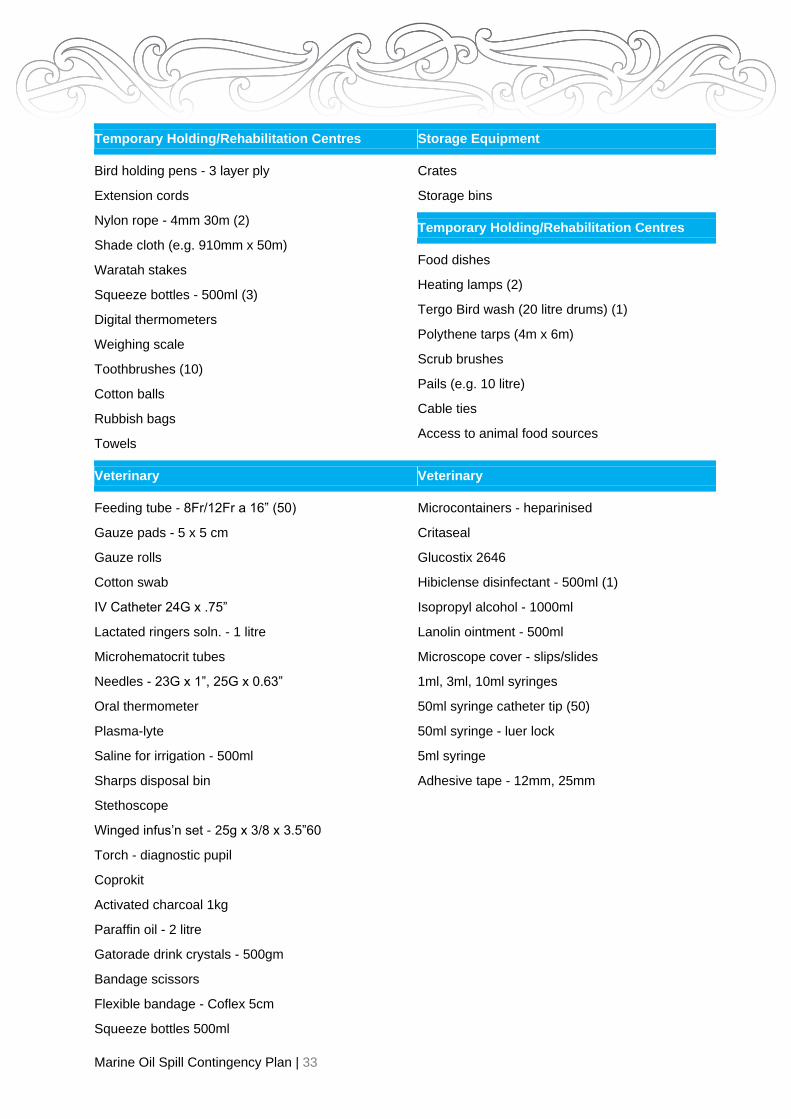
Marine Oil Spill Contingency Plan | 33
Temporary Holding/Rehabilitation Centres
Bird holding pens - 3 layer ply
Extension cords
Nylon rope - 4mm 30m (2)
Shade cloth (e.g. 910mm x 50m)
Waratah stakes
Squeeze bottles - 500ml (3)
Digital thermometers
Weighing scale
Toothbrushes (10)
Cotton balls
Rubbish bags
Towels
Storage Equipment
Crates
Storage bins
Temporary Holding/Rehabilitation Centres
Food dishes
Heating lamps (2)
Tergo Bird wash (20 litre drums) (1)
Polythene tarps (4m x 6m)
Scrub brushes
Pails (e.g. 10 litre)
Cable ties
Access to animal food sources
Veterinary
Feeding tube - 8Fr/12Fr a 16” (50)
Gauze pads - 5 x 5 cm
Gauze rolls
Cotton swab
IV Catheter 24G x .75”
Lactated ringers soln. - 1 litre
Microhematocrit tubes
Needles - 23G x 1”, 25G x 0.63”
Oral thermometer
Plasma-lyte
Saline for irrigation - 500ml
Sharps disposal bin
Stethoscope
Winged infus’n set - 25g x 3/8 x 3.5”60
Torch - diagnostic pupil
Coprokit
Activated charcoal 1kg
Paraffin oil - 2 litre
Gatorade drink crystals - 500gm
Bandage scissors
Flexible bandage - Coflex 5cm
Squeeze bottles 500ml
Veterinary
Microcontainers - heparinised
Critaseal
Glucostix 2646
Hibiclense disinfectant - 500ml (1)
Isopropyl alcohol - 1000ml
Lanolin ointment - 500ml
Microscope cover - slips/slides
1ml, 3ml, 10ml syringes
50ml syringe catheter tip (50)
50ml syringe - luer lock
5ml syringe
Adhesive tape - 12mm, 25mm

Marine Oil Spill Contingency Plan | 34
Limits on Gisborne regional response expectations
Any wildlife response in Gisborne at the Tier 2 level will involve the mobilisation of the National wildlife
response capability.
Taking into account the type and number of species likely to be impacted in the event of an oil spill and
the limitations with respect to the Temporary Holding Centres, Temporary Rehabilitation Centres,
equipment and trained personnel in the region, the response expectations are:
• 50 birds; and
• 5 NZ fur seals (sub-adults up to approximately 18 months old).
Temporary Holding Centre (THC) & Temporary Rehabilitation Centres (TRC)
The following Section describes suitable THC’s and the TRC that have been selected for the Gisborne
region. This includes the resources available in each Centre, and identifies any constraints that would
need addressing in order to cater for wildlife in a response.
Waipaoa Water Treatment Plant
429 Bushmere Road
Gisborne
The site is owned by the Gisborne District Council and is situated 10 km from Gisborne.
This site has been assessed as being suitable for wildlife rehabilitation in the event of an oil spill
response. Permission from the owners will be required prior to this site being used.
The complex consists of a large double vehicle shed plus a three-bay implement shed and single vehicle
shed all with concrete floors. There is plenty of room for a container and marquee.
The site is fully fenced and secure and there is plenty of parking on site.
There is city water to the site but the cleaning area would require a temporary supply. There is a 200 litre
hot water cylinder in the main building. There is also a septic tank.
Both 3 phase/single phase power is available. There are toilets, showers and kitchen facilities in the main
building.
The Gisborne airport is less than 10 km away and there is plenty of room to land helicopters on site.
Although this is a quiet rural setting bird scarers are used seasonally in the area. The only concern is that
birds could escape and land on the water storage ponds and pollute the water supply. This however is
back up supply only used occasionally.
Contacts
Director Lifelines or Manager Utilities
Gisborne District Council Ph (06) 8672049 (24/7)

Marine Oil Spill Contingency Plan | 35
Gisborne A&P Showgrounds
20 Main Road Makaraka Gisborne
This site is owned by the Poverty Bay A&P Association.
The A+P showgrounds Event Centre in Makaraka consists of three areas.
• A large Event Centre (hall)
• A shearing display auditorium, wool room and associated buildings and
• A large building on the opposite side of the field that is used by the Riding Club for the Disabled.
The site is used for the Annual Show in October and horse jumping events throughout the year while the
event centre is booked throughout the year for a range of events.
Event Centre
The hall consists of wooden frame walls with corrugated iron covering, interior panelling boards, and
netting at the eaves. The roof is insulated corrugated iron. The flooring is concrete.
There are multiple entrance ways into the building and a large roller door opens onto a concrete pad. This
area was set up in 2002.
This is a multi-room complex which could contain all indoor activities and has hot and cold running water.
Connections to City water and GDC sewers are available.
There is a kitchen in the event centre as well as one for the camping area. Lighting is from skylights,
fluorescent strips and incandescent pendants.
This site was set up during the Jodie F Millennium spill in February 2002.
There are large fire hydrant mains located on exteriors of buildings. There is a camping ground and
cabins on site.
The site is gated and surrounded with a low wire fence and is situated close to the Gisborne Airport.
There is no air conditioning and the concrete flooring is uneven and susceptible to water pooling.
Shearing Display Auditorium and Wool Room
The former area could be useful for small scale responses but is flawed by its proximity of deeply
manured sheep holding and handling facilities.
For small scale operations the Shearing Display Auditorium is available for accession/triage/stabilisation
and the Wool Room is available for washing. For longer stay husbandry an outdoor access area would
need to be created, possibly based from the Wool Room.
Shearing Auditorium room lighting is via skylight translucent sheeting and fluorescent tubes.
Shearing Auditorium floor is concrete with a wooden shearing podium and wooden amphitheatre step
seating.

Marine Oil Spill Contingency Plan | 36
Seal off any agricultural animal handling areas from useable spaces with temporary polythene sheeting.
Remove and store interior furnishings of display boxes and benches.
Contact
Secretary A & P Association [email protected]
(06) 868 6084 or
Inside the Event Centre Toilet block and Event Centre
Shearing auditorium and wool room Outdoor Area
Entrance Driveway

Marine Oil Spill Contingency Plan | 37
Establishment Plan – Events Centre and Shearing Pavilion:
Fire Station Main Road Tokomaru Bay
The station is owned by Fire and Emergency New Zealand.
This site has been assessed as being suitable for wildlife rehabilitation in the event of an oil spill response
however permission from the owners will be required prior to this site being used.
The buildings are fed by a 20,000 litre rain-water tank as well as spring water. The building has a septic
tank and power.
There is off road parking, roadside parking and parking in an adjacent paddock. A helicopter can land in
the rugby field opposite.
The building has a kitchen, adequate toilet facilities and a grocery shop nearby.
There are two fire station bays (14m x 6m and 14m x 7m) and a mezzanine floor (3mx7m). There is also
security fencing at the rear but it may require fencing in the front.
Accommodation is available at nearby motels and camping grounds as well as backpackers and maraes.
There could be quite a bit of noise from the road traffic as well as the station siren – however this can be
muted.
Contacts
In an emergency dial 111. For the station house call: 06 864 5782
Tokomaru Bay Fire Station Paddock behind the Fire Station

Marine Oil Spill Contingency Plan | 38
Ruatoria
The site is owned by Fire and Emergency New Zealand.
This site has been assessed as being suitable for wildlife rehabilitation in the event of an oil spill
response. Permission from the owners will be required prior to this site being used.
If the site is required, the fire engine and water tanker could be moved elsewhere. The site has a 40,000
litre tank supply plus additional water from a spring. Toilets and showers are available and a septic tank
for wastewater disposal.
There is a kitchen and large smoko area, some parking in front of the building but otherwise there is road
side parking. The building is secure with land at the rear for a marquee.
Gisborne airport is two hours away however there is a helipad on site. There is minimal traffic noise and
the station siren can be muted if necessary. There is the Kai Kart Takeaways and Cafe and a Four
Square Supermarket. The Marae is currently being renovated.
Contacts:
In an emergency dial 111. For the station house call: 06 8649123
Ruatoria Bed and Breakfast:
Enz of the Earth Telephone: 06 864 8711 - Sleeps up to 10 people with shared kitchen and bathroom
space.

Marine Oil Spill Contingency Plan | 39
Te Araroa Sports Grounds
East Cape Hunting and Fishing Inc Tokararangi Sports Club
10 Pohutu Road 10 Pohutu Road
Te Araroa Te Araroa
Telephone: 06 5644 853
There are two buildings on the Te Araroa Sports Grounds.
This site has been assessed as being suitable for wildlife rehabilitation in the event of an oil spill response
however permission from the owners will be required prior to this site being used. The land is owned by
the Gisborne District Council but the buildings are owned by the clubs. The buildings are fed by spring
water and have septic tanks. The power is single phase. There is plenty of parking with truck access with
security fencing on the road frontage. There is room for a helipad on site and a small fixed wing air strip
along the beach front. The buildings have kitchen facilities and food outlets/grocery shops within a short
distance.
There is accommodation at the Lottin Point Motel (06 864 4455), camping grounds or local maraes.
There are adequate toilets and showers and outside lighting.
Contact
Ngati Porou East Coast Rugby Union
Rugby Pavilion
Rear of the grounds Veranda of the club rooms

Marine Oil Spill Contingency Plan | 40
Resources and Logistical Support
Annex 1
Products Company Name Address Phone No. Fax no. Email Web Address
PPE NZ Safety Blackwoods 372 Gladstone Road 0800 66 0660
PPE
Suppliers, waste bags &
spill equipment
EnviroNZ A -
comprehensive range of
oil absorbing product &
related equipment
Spill Control NZ
Auckland – overnight
courier
PO Box 17
Oakura, New Plymouth
4345
See contact sheet
for details
08000 30953
[email protected] o.nz
Building Supplies Bunnings Trade Carnarvon Street 8679599 8679597
Bunnings Warehouse Cnr Peel Street & Kahutia
Street
8693300 8630600
Tumu ITM 356Childers Road 8689599
Carters 342 Gladstone Road 8688099
Plumbing Supplies Plumbing World 121Kahutia Street 869 0068
Gas Supplies Hirepool/BOC 429 Gladstone Road 068679466 068679466
Hire Centres e.g.,
Marquees, Portable
Buildings, Fencing,
Toilets, Refrigeration,
Tarpaulins Generators
Hire Pool – as above 429 Gladstone Road 8679466 8679364
Martins Hiremaster
(Mechanical)
126 Disraeli Street 8679131
Martins Event & Party Hire 346 Palmerston Road 8633550
Drainage & Earthworks Thompson Drainage 81 Innes Street 8674902
Assorted Earthmoving Contractors
Transportation Budget Car Rental NO
TRUCKS – 12 SEATER
VAN ONLY
Gisborne Airport 8679794
0800283438

Marine Oil Spill Contingency Plan | 41
Products Company Name Address Phone No. Fax no. Email Web Address
Veterinary Supplies Vet Ent
Eastland Veterinary
Services Ltd
281 Gladstone Road
743 Gladstone Road
8685151
2615831
8685351
Electrolytes, PPE, Feeds PGG Wrightsons 21 Solander Street 8631686
Fish Supplies* New Zealand King
Salmon Co.
10-18 Bullen Street
PO Box 1180, Nelson
03 548 5714 03 53808 741
Live Insects – Reptile
Food
Biosupplies -
Annimates
383 Gladstone Road 022 1354740
8631286
Security Firms CSL Fitzherbert Street, Ormond
Road
8690004 068691650
360 Degrees 70 Disraeli Street 8688360
Accommodation Various
Hazing Supplies eg gas
cannons, birdscare tape
FruitFed PPG Wrightson 21 Solander Street 8631686 gisbornbeeffstore@ppgwrightson
Able to supply up to 2 tonne of salmon smoults within 2 days.
NB: Accommodation, catering and personnel transport is typically organised by ICC through MNZ controlled cost centres.

Marine Oil Spill Contingency Plan | 42
Regional Wildlife Response Equipment Contents
Blue Box
These contents are intended to cater for 50 birds and 20 field personnel
Item Use Number Supplier On shopping list Check
Capture Transport boxes Transportation of birds 50 Contact Wildbase Oil
Response
Matasorb(sorbent mats) Lining bottom of transport boxes 100 See PPE suppliers above
Pillow cases Holding birds before placing in
transport boxes
50 Manchester retailer
Wildlife Collection tags Labelling boxes (live) & Bags
(dead)
75 Contact Wildbase Oil
Response
Long handled dip nets Net capture of birds 10 Fishing store or similar
Tyvex suits - size M PPE 3 See PPE suppliers listed
Tyvex suits - size L PPE 12 See PPE suppliers listed
Tyvex suits - size XL PPE 12 See PPE suppliers listed
Tyvex suits - size XXL PPE 3 See PPE suppliers listed
Nitrile gloves
(disposable) - size S
PPE 2 boxes See PPE suppliers listed
Nitrile gloves
(disposable) - size M
PPE 2 boxes See PPE suppliers listed
Nitrile gloves
(disposable) - size L
PPE 3 boxes See PPE supplies listed
Safety sunglasses PPE 20 pairs See PPE suppliers listed
PVC gloves PPE 20 pairs See PPE suppliers listed
High visibility Safety
Vests
PPE 20 See PPE suppliers listed

Marine Oil Spill Contingency Plan | 43
Item Use Number Supplier On shopping list Check
Whistles Attracting attention in the field 20 Tramping store
Hibitane/Hibiclens
disinfectant - 500ml
Hand cleaning 1 Order through local
veterinarian
Paper towels Hand cleaning 10 rolls supermarket Y
Alcohol hand gel (small
bottles)
Hand cleaning 20 supermarket Y
Field notebooks (plastic
paper)
Field notes 10 OfficeMax see link below
Pencils Field notes 20 Local bookshop
Field Guide to Birds of
NZ
NZ Birds Online
Species Identificatio n 1 Local bookshop Y
Infectious waste bags Containing oiled PPE etc 20 Contact Wildbase Oil
Response or PPE suppliers
Plastic leg bands for bird
ID
Bird ID 50 Contact Wildbase Oil
Response
Sharpie pens Labelling 10 Local bookshop
Stabilisation 50ml syringes, without catheter Oral fluid administration 20 Order through local
veterinarian
20ml syringes, without catheter Oral fluid administration 15 Order through local
veterinarian
10ml syringes, without catheter Oral fluid administration 15 Order through local
veterinarian
Roll of silicone tubing Oral fluid administration 20 m Rubbermark
Cotton buds Cleaning oil from eyes
and mouth
5 pkts Pharmacy
0.9% NaCl (500ml bottle) Cleaning oil from eyes
and mouth
2 Get at local
veterinarians
Y
Squeeze bottles Cleaning oil from eyes
and mouth
3 Plastic box

Marine Oil Spill Contingency Plan | 44
Item Use Number Supplier On shopping list Check
Digital thermometer Cloacal temperature
taking
1 Local
chemist/pharmacy
Electrolytes, powder Oral fluid administration Pharmacy,
supermarket, vet clinic
Y
Dead bird
collection
Plastic bags Holding dead birds 100 Plastic box
Cable ties, 200mm Sealing bags 100 Hardware store
Cable ties, 100mm Sealing bags 100 Hardware store
Administration
etc
Clipboards 5 Bookshop
Writing Pads 5 Bookshop
Nylon rope - 4mm - 30m 2 Hardware store
Animal admission logs in folder Complete for each animal 60 Photocopied forms
Register of equipment (in and
out)
1 Contact Wildbase Oil
Response
Stock rotation schedule 1 Contact Wildbase Oil
Response
Audit checklist 1 Contact Wildbase Oil
Response
Non-tamper plastic sealing tag 1 Contact Wildbase Oil
Response/MNZ
Bird scare tape Hazing 5 rolls FruitFed or Farmlands
Sports horn Hazing 1 NZ Safety Blackwoods
Rotatable stock:
Nitrile gloves – check expiry
dates during audit and replace as
necessary
PPE Suppliers

Marine Oil Spill Contingency Plan | 45
Annex 2 – Personal Lists and Mobilisation Instructions
Contents
MOBILISING PERSONNEL 1
RESPONSE PERSONNEL 2
INSURANCE AND PAYMENT OF RESPONDERS 2
RESPONDER PRIVACY CONSIDERATIONS 3
Mobilising Personnel
The decision with respect to which personnel to activate from the potential list of EOC Staff, and adjacent
regional councils will be made by the ROSC.
A list of potential EOC Staff, alert list for interested parties and adjacent regional councils is outlined
below.
The decision with respect to which potentially affected interested parties to contact will be made during
the development of the IAP.
The safety of human life, both responders and the general public, is to take precedence over all aspects
of the response operation.
Persons employed in these operations are to do so in compliance with the Health and Safety in
Employment Act 2015. Persons mobilising responders are to verify that they have been trained and
briefed in the hazardous nature/danger of this work.
The Council has a limited supply of oil spill safety clothing which is stored at the MOS Shed in Banks
Street. The clothing consists of oil proof overalls (disposable), safety gumboots (steel toe), safety hats,
ear defenders (for machinery operators) and safety glasses
For cost and administrative purposes oil spill response personnel should be mobilised in order of priority:
1. ROSC and EOC staff/Regional Responders;
2. Other Gisborne District Council staff listed in Annex 2;
3. Eastland Port staff (re vessels);
4. Department of Conservation staff;
5. Ministry of Primary Industries (MPI) staff;
6. Oil Company Contractors; and
7. Adjacent Regional Councils.
Notwithstanding the above priority list, DOC staff and other persons may need to be mobilised early to
address any required wildlife response operation. Fire and Emergency NZ and Maritime NZ will be
notified in all spill events and their level of involvement assessed at the time.
Persons mobilising responders are to ensure that:
• Responders are trained;
• Responders are adequately attired and have adequate safety equipment, including personal
flotation devices, if appropriate;
• Transport to the appropriate site is arranged for the responders (as required), and the
responders are informed of these arrangements;

Marine Oil Spill Contingency Plan | 46
• Responders are briefed where they will be working, for approximately how long they will be
deployed in the field [hours, days or longer], and who they are to report to on arrival;
• The Operations Manager is informed who the responders are and their estimated time of arrival
(ETA);
• Adequate accommodation is arranged for the responders (if required), with transport to and from
the site at which they will be working;
• Adequate first aid and medical facilities are arranged;
• Sufficient and timely relief personnel are provided to allow adequate rest for response staff. The
relief staff are to be treated as for first-call staff above;
• The Logistics Manager is informed of the responder’s name, hourly pay rate, commencement
and finish times for pay;
• Return transport and debriefing is arranged on their release by the ROSC;
• As far as possibly practical ensure responders have adequate access to sufficient food and
drink during working hours. Self-catering of sufficient food and water may sometimes be
necessary, particularly in remote locations.
Response Personnel
The following personnel have been identified as suitable to fulfil the duties as designated and may be
called upon in the event of a marine oil spill. The person at the top of each list is the first choice for that
particular role, if not combined with other roles. Those in brackets have yet to complete training and are
listed for future involvement. Contact details are contained in the starter pack.
All Regional Council personnel responsible for implementing the Plan and dealing with oil spills shall
receive training appropriate to their responsibilities under this Plan.
Requirements of the Regional On-Scene Commander and Health and Safety Advisor are to ensure that:
• Responders are not employed in hazardous situations beyond their training and/or experience,
• Responders wear safety equipment appropriate to the conditions under which they are working,
• Responders are given adequate supervision, rest and refreshments.
The times worked by individual responders are noted for payment purposes, and Responders receive
adequate medical care and rest, as and when required
Insurance and Payment of responders
Responders or their parent organisations are expected to arrange suitable insurance for the response
operation. Special payments will not be made to responders.
A responder’s organisation will be reimbursed wages/salaries incurred for the period of employment
undertaken on the response operation. This will be made upon the recovery of response costs from the
oil spill polluter or the Marine Oil Pollution Fund.
Responder Privacy Considerations
Safeguards to protect individual’s private information under the Privacy Act were strengthened in 2020. A
summary of changes can be found here: Privacy Act 2020.
The personal information held in this plan is for the purposes of marine oil spill response. Personal
information that is not otherwise available publically has been extracted from the plan. Any individual who
wishes to have their information removed or amended from the public version of this plan should contact
the ROSC.
Private information will be stored in Gisborne District Council’s secure file storage system which is called
Objective.

Marine Oil Spill Contingency Plan | 47
Decisions to share personal information during an oil spill response or during training should be made in
consideration of the protections provided in the Privacy Act 2020.
NOTE: All private contact information is stored in Objective:

Marine Oil Spill Contingency Plan | 48
Annex 3 - Communications
Communication overview
The Civil Defence Communication Centre (normally also the EOC for smaller Tier 2 operations) is the
communication centre for most oil spill responses. Information relevant to the response and logistic
support will be channelled into it and either processed or passed on to the appropriate response section.
In any spill, to retain effective control, a number of different nets can be established as the need arises.
This could be to control different resources, like air assets or operations such as land and sea (see radio
communications section over page for more information).
Safety Note
Radios, cell phones, pagers and certain cameras must not be taken on board tankers or into a spill
situation unless they are intrinsically safe.
All handheld radios used in conditions where they may get wet, will be protected by waterproof bags.
Initial Communications
In the early stages of an oil spill response, it is likely that communications from the incident will be from a
Council vehicle or CDEM handheld radios.
The initial call/s may be to Council reception but all further traffic will be to/from the CDEM Office.
Methods of communication
Communication Reserves
There are several methods of communication available to the Incident Command Team and field
personnel. These include:
• Telephone;
• Cellular phone;
• Council vehicle or CDEM handheld radios
• Marine radio frequencies;
• Aviation frequencies
The Rural Fire Bus can be equipped with all necessary communications and used as an on site station.
FENZ also have mobile command units which can provide self-contained comms, electricity and a field
EoC for the purpose of incident management.
Response Procedures
The method/s of communication to be used at any spill will be confirmed “on the day”. It is likely to be a
combination of methods, chosen to give the most practical response coordination solution for the ROSC.
As cellphone coverage is not good on some of the coastline (check either
https://www.spark.co.nz/shop/mobile/network/ or www.vodafone.co.nz/coverage or access to normal
telephone systems, it is likely that most communications will be via a suitable mix of radio channels.
Alternatively marine channels may be used.
Supporting organisations will use their own radio networks, most of these are available in the CD
Communications Centre.

Marine Oil Spill Contingency Plan | 49
For security and to stop interference by non-response participants and where practical (equipment
availability and radio coverage) all links between the incident site and the ECC will be on a CD frequency.
Radio Communication (Nets)
The CDEM base and handheld radios have the CD channels for the region programmed into them and if
working in the isolated areas the handhelds report back to the nearest CDEM base radio.
Subject to the above, each operational area (air, sea, land) will be allocated an appropriate
communication channel as required. These channels of communication (nets) may include:
Maritime Net
A Marine VHF frequency, where appropriate, will be designated for on-site operations for the spill, subject
to location.
Maritime Radio
71 Runaway or 16 (emergency channel)
67 Tolaga Bay or 16 (emergency channel)
Marine Channels
12 Port and Harbour working channel
10 Tug Channel
60 Tatapouri Fishing Club (Poverty Bay to Tolaga Bay)
85 Tolaga (Tolaga/Anaura)
61 Tokomaru Bay (Tokomaru to East Cape)
63 Lottin Point (East Cape to Lottin Point)
16 Emergency Channel
6 or 8 Working Channels (Ship to Ship - exercise or incident) 69 – Surf lifesaving – Midway
and Waikanae
Coastguard
65 Waihau Bay
05 East Cape
03 Gisborne
Call signs will be the person’s title or ship’s name. For radio manual:
Aviation Net
• Ground to Air: Frequencies: Simplex - Repeater (CD controlled): Base ESX27. Aircraft 132.7 or
designated Civil Defence channel. Normal aircraft registrations will be used for call signs.
• Air to Air (pilots): 132.7 can be used to talk between aircraft but if this is busy 119.1 should be
used. Normal aircraft registrations will be used for call signs.
Onshore Net
A suitable VHF Marine or Civil Defence frequency will be assigned for the spill. The incident control
net will be on a CD frequency. Call signs will be allocated at the time as appropriate to positions.
The confirmation of frequencies and the design of the net diagrams will be the responsibility of the
Logistics Section through the Communications Officer.
An Emergency Services Liaison frequency (ESB164) is available for interagency communications.
Coverage is for Poverty Bay to Pouawa.

Marine Oil Spill Contingency Plan | 50
Annex 4 – sensitive areas and coastal information
Gisborne wildlife rehabilitation priority rankings
The conservation status of New Zealand birds were ranked in Robertson et al. (2013) and include the
following categories: - copies of this publication are included in Annex 9.
In some circumstances (e.g. where there are a large number of species impacted by an oil spill) it may be
necessary for the Wildlife Coordinator to establish priorities for deterrence, rescue and rehabilitation of
wildlife. The following categories identify species in the region that may be impacted by a marine oil spill,
and will provide some assistance with assigning priority rankings.
Category 1: First priority for deterrence, rescue and/or rehabilitation
Species with a New Zealand Threat Classification of ‘Threatened’ and/or IUCN Red-list classification
(www.iucnredlist.org) of critically endangered (CR), endangered (EN) or vulnerable (VU). These are
ranked from 1A to 1c for further prioritization using the New Zealand Threat Classification system.
1A Nationally critical
1B Nationally endangered 1C Nationally vulnerable
Category 2: Second priority for deterrence, rescue and rehabilitation
Species with a New Zealand Threat Classification of ‘At Risk’ and/or IUCN Red-list classification
(www.iucnredlist.org) of critically endangered (CR), endangered (EN) or vulnerable (VU). These are
ranked from 2A to 2D for further prioritization using the New Zealand Threat Classification system.
2A Declining
2B Recovering
2C Relict
2D Naturally uncommon
An additional and useful source of information for wildlife response is: nzbirdsonline.org.nz
Category 3: Third priority for deterrence, rescue and rehabilitation
Species which are endemic to New Zealand and are considered to be ‘Not Threatened’ under the NZ
Threat Classification System, and with an IUCN Red-list classification of lower risk (LR) or not listed.
Category 4: Fourth priority for deterrence, rescue and rehabilitation
Species considered as migrants, vagrants or colonizers under the NZ Threat Classification System, and
with an IUCN Red-list classification of lower risk (LR) or not listed.
Category 5: Fifth priority for deterrence, rescue and rehabilitation
Species which are native to New Zealand and are considered to be ‘Not Threatened’ under the NZ Threat
Classification System, and with an IUCN Red-list classification of lower risk (LR) or not listed.
Category 6: Sixth priority for deterrence, rescue and rehabilitation
Species considered to be ‘Introduced & Naturalised’ under the NZ Threat Classification System, and with
an IUCN Red-list classification of lower risk (LR) or not listed.

Marine Oil Spill Contingency Plan | 51
Marine Mammals and Birds Recorded in Gisborne
Priority
Category Species Scientific Name
Species Common
Name NZ Threat Classification
IUCN
category Status code
Breeds in
Gisborne Breeding Season
Seasonal
Distribution
1A Charadrius obscurus NZ Dotterel Nationally critical EN E Y Aug-Feb Year round
1A Ardea modesta White Heron Nationally critical Not listed N N n/a Sp, S
1B Anas superciliosa Grey Duck Nationally endangered LC N Y Aug-Feb (peaking
Oct-Nov)
Year round
1B Botaurus poiciloptilus Australasian Bittern Nationally endangered EN N N n/a A, W, Sp
1C Anarhynchus frontalis Wrybill Nationally vulnerable VU E N Year round
1C Egretta sacra Reef Heron Nationally Threatened LC N N n/a Sp, S
1C Sterna caspia Caspian Tern Nationally vulnerable LC N N n/a Year round
1D Larus bulleri Black Billed Gull Serious decline EN E N n/a Year round
1E Charandrius bicinctus Banded Dotterel Gradual decline Not listed E Y Jul-Feb Year round
1E Eudyptula minor Little Blue Penguin Gradual decline LC N N n/a Year round
1E Larus novaehollandiae scopulinus Red Billed Gull Declining LC E Y All Year Year round
1E Pterodroma cookii Cook’s petrel Gradual decline EN N N n/a A
1E Puffinus griseus Sooty Shearwater Gradual decline NT N Y Nov-May Year round
1E Sterna striata White Fronted Tern Gradual decline LC N N n/a Year round
1F Phalacrocorax carbo Black Shag Range restricted LC N Y All Year Year round
1F Poliocephalus rufopectus NZ Dabchick Range restricted VU E N n/a Year round
1F Porzana tabuensis Spotless Crake Declining LC N N n/a S, A, W
1G Phalacrocorax sulcirostris Little Black Shag Sparse LC N N n/a Year round
1G Puffinus bulleri Buller’s Shearwater Sparse VU E N n/a A, Sp
2 Anas rhynchotis variegata NZ shoveler Not listed LC E N n/a Year round
2A Haematopus ostralegus Pied Oystercatcher Not listed LC E N n/a A, W, Sp

Marine Oil Spill Contingency Plan | 52
Priority
Category Species Scientific Name
Species Common
Name NZ Threat Classification
IUCN
category Status code
Breeds in
Gisborne Breeding Season
Seasonal
Distribution
2B Haematopus unicolor Variable
Oystercatcher
Not threatened LC E Y Sep-Mar Year round
2D Phalacrocorax melanoleucos Little Shag Not threatened LC E N n/a Year round
3 Pterodroma macroptera gouldi Grey Faced Petrel Not threatened LC E Y Jun-Jan Sp
3 Arenaria interpres Turnstone Not listed LC M N n/a A
3 Bubulcus ibis Cattle Egret Not listed LC M N n/a Year round
3 Calidris canutus Lesser Knot (red knot) Migrant LC M N n/a A
3 Limosa lapponica Eastern Bar-tailed
Godwit
Migrant LC M N n/a Year round
3 Numensis phaeopus spp. Whimbrel-Asiatic,
American
Not listed LC M N n/a Sp
3 Pluvialis fulva Pacific Golden Plover Not listed LC M N n/a Year round
3 Sterna albifrons Eastern Little Tern Not listed LC M N n/a Sp
4 Anas gracilis Grey Teal Not listed LC M N n/a Year round
4 Ardea novaehollandiae White Faced Heron Not listed LC N Y Jun-Dec Year round
4 Charadrius melanops Black Fronted Dotterel Not listed LC N Y Sep-Mar W, Sp, S
4 Himantopus leucocephalus Australasian Pied Stilt Not threatened LC N Y Jul-Jan Year round
4 Larus dominicanus Southern Black-backed
Gull
Not threatened LC N N n/a Year round
4 Morus serrator Australasian Gannet Not threatened LC N N n/a Year round
4 Pelecanoides urinatrix Common Diving Petrel Not listed LC N N n/a A
4 Phalacrocorax varius Pied Shag Recovering LC N Y Aug-Sep/Mar-Apr Year round
4 Platalea regia Royal Spoonbill Not threatened LC N N n/a A, W, Sp
4 Porphyrio Pukeko Not listed LC N Y Variable Year round
4 Vannelus miles novaehollandiae Spur Winged Plover Not threatened LC N N n/a Year round

Marine Oil Spill Contingency Plan | 53
Priority
Category Species Scientific Name
Species Common
Name NZ Threat Classification
IUCN
category Status code
Breeds in
Gisborne Breeding Season
Seasonal
Distribution
5 Anas platyrhynchos Mallard Not listed LC I Y Aug-Feb Year round
5 Anser Feral Goose Not listed LC I N n/a S, A, W
5 Branta Canadensis Canada Goose Not listed LC I Y Sep-Jan Year round
5 Cygnus atratus Black Swan Not listed LC I Y Variable Year round
Arctocephalus forsteri NZ Fur Seal Not listed LC N N Nov-Feb Year round
Key
Status Code:
Seasons
IUCN Classification Scheme
(http://www.lucnredlist.org)
E Endemic Breeds only in NZ territories Sp Spring CR Critically Endangered
N Native Breeds in NZ territories and elsewhere S Summer EN Endangered
M Migrant A reasonable number migrate to NZ territories but do not breed A Autumn VU Vulnerable
S Straggler/vagrant Not a regular migrant or few migrate to NZ territories but do not breed W Winter LC Least Concern
I Introduced Introduced by humans NT Not threatened

Marine Oil Spill Contingency Plan | 54
Wildlife response information specific to Gisborne region
Gisborne Wildlife Likely to be threatened by an Oil Spill
Sites of particular significance have been identified on Sensitive Site Maps. These include “Important
Marine Areas”, which identify areas with important “Wildlife Values”. Cross referencing the above risk
sites to the Important Marine Areas:
• East Cape (East Island): East Island is an Important Marine Area with Wildlife Values.
• Aerial Reef: The reef is an Important Marine Area with Wildlife Values.
• Gisborne Harbour: Tuamotu Island is an Important Marine Area to the south east.
Department of Conservation responsibilities
• To ensure that in the event of a marine oil spill emergency that the necessary consents and
approvals needed for an effective response associated with the management of land, flora and
fauna are provided according to policy and, where these are not already in place, to do so
without delay.
• Under the Wildlife Act 1953, to authorise:
• Capture, handling, possession and transfer of protected wildlife;
• Holding of protected wildlife in captivity for the purposes of treatment and rehabilitation, and to
licence approved people and institutions to do so.
• Euthanasia of injured protected wildlife where necessary to avoid further suffering; and
• Liberation of protected wildlife after rehabilitation.
• Under the Conservation Act 1953, to authorise:
• As owner or occupier of land where entry is restricted, access by OSC’s or their staff or agents,
where needed for the effective control or mitigation of marine oil spills;
• The capture of euthanasia, where necessary, of any fauna found within these classes of land;
• The removal or disturbance of vegetation, gravel sand and the like in the course of clean-up
operations, or for a more effective response to a marine oil spill emergency.
• Under the Marine Mammals Protection Act 1978, to authorise:
• The capture and marking of injured marine mammals, and their euthanasia, where necessary to
avoid further suffering due to the effects of a marine oil spill.
• Act as a contractor to industry, regional Councils and the Maritime NZ with support for oil spill
planning and response logistics, communications and personnel.
Any contact with the Department with respect to an oil spill response should be through the Conservator
or Area Manager in the first instance, telephone: (06) 869 0460.

Marine Oil Spill Contingency Plan | 55
Priority Areas
The following topographical maps and associated areas of Significant Conservation Value text, outlines:
• These areas and associated wildlife should be given priority during development of the
Response Action Plan, if they are likely to be impacted by the spill.
• Historic Sites.
• Beach access.
• Important Iwi/Hapu Areas. This information is still being researched. In the interim, the contacts
will be able to help identify important sites. Also, there are many burial grounds along the coast,
many of which are unknown. The general location of known sites is shown by “MB” on the maps.
• Air strips.
• Ship wrecks (navigation hazards).
• Information on shoreline types.
• Local contacts. The people have local knowledge which may be of assistance during a spill
response.
Further information can be found on the Hydrographic charts and other information located in the EOC.
Tairāwhiti Resource Management Plan
A further document of relevance for marine oil spill response is the Tairāwhiti Resource Management
Plan. In particular the Coast section of the plan defines Protection Management Areas and maps the
coastline of the region indicating areas of special significance, as well as detailed information to identify
special native flora, fauna and unique landscape features.
Once oil or oily waste has been effectively contained all relevant rules, regulations, consent conditions
and legislation apply and must be complied with.

Marine Oil Spill Contingency Plan | 56

Marine Oil Spill Contingency Plan | 57

Marine Oil Spill Contingency Plan | 58
Map A Site 1 & 2 Potaka/Lottin Point/ Matakaoa Risk Rating (1 = high) (1) 2 3
Description
The Matakaoa volcanic coast is located at the tip of the East Cape between Cape Runaway in the West and Hicks
Bay in the East, some 34 kilometres. Lottin Point is located near the centre and is representative of the whole site.
The Lottin Point-Hicks Bay Site has significant marine, as well as terrestrial, ecological flora and fauna values,
outstanding underwater scenery and outstanding terrestrial natural features and coastal landscape values.
Foreshore Type Stone/rocky beach and cliffs
Map Sheets Map No BD44
Tairāwhiti RMP (Maps 2A.1, 2 & 3)Marine Chart NZ300055
At Risk Resources
On every relevant ground of scenic and environmental quality and scientific interest, Lottin Point must be ranked
in the first priority for gazetting as a Marine Reserve (Morton, J., 1989).
The Tairāwhiti Resource Management Plan designates the coast line a Marine Area of Significant Conservation
Value and an Outstanding Landscape. Terrestrial areas of Significant Conservation Value are also recognised.
Part of the adjacent land area is recommended for protection in the Pukeamaru Ecological District Protected
Natural Area (PNA) Survey report as being one of the district’s rare remnants of coastal
forest with a high diversity of vegetation types (Regnier, C., 1988).
Ecosystems, Flora and Fauna Habitats
Lottin Point has marine biogeographic features, which are unique. The site is located in close proximity to the
Kermadec Trench and has many of the biogeographic features of a clean steep offshore island, including a
species of vermetid gastropod (Dendropoma novastoa lamellosum) not found elsewhere on the NZ mainland
(Morton, J., 1989). Lottin Point is located at the centre of the Matakaoa volcanic region and supports an unusual
assemblage of marine plant and animal life including examples of northern algae species (Vidalia colensoi,
Xiphophora chondrophulla, Carpophyllum plumosum and C.angustifolium) and of southern algae species
(Halopteris congesta,
Halopteris funicularis, and Chaetomophora coliformis) (MAFISH 1987).
Scenic Values
The Lottin Point subtidal area is nationally recognised as an outstanding dive location. The underwater scenery,
clear water and the diversity and abundance of marine life attract divers the year round (MAFISH 1987).
The steep coastal hills between Cape Runaway and Lottin Point are listed under Regionally Significant Features
and Landscape in the Boffa Miskell Assessment of Coastal Landscape for Environment Bay of Plenty (EBOP).
The coastal landscape between Matakaoa Headland and Waiaka, west of Lottin Point, is of outstanding quality
and also the best representative example of its type in the region (Smale, S., 1993).
Boundary Of Area Of Significant Conservation Value
All that part of the Coastal Marine Area between Waiaka Point at Map Ref: Y14 640.933 in the West, and Hicks
Bay at Map Ref: Z14 787.899 in the East, contained by the Line of Mean High Water Springs and a line running
parallel one nautical mile off-shore.
Iwi/Hapu areas
Te Runanga-a-Ngati Porou
Main Office: 06 8679960, Ruatoria Office: 06 8649004, Chief Executive: 06 864 8121
Potaka Contacts: TBC
Beach access Lottin Point
Exists at boat landing off Potikirua Road through a locked gate – key at motel (4WD required).

Marine Oil Spill Contingency Plan | 59
Map A Site 1 & 2 Potaka/Lottin Point/ Matakaoa Risk Rating (1 = high) (1) 2 3
Lottin Point boat ramp at the end of Lottin Point Road.
Access would be possible with 4WD/bulldozer along most of the length of Potikirua Road from the
road down onto the rocks at shore level.
Midway Point
Via farm track over Matakaoa Station (bulldozer required if wet).
Local contacts
Matakaoa Station Lottin Point Motel
Phone: (06) 864 4462 Phone: (06) 864 4455
Preferred response options matrix
Most preferred Least preferred Feasibility
Containment and recovery √ Med - Low
On water recovery √ Med - Low
Dispersant application √ High - Med
Shoreline clean-up √ Med - Low
Natural recovery √ High - Med

Marine Oil Spill Contingency Plan | 60
Map A Site 3 Hicks Bay Risk Rating (1 =high) ( 1 ) 2 3
Description
Located at Hicks Bay this site comprises of the Wharekahika River estuary and associated coastal lagoons and
intertidal beach. The site has significant ecological, fauna, flora and wildlife values.
Foreshore type Sandy at Horseshoe Bay Coarse sand at Hicks Bay
Rocky headlands
Map sheets Map No BD45
Tairāwhiti RMP (Map 2A.3)
Marine Chart NZ300055,NZ455513 & NZ400055 (Ranfurly Bank)
At Risk Resources
Wetlands, Estuaries, Coastal Lagoons
The Wharekahika estuary and associated coastal lagoon has a high Site of Specific Wildlife Interest (SSWI) rating
and is a Priority One (nationally important) Recommended Area for Protection (RAP) in the Pukeamaru Ecological
District Protected Natural Area (PNA) Survey Report; for its estuarine and freshwater flora; a high diversity of
representative vegetation types associated with the lagoon, and fauna; the presence of nationally threatened
wildlife – NZ Dotterel (Charadrius obscurus), Banded Dotterel (Charadrius bicinctus bicinctus) and other coastal
birds. The adjacent dune lands support the largest population of the rare plant Pingao (Desmoschoenus spiralis)
in the region (Regnier, C,, 1988). The site has a rating of national significance for its diverse avifauna.
Marine Mammals and Birds
The Wharekahika Estuary and associated coastal lagoon has a high Site of Specific Wildlife Interest (SSWI) rating
for its estuarine and freshwater lagoon habitat and wildlife species list it supports including rare endangered and
migratory species; NZ Dotterel (Charadrius obscurus), Banded Dotterel (Charadrius bicinctus bicinctus), White
Heron (Egretta alba modesta) and large numbers of waders including Pied Stilts (Himantopus) and Variable
Oyster Catcher (Haematopus unicolor), waterfowl and field birds (Rasch G., 1989).
Both dotterel species are present all year round but nesting occurs from October through to February where these
waders along with Oyster Catcher, Pied Stilts and other waterfowl would be vulnerable.
Ecosystems, Flora and Fauna Habitats
The Wharekahika estuary and associated coastal lagoon supports a high diversity of representative vegetation
types including intertidal species; Juncus maritimus, Triglochin striatum, Cyprus ustulatus and Scirpus cemuss,
Raupo and Scirpus medianus. The adjacent sand dune area supports the largest population of the rare plant
Pingao (Desmoschoenus spiralis) in the region (Regnier, C., 1988).
The Wharekahika estuary and associated coastal lagoon has a high Site of Specific Wildlife Interest (SSWI) rating
for its estuarine and freshwater lagoon habitat and wildlife species list it supports including rare and endangered
and migratory species; NZ Dotterel (Charadrius obscurus), Banded Dotterel (Charadrius bicinctus bicinctus),
White Heron (Egretta alba modesta) and large numbers of waders including Pied Stilts (Himantopus) and Variable
Oyster Catcher (Haematopus unicolor), waterfowl and field birds (Rasch G., 1989). Whitebait (Galaxias
maculates) spawn in the upper estuary (Hogan, K., pers.obs).
The main whitebait run up the Wharekahika is from July to November.
Boundary of area of Significant Conservation Value
All that part of the Coastal Marine Area between Map Ref. Z14 777.989 in the West to Map Ref. Z14 780.875 in
the East, contained by the line of Mean High Water Springs, including upstream of the Wharekahika River to the
effective Coastal Marine Area boundary, and a line running parallel to the shore following the 5 metre depth
contour.

Marine Oil Spill Contingency Plan | 61
Map A Site 3 Hicks Bay Risk Rating (1 =high) ( 1 ) 2 3
Historic Sites Hicks Bay Wharf Iwi/Hapu areas
Te Runanga-a-Ngati Porou
Main Office: 06 8679960, Ruatoria Office: 06 8649004, Chief Executive: 06 864 8121
Local Contacts
Manager Manager
Matakaoa Station Te Araroa Holiday Park and Motel
Phone: (06) 864 4462 Phone: (06) 864 4873
Kawakawa Mai Tawhiti School Phone: 06 864 4616
Hicks Bay Motel & Lodge Phone: (06) 864 4880
Beach access
• Boat ramp at Hicks Bay Wharf.
• Off Wharf Road (Hicks Bay) (4WD required).
• Several places along Onepoto Road.
• Through Te Araroa Holiday Park (4WD required).
• Also, it is possible to drive the length of Hicks Bay Beach (4WD required).
Preferred response options matrix
Most Preferred Least Preferred Feasibility
Containment and recovery √ Med - Low
On water recovery √ Med - Low
Dispersant application √ High - Med
Shoreline clean-up √ Med - Low
Natural recovery √ High - Med
Preferred response options for wildlife
• Birds (identified as nationally endangered, vulnerable or critical or those in serious decline)
- Hazing to prevent oiling
- Pre–emptive capture and release once habitat clean
- If oily then capture and rehabilitation and release

Marine Oil Spill Contingency Plan | 62
Map A Site 4 Karakatuwhero River Estuary Risk Rating (1=high) (1) 2 3
Description
Located two kilometres west of Te Araroa township, this site comprises the Karakatuwhero River Estuary,
associated coastal lagoons and the beach area. The site has significant ecological, fauna, flora and wildlife values
and also significant landscape and landform values.
Foreshore type Stony beach
Map sheets Map No BD45
Tairāwhiti RMP (Map 2A.3)
Marine Chart NZ300055,NZ455513 & NZ400055 (Ranfurly Bank)
At Risk Resources
Wetlands, Estuaries, Coastal Lagoons
The Karakatuwhero River mouth passes through a shingle dune system comprising a series of parallel shingle
dune ridges and hollows that represent old shorelines, which is a unique landform in the ecological district
(Regnier, C., 1988).
The river is very unstable and likely to migrate 1.5km either side of its present position (Gibb, J., 1981). The river
mouths periodic migration has formed several coastal lagoons and an estuary. The site is a priority one (nationally
important) Recommended Area for Protection (RAP) in the Pukeamaru Ecological District for its unique coastal
landform and the flora and fauna values in the coastal lagoons and estuary (Regnier, C., 1988). The site has a
national significance rating for its avifauna values.
Marine Mammals and Birds
Both the freshwater and the saline wetlands have high wildlife values with the lagoon at the Karakatuwhero River
mouth supporting the highest number of nesting coastal birds and wading birds in the Ecological District.
Species include nationally threatened species; NZ Dotterel (Charadrius obscurus) and Banded Dotterel
(Charadrius bicinctus bicinctus), waterfowl and field birds (Rasch, G., 1989).
Wading birds are nesting on this coastal area between October and February.
Ecosystems, Flora and Fauna Habitats
The Karakatuwhero coastal wetlands comprise the most extensive salt meadow in the Ecological District. Coastal
herbs include the threatened Mazus pumilio, and other uncommon species such as Lilaeopsis sp., Myriophyllum
propinquum and Rununculus acaulis. Whitebait (Galaxias maculatus) spawn in the estuary (Hogan, K., pers.
obs.).
Scenic values
The best representative example of a coastal landscape of its type in the region (Smale, S., 1993).
Coastal Landforms and Associated Processes
The shingle dune system is a unique landform in the Pukeamaru Ecological District comprising a series of parallel
shingle dune ridges and hollows that represent old shorelines.
Boundary of area of Significant Conservation Value
All that part of the Coastal Marine Area between Map Ref. Z14 805.853 in the West to Map Ref. Z14
826.834 in the East, contained by the line of Mean High Water Springs, including upstream to the
effective Coastal Marine Area Boundary, and a line running parallel to the shore along the 5-metre
water depth contour.

Marine Oil Spill Contingency Plan | 63
Map A Site 4 Karakatuwhero River Estuary Risk Rating (1=high) (1) 2 3
Iwi/Hapu areas
Te Runanga-a-Ngati Porou
Main Office: 06 8679960, Ruatoria Office: 06 8649004, Chief Executive: 06 864 8121
Local Contacts
Manager - Te Araroa Holiday Park Te Araroa
Phone: (06) 864 4873 Phone: (06) 864 4804
Hicks Bay Motel & Lodge Matakaoa Contact: TBC Phone: (06) 864 4880
Beach access
• Off SH35 on both sides of the Karakatuwhero River (4WD required).
• 4WD over the dunes along Moana Parade and beach track to the old sale yards road.
Preferred response options matrix
Most Preferred Least Preferred Feasibility
Containment and recovery √ Med - Low
On water recovery √ Med - Low
Dispersant application √ High - Med
Shoreline clean-up √* Med - Low
Natural recovery √ High - Med
Note *
Shoreline Cleanup
This site has dune ridges which are of significant value and any shoreline cleanup should ensure that
there is no damage to the unique landform.
Preferred response options for wildlife
• Birds (identified as nationally endangered, vulnerable or critical or those in serious decline)
- Hazing to prevent oiling
- Pre-emptive capture and release once habitat clean
- If oily then capture and rehabilitation and release

Marine Oil Spill Contingency Plan | 64
Map A Site 5 Kakanui/Awatere River Risk rating (1=high) ( 1 ) 2 3
Description
An outstanding coastal landscape located immediately east of the Te Araroa township. Significant terrestrial
ecological values adjacent.
Foreshore type Rocky foreshore
Map sheets Map NoBD 45
Tairāwhiti RMP (Map 2A.4)
Marine Chart NZ300055,NZ455513 & NZ400055 (Ranfurly Bank)
At Risk Resources Ecosystems, Flora and Habitat
The most extensive marine terrace system in the Pukeamaru Ecological District contains some unique and some
best examples of landform and vegetation types in the district. A category one Recommended Area for Protection
(RAP) in the Pukeamaru Ecological District Protected Natural Area (PNA) Survey Report (Regnier, C., 1988).
Scenic Values
An outstanding coastal landscape and the best representative example of a coastal landscape type in the region
(Smale, S., 1993).
Boundary area of Significant Conservation Value
All that part of the Coastal Marine Area contained by the line of Mean High Water Springs and a line running
parallel to it, one nautical mile off-shore, between the East Bank of the Awatere River at Map Ref. Z14 846.827 in
the West, and Maruhou Point at Map Ref. Z14 865.827 in the East.
Iwi/Hapu areas
Te Runanga-a-Ngati Porou
Main Office: 06 8679960, Ruatoria Office: 06 8649004, Chief Executive: 06 864 8121 Spokesperson
Ngati Uepohatu Iwi Authority
Local Contacts
Manager
Te Araroa Holiday Park Phone: (06) 864 4873
Te Waha O Rerekohu School, Te Araroa Phone: (06) 864 4853
Beach Access
• Several places along East Cape Road. Possible access off the road over the dunes (4WD) in most
places along the East Cape Road.
Preferred response options matrix
Most Preferred Least Preferred Feasibility
Containment and recovery √ Med - Low
On water recovery √ Med - Low
Dispersant application √ High - Med
Shoreline clean-up √ Med – Low
Natural recovery √ High - Med

Marine Oil Spill Contingency Plan | 65

Marine Oil Spill Contingency Plan | 66
Map A Site 6 East Island/Whangaokena Risk rating (1=high) ( 1) 2 3
Description
The Coastal Marine Area around East Island and adjoining the East Cape. The site has significant ecological,
fauna and flora and wildlife values and is located adjacent to a National Wildlife Reserve, which is also a
significant regional landform.
Foreshore type Rocky foreshore
Map sheets Map No BD45
Tairāwhiti RMP (Map 2A.7)
Marine Chart NZ300055,NZ455513 & NZ400055 (Ranfurly Bank)
At Risk Resources
Wetlands, Estuaries, Coastal Lagoons
Whangaokena/East Island is the largest island in the Pukeamaru Ecological District and has high botanical
values, and very high wildlife values notably the presence of breeding colonies of seabirds. The island is a
gazetted Wildlife Refuge Reserve (Regnier, C., 1988). Extensive intertidal and subtidal reef systems occur around
the island, which are utilised as habitat by the wildlife. The reefs are proposed as a site for Marine Reservation
(MAFISH, 1987).
Marine Mammals and Birds
A gazetted Wildlife Refuge Reserve. A priority one (nationally significant) Recommended Area for Protection
(RAP) in the Pukeamaru Ecological District Survey report for its high botanical and very high wildlife values. The
Tairāwhiti RMP lists the area around the island as a Marine Area of Significant Conservation Value.
The largest island (8 hectares) in the Pukeamaru Ecological District. Has very high wildlife values, especially the
presence of breeding colonies of seabirds; Fluttering Shearwater (Puffins gavial gavial), Sooty Shearwater
(Puffinus griseus), Grey-faced Petrel (Pterodroma macroptera), Black Petrel (Pterodroma nigripennis), White-
faced Storm Petrel (Pelagodroma marina maoriana), and Northern Blue Penguins (Eudyptula minor iredalai)
(Regnier, C., 1988).
Seabirds present on Whangaokena are generally all year round. The four species of birds that nest all do so at
different times of the year, so the island always has a population of breeding birds.
Up to a 1,000 N Z fur seals can be found on Whangaokena from April through to August (outside the breeding
season) NB: human safety a priority – never send responders into a colony – this requires experienced personnel
Ecosystems, Flora and Fauna Habitats
The largest island (8 hectares) in the Pukeamaru Ecological District. It has very high wildlife values, especially the
presence of breeding colonies of seabirds; Fluttering Shearwater (Puffinus gavial gavial), Sooty Shearwater
(Puffinus griseus), Grey-faced Petrel (Pterodroma macroptera), Black Petrel (Pterodroma nigripennis), White-
faced Storm Petrel (Pelagodroma marina maoriana), and Northern Blue Penguins (Eudyptual minor iredalai). The
botanical values on the island include the presence of the rare plant Plantago picta (Regnier, C., 1988). Extensive
intertidal and subtidal reef systems occur around the island the biology of which is yet to be studied in detail. The
reefs are utilised as habitat by the island’s wildlife (Hogan, K., pers.obs).
Coastal Landforms and Associated Processes
The largest island (8 hectares) in the Pukeamaru Ecological District. A gazetted Wildlife Refuge Reserve. A
priority one (nationally significant) Recommended Area for Protection (RAP) in the Pukeamaru Ecological District
Survey Report for its high botanical and very high wildlife values (Regnier, C., 1988).
Boundary area of Significant Conservation Value
All that part of the Coastal Marine Area contained by the line of Mean High Water Springs on the mainland
between Map Ref. Z14.994.756 in the North, and the Tunanui Stream in the South at Map Ref. Z14.991.745, and
a line located one nautical mile East of East Island running parallel to the shore of the Island; confined in the
North by a straight line running from Map Ref. Z14.994.756 to intersect the Northern most part of the Eastern
Boundary Line; confined in the South by a straight line running from Map Ref. Z14.991.745 to intersect with the
southernmost part of the Eastern boundary line.

Marine Oil Spill Contingency Plan | 67
Map A Site 6 East Island/Whangaokena Risk rating (1=high) ( 1) 2 3
Historic Site Lighthouse Iwi/Hapu areas
Te Runanga-a-Ngati Porou
Main Office: 06 8679960, Ruatoria Office: 06 8649004, Chief Executive: 06 864 8121 Spokesperson
Ngati Ruawaipu Iwi Authority Phone: (06) 868 6732
Ngati Uepohatu Iwi Authority
Local Contacts
Manager Haha & Pakihi Stations
Rangiata Phone: (06) 864 3879
Phone: (06) 864 4750 See contacts list for Lighthouse
Beach Access
• Off East Cape Road. Also, access off the road and over the dunes (with 4WD) in most places along the
East Cape Road.
• Via farm tracks over Rangiata and Pakihi Stations.
• Via farm track over Haha Station (4WD/bulldozer required).
Preferred response options matrix
Most Preferred Least Preferred Feasibility
Containment and recovery √ Med - Low
On water recovery √ Med - Low
Dispersant application √* High - Med
Shoreline clean-up √ Med - Low
Natural recovery √ High - Med
Note*
Dispersant use has been identified for use in this area however there are sub tidal reefs that have been
identified and it is unclear whether dispersants would affect these reefs. Dispersant use may be
considered in advance of the oil reaching the tidal reef area however this should need to be discussed
with an MNZ Environmental Adviser prior to dispersant being used. See note on dispersant use in Annex
1.
Preferred response options for wildlife
• Birds (identified as nationally endangered, vulnerable or critical or those in serious decline
- Hazing to prevent oiling
- Pre-emptive capture and release once habitat clean
- If oily then capture and rehabilitation and release
- Seals
- Hazing/deterring or blockading from oily area

Marine Oil Spill Contingency Plan | 68
Map B Site 7 Waiapu Estuary Risk Rating (1 = High) 1 ( 2 ) 3
Description
Located 15 km south of East Cape, the Waiapu River mouth has an estuary and coastal lagoon system, which
has significant fauna and wildlife values.
Foreshore Type Gravel/rocky Coarse Sands
Map Sheets Map No BD45 pt BD46 Tairāwhiti RMP (Map 2A.8)
Marine Chart NZ300055,NZ455513 & NZ400055 (Ranfurly Bank)
At Risk Resources
Wetlands, Estuaries, Coastal Lagoons
The estuary and coastal lagoon provide a stepping-stone for migratory bird species along the coastal tract
(Rasch, G., 1989). The Tairāwhiti RMP notes the area as an Outstanding Landscape
Marine Mammals and Birds
The river estuary has a high Site of Specific Wildlife Interest (SSWI) rating for its wildlife habitat value, large
numbers of wildfowl, coastal birds, migratory birds and the presence of threatened species Banded Dotterel
(Charadrius bicinctus bicinctus) (Rasch, G., 1989).
Migratory birds can be found in this area from October through to March along with breeding dotterel species.
Ecosystems, Flora and Fauna Habitats
The river estuary has a high SSWI rating for its wildlife habitat value, large numbers of wildfowl, coastal birds,
migratory birds and the presence of threatened species Banded Dotterel (Charadrius bicinctus bicinctus) (Rasch,
G., 1989).
Coastal Landforms and associated Processes
The Waiapu River is the major source of beach material from the Waiapu River mouth, north to Matakaoa Point at
Hicks Bay (Gibb, J., 1981). The River mouth has an estuary and coastal lagoons maintained by the presence of a
persistent shingle/cobble spit at the river mouth.
Boundary of Area of Significant Conservation Value
All that part of the Coastal Marine Area contained by the line of Mean High Water Springs from the river mouth
upstream along both banks to the effective Coastal Marine Area Boundary on the river.
Iwi/Hapu Areas
Te Runanga-a-Ngati Porou
Main Office: 06 8679960, Ruatoria Office: 06 8649004, Chief Executive: 06 864 8121 Spokesperson
Ngati Uepohatu Iwi Authority
Local Contacts
Principal Rangitukia School
Phone: (06) 864 3850
Beach Access
• Two places off Rangitukia Beach Road.
• 4WD access to the foreshore in most places along the beach at Tikapa, but due to the amounts of
driftwood on the beach, a bulldozer would be required to allow beach access.

Marine Oil Spill Contingency Plan | 69
Preferred response options matrix
Most preferred Least preferred Feasibility
Containment and recovery √* Med - Low
On water recovery √ Med - Low
Dispersant application √ High - Med
Shoreline clean-up √ Med - Low
Natural recovery √ High - Med
Note*
Containment and recovery could be used in the adjacent marine area, estuary or upstream in the area.
Further options should be explored at the time of an incident.
Preferred response options for wildlife
• Birds (identified as nationally endangered, vulnerable or critical or those in serious decline) is:
- Hazing to prevent oiling
- Pre-emptive capture and release once habitat clean
- If oily then capture, rehabilitate and release

Marine Oil Spill Contingency Plan | 70

Marine Oil Spill Contingency Plan | 71
Map C Site 8 Waimahuru Bay Risk rating (1 = high) 1 (2 ) 3
Description
Located on the headland between Waipiro Bay in the North and Tokomaru Bay in the South. This site contains the
only intact coastal forest catchment area between East Cape and Cape Palliser. The site is now reserved, part as
a Conservation Area and part as a forest heritage acquisition. This site represents a unique opportunity to put in
place a land-sea reservation continuum on the East Coast. The site has unique terrestrial ecological, fauna and
flora values and representative marine ecological values and significant landscape values.
Foreshore Type Rocky and cliffs
Map Sheets Map No BE45
Tairāwhiti RMP (Map 2A.12)
Marine Chart NZ300055, NZ455511& NZ455514
At Risk Resources
Protected Areas
The 77-hectare Koutunui Head Conservation Area and the adjacent 203-hectare Waimahuru Bay Forest Heritage
Fund Acquisition together comprise a site of very high or exceptional ecological significance. The site is the largest
catchment system that is essentially all in indigenous forest on the East Coast of the North Island from East Cape
to Cape Palliser. A regionally and nationally rare diverse coastal forest.
The adjacent intertidal and subtidal habitats provide a rare opportunity for a land/marine continuum of protection of
a down shore succession of marine habitats representative of marine habitats in the area including the marine
habitat successions around an off-shore island. The Tairāwhiti RMP recognises a Marine Area of Significant
Conservation Value and an Outstanding Landscape.
Ecosystems, Flora and Fauna Habitats
Very high or exceptional terrestrial ecological values in the adjacent catchment area, the largest catchment system
that is essentially all in indigenous forest on the East Coast of the North Island from East Cape to Cape Palliser, a
regionally and nationally rare and diverse coastal forest (Ward, C., 1991).
A rare opportunity for a land/marine continuum of protection of a down shore succession of marine habitats
representative of marine habitats in the area including the marine habitat successions around an off-shore island.
The marine habitats have not been studied in detail. It is known that the intertidal rocky shore succeeds to a reef
system, which drops steadily away to a sediment bottom at 25 metres water depth. Around the Island the marine
habitats drop steeply away to the sediment substrate (Hogan, K., 1991).
Scenic Values
The only intact representative example of a forested coastal catchment landscape in the region (Smale, S., 1993).
Boundary of Area of Significant Conservation Value
All that part of the Coastal Marine Area contained by the line of Mean High Water Springs between Map Ref. Z16
813.365 near Koutunui Point in the South to Map Ref. Z16 813.334 at Te Upoko in the N; and by a straight line
running due East from Map Ref. Z16 813.365 near Koutunui Point, to Map Ref. Z16 830.365, then due South to
Map Ref. Z16 830.334 then due West to Map Ref. Z16 813.334 at Te Upoko.
Iwi/Hapu Areas
Te Runanga-a-Ngati Porou
Main Office: 06 8679960, Ruatoria Office: 06 8649004, Chief Executive: 06 864 8121
Local Contacts
See confidential contacts.
Beach Access
None given.

Marine Oil Spill Contingency Plan | 72
Preferred response options matrix
Most Preferred Least Preferred Feasibility
Containment and recovery √ Med - Low
On water recovery √ Med - Low
Dispersant application √ High - Med
Shoreline clean-up √ Med - Low
Natural recovery √ High - Med
Map C Site 9 Tokomaru Bay (Waima) Wharf Risk rating (1 = high) 1 2 3
Description
The historic wharf structure at Tokomaru Bay.
Foreshore Type Coarse sand/rocky
Map Sheets Map No BE45
Tairāwhiti RMP (Map 2A.15)
Marine Charts NZ300055 & NZ455511
At Risk Resources
Historic Values
The Historic Places Trust classifies the Tokomaru Bay Wharf as of historical significance. The wharf was built
together with the Tokomaru Bay Freezing Works in 1909. The wharf handled 400 coastal shipping movements
per year between 1913 and 1916 (Mackey, A.)
Boundary Area of Significant Conservation Value
All that part of the Coastal Marine Area contained by the line of Mean High Water Springs at the landward end of
the structure, and by a line located 5 metres from, and running parallel to, the outermost part of the entire
structure.
Iwi/Hapu Areas
Chief Executive
Te Runanga-a-Ngati Porou Phone: (06) 8648121
Local Contacts Not specified
Spokesperson
Beach Access
• Off Waima Road
• Off Beach Road (Tokomaru)
• Off Mangahauini Street
• Two places off Waiotu Road access over dunes (4WD) onto the beach in most places along the
Tokomaru Bay foreshore
Preferred response options matrix
Most Preferred Least Preferred Feasibility
Containment and recovery √ Med - Low
On water recovery √ Med - Low
Dispersant application √ High - Med
Shoreline clean-up √ Med - Low
Natural recovery √ High - Med

Marine Oil Spill Contingency Plan | 73
Map C Site 10 Anaura Bay Risk rating (1 = high) (1) 2 3
Description
Located 50 km north of Gisborne, Anaura Bay is a site of national historic and cultural importance. The site is
located adjacent to a national scenic reserve and has significant coastal landscape values.
Foreshore Type Sandy foreshore
Motuoroi Island – sandy foreshore and rocky cliffs
Map Sheets Map No BF45 pt BF44 – Marau Point Tairāwhiti RMP (Map 2A.20)
Marine Charts NZ300055 & NZ455514
At Risk Resources Protected Areas
The Anaura Bay Scenic Reserve extends to the seashore at the northern end of the Bay. The Reserve is the
coastal end of a rare montane-coastal vegetation succession in the Waiapu Ecological District. The Anaura Bay
Walkway traverses the Scenic Reserve and the adjacent Waipare Farm settlement.
Historic Values
Cooks Landing Place 1789 (NZMS 260 Z16 Tokomaru Bay). The Historic Places Trust erected a monument on
the beach at Anaura Bay to commemorate Cook’s visit on 23 October 1769. The site is historically important, as it
is the first place a comprehensive written description of Maori horticulture was undertaken.
Scenic Values
An outstanding coastal landscape, and the best representative example of an East Coast sandy bay in the Region
(Smale, S., 1993).
Boundary Area of Significant Conservation Value
All that part of the Coastal Marine Area contained by the line of Mean High Water Springs between the Northern
headland of the Bay at Map Ref. Z16 771.178 and the Southern headland of the Bay at Map Ref. Z16 766.134,
and a line running parallel to it, one nautical mile from shore.
Iwi/Hapu Sites
Te Runanga-a-Ngati Porou
Main Office: 06 8679960, Ruatoria Office: 06 8649004, Chief Executive: 06 864 8121
Spokesperson
Te Aitanga-a-Hauitii Iwi Authority
Local Contacts
Anaura Bay Motor Camp Phone: (06) 862 6380
Manager Manager
Nuhiti Station Katere Lockwood
Phone: (06) 862 6308 Phone: (06) 862 6350
Beach Access
• Via farm track over Nuhiti Station.
• Via farm track in two places over Katere Lockwood.
• Cooks landing place at Anaura Bay. Possible to get 4WD over the dunes most of the way along the road.
• Via farm track over Anaura Station (4WD) although Kaiaua Road runs along the beach there is no
existing vehicle access. 4WD/bulldozer would be required, as there is a 4-15 foot drop off the dunes onto
the beach.

Marine Oil Spill Contingency Plan | 74
Preferred response options matrix
Most Preferred Least Preferred Feasibility
Containment and recovery √ Med - Low
On water recovery √ Med - Low
Dispersant application √ High - Med
Shoreline clean-up √* Med - Low
Natural recovery √ High - Med
Note*
The beach around the campgrounds is sand and therefore shoreline cleanup can be undertaken between
the DOC and the public campground.
At either end of the beach and around Moturoi Island the shoreline has significant values and shoreline
cleanup could cause damage.

Marine Oil Spill Contingency Plan | 75

Marine Oil Spill Contingency Plan | 76
Map D Site 11 Uawa River Estuary Risk Rating (1 = high) 1 (2) 3
Description
The Uawa River Estuary is located at Tolaga Bay. The site has significant ecological, fauna and flora and wildlife
values.
Foreshore Type Coarse Sand
River Mud Driftwood
Map Sheets Map No BF45 pt BF 44 Tairāwhiti RMP (Map 2A.17)
Marine Charts NZ300055 & NZ455515
At Risk Resources Protected Areas
Much of the estuarine margins of the Uawa River Estuary are zoned in the Transitional (Cook County) District
Plan as Conservation zones to protect their natural values.
Wetlands, Estuaries, Coastal Lagoons
The Uawa Estuary is rated moderate/high (Site of Specific Wildlife Interest- SSWI) for its habitat value; a rush
sedge estuarine wetland, mudflats and adjacent dune lands and for its wildlife values; its diverse wader and field
species including threatened species Banded Dotterel (Charadrius bicinctus bicinctus) and Reef Heron (Egretta
sacra sacra) (Rasch, G., 1989).
The Uawa River supports one of the better whitebait fisheries in the Gisborne Region. Whitebait (Galaxias
maculatus) spawning areas have been reported in the upper reaches of the estuary (Bassett, A., pers com.).
Marine Mammals and Birds
The Uawa Estuary is rated moderate/high (Site of Specific Wildlife Interest -SSWI) for its habitat value; a rush
sedge estuarine wetland, mudflats and adjacent dune lands and for its wildlife values; its diverse wader and field
species including threatened species Banded Dotterel (Charadrius bicinctus bicinctus) and Reef Heron (Egretta
sacra sacra) (Rasch, G., 1989).
Wading birds are in their highest densities around October through to March and would also be nesting at this
time.
Ecosystems, Flora and Fauna Habitats
The Uawa Estuary is rated moderate/high (Site of Specific Wildlife Interest -SSWI) for its habitat value; a rush
sedge estuarine wetland, mudflats and adjacent dune lands and for its wildlife values; its diverse wader and field
species including threatened species Banded Dotterel (Charadrius bicinctus bicinctus) and Reef Heron (Egretta
sacra sacra) (Rasch, G., 1989). There are few habitats for wading species in the ecological district hence the
importance of this site.
The Uawa River supports one of the better whitebait fisheries in the Gisborne region. Whitebait (Galaxias
maculatus) spawning areas have been reported in the upper reaches of the estuary (Bassett, A., pers com.).
Boundary Area of Significant Conservation Value
All that part of the Coastal Marine Area contained by the line of Mean High Water Springs at the mouth of the
Uawa River upstream along both banks to the Waimaunu Stream confluence.
Iwi/Hapu
Te Runanga-a-Ngati Porou
Main Office: 06 8679960, Ruatoria Office: 06 8649004, Chief Executive: 06 864 8121
Spokesperson
Te Aitanga-a-Hauitii Iwi Authority See contacts
Paikea-Whitireia Iwi Authority
Local Contacts
Manager Manager
Titirangi Station (managed with Iwanui Station) Karaka Bay Station
Phone: (06) 86 26810 See Contacts List

Marine Oil Spill Contingency Plan | 77
Map D Site 11 Uawa River Estuary Risk Rating (1 = high) 1 (2) 3
Beach Access
• Via farm track over Karaka Bay Station.
• Via access ways at each end of Ferneaux Street. 4WD access possible as most points along the road
over the sand dunes.
Preferred response options matrix
Most Preferred Least Preferred Feasibility
Containment and recovery √ Med - Low
On water recovery √ Med - Low
Dispersant application √ High - Med
Shoreline clean-up √* Med - Low
Natural recovery √ High - Med
Note*
Both foreshores on either side of the estuary are sandy and prone to being littered with large amounts of
driftwood. The response for this area is shoreline cleanup.
There is a sand bar across the estuary and any oil would hit the sandy area before the mudflats and
marsh areas.
Shoreline cleanup should be assessed at the time.
Preferred response options for wildlife
• Birds (identified as nationally endangered, vulnerable or critical or those in serious decline) is:
- Hazing to prevent oiling
- Pre-emptive capture and release once habitat clean
- If oily then capture, rehabilitate and release

Marine Oil Spill Contingency Plan | 78
Map D Site 11 Tolaga Bay Wharf Risk Rating (1 = high) 1 2 (3)
Description
The Historic Wharf Structure is located south of Tolaga Bay.
Foreshore Type Sandy foreshore – lots of driftwood
Map Sheets Map No BF45 pt BF44 Tairāwhiti RMP (Map 2A.17)
Marine Charts NZ300055 & NZ455515
At Risk Resources Historic Values
During 1926 – 1929, at a cost of £90,000, the Tolaga Bay Wharf was built to accommodate coastal shipping. It is
the longest ferro-concrete wharf in the country, at 660 metres. It was closed to shipping in 1967. The wharf is
classified as of historic significance (category II) by the Historic Places Trust (Bain, P., 1993).
Boundary Area of Significant Conservation Value
All that part of the Coastal Marine Area contained by the line of Mean High Water Springs at the landward end of
the structure, and by a line located 5 metres from, and running parallel to, the outermost part of the entire
structure.
Historic Site
Tolaga Bay Wharf
Iwi/Hapu
Important Iwi/Hapu Areas
Te Runanga-a-Ngati Porou
Main Office: 06 8679960, Ruatoria Office: 06 8649004, Chief Executive: 06 864 8121 Spokesperson
Te Aitanga-a-Hauitii Iwi Authority (Hauiti Incorporation)
spokesperson Whitireia Iwi Authority
Local Contacts
Manager Manager
Titirangi Station (managed with Iwanui Station) Karaka Bay Station Phone: (06) 86 26810
See Contacts List
Beach Access
• Next to the Tolaga Wharf, off the end of Wharf Road.
Preferred response options matrix
Most Preferred Least Preferred Feasibility
Containment and recovery √ Med - Low
On water recovery √ Med - Low
Dispersant application √ High - Med
Shoreline clean-up √ Med – Low
Natural recovery √ High - Med

Marine Oil Spill Contingency Plan | 79
Map D Site 12 Cooks Cove Risk Rating (1 = high) (1) 2 3
Description
Located on the southern headland of Tolaga Bay, this site has significant ecological, fauna and flora and wildlife
values, significant historic and cultural values and significant coastal landscape values. The area also includes
Tapwae O Rongokako Marine Reserve.
Foreshore Type Rocky
Map Sheets Map No Bf45 pt BF44 Tairāwhiti RMP (Map 2A.20)
Marine Charts NZ300055 & NZ455515
At Risk Resources
Marine Mammals and Birds
Mitre Rocks and Pourewa Island have high and moderate/high SSWI ratings, respectively, as nesting areas for
breeding populations of common seabirds and the presence of mutton-bird burrows (Rasch, G., 1989).
Ecosystems, Flora and Fauna Habitats
Pourewa Island is one of only two islands in the Waiapu Ecological District, which support tall shrub or forest
vegetation. The presence of Paratrophis banksii is notable (Daniel, L., 1985).
Scenic Values
The Cooks Cove National Walkway is the most popular walk in the Gisborne area. The site encompasses
seascapes considered remarkable by Cook and Banks in 1769, including the “hole in the wall’ described by
Banks “as an extraordinary natural curiosity.” An outstanding coastal landscape which encompasses the sea
cliffs east of Tolaga Bay, Pourewa Island, Mitre
Rocks and Cook’s Cove (Smale, S., 1993).
Historic Values
Historic Cooks Landing Site. The Historic Places Trust erected a monument here to commemorate Cook’s visit
on 23 October 1769. The Historic significance of the site is due to Cook spending six days with the local people
learning their customs and country. Banks
undertook botanical studies and collected specimens of flora and fauna.
Boundary of Area of Significant Conservation Value
All that part of the Coastal Marine Area contained by the line of Mean High Water Springs between Map Ref. Z17
750.997 in the North along the coast to Map Ref. Z17 760.982 in the South, and a line running parallel to it, one
nautical mile off-shore.
Iwi/Hapu Sites
Te Runanga-a-Ngati Porou
Main Office: 06 8679960, Ruatoria Office: 06 8649004, Chief Executive: 06 864 8121
Spokesperson
Te Aitanga-a-Hauitii Iwi Authority
Local Contacts
Manager Manager
Titirangi Station (managed with Iwanui Station) Karaka Bay Station Phone: (06) 86 26810
See Contacts List
Beach Access
• Next to the Tolaga Wharf, off the end of Wharf Road.
• Via a bulldozer farm track down to Cooks Cove on Titirangi Station.

Marine Oil Spill Contingency Plan | 80
Preferred response options matrix
Most Preferred Least Preferred Feasibility
Containment and recovery √ Med - Low
On water recovery √ Med - Low
Dispersant application √ High - Med
Shoreline clean-up √ Med - Low
Natural recovery √ High - Med
Preferred response options for wildlife
• Birds (identified as nationally endangered, vulnerable or critical or those in serious decline)
- Hazing to prevent oiling
- Pre-emptive capture and release once habitat clean
- If oily then capture, rehabilitate and release

Marine Oil Spill Contingency Plan | 81
Map D Site 13 Waiomoko River Estuary Risk Rating (1 = high) 1 ( 2 ) 3
Description
Located at Whangara, 20km north of Gisborne, this site comprises the Waiomoko River estuary, which has
significant ecological, flora and fauna and wildlife values.
Foreshore Type Coarse sand
Map Sheets Map No BG44
Tairāwhiti RMP (Map 2A.20) Marine Charts NZ300055
AT RISK RESOURCES
Marine Mammals and Birds
The Estuary has a moderate Site of Specific Wildlife Interest (SSWI) rating for its wildlife values; the presence of
waders, Pied Stilt (Himantopus leucocephalus), Variable Oyster Catcher (Haematopus unicolor), waterfowl and
nesting threatened species, NZ Dotterel (Charadrius obscurus), Banded Dotterel (Charadrius bicinctus bicinctus)
(Rasch, G., 1989).
Wader birds would be at their highest densities during October due to March.
Ecosystems, Flora and Fauna Habitats
A 10-hectare estuarine system with associated dunes, mudflats and estuarine vegetation. The estuary has a
moderate SSWI rating for its wildlife values; the presence of waders, Pied Stilt (Himantopus leucocephalus),
Variable Oyster Catcher (Haematopus unicolor), waterfowl and nesting threatened species, NZ Dotterel
(Charadrius obscurus), Banded Dotterel (Charadrius bicinctus bicinctus), (Rasch, G., 1989). The dunes at the
Waiomoko River mouth rated 12 (highest score on the East Coast) in an inventory of North Island dune vegetation
for its size intactness and the presence of the vulnerable plant Austrofestuca littoralis (Partridge, T., 1990). The
dune system is of high botanical conservation value for its intactness and species diversity and the presence of
endangered plants (Beadle, S., 1990).
Boundary Area of Significant Conservation Value
All that part of the Coastal Marine Area contained by the line of Mean High Water Springs across the river mouth
and extending upwards along both banks to the effective Coastal Marine Area Boundary.
Iwi/Hapu Site
Chief Executive - Te Runanga-a-Ngati Porou Phone: (06) 864 8121
Spokesperson - Paikea-Whitireia Iwi Authority Phone: (07) 343 7333
Local Contacts
Dive Tatapouri Phone: 06 8622890
Whangara Marae Phone: 06 8685153
Manager - Whangara B5 Station Phone: TBC
Beach Access
Not specified.
Preferred response options matrix
Most Preferred Least Preferred Feasibility
Containment and recovery √ Med - Low
On water recovery √ Med - Low
Dispersant application √* High - Med
Shoreline clean-up √* Med - Low
Natural recovery √ High - Med

Marine Oil Spill Contingency Plan | 82
Note*
Dispersant use should be considered in advance of the oil reaching the muddy estuary/lagoon area. See
note on Dispersant Use in Annex 1.
Preferred response options for wildlife
• Birds (identified as nationally endangered, vulnerable or critical or those in serious decline):
- Hazing to prevent oiling
- Pre-emptive capture and release when habitat clean
- If oily then capture, rehabilitate and release
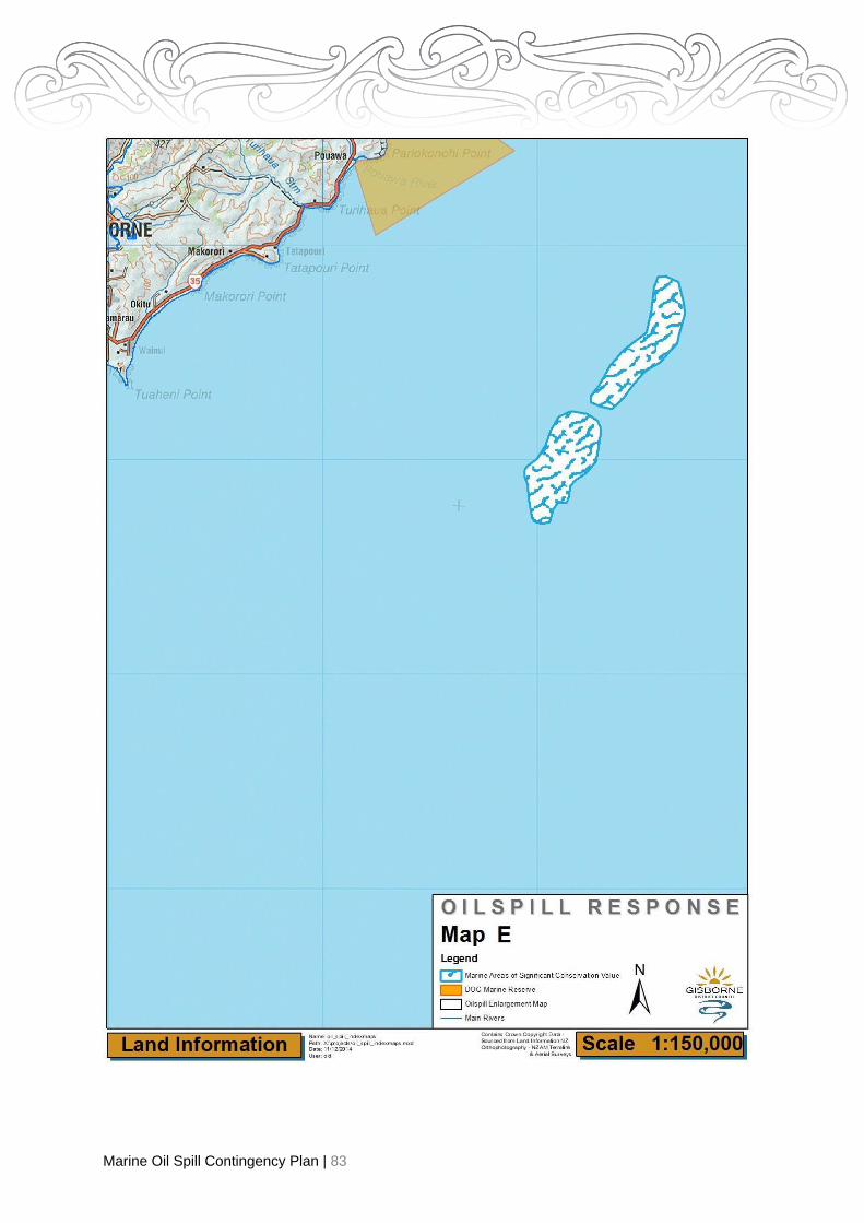
Marine Oil Spill Contingency Plan | 83

Marine Oil Spill Contingency Plan | 84
Map E Ariel Bank Risk rating (1 = high) 1 2 ( 3)
Description
The Ariel Bank is located 8.6 nautical miles east south east of Tatapouri Boat Ramp, which is 10 km north of
Gisborne. The site is one of a small number of, and by far the largest, hard-rock reef systems located in open
water off the Gisborne Coast. It has significant ecological and fauna and flora values and is recognised for the
quality of its underwater scenery.
Foreshore Type Rocky foreshore
Map Sheets Map No BG44
Tairāwhiti RMP - Not Applicable Marine Charts NZ300055
AT RISK RESOURCES
Ecosystems, Flora and Fauna Habitats
An offshore (8.6 nautical miles from Tatapouri) hard rock reef system, which rises from the seabed at 40 metres
to within 7.6 metres of the surface. Located in relatively calm off-shore waters the reef has a reputation of
supporting a diverse and abundant assemblage of benthic and demersal
species, unique to the region, which are yet to be surveyed in detail (Quirke, J., 1993).
Boundary Area of Significant Conservation Value
All that part of the Coastal Marine Area of the Ariel Bank located above the 40 metre depth contour line, as shown
or indicated on NZ Marine Chart NZ55.
Scenic Values
The underwater scenery of the Ariel Reef is reputed to be the best in the Gisborne area. It is equal to the Lottin
Point underwater scenery, which has a nationally significant reputation (Quirke, J., 1993).
Coastal Landforms and Associated Processes
The only significant hard rock reef system off the Gisborne Coast.
Iwi/Hapu Areas
None listed
Local Contacts
Dive Tatapouri Phone: 06 8622890
Access
• Open water access is by boat.
Preferred response options matrix
Most Preferred Least Preferred Feasibility
Containment and recovery √ Med - Low
On water recovery √ Med - Low
Dispersant application √* High - Med
Shoreline clean-up √ Med - Low
Natural recovery √ High - Med
Note*: Oil will pass over the submerged reef with no damage and any dispersant use should be
considered prior to the oil reaching the reef or after the oil has passed over the reef.

Marine Oil Spill Contingency Plan | 85

Marine Oil Spill Contingency Plan | 86
Map F Site 14 Gisborne Port
Description
The Gisborne Port has both large fishing vessels and leisure craft moored inside. This Port also loads our logs
and produce throughout the year.
During the summer months cruise ships also visit but these anchor in the Bay and use tenders to off load
passengers.
Foreshore Type On the east side of the Port is Kaiti Beach which is used for shellfish gathering and
yachting. The beach is coarse sand with a rocky area at low tide.
On the west side is the Turanganui River which leads to the Waimata River and
Taruheru River which flow through town.
There is also a sandy beach
Map Sheets Map No BG43
Tairāwhiti RMP – Map 2A.23
Marine Charts NZ300055, NZ405571 & NZ505571
AT RISK RESOURCES
Marine Mammals and Birds:
NZ fur seals often beach in this area. Hazing, deterring, blockading may be required to prevent seals from being
oiled or entering oiled habitat.
Human safety is the top priority – never send responders into a colony. This requires experienced
and trained personnel.
Ecosystems, Flora and Fauna Habitats
In the inner harbour is a private crayfish hatchery (under and around the port piles). Kaiti Beach is used for
shellfish gathering
Boundary Area of Significant Conservation Value
While a medium sized port there are areas of significant value- Cone of Vision and Cook Monuments.
Iwi/Hapu Site
Ngati Oneone
Chief Executive Chair
Te Runanga-o-Turanganui-a-Kiwa (TROTAK) Rongowhakaata Trust
Phone: (06) 8678109
See Contacts List
Local Contacts
Nick Tupara 027 278 4781 Eastland Port
Phone: 06 986 4800
Rongo Whakata Iwi/Hapu TROTAK
Beach/Port Access
• Areas very accessible by vehicles and boats.

Marine Oil Spill Contingency Plan | 87
Preferred response options matrix
Most Preferred Least Preferred Feasibility
Containment and recovery √ Med - Low
On water recovery √ Med - Low
Dispersant application √* High - Med
Shoreline clean-up √ High
Natural recovery √ High - Med
Note*: For Dispersant use see Appendix 1.
Preferred response options for wildlife
• Birds (identified as nationally endangered, vulnerable or critical or those in serious decline:
- Hazing to prevent oiling
- Pre-emptive capture and release once habitat clean
- If oily then capture and rehabilitation and release
• Seals
- Hazing/deterring or blockading from oily area

Marine Oil Spill Contingency Plan | 88
Map F Site 15 Wherowhero/Waipaoa Estuaries Risk rating (1 = high) (1) 2 3
Description
Located at the south-eastern end of Poverty Bay, the site comprises the estuaries of the Waipaoa River and the
adjacent Wherowhero Stream and associated coastal lagoons. The site has significant ecological, fauna and flora
and wildlife values.
Foreshore Type Sandy lagoon
Map Sheet Map No BG43
Tairāwhiti RMP – Map 2A.24, 25 & 26 Marine Charts NZ300055
AT RISK RESOURCES
Wetland, Estuaries, Coastal Lagoons
The Wherowhero estuary is a 200-hectare coastal lagoon estuary. An associated 30-hectare tidal mudflat occurs
at the mouth of the Waipaoa River. The site is a Priority One (nationally important) Recommended Area for
Protection (RAP) in the Turanga Ecological District Protected Natural Area (PNA) Survey Report. The site
includes the estuarine lagoon and adjacent dune lands and spits. The natural values at the site include the range
of native vegetation types such as Ruppia sp. herbfield, Glasswort herbfield, sea rush tussockland,
Bolboschoenus sp. sedgeland and spinifex grass land: and the wildlife values; Wherowhero Lagoon has a high
SSWI rating for the presence of 34 species of coastal waders, migrating and shorebirds including the endangered
White Heron (Ardea alba modesta) and the threatened Wrybill (Anarhynchus frontalis), Caspian Turn
(Hydroprogne caspia), Banded Dotterel (Charadrius bicinctus bicinctus), NZ Dotterel (Charadrius obscurus). The
Waipaoa River mouth has an SSWI rating of moderate/high (Clarkson, B., 1991).
Marine Mammals and Birds
The Wherowhero Lagoon has a high ranking as a Site of Special Wildlife Interest. Thirty-four species of coastal
waders, migrating birds and shore birds are present including the endangered White Heron (Ardea alba modesta)
and the threatened Wrybill (Anarhynchus frontalis), Caspian Turn (Hydroprogne caspia), Banded Dotterel
(Charadrius bicinctus bicinctus), NZ Dotterel (Charadrius obscurus).
Other uncommon birds include the Golden Plover (Pluvialis fulva), Royal Spoonbill (Platalea regia), Eastern Bar-
tailed Godwit (Limosa lapponica baueri), Red-necked Stint (canutus canutus), and (Clarkson, B., 1991). The
Waipaoa River mouth has an SSWI rating of moderate/high (Clarkson, B., 1991).
One of the most important places on the East Coast where wader bird numbers are constant. Nesting of most of
the waders found in this area occur during October to March.
Ecosystems, Flora and Fauna Habitats
Refer to the information listed under the heading: Wetland, Estuaries and Coastal Lagoons.
Boundary Area of Significant Conservation Value
All that part of the Coastal Marine Area contained by the line of Mean High Water Springs from the mouth of the
Waipaoa River upstream along both banks to the effective Coastal Marine Area Boundary at the Railway Bridge
and all that part of the Coastal Marine Area contained by the line of Mean High Water Springs from the mouth of
the Wherowhero Stream upstream to the effective Coastal Marine Area Boundary.
Iwi/Hapu Areas
Chief Executive Chair
Te Runanga-o-Turanganui-a-Kiwa (TROTAK) Rongowhakaata Trust
Phone: (06) 8678109
Manager
Ngai Tamanuhiri Whanau Whanui Trust
Local Contacts Manager Karaua Station
Phone: (06) 867 5991
See Contacts List
Te Kuri a Paua. Young Nicks Head Station See contacts below
Beach Access
• Off Centennial Marine Drive in several places along the beach out to the river mouth.
• Off Browns Beach Road along the side of the estuary (4WD).

Marine Oil Spill Contingency Plan | 89
Preferred response options matrix
Most Preferred Least Preferred Feasibility
Containment and recovery √ Med - Low
On water recovery √ Med - Low
Dispersant application √* High - Med
Shoreline clean-up √ Med - Low
Natural recovery √ High - Med
Note*: Dispersant use should be considered in advance of the oil reaching the muddy estuary/lagoon
area. See notes on Dispersant Use in Annex 1.
Preferred response options for wildlife
• Birds (identified as nationally endangered, vulnerable or critical or those in serious decline):
- Hazing to prevent oiling
- Pre-emptive capture and release
- If oily then capture, rehabilitate and release
Map F Site 15 Wherowhero – Oil Spill Exercise – 19 March 2013
Summary of wildlife response activities:
A wildlife survey of the Eastern Arm and surrounding area was conducted by Sandy Bull, Darryl Coulter
and Helen McConnell on the morning (0800h – 1100h) of 19 March 2013 as part of the Tier 2 oil spill
exercise run by Gisborne District Council. The survey was conducted by foot and vehicle on a mid-tide
using a spotting scope to increase field of vision and accuracy of species identification. At the conclusion
of the survey the wildlife response team convened with the operations team and exercise managers at
the coastal Murawai operations base to share findings and to highlight priority areas for protection should
oil enter the lagoon from an oil spill in the vicinity.
Survey Results:
Shorebirds use the whole lagoon extensively for foraging in the exposed mudflat as the tide recedes.
Site Priority* Species Approx.
No. Total
Lake, just North of Lagoon 5 Black-backed gulls 40
Lake, just North of Lagoon 5 Black swans 20
Lake, just North of Lagoon 3 Paradise ducks 50
Lake, just North of Lagoon 6 Mallards 10 120
Eastern arm Wherowhero Lagoon 3 Paradise duck 6
Eastern arm Wherowhero Lagoon 5 White-faced heron 25
Eastern arm Wherowhero Lagoon 5 Australasian harrier 2
Eastern arm Wherowhero Lagoon 2A Pied stilt 30
Eastern arm Wherowhero Lagoon 1C Northern NZ dotterel 50
Eastern arm Wherowhero Lagoon 4 Eastern bartailed godwit 50
Eastern arm Wherowhero Lagoon 1C Caspian tern 2
Eastern arm Wherowhero Lagoon 5 Black swan 2

Marine Oil Spill Contingency Plan | 90
Site Priority* Species Approx.
No. Total
Eastern arm Wherowhero Lagoon 2B Variable oyster catcher 15
Eastern arm Wherowhero Lagoon 2A Sth Is pied oyster catcher 12
Eastern arm Wherowhero Lagoon 1C Pied shag 1
Eastern arm Wherowhero Lagoon 5 King fisher 1
Eastern arm Wherowhero Lagoon 2D Little shag 1
Eastern arm Wherowhero Lagoon 2A White-fronted tern 7
Eastern arm Wherowhero Lagoon 5 Welcome swallow 3
Eastern arm Wherowhero Lagoon 6 Skylark 20 227
Lagoon Entrance, exposed coast 2B Variable oyster catcher 10
Lagoon Entrance, exposed coast 2A Sth Is pied oyster catcher 20
Lagoon Entrance, exposed coast 2A White-fronted tern 20
Lagoon Entrance, exposed coast 1C Red-billed gulls 12 62
* As listed in the Gisborne District Oil Spill Contingency Plan, key provided below:
Our survey results identified the following ‘threatened’ and ‘at risk’ species:
THREATENED AT RISK
Northern New Zealand dotterel (1C) Caspian terns (1C)
Pied shag (1C)
Red-billed gulls (1C)
Pied stilt (2A)
White-fronted tern (2A)
South Island pied oyster catcher (2A) Variable oyster
catcher (2B)
The only threatened species known to breed in the vicinity of the lagoon is the Northern NZ dotterel and
its breeding habitat is restricted to the last 500m of the sand spit.
Threatened and at risk species were observed utilising the lagoon entrance and the eastern arm in high
numbers. Habitat characteristics of the eastern arm (i.e. more open vegetation on the high tide line and
more extensive shallow areas) suggest that this area would be a more significant foraging area than the
lagoons western arm.
The Orongo wetland is a significant conservation initiative close to the lagoon with a drain that connects
the two water bodies. It is possible therefore that a spill affecting the lagoon would also have the potential
to impact these wetlands.
Recommendations for protection:
Based on our observations and survey findings we recommend that the following areas be prioritised for
protection should oil threaten the Wherowhero Lagoon:
• The eastern arm of the lagoon (in particular the NZ dotterel breeding habitat), and
• Orongo wetland

Marine Oil Spill Contingency Plan | 91
Map F Site 16 Whareongaonga Risk Rating (1 = High) 1 2 (3)
Description
The Whareongaonga headland is located 12 kilometres south of Poverty Bay. The site has significant coastal
landscape values.
Foreshore Type Rocky beach and cliffs
Map Sheets Map No BH43
Tairāwhiti RMP – Map 2A.27 Marine Chart NZ55
Scenic Values
The Whareongaonga headland, its associated intertidal reef system and the adjacent open water, is a significant
natural feature on the south Gisborne coast and the best representative example of a coastal landscape of its
type in the region (Smale, S., 1993).
Boundary of Area of Significant Conservation Value
All that part of the Coastal Marine Area contained by the line of Mean High Water Springs and occurring within 1
km radius from the seaward end of the Whareongaonga headland at Map Ref. Y19 368.486.
Iwi/Hapu Areas
Chief Executive Manager
Te Runanga-o-Turanganui-a-Kiwa (TROTEK) Ngai Tamanuhiri Whanau Whanui Trust Phone: (06) 8678109
Local Contacts
Manager Manager
Mapere Station Tiritea Station
Phone: (06) 862 9650
Te Kuri a Paua. Young Nicks Head Station See contacts below
Beach Access
• Via farm track/creek bed over Mapere Station (4WD/bulldozer required).
• Possible through Tiritea Station (bulldozer required).
• At the end of Wharekakaho Road down to the old wharf at Whareongaonga (4WD).
Preferred response options matrix
Most Preferred Least Preferred Feasibility
Containment and recovery √ Med - Low
On water recovery √ Med - Low
Dispersant application √ High - Med
Shoreline clean-up √ Med - Low
Natural recovery √ High - Med

Marine Oil Spill Contingency Plan | 92
Areas Not of Significant Conservation Value
Marangairoa
Iwi/Hapu Areas
Chief Executive Spokesperson
Te Runanga-a-Ngati Porou Ngai Ruawaipu iwi Authority
Phone: (06) 864 812
Beach Access
• Several places along East Cape Road. Possible access off the road over the dunes (4WD) in most
places along the East Cape Road.
Local Contacts
Toetoe Station Manager
C/- Dewes Road Parera Station East Cape
Phone: (06) 864 4751
Port Awanui
Iwi/Hapu Areas
Chief Executive Spokesperson
Te Runanga-a-Ngati Porou Ngai Ruawaipu iwi Authority
Phone: (06) 864 8121
Spokesperson
Ngati Uepohatu Iwi Authority
Beach Access
• Port Awanui at the end of Awanui Road. Due to the nature of the road itself (washout prone)
bulldozer is required.
• Via farm track over Kouka Stream.
• Off Reporua Road at the Reporua church.
Local Contacts
Manager Manager
Kouka Station Tuimata Station

Marine Oil Spill Contingency Plan | 93
Tuparoa
Iwi/Hapu Area
Chief Executive Spokesperson
Te Runanga-a-Ngati Porou Ngai Ruawaipu Iwi Authority
Phone: (06) 864 8121
Spokesperson
Ngati Uepohatu Iwi Authority
Beach Access
• At the end of Tuparoa Road, it is also possible to get onto the beach with 4WD in most places
along the beachfront.
Local Contact
Manager Tawai Station
Phone: (06) 864 0380
Whareponga
Iwi/Hapu Areas
Chief Executive Spokesperson
Te Runanga-a-Ngati Porou Ngai Ruawaipu iwi Authority
Phone: (06) 864 8121
Spokesperson
Ngati Uepohatu Iwi Authority
Beach Access
• 4WD at the end of Whareponga Road at the boat landing.
Local Contact
Manager Koura Station
Phone: (06) 86 86464
Waipiro Bay
Iwi/Hapu Areas
Chief Executive Spokesperson
Te Runanga-a-Ngati Porou Ngati Uepohatu Iwi Authority
Phone: (06) 864 8121
Spokesperson
Te Aitanga-a-Hauiti Iwi authority
Beach Access
• McIlroy Road.
• Two places at the end of Marae Road (from here it is possible to drive the length of the beach).
• Several places along Waikawa Road.
Marine Oil Spill Contingency Plan | 94
Mawhai Point
Iwi/Hapu Areas
Chief Executive Spokesperson
Te Runanga-a-Ngati Porou Te Aitanga-a-Hauiti Iwi Authority
Phone: (06) 864 8121
Beach Access
• Via farm track over Nuhiti Station (4WD required).
Local Contact
Manager Nuhiti Station
Phone: (06) 862 6308
Kaiaua
Iwi/Hapu Areas
Chief Executive Spokesperson
Te Runanga-a-Ngati Porou Te Aitanga-a-Hauiti Iwi Authority
Phone: (06) 864 812
Beach Access
• Via farm track over Kaiaua Station to Marau Point.
Local Contacts
Manager Manager
Anaura Station Kaiaua Station
Phone: (06) 862 6370
Manager Kapuni Station
Phone:
Loisels
Iwi/Hapu Area
Chief Executive Spokesperson
Te Runanga-a-Ngati Porou Te Aitanga-a-Hauiti Iwi Authority
Phone: (06) 864 8121
Spokeperson
Paikea-Whitireia Iwi Authority
Beach Access
• Over Raroa Station down a bulldozed track which mirrors the Old Coach Road (Shelton Road).
• At Loisels Beach, at the end of Waihau Road. It is possible to drive along the beach from this point
in both directions for some distance.
Local Contacts
Manager Manager
Titirangi Station (managed with Iwanui Station) Waihau Stations
Phone: Phone: (06) 86 26810 Phone: (06) 862 2668

Marine Oil Spill Contingency Plan | 95
Pakarae
Iwi/Hapu Area
Chief Executive Spokesperson
Te Runanga-a-Ngati Porou Te Aitanga-a-Hauiti Iwi Authority
Phone: (06) 864 8121
Contact Pakarae Station Manager for access Spokeperson
Paikea-Whitireia Iwi Authority
Beach Access
• There is possible access in only one place along Pakarae (not shown).
• Pakarae Station is very reluctant to allow access (bulldozer required).
Local Contact
Manager Puatai Station
Phone: (06) 862 2712
Whangara
Iwi/Hapu Area
Chair Chair
Te Aitanga-a-Mahaki Trust Rongowhakaata Trust
Spokesperson Spokeperson
Te Aitanga-a-Hauiti Iwi Authority Paikea- Whitireia Iwi Authority
Phone: (06) 867 7163 Phone: (07) 343 7333
Chief Executive
Te Runanga-a-Ngati Porou Phone: (06) 864 8121
Beach Access
• End of Pa Road although 4WD access would be possible in most places along the beach.
• By the Marae at the end of the Road.
Local Contact
Manager - Whangara B5 Station
Pouawa
Iwi/Hapu Area
Chair Chair
Te Aitanga-a-Mahaki Trust Rongowhakaata Trust
Spokesperson Spokesperson
Te Runanga-o-Ngati Oneone Te Aitanga-a-Hauiti Iwi Authority
Spokeperson Chief Executive
Paikea-Whitireia Iwi Authority Te Runanga-a-Ngati Porou Phone: (06) 864 812
Beach Access
• Off SH35 onto the beach via access ways. Although access is possible at most places along the
coast (4WD) over the sand dunes.
Local Contact
Manager Whitiwhiti Station
Phone: (06) 862 2037

Marine Oil Spill Contingency Plan | 96
Wainui
Iwi/Hapu Area
Chair Chair
Te Aitanga-a-Mahaki Trust Rongowhakaata Trust
Spokesperson Spokesperson
Te Runanga-o-Ngati Oneone Te Aitanga-a-Hauiti Iwi Authority
Chief Executive
Te Runanga-a-Ngati Porou Phone: (06) 864 8121
Beach Access
• Off SH35 at the Tatapouri boat ramp and by the old Tatapouri Hotel.
• Access is possible in most places along Makorori Beach Road and SH35 to Makorori point with
4WD.
• Off SH35 opposite Sirrah Street (4WD required).
• Off SH35 at the Wainui Surf Club boat ramp.
• Off Wairere Road, not far from Oneroa Road.
• At the end of Pare Street.
Local Contact
None listed.
Gisborne
Iwi/Hapu Area
Chief Executive Manager
Te Runanga-o-Turanganui-a-Kiwa Ngai Tamanuhiri Whanau Whanui Trust
Phone: (06) 867 8109
Chair Chair
Te Aitanga-a-Mahaki Trust Rongowhakaata Trust
Spokesperson Spokesperson
Te Runanga-o-Ngati Oneone Te Aitanga-a-Hauiti Iwi Authority
Chief Executive
Te Runanga-a-Ngati Porou Phone: (06) 864 8121
Lighthouse on Tuaheni Point – Historic Site
Uruhangenge Pa site (Tuamoto Island) occupied in 1769 during Cooks arrival to Poverty Bay.
Beach Access
• Off Kaiti Beach Road at the Yacht Club and the end of the road.
• To Waikanae Beach possible in two places through Waikanae Motor Camp.
• Off Centennial Marine Drive at various places along the beach.
• Beach access is possible in most other places between Waikanae Beach and the Waipaoa River
mouth, over the sand dunes (4WD or bulldozer required, as there are 2-8 foot drop offs in places).
Local Contact
None listed.

Marine Oil Spill Contingency Plan | 97
Young Nicks Head
Iwi/Hapu Area
Chief Executive Manager
Te Runanga-o-Turanganui-a-Kiwa Ngai Tamanuhiri Whanau Whanui Trust
Phone: (06) 867 8109 Phone: (06) 862 8083
Beach Access
• At the end of Muriwai Beach Road down to the southern end of Wherowhero Lagoon (4WD if wet).
• Via farm tracks over Nicks Head Station.
• Via farm track over “Highgate”.
• Via farm track over Mapere Station.
Local Contact
Manager Manager
Nicks Head Station “Highgate”
Phone: (06) 862 8642 Phone: (06) 862 8435
Waiparapara
Iwi/Hapu Area
Chief Executive Manager
Te Runanga-o-Turanganui-a-Kiwa Ngai Tamanuhiri Whanau Whanui Trust
Beach Access
• Due to the rugged terrain and coast cliffs Whareongaonga is the most southern access point in the
district. The next access point would be Happy Jacks Boat Harbour (Hawke’s Bay boundary).
Local Contact
Whareongaonga Block
Phone: (06) 867 9431
Paritu
Iwi/Hapu Area
Chief Executive Manager
Te Runanga-o-Turanganui-a-Kiwa Ngai Tamanuhiri Whanau Whanui Trust
Phone: (06) 867 8109
Beach Access
• Due to the rugged terrain and coast cliffs Whareongaonga is the most southern access point in the
district. The next access point would be Happy Jacks Boat Harbour (Hawke’s Bay boundary).
Local Contact
None Listed

Marine Oil Spill Contingency Plan | 98
Annex 5 – Prediction of Oil Movement and Behaviour
Oil Spill Risk
Overview of Spill Risk
Vessels holding up to 40,000 tonnes of light or heavy fuel oil travel around the east coast of the North
Island within or close to the 12 mile limit. The average quantity of heavy fuel oil is 7,500 tonnes. Vessels
holding up to 2,000 tonnes of heavy, medium or intermediate fuel oil call into Port of Gisborne. Up to
2,000 tonnes diesel and 4 tonnes oil may also be carried.
The most likely sites for some or all of this oil to be discharged to the marine environment are:
• East Cape
• Aerial Reef
• Port Gisborne
Bunkering and Bulk Transfer Risk
The following description of oil transfer sites, transfer types, oil type, and flow rates outline the bunkering
and bulk transfer risk within the region.
Location Transfer Type Oil Type Flow Rate 1
Port of Gisborne Motorised mobile diesel pump on
tandem trailer
Diesel (AGO) 1000 litres/minute
Port of Gisborne Mobile tanker truck to ship Diesel (AGO) 180-200 litres/minute
Shipping Routes
Maritime NZ has initiated a voluntary navigation guideline, recommending that ships stay at least five
nautical miles away from any coastline. This guideline is targeted towards vessels laden with oil or other
harmful substances carried in bulk coastal tankers and New Zealand ships. Ships pose a threat of oil spill
with low probability of occurrence but high potential effects on the environment.
Oil Movement
Oil moves at approximately 100% of surface current and 3% of wind speed.
Winds blow from the specified direction, whereas currents flow towards the specified direction. This
calculation will not predict the movement of emulsified slicks (mousse).
The ADIOS computer program can be used to predict the changes in physical and chemical
characteristics of the slick over time. Hence, it may be used to predict when mousse formation may occur.
ADIOS can be accessed via the internet or the OSDO at any time.
MNZ also have the oil spill trajectory modelling program OILMAP. This is available to assist with trajectory
modelling and can be requested through the OSDO.
1 Developed by Department of Conservation staff Andy Bassett in consultation with Sandy Bull. It is derived from the Malloy Davis
Category (A, B, C, O) 1994, but has been adjusted for regional variation and to take into account that this Appendix is specific to oil
spills.

Marine Oil Spill Contingency Plan | 99
Tides and Currents
The following pages contain references to:
• Tide Tables outlining times and heights of high and low waters in Gisborne, Wellington and
Auckland;
• Offshore Tidal Streams (currents) maps.
• Online Marine (Vector) Charts – Note: For navigation purposes use corrected Hydrographic
Charts for the area of passage.
The Wellington and Auckland tidal information may be used to determine the direction of Gisborne’s
offshore currents. Also, the Hydrographic Charts of the region provide some information with respect to
currents.
Numerical modelling work undertaken for the Port Gisborne expansion indicates that the currents within
Poverty Bay are complex and vary over time.
For Eastland Port arrivals and departures click here.
Tidal currents are minor because the dominant north moving continental shelf current refracts into the
Bay with no significant phase lag across the entrance (which would drive currents around the Bay).
Surface currents in the Bay are predominantly influenced by:
• Strong inner continental shelf currents. Southbound inner shelf currents tend to drive eddies in a
clockwise direction. Whilst Northbound inner shelf currents tend to drive eddies in an anti-
clockwise direction; and
• Plumes from the Waipaoa and Turanganui River. However, the plume movement is variable and
fluctuates with river flows. The Waipaoa plume has a dominant effect on surface currents,
particularly during high flows.
Given the limited data about surface currents, their complex nature, and the way that they vary over time,
emphasis will be placed on monitoring the fate of an oil spill at all times.

Marine Oil Spill Contingency Plan | 100
Water Temperature
Water temperatures range from 12-21 degrees centigrade.
• Summer is 15-21,
• Autumn and spring 13-19 and
• Winter 12-13 degrees.
Weather Forecasts
Previous, present and predicted weather information for the region can be obtained from: Marine
Forecaster, Meteorological Office 04 470 0700 (8.30am – 5.00 pm)
(Or by automatic transfer outside working hours to the marine forecasting desk)
Lead forecaster 04 470 0794 (9.00pm – 6.00 am)
Public Forecast (24 hours) 04 496 9380
Website www.metservice.com
Sea Surface Temperatures
Sea surface information is available on-line, or by contacting the Met Service Office on numbers above.
Tide Charts
Note: Detailed information is provided in the NZ Nautical Almanac held in the “CDEM Emergency Plans,
MOS Plans and ECC Setup Plans bookshelf” in the CDEM office or online via the attached links.

Marine Oil Spill Contingency Plan | 101
Annex 6 – Memoranda of Understanding
Responsibilities
The overall responsibility for incidents that occur within the water areas controlled by the Regional
Council are the responsibility of that organization. However, other organisations may become involved in
such incidents if the material causing the problem comes within that organizations particular field.
The Police are responsible for co-ordination of non-fire emergencies, but the Fire & Emergency New
Zealand (FENZ) usually continues to handle and stabilize the incident under the overall guidance of the
Hazardous Substances Technical Liaison Committee (HSTLC).
Fire & Emergency New Zealand (FENZ)
FENZ has a responsibility under the Fire and Emergency Act 2017 under Part 1, Functions, s.12 (3)(b) of
responding to maritime incidents. There is also a responsibility under Part 1 Functions, s.12f & g to
respond to incidents in which a substance, hazardous or otherwise, presents a risk to people, property, or
the environment. This provides a mandate for FENZ to respond to marine oil spill incidents, particularly
around immediate and significant risks to people, property and/or the environment. While the Maritime
Transport Act specifically provides authorities and powers related to marine oil spills to the Regional On-
Scene Commander at the regional (Tier 2) level, the provisions of the Fire & Emergency Act provide a
mandate for a multi-agency approach to leadership, safety and effective response to marine oil spills. A
spill of volatile hydrocarbons as a result of a fire, either terrestrial or marine, provides an example of an
incident were the ROSC and the FENZ Incident Controller need to work closely together. Combined
FENZ-Regional Council oil spill exercises can provide opportunities to apply combined response
procedures and resources, as well as to better define organisational responsibilities and incident
leadership.
FENZ Contacts
Telephone 111 Emergency. Otherwise (06) 867 9039 Gisborne Fire Station.
General Procedures
• As with all calls to assist the public, if the FENZ receives a call to a substantial spill then a
normal response will occur.
• If upon arrival it is considered that life and/or property is at risk, then the responding appliances
are to stabilize the situation (if possible) and carry out the actions for a hazardous spillage.
• Contact is to be made immediately with the Gisborne District Council on the 24/7 emergency
number 0800 653 800
• FENZ’s actions will be such to ensure that the situation is stabilized and to that end will handle
the incident under the guidance of the Hazardous Substances Tactical Liaison Committee
(HSTLC).
Marine Oil Spill Contingency Plan | 102
Environmental considerations
The fact that a substance presents an environmental or other hazard will have to be determined by the
Officer of the first arriving appliance. However, to avoid any conflict of interest, a Senior Officer of FENZ
will respond to such incidents and if necessary, make the decision as to whether FENZ becomes involved
or not. It should be fully appreciated that FENZ equipment and training are such that assistance could
result in a substantial reduction in clean-up costs which could occur if a time delay in the response of
other organizations did occur.
Pollution response procedure (Environmental Hazard)
All requests for assistance would be actuated via the Gisborne District Council which will serve as the
initial communications centre for any pollution incident. All reports of a spill to this 24/7 emergency
number 0800 653 800. If there is an immediate risk to human health and safety from fire or explosion call
111.
FENZ will determine what response is appropriate based on an assessment of the incident.
If the substance is considered hazardous i.e. chemical etc., then the following procedure is to be followed:
• Gisborne District Council personnel are to be contacted via the spill phone and arrangements
made for suitable equipment procurement and transport to the pollution area.
• Before any assistance is given, authorization is to be received from the Regional On Scene
Commander. Note that the use of MNZ spill equipment for purposes other than marine oil spill
response will require prior approval from MNZ via the Oil Spill Duty Officer phone number (04
473 6368)
Police
The Police are responsible for co-ordination of non-fire emergencies, but FENZ usually continues to
handle and stabilize the incident under the overall guidance of the HSTLC.
Telephone 111 Emergency (happening now). For all other enquires related to incidents that are not
happening now phone 105. Note all Police calls are directed to the National Call Centre.
Oil transfer sites spill response (Tier 1)
Oil Transfer Sites (OTS) are required under S.130B of the Marine Protection Rules to have a Marine Oil
Transfer Site Marine Oil Spill Response Contingency Plan. Plans should specify controls, procedures and
spill equipment to provide a credible first strike capability to contain the reasonably foreseeable spill
volume that the plan predicts. Where a spill exceeds the capabilities of the OTS the ROSC may declare a
Regional (Tier 2) Response (or the National On- Scene Commander may declare a National (Tier 3)
Response). In either case the spiller is required to provide assistance to the response in accordance with
the procedures and equipment detailed in their OTS spill plan and as directed by the ROSC or NOSC.
All marine spills that occur in the Gisborne region as part of a marine oil transfer operation must be
immediately reported to the Gisborne District Council in accordance with spill plan procedures. For copies
of OTS plans refer to Web EoC.

Marine Oil Spill Contingency Plan | 103
Oil Spill Reported/Discovered
• Telephone Gisborne District Council - (06) 867 2049 or 027 6527919 Pollution Incidents Officer;
and
• Investigate;
No Clean Up Required
• Stand down; and
• Inform Gisborne District Council.
Clean Up Required (Tier 1 Response)
• Inform Eastland Port Limited; and
• Commence clean-up operations in accordance with Tier 1 Plan; and
• Keep the Regional OSC updated with respect to how the response is proceeding.
Clean Up Required (Tier 2 Response)
• Inform Eastland Port Limited; and
• Commence clean-up operations in accordance with Tier 1 Plan until the Regional OSC declares
a Tier 2 response and issues instructions to the contrary in accordance with the Tier 2
Response Action Plan.
Eastland Port Limited
Eastland Port Ltd has limited resources that it may offer to GDC during an oil spill response. The
personnel and equipment that operate on the EPL property are a mixture of employees, contractors and
private companies.
Hence, EPL role with respect to marine oil spills is focused on promoting prevention of oil spills providing
facilities, advice and resources when requested. In the event that a spill is discovered, EPL will contact
GDC immediately.
The Maritime Operations Manager will coordinate the Company’s activities. Telephone (06) 868 5129.
Use of Eastland Port Ltd Vessels
If vessels are required, it will be the responsibility of the Marine Operations Manager and / or the Duty
Pilot to arrange for the allocation, crewing and control of such vessel(s).
Eastland Port Ltd Staff Welfare
It will be the responsibility of the Marine Operations Manager to ensure that Port staff engaged in clean-
up operation on behalf of the Gisborne District Council are relieved and catered for when and as required.
Recovery of Costs
The Gisborne District Council will assist in collating documentation required when Port company staff
and/or equipment are employed in a pollution incident.
All activities undertaken by Eastland Port Ltd will be authenticated by appropriate documentation to
enable recovery of clean-up costs from the spiller and if that is unsuccessful, from the Maritime NZ.

Marine Oil Spill Contingency Plan | 104
Ministry of Primary Industries (MPI)
There are several areas in which MPI resources and expertise might be best utilized. These are:
• Helping out with advice on the possible immediate and long-term effects that pollutants and
dispersants may have on fish and shellfish stocks.
• Identification of polluted shellfish and fish specimens.
• Making available MPI vessels for pollution control and marine life rescue in the event of a large
spill.
• Providing labour and resources e.g. vehicles.
Toxic Effects of Pollutants on Fish / Shellfish
MPI will endeavour to offer advice on the possible immediate and long term effects that pollutants and
dispersants may have on fish and shellfish stock.
Contact (06) 868 7160.
Identification of Polluted Shellfish and Fish Specimens
Contact MPI (06) 869 0870
Loan of Vessels
MPI may be able to make their vessels available for pollution control or marine life rescue. All the vessels
are well equipped and maintained. These vessels are:
• Te Haeata, 7.5 metre Niad – permanently located in Gisborne – Hydraulic lifting davit on- board.
• Other various small craft including small inflatables that may be able to be sourced from other
nearby MPI offices (Whakatane and Tauranga).
• Contact with local fishermen who could provide almost any vessel on relatively short notice.
Department of Conservation
DoC has offered to provide their services in the event of a major marine oil spill. These services could
include:
• Advice on wildlife habits and habitats.
• Advice on sensitive areas and areas of special value.
• On-the-spot reports from rangers in the field.
• Logistic support including vessels, communications, facilities etc.
• Specific personnel assigned to Council for EOC in a Tier 2 response.
• Access to skilled and semi-skilled labour, both DoC and volunteer.
• Wildlife response operations assistance in accordance with Annex 2. Telephone hotline 0800
362 468 (0800 DOC HOT).
Volunteer Coastguard
The Volunteer Coastguard will assist (where possible) the Gisborne District Council on request with
personnel and/or equipment including the EOC during a marine oil spill response.
Telephone (06) 867 1027.

Marine Oil Spill Contingency Plan | 105
Hawkes Bay Regional Council
• It is recognised that for the purpose of effective marine oil spill response (and due to the erratic
nature of marine oil spills in the environment) a co-operative approach between neighbouring
Regional Councils is essential.
• Should a spill cross the boundary between the Gisborne and the Hawkes Bay districts that the
response action will usually be governed and controlled by the Regional OSC in the territory in
which any spill response originated.
• It is agreed that in an unlikely event that Gisborne District Council staff are unable to adequately
respond to an event, Hawkes Bay Regional Council will provide trained staff to assist, as far as
they are able.
• Associated costs will be met by Gisborne District Council subject to prior approval by the
Regional OSC.
• In order to ensure that skills and experiences are shared (and to familiarise the key staff in
cross-boundary operations and issues), Hawkes Bay Regional Council staff will be invited to
participate in training and exercises conducted by the Gisborne District Council.
• It will be the responsibility of the Gisborne District Council and the Hawkes Bay Regional
Council to ensure that their respective staff are appropriately trained and approved by the
Maritime NZ.
• Telephone Hawkes Bay Regional Council (06) 835 9200 (24/7) or Ian Lilburn 027 4838 754.
Bay of Plenty Regional Council
• It is recognised that for the purpose of effective marine oil spill response (and due to the erratic
nature of marine oil spills in the environment) a co-operative approach between neighbouring
Regional Councils is essential.
• Should a spill cross the boundary between the Gisborne and Bay of Plenty Regional Council
districts that the response action will usually be governed and controlled by the Regional OSC in
the territory in which any spill response originated.
• It is agreed that in an unlikely event that Gisborne District Council staff are unable to adequately
respond to an event, Bay of Plenty Regional Council will provide trained staff to assist, as far as
they are able.
• Associated costs will be met by Gisborne District Council subject to prior approval by the
Regional OSC.
• In order to ensure that skills and experiences are shared (and to familiarise the key staff in
cross-boundary operations and issues), Bay of Plenty Regional Council staff will be invited to
participate in training and exercises conducted by the Gisborne District Council.
• It will be the responsibility of the Gisborne District Council and the Bay of Plenty Council to
ensure that their respective staff are appropriately trained and approved by the Maritime NZ.
• Telephone ROSC Adrian Heays 027 2895020 or 0800 884 883 and ask to speak to the Duty
ROSC.
General
Indemnity Authorisation and Costs
If any organization becomes involved in a Tier 2 response, then as soon as is practicable, a contract to
assist in the response and claim costs is to be signed by the Regional on Scene Commander.

Marine Oil Spill Contingency Plan | 106
Annex 7 – Administration
Estimate of Response Costs
MONITORING (Including sampling)
Personnel hrs @ Amount
Sample analysis hrs @
Launch hire hrs @
Aircraft hire hrs @
CLEAN UP SEA
Labour hrs @
Supervision hrs @
Aircraft hire hrs @
Tug hire hrs @
Launch hire hrs @
Dispersant ltr @
Absorbent booms mtr @
FORESHORE
Labour hrs @
Supervision hrs @
Degreaser ltr @
Absorbents hrs @
Plant hrs @
DISPOSAL
Labour hrs @
Truck hrs @
Dump Fee hrs @

Marine Oil Spill Contingency Plan | 107
EQUIPMENT CLEAN/REPACK
Labour hrs @
Degreasant ltr @
Materials
Vehicles per/km@
EOC per/day
Incidentals per/item
MNZ Equipment charge-out and standby rates
See: Web EoC-NRT Portal-Operations-Dropdown Menu-Operations-MPRS Equipment-MPRS Equipment
Tab-Select Equipment to see standby and in use rates
MNZ Item 1
MNZ Item 2
MNZ Item 3
MNZ Item 4
MNZ Item 5
MNZ Item 6
MNZ Item 7
MNZ Item 8
GST
TOTAL

Marine Oil Spill Contingency Plan | 108
Pollution Incident Service Orders
This form will act as a trigger for support organisations to become involved in a response operation.
(Support organisations to complete along with green or yellow forms.)
On Scene Commander to give support to the organisation when request for assistance is made.
Return to:
Gisborne District Council
Telephone: (06) 867 2049 (24 hours)
Fax: (06) 867b 8076
Pollution Incident Charge Out Sheet
(Please fill out the attached Green or Yellow forms depending on how soon payment is required)
Pollution Incident No: Date:
Work undertaken by:
Postal Address:
Called by: Time:
Details of Account (itemise)
Note re Insurance: Responders or their parent organisations are expected to arrange suitable insurance
for the response operation.

Marine Oil Spill Contingency Plan | 109
Indicative Costs Equipment and Labour
Floating Plant
Tug (including crew) per hour
Pilot Boat (including crew) per hour
Survey Boat (including crew) per hour
Shore Plant
Forklift 2.5 - 3t = (dry hire) per hour
Forklift 4.5t (dry hire) per hour
Truck (6 wheeler, including driver) per hour
Labour
All Response Staff per hour $100.00
Aircraft
Grumman 2 per hour
Cessna 3 per hour
Piper Seneca 4 (x2) per hour
Absorbents
Matasorb M55 per boom $72.45
Pads per bale (100) $224.45
Dump Fees
Oily Waste per tonne
Note The above costs are indicative figures only to assist in estimating costs for guarantee from spiller.

Marine Oil Spill Contingency Plan | 110
Message Form
MOS MESSAGE FORM
Time Date Month Year Ref. No:
Received / To Send
To: Telephone
From: Fax / Email
Organisation / Address: Radio
Contact No. Other:
Message: Distribution:
Action Info
Ops
Plan
Logs
H&S
Media
ROSC
Signed: Designation;
To be filled in by the Recipient
Action Taken:
Signed: Designation:
Transmission Instructions: Transmitted:
Action Lodged:

Marine Oil Spill Contingency Plan | 111
CELL:
Date: Sheet No:
SERIAL TIME TO FROM EVENT ACTION
Document Control and Plan Maintenance
The Regional Marine Oil Spill Contingency Plan is a controlled document. Official copies of the Plan will
be issued to holders of the roles listed in the Plan Distribution List.
The Plan is dynamic and will be updated as often as necessary to improve and enhance response
capabilities.
This document can only be changed by the ROSC.
Policy changes however will also require Chief Executive or Council approval.
Updates
Updates will be issued electronically and on an “as required” basis and will be accompanied by an Update
Summary which should be filed after Table C in this Annex. It shows the most up to date version of each
section on issue and can be used for checking purposes.
Document Control
The register of controlled copies will be maintained by the ROSC.

Marine Oil Spill Contingency Plan | 112
Uncontrolled Copies
Uncontrolled copies will be available to any person/organisation on a reasonable request basis. There
may be a charge for this.
To avoid confusion, all blank pages required for copying purposes will be clearly identified with the words
‘this page intentionally left blank.’
Exercising and Plan Review
The Plan will be exercised in accordance with Part 130C Marine Protection Rules which states that the
Plan shall be regularly tested in accordance with an exercise programme approved by the Director for
each year.
Regional Council Guidelines – Regional Exercise Programme
Plan Review
This Marine Oil Spill Contingency Plan must be reviewed after the following circumstances arise: After
three years has elapsed, unless a review is called earlier due to:
• The Plan being used in a response to a region spill.
• The ROSC or the Director determine that a review is necessary (e.g. after an exercise).
It will also be checked every 12 months and updated as necessary to address currency and
completeness of the information contained in it.
Any proposed amendments to increase the effectiveness of the Plan shall be submitted by the Council as
soon as practicable for approval under Section 293(2) of the MTA.
As this Plan is a controlled document, all reviews and significant amendments to this Plan must be
approved by Maritime NZ following consultation with the ROSC. Any updates and new material for
inclusion in the Plan will be forwarded to the “Controlled Plan” holders who must insert the updates and
file the update letter at the rear of the Plan.
NB: Any recommendations for amendments should be forwarded to the Regional on Scene
Commander Gisborne District Council, PO Box 747, Gisborne; telephone 06 867 2049.
All organisations named in this Plan are asked to notify the ROSC when their nominated personnel, or
their contact details, change.
Training
The ROSC shall ensure that personnel identified in this Plan are appropriately trained and familiar with
their duties. MNZ will conduct training in accordance with the latest training schedule which is maintained
on the Maritime NZ website WebEOC along with details of the courses.
The ROSC shall liaise with Maritime NZ to determine the appropriate level of training, including refresher
courses as required.
Accurate details of training provided shall be kept as outlined above. Regional Council Guidelines –
Training
Annual Budget
The Annual Plan will outline the annual budget in terms of exercising, training, purchase of equipment
and maintenance costs necessary to adequately respond to an oil spill.
As these costs are to be paid by Maritime NZ, they will be approved by Maritime NZ prior to publication in
the Annual Plan.

Marine Oil Spill Contingency Plan | 113
Hard Copy Circulation List
No. Holder Hardcopy Web
1 Maritime NZ √
2 Maritime NZ √
3 GDC Central File √
4 Harbourmaster/Principle ROSC √
5 ROSC 2 √
6 Wildlife Co-ordinator √
7 Eastland Port Limited Manager √
8 6 Copies for the EoC √
EOC Container
8 EOC Manager √
9 Community and Media Liaison Team Box √
10 Health and Safety Advisor* √
11 Operations Manager* √
12 Operations Team √
13 Planning Manager* √
14 Planning Team √
15 Logistics Manager √
16 Logistics Team √
GDC Website GDC Website
Department of Conservation √
Ministry of Fisheries √
Fire and Emergency NZ √
WebEOC WebEOC
Maritime NZ √
Massey University, (NOWRT) √
HBRC ROSC √
BOPRC ROSC √

Marine Oil Spill Contingency Plan | 114
GISBORNE MARINE OIL SPILL CONTINGENCY PLAN
CONTROLLED COPY REGISTRATION
Please sign both copies of this registration form, retain one copy with your copy of the
Plan and return the other to:
EMERGENCY MANAGEMENT SUPPORT
OFFICER GISBORNE DISTRICT COUNCIL
P O BOX 747
GISBORNE
4040
Table A
ISSUED ON: COPY NUMBER
ISSUED TO:
IN HIS/HER CAPACITY AS:
In accepting this copy of the Gisborne Marine Oil Spill Contingency Plan, the holder agrees to maintain it
in a state fit for use. The holder further undertakes to incorporate any and all updates as soon as they are
issued and to advise the Emergency Management Support Officer should the ownership of this copy be
transferred to another named individual.
Signature:
Date:
ORGANISATION:
POSTAL ADDRESS:
TELEPHONE:

Marine Oil Spill Contingency Plan | 115
Please sign both copies of this registration form, retain one copy with your copy of the
Plan and return the other to:
EMERGENCY MANAGEMENT SUPPORT
OFFICER GISBORNE DISTRICT COUNCIL
P O BOX 747
GISBORNE
Table B
All New / Replacement Pages are Marked - Issue
Section Replace Pages With Pages Section Replace Pages With Pages
Issued On:
Issued To:
In his / her capacity as:
I hereby acknowledge receipt of Update # to the Gisborne District Marine Oil Spill Contingency
Plan and confirm that I have updated my copy of the Plan accordingly.
Signature:
Date:
Organisation:
Postal Address:
Telephone:
GISBORNE MARINE OIL SPILL CONTINGENCY PLAN
UPDATE #
Copy Number:

Marine Oil Spill Contingency Plan | 116
Annex 8 - site specific response options
Explanation
The following Standard Operating Procedures (SOPs) and the Example Incident Action Plans (IAPs) are
provided to help guide an effective and rapid response to a range of common spill scenarios. They are
not definitive nor are they the only options. They are to be used more as a prompt for Operations whilst
the Incident Action Plan continues to develop and the planning cycle (Planning P) that will direct the
incident becomes established. Other useful supporting documents with checklists for response can be
found in Web EoC at: Gisborne – Drop-down list – Library – Aide Memoirs
Initial spill assessment – information required
What is it?
Is it a verified oil spill? What kind of oil is it? Is the oil persistent in the marine environment? Is it a light oil
(petrol, diesel); a medium oil (lube, hydraulic) or a heavy (IFO, HFO) oil? Or is it a mixture of oils? The
type of oil will help determine the response options available. Can an estimate of the volume/extent of the
spill be made? How much oil is there? If such key information such as the location, extent and
appearance of the oil can be gathered then oil spill modelling can be used to estimate the volume of oil
and the likely oil spill trajectory over time. For this service contact the Oil Spill Duty Officer (04 4736369
24/7) at the Marine Pollution Response Service (MPRS).
Where is it now?
Is the location of the spill verified?
Where is it going (and when will it get there)?
This will determine where to deploy to contain and collect oil. Tide, current and wind will all influence oil
movement.
What is in the way?
Check the GDC Regional Oil Spill Response Plan for sensitive site information. This will help prioritise
relevant response actions and sensitive sites for protection.
What will it be like when it gets there?
Oil on the water is constantly changing by processes of evaporation, emulsification, dissolution and
dispersion. Over the course of a response samples of the oil should be collected for analysis. This may
be useful for enforcement, to understand the changing nature of the oil and to assess for contaminants
(strong acids/alkalis/biological contaminants) that may pose risks to spill responders.
Who will be notified/affected by the spill?
The list of individuals, groups and organisations that may be impacted by an oil spill may be large and
diverse. It may for example include Hauora Tairāwhiti Public Health where there are concerns that
shellfish beds could become contaminated by oil and unsafe to eat. There may be groups planning public
events that are impacted, organisations concerned about wildlife impacts and animal health. Intelligence
and the PIM may be tasked with identifying those parties needing to be contacted during a response.

Marine Oil Spill Contingency Plan | 117
Observation Flight Required?
Aerial observation of a reported oil spill is often the most efficient and fastest way to accurately assess an
oil spill and help answer the questions above. Response staff undertaking aerial assessments should
take with them cameras and video equipment, GPS and binoculars to collect and use this equipment to
collect relevant information. Useful aerial observation training materials may be viewed here.
Initial Actions - Checklist
Once the spill is verified and the decision is made to respond the following initial actions can occur:
ROSC declares the spill to RCCNZ
An appropriate site safety plan and/or Job Safety Analysis is undertaken for each operation*
A system for equipment dispatch and demobilisation is established*
An initial action plan (this may be verbal in the initial stages) has identified appropriate actions
and equipment to be deployed
An appropriate forward staging area is identified and clear transport instructions are
communicated to delivery drivers
Decontamination and waste procedures are established on site*
An oily waste management and disposal plan is place
(* Indicates that an expanded SOP is further provided below)
Site Safety Plans - Checklist
The site is made secure and safe using barrier tape and/or cones and/or security staff where
necessary
Each site should have a controlled entry point where staff are:
Signed into the site
Required PPE is inspected/provided and recorded
Provided with an appropriate site/task induction. This may include information about any
special cultural or ecological information or any particular hazards at the location
Staff are assigned to a team or a task that they are trained and competent in doing or are
supervised by someone who is trained and competent in doing
Operational periods/tasks are clearly defined and communicated
Emergency evacuation and significant injury procedures are established
All machinery/equipment operators are suitably trained and qualified on the equipment they
are operating

Marine Oil Spill Contingency Plan | 118
Job Safety Analysis - Checklist (JSAs)
JSAs may use existing templates or be ad-hoc. They should be brief and easy to understand. They need
to collect key information such as who is in charge, and the date and time of the activity. They should:
Clearly define the activity being undertaken
Identify and list any hazards
Identify risk control measures
Identify who is responsible for what
Oils have potential for volatility – control the risk of fire or explosion
Hydrocarbon vapours are toxic with no safe exposure levels. Manage exposure risks
accordingly
A process to check and review to maintain situational awareness and detect changes that
could create new hazards and/or change the risk analysis should be part of the JSA. For
example weather changes/responder fatigue/equipment damage/changing light conditions
may all negatively impact risk and mitigation measures. Such changes should trigger the
review of the JSA/operational safety
A simple Worksafe JSA template can be found here
Note that MNZ equipment Standard Operating Procedures (SOPs) include safe operating guidelines and
required PPE. These SOPs should be stored with the equipment.
Replacement SOPs can be accessed from Web EoC – Gisborne Portal – Library – Equipment SOPs
Note that trained and current Regional Responders are considered by MNZ to be competent users of
MNZ equipment in the context of an oil spill response. During the initial stages of a response the
deployment of only trained and current responders may enable more rapid initial actions while stringent
health and safety procedures are developed to cover all responding staff.
Decisions relating the safety should be referred to the ROSC (or their delegate) for approval
before works commence (ROSC, Operations Manager, Site Supervisor)
Equipment Dispatch and Demobilisation - Checklist
Equipment is selected for dispatch based on the spill assessment or at the directions of the
ROSC (or their delegate) or in accordance with an approved Incident Action Plan (IAP)
Equipment is distributed to the care of a responsible person at all times. Usually a site
supervisor, transport or dispatch/returns officer
Accurate records of equipment dispatch and demobilisation are maintained and routinely
provided to Logistics for the purpose of cost tracking. Note it is important to note if the item is
on a standby or in-use as rates change.
MNZ equipment is dispatched with MNZ Standard Operating Procedures (SOPS) and with the
necessary ancillary equipment specified in the SOP. (See link to SOPs in the above JSA
section)
Bent screwdrivers are sent with equipment to assist opening MNZ boxes
If needed the “Blue Box” is dispatched for wildlife response
If needed additional resources for wildlife response are identified and dispatched (see Annex
1)
Fresh fuel and oil may be required to operate mechanised equipment
Equipment is checked when it arrives on site to make sure that all items required for operation
are present

Marine Oil Spill Contingency Plan | 119
All disposable equipment that is deployed during a response is recorded and re-ordered.
Records are sent to Logistics for the purpose of cost accounting
Equipment is selected for demobilisation based on the spill assessment or at the directions of
the ROSC or their delegate or in accordance with an approved IAP
All damage to equipment is noted and sent for repair at the earliest possible time
All demobilised equipment is checked and is:
Clean and dry
Complete – all component parts are accounted for
Serviceable – no parts are damaged
Packed and stored correctly
Decontamination/security/waste – Equipment Checklist
Cones/waratahs safety tape/security barriers
Port-a-loo x 2 (1 Hot Zone/1 Cold Zone)
Eye-wash
Wheelie Bins for waste – non-oily landfill/recyclable plastic/paper/glass
Lined/covered skip bins – oily solid waste
IBCs for wash water/liquid oily waste
Fresh water for washing and drinking water
Personal Protective Equipment – High Vis vest, coveralls, gloves, eye/ear
protection/sunhats/sunglasses/face masks
Degreaser such as DeSolvit and rags
Sorbent roll, pads & booms
Duct tape/basic tool box
Lighting/signage/white boards & white board markers
Sun cream
Portable tables/notebook/pens/camera/phone/site supervisor’s bag etc.
Sufficient heavy-duty contaminated waste bags are provided
Polythene Roll and Adhesive Tape
Toolbox

Marine Oil Spill Contingency Plan | 120
Figure 1: Example Secure Site/Decom for Shoreline Clean-up Operations
Shoreline Clean-up - Equipment Checklist
Sufficient heavy-duty contaminated waste bags for the response team
Manual tools for oily waste removal may include: square mouthed shovels, shovels, rakes,
trowels, scrapers, scrubbers, sieves, clippers, saws, sledgehammer, hammer, waratah
remover, PVC pipes for decanting earth bunds, polythene sheets
Chainsaw, fuel, PPE & trained operator
Sorbent booms and pads
Waratahs
Emergency/keep-out tape
4WD vehicles/trailers/trucks to transport responders/waste
PFDs or waders if working around water (above knee height). Check responders have wader
safety training if working in fast flowing or deep waters
Where there is heavy oiling of persistent oils on sandy beaches mechanical clean up techniques may be
more cost efficient. Consider a site transport plan to ensure safe operations.
Techniques may include scraping and skimming off oiled sand, surf washing sand to remobilise and
collect freed oil and/or the construction of decanting earth bunds or weirs to capture oil from the water
surface.

Marine Oil Spill Contingency Plan | 121
Useful machinery for mechanical clean up may include:
Diggers & Loaders
Tracked excavators - will not as easily get stuck on sandy/muddy beaches
Trucks
Beach groomers
Side by side/gators for transporting responders/scat assessment
Quad bikes
Trailers
All operators must be suitably qualified
Mechanical clean-up may increase waste volumes as waste to oil ratios tend to also increase. There may
also be additional environmental impact to mitigate such as beach compaction, faster coastal erosion due
to beach/dune disturbance and sand/rock removal. Oiled vegetation may be trimmed back rather than
dug out where this assists vegetation recovery. A transport plan and measures to ensure public safety
may be also be required. A cost benefit analysis may be undertaken to help determine if mechanical
clean-up is cost efficient.
Spill in A River – Example Incident Action Plan (IAP)
Figure 2: Spill location
Mission
To safely minimise the environmental impact of an oil spill in the Gisborne Urban River System in
accordance with the GDC Regional Marine Oil Spill Plan.

Marine Oil Spill Contingency Plan | 122
IAP Objectives - Urban River System
• To deploy MNZ booming equipment and oil recovery systems to contain, collect and remove oil
from the river
• To effectively assess and respond to any wildlife impacts
• Protect the urban stormwater system and private property from oil/vapour contamination as far
as possible
• To establish effective decontamination and waste management processes
• To conduct the operation in accordance with occupational health and safety requirements and
the GDC Tier 2 Response Plan
• To dispose of solid and liquid waste in a safe and efficient manner in accordance with the RMA
(1991)
• To ensure the response is safely undertaken.
What is threatened?
Turanganui, Waimata, Taruheru Rivers – amenity, recreation purposes (rowing, kayaking and Waka
Ama), tourisms, events, washing back into the sea and wildlife (birds) or oil/vapours entering stormwater
systems.
Taruheru River – wading birds further up the river.
Significant issues
• Amenity and recreation uses
• Structures, stormwater outfalls, abutments, mud flats and spartina grass
Figure 3: Examples of deflection/collection booms
in the river for incoming tide

Marine Oil Spill Contingency Plan | 123
Assessment
• Visual assessment by land and water
• Photographs for evidence
Intelligence
• Weather & wind direction
• Swell & tides
• Quantity of oil spilt
• Type of oil spilt
• Look at whether to sample for evidence and dispersant use
Evidence gathering
• Sample of oil off the water
• Sample all possible sources (including relevant vessels for marine spills)
• Photographs/video of any evidence
• Copy vessel logs
• Interview suspect vessel masters
Stakeholders
• DOC
• Iwi
• Port
• GDC
• Recreational users – waka ama, kayaking, fishermen, jet skis
Response options
• Contain and clean up
• Dispersant – use requires Net Environmental Benefit Analysis & MNZ approval. Generally not
recommended in shallow/fresh water environments.
• Monitor
Explanation:
The Turanganui/Taruheru and Waimata Rivers are used as an example for this SOP. Oil may travel up
the river systems on an incoming tide or flow down the rivers due from an up-river spill source. The
practical objective for persistent oils will be to contain and remove free oil from the water, to undertake
shoreline clean-up of oiled surfaces and to respond to oiled wildlife in a safe manner.

Marine Oil Spill Contingency Plan | 124
River Booming Equipment – Checklist
At least 1 box of Rapid Deployment (99m) At least 1 box of Land Sea (80m)
1 box of harbour boom (100m) Ancillary box for booms
Stihl Blowers for boom inflation Spate pump
Fresh 2 stroke fuel mix for Stihl Blowers Fresh diesel fuel for spate pump
IBC, vacuum removal truck or frame tank PPE – Coveralls, gloves, eye & ear
protection
PPE: High-vis vests/steel capped boots PFDs for working on boats or water
above knees
Drinking water Toolbox
Cones Safety boots
Safety helmets if risk for head impacts
1. At least 100m of booms: 1 box of Rapid Deployment (99m) and 1 box of Land/Sea 80m. Ideally
double this to enable deflection and protection booming. Harbour boom will be most effective if laid
almost parallel to river/wind flows. It could be used to help protect property, structures & stormwater
outlets
2. L/S ancillaries – Note windy buoys for use in anchoring must first be inflated. Add extra anchors/rope
etc. into an ancillary container. Add extra end connectors, bent screw-drivers for opening boxes. Add
sorbent rolls, pads and booms, Desolvit degreaser, rags, a boot wash, hand wash, cones, security
tape, wheelie bins. See Decom/Waste checklist
3. Still blower and fresh fuel for boom inflation
4. PPE kit – enough basic PPE for 20 responders for 12 hours – Order replacement disposables
immediately these are dispatched.
Sufficient food & water
Figure 1 L/S Boom deployed for protection, deflection & collection of oil
Collection of Oil
1. Oil recovered at the marina ramp and marina wall will be pumped into the frame tank/IBC located in
the car park adjacent to the marina ramp and held for transportation; or
2. Directly into a suction truck parked in the marina car park and remove oil from the boomed area by
hose.
Limitations
• Tidal Flow
• Weather

Marine Oil Spill Contingency Plan | 125
Exercise Photos
Different booming configurations with MNZ booms.

Marine Oil Spill Contingency Plan | 126
Oil Spill in the Port – Harbour Entrance
Figure 4 Eastland Port Wharf and Entrance showing breakwater
Explanation
No persistent fuel oils are transferred to ships at Eastland Port during normal port operations. Diesel oil is
transferred to vessels from tanker trucks but this is mostly to fishing boats. Eastland Port’s main business
is export logs. An oil spill could occur as a result of log yard operations. Lube or hydraulic oils could
conceivably enter water via the port’s stormwater system or directly discharge from the wharf edges or a
ship during loading operations. In calm weather conditions wind, current and tides are not expected to
have a major influence on the movement of oil within the confines of the port. Depending on where the oil
is and how much there is, there are a number of potential options to effectively contain oil within the port
environs for recovery.
IAP Aim
To contain oil spilt from (insert source) within the Eastland Port and to safely recover oil in accordance
with the Gisborne District Regional Marine Oil Spill Response Plan.

Marine Oil Spill Contingency Plan | 127
Port Booming Equipment - Checklist
At least 2 boxes of Rapid Deployment (99m) At least 2 boxes of Land Sea (80m)
1 boxes of harbour boom (100m) Ancillary box for booms
Stihl Blower for boom inflation Spate pump
Fresh 2 stroke fuel mix for Stihl Blowers Fresh diesel fuel for spate pump
IBCs, vacuum removal truck or frame tank PPE – Coveralls, gloves, eye & ear
protection
PPE: High-vis vests/steel capped boots PFDs for working on boats or water
above knees
Drinking water Toolbox
Cones Trash pump
Figure 5 Example Booming Plan for Eastland Port showing incoming and outgoing boom sets.
Discussion
Booms will need to rise and fall with the tides to avoid releasing oil. Ideally tidal compensators would be
pre-installed to enable rapid boom deployment and to provide a sealed shoreline-to-water-interface. It is
unclear what attachment points are currently available on the breakwater structures. A tidal compensator
may be fastened to the concrete structures via dyna-bolts and simple a float system could be installed
with relative ease and minimal expense. Sorbent booms and pads may also be applied to close up any
failure points in the booms.

Marine Oil Spill Contingency Plan | 128
Allowance needs to be made to positioning a skimmer or a vacuum truck to remove collected oil. A vessel
would need to be positioned relative to the oil, tide, wind and current. A vessel with a davit or crane will
likely be required in order to lift the skimmer into the oil. Provision will also need to be made to contain
oily waste (IBCs). It may be necessary to decant clean water from the free oil. Care must be taken when
doing this to avoid re-releasing emulsified or oil residues however. Dewatering processes should not
create a visible oil sheen as this indicates the presence of oil contamination.
If there was a large swell or flooding event at the same time as a spill the use of the breakwater to contain
oil may however be neither practical nor safe.
Example IAP objectives – Harbour Entrance
• To prevent oil flowing into and out of the Harbour Entrance by booming.
• To contain and collect oil.
• To conduct the operation in accordance with occupational health and safety requirements and
the GDC Tier 1 Response Plan.
• To dispose of solid and liquid waste in a safe and efficient manner in accordance with the RMA
(1991).
What is threatened?
Port – visual amenity, recreation use, moored vessels, livelihood, structures, and tourism Koura Hatchery
intakes.
Waikanae Beach – recreation use, visual amenity, beach structure and ecology, tourism, wildlife, and
events.
Turanganui, Waimata, Taruheru Rivers – amenity, recreation purposes (rowing, kayaking and Waka
Ama), tourisms, events, washing back into the sea and wildlife (birds).
Taruheru River – wading birds further up.
Waikanae Creek- visual amenity, washing back into the sea, wildlife (birds).
Significant Issues
Amenity and recreation uses.
(Refer To: Example Incident Action Plan Template Above)
Method
• Boom the harbour entrance with land sea booms
Working information
• Inflated booms to be launched from the boat ramp by Wharf Shed 3.
• Place in position and ballast by sea water.
• Tie off points on the rock walls.
• Frame tank and suction trucks can use reclaimed land for working area (key needed to access).

Marine Oil Spill Contingency Plan | 129
Exercise Photo
Limitations
• Swell and tide
• Weather
• Use quantity of land sea booms
Large Diesel Spill in the Port of Gisborne
Explanation
Diesel is transferred by mobile tanker trucks and is the most common hydrocarbon transferred over water
at Eastland Port. Oil Transfer Site Plans typically estimate potential spill volumes at between 100 – 300
Litres. Such calculations are based on the length and diameter of hoses, the time taken to shut down the
flow and the rate of flow + residual fuel left in the hose lines.
Diesel can be acutely toxic to marine and avian life, but it is not a persistent (residually toxic) oil because
it readily evaporates and/or disperses in the environment. Generally, diesel will no longer be observed in
the water within 2-3 days of a spill incident. In some situations, natural dispersion and evaporation of
diesel fuel is a practical response action.
Environmental monitoring will generally be required to identify wildlife impacts. Diesel vapours and sheen
may cause public concern which may be addressed via media releases. The deployment of spill
equipment such as sorbent booms and pads can help remove diesel from the water and speed recovery.
Prop-washing and agitation of diesel will also assist with dispersion.
Heat significantly reduces diesel’s flashpoint. The risk of ignition must be assessed and managed as part
of safe operating procedures during a diesel-spill response.
(As per previous IAP templates)
Significant issues
Amenity and recreation uses, shell fish gathering (particularly intertidal species) and fishing Diesel
vapours may be widely detectable depending on wind and weather conditions.

Marine Oil Spill Contingency Plan | 130
Response options
• Monitor
• Booms to protect areas and clean up
• Agitate to enhance dispersion – prop washing can be effective
• Where diesel is concentrated by wind or tide the Komara Disc Skimmer maybe effective in
recovering diesel. Sorbents can also be effective in absorbing and removing diesel from the
environment.
Method
• Harbour booms across inner harbour to protect craft
• Absorbent booms across the harbour to soak up diesel
• Boom and pads for clean up
• Agitate to enhance dispersion preferable on ebb or outgoing tide
• Deflect diesel to harbour swing area to contain and soak up
• Komara skimmer where diesel is concentrated
Working information
Response dependent upon time of day and weather and tidal conditions – could spread to sensitive areas
Response/Exercise Photos
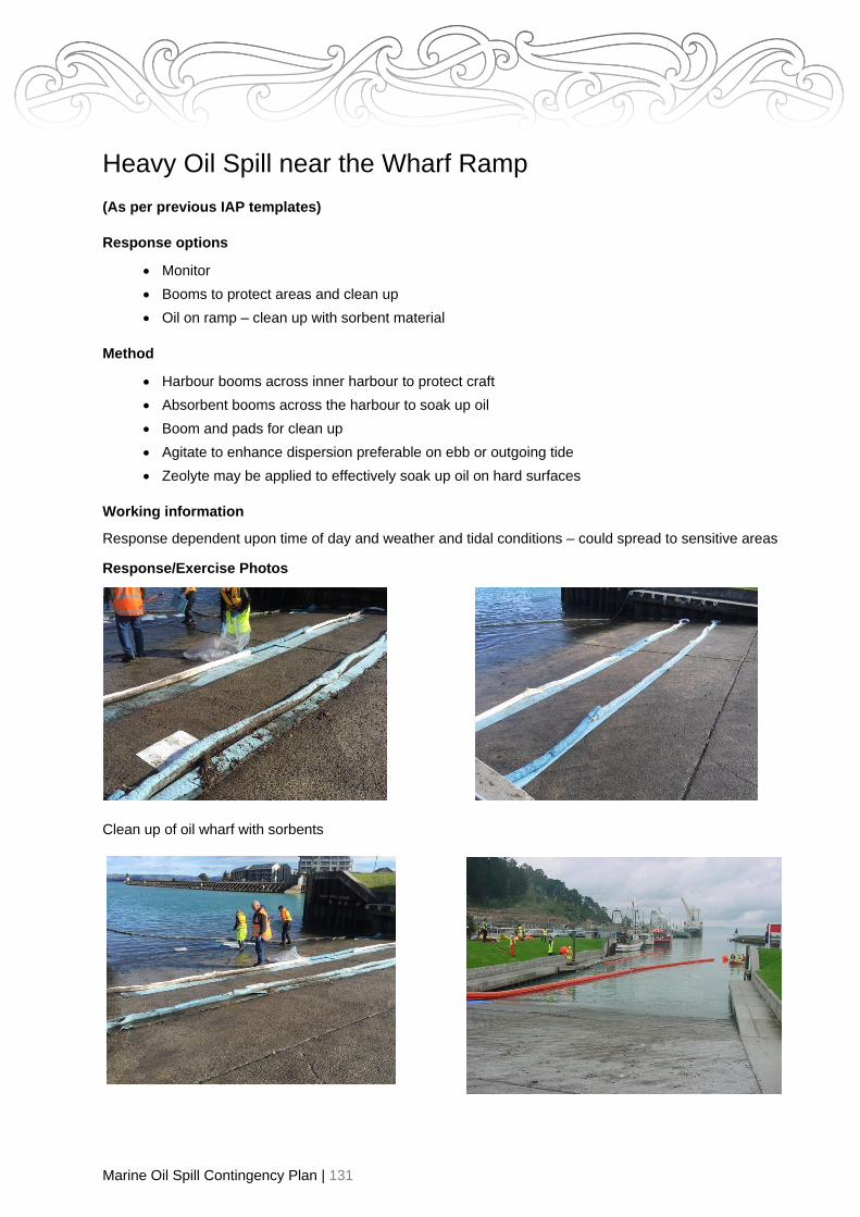
Marine Oil Spill Contingency Plan | 131
Heavy Oil Spill near the Wharf Ramp
(As per previous IAP templates)
Response options
• Monitor
• Booms to protect areas and clean up
• Oil on ramp – clean up with sorbent material
Method
• Harbour booms across inner harbour to protect craft
• Absorbent booms across the harbour to soak up oil
• Boom and pads for clean up
• Agitate to enhance dispersion preferable on ebb or outgoing tide
• Zeolyte may be applied to effectively soak up oil on hard surfaces
Working information
Response dependent upon time of day and weather and tidal conditions – could spread to sensitive areas
Response/Exercise Photos
Clean up of oil wharf with sorbents

Marine Oil Spill Contingency Plan | 132
Oil Spill Response in Remote or Inaccessible Parts of the
Region
Explanation
Coastlines of the region are typically remote and/or inaccessible. They include sandy, rocky, cliff,
estuarine and/or river mouth environments. There are also offshore islands and hazards to navigation
may lead to a vessel casualty and an oil spill at sea. This SOP looks at the additional factors for
consideration when responding in remote and/or inaccessible parts of the region.
Initial Assessment
• Is the coastline accessible by vehicle or boat or by air? Access may be 4WD only/quad bike or
on foot.
• Is access through private land? If so has the owner been identified and contacted for permission
to access the property? The ROSC has powers to enter private property for the purpose of oil
spill response but that could threaten responder safety. It may be Police or security staff are
required to help address such safety concerns.
• Some sites may only be accessed by boat and then only in calm conditions.
• It may be necessary to use a helicopter to access some potential sites in the region.
• There may be parts of the region where it is simply not possible to safely access for the purpose
of oil spill response.

Marine Oil Spill Contingency Plan | 133
• Weather/sea conditions and the forecast may significantly impact the choice of response options.
• Tidal flows and swell may restrict the times when shoreline clean-up/response is safe and practical.
• Natural hazards such as freak waves, earthquake or tsunami could occur while a response is in
progress. Procedures to manage such risks must be in place.
• Communications in remote locations maybe severely limited.
Safety Assessment and Planning
• Assess risk of harassment when accessing private land.
• Lone worker procedures should be implemented where staff are working alone or away from the
immediate assistance of others.
• Provide personal locator beacons, hand-held VHF radios for communications to staff working in
areas with limited cell phone coverage.
• Emergency evacuation procedures including an effective means to raise an alarm are agreed.
• Suitable first aid kits and current first aiders are assigned to each group.
• Responders to have sufficient food, water and sun protection.
• Work goals are measurable and achievable. (For example: 5 people may be assigned a 20m
section of a 100m oiled-beach. It is important that waste bags are not overfilled. None should
be more than 15kgs per bag or they become heavy to lift and injuries can result).
• Some environments may require specialist equipment. For example, waders may be useful for
work in estuarine environments. Hazing wildlife may require the use of horns/bells. Swift
currents in places like Wherowhero Lagoon may make boom deployment impractical.
Working information
For beach pre-cleaning move all driftwood, seaweed to above the high water tide mark (does not have to
be removed from beach).
Beach clean-up- use spades and four-wheeler motorbike and trailer or front-end loader trailer (minimise
waste/sand).

Marine Oil Spill Contingency Plan | 134
Example IAP - Spill Affecting Wherowhero Lagoon
NB High Value Area Aim
To minimise the environmental effects of any oil spilt from the vessel “name” in “location”.
IAP objectives
• To minimise the impact on the Wherowhero Lagoon.
• To conduct the operation in accordance with occupational health and safety requirements and
the GDC Tier 1 Response Plan.
• To dispose of solid and liquid waste in a safe and efficient manner in accordance with the RMA
(1991).
What is threatened?
Wherowhero lagoon - shell fish gathering and fishing, visual amenity, recreation use, tourism.
NB: Wherowhero Lagoon is a priority one area for protection – depending upon the type of oil
major effects on wildlife and fauna if spill comes ashore.
Significant issues
Amenity and recreation uses, shell fish gathering and fishing.
Assessment
Visual assessment by air, land and sea. Photographs for evidence.
Intelligence
• Weather
• Swell
• Quantity of oil Spilt
• Type of Oil spilt
• Look at whether to sample for evidence and dispersant use
Evidence gathering
• Sample of diesel off the water
• Sample all possible boats in port
• Determine what vessels have left the port
• Hill side photographs
• Photographs of any evidence
• Interview suspect vessel masters

Marine Oil Spill Contingency Plan | 135
Response options
• Monitor
• Dispersant – not normally appropriate in shallow estuarine environments. Requires MNZ
approval
• Agitate
• Trailing sorbent booms
• Deploy boom in estuary – sorbent boom for quick deployment
• Hazing of wildlife in Lagoon and beach
• Beach pre clean
• Beach clean-up
Method
• Agitate with large vessel such as tug to aid break down
• Contain and recover at sea
• Boom away from Lagoon
• Deploy boom in estuary
• Pre beach clean up
• Beach clean-up
Working information
• Tidal movements are strong - both ingoing and out going
• Large expanse requires booming
• Booming may take several hours to achieve and currents may rule this out
• Access is 4WD
Contingencies
• Assistance from HBRC/BOPRC or Tier 3 due to significance
• Shellfish prohibition until testing declares safe – notify Public Health
• Wildlife response
Exercise Photos

Marine Oil Spill Contingency Plan | 136

Marine Oil Spill Contingency Plan | 137
Vessel in Distress at Sea SOP
Explanation
In case of large ship in distress at sea the incident is likely to be escalated quite rapidly to a Tier 3
(National) Response. Only National On-Scene Commander (NOSC) can declare a Tier 3 Response.
While Regional Oil Spill Response Plans are primarily developed for use at the regional level they remain
key reference documents at all levels of response. They provide immediate access to local knowledge
and key people, equipment, resources as well as the regional response team. During the early stages of
a major response the ROSC and regional responders can provide critical services to the NOSC and the
quality of this interaction may be critical in a response outcome. The aim should be to foster a seamless
escalation between regional and national response tiers.
There are also a number of scenarios where a vessel in distress may be dealt with at the Tier 2
(Regional) Response level. The region has previously responded to the grounding of a commercial fishing
boat and there other vessels both large and small that could potentially trigger a regional response. This
SOP will outline some of the considerations that may apply to a vessel in distress at sea and the
implications for oil spill response at the Tier 2 response level.
Marine Oil Spill Contingency Plan | 138
Initial Considerations & Useful Intel
• Are all crew aboard the vessel safe and/or in danger of any kind?
• Is there a search and rescue or operation underway? It may be necessary to initially prioritise
support for search & rescue over oil spill response.
• Does the vessel itself present any immediate risks? This may include navigation hazards,
hazards such as chemicals/wastewater or other dangerous cargo that may be aboard the vessel
or have spilled or be discharged from the vessel
• Have the owners appointed an agent? What are they planning to do? Do they need support of
any kind and/or are they taking the right actions in a timely manner?
• Who is paying for the response? If possible get this in writing?
• Has the CEO of the council been appraised of the situation?
• Have PIM been activated and informed?
• Have likely costs been relayed to the vessel owner via the agent?
• What is the weather doing now and what is it forecast to do?
• How will tides and currents impact the situation and practicality of a response?
• How much fuel and oil is aboard the vessel? Where is it and what kinds of oil are there – HFO,
diesel, petrol, lube, hydraulic, waste oil or sludge?
• Are there vessel as-built plans available?
• Has a suitable vessel surveyor, boat builder or marine engineer been contracted by the agent to
help assess the status of the vessel as well as response options?
• Are there Safety Data Sheets (SDS) available for oils and chemicals aboard the vessel?
• Has any oil leaked into vessel bilges and/or discharged into the marine environment? Consider
aerial observation flights to assess the situation accurately
• Undertake oil spill trajectory modelling to determine potential shore impacts and arrival times –
contact the Oil Spill Duty Officer for assistance. (Refer to shoreline SOPs for shore impacts as
needed)
• There may be a need to board a vessel in distress for a number of reasons such as establishing
the status of the vessel, checking for crew still aboard, blocking leaks, securing fuel tanks and/or
removal of loose containers of fuel, oil or chemicals, securing a line or adding buoyancy or for
evidence collection for example. Boarding any vessel at sea (or one that has grounded) can be
dangerous and require specialist equipment, training and experience. Developing a JSA before
attempting to board a vessel is strongly advised. A written JSA will help record the process and
controls in place to undertake the operation safely.
• If considering vessel towage make sure the tow vessel and all equipment/operators confirm with
current commercial survey requirements
• Consider getting a sample of persistent oil & under-taking a dispersant test

Marine Oil Spill Contingency Plan | 139
Vessel in Distress Response Equipment - Checklist
Spare lines, buoys, fenders, anchors, shackles High volume pump
Decom equipment (refer checklist) Fuel & intrinsically safe fuel pump
(petrol)
Toolkit Sorbent roll
Suitable waste oil containers Grinder/cutting equipment/drill
Small diameter suction hose to feed into fuel tanks Sorbent booms/pads
Sampling kit & sampling pole Camera/notebook/pens/GPS
Warrant of authority Ways to plug holes/leaks
Appropriate PPE (refer waste/decom checklist) Chainsaw, Fuel, PPE & Operator
Food & Water Pool scoops & nets
Handheld radios
Pump ancillaries: Intake & outlet hoses, pump primer, funnel & intake strainer
For Diving/Towing Operations
Inflation bags Compressor
Work barge with crane Professional Dive Team & Diver
master
Suitable Tow lines In-survey Tow Vessel
Dive flag
Figure 2 Using lift bags while pumping out a sunken yacht

Marine Oil Spill Contingency Plan | 140
Example IAP - Slick off East Cape
Aim
To minimise the environmental effect of any oil spilt from the vessel “name” in “location”.
IAP objectives
• To minimise the amount of impact on the coastal areas/beaches
• To minimise the impact on the sensitive areas
• To conduct the operation in accordance with occupational health and safety requirements and
the GDC Tier 1 Response Plan
• To dispose of solid and liquid waste in a safe and efficient manner in accordance with the RMA
(1991)
What is threatened?
East Island and East Cape – High wildlife value - large quantities of wildlife (birds/seals/penguins)
Recreation use, livelihood, and tourism
Significant issues
Amenity and recreation uses, shell fish gathering and fishing
Assessment
Visual assessment by air Contact master to discuss Photographs for evidence.
Intelligence
• Weather
• Swell
• Quantity of oil/diesel on board
• Type of Oil
• Look at whether to sample for evidence and dispersant use
• Owners agent or engineer to check for damage
• OSDO to work out rate of travel and direction – time to hit shore
Evidence gathering
• Sample of spilled oil if possible
• Suspect vehicles traced
• Air - GPS
• Photographs of any evidence
• Interview suspect vessel masters by staff in other Ports
Response options
• Monitor
• Dispersant use – requires MNZ approval at Tier 2 level
• Minimise impact on wildlife – hazing
• Beach pre clean
• Beach clean up

Marine Oil Spill Contingency Plan | 141
Working information
Response dependent upon time of day and weather and tidal conditions Transport of personnel and
equipment to area – transport time 3 hours by road
Contingencies
Deploy equipment for dispersant use, containment, recovery and temporary storage Maybe Tier 3 due to
significant resources required.
Related Documents